Embed Size (px)
Citation preview
Bulahdelah Upgrading the Pacific Highway Environmental Impact Statement Technical Paper 2 Statutory Planning
November 2004
Roads and Traffic
Authority
Parsons Brinckerhoff Australia Pty Limited ACN 078 004 798 and Parsons Brinckerhoff International (Australia) Pty Limited ACN 006 475 056 trading as Parsons Brinckerhoff ABN 84 797 323 433
PPK House 9 Blaxland Road Rhodes NSW 2138 Locked Bag 248 Rhodes NSW 2138 Australia Telephone +61 2 9743 0333 Facsimile +61 2 9736 1568 Email [email protected] ABN 84 797 323 433 NCSI Certified Quality System ISO 9001
58L320A.1062 - Statutory Planning Final.doc

Bulahdelah – Upgrading the Pacific Highway Technical Paper 2
Author: David Fingland
Reviewer: Mark Keogh
Approved by: Mark Keogh
Signed: ..................................................................................................................
Date: 1 November 2004
Contents Technical Paper 2
Contents
Page Number
1. Introduction 1-1 1.1 Overview 1-1 1.2 Purpose of the Technical Paper 1-2 1.3 The Proponent 1-2 1.4 The Proposed Activity 1-2 1.5 Environmental Impact Statement Requirements 1-4 1.6 Clarification of Government Departments 1-5
2. Statutory Planning Context 2-1 2.1 Introduction 2-1 2.2 Local Environmental Plans 2-1
2.2.1 Purpose of Local Environmental Plans 2-1 2.2.2 Zoning 2-1 2.2.3 Permissibility 2-4 2.2.4 Conservation of Heritage Items 2-5
2.3 Regional Environmental Plans 2-5 2.4 State Environmental Planning Policies 2-6
2.4.1 Purpose of a State Environmental Planning Policy 2-6 2.4.2 State Environmental Planning Policy No. 14 (SEPP No. 14) — Coastal
Wetlands 2-6 2.4.3 State Environmental Planning Policy No. 26 — Littoral Rainforests 2-6 2.4.4 State Environmental Planning Policy No. 44 (SEPP No. 44) — Koala
Habitat Protection 2-6 2.4.5 State Environmental Planning Policy No. 71 (SEPP No. 71) — Coastal
Protection 2-7 2.5 Ministerial Directions 2-7 2.6 Native Title 2-7 2.7 Register of the National Estate 2-7 2.8 Commonwealth Government Environmental Legislation 2-8
58L320A.106 2 - Statutory Planning Final.doc PARSONS BRINCKERHOFF Page i

Bulahdelah – Upgrading the Pacific Highway Technical Paper 2
3. Determination Process 3-1 3.1 Public Exhibition and Comment 3-1 3.2 Determination Activities 3-1 3.3 Post-determination Activities 3-4 3.4 Other Potential Statutory Approvals 3-4 3.5 Powerline Relocation 3-8
List of Tables Table 3.1 Other Statutory Approvals Required 3-5
List of Figures Chapter 1 Introduction Figure 1.1 The Proposal Chapter 2 Statutory Planning Context Figure 2.1 Zoning Figure 2.2 Non-Indigenous Heritage Chapter 3 Determination Process Figure 3.1 Planning, Design and Decision Process
Page ii Roads and Traffic Authority 58L320A.106 2 - Statutory Planning Final.doc

Introduction Technical Paper 2
1. Introduction
1.1 Overview
The Roads and Traffic Authority (RTA) proposes to upgrade the Pacific Highway at Bulahdelah. The technical paper forms part of an environmental impact statement (EIS) that defines the proposal and examines its impacts. The Environmental Impact Statement comprises a main volume and 16 technical papers, which are listed below:
Technical Paper 1 Community and Stakeholder Involvement
Technical Paper 2 Statutory Planning
Technical Paper 3 Need and Route Evaluation
Technical Paper 4 The Proposal
Technical Paper 5 Environmental Management Framework
Technical Paper 6 Traffic and Transport
Technical Paper 7 Ecological Assessment and Species Impact Statement
Technical Paper 8 Water
Technical Paper 9 Hazard and Risk
Technical Paper 10 Energy, Waste and Demand on Resources
Technical Paper 11 Topography, Geology and Soils
Technical Paper 12 Visual
Technical Paper 13 Social and Economic
Technical Paper 14 Noise and Vibration
Technical Paper 15 Air
Technical Paper 16 Heritage
The proposed Upgrade of the Pacific Highway at Bulahdelah consists of approximately 8.5 kilometres of dual carriageway that would connect the proposed Karuah to Bulahdelah upgrade to the south to the completed Bulahdelah to Coolongolook upgrade to the north.
58L320A.106 2 - Statutory Planning Final.doc PARSONS BRINCKERHOFF Page 1-1
Bulahdelah – Upgrading the Pacific Highway Technical Paper 2
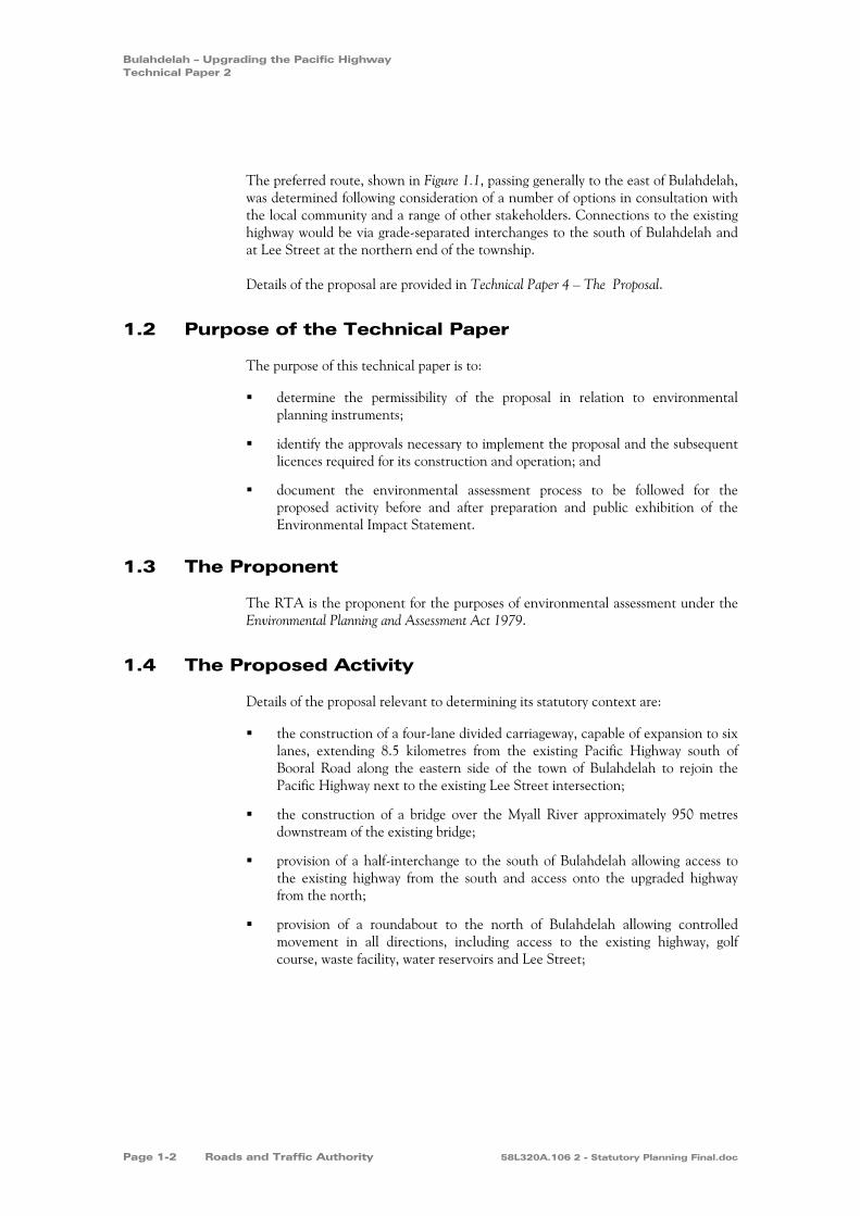
The preferred route, shown in Figure 1.1, passing generally to the east of Bulahdelah, was determined following consideration of a number of options in consultation with the local community and a range of other stakeholders. Connections to the existing highway would be via grade-separated interchanges to the south of Bulahdelah and at Lee Street at the northern end of the township.
Details of the proposal are provided in Technical Paper 4 – The Proposal.
1.2 Purpose of the Technical Paper
The purpose of this technical paper is to:
determine the permissibility of the proposal in relation to environmental planning instruments;
identify the approvals necessary to implement the proposal and the subsequent licences required for its construction and operation; and
document the environmental assessment process to be followed for the proposed activity before and after preparation and public exhibition of the Environmental Impact Statement.
1.3 The Proponent
The RTA is the proponent for the purposes of environmental assessment under the Environmental Planning and Assessment Act 1979.
1.4 The Proposed Activity
Details of the proposal relevant to determining its statutory context are:
the construction of a four-lane divided carriageway, capable of expansion to six lanes, extending 8.5 kilometres from the existing Pacific Highway south of Booral Road along the eastern side of the town of Bulahdelah to rejoin the Pacific Highway next to the existing Lee Street intersection;
the construction of a bridge over the Myall River approximately 950 metres downstream of the existing bridge;
provision of a half-interchange to the south of Bulahdelah allowing access to the existing highway from the south and access onto the upgraded highway from the north;
provision of a roundabout to the north of Bulahdelah allowing controlled movement in all directions, including access to the existing highway, golf course, waste facility, water reservoirs and Lee Street;
Page 1-2 Roads and Traffic Authority 58L320A.106 2 - Statutory Planning Final.doc
Figure 1.1 The Proposal
Proposed Upgrade
0 2
kilometres
1
Sour
ce: C
adas
tre -
Grea
t Lak
es C
ounc
il 20
00. S
urve
y - Q
asco
200
0.
Golfcourse
Sewagetreatment
plant Wastefacility
Woo
tton
RoadFrys Creek
Waterreservoir
Lee Street
Richmond Street
Stuart Street
Stro
ud S
treet
Craw
ford
Stre
etEx
istin
g Pa
cific
Hig
hway
Markw
ell Road
Caravanpark
Prin
ce S
treet
Alex
andr
a St
reet
Mya
ll St
reet
Bool
oom
bayt
Stre
et
Blanch Street
Meade Street
Church Street
MountainPark
Ann Street
Myall River
Powerline easem
ent
Myall River
Jackson Street
Booral
Road
Existin
g Pacifi
c Highw
ay
Bulahdelah State Forest
Crawford River
Proposed Upgrade
The LakesWay
Frys Creek
Bulahdelah (Alum)Mountain
SEPP 14WetlandNo. 698
Newcastle
Taree
Karuah
Hexham
Coolongolook
Nabiac
Bulahdelah
TuncurryForster
Reconstructionof northboundcarriagewayAccess to
waste facilityand sewage
treatment plant
Northern interchange
Access towater reservoir
Pedestrian Underpass
Pedestrian andvehicle connectionto mountain
Bombah PointRoad Overbridge
Southerninterchange
Realignment ofBooral Road/
Pacific Highwayintersection
Exit toBooral
Road
Pow
erlin
e eas
emen
t
Bombah Point Road
Realignment of Keels Road/Pacific Highway intersection
Realignment ofaccess track forpowerline easement

Bulahdelah – Upgrading the Pacific Highway Technical Paper 2
the construction of a vehicle and pedestrian overbridge to maintain access to Bulahdelah (Alum) Mountain across the alignment; and
provision of space to allow the partial relocation of the existing powerline along the alignment.
The details of the proposal are provided in Technical Paper 4 – The Proposal.
1.5 Environmental Impact Statement Requirements
The requirements for preparing an Environmental Impact Statement are regulated by a number of sections of the Environmental Planning and Assessment Act 1979 and the Environmental Planning and Assessment Regulation 2000. The contents of the Environmental Impact Statement must be in accordance with Schedule 2 — Environmental Impact Statements and Clause 230 of the Regulation, and take into account the factors set out in Clause 228.
The Environmental Impact Statement must also address the requirements of the Director-General of the Department of Infrastructure, Planning and Natural Resources (DIPNR) under Clause 231 of the Regulation. These requirements, dated 4 April 2002, specify that the Environmental Impact Statement must be prepared in accordance with:
the statutory requirements for the form and content of an Environmental Impact Statement, assuming Division 4 of Part 5 of the Environmental Planning and Assessment Act 1979 applies, together with requirements for public exhibition and seeking approval outlined in Attachment Number 1 (to the Director-General's requirements);
the Department's Environmental Impact Statement Guidelines — Roads and Related Facilities (Department of Urban Affairs and Planning 1996); and
the key issues outlined in the Director-General's letter (dated 4 April 2002).
The Department of Infrastructure, Planning and Natural Resources provided a list of additional requirements, dated 7 May 2004, that incorporated the responses from its consultation with the Commonwealth Department of Environment and Heritage.
Copies of the April 2002 and May 2004 Director-General's requirements for the proposed Upgrade are contained in Appendix B of Volume One of the Environmental Impact Statement.
The Director-General of the Department of Infrastructure, Planning and Natural Resources requires that the preparation of the Environmental Impact Statement includes consultation with relevant public agencies and the community. This is normal practice for the RTA. Community and stakeholder involvement is described in Technical Paper 1 — Community and Stakeholder Involvement.
Page 1-4 Roads and Traffic Authority 58L320A.106 2 - Statutory Planning Final.doc
Introduction Technical Paper 2
The proposal is considered to have the potential to result in significant impacts on three flora species. A Species Impact Statement (SIS) is therefore required according to Section 112(1B) of the Environmental Planning and Assessment Act 1979. Specific requirements for the preparation of the Species Impact Statement have been obtained from the Director-General of the Department of Environment and Conservation (formerly National Parks and Wildlife Service). The Species Impact Statement is included in Technical Paper 7 — Ecological Assessment and Species Impact Statement.
The overall proposal is assessed under Part 5 of the Environmental Planning and Assessment Act 1979.
1.6 Clarification of Government Departments
NSW Department of Primary Industries commenced on 1 July 2004 as the amalgamation of:
NSW Fisheries;
State Forests of NSW;
NSW Agriculture; and
Mineral Resources.
The 16 technical papers supporting the Environment Impact Statement were written before this amalgamation occurred. All references to these government departments in the technical papers signify the NSW Department of Primary Industries.
58L320A.106 2 - Statutory Planning Final.doc PARSONS BRINCKERHOFF Page 1-5


Statutory Planning Context Technical Paper 2
2. Statutory Planning Context
2.1 Introduction
This section describes those statutory planning instruments that are relevant to the proposed Upgrade of the Pacific Highway at Bulahdelah and assesses their implications in relation to permissibility and the required approvals process.
2.2 Local Environmental Plans
2.2.1 Purpose of Local Environmental Plans
Local environmental plans are initiated by local councils and are mainly concerned with matters considered to be of significance for environmental planning within a defined local government area. The zoning provisions contained in local environmental plans are relevant in determining the permissibility of a proposal. Provisions are also included in local environmental plans that, while not affecting the permissibility of a proposal, are relevant in the determination of its consistency with a council's strategic planning position. The local environmental plan relevant to the proposal is the Great Lakes Local Environmental Plan 1996.
2.2.2 Zoning
The proposal would pass through land with the following zoning as shown on Figure 2.1:
1(a) Rural;
1(f) Forestry;
2 Village; and
7(b) Conservation.
58L320A.106 2 - Statutory Planning Final.doc PARSONS BRINCKERHOFF Page 2-1

Golfcourse
Sewagetreatment
plant Wastefacility
Woo
tton
RoadFrys Creek
Pow
erlin
e eas
emen
t
Waterreservoir
Lee Street
Richmond Street
Stuart Street
Stro
ud S
treet
Craw
ford
Stre
etEx
istin
g Pa
cific
Hig
hway
Markw
ell Road
Caravanpark
Prin
ce S
treet
Alex
andr
a St
reet
Mya
ll St
reet
Bool
oom
bayt
Stre
et
Blanch Street
Meade Street
Church Street
MountainPark
Ann Street
Bombah PointRoad
Myall River
Powerline easem
ent
Myall River
Jackson Street
Booral
Road
Existin
g Pacifi
c Highw
ay
Bulahdelah State Forest
Crawfor
d Rive
r
Proposed Upgrade
The LakesWay
Frys Creek
Bulahdelah (Alum)Mountain
7(b)
1(f)
1(f)
1(d)
1(a)
1(a)
1(a)
1(a)
1(a)
1(a)
7(a)
7(a)
2
1(a) Rural
1(f) Forestry
2 Village
7(a) Wetlands and littoral rainforest
7(b) Conservation
Proposed Upgrade
Great Lakes Local Environmental Plan 1996
Figure 2.1 Zoning
Sour
ce: C
adas
tre -
Grea
t Lak
es C
ounc
il 20
00. S
urve
y - Q
asco
200
0.
0 2
kilometres
1

Statutory Planning Context Technical Paper 2
Zone 1(a) — Rural
The Rural 1(a) zone aims to restrict development to those uses which are unlikely to:
prejudice in a significant manner the agricultural production potential of land within the zone;
generate significant additional traffic or create or increase a condition of ribbon development on any road, relative to the capacity and safety of the road;
have an adverse impact on the area's water resources; and
create unreasonable or uneconomic demands for the provision or extension of public amenities or services.
Development related to agriculture and bushfire hazard reduction is permissible without development consent, while a range of development listed in the zoning tables of the Great Lakes Local Environmental Plan 1996 is prohibited. Any development not included in the development without consent and prohibited development categories is permitted with the consent of Great Lakes Council.
Zoning 1(f) — Forestry
The objective of the 1(f) Forestry zone is to conserve forest resources.
Development related to any use of land authorised under the Forestry Act 1916 and to bushfire hazard reduction is permissible without development consent and development for the purposes of communication facilities, extractive industries and tourist facilities is permissible with Council consent. Any other development is prohibited.
Zone 2 — Village
The objective of the 2 Village zone is to restrict development to small scale developments which are compatible with the general residential character of village areas.
Development for the purpose of bushfire hazard reduction and dwellings (houses) is permitted without development consent. A range of development listed in the zoning tables of the Great Lakes Local Environmental Plan 1996 is prohibited. Any development not included in the development without consent and prohibited development categories is permitted with the consent of Great Lakes Council.
58L320A.106 2 - Statutory Planning Final.doc PARSONS BRINCKERHOFF Page 2-3

Bulahdelah – Upgrading the Pacific Highway Technical Paper 2
Zone 7(b) — Conservation
The objective of the 7(b) Conservation zone is to enable a limited range of development (including tourist facilities) on land possessing special aesthetic or conservation values where:
it can be demonstrated that the development can be carried out in a manner that minimises risks from natural hazards;
the development functions efficiently;
the development does not prejudice other economic development;
the development does not significantly detract from the scenic quality of the land within the zone;
the development is unlikely to have a significant detrimental effect on the growth of native plant communities;
the development is unlikely to affect the survival of native wildlife populations; and
the development is unlikely to adversely affect the provision or quality of habitats for either indigenous or migratory species.
A range of facilities are permissible within the 7(b) zone with Council’s consent. All other developments are prohibited. Roads are not listed as being permissible.
2.2.3 Permissibility
The proposed Upgrade of the Pacific Highway at Bulahdelah is located entirely within the Great Lakes local government area. Clause 15 of the Local Environment Plan states:
Nothing in this plan restricts, prohibits or requires development consent for:
a) the use of existing buildings under the control of the Crown by the Crown; or
b) any activity listed in Schedule 1.
Schedule 1 — Development not Requiring Consent of the Local Environment Plan contains the following clause:
8. The carrying out by the Council or the Roads and Traffic Authority of any development required in connection with the construction, reconstruction, improvement, widening, realignment, relocation, maintenance or repair of any road.
Notwithstanding the fact that roads are not listed as being permissible within the 1(f) and 7(b) zones, the proposal is permissible without the consent of Council
Page 2-4 Roads and Traffic Authority 58L320A.106 2 - Statutory Planning Final.doc

Statutory Planning Context Technical Paper 2
pursuant to Clause 15. Therefore, the proposal is required to be considered under Part 5 of the Environmental Planning and Assessment Act, 1979.
2.2.4 Conservation of Heritage Items
Schedule 2 — Heritage of the Local Environmental Plan lists four lots relating to the former alunite mine on Bulahdelah (Alum) Mountain, which it describes as regionally significant. These are Lot 1, DP228555 (formerly Portion 150) and Portions 64, 122 and 187 as shown in Figure 2.2. However, none of these lots includes the main features of the mine. The Local Environment Plan is currently under review by Council and it is likely that the alunite mine precinct will be more accurately described.
Clause 21 of the Local Environmental Plan relates to the protection of heritage items and conservation areas. The consent of Council is normally required for demolishing, altering or moving a heritage item and Council must take account of the extent to which a proposal would affect the significance of the heritage item or conservation area. However, this clause does not apply to the proposed Upgrade under the provisions in Clause 15, Schedule 1 (8), as stated in Section 2.2.2.
2.3 Regional Environmental Plans
A regional environmental plan is an environmental planning instrument prepared by the Director-General of the Department of Infrastructure, Planning and Natural Resources and made by the Minister for Infrastructure and Planning and Minister for Natural Resources. It refers to matters considered to be of significance for environmental planning for the region to which it applies and provides guidance for the preparation of local environmental plans and the control of new development.
The Hunter Regional Environmental Plan 1989 applies to the Great Lakes local government area. This plan was considered in the development of the proposal but has no effect on the permissibility of the proposal.
The aims of the Hunter Regional Environmental Plan are:
to promote the balanced development of the region, the improvement of its urban and rural environments and the orderly and economic development and optimum use of its land and other resources, consistent with conservation of natural and man made features and so as to meet the needs and aspirations of the community;
to co-ordinate activities related to development in the region so there is optimum social and economic benefit to the community; and
to continue a regional planning process that will serve as a framework for identifying priorities for further investigations to be carried out by the Department and other agencies.
Clause 7 of the Plan requires, among other things, the Chief Executive Officer and the RTA and the Minister for Infrastructure and Planning to consider the
58L320A.106 2 - Statutory Planning Final.doc PARSONS BRINCKERHOFF Page 2-5

Bulahdelah – Upgrading the Pacific Highway Technical Paper 2
background report and the objectives, policies and principles contained in the Plan when considering whether to approve the proposed Upgrade.
2.4 State Environmental Planning Policies
2.4.1 Purpose of a State Environmental Planning Policy
A State Environmental Planning Policy (SEPP) is an environmental planning instrument made by the Governor following its preparation by the Director-General of the Department of Infrastructure, Planning and Natural Resources. It relates to matters considered to be of significance for environmental planning for the State. The following State Environmental Planning Policies could have some relevance to statutory issues relating to the Environmental Impact Statement, or are required by the Director-General to be examined in relation to the Environmental Impact Statement.
2.4.2 State Environmental Planning Policy No. 14 (SEPP No. 14) — Coastal Wetlands
SEPP No. 14 — Coastal Wetlands aims to ensure that coastal wetlands are preserved and protected in the environmental and economic interests of the State. The nearest coastal wetland (number 698) is approximately one kilometre from the proposed Upgrade alignment and would be unlikely to be adversely affected.
2.4.3 State Environmental Planning Policy No. 26 — Littoral Rainforests
SEPP No. 26 — Littoral Rainforests provides a mechanism for the consideration of applications for development that is likely to damage or destroy littoral rainforest areas with a view to the preservation of those areas in their natural state. SEPP No. 26 applies to specified areas of rainforests. The proposal is not located near rainforests.
2.4.4 State Environmental Planning Policy No. 44 (SEPP No. 44) — Koala Habitat Protection
SEPP No. 44 — Koala Habitat Protection aims to encourage the proper conservation and management of natural koala habitat to ensure that there is a permanent free-living population of koalas throughout their present range and to reverse the current trend of population decline.
There is no requirement for specific assessment under SEPP No. 44 as the proposed Upgrade is to be assessed under Part 5 of the Environmental Planning and Assessment Act 1979. In addition, the assessments undertaken for the Environmental Impact Statement did not identify any habitat suitable for koalas near the proposed Upgrade.
Page 2-6 Roads and Traffic Authority 58L320A.106 2 - Statutory Planning Final.doc
Statutory Planning Context Technical Paper 2
2.4.5 State Environmental Planning Policy No. 71 (SEPP No. 71) — Coastal Protection
The broad aims of SEPP No. 71 — Coastal Protection are to:
ensure that the coastal zone is protected in accordance with Ecologically Sustainable Development Principles;
ensure that development is appropriate and suitably located; and
establish a clear and consistent development assessment framework for the costal zone.
SEPP No. 71 — Coastal Protection applies to State significant development and significant coastal development. This policy does not apply to the proposed Upgrade because it is not a classed as a State significant development and is not located in a sensitive coastal location (as defined in Schedule 1).
2.5 Ministerial Directions
The Minister for Infrastructure and Planning and Minister for Natural Resources may direct local governments under Section 117(2) of the Environmental Planning and Assessment Act 1979 to conform to particular policy directions as part of the preparation of any draft local environmental plan.
Direction S28 addresses the nature of commercial/retail development along the Pacific Highway between Hexham (near Newcastle) and the Queensland border, and reflects a need for such development with a highway service function at appropriate intervals. The upgrade of the Pacific Highway presents an opportunity for Bulahdelah to reinforce its current highway service function and develop its role as a tourist centre and gateway to the Great Lakes region.
Great Lakes Council has formally endorsed the concept of Bulahdelah as a service town and is reviewing its local environmental plan to ensure that the role of the town is supported and enhanced.
2.6 Native Title
A search of the Register of Native Title Claims, the Register of Indigenous Land Use Agreements, the National Native Title Register and the Applications Summary has indicated that there are no entries of relevance to the proposed Upgrade.
2.7 Register of the National Estate
The portion of the Bulahdelah (Alum) Mountain range over 180 metres above sea level has been listed on the Register of the National Estate, as shown in Figure 2.2. It is described as ‘Alum Mountain Geological Site 1, Bulahdelah NSW’. The statement of significance in the Register includes the following:
58L320A.106 2 - Statutory Planning Final.doc PARSONS BRINCKERHOFF Page 2-7

Bulahdelah – Upgrading the Pacific Highway Technical Paper 2
The site is a rare example of alunite in New South Wales. It is also important as an educational site and for research into the structural relationships of the various components of the Alum Mountain volcanics.
Although the history of alunite mining is mentioned in the description, and the ‘disused quarries and shafts’ are listed as non-fragile features of the site, the citation is based primarily on the site’s natural and geological significance.
The listed area includes only the upper slopes and ridge crests of Bulahdelah (Alum) Mountain, which are outside the study area for the proposed Upgrade.
2.8 Commonwealth Government Environmental Legislation
The Commonwealth Environment Protection and Biodiversity Conservation Act 1999 applies to a State proposal if it is determined to be a controlled action as defined in the Act.
Two plant species listed as threatened under the Act were confirmed as present within and adjacent to the footprint of the proposed Upgrade on the footslopes of Bulahdelah (Alum) Mountain and one further threatened species has been recorded in the area but not identified in recent surveys.
The Commonwealth Minister for the Environment and Heritage has determined that the proposal is a controlled action and has given approval to utilise the NSW Environmental Impact Statement process as an accredited assessment process under the Act.
Page 2-8 Roads and Traffic Authority 58L320A.106 2 - Statutory Planning Final.doc
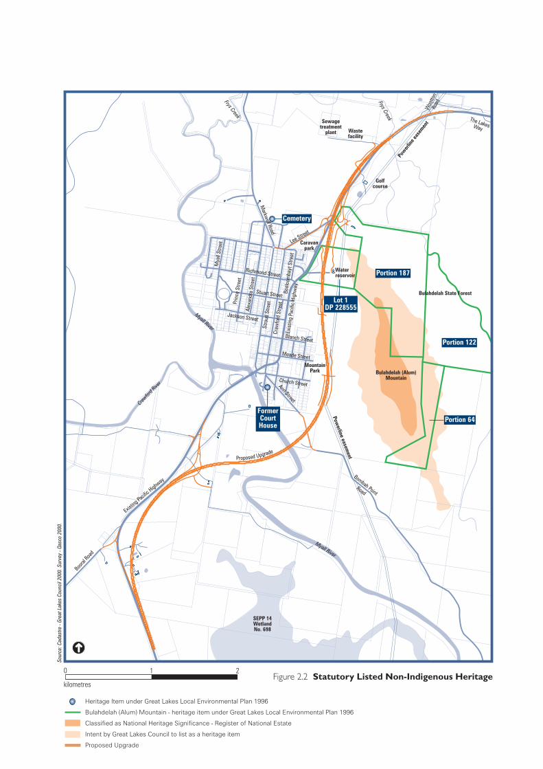
Heritage Item under Great Lakes Local Environmental Plan 1996
Bulahdelah (Alum) Mountain - heritage item under Great Lakes Local Environmental Plan 1996
Classified as National Heritage Significance - Register of National Estate
Intent by Great Lakes Council to list as a heritage item
Proposed Upgrade
Figure 2.2 Statutory Listed Non-Indigenous Heritage
Sour
ce: C
adas
tre -
Grea
t Lak
es C
ounc
il 20
00. S
urve
y - Q
asco
200
0.
0 2
kilometres
1
SEPP 14WetlandNo. 698
Golfcourse
Sewagetreatment
plant Wastefacility
Woo
tton
RoadFrys Creek
Pow
erlin
e eas
emen
t
Waterreservoir
Lee Street
Richmond Street
Stuart Street
Stro
ud S
treet
Craw
ford
Stre
etEx
istin
g Pa
cific
Hig
hway
Markw
ell Road
Caravanpark
Prin
ce S
treet
Alex
andr
a St
reet
Mya
ll St
reet
Bool
oom
bayt
Stre
et
Blanch Street
Meade Street
Church Street
MountainPark
Ann Street
Bombah PointRoad
Myall River
Powerline easem
ent
Myall River
Jackson Street
Booral
Road
Existin
g Pacifi
c Highw
ay
Bulahdelah State Forest
Crawfor
d Rive
r
Proposed Upgrade
The LakesWay
Frys Creek
Bulahdelah (Alum)Mountain
FormerCourtHouse
Cemetery
Portion 187
Lot 1DP 228555
Portion 122
Portion 64


Determination Process Technical Paper 2
3. Determination Process
3.1 Public Exhibition and Comment
The RTA, as the proponent and nominated determining authority for the proposal, would place the Environmental Impact Statement on public exhibition for a minimum period of 30 days in accordance with the requirements of the Environmental Planning and Assessment Regulation 2000. During this period, the Environmental Impact Statement would be available for inspection at selected RTA offices and other locations, including those specified in Section 113 of the Environmental Planning and Assessment Act 1979 and Clause 235 of the Environmental Planning and Assessment Regulation 2000. The Environmental Impact Statement would be offered for sale in hard copy and as a CD-ROM, and would also be available on the RTA's website. Public authorities, interested groups and organisations, and the general community would be invited to make written representations in response to the Environmental Impact Statement.
3.2 Determination Activities
Following the exhibition of the Environmental Impact Statement and Species Impact Statement, the RTA would review all representations and the contents of the Environmental Impact Statement, including the Technical Papers, the Species Impact Statement and any other relevant matters, and prepare a Representations Report. Copies of all representations will be forwarded to the Department of Infrastructure, Planning and Natural resources. The Representations Report would include consideration of:
the Environmental Impact Statement;
the Species Impact Statement;
all representations and responses to the issues raised;
any new information concerning the proposal;
any modifications to the proposal;
a summary of mitigation measures and other commitments should the proposal proceed; and
any other matters required under Clause 243 of the Environmental Planning and Assessment Regulation 2000.
58L320A.106 2 - Statutory Planning Final.doc PARSONS BRINCKERHOFF Page 3-1
Bulahdelah – Upgrading the Pacific Highway Technical Paper 2
Having examined the Environmental Impact Statement, Species Impact Statement and the Representations Report, the RTA would decide whether the proposal should proceed, either in the form described in the Environmental Impact Statement or in a modified form in light of representations made, or not proceed at all. If the RTA decides that it should proceed with the proposal, it would forward the Representations Report and any other relevant information to the Department of Infrastructure, Planning and Natural Resources and seek the approval of the Minister for Infrastructure and Planning and Minister for Natural Resources. The RTA would also seek concurrence of the Director-General of the Department of Environment and Conservation (formerly National Parks and Wildlife Service) in relation to the Species Impact Statement.
The Department of Infrastructure, Planning and Natural Resources would examine the proposal and prepare a report to the Minister for Infrastructure and Planning and Minister for Natural Resources. Acting on that report and following consultation with the Minister for Roads, the Minister for Infrastructure and Planning and Minister for Natural Resources would decide whether to approve the proposal. The Minister for Infrastructure and Planning and Minister for Natural Resources may attach conditions to the approval. If approval is granted, the Chief Executive of the RTA would determine if the proposal is to proceed.
The Species Impact Statement is prepared in accordance with guidelines issued by the Director-General of the Department of Environment and Conservation (formerly National Parks and Wildlife Service). It is exhibited concurrently with the Environmental Impact Statement. Following exhibition of the Species Impact Statement, the Director-General of the National Parks and Wildlife Service would consider submissions on this statement and the Representations Report prepared by the RTA. After review of this material, the Director-General of the Department of Environment and Conservation would decide whether to grant concurrence for the proposal and would forward the Concurrence Report to the Department of Infrastructure, Planning and Natural Resources.
The planning, design and decision process for the Upgrade of the Pacific Highway at Bulahdelah is shown in Figure 3.1. This process allows input from public authorities and the community. Assessment of representations made in response to the exhibition of the Environmental Impact Statement and Species Impact Statement is an integral part of the approval process and can result in modifications and improvements to the design of the proposal in accordance with Division 4 of Part 5 of the Environmental Planning and Assessment Act 1979. Should the proposal be approved, the RTA would continue to involve relevant agencies and the local community in the detailed design of the proposal and during the construction period.
Page 3-2 Roads and Traffic Authority 58L320A.106 2 - Statutory Planning Final.doc

Figure 3.1 Planning, Design and Decision Process
Preliminary Investigations
Development of Preliminary Route Options
Refinement of Options
Selection of Preferred Route
RTA review of proposal and possible design refinementin light of EIS/SIS exhibition and representations received
RTA prepare Representations Report
Assessment Report prepared by Director General of Departmentof Infrastructure, Planning and Natural Resources
Minister for Infrastructure and Planning and Minister for NaturalResources decides whether or not to approve the proposal
If proposal approved by the Minister, the Chief Executive of the RTAdecides whether to proceed with the proposal (either withor without modifications requiring further approval)
Release of EIS/SIS
Community information evening
Development of Community Focus Group
Public Display
Community and stakeholder involvement duringEIS/SIS preparation
Exhibition of EIS/SIS for minimum of 30 daysfor public review and comment
Community kept informed of progress
COMMUNITY & INVOLVEMENTPROPOSAL DEVELOPMENT PHASE
PROPOSAL ASSESSMENT PHASE
PROPOSAL DETERMINATION PHASE
IMPLEMENTATION
Government and Community Workshop
If decision to proceed, the Chief Executive of the RTA forwards theRepresentations Report to the Department of Environment andConservation to seek the concurrence of its Director General
Chief Executive of RTA considers EIS/SIS, Representations Reportand relevant matters and decides if the proposal should proceed
Release of the Preferred Activity Report (if substantialchanges are made to the proposal). Opportunity forcommunity to make further comment.
Prepare EIS and SIS in accordance with statutory requirements forPart 5 of the EP&A Act 1979 and the requirements of the DirectorsGeneral of the Department of Infrastructure, Planning and NaturalResources (for EIS) and Department of Environment and Conservation(for SIS)
If concurrence is received, the Chief Executive of the RTA forwardsthe Representations Report to the Department of Infrastructure,Planning and Natural Resources and seeks approval of the Ministerfor Infrastructure and Planning and Minister for Natural Resources
Release of Minister for Infrastructure and Planningand RTA Chief Executive’s decisions, RepresentationsReport and Assessment Report
Community Surveys, Site Tours,Property Owner Discussions
If proposal approved, project delivery method determinedand project implemented
If approved, a copy of the EIS, SIS, Representations Report andAssessment Report is provided to the Commonwealth Minister forthe Environment and Heritage who then decides whether approvalis granted under the EPBC Act
Bulahdelah – Upgrading the Pacific Highway Technical Paper 2
3.3 Post-determination Activities
Should the proposal for the Upgrade of the Pacific Highway at Bulahdelah be approved, the RTA would:
notify the local community of the decision to proceed with the proposal by correspondence, newspaper notices and/or newsletters; such notification could include an indication of anticipated timing and staging of construction works and contact details for further information;
make the following documents available for public inspection at selected locations: the approvals of the NSW Minister for Infrastructure and Planning and the Commonwealth Minister for the Environment and Heritage, the Representations Report, the determination of the Chief Executive of the RTA, the Concurrence Report of the Director-General of the National Parks and Wildlife Service and the report of the Director-General of the Department of Infrastructure, Planning and Natural Resources;
notify property owners affected by acquisition soon after the announcement of the decision to clarify the likely impacts on individual properties and the anticipated timing and staging of construction; owners would be kept informed and consulted during the design and construction process; and
prepare a detailed Environmental Management Plan for the construction phase of the proposal before construction commences.
The RTA would ensure that contractors for the proposal have an environmental management system prepared in accordance with the NSW Government Environmental System Guidelines (1998) and accredited by a NSW government construction agenda. Contractors would also need to demonstrate successful implementation of their environmental management system at a project level.
All approvals are usually subject to conditions. The RTA would meet those conditions either directly or through its contractual requirements.
3.4 Other Potential Statutory Approvals
If the RTA proceeds with construction of the proposal following determination, approvals would be required under a number of State statutes and policies. These are listed in Table 3.1.
Page 3-4 Roads and Traffic Authority 58L320A.106 2 - Statutory Planning Final.doc

Determination Process Technical Paper 2
Table 3.1: Other Statutory Approvals Required
Legislation (responsible agency)
Purposes of Legislation Circumstances in Which Approvals/Permits/Licences Would Be Required
Animal Research Act 1985 (Department of Primary Industries)
The objective of the Act is to protect the welfare of animals used in connection with research. Authorisation may be granted under the Act for recognised research purposes.
An Animal Research Authority under Division 3 of the Act may be required if further fauna surveys are undertaken.
Fisheries Management Act 1994 and Fisheries Management Amendment Act 1997 (Department of Primary Industries)
The purpose of the Act is to conserve, develop and share the fisheries resources of the State.
Notice is required to be given of proposed “reclamation work” (bridge construction in this case) under Section 199.
Fish passage would not be obstructed and therefore a permit under Section 219 should not be required.
Similarly, it is unlikely that a permit to harm marine vegetation would be required under Section 205 of the Act.
Forestry Act 1916 (Department of Primary Industries)
The main objective of this Act is to manage timber production on areas of Crown land under the control of NSW Forests consistent with conservation obligations under the Act.
Revocation of dedication of part of Bulahdelah State Forest would be required under Section 19B of the Act. A permit to occupy or use State Forest land may also be required under Section 31 of the Act.
Heritage Act 1977 (Heritage Council of NSW)
The purpose of the Act is to ensure that historical heritage in NSW is adequately identified and conserved.
Section 139 Excavation Permit is required for disturbance or excavation of land that would or would be likely to result in a relic being discovered, exposed, moved, damaged or destroyed.
National Parks and Wildlife Act 1974 (Department of Environment and Conservation)
The Act aims to prevent the unnecessary or unwarranted destruction of relics and the active protection and conservation of relics of high cultural significance. This Act covers relics of both ‘Indigenous and non-European’ habitation in NSW.
The Act also contains
Consent is required to disturb or destroy any archaeological sites under Section 90 (Consent to Destroy Permit). A permit is required for disturbance or removal or taking possession of archaeological objects under Section 87 (Preliminary Research Permit).
A Scientific Licence under
58L320A.106 2 - Statutory Planning Final.doc PARSONS BRINCKERHOFF Page 3-5

Bulahdelah – Upgrading the Pacific Highway Technical Paper 2 Table 3.1 (continued)
Legislation (responsible agency)
Purposes of Legislation Circumstances in Which Approvals/Permits/Licences Would Be Required
provisions related to the conservation of habitats; ecosystems; biological diversity; and landforms, landscapes and natural features of significance.
Section 132C would be required to carry out actions for scientific purposes that involve protected fauna; protected native plants; threatened species, populations or ecological communities, or their habitat.
Native Vegetation Conservation Act 1997 (Department of Infrastructure, Planning and Natural Resources)
The Act protects State-protected land and native vegetation identified by the Minister for Natural Resources.
Development consent is required under specified circumstances when native vegetation is proposed to be cleared
Approval under this Act would not be required pursuant to Section 12 as clearing would be carried out in accordance with the Roads Act 1993.
Native Vegetation Act 2003 (Department of Infrastructure Planning and Natural Resources)
This Act is proposed to be introduced to replace and simplify the provisions of the Native Vegetation Conservation Act 1997. It will set a framework for the:
management of native vegetation;
prevention of broadscale clearing;
protection of high conservation value native vegetation; and
revegetation and rehabilitation of land.
The Act will not come into force until supporting regulations have been finalised
Section 25 of the Act would exempt the proposal from requiring approval as the activity (the Upgrade) would be carried out by the RTA under Part 5 of the Environmental Planning and Assessment Act 1979.
Navigation Act 1901 (Waterways Authority)
The Act controls navigable waters in NSW. The Act also authorises works on navigable waters.
Approval is needed under Section 142 for the construction of the proposed bridge across the Myall River.
Page 3-6 Roads and Traffic Authority 58L320A.106 2 - Statutory Planning Final.doc
Determination Process Technical Paper 2 Table 3.1 (continued)
Legislation (responsible agency)
Purposes of Legislation Circumstances in Which Approvals/Permits/Licences Would Be Required
Protection of the Environment Operations Act 1997 (Department of Environment and Conservation)
This Act contains pollution controls and requirements for the grant of environmental protection licences for specific scheduled activities. Its objectives include to protect, restore and enhance the quality of the environment in the context of ecologically sustainable development and to reduce risks to human health and prevent degradation of the environment.
The proposal is a scheduled activity under Schedule 1.
During construction the RTA and/or contractor must comply with the provisions of the Act in relation to pollution control and an environmental protection licence must be obtained for the construction work under Chapter 3 of the Act.
Rural Fires Act 1997 (NSW Fire Service)
This Act provides provisions intended to prevent, mitigate and suppress bushfires and coordinate bushfire fighting and prevention.
Section 63 sets out duties of public authorities to prevent bushfires.
The RTA would prepare a bushfire risk management plan for the local area affected.
RTA needs to indicate those measures to be implemented to ensure that road verges are maintained to prevent the occurrence on and spread of fire from the road corridor.
Waste Avoidance and Resource Recovery Act 2001 (ResourceNSW)
The objective of the Act is to minimise waste going to landfill and maximise resource recovery by addressing the waste management hierarchy of avoidance, re-use, recycling and reprocessing, and disposal.
RTA/contractor would be required to comply with the Act in relation to waste management during construction.
Water Management Act 2000, Water Act 1912 and Rivers and Foreshores Improvement Act 1948 (Department of Infrastructure, Planning and Natural Resources)
The Water Management Act provides for the protection, conservation and ecologically sustainable development of western NSW.
The Water Management Act is progressively being introduced to replace the Water Act and the Rivers and Foreshores Improvement Act.
Water use for road construction is exempt from the approval under the Water Management Act pursuant to Clause 38 of the Water Management (General) Regulation 2004.
The requirements of the Water Management Act would need to be reviewed at the time of construction in respect to the status of its regulations and the repealing of the Water Act and the Rivers and Foreshores Improvement Act.
58L320A.106 2 - Statutory Planning Final.doc PARSONS BRINCKERHOFF Page 3-7

Bulahdelah – Upgrading the Pacific Highway Technical Paper 2
3.5 Powerline Relocation
The proposed Upgrade would require the relocation of approximately 750 metres of the powerline located on the footslopes of Bulahdelah (Alum) Mountain. The powerline is owned and operated by TransGrid.
This EIS and SIS defines and assesses the clearing of vegetation associated with the relocation of the transmission line easement and the associated access track. Physical works associated with the actual relocation of the power poles and line will be the subject of a separate environmental impact assessment process to be undertaken by TransGrid.
Page 3-8 Roads and Traffic Authority 58L320A.106 2 - Statutory Planning Final.doc