Embed Size (px)
Citation preview

Warrell Creek to Urunga Upgrading the Pacific Highway
ENVIRONMENTAL ASSESSMENT VOLUME 1 ENVIRONMENTAL ASSESSMENT January 2010
ISBN 978-1-921692-63-5
Sinclair Knight Merz ABN 37 001 024 095 100 Christie Street PO Box 164 St Leonards NSW Australia 1590 Tel: +61 2 9928 2100 Fax: +61 2 9928 2500 Web: www.skmconsulting.com
COPYRIGHT: The concepts and information contained in this document are the property of the NSW Roads and Traffic Authority (RTA). Use or copying of this document in whole or in part without the written permission of the RTA constitutes an infringement of copyright.

ENVIRONMENTAL ASSESSMENT| SINCLAIR KNIGHT MERZ PAGE 485
APPENDICES
References AMBS 2001, Fauna Underpass Monitoring Stage One, Final Report, Herons Creek. Unpublished report to the NSW Roads and Traffic Authority.
AMBS 2002a, Fauna Underpass Monitoring Stage Two, Episode Five, Taree. Unpublished Report to the NSW Roads and Traffic Authority.
AMBS 2002b, Fauna Underpass Monitoring Stage Two, episode Five, Bulahdelah to Coolongolook. Unpublished report to the NSW Roads and Traffic Authority.
Armour, 1992, The Challenge of Assessing Social Impact. The Social Impact Assessment Bulletin Volume 1. No 4.
ANPC 2004, Guidelines for the Translocation of Threatened Plants in Australia. 2nd Edition. Australian Network for Plant Conservation.
ANZECC/ARMCANZ (2000) Australian and New Zealand Guidelines for Fresh and Marine Water Quality. Australian and New Zealand Environment and Conservation Council and Agriculture and Resource Management Council of Australia and New Zealand.
ASSMAC 1998, Acid Sulfate Soil Manual, Acid Sulfate Soil Management Advisory Committee, NSW Agriculture.
Australian Bureau of Statistics 2006, Census Data Online, www.census.abs.gov.au.
Austroads 1999, Guide to Traffic Engineering Practice: Part 2 – Roadway Capacity. Austroads: Sydney, NSW.
Austroads 2001, Road Runoff and Drainage: Environmental Impacts and Management Options, Sydney, NSW.
Bellingen Shire Council 2008, Community Profile 2008.
Bellingen Shire Council 2006, Pedestrian and Access Mobility Plan, October 2006.
Bellingen Shire Council 2007, Bellingen Growth Management Strategy, Prepared by GHD for Bellingen Shire Council.
Bureau of Transport and Regional Economics 2006, Working paper 66, Demand Projections for AusLink Non-Urban Corridors: Methodology and Projections, February 2006.
Clancy, G.P. 1991. The biology and management of the osprey (Pandion haliaetus) in NSW. NSW, National Parks and Wildlife Service, Hurstville.
CSIRO, Australian Bureau of Meteorology 2007, Climate change in Australia: technical report 2007, CSIRO. 148pp.
Department of Environment and Climate Change 2007, NSW Waste Avoidance and Resource Recovery Strategy 2007, October 2007.

WARRELL CREEK TO URUNGA|UPGRADING THE PACIFIC HIGHWAY
PAGE 486 ENVIRONMENTAL ASSESSMENT| SINCLAIR KNIGHT MERZ
Department of Environment and Climate Change 2007b, Landscape selection process, Key Altitudinal, Latitudinal and Coastal Corridors for response to Climate Change, Hurstville.
Department of Environment and Climate Change 2007c, Threatened species assessment guidelines: the assessment of significance.
Department of Environment and Climate Change 2008, Waste Classification Guidelines, April 2008.
Department of Environment and Climate Change 2008b, New South Wales Construction Noise Guidelines, August 2008.
Department of Environment and Climate Change 2008c, Managing Urban Stormwater: Soils and Construction: Volume 2D Main road construction, June 2008.
Department of Environment and Conservation 2004, Threatened Biodiversity Survey and Assessment: Guidelines for Developments and Activities – Working Draft, November 2004.
Department of Environment and Conservation 2005, Interim Community Consultation Requirements for Applicants.
Department of Environment and Conservation 2006, Assessing Vibration: a technical guideline, February 2006. http://www.environment.nsw.gov.au/resources/noise/vibrationguide0643.pdf.
Department of Environment and Conservation 2007, Practical Consideration for Climate Change.
Department of the Environment and Heritage 2006, EPBC Act Policy Statement 1.1 Significant Impact Guidelines – Matters of National Environment Significance, May 2006.
Department of Housing 2004, Managing Urban Stormwater: Soils and Construction, 4th Edition, Department of Housing and Landcom, NSW, Sydney.
Department of Planning 2007, Guideline for Major Projects Community Consultation, October 2007.
Department of Planning 2009a, Mid North Coast Regional Strategy 2006-31, August 2009.
Department of Planning 2009b, Mid North Coast Farmland Mapping Project, August 2009.
Department of Infrastructure, Planning and Natural Resources 2005, Floodplain Development Manual: the management of flood liable land, April 2005.
Department of Primary Industries 2006, NSW Oyster Industry Sustainable Aquaculture Strategy.
Department of Public Works 1994: Lower Nambucca River: Flood Study, February 1994.
Department of Transport and Regional Services 2004, AusLink White Paper.
ENVIRONMENTAL ASSESSMENT| SINCLAIR KNIGHT MERZ PAGE 487
APPENDICES
Department of Transport and Regional Services 2007, Sydney-Brisbane Corridor Strategy, http://www.auslink.gov.au/publications/reports/pdf/Sydney_Brisbane_Corridor_Strategy.pdf.
Department of Urban Affairs and Planning 1995 Environmental Impact Statement Guidelines.
Doley D. 2006. Airborne Particulates and Vegetations: Review of Physical Interactions. Clean Air and Environmental Quality, vol 41. No 2.
Dunne, D. 1990, Family Farm and Forest. A History of the Eungai District. Cruickshanks, Kempsey.
Dunne, D. (n.d.), Precious Memories: A photographic history of the Nambucca Shire.
Environmental Protection Authority 1994, Environmental Noise Control Manual, Chatswood, NSW.
Environmental Protection Authority 1998, Action for Air, February 1998, http://www.environment.nsw.gov.au/resources/air/actionforair/actionair.pdf.
Environmental Protection Authority 1999, Environmental Criteria for Road Traffic Noise, May 1999.
Environmental Protection Authority 2000, NSW Industrial Noise Policy, January 2000.
Ernst and Young 2006, North-South Rail Corridor Study – Executive Report, 30 June 2006, pp 39-40.
Fairfull, S. and Witheridge, G. 2003, Why do Fish Need to Cross the Road? Fish Passage Requirements for Waterway Crossings. NSW Fisheries, Cronulla, 16 pp.
Forman, R.T.T and Alexander, L.E. 1998, Roads and their major ecological effects. Ann.Rev.Ecol.Syst. 29: 207-31.
Garner and Parolin1996, Evaluation of the Economic Impacts of Bypass Roads on Country Towns. Final Project Report prepared for the Roads and Traffic Authority.
Goosem, M.W 1997, Internal fragmentation: the effects of roads, highways and powerline clearings on movements and mortality of rainforest vertebrates. In ‘Tropical Forest Remnants: Ecology, Management and Conservation of Fragmented Communities’. (eds W.F. Laurance and R.O. Bierragaard Jr.) pp. 241-255, University of Chicago Press: Chicago.
Goosem, M.W. 2001, Effects of tropical rainforest roads on small mammals: inhibition of crossing movements. Wildlife Research 28, 351-364.
Law, B. Chidel, M and Turner, G. 2000, The use by wildlife of paddock trees in farmland. Pacific Conservation Biology. Vol 6 (2), 130-143.
Leitch, E.C., Neilson, M.J. and Hobson, E. 1971, Dorrigo-Coffs Harbour, 1:250 000 Geological Series Sheet SH 56-10 and 11. Department of Mines, Sydney.

WARRELL CREEK TO URUNGA|UPGRADING THE PACIFIC HIGHWAY
PAGE 488 ENVIRONMENTAL ASSESSMENT| SINCLAIR KNIGHT MERZ
Mitchell, P.B. 2003, NSW ecosystems database mapping unit descriptions. Unpublished report to the NSW National Parks and Wildlife Service, Hurstville.
National Transport Commission 2008, Australian Code for the Transport of Dangerous Goods by Road and Rail. 7th Edition. July 2008.
Nambucca Shire Council 2004, Social and Community Plan 2004.
Nambucca Shire Council 2005, 2005 Nambucca Economic Development Plan.
Nambucca Shire Council 2007, Official Council Website, www.nambucca.nsw.gov.au.
Nambucca Shire Council 2008, Nambucca Shire Council 20 Year Structure Plan, Prepared for Nambucca Shire Council by Sutherland Koshy Planning and Urban Design, March 2008.
NSW Fisheries 1999, Policy and Guidelines: Aquatic Habitat Management and Fish Conservation: (1999 update). Smith, A. and Pollard, D.A. (eds) NSW Fisheries, Port Stephens Research Centre.
NSW Fisheries 2008, Recreational Fishing Havens http://www.dpi.nsw.gov.au/fisheries/recreational/your-fees/rfh
NSW Government 2006, NSW State Plan – A New Direction for NSW, November 2006, http://www.nsw.gov.au/stateplan/pdf/State_Plan_complete.pdf.
NSW National Parks and Wildlife Service 2002, Threatened Species of the Upper North Coast of New South Wales: Flora, NSW National Parks and Wildlife Service Hurstville.
NSW Treasury 2008, State Infrastructure Strategy – 2008-09 to 2017-2018, http://www.treasury.nsw.gov.au/sis/state_infrastructure_strategy.
Pearson, S. 1994, Archaeological Survey of Historic Sites: Coffs Harbour/Urunga Forest Management Area. State Forests of NSW.
Pilgrim DH (ed) 1998, Australian rainfall and runoff, a guide to flood estimation, Vol. 1. 4th edition, The Institution of Engineers, Australia.
Roads and Traffic Authority 1998, Pacific Highway Upgrading Program, Strategic Assessment, Working paper 7 – Social Impact Assessment, Final Draft, unpublished, Prepared for the RTA by SKM.
Roads and Traffic Authority 1999, Code of Practice for Water Management: Road Development and Management, April 1999.
Roads and Traffic Authority 2000, Road Safety 2010: A Framework for Saving 2,000 Lives by the Year 2010 in New South Wales.
Roads and Traffic Authority 2000b, Road Design Guide, Roads and Traffic Authority of NSW.

ENVIRONMENTAL ASSESSMENT| SINCLAIR KNIGHT MERZ PAGE 489
APPENDICES
Roads and Traffic Authority 2001a, RTA Environmental Noise Management Manual, Version No. 1.0, December 2001.
Roads and Traffic Authority 2001b, Compensatory Habitat Policy and Guidelines. Providing Compensatory Habitat as Amelioration for Impacts on Habitat Resulting from Road Development.
Roads and Traffic Authority 2003, Bridge Aesthetics: Design Guidelines to Improve the Appearance of Bridges in NSW, July 2003.
Roads and Traffic Authority 2003b, Procedure for selecting treatment strategies to control road runoff, Version 1.1, June 2003.
Roads and Traffic Authority 2004a, Macksville to Urunga Upgrading the Pacific Highway – Draft Route Options Development Report, Prepared for the RTA by SKM, November 2004.
Roads and Traffic Authority 2004b, Macksville to Urunga Upgrading the Pacific Highway – Draft Assessment of West of Macksville Route Options Report, Prepared for the RTA by SKM, November 2004.
Roads and Traffic Authority, 2004c, Macksville to Urunga: Upgrading the Pacific Highway, Preliminary Biological Report, Prepared for the RTA by SKM.
Roads and Traffic Authority 2004d, Pacific Highway Safety Review, May 2004.
Roads and Traffic Authority 2004e, Pacific Highway Upgrading Program, Options Investigation Phase, Macksville to Urunga Preliminary Options Assessment – Heritage Assessment – Final Draft Report. Prepared by R. Mills.
Roads and Traffic Authority 2005a, Macksville to Urunga – Draft Route Options Submissions Report, Prepared for the RTA by SKM, March 2005.
Roads and Traffic Authority 2005b, Macksville to Urunga– Preferred Route Report, Prepared for the RTA by SKM, November 2005.
Roads and Traffic Authority 2005c, Pacific Highway Urban Design Framework, Sydney, NSW.
Roads and Traffic Authority 2005d, Upgrading the Pacific Highway - Macksville to Urunga, Working paper 10 – Socio-Economic Impact Assessment, unpublished, Prepared for the RTA by SKM.
Roads and Traffic Authority 2005e, Contaminated Land Management Guideline, April 2005. http://www.rta.nsw.gov.au/environment/downloads/contaminated_land_mgt_guideline.pdf.
Roads and Traffic Authority 2006, Upgrading the Pacific Highway, Upgrading Program Beyond 2006, Design Guidelines (draft), Sydney.
Roads and Traffic Authority 2007a, Warrell Creek to Urunga - Part 3A Project Application Report, Prepared for the RTA by SKM, September 2007.

WARRELL CREEK TO URUNGA|UPGRADING THE PACIFIC HIGHWAY
PAGE 490 ENVIRONMENTAL ASSESSMENT| SINCLAIR KNIGHT MERZ
Roads and Traffic Authority 2007b, Macksville to Urunga - Preferred Route Submissions Report, Prepared for the RTA by SKM, September 2007.
Roads and Traffic Authority 2007c, Warrell Creek to Urunga Upgrading the Pacific Highway – Draft Warrell Creek Report, Prepared for the RTA by SKM, September 2007.
Roads and Traffic Authority 2008a, Warrell Creek to Urunga Upgrading the Pacific Highway –Warrell Creek Review Report, Prepared for the RTA by SKM, June 2008.
Roads and Traffic Authority 2008b, RTA Procedure for Aboriginal Cultural Heritage Consultation and Investigation, August 2008.
Roads and Traffic Authority 2008c, Tintenbar to Ewingsdale Environmental Assessment, Part D Justification and Conclusions, August 2008.
Rowe and Phibbs 2005, Karuah Highway Bypass – Economic and Social Impacts – The 1 year report.
Taylor, B.D. and Goldingay, R.L. 2003, Cutting the carnage: wildlife use of road culverts in north-eastern New South Wales. Wildlife Research 30, 529-537.
Thurtell. K. and “Pop” Smith 1997, Early Valla Days (A Lions Club of Valla Project).
Tourism NSW 2008, Travel to Mid North Coast, Year ended September 2008, http://corporate.tourism.nsw.gov.au/Sites/SiteID6/objLib18/MidNorthCoastYESep08.pdf
Townsend, N. 1993, Valley of the Crooked River, NSW University Press.
WetlandCare Australia 2004, Gumma Gumma Wetland: Management Issues and Options Information Bulletin 30 July 2004.
ENVIRONMENTAL ASSESSMENT| SINCLAIR KNIGHT MERZ PAGE 491
APPENDICES
Appendix A Director-General’s requirements

WARRELL CREEK TO URUNGA|UPGRADING THE PACIFIC HIGHWAY
PAGE 492 ENVIRONMENTAL ASSESSMENT| SINCLAIR KNIGHT MERZ
This page is intentionally blank


ENVIRONMENTAL ASSESSMENT| SINCLAIR KNIGHT MERZ PAGE 493
APPENDICES
Appendix B Director-General’s requirements checklist Director-General’s requirement Where addressed in EA
An executive summary Executive Summary
A detailed description of the project including:
route alignment and corridor width;
design elements (e.g. requirements for LOS, pedestrian and cyclists , rest areas and service centres etc);
differentiate the limits of the Project with respect to the existing Pacific Highway, including operational/maintenance responsibilities;
potential staging;
ancillary facilities (e.g. compound sites, batching plants etc); and
resourcing (e.g. construction material needs, spoil disposal, natural resource consumption including water).
Sections 6.4
Sections 6.2.4, 6.5, 6.5.7, 6.5.10
Section 6.4
Section 7.2
Section 7.3.7
Section 7.3, 19.4.2
An assessment of the key issues, with the following aspects addressed for each key issue (where relevant):
describe the existing environment;
assess the potential impacts of the proposal at both construction and operation stages, in accordance with relevant policies and guidelines. Both direct and indirect impacts must be considered including potential interactions with the existing Pacific Highway (as relevant);
identify how relevant planning, land use and development matters (including relevant strategic and statutory matters), have been considered in the impact assessment and/or in developing management and mitigation measures;
describe measure to be implemented to avoid, minimise, manage, mitigate, offset and/or monitor the impacts of the Project (such as staging to facilitate migratory fish and fish passage) and the residual impacts.
Chapters 10-18 are dedicated to assessment of key issues.
The required aspects are assessed within each key issue chapter (i.e. Chapters 10-18).
A Draft Statement of Commitments (SoC)
The SoC must incorporate or otherwise capture all measures to avoid, minimise, manage, mitigate, offset or monitor impacts identified in the impact assessment sections of the EA and
Appendix D
WARRELL CREEK TO URUNGA|UPGRADING THE PACIFIC HIGHWAY
PAGE 494 ENVIRONMENTAL ASSESSMENT| SINCLAIR KNIGHT MERZ
Director-General’s requirement Where addressed in EA
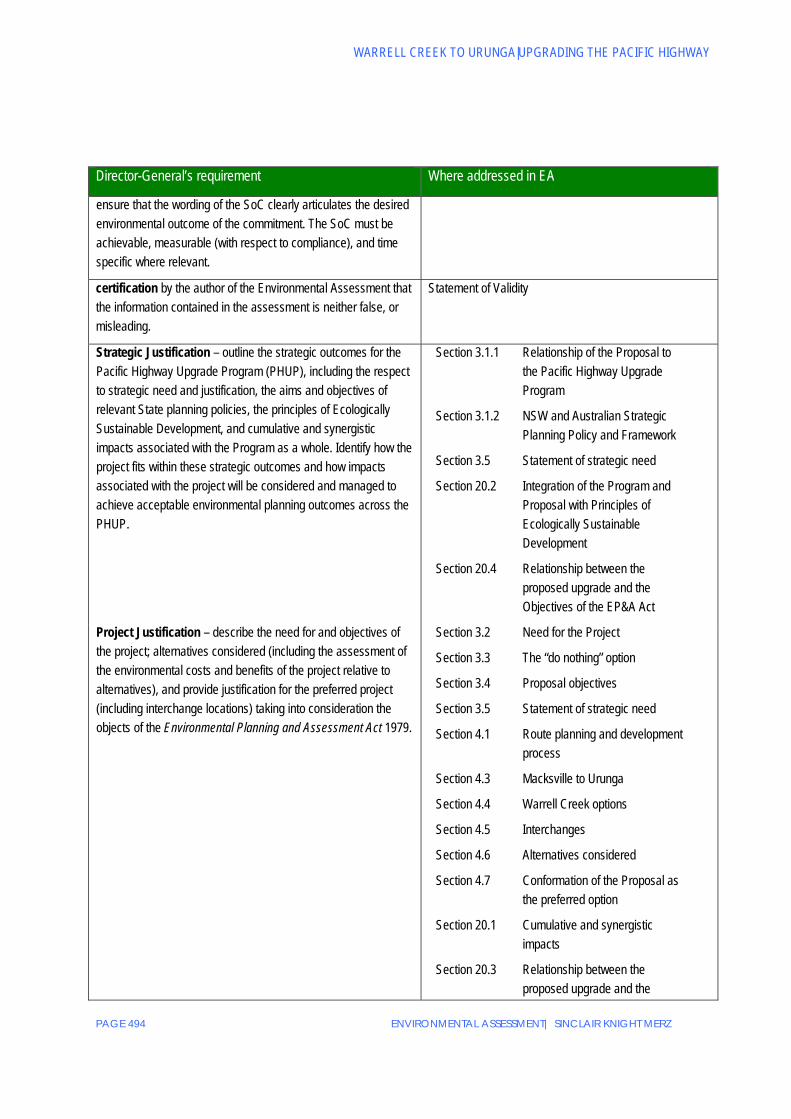
ensure that the wording of the SoC clearly articulates the desired environmental outcome of the commitment. The SoC must be achievable, measurable (with respect to compliance), and time specific where relevant.
certification by the author of the Environmental Assessment that the information contained in the assessment is neither false, or misleading.
Statement of Validity
Strategic Justification – outline the strategic outcomes for the Pacific Highway Upgrade Program (PHUP), including the respect to strategic need and justification, the aims and objectives of relevant State planning policies, the principles of Ecologically Sustainable Development, and cumulative and synergistic impacts associated with the Program as a whole. Identify how the project fits within these strategic outcomes and how impacts associated with the project will be considered and managed to achieve acceptable environmental planning outcomes across the PHUP.
Section 3.1.1 Relationship of the Proposal to the Pacific Highway Upgrade Program
Section 3.1.2 NSW and Australian Strategic Planning Policy and Framework
Section 3.5 Statement of strategic need
Section 20.2 Integration of the Program and Proposal with Principles of Ecologically Sustainable Development
Section 20.4 Relationship between the proposed upgrade and the Objectives of the EP&A Act
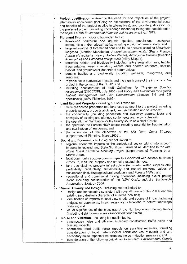
Project Justification – describe the need for and objectives of the project; alternatives considered (including the assessment of the environmental costs and benefits of the project relative to alternatives), and provide justification for the preferred project (including interchange locations) taking into consideration the objects of the Environmental Planning and Assessment Act 1979.
Section 3.2 Need for the Project
Section 3.3 The “do nothing” option
Section 3.4 Proposal objectives
Section 3.5 Statement of strategic need
Section 4.1 Route planning and development process
Section 4.3 Macksville to Urunga
Section 4.4 Warrell Creek options
Section 4.5 Interchanges
Section 4.6 Alternatives considered
Section 4.7 Conformation of the Proposal as the preferred option
Section 20.1 Cumulative and synergistic impacts
Section 20.3 Relationship between the proposed upgrade and the
ENVIRONMENTAL ASSESSMENT| SINCLAIR KNIGHT MERZ PAGE 495
APPENDICES
Director-General’s requirement Where addressed in EA
Objectives of the EP&A Act
Section 20.4 Conclusion
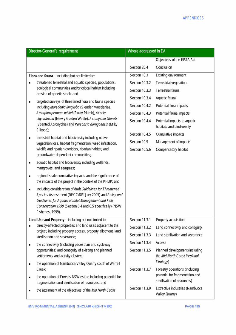
Flora and fauna – including but not limited to: threatened terrestrial and aquatic species, populations,
ecological communities and/or critical habitat including erosion of genetic stock; and
targeted surveys of threatened flora and fauna species including Marsdenia longiloba (Slender Marsdenia), Amorphospermum whitei (Rusty Plumb), Acacia chyrsotricha (Newry Golden Wattle), Acronychia littoralis (Scented Acronychia) and Parsonsia dorrigoensis (Milky Silkpod);
terrestrial habitat and biodiversity including native vegetation loss, habitat fragmentation, weed infestation, wildlife and riparian corridors, riparian habitat, and groundwater-dependant communities;
aquatic habitat and biodiversity including wetlands, mangroves, and seagrass;
regional scale cumulative impacts and the significance of the impacts of the project in the context of the PHUP; and
including consideration of draft Guidelines for Threatened Species Assessment (DECC/DPI July 2005) and Policy and Guidelines for Aquatic Habitat Management and Fish Conservation 1999 (Section 6.4 and 6.5 specifically) (NSW Fisheries, 1999).
Section 10.3 Existing environment
Section 10.3.2 Terrestrial vegetation
Section 10.3.3 Terrestrial fauna
Section 10.3.4 Aquatic fauna
Section 10.4.2 Potential flora impacts
Section 10.4.3 Potential fauna impacts
Section 10.4.4 Potential impacts to aquatic habitats and biodiversity
Section 10.4.5 Cumulative impacts
Section 10.5 Management of impacts
Section 10.5.6 Compensatory habitat
Land Use and Property – including but not limited to: directly-affected properties and land uses adjacent to the
project, including property access, property allotment, land sterilisation and severance;
the connectivity (including pedestrian and cycleway opportunities) and contiguity of existing and planned settlements and activity clusters;
the operation of Nambucca Valley Quarry south of Warrell Creek;
the operation of Forests NSW estate including potential for fragmentation and sterilisation of resources; and
the attainment of the objectives of the Mid North Coast
Section 11.3.1 Property acquisition
Section 11.3.2 Land connectivity and contiguity
Section 11.3.3 Land sterilisation and severance
Section 11.3.4 Access
Section 11.3.5 Planned development (including the Mid North Coast Regional Strategy)
Section 11.3.7 Forestry operations (including potential for fragmentation and sterilisation of resources)
Section 11.3.9 Extractive industries (Nambucca Valley Quarry)

WARRELL CREEK TO URUNGA|UPGRADING THE PACIFIC HIGHWAY
PAGE 496 ENVIRONMENTAL ASSESSMENT| SINCLAIR KNIGHT MERZ
Director-General’s requirement Where addressed in EA
Strategy (Department of Planning, March 2009).
Social and Economic - including but not limited to: regional economic impacts to the agricultural sector taking
into account impacts to regional and State significant farmland as identified in the Mid North Coast Farmland Mapping Project (Department of Planning et al. March 2009).
local community socio-economic impacts associated with access, business exposure, land use, property and amenity related changes;
land use viability, property infrastructure (i.e. sheds, water supplies etc), profitability, productivity, sustainability and natural resource values of businesses (including agricultural producers and Forests NSW).
recreational and commercial fishing operations including oyster priority areas including consideration of the NSW Oyster Industry Sustainable Aquaculture Strategy 2006.
Section 11.3.6 Agriculture Section 11.3.7 Forestry Section 12.3.1 Regional agricultural and
forestry impacts Section 12.3.2 Local community social and
economic impacts Section 12.3.2.7
Impacts on recreational and commercial fishing operations including oyster priority areas
Visual amenity and design – including but not limited to:
Design and landscaping consistent with overall design of the PHUP and the existing (and desired) character of affected localities;
identification of impacts to local view sheds and source of impact including bridges, embankments, interchange and alterations to natural landscape features; and.
visual significance of the crossings at the Nambucca and Kalang Rivers (including district views across associated floodplains).
Section 13.3 Impacts of landscapes and views
Section 13.3.4 Impacts on local view sheds Section13.3.6 Crossings of Nambucca and
Kalang Rivers Section13.4.1 Consistency with Pacific
Highway Upgrade Program guidelines
Noise and vibration – including but not limited to: construction noise and vibration including construction traffic
noise and blasting impacts;
Section 14.3.4 Construction noise and vibration Section 14.3.4.5
Blasting
Section 14.5 Construction assessment Section 14.5.1 Typical construction activities Section 14.5.3 Construction noise from mobile
activities Section 14.5.4 Noise and vibration from batch
plants, construction compounds and deliveries
Section 14.5.5 Construction vibration

ENVIRONMENTAL ASSESSMENT| SINCLAIR KNIGHT MERZ PAGE 497
APPENDICES
Director-General’s requirement Where addressed in EA
Section 14.5.6 Blasting
operational road traffic noise impacts including consideration of local meteorological conditions (as relevant) and any secondary noise impacts from proposed noise mitigation measures; and
Section 14.4 Operational noise assessment Section 14.4.4 Meteorological impact assessment Section 14.4.5 Secondary noise impacts
consideration of the following guidelines as relevant: Environmental Criteria for Road Traffic Noise (EPA 1999), Environmental Noise Management Manual (RTA 2001), Environmental Noise Control Manual (EPA 1994) and Assessing Vibration: A Technical Guideline (DEC, 2006).
Section 14.1 Assessment approach Section 14.3 Assessment criteria Section 14.4 Operational noise assessment Section 14.6 Identification of appropriate noise
mitigation
Aboriginal heritage – including but not limited to: Aboriginal cultural heritage values of the route, specifically on artefact, potential archaeological deposits and landscape cultural values (such as watercourses, spur lines and raised areas in floodplains) where relevant.
Section 15.2.2 Cultural heritage Section 15.2.3 Archaeological Heritage
Regional scale cumulative impacts and the significance of the impacts of the project in the context of the Pacific Highway Upgrade Program.
Section 15.3.3 Regional scale cumulative impacts
Section 15.3.4 Significance of impacts in the context of the Pacific Highway Upgrade Program
consideration of the draft Guidelines for Aboriginal Cultural Heritage Impact Assessment and Community Consultation (DEC, 2005).
Water – including but not limited to: Water way and wetland water quality taking into account impacts from both accidents and runoff and considering relevant environmental water quality criteria specific in the Australian and New Zealand Guidelines for Fresh and Marine Water Quality 2000.
Section 16.1.1 Water quality
Section 16.2.2 Surface water quality
Section 16.3.1 Construction stage (water quality
Section 16.3.2 Operational stage (water quality)
Groundwater contamination risk, groundwater use and groundwater users.
Section 1.1.1 Groundwater
Section 16.3.1 Construction stage (groundwater and contamination risk)
Section 16.3.2 Operational stage (groundwater and contamination risk)
Changes to existing flood regimes, in accordance with the Floodplain Development Manual (former Department of Natural Resources, 2005), including impacts to existing property and infrastructure and the future development potential of affected land.
Section 16.1.2 Flooding
Section 16.2.4 Flooding (existing conditions)
Section 16.3.1 Construction stage (flooding)
Section 16.3.2 Operational stage (flooding)
Traffic and transport – including but not limited to the following:
Operational traffic and transport impacts to the local, regional and fire trail networks (existing and planned) including impacts from traffic rerouting and modified access to the upgraded highway.
Section 17.2.1 Existing road network
Section 17.2.2 Planned road network
Section 17.3 Impact of future traffic growth

WARRELL CREEK TO URUNGA|UPGRADING THE PACIFIC HIGHWAY
PAGE 498 ENVIRONMENTAL ASSESSMENT| SINCLAIR KNIGHT MERZ
Director-General’s requirement Where addressed in EA
Public transport impacts (including on bus services).
Interactions with rail infrastructure and the viability of a shared road and rail corridor.
Construction traffic impacts (including spoil haulage).
on the existing road network
Section 17.4 Traffic and transport impacts
Section 17.4.1 Changes to the road network with the proposed upgrade (impacts from traffic rerouting)
Section 17.4.5 Impacts on local roads and modified access to the upgraded highway
Section 17.4.6 Impacts on fire trail network
Section 17.4.8 Impacts on public transport including bus services
Section 17.2.11 Interaction with rail infrastructure
Section 17.4.9 Construction traffic impacts
Soil and Fill – including but not limited to: Surface, geological and soil characteristics and the potential for soil contamination, soft soils and acid sulphate soils.
Section 16.3.2 Operational stage (potential water quality impacts)
Section 18.2.1 Topographical and terrain characteristics
Section 18.2.2 Geographical and soil characteristics
Section 18.2.3 Soft soils
Section 18.2.4 Contamination
Section 18.2.5 Acid sulphate soils
Section 18.2.6 Gumma Flat tidal wetland area
Section 18.3 Impact of changes to surface and subsurface conditions
Erosion and sedimentation control measures such as retention pond siting, with particular reference to the Gumma Flat tidal and wetland areas.
Section 18.2.6 Gumma Flat tidal wetland area (existing environment)
Section 18.3.5 Erosion and sedimentation (potential impacts)
Section 18.3.6 Gumma Flat tidal wetland area (potential impacts)
Section 18.4.1.2 Erosion and sedimentation (management of construction impacts)
ENVIRONMENTAL ASSESSMENT| SINCLAIR KNIGHT MERZ PAGE 499
APPENDICES
Director-General’s requirement Where addressed in EA
Section 18.4.2.1 Erosion and sedimentation (management of operational impacts)
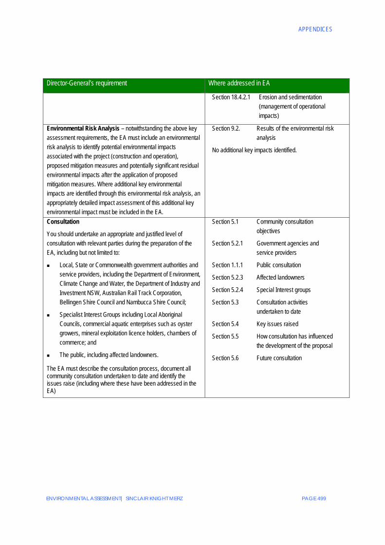
Environmental Risk Analysis – notwithstanding the above key assessment requirements, the EA must include an environmental risk analysis to identify potential environmental impacts associated with the project (construction and operation), proposed mitigation measures and potentially significant residual environmental impacts after the application of proposed mitigation measures. Where additional key environmental impacts are identified through this environmental risk analysis, an appropriately detailed impact assessment of this additional key environmental impact must be included in the EA.
Section 9.2. Results of the environmental risk analysis
No additional key impacts identified.
Consultation
You should undertake an appropriate and justified level of consultation with relevant parties during the preparation of the EA, including but not limited to:
Local, State or Commonwealth government authorities and service providers, including the Department of Environment, Climate Change and Water, the Department of Industry and Investment NSW, Australian Rail Track Corporation, Bellingen Shire Council and Nambucca Shire Council;
Specialist Interest Groups including Local Aboriginal Councils, commercial aquatic enterprises such as oyster growers, mineral exploitation licence holders, chambers of commerce; and
The public, including affected landowners.
The EA must describe the consultation process, document all community consultation undertaken to date and identify the issues raise (including where these have been addressed in the EA)
Section 5.1 Community consultation objectives
Section 5.2.1 Government agencies and service providers
Section 1.1.1 Public consultation
Section 5.2.3 Affected landowners
Section 5.2.4 Special Interest groups
Section 5.3 Consultation activities undertaken to date
Section 5.4 Key issues raised
Section 5.5 How consultation has influenced the development of the proposal
Section 5.6 Future consultation

WARRELL CREEK TO URUNGA|UPGRADING THE PACIFIC HIGHWAY
PAGE 500 ENVIRONMENTAL ASSESSMENT| SINCLAIR KNIGHT MERZ
This page is intentionally blank

ENVIRONMENTAL ASSESSMENT| SINCLAIR KNIGHT MERZ PAGE 501
APPENDICES
Appendix C Other issues raised checklist Issues Raised Environmental
assessment reference
Department of Planning
Negative impacts of bypasses on town business. Chapter 12
Impacts on noise and water quality.
Impacts on threatened species and their habitat.
Chapters 14 & 16
Chapter 10
Impact on Aboriginal cultural heritage values. Chapter 15
Avoidance and mitigation of impacts, or compensation for unavoidable impacts upon threatened species and Aboriginal cultural heritage.
Chapters 10 & 15
Impacts on biological, ecological and physical characteristics of estuarine and salt marshes. Chapter 10
Protection, rehabilitation and ongoing management of estuarine river banks, including mitigation of impacts on waterway stability to control erosion and sedimentation.
Chapters 10 & 18
Flooding impacts on land, infrastructure and assets during and post development. Chapter 16
Methods used to address acid sulphate soils when found. Chapter 18
Consultation with others undertaking natural resource management projects in the area. Chapter 5
Department of Environment and Climate Change (now part of the Department of Environment, Climate Change and Water)
Existing acoustic environment should be assessed and reported with reference to the relevant sections of the DECC Guidelines ‘Environmental Criteria for Road Traffic Noise’ (ECRTN) and the NSW Industrial Noise Policy.
Chapter 14
Assessment of predicted operational noise impacts of Proposal in accordance with ECRTN and RTA’s Environmental Noise Management Manual (ENMM).
Chapter 14
The Proposal will result in significant noise impacts for rural residential areas including those located in the vicinity of Donnellyville, Bald Hill Road, Letitia Close/Mattick Road, Old Coast Road, Florence Wilmont Drive, East West Road, South Arm Road, Short Cut Road and Ridgewood Drive. The environmental assessment should place particular emphasis on these locations with the aim of incorporating operational noise mitigation measures into the design of the highway.
Chapter 14
Location of sensitive receivers (such as schools, residences or hospitals for example) should be clearly identified on any diagrams provided by the NAR.
Chapter 14
Criteria used to develop the proposed mitigation measures to control noise, vibration and blasting impacts caused by construction activities and associated traffic should be included in the NAR. The NAR should provide details of measures proposed to mitigate noise and vibration in relation to construction and blasting activities.
Chapter 14
Assess the requirement for, and feasibility of, implementing operation stage noise mitigation Chapter 14

WARRELL CREEK TO URUNGA|UPGRADING THE PACIFIC HIGHWAY
PAGE 502 ENVIRONMENTAL ASSESSMENT| SINCLAIR KNIGHT MERZ
Issues Raised Environmental assessment reference
measures prior to commencement of construction to provide a construction stage benefit, particularly for those rural residential areas listed above, and for those residences on Gumma Road, adjacent to the Nambucca River Bridge.
Impacts of the Proposal on watercourses along the road corridor should be assessed. Chapters 10 & 16
Ambient water quality conditions and the impact of the Proposal on SEPP 14 wetlands (#388, 353 and 351) should be assessed with reference to the National Water Quality Management Strategy (ANZECC, 2000) and River Flow and Water Quality Objectives.
Chapter 16
Identification of the number and types of bridges and culverts for the Proposal. Should consider whether structures are to be placed in the watercourse and demonstrate how construction and operation stage impacts will be mitigated.
Chapters 6 & 10
Description of any potential changes to flooding and drainage patterns arising from the Proposal. Chapter 16
Assessment of the presence of ASS on the site and determine the likelihood of the Proposal’s construction processes disturbing ASS and appropriate measure that will be implemented to mitigate these impacts. This assessment should be conducted in accordance with the Acid Sulphate Soils Manual (ASSMAC, 1998).
Chapter 18
Details of stormwater management with particular regard to soil dispersability (including imported fill), operational spill containment measure and approximate locations of temporary sediment basins.
Chapters 6 & 16
Water usage requirements and potential supply sources of the construction stage of the Proposal and wastewater re-use opportunities should be considered.
Chapter 7
Threatened biodiversity field surveys and assessments following steps listed in NSW Threatened Species Survey and Assessment Guidelines: June 2006, should be carried under seasonal and climatic conditions, specifically within the preferred route corridor.
Detailed analysis of up-to-date biodiversity study data for the study area.
Chapter 10
Describe, quantify and address likely direct and indirect impacts associated with the project to threatened biodiversity, their habitats and native vegetation distribution, including cumulative impacts and a qualitative and quantitative landscape impact assessment.
Chapter 10
Where biodiversity impacts and unable to be demonstrably mitigated or avoided, these should be described and quantified to determine the extent to which compensatory habitat or other offsets will be required. Consideration should be given to applying the DECC Biobanking Credit Calculator.
Chapter 10
Identify whether the Proposal constitute Key Threatening Processes (KTPs) listed under the TSC Act. Where KTPs are identified, relevant threat abatement measures proposed to be implemented are required.
Chapter 10
Describe objectives and assess the feasibility of implementing appropriate flora and fauna mitigation measures during construction and operation, including nature and extent of expected
Chapter 10

ENVIRONMENTAL ASSESSMENT| SINCLAIR KNIGHT MERZ PAGE 503
APPENDICES
Issues Raised Environmental assessment reference
impacts.
Where appropriate and feasible mitigation measures are identified, environmental assessment should define and commit to measure to ensure impacts to threatened species and biodiversity are managed in accordance with current environmental best practice. Where fauna crossing structures are proposed, the environmental assessment must consider the suitability of such structures by gaining a thorough understanding of pre-development threatened fauna population dynamics including a habitat assessment of the adjacent landscape. Any proposed mitigation measures should be evaluated against a clearly defined and measurable goal.
Chapters 6 & 10
Flora survey work needs to target Marsdenia longiloba (Slender Marsdenia), Amorphospermum whitei (Rusty Plumb), Aciacia chrysotricha (Newry Golden Wattle), Achronychia littoralis (Scented Acronychia), Parsonia dorrigoensis (Milky Silkpod) and any additional threatened flora species known or predicted to occur along the Proposal.
Chapters 6 & 10
Evaluate direct and indirect impacts to EECs including Swamp Sclerophyll Forest on Coastal Floodplains, Freshwater Wetlands on Coastal Floodplains, River-Flat Eucalypt Forest on Coastal Floodplains, Subtropical Coastal Floodplain Forest, and Swamp Oak Floodplain Forest. These contain indigenous plant and animal assemblages that are generally poorly conserved in the region and are subject to further fragmentation and erosion of genetic stock. Must evaluate and proposed mitigation measures for EECs.
Chapter 10
Determine direct and indirect impacts and mitigation measures for SEPP 14 wetlands through alteration of hydrological regimes, particularly near Gumma Swamp south of Nambucca River, Newee Creek, Deep Creek complex near Boggy and Cow Creeks, and wetlands west of Urunga and Newry Island. Evaluate impacts of altered hydrological regimes on EECs associated with SEPP 14 wetlands.
Chapter 16
Address how the RTA has met the information, survey and consultation requirements as set out in the draft Guidelines for Aboriginal Cultural Heritage Impact Assessment and Community Consultation.
Chapter 15
Identify nature and extent of impacts on Aboriginal cultural heritage values across Proposal. Direct and indirect impacts on the Proposal and document the number, nature and significance of Aboriginal site to be impacted including consideration of impacts resulting from ancillary activities and infrastructure.
Chapter 15
Aboriginal cultural values should be assessed in consultation with the Aboriginal community and determine appropriate mitigation measures to offset or avoid these impacts for incorporation in concept designs and future environmental management plans.
Chapter 15
Describe actions that will be (or have been) taken to avoid or mitigate impacts on Aboriginal cultural heritage values during construction and operation of the Proposal. Describe activities and actions which will be undertaken and any agreements made with the Aboriginal community and DECC, which will attempt to compensate for unavoidable impacts of the Proposal on Aboriginal cultural values. This should include an assessment of likely effectiveness and reliability of the
Chapter 15

WARRELL CREEK TO URUNGA|UPGRADING THE PACIFIC HIGHWAY
PAGE 504 ENVIRONMENTAL ASSESSMENT| SINCLAIR KNIGHT MERZ
Issues Raised Environmental assessment reference
measures proposed and any residual impacts after these measures are implemented.
Demonstrate that effective Aboriginal community consultation has been undertaken in determining and assessing impacts, developing options, determining Aboriginal site management and salvage requirements and making final recommendations.
Chapters 5 & 15
Bellingen Shire Council
Improved access to the south of Urunga to avoid isolation of the Urunga township.
Consider threatened species habitat located north of the Kalang River and south of the Short Cut Road.
Noise mitigation measures to land adjacent to and either side of Short Cut Road, zoned Rural 1 (c1) Rural Residential.
Minimisation of environmental and visual impact of highway between Raleigh and Raleigh Industrial estate, within 7(s) Special emphasis zone, on surrounding forest.
Design for dual carriageway at South Arm Road will need to ensure that there is no change to flood effects for this section of road.
Provision will need to be made to enable convenient pavement rehabilitation of the section of road under the dual carriageway at South Arm Road.
Extensive sections of the existing highway will be used as local access roads (such as bridge over Kalang River). Consideration of options required as ongoing maintenance will impose significant additional cost burden on Council.
Assessment of south bound exit at the Raleigh deviation to ensure that traffic does not back up the south bound carriageway.
The Proposal should be referred to the Rural Fire Service to assess whether there are any adverse impacts on fire trails.
Provision of new Rest Area / Visitor Information Centre at Waterfall Way Interchange to replace existing facility.
Chapters 4 & 6
Chapter 10
Chapter 14
Chapter 13
Chapter 16
Chapter 6
Chapter 6
Chapter 4 & 6
Chapter 5 & 6
Chapter 4 & 6
Nambucca Shire Council
Impact on local infrastructure and access to local towns
Access to Valla, Boggy Creek and Cow Creek urban release areas.
Chapters 4 & 12
State Emergency Services (now part of the Department of Police and Emergency Services)
Access for emergency vehicles on to and off the highway. Chapters 6 & 12

ENVIRONMENTAL ASSESSMENT| SINCLAIR KNIGHT MERZ PAGE 505
APPENDICES
Issues Raised Environmental assessment reference
Department of Primary Industries (Forests NSW)
(now part of the Department of Industry and Investment)
Loss of productive land for timber production and impact on local forest agreements.
Impact on productive native forests, plantation estates, and conservation areas (as Special Management Areas established under s21A Forestry Act).
Impacts on State Forest access, including the effect upon local road and forest roads during and post construction.
Severance of roads and fire trails, therefore alternate road and fire management needs to be addressed.
Parts of the areas have a high wildfire frequency and the assessment should consider the impact of the proposed upgrade on fire management in bush fire prone areas, particularly in relation to access.
Chapter 12
Chapter 12
Chapter 12
Chapter 12
Chapter 12
Department of Primary Industries (Fishing and Aquaculture) (now part of the Department of Industry and Investment)
Potential impacts on SEPP14 wetlands.
Impacts on aquacultures.
Number of waterways and the ability to construct structures over these waterways.
Impact on marine vegetation including mangroves, sea grass and salt marsh. Any impact on marine vegetation will need to be address through compensatory habitat.
Proposed width of the alignment including predicted temporary crossings and haulage routes to identify footprint over waterways and their impacts on aquatic vegetation.
Potential staging or timing of works (to consider migratory fish movements).
Provide description of temporary or permanent sediment retention ponds adjacent to waterways.
The environmental assessment should capture the area known as Gumma Flat where low lying tidal flats and wet lands are identified as potential acid sulphate soils conducive to the production of iron sulphides. This may result in acid run off during earth moving works and a poor outcome for water quality.
The environmental assessment should include that the impact of acid water is directly linked to red spot disease in fish and high mortality in oysters. Water-flows from the proposed alignment form a direct link to Gumma Creek which confluences with Nambucca River just upstream of commercial oyster growing leases.
Detailed risk assessment of all potential impacts to fish habitat during and after works. Include consideration of impacts on the oyster industry, commercial fisheries, and any recreational fishery issues.
Description of measures and initiatives to avoid, minimise, manage and mitigate impacts of the
Chapters 4 & 10
Chapters 5 & 12
Chapter 6
Chapter 10
Chapters 6 & 10
Chapter 7
Chapter 6
Chapter 16
Chapter 10
Chapter 9 Chapters 8 & 10

WARRELL CREEK TO URUNGA|UPGRADING THE PACIFIC HIGHWAY
PAGE 506 ENVIRONMENTAL ASSESSMENT| SINCLAIR KNIGHT MERZ
Issues Raised Environmental assessment reference
project to waterways and fish habitat.
Department of Primary Industries (Minerals) (now part of the Department of Industry and Investment)
Consultation with operators of the Nambucca Valley Quarry and assessment of risks associated with blasting is recommended.
Chapter 5
Department of Primary Industries (Agriculture) (now part of the Department of Industry and Investment)
Property dislocation and machinery access. Chapters 6 & 12
Department of Primary Industries (North Coast Region) (now part of the Department of Industry and Investment)
The Draft Mid North Coast Regional Strategy should be addressed in the environmental assessment.
Chapter 3
Department of Water and Energy
(now part of the Department of Environmental, Climate Change and Water)
If extraction of water from a surface water source or the course of a river is changed, a permit or licence is required under Part 2 of the Water Act 1912.
If the Proposal is in a gazetted Water Sharing Plan (under provisions of the Water Management Act 2000), approval requirements may be satisfied under the Act.
Address the decommissioning of bores in accordance with Chapter 18 of Minimum Construction Requirements for Water Bores in Australia, Edition 2 Revised September, 2003.
Details of any proposed works likely to intercept groundwater.
Details of any proposed groundwater extraction and use.
Details of proposed method of disposal of any water extracted and approval from the relevant approval authority.
Details of any existing bores on the development site and in the immediate vicinity.
Details of the existing groundwater users (including the natural environment) within the area of the proposed development and any potential impacts on these users.
Management strategy to deal with potential impact on groundwater with the disturbance of acid sulphate soils.
Details on protective measures for groundwater dependent ecosystems.
Details to prevent groundwater pollution, so that future remediation is not required.
Monitoring program for assessment on groundwater.
Contingency plans linked to the groundwater monitoring program.
Chapter 2
Chapter 2
Chapter 16
Chapter 16
Chapter 16
Chapter 16
Chapter 16
Chapter 16
Chapter 16
Chapter 10
Chapter 16
Chapter 16
Chapter 16

ENVIRONMENTAL ASSESSMENT| SINCLAIR KNIGHT MERZ PAGE 507
APPENDICES
Issues Raised Environmental assessment reference
Australian Rail and Track Corporation
Alternatives to road transport.
Construction method for railway crossings.
Chapter 3
Chapter 17
Heritage Council
Assessment of heritage significance of identified sites and any impacts upon heritage sites, including those of Aboriginal, historic or archaeological significance. Also consideration of wider heritage impacts in areas surrounding the Proposal.
Lists maintained by the National Trust under the EPBC Act and the local council should be reviewed to determine areas of historical significance which may be affected by Proposal.
Non-Aboriginal heritage items within the study area affected by the Proposal should be identified by field survey. A statement of significance and an assessment of the impact of the Proposal on the heritage significance of these items should be undertaken. Measures to conserve their heritage significance should be identified.
The field survey and assessment should be undertaken by a qualified practitioner/consultant with historic sites experience.
Where it is likely that the project will impact on Aboriginal heritage, adequate community consultation should take place regarding the assessment of significance, likely impacts and management/mitigation measures.
Chapters 15 & 19
Chapter 19
Chapter 19
Chapters 15 & 19
Chapter 15
Ministry of Transport (now part of the Department of Transport and Infrastructure)
Potential for disruption of existing school bus services during construction.
Opportunity for provision of cycle way connections along the highway and to adjoining communities.
Chapters 6 & 12
Chapter 6
Maritime NSW
Identified the necessary vertical and horizontal clearances required on the Nambucca and Bellingen River bridges to ensure adequate clearances for river vessels.
Chapter 12
Coffs Harbour Local Aboriginal Land Council
Management of Aboriginal artefacts. Chapter 15
Nambucca Head Local Aboriginal Land Council
Methodology for investigation of Cow Creek Aboriginal Reserve. Chapter 15

WARRELL CREEK TO URUNGA|UPGRADING THE PACIFIC HIGHWAY
PAGE 508 ENVIRONMENTAL ASSESSMENT| SINCLAIR KNIGHT MERZ

ENVIRONMENTAL ASSESSMENT| SINCLAIR KNIGHT MERZ PAGE 509
APPENDICES
Appendix D Draft Statement of Commitments This appendix outlines the Draft Statement of Commitments proposed by the RTA to avoid, minimise, manage, mitigate or offset and/or monitor impacts identified in the environmental assessment.
Director-General’s requirements Where addressed A Draft Statement of Commitments (SoC)
The SoC must incorporate or otherwise capture all measures to avoid, minimise, manage, mitigate, offset or monitor impacts identified in the impact assessment sections of the EA and ensure that the wording of the SoC clearly articulates the desired environmental outcome of the commitment. The SoC must be achievable, measurable (with respect to compliance), and time specific where relevant.
Appendix D
The Draft Statement of Commitments includes:
The desired environmental outcomes for the Proposal.
Key actions to be undertaken to achieve the outcomes.
Reference to the timing of the actions.
Reference documents influencing the outcomes and implementation of the commitment.
The Draft Statement of Commitments specifies certain environmental outcomes to be achieved. Greater detail as to how those outcomes would be achieved is provided in the mitigation and management measures in Chapters 10 to 19. The Draft Statement of Commitments is presented in a format that is readily auditable and transparent.
The Director-General of the Department of Planning may require the Draft Statement of Commitments to be revised in response to submissions to the environmental assessment and/or for changes to the Proposal to minimise environmental impacts. The revised Statement of Commitments would be included in the submissions report prepared to respond to issues raised in submissions.
WARRELL CREEK TO URUNGA|UPGRADING THE PACIFIC HIGHWAY
PAGE 510 ENVIRONMENTAL ASSESSMENT| SINCLAIR KNIGHT MERZ
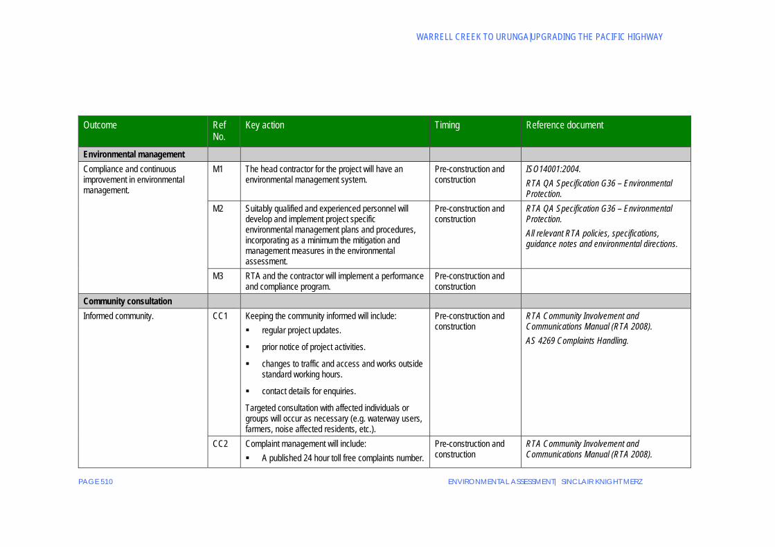
Outcome Ref No.
Key action Timing Reference document
Environmental management Compliance and continuous improvement in environmental management.
M1 The head contractor for the project will have an environmental management system.
Pre-construction and construction
ISO14001:2004. RTA QA Specification G36 – Environmental Protection.
M2 Suitably qualified and experienced personnel will develop and implement project specific environmental management plans and procedures, incorporating as a minimum the mitigation and management measures in the environmental assessment.
Pre-construction and construction
RTA QA Specification G36 – Environmental Protection. All relevant RTA policies, specifications, guidance notes and environmental directions.
M3 RTA and the contractor will implement a performance and compliance program.
Pre-construction and construction
Community consultation Informed community. CC1 Keeping the community informed will include:
regular project updates.
prior notice of project activities.
changes to traffic and access and works outside standard working hours.
contact details for enquiries.
Targeted consultation with affected individuals or groups will occur as necessary (e.g. waterway users, farmers, noise affected residents, etc.).
Pre-construction and construction
RTA Community Involvement and Communications Manual (RTA 2008). AS 4269 Complaints Handling.
CC2 Complaint management will include: A published 24 hour toll free complaints number.
Pre-construction and construction
RTA Community Involvement and Communications Manual (RTA 2008).

APPENDICES
ENVIRONMENTAL ASSESSMENT| SINCLAIR KNIGHT MERZ PAGE 511
Outcome Ref No.
Key action Timing Reference document
Directions on how to register a complaint.
Acknowledgment of complaints within eight working hours.
Complaint recording.
Tracking of complaints until resolution.
AS 4269 Complaints Handling.
Traffic and transport Minimise impacts on traffic. T1 Construction vehicle movements and work programs
will incorporate traffic control measures to minimise traffic and transport impacts on local roads and the existing Pacific Highway.
Pre-construction and construction
RTA Traffic Control at Work Sites (RTA 2003). RTA QA Specification G10 Control of Traffic. RTA Community Involvement and Communications Manual (RTA 2008).
T2 Any use of non-arterial roads by construction traffic will require the preparation of pre-construction and post-construction dilapidation reports, with copies to go to the relevant roads authority. Repair of any damage resulting from construction (normal wear and tear), will occur, unless there are alternative arrangements with the relevant roads authority.
Pre-construction and operation
RTA QA Specification G10 Control of Traffic.
Minimise impacts on local traffic movement, pedestrians and public transport.
T3 Construction vehicle movement arrangements will limit impacts on other road users (including pedestrians, vehicles, cyclists and disabled persons), having regard to other road works in the area, local traffic movement requirements, and peak traffic volumes, including those during long weekends and holiday periods.
Pre-construction and Construction
RTA Traffic Control at Work Sites. RTA QA Specification G10 Control of Traffic.
Maintaining access to private properties and state forest resources.
T4 Where the Proposal temporarily or permanently affects any legal property access, the provision of feasible and reasonable alternative access to an equivalent standard will be necessary, unless a property owner agrees to alternative arrangements.
Pre-construction, construction and operation
RTA Traffic Control at Work Sites. RTA QA Specification G10 Control of Traffic. Land Acquisition (Just Terms Compensation) Act 1991. RTA Land Acquisition Policy.
WARRELL CREEK TO URUNGA|UPGRADING THE PACIFIC HIGHWAY
PAGE 512 ENVIRONMENTAL ASSESSMENT| SINCLAIR KNIGHT MERZ
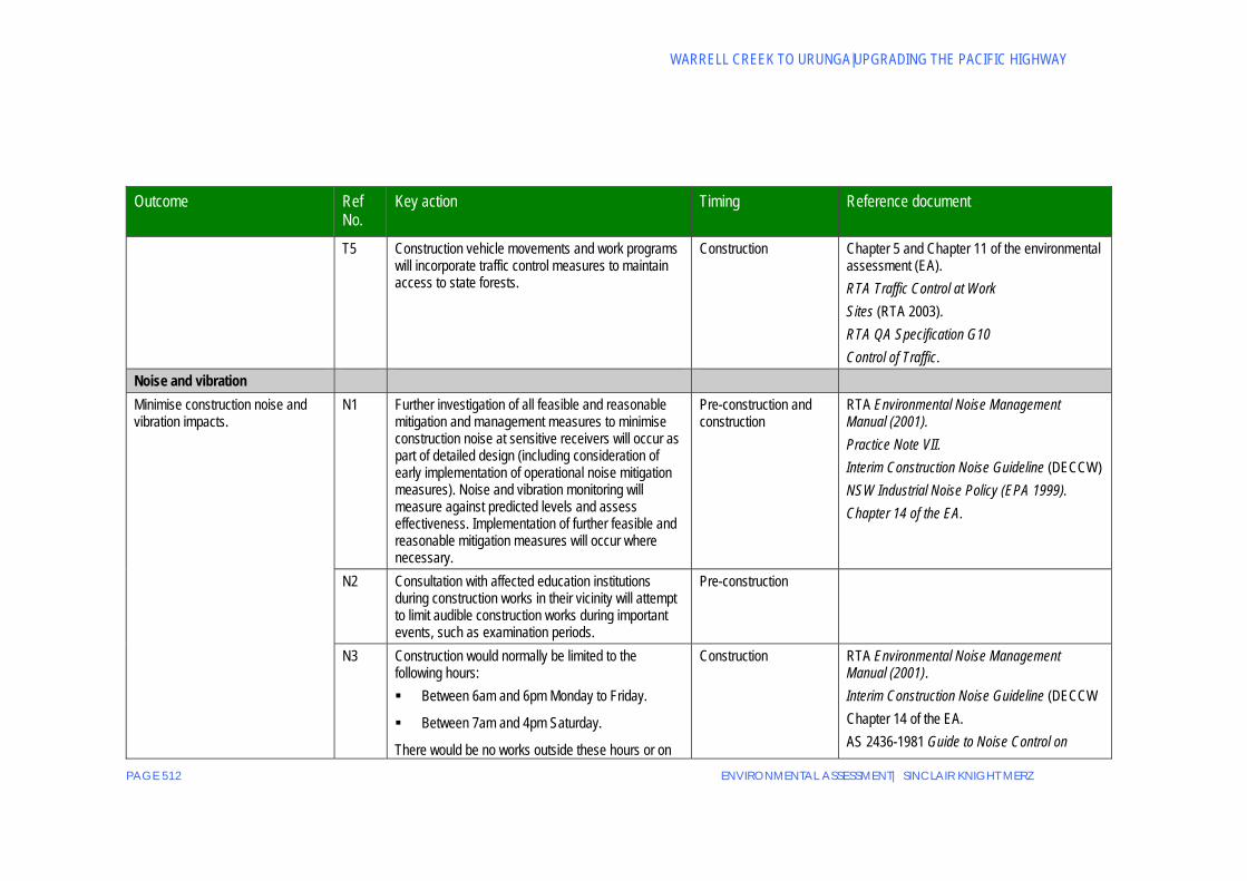
Outcome Ref No.
Key action Timing Reference document
T5 Construction vehicle movements and work programs will incorporate traffic control measures to maintain access to state forests.
Construction Chapter 5 and Chapter 11 of the environmental assessment (EA). RTA Traffic Control at Work Sites (RTA 2003). RTA QA Specification G10 Control of Traffic.
Noise and vibration Minimise construction noise and vibration impacts.
N1 Further investigation of all feasible and reasonable mitigation and management measures to minimise construction noise at sensitive receivers will occur as part of detailed design (including consideration of early implementation of operational noise mitigation measures). Noise and vibration monitoring will measure against predicted levels and assess effectiveness. Implementation of further feasible and reasonable mitigation measures will occur where necessary.
Pre-construction and construction
RTA Environmental Noise Management Manual (2001). Practice Note VII. Interim Construction Noise Guideline (DECCW) NSW Industrial Noise Policy (EPA 1999). Chapter 14 of the EA.
N2 Consultation with affected education institutions during construction works in their vicinity will attempt to limit audible construction works during important events, such as examination periods.
Pre-construction
N3 Construction would normally be limited to the following hours: Between 6am and 6pm Monday to Friday.
Between 7am and 4pm Saturday.
There would be no works outside these hours or on
Construction RTA Environmental Noise Management Manual (2001). Interim Construction Noise Guideline (DECCW Chapter 14 of the EA. AS 2436-1981 Guide to Noise Control on

APPENDICES
ENVIRONMENTAL ASSESSMENT| SINCLAIR KNIGHT MERZ PAGE 513
Outcome Ref No.
Key action Timing Reference document
Sundays or public holidays except: a) Works that do not cause construction noise
to be audible at any sensitive receivers.
b) For the delivery of materials required outside these hours by the Police or other authorities for safety reasons.
c) Where it is required in an emergency to avoid the loss of lives, property and/or to prevent environmental harm.
d) Any other work as agreed through negotiations between the RTA and potentially affected sensitive receivers. Any such agreement must be recorded in writing and a copy kept on site for the duration of the works.
e) Where the work is identified in the CNVMP and approved as part of the Construction Environmental Management Plan.
f) As agreed by DoP and the DECCW.
Local residents and the DECCW must be informed of the timing and duration of work approved under items (d) and (e) at least 48 hours before that work commences.
Construction, Maintenance and Demolition Sites.

WARRELL CREEK TO URUNGA|UPGRADING THE PACIFIC HIGHWAY
PAGE 514 ENVIRONMENTAL ASSESSMENT| SINCLAIR KNIGHT MERZ
Outcome Ref No.
Key action Timing Reference document
N4 All reasonable attempts will be made to contact sensitive receivers located within 500 metres of a blast location. The contact will be at least 48 hours before a blast and will include a schedule of blast time(s), and a telephone contact name and number.
Construction Technical Basis for Guidelines to Minimise Annoyance due to Blasting Overpressure and Ground Vibration (ANZECC). German Standard DIN 4150 Part 3 Structural Vibration in Buildings (Effects on Structures). Assessing Vibration: A Technical Guideline NSW DECC (2006). RTA Community Involvement and Communications Manual (RTA 2008).
Management of operational noise and vibration.
N5 Confirmation of all feasible and reasonable mitigation and management measures to minimise operational noise at sensitive receivers will occur as part of detailed design. Implementation of the measures would occur as construction proceeds.
Pre-construction and construction
Section 14.6 of the EA. NSW Government’s Environmental Criteria for Road Traffic Noise. RTA’s Environmental Noise Management Manual.
N6 Monitoring of operational noise will continue for one year after completion of construction. If monitoring indicates a clear trend that traffic noise levels exceed those predicted, investigation of all further feasible and reasonable management measures will occur. Consultation with a suitably qualified and experienced acoustic specialist and the affected property owner will be necessary during the development of any additional mitigation measures.
Operation NSW Government’s Environmental Criteria for Road Traffic Noise. RTA’s Environmental Noise Management Manual.
Flora and fauna Minimise impacts on flora and fauna.
F1 Clearing of native vegetation (including endangered ecological communities (EECs)) will be restricted to the minimum area necessary for construction.
Pre-construction and construction
Chapter 10 of the EA.

APPENDICES
ENVIRONMENTAL ASSESSMENT| SINCLAIR KNIGHT MERZ PAGE 515
Outcome Ref No.
Key action Timing Reference document
F2 A qualified ecologist will identify any vegetation (including Marsdenia longiloba) to be retained and to be clearly delineated on work plans within the construction corridor. Erection of flagging/fencing on-site prior to any construction works, which is to remain in place for the full construction period, will clearly delineate this vegetation.
Pre-construction and construction
Chapter 10 of the EA. DECC (2004) Threatened species survey and assessment: Guidelines for developments and activities (working draft). Australian Network for Plant Conservation 2004 guidelines.
F3 Site induction of construction workers will inform and instruct them of vegetation to be retained.
Pre-construction and construction
DECC (2004) Threatened species survey and assessment: Guidelines for developments and activities (working draft).
F4 Plantings of rusty plum (Amorphospermum whitei) in areas of suitable habitat adjacent to the Proposal will follow from seed collection and propagation.
Pre-construction Australian Network for Plant Conservation 2004 guidelines.
Maintain fauna habitat and connectivity.
F5 A suitably qualified ecologist will undertake pre-clearance surveys. Searches will include nests and hollow bearing trees. Re-location of fauna species at risk of injury found in pre-clearance surveys or during construction will be in suitable habitat as close as possible to the area in which they were found. Immediately prior to clearing an inspection will confirm that the sites subject to pre-clearance surveys remain free of fauna.
Pre construction and construction
National Parks and Wildlife Act 1979. RTA QA Specification G36 Environmental Protection.
F6 Where feasible and reasonable the identification and distribution of natural and artificial habitat features and resources (such as hollow-bearing trees, hollow logs, nest boxes and bush rocks) will occur along the Proposal. This relocation will limit injury to fauna and damage to existing vegetation.
Pre construction and construction
Section 10.5 of the EA. Australian Network for Plant Conservation 2004 guidelines.
F7 Retention of mature trees in the median at locations identified in the EA will provide a stepping stone for gliders. Protection of these trees will occur (F2), and lopping and pruning is not to occur without expert advice.
Pre-construction and construction
Table 10-12 of the EA.

WARRELL CREEK TO URUNGA|UPGRADING THE PACIFIC HIGHWAY
PAGE 516 ENVIRONMENTAL ASSESSMENT| SINCLAIR KNIGHT MERZ
Outcome Ref No.
Key action Timing Reference document
F8 Provision of fauna crossings will be as identified in the environmental assessment
Pre-construction Table 10-11 of the EA.
Minimise adverse impacts on aquatic habitat and fish species.
F9 Design and construction of waterway crossings will be in accordance with the fish habitat classification of each waterway and in consultation with the Department of Industry and Investment.
Pre-construction Fishnote: Policy and Guidelines for Fish Friendly Waterway Crossings (NSW Fisheries). Policy and Guidelines for Design and Construction of Bridges, Roads, Causeways, Culverts and Similar Structures (NSW Fisheries 1999). Fish Passage Requirements for Waterway Crossings (Fairfull and Witheridge 2003).
Minimise fauna road injuries and mortalities during operation.
F10 Erection of fauna exclusion fencing (e.g. floppy-top fencing) along the Proposal at appropriate locations will direct fauna movement towards fauna-crossing structures.
Construction and Operation
Figure 10-6 to 10-9 of the environmental assessment.
Offset residual impacts of the Proposal on key habitat.
F11 Development of an offset agreement will occur in consultation with the Department of Environment, Climate Change and Water.
Pre-construction and construction
RTA Compensatory Habitat Policy and Guideline (draft).
Effective flora and fauna management and mitigation measures.
F12 Monitoring and assessment of the effectiveness of fauna and flora mitigation measures will be for a minimum period of 12 months after completion of construction. This would include the use of any required additional feasible and reasonable mitigation and management measures.
Operation Section 10.5.11 of the EA.
F13 The RTA will set bed levels for culverts and ledges for combined fauna passage in consultation with the Department of Environment, Climate Change and Water.
Pre-construction and construction
Section 10.4.3 of the EA
APPENDICES
ENVIRONMENTAL ASSESSMENT| SINCLAIR KNIGHT MERZ PAGE 517
Outcome Ref No.
Key action Timing Reference document
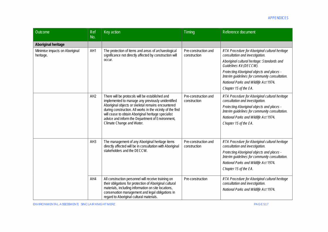
Aboriginal heritage Minimise impacts on Aboriginal heritage.
AH1 The protection of items and areas of archaeological significance not directly affected by construction will occur.
Pre-construction and construction
RTA Procedure for Aboriginal cultural heritage consultation and investigation. Aboriginal cultural heritage: Standards and Guidelines Kit (DECCW). Protecting Aboriginal objects and places - Interim guidelines for community consultation. National Parks and Wildlife Act 1974. Chapter 15 of the EA.
AH2 There will be protocols will be established and implemented to manage any previously unidentified Aboriginal objects or skeletal remains encountered during construction. All works in the vicinity of the find will cease to obtain Aboriginal heritage specialist advice and inform the Department of Environment, Climate Change and Water.
Pre-construction and construction
RTA Procedure for Aboriginal cultural heritage consultation and investigation. Protecting Aboriginal objects and places - Interim guidelines for community consultation. National Parks and Wildlife Act 1974. Chapter 15 of the EA.
AH3 The management of any Aboriginal heritage items directly affected will be in consultation with Aboriginal stakeholders and the DECCW.
Pre-construction and construction
RTA Procedure for Aboriginal cultural heritage consultation and investigation. Protecting Aboriginal objects and places - Interim guidelines for community consultation. National Parks and Wildlife Act 1974. Chapter 15 of the EA.
AH4 All construction personnel will receive training on their obligations for protection of Aboriginal cultural materials, including information on site locations, conservation management and legal obligations in regard to Aboriginal cultural materials.
Pre-construction RTA Procedure for Aboriginal cultural heritage consultation and investigation. National Parks and Wildlife Act 1974.

WARRELL CREEK TO URUNGA|UPGRADING THE PACIFIC HIGHWAY
PAGE 518 ENVIRONMENTAL ASSESSMENT| SINCLAIR KNIGHT MERZ
Outcome Ref No.
Key action Timing Reference document
Aboriginal participation will be on-going.
AH5 The RTA will comply with the NSW Government’s Aboriginal Participation in Construction Guidelines.
Pre-construction and construction
RTA Procedure for Aboriginal cultural heritage consultation and investigation. NSW Government’s Aboriginal Participation in Construction Guidelines (2007).
Non-Aboriginal heritage Minimise impacts on non-Aboriginal heritage.
NH1 The detailed design will minimise impacts to identified non-Aboriginal heritage items where feasible and reasonable.
Pre-construction Heritage Act 1977. Section 19.3 of the EA.
NH2 If any material of potential archaeological significance is unearthed, work will cease to obtain specialist heritage advice.
Pre-construction and construction
Heritage Act 1977. Section 19.3 of the EA.
NH3 Preparation of archival and photographic records for impacted heritage items would be in accordance with relevant guidelines.
Pre-construction NSW Heritage Branch Guidelines: How to Prepare Archival Recording of Heritage Items (1998). Photographic Recording of Heritage Items Using Film or Digital Capture (2006). Heritage Act 1977. Section 19.3 of the EA.
Water quality and hydrology Erosion and sediment controls are effective.
W1 Minimisation of the area of soil exposure during construction.
Construction RTA QA Specification G40 Clearing and Grubbing.
W2 Detailed design will further investigate any additional feasible and reasonable mitigation and management measures to minimise construction erosion and sedimentation.
Pre- construction Managing Urban Stormwater – Soils and Construction”, the RTA’s “Guidelines for the Control of Erosion and Sedimentation in Roadworks” and the Department of Planning’s “Constructed Wetlands Manual”.
APPENDICES
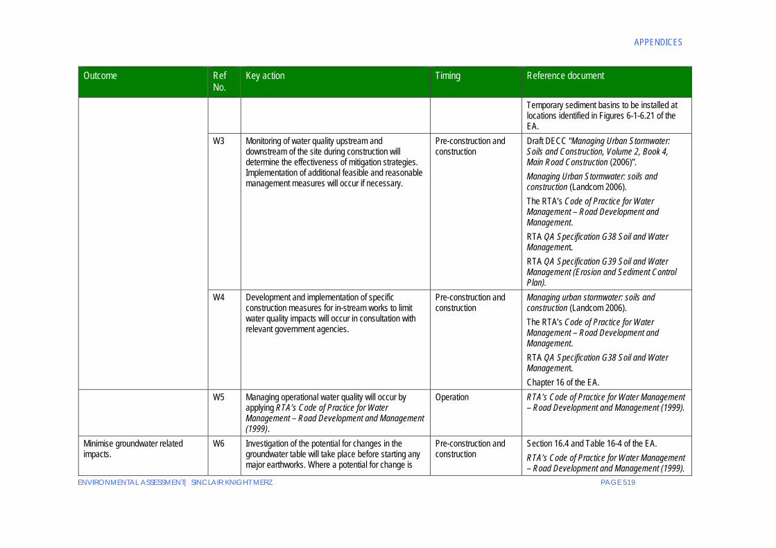
ENVIRONMENTAL ASSESSMENT| SINCLAIR KNIGHT MERZ PAGE 519
Outcome Ref No.
Key action Timing Reference document
Temporary sediment basins to be installed at locations identified in Figures 6-1-6.21 of the EA.
W3 Monitoring of water quality upstream and downstream of the site during construction will determine the effectiveness of mitigation strategies. Implementation of additional feasible and reasonable management measures will occur if necessary.
Pre-construction and construction
Draft DECC “Managing Urban Stormwater: Soils and Construction, Volume 2, Book 4, Main Road Construction (2006)”. Managing Urban Stormwater: soils and construction (Landcom 2006). The RTA’s Code of Practice for Water Management – Road Development and Management. RTA QA Specification G38 Soil and Water Management. RTA QA Specification G39 Soil and Water Management (Erosion and Sediment Control Plan).
W4 Development and implementation of specific construction measures for in-stream works to limit water quality impacts will occur in consultation with relevant government agencies.
Pre-construction and construction
Managing urban stormwater: soils and construction (Landcom 2006). The RTA’s Code of Practice for Water Management – Road Development and Management. RTA QA Specification G38 Soil and Water Management. Chapter 16 of the EA.
W5 Managing operational water quality will occur by applying RTA’s Code of Practice for Water Management – Road Development and Management (1999).
Operation RTA’s Code of Practice for Water Management – Road Development and Management (1999).
Minimise groundwater related impacts.
W6 Investigation of the potential for changes in the groundwater table will take place before starting any major earthworks. Where a potential for change is
Pre-construction and construction
Section 16.4 and Table 16-4 of the EA. RTA’s Code of Practice for Water Management – Road Development and Management (1999).

WARRELL CREEK TO URUNGA|UPGRADING THE PACIFIC HIGHWAY
PAGE 520 ENVIRONMENTAL ASSESSMENT| SINCLAIR KNIGHT MERZ
Outcome Ref No.
Key action Timing Reference document
identified, the significance of the change and any resultant impacts will be determined and measures to manage the changes will be designed and implemented as necessary.
RTA QA Specification G38 Soil and Water Management.
Soils and fill Minimise impact of exposing acid sulphate soil.
S1 Identification and management of Acid Sulphate Soils will be in accordance with the Guidelines for the Management of Acid Sulphate materials: Acid Sulphate Soils, Acid Sulphate Rock and Monosulphidic Black Ooze (RTA 2005).
Pre-construction and construction
Guidelines for the Management of Acid Sulphate materials: Acid Sulphate Soils, Acid Sulphate Rock and Monosulphidic Black Ooze (RTA 2005). Acid Sulphate Soils Manual” (Acid Sulphate Soil Management Advisory Committee 1998).
Protection of the environment, workers and the public.
S2 There will be identification, investigation and appropriate management of areas of potential soil contamination (including works in the vicinity of the old municipal tip site in Nambucca State Forest).
Pre-construction and construction
DECC (1999) Environmental Guidelines – Assessment, Classification and Management of Liquid and non-liquid Waste. Contaminated Land Management Guideline (RTA 2005). DECC Guidelines for NSW Site Auditor Scheme. Contaminated Land Management Act, 1997. SEPP 55 – Remediation of Land.
Air quality Minimise dust generation and impact to sensitive receivers.
AQ1 To minimise windblown, traffic generated or equipment generated dust emissions, there will be feasible and reasonable mitigation and management measures.
Construction DECC guideline “Approved Methods for Sampling and Analysis of Air Pollutants in New South Wales”.

APPENDICES
ENVIRONMENTAL ASSESSMENT| SINCLAIR KNIGHT MERZ PAGE 521
Outcome Ref No.
Key action Timing Reference document
AQ2 Dust generating activities will stop where visible dust is being emitted outside the construction corridor and dust suppression measures are ineffective.
Construction Section 19.2 of the EA.
Greenhouse gases and energy Minimise greenhouse gas and energy consumption.
G1 Wherever feasible and reasonable detailed design will consider whole of life reductions in greenhouse gas emissions and energy consumption.
Pre-construction and construction
AS/NZS 1158:1.1.2005.
G2 Energy efficient work practices will be adopted to limit energy use. Where reasonable and feasible, equipment and management measures will be adopted to minimise energy use and greenhouse gas production.
Preconstruction and construction
Visual amenity and design Urban and landscape character of the study area will be maintained and enhanced.
UD1 The preparation of detailed urban and landscape design will be in consultation with Nambucca and Bellingen Shire councils and the community. The detailed design and implementation of built elements and landscapes and the mitigation of residual impacts will be in accordance with the visual and urban design objectives and principles of the project.
Pre-construction Beyond the Pavement – RTA Urban and Regional Design Practice Notes (RTA 2004). Pacific Highway Urban Design Framework (RTA 2005). Chapter 13 of the environmental assessment. Working paper 2 – Visual amenity and design. Landscape Guidelines (RTA 2008).
Minimise visual impacts. UD2 The species to be used in the landscaping treatments will include native and locally indigenous plants.
Pre-construction and construction
Working paper 2 - Visual Amenity and Design and Working paper 1 – Flora and fauna.
Monitoring and management of landscaping to ensure its effectiveness.
UD3 Landscape and rehabilitation works will be subject to monitoring and maintenance where necessary for a minimum of two years after construction.
Construction and operation
Chapter 10 and 13 of the EA.
Hazards and risk Minimise the risk of hazard on the environment and community.
HR1 Hazardous materials used during construction will be stored in bunded areas within construction sites. Hazardous materials will not be stored on the floodplain below the 20 year ARI flood level. Use of
Construction AS 1940 The Storage and Handling of Flammable and Combustible Liquids. RTA QA Specification G38 Soil and Water

WARRELL CREEK TO URUNGA|UPGRADING THE PACIFIC HIGHWAY
PAGE 522 ENVIRONMENTAL ASSESSMENT| SINCLAIR KNIGHT MERZ
Outcome Ref No.
Key action Timing Reference document
hazardous materials in floodplain areas will be limited to a daily or weekly threshold. Containers, workshops, plant, material stores and storage tanks will not be sited on the floodplain of watercourses where avoidable.
Management. DEC Bunding and Spill Management Guidelines (in DEC Environmental Protection manual for Authorised Officers). RTA Code of Practice for Water management (RTA 1999). RTA QA Specification G36 Environmental Protection.
HR2 Potentially hazardous and contaminating activities (such as washing construction plant and handling hazardous chemicals) and activities with the potential for spillage such as refuelling, maintenance of equipment, mixing of cutting oil and bitumen will be in bunded areas or in other areas where suitable containment measures are in place to prevent discharge into watercourses.
Construction AS 1940 The Storage and Handling of Flammable and Combustible Liquids.
Waste and resource management
Minimise waste production. WR1 The waste minimisation hierarchy principles of avoid / reduce / re-use / recycle / dispose will apply to all aspects of the proposal, including work programs, purchase strategies and site inductions. Quarterly assessments will identify opportunities for improvement.
Pre-construction and construction
Waste Avoidance and Resource Recovery Act 2001. NSW Government’s Waste Reduction and Purchasing Policy. Waste Avoidance and Resource Recovery Strategy (DECC 2006). DECC (1999) Environmental Guidelines – Assessment, Classification and Management of Liquid and non-liquid Waste.

APPENDICES
ENVIRONMENTAL ASSESSMENT| SINCLAIR KNIGHT MERZ PAGE 523
Outcome Ref No.
Key action Timing Reference document
RTA Stockpile management procedures 2001. Minimise waste produced and dispose appropriately.
WR2 Where reuse or recycling of water is not possible, it will be sent to an appropriately licensed facility.
Construction Protection of the Environment Operations Act 1997. Waste Classification Guidelines (DECC 2008). RTA Guidelines for Management of Acid Sulphate Materials (RTA 2005). RTA QA SpecificationsG36 Environmental Protection.
Landuse and property Appropriate compensation will be paid in relation to property acquisitions.
P1 Negotiation of all property acquisitions will be in accordance with the RTA Land Acquisition Policy Statement. Compensation assessment will be in accordance with the Land Acquisition (Just Terms Compensation) Act 1991.
Pre-construction RTA Land Acquisition Policy Statement. Land Acquisition (Just Terms Compensation) Act 1991.
Minimise impacts on forestry operations.
P2 The Department of Industry and Investment will have access to state forest land identified for acquisition by RTA to remove any harvestable timber within the footprint of the proposal prior to commencement of construction. Access to state forest land adjacent to the proposal will provide for forestry operations, fire management activities and recreation purposes.
Pre-construction, construction and operation
Community involvement a Communications. Draft: A resource manual for staff (RTA June 2008).
Maintenance of water supply to properties.
P3 Where the proposal adversely affects a licensed bore, dam or other property water supply, RTA will investigate an alternate source or negotiate compensation for the loss with the landowner.
Construction and operation
Socio economic impacts Minimise impacts on businesses, agriculture and aquaculture.
S1 There will be ongoing consultation with affected businesses, agricultural and aquaculture landowners.
Pre-construction and construction
Community Involvement and Communications. Draft: A resource manual for staff (RTA June 2008).
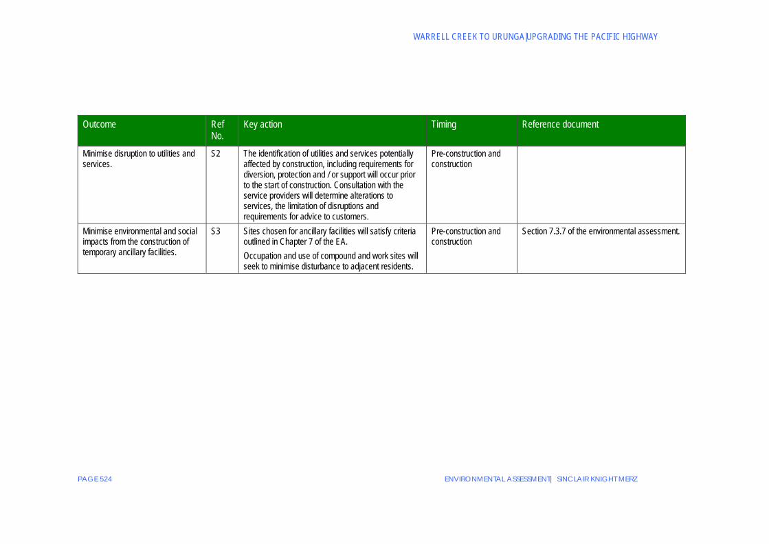
WARRELL CREEK TO URUNGA|UPGRADING THE PACIFIC HIGHWAY
PAGE 524 ENVIRONMENTAL ASSESSMENT| SINCLAIR KNIGHT MERZ
Outcome Ref No.
Key action Timing Reference document
Minimise disruption to utilities and services.
S2 The identification of utilities and services potentially affected by construction, including requirements for diversion, protection and / or support will occur prior to the start of construction. Consultation with the service providers will determine alterations to services, the limitation of disruptions and requirements for advice to customers.
Pre-construction and construction
Minimise environmental and social impacts from the construction of temporary ancillary facilities.
S3 Sites chosen for ancillary facilities will satisfy criteria outlined in Chapter 7 of the EA. Occupation and use of compound and work sites will seek to minimise disturbance to adjacent residents.
Pre-construction and construction
Section 7.3.7 of the environmental assessment.

APPENDICES
ENVIRONMENTAL ASSESSMENT| SINCLAIR KNIGHT MERZ PAGE 525
Appendix E Study team Sinclair Knight Merz – Key project team members Jo Moss Project Director
Ross Jones Project Manager
Kim Collings Assistant Project Manager
Jo North Environment Team Leader
Katie Bagnall
Richard Davies Design Team Leader
Prudence Burke Consultation Team Leader
Denise Lo Environmental Scientist
Chris Thomson Flora and Fauna
Andrew Carty
Scott Hughes Noise and Vibration
Tony Church
Water Quality Kate Byrnes
Emma Collins
Vanessa Edmonds
Heritage Joseph Brookes
Rose Reid
Tim Bickerstaff Traffic and Transport
David Lowe
Matt Davies Air Quality and Greenhouse
Yvette Sheedy Land Use Planning
David Cotterill Economics
Ajay Arcot GIS
Jonathan Chen
Adrian Howard Flooding and Hydrology
Sarah Gosling
Sub-consultants– Environmental assessment preparation DEM Visual and Urban Design Golder Associates Geotechnical Au Fait Design Graphics

WARRELL CREEK TO URUNGA|UPGRADING THE PACIFIC HIGHWAY
PAGE 526 ENVIRONMENTAL ASSESSMENT| SINCLAIR KNIGHT MERZ
RTA Bob Higgins General Manager, Pacific Highway Office Chris Clark
Project Development Manager Adam Cameron John O’Donnell Environmental Services Manager Michelle Forwood
Senior Environmental Specialist Peter Keane
APPENDICES
ENVIRONMENTAL ASSESSMENT| SINCLAIR KNIGHT MERZ PAGE 527
Appendix F Minister’s Orders and Letter of confirmation from the Director-General

WARRELL CREEK TO URUNGA|UPGRADING THE PACIFIC HIGHWAY
PAGE 528 ENVIRONMENTAL ASSESSMENT| SINCLAIR KNIGHT MERZ
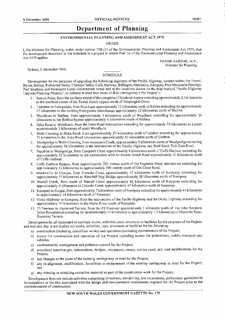


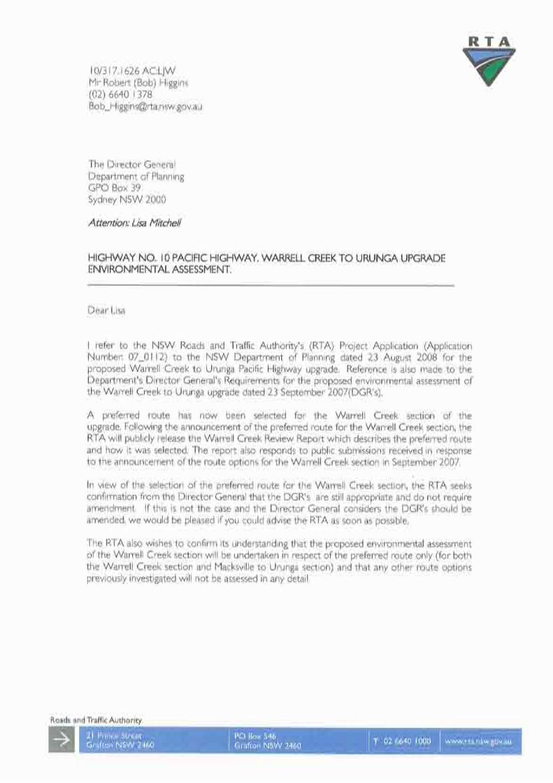


APPENDICES
ENVIRONMENTAL ASSESSMENT| SINCLAIR KNIGHT MERZ PAGE 529
Appendix G Community updates
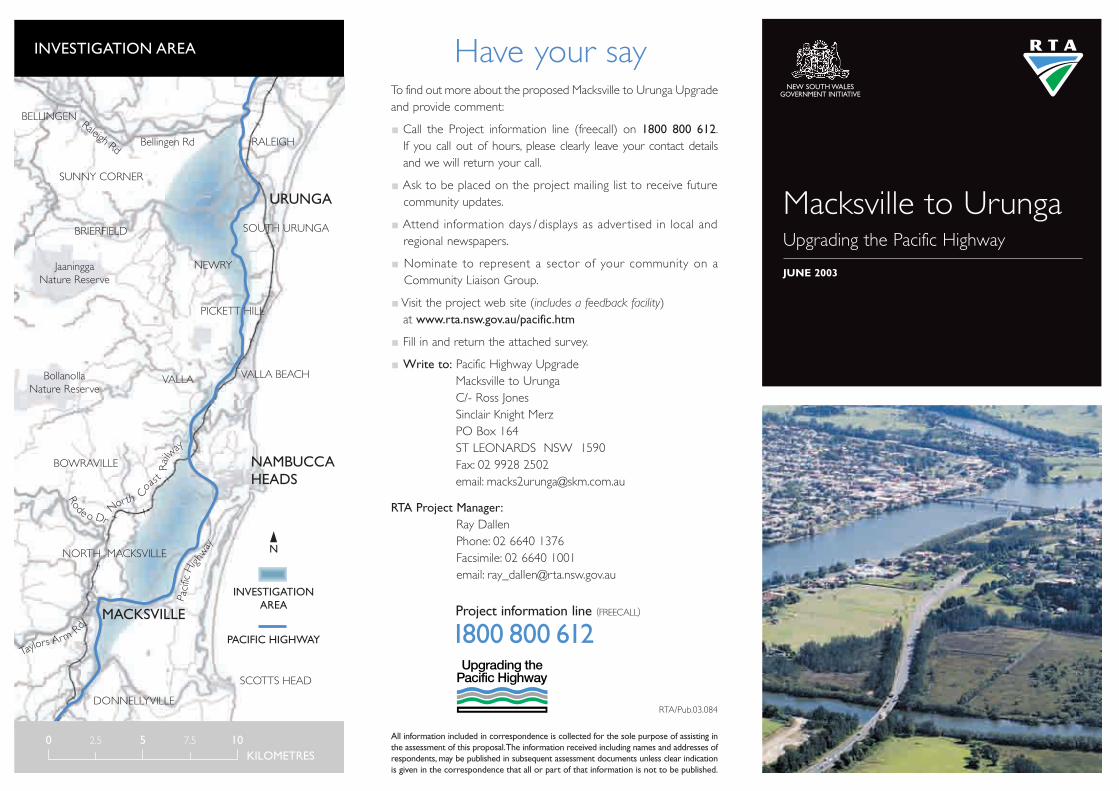
Macksville to UrungaUpgrading the Pacific Highway
JUNE 2003
N
INVESTIGATIONAREA
PACIFIC HIGHWAY
RALEIGH
Raleigh Rd
SOUTH URUNGA
NEWRY
PICKETT HILL
VALLA BEACHVALLA
BELLINGEN
SUNNY CORNER
BRIERFIELD
SCOTTS HEAD
Bellingen Rd
JaaninggaNature Reserve
BollanollaNature Reserve
BOWRAVILLE
DONNELLYVILLE
NORTH MACKSVILLE
NAMBUCCAHEADS
MACKSVILLE
URUNGA
North
Coa
st
Railw
ay
Paci
ficHi
ghw
ay
Taylors Arm
Rd
Rode o Dr
0 2.5 5 7.5 10KILOMETRES
Have your sayTo find out more about the proposed Macksville to Urunga Upgradeand provide comment:
Call the Project information line (freecall) on 1800 800 612.If you call out of hours, please clearly leave your contact details and we will return your call.
Ask to be placed on the project mailing list to receive futurecommunity updates.
Attend information days /displays as adver tised in local andregional newspapers.
Nominate to represent a sector of your community on aCommunity Liaison Group.
Visit the project web site (includes a feedback facility)at www.rta.nsw.gov.au/pacific.htm
Fill in and return the attached survey.
Write to: Pacific Highway UpgradeMacksville to UrungaC/- Ross JonesSinclair Knight MerzPO Box 164ST LEONARDS NSW 1590Fax: 02 9928 2502email: [email protected]
RTA Project Manager:Ray DallenPhone: 02 6640 1376Facsimile: 02 6640 1001email: [email protected]
INVESTIGATION AREA
NEW SOUTH WALES GOVERNMENT INITIATIVE
Project information line (FREECALL)
1800 800 612
RTA/Pub.03.084
All information included in correspondence is collected for the sole purpose of assisting inthe assessment of this proposal.The information received including names and addresses ofrespondents, may be published in subsequent assessment documents unless clear indicationis given in the correspondence that all or part of that information is not to be published.

The proposed upgrade would benefit both road users andlocal residents by:
Improving road safety.
Improving traffic flows.
Reducing travel times.
This is the first in a series of community updates for the routeoptions development and assessment process. It explains what will take place and how you can be involved. Community input willplay an important part in the project planning.
Upgrading options
There is currently no preferred route for the project. However,an investigation area has been defined (see map). The study areawill allow the development of a range of feasible route options.Potential routes both east and west of the existing Pacific Highway,as well as along the existing highway corridor would be considered.Bypasses of Macksville, Urunga and Bellwood will be investigated,as well as the possibility of upgrading the existing route throughthese towns.
Options development and assessment process
Sinclair Knight Merz (SKM) has been engaged by the RTA to assist
in the development and assessment of route options. Project
planning is aimed at achieving a balance between environmental,
community, social, engineering and economic considerations.
Given the significant local knowledge that exists on a range of
issues relevant to the study area, it is important that members of
the local communities participate fully throughout the process.
A number of technical, environmental and social studies will
commence shortly. As some of these will involve field investigations,
permission to enter private properties for the studies will be
arranged through individual property owners.
Following these initial studies, concept designs for possible route
options will be developed for a more detailed assessment. These
options will be publicly displayed for community comment.
A broad outline of the planning process and opportunities for
community involvement are shown on the next page.
Pacific Highway Upgrading Program
This is the single largest construction program in NSW for the past 40 years. Twenty-one major projects and 19 smallerprojects have been opened to traffic. Four major constructionprojects are underway, including the Karuah Bypass, HalfwayCreek Realignment, Coopernook Bypass and Taree to CoopernookUpgrade. A further 15 projects are at various stages of planning
The Roads and Traffic Authority (RTA) has begun investigating options to upgrade the Pacific Highway
between Macksville and Urunga on the mid north coast (a distance of approximately 40 kilometres).
The project will link the proposed Warrell Creek Realignment in the south to the completed Raleigh
Deviation in the north. Initial planning for this project is fully funded by the NSW Government as part
of its $1.6 billion commitment to the Pacific Highway Upgrading Program.
Macksville to Urunga
and development, including the Kempsey to Eungai and Moorlandto Herons Creek Upgrades.
The program has brought major improvements to the road conditions
and travel times. Notorious blackspots have been removed with
the completion of the Bulahdelah to Coolongolook and Yelgun to
Chinderah Freeways, Raleigh Deviation and Ewingsdale Interchange.
As well as boosting tourism and transport efficiency and providing
safer and more consistent overtaking opportunities, the Pacific
Highway Upgrading Program has saved lives and reduced serious
injury accidents.
Community information daysFormation of community forums
Development of route options
Community forums andstakeholder meetings
Refinement of options
Community information days/displays,community forums, stakeholder meetings
Selection of a preferred route
Community information days/displays,community forums, stakeholder meetings
�
�
�
Refinement of the preferred route �
�WE ARE HERE
2-W
AY
CO
MM
UN
ITY
INV
OLV
EMEN
T
PLANNING PROCESS
Preliminary investigation
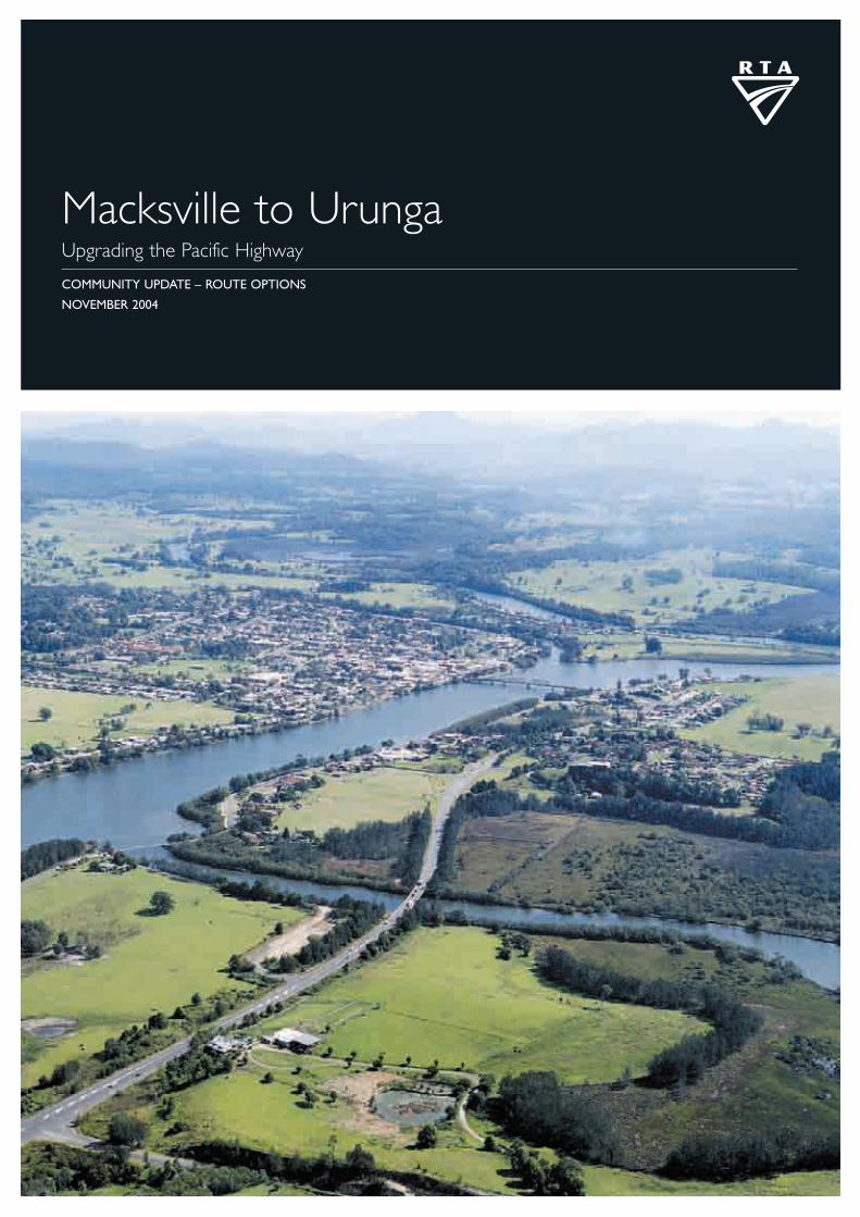
Macksville to UrungaUpgrading the Pacific Highway
COMMUNITY UPDATE – ROUTE OPTIONS
NOVEMBER 2004

Macksville to Urunga Route options2
Planning for the project is fully funded by the NSWGovernment as par t of the 10 year Pacific HighwayUpgrading Program. The project will link the existinghighway at Warrell Creek in the south to the completedRaleigh Deviation in the north.
Study team investigations
Since the star t of planning for the project and theannouncement of the investigation area in June 2003, the studyteam has been developing and assessing possible route options.Investigation of environmental, traffic, engineering, land use andsocial issues and community input have helped identify feasibleroute options.These investigations included:
The development of maps showing environmental,engineering and social information.
Consideration of community input provided through thecommunity information displays held in 2003 and thethree Community Liaison Groups (CLGs).
Assessment of different land uses and property information.
A review of the plants and animals, and their habitats.
Identification of indigenous and non-indigenous heritageissues.
Assessment of geotechnical and flooding conditions.
Prediction of future traffic volumes and pedestrian needs.
Examination of existing and future road traffic noise.
Assessment of potential effects on businesses for thevarious options.
Consideration of social and economic issues relating tothe current location of the Pacific Highway.
In response to requests from sections of the Macksvillecommunity, the study team has also investigated the feasibility ofroute options to the west of Macksville. These options arelocated outside the June 2003 investigation area.
Macksville to Urunga Upgrade
The Roads and Traffic Authority (RTA) has been investigating options to upgrade the Pacific Highway
between Macksville and Urunga on the mid north coast (a distance of approximately 40 kilometres).
This Community Update describes the route options that have been shortlisted for further consideration
and the key issues associated with each of the options. The options are on public display for comment
from Tuesday 30 November 2004 to Wednesday 2 February 2005.
What are the options?
There is currently no preferred option for the project.Theselection of a preferred option will be based on theconsideration of community, environmental, engineering,economic and functional issues.
The June 2003 investigation area has been divided into foursections to enable a detailed review of the options and tobetter understand local issues.The sections are:
Section 1: From the northern end of the proposed WarrellCreek Deviation to the northern bank of theNambucca River (see pages 6 and 7).
Section 2: From the northern bank of the Nambucca Riverto where the existing highway crosses the NorthCoast Railway Line west of Nambucca Heads(see pages 8 and 9).
Section 3: From where the highway crosses the railway west of Nambucca Heads to Little Newry State Forestin the vicinity of Mines Road, south of Urunga(see pages 10 and 11).
Section 4: From Mines Road to the southern end of theRaleigh Deviation (see pages 12 and 13).
A wide range of options were considered. These wererefined into a smaller number of viable options in Sections1, 2 and 4 as shown on the following maps. Due toconstraints to the east and west of the existing highway, oneoption is proposed in Section 3 (see page 10 for details).
Options to the west of Macksville are shown on pages 14 and15.These options leave the existing highway south of WarrellCreek and rejoin the highway west of Nambucca Heads nearthe southern end of Section 3. The proposed Warrell CreekDeviation is currently on hold, pending the selection of thepreferred option for the Macksville to Urunga project.

Macksville to Urunga Route options 3
The upgrading of the Pacific Highway in the Macksville toUrunga area is a significant component of the overall PacificHighway Upgrading Program. This section provides anoverview of the shortlisted upgrade options between WarrellCreek and the Raleigh Deviation. The following pages thendescribe, in more detail, the proposed route options and theconstraints that exist throughout the study area.
Given the size of the proposed upgrade there are opportunitiesto stage construction of the project. Staging would provide thecommunity with benefits in key areas as early as practicable,and the RTA could allocate the available funding for the PacificHighway Upgrading Program to those areas that can providethe most community benefit.
Figure 1 and the table below provide a broad comparison ofthe options being considered between Warrell Creek andRaleigh. For all options, a four-lane, divided highway isproposed with provision for additional lanes in the medianin the future if required (see Figure 3 on the following page).
Overview of route options
WESTERN EASTERNOPTIONS OPTIONS
LENGTH 41.0-45.1km 40.8-43.4kma
PRELIMINARYCOST ESTIMATED $530-558 million $520-555b millionIN $2003
ECONOMIC (BCRc 1.2-1.4) (BCR 1.5-1.8)VIABILITY
ABILITY TO STAGE Limited opportunities Greater opportunitiesto stage
ENVIRONMENTAL Large amount of Large amount o ISSUES vegetation clearing vegetation clearing
Potentialarchaeological issues
COMMUNITY Longer access to Shorter access toISSUES Macksville Macksville
Potential impacts on Potential impacts onexisting and future existing and future rural residential rural residential development development
Potential noise impactson Macksville
Potentialflood impacts
near Macksville
Potential impact onrural properties
NUMBER OF 6 to 9 7 to 8MAJOR BRIDGES
a Includes Warrell Creek Deviation.b Includes $50 million for the proposed Warrell Creek Deviation.c Benefit Cost Ratio (BCR) – present value of road user benefits divided
by the present value of costs.d BCR for the West of Macksville options between Warrell Creek
and Nambucca Heads is approximately 1.0.
Figure 1: Overview
RALEIGHRALEIGHBELLINGENBELLINGEN
BOWRAVILLEBOWRAVILLE
VALLA BEACHVALLA BEACH
VALLA VALLA
SCOTTS HEADSCOTTS HEAD
DONNELLYVILLEDONNELLYVILLE
NAMBUCCA HEADSNAMBUCCA HEADS
BELLWOOD BELLWOOD
WIRRIMBIWIRRIMBI
WARRELL CREEKWARRELL CREEK
TO KEMPSEYTO KEMPSEY
TO COFFS HARBOURTO COFFS HARBOUR
URUNGAURUNGA
MACKSVILLEMACKSVILLE
Bellingen
Rd
Nam
bucca
Nam
bucca
Nam
bucc
a
Nam
bucc
aRi
ver
Rive
r
RiverRiver
Deep Creek
Nam
bucc
a
Nam
bucc
aRi
ver
Rive
r
Deep Creek
Valla
Road
RALEIGHBELLINGEN
BOWRAVILLE
VALLA BEACH
VALLA
SCOTTS HEAD
PICKETT HILLPICKETT HILLPICKETT HILL
MOUNT MOUNT ENGLANDENGLANDMOUNT
ENGLAND
(EI.383m)
DONNELLYVILLE
NAMBUCCA HEADS
BELLWOOD
WIRRIMBI
WARRELL CREEK
TO KEMPSEY
TO COFFS HARBOUR
URUNGA
MACKSVILLE
Nor
thC
oast
Railw
ay
Line
Nor
thC
oast
Railw
ay
Line
Old
C
oast
Rd
Old
C
oast
Rd
Nam
bucca
Taylors
Warrell Creek
Nam
bucc
aRi
ver
Arm
River
River
Kalang
Bellinger River
Existi
ngPa
cific
High
way
Existi
ngPa
cific
High
way
Deep Creek
(EI.279m)
LEGEND
Eastern Options
Western Options
Combined Eastern/ Western Options
Existing Pacific Highway
Investigation area
Local Roads
North Coast Railway Line
State Forest
N
0 2.5 5km

Macksville to Urunga Route options4
What should the upgrade achieve?
The Macksville to Urunga upgrade forms part of the PacificHighway Upgrading Program.The objectives of this programare to:
Significantly reduce road accidents and injuries.
Reduce travel times.
Reduce freight transport costs.
Have a community satisfied with the physical development of the route.
Provide a route that supports economic development.
Manage the upgrading of the route in accordance withEcologically Sustainable Development (ESD) principles.
Maximise the effectiveness of expenditure.
The specific objectives of the Macksville to Urungaupgrade are to:
Achieve safe driving conditions on the highway for travelspeeds of 110 kilometres per hour in rural areas and 80kilometres per hour in urban areas.
Integrate input from local communities into the development of the project.
Provide connections from the upgraded highway to the keycentres of Macksville, Nambucca Heads and Urunga.
Have acceptable roadway capacity for traffic volumes atleast 30 years after opening.
Develop a dual carriageway road that accommodates allvehicles up to and including B-Double trucks.
Maintain highway access during flood conditions.
Provide acceptable access to properties.
Develop delay management strategies to minimise disruption to local and through traffic and maintain access to affectedproperties and land during construction.
Develop solutions that facilitate the staged construction ofthe project.
Develop solutions for the ultimate grade separation of thePacific Highway and local road intersections includingconsolidation of accesses by the use of service roads.
Provide rest areas within the investigation area.
Provide transport infrastructure that is complementary withsurrounding land use.
Ensure the project achieves value for money.
Strategic context
Shou
lder
Traf
fic la
ne
Traf
fic la
ne
Shou
lder
Shou
lder
2.5
0 m
Varia
ble
med
ian
wid
th
Shou
lder
2.5
0 m
Traf
fic la
ne 3
.50
m
Traf
fic la
ne 3
.50
m
Traf
fic la
ne 3
.50
m
Traf
fic la
ne 3
.50
m
Shou
lder
0.5
m
Shou
lder
0.5
m
Potential future third lane
Nominal median 11.00 m
Local access road
New dual carriageway highway
Figure 3:Typical cross section of proposal
Figure 2: Dual carriageway highway with service road

Macksville to Urunga Route options 5
Upgrading the existing highway
The option of upgrading the existing Pacific Highway throughthe townships of Macksville, Bellwood and Urunga has beenconsidered.The road corridor through Macksville is narrowand widening it would have a significant impact on a largenumber of residential and commercial properties.
The existing highway through Bellwood is constrained by the Nambucca River to the east and the residential andcommercial properties to the west. Because the existinghighway winds through Urunga, widening it to dual carriageway,even with an 80km/h travel speed, would have a significantimpact on adjacent residential and commercial properties.
The option of upgrading the existing highway throughMacksville, Bellwood and Urunga is not acceptable due tothe impacts on these townships. No further considerationwill therefore be given to this option.
The process to select a preferred route for the project thatincludes community issues is shown in the planning processdiagram on the right.
No preferred option has been selected at this stage.Community comment on these shortlisted options willbe considered as part of the process of selecting thepreferred option.
A Value Management Study will be held to help select a preferred option. The Value Management Study will involve a workshop with representatives from a range of government, council and community interests. Therecommendations arising from the study, together with thetechnical reports and community input, will be part of theevaluation of the options.
When selected, the preferred option will be placed on display.
Please review the information on the route options in thefollowing sections of this Community Update and provideyour comments to the study team using the contact detailson the back cover.
Selecting a preferred route
Figure 4: Planning process
Community information displaysFormation of Community Liaison Groups (CLGs)
CLGs and stakeholder meetings
Community information displays,CLGs, stakeholder meetings
Community information displays,CLGs, stakeholder meetings
�
�
�
REFINEMENT OF THE PREFERRED ROUTE�
�
WE
AR
EH
ERE
2-W
AY
CO
MM
UN
ITY
INV
OLV
EMEN
T
PRELIMINARY INVESTIGATION
DEVELOPMENT OF ROUTE OPTIONS
DISPLAY OF OPTIONS
SELECTION OF A PREFERRED ROUTE
�
��
��
Figure 5: Grade separated interchange – Waterfall Way Interchange at Raleigh

DONNELLYVILLE
MACKSVILLEMACKSVILLEMACKSVILLE
Nor
thC
oast
Railw
ayLine
Existing Pacific Highway
Old
Coa
stR
oad
Nambucca River
Warrell C
reek
Taylo
rs Ar m
Newee
Cre
ek
1e
1a
1b
1c
1d
Macksville sewage treatment plant
Close proximity to items of cultural heritage (Boulton
Hotel and Old Ferry Crossing)
High quality flora and fauna habitat either side of existing
Pacific Highway
SEPP 14 Wetland No.388
East-west spurnorth and south of Bald Hill Road
is an area of potential
archaeological sensitivity
High quality flora and fauna habitat along the northern
side of Warrell Creek
Vicinity of possible elevated interchange
TO NAMBUCCA HEADS
TO KEMPSEY
Land zoned rural residential under Nambucca Local Environment Plan
Wallace
Street
River Street
Gumma Road
Boundary Street
ScottsH
eadRoad
Rodeo
Drive
Bald Hill Road
Albert
Drive
High quality flora and fauna habitat
Very high quality flora and fauna
habitat
Significant archaeological
site
Would require noise mitigation for adjacent residential development
0 0.5 1km
N
LEGEND
FIGURE 6: SECTION 1
Option 1a
Option 1b
Option 1c
Option 1d
Option 1e
Very high quality habitat
High quality habitat
SEPP# 14 Wetland
Residential area
Rural residential area
Industrial Area
Investigation area
Existing Pacific Highway
North Coast Railway Line
Local Roads
# SEPP – State Environmental Planning Policy.
SECTION 1 OPTIONS From northern end of proposed Warrell Creek deviation to the northern bank of the Nambucca River.
Macksville to Urunga Route options6
DESIGN ISSUES
TOTAL LENGTH – INCLUDINGBRIDGE OVER NAMBUCCA RIVER
BRIDGES REQUIRED
BRIDGE OVER NAMBUCCA RIVER
MAXIMUM GRADIENT
MAXIMUM ELEVATION
SIGNPOSTED SPEED
CONNECTIONS TO TOWNS
CONNECTION TO OPTIONS IN SECTION 2
PRELIMINARY COST ESTIMATEDIN $ 2003
ABILITY TO STAGE CONSTRUCTION
PROPERTY IMPACTS
APPROXIMATE NUMBER OF AFFECTED PROPERTIES
IMPACT ON RURAL PROPERTIES
IMPACT ON MACKSVILLESEWAGE TREATMENT PLANT
COMMUNITY IMPACTS
POTENTIAL NOISE IMPACTS
FLOOD IMPACTS
BIOPHYSICAL IMPACTS
POTENTIAL IMPACT ON – FLORA AND FAUNA HABITAT
– THREATENED SPECIES
– RIVERINE/AQUATIC VEGETATION
HERITAGE IMPACTS
4
3
2
1
URUNGAURUNGA
MACKSVILLEMACKSVILLE
WES
TE
RN

Macksville to Urunga Route options 7
OPTION 1a OPTION 1b OPTION 1c OPTION 1d OPTION 1e(GREEN) (YELLOW) (ORANGE) (BLUE) (PINK)
All options share a common route for a distance of 2.5 km from the southern end of the investigation area to approximately where Bald Hill Road crosses the existing Pacific Highway.The upgrade for this length could be accommodated within the existing road reserve.
6.1 km including 2.4 km 6.1 km including 3.5 km 6 km including 3.6 km 6.1 km including 3.6 km 6.3 km including 3.8 km of new dual carriageway. of new dual carriageway. of new dual carriageway. of new dual carriageway. of new dual carriageway.
All options in Section 1 would require duplication of the existing bridge over Warrell Creek and a new 4 lane bridge over the Nambucca River.
Approx. 360 m in length. Approx. 360 m in length. Approx. 340 m in length. Approx. 380 m in length. Approx. 450 m in length.
All options have a maximum gradient of 4%.
24 m above sea level for all options.
All options have been developed for an ultimate signposted speed limit of 110km/h.With staged construction, initial speed limit may be 100km/h.
All options include a possible interchange with the existing highway south of Macksville.
Connects with Option 2b and, with modifications, Option 2a. Connects with Option 2a and, Connects with Option 2c.with modifications, Option 2b.
$124 million ($20.4 M/km). $116 million ($19 M/km). $114 million ($19 M/km). $117 million ($19.2 M/km). $124 million ($19.7 M/km).
Cost for all options includes a bridge over the Nambucca River.
A 6 to 6.3 km bypass of Macksville could be constructed as a stand alone project.
59 parcels of land. 49 parcels of land. 48 parcels of land. 52 parcels of land. 52 parcels of land.
All options have the potential to divide some rural properties and may require measures to provide connectivity between severed properties.
In close proximity to the Macksville sewage treatment plant. Encroaches on the property on which the Macksville sewage treatment plant is located.
267 residences potentially 277 residences potentially 122 residences potentially 105 residences potentially 103 residences potentiallyaffected without noise affected without noise affected without noise affected without noise affected without noisemitigation. mitigation. mitigation. mitigation. mitigation.
For all options, the crossing of the Nambucca River and floodplain would result in a maximum predicted increase in flood level of less than 50 mm for the 1 in 100 year flood.
• 2.5 ha of very high quality. • 2.5 ha of very high quality. • 3.5 ha of very high quality. • 4 ha of very high quality. • 4 ha of very high quality.• 1.5 ha of high quality. • 4ha of high quality. • 2.5 ha of high quality. • 2.5 ha of high quality. • 2.5 ha of high quality.
All options could have a moderate impact on potential threatened species habitat requiring mitigation measures.
Moderate potential to cross Low potential to cross existing wildlife corridors.a wildlife corridor adjacent to the existing highway.
All options have the potential for impact on riverine and aquatic vegetation at the Warrell Creek and Nambucca River crossings.
All options impact on 2 areas of potential archaeological sensitivity
No direct impact to any known sites of non-indigenous heritage significance.
Five shortlisted options have been developed in this section.They are all located east of Macksville. Figure 6 and the tablebelow provide a comparison of the shortlisted options for Section 1.

NAMBUCCAHEADS
BELLWOOD
Old
Coa
stR
d
North Coast Railway Line
Nam
bucc
aR
iver
Nambucca State Forest
High quality floraand fauna habitat
Area of high qualityflora and fauna habitat
Existing ruralresidential
development alongOld Coast Road
SEPP 14 WetlandNo. 383
Potential highimpact on amenityof rural residential
properties
Area of developingrural residential land
SEPP 14 Wetland No.362
Area of high archaeological sensitivity for
indigenous community
Area containingSEPP 14 No.365,367,368,370
Area of very highquality flora and
fauna habitat
Areas containing lowlandsubtropical rainforest
2a
2b
2c
TO MACKSVILLE
TO URUNGA
New
ee
Creek
FlorenceWilmont Drive
Jack Ridge R oad
Bellwood Road
Gordons Knob Road
Alexandra D
rive
Mann Street
Wirrim Road
Gumma Road
Hyl
and
Park
Road
Area containingkoala feed trees
Area containingkoala feed trees
Exist
ing
Paci
fic H
wy
Possiblevicinity of elevated
interchange
Area of high qualityflora and fauna habitat
LEGEND
FIGURE 7: SECTION 2
Option 2a
Option 2b
Option 2c
Very high quality habitat
High quality habitat
SEPP# 14 Wetland
Residential area
Rural residential area
Industrial Area
Investigation area
Existing Pacific Highway
North Coast Railway Line
Local Roads
State Forest
0 0.5 1km
N
# SEPP – State Environmental Planning Policy.
Macksville to Urunga Route options8
DESIGN ISSUES
TOTAL LENGTH
BRIDGES REQUIRED
MAXIMUM GRADIENT
MAXIMUM ELEVATION
SIGNPOSTED SPEED
CONNECTIONS TO TOWNS
CONNECTION TO OPTIONS IN SECTION 1
CONNECTION TO OPTIONS IN SECTION 3
PRELIMINARY COST ESTIMATED IN $ 2003
ABILITY TO STAGE CONSTRUCTION
PROPERTY IMPACTS
APPROXIMATE NUMBER OF AFFECTED PROPERTIES
IMPACT ON RURAL PROPERTIES
COMMUNITY IMPACTS
POTENTIAL NOISE IMPACTS
FLOOD IMPACTS
BIOPHYSICAL IMPACTS
POTENTIAL IMPACT ON– FLORA AND FAUNA HABITAT
– THREATENED SPECIES
– STATE FOREST
– RIVERINE/AQUATIC VEGETATION
HERITAGE IMPACTS
From the northern bank of the Nambucca River to where the existing highway crosses the North Coast Railway Line west of Nambucca Heads.
SECTION 2 OPTIONS
4
3
2
URUNGAURUNGA
1MACKSVILLEMACKSVILLE
WES
TE
RN

Macksville to Urunga Route options
OPTION 2a (BLUE) OPTION 2b (GREEN) OPTION 2c (PINK)
9.3 km. 9.7 km. 9.3 km.
All options would require bridges at local crossings (including Old Coast Road), major streams and the North Coast Railway Line.
All options have a maximum gradient of 3%.
38 m above sea level for all options.
All options have been developed for an ultimate signposted speed limit of 110km/h.With staged construction, initial speed limit may be 100km/h.
All options include a possible interchange with the existing highway north of Macksville (east of Newee Creek).
Connects with Option 1d and, with modifications, Connects with Options 1a, 1b, or 1c and, with Connects with Option 1e.Options 1a, 1b or 1c. modifications, Option 1d.
All options continue north as option 3a.
$87 million ($9.3 M/km). $88 million ($9 M/km). $83 million ($9 M/km).
Cost for all options includes a possible interchange with the existing highway north of the Nambucca River.
The 9.3 to 9.7 km bypass of Bellwood could be constructed as a stand alone project.
54 parcels of land. 45 parcels of land. 36 parcels of land.
All options have the potential to divide some rural properties and may require measures to provide connectivity between severed properties.
127 residences potentially affected without 104 residences potentially affected without 124 residences potentially affected without noise mitigation. noise mitigation. noise mitigation.
None of the options would have major flooding impacts.
• No impact on very high quality. • 2.5 ha of very high quality. • 4.5 ha of very high quality.• 4 ha of high quality. • 4ha of high quality. • 4.5 ha of high quality.• 22 ha of medium quality. • 19 ha of medium quality. • 21 ha of medium quality.
All options in Section 2 have a high potential to cross wildlife corridors.
Low potential impact to threatened Moderate potential impact to threatened High potential impact to threatened speciesspecies habitat. species habitat. habitat. Impacts on small area of Lowland
Subtropical Rainforest which is an endangered ecological community.
All options would impact on Nambucca State Forest.
None of the options would have the potential for significant impacts on riverine or aquatic vegetation at river crossings.
Impact on 7 areas of potential Impact on 5 areas of potential Impact on 2 areas of potential archaeological sensitivity. archaeological sensitivity. archaeological sensitivity.
Impact on 2 items of low potential significance Impact on 1 item of low potential significance for non-indigenous heritage.for non-indigenous heritage.
Section 2 provides a bypass of Bellwood.Three shortlisted options have been developed in this section.The northern partof the three options share a common route generally along Old Coast Road, from Newee Creek to the existing highway atthe North Coast Railway Line. Figure 7 and the table below provide a comparison of the shortlisted options for Section 2.
9

DeepCreek
Exis tin g Pacific Highway
Nor
th C
oast
Rai
lway
Lin
e
VALLA BEACH
VALLA
PICKETT HILL
BELLWOOD
NAMBUCCA HEADS
Area of high qualityflora and fauna habitat
Little Newry State Forest
Valla Gold Mine, identified as a non-indigenous heritage site of potential local significance
TO URUNGA
Area of very high qualityflora and fauna habitat
SEPP 14 WetlandsNo. 357,360a,360 and 361
Possible elevatedinterchange
Area zoned forfuture urban land use
Very high qualityflora and fauna habitat
TO MACKSVILLE
Scattered area of developingrural-residential land
Cow
Creek Ro ad
Valla Road
East West Road
Va lla Beach Road
Hyland
Park Road
Gordons Knob R oad
Deep Creek
Road
Jacksons Road
3a
Area of higharchaeological significance
LEGEND
FIGURE 8: SECTION 3
Option_3aState ForestLocal Roads
Very high quality habitatHigh quality habitatSEPP 14 Wetland
North Coast RailwayExisting Pacific HighwayLocal Government Area boundary
Residential areaRural residential areaIndustrial Area
InvestigationArea
0 0.5 1km
N
LEGEND
Option 3a Very high quality habitat
High quality habitat
SEPP# 14 Wetland
Residential area
Rural residential area
Industrial Area
Investigation area
Existing Pacific Highway
North Coast Railway Line
Local Government Area boundary
Local Roads
State Forest
# SEPP – State Environmental Planning Policy.
Macksville to Urunga Route options10
DESIGN ISSUES
TOTAL LENGTH
BRIDGES REQUIRED
MAXIMUM GRADIENT
MAXIMUM ELEVATION
SIGNPOSTED SPEED
CONNECTIONS TO TOWNS
CONNECTIONS SECTION 2 ANDWEST OF MACKSVILLE OPTIONS
CONNECTIONS TO SECTION 4
PRELIMINARY COST ESTIMATEDIN $2003
ABILITY TO STAGE CONSTRUCTION
PROPERTY IMPACTS
APPROXIMATE NUMBER OF AFFECTED PROPERTIES
IMPACT ON RURAL PROPERTIES
COMMUNITY IMPACTS
POTENTIAL NOISE IMPACTS
FLOOD IMPACTS
BIOPHYSICAL IMPACTS
POTENTIAL IMPACT ON– FLORA AND FAUNA HABITAT
– THREATENED SPECIES
– STATE FOREST
– RIVERINE/AQUATIC VEGETATION
HERITAGE IMPACTS
4
3
2
URUNGAURUNGA
1MACKSVILLEMACKSVILLE
WES
TE
RN
From the crossing the North Coast Railway west of Nambucca Heads to Little NewryState Forest in the vicinity of Mines Road south of Urunga.
SECTION 3 OPTION

Macksville to Urunga Route options 11
OPTION 3a (GREEN)
9.1km generally parallel to the existing highway.
Deep Creek and other streams.
5%.
26 m above sea level.
Ultimate travel speed of 110km/h. With staged construction, initial speed may be 100km/h.
Possible interchange with the existing highway west of Nambucca Heads.
Connects to the northern end of Section 2 and west of Macksville options.
Connects to the southern end of Section 4 options.
$113 million, including bridge over North Coast Railway Line ($12.5 M/km).
Could be constructed in small increments.
105 parcels of land (approx.).
Impact minimised as it closely follows the existing highway.
This option closely follows the existing highway alignment and makes provision for the use of the existing highway as a service road in the long term.
Would not directly impact on future Cow Creek urban land release area.
128 residences potentially affected without noise mitigation adjacent to the existing highway.
Potential impacts for stream crossings.
• 5 ha very high quality.• 1 ha of high quality.• 10 ha of medium quality.
Would have a moderate impact on potential threatened species habitat.
Impacts on Little Newry State Forest.
Potential impact on riverine and aquatic vegetation at stream crossings.
Located immediately adjacent to a site considered significant for indigenous heritage.Potential impact on six areas of potential archaeological sensitivity, of low to moderate significance.
In close proximity to Valla Gold Mine, which is of potential local non-indigenous heritage significance.
Section 3 is a narrow section of the investigation area and for much of its length the existing Pacific Highway is suitable forduplication. Only one option has been developed in this section. Details of the option for this section are shown in Figure8 and the table below.

PICKETT HILL
NEWRY
Kalang River
Bellinger R iver
No
rth
Co
ast
Rai
lway
Lin
e
URUNGAURUNGAURUNGAEx
isti
ngPa
cific
Hw
y
Existing rural residential development
Area of very high quality flora and fauna habitat
Area of very high quality flora and
fauna habitat
Area containing Koala feed trees
Would traverse South Arm Road scenic landscape, listed on Bellingen Local
Environment Plan
SEPP 14 Wetland No.351
SEPP 14 Wetland No.353
Rural residential dwellings along South-Arm Road
Modify existing Waterfall Way Interchange
Raleigh industrial estate
Area containing rural residential dwellings along Short Cut Road
Would impact on existing rural residential development
Traverses through land identified as high qualityflora and fauna habitat
SEPP 14 wetland No. 352
Would traverse Newry Island, an area identified as significant to the local indigenous community
Area of high archaeological significance.
Active oyster leases throughout Kalang River
Possible elevated interchange
TO COFFS HARBOUR
TO NAMBUCCA
HEADS
Raleigh
St
Mitchells Road
Moyles R oad
Ainsworth Road
Balla
rds
Road
South Arm Road
Short Cut Road
Rive
rside
Drive
New
ry
Islan
dD
rive
4a 4b 4c
Glossy Black Cockatoo feed tree
RALEIGHRALEIGHRALEIGH
Area of veryhigh quality floraand fauna habitat
0 0.5 1km
N
FIGURE 9: SECTION 4
LEGEND
Option 4a
Option 4b
Option 4c
Very high quality habitat
High quality habitat
SEPP# 14 Wetland
Residential area
Rural residential area
Industrial Area
Investigation area
Existing Pacific Highway
North Coast Railway Line
Local Roads
State Forest
# SEPP – State Environmental Planning Policy.
URUNGAURUNGA4
3
2
1MACKSVILLEMACKSVILLE
WES
TE
RN
Macksville to Urunga Route options12
DESIGN ISSUES
TOTAL LENGTH
BRIDGES OVER KALANG RIVER
MAXIMUM GRADIENT
MAXIMUM ELEVATION
SIGNPOSTED SPEED
CONNECTIONS TO TOWNS
CONNECTIONS TO SECTION 3
PRELIMINARY COST ESTIMATEDIN $2003
ABILITY TO STAGE CONSTRUCTION
PROPERTY IMPACTS
APPROXIMATE NUMBER OF AFFECTED PROPERTIES
IMPACT ON RURAL PROPERTIES
COMMUNITY IMPACTS
POTENTIAL NOISE IMPACTS
FLOOD IMPACTS
BIOPHYSICAL IMPACTS
POTENTIAL IMPACT ON– FLORA AND FAUNA HABITAT
– THREATENED SPECIES
– STATE FOREST
– RIVERINE/AQUATIC VEGETATION
HERITAGE IMPACTS
SECTION 4 OPTIONS From Little Newry State Forest in the vicinity of Mines Road to the southern endof the Raleigh Deviation.

Macksville to Urunga Route options 13
OPTION 4a (GREEN) OPTION 4b (YELLOW) OPTION 4c (BLUE)
13.5 km. 12.4 km. 11.3 km.
Single crossing approximately 170 metres Single crossing approximately 155 metres Bridges over both arms of the Kalang Riverin length. in length. approximately 355 metres in total length.
Would have a maximum gradient of 5%. Would have a maximum gradient of 6%. Would have a maximum gradient of 5%.
43 m above sea level. 36 m above sea level. 41 m above sea level.
All options have been developed for an ultimate signposted speed of 110km/h.With staged construction, initial speed limit may be 100km/h.
All options include a possible interchange with the existing highway south of Urunga and a modification to the existing Raleigh Interchange.
All options connect with the northern end of Section 3.
$166 million ($12.3 M/km). $156 million ($12.5 M/km). $180 million ($15.9 M/km).
The 11.3 to 13.5km bypass of Urunga could be constructed as a stand alone project.
47 parcels of land. 58 parcels of land. 62 parcels of land.
All options have the potential to divide some rural properties and may require measures to reconnect severed properties.
86 residences potentially affected 85 residences potentially affected 284 residences potentially affectedwithout noise mitigation. without noise mitigation. without noise mitigation.
Both options have potential to impact on the South Arm Road scenic landscape, In close proximity to the South Arm Road which is of cultural heritage significance. scenic landscape.
For all options, the crossing of the Kalang River and floodplain would result in a maximum increase in flood level of less than 50 mm for the 1 in 100 year flood.
• 1.5 ha very high quality. • 1 ha very high quality. • No impact onvery highquality.• 20 ha of high quality. • 12 ha of high quality. • 4 ha of high quality.• 28 ha of medium quality. • 20 ha of medium quality. • 20 ha of medium quality.
Would have a high impact on potential Would have a moderate impact on potential Would have a low impact on potentialthreatened species habitat. threatened species habitat. threatened species habitat.
All options would impact on Little Newry State Forest and Newry State Forest.
All options have the potential for impact on riverine and aquatic vegetation at the Kalang River and other waterway crossings.
Impact on 2 areas of potential archaeological Impact on 9 areas of potential Impact on 4 areas of potential archaeologicalsensitivity (1 of high significance). Impact on archaeological sensitivity, of low to sensitivity, of low to moderate significance 1 site of low significance. moderate significance. Impact on 1 site and Newry Island, an area of high
of low significance. archaeological significance. Impact on 1 site of low significance. Is in close proximity to another site of high cultural significance.
These options are in the vicinity of an area of significance for indigenous heritage In the vicinity of two areas of significanceon the eastern side of the existing highway. for indigenous heritage.
Section 4 provides a bypass of Urunga.Three shortlisted options have been developed in this section.Figure 9 and the table below provide a comparison of the shortlisted options for Section 4.

Macksville to Urunga Route options14
DESIGN ISSUES
TOTAL LENGTH
BRIDGES REQUIRED
MAXIMUM GRADIENT
MAXIMUM ELEVATION
SIGNPOSTED SPEED
CONNECTIONS TO TOWNS
CONNECTIONS TO SECTION 3
PRELIMINARY COST ESTIMATEDIN $2003
ABILITY TO STAGE
PROPERTY IMPACTS
APPROXIMATE NUMBER OF DIRECTLY AFFECTED PROPERTIES
IMPACT ON RURAL PROPERTIES
COMMUNITY IMPACTS
BIOPHYSICAL IMPACTS
POTENTIAL IMPACT ON– WILDLIFE
– FLORA AND FAUNA HABITAT
– STATE FOREST
– RIVERINE/AQUATIC VEGETATION
HERITAGE IMPACTS
Exist
ingPa
cific
Hig
hw
ay
MACKSVILLE
DONNELLYVILLE
SCOTTS HEAD
WARRELL CREEK
TO KEMPSEY
Warrell C
reek
Cow Creek RdValla Road
Coronation
Road
New
ee Creek Road
Taylors Ar m
Nor
thC
oast
Railw
ayLine
NAMBUCCAHEADS
NAMBUCCAHEADS
BELLWOODBOWRAVILLE
WIRRIMBI
TO URUNGA
W7
W6
W7
W6
N
eweeC
reek
Old
Coa
stRo
ad
Bellwood Road
Deep
Creek
Wilson Road
ScottsHead
Road
Nambucca RiverGumma Road
Area of potential archaeological sensitivity assessed as of
high significance
SEPP 14 Wetlands
Close proximity to Blackbutt Cemetry, a site of non-indigenousheritage significance
Traverses through 2.5km of Nambucca State Forest
Traverses through 1.5km of
Ingalba State Forest
Secondary agricultural land and rural residential development
Land zoned for rural residential development
Known indigenous heritage site of high significance
Known indigenous heritage site of high significance
Area zoned for future urban development
Area of high indigenous heritage significance
Area of prime agricultural land
Possible elevated interchange
Possible elevatedinterchange
FIGURE 10: WEST OF MACKS VILLE
0 1.0 2km
N
LEGEND
Option W6
Option W7
Local Roads
State Roads
SEPP# 14 Wetland
Residential area
Industrial area
Rural residential area
Existing Pacific Highway
North Coast Railway Line
# SEPP – State Environmental Planning Policy.
Very high quality habitat
High quality habitat
Investigation area
4
3
URUNGAURUNGA
WES
TE
RN
MACKSVILLEMACKSVILLE
2
1
(Alternatives to the options identified for Section 1and 2) From the existing highway south of Warrell Creek to the existing highway west of Nambucca Heads.
The west of Macksvilleoptions provide a westernbypass of both WarrellCreek and Macksville.Two shortlisted optionshave been developed for this section. Figure 10and the table belowprovides a comparison ofthe shortlisted options forwest of Macksville.
OPTIONS TO THE WEST OF MACKSVILLE
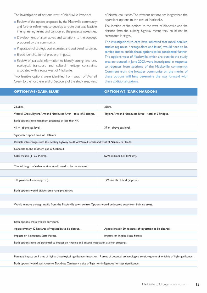
Macksville to Urunga Route options 15
OPTION W6 (DARK BLUE) OPTION W7 (DARK MAROON)
22.6km. 25km.
Warrell Creek,Taylors Arm and Nambucca River – total of 5 bridges. Taylors Arm and Nambucca River – total of 3 bridges.
Both options have maximum gradients of less than 4%.
41 m above sea level. 37 m above sea level.
Signposted speed limit of 110km/h.
Possible interchanges with the existing highway south of Warrell Creek and west of Nambucca Heads.
Connects to the southern end of Section 3.
$286 million ($12.7 M/km). $296 million( $11.8 M/km).
The full length of either option would need to be constructed.
111 parcels of land (approx.). 129 parcels of land (approx.).
Both options would divide some rural properties.
Would remove through traffic from the Macksville town centre. Options would be located away from built up areas.
Both options cross wildlife corridors.
Approximately 42 hectares of vegetation to be cleared. Approximately 50 hectares of vegetation to be cleared.
Impacts on Nambucca State Forest. Impacts on Ingalba State Forest.
Both options have the potential to impact on riverine and aquatic vegetation at river crossings.
Potential impact on 3 sites of high archaeological significance. Impact on 17 areas of potential archaeological sensitivity, one of which is of high significance.
Both options would pass close to Blackbutt Cemetery, a site of high non-indigenous heritage significance.
The investigation of options west of Macksville involved:
Review of the option proposed by the Macksville communityand further refinement to develop a route that was feasiblein engineering terms and considered the project’s objectives.
Development of alternatives and variations to the conceptproposed by the community.
Preparation of strategic cost estimates and cost benefit analyses.
Broad identification of property impacts.
Review of available information to identify zoning, land use,ecological, transport and cultural heritage constraintsassociated with a route west of Macksville.
Two feasible options were identified from south of WarrellCreek to the northern end of Section 2 of the study area, west
of Nambucca Heads.The western options are longer than theequivalent options to the east of Macksville.
The location of the options to the west of Macksville and thedistance from the existing highway means they could not beconstructed in stages.
The investigations to date have indicated that more detailedstudies (eg noise, heritage, flora and fauna) would need to becarried out to enable these options to be considered further.The options west of Macksville, which are outside the studyarea announced in June 2003, were investigated in responseto requests from sections of the Macksville community.Comment from the broader community on the merits ofthese options will help determine the way forward withthese additional options.

Macksville to Urunga Route options16
Have your sayThe shortlisted options are on display from Tuesday 30 November 2004 to Wednesday 2 February 2005at the locations shown below.
The displays provide maps showing greater detail of the keyconstraints that guided development of the options.
Display locationsNambucca Shire Council, Princess Street, Macksville (Mon-Fri 9am -4pm)
Bellingen Shire Council, Hyde Street, Bellingen (Mon-Fri 8.30am -4.30pm)
Nambucca Heads, RTA Motor Registry, Shops 11&13 Seascape Shopping Centre, Ridge Street (Mon-Fri 9am -4pm)
Nambucca Heads, Nambucca Plaza, Pacific Highway (Mon-Wed 8am-7pm,Thur-Fri 8am -7.30pm, Sat-Sun 8am -6pm)
Urunga Post Office, Bonville Street (Mon-Fri 9am-5pm)
Bowraville Technology Centre, 39 High Street (Mon-Fri 9am-5pm)
Warrell Creek, Fire Brigade, Cnr Sonny’s Rd and Albert Drive(Mon-Sun 9am-5pm)
RTA Pacific Highway Office, Prince Street, Grafton (Mon-Fri 8.30am-4.30pm)
Staffed displaysProject staff will be available to discuss the route options in moredetail at:
Urunga Post Office, Bonville Street, Urunga Tuesday 7 December 2004, 9am-5pm
Macksville Senior Citizens’ Hall, Princess Street, Macksville Wednesday 8 December 2004, 9am-5pm
Nambucca Plaza, Pacific Highway, BellwoodThursday 9 December 2004, 11am-7.30pm
How to commentComments and submissions are welcome and should be sentby Wednesday 2 February 2005 to the postal address on thispage. Please refer to sections 1,2,3,4 or the options West of Macksville in your submission.
Detailed reports availableThe following detailed reports have been prepared:
Macksville to Urunga, Draft Route Options Development Report.
Macksville to Urunga, Draft Assessment of West of MacksvilleRoute Options.
The reports outline how the options were identified, themajor planning constraints and the potential impacts of eachoption.The reports are available on the project website or byphoning the project information line (see details below).Copies of the reports can be viewed at the display locations.
For further enquiries:
www.rta.nsw.gov.au/pacific(click on ‘Macksville to Urunga Upgrade’ )
1800 800 612 (freecall)
FOR SUBMISSIONS OR FURTHER INFORMATION WRITE TO:Pacific Highway Upgrade – Macksville to Urunga C/- Ross Jones Sinclair Knight Merz PO Box 164 St Leonards NSW 1590Facsimile: 02 9928 2502 Email: [email protected]
RTA PROJECT MANAGER:Chris Clark Phone: 02 6640 1043Facsimile: 02 6640 1001 Email: [email protected]
All information in representations received, including the name and addressof the respondent, may be published in subsequent assessment documentsunless clear indication is given in the representation that all or any part ofthat information is not to be published.
The Pacific Highway Upgrading Program
The Pacific Highway Upgrading Program is the single largest
construction program in NSW for the last 40 years.
Already twenty-three major projects and 19 smaller
projects have been opened to traffic. Three major
construction projects are underway – including Bundacree
Creek to Possum Brush, Coopernook Bypass and Taree to
Coopernook Upgrade. Further projects are at various stages
of planning and development, including the Bulahdelah,
Kempsey to Eungai and Moorland to Herons Creek upgrades.
The program has brought major improvements to roadconditions and travel times. From 1997 to 2002, travel timesbetween Hexham and the Queensland border have beenreduced by about 55 minutes for passenger vehicles and justover an hour for heavy vehicles. Notorious black spots havebeen removed with the completion of the Bulahdelah toCoolongolook and Yelgun to Chinderah Freeways, RaleighDeviation and Ewingsdale Interchange.
As well as boosting tourism and transport efficiency, providingsafer and more consistent overtaking opportunities has savedlives and reduced the incidence of serious injury accidents.
RTA/Pub. 04.311
Macksville to UrungaUpgrading the Pacific Highway
PREFERRED ROUTE NOVEMBER 2005
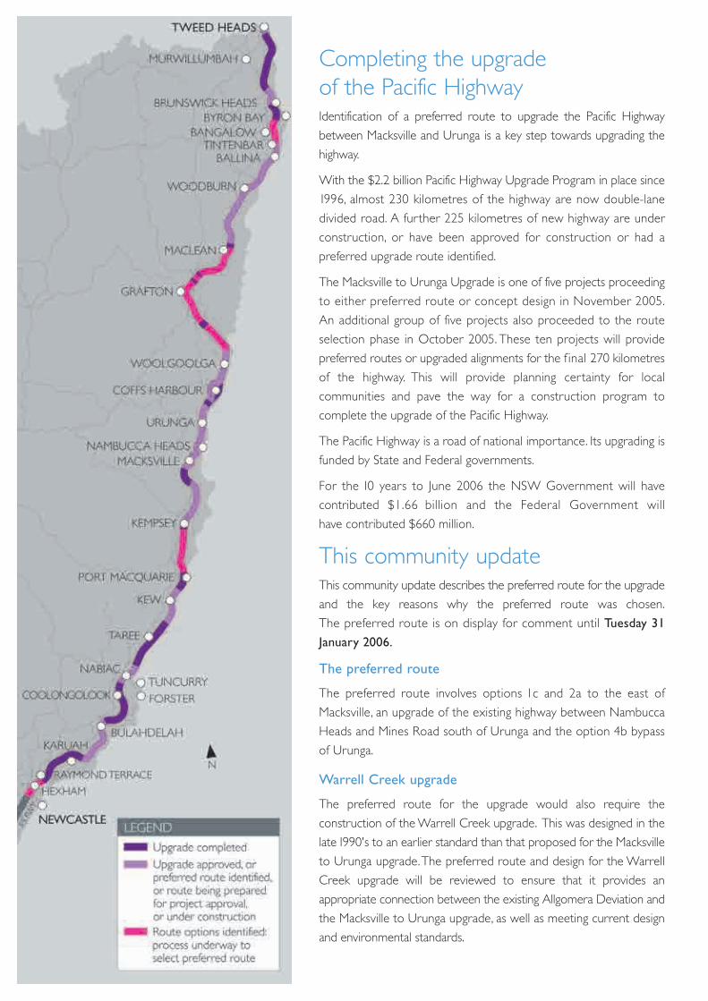
Completing the upgrade of the Pacific HighwayIdentification of a preferred route to upgrade the Pacific Highway
between Macksville and Urunga is a key step towards upgrading the
highway.
With the $2.2 billion Pacific Highway Upgrade Program in place since
1996, almost 230 kilometres of the highway are now double-lane
divided road. A further 225 kilometres of new highway are under
construction, or have been approved for construction or had a
preferred upgrade route identified.
The Macksville to Urunga Upgrade is one of five projects proceeding
to either preferred route or concept design in November 2005.
An additional group of five projects also proceeded to the route
selection phase in October 2005. These ten projects will provide
preferred routes or upgraded alignments for the f inal 270 kilometres
of the highway. This will provide planning certainty for local
communities and pave the way for a construction program to
complete the upgrade of the Pacific Highway.
The Pacific Highway is a road of national importance. Its upgrading is
funded by State and Federal governments.
For the 10 years to June 2006 the NSW Government will have
contributed $1.66 billion and the Federal Government will
have contributed $660 million.
This community updateThis community update describes the preferred route for the upgrade
and the key reasons why the preferred route was chosen.
The preferred route is on display for comment until Tuesday 31
January 2006.
The preferred route
The preferred route involves options 1c and 2a to the east of
Macksville, an upgrade of the existing highway between Nambucca
Heads and Mines Road south of Urunga and the option 4b bypass
of Urunga.
Warrell Creek upgrade
The preferred route for the upgrade would also require the
construction of the Warrell Creek upgrade. This was designed in the
late 1990's to an earlier standard than that proposed for the Macksville
to Urunga upgrade.The preferred route and design for the Warrell
Creek upgrade will be reviewed to ensure that it provides an
appropriate connection between the existing Allgomera Deviation and
the Macksville to Urunga upgrade, as well as meeting current design
and environmental standards.

PREFERRED ROUTE
This cross section shows a typical arrangement of the highway upgrade, with a 12 metre wide median and 32 metres fromshoulder to shoulder. The final arrangement may vary, for example, the local access road may not be near the highway.
TYPICAL CROSS SECTION
Shou
lder
Shou
lder Sh
ould
er
Shou
lder
Shou
lder
Shou
lder
Median width to accomodate future upgrading
to a six lane highway
Two traffic lanes
southbound
Two traffic lanes
northbound
Local traffic lanes(two lanes /
one laneeach direction)
Width varies
Local access road (existing highway)
Four lane dual carriageway motorway
0 1 2
Kilometres
How was the preferredroute chosen?Possible constraints to building a highway were
mapped. From this, route options were identified and
the most feasible options were placed on public display
from November 2004 to February 2005.
Field investigations, public submissions, comments
received from other government agencies and the
outcomes of a value management workshop held in
April 2005 were considered during the selection of the
preferred route.
Why was the preferredroute chosen?The preferred route provides the best overall balance
between functional, ecological, social and economic
considerations.
When compared to options to the west of Macksville,
options located in the original study area to the east of
Macksville were found to:
Provide better road safety, transport efficiency,
highway access and ability to stage construction.
Have less impact on urban businesses, future
growth, native flora and fauna and cultural heritage.
Of the options located to the east of Macksville options
1c and 2a were selected as they:
Provide good road safety and transport efficiency.
Have the lowest impact (including potential
noise impact) on existing and future residential
areas, communities and rural activities.
Have moderate flooding, ecological and
Aboriginal heritage impacts.
In the north of the study area, option 4b was selected
as it would:
Provide the best outcome both overall and
in the vicinity of the Raleigh Industrial Area.
Provide good road safety and transport efficiency.
Have the least impact on future growth and
rural activities.
Have moderate impacts on residential areas,
communities, businesses and cultural heritage.
Local access arrangementsAccess to the preferred route will be provided at the
existing interchange at Raleigh and at proposed new
interchanges located south of Macksville and west of
Nambucca Heads.
The existing highway and other local roads will be
retained for access to townships, communities and
properties. Where required, these roads will pass
over or under the preferred route.
Detailed report availableMore information is contained in the Macksville to
Urunga Preferred Route Report.The report describes
the preferred route and why it was chosen.The report is
available on the project website or by phoning the project
information line (see details on back page). Copies of the
report can be viewed at the display locations.
N
LEGENDPreferred route
Possible interchange location
Existing Pacific Highway
North Coast Railway Line
Property boundaries
State Forest area
SEPP 14 Wetland area
Residential
Commercial / Industrial

Stay involvedThe RTA will continue to consult with landowners and the
community about the preferred route.There are many
aspects of the design that will need local community input,
including access arrangements, reducing impact on the
immediate environment, drainage infrastructure, noise
management and others.
Your submission on the preferred route should be sent to
the address shown in the contact information box. All
community issues for the preferred route will be
considered during the assessment studies.
Display locationsThe preferred route is on display until Tuesday 31
January 2006 at the locations shown below. These
displays include maps that show more detail about the
issues in this area, and how they relate to the preferred
route.
Nambucca Shire Council, Princess Street, Macksville
(Mon-Fri 9am-4pm)
Bellingen Shire Council, Hyde Street, Bellingen
(Mon-Fri 8.30am-4.30pm)
Nambucca Heads, RTA Motor Registry,
Shops 11 & 13 Seascape Shopping Centre,
Ridge Street (Mon-Fri 9am-4pm)
Nambucca Heads, Nambucca Plaza, Pacific Highway
(Mon-Wed 8am-7pm,Thur-Fri 8am-7.30pm,
Sat-Sun 8am-6pm)
Urunga Post Office, Bonville Street Urunga
(Mon-Fri 9am-5pm)
Bowraville Technology Centre, 39 High Street
Bowraville (Mon-Fri 9am-5pm)
Warrell Creek, Fire Brigade, Cnr Sonny’s Road
and Albert Drive (Mon-Sun 9am-5pm)
RTA Pacific Highway Office, Prince Street Grafton
(Mon-Fri 8.30am-4.30pm)
Staffed displaysProject staff will be available to discuss the preferred
route in more detail at:
Urunga Senior Citizens’ Hall, Urunga
Tuesday 6 December 2005, 9am-5pm
Nambucca Shire Council, Princess Street Macksville,
Wednesday 7 December 2005, 9am-5pm
Shop 2A Nambucca Plaza, Pacific Highway, Bellwood
Thursday 8 December 2005,10am-7pm
All information in correspondence is collected for the sole purpose ofassisting in the assessment of this proposal.The information may be usedby the RTA and/or the RTA’s project contractors. All informationreceived, including names and addresses of respondents,may be publishedin subsequent documents unless clear indication is given in thecorrespondence that all or part of that information is not to be published.
RTA/Pub. 05.274
Further survey, geotechnical and ecological investigations
will commence shortly and the design for the preferred
route will be refined.
Approval of the proposal will be requested under the
recently introduced Part 3A of the EP&A Act. The proposal
will be the subject of an environmental assessment which
will examine the potential impacts of the preferred route.
The refined design and assessment will be displayed for
community comment prior to assessment of the proposal
by the Department of Planning and consideration by the
Minister for Planning.
DISPLAY REFINED DESIGN AND ENVIRONMENTAL ASSESSMENT
SELECTION OF PREFERRED ROUTE
ASSESSMENT OF PROPOSAL BY DEPARTMENT OF PLANNING
CONSIDERATION BY MINISTER FOR PLANNING
REFINE DESIGN
�
��
��
�
PREPARE ENVIRONMENTAL
ASSESSMENT
�
WE
AR
EH
ERE
What happens next
To contact the study team, write to:Ross Jones, Sinclair Knight MerzPO Box 164, St LEONARDS NSW 1590
1800 800 612 (toll free)Project Information Line
To contact the RTA’s Project Manager write to:Chris Clark, RTAPO Box 546, GRAFTON NSW 2460
www.rta.nsw.gov.au/pacific(Click on Macksville to Urunga project)
T 02 6640 1000 F 02 6640 1001
Warrell Creek to Urunga upgrade(Incorporating Warrell Creek and Macksville to Urunga upgrading projects)Upgrading the Pacific Highway
COMMUNITY UPDATE
SEPTEMBER 2007
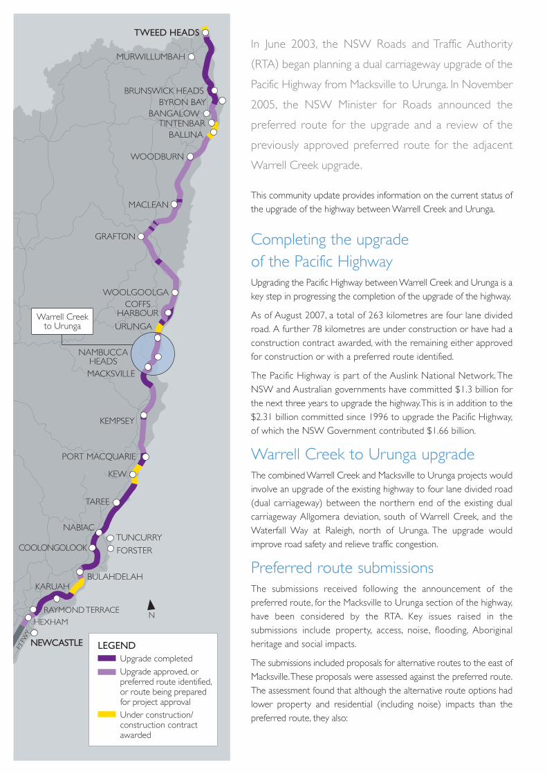
BALLINA
BYRON BAYBRUNSWICK HEADS
TINTENBARBANGALOW
MURWILLUMBAH
TWEED HEADS
MACLEAN
WOODBURN
NEWCASTLE
KARUAH
HEXHAMRAYMOND TERRACE
BULAHDELAH
FORSTER
TUNCURRY
TAREE
NABIAC
KEW
COOLONGOLOOK
KEMPSEY
PORT MACQUARIE
MACKSVILLE
NAMBUCCAHEADS
URUNGA
COFFSHARBOUR
WOOLGOOLGA
GRAFTON
F3 F
WY
E
N
LEGENDUpgrade completedUpgrade approved, orpreferred route identified,or route being preparedfor project approvalUnder construction/construction contractawarded
Warrell Creekto Urunga
In June 2003, the NSW Roads and Traffic Authority
(RTA) began planning a dual carriageway upgrade of the
Pacific Highway from Macksville to Urunga. In November
2005, the NSW Minister for Roads announced the
preferred route for the upgrade and a review of the
previously approved preferred route for the adjacent
Warrell Creek upgrade.
This community update provides information on the current status ofthe upgrade of the highway between Warrell Creek and Urunga.
Completing the upgrade of the Pacific HighwayUpgrading the Pacific Highway between Warrell Creek and Urunga is akey step in progressing the completion of the upgrade of the highway.
As of August 2007, a total of 263 kilometres are four lane dividedroad. A further 78 kilometres are under construction or have had aconstruction contract awarded, with the remaining either approvedfor construction or with a preferred route identified.
The Pacific Highway is part of the Auslink National Network. TheNSW and Australian governments have committed $1.3 billion forthe next three years to upgrade the highway.This is in addition to the $2.31 billion committed since 1996 to upgrade the Pacific Highway,of which the NSW Government contributed $1.66 billion.
Warrell Creek to Urunga upgradeThe combined Warrell Creek and Macksville to Urunga projects wouldinvolve an upgrade of the existing highway to four lane divided road(dual carriageway) between the northern end of the existing dualcarriageway Allgomera deviation, south of Warrell Creek, and theWaterfall Way at Raleigh, north of Urunga. The upgrade wouldimprove road safety and relieve traffic congestion.
Preferred route submissionsThe submissions received following the announcement of thepreferred route, for the Macksville to Urunga section of the highway,have been considered by the RTA. Key issues raised in thesubmissions include property, access, noise, flooding, Aboriginalheritage and social impacts.
The submissions included proposals for alternative routes to the east ofMacksville.These proposals were assessed against the preferred route.The assessment found that although the alternative route options hadlower property and residential (including noise) impacts than thepreferred route, they also:
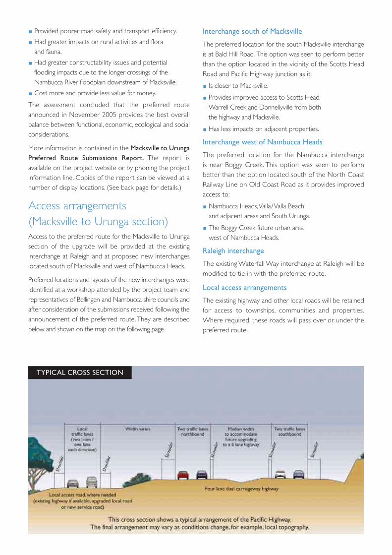
Provided poorer road safety and transport efficiency.
Had greater impacts on rural activities and flora and fauna.
Had greater constructability issues and potential flooding impacts due to the longer crossings of theNambucca River floodplain downstream of Macksville.
Cost more and provide less value for money.
The assessment concluded that the preferred routeannounced in November 2005 provides the best overallbalance between functional, economic, ecological and socialconsiderations.
More information is contained in the Macksville to UrungaPreferred Route Submissions Report. The report isavailable on the project website or by phoning the projectinformation line. Copies of the report can be viewed at anumber of display locations. (See back page for details.)
Access arrangements (Macksville to Urunga section)Access to the preferred route for the Macksville to Urungasection of the upgrade will be provided at the existinginterchange at Raleigh and at proposed new interchangeslocated south of Macksville and west of Nambucca Heads.
Preferred locations and layouts of the new interchanges wereidentified at a workshop attended by the project team andrepresentatives of Bellingen and Nambucca shire councils andafter consideration of the submissions received following theannouncement of the preferred route.They are describedbelow and shown on the map on the following page.
Interchange south of Macksville
The preferred location for the south Macksville interchangeis at Bald Hill Road. This option was seen to perform betterthan the option located in the vicinity of the Scotts HeadRoad and Pacific Highway junction as it:
Is closer to Macksville.
Provides improved access to Scotts Head,Warrell Creek and Donnellyville from both the highway and Macksville.
Has less impacts on adjacent properties.
Interchange west of Nambucca Heads
The preferred location for the Nambucca interchange is near Boggy Creek. This option was seen to performbetter than the option located south of the North CoastRailway Line on Old Coast Road as it provides improvedaccess to:
Nambucca Heads,Valla/Valla Beachand adjacent areas and South Urunga.
The Boggy Creek future urban area west of Nambucca Heads.
Raleigh interchange
The existing Waterfall Way interchange at Raleigh will bemodified to tie in with the preferred route.
Local access arrangements
The existing highway and other local roads will be retainedfor access to townships, communities and properties.Where required, these roads will pass over or under thepreferred route.
TYPICAL CROSS SECTION
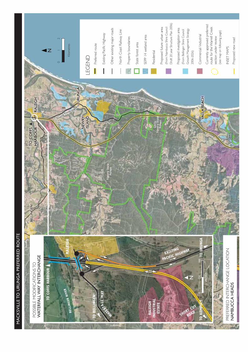
TO C
OFF
S HAR
BOUR
RALE
IGH
RALE
IGH
INDUST
RIAL
ESTA
TE
TO U
RUNGA
N
MA
CK
SVIL
LE T
O U
RU
NG
A P
REF
ERR
ED R
OU
TE
POSS
IBLE
MO
DIF
ICAT
ION
S TO
WAT
ERFA
LL W
AY IN
TER
CH
AN
GE
PREF
ERRE
D IN
TERC
HA
NG
E LO
CAT
ION
NA
MBU
CC
A H
EAD
S
BEL
LINGER
RIVE
R
PACIFICHIGHWAYEXISTING
SHORT
CUT
ROAD
LEG
END
Pref
erre
d ro
ute
Exist
ing
Paci
fic H
ighw
ay
Oth
er e
xist
ing
maj
or r
oads
Nor
th C
oast
Rai
lway
Lin
e
Prop
erty
bou
ndar
ies
Stat
e fo
rest
are
a
SEPP
14
wet
land
are
a
Resid
entia
l
Prop
osed
futu
re u
rban
are
a(F
rom
Nam
bucc
a Sh
ire C
ounc
il
Dra
ft 20
yea
r St
ruct
ure
Plan
200
6)
Prop
osed
inve
stig
atio
n ar
ea(F
rom
Bel
linge
n Sh
ire C
ounc
il
Gro
wth
Man
agem
ent
Stra
tegy
2006
-202
6)
Com
mer
cial
/ ind
ustr
ial
Cur
rent
ly a
ppro
ved
pref
erre
dro
ute
for
the
War
rell
Cre
ekse
ctio
n un
der
revi
ew
(see
map
on
follo
win
g pa
ge)
INSE
T M
APS
Prop
osed
new
roa
d
01
2
Kilo
met
res
N
025
050
0
MET
RES
TO B
ELLI
NGEN
TO K
EMPS
EY
WAT
ERFA
LLW
AY

N
PREF
ERRE
D IN
TERC
HA
NG
E LO
CAT
ION
SOU
TH
MA
CK
SVIL
LE
PROPO
SED F
UTU
REURB
AN A
REA
N
TO C
OFF
S HAR
BOUR
NORTHCOASTRAILWAYLINE
NORTHCOASTRAILWAYLINE
Exist
ing
Paci
fic H
ighw
ay
New
loca
l acc
ess
road
Oth
er e
xist
ing
maj
or r
oads
Roun
dabo
ut a
nd r
amp
Brid
ge
Mai
n m
ap a
eria
l pho
togr
aphy
sou
rced
from
Dep
artm
ent
of L
ands
.Ins
et m
aps
aeria
l pho
togr
aphy
dat
e 5
Mar
ch 2
006.
TO B
ELLW
OOD
NAM
BUCC
A HEA
DS
TO K
EMPS
EY
TO K
EMPS
EY
TO D
ONNEL
LYVI
LLE
WAR
RELL
CRE
EK
BOGG
Y CRE EK
ROAD
TO C
OFF
S HAR
BOUR
TO M
ACKS
VILL
E
TO S
OUTH
MAC
KSVI
LLE
EXISTING PACIFIC HIGHWAY
WARRE
LLCR
EEK
SCOT
TS
HEAD
ROAD
025
050
0
MET
RES
025
050
0
MET
RES
EXISTINGPACIFICHIGHWAY TO
BEL
LWOOD
NAM
BUCC
A HEA
DS
TO D
ONNEL
LYVI
LLE
WAR
RELL
CRE
EK

Warrell Creek upgrade reviewOutcomes of review
Planning approval for the preferred route for the WarrellCreek upgrade was granted in the 1990s to an earlierstandard than that proposed for current upgrades of thePacific Highway.
A review of the upgrade found that the currently approvedpreferred route and design would need to be modified tomeet current design standards for the Pacific Highway andprovide an appropriate connection between the existingAllgomera deviation and the Macksville to Urunga upgrade.The review also found that the design would have significantnoise impacts on the village of Warrell Creek and would needto be substantially modified to meet current noise guidelines.
In response to the outcomes of the review, a number ofoptions for the Warrell Creek upgrade have been developed.
How were the options developed?
The new route options were assessed against a range of functional, environmental, social, economic and costconsiderations. Comments received from governmentagencies, Nambucca Shire Council and the communitywere considered during the identification of the options.
The assessment identified a shortlist of the four most feasibleroutes.The currently approved preferred route and the fournew shortlisted route options are shown in the figure on thefollowing page.
Key findings
The key findings of the assessment of the shortlisted options(shown overleaf) were that:
As the study area is primarily used for residential andfarming purposes, the extent of very high and highquality ecological habitat is limited. Most of the nativeflora and fauna is located on the eastern side ofWarrell Creek in the south of the study area.
While the western (Red and Blue) options would have lessimpact on farming properties than the eastern (Orangeand Purple) options, they would provide little change toexisting noise levels at Warrell Creek village; would requirenew arrangements to provide access to properties east ofthe upgrade and would have more construction difficultiesthan the eastern options.
Of the two eastern options, the Purple option wasassessed as performing better than the Orange option as itwould result in the least change to existing accessarrangements and have fewer construction difficulties andslightly lower noise impacts than the Orange option.
With preliminary costs of $88 million to $91 million($2006), the eastern options are less expensive than thewestern options at $102 million to $122 million ($2006).
The Purple option was assessed to be one of the bestperforming options overall and provided the best value formoney. On balance, it was considered to have more meritthan the other options.
Local access arrangements
For all the route options, local access would be provided byan at-grade T-intersection at the southern end of the projectand by a local road connection from Donnellyville to theproposed interchange south of Macksville. Access across thehighway upgrade would be provided by a western extensionof Albert Drive, north of the railway line.
Stay involved
The RTA is seeking your comments on the new routeoptions before making a decision on the outcomes of thereview of the Warrell Creek upgrade.
Written submissions are welcome and should be sent byclose of business on Friday 5 October 2007. You can use theenclosed feedback form or send a response to the addressshown in the contact information box (back page). Allcommunity submissions will be considered before a decisionon the outcomes of the review of the Warrell Creekupgrade is made.
The outcomes of the review will be included in theenvironmental assessment of the upgrade of the highwaybetween Warrell Creek and Urunga.
Detailed report available
More information is contained in the Draft Warrell CreekReview Report. The report describes the review of thecurrently approved preferred route and the development andassessment of new route options.The report is available onthe project website or by phoning the project informationline (see back page for details). Copies of the report can beviewed at the display locations.
Staffed display
Project staff will be available to discuss the Warrell Creekupgrade review at the Warrell Creek Community Hall,Tuesday11 September 2007, 2pm-8pm.

WARRELL CREEK UPGRADE OPTIONS

Environmental assessment processProject application
The RTA has lodged an application for project approval underPart 3A of the EP&A Act, 1979 with the Director-General of theDepartment of Planning for the upgrade of the highway betweenWarrell Creek and Urunga. The application, which includes apreliminary environmental assessment, has been advertised andposted on the Department of Planning and RTA websites.
The Department of Planning will consult various agenciesbefore providing the RTA with a list of requirements for theassessment of the proposal.
Environmental assessment
When completed, the environmental assessment andrefined design will be placed on display for public commentfor at least 30 days. The assessment will contain a draftStatement of Commitments indicating the measuresproposed by the RTA to minimise the potential impact ofthe proposal on the environment.
At the end of the display, the RTA will be asked to respond tothe issues raised in community submissions.The RTA may modifythe proposal further to manage impacts on the environment.
The Department of Planning provides an assessment reportfor consideration by the Minister for Planning. The Ministerthen decides whether to approve the proposal.
Display locationsThe documents discussed in this community update are ondisplay until Friday 5 October 2007 at the locations shownbelow. These displays include maps that show more detailabout the proposed upgrade.
Nambucca Shire Council,Princess Street, Macksville (Mon-Fri 9am-4pm).
RTA Pacific Highway Office,Prince Street, Grafton (Mon-Fri 8.30am-4.30pm).
Bellingen Shire Council,Hyde Street, Bellingen(Mon-Fri 8.30am-4.30pm).
Urunga Post Office,Bonville Street, Urunga(Mon-Fri 9am-5pm).
Nambucca Heads, RTA Motor Registry,Shops 11 &13 Seascape Shopping Centre,Ridge Street (Mon-Fri 9am-4pm).
To contact the study team, write to:Ross Jones, Sinclair Knight MerzPO Box 164, ST LEONARDS NSW 1590
1800 800 612 (toll free)Project information line
To contact the RTA’s Project Manager write to: Chris Clark, RTAPO Box 546, GRAFTON NSW 2460
www.rta.nsw.gov.au/pacific (click on Warrell Creek to Urunga )
T 02 6640 1000 F 02 6640 1001
RTA/Pub. 07.256
All information in correspondence is collected for the sole purpose of assistingin the assessment of this proposal.The information may be used by the RTAand/or the RTA’s project contractors.All information received, including namesand addresses of respondents,may be published in subsequent documents unlessclear indication is given in the correspondence that all or part of that informationis not to be published.
STEPS IN THE ENVIRONMENTAL ASSESSMENT PROCESS
Public display of refined design and the environmental assessment
RTA considers community submissions and proposals to reduce impacts and (if required) modifies the proposal to manage impacts
Department of Planning consults with agencies and council(s) and prepares a report on the proposal (including any modifications)
Minister for Planning decides whether to approve the proposal
RTA displays review of Warrell Creek section
RTA submits application forapproval of Warrell Creek
to Urunga upgrade toDepartment of Planning
Selection of preferred route for Macksville to Urunga section
RTA announces that Warrell Creek section
will be reviewed
RTA considers submissionsfrom display of review
of Warrell Creek section
Outcomes of review ofWarrell Creek section
announced
Department of Planning consults with agencies
and council(s) and issuesrequirements for the
environmental assessment
RTA refines design and prepares environmental assessment for the Warrell Creek to Urunga upgrade
WEAREHERE
2-WA
Y C
OM
MU
NIT
Y IN
VOLV
EMEN
T

TO KEMPSEY
TO COFFS HARBOUR
Macksville
Nambucca Heads
Exist
ing
Paci
fic H
ighw
ay
Valla Beach
UrungaRaleigh
Warrell Creek Donnellyville
Pref
erre
d ro
ute
Warrell Creek to Urunga upgrade(Incorporating Warrell Creek and Macksville to Urunga projects)Upgrading the Pacific Highway
QUESTION AND ANSWER SHEETJUNE 2008
The preferred route The preferred route for the Warrell Creek section is the Purple option. In response to community issues raised, thedesign was further refined at the northern end to reduce potential noise and visual impacts on residences. The preferredroute is shown in the diagram below.
The RTA has a program to upgrade the whole Pacific Highway. It is important for drivers to have a consistent standard onthe Pacific Highway.The previously approved route was designed to an earlier standard than that proposed for the currentupgrade of the Pacific Highway.
Detailed report availableMore information is contained in the WarrellCreek Review Report. The report describesthe review of the Warrell Creek section, thedevelopment of route options and theselection of the preferred route.The reportidentifies and responds to the issues raisedin community submissions.
The report is available on the project websiteor by phoning the project information line(see back page for details).
Locality sketch
Aerial photography sourced from Department of Lands September 2000. Area surrounding preferred route November 2007.
N
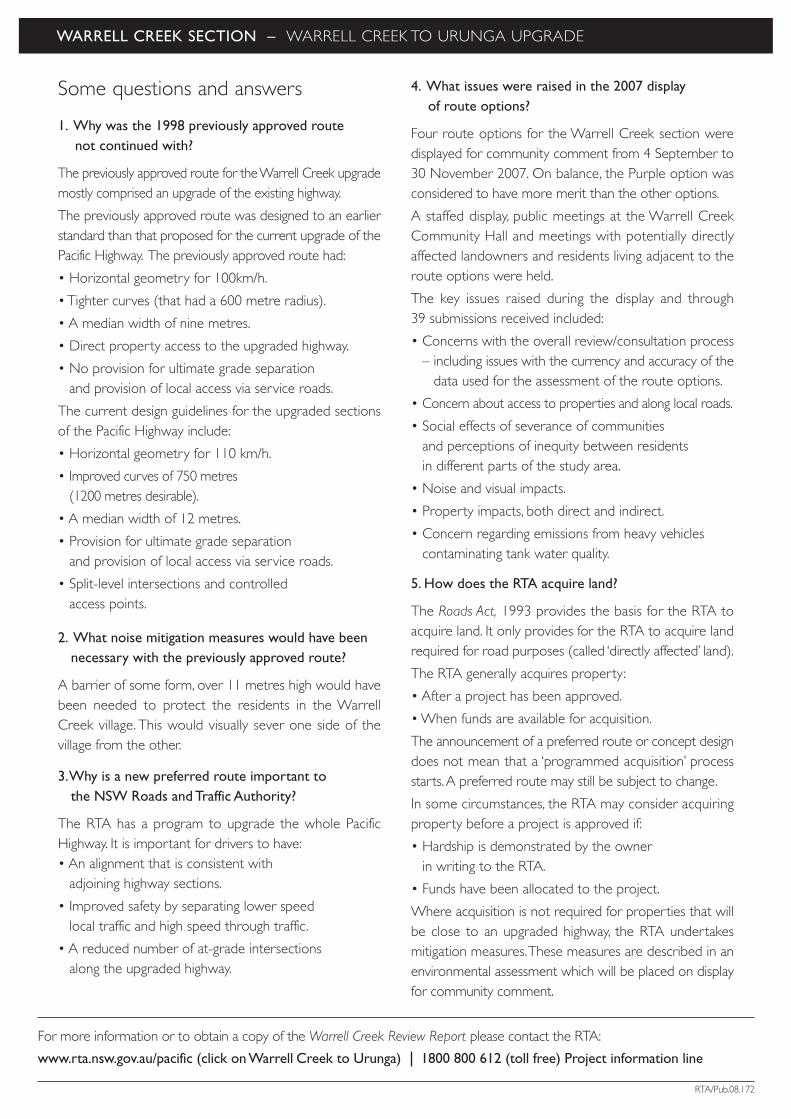
Some questions and answers
1. Why was the 1998 previously approved route not continued with?
The previously approved route for the Warrell Creek upgrademostly comprised an upgrade of the existing highway.
The previously approved route was designed to an earlierstandard than that proposed for the current upgrade of thePacific Highway. The previously approved route had:
• Horizontal geometry for 100km/h.
• Tighter curves (that had a 600 metre radius).
• A median width of nine metres.
• Direct property access to the upgraded highway.
• No provision for ultimate grade separation and provision of local access via service roads.
The current design guidelines for the upgraded sectionsof the Pacific Highway include:
• Horizontal geometry for 110 km/h.
• Improved curves of 750 metres (1200 metres desirable).
• A median width of 12 metres.
• Provision for ultimate grade separation and provision of local access via service roads.
• Split-level intersections and controlled access points.
2. What noise mitigation measures would have beennecessary with the previously approved route?
A barrier of some form, over 11 metres high would havebeen needed to protect the residents in the WarrellCreek village. This would visually sever one side of thevillage from the other.
3.Why is a new preferred route important to the NSW Roads and Traffic Authority?
The RTA has a program to upgrade the whole PacificHighway. It is important for drivers to have:• An alignment that is consistent with
adjoining highway sections.
• Improved safety by separating lower speed local traffic and high speed through traffic.
• A reduced number of at-grade intersections along the upgraded highway.
4. What issues were raised in the 2007 display of route options?
Four route options for the Warrell Creek section weredisplayed for community comment from 4 September to30 November 2007. On balance, the Purple option wasconsidered to have more merit than the other options.
A staffed display, public meetings at the Warrell CreekCommunity Hall and meetings with potentially directlyaffected landowners and residents living adjacent to theroute options were held.
The key issues raised during the display and through 39 submissions received included:
• Concerns with the overall review/consultation process– including issues with the currency and accuracy of the
data used for the assessment of the route options.
• Concern about access to properties and along local roads.
• Social effects of severance of communitiesand perceptions of inequity between residents in different parts of the study area.
• Noise and visual impacts.
• Property impacts, both direct and indirect.
• Concern regarding emissions from heavy vehiclescontaminating tank water quality.
5. How does the RTA acquire land?
The Roads Act, 1993 provides the basis for the RTA toacquire land. It only provides for the RTA to acquire landrequired for road purposes (called ‘directly affected’ land).
The RTA generally acquires property:
• After a project has been approved.
• When funds are available for acquisition.
The announcement of a preferred route or concept designdoes not mean that a ‘programmed acquisition’ processstarts.A preferred route may still be subject to change.
In some circumstances, the RTA may consider acquiringproperty before a project is approved if:
• Hardship is demonstrated by the ownerin writing to the RTA.
• Funds have been allocated to the project.
Where acquisition is not required for properties that willbe close to an upgraded highway, the RTA undertakesmitigation measures.These measures are described in anenvironmental assessment which will be placed on displayfor community comment.
WARRELL CREEK SECTION – WARRELL CREEK TO URUNGA UPGRADE
RTA/Pub.08.172
For more information or to obtain a copy of the Warrell Creek Review Report please contact the RTA:
www.rta.nsw.gov.au/pacific (click on Warrell Creek to Urunga) 1800 800 612 (toll free) Project information line

Warrell Creek to Urunga upgrade(Incorporating Warrell Creek and Macksville to Urunga upgrade projects)Upgrading the Pacific Highway
COMMUNITY UPDATE
JUNE 2008

BALLINA
BYRON BAYBRUNSWICK HEADS
TINTENBARBANGALOW
MURWILLUMBAH
TWEED HEADS
MACLEAN
WOODBURN
NEWCASTLE
KARUAH
HEXHAMRAYMOND TERRACE
BULAHDELAH
FORSTER
TUNCURRY
TAREE
NABIAC
KEW
COOLONGOLOOK
KEMPSEY
PORT MACQUARIE
WOOLGOOLGA
GRAFTON
F3 F
WY
N
LEGEND
Upgrade completedUpgrade approved, or preferred route identified,or route being prepared for project approvalUnder construction
Warrell Creekto Urunga
NAMBUCCA HEADSMACKSVILLE
URUNGA
COFFS HARBOUR
This community update provides information onthe upgrade of the Pacific Highway betweenWarrell Creek and Urunga. It identifies:
• The preferred route for the Warrell Creek section.
• The concept design for the Warrell Creek to Urunga upgrade, including the locationand layout of modified interchanges andareas where the design has been modifiedto reduce impact.
Completing the upgrade of the Pacific HighwayCurrently, 267 of a total of 679 kilometres are double lanedivided road.A further 87 kilometres are under construction.The remaining kilometres are either approved for constructionor have had a preferred route identified.
The Pacific Highway is part of the AusLink National Network.By mid 2009, the NSW Government will have spent $2.3 billion and the Australian Government $1.3 billiontowards the upgrade of the Pacific Highway.
Warrell Creek to Urunga upgradeThe existing highway would be upgraded to a four lanedivided road (dual carriageway) between the northern endof the completed Allgomera deviation, south of WarrellCreek and the Waterfall Way at Raleigh, north of Urunga.
The preferred route for Macksville to Urunga was announcedin November 2005. The preferred route was selected aftercommunity consultation and field investigations. As part ofthose investigations, a range of options were considered,including options to the west of Macksville and optionssuggested by the community. Information on theseinvestigations is contained in a series of project reports, whichare available on the project website (see back page for details).
Preferred route for Warrell Creek The preferred route for the Warrell Creek section is thePurple option displayed in September 2007 (see next page).

WARRELL CREEK SECTION
Update since November 2007 Since the display of the route options the followingactivities have taken place:
• New aerial photography was obtained to reassess the four route options.
•The assessment process was updated.
More information on the Warrell Creek section isavailable in the Warrell Creek question and answer sheet.
Detailed report available More information is contained in the Warrell CreekReview Report. The report describes the review ofthe Warrell Creek section, the development ofroute options and the selection of the preferredroute. The report identifies and responds to theissues raised in community submissions.
The report is on display at the locations marked with# on the back of this update. The report is available on the project website or by phoning the projectinformation line (see back page for details).
The preferred route The preferred route for the Warrell Creek section is thePurple option. In response to community issues raisedthe design was further refined at the northern end toreduce potential noise and visual impacts on residences.The preferred route is shown in this diagram.
The preferred route for the Warrell Creek sectionwill be included in the environmental assessment ofthe proposal to upgrade the highway betweenWarrell Creek and Urunga.
Aerial photography sourced from Department of Lands September 2000. Area surrounding preferred route November 2007.
N

WARRELL CREEK TO URUNGA CONCEPT DESIGN – KEY FEATURES
Concept design
The concept design for the upgrade of the Pacific Highway from Warrell Creek to Urunga is shown on the
map above. Further refinements to the concept design may occur during the environmental assessment of
the project and in response to further community comments.
It is proposed to build a new four lane dual carriageway highway between Warrell Creek and the existing
Waterfall Way interchange at Raleigh. The existing highway would become a local road connecting existing
and future communities to each other and to the new highway.
Highway access arrangements
The location and layout of access points on the highwayhave been refined based on community commentsand further investigations. Access would be providedvia five grade-separated interchanges at the followinglocations:
Existing Waterfall Way interchange at Raleigh.
Ballards Road, south of Urunga.
Near Boggy Creek, west of Nambucca Heads.
Bald Hill Road, south of Macksville.
South of Warrell Creek village.
Changes to the highway access arrangements sincethe September 2007 community update include:
New interchanges at Ballards Road and south of Warrell Creek.
Refinement of the Bald Hill Road interchange to retain the existing highway south of the interchange as part of the local road network.
Upgrading the access ramps at the existing Raleighinterchange, to improve road safety.
Local roads and property accesses
The existing Pacific Highway would connect to the new highwayat five interchanges.This would:
Provide safer access to properties that currently have directhighway access.
Enable residents to take road trips to local shops and facilitieswithout having to use the upgraded section of highway.
Provide a continuous alternative local road link betweenWarrell Creek and Raleigh for school buses and motoristswho do not wish to use the upgraded highway.
Existing local roads would be retained and new local roadsconstructed to provide access to townships, communities andproperties. Where required, these roads would pass over orunder the new highway. There would be no direct access fromproperties to the new highway.
Alignment changes
Changes to the alignment of the new highway since theSeptember 2007 community update include:
A shift in the alignment of the upgrade to the east, southof Bald Hill Road, to retain the existing highway as a localroad connecting Scotts Head Road and the WarrellCreek/Donnellyville area to the interchange at Macksville.
Minor shifts in the alignment through the NambuccaState Forest to minimise impacts on native flora and toavoid the disused tip site adjacent to Old Coast Road.
Minor shifts in the alignment north of Valla Beach andthrough the Newry State Forest to reduce impactson the existing highway and to minimise impacts onnative flora.
A minor shift in the alignment west of Newry Islandto minimise impacts on native flora and to fur therdistance the upgrade from the SEPP 14 wetlands tothe east.
New rest area
The area between the new and existing highways northof the Boggy Creek interchange is a potential locationfor a rest area for light and heavy vehicles.
Opportunities to stage construction
Opportunities to stage construction of the upgrade includeconstructing one or more of the sections of highway to bypass Warrell Creek village, Macksville, Bellwood(Nambucca Heads) and Mines Road, south of Urunga.
No decision has been made in regard to staging theconstruction of the project.
PREFERRED INTERCHANGE LOCATIONSOUTH MACKSVILLE
PREFERRED INTERCHANGE LOCATIONWARRELL CREEK
LEGEND INSET MAPS
Proposed new road
Existing Pacific Highway
Ramp
New local access road
Roundabout
New bridge
Existing bridge
Other existing major road
Proposed future urban area(From Nambucca Shire
Council Draft 20 Year Structure
Plan 2006)
Proposed investigation area(From Bellingen Shire Council
Growth Management Strategy
2006-2026)
Preferred route
Existing Pacific Highway
Other existing major roads
North Coast Railway Line
Property boundaries
State forest area
SEPP 14 wetland area
Residential
Commercial /industrial
PREFERRED INTERCHANGE LOCATIONS ATSOUTH URUNGA AND NAMBUCCA HEADS
PROPOSED MODIFICATIONS TOWATERFALL WAY INTERCHANGE
NN
N
N
Aerial images in inset maps: November 2007Main map aerial photography sourced from Department of Lands September 2000. Area surrounding preferred route November 2007.
Ballards Road interchange
Local road undernew highway
Proposed rest area
Overpass for local access
Existing Pacific Highway located within
preferred route corridor
Nambucca Headsinterchange

Display locationsThe concept design for the Warrell Creek to Urunga upgradeand the Warrell Creek Review Report are on display untilFriday 8 August 2008 at the locations shown below:
Nambucca Shire Council, Princess Street, Macksville(Mon-Fri 9am-4pm).#
Bellingen Shire Council, Hyde Street, Bellingen(Mon-Fri 8.30am-4.30pm).#
Urunga Post Office, Bonville Street, Urunga(Mon-Fri 9am-5pm).#
Nambucca Heads, RTA Motor Registry,Shops 11 &13 Seascape Shopping Centre, Ridge Street(Mon-Fri 9am-4pm).#
Warrell Creek Community Hall,Albert Drive,Warrell Creek.
RTA Pacific Highway Office, 21 Prince Street, Grafton(Mon-Fri 8.30am-4.30pm).#
Staffed displays Project staff will be available to discuss the conceptdesign for the Warrell Creek to Urunga upgrade andthe preferred route for the Warrell Creek section inmore detail at the following locations:
Warrell Creek Community Hall,Monday 30 June 2008, 4pm-8pm.
Nambucca Shire Council,Tuesday 1 July 2008, 9am-4pm.
Urunga Senior Citizens Hall, Urunga,Wednesday 2 July 2008, 10am-4pm.
Nambucca Plaza, Pacific Highway, Bellwood,Thursday 3 July 2008, 10am-8pm.
It should be noted that you can drop in at any timeduring the staffed displays.
What happens next?The Department of Planning has provided the RTA with a listof requirements for the environmental assessment of theproposal to upgrade the highway between Warrell Creekand Urunga.
When completed, the environmental assessment will beplaced on display for public comment for at least 30 days.At the end of the display, the RTA will be asked to respondto the issues raised in the community submissions. The RTAmay modify the proposal further to manage impacts on theenvironment.
The Department of Planning provides an assessment reportfor consideration by the NSW Minister for Planning. TheMinister then decides whether to approve the proposal.
STEPS IN THE ENVIRONMENTAL ASSESSMENT PROCESS
Public display of the environmental assessment
RTA considers community submissions and proposals to reduce impacts and (if required) modifies the proposal to manage impacts
Department of Planning consults with agencies and council(s) and prepares a report on the proposal (including any modifications)
Minister for Planning decides whether to approve the proposal
RTA displays review of Warrell Creek section
RTA submits application forapproval of Warrell Creek
to Urunga upgrade toDepartment of Planning
Selection of preferred route for Macksville to Urunga section
RTA announces that Warrell Creek section
will be reviewed
RTA considers submissionsfrom display of review
of Warrell Creek section
Outcomes of review ofWarrell Creek section
announced
Department of Planning consults with agencies
and council(s) and issuesrequirements for the
environmental assessment
RTA refines design and prepares environmental assessment for the Warrell Creek to Urunga upgrade
WEAREHERE
TW
O-W
AY
CO
MM
UN
ITY
INV
OLV
EMEN
T
To contact the study team, write to:Ross Jones, Sinclair Knight MerzPO Box 164, St Leonards NSW 1590
1800 800 612 (toll free)Project information line
To contact the RTA’s Project Manager write to: Chris Clark, RTAPO Box 546, GRAFTON NSW 2460
www.rta.nsw.gov.au/pacific (click on Warrell Creek to Urunga )
www.auslink.gov.au
T 02 6640 1000 F 02 6640 1001
RTA/Pub. 08.171
All information is collected for the sole purpose of assisting in theassessment of the proposal. All information received, including namesand addresses of respondents, may be published in subsequentassessment documents unless a clear indication is given in thecorrespondence that such information is not to be published.

![Messages file0118 5/6/01 The Social Test [pt 3 of 3] Pope, Randy 2001A 0119 5/13/01 The Authenticity of New Birth Radmanesh, Abe - 0120 5/20/01 The Doctrinal Test Pope, Randy 2001A](https://img.pdfslide.us/doc/110x75/5e1783e7e66a6a4247670993/messages-5601-the-social-test-pt-3-of-3-pope-randy-2001a-0119-51301-the-authenticity.jpg)