Embed Size (px)
Citation preview

Pacific Highway upgradeAchievement report May 2015
Drilling in preparation for blasting at Maria River State Forest, looking south, on the Kundabung to Kempsey project

N
LEGEND
I I I
Major roads
RailwayState border
PACIFIC HIGHWAY UPGRADEUpgrade completedUpgrade approved, orpreferred route identified, orbeing prepared for projectapprovalConstruction contractawarded / under construction
Rivers
0 25 50km
LEGENDUpgrade completed
Upgrade approved, orpreferred route identified,or route being preparedfor project approval
Under construction
N
N
LEGENDUpgrade completed
Upgrade approved, orpreferred route identified,or route being preparedfor project approval,or under constructionRoute options identified:process underway toselect preferred route
BALLINA
BYRON BAYBRUNSWICK HEADS
TINTENBARBANGALOW
MURWILLUMBAH
TWEED HEADS
MACLEAN
WOODBURN
NEWCASTLE
KARUAH
HEXHAM
RAYMOND TERRACE
BULAHDELAH
FORSTER
TUNCURRY
TAREE
NABIAC
KEW
COOLONGOLOOK
KEMPSEY
PORT MACQUARIE
MACKSVILLENAMBUCCA HEADS
URUNGA
COFFS HARBOUR
WOOLGOOLGA
GRAFTON
F3 F
WY
DRAFT 3 / 19 SEPTEMBER 2006
WA
NT
SANSW
VIC
QLD
KEY MAP
WNSW
LEGEND
Upgrade completed
Planning / design stageUnder constructionExisting Pacific Highway
N
LEGEND
Upgrade completed
Planning / design stageUnder construction
N
NSW
QLD
F3 F
reew
ay
Paci
fic H
ighw
ay
Paci
fic H
ighw
ay
Pacific Highwayupgrade
WA
NT
SANSW
VIC
QLD
KEY MAP
WNSW
BALLINA
BRISBANE
TWEEDHEADS
GRAFTON
NSW
QLD
NEWCASTLE
GOSFORD
SYDNEY
SOUTHPORT
LISMORE
N
Four-lane divided road
Environmental assessments or concept designs being preparedfor the remaining sections of single lane highway
Tendering phase
Under construction
COFFSHARBOUR
KEMPSEY
PORTMACQUARIE
TAREE
P a c i f i c H i g h w a y u p g r a d e A c h i e v e m e n t r e p o r t , M a y 2 0 1 5
Pacific Highway upgrade
This report will provide you with information about Pacific Highway upgrade projects, including the current status and key activities.
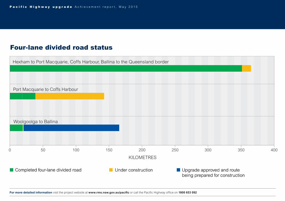
As of 31 May 2015, 397 kilometres are four lane divided road and about 123 kilometres are being built. The remaining sections of two lane highway are being prepared for major work.
About 60 per cent of the final highway length is now four lane divided road.
123 km of highway under construction during May 2015.
About 2700 construction workers on site.
For overall upgrading strategy refer to the second last page.
For more detailed information visit the project website at www.rms.nsw.gov.au/pacific or call the Pacific Highway office on 1800 653 092
Upgrade completed to dual carriagewayUpgrade approved and/or route being prepared for constructionUnder construction
Short Cut Road overbridge
and new South Arm Road
intersection open to traffic on the
Nambucca Heads to Urunga project
Completed mainline
earthworks on the Tintenbar to Ewingsdale
project
Contractors: Lend Lease
Form of contract: Design and build
Workers on site: 478
Pieces of large machinery: 122
Start date of major construction: October 2014
Expected completion date: 2017 (weather permitting)
Project value: $820 million
Australian Government contribution: $542.4 million *
NSW State Government contribution: $277.6 million *
* Contribution amounts may vary from year to year.
P a c i f i c H i g h w a y u p g r a d e A c h i e v e m e n t r e p o r t , M a y 2 0 1 5
Port Macquarie to Coffs Harbour – projects being built
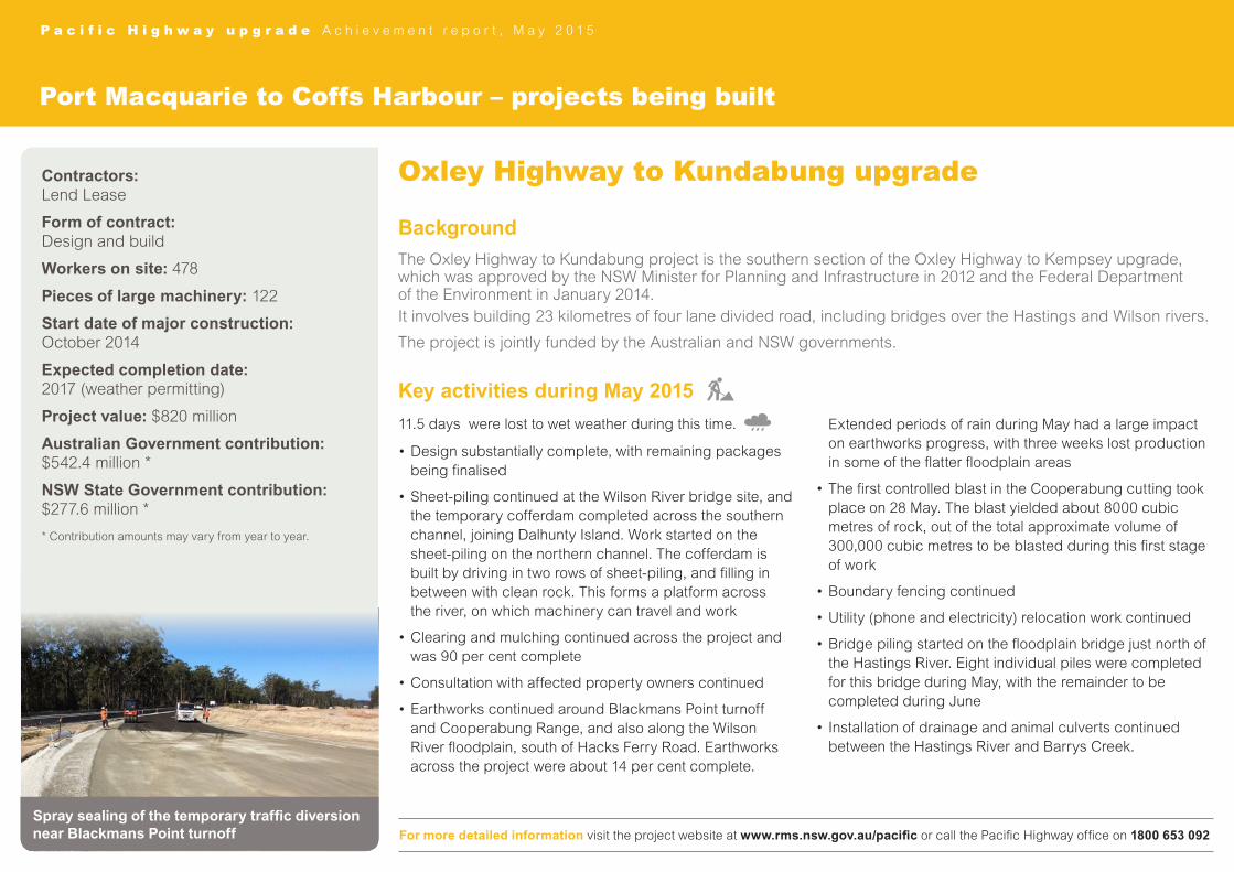
Oxley Highway to Kundabung upgrade
Background
The Oxley Highway to Kundabung project is the southern section of the Oxley Highway to Kempsey upgrade, which was approved by the NSW Minister for Planning and Infrastructure in 2012 and the Federal Department of the Environment in January 2014.It involves building 23 kilometres of four lane divided road, including bridges over the Hastings and Wilson rivers.
The project is jointly funded by the Australian and NSW governments.
Key activities during May 2015
11.5 days were lost to wet weather during this time.
•Design substantially complete, with remaining packages being finalised
•Sheet-piling continued at the Wilson River bridge site, and the temporary cofferdam completed across the southern channel, joining Dalhunty Island. Work started on the sheet-piling on the northern channel. The cofferdam is built by driving in two rows of sheet-piling, and filling in between with clean rock. This forms a platform across the river, on which machinery can travel and work
•Clearing and mulching continued across the project and was 90 per cent complete
•Consultation with affected property owners continued
•Earthworks continued around Blackmans Point turnoff and Cooperabung Range, and also along the Wilson River floodplain, south of Hacks Ferry Road. Earthworks across the project were about 14 per cent complete.
Extended periods of rain during May had a large impact on earthworks progress, with three weeks lost production in some of the flatter floodplain areas
•The first controlled blast in the Cooperabung cutting took place on 28 May. The blast yielded about 8000 cubic metres of rock, out of the total approximate volume of 300,000 cubic metres to be blasted during this first stage of work
•Boundary fencing continued
•Utility (phone and electricity) relocation work continued
•Bridge piling started on the floodplain bridge just north of the Hastings River. Eight individual piles were completed for this bridge during May, with the remainder to be completed during June
•Installation of drainage and animal culverts continued between the Hastings River and Barrys Creek.
For more detailed information visit the project website at www.rms.nsw.gov.au/pacific or call the Pacific Highway office on 1800 653 092
Spray sealing of the temporary traffic diversion near Blackmans Point turnoff
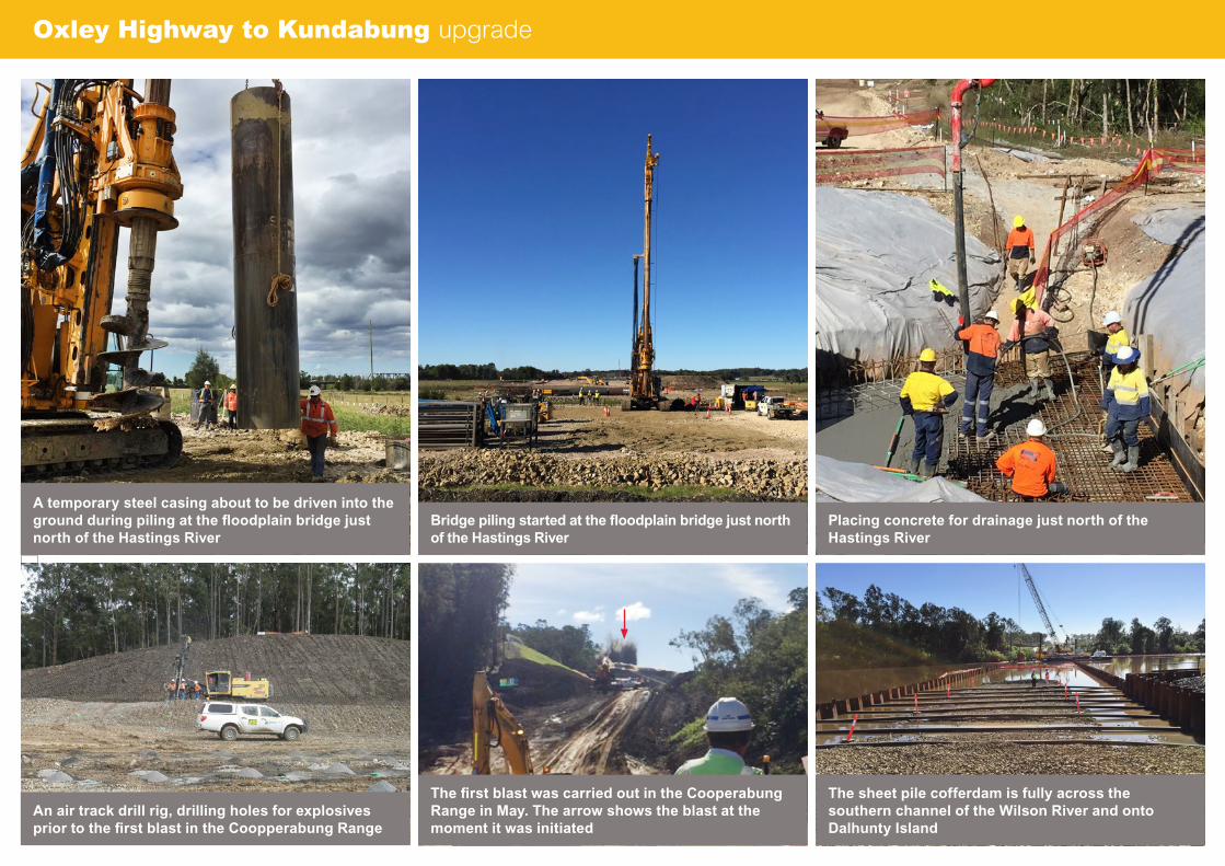
Oxley Highway to Kundabung upgrade
Placing concrete for drainage just north of the Hastings River
The first blast was carried out in the Cooperabung Range in May. The arrow shows the blast at the moment it was initiated
The sheet pile cofferdam is fully across the southern channel of the Wilson River and onto Dalhunty Island
Bridge piling started at the floodplain bridge just north of the Hastings River
A temporary steel casing about to be driven into the ground during piling at the floodplain bridge just north of the Hastings River
An air track drill rig, drilling holes for explosives prior to the first blast in the Coopperabung Range

Contractors: Ferrovial Agroman
Form of contract: Build only
Workers on site: 109
Pieces of large machinery: 20
Start date of major construction: August 2014
Expected completion date: Second half of 2015
Project value: forms part of the Oxley Highway to Kempsey upgrade
P a c i f i c H i g h w a y u p g r a d e A c h i e v e m e n t r e p o r t , M a y 2 0 1 5
Port Macquarie to Coffs Harbour – projects being built
Sancrox interchange
Background
The Sancrox interchange is early work for the Oxley Highway to Kempsey upgrade.
It includes building local service roads and a bridge over the Pacific Highway at Sancrox about 600 metres south of the existing Sancrox Road intersection.
Key activities during May 2015
16 days were lost to wet weather during this time.
•Earthworks continued on the Sancrox and Fernbank Creek roads roundabouts, as well as the approaches to the overbridge
•Earthworks at south-eastern roundabout finalised in preparation for concrete pavement
•Stormwater and sub-surface drainage work along Sancrox Road continued
•Sancrox overbridge deck pours were completed and precast parapet installation started.
For more detailed information visit the project website at www.rms.nsw.gov.au/pacific or call the Pacific Highway office on 1800 653 092Drainage work south of Sancrox Road

Sancrox interchange upgrade
Precast concrete being delivered to site ready for installation onto the bridgeLooking south through the main cutting
Earthworks on the western approach to the overbridge, looking west
Curing of the bridge deck after the concrete pour Earthworks on the Sancrox Road roundabout

P a c i f i c H i g h w a y u p g r a d e A c h i e v e m e n t r e p o r t , M a y 2 0 1 5
Port Macquarie to Coffs Harbour – projects being built
Kundabung to Kempsey upgrade
Background
The Kundabung to Kempsey project is the northern section of the Oxley Highway to Kempsey upgrade, which was approved by the NSW Minister for Planning and Infrastructure in 2012 and the Federal Department of the Environment in January 2014.
It involves building 14 kilometres of four lane divided road, including a new interchange at Kundabung and new rest areas.
The project is jointly funded by the Australian and NSW governments.
Key activities during May 2015
12 days were lost to wet weather during this time.
•Clearing and grubbing continued and was 95 per cent complete
•Earthworks continued
•Three compound basins completed and 12 permanent basins being built
•Installation of animal and boundary fencing continued
•Installation of drainage continued
•Work started to build accesses and work platforms for bridges at Pipers Creek, Smiths Creek and Kundabung
•Backfilling of two culverts completed and a further two started. Unit installation for a further four culverts and excavation and base slab for four culverts started
•Drilling and blasting started in Maria River State Forest.
Contractors: McConnell Dowell OHL joint venture
Form of contract: Build only
Workers on site: 250
Pieces of large machinery: 150
Start date of major construction: November 2014
Expected completion date: 2017 (weather permitting)
Project value: $230 million
Australian Government contribution: $115 million *
NSW State Government contribution: $115 million *
* Contribution amounts may vary from year to year.
For more detailed information visit the project website at www.rms.nsw.gov.au/pacific or call the Pacific Highway office on 1800 653 092Loading and hauling near Bloodwood rest area
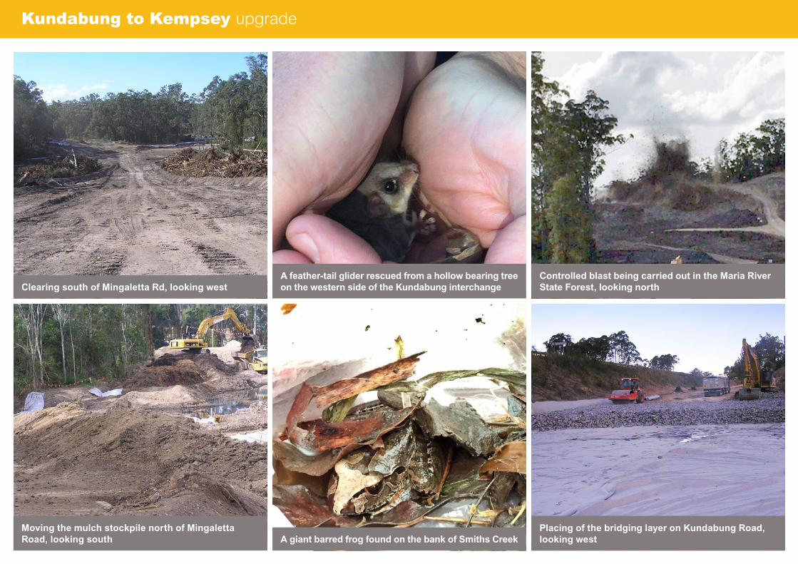
Kundabung to Kempsey upgrade
Moving the mulch stockpile north of Mingaletta Road, looking south
Placing of the bridging layer on Kundabung Road, looking west
Clearing south of Mingaletta Rd, looking west Controlled blast being carried out in the Maria River State Forest, looking north
A feather-tail glider rescued from a hollow bearing tree on the western side of the Kundabung interchange
A giant barred frog found on the bank of Smiths Creek

P a c i f i c H i g h w a y u p g r a d e A c h i e v e m e n t r e p o r t , M a y 2 0 1 5
Port Macquarie to Coffs Harbour – projects being built
Frederickton to Eungai upgrade
Background
The Frederickton to Eungai project is the second stage of the Kempsey to Eungai upgrade, which was approved in 2008. The Kempsey bypass was the first stage and opened to traffic in March 2013.
The project is jointly funded by the Australian and NSW governments.
It will provide about 26.5 kilometres of four lane divided road from the completed Kempsey bypass to Eungai Rail.
Key activities during May 2015
14 days were lost to wet weather during this time.
•Building work continued on the former alignment of the Pacific Highway at the northern end of the project
•Concrete paving continued at various locations throughout the project, with 30 per cent of 213,000 cubic metres placed to date
•Bridgework continued and was 78 per cent complete. Plank and deck placement continued at the bridges over the Collombatti Creek and Collombatti floodplain and also at the bridge over Seven Hills Road. Building has started at the Boririgalla Creek twin bridges
•Building of culverts and other drainage structures continued and was 91 per cent complete
•Installation of boundary and fauna fencing continued and was about 80 per cent complete
•Off-site manufacture of precast concrete components, such as bridge girders, completed.
Contractors: Thiess Pty Ltd
Form of contract: Design and build
Workers on site: 349
Pieces of large machinery: 145
Start date of major construction: August 2013
Expected completion date: Mid 2016 (weather permitting)
Project value: $675 million
Australian Government contribution: $337.5 million *
NSW State Government contribution: $337.5 million *
* Contribution amounts may vary from year to year.
For more detailed information visit the project website at www.rms.nsw.gov.au/pacific or call the project information line on 1800 668 240Looking north at work south of Collombatti Creek
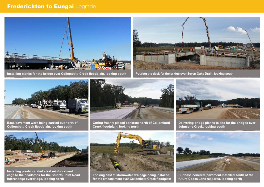
Frederickton to Eungai upgrade
Base pavement work being carried out north of Collombatti Creek floodplain, looking south
Installing planks for the bridge over Collombatti Creek floodplain, looking south
Installing pre-fabricated steel reinforcement cage to the headstock for the Stuarts Point Road interchange overbridge, looking north
Delivering bridge planks to site for the bridges over Johnsons Creek, looking south
Pouring the deck for the bridge over Seven Oaks Drain, looking south
Subbase concrete pavement installed south of the future Cooks Lane rest area, looking north
Curing freshly placed concrete north of Collombatti Creek floodplain, looking north
Looking east at stormwater drainage being installed for the embankment over Collombatti Creek floodplain

P a c i f i c H i g h w a y u p g r a d e A c h i e v e m e n t r e p o r t , M a y 2 0 1 5
Port Macquarie to Coffs Harbour – projects being built
Warrell Creek to Nambucca Heads
Background
The Warrell Creek to Nambucca Heads project is the second stage of the Warrell Creek to Urunga upgrade, which was approved by the NSW Minister for Planning and Infrastructure in 2011. The Federal Minister for the Environment approved this upgrade in December 2014.
The project is jointly funded by the Australian and NSW governments.
The 20 kilometre project involves upgrading the existing highway to a four lane divided road between the Allgomera deviation, south of Warrell Creek and Nambucca Heads, just south of the North Coast railway line where it will join the Nambucca Heads to Urunga upgrade.
Key activities during May 2015
11 days were lost to wet weather during this time.
•Detailed design work continued
•Detailed site survey to support design continued
•Additional geotechnical investigations continued
•Vegetation clearing along Old Coast Road (for sedimentation basin) and across the south of the project, including the railway diversion, continued
•Vegetation clearing on the north section of the project started
•Surface water monitoring continued
•Consultation with affected property owners continued
•Earthworks for precasting yard continued
•Process to install at-resident noise treatments continued
•Building erosion and sedimentation controls continued
•Relocation of utilities continued
•Installation of site access gates off some local roads continued
•Installation of boundary fencing and clearing limit flagging continued
•Installation of frog fencing completed
•Removal of houses at Bald Hill Road completed
•Trial blasting in a number of locations
•Work to build the platform for Nambucca bridgework started.
Contractors: Acciona Ferrovial joint venture
Form of contract: Design and build
Workers on site: 276
Pieces of large machinery: 95
Start date of major construction: December 2014
Expected completion date: Late 2017 (weather permitting)
Project value: $830 million
Australian Government contribution: $415 million *
NSW State Government contribution: $415 million *
* Contribution amounts may vary from year to year.
For more detailed information visit the project website at www.rms.nsw.gov.au/pacific or call the Pacific Highway office on 1800 653 092
Looking north from Cockburn lane at clearing work and building of of sediment controls

Warrell Creek to Nambucca Heads under construction
Clearing adjacent to flying-fox camp
Looking south at earthworks and the building of a sedimentation basin west of the Boral quarry
Looking north at the junction where the project will connect with the Nambucca Heads to Urunga upgrade
Looking north at machinery operating on the south bank of Upper Warrell Creek across from Scotts Head Road
Looking south from Albert Drive in Donnellyville at earthworks and building of sediment basins along the existing Pacific Highway
Looking south at vegetation clearing and sediment controls being built at Cockburn lane
Looking west at underground relocation of electrical cables on Nursery Road in preparation for bridgework
Looking east from Old Coast Road at the precasting yard, including dam
P a c i f i c H i g h w a y u p g r a d e A c h i e v e m e n t r e p o r t , M a y 2 0 1 5
Port Macquarie to Coffs Harbour – projects being built
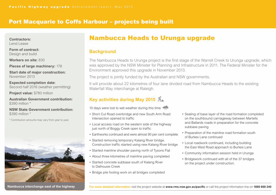
Nambucca Heads to Urunga upgrade
Background
The Nambucca Heads to Urunga project is the first stage of the Warrell Creek to Urunga upgrade, which was approved by the NSW Minister for Planning and Infrastructure in 2011. The Federal Minister for the Environment approved this upgrade in November 2013.
The project is jointly funded by the Australian and NSW governments.
It will provide about 22 kilometres of four lane divided road from Nambucca Heads to the existing Waterfall Way interchange at Raleigh.
Key activities during May 2015
10 days were lost to wet weather during this time
•Short Cut Road overbridge and new South Arm Road intersection opened to traffic
•Local access road on the western side of the highway just north of Boggy Creek open to traffic
•Earthworks continued and were almost 90 per cent complete
•Started removing temporary Kalang River bridge. Construction traffic started using new Kalang River bridge
•Started mainline shoulder paving north of Tysons Flat
•About three kilometres of mainline paving completed
•Started concrete subbase south of Kalang River to Dalhousie Creek
•Bridge pile footing work on all bridges completed
•Sealing of base layer of the road formation completed on the southbound carriageway between Martells and Ballards roads in preparation for the concrete subbase paving
•Preparation of the mainline road formation south of Burkes Lane continued
•Local roadwork continued, including building the East West Road approach to Burkes Lane
•Community information session held in Urunga
•Bridgework continued with all of the 37 bridges on the project under construction.
Contractors: Lend Lease
Form of contract: Design and build
Workers on site: 830
Pieces of large machinery: 178
Start date of major construction: November 2013
Expected completion date: Second half 2016 (weather permitting)
Project value: $780 million
Australian Government contribution: $390 million *
NSW State Government contribution: $390 million *
* Contribution amounts may vary from year to year.
For more detailed information visit the project website at www.rms.nsw.gov.au/pacific or call the project information line on 1800 668 240Nambucca interchange east of the highway
Nambucca Heads to Urunga upgrade
Haulage crossing area at Boggy Creek site
New bridge over the highway at the Nambucca interchange
Work on the local access road overbridge north of the Kalang River
Boggy Creek bridge and creek realignment
Bridge headstock and column for the local access road overbridge north of the Kalang River
Nambucca interchange rest area/highway service centre taking shape
Looking south from the Nambucca interchange to Deep Creek
Progress on the Martells Road overbridge

WOOLGOOLGA
GRAFTON
BALLINA
CASINO
Coolgardie Roadto Ballina Bypass
Richmond Riverto Coolgardie Road
National ParkBroadwater
to Richmond River
Trustums Hill toBroadwater National Park
Devils Pulpit upgradeto Trustums Hill
Iluka Road toDevils Pulpit upgrade
Maclean to Iluka Road
Tyndale to Maclean
Glenugie upgrade to Tyndale
Glenugie upgrade
Halfway Creek to Glenugie upgrade
Woolgoolga to Halfway Creek
Devils Pulpit upgrade
11
10
9
8
7
6
5
4
3
2
1
P a c i f i c H i g h w a y u p g r a d e A c h i e v e m e n t r e p o r t , M a y 2 0 1 5
Woolgoolga to Ballina – projects being prepared for major work
Woolgoolga to Ballina
Background
The Woolgoolga to Ballina upgrade was approved by the NSW Minister for Planning in June 2014 and the Federal Minister for the Environment in August 2014. The 155 kilometre project will provide a four lane divided road from the northern end of the Woolgoolga Bypass to the southern end of the Ballina Bypass.
The project is jointly funded by the Australian and NSW governments. Roads and Maritime Services has selected Pacific Complete from the private sector as its preferred delivery partner for the Woolgoolga to Ballina Pacific Highway upgrade. Pacific Complete will work closely with Roads and Maritime’s Pacific Highway Office to manage multiple contracts in delivering the design and construction of the Woolgoolga to Ballina upgrade.
Activities underway during May 2015
For more detailed information visit the project website at www.rms.nsw.gov.au/pacific or call the Pacific Highway office on 1800 653 092
Contracts•Awarded contract for independent hydrologist to WMA Water•Golding Contractors started work on the Construction
Environmental Management Plan documents for soft soil treatments – Wave 1 (Yamba Road to Chatsworth Road)
•SEE Civil started work on the Construction Environmental Management Plan documents for soft soil treatments – Wave 2 (Whytes Lane to Pimlico)
•Roads and Maritime’s Pacific Highway Office continued to work with its preferred delivery partner Pacific Complete, to fine tune the packaging and procurement strategy for the project
•Continued to assess registrations of interest to design and build the bridge over the Clarence River at Harwood
•Agreements in place on 90 per cent of land acquisitions, with negotiations continuing on the remainder.
Design•Continued to work on design for soft soil early work –
Wave 3 (Shark Creek, Maclean).
Environment•Carried out a contamination assessment in section 5
(Maclean to Iluka Road)•Continued trial of emu fencing•Continued with threatened species baseline surveys
including frogs, koalas, emus, long-nosed potoroos and gliders
•Continued work on biodiversity offset strategy•Continued to submit threatened species management plans
to the NSW Department Planning and Environment and federal Department of the Environment for approval
•Continued to capture and release koalas in section 10 for the Population Viability Analysis (PVA)
•Started to develop strategy for planting koala feed trees•Aboriginal salvage work continued in sections 1 (Woolgoolga
to Halfway Creek) and 9 (Broadwater National Park to Richmond River)
•Continued to carry out non-Aboriginal archival recording and historical research.
Stakeholder engagement•Provided an update to the community on the status of koala
captures in section 10, the process for collecting data for the PVA and the next steps.

Bulahdelah upgrade under constructionWoolgoolga to Ballina upgrade
A trial emu fence-gate
Aboriginal salvage north of Richmond River
Trial emu fencing in section 3
Aboriginal salvage north of Woodburn
Under construction
P a c i f i c H i g h w a y u p g r a d e A c h i e v e m e n t r e p o r t , M a y 2 0 1 5
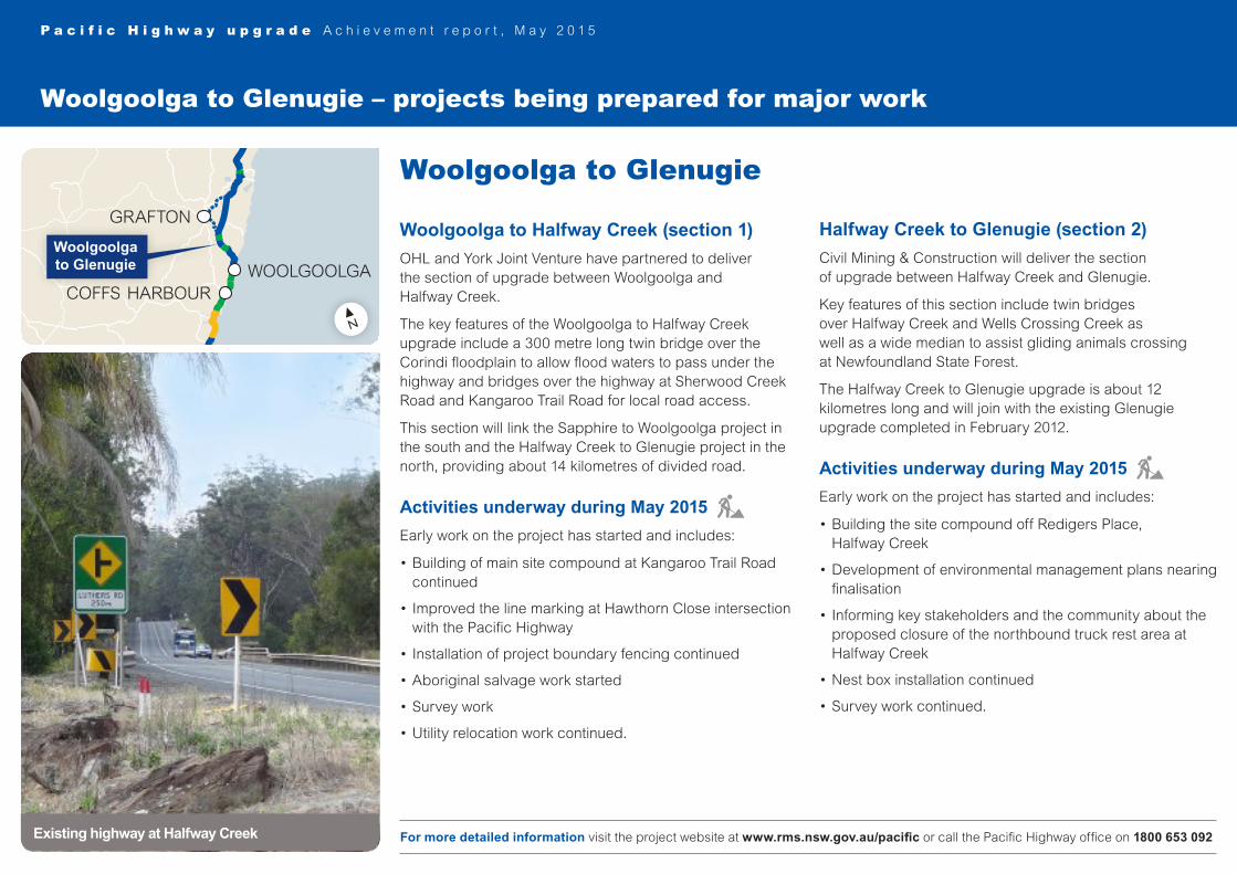
Woolgoolga to Glenugie – projects being prepared for major work
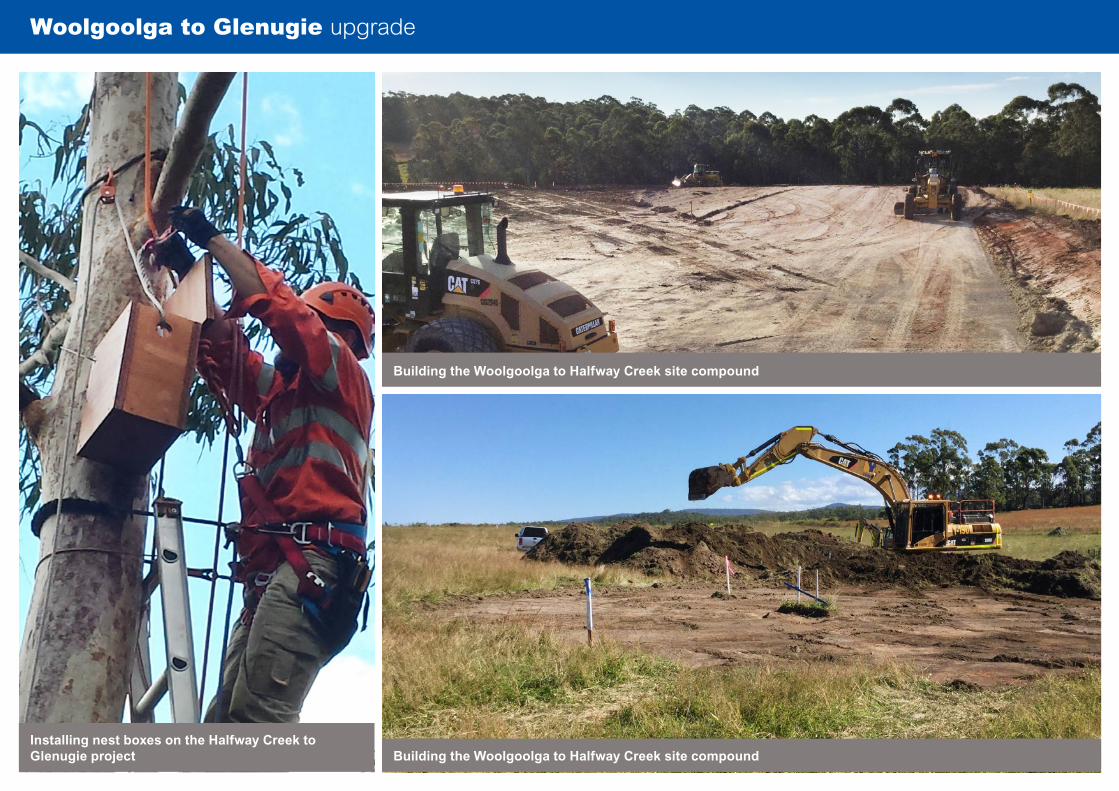
Woolgoolga to Glenugie
Woolgoolga to Halfway Creek (section 1)
OHL and York Joint Venture have partnered to deliver the section of upgrade between Woolgoolga and Halfway Creek.
The key features of the Woolgoolga to Halfway Creek upgrade include a 300 metre long twin bridge over the Corindi floodplain to allow flood waters to pass under the highway and bridges over the highway at Sherwood Creek Road and Kangaroo Trail Road for local road access.
This section will link the Sapphire to Woolgoolga project in the south and the Halfway Creek to Glenugie project in the north, providing about 14 kilometres of divided road.
Activities underway during May 2015
Early work on the project has started and includes:
•Building of main site compound at Kangaroo Trail Road continued
•Improved the line marking at Hawthorn Close intersection with the Pacific Highway
•Installation of project boundary fencing continued
•Aboriginal salvage work started
•Survey work
•Utility relocation work continued.
Halfway Creek to Glenugie (section 2)
Civil Mining & Construction will deliver the section of upgrade between Halfway Creek and Glenugie.
Key features of this section include twin bridges over Halfway Creek and Wells Crossing Creek as well as a wide median to assist gliding animals crossing at Newfoundland State Forest.
The Halfway Creek to Glenugie upgrade is about 12 kilometres long and will join with the existing Glenugie upgrade completed in February 2012.
Activities underway during May 2015
Early work on the project has started and includes:
•Building the site compound off Redigers Place, Halfway Creek
•Development of environmental management plans nearing finalisation
•Informing key stakeholders and the community about the proposed closure of the northbound truck rest area at Halfway Creek
•Nest box installation continued
•Survey work continued.
For more detailed information visit the project website at www.rms.nsw.gov.au/pacific or call the Pacific Highway office on 1800 653 092Existing highway at Halfway Creek
N
LEGEND
I I I
Major roads
RailwayState border
PACIFIC HIGHWAY UPGRADEUpgrade completedUpgrade approved, orpreferred route identified, orbeing prepared for projectapprovalConstruction contractawarded / under construction
Rivers
0 25 50km
LEGENDUpgrade completed
Upgrade approved, orpreferred route identified,or route being preparedfor project approval
Under construction
N
N
LEGENDUpgrade completed
Upgrade approved, orpreferred route identified,or route being preparedfor project approval,or under constructionRoute options identified:process underway toselect preferred route
BALLINA
BYRON BAYBRUNSWICK HEADS
TINTENBARBANGALOW
MURWILLUMBAH
TWEED HEADS
MACLEAN
WOODBURN
NEWCASTLE
KARUAH
HEXHAM
RAYMOND TERRACE
BULAHDELAH
FORSTER
TUNCURRY
TAREE
NABIAC
KEW
COOLONGOLOOK
KEMPSEY
PORT MACQUARIE
MACKSVILLENAMBUCCA HEADS
URUNGA
COFFS HARBOUR
WOOLGOOLGA
GRAFTON
F3 F
WY
DRAFT 3 / 19 SEPTEMBER 2006
WA
NT
SANSW
VIC
QLD
KEY MAP
WNSW
LEGEND
Upgrade completed
Planning / design stageUnder constructionExisting Pacific Highway
N
LEGEND
Upgrade completed
Planning / design stageUnder construction
N
NSW
QLD
F3 F
reew
ay
Paci
fic H
ighw
ay
Paci
fic H
ighw
ay
Pacific Highwayupgrade
WA
NT
SANSW
VIC
QLD
KEY MAP
WNSW
BALLINA
BRISBANE
TWEEDHEADS
GRAFTON
COFFS HARBOUR
KEMPSEY
PORTMACQUARIE
TAREE
NSW
QLD
NEWCASTLE
GOSFORD
SYDNEY
SOUTHPORT
LISMORE
N
Four-lane divided road
Environmental assessments or concept designs being preparedfor the remaining sections of single lane highway
Tendering phase
Under construction
WOOLGOOLGA
Woolgoolga to Glenugie
Bulahdelah upgrade under constructionWoolgoolga to Glenugie upgrade
Building the Woolgoolga to Halfway Creek site compound
Installing nest boxes on the Halfway Creek to Glenugie project Building the Woolgoolga to Halfway Creek site compound

P a c i f i c H i g h w a y u p g r a d e A c h i e v e m e n t r e p o r t , M a y 2 0 1 5
Woolgoolga to Ballina – projects being built
Pimlico to Teven upgrade
Background
The Pimlico to Teven project will upgrade about two kilometres of the Pacific Highway between Pimlico Road and Teven Road. This enabling work will facilitate the next phase of the highway upgrade, which is part of the overall Woolgoolga to Ballina project.
This project is jointly funded by the Australian and NSW governments.
The Pimlico to Teven project involves building bridges over Duck and Emigrant creeks and more than one kilometre of new road on the Bruxner Highway.
The project is being carried out in three stages. Stage one was completed by the Ballina Bypass Alliance.
Stage two is now under construction.
Stage three, which provides a four lane divided road, will be completed as part of the larger Woolgoolga to Ballina upgrade.
Key activities during May 2015
No days were lost to wet weather during this time.
•Started parapet installation on Emigrant Creek bridge
•Drainage installation on Emigrant Creek bridge continued
•Pavement work on the Bruxner Highway continued
•Started landscaping work for the Bruxner Highway
•Drainage work on access tracks and property adjustment work continued
•Asphalt work on the existing Bruxner Highway completed
•Placement of girders on Duck Creek bridge completed.
Contractors: Leighton Contractors
Form of contract: Build only
Workers on site: 61
Pieces of large machinery: 8
Start date of major construction: November 2013
Expected completion date: Mid 2016
Project value: Forms part of the Woolgoolga to Ballina upgrade.
For more detailed information visit the project website at www.rms.nsw.gov.au/pacific or call the project information line on 1800 639 842Pavement work on the Bruxner Highway

Pimlico to Teven upgrade
Placing pavement on the Bruxner HighwayInstalling girders for Duck Creek bridge View under Duck Creek bridge
Drainage being installed on Emigrant Creek bridge Installation of girders for Duck Creek bridge has been completed

Contractors: Lend Lease
Form of contract: Design and build
Workers on site: 226
Pieces of large machinery: 148
Start date of major construction: September 2012
Expected completion date: Late 2015 (weather permitting)
Project value: $862 million
Australian Government contribution: $566.1 million *
NSW State Government contribution: $295.9 million *
* Contribution amounts may vary from year to year.
P a c i f i c H i g h w a y u p g r a d e A c h i e v e m e n t r e p o r t , M a y 2 0 1 5
Projects being built
Tintenbar to Ewingsdale upgrade
Background
The Tintenbar to Ewingsdale project was approved on 29 January 2010.
The project is jointly funded by the Australian and NSW governments.
It will provide 17 kilometres of four lane divided road from the northern end of the Ballina bypass at Ross Lane to the existing Ewingsdale interchange.
Key activities during May 2015
Five days were lost to wet weather during this time.
•Completed mainline earthworks
•Placed a further 27,000 cubic metres of concrete pavement bringing the total to 82 per cent complete
•Building Bangalow interchange continued
•Building Myocum Road roundabout continued
•Verge placement between Ross Lane and Tinderbox Creek substantially completre
•Progressed finishing work, most notably between Ross Lane and Minor Creek (landscaping, safety barriers, headlight screen painting)
•Continued electrical and mechanical fit out in both St Helena tunnels
•Landscaping work progressed.
For more detailed information visit the project website at www.rms.nsw.gov.au/pacific or call the project information line on 1800 882 787New access road bridge near Bangalow
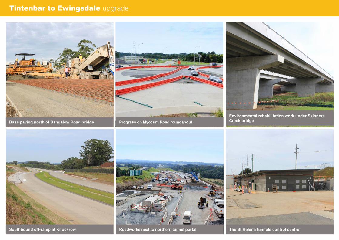
Tintenbar to Ewingsdale upgrade
Southbound off-ramp at Knockrow The St Helena tunnels control centre
Base paving north of Bangalow Road bridge
Environmental rehabilitation work under Skinners Creek bridge Progress on Myocum Road roundabout
Roadworks next to northern tunnel portal
P a c i f i c H i g h w a y u p g r a d e A c h i e v e m e n t r e p o r t , M a y 2 0 1 5
Environment
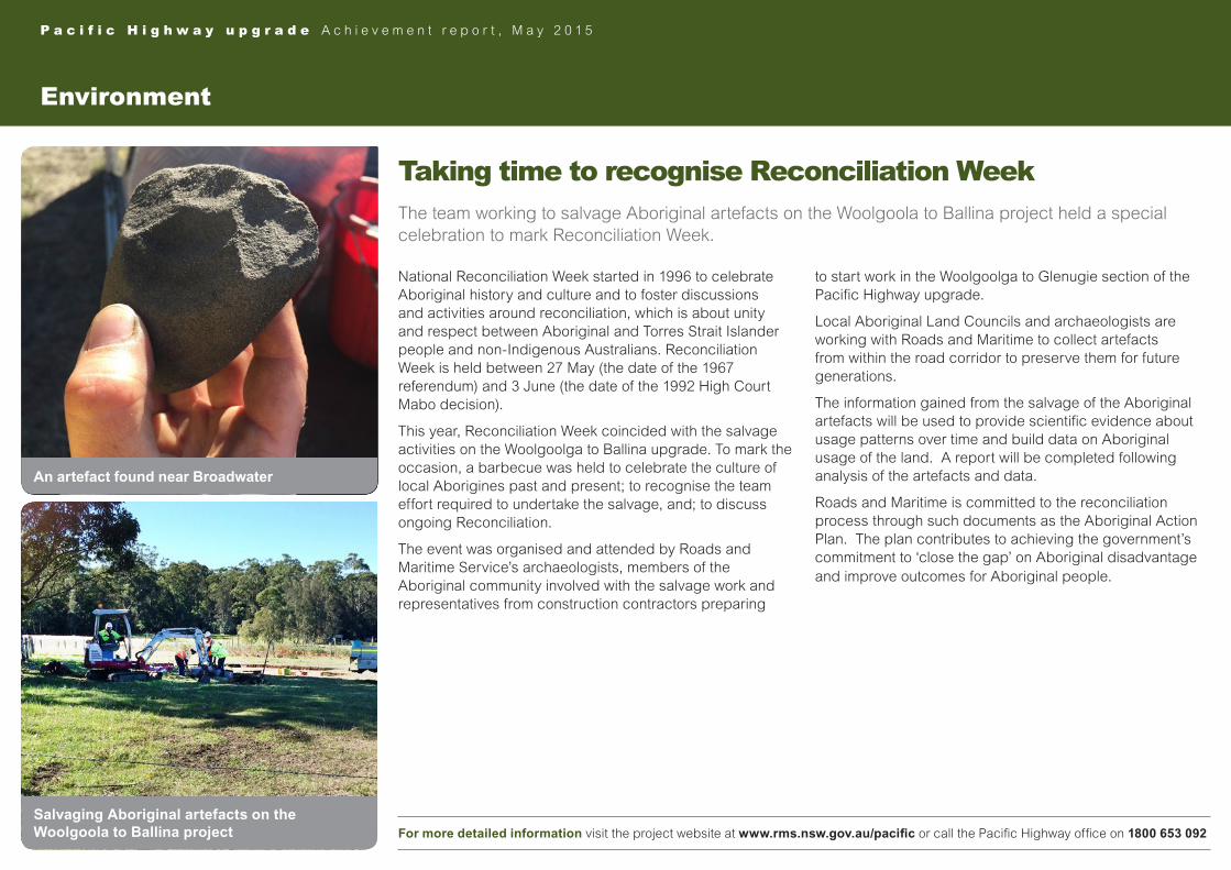
Taking time to recognise Reconciliation WeekThe team working to salvage Aboriginal artefacts on the Woolgoola to Ballina project held a special celebration to mark Reconciliation Week.
National Reconciliation Week started in 1996 to celebrate Aboriginal history and culture and to foster discussions and activities around reconciliation, which is about unity and respect between Aboriginal and Torres Strait Islander people and non-Indigenous Australians. Reconciliation Week is held between 27 May (the date of the 1967 referendum) and 3 June (the date of the 1992 High Court Mabo decision).
This year, Reconciliation Week coincided with the salvage activities on the Woolgoolga to Ballina upgrade. To mark the occasion, a barbecue was held to celebrate the culture of local Aborigines past and present; to recognise the team effort required to undertake the salvage, and; to discuss ongoing Reconciliation.
The event was organised and attended by Roads and Maritime Service’s archaeologists, members of the Aboriginal community involved with the salvage work and representatives from construction contractors preparing
to start work in the Woolgoolga to Glenugie section of the Pacific Highway upgrade.
Local Aboriginal Land Councils and archaeologists are working with Roads and Maritime to collect artefacts from within the road corridor to preserve them for future generations.
The information gained from the salvage of the Aboriginal artefacts will be used to provide scientific evidence about usage patterns over time and build data on Aboriginal usage of the land. A report will be completed following analysis of the artefacts and data.
Roads and Maritime is committed to the reconciliation process through such documents as the Aboriginal Action Plan. The plan contributes to achieving the government’s commitment to ‘close the gap’ on Aboriginal disadvantage and improve outcomes for Aboriginal people.
For more detailed information visit the project website at www.rms.nsw.gov.au/pacific or call the Pacific Highway office on 1800 653 092
Salvaging Aboriginal artefacts on the Woolgoola to Ballina project
An artefact found near Broadwater
P a c i f i c H i g h w a y u p g r a d e A c h i e v e m e n t r e p o r t , M a y 2 0 1 5
For more detailed information visit the project website at www.rms.nsw.gov.au/pacific or call the Pacific Highway office on 1800 653 092
Four-lane divided road status
Completed four-lane divided road Under construction Upgrade approved and route being prepared for construction
0 50 100 150 200
KILOMETRES
250 300 350 400
Completed four-lane divided road Under construction Upgrade approved and route being prepared for construction
Hexham to Port Macquarie, Coffs Harbour, Ballina to the Queensland border
Woolgoolga to Ballina
Port Macquarie to Coffs Harbour

For detailed information about any of the Pacific Highway projects, visit the project website at www.rms.nsw.gov.au/pacific or call the Pacific Highway office on 1800 653 092