Embed Size (px)
Citation preview
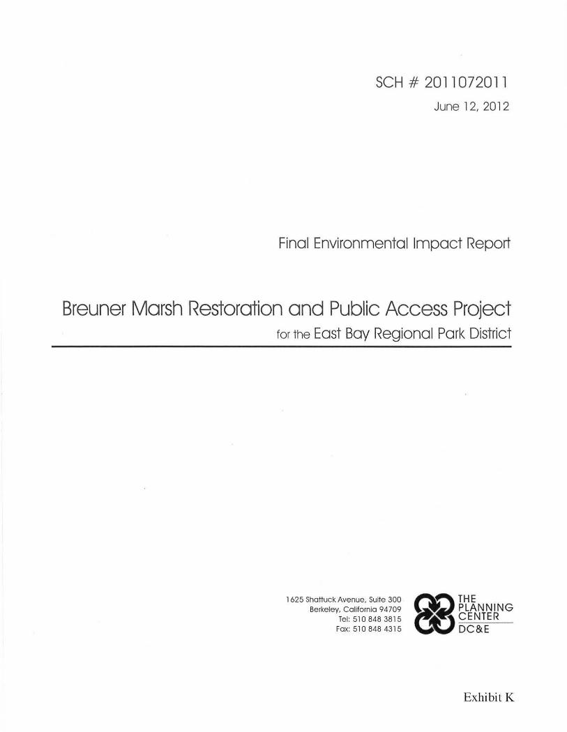
SCH # 2011072011
June 12, 2012
Final Environmental Impact Report
Breuner Marsh Restoration and Public Access Project for the East Bay Regional Park District
1625 Shattuck Avenue, Suite 300 Berkeley, California 94709
Tel: 510 848 3815 Fax: 510 848 4315
Exhibit K


2 REPORT SUMMARY
This summary presents an overview of the analysis contained in the Draft
EIR as originally presented in the Chapter 2 of that document, with
corrections incorporated. The corrections are included in Chapter 3 in
underline and strikethro~:~gh text.
This summary presents an overview of the analysis contained in this Draft
EIR. The chapter summarizes the following: 1) the Project under review,
2) areas of controversy, 3) significant impacts and mitigation measures, 4)
unavoidable significant impacts, and 5) alternatives to the Project. Additional
detail on the proposed Project is provided in Chapter 3. Additional detail on
the environmental impacts is provided in Chapter 4. Alternatives are
described and evaluated in Chapter 5.
A. Project Under Review
1. Location and Setting
The 150-acre Breuner Marsh project area is t he focus of the restoration and
public access Project. It is located at Point Pinole, in the northwest part of
the City of Richmond on the San Francisco Bay shoreline (see Figure 3-1).
Breuner Marsh is bordered by Rheem Creek to the south and merges with
Giant Marsh to the north. Approximately 120 acres of the recently
purchased Breuner property, 30 acres of Giant Marsh and some additional
upland areas of Point Pinole Peninsula, are the subject of the Proposed
Project. Together they form an enlarged Point Pinole Regional Shoreline
Park. This geographic context of the site is shown in more detail in Figure 3-
2.
Union Pacific railroad tracks run along the eastern boundary of the property.
East of the railroad tracks lies the residential community of Parchester
Village. The Carr property, which is a separate parcel of 20 acres under
private ownership, abuts the project area in the southeast comer. The
shallow offshore area and two man-made spits within the boundaries of the
Breuner property are owned by the State Lands Commission and are
managed by EBRPD.
2-1
EAST BAY REGIONAL PARK DISTRICT
BREUNER MARSH RESTORATION AND
PUBLIC ACCESS PROJECT FINAL EIR
REPORT SUMMARY
A Shell Oil petroleum pipeline, Pacific Gas & Electricity transmission lines,
and a West County Sanitary District sanitary sewer force main cross parts of
the project site on easements. Rheem Creek, a federal flood control channel,
operated and maintained by the Contra Costa County Flood Control and
Water Conservation District, under agreement with the U.S. Army Corps of
Engineers, runs along the southern site margin.
2. Project Characteristics
The Proposed Project would involve the removal of the existing site
structures, debris, and hazardous materials, and existing non-native
vegetation, and re-grading of much of the southern portion of the site.
Existing wetland areas would be enhanced by excavating new channels to
connect them to the Bay and allow tidal flooding. Material removed from
wetland areas would be used to build upland areas with gentle slopes and to
create broad transitional zone habitat. The transitional zone would become a
future tidal marsh as sea level rises in line with predictions. Restoratioa of
the ffiOI:Ith of Rheeffi Creel< ey loweriag the leYel of the aorth eaak to allow
tidal floodiag of the lower reaches WOI:Ild Be a highly desiraBle project
compoaeat. This remaias aa optioaal part of the Proposed Project, s~:~eject to
cost aad feasibility, howeYer, it is e-fal~:~ated ia this EIR.
Following mass grading, areas would be re-vegetated with appropriate native
plants, and weeded and irrigated as necessary to ensure that the plants become
established. Non-native invasive Spartina (cordgrass) would be eradicated
from existing tidal marsh areas before site grading. Predators, such as feral
cats and red fox would be trapped to allow wildlife to gain ground and
reestablish territory.
Two trails would be built across the project site to allow public access. The
Main Trail, which would serve as a section of the Bay Trail, would run from
the parking lot located in the south of the site, across a new bridge over
Rheem Creek, to the east of the existing paved trail, run inland to the
property boundary, and run parallel to the railroad tracks north to connect
2-2
EAST BAY REGIONAL PARK DISTRICT
BREUNER MARSH RE S TOR A TION AND
PUBLIC ACCESS PROJECT FINAL EIR
REPORT SUMMARY
with existing trails. The Main Trail would be paved and would cross slough
and wetland areas by a variety of bridges and boardwalk segments.
The Spit T rail would diverge from the Main Trail to connect to the existing
fishing spit. Although the Main Trail would be for bicycle and pedestrian
access, the Spit Trail would be pedestrian only. A picnic area and rest area
would be built by the side of the Main Trail and appropriate interpretative
signs would be located at intervals along the trail.
3. Required Permits and Approvals
It is estimated that permits and/ or approvals would be required from nine
separate agencies. These are:
a. Federal Agencies
U.S. Fish and Wildlife Service - Consultation/Biological Opinion under
Section 7 of Federal Endangered Species Act
U .S. Army Corps of Engineers - Permits for filling wetlands under Section
404 of the Clean Water Act; and Section 408 of the Rivers and Harbors Act
for construction/ restoration of Rheem Creek and bridge construction
U.S. Coast Guard- Bridge Construction
b. State Agencies
State Lands Commission - Public Trust Lands and Leases for construction of
segment of Bay Trail in Giant Marsh
Department of Fish and Game - Section 1601 Streambed Alteration
Agreement; and Section 2081 Agreement
c. County and Regional Agencies
San Francisco Bay Regional Water Quality Control Board (RWQCB) -
Water Quality Certification under Section 401 of the Clean Water Act for
wetland restoration
2-3

EAST BAY REGIONAL PARK DISTRICT
BREUNER MARSH RESTORATION AND
PUBLIC ACCESS PROJECT FINAL EIR
REPORT SUMMARY
Bay Area Conservation and Development Commission (BCDC) - Permit for
work in wetland areas and conformance with climate change policies
Contra Costa County Flood Control and Water Conservation District -
Encroachment Permit for Rheem Creek bridge
d. Local Agencies
City of Richmond- Demolition, Grading, and Building Permits
In addition, small easements may be acquired from Shell Pipeline, Pacific Gas
& Electric Company (PG&E), and Union Pacific Railroad in order to
construct the Bay Trail along the chosen alignments.
B. Areas of Controversy
Public comments were received at the EIR scoping meeting held at Parchester
Village Community Center on July 14, 2011. Issues raised that were
pertinent to the scope of the EIR (and not to the project merits), and requests
for information to be included in the EIR were as follows:
1. Hydrology/Flooding
• Flooding impacts on Parchester Village, the Carr property, pipelines, and
sewer manholes.
• Effects of sea level rise on all resources.
• Inclusion of parcel map and watershed boundary map with all drainage
shown.
• Quantification of runoff and impacts to existing drainage facilities and
drainage problems in the downstream area.
• Flooding impacts from modification of Rheem Creek channel.
2-4
EA ST BA Y REG ION A L PA R K DI S TRICT
BREUN E R MA R S H RES TORATION AND
PU B LI C ACCESS P R OJECT FIN A L E IR
REPORT SUMMARY
2. Hazards/Contamination
• Proximity of buried pipelines.
• Contamination on the Carr property and public availability of
information.
• Lead contamination in the former Rheem Creek drainage.
• Possible migration of contaminated groundwater onto the project site.
3. Land Use
• Access to the Carr property, and utilities during and after construction.
• Inclusion of a wetland delineation for the project site.
• Possible conflicts with development of the Carr property that is zoned as
office/flex.1
• Project impacts to the possibility of constructing a second bridge across
the Creek for the Carr property.
• State Lands Jurisdiction over parts of the project site.
4. Recreation
• Access to Bay Trail after dark to allow commuting.
• Impacts to recreational resources (short-term and long-term).
5. Biological Resources
• Impacts to existing wetlands, wildlife habitat , and special-status species.
• Disturbance to birds during construction; bird populations on the
transitional habitat.
Sensitive species occurrence; mvas1ve spec1es; construction nmse and
wildlife impacts.
1 The C ity of Richmond has prepesee te reEiesigRate redesignated this land as
OpeR Spaee Low Intensiw Business/Light Industrial as part of the ~ General
Plan update. Hewever, this is eHrreRtly iR EiispHte.
2-5
EAST BAY REGIONAL PARK DISTRICT
BREUNER MARSH RESTORATION AND
PUBLIC ACCESS PROJECT FINAL EIR
REPORT SUMMARY
Rules on off-leash dogs and potential dog and human intrusion into
marsh habitat with impacts to wildlife.
• Long-term preservation and restoration of native habitat.
• Possible impacts to wildlife, particularly rafting birds, from water users
in small boats.
• Areas of existing coastal prairie that will be lost.
6. Cultural Resources
• Shellmound occurrences and impacts.
7. Air Quality
• Dust and fumes from project construction.
• Air Quality impacts from removal of the contaminated soil.
8. Greenhouse Gases
• Greenhouse gas emissions from project construction and operation.
C. Significant Impacts and Mitigation Measures
Significant Impacts and Mitigation Measures are summarized in Table 2-1.
D. Unavoidable Significant Impacts
Section 15126.2(b) of the CEQA Guidelines requires that an EIR identify any
significant impacts that cannot be avoided, even with the implementation of
feasible mitigation measures. No Significant and Unavoidable Impacts were
found.
2-6

EAST BAY REGIONAL PARK DISTRICT
BREUNER MARSH RESTORATION AND
PUBLIC ACCESS PROJECT FINAL EIR
REPORT SUMMARY
E. Alternatives to the Project
This CEQA review analyzes the following alternatives to the Proposed
Project:
1. No Project Alternative
Under the No Project Alternative, the site would rema1n in its existing
condition. There would continue to be no official public access, and signs
and derelict fences would discourage, but not prevent, casual hikers,
dogwalkers, birdwatchers, and fishers from using the site. The existing trail
would provide a route as far as the debris mound east of the spit and to the
spit itself. There would continue to be no through-route for bicycles on the
Bay Trail from Richmond Parkway south of the site to Point Pinole.
The model airplane structures and runway would remain, although the
BARCS lease, which will end in June 2012, would not be renewed. The
debris mounds, contaminated soil, old fences, and scattered concrete blocks
would remain. Through time, with sea level rise, the existing habitats close to
the Bay would flood. Low marsh (cordgrass) would migrate to where high
marsh (pickleweed) is found now. Tidal marsh habitat would replace today's
transitional habitat and transitional habitat would be found in areas that are
upland today. The man-made topographic features, such as the mounds that
were originally building pads, and some of the drainage ditches, would
become scattered islands and canals as a result of sea level rise.
2. Additional Tidal Marsh Acreage Alternative
The public access component of the Additional Tidal Habitat Alternative
would be the same as the Proposed Project. A Bay Trail route and a smaller
pedestrian-only spur to the spit would still be provided in a site cleared of
debris and contamination. However, t he restoration component of the
project would differ in that, west of the trail in the south of the site, the site
would be excavated to a greater depth, with a steeper slope than the Project.
Both the Project and Additional Tidal Habitat Alternative would require the
removal of a small amount of contaminated soil, concrete, fill, and the import
of some aggregate base for the parking area and trails. With these exceptions,
2-7

EAST BAY REGIONAL PARK DISTRICT
BR E UNER MAR S H RE S TORATION AND
PUBLIC ACCESS PROJECT FINAL EIR
REPO R T SUMMARY
there would be a zero balance of sediment, with no net import or export
from the site for both the Additional Tidal Habitat Alternative and the
Proposed Project.
Under the Additional Tidal Habitat Alternative there would be larger areas of
tidally connected wetlands, instead of transitional habitat and uplands with
seasonal wetlands. On project completion, there would therefore be a
reduced area of transitional habitat and seasonal wetlands, but an increased
area of tidal wetlands compared to the Proposed Project. With sea level rise,
the area of tidal wetland would increase at the expense of some transition
zone habitat . Although on project construction the Additional Tidal Habitat
Alternative would have more acres of tidal marsh than the Proposed Project,
the Proposed Project would add acres at a faster rate until eventually the
Additional Tidal Marsh H abitat Alternative would have fewer acres of tidal
marsh than the Proposed Project.
3. Environmentally Superior Alternative
In the long term, over the next century, the Proposed Project would prove to
be the Environmentally Superior Alternative.
2-8

EAST BAY REGIONAL PARK DISTRICT
BREUNER MARSH RESTORATION AND PUBLIC ACCESS PROJECT FINAL EIR
REPORT SUMMARY
TABLE 2-1 SUMMARY OF IMPACTS AND MITIGATION MEASURES
Significant Impact
AESTHETICS
Significance Before
Mitigation Mitigation Measures
The project would not result in significant project or cumulative impacts related to aesthetics; therefore. no mitigation measures are required.
AIR QUALITY
Impact AQ-1: Grading and other ground
disturbing activities would produce temporary fugitive dust, which could add to the amount of airborne particulates and contribute to the
nonattainment designation of the SFBAAB.
s Mitigation Measure AQ-1: The Proposed Project would comply with BAAQMD
Basic Control Measures for reducing construction emissions of PM to:
• Water all active construction areas at least twice daily. Watering should be
sufficient to prevent ai rborne dust from leaving the site. Increased watering
frequency may be necessary whenever wind speeds exceed 15 miles per hour. Reclaimed water should be used whenever possible.
• Cover all trucks hauling soil, sand, and other loose materials or require all trucks to maintain at least 24-inches of freeboard (i.e. the minimum required
space between the top of the load the top of the trailer).
Apply water three times daily, or apply (non-toxic) soil stabilizers on all unpaved access roads, parking areas, and staging areas at construction sites.
• Sweep streets (with water sweepers using reclaimed water if possible) at the end of each day if visible soil material is carried onto adjacent paved roads.
L TS = Less Than Significant S = Significant SU = Significant Unavoidable Impact
2-9
Significance With
Mitigation
LTS
EAST BAY REGIONAL PARK DISTRICT
BREUNER MARSH RESTORATION AND P UBL I C ACCESS PROJECT EIR
REPORT SUMMARY
TABLE 2-1 SUMMARY OF IMPACTS AND MITIGATION MEASURES (CONTINUED)
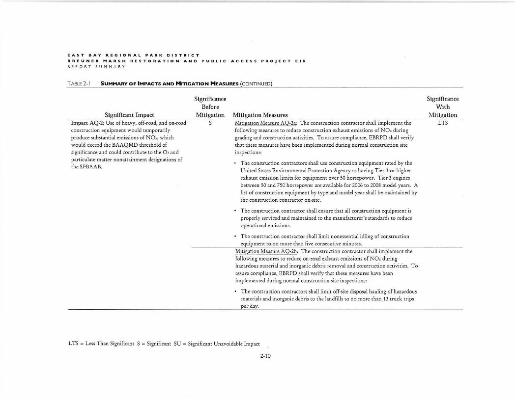
Significant Impact Impact AQ -2: Use of heavy, off-road, and on-road construction equipment would temporarily produce substantial emissions of NOx, which would exceed the BAAQMD threshold of significance and could contribute to the OJ and paniculate matter nonattainment designations of the SFBAAB.
Significance Before
Mitigation s
Mitigation Measures Mitigation Measure AQ-2a: The construction contractor shall implement the following measures to reduce construction exhaust emissions of NOx during grading and construction activities. To assure compliance, EBRPD shall verify that these measures have been implemented during normal construction site inspections:
The construction contractors shall use construction equipment rated by the United States Environmental Protection Agency as having Tier 3 or higher exhaust emission limits for equipment over 50 horsepower. Tier 3 engines between 50 and 750 horsepower are available for 2006 to 2008 model years. A list of construction equipment by type and model year shall be maintained by the construction contractor on-site.
• The construction contractor shall ensure that all construction equipment is properly serviced and maintained to the manufacturer's standards to reduce operational emissions.
• The construction contractor shall limit nonessential idling of construction equipment to no more than five consecutive minutes.
Mitigation Measure AQ-2b: The construction contractor shall implement the following measures to reduce on-road exhaust emissions of NOx during hazardous material and inorganic debris removal and construction activities. To assure compliance, EBRPD shall verify that these measures have been implemented during normal construction site inspections:
• The construction contractors shall limit off-site disposal hauling of hazardous materials and inorganic debris to the landfills to no more than 13 truck trips per day.
L TS = Less Than Significant S = Significant SU = Significant Unavoidable Impact
2-10
Significance With
Mitigation LTS
EAST BAY REGIONAL PARK DISTRICT
BREUNER MARSH RESTORATION AND PUBLIC ACCESS PROJECT FINAL EIR
REPORT SUMMARY
TABLE 2-1 SUMMARY OF IMPACTS AND MITIGATION MEASURES (CONTINUED)
Significant Impact
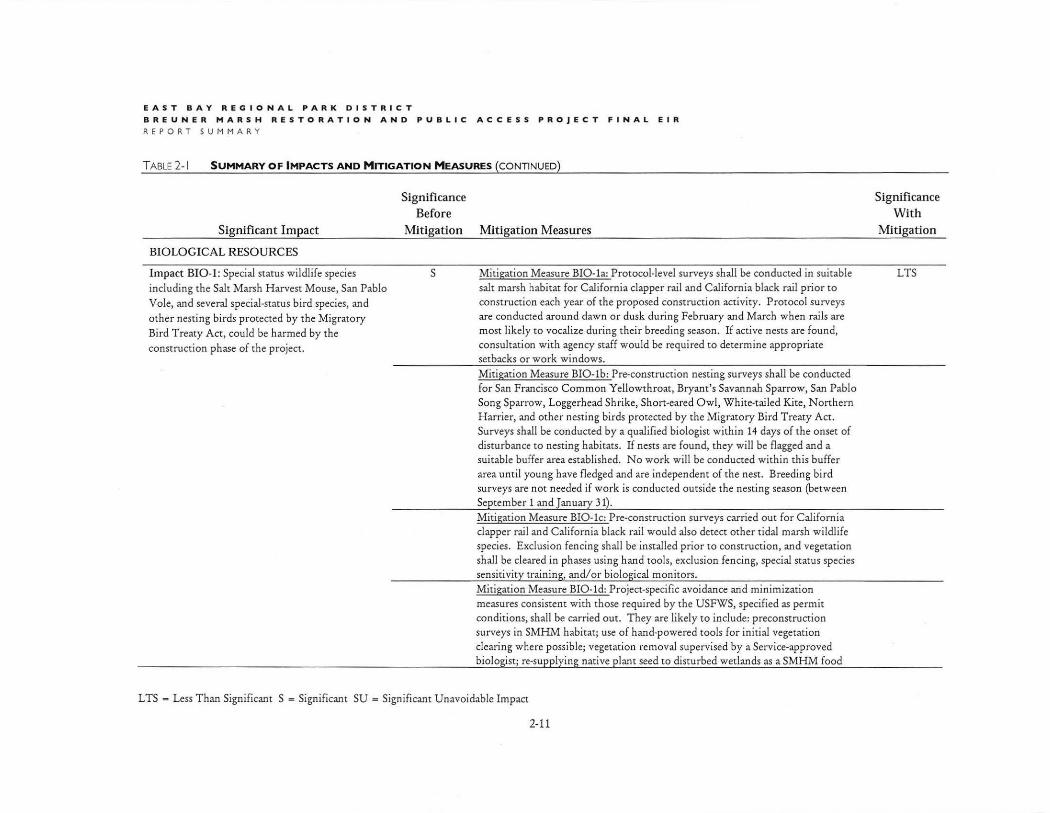
BIOLOGICAL RESOURCES
Impact BIO-I : Special status wildlife species including the Salt Marsh Harvest Mouse, San Pablo
Vole, and several special-status bird species, and
other nesting birds protected by the Migratory Bird Treaty Act, could be harmed by the
construction phase of the project.
Significance Before
Mitigation Mitigation Measures
s Mitigation Measure BIO-la: Protocol-level surveys shall be conducted in suitable salt marsh habitat for California clapper rail and California black rail prior to construction each year of the proposed construction activity. Protocol surveys are conducted around dawn or dusk during February and March when rails are most likely to vocalize during their breeding season . If active nests are found, consultation with agency staff would be required to determine appropriate setbacks or work windows.
Mitigation Measure BIO-lb: Pre-construction nesting surveys shall be conducted for San F rancisco Common Yellowthroat, Bryant's Savannah Sparrow, San Pablo Song Sparrow, Loggerhead Shrike, Short-eared Owl, White-tailed Kite, Northern H arrier, and other nesting birds protected by the Migratory Bird Treaty Act. Surveys shall be conducted by a qualified biologist within 14 days of the onset of disturbance to nesting habitats. If nests are found, they will be flagged and a suitable buifer area established. No work will be conducted within this buffer area until young have fledged and are independent of the nest. Breeding bird surveys are not needed if work is conducted outside the nesting season (between September 1 and January 31). Mitigation Measure BIO-lc: Pre-construction surveys carried out for California clapper rail and California black rail would also detect other tidal marsh wildlife species. Exclusion fencing shall be installed prior to construction, and vegetation shall be cleared in phases using hand tools, exclusion fencing, special status species sensitivity training, and/or biological monitors. Mitigation Measure BIO-ld: Project-specific avoidance and minimization measures consistent with those required by the USFWS, specified as permit conditions, shall be carried out. T hey are likely to include: preconstruction surveys in SMHM habitat; use of hand-powered tools for initial vegetation clearing where possible; vegetation removal supervised by a Service-approved biologist; re-supplying native p lant seed to disturbed wetlands as a SMHM food
L TS = Less Than Significant S = Significant SU = Significant Unavoidable Impact
2-11
Significance With
Mitigation
LTS
EAST BAY REGIONAL PARK DISTRICT
BREUNER MARSH RESTORATION AND PUBLIC ACCES S PROJECT E I R
REPORT SUMMARY
TABLE 2-1 SUMMARY OF IMPACTS AND MITIGATION MEASURES (CONTINUED)
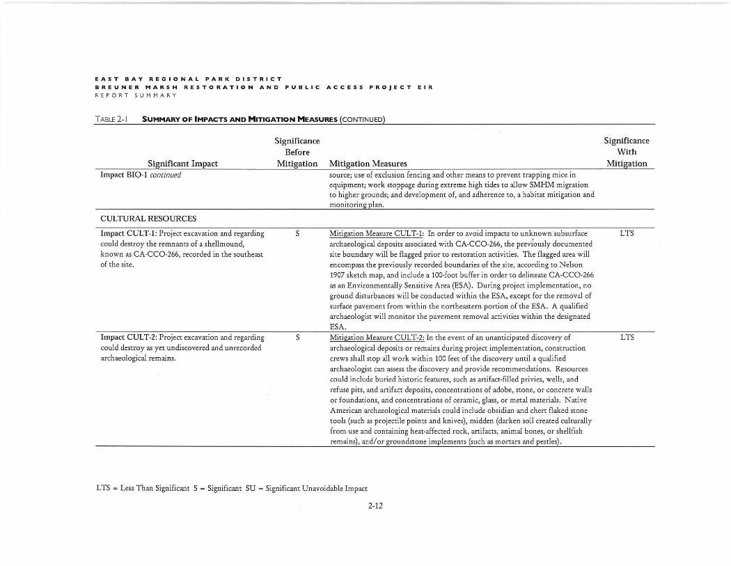
Significant Impact Impact BI0-1 continued
CULTURAL RESOURCES
Impact CU LT-1: Project excavation and regarding could destroy the remnants of a shell mound, known as CA-CC0-266, recorded in the southeast of the site.
Impact CUL T-2: Project excavation and regarding could destroy as yet undiscovered and unrecorded archaeological remains.
Significance Before
Mitigation Mit igation Measures
s
s
source; use of exclusion fencing and other means to prevent trapping mice in equipment; work stoppage during extreme high tides to allow SMHM migration to higher grounds; and development of, and adherence to, a habitat mitigation and monitoring plan.
Mitigation Measure CULT-1: In order to avoid impacts to unknown subsurface archaeological deposits associated with CA-CC0-266, the previ'ously .documented site boundary will be flagged prior to restoration activities. The flagged area will encompass the previously recorded boundaries of the site, according to Nelson 1907 sketch map, and include a 100-foot buffer in order to delineate CA-CC0-266 as an Environmentally Sensitive Area (ESA). During project implementation, no ground disturbances will be conducted within the ESA, except for the removal of surface pavement from within the northeastern portion of the ESA. A qualified archaeologist will monitor the pavement removal activities within the designated ESA. Mitigation Measure CUL T-2: In the event of an unanticipated discovery of archaeological deposits or remains during project implementation, construction crews shall stop all work within 100 feet of the discovery until a qualified archaeologist can assess the discovery and provide recommendations. Resources could include buried historic features, such as artifact-filled privies, wells, and refuse pits, and artifact deposits, concentrations of adobe, stone, or concrete walls or foundat ions, and concentrations of ceramic, glass, or metal materials. Native American archaeological materials could include obsidian and chert flaked stone tools (such as projectile points and knives), midden (darken soil created culturally from use and containing heat-affected rock, artifacts, animal bones, or shellfish remains), and/or groundstone implements (such as mortars and pestles).
LTS = Less Than Significant S = Significant SU = Significant Unavoidable Impact
2-12
Significance With
Mitigation
LTS
LTS
EAST BAY REGIONAL PAR K DISTRICT
BREUNER MARSH RESTORATION AND PUBLIC ACCESS PROJECT FINAL EIR REPORT SUMMARY
TABLE 2-1 SUMMARY OF IMPACTS AND MITIGATION MEASURES (CONTINUED)
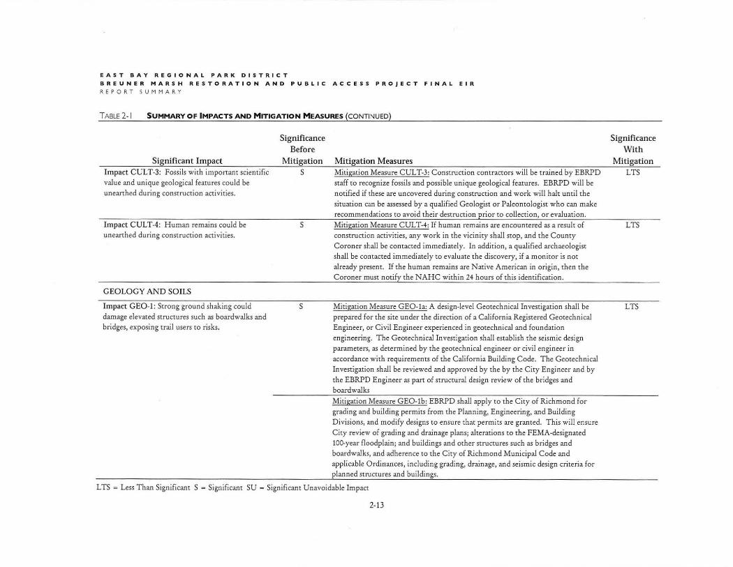
Significant Impact Impact CULT-3: Fossils with important scientific
value and unique geological featu res could be unearthed during co nstruction activities.
Impact CULT-4: H uman remains could be unearthed during construction activities.
GEOLOGY AND SOILS
Impact GE0-1 : Strong ground shaking could damage elevated structures such as boardwalks and bridges, exposing trail users to risks.
Significance Before
Mitigation s
s
s
Mitigation Measures Mitigation Measure CUL T-3: Construction contractors will be trained by EBRPD staff to recognize fossils and possible unique geological features. EBRPD will be
notified if these are uncovered during construction and work will halt until the
situation can be assessed by a qualified Geologist or Paleontologist who can make recommendations to avoid their destruction prior to collection, or evaluation.
Mitigation Measure CUL T-4: If human remains are encountered as a result of
construction activit ies, any work in the vicinity shall stop, and the County Co roner shall be contacted immediately. In addition, a qualified archaeologist shall be contacted immediately to evaluate the discovery, if a monitor is not
already p resent. If the human remains are Native American in origin, then t he Coroner must notify the NAH C within 24 hours of this identification.
Mitigation Measure GEO-l a: A design-level Geotechnical Investigation shall be
prepared for the site under the direction of a California Registered Geotechnical Engineer, or C ivil Engineer experienced in geotechnical and foundation engineering. The Geotechnical Investigation shall establish the seismic design
parameters, as determined by the geotechnical engineer or civil engineer in
accordance with requirements of the California Building Code. T he Geotechnical Investigation shall be reviewed and approved by the by the City Engi neer and by
the EBRPD Engineer as part of structural design review of the bridges and boardwalks
Mitigation Measure GEO-lb: EBRPD shall apply to the C ity of Richmond for grading and building permits from the Planning, Engineering, and Building Divisions, and modify designs to ensure that permits are granted. T his will ensure
City review of grading and drainage p lans; alterations to the FEMA-designated
100-year floodplain; and buildings and other structures such as bridges and boardwalks, and adherence to the City of Richmond Municipal Code and
applicable Ordinances, including grading, drainage, and seismic design criteria for p lanned structures and buildings.
L TS = Less Than Significant S - Significant SU = Significant Unavoidable Impact
2-13
Significance With
Mitigation LTS
LTS
LTS
E AS T BA Y R EG I O N AL PA RK DI S TRICT
BREUNER MARS H RE S TORATION AND PUBL I C ACCE SS PROJECT EIR
REPOR T SUMMARY
TABLE2- I SUMMARY OF IMPACTS AND MITIGATION MEASURES (CONTINUED)
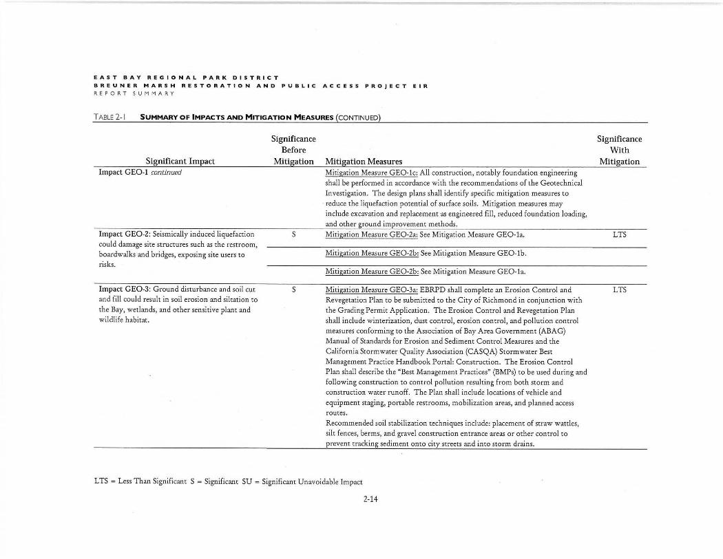
Significant Impact Impact GE0-1 continued
Impact GE0-2: Seismically induced liquefaction could damage site st ructures such as the rest room, boardwalks and bridges, exposing site users to risks.
Impact GE0-3: Ground disturbance and soil cut and fill could result in soil erosion and siltation to the Bay, wetlands, and other sensitive plant and wildlife habitat.
Significance Before
Mitigation Mitigation Measures Mit igation Measure GEO -l c: All construction, notably foundation engineering shall be performed in accordance with the recommendations of the Geotechnical Investigation. The design plans shall identify specific mitigation measures to reduce the liquefaction potential of surface soils. Mitigation measures may include excavation and replacement as engineered fill, reduced foundation loading, and other ground improvement methods.
S Mitigation Measure GE0 -2a: See Mitigation Measure GEO-l a.
s
Mit igation Measure GE0 -2b: See Mitigation Measure GEO-lb.
Mitigation Measure GE0-2b: See Mitigation Measure GEO-la.
Mitigation Measure GE0-3a: EBRPD shall complete an Erosion Control and Revegetatio:J Plan to be submitted to the City of Richmond in conjunction with the Grading Permit Application. T he Erosion Control and Revegetation Plan shall include winterization, dust control, erosion control, and pollution control measures conforming to the Association of Bay Area Government (ABAG) Manual of Standards for Erosion and Sediment Control Measures and the California Storm water Quality Association (CASQA) Storm water Best Management Practice H andbook Portal: Construction. The Erosion Control Plan shall describe the "Best Management Practices" (BMPs) to be used during and following construction to control pollution resulting from both storm and construction water runoff. The Plan shall include locations of vehicle and equipment staging, portable restrooms, mobilization areas, and planned access routes. Recommended soil stabilization techniques include: placement of straw wattles, silt fences, berms, and gravel construction entrance areas or other control to prevent tracking sediment onto city streets and into storm drains.
L TS = Less Than Significant S = Significant SU = Significant Unavoidable Impact
2-14
Significance With
Mitigation
LTS
LTS
EAST BAY REGIONAL PARK DI S TRICT
B REUNER MARSH RESTORATION AND PUBLIC ACCESS PR OJECT FI NAL E IR
REPOR T SUMMARY
TABLE 2-1 SUMMARY OF IMPACTS AND MITIGATION MEASURES (CONTINUED)
Significance Before
Significance With
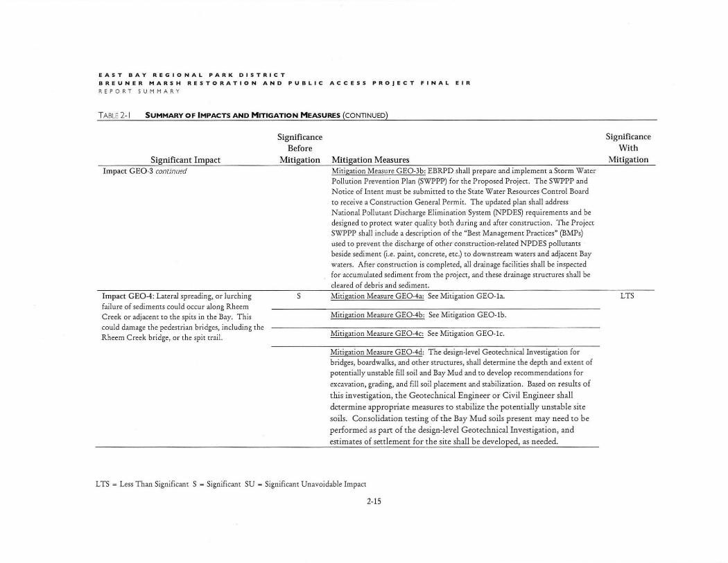
Significant Impact Mitigation Mitigation Measures Mitigation Impact GE0-3 continued
Impact GE0-4: Lateral spreading, or lurching failure of sediments could occur along Rheem Creek or adjacent to the spits in the Bay. This could damage the pedestrian bridges, including the Rheem Creek bridge, or the spit trail.
Mitigation Measure GE0-3b: EBRPD shall prepare and implement a Storm Water Pollution Prevention Plan (SWPPP} for the Proposed Project. The SWPPP and Notice of Intent must be submitted to the State Water Resources Control Board to receive a Construction General Permit. The updated plan shall address National Pollutant Discharge Elimination System (NPD ES} requirements and be designed to protect water quality both during and after construction. The Project SWPPP shall include a description of the "Best Management Practices" (BMPs} used to prevent the discharge of other construction-related NPDES pollutants beside sediment (i.e. paint, concrete, etc.) to downstream waters and adjacent Bay waters. After construction is completed, all drainage facilities shall be inspected for accumulated sediment from the project, and these drainage structures shall be cleared of debris and sediment.
S Mitigation Measure GE0-4a: See Mitigation GEO-la. LTS
Mitigation Measure GE0-4b: See Mitigation GEO-lb.
Mitigation Measure GE0-4c: See Mitigation GEO-lc.
Mitigation Measure GE0-4d: The design-level Geotechnical Investigation for bridges, boardwalks, and other structures, shall determine the depth and extent of potentially unstable fill soil and Bay Mud and to develop recommendations for
excavation, grading, and fill soil placement and stabilization. Based on results of
this investigation, the Geotechnical Engineer or Civil Engineer shall
determine appropriate measures to stabilize the potentially unstable site
soils. Consolidation testing of the Bay Mud soils present may need to be
performed as part o f the design-level Geotechn ical Investigation, and
estimates of settlement for the site shall be develop ed, as needed.
LTS = Less Than Significant S - Significant SU - Significant Unavoidable Impact
2-15
EAST BAY REGIONAL PARK DISTRICT
BREUNER MARSH RESTORATION AND PUBLIC ACCESS PROJECT EIR
REPORT SUMMARY
TABLE 2-1 SUMMARY OF IMPACTS AND MITIGATION MEASURES (CONTINUED)
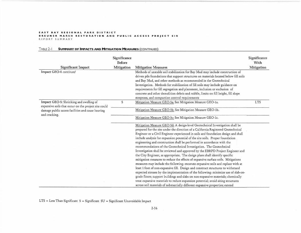
Significant Impact Impact GE0-4 continued
Impact GE0-5: Shrinking and swelling of
expansive soils that occur on the project site could damage public access facilities and cause heaving and cracking.
Significance Before
Mitigation Mitigation Measures
s
Methods of unstable soil stabilization for Bay Mud may include construction of driven pile foundations that support structures on materials located below fill soils and Bay Mud, and other methods as recommended in the Geotechnical
Investigation. Methods for stabilization of fill soils may include guidance on requirements for fill segregation and placement, inclusion or exclusion of concrete and other demolition debris and rubble, limits on fi ll height, fi ll slope steepness, and compaction control requirements
Mitigation Measure GEO-Sa: See Mitigation Measure GEO-la.
Mitigation Measure GEO-Sb: See Mitigation Measure GEO-lb.
Mitigation Measure GEO-Sc: See Mitigation Measure GEO-lc.
Mitigation Measure GEO-Sd: A design-level Geotechnical Investigation shall be prepared for the site under the direction of a California Registered Geotechnical Engineer or a Civil Engineer experienced in soils and foundation design and shall
include analysis for expansion potential of the site soils. Proper foundat ion engineering and construction shall be performed in accordance with the
recommendations of the Geotechnical Investigation. The Geotechnical Investigation shall be reviewed and approved by the EBRPD Project Engineer and the City Engineer, as appropriate. The design plans shall identify specific mitigation measures to reduce the effects of expansive surface soils. Mitigations
measures may include the following: excavate expansive soils and replace with at least 1 foot of non-expansive fill. Design and construct structures to withstand expected stresses by the implementation of the following: minimize use of slab-ongrade floors; support buildings and slabs on non-expansive materials; chemically treat expansive materials to reduce expansion potential; avoid siting structures across soil materials of substantially different expansive properties; extend
L TS = Less Than Significant S = Significant SU = Significant Unavoidable Impact
2-16
Significance With
Mitigation
LTS

EAST BAY REGIONAL PARK DISTRICT BREUNER MARSH RESTORATION AND PUBLIC ACCESS PROJECT FINAL EIR
REPORT SUMMARY
TABLE 2-1 SUMMARY OF IMPACTS AND MITIGATION MEASURES (CONTINUED)
Significant Impact Impact GE0-5 continued
GR EENHOUSE GAS EMISSIONS
Significance Before
Mitigation Mitigation Measures foundations below the zone of seasonal moisture change; utilize pier-and-grade
beam foundation systems where appropriate; utilize special bending resistant
design; and prevent accumulation of surface water adjacent to buildings.
The project would not result in significant impacts related to greenhouse gas emissions; therefore. no miligation measures are required.
H AZAR DS AND H AZARDOUS MATERIALS
Impact H AZ-1: The proposed trail route would be within a few tens of feet of the underground
Shell pipeline on the eastern side of the Project Site
and construction could damage the pipeline.
Impact HAZ-2: Contamination from past pipeline leaks other petroleum chemicals formerly used on
the project site, could be discovered during grading.
Impact HAZ-3: Lead-contaminated soils may be present on the project site in fill of the former Rheem Creek channel and could result in exposure to construction workers and nearby residents to
lead during project construction.
s
s
s
Mitigation Measure HAZ-1: Fill placement within a zone 10 feet either side of a known pipeline location, or excavation within 25 feet, would be avoided if
possible. If field conditions dictate a reduced distance in certain locations, the
absolute minimum distance for excavation would be 5 feet from any h igh risk utility pipeline. No more than 1 foot of additional fill shall be placed on top of a pipeline. Existing markers shall be relocated as needed.
Mitigation Measure HAZ-2: If any oil-stained soil, or soil with a strong petroleum
odor is discovered during project site grading, work will halt, samples will be taken, and the excavation will be covered unti l the results are received. If contamination above regulatory limits is found, the contaminated soil shall be
remediated in accordance with standard procedures.
Mitigation Measure HAZ-3: During the site grading process, the fill material from O ld Rheerr. Creek will be sampled and analyzed for lead and other metals. If results are above applicable regulatory standards, the soil will be either excavated
and removed, or capped and buried in place.
L TS = Less Than Significant S = Significant SU = Significant Unavoidable Impact
2-17
Significance With
Mitigation
LTS
LTS
LTS
EAST BA Y REGIONAL PARK DISTRICT
BREUNER MARSH RESTORATION AND PUBLIC ACCESS PROJECT EIR REPORT SUMMARY
TABLE 2-1 SUMMARY OF IMPACTS AND MITIGATION MEASURES (CONTINUED)
Significant Impact
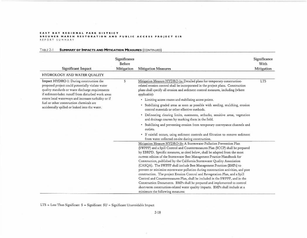
HYDROLOGY AND WATER QUALITY
Impact HYDR0-1: During construction the proposed project could potentially violate water quality standards or waste discharge requirements if sediment-laden runoff from disturbed work areas enters local waterways and increases turbidity or if fuel or other construction chemicals are accidentally spilled or leaked into the water.
Significance Before
Mitigation Mitigation Measures
s Mitigation Measure HYDRO-la: Detailed plans for temporary constructionrelated erosion control shall be incorporated in the project plans. Construction plans shall specify all erosion and sediment control measures, including (where applicable):
• Limiting access routes and stabilizing access points.
• Stabilizing graded areas as soon as possible with seeding, mulching, erosion control materials or other effective methods.
Delineating clearing limits, easements, setbacks, sensitive areas, vegetation and drainage courses by marking them in the field.
Stabilizing and preventing erosion from temporary conveyance channels and outlets.
• If rainfall occurs, using sediment controls and filtration to remove sediment from water collected on-site during construction.
Mitigation Measure HYDRO-lb: A Storm water Pollution Prevention Plan (SWPPP) and a Spill Control and Countermeasures Plan (SCCP) shall be prepared by EBRPD. Specific measures, as cited below, shall be adapted from the most current edition of the Storm water Best Management Practice Handbook for Construction, published by the California Storm water Quality Association (CASQA). The SWPPP shall include Best Management Practices (BMPs) to prevent or minimize storm water pollution during construction activities, and post construction. The project Erosion Control and Revegetation Plan, and a Spill Control and Countermeasures Plan, shall be included in the SWPPP, and in the Construction Documents. BMPs shall be prepared and implemented to control short-term construction-related water quality impacts. BMPs shall include at a minimum the following measures:
L TS = Less Than Significant S = Significant SU = Significant Unavoidable Impact
2-18
Significance With
Mitigation
LTS
EAST BAY REGIONAL PARK DISTRICT
BREUNER MARSH RESTORATION AND PUBLIC ACCE SS PROJEC T F INAL EIR
REPORT SUMMARY
TABLE2-I SUMMARY OF IMPACTS AND MITIGATION MEASURES {CONTINUED)
Significant Impact Impact HYDRO-I continued
Significance Before
Mitigation Mitigation Measures
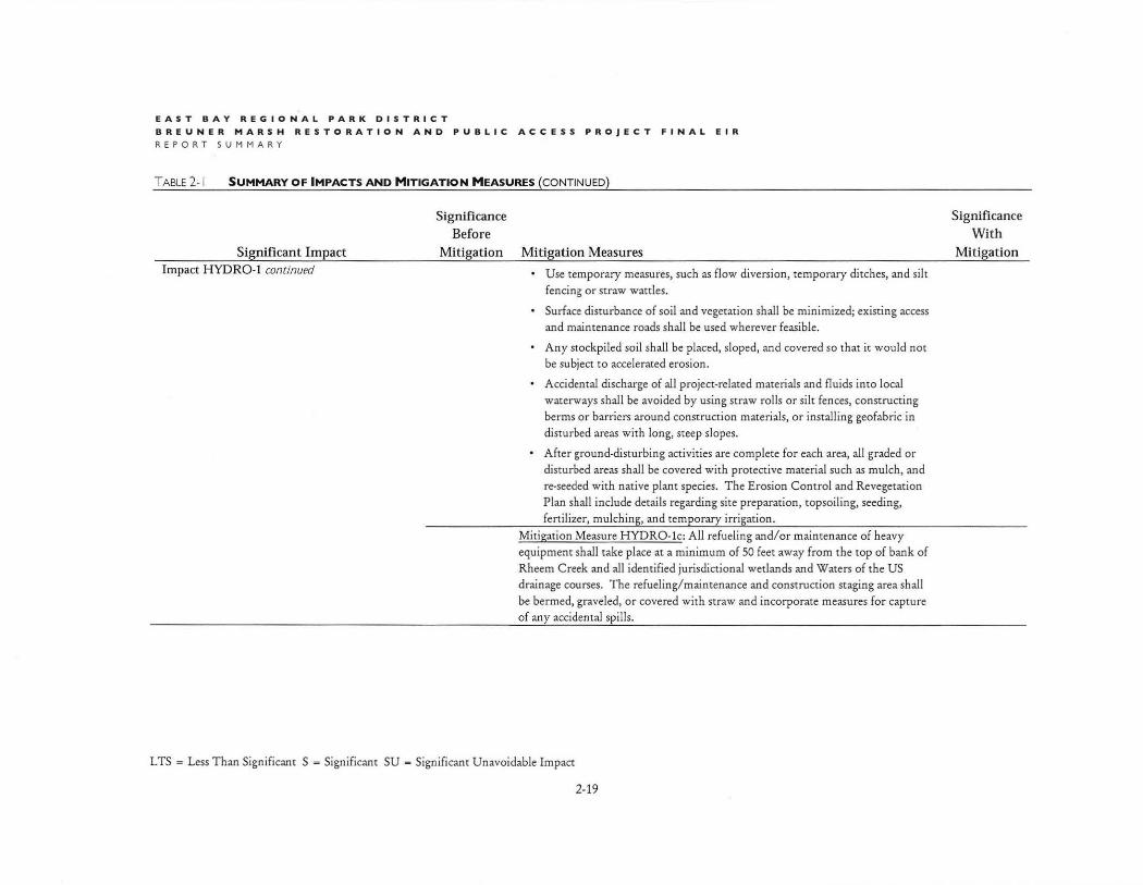
• Use temporary measures, such as flow diversion, temporary ditches, and silt
fencing or straw wattles.
• Surface disturbance of soil and vegetation shall be minimized; existing access and maintenance roads shall be used wherever feasible.
• Any stockpiled soil shall be placed, sloped, and covered so that it would not be subject to accelerated erosion.
• Accidental discharge of all project-related materials and fluids into local waterways shall be avoided by using straw rolls or silt fences, constructing
berms or barriers around construction materials, o r installing geofabric in disturbed areas with long, steep slopes.
After ground-disturbing activities are complete for each area, all graded or
disturbed areas shall be covered with protective material such as mulch, and re-seeded with native plant species. The Erosion Control and Revegetation
Plan shall include details regarding site preparation, topsoil ing, seeding,
fertil izer, mulching, and temporary irrigation .
Mitigation Measure HYDRO-lc: All refueling and/or maintenance of heavy
equipment shall take place at a minimum of 50 feet away from the top of bank of Rheem Creek and all identified jurisdictional wetlands and Waters of the US drainage courses. T he refueling/ maintenance and construction staging area shall
be bermed, graveled, or covered with straw and incorporate measures for capture of any accidental spills.
L TS = Less Than Significant S = Significant SU - Significant Unavoidable Impact
2-19
Significance With
Mitigation
EAST BAY REGIONAL PARK DISTRICT
BREUNER MARSH RESTORATION AND PUBLIC ACCESS PROJECT EIR REPORT SUMMARY
TABLE 2-1 SUMMARY OF IMPACTS AND MITIGATION MEASURES (CONTINUED)
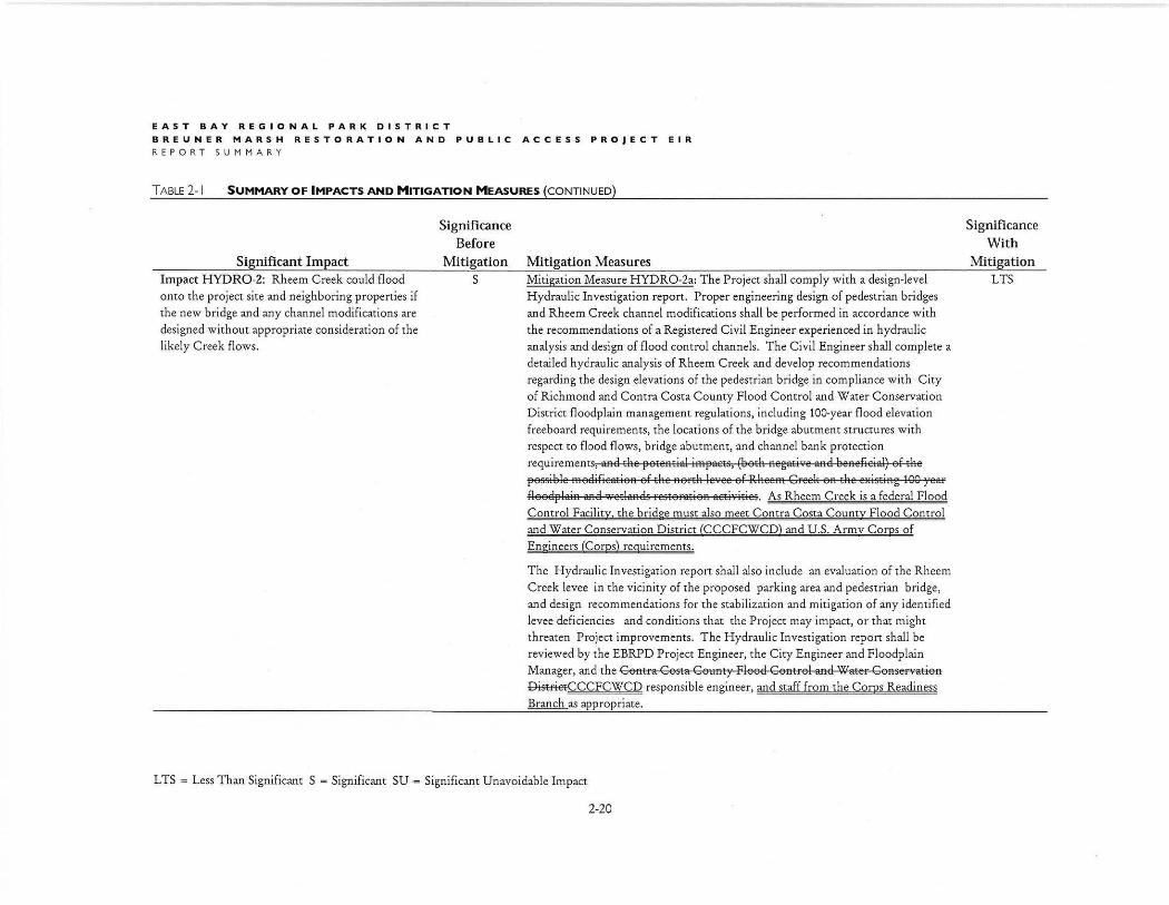
Significant Impact Impact HYDR0-2: Rheem Creek could flood onto the project site and neighboring properties if
the new bridge and any channel modifications are
designed without appropriate consideration of the likely Creek flows.
Significance Before
Mitigation s
Mitigation Measures Mitigation Measure H YDR0-2a: The Project shall comply with a design-level Hydraulic Investigation report. Proper engineering design of pedestrian bridges and Rheem Creek channel modifications shall be perfo rmed in accordance with
the recommendations of a Registered C ivil Engineer experienced in hydraulic analysis and design of flood control channels. The Civil Engineer shall complete a detailed hydraulic analysis of Rheem C reek and develop recommendations regarding the design elevations of the pedestrian bridge in compliance with City of Richmond and Contra Costa County Flood Control and Water Conservation
District floodplain management regulations, including 100-year flood elevation freeboard requirements, the locations of the bridge abutment structures with respect to flood flows, bridge abutment, and channel bank protection
requirements, aael the flOteatial iHJoflaets, (beth aegati"e aRe eeaefieiad) ef the flOSsie le HJooelifieatioa of the Ronh leYee of RheeHJo Greek OR the elfistiag 100 year floeelfllaia aael wetlaaels resteratieR aetivities. As Rheem Creek is a federal Flood
Control Facility. the bridge must also meet Contra Costa County Flood Control and Water Conservation District (CCCFCWCD) and U.S. Army Corps of Engineers (Corps) requirements.
The H ydraulic Investigation report shall also include an evaluation of the Rheem
Creek levee in the vicinity of the proposed parking area and pedestrian bridge, and design recommendations for the stabilization and mitigation of any identified
levee deficiencies and conditions that the Project may impact, or that might threaten Project improvements. The Hydraulic Investigation report shall be
reviewed by the EBRPD Project Engineer, the C ity Engineer and Floodplain Manager, and the GoRtra Costa CouRt)' Floocl GoRtrol aacl 'Water GoRservatioR
&-isffietCCCFCWCD responsible engineer, and staff from the Corps Readiness Branch as appropriate.
L TS = Less Than Significant S = Significant SU = Significant Unavoidable Impact
2-20
Significance With
Mitigation LTS
EAST BA Y REGIONAL PARK DI S TRICT
BREUN E R MARSH RESTORA TI ON AND PU B LIC AC C E S S PROJECT FINAL EIR
REPORT SUMMARY
TABLE 2-1 SUMMARY OF IMPACTS AND MITIGATION MEASURES (CONTINUED)
Significant Impact Impact HYDR0-2 continued
LAND USE AND PLANNING
Significance Before
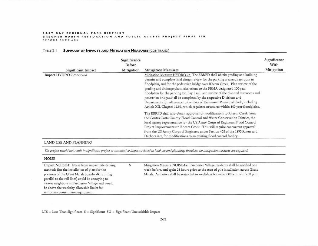
Mitigation Mitigation Measures Mitigation Measure HYDR0-2b: The EBRPD shall obtain grading and building permits and complete final design review for the parking area and restroom in
floodplain, and for the pedestrian bridge over Rheem Creek. Plan review of the
grading and drainage plans, alterations to the FEMA designated 100-year floodplain for the parking lot, Bay Trail, and review of the planned restrooms and pedestrian bridges shall be completed by the respective Divisions and
Departments for adherence to the City of Richmond Municipal Code, including Article XII, Chapter 12.56, which regulates structures within 100-year floodplains.
The EBRPD shall also obtain approval for modifications to Rheem Creek from the Contra Costa County Flood Control and Water Conservation District, the
local agency representative for the US Army Corps of Engineers Flood Control Project Improvements to Rheem Creek. This will require concurrent approval from the US Army Corps of Engineers under Section 408 of the 1890 Rivers and
H arbors Act, for modifications to an existing flood control facility.
The project would not result in significant project or cumulative impacts related to land use and planning; therefore. no mitigation measures are required.
N OISE
Impact NOISE-1: Noise from impact pile driving
methods (for the installation of piers for the portions of the Giant Marsh boardwalk running parallel to the rail lines) could be annoying to
closest neighbors in Parchester Village and would be above the weekday allowable limits for stationary construction equipment.
s Mitigation Measure NOISE-1a: Parchester Village residents shall be notified one week before, and again 24 hours prior to the start of pile installation across Giant Marsh. Activities shall be restricted to weekdays between 9:00 a.m. and 5:00 p.m.
L TS = Less Than Significant S - Significant SU - Significant Unavoidable Impact
2-21
Significance With
Mitigation

EAST BAY REGIONAL PARK DISTRICT
BREUNER MARSH RESTORATION AND PUBLIC ACCESS PROJECT EIR
REPORT SUMMARY
T ABLE 2-1 SUMMARY OF IMPACTS AND MITIGATION MEASURES (CONTINUED)
Significant Impact Impact NOISE-1 continued
RECREATION
Significance Before
Mitigation Mitigation Measures Mitigation Measure NOISE-lb: Impact pile driving shall not be used to install piers within 700 feet of the residences. Suitable alternative techniques could include (but are not necessarily limited to) Auger Cast Piles (large diameter hollow stem auger with steel rebar and concrete installed prior to/ during auger removal); Torque-down Piles (steel pipe pile drilled in place then filled with concrete); Micro-piles {Steel piles sized for corrosion protection with a concrete pile cap); Steel H-beams sized for corrosion protection and installed using vibratory hammer (no pounding and with concrete pile cap above the surface for corrosion protection); and/or Helical piles (screw piles with concrete cap) . The selected pile installation equipment shall have a noise level less than 86 dBA Lm.,. at 50 feet for full-load operations and including work-piece noise contributions.
The project would not result in signi!Jcant project or cumulative impacts related to recreation; therefore, no mitigation measures are required.
TRANSPORTATION AND TRAFFIC
The project would not result in significant project or cumulative impacts related to transportation and traffic; therefore, no mitigation measures are required.
UTILITIES AND SERVICE SYSTEMS
The project would not result in significant project or cumulative impacts related to utilicies and service systems; therefore. no mitigation measures are required.
L TS = Less Than Significant S = Significant SU - Significant Unavoidable Impact
2-22
Significance With
Mitigation