Embed Size (px)
Citation preview

1
2

3
BOLLENTI SPIRITI URBAN LAB OF THE “MIDDLE-EARTHS”
AS PART OF THE “LIVING THE PADULI” PROJECTLAUNCHES
“NESTING PADULI”IDEAS COMPETITION
shelter design and self-construction for the future biodegradable and temporary hotel
of the PAMP, Paduli Agricultural Multifunctional Park
4
Instructions for a good use
The first part consists of the notice, where procedures and participation rules are provided.
The second part includes attachments to the notice describing the conditions of the competition, the local context, the ongoing participatory process, the shared viewpoints and the objectives of this competition.
All documentation relatng to the Paduli Territory has been produced since 2003, when the first urban laboratory has been launched, and the data collection has run until 2011, when the Integrated Programme of Territorial Regeneration has been drafted, pursuant to LR n. 21 of 2008.
More than 500 people have collaborated in preparing the documentation, including residents and specialised technicians, which contribution has been pivotal to draw an alternative in terms of development, enhancement and innovation in this area.
Related documents are publicly available online at www.parcopaduli.it

5
INDEX
ABSTRACT……………………………………………………………………………..6
FIRST PART: THE NOTICEArticle 1…………………………………………………………………………………..7Article 2…………………………………………………………………………………..7Article 3…………………………………………………………………………………..7Article 4…………………………………………………………………………………..7Article 5…………………………………………………………………………………. 8Article 6…………………………………………………………………………………..8Article 7…………………………………………………………………………………. 8Article 8…………………………………………………………………………………. 8Article 9…………………………………………………………………………………. 8Article 10……………………………………………………………………………….. 9Article 11…………………………………………………………………………………9Article 12…………………………………………………………………………………9Article 13…………………………………………………………………………………9Article 14…………………………………………………………………………………10Article 15…………………………………………………………………………………10Article 16…………………………………………………………………………………10Article 17…………………………………………………………………………………10Article 18…………………………………………………………………………………10Article 19…………………………………………………………………………………10
SECOND PART: ANNEXES1. Promoters…………………………………………………………………………….112. Objectives…………………………………………………………………………….123. Competition’s core topics………………………………………………………… 134. The process…………………………………………………………………………. 145. Territory description …………………………………………………………………155.1 Stones landscape …………………………………………..…………….. 165.2 The ”Paduli”………………………………………………………………… 17 5.3 Territory’s landscape components ……………………………………… 195.3.1 Historical-cultural components …………………………………. 195.3.2 Geological components. The lands……………………………… 23 5.3.3 Botanical-vegetational components ……………………………. 23
Annex A…………………………………………………………………………………Annex B…………………………………………………………………………………Annex C…………………………………………………………………………………
6
ABSTRACT
“Nesting Paduli” (original: “Nidificare i Paduli”) is a concept competition on the sustainable housing theme, comprehensive of a workshop and aimed at collecting contributions about the construction of a eco-friendly Temporary Hotel, in accordance with a guideline identified by the Integrated Programme of Territorial Regeneration. Particularly, this competition puts forward the concept of a biodegradable and widespread recovery within the Paduli area.
The competition is funded by the Regional Youth Policies Department, as part of the “Bollenti Spiriti” Urban Laboratory, and by the Municipalities of San Cassiano, Botrugno, Nociglia, Surano and Giuggianello in the Province of Lecce, in order to activate a process of involvement and testing of best practices through the creative Youth action with a special concern to improvement and development of an area characterized by a high landscape value and agricultural and cultural heritage, although it is nowadays affected by a phenomenon of slow degradation on a both local and large-scale level. The main aim of this competition is to select ideas and design teams that will participate in the implementation of projects and will take action in the forthcoming process.
The competition was created to find alternative ways to conventional tourism, according to an integrated system of services for the use of a high quality and rich in resources area. The temporary, biodegradable and widespread hotel’s destination is to receive students, cyclo-tourists and visitors and it will be equipped with common areas for open public activities, inside an agricultural park where users can move on foot, by bicycle or on horseback riding, and practice sustainable agriculture that focuses on local production and consumption, but also includes educational and recreational purposes.
Aware of the high potential of this opportunity for the municipalities of the Paduli, the actors in the area have decided to trigger a virtuous process involving external expertise and excellence to set up an overall sustainable design.The Urban Open Laboratory “LUA” (Managing Authority of the Middle-Earths urban laboratories) is entitled to coordinate this process, of which LUA has been promoter and coordinator since 2003.In support of the initiative, associated groups of young local professionale will participate in the organization and promotion of the winning projects through the “Bollenti Spiriti” Urban Labs of the five municipalities (San Cassiano- soft mobility lab; Botrugno- widespread hotel lab; Nociglia-agricultural lab; Surano- food and wine lab; Giuggianello- cultural experiences lab).
As in the past, the process leads us to collectively experiment sustainable and innovative ideas for the empowerment of our land. In fact, the process proposal consists of:
1_ ideas competition, to collect ideas for the construction of a scenario;
2_ event-workshop aimed at the collective realization of the awarded ideas, with the supervision of a tutor/artist and the technical support of two professional craftsmen to test and improve construction techniques;
3_event-trial of the first shelter and its promotion as a tourist lodging, as part of the packages offered by the urban labs.
All this gives the competition a not traditional shape: it will rather be a collective creativity experiment for the development of the territory.

7
FIRST PART: THE NOTICE
ART. 1 - THEMEThe Middle-Earths Bollenti Spiriti Urban Lab, LUA Association and Municipalities of San Cassiano, Botrugno, Surano, Nociglia, Giuggianello, promote the ideas competition “Nesting Paduli: alternative strategies of living in nature”, for the design and construction of a shelter for the future Biodegradable and Temporary Paduli’s Hotel.
The contest is aimed at selecting two projects and the construction of two “prototypes” of temporary shelter to promote low-cost innovative languages based on the concepts of essentiality, contextualization in the agricultural environment of Paduli, use of existing resources (straw, reeds, soil, leaves, waste wood from pruning, stones, etc.), traditional techniques and focus on the morphology (natural shelter, nest, cave, sinkhole, cave, hollow, tower).
ART.2 - GUIDELINESParticipants are asked to design and then create a shelter not exceeding 16 square meters of floor area organised in a single or multiple space solution. The construction must respect the principles of self-construction and recycling of natural and waste materials from agriculture, but also convey landscape sensitivity criteria.The overall idea is to aggregate two-users conceived small shelters, lightweight and self-built, to form tiny villages, replicable for small groups or communities of tourists, students, scholars, ordinary visitors to relax/explore/use/observe the territory.The choice of living these sites by providing them with temporary structures, far from being considered as a survival game, is rather related to building a new relationship with a natural habitat with strong landscape peculiarity.
ART. 3 - LOCATIONThe Paduli’s olive grove is the reference area for the ecological refuge concept.In particular, the intervention area as described in the attachments, is located in a 3000 square meters olive grove owned by the Municipality and it runs along the vicinal Campine, which is one of the paths identified by the project of interconnection of slow mobility for the future park and will be equipped with the basic amenities (toilets, water and electricity supply) placed in a small restored agricultural dwelling.
ART. 4 - ELIGIBILITY CRITERIAThe competition is open to participation from local and international individuals, students and professionals, designers, graphic artists, architects, etc., organized in informal groups of individuals with the upper age limit of 28 years (must have not completed the 29th year by the expiration date of this notice). The competition is not addressed to a particular category of professionals, therefore no specific requirement of belonging to professional associations or similari s requested.Participation is exclusively restricted to informal groups of two or more people. Individual participation is not allowed (penalty of exclusion).Priority will be given to proposals based on an interdisciplinary approach: ideal groups collect different team members skills.Each group should appoint a member as a contact person as described in Annex B, All although all group members retain ownership of any proposal they develop or any other intellectual property rights they create.Participants can not belong to more than one group.

8
ART. 5 - INELIGIBILITY CRITERIA• Members of the jury and their family members up to the III degree;• Members of the Steering Committee, staff of the Assembly and/or employees of the sponsor Institutions;• Employers or those who have any employment and collaboration link with the Jury members;are not eligible to enter this contest.
ART. 6 - CONFLICT OF INTEREST OF THE JURY• participants, their immediate family members and their relatives up to the III degree;• employers and employees of participants and those who have any employment and collaboration link with the participants;are not eligible as members of the Jury.
ART. 7 - SELECTION OF PARTICIPANTSTwo projects will be selected among the entries. The selected groups shall communicate not later than June 22, 2013, by fax or certified mail, any waiver of the prize and the subsequent uvailability to realize the project, turning into exclusion from the ranking.The Jury reserves the right to select additional groups on the list, upon availability of resources, in order to offer their free participation in the workshop and accommodation.By June 3, 2013, as explained in art. 8, the interested parties must submit the equipment as required to participate in the selection process.
ART. 8 - ENTRY INSTRUCTIONSApplicants must exhaustively formulate their proposal and send it in a properly sealed package (anonymous and unmarked) containing:- 1 rigid A1 panel in free composition containing drawings, illustrations, diagrams and texts that fully describe the proposal;- a descriptive report of the proposal consisting of max 6 pages in A3 horizontal format;- a CD ROM comprehensive of the above documents in jpeg and/or pdf, max 300 DPI;- a envelope (Pack A) properly sealed and containing: - application form completed as per attached form (Annex A); - Annex B; - declaration in lieu of an affidavit as per attached form (Annex C) to be filled in by each group member; - photocopy of identity documents.No additional or different documents are permitted within the Entrant’s Application, penalty of exclusion. All documents must be anonymous.Entries must be delivered to the Organiser no later than 12:00 pm of June 3, 2013, to the following address:LUA Laboratorio Urbano Aperto, c/o Comune di San Cassiano, Piazza Cito, ufficio protocollo, cap 73020, San Cassiano, Lecce.
Any delay or difficulty in delivery shall not be justified in any way.
ART. 9 - SCHEDULE- Publication of notice: April 2, 2013- Submission deadline and papers delivery: 12 noon on June 3, 2013- Requests for clarification up to: May 15, 2013- Evaluation by the Jury: from June 10, 2013 to June 17, 2013- Announcement of awards: June 18, 2013 on www.parcopaduli.it- Deadline for withdrawal of the award: June 22, 2013- Awards ceremony and launch of the self-construction workshop: July 14, 2013

9
- End of the workshop: July 20, 2013- Exhibition of all submitted projects: July 14 to 21- Closing party: July 20, 2013All requests for clarification may be sent to: [email protected] will be published on www.parcopaduli.it and communicated to the winners by registered or certified mail.
ART. 10 - ANNEXES Competitors may download the competition materials from the official competition page on www.parcopaduli.it.Archive of LUA labs carried out since 2003 on the Paduli area will also be available for the potential participants on the above website.
ART.11 - EXTENSIONSDeadlines may exceptionally be extended by the managing authority in order to achieve the best outcome for the contest.Any extension will be published and disseminated with adeguate advance notice on www.parcopaduli.it and in any case before the half of the originally fixed submission deadline.
ART.12 - THE JURYAll award entries are reviewed by a domestic jury of:5 effective jurors2 substitute jurors
The jury will be constituted according to the following competencies:a. decode the quality of the project proposals b. check the relevance and potential synergy with the territory
and composed as follows:• Local citizenship stakeholder • Territory Stakeholder (LUA member)• “Bollenti Spiriti” Program (Youth Policy Dept. of Puglia Region)• GAL (Local Action Group “Terre d’Otranto”) Representative• Famous expert
Jury meetings are valid if attended by all members. In case of notified unavailability of effective jurors, substitute members are entitled ad jurors. Should it happens for two consecutive work sessions, the alternate member will permanently replace the juror.The Secretary of the Organizer serves as a non-voting member.The Jury’s decisions are taken by majority vote; the vote of the President prevails in case of even-steven.
ART.13 - EVALUATION CRITERIAProposal will be evaluated according to these criteria:• composition of the working group, from 0 to 5• relevance to the objective of the contest, from 0 to 20• feasibility of the proposals, from 0 to 20• level of innovation and technical construction, from 0 to 15• level of consistency with landscape and territory, from 0 to 10• use of recycled materials from local agricultural activities, from 0 to 15• the quality and comfort of the proposal, from 0 to 15Jurors will simultaneously express a qualitative assessment of all submitted proposals.

10
ART.14 – CLASSIFICATION AND AWARDSThe first two classified projects will be awarded a cash prize of € 7000.00 all-inclusive for the participation in the workshop and the realization of the prototype.A merit ranking will be published on www.parcopaduli.it and winners will be also notified by email.Following the awards ceremony, the self-construction workshop will be launched together with an exhibition inclusive of all submitted proposals.During the workshop period, winning teams will be provided of accommodation for a total period of 7 days. The workshop is open to the other participants, without covers expenses.
ART.15 - JUDGINGThe panel of judges will be formally called for evaluation with at least 5 days notice and will begin its work by the 5th day after the deadline for submission of entries. Evaluation must be completed by June 17, 2013. Examination of the documents will follow a preliminary phase of checking compliance to the requirements and completeness of documents, with attention to keep intact the seals on the envelope containing personal data of the participants. The following sessions will be dedicated to the examination and evaluation of conceptual design proposals and to the ranking assessment.Jury proceedings are secret and the Secretary of the managing Authority will maintain adequate records in a report to be in custody of the President for 60 days from the announcement of the winners. Once the requirements of entrants are verified, as indicated in articles 4. and 5. of this announcement, the Jury will evaluate the admitted proposals and indicate the winning projects.
ART. 16 - EXHIBITION AND PUBLICATION OF PROJECTSThe managing authority has the right to use the project for publication and exhibition in public spaces. Regardless of award, no submitted work will be returned to entrants.
ART. 17 - OBLIGATIONSThe managing authority and promoters have no contractual obligation with the winners, apart from awarding the prizes and covering expenses as described.
ART. 18 - PERSONAL DATAThe entrants agree, in accordance with the Legislative Decree no. 30th June 2003, n ° 196 of the “Code regarding the protection of personal data” and subsequent amendments and additions, to the treatment of the personal data provided. In compliance with Art. 2 of the above mentioned Law, processing of data is conducted in respect of rights, fundamental freedoms and dignity, with particular reference to confidentiality, personal identity and the right to protection of personal data. Any refusal by the competitor to provide the required data for the accomplishment of activities implies exclusion from the competition.Holder of the treatment is the Open Urban Laboratory Association (LUA).By registering and sending proposals applicants agree to accept the conditions set in the announcement and the decisions of the jury.
ART. 19 - CONTACTS- LUA Laboratorio Urbano Aperto, c/o Comune di San Cassiano, Piazza Cito, ufficio protocollo, cap 73020, San Cassiano Lecce;- Email: [email protected] Certified email: [email protected] - Fax: 0836992100- Web: www.parcopaduli.it- Facebook: laboratorio urbano aperto

11
SECOND PART: ANNEXES
1. PROMOTERSThe competition is concerned with the needs of the territory, and it comes from the synergy among people, associations, local government, regional administration.
Promoters:Urban Laboratory, Bollenti Spiriti, “Middle-Earths”Municipalities of San Cassiano, Botrugno, Nociglia, Surano, Giuggianello.The Urban Laboratory was established in 2011, within a Regional Program funded by the Youth Department, with the two purposes of re-addressing public properties to activities and services (Urban Laboratories), and activating, within them, best practices through the involvement and creativity of youth in action for the enhancement and development of the territory.Nowadays, it involves five responsible parties and around 30 young people belonging to structured associations and informal groups.Specific activities are organised in thematic workshops as listed below:• LAB.1 widespread hotel• LAB.2 soft mobility and territory• LAB.3 taste, crafts and business• LAB.4 agriculture and environment• LAB.5 cultural heritageEach laboratory operates on a specific theme in interaction with the others and with the territory of the Paduli, involving: the institution of a widespread, temporary and permanent hotel; the organization of alternative forms of mobilità; the identification of thematic routes; the landscape and public goods enhancement; the spread of organic farming; the implementation of good practice related to the environment; hospitality and sociability, research, documentation, communication and promotion of the territory.
Objectives:• create a model of sustainable tourism, based on a coherent local and regional basis, as an alternative to traditional receptive. models• create a best practice to give awareness of the territory internationally.
Managing Authority:The cultural association LUA, Open Urban Laboratory, formally constituted in San Cassiano (Lecce) in 2005. is the managing body of the Urban Laboratory Bollenti Spiriti of the Middle-Earths.Around the association core consisting of the founders, a heterogeneous group of people operates, which enriches the same mission according to the different cultural background, availability, sensitivity and skills.LUA’s main aim is the construction of urban and social transformation processes through the involvement of users.Since 2003, the LUA coordinates the involvement of people and institutions around the themes of exploitation and development of the Paduli territory. It has also peviously coordinated the technical table for the preparation of the Integrated Program of Territorial Regeneration PIRT.
The LUA is the project coordinator.
12
Objectives: • Innovative use of the structures restored with regional and municipal funding • preserve the local footprint of the initiative and ensure the medium and long term sustainability of the project • transform the Paduli in a cultural heritage area • to systematize culture, traditions and local professionals • to promote local economic development
Institutions involved: • Youth Policy Department, Puglia Region • Union of Municipalities of the Middle-Earths • Municipalities of San Cassiano, Botrugno, Nociglia, Surano, Giuggianello.Paduli’s Municipalities are both co-promoters and main beneficiaries of the project.Objectives: • complete the process in redevelopment areas • create receptivity and cultural heritage value • identify a sustainable and long-lasting model for the existing agricultural heritage
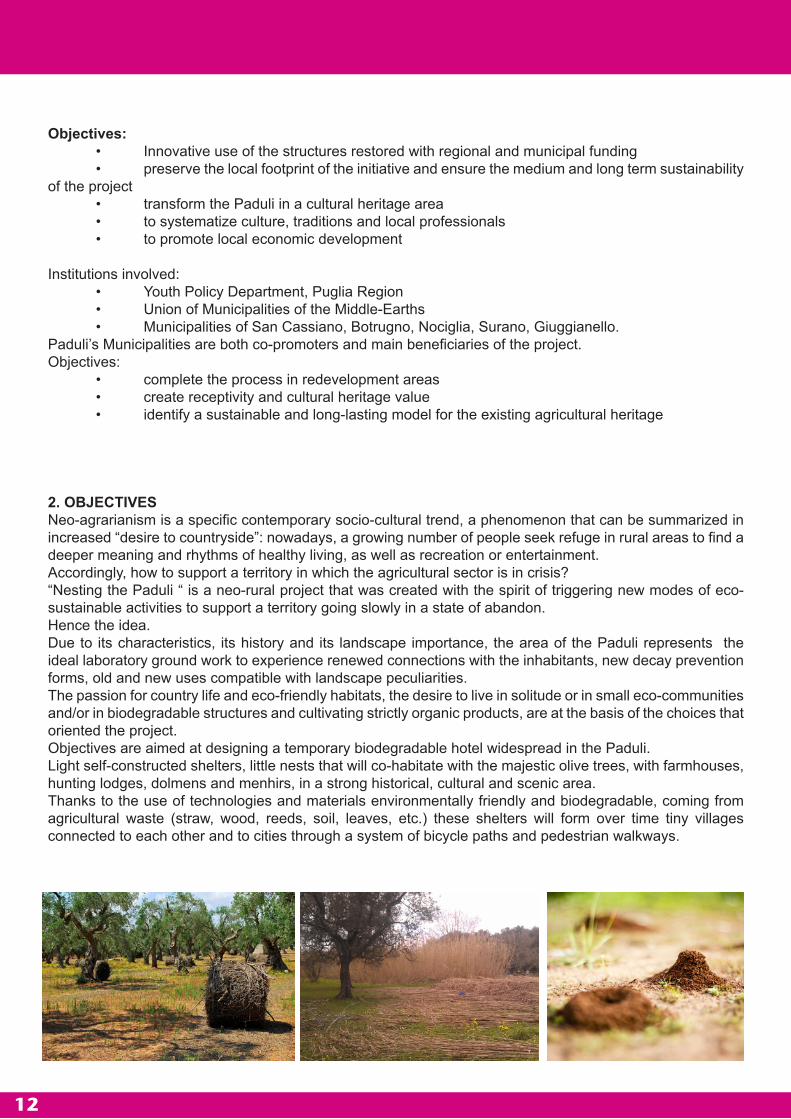
2. OBJECTIVESNeo-agrarianism is a specific contemporary socio-cultural trend, a phenomenon that can be summarized in increased “desire to countryside”: nowadays, a growing number of people seek refuge in rural areas to find a deeper meaning and rhythms of healthy living, as well as recreation or entertainment.Accordingly, how to support a territory in which the agricultural sector is in crisis?“Nesting the Paduli “ is a neo-rural project that was created with the spirit of triggering new modes of eco-sustainable activities to support a territory going slowly in a state of abandon.Hence the idea.Due to its characteristics, its history and its landscape importance, the area of the Paduli represents the ideal laboratory ground work to experience renewed connections with the inhabitants, new decay prevention forms, old and new uses compatible with landscape peculiarities.The passion for country life and eco-friendly habitats, the desire to live in solitude or in small eco-communities and/or in biodegradable structures and cultivating strictly organic products, are at the basis of the choices that oriented the project.Objectives are aimed at designing a temporary biodegradable hotel widespread in the Paduli. Light self-constructed shelters, little nests that will co-habitate with the majestic olive trees, with farmhouses, hunting lodges, dolmens and menhirs, in a strong historical, cultural and scenic area.Thanks to the use of technologies and materials environmentally friendly and biodegradable, coming from agricultural waste (straw, wood, reeds, soil, leaves, etc.) these shelters will form over time tiny villages connected to each other and to cities through a system of bicycle paths and pedestrian walkways.

13
The competition aims, therefore, at selecting projects caring of the development of a healthy and ecocompatible receptivity, capable of intercepting through art, architecture and creativity new forms of eco-tourism, edutainement, experimental agricultural production and with the primary objective to give a face to the long-term future of Paduli, based on the cooperation of local and no-local resources.In this project different systems coexist: history and memory of places and knowledge of the people, affected by the crisis in the agricultural sector and by a slow abandon of loved places, a vulnerable environmental system of great historical and landscape value, and a contemporary design that aims to bring the center of everyday social life within the agricultural park.
Specific objectives:1. generate a new visionCurrently, there is not the right perception of the opportunities of the area, although the vision of its complexity is supported by the people. General objective is to find accommodation and protection experiments showing that it is strictly related to activation of links among subjects, activities, places and institutions. The vision as a result of a process is the starting point, and this competition provides an opportunity for the emergence of alternatives sized up to the community needs.
2. meeting design needs Generate a model of temporary living space (concept) able to relate and form a network with the contemporary focus on communication, and the slow mobility and interconnection by generating a model of co-habitation between visitors and residents, through the accountability and the involvement of the residents (in parallel, urban laboratories will be active that will support through projects and services the mobility system, the temporary and permanent widespread hotel system, and the experimental practices of organic farming).
3. respond to specific objectivesDevelop activities related to: • temporary residence in support of the widespread hotel and permanent residences, • services for the use of the territory (its centrality is pivotal within the historical, agricultural and cultural system and within the slow mobility network) identifying a pattern of involvement of local knowledge.
The inhabited park will experience the coexistence of different populations: the locals that will daily benefit for a walk with the children, to buy vegetables or cheese, to grow olives and produce oil; the hotel guests that will have an opportunity to move on foot, by bicycle, or on horseback riding from the park gates and from there continue to walk, observe, learn, grow, play; farmers and breeders who can sell their products directly; the daily visitors, who on weekends can get there from Lecce, Otranto and Gallipoli (also by the Southeast railway) connecting to the network of cycle paths in the park.

14
3 PURPOSE OF THE COMPETITION“Nesting the Paduli” involves the structuring, within an olive grove owned by the Municipality (3000 square meters) located along one of the main paths of the park (Campine Vicinal), of some small shelters self-constructed for temporary residence linked to the mobility of subjects such as students, hikers, professional cyclists and visitors.A ruin restored with a biocompatible approach is placed within this olive grove, in which all the temporary hotel’s useful services will be located.The shelters, self-constructed with local materials, will respond to basic needs of summer period accomodation, internal layout, aggregation of units, organized in a space characterized by majestic olive trees, while services and facilities will be located inside the ruin. The preferable approach for the shelter is to adopt the philosophy of the nest, the burrow. The parts that compose it must be designed so as to facilitate transport, self-construction, self-supporting, disposal, and shall not require installation of fixed structures, in order not to alter the state of the area and at the same time increase the seductive character of the landscape.
In addition to being a land-art intervention in the Paduli, the project aims to promote a sustainable model of temporary residence (temporary biodegradable and widespread hotel) within the Paduli, capable of intercepting a healthy and ecological tourism in the middle seasons.
4 THE PROCESSThe Municipalities of San Cassiano, Botrugno, Nociglia, Surano and Giuggianello (Middle-Earths) along with the Municipalities of Scorrano, Maglie, Sanarica, Muro Leccese and Supersano, have started in the Province of Lecce since 2003 a long process of listening to the people, analysis, observation, planning and models sharing for the development of the territory, with external professional excellence.
This process has led to experience, on this territory in crisis, new forms of “treatment” involving local knowledge, experts and institutions all around a single idea of a Multifunctional Agricultural Park of the Paduli.
The Park of the Paduli, although not being an established “farm park”, is recognized in the “will” of the ten Municipalities, of the Integrated Program of Urban Regeneration “Land of Paduli among olive trees, stones and icons” adopted by those Municipalities in July 2011 and of the new PPTR Landscape Plan of the Puglia Region, in which the Park is identified as a Master Plan to test practices related to multifunctionality in agricultural land.
The Paduli Park covers 5,500 hectares with majestic olive trees, stone walls, pajare (trulli shaped houses), farms, hunting lodges, crypts, dolmens, menhirs, “vore”, and it is bordered by the Municipalities of San Cassiano, Nociglia, Botrugno, Surat, Maglie, Muro Leccese, Sanarica, Scorrano, Giuggianello, Supersano.
The Park is located between the Adriatic and the Ionian Sea, crossed by canals and roads, temporary ponds and lakes, from North to South by the “market street” SS275 and the railway network of the South-East, which connects the city of Lecce with Otranto, Leuca and Gallipoli, and from East to West through the Ancient Way, which might be called “isthmus”, perhaps due to currents of Hellenization, linking the areas of Callipolis-Ydruntum (Gallipoli and Otranto).
The olive tree is the unifying element of the landscape, whose importance depends not only on agronomic and economic reasons, but also on reasons relating to the sphere of values and local traditions.
This territory is today in a condition of degradation linked to the profound crisis in the agricultural sector, and also in a situation of marginalization of tourism, which is mainly focused on the Adriatic and Ionian coast of the Salento. Nevertheless, due to its geographical location (in the regional ecological network, it connects the existing system of coastal parks on the Adriatic coast to the ones on the Ionian coast) and landscape value (the area is recognized by the new Regional Landscape Plan as a “enhancement multifunctional agricultural park”) the Park represents an experimental land for new forms of eco-tourism in support of the agricultural sector.

15
In support of this heritage, in recent years the Municipalities of the Paduli have adopted a common territorial program, which was the first in the list of projects eligible for the Urban Regeneration (2011) and has led to the signing of a Memorandum of Understanding with the Territory Department of the Puglia Region for the “joint and shared experimentation of the new PPTR (Landscape Territorial Regional Plan).”The program includes a redevelopment project of agricultural and architectural goods, especially those of significant historical and cultural value, through the recovery plan of the articulated infrastructure of roads of the Paduli (under construction).The design of an interconnection network between smaller villages within the Park intertwines preservation and protection of historical and cultural heritage of the territory with the defense of an economic function such as agriculture that has marked the history of economic development in this area; a project that takes into account a growing social demand, in search of open spaces, fully accessible and rich in cultural values, all in a context of disadvantaged rural areas, if compared to the two coastal systems.The project is then inspired by the intention to “integrate” the spontaneous use of communities, services (Urban Laboratories Bollenti Spiriti), productive activities related to agriculture, architecture, history, popular culture and the landscape in a single connecting plan.The path becomes the place where all goods of the territory are kept, protected, collected, disseminated, both the tangibile goods (woods, olive groves, crypts, farms, squares, service areas) and the intangibile ones (tales, historical, archaeological, architectural, anthropological, sociological, botanical and agrarian researches, producted within the participative Laboratories dated from 2003-2009) and it thus offers the user an innovative knowledge path.
5 DESCRIPTION OF THE REGIONAL CONTEXTThe municipalities of San Cassiano, Supersano, Surano, Nociglia, Botrugno, Scorrano, Sanarica, Giuggianello, Maglie and Muro Leccese, belong to a context characterized by the interpenetration of two geographical areas that result strongly interconnected for physical, morphological, urban, environmental, landscape, historical and cultural reasons, and that are characterised by a significant roads infrastructure of strategic importance, the SS n. 275 that, although physically dividing at the same time unifies them, then representing the place of maximum visibility and perception of the two areas.On one side, there is the area located to the East side of the road within which the Municipalities of Sanarica, Giuggianello and Muro Leccese, mutually interpenetrating, are precursors to the system of “Salento Serre”; while to the West of the SS n. 275 there is the Paduli area, formerly occupied by the Bosco Belvedere, whose existence has historically influenced the life and activities of the urban centers and that previously included much of the territories of Sanarica, Giuggianello and Muro Leccese.The Municipalities that mark more strongly the interconnection between the two areas are Scorrano, Maglie, Botrugno, Nociglia, San Cassiano and Surano that have their urban centers close and to the East side of the SS n. 275, but extend their territory until the heart of the Paduli.

16
5.1 The landscape stonesThe landscape on the East side, thanks also to the extinction of the Bosco Belvedere, the health of the land and the most intense urbanization due to the construction of a dense network of roads, is mostly identified as the “rock landscape” and it represents the unifying element of a context whose morphology is characterized by rough and rocky outcrops, by the agrarian landscape with particles of modest size, divided by dry stone walls. The presence of the Serre (Greenhouses), mainly in the areas of Giuggianello and Muro Leccese with a maximum altitude of 123 meters in the territory of Giuggianello, provides a sort of natural boundary of this area, corresponding on the West side to the Greenhouses of Supersano.
The territory, from the 275 to the East goes from the Paduli to the mountains of the Serre, declining all combinations of geology, geomorphology, soil, vegetation, land use, field structure and human settlements that create a diverse landscape, where human activity is more visible, since this portion of territory is historically more accessible and attractive from the point of view of urban diffusion and suitable building, due to its distance from unhealthy areas subject to flooding as the Paduli, and protected from the heights of the Serre, certainly more hospitable, as evidenced by the numerous Neolithic and Protohistoric findings therein found mainly in the territory of Muro Leccese and Giuggianello. In the latter the “Hill of boys and Water Lilies” dominates.This results in a tight agro-pastoral mosaic, where agricultural areas interface to space semi-natural habitats typical of the areas for grazing and are defined by the geometry of the stone walls and characterized by recurrent presence of numerous stone shelters such as pagghiare, furnieddhi, chipuri. The olive trees that represent the unifying element of most part of the territory, become thinner here than in the Paduli area , in particular between the axis between the 275 and the one of Muro and Sanarica. Then they become again more consistent on the East, near the Serre, where appear in large extensions aand show their old age grandeur.In fact, in the range between the two axes mentioned above, the land use is characterized by the presence of arable and fallow areas that are sometimes interrupted by sparse olive groves, which instead gather where buildings and infrastructures are less common. In contrast with the area of the Paduli, following the tendency to be more urbanized, this area is moe natural and fragmented, it consists mainly of grassland, interspersed with arable areas. In addition, to a network of surface water practically non-existent, the underground of this area has a rich hydrography, as witnessed by the presence of numerous sinkholes.
Urban centers located in this part of the territory as Sanarica, Muro Leccese, Giuggianello, Botrugno, Nociglia, Surano and San Cassiano already belong to the surprising amount of small settlements, set on a dense road network which shows that, despite current trends of conurbation, polycentrism is still present in a rural context in which the direct link between town and country appears. The road network, basically functional to the connection of urban centers, does not appear branched out into other paths to access those rural areas that are closer and interconnected with the urban center.The towns of Muro Leccese and Sanarica, affected by the track and the South East Railways, have a built area that stands mainly on paths roads that connect them to Maglie. Fom the distribution of built-up areas, Muro results in having more decontextualized urban functions and dispersed in rural areas, closer to the characteristics of Maglie. This phenomenon is less obvious in Sanarica and Giuggianello where, as in most of the province, the historical margins of the village show proliferations that penetrate the landscape and reach the roads linking such centers. It appears evident on the arteries linking Muro Leccese and Scorrano, between Muro and Maglie and between Sanarica and Botrugno. Additionally, the presence o the West side of the Paduli, natural impediment to the expansion, has meant that the villages of Scorrano, Botrugno and San Cassiano, have expanded towards the East along the links with centers located in that direction. The characteristic of urban centers margins of Muro, Sanarica and Giuggianello, mentioned above, which actually distinguishes these countries in their relationship with the agricultural areas, identifies “the campaign of the small”, that is the part of the agricultural land around the villages enveloping the peripheries, where the city and the country can find the signs of a renewed relationship.Dolmens, menhirs, “specchie”, archaeological sites, culminate in the relevant wall of Muro Leccese, which is the largest “Messapi” city known in Salento.

17
5.2 The “Paduli”To the west of the S.S. n. 275 the rural area of Paduli dominates, around which numerous urban centers are located, characterized by a landscape mainly dominated by extensive and majestic olive groves. It is a level ground that extends to the West up to Supersano, and covers an area historically occupied (until the end of 1800) by a thick forest of oaks, belonging to the ancient forest of Belvedere, whose existence is attested today by a few trees rising near the dense network of roads.
The area of the Paduli is in a settlement system which consists of a few urban centers aligned along the sub-hilly central area of the Serre, of sparse rural settlements (farms) and mixed large agricultural areas replacing the ancient forest areas. The extention of olive trees is bordered to the West by the above Serre of Supersano, with a variety of natural elements (pine forests) and anthropic elements (farms) that enhance its perception. These are the most significant view point for the contemplation of the Paduli. To the East side the 275 represents the biggest stop to the large olive grove area and its replacement with the urban centers that surround it or are crossed by it. This road axis represents the gap with the centers of Muro Leccese, Sanarica and Giuggianello that historically would absorbe in their municipalities part of the ancient Forest of Belvedere. To the North, the SP road that connects Maglie to Collepasso represents a passage between the Paduli and the northern rural areas, much more urbanized. To the South, in the Municipalities of Ruffano, Miggiano and Montesano the area shows a more widespread urbanization trend gradually, losing the character of rurality.The olive tree is the unifying element of the landscape, and its importance depends not only on agronomic and economic reasons, but also on reasons relating to the sphere of values and traditions.
The history of the Paduli made sure that this area can be considered as a relevant agricultural area in which there are no external elements to agricultural activity.The Paduli represent an area in progressive marginalization also as a result of the thickening of the Nardò-Leuca and Leuca-Maglie axes and of the strong attractiveness of the close urban centers and coastal areas. Is not a not very populated area if compared to the provincial context, in some ways almost “forgotten” by the big urbanization, and whose characteristic is not to be a public space, but an area divided into a myriad of small/large areas of private property, perhaps less attractive because of its farness from traditional places of coastal tourism and centers of higher attendance and/or production. Since the disappearance of the Belvedere forest its replacement with mainly arboreal crops, it has never been attractive in terms of urban sprawl, alo because it is subject to flooding and it seems unsuitable for building, remaining a merely rural landscape-environmental area with little pressare by human activities. Of the ancient forest of Belvedere only some natural strips remains, emerging over the olive groves, and also some woods sporadically occur, one of which, near the town of Scorrano, is a SIC.The agricultural activity, which affected the area in the last two centuries as a result of the above mentioned logging, has played an important role in the conservation of landscape and biodiversity. Farmers, creating specific types of intervention such as the dry stone walls to mark the land, the “pagghiare” for the housing of farming tools, canals for irrigation and farms, also performed a function of presence in the territory and, therefore, of prevention of land degradation as well as an activity of construction and maintenance of the aesthetic and perceptive value of the landscape.

18
At the same time, such interventions have given continuity to the culture of the local people, renewing the traditions, as with the production of typical and traditional products, which have significant territorial connotations, both because they are linked to the cultural background of the people living there, and because of the relatively high level of quality of raw materials produced in designated areas.The presence of producers within the area has historically maintained an active and daily link with the land and its buildings, representing a durable and permanent aid to the conservation and enhancement of the landscape.The villages of the Paduli appear to be more similar to “rural villages” surrounded by cultivated land rather than urban centers with a strong character, with the exception of Maglie and Muro Leccese that are more similar to a model in which the “rural background is changing rapidly and it is accompanied by the spread of small and medium-sized enterprises not related to agriculture”.What characterizes the “crown” urban centers (but it is a very common feature in Salento) is “the direct relationship between the building and the road and the lack of open common spaces “ that cause “a contact between public and private space without mediation”. Roads generally small, transition between the edge of the city and the country, which seems to represent the real collective space that weighs the obvious lack of green and collectives spaces within the city. The care of Paduli perpetuated over the years by the inhabitants of these centers, naturally preserved and defended from the expansion and diffusion of the sparse building practice, tells about a life way that is centered on a city that provides essential services and a campaign that represents the “garden” and the collective enjoyment, although fragmented into a multitude of small private properties.To the East, in particular, the presence of the SS. 275, as already mentioned, has created a strong gap between some of these centers and the countryside, with the roadway becoming a place of settlement of new facilities due to easier accessibility. Along this axis “there is a double side of production buildings, some of which very recent, separated from each other by agricultural areas” that appear intended to be gradually replaced also by exhibition buildings, connoting then the SS 275 as a “street market”, the route of which will soon be doubled in some parts, consequently strengthening that function. This, however, has “stopped” the potential expansion of these centers placing it along an axis of infrastructure which in fact does not interact with the area of the Paduli, but seems to be almost a factor of resistance to the urban expansion. Parallel to 275, the Via Vecchia Lecce runs to the West, at the edge of olive groves, representing a tangible and historical sign of acquaintances also because the area is characterized by the presence of numerous farms and “specchie”, as well as an evidence of preferred route for pilgrims. In spite of the many path roads, trails, paths through the area of the Paduli in the transverse direction, not as many paths crossings in the longitudinal direction are detected with exception to the above mentioned Via Vecchia Lecce, which can be considered a margin rather than a real crossing path. To the West the area is bordered and marginally crossed by the other longitudinal connection between Cutrofiano and Ruffano (SS 476), marked, where it does not cross the urban centers, by the presence of farms and sites of archaeological importance.
In the villages of Supersano, Scorrano, San Cassiano, Nociglia, Botrugno, Surano there is no sign of the “confined countryside” because villages are small, have limited expansions if compared to other towns and have their orientation in the opposite direction with respect to the agricultural areas of the Paduli. Over the years there has been planning choices, conscious and/or unconscious, aime to respect and protection of rural reality that surrounds them, which did not result in the formation of irregular “urban fringes”, but in the close proximity of urban spaces with agricultural spaces in most cases. In fact, it is still possibile to recognize the old boundary between city and countryside, where farms, trees, country roads, networks of rural roads begin, with a net change of scenery.To be noted, in particular, the compactness of the built area overlooking the Paduli: it is the image of a reality in which the countryside is immediately outside the centers, with its olive groves and/or arable land, “territory other and different”.These characteristics are part of the historical use of the Paduli that from being a wooded area intended primarily for hunting and grazing became an agricultural area with the planting of olive trees and the location of certain farms basically located at the edgeof the area (except for some visible cases). Over time no phenomena of intense construction raised, also due to the presence of numerous phenomena of flooding and waterlogging.
19
These phenomena have accompanied the life of local people and have been documented by many travelers since the Seventeenth Century. Still in the presence of heavy rains, there is flooding in many areas of Paduli campaigns, although the presence of a dense network of canals contributes to the correct disposal. However, there is still some permanence of water at small depressions fed by superficial layers (for example, within the “Bosco Belvedere”, the Sombrino Lake in the village of Supersano).
The intensive farming has increased its road infrastructure to allow access to funds. There are still some historic streets with particular reference to the current SP linking Scorrano to Collepasso and that historically represented the main link between Gallipoli and Otranto, as per the readable historical cartography. Other historical axis, as mentioned above, which runs in the longitudinal direction with respect to the area, used until the construction of SS 275, is the Via Vecchia Lecce which runs parallel to the same SS. The articulated infrastructure of roads of the Paduli consists predominantly of narrow paths and some still unpaved roads. In principle, such paths allow easy accessibility, but due to its labyrinthic nature it is known by only those who daily attend these areas.To complete the picture of the complexity of the Paduli, there are geomorphological components such as sinkholes, historical artifacts such as farms and hunting lodges, sites dating back to prehistoric times, byzantine, medieval as well as a large spread of typical dry stone walls and “pagghiari”. It should be noted that these historical artifacts and architecture appear mainly in areas outside the very heart of the area, a sign of the inaccessibility due to phenomena of waterlogging, unsanitary conditions and the presence itself of the old Bosco Belvedere. The unifying element of such “episodes of anthropization” is constituted by olive groves that extend almost seamlessly.The agricultural use of the land has also led to the creation of numerous canals for irrigation and that at present, partly because of the initial phenomena of abandon are taking the shape of natural irrigation projects with a strong connotation of spontaneous marsh vegetation that draws the margins. Historical sources, however, show that in this area there were small river networks naturally built by rainwater, that converged in the ground. Given this hydrographic surface network, the Paduli are characterized by a large and significant underground water presence.The area, therefore, is characterized by landscape and environmental emergencies and densely infrastructured due to its links with farming activities, it hosts a network of roads, slow travel speed when measured with respect to the longitudinal axes and the Maglie-Collepasso one, and holds together the environmental characteristics with the performance of many activities and social practices.The slow speed allows a degree of perception of such common goods as well as a concept of road and path that become more complex places destined to different practices. The proximity of urban centers, the location of some of these beyond the SS n. 275, allows to reconnect in a single integrated system living places and places of agricultural production, which historically lived interconnected.These places can widen “the thickness of the coastal tourism” also moving it towards the interior of the Salento, presenting themselves as rural places of high environmental and landscape quality, which integrate the traditional tourist destinations related to the beach activities through an integrated rural functions related to high-quality agriculture. In this view, the urban centers represent the nodes of a connection network with urban coastal settlements.
5.3 THE LANDSCAPE COMPONENTS 5.3.1 Historical and cultural components
The area is characterized by the presence of some, historical and cultural characteristics typical of the Salento, with the presence of farms (Masserie), “appoderamento” phenomenon that from the fifteenth century until the beginning of the last century has affected this part of Puglia, together with the spread of stone artefacts in support to agriculture. The presence of large landowners has determined the presence of a few large architectures in agricultural areas and a more recent phenomenon of fragmentation of properties, which has led to a widespread diffusion of small shelters for farming tools.Surveys have allowed to categorize certain types of artifacts significant to the architectural and functional connotation and the character representation of the rural Salento:

20
• Dolmen and MenhirThe megalithic dolmens and menhirs are present in various areas of the European, African and Asian continents. These monuments are characterized by simple architecture and unrefined shapes and materials.Dolmens are burial chambers with a perimeter of stones inserted into the ground as walls and a monolithic slab ceiling. The menhir is made of a single cylindrical or parallelepiped stone at the top, ranging between one and ten meters. Its function seems to be related to funeral religious or celebration purposes, despite the absence of inscriptions or paintings.The dolmens are sometimes covered with earth to form artificial hills and are often surrounded by other megaliths, and unlike menhirs were mainly isolated.In Puglia a few but meaningful examples of dolmens have been found, whereas the menhirs defined by the locals “buried stones”, are quite common.
• MasserieThe Masseria (farm) is the expression of a geo-economic settlement related to the Latifondo (large estate), typical landholding that fueled the revenues of the aristocratic classes and the bourgeoisie. The farms were therefore the expression of lhuge farms, but also smaller, inhabited, sometimes even by the landowners, whereas the rural construction also included the houses of farmers and in some areas even seasonal stalls, deposits and forage crops.The birth of the farm was often a product of colonization between the Sixteenth and Eighteenth Centuries of abandoned and uncultivated baronial areas, when Spain for supplies of cereals granted the nobles of the kingdom with the license of repopulating, phenomenon that gave birth to real villages in the surrounding area of the original building.The typical pattern of the farm included a main building closed to the outside and with the openings all facing in the court or the large courtyard. The perimeter walls, without openings, acted as protection against intruders and attackers and assaults by bandits. A large entrance door blocked by a sturdy door allowed access to the large courtyard also to carriages and freight wagons. Usually a part of the building for residential purposes had one or more upper floors where the “master” lived with his family. The lower floors were used as residences for farmers and deposits for provisions. Inside the courtyard, stables for horses or mules as well as placet for chickens, rabbits and various birds from breeding. Other rooms were used for storage of tools and carriages. According to B. Spano, who studied settlements and rural dwellings of central and southern Puglia, the Salento farm occupies a special place. This Masseria has a predominantly small plant (Masseriola), with reduced outdoor space focusing on the functional exploitation of land and breeding resources.

21
• CaseddheSquare stone buildings, dry or with mortar, quadrangular and covered with shingles or tatched and reeds roof.
• PajareDry construction trulli shaped that were used as temporary or daily shelters by farmers. The pajare, have square or round layout, with a pyramidal, a truncated cone or truncated pyramid shape, single or in pairs, isolated at the center of the land units or situated on the borders to not use space dedicated to crops. Flanking the pajara there are often dry stone fences with reverse access from the pajara, used as refuge for animals. A henhouse built as a trulli-shaped construction has been found near a pajara, but smaller and with low entrance at the surrounding ground level. The presence of the pajare is a phenomenon of cultural stay in the region and a construction technique that, since its inception in ancient times, has remained almost unchanged.The architectural technique by which the “Trulli of Salento” are constructed is the derivation of the system of the “exhaust triangle”, as well as the dome and the barrel vaults derive from the round arc. Therefore, the architecture system, which may apparently seem complex, it is really basic.The construction process has a few variations, a hammer was the only tool, with a dual function: to settle and to slightly shape the stones. These stones are never cemented (dry buildings) and, generally, not boxy (because of the type of limestone difficult to cut in regular shapes).In the chosen location, the farmer or expert manufacturer, who earned a daily fee higher than the farmers, had to draw the floor plan of the shelter directly on the ground. In case of emerging rocks, he paved appropriately to create the ground plane and the floor, or removed the layer of earth covering the limestone rock and began to build the walls that were drawn vertically in height up to about 1,5 or 2 meters.Between the inner and outer wall a gap (“muraja”) was left, depending on the size of the shelter (generally a couple of meters), then filled with smaller stones mixed with earth.The larger buildings reach heights of 14 meters and have 6 meters muraje.Successive layers of stone were arranged slightly inclined inwards (to the outside wall), and bulging false (to the inner wall). The stones of the same layer, which laterally contrast constituting a virtually rigid ring system, even without reinforcement and without mortar, are supporting each other exclusively through the contrasts and to the force of gravity.The later and therefore overlying rings are, as said, slightly projecting towards the inside thanks to the use of longer stones, thus having a diameter which is progressively reduced, until reaching the length of 30-40 cm.At this point a large slab (“Chianca”) was placed, with a key function for the entire structure and to cover the opening.
The pajare are all fitted with one or more external spiral stairs, formed by the thickness of the muraja. The importance of the presence of the stairs is linked to the possibility of drying figs, peppers and other food under the sun, to the need of carrying out maintenance work on the roof, but, mainly, stairs would appear to be a necessary element during the construction of the shelter, because as the structure stood vertically, the manufacturer could carry the material proceeding in parallel with the construction of the stairs and the pajara itself.
22
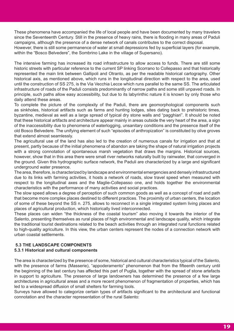
• PuddharuTulli-shaped onstruction built according to the pajara method; in advanced forms shows Tholos coverage. The low entry denotes its function as a house and shelter for the hens. Is often associated with the threshing.
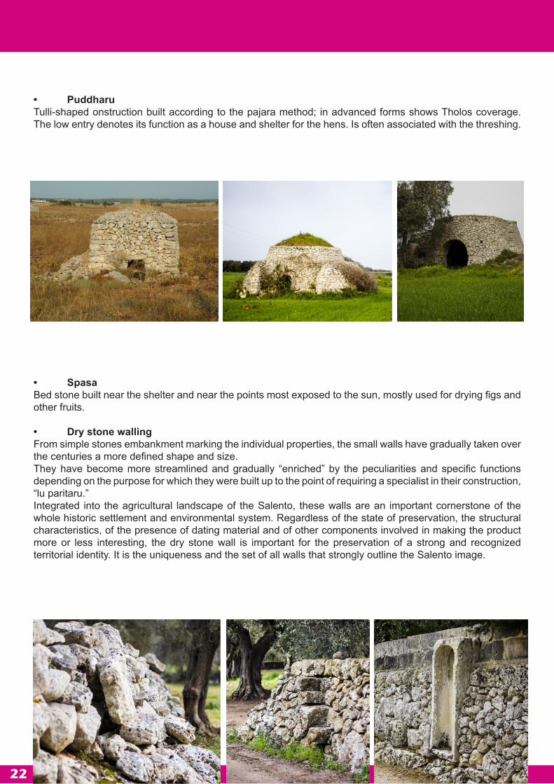
• SpasaBed stone built near the shelter and near the points most exposed to the sun, mostly used for drying figs and other fruits.
• Dry stone wallingFrom simple stones embankment marking the individual properties, the small walls have gradually taken over the centuries a more defined shape and size.They have become more streamlined and gradually “enriched” by the peculiarities and specific functions depending on the purpose for which they were built up to the point of requiring a specialist in their construction, “lu paritaru.”Integrated into the agricultural landscape of the Salento, these walls are an important cornerstone of the whole historic settlement and environmental system. Regardless of the state of preservation, the structural characteristics, of the presence of dating material and of other components involved in making the product more or less interesting, the dry stone wall is important for the preservation of a strong and recognized territorial identity. It is the uniqueness and the set of all walls that strongly outline the Salento image.

23
Additionally, it has also been identified the historical path that was used to link SM Leuca to Lecce and crossing the territory of five of the ten municipalities (Scorrano, Botrugno, San Cassiano, Surano and Nociglia). Now partly replaced by the construction of the SS 275, it is still present in the West area of the SS 275, as it can be verified by consulting the cadastral maps and mapping as shown in the PIRT (Territorial Regeneration Integrated Programme). The ancient road connecting to Lecce has a high landscape value. In fact, it intercepts most of the farms built in this part of the territory and goes through the South-West area out of the Paduli villages, the olive grove area characterized by the presence of centuries-old trees alternate with recents born areas with complex historical, geographical, flora and fauna connotation and a strong value of identity. Inside the “Paduli” routes of particular environmental interest have been identified that form, with the surrounding Municipalities, a network of crossings and connections to nature and historical farm that today are used in a spontaneous way for leisure and for sport.
5.3.2 Components geology. The landsRed earthIn the Calcareniti sedimentary covers are detectable, generally of small thickness, of secondary origin, consisting of a reddish brown clay known with the name of red earth, with a mostly lumpy structure and containing pisoliths and bauxitici nodules (“cucule”) in diameter variable from a few millimeters to a few centimeters.The pisoliths and nodules are usually rounded, very consistent with color varying from yellow to brick-red, and they are clearly visible on the soils of the limestone where the clay fraction has been partially washed away.The thickness of these sedimentary cover is usually limited to a few decimetres, but it can reach a few meters.The red soils are granulometry as a silt-clay and have a mineralogical composition that consists of abundant iron and aluminum hydroxides and little crystalline clay minerals, illite and kaolinite generally. They also contain, to a lesser extent, quartz, feldspar, micas, pyroxenes, apatite, rutile and zircon.The genesis of red soils and bauxite is directly related to limestone. The latter, during the long periods of continentality that have characterized the carbonate platform, have been subjected to the action of physical and chemical surface water that took away by dissolving the soluble fraction, creating colloidal suspensions forming the insoluble residue and carbonate. For processes of flocculation of colloids the bauxites would have been formed, the nodular nature of which was determined by mechanical transport.The insoluble suspension of limestone, subject to changes due to phenomena of lateralization, would have given rise to the red soils.The processes of mechanical transport would then concentrated bauxites and red soils in the more depressed parts or in cavities of limestone. These deposits, attributable to the Cretaceous in age, were then covered by sediments of sedimentary cycles.Associated with deposits of bauxites and to the roof of the latter there are sometimes decimetric levels of lignite.
5.3.3 Botanical vegetation componentsThe landscape is the result of human activities that for centuries has modified the original landscape and its vegetation, which is nowadays almost completely destroyed and remains relegated to areas considered of limited use for any economically profitable activity.Currently, most of the territory is made up of an agricultural landscape characterized by fragmentation that is defined by dry stone walls and dry stone construction types, with predominant olive crops and arable crop areas.

24
Of great interest, and worthy of a detailed program for the protection and enhancement (Agricultural Park) is the area called “Paduli”, characterized by the presence of olive trees organised by rows together with nuts trees and isolated oak trees (Quercus Tree, Quercus ilex) that help in drawing the landscape. This also happens in areas closer to urban centers, where the relationship between urban and countryside seems not yet spoiled, as it generally happens in Salento, by recent urban expansions that tend to ignore the landscape.With a view to enhancing and more properly manage the land through the creation of bike paths and trails, the area has a few sights in which the morphology of the landscape allows extensive views of the rural landscape, therefore it is desirable that such sights are taken into account in choices in future planning.
The very low wooded areas are the result of artificial systems present in confined areas and private property (closed forests), there is a small presence of trees that can be considered as originating from the oak forest “Bosco Belvedere” and Mediterranean sclerophyllous that once covered much of the Salento peninsula: mainly small wooded areas with predominantly non-native tree species such as eucalyptus (Eucalyptus canaldulensis), cypress (Cupressus sempervirens, Cupressus macrocarpa) and Aleppo pine (Pinus halepensis).
The territory to the North-East is characterized by a larger number of areas of arable crops (wheat, oats), there is little presence of olive groves, the significant presence of rocky outcrops and sinkholes and depressions has meant that in some areas herbaceous vegetation has remained characterized by weeds and synanthropic plants, but in areas less disturbed by fires and grazing, elements remains from the Mediterranean vegetation, although degraded in a more simplified form as the garrigue cyst, Pugliese Heather and thyme shrub.The edges of the roads and rural areas and plots left fallow feature rich spring blooms of invasive and synanthropic species characterized by showy flowers such as yellow chrysanthemum (Chrysanthemum coronarium), the wild mallow (Malva sylvestris), wild carrot (Daucus carota) , borage (Borrago officinalis), wild oats (avena barbata), poppy (Papaver rhoeas), wild marigold (Calendula arvensis).
The WoodsWoods have a timberline mainly characterized by holm oak (Quercus ilex), the lack of land management have led to a gradual development of the undergrowth to the characteristic forms of the forest of oaks in the Mediterranean environment.Relevant arboreal-shrubby plant species are:Quercus ilexQuercus cocciferaPinus halepensisPinus pineaRuscus aculeatusLaurus nobilisPistacea lentiscusMyrtus communisArbutus unedusPhlomys fruticosaRhamnus alaternusAsparagus acutifolius
The artificial WoodsArboreal artificial and fenced plants.Prevalent tree species are:Eucalyptus camaldulensisPinus halepensisPinus pinea

25
The road WoodsArboreal plants consisting of considerably sized trees. The landscape around the wooded areas is of particular value due to the presence of olive groves and rows of olive trees that draw the landscape, but also for the presence of farm buildings that have structural characteristics linked to local traditions and that are therefore worth of preservation.Dominant tree species:Pinus halepensisQuercus ilex
photo:Alberto Caroppo

ANNEX A
Associazione culturale LUA Laboratorio Urbano Aperto c/o Comune di San Cassiano
Ufficio Protocollo Piazza Cito,
73020 San Cassiano (Lecce)
I, the undersigned............... born in ................. prov. ................on .................. and resident in ............... prov. ............... street/square .................... as CONTACT person of the informal group consisting of:
1. Name, Surname, born in ........ (prov) ........... on ............., .................. resident in street/square ........ fiscal code .................................qualification .................
as proponent of this instance,
REQUESTS to participate in the advertised public competition, with the proposal described in the attachments.
Place and date Signature

ANNEX B
Associazione culturale LUA Laboratorio Urbano Aperto c/o Comune di San Cassiano
Ufficio Protocollo Piazza Cito,
73020 San Cassiano (Lecce)
“Nesting Paduli” ideas competition - shelter design and self-construction for the future biodegradable and temporary hotel of the PAMP, Paduli Agricultural Multifunctional Park
The undersigned:1. Name, Surname, born in ........ (prov) ........... on ............., .................. resident in street/square ........ fiscal code .................................qualification .................
APPOINT Mr/Ms ................................................................ as a contact person with the managing authority (Article 4 of the notice)
DECLARE, subject to the provisions of art. 7 of the notice, that in case of victory are committed to participate in the workshop for the implementation of the proposed project.
INDICATE HOW:E-MAIL ADDRESS FOR COMMUNICATIONS ....................................................................E-MAIL ADDRESS OF CERTIFIED MAIL FOR MESSAGES .................................ADDRESS
Place and date .................................

ANNEX C
DICHIARAZIONE SOSTITUTIVA DELL’ATTO DI NOTORIETA’ (Art. 47 D.P.R. 28 dicembre 2000, n. 445)
“Nesting the Paduli” ideas competition - shelter design and self-construction for the future biodegradable and temporary hotel of the PAMP, Paduli Agricultural Multifunctional Park
I, the undersigned …………………………………… born in ………………………………… (prov) ………………. on ……………………………….. resident in …………………………………………. (prov)………….. street/square …………………………………………….. n. ……………..
aware of the penalties in the case of false declarations, production or use of false documents, referred to in art. 76 of D.P.R. 445 of 28 December 2000
DECLARES1. to meet the requirements as indicated in the Articles. 4 and 5 of the notice in question;2. to be aware of and accept unconditionally the rules of the competition;3. that the contents of this form are true;4. that the applicant is in the free and full exercise of his/her rights, not being in a state of bankruptcy, creditor’s composition, temporary or extraordinary receivership, forced or voluntary liquidation, and did not have a criminal record or does not have criminal proceedings;5. to accept that the Park Authority may, at any time, verify personal qualifications of the applicant in relation to the proposed activities, and if the proposed project presents matters which fall within the Legislative Decree 163/2006, to respect content and requirements;6. to be informed, in accordance with and for the purposes of Legislative Decree no. N. 196/2003 on the “Code on the protection of personal data” and subsequent amendments and additions, that personal data collected shall be processed by computer, only part of the procedure to which this declaration is made.
Place and date.....................................................
The Declarant
……………………………………………..
Attach a copy of a valid identity document