Embed Size (px)
Citation preview
October 8, 2010
Ms. Anne Neville
Program Director
State Broadband Data and Development Program
National Telecommunications and Information Administration
U.S. Department of Commerce
Herbert C. Hoover Building
1401 Constitution Avenue, NW
Washington, DC 20230
RE: State of Louisiana Broadband Mapping Project October 2010 Data Delivery
Dear Ms. Neville:
We are pleased to submit our second formal data submission, the first semi-annual update, for the
State Broadband Data and Development (SBDD) program. This data submission meets the
requirements set forth in the Notice of Funding Availability (NOFA), as amended by subsequent
clarifications, and the SBDD Data Transfer Model. We deem it to be complete, insofar as it
includes all validated data received from the broadband providers willing to cooperate under the
program. Details of the data development and validation methodologies that were used to
aggregate and verify this data are provided in Attachment A.
The data submission uploaded to the secure ftp site is a zip file package (20101008_LA.zip),
which contains the following two (2) files:
FILE_BASED_GEODATABASE_LA.ZIP – contains the spatial files using the SBDD Data
Transfer Model stored in a file-based geodatabase format;
LA_DATA_PACKAGE.XLS – documents data package and contents of the geodatabase.
LA_DATA_PACKAGE.XLS provides the requested contact information, list of submitted files
and detailed table indicating the name and status of all 91 companies contacted, regardless of
whether their data is included in this delivery, along with details on the corresponding records
included in this data submission. Any additional information concerning Provider submittals and
validations results are included in the Provider Table comments column.
Please note that our data validation process now includes verification against the front end
business logic rules provided in the SBDD Data Transfer Model. When an inconsistency was
BOBBY JINDAL ANGELE DAVIS GOVERNOR COMMISSIONER OF ADMINISTRATION
State of Louisiana Division of Administration
Office of Information Technology
Post Office Box 94095 Baton Rouge, Louisiana 70804-9095 (225) 342-7105 1-800-354-9548 Fax (225) 219-4994 An Equal Opportunity Employer

Ms. Anne Neville
October 8, 2010
Page 2 of 3
detected between a business logic rule and the Provider data, additional outreach was conducted,
and in many cases the Provider feedback indicated that their submitted data was indeed valid. In
these cases, we have included the provided data and indicated the inconsistency in the Provider
tab of the LA_DATA_PACKAGE.XLS in the Comments column.
The following Table presents the Broadband Provider participation status for this submittal.
Following is an update on our project status since the initial data submittal on May 28, 2010. The
matrix below indicates the progress made since that initial submittal.
Data collection related to Community Anchor Institution (CAI) connectivity has improved
significantly since the May 28 submittal. Since then, broadband connectivity data has been
collected from various state agencies. To date, we have collected data on 7,861 identified CAIs in
this data submittal. Data collection will continue for subsequent data submittals.
Broadband Service Provider Participation Statistics
Category No. of Providers
Providers That Have Submitted Data 43
Providers That Have Submitted Partial Datasets 3
Providers That State They Will Submit Data 4
Companies Determined Not to be Broadband Providers 14
Providers Contacted That Will Not Submit Data 3
Providers That Were Non Responsive 12
Providers Contacted That Were Determined to be Resellers 13
Providers That Were Sold or No Longer Doing Business 2
Providers Determined to be Part of Another Company 8
Total Providers Identified 102
Providers Included in this October Data Submittal 43
Broadband Service Provider Participation Statistics Since Last Submittal
Category May 2010 October 2010
Total Providers 93 102
Submitted Data 44 46
Not Submitted Data But Will 4 4
Will Not Participate 3 3
Non Responsive 7 12
Community Anchor Institution Statistics
Category May 2010 October 2010
Schools (K-12) 3581 1968
Library 545 273
Medical/Healthcare 1766 1562
Public Safety 1507 1345
University, College, Other Post-Secondary 117 74
Other Community Support, Government 638 405
Other Community Support, Non-Government 2355 2234
Ms. Anne Neville
October 8, 2010
Page 3 of 3
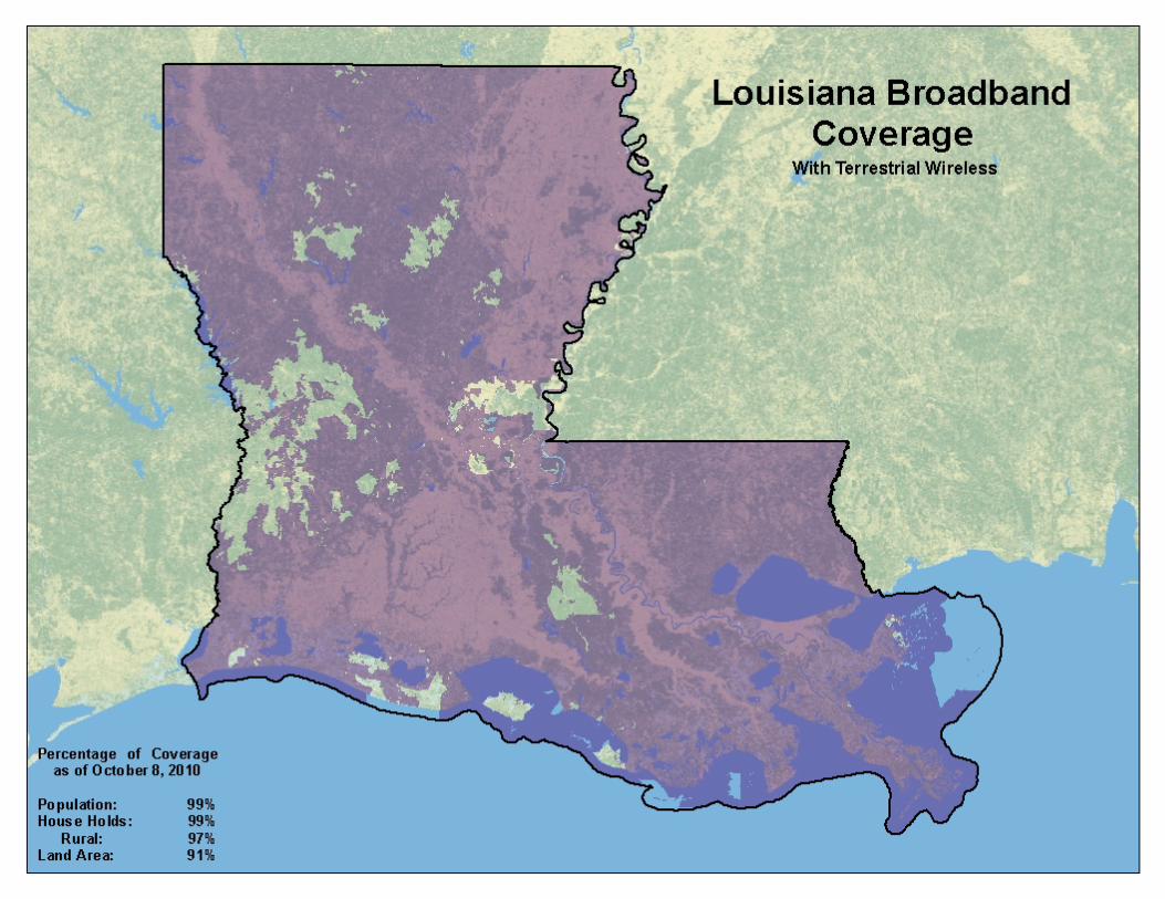
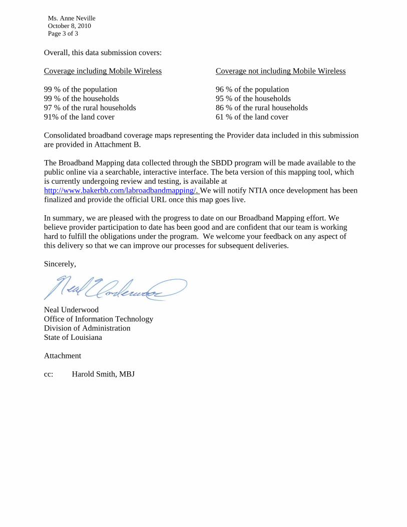
Overall, this data submission covers:
Coverage including Mobile Wireless Coverage not including Mobile Wireless
99 % of the population 96 % of the population
99 % of the households 95 % of the households
97 % of the rural households 86 % of the rural households
91% of the land cover 61 % of the land cover
Consolidated broadband coverage maps representing the Provider data included in this submission
are provided in Attachment B.
The Broadband Mapping data collected through the SBDD program will be made available to the
public online via a searchable, interactive interface. The beta version of this mapping tool, which
is currently undergoing review and testing, is available at
http://www.bakerbb.com/labroadbandmapping/. We will notify NTIA once development has been
finalized and provide the official URL once this map goes live.
In summary, we are pleased with the progress to date on our Broadband Mapping effort. We
believe provider participation to date has been good and are confident that our team is working
hard to fulfill the obligations under the program. We welcome your feedback on any aspect of
this delivery so that we can improve our processes for subsequent deliveries.
Sincerely,
Neal Underwood
Office of Information Technology
Division of Administration
State of Louisiana
Attachment
cc: Harold Smith, MBJ

Attachment A
State of Louisiana
State Broadband Data and Development (SBDD)
Broadband Mapping Development Process
NTIA Data Submittal October 8, 2010

State of Louisiana SBDD Broadband Mapping Development Process
2
Table of Contents Introduction ..................................................................................................................................................3
Broadband Provider Outreach ........................................................................................................................3
Data Submission Guidelines ........................................................................................................................3
Louisiana Broadband Providers Website .....................................................................................................3
Outreach Delivery Vehicles .........................................................................................................................3
Broadband Outreach Tracker Application ....................................................................................................4
Provider Submittal Validation ........................................................................................................................5
Validation Checklist ....................................................................................................................................5
Data Usability Determination .....................................................................................................................6
SBDD Data Development ................................................................................................................................6
Spatial Data ...............................................................................................................................................6
Address Data Geocoding.............................................................................................................................6
Census Block Aggregation ...........................................................................................................................6
Road Segment Aggregation ........................................................................................................................7
Overview Data Aggregation ........................................................................................................................7
Polygonal Boundary Aggregation/Integration .............................................................................................7
Wireline Provider ................................................................................................................................................7
Wireless Provider................................................................................................................................................7
Middle/Last Mile Data Integration ..............................................................................................................8
Community Anchor Institution Integration ..................................................................................................8
Provider CAIs ......................................................................................................................................................8
Provider Validation ........................................................................................................................................8
Types of Provider Maps ..............................................................................................................................8
Outreach Maps ...................................................................................................................................................8
Initial Verification Maps .....................................................................................................................................9
Detailed Verification Maps .................................................................................................................................9
Revised Maps ......................................................................................................................................................9
Data Validation ............................................................................................................................................ 11
Validation Data Set Collection and Development ...................................................................................... 11
Provider Data Validation Process .............................................................................................................. 14
October 1, 2010 Validation Reporting ........................................................................................................... 14
Future Validation and Confidence Level Reporting ........................................................................................ 14
State of Louisiana SBDD Process Workflow ................................................................................................... 15

State of Louisiana SBDD Broadband Mapping Development Process
3
Introduction The following sections of this document provide an overview of the process used for the SBDD Broadband
Mapping data development for the State of Louisiana. The following narrative is depicted in Figure 4, the State
of Louisiana SBDD Process Workflow included at the end of this document.
Broadband Provider Outreach The following outreach procedure provides the framework for communicating with Broadband Service Providers
(Providers). The primary goals of the outreach approach documented herein are to:
Promote Provider understanding and acceptance of the Broadband Mapping process, results, and benefits
Clarify NTIA Broadband Mapping requirements
Facilitate data confidentiality agreements as required
Minimize the submittal of invalid data
Enhance the understanding of the semi-annual update process
Work with Providers to evaluate submittal options to facilitate data submittals
Data Submission Guidelines Guidelines for the Providers submission of of Broadband Mapping Data are documented in the “Data Submission
Guidelines”. These Guidelines define technical requirements, submission specifications, and coordination and
documentation activities.
Louisiana Broadband Providers Website A URL was deployed (http://www.Broadband.la.gov/) to distribute NTIA NOFA requirements along with
outreach and data submittal materials including:
NTIA NOFA and subsequent clarification
Outreach letters to providers
Non-Disclosure Agreement
Data Submission Guidelines
Data Transmittal Letter
Broadband Data Submittal Templates
TIGER Data
Data Submittal Assistance Contact Information
Outreach Delivery Vehicles A State Broadband Mapping Initiative Call for Data letter from the Louisiana Office of Information
Technology (OIT) was emailed to all Broadband Service Providers in the state. This initial provider contact
letter described the program and the role of Michael baker Jr., Inc. (Baker) acting on behalf of the OIT for
Broadband Data Collection and Mapping.
Baker distributed a follow-up letter to all Providers describing the data submittal requirements and material
and help available to aid with the data submittals.

State of Louisiana SBDD Broadband Mapping Development Process
4
Submittal assistance was provided to providers that needed help with data submittals.
Presentations were conducted with various broadband provider associations to present the data submittal
requirements and answer questions.
Email communication and electronic transfer of data was encouraged to facilitate a faster delivery of data
and information.
A URL was deployed and promoted to distribute outreach material and information concerning the
Broadband Mapping Project.
A secure FTP URL was provided for submittal of broadband data by providers.
Broadband Outreach Tracker Application
The Tracker application (Figure 1) was utilized to collect all correspondence with Providers and feedback on the
effectiveness of the outreach activities by tracking items such as:
The number and content of incoming e-mails and letters submitted from the Providers
The number and source of comments, questions, and suggestions made by Providers
The number and source of comments, questions, and suggestions made by attendees at Provider meetings
and conference calls
Provider contact information and data submittal status.

State of Louisiana SBDD Broadband Mapping Development Process
5
Figure 1 Broadband Outreach Tracker
Provider Submittal Validation When a data submittal is received from a broadband service provider it is updated in the Broadband Outreach
Tracker and run through an initial validation process to assure that it meets the submittal guidelines.
Validation Checklist The following items are part of this initial data validation process:
Verify Transmittal Letter is complete and matches submitted data
Verify the file naming conventions
Verify each file is machine readable
Verify data is in the correct GIS or Tabular format/file type
Verify each field is populated and no empty or NULL values are present for mandatory fields
Verify all ID (record number points) are unique within the submittal
Verify all attribute data is formatted according to the submittal guidelines
Verify topology for all geospatial submissions
Verify Metadata for all submissions
Verify the required contact information is included
Verify adherence to Data Submittal Guidelines (see http://www.Broadband.la.gov/ to access Data Submittal Guidelines) Broadband Service Availability (at least one)
Individual Street Addresses (Sec 3.1 & 4.1)
Census Blocks < 2 sq mi (3.3 & 4.3)
Street Segments for Census Blocks > 2 sq mi (3.2 & 4.2)
Metropolitan/Micropolitan Statistical Area (Sec 3.4 & 4.4)
Polygonal Boundary Area(s) (Sec 4.8)

State of Louisiana SBDD Broadband Mapping Development Process
6
Subscriber-Weighted Nominal Speed Data (Sec 3.5 & 4.5)
Middle-mile Points (Sec 3.6 & 4.6)
Community Anchor Institutions (Sec 3.7 & 4.7)
Optional Data
Last Mile Connection Points (Sec 3.8 & 4.9)
Data Usability Determination The validation results are evaluated by the outreach and aggregation persons to determine the usability of the
data. If the data meets the submission specifications, it is forwarded on for data aggregation. If it is determined
to be unusable, it is returned to the Broadband Service Provider for resolution. If the data can be manipulated to
get it into a usable format, it is manipulated as required, and then forwarded on for data aggregation.
SBDD Data Development The data from the Broadband Service Providers may be submitted in various formats as defined in the Data
Submittal Guidelines, or in some cases unspecified formats to help facilitate provider participation. Depending
on the format of the submitted data, it is processed through one of the following processes to upgrade it to the
NTIA SDBB data standards.
Spatial Data After validation and any required manipulation of any spatial data submitted by the Broadband Service
Providers, it is georeferenced and simply loaded into the appropriate NTIA geodatabase feature class.
Address Data Geocoding If not already in the standard address point template, the provider tabular address data is first loaded into that
template. The data is then exported to a geodatabase table using the ArcGIS Conversion Tools. ArcGIS geocoding
tools are then utilized geospatially locate the address points for the tabular records. Interactive address
rematching is performed against two additional street centerline datasets as needed to increase geocoding
matching results. The NTIA deliverable is the geocoded address point geodatabase table. The geocoded address
points are also subsequently aggregated to the census block or road segment feature class for public web map
display.
Census Block Aggregation If not already in the standard census block template, the provider tabular census block data is first loaded into
that template. The data is then exported to a geodatabase table using the ArcGIS Conversion Tools. The Provider
tabular census block records are then joined to the geodatabase 2000 U.S. Census Block. This join is performed
as many times as necessary for multiple Trans Tech values for each Provider/Census Block combination. The
NTIA deliverable is the census block geodatabase table.
If the list of census blocks contains blocks > 2 sq. miles then these blocks are used to select all the 2000 U.S.
Census TIGER centerlines that intersect those blocks. The Census Block record data is aggregated to each Road
Segment within the Census Block. This process is performed as many times as necessary for multiple Trans Tech
values for each Provider/Census Block combination.
State of Louisiana SBDD Broadband Mapping Development Process
7
Road Segment Aggregation If not already in the standard road segment template, the provider road segment data is first loaded into that
template. The data is then exported to a geodatabase table using the ArcGIS Conversion Tools. If the provider
submittal included graphic centerline segments, these are migrated into the delivery geodatabase along with
the linked attribute records. If the provider submittal was tabular road segment records only, they are then
joined to the geodatabase 2000 U.S. Census TIGER centerline feature class. This join is performed as many times
as necessary for multiple Trans Tech values for each Provider/Road Segment combination. The NTIA deliverable
is the road segment geodatabase table.
If the provider road segment data lie within census blocks <= 2 sq. miles then the road segment data is
aggregated to the census block. This process is performed as many times as necessary for multiple Trans Tech
values for each Provider/Road Segment combination. The NTIA deliverable is the road segment geodatabase
table.
Overview Data Aggregation Subscriber-Weighted Nominal Speed data, or Provider Service Availability Areas submitted for entire county
areas are loaded into the NTIA geodatabase Overview table. If not already in the standard template, the
provider data is first loaded into that template. The data is then exported to a geodatabase table using the
ArcGIS Conversion Tools. The Provider Overview records are then joined to the geodatabase 2000 U.S. Census
County feature class. This join is performed as many times as necessary for multiple Trans Tech values for each
Provider/County Area combination.
Polygonal Boundary Aggregation/Integration Broadband Service Providers submitting polygonal service area data is handled in two ways. Wireline Provider
data is aggregated to the census block feature class for areas where census blocks <= 2 sq. mi., or road segment
feature class for areas where census blocks > 2 sq. mi. Wireless Provider Service Availability Areas submitted by
polygonal area are simply loaded into the NTIA geodatabase Poly_Bndry feature class.
Wireline Provider
The polygonal data is georeferenced and loaded into the Poly_Bndry feature class. The polygon is then
attributed, manually if necessary. Depending on the area, census blocks < or => 2 sq. mi., a selection set of either
census blocks or road segments that intersect the polygon boundary is created. The attributed polygon
boundary is then joined with census blocks or road segments table to attribute accordingly. This join is
performed as many times as necessary for multiple Trans Tech values for each Provider/County Area
combination. The NTIA deliverable is the census block or road segment geodatabase table.
Wireless Provider
The polygonal data is georeferenced and loaded into the Poly_Bndry feature class. The polygon is then
attributed, manually if necessary. Multiple Poly_Bndry records are created for multiple Trans Tech values for
each Provider. The NTIA deliverable is the polygon boundary geodatabase table.

State of Louisiana SBDD Broadband Mapping Development Process
8
Middle/Last Mile Data Integration If not already in the standard template, the data is first loaded into that template. The data is then exported to a
geodatabase table using the ArcGIS Conversion Tools. The point features are geo-located utilizing the lat/long
information provided. The NTIA deliverable is the middle or last mile geodatabase table.
Community Anchor Institution Integration Broadband Service Providers provided some Community Anchor Institution (CAI) data with the data submittals.
But the majority of the data was collected from previous state-wide studies and existing commercial databases.
Provider CAIs
If not already in the standard template, the data is first loaded into that template. The data is then exported to a
geodatabase table using the ArcGIS Conversion Tools. The point features are geo-located utilizing the lat/long
information provided. Address data is used to geocode locations only when Lat/Long data is not provided.
Provider Validation After data development, service availability maps are generated and submitted to the providers to validate their
mapping results. This provides a “sign off” on the interpretation of the submitted data and extends the
outreach efforts by providing a visual representation of the data to be delivered to the State and the NTIA.
Types of Provider Maps Provider maps generally consist of the following types.
Outreach Maps
Often time’s providers will send data which does not contain all the information needed for a NTIA compliant
dataset. In such cases, as an aid to the outreach communication, it may be necessary to produce a map to help
the provider locate their service area or verify data they have provided. These maps may take many forms but
generally are of two types:
General Location Maps – these maps are often produced when the provider does not have a list of address
or other standard submittal data and needs help defining their service area. A typical map will show
counties, major roads, and towns of the general area the provider has stated as their service area. The
intent of the map is to give the provider a way to markup or delineate their service area. If a provider has
not provided required attribute information such as Technology of Transmission, Speed Data, etc. then it
may be necessary to add a visual clue to this data like an information stamp on the map that they can easily
fill out. If the provider sends the map back with a service area boundary, this can then be digitized and sent
back to the provider for verification.
Verification of Provider Supplied Boundaries – these maps are produced when the provider has sent service
area boundary information which is confusing or otherwise unclear. Often these are produced when
providers send CAD maps, hand drawn maps that need digitization, or lists of zip codes or counties served.
A typical map will place the interpreted boundary over a location map so the provider can verify the service
State of Louisiana SBDD Broadband Mapping Development Process
9
area. As with the General Location Map, information stamps or other visual clues may be placed on the
map.
Initial Verification Maps
Once the provider data has been processed and the census block and road segment feature classes created, an
Initial Verification Map is produced to give the provider a visual representation of their service area by census
block. These maps enable the provider to verify their service area and make changes if necessary. Initial
Verification Maps are produced using a set of standards and produced at the highest resolution necessary to
convey the map information to the provider. Initial Verification Maps are also produced for Wireless Polygon
areas.
Detailed Verification Maps
Providers who have questions about their service areas may request additional information to help clarify issues.
In these cases it may be necessary to create a Detailed Verification Map to highlight the areas in question.
Detailed Verification Maps provide the same information as Initial Verification Maps only at a higher resolution.
Several maps may be needed to accurately portray an area in question.
Revised Maps
Revised maps take two forms:
Initial or Detailed Verification Maps which have been annotated or marked-up by the provider
Outreach produced Initial or Detailed Verification Maps incorporating provider changes

State of Louisiana SBDD Broadband Mapping Development Process
10
Figure 2 Provider Map
Road Segment Coverage as depicted on broadband maps is defined as
a 500 foot buffer around existing roads in census blocks greater than
2 square miles in area. Unnamed and other lesser roads may not be
shown on the maps. Absence of road features does not necessarily
indicate broadband service is unavailable.
State of Louisiana SBDD Broadband Mapping Development Process
11
Data Validation A critical component of the project is the validation of the data submitted by the broadband service providers.
Data from various sources, as described in more detail in the following sections, is utilized to develop a level of
confidence in the data received from the broadband providers.
Validation Data Set Collection and Development This validation process employs data sets developed or acquired from different sources as described in the
following sections.
Stakeholder Validation: Maps of completed Provider service areas and data are furnished to the Providers for
confirmation of the processed/aggregated information. Feedback is integrated into the each Provider’s dataset.
Strategic Networks Group (SNG) Wireline Market Intelligence Data: Data is extracted from internal and
commercial databases defining geographic service areas of telephone and cable companies and locations of
central office (CO) switches and areas upgraded with fiber. The geographic areas are overlaid with Census
demographic data on housing unit counts and density. The areas are then modified based on standard business
practices for conducting service build-out and offering broadband service relative to housing density and other
variables, such as distance from CO and other infrastructure elements, type of cable franchise (e.g., Census Place
vs. Unincorporated County) This represents the first pass conservative estimate of coverage.
The above methods and data sources are supplemented by other data sources and methodologies, including: 1)
connectivity data points acquired from InfoUSA that include ISP and type of connection (e.g., DSL, cable modem,
dial-up, wireless, fiber) providing Internet service to specific geo-coded (i.e., by Latitude and Longitude)
residential addresses; 2) web-based and telephone research, including address-level service-availability queries
of web sites operated by service providers and independent entities. This multi-sourced SNG dataset is used as
a validation source for provider service area coverage, Technology of Transmission, and Speed.
American Roamer Wireless Market Intelligence Data: Commercially available dataset used as an independent
source to verify information submitted by Providers of wireless broadband service. This dataset is used as a
validation source for provider service area coverage.
Strategic Networks Group (SNG) Targeted Online Surveys: Questionnaires (e-mail/web based) have been sent
directly to businesses and households, including over-sampling in rural area and those where the above
conservative estimate indicates are “unserved” and “underserved” areas. In addition to collecting broadband
supply data on type of access, speeds, price, etc. questionnaires gather broadband service demand and usage
data from businesses, organizations, and households. Survey responses include geographic coordinates that
allow mapping and cross-reference to census blocks or street segments. This dataset is used as a validation
source for provider service area coverage, Technology of Transmission, and Speed.
Online Public Survey and Speed Test: A Broadband Mapping Public Survey Site is deployed. Site visitors are
requested to provide data on broadband availability, technology, service type (e.g., speed tier) service provider
name; monthly prices paid and measured downstream and upstream speeds. In addition to State promotion via
the state education system promoting participation on this survey to the faculty and student population. This
dataset is used as a validation source for provider service area coverage, Technology of Transmission, and
Speed.

State of Louisiana SBDD Broadband Mapping Development Process
12
Prior Broadband Mapping: Statewide coverage areas for Cable, DSL, and Fixed Wireless providers that were
aggregated as part of a previous broadband mapping effort for the State of Louisiana are used to validate
against Provider submitted data. In addition to the service areas, the DSL and Fixed Wireless layers contain
general speed information that can be compared against Provider submitted data.
FCC Speed Test: The FCC speed test data and researched Provider by assigned IP address ranges dataset is used
as a validation source for provider service coverage and typical speeds.
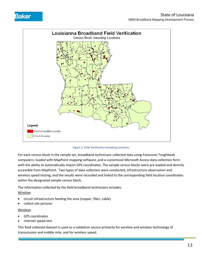
Field Data Acquisition: Broadband technicians visited a sampling of census block locations to gather broadband
data to be used for validation. The following criteria were taken into account when developing the census block
sampling dataset:
urban vs. rural census block characteristic
censes block grouping
land vs. water census block characteristic
The overarching mission of the Federal program is to provide Broadband service to areas that are currently
unserved and underserved. Also, the market intelligence validation sources typically represent some rural, but
more urban areas. Thus, our field data collection efforts were targeted more towards the rural areas; split 90%
rural, 10% urban.
Additionally, a study by Penn State University (Glasmeier 2002) notes that a large number of block groups
typically fit within any given cable or telephone company service areas. Therefore, our field sample was also
based on selection of one census block per block group. The selected census block also was greater than 50%
land versus water. There are a total of 3,512 census block groups in Louisiana. Using a statistical sample size
calculator based upon the number of block groups in the state and +/- 4% margin of error at a 95% confidence
level, the sample size is 557 census block locations.
For the 557 census blocks that were visited, 3257 individual wired/wireless data elements were recorded and
3410 pictures were taken at those locations. This field collected dataset is used as a validation source primarily
for wireline and wireless technology of transmission and middle mile, and for wireless speed.
State of Louisiana SBDD Broadband Mapping Development Process
13
Figure 3 Field Verification Sampling Locations
For each census block in the sample set, broadband technicians collected data using Panasonic Toughbook
computers, loaded with MapPoint mapping software, and a customized Microsoft Access data collection form
with the ability to automatically import GPS coordinates. The sample census blocks were pre-loaded and directly
accessible from MapPoint. Two types of data collection were conducted; infrastructure observation and
wireless speed testing; and the results were recorded and linked to the corresponding field location coordinates
within the designated sample census block.
The information collected by the field broadband technicians includes:
Wireline:
circuit infrastructure feeding the area (copper, fiber, cable)
collect site pictures
Wireless:
GPS coordinates
internet speed test
This field collected dataset is used as a validation source primarily for wireline and wireless technology of
transmission and middle mile, and for wireless speed.

State of Louisiana SBDD Broadband Mapping Development Process
14
Provider Data Validation Process Stakeholder Feedback: Feedback received from the providers and/or regional Areas Development Districts is
visually inspected and integrated directly into the mapping GIS database.
Service Area Validation Data: The SNG wireline service area data is tabular and contains a separate record for
each provider/technology of transmission combination with an associated census block or TIGER road segment,
depending on the whether the size of the census block area (=/< or > 2 sq. mi.). This data is exported into an
ArcGIS data format. The American Roamer and Prior Mapping service area data is already in and ArcGIS data
format. The validation data is then joined to the Provider service area data by census block or TIGER road
segment ID. Any database records in the Provider or Validation tables that cannot be joined are output to a
separate layer that indicates the areas of discrepancy between the two datasets. The joined tables are then
queried to detect any speed discrepancies which are also output to a separate discrepancy layer.
Online Surveys and Field Validation Data: The Public and Targeted Business/Household survey and field data are
also collected in tabular database format, and represent a specific lat/long spatial location for each record. This
data is exported into ArcGIS data format, joined to the provider data, queried to validate pertinent attribution.
Again, records not joined and or with detected attribution discrepancies are output to separate GIS layers.
Business Logic Rules: Model Builder is used to build a model of GIS geo-processing tools to validate that the
broadband data is consistent with the front end business logic rules of the SBDD Data Transfer Model.
Topology: The ArcGIS Validate Topology Tool is used to flag any topology issues in the broadband data. Flagged
issues are reviewed to identify false positives and update true errors as required.
October 1, 2010 Validation Reporting An accumulation process is executed on the data comparison results. A matched percentage will be obtained
through the process for each of the database records. The matched percentage for each record is the result of
the total count of the matched validations for the record divided by the total count of all the validations for the
record. The matched percentage for each of the records will be summarized and then divided by the total count
of the records to create the final matched percentage for the specific provider.
Future Validation and Confidence Level Reporting Confidence Level Reporting: Identified areas of discrepancy will be flagged for reporting confidence level of the
data per provider at census block and road segment level. The plan is to then input these unit confidence levels
into a statistical model to develop confidence levels for each of the broadband service providers. Deployment of
this automated statistical reporting process is scheduled before the April 1, 2011 delivery to the NTIA.
Audit of Wireless Broadband Availability Reporting: Wireless coverage is evaluated using a contour calculation
tool, with key inputs being transmitter location and, where available, data on spectrum power levels and other
relevant transmission factors provided by carriers and/or supplemented by data available from public web sites
and other sources. Data will then be input to a contour calculation tool to provide estimates of fixed wireless
broadband coverage areas. This dataset is used as a source to determine gaps in provider wireless service area
coverage. The Prior Mapping data is also used as a validation source for gap analysis.

State of Louisiana SBDD Broadband Mapping Development Process
15
Broadband
Outreach
Tracker
Data Meets
Specifications
Broadband
Providers
Usable Data
NO
Manipulate to
Required FormatYES
YES
Broadband
Provider
Outreach
Address
Records
Source
Data
YES
Spatial
Data
NO
Project to
Designated
Coordinate
System
Is data in proper
projection?YES YES
NO
NO
Datasets for Accuracy and Verification
Market Intelligence
Targeted On-Line Surveys
On-Line Public Survey/Speed Test
FCC Speed Test
Prior Broadband Mapping
Field Validation
Figure 4: State of Louisiana SBDD Process Workflow
Legend
ProcessFileOutput
InputDecision Data Set
Provider
Data
Street
Segment
Records
YES
NO
Census
Block
Records
YES
Address Points,
Street Segments,
Census Blocks
NO
Spatial Data
Geocoded
Points
Street Segments
Census Blocks
Geocode
Conflate to Street
Segment Layer
Conflate to
Census Block
Layer
Unmatched or
Incorrect Records
Import Street
Segments and
Address Points,
Conflate Census
Block Layers
Broadband Provider
Validation Maps
YES
Provider
Validation
Conflate to Census
Block/
Street Segment
Layer
Other
Records
NO
YES
Aggregate to
Road Segments,
Census Blocks,
Overview
Other
NTIA Geodatabase
NO
NO
Data
Adjustments
October 1, 2010
Automated Validation of Provider Data
Statistical
Reporting