Embed Size (px)
DESCRIPTION
Graduate landscape architecture project approaching the city of Gosford that has various urban ailments including a declining population, high unemployment rates and poor connections to its natural context. Through a framework that was influenced by concepts grounded in ecological and landscape urbanism, REHAB sought to rethink the spaces that support social services and frame a new type of public infrastructure.
Citation preview

rehab rehabG
OSF
ORD
CIT
Y CB
D//
ALE
X G
EORG
OU
RAS/
/BLA
RCH
GRA
D S
TUD
IO
_1 rehab
BACKGROUND
regionalecologicalsocialstylistic/heritageprogrammatic
hydrology 1. carparks 2. street3. open space vegetation
infilltransport
concept modelsscale models
sketches
ques
tion
revi
sion
check against design principlesrevi
se m
aste
rpla
n to
re�e
ct d
esig
n re
sear
ch ?
local
site
RESEARCH QUESTION
DESIGN PRINCIPLES
INFLUENCESEXPLORATIONS
SYSTEMSDETAIL PLANS
CONSTRUCTION
OVERVIEW PLAN
SCHEMATIC PLAN
MASTERPLAN
INTRODUCTION
AREA OF INVESTIGATION
SITE ANALYSIS
zoom 3
APPROACH
FRAMEWORKDESIGN RESOLUTION
RESEARCH + UNDERSTANDING
zoom 2
zoom 1
research
methods
outcome
observations
opportunities
constraints
method
mapping
research
outcome
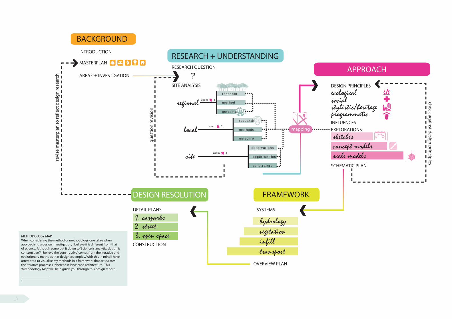
METHODOLOGY MAPWhen considering the method or methodology one takes when approaching a design investigation, I believe it is di� erent from that of science. Although some put it down to ‘Science is analytic; design is constructive.’1 I believe the ‘constructive’ comes from the iterative and evolutionary methods that designers employ. With this in mind I have attempted to visualise my methods in a framework that articulates the iterative processes inherent in landscape architecture. This ‘Methodology Map’ will help guide you through this design report.
1
_1_1
rehabrehabRESEARCH QUESTION
REGIONAL ANALYSIS
LOCAL ANALYSIS
SITE ANALYSIS
INTRODUC TION
MASTERPLAN
AREA OF INVESTIGATION
METHODOLOGY MAP
DESIGN PRINCIPLES
PRECEDENTS
EXPLORATIONS
STRATEGIES
SYSTEMS
OVERVIEW PLAN
DETAIL AREA 1
DETAIL AREA 2
DETAIL AREA 3
REFLEC TIONS
Background
Research + Understanding
Approach
Framework
Design Resolution
01
02
03
04
05rehab_2
BACKGROUND
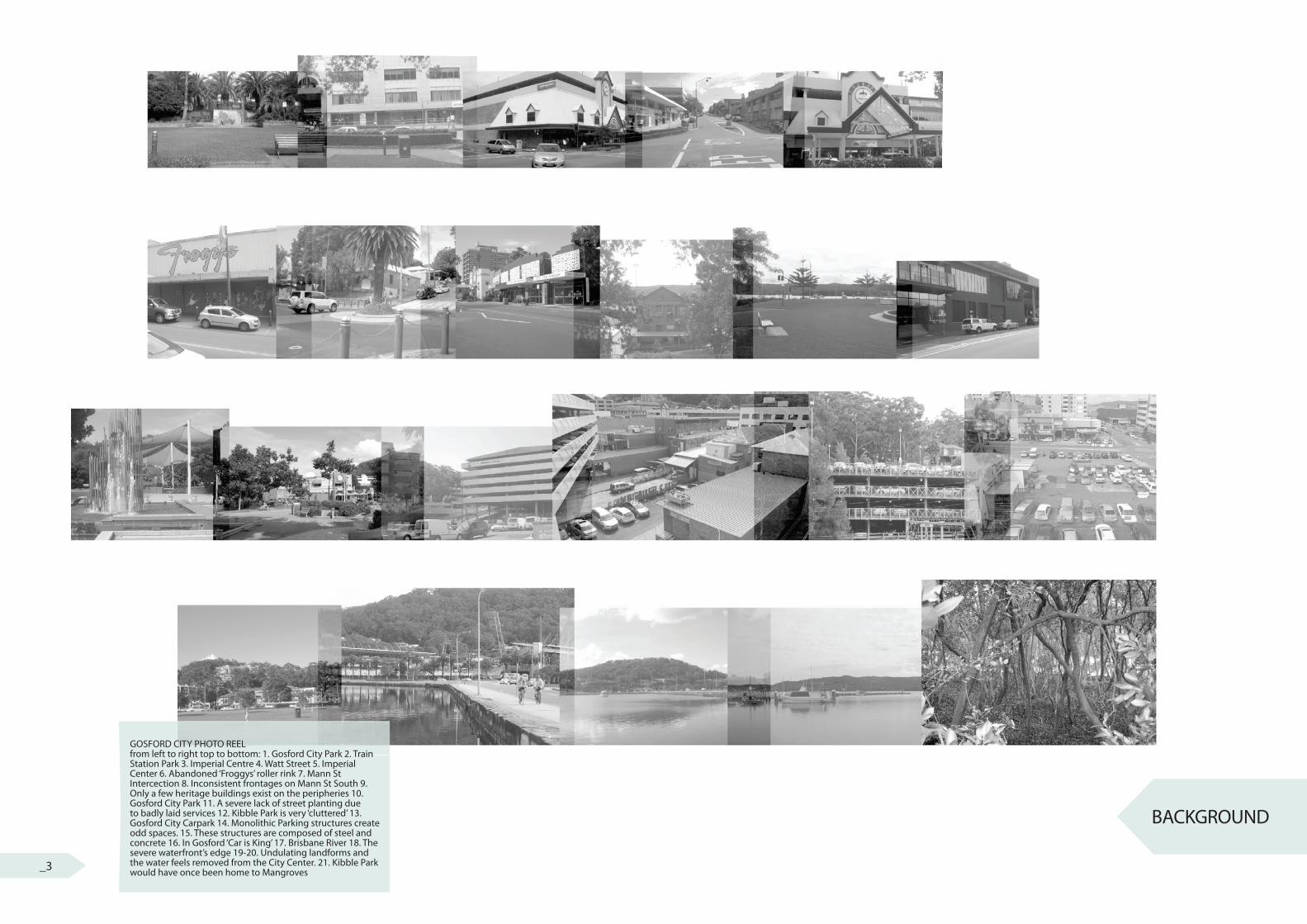
GOSFORD CITY PHOTO REELfrom left to right top to bottom: 1. Gosford City Park 2. Train Station Park 3. Imperial Centre 4. Watt Street 5. Imperial Center 6. Abandoned ‘Froggys’ roller rink 7. Mann St Intercection 8. Inconsistent frontages on Mann St South 9. Only a few heritage buildings exist on the peripheries 10. Gosford City Park 11. A severe lack of street planting due to badly laid services 12. Kibble Park is very ‘cluttered’ 13. Gosford City Carpark 14. Monolithic Parking structures create odd spaces. 15. These structures are composed of steel and concrete 16. In Gosford ‘Car is King’ 17. Brisbane River 18. The severe waterfront’s edge 19-20. Undulating landforms and the water feels removed from the City Center. 21. Kibble Park would have once been home to Mangroves_3
LLepepepepppiingngttoonn
RRiicchmohmohmohmohmohmohmohmonnnndddd
Urban Density
SydneySydney
GosfordGosfordGosfordGosfordGosfordGosfordGosfordGosfordGosfordGosfordGosford
PenrithPenrithPenrithPenrithPenrithHornsby
LiverpoolLiverpool
ToWollongong
Passenger rail
Urban Centre
Key:
Freight Rail
COURSE CONTEXT
SITE
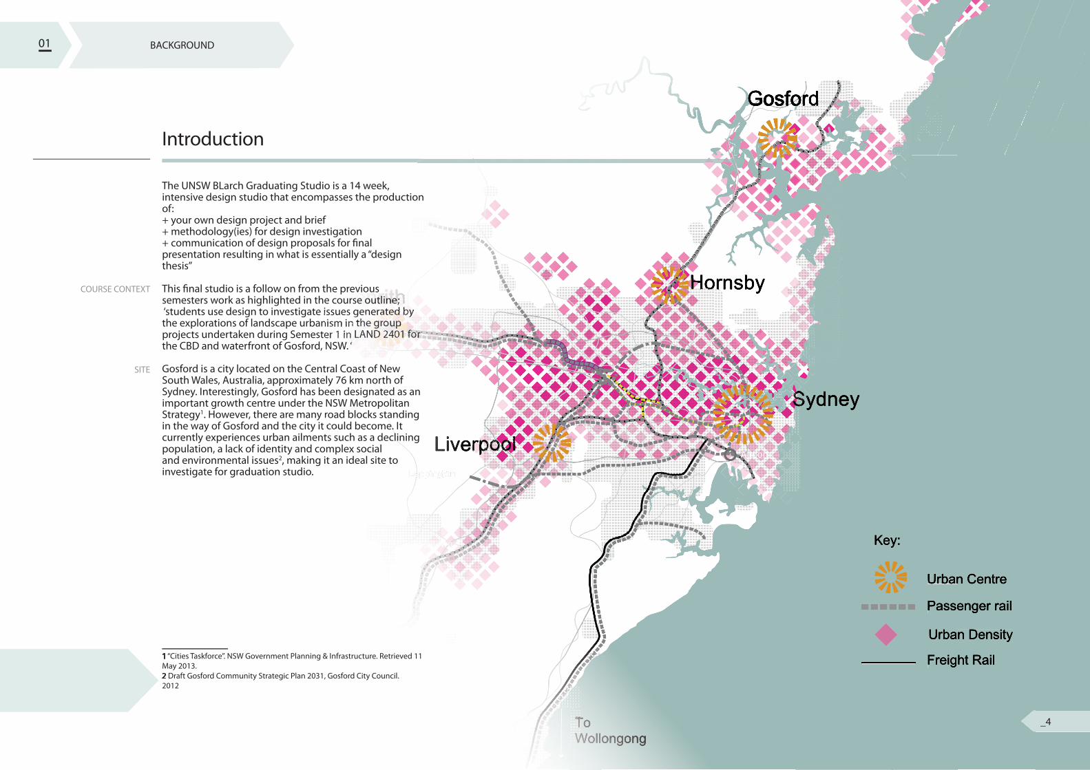
Introduction
The UNSW BLarch Graduating Studio is a 14 week, intensive design studio that encompasses the production of:+ your own design project and brief+ methodology(ies) for design investigation+ communication of design proposals for � nal presentation resulting in what is essentially a “design thesis”
This � nal studio is a follow on from the previous semesters work as highlighted in the course outline; ‘students use design to investigate issues generated by the explorations of landscape urbanism in the group projects undertaken during Semester 1 in LAND 2401 for the CBD and waterfront of Gosford, NSW. ‘
Gosford is a city located on the Central Coast of New South Wales, Australia, approximately 76 km north of Sydney. Interestingly, Gosford has been designated as an important growth centre under the NSW Metropolitan Strategy1. However, there are many road blocks standing in the way of Gosford and the city it could become. It currently experiences urban ailments such as a declining population, a lack of identity and complex social and environmental issues2, making it an ideal site to investigate for graduation studio.
1 “Cities Taskforce”. NSW Government Planning & Infrastructure. Retrieved 11 May 2013. 2 Draft Gosford Community Strategic Plan 2031, Gosford City Council. 2012
01 BACKGROUND
_4
BACKGROUND
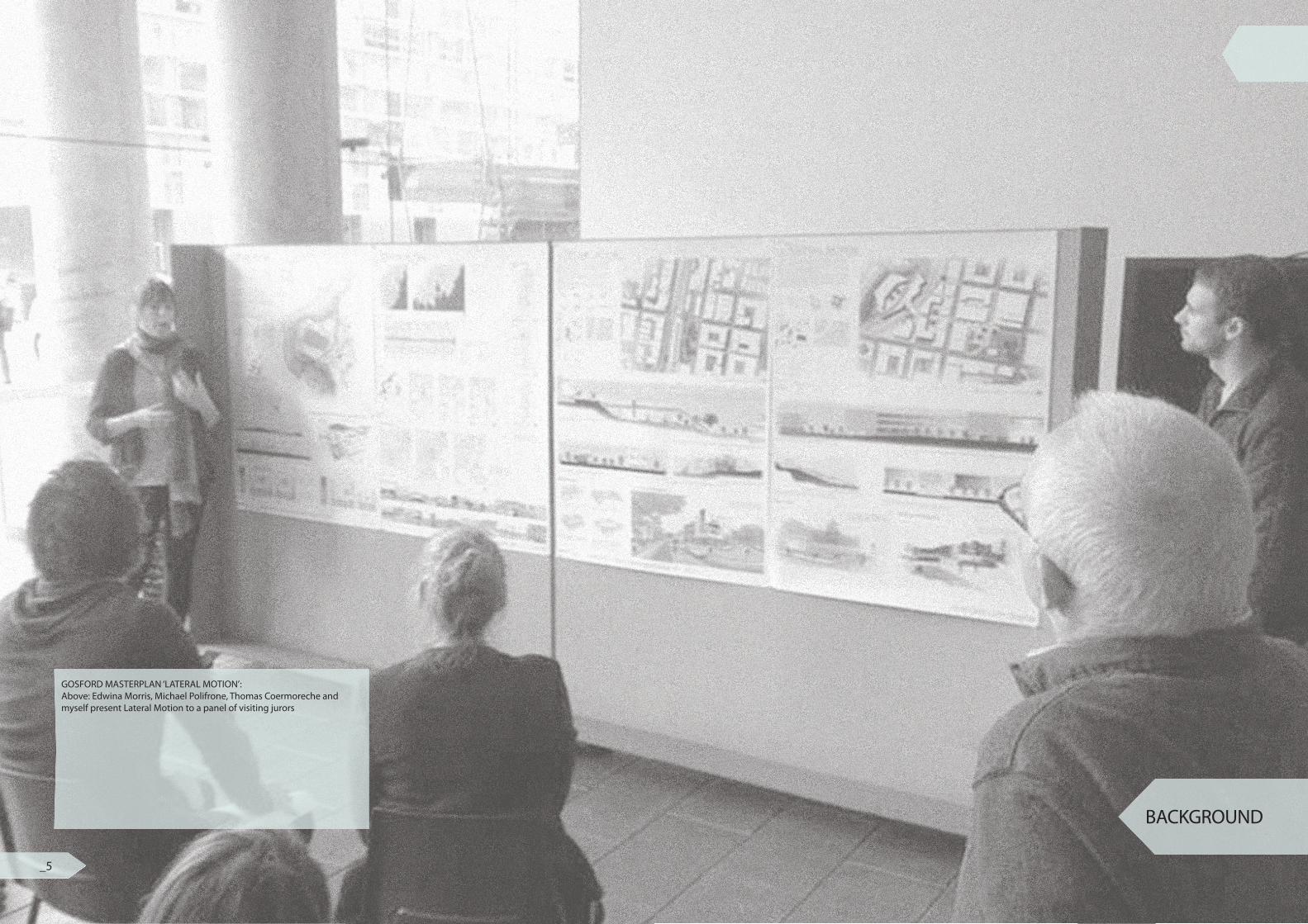
GOSFORD MASTERPLAN ‘LATERAL MOTION’:Above: Edwina Morris, Michael Polifrone, Thomas Coermoreche and myself present Lateral Motion to a panel of visiting jurors
_5
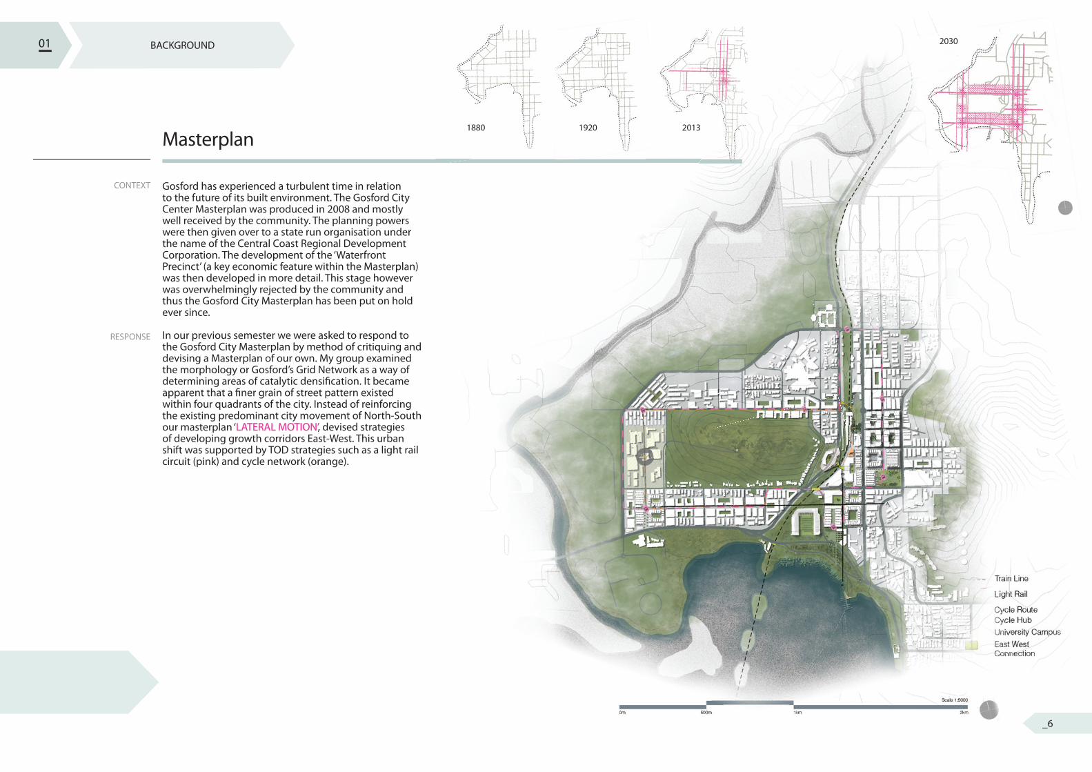
CONTEXT
RESPONSE
Masterplan
Gosford has experienced a turbulent time in relation to the future of its built environment. The Gosford City Center Masterplan was produced in 2008 and mostly well received by the community. The planning powers were then given over to a state run organisation under the name of the Central Coast Regional Development Corporation. The development of the ‘Waterfront Precinct’ (a key economic feature within the Masterplan) was then developed in more detail. This stage however was overwhelmingly rejected by the community and thus the Gosford City Masterplan has been put on hold ever since.
In our previous semester we were asked to respond to the Gosford City Masterplan by method of critiquing and devising a Masterplan of our own. My group examined the morphology or Gosford’s Grid Network as a way of determining areas of catalytic densi� cation. It became apparent that a � ner grain of street pattern existed within four quadrants of the city. Instead of reinforcing the existing predominant city movement of North-South our masterplan ‘LATERAL MOTION’, devised strategies of developing growth corridors East-West. This urban shift was supported by TOD strategies such as a light rail circuit (pink) and cycle network (orange).
01 BACKGROUND
1880 1920 2013
2030
_6
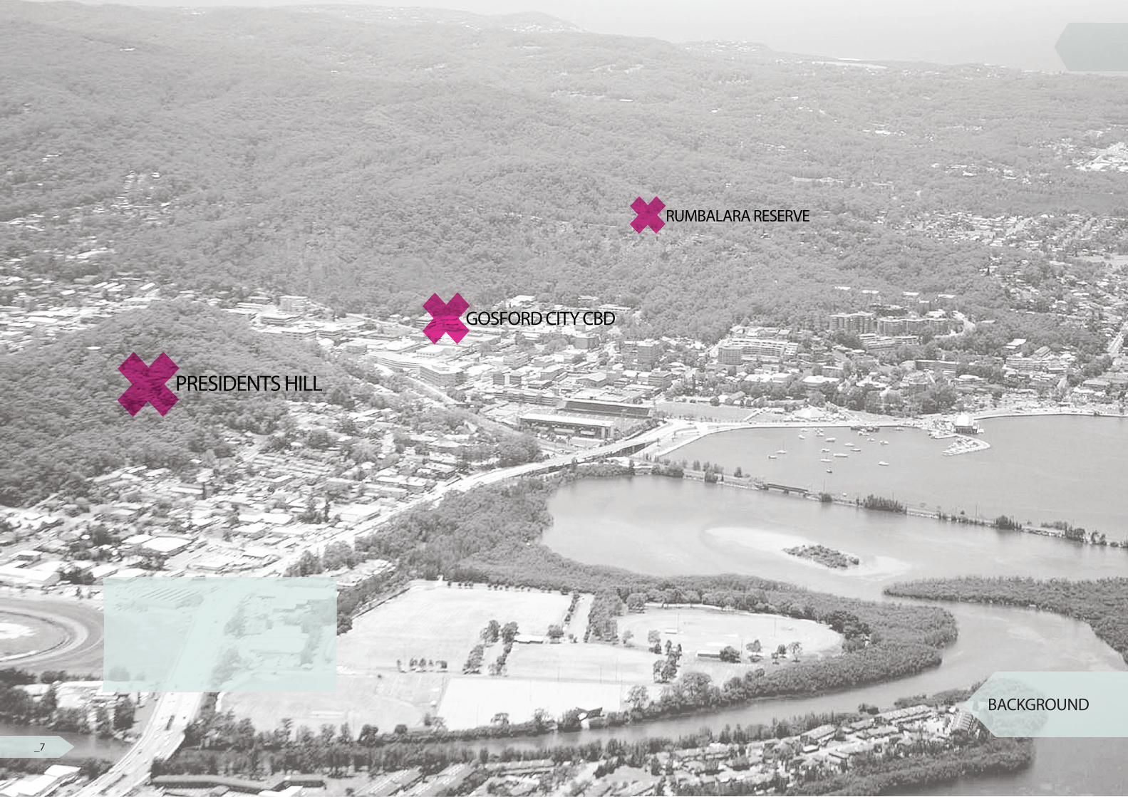
GOSFORD CITY CBD
PRESIDENTS HILL
RUMBALARA RESERVE
BACKGROUND
_7
PROBLEM
OPPORTUNITY
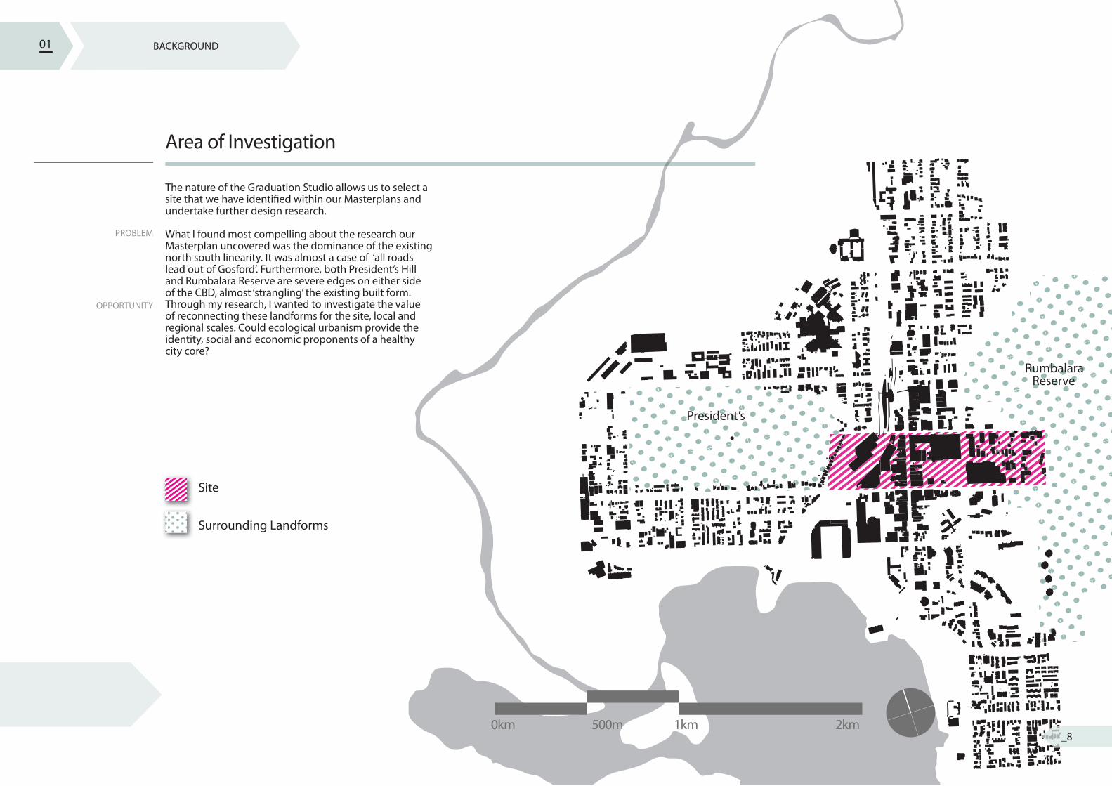
Area of Investigation
The nature of the Graduation Studio allows us to select a site that we have identi� ed within our Masterplans and undertake further design research.
What I found most compelling about the research our Masterplan uncovered was the dominance of the existing north south linearity. It was almost a case of ‘all roads lead out of Gosford’. Furthermore, both President’s Hill and Rumbalara Reserve are severe edges on either side of the CBD, almost ‘strangling’ the existing built form. Through my research, I wanted to investigate the value of reconnecting these landforms for the site, local and regional scales. Could ecological urbanism provide the identity, social and economic proponents of a healthy city core?
01 BACKGROUND
President’s
Site
Surrounding Landforms
RumbalaraReserve
0km 500m 1km 2km_8
RESEARCH+ UNDERSTANDING
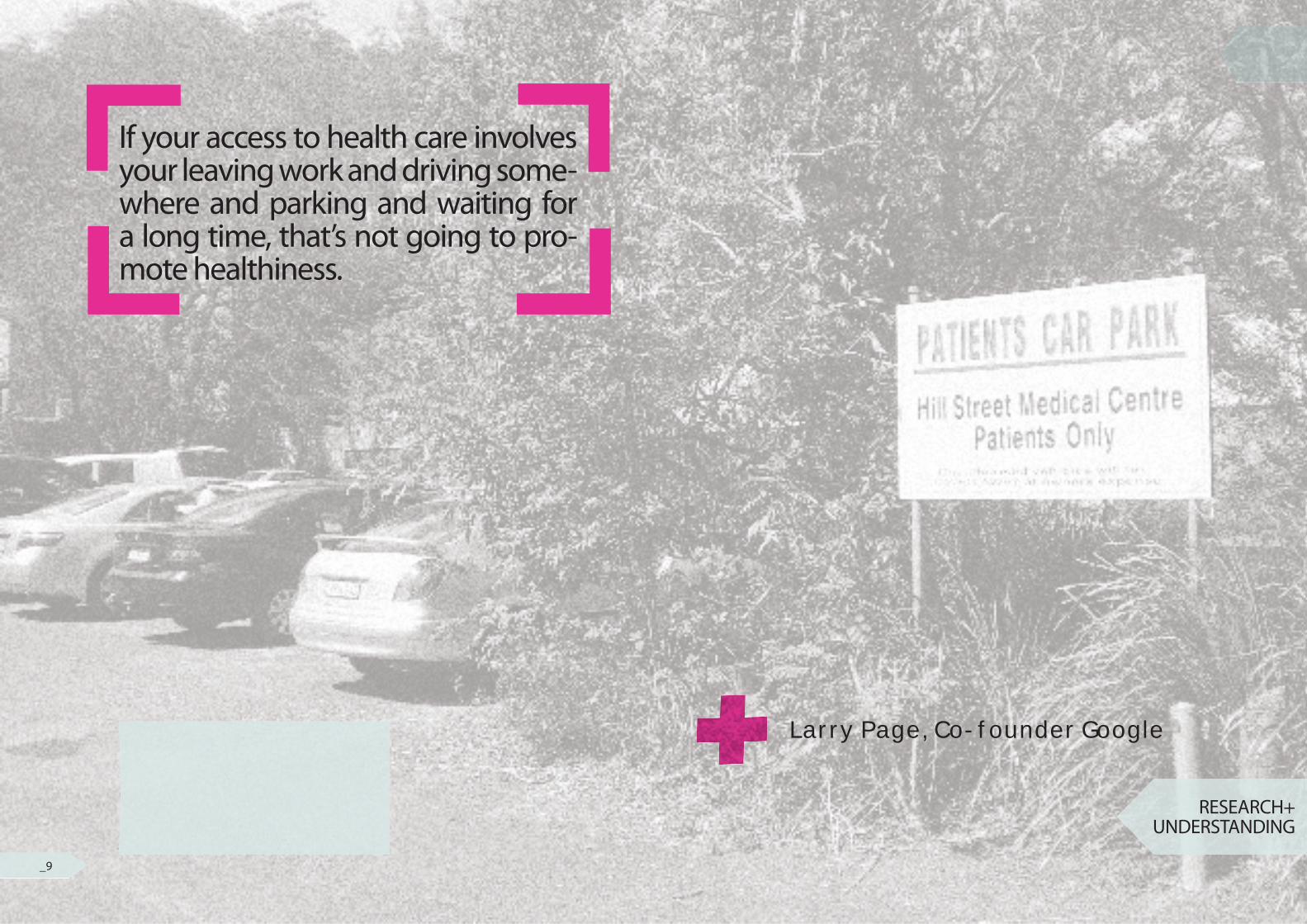
If your access to health care involves your leaving work and driving some-where and parking and waiting for a long time, that’s not going to pro-mote healthiness.
Larry Page, Co-founder Google
_9
BACKGROUND
regionalecologicalsocialstylistic/heritageprogrammatic
hydrology 1. carparks 2. street3. open space vegetation
infilltransport
concept modelsscale models
sketches
ques
tion
revi
sion
check against design principlesrevi
se m
aste
rpla
n to
re�e
ct d
esig
n re
sear
ch ?
local
site
RESEARCH QUESTION
DESIGN PRINCIPLES
INFLUENCESEXPLORATIONS
SYSTEMSDETAIL PLANS
CONSTRUCTION
OVERVIEW PLAN
SCHEMATIC PLAN
MASTERPLAN
INTRODUCTION
AREA OF INVESTIGATION
SITE ANALYSIS
zoom 3
APPROACH
FRAMEWORKDESIGN RESOLUTION
RESEARCH + UNDERSTANDING
zoom 2
zoom 1
research
methods
outcome
observations
opportunities
constraints
method
mapping
research
outcome
RESEARCH QUESTIONRESEARCH QUESTIONRESEARCH QUESTIONRESEARCH QUESTIONRESEARCH QUESTION
?RESEARCH QUESTIONRESEARCH QUESTIONRESEARCH QUESTIONRESEARCH QUESTION
PREJUDICE
QUESTION
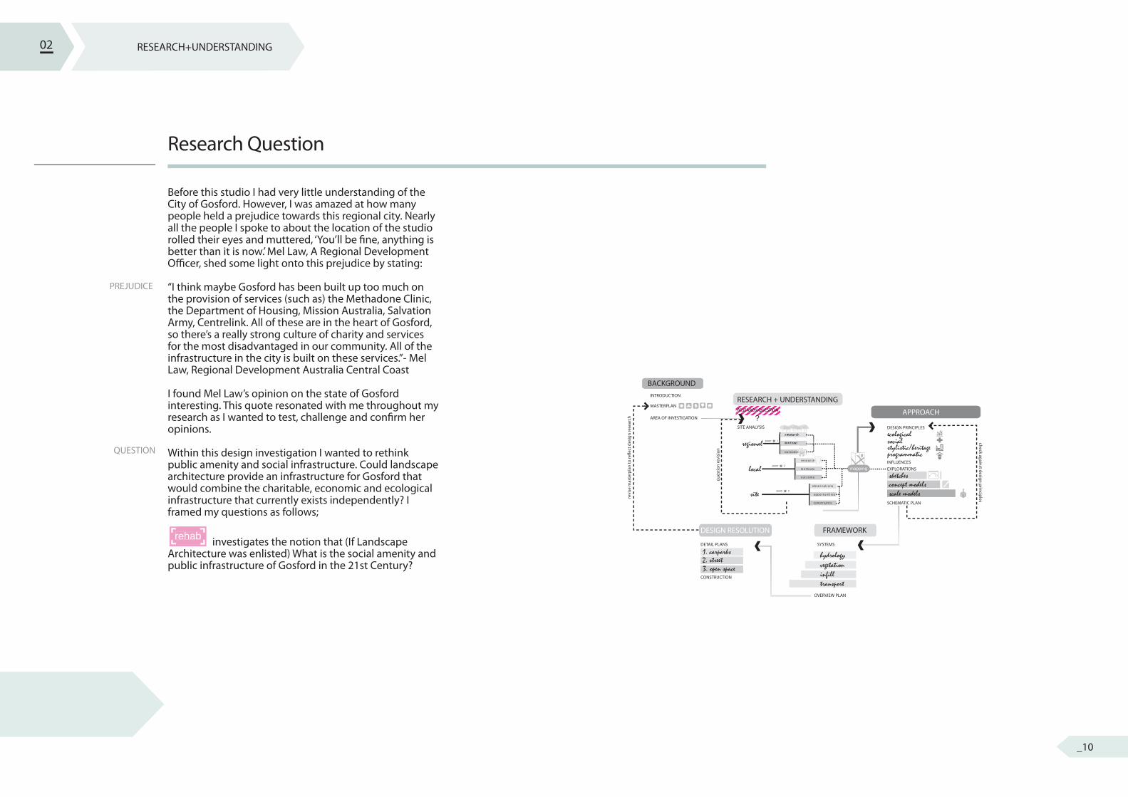
Research Question
Before this studio I had very little understanding of the City of Gosford. However, I was amazed at how many people held a prejudice towards this regional city. Nearly all the people I spoke to about the location of the studio rolled their eyes and muttered, ‘You’ll be � ne, anything is better than it is now.’ Mel Law, A Regional Development O� cer, shed some light onto this prejudice by stating:
“I think maybe Gosford has been built up too much on the provision of services (such as) the Methadone Clinic, the Department of Housing, Mission Australia, Salvation Army, Centrelink. All of these are in the heart of Gosford, so there’s a really strong culture of charity and services for the most disadvantaged in our community. All of the infrastructure in the city is built on these services.”- Mel Law, Regional Development Australia Central Coast
I found Mel Law’s opinion on the state of Gosford interesting. This quote resonated with me throughout my research as I wanted to test, challenge and con� rm her opinions.
Within this design investigation I wanted to rethink public amenity and social infrastructure. Could landscape architecture provide an infrastructure for Gosford that would combine the charitable, economic and ecological infrastructure that currently exists independently? I framed my questions as follows;
investigates the notion that (If Landscape Architecture was enlisted) What is the social amenity and public infrastructure of Gosford in the 21st Century?
02 RESEARCH+UNDERSTANDING
rehab
_10
RESEARCH
METHOD
OUTCOME
Regional Analysis
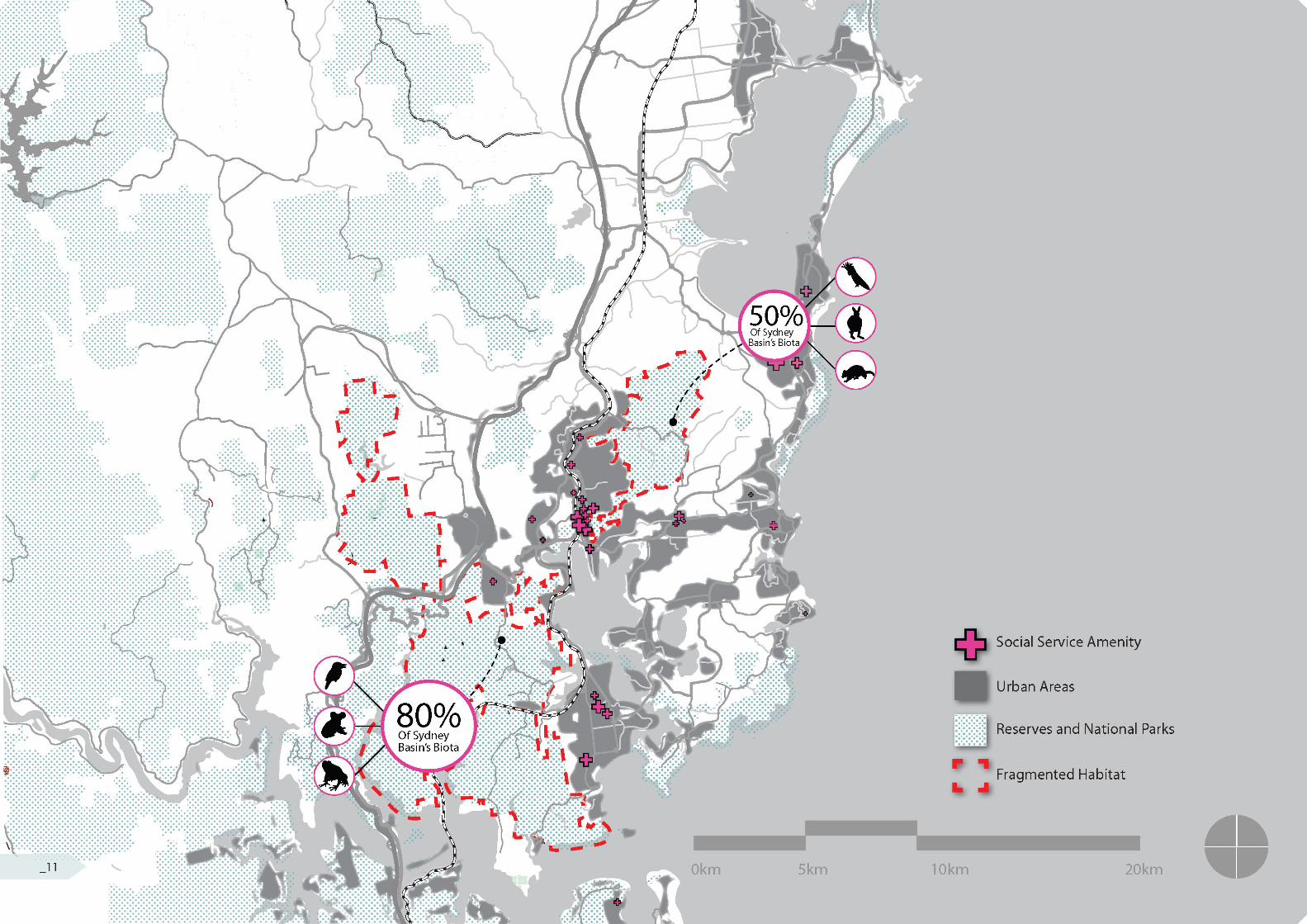
There were two design questions I wanted to answer by looking at my site at a Regional Level. 1. To what degree was Mel Law correct in saying that ‘Gosford has been built up too much on the provision of (charitable) services’?and2. Are the habitats of Presidents Hill and Rumbalara Reserve part of a larger ecosystem?
By collating maps on local parks, national reserves and state bush land I managed to generate a regional map that was the basis for my regional analysis. I then traced and overlaid urban areas that typically followed major transport links (i.e. the train line, highways, arterial road). I then used the Brisbane River Plan of Management to understand the signi� cant � ora and fauna communities within the region. Additionally, I plotted the size and location of major social amenities (both public and private) in the region.
Two interesting observations were made of the social amenities of the region: 1. There was a large concentration of charitable infrastructure within Gosford (Mel Law was correct)and2. The Infrastructure seems to run north-south a few kilometres inland. Additionally, the two landforms separated by Gosford are indeed part of a larger super-ecosystems. President’s Hill is the distance of a Highway crossing away from connecting to a waterbody and ecosystem that houses 80% of Sydney’s Basin’s Biota 1. Frequent spottings of the Phascolarctos cinereus (Koala) and the endangered Litoria aurea (Green and Golden Bellfrog) can be found. Rumbalara also houses roughly half the Biota yet is still home to the vulnerable Ninox strenua (Powerful Owl). Large wombats and eastern grey kangaroo communities are also present.
1. 2011, Department of Environment NSW, http://www.environment.nsw.gov.au/resources/parks/pom� nalbrisbane.pdf
02 RESEARCH+UNDERSTANDING
1.3 Ecological fragmentation separates wildlife communities and creates more edge disturbance(Author, 2013)
_12
RESEARCH+ UNDERSTANDING
RESEARCH+ UNDERSTANDING
Transport Infrastructure
Methadone Clinic
Regional Hospital
Mission Australia
Centrelink
Workcover AustraliaYouth Services
Social Service Amenity
0km 500m 1km 2km_13
RESEARCH
METHODS
OUTCOMES
Local Analysis
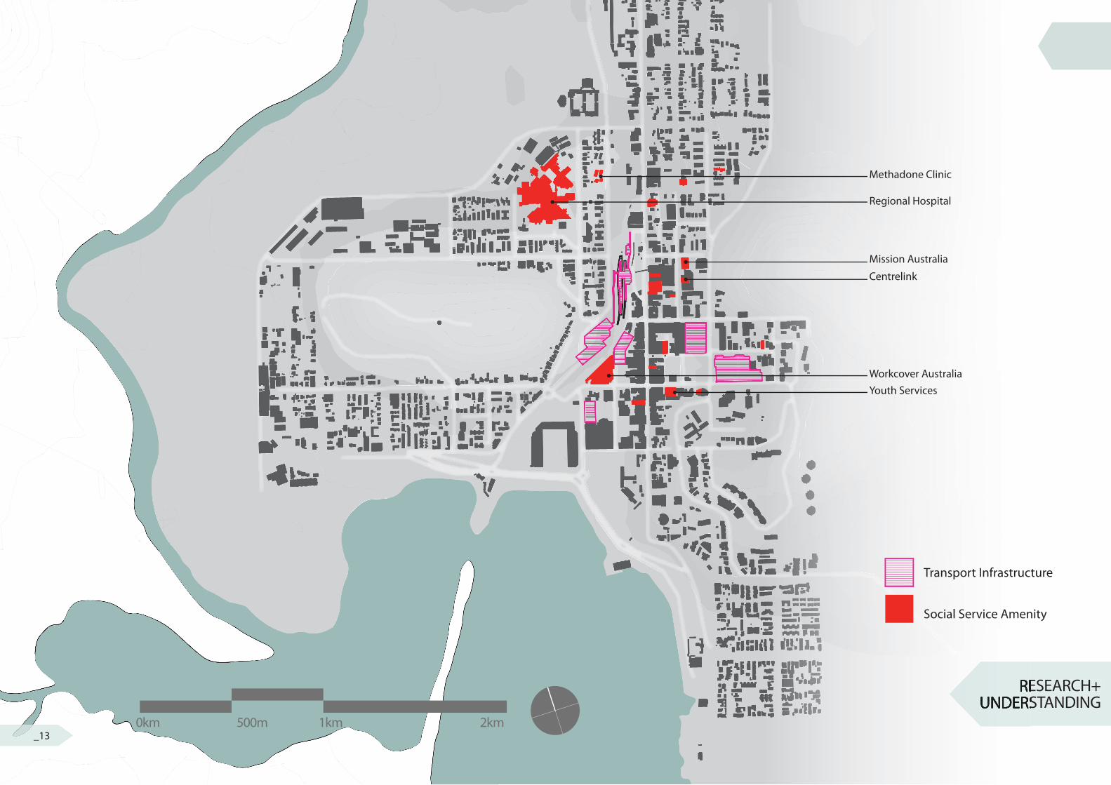
By shifting to a local/city scale lens I wanted to examine further:1. How the forementioned social service amenity sits within the city? 2. What other supporting infrastructure exists due to the social service amenity?and 3. What opportunities are present that can provide a shift to a more mixed-use public infrastructure?
Firstly I began mapping the location and type of social service amenity. Secondly I searched for the website of each corresponding social service amenity and found how they ‘suggested’ getting to the location (i.e. train, parking, bus, e.t.c.). Through my research I came across the Gosford City Center Parking Study, that outlined many of the future ambitions for car based infrastructure.
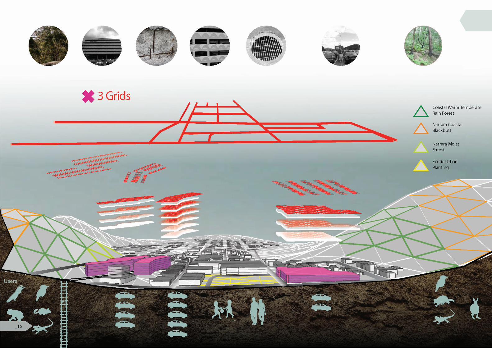
A few interesting patterns emerged through mapping the social service amenity within Gosford. Firstly, the majority of the amenity ran North-South along Watt Street. Secondly, the majority of these charitable amenities did not adjoin quality public space. Interestingly the majority of information pages for ‘getting to’ the social service amenity lists car-based infrastructure (parking facilities) as the � rst method. Some even omitting the train or bus route as supportive infrastructure. None mention cycling as an option, unsuprisingly. Although the majority of services ran North-South the supportive infrastructure intersected this axis, running predominately East-West. This raised the question of whether the carparks could better serve the people community and the surrounding ecology. Lastly, it was interesting that the landforms of Rumbalara and President’s Hill are both aligned to Gosford’s Grid, with their trig stations being nearly symmetrically re� ected either side of the city.
02 RESEARCH+UNDERSTANDING
_14
OPPORTUNITIES
OBSERVATIONS
CONSTRAINTS
Site Analysis
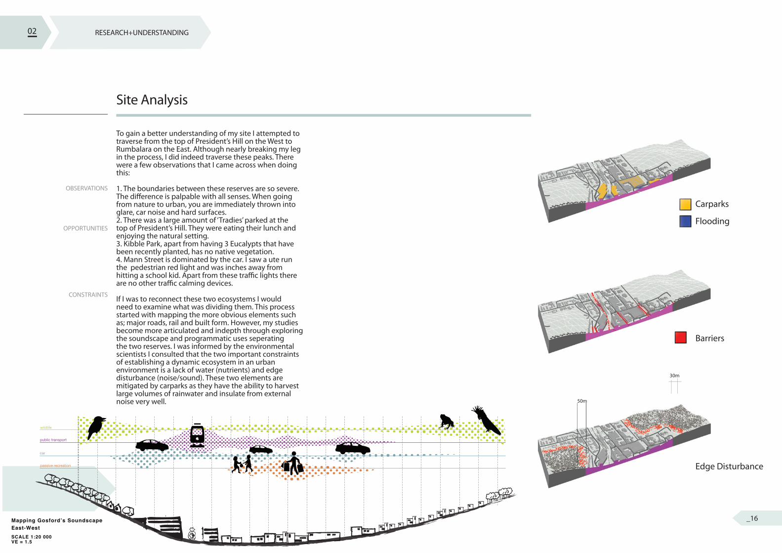
To gain a better understanding of my site I attempted to traverse from the top of President’s Hill on the West to Rumbalara on the East. Although nearly breaking my leg in the process, I did indeed traverse these peaks. There were a few observations that I came across when doing this:
1. The boundaries between these reserves are so severe. The di� erence is palpable with all senses. When going from nature to urban, you are immediately thrown into glare, car noise and hard surfaces. 2. There was a large amount of ‘Tradies’ parked at the top of President’s Hill. They were eating their lunch and enjoying the natural setting. 3. Kibble Park, apart from having 3 Eucalypts that have been recently planted, has no native vegetation. 4. Mann Street is dominated by the car. I saw a ute run the pedestrian red light and was inches away from hitting a school kid. Apart from these tra� c lights there are no other tra� c calming devices.
If I was to reconnect these two ecosystems I would need to examine what was dividing them. This process started with mapping the more obvious elements such as; major roads, rail and built form. However, my studies become more articulated and indepth through exploring the soundscape and programmatic uses seperating the two reserves. I was informed by the environmental scientists I consulted that the two important constraints of establishing a dynamic ecosystem in an urban environment is a lack of water (nutrients) and edge disturbance (noise/sound). These two elements are mitigated by carparks as they have the ability to harvest large volumes of rainwater and insulate from external noise very well.
02 RESEARCH+UNDERSTANDING
Carparks
Flooding
Barriers
Edge Disturbance
50m
30m
public transport
car
wildlife
passive recreation
Mapping Gosford’s SoundscapeEast-WestSCALE 1:20 000VE = 1.5
public transport
car
wildlife
passive recreation
Mapping Gosford’s SoundscapeEast-WestSCALE 1:20 000VE = 1.5
_16
RESEARCH+ UNDERSTANDING
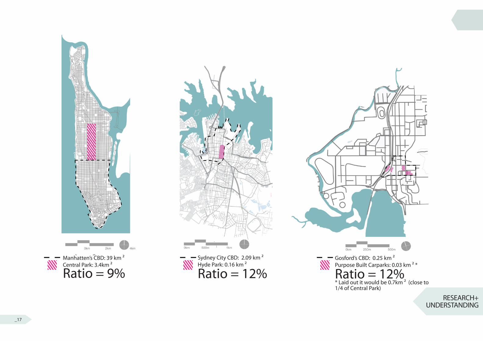
Manhatten’s CBD: 39 km ²Central Park: 3.4km ²
Ratio = 9%Sydney City CBD: 2.09 km ²Hyde Park: 0.16 km ²
Ratio = 12%Gosford’s CBD: 0.25 km ²Purpose Built Carparks: 0.03 km ² *
Ratio = 12%* Laid out it would be 0.7km ² (close to 1/4 of Central Park)
_17
SCALE
CARPARKS
POTENTIAL
Site Analysis
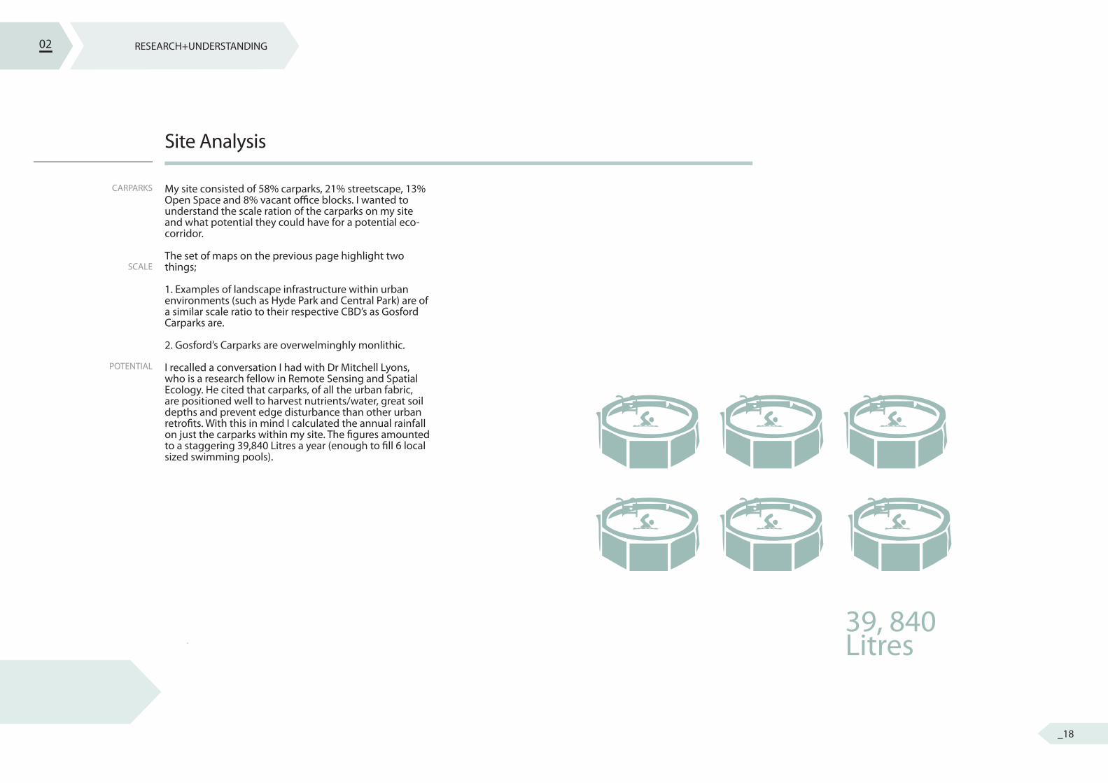
My site consisted of 58% carparks, 21% streetscape, 13% Open Space and 8% vacant o� ce blocks. I wanted to understand the scale ration of the carparks on my site and what potential they could have for a potential eco-corridor.
The set of maps on the previous page highlight two things;
1. Examples of landscape infrastructure within urban environments (such as Hyde Park and Central Park) are of a similar scale ratio to their respective CBD’s as Gosford Carparks are.
2. Gosford’s Carparks are overwelminghly monlithic.
I recalled a conversation I had with Dr Mitchell Lyons, who is a research fellow in Remote Sensing and Spatial Ecology. He cited that carparks, of all the urban fabric, are positioned well to harvest nutrients/water, great soil depths and prevent edge disturbance than other urban retro� ts. With this in mind I calculated the annual rainfall on just the carparks within my site. The � gures amounted to a staggering 39,840 Litres a year (enough to � ll 6 local sized swimming pools).
02 RESEARCH+UNDERSTANDING
39, 840Litres
_18
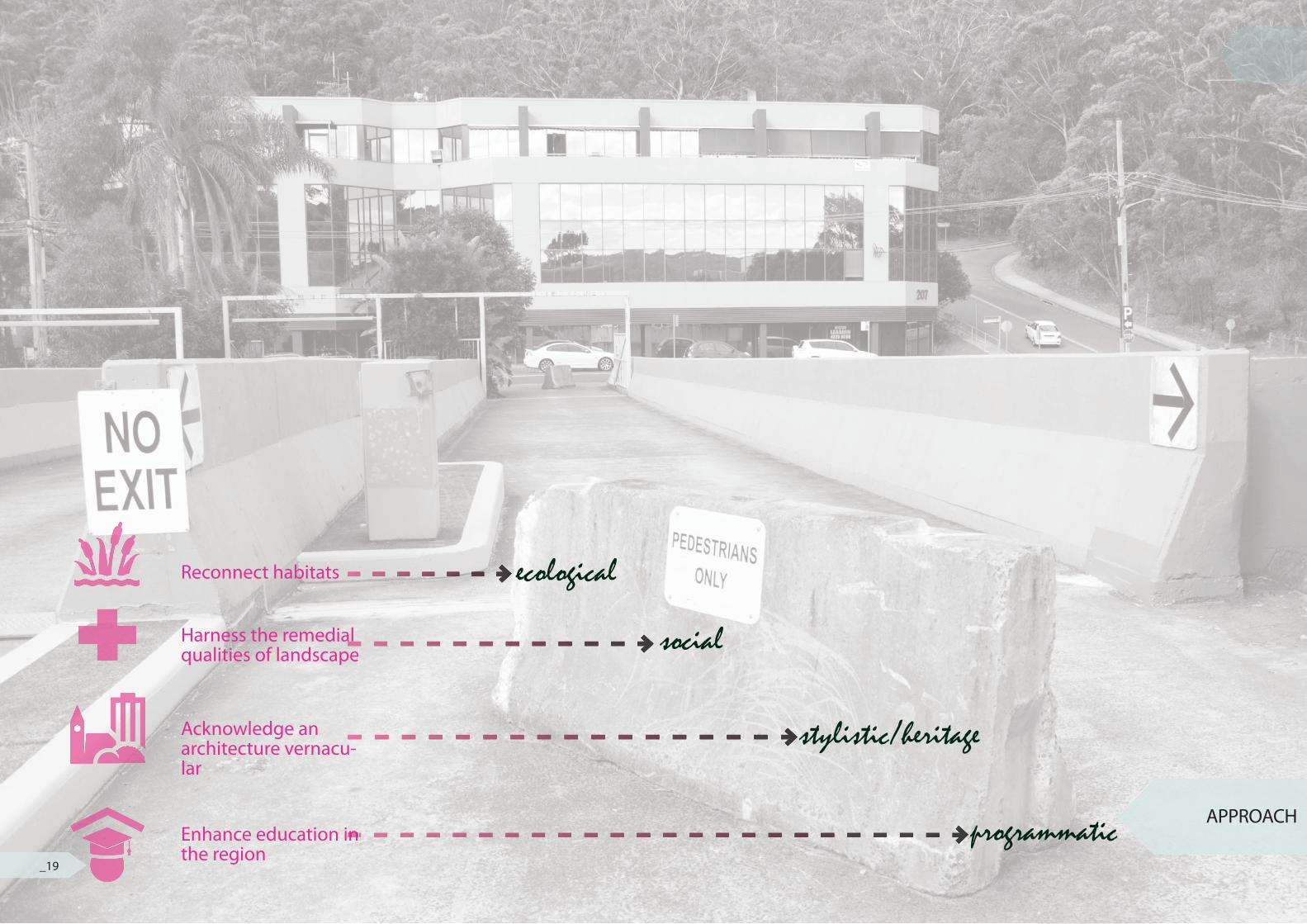
APPROACH
Reconnect habitats ecological
social
programmatic
stylistic/heritage
Harness the remedial qualities of landscape
Acknowledge an architecture vernacu-lar
Enhance education in the regionEnhance education in
_19
PRINCIPLES
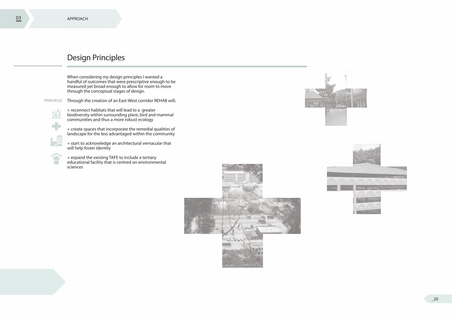
Design Principles
When considering my design principles I wanted a handful of outcomes that were prescriptive enough to be measured yet broad enough to allow for room to move through the conceptual stages of design.
Through the creation of an East-West corridor REHAB will;
+ reconnect habitats that will lead to a greater biodiversity within surrounding plant, bird and mammal communities and thus a more robust ecology
+ create spaces that incorporate the remedial qualities of landscape for the less advantaged within the community
+ start to acknowledge an architectural vernacular that will help foster identity
+ expand the existing TAFE to include a tertiary educational facility that is centred on environmental sciences
03 APPROACH
_20
APPROACH
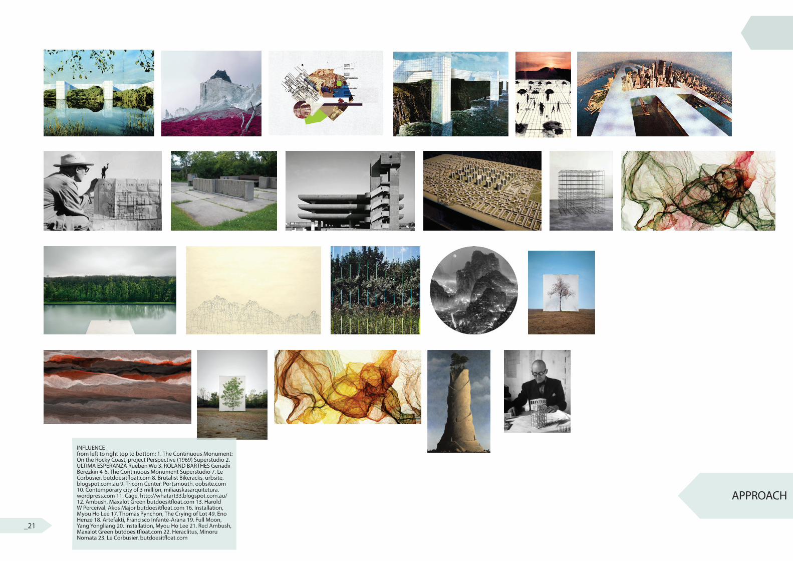
INFLUENCEfrom left to right top to bottom: 1. The Continuous Monument: On the Rocky Coast, project Perspective (1969) Superstudio 2. ULTIMA ESPERANZA Rueben Wu 3. ROLAND BARTHES Genadii Berёzkin 4-6. The Continuous Monument Superstudio 7. Le Corbusier, butdoesit� oat.com 8. Brutalist Bikeracks, urbsite.blogspot.com.au 9. Tricorn Center, Portsmouth, oobsite.com 10. Contemporary city of 3 million, miliauskasarquitetura.wordpress.com 11. Cage, http://whatart33.blogspot.com.au/ 12. Ambush, Maxalot Green butdoesit� oat.com 13. Harold W Perceival, Akos Major butdoesit� oat.com 16. Installation, Myou Ho Lee 17. Thomas Pynchon, The Crying of Lot 49, Eno Henze 18. Artefakti, Francisco Infante-Arana 19. Full Moon, Yang Yongliang 20. Installation, Myou Ho Lee 21. Red Ambush, Maxalot Green butdoesit� oat.com 22. Heraclitus, Minoru Nomata 23. Le Corbusier, butdoesit� oat.com
_21
CITY X NATURE
GRID
GRADIENTS
In� uence
Throughout this studio I have been consistently allowing myself to be imprinted by work that I � nd inspiring. My project seemed to engage age old paradigms of city and nature, boundaries and edges, and alternation of axis. The tiles on the left are just a snapshot of drawings, collage, generative art and photography that helped in the imagination and realisation of my project.
Political barriers have dictated a severe edge on the surrounding reserves of Gosford. I wanted to explore the idea of hierarchical counters and the possibility of inverting these. However, cross overs within these opposites emerge in areas unseen. The concrete parking structures, scattered in abundance, dominate the sandstone in this setting. The once parent rock has been cast aside to make way for the new, and in this a new nature is born.
Unknown to many, due to its severe topography, Gosford lay on a rigid city grid. James Corner’s Terra Fluxus provided many salient thoughts on the ‘democratic grid’. Through various provocations and drawings I began to develop a design language that would aid in the form of the corridor connection. I began to draw out other grids that were either impregnated into or imprinted onto the urban landscape. The grid identi� ed within the monolithic carparks, takes its form as steel reinforcing, sitting in a state of latency (for the moment).
Through examining how certain elements interface, such as city and nature, I began to explore the idea of gradients. Within many of the tiles on the left there is an exploration of gradients. These gradients manifest in either a subtle blending or a severe fusion. These ideas have been heavily grounded in my project were the urban city meets the Rehab corridor.
03 APPROACH
BACKGROUND
regionalecologicalsocialstylistic/heritageprogrammatic
hydrology 1. carparks 2. street3. open space vegetation
infilltransport
concept modelsscale models
sketches
ques
tion
revi
sion
check against design principlesrevi
se m
aste
rpla
n to
re�e
ct d
esig
n re
sear
ch ?
local
site
RESEARCH QUESTION
DESIGN PRINCIPLES
INFLUENCESEXPLORATIONS
SYSTEMSDETAIL PLANS
CONSTRUCTION
OVERVIEW PLAN
SCHEMATIC PLAN
MASTERPLAN
INTRODUCTION
AREA OF INVESTIGATION
SITE ANALYSIS
zoom 3
APPROACH
FRAMEWORKDESIGN RESOLUTION
RESEARCH + UNDERSTANDING
zoom 2
zoom 1
research
methods
outcome
observations
opportunities
constraints
method
mapping
research
outcome programmaticprogrammaticINFLUENCES
programmaticINFLUENCES
programmaticINFLUENCES
programmaticINFLUENCES
programmaticINFLUENCES
programmatic
_22
APPROACH
_23
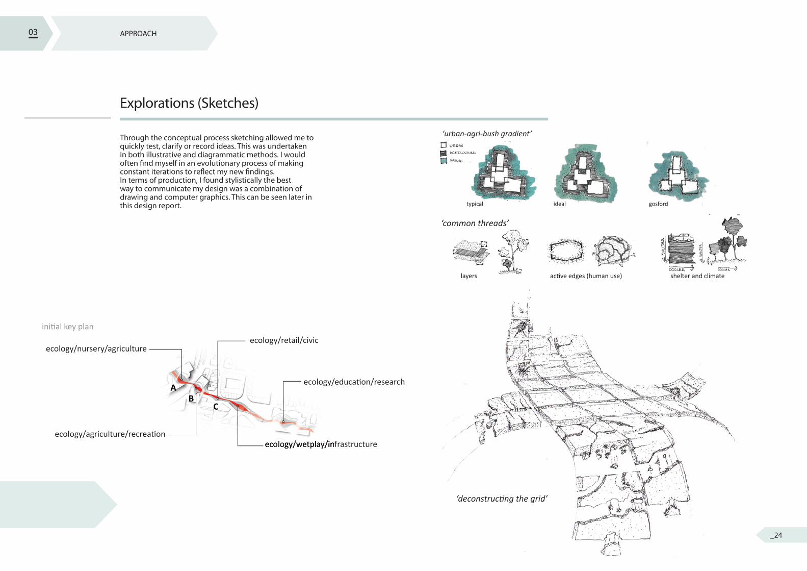
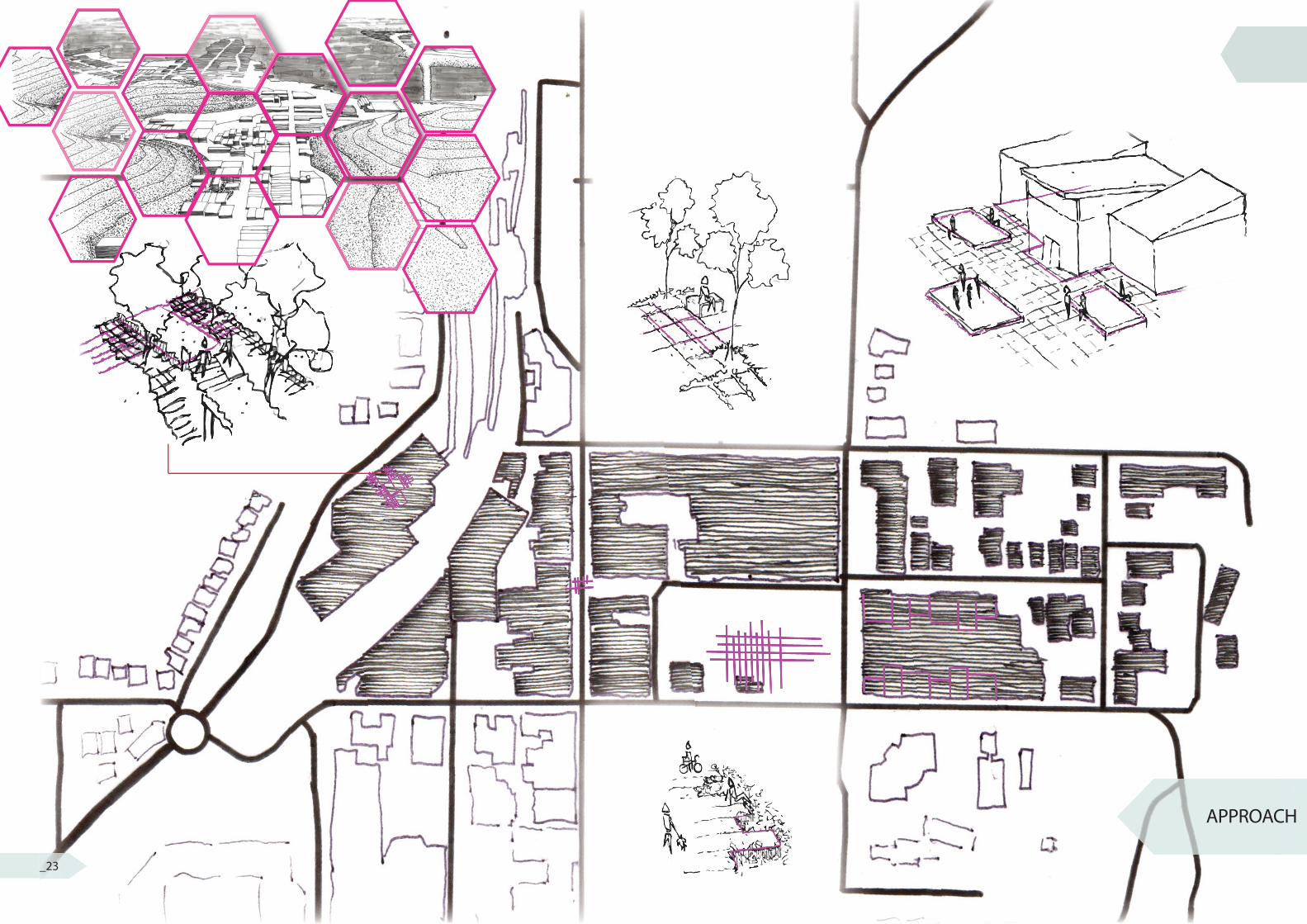
Explorations (Sketches)
Through the conceptual process sketching allowed me to quickly test, clarify or record ideas. This was undertaken in both illustrative and diagrammatic methods. I would often � nd myself in an evolutionary process of making constant iterations to re� ect my new � ndings. In terms of production, I found stylistically the best way to communicate my design was a combination of drawing and computer graphics. This can be seen later in this design report.
03 APPROACH
initi al key plan
ecology/nursery/agricultureecology/retail/civic
ecology/educati on/research
ecology/wetplay/infrastructureecology/agriculture/recreati on
ecology/wetplay/infrastructure
AB
C
‘urban-agri-bush gradient’
typical ideal gosford
‘common threads’
layers acti ve edges (human use) shelter and climate
‘deconstructi ng the grid’
_24
WO
RDM
OD
ELLO
CATI
ON
ABST
RACT
ION
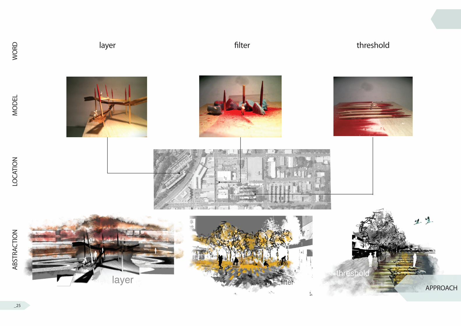
layer � lter threshold
APPROACH
_25
IDEATION
TWIN PEAKS
PARENT ROCK
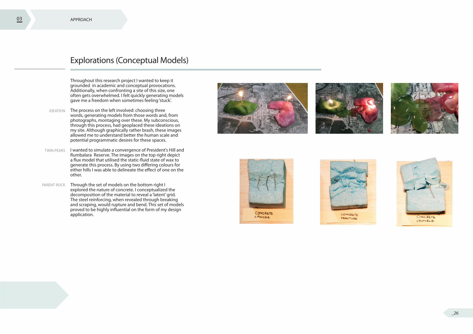
Explorations (Conceptual Models)
Throughout this research project I wanted to keep it grounded in academic and conceptual provocations. Additionally, when confronting a site of this size, one often gets overwhelmed. I felt quickly generating models gave me a freedom when sometimes feeling ‘stuck’.
The process on the left involved: choosing three words, generating models from those words and, from photographs, montaging over these. My subconscious, through this process, had geoplaced these ideations on my site. Although graphically rather brash, these images allowed me to understand better the human scale and potential programmatic desires for these spaces.
I wanted to simulate a convergence of President’s Hill and Rumbalara Reserve. The images on the top right depict a � ux model that utilised the static-� uid state of wax to generate this process. By using two di� ering colours for either hills I was able to delineate the e� ect of one on the other.
Through the set of models on the bottom right I explored the nature of concrete. I conceptualized the decomposition of the material to reveal a ‘latent’ grid. The steel reinforcing, when revealed through breaking and scraping, would rupture and bend. This set of models proved to be highly in� uential on the form of my design application.
03 APPROACH
_26
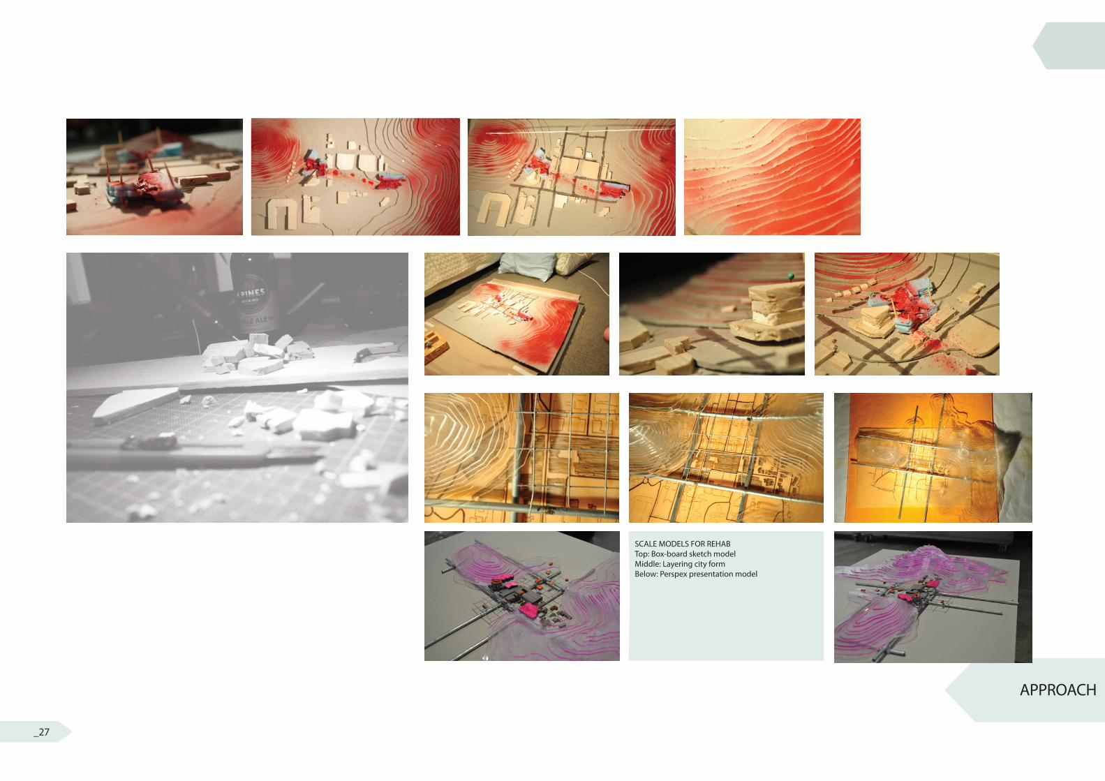
APPROACH
SCALE MODELS FOR REHABTop: Box-board sketch modelMiddle: Layering city formBelow: Perspex presentation model
_27
SKETCH MODEL
PRESENTATION MODEL
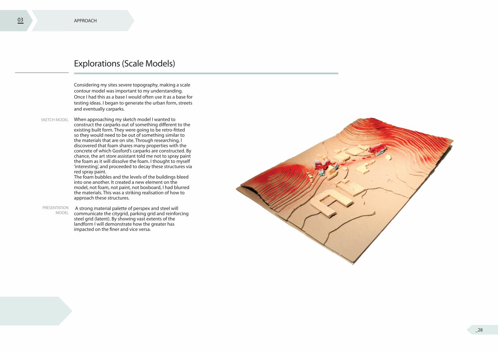
Explorations (Scale Models)
Considering my sites severe topography, making a scale contour model was important to my understanding. Once I had this as a base I would often use it as a base for testing ideas. I began to generate the urban form, streets and eventually carparks.
When approaching my sketch model I wanted to construct the carparks out of something di� erent to the existing built form. They were going to be retro-� tted so they would need to be out of something similar to the materials that are on site. Through researching, I discovered that foam shares many properties with the concrete of which Gosford’s carparks are constructed. By chance, the art store assistant told me not to spray paint the foam as it will dissolve the foam. I thought to myself ‘interesting’, and proceeded to decay these structures via red spray paint. The foam bubbles and the levels of the buildings bleed into one another. It created a new element on the model, not foam, not paint, not boxboard, I had blurred the materials. This was a striking realisation of how to approach these structures.
A strong material palette of perspex and steel will communicate the citygrid, parking grid and reinforcing steel grid (latent). By showing vast extents of the landform I will demonstrate how the greater has impacted on the � ner and vice versa.
03 APPROACH
_28
APPROACH
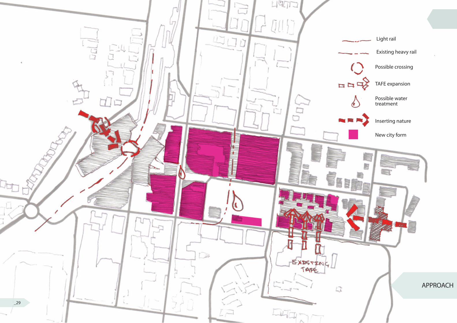
Light rail
Existing heavy rail
Possible crossing
TAFE expansion
Inserting nature
New city form
Possible watertreatment
_29
APPROACH
HYDROLOGY
ECOLOGY
SOCIAL NEEDS
CITY FUNCTION
Schematic Plan
Throughout my research I had set out some areas of opportunity within the corridor. I started developing schematic plans at an early stage to re� ect and record these design moves. The image on the right illustrates my desire to create a cohesive landscape that acknowledges multiple systems of hydrology, ecology, social needs and city function.
The opportunity to catch water from the large impervious surfaces was fundamental to my design research. I wanted to also use this opportunity to acknowledge the heritage of the creek that was covered up in Kibble Park.
Through the connection of endemic planting structures on either side I would begin to reconnect habitats and increase biodiversity. The ecology one either side of Gosford is slightly varied and this convergence would become an interesting ecotonal gradation.
Gosford loses a large proportion of its 18-25 population (nearly 1500 a year). A large reason behind this is young adults looking for tertiary education, either in Sydney or Newcastle. By extending the current TAFE facility we will relieve the pressures on the existing small campus and provide a more diverse program that will counter the depleting population.
With the encasing of an abundance of infrastructure within the 5 hectare site; city function was always going to be a design challenge when bridging east west. I decided to include the daylighting of the Imperial Centre and its housing of a new light rail network that was generated in the Masterplan stage from last semester. The opportunity for various crossings arose when the height of Gosford Commuter Carpark and Gosford City Carpark were discovered to be similar.
03
BACKGROUND
regionalecologicalsocialstylistic/heritageprogrammatic
hydrology 1. carparks 2. street3. open space vegetation
infilltransport
concept modelsscale models
sketches
ques
tion
revi
sion
check against design principlesrevi
se m
aste
rpla
n to
re�e
ct d
esig
n re
sear
ch ?
local
site
RESEARCH QUESTION
DESIGN PRINCIPLES
INFLUENCESEXPLORATIONS
SYSTEMSDETAIL PLANS
CONSTRUCTION
OVERVIEW PLAN
SCHEMATIC PLAN
MASTERPLAN
INTRODUCTION
AREA OF INVESTIGATION
SITE ANALYSIS
zoom 3
APPROACH
FRAMEWORKDESIGN RESOLUTION
RESEARCH + UNDERSTANDING
zoom 2
zoom 1
research
methods
outcome
observations
opportunities
constraints
method
mapping
research
outcome
SCHEMATIC PLANSCHEMATIC PLANSCHEMATIC PLANSCHEMATIC PLANSCHEMATIC PLANSCHEMATIC PLANSCHEMATIC PLAN
_30
Forest CanopyEucalyptus pilularisEucaluptus robustaAllocasuarinatorulosaSyncarpiaglomulifera
Livistona australisPlatanus acerifoliaWaterhousia � oribundaLophostemon confertus
Dense shrub layerRhodamnia rubescens Acacia � licifoliaSynoum glandulsum,Glochidion ferdinandi,Podolobiumilicifolium, Rapaneavariabilis
Herbs and FernsPseuderanthemumvariabile,Pratia purpurascens,Microlaena stipoides,Oplismenus imbecillis,Desmodium varians, Viola hederacea
endemic planting structures exotic + native street planting
wetland plantingBaumea articulataBaumea junceaCarex appressaTypha orientalisPhragmites australis
FRAMEWORK
urban catchment
water treatment
main water � ow
peak over� ow outletwater treatment
To S
ydne
y
President’s Hill
Walking Tracks
Connection to existing Rumbalara trails
conn
ect t
o re
gion
al b
ike
netw
ork
To Gosford West
To S
ydne
y
President’s Hill
Walking Tracks
Connection to existing Rumbalara trails
conn
ect t
o re
gion
al b
ike
netw
ork
To Gosford West
To S
ydne
y
President’s Hill
Walking Tracks
Connection to existing Rumbalara trails
conn
ect t
o re
gion
al b
ike
netw
ork
To Gosford West
To S
ydne
y
President’s Hill
Walking Tracks
Connection to existing Rumbalara trails
conn
ect t
o re
gion
al b
ike
netw
ork
To Gosford West
To S
ydne
y
President’s Hill
Walking Tracks
Connection to existing Rumbalara trails
conn
ect t
o re
gion
al b
ike
netw
ork
To Gosford West
To S
ydne
y
President’s Hill
Walking Tracks
Connection to existing Rumbalara trails
conn
ect t
o re
gion
al b
ike
netw
ork
To Gosford West
Pedestrian
Cycle way
Shared way
Light rail
RoundaboutService vehiclesonly
New buildings
Retro-� t
_31
HYDROLOGY
VEGETATION
CIRCULATION
BUILT FORM
Systems
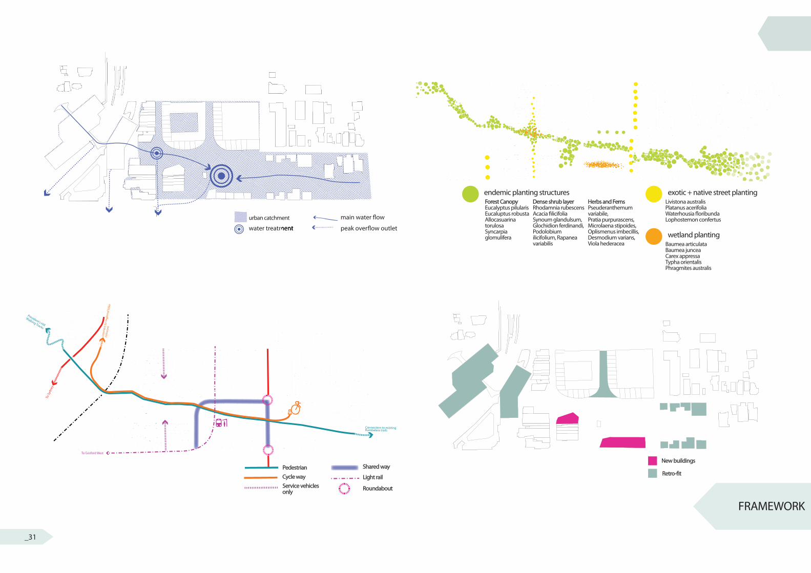
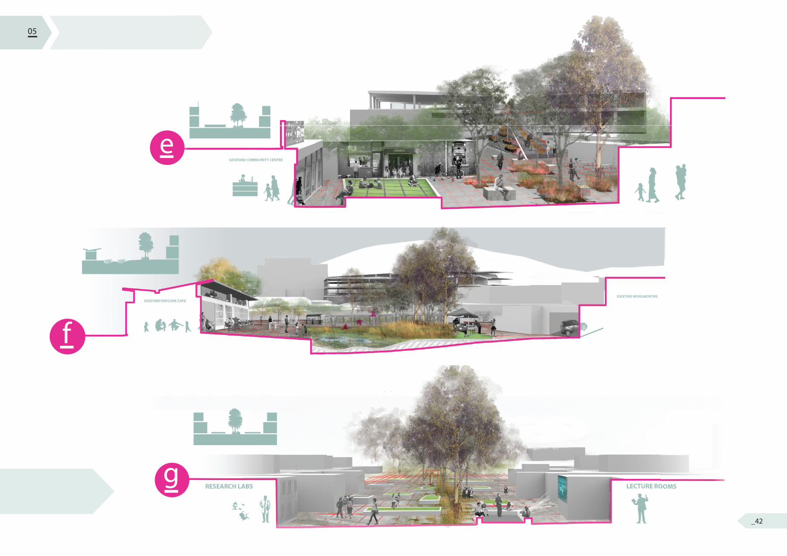
Often generating an overview plan can be quite daunting as there is so much to include. By breaking my design responses into systems I was able to focus more holistically on that landscape element. I wanted to use the grid as a way of ‘perculating’ and ‘� ltering’ water throughout the site. Within the carparks, water is harvested and guided into the second level rain garden. From here it is guided through the corridor into a series of modular rain gardens eventually making its way into a wetland. This wetland will gather in the lowest point of the valley, Kibble Park; a location that was home to a creek and then a carpark. The wetland will take on the footprint of the old carpark and yet still acknowledge the heritage creek.
Through the use of endemic planting structures, East-West, I will create a way� nding solution for both native fauna and the people of Gosford. North-South connections however will use a planting palette of native and exotic planting to delineate the urban axis.
Gosford will experience a shift from car centred to more diverse mode of transport: 1. Mann street will be restricted to service vehicles for the existing retail. 2. Overall paving will delineate these new founded pedestrian areas. These spaces will connect to new and existing trails on President’s Hill and Rumbalara Reserve. 2. Kibble Park will stay open to car access, providing the opportunity for drop-o� s and pick-ups. 3. Cycleways will join the corridor through level 2 of the Commuter Carpark on the west side. Cyclists will be able to then access Mann Street via the rail crossing. 4. Light rail will connect Gosford to its much neglected Western side. There will be a light rail stop within Kibble Park, that will connect to ‘o� site’ parking facilities. These sites have been outlined within the 2011 Gosford City Centre Strategic Parking Study produced by Brown Consulting.
In terms of new urban form, there will be a combination of new buildings or retro-� tting. New Urban Buildings (Pink) will include a Gosford Arts Centre and child care facilities. The Retro� t of the 3 carparks and the Imperial Centre will open the city centre up to this corridor and start to develop an architectural vernacular and thus identity.
04 FRAMEWORK
BACKGROUND
regionalecologicalsocialstylistic/heritageprogrammatic
hydrology 1. carparks 2. street3. open space vegetation
infilltransport
concept modelsscale models
sketches
ques
tion
revi
sion
check against design principlesrevi
se m
aste
rpla
n to
re�e
ct d
esig
n re
sear
ch ?
local
site
RESEARCH QUESTION
DESIGN PRINCIPLES
INFLUENCESEXPLORATIONS
SYSTEMSDETAIL PLANS
CONSTRUCTION
OVERVIEW PLAN
SCHEMATIC PLAN
MASTERPLAN
INTRODUCTION
AREA OF INVESTIGATION
SITE ANALYSIS
zoom 3
APPROACH
FRAMEWORKDESIGN RESOLUTION
RESEARCH + UNDERSTANDING
zoom 2
zoom 1
research
methods
outcome
observations
opportunities
constraints
method
mapping
research
outcome
SYSTEMSSYSTEMSSYSTEMSSYSTEMS
_32
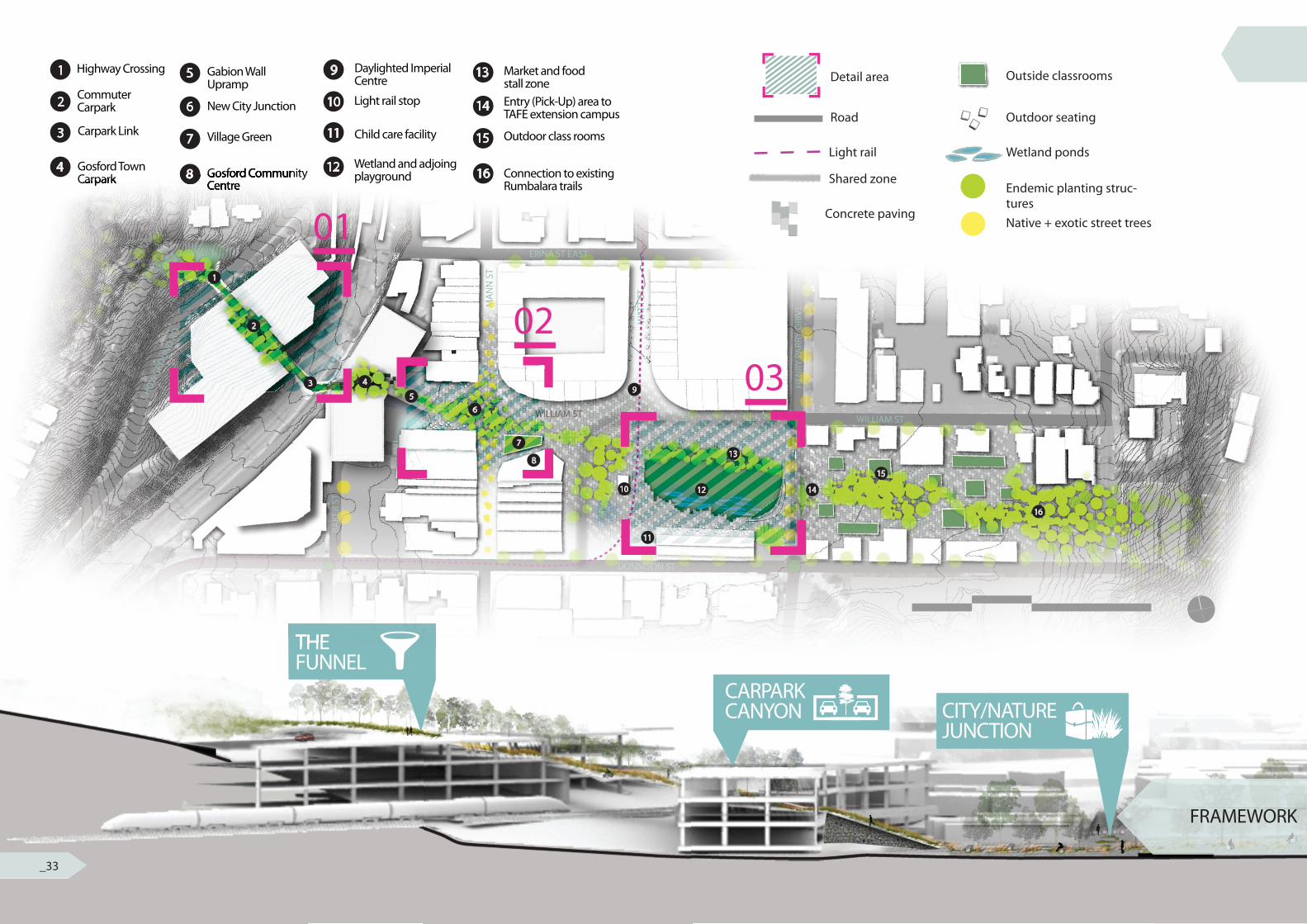
THE FUNNEL
CARPARKCANYON CITY/NATURE
JUNCTION
FRAMEWORK
9
10
11
12
Daylighted Imperial Centre
Light rail stop
Child care facility
Wetland and adjoing playground
13
14
15
16
Market and food stall zoneEntry (Pick-Up) area to TAFE extension campus
Outdoor class rooms
Connection to existing Rumbalara trails
1
2
3
4
Highway Crossing
Commuter Carpark
Carpark Link
Gosford Town Carpark
5
6
7
8
Gabion Wall Upramp
New City Junction
Village Green
Gosford Community Centre
Detail area Outside classrooms
Outdoor seating
Wetland ponds
Endemic planting struc-turesNative + exotic street trees
Road
Light rail
Shared zone
Concrete paving
THE
Carpark 88 Gosford Community Centre
01
0203
1
2
3 4
56
7
8
9
10
11
12
13
14
15
16
0 k m 5 k m 1 0 k m
2 0 k m
80% Of Sydney Basin’s Biota
50% Of Sydney
Basin’s Biota
80% Of Sydney
Basin’s Biota
_33
IMPERIALLANEWAY
KIBBLE’S CATCHMENT
KIBBLE’S CAMPUS
FRAMEWORK
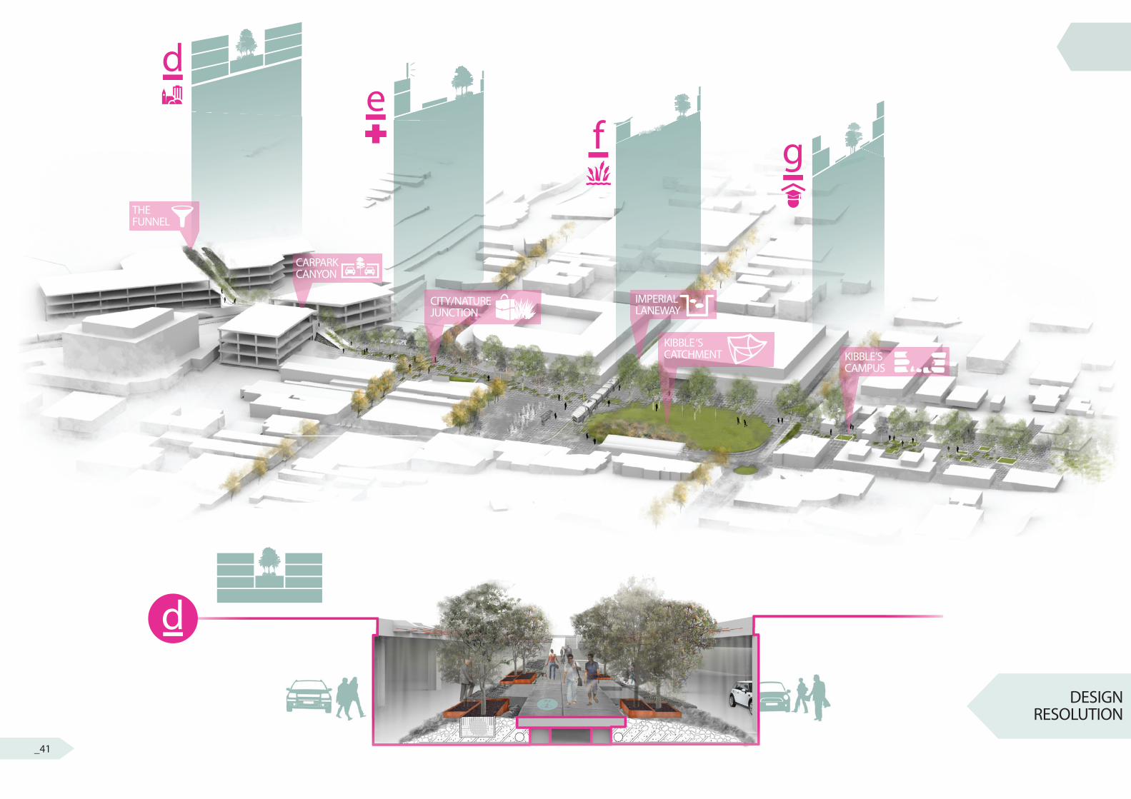
Overview Plan
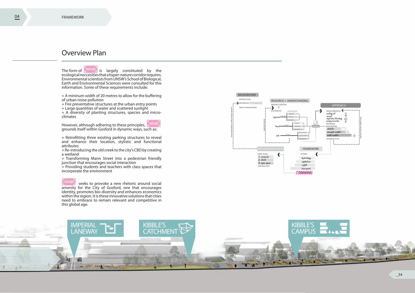
The form of is largely constituted by the ecological neccesities that a hyper-nature corridor requires. Environmental scientists from UNSW’s School of Biological, Earth and Environmental Sciences were consulted for this information. Some of these requirements include:
+ A mininum width of 20 metres to allow for the bu� ering of urban noise pollution+ Fire preventative structures at the urban entry points+ Large quantities of water and scattered sunlight+ A diversity of planting structures, species and micro-climates
However, although adhering to these principles, grounds itself within Gosford in dynamic ways, such as:
+ Retro� tting three existing parking structures to reveal and enhance their location, stylistic and functional attributes+ Re-introducing the old creek to the city’s CBD by creating a wetland+ Transforming Mann Street into a pedestrian friendly junction that encourages social interaction+ Providing students and teachers with class spaces that incorporate the environment
seeks to provoke a new rhetoric around social amenity for the City of Gosford, one that encourages identity, promotes bio-diversity and enhances economics within the region. It is these innovative solutions that cities need to embrace to remain relevant and competitive in this global age.
04
BACKGROUND
regionalecologicalsocialstylistic/heritageprogrammatic
hydrology 1. carparks 2. street3. open space vegetation
infilltransport
concept modelsscale models
sketches
ques
tion
revi
sion
check against design principlesrevi
se m
aste
rpla
n to
re�e
ct d
esig
n re
sear
ch ?
local
site
RESEARCH QUESTION
DESIGN PRINCIPLES
INFLUENCESEXPLORATIONS
SYSTEMSDETAIL PLANS
CONSTRUCTION
OVERVIEW PLAN
SCHEMATIC PLAN
MASTERPLAN
INTRODUCTION
AREA OF INVESTIGATION
SITE ANALYSIS
zoom 3
APPROACH
FRAMEWORKDESIGN RESOLUTION
RESEARCH + UNDERSTANDING
zoom 2
zoom 1
research
methods
outcome
observations
opportunities
constraints
method
mapping
research
outcome
OVERVIEW PLANOVERVIEW PLANOVERVIEW PLANOVERVIEW PLANOVERVIEW PLANOVERVIEW PLAN
The form of is largely constituted by the rehabThe form of is largely constituted by the rehabThe form of is largely constituted by the
seeks to provoke a new rhetoric around social rehab rehab seeks to provoke a new rhetoric around social rehab seeks to provoke a new rhetoric around social
rehab
_34
a
b
c
aelevated walkway
To President’s H
ill
observation areas
01c
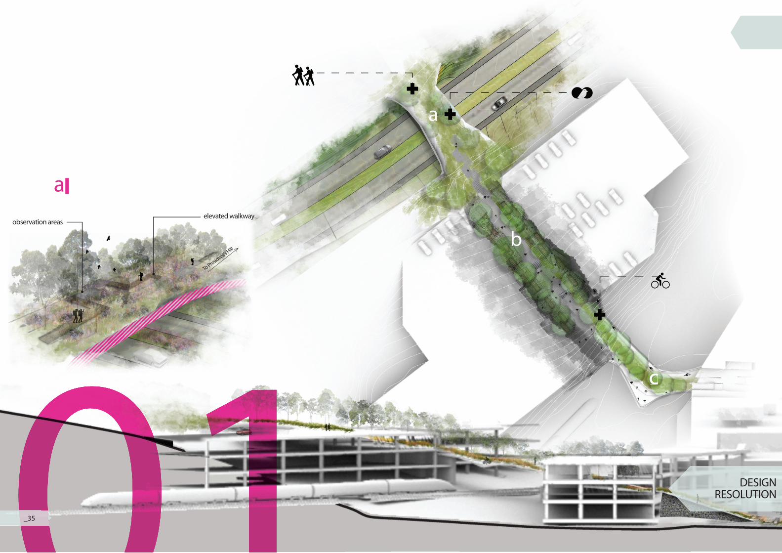
01 DESIGN RESOLUTION01_35
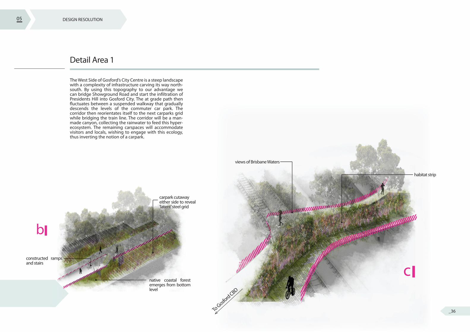
b
constructed ramps and stairs
native coastal forest emerges from bottom level
carpark cutawayeither side to reveal ‘latent’ steel grid
c
views of Brisbane Waters
habitat strip
To Gosfo
rd CBD
DESIGN RESOLUTION
Detail Area 1
The West Side of Gosford’s City Centre is a steep landscape with a complexity of infrastructure carving its way north-south. By using this topography to our advantage we can bridge Showground Road and start the in� ltration of Presidents Hill into Gosford City. The at grade path then � uctuates between a suspended walkway that gradually descends the levels of the commuter car park. The corridor then reorientates itself to the next carparks grid while bridging the train line. The corridor will be a man-made canyon, collecting the rainwater to feed this hyper-ecosystem. The remaining carspaces will accommodate visitors and locals, wishing to engage with this ecology, thus inverting the notion of a carpark.
05
_36
02a
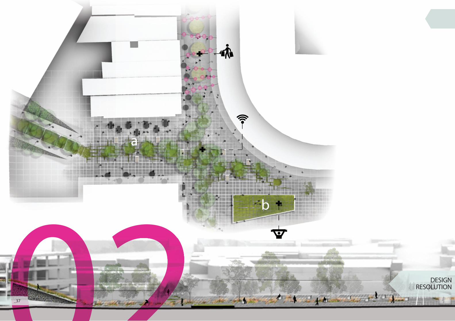
b
02 DESIGN RESOLUTION0_37
DESIGN RESOLUTION
Detail Area 2
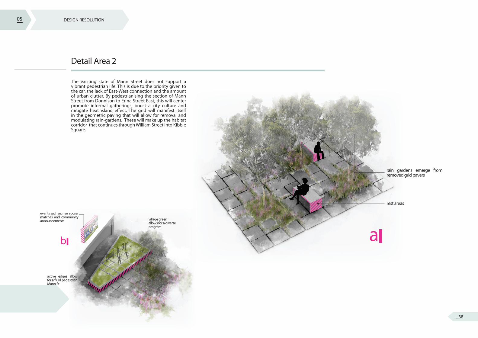
The existing state of Mann Street does not support a vibrant pedestrian life. This is due to the priority given to the car, the lack of East-West connection and the amount of urban clutter. By pedestrianising the section of Mann Street from Donnison to Erina Street East, this will center promote informal gatherings, boost a city culture and mitigate heat island e� ect. The grid will manifest itself in the geometric paving that will allow for removal and modulating rain-gardens. These will make up the habitat corridor that continues through William Street into Kibble Square.
05
a
rain gardens emerge from removed grid pavers
rest areas
b
village green allows for a diverse program
events such as: nye, soccer matches and community announcements
active edges allow for a � uid pedestrian Mann St
_38
03a
b
0303 DESIGN RESOLUTION0_39
achild care facilities
wetland wharf
water remediation facility will be located on the footprint of the old car lot in Kibble Park
DESIGN RESOLUTION
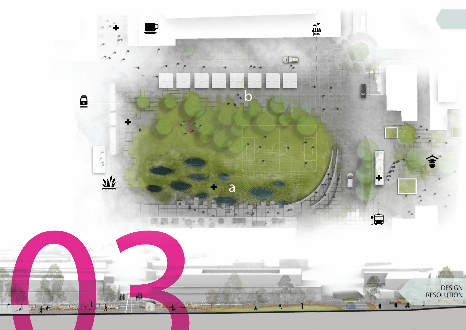
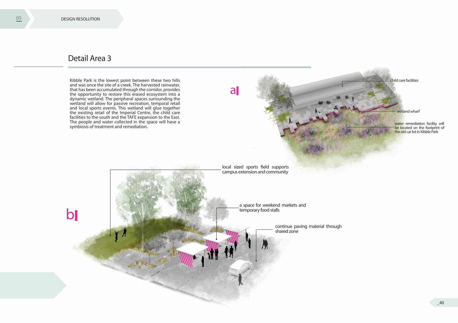
Detail Area 3
Kibble Park is the lowest point between these two hills and was once the site of a creek. The harvested rainwater, that has been accumulated through the corridor, provides the opportunity to restore this erased ecosystem into a dynamic wetland. The peripheral spaces surrounding the wetland will allow for passive recreation, temporal retail and local sports events. This wetland will glue together the existing retail of the Imperial Centre, the child care facilities to the south and the TAFE expansion to the East. The people and water collected in the space will have a symbiosis of treatment and remediation.
05
local sized sports � eld supports campus extension and community
a space for weekend markets and temporary food stalls
continue paving material through shared zone
b
05
_40
f
CARPARKCANYON
IMPERIALLANEWAY
KIBBLE’SCAMPUS
de
g
KIBBLE ‘SCATCHMENT
CITY/NATURE JUNCTION
THE FUNNEL
d
DESIGN RESOLUTION
_41
g
e
05
f
_42
DESIGN RESOLUTION
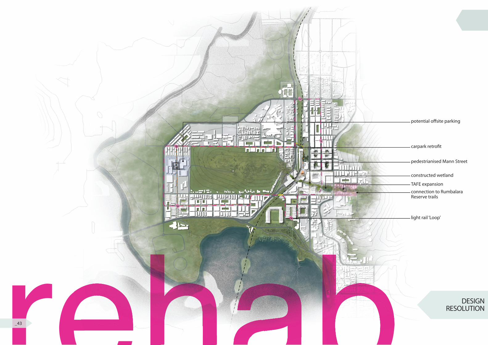
potential o� site parking
carpark retro� t
pedestrianised Mann Street
constructed wetland
TAFE expansion
connection to Rumbalara Reserve trails
light rail ‘Loop’
rehabrehabrehab_43
DESIGN RESOLUTION
STAGING
NATURAL DISASTER
REVISED MASTERPLAN
Construction
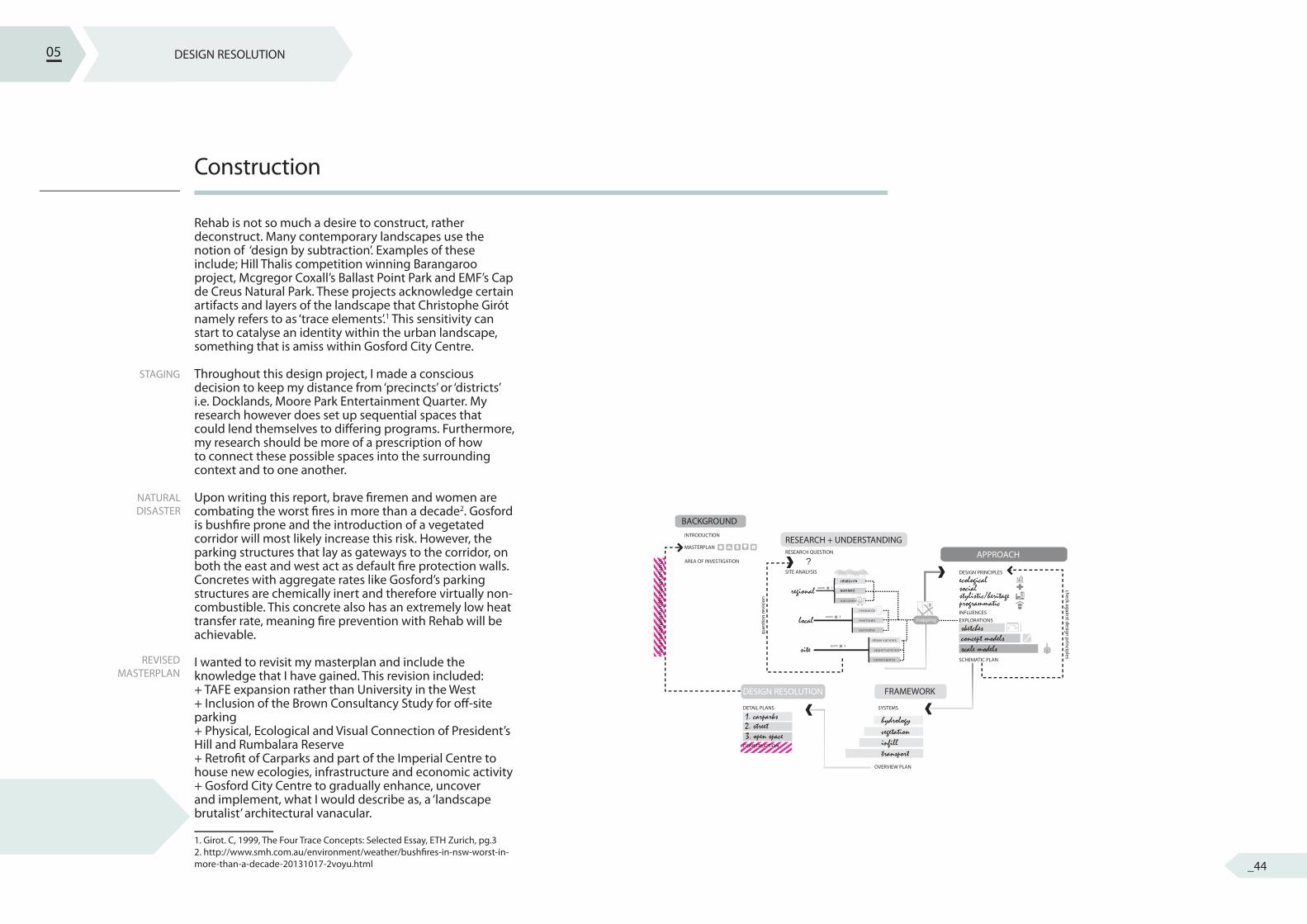
Rehab is not so much a desire to construct, rather deconstruct. Many contemporary landscapes use the notion of ‘design by subtraction’. Examples of these include; Hill Thalis competition winning Barangaroo project, Mcgregor Coxall’s Ballast Point Park and EMF’s Cap de Creus Natural Park. These projects acknowledge certain artifacts and layers of the landscape that Christophe Girót namely refers to as ‘trace elements’.1 This sensitivity can start to catalyse an identity within the urban landscape, something that is amiss within Gosford City Centre.
Throughout this design project, I made a conscious decision to keep my distance from ‘precincts’ or ‘districts’ i.e. Docklands, Moore Park Entertainment Quarter. My research however does set up sequential spaces that could lend themselves to di� ering programs. Furthermore, my research should be more of a prescription of how to connect these possible spaces into the surrounding context and to one another.
Upon writing this report, brave � remen and women are combating the worst � res in more than a decade2. Gosford is bush� re prone and the introduction of a vegetated corridor will most likely increase this risk. However, the parking structures that lay as gateways to the corridor, on both the east and west act as default � re protection walls. Concretes with aggregate rates like Gosford’s parking structures are chemically inert and therefore virtually non-combustible. This concrete also has an extremely low heat transfer rate, meaning � re prevention with Rehab will be achievable.
I wanted to revisit my masterplan and include the knowledge that I have gained. This revision included:+ TAFE expansion rather than University in the West+ Inclusion of the Brown Consultancy Study for o� -site parking+ Physical, Ecological and Visual Connection of President’s Hill and Rumbalara Reserve+ Retro� t of Carparks and part of the Imperial Centre to house new ecologies, infrastructure and economic activity+ Gosford City Centre to gradually enhance, uncover and implement, what I would describe as, a ‘landscape brutalist’ architectural vanacular.
1. Girot. C, 1999, The Four Trace Concepts: Selected Essay, ETH Zurich, pg.3 2. http://www.smh.com.au/environment/weather/bush� res-in-nsw-worst-in-more-than-a-decade-20131017-2voyu.html
05
BACKGROUND
regionalecologicalsocialstylistic/heritageprogrammatic
hydrology 1. carparks 2. street3. open space vegetation
infilltransport
concept modelsscale models
sketches
ques
tion
revi
sion
check against design principlesrevi
se m
aste
rpla
n to
re�e
ct d
esig
n re
sear
ch ?
local
site
RESEARCH QUESTION
DESIGN PRINCIPLES
INFLUENCESEXPLORATIONS
SYSTEMSDETAIL PLANS
CONSTRUCTION
OVERVIEW PLAN
SCHEMATIC PLAN
MASTERPLAN
INTRODUCTION
AREA OF INVESTIGATION
SITE ANALYSIS
zoom 3
APPROACH
FRAMEWORKDESIGN RESOLUTION
RESEARCH + UNDERSTANDING
zoom 2
zoom 1
research
methods
outcome
observations
opportunities
constraints
method
mapping
research
outcome
CONSTRUCTIONCONSTRUCTIONCONSTRUCTIONCONSTRUCTIONCONSTRUCTIONCONSTRUCTIONCONSTRUCTION
revi
se m
aste
rpla
n to
re�e
ct d
esig
n re
sear
chre
vise
mas
terp
lan
to re
�ect
des
ign
rese
arch
revi
se m
aste
rpla
n to
re�e
ct d
esig
n re
sear
chre
vise
mas
terp
lan
to re
�ect
des
ign
rese
arch
revi
se m
aste
rpla
n to
re�e
ct d
esig
n re
sear
chre
vise
mas
terp
lan
to re
�ect
des
ign
rese
arch
revi
se m
aste
rpla
n to
re�e
ct d
esig
n re
sear
chre
vise
mas
terp
lan
to re
�ect
des
ign
rese
arch
revi
se m
aste
rpla
n to
re�e
ct d
esig
n re
sear
chre
vise
mas
terp
lan
to re
�ect
des
ign
rese
arch
revi
se m
aste
rpla
n to
re�e
ct d
esig
n re
sear
chre
vise
mas
terp
lan
to re
�ect
des
ign
rese
arch
revi
se m
aste
rpla
n to
re�e
ct d
esig
n re
sear
chre
vise
mas
terp
lan
to re
�ect
des
ign
rese
arch
revi
se m
aste
rpla
n to
re�e
ct d
esig
n re
sear
ch
_44
DESIGN RESOLUTION
Conclusion
is a innovative approach to a city that is in decline. It examines the regional, local and site to synthesise ‘speculative design innovations rather than... conventional solutions’ 1. My research has identi� ed that Gosford, does indeed have a ‘strong culture of charity’2. However, these charitable qualities do not extend to the surrounding ecologies. Rehab seeks to provoke a new rhetoric around social amenity for the City of Gosford, one that encourages identity, promotes bio-diversity and enhances economics within the region. It is these innovative solutions that cities need to embrace to remain relevant and competitive in this global age.
1. Mohsen. M (2010), Ecological Urbanism: Introduction, Harvard Graduate School of Design, pg. 14 2 Mel Law, Regional Development Australia Central Coast
05
is a innovative approach to a city that is in rehab is a innovative approach to a city that is in rehab is a innovative approach to a city that is in
_45


![MFA Course Progression · F. CDE 506 Grad Sem: Contemporary Topics in Design 3 Thesis [12cr] ... MFA Course Progression Fall I/1st Semester Personal Exploration Seminar 3cr Grad Sem:](https://img.pdfslide.us/doc/110x75/5fcbe80b0ab1d711a56e6767/mfa-course-progression-f-cde-506-grad-sem-contemporary-topics-in-design-3-thesis.jpg)


![402 - Grad at Grad SLU Presentation[1]Final - Clark](https://img.pdfslide.us/doc/110x75/577cd5441a28ab9e789a53f1/402-grad-at-grad-slu-presentation1final-clark.jpg)