1
Suwannee River 1. Town of Suwannee - Several ramps in the town, both free and fee. 2. Munden Creek - From Old Town on Hwy 349 to Munden Creek Rd., near the town of Suwannee. Turn east on the Munden Creek Rd. and turn right at the T-intersection to the ramp. 3. Fowlers Bluff - From Chiefland go south on Hwy 345 to Hwy 347 and continue south to NW 46 Lane, which goes to the ramp. 4. Yellow Jacket - From Hwy 19-27A in Old Town go south on Hwy 349 for 9.8 miles; turn on Yellow Jacket Landing Rd. Go east for 0.9 mile to the fork, then go right to the ramp. 5. Camp Azalea - From Chiefland take Hwy 320 west to NW 107 Terrace (Camp Azalea Rd.). Follow the road around as it turns into NW 102 Pl. and then NW 92 St. At the T-intersection go right to the ramp. 6. Usher - From Chiefland take Hwy 320 west to NW 107 Terrace (Camp Azalea Rd.). Follow the road around 2 1/2 miles. Canoe launch on right. 7. Manatee Springs State Park, canoe launch only - From Chiefland follow Hwy 320 west to the park entrance. Entrance fee to the park. 8. New Clay Landing - From Chiefland go west on Hwy 320 to NW 110 Ave. Go north on 110 Ave. and continue on NW 129 Pl. and NW 130 St. to the park. 9. New Pine Landing - From Hwy 19-27A in Old Town go south on Hwy 349 to New Pine Landing Rd. Follow to the ramp at the end of the road. 10. Old Pine Landing - From Old Town go south on Hwy 349 to Old Pine Landing Rd. Turn left and fol low the road to the boat ramp. 11. Hinton Landing - From Fanning Springs go across the river and south on Hwy 317 to the park. From Old Town go south on Hwy 349 to Hwy 346-A. Go left on Hwy 346-A to Hwy 317 and turn right to the park. 12. From Fanning Springs go west across the river on Hwy 19-27A to the first dirt road on the left. Follow this road for two blocks to the ramp on the left. 13. Suwannee Gables Ramp - From Fanning Springs go west on Hwy 19-27A. The Suwannee Gables Motel is on the north side of the road. 14. KOA Campground - From Old Town go north on Hwy 349 for 1.2 miles to the camp ground. Ramp fee is charged. 15. Purvis Landing - From Old Town follow Hwy 349 north to Purvis Landing Rd. and the ramp. 16. Hart Spring - From Trenton go west on Hwy 26 to Hwy 232 and go north to Hwy 344. Turn west on Hwy 344 and follow to the ramp. 17. Eula Landing - From Trenton go west on Hwy 26 to Hwy 232 and go north. The paved road makes a 90 degree turn, but continue straight on the dirt road to SW 25 St. Go west to the ramp. 18. Wannee - From Bell go west on Hwy 341 to Hwy 341-A and go south to West Suwannee Road. Go west on W. Suwannee to NW 70 Ave and then south to SW 10 St. Take SW 10 St west to the ramp. 19. Log Landing - From Bell go west on Hwy 341 to Hwy 341-A and go south to West Suwannee Rd. Go west on W. Suwannee Rd. to NW 70 Ave. and then north on 70 Ave. to NW 7 Pl. Follow 7 Pl. west, and then go south on NW 73 Way and west on NW 6 St. to the ramp. 20. Guaranto Spring - From Branford go south on Hwy 349 to Hwy 353. Follow Hwy 353 east and take the first road on the right at the Rock Sink Church. The road winds around to the park. 21. Rock Bluff - From Bell go north on Hwy 129 to Hwy 340. Take Hwy 340 west to the park on the south side of the road just before the river. 22. Hurst Landing - From the Dixie-Lafayette County line go north on Hwy 349 to Hwy 342 and take it east to the Hatchbend Church. Go north at the church for .2 miles. Turn right on county graded road, go .7 miles. Turn right on county graded road. Go 1.3 miles to the ramp. 23. Sims Landing - From the Dixie-Lafayette County line go north on Hwy 349 to Hwy 342 and take it east to the Hatchbend Church. Go south at the church to the T-intersection and then go right 0.2 miles. Ramp is on the left. 24. Wanamake - From the Santa Fe River go south on Hwy 129 to NW 102 Pl. and then take 102 Pl. west to NW 39 Ave. and the ramp. 25. Hatchbend - From Branford take Hwy 349 south to Hwy 138; go east on Hwy 138 to T-intersection. Then take the paved road to the right to the ramp. 26. Ivey Memorial Park - In the town of Branford on the south side of Hwy 27 just before the river. 27. Patrician Oaks - From Branford go north on Hwy 27 to the first road on the right after Hwy 475 on the left. Follow the road into Patrician Oaks. The ramp is at the end of the road. 28. Ruth Spring Tract, SRWMD canoe launch - From Branford take Hwy 27 north to County Road 425; go north to the tract entrance at the curve in the road. Follow the road and sign inside the tract. 29. Walker Tract, SRWMD canoe launch - From Branford take Hwy 27 north to County Road 425. Go north past the Ruth Spring Tract to the Walker Tract entrance and follow the signs inside the tract to the canoe launch. 30. Mearson Spring - From Hwy 27 between Branford and Mayo take Hwy 251 to the river and the ramp. 31. Royal Spring - From Live Oak take Hwy 51 west to Hwy 349 and go south 10 miles to 198 Terrace. Follow 198 Terrace to the park. 32. Hardinburg Ramp - From Hwy 51 in Mayo go east on Hwy 27 to Hwy 354-B and go north. At the intersection of 354 and 354-B go straight ahead to the river and ramp. 33. Hal W. Adams Bridge - From Mayo follow Hwy 51 north to the river. Park is on the east side of the road just before the bridge. 34. Lafayette County Blue Spring - From Mayo take Hwy 27 west to Hwy 251-B and go north to the graded road. Go east on the graded road to the park. Entrance fee. 35. Allen Mill Pond - From Mayo go north on Hwy 27 to Hwy 251-B. Then go north to where the road takes the 90 degree turn to the west. Follow the graded road at the turn north to the ramp. 36. Charles Spring - From Live Oak take Hwy 51 south 12 miles to Hwy 252. Go west on 252 to the T- intersection on the graded road. Take the road to the left; the road to the park is on the right. 37. Christian Tract, SRWMD canoe launch - From Dowling Park go east on Hwy 250 to 225 Rd and then south to 132 St. Go west on 132 St. to the tract entrance. 38. Sand Pond Ramp - From Dowling Park take Hwy 250 west across the river to Hwy 251 and go south for 1.5 miles to Sand Pond Road. Follow this winding county grade road to the river. 39. Dowling Park - Ramp is in the park on the north side on Hwy 250 just before the river. 40. Boundary Bend - From Dowling Park go west on Hwy 250 across the river to the first paved road on the north side of Hwy 250. Follow this road to the second graded road on the right and go right. Take this road to the ramp. 41. Suwannee River State Park - From Live Oak take Hwy 90 west out of to the park, just before the river. Entrance fee to park. 42. Road 141 ramp - From the Hwy 141 and US 90 intersection go north to Hwy 143. Then go east on the graded road across from Hwy 143. Go right at the T-intersection and follow road to the ramp. 43. Gibson Park - From Live Oak take Hwy 249 north across the river. Park is on the west side of the road. 44. Boys Ranch - From Live Oak take Hwy 795 north to the Boys Ranch. Follow the main road into the ranch almost to the end and the ramp is on the right. 45. Fox Trail - From Live Oak go north on Hwy 795 to 24 St. (Fox Trail Rd.) and go east to 107 Rd. The ramp is at the end of the road. 46. Spirit of the Suwannee Campground - From Live Oak take Hwy 129 north. The park is on the west side of the road across from the inspection station. Entrance fee. 47. Woods Ferry Tract, SRWMD canoe Launch - From Live Oak take Hwy 129 north to Hwy 136-A; go east to 57 Rd. Take 57 Rd. north to the tract entrance, then follow the road to the canoe launch. 48. Hwy 41 Bridge Park - From White Springs take Hwy 41 south out of town. The park is on the right before the river. 48a. Stephen Foster State Park canoe launch - located inside the state park. Entrance fee to park. 49. Big Shoals Tract, SRWMD canoe launch - From White Springs follow Hwy 135 north to Godwin Bridge Rd. Take the road to the tract and the launch. 50. Cone Bridge Road - From Lake City go north on Hwy 441 to Cone Bridge Road. The road dead ends at the ramp. 51. Turner Bridge Boat Ramp - Take Hwy 6 east from Jasper. Turn north on Woodpecker Route (graded road). Turn east at Turner Bridge, follow road to ramp. 52. Roline canoe launch - From Hwy 6 east of Jasper turn north on the Woodpecker Rt. (graded road) to Roline Rd. Go east on Roline Rd. to the ramp. Withlacoochee River W1. Hwy 143 Ramp - From Hwy 6 take Hwy 143 south around two sharp curves to the first graded road on the right. Follow this road to the ramp. W2. From river go west on Hwy. 6 to the first graded road on the south side of the road. Follow the road 0.7 mile and take the left fork to the ramp. W3. Madison County Blue Spring Canoe Launch - From the Witlacoochee River go west on Hwy 6 to the spring on the south side of the road. W4. From Hwy. 6 go north on Hwy 143 to the second dirt road on the left. Follow the road and take a right at the bend and a left at the T-intersection to the ramp. W5. Canoe launch - Just across the river on the Madison County side off of Hwy150 on the first dirt road to the left. Santa Fe River S1. Sandy Point Ramp - Take Hwy 129 south from Hwy 27 to the county park which is on the right side of the road just before the river. S2. Sandy Point Campground - Follow the directions above but go past the park and take the first dirt road on the left to the campground. Ramp fee is charged. S3. Ichetucknee Springs State Park, canoe launch - From Fort White follow signs north on CR47 to north entrance. S4. Ira Bea Oasis Ramp - From the Santa Fe River go south on Hwy 49 to Hwy 138. Turn east on Hwy 138 for 3.4 miles to NE 2nd Way. Follow NE 2nd Way for 2.6 miles to dirt road on the right and the ramp. From Hwy 138 and Hwy 47 in Gilchrist County go west to NE 100 St. and the ramp. S6. Hollingsworth Bluff - Go south from Fort White for 4 miles on Hwy 47 to Hollingsworth Bluff Rd. and follow to ramp. S7. Santa Fe River Park - From Fort White take Hwy 47 south to the Santa Fe River. Go across the river the park is on the east side of Hwy 47. S8. Rum Island - Take Hwy 47 south out of Fort White to Hwy 138; go east to RumIsland Road and the ramp. S9. Ginnie Springs - From High Springs take Hwy 340 for 6.5 miles to a dirt road on the right with a sign marking the spring. Entrance fee is required. S10. Poe Springs - From High Springs take Hwy 340 (Poe Springs Road) to the sign for the park. Entrance fee is required. S11. Hwy 27 Ramp - From High Springs go north on Hwy 27 across the river. Park is on the north side of of the road just after the bridge. S12. High Springs Ramp - From High Springs take Hwy 441 north to NW 210 Lane. Turn leftto go to the ramp.

big boat ramp map - Florida Trail Association first road on the right at the Rock Sink Church. ... From the Dixie-Lafayette County line go north on Hwy 349 to Hwy 342 and take

  • Upload
    vonhan

  • View
    226

  • Download
    3

Embed Size (px)

Citation preview

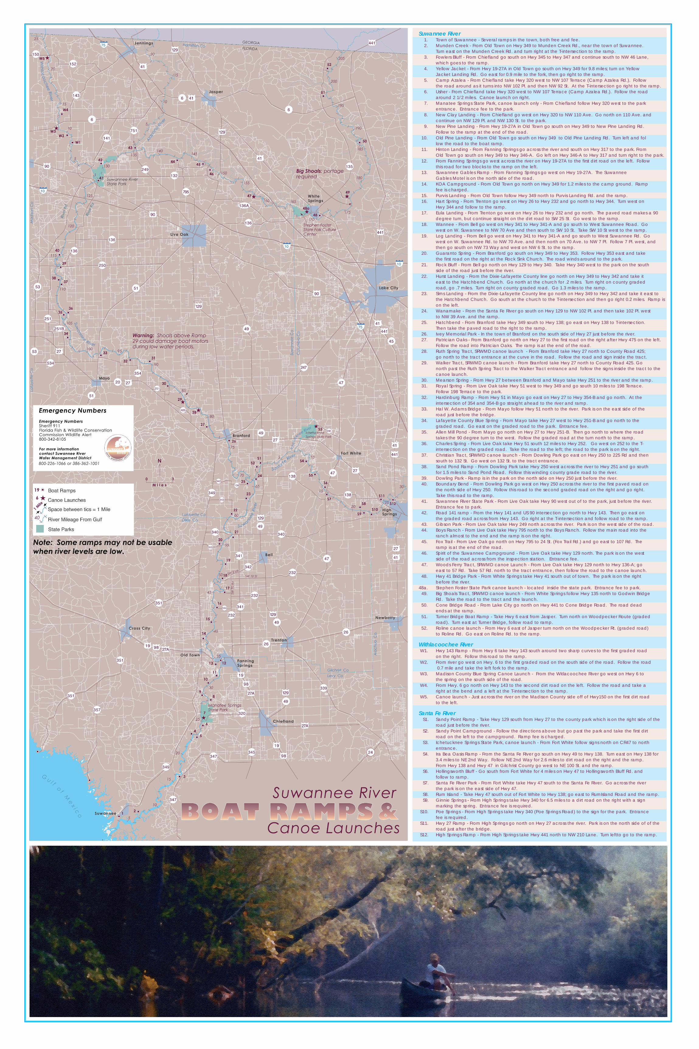
Suwannee River1. Town of Suwannee - Several ramps in the town, both free and fee.2. Munden Creek - From Old Town on Hwy 349 to Munden Creek Rd., near the town of Suwannee.

Turn east on the Munden Creek Rd. and turn right at the T-intersection to the ramp. 3. Fowlers Bluff - From Chiefland go south on Hwy 345 to Hwy 347 and continue south to NW 46 Lane,

which goes to the ramp.4. Yellow Jacket - From Hwy 19-27A in Old Town go south on Hwy 349 for 9.8 miles; turn on Yellow

Jacket Landing Rd. Go east for 0.9 mile to the fork, then go right to the ramp.5. Camp Azalea - From Chiefland take Hwy 320 west to NW 107 Terrace (Camp Azalea Rd.). Follow

the road around as it turns into NW 102 Pl. and then NW 92 St. At the T-intersection go right to the ramp.6. Usher - From Chiefland take Hwy 320 west to NW 107 Terrace (Camp Azalea Rd.). Follow the road

around 2 1/2 miles. Canoe launch on right.7. Manatee Springs State Park, canoe launch only - From Chiefland follow Hwy 320 west to the park

entrance. Entrance fee to the park.8. New Clay Landing - From Chiefland go west on Hwy 320 to NW 110 Ave. Go north on 110 Ave. and

continue on NW 129 Pl. and NW 130 St. to the park.9. New Pine Landing - From Hwy 19-27A in Old Town go south on Hwy 349 to New Pine Landing Rd.

Follow to the ramp at the end of the road.10. Old Pine Landing - From Old Town go south on Hwy 349 to Old Pine Landing Rd. Turn left and fol

low the road to the boat ramp.11. Hinton Landing - From Fanning Springs go across the river and south on Hwy 317 to the park. From

Old Town go south on Hwy 349 to Hwy 346-A. Go left on Hwy 346-A to Hwy 317 and turn right to the park.12. From Fanning Springs go west across the river on Hwy 19-27A to the first dirt road on the left. Follow

this road for two blocks to the ramp on the left.13. Suwannee Gables Ramp - From Fanning Springs go west on Hwy 19-27A. The Suwannee

Gables Motel is on the north side of the road.14. KOA Campground - From Old Town go north on Hwy 349 for 1.2 miles to the camp ground. Ramp

fee is charged.15. Purvis Landing - From Old Town follow Hwy 349 north to Purvis Landing Rd. and the ramp.16. Hart Spring - From Trenton go west on Hwy 26 to Hwy 232 and go north to Hwy 344. Turn west on

Hwy 344 and follow to the ramp.17. Eula Landing - From Trenton go west on Hwy 26 to Hwy 232 and go north. The paved road makes a 90

degree turn, but continue straight on the dirt road to SW 25 St. Go west to the ramp.18. Wannee - From Bell go west on Hwy 341 to Hwy 341-A and go south to West Suwannee Road. Go

west on W. Suwannee to NW 70 Ave and then south to SW 10 St. Take SW 10 St west to the ramp.19. Log Landing - From Bell go west on Hwy 341 to Hwy 341-A and go south to West Suwannee Rd. Go

west on W. Suwannee Rd. to NW 70 Ave. and then north on 70 Ave. to NW 7 Pl. Follow 7 Pl. west, and then go south on NW 73 Way and west on NW 6 St. to the ramp.

20. Guaranto Spring - From Branford go south on Hwy 349 to Hwy 353. Follow Hwy 353 east and take the first road on the right at the Rock Sink Church. The road winds around to the park.

21. Rock Bluff - From Bell go north on Hwy 129 to Hwy 340. Take Hwy 340 west to the park on the south side of the road just before the river.

22. Hurst Landing - From the Dixie-Lafayette County line go north on Hwy 349 to Hwy 342 and take it east to the Hatchbend Church. Go north at the church for .2 miles. Turn right on county graded road, go .7 miles. Turn right on county graded road. Go 1.3 miles to the ramp.

23. Sims Landing - From the Dixie-Lafayette County line go north on Hwy 349 to Hwy 342 and take it east to the Hatchbend Church. Go south at the church to the T-intersection and then go right 0.2 miles. Ramp ison the left.

24. Wanamake - From the Santa Fe River go south on Hwy 129 to NW 102 Pl. and then take 102 Pl. west to NW 39 Ave. and the ramp.

25. Hatchbend - From Branford take Hwy 349 south to Hwy 138; go east on Hwy 138 to T-intersection. Then take the paved road to the right to the ramp.

26. Ivey Memorial Park - In the town of Branford on the south side of Hwy 27 just before the river.27. Patrician Oaks - From Branford go north on Hwy 27 to the first road on the right after Hwy 475 on the left.

Follow the road into Patrician Oaks. The ramp is at the end of the road.28. Ruth Spring Tract, SRWMD canoe launch - From Branford take Hwy 27 north to County Road 425;

go north to the tract entrance at the curve in the road. Follow the road and sign inside the tract.29. Walker Tract, SRWMD canoe launch - From Branford take Hwy 27 north to County Road 425. Go

north past the Ruth Spring Tract to the Walker Tract entrance and follow the signs inside the tract to the canoe launch.

30. Mearson Spring - From Hwy 27 between Branford and Mayo take Hwy 251 to the river and the ramp.31. Royal Spring - From Live Oak take Hwy 51 west to Hwy 349 and go south 10 miles to 198 Terrace.

Follow 198 Terrace to the park.32. Hardinburg Ramp - From Hwy 51 in Mayo go east on Hwy 27 to Hwy 354-B and go north. At the

intersection of 354 and 354-B go straight ahead to the river and ramp.33. Hal W. Adams Bridge - From Mayo follow Hwy 51 north to the river. Park is on the east side of the

road just before the bridge. 34. Lafayette County Blue Spring - From Mayo take Hwy 27 west to Hwy 251-B and go north to the

graded road. Go east on the graded road to the park. Entrance fee.35. Allen Mill Pond - From Mayo go north on Hwy 27 to Hwy 251-B. Then go north to where the road

takes the 90 degree turn to the west. Follow the graded road at the turn north to the ramp. 36. Charles Spring - From Live Oak take Hwy 51 south 12 miles to Hwy 252. Go west on 252 to the T-

intersection on the graded road. Take the road to the left; the road to the park is on the right.37. Christian Tract, SRWMD canoe launch - From Dowling Park go east on Hwy 250 to 225 Rd and then

south to 132 St. Go west on 132 St. to the tract entrance.38. Sand Pond Ramp - From Dowling Park take Hwy 250 west across the river to Hwy 251 and go south

for 1.5 miles to Sand Pond Road. Follow this winding county grade road to the river.39. Dowling Park - Ramp is in the park on the north side on Hwy 250 just before the river.40. Boundary Bend - From Dowling Park go west on Hwy 250 across the river to the first paved road on

the north side of Hwy 250. Follow this road to the second graded road on the right and go right. Take this road to the ramp.

41. Suwannee River State Park - From Live Oak take Hwy 90 west out of to the park, just before the river. Entrance fee to park.

42. Road 141 ramp - From the Hwy 141 and US 90 intersection go north to Hwy 143. Then go east on the graded road across from Hwy 143. Go right at the T-intersection and follow road to the ramp.

43. Gibson Park - From Live Oak take Hwy 249 north across the river. Park is on the west side of the road.44. Boys Ranch - From Live Oak take Hwy 795 north to the Boys Ranch. Follow the main road into the

ranch almost to the end and the ramp is on the right.45. Fox Trail - From Live Oak go north on Hwy 795 to 24 St. (Fox Trail Rd.) and go east to 107 Rd. The

ramp is at the end of the road.46. Spirit of the Suwannee Campground - From Live Oak take Hwy 129 north. The park is on the west

side of the road across from the inspection station. Entrance fee.47. Woods Ferry Tract, SRWMD canoe Launch - From Live Oak take Hwy 129 north to Hwy 136-A; go

east to 57 Rd. Take 57 Rd. north to the tract entrance, then follow the road to the canoe launch.48. Hwy 41 Bridge Park - From White Springs take Hwy 41 south out of town. The park is on the right

before the river.48a. Stephen Foster State Park canoe launch - located inside the state park. Entrance fee to park.

49. Big Shoals Tract, SRWMD canoe launch - From White Springs follow Hwy 135 north to Godwin Bridge Rd. Take the road to the tract and the launch.

50. Cone Bridge Road - From Lake City go north on Hwy 441 to Cone Bridge Road. The road dead ends at the ramp.

51. Turner Bridge Boat Ramp - Take Hwy 6 east from Jasper. Turn north on Woodpecker Route (graded road). Turn east at Turner Bridge, follow road to ramp.

52. Roline canoe launch - From Hwy 6 east of Jasper turn north on the Woodpecker Rt. (graded road) to Roline Rd. Go east on Roline Rd. to the ramp.

Withlacoochee RiverW1. Hwy 143 Ramp - From Hwy 6 take Hwy 143 south around two sharp curves to the first graded road

on the right. Follow this road to the ramp. W2. From river go west on Hwy. 6 to the first graded road on the south side of the road. Follow the road

0.7 mile and take the left fork to the ramp.W3. Madison County Blue Spring Canoe Launch - From the Witlacoochee River go west on Hwy 6 to

the spring on the south side of the road.W4. From Hwy. 6 go north on Hwy 143 to the second dirt road on the left. Follow the road and take a

right at the bend and a left at the T-intersection to the ramp.W5. Canoe launch - Just across the river on the Madison County side off of Hwy150 on the first dirt road

to the left.

Santa Fe RiverS1. Sandy Point Ramp - Take Hwy 129 south from Hwy 27 to the county park which is on the right side of the

road just before the river. S2. Sandy Point Campground - Follow the directions above but go past the park and take the first dirt

road on the left to the campground. Ramp fee is charged.S3. Ichetucknee Springs State Park, canoe launch - From Fort White follow signs north on CR47 to north

entrance. S4. Ira Bea Oasis Ramp - From the Santa Fe River go south on Hwy 49 to Hwy 138. Turn east on Hwy 138 for

3.4 miles to NE 2nd Way. Follow NE 2nd Way for 2.6 miles to dirt road on the right and the ramp.From Hwy 138 and Hwy 47 in Gilchrist County go west to NE 100 St. and the ramp.

S6. Hollingsworth Bluff - Go south from Fort White for 4 miles on Hwy 47 to Hollingsworth Bluff Rd. and follow to ramp.

S7. Santa Fe River Park - From Fort White take Hwy 47 south to the Santa Fe River. Go across the river the park is on the east side of Hwy 47.

S8. Rum Island - Take Hwy 47 south out of Fort White to Hwy 138; go east to RumIsland Road and the ramp.S9. Ginnie Springs - From High Springs take Hwy 340 for 6.5 miles to a dirt road on the right with a sign

marking the spring. Entrance fee is required.S10. Poe Springs - From High Springs take Hwy 340 (Poe Springs Road) to the sign for the park. Entrance

fee is required.S11. Hwy 27 Ramp - From High Springs go north on Hwy 27 across the river. Park is on the north side of of the

road just after the bridge.S12. High Springs Ramp - From High Springs take Hwy 441 north to NW 210 Lane. Turn leftto go to the ramp.