Embed Size (px)
Citation preview
Bauxite Deposits of the Andersonville District Georgia
GEOLOGICAL SURVEY BULLETIN 1199-G

Bauxite Deposits of the Andersonville District GeorgiaBy ALFRED D. ZAPP
BAUXITE DEPOSITS OF THE SOUTHEASTERN UNITED STATES
GEOLOGICAL SURVEY BULLETIN 1199-G
Distribution, occurrence and resources of bauxite
UNITED STATES GOVERNMENT PRINTING OFFICE, WASHINGTON : 1965
UNITED STATES DEPARTMENT OF THE INTERIOR
STEWART L. UDALL, Secretary
GEOLOGICAL SURVEY
Thomas B. Nolan, Director
For sale by the Superintendent of Documents, U.S. Government Printing Office Washington, D.C. 20402
CONTENTS
PagaAbstract- ________________________________________________________ GlIntroduction-_ _-___---_---____---__-_______--_-_--_---_________-__ 1
Object and nature of the investigation.__________________________ 1Acknowledgments.__-____-------_--__-_---__--_--___-_-_______ 2Previous investigations.________________________________________ 2Location and size of the district._-_____-__--___-_-___-_--_-_____ 3
Physiography.____________________________________________________ 3Stratigraphy ____-______-__-----__-_-_-_-_-_____---_-_______-______ 4
Upper Cretaceous._____________-____________-__-_-_-__--______ 5Paleocene______--___---___-----__-__--__---_----_-_-__-_---___ 5
Midway Group____-__-__-_-_-___-__--__--_-______--_____- 5Eocene.__--___-__-___-___-__-_-_-___-__--_---_-______--_____- 5
Wilcox Group...------_------_---_-_______________________ 5Nanafalia Formation.------------------.--------------- 5Tuscahoma Formation_______--___-___-_-___-_________- 7
Claiborne Group._________________________________________ 7Jackson Group__-____-____-___--_-___--_-_-------_--__-_._ 8
Oligocene.._-__--_-_-__---__-___________--_---_-_-_--__--__-__ 8Quaternary.____-.-_-___-____--___-__-_______-_____-_________. 9
Structure. ________________________________________________________ 9Bauxite and kaolin deposits_______________________________________ 9
Occurrence, size, and distribution_______-___--__-_-___-__-____-_- 9Physical character and mineralogy____-----__-_--___-_-___-__-__- 12
Kaolin..-__________________________________ 12Bauxite.___-______-___--.-__-___--__-__--_____-___-__-_-- 13
Classification of bauxite, bauxitic clay, and kaolin_________________ 14Economic implications of the geologic occurrence of bauxite____---__ 14
History of mining in the district...._-___-_-_-__--_---______-_-______ 16Exploratory drilling______________________________________________ 17Estimate of reserves.______________________________________________ 20Notes on individual deposits._______________________________________ 22
Mines____-__--__--__-___-__________________-_______________ 22Hatton (Old Sweetwater) mine__--_------_--_____-___-_-____ 22Thigpen mines_______---___-__--________-_-_______________ 22Easterlin mine__-_______-_____-___--___-____-_-___-_--___ 24Me Michael (Boggy Branch) mine___-_--__--__--_--__-_-___- 24English mine____________________________________________ 24Ideal mine___-____________________________________________ 24
Outcrops _____________________________________________________ 25Deposits discovered in drilling._________________________________ 27
Area south of Sweetwater Creek___________________________ 27North slope of the Sweetwater Creek valley.__________________ 29Valley of Triple Creek_____.___________.____-___-______-. 30Pierce, Jones, and Bank of Oglethorpe properties._____________ 31South slope of the valley of Camp Creek-_ _..-______---------- 33
Suggestions for prospecting.__-__-___--___-_-----__________-_-__---_ 34References cited_________________________________________________ 37
m
IV
PLATE 1. 2.
FIGURE 1. 2-3.
CONTENTS
ILLUSTRATIONS
[Plates are in pocket]
Geologic map of the Andersonville bauxite district, Georgia.Geologic section along A-A' showing relation of strati-
graphic units and ore bodies.Fence diagram illustrating the occurrence of bauxite, baux-
itic clay, and kaolin in the Nanafalia Formation. PageIndex map showing location of the Andersonville district __ G3Photographs of
2. Coarsely pisolitic bauxite-___- ______-_-__--_-__ 133. Abandoned mine face showing 4-foot bed of low-grade
bauxite ______---.--_____-_---._-----__-----__-_ 23
TABLES
Page TABLE 1. Classification and average chemical composition of bauxite,
bauxitic clay, and kaolin of the Andersonville district.-_____ G15 2. Estimate of reserves of bauxite, bauxitic clay, and kaolin,
Andersonville district, 1943____________________________ 21
BAUXITE DEPOSITS OF THE SOUTHEASTERN UNITED STATES
BAUXITE DEPOSITS OF THE ANDERSONVILLE DISTRICT,GEORGIA
By ALFRED D. ZAPP
ABSTRACT
An investigation of the Andersonville bauxite district in the Coastal Plain of southwestern Georgia was conducted jointly by the U.S. Geological Survey and U.S. Bureau of Mines during 1942 and 1943. The investigation included surface geologic mapping of the district and subsurface exploration by more than 1,100 test holes.
In the Andersonville district, bauxite occurs generally as relatively thin flat-lying tabular bodies within larger lenses of sedimentary kaolin in the Nanafalia Formation of the Wilcox Group of early Eocene age. In most of the district, the Nanafalia Formation is under a thick cover of later Eocene and Oligocene sediments.
At the time of the fieldwork for this report, in 1943, the district probably contained slightly less than 6 million long tons of bauxite containing at least 51 percent alumina. Of this total, probably less than 10 percent was suffi ciently close to the surface to be profitably mined. A much greater amount of bauxite is recoverable, however, if the large amounts of kaolin and bauxitic clay invariably associated with the bauxite can be used. On the average, 164 tons of bauxitic clay containing between 45 and 51 percent alumina, 273 tons of bauxitic clay containing between 40 and 45 percent alumina, and 1,640 tons of kaolin containing less than 2 percent grit and having an average alumina content of about 38.5 percent were associated with each 100 tons of bauxite in the deposits explored by drilling. These figures represent kaolin and bauxitic clay directly above, below, and laterally adjacent to the bauxite. In addition, large reserves of bauxitic clay and kaolin are not associated with bauxite. The district probably contains nearly a quarter of a billion tons of kaolin. There has been virtually no commercial development of the kaolin and bauxitic clay up to 1960, and, in current bauxite-mining practice, such material is treated as overburden and is stripped indiscriminately with the sand.
INTRODUCTION
OBJECT AND NATURE OF THE INVESTIGATION
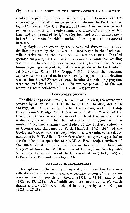
In the fall of 1941, the Nation was faced with the possibility, in the event of war, of being forced to rely chiefly on domestic sources of alumina to supply the unprecedented and ever-increasing require-
Gl
G2 BAUXITE DEPOSITS OF THE SOUTHEASTERN UNITED STATES
ments of expanding industry. Accordingly, the Congress ordered an investigation of all domestic sources of alumina by the U.S. Geo logical Survey and the U.S. Bureau of Mines. Attention was focused primarily on bauxite, the only commercial source of alumina at that time, and by the end of 1941, investigations had begun in most areas in the United States in which bauxite had been produced or reported to occur.
A geologic investigation by the Geological Survey and a test- drilling program by the Bureau of Mines began in the Anderson- ville district during the last week of December 1941. Detailed geologic mapping of the district to provide a guide for drilling started immediately and was completed in September 1942. A pre liminary geologic map of the district was published by the Geologi cal Survey in March 1943 (Zapp, 1943). During the mapping, exploration was carried on in areas already mapped, and the drilling was continued until November 1943. Kesults of the drilling program were reported by Beck (1949). The project personnel of the two federal agencies collaborated in the drilling program.
ACKNOWLEDGMENTS
For different periods during the course of the work, the writer was assisted by M. W. Ellis, H. B. Foxhall, E. P. Kneedler, and P. D. Snavely, Jr. Mr. Snavely directed the drilling north of Camp Creek. Josiah Bridge, W. H. Monroe, and W. C. Warren of the Geological Survey actively supervised much of the work, and the writer is grateful for their helpful advice and suggestions. The results of regional stratigraphic studies of the Tertiary sediments in Georgia and Alabama by F. S. MacNeil (1946, 1947) of the Geological Survey were also very helpful, as were mineralogic deter minations by V. T. Alien. The writer wishes to express appreciation for the splendid cooperation of Mr. W. A. Beck, project engineer of the Bureau of Mines. Chemical data in this report are based on analyses of more than 3,000 samples of kaolin, bauxitic clay, and bauxite by the laboratories of the Bureau of Mines (Beck, 1949) at College Park, Md., and Tuscaloosa, Ala.
PREVIOUS INVESTIGATIONS
Descriptions of the bauxite mines and outcrops of the Anderson- ville district and discussions of the geologic setting of the bauxite were included in reports by Shearer (1917, p. 61-91) and Smith (1929, p. 432-451). Brief additional notes made by R. W. Smith during a later visit were included in a report by A. C. Munyan (1938, p. 37-38).
ANDERSONVILLE DISTRICT, GEORGIA G3
LOCATION AND SIZE OF THE DISTRICT
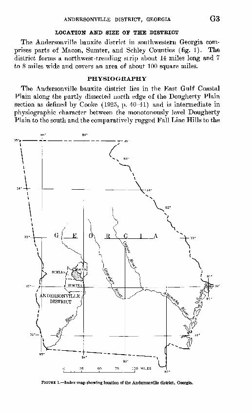
The Andersonville bauxite district in southwestern Georgia com prises parts of Macon, Sumter, and Schley Counties (fig. 1). The district forms a northwest-trending strip about 14 miles long and 7 to 8 miles wide and covers an area of about 100 square miles.
PHYSIO GR APH Y
The Andersonville bauxite district lies in the East Gulf Coasta] Plain along the partly dissected north edge of the Dougherty Plain section as defined by Cooke (1925, p. 40-41) and is intermediate in physiographic character between the monotonously level Dougherty Plain to the south and the comparatively rugged Fall Line Hills to the
FiotfEE 1. Index map showing location of the Andersonville district, Georgia.
G4 BAUXITE DEPOSITS OF THE SOUTHEASTERN UNITED STATES
north. The Andersonville district is characterized by wide, shallow valleys of eastward-flowing tributaries of the Flint River and by rather wide, level divides. Surface altitudes reach a maximum of about 550 feet in the northwestern part of the area and a minimum of about 245 feet along the Flint River at the southeast corner of the district. This tdtal relief of only 300 feet is well distributed, and the crests of the divides are, for the most part, only about 150 feet above the streams. The transverse valley profiles generally show a marked asymmetry, the north slopes being much more gentle. In the southern part of the district, especially in the valley of Sweet- water Creek, there are a number of rather deep, vertical-walled gullies and steep-walled amphitheater-shaped "healed gullies" re sulting from sapping by springs at the base of thick sequences of unconsolidated porous sand.
The valley bottoms are in most places broad, flat, swampy, and thickly wooded. The flat uplands and the more gentle valley slopes are under cultivation.
The climate of the region is warm and humid, and deep weather ing and abundant vegetation therefore prevail. These conditions, in combination with the low relief of the district and the predomi nance in the geologic section of loose sands which tend to spread over slopes, result in a paucity of natural outcrops. The swampy bottoms of the major stream valleys and of most of the smaller branch valleys are virtually devoid of rock exposures.
STRATIGRAPHY
The Andersonville district is underlain by relatively undisturbed sediments of Cretaceous and younger age, that dip gently south and southeast toward the sea. Their extent is shown on the geologic map of the district (pi. 1) and in the section drawn northwest- southeast across it (pi. 2). The district is at the east end of a belt along which continental sediments of the Wilcox Group of early Eocene age contain bauxite-bearing lenses of sedimentary kaolin. This bauxite belt extends southwestward through the Springvale district, Georgia, into the Eufaula district in eastern Alabama. Northeastward along the strike between these districts a progressive overlap by sediments of the Claiborne Group of middle Eocene age covers more and more of the beds of early Tertiary age, and a short distance northeast of the Andersonville district all the earlier beds of Tertiary age are buried under sediments of the Claiborne Group. At one time the overlapping blanket of Claiborne and post-Claiborne sediments completely covered the Andersonville district also, and even now erosion has exposed the underlying bauxite-bearing sedi ments only in the stream valleys. The stratigraphic classification of
ANDERSONVILLE DISTRICT, GEORGIA G5
the post-Wilcox sediments is based on the results of regional strati- graphic studies by MacNeil (1946,1947).
UPPER CRETACEOUS
The oldest formation exposed in the Andersonville district is the Providence Sand of Late Cretaceous age. This formation consists chiefly of light-colored poorly sorted micaceous sand containing irregularly distributed lenses and fragments of kaolin and sandy kaolin. The base of the formation is not exposed within the Ander sonville district, but in the valley of Buck Creek, a short distance northeast of the district, the contact with the underlying dark-gray clay and fine sand of the Ripley Formation crops out. In that area, the thickness of the Providence Sand is approximately 120 feet.
PALEOCENEMIDWAY GROUP
Unconformably overlying the Providence sand in most of the Andersonville district is a series of marine clay and fossiliferous limestone of the Midway Group of Paleocene age. As exposed in bluffs along the Flint Eiver, this unit consists of approximately 45 to 50 feet of dark-gray to black waxy clay and sandy clay and hard cream-colored to gray fossiliferous sandy and argillaceous limestone. The limestone and clay tend to intergrade laterally, but the lower part of the unit is predominantly limy. Locally, there are beds of pale-blue calcareous sand, and a basal brown sand is generally present.
The limestone of the Midway Group has been partly or entirely leached away in much of the Andersonville district, especially along the valley slopes, and limestone is generally absent in outcrops except in bluffs along the Flint Eiver. Most outcrops of the Midway Group within the Andersonville district consist of lustrous light- to dark- gray clay locally containing lumps of powdery to hard white chert. Crumpled sandy green to brown clays, generally containing concre tions and thin beds of limonite, are residual from the solution of the limestone. Where decalcified, the Midway Group is approximately 20 feet thick.
The Midway Group is absent over some of the northwestern part of the Andersonville district and apparently has pinched out against an ancient hill on the surface of the Providence Sand.
EOCENE
WELCOX GROUP
NANAFALIA FORMATION
The Midway Group is unconformably overlain by a series of sands and clays of continental origin that constitute the bauxite-bearing formation of the district. Warren and Clark (1965) show that these
I768-S99 O <65 2
G6 BAUXITE DEPOSITS OF THE SOUTHEASTERN UNITED STATES
bauxite-bearing sediments overlying the Midway Group in the Eufaula district are the updip nonmarine equivalent of fossiliferous marine sediments of the Nanaf alia Formation (lower part of the Wilcox Group) as exposed near Fort Gaines, Ga., on the Chattahoo- chee River.
The Nanafalia Formation in the Andersonville district ranges from 50 to 90 feet in thickness, but over most of the area the thick ness is about 70 feet. Lithologically, sediments of the Nanafalia are similar to those of the Providence Sand, and where the Midway Group is absent, the two units are difficult to separate. The Nana falia Formation consists chiefly of crossbedded fine to coarse mica ceous sand containing large lens! ike masses of sandy and sand-free kaolin. The thicker masses of sand-free kaolin contain lenses of bauxite and bauxitic clay. In the Nanafalia Formation the lithology is highly variable, and lateral changes are abrupt. In some places the formation consists of sandy clays and clayey sands, widely varied in color and texture. Thick masses of angular fine quartz gravel are not uncommon. Two drill holes penetrated a considerable thickness of slightly carbonaceous fine argillaceous sand containing scattered fragmentary plant remains. Black carbonaceous sand and clay containing fragments of lignite have been found at various levels and are especially common at the base of the thickest part of a kaolin mass. Small to large flakes of mica are characteristic of most of the sands.
The Nanafalia Formation was locally cut by channels that were filled with sands and clays similar to the main part of the formation; however, bodies of kaolin in the channel fillings are much thinner and, insofar as known, are devoid of bauxite. The channel fillings locally consist of alternating thin beds of kaolin and sand that con trast with the massive character of most of the Nanafalia Formation. Black carbonaceous sand containing large fragments of white kaolin occurs locally at the base of tjie channel fillings.
The channels in some places probably cut into and through bauxite beds. That seems to have happened along the east edge of the ore body at the Thigpen No. 3 mine (pi. 1) of the American Cyanamid and Chemical Co. and in some of the ore bodies that were found in drilling.
The channel fillings have been assigned to the Nanafalia Forma tion in this report because they are lithologically so much like the rest of the Nanafalia that they could not be differentiated from it except where there were extensive exposures of the two in contact. Nevertheless, the channel fillings constitute a distinct sedimentary unit and may be considerably younger than the rest of the forma tion. No exposures have been observed that establish the relation of
ANDERSONVILLE DISTRICT, GEORGIA G7
channel fillings to the overlying Tuscahoma Formation, but they possibly represent the earliest Tuscahoma deposits.
TUSCAHOMA FORMATION
Over most of the southern part of the Andersonville district, the Nanafalia Formation is overlain by 5 to 20 feet of poorly laminated clay, silt, and fine sand representing a northeastern "featheredge" of the Tuscahoma Formation (middle part of the Wilcox Group), a sedimentary unit that is prominent to the southwest. In the Ander sonville district, the Tuscahoma Formation consists at most places of interlaminated yellow and dark-gray clayey silt or very fine sand with a thin pebbly basal sand. Locally, the unit is almost entirely faintly laminated yellow silt. At Copperas Bluff on the Flint River, about 7 miles east-southeast of Andersonville (pi. 1), the lower part of the formation consists of carbonaceous sand and clay.
The thickness of the Tuscahoma is variable. The greatest thick nesses are present in depressions on the irregular upper surface of the Nanafalia Formation, and the Tuscahoma may pinch out against highs on that surface. It wedges out northward beneath overlapping younger sediments between the valleys of Sweetwater and Camp Creeks, and only a few small remnants occur in the northern part of the district. One of the northernmost exposures is in the McMichael mine, 2!/2 miles north of Andersonville. A "sliver", 2 to 4 feet thick, was observed in the overburden of the western part of this mine.
CLAIBORNE GROUP
The sediments of the Wilcox Group are unconformably overlain by an overlapping white to yellowish sand that is about 100 feet thick in the southeastern part of the district and thins rather uni formly to about 30 feet in the northeastern part. No fossils have been found in this sand within the Andersonville district, but F. S. MacNeil (oral commun., 1942) collected fossils of middle Eocene age (Claiborne age) from a ledge in the unit several miles south of the district. The formation has not been named and will be referred to in this report as the sand unit of the Claiborne Group.
The sand unit is the most conspicuous formation in the Anderson ville district. Where freshly exposed, it consists of well-sorted nearly pure fine to medium quartz sand, white to yellowish in color and commonly crossbedded. In contrast to the heterogeneous sands of the Nanafalia Formation, it contains little mica and a very small percentage of dark minerals. Local concentrations of iron oxide, possibly old ground-water levels in the sand, have produced thin, partially indurated, dark-red-brown layers which contrast sharply with intervening layers of loose white sand. Kaolin in fragments,
G8 BAUXITE DEPOSITS OF THE SOUTHEASTERN UNITED STATES
lentils, and even persistent beds as much as 2 feet thick is common in the lower part of the sand.
Where the sand unit is exposed on slopes and is therefore subject to steady removal by erosion, it supports only a sparse growth of small scrub oaks and scattered pines. On the other hand, where the formation is at the top of the relatively flat divides, the sand is impregnated with iron oxide and argillaceous material to a depth of 10 to 20 feet, and the resulting firm brick-red sand forms some of the richest agricultural land of the area.
JACKSON GROUP
The sand unit of the Claiborne Group is overlain with sharp un dulating contact by about 5 to 15 feet of highly distorted sand and clay. Fresh exposures of this unit show, at the base, 1 to 3 feet of crumpled clayey fine sand usually containing glauconite and carbo naceous seams and partings. This sand is overlain by waxy crumpled yellow to bluish-gray clay resembling the "fullers earth" of the Jackson Group in central Georgia. F. S. MacNeil (oral commun., 1942) concluded from regional stratigraphic studies that this series of sands and clays represents a decalcified continuation of the Ocala Limestone (Jackson Group of late Eocene age) of southwestern and central Georgia. The distorted clayey sand at the base probably represents a residuum from the solution of an unknown thickness of limestone. The distorted structure of the whole unit was presum ably caused by irregular slumping into collapse structures during the leaching of the limestone. In this report the distorted clay and sandy residuum will be referred to as the clay unit of the Jackson Group.
OLIGOCENE
The clay unit of the Jackson Group is overlain by a sandy residuum derived from limestone of Oligocene age. In the Ander- sonville district, this residuum consists chiefly of yellow-brown com pact argillaceous sand, much of which shows strongly developed mottling. Scattered large ragged boulders of fossiliferous chert are characteristic of the formation. These sediments in the district are highly distorted, presumably because of slumping into sinks during the leaching of the limestone of Jackson age.
The contact between the residual materials of the Jackson Group and those of Oligocene age is not well marked, and the two units were mapped together. Together they form the crests of the higher divides and produce a flat to gently rolling topography and a deep- red sandy soil much like that of parts of the outcrop area of the underlying sand unit.
ANDERSONVILLE DISTRICT, GEORGIA G9
QUATERNARY
The Flint River is bordered on the west by a narrow band of river-terrace deposits composed of gravel, sand, and clay. The prin cipal terrace level is at an altitude of about 340 feet or about 90 feet above the river. East from this level below a gentle slope is another terrace level about 40 feet lower. To the west are several small flat areas which probably represent a terrace level about 360 feet above sea level, but these were not mapped.
STRUCTURE
The direction of regional dip in the district is to the southeast; the rate of dip ranges from about 25 feet per mile at the base of the Tertiary to slightly less than 15 feet per mile at the base of the clay unit of the Jackson Group. Northeastward thinning of the inter vening formations, particularly the sand unit of the Claiborne Group, accounts for the divergence in rate of dip.
An east-trending fault having a maximum vertical displacement of 100 feet is present in the eastern part of the district in the latitude of Sweetwater Creek. The block north of the fault is downthrown in relation to the block to the south. A short distance west of the town of Andersonville, the fault passes into a steep north-facing monocline that dies out to the west. To the east, the fault has been traced to about 5 miles east of the Flint River, where the vertical displacement decreases to about 60 feet. Whether the fault is of the reverse or normal type is not known, for the fault plane is nowhere observable.
Local structural irregularities have resulted from underground solution of limestone in the Midway Group and consequent irregular slumping of the overlying sediments. The maximum possible dis placement from this cause in the Andersonville district, however, is only about 25 feet. Shallow circular depressions from 500 to 1,500 feet in diameter in the present land surface indicate that leaching of the limestone is still going on.
BAUXITE AND KAOLIN DEPOSITS
OCCURRENCE, SIZE, AND DISTRIBUTION
The Nanafalia Formation contains many tabular lenticular masses of sedimentary kaolin, some of them having cores of bauxite or bauxitic clay. The kaolin bodies reach a maximum known thickness of slightly more than 50 feet, and some are several hundred acres in extent. The largest deposits generally consist of two or more thick masses connected by thick, narrow necks or thin sheets of kaolin. The kaolin masses grade downward, laterally, and some
G10 BAUXITE DEPOSITS OF THE SOUTHEASTERN UNITED STATES
grade upward into sandy kaolin, which in turn grades into sand. Lenses of sand or sandy kaolin rarely occur within the sand-free kaolin masses.
Most of the sand-free kaolin masses that are more than 30 feet thick have cores of bauxitic clay or bauxite. The bauxite forms thin, tabular bodies which reflect the shape of the kaolin containing them; that is, the bauxite is thickest (and of highest grade) where the kaolin is thickest and tends to thin or pinch out where the kaolin thins. A good example of this is the deposit found by drilling 2% miles north-northwest of Andersonville (pi. 1), a part of which is illustrated in plate 3. Thus a kaolin body that varies considerably in thickness is likely to contain bauxite only in the thickest parts, with the result that the bauxite forms several iso lated masses that may range in size from small pockets up to tabular masses more than 10 acres in areal extent.
Except where erosion has cut to the bauxite, the bauxite grades in all directions into bauxitic clay, which in turn grades into kaolin. In other words, there is normally a rather uniform decrease in con tent of alumina away from a central maximum. Most of the bauxite ranges from a few inches to 8 feet in thickness, but bauxite 25 feet thick was found in one deposit. The combined thickness of bauxite and bauxitic clay exceeds 20 feet in parts of several deposits but is commonly about 10 feet.
The thickness of kaolin above bauxite generally exceeds that below bauxite, but the converse is not uncommon. The maximum cover of kaolin penetrated in drilling is 34 feet, and the average is about 20 feet. At most places 5 to 20 feet of kaolin underlies the bauxite. No physical or chemical differences were apparent between the kaolins above and below bauxite.
In summary, a vertical core through a typical deposit in the Andersonville district might show the following sequence from top to bottom: 10 feet or more of kaolin, perhaps sandy toward the top; 10 feet of bauxitic material consisting of a few feet of increasingly bauxitic clay, about 4 or 5 feet of bauxite, and several feet of de- creasingly bauxitic clay; and 10 feet or more of kaolin grading downward into sandy kaolin.
Probably 90 percent or more of the bauxite in the Andersonville district occurs within a southeast-trending strip approximately 2!/2 miles wide and extending from the Englishville-Oglethorpe road to about 1 mile southeast of the Hatton mine. This area embraces the McMichael, Easterlin, Thigpen, and Hatton mines and the large deposits found by drilling south of the Easterlin mine, along the south slope of the Sweetwater Creek valley, and along the north
ANDERSONVILLE DISTRICT, GEORGIA Gil
slope of the Boggy Branch valley. Within this area, kaolin and bauxite are abundant, and the deposits tend to be of wide areal extent. This part of the Andersonville district will be referred to as the "area of blanket deposits." In the remainder of the district, the known kaolin deposits are much smaller, and the bauxite bodies consequently have little areal extent.
The greatest known thickness of bauxite in the Andersonville district is 25 feet; the greatest known thickness of kaolin is a little more than 50 feet. Greater thicknesses may be discovered. The thickness of bauxite increases as the thickness of the enveloping mass of kaolin; hence, the only known limit to the possible thickness of bauxite is taken as a function of the maximum thickness of kaolin. The only known limit to the thickness of kaolin is the thickness of the Nanafalia Formation, which is about 70 feet over most of the area. Kaolin has been observed within a few feet of the base of the formation, and there is no known reason why a kaolin deposit with a bauxite core may not occupy the entire interval of the Nanafalia in some part of the area. Such kaolin would be likely to contain a body of bauxite much thicker than any yet known. This possibility may justify eventual exploration of more deeply buried parts of the Nanafalia Formation than would otherwise be warranted.
The Andersonville bauxite district as defined in this report is limited to the area of the accompanying geologic map (pi. 1), which includes the area believed most favorable for prospecting. North westward from the area of the map, the bauxite-bearing formation has been eroded away. Southwest and northeast of the northern part of the district, the Nanafalia Formation thins rapidly to an average thickness between 20 and 30 feet and contains little or no bauxite. Southwest, southeast, and east from the southern part of the Andersonville district, the limits of the area which may be un derlain by large bauxite deposits have not been determined by drill ing and cannot be determined by surface study. Down the dip, the continental sediments of the Nanafalia Formation, as in the Eufaula bauxite district, Alabama, undoubtedly grade into marine beds devoid of bauxite. This gradation, however, may not occur for some distance south of the margin of the Andersonville district, and bauxite under very heavy overburden may be present as far as the nonmarine facies extends. Bauxite deposits may also be present over a considerable area east of the Flint River, but they would be under excessive overburden except in a small area in the lower valley of Hogcrawl Creek, which lies east of the district, opposite the mouth of Sweetwater Creek.
G12 BAUXITE DEPOSITS OF THE SOUTHEASTERN UNITED STATES
PHYSICAL CHARACTER AND MINERALOGY KAOLIN
Typical kaolin in the Andersonville bauxite district is fine-grained massive plastic clay. Kaolin that has not been affected by oxidation is light gray, almost white to bluish gray. The edges of the kaolin masses are generally oxidized to cream or light-tan colors and may be brightly stained by oxides to violet, yellow-brown, or pink to red colors.
Most of the kaolin is massive, but soft pisolitic structures are locally present, especially in kaolin which grades laterally into pisolitic bauxite (pi. 3). Most core samples of kaolin from a wide zone completely surrounding bauxite bodies show, at a certain stage of wetness, a well-formed intricate interveining of two types of clay differing slightly in color and plasticity. In many samples one of the clays seems to be minutely brecciated fragments in a matrix of the other type. In preparing logs of the cores, the terms "marbling" and "pseudobrecciation" were used to indicate such structures that are strikingly well defined where there is only a small amount of water present. Where the kaolin is very wet or very dry, it appears structureless. As clays showing these features are generally peri pheral to bauxite bodies, they constitute a favorable sign where found in prospecting.
Nonplastic, hard kaolin resembling bauxite or the "chimney rock" of the Irwinton bauxite district, Georgia, is adjacent to bauxite bodies in a few deposits. Such material occurs at the Ideal mine, 6 miles northwest of Andersonville, and was found in coring the deposit 3% miles N. 60° E. of Andersonville (p. G33) where the hard kaolin some of it containing hard pisolites so closely re sembled the associated bauxite that chemical analysis was necessary for identification. The hard kaolin occurs as a shell almost com pletely surrounding the bauxite deposit and is itself surrounded by a shell of nonsandy plastic kaolin. The plastic kaolin is abnormally thin in this deposit. The kaolin occurs rarely as dense hard trans lucent gray particles within bauxitic material elsewhere in the An dersonville district.
The kaolin consists almost entirely of the mineral kaolinite (Al2 O3*2SiO2 *2H2O). The chief impurities are compounds of iron and titanium, usually totaling less than 3 percent. In unoxidized parts of the deposits, the iron is generally present as pyrite or mar- casite and occurs in small nodules, thin irregular veins, and dissemi nated tiny flecks. This occurrence imparts the typical gray color to the kaolin. In the peripheral parts of the kaolin masses, the iron occurs as iron oxide. Siderite in the form of oolites is locally abundant in thin tabular zones in the kaolin. A small percentage of
ANDERSONVILLE DISTRICT, GEORGIA G13
titanium is invariably present. Chemical analyses of most of the sand-free kaolin samples indicate that a small amount of gibbsite (A1 2O3*3H2 O) is present; that is, when the percentages of iron oxide and titania are subtracted from the total of the analysis and the percentages of the remaining constituents A12O3 , SiO2 , and com bined water are recalculated to 100 percent, the result often shows a percentage of A12O3 slightly greater than that of pure kaolinite.
BAUXITE
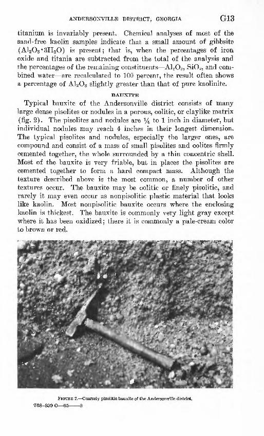
Typical bauxite of the Andersonville district consists of many large dense pisolites or nodules in a porous, oolitic, or claylike matrix (fig. 2). The pisolites and nodules are i/4 to 1 inch in diameter, but individual nodules may reach 4 inches in their longest dimension. The typical pisolites and nodules, especially the larger ones, are compound and consist of a mass of small pisolites and oolites firmly cemented together, the whole surrounded by a thin concentric shell. Most of the bauxite is very friable, but in places the pisolites are cemented together to form a hard compact mass. Although the texture described above is the most common, a number of other textures occur. The bauxite may be oolitic or finely pisolitic, and rarely it may even occur as nonpisolitic plastic material that looks like kaolin. Most nonpisolitic bauxite occurs where the enclosing kaolin is thickest. The bauxite is commonly very light gray except where it has been oxidized; there it is commonly a pale-cream color to brown or red.
FIGURE 2. Coarsely pisolitic bauxite of the Andersonville district.768-889i
G14 BAUXITE DEPOSITS OF THE SOUTHEASTERN UNITED STATES
Bauxitic clay, likewise, may be nonpisolitic or may consist of scattered hard pisolites of bauxite in a matrix of only slightly bauxitic clay.
The bauxite is a mixture of the minerals gibbsite (A12O3 '3H2O) and kaolinite (Al2O3*2SiO2*2H2O). The term "bauxite" as used in this report refers to material in which the percentage of gibbsite exceeds that of kaolinite. The two minerals are not distinguishable megascopically, but their relative abundance can be ascertained from chemical or differential thermal analyses.
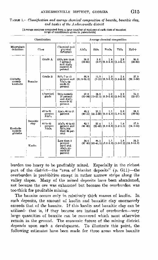
Impurities in the bauxite are the same as in the kaolin, and in most places total between 3 and 4 percent. Bauxite has a higher content of titanium than kaolin has, and there seems to be a sys tematic increase in titanium with increasing content of aluminum. The titanium content of samples of kaolin or of bauxite of given grade differs considerably; however, when a large number of analy ses are averaged, the titania-alumina ratio remains almost constant for the entire range from kaolin to bauxite (table 1).
CLASSIFICATION OF BAUXITE, BAUXITIC CLAY, AND KAOLIN
The principal use of bauxite is for the production of metallic aluminum, and bauxite mined for this purpose is treated by the Bayer process to extract alumina. Consequently, classifications of ore based on suitability as feed for the Bayer process have evolved. Such classifications are not satisfactory for the deposits of the Andersonville district, where only very little bauxite has a suffi ciently low content of silica to be suitable for treatment by the process. However, other features of the Andersonville deposits, notably their uniformly low content of iron compounds, make them ideally suited for the manufacture of chemicals. The classification shown in table 1, which is designed to show the nature of the reserves of aluminous materials, is intended to apply only to the deposits of the Andersonville district; it presupposes a low content of iron.
Under this classification, bauxite of grade A is suitable for feed in straight Bayer process plants, and bauxite of grade B would be usable in the modified Bayer plants. Bauxite here classified as chemical grade could also be used by blending with bauxite contain ing less silica.
ECONOMIC IMPLICATIONS OF THE GEOLOGIC OCCURRENCE OFBAUXITE
At the time of the field work in 1943, the Andersonville bauxite district probably contained almost 6 million long tons of bauxite, but probably more than 90 percent of this total was under over-
ANDERSONVILLE DISTRICT, GEORGIA G15
TABLE 1. Classification and average chemical composition of bauxite, bauxitic clay, and kaolin of the Andersonville district
[Average analyses computed from a large number of analyses of each class of samples; range of constituents given in parenthesis]
Classification
Mineralogic definition
Gibbsite exceeds kaolinite
Kaolinite exceeds gibbsite
Class
Bauxite
Bauxitic clay
Kaolin
Grade A
Grade B
Chemical grade
45 to 51 percent A120 3
40 to 45 percent Ali03
Chemical and physical definition
SiOj less than 7 percent and AljOj exceeds 51 percent
SiO z 7tol5 percent and A12O 3 ex ceeds 51 percent
SiO 2 exceeds 15 percent and AhO 3 exceeds 51 percent
AljOs 45 to 51 percent
Al 2O 3 40to45 percent and SiOj less than 43 per cent
Less than 2 percent sand and AhOs ex ceeds 37 percent
Average chemical composition
AlsOj
59.6 (56-61)
56.8 (52. 5-59. 5)
52.9 (51-54)
48.2 (45-51)
42.7 (40-45)
38.6 (37-40)
Si0 2
5.6 (3-7)
11.9 (7-15)
18.9 (15-22. 5)
27.1 (22. 5-33)
37.4 (32-43)
44.5 (42-45, 5)
FezOs
1.4 (0. 5-3. 0)
1.0 (0. 3-3. 0)
1.0 (0. 3-3. 0)
1.1 (0. 5-3. 0)
1.1 (0. 5-3. 0)
1.1 (0. 5-3. 0)
TiOj
2.8 (2. 5-3. 5)
2.4 (1. 8-3. 0)
2.2 (1. 6-2. 9)
2.0 (1. 4-2. 6)
1.8 (1. 2-2. 5)
1.6 (1. 0-2. 2)
HZ0+
30.6 (30-32)
27.9 (26. 5-30)
25.0 (22-27)
21.6 (18-23)
17.0 (14. 5-19)
14.2 (13. 5-15. 0)
burden too heavy to be profitably mined. Especially in the richest part of the district the "area of blanket deposits" (p. Gil) the overburden is prohibitive except in rather narrow strips along the valley slopes. Many of the mined deposits have been abandoned, not because the ore was exhausted but because the overburden was too thick for profitable mining.
The bauxite occurs only in relatively thick masses of kaolin. In such deposits, the amount of kaolin and bauxitic clay enormously exceeds that of the bauxite. If this kaolin and bauxitic clay can be utilized that is, if they become ore instead of overburden very large quantities of bauxite can be recovered which must otherwise remain in the ground. The economic future of the mining district depends upon such a development. To illustrate this point, the following estimates have been made for three areas where bauxite
G16 BAUXITE DEPOSITS OF THE SOUTHEASTERN UNITED STATES
bodies have been delimited by drilling and chemical analyses have been made of the cores:
Area (sq ft)
170, 000.. ____________400, 000.. ___________570, 000... __________
Bauxite (all grades)
Bauxitic clay
45-51 percent
A1203
40-45 percent A1.0 3
Kaolin
Thousands of long tons
27 109 91
56 3177
62 115 91
132 655478
Overburden above
Bauxite Kaolin
Thousands of cubic yards
265 850
1,075
133 530700
Totals for all the bauxite-bearing kaolin deposits explored by drilling indicate that for every 100 tons of bauxite there are 164 tons of bauxitic clay containing 45 to 51 percent alumina, 273 tons of bauxitic clay containing 40 to 45 percent alumina, and 1,640 tons of kaolin. Furthermore, there are large deposits of nonbauxitic kaolin and kaolin containing only bauxitic clay.
Much research has been done on processes for the extraction of alumina from high-alumina clay. The deposits of the Andersonville district seem to be ideally suited for such use. The many other possible uses for kaolin and bauxitic clay should be investigated.
HISTORY OF MINING IN THE DISTRICT
The first discovery of bauxite in the district was made in 1912 at the site of the Hatton (Old Sweetwater) mine south of Sweetwater Creek, 4 miles east-southeast of Andersonville (pi. 1). Mining was begun by the Republic Mining and Manufacturing Co. (now Alumi num Co. of America) in 1914. Before the end of World War I, the Easterlin, McMichael (Boggy Branch), and English mines had been opened. The Easterlin mine was operated by B. F. Easterlin, who owned the property, and the McMichael mine was operated by the Kalbfleisch Corp. Production dropped off after the war, but a small tonnage continued to be produced annually, principally from the Hatton and McMichael pits. The McMichael mine was worked for about 10 years before it was abandoned because of excessive overburden. In 1930, the Hatton property was purchased by the American Cyanamid and Chemical Co. At that time the overburden in parts of the mining face was more than 50 feet thick; so, opencut mining was abandoned, and entries were driven back from the face of the ore in the opencut. Caving of the roof complicated the operation and resulted in poor recovery, but a considerable tonnage was produced for about 7 years from the underground mine. The
ANDERSONVILLE DISTRICT, GEORGIA G17
caving of the roof finally forced abandonment of the operation although the ore body had not been exhausted.
All other mining in the district has been by open-pit methods. The mined ore consists chiefly of bauxite of A and B grades, al though some associated ore of chemical grade is usually mined along with the higher grades. Overlying kaolin and bauxitic clay are treated as overburden and are stripped and dumped with the over lying sand. Scrapers and a dragline are used to remove overburden, and the ore is mined by power shovel. In the past the ore was generally trucked to a drying plant at Andersonville. It is esti mated that a total of about 400,000 tons of bauxite has been mined in the district.
In 1941, the American Cyanamid and Chemical Co. began mining from the Thigpen property a short distance west of the Hatton mine. Outcrops of the Thigpen deposits had been known since 1912. For some years after these large deposits were opened, virtually the entire production of the Andersonville district was from them. At the close of 1943, the Thigpen No. 1 and Thigpen No. 4 mines were still active, and stripping of a deposit about 1,500 feet northwest of the Thigpen No. 1 mine was under way.
During the period 1944-49 mining continued on the Thigpen prop erty, and strip mining was resumed at the old Hatton (Old Sweet- water) mine. In 1949 mining ceased in the district, and the drying plant at Andersonville was removed. In November 1951, mining was resumed in the district at the old McMichael mine. In June 1952 the mining face showed 9 feet of bauxite, and 45 to 50 feet of overburden had been stripped. The ore was being shipped wet. The American Cyanamid and Chemical Co. has been the only producer in the district for many years.
The only known commercial production of kaolin in the district up to the time of the fieldwork in 1942 was from a 20-foot bed of kaolin that underlay the bauxite at the English mine, 2^2 miles north of Andersonville. This operation, conducted by the American Pelinite Co., was reported by Smith (1929, p. 445-446).
EXPLORATORY DRILLING
During the geologic investigation, a cooperative exploratory drilling program was conducted by the Geological Survey and the Bureau of Mines to increase the known reserves of bauxite in the district. Drilling began late in December 1941, was continued with various interrup tions until the middle of July 1942, was resumed in December 1942, and was continued until the middle of November 1943. More than 1,100 holes were drilled, of which more than 600 were widely spaced wildcat holes and the others were more closely spaced holes to
G18 BAUXITE DEPOSITS OF THE SOUTHEASTERN UNITED STATES
explore deposits located by the wildcat drilling. The deepest test hole was 125 feet deep; the average depth was about 70 feet.
The drilling was done by contractors for the Bureau of Mines. Much of the wildcat drilling and all of the drilling to delimit ore bodies was done with a core drill (Sullivan "37"). In the wildcat drilling with this rig, all kaolin bodies were cored. As recovery of bauxite by rotary coring was very unsatisfactory, the rig was adapted for drive sampling for further exploration of discovered ore bodies. The wildcat drilling along the south slope of the Camp Creek Valley northwest of Georgia Highway 49 and on the divide between Camp and Buck Creeks was done with a power auger which provided a relatively inexpensive and fast means of exploration; however, the samples obtained were contaminated, and some holes could not be completed with this equipment because the power auger could not penetrate indurated ledges.
The first 68 test holes were closely spaced in an area immediately south of the Easterlin mine, 2*4 miles east-southeast of Anderson- ville. A deposit of bauxite and bauxitic clay was partly outlined in this area. Thereafter, a wildcat drilling program was begun. The program consisted of drilling widely separated holes to locate the bauxite bodies, which were then sampled and roughly delimited by drilling on 200-foot centers. The Geological Survey cooperated in this program and undertook the selection of areas to be drilled, the selection and mapping of individual wildcat drill sites, the determination of collar elevations at the drill sites, the assignment of drilling depths, and the preparation of descriptive logs from the sludge and cores obtained in the drilling.
The selection of the drill sites was controlled by a number of factors. The object was, of course, to explore as much of the favorable area as possible with the available funds. It was apparent from preliminary examination that the bulk of the district's reserves of bauxite occurred within a relatively narrow strip that included the McMichael mine, 2y2 miles north of Andersonville, and the mines along the south side of the valley of Sweetwater Creek. At first, drilling was accordingly concentrated in this area. As the object was to find deposits under light to moderate overburden, drilling was confined to narrow strips along the valleys of Sweetwater Creek, Triple Creek, Boggy Branch, and the south slope of the Camp Creek Valley east of the Camp Creek-Triple Creek confluence. Where other controlling factors permitted, drill sites were selected that were not more than 70 feet above the bauxite horizon. In general, the wildcat holes were spaced approximately 1,000 feet apart. Though this interval was too great to allow complete exploration,
ANDERSONVILLE DISTRICT, GEORGIA G19
it was considered the best for finding the larger blanket deposits with the least drilling. In order that the drill hole might have full exploratory value, drill sites were selected at least 1,000 feet from barren outcrops of the Nanafalia Formation unless there was evi dence that the overburden at that distance from the outcrop was excessive. To keep the holes as shallow as possible, drill sites were selected at topographically low points wherever it was possible to do so without greatly disturbing the uniform spacing. Lastly, accessibility for the drilling equipment had to be taken into con sideration in the selection of every drill site.
Of the 186 wildcat holes drilled in the valleys of Sweetwater Creek, Triple Creek, and Boggy Branch and in that part of the valley of Camp Creek that lies east of the mouth of Triple Creek, 22 holes penetrated bauxite or bauxitic clay. The ore bodies 3y2 to 4 miles east of Andersonville, 2% miles north-northwest of Anderson- ville, and 3!/o miles N. 60° E. of Andersonville (pi. 1) were explored by drive sampling on 200-foot intervals.
Upon the acquisition of a power auger, which provided a fast and inexpensive method exploration, the search for bauxite was ex tended into the upper valley of Camp Creek and northward from there. Although surface investigation had shown that bauxite in this area was more likely to occur in small scattered bodies, it was hoped that buried blanket deposits comparable to those in the Sweet- water Creek-Boggy Branch area would be found. Wildcat holes were drilled at intervals of 500 to 1,000 feet. Here, much more than in the area previously drilled, the spacing was too wide to explore the area adequately for bauxite, but it was possible that major buried kaolin deposits that might underlie the area could thus be found. Holes could then be put down at shorter intervals in order to find the bauxite that the kaolin possibly contained. In a 3-month period in the summer of 1943, about 400 holes were drilled in this area with the power-auger drill, but no bauxite was found. However, kaolin bodies that had been so located along the south slope of Camp Creek were further explored by drive sampling at intervals of approxi mately 400 feet, the interval being decreased to 200 feet where bauxitic material was found. In this manner, the deposits 3% miles N. 20° W. of Andersonville and 4 miles northwest of Andersonville were found (pi. 1).
The final phase of the drilling program consisted of offset ex ploration in the vicinity of early drill holes that had penetrated bauxitic clay or thick kaolin bodies. This phase of the program had not been completed when the available funds were exhausted.
Little bauxite that could be profitably mined at that time was discovered in the drilling; however, had the Nation been cut off
G20 BAUXITE DEPOSITS OF THE SOUTHEASTERN UNITED STATES
from foreign sources of bauxite for a number of years during the war, as was feared, these deeply buried deposits would have been of immediate importance. Thus, the "emergency reserves" of bauxite in the district were appreciably increased by the exploration. Prob ably of greater long-range importance are the facts that the drilling has provided both a good basis for estimating the ultimate reserves of the district and a three-dimensional picture of the occurrence of the bauxite a picture which clearly shows that the economic de velopment of the district depends upon the extent to which the kaolin and bauxitic clay associated with the bauxite can be used.
Eesults of the drilling program and chemical analyses of core samples have been published (Beck, 1949), as well as preliminary reports on the geology (Zapp, 1943,1948).
ESTIMATE OF RESERVES
Estimates of the reserves of bauxite, bauxitic clay, and sand-free kaolin in the Andersonville district are given in table 2. The esti mates were arrived at by extrapolating the results of drilling and surface study into unexplored parts of the district. The estimated tonnages are divided into two parts: that in which the overburden over kaolin is 50 feet or less and that in which this overburden exceeds 50 feet but is no greater than 150 feet. The bauxite deposits in the first category are generally under a total overburden of not more than 70 feet.
The estimates of the tonnages of kaolin in the preceding table are for kaolin in beds not less than 10 feet thick. A very large addi tional tonnage that was not considered in preparing the estimates is represented by deposits of kaolin less than 10 feet thick and deposits of kaolin containing more than 2 percent grit (sand).
All three grades of bauxite (A, B, and chemical) were lumped to gether in table 2. Eesults of the drilling indicated that the bauxite contained the following average amounts of the different grades: Grade A, 5 percent; grade B, 45 percent; chemical grade, 50 percent.
The bulk of the reserves of the district reportedly lies in the so- called area of blanket deposits, an area of about 17 square miles embracing the deposits in the valley of Boggy Branch and the lower Sweetwater Creek valley. This small area is estimated to contain about 90 percent of the bauxite and bauxitic clay and 67 percent of the kaolin in the district. The Nanafalia Formation, however, is deeply buried in a greater proportion of this area than in the re mainder of the district; consequently, of the total tonnages under less than 50 feet of overburden, only about 75 percent of the bauxite and bauxitic clay and only 45 percent of the kaolin are estimated to lie within the area of blanket deposits.
TA
BL
E 2.
Est
imat
e of
res
erve
s in
tho
usan
ds o
f lo
ng t
ons
of b
auxi
te,
baux
itic
cla
y, a
nd
kao
lin,
And
erso
nvil
le d
istr
ict,
194
3
Indic
ated
2__
Infe
rred
3.
_ __
_
Tota
ls.
__ _
_
Ove
rbur
den
over
kao
lin 5
0 ft
or
less
Bau
xite
(a
ll gr
ades
)
700
220
320
1,2
40
Bau
xiti
c cl
ay
45-5
1 pe
r
cent
AbO
3
1, 1
00
350
610
2,0
60
40-4
5 pe
r
cent
AhO
s
2, 2
50
630
1,0
50
3,9
30
Kao
lin
18,
000
30,
000
35,
000
83,
000
Ove
rbur
den
over
kao
lin e
xcee
ds 5
0 ft
Bau
xite
(a
ll gr
ades
)
250
260
4, 1
50
4,6
60
Bau
xitic
cla
y
45-5
1 pe
r
cent
AbO
s
420
410
5, 2
00
6,0
30
40-4
5 pe
r
cent
AbO
s
640
760
10
,50
0
11
,90
0
Kao
lin
3,5
00
14,
000
145,
000
162,
500
Tot
al
Bau
xite
(a
ll gr
ades
)
950
480
4,4
70
5,9
00
Bau
xiti
c cl
ay
45-5
1 pe
r
cent
AbO
s
1,5
20
760
5,8
10
8,0
90
40-4
5 pe
r
cent
AbO
s
2,8
90
1,3
90
11,5
50
15,
830
Kao
lin
21,
500
44,
000
180,
000
245,
500
1 In
depo
sits
exp
lore
d by
dri
lling
at
inte
rval
s no
t ex
ceed
ing
400
ft a
nd i
n ar
eas
imm
edia
tely
adj
acen
t to
min
es a
nd o
utcr
ops.
2 In
depo
sits
fou
nd i
n w
idel
y sp
aced
dri
ll h
oles
but
not
exp
lore
d fu
rthe
r.3 I
nfer
red
depo
sits
in u
nexp
lore
d ar
eas.
Q
to
G22 BAUXITE DEPOSITS OF THE SOUTHEASTERN UNITED STATES
NOTES ON INDIVIDUAL DEPOSITS
Most of the mines and outcrops of bauxite in the Andersonville district have been described in reports by Shearer (1917, p. 66-91) and Smith (1929, p. 432-451). The mines and outcrops of bauxite are indicated on the geologic map (pi. 1) and are described briefly in the following pages as they were in 1942, unless a more recent date, is given. Brief notes supplementary to the information in the previously mentioned reports are given where they seemed war ranted. The mines and outcrops were visited by the writer but were studied only for what light they might shed on the regional prob lems. No detailed sampling was done, and no attempt was made to determine the exact areal extent of the deposits. When visited by the writer, most of the old prospect pits were filled with debris, and the bauxite beds in most of the abandoned mines had been obscured by caving along the faces of the mines.
The deposits found in drilling during this investigation are shown by symbol on plate 1, and the more important deposits are briefly described on p. G27-G34. Lithologic logs of all drill holes, chemical analyses of the samples, and larger scale maps showing the location of the drill holes were reported by Zapp (1948) and, except for the logs of the holes, by Beck (1949).
MINESHATTON (OLD SWEETWATER) MINE
The Hatton (Old Sweet water) mine is about 4 miles east-southeast of Andersonville. When it was visited in 1943, slumping along the face of the open-pit part of the mine had concealed the bauxite bed and closed the entrance to the underground part of the mine. From 8 to 20 feet of kaolin, of which approximately the upper 4 feet is sandy in places, could be seen in the overburden. The kaolin is locally overlain by sand of the Nanafalia Formation, and the sand or kaolin of the Nanafalia Formation is overlain by 8 to 17 feet of thin-bedded sand and clay of the Tuscahoma Formation. In the upper part of the cut, about 20 feet of sand, representing the basal part of the sand unit of the Claiborne Group, was exposed. The mine was 60 feet deep in places, and the land surface continues to rise to the southeast. The crest of the hill, about three quarters of a mile back of the present cut, is about 100 feet above the level of the bauxite and probably 80 feet above the top of the kaolin. After the investigation was concluded, strip mining of the bauxite was resumed and continued intermittently until 1949.
THIOPEN MINES
The Thigpen mines are about 8^2 miles east-southeast of Ander sonville. The configuration of the mines in March 1948 is shown on
ANDERSONVILLE DISTRICT, GEORGIA G23
plate 1. Stripping of the No. 5 pit, about 1,500 feet northwest of the No. 1 pit, was begun late in 1943. The mines are developed around the edges of a broad ridge trending slightly east of north. In the area between the mines the ridge rises gradually to a crest which is about 70 feet above the level of the bauxite and probably about 50 feet above the top of the kaolin. The pits are worked back into the ridge until the ore becomes too thin, too low in grade, or too deeply buried for profitable production. In December 1943, the No. 1 and No. 4 pits were still active, and as much as 40 feet of overburden was being removed. Mining continued until 1949.
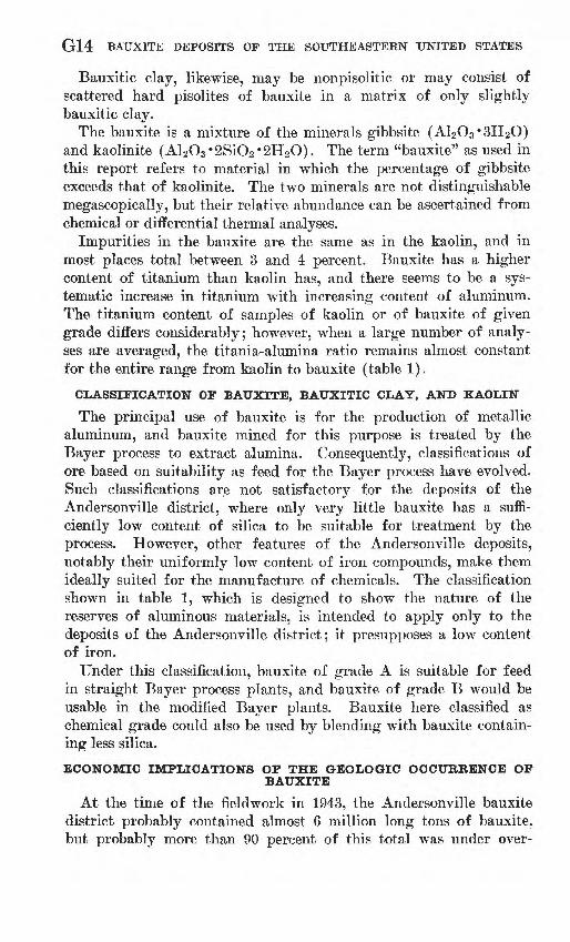
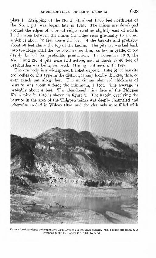
The ore body is a widespread blanket deposit. Like other bauxite ore bodies of this type in the district, it may locally thicken, thin, or even pinch out altogether. The maximum observed thickness of bauxite was about 6 feet; the minimum, 1 foot. The average is probably about 4 feet. The abandoned mine face of the Thigpen No. 3 mine in 1943 is shown in figure 3. The kaolin overlying the bauxite in the area of the Thigpen mines was deeply channeled and otherwise eroded in Wilcox time, and the channels were filled with
FIGURE 3. Abandoned mine face showing a 4-foot bed of low-grade bauxite. The bauxite (B) grades into overlying kaolin (K), which is overlain by sand.
G24 BAUXITE DEPOSITS OF THE SOUTHEASTERN UNITED STATES
clays and fine to coarse sands. For this reason, the kaolin and bauxitic clay over the bauxite is very thin in places. The mine faces in December 1943 showed from 8 to 22 feet of kaolin and bauxitic clay over the bauxite. The kaolin was thickest in the No. 4 mine.
EASTERLIN MINE
The Easterlin mine is about 21/4 miles east-southeast of Anderson- ville. This small pit has not been worked for a number of years and remains virtually as described by Smith (1929).
McMICHAEL (BOGGY BRANCH) MINE
The McMichael mine (Boggy Branch mine) is about 2^ miles north of Andersonville. When mapped in 1942, the mine had been abandoned for many years, and slumping along the face had ob scured the bauxite and much of the overlying kaolin. The deposit was worked back into a rather steep valley slope until the over burden became excessive. The mine consists of two main pits separated by a narrow ridge apparently underlain by bauxitic clay. Strip mining was resumed in 1951 by the American Cyanamid and Chemical Co., and in June 1951, the mine face showed 9 feet of bauxite.
ENGLISH MINE
The English mine is directly across Boggy Branch from the McMichael mine. The mine consists of one very small pit from which a small pocket of bauxite and some of the underlying kaolin were mined about 25 years ago. The pit is now filled with water.
IDEAL MINE
The Ideal mine, 5~y2 miles northwest of Andersonville, consists of two small pits on the south valley slope of a small tributary of Camp Creek. The pits are 100 feet apart, and prospect pits in the area between them show only sand. The pit to the southeast is the smaller and shows a face of 8 to 10 feet of brittle oolitic or struc tureless bauxitic clay, locally pisolitic near the top. This clay is overlain by 4 feet or more of kaolin and about 6 feet of red sand. The pit to the northwest is 150 feet long and has a maximum width of about 60 feet. The face shows 12 feet of bauxitic material, the upper 4 feet of which is pisolitic and, although cut by several seams of kaolin, probably represents the best bauxite. According to the property owner, William Hite, Putnam, Ga., an additional 15 feet of bauxitic material underlies the floor of the pit.
Northwest from the larger pit, prospect holes and trenches show bauxitic clay and bauxite for a distance of 175 feet. In the walls of the northwesternmost prospect trench are brittle cream-colored pisolites which contain slightly more than 60 percent alumina.
ANDERSONVILLE DISTRICT, GEORGIA G25
These pisolites are embedded in a matrix of dense, hard, light-gray substance which looks much like chalcedony but which chemical analysis proved to be a very slightly bauxitic kaolin. Scattered particles of this dense kaolin are present in the bauxitic material of both the mining pits. The principal extension of the ore body is probably west and northwest from the larger pit.
OUTCROPS
HODGES PROPERTY
On Hodges property, li/4 miles south-southwest of Andersonville, on the slope south of the valley of Viney Branch and about 100 feet east of Georgia Highway 49, bauxitic clay and pisolitic bauxite are exposed in a cluster of small pits. These outcrops are shown by a single symbol on plate 1. According to the owner the area behind the pits has been thoroughly prospected and the bauxite was not found to extend under the hill; however, a small but thick deposit of kaolin under light overburden is present.
The north end of a highway cut just west of these pits shows kaolin, some of it nodular and possibly bauxitic, grading southward into kaolinitic sand. The property west of the highway has not been prospected.
FORMER W. H. CHILJJERS PROPERTY
On the former W. H. Childers property 41/2 miles N. 70° W. of Andersonville, about a foot of cream-colored oolitic bauxitic clay is exposed in the north ditch of a dirt road about 750 feet east of the bridge across Toteover Creek. A short distance north of the road is a prospect pit, filled with water but showing kaolin at the top. Drill holes upslope to the northeast penetrated only sand and showed that the deposit is of small extent. Whatever deposit there may be is under light overburden.
FORMER G. W. HOLLOWAY PROPERTY
On the former G. W. Holloway property, 5y2 miles west-northwest of Andersonville, hard yellow-brown ferruginous bauxite is exposed at one place on a gentle slope just east of a small tributary of Camp Creek. At several other places along the lower slopes on both sides of the ridge between Camp Creek and Toteover Creek are scattered bauxite pisolites, but a large number of drill holes on the upper slopes and top of the ridge failed to find any bauxite. Closely spaced drilling of the area in which the surface altitude is between 400 and 430 feet, however, might find considerable kaolin and some bauxite under light overburden.
G26 BAUXITE DEPOSITS OF THE SOUTHEASTERN UNITED STATES
OLD ADAM JONES PLACE
At the old Adam Jones place, 61/4 miles N. 55° W. of Anderson- ville, bauxite crops out at one place. Several shallow prospect pits were dug within about 200 feet along the base of the west slope of the valley of a small branch. These pits are now caved in, but the dumps show finely pisolitic bauxite containing scattered large nodules. Near the edge of a field a little more than 200 feet north west of the outcrop is a deep prospect pit, and the dump of this pit shows smooth kaolin and some bauxite or bauxitic clay.
GAMMAGE PROPERTY
At the Gammage property, 5% miles N. 55° W. of Andersonville, a prospect pit on the lower part of a west-facing slope exposes several feet of bauxitic clay consisting of pisolites of bauxite in a light-gray kaolinitic matrix. Only one test pit was seen.
WILLIAMS PROPERTY
On the Williams property, formerly the J. T. Stewart property, about 7 miles northwest of Andersonville, finely pisolitic red bauxite crops out at two places about 1,150 feet apart. At the west outcrop the hard bauxite barely projects above the surface of a very gentle northwestward slope. The outcrop is only a few feet wide. In the exposed part of a prospect pit up the slope from this outcrop, only bauxitic clay was visible.
The east outcrop is on a fairly steep slope about where the trend of the slope changes from eastward to southeastward. Neither the top nor the bottom of the bauxite is exposed, but the thickness evi dently exceeds 3 feet. Prospect pits along the slope at intervals beginning 180 feet west of the outcrop and continuing to 170 feet southeast of the outcrop are badly caved, but the dumps show kaolin and some bauxite.
Much bauxite float north of a line connecting the two outcrops, especially in the vicinity of the east outcrop, indicates that a sizable bauxite body was once present. If the ore of the east outcrop has any appreciable underground extension, that extension is probably to the southeast. The area immediatety south and southwest of the west outcrop and prospect pits, however, looks more promising for exploration. The upper parts of the west-facing slope due east of the west outcrop should also be explored.
FORMER E. J. KLECKLEY PROPERTY
On the former E. J. Kleckley property, about 6y2 miles N. 30° W. of Andersonville, two occurrences of bauxite about 2,000 feet apart and on both sides of the crest of a divide between Buck Creek and one of its tributaries were described by Shearer (1917, p. 81-85) at a time when the prospect pits and trenches were fresh. At the time

ANDERSONVILLE DISTRICT, GEORGIA G27
of the fieldwork in 1942 the walls of the pits were badly obscured by debris.
FORMER MRS. MARY ROBINSON PROPERTY
At the former Mrs. Mary Robinson property, 6 miles N. 30° W. of Andersonville, prospect pits are scattered along an east-facing slope for about 600 feet. The pits have largely caved, but kaolin, bauxitic clay, and bauxite occur in the dumps. The area that extends about half a mile southeast and south-southeast from this prospect is underlain by a large deposit of kaolin, parts of which contain bauxite. The area was prospected for kaolin by Dixie Minerals, Inc., in 1943.
UNNAMED OUTCROPS
Two unnamed outcrops in the area. At the outcrop 5y2 miles northeast of Andersonville, bauxitic clay is very poorly exposed along a field road at the base of a gentle slope between two river terraces. Bauxite may be present at least this far north under the higher terrace, which has a general altitude of 340 feet. As the exposure of bauxitic clay is the only one in the vicinity, nothing is known about the size and grade of the deposit. Eastward from the outcrop, any bauxite that may have been present was undoubtedly eroded away during the carving of the Flint River valley. West ward from the outcrop, the overburden should not exceed 25 feet over a wide area, and the area immediately west of the outcrop should be prospected.
At the outcrop about 10 miles north-northwest of Andersonville, a very poor exposure of bauxitic clay containing hard nodules of bauxite was seen on a gentle slope near the top of the divide north of Buck Creek. From the outcrop, the land surface rises slightly to the east and to the north, and prospecting should be carried in these directions.
DEPOSITS DISCOVERED IN DRILLING
AREA SOUTH OF SWEETWATER CREEK
ROOKS PROPERTY
On Rooks property, ys mile southeast of Andersonville, a large area extending from just southwest of the town of Andersonville, eastward across the railroad to Georgia Highway 49, is underlain by a thick deposit of kaolin (pi. 1). The deposit is cut by the Ander sonville fault, and the part to the north of the fault has dropped about TO feet relative to the part to the south. The part of the deposit south of the fault has as little as 9 feet of overburden near the highway and has been prospected by a clay company, but no bauxite was found. To the south and southwest the kaolin grades into sand. The greatest extent of the deposit is probably north of
G28 BAUXITE DEPOSITS OF THE SOUTHEASTERN UNITED STATES
the fault, where it may include bauxite. Kaolin was penetrated by two holes drilled by the Bureau of Mines: one, hole 136, south of the fault on the crest of the hill; the other, hole 137, north of the fault in the valley of a tributary of Sweetwater Creek, at a surface altitude 70 feet lower than the first. Both holes reached sandy kaolin at a depth of about 40 feet.
EASTEELIN PEGPERTY
On the Easterlin property, 2*4 miles east-southeast of Anderson- ville, a large deposit of kaolin, bauxitic clay, and bauxite was partly explored during the earliest stage of the drilling program. Recovery of core was unsatisfactory, and only parts of the core were sampled and chemically analyzed; hence, data on the ore body are not com plete. The central bauxite body is 2 to 4 feet thick and is under 31 to 50 feet of overburden. In the area underlain by bauxite the total thickness of bauxitic material ranges from 16 to 22 feet. This part of the deposit is unusual in that it consists of an upper zone of almost nonpisolitic highly bauxitic clay separated by a few feet of kaolin and very slightly bauxitic clay from a lower zone of pisolitic bauxite and bauxitic clay. As shown by pattern on plate 1, this bauxite body is part of a much larger deposit of partly bauxitic kaolin. The overburden over the entire deposit ranges from 6 to 60 feet. The total thickness of the deposit, including kaolin, bauxitic clay, and bauxite, reaches 45 feet. The small area near the west edge of the deposit, shown as underlain by bauxitic clay, is probably underlain by bauxite as well, but core recovery was too poor to make this certain.
Much more prospecting should be done in this area, particularly southwest and southeast of the explored area. About half a mile southeast of the explored area, a gully 25 feet deep exposes the top of a mass of smooth kaolin. The area between the explored area and this outcrop is favorable for prospecting. About 1,000 feet southeast of the explored deposits, drill holes 38 and 39 penetrated thick kaolin deposits containing bauxitic clay. The area between the explored deposits and these two drill holes and the broad area eastward toward the Thigpen mines are also favorable for prospecting.
SOUTH-SOUTHWEST OF THE HATTON MINE
Two drill holes on the south slope of the valley of Big Branch penetrated bauxitic clay that has an alumina content exceeding 45 percent. The bauxitic clay is plastic and virtually nonpisolitic and was thought to be kaolin until chemical analyses were made. Hole 149, nearest the branch, penetrated kaolin at a depth of 30 feet and the most bauxitic clay (49.2 percent A12O3 ) at 50 feet. The kaolin mass containing bauxitic clay is more than 50 feet thick here.
ANDERSONVILLE DISTRICT, GEORGIA G29
Southernmost hole 87 penetrated kaolin, possibly sandy, at a depth of 50 feet and bauxitic clay at 80 feet. A very large mass of kaolin and bauxitic kaolin is apparently in this area, under overburden ranging from a few feet to 60 feet in thickness. The altitude of the bauxitic clay is about that of Big Branch.
SOUTH-SOUTHEAST OF THE HATTON MINE
At this locality, drill hole 69 entered kaolin at a depth of 70 feet and entered &y2 feet of pisolitic bauxite at a depth of 104 feet. Of five holes that were drilled oifset from the discovery hole, hole 69-5, 400 feet to the north, entered bauxitic material at a depth of 92 feet; the rest of the holes penetrated only kaolin and sandy kaolin, as is shown by symbol on plate 1.
EAST OF THE HATTON MINE
At this locality, drill hole 73 near the crest of a rather narrow ridge penetrated bauxitic clay at a depth of 52 feet. Kaolin was present in the same hole at 17 feet, and the entire deposit, including some silty and slightly sandy kaolin, is 50 feet thick. This kaolin deposit deserves further exploration. Overburden must increase slightly to the east and southeast but must generally decrease in other directions.
A small low flat area about 1,750 feet due east of drill hole 73 should be prospected for kaolin and bauxite that, if present, would be under light overburden. The north margin of this suggested area is about 600 feet south of Sweetwater Creek.
NORTH SLOPE OF THE SWEETWATER CREEK VALLEY
UNNAMED DEPOSIT
In an area about 1*4 miles east of Andersonville, five widely separated drill holes (121,123, 125,132, and 134) penetrated bauxitic material at depths ranging from 63 to 103 feet. Kaolin in these holes was reached at depths ranging from 43 to 82 feet. Because ore recovery was extremely poor and in many cases no core at all was recovered at critical depths, the grade of the material present could not be ascertained. The area is probably underlain by considerable bauxite that is under heavy overburden. As the level of the bauxite in this area is about 30 feet below the level of Sweetwater Creek, mining would be difficult.
CAVENDER AND AMERICAN CYANAMID AND CHEMICAL CO. PROPERTIES
On these properties, 3y2 to 4 miles east of Andersonville, three interconnected large deposits were explored by drilling at intervals of 200 feet. The westernmost bauxite body is 2 to 3 feet thick except in the areas shown to be underlain by grade B ore, where the thick ness is 4 to 5 feet. Overburden increases from 35 feet along the
G30 BAUXITE DEPOSITS OF THE SOUTHEASTERN UNITED STATES
south edge to 60 feet at the north edge. To the southwest the bauxite is apparently cut by an ancient channel.
The central bauxite body is 3 to 9 feet thick, under overburden increasing from 35 feet at the south edge to 75 feet at the north edge. The bauxite is thickest in the area shown on the map as underlain by grade B ore. Here the average thickness of the bauxite is appar ently about 8 feet, of which about 4 feet is of grade B. The thick ness of overburden over this part of the deposit ranges from 45 to 65 feet.
The easternmost bauxite body generally ranges from 2 to 5 feet in thickness. The ore is thickest along the south edge where the bauxite averages 5 feet in thickness, of which about 3 feet is grade B. Also, the overburden is thinnest here and averages about 35 feet. Northward the overburden increases to 65 feet. The extent of the bauxite body southward has not been satisfactorily deter mined, but the overburden decreases in this direction. Parts of the south edge of the body have been cut away by ancient channels, but considerable amounts may be present south of the area explored.
A rather wide swamp area along the south edge of the deposit was not explored because it was inaccessible to the drill, but it is probably underlain by considerable amounts of bauxite under not more than 10 feet of overburden in some places.
Because the bauxite in these deposits is well above the level of Sweetwater Creek, natural drainage of mines will be possible. The tonnage of minable bauxite in the deposits is very small compared with that of kaolin and bauxitic clay. The average thickness of the- entire deposit including bauxite, bauxitic clay, and kaolin exceeds 30 feet. The overburden over the kaolin does not exceed 40 feet except along the northeast edge of the westernmost large kaolin deposit.
VALLEY OF TRIPLE CREEK
UNNAMED DEPOSIT
In the region 2 miles N. 10° E. of Andersonville, Triple Creek flows through the area of a large kaolin deposit which is partly in Macon County and partly in Sumter County. The thickness of the kaolin is as much as 45 feet in places, and the overburden is less than 20 feet over a wide area. A number of holes were drilled into the deposit at intervals of 400 feet or more. No bauxite was found, but bauxitic clay was penetrated in drill holes 196, 196a, and in three of the holes offset around hole 214 two of which contained about 20 feet of bauxitic clay. The bauxitic clay is plastic and does not differ from kaolin in physical appearance. Bauxite may possibly be present in unexplored parts of the kaolin deposit. The upper part
ANDERSONVILLE DISTRICT, GEORGIA G31
of the kaolin has been eroded away in the valley bottom; but, as the level of the top of the bauxitic clay is only very slightly above that of the creek, most of the swampy creek bottom is high enough to be underlain by bauxite. Prospecting to the east and southeast from the cluster of drill holes around hole 214 just west of the comity line is especially recommended.
Southeast of Triple Creek the thickness of the overburden on the kaolin increases steadily, and along the railroad it is about 40 to 50 feet thick. The deposit probably extends for some distance southeast of the railroad, but the overburden in that direction increases to 60 or 70 feet.
PIERCE, JONES, AND BANK OF OGLETHORPE PROPERTIES
A large bauxite and kaolin deposit on the north side of Boggy Branch, just north of the Sumter County line and about 2% miles north-northwest of Andersonville, was discovered in drill hole 236. This large deposit contains seven lenses or bodies of bauxite sepa rated by areas underlain by bauxitic clay or kaolin. The deposit was delimited by drill holes on 200-foot centers. The extent of the bauxite, bauxitic clay, and kaolin is shown by pattern on plate 1, and sections through a part of the deposit are shown on plate 3.
The very small southernmost bauxite body was penetrated by a single drill hole showing 4 feet of bauxite of chemical grade under 15 feet of overburden. About 1,000 feet northeast of this deposit, another small body was penetrated by two drill holes: one showed 21/2 feet of chemical-grade bauxite under 42 feet of overburden; the other showed 2 feet of grade B bauxite under 40 feet of overburden. The small easternmost bauxite body was penetrated by a single drill hole which cut 2 feet of chemical-grade bauxite at a depth of 35 feet.
The large, irregularly shaped, central body of bauxite consists of3 to 9 feet of bauxite under overburden which increases to the north west from 45 to 80 feet. The kaolin overlying the bauxite here is under 25 to 60 feet of overburden. The west prong of this kaolin deposit is underlain by bauxite mostly of chemical grade and from4 to 7 feet thick. One of the drill holes in this prong of the bauxite body penetrated 2 feet each of grade A, grade B, and chemical-grade bauxite. The bauxite is thickest and of highest grade in the north prong of the deposit, where two drill holes penetrated 9 feet of bauxite, of which 7 feet was grade A. This ore has a low content of both silica and iron and therefore meets requirements of ore suitable for use in the manufacture of abrasives. The overburden is thick, however, ranging from 60 to 75 feet. A wide area to the south and southeast of this north prong is underlain by grade B ore from 2 to 7 feet thick and under 45 feet to 55 feet of overburden.
G32 BAUXITE DEPOSITS OF THE SOUTHEASTERN UNITED STATES
The westernmost and the two northern bauxite bodies underlie parts of a wide level divide, and the bauxite is under very heavy overburden that ranges from 75 to 98 feet in thickness and averages about 90 feet. The westernmost bauxite body ranges from 4 to 9 feet in thickness. Most of the deposit consists of grade B bauxite which is 4 to 7 feet thick and averages about 6 feet thick. The extreme northern deposit consists of a 5-foot bed of bauxite. The bauxite, which was penetrated in two drill holes, includes 2 feet of grade A material. The elongate northern body of bauxite just southeast of the extreme northern deposit was penetrated by five drill holes that showed 5 to 8 feet of bauxite. About one-half the bauxite in this body is of grade B material, and one-half is of chemical grade.
The overburden over the kaolin ranges in thickness from a f^w feet along parts of the southwest margin to an average of about 75 feet in the northern and western parts. Much of the kaolin is excep tionally smooth in texture and light in color. It is under less than 50 feet of overburden in most of the area of the large central bauxite body, in the areas due south and southwest of that body, and in the area west of the neck of kaolin connecting the easternmost deposit with the main mass. Prospecting should be extended into adjacent areas south and southeast of the explored area.
The altitude of the bauxite in most of the deposit is slightly above the level of Boggy Branch to the southwest. In the extreme south western part of the deposit, however, the bauxitic clay is lower than the bed of Boggy Branch, probably as a result of slumping due to solution of limestone in the underlying Midway Group. The same is true for bauxitic clay penetrated in drill hole 224 across the branch to the south (pi. 1). The deposit penetrated by this drill hole is probably an extension of the southwestern part of the large deposit north of the branch, and the intervening valley bottom may be underlain by bauxite.
On the south side of the valley of Boggy Branch and a short distance east of hole 224, two drill holes penetrated thick kaolin deposits at depths of 30 feet and 49 feet, respectively. The entire area between Boggy Branch and a line connecting these two drill holes with the point where the power line crosses the north boundary of Sumter County is favorable for prospecting, but overburden will fo} heavy over most of it. Only two wildcat holes, 221 and 222, were drilled in this area, and these holes penetrated much dark bluish- gray sand and clay that may represent channel filling.
ANDERSONVILLE DISTRICT, GEORGIA G33
SOUTH SLOPE OF THE VALLEY OF CAMP CREEK
HARBIN AND AYCOCK PROPERTIES
This deposit, 3y2 miles N. 60° E. of Andersonville, was explored by drilling at intervals of 200 feet. Six holes penetrated bauxite ranging in thickness from 2 to 12 feet under overburden which in creases southward from 60 to 93 feet. The overburden over the kaolin ranges from 45 to 90 feet. The level of the bauxite is about that of Camp Creek to the north.
The drill holes were too widely spaced to explore this bauxite deposit satisfactorily, for great changes in thickness and grade of the material apparently take place within less than 100 feet. The kaolin forms an irregular, thick, elongate mass that thins and grades into sandy kaolin within relatively short distances 011 either side. Along the north-south axis of the deposit, where the kaolin is thickest, the total thickness of bauxitic material reaches as much as 24 feet and probably averages 20 feet, including as much as 12 feet or more of bauxite. On either side of this narrow area, the bauxitic material is almost completely surrounded by rather hard, nonplastic kaolin resembling bauxite, and this nonplastic kaolin is in turn surrounded by plastic gray kaolin.
The area on both sides of Camp Creek from this deposit westward across Georgia Highway 49 serins favorable for further prospecting. Kaolin showing structures like those in kaolin that surrounds bauxite bodies was found in several drill holes in this area. Overburden over most of the area will be lighter than that over the explored deposit.
CLARK PROPERTY
This deposit, 3% miles N. 20° W. of Andersonville, underlies a flat divide. The overburden over the kaolin ranges in thickness from 45 to 59 feet and averages very slightly more than 50 feet. Two drill holes penetrated 41/2 feet of bauxitic clay at a depth of 64 feet. The holes here were also too widely spaced to explore the deposit adequately, and small bodies of bauxite may be present between the holes drilled. Much prospecting remains to be done northeast and north from the deposit indicated by pattern on plate 1.
HOLLOWAY PROPERTY
A small but thick body of bauxite underlying a northeast-sloping field on the Holloway property, 4 miles northwest of Andersonville, was prospected with holes drilled about 200 feet apart. One drill hole entered kaolin at a depth of 37 feet and at 46% feet struck a body of hard finely pisolitic bauxite 25 feet thick. The bauxite consists of 12 feet of grade A ore overlain by 10 feet and underlain
G34 BAUXITE DEPOSITS OF THE SOUTHEASTERN UNITED STATES
by 3 feet of grade B ore. The iron content of the lower 12 feet of the bauxite ranges from 5 to 8 percent, which is unusually high for deposits in the Andersonville district. The holes were too widely spaced to determine the exact size and character of the bauxite body, which is probably small. Three additional holes penetrated bauxitic clay and indicate that the bauxite extends south-southeast and possibly southwest from the discovery hole. The thickness of over burden over the entire bauxite and kaolin deposit ranges from about 10 feet along the east edge to 40 feet along the west edge. Because the deposit is above the level of Camp Creek to the north, natural drainage of a mine would be possible.
Prospecting in this general area is recommended. About 1,000 feet west of the explored deposit, a thick kaolin body mostly under overburden of less than 30 feet was penetrated by four drill holes of which hole 322a encountered very slightly bauxitic clay. This area is likely to contain bauxite. About 1,500 feet north of the deposit, a small but thick body of kaolin was found under 15 to 25 feet of overburden. One of the two drill holes, No. 316e, penetrated slightly bauxitic clay. The unexplored west-facing slope southeast across the branch from the explored deposit is also favorable for prospecting.
UNNAMED DEPOSIT
A deposit of kaolin, 5!/4 miles N. 35° W. of Andersonville, was penetrated by eight irregularly spaced drill holes. As much as 40 feet of kaolin is present, and the overburden ranges from 10 to 30 feet in thickness. Near the south edge of the deposit, the upper part of the kaolin is somewhat sandy. This deposit has been only partly explored, and it may contain bauxite and bauxitic clay.
About a quarter of a mile west-northwest of the above deposit, a narrow but thick kaolin deposit may extend west-north west for more than three-quarters of a mile. Nonsandy kaolin was 51 and 25 feet thick in drill holes 688 and 689, respectively.
SUGGESTIONS FOR PROSPECTING
In the past, much time and money have been wasted on prospect holes and pits started below the level of bauxite or started high and abandoned before the bauxite level was reached. One of the pur poses of the geologic map (pi. 1) that accompanies this report is to enable prospectors to avoid such useless exploration, as well as to indicate areas where deposits might be found.
In the Andersonville district, the bauxite is restricted to the Nanafalia Formation of the Wilcox Group and generally occurs from 20 to 40 feet below the top of the Wilcox Group. The Midway Group and the Providence Sand underlie the Nanaf alia Formation;
ANDERSONVILLE DISTRICT, GEORGIA G35
therefore, in the areas where these formations are shown on the map, the bauxite zone has been eroded away. It has also been eroded away in much of the area mapped as Wilcox Group, for the bauxite generally occurs a little above the middle of the group.
Because the contact between the Wilcox and the sand unit of the Claiborne Group is generally 20 to 40 feet above the bauxite horizon, most drill prospecting for bauxite under light overburden should be done along or close to this contact. Some topographically low areas within the area mapped, as the sand unit of the Claiborne Group, may be underlain by bauxite under moderate overburden; in the remainder of the district the overburden is rather thick. These rela tions can be seen by comparing the geologic section (pi. 2) with the geologic map. The buried ore bodies shown in the section are hypothetical, but the approximate size and shape of bauxite and kaolin deposits and the zone in which they occur are indicated.
The geologic map and section can be used to estimate the depth to the bauxite zone at any given place. For example, in the area south of Sweetwater Creek, the base of the sand unit of the Claiborne Group is about 40 feet above the general level of bauxite. As the sand unit is about 110 feet thick here, points along the line marking the top of the sand unit are approximately 150 feet above the bauxite level. On the divide between Camp and Buck Creeks, however, these intervals are approximately 20 feet and 60 feet, respectively.
On the geologic map, the altitude of the bauxite zone is shown by subsurface contour lines. Most bauxite deposits lie within 10 feet of this altitude, but they may occur as much as 15 feet below or 25 feet above it. Similarly, the tops of most of the major kaolin bodies lie about 25 feet above this altitude, though the top of some kaolin bodies may be as much as 40 feet above it. If the altitude of a drill site is known, the difference between this altitude and the altitude of the bauxite zone at that place, as indicated by the contours, gives the approximate depth at which bauxite will be found, if present. It should be emphasized that the bauxite may occur some distance above or below this depth, and drill holes which have not gone through bauxite or a thick body of kaolin should be drilled about 15 feet below the indicated depth before being abandoned. In any event, no drill hole should be stopped while still in kaolin.
As the bauxite occurs within much larger masses of kaolin, the first step in finding bauxite is to find large kaolin deposits. A spacing interval of 500 feet is recommended for this preliminary exploration. Kaolin thus located may be further explored by more closely spaced drilling. Within the area of blanket deposits (p. Gil), drilling at 250-foot intervals should reveal whether the
G36 BAUXITE DEPOSITS OF THE SOUTHEASTERN UNITED STATES
kaolin contains any bauxite. Elsewhere in the district, spacing no greater than 100 feet is recommended for exploring in kaolin.
Were it not for the channeling of the Nanafalia Formation, drill holes which had not penetrated kaolin could safely be abandoned at least 10 feet short of the depth calculated from the subsurface contour lines because unchanneled deposits show at least 10 feet, and generally a greater thickness, of kaolin above the bauxite. The effect of channeling on the recommended spacing of holes is even more significant than its effect on their depth, for a productive area may appear to be barren if widely spaced exploratory drill holes happen to penetrate the sands and clays that fill channels in an ore body. Unfortunately, no criteria were determined during this study for the recognition of these channel fillings, as they are lithologically like the rest of the Nanafalia Formation. The chances of missing a significant kaolin deposit by drilling at 500-foot intervals are, how ever, exceedingly small.
Most bauxite is easily recognized by its hardness and pisolitic structure, but some highly bauxitic clay and even low-grade bauxite has the appearance of kaolin. Samples should therefore be checked by chemical, X-ray, or differential thermal analysis or other con venient technique.
Prospect holes in the Andersonville district will drill mostly sand and clay. Some gravel may be found, especially in holes started on river-terrace plains. The sand just above the kaolinitic clay is likely to be water bearing and to form a quicksand which caves into drill holes and makes continuation of the hole or recovery of good samples from the clay body very difficult or impossible unless the hole is cased to below the level of the quicksand. Hard ledges of sandstone, cemented by iron oxide, are also likely to be present at the contact between the sand and clay. These layers of sandstone range in thickness from less than an inch to 8 inches.
Prospectors can benefit greatly from the results of the drilling program sponsored by the Bureau of Mines. The locations of most of the holes drilled during this program are shown on the accom panying geologic map (pi. 1), and detailed information on the re sults of the drilling are given by Beck (1949) and Zapp (1948). Wildcat holes that penetrated bauxitic material, kaolin, or thick masses of sandy kaolin should be offset with additional holes. Holes that did not penetrate kaolin or bauxitic material do not necessarily prove that the surrounding area is barren, but the actual sites of such holes should be avoided in future prospecting. In short, the drill holes were too widely spaced for the areas to be considered completely prospected.
ANDERSONVILLE DISTRICT, GEORGIA G37
The only very broad area that was not even partly explored and that may be underlain by deposits under light to moderate over burden is the north and northeast slope of the valley of Camp Creek from the vicinity of Fountainville southeastward to the Flint River, in the northeastern part of the district. Exploration of this area was planned but was never executed. The area was not considered as favorable as most of the explored area.
REFERENCES CITED
Beck, W. A., 1949, Investigation of the Andersonville bauxite district, Sumter,Macon, and Schley Counties, Georgia: U.S. Bur. Mines Kept. Inv. 4538,150 p.
Cooke, C. Wythe, 1925. The Coastal Plain, in La Forge, Laurence and others,Physical geography of Georgia: Georgia Geol. Survey Bull. 42, p. 19-54.
MacNeil, F. S., 1946, Summary of the Midway and Wilcox stratigraphy ofAlabama and Mississippi: U.S. Geol. Survey Strategic Minerals Inv.Prelim. Kept. 3-195, 29 p.
1947, Geologic map of the Tertiary and Quaternary formations ofGeorgia: U.S. Geol. Survey Oil and Gas Inv. Prelim. Map 72.
Munyan, A. C., 1938, Supplement to sedimentary kaolins of Georgia: GeorgiaGeol. Survey Bull. 44-A, 42 p.
Shearer, H. K., 1917, A report on the bauxite and fuller's earth of the CoastalPlain of Georgia : Georgia Geol. Survey Bull. 31, 340 p.
Smith, R. W., 1929, Sedimentary kaolins of the Coastal Plain of Georgia:Georgia Geol. Survey Bull. 44, 482 p.
Warren, W. C., and Clark, L. D., 1965, Bauxite deposits of the Eufaula district,Alabama : U.S. Geol. Survey Bull. 1199-E, 31 p.
Zapp, A. D., 1943, Andersonville bauxite district, Georgia: U.S. Geol. SurveyStrategic Minerals Inv. Prelim. Map [text and map on one sheet].
1948, Geology of the Andersonville bauxite district, Georgia: U.S. Geol.Survey open-file report, 60 p., 7 pis.
o