Embed Size (px)
DESCRIPTION
New stock in the gallery including a rare sea chart by Pieter Goos.
Citation preview

New StockAnd They Just Keep On Coming!
Paskaerte/Zynde/t’OOSTERDEEL/Van/OOST INDIEN,/met alle de Eylanden daer/ontrendt geleegen/van C. Comorin tot aen Iapan. t’AMSTERDAM,/by Pieter Goos, op’t Water/in de Vergulde Zeefpiegel.
A rare mid to late 17th century sea chart in original outline colour by Pieter Goos (1615-1675), son of the noted Amsterdam engraver Abraham Goos (fl 1614 - 1643) and published in his beautiful sea atlas De Zee-Atlas Ofte Water-Wereld first published in 1666. The atlas was very popular and went through eleven editions between 1666 and 1683. The chart covers Southeast Asia including the East Indies, China and Japan and with much of North-west Australia.
The chart became the model for similar charts of Southeast Asia by De Wit, Seller and Renard. This chart is oriented with North to the left and shows the results of Abel Tasman’s voyages. The Torres Strait that separates Papua New Guinea from Cape York is still not shown, although Torres passed through this strait some sixty years before in 1606. The chart represents the Eastern part of a pair of charts with the second one covering the Indian Ocean from the coast of East Africa and Saudi Arabia, to the West coast of the Indian sub-continent. Three Dutch galleons appear in the lower right corner of the map and a decorative title cartouche is in the lower left surmounted by winged putti and cherubs.
Sea charts were working documents and as such suffered inevitable wear and tear at sea. They are therefore much rarer than atlas maps although in this case it appears as though Goos produced a set of bound charts for the libraries of gentlemen and merchants and a more practical less adorned set of charts often printed on vellum rather than paper for use onboard ship. Measures 440 x 535mm.
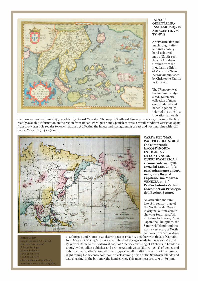
CARTA DEL/MAR PACIFICO DEL NORD/che comprende la/COSTANORD-EST D’ASIA./E LA COSTA NORD OUEST D’AMERICA./riconoscuite nel 1778. e 79./dal Cap. Cook/e particolarmente ancora nel 1788.e 89./dal Capitano Gio. Meares/VENEZIA 1796./Prefso Antonia Zatta q. Giacomo/Con Privilegio dell Eccino. Senato.
An attractive and rare late 18th century map of the North Pacific Ocean in original outline colour showing South-east Asia including Indonesia, China, Japan, the Philippines, the Sandwich Islands and the north-west coast of North America from Alaska down
to California and routes of Cook’s voyages in 1778-79, together with those of Captain John Meares R.N. (1756-1810), (who published Voyages made in the years 1788 and 1789 from China to the northwest coast of America consisting of 27 charts in London in 1790), by the Italian publisher and printer Antonio Zatta (fl. 1750-1804) of Venice and published in his atlas Nuovo atlante c. 1799. Overall condition good apart from some slight toning to the centre fold, some black staining north of the Sandwich Islands and text ‘ghosting’ in the bottom right-hand corner. This map measures 459 x 583 mm.
INDIAE/ORIENTALIS,/INSULARUMQVE/ADIACENTI:/VM TY:/PVS.
A very attractive and much sought-after late 16th century hand-coloured map of South-east Asia by Abraham Ortelius from the 1592 Latin edition of Theatrum Orbis Terrarum published by Christophe Plantin in Antwerp.
The Theatrum was the first uniformly-sized, systematic collection of maps ever produced and hence is generally referred to as the first true atlas, although
the term was not used until 25 years later by Gerard Mercator. The map of Southeast Asia represents a synthesis of the best readily available information on the region from Italian, Portuguese and Spanish sources. Overall condition very good apart from two worm hole repairs to lower margin not affecting the image and strengthening of east and west margins with stiff paper. Measures 345 x 496mm.
Bartele GalleryKantor Taman E-3.3 Unit A14th Floor (via Cazbar)Jl. Mega Kuningan Jakarta, Indonesiat +62 21 576 4575f +62 21 576 4576e [email protected]/bartelegallery