Embed Size (px)
DESCRIPTION
Â
Citation preview
2012
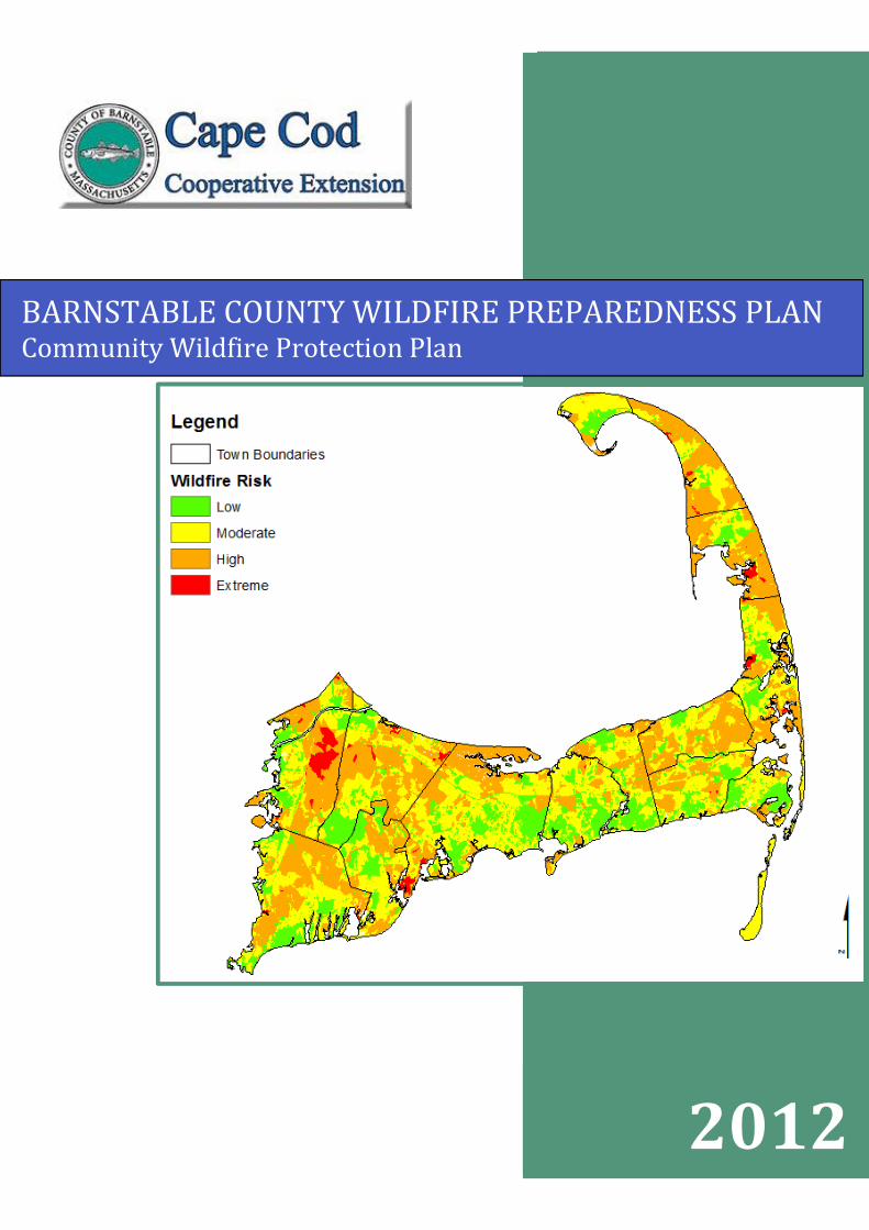
BARNSTABLE COUNTY WILDFIRE PREPAREDNESS PLANCommunity Wildfire Protection Plan

i
ii
EXECUTIVE SUMMARY
Wildfire has played a role in shaping the landscape of Barnstable County for thousands of years,resulting in the abundance of fire-adapted ecosystems. The predominance of fire-adaptedspecies combined with its climate and current development pattern puts Barnstable County atrisk for wildfire.
The Barnstable County Wildfire Preparedness Plan was developed to address wildfire risk bymapping wildfire hazard and identifying the level of threat for the entire county. The plan isdesigned to enable municipal natural resource managers, planners, and fire departments tocollaborate in addressing wildand fire risk. The risk assessment can be used as a guide for theprioritization of site-specific wildfire preparedness planning and to outline strategies to reducewildand fire hazards.
Spatial data was used to conduct the risk analysis, classifying Barnstable County into fourcategories of wildland fire risk (percent of land area); low (14.7%), moderate (42.1%), high(41.2%), and extreme (2.0%). Recommendations for reducing wildland fire risk includeconducting fuel management treatments on lands with a ‘high’ or ‘extreme’ wildland fire riskranking and increasing education and public outreach efforts on Firewise and defensible spacetreatments.
General descriptions of fuel treatments and a site implementation plan template to aid in creatingtreatment prescription are presented to aid natural resource managers in designing fuel mitigationprojects. In addition, strategies for homeowners to reduce the risk of wildfire to structures arepresented.
Results of a county-wide survey of fire departments indicated that more wildland fire trainingopportunities such as county or state-run classes and participation on prescribed burns would bethe most effective in increasing wildand fire preparedness. Many departments indicated thatmore firefighters would be beneficial to increasing suppression capabilities.
iii
BARNSTABLE COUNTY WILDFIRE PREPAREDNESS PLANCommunity Wildfire Protection Plan
The plan was produced at the request of the Barnstable County Cape Cod Cooperative Extensionprogram and funded by Barnstable County.
William Clark, Extension Director
Guidance Committee
William ClarkCounty Extension DirectorCape Cod Cooperative Extension
William BonnettiField Supervisor, Division of Natural ResourcesTown of Yarmouth
George BakerChief, Fire & Rescue DepartmentTown of Mashpee
David Crary, Jr.Fire Management Officer, Cape Cod National SeashoreNational Park Service
Tim SimmonsRestoration EcologistDivision of Fisheries and Wildlife
Josh NigroDistrict 1 Warden, Forest Fire ControlDepartment of Conservation and Recreation
Heather McElroyNatural Resources/Open Space SpecialistCape Cod Commission
Mark RobinsonExecutive DirectorThe Compact of Cape Cod Conservation Trusts, Inc.
The information presented in this plan is intended to identify potential areas requiring furtherverification of wildfire risk. As a result of the course scale of the data used for analysis of risk,recommendations and findings should be field verified prior to any policy implementation or
management actions. At no times should fire behavior predictions presented in this plan be usedin place of site specific and event specific predictions and professional judgment.
Prepared By
Kate Sullivan, Consultantand
Joel R. Carlson, Principal Consultant
Suggested Reference Format: Sullivan, K. and J. R. Carlson, 2012. Barnstable County Wildfire PreparednessPlan. Barnstable, Massachusetts: Cape Cod Cooperative Extension.
For copies of Barnstable County Wildfire Preparedness Plan - CWPP or GIS layers contact the Cape CodCooperative Extension at P.O. Box 367, Barnstable, MA 02630 or go to http://www.capecodextension.org .
iv
CONTENTSINTRODUCTION .......................................................................................................................... 1
COMMUNITY BACKGROUND .................................................................................................. 3
WILDFIRE PROBLEM STATEMENT AND FIRE HISTORY ................................................... 4
Common Vegetation and Fuel Types ....................................................................................... 6
Weather...................................................................................................................................... 7
Wildland Urban Interface Types .............................................................................................. 8
COMMUNITY RISK ASSESSMENT......................................................................................... 11
Risk Assessment Process ........................................................................................................ 11
GIS Analysis ......................................................................................................................... 11
Analysis Steps....................................................................................................................... 16
Analysis Results.................................................................................................................... 18
Local Preparedness Assessment ............................................................................................ 19
Training................................................................................................................................. 20
Equipment ............................................................................................................................. 20
Detection ............................................................................................................................... 21
MANAGEMENT RECOMMENDATIONS................................................................................ 22
Fuel Treatment Introduction.................................................................................................. 22
Fuel Treatment Options ........................................................................................................ 23
Generic Treatment Objectives .............................................................................................. 27
Measures to Reduce Structural Ignitability .......................................................................... 28
Strategies to Increase Preparedness ..................................................................................... 34
SOURCES OF FUNDING FOR MITIGATION WORK ............................................................ 35
FRAMEWORK TO EVALUATE PLAN .................................................................................... 35
COLLABORATIVE PROCESS................................................................................................... 36
GLOSSARY ................................................................................................................................. 37
REFERENCES ............................................................................................................................. 62
APPENDIX A: EXAMPLE SITE IMPLEMENTATION PLANS AND REPORT.................... 65
Example Site Plan – Short Format.......................................................................................... 66
Example Site Plan – Forest Stewardship Plan Format ......................................................... 79
Example Treatment Report .................................................................................................. 112
APPENDIX B: TOWN WILDFIRE RISK MAPS AND DATA OVERVIEWS....................... 116
Town of Barnstable ............................................................................................................... 117
Town of Bourne ..................................................................................................................... 119
v
Town of Brewster.................................................................................................................. 121
Town of Chatham .................................................................................................................. 123
Town of Dennis...................................................................................................................... 125
Town of Eastham ................................................................................................................... 127
Town of Falmouth ................................................................................................................. 129
Town of Harwich ................................................................................................................... 131
Town of Mashpee .................................................................................................................. 133
Town of Orleans .................................................................................................................... 135
Town of Provincetown.......................................................................................................... 137
Town of Sandwich ................................................................................................................. 139
Town of Truro........................................................................................................................ 141
Town of Wellfleet .................................................................................................................. 143
Town of Yarmouth ................................................................................................................ 145
APPENDIX C: COUNTY-WIDE FIRE DEPARTMENT SURVEY........................................ 147
APPENDIX D: BROCHURE ON REDUCING WILDFIRE ON CAPE COD......................... 154
APPENDIX E: POTENTIAL SOURCES OF FUNDING ......................................................... 156
APPENDIX F: DESCRIPTION OF GIS DATA LAYERS AND FILES INCLUDED ONPROJECT THE DVD ................................................................................................................. 158
vi
LIST OF FIGURES
Figure 1: Barnstable County Towns and Existing CWPPs............................................................. 2
Figure 2: Mean Fire Return Interval map for Southern New England (source LANDFIRE). ....... 5
Figure 3: WUI categories across Barnstable County. ................................................................... 10
Figure 4: Flame Length (from BehavePlus Fire Modeling System, Version 4.0: Variables). ..... 12
Figure 5: Modeled flame lengths for Barnstable County.............................................................. 13
Figure 6: Modeled rate of spread for Barnstable County. ............................................................ 13
Figure 7: Three Types of Wind Driven Crown Fires (U.S. Forest Service 2011). ....................... 14
Figure 8: Modeled fire type for Barnstable County...................................................................... 14
Figure 9: Population density calculated by U.S. Census block for Barnstable County................ 15
Figure 10: Buffered distance from fire stations for Barnstable County........................................ 15
Figure 11: Fire behavior spatial model steps. ............................................................................... 17
Figure 12: Proximity/density spatial model steps. ........................................................................ 17
Figure 13: Final wildfire risk spatial model steps......................................................................... 17
Figure 14: Barnstable County Wildfire Risk Assessment. .......................................................... 19
Figure 15: Wildland fire training classes attended. ...................................................................... 20
Figure 16: Fire suppression resources for Barnstable County. ..................................................... 21
Figure 17: Canopy Base Height and Canopy Bulk Density. ........................................................ 24
Figure 18: Thinning from below (low thinning) example (from Peterson et al. 2005). .............. 24
Figure 19: Flame length reduction associated with fuel mastication (Patterson & Clarke 2007). 25
Figure 20: The home ignition zone (from Cohen 2000). .............................................................. 29
Figure 21: Defensible Space Zones (from Firewise). ................................................................... 30
Figure 22: Non-flammable materials near the home’s foundation (from Firewise Guide). ......... 31
Figure 23: Fuel breaks between vegetation and the house (from Firewise Guide). ..................... 32
Figure 24: Home construction that reduces the ignition potential (from Firewise Guide). .......... 33
vii
LIST OF TABLES
Table 1: Existing Barnstable County CWPPs................................................................................. 3
Table 2: Town populations, size, housing density, and population density. .................................. 4
Table 3: Barnstable Airport 10-year average weather data (2001-2011). ...................................... 7
Table 4: Coast Guard Air Station 10-year average weather data (2001-2011)............................... 8
Table 5: Design criteria used to model fire behavior for Barnstable County. .............................. 12
Table 6: Barnstable County risk assessments inputs, weights, and rankings/reclassifications. ... 16
Table 7: Spatial layers used in creation of wildfire risk assessment............................................. 18
Table 8: Example of fuels mitigation treatment options............................................................... 23
BARNSTABLE COUNTY WILDFIRE PREPAREDNESS PLANCommunity Wildfire Protection Plan
1 | P a g e
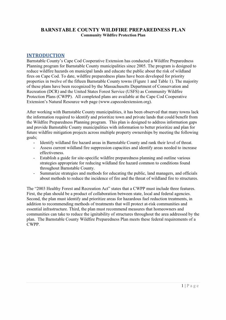
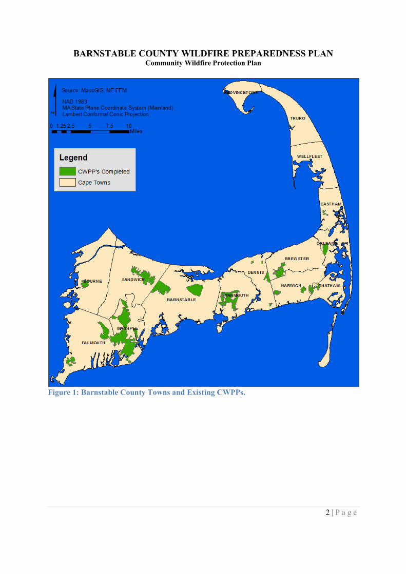
INTRODUCTIONBarnstable County’s Cape Cod Cooperative Extension has conducted a Wildfire PreparednessPlanning program for Barnstable County municipalities since 2005. The program is designed toreduce wildfire hazards on municipal lands and educate the public about the risk of wildlandfires on Cape Cod. To date, wildfire preparedness plans have been developed for priorityproperties in twelve of the fifteen Barnstable County towns (Figure 1 and Table 1). The majorityof these plans have been recognized by the Massachusetts Department of Conservation andRecreation (DCR) and the United States Forest Service (USFS) as Community WildfireProtection Plans (CWPP). All completed plans are available at the Cape Cod CooperativeExtension’s Natural Resource web page (www.capecodextension.org).
After working with Barnstable County municipalities, it has been observed that many towns lackthe information required to identify and prioritize town and private lands that could benefit fromthe Wildfire Preparedness Planning program. This plan is designed to address information gapsand provide Barnstable County municipalities with information to better prioritize and plan forfuture wildfire mitigation projects across multiple property ownerships by meeting the followinggoals;
- Identify wildland fire hazard areas in Barnstable County and rank their level of threat.- Assess current wildland fire suppression capacities and identify areas needed to increase
effectiveness.- Establish a guide for site-specific wildfire preparedness planning and outline various
strategies appropriate for reducing wildland fire hazard common to conditions foundthroughout Barnstable County.
- Summarize strategies and methods for educating the public, land managers, and officialsabout methods to reduce the incidence of fire and the threat of wildland fire to structures.
The “2003 Healthy Forest and Recreation Act” states that a CWPP must include three features.First, the plan should be a product of collaboration between state, local and federal agencies.Second, the plan must identify and prioritize areas for hazardous fuel reduction treatments, inaddition to recommending methods of treatments that will protect at-risk communities andessential infrastructure. Third, the plan must recommend measures that homeowners andcommunities can take to reduce the ignitability of structures throughout the area addressed by theplan. The Barnstable County Wildfire Preparedness Plan meets these federal requirements of aCWPP.
BARNSTABLE COUNTY WILDFIRE PREPAREDNESS PLANCommunity Wildfire Protection Plan
2 | P a g e
Figure 1: Barnstable County Towns and Existing CWPPs.
BARNSTABLE COUNTY WILDFIRE PREPAREDNESS PLANCommunity Wildfire Protection Plan
3 | P a g e
Table 1: Existing Barnstable County CWPPs.
Town Plan LocationBarnstable Old Jail Lane Conservation Area and Adjacent Town LandBarnstable West Barnstable Cons. Area & Adjacent Open Space LandsBourne Bourne Town Forest, Four Ponds Cons. Area, & Water Dis. LandsBrewster Punkhorn ParklandsChatham/Harwich Chatham Town Forest and Harwich Water Department LandsChatham The Goose Pond TractDennis Princess Beach Conservation Area and Adjacent Scargo HillDennis Green Belt Well FieldDennis Plashes Conservation Area and Surrounding Open Space TractsDennis Ralph and Florence Shoop Memorial Conservation LandsEastham Wiley Park, The Nickerson Property, and Cottontail AcresFalmouth Beebe Woods and Peterson Farm Conservation Areas (Draft)Falmouth/Mashpee Wildland Fuel Hazard Assessment for Mashpee National Wildlife RefugeHarwich Thompson's Field Conservation Area and Adjacent Water District LandsHarwich Bell's NeckMashpee The Town of Mashpee River WoodlandsOrleans Orleans Watershed LandsOrleans Paw Wah PointSandwich Maple Swamp and Discovery Hill Sandwich Town Lands ComplexYarmouth Yarmouth Town Lands
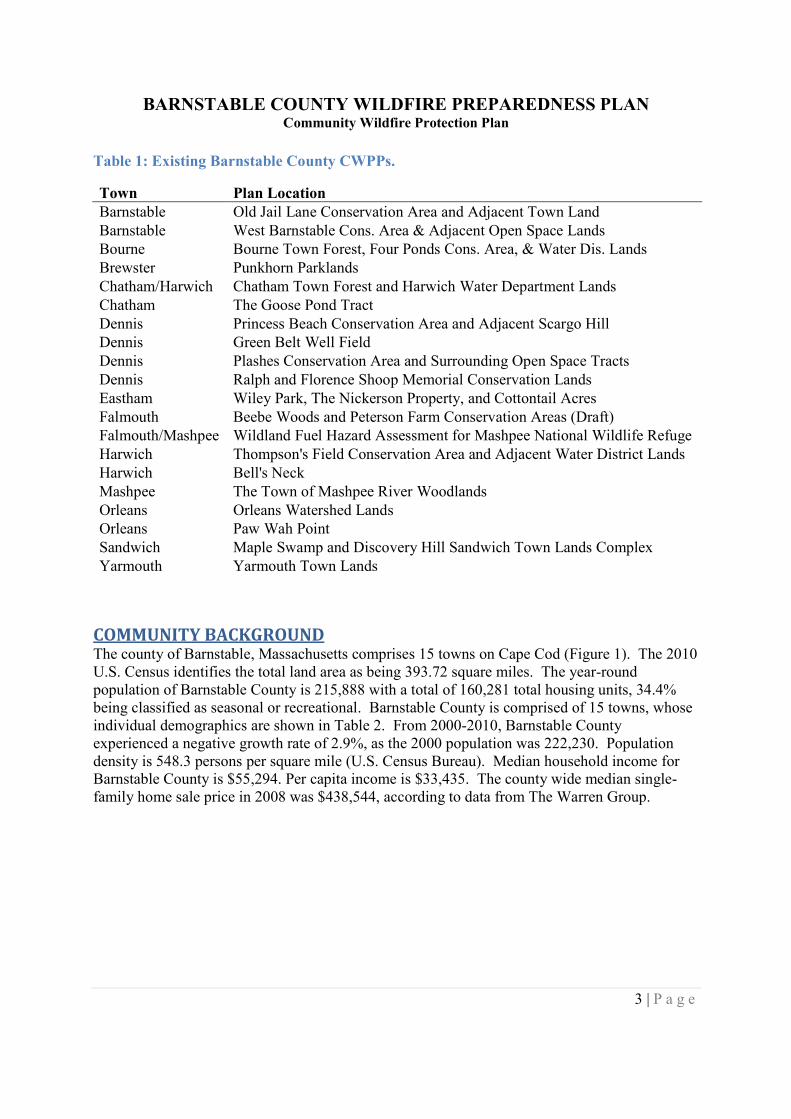
COMMUNITY BACKGROUNDThe county of Barnstable, Massachusetts comprises 15 towns on Cape Cod (Figure 1). The 2010U.S. Census identifies the total land area as being 393.72 square miles. The year-roundpopulation of Barnstable County is 215,888 with a total of 160,281 total housing units, 34.4%being classified as seasonal or recreational. Barnstable County is comprised of 15 towns, whoseindividual demographics are shown in Table 2. From 2000-2010, Barnstable Countyexperienced a negative growth rate of 2.9%, as the 2000 population was 222,230. Populationdensity is 548.3 persons per square mile (U.S. Census Bureau). Median household income forBarnstable County is $55,294. Per capita income is $33,435. The county wide median single-family home sale price in 2008 was $438,544, according to data from The Warren Group.
BARNSTABLE COUNTY WILDFIRE PREPAREDNESS PLANCommunity Wildfire Protection Plan
4 | P a g e
Table 2: Town populations, size, housing density, and population density.
Town Population Land Area ) (.Population Density
(persons/ (.Home Density
(housing units/ (.Barnstable 45,193 60.0 753.2 439.1Bourne 19,754 40.9 482.9 264.2Brewster 9,820 23.0 426.9 345.6Chatham 6,125 16.2 378.1 453.3Dennis 14,207 20.6 689.7 756.6Eastham 4,956 14.0 354.0 425.7Falmouth 31,531 44.2 713.4 497.0Harwich 12,243 21.0 583.0 775.5Mashpee 14,006 23.5 596.0 420.1Orleans 5,890 14.2 414.8 376.7Provincetown 2,942 9.7 303.3 463.2Sandwich 20,675 43.0 480.8 220.3Truro 2,003 21.2 94.5 145.8Wellfleet 2,750 19.8 138.9 217.4Yarmouth 23,793 24.3 979.1 718.7
There is approximately 100,720 acres of protected open space in Barnstable County according tothe MassGIS Open Space data layer. The state owns and manages approximately 34,988 acresof this open space, the three largest being the Massachusetts Military Reservation, NickersonState Park, and the Frances A. Crane Wildlife Management Area. The federal government ownsor manages approximately 28,596 acres in Barnstable County, with the three largest being CapeCod National Seashore and the Monomoy and Mashpee National Wildlife Refuges. Municipalopen space landholdings account for approximately 23,379 acres across Barnstable County.Barnstable County owns approximately 145 acres and the remaining 13,612 acres is owned byprivate nonprofits, public nonprofits, private for profits, land trusts, conservation organizations,and other nongovernmental entities.
WILDFIRE PROBLEM STATEMENT AND FIRE HISTORYPaleo-ecological records show fire has played a large role in affecting the landscape of Cape Codfor thousands of years (Winkler 1985, Patterson and Sassman 1988, and Patterson 1999). As aresult of this process, fire-adapted ecosystems predominate most of the area. Sediment coresfrom Duck Pond at Cape Cod National Seashore that date back 12,000 years before present and4,800 years before present contain abundant charcoal, suggesting that fire has shaped andmaintained pine and oak forests on Cape Cod throughout the Holocene era (Winkler 1985, Clark2002, Patterson and Crary 2004), indicating that fire has been an important influence on the preand post European settlement landscape of Cape Cod.
In the early 1800’s, fires were extensive, often thousands of acres, as a result of land usepractices. Expanding railroad activities in this time period also increased the occurrence offorest fires. Drifting embers from locomotives were responsible for most fires (Thompson1928). Only 44% of current forests on the outer Cape were wooded between 1848 and 1856
BARNSTABLE COUNTY WILDFIRE PREPAREDNESS PLANCommunity Wildfire Protection Plan
5 | P a g e
(Eberhardt et al 2003). Fires continued to be abundant on Cape Cod through the early 1900’s.Thompson (1928) reported an average of 8,500 acres of woodlands burned annually. Only 12.6%of the current houses in Barnstable County were present before 1940 (Cape Cod Commission).Although fewer fires occur now, Barnstable County has considerably more houses and morevalues at risk.
As tourism became an important economic activity, public opinion began to favor thesuppression of all fires. The first fire tower on Cape Cod was erected in Barnstable in 1913. Thepredecessor agency of the Massachusetts Department of Conservation and Recreation startedpatrolling Cape Cod in the 1920’s. By the 1930’s, Cape Cod developed the first brush breakersto fight forest fires (Crosby 2003). After this period, forest fires tended to burn fewer acres andfor shorter periods.
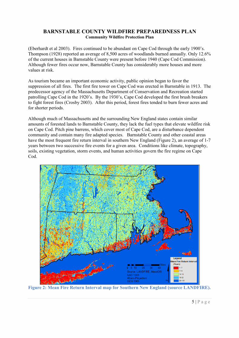
Although much of Massachusetts and the surrounding New England states contain similaramounts of forested lands to Barnstable County, they lack the fuel types that elevate wildfire riskon Cape Cod. Pitch pine barrens, which cover most of Cape Cod, are a disturbance dependentcommunity and contain many fire adapted species. Barnstable County and other coastal areashave the most frequent fire return interval in southern New England (Figure 2), an average of 1-7years between two successive fire events for a given area. Conditions like climate, topography,soils, existing vegetation, storm events, and human activities govern the fire regime on CapeCod.
Figure 2: Mean Fire Return Interval map for Southern New England (source LANDFIRE).
BARNSTABLE COUNTY WILDFIRE PREPAREDNESS PLANCommunity Wildfire Protection Plan
6 | P a g e
Common Vegetation and Fuel TypesPitch Pine Barrens are the dominant vegetative community on Cape Cod. Pine Barrens are hometo several highly flammable plant species that are adapted to survive or regenerate post fire. Thisis a disturbance-dependent community type created by wildfires and historic logging, grazingand agriculture (Motzkin and Foster 2002). Pine Barrens Systems are a mosaic of pitch pine andscrub oak, typically located on nutrient-poor, acidic, drought-prone soils. Dominant vegetationin pine barrens systems include woodlands and shrublands with an overstory of pitch pine and anunderstory of scrub oak and heath species. Open grasslands and heathlands are also common(Ciaranca et al 2005).
The majority of plant communities across Barnstable County contain fire-adapted species and areprone to burning. Common plants such as huckleberry, scrub oak, and pitch pine producevolatile substances in their leaves and stems, which can contribute to the spread of fire. A denseshrub understory combined with ladder fuels like greenbrier or scrub oak can increase thepossibility of fires reaching the forest canopy allowing for crown fire initiation and propagation.Pitch pines in the overstory contain highly flammable compounds and are more likely than othertrees to carry a crown fire (Cauljow 2005). Fuels created by xeric vegetation like pitch pine,scrub oak, and ericaceous shrubs dry rapidly and can create flammable conditions in the forest(Patterson and Sassman 1988). This increased fire behavior combined with a large populationliving in the Wildland Urban Interface (WUI) further increase the threat of catastrophic wildfire.
The potential of large wildfires occurring on Cape Cod every 30-50 years exists (Patterson andRuffner 2002). Long intervals between fires may increase fuel loads and the ultimate threat fromsevere wildand fire behavior. Additionally, populations may become complacent aboutcontrolling flammable fuels around dwellings and other structures. Different fire frequenciesand intensities are responsible for variations in forest composition. Periodic severe wildfireswith 40-100 year intervals have created oak-pine forests in the uplands. More frequent, severefires (5-25 year intervals) have produced mixtures of pitch pine and scrub oak. The mostfrequent and severe fires (2-3 year intervals) have created the pine plains (Ciaranca et al 2005).
Wildfires most often occur in Barnstable County from late March to early June, correspondingwith the driest live fuel moisture periods of the year. The prevailing direction of fire spread issouthwest to northeast. Severe fall fires can follow periodic summer and fall droughts, as seen in1947, 1995, and 1999.
Barnstable County’s natural environment is adapted to fire and many forest ecosystems need aregular cycle of fire to maintain their structure and species composition for rare species andwildlife habitat. Efforts to eliminate wildfires from the natural environment may make theseevents much more severe when they do occur due to accumulated vegetative fuels. More severefires harm the health of the ecosystem and put neighboring developments in danger. The role ofwildfires in the natural environment of Barnstable County needs to be integrated into publiceducation programs, planning for development within the WUI, and prioritizing fuel reductiontreatments to reduce wildfire risk.
BARNSTABLE COUNTY WILDFIRE PREPAREDNESS PLANCommunity Wildfire Protection Plan
7 | P a g e
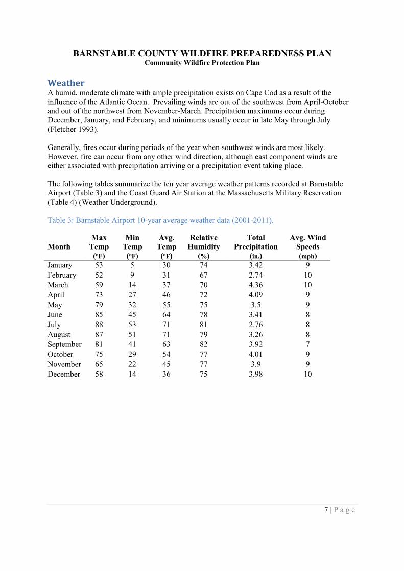
WeatherA humid, moderate climate with ample precipitation exists on Cape Cod as a result of theinfluence of the Atlantic Ocean. Prevailing winds are out of the southwest from April-Octoberand out of the northwest from November-March. Precipitation maximums occur duringDecember, January, and February, and minimums usually occur in late May through July(Fletcher 1993).
Generally, fires occur during periods of the year when southwest winds are most likely.However, fire can occur from any other wind direction, although east component winds areeither associated with precipitation arriving or a precipitation event taking place.
The following tables summarize the ten year average weather patterns recorded at BarnstableAirport (Table 3) and the Coast Guard Air Station at the Massachusetts Military Reservation(Table 4) (Weather Underground).
Table 3: Barnstable Airport 10-year average weather data (2001-2011).
MonthMax
Temp(°F)
MinTemp(°F)
Avg.Temp(°F)
RelativeHumidity
(%)
TotalPrecipitation
(in.)
Avg. WindSpeeds(mph)
January 53 5 30 74 3.42 9
February 52 9 31 67 2.74 10March 59 14 37 70 4.36 10
April 73 27 46 72 4.09 9
May 79 32 55 75 3.5 9June 85 45 64 78 3.41 8
July 88 53 71 81 2.76 8
August 87 51 71 79 3.26 8September 81 41 63 82 3.92 7
October 75 29 54 77 4.01 9
November 65 22 45 77 3.9 9December 58 14 36 75 3.98 10
BARNSTABLE COUNTY WILDFIRE PREPAREDNESS PLANCommunity Wildfire Protection Plan
8 | P a g e
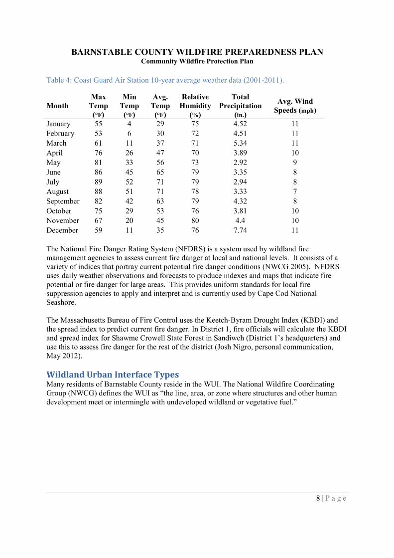
Table 4: Coast Guard Air Station 10-year average weather data (2001-2011).
MonthMax
Temp(°F)
MinTemp(°F)
Avg.Temp(°F)
RelativeHumidity
(%)
TotalPrecipitation
(in.)
Avg. WindSpeeds (mph)
January 55 4 29 75 4.52 11February 53 6 30 72 4.51 11
March 61 11 37 71 5.34 11
April 76 26 47 70 3.89 10May 81 33 56 73 2.92 9
June 86 45 65 79 3.35 8
July 89 52 71 79 2.94 8August 88 51 71 78 3.33 7
September 82 42 63 79 4.32 8
October 75 29 53 76 3.81 10November 67 20 45 80 4.4 10
December 59 11 35 76 7.74 11
The National Fire Danger Rating System (NFDRS) is a system used by wildland firemanagement agencies to assess current fire danger at local and national levels. It consists of avariety of indices that portray current potential fire danger conditions (NWCG 2005). NFDRSuses daily weather observations and forecasts to produce indexes and maps that indicate firepotential or fire danger for large areas. This provides uniform standards for local firesuppression agencies to apply and interpret and is currently used by Cape Cod NationalSeashore.
The Massachusetts Bureau of Fire Control uses the Keetch-Byram Drought Index (KBDI) andthe spread index to predict current fire danger. In District 1, fire officials will calculate the KBDIand spread index for Shawme Crowell State Forest in Sandiwch (District 1’s headquarters) anduse this to assess fire danger for the rest of the district (Josh Nigro, personal communication,May 2012).
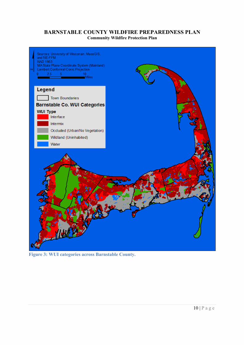
Wildland Urban Interface TypesMany residents of Barnstable County reside in the WUI. The National Wildfire CoordinatingGroup (NWCG) defines the WUI as “the line, area, or zone where structures and other humandevelopment meet or intermingle with undeveloped wildland or vegetative fuel.”
BARNSTABLE COUNTY WILDFIRE PREPAREDNESS PLANCommunity Wildfire Protection Plan
9 | P a g e
The 2001 Federal Register further divides the WUI into three categories:
Category 1 - Interface Community:The Interface Community exists where structures directly abut wildlandfuels. There is a clear line of demarcation between residential, business, andpublic structures and wildland fuels. Wildland fuels do not generallycontinue into the developed area. The development density for an interfacecommunity is usually 3 or more structures per acre, with shared municipalservices. Fire protection is generally provided by a local government firedepartment with the responsibility to protect the structure from both aninterior fire and an advancing wildland fire. An alternative definition of theinterface community emphasizes a population density of 250 or more peopleper square mile.
Category 2 - Intermix Community:The Intermix Community exists where structures are scattered throughout awildland area. There is no clear line of demarcation; wildland fuels arecontinuous outside of and within the developed area. The developmentdensity in the intermix ranges from structures very close together to onestructure per 40 acres. Fire protection districts funded by various taxingauthorities normally provide life and property fire protection and may alsohave wildland fire protection responsibilities. An alternative definition ofintermix community emphasizes a population density of 28-250 people persquare mile.
Category 3 - Occluded Community:The Occluded Community generally exists in a situation, often within a city,where structures abut an island of wildland fuels (e.g., park or open space).There is a clear line of demarcation between structures and wildland fuels.The development density for an occluded community is usually similar tothose found in the interface community, but the occluded area is usually lessthan 1,000 acres in size. Fire protection is normally provided by localgovernment fire departments (USDA and USDI 2001).
Development in the WUI can increase wildfire risk to structures. Fires that ignite in wildlandscan move into surrounding developments, putting homes or other structures at risk for ignition.WUI residents and municipalities must realize this increased risk, plan for responding to firesaccordingly, and work to reduce wildland fire risk. The University of Wisconsin Silvis Lab hasmapped the WUI intermix, interface, and occluded (urban/no vegetation) communities.Uninhabited areas like the outer part of Provincetown, the Monomoy Wilderness, and parts ofthe Massachusetts Military Reservation meet the criteria of ‘wildlands’ (See Figure 3).
BARNSTABLE COUNTY WILDFIRE PREPAREDNESS PLANCommunity Wildfire Protection Plan
10 | P a g e
Figure 3: WUI categories across Barnstable County.
BARNSTABLE COUNTY WILDFIRE PREPAREDNESS PLANCommunity Wildfire Protection Plan
11 | P a g e
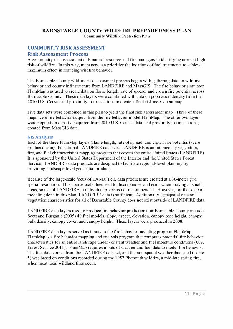
COMMUNITY RISK ASSESSMENTRisk Assessment ProcessA community risk assessment aids natural resource and fire managers in identifying areas at highrisk of wildfire. In this way, managers can prioritize the locations of fuel treatments to achievemaximum effect in reducing wildfire behavior.
The Barnstable County wildfire risk assessment process began with gathering data on wildfirebehavior and county infrastructure from LANDFIRE and MassGIS. The fire behavior simulatorFlamMap was used to create data on flame length, rate of spread, and crown fire potential acrossBarnstable County. These data layers were combined with data on population density from the2010 U.S. Census and proximity to fire stations to create a final risk assessment map.
Five data sets were combined in this plan to yield the final risk assessment map. Three of thesemaps were fire behavior outputs from the fire behavior model FlamMap. The other two layerswere population density, acquired from 2010 U.S. Census data, and proximity to fire stations,created from MassGIS data.
GIS AnalysisEach of the three FlamMap layers (flame length, rate of spread, and crown fire potential) wereproduced using the national LANDFIRE data sets. LANDFIRE is an interagency vegetation,fire, and fuel characteristics mapping program that covers the entire United States (LANDFIRE).It is sponsored by the United States Department of the Interior and the United States ForestService. LANDFIRE data products are designed to facilitate regional-level planning byproviding landscape-level geospatial products.
Because of the large-scale focus of LANDFIRE, data products are created at a 30-meter gridspatial resolution. This coarse scale does lead to discrepancies and error when looking at smallareas, so use of LANDFIRE in individual pixels is not recommended. However, for the scale ofmodeling done in this plan, LANDFIRE data is sufficient. Additionally, geospatial data onvegetation characteristics for all of Barnstable County does not exist outside of LANDFIRE data.
LANDFIRE data layers used to produce fire behavior predictions for Barnstable County includeScott and Burgan’s (2005) 40 fuel models, slope, aspect, elevation, canopy base height, canopybulk density, canopy cover, and canopy height. These layers were produced in 2008.
LANDFIRE data layers served as inputs to the fire behavior modeling program FlamMap.FlamMap is a fire behavior mapping and analysis program that computes potential fire behaviorcharacteristics for an entire landscape under constant weather and fuel moisture conditions (U.S.Forest Service 2011). FlamMap requires inputs of weather and fuel data to model fire behavior.The fuel data comes from the LANDFIRE data set, and the non-spatial weather data used (Table5) was based on conditions recorded during the 1957 Plymouth wildfire, a mid-late spring fire,when most local wildland fires occur.
BARNSTABLE COUNTY WILDFIRE PREPAREDNESS PLANCommunity Wildfire Protection Plan
12 | P a g e
Table 5: Design criteria used to model fire behavior for Barnstable County.
Design Variable Design Condition20’ Wind Speed: 25 mph1-hour Fuel Moisture: 5 %10-hour Fuel Moisture: 8 %100-hour Fuel Moisture: 12 %Live Herbaceous Fuel Moisture: 30 %Live Woody Fuel Moisture: 30 %Foliar Fuel Moisture: 100 %
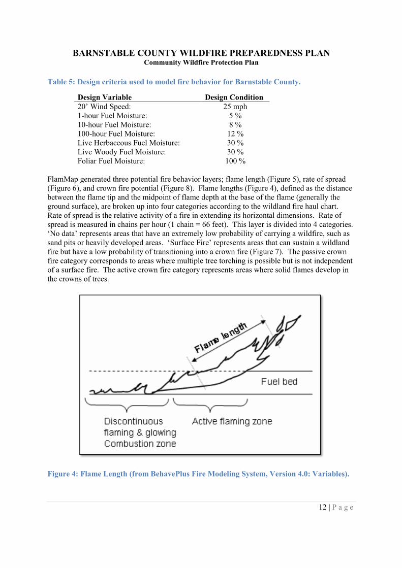
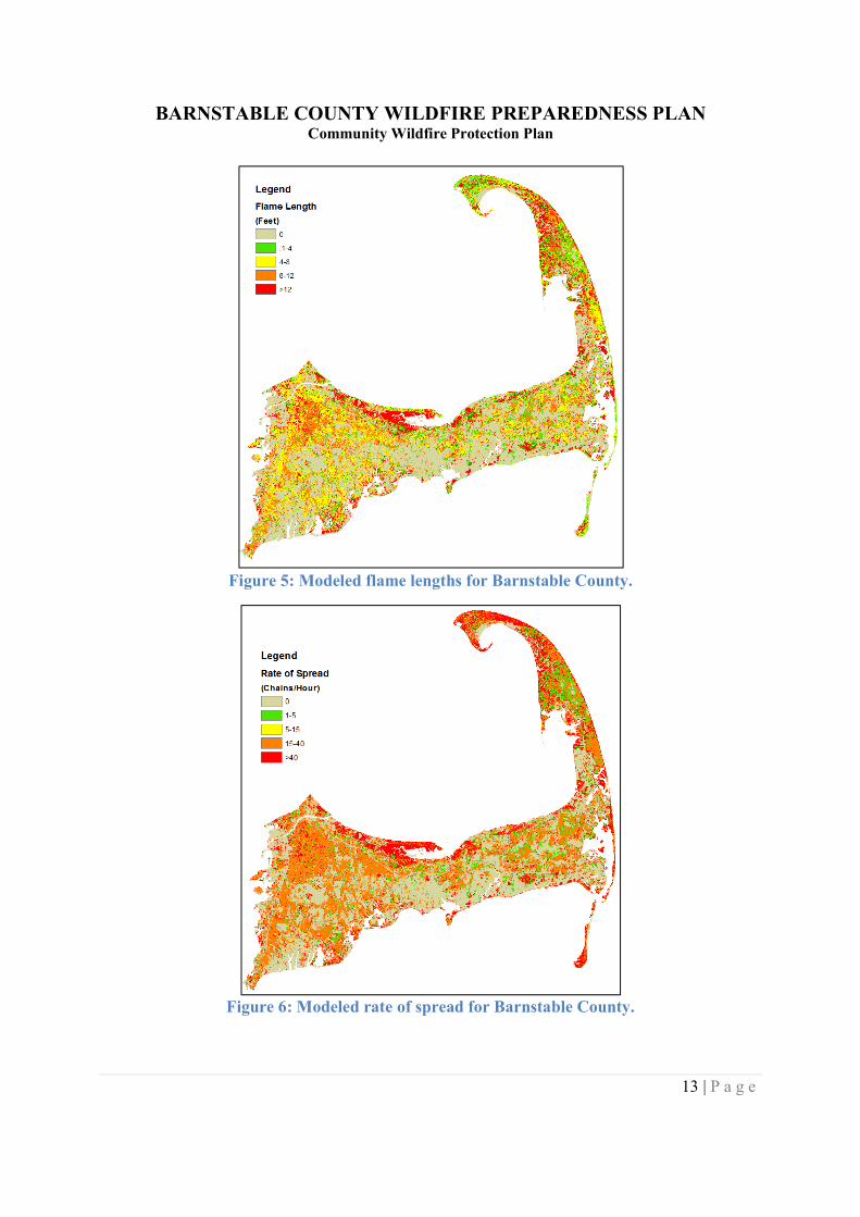
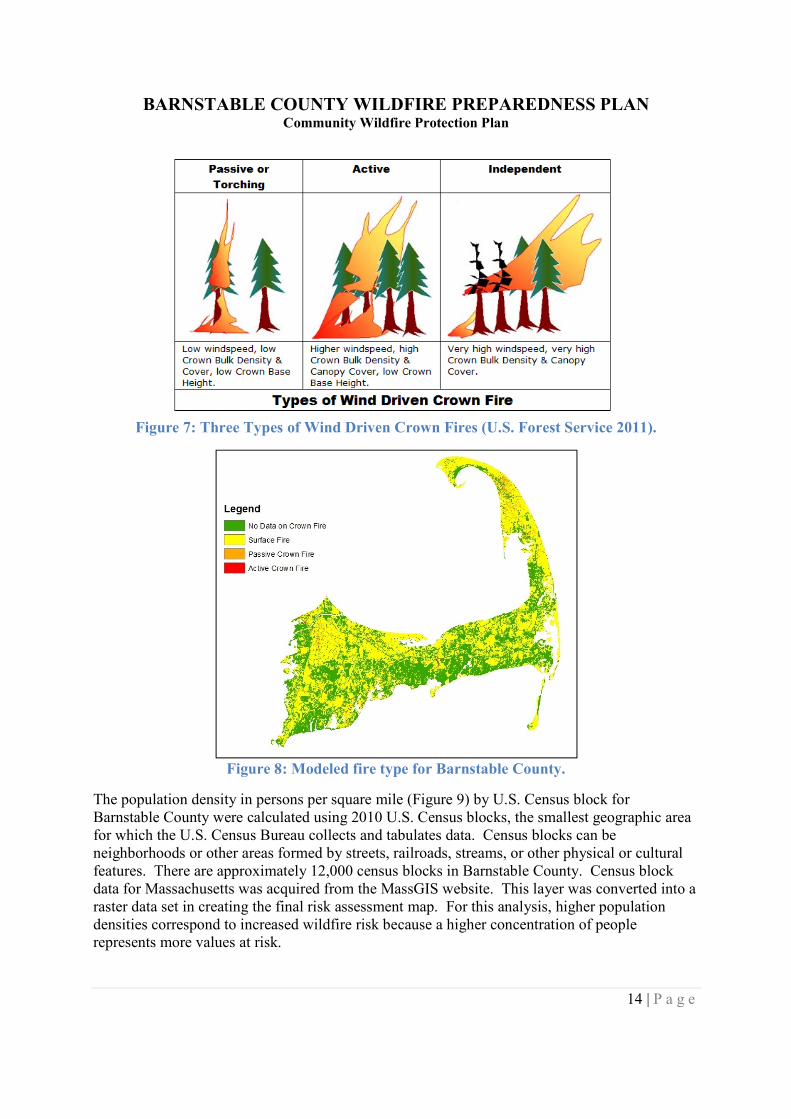
FlamMap generated three potential fire behavior layers; flame length (Figure 5), rate of spread(Figure 6), and crown fire potential (Figure 8). Flame lengths (Figure 4), defined as the distancebetween the flame tip and the midpoint of flame depth at the base of the flame (generally theground surface), are broken up into four categories according to the wildland fire haul chart.Rate of spread is the relative activity of a fire in extending its horizontal dimensions. Rate ofspread is measured in chains per hour (1 chain = 66 feet). This layer is divided into 4 categories.‘No data’ represents areas that have an extremely low probability of carrying a wildfire, such assand pits or heavily developed areas. ‘Surface Fire’ represents areas that can sustain a wildlandfire but have a low probability of transitioning into a crown fire (Figure 7). The passive crownfire category corresponds to areas where multiple tree torching is possible but is not independentof a surface fire. The active crown fire category represents areas where solid flames develop inthe crowns of trees.
Figure 4: Flame Length (from BehavePlus Fire Modeling System, Version 4.0: Variables).
BARNSTABLE COUNTY WILDFIRE PREPAREDNESS PLANCommunity Wildfire Protection Plan
13 | P a g e
Figure 5: Modeled flame lengths for Barnstable County.
Figure 6: Modeled rate of spread for Barnstable County.
BARNSTABLE COUNTY WILDFIRE PREPAREDNESS PLANCommunity Wildfire Protection Plan
14 | P a g e
Figure 7: Three Types of Wind Driven Crown Fires (U.S. Forest Service 2011).
Figure 8: Modeled fire type for Barnstable County.
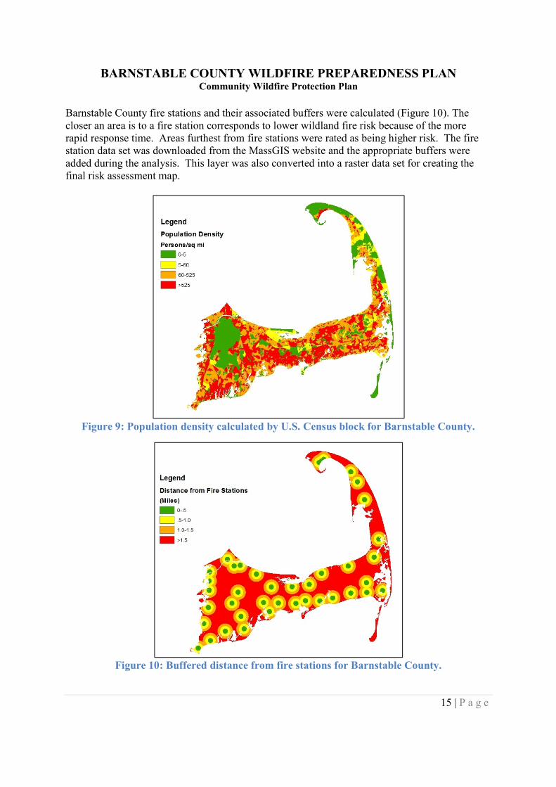
The population density in persons per square mile (Figure 9) by U.S. Census block forBarnstable County were calculated using 2010 U.S. Census blocks, the smallest geographic areafor which the U.S. Census Bureau collects and tabulates data. Census blocks can beneighborhoods or other areas formed by streets, railroads, streams, or other physical or culturalfeatures. There are approximately 12,000 census blocks in Barnstable County. Census blockdata for Massachusetts was acquired from the MassGIS website. This layer was converted into araster data set in creating the final risk assessment map. For this analysis, higher populationdensities correspond to increased wildfire risk because a higher concentration of peoplerepresents more values at risk.
BARNSTABLE COUNTY WILDFIRE PREPAREDNESS PLANCommunity Wildfire Protection Plan
15 | P a g e
Barnstable County fire stations and their associated buffers were calculated (Figure 10). Thecloser an area is to a fire station corresponds to lower wildland fire risk because of the morerapid response time. Areas furthest from fire stations were rated as being higher risk. The firestation data set was downloaded from the MassGIS website and the appropriate buffers wereadded during the analysis. This layer was also converted into a raster data set for creating thefinal risk assessment map.
Figure 9: Population density calculated by U.S. Census block for Barnstable County.
Figure 10: Buffered distance from fire stations for Barnstable County.
BARNSTABLE COUNTY WILDFIRE PREPAREDNESS PLANCommunity Wildfire Protection Plan
16 | P a g e
Other layers were considered for analysis but were not used in creating the final map due to datagaps, increased complexity, or irrelevance. Data on fire occurrence would be a valuable additionto this assessment to see where fires commonly start, but currently no usable geospatial data forBarnstable County on wildland fire occurrence exists. The use of distance to roads, rail beds, orschools was considered as a substitute for fire occurrence. Given that these areas are mayincrease the occurrence of fire starts it was determined that these data layers would detract fromthe clarity of the final analysis due to the amount of buffers required, additionally though firesmay start near roads, they would also be easier to access and suppress.
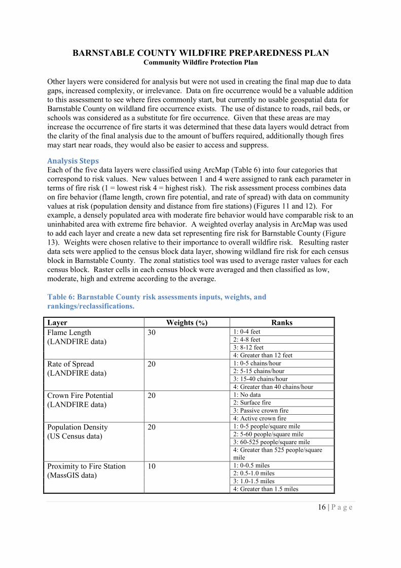
Analysis StepsEach of the five data layers were classified using ArcMap (Table 6) into four categories thatcorrespond to risk values. New values between 1 and 4 were assigned to rank each parameter interms of fire risk (1 = lowest risk 4 = highest risk). The risk assessment process combines dataon fire behavior (flame length, crown fire potential, and rate of spread) with data on communityvalues at risk (population density and distance from fire stations) (Figures 11 and 12). Forexample, a densely populated area with moderate fire behavior would have comparable risk to anuninhabited area with extreme fire behavior. A weighted overlay analysis in ArcMap was usedto add each layer and create a new data set representing fire risk for Barnstable County (Figure13). Weights were chosen relative to their importance to overall wildfire risk. Resulting rasterdata sets were applied to the census block data layer, showing wildland fire risk for each censusblock in Barnstable County. The zonal statistics tool was used to average raster values for eachcensus block. Raster cells in each census block were averaged and then classified as low,moderate, high and extreme according to the average.
Table 6: Barnstable County risk assessments inputs, weights, andrankings/reclassifications.
Layer Weights (%) Ranks
Flame Length(LANDFIRE data)
30 1: 0-4 feet2: 4-8 feet3: 8-12 feet4: Greater than 12 feet
Rate of Spread(LANDFIRE data)
20 1: 0-5 chains/hour2: 5-15 chains/hour3: 15-40 chains/hour4: Greater than 40 chains/hour
Crown Fire Potential(LANDFIRE data)
20 1: No data2: Surface fire3: Passive crown fire4: Active crown fire
Population Density(US Census data)
20 1: 0-5 people/square mile2: 5-60 people/square mile3: 60-525 people/square mile4: Greater than 525 people/squaremile
Proximity to Fire Station(MassGIS data)
10 1: 0-0.5 miles2: 0.5-1.0 miles3: 1.0-1.5 miles4: Greater than 1.5 miles

BARNSTABLE COUNTY WILDFIRE PREPAREDNESS PLANCommunity Wildfire Protection Plan
17 | P a g e
Figure 11: Fire behavior spatial model steps.
Figure 12: Proximity/density spatial modelsteps.
Figure 13: Final wildfire risk spatial modelsteps.
BARNSTABLE COUNTY WILDFIRE PREPAREDNESS PLANCommunity Wildfire Protection Plan
18 | P a g e
Table 7: Spatial layers used in creation of wildfire risk assessment.
Data Source Data Layers LocationRisk Analysis Layers Flame Length, Rate of Spread,
Crown Fire Potential,Population Density, Proximityto Fire Stations
Barnstable County CooperativeExtension
LANDFIRE(inputs to FlamMap)
Elevation, Slope, Aspect, FuelModels, Canopy Height,Canopy Cover, Canopy BaseHeight, Canopy Bulk Density
http://landfire.cr.usgs.gov/viewer/
MassGIS Town and State Boundaries,Open Space, Roads, Streamsand Ponds
http://www.mass.gov/mgis/laylist.htm
U.S. Census 2010 Census Blocks http://www.census.gov/cgi-bin/geo/shapefiles2010/main
Analysis ResultsThe final wildfire risk assessment provides a snapshot of wildfire risk for Barnstable Countyunder the specified weather design criteria. Areas of Barnstable County that have a greaterrelative wildfire risk than other areas are identified. Wildfire risk has been calculated bycombining data on fire behavior and data on community values at risk. Areas with the greatestfire behavior risk may have a lower overall risk as a result of being an unpopulated area or closeto a fire station. Figure 14 shows the final wildfire risk assessment for Barnstable County bycensus block. Appendix B contains the risk assessment maps for each town in BarnstableCounty. The GIS layers used in this analysis and their location are listed in Table 7.
Where possible results presented in the fire behavior and final risk assessment were compared toexisting assessments and antidotal observations at various sites across Barnstable County. At thescale that the plan is intended to be used results were found to be reliable and accurate.
Data resolution is coarse and there is always a margin of error in modeling fire behavior, but thehigh or extreme risk polygons should be considered first when prioritizing detailed fieldassessments or potential mitigation work. Results are for general planning purposes only andare not intended to serve as the sole basis for decisions on locating fuel treatments orimplementing defensible space projects. Because these maps are not designed to pinpoint exactlocations for fuel treatment or fire hazard reduction work, a field inventory and more site-specific work is required.
BARNSTABLE COUNTY WILDFIRE PREPAREDNESS PLANCommunity Wildfire Protection Plan
19 | P a g e
Figure 14: Barnstable County Wildfire Risk Assessment.
Local Preparedness AssessmentA goal of the Barnstable County Wildfire Preparedness Plan was to assess current wildland firesuppression capacities and identify areas to increase effectiveness. This was accomplished with acounty-wide fire department survey completed by municipal fire departments, Cape CodNational Seashore, and DCR Bureau of Forest Fire Control District 1. A copy of the survey is inAppendix C. The survey asked questions pertaining to wildland fire trainings and equipment andsolicited ideas from fire officials on how to increase wildland fire suppression capabilities andpreparedness. Seven out of 21 surveys were completed and analyzed. Summaries of wildlandfirefighting equipment by town are available with the town risk assessment maps in Appendix B.
BARNSTABLE COUNTY WILDFIRE PREPAREDNESS PLANCommunity Wildfire Protection Plan
20 | P a g e
TrainingOf the 181 firefighters among the responding departments, 119 had some form of wildland firetraining. The majority of the municipal firefighters had taken a 2-hour DCR wildfire class andsome had taken a 2-hour DCR sponsored fire shelter class. No municipal departments indicatedthat their firefighters had taken Firefighter Training/Introduction to Wildland Fire Behavior(S130/S190), the National Wildfire Coordinating Group (NWCG) courses for basic wildlandfirefighting (see Figure 15).
Figure 15: Wildland fire training classes attended.
All but one department reported that they conduct wildfire drills or training scenarios, spendingan average of 3 hours per year on wildland fire drills. Only one department surveyed hadparticipated on a prescribed burn, but 6 of the 7 indicated a desire to do so.
Increasing wildland fire training opportunities was ranked as the most important for increasingwildfire preparedness in Barnstable County. The fire departments surveyed indicated that acounty or state run wildfire training academy would benefit them the most. Live fire exercises,greater access to NWCG online trainings, and participation on prescribed burns also rated highlyfor increasing wildland fire training.
EquipmentAll departments surveyed had equipment specific to wildland firefighting, whether it be brushbreakers or wildland fire engines, chainsaws, or porta-tanks. Only one department required theirfirefighters to carry fire shelters when fighting wildfires. Two departments did not have any fireshelters, and the remaining departments only had enough fire shelters for an average of 21% oftheir firefighters. Only one department requires chaps to be worn during wildland fire chainsawoperations, and majority of departments did not have any chaps. Survey responses ranked
0
20
40
60
80
100
120
140
2-hr DCR 2-hr DCR Shelter 12-hr DCR
Fire
figh
ter
Att
en
dee
s
Wildland Fire Training Class
BARNSTABLE COUNTY WILDFIRE PREPAREDNESS PLANCommunity Wildfire Protection Plan
21 | P a g e
additional equipment as the second most important factor to increasing wildland fire suppressioncapabilities and wildfire preparedness.
Barnstable County has 62 structural engines, 32 wildland engines, and 11 water tenders availablefor fire suppression in its 15 towns, Cape Cod National Seashore, DCR District 1, and theMassachusetts Military Reservation (See Figure 16). This data was summarized from townsurvey responses and DCR District 1 information.
Figure 16: Fire suppression resources for Barnstable County.
DetectionBarnstable County is part of District 1 for the DCR - Bureau of Forest Fire Control. DCRmanages 9 fire detection towers in DCR District 1, 8 of which are located in Barnstable Countyin the towns of Bourne, Sandwich, Falmouth, Barnstable, Dennis, Brewster, Wellfleet, andYarmouth. On any given day depending on the expected fire danger, 3 to 4 towers are staffedfrom 1000 to 1800 during April to October. Typically, DCR staffs a ‘triangle’ of towers in thetowns of Falmouth, Sandwich, and Barnstable.
62
32
11
0
10
20
30
40
50
60
70
Structural Engines Wildland Engines Water Tenders
Nu
mb
er
Apparatus Type
BARNSTABLE COUNTY WILDFIRE PREPAREDNESS PLANCommunity Wildfire Protection Plan
22 | P a g e
MANAGEMENT RECOMMENDATIONSFuel Treatment IntroductionFuel management treatments can alter fuel loads to reduce wildfire hazard by changing firebehavior. These actions can increase public and firefighter safety while also reducing fireresponse and suppression costs.
Landscape-level fuel treatments have been shown to be effective at reducing the impacts ofwildland fire (Finney 2001, Stratton 2004, and Finney et al. 2007). Fire behavior at thelandscape scale maybe addressed through the application of fuel treatments in a strategic pattern(Finney 2001). The treatments are not designed to stop fires, but to reduce the intensity of thefire in the treated areas. Fuel treatments that disrupt the continuity of fuels reduce the rate ofspread and flame lengths of the fire, which slows the growth of the fire and increases thesuppression efficiency of firefighters.
Wildland fuels that are capable of producing fire behavior beyond suppression capabilities arebest mitigated through fuels management treatments, rather than with an increase in suppressionforces (Finney and Cohen 2003). Most fires that escape initial attack burn under conditions thatare too extreme for suppression regardless of the availability of suppression resources (Finneyand Cohen 2003). Fuels management at the WUI is especially important as the complexity ofsuppressing structure fires that transition from the wildland, as well as providing for firefighterand public safety, can quickly exceed the capabilities of local firefighting resources (Finney andCohen 2003, National WUI Fire Program). Fuels management is most effective at preventingstructure loss when applied to the immediate surroundings.
Conducting fuel treatments is good strategy to increase preparedness and reduce future wildfirehazard. The goals of a fuels management program in Barnstable County should be to increasesuppression capabilities and provide for greater firefighter and public safety.
Issues that a landowner or manager might consider when deciding on a treatment strategy mightinclude:
Treatment Objectives – i.e. reduce crown fire potential, reduce flame lengths or rate of
spread, provide for wildlife habitat
Site Conditions – access, topography, fuel type and distribution, soils, crown fire
potential, existing development
Cost of Treatment or Source of Funding
Time Available to Complete the Project
Size of Treatment Area
Concerns About Resources and Other Values – i.e. residual tree damage, condition,
wildlife habitat, recreation, wetlands, threatened/endangered species, permits
BARNSTABLE COUNTY WILDFIRE PREPAREDNESS PLANCommunity Wildfire Protection Plan
23 | P a g e
Fuel Treatment OptionsIn forest stands that have not experienced fire or fuels reduction management in several
decades, multiple and/or combinations of treatments that address changes in surface fuel and/orcrown fuels may be necessary. The fuel treatments presented in this plan will reduce flamelengths from surface fires and minimize the potential for surface fires to transition to the crownfuels. Additionally, the treatments will reduce flame lengths and fireline intensity to levels thatwill better facilitate suppression actions. In most cases in Barnstable County a net benefit willalso be achieved for wildlife habitat management and the maintenance of ecosystem integrity.
The application of a particular treatment or combination of treatments to an area will depend onthe specific conditions of the fuels in that area (Fitzgerald 2002) and general land managementgoals. The interval at which subsequent treatments will be applied to maintain the desiredcondition depends on the initial treatment employed and how the fuels respond to that treatment.Some treatment options that may be applicable to areas of Barnstable County include forestthinning, surface fuel mastication, prescribed burning, and mechanical pruning (Table 8).
Table 8: Example of fuels mitigation treatment options.
Treatment Target Layer Maintenance Interval Logistical Constraints
Thinning From Below Crown 10 - 20 years Slash treatments
Surface Fuel Mastication Surface 5 - 10 years Seasonality of treatments
Prescribed Burning Surface/Crown 5 - 10 yearsWeather parameters,smoke management
Mechanical Pruning Crown 10 - 20 yearsHeights above 10 ft.
impractical
Prescribed Grazing Surface 5 - 10 yearsAnimal care, availability
of animals
Information on specific costs, availability of machinery, production rates, strategies for locatingtreatments, and their effectiveness is not included in this plan due to the variability that existsrelated to season of treatment, current conditions, management objectives, restrictions onimplementation, and funding sources. However, all these factors and variables need to beconsidered when designing a fuel treatment. A template for fuel treatment prescriptions can befound in Appendix A. This form can aid natural resource managers in creating a treatmentprescription, although consulting with capable technical experts may still be necessary.
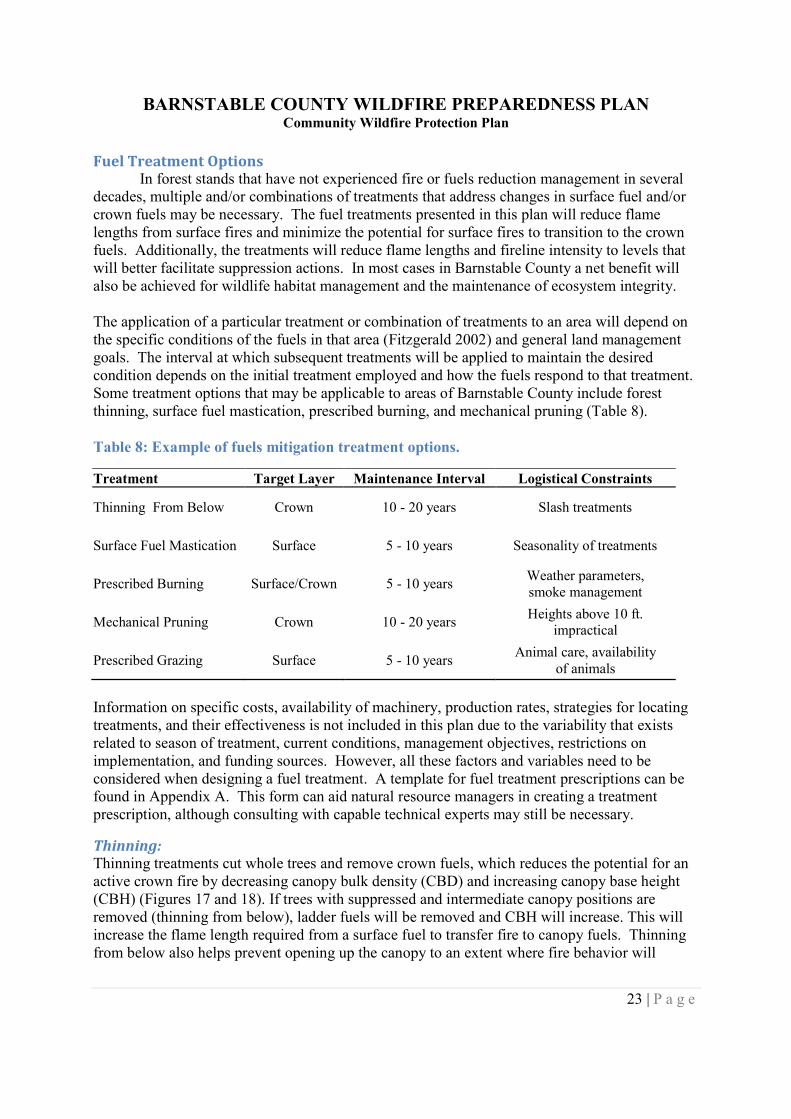
Thinning:Thinning treatments cut whole trees and remove crown fuels, which reduces the potential for anactive crown fire by decreasing canopy bulk density (CBD) and increasing canopy base height(CBH) (Figures 17 and 18). If trees with suppressed and intermediate canopy positions areremoved (thinning from below), ladder fuels will be removed and CBH will increase. This willincrease the flame length required from a surface fuel to transfer fire to canopy fuels. Thinningfrom below also helps prevent opening up the canopy to an extent where fire behavior will
BARNSTABLE COUNTY WILDFIRE PREPAREDNESS PLANCommunity Wildfire Protection Plan
24 | P a g e
increase due to increased surface midflame wind speed and an increase in the drying rate ofsurface fuels.
Figure 17: Canopy Base Height and Canopy Bulk Density.
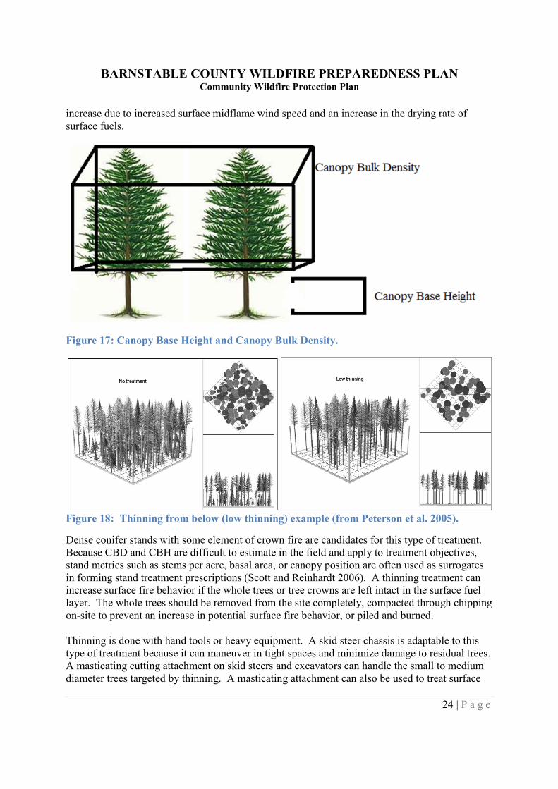
Figure 18: Thinning from below (low thinning) example (from Peterson et al. 2005).
Dense conifer stands with some element of crown fire are candidates for this type of treatment.Because CBD and CBH are difficult to estimate in the field and apply to treatment objectives,stand metrics such as stems per acre, basal area, or canopy position are often used as surrogatesin forming stand treatment prescriptions (Scott and Reinhardt 2006). A thinning treatment canincrease surface fire behavior if the whole trees or tree crowns are left intact in the surface fuellayer. The whole trees should be removed from the site completely, compacted through chippingon-site to prevent an increase in potential surface fire behavior, or piled and burned.
Thinning is done with hand tools or heavy equipment. A skid steer chassis is adaptable to thistype of treatment because it can maneuver in tight spaces and minimize damage to residual trees.A masticating cutting attachment on skid steers and excavators can handle the small to mediumdiameter trees targeted by thinning. A masticating attachment can also be used to treat surface
BARNSTABLE COUNTY WILDFIRE PREPAREDNESS PLANCommunity Wildfire Protection Plan
25 | P a g e
fuels (see Surface Fuel Mastication below). Larger diameter trees would need to be cut by handor with a tree shear attachment on more traditional timber harvesting equipment.
The cost for thinning materials depends on site access, the size and amount of material to thin,treatment area size, and current markets for products being removed. Slash must be considered;it could be piled and burned, scattered, or chipped and hauled away. Additionally, mechanicaltreatments can serve as a source of invasive species if equipment is not cleaned prior totreatments.
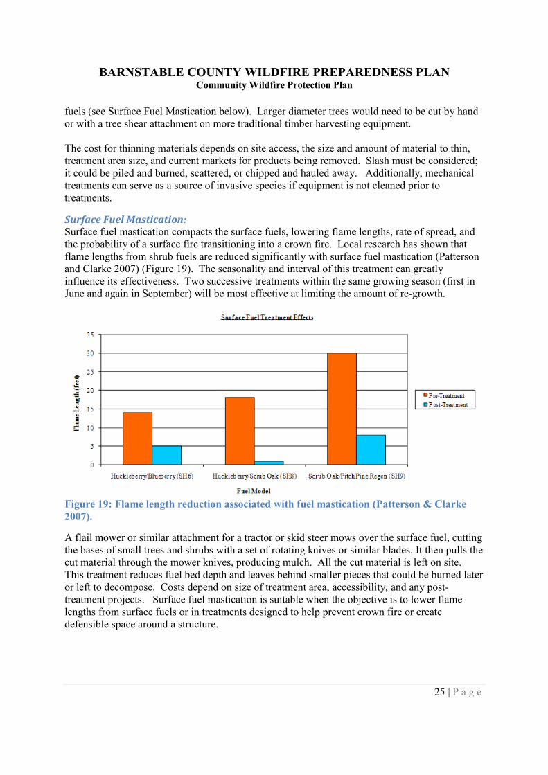
Surface Fuel Mastication:Surface fuel mastication compacts the surface fuels, lowering flame lengths, rate of spread, andthe probability of a surface fire transitioning into a crown fire. Local research has shown thatflame lengths from shrub fuels are reduced significantly with surface fuel mastication (Pattersonand Clarke 2007) (Figure 19). The seasonality and interval of this treatment can greatlyinfluence its effectiveness. Two successive treatments within the same growing season (first inJune and again in September) will be most effective at limiting the amount of re-growth.
Figure 19: Flame length reduction associated with fuel mastication (Patterson & Clarke2007).
A flail mower or similar attachment for a tractor or skid steer mows over the surface fuel, cuttingthe bases of small trees and shrubs with a set of rotating knives or similar blades. It then pulls thecut material through the mower knives, producing mulch. All the cut material is left on site.This treatment reduces fuel bed depth and leaves behind smaller pieces that could be burned lateror left to decompose. Costs depend on size of treatment area, accessibility, and any post-treatment projects. Surface fuel mastication is suitable when the objective is to lower flamelengths from surface fuels or in treatments designed to help prevent crown fire or createdefensible space around a structure.
BARNSTABLE COUNTY WILDFIRE PREPAREDNESS PLANCommunity Wildfire Protection Plan
26 | P a g e
Mechanical Pruning:Pruning, the removal of lower branches to a specified height, increases canopy base height,decreasing the potential for fire to spread up ladder fuels and into the crown. The prunedbranches are usually chipped or piled and burned to avoid adding surface fuels.
Mechanical pruning is usually done with chainsaws. Because of height limitations for safechainsaw use, pruning above 10 feet is impractical (Scott 2006). Mechanical pruning is verylabor intensive.
This treatment can be effective in areas where the objective is to reduce crown fire potential byincreasing canopy base height. Pruning can increase canopy base height to a maximum of 12feet. This treatment is most often used in combination with a surface fuel treatment.
Prescribed Burning:Prescribed burns can mimic a natural regime and return fire to its vital role in certain ecosystemsin a controlled fashion. It is also a tool for hazard fuel reduction to reduce the risk ofcatastrophic wildfires.
Depending on the condition when an area is burned, prescribed fire can address both surface andcrown fuels. The fire consumes surface fuel loads, which will reduce fire behavior (flame lengthand rate of spread) post-burn. A prescribed burn can also increase the height required for asurface fire to transition to a crown fire by scorching lower branches. These scorched brancheswill eventually fall off, effectively pruning the tree and raising canopy base height.
While prescribed fires have been shown to be more efficient at thermal pruning and treatingsurface fuels than mechanical treatments (Scott 2006), it is not applicable to areas where there isa crown fire risk without a mechanical treatment pre-burn.
Restrictive weather parameters under which a burn can be conducted, additional planningrequirements, smoke management problems, and increased liability risks make this treatmentoption more difficult to employ then mechanical treatments. Costs depend on the time of yearbecause it determines the amount of mop-up needed. Other factors influencing cost are unit size,type of equipment needed, number of experienced personnel required, and the cost of preparingfirelines or firebreaks.
Prescribed Grazing:Prescribed grazing can be a type of fuel treatment where animals consume vegetation and reducefuel loads and/or fuel density. Grazing is most effective in grasslands where goats, sheep, horsesor cattle can consume the fine fuels. Because each animal grazes differently, not all animals willbe suited to all areas. Plants and conditions like unit size and shrub density must be suited to thegrazing species.
Grazing can be used annually in grasslands as a tool to reduce fine fuels and fire hazard. It is arelatively inexpensive treatment method. However, negative effects of overgrazing like soilcompaction or increased erosion are possible. Grazing can also result in an influx of invasive
BARNSTABLE COUNTY WILDFIRE PREPAREDNESS PLANCommunity Wildfire Protection Plan
27 | P a g e
species. Additional controls like fencing off sensitive or riparian areas may be required toachieve a successful treatment.
Generic Treatment ObjectivesDue to the scale of the Barnstable County Wildfire Preparedness Plan and the complexity of theinformation that must be conveyed, specific treatment prescriptions are not presented in thisplan. A Site Implementation Plan (see Appendix A) should be prepared using conceptspresented in this plan and adapting generic treatment prescriptions to specific site conditions andproperty management goals. The following paragraphs contain possible objectives for fueltreatments.
Active Crown Fire Reduction:Treatments can eliminate the potential for the occurrence of active crown fire by decreasingpredicted flame lengths from surface fuels and/or decreasing CBD to a level where an activecrown fire cannot be sustained (i.e. crowns are further apart).
Treatment recommendations include surface fuel treatments (mastication or prescribed burning)and thinning from below by diameter and/or canopy position. Surface fuels should be masticatedto within 3' of the boles of all trees with the intent of reducing average surface fuel depths.Mastication should include all herbaceous vegetation, shrubs, and small conifer trees. Crownfuel thinning treatments should select suppressed and intermediate trees and trees with a highcrown ratio. If trees were not masticated during felling, they should be removed from the site,piled and burned, or chipped with the resulting material spread out or removed from the site.
When possible, stand level plot data should be acquired and analyzed to model existingconditions and to identify target thresholds for fuel removal. This analysis can be achieved byusing software such as Fuels Management Analyst 3.
Firefighter Access/Egress:Finding suitable places for fire engines to turn around in high-risk areas can aid in increasingsuppression capabilities. Aerial photos and field inspections should be used in combination withexisting spatial databases of roads to identify roads that are suitable places for a fire engine toturn around. Larger wildland fire apparatus have a turning radius of approximately 65 feet, so aminimum space of approximately 35 feet by 35 feet is required for a 3-point turn. These areasshould be clear of trees and shrubs and have no obstacles or holes greater than 8 inches in depthto avoid ground clearance issues associated with smaller engines.
Safety Zones:Available safety zones, locations where firefighters and apparatus are clear of wildland firethreats, are crucial in enabling wildland fire suppression. Aerial photos and field inspectionsshould be used in combination with existing spatial databases of roads to identify road and trailjunctions where safety zones can be established. Although these junctions usually have areasfree of combustible material, the surrounding fuels need treatments that will provide firefightersa buffer of 4 times the surrounding flame lengths.
BARNSTABLE COUNTY WILDFIRE PREPAREDNESS PLANCommunity Wildfire Protection Plan
28 | P a g e
Identifying stand fuel models and fire behavior specific to a site is more beneficial for designingspecific treatments than using the coarse scale flame length data presented in this plan. Thisanalysis can be achieved by using software such as BehavePlus.
Strategic Road Buffers:Creating buffers along important roads may help control the spread of wildland fire. Forexample, a road that separates a housing development from a wildland can be buffered with afirebreak to slow fire spread or reduce fire intensity. Aerial photos and field inspections shouldbe used in combination with existing spatial databases of roads to identify roads that may be usedto control the spread of a wildland fire. Surface fuels should be treated for a minimum of 10 to30 feet on both sides of any road and limbs should be trimmed to a height so as not to impairemergency vehicle passage.
Landscape Fuel Treatments:Fire behavior at the landscape scale may be addressed through the application of fuel treatmentsin a strategic pattern (Finney 2001). Surface fuel treatments should be applied in a staggered,overlapping pattern, perpendicular to the prevailing southwest wind (Finney 2001). Irregularlyshaped treatments would still achieve treatment objectives as long as they are placed in astaggered and overlapping manner. Treating a small fraction of the landscape using thistreatment method would reduce the rate of spread associated with a large wildfire (Finney 2001).
The landscape fuel treatment option is not always feasible depending on the configuration andcondition of the property being considered and the capacity of the managing entity. However,this option is best suited to create resilient and healthy ecosystems in the fire adapted landscapethat covers much of Barnstable County.
Prioritizing Fuel Reduction Treatments:The Barnstable County Wildfire Preparedness Plan is unique in that it attempts to address firerisk for many private ownerships and land management agencies across Barnstable County.Given its complex nature, it is impossible to lay out a comprehensive treatment prioritization andscheduling outline for the entire county. However, it is possible to lay out a hierarchy of actionsto be evaluated and addressed in an opportunistic and strategic manner as resources,organizational goals, and needs all unite to present management opportunities. Generally, thehighest priority should be given to management actions on areas that are rated as ‘High’ or‘Extreme’ in the Barnstable County Wildland Fire Risk Assessment. Additionally areas with a“Low” or “Moderate rating containing improvements (developments or infrastructure) orimportant natural resources that are potentially sensitive to fire impacts, immediately adjacent toareas rated as ‘High’ or ‘Extreme’ should also be given a high priority for management actions.Treatment actions on these lands will be the most effective in reducing overall wildland fire risk.
Measures to Reduce Structural IgnitabilityMany houses throughout Barnstable County are located next to or among areas of undevelopedor preserved lands. Houses in this zone, the WUI, become vulnerable to wildfires that mayignite in the surrounding area. However, homeowners can take simple actions to reduce thepotential ignition of their homes. A home’s exterior and yard characteristics can greatlyinfluence its ignitability and chances for survival (Cohen 2000).
BARNSTABLE COUNTY WILDFIRE PREPAREDNESS PLANCommunity Wildfire Protection Plan
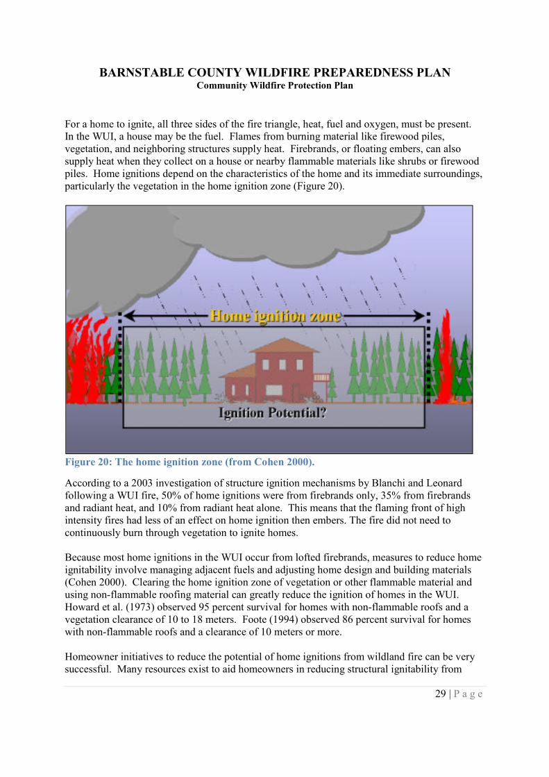
29 | P a g e
For a home to ignite, all three sides of the fire triangle, heat, fuel and oxygen, must be present.In the WUI, a house may be the fuel. Flames from burning material like firewood piles,vegetation, and neighboring structures supply heat. Firebrands, or floating embers, can alsosupply heat when they collect on a house or nearby flammable materials like shrubs or firewoodpiles. Home ignitions depend on the characteristics of the home and its immediate surroundings,particularly the vegetation in the home ignition zone (Figure 20).
Figure 20: The home ignition zone (from Cohen 2000).
According to a 2003 investigation of structure ignition mechanisms by Blanchi and Leonardfollowing a WUI fire, 50% of home ignitions were from firebrands only, 35% from firebrandsand radiant heat, and 10% from radiant heat alone. This means that the flaming front of highintensity fires had less of an effect on home ignition then embers. The fire did not need tocontinuously burn through vegetation to ignite homes.
Because most home ignitions in the WUI occur from lofted firebrands, measures to reduce homeignitability involve managing adjacent fuels and adjusting home design and building materials(Cohen 2000). Clearing the home ignition zone of vegetation or other flammable material andusing non-flammable roofing material can greatly reduce the ignition of homes in the WUI.Howard et al. (1973) observed 95 percent survival for homes with non-flammable roofs and avegetation clearance of 10 to 18 meters. Foote (1994) observed 86 percent survival for homeswith non-flammable roofs and a clearance of 10 meters or more.
Homeowner initiatives to reduce the potential of home ignitions from wildland fire can be verysuccessful. Many resources exist to aid homeowners in reducing structural ignitability from
BARNSTABLE COUNTY WILDFIRE PREPAREDNESS PLANCommunity Wildfire Protection Plan
30 | P a g e
wildland fire. The National Fire Protection Association (NFPA) started the FirewiseCommunities initiative in 1997 to teach people how to adapt and live with wildfire whileencouraging local solutions for wildfire safety and increased preparedness. The Firewiseinitiative has published many strategies to reduce the risk of structures burning in the WUIduring a wildfire. Guides for landscaping and construction, as well as many other resources forhomeowners, are available on the Firewise website, www.firewise.org.
Firewise has created guides and tools for homeowners, firefighters, and planners to aid inimproving wildfire preparedness and reducing WUI fire hazards. For homeowners, they addressstrategies to reduce home ignition risk in two categories, landscaping and construction.
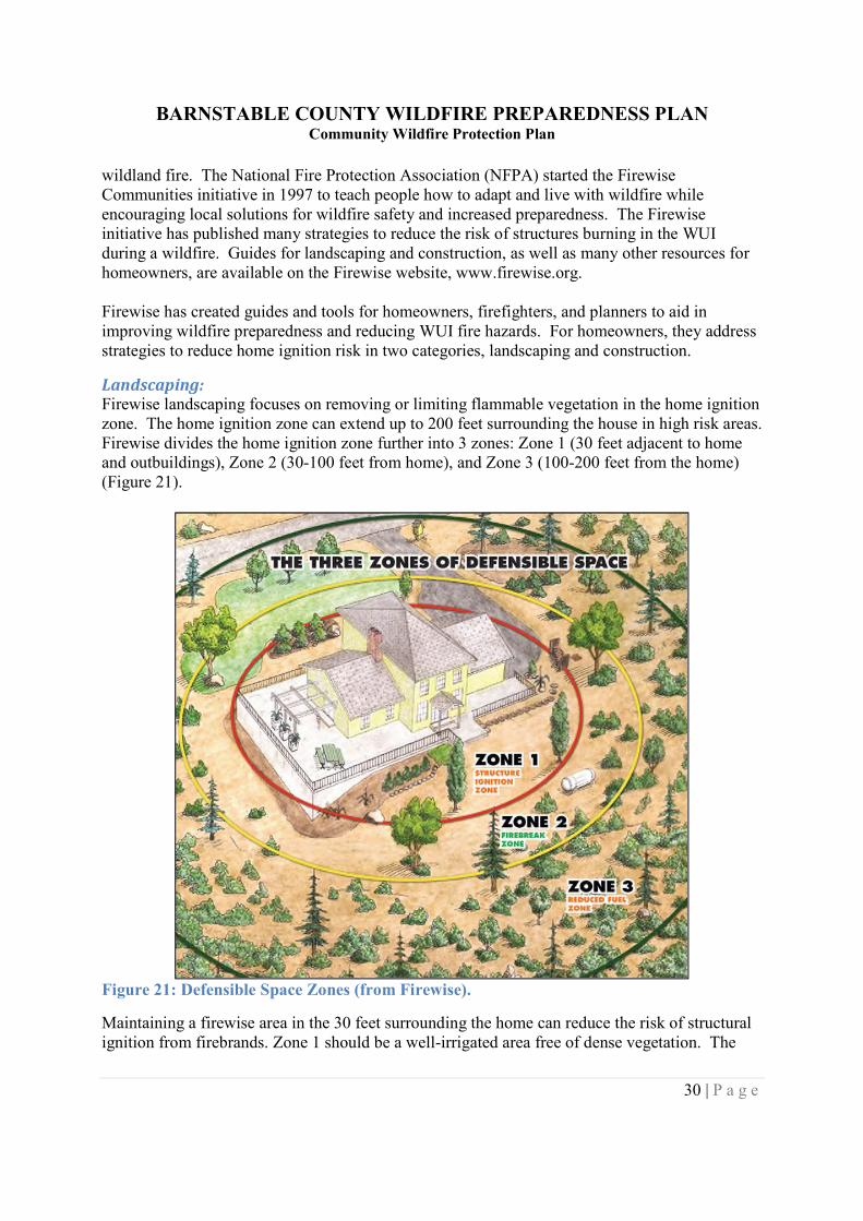
Landscaping:Firewise landscaping focuses on removing or limiting flammable vegetation in the home ignitionzone. The home ignition zone can extend up to 200 feet surrounding the house in high risk areas.Firewise divides the home ignition zone further into 3 zones: Zone 1 (30 feet adjacent to homeand outbuildings), Zone 2 (30-100 feet from home), and Zone 3 (100-200 feet from the home)(Figure 21).
Figure 21: Defensible Space Zones (from Firewise).
Maintaining a firewise area in the 30 feet surrounding the home can reduce the risk of structuralignition from firebrands. Zone 1 should be a well-irrigated area free of dense vegetation. The
BARNSTABLE COUNTY WILDFIRE PREPAREDNESS PLANCommunity Wildfire Protection Plan
31 | P a g e
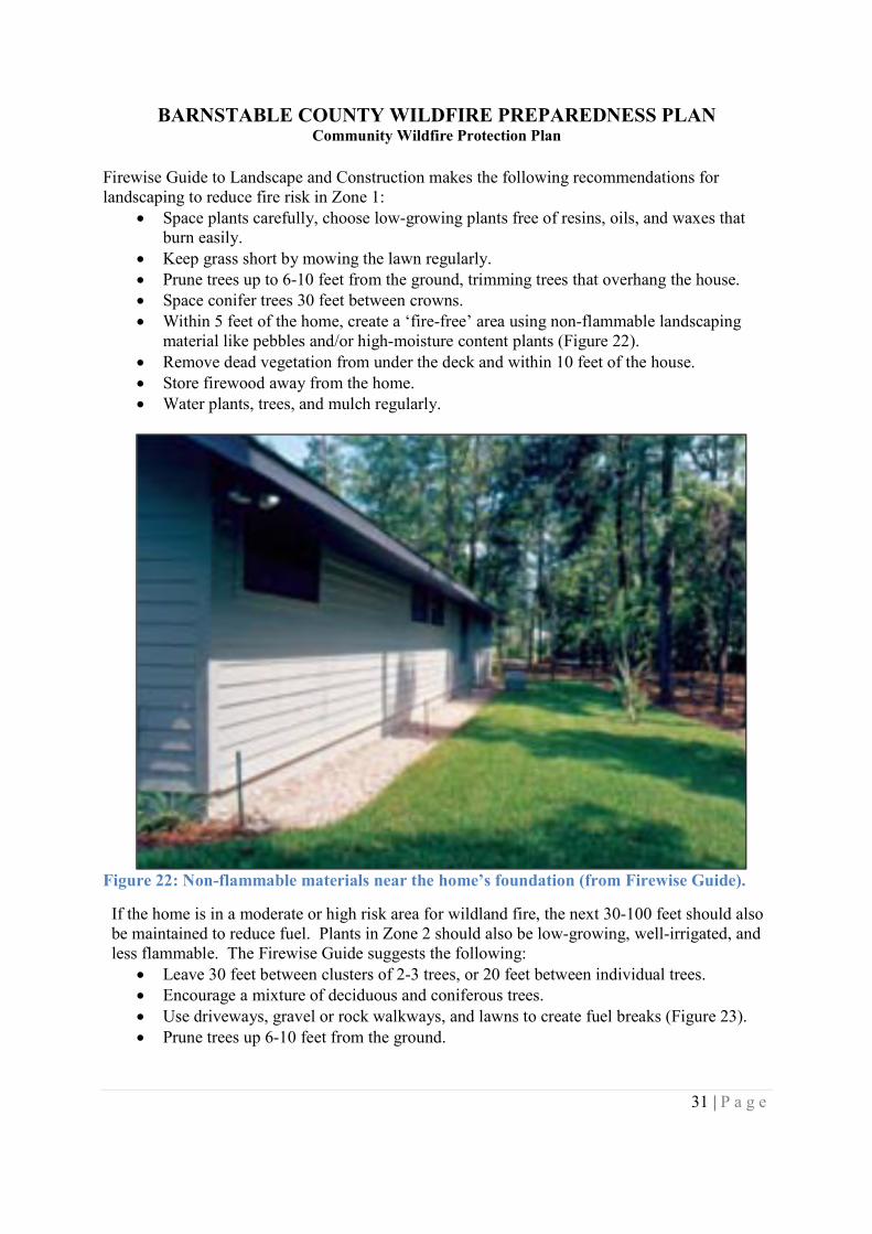
Firewise Guide to Landscape and Construction makes the following recommendations forlandscaping to reduce fire risk in Zone 1:
Space plants carefully, choose low-growing plants free of resins, oils, and waxes thatburn easily.
Keep grass short by mowing the lawn regularly. Prune trees up to 6-10 feet from the ground, trimming trees that overhang the house. Space conifer trees 30 feet between crowns. Within 5 feet of the home, create a ‘fire-free’ area using non-flammable landscaping
material like pebbles and/or high-moisture content plants (Figure 22). Remove dead vegetation from under the deck and within 10 feet of the house. Store firewood away from the home. Water plants, trees, and mulch regularly.
Figure 22: Non-flammable materials near the home’s foundation (from Firewise Guide).
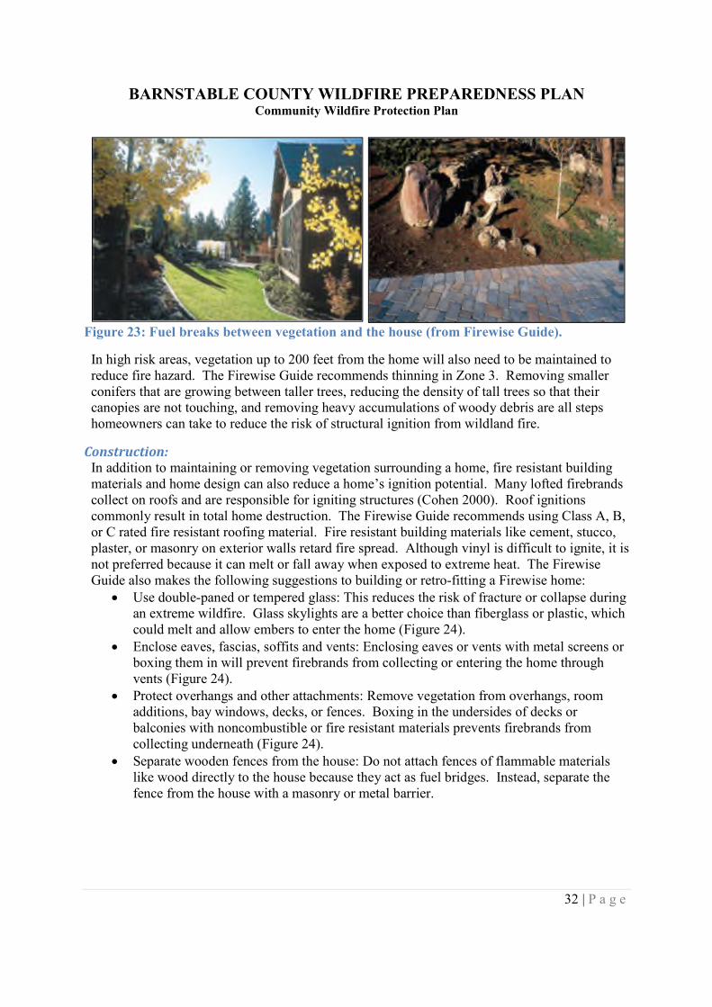
If the home is in a moderate or high risk area for wildland fire, the next 30-100 feet should alsobe maintained to reduce fuel. Plants in Zone 2 should also be low-growing, well-irrigated, andless flammable. The Firewise Guide suggests the following:
Leave 30 feet between clusters of 2-3 trees, or 20 feet between individual trees. Encourage a mixture of deciduous and coniferous trees. Use driveways, gravel or rock walkways, and lawns to create fuel breaks (Figure 23). Prune trees up 6-10 feet from the ground.
BARNSTABLE COUNTY WILDFIRE PREPAREDNESS PLANCommunity Wildfire Protection Plan
32 | P a g e
Figure 23: Fuel breaks between vegetation and the house (from Firewise Guide).
In high risk areas, vegetation up to 200 feet from the home will also need to be maintained toreduce fire hazard. The Firewise Guide recommends thinning in Zone 3. Removing smallerconifers that are growing between taller trees, reducing the density of tall trees so that theircanopies are not touching, and removing heavy accumulations of woody debris are all stepshomeowners can take to reduce the risk of structural ignition from wildland fire.
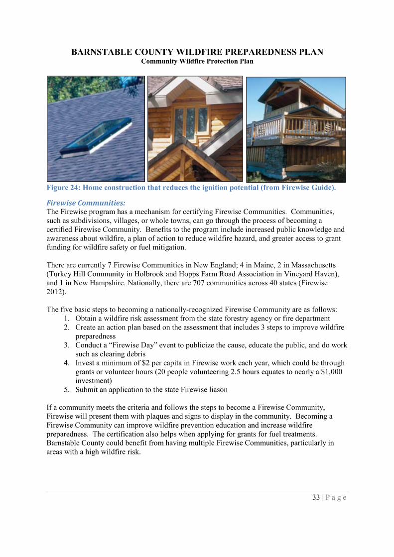
Construction:In addition to maintaining or removing vegetation surrounding a home, fire resistant buildingmaterials and home design can also reduce a home’s ignition potential. Many lofted firebrandscollect on roofs and are responsible for igniting structures (Cohen 2000). Roof ignitionscommonly result in total home destruction. The Firewise Guide recommends using Class A, B,or C rated fire resistant roofing material. Fire resistant building materials like cement, stucco,plaster, or masonry on exterior walls retard fire spread. Although vinyl is difficult to ignite, it isnot preferred because it can melt or fall away when exposed to extreme heat. The FirewiseGuide also makes the following suggestions to building or retro-fitting a Firewise home:
Use double-paned or tempered glass: This reduces the risk of fracture or collapse duringan extreme wildfire. Glass skylights are a better choice than fiberglass or plastic, whichcould melt and allow embers to enter the home (Figure 24).
Enclose eaves, fascias, soffits and vents: Enclosing eaves or vents with metal screens orboxing them in will prevent firebrands from collecting or entering the home throughvents (Figure 24).
Protect overhangs and other attachments: Remove vegetation from overhangs, roomadditions, bay windows, decks, or fences. Boxing in the undersides of decks orbalconies with noncombustible or fire resistant materials prevents firebrands fromcollecting underneath (Figure 24).
Separate wooden fences from the house: Do not attach fences of flammable materialslike wood directly to the house because they act as fuel bridges. Instead, separate thefence from the house with a masonry or metal barrier.
BARNSTABLE COUNTY WILDFIRE PREPAREDNESS PLANCommunity Wildfire Protection Plan
33 | P a g e
Figure 24: Home construction that reduces the ignition potential (from Firewise Guide).
Firewise Communities:The Firewise program has a mechanism for certifying Firewise Communities. Communities,such as subdivisions, villages, or whole towns, can go through the process of becoming acertified Firewise Community. Benefits to the program include increased public knowledge andawareness about wildfire, a plan of action to reduce wildfire hazard, and greater access to grantfunding for wildfire safety or fuel mitigation.
There are currently 7 Firewise Communities in New England; 4 in Maine, 2 in Massachusetts(Turkey Hill Community in Holbrook and Hopps Farm Road Association in Vineyard Haven),and 1 in New Hampshire. Nationally, there are 707 communities across 40 states (Firewise2012).
The five basic steps to becoming a nationally-recognized Firewise Community are as follows:1. Obtain a wildfire risk assessment from the state forestry agency or fire department2. Create an action plan based on the assessment that includes 3 steps to improve wildfire
preparedness3. Conduct a “Firewise Day” event to publicize the cause, educate the public, and do work
such as clearing debris4. Invest a minimum of $2 per capita in Firewise work each year, which could be through
grants or volunteer hours (20 people volunteering 2.5 hours equates to nearly a $1,000investment)
5. Submit an application to the state Firewise liason
If a community meets the criteria and follows the steps to become a Firewise Community,Firewise will present them with plaques and signs to display in the community. Becoming aFirewise Community can improve wildfire prevention education and increase wildfirepreparedness. The certification also helps when applying for grants for fuel treatments.Barnstable County could benefit from having multiple Firewise Communities, particularly inareas with a high wildfire risk.
BARNSTABLE COUNTY WILDFIRE PREPAREDNESS PLANCommunity Wildfire Protection Plan
34 | P a g e
Strategies to Increase Preparedness
Research indicates that the most effective ways to increase wildland fire preparedness inBarnstable County include:
Applying fuel treatments to areas of high or extreme wildland fire risk Increasing education and public outreach efforts on Firewise/defensible space treatments
and fire prevention Increased wildland fire training opportunities for Barnstable County firefighters
Fuel treatments can be implemented on high-priority lands (those with high or extreme fire risk)to reduce the threat of wildland fire. Properties or housing developments adjacent to high-riskareas could conduct Firewise work and create defensible space to reduce the threat of wildlandfire to structures. Fuel treatments combined with Firewise projects can be very effective atreducing wildland fire risk and increasing wildfire preparedness.
Residents of Barnstable County need to be aware of wildfire risk and educated about the stepsthey can take as homeowners to reduce fire hazard. Two fire departments surveyed indicatedthat they conduct site visits and discuss defensible space with homeowners. Fire departments,town officials, state agencies, or other professionals can use the risk assessment presented in thisplan for prioritizing neighborhoods that may require site visits or Firewise work. This willincrease overall wildfire preparedness for Barnstable County.
Increasing public outreach and education on wildland fire prevention is equally important onreducing wildfire risk. Common wildfire start occurrences as identified in the fire departmentsurvey include careless disposal of smoking materials, permit burns getting out of control, andchildren playing with fire. Educating the public on safe ways to conduct pile burns or increasingfire awareness during periods of high fire danger can be effective. Additionally, having Smokythe Bear visit Barnstable County schools can help educate children on wildfire prevention.
A challenge that Barnstable County faces is the increased population during the summer, whichoften corresponds with periods of high fire danger. People who are not full-time residents maybe unaware of wildfire danger on Cape Cod. If Cape Cod encountered a severe drought or otherfactors that greatly increased fire danger, public service announcements or other forms ofoutreach would be important in educating visitors.
Expanding opportunities for wildland fire training for town fire departments would increasewildland fire suppression capabilities and wildfire preparedness. Courses in wildland fire atCape Cod Community College could benefit potential firefighters or serve as continuingeducation for those already in the fire service. More county or state-run wildfire classes wouldalso benefit town firefighters. Participation on prescribed burns and live fire exercises wouldprovide training opportunities for town departments.
The establishment of a county-wide natural communities map would enable detailed wildlandfuel model mapping. The county-wide natural community and wildland fuels map wouldestablish a baseline to track landscape level change overtime as a result of disturbance,development, or management actions.
BARNSTABLE COUNTY WILDFIRE PREPAREDNESS PLANCommunity Wildfire Protection Plan
35 | P a g e
A county-wide atlas of fuel treatments or prescribed burns across Cape Cod would greatly assistland managers and aid in wildfire planning. A county-wide database of the location, size, anddate of any fuel treatment work would assist town planners in prioritizing future treatments andfollowing up on past work. A log of wildfire mitigation projects would also aid in assessing theBarnstable County Wildfire Preparedness Plan, as future risk assessments may adjust wildfirerisk (i.e. a red polygon goes to a yellow) based on work that has been done. Creating a county-wide database would require collaboration between the towns, Barnstable County offices, thestate, and federal agencies with land on Cape Cod. Although creating this database wouldrequire effort and diligence, keeping a record of mitigation projects would strengthen wildfirepreparedness and direct future work.
SOURCES OF FUNDING FOR MITIGATION WORKWildfire hazard reduction funding is available from numerous grant sources (see Appendix D:Sources of Funding). Many of the grants are specifically designed to address planning andimplementation for fuel hazard reduction, equipment acquisition, training, public education, anddisaster response. A number of the grant programs provide assistance with planning andimplementation on projects related to forestry, wildlife habitat, and endangered speciesmanagement. In many cases in Barnstable County both fire risk and forestry, wildlife habitat,and endangered species management can be addressed at the same time, enabling well plannedprograms to be funded by these non-specific fire funding sources.
FRAMEWORK TO EVALUATE PLANEvaluating the Barnstable County Wildfire Preparedness Plan at regular intervals wouldstrengthen its implementation and keep it up to date with current conditions. As communitydemographics and forest conditions change, so will wildfire risk. The plan and its assessmentscan be repeated to adapt to these changes.
Annual progress reports should be written each year. These brief reports would containdescriptions of what has been done in Barnstable County will keep a record of any projects donerelating to the plan. Summaries of any fuel treatments, Firewise work, or major wildfires inBarnstable County would aid greatly in keeping the plan up to date.
Full evaluations should be conducted on a periodic basis. Every 5-10 years, the community riskassessment should be repeated as conditions change. This evaluation would identify changes inwildfire risk- such as more development in high-risk areas. This assessment would incorporatethe most recent data sets. Additionally, if fuel treatments have been applied and tracked, wildfirerisk may be reduced (i.e. an area would shift from red to yellow on the map) and documented.
A periodic evaluation would update the Barnstable County Wildfire Preparedness Plan to ensureCWPP goals and objectives are being met and to identify areas for further action. Manyresources are available for communities to develop a framework for evaluating their plans, suchas the CWPP Evaluation Guide created by the University of Oregon, which containsquestionnaires and surveys and is available at the school’s website.
BARNSTABLE COUNTY WILDFIRE PREPAREDNESS PLANCommunity Wildfire Protection Plan
36 | P a g e
COLLABORATIVE PROCESSThe Barnstable County Wildfire Preparedness Plan is a product of collaboration between theCape Cod Cooperative Extension, Massachusetts Department of Conservation and Recreation,and the Barnstable County Fire Chiefs. Meetings to provide stake holders with the planningprocess and to receive process input were held with Cape Cod Cooperative Extension officials,the guidance committee (listed on page ii), municipal natural resource managers, BarnstableCounty Fire Chiefs, the Barnstable County Regional Emergency Planning Committee, andfederal and state land managers in Barnstable County.
A project summary was presented in a poster board format at the Cape Cod Natural HistoryConference in March 2012. The County Extension Director for Cape Cod CooperativeExtension provided a project overview during an interview with WQRC 99.9 FM radio andOcean 104.7 FM radio in April 2012.
BARNSTABLE COUNTY WILDFIRE PREPAREDNESS PLANCommunity Wildfire Protection Plan
37 | P a g e
GLOSSARY(Modified from the National Wildfire Coordinating Group Glossary of Wildland Fire Terminology)
Active Crown Fire - A fire in which a solid flame develops in the crowns of trees, but thesurface and crown phases advance as a linked unit dependent on each other.
Activity Fuels - Fuels resulting from, or altered by, forestry practices such as timber harvest orthinning, as opposed to naturally created fuels.
Aerial Fuels - Standing and supported live and dead combustibles not in direct contact with theground and consisting mainly of foliage, twigs, branches, stems, cones, bark, and vines.
Ambient Air - Air of the surrounding environment.
Aspect - Cardinal direction toward which a slope faces.
Available Fuel - That portion of the total fuel that would actually burn under variousenvironmental conditions.
Backing Fire - Fire spreading, or ignited to spread, into (against) the wind or downslope. A firespreading on level ground in the absence of wind is a backing fire.
Barrier - Any obstruction to the spread of fire. Typically an area or strip devoid of combustiblefuel.
Behavior - An observable activity or action demonstrated by an individual in a particularcontext.
Bole - The trunk of a tree.
British Thermal Unit (Btu) - Amount of heat required to raise 1 pound of water 1 degreeFahrenheit (from 59.50 to 60.50 F), measured at standard atmospheric pressure.
Broadcast Burning - Prescribed burning activity where fire is applied generally to most or all ofan area within well-defined boundaries for reduction of fuel hazard, as a resource managementtreatment, or both.
Brush - A collective term that refers to stands of vegetation dominated by shrubby, woodyplants, or low growing trees, usually of a type undesirable for livestock or timber management.
Brush Breaker – A combination of an all-terrain vehicle and fire engine often used to fightwildfires.
Brush Fire - A fire burning in vegetation that is predominantly shrubs, brush, and scrub growth.
BARNSTABLE COUNTY WILDFIRE PREPAREDNESS PLANCommunity Wildfire Protection Plan
38 | P a g e
Brush Management - Manipulation of stands of brush by manual, mechanical, chemical, orbiological means or by prescribed burning for the purpose of achieving land managementobjectives.
Build-up - The cumulative effects of long-term drying on current fire danger.
Burn Patterns - The characteristic configuration of char left by a fire. In wildland fires burnpatterns are influenced by topography, wind direction, length of exposure, and type of fuel.Definitions are scale-dependent: (1) They can be used to trace a fire's origin; (2) They areinfluenced by severity and intensity within a stand; (3) They describe the landscape mosaic.
Burning Conditions - The state of the combined factors of the environment that affect firebehavior in a specified fuel type.
Canopy - The stratum containing the crowns of the tallest vegetation present (living or dead),usually above 20 feet.
Canopy Base Height – The average height from the ground to a forest stand’s canopy bottom.
Canopy Bulk Density – The density of available canopy fuel in a stand, or the mass of availablecanopy fuel per canopy volume unit.
Cardinal Directions - North, south, east, west; used for giving directions and information fromthe ground or air in describing the fire (e.g., the west flank or east flank, not right flank or leftflank).
Carrier Fuels - The fuels that support the flaming front of the moving fire.
Chain - Unit of measure in land survey, equal to 66 feet (20 M) (80 chains equal 1 mile).Commonly used to report fire perimeters and other fireline distances, this unit is popular in firemanagement because of its convenience in calculating acreage (e.g., 10 square chains equal oneacre).
Char - Carbonaceous material formed by incomplete combustion of an organic material, mostcommonly wood; remains of burned materials.
Char Height - The vertical distance above ground scorched or blackened on a tree bole.
Climate - The prevalent or characteristic meteorological conditions of any place or region, andtheir extremes.
Community Wildfire Protection Plan (CWPP) - A plan developed in the collaborativeframework established by the Wildland Fire Leadership Council and agreed to by state, tribal,and local government, local fire department, other stakeholders and federal land managementagencies managing land in the vicinity of the planning area. A Community Wildfire ProtectionPlan (CWPP) identifies and prioritizes areas for hazardous fuel reduction treatments and
BARNSTABLE COUNTY WILDFIRE PREPAREDNESS PLANCommunity Wildfire Protection Plan
39 | P a g e
recommends the types and methods of treatment on Federal and non-Federal land that willprotect one or more at-risk communities and essential infrastructure and recommends measuresto reduce structural ignitability throughout the at-risk community. A CWPP may address issuessuch as wildfire response, hazard mitigation, community preparedness, or structure protection –or all of the above.
Condition Class - Depiction of the degree of departure from historical fire regimes, possiblyresulting in alternations of key ecosystem components. These classes categorize and describevegetation composition and structure conditions that currently exist inside the Fire RegimeGroups. Based on the coarse-scale national data, they serve as generalized wildfire rankings.The risk of loss of key ecosystem components from wildfires increases from Condition Class 1(lowest risk) to Condition Class 3 (highest risk).
Condition of Vegetation - Stage of growth or degree of flammability of vegetation that formspart of a fuel complex. Herbaceous stage is at times used when referring to herbaceousvegetation alone. In grass areas minimum qualitative distinctions for stages of annual growth areusually green, curing, and dry or cured.
Conduction - Heat transfer through a material from a region of higher temperature to a region oflower temperature.
Conflagration - A raging, destructive fire. Often used to connote such a fire with a movingfront as distinguished from a fire storm.
Consumption - The amount of a specified fuel type or strata that is removed through the fireprocess, often expressed as a percentage of the preburn weight.
Control Line - An inclusive term for all constructed or natural barriers and treated fire edgesused to control a fire.
Convection - The transfer of heat by the movement of a gas or liquid; convection, conduction,and radiation are the principal means of energy transfer.
Coordinates - The intersection of lines of reference, usually expressed indegrees/minutes/seconds of latitude and longitude, used to determine or report position orlocation.
Cover - The area on the ground covered by the combined aerial parts of plants expressed as apercent of the total area.
Cover Type - The designation of a vegetation complex described by dominant species, age, andform.
Creeping Fire - Fire burning with a low flame and spreading slowly.
Crown Consumption - Combustion of the twigs, and needles or leaves of a tree during a fire.
BARNSTABLE COUNTY WILDFIRE PREPAREDNESS PLANCommunity Wildfire Protection Plan
40 | P a g e
Crown Cover - The ground area covered by the crown of a tree as delimited by the verticalprojection of its outermost perimeter.
Crown Fire - A fire that advances from top to top of trees or shrubs more or less independent ofa surface fire. Crown fires are sometimes classed as running or dependent to distinguish thedegree of independence from the surface fire.
Crown Out - A fire that rises from ground into the tree crowns and advances from tree top totree top. To intermittently ignite tree crowns as a surface fire advances.
Crown Ratio - The ratio of live crown to tree height.
Crowning Potential - A probability that a crown fire may start, calculated from inputs of foliagemoisture content and height of the lowest part of the tree crowns above the surface.
Curing - Drying and browning of herbaceous vegetation due to mortality or senescence, and alsoloss of live fuel moisture content of woody fuel following mechanically-caused mortality (e.g.,woody debris slash.)
Dead Fuels - Fuels with no living tissue in which moisture content is governed almost entirelyby absorption or evaporation of atmospheric moisture (relative humidity and precipitation).
Debris Burning Fire - In prescribed fire terminology, a fire used to dispose of scattered, piled,or windrowed dead woody fuel, generally in the absence of a merchantable overstory. Itspurpose is to reduce unsightly fuel concentrations, or consume unwanted natural fuels tofacilitate subsequent resource management or land use actions on the area.
Dew Point - Temperature to which a specified parcel of air must cool, at constant pressure andwater-vapor content, in order for saturation to occur. The dew point is always lower than thewet-bulb temperature, which is always lower than the dry-bulb temperature, except when the airis saturated and all three values are equal. Fog may form when temperature drops to equal thedew point.
Digital Elevation Model - A set of points which defines the terrain as numbers for computerapplications. This data may be used to draw contours, make ortho photos, slope maps, and drivefire models.
Direct Attack - Any treatment applied directly to burning fuel such as wetting, smothering, orchemically quenching the fire or by physically separating the burning from unburned fuel.
Direct Protection Area - That area for which a particular fire protection organization has theprimary responsibility for attacking an uncontrolled fire and for directing the suppression action.Such responsibility may develop through law, contract, or personal interest of the firefightingagent (e.g., a lumber operator). Several agencies or entities may have some basic responsibilities
BARNSTABLE COUNTY WILDFIRE PREPAREDNESS PLANCommunity Wildfire Protection Plan
41 | P a g e
(e.g., private owner) without being known as the fire organization having direct protectionresponsibility.
Dormant Season Burning - Prescribed burning early in the dry season before the leaves andundergrowth are completely dry or before the leaves are shed, as an insurance against moresevere fire damage later on.
Draped Fuels - Needles, leaves, and twigs that have fallen from above and have lodged on lowerbranches or brush. Draped fuels are part of aerial fuels.
Drought - A period of relatively long duration with substantially below-normal precipitation,usually occurring over a large area.
Drought Index - A number representing the net effect of evaporation, transpiration andprecipitation in producing cumulative moisture depletion in deep duff or upper soil layers.
Dry Bulb Temperature - The temperature of the air measured in the shade 4-8 feet above theground.
Duff - The layer of decomposing organic materials lying below the litter layer of freshly fallentwigs, needles, and leaves and immediately above the mineral soil.
Ecosystem - An interacting natural system including all the component organisms together withthe abiotic environment and processes affecting them.
Ecosystem Sustainability - A concept that promotes the use of natural resources to benefithumans while conserving and wisely managing natural ecosystems for the future.
Edge - The boundary between two fairly distinct fuel types.
Effective Windspeed - The midflame windspeed adjusted for the effect of slope on fire spread.
Emission - A release of combustion gases and aerosols into the atmosphere.
Engine - Any ground vehicle providing specified levels of pumping, water, and hose capacitybut with less than the specified level of personnel.
Entrapment - A situation where personnel are unexpectedly caught in a fire behavior-related,life-threatening position where planned escape routes or safety zones are absent, inadequate, orcompromised. An entrapment may or may not include deployment of a fire shelter for itsintended purpose. These situations may or may not result in injury. They include "near misses."
Environment - The complex surroundings of an item or area of interest, such as air, water,natural resources, and their physical conditions (temperature, humidity).
BARNSTABLE COUNTY WILDFIRE PREPAREDNESS PLANCommunity Wildfire Protection Plan
42 | P a g e
Escape Route - A preplanned and understood route firefighters take to move to a safety zone orother low-risk area. When escape routes deviate from a defined physical path, they should beclearly marked (flagged).
Escaped Fire - Fire which has exceeded or is expected to exceed initial attack capabilities orprescription.
Evacuation - An organized, phased, and supervised withdrawal, dispersal, or removal ofcivilians from dangerous or potentially dangerous areas, and their reception and care in safeareas.
Exposure - Property that may be endangered by a fire burning in another structure or by awildfire.
Extreme Fire Behavior - "Extreme" implies a level of fire behavior characteristics thatordinarily precludes methods of direct control action. One or more of the following is usuallyinvolved: high rate of spread, prolific crowning and/or spotting, presence of fire whirls, strongconvection column. Predictability is difficult because such fires often exercise some degree ofinfluence on their environment and behave erratically, sometimes dangerously.
Fine Fuel Moisture - The probable moisture content of fast-drying fuels which have a timelagconstant of 1 hour or less; such as, grass, leaves, ferns, tree moss, pine needles, and small twigs(0-1/4").
Fine Fuels - Fast-drying dead or live fuels, generally characterized by a comparatively highsurface area-to-volume ratio, which are less than 1/4-inch in diameter and have a timelag of onehour or less. These fuels (grass, leaves, needles, etc.) ignite readily and are consumed rapidly byfire when dry.
Fire - Rapid oxidation, usually with the evolution of heat and light; heat fuel, oxygen andinteraction of the three.
Fire Behavior - The manner in which a fire reacts to the influences of fuel, weather, andtopography.
Fire Behavior Prediction Model - A set of mathematical equations that can be used to predictcertain aspects of fire behavior when provided with an assessment of fuel and environmentalconditions.
Fire Behavior Prediction System - A system that uses a set of mathematical equations topredict certain aspects of fire behavior in wildland fuels when provided with data on fuel andenvironmental conditions.
Fire Benefits - Fire effects with positive monetary, social, or emotional value or that contribute,through changes in the resource base, to the attainment of organizational goals.
BARNSTABLE COUNTY WILDFIRE PREPAREDNESS PLANCommunity Wildfire Protection Plan
43 | P a g e
Fire Damage - Detrimental fire effects expressed in monetary or other units, including theunfavorable effects of fire-induced changes in the resource base on the attainment oforganizational goals.
Fire Danger - Sum of constant danger and variable danger factors affecting the inception,spread, and resistance to control, and subsequent fire damage; often expressed as an index.
Fire Dependent - Plants and vegetation communities which have evolved adaptations such as areliance on fire as a disturbance agent, protection as a species against the effects of wildland fire,or even a strengthening or enhancement by it.
Fire Ecology - The study of the effects of fire on living organisms and their environment.
Fire Effects - The physical, biological, and ecological impacts of fire on the environment.
Fire Environment - The surrounding conditions, influences, and modifying forces oftopography, fuel, and weather that determine fire behavior.
Fire Frequency - A general term referring to the recurrence of fire in a given area over time.
Fire Front - The part of a fire within which continuous flaming combustion is taking place.Unless otherwise specified, the fire front is assumed to be the leading edge of the fire perimeter.In ground fires, the fire front may be mainly smoldering combustion.
Fire Hazard - A fuel complex, defined by volume, type condition, arrangement, and location,that determines the degree of ease of ignition and of resistance to control.
Fire Hazard Index - A numerical rating for specific fuel types, indicating the relativeprobability of fires starting and spreading, and the probable degree of resistance to control;similar to burning index, but without effects of wind speed.
Fire Hazardous Areas - Those wildland areas where the combination of vegetation, topography,weather, and the threat of fire to life and property create difficult and dangerous problems.
Fire Interval - The number of years between two successive fire events for a given area; alsoreferred to as fire-free interval or fire-return interval.
Fire Management - Activities required for the protection of burnable wildland values from fireand the use of prescribed fire to meet land management objectives.
Fire Management Area - One or more parcels of land having a common set of fire managementobjectives.
Fire Management Objective - Planned, measurable result desired from fire protection and usebased on land management goals and objectives.
BARNSTABLE COUNTY WILDFIRE PREPAREDNESS PLANCommunity Wildfire Protection Plan
44 | P a g e
Fire Management Plan (FMP) - A plan which identifies and integrates all wildland firemanagement and related activities within the context of approved land/resource managementplans. It defines a program to manage wildland fires (wildfire, prescribed fire, and wildland fireuse). The plan is supplemented by operational plans, including but not limited to preparednessplans, preplanned dispatch plans, and prevention plans. Fire Management Plans assure thatwildland fire management goals and components are coordinated.
Fire Perimeter - The entire outer edge or boundary of a fire.
Fire Planning - Systematic technological and administrative management process of designingorganization, facilities, and procedures, including fire use, to protect wildland from fire.
Fire Potential - The likelihood of a wildland fire event measured in terms of anticipatedoccurrence of fire(s) and management's capabiltiy to respond. Fire potential is influenced by asum of factors that includes fuel conditions (fuel dryness and/or other inputs), ignition triggers,significant weather triggers, and resource capability.
Fire Presuppression - Activities undertaken in advance of fire occurrence to help ensure moreeffective fire suppression. Activities includes overall planning, recruitment and training of firepersonnel, procurement and maintenance of firefighting equipment and supplies, fuel treatmentand creating, maintaining, and improving a system of fuelbreaks, roads, water sources, andcontrol lines.
Fire Prevention - Activities such as public education, community outreach, law enforcement,and reduction of fuel hazards that are intended to reduce wildland fire and the risks it poses tolife and property.
Fire Progression - The progress of the fire outwards from the point of origin.
Fire Regime - Description of the patterns of fire occurrences, frequency, size, severity, andsometimes vegetation and fire effects as well, in a given area or ecosystem. A fire regime is ageneralization based on fire histories at individual sites. Fire regimes can often be described ascycles because some parts of the histories usually get repeated, and the repetitions can becounted and measured, such as fire return interval.
Fire Regime Current Condition Class - A qualitative measure classified into three classesdescribing the relative degree of departure from historical fire regimes, possibly resulting inalterations of key ecosystem components such as species composition, structural stage, standage, canopy closure, and fuel loadings.
Fire Resistant Tree - A species with compact, resin-free, thick corky bark and less flammablefoliage that has a relatively lower probability of being killed or scarred by a fire than a firesensitive tree.
Fire Resources - All personnel and equipment available or potentially available for assignmentto incidents.
BARNSTABLE COUNTY WILDFIRE PREPAREDNESS PLANCommunity Wildfire Protection Plan
45 | P a g e
Fire Risk - The chance of fire starting, as determined by the presence and activity of causativeagents.
Fire Season - Period(s) of the year during which wildland fires are likely to occur, spread, andaffect resources values sufficient to warrant organized fire management activities.
Fire Sensitive Tree - A species with thin bark or highly flammable foliage that has a relativelygreater probability of being killed or scarred by a fire.
Fire Severity - Degree to which a site has been altered or disrupted by fire; loosely, a product offire intensity and residence time.
Fire Shelter - An aluminized tent offering protection by means of reflecting radiant heat andproviding a volume of breathable air in a fire entrapment situation. Fire shelters should only beused in life threatening situations, as a last resort.
Fire Spread Model - A set of physics and empirical equations that form a mathematicalrepresentation of the behavior of fire in uniform wildland fuels.
Fire Storm - Violent convection caused by a large continuous area of intense fire. Oftencharacterized by destructively violent surface indrafts, near and beyond the perimeter, andsometimes by tornado-like whirls.
Fire Suppression - All work and activities connected with control and fire-extinguishingoperations, beginning with discovery and continuing until the fire is completely extinguished.
Fire Treatment - The use of fire to accomplish a specified objective.
Fire Triangle - Instructional aid in which the sides of a triangle are used to represent the threefactors (oxygen, heat, fuel) necessary for combustion and flame production; removal of any ofthe three factors causes flame production to cease.
Fire Weather - Weather conditions which influence fire ignition, behavior, and suppression.
Firebrand - Any source of heat, natural or human made, capable of igniting wildland fuels.Flaming or glowing fuel particles that can be carried naturally by wind, convection currents, orby gravity into unburned fuels.
Firebreak - A natural or constructed barrier used to stop or check fires that may occur, or toprovide a control line from which to work.
Fireline - The part of a containment or control line that is scraped or dug to mineral soil.
Fireline Intensity - The product of the available heat of combustion per unit of ground and therate of spread of the fire, interpreted as the heat released per unit of time for each unit length of
BARNSTABLE COUNTY WILDFIRE PREPAREDNESS PLANCommunity Wildfire Protection Plan
46 | P a g e
fire edge. The primary unit is Btu per second per foot (Btu/sec/ft) of fire front. The rate of heatrelease per unit time per unit length of fire front. Numerically, it is the product of the heat yield,the quantity of fuel consumed in the fire front, and the rate of spread.
Firewise - A national program designed to reach beyond the fire service by involvinghomeowners, community leaders, planners, developers, and others in the effort to protect people,property, and natural resources from the risk of wildland fire before a fire starts.
Flame - A mass of gas undergoing rapid combustion, generally accompanied by evolution ofsensible heat and incandescence.
Flame Depth - The depth of the fire front.
Flame Height - The average maximum vertical extension of flames at the leading edge of thefire front. Occasional flashes that rise above the general level of flames are not considered. Thisdistance is less than the flame length if flames are tilted due to wind or slope.
Flame Length - The distance between the flame tip and the midpoint of the flame depth at thebase of the flame (generally the ground surface), an indicator of fire intensity.
Flammability - The relative ease with which fuels ignite and burn regardless of the quantity ofthe fuels. Preferred to "inflammability."
Flammable - Easily ignitable and capable of burning and producing flames.
FlamMap - A fire behavior mapping and analysis program that computes potential fire behaviorcharacteristics (spread rate, flame length, fireline intensity, etc.) over an entire landscape forconstant weather and fuel moisture conditions.
Flank Fire - A firing technique consisting of treating an area with lines of fire set into the windwhich burn outward at right angles to the wind.
Flare-up - Any sudden acceleration in rate of spread or intensification of the fire. Unlikeblowup, a flare-up is of relatively short duration and does not radically change existing controlplans.
Flash Fuels - Highly combustible fine fuels such as grass, leaves, draped pine needles, fern, treemoss and some kinds of slash, which ignite readily and are consumed rapidly when dry.
Foliar Moisture Content – The probable moisture content of live foliage in the canopy.
Forest Fire - Variously defined for legal purposes (e.g., the State of California Public ResourcesCode: uncontrolled fire on lands covered wholly or in part by timber, brush, grass, grain, or otherflammable vegetation). Types of fires are ground, surface, and crown.
BARNSTABLE COUNTY WILDFIRE PREPAREDNESS PLANCommunity Wildfire Protection Plan
47 | P a g e
Forest Residue - Accumulation in the forest of living or dead (mostly woody) material that isadded to and rearranged by human activities such as harvest, cultural operations, and landclearing.
Forward Rate of Spread - The speed with which a fire moves in a horizontal direction acrossthe landscape, usually expressed in chains per hour or feet per minute.
Free Burning - The condition of a fire or part of a fire that has not been slowed by naturalbarriers or by control measures.
Frequency of Occurrence - A quantitative expression of the presence or absence of individualsof a species in a population; the ratio between the number of sample units that contain a speciesand the total number of sample units.
Fuel - Any combustible material, especially petroleum-based products and wildland fuels.
Fuel Arrangement - A general term referring to the spatial distribution and orientation of fuelparticles or pieces.
Fuel Bed - An array of fuels usually constructed with specific loading, depth, and particle size tomeet experimental requirements; also, commonly used to describe the fuel composition.
Fuel Bed Depth - Average height of surface fuels contained in the combustion zone of aspreading fire front.
Fuel Characteristics - Factors that make up fuels such as compactness, loading, horizontalcontinuity, vertical arrangement, chemical content, size and shape, and moisture content.
Fuel Class - Part of the National Fire Danger Rating System (NFDRS). Group of fuelspossessing common characteristics. Dead fuels are grouped according to 1-, 10-, 100-, and1000-hour timelag, and living fuels are grouped as herbaceous (annual or perennial) or woody.
Fuel Condition - Relative flammability of fuel as determined by fuel type and environmentalconditions.
Fuel Continuity - The degree or extent of continuous or uninterrupted distribution of fuelparticles in a fuel bed thus affecting a fire's ability to sustain combustion and spread. Thisapplies to aerial fuels as well as surface fuels.
Fuel Depth - The average distance from the bottom of the litter layer to the top of the layer offuel, usually the surface fuel.
Fuel Group - An identifiable association of fuel elements of distinctive species, form, size,arrangement, or other characteristics. General fuel groups are grass, brush, timber, and slash.
BARNSTABLE COUNTY WILDFIRE PREPAREDNESS PLANCommunity Wildfire Protection Plan
48 | P a g e
Fuel Loading - The amount of fuel present expressed quantitatively in terms of weight of fuelper unit area. This may be available fuel (consumable fuel) or total fuel and is usually dryweight.
Fuel Management - Act or practice of controlling flammability and reducing resistance tocontrol of wildland fuels through mechanical, chemical, biological, or manual means, or by fire,in support of land management objectives.
Fuel Model - Simulated fuel complex for which all fuel descriptors required for the solution of amathematical rate of spread model have been specified.
Fuel Modification - Manipulation or removal of fuels to reduce the likelihood of ignition and/orto lessen potential damage and resistance to control (e.g., lopping, chipping, crushing, piling andburning).
Fuel Moisture Content - The quantity of moisture in fuel expressed as a percentage of theweight when thoroughly dried at 212 degrees F.
Fuel Reduction - Manipulation, including combustion, or removal of fuels to reduce thelikelihood of ignition and/or to lessen potential damage and resistance to control.
Fuel Size Class - A category used to describe the diameter of down dead woody fuels. Fuelswithin the same size class are assumed to have similar wetting and drying properties, and topreheat and ignite at similar rates during the combustion process.
Fuel Treatment - Manipulation or removal of fuels to reduce the likelihood of ignition and/or tolessen potential damage and resistance to control (e.g., lopping, chipping, crushing, piling andburning).
Fuel Type - An identifiable association of fuel elements of distinctive species, form, size,arrangement, or other characteristics that will cause a predictable rate of spread or resistance tocontrol under specified weather conditions.
Fuelbreak - A natural or manmade change in fuel characteristics which affects fire behavior sothat fires burning into them can be more readily controlled.
Fuelbreak System - A series of modified strips or blocks tied together to form continuousstrategically located fuel breaks around land units.
Geographic Information System (GIS) - A system for storing and manipulating geographicalor spatial information on computer.
GIS Layer - A collection of specific elements, such as trees, roads, or buildings that can beviewed together with other layers for a complete overview of the area, or separately to give amore specific indication of the presence of that particular element.
BARNSTABLE COUNTY WILDFIRE PREPAREDNESS PLANCommunity Wildfire Protection Plan
49 | P a g e
Global Positioning System (GPS) - A system of navigational satellites operated by the U.S.Department of Defense and available for civilian use. The system can track objects anywhere inthe world with an accuracy of approximately 40 feet.
Grass Fire - Any fire in which the predominant fuel is grass or grasslike.
Greenbelt - Landscaped and regularly maintained fuelbreak, usually put to some additional use(e.g., golf course, park, playground).
Ground Fire - Fire that consumes the organic material beneath the surface litter ground, such asa peat fire.
Ground Fuel - All combustible materials below the surface litter, including duff, tree or shrubroots, punky wood, peat, and sawdust, that normally support a glowing combustion withoutflame.
Ground Truth - Verification at the site of what has been observed and/or measured fromaircraft, satellites, other aerial platforms, aerial photographs, or maps.
Growing Season Burning - Prescribed burning or wildland fire use during thephotosynthetically-active growing season, where live fuel moistures are relatively high and thedominant vegetation, grasses, forbs, and herbaceous vegetation are fully greened.
Gust - Rapid fluctuations in wind speed with a variation of 10 knots (11.5 mph) or more betweenpeaks and lulls.
Handline - Fireline constructed with hand tools.
Hazard - Any real or potential condition that can cause injury, illness or death of personnel, ordamage to, or loss of equipment or property.
Hazard Assessment - Assess hazards to determine risks. Assess the impact of each hazard interms of potential loss, cost, or strategic degradation based on probability and severity.
Hazard Fuel - A fuel complex defined by kind, arrangement, volume, condition, and locationthat presents a threat of ignition and resistance to control.
Hazard Map - Map of the area of operations that shows all of the known aerial hazards,including but not limited to power lines, military training areas, hang gliding areas, etc.
Hazard Reduction - Any treatment of living and dead fuels that reduces the potential spread orconsequences of fire.
Head Fire - A fire spreading or set to spread with the wind.
BARNSTABLE COUNTY WILDFIRE PREPAREDNESS PLANCommunity Wildfire Protection Plan
50 | P a g e
Head of a Fire - The most rapidly spreading portion of a fire's perimeter, usually to the leewardor up slope.
Healthy Forests Restoration Act (HFRA) – A 2003 law enacted to expedite high-priority fuelreduction and forest restoration on public lands. This act also contains the three requirements fora Community Wildfire Protection Plan (CWPP).
Heat - Temperatures higher than that of the normal atmosphere, produced by the process ofburning or oxidation.
Heat Content - The net amount of heat that would be given off if fuel burns when it isabsolutely dry, noted as Btu per pound of fuel.
Heat Transfer - Process by which heat is imparted from one body to another, throughconduction, convection, and radiation.
Heavy Fuels - Fuels of large diameter such as snags, logs, large limbwood, which ignite and areconsumed more slowly than flash fuels. Also called coarse fuels.
Height - The vertical measurement of vegetation from the top of the crown to ground level.
Herb - A plant that does not develop woody, persistent tissue but is relatively soft or succulentand sprouts from the base (perennials) or develops from seed (annuals) each year. Includesgrasses, forbs and ferns.
Herbaceous Fuel Moisture - In NFDRS, a calculated value representing the approximatemoisture content of the live herbaceous vegetation in the rating area expressed as a percentage ofthe oven dry weight of the sample.
Home Assessment - Evaluation of a dwelling and its immediate surroundings to determine itspotential to escape damage by an approaching wildland fire. Includes the fuels and vegetation inthe yard and adjacent to the structure, roof environment, decking and siding materials, prevailingwinds, topography, fire history, etc., with the intent of mitigating fire hazards and risks.
Humidity - General term referring to the moisture content of the atmosphere.
Ignition Factor - The conditions, subsequent actions, and sequence of events that bring acompetent ignition source into contact with the materials first ignited. Also referred to as thecause of the fire.
Ignition Probability - Chance that a firebrand will cause an ignition when it lands on receptivefuels.
Implementation Plan - The design and definition of all the activities, resources, limitations, andcontingencies required for successful wildland fire management.
BARNSTABLE COUNTY WILDFIRE PREPAREDNESS PLANCommunity Wildfire Protection Plan
51 | P a g e
Indirect Attack - A method of suppression in which the control line is located someconsiderable distance away from the fire's active edge. Generally done in the case of a fast-spreading or high-intensity fire and to utilize natural or constructed firebreaks or fuelbreaks andfavorable breaks in the topography. The intervening fuel is usually backfired; but occasionallythe main fire is allowed to burn to the line, depending on conditions.
In-stand Wind - Wind speed within a stand at about eye level.
Island - An unburned area within a fire perimeter.
I-Zone - An area that, in relation to wildland/urban fire, has a set of conditions that provides theopportunity for fire to burn from wildland vegetation to the home/structure ignition zone.
Keetch-Byram Drought Index (KBDI) - An estimate (0-800) of the amount of precipitation (in100ths of inches) needed to bring the top 8 inches of soil back to saturation. A value of 0 iscomplete saturation of the soil, a value of 800 means 8.00 inches of precipitation would beneeded for saturation. In the 1988 version of NFDRS, outputs of KBDI are used to adjust liveand dead fuel loadings.
Ladder Fuels - Fuels which provide vertical continuity between strata, thereby allowing fire tocarry from surface fuels into the crowns of trees or shrubs with relative ease. They help initiateand assure the continuation of crowning.
LANDFIRE - Also known as the Landscape Fire and Resource Management Planning ToolsProject, is a five-year, multi-partner project producing consistent and comprehensive maps anddata describing vegetation, wildland fuel, and fire regimes across the United States.
Land Use Plan - A set of decisions that establish management direction for land within anadministrative area; an assimilation of land-use-plan-level decisions developed through theplanning process regardless of the scale at which the decisions were developed.
Large Fire - For statistical purposes, a fire burning more than a specified area of land e.g., 300acres.
Life-Safety - Refers to the joint consideration of both the life and physical well-being ofindividuals.
Light (Fine) Fuels - Fast-drying fuels, generally with a comparatively high surface area-to-volume ratio, which are less than 1/4-inch in diameter and have a timelag of 1 hour or less. Thesefuels readily ignite and are rapidly consumed by fire when dry.
Live Fuel Moisture Content - Ratio of the amount of water to the amount of dry plant materialin living plants.
BARNSTABLE COUNTY WILDFIRE PREPAREDNESS PLANCommunity Wildfire Protection Plan
52 | P a g e
Live Fuels - Living plants, such as trees, grasses, and shrubs, in which the seasonal moisturecontent cycle is controlled largely by internal physiological mechanisms, rather than by externalweather influences.
Live Herbaceous Moisture Content - Ratio of the amount of water to the amount of dry plantmaterial in herbaceous plants, i.e., grasses and forbs.
Live Woody Moisture Content - Ratio of the amount of water to the amount of dry plantmaterial in shrubs.
Local Winds - Winds which are generated over a comparatively small area by local terrain andweather. They differ from those which would be appropriate to the general pressure pattern.
Logging Debris - Unwanted tree parts (crowns, logs, uprooted stumps) remaining after harvest.
Lopping - After felling, cutting branches, tops, and unwanted boles into lengths such thatresultant logging debris will lie close to the ground.
Lopping and Scattering - Lopping logging debris and spreading it more or less evenly over theground.
National Fire Danger Rating System (NFDRS) - A uniform fire danger rating system thatfocuses on the environmental factors that control the moisture content of fuels.
Mass Fire - A fire resulting from many simultaneous ignitions that generates a high level ofenergy output.
Mathematical Model - A model that is a quantitative and mathematical representation orsimulation which attempts to descibe the characteristics or relationship of physical events.
Mean Fire Return Interval - Arithmetic average of all fire intervals in a given area over a giventime.
Methodology - A set of standardized procedures and practices that have been peer-reviewed andhave received general acceptance by the profession.
Mid-Flame Windspeed - The speed of the wind measured at the midpoint of the flames,considered to be most representative of the speed of the wind that is affecting fire behavior.
Mineral Soil - Soil layers below the predominantly organic horizons; soil with little combustiblematerial.
Mitigation - Those activities implemented prior to, during, or after an incident which aredesigned to reduce or eliminate risks to persons or property that lessen the actual or potentialeffects or consequences of an incident. Mitigation measures can include efforts to educate
BARNSTABLE COUNTY WILDFIRE PREPAREDNESS PLANCommunity Wildfire Protection Plan
53 | P a g e
governments, businesses, and the general public on measures they can take to reduce loss andinjury and are often informed by lessons learned from prior incidents.
Mitigation Actions - On-the-ground actions that will serve to increase the defensibility of theMaximum Management Area (MMA); check, direct, or delay the spread of fire; and minimizethreats to life, property, and resources. Mitigation actions may include mechanical and physicalnon-fire tasks, specific fire applications, and limited suppression actions. These actions will beused to construct firelines, reduce excessive fuel concentrations, reduce vertical fuel continuity,create fuel breaks or barriers around critical or sensitive sites or resources, create "black lines"through controlled burnouts, and to limit fire spread and behavior.
Model - A simplified or generalized representation of reality; a description, analogy, picture, orhypothesis to help visualize something that cannot be directly observed.
Moisture of Extinction - The fuel moisture content, weighed over all the fuel classes, at whichthe fire will not spread. Also called extinction moisture content (EMC).
Mop Up - Extinguishing or removing burning material near control lines, felling snags, andtrenching logs to prevent rolling after an area has burned, to make a fire safe, or to reduceresidual smoke.
Mosaic - The intermingling of plant communities and their successional stages in such a manneras to give the impression of an interwoven design.
National Wildlife Refuge System - All lands, waters and interests therein administered by theFish and Wildlife Service for the protection and conservation of fish and wildlife, includingthose that are threatened with extinction.
Native Species - A species which is a part of the original fauna or flora of the area in question.
Natural Barrier - Any area where lack of flammable material obstructs the spread of wildfires.
Natural Fuels - Fuels resulting from natural processes and not directly generated or altered byland management practices.
Nonflammable - Material unlikely to burn when exposed to flame under most conditions.
Objective - A description of a desired condition; quantified and measured, and where possible,with established time frames for achievement or specific, achievable, measurable, time-limitedresults to be achieved through land management practices, either through a description of adesired condition or the degree of desired change in an attribute.
One-hour Timelag Fuel Moisture (1-h TL FM) - Moisture content of one-hour timelag fuels.
BARNSTABLE COUNTY WILDFIRE PREPAREDNESS PLANCommunity Wildfire Protection Plan
54 | P a g e
One-hour Timelag Fuels - Fuels consisting of dead herbaceous plants and roundwood less thanabout one-fourth inch (6.4 mm) in diameter. Also included is the uppermost layer of needles orleaves on the forest floor.
One-hundred Hour Timelag Fuel Moisture (100-h TL FM) - The moisture content of the l00-hour timelag fuels.
One-hundred Hour Timelag Fuels - Dead fuels consisting of roundwood in the size range of 1to 3 inches (2.5 to 7.6 cm) in diameter and very roughly the layer of litter extending fromapproximately three-fourths of an inch (1.9 cm) to 4 inches (10 cm) below the surface.
Open Burning - Burning of any fuel outdoors without the use of mechanical combustionenhancements.
Organic Matter - That fraction of the soil that includes plant and animal residues at variousstages of decomposition, cells and tissues of soil organisms, and substances synthesized by thesoil population.
Parameter - A variable which can be measured quantitatively; sometimes, an arbitrary constant;associated with populations. One of the unknown values that determine a model.
Particle Size - The size of a piece of fuel, often expressed in terms of size classes.
Parts of a Fire - Different areas of the fire usually determined by the predominant direction offire spread and delineated from the fastest moving area (head) to the slowest moving area (baseor tail). The most rapidly moving portion is designated the head of the fire, the adjoiningportions of the perimeter at right angles to the head are known as the flanks, and the slowestmoving portion is known as the rear or the base of the fire.
Passive Crown Fire - A fire in the crowns of trees in which trees or groups of trees torch,ignited by the passing front of the fire. The torching trees reinforce the spread rate, but thesefires are not basically different from surface fires.
Pattern - The distribution of an aerially delivered retardant drop on the target area in terms of itslength, width, and momentum (velocity x mass) as it approaches the ground. The latterdetermines the relative coverage level of the fire retardant on fuel within the pattern.
Piling and Burning - Piling slash resulting from logging or fuel management activities andsubsequently burning the individual piles.
Preattack Planning - Within designated blocks of land, planning the locations of firelines, firecamps, water sources, and helispots; planning transportation systems, probable rates of travel,and constraints of travel on various types of attack units; and determining what types of attackunits likely would be needed to construct particular firelines, their probable rate of firelineconstruction, and topographic constraints on fireline construction.
BARNSTABLE COUNTY WILDFIRE PREPAREDNESS PLANCommunity Wildfire Protection Plan
55 | P a g e
Precipitation - Any or all forms of water particles, liquid or solid, that fall from the atmosphereand reach the ground.
Precipitation Amount - The total amount of precipitation that occurred within the preceding 24-hour period.
Precipitation Duration - Time, in hours and fraction of hours that a precipitation event lasts.More precisely, for fire danger rating purposes, the length of time that fuels are subjected toliquid water.
Prescribed Burning - Application of prescribed fire.
Prescribed Fire - Any fire ignited by management actions to meet specific objectives. A written,approved prescribed fire plan must exist, and NEPA requirements (where applicable) must bemet, prior to ignition.
Prescribed Fire Burn Plan - A plan required for each fire application ignited by management.Plans are documents prepared by qualified personnel, approved by the agency administrator, andinclude criteria for the conditions under which the fire will be conducted (a prescription). Plancontent varies among the agencies.
Prescription - Measurable criteria that define conditions under which a prescribed fire may beignited, guide selection of appropriate management responses, and indicate other requiredactions.
Prevention - Activities directed at reducing the incidence of fires, including public education,law enforcement, personal contact, and reduction of fuel hazards (fuels management).
Probability - A number representing the chance that a given event will occur. The range is from0% for an impossible event, to 100% for an inevitable event.
Probability of Ignition - The chance that a firebrand will cause an ignition when it lands onreceptive fuels.
Protection - The actions taken to limit the adverse environmental, social, political, andeconomical effects of fire.
Protection Area - That area for which a particular fire protection organization has the primaryresponsibility for attacking an uncontrolled fire and for directing the suppression action. Suchresponsibility may develop through law, contract, or personal interest of the firefighting agent(e.g., a lumber operator). Several agencies or entities may have some basic responsibilities (e.g.,private owner) without being known as the fire organization having direct protectionresponsibility.
BARNSTABLE COUNTY WILDFIRE PREPAREDNESS PLANCommunity Wildfire Protection Plan
56 | P a g e
Protection Boundary - The exterior perimeter of an area within which a specified fire agencyhas assumed a degree of responsibility for wildland fire control. It may include land in additionto that for which the agency has jurisdiction or contractual responsibility.
Punky Material - Partly decayed material, such as old wood, in which fire can smolder unles itis carefully mopped up and extinguished. A good receptor for firebrands when dry.
Radiation - Transfer of heat in straight lines through a gas or vacuum other than by heating ofthe intervening space.
Rate of Spread - The relative activity of a fire in extending its horizontal dimensions. It isexpressed as rate of increase of the total perimeter of the fire, as rate of forward spread of the firefront, or as rate of increase in area, depending on the intended use of the information. Usually itis expressed in chains or acres per hour for a specific period in the fire's history.
Rate of Spread Factor - A factor usually on a scale of 1 to 100 which represents a relative rateof forward spread for a specific fuel condition and fixed weather conditions (or fuel model).Factors can be used as multipliers, arguments for entering tables, or provide a ratio of valuesbetween two fuels.
Reburn - Repeat burning of an area over which a fire has previously passed, but left fuel thatlater ignites when burning conditions are more favorable.
Relative Humidity (RH) - The ratio of the amount of moisture in the air, to the maximumamount of moisture that air would contain if it were saturated. The ratio of the actual vaporpressure to the saturated vapor pressure.
Residual Smoke - Smoke produced by smoldering material. The flux of smoke originating wellafter the active flaming combustion period with little or no vertical buoyancy and, therefore,most susceptible to subsidence inversions and down-valley flows.
Resources - Personnel, equipment, services and supplies available, or potentially available, forassignment to incidents. Personnel and equipment are described by kind and type, e.g., ground,water, air, etc., and may be used in tactical, support or overhead capacities at an incident.
Restoration - The continuation of rehabilitation beyond the initial three years or the repair orreplacement of major facilities damaged by the fire.
Risk - The chance of fire starting as determined by the presence and activity of causative agents.
Risk Index - A number related to the probability of a firebrand igniting a fire.
Risk Management (RM) - A continuous, five-step process that provides a systematic methodfor identifying and managing the risks associated with any operation.
BARNSTABLE COUNTY WILDFIRE PREPAREDNESS PLANCommunity Wildfire Protection Plan
57 | P a g e
Risk Source - Identifiable human activity that historically has been a major cause of wildfires ona protection unit; one of the eight general causes listed on the standard fire report.
Run (Of a Fire) - Rapid advance of the head of a fire, characterized by a marked transition infireline intensity and rate of spread with respect to that noted before and after the advance.
Running Fire - Behavior of a fire spreading rapidly with a well-defined head.
Rural - Any area wherein residences and other developments are scattered and intermingledwith forest, range, or farm land and native vegetation or cultivated crops.
Scorch Height - Average heights of foliage browning or bole blackening caused by a fire.
Shaded Fuelbreak - Fuelbreaks built in timbered areas where the trees on the break are thinnedand pruned to reduce the fire potential yet retain enough crown canopy to make a less favorablemicroclimate for surface fires.
Short-Range Spotting - Firebrands, flaming sparks, or embers are carried by surface winds,starting new fires beyond the zone of direct ignition by the main fire. The range of such spottingis usually less than 1/4 mile.
Shrub - A woody perennial plant differing from a perennial herb by its persistent and woodystem; and from a tree by its low stature and habit of branching from the base.
Shrub Type - The two-category (evergreen, deciduous) classification of shrubs vegetation in the1988 version of NFDRS.
Significant Fire Potential - The likelihood a wildland fire event will require mobilization ofadditional resources from outside the area in which the fire situation originates.
Significant Weather Trigger - A weather phenomenon resulting in an environment that has asignificant impact on fire spread, intensity, or occurrence. Example: strong wind, unstable airmass, etc.
Simulation - An activity that imitates something real, but it's not real itself and it can be alteredby users for the specific purpose of providing an experiential learning environment. (Examples:Sand Table Exercise or CBT/WBT Forest Service Wildland Fire Simulation Scenario Editor)
Size Class of Fire - As to size of wildfire: Class A - one-fourth acre or less; Class B - more thanone-fourth acre, but less than 10 acres; Class C - 10 acres or more, but less than 100 acres; ClassD - 100 acres or more, but less than 300 acres; Class E - 300 acres or more, but less than 1,000acres; Class F - 1,000 acres or more, but less than 5,000 acres; Class G - 5,000 acres or more.
Skid Steer - A self-propelled land vehicle propelled by an internal combustion engine withhydraulically-powered mechanical arms capable of utilizing various connecting attachments suchas mower decks or tree cutting heads.
BARNSTABLE COUNTY WILDFIRE PREPAREDNESS PLANCommunity Wildfire Protection Plan
58 | P a g e
Slash - Debris resulting from such natural events as wind, fire, or snow breakage; or such humanactivities as road construction, logging, pruning, thinning, or brush cutting. It includes logs,chunks, bark, branches, stumps, and broken understory trees or brush.
Slash Disposal - Treatment of slash to reduce fire hazard or for other purposes. (Preferred toBrush Disposal).
Slope Percent - The ratio between the amount of vertical rise of a slope and horizontal distanceas expressed in a percent. One hundred feet of rise to 100 feet of horizontal distance equals 100percent.
Smoke - Small particles of carbon, tarry and water vapor resulting from the incompletecombustion of carbonaceous materials such as wood, coal or oil.
Smoke Management - The policies and practices implemented by air and natural resourcemanagers directed at minimizing the amount of smoke entering populated areas or impactingsensitive sites, avoiding significant deterioration of air quality and violations of NationalAmbient Air Quality Standards, and mitigating human-caused visibility impacts in Class I areas.
Snag - A standing dead tree or part of a dead tree from which at least the leaves and smallerbranches have fallen. Often called a stub, if less than 20 feet tall.
Specific Heat - The heat required to raise a unit mass of a substance one degreee kelvin. It is theheat capacity of a system per unit mass; i.e., the ratio of the heat absorbed (or released) to thecorresponding temperature rise (or fall).
Spot Burning - A modified form of broadcast slash burning in which the greater accumulationsof slash are fired and the fire is confined to these spots. Sometimes called "Jackpot Burning" or"Jackpotting."
Spot Fire - Fire ignited outside the perimeter of the main fire by a firebrand.
Spotting - Behavior of a fire producing sparks or embers that are carried by the wind and whichstart new fires beyond the zone of direct ignition by the main fire.
Staging Area - Locations set up at an incident where resources can be placed while awaiting atactical assignment on a three (3) minute available basis. Staging Areas are managed by theOperations Section.
Stand Replacing Fire - Fire which kills all or most of the living overstory trees in a forest andinitiates forest succession or regrowth. Also explicitly describes the nature of fire in grasslandsand some shrublands.
Strategy - The general plan or direction selected to accomplish incident objectives.
BARNSTABLE COUNTY WILDFIRE PREPAREDNESS PLANCommunity Wildfire Protection Plan
59 | P a g e
Structural Fire Protection - The protection of homes or other structures from wildland fire.
Structure - A constructed object, usually a free-standing building above ground.
Structure (Vegetative) - The arrangement of vegetation in terms of density, basal area, cover,and vertical arrangement.
Structure Fire - Fire originating in and burning any part or all of any building, shelter, or otherstructure.
Succession - The process of vegetational development whereby an area becomes successivelyoccupied by different plant communities of higher ecological order.
Suppression - All the work of extinguishing or confining a fire beginning with its discovery.
Surface Fire - Fire that burns loose debris on the surface, which includes dead branches, leaves,and low vegetation.
Surface Fuel - Fuels lying on or near the surface of the ground, consisting of leaf and needlelitter, dead branch material, downed logs, bark, tree cones, and low stature living plants.
Surface Wind - Wind measured at a surface observing station, customarily at some distance(usually 20 feet) above the average vegetative surface to minimize the distorting effects of localobstacles and terrain.
Tactics - Deploying and directing resources on an incident to accomplish the objectivesdesignated by strategy.
Task - A unit of work activity that is a logical and necessary action in the performance of abehavior; how the behavior is demonstrated or performed in a particular context.
Ten-hour Timelag Fuel Moisture (10-h TL FM) - The moisture content of the l0-hour timelagroundwood fuels.
Ten-hour Timelag Fuels - Dead fuels consisting of roundwood 1/4 to l-inch (0.6 to 2.5 cm) indiameter and, very roughly, the layer of litter extending from immediately below the surface to3/4 inch (1.9 cm) below the surface.
Threat Fire - Any uncontrolled fire near to or heading toward an area under organized fireprotection.
Tinder - Burnable organic material (duff, peat, rotten wood, etc.) with a high surface to volumeratio.
Torching - The burning of the foliage of a single tree or a small group of trees, from the bottomup.
BARNSTABLE COUNTY WILDFIRE PREPAREDNESS PLANCommunity Wildfire Protection Plan
60 | P a g e
Total Fuel - All plant material both living and dead that can burn in a worst case situation.
Unacceptable Risk - Level of risk as determined by the risk management process which cannotbe mitigated to an acceptable safe level.
Uncontrolled Fire - Any fire which threatens to destroy life, property, or natural resources, and(a) is not burning within the confines of firebreaks, or (b) is burning with such intensity that itcould not be readily extinguished with ordinary tools commonly available.
Underburn - A fire that consume surface fuels but not the overstory canopy.
Understory Burning - Prescribed burning under a forest canopy.
Variable - Any changing characteristic; in statistics, a measurable characteristic of anexperimental unit.
Variable Wind Direction - Wind direction which varies by 60 degrees or more during theperiod of time the wind direction is being determined.
Vectors - Directions of fire spread as related to rate of spread calculations (in degrees fromupslope).
Vegetative Regeneration - Development of new aboveground plants from surviving plant parts,such as by sprouting from a root crown or rhizomes. Even if plants form their own root system,they are still genetically the same as the parent plant.
Vegetative Reproduction - Establishment of a new plant from a seed that is a geneticallydistinct individual.
Vertical Fuel Arrangement - Fuels above ground and their vertical continuity, which influencesfire reaching various levels or vegetation strata.
Vigor - A subjective assessment of the health of individual plants in similar site and growingconditions; or a more specific measure based upon a specific facet of growth, such as seed stalkor tiller production per plant or per unit area.
Volatile - Readily changeable into vapor at low temperatures.
Volatiles - Readily vaporized organic materials which, when mixed with oxygen, are easilyignited.
Water Tender - Any ground vehicle capable of transporting specified quantities of water.
Wet-bulb Temperature - The lowest temperature to which air can be cooled by evaporatingwater into it at a constant pressure when the heat required for evaporation is supplied by the
BARNSTABLE COUNTY WILDFIRE PREPAREDNESS PLANCommunity Wildfire Protection Plan
61 | P a g e
cooling of the air. It is measured by the wet bulb thermometer, which usually employs wettedwicking on the bulb as a cooling (through evaporation) device.
Wildfire - An unplanned, unwanted wildland fire including unauthorized human-caused fires,escaped wildland fire use events, escaped prescribed fire projects, and all other wildland fireswhere the objective is to put the fire out.
Wildfire Suppression - An appropriate management response to wildfire, escaped wildland fireuse or prescribed fire that results in curtailment of fire spread and eliminates all identified threatsfrom the particular fire.
Wildland - An area in which development is essentially non-existent, except for roads, railroads,powerlines, and similar transportation facilities. Structures, if any, are widely scattered.
Wildland Fire - Any non-structure fire that occurs in the wildland. Three distinct types ofwildland fire have been defined and include wildfire, wildland fire use, and prescribed fire.
Wildland Urban Interface (WUI) - The line, area, or zone where structures and other humandevelopment meet or intermingle with undeveloped wildland or vegetative fuels.
Wind - The horizontal movement of air relative to the surface of the earth.
Wind Direction - Compass direction from which wind is blowing.
Wind Speed - Wind, in miles per hour, measured at 20 feet above open, level ground or asadjusted to meet this standard to compensate for height of ground cover, uneven ground, andnearby obstructions.
Wind Vectors - Wind directions used to calculate fire behavior.
Wind-driven Wildland Fire - A wildland fire that is controlled by a strong consistent wind.
Woody Fuel Moisture - In NFDRS, a calculated value representing the approximate moisturecontent of the live woody vegetation in the rating area expressed as a percentage of the oven dryweight of the sample.
BARNSTABLE COUNTY WILDFIRE PREPAREDNESS PLANCommunity Wildfire Protection Plan
62 | P a g e
REFERENCESBlanchi, R. and J.E. Leonard. 2005. Investigation of bushfire attack mechanisms resulting inhouse loss in the ACT bushfire 2003. Report for Bushfire CRC, CSIRO Manufacturing andInfrastructure Technology, Highett, Australia.
Caljouw, C. A. 2005. Wildland fire and preparedness plan for West Barnstable ConservationArea and adjacent open space lands. Barnstable, Massachusetts: Cape Cod CooperativeExtension.
Cape Cod Commission. Stats Cape Cod. Retrieved May 12, 2012, fromhttp://www.statsamerica.org/capecod/town.
Ciaranca, M., M. Drake, and E. Small. 2005. Rapid Assessment Reference Condition Model:Pine Barrens. LANDFIRE Project.
Cohen, J.D. 2000. Preventing disaster: home ignitibility in the wildland-urban interface. Journalof Forestry 98:15-21.
Crosby, B.W. 2003. Images of America. Cape Cod Firefighting.
Eberhardt, R.W., D.R. Foster, G. Motzkin, and B. Hall. 2003. Conservation of changinglandscapes: vegetation and land-use history of Cape Cod National Seashore. EcologicalApplications 13: 68–84.
Finney, M. A. 2001. Design of regular landscape fuel treatment patterns for modifying firegrowth and behavior. For. Sci. 47(2):219-228.
Finney, M. A., and J. D. Cohen. 2003. Expectation and evaluation of fuel managementobjectives. USDA Forest Service Proceedings RMRS-P-29. 16 p.
Finney, M. A., S. Brittain, and R. Seli. 2007. FlamMap3©. Version 3.0. [computer program].Systems for Environmental Management, Missoula, Montana, USA.
Firewise. 2012. Firewise Communities. Retrieved April 10, 2012 from http://www.firewise.org
Firewise Communities. 2008. Firewise Guide to Landscape and Construction. Available:http://www.firewise.org/Information/Who-is-this-for/Homeowners.aspx
Fitzgerald, S. A. 2002. Fuel-reduction and restoration treatments for Oregon’s forests. Pages127-138 in S. Fitzgerald (ed.). 2002. Fire in Oregon’s forests: risks, effects, and treatmentoptions. Oregon Forest Resources Institute, Portland, Oregon.
Fletcher, P. C. 1993. Soil survey of Barnstable County, Massachusetts. U.S. Department ofAgriculture, Soil Conservation Service, Massachusetts Agricultural Experiment Station,Amherst, Massachusetts, USA.Foote, E.I. D. 1994. Structure survival on the 1990 Santa Barbara “Paint” fire: A retrospectivestudy of urban-wildland interface fire hazard mitigation factors. MS thesis, University of
BARNSTABLE COUNTY WILDFIRE PREPAREDNESS PLANCommunity Wildfire Protection Plan
63 | P a g e
California at Berkley.
Howard, R.A., D.W. North, F.L. Offensend, and C.N. Smart. 1973. Decision analysis of fireprotection strategy for the Santa Monica mountains: An initial assessment (on file). Menlo Park,CA: Stanford Research Institute.
LANDFIRE. LANDFIRE Fact Sheet. Retrieved April 20, 2012, fromhttp://www.landfire.gov/documents/LF_fact_sheet.pdf
LANDFIRE [online database]. 2008. U.S. Department of the Interior, U.S. Geological Survey.Available: http://landfire.cr.usgs.gov/viewer/. Retrieved: February 3, 2012.
MassGIS [online database]. 2010. Office of Geographic Information, Commonwealth ofMassachusetts: Information Technology Division. Available:http://www.mass.gov/mgis/laylist.htm. Retrieved: February 3, 2012.
Motzkin, G., and D. R. Foster. 2002. Grasslands, heathlands, and shrublands in coastal NewEngland: historical interpretations and approaches to conservation. Journal of Biogeography.29: 1569-1590.
National Wildfire Coordinating Group. 2005. Wildland fire suppression tactics reference guide.NWCG PMS 465.
National Wildland/Urban Interface Program. 2003. Guide to the wildland urban interface:firefighter safety series. Catalog No. FWC-602-03-VST. 64 p.
Patterson, W.A. III and D. W. Crary. 2004. Managing Fuels in Northeastern Barrens. A FieldTour sponsored by the Joint Fire Sciences Program in cooperation with the University ofMassachusetts/Amherst, Cape Cod National Seashore, Massachusetts Division of Fisheries andWildlife, and the Massachusetts Department of Conservation and Recreation.
Patterson, W. A. III, and C. H. Ruffner. 2002. Camp Edwards training site fire managementplan. Massachusetts Army National Guard, Camp Edwards, Natural Resources Office, CampEdwards, Massachusetts, USA.
Patterson, W.A. III. 1999. Preliminary Pollen and Charcoal Analysis for Mary Dunn Pond,Hyannis, Massachusetts. Unpublished report submitted to Massachusetts Field Office of TheNature Conservancy and Natural Heritage and Endangered Species Program, MassachusettsDivision of Fisheries and Wildlife, Westboro, Massachusetts.
Patterson, W.A.III. and K.E. Sassaman. 1988. Indian fires in the prehistory of New England.Pages 107-135 in G.P. Nicholas, editor. Holocene Human Ecology in Northeastern NorthAmerica. Plenum, New York.
Patterson, W. A. III, and G. L. Clarke. 2007. Restoring barrens shrublands: decreasing firehazard and improving rare plant habitat. Pages 73-82 in R. E. Masters and K. E. M. Galley
BARNSTABLE COUNTY WILDFIRE PREPAREDNESS PLANCommunity Wildfire Protection Plan
64 | P a g e
(eds.). Proceedings of the 23rd Tall Timbers Fire Ecology Conference: Fire in Grassland andShrubland Ecosystems. Tall Timbers Research Station, Tallahassee, Florida, USA.
Peterson, D.L., M.C. Johnson, J.K. Agee, T.B. Jain, D. McKenzie, and E.D. Reinhardt. 2005.Forest structure and fire hazard in dry forests of the western United States. USDA Forest ServiceGen. Tech. Rep. PNW-GTR-628. 38 p.
Reinhardt, E.D., R.E. Keane, D.E. Calkin, and J.D. Cohen, 2008. Objectives and considerationsfor wildland fuel treatment in forested ecosystems of the interior western United States. ForestEcology and Management 256, 1997-2006.
Scott, J. H. 2003. Canopy Fuel Treatment Standards for the Wildland-Urban Interface. USDAForest Service Proceedings RMRS-P-29.
Stratton, R. D. 2004. Assessing the effectiveness of landscape fuel treatments on fire growthand behavior. J. For. October 2004: 32-40.
The Warren Group. 2008. Home sales and median prices in Massachusetts towns and cities.Retrieved March 1, 2012, fromhttp://www.boston.com.realestate/specials/07_08_june_ytd_sales_single/
Thompson, E.S. 1928. History of Plymouth, Norfolk, and Barnstable Counties, Massachusetts.Lewis Historical Publishing Company, Inc. New York.
U.S. Census Bureau 2010. Demographics of Barnstable County, Massachusetts: 2010.Retrieved from http://quickfacts.census.gov/qfd/states/25/25001.html.
U.S. Census Bureau [online database]. 2011. U.S. Census Bureau, Geography Division.Available: http://www.census.gov/geo/www/maps/DC10_GUBlkMap/dc10blk_main. Retrieved:March 10, 2012.
U.S. Department of Agriculture and U.S. Department of the Interior. 2001. Urban wildlandinterface communities within vicinity of Federal lands that are at high risk from wildfire. FederalRegister 66:75 1-777.
U.S. Forest Service. 2011. Fire Behavior and Fire Danger Software. RetrievedApril 1, 2012 from http://firemodels.org
University of Wisconsin [online database]. 2011. University of Wisconsin Silvis Lab, Madison,Wisconsin. Available: http://silvis.forest.wisc.edu/maps/wui/state. Retrieved: March 10 2012.
Weather Underground. 2012. Historical Weather Data for Stations KHYA and CGAS.Retrieved March 29, 2012, from Weather Underground: http://wunderground.com
Winkler, M. G. 1985. A 12, 000-year old history of vegetation and climate for Cape Cod,Massachusetts. Quaternary Research 23:301–312.
BARNSTABLE COUNTY WILDFIRE PREPAREDNESS PLANCommunity Wildfire Protection Plan
65 | P a g e
APPENDIX A: EXAMPLE SITE IMPLEMENTATION PLANS AND REPORT
The “Example Site Plan – Short Format”, “Example Site Plan – Forest Stewardship PlanFormat”, and “Example Treatment Report” have been completed for three properties to provide asuggested format and example content for site plans and treatment reports. The three documentsare in DRAFT and have not been finalized by the property managers. Information presented isonly intended to serve as an example and should not be referenced as finalized approveddocuments. Templates for the “Example Site Plan – Short Format” and “Example TreatmentReport” are included on the project DVD and may also be obtained from the Cape CodCooperative Extension at P.O. Box 367, Barnstable, MA 02630. The “Example Site Plan –Forest Stewardship Plan Format” is based on the Massachusetts Department of Conservation andRecreation’s Forest Stewardship Plan at can be downloaded athttp://www.mass.gov/dcr/stewardship/forestry/service .
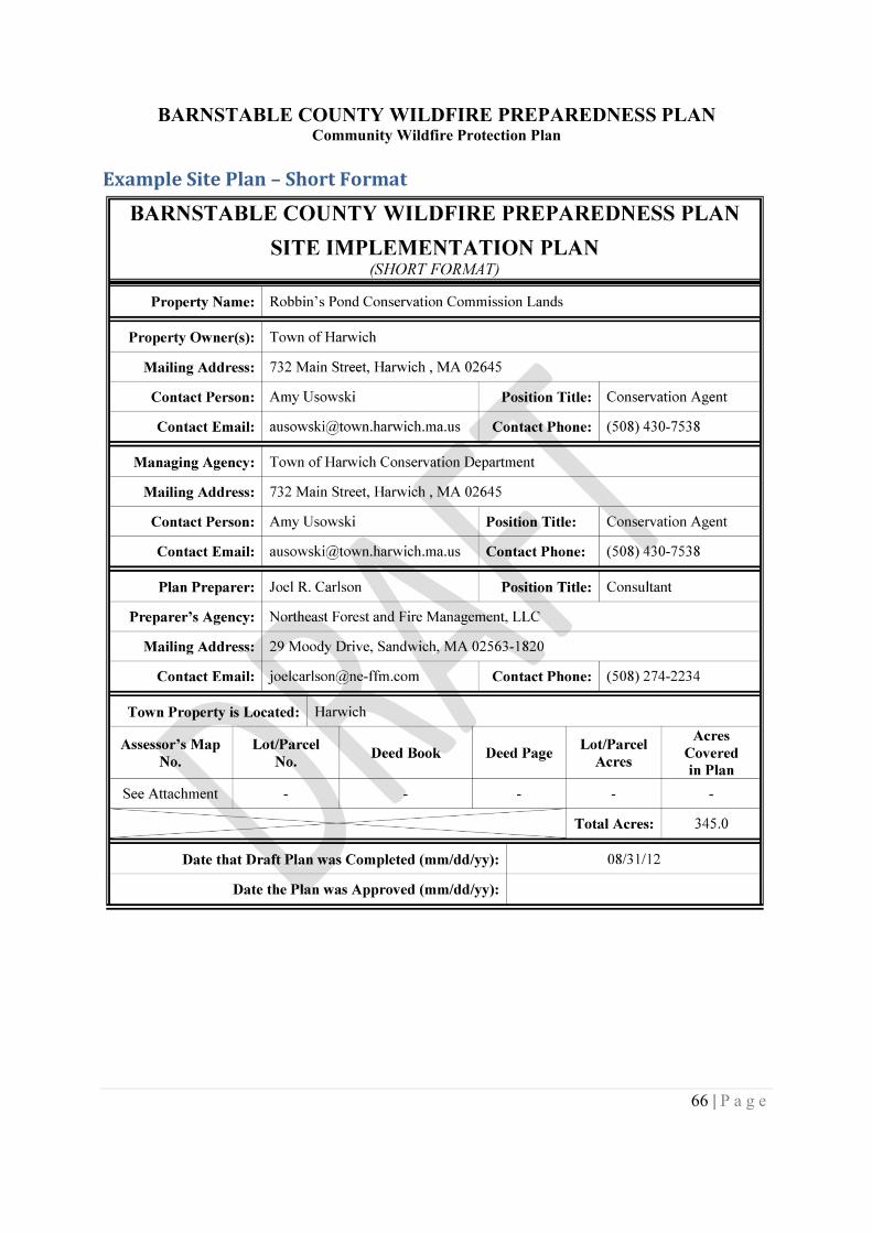
BARNSTABLE COUNTY WILDFIRE PREPAREDNESS PLANCommunity Wildfire Protection Plan
66 | P a g e
Example Site Plan – Short Format
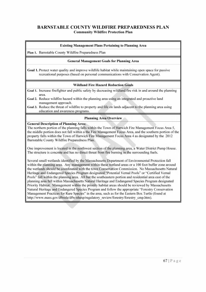
BARNSTABLE COUNTY WILDFIRE PREPAREDNESS PLANCommunity Wildfire Protection Plan
67 | P a g e
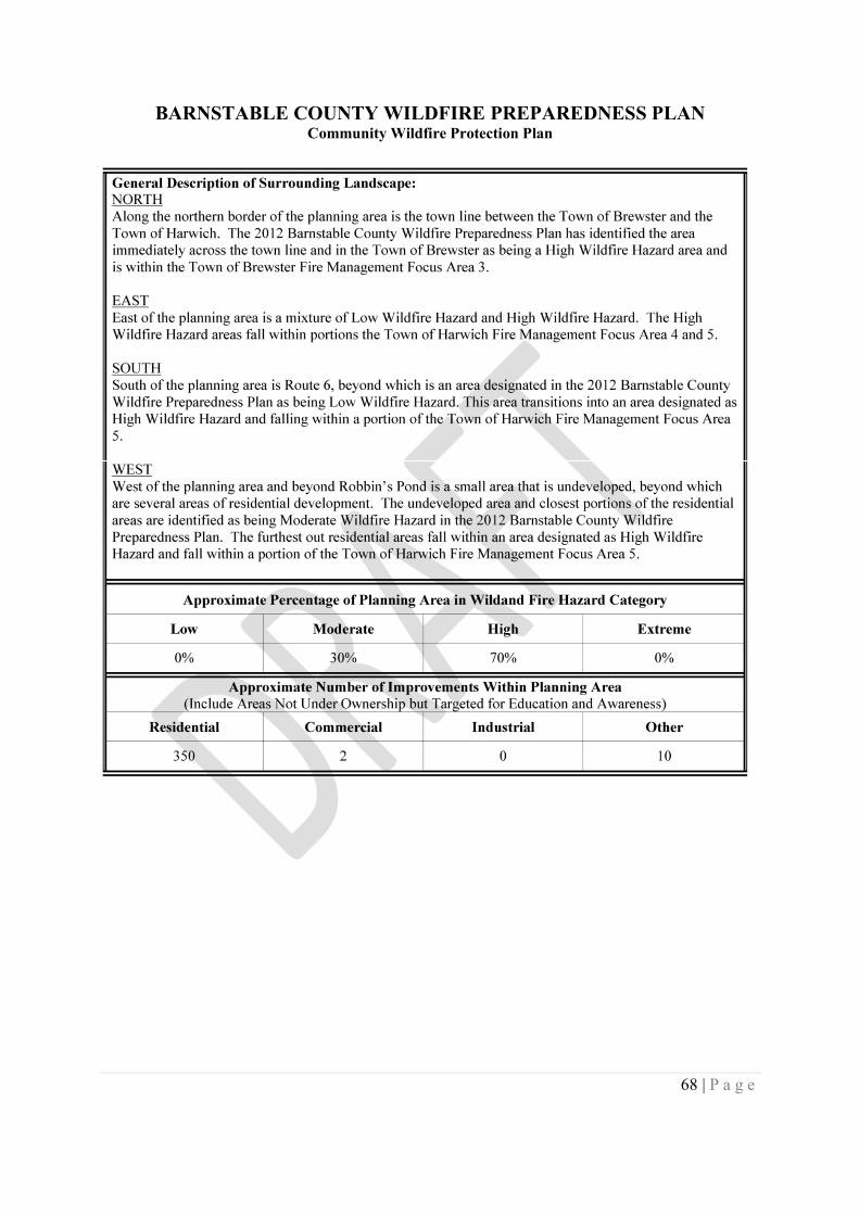
BARNSTABLE COUNTY WILDFIRE PREPAREDNESS PLANCommunity Wildfire Protection Plan
68 | P a g e
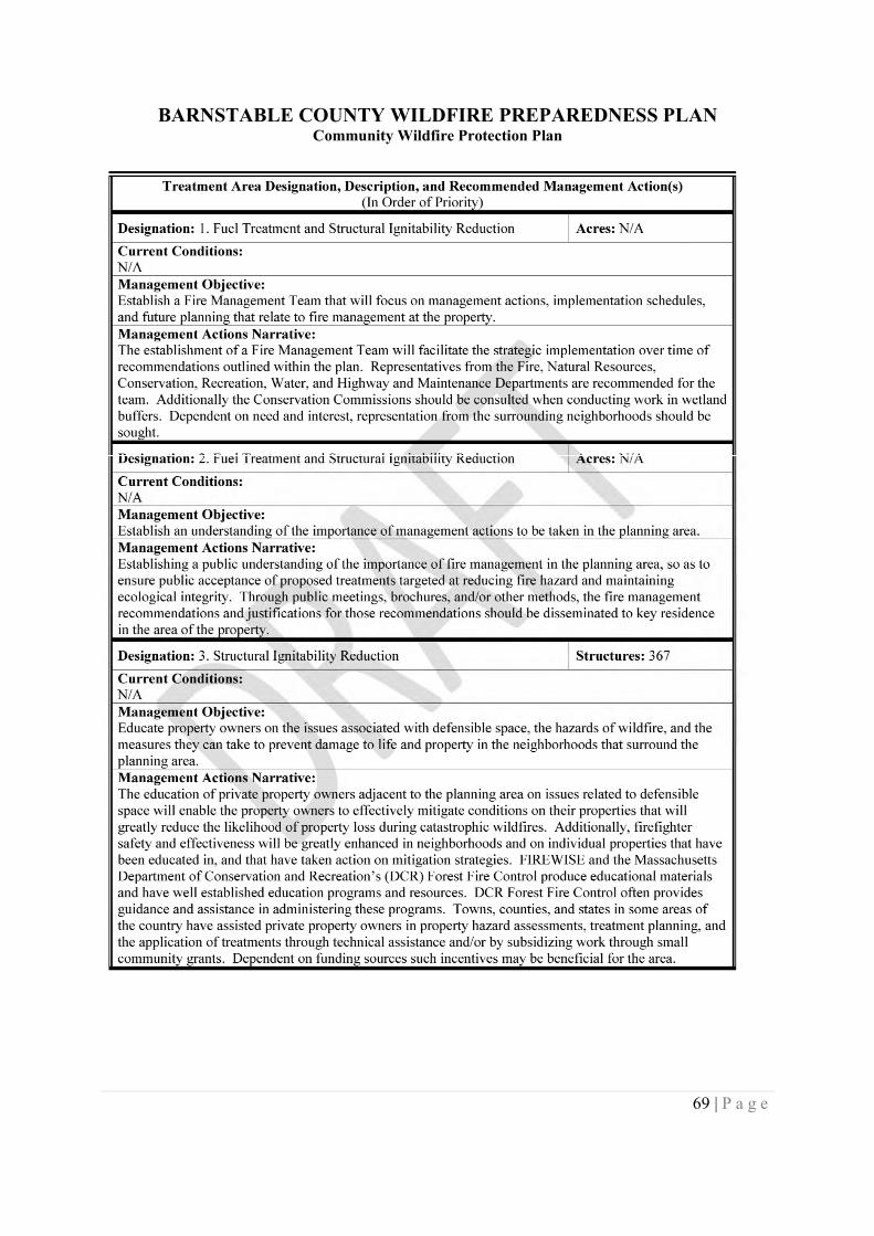
BARNSTABLE COUNTY WILDFIRE PREPAREDNESS PLANCommunity Wildfire Protection Plan
69 | P a g e
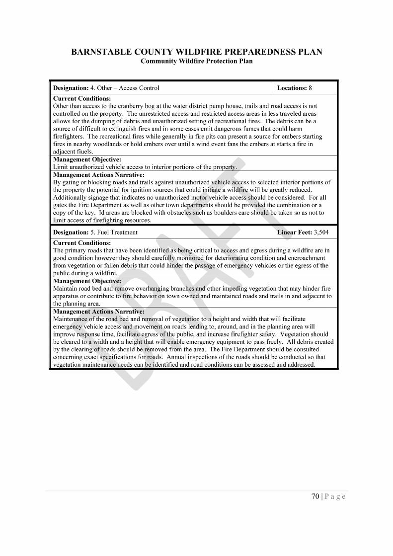
BARNSTABLE COUNTY WILDFIRE PREPAREDNESS PLANCommunity Wildfire Protection Plan
70 | P a g e
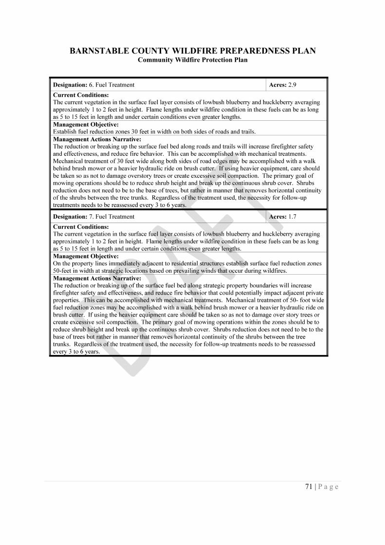
BARNSTABLE COUNTY WILDFIRE PREPAREDNESS PLANCommunity Wildfire Protection Plan
71 | P a g e
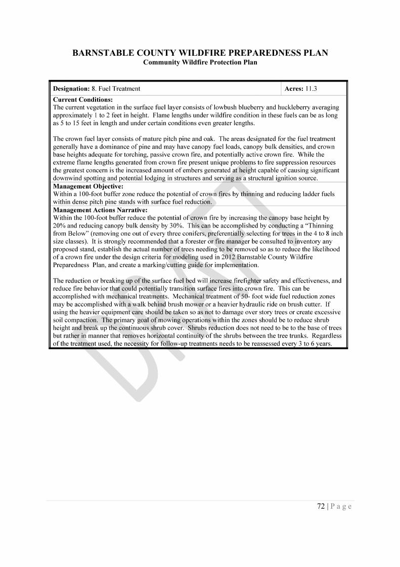
BARNSTABLE COUNTY WILDFIRE PREPAREDNESS PLANCommunity Wildfire Protection Plan
72 | P a g e
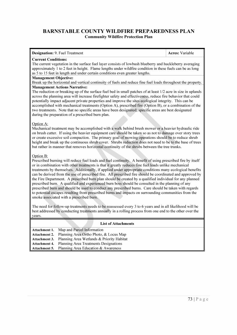
BARNSTABLE COUNTY WILDFIRE PREPAREDNESS PLANCommunity Wildfire Protection Plan
73 | P a g e
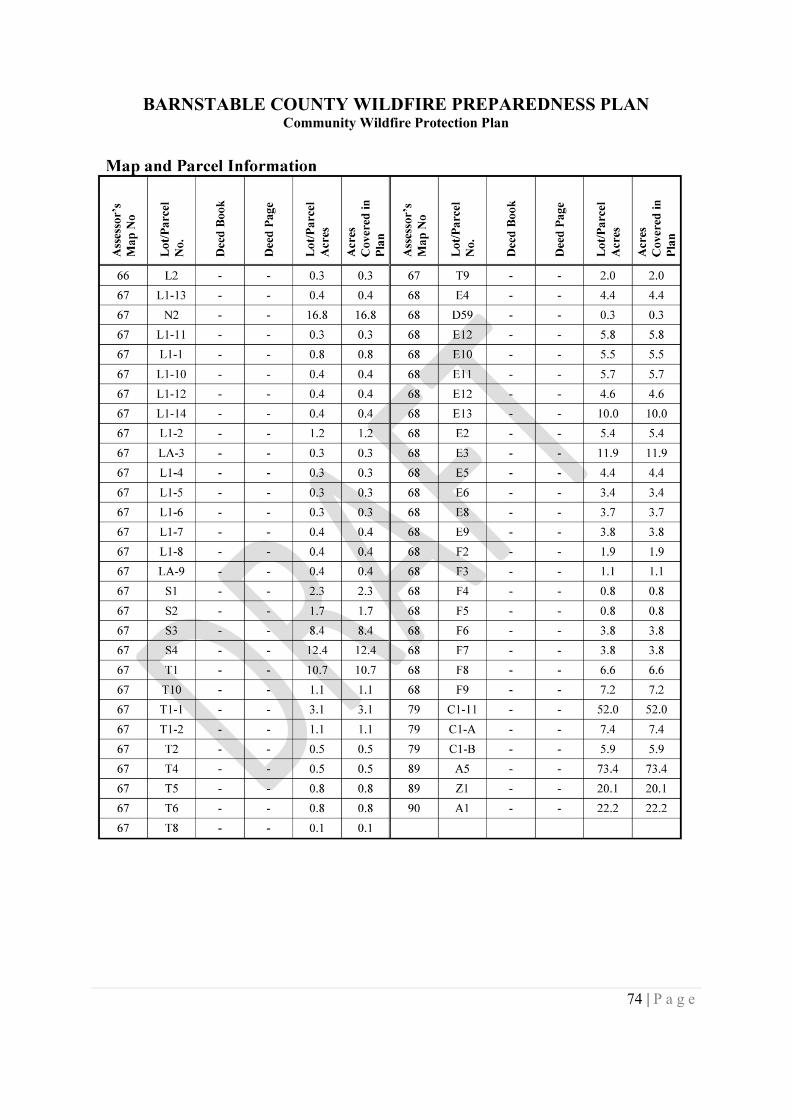
BARNSTABLE COUNTY WILDFIRE PREPAREDNESS PLANCommunity Wildfire Protection Plan
74 | P a g e
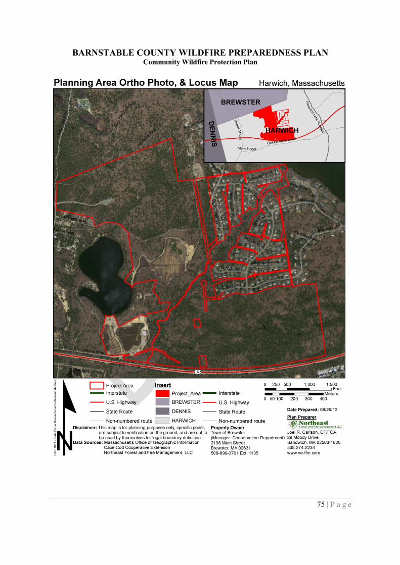
BARNSTABLE COUNTY WILDFIRE PREPAREDNESS PLANCommunity Wildfire Protection Plan
75 | P a g e
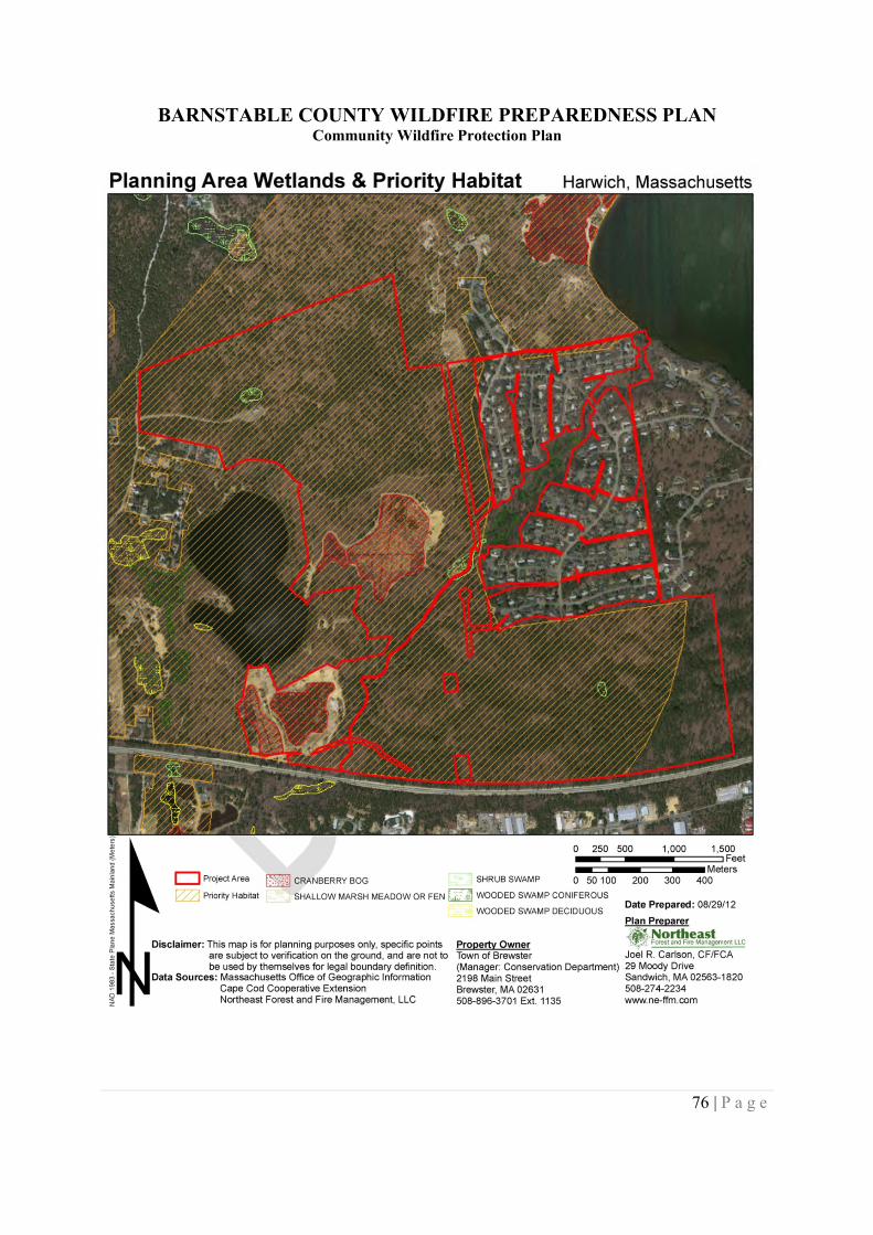
BARNSTABLE COUNTY WILDFIRE PREPAREDNESS PLANCommunity Wildfire Protection Plan
76 | P a g e
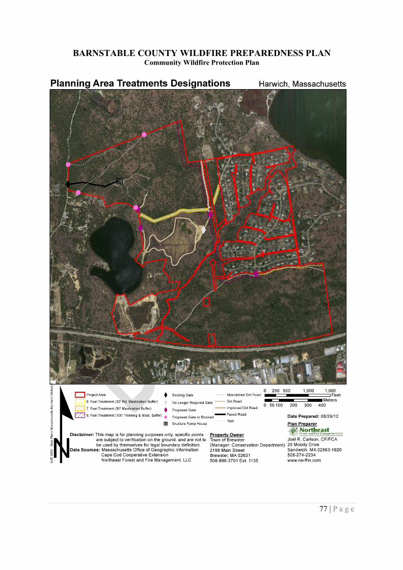
BARNSTABLE COUNTY WILDFIRE PREPAREDNESS PLANCommunity Wildfire Protection Plan
77 | P a g e
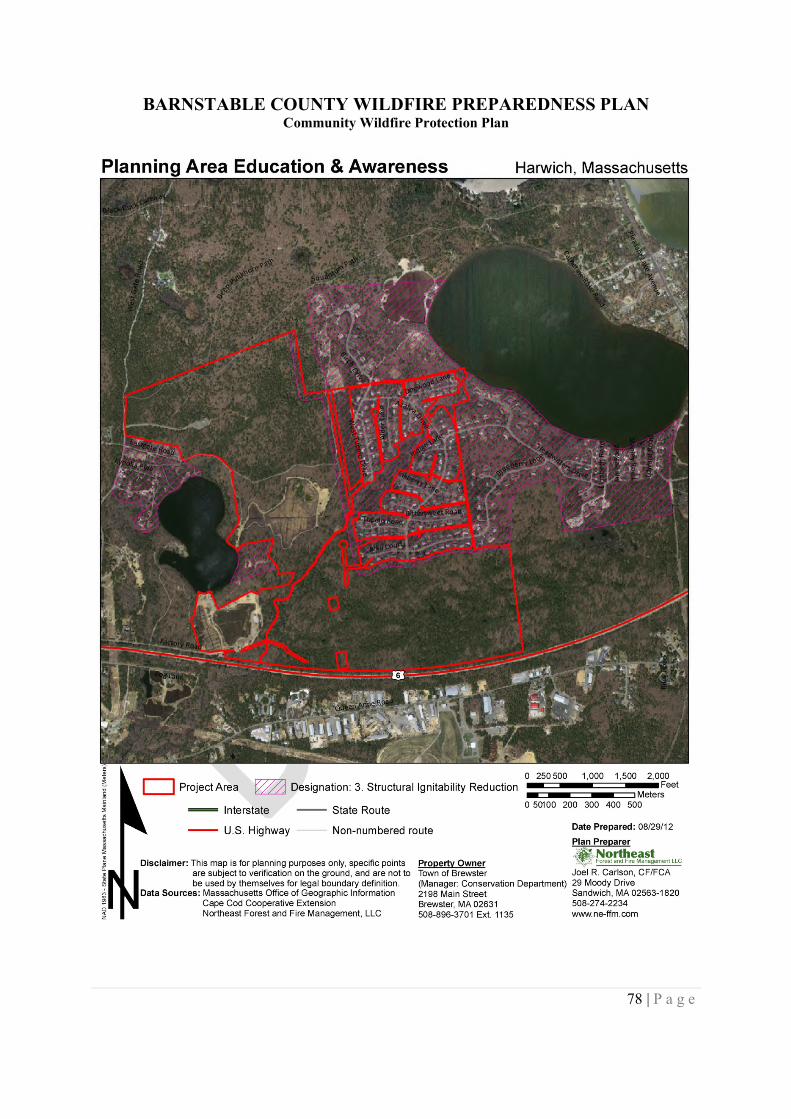
BARNSTABLE COUNTY WILDFIRE PREPAREDNESS PLANCommunity Wildfire Protection Plan
78 | P a g e
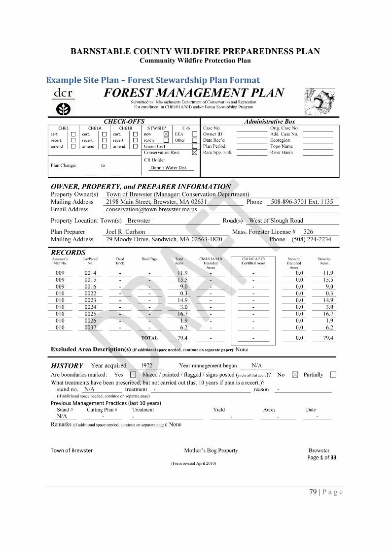
BARNSTABLE COUNTY WILDFIRE PREPAREDNESS PLANCommunity Wildfire Protection Plan
79 | P a g e
Example Site Plan – Forest Stewardship Plan Format
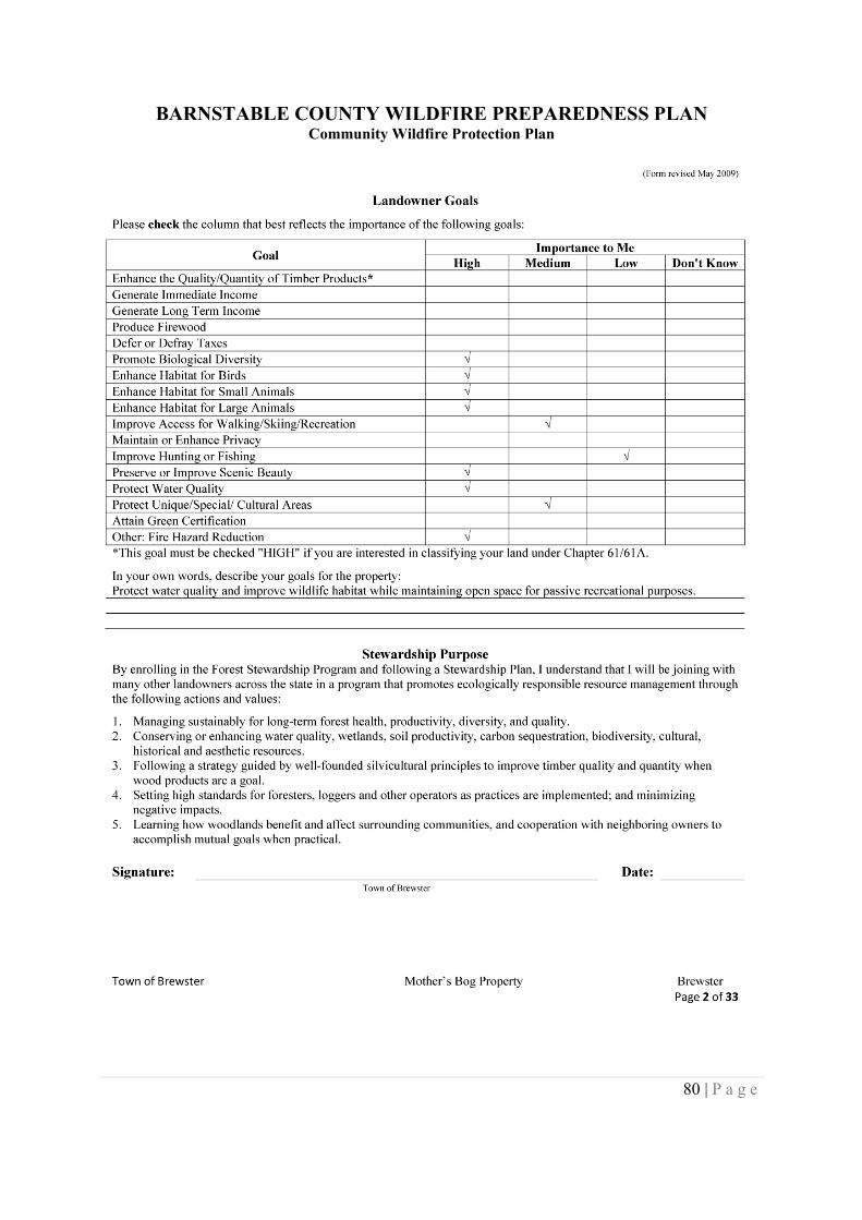
BARNSTABLE COUNTY WILDFIRE PREPAREDNESS PLANCommunity Wildfire Protection Plan
80 | P a g e
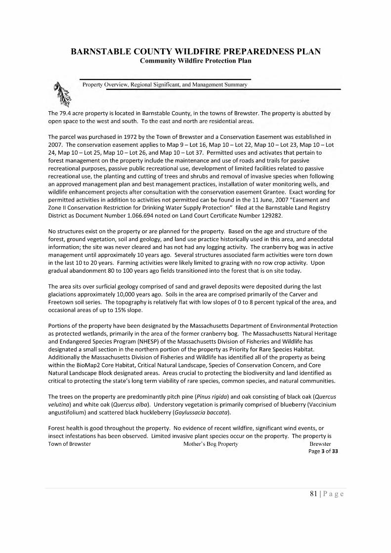
BARNSTABLE COUNTY WILDFIRE PREPAREDNESS PLANCommunity Wildfire Protection Plan
81 | P a g e
BARNSTABLE COUNTY WILDFIRE PREPAREDNESS PLANCommunity Wildfire Protection Plan
82 | P a g e
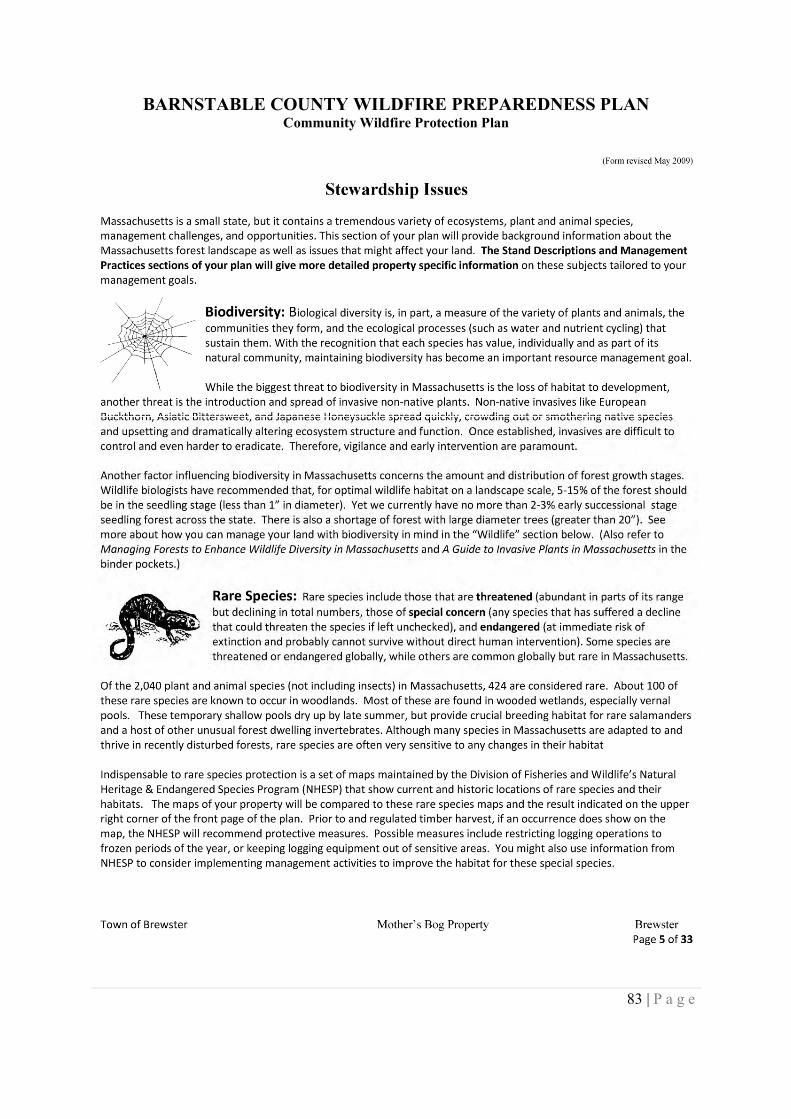
BARNSTABLE COUNTY WILDFIRE PREPAREDNESS PLANCommunity Wildfire Protection Plan
83 | P a g e
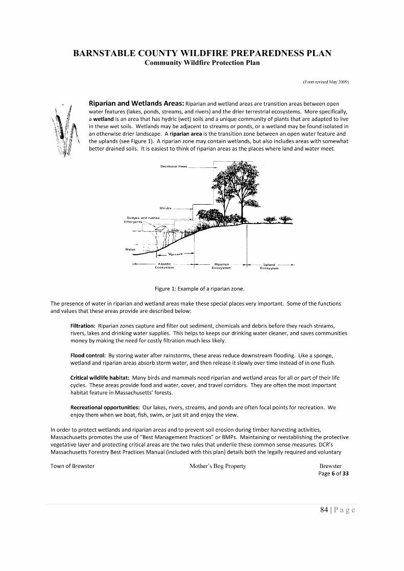
BARNSTABLE COUNTY WILDFIRE PREPAREDNESS PLANCommunity Wildfire Protection Plan
84 | P a g e
BARNSTABLE COUNTY WILDFIRE PREPAREDNESS PLANCommunity Wildfire Protection Plan
85 | P a g e
BARNSTABLE COUNTY WILDFIRE PREPAREDNESS PLANCommunity Wildfire Protection Plan
86 | P a g e
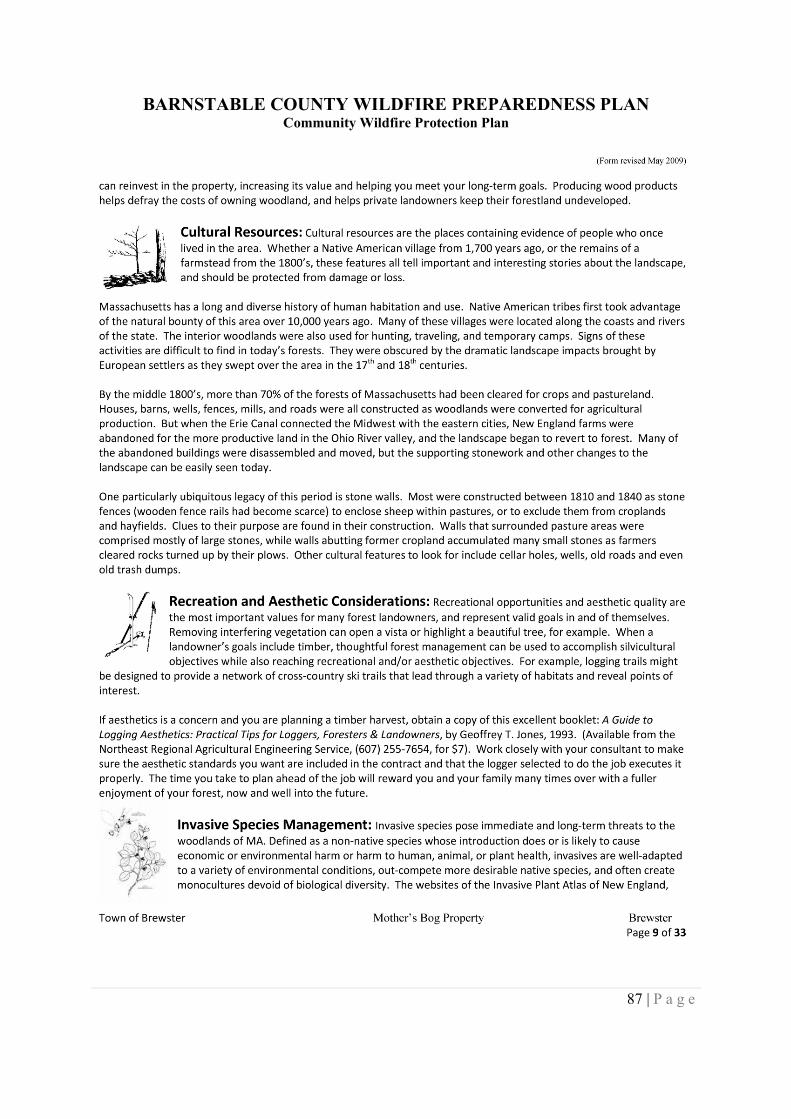
BARNSTABLE COUNTY WILDFIRE PREPAREDNESS PLANCommunity Wildfire Protection Plan
87 | P a g e
BARNSTABLE COUNTY WILDFIRE PREPAREDNESS PLANCommunity Wildfire Protection Plan
88 | P a g e
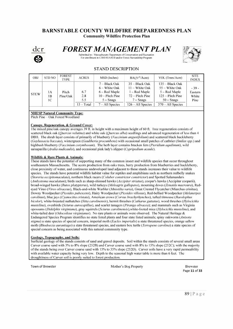
BARNSTABLE COUNTY WILDFIRE PREPAREDNESS PLANCommunity Wildfire Protection Plan
89 | P a g e
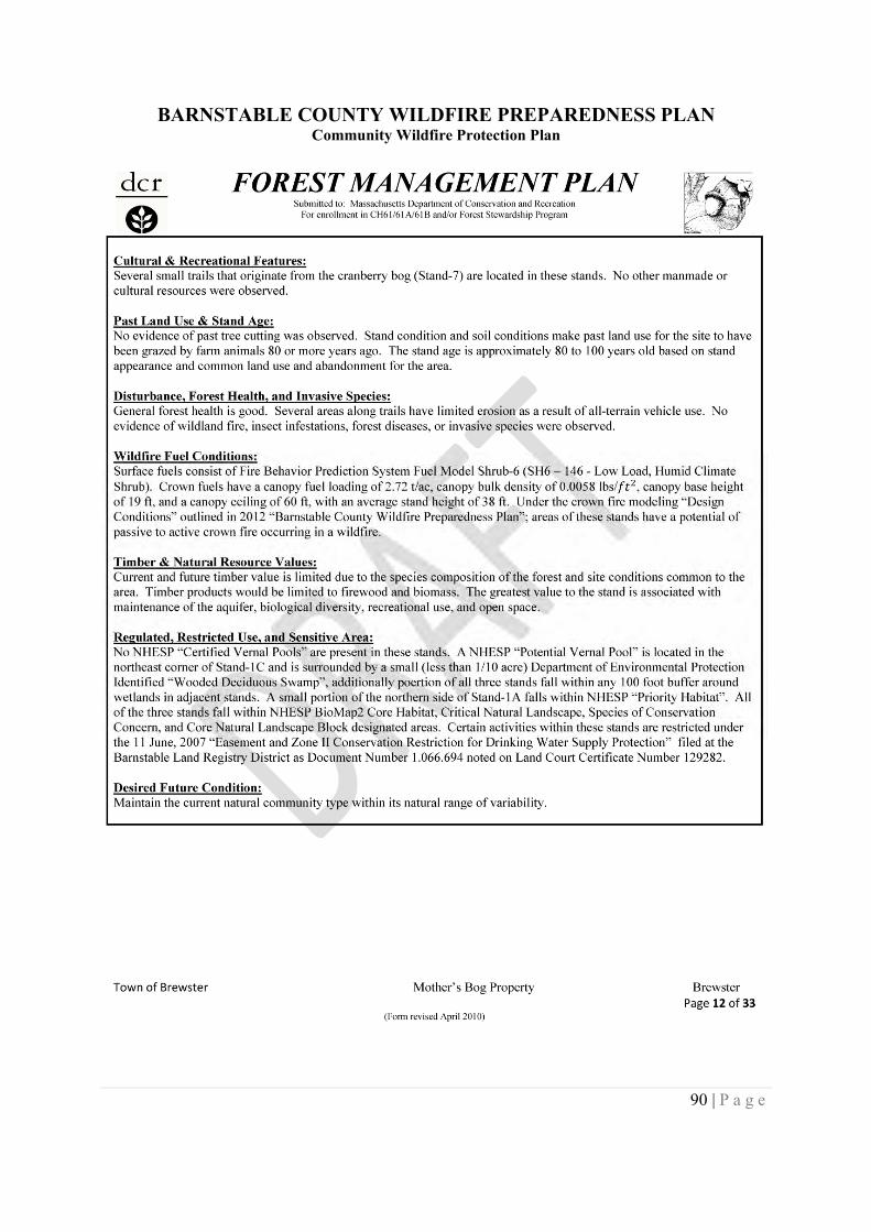
BARNSTABLE COUNTY WILDFIRE PREPAREDNESS PLANCommunity Wildfire Protection Plan
90 | P a g e
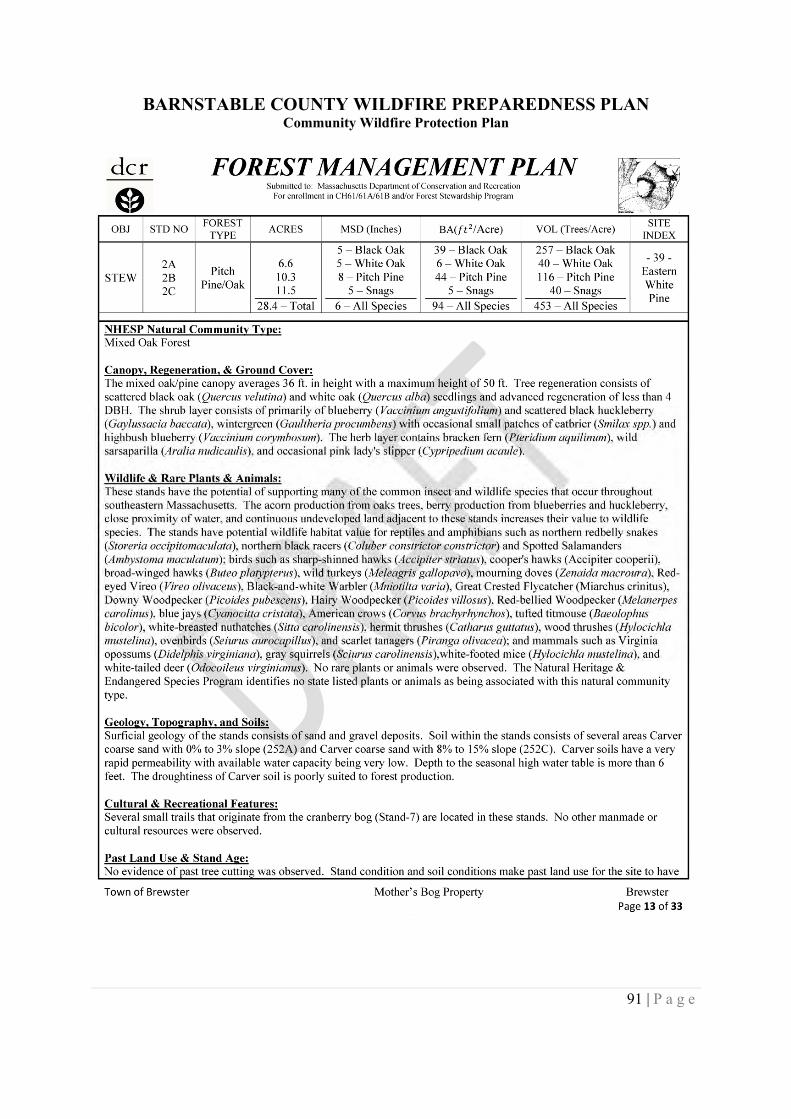
BARNSTABLE COUNTY WILDFIRE PREPAREDNESS PLANCommunity Wildfire Protection Plan
91 | P a g e
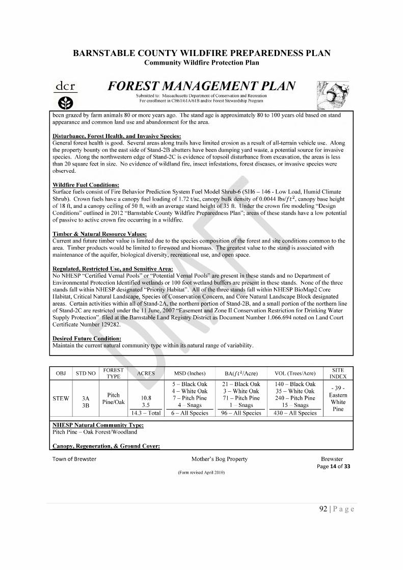
BARNSTABLE COUNTY WILDFIRE PREPAREDNESS PLANCommunity Wildfire Protection Plan
92 | P a g e
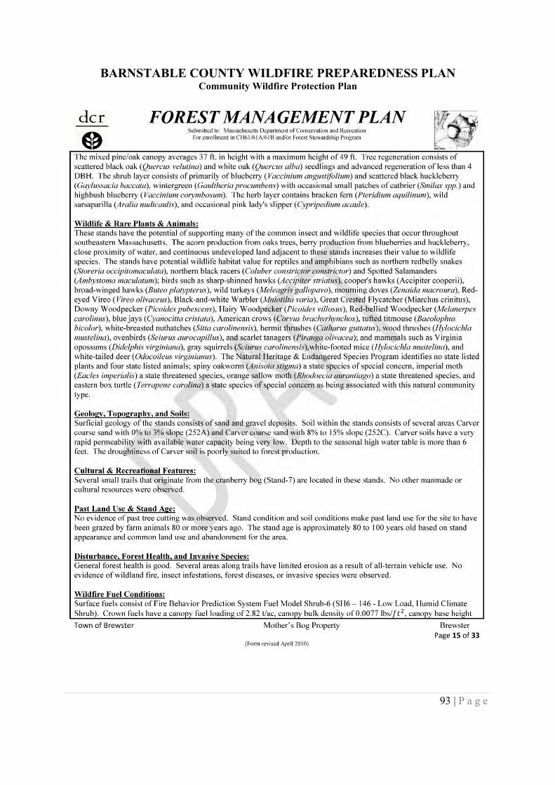
BARNSTABLE COUNTY WILDFIRE PREPAREDNESS PLANCommunity Wildfire Protection Plan
93 | P a g e
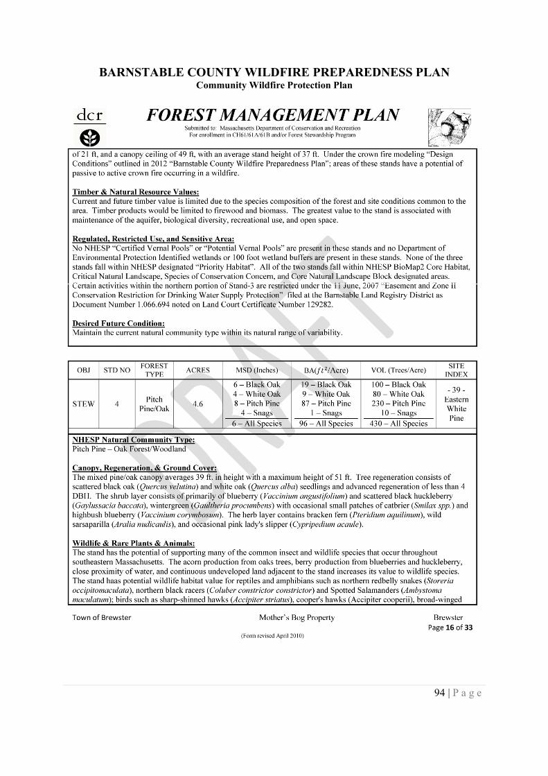
BARNSTABLE COUNTY WILDFIRE PREPAREDNESS PLANCommunity Wildfire Protection Plan
94 | P a g e
BARNSTABLE COUNTY WILDFIRE PREPAREDNESS PLANCommunity Wildfire Protection Plan
95 | P a g e
BARNSTABLE COUNTY WILDFIRE PREPAREDNESS PLANCommunity Wildfire Protection Plan
96 | P a g e
BARNSTABLE COUNTY WILDFIRE PREPAREDNESS PLANCommunity Wildfire Protection Plan
97 | P a g e
BARNSTABLE COUNTY WILDFIRE PREPAREDNESS PLANCommunity Wildfire Protection Plan
98 | P a g e
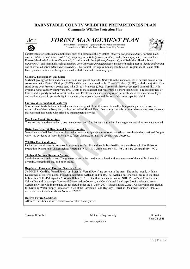
BARNSTABLE COUNTY WILDFIRE PREPAREDNESS PLANCommunity Wildfire Protection Plan
99 | P a g e
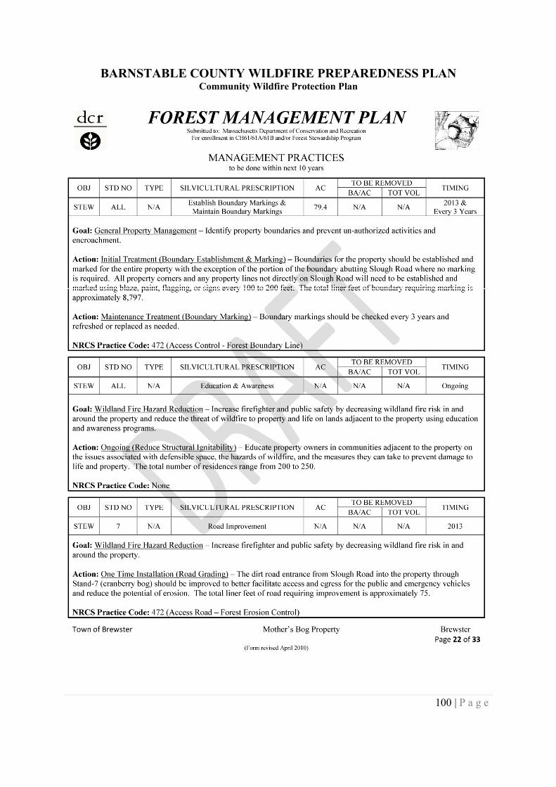
BARNSTABLE COUNTY WILDFIRE PREPAREDNESS PLANCommunity Wildfire Protection Plan
100 | P a g e
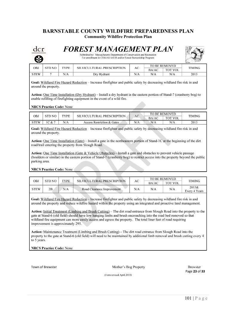
BARNSTABLE COUNTY WILDFIRE PREPAREDNESS PLANCommunity Wildfire Protection Plan
101 | P a g e
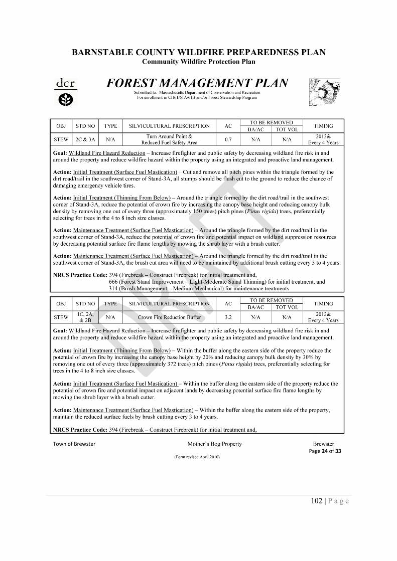
BARNSTABLE COUNTY WILDFIRE PREPAREDNESS PLANCommunity Wildfire Protection Plan
102 | P a g e
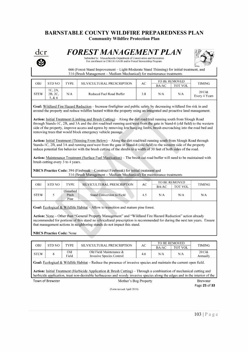
BARNSTABLE COUNTY WILDFIRE PREPAREDNESS PLANCommunity Wildfire Protection Plan
103 | P a g e
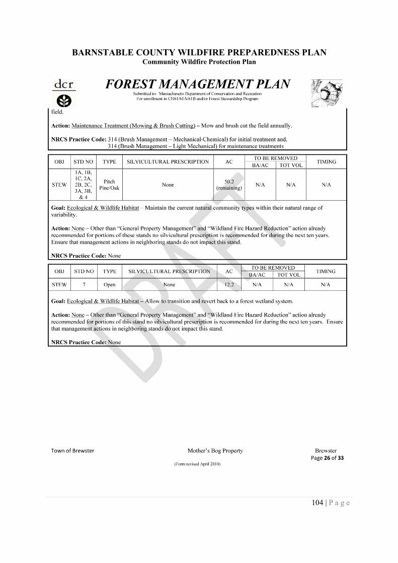
BARNSTABLE COUNTY WILDFIRE PREPAREDNESS PLANCommunity Wildfire Protection Plan
104 | P a g e
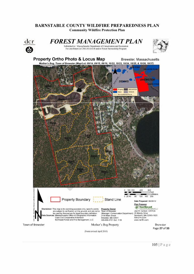
BARNSTABLE COUNTY WILDFIRE PREPAREDNESS PLANCommunity Wildfire Protection Plan
105 | P a g e
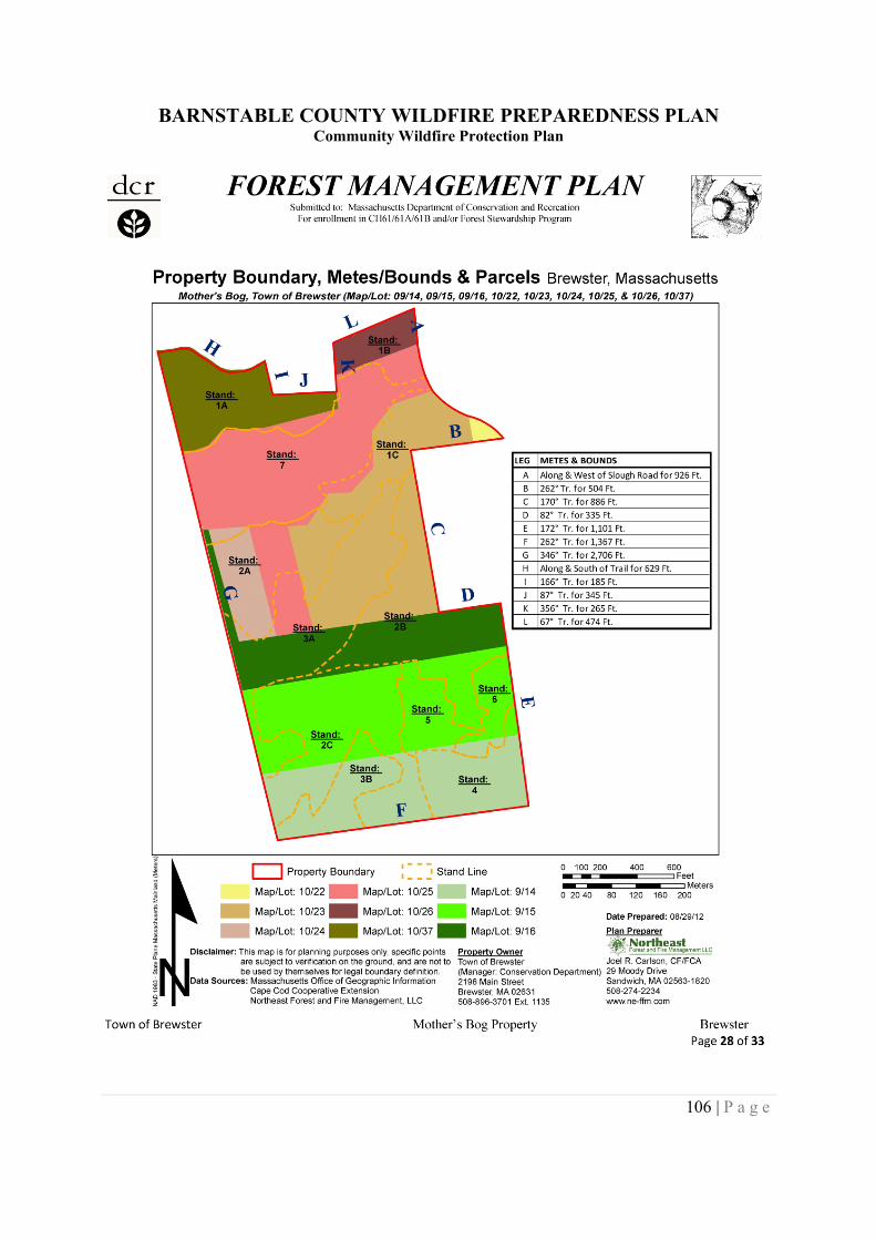
BARNSTABLE COUNTY WILDFIRE PREPAREDNESS PLANCommunity Wildfire Protection Plan
106 | P a g e

BARNSTABLE COUNTY WILDFIRE PREPAREDNESS PLANCommunity Wildfire Protection Plan
107 | P a g e
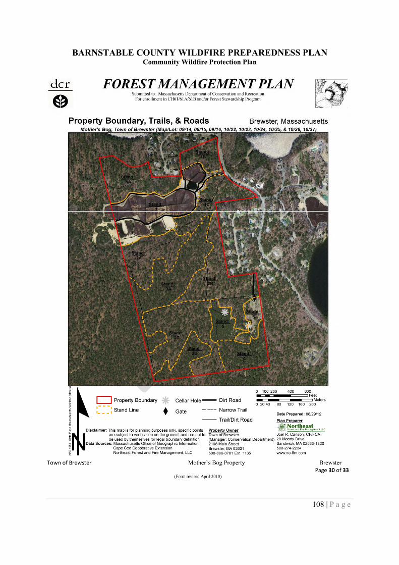
BARNSTABLE COUNTY WILDFIRE PREPAREDNESS PLANCommunity Wildfire Protection Plan
108 | P a g e
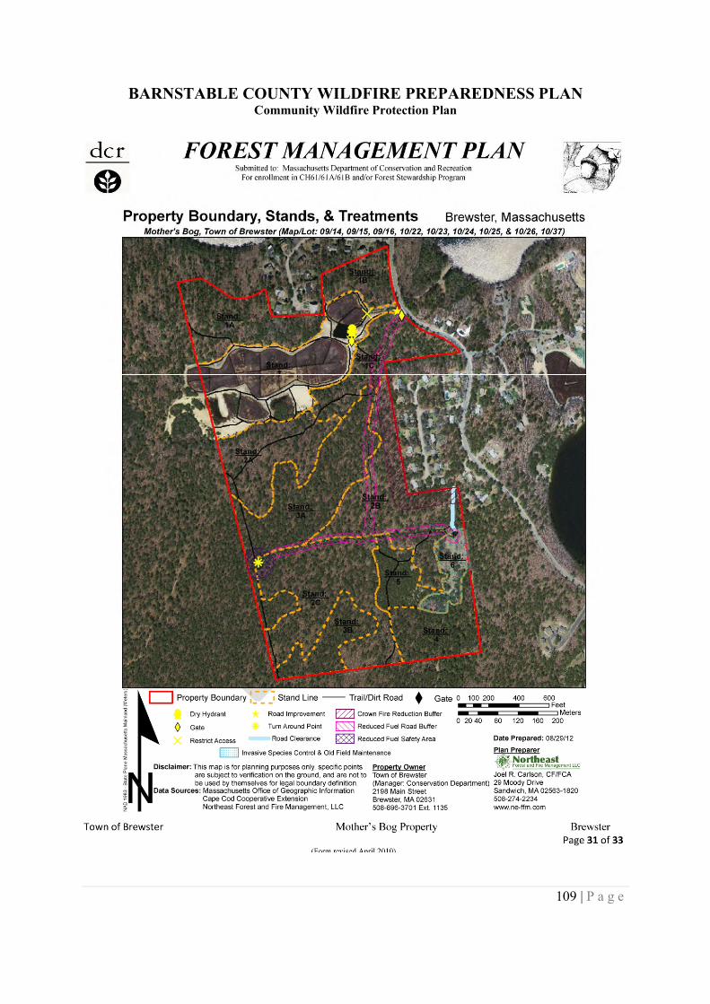
BARNSTABLE COUNTY WILDFIRE PREPAREDNESS PLANCommunity Wildfire Protection Plan
109 | P a g e
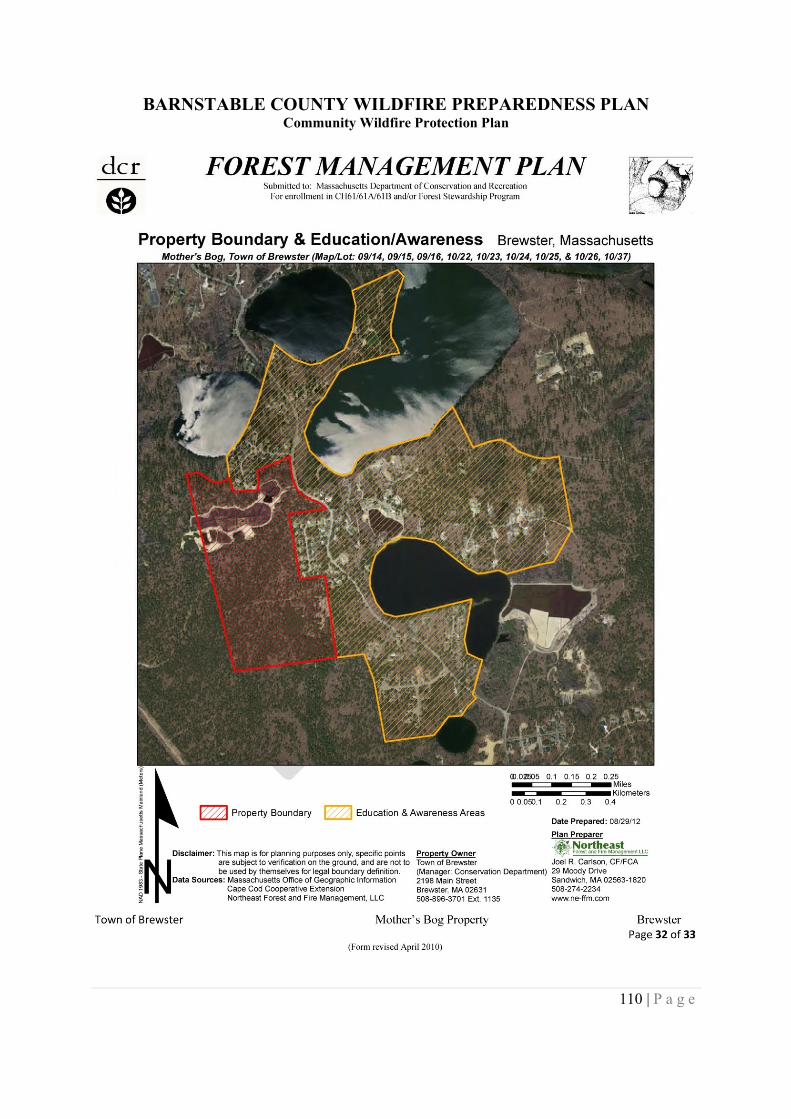
BARNSTABLE COUNTY WILDFIRE PREPAREDNESS PLANCommunity Wildfire Protection Plan
110 | P a g e
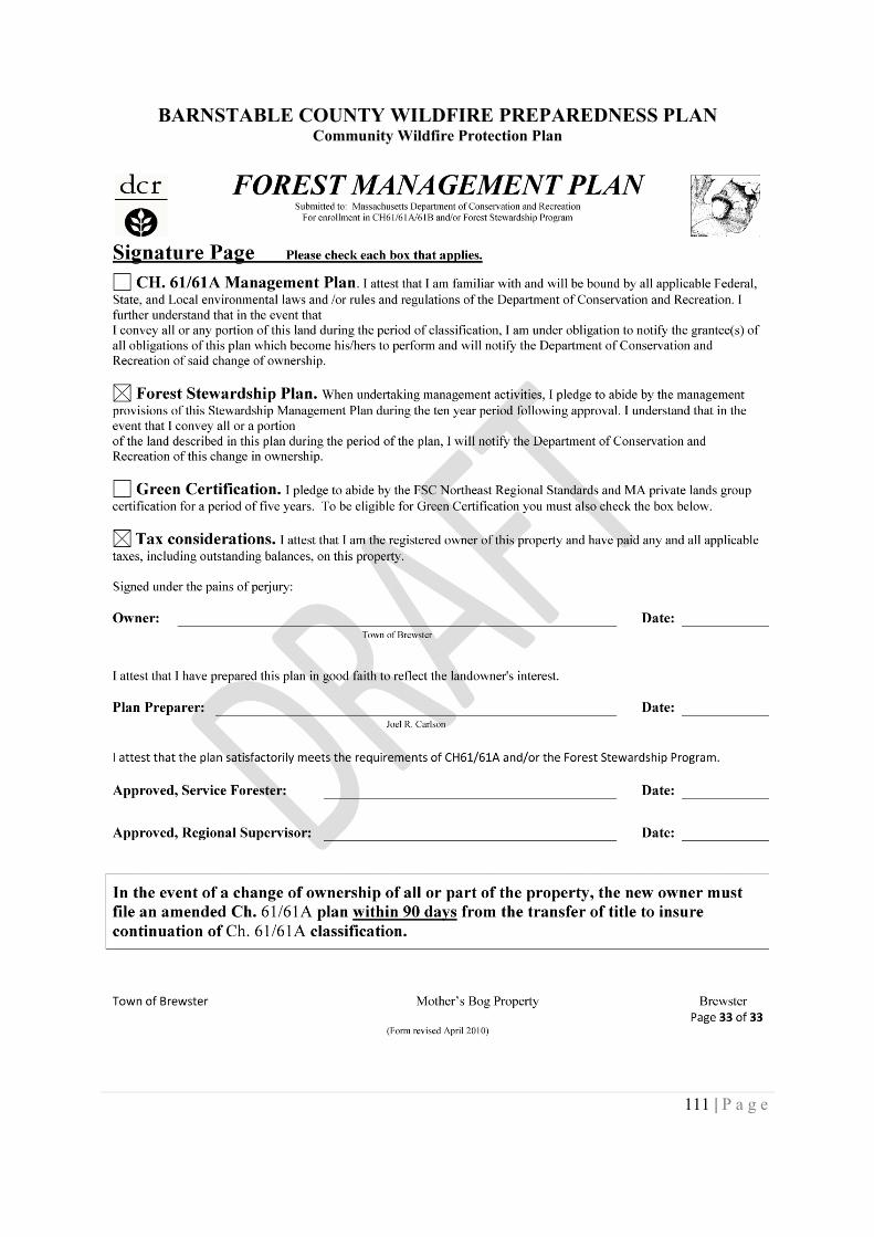
BARNSTABLE COUNTY WILDFIRE PREPAREDNESS PLANCommunity Wildfire Protection Plan
111 | P a g e
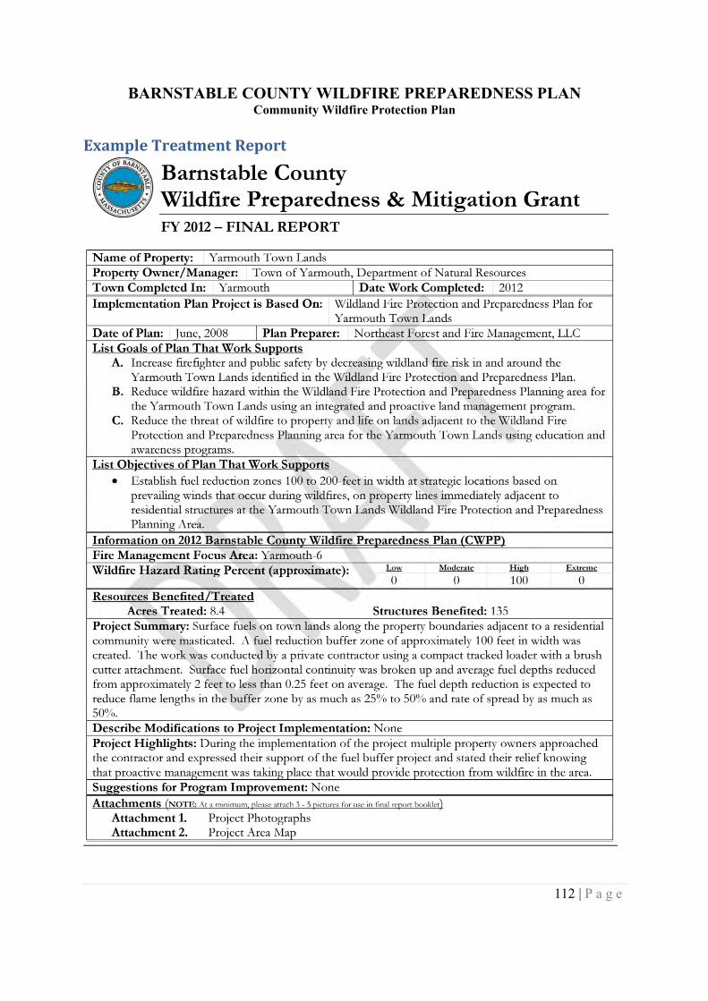
BARNSTABLE COUNTY WILDFIRE PREPAREDNESS PLANCommunity Wildfire Protection Plan
112 | P a g e
Example Treatment Report
BARNSTABLE COUNTY WILDFIRE PREPAREDNESS PLANCommunity Wildfire Protection Plan
113 | P a g e
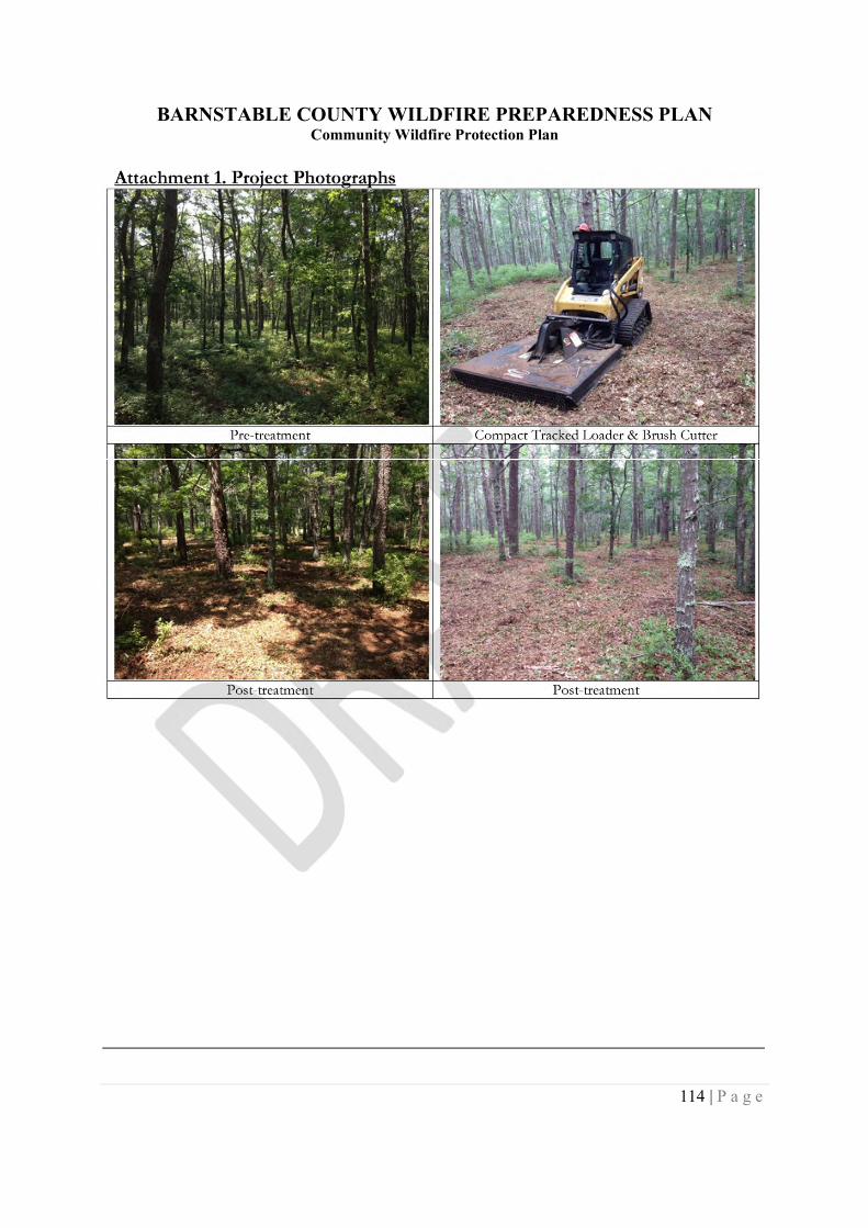
BARNSTABLE COUNTY WILDFIRE PREPAREDNESS PLANCommunity Wildfire Protection Plan
114 | P a g e
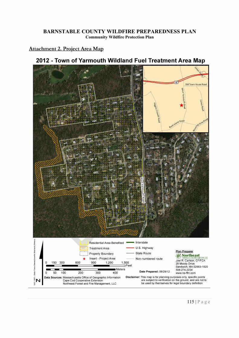
BARNSTABLE COUNTY WILDFIRE PREPAREDNESS PLANCommunity Wildfire Protection Plan
115 | P a g e
BARNSTABLE COUNTY WILDFIRE PREPAREDNESS PLANCommunity Wildfire Protection Plan
116 | P a g e
APPENDIX B: TOWN WILDFIRE RISK MAPS AND DATA OVERVIEWS
Data has been summarized for each town in Barnstable County and presented in a graphical andtable format. The graphical and table information is intended to be used as a tool by landmanagers, land owners, and agencies in identifying areas that may require a site plan to guideimplementation on the ground. Additionally the information is presented so that towninformation can be easily accesses when preparing reports and grants.
The graphical format is a map that shows the four calculated risk levels and major roads forreference. Additionally suggested Focus Area have been identified and numbered. The FocusAreas were derived by using the hazard ratings and ortho photos. Areas that contained High andExtreme ratings, totaling greater than 50 acres were delineated using the screen digitizingfunction on GIS.
The tabular information summarizes general statistics for the town, results from the firedepartment survey, and information from the county wide hazard rating map. Existing firemanagement plans for lands within the town and wildland fire management programs arepresented to provide information on current management and possible sources of informationand resources for fire management work. The Town Focus Areas presented in the map aresummarized and possible broad scale strategies from the management recommendations sectionof the plan are listed.
BARNSTABLE COUNTY WILDFIRE PREPAREDNESS PLANCommunity Wildfire Protection Plan
117 | P a g e
Town of BarnstableTOWN OF BARNSTABLE WILDFIRE RISK MAP
BARNSTABLE COUNTY WILDFIRE PREPAREDNESS PLANCommunity Wildfire Protection Plan
118 | P a g e
TOWN OF BARNSTABLE SUMMARY STATISTICSTown: Barnstable Population Density (people/݉ .݅ଶ): 753.2Land Area ( ݉ .݅ଶ): 60.0 Home Density (housing units/݉ .݅ଶ): 439.1Town Hosing Units Vacant for Seasonal/Recreational Use (%): 20.7
Percent of Town Classified by Wildland Urban Interface TypesUrban/No Vegetation Uninhabited Interface Intermix
38.1% 10.9% 36.1% 14.9%
Percent of Town by Modeled Wildfire RiskLow Moderate High Extreme
17.1% 48.7% 32.5% 1.7%
Percent of Town by Modeled/Calculated Wildfire Risk InputsFlame Length Rate of Spread Fire Type Dist. from Fire Station Pop. Density0 – 4 (ft.): 21 0 – 5 (ch./hr.): 21 No Data: 22 0 – 0.5 (mi.): 11 0 – 5 (people/݉ .݅ଶ): 674 – 8 (ft.): 24 5 – 15 (ch./hr.): 4 Surface Fire: 42 0.5 – 1.0 (mi.): 19 5 – 60 (people/݉ .݅ଶ): 3
8 – 12 (ft.): 32 15 – 40 (ch./hr.): 44 Passive Crown Fire: 32 1.0 – 1.5 (mi.): 32 60 – 525 (people/݉ .݅ଶ): 17> 12 (ft.): 23 > 40 (ch./hr.): 31 Active Crown Fire: 4 > 1.5 (mi.): 39 > 525 (people/݉ .݅ଶ): 13
Fire Department Statistics (Barnstable, W. Barnstable, COMM, and Cotuit)Fire Stations: 6 Fulltime Firefighters: 87 Call Firefighters: 53
Water Tender Wildland EnginesType 1: 1 (Brush Breaker) Standard Brush Breaker
Type 2: 2 Type 3: 3
Type 3: 1 Type 4: 0
Structure Engines Type 5: 0
Type 1: 8 Type 6: 1
Type 2: 0 Type 7: 0
NOTE: Data provided by Town Survey and Massachusetts Department of Conservation and Recreation
Current Fire and Fuel Management Programs and Plans Old Jail Lane Conservation Area and Adjacent Town Land - Wildfire Preparedness Plan (CWPP) Town of Barnstable Prescribed Burn Program West Barnstable Conservation Area and Adjacent Open Space Lands - Wildfire Preparedness Plan (CWPP)
Suggested Mitigation Focus Area (See Town Wildfire Risk Map)
Area ID Area Acres High Risk Present Likely Management Action (See Management Recommendations)1 330 No Fuel Treatments and/or Structural Ignitability Reduction2 645 No Fuel Treatments and/or Structural Ignitability Reduction3 7,666 Yes Fuel Treatments and/or Structural Ignitability Reduction4 332 No Fuel Treatments and/or Structural Ignitability Reduction5 276 No Fuel Treatments and/or Structural Ignitability Reduction6 208 No Fuel Treatments and/or Structural Ignitability Reduction7 3,289 Yes Fuel Treatments and/or Structural Ignitability Reduction8 93 No Fuel Treatments and/or Structural Ignitability Reduction
BARNSTABLE COUNTY WILDFIRE PREPAREDNESS PLANCommunity Wildfire Protection Plan
119 | P a g e
Town of BourneTOWN OF BOURNE WILDFIRE RISK MAP
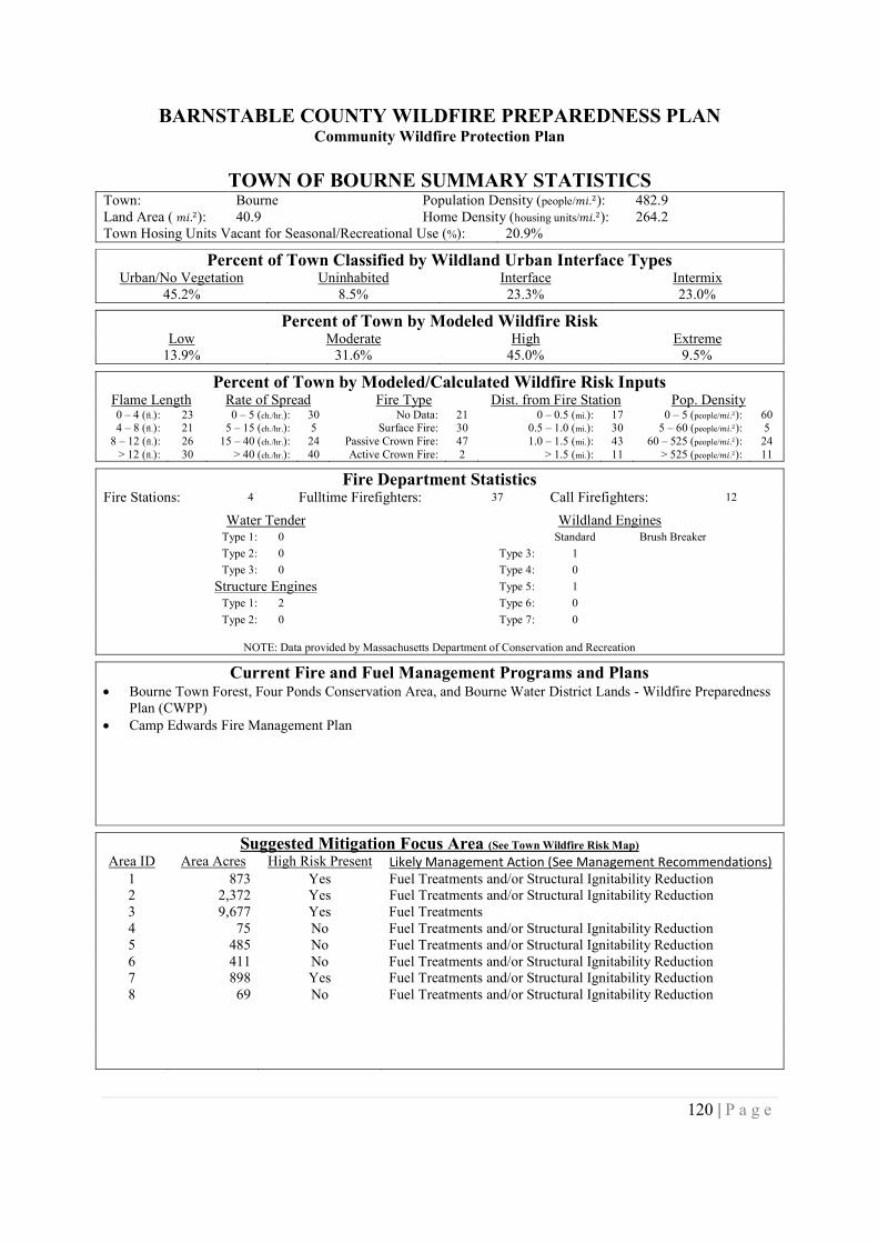
BARNSTABLE COUNTY WILDFIRE PREPAREDNESS PLANCommunity Wildfire Protection Plan
120 | P a g e
TOWN OF BOURNE SUMMARY STATISTICSTown: Bourne Population Density (people/݉ .݅ଶ): 482.9Land Area ( ݉ .݅ଶ): 40.9 Home Density (housing units/݉ .݅ଶ): 264.2Town Hosing Units Vacant for Seasonal/Recreational Use (%): 20.9%
Percent of Town Classified by Wildland Urban Interface TypesUrban/No Vegetation Uninhabited Interface Intermix
45.2% 8.5% 23.3% 23.0%
Percent of Town by Modeled Wildfire RiskLow Moderate High Extreme
13.9% 31.6% 45.0% 9.5%
Percent of Town by Modeled/Calculated Wildfire Risk InputsFlame Length Rate of Spread Fire Type Dist. from Fire Station Pop. Density0 – 4 (ft.): 23 0 – 5 (ch./hr.): 30 No Data: 21 0 – 0.5 (mi.): 17 0 – 5 (people/݉ .݅ଶ): 604 – 8 (ft.): 21 5 – 15 (ch./hr.): 5 Surface Fire: 30 0.5 – 1.0 (mi.): 30 5 – 60 (people/݉ .݅ଶ): 5
8 – 12 (ft.): 26 15 – 40 (ch./hr.): 24 Passive Crown Fire: 47 1.0 – 1.5 (mi.): 43 60 – 525 (people/݉ .݅ଶ): 24> 12 (ft.): 30 > 40 (ch./hr.): 40 Active Crown Fire: 2 > 1.5 (mi.): 11 > 525 (people/݉ .݅ଶ): 11
Fire Department StatisticsFire Stations: 4 Fulltime Firefighters: 37 Call Firefighters: 12
Water Tender Wildland EnginesType 1: 0 Standard Brush Breaker
Type 2: 0 Type 3: 1
Type 3: 0 Type 4: 0
Structure Engines Type 5: 1
Type 1: 2 Type 6: 0
Type 2: 0 Type 7: 0
NOTE: Data provided by Massachusetts Department of Conservation and Recreation
Current Fire and Fuel Management Programs and Plans Bourne Town Forest, Four Ponds Conservation Area, and Bourne Water District Lands - Wildfire Preparedness
Plan (CWPP) Camp Edwards Fire Management Plan
Suggested Mitigation Focus Area (See Town Wildfire Risk Map)
Area ID Area Acres High Risk Present Likely Management Action (See Management Recommendations)1 873 Yes Fuel Treatments and/or Structural Ignitability Reduction2 2,372 Yes Fuel Treatments and/or Structural Ignitability Reduction3 9,677 Yes Fuel Treatments4 75 No Fuel Treatments and/or Structural Ignitability Reduction5 485 No Fuel Treatments and/or Structural Ignitability Reduction6 411 No Fuel Treatments and/or Structural Ignitability Reduction7 898 Yes Fuel Treatments and/or Structural Ignitability Reduction8 69 No Fuel Treatments and/or Structural Ignitability Reduction
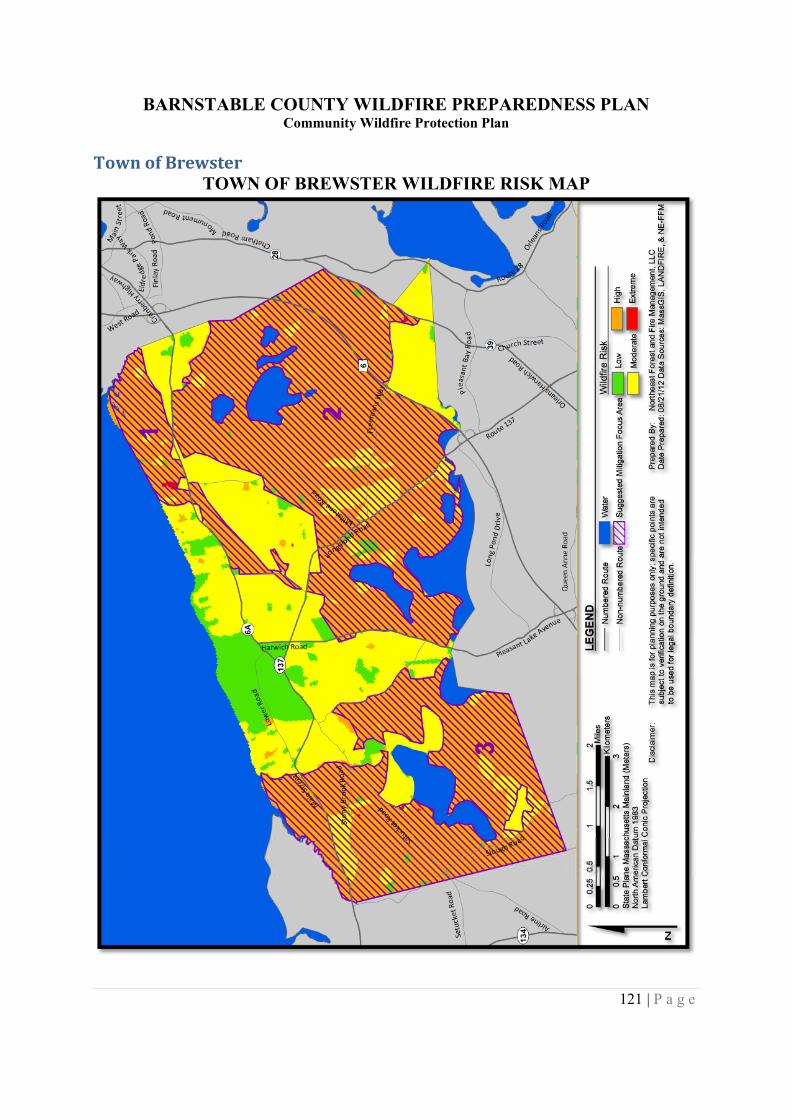
BARNSTABLE COUNTY WILDFIRE PREPAREDNESS PLANCommunity Wildfire Protection Plan
121 | P a g e
Town of BrewsterTOWN OF BREWSTER WILDFIRE RISK MAP
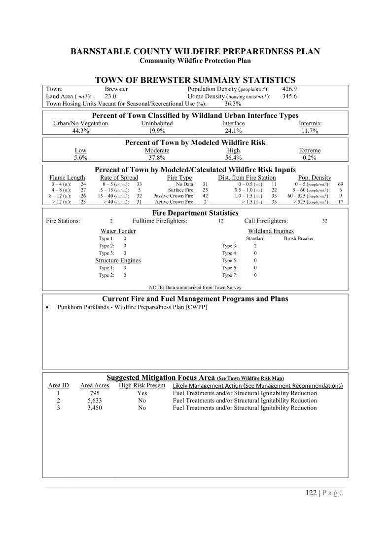
BARNSTABLE COUNTY WILDFIRE PREPAREDNESS PLANCommunity Wildfire Protection Plan
122 | P a g e
TOWN OF BREWSTER SUMMARY STATISTICSTown: Brewster Population Density (people/݉ .݅ଶ): 426.9Land Area ( ݉ .݅ଶ): 23.0 Home Density (housing units/݉ .݅ଶ): 345.6Town Hosing Units Vacant for Seasonal/Recreational Use (%): 36.3%
Percent of Town Classified by Wildland Urban Interface TypesUrban/No Vegetation Uninhabited Interface Intermix
44.3% 19.9% 24.1% 11.7%
Percent of Town by Modeled Wildfire RiskLow Moderate High Extreme5.6% 37.8% 56.4% 0.2%
Percent of Town by Modeled/Calculated Wildfire Risk InputsFlame Length Rate of Spread Fire Type Dist. from Fire Station Pop. Density0 – 4 (ft.): 24 0 – 5 (ch./hr.): 33 No Data: 31 0 – 0.5 (mi.): 11 0 – 5 (people/݉ .݅ଶ): 694 – 8 (ft.): 27 5 – 15 (ch./hr.): 5 Surface Fire: 25 0.5 – 1.0 (mi.): 22 5 – 60 (people/݉ .݅ଶ): 6
8 – 12 (ft.): 26 15 – 40 (ch./hr.): 32 Passive Crown Fire: 42 1.0 – 1.5 (mi.): 33 60 – 525 (people/݉ .݅ଶ): 9> 12 (ft.): 23 > 40 (ch./hr.): 31 Active Crown Fire: 2 > 1.5 (mi.): 33 > 525 (people/݉ .݅ଶ): 17
Fire Department StatisticsFire Stations: 2 Fulltime Firefighters: 12 Call Firefighters: 32
Water Tender Wildland EnginesType 1: 0 Standard Brush Breaker
Type 2: 0 Type 3: 2
Type 3: 0 Type 4: 0
Structure Engines Type 5: 0
Type 1: 3 Type 6: 0
Type 2: 0 Type 7: 0
NOTE: Data summarized from Town Survey
Current Fire and Fuel Management Programs and Plans Punkhorn Parklands - Wildfire Preparedness Plan (CWPP)
Suggested Mitigation Focus Area (See Town Wildfire Risk Map)
Area ID Area Acres High Risk Present Likely Management Action (See Management Recommendations)1 795 Yes Fuel Treatments and/or Structural Ignitability Reduction2 5,633 No Fuel Treatments and/or Structural Ignitability Reduction3 3,450 No Fuel Treatments and/or Structural Ignitability Reduction
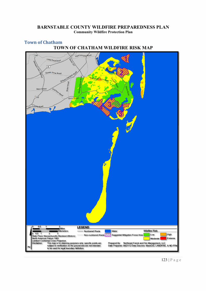
BARNSTABLE COUNTY WILDFIRE PREPAREDNESS PLANCommunity Wildfire Protection Plan
123 | P a g e
Town of ChathamTOWN OF CHATHAM WILDFIRE RISK MAP
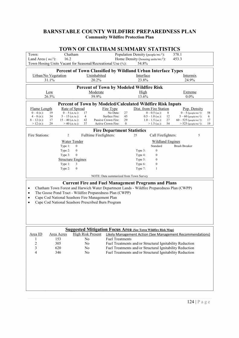
BARNSTABLE COUNTY WILDFIRE PREPAREDNESS PLANCommunity Wildfire Protection Plan
124 | P a g e
TOWN OF CHATHAM SUMMARY STATISTICSTown: Chatham Population Density (people/݉ .݅ଶ): 378.1Land Area ( ݉ .݅ଶ): 16.2 Home Density (housing units/݉ .݅ଶ): 453.3Town Hosing Units Vacant for Seasonal/Recreational Use (%): 54.8%
Percent of Town Classified by Wildland Urban Interface TypesUrban/No Vegetation Uninhabited Interface Intermix
31.1% 20.2% 23.8% 24.9%
Percent of Town by Modeled Wildfire RiskLow Moderate High Extreme
26.5% 59.9% 13.6% 0.0%
Percent of Town by Modeled/Calculated Wildfire Risk InputsFlame Length Rate of Spread Fire Type Dist. from Fire Station Pop. Density0 – 4 (ft.): 19 0 – 5 (ch./hr.): 17 No Data: 27 0 – 0.5 (mi.): 8 0 – 5 (people/݉ .݅ଶ): 584 – 8 (ft.): 34 5 – 15 (ch./hr.): 4 Surface Fire: 45 0.5 – 1.0 (mi.): 12 5 – 60 (people/݉ .݅ଶ): 6
8 – 12 (ft.): 17 15 – 40 (ch./hr.): 42 Passive Crown Fire: 29 1.0 – 1.5 (mi.): 27 60 – 525 (people/݉ .݅ଶ): 17> 12 (ft.): 29 > 40 (ch./hr.): 37 Active Crown Fire: 0 > 1.5 (mi.): 54 > 525 (people/݉ .݅ଶ): 19
Fire Department StatisticsFire Stations: 2 Fulltime Firefighters: 25 Call Firefighters: 5
Water Tender Wildland EnginesType 1: 0 Standard Brush Breaker
Type 2: 0 Type 3: 0
Type 3: 0 Type 4: 0
Structure Engines Type 5: 0
Type 1: 3 Type 6: 0
Type 2: 0 Type 7: 1
NOTE: Data summarized from Town Survey
Current Fire and Fuel Management Programs and Plans Chatham Town Forest and Harwich Water Department Lands - Wildfire Preparedness Plan (CWPP) The Goose Pond Tract - Wildfire Preparedness Plan (CWPP) Cape Cod National Seashore Fire Management Plan Cape Cod National Seashore Prescribed Burn Program
Suggested Mitigation Focus Area (See Town Wildfire Risk Map)
Area ID Area Acres High Risk Present Likely Management Action (See Management Recommendations)1 153 No Fuel Treatments2 305 No Fuel Treatments and/or Structural Ignitability Reduction3 620 No Fuel Treatments and/or Structural Ignitability Reduction4 346 No Fuel Treatments and/or Structural Ignitability Reduction
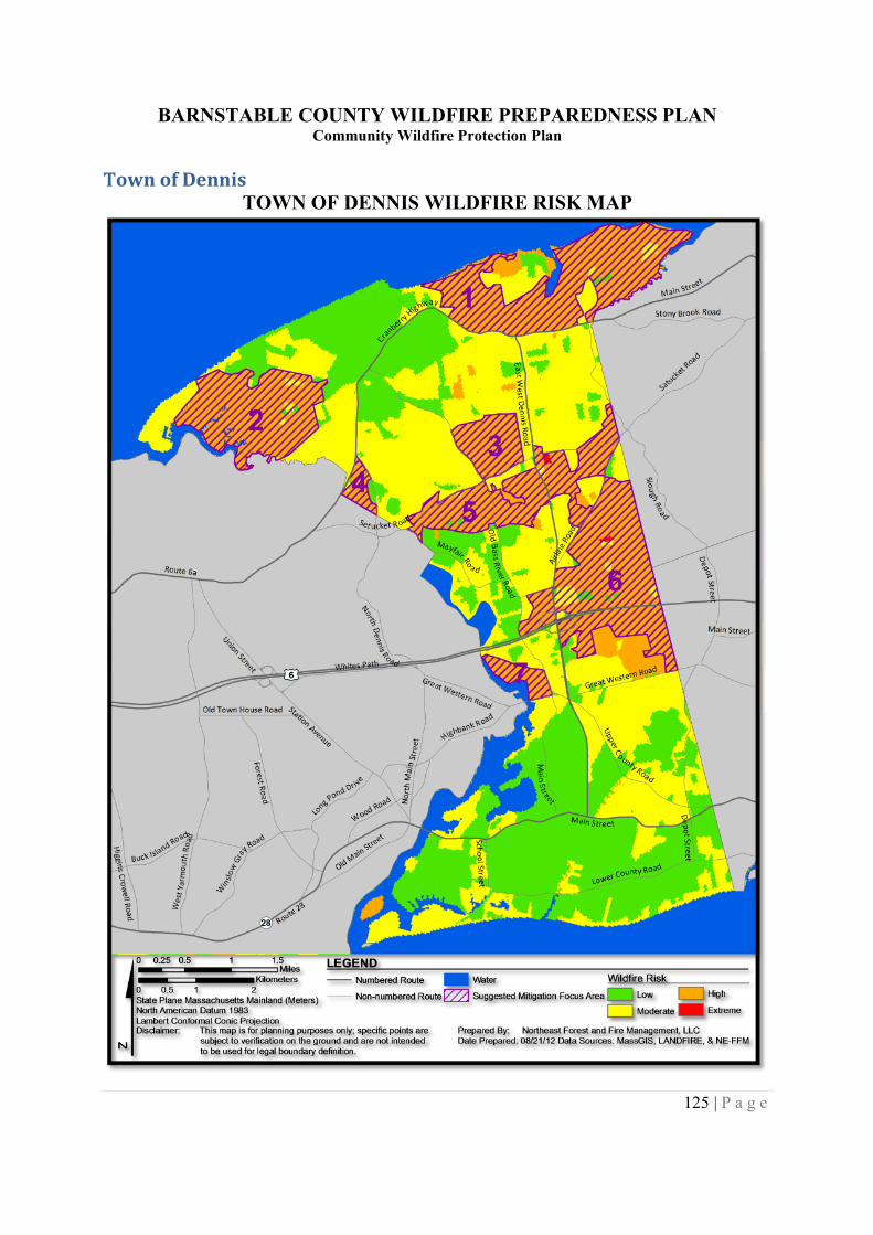
BARNSTABLE COUNTY WILDFIRE PREPAREDNESS PLANCommunity Wildfire Protection Plan
125 | P a g e
Town of DennisTOWN OF DENNIS WILDFIRE RISK MAP
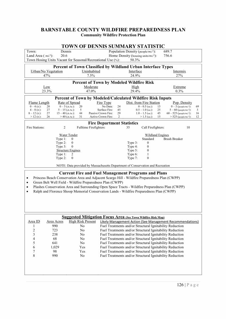
BARNSTABLE COUNTY WILDFIRE PREPAREDNESS PLANCommunity Wildfire Protection Plan
126 | P a g e
TOWN OF DENNIS SUMMARY STATISTICTown: Dennis Population Density (people/݉ .݅ଶ): 689.7Land Area ( ݉ .݅ଶ): 20.6 Home Density (housing units/݉ .݅ଶ): 756.6Town Hosing Units Vacant for Seasonal/Recreational Use (%): 50.3%
Percent of Town Classified by Wildland Urban Interface TypesUrban/No Vegetation Uninhabited Interface Intermix
47% 7.5% 24.9% 27%
Percent of Town by Modeled Wildfire RiskLow Moderate High Extreme
23.3% 47.0% 29.4% 0.3%
Percent of Town by Modeled/Calculated Wildfire Risk InputsFlame Length Rate of Spread Fire Type Dist. from Fire Station Pop. Density0 – 4 (ft.): 20 0 – 5 (ch./hr.): 20 No Data: 24 0 – 0.5 (mi.): 15 0 – 5 (people/݉ .݅ଶ): 694 – 8 (ft.): 27 5 – 15 (ch./hr.): 5 Surface Fire: 45 0.5 – 1.0 (mi.): 25 5 – 60 (people/݉ .݅ଶ): 3
8 – 12 (ft.): 27 15 – 40 (ch./hr.): 44 Passive Crown Fire: 29 1.0 – 1.5 (mi.): 45 60 – 525 (people/݉ .݅ଶ): 16> 12 (ft.): 26 > 40 (ch./hr.): 31 Active Crown Fire: 2 > 1.5 (mi.): 15 > 525 (people/݉ .݅ଶ): 12
Fire Department StatisticsFire Stations: 2 Fulltime Firefighters: 35 Call Firefighters: 10
Water Tender Wildland EnginesType 1: 0 Standard Brush BreakerType 2: 0 Type 3: 0Type 3: 0 Type 4: 0Structure Engines Type 5: 0Type 1: 2 Type 6: 1Type 2: 0 Type 7: 0
NOTE: Data provided by Massachusetts Department of Conservation and Recreation
Current Fire and Fuel Management Programs and Plans Princess Beach Conservation Area and Adjacent Scargo Hill - Wildfire Preparedness Plan (CWPP) Green Belt Well Field - Wildfire Preparedness Plan (CWPP) Plashes Conservation Area and Surrounding Open Space Tracts - Wildfire Preparedness Plan (CWPP) Ralph and Florence Shoop Memorial Conservation Lands - Wildfire Preparedness Plan (CWPP)
Suggested Mitigation Focus Area (See Town Wildfire Risk Map)
Area ID Area Acres High Risk Present Likely Management Action (See Management Recommendations)1 990 No Fuel Treatments and/or Structural Ignitability Reduction2 723 No Fuel Treatments and/or Structural Ignitability Reduction3 238 No Fuel Treatments and/or Structural Ignitability Reduction4 68 No Fuel Treatments and/or Structural Ignitability Reduction5 641 No Fuel Treatments and/or Structural Ignitability Reduction6 1,029 Yes Fuel Treatments and/or Structural Ignitability Reduction7 98 Yes Fuel Treatments and/or Structural Ignitability Reduction8 990 No Fuel Treatments and/or Structural Ignitability Reduction
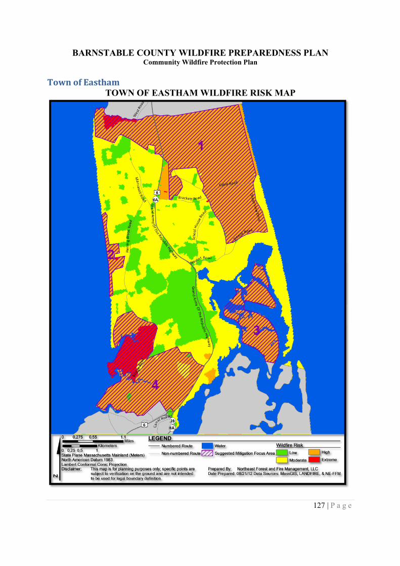
BARNSTABLE COUNTY WILDFIRE PREPAREDNESS PLANCommunity Wildfire Protection Plan
127 | P a g e
Town of EasthamTOWN OF EASTHAM WILDFIRE RISK MAP
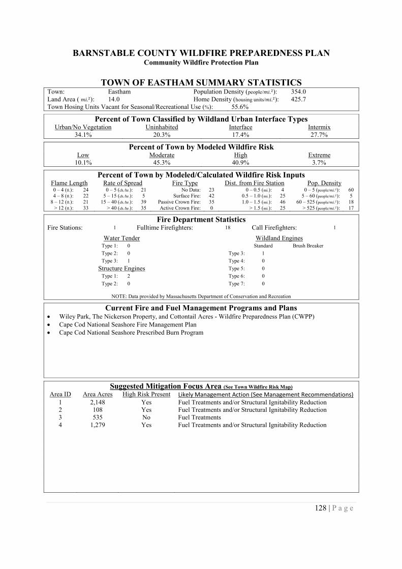
BARNSTABLE COUNTY WILDFIRE PREPAREDNESS PLANCommunity Wildfire Protection Plan
128 | P a g e
TOWN OF EASTHAM SUMMARY STATISTICSTown: Eastham Population Density (people/݉ .݅ଶ): 354.0Land Area ( ݉ .݅ଶ): 14.0 Home Density (housing units/݉ .݅ଶ): 425.7Town Hosing Units Vacant for Seasonal/Recreational Use (%): 55.6%
Percent of Town Classified by Wildland Urban Interface TypesUrban/No Vegetation Uninhabited Interface Intermix
34.1% 20.3% 17.4% 27.7%
Percent of Town by Modeled Wildfire RiskLow Moderate High Extreme
10.1% 45.3% 40.9% 3.7%
Percent of Town by Modeled/Calculated Wildfire Risk InputsFlame Length Rate of Spread Fire Type Dist. from Fire Station Pop. Density0 – 4 (ft.): 24 0 – 5 (ch./hr.): 21 No Data: 23 0 – 0.5 (mi.): 4 0 – 5 (people/݉ .݅ଶ): 604 – 8 (ft.): 22 5 – 15 (ch./hr.): 5 Surface Fire: 42 0.5 – 1.0 (mi.): 25 5 – 60 (people/݉ .݅ଶ): 5
8 – 12 (ft.): 21 15 – 40 (ch./hr.): 39 Passive Crown Fire: 35 1.0 – 1.5 (mi.): 46 60 – 525 (people/݉ .݅ଶ): 18> 12 (ft.): 33 > 40 (ch./hr.): 35 Active Crown Fire: 0 > 1.5 (mi.): 25 > 525 (people/݉ .݅ଶ): 17
Fire Department StatisticsFire Stations: 1 Fulltime Firefighters: 18 Call Firefighters: 1
Water Tender Wildland EnginesType 1: 0 Standard Brush Breaker
Type 2: 0 Type 3: 1
Type 3: 1 Type 4: 0
Structure Engines Type 5: 0
Type 1: 2 Type 6: 0
Type 2: 0 Type 7: 0
NOTE: Data provided by Massachusetts Department of Conservation and Recreation
Current Fire and Fuel Management Programs and Plans Wiley Park, The Nickerson Property, and Cottontail Acres - Wildfire Preparedness Plan (CWPP) Cape Cod National Seashore Fire Management Plan Cape Cod National Seashore Prescribed Burn Program
Suggested Mitigation Focus Area (See Town Wildfire Risk Map)
Area ID Area Acres High Risk Present Likely Management Action (See Management Recommendations)1 2,148 Yes Fuel Treatments and/or Structural Ignitability Reduction2 108 Yes Fuel Treatments and/or Structural Ignitability Reduction3 535 No Fuel Treatments4 1,279 Yes Fuel Treatments and/or Structural Ignitability Reduction

BARNSTABLE COUNTY WILDFIRE PREPAREDNESS PLANCommunity Wildfire Protection Plan
129 | P a g e
Town of FalmouthTOWN OF FALMOUTH WILDFIRE RISK MAP
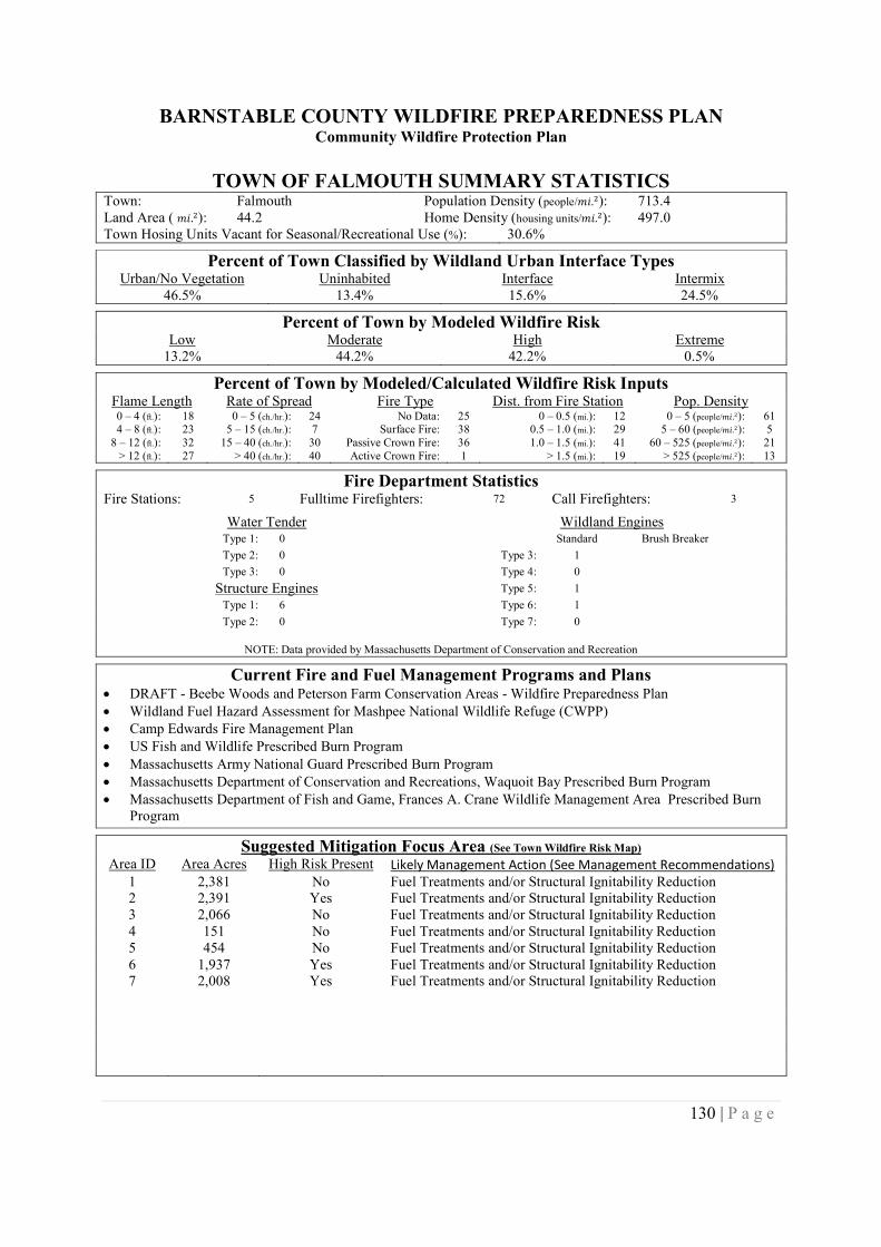
BARNSTABLE COUNTY WILDFIRE PREPAREDNESS PLANCommunity Wildfire Protection Plan
130 | P a g e
TOWN OF FALMOUTH SUMMARY STATISTICSTown: Falmouth Population Density (people/݉ .݅ଶ): 713.4Land Area ( ݉ .݅ଶ): 44.2 Home Density (housing units/݉ .݅ଶ): 497.0Town Hosing Units Vacant for Seasonal/Recreational Use (%): 30.6%
Percent of Town Classified by Wildland Urban Interface TypesUrban/No Vegetation Uninhabited Interface Intermix
46.5% 13.4% 15.6% 24.5%
Percent of Town by Modeled Wildfire RiskLow Moderate High Extreme
13.2% 44.2% 42.2% 0.5%
Percent of Town by Modeled/Calculated Wildfire Risk InputsFlame Length Rate of Spread Fire Type Dist. from Fire Station Pop. Density0 – 4 (ft.): 18 0 – 5 (ch./hr.): 24 No Data: 25 0 – 0.5 (mi.): 12 0 – 5 (people/݉ .݅ଶ): 614 – 8 (ft.): 23 5 – 15 (ch./hr.): 7 Surface Fire: 38 0.5 – 1.0 (mi.): 29 5 – 60 (people/݉ .݅ଶ): 5
8 – 12 (ft.): 32 15 – 40 (ch./hr.): 30 Passive Crown Fire: 36 1.0 – 1.5 (mi.): 41 60 – 525 (people/݉ .݅ଶ): 21> 12 (ft.): 27 > 40 (ch./hr.): 40 Active Crown Fire: 1 > 1.5 (mi.): 19 > 525 (people/݉ .݅ଶ): 13
Fire Department StatisticsFire Stations: 5 Fulltime Firefighters: 72 Call Firefighters: 3
Water Tender Wildland EnginesType 1: 0 Standard Brush Breaker
Type 2: 0 Type 3: 1
Type 3: 0 Type 4: 0
Structure Engines Type 5: 1
Type 1: 6 Type 6: 1
Type 2: 0 Type 7: 0
NOTE: Data provided by Massachusetts Department of Conservation and Recreation
Current Fire and Fuel Management Programs and Plans DRAFT - Beebe Woods and Peterson Farm Conservation Areas - Wildfire Preparedness Plan Wildland Fuel Hazard Assessment for Mashpee National Wildlife Refuge (CWPP) Camp Edwards Fire Management Plan US Fish and Wildlife Prescribed Burn Program Massachusetts Army National Guard Prescribed Burn Program Massachusetts Department of Conservation and Recreations, Waquoit Bay Prescribed Burn Program Massachusetts Department of Fish and Game, Frances A. Crane Wildlife Management Area Prescribed Burn
Program
Suggested Mitigation Focus Area (See Town Wildfire Risk Map)
Area ID Area Acres High Risk Present Likely Management Action (See Management Recommendations)1 2,381 No Fuel Treatments and/or Structural Ignitability Reduction2 2,391 Yes Fuel Treatments and/or Structural Ignitability Reduction3 2,066 No Fuel Treatments and/or Structural Ignitability Reduction4 151 No Fuel Treatments and/or Structural Ignitability Reduction5 454 No Fuel Treatments and/or Structural Ignitability Reduction6 1,937 Yes Fuel Treatments and/or Structural Ignitability Reduction7 2,008 Yes Fuel Treatments and/or Structural Ignitability Reduction
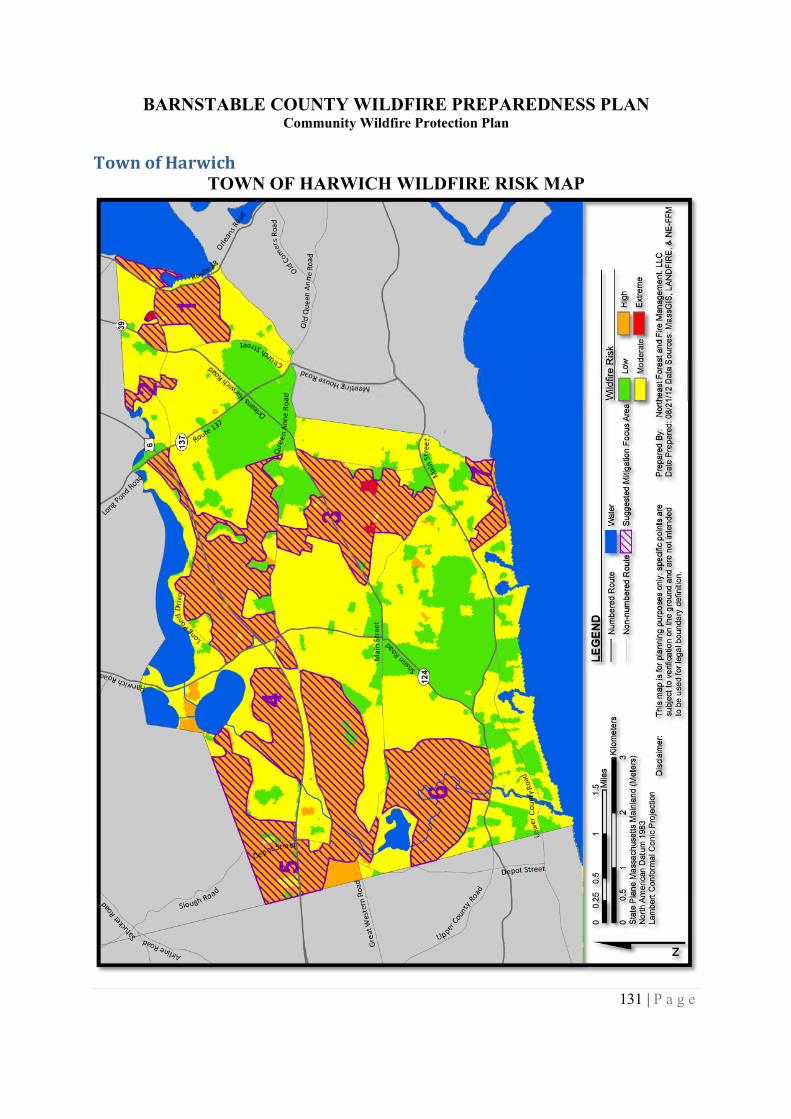
BARNSTABLE COUNTY WILDFIRE PREPAREDNESS PLANCommunity Wildfire Protection Plan
131 | P a g e
Town of HarwichTOWN OF HARWICH WILDFIRE RISK MAP
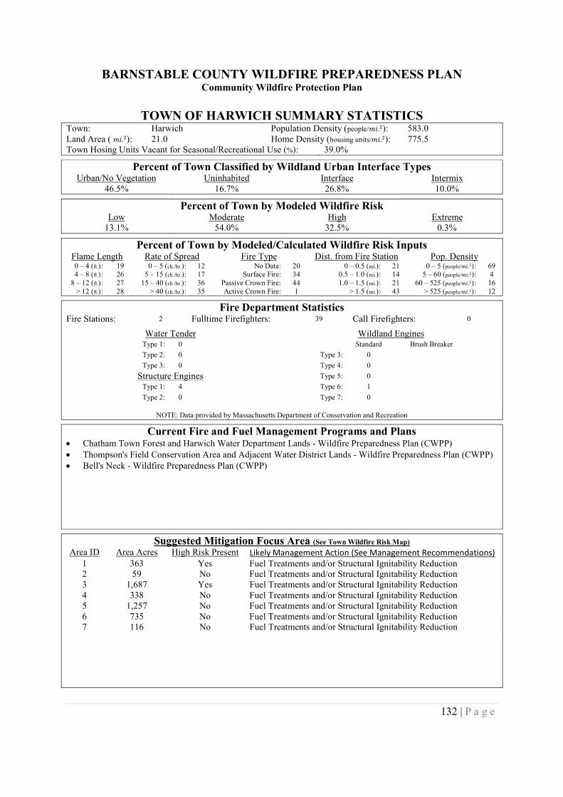
BARNSTABLE COUNTY WILDFIRE PREPAREDNESS PLANCommunity Wildfire Protection Plan
132 | P a g e
TOWN OF HARWICH SUMMARY STATISTICSTown: Harwich Population Density (people/݉ .݅ଶ): 583.0Land Area ( ݉ .݅ଶ): 21.0 Home Density (housing units/݉ .݅ଶ): 775.5Town Hosing Units Vacant for Seasonal/Recreational Use (%): 39.0%
Percent of Town Classified by Wildland Urban Interface TypesUrban/No Vegetation Uninhabited Interface Intermix
46.5% 16.7% 26.8% 10.0%
Percent of Town by Modeled Wildfire RiskLow Moderate High Extreme
13.1% 54.0% 32.5% 0.3%
Percent of Town by Modeled/Calculated Wildfire Risk InputsFlame Length Rate of Spread Fire Type Dist. from Fire Station Pop. Density0 – 4 (ft.): 19 0 – 5 (ch./hr.): 12 No Data: 20 0 – 0.5 (mi.): 21 0 – 5 (people/݉ .݅ଶ): 694 – 8 (ft.): 26 5 – 15 (ch./hr.): 17 Surface Fire: 34 0.5 – 1.0 (mi.): 14 5 – 60 (people/݉ .݅ଶ): 4
8 – 12 (ft.): 27 15 – 40 (ch./hr.): 36 Passive Crown Fire: 44 1.0 – 1.5 (mi.): 21 60 – 525 (people/݉ .݅ଶ): 16> 12 (ft.): 28 > 40 (ch./hr.): 35 Active Crown Fire: 1 > 1.5 (mi.): 43 > 525 (people/݉ .݅ଶ): 12
Fire Department StatisticsFire Stations: 2 Fulltime Firefighters: 39 Call Firefighters: 0
Water Tender Wildland EnginesType 1: 0 Standard Brush Breaker
Type 2: 0 Type 3: 0
Type 3: 0 Type 4: 0
Structure Engines Type 5: 0
Type 1: 4 Type 6: 1
Type 2: 0 Type 7: 0
NOTE: Data provided by Massachusetts Department of Conservation and Recreation
Current Fire and Fuel Management Programs and Plans Chatham Town Forest and Harwich Water Department Lands - Wildfire Preparedness Plan (CWPP) Thompson's Field Conservation Area and Adjacent Water District Lands - Wildfire Preparedness Plan (CWPP) Bell's Neck - Wildfire Preparedness Plan (CWPP)
Suggested Mitigation Focus Area (See Town Wildfire Risk Map)
Area ID Area Acres High Risk Present Likely Management Action (See Management Recommendations)1 363 Yes Fuel Treatments and/or Structural Ignitability Reduction2 59 No Fuel Treatments and/or Structural Ignitability Reduction3 1,687 Yes Fuel Treatments and/or Structural Ignitability Reduction4 338 No Fuel Treatments and/or Structural Ignitability Reduction5 1,257 No Fuel Treatments and/or Structural Ignitability Reduction6 735 No Fuel Treatments and/or Structural Ignitability Reduction7 116 No Fuel Treatments and/or Structural Ignitability Reduction
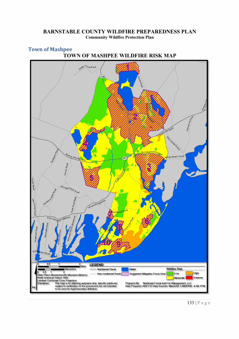
BARNSTABLE COUNTY WILDFIRE PREPAREDNESS PLANCommunity Wildfire Protection Plan
133 | P a g e
Town of MashpeeTOWN OF MASHPEE WILDFIRE RISK MAP
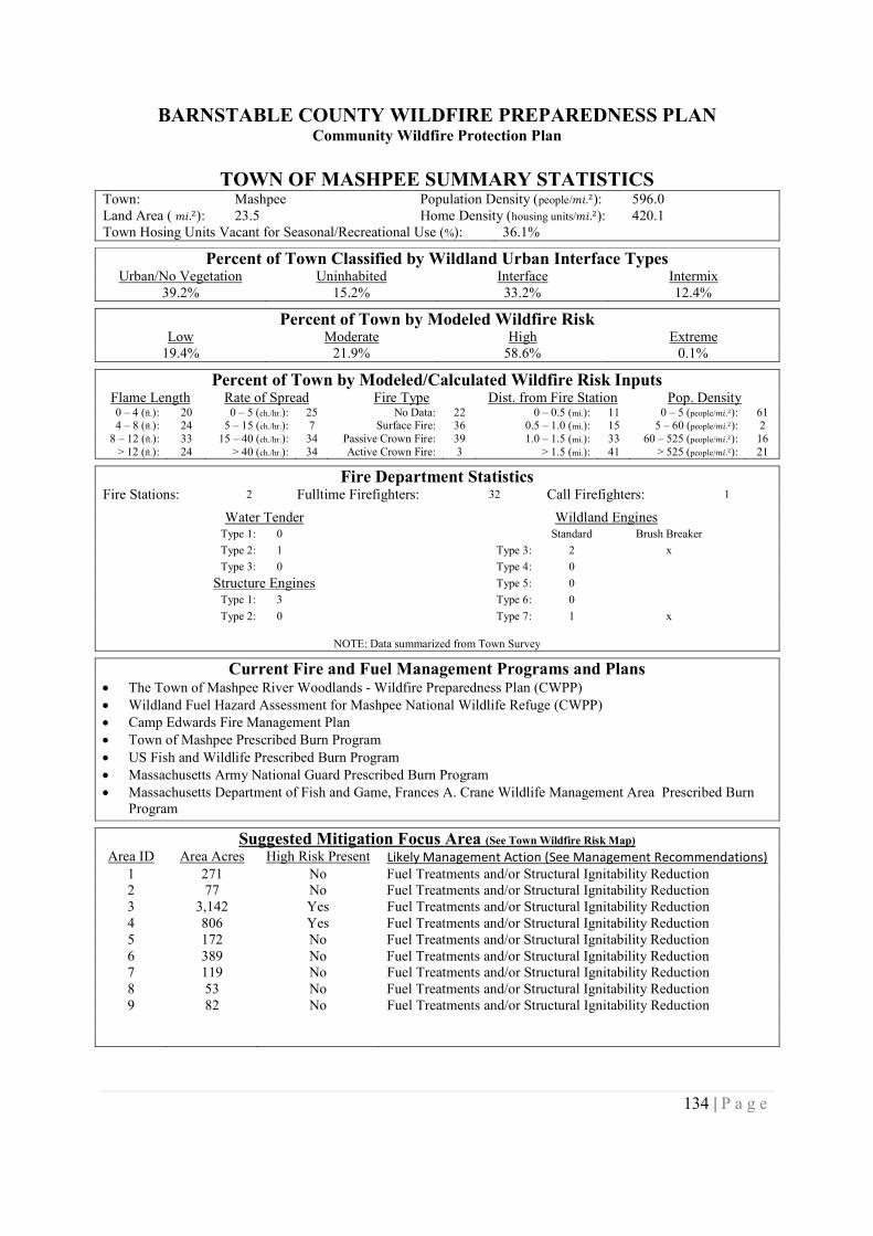
BARNSTABLE COUNTY WILDFIRE PREPAREDNESS PLANCommunity Wildfire Protection Plan
134 | P a g e
TOWN OF MASHPEE SUMMARY STATISTICSTown: Mashpee Population Density (people/݉ .݅ଶ): 596.0Land Area ( ݉ .݅ଶ): 23.5 Home Density (housing units/݉ .݅ଶ): 420.1Town Hosing Units Vacant for Seasonal/Recreational Use (%): 36.1%
Percent of Town Classified by Wildland Urban Interface TypesUrban/No Vegetation Uninhabited Interface Intermix
39.2% 15.2% 33.2% 12.4%
Percent of Town by Modeled Wildfire RiskLow Moderate High Extreme
19.4% 21.9% 58.6% 0.1%
Percent of Town by Modeled/Calculated Wildfire Risk InputsFlame Length Rate of Spread Fire Type Dist. from Fire Station Pop. Density0 – 4 (ft.): 20 0 – 5 (ch./hr.): 25 No Data: 22 0 – 0.5 (mi.): 11 0 – 5 (people/݉ .݅ଶ): 614 – 8 (ft.): 24 5 – 15 (ch./hr.): 7 Surface Fire: 36 0.5 – 1.0 (mi.): 15 5 – 60 (people/݉ .݅ଶ): 2
8 – 12 (ft.): 33 15 – 40 (ch./hr.): 34 Passive Crown Fire: 39 1.0 – 1.5 (mi.): 33 60 – 525 (people/݉ .݅ଶ): 16> 12 (ft.): 24 > 40 (ch./hr.): 34 Active Crown Fire: 3 > 1.5 (mi.): 41 > 525 (people/݉ .݅ଶ): 21
Fire Department StatisticsFire Stations: 2 Fulltime Firefighters: 32 Call Firefighters: 1
Water Tender Wildland EnginesType 1: 0 Standard Brush Breaker
Type 2: 1 Type 3: 2 x
Type 3: 0 Type 4: 0
Structure Engines Type 5: 0
Type 1: 3 Type 6: 0
Type 2: 0 Type 7: 1 x
NOTE: Data summarized from Town Survey
Current Fire and Fuel Management Programs and Plans The Town of Mashpee River Woodlands - Wildfire Preparedness Plan (CWPP) Wildland Fuel Hazard Assessment for Mashpee National Wildlife Refuge (CWPP) Camp Edwards Fire Management Plan Town of Mashpee Prescribed Burn Program US Fish and Wildlife Prescribed Burn Program Massachusetts Army National Guard Prescribed Burn Program Massachusetts Department of Fish and Game, Frances A. Crane Wildlife Management Area Prescribed Burn
Program
Suggested Mitigation Focus Area (See Town Wildfire Risk Map)
Area ID Area Acres High Risk Present Likely Management Action (See Management Recommendations)1 271 No Fuel Treatments and/or Structural Ignitability Reduction2 77 No Fuel Treatments and/or Structural Ignitability Reduction3 3,142 Yes Fuel Treatments and/or Structural Ignitability Reduction4 806 Yes Fuel Treatments and/or Structural Ignitability Reduction5 172 No Fuel Treatments and/or Structural Ignitability Reduction6 389 No Fuel Treatments and/or Structural Ignitability Reduction7 119 No Fuel Treatments and/or Structural Ignitability Reduction8 53 No Fuel Treatments and/or Structural Ignitability Reduction9 82 No Fuel Treatments and/or Structural Ignitability Reduction
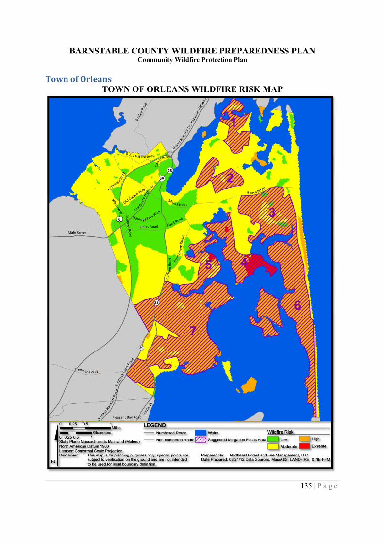
BARNSTABLE COUNTY WILDFIRE PREPAREDNESS PLANCommunity Wildfire Protection Plan
135 | P a g e
Town of OrleansTOWN OF ORLEANS WILDFIRE RISK MAP
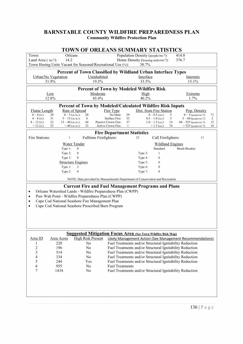
BARNSTABLE COUNTY WILDFIRE PREPAREDNESS PLANCommunity Wildfire Protection Plan
136 | P a g e
TOWN OF ORLEANS SUMMARY STATISTICSTown: Orleans Population Density (people/݉ .݅ଶ): 414.8Land Area ( ݉ .݅ଶ): 14.2 Home Density (housing units/݉ .݅ଶ): 376.7Town Hosing Units Vacant for Seasonal/Recreational Use (%): 38.7%
Percent of Town Classified by Wildland Urban Interface TypesUrban/No Vegetation Uninhabited Interface Intermix
31.9% 19.5% 33.5% 15.1%
Percent of Town by Modeled Wildfire RiskLow Moderate High Extreme
12.8% 45.4% 40.2% 1.7%
Percent of Town by Modeled/Calculated Wildfire Risk InputsFlame Length Rate of Spread Fire Type Dist. from Fire Station Pop. Density0 – 4 (ft.): 20 0 – 5 (ch./hr.): 20 No Data: 29 0 – 0.5 (mi.): 5 0 – 5 (people/݉ .݅ଶ): 714 – 8 (ft.): 31 5 – 15 (ch./hr.): 4 Surface Fire: 33 0.5 – 1.0 (mi.): 5 5 – 60 (people/݉ .݅ଶ): 2
8 – 12 (ft.): 23 15 – 40 (ch./hr.): 44 Passive Crown Fire: 37 1.0 – 1.5 (mi.): 14 60 – 525 (people/݉ .݅ଶ): 12> 12 (ft.): 25 > 40 (ch./hr.): 33 Active Crown Fire: 1 > 1.5 (mi.): 76 > 525 (people/݉ .݅ଶ): 16
Fire Department StatisticsFire Stations: 1 Fulltime Firefighters: 23 Call Firefighters: 11
Water Tender Wildland EnginesType 1: 0 Standard Brush Breaker
Type 2: 0 Type 3: 1
Type 3: 0 Type 4: 0
Structure Engines Type 5: 0
Type 1: 2 Type 6: 0
Type 2: 0 Type 7: 0
NOTE: Data provided by Massachusetts Department of Conservation and Recreation
Current Fire and Fuel Management Programs and Plans Orleans Watershed Lands - Wildfire Preparedness Plan (CWPP) Paw Wah Point - Wildfire Preparedness Plan (CWPP) Cape Cod National Seashore Fire Management Plan Cape Cod National Seashore Prescribed Burn Program
Suggested Mitigation Focus Area (See Town Wildfire Risk Map)
Area ID Area Acres High Risk Present Likely Management Action (See Management Recommendations)1 220 No Fuel Treatments and/or Structural Ignitability Reduction2 196 No Fuel Treatments and/or Structural Ignitability Reduction3 514 No Fuel Treatments and/or Structural Ignitability Reduction4 334 No Fuel Treatments and/or Structural Ignitability Reduction5 244 Yes Fuel Treatments and/or Structural Ignitability Reduction6 955 No Fuel Treatments7 1434 No Fuel Treatments and/or Structural Ignitability Reduction
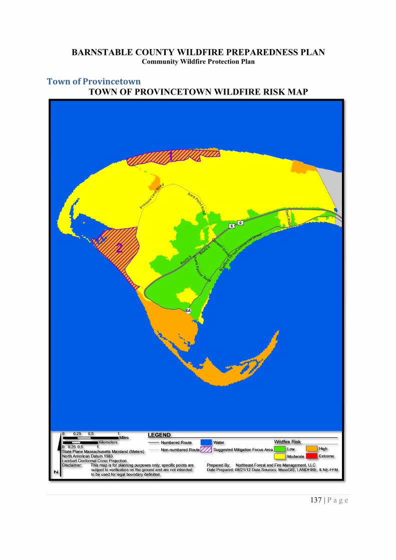
BARNSTABLE COUNTY WILDFIRE PREPAREDNESS PLANCommunity Wildfire Protection Plan
137 | P a g e
Town of ProvincetownTOWN OF PROVINCETOWN WILDFIRE RISK MAP
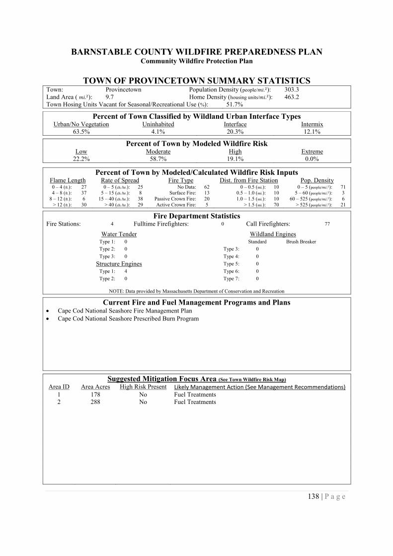
BARNSTABLE COUNTY WILDFIRE PREPAREDNESS PLANCommunity Wildfire Protection Plan
138 | P a g e
TOWN OF PROVINCETOWN SUMMARY STATISTICSTown: Provincetown Population Density (people/݉ .݅ଶ): 303.3Land Area ( ݉ .݅ଶ): 9.7 Home Density (housing units/݉ .݅ଶ): 463.2Town Hosing Units Vacant for Seasonal/Recreational Use (%): 51.7%
Percent of Town Classified by Wildland Urban Interface TypesUrban/No Vegetation Uninhabited Interface Intermix
63.5% 4.1% 20.3% 12.1%
Percent of Town by Modeled Wildfire RiskLow Moderate High Extreme
22.2% 58.7% 19.1% 0.0%
Percent of Town by Modeled/Calculated Wildfire Risk InputsFlame Length Rate of Spread Fire Type Dist. from Fire Station Pop. Density0 – 4 (ft.): 27 0 – 5 (ch./hr.): 25 No Data: 62 0 – 0.5 (mi.): 10 0 – 5 (people/݉ .݅ଶ): 714 – 8 (ft.): 37 5 – 15 (ch./hr.): 8 Surface Fire: 13 0.5 – 1.0 (mi.): 10 5 – 60 (people/݉ .݅ଶ): 3
8 – 12 (ft.): 6 15 – 40 (ch./hr.): 38 Passive Crown Fire: 20 1.0 – 1.5 (mi.): 10 60 – 525 (people/݉ .݅ଶ): 6> 12 (ft.): 30 > 40 (ch./hr.): 29 Active Crown Fire: 5 > 1.5 (mi.): 70 > 525 (people/݉ .݅ଶ): 21
Fire Department StatisticsFire Stations: 4 Fulltime Firefighters: 0 Call Firefighters: 77
Water Tender Wildland EnginesType 1: 0 Standard Brush Breaker
Type 2: 0 Type 3: 0
Type 3: 0 Type 4: 0
Structure Engines Type 5: 0
Type 1: 4 Type 6: 0
Type 2: 0 Type 7: 0
NOTE: Data provided by Massachusetts Department of Conservation and Recreation
Current Fire and Fuel Management Programs and Plans Cape Cod National Seashore Fire Management Plan Cape Cod National Seashore Prescribed Burn Program
Suggested Mitigation Focus Area (See Town Wildfire Risk Map)
Area ID Area Acres High Risk Present Likely Management Action (See Management Recommendations)1 178 No Fuel Treatments2 288 No Fuel Treatments
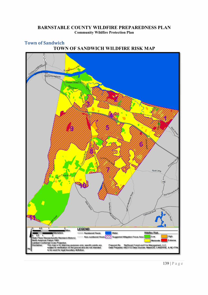
BARNSTABLE COUNTY WILDFIRE PREPAREDNESS PLANCommunity Wildfire Protection Plan
139 | P a g e
Town of SandwichTOWN OF SANDWICH WILDFIRE RISK MAP
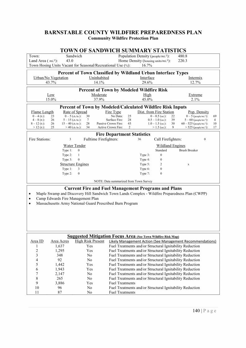
BARNSTABLE COUNTY WILDFIRE PREPAREDNESS PLANCommunity Wildfire Protection Plan
140 | P a g e
TOWN OF SANDWICH SUMMARY STATISTICSTown: Sandwich Population Density (people/݉ .݅ଶ): 480.8Land Area ( ݉ .݅ଶ): 43.0 Home Density (housing units/݉ .݅ଶ): 220.3Town Hosing Units Vacant for Seasonal/Recreational Use (%): 16.7%
Percent of Town Classified by Wildland Urban Interface TypesUrban/No Vegetation Uninhabited Interface Intermix
43.7% 14.1% 29.6% 12.7%
Percent of Town by Modeled Wildfire RiskLow Moderate High Extreme
15.0% 37.9% 45.0% 2.1%
Percent of Town by Modeled/Calculated Wildfire Risk InputsFlame Length Rate of Spread Fire Type Dist. from Fire Station Pop. Density0 – 4 (ft.): 23 0 – 5 (ch./hr.): 30 No Data: 25 0 – 0.5 (mi.): 22 0 – 5 (people/݉ .݅ଶ): 694 – 8 (ft.): 26 5 – 15 (ch./hr.): 7 Surface Fire: 28 0.5 – 1.0 (mi.): 39 5 – 60 (people/݉ .݅ଶ): 4
8 – 12 (ft.): 26 15 – 40 (ch./hr.): 28 Passive Crown Fire: 45 1.0 – 1.5 (mi.): 30 60 – 525 (people/݉ .݅ଶ): 10> 12 (ft.): 25 > 40 (ch./hr.): 34 Active Crown Fire: 2 > 1.5 (mi.): 9 > 525 (people/݉ .݅ଶ): 17
Fire Department StatisticsFire Stations: 3 Fulltime Firefighters: 36 Call Firefighters: 0
Water Tender Wildland EnginesType 1: 0 Standard Brush Breaker
Type 2: 1 Type 3: 0
Type 3: 0 Type 4: 0
Structure Engines Type 5: 2 x
Type 1: 3 Type 6: 0
Type 2: 0 Type 7: 0
NOTE: Data summarized from Town Survey
Current Fire and Fuel Management Programs and Plans Maple Swamp and Discovery Hill Sandwich Town Lands Complex - Wildfire Preparedness Plan (CWPP) Camp Edwards Fire Management Plan Massachusetts Army National Guard Prescribed Burn Program
Suggested Mitigation Focus Area (See Town Wildfire Risk Map)
Area ID Area Acres High Risk Present Likely Management Action (See Management Recommendations)1 1,637 Yes Fuel Treatments and/or Structural Ignitability Reduction2 1,295 Yes Fuel Treatments and/or Structural Ignitability Reduction3 348 No Fuel Treatments and/or Structural Ignitability Reduction4 92 No Fuel Treatments and/or Structural Ignitability Reduction5 1,442 Yes Fuel Treatments and/or Structural Ignitability Reduction6 1,943 Yes Fuel Treatments and/or Structural Ignitability Reduction7 2,147 No Fuel Treatments and/or Structural Ignitability Reduction8 265 No Fuel Treatments and/or Structural Ignitability Reduction9 3,886 Yes Fuel Treatments10 96 No Fuel Treatments and/or Structural Ignitability Reduction11 87 No Fuel Treatments
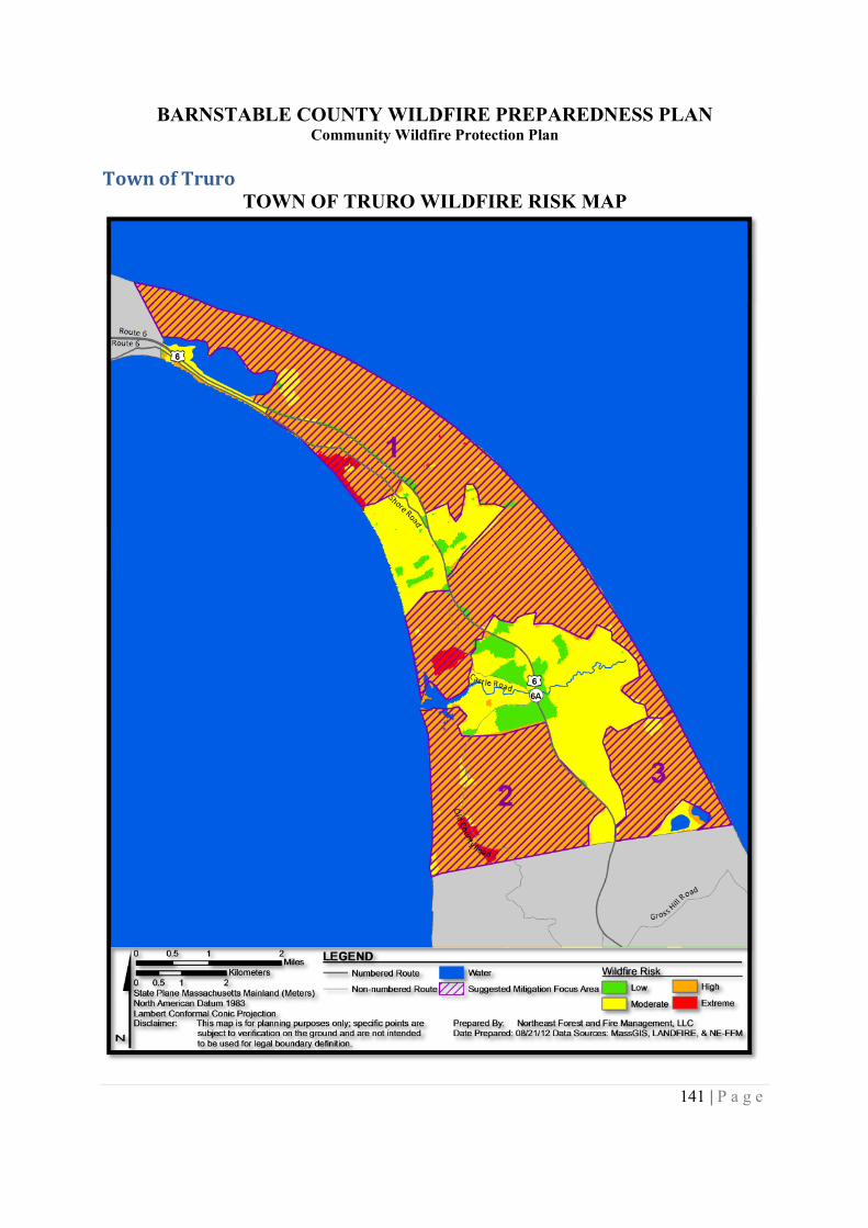
BARNSTABLE COUNTY WILDFIRE PREPAREDNESS PLANCommunity Wildfire Protection Plan
141 | P a g e
Town of TruroTOWN OF TRURO WILDFIRE RISK MAP
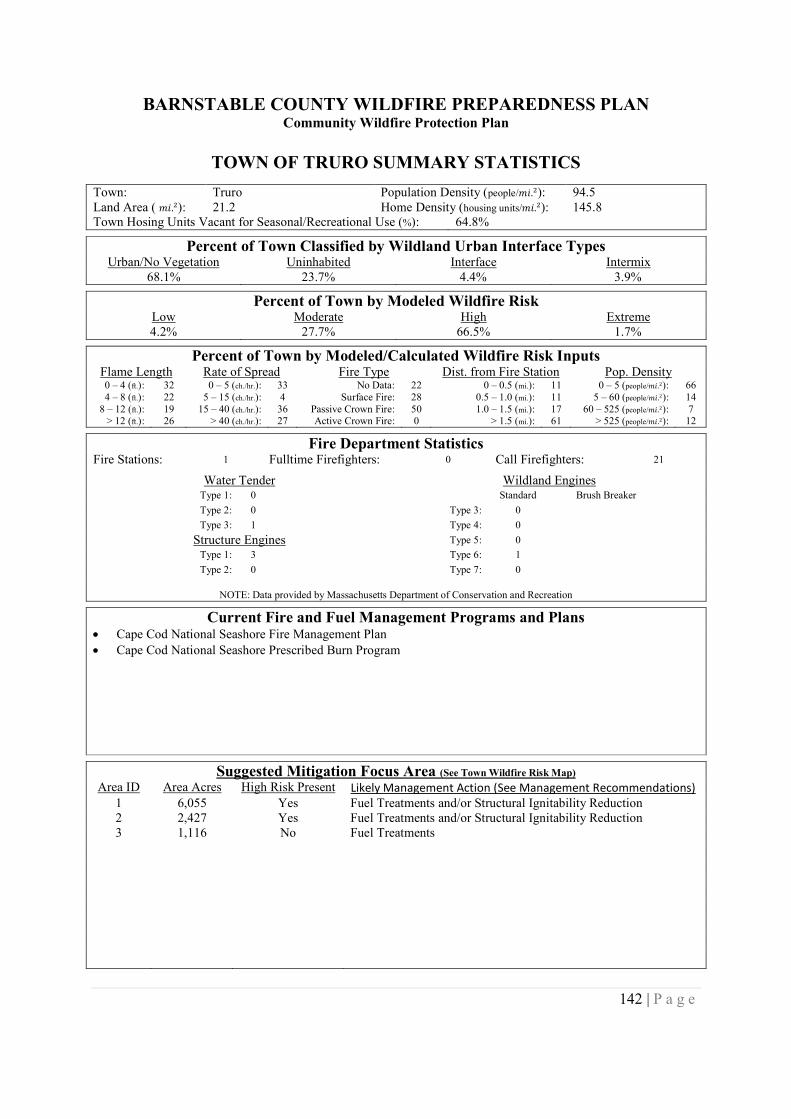
BARNSTABLE COUNTY WILDFIRE PREPAREDNESS PLANCommunity Wildfire Protection Plan
142 | P a g e
TOWN OF TRURO SUMMARY STATISTICS
Town: Truro Population Density (people/݉ .݅ଶ): 94.5Land Area ( ݉ .݅ଶ): 21.2 Home Density (housing units/݉ .݅ଶ): 145.8Town Hosing Units Vacant for Seasonal/Recreational Use (%): 64.8%
Percent of Town Classified by Wildland Urban Interface TypesUrban/No Vegetation Uninhabited Interface Intermix
68.1% 23.7% 4.4% 3.9%
Percent of Town by Modeled Wildfire RiskLow Moderate High Extreme4.2% 27.7% 66.5% 1.7%
Percent of Town by Modeled/Calculated Wildfire Risk InputsFlame Length Rate of Spread Fire Type Dist. from Fire Station Pop. Density0 – 4 (ft.): 32 0 – 5 (ch./hr.): 33 No Data: 22 0 – 0.5 (mi.): 11 0 – 5 (people/݉ .݅ଶ): 664 – 8 (ft.): 22 5 – 15 (ch./hr.): 4 Surface Fire: 28 0.5 – 1.0 (mi.): 11 5 – 60 (people/݉ .݅ଶ): 14
8 – 12 (ft.): 19 15 – 40 (ch./hr.): 36 Passive Crown Fire: 50 1.0 – 1.5 (mi.): 17 60 – 525 (people/݉ .݅ଶ): 7> 12 (ft.): 26 > 40 (ch./hr.): 27 Active Crown Fire: 0 > 1.5 (mi.): 61 > 525 (people/݉ .݅ଶ): 12
Fire Department StatisticsFire Stations: 1 Fulltime Firefighters: 0 Call Firefighters: 21
Water Tender Wildland EnginesType 1: 0 Standard Brush Breaker
Type 2: 0 Type 3: 0
Type 3: 1 Type 4: 0
Structure Engines Type 5: 0
Type 1: 3 Type 6: 1
Type 2: 0 Type 7: 0
NOTE: Data provided by Massachusetts Department of Conservation and Recreation
Current Fire and Fuel Management Programs and Plans Cape Cod National Seashore Fire Management Plan Cape Cod National Seashore Prescribed Burn Program
Suggested Mitigation Focus Area (See Town Wildfire Risk Map)
Area ID Area Acres High Risk Present Likely Management Action (See Management Recommendations)1 6,055 Yes Fuel Treatments and/or Structural Ignitability Reduction2 2,427 Yes Fuel Treatments and/or Structural Ignitability Reduction3 1,116 No Fuel Treatments
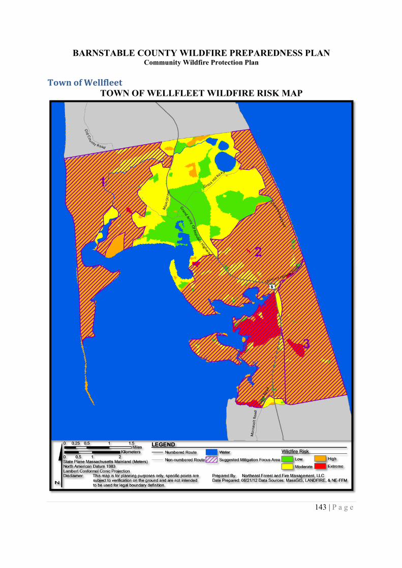
BARNSTABLE COUNTY WILDFIRE PREPAREDNESS PLANCommunity Wildfire Protection Plan
143 | P a g e
Town of WellfleetTOWN OF WELLFLEET WILDFIRE RISK MAP
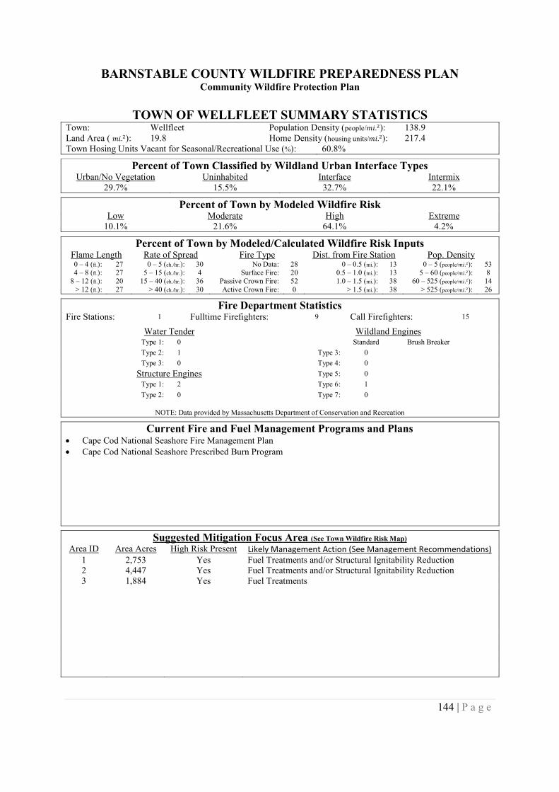
BARNSTABLE COUNTY WILDFIRE PREPAREDNESS PLANCommunity Wildfire Protection Plan
144 | P a g e
TOWN OF WELLFLEET SUMMARY STATISTICSTown: Wellfleet Population Density (people/݉ .݅ଶ): 138.9Land Area ( ݉ .݅ଶ): 19.8 Home Density (housing units/݉ .݅ଶ): 217.4Town Hosing Units Vacant for Seasonal/Recreational Use (%): 60.8%
Percent of Town Classified by Wildland Urban Interface TypesUrban/No Vegetation Uninhabited Interface Intermix
29.7% 15.5% 32.7% 22.1%
Percent of Town by Modeled Wildfire RiskLow Moderate High Extreme
10.1% 21.6% 64.1% 4.2%
Percent of Town by Modeled/Calculated Wildfire Risk InputsFlame Length Rate of Spread Fire Type Dist. from Fire Station Pop. Density0 – 4 (ft.): 27 0 – 5 (ch./hr.): 30 No Data: 28 0 – 0.5 (mi.): 13 0 – 5 (people/݉ .݅ଶ): 534 – 8 (ft.): 27 5 – 15 (ch./hr.): 4 Surface Fire: 20 0.5 – 1.0 (mi.): 13 5 – 60 (people/݉ .݅ଶ): 8
8 – 12 (ft.): 20 15 – 40 (ch./hr.): 36 Passive Crown Fire: 52 1.0 – 1.5 (mi.): 38 60 – 525 (people/݉ .݅ଶ): 14> 12 (ft.): 27 > 40 (ch./hr.): 30 Active Crown Fire: 0 > 1.5 (mi.): 38 > 525 (people/݉ .݅ଶ): 26
Fire Department StatisticsFire Stations: 1 Fulltime Firefighters: 9 Call Firefighters: 15
Water Tender Wildland EnginesType 1: 0 Standard Brush Breaker
Type 2: 1 Type 3: 0
Type 3: 0 Type 4: 0
Structure Engines Type 5: 0
Type 1: 2 Type 6: 1
Type 2: 0 Type 7: 0
NOTE: Data provided by Massachusetts Department of Conservation and Recreation
Current Fire and Fuel Management Programs and Plans Cape Cod National Seashore Fire Management Plan Cape Cod National Seashore Prescribed Burn Program
Suggested Mitigation Focus Area (See Town Wildfire Risk Map)
Area ID Area Acres High Risk Present Likely Management Action (See Management Recommendations)1 2,753 Yes Fuel Treatments and/or Structural Ignitability Reduction2 4,447 Yes Fuel Treatments and/or Structural Ignitability Reduction3 1,884 Yes Fuel Treatments
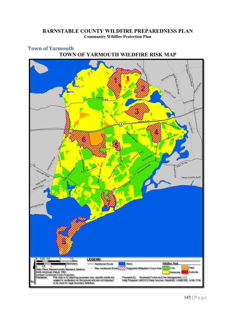
BARNSTABLE COUNTY WILDFIRE PREPAREDNESS PLANCommunity Wildfire Protection Plan
145 | P a g e
Town of YarmouthTOWN OF YARMOUTH WILDFIRE RISK MAP
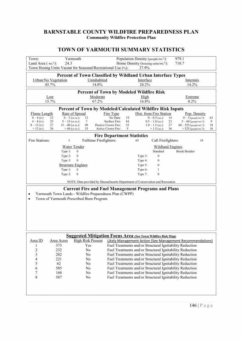
BARNSTABLE COUNTY WILDFIRE PREPAREDNESS PLANCommunity Wildfire Protection Plan
146 | P a g e
TOWN OF YARMOUTH SUMMARY STATISTICS
Town: Yarmouth Population Density (people/݉ .݅ଶ): 979.1Land Area ( ݉ .݅ଶ): 24.3 Home Density (housing units/݉ .݅ଶ): 718.7Town Hosing Units Vacant for Seasonal/Recreational Use (%): 27.9%
Percent of Town Classified by Wildland Urban Interface TypesUrban/No Vegetation Uninhabited Interface Intermix
45.7% 14.0% 24.2% 14.2%
Percent of Town by Modeled Wildfire RiskLow Moderate High Extreme
15.7% 67.2% 16.8% 0.2%
Percent of Town by Modeled/Calculated Wildfire Risk InputsFlame Length Rate of Spread Fire Type Dist. from Fire Station Pop. Density0 – 4 (ft.): 22 0 – 5 (ch./hr.): 12 No Data: 19 0 – 0.5 (mi.): 14 0 – 5 (people/݉ .݅ଶ): 634 – 8 (ft.): 25 5 – 15 (ch./hr.): 7 Surface Fire: 44 0.5 – 1.0 (mi.): 23 5 – 60 (people/݉ .݅ଶ): 9
8 – 12 (ft.): 27 15 – 40 (ch./hr.): 49 Passive Crown Fire: 32 1.0 – 1.5 (mi.): 27 60 – 525 (people/݉ .݅ଶ): 18> 12 (ft.): 26 > 40 (ch./hr.): 33 Active Crown Fire: 5 > 1.5 (mi.): 36 > 525 (people/݉ .݅ଶ): 10
Fire Department StatisticsFire Stations: 3 Fulltime Firefighters: 65 Call Firefighters: 10
Water Tender Wildland EnginesType 1: 0 Standard Brush Breaker
Type 2: 0 Type 3: 0
Type 3: 0 Type 4: 0
Structure Engines Type 5: 0
Type 1: 6 Type 6: 1
Type 2: 0 Type 7: 0
NOTE: Data provided by Massachusetts Department of Conservation and Recreation
Current Fire and Fuel Management Programs and Plans Yarmouth Town Lands - Wildfire Preparedness Plan (CWPP) Town of Yarmouth Prescribed Burn Program
Suggested Mitigation Focus Area (See Town Wildfire Risk Map)
Area ID Area Acres High Risk Present Likely Management Action (See Management Recommendations)1 373 Yes Fuel Treatments and/or Structural Ignitability Reduction2 232 No Fuel Treatments and/or Structural Ignitability Reduction3 282 No Fuel Treatments and/or Structural Ignitability Reduction4 221 No Fuel Treatments and/or Structural Ignitability Reduction5 62 No Fuel Treatments and/or Structural Ignitability Reduction6 585 No Fuel Treatments and/or Structural Ignitability Reduction7 168 No Fuel Treatments and/or Structural Ignitability Reduction8 587 No Fuel Treatments and/or Structural Ignitability Reduction
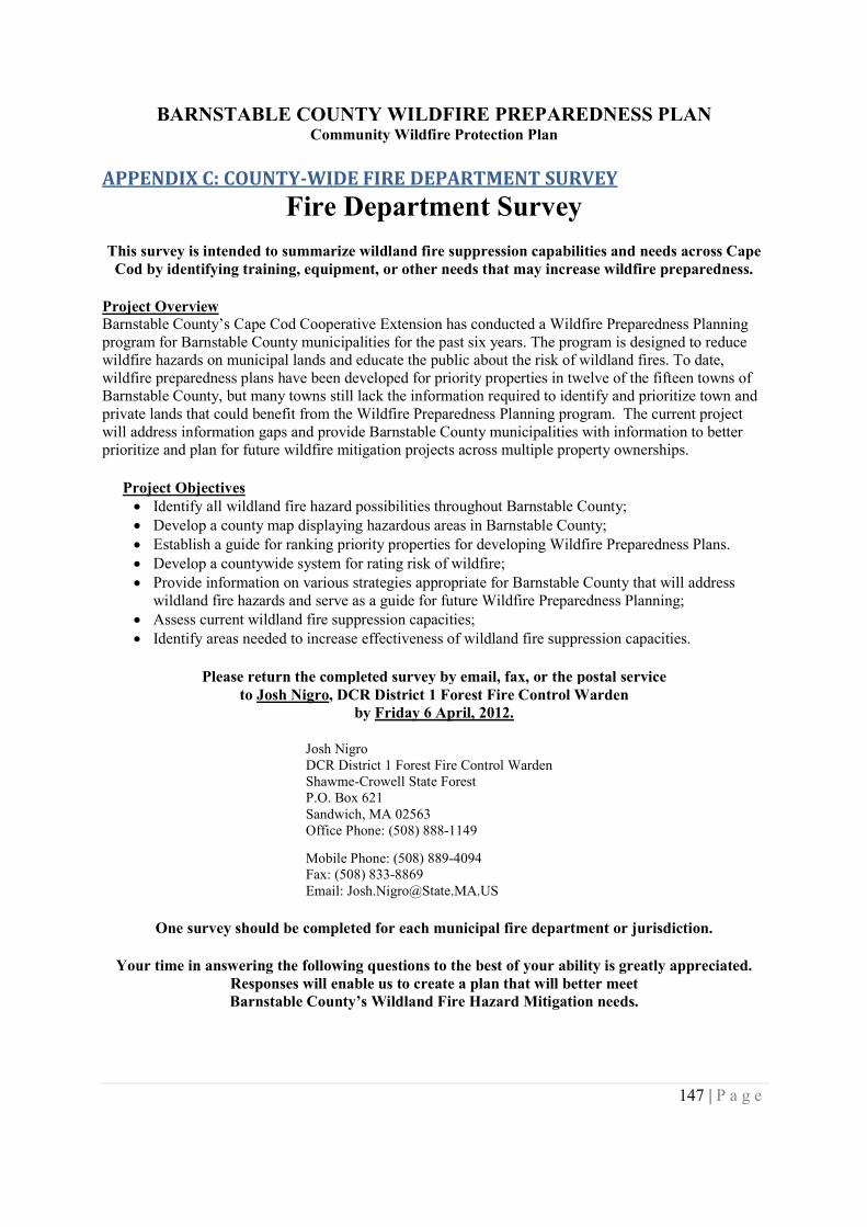
BARNSTABLE COUNTY WILDFIRE PREPAREDNESS PLANCommunity Wildfire Protection Plan
147 | P a g e
APPENDIX C: COUNTY-WIDE FIRE DEPARTMENT SURVEY
Fire Department Survey
This survey is intended to summarize wildland fire suppression capabilities and needs across CapeCod by identifying training, equipment, or other needs that may increase wildfire preparedness.
Project OverviewBarnstable County’s Cape Cod Cooperative Extension has conducted a Wildfire Preparedness Planningprogram for Barnstable County municipalities for the past six years. The program is designed to reducewildfire hazards on municipal lands and educate the public about the risk of wildland fires. To date,wildfire preparedness plans have been developed for priority properties in twelve of the fifteen towns ofBarnstable County, but many towns still lack the information required to identify and prioritize town andprivate lands that could benefit from the Wildfire Preparedness Planning program. The current projectwill address information gaps and provide Barnstable County municipalities with information to betterprioritize and plan for future wildfire mitigation projects across multiple property ownerships.
Project Objectives Identify all wildland fire hazard possibilities throughout Barnstable County; Develop a county map displaying hazardous areas in Barnstable County; Establish a guide for ranking priority properties for developing Wildfire Preparedness Plans. Develop a countywide system for rating risk of wildfire; Provide information on various strategies appropriate for Barnstable County that will address
wildland fire hazards and serve as a guide for future Wildfire Preparedness Planning; Assess current wildland fire suppression capacities; Identify areas needed to increase effectiveness of wildland fire suppression capacities.
Please return the completed survey by email, fax, or the postal serviceto Josh Nigro, DCR District 1 Forest Fire Control Warden
by Friday 6 April, 2012.
Josh NigroDCR District 1 Forest Fire Control WardenShawme-Crowell State ForestP.O. Box 621Sandwich, MA 02563Office Phone: (508) 888-1149
Mobile Phone: (508) 889-4094Fax: (508) 833-8869Email: [email protected]
One survey should be completed for each municipal fire department or jurisdiction.
Your time in answering the following questions to the best of your ability is greatly appreciated.Responses will enable us to create a plan that will better meetBarnstable County’s Wildland Fire Hazard Mitigation needs.
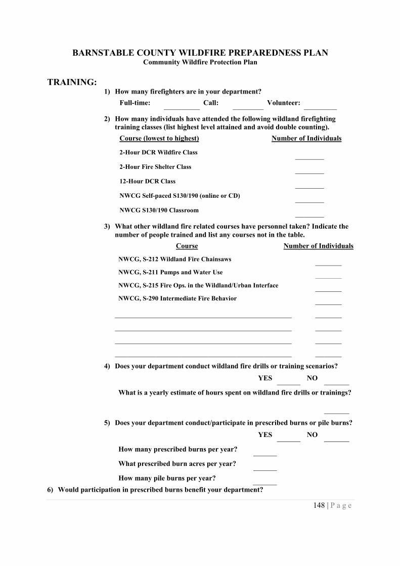
BARNSTABLE COUNTY WILDFIRE PREPAREDNESS PLANCommunity Wildfire Protection Plan
148 | P a g e
TRAINING:1) How many firefighters are in your department?
Full-time: Call: Volunteer:
2) How many individuals have attended the following wildland firefightingtraining classes (list highest level attained and avoid double counting).
Course (lowest to highest) Number of Individuals
2-Hour DCR Wildfire Class
2-Hour Fire Shelter Class
12-Hour DCR Class
NWCG Self-paced S130/190 (online or CD)
NWCG S130/190 Classroom
3) What other wildland fire related courses have personnel taken? Indicate thenumber of people trained and list any courses not in the table.
Course Number of Individuals
NWCG, S-212 Wildland Fire Chainsaws
NWCG, S-211 Pumps and Water Use
NWCG, S-215 Fire Ops. in the Wildland/Urban Interface
NWCG, S-290 Intermediate Fire Behavior
4) Does your department conduct wildland fire drills or training scenarios?
YES NO
What is a yearly estimate of hours spent on wildland fire drills or trainings?
5) Does your department conduct/participate in prescribed burns or pile burns?
YES NO
How many prescribed burns per year?
What prescribed burn acres per year?
How many pile burns per year?
6) Would participation in prescribed burns benefit your department?
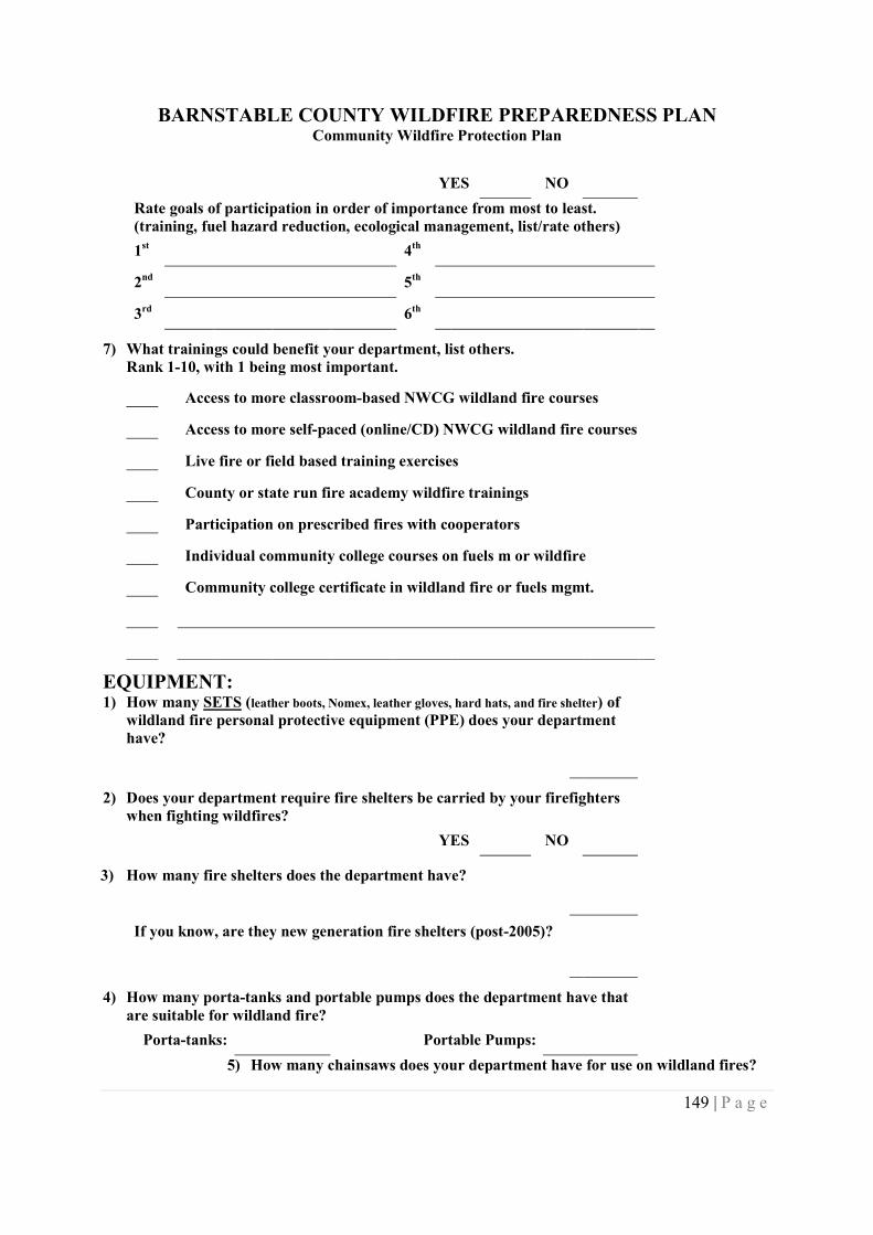
BARNSTABLE COUNTY WILDFIRE PREPAREDNESS PLANCommunity Wildfire Protection Plan
149 | P a g e
YES NO
Rate goals of participation in order of importance from most to least.(training, fuel hazard reduction, ecological management, list/rate others)
1st 4th
2nd 5th
3rd 6th
7) What trainings could benefit your department, list others.Rank 1-10, with 1 being most important.
Access to more classroom-based NWCG wildland fire courses
Access to more self-paced (online/CD) NWCG wildland fire courses
Live fire or field based training exercises
County or state run fire academy wildfire trainings
Participation on prescribed fires with cooperators
Individual community college courses on fuels m or wildfire
Community college certificate in wildland fire or fuels mgmt.
EQUIPMENT:1) How many SETS (leather boots, Nomex, leather gloves, hard hats, and fire shelter) of
wildland fire personal protective equipment (PPE) does your departmenthave?
2) Does your department require fire shelters be carried by your firefighterswhen fighting wildfires?
YES NO
3) How many fire shelters does the department have?
If you know, are they new generation fire shelters (post-2005)?
4) How many porta-tanks and portable pumps does the department have thatare suitable for wildland fire?
Porta-tanks: Portable Pumps:
5) How many chainsaws does your department have for use on wildland fires?
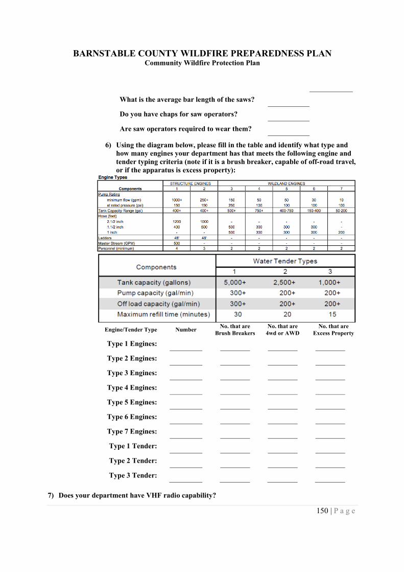
BARNSTABLE COUNTY WILDFIRE PREPAREDNESS PLANCommunity Wildfire Protection Plan
150 | P a g e
What is the average bar length of the saws?
Do you have chaps for saw operators?
Are saw operators required to wear them?
6) Using the diagram below, please fill in the table and identify what type andhow many engines your department has that meets the following engine andtender typing criteria (note if it is a brush breaker, capable of off-road travel,or if the apparatus is excess property):
Engine/Tender Type NumberNo. that are
Brush BreakersNo. that are
4wd or AWDNo. that are
Excess Property
Type 1 Engines:
Type 2 Engines:
Type 3 Engines:
Type 4 Engines:
Type 5 Engines:
Type 6 Engines:
Type 7 Engines:
Type 1 Tender:
Type 2 Tender:
Type 3 Tender:
7) Does your department have VHF radio capability?
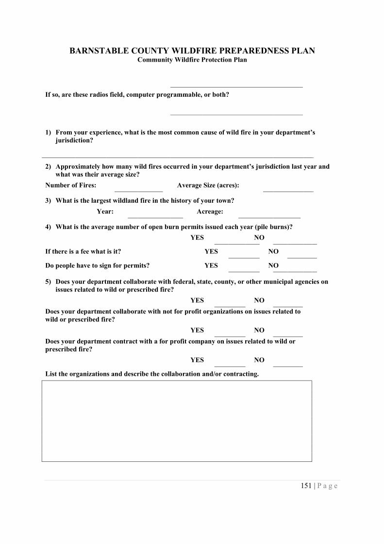
BARNSTABLE COUNTY WILDFIRE PREPAREDNESS PLANCommunity Wildfire Protection Plan
151 | P a g e
If so, are these radios field, computer programmable, or both?
1) From your experience, what is the most common cause of wild fire in your department’sjurisdiction?
2) Approximately how many wild fires occurred in your department’s jurisdiction last year andwhat was their average size?
Number of Fires: Average Size (acres):
3) What is the largest wildland fire in the history of your town?
Year: Acreage:
4) What is the average number of open burn permits issued each year (pile burns)?
YES NO
If there is a fee what is it? YES NO
Do people have to sign for permits? YES NO
5) Does your department collaborate with federal, state, county, or other municipal agencies onissues related to wild or prescribed fire?
YES NO
Does your department collaborate with not for profit organizations on issues related towild or prescribed fire?
YES NO
Does your department contract with a for profit company on issues related to wild orprescribed fire?
YES NO
List the organizations and describe the collaboration and/or contracting.
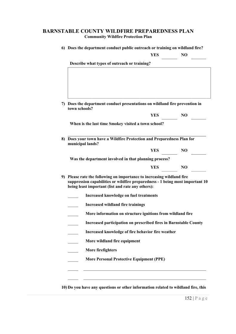
BARNSTABLE COUNTY WILDFIRE PREPAREDNESS PLANCommunity Wildfire Protection Plan
152 | P a g e
6) Does the department conduct public outreach or training on wildland fire?
YES NO
Describe what types of outreach or training?
7) Does the department conduct presentations on wildland fire prevention intown schools?
YES NO
When is the last time Smokey visited a town school?
8) Does your town have a Wildfire Protection and Preparedness Plan formunicipal lands?
YES NO
Was the department involved in that planning process?
YES NO
9) Please rate the following on importance to increasing wildland firesuppression capabilities or wildfire preparedness - 1 being most important 10being least important (list and rate any others):
Increased knowledge on fuel treatments
Increased wildland fire trainings
More information on structure ignitions from wildland fire
Increased participation on prescribed fires in Barnstable County
Increased knowledge of fire behavior fire weather
More wildland fire equipment
More firefighters
More Personal Protective Equipment (PPE)
10) Do you have any questions or other information related to wildland fire, this
BARNSTABLE COUNTY WILDFIRE PREPAREDNESS PLANCommunity Wildfire Protection Plan
153 | P a g e
questionnaire, or the proposed Barnstable County Community WildfireProtection Plan?
Name of Person Completing Survey:
Position/Job Title of Person Completing Survey:
Contact Phone Number:
Contact Email:
Fire Department, Jurisdiction,or Town Represented in Survey:
Thank You For Your Time
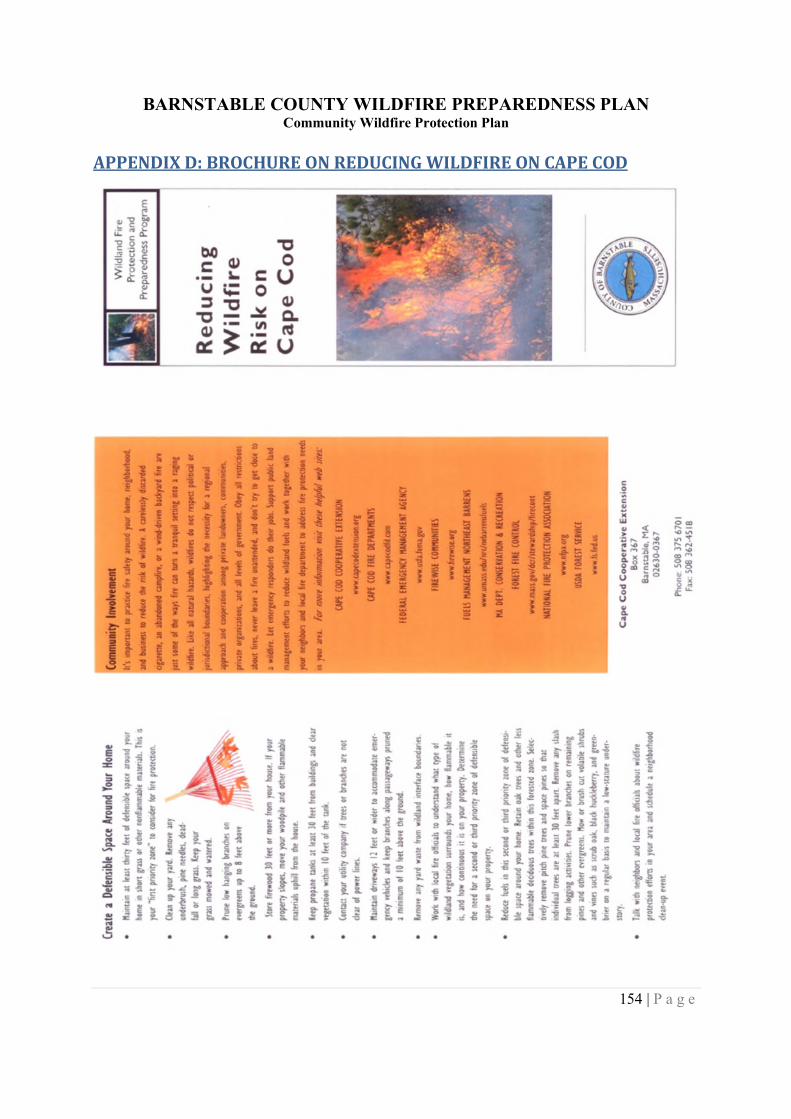
BARNSTABLE COUNTY WILDFIRE PREPAREDNESS PLANCommunity Wildfire Protection Plan
154 | P a g e
APPENDIX D: BROCHURE ON REDUCING WILDFIRE ON CAPE COD
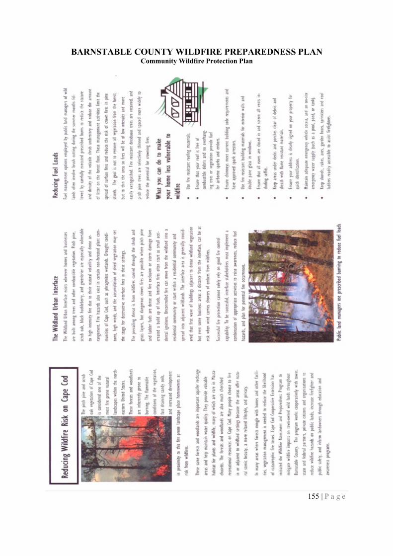
BARNSTABLE COUNTY WILDFIRE PREPAREDNESS PLANCommunity Wildfire Protection Plan
155 | P a g e
BARNSTABLE COUNTY WILDFIRE PREPAREDNESS PLANCommunity Wildfire Protection Plan
156 | P a g e
APPENDIX E: POTENTIAL SOURCES OF FUNDINGSafe and Vital Communities Program - The Allstate FoundationProvides grants for community development, government/public administration, safety/disasters. Grants average$1,000 to $10,000.
www.allstate.com/foundation/
Wildfire Preparedness Planning - Cape Cod Cooperative ExtensionThe program is intended to help with public education about the risk of wildland (forest) fires and address the issueof fire safety, specifically management of available wildland fuels on public owned lands. This initiative, funded byBarnstable County, will provide the services of a consulting forester who will evaluate identified town ownedparcels and develop wildland fire management plans for each identified parcel. Each fire management plan willaddress fuel reduction measures (mechanical, prescribed fire, or combination mechanical/fire prescriptions) that, ifimplemented, will reduce the risk of wildfire. The program will also include matching mini-grants to helpimplement the recommendations made by the consulting forester.
http://www.capecodextension.org/Natural-Resources/Wildlife-Preparedness-Planning.html
Volunteer Fire Assistance - Massachusetts Department of Conservation and RecreationThrough the USDA Forest Service's Volunteer Fire Assistance program, the Bureau is enabled to issue grants andmaterials to towns with less than 10,000 populations. This program provides technical, financial and otherassistance to fire departments for forest fire related purposes.
www.mass.gov/dcr/stewardship/firecont/services.htm
Federal Excess Property Program - Massachusetts Department of Conservation and RecreationWithin the Commonwealth, the Bureau administers the USDA Forest Service's Excess Property Program. Thisprogram provides cities and towns with free firefighting materials. Any equipment acquired must be used for firecontrol purposes only.
www.mass.gov/dcr/stewardship/firecont/services.htm
Community Forest Stewardship Grants - Massachusetts Department of Conservation and RecreationThe purpose of the Community Forest Stewardship Grants grant program is to aid communities in putting foreststewardship into practice and to help connect the local citizens to their forest and the benefits these forests provide -including a local source of wood products, clean water, biodiversity, and wildlife habitat.
http://www.mass.gov/dcr/stewardship/forestry/service/steward.htm
Forest Stewardship Program - Massachusetts Department of Conservation and RecreationThe Massachusetts Forest Stewardship Program supports and encourages private forest landowners' efforts tomanage, enjoy, and care for their land using a long-term approach. The program is administered by theMassachusetts Department of Conservation and Recreation Bureau of Forestry which strives to provide educationand periodic cost-share opportunities to forest landowners.
http://www.mass.gov/dcr/stewardship/forestry/service/steward.htm
Landowner Incentive Program - Massachusetts Division of Fisheries and WildlifeThe LIP program is administered through the MA Division of Fisheries and Wildlife as a partnership that providesprivate landowners interested in developing and maintaining wildlife habitat on their property with financial andtechnical assistance.
http://www.mass.gov/dfwele/dfw/habitat/grants/lip/lip_home.htm
Environmental Quality Incentives Program - Natural Resource Conservation ServiceThe Environmental Quality Incentives Program (EQIP) is a voluntary program that provides technical and financialassistance to agricultural producers and forest land owners who want to improve and protect the condition of soil,water, air, plants and animals.
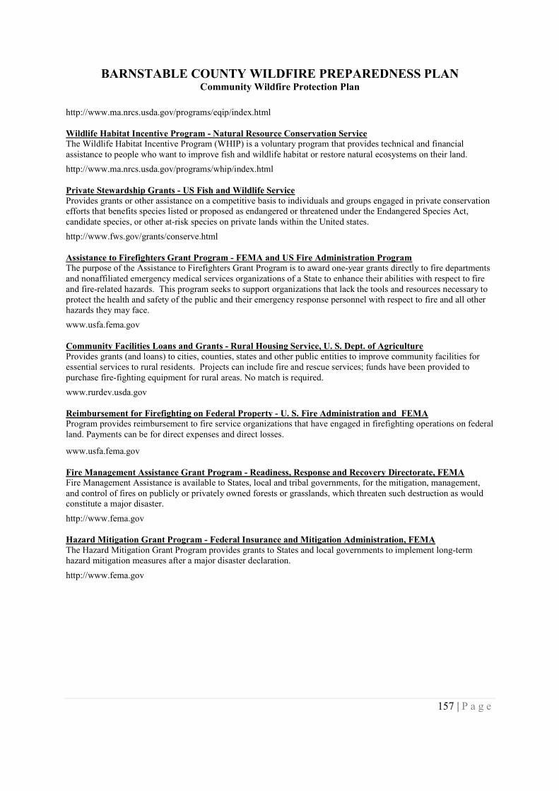
BARNSTABLE COUNTY WILDFIRE PREPAREDNESS PLANCommunity Wildfire Protection Plan
157 | P a g e
http://www.ma.nrcs.usda.gov/programs/eqip/index.html
Wildlife Habitat Incentive Program - Natural Resource Conservation ServiceThe Wildlife Habitat Incentive Program (WHIP) is a voluntary program that provides technical and financialassistance to people who want to improve fish and wildlife habitat or restore natural ecosystems on their land.
http://www.ma.nrcs.usda.gov/programs/whip/index.html
Private Stewardship Grants - US Fish and Wildlife ServiceProvides grants or other assistance on a competitive basis to individuals and groups engaged in private conservationefforts that benefits species listed or proposed as endangered or threatened under the Endangered Species Act,candidate species, or other at-risk species on private lands within the United states.
http://www.fws.gov/grants/conserve.html
Assistance to Firefighters Grant Program - FEMA and US Fire Administration ProgramThe purpose of the Assistance to Firefighters Grant Program is to award one-year grants directly to fire departmentsand nonaffiliated emergency medical services organizations of a State to enhance their abilities with respect to fireand fire-related hazards. This program seeks to support organizations that lack the tools and resources necessary toprotect the health and safety of the public and their emergency response personnel with respect to fire and all otherhazards they may face.
www.usfa.fema.gov
Community Facilities Loans and Grants - Rural Housing Service, U. S. Dept. of AgricultureProvides grants (and loans) to cities, counties, states and other public entities to improve community facilities foressential services to rural residents. Projects can include fire and rescue services; funds have been provided topurchase fire-fighting equipment for rural areas. No match is required.
www.rurdev.usda.gov
Reimbursement for Firefighting on Federal Property - U. S. Fire Administration and FEMAProgram provides reimbursement to fire service organizations that have engaged in firefighting operations on federalland. Payments can be for direct expenses and direct losses.
www.usfa.fema.gov
Fire Management Assistance Grant Program - Readiness, Response and Recovery Directorate, FEMAFire Management Assistance is available to States, local and tribal governments, for the mitigation, management,and control of fires on publicly or privately owned forests or grasslands, which threaten such destruction as wouldconstitute a major disaster.
http://www.fema.gov
Hazard Mitigation Grant Program - Federal Insurance and Mitigation Administration, FEMAThe Hazard Mitigation Grant Program provides grants to States and local governments to implement long-termhazard mitigation measures after a major disaster declaration.
http://www.fema.gov
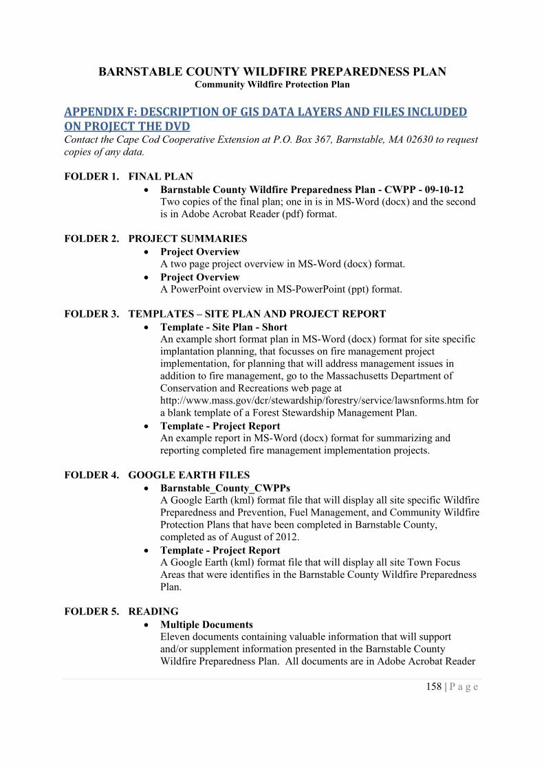
BARNSTABLE COUNTY WILDFIRE PREPAREDNESS PLANCommunity Wildfire Protection Plan
158 | P a g e
APPENDIX F: DESCRIPTION OF GIS DATA LAYERS AND FILES INCLUDEDON PROJECT THE DVDContact the Cape Cod Cooperative Extension at P.O. Box 367, Barnstable, MA 02630 to requestcopies of any data.
FOLDER 1. FINAL PLAN Barnstable County Wildfire Preparedness Plan - CWPP - 09-10-12
Two copies of the final plan; one in is in MS-Word (docx) and the secondis in Adobe Acrobat Reader (pdf) format.
FOLDER 2. PROJECT SUMMARIES Project Overview
A two page project overview in MS-Word (docx) format.
Project OverviewA PowerPoint overview in MS-PowerPoint (ppt) format.
FOLDER 3. TEMPLATES – SITE PLAN AND PROJECT REPORT Template - Site Plan - Short
An example short format plan in MS-Word (docx) format for site specificimplantation planning, that focusses on fire management projectimplementation, for planning that will address management issues inaddition to fire management, go to the Massachusetts Department ofConservation and Recreations web page athttp://www.mass.gov/dcr/stewardship/forestry/service/lawsnforms.htm fora blank template of a Forest Stewardship Management Plan.
Template - Project ReportAn example report in MS-Word (docx) format for summarizing andreporting completed fire management implementation projects.
FOLDER 4. GOOGLE EARTH FILES Barnstable_County_CWPPs
A Google Earth (kml) format file that will display all site specific WildfirePreparedness and Prevention, Fuel Management, and Community WildfireProtection Plans that have been completed in Barnstable County,completed as of August of 2012.
Template - Project ReportA Google Earth (kml) format file that will display all site Town FocusAreas that were identifies in the Barnstable County Wildfire PreparednessPlan.
FOLDER 5. READING Multiple Documents
Eleven documents containing valuable information that will supportand/or supplement information presented in the Barnstable CountyWildfire Preparedness Plan. All documents are in Adobe Acrobat Reader
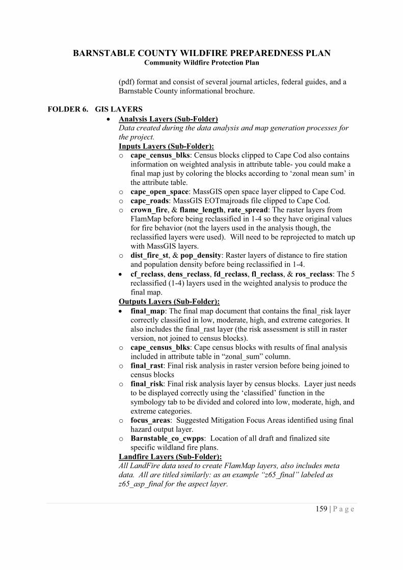
BARNSTABLE COUNTY WILDFIRE PREPAREDNESS PLANCommunity Wildfire Protection Plan
159 | P a g e
(pdf) format and consist of several journal articles, federal guides, and aBarnstable County informational brochure.
FOLDER 6. GIS LAYERS Analysis Layers (Sub-Folder)
Data created during the data analysis and map generation processes forthe project.Inputs Layers (Sub-Folder):o cape_census_blks: Census blocks clipped to Cape Cod also contains
information on weighted analysis in attribute table- you could make afinal map just by coloring the blocks according to ‘zonal mean sum’ inthe attribute table.
o cape_open_space: MassGIS open space layer clipped to Cape Cod.o cape_roads: MassGIS EOTmajroads file clipped to Cape Cod.o crown_fire, & flame_length, rate_spread: The raster layers from
FlamMap before being reclassified in 1-4 so they have original valuesfor fire behavior (not the layers used in the analysis though, thereclassified layers were used). Will need to be reprojected to match upwith MassGIS layers.
o dist_fire_st, & pop_density: Raster layers of distance to fire stationand population density before being reclassified in 1-4.
cf_reclass, dens_reclass, fd_reclass, fl_reclass, & ros_reclass: The 5reclassified (1-4) layers used in the weighted analysis to produce thefinal map.
Outputs Layers (Sub-Folder): final_map: The final map document that contains the final_risk layer
correctly classified in low, moderate, high, and extreme categories. Italso includes the final_rast layer (the risk assessment is still in rasterversion, not joined to census blocks).
o cape_census_blks: Cape census blocks with results of final analysisincluded in attribute table in “zonal_sum” column.
o final_rast: Final risk analysis in raster version before being joined tocensus blocks
o final_risk: Final risk analysis layer by census blocks. Layer just needsto be displayed correctly using the ‘classified’ function in thesymbology tab to be divided and colored into low, moderate, high, andextreme categories.
o focus_areas: Suggested Mitigation Focus Areas identified using finalhazard output layer.
o Barnstable_co_cwpps: Location of all draft and finalized sitespecific wildland fire plans.
Landfire Layers (Sub-Folder):All LandFire data used to create FlamMap layers, also includes metadata. All are titled similarly: as an example “z65_final” labeled asz65_asp_final for the aspect layer.
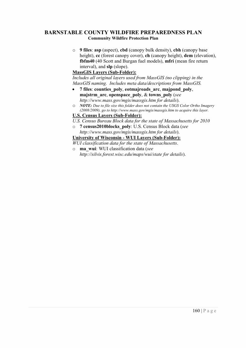
BARNSTABLE COUNTY WILDFIRE PREPAREDNESS PLANCommunity Wildfire Protection Plan
160 | P a g e
o 9 files: asp (aspect), cbd (canopy bulk density), cbh (canopy baseheight), cc (forest canopy cover), ch (canopy height), dem (elevation),fbfm40 (40 Scott and Burgan fuel models), mfri (mean fire returninterval), and slp (slope).
MassGIS Layers (Sub-Folder):Includes all original layers used from MassGIS (no clipping) in theMassGIS naming. Includes meta data/descriptions from MassGIS. 7 files: counties_poly, eotmajroads_arc, majpond_poly,
majstrm_arc, openspace_poly, & towns_poly (seehttp://www.mass.gov/mgis/massgis.htm for details).
o NOTE: Due to file size this folder does not contain the USGS Color Ortho Imagery(2008/2009), go to http://www.mass.gov/mgis/massgis.htm to acquire this layer.
U.S. Census Layers (Sub-Folder):U.S. Census Bureau Block data for the state of Massachusetts for 2010o 7 census2010blocks_poly: U.S. Census Block data (see
http://www.mass.gov/mgis/massgis.htm for details).University of Wisconsin - WUI Layers (Sub-Folder):WUI classification data for the state of Massachusetts.o ma_wui: WUI classification data (see
http://silvis.forest.wisc.edu/maps/wui/state for details).