Embed Size (px)
Citation preview

Standing Structures Investigations Grubb Road. Naamans Road to Marsh Road. New Castle County. Delaware
BACKGROUND RESEARCH
General Overview
The project area for the Grubb Road improvements planned by DelDOT lies primarily along Grubb Road between Naamans Road on the west and Marsh Road on the east, in Brandywine Hundred, New Castle County (see Figure 1). The improvements begin approximately 60 meters (200 feet) east of the southwest corner of Grubb and Naamans roads and end at the west side of the Grubb and Marsh roads intersection. The project area also typically extends a few meters (5 to 10 feet) along the minor roadways and lanes intersecting the north and south sides of Grubb Road. The improvements extend roughly 30 meters (100 feet) northward along the west side of Marsh Road. Located in the northeastern portion of Delaware, Brandywine Hundred is bounded on the south by the Christina River and the City of Wilmington, on the west by the Brandywine River, on the north by the Commonwealth of Pennsylvania, and on the east by th~ Delaware River.
The project area is located within the Piedmont Geographic Zone as defined by the Delaware Comprehensive Historic Preservation Plan (Ames et al. 1989). As the northern of the state's three geographic zones, the Piedmont encompasses land north of the fall line, which separates this zone from the Coastal Plain as it crisscrosses the state in a generally northeast to southwest direction. A nearly level to hilly topography composed of fertile clay soils well suited for agricultural uses characterizes the Piedmont's surface. Eastern portions of the Piedmont, including the Grubb Road project area, are generally flatter but have rockier, less well-drained soils. Major land forms of the Piedmont include Iron Hill and Chestnut Hill, both generally located south of Newark, and Mount Cuba, to the north. Early European pioneers would have found a rich variety of oak, hickory, poplar, walnut, and ash trees in the Piedmont region prior to the extensive clearance of land. The Piedmont's major and minor creeks and streams generally drain southeastward into the Christina River, which flows northeastward before entering the Delaware River at Wilmington (Ames et al. 1989:32-34). Naamans Creek and its tributaries flow generally west to east into the Delaware River parallel to the Delaware/Pennsylvania state line across the northern part of Brandywine Hundred.
Colonial settlement of northern Delaware began in the early seventeenth century. The earliest settlers, primarily Dutch, Swedes, and Finns, established hunting and trapping villages near the Delaware River. After England acquired control of the region in the mid-1600s, agricultural settlement gradually intensified and moved inland along the region's larger creeks and streams. Before it became clogged with silt, the Christina River provided an important transportation network into hinterland areas as greater areas of land were cleared for the expanding agricultural economy. Settlement of the region increased significantly after William Penn began granting tracts ofland in Delaware to English and Welsh immigrants in the 1680s. As permanent settlement of the area increased, overland transportation networks were created that joined outlying agricultural areas with larger village centers and engendered further intensive settlement along their routes (Ames et al. 1989:45-46).
Settlement and agricultural development of the region quickened during the eighteenth century. Despite heavy silting that curtailed navigation, the Piedmont's watercourses provided power for mills and early manufacturing. The area's streams were at first used primarily to power gristmills and sawmills, but by the early 1800s they provided power for a wide variety of manufacturing establishments, including paper mills, woolen mills, spice mills, powder mills, carding mills, and iron-rolling mills. Partly in response to the mills' demands for workers, nucleated settlements developed surrounding these early industrial centers.
4
Standing Structures investigations Grubb Road. Naamans Road to Marsh Road. New Castle County, Delaware
Although industrial growth continued along the Piedmont's rural waterways during much of the nineteenth century, agriculture remained the predominant land use throughout the region. By the early 1800s, very little uncultivated, arable land remained in the Piedmont region of Delaware (Ames et al. 1989:47-49). The introduction of improved transportation networks, such as turnpikes and railroads, greatly assisted both farming and manufacturing activities, and linked the area with the larger, regional economy. Rail access provided farmers with more efficient methods of transporting surplus produce to distant markets, thereby boosting productivity and the cultivation of lucrative cash crops. In addition to furnishing outlets for exporting finished goods, railroads provided mill and manufacturing centers with a means for importing raw materials not available locally. The railroads also helped to focus commercial activities and further settlement at villages and towns with rail stations (Ames et al. 1989:49-51).
As the City of Wilmington evolved into the state's largest population and manufacturing center during the late nineteenth and early twentieth centuries, many of the Piedmont's rural manufacturing centers ceased operations. Improved transportation networks, such as those provided by electric trolleys, and the rise of a substantial middle class contributed to the development of suburbs on former agricultural land -in outlying areas surrounding Wilmington. The introduction of the automobile and corollary improvement of the area's road networks further intensified the development of suburbs around Wilmington. Throughout most other areas of the Piedmont, the economy continued to rely on agricultural activity (Ames et al. 1989:51).
Since the end World War n in 1945, the Piedmont has experienced continued suburban growth and extensive development. Much of the region's former agricultural land is now the locus for tract housing. Associated development of strip- and mega-mall complexes, designed to accommodate the commercial needs of area residents unwilling to travel to congested urban or town centers, has swallowed large areas of former farmland as well. Business parks and research laboratories have also relocated to once-rural areas, engendering further suburban development and transforming the Piedmont's landscape.
Historic Context
In accord with federal and State of Delaware guidelines concerning National Register eligibility for historical resources, this study uses historic contexts to link the project area's history with property types that describe the evolution of its built environment. The context outlines levels of historical significance and architectural integrity which identified historical resources must possess in order to be recommended as eligible for listing in the National Register. Subsequent decisions regarding National Register eligibility compare levels of integrity and significance established by the context to the historical significance and architectural integrity of each identified historical resource. The use of historic contexts makes it possible to perform a systematic evaluation of each resource's National Register eligibility based upon the historical evolution of the locale.
The following historic context has been divided into five chronological periods based on periods outlined in the Delaware Comprehensive Historic Preservation Plan (Ames et al. 1989). Fieldwork and research activities identified two principal themes contributing to the historical evolution of the project area, namely, Agriculture, and Settlement Patterns and Demographic Change. Both themes are discussed in each of the sections describing the chronological periods.
Previously completed historic contexts and cultural resource survey reports on file at the DESHPO helped in the development of the historic context for this study. Lu Ann De Cunzo's and Ann Marie Garcia's context examining agriculture in New Castle and Kent counties between 1830 and 1940 proved very helpful in describing agricultural trends that contributed to Brandywine Hundred's evolution (De Cunzo and Garcia 1992). A DelDOT report outlining the results of archaeological and architectural investigations associated with the Naamans Road improvement project also helped in delineating the context for this study
5
Standing Structures InvestigatIOns Grubb Road. Naamans Road to A,farsh Road. ;\'ew Castle County Delaware
(Cunningham et al. 1986). CRS forms on file at the DESHPO and at the New Castle County Department of Land Use and Planning (NCC) also contributed to the development of a historic context describing the significant trends that have contributed to the project area's historical development.
Exploration and Frontier Settlement, 1630-1730 ±
Although Swedish and Dutch colonization of Delaware began in the 1630s, much of this settlement focused on areas immediately surrounding the Delaware River and Bay. Most early pioneers were primarily involved with fishing, hunting, and trapping and did not venture far inland and establish permanent encampments or settlements (Herman et al. 1989:3). Somewhat intensive settlement did occur at Fort Christina (present-day Wilmington), first established by Swedish colonists in 1638. By 1854 a village at the fort contained nearly 400 Swedish, Finnish, and Dutch settlers (Cunningham et al. 1986). Sporadic settlement of areas north of the Fort Christina village began during the 1660s. Composed of non-nucleated landholdings, the tracts taken up featured narrow Delaware River frontages that extended westward into the Piedmont's wooded hillsides. Nearby marshlands were used as common woodland and pasture. By the early 1660s about 20 families, mostly Finnish, resided north of the village (Scharf 1888:898). Houses of these early settlers were most often erected closer to the river's edge (Conrad 1908:451), but European incursions into the Brandywine Hundred and Grubb Road project area probably occurred prior to the lat~ seventeenth century. Hunters, trappers, and traders utilizing Naamans Creek and its tributaries to travel to inland areas of the county would have traversed the Grubb Road area.
After William Penn became proprietor of Delaware in the late seventeenth century, his agents often granted the lands previously settled by the earlier Swedish, Finnish, and Dutch colonists to the current residents. New English, Welsh, and Scotch-Irish immigrants were also patented land and began establishing agricultural settlements in further inland regions of New Castle County, including the Grubb Road area. John Grubb purchased land along the Delaware River that later, in the 1680s, became known as Grubbs Landing (Scharf 1888:901). He subsequently erected a one-and-one-half-story log house on a tract located along the north side of what later became Grubbs Landing Road, adjacent to the project area (Federal Writers' Project of the W'orks Progress Administration [WPA] 1938:324). William Talley acquired 200 acres surrounding Naamans Creek near Foulk Road in 1695 (Cunningham et al. 1986). Settlement still concentrated near the waterways that served as the major transportation networks during the first waves of immigration. A Native American path running parallel to the Delaware River was used by early pioneers as a link between New Castle, Chester, and Tinicum further north along the Delaware River, but small sloops and shallops provided the major transportation network, linking established villages and landings with the region's larger ports (Scharf 1888:904).
Early roads began to cross Brandywine Hundred and much of the Piedmont region of Delaware during the 1680s as inland settlement intensified. During this period the King's Road linked New Castle, via a ferry at the falls of the Brandywine River, with Chester and points north. This highway, a precursor to the Philadelphia & Wilmington Turnpike and U.S. Route 13, paralleled the Delaware River but ran one mile further inland atop a ridge of high land extending through the rear of the earlier Swedish, Finnish, and Dutch settlers' lots (Scharf 1888:898). A bridge carried the King's Road over Naamans Creek near present-day Claymont by 1682. By the end of the century, additional roadways had been established, generally following the present-day paths ofU.S. Route 202 (Concord Pike linking the lower Brandywine River area with Chester County, Pennsylvania), Foulk Road (leading from the Brandywine River to Delaware County, Pennsylvania), Naamans Road (connecting the road to Concord, Pennsylvania, and the mouth of Naamans Creek), and Grubbs Landing Road, joining western Naamans Road with Grubbs Landing along the Delaware River (Scharf 1888:904). The establishment of gristmills and sawmills served as another adjunct to intensive settlement. Neil Neilson erected a mill along Stony Creek south of Grubbs Landing in the 1670s. William
6

Standing Structures InvestigatIOns Grubb Road. Naamans Road to Marsh Road. New Castle County, Delaware
Robinson operated a gristmill along Naamans Creek in 1701 (Conrad 1908:452). Geopolitical boundaries for the hundred were established by 1687, although it took a number ofyears for the area to acquire the name of Brandywine (Conrad 1908:449).
During the earliest periods of settlement, Swedish and Finnish settlers primarily grew rye and barley on their farms. As settlement increased, the region's farmers found wheat easier to grow and also to be a more marketable commodity. Marking a shift from subsistence to market agriculture, wheat and com became extensively grown throughout the area. The grains were carted to area mills to be ground, and the flour was then shipped by sloops and coastal traders to larger transhipment centers such as Wilmington and Philadelphia. Grubbs Landing on the Delaware River served as one of the earliest of these transhipment points in Brandywine Hundred. Grain and produce of the area's farmers were exported from the Grubbs Landing wharf and finished commodities imported for sale arrived at the wharf (Scharf 1888:907). As a result of more intensive agricultural practices, marginally productive land came under cultivation and farm size decreased. Mixed husbandry, consisting ofgrain cultivation and raising livestock, nevertheless remained the predominant farming technique. Wheat, rye, com, barley, and oats were the principal grains grown during the latter years of this period (Cunningham et al. 1986).
Property types reflecting settlement patterns and agricultural trends during this period include non-nucleated agricultural settlements, pioneer trapping and hunting camps, roads, paths, early trails, landings, fords, impermanent architecture associated with ethnic groups, and early durable buildings. Examples of these property types on the landscape should be considered extremely significant, as they provide information on the earliest settlement of the region. While low levels of integrity would be expected for these property types, the resources should retain some integrity of materials and location in order to convey their significance.
Intensified and Durable Occupation, 1730-1770 ±
Non-nucleated agricultural settlements continued to dominate Brandywine Hundred's landscape during the period between about 1730 and 1770. Francis Day acquired a large property near western portions of the project area in the 1760s that formed the nucleus of his family's holdings throughout the nineteenth century (Scharf 1888:902). Although some small-scale manufacturing establishments operated in the area, farming remained the preeminent economic activity, employing about 85 percent of the area's inhabitants (Cunningham et al. 1986).
The Grubb family began to establish themselves at the Grubb and Marsh crossroads during this period. Family records available to WPA writers during the 1930s showed that the Grubb family operated a store during the mid-eighteenth century. The Grubbs also enlarged the log house erected along the north side of Grubb Road by John Grubb in the 1680s. In the 1760s, a two-and-one-half-story stone building became the main dwelling, while the earlier log structure to which the stone building was appended became a kitchen wing (WPA 1938:324). Ruban Ford and Samuel Reynolds erected a gristmill along Naamans Creek at Marsh Road north of the Grubb Road intersection in the late 1750s. Emmanuel Grubb acquired the mill in 1771. The Grubbs operated the mill until 1850, when Lewis B. Harvey purchased the mill property (DESHPO CRS N-463).
Property types indicative of the historical trends of the period include agricultural complexes, hamlets and individual building sites, durable and permanent buildings, and stair-passage dwellings. For this period, as with the period of Exploration and Frontier Settlement, survival rates and integrity levels for these property types are very low, making surviving examples very significant. Resources documenting these trends should
7
Standing Structures Investigations Grubb Road, lv'aamans Road to Marsh Road. jVew Castle County. Delaware
retain sufficient integrity of location, materials, and workmanship to convey information related to their significance.
Early Industrialization, 1770-1830 ±
A population boom in New Castle County driven by expanding industry and the evolution of Wilmington as an urban center led to a decrease in the number of people engaged in agriculture. During the latter stages of this period, a large number of the area's residents emigrated to cheaper an~ more profitable land in the Ohio Valley. Indicative of this trend, the hundred's general population decreased. In 1787 Brandywine Hundred boasted nearly 315 taxable residents. Twenty-five years later, only 265 voters lived in the hundred (Scharf 1888:902-904). As a corollary development to the decrease in farming, smaller farms were often consolidated into larger parcels by wealthy landowners (Cunningham et al. 1986).
Improved transportation networks contributed to the growth of industry and urban centers and exacerbated the trend away from farming activities. Shipley Road, a major north-south route connecting the mouth of Shell Pot Creek with Naamans Road and Concord Pike, was first established during the 1780s. In 1800, a stone arch span replaced the former King's Road bridge over Naamans Creek. The bridge became a toll bridge in 1830s when it was taken over by the Philadelphia & Wilmington Turnpike (Scharf 1888:904). Incorporated in 1808, the Philadelphia & Wilmington Turnpike, along with the Wilmington and Great Valley Turnpike (later Concord Pike) established in 1811, helped to focus much of the area's overland transportation through northern Brandywine Hundred.
Property types documenting these trends include roads, bridges, villages, hall-parlor and stair-passage house plans, farmsteads, and specific-function farm buildings. Although survival rates for dwellings and major agricultural buildings from this period are relatively good, such resources in the Piedmont are under severe pressure from new development occurring in the area. Property types indicative of these trends should be considered very significant but must also retain higher integrity than resources documenting earlier periods. Resources must possess integrity of location, materials, workmanship, and feeling.
Industrialization and Early Urbanization, 1830-1880 ±
Agricultural endeavors continued to dominate the county and Brandywine Hundred throughout the period. Although farm production had decreased during the later years of the Early Industrialization period, advances in farming practices, including the use of fertilizers and mechanized equipment, increased productivity in the mid-nineteenth century. The rise of urban centers also helped to spur a shift from grain production and mixed animal husbandry to dairy farnling and butter manufacture for local markets. During the midnineteenth century dairy herds of 15 to 100 cows were common in the county. Brandywine Hundred composed part of Delaware's northern tier of agricultural regions that concentrated on dairying and feeder cattle (De Cunzo and Garcia 1992:34-38). Statewide, tenant farming became more prevalent as larger landholdings acquired during the lean years of the early part of the century were leased out. Toward the end of the period, nearly 50 percent of all farmers in the state were either tenants or sharecroppers (Cunningham et al. 1986). The fanns of Brandywine Hundred and the other northern tier hundreds, however, averaged less than 100 acres and were worked principally by members of the immediate or extended family. The increased use of farm machinery and lime and guano fertilizers rewarded northern tier fanners with neat profits from their relatively small farms as the period progressed (De Cunzo and Garcia 1992:64-65).
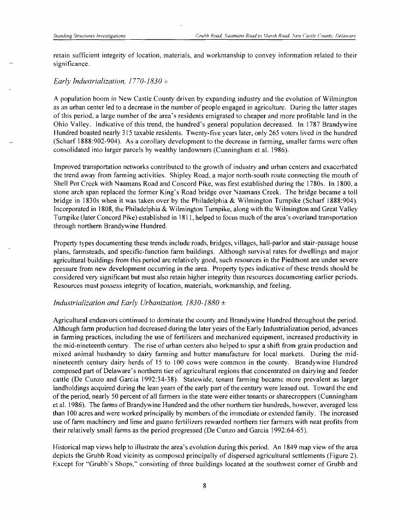
Historical map views help to illustrate the area's evolution during this period. An 1849 map view of the area depicts the Grubb Road vicinity as composed principally of dispersed agricultural settlements (Figure 2). Except for "Grubb's Shops," consisting of three buildings located at the southwest comer of Grubb and
8
o 1 MILE ~_"iiiiiif.~~~i
FIGU RE 2: Project Area in 1849 SOURCE: Rea and Price 1849
9
Standing Structures Investigations Grubb Road, Naamans Road to ,Harsh Road, New Castle County, Delaware
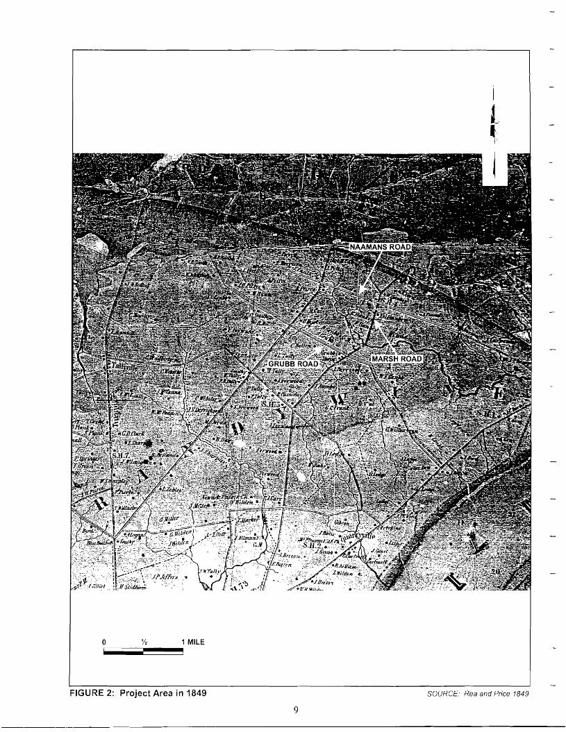
Marsh roads, a total of eight buildings are identified adjacent to Grubb Road between Marsh and Naamans roads. The Grubb mill is also identified along the west side of Marsh Road beside Naamans Creek, a short distance north of the Grubb and Marsh roads intersection (Rea and Price 1849). About 20 years later, nearly twice as many buildings are located adjacent to Grubb Road, although still generally dispersed along its entire length (Figure 3). "W. Wilson" and "LN. Grubb" are indicated as the owners of two buildings along Grubb Road. Each man probably leased out at least one of the two properties he owned. The 1868 map also vividly portrays the growth of the Grubbs Comers crossroads. Two of the Grubb's shops remain at the southwest comer, both owned by "S.L. Grubb." An Odd Fellows hall and a blacksmith shop occupy the northwest comer (Beers 1868).
The establishment of community organizations testifies to the area's growth and identification as a community. Local residents founded the Star of Bethel LO.O.F. Lodge No. 19 in 1849. After meeting in members' homes for a few years, the lodge built a hall at the Grubb and Marsh roads comers in 1853. Within three years enlargement of the building was necessary, and commercial space was installed on the first story. The Knights of Pythias also established a lodge in the area in 1868 and used the Odd Fellows' facilities for their meetings. During the mid-nineteenth century, local chapters of the Grange of Patrons of Husbandry and the Redmen also met at the Star of Bethel lodge. The Grange also established a lodge at Talleyville in 1874, and erected a hall for meetings in 1886 along the Wilmington and Great Valley Turnpike (Scharf 1888:910).
Property types documenting these trends with respect to the themes of Settlement and Agriculture include a variety of nineteenth-century architectural styles, fraternal meeting halls, single and multiple family dwellings, and bridges. Although survival rates for these types of resources are relatively good, especially in comparison with earlier periods, these resources are under pressure from new development. Integrity levels are relatively high for these resources requiring integrity of materials, workmanship, design, location, setting, and feeling.
Urbanization and Early Suburbanization, 1880-1940 ±
At the beginning of this period, farm size in the county averaged roughly 130 acres. By 1930 New Castle County farms specializing in dairying, cash grains, and general farming contained between 50 and 259 acres. Corn and wheat remained the staple crops during this period (De Cunzo and Garcia 1992: 102-116). Although a diversity of crops was produced for export, dairying continued to dominate agricultural activities in New Castle County during the late nineteenth and early twentieth centuries. Beef cattle were also raised in significant numbers. Within the county, dairying and cattle raising continued to be concentrated in the northern tier of hundreds. Area farmers sold their milk and butter to consumers in Wilmington and Philadelphia (De Cunzo and Garcia 1992:143,156,163).
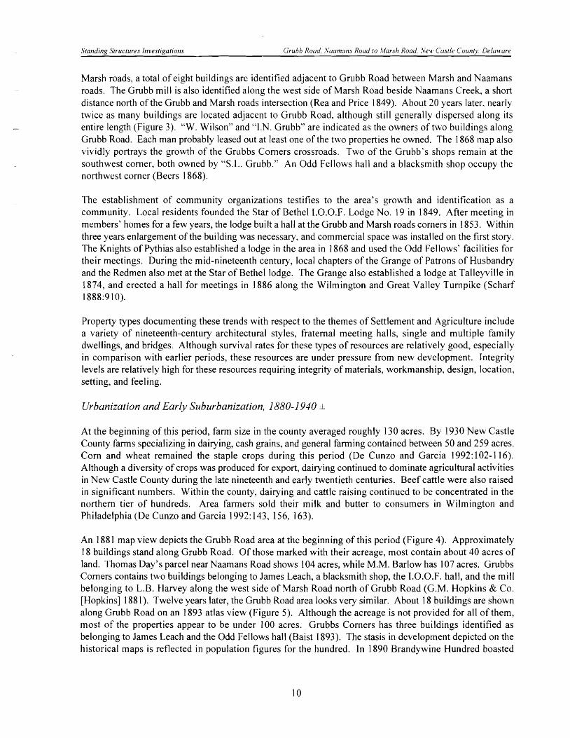
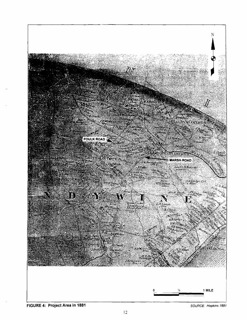
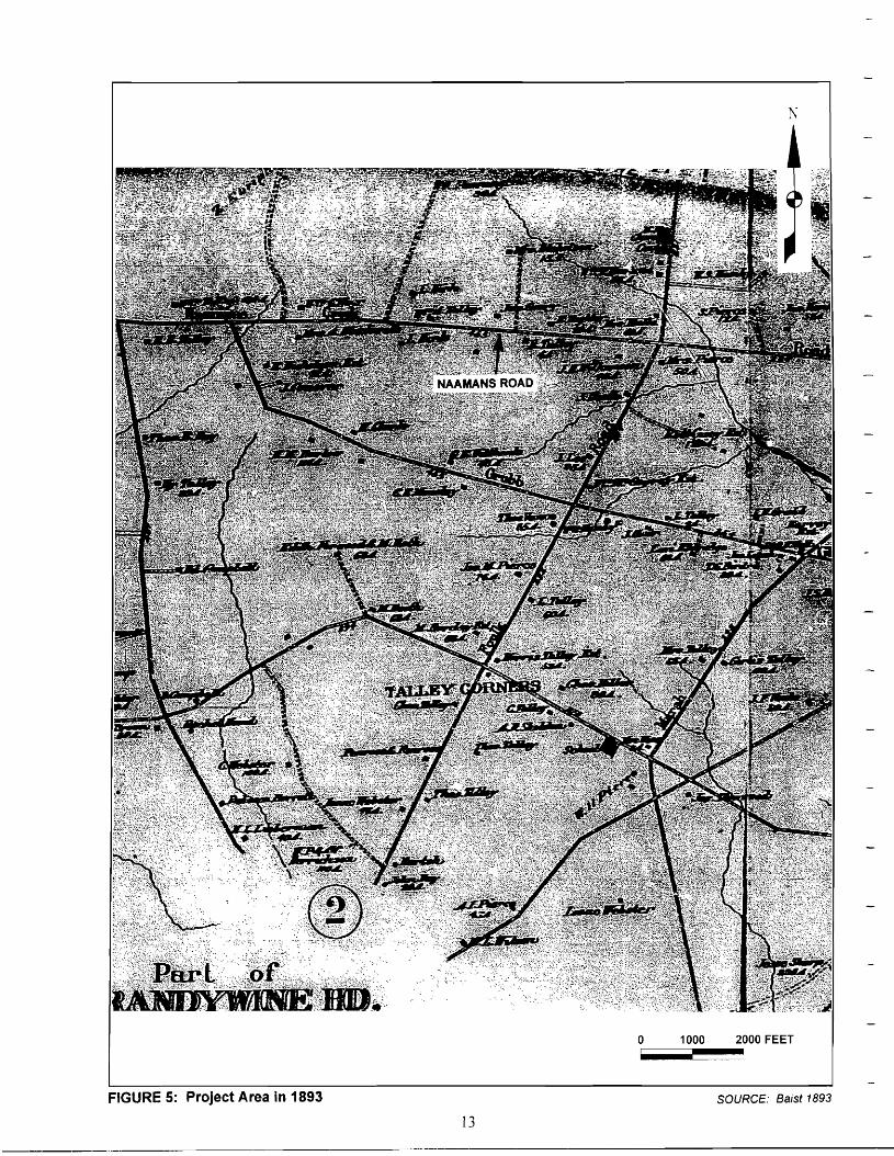
An 1881 map view depicts the Grubb Road area at the beginning of this period (Figure 4). Approximately 18 buildings stand along Grubb Road. Of those marked with their acreage, most contain about 40 acres of land. Thomas Day's parcel near Naamans Road shows 104 acres, while M.M. Barlow has 107 acres. Grubbs Comers contains two buildings belonging to James Leach, a blacksmith shop, the LO.O.F. hall, and the mill belonging to L.B. Harvey along the west side of Marsh Road north of Grubb Road (G.M. Hopkins & Co. [Hopkins] 1881). Twelve years later, the Grubb Road area looks very similar. About 18 buildings are shown along Grubb Road on an 1893 atlas view (Figure 5). Although the acreage is not provided for all of them, most of the properties appear to be under 100 acres. Grubbs Corners has three buildings identified as belonging to James Leach and the Odd Fellows hall (Baist 1893). The stasis in development depicted on the historical maps is reflected in population figures for the hundred. In 1890 Brandywine Hundred boasted
10
N
o 1 MILE i
FIGURE 3: Project Area in 1868 SOURCE: Beers 1868
11
N
FIGURE 4: Project Area in 1881 SOURCE: Hopkins 1881
12
••••
N
:~ .. ,.\~<~'y;. >'
::J~i~., .» (,,<~,".: "~~&~-~"'\'U~~L"~c:~U1I~:~
1000 2000 FEET o ~_~~~i
FIGURE 5: Project Area in 1893 SOURCE: Baist 1893
13
Standing Structures Investigations Grubb Road. Naamans Road to ,Harsh Road. New Castle County, Delaware
4,089 residents. Ten years later the hundred had lost 95 inhabitants, its population having dropped to 3,994 persons (Conrad 1908:449).
Increased use of the automobile in the early twentieth century resulted in improvements to the area's road infrastructure. In the 1920s the State Highway Department paved Naamans Road (Cunningham et al. 1986). This was part of a statewide program undertaken between 1925 and 1935 to consolidate the primary road system and develop a secondary road network. Two bridges in the Grubb Road area were replaced in the early twentieth century as well. The Marsh Road bridge over Naamans Creek was built in 1926 and the Grubb Road bridge over a branch of the same creek was erected in 1931. Both-bridges were replaced during the 1990s (DESHPO CRS N-12536, CRS N-12538).
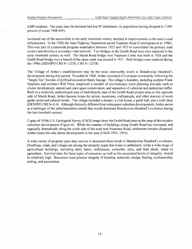
The Village of Arden's establishment may be the most noteworthy event in Brandywine Hundred's development during this period. Founded in 1900, Arden consisted of a utopian community following the "Single Tax" theories of political economist Henry George. The village's founders, including sculptor Frank Stephens and architect Will Price, employed a number of revolutionary town planning precepts such as cluster development, natural and open space conservation, and separation of vehicular and pedestrian traffic. Built in a relatively undeveloped area of land directly east of the Grubb Road project area on the opposite side of Marsh Road, Arden became home for artists, musicians, craftspeople, and other mavens of avant garde social and cultural trends. The village included a theater, a club house, a guild hall, and a craft shop (DESHPO CRS N-414). Although distinctly different from subsequent suburban developments, Arden serves as a harbinger of the suburbanization trends that would dominate Brandywine Hundred's evolution during the late twentieth century.
Copies of 1950s U.S. Geological Survey (USGS) maps show the Grubb Road area on the cusp of this modem suburban development (Figure 6). While the number of buildings along Grubb Road has increased, and especially dramatically along the south side of the road near Naamans Road, settlement remains dispersed. Arden forms the only dense development in the area (USGS 1953, 1954).
A wide variety of property types may survive to document these trends in Brandywine Hundred's evolution. Dwellings, roads, and villages are among the property types that relate to settlement, while a wide range of agricultural buildings, including dairy barns, milkhouses, corncribs, silos, and feed sheds, relate to agriculture. Survival rates for these types of resources, as well as the associated levels of integrity, should be relatively high. Resources must possess integrity of location, materials, design, feeling, workmanship, setting, and association.
14

.' ': ;
-l"~::::-L- __._
,."
.£ E 1(.' H
/.",
E N
FIGURE 6: Project Area in 1953/1954 SOURCE: USGS 7.5 Minute Quadrangles, Marcus Hook, PA-DEL-NJ (1953) and Wilmington North, DEL-PA (1954)
15