Embed Size (px)
Citation preview
South Yorkshire Historic Environment Characterisation Project Barnsley Character Zone Descriptions
1
Planned Industrial Settlements Areas within this Zone ‘Goldthorpe and Bolton Upon Dearne Expansion’, ‘Royston Miners Housing’, ‘Shafton Miners Housing’, ‘Brierley Colliery Housing’, ‘Carlton Miners Housing’, ‘Cudworth Miners Housing’, ‘Grimethorpe’, ‘Great Houghton Colliery Housing’, ‘Thurnscoe Colliery Village’, ‘Staincross Planned Colliery Housing’, ‘Middlecliff’, ‘Darton and Kexbrough Miners Housing’, ‘Penistone Industrial Expansion’, ‘Dodworth Colliery Housing’, ‘Planned Wombwell’, ‘Hoyland, Jump and Elsecar Planned Expansion’, ‘Darfield Planned Housing’, ‘Bolton Upon Dearne Miners Housing’, ‘Stairfoot Planned Housing’ Summary of Dominant Character As the coal seams are near to the surface in the west of the district they could be utilised from an early date and documentary evidence puts coal mining back as far as the medieval period. However, it wasn’t until between 1550 and 1700 that the industry expanded (Hill 2001, 54). These early mines were shallow, relatively small scale, short-lived operations because there were few transport links beyond local markets. These mines left few traces on the landscape and many did not survive long enough to be marked on the 1850s Ordnance Survey maps. This style of mining continued into the early 19th century but the coming of railways in the mid 19th and 20th century and the building of the canals facilitated greater expansion. The greatest density of coal seams in the South Yorkshire coalfield was along the centre of the coal measures running through the east of Barnsley. This meant that although these seams had been worked for half a century longer than the concealed coal measures east of Barnsley there were similar reserves remaining (ibid, 14). Because of this, existing coal mines in the area were expanded and new shafts sunk producing increasing demands for workers. The provision of the initial houses for the workers at collieries in Barnsley was generally the responsibility of single landlords, the planned settlements being late examples of such guided development. The dominant characteristics of this zone largely relate to the parts of these character areas that developed rapidly prior to 1939 to accommodate miners working on the exposed coal field in central and eastern Barnsley. Also included are the geometric estates built for the workforce at the Iron and Steel works in Penistone. The development of ‘Stairfoot Planned Housing’ and ‘Planned Wombwell’ will also have been substantially influenced by the nearby glassworks alongside the housing developments for the collieries. Many of these settlements expanded out from late 19th/early 20th century ‘Industrial Settlements’ with their more irregular terraced forms (see ‘Industrial Settlements’ zone), with the major expansions within this area taking place in the 1930s. Other settlements such as Thurnscoe, Kexbrough,
South Yorkshire Historic Environment Characterisation Project Barnsley Character Zone Descriptions
2
Brierley and Carlton, however, had developed only a very small area of terracing prior to the major geometric expansion and are focused on the edge of existing medieval settlements. Some of the settlements within this zone, such as ‘Staincross Common’ and ‘Bolton Upon Dearne Miners Housing’, have a limited amount of pre Second World War housing and owe their dominant expansion to the period between 1960 and 1980. There are also substantial areas of post 1939 development within all of the character areas within this zone. Housing within this zone is dominated by geometrically planned estates of brick built semi-detached houses although some times there are also short terraces of 4 or 6 houses. This kind of estate design is heavily influenced by the garden city designs of Ebenezer Howard. Howard was working in the late 19th and early 20th century designing satellite settlements of low density houses with associated shops and recreational facilities (Edwards 1981, 83). Only two of these Garden Cities were built but the ideas were used in the development of suburban settlements particularly those developed by the municipal authorities and large scale industrialists.
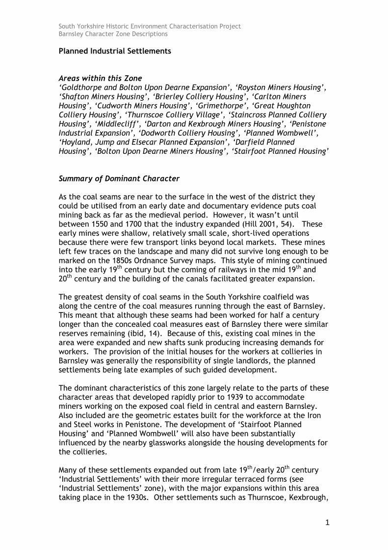
These types of estate often have radial plans which frequently make use of concentric circles divided by axial roads. Architectural forms were designed to emulate traditional cottages, all be it in a thoroughly modernised form (English Heritage 2007a, 5). Styles favoured to achieve this effect were generally influenced by the Arts and Crafts revival of the late 19th century and the Neo-Georgian school of architecture (English Heritage 2007b), plans which surround communal open spaces with cottages in the supposed tradition of English village greens. There were also generous provisions of garden plots.
Figure 1: The south west suburbs of Wombwell showing their complex radial forms.
Cities Revealed aerial photography © the GeoInformation Group, 2002
South Yorkshire Historic Environment Characterisation Project Barnsley Character Zone Descriptions
3
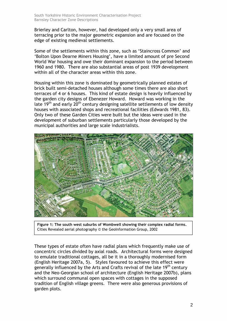
Fitting within the garden suburbs ideas of public recreational space, mining villages also generally feature facilities originally provided by the Miners Welfare Fund. This was the product of a levy paid by colliery companies of 1d on every ton of coal produced following the Mining Industry Act of 1920 (Griffin 1971, 170). At colliery sites this fund provided pit-head baths, but within this zone notable features are welfare halls, recreation grounds and parks. The provision has certain characteristics, team and spectator sports are well catered for with football and cricket pitches at most grounds. Some grounds include provision for tennis and bowling. Large areas of allotment gardens can also be seen on the 1930s OS plans of these settlements. With the nationalisation of the coal industry in 1947 (Hill 2001, 36), all assets of the former colliery companies, including 140,000 houses nationally passed to the new coal board (Beynon, Hollywood and Hudson 1999, 2). The NCB continued to take a role in the construction of housing estates to attract workers to colliery communities, although from 1952 this role was undertaken in partnership with local authorities (ibid). In this zone the majority of residential development up to 1976 (when the NCB withdrew from the provision of miners housing (ibid, 3) was provided as part of large scale social housing schemes [generally characterised at character unit level by this project as ‘Planned Estate (Social Housing)] was undertaken by the public sector. Until the 1970s development led by the private sector was generally small scale, and mostly consisted of ribbon development along main roads. The earliest housing during this period has superficial characteristics in common with the earlier estates however the open spaces of the earlier estates became less common and the developments tend to increase in housing density. Houses may also be built from cheap building materials as with the corrugated metal homes in part of the ‘Royston Miners Housing’ area.
Figure 2: Central Drive, south Royston. Cheaply constructed houses built within the same housing layout as earlier brick built homes. Cities Revealed aerial photography © the GeoInformation Group, 2002

South Yorkshire Historic Environment Characterisation Project Barnsley Character Zone Descriptions
4
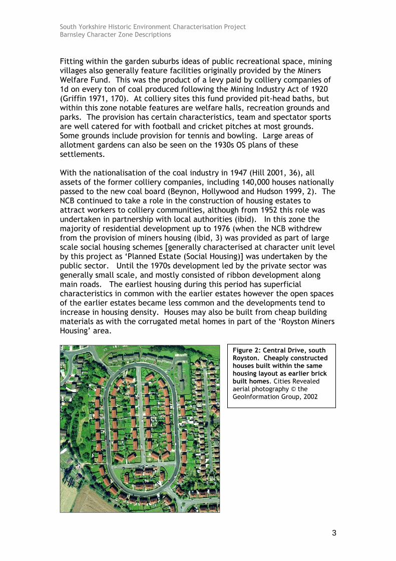
Some of the later housing developments within this zone move away from the provision of private space to the planning of open plan estates based on the Radburn principles of design. These layout principles, originating in a study by US architects Stein and Wright of English garden suburb planning (Sheffield Corporation 1962, 12) aimed to maximise the separation of vehicles and pedestrians by avoiding points at which pedestrians would have to cross vehicle carriageways. Instead of facing on to carriageways, houses were designed to front directly onto common green-spaces without privately demarcated enclosed gardens.
The Radburn estates built across this zone in this period are typical of many developed nationwide from the 1950s through to the late 1970s. Houses of this type are generally constructed according to system building techniques, typically the ‘No Fines’ method developed by Wimpey. Houses built in this system were cast in-situ from a concrete mix requiring no ‘fine’ aggregates (i.e. cement and gravel). This method could be executed quickly and cheaply, however, the resulting aesthetics of the properties, which were finished with quickly applied render, are generally regarded as bleak. Structural problems with the system include poor thermal insulation an condensation More recent urban design theories have turned away from the open plan concept of these areas which is now believed to offer no defensible space to increase the security and privacy of its residents whilst the common parking areas provided to the rear of property have been criticised as “poorly overlooked and magnets for anti-social behaviour” (CSR
Figure 3: Billingley View, west Bolton-upon-Dearne. Cities Revealed aerial photography © the GeoInformation Group, 2002
South Yorkshire Historic Environment Characterisation Project Barnsley Character Zone Descriptions
5
Partnership 2004, 26). These designs are fairly low in number in Barnsley however, with most estates conforming, at least partially, to the geometric styles of the earlier estates. Relationship to Adjacent Character Zones The most obvious relationship between this zone and others is with the ‘Industrial’, ‘Extractive’ and ‘Post Industrial’ zones where the sites of the commercial concerns that influenced the development of these ‘Planned Industrial Settlements’ are located. The link with industry also means that settlements were located near to the numerous railway lines that ran across the district and in proximity to the Dearne and Dove Canal and the Barnsley Canal. Many of these transport links were removed in the mid to late 20th century but some railway lines remain as do sections of the canals. There are currently no coal mines operational within Barnsley and the sites of the former mines are under going significant alteration as part of the regeneration of the district. There are many comparisons that can be made between the ‘Industrial Settlements’ zone and ‘Planned Industrial Settlements’. Like many of the villages within this zone, most of the ‘Industrial Settlements’ were developed to house a mining population, however, the planned settlements have a greater level of organisational planning and the developments are built on a larger scale. There are streets within the ‘Planned Industrial Settlements’ zone that have more irregular characteristics but these are too small to pull out as a separate zone. Many of the ‘Planned Industrial Settlements’ developed around earlier ‘Industrial Settlements’ and all of the character areas of this group generally abut or are closely located to historic villages described by this project by the ‘Nucleated Rural Settlements’ zone description. Inherited Character Within this zone, character relating to earlier landscapes is generally rare. As with the similar housing forms of the ‘Municipal Suburbs’, the geometric housing patterns tend to overwrite much of the previous landscape. This is particularly true where the planned settlements have been developed rapidly on a large scale. The main features of the past landscape partially visible within the current housing estates are historic enclosure boundaries and earlier rural lanes. These are generally seen along boundaries of various phases of development or along the edges of housing estates. 89% of the housing in this zone was built on agricultural land and due to the wide ranging landscapes that coal mines developed on, colliery settlements developed on a broad range of rural landscape types. The close proximity of many of these settlements to medieval villages however, means that enclosed strip fields and medieval crofts account for near half of this enclosed land. Strip field patterns
South Yorkshire Historic Environment Characterisation Project Barnsley Character Zone Descriptions
6
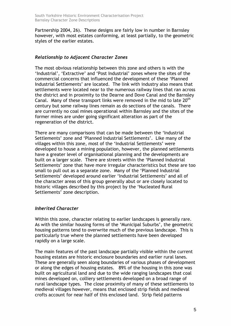
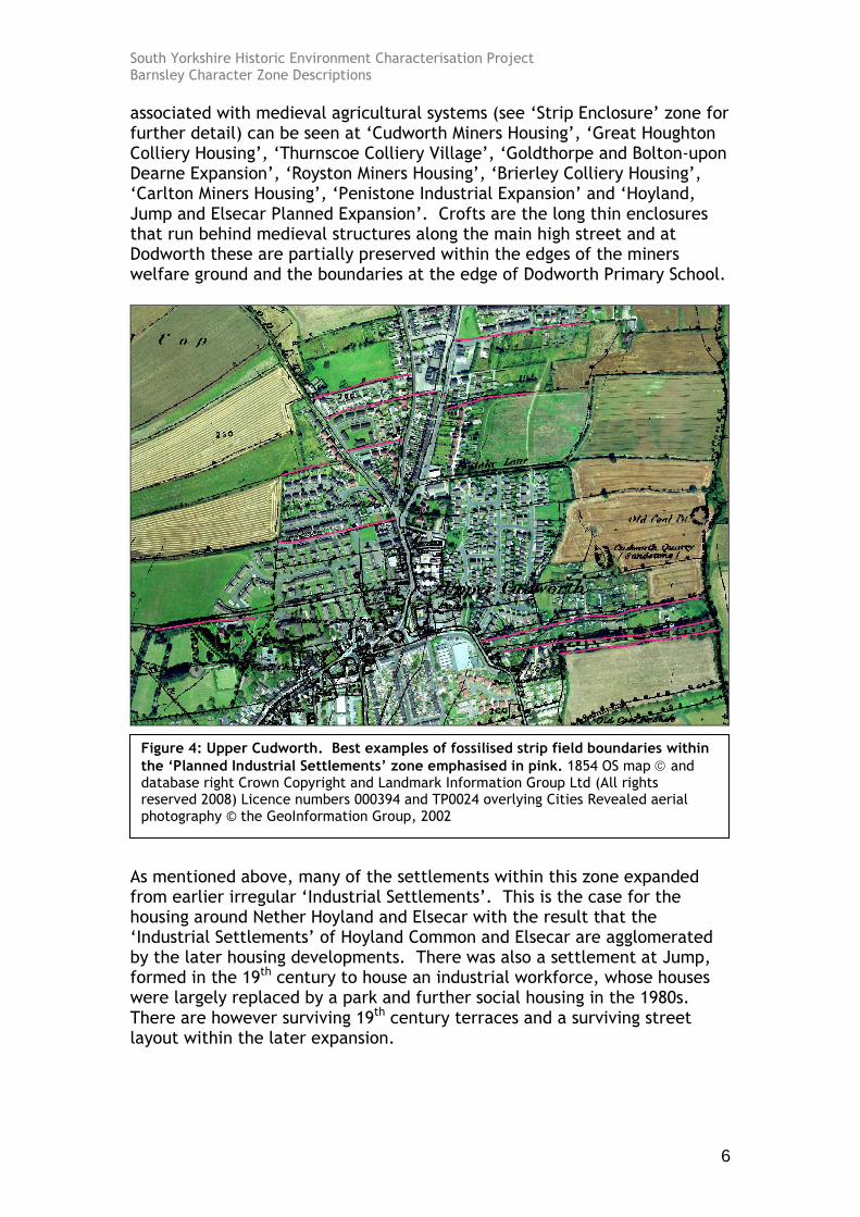
associated with medieval agricultural systems (see ‘Strip Enclosure’ zone for further detail) can be seen at ‘Cudworth Miners Housing’, ‘Great Houghton Colliery Housing’, ‘Thurnscoe Colliery Village’, ‘Goldthorpe and Bolton-upon Dearne Expansion’, ‘Royston Miners Housing’, ‘Brierley Colliery Housing’, ‘Carlton Miners Housing’, ‘Penistone Industrial Expansion’ and ‘Hoyland, Jump and Elsecar Planned Expansion’. Crofts are the long thin enclosures that run behind medieval structures along the main high street and at Dodworth these are partially preserved within the edges of the miners welfare ground and the boundaries at the edge of Dodworth Primary School.
As mentioned above, many of the settlements within this zone expanded from earlier irregular ‘Industrial Settlements’. This is the case for the housing around Nether Hoyland and Elsecar with the result that the ‘Industrial Settlements’ of Hoyland Common and Elsecar are agglomerated by the later housing developments. There was also a settlement at Jump, formed in the 19th century to house an industrial workforce, whose houses were largely replaced by a park and further social housing in the 1980s. There are however surviving 19th century terraces and a surviving street layout within the later expansion.
Figure 4: Upper Cudworth. Best examples of fossilised strip field boundaries within
the ‘Planned Industrial Settlements’ zone emphasised in pink. 1854 OS map and database right Crown Copyright and Landmark Information Group Ltd (All rights reserved 2008) Licence numbers 000394 and TP0024 overlying Cities Revealed aerial photography © the GeoInformation Group, 2002
South Yorkshire Historic Environment Characterisation Project Barnsley Character Zone Descriptions
7
Later Characteristics All of the settlements within this zone were closely associated with industry, especially with coal mining. The 1970s saw the gradual reduction of pits as sites were rationalised and combined. The major closures started in the 1980s with the last colliery in Barnsley closing in 1992 (Yorkshire Forward 2003, 17). These closures were fought against by the vast majority the working population who were directly involved in a violent and economically devastating industrial dispute (Adeney and Lloyd 1986). The eventual closures left communities with substantial numbers of unemployed people and a landscape of derelict industrial sites and disused soil heaps. The NCB had disbanded the Coal Industry Housing Association in 1977 and had been selling off its housing at a gradual rate but this was to increase substantially after the miner strike of 1984-5. Much housing had been transferred to the municipal authority or sitting tenants, but the late 80s saw the sale of housing to private landlords (Beynon et al 1999, 3). There are still large numbers of council owned housing within this zone but there is still a move towards more private ownership; this is in line with national trend (Office for National Statistics 2004, 30). Barnsley, like much of the surrounding region, received substantial grants from the European Union in the 1990s to reverse the effects of economic decline (Government Office for Yorkshire and the Humber 2007). This funding has been ongoing and has been used to reclaim disused land, bring business into the area and improve housing in former colliery settlements. These changes are not always seen directly within this zone as often the areas of housing removed and replaced are within the earlier ‘Industrial Settlements’ zone. Examples of improvement within the zone include the demolition of early terraces on the edge of Staincross and the regeneration of a former brickworks on the edge of Thurnscoe. Both these sites have been redeveloped into public parks. Throughout the zone small private estates have also been built, sometimes infilling between earlier developments or built on the edge of the settlement. Other later developments within this zone include improvement of green spaces, expansion of schools, establishment of a modern sport centre and the creation of a number of nursing homes established within the zone.
South Yorkshire Historic Environment Characterisation Project Barnsley Character Zone Descriptions
8
Bibliography Adeney, M. and Lloyd, J. 1985 The Miners Strike 1984-5: Loss Without Limit.
London: Routledge. Beynon, H., Hollywood, E., and Hudson, R. 1992 Regenerating Housing: Coalfields Research
Programme, Discussion Paper 6. Cardiff, Cardiff University Available from: www.cardiff.ac.uk/socsi/resources/regenerating%20housing%20-%206.pdf [accessed 16/04/08].
CSR Partnership 2004 Masterplanning at Royal: Granby: Howbeck
Estates, Edlington. CSR Partnership for Doncaster MBC / Transform South Yorkshire. Available from: www.doncaster-community.co.uk/Living_in_Doncaster/Homes_and_Housing/HMR_pathfinder/edlington/Masterplans_for_Edlington.asp accessed 16/04/08].
Edwards, A.M. 1981 The Designs of Suburbia. London: Pembridge
Press. English Heritage 2007a The Heritage of Historic Suburbs [online].
London: English Heritage. Available from: www.helm.org.uk/upload/pdf/Heritage-Suburbs.pdf [accessed 16/04/08].
English Heritage 2007b The Modern House and Housing: Selection Guide
– Domestic Buildings (4) [online]. London: English Heritage, Heritage Protection Department. Available from: www.english-heritage.org.uk/upload/pdf/Domestic_4_Modern_House_and_Housing.pdf [accessed 16/04/08].
Government Office for Yorkshire and the Humber 2007 Objective 1 [online]. Government Office for
Yorkshire and the Humber. Available from: www.gos.gov.uk/goyh/eurofund/o1/ [accessed 17/04/08].
Hill, A. 2002 The South Yorkshire Coalfield: A History and
Development. Stroud: Tempus Publishing Ltd.
South Yorkshire Historic Environment Characterisation Project Barnsley Character Zone Descriptions
9
Office for National Statistics 2004 Living in Britain: Results from the 2002 General
Household Survey [online]. The Office for National Statistics. Available from: www.statistics.gov.uk/lib2002/ [accessed 01/04/08].
Sheffield Corporation 1962 Ten Years of Housing in Sheffield. Sheffield:
Sheffield Corporation, Housing Development Committee.
Yorkshire Forward 2003 Remaking Barnsley: Strategic Development
Framework 2003-2033 [online]. Available from: www.remakingbarnsley.co.uk/ [accessed 16/04/08].