Embed Size (px)
Citation preview
South Yorkshire Historic Environment Characterisation Project Rotherham Character Zone Descriptions
1
Nucleated Rural Settlements Gazetteer All modern mapping within gazetteer © Crown copyright. All rights reserved. Sheffield City Council 100018816. 2007
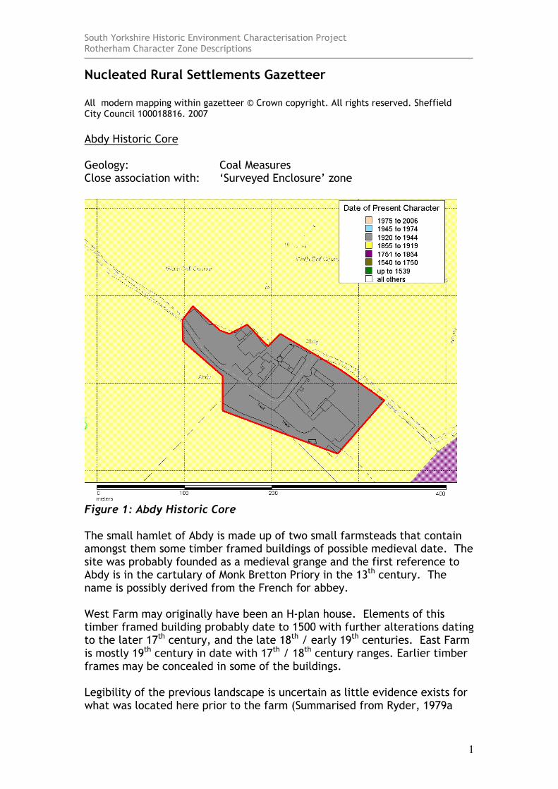
Abdy Historic Core Geology: Coal Measures Close association with: ‘Surveyed Enclosure’ zone
Figure 1: Abdy Historic Core The small hamlet of Abdy is made up of two small farmsteads that contain amongst them some timber framed buildings of possible medieval date. The site was probably founded as a medieval grange and the first reference to Abdy is in the cartulary of Monk Bretton Priory in the 13th century. The name is possibly derived from the French for abbey. West Farm may originally have been an H-plan house. Elements of this timber framed building probably date to 1500 with further alterations dating to the later 17th century, and the late 18th / early 19th centuries. East Farm is mostly 19th century in date with 17th / 18th century ranges. Earlier timber frames may be concealed in some of the buildings. Legibility of the previous landscape is uncertain as little evidence exists for what was located here prior to the farm (Summarised from Ryder, 1979a

South Yorkshire Historic Environment Characterisation Project Rotherham Character Zone Descriptions
2
and YAJ 1980, 184). Fragments of a fossilised former open field system are visible to the north within Wath Golf Course (character unit HSY 3121).
South Yorkshire Historic Environment Characterisation Project Rotherham Character Zone Descriptions
3
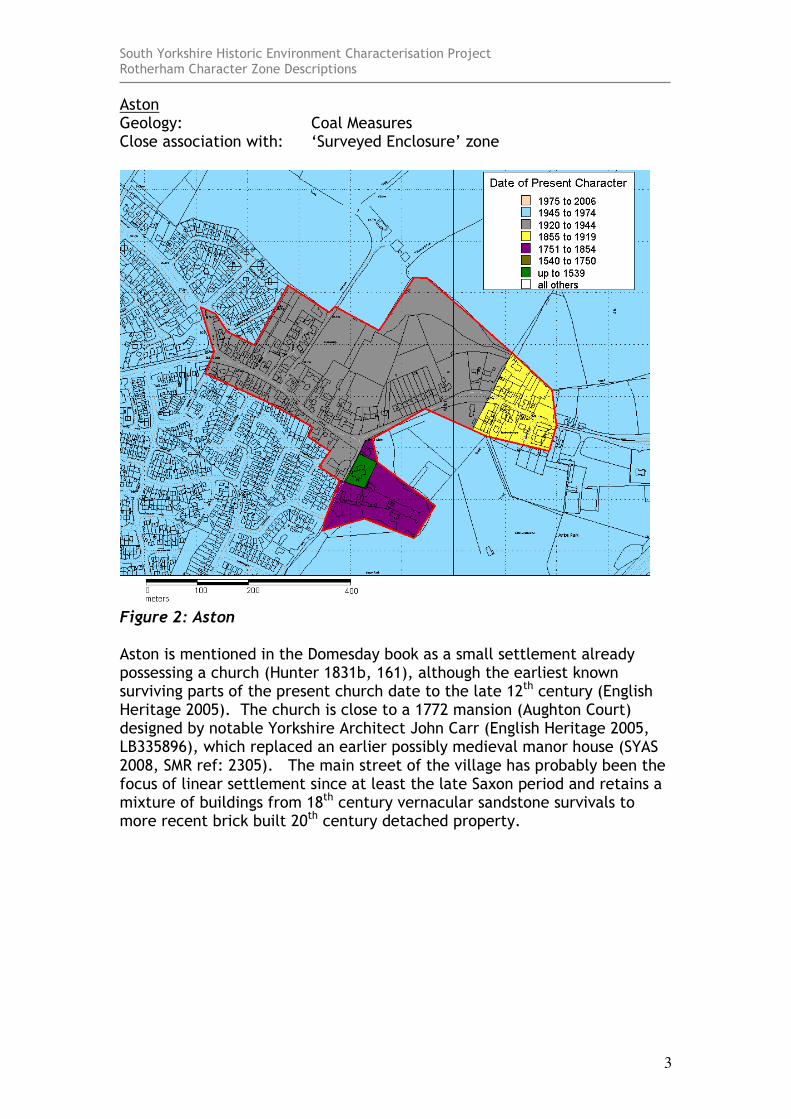
Aston Geology: Coal Measures Close association with: ‘Surveyed Enclosure’ zone
Figure 2: Aston Aston is mentioned in the Domesday book as a small settlement already possessing a church (Hunter 1831b, 161), although the earliest known surviving parts of the present church date to the late 12th century (English Heritage 2005). The church is close to a 1772 mansion (Aughton Court) designed by notable Yorkshire Architect John Carr (English Heritage 2005, LB335896), which replaced an earlier possibly medieval manor house (SYAS 2008, SMR ref: 2305). The main street of the village has probably been the focus of linear settlement since at least the late Saxon period and retains a mixture of buildings from 18th century vernacular sandstone survivals to more recent brick built 20th century detached property.
South Yorkshire Historic Environment Characterisation Project Rotherham Character Zone Descriptions
4
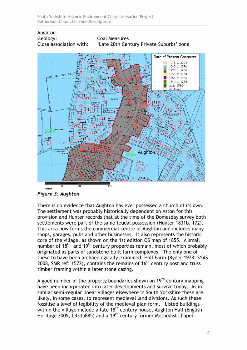
Aughton Geology: Coal Measures Close association with: ‘Late 20th Century Private Suburbs’ zone
Figure 3: Aughton There is no evidence that Aughton has ever possessed a church of its own. The settlement was probably historically dependent on Aston for this provision and Hunter records that at the time of the Domesday survey both settlements were part of the same feudal possession (Hunter 1831b, 172). This area now forms the commercial centre of Aughton and includes many shops, garages, pubs and other businesses. It also represents the historic core of the village, as shown on the 1st edition OS map of 1855. A small number of 18th and 19th century properties remain, most of which probably originated as parts of sandstone-built farm complexes. The only one of these to have been archaeologically examined, Hall Farm (Ryder 1978; SYAS 2008, SMR ref: 1572), contains the remains of 16th century post and truss timber framing within a later stone casing. A good number of the property boundaries shown on 19th century mapping have been incorporated into later developments and survive today. As in similar semi-regular linear villages elsewhere in South Yorkshire these are likely, in some cases, to represent medieval land divisions. As such these fossilise a level of legibility of the medieval plan form. Listed buildings within the village include a late 18th century house, Aughton Hall (English Heritage 2005, LB335885) and a 19th century former Methodist chapel

South Yorkshire Historic Environment Characterisation Project Rotherham Character Zone Descriptions
5
(English Heritage 2005, LB335886). Terraced housing was built in the village near Well Lane and West Lane in the late 19th and early 20th centuries and much of the remaining housing stock dates to the 20th century.
South Yorkshire Historic Environment Characterisation Project Rotherham Character Zone Descriptions
6
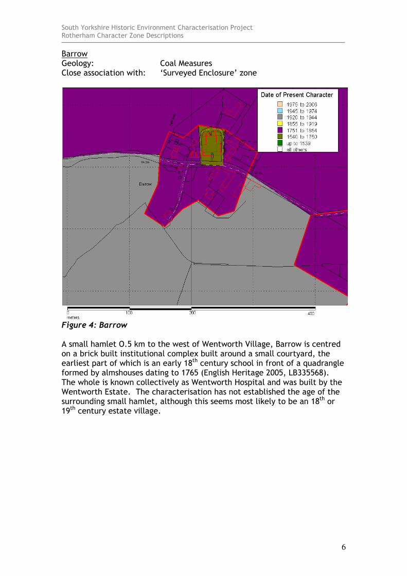
Barrow Geology: Coal Measures Close association with: ‘Surveyed Enclosure’ zone
Figure 4: Barrow A small hamlet O.5 km to the west of Wentworth Village, Barrow is centred on a brick built institutional complex built around a small courtyard, the earliest part of which is an early 18th century school in front of a quadrangle formed by almshouses dating to 1765 (English Heritage 2005, LB335568). The whole is known collectively as Wentworth Hospital and was built by the Wentworth Estate. The characterisation has not established the age of the surrounding small hamlet, although this seems most likely to be an 18th or 19th century estate village.
South Yorkshire Historic Environment Characterisation Project Rotherham Character Zone Descriptions
7
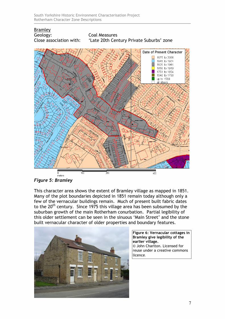
Bramley Geology: Coal Measures Close association with: ‘Late 20th Century Private Suburbs’ zone
Figure 5: Bramley This character area shows the extent of Bramley village as mapped in 1851. Many of the plot boundaries depicted in 1851 remain today although only a few of the vernacular buildings remain. Much of present built fabric dates to the 20th century. Since 1975 this village area has been subsumed by the suburban growth of the main Rotherham conurbation. Partial legibility of this older settlement can be seen in the sinuous ‘Main Street’ and the stone built vernacular character of older properties and boundary features.
Figure 6: Vernacular cottages in Bramley give legibility of the earlier village. © John Charlton. Licensed for reuse under a creative commons
licence.
South Yorkshire Historic Environment Characterisation Project Rotherham Character Zone Descriptions
8
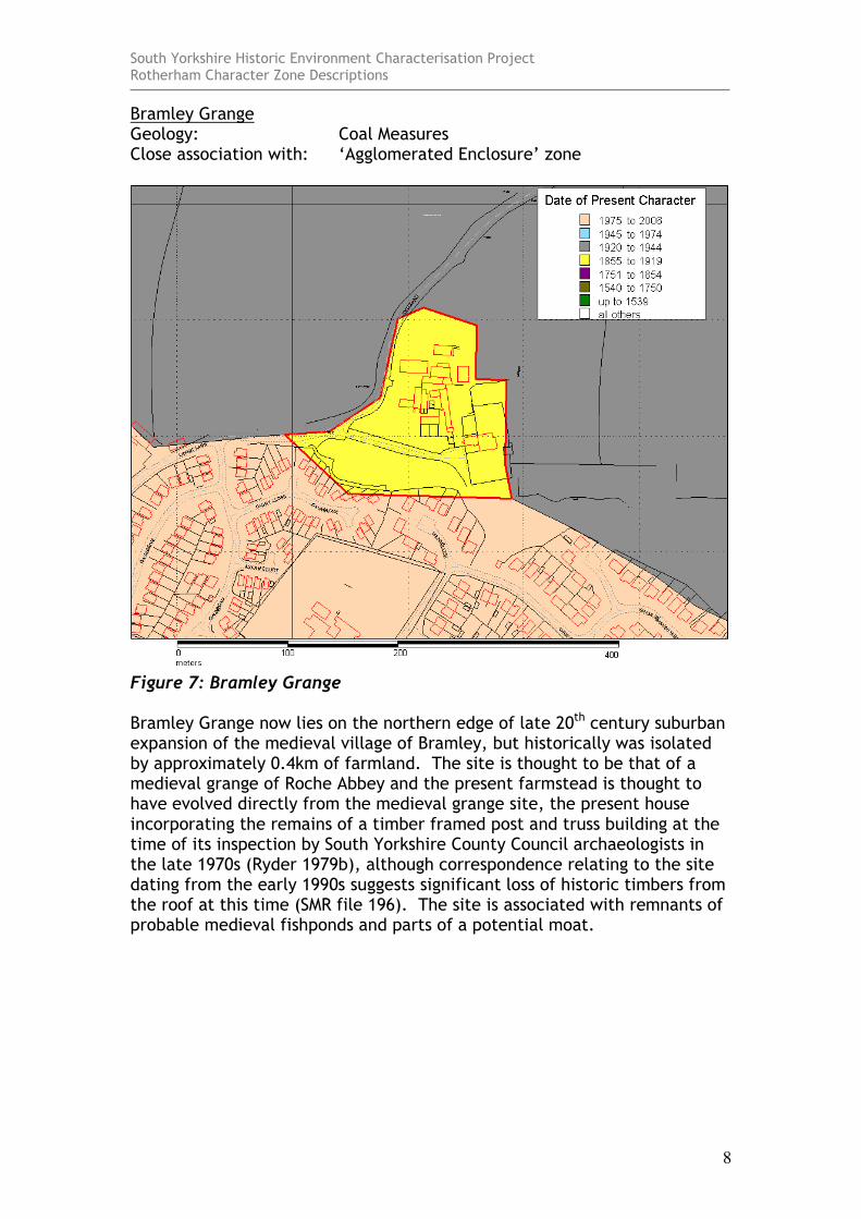
Bramley Grange Geology: Coal Measures Close association with: ‘Agglomerated Enclosure’ zone
Figure 7: Bramley Grange Bramley Grange now lies on the northern edge of late 20th century suburban expansion of the medieval village of Bramley, but historically was isolated by approximately 0.4km of farmland. The site is thought to be that of a medieval grange of Roche Abbey and the present farmstead is thought to have evolved directly from the medieval grange site, the present house incorporating the remains of a timber framed post and truss building at the time of its inspection by South Yorkshire County Council archaeologists in the late 1970s (Ryder 1979b), although correspondence relating to the site dating from the early 1990s suggests significant loss of historic timbers from the roof at this time (SMR file 196). The site is associated with remnants of probable medieval fishponds and parts of a potential moat.
South Yorkshire Historic Environment Characterisation Project Rotherham Character Zone Descriptions
9
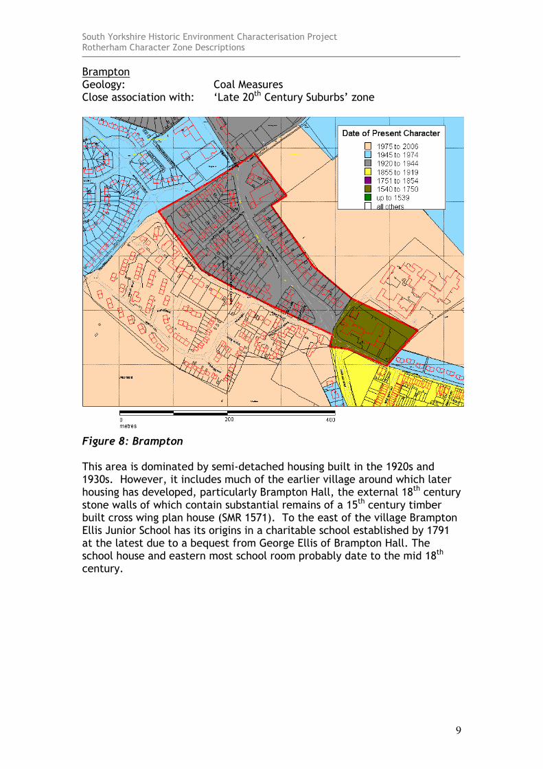
Brampton Geology: Coal Measures Close association with: ‘Late 20th Century Suburbs’ zone
Figure 8: Brampton This area is dominated by semi-detached housing built in the 1920s and 1930s. However, it includes much of the earlier village around which later housing has developed, particularly Brampton Hall, the external 18th century stone walls of which contain substantial remains of a 15th century timber built cross wing plan house (SMR 1571). To the east of the village Brampton Ellis Junior School has its origins in a charitable school established by 1791 at the latest due to a bequest from George Ellis of Brampton Hall. The school house and eastern most school room probably date to the mid 18th century.
South Yorkshire Historic Environment Characterisation Project Rotherham Character Zone Descriptions
10
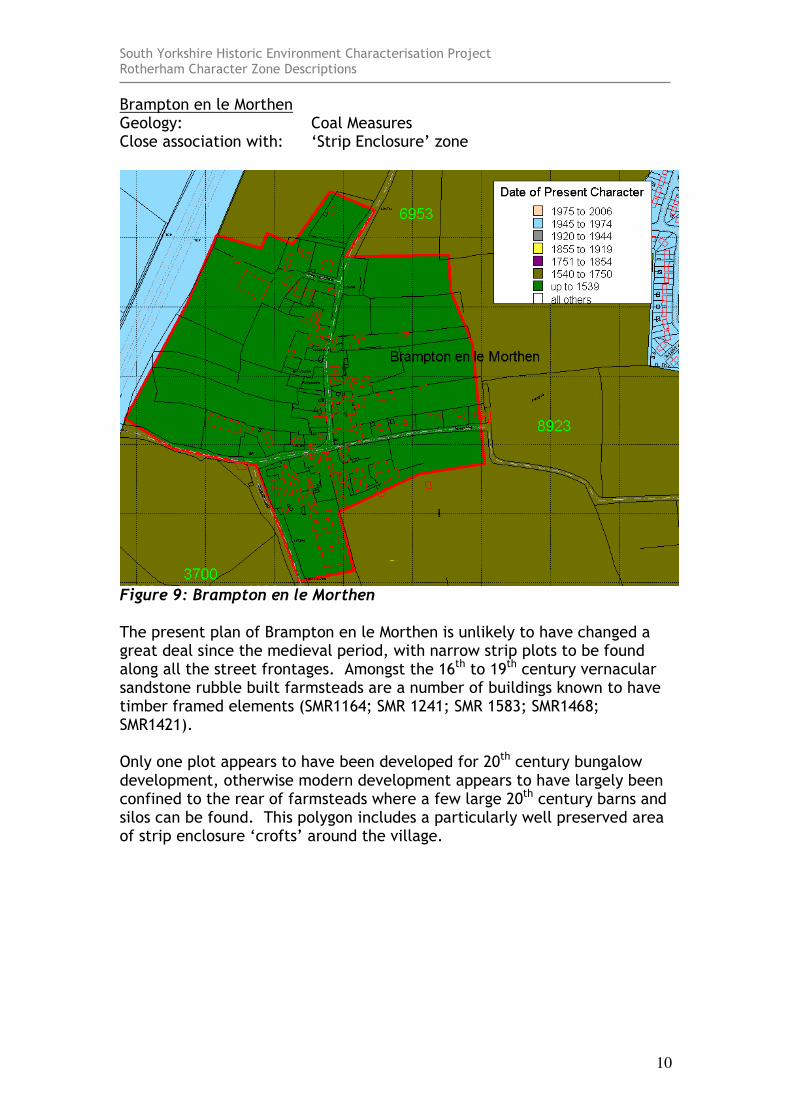
Brampton en le Morthen Geology: Coal Measures Close association with: ‘Strip Enclosure’ zone
Figure 9: Brampton en le Morthen The present plan of Brampton en le Morthen is unlikely to have changed a great deal since the medieval period, with narrow strip plots to be found along all the street frontages. Amongst the 16th to 19th century vernacular sandstone rubble built farmsteads are a number of buildings known to have timber framed elements (SMR1164; SMR 1241; SMR 1583; SMR1468; SMR1421). Only one plot appears to have been developed for 20th century bungalow development, otherwise modern development appears to have largely been confined to the rear of farmsteads where a few large 20th century barns and silos can be found. This polygon includes a particularly well preserved area of strip enclosure ‘crofts’ around the village.
South Yorkshire Historic Environment Characterisation Project Rotherham Character Zone Descriptions
11
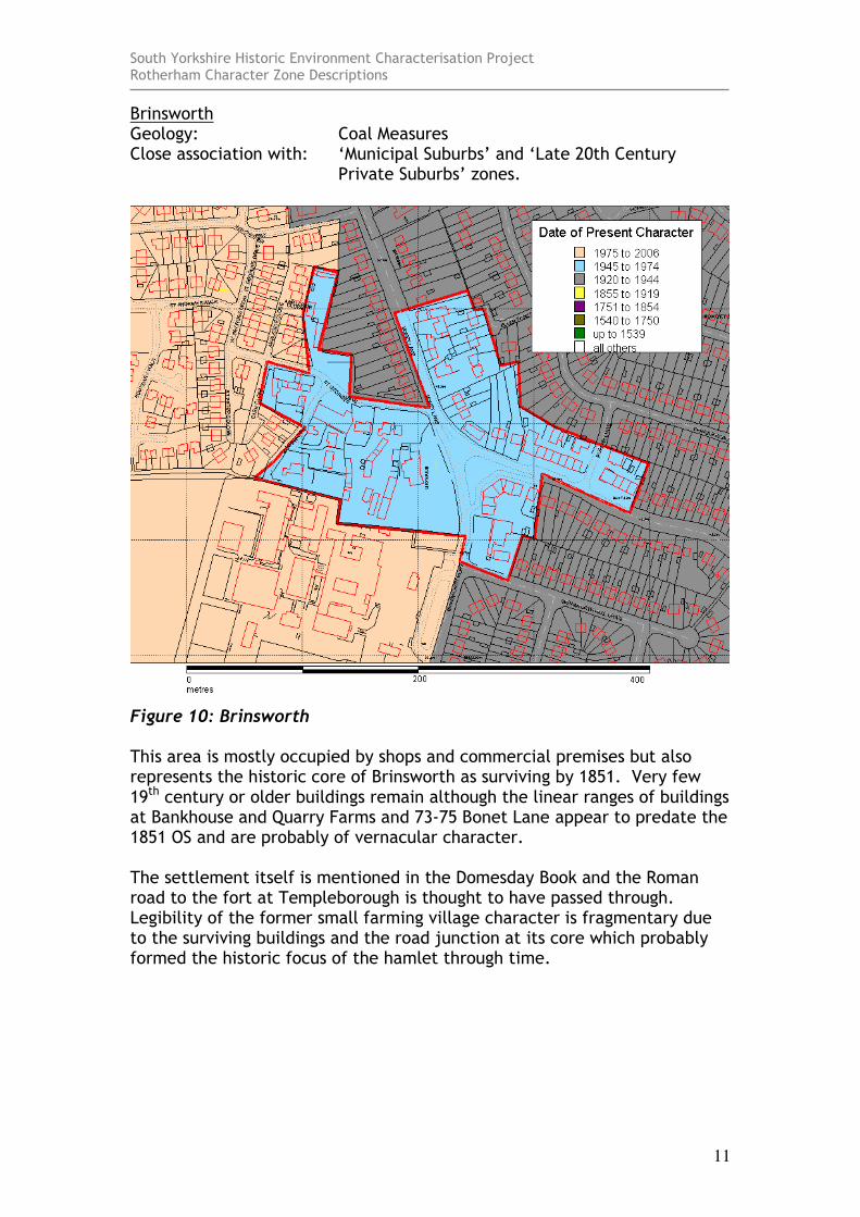
Brinsworth Geology: Coal Measures Close association with: ‘Municipal Suburbs’ and ‘Late 20th Century
Private Suburbs’ zones.
Figure 10: Brinsworth This area is mostly occupied by shops and commercial premises but also represents the historic core of Brinsworth as surviving by 1851. Very few 19th century or older buildings remain although the linear ranges of buildings at Bankhouse and Quarry Farms and 73-75 Bonet Lane appear to predate the 1851 OS and are probably of vernacular character. The settlement itself is mentioned in the Domesday Book and the Roman road to the fort at Templeborough is thought to have passed through. Legibility of the former small farming village character is fragmentary due to the surviving buildings and the road junction at its core which probably formed the historic focus of the hamlet through time.
South Yorkshire Historic Environment Characterisation Project Rotherham Character Zone Descriptions
12
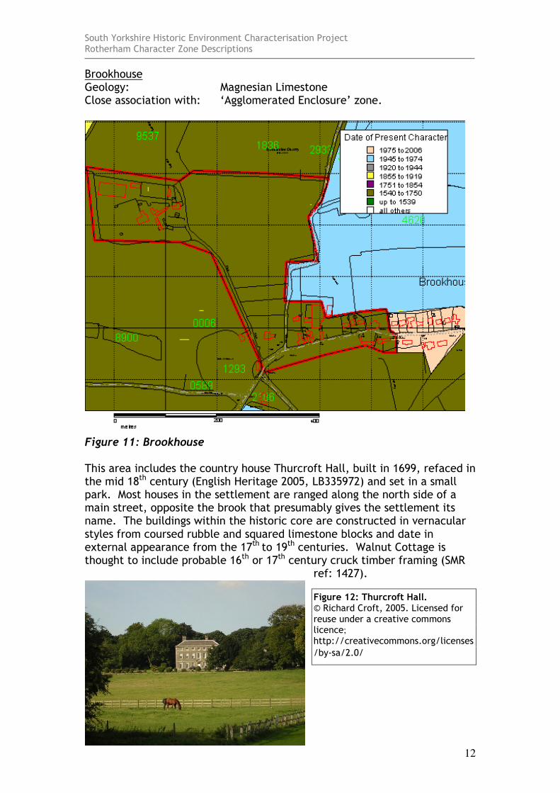
Brookhouse Geology: Magnesian Limestone Close association with: ‘Agglomerated Enclosure’ zone.
Figure 11: Brookhouse This area includes the country house Thurcroft Hall, built in 1699, refaced in the mid 18th century (English Heritage 2005, LB335972) and set in a small park. Most houses in the settlement are ranged along the north side of a main street, opposite the brook that presumably gives the settlement its name. The buildings within the historic core are constructed in vernacular styles from coursed rubble and squared limestone blocks and date in external appearance from the 17th to 19th centuries. Walnut Cottage is thought to include probable 16th or 17th century cruck timber framing (SMR
ref: 1427).
Figure 12: Thurcroft Hall. © Richard Croft, 2005. Licensed for reuse under a creative commons licence;
http://creativecommons.org/licenses
/by-sa/2.0/
South Yorkshire Historic Environment Characterisation Project Rotherham Character Zone Descriptions
13
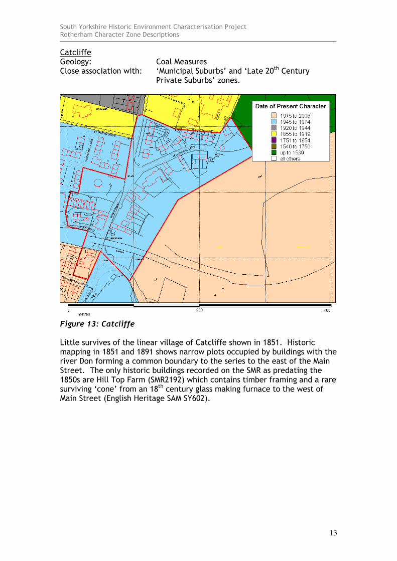
Catcliffe Geology: Coal Measures Close association with: ‘Municipal Suburbs’ and ‘Late 20th Century
Private Suburbs’ zones.
Figure 13: Catcliffe Little survives of the linear village of Catcliffe shown in 1851. Historic mapping in 1851 and 1891 shows narrow plots occupied by buildings with the river Don forming a common boundary to the series to the east of the Main Street. The only historic buildings recorded on the SMR as predating the 1850s are Hill Top Farm (SMR2192) which contains timber framing and a rare surviving ‘cone’ from an 18th century glass making furnace to the west of Main Street (English Heritage SAM SY602).
South Yorkshire Historic Environment Characterisation Project Rotherham Character Zone Descriptions
14
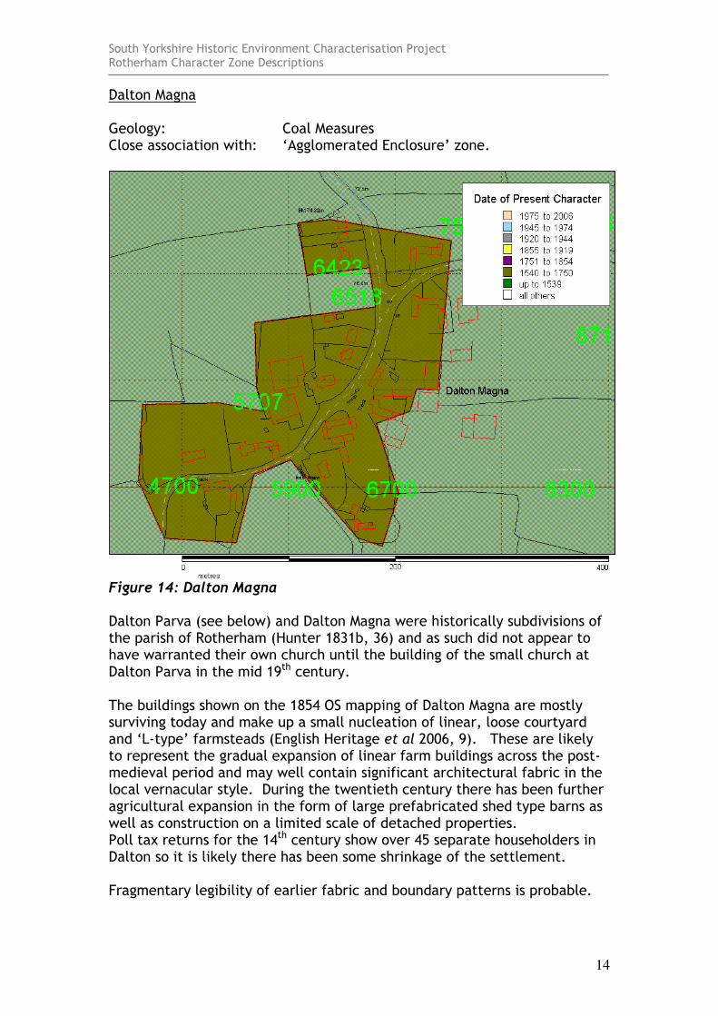
Dalton Magna Geology: Coal Measures Close association with: ‘Agglomerated Enclosure’ zone.
Figure 14: Dalton Magna Dalton Parva (see below) and Dalton Magna were historically subdivisions of the parish of Rotherham (Hunter 1831b, 36) and as such did not appear to have warranted their own church until the building of the small church at Dalton Parva in the mid 19th century. The buildings shown on the 1854 OS mapping of Dalton Magna are mostly surviving today and make up a small nucleation of linear, loose courtyard and ‘L-type’ farmsteads (English Heritage et al 2006, 9). These are likely to represent the gradual expansion of linear farm buildings across the post- medieval period and may well contain significant architectural fabric in the local vernacular style. During the twentieth century there has been further agricultural expansion in the form of large prefabricated shed type barns as well as construction on a limited scale of detached properties. Poll tax returns for the 14th century show over 45 separate householders in Dalton so it is likely there has been some shrinkage of the settlement. Fragmentary legibility of earlier fabric and boundary patterns is probable.
South Yorkshire Historic Environment Characterisation Project Rotherham Character Zone Descriptions
15
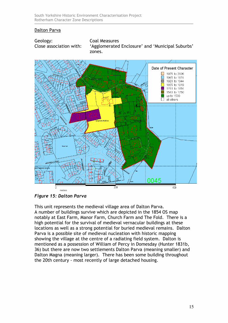
Dalton Parva Geology: Coal Measures Close association with: ‘Agglomerated Enclosure’ and ‘Municipal Suburbs’
zones.
Figure 15: Dalton Parva This unit represents the medieval village area of Dalton Parva. A number of buildings survive which are depicted in the 1854 OS map notably at East Farm, Manor Farm, Church Farm and The Fold. There is a high potential for the survival of medieval vernacular buildings at these locations as well as a strong potential for buried medieval remains. Dalton Parva is a possible site of medieval nucleation with historic mapping showing the village at the centre of a radiating field system. Dalton is mentioned as a possession of William of Percy in Domesday (Hunter 1831b, 36) but there are now two settlements Dalton Parva (meaning smaller) and Dalton Magna (meaning larger). There has been some building throughout the 20th century - most recently of large detached housing.
South Yorkshire Historic Environment Characterisation Project Rotherham Character Zone Descriptions
16
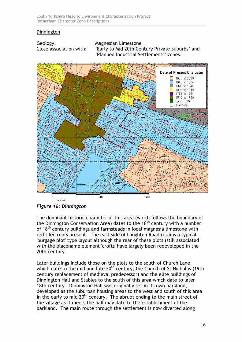
Dinnington Geology: Magnesian Limestone Close association with: ‘Early to Mid 20th Century Private Suburbs’ and
‘Planned Industrial Settlements’ zones.
Figure 16: Dinnington The dominant historic character of this area (which follows the boundary of the Dinnington Conservation Area) dates to the 18th century with a number of 18th century buildings and farmsteads in local magnesia limestone with red tiled roofs present. The east side of Laughton Road retains a typical 'burgage plot' type layout although the rear of these plots (still associated with the placename element 'crofts' have largely been redeveloped in the 20th century. Later buildings include those on the plots to the south of Church Lane, which date to the mid and late 20th century, the Church of St Nicholas (19th century replacement of medieval predecessor) and the elite buildings of Dinnington Hall and Stables to the south of this area which date to later 18th century. Dinnington Hall was originally set in its own parkland, developed as the suburban housing areas to the west and south of this area in the early to mid 20th century. The abrupt ending to the main street of the village as it meets the hall may date to the establishment of the parkland. The main route through the settlement is now diverted along
South Yorkshire Historic Environment Characterisation Project Rotherham Character Zone Descriptions
17
New Road, which may, like similar arrangements observed in the Doncaster district, date to a deliberate act of replanning to create parkland. The southern side of Barleycroft road consists of a long burgage plot which has been progressively subdivided across its width to form smaller plots in the manner described by the 'Burgage Cycle' concept developed by Conzen (Whitehand 2001, 105). In the area of Barleycroft road described her this process of subdivision dates to the early decades of the 20th century with the construction within the larger plot of around 17 terraced houses and their toilet blocks.

South Yorkshire Historic Environment Characterisation Project Rotherham Character Zone Descriptions
18
Firbeck Geology: Magnesian Limestone Close association with: ‘Agglomerated Enclosure’ and ‘Private Parklands
zones.
Figure 17: Firbeck Firbeck is mostly made up of estate cottages built from the 18th and 19th century connected to the St Ledger Estate. The village includes fragments of planting associated with the general landscaping of the area by the estate, a lodge at the entrance to the main park and the estate church built in the 19th century. No evidence for a medieval precursor to this village in this location is immediately apparent through its plan form, although there is at least one building (Manor Farm – SMR 2160) recorded as dating from the 16th-17th century. There is some mid 20th century higher density housing to the north side of the main street and west of the church.
South Yorkshire Historic Environment Characterisation Project Rotherham Character Zone Descriptions
19
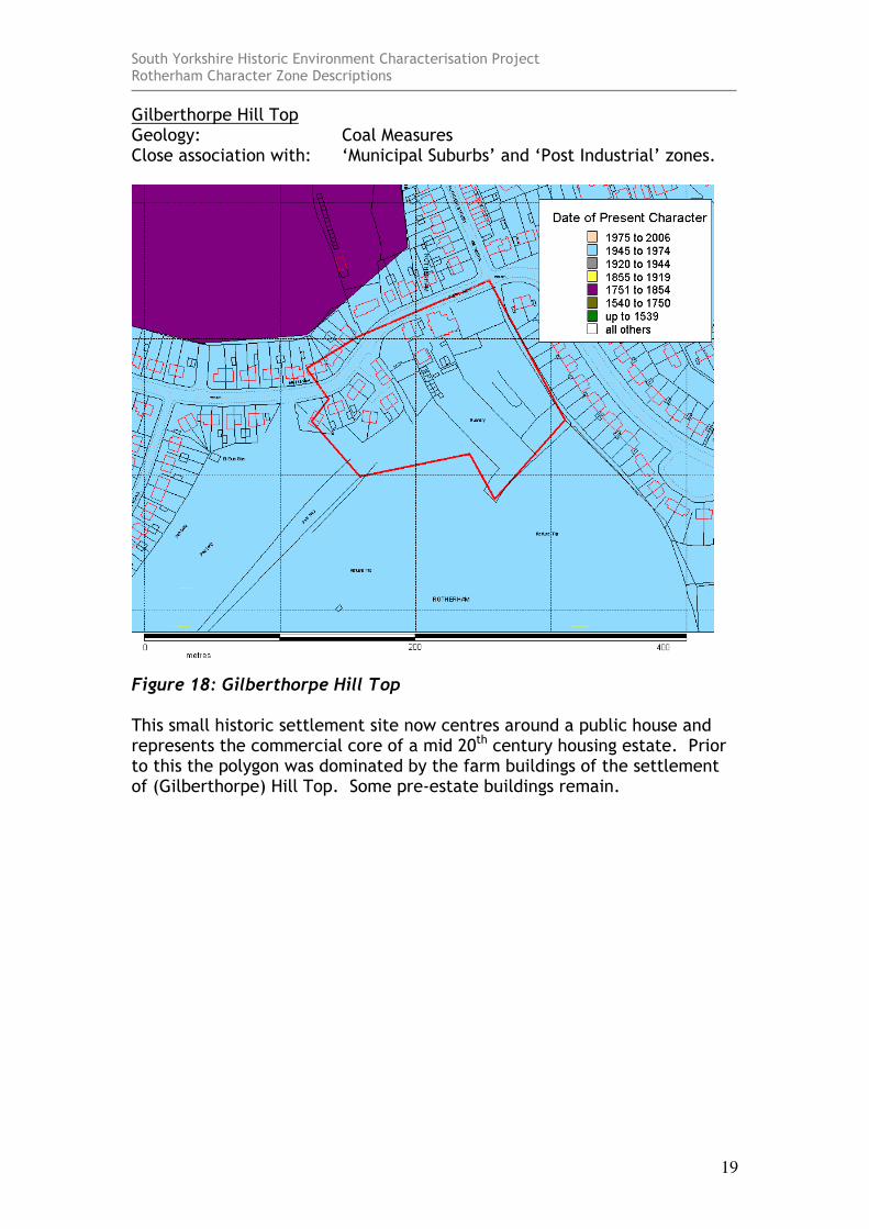
Gilberthorpe Hill Top Geology: Coal Measures Close association with: ‘Municipal Suburbs’ and ‘Post Industrial’ zones.
Figure 18: Gilberthorpe Hill Top This small historic settlement site now centres around a public house and represents the commercial core of a mid 20th century housing estate. Prior to this the polygon was dominated by the farm buildings of the settlement of (Gilberthorpe) Hill Top. Some pre-estate buildings remain.

South Yorkshire Historic Environment Characterisation Project Rotherham Character Zone Descriptions
20
Gildingwells Geology: Magnesian Limestone Close association with: ‘Strip Enclosure’ and ‘Agglomerated Enclosure.
Figure 19: Gildingwells This is a straggling hamlet with a name suggestive of springs. There is a good selection of 18th and 19th century brick and limestone built farmsteads and 1 medieval timber framed building dating to the late medieval period has been recorded (SMR 1555; Ryder 1982).
South Yorkshire Historic Environment Characterisation Project Rotherham Character Zone Descriptions
21
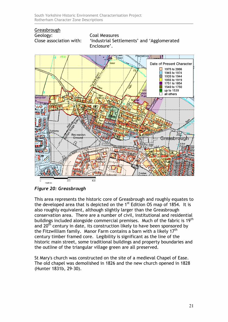
Greasbrough Geology: Coal Measures Close association with: ‘Industrial Settlements’ and ‘Agglomerated
Enclosure’.
Figure 20: Greasbrough This area represents the historic core of Greasbrough and roughly equates to the developed area that is depicted on the 1st Edition OS map of 1854. It is also roughly equivalent, although slightly larger than the Greasbrough conservation area. There are a number of civil, institutional and residential buildings included alongside commercial premises. Much of the fabric is 19th and 20th century in date, its construction likely to have been sponsored by the Fitzwilliam family. Manor Farm contains a barn with a likely 17th century timber framed core. Legibility is significant as the line of the historic main street, some traditional buildings and property boundaries and the outline of the triangular village green are all preserved. St Mary's church was constructed on the site of a medieval Chapel of Ease. The old chapel was demolished in 1826 and the new church opened in 1828 (Hunter 1831b, 29-30).
South Yorkshire Historic Environment Characterisation Project Rotherham Character Zone Descriptions
22
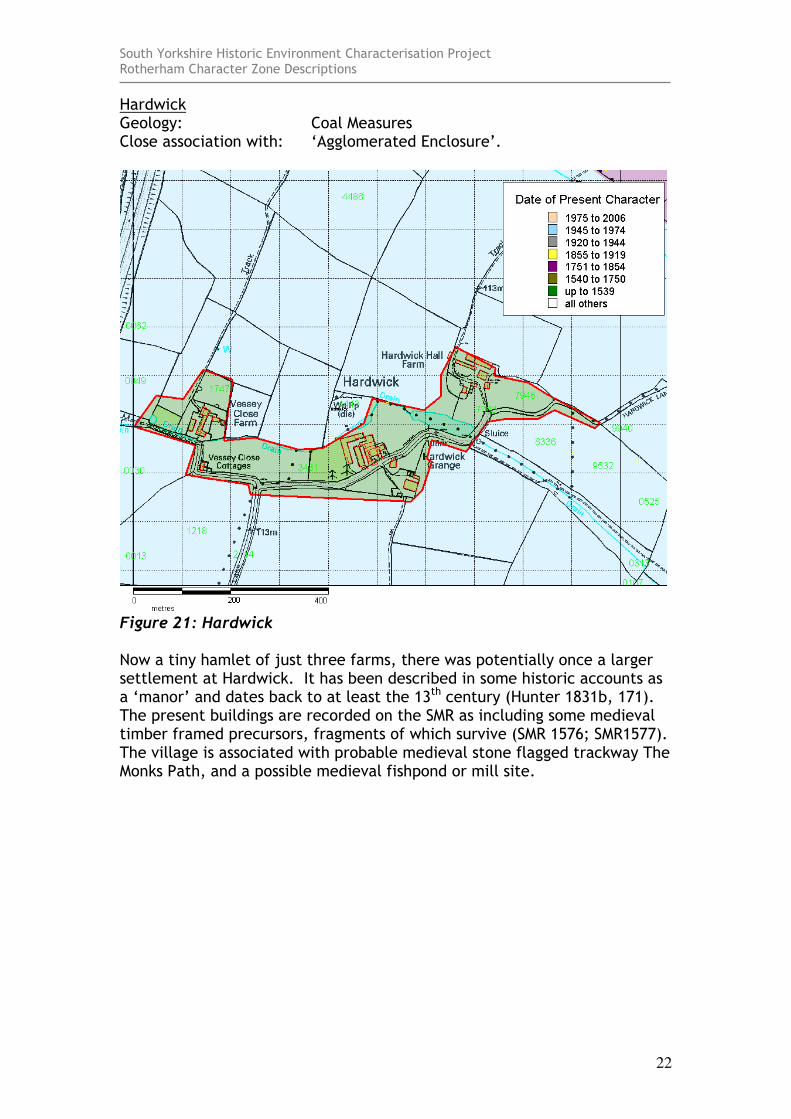
Hardwick Geology: Coal Measures Close association with: ‘Agglomerated Enclosure’.
Figure 21: Hardwick Now a tiny hamlet of just three farms, there was potentially once a larger settlement at Hardwick. It has been described in some historic accounts as a ‘manor’ and dates back to at least the 13th century (Hunter 1831b, 171). The present buildings are recorded on the SMR as including some medieval timber framed precursors, fragments of which survive (SMR 1576; SMR1577). The village is associated with probable medieval stone flagged trackway The Monks Path, and a possible medieval fishpond or mill site.

South Yorkshire Historic Environment Characterisation Project Rotherham Character Zone Descriptions
23
Harley Geology: Coal Measures Close association with: ‘Agglomerated Enclosure’.
Figure 22: Harley The historic hamlet of Harley includes a substantial H-plan timber framed house (Harley Hall), parts of which date to approximately 1500 (Ryder 1987, 62). Other elements of the hamlet may have been developed for estate workers of the Wentworth Estate.
South Yorkshire Historic Environment Characterisation Project Rotherham Character Zone Descriptions
24
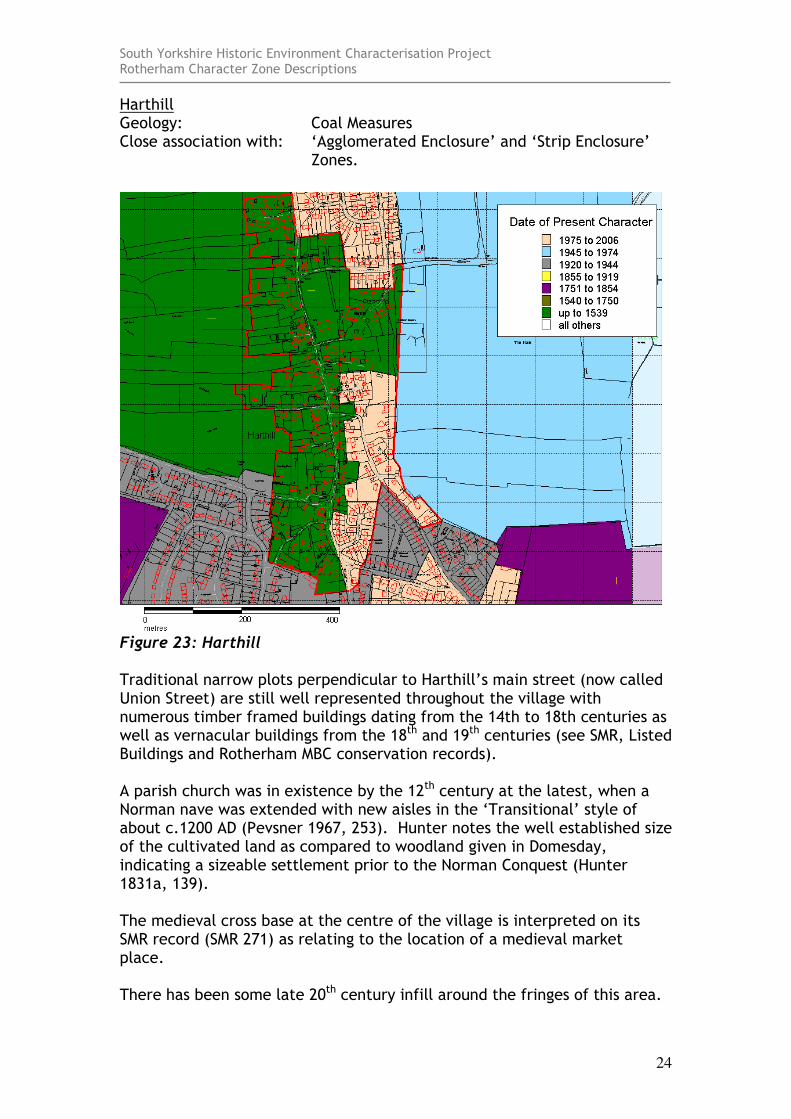
Harthill Geology: Coal Measures Close association with: ‘Agglomerated Enclosure’ and ‘Strip Enclosure’
Zones.
Figure 23: Harthill Traditional narrow plots perpendicular to Harthill’s main street (now called Union Street) are still well represented throughout the village with numerous timber framed buildings dating from the 14th to 18th centuries as well as vernacular buildings from the 18th and 19th centuries (see SMR, Listed Buildings and Rotherham MBC conservation records). A parish church was in existence by the 12th century at the latest, when a Norman nave was extended with new aisles in the ‘Transitional’ style of about c.1200 AD (Pevsner 1967, 253). Hunter notes the well established size of the cultivated land as compared to woodland given in Domesday, indicating a sizeable settlement prior to the Norman Conquest (Hunter 1831a, 139). The medieval cross base at the centre of the village is interpreted on its SMR record (SMR 271) as relating to the location of a medieval market place. There has been some late 20th century infill around the fringes of this area.
South Yorkshire Historic Environment Characterisation Project Rotherham Character Zone Descriptions
25
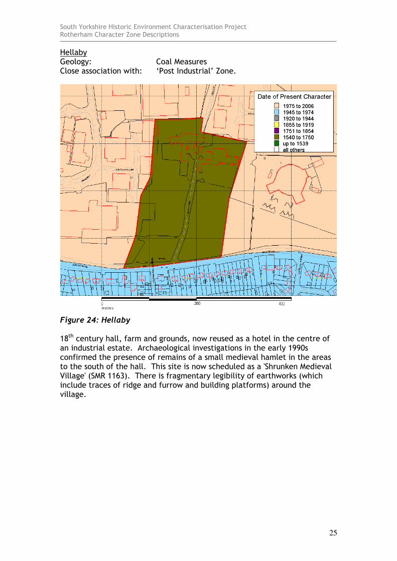
Hellaby Geology: Coal Measures Close association with: ‘Post Industrial’ Zone.
Figure 24: Hellaby 18th century hall, farm and grounds, now reused as a hotel in the centre of an industrial estate. Archaeological investigations in the early 1990s confirmed the presence of remains of a small medieval hamlet in the areas to the south of the hall. This site is now scheduled as a 'Shrunken Medieval Village' (SMR 1163). There is fragmentary legibility of earthworks (which include traces of ridge and furrow and building platforms) around the village.
South Yorkshire Historic Environment Characterisation Project Rotherham Character Zone Descriptions
26
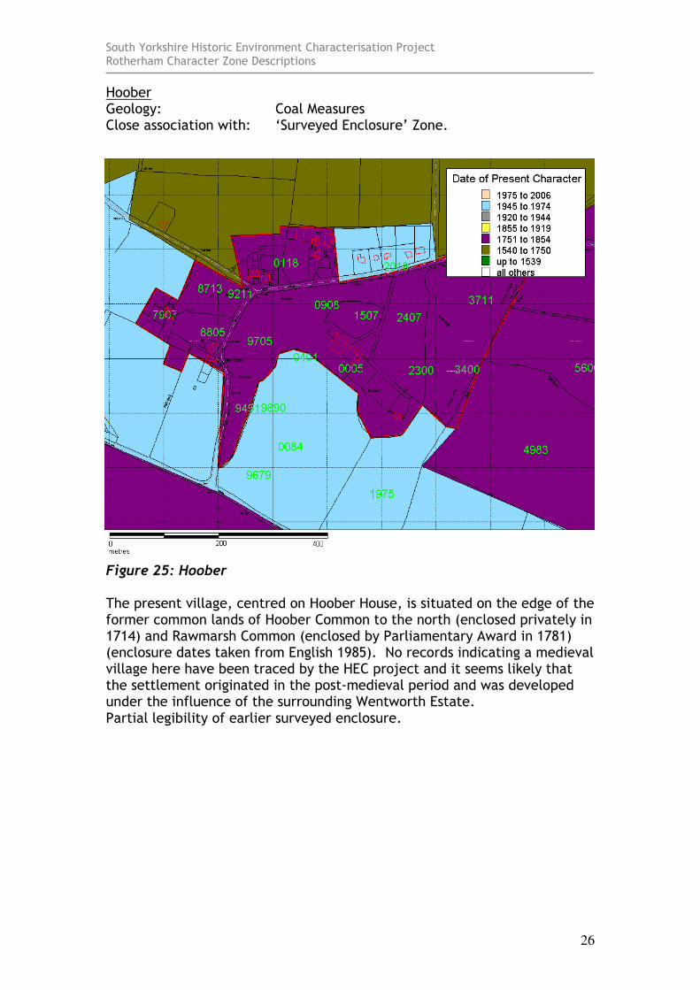
Hoober Geology: Coal Measures Close association with: ‘Surveyed Enclosure’ Zone.
Figure 25: Hoober The present village, centred on Hoober House, is situated on the edge of the former common lands of Hoober Common to the north (enclosed privately in 1714) and Rawmarsh Common (enclosed by Parliamentary Award in 1781) (enclosure dates taken from English 1985). No records indicating a medieval village here have been traced by the HEC project and it seems likely that the settlement originated in the post-medieval period and was developed under the influence of the surrounding Wentworth Estate. Partial legibility of earlier surveyed enclosure.
South Yorkshire Historic Environment Characterisation Project Rotherham Character Zone Descriptions
27
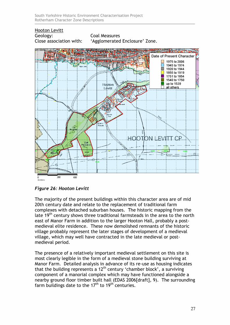
Hooton Levitt Geology: Coal Measures Close association with: ‘Agglomerated Enclosure’ Zone.
Figure 26: Hooton Levitt The majority of the present buildings within this character area are of mid 20th century date and relate to the replacement of traditional farm complexes with detached suburban houses. The historic mapping from the late 19th century shows three traditional farmsteads in the area to the north east of Manor Farm in addition to the larger Hooton Hall, probably a post-medieval elite residence. These now demolished remnants of the historic village probably represent the later stages of development of a medieval village, which may well have contracted in the late medieval or post-medieval period. The presence of a relatively important medieval settlement on this site is most clearly legible in the form of a medieval stone building surviving at Manor Farm. Detailed analysis in advance of its re-use as housing indicates that the building represents a 12th century ‘chamber block’, a surviving component of a manorial complex which may have functioned alongside a nearby ground floor timber built hall (EDAS 2006[draft], 9). The surrounding farm buildings date to the 17th to 19th centuries.
South Yorkshire Historic Environment Characterisation Project Rotherham Character Zone Descriptions
28
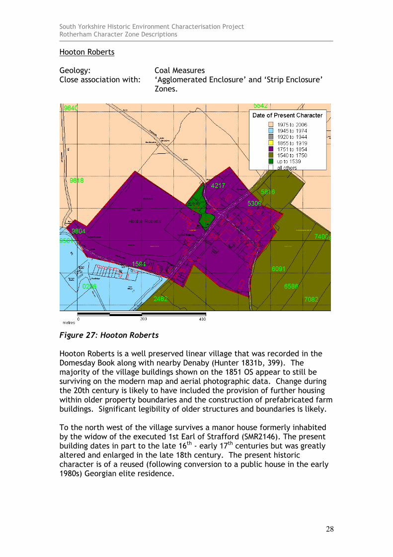
Hooton Roberts Geology: Coal Measures Close association with: ‘Agglomerated Enclosure’ and ‘Strip Enclosure’
Zones.
Figure 27: Hooton Roberts Hooton Roberts is a well preserved linear village that was recorded in the Domesday Book along with nearby Denaby (Hunter 1831b, 399). The majority of the village buildings shown on the 1851 OS appear to still be surviving on the modern map and aerial photographic data. Change during the 20th century is likely to have included the provision of further housing within older property boundaries and the construction of prefabricated farm buildings. Significant legibility of older structures and boundaries is likely. To the north west of the village survives a manor house formerly inhabited by the widow of the executed 1st Earl of Strafford (SMR2146). The present building dates in part to the late 16th - early 17th centuries but was greatly altered and enlarged in the late 18th century. The present historic character is of a reused (following conversion to a public house in the early 1980s) Georgian elite residence.
South Yorkshire Historic Environment Characterisation Project Rotherham Character Zone Descriptions
29
The English Heritage listing record for the medieval church in this settlement records a 12th century core with rebuilding instances in 15th and 19th centuries.
South Yorkshire Historic Environment Characterisation Project Rotherham Character Zone Descriptions
30
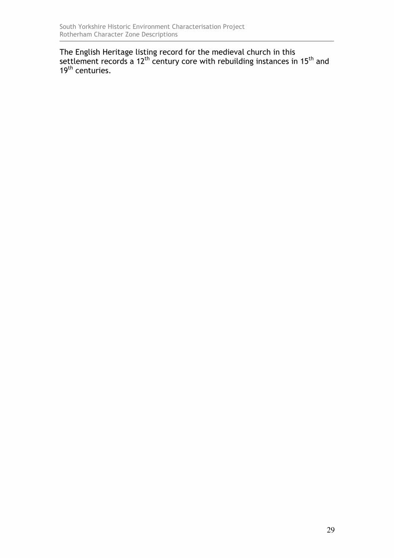
Kimberworth Geology: Coal Measures Close association with: ‘Industrial Settlement’ Zone.
Figure 28: Kimberworth Kimberworth is likely to have been a focus for settlement since the Saxon period. The settlement is detailed in Domesday and situated on the course of the pre-conquest ‘Roman Ridge’ earthwork. Comparison with the present form of this area and the settlement shown on pre 20th century mapping, shows that the majority of its historic buildings have been redeveloped, although the forms of Church Street and High Street are probably medieval in origin. There are remains of the medieval manor house, in addition to a mid 19th century parish church and a probable 18th to 19th century farm complex at Old Hall Farm.
South Yorkshire Historic Environment Characterisation Project Rotherham Character Zone Descriptions
31
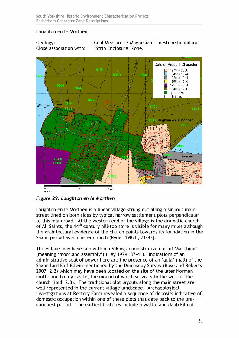
Laughton en le Morthen Geology: Coal Measures / Magnesian Limestone boundary Close association with: ‘Strip Enclosure’ Zone.
Figure 29: Laughton en le Morthen Laughton en le Morthen is a linear village strung out along a sinuous main street lined on both sides by typical narrow settlement plots perpendicular to this main road. At the western end of the village is the dramatic church of All Saints, the 14th century hill-top spire is visible for many miles although the architectural evidence of the church points towards its foundation in the Saxon period as a minster church (Ryder 1982b, 71-83). The village may have lain within a Viking administrative unit of ‘Morthing’ (meaning ‘moorland assembly’) (Hey 1979, 37-41). Indications of an administrative seat of power here are the presence of an ‘aula’ (hall) of the Saxon lord Earl Edwin mentioned by the Domesday Survey (Rose and Roberts 2007, 2.2) which may have been located on the site of the later Norman motte and bailey castle, the mound of which survives to the west of the church (ibid, 2.3). The traditional plot layouts along the main street are well represented in the current village landscape. Archaeological investigations at Rectory Farm revealed a sequence of deposits indicative of domestic occupation within one of these plots that date back to the pre-conquest period. The earliest features include a wattle and daub kiln of

South Yorkshire Historic Environment Characterisation Project Rotherham Character Zone Descriptions
32
Saxon date (ibid). Other plots contain a mixture of vernacular buildings some of which have medieval timber framed cores and many of which are faced in local Magnesian limestone (SMR and Listed building records). The village also contains “[t]he oldest surviving school in the county….[a] delightful building opposite the north side of the church at Laughton, which was erected sometime between 1610 and 1619 on land given by Anthony Eyre and Edmund Laughton” (Hey 1979, 142). 20th Century development in this area has largely respected the boundaries of earlier properties.
Figure 30: Saxon north doorway surround at All Saints Church, Laughton en le Morthen
Photo by Dan Ratcliffe © SYAS
South Yorkshire Historic Environment Characterisation Project Rotherham Character Zone Descriptions
33
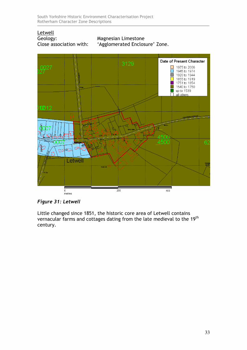
Letwell Geology: Magnesian Limestone Close association with: ‘Agglomerated Enclosure’ Zone.
Figure 31: Letwell Little changed since 1851, the historic core area of Letwell contains vernacular farms and cottages dating from the late medieval to the 19th century.

South Yorkshire Historic Environment Characterisation Project Rotherham Character Zone Descriptions
34
Maltby Geology: Magnesian Limestone Close association with: ‘Planned Industrial Settlements’ Zone.
Figure 32: Maltby This character area is the extent of the historic settlement of Maltby, prior to its expansion due to the sinking of Maltby Main Colliery in the early 20th century. The village is at least Saxon in origin, with a record in the Domesday Book (Smith 1961: Pt1, 137) and a church with strong indications of Late Saxon or Early Norman work in its tower (Ryder 1982, 84). The pre 20th century village of Maltby was associated with an extensive open field system, the last remnants of which are shown as still unenclosed to the north and east of the village on Sanderson's map of 1835. There has been significant mid 20th century rebuilding within this area, following its absorption into the mining village that surrounds it.
South Yorkshire Historic Environment Characterisation Project Rotherham Character Zone Descriptions
35
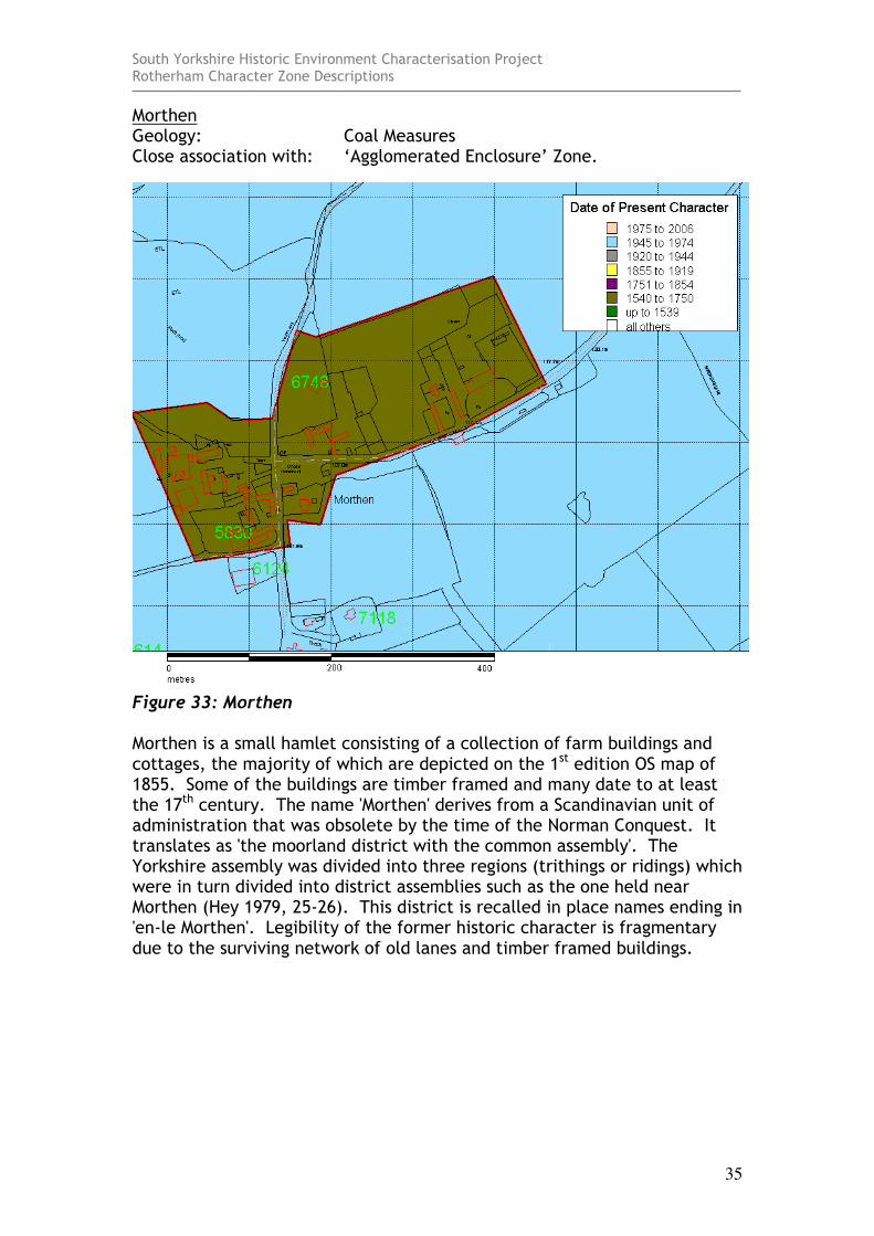
Morthen Geology: Coal Measures Close association with: ‘Agglomerated Enclosure’ Zone.
Figure 33: Morthen Morthen is a small hamlet consisting of a collection of farm buildings and cottages, the majority of which are depicted on the 1st edition OS map of 1855. Some of the buildings are timber framed and many date to at least the 17th century. The name 'Morthen' derives from a Scandinavian unit of administration that was obsolete by the time of the Norman Conquest. It translates as 'the moorland district with the common assembly'. The Yorkshire assembly was divided into three regions (trithings or ridings) which were in turn divided into district assemblies such as the one held near Morthen (Hey 1979, 25-26). This district is recalled in place names ending in 'en-le Morthen'. Legibility of the former historic character is fragmentary due to the surviving network of old lanes and timber framed buildings.
South Yorkshire Historic Environment Characterisation Project Rotherham Character Zone Descriptions
36
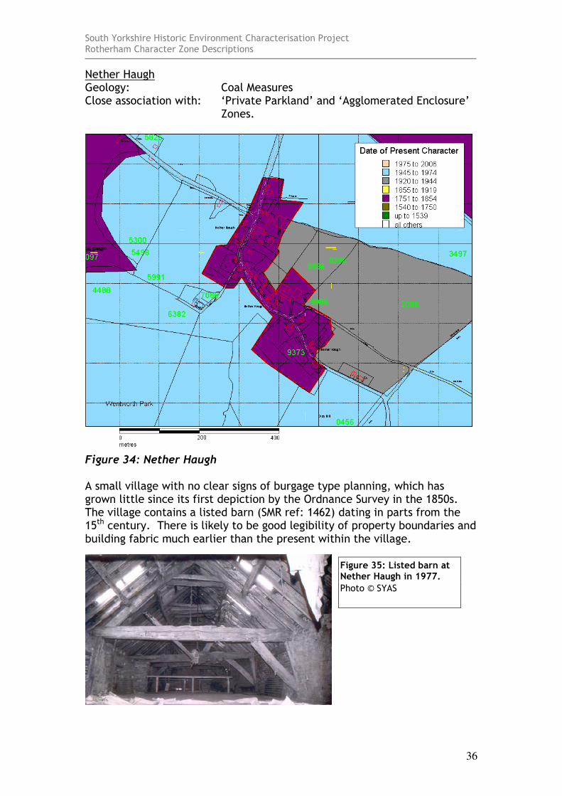
Nether Haugh Geology: Coal Measures Close association with: ‘Private Parkland’ and ‘Agglomerated Enclosure’
Zones.
Figure 34: Nether Haugh A small village with no clear signs of burgage type planning, which has grown little since its first depiction by the Ordnance Survey in the 1850s. The village contains a listed barn (SMR ref: 1462) dating in parts from the 15th century. There is likely to be good legibility of property boundaries and building fabric much earlier than the present within the village.
Figure 35: Listed barn at Nether Haugh in 1977.
Photo © SYAS
South Yorkshire Historic Environment Characterisation Project Rotherham Character Zone Descriptions
37
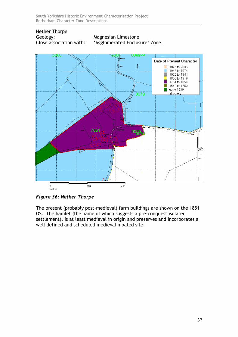
Nether Thorpe Geology: Magnesian Limestone Close association with: ‘Agglomerated Enclosure’ Zone.
Figure 36: Nether Thorpe The present (probably post-medieval) farm buildings are shown on the 1851 OS. The hamlet (the name of which suggests a pre-conquest isolated settlement), is at least medieval in origin and preserves and incorporates a well defined and scheduled medieval moated site.
South Yorkshire Historic Environment Characterisation Project Rotherham Character Zone Descriptions
38
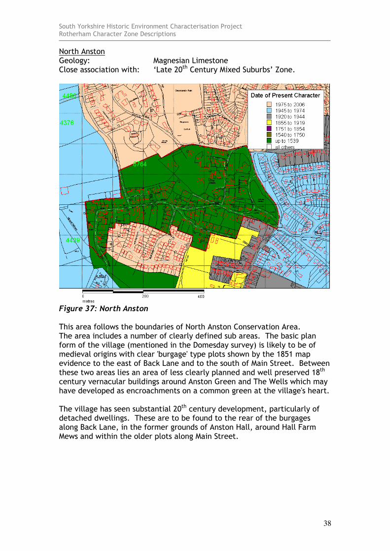
North Anston Geology: Magnesian Limestone Close association with: ‘Late 20th Century Mixed Suburbs’ Zone.
Figure 37: North Anston This area follows the boundaries of North Anston Conservation Area. The area includes a number of clearly defined sub areas. The basic plan form of the village (mentioned in the Domesday survey) is likely to be of medieval origins with clear 'burgage' type plots shown by the 1851 map evidence to the east of Back Lane and to the south of Main Street. Between these two areas lies an area of less clearly planned and well preserved 18th century vernacular buildings around Anston Green and The Wells which may have developed as encroachments on a common green at the village's heart. The village has seen substantial 20th century development, particularly of detached dwellings. These are to be found to the rear of the burgages along Back Lane, in the former grounds of Anston Hall, around Hall Farm Mews and within the older plots along Main Street.
South Yorkshire Historic Environment Characterisation Project Rotherham Character Zone Descriptions
39
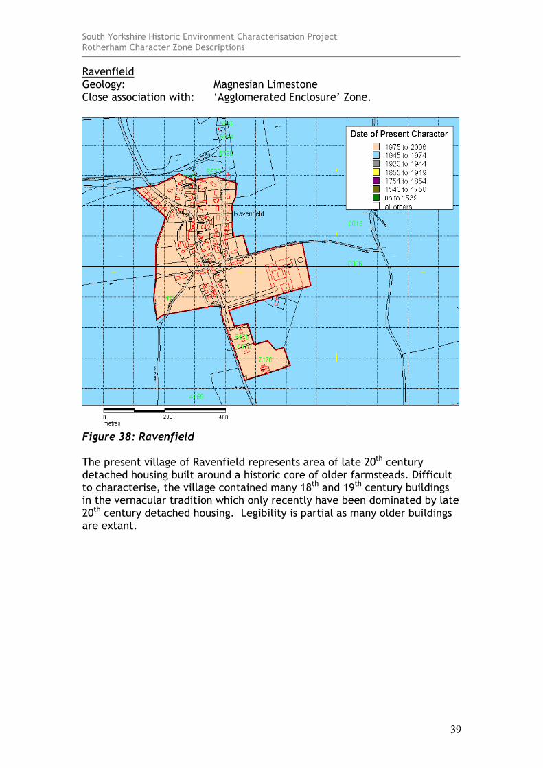
Ravenfield Geology: Magnesian Limestone Close association with: ‘Agglomerated Enclosure’ Zone.
Figure 38: Ravenfield The present village of Ravenfield represents area of late 20th century detached housing built around a historic core of older farmsteads. Difficult to characterise, the village contained many 18th and 19th century buildings in the vernacular tradition which only recently have been dominated by late 20th century detached housing. Legibility is partial as many older buildings are extant.
South Yorkshire Historic Environment Characterisation Project Rotherham Character Zone Descriptions
40
Rawmarsh Geology: Coal Measures Close association with: ‘Municipal Suburbs’ and ‘Planned Industrial
Settlements’
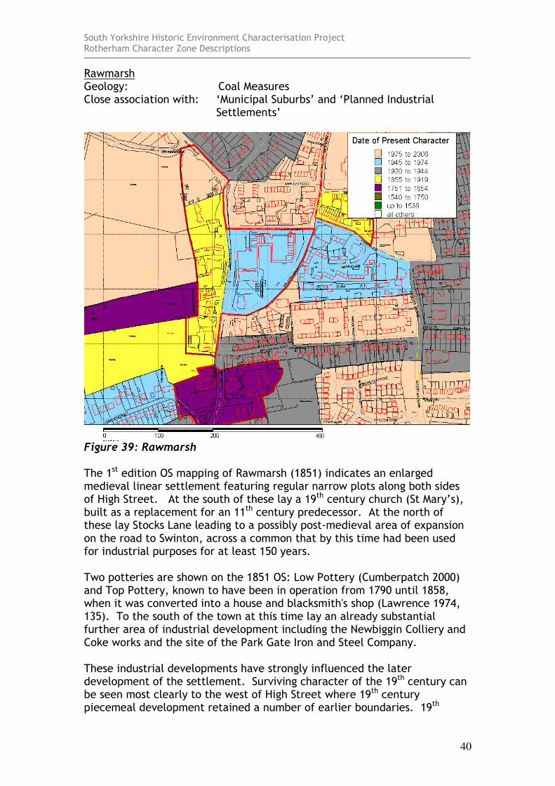
Figure 39: Rawmarsh The 1st edition OS mapping of Rawmarsh (1851) indicates an enlarged medieval linear settlement featuring regular narrow plots along both sides of High Street. At the south of these lay a 19th century church (St Mary’s), built as a replacement for an 11th century predecessor. At the north of these lay Stocks Lane leading to a possibly post-medieval area of expansion on the road to Swinton, across a common that by this time had been used for industrial purposes for at least 150 years. Two potteries are shown on the 1851 OS: Low Pottery (Cumberpatch 2000) and Top Pottery, known to have been in operation from 1790 until 1858, when it was converted into a house and blacksmith's shop (Lawrence 1974, 135). To the south of the town at this time lay an already substantial further area of industrial development including the Newbiggin Colliery and Coke works and the site of the Park Gate Iron and Steel Company. These industrial developments have strongly influenced the later development of the settlement. Surviving character of the 19th century can be seen most clearly to the west of High Street where 19th century piecemeal development retained a number of earlier boundaries. 19th

South Yorkshire Historic Environment Characterisation Project Rotherham Character Zone Descriptions
41
century redevelopment also reduced the legibility of medieval character to the east of High Street, although this has been compounded by further mid 20th century redevelopment.

South Yorkshire Historic Environment Characterisation Project Rotherham Character Zone Descriptions
42
Scholes Geology: Coal Measures Close association with: ‘Agglomerated Enclosure’ zone
Figure 40: Scholes There seems to be little evidence in the surrounding landscape that this village was ever a nucleated settlement of the type that once formed the foci of a medieval open field system. The oldest building of the settlement is a 15th century barn (SMR 1497) which may have originated as a farmstead placed within this landscape at the time the surrounding fields were first enclosed. The settlement today includes two small farmsteads and late 19th century housing, which may well reflect investment by the nearby Wentworth Estate.
South Yorkshire Historic Environment Characterisation Project Rotherham Character Zone Descriptions
43
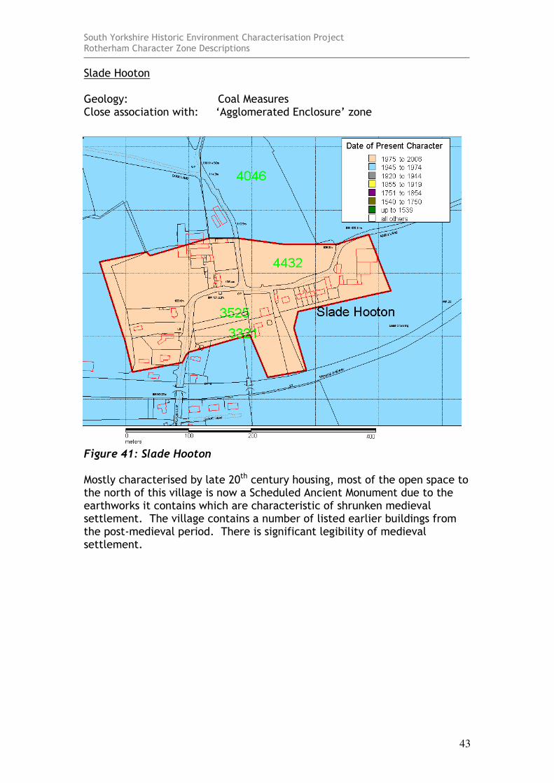
Slade Hooton Geology: Coal Measures Close association with: ‘Agglomerated Enclosure’ zone
Figure 41: Slade Hooton Mostly characterised by late 20th century housing, most of the open space to the north of this village is now a Scheduled Ancient Monument due to the earthworks it contains which are characteristic of shrunken medieval settlement. The village contains a number of listed earlier buildings from the post-medieval period. There is significant legibility of medieval settlement.
South Yorkshire Historic Environment Characterisation Project Rotherham Character Zone Descriptions
44
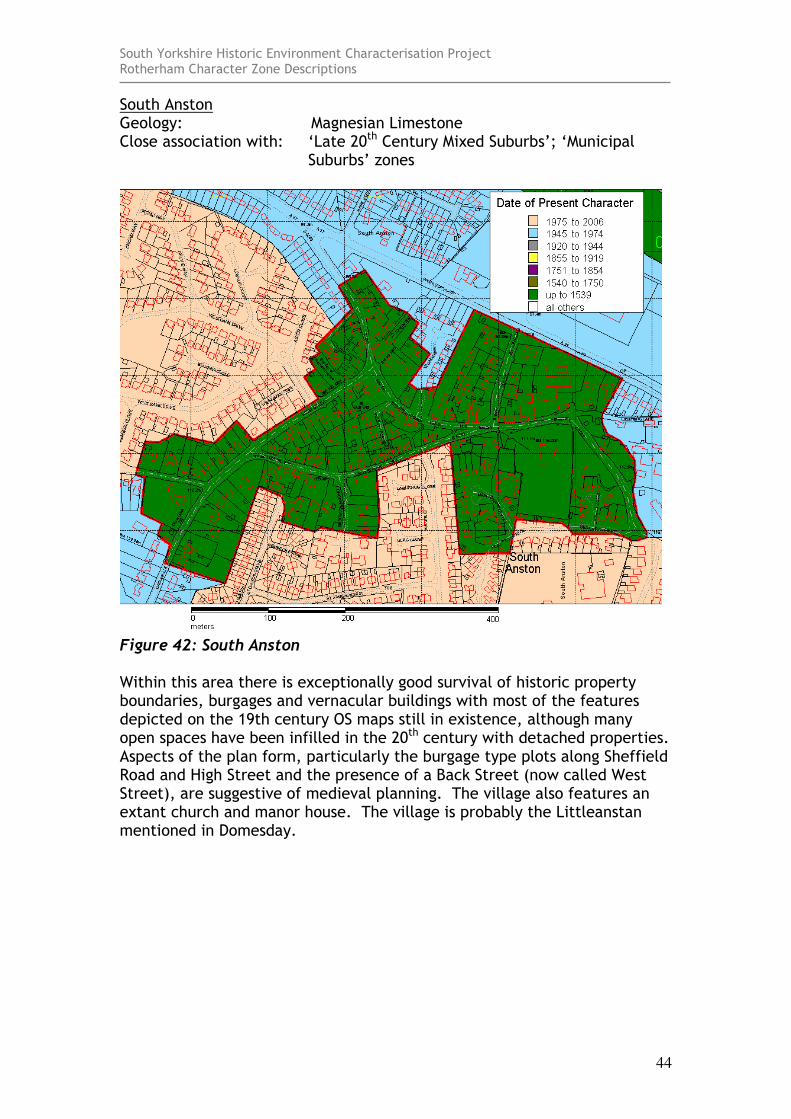
South Anston Geology: Magnesian Limestone Close association with: ‘Late 20th Century Mixed Suburbs’; ‘Municipal
Suburbs’ zones
Figure 42: South Anston Within this area there is exceptionally good survival of historic property boundaries, burgages and vernacular buildings with most of the features depicted on the 19th century OS maps still in existence, although many open spaces have been infilled in the 20th century with detached properties. Aspects of the plan form, particularly the burgage type plots along Sheffield Road and High Street and the presence of a Back Street (now called West Street), are suggestive of medieval planning. The village also features an extant church and manor house. The village is probably the Littleanstan mentioned in Domesday.
South Yorkshire Historic Environment Characterisation Project Rotherham Character Zone Descriptions
45
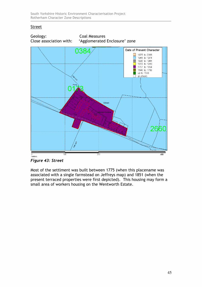
Street Geology: Coal Measures Close association with: ‘Agglomerated Enclosure’ zone
Figure 43: Street Most of the settlment was built between 1775 (when this placename was associated with a single farmstead on Jeffreys map) and 1851 (when the present terraced properties were first depicted). This housing may form a small area of workers housing on the Wentworth Estate.
South Yorkshire Historic Environment Characterisation Project Rotherham Character Zone Descriptions
46
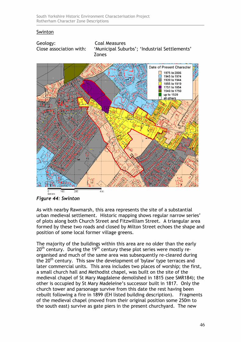
Swinton Geology: Coal Measures Close association with: ‘Municipal Suburbs’; ‘Industrial Settlements’
Zones
Figure 44: Swinton As with nearby Rawmarsh, this area represents the site of a substantial urban medieval settlement. Historic mapping shows regular narrow series’ of plots along both Church Street and Fitzwilliam Street. A triangular area formed by these two roads and closed by Milton Street echoes the shape and position of some local former village greens. The majority of the buildings within this area are no older than the early 20th century. During the 19th century these plot series were mostly re-organised and much of the same area was subsequently re-cleared during the 20th century. This saw the development of 'bylaw' type terraces and later commercial units. This area includes two places of worship; the first, a small church hall and Methodist chapel, was built on the site of the medieval chapel of St Mary Magdalene demolished in 1815 (see SMR184); the other is occupied by St Mary Madeleine’s successor built in 1817. Only the church tower and parsonage survive from this date the rest having been rebuilt following a fire in 1899 (EH listed building description). Fragments of the medieval chapel (moved from their original position some 250m to the south east) survive as gate piers in the present churchyard. The new

South Yorkshire Historic Environment Characterisation Project Rotherham Character Zone Descriptions
47
church’s site was previously within an area of strip enclosure of probable former open field.

South Yorkshire Historic Environment Characterisation Project Rotherham Character Zone Descriptions
48
Thorpe Hesley Geology: Coal Measures Close association with: ‘Late 20th Century Private Suburbs’.
Figure 45: Thorpe Hesley This area represents the historic core of Thorpe Hesley and equates roughly to the conservation area. It covers approximately the area shown as developed on the 1st edition OS map of 1854. The village is recorded in Domesday and has grown in size in recent years but the core retains a number of farms and some older timber framed buildings.
South Yorkshire Historic Environment Characterisation Project Rotherham Character Zone Descriptions
49
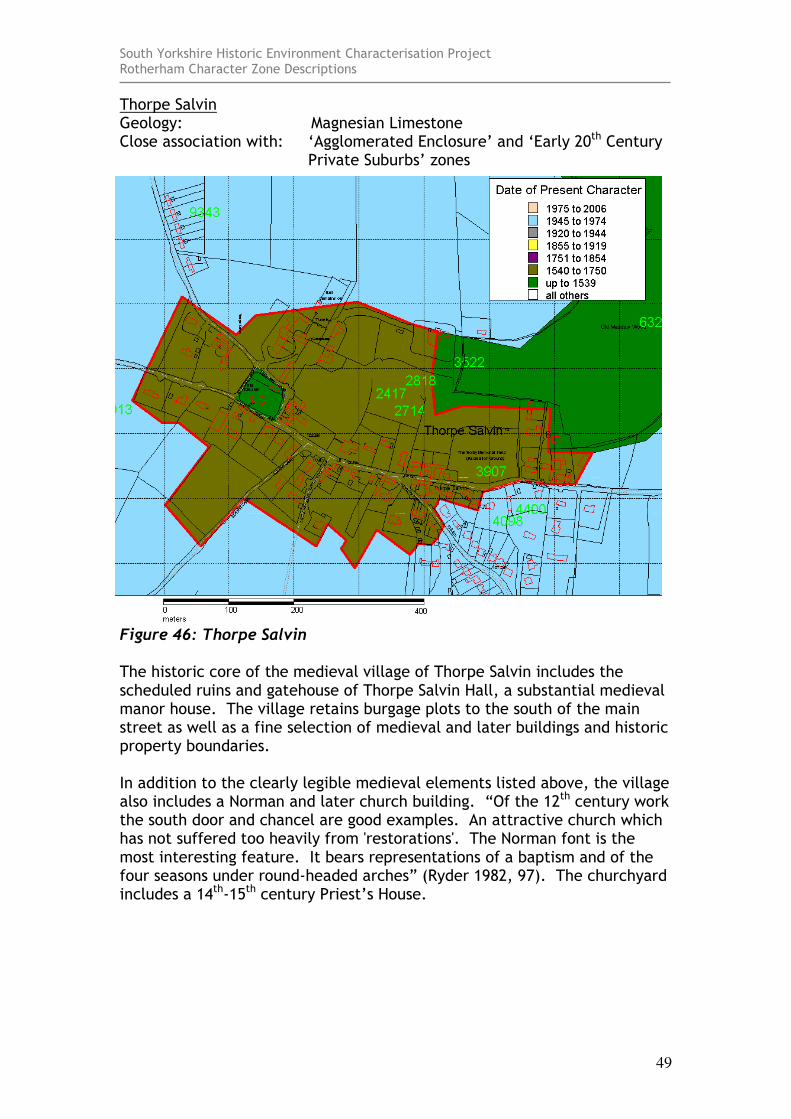
Thorpe Salvin Geology: Magnesian Limestone Close association with: ‘Agglomerated Enclosure’ and ‘Early 20th Century
Private Suburbs’ zones
Figure 46: Thorpe Salvin The historic core of the medieval village of Thorpe Salvin includes the scheduled ruins and gatehouse of Thorpe Salvin Hall, a substantial medieval manor house. The village retains burgage plots to the south of the main street as well as a fine selection of medieval and later buildings and historic property boundaries. In addition to the clearly legible medieval elements listed above, the village also includes a Norman and later church building. “Of the 12th century work the south door and chancel are good examples. An attractive church which has not suffered too heavily from 'restorations'. The Norman font is the most interesting feature. It bears representations of a baptism and of the four seasons under round-headed arches” (Ryder 1982, 97). The churchyard includes a 14th-15th century Priest’s House.
South Yorkshire Historic Environment Characterisation Project Rotherham Character Zone Descriptions
50
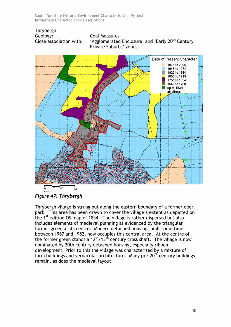
Thrybergh Geology: Coal Measures Close association with: ‘Agglomerated Enclosure’ and ‘Early 20th Century
Private Suburbs’ zones
Figure 47: Thrybergh Thrybergh village is strung out along the eastern boundary of a former deer park. This area has been drawn to cover the village’s extent as depicted on the 1st edition OS map of 1854. The village is rather dispersed but also includes elements of medieval planning as evidenced by the triangular former green at its centre. Modern detached housing, built some time between 1967 and 1982, now occupies this central area. At the centre of the former green stands a 12th/13th century cross shaft. The village is now dominated by 20th century detached housing, especially ribbon development. Prior to this the village was characterised by a mixture of farm buildings and vernacular architecture. Many pre-20th century buildings remain, as does the medieval layout.
South Yorkshire Historic Environment Characterisation Project Rotherham Character Zone Descriptions
51
Todwick Geology: Coal Measures Close association with: ‘Agglomerated Enclosure’ and ‘Late 20th Century
Private Suburbs’ Zone.
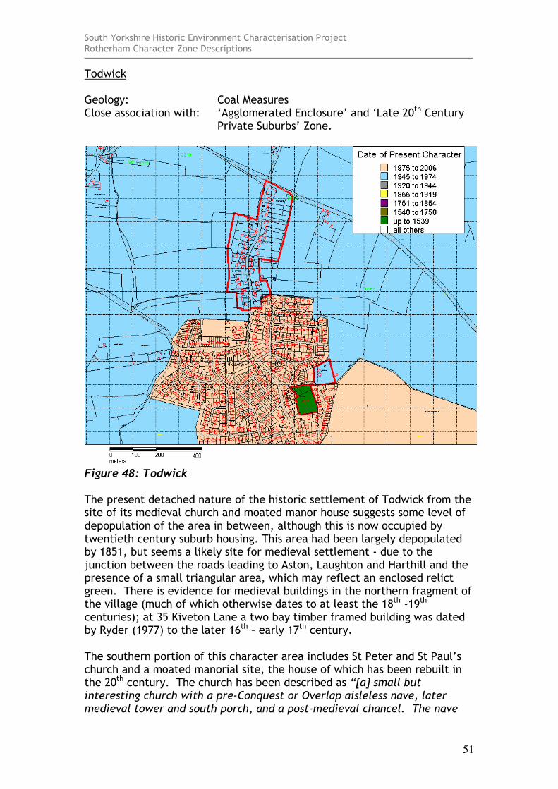
Figure 48: Todwick The present detached nature of the historic settlement of Todwick from the site of its medieval church and moated manor house suggests some level of depopulation of the area in between, although this is now occupied by twentieth century suburb housing. This area had been largely depopulated by 1851, but seems a likely site for medieval settlement - due to the junction between the roads leading to Aston, Laughton and Harthill and the presence of a small triangular area, which may reflect an enclosed relict green. There is evidence for medieval buildings in the northern fragment of the village (much of which otherwise dates to at least the 18th -19th centuries); at 35 Kiveton Lane a two bay timber framed building was dated by Ryder (1977) to the later 16th – early 17th century. The southern portion of this character area includes St Peter and St Paul’s church and a moated manorial site, the house of which has been rebuilt in the 20th century. The church has been described as “[a] small but interesting church with a pre-Conquest or Overlap aisleless nave, later medieval tower and south porch, and a post-medieval chancel. The nave
South Yorkshire Historic Environment Characterisation Project Rotherham Character Zone Descriptions
52
has walls of coursed red sand-stone (the same material the Saxon builders used at nearby Laughton). All the angle quoins have been rebuilt with the exception of the lower part of the south eastern wall, which shows some good side-alternate work. The blocked north door, although partly reconstructed at some later date, shows some Overlap features which are stylistically pre-Conquest. The semicircular chancel arch might either be Overlap or Norman, but has been subject to much alteration” (Ryder 1982, 99).
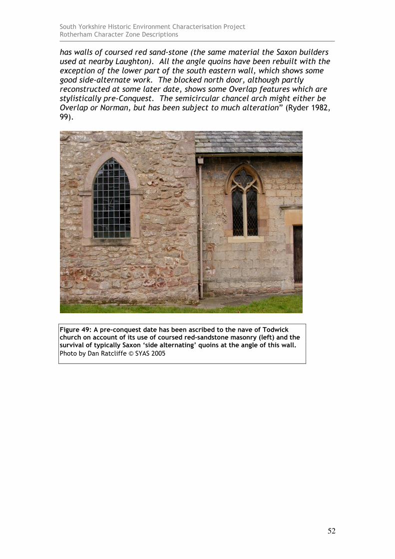
Figure 49: A pre-conquest date has been ascribed to the nave of Todwick church on account of its use of coursed red-sandstone masonry (left) and the survival of typically Saxon ‘side alternating’ quoins at the angle of this wall.
Photo by Dan Ratcliffe © SYAS 2005
South Yorkshire Historic Environment Characterisation Project Rotherham Character Zone Descriptions
53
Treeton Geology: Coal Measures Close association with: ‘Municipal Suburbs’ and ‘Private Suburbs’ Zones.
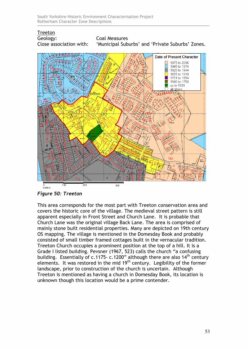
Figure 50: Treeton This area corresponds for the most part with Treeton conservation area and covers the historic core of the village. The medieval street pattern is still apparent especially in Front Street and Church Lane. It is probable that Church Lane was the original village Back Lane. The area is comprised of mainly stone built residential properties. Many are depicted on 19th century OS mapping. The village is mentioned in the Domesday Book and probably consisted of small timber framed cottages built in the vernacular tradition. Treeton Church occupies a prominent position at the top of a hill. It is a Grade I listed building. Pevsner (1967, 523) calls the church “a confusing building. Essentially of c.1175- c.1200” although there are also 14th century elements. It was restored in the mid 19th century. Legibility of the former landscape, prior to construction of the church is uncertain. Although Treeton is mentioned as having a church in Domesday Book, its location is unknown though this location would be a prime contender.

South Yorkshire Historic Environment Characterisation Project Rotherham Character Zone Descriptions
54
Ulley Geology: Coal Measures Close association with: ‘Surveyed Enclosure’ and ‘Agglomerated
Enclosure’ Zones.
Figure 51: Ulley This area covers the village of Ulley and is slightly larger than the extent depicted on the 1st edition OS map of 1855. The village has many larger private residences which appear to have been built in the latter half of the 20th century. These are intermingled with older farm complexes and Ulley Hall which dates to the early 18th century. The church is of mid-19th century date. Excavations have revealed the course of a Roman road running north-south through Church Lane and Roman coins have been found in back gardens. Many older buildings co-exist with the newer houses on the probably medieval street plan.
South Yorkshire Historic Environment Characterisation Project Rotherham Character Zone Descriptions
55
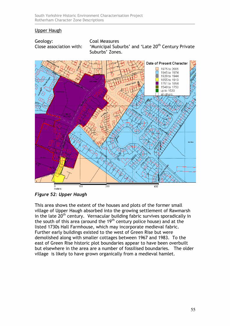
Upper Haugh Geology: Coal Measures Close association with: ‘Municipal Suburbs’ and ‘Late 20th Century Private
Suburbs’ Zones.
Figure 52: Upper Haugh This area shows the extent of the houses and plots of the former small village of Upper Haugh absorbed into the growing settlement of Rawmarsh in the late 20th century. Vernacular building fabric survives sporadically in the south of this area (around the 19th century police house) and at the listed 1730s Hall Farmhouse, which may incorporate medieval fabric. Further early buildings existed to the west of Green Rise but were demolished along with smaller cottages between 1967 and 1983. To the east of Green Rise historic plot boundaries appear to have been overbuilt but elsewhere in the area are a number of fossilised boundaries. The older village is likely to have grown organically from a medieval hamlet.
South Yorkshire Historic Environment Characterisation Project Rotherham Character Zone Descriptions
56
Upper Whiston Geology: Coal Measures Close association with: ‘Municipal Suburbs’ and ‘Late 20th Century Private
Suburbs’ Zones.
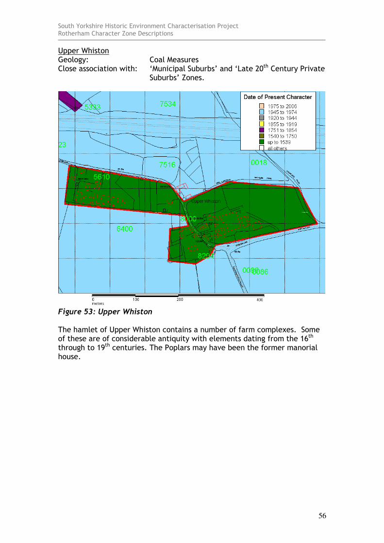
Figure 53: Upper Whiston The hamlet of Upper Whiston contains a number of farm complexes. Some of these are of considerable antiquity with elements dating from the 16th through to 19th centuries. The Poplars may have been the former manorial house.
South Yorkshire Historic Environment Characterisation Project Rotherham Character Zone Descriptions
57
Wales Geology: Coal Measures Close association with: ‘Strip Enclosure’ and ‘Municipal Suburbs’ Zones.
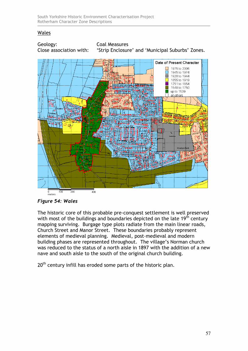
Figure 54: Wales The historic core of this probable pre-conquest settlement is well preserved with most of the buildings and boundaries depicted on the late 19th century mapping surviving. Burgage type plots radiate from the main linear roads, Church Street and Manor Street. These boundaries probably represent elements of medieval planning. Medieval, post-medieval and modern building phases are represented throughout. The village’s Norman church was reduced to the status of a north aisle in 1897 with the addition of a new nave and south aisle to the south of the original church building. 20th century infill has eroded some parts of the historic plan.
South Yorkshire Historic Environment Characterisation Project Rotherham Character Zone Descriptions
58
Wath upon Dearne Geology: Coal Measures Close association with: ‘Municipal Suburbs’, ‘Post Industrial’ and
‘Industrial Settlements’ Zones.
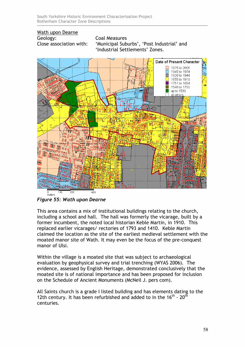
Figure 55: Wath upon Dearne This area contains a mix of institutional buildings relating to the church, including a school and hall. The hall was formerly the vicarage, built by a former incumbent, the noted local historian Keble Martin, in 1910. This replaced earlier vicarages/ rectories of 1793 and 1410. Keble Martin claimed the location as the site of the earliest medieval settlement with the moated manor site of Wath. It may even be the focus of the pre-conquest manor of Ulsi. Within the village is a moated site that was subject to archaeological evaluation by geophysical survey and trial trenching (WYAS 2006). The evidence, assessed by English Heritage, demonstrated conclusively that the moated site is of national importance and has been proposed for inclusion on the Schedule of Ancient Monuments (McNeil J. pers com). All Saints church is a grade I listed building and has elements dating to the 12th century. It has been refurbished and added to in the 16th - 20th centuries.
South Yorkshire Historic Environment Characterisation Project Rotherham Character Zone Descriptions
59
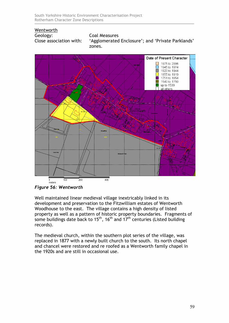
Wentworth Geology: Coal Measures Close association with: ‘Agglomerated Enclosure’; and ‘Private Parklands’
zones.
Figure 56: Wentworth Well maintained linear medieval village inextricably linked in its development and preservation to the Fitzwilliam estates of Wentworth Woodhouse to the east. The village contains a high density of listed property as well as a pattern of historic property boundaries. Fragments of some buildings date back to 15th, 16th and 17th centuries (Listed building records). The medieval church, within the southern plot series of the village, was replaced in 1877 with a newly built church to the south. Its north chapel and chancel were restored and re roofed as a Wentworth family chapel in the 1920s and are still in occasional use.
South Yorkshire Historic Environment Characterisation Project Rotherham Character Zone Descriptions
60
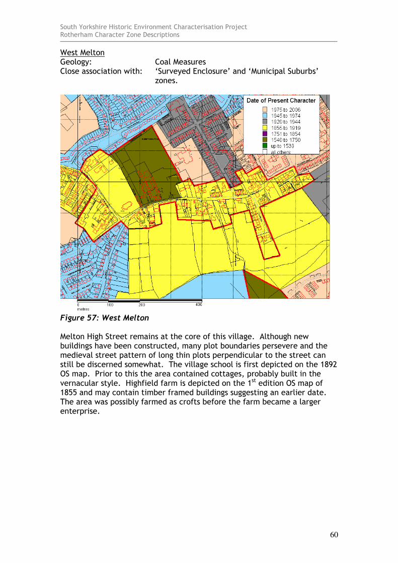
West Melton Geology: Coal Measures Close association with: ‘Surveyed Enclosure’ and ‘Municipal Suburbs’
zones.
Figure 57: West Melton Melton High Street remains at the core of this village. Although new buildings have been constructed, many plot boundaries persevere and the medieval street pattern of long thin plots perpendicular to the street can still be discerned somewhat. The village school is first depicted on the 1892 OS map. Prior to this the area contained cottages, probably built in the vernacular style. Highfield farm is depicted on the 1st edition OS map of 1855 and may contain timber framed buildings suggesting an earlier date. The area was possibly farmed as crofts before the farm became a larger enterprise.
South Yorkshire Historic Environment Characterisation Project Rotherham Character Zone Descriptions
61
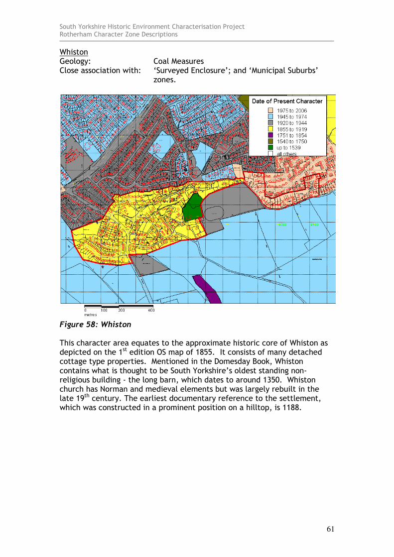
Whiston Geology: Coal Measures Close association with: ‘Surveyed Enclosure’; and ‘Municipal Suburbs’
zones.
Figure 58: Whiston This character area equates to the approximate historic core of Whiston as depicted on the 1st edition OS map of 1855. It consists of many detached cottage type properties. Mentioned in the Domesday Book, Whiston contains what is thought to be South Yorkshire’s oldest standing non-religious building - the long barn, which dates to around 1350. Whiston church has Norman and medieval elements but was largely rebuilt in the late 19th century. The earliest documentary reference to the settlement, which was constructed in a prominent position on a hilltop, is 1188.
South Yorkshire Historic Environment Characterisation Project Rotherham Character Zone Descriptions
62
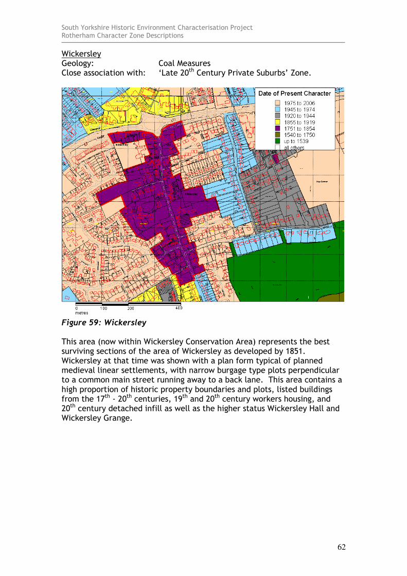
Wickersley Geology: Coal Measures Close association with: ‘Late 20th Century Private Suburbs’ Zone.
Figure 59: Wickersley This area (now within Wickersley Conservation Area) represents the best surviving sections of the area of Wickersley as developed by 1851. Wickersley at that time was shown with a plan form typical of planned medieval linear settlements, with narrow burgage type plots perpendicular to a common main street running away to a back lane. This area contains a high proportion of historic property boundaries and plots, listed buildings from the 17th - 20th centuries, 19th and 20th century workers housing, and 20th century detached infill as well as the higher status Wickersley Hall and Wickersley Grange.
South Yorkshire Historic Environment Characterisation Project Rotherham Character Zone Descriptions
63
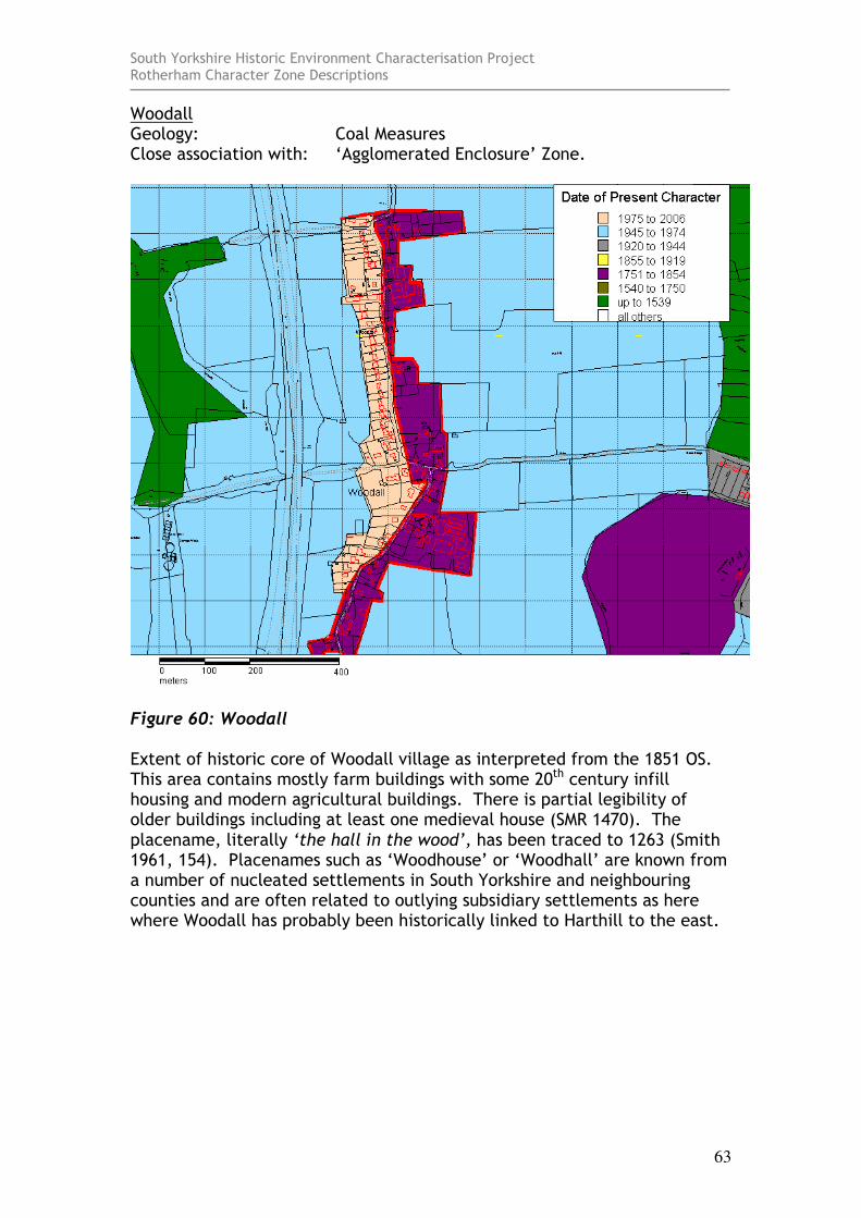
Woodall Geology: Coal Measures Close association with: ‘Agglomerated Enclosure’ Zone.
Figure 60: Woodall Extent of historic core of Woodall village as interpreted from the 1851 OS. This area contains mostly farm buildings with some 20th century infill housing and modern agricultural buildings. There is partial legibility of older buildings including at least one medieval house (SMR 1470). The placename, literally ‘the hall in the wood’, has been traced to 1263 (Smith 1961, 154). Placenames such as ‘Woodhouse’ or ‘Woodhall’ are known from a number of nucleated settlements in South Yorkshire and neighbouring counties and are often related to outlying subsidiary settlements as here where Woodall has probably been historically linked to Harthill to the east.
South Yorkshire Historic Environment Characterisation Project Rotherham Character Zone Descriptions
64
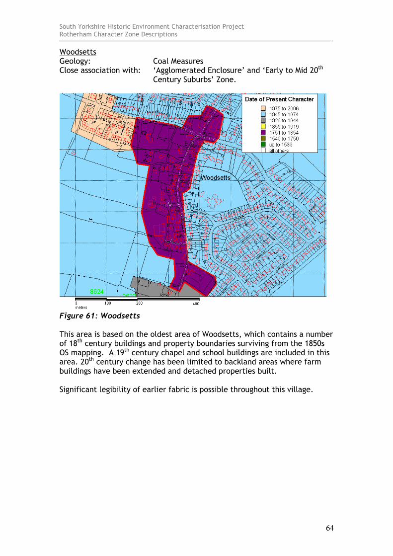
Woodsetts Geology: Coal Measures Close association with: ‘Agglomerated Enclosure’ and ‘Early to Mid 20th
Century Suburbs’ Zone.
Figure 61: Woodsetts This area is based on the oldest area of Woodsetts, which contains a number of 18th century buildings and property boundaries surviving from the 1850s OS mapping. A 19th century chapel and school buildings are included in this area. 20th century change has been limited to backland areas where farm buildings have been extended and detached properties built. Significant legibility of earlier fabric is possible throughout this village.
South Yorkshire Historic Environment Characterisation Project Rotherham Character Zone Descriptions
65
Bibliography EDAS 2006(draft) Manor Farm, Hooton Levitt Draft Report
[unpublished]. Ed Dennison Archaeological Services Ltd.
Cumberpatch, C. 2000 A Desktop Assessment of the Archaeological
Potential of Land off Bellows Road, Rawmarsh [unpublished]. Sheffield: C. Cumberpatch freelance archaeologist.
English, B. 1985 Yorkshire Enclosure Awards. Hull: University
of Hull.
English Heritage 2005 Listed Building System Data [unpublished MIDAS dataset export in xml format]. Swindon: English Heritage National Monuments Record. Available from: National Monuments Record Centre, Kemble Drive, Swindon.
English Heritage, University of Gloucestershire and the Countryside Agency 2006 Living Buildings in a Living Landscape: finding
a future for historic farm buildings (long version). University of Gloucestershire.
Hey, D. 1979 The Making of South Yorkshire. Ashbourne:
Moorland Publishing Co. Hunter, J. 1831a South Yorkshire (Volume I). Sheffield: Joseph
Hunter. Hunter, J. 1831b South Yorkshire (Volume II). Sheffield: Joseph
Hunter. Jeffreys, T. 1775 A Map of the County of Yorkshire [1973
facsimile of original 1inch:mile] Harry Margary.
Lawrence, H. 1974 Yorkshire Pots and Potteries. Newton Abbott:
David and Charles. Pevsner, N. 1967 Yorkshire: The West Riding [second edition
with Ratcliffe E]. Middlesex: Penguin Books.
South Yorkshire Historic Environment Characterisation Project Rotherham Character Zone Descriptions
66
Rose, M. and Roberts, I. 2007 Rectory Farm, Laughton en le Morthen, South
Yorkshire: Archaeological Excavation [unpublished]. Morley: Archaeological Services WYAS.
Ryder, P.F. 1977 35 Kiveton Lane, Todwick. [unpublished report]
for South Yorkshire County Archaeological Service. Held within SMR file 1514
Ryder, P.F. 1978 Hall Farm (Aughton [unpublished]. For South
Yorkshire County Archaeological Service. Held within SMR file 1572.
Ryder, P.F. 1979a Timber Framed Buildings at Abdy
[unpublished]. For South Yorkshire County Archaeological Service . Held within SMR file 1596.
Ryder, P.F. 1979b Bramley Grange [unpublished]. For South
Yorkshire County Archaeological Service. Held within SMR file 196.
Ryder, P.F. 1982 Timber Framed House (The Croft), 17
Woodsetts Road, Gildingwells. [unpublished]. For South Yorkshire County Archaeological Service. Held within SMR file 1555.
Ryder, P.F. 1982 Saxon Churches in South Yorkshire. Barnsley:
South Yorkshire County Council. Ryder, P.F. 1987 Five South Yorkshire Timber-Framed Houses.
Yorkshire Archaeological Journal, 59. Smith, A.H. 1961 The Place-Names of the West Riding of
Yorkshire: Part I. Cambridge: University Press. SYAS 2008 South Yorkshire Sites and Monument Record
(SMR) [dynamic MS Access – GIS database] Sheffield: South Yorkshire Archaeology Service. Available by appointment with SYAS, Howden House, 1 Union Street, Sheffield, S1 2SH. Email: [email protected] [accessed 07/05/08].
Whitehand, J.W.R. 2001 British Urban Morphology: The Conzenian
Tradition. Urban Morphology 5(2), 103-109.

South Yorkshire Historic Environment Characterisation Project Rotherham Character Zone Descriptions
67