Embed Size (px)
Citation preview

PLEASE SCROLL DOWN FOR ARTICLE
This article was downloaded by: [Retallack, G. J.][University of Oregon]On: 2 June 2009Access details: Access Details: [subscription number 906605100]Publisher Taylor & FrancisInforma Ltd Registered in England and Wales Registered Number: 1072954 Registered office: Mortimer House,37-41 Mortimer Street, London W1T 3JH, UK
Australian Journal of Earth SciencesPublication details, including instructions for authors and subscription information:http://www.informaworld.com/smpp/title~content=t716100753
Cambrian, Ordovician and Silurian pedostratigraphy and global events inAustraliaG. J. Retallack a
a Department of Geological Sciences, University of Oregon, Eugene, OR, USA
Online Publication Date: 01 June 2009
To cite this Article Retallack, G. J.(2009)'Cambrian, Ordovician and Silurian pedostratigraphy and global events in Australia',AustralianJournal of Earth Sciences,56:4,571 — 586
To link to this Article: DOI: 10.1080/08120090902806321
URL: http://dx.doi.org/10.1080/08120090902806321
Full terms and conditions of use: http://www.informaworld.com/terms-and-conditions-of-access.pdf
This article may be used for research, teaching and private study purposes. Any substantial orsystematic reproduction, re-distribution, re-selling, loan or sub-licensing, systematic supply ordistribution in any form to anyone is expressly forbidden.
The publisher does not give any warranty express or implied or make any representation that the contentswill be complete or accurate or up to date. The accuracy of any instructions, formulae and drug dosesshould be independently verified with primary sources. The publisher shall not be liable for any loss,actions, claims, proceedings, demand or costs or damages whatsoever or howsoever caused arising directlyor indirectly in connection with or arising out of the use of this material.

Cambrian, Ordovician and Silurian pedostratigraphyand global events in Australia
G. J. RETALLACK
Department of Geological Sciences, University of Oregon, Eugene, OR 97403, USA([email protected]).
Paleosols are used for stratigraphic correlation of Quaternary sediments because they reflectchronologically synchronous changes of glacial and interglacial paleoclimates. One obviouspaleoclimatic indicator is depth to carbonate nodules as a proxy for mean annual precipitation.Paleosol sequences of the Flinders Ranges (Cambrian, South Australia), Kalbarri (Ordovician, WesternAustralia) and Grampians (Silurian, Victoria) show variation in depth to carbonate through time, butoccasional transient excursions to very deep (450 cm) carbonate. These pedostratigraphic spikescorrespond to times of unusually high precipitation and temperature, but also to internationallyrecognised negative carbon isotope anomalies and mass extinctions, including the Late Ordovicianextinctions. These deep-calcic excursions can be correlated across Australia. Like magnetostratigraphyand chemostratigraphy, pedostratigraphic spikes provide calibration points for sequences less-precisely dated by paleontology or radiometry. Also like magnetostratigraphy and chemostratigraphy,pedostratigraphic correlations are best with numerous excursions spaced at irregular intervals andassuming constant local rate of sedimentation. Pedostratigraphy refines geological dating of Paleozoicand Precambrian redbeds and early terrestrial fossils.
KEY WORDS: Australia, Cambrian, Ordovician, paleoclimate, paleosol, pedostratigraphy, Silurian.
INTRODUCTION
Pedostratigraphy is stratigraphic correlation using
paleosols. Its fundamental soil stratigraphic unit is the
geosol (North American Commission on Stratigraphic
Nomenclature 1982) or pedoderm (Stratigraphic Nomen-
clature Committee 1973). The Sangamon Geosol of the
North American midwest is an unusually well-devel-
oped paleosol compared with glacial paleosols above and
below (Follmer 1978), and represents near-modern
interglacial conditions of ca 126 ka (Gradstein et al.
2004). Naming a buried landscape can be difficult,
because soils vary from hilltop to valley bottom, under
different vegetation, and with other soil-forming factors
(Follmer 1978). A simpler approach to pedostratigraphy
is to focus on recognisable features of laterally extensive
paleosols, such as violet horizons of the German
Triassic, Buntsandstein (Ortlam 1971), or clayey paleo-
sols of the North American Jurassic, Morrison Forma-
tion (Demko et al. 2004). Inflexions in time series of such
data can then be used to correlate sections in a manner
comparable with correlating carbon-isotopic chemostrat-
igraphic spikes (Retallack & Krull 2006), magnetostrat-
igraphic reversals (Morrison & Ellwood 1986; Schmidt &
Hamilton 1990), or geophysical logs (Evans et al. 2007).
Like these other forms of sedimentary correlation,
pedostratigraphic correlation is based on an assumption
of constant sedimentation rates, and this assumption is
only rejected when there is strong deviation from non-
linearity. Also like these other forms of correlation,
pedostratigraphy does not produced numerical age
estimates, but extends the geographic and temporal
reach of pre-existing radiometric and paleontological tie
points. This paper records variation in depth from the
top of a paleosol to its zone of calcareous nodules (Bk
horizon of Soil Survey Staff 2000) in sequences of many
successive paleosols. These simple measurements can
be made quickly in outcrop and core to reveal distinc-
tive patterns suitable for lithological correlation of
sparsely fossiliferous redbeds of Cambrian to Silurian
age in Victoria, South Australia and Western Australia
(Figure 1). Depth to Bk has been shown to be highly
correlated with mean annual precipitation in modern
soils (Retallack 2005a), and this relationship can be used
to estimate paleoprecipitation from paleosols once
corrected for compaction due to burial (Sheldon &
Retallack 2001). Recognition of the top of a paleosol is
not always straightforward, because some paleosols had
cumulic horizons (Soil Survey Staff 2000), in which
additional increments of sediment were at first incorpo-
rated into the soil by surviving plants, until these plants
were overwhelmed by additional sediment. Even if not
preserved as the usual abrupt discontinuity, the tops of
paleosols can be recognised by truncation of rhizocon-
cretions, drab-haloed root traces, soil cracks or
other indications of soil formation (Figures 2–4). Also
Australian Journal of Earth Sciences (2009) 56, (571–586)
ISSN 0812-0099 print/ISSN 1440-0952 online � 2009 Geological Society of Australia
DOI: 10.1080/08120090902806321
Downloaded By: [Retallack, G. J.][University of Oregon] At: 17:11 2 June 2009

problematic for this measure of paleoprecipitation is
erosion of soil prior to burial, which is sometimes
visible as erosional microrelief, as calcareous nodules
from lower in paleosols redeposited in overburden, or
from carbonate benches of unusual thickness and
cementation found today in old (pre-Holocene) and
eroded soils (Retallack 2001). Some degree of erosion
may compromise precise paleoclimatic interpretations,
but this study emphasises exceptionally deep-calcic
paleosols, which would not be recognised if eroded.
Deep-calcic paleosols are rare in most redbed sequences.
A recent compilation of 3718 Permian to Holocene
paleosols from Utah and Montana found only 102 deep-
calcic paleosols at 40 distinct stratigraphic levels
correlative with times of crisis: mass extinctions, high
atmospheric CO2, carbon and oxygen isotopic excur-
sions, and fossil lagerstatten (Retallack 2005b, in press).
In Australia, Paleozoic deep-calcic paleosols correlate
with global environmental crises identified in marine
rocks by Talent et al. (1993), Saltzman (2005) and Zhu
et al. (2006).
MATERIALS AND METHODS
This work involved measuring stratigraphic sections,
usually formation type sections, and also observations
of drillcore. Thickness and size of soil features were
measured using a milliner’s tape. Munsell colour and
reaction with dilute acid were also recorded. Depth to
calcic horizon, as well as thickness of paleosol with
nodules and size of nodules were measured, because all
have paleoenvironmental significance (Retallack 2005a).
Comprehensive petrographic and geochemical study of
Cambrian paleosols from South Australia is presented
elsewhere (Retallack 2008), but was not completed for
Ordovician and Silurian paleosols of Western Australia
and Victoria. For each area studied, previous studies of
geological age are summarised, and known compro-
mising burial alteration considered, before interpreting
new pedostratigraphic data and correlations. The time-
scale used here is Avalonian (Britain and Newfound-
land), because this is a coherent scheme established
over a single geological region, and because Cambrian
Figure 1 Australian onshore surface sedimentary basins, with localities and boreholes of Cambrian to Devonian paleosols
examined in this study.
572 G. J. Retallack
Downloaded By: [Retallack, G. J.][University of Oregon] At: 17:11 2 June 2009

and Ordovician international stages are not formally
agreed (Gradstein et al. 2004).
PALEOSOL RECOGNITION
Paleosols were discovered largely in sedimentary facies
known for a suite of non-marine indicators: redbeds,
loessites, halite hopper-casts, paleokarst, wind-dissected
ripples (setulfs), climbing translatant cross stratifica-
tion, mud cracks, and arthropod trackways (Mawson &
Segnit 1949; Clarke 1990; Moore 1979, 1990; Hocking 1991;
Trewin & McNamara 1994; Cayley & Taylor 1997).
Vascular plant roots are a key feature for recognition
of Silurian and younger paleosols (Retallack 1992; Driese
et al. 1997, 2000), but were seen in few paleosols identified
in this study. Instead, paleosol recognition was based on
soil horizons and soil structures (Figures 2–4).
Soil horizons show gradational changes below shar-
ply truncated surfaces, regarded as ancient exposure
surfaces because of their more intense weathering and
mud cracks, and diffuse zones of carbonate nodules. In
essence, the top of a paleosol is recognised at the contact
between clear primary bedding and massive, hackly,
reddened rock, grading downward into increasingly
clear bedding again. Gradational change in clay content
due to hydrolytic weathering can be superficially like
graded bedding, but is less regular and redder than
Figure 2 Cambrian–Ordovician paleosols of South Australia. (a) Dawson Hill capped with Grindstone Range Sandstone
(white) on Pantapinna Sandstone (red), both dipping west (left) from central Balcoracana Creek (31.178368S, E138.917858E). (b,
c) Red sandy Aridisols (Adla pedotype) in (b) Grindstone Range Sandstone (27 m in local section) and (c) upper Pantapinna
Sandstone (0.3 m in local section), both in bluffs south of central Balcoracana Creek (31.172468S, 138.929638E). (d) Red sandy
Entisol (Wandara pedotype) in Trainor Hill Sandstone at 416.1 m in Byilkaoora 2 borehole (27.29994518S, 133.45075958E) ca
500 Ma , early Late Cambrian. (e) Red silty Vertisol (Viparri pedotype) in Moodlatana Formation at 456.6 m in Lake Frome 2
borehole (31.04681618S, 139.79473568E) ca 510 Ma, Middle Cambrian.
Early Paleozoic pedostratigraphy 573
Downloaded By: [Retallack, G. J.][University of Oregon] At: 17:11 2 June 2009
marine or lacustrine turbidites. Soil formation depletes
easily weathered grains such as feldspar and rock
fragments, to produce an upward increase in resistant
minerals such as quartz, and products of weathering
such as clay and iron oxides. Evidence for soil oxidation
of iron in well-drained paleosols includes even distribu-
tion of hematite pigment in carbonate-cemented silt-
stones, sharp boundaries between red and green beds,
mottles only a few millimetres thick within texturally
homogenous siltstones, and red clasts at the base of
green-grey channel sandstone facies (Moore 1990;
Retallack 2008). Gamma-ray survey of one of these
sequences (Evans et al. 2007) showed that paleosols were
less radioactive than their enclosing sediments, pre-
sumably due to weathering of naturally radiogenic
minerals before burial.
Figure 3 Ordovician paleosols of the Tumblagooda Sandstone, Western Australia. (a) View south along Murchison River from
Z-bend Lookout, Kalbarri National Park (27.63538S, 114.456638E) showing end-Llanvirnian deep-calcic paleosol half-way-up
left slope. (b) Sandy Aridisol 3 km southeast of Ross Graham Lookout (27.8128698S, 114.498078E) at 447.1 m in composite
section (ca 472 Ma early Llanvirnian). (c) Sandy Aridisol at Red Bluff (27.747088S, 114.137708E) at 1108.1 m in composite section
(ca 443 Ma, Hirnantian). (d) Rhizomorph in Entisol overlain by red claystone breccia at 450.1 m in Wendy 1 core (28.299058S,
115.0166818E: ca 445 Ma, Hirnantian). (e) Drab top with bioturbation and calcareous nodules in Aridisol at 442.9 m in Wendy 1
core (ca 444 Ma, Hirnantian). (f) Drab-haloes and calcareous nodules in Aridisol at 514.4 m in Wendy 1 core (ca 451 Ma, late
Caradocian).
574 G. J. Retallack
Downloaded By: [Retallack, G. J.][University of Oregon] At: 17:11 2 June 2009

Distinctive paleosol structures include nodules of
micrite, sand crystals (after gypsum), rosettes of anhy-
drite (replacing gypsum), and silica geodes pseudomor-
phous after gypsum rosettes. Such fossil soil structures
contribute to the hackly and rubbly appearance of
paleosols, in contrast with bedded sedimentary rocks.
Calcic horizons show considerable variation in develop-
ment from calcareous mottles to hard carbonate nodules
Figure 4 Silurian and Devonian paleosols of Grampians National Park, Victoria. (a) Case-hardened paleosols showing sharp
tops and graded lower horizons in the Serra Sandstone [same level as (d, e) in core] along Wonderland Trail (37.1509338S,
142.50548E) at about 3700 m in composite section (ca 417 Ma, Pridolian). (b) Sandy Aridisol in middle Wartook Sandstone in
roadcut 2 km south of Zumstein (37.107288S, 142.399318E) at 3901 m in composite section (ca 407 Ma, early Emsian). (c) Silty
Aridisol in middle Silverband Formation in roadcut 2 km south of Silverband–Dunkeld road junction (37.129808S,
142.531978E) at 2303 m in composite section (ca 426 Ma, Wenlockian). (d, e) Sandy Entisol, Inceptisol and Aridisol in Serra
Sandstone (respectively, left to right) at 56.1, 57.3 and 46.3 m in VIMP10 core, northern Grampians (37.178938S, 142.542088E)
*2800 m in composite section (ca 420 Ma, Ludlovian).
Early Paleozoic pedostratigraphy 575
Downloaded By: [Retallack, G. J.][University of Oregon] At: 17:11 2 June 2009

of increasing size, and some carbonate benches, as in
aridland soils today (Gile et al. 1966, 1980). The most
spectacular soil structures are deep cracks and ridges
interpreted as vertic structure (mukkara) of swelling
clay soils (Vertisols: Driese & Foreman 1992). Unlike
gravity-driven load structures or mud volcanoes (Owen
2003), or seismically induced sand blows, contorted
lamination, dykes and breccia (Wheeler 2002), this
distinctive deformation fades downward from an un-
dulating, erosionally truncated surface to undeformed
layers. Some of these paleosols have burrows and track-
ways described by Trewin & McNamara (1994) and
Gouramanis et al. (2003), and are evidence of early colo-
nisation of land by arthropods and other invertebrates.
Cambrian paleosols of the Flinders Ranges were the
most varied of the paleosols studied (Retallack 2008).
Ordovician paleosols of the Tumblagooda Sandstone and
Silurian paleosols of the Grampians Group were com-
parable to a subset of the Cambrian paleosols (Grind-
stone Range Sandstone profiles only). The most common
paleosols in all areas examined were red sandy profiles
with cracking, clay enrichment and green mottling
near the surface over an horizon of sandy micrite
nodules 1–5 cm in diameter (Adla and Natala pedotypes
of Retallack 2008).
CAMBRIAN OF FLINDERS RANGES AND OFFICERBASIN
Cambrian strata flank ridges of Proterozoic sandstones
which form the high peaks of the Flinders Ranges of
South Australia (Figure 1). Mawson’s (1938, 1939a, b)
sections in Brachina and Parachilna Gorges, and on
Ten Mile and Balcoracana Creeks near Wirrealpa
Station (Figure 5) were re-assessed, taking into account
subsequent stratigraphic and structural mapping by
Dalgarno (1964), Dalgarno & Johnson (1966) and Clarke
(1990). This Cambrian sequence dips outward from the
Blinman Dome, a diapiric breccia in the Arrowie Basin,
between the Curnamona Craton to the east and the
Gawler Craton to the west (Jago et al. 2006). Paleocur-
rents in the Moodlatana, Pantapinna and Grindstone
Range Formation were to the north and east (Wopfner
1970; Stock 1974), indicating source terranes in the
Gawler Craton, rather than the distant eastern Curna-
mona Craton. Also examined were cores from Ungoolya
1 and Byilkaoora 2 from the central Officer Basin
(Lindsay & Leven 1996; Tingate & Duddy, 2002), an
intracratonic basin originally draining the eastern
Yilgarn Craton of northern South Australia and eastern
Western Australia (Figure 1).
Published age constraints
Several stratigraphic levels can be dated within the
section measured by Mawson (1939a) in Ten Mile Creek
(Figure 2a). A marked negative carbon isotope (d13Ccarb.)
excursion in the Woodendinna Dolomite, equivalent to
1152 m in Ten Mile Creek, has been correlated with a
538 Ma carbon isotope excursion in Siberia (by Tucker
1991; Kirschvink & Raub 2003). A tuff in the basal Billy
Creek Formation at 2389 m in Ten Mile Creek has
yielded a 206Pb/238U SHRIMP zircon (SL13 standard) age
of 522.8+ 1.8 Ma (Haines & Flottmann 1998; Gravestock
& Shergold 2001). The first appearance of the trilobite
Figure 5 Geological map of Cambrian rocks near Wirrealpa, eastern Arrowie Basin, Flinders Ranges, South Australia
(modified from Dalgarno & Johnson 1966) showing sections examined for paleosols.
576 G. J. Retallack
Downloaded By: [Retallack, G. J.][University of Oregon] At: 17:11 2 June 2009

Redlichia guizhouensis in the basal Wirrealpa Lime-
stone at 3170 m in Ten Mile Creek has been correlated
with the late Lungwangmaioan R. guizhouensis zone of
China (Jago et al. 2006; Paterson & Brock 2007), which
is dated at 511.5 Ma by Gradstein et al. (2004). Two
other internationally correlatable trilobite occurrences
are the first appearance of Onaraspis rubra in the
Moodlatana Formation at 3533 m in Ten Mile Creek
(Jago et al. 2002), taken as coeval with the 509.5 Ma
Oryctocephalus indicus zone (Geyer & Shergold 2000;
Gradstein et al. 2004), and the 504 Ma agnostid Leiopyge
laevigata in the uppermost Balcoracana Formation in
Lake Frome 3 core (Daily & Forbes 1969), equivalent to
3882 m in Ten Mile Creek. The radiometric date and
Leiopgye have been considered controversial (Retallack
2008). A final constraint is folding and uplift of the
northern Flinders Ranges with intrusion of the British
Empire Granite, dated by U–Pb isochron at 446.3+ 2.2
to 441.1+ 2.1 Ma (Elburg et al. 2003; Foden et al. 2006),
which is Late Ordovician to Early Silurian (Gradstein
et al. 2004).
Age constraints on Cambrian rocks of the Officer
Basin come principally from the trilobite Abadiella
officerensis from the Ouldburra Formation from 967.6–
970.1 m in Manya 6 core (Jago et al. 2002). Also
suggestive of a mid-late Atdabanian age (ca 520 Ma:
Gradstein et al. 2004) for the Ouldburra Formation are
the acritarchs Ceratophyton dumufuntum, Redkinia sp.,
and Polygonium sp. (Jago et al. 2006). Unidentified Early
Cambrian redlichiid trilobites were also found in the
Observatory Hill Formation at 87.85–333 m in Marla 1
core (Jago & Youngs 1980) and a small shelly fossil
comparable with late Early Cambrian (ca 515 Ma)
Biconulites from the type section of the same formation
at Observatory Hill (Gatehouse 1976). Regional uncon-
formities bounding the Marla Group are apparent in
outcrop in the Mt Johns Range (Benbow 1982) and from
regional correlation of drillcore (Lindsay & Leven 1996;
Tingate & Duddy 2002).
Burial alteration
The 5 km of Cambrian strata in Ten Mile Creek (Mawson
1939a) include zircons with fission-track ages indicating
Late Paleozoic exhumation (temperatures51108C), as
well as post-mid-Cretaceous cooling (Mitchell et al. 1998,
2002). This is compatible with evidence from the
Triassic, Leigh Creek Coal Measures, which are over
610 m thick, and include sub-bituminous coals (Parkin
1969). Fluorescence colour and intensity of organic
matter indicates increasing thermal alteration down
the Cambrian section: equivalent to sub-bituminous to
bituminous vitrinite reflectance of 0.5–1.53% in the
Balcoracana Formation, 0.8–0.9% in Moodlatana Forma-
tion, 1.11% in Wirrealpa Limestone, and 1.16% in
Oraparinna Shale (Zang 2002). Organic-matter matura-
tion data are compatible with burial temperatures of
about 1008C at the top of the sequence, and about 2008C in
the Oraparinna Shale (Tissot & Welte 1984; Diessel 1992),
and these values extrapolate to 258C at 8569 m, implying
2.7 km of missing overburden. Comparable alteration is
apparent from clay crystallinity studies, which show
smectite remaining only in the Billy Creek and higher
formations, and progressive illitisation downsection to
lower greenschist facies in the Parachilna Formation
(Retallack 2008). An additional 3 km of rock above the
highest paleosol in the Grindstone Range Sandstone at
5599 m, would have created burial compaction to 58.9%
of original thickness at that level, and 52.3% at the base
of the Parachilna Formation at 1052 m, using the
compaction algorithm of Sheldon & Retallack (2001).
Burial alteration was less profound in the Officer
Basin where the sedimentary sequence is more gently
deformed. Reflectance-equivalents calculated from the
methyphenanthrene index for the Cambrian Ouldburra
Formation is 1.07%, suggesting a maximum tempera-
ture of 1458C before Permian (ca 280 Ma dated by
fission track) cooling to below 95–1008C, and subse-
quent minor fluctuation to current 36–388C at 450–500 m
depth (Tingate & Duddy 2002). Like the Ten Mile Creek
section, pedogenic carbonate nodules in the redbeds
are strongly reactive to acid, micritic and unrecrystal-
lised in core. An additional 3 km of overburden above
the top of the Ungoolya and Byilkaoora bores would
have created burial compaction to 53.8% of original
thickness at the top of the Trainor Hill Sandstone and
55.0% at the base of the Observatory Hill Formation,
using the compaction algorithm of Sheldon & Retallack
(2001).
Pedostratigraphic ages
Ten Mile Creek and Balcoracana Creek sections reveal a
pattern of multiple deep-calcic paleosol horizons within
the upper Moodlatana and Balcoracana Formations, but
few such deep-calcic paleosols in the upper and lower
parts of the sequence, a pattern repeated in the Officer
Basin drillholes (Figure 6). Each local sequence is
plotted at different scales reflecting local sedimentation
rate, but the proportional spacing of deep-calcic hor-
izons in each are too similar to be due to chance. This
irregularity of spacing and magnitude allows correla-
tion in a manner comparable with geophysical logs. In
addition, published ages show a linear relationship with
stratigraphic level of high statistical significance
(R2¼ 0.99), supporting an assumption of steady accumu-
lation rate (Figure 6).
New results of the age model (Figure 6) is extrapola-
tion to an Ordovician (Tremadocian) age of the basal
Grindstone Range Formation in the Arrowie Basin, and
an age no younger than mid-Late Cambrian for the
Trainor Hill Sandstone of the Officer Basin. This
approach thus supports ages implied by the controver-
sial identification of the trilobite Leiopyge laevigata, and
the disputed 206Pb/238U SHRIMP zircon date from the
Billys Creek Formation (Retallack 2008). Extrapolating
backward is unsurprising: both sequences fall short of
the Cambrian–Precambrian boundary, as already
known (Jago et al. 2006).
ORDOVICIAN OF KALBARRI AND OFFICER BASIN
The Tumblagooda Sandstone is red and white quartz-
rich sandstone exposed in gorges of the Murchison
River and coastal cliffs of Kalbarri National Park,
Early Paleozoic pedostratigraphy 577
Downloaded By: [Retallack, G. J.][University of Oregon] At: 17:11 2 June 2009

Western Australia (Figure 1). Hocking’s (1991) com-
posite section of the formation was traversed from
Hardabut Pool to the Z-bend, The Loop, Bracken Point,
and then coastal sections of Red Bluff. The sequence is
well known for its non-marine trace fossils, including
trackways of large arthropods (Trewin & McNamara
1994), and a body fossil of perhaps the oldest known land
animal (probably amphibious), the euthycarcinoid Kal-
barria brimmellae (McNamara & Trewin 1993). The
sequence of paleosols is remarkably similar to that of
the Tumblagooda Sandstone in the Wendy 1 core 100 km
to the southeast (Victoria Petroleum N. L. 2004), and to
the Munda Group, unconformably overlying the Marla
Group in Ungoolya 1 core from the Officer Basin, South
Australia (Tingate & Duddy 2002).
Published age constraints
The Tumblagooda Sandstone was considered Silurian
because of Ludlovian (421 Ma: Gradstein et al. 2004)
conodonts in the overlying Dirk Hartog Group in Dirk
Hartog 17B core (Philip 1969). A Silurian age was also
supported by Pb mineralisation ages of 434+ 16 Ma
(Llandoverian) in the nearby Northampton Block
(Richards et al. 1985), and assumed lack of mineralisa-
tion of the sandstones (Hocking 1990). My observations
of gossans associated with faults near Fourways,
Hardabut and Mooliabaanya suggest that the Tumbla-
gooda Sandstone may pre-date mineralisation. Gorter
et al. (1994) reported Cambrian–Ordovician conodonts
from the lower Tumblagooda Sandstone in Wandagee 1
core, but these rare fragments were considered re-
worked by Trewin & McNamara (1994). More conclu-
sive evidence for a pre-Silurian age comes from
conodonts (Ozarkodina broenlundi) in the Marron
Member (Ajana Formation, Dirk Hartog Group) over-
lying the Tumblagooda Sandstone in Coburn 1 core
(Yasin & Mory 1999) at a stratigraphic level of 907.3–
908.2 m (equivalent to 1265 m in Figure 7). This
conodont is within the Pterospathognathus celloni zone,
and mid-Telychian (432 Ma: Gradstein et al. 2004).
Another age constraint is a paleomagnetic reverse-to-
normal transition near the Gabba Gabba Member
conglomerate at 1115 m in coastal outcrops near Red
Bluff (Schmidt & Hamilton 1990), which can be corre-
lated with basal Silurian (ca 444 Ma: Gradstein et al.
2004) reversed to normal polarity at Ringgold Gap,
Georgia, USA (sites 24–25 of Morrison & Ellwood 1986;
Rindsberg & Chowns 1986).
Other age constraints apply to Ungoolya 1 in the
Officer Basin, South Australia, where the Mt Chandler
Sandstone overlies volcanics dated by K–Ar at
484+ 4 Ma (Table Hill Volcanics of Stevens & Apak
1999) and 483.6+ 20 Ma and 493.7+ 20 Ma (Kulyong
Volcanics of Major & Teluk 1967, corrected using
Dalrymple 1979). The Indulkana Shale was also dated
by Rb–Sr isochron at 460+ 15 Ma (Webb 1978), which is
compatible with correlation of the basal Indulkana
Shale with marine transgression of the Horn Valley
Siltstone of the Amadeus Basin and its Castlemainian
Figure 6 Cambrian age model and pedostratigraphic correlations of the Arrowie and Officer Basins, South Australia. Metre
scales differ according to local sediment accumulation rates, but proportional distribution of deep-calcic events is preserved
in each, and shows highly significant correlation.
578 G. J. Retallack
Downloaded By: [Retallack, G. J.][University of Oregon] At: 17:11 2 June 2009
trilobite (Lycophron freemani) assemblage (Laurie 2006),
equivalent to Llanvirnian of Avalonia and dated at ca
468 Ma (Gradstein et al. 2004).
Burial alteration
The Tumblagooda Sandstone is up to 1400 m thick in
deep wells onshore (Iasky et al. 2002) and in outcrop
(Hocking 1991), though up to 4633 m has been inferred
from seismic lines offshore (Iasky et al. 2002). It is mostly
flat-lying, with exception of the basal 400 m near
Hardabut Pool, which dips at 98 west on strike 2118magnetic azimuth (for 2007). Pedogenic micrite nodules
in the Wendy 1 core reacted strongly with acid, but some
small nodules in outcrop showed weak reaction, because
of siliceous case hardening. Maximum conodont color
alteration index in the overlying Dirk Hartog Group in
Coburn 1 well is 1, equivalent to reflectance value of
about 0.8%, and temperatures5808C (Yasin & Mory
1999), and modelled alteration down into the upper
Tumblagooda Sandstone in that well is51% reflectance
(Iasky & Mory 1999). Apatite fission-track analyses of the
Ajana Sandstone in Coburn 1 are evidence of thermal
events of about 100–1058C in the Permian and Late
Jurassic, but5808C during the Tertiary (Yasin & Mory
1999). At a geothermal gradient of 258C/km, this gives an
additional 3 km of eroded section, and compaction of
59.6% at 315.4 m in Wendy 1 core, 60.6% in the highest
paleosol at Red Bluff, and 56.9% for the lowest paleosol
near Hardabut Pool, using algorithms of Sheldon &
Retallack (2001).
Pedostratigraphic ages
Paleosols in Kalbarri National Park, like those in
Wendy 1 core in the nearby Perth Basin and Ungoolya
1 core of the Officer Basin all show a similar pattern of
two upper deep-calcic paleosols above three more widely
spaced deep-calcic paleosols (Figure 8). Once again the
different scales for each section reflect different local
sedimentation rates, but the proportional spacing of
deep-calcic horizons in each are similar and validate the
assumption of near-constant local sedimentation rate.
The uppermost deep-calcic paleosol at Kalbarri is near
the paleomagnetic reversal at the Hirnantian–Llando-
verian boundary (Morrison & Ellwood 1986; Rindsberg
& Chowns 1986; Schmidt & Hamilton 1990), and the basal
Indulkana Shale at 685.5 m in Ungoolya 1 core is
correlated with the early Llanvirnian (ca 468 Ma)
marine transgression of the trilobite-bearing Horn
Valley Sandstone (Laurie 2006).
This pedostratigraphic study confirms a Late Cam-
brian age inferred for the lower Tumblagooda Sand-
stone on the basis of conodonts in the Wandagee 1 core
(Gorter et al. 1994). A Cambrian–Ordovician rock unit
below the Tumblagooda Sandstone has been suggested
for a high-amplitude reflection interpreted as an un-
conformity in seismic lines of the offshore southern
Carnarvon Basin (Iasky et al. 2002). The dip of 98 noted
in the lower part of the ‘Tumblagooda Sandstone’ near
Hardabut Pool declines to flat-lying by the stream
gauging station at 400 m in the section of Hocking
(1991). An angular unconformity was not found in this
area of poor exposure, but this lower part of the section
could be the sub-Tumblagooda interval inferred from
offshore seismic lines. This is stratigraphically below
the lowest of the deep-calcic paleosols, which is in the
lower part of the flat-lying Tumblagooda Sandstone.
This lowest deep-calcic paleosol falls near the Cam-
brian–Ordovician boundary, and others are near the top
of the Arenigian, Llanvirnian, Caradocian and Ashgil-
lian (Figure 8). Of the Avalonian Ordovician stages, only
the Tremadocian–Arenigian boundary was not marked
by deep-calcic paleosols.
The pedostratigraphic age model (Figure 8) now
allows dating of the various terrestrial trace fossils
and body fossils described by Trewin & McNamara
(1994). The lowest large arthropod trackway (Diplich-
nites gouldi form B) was seen at a stratigraphic level of
451 m, equivalent to 472 Ma in the age model, or late
Arenigian (of Gradstein et al. 2004). The oldest deep
burrows in paleosols (Heimdallia chatwini, Daedalus
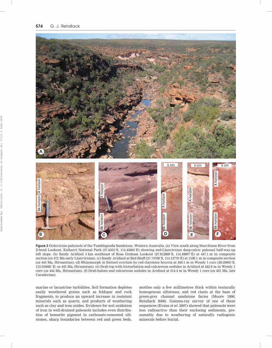
Figure 7 Distribution of Cam-
brian–Silurian Tumblagooda
Sandstone in Kalbarri National
Park, Western Australia (after
Hocking 1991), showing localities
examined to construct a compo-
site section.
Early Paleozoic pedostratigraphy 579
Downloaded By: [Retallack, G. J.][University of Oregon] At: 17:11 2 June 2009

sp. indet.) at a level of 446 m, were also 472 Ma, and
late Arenigian. McNamara (in Hocking & Mory 2006)
used the trackways as a dating constraint, assuming
they were from eurypterids known to be no older
than Arenigian. However, the track makers could also
have been euthycarcinoids, arthropleurids, or xipho-
surs, as well as eurypterids (Trewin & McNamara
1994). The euthycarcinoid body fossil Kalbarria
brimmellae was found near The Loop plateau level
(McNamara & Trewin 1993), at a stratigraphic level
of 851 m, or ca 454 Ma (mid-Caradocian: Gradstein
et al. 2004) (Figure 8). The Skolithos–Diplocraterion
assemblage of Red Bluff and Pencell Pool records a
marine transgression, though not with definitive
marine body fossils (Trewin & McNamara 1994;
Hocking & Mory 2006) at a stratigraphic level 10 m
above the Gabba Gabba Member conglomerate marker
beds at 1125 m, or 442 Ma in the age model (Figure 8),
just above the base of the Silurian (443.7 Ma: Gradstein
et al. 2004).
SILURIAN OF GRAMPIAN RANGES
The Grampian Ranges are rugged ridges of quartzite
rising 700 m above the cleared Wimmera Tableland, in
western Victoria (Figure 9). Grampians Group quart-
zites are poorly fossiliferous (Turner 1986; Warren
et al. 1986; Burrow & Turner 2000; Gouramanis et al.
2003), and were deposited largely by rivers, although
some intervals show intertidal facies and fossils
(Spencer-Jones 1965; George 1994; Gouramanis et al.
2003). The quartzites are structurally complex, with
numerous thrust faults and local granitic and rhyolitic
intrusions deformed during Benambran mountain-
building of the Lachlan Fold Belt (Cayley & Taylor
1997).
Published age constraints
Fish denticles (Turinia fuscina), spines (Sinacanthus?
sp.) and scales (Poracanthus sp. cf. P. qujingensis)
from the Silverband Formation (2730 m in Figure 10)
are Silurian (Ludlovian: Burrow & Turner 2000) or ca
419 Ma (Gradstein et al. 2004), not Devonian or
Carboniferous as previously thought (Spencer-Jones
1965). The Rocklands Rhyolite with a U–Pb zircon age
of 410+ 3 (VandenBerg 2003) supported a Devonian
age when considered sedimentary basement, but then
the rhyolite was found to have intruded the sequence
(Simpson & Woodfull 1994), supporting a Silurian age
of the fossil fish. This rhyolite and three granodior-
ites intruding the sedimentary sequence average
400+ 13.6 Ma, whereas nine granitoids pre-dating
the sedimentary sequence average 474+ 28 Ma
(VandenBerg 2003), which is roughly Ordovician to
Devonian (Emsian to Arenigian inclusive: Gradstein
et al. 2004).
Figure 8 Age model and pedostratigraphic correlation of the Tumblagooda Sandstone of Western Australia, and equivalents
in the Officer Basin of South Australia. Metre scales differ according to local sediment accumulation rates, but proportional
distribution of deep-calcic events is preserved in each, and shows highly significant correlation.
580 G. J. Retallack
Downloaded By: [Retallack, G. J.][University of Oregon] At: 17:11 2 June 2009

Figure 9 Geological map and paleosol sites examined in Grampians National Park, Victoria (after Cayley & Taylor 1997;
VandenBerg 2003).
Early Paleozoic pedostratigraphy 581
Downloaded By: [Retallack, G. J.][University of Oregon] At: 17:11 2 June 2009

Burial alteration
Quartzites of the Grampians have been overthickened to
some 6250 m (Spencer-Jones 1965), due to overthrust
repetition of an original thickness of about 4000 m
(Cayley & Taylor 1997). Evidence of metamorphic
alteration is obvious as cataclastic bands near thrust
faults (Cayley & Taylor 1997), and as biotite–sericite
metaquartzite and quartz–diopside hornfels near grani-
tic intrusions (Spencer-Jones 1965). Pedogenic micrite
nodules are well preserved in red siltstones in outcrop
and in core, but comparable nodules in red sandstone
commonly appear strongly silicified and are weakly
reactive to acid. Many of the siltstones of the Silverband
Formation are not metamorphically recrystallised
(George 1994), yet were intruded by coarse-grained
Devonian granites. Possible comagmatic Devonian
ignimbrites include the Rocklands Volcanics. In modern
Yellowstone National Park, Wyoming, granitic magma
is indicated at depths of 5–10 km by a seismically slow
zone of low density, with high heat flow and low
magnetotelluric resistivity beneath a caldera which
erupted voluminous rhyolitic tuffs (Iyer 1988). Simi-
larly, a Pliocene (2.83+ 0.2 Ma by 40Ar/39Ar) ignimbrite
(Chegem Tuff) was erupted some 5 km above Eltjurta
granite in the Northern Causasus Mountains of Georgia
(Lipman et al. 1993). These calderas provide a model for
ignimbrites of the Rocklands Volcanic Group (Cayley &
Taylor 1997) and nearby granites of igneous affiliation in
the Grampians (Mafeking, Mackenzie River, Victoria
Valley, and Mirranatwa Granites: White & Chappell
1988). All the paleosols observed were from a topo-
graphic range of 500 m, and considering thrust inter-
leaving of sediments above granitic intrusions (Cayley
& Taylor 1997), all underwent nearly equal maximal
burial depths of 5.0+ 0.5 km, giving burial compaction
of 55.3+ 0.7%, using an algorithm of Sheldon &
Retallack (2001).
Pedostratigraphic ages
Deep-calcic paleosols are well spaced in lower and upper
parts of the Grampians sequence, but show three closely
spaced climatic perturbations during deposition of the
Ludlovian–Pridolian Silverband Formation (Burrow &
Turner 2000). Each deep-calcic episode is a reflection of
unusually high precipitation (Retallack 2005a) and is
associated with an increase in stream power demon-
strated by onset of erosive conglomeratic sandstones
after long intervals of silty or flaggy sandstones
(Figure 10). These perturbations correlate very closely
(R2¼ 0.99) with a series of isotopic and biotic crises
recognised in the Australian Silurian and Devonian
(Talent et al. 1993): lower Murray Hill Sandstone with
443.7 Ma basal Llandoverian, lower Major Mitchell
Sandstone with 436.2 Ma mid-Llandoverian Sandvika
Event, basal Silverband Formation with 427.6 Ma
earliest Wenlockian Ireviken Event, middle Silverband
Formation with 424.4 Ma mid-Wenlockian Mulde Event,
uppermost Silverband Formation with 420.2 Ma mid-
Ludlovian to Pridolian Lau Events, upper Serra Sand-
stone with 416.0 Ma basal Devonian Klonk Event, upper
Figure 10 Age model and pedostratigraphy of Grampians National Park. Proportional distribution of deep-calcic events in
section shows highly significant correlation with biotic and isotopic events in time.
582 G. J. Retallack
Downloaded By: [Retallack, G. J.][University of Oregon] At: 17:11 2 June 2009
Moora Moora Sandstone with 411.2 Ma basal Pragian
Prague–Lochov Event, and upper Wartook Sandstone
with 406.2 Ma basal Emsian Zlichov Event (event dating
from Gradstein et al. 2004).
This new time framework allows dating of a variety
of significant fossils from the Grampians. Impressions of
equisetalean stems, 5 mm wide, from Chimney Pot Gap
(Douglas 1965) are in the lowest part of the Serra
Sandstone (Cayley & Taylor 1997), here regarded as
about 419 Ma (latest Ludlovian), so about the same age
of comparably (and controversially) large fossil plants
from Yea (Garratt & Rickards 1984). Sandstone casts of
Prototaxites (Douglas 1981; Douglas & Kenley 1981) on
the summit of Mt William (37.292958S, 142.801508E) are
also unusually large (2.91 m long by 0.32 m diameter) for
this genus of basidiomycete fungus (Boyce et al. 2007),
and here dated at 433 Ma or mid-Telychian (late
Llandoverian: Gradstein et al. 2004). Large terrestrial
arthropod burrows (Taenidium barrettii) from Mt
William (Gouramanis et al. 2003) are the same age. This
study also indicates a Llandoverian age for trace
fossils elsewhere in the Major Mitchell Sandstone
(Gouramanis et al. 2003): more specifically around
430 Ma for Glenisla quarry and 431 Ma for Mt Bepcha
some 170 m stratigraphically lower in the formation. Mt
Bepcha includes the terrestrial arthropod (Taenidium
barretti) and worm burrows (Daedalus), and a variety
of marginal-marine burrows (Skolithos linearis,
Thalassinoides, Rhizocorallium) and grazing trails
(Cruziana problematica). Glenisla quarry includes mar-
ginal marine burrows (Paleophycus, Skolithos linearis)
and large arthropod trackways (Diplichnites cuithensis),
at one time considered evidence of tetrapods on land
(Warren et al. 1986).
CONCLUSIONS
Transient deep-calcic paleosols of Paleozoic redbeds in
Australia record continent-wide abrupt increases in
mean annual precipitation (Figure 11), considering what
is known about this feature in modern soils (Retallack
2005a). In South Australian sections, deep-calcic hor-
izons also correspond to times of climatic warming,
marine transgression, black shale deposition and
articulated trilobite preservation (Retallack 2008). Deep-
calcic paleosols also were coeval with transient declines
in carbon isotopic composition of Australian Silurian–
Devonian limestones and extinctions (Talent et al. 1993).
Deep-calcic paleosols also appear at times of global
Cambrian–Devonian bioevents (Barnes et al. 1996; Zhu
et al. 2006; Patzkowsky & Holland 2007), including the
fourth largest known mass extinction within the latest
Ordovician (end-Ashgillian, 445.6 Ma) and seventh lar-
gest in the Late Silurian (end-Ludlovian, 418.7 Ma:
Calner 2005; Stanley 2007). The Australian paleosol
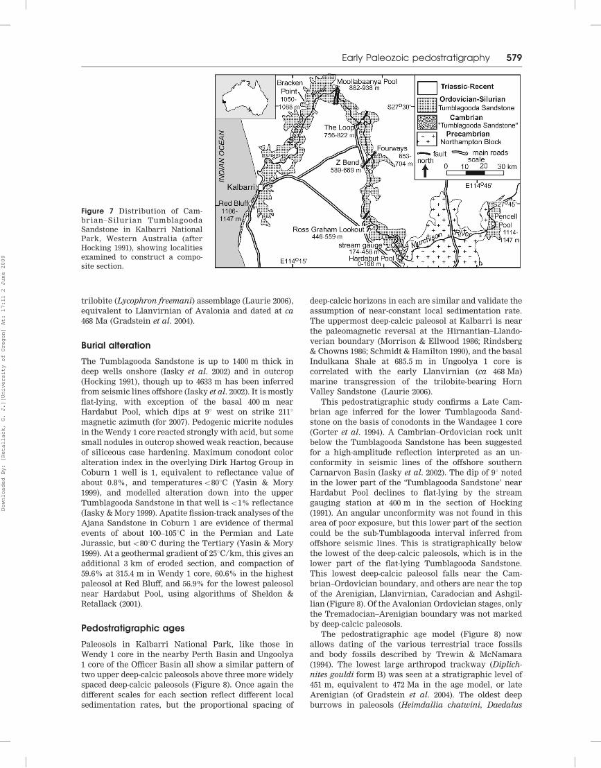
Figure 11 Composite Australian record of depth to Bk horizon in paleosols, compared with carbon isotopic record of the Great
Basin, USA (Saltzman 2005), Siberia (Kouchinsky et al. 2007), and Early Paleozoic bioevents (Gradstein et al. 1984).
Early Paleozoic pedostratigraphy 583
Downloaded By: [Retallack, G. J.][University of Oregon] At: 17:11 2 June 2009

record also corresponds with global variation in marine
carbonate isotopic composition (Figure 11), best known
from long records in the North American Great Basin
(Saltzman 2005) and Siberia (Kouchinsky et al. 2007).
Marine records show not only transient negative carbon
isotopic excursions coeval with deep-calcic paleosols,
but protracted intervening intervals of very high (42 %d13CPDB) carbon isotope composition. The Late Cam-
brian (Steptoan) positive carbon isotopic interval
(SPICE of Saltzman 2005) corresponds with a protracted
interval of consistently shallow paleosol calcic depth.
Other positive isotopic excursions in the marine
carbonate record were more short-lived within the
Caradocian, Hirnantian, Wenlockian, Ludlovian and
Pridolian, and correspond with shallow calcic paleosols
of dry climates. One of these intervals, the Hirnantian,
coincides with a short-lived glaciation centered on West
Africa (Denis et al. 2007), and coarse gravelly sediments
in the Gabba Gabba Member of the Tumblagooda
Sandstone (Evans et al. 2007) may have been distal
glacial outwash. Also comparable between paleosol and
marine isotopic records is increased time intervals
between perturbations through time (Saltzman 2005),
from an unsettled Cambrian record (Figure 11). Deep-
calcic paleosol events thus reflect global atmospheric
perturbations in the carbon cycle.
What would cause such perturbations is unclear for
the Early Paleozoic, but has been widely discussed in
the case of the end-Permian carbon isotopic excursions
and mass extinctions. Permian negative carbon isotopic
excursions and deep-calcic zones associated with mass
extinctions have been attributed to bolide impact,
massive volcanism, oceanic overturn, biomass oxida-
tion, and methane emission from permafrost and
oceanic clathrates, or from thermal alteration of carbo-
naceous sediments during intrusion (Retallack 2005b;
Retallack & Krull 2006; Retallack & Jahren 2008). Marine
positive excursions on the other hand signal increased
biological productivity, due to increased oceanic fertili-
sation and ventilation, and carbon burial at sea (Saltz-
man 2005). Plate-tectonic rearrangements or volcanic
flareups could be responsible for such events (Bluth &
Kump 1991), but a more likely explanation is evolu-
tionary advancements on land which promoted chemi-
cal weathering, such as the Middle Cambrian advent of
nonvascular land plants, Late Ordovician evolution of
mosses, and Early Silurian appearance of vascular land
plants (Retallack 2000).
ACKNOWLEDGEMENTS
Barbara and Warren Fargher graciously allowed access
to Wirrealpa Station. Permission for research in Flin-
ders Ranges National Park was approved by Kate Wood,
Ken Anderson, Darren Crawford, Arthur Coulthard,
and Pauline Coulthard. Permission for research in
Kalbarri National Park was approved by Kieran
McNamara, Mike Paxman and Russell Asplin. Exam-
ination of cores was aided by Brian Logan and Michael
Willison at the Primary Industries and Resources South
Australia Core Library in Glenside, Avi Olchina and
Ken Sherring at the Geoscience Victoria Core Library in
Werribee, and Chris Brooks at the Geological Survey of
Western Australia Core Library in Carlisle. Ian John-
son, Diane Retallack and Christine Metzger helped with
fieldwork. Arthur Mory and Ken McNamara provided
helpful and detailed reviews. Funded by American
Chemical Society PRF grant 45257-AC8.
REFERENCES
BARNES C. R., FORTEY R. A. & WILLIAMS S. H. 1996. The pattern of
global bioevents during the Ordovician period. In: Walliser O. H.
ed. Global Events and Event Stratigraphy in the Phanerozoic, pp.
139–179. Springer, Berlin.
BENBOW M. C. 1982. Stratigraphy of the Cambrian–?Early Ordovi-
cian Mount Johns Range, NE Officer Basin, South Australia.
Transaction of the Royal Society of South Australia 106, 191–211.
BLUTH G. J. S. & KUMP L. R. 1991. Phanerozoic paleogeology.
American Journal of Science 291, 284–308.
BOYCE C. K., HOTTON C. L., FOGEL M. L., CODY G. D., HAZEN R. M.,
KNOLL A. H. & HUEBER F. M. 2007. Devonian landscape
heterogeneity recorded by a giant fungus. Geology 35, 399–402.
BURROW C. J. & TURNER S. 2000. Silurian vertebrates from Australia.
Courier Forschungsinstitut Senckenberg 22, 169–174.
CALNER M. 2005. A Late Silurian extinction event and anachronistic
period. Geology 4, 305–308.
CAYLEY R. A. & TAYLOR D. H. 1997. Grampians special area
geological report. Geological Survey of Victoria Report 107.
CLARKE J. D. A. 1990. An Early Cambrian carbonate platform near
Wilkawillina Gorge, South Australia. Australian Journal of
Earth Sciences 37, 471–483.
DAILY B. & FORBES B. G. 1969. Notes on the Proterozoic and
Cambrian, southern and central Flinders Ranges. In: Daily B.
ed. Geological Excursions Handbook, pp. 23–30. ANZAAS Con-
gress, Section 3, Adelaide.
DALGARNO C. R. 1964. Lower Cambrian stratigraphy of the Flinders
Ranges. Transactions of the Royal Society of South Australia 88,
129–144.
DALGARNO C. R. & JOHNSON J. E. 1966. Parachilna Sheet SH54-13,
1:2500 Geological Atlas Sheet. Geological Survey of South
Australia, Adelaide.
DALRYMPLE G. B. 1979. Critical tables for conversion of K–Ar ages
from old to new constants. Geology 7, 558–560.
DEMKO T. M., CURRIE B. S. & NICOLL K. A. 2004. Regional
paleoclimatic and stratigraphic implications of paleosols and
fluvial/overbank architecture in the Morrison Formation
(Upper Jurassic), Western Interior, USA. Sedimentary Geology
167, 115–135.
DENIS M., BUONCRISTIANI J-F., KONATE M. & GUIRAUD M. 2007. The
origin and glaciodynamic significance of sandstone ridge net-
works from the Hirnantian glaciation of the Djado Basin (Niger).
Sedimentology 54, 1225–1243.
DIESSEL C. F. K. 1992. Coal-Bearing Depositional Systems. Springer,
Berlin.
DOUGLAS J. G. 1965. Articulated stems from the Grampians. In:
Spencer-Jones D. ed. The Geology and Structure of the Grampians
Area, Western Victoria, p. 92. Geological Survey of Victoria
Memoir 25.
DOUGLAS J. G. 1981. Fossil algae, Victoria, Australia. Palaeobotanist
28/29, 8–14.
DOUGLAS J. G. & KENLEY P. R. 1981. Enigmatic organic structures in
the Grampians Group sediments. Victorian Naturalist 98, 65–67.
DRIESE S. G. & FOREMAN J. L. 1992. Paleopedology and paleoclimatic
implications of Late Ordovician vertic paleosols southern
Appalachians. Journal of Sedimentary Petrology 62, 71–83.
DRIESE S. G., MORA C. I. & ELICK J. M. 1997. Morphology and
taphonomy of root and stump casts of the earliest trees (Middle
to Late Devonian), Pennsylvania and New York. Palaios 12, 524–
537.
DRIESE S. G., MORA C. I. & ELICK J. M. 2000. The paleosol record of
increasing plant diversity and depth of rooting and changes in
atmospheric pCO2 in the Siluro-Devonian. In: Gastaldo R. A. &
Dimichele W. A. eds. Phanerozoic Terrestrial Ecosystems, pp. 47–
61. Paleontological Society Special Paper 6.
584 G. J. Retallack
Downloaded By: [Retallack, G. J.][University of Oregon] At: 17:11 2 June 2009
ELBURG M. A., BONS P. D., FODEN J. & BRUGGER J. 2003. A newly
defined Late Ordovician magmatic–thermal event in the Mt
Painter Province, northern Flinders Ranges, South Australia.
Australian Journal of Earth Sciences 50, 611–631.
EVANS R., MORY A. J. & TAIT A. M. 2007. An outcrop gamma ray
study of the Tumblagooda Sandstone, Western Australia.
Journal of Petroleum Science and Engineering 57, 37–59.
FODEN J., ELBURG M. A., DOUGHERTY-PAGE J. & BURTT A. 2006. The
timing and duration of the Delamerian Orogeny: correlation
with the Ross Orogen and implications for Gondwana assembly.
Journal of Geology 114, 189–210.
FOLLMER L. R. 1978. The Sangamon in its type area—a review. In:
Mahaney W. C. ed. Quaternary Soils, pp. 125–165. GeoAbstracts,
Norwich.
GARRATT M. J. & RICKARDS R. B. 1984. Graptolite biostratigraphy of
early land plants from Victoria, Australia. Proceedings of the
Yorkshire Geological Society 44, 377–384.
GATEHOUSE C. G. 1976. A fossil in the Observatory Hill Beds, South
Australia. Geological Survey of South Australia Quarterly Notes
60, 5–8.
GEORGE A. D. 1994. Tidal sedimentation in part of the Late Silurian
Grampians Basin, southeastern Australia. Journal of Sedimen-
tary Research B64, 311–325.
GEYER G. & SHERGOLD J. 2000. The quest for internationally
recognized divisions of Cambrian time. Episodes 23, 188–195.
GILE L. H., HAWLEY J. W. & GROSSMAN R. B. 1980. Soils and
geomorphology in the Basin and Range of southern New Mexico:
Guidebook to the desert project. New Mexico Bureau of Mines &
Mineral Resources Memoir 39.
GILE L. H., PETERSON F. F. & GROSSMAN R. B. 1966. Morphological
and genetic sequences of carbonate accumulation in desert soils.
Soil Science 101, 341–360.
GORTER J. D., NICOLL R. S. & FOSTER C. B. 1994. Lower Palaeozoic
facies in the Carnarvon Basin, Western Australia: stratigraphy
and hydrocarbon prospectivity. In: Purcell P. G. & Purcell R. R.
eds. The Sedimentary Basins of Western Australia, pp. 373–396.
Petroleum Exploration Society of Australia, Perth.
GOURAMANIS C., WEBB J. A. & WARREN A. A. 2003. Fluviodeltaic
sedimentology and ichnology of part of the Silurian Grampians
Group, western Victoria. Australian Journal of Earth Sciences
50, 811–825.
GRADSTEIN F. M., OGG J. G. & SMITH A. G. 2004. A Geologic Time Scale
2004. Cambridge University Press, Cambridge.
GRAVESTOCK D. I. & SHERGOLD J. H. 2001. Australian Early and
Middle Cambrian sequence biostratigraphy with implications
for species diversity and correlation. In: Zhuravlev A. Y. &
Riding R. eds. The Ecology of the Cambrian Radiation, pp. 107–
136. Columbia University Press, New York.
HAINES P. W. & FLOTTMANN T. 1998. Delamerian orogeny and
potential foreland sedimentation: a review of age and strati-
graphic constraints. Australian Journal of Earth Sciences 45,
559–570.
HOCKING R. M. 1990. Carnarvon Basin. In: Geology and Mineral
Resources of Western Australia, pp. 457–494. Geological Survey of
Western Australia Memoir 3.
HOCKING R. M. 1991. The Silurian Tumblagooda Sandstone, Western
Australia. Geological Survey of Western Australia Report 27.
HOCKING R. M. & MORY A. J. 2006. Geology of the Kalbarri area—a field
guide. Geological Survey of Western Australia Record 2006/19.
IASKY R. P., D’ERCOLE C., GHARI K. A. R., MORY A. J. & LOCKWOOD A.
2002. Structure and petroleum prospectivity of the Gascoyne
Platform, Western Australia. Geological Survey of Western
Australia Report 87.
IASKY R. P. & MORY A. J. 1999. Geology and petroleum potential of
the Gascoyne Platform, southern Carnarvon Basin, Western
Australia. Geological Survey of Western Australia Report 69.
IYER H. M. 1988. Seismological detection and delineation of magma
chambers beneath intraplate volcanic centers in western USA.
In: King C-Y. & Scarpa R. eds. Modeling of volcanic processes, pp.
1–56. Friedrick Vieweg & Sohn, Braunschweig.
JAGO J. B., LIN T. R. & DUNSTER J. N. 2002. A new species of the
trilobite Abadiella from the Lower Cambrian of the eastern
Officer Basin, South Australia. Acta Palaeontologica Sinica 41,
428–433.
JAGO J. B. & YOUNGS B. C. 1980. Early Cambrian trilobites from the
Officer Basin, South Australia. Transactions of the Royal Society
of South Australia 104, 197–199.
JAGO J. B., ZANG W. L., SUN X. L., BROCK G. A., PATERSON J. R. &
SKOVSTED C. B. 2006. A review of the Cambrian biostratigraphy
of South Australia. Palaeoworld 15, 406–423.
KIRSCHVINK J. L. & RAUB T. D. 2003. A methane fuse for the Cambrian
explosion: carbon cycles and true polar wander. Geoscience 335,
65–78.
KOUCHINSKY A., BENGTSON S., PAVLOV V., RUNNEGAR B., TORSSANDER
P., YOUNG E. & ZIEGLER K. 2007. Carbon isotope stratigraphy of
the Precambrian–Cambrian Sukharikha River section, north-
western Siberian Platform. Geological Magazine 144, 609–618.
LAURIE J. R. 2006. Ordovician trilobites from the Horn Valley
Siltstone and basal Stairway Sandstone, Amadeus Basin, North-
ern Territory. In: Paterson J. R. & Laurie J. R. eds. Cambro-
Ordovician studies II, pp. 287–345. Association of Australasian
Palaeontologists Memoir 32.
LINDSAY F. F. & LEVEN J. A. 1996. Evolution of a Neoproterozoic to
Palaeozoic intracratonic setting, Officer Basin, South Australia.
Basin Research 8, 403–424.
LIPMAN P. W., GOGATIKOV O. A., TSVETKOV A. A., GAZIS C.,
GURBANOV A. G., HON K., KORONOVSKY N. V., KOVALENKO V. I.
& MARCHEV P. 1993. 2.8-Ma ash-flow caldera at Chegem River in
northern Caucasus Mountains (Russia), contemporaneous gran-
ites, and associated ore deposits. Journal of Volcanology and
Geothermal Research 57, 85–124.
MAJOR R. B. & TELUK J. A. 1967. The Kulyong Volcanics. Geological
Survey of South Australia Quarterly Geology Notes 22, 8–11.
MAWSON D. 1938. Cambrian and sub-Cambrian formations at
Parachilna Gorge. Transactions of the Royal Society of South
Australia 62, 255–262.
MAWSON D. 1939a. The Cambrian sequence in the Wirrealpa Basin.
Transactions of the Royal Society of South Australia 63, 331–347.
MAWSON D. 1939b. The late Proterozoic sediments of South
Australia. ANZAAS Meeting Report 24(1), 79–88.
MAWSON D. & SEGNIT E. R. 1949. Purple slates of the Adelaide
System. Transactions of the Royal Society of South Australia 72,
276–280.
MCNAMARA K. J. & TREWIN N. H. 1993. A euthycarcinoid arthropod
from the Silurian of Western Australia. Palaeontology 36, 319–335.
MITCHELL M. M., KOHN B. P. & FOSTER D. A. 1998. Post-orogenic
cooling history of eastern South Australia from apatite FT
thermochronology. In: Van den Haute P. & de Corte F. eds.
Advances in fission-track geochronology, pp. 207–224. Kluwer,
Amsterdam.
MITCHELL M. M., KOHN B. P., O’SULLIVAN P. B., HARTLEY M. J. &
FOSTER D. A. 2002. Low-temperature thermochronology of the Mt
Painter Province, South Australia. Australian Journal of Earth
Sciences 49, 551–563.
MOORE P. S. 1979. Stratigraphy and depositional environments of the
Billy Creek Formation (Cambrian) central and northern Flin-
ders Ranges, South Australia. Transactions of the Royal Society of
South Australia 103, 197–211.
MOORE P. S. 1990. Origin of redbeds and variegated sediments,
Cambrian, Adelaide Geosyncline, South Australia. In: Jago J. B.
& Moore P. S. eds. The Evolution of a Late Precambrian–Early
Palaeozoic Rift Complex: the Adelaide Geosyncline, pp. 334–350.
Geological Society of Australia Special Publication 16.
MORRISON J. & ELLWOOD B. B. 1986. Paleomagnetism of Silurian-
Ordovician sediments from the Valley and Ridge Province,
northwest Georgia. Geophysical Research Letters 13, 189–192.
NORTH AMERICAN COMMISSION ON STRATIGRAPHIC NOMENCLATURE
1982. North American stratigraphic code. AAPG Bulletin 67, 841–
875.
ORTLAM D. 1971. Paleosols and their significance in stratigraphy and
applied geology in the Permian and Triassic of southern Germany.
In: Yaalon D. H. ed. Paleosols: Origin, Nature and Dating of
Paleosols, pp. 321–327. Israel Universities Press, Jerusalem.
OWEN G. 2003. Load structures: gravity-driven sediment mobilization
in the shallow subsurface. In: Van Rensbergen P., Hillis R. R.,
Maltman A. J. & Morley C. K. eds. Subsurface Sediment
Mobilization, pp. 21–34. Geological Society of London Special
Publication 216.
PARKIN L. W. 1969. Handbook of South Australian Geology. Geologi-
cal Survey of South Australia, Adelaide.
PATERSON J. R. & BROCK G. A. 2007. Early Cambrian trilobites from
Angorichna, Flinders Ranges, South Australia, with a new
assemblage from the Pararaia bunyerooensis zone. Journal of
Paleontology 81, 116–142.
Early Paleozoic pedostratigraphy 585
Downloaded By: [Retallack, G. J.][University of Oregon] At: 17:11 2 June 2009

PATZKOWSKY M. E. & HOLLAND S. M. 2007. Diversity partitioning of a
Late Ordovician marine biotic invasion: controls on diversity in
a regional ecosystem. Paleobiology 33, 295–309.
PHILIP G. M. 1969. Silurian conodonts from the Dirk Hartog
Formation, Western Australia. Proceedings of the Royal Society
of Victoria 82, 287–297.
RETALLACK G. J. 1992. What to call early plant formations on land.
Palaios 7, 508–520.
RETALLACK G. J. 2000. Ordovician life on land and early Paleozoic
global change. In: Gastaldo R. A. & Dimichele W. A. eds.
Phanerozoic terrestrial ecosystems, pp. 21–45. Paleontological
Society Special Paper 6.
RETALLACK G. J. 2001. Soils of the Past. Blackwell, Oxford.
RETALLACK G. J. 2005a. Pedogenic carbonate proxies for amount and
seasonality of precipitation in paleosols. Geology 33, 333–336.
RETALLACK G. J. 2005b. Permian greenhouse crises. In: Lucas S. G. &
Ziegler K. E. eds. The Nonmarine Permian, pp. 256–269. Bulletin
New Mexico Museum of Natural History and Science 30.
RETALLACK G. J. 2008. Cambrian paleosols and landscapes of South
Australia. Australian Journal of Earth Sciences 55, 1083–1106.
RETALLACK G. J. Greenhouse crises of the geological past. Geological
Society of America Bulletin (in press).
RETALLACK G. J. & JAHREN A. H. 2008. Methane release from igneous
intrusion of coal during Late Permian extinction events. Journal
of Geology 116, 1–20.
RETALLACK G. J. & KRULL E. S. 2006. Carbon isotopic evidence for
terminal-Permian methane outbursts and their role in extinc-
tions of animals, plants, coral reefs and peat swamps. In: Greb S.
& DiMichele W. A. eds. Wetlands Through Time, pp. 249–268.
Geological Society of America Special Paper 399.
RICHARDS J. R., BLOCKLEY J. G. & DE LAETER J. R. 1985. Rb–Sr and Pb
isotopic data from the Northampton Block, Western Australia.
Australasian Institute of Mining and Metallurgy Proceedings 290,
43–55.
RINDSBERG A. K. & CHOWNS T. M. 1986. Ringgold Gap: progradational
sequences in the Ordovician and Silurian of northwest Georgia.
In: Neathery T. L. ed. Centennial Field Guide, Southeast Section,
vol. 6, pp. 159–162. Geological Society of America, Boulder.
SALTZMAN M. R. 2005. Phosphorus, nitrogen, and the redox evolution
of the Paleozoic oceans. Geology 33, 573–576.
SCHMIDT P. W. & HAMILTON P. J. 1990. Palaeomagnetism and age of
the Tumblagooda Sandstone, Western Australia. Australian
Journal of Earth Sciences 37, 381–385.
SHELDON N. D. & RETALLACK G. J. 2001. Equation for compaction of
paleosols due to burial. Geology 29, 247–250.
SIMPSON C. J. & WOODFULL C. J. 1994. New field evidence resolving
the relationship between the Grampians Group and Rocklands
Rhyolite, western Victoria. Australian Journal of Earth Sciences
41, 621–624.
SOIL SURVEY STAFF 2000. Keys to Soil Taxonomy. Pocahontas Press,
Blacksburg.
SPENCER-JONES D. 1965. The geology and structure of the Grampians
area, western Victoria. Geological Survey of Victoria Memoir 25.
STANLEY S. M. 2007. An analysis of the history of marine animal
diversity. Paleobiology Memoir 33(4), 1–55.
STRATIGRAPHIC NOMENCLATURE COMMITTEE.1973. Australian code of
stratigraphic practice. Journal of the Geological Society of
Australia 20, 105–112.
STEVENS M. K. & APAK S. N. 1999. Empress 1 and 1A well completion
report, Yowalga Sub-basin, Officer basin, Western Australia.
Geological Survey of Western Australia Record 1999/4.
STOCK E. C. 1974. The clay mineralogy, petrology and environments
of deposition of the Cambrian Lake Frome Group, Flinders
Ranges, South Australia. MSc thesis, University of Adelaide,
Adelaide (unpubl.).
TALENT J. A, MAWSON R., ANDREW A. S., HAMILTON P. J. & WHITFORD
D. J. 1993. Middle Palaeozoic extinction events: faunal and
isotopic data. Palaeogeography Palaeoclimatology Palaeoecology
104, 139–152.
TINGATE P. R. & DUDDY I. R. 2002. The thermal history of the eastern
Officer Basin (South Australia): evidence from apatite fission
track analysis and organic maturity data. Tectonophysics 349,
251–275.
TISSOT B. P. & WELTE D. H. 1984. Petroleum Formation and
Occurrence. Springer, Berlin.
TREWIN N. H. & MCNAMARA K. J. 1994. Arthropods invade the land:
trace fossils and paleoenvironments of the Tumblagooda Sand-
stone (?late Silurian) of Kalbarri, Western Australia. Transac-
tions of the Royal Society of Edinburgh: Earth Sciences 85, 177–
210.
TUCKER M. D. 1991. Carbon isotopes and Cambrian–Precambrian
boundary geology South Australia: ocean basin formation,
seawater chemistry and organic evolution. Terra Nova 1, 573–
582.
TURNER S. 1986. Vertebrate fauna of the Silverband Formation,
Grampians, western Victoria. Proceedings of the Royal Society of
Victoria 98, 53–62.
VANDENBERG A. H. M. 2003. Silurian to Early Devonian. In: Birch W.
D. ed. Geology of Victoria, pp. 117–155. Geological Society of
Australia Special Publication 23.
VICTORIA PETROLEUM N. L. 2004. Final well report Wendy 1
stratigraphic drilling project EP 427. Geological Society of
Western Australia Statutory Petroleum Exploration Report
S20948A1 (unpubl.).
WARREN A., JUPP R. & BOLTON B. 1986. Earliest tetrapod trackway.
Alcheringa 10, 183–186.
WEBB A. W. 1978. Geochronology of stratigraphically significant
rocks. South Australia Department of Mines and Energy Amdel
Progress Report 24.
WHEELER R. L. 2002. Distinguishing seismic from no-seismic soft-
sediment structures: criteria from seismic-hazard analysis. In:
Ettensohn F. R., Rast N. & Brett C. E. eds. Ancient Seismites, pp.
1–11. Geological Society America Special Paper 359.
WHITE A. J. R. & CHAPPELL B. W. 1988. Granites. In: Douglas J. G. &
Ferguson J. A. eds. Geology of Victoria, pp. 427–439. Geological
Society of Australia, Victorian Division, Melbourne.
WOPFNER H. 1970. Early Cambrian paleogeography, Frome Embay-
ment, South Australia. AAPG Bulletin 54, 2395–2409.
YASIN A. R. & MORY A. J. 1999. Coburn well completion report,
Gascoyne Platform, southern Carnarvon Basin Western Austra-
lia. Geological Survey of Western Australia Record 1999/5.
ZANG W-L. 2002, Sequence analysis and petroleum potential in the
Arrowie Basin, South Australia. Minerals and Energy Resources
South Australia Report Book 2002/024.
ZHU M-Y., BABCOCK L. E. & PENG S-C. 2006. Advances in Cambrian
stratigraphy and paleontology: integrating correlation techni-
ques, paleobiology, taphonomy and paleoenvironmental recon-
struction. Paleoworld 2, 217–222.
Received 4 March 2008; accepted 15 January 2009
586 G. J. Retallack
Downloaded By: [Retallack, G. J.][University of Oregon] At: 17:11 2 June 2009