Embed Size (px)
Citation preview
ATOLL RESEARCH BULLETIN
NO. 443
THE EVOLUTION OF A HOLOCENE FRINGING REEF AND ISLAND: REEFAL ENVIRONMENTAL SEQUENCE AND SEA LEVEL CHANGE IN
TONAKI ISLAND, THE CENTRAL RYUKYUS
H. KAN, N. HORI, T. KAWANA, T. KAIGARA, AND K. ICHIKAWA
ISSUIm BY NATIONAL MUSEUM OF NATURAL HISTORY
SMITHSONIAN INSTITUTION WASHINGTON, D.C., U S A .
OCTORICR 1997
Ton
I
rn Limi Reef FI
5'
'@ >Q
7 - 135"E
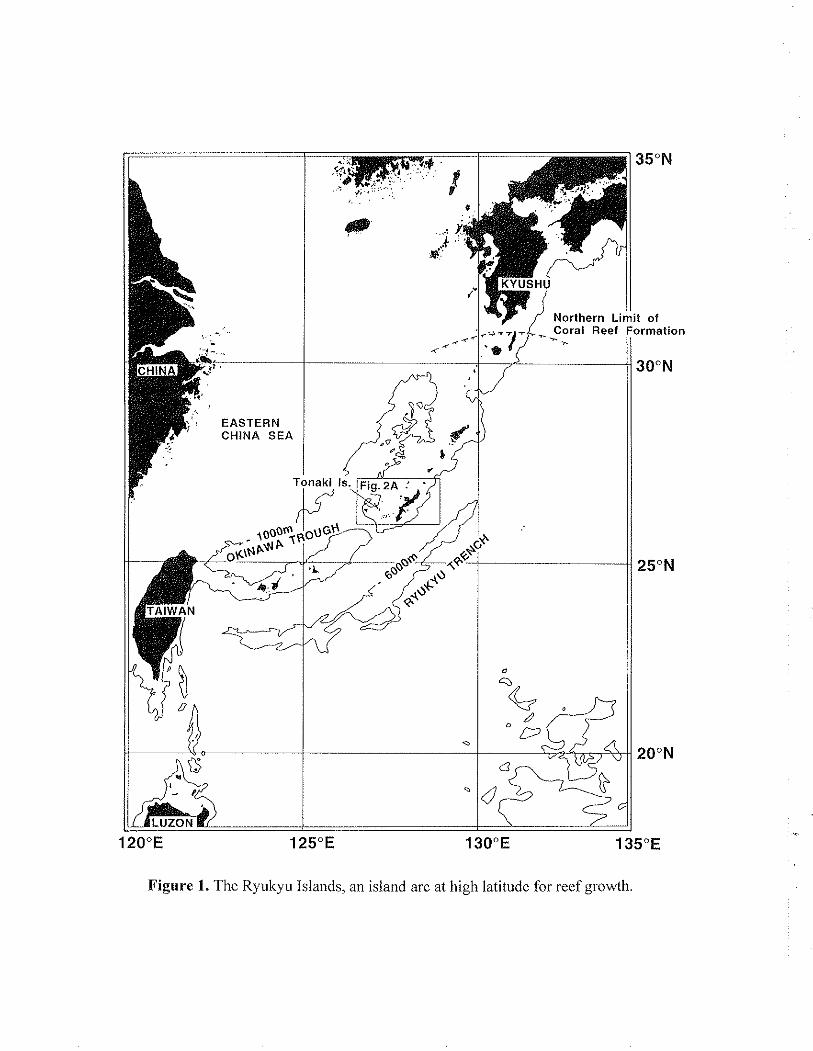
Figure 1. The Ryukyu Islands, an island arc at high latitude for reef growth.
THE EVOLUTION OF A HOLOCENE FRINGING REEF AND ISLAND:
REEFAL ENVIRONMENTAL SEQUENCE AND SEA LEVEL CHANGE
IN TONAKI ISLAND, THE CENTRAL RYUKYUS
1-1. KAN', N. H0R12, T. K A W A N A ~ , 'F. K A I G A R A ~ and K. I C H I K A W A ~
ABSTRACT
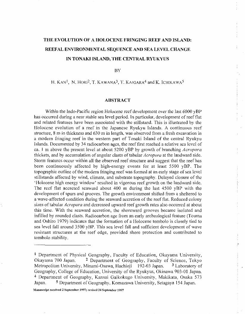
Within the lndo-Pacific region Holocene reef development over tlie last 6000 yBP has occurred during a near stable sea level period. In particular, development of reef flat and related features have been associated with the stillstand. This is illustrated by the Holocene evolution of a reef in the Japanese Ryukyu Islands. A continuous reef structure, 8 m in thickness and 630 n~ in length, was observed from a fresh excavation in a modern fringing reef in the western part of Tonaki Island of the central Ryukyu Islands. Documented by 34 radiocarbon ages, the reef first reached a relative sea level of ca. 1 m above the present level at about 5200 yBP by growth of branching Acropora thickets, and by accumulation of angular clasts of tabular Acropora at the landward side. Storm features occur within all the observed reef structure and suggest that the reef has been continuously affected by high-energy events for at least 5500 yBP. The topographic outline of the modern fringing reef was formed at an early stage of sea level stillstands affected by wind, climate, and substrate topography. Delayed closure of the 'Holocene high energy window' resulted in vigorous reef growth on the landward side. The reef flat accreted seaward about 400 m during the last 4500 yBP with the development of spurs and grooves. 'The growth environment shifted from a sheltered to a wave-affected condition during the seaward accretion of the reef flat. Reduced colony sizes of tabular Acropora and decreased upward reef growth rates also occurred at about this time. With the seaward accretion, the shoreward grooves became isolated and infilled by rounded clasts. Radiocarbon age from an early archeological feature ('Touma and Oshiro 1979) indicates that the formation of a Holocene tombolo is closely tied to sea level fall around 3500 yBP. This sea level fall and sufficient development of wave resistant structures at the reef edge, provided shore protection and contributed to tombolo stability.
Department of Physical Geography, Faculty of Education, Okayama University, Okayama 700 Japan. Department of Geography, Faculty of Science, Tokyo Metropolitan University, Minan~i-Osawa, Ilachioji 192-03 Japan. Laboratory of Geography, College of Education, University of the Ryukyus, Okinawa 903-01 Japan.
Department of Geography, Kansai Gaikokugo liniversity, Makikata, Osaka 573 Japan. Department of Geography, Komazawa University, Setagaya 154 Japan.
INTRODUCTION
As coral reefs grow they can alter their own environment. In mid-Holocene times, reefs that were still catching up with sea level had minimal wave baffling effects. Neumann (1972) named this the 'Holocene high energy window'. Subsequent reef growth produces a protective crest which in turn results in the developn~ent of the back- reef area. On fringing reefs, in particular, this may result in a shallow lagoon or moat with ponding of terrestrial run-off which may limit coral growth (Ginsburg and Shinn 1964; Schlager 198 1 ; Neumann and Macintyre 1985; Acevedo et ul. 1989).
Sea level stillstands of the order of millennia can produce substantial fringing-reef flats (Buddemeier and Hopley 1988). In the Indo-Pacific region where a Holocene stillstand has occurred for approximately the last 6000 years, understanding of reef growth in response to both early Holocene sea level rise and late Holocene stillstand is needed to fully understand reef evolution.
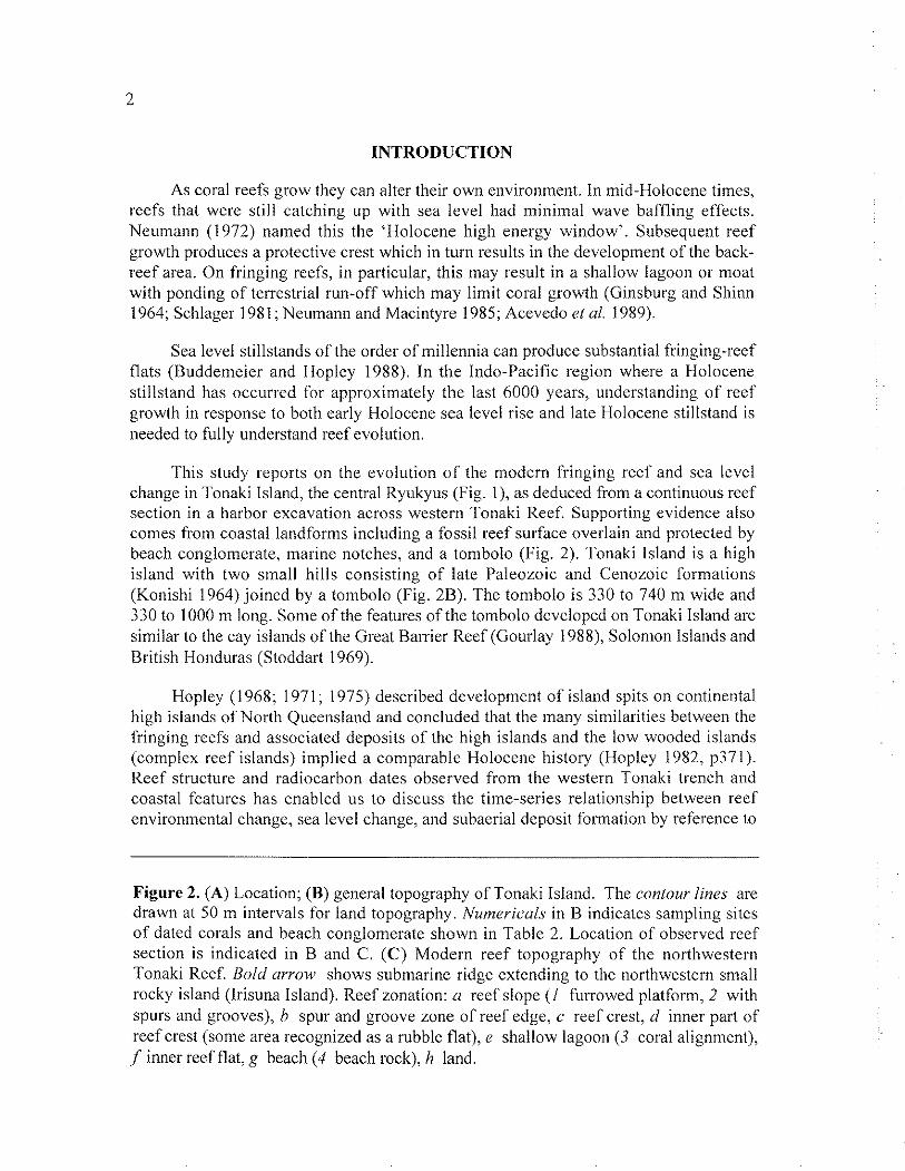
This study reports on the evolution of the modern fringing reef and sea level change in Tonaki Island, the central Ryukyus (Fig. I), as deduced from a continuous reef section in a harbor excavation across western Tonaki Reef. Supporting evidence also comes from coastal landforms including a fossil reef surface overlain and protected by beach conglomerate, marine notches, and a tonibolo (Fig. 2). Tonaki Island is a high island with two small hills consisting of late I'aleozoic and Cenozoic forniations (Konishi 1964) joined by a tombolo (Fig. 2B). The tonibolo is 330 to 740 m wide and 330 to I000 ni long. Some of the features of the tombolo dcvclopcd on Tonaki Island arc similar to the cay islands of the Great Harrier Reef (Gourlay 1988), Solomon Islands and British Honduras (Stoddart 1969).
Hopley (1968; 1971; 1975) described development of island spits on continental high islands of North Queensland and concluded that the many similarities between the fringing reefs and associated deposits of the high islands and the low wooded islands (complex reef islands) implied a comparable Holocene histo~y (Hopley 1982, p371). Reef structure and radiocarbon dates observed from the western Tonaki trench and coastal features has enabled us to discuss the time-series relationship between reef environmental change, sea level change, and subaerial deposit formation by reference to
Figure 2. (A) Location; (B) general topography of Tonaki Island. The contour lines are drawn at 50 m intervals for land topography. Numericul.~ in B indicates sampling sites of dated corals and beach conglomerate shown in Table 2. Location of observed reef section is indicated in B and C. (C) Modern reef topography of the northwestern Tonaki Reef. Bold arrow shows submarine ridge extending to the northwestern small rocky island (Irisuna Island). Reef zonation: a reef slope (I furrowed platform, 2 with spurs and grooves), h spur and groove zone of reef edge, c reef crest, d inner part of reef crest (some area recognized as a rubble flat), e shallow lagoon (3 coral alignment), ,f inner reef flat, g beach (4 beach rock), h land.
these observations and radiocarbon dates of a fossil reef surface and the earliest archeological ruin on the tombolo of Tonaki Island as described by Touma and Oshiro (1979). This relationship between the reef and associated Holocene landforms indicates how reefs respond to extcrnal and internal environmental change.
MATERIALS AND METHODS
In the Ryukyu Islands, many trenches have been excavated to construct harbors and associated ship channels across modern fringing reefs. Such excavations provide the opportunity to observe the continuous structure of modern reefs. Reef structure directly observed from trench walls reveals the exact location of sedimentary facies, shape and size of coral colonies and coral clasts in contrast to observations made from reef cores (Kan and Flori 1991). In Tonaki Island, a harbor excavation reaching 8 m in thickness and 630 ni in length across the western Tonaki Reef, provides a continuous reef section (Fig. 2). The southern wall of the excavation provided a fresh reef section because the survey was carried out immediately after widening of the trench in 1989.
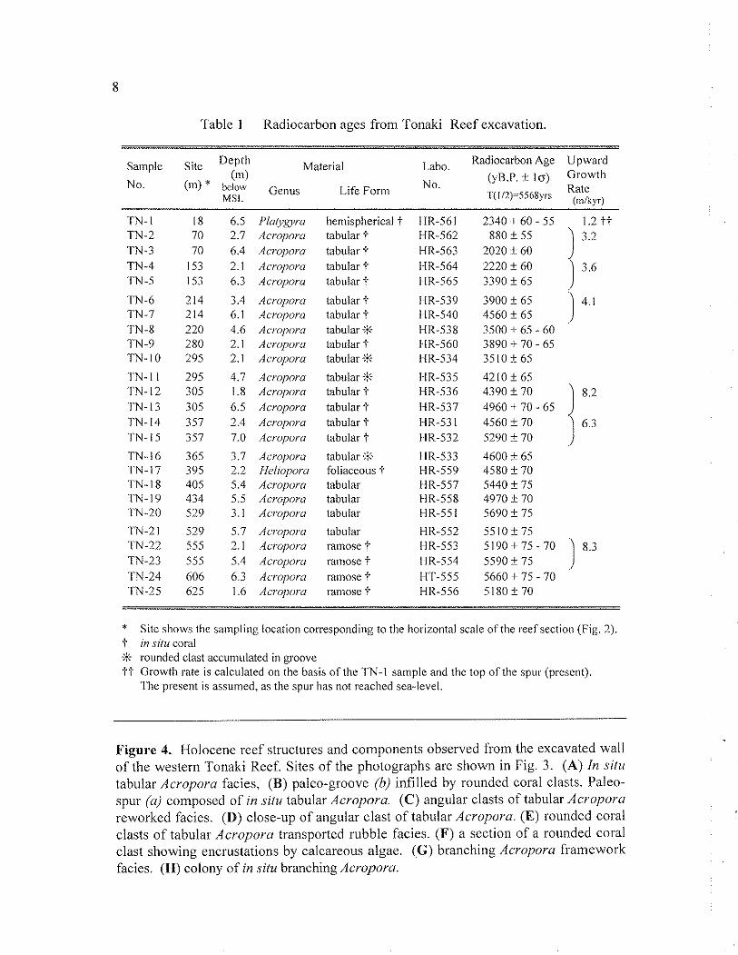
The rcef profile (Fig. 3) was survcycd using measuring tapes, a 5-meter pole and depth meter to define micro-topographic features and to provide the basis for later descriptions of the section. Descriptions of the reef structure were carried out from the reef surface to the foot of the excavation at approximately 5 to 10 m intervals along the entire length of the section. The survey was carried out at closely spaced horizontal intervals especially at the boundaries of the sedimentary facies. Fossil corals were collected from the excavation by using a hammer and chisel. Twenty-five radiocarbon aces were obtained for corals in this reef section (Table 1). These dates were established - by methanol liquid scintillation counting, at the Dept. of Geography, Hiroshima University. Laboratory procedures were based on Fujiwara and Nakata (1984).
The geomorphological map of the northwestern Tonaki Reef (Fig. 2C) was prepared to document the zonal and the micro-topographic features. The reef topography is based on the interpretation of field observations in 1989 and the 1977 color aerial photographs scaled to 1: 10,000. Coastal landforms such as fossil reef surface overlain by beach conglon~erate, and marine notches were investigated to document mid- to late-Holocene sea level indicators in 1991 and 1996 (Fig. 2). The altitude data were revised with reference to tide tables. Tidal values in Tonaki Island are corrected by reference to those in Zamami Island, near Tonaki (Fig. 2). Mean high (low) water level in Tonaki is about 0.6 m above (below) mean sea level (MSL) which is 1.16 m above the tidal datum. Tidal range is approximately 2.0 m at spring tide. Nine radiocarbon ages were obtained from in situ corals in the modern reef surface and in the fossil reef surface overlain by the beach conglomerate (Table 2). These ages were dated by Prof. emeritus K. Kigoshi of Gakushuin University.
X-ray diffraction was used to confirm the absence of calcite in all dated samples. Age calculations are based on the Libby half-life of 5568 i. 30 years. Errors are indicated at the range o f f 1 o. The dates have not been corrected for isotopic fluctuations or
environmental factors because we have no data on the ocean l4C reservoir effect for the Ryukyu Islands.
RESULTS
Topography of western Tonaki Reef
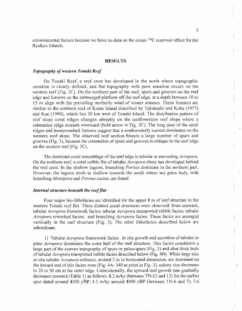
On Tonaki Reef, a reef crest bas developed in the north where topographic zonation is clearly defined, and flat topography with poor zonation occurs on the western reef (Fig. 2C). On the northern part of the reef, spurs and grooves on the reef edge and furrows on the submerged platform off the reef edge, at a depth between 10 to 15 m align with the prevailing northerly wind of winter seasons. These features are similar to the northern reef of Kume Island described by Takahashi and Koba (1977) and Kan (1990), which lies 30 km west of Tonaki Island. The diskibution pattern of reef slope coral ridges changes abruptly on the northwestern reef slope where a submarine ridge extends westward (bold arrow in Fig. 2C). The long axes of the coral ridges and honeycombed furrows suggest that a southwesterly current dominates on the western reef slope. The observed reef section bisects a large number of spurs and grooves (Fig. 3), because the orientation of spurs and grooves is oblique to the reef edge on the western reef (Fig. 2C).
The dominant coral assemblage of the reef edge is tabular or encrusting Acropora. On the northern reef, a coral rubble flat of tabular Acropora clasts has developed behind the reef crest. In the shallow lagoon, branching Porites dominate in the northern part. However, the lagoon tends to shallow towards the south where sea grass beds, with branching Moniiporu and Pavona cactus, are found.
Znternul structure beneath the reefflat
Four major bio-lithofacies are identified for the upper 8 nl of reef structure in the western Tonaki reef flat. Three distinct zonal structures were observed: from seaward, tabular Acropora framework facies; tabular Acropora transported rubble facies; tabular Acroporu reworked facies; and branching Acropora facies. These facies are arranged vertically in thc reef structure (Fig. 3). The other lithofacies described below arc subordinate.
1) Tabular Acropora framework facies: In siru growth and accretion of tabular or plate Acropura dominates the outer half of the reef structure. This facics constitutes a large part of the convex topography of spurs or paleo-spurs (Fig. 3) and abut thick beds of tabular Acropora transported rubble facies described below (Fig. 4B). While largc size in ~ i t u tabular Acropora colonies, around 2 m in horizontal dimension, are dominant on the inward end of this facies zone (Fig. 4A: 340 m point in Fig. 3), colony size decreases to 20 to 50 cm at the outer edge. Coincidentally, the upward reef growth rate gradually decreases seaward (Table 1) as follows: 8.2 mlky (between TN-12 and 13) for the earlier spur dated around 4500 yBP; 4.1 mlky around 4000 yBP (between TN-6 and 7); 3.6
mlky (between TN-4 and 5); 3.2 mlky (between TN-2 and 3); 1.2 mlky (between TN-l and present).
2) Tabular Acropora reworked facies: The unconsolidatcd platy clasts of tabular Acropora have accumulated (Fig. 4C) to at least 6m thickness and formed a sedimentary zonc behind the tabular Acvoporu framework facies (Pig. 3). These Acropora clasts (Fig. 4D) are relatively well preserved and essentially overturned in situ colonies. The radiocarbon ages between TN-20 and TN-21 are reverscd, despite 2.6 m difference in their depths (Table 1).
3) Tabular Acropora transported rubble facies : In the outer half of the reef structure, rounded coral clasts (Fig. 4E) havc densely infillcd thc in situ tabular Acropora facies (Fig. 3). Some clasts are coated by calcareous algae (in thc form of rhodoliths; Fig. 4F), which suggests that they had been tumbled. These arc similar to thosc that have accumulated in the present-day grooves of the rcef edge. Radiocarbon ages of rubble lag approximately 400 to 900 years bchind neighboring in situ tabular Acro~~ora facies (betwccn TN-9, 12 and 10; Fig. 3).
4) Branching Acroporu framework facies: Thickets of in situ branching Acvoporu (Fig. 4G) form a framework zone which exceeds 100 m in width and is more than 6 m thick (Pig. 3). These colonies were relatively intact (Fig. 4H). However, calcareous algae which covered the surface of branches makes species identification difficult. Radiocarbon ages (Table 1) show this coral thicket had been growing for over 400 years. The observed upward reef growth rates were 6.3 mlky (between TN-14 and 15) for this thicket. Aside from the fine sediment that covers the excavation (Fig. 4G), little sediment was observed infilling the branching framework.
tabular Acropora tabular Acropora framework facies transpolied rubbie facies
tabular Acropora a reworked facies tabular Acropora
0 reworked framework facies
Figure 3. Rcef structure and radiocarbon ages of fossil corals in the western Tonaki Reef. Lettered squares indicate positions of photographic sites presented in Fig. 4.
5) Tabular Acropora reworked framework facies: Tabular corals and calcareous algae constitute blocks 1 to 5 n~ in diameter. This bio-lithofacies is similar to the tabular Acropora framework facies of the reef margin. However, directions of individual coral growth and of accumulated coral colonies are different from the framework facies.
6) Mixed coral framework facies: This facies constitutes corals, calcareous algae and skeletal grains. No dominant coral genus was observed in this facies.
Beside these bio-lithofacies, the following in situ coral colonies larger than 2 m in diameter are identified in the growth fabric: foliaceous Heliopora, stubby branching Acropora, and hemispherical Lobophyllia. No terrigenous facies or Pleistocene limestone was observed within the section.
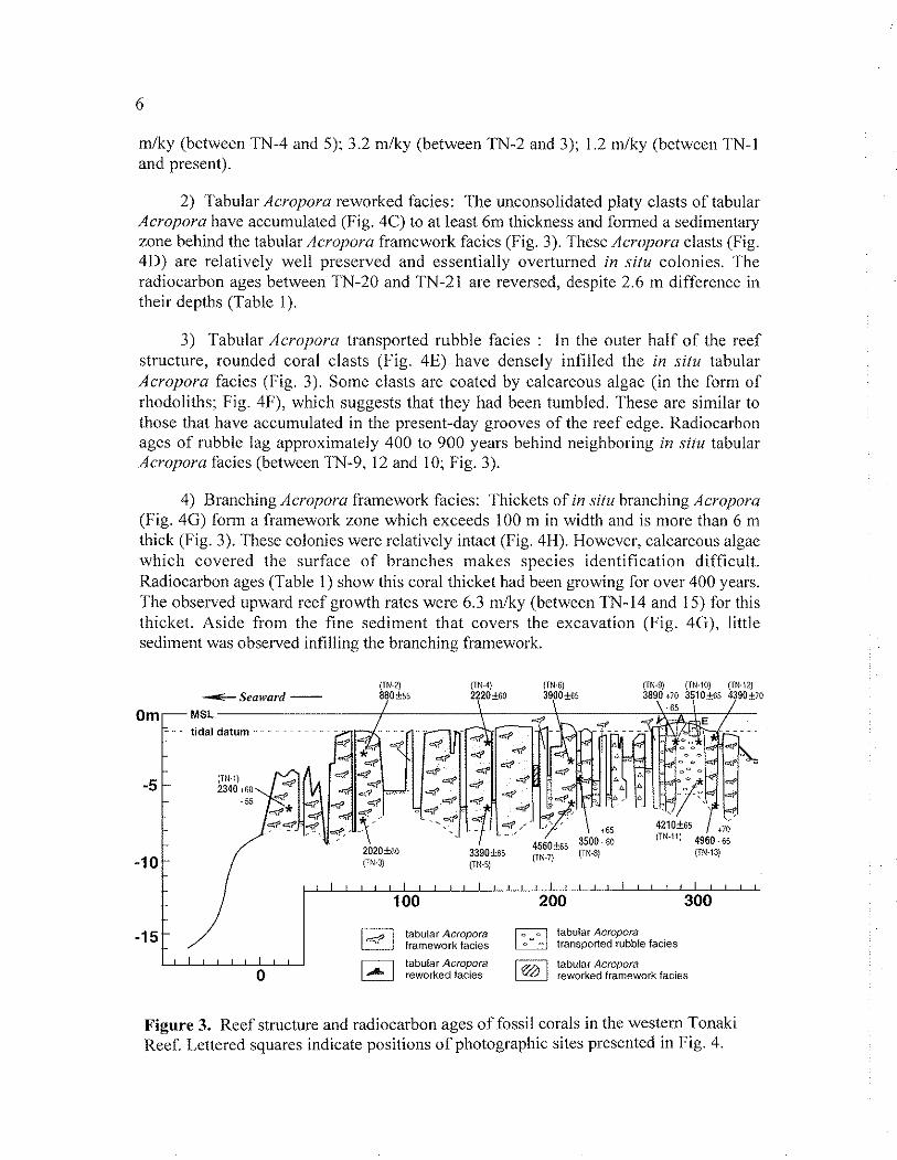
Late-Holocene sea level change
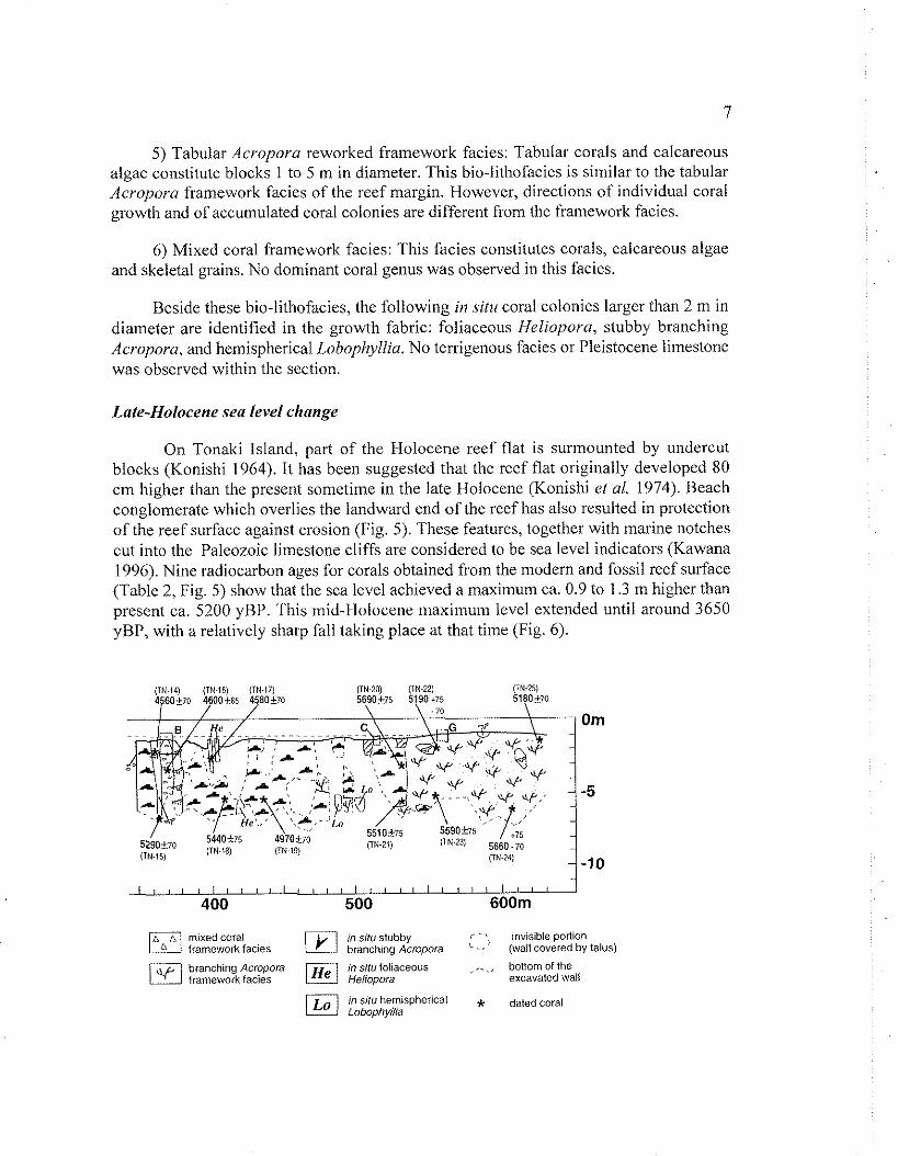
On Tonaki Island, part of the Holocene reef flat is surmounted by undercut blocks (Konishi 1964). It has been suggested that the reef flat originally developed 80 em higher than the present sometime in the late Holocene (Konishi el al. 1974). Beach conglomerate which overlies the landward end of the reef has also resulted in protection of the reef surface against erosion (Fig. 5). These features, together with marine notches cut into the Paleozoic limestone cliffs are considered to be sea level indicators (Kawana 1996). Nine radiocarbon ages for corals obtained from the modern and fossil reef surface (Table 2, Fig. 5) show that the sea level achieved a maximum ca. 0.9 to 1.3 m higher than present ca. 5200 yBP. This mid-Holocene tnaximum level extended until around 3650 yBP, with a relatively sharp fall taking place at that time (Fig. 6).
mimidcoral ilL_i in silu stubby i ' invisible portion framework facies branching Acropora ' -,' (wall covered by talus)
branching Acropora rn slfu foliaceous , ,. ., framework facies Heliopora
baltom of the excavated wall
in silu hemisphericai * dated coral Lobophyila
8
Table 1 Radiocarbon ages from Tonaki Reef excavation.
Sample Site Depth Material Labo. Radiocarbon Age Upward
No. (m)
No. ( ~ B . P , i l a ) Growth
(m) * MOW Life Form Rate MSI. 'l'(1/2)=5568yrs io,/kvr,
TN- I TN-2 TN-3 TN-4 TN-5
TN -6 TN-7 TN-8 'I'N-9 'TN- I0
TN-l l TN- 12 TN- 13 TN- 14 TN-I5
TN-16 TN-17 TN-18 TN-19 TN-20
TN-2 I TN-22 TN-23 TN-24 TN-25
6.5 I'la/yg~~.a hemispherical t HR-561 2.7 Acroporu tabular 'f
Acroporu Acropora Acroporu
Acroporu Acropora Acropora Awopora Awopora
Acroporu Acroporu Acropora Acropom Acropora
Acropora f feliopora Acropor~ Acropora Acropora
Awoporu Ao.oporu Acroporu Acropora Acropora
tabular t tabular t tabular i'
tabular i' tabular i' tabular :% tabular i' tabular :%
tabular :% tabular + tabular t tabular t tabular t tabular :% foliaceous I- tabular tabular tabular
tabular ramose i' ramose i' ramose "r ratnosc '4
* Sitc shows the sampling location corresponding to the horizontal scale orthe reef section (Fig. 2). I' in situ coral % rounded clast accumulated in groove ti' Growth rate is calculated on the basis of the TN-I sample and the top of the spur (present).
The present is assumed, as the spur has not reached sea-level.
Figure 4. I-iolocenc reef structures and components observed from the excavated wall of the western Tonaki Reef. Sites of the photographs are shown in Fig. 3. (A) In situ tabular Acropora facies, (R) paleo-groove (b) infilled by rounded coral clasts. Paleo- spur (a) composed of in .ritu tabular Acropora. (C) angular clasts of tabular Acropora reworked facies. (D) close-up of angular clast of tabular Acropora. (E) rounded coral clasts of tabular Acropora transported rubble facies. (F) a section of a rounded coral clast showing encrustations by calcareous algae. ( G ) branching Acropora framework facies. ( H ) colony of in sicu branching Acropora.
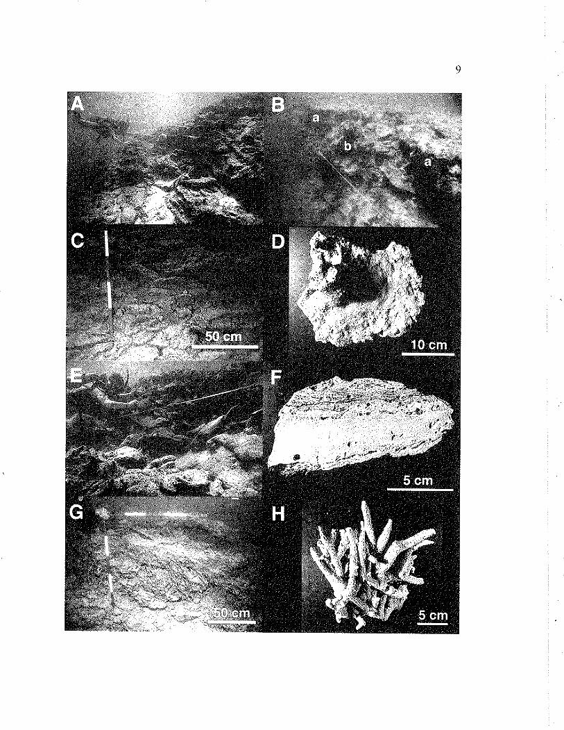
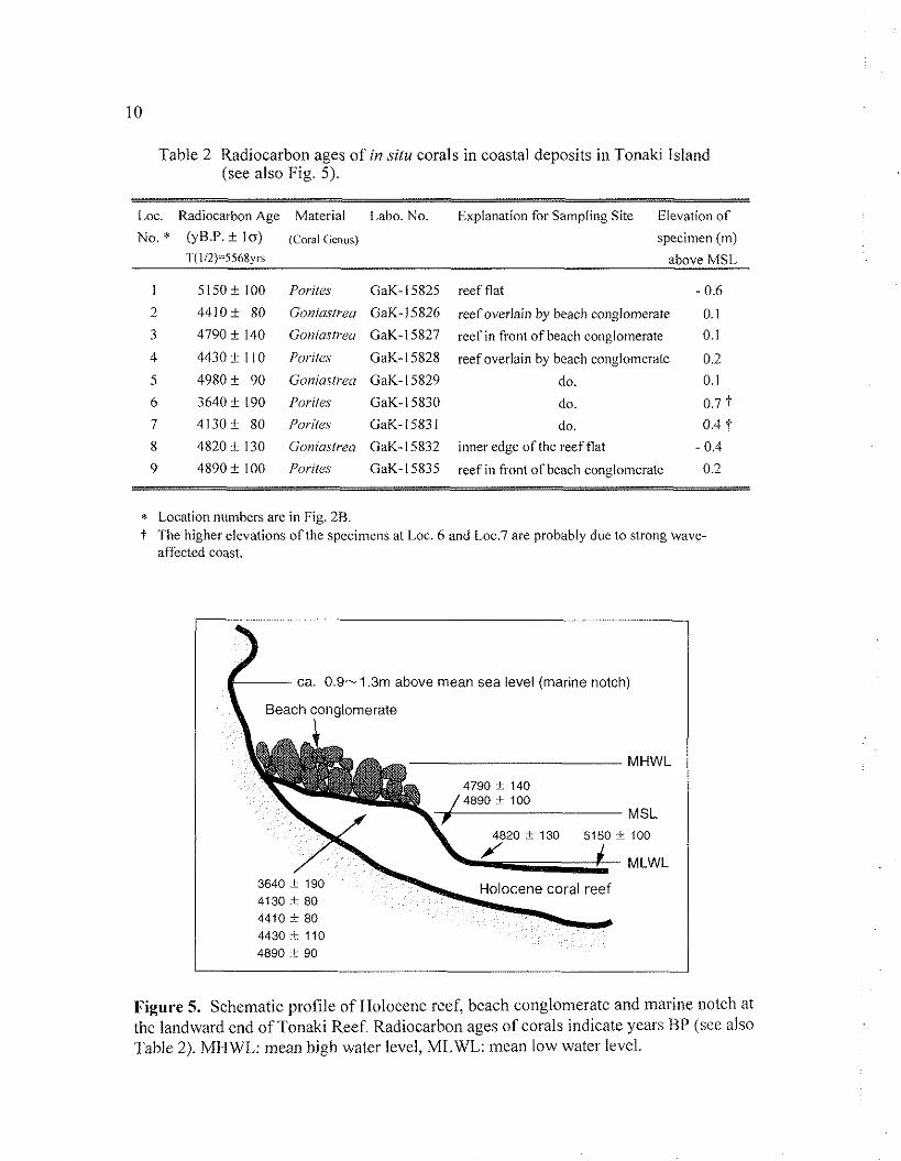
Table 2 Radiocarbon ages of in silu corals in coastal deposits in Tonaki Island (see also Fig. 5).
Loc. Radiocarbon Age Material Labo. No. Explanation for Sampling Site Elevation of
No. * (yH.P. * 10) (Coral Genus) specimen (tn) '1(112)=5568ys above MSL
1 5 150 i 100 Porite.~ GaK- 15825 reef flat - 0.6
2 44 10 i 80 Gouiaslrea GaK-I 5826 reef overlain by beach conglomerate 0.1
3 4790 i 140 Goniastrea GaK-15827 reef in front of beach conglomerate 0.1
4 4430 + l I0 Porim GaK-15828 reef overlain by beach conslomerate 0.2
5 4980 i 90 Goniastrea GaK-15829 do. 0.1
6 3640 + 190 I'oriter GaK-I 5830 do. 0.7 'i 7 4 130 + 80 Poriter. GaK- 1583 1 do. 0.4 t 8 4820 i 130 Goniastrea GaK-15832 inner edge of the reef flat - 0.4
9 4890 f 100 Porites GaK-15835 reef in front of beach conglomerate 0.2
* Location numbers are in Fig. 2B. t The higher elevations of the specimens at Loc. 6 and Loc.7 are probably due to strong wave-
affected coast.
Holocene coral reef
MHWL
MSL
100
MLWL
Figure 5. Schcmatic profile of Holocene reef, beach conglomerate and marine notch at the landward end of Tonaki Reef. Radiocarbon ages of corals indicate years BP (see also 'Table 2). MIIWL: mean high watcr Ievcl, MLWL: mean low watcr level.
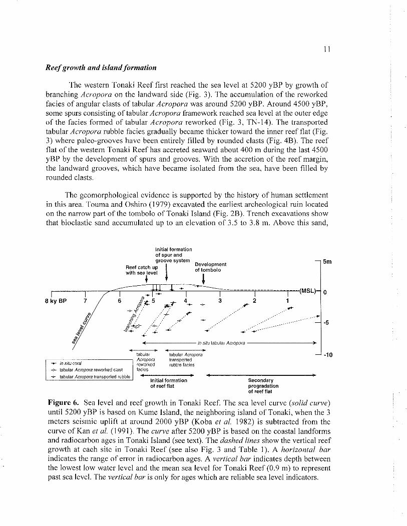
Reef growth and island formatioil
The western Tonaki Reef first reached the sea level at 5200 yBP by growth of branching Acropora on the landward side (Fig. 3). The accun~ulation of the reworked facies of angular clasts of tabular Acropora was around 5200 yBP. Around 4500 yBP, some spurs consisting of tabular Acroporu framework reached sea level at the outer edge of the facies formed of tabular Acropora reworked (Fig. 3 , 'I'N-14). The transported tabular Acroporu rubble facies gradually became thicker toward the inner reef flat (Fig. 3) where paleo-grooves have been entirely filled by rounded clasts (Fig. 4B). The reef flat of the western Tonaki Reef has accreted seaward about 400 m during the last 4500 yBP by the development of spurs and grooves. With the accretion of the reef margin, the landward grooves, which have became isolated from the sea, have been filled by rounded clasts.
The geomorphological evidence is supported by the history of human settlement in this area. Touma and Oshiro (1979) excavated the earliest archeological ruin located on the narrow part of the tombolo of Tonaki Island (Fig. 2B). Trench excavations show that bioclastic sand accumulated up to an elevation of 3.5 to 3.8 m. Above this sand.
Initial formation of spur and groove system -
Reef catch up I Development
with sea level of tombolo + / *
C ...............
* I - I I I (MSL)-
6 5 3 2 1 09; , .t- *$... .. .+C .is .+- ..... p .' ' I .... , , - .... $; , , ,+ ....
.... - .... . . . . . .
I * *' 4. *... * < iri 511" tabular Aciopora F -. .
tabular tabulai Acropora - Acropora transported reworked rubble facies . . .
initial formation Secondary of reef flat progradation
of reef flat
Figure 6. Sea level and reef growth in Tonaki Reef. The sea level curve (.solid curve) until 5200 yBP is based on Kume Island, the neighboring island of Tonaki, when the 3 meters seismic uplift at around 2000 yBP (Koba ei ul. 1982) is subtracted from the curve of Kan et ul. (1991). The curve after 5200 yBP is based on the coastal landforms and radiocarbon ages in Tonaki Island (see text). The dashed lines show the vertical reef growth at each site in Tonaki Reef (see also Fig. 3 and Table 1). A horizontal bar indicates the range of error in radiocarbon ages. A iwiical bar indicates depth between the lowest low water level and the mean sea level for Tonaki Reef (0.9 111) to represent past sea level. The ,wtical bar is only for ages which are reliable sea level indicators.
two layers of brown humic sand were observed with a thickness of betwcen 0.3 to 0.7 m below the present-day surface soil. The lower bed, just above the bioclastic sand, contains earthenware and shell middens. The radiocarbon age of shcll material was 3510+90 yBP (laboratory code: N-3080). This age coincides with the chronological determination of excavated earthenware (Touma and Oshiro 1979).
DISCUSSION
Sform features in flze reef development
The Ryukyu Islands are located in the hunicane belt. Catastrophic storm events result in obvious degradation of coral colonies (see review of Rogers 1993) and produce large amount of coral clasts (e.g. MacNeil 1954; ~ e r n a n d e z - ~ v i l a el ul. 1977; Scoffin 1993) during cyclic growth and destruction processes (Done 1992). The fragmentation of coral colonies appears to be a widespread and extremely important method of reproduction and distribution (Highsmith 1982). However, overturning of the colony is critical to survival (Chamberlain and Graus 1975). The morphology of tabular Acropora colonies which widen toward the top, when broken, produces the overturned accumulations of the tabular Acropora reworked facies. Storms on modern reefs can result in deposition in the back reef environment (c.f., MacNeil 1954; Newell and Bloom 1970) and mixing debris of varying ages (Johnson and Risk 1987). The observed age reversal between TN-20 and TN-21 in the tabular Acrojmra reworked facies is of similar magnitude to those obtained by Marshall and Davies (1982) from a drill core which penetrated into reef flat rubble facies in One Tree Reef on the Great Barrier Reef.
Catastrophic redistribution and abrasion by sediment have becn observed during storm conditions (Kobluk and Lysenko 1992) especially along reef-edge grooves (Kan 1995). The unstabilizcd rubble is subjccted to tumbling (Blanchon and Jones 1995) and infills cavities (Newcll 1956; Edmunds and Witman 1991). The transported tabular Acropora rubble facies accumulated between the tabular Acvopora framework facies (Fig. 4R) where 'room and pillar structures' (Tracey c.1 a1 1948) had been formed. Storr (1964) showed that water flow over the tops of reefs is erratic and the rate of flow is generally low, whereas passageways (c.g., grooves, reef tunnels) permit high flow rates. The initial accumulation site of fragmentated colonies (i.e., back reef or reef edge grooves) may cause the differentiation between angular or rounded rubble. The observed reef structure shows that the accumulated coral clasts form rounded rubble (transported rubble facies) after the development of a spur and groove system (Fig. 6).
Storm events can also dcstroy reef edge spurs (Stoddart 1962) and throw them onto the reef flat (Ladd 1961; Newel1 and Bloom 1970; Bourrouilth-Le Jan and Talandier 1985). The buried blocks of tabular Acropora reworked framework facies, along with the accumulation of a large amount of Acrojlora clasts and the tightly interlaced branching colonies (as in Fig. 4H) which may also be formed during the regenerative growth process of fragments (Kawaguti 1937; Gilmore and Hall 1976), suggest that the reef bas been contiuuously affected by high-energy events.
Windward-leeward contrast in the reef development
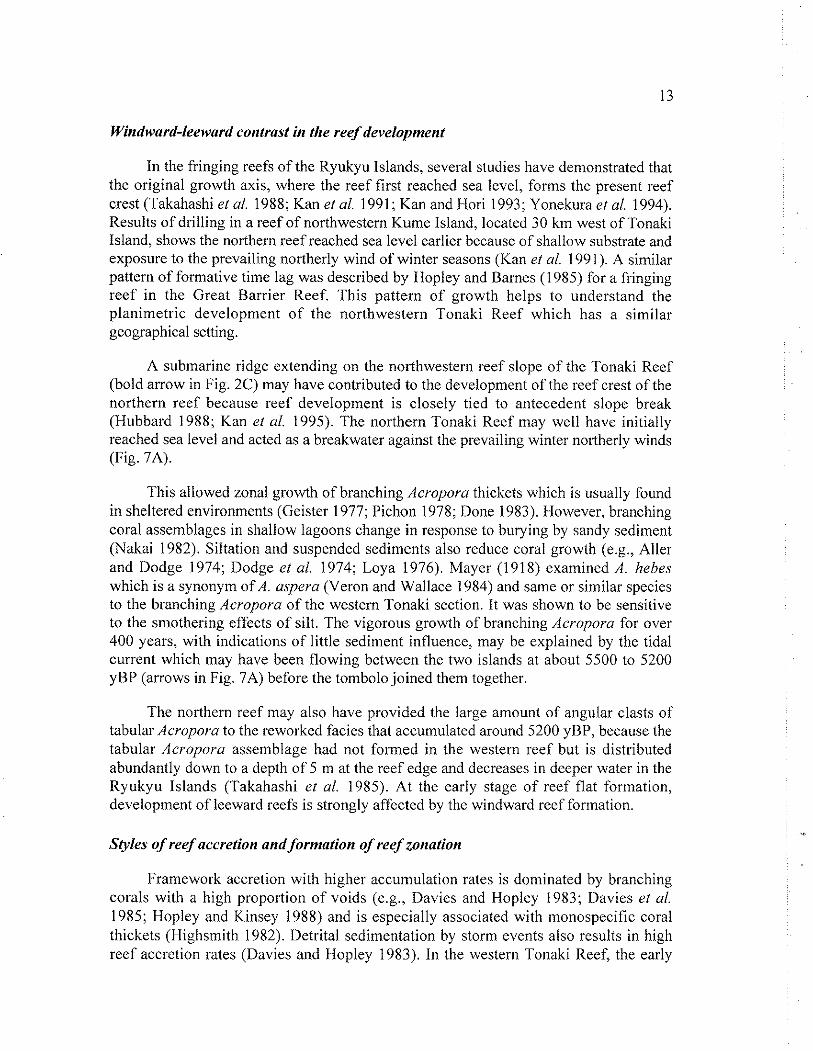
In the fringing reefs of the Ryukyu Islands, several studies have demonstrated that the original growth axis, where the reef first reached sea level, forms the present reef crest (Takahashi et al. 1988; Kan et al. 1991; Kan and Hori 1993; Yonekura et al. 1994). Results of drilling in a reef of northwestern Kume Island, located 30 km west of Tonaki Island, shows the northern reef reached sea level earlier because of shallow substrate and exposure to the prevailing northerly wind of winter seasons (Kan et al. 1991). A similar pattern of formative time lag was described by Hopley and Barnes (1 985) for a fringing reef in the Great Barrier Reef. This pattern of growth helps to understand the planimetric development of the northwestern Tonaki Reef which has a similar geographical setting.
A submarine ridge extending on the northwestern reef slope of the Tonaki Reef (bold arrow in Fig. 2C) may have contributed to the development of the reef crest of the northern reef because reef development is closely tied to antecedent slope break (Hubbard 1988; Kan et al. 1995). The northern Tonaki Reef may well have initially reached sea level and acted as a breakwater against the prevailing winter northerly winds (Fig. 7A).
This allowed zonal growth of branching Acropora thickets which is usually found in sheltered environments (Geister 1977; Pichon 1978; Done 1983). However, branching coral assemblages in shallow lagoons change in response to busying by sandy sediment (Nakai 1982). Siltation and suspended sediments also reduce coral growth (e.g., Aller and Dodge 1974; Dodge et al. 1974; Loya 1976). Mayer (1918) examined A. lzebes which is a synonym of A. aspera (Veron and Wallace 1984) and same or similar species to the branching Acropora of the western Tonaki section. It was shown to be sensitive to the smothering effects of silt. The vigorous growth of branching Acropora for over 400 years, with indications of little sediment influence, may be explained by the tidal current which may have been flowing between the two islands at about 5500 to 5200 yBP (arrows in Fig. 7A) before the tombolo joined them together.
The northern reef may also have provided the large amount of angular clasts of tabular Acropora to the reworked facies that accumulated around 5200 yBP, bccausc the tabular Acropora assemblage had not formed in the western reef but is distributed abundantly down to a depth of 5 m at the reef edge and decreases in dcepcr water in the Ryukyu lslands (Takahashi et al. 1985). At the early stage of reef flat formation, development of leeward reefs is strongly affected by the windward reef formation.
Styles of reef accretion and formation of reef zonation
Framework accretion with higher accumulation rates is dominated by branching corals with a high proportion of voids (e.g., Davies and Hopley 1983; Davies et al. 1985; Hopley and Kinsey 1988) and is especially associated with monospecific coral thickets (Highsmith 1982). Detrital sedimentation by storm events also results in high reef accretion rates (Davies and Hopley 1983). In the western Tonaki Reef, the early
stages of reef were developed by these two bio-lithofacies within a short period around 5200 yBP. They may have also contributed to the sediments of the broad inner reef flat at the western part of Tonaki Reef quickly infilling any shallow lagoons.
The duration of the 'Holocene high energy window' has some regional variation (Hopley 1984). The development of spurs consisting of tabular Acropora framework around 4500 yBP (Fig. 3, TN-14) intimates that the 'high energy window' has been progressively closcd since 4500 yBP. Subsequently, the area available for active carbonate production has been reduced to a zone at the reef edge (Stoddart et a1 1978) as reported in other present-day reefs (e.g., Gladfelter et a/. 1978; Kinsey 1981).
Since the size of wave-swept organisms depends on wave exposure (Denny et a/. 1985), the smaller colony sizes of in situ tabular Acropora on the outer reef flat suggest that the growth setting has changed to a wave-affected condition with the outward migration of the reef flat. The decline in vertical growth rates at the outward edge of the reef flat (Table 1, Fig. 6) has accompanied this change.
Contrary to reefs where the crest kept pace with sea level, the delayed closure of the 'Holocene high energy window' resulted in vigorous reef growth toward the island. Subsequently, however, the area of active reef growth has shifted progressively seaward with the development of reef edge spurs. This gradual process has contributed to the build up of flat topography with poor zonation.
Timing of island formation and sea level fall
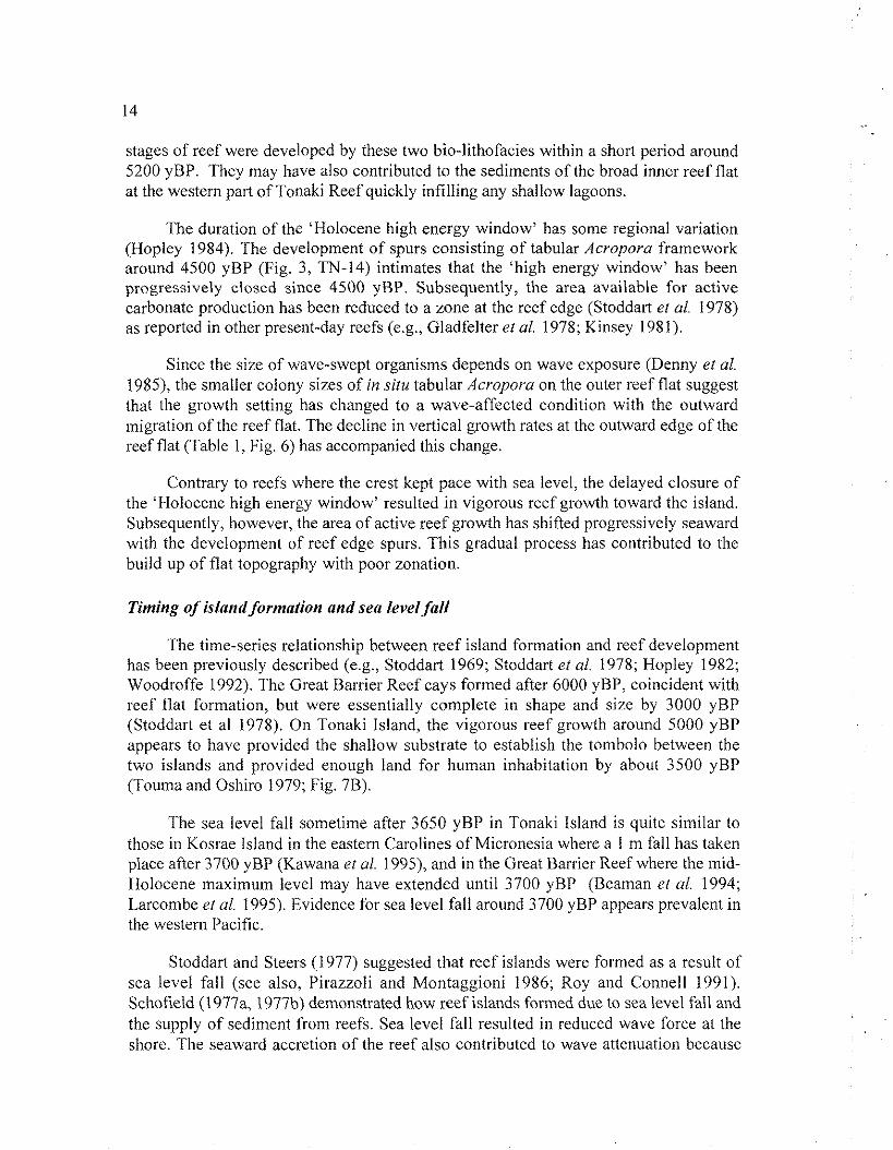
The time-series relationship between reef island formation and reef development has been previously described (e.g., Stoddart 1969; Stoddart et a/. 1978; Hopley 1982; Woodroffe 1992). The Great Barrier Reef cays formed after 6000 yBP, coincident with reef flat formation, but were essentially complete in shape and size by 3000 yBP (Stoddart et al 1978). On Tonaki Island, the vigorous reef growth around 5000 yBP appears to have provided the shallow substrate to establish the tombolo between the two islands and provided enough land for human inhabitation by about 3500 yBP (Touma and Oshiro 1979; Fig. 7B).
The sea level fall sometime after 3650 yBP in Tonaki island is quite similar to those in Kosrae Island in the eastern Carolines of Micronesia where a 1 m fall has taken place after 3700 yBP (Kawana et 01. 1995), and in the Great Barrier Reef where the mid- Holocene maximum level may have extended until 3700 yBP (Beaman et 01. 1994; Larcombe et al. 1995). Evidence for sea level fall around 3700 yBP appears prevalent in the western Pacific.
Stoddart and Steers (1977) suggested that reef islands were formed as a result of sea level fall (see also. I'irazzoli and Montaggioni 1986; Roy and Connell 1991). Schofield (1977a, 1977b) demonstrated how reef islands formed due to sea level fall and the supply of sediment from reefs. Sea level fall resulted in reduced wave force at the shorc. The seaward accretion of the reef also contributed to wave attenuation because
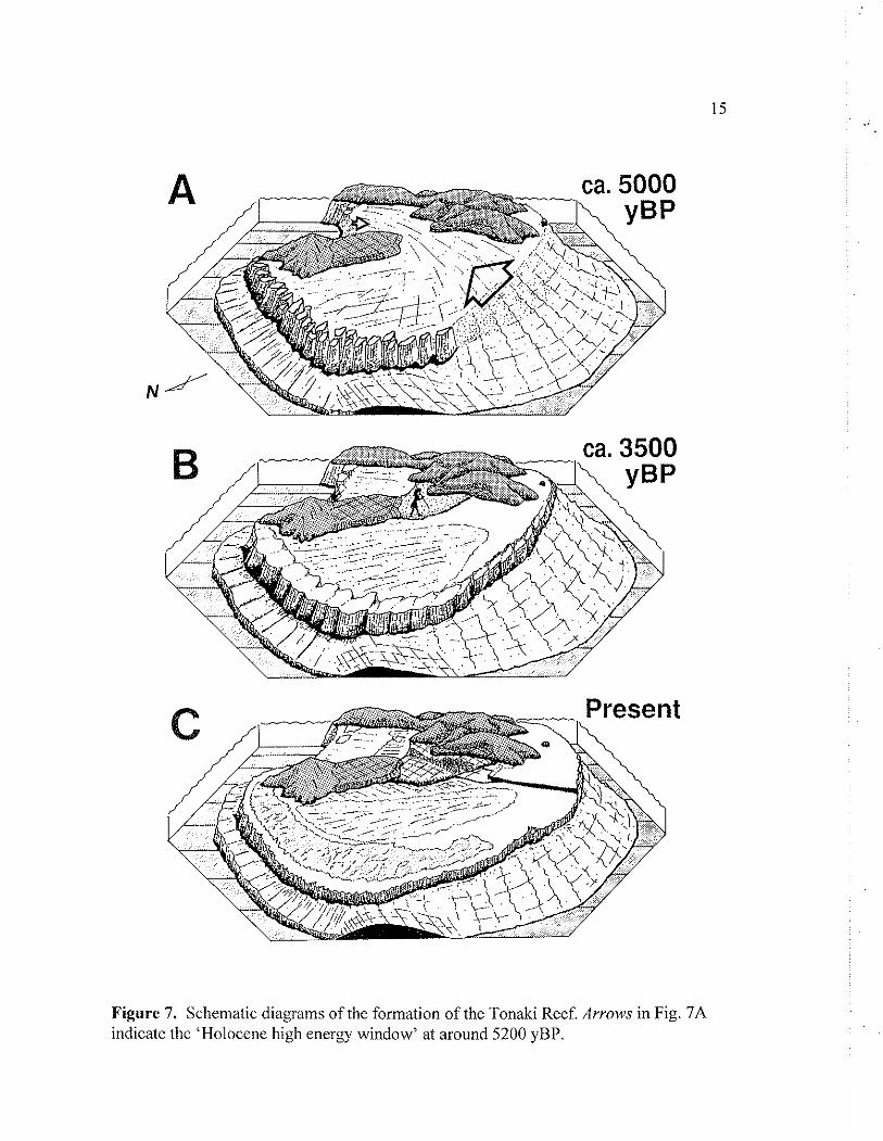
Figure 7. Schematic diagrams of the formation of the Tonaki Reef. Arrows in Fig. 7A indicate the 'Holocene high energy window' at around 5200 yBP.
waves break farther from the shore. At 3500 yBP, the western Tonaki reef flat accreted to approximately half way across the present-day reef flat (Fig. 7B). The sea level fall and reef maturation with development of wave resistant structures at the rccf edge, provided shore protection and contributed to tombolo stability.
CONCLUSION
Sea level achieved a maximum ca. 0.9 to 1.3 m higher than present ca. 5200 yBP in Tonaki Island, the central Ryukyus. This Holocene maximum level extended until around 3650 yBP, with a relatively sharp fall taking place at that time.
Early development of the reef in Holocene times was influenced by substrate topography that produced an initial zonation contrasting the outer windward margin, and the inner sheltered reef. Spur and groove systems were initiated with major reef accretion occurring by growth of the reef edge spurs. As inner grooves have become isolated from the sea, they have been infilled during storms by rounded coral clasts. The deposition of subaerial deposits of the tombolo of Tonaki Island is linked both to the accretion of the reef flat seaward, and to a fall in sea level about 3650 yBP.
ACKNOWLEDGEMENTS
The authors are indebted to: Dr. D. Hopley, Prof. L.F. Montaggioni, Dr. M.K. Gagan and Dr. J. Kleypas for their invaluable comments on this manuscript; Dr. I.G. Macintyre and Dr. J.I. Tracey for their helpful review; Prof. K. Fujiwara and Prof. T. Nakata for arrangement to use radiocarbon dating system at Hiroshima University; Prof. emeritus K. Kigoshi for radiocarbon dating at Gakushuin University; Mr. Y. Nakashima, Mr. K. Takemasa, Ms. Y. Oka and Mr. T. Toubara for their field assistance; Ms. N. Nakamura and Mr. K. Yoshihama provide us information about the harbor construction.
REFERENCES
ACEVEDO, R., MORELOCK, J. AND OLIVIERI, R.A. (1989) Modification of coral reef zonation by terrigenous sediment stress. Palaios, 4, 92-100.
ALLHI, R.C. AND DODGE, R.E. (1974) Animal-sediment relations in a tropical lagoon Discovery Bay, Jamaica. J Mar. Rex, 32,209-232.
B E A M A N , R,, LARCOMBE, P. AND CARTER, R.M. (1994) New evidence for the Holocene sea-level high from the inner shelf, Central Great Barrier Reef. J. Sediment. Res., A64,881-885.
BLANCHON, P. AND JONES, B. (1995) Marine-planation terraces on the shclf around Grand Cayman: a result of stepped Holocene sea-level rise. .I. Coastal Res., 11, 1 - 33.
B~URROUILTH-LE JAN, F.G. AND TALANDIER, J. (1985) Major high-energy events in a reef environment: tsunamis, hurricanes and tropical cyclones and their effects on
the sedimentology and geomorphology of an atoll: Rangiroa, Tuamotu, SE Pacific. Mar Geol , 67,263-333.
B U D D E M E I E R , R.W. AND HOPLEY, D. (1988) Turn-ons and turn-offs: cause and mechanisms of the initiation and termination of coral reef growth. Proc. 6th Int. Coral RegfSymp., 1,253-261.
CI - IAMBERLAIN, J.A. AND GRAUS, R.R. (1975) Water flow and hydromechanical adaptations of branched reef corals. Bull. Mar. Sci., 25, 1 12- 125.
DAVIES, P.J. AND I-IOPLEY, D. (1983) Growth fabrics and growth rates of Holocene reefs in the Great Barrier Reef. BMR J Aust. Geol. Geophys., 8, 237-25 1.
DAVIES, P.J., MARSHALL, J.F. A N D HOPLEY, D. (1985) Relationship between reef growth and sea level in the Great Barrier Reef. Proc. 5th Int. Coral Reef Congr., 3, 95-103.
DENNY, M.W., DANIEL, T. AND KOEHL, M.A.R. (1985) Mechanical limits to size in wave swept organisms. Ecol. Monogr., 55,69- 102.
DODGE, R.E., ALLER, R.C. AND THOMSON, J. (1974) Coral growth related to resuspension of bottom sediments. Nature, 247,574-577.
DONE, T.J. (1983) Coral zonation: its nature and significance. In: Barnes DJ (ed.) perspective.^ on coral reej~.. Brian Clouson, ACT Australia, 107-1 47.
DONE, T.J. (1992) Effects of tropical cyclone waves on ecological and geomorphological structures on the Great Barrier Reef. Continental ShelfRes., 12, 859-872.
EDMUNDS, P.J. A N D WITMAN, J.D. (1991) Effect of Hurricane Hugo on the primary framework of a reef along the south shore of St. John, US Virgin Islands. Mar. Ecol. Prog. Ser., 78,201-204.
FUJIWARA, K. AND NAKATA, T. (1 984) Methanol liquid scintillation radiocarbon dating I. Bull. Fac. Lit. Hiroshima Univ., 44, 120-134 (in Japanese).
GEISTER, J. (1977) The influence of wave exposure on the ecological zonation of Caribbean coral reefs. Proc. 3rd Int. Coral ReefSymp., 1,23-29.
GILMORE, M.D. AND HALL, B.R. (1976) Life history, growth habits, and constructional role of Acropora cervicornis in the patch reef environment. Sed. Petrol., 46, 5 19-522,
GINSBURG, R.N. AND SHINN, E.A. (1964) Distribution of the reef-building community in Florida and the Bahamas. A.A. P.G. Bull., 48,527.
GL.ADFELTER, E.H., MONAHAN, R.K. AND GLADFELTER, W.B. (1978) Growth rates of five reef-building corals in the northeastern Caribbean. Bull. Mar. Sci., 28, 728- 734,
GOURLAY, M.R. (1988) Coral cays: products of wave action and geological processes in a biogenic environment. Proc. 6th Int. Coral ReefSymp., 2,491 -496.
HERNANDEZ-AVILA, M.L., ROBERTS, H.H. AND ROUSE, L.J. (1977) Hurricane- generated waves and coastal rampart formation. Proc. 3rd Int. Coral ReefSymp., 2, 71-78.
HIGHSMITH, R.C. (1982) Reproduction by fragmentation in corals. Mar. Ecol. Monogr. Ser., 7,207-226.
HOPLEY, D. (1968) Morphology of Curacoa Island spit, North Queensland. Ausi. J. Sci., 31, 122-123.
HOPLEY, D. (1971) The origin and significance ofNorth Queensland island spits. ZeitsJ:
Geomorph. N.F., 15,371-389. HOPLEY, D. (1975) Contrasting evidence for Holocene sea levels with special reference
to the Bowen-Whitsunday area of Queensland. In: Douglas, I., I-Iobbs, J.E. and Pigram, J.J. (eds.) Geographical Essays in Honour ofGilbert J Butland, Dept. Geogr., Univ. New England, Armidale, 5 1-84
HOPLEY, D. (1982) Geomorphologv ofthe Great Barrier ReejQuaternary development ofcoral reefs. John Wiley-Interscience, New York, 453pp
HOPLEY, D. (1984) The Holocene 'high energy window' on the Central Great Barrier Reef. In: Thoni, B.G. (ed.) Coastal geomorphology in Australia, Academic Press, 135-150.
HOPLEY, D. AND BARNES, R. (1985) Structure and development of a windward fringing reef, Orpheus Island, Palm Group, Great Barreir Reef. Proc. 5th Int. Coral Reef Congr.,3, 141-146.
HOPLEY, D. AND KINSEY, D.W. (1988) The effects of a rapid short-term sea-level rise on the Great Barrier Reef. In: Pearman, G.I. (ed.) Greenhou.re: planning for climate change, CSIRO Australia, Melbourn, 189-201.
HUBBARD, D.K. (1988) Controls of modern and fossil reef development, common ground for biological and geological research. Proc. 6th In/. Coral Reef Symp., 1, 243-252.
JOHNSON, D.P. AND RISK, M.J. (1987) Fringing reef growth on a terrigenous mud foundation, Fantome Island, central Great Barrier Reef, Australia. Sedimentology, 34, 275-287.
KAN, H. (1990) The upper reef-slope topography of Kume Island, central Ryukyus, Japan. In: Region and L fe II, Okayama Univ. 40th Anniv. Geogr. Issue, 1-12 (in Japanese with English abstract).
KAN, H. (1995) Typhoon effects on sediment movement on reef edges and reef slopes. In: Bellwood, O., Choat, H. and Saxena, N. (eds.) Recent advances in marine science and technology '94. Pacon International and James Cook IJniv, Townsville, 19 1-20 1.
K A N , H. A N D HORI, N. (1991) Methodology and conceptual design for geomorphological surveying of submarine 'road cut' in modern reef-flats. Geogr. Sci., 46,208-221.
K A N , H . A N D H O R I , N. (1993) Formation of topographic zonation on the well- developed fringing reef-flat, Minna Island, the Central Ryukyus. Trans. Juj~anese Geomorph. Union, 14, 1-16.
KAN, H., TAKAHASHI, T. AND KOBA, M. (1991) Morpho-dynamics on Holocene reef accretion: drilling results from Nishimezaki Reef, Kume Island, the Central Ryukyus. Geogr. Rev. Japan, 64B, 1 14-13 1.
KAN, H., HORI, N., NAKASHIMA, Y. AND I C H I K A W A , K. (1995) Narrow reef flat formation in a high-latitude fringing reef. Coral Re& 14, 123-130.
K A W A G U T I , S. (1937) On the physiology of reef corals 111 Regeneration and phototropism in reef corals. Palao Trop. Biol. St. Stud, 1,209-216.
KAWANA, T., MIYAGI, T., FUJIMOTO, K. AND KIKUCHI, 1'. (1995) Late Holocene sea- level changes and mangrove development in Kosrae Island, the carolines, Micronesia. In: Kikuchi, T. (ed.) Rapid .sea level rise and mangrove habitat, 1-7.
KAWANA, T. (1996) Late Holocene sea level change in non-limestone area in the central Ryukyus., Ahsi. Japan Geogr. Assoc., 50, 116-1 17 (in Japanese).
KINSEY, D.W. (1981) The PacificIAtlantic reef growth controversy. Proc. 4th Int. Coral ReefSymp., 1,493-498.
KOBA, M., NAKATA, T. AND ~ ' A K A H A S H I , T. (1982) Late Holocene eustatic sea-level changes deduced from geomorphological features and their '4C dates in the Ryukyu Islands, Japan. Palaeoclimatol. Palaeogeogr. Palaeoecol., 29,23 1-260
KOBLUK, D.R. AND LYSENKO, M.A. (1992) Storm features on a southern Caribbean fringing coral reef. Pulaios, 7 , 2 13-22 1.
KONISHI, K. (1964) Geologic note on Tonaki-jima and width of Motobu Belt, Ryukyu Islands. Sci. Rep. Kanazawa Univ., 9, 169- 188.
KONISHI, K., OMURA, A. AND NAKAMICHI, 0. (1974) Radiometric coral ages and sea level records from the late Quaternary reef complexes of the Ryukyu Islands. Proc. 2nd In/. Coral Reef Symp., 2, 595-6 13.
LARCOMBE, P., CARTER, R.M., DYE, J., GAGAN, M.K. AND JOHNSON, D.P. (1995) New evidence for episodic post-glacial sea-level rise, central Great Barrier Reef, Australia. Mar. Geol., 127, 1-44.
LADD, 1i.S. (1961) Reef Building. Science, 134,703-715. LOYA, Y. (1976) Effects of water turbidity and sedimentation on the community
structure of Puerto Rican corals. Bull. Mar. Sci., 26, 450-466. MACNEIL, F.S. (1954) Organic reefs and banks and associated detrital sediments. Amer.
J. Sci., 252, 385-401. MARSHALL, J.F. AND DAVIES, P.J. (1982) Internal structure and Holocene evolution of
One Tree Reef, southern Great Barrier Reef. Coral Reefy, 1,21-28. MAYER, A.G. (1918) Ecology of the Murray Island coral reef. Pap. llepi. Mar. Biol.
Carneg. Inst. Wash., 9, 1-48. NAKAI, T. (1982) Micro-topographic structure and sediment movement on modern reef
flat, Yoron Island. Absi. Japan Geogr. Assoc., 22, 118-1 19 (in Japanese). NEUMANN, A.C. (1972) Quaternary sea level history of Bermuda and the Bahamas. Am.
Quai. Assoc. 2nd Nul. Con$ Abst., 41-44. NEUMANN, A.C. AND MACINTYRE, I.G. (1985) Reef response to sea level rise: keep-
up, catch-up or give-up. Proc. 5th Int. Coral Reef-fongr., 3, 105-1 10. NEWELL, N.D. (1956) Geological reconnaissance of Rarioa (Kon Tiki) Atoll, Tuarnotu
Archipelago. Bull. Am. Museum. Nut. Hist., 109,311-372. NEWELL, D. AND BLOOM, A.L. (1970) The reef flat and 'two-meter eustatic terrace' of
some Pacific Atolls. Geol. Soc. Am. Bull., 81, 1881-1894. PICHON, M. (1978) Recherches sur les peuplements a dominance d'anthozoaires dans
les recifs coralliens de Tulear (Madagascar). ,41011 Res. Bull., 222, 1-447. PIRAZZOLI, P.A. AND MONTAGGIONI, L.F. (1986) Late Holocene sea-level changes in
the northwest Tuamotu Islands, French Polynesia. Qua/ernary Res., 25,350-368. ROGERS, C.S. (1993) Hurricanes and coral reefs: the intermediate disturbance
hypothesis revisited. Coral Reefi, 12, 127-137. ROY, P. A N D CONNELI., J. (1991) Climate change and the future of atoll stales. .I.
Coasral Res., 7, 1057-1075. SCHLAGER, W . (1981) The paradox of drowned reefs and carbonate platforms. Geol.
Soc. Am. Bull., 92, 197-21 1. SCHOFIELD, J.C. (1977a) Late Holocene sea level, Gilbert and Ellice Islands, west
central Pacific Ocean. N.Z. .I. Geol. Geophys., 20,503-529. SCHOFIELD, J.C. (1977b) Effect of late Holocene sea-level fall on atoll development.
N Z J. Geol. Geophys., 20,53 1-536. SCOFFIN, T.P. (1993) The geological effects of hurricanes on coral reefs and the
interpretation of storm deposits. Coral Reefs, 12, 203-221. STODDART, D.R. (1962) Catastrophic storm effects on the British Honduras reefs and
cays. Nature, 196, 512-515. STODDART, D.R. (1969) Sand cays of eastern Guadalcanal. Phil. Trans. Roy. Soc.
Lond, B255,403-432. STODDART, D.R., MCLEAN, R.F., SCOFFIN, T.P., THOM, B.G. AND HOPLEY, D.
(1978) Evolution of reefs and islands, northern Great Barrier Reef: synthesis and interpretation. Phil. Trans. Roy. Sac. Lond., B284, 149-159.
STODDART, D.R. A N D STEERS, J.A. (1977) The nature and origin of coral reef islands. In: Jones, O.A. and Endean, R. (eds.) B i o l o ~ y and geology ,yf coral reeji IV, Academic Press, 59- 105.
STORR, J.F. (1964) Ecology and oceanography of the coral-reef tract, Abaco Island, Bahamas. Geol. Soc. Am. Spec. Pap., 79, 1-98.
TAKAHASHI, T. AND KOBA, M. (1977) Emerged Holocene coral reefs around Kume Island, Ryukyus. Sci Rept. Tohoku Univ., Ser 7,27, 81-94.
TAKAHASHI, T., KOBA, M. A N D NAKAMORI, T. (1985) Coral reefs of the Ryukyu Islands: reef morphology and reef zonation. Proc. 5th Int. Coral Reef Congr., 3, 211-216.
TAKAHASHI, T., KOBA, M. AND KAN, 13. (1988) Relationship between reef growth and sea level on the northwestern coast of Kume Island, the Ryukyus: data from drill holes on the Holocene coral reef. Proc. 6th Int. Coral ReefSymp., 3,491 -496.
TOUMA, S. AND OSHIRO, A. (1979) Research report for excavation of Higashi shell midden. In: Archeological ruin on Tonaki Island I, Educ Board Tonaki Village, 1- 44 (in Japanese).
TRACEY, J.I., LADD, H.S. A N D I-IOFFMEISTER, J.E. (1948) Reefs of Bikini, Marshall Islands. Geol. Soc. Am. Bull., 59,861-878.
VERON, J.E.N. AND WALLACE, C.C. (1984) Scleractinia of Eastern Australia part V Family Acroporidae. Aust. Inst. Mar. Sci. M o n o s Ser., 6 , 4 8 5 ~ ~ .
WOODROFFE, C.D. (1992) Morphology and evolution of reef islands in the Maldives. Proc. 7th Int. Coral Reef'Symp., 2, 12 17- 1226.
YONEKURA, N., KAYANNE, H., MATSUMOTO, E., ISHII, T., MATSUSHIMA, Y., HORI, N. AND NAKAI, T. (1994) Geon~orphic development of modern fringing reefs of Yoron Island, Ryukyu Arc, Japan. The Quai. Res. (Daiyonki Kenkyuj, 33,67-79.