Embed Size (px)
Citation preview
University of Southern Queensland
Faculty of Health, Engineering and Sciences
Asset Condition Monitoring of Gympie Regional
Council’s Road Network
A dissertation submitted by
Liam Douglas Watson
in fulfilment of the requirements of
ENG4111 and ENG4112 Research Project
towards the degree of
Bachelor of Engineering (Honours) (Civil)
Submitted 13 October, 2016
i
Abstract
Gympie Regional Council (GRC) spends between $10M-$15M on roadworks as part
of its annual capital works program. Currently, the selection of projects for these
programs relies heavily on customer complaints, councillor requests and feedback
from GRCs Construction and Maintenance Branch. GRCs Design Service Division has
identified a need for this process to include quantifiable asset condition data, giving
the project selection process a consistent and impartial foundation. This project
seeks to define a process which will result in the collection of road condition data
which can then be used to identify road segments in need of capital works.
Road condition assessments seek to provide an indication of the overall condition of
the road by identifying and recording defects in the road pavement and surfacing. As
road condition is linked to the age of the asset, road segments found with high defect
rates, thus approaching the end of their useful life can be programmed in for capital
works. The goal is to provide a reliable long term capital works program to ensure
optimal distribution of the available funding.
An analysis of the available literature covering road condition assessments was
undertaken. This included nationally recognised best-practice manuals by
Austroads, to research papers addressing state of the art data collection techniques.
GRCs practices regarding road condition assessment were reviewed. This lead to
conducting a gap analysis between GRCs existing road inspection procedure and
what is currently accepted as best-practice. The above-mentioned research, review
and gap analysis provided the platform for the development of draft corporate
documents for GRC concerning road condition assessment, including an operational
framework.
The framework comprises of an initial assessment phase where the entire sealed
road network is screened using road roughness measurement. The roughness data
is then used to shortlist a portion of the road network for detailed assessment.
There is scope for the detailed assessment phase to be undertaken by GRCs existing
inspectors. The framework was developed with a focus on the following findings:
Quality data must be collected and used; otherwise there will be little
confidence in the outputs of the system.
ii
From a strategic planning standpoint, the condition of a road does not
change rapidly. Therefore, frequent inspection cycles are unnecessary and
uneconomical.
The amount of roadworks that can be undertaken is ultimately controlled by
the available funding. Therefore, the number of candidate projects is limited
by this and the scope of condition inspections should reflect this.
Beyond this project, the next step will be to run a pilot inspection program to test
the framework. From there, a process of evaluation and review can be implemented
to ensure that GRC benefits from the framework as much as possible.
In conclusion, the establishment of a road condition assessment program for GRC is
very much achievable in the short to medium term. This will lead to increased
confidence in the outputs of the capital works programming process.
iii
University of Southern Queensland
Faculty of Health, Engineering and Sciences
ENG4111 & ENG4112 Research Project
Limitations of Use
The Council of the University of Southern Queensland, its Faculty of Health,
Engineering and Sciences, and the staff of the University of Southern Queensland, do
not accept any responsibility for the truth, accuracy or completeness of material
contained within or associated with this dissertation.
Persons using all or any part of this material do so at their own risk, and not at the
risk of the Council of the University of Southern Queensland, its Faculty of Health,
Engineering and Sciences or the staff of the University of Southern Queensland.
This dissertation reports an educational exercise and has no purpose or validity
beyond this exercise. The sole purpose of the course pair entitles “Research Project”
is to contribute to the overall education within the student’s chosen degree
program. This document, the associated hardware, software, drawings, and any
other material set out in the associated appendices should not be used for any other
purpose: if they are so used, it is entirely at the risk of the user.


v
Acknowledgements
Many thanks go to my project supervisor Dr Mahmood as his timely assistance
ensured I completed this project. Acknowledgements also go to GRC staff that’ve
assisted me and the neighbouring Fraser Coast Regional Council for providing some
vital insights on their approach to road condition assessment.
vi
Table of Contents
Chapter 1: Introduction ......................................................................................................................... 1
1.1 Road Condition Assessment for GRC .................................................................................... 2
1.2 Gympie Regional Council .......................................................................................................... 3
1.3 Consequential Effects ................................................................................................................. 4
1.4 Ethical Responsibility ................................................................................................................. 5
1.5 Project Planning – Methodology, Resource Analysis and Task Timelines ............ 6
1.6 Risk Assessment ........................................................................................................................... 7
Chapter 2: Literature Review ............................................................................................................10
2.1 Introduction ..................................................................................................................................10
2.2 Road Condition Assessments ................................................................................................10
2.3 Road Asset Information ...........................................................................................................11
2.2.1 Road Hierarchy ...................................................................................................................11
2.2.2 Road Segmentation ...........................................................................................................11
2.2.3 Road Componentisation ..................................................................................................12
2.2.4 Useful Life..............................................................................................................................13
2.4 Condition Data Distress Modes.............................................................................................15
2.3.1 Roughness .............................................................................................................................15
2.3.2 Deformation .........................................................................................................................16
2.3.3 Cracking .................................................................................................................................17
2.3.4 Wearing Course Defects ..................................................................................................19
2.3.5 Maintenance Patching ......................................................................................................21
2.3.6 Strength ..................................................................................................................................22
2.5 Condition Data Needs ...............................................................................................................22
2.6 Condition Data Collection .......................................................................................................24
2.5.1 Defect specific collection methods..............................................................................25
vii
2.7 Condition Assessment Frequency .......................................................................................29
2.8 Condition Data Modelling .......................................................................................................30
2.9 Conclusion .....................................................................................................................................30
Chapter 3: Review of Gympie Regional Council’s Road Condition Assessment
Practices .....................................................................................................................................................32
3.1 Organisational Structure .........................................................................................................32
3.2 Policies and Procedures...........................................................................................................32
3.3 Road Asset Register ...................................................................................................................34
3.4 Capital Works Prioritisation Process .................................................................................35
3.5 Existing Inspection Regimes ..................................................................................................36
Chapter 4: Current Best Practice and Gap Analysis..................................................................38
4.1 Introduction ..................................................................................................................................38
4.2 Best Practice .................................................................................................................................38
4.3 Gap Analysis .................................................................................................................................39
4.3.1 Inspection Frequency .......................................................................................................40
4.3.2 Distress Modes Collected ................................................................................................40
Chapter 5: Road Condition Assessment Framework for Gympie Regional Council ....42
5.1 Proposed Framework ...............................................................................................................42
5.1.1 Asset Register and GIS Database .................................................................................43
5.1.2 Initial Assessment Phase (Screening) .......................................................................44
5.1.3 Screening Results using Initial Assessment Results ............................................46
5.1.4 Detailed Assessment Phase ...........................................................................................47
5.1.5 Condition Assessment Results......................................................................................47
5.1.6 Review and Continuous Improvement .....................................................................49
6.0: Conclusion .........................................................................................................................................50
6.1 Recommendations/Further Research ...............................................................................51
References .................................................................................................................................................53
viii
Appendix A: Project Specification ....................................................................................................57
Appendix B: GRC Work Instruction – Road Inspections .........................................................58
Appendix C: GRC Enterprise Risk Management Procedure ..................................................62
Appendix D: GRC Enterprise Risk Assessment Record ...........................................................67
Appendix E: GRC Organisational Structure ..................................................................................68
Appendix F: GRC Asset Maintenance Inspection Form (Partial Copy) .............................69
Appendix G: GRC Inspection and Prioritisation of Reseals ...................................................70
ix
List of Figures
Figure 1: Generic Asset Management Process .............................................................................. 1
Figure 2: Map of Gympie Regional Council .................................................................................... 3
Figure 3: Project Gantt Chart ............................................................................................................... 8
Figure 4: Example of Road Segmentation .....................................................................................12
Figure 5: The components of a roadway .......................................................................................13
Figure 6: Remaining useful life of an asset ...................................................................................14
Figure 7: Deformation Defects in Flexible Pavements ............................................................16
Figure 8: Cracking of Flexible Pavements ....................................................................................18
Figure 9: Surface Distress of Flexible Pavements .....................................................................20
Figure 10: Information Quality Level Concept ...........................................................................23
Figure 11: Current Capital Works Programming Cycle ..........................................................36
Figure 12: Proposed Condition Assessment Framework ......................................................43
Figure 13: Example of GRC Video Footage ...................................................................................46
Figure 14: Example of Imported Condition Data within the Asset Register ..................48
Figure 15: Updated Capital Works Programming Cycle .........................................................48
List of Tables
Table 1: Enterprise Risk Assessment Record ............................................................................... 9
Table 2: Cost/Performance Trade-off Matrix for Data Collection Methods ...................25
Table 3: Detailed Roughness Data Collection Methods ..........................................................26
Table 4: Example of Subjective Roughness Ratings .................................................................27
Table 5: Summary of Road Network Management Policies and Procedures.................32
Table 6: Inspection Frequency Gap Analysis ..............................................................................40
Table 7: Road Distress Mode Gap Analysis ..................................................................................41
Table 8: Roughness Data Output Specification. Adapted from ............................................45
x
Abbreviations and Acronyms
ARRB Australian Road Research Board
EA Engineers Australia
IIMM International Infrastructure Management Manual
IPWEA Institute of Public Works Engineers Australasia
GRC Gympie Regional Council
LATM Local Area Traffic Management: areas of road that have specially
design characteristics to control vehicle speed and movement.
LGAQ Local Government Association of Queensland
LRRS Local Roads of Regional Significance. A selection of twenty (20) roads
within the Gympie region that are eligible for State Government
funding as administered by RRTG.
RRTG Regional Roads and Transport Group. “A cooperative governance
arrangement between the Department of Transport and Main Roads,
the Local Government Association of Queensland (LGAQ) and local
governments to invest in and regionally manage the Queensland
transport network.” (TMR 2015)
TMR Queensland Government Department of Transport and Main Roads
QA Quality Assurance
ERP2016 Asset Condition Monitoring of Page 1 of 71 Gympie Regional Council’s Road Network
Liam Watson 0050074366
Chapter 1: Introduction
The Australian, state, territory and local Governments expended $15.8 billion on
road related activities during 2008/09 (BITRE 2011). Driving the allocation of this
expenditure will be each organisations asset management framework, which
“applies a systematic approach of maintaining, upgrading, and operating physical
assets cost effectively … with sound business practices and economic theory”
(Bryant & Flintsch 2006, p. 12). In order for the asset management framework to
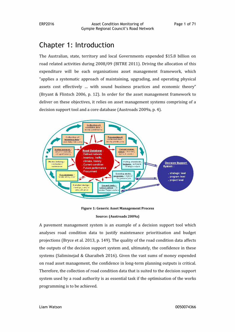
deliver on these objectives, it relies on asset management systems comprising of a
decision support tool and a core database (Austroads 2009a, p. 4).
Figure 1: Generic Asset Management Process
Source: (Austroads 2009a)
A pavement management system is an example of a decision support tool which
analyses road condition data to justify maintenance prioritisation and budget
projections (Bryce et al. 2013, p. 149). The quality of the road condition data affects
the outputs of the decision support system and, ultimately, the confidence in these
systems (Saliminejad & Gharaibeh 2016). Given the vast sums of money expended
on road asset management, the confidence in long-term planning outputs is critical.
Therefore, the collection of road condition data that is suited to the decision support
system used by a road authority is as essential task if the optimisation of the works
programming is to be achieved.
ERP2016 Asset Condition Monitoring of Page 2 of 71 Gympie Regional Council’s Road Network
Liam Watson 0050074366
1.1 Road Condition Assessment for GRC
This project aims to produce a road condition assessment framework for the
Gympie Regional Council (GRC) that is economical and purpose-built for the region.
The framework aims to deliver quantifiable road condition data that will underpin
the systematic allocation of rehabilitation expenditure on GRCs road network. At
present, there is very little to no quantifiable condition data used in the project
prioritisation process.
“The over-riding obligation on Council in managing the road network is
to maintain a focus on asset management and long term financial
sustainability. This obligation is embedded in the Local Government Act
2009 and Local Government (Finance, Plans and Reporting) Regulation
2010 and further developed in the state government’s “Financial
management (sustainability) Guideline 2011”.” (GRC 2016, p. 4)
By being able to support the distribution of rehabilitation expenditure with
impartial condition assessment data, this project will assist GRC in meeting the
above obligations as well as managing “the challenge of fiscal austerity that faces
governments throughout the world and will beset Australia too for at least another
decade” (Evans & Sansom 2015, p. 4).
This project will consider sealed roads, with the following elements being covered in
detail:
A framework for road condition assessments.
An outline of the procedures for road condition assessments, including:
An initial assessment phase
The screening of the sealed road network
The detailed assessment of the shortlisted road segments
Adding the condition assessment results to GRCs asset management
software
Some existing activities that will benefit from the outcomes of this project include:
The streamlining of council’s existing inspection procedures that will allow
the incorporation of a road condition monitoring program with minimal
extra financial output.
ERP2016 Asset Condition Monitoring of Page 3 of 71 Gympie Regional Council’s Road Network
Liam Watson 0050074366
The project selection process for long-term capital works programming.
A major goal of this project will be to ensure the final framework is logical and
presented in a simple manner. This is especially relevant to the road condition
assessment procedure as it may be used by a broad range of personnel, not all of
which will have a background in the technical aspects of road asset management.
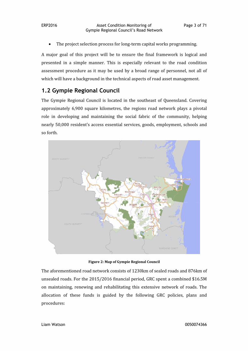
1.2 Gympie Regional Council
The Gympie Regional Council is located in the southeast of Queensland. Covering
approximately 6,900 square kilometres, the regions road network plays a pivotal
role in developing and maintaining the social fabric of the community, helping
nearly 50,000 resident’s access essential services, goods, employment, schools and
so forth.
Figure 2: Map of Gympie Regional Council
The aforementioned road network consists of 1230km of sealed roads and 876km of
unsealed roads. For the 2015/2016 financial period, GRC spent a combined $16.5M
on maintaining, renewing and rehabilitating this extensive network of roads. The
allocation of these funds is guided by the following GRC policies, plans and
procedures:
ERP2016 Asset Condition Monitoring of Page 4 of 71 Gympie Regional Council’s Road Network
Liam Watson 0050074366
Asset Management Policy (PRESD400)
Road Network Policy (ESPOL015)
Road Maintenance Procedure (ISP018)
Road Plan (Draft)
Infrastructure Road Asset Maintenance Plan (Draft)
Inspection and Prioritisation of Reseals (ISP055)
1.3 Consequential Effects
The long term consequential effect of this project will be the improvement in
programming of road rehabilitation works leading to optimal value for money on
GRCs capital expenditure. In the short to medium term, there will be a number of
consequential effects that may have negative impacts on GRC. Listed below are the
primary concerns:
Staffing
Road condition inspections are currently undertaken by full time GRC employees.
This project may identify processes that differ from what is currently being
undertaken by these employees. As a result, there may be an effect on the workload
of these employees. Whether that effect is a net increase, decrease or nil is yet to be
determined. Examples include:
Reduced workload due to the use of specialised equipment, which may only
be available through external contractors
Reduced workload due to automated measurement and recording
Increased workload due to more frequent inspection cycles
Increased workload due to more detailed data collection
Implementation
An opportunity exists for the new framework to be implemented incorrectly,
especially in its initial stages, due to factors such as:
Under resourcing
Resistance to change
Lack of technical expertise
ERP2016 Asset Condition Monitoring of Page 5 of 71 Gympie Regional Council’s Road Network
Liam Watson 0050074366
If this occurs, there may be a drop in the level of service provided by GRC until the
new framework is fully understood and functioning. By ensuring the final procedure
is logical and presented in a simple manner, the implementation time will be
minimised.
Corporate Documents
The new road condition assessment framework will require the adaption of existing
corporate documents or the creation of new documents. For example, the existing
work instruction for road inspections (see Appendix B) may require redrafting to
include any new methods of inspection.
Due to GRCs quality assurance (QA) procedures, there may a slight delay between
the drafting or editing of these documents and their approval for use. In this case,
considerations will be made to make available draft versions of the new documents
while the QA process is finalised.
1.4 Ethical Responsibility
The Engineers Australia Code of Ethics (2010) states:
“As engineering practitioners, we use our knowledge and skills for the
benefit of the community to create engineering solutions for a
sustainable future. In doing so, we strive to serve the community ahead
of other personal or sectional interests.” (EA 2010)
As mentioned beforehand, a new road condition assessment framework will assist
GRC to manage its roads in a more sustainable and impartial manner, effectively
satisfying the key concept of the EA Code of Ethics. In addition to this, the GRC Staff
Code of Conduct will provide guidance on ethical issues as and if they arise. Two
examples of where the above guidelines will influence the project have been listed
below.
As noted previously, there is a chance the existing staffing level of road
inspections will change. If that situation arises, any recommendations must
be suitably justified and must not be influenced by personnel within GRC
that may have a conflict of interest on these matters.
ERP2016 Asset Condition Monitoring of Page 6 of 71 Gympie Regional Council’s Road Network
Liam Watson 0050074366
The task of road condition assessment has developed beyond visual
inspection methods. There have been technical advancements in this field
which have led to the development of purpose built equipment. Whilst this
equipment would appear to be an improvement on visual methods, matters
such as sustainability must be considered. Will it be sustainable to assess
GRCs network entirely using this type of equipment? This, and similar,
questions will need be considered from both ethical and operational aspects.
1.5 Project Planning – Methodology, Resource Analysis and
Task Timelines
This project has been broken up into five (5) main components. Each component has
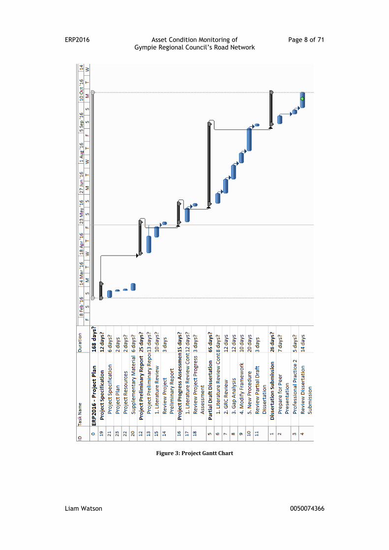
been described below and is represented on the projects Gantt Chart (see Figure 3)
with an estimated timeline. As the project develops, the Gantt Chart will be used to
estimate the projects progress in line with the risks identified in subsection 1.6 Risk
Assessment.
1. Undertake a review of information on the practice of road condition
monitoring, including:
current best practice guidelines
predictive modelling of future road conditions
assessable modes of distress of a road
techniques to assess and/or measure the modes of distress
the accuracy of measurement required for the particular distress
modes
The publications for review are available as hard copies within GRCs
engineering library or are freely available on the internet.
2. Review the current road condition monitoring practices employed by GRC.
This will involve meeting with staff from:
GRCs Construction and Maintenance Branch that are currently
employed to undertake and manage road condition inspections.
GRCs Design Services Branch that administer its asset management
software.
ERP2016 Asset Condition Monitoring of Page 7 of 71 Gympie Regional Council’s Road Network
Liam Watson 0050074366
All of GRCs current policies, procedures and plans are available via the
internal intranet. GRCs asset management software has been made available
for the length of this project.
3. Conduct a gap analysis between GRCs road condition monitoring practices
and the current best practice guidelines.
4. Develop an asset condition monitoring framework for GRCs sealed road
network. Detail the individual components of the framework, including:
An initial assessment phase
The screening of the sealed road network
The detailed assessment of the shortlisted road segments
Adding the condition assessment results to GRCs asset management
software
1.6 Risk Assessment
With regard to exposure to health and safety risks, this project will have a minimal
exposure to any safety hazards. As the sponsor of this project, GRC has a work
instruction in place for the collection of road condition data (See Appendix B) which
includes risk assessments for personnel undertaking visual inspections. This
document will be reviewed as part of this project; however its risk analysis
component is applicable.
The project will however be exposed to enterprise hazards. These mainly concern
production losses for GRC due to complications such as:
Change in scope mid-project, leading to time delays
Reduced quality to meet time deadlines
Limited availability of skilled personnel, appropriate plant and/or suitable
contractors to carry out the results of the project
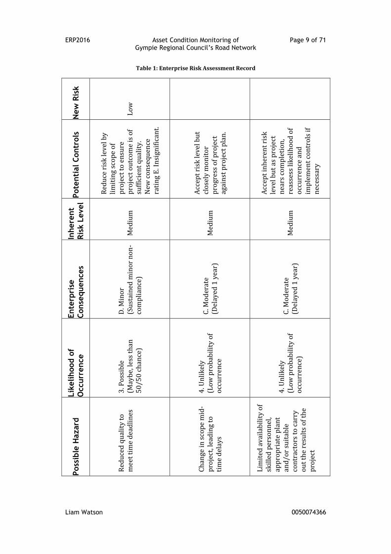
All enterprise hazards encountered by GRC must be dealt with in accordance to
GRCs Enterprise Risk Management Procedure (See Appendix C). Table 1 (see
Appendix D) summarises the risk attributed to the above hazards as per GRCs
procedure. As illustrated in Table 1, the risk level of the identified hazards is
acceptable, provided the projects progress is monitored closely. The Project Gantt
Chart shown in Figure 3 will assist with this process.
ERP2016 Asset Condition Monitoring of Page 8 of 71 Gympie Regional Council’s Road Network
Liam Watson 0050074366
Figure 3: Project Gantt Chart
ERP2016 Asset Condition Monitoring of Page 9 of 71 Gympie Regional Council’s Road Network
Liam Watson 0050074366
Table 1: Enterprise Risk Assessment Record
New
Ris
k
Lo
w
Pote
nti
al C
ontr
ols
Red
uce
ris
k le
vel
by
lim
itin
g sc
op
e o
f p
roje
ct t
o e
nsu
re
pro
ject
ou
tco
me
is o
f su
ffic
ien
t q
ual
ity.
N
ew c
on
seq
uen
ce
rati
ng
E. I
nsi
gnif
ican
t.
Acc
ept
risk
leve
l bu
t cl
ose
ly m
on
ito
r p
rogr
ess
of
pro
ject
ag
ain
st p
roje
ct p
lan
.
Acc
ept
inh
eren
t ri
sk
lev
el b
ut
as p
roje
ct
nea
rs c
om
ple
tio
n,
reas
sess
lik
elih
oo
d o
f o
ccu
rren
ce a
nd
im
ple
men
t co
ntr
ols
if
nec
essa
ry
Inhere
nt
Ris
k L
evel
Med
ium
Med
ium
Med
ium
Ente
rpri
se
Conse
quences
D. M
ino
r (S
ust
ain
ed m
ino
r n
on
-co
mp
lian
ce)
C. M
od
erat
e (D
elay
ed 1
yea
r)
C. M
od
erat
e (D
elay
ed 1
yea
r)
Lik
elihood o
f
Occurr
ence
3. P
oss
ible
(M
ayb
e, le
ss t
han
5
0/5
0 c
han
ce)
4. U
nli
kel
y
(Lo
w p
rob
abil
ity
of
occ
urr
ence
4. U
nli
kel
y
(Lo
w p
rob
abil
ity
of
occ
urr
ence
)
Poss
ible
Hazard
Red
uce
d q
ual
ity
to
mee
t ti
me
dea
dli
nes
C
han
ge in
sco
pe
mid
-p
roje
ct, l
ead
ing
to
tim
e d
elay
s
Lim
ited
av
aila
bil
ity
of
skil
led
per
son
nel
, ap
pro
pri
ate
pla
nt
and
/or
suit
able
co
ntr
acto
rs t
o c
arry
o
ut
the
resu
lts
of
the
pro
ject
ERP2016 Asset Condition Monitoring of Page 10 of 71 Gympie Regional Council’s Road Network
Liam Watson 0050074366
Chapter 2: Literature Review
2.1 Introduction
There is a vast array of guidelines, manuals and research papers that address the
management of roads. These publications have been produced by state or national
road authorities (i.e. TMR), road and transport associations (i.e. Austroads, IPWEA),
public or private companies (i.e. ARRB), and by sponsored or independent
researchers. This literature review will examine road condition assessments
through the following topics:
Road condition assessments
Road asset information
Condition data distress modes
Condition data needs
Condition data collection
Condition assessment frequency
Condition data modelling
2.2 Road Condition Assessments
IPWEA and NAMS (2011, p. 2|72) state that asset condition is a measure of the
asset’s physical integrity. Austroads (2009c, p. 13) supports this view, relating
condition data to the description of the transient physical properties of the asset.
Provided the asset in question is a roadway, road condition assessment involves the
systematic collection and processing of pavement condition data (AASHTO 2012;
Koch et al. 2015).
The objective of a road condition assessment “is to provide sufficient information on
asset condition to assist informed strategic asset planning” IPWEA (2015, p. 4). The
pivotal role that condition data plays in the decision making process, and the effect
its quality has on these decision was widely recognized throughout the literature
(Ruotoistenmäki, Seppälä & Kanto 2006; Saliminejad & Gharaibeh 2016; Sun & Gu
2011).
Despite the obvious advantages of undertaking road condition assessment, IPWEA
(2015, p. 3) cites that there are inconsistent approaches to its implementation. This
ERP2016 Asset Condition Monitoring of Page 11 of 71 Gympie Regional Council’s Road Network
Liam Watson 0050074366
leads to various forms of data collection, making aggregation and regional
benchmarking impractical.
2.3 Road Asset Information
The road itself “must serve two basic functions – it must perform as an engineering
structure and at the same time meet functional requirements” (Austroads 2009d, p.
4). In order to properly manage a road to meet these functions, the road must be
defined on several different levels.
2.2.1 Road Hierarchy
The first level of differentiation is described as the road hierarchy or classification.
Austroads (2009e, p. 11) defines a road hierarchy as the grading of roads according
to increasing (or decreasing) importance of traffic task/function or importance in
the logistics chain. An example of a road hierarchy as developed by Eppell, McClurg
and Bunker (2001, p. 7) has been provided below.
“The four functional categories in level 2 of the hierarchy are defined
as:-
arterial roads – to carry long distance through traffic external to
specific areas;
sub arterial roads – to carry through traffic between specific
areas and arterial roads on a supporting role to the latter;
collector streets – to provide connectivity between the
environmental cells and the traffic carrying road and serve
property access; and
local streets – to provide direct property access.”
2.2.2 Road Segmentation
The next level of division involves segmenting the road. IPWEA (2015, p. 2)
summarises that segments are used to represent uniform lengths of road with
important characteristic similarities being pavement type, width and age. “Generally
segments need to be long enough to form an on-site project and short enough so
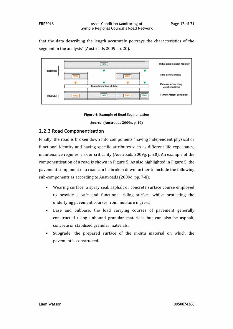
ERP2016 Asset Condition Monitoring of Page 12 of 71 Gympie Regional Council’s Road Network
Liam Watson 0050074366
that the data describing the length accurately portrays the characteristics of the
segment in the analysis” (Austroads 2009f, p. 20).
Figure 4: Example of Road Segmentation
Source: (Austroads 2009c, p. 19)
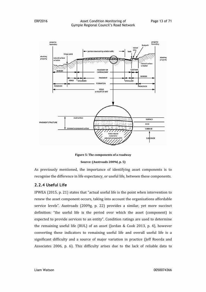
2.2.3 Road Componentisation
Finally, the road is broken down into components “having independent physical or
functional identity and having specific attributes such as different life expectancy,
maintenance regimes, risk or criticality (Austroads 2009g, p. 20). An example of the
componentisation of a road is shown in Figure 5. As also highlighted in Figure 5, the
pavement component of a road can be broken down further to include the following
sub-components as according to Austroads (2009d, pp. 7-8):
Wearing surface: a spray seal, asphalt or concrete surface course employed
to provide a safe and functional riding surface whilst protecting the
underlying pavement courses from moisture ingress.
Base and Subbase: the load carrying courses of pavement generally
constructed using unbound granular materials, but can also be asphalt,
concrete or stabilised granular materials.
Subgrade: the prepared surface of the in-situ material on which the
pavement is constructed.
ERP2016 Asset Condition Monitoring of Page 13 of 71 Gympie Regional Council’s Road Network
Liam Watson 0050074366
Figure 5: The components of a roadway
Source: (Austroads 2009d, p. 5)
As previously mentioned, the importance of identifying asset components is to
recognise the difference in life expectancy, or useful life, between these components.
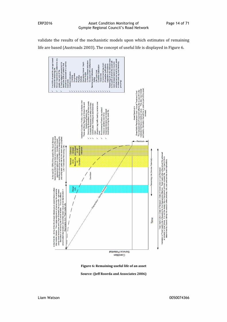
2.2.4 Useful Life
IPWEA (2015, p. 21) states that “actual useful life is the point when intervention to
renew the asset component occurs, taking into account the organisations affordable
service levels”. Austroads (2009g, p. 22) provides a similar, yet more succinct
definition: “the useful life is the period over which the asset (component) is
expected to provide services to an entity”. Condition ratings are used to determine
the remaining useful life (RUL) of an asset (Jordan & Cook 2013, p. 4), however
converting these indicators to remaining useful life and overall useful life is a
significant difficulty and a source of major variation in practice (Jeff Roorda and
Associates 2006, p. 6). This difficulty arises due to the lack of reliable data to
ERP2016 Asset Condition Monitoring of Page 14 of 71 Gympie Regional Council’s Road Network
Liam Watson 0050074366
validate the results of the mechanistic models upon which estimates of remaining
life are based (Austroads 2003). The concept of useful life is displayed in Figure 6.
Figure 6: Remaining useful life of an asset
Source: (Jeff Roorda and Associates 2006)
ERP2016 Asset Condition Monitoring of Page 15 of 71 Gympie Regional Council’s Road Network
Liam Watson 0050074366
2.4 Condition Data Distress Modes
As the asset approaches intervention level, typically the last 20-50% of its useful life,
the asset develops visual distresses (Jeff Roorda and Associates 2006, p. 25). These
distresses result from a process of deterioration under the effects of both traffic and
environmental conditions (Mubaraki 2013, p. 239). These concepts are best
summarised by Figure 6, displaying the link between useful life and asset
deterioration. The remainder of this section will be dedicated to the different
distress modes of a sealed road pavement.
2.3.1 Roughness
Austroads (2007b, p. 4) defines roughness as “a condition parameter which
characterises deviations from the intended longitudinal profile of a road surface
with characteristic dimensions that affect vehicle dynamics (and hence road user
costs), ride quality and dynamic pavement loading”. Jordan and Cook (2013, p. 14)
simplifies roughness “to the measurement of the unevenness of a road surface”.
Whilst the definitions encountered through the literature vary in terminology, there
is consensus among the literature to its usefulness in measuring pavement
condition, leading Hunt (2002) to find that “roughness is the most widely used
pavement condition indicator, as it is affordable data to capture, it reflects the road
user's costs and is widely accepted as the most relevant measure of pavement
behaviour”.
The preferred method of reporting road roughness is via the International
Roughness Index (IRI). “Initiated by the World Bank in 1986, the IRI is a profile-
based statistic which is used around the world as a cost-effective index for gathering
and comparing pavement smoothness” (King 2014, p. 27). “IRI roughness results are
usually reported in … meters per kilometre (m/km) on an increasing, boundless
scale … Therefore, a perfectly smooth pavement (which is generally considered to be
impossible to achieve) would have an IRI of 0” (AASHTO 2012, pp. 4-14).
“NAASRA roughness counts (NRM) which were an older method of determining
roughness” (King 2014, p. 23) have been superseded by IRI measurements. These
ratings can be converted to IRI using conversion tables available in Austroads
(2007b) and IPWEA (2015) manuals.
ERP2016 Asset Condition Monitoring of Page 16 of 71 Gympie Regional Council’s Road Network
Liam Watson 0050074366
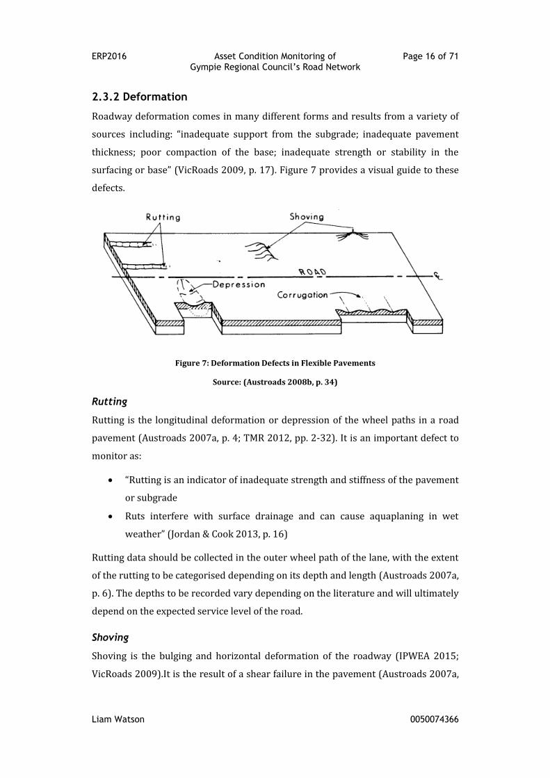
2.3.2 Deformation
Roadway deformation comes in many different forms and results from a variety of
sources including: “inadequate support from the subgrade; inadequate pavement
thickness; poor compaction of the base; inadequate strength or stability in the
surfacing or base” (VicRoads 2009, p. 17). Figure 7 provides a visual guide to these
defects.
Figure 7: Deformation Defects in Flexible Pavements
Source: (Austroads 2008b, p. 34)
Rutting
Rutting is the longitudinal deformation or depression of the wheel paths in a road
pavement (Austroads 2007a, p. 4; TMR 2012, pp. 2-32). It is an important defect to
monitor as:
“Rutting is an indicator of inadequate strength and stiffness of the pavement
or subgrade
Ruts interfere with surface drainage and can cause aquaplaning in wet
weather” (Jordan & Cook 2013, p. 16)
Rutting data should be collected in the outer wheel path of the lane, with the extent
of the rutting to be categorised depending on its depth and length (Austroads 2007a,
p. 6). The depths to be recorded vary depending on the literature and will ultimately
depend on the expected service level of the road.
Shoving
Shoving is the bulging and horizontal deformation of the roadway (IPWEA 2015;
VicRoads 2009).It is the result of a shear failure in the pavement (Austroads 2007a,
ERP2016 Asset Condition Monitoring of Page 17 of 71 Gympie Regional Council’s Road Network
Liam Watson 0050074366
p. 20) and generally occurs in areas of the road subject to heavy braking or
acceleration (VicRoads 2009, p. 17), for example intersections or sharp curves.
Depression
A depression is “a localised areas within a pavement with elevations lower than the
surrounding area” (Austroads 2007a; VicRoads 2009). Depressions arise in a
pavement primarily due to the variable settlement of an underlying subgrade
(IPWEA 2015; VicRoads 2009).
Corrugations
Corrugations (or megatexture) are closely spaced transverse undulations with
wavelengths of less than 2 metres (IPWEA 2015; VicRoads 2009), creating a
directional instability in the vehicle as it navigates the defect (Jones & Paige-Green
2000, p. 43). Corrugations, similar to shoving, form primarily in locations of high
shear stress.
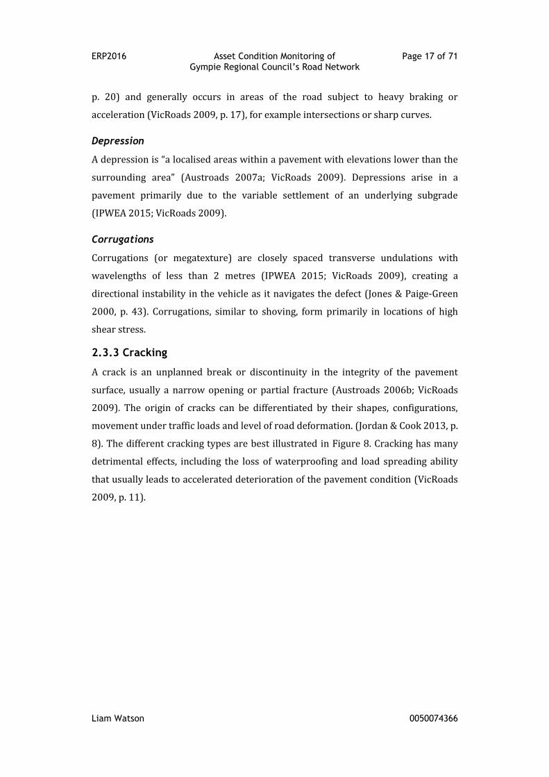
2.3.3 Cracking
A crack is an unplanned break or discontinuity in the integrity of the pavement
surface, usually a narrow opening or partial fracture (Austroads 2006b; VicRoads
2009). The origin of cracks can be differentiated by their shapes, configurations,
movement under traffic loads and level of road deformation. (Jordan & Cook 2013, p.
8). The different cracking types are best illustrated in Figure 8. Cracking has many
detrimental effects, including the loss of waterproofing and load spreading ability
that usually leads to accelerated deterioration of the pavement condition (VicRoads
2009, p. 11).
ERP2016 Asset Condition Monitoring of Page 18 of 71 Gympie Regional Council’s Road Network
Liam Watson 0050074366
Figure 8: Cracking of Flexible Pavements
Source: (Austroads 2008b, p. 34)
Block Cracking
Block cracking is identified by a series of interconnected cracks forming a series of
rectangular block shapes. The common causes of block cracking include shrinkage of
an underlying cement treated pavement layer, ageing of the bitumen surface or
reflection from underlying joints (Austroads 2006b; IPWEA 2015; VicRoads 2009).
Crocodile Cracking
Crocodile cracking “consists of interconnected or interlaced cracks forming a series
of small polygons resembling crocodile hide” (Austroads 2006b, p. 45). The
presence of crocodile cracking usually signifies that the surfacing has reached the
end of its design life (IPWEA 2015, p. 54). These cracks usually results from
inadequate pavement thickness; low stiffness/strength base; brittle base or wearing
course (e.g. cemented, aged); or fatigue cracking in brittle (aged) asphalt wearing
course. (Austroads 2006b; IPWEA 2015; VicRoads 2009).
Transverse Cracking, Diagonal Cracking and Meandering Cracking
These crack types are identified as an unconnected crack running transversely,
diagonally or irregularly (meandering) across the pavement (IPWEA 2015; VicRoads
2009). These isolated cracks can develop due to reflection of a shrinkage crack or
joint from an underlying cemented base, settlement associated with an underground
service or structure or the instruction of tree roots into or under the pavement
layers (IPWEA 2015; VicRoads 2009).
ERP2016 Asset Condition Monitoring of Page 19 of 71 Gympie Regional Council’s Road Network
Liam Watson 0050074366
Longitudinal Cracking
Longitudinal cracking runs longitudinally along the pavement and does not exhibit
strongly developed transverse branches. (Austroads 2006b, p. 45). This cracking
type is often a precursor to wheel path rutting (IPWEA 2015, p. 62). When found in
isolation, longitudinal cracking represents:
Reflection of a shrinkage crack or joint in an underlying base;
Poorly constructed paving lane joint in asphalt surfacing;
Daily temperature cycles, or asphalt hardening;
Displacement of joint at pavement widening.
But if a series of these cracks is present, the causes can differ to include:
Volume change of expansive clay subgrade, due to moisture;
Cyclical weakening of pavement edge;
Differential settlement between cut and fill. (Austroads 2006b; IPWEA 2015;
VicRoads 2009)
Crescent Shaped Cracking
Austroads (2006b, p. 37) defines crescent shaped cracking as closely spaced half-
moon shaped cracking that is commonly associated with shoving in asphalt wearing
courses. The list of possible causes of crescent shaped cracking provided by
VicRoads (2009, p. 11) includes:
Poor bond between wearing course and underlying layers;
Low strength base course;
Thin wearing courses;
High stresses due to braking and acceleration movements.
2.3.4 Wearing Course Defects
Wearing course defects cover a range of distress modes as displayed in Figure 9. The
development of these defects has a “significant influence on the serviceability of a
pavement surfacing, especially with regard to skid resistance and ride quality”
(VicRoads 2009, p. 16). Depending on the type of in-situ wearing course (either
sprayed seal or asphalt), the modes of deterioration may be quite different
(VicRoads 2009, p. 9).
ERP2016 Asset Condition Monitoring of Page 20 of 71 Gympie Regional Council’s Road Network
Liam Watson 0050074366
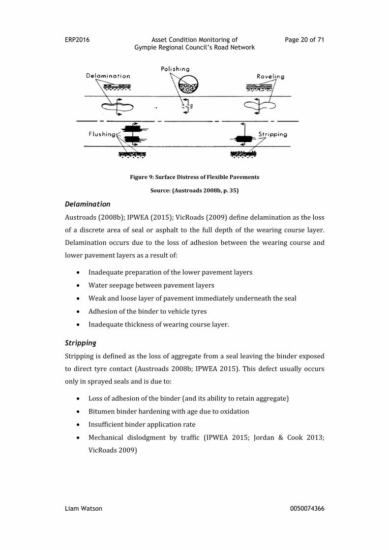
Figure 9: Surface Distress of Flexible Pavements
Source: (Austroads 2008b, p. 35)
Delamination
Austroads (2008b); IPWEA (2015); VicRoads (2009) define delamination as the loss
of a discrete area of seal or asphalt to the full depth of the wearing course layer.
Delamination occurs due to the loss of adhesion between the wearing course and
lower pavement layers as a result of:
Inadequate preparation of the lower pavement layers
Water seepage between pavement layers
Weak and loose layer of pavement immediately underneath the seal
Adhesion of the binder to vehicle tyres
Inadequate thickness of wearing course layer.
Stripping
Stripping is defined as the loss of aggregate from a seal leaving the binder exposed
to direct tyre contact (Austroads 2008b; IPWEA 2015). This defect usually occurs
only in sprayed seals and is due to:
Loss of adhesion of the binder (and its ability to retain aggregate)
Bitumen binder hardening with age due to oxidation
Insufficient binder application rate
Mechanical dislodgment by traffic (IPWEA 2015; Jordan & Cook 2013;
VicRoads 2009)
ERP2016 Asset Condition Monitoring of Page 21 of 71 Gympie Regional Council’s Road Network
Liam Watson 0050074366
Ravelling
The progressive disintegration of the pavement surface by the loss of both binder
and aggregate is defined as ravelling according to Austroads (2008b) and IPWEA
(2015). The causes to ravelling include:
Hardening and oxidation of the binder
Poor asphalt mix design
Poor construction quality (i.e. lack of compaction, binder contamination)
(Austroads 2008b; IPWEA 2015; VicRoads 2009)
Flushing
Austroads (2008b); IPWEA (2015) define flushing as an excess of binder on the
surface of the pavement. Flushing is often the result of:
Inappropriate binder application rate either because of poor design or poor
spraying practice
Sealing over an already flushed surface, sealing over patches, which have not
had sufficient time to strengthen (routine maintenance should precede a
reseal by at least two months),
Using excessive cutter in the binder.
Stone penetration into the granular base, hence flushing may be indicative of
a base with inadequate strength or compaction
Polishing
Austroads (2008b); IPWEA (2015) define polishing as the smoothing and rounding
of the upper surface of a sealing aggregate. It commonly occurs is the wheel tracks
and is caused by:
Inadequate durability of the selected surface aggregate
The use of naturally smooth aggregates.
2.3.5 Maintenance Patching
The extent of maintenance patching provides a reasonable indication of the
pavement performance with regard to strength and the effect of moisture passing
through the surfacing into the pavement (Austroads 2008b; VicRoads 2009).
Austroads (2008b); IPWEA (2015); VicRoads (2009) provide the following
ERP2016 Asset Condition Monitoring of Page 22 of 71 Gympie Regional Council’s Road Network
Liam Watson 0050074366
definitions and causes of maintenance patching defects, which includes potholing,
patching and edge defects.
Potholing
Potholing is defined as a steep-sided or bowl-shaped cavity extending into the layers
below the wearing course. Potholing can occur due to:
Failure of the wearing course, resulting in moisture ingress
Low quality or disintegration of base course pavement material
Pickup of bitumen wearing surface in sprayed seals caused by binder
adhesion to tyres.
Patches
Patches are repaired sections of pavement. They are usually employed to:
Repair surface defects as identified in this section
Correct a deficiency in the pavement
Edge break/drop-off
Edge defects occur along the interface between a sealed roadway and an unsealed
shoulder. As the unsealed shoulder deteriorates and leaves the sealed edge
unsupported (usually a result of inadequate seal width exposing the shoulder to
higher traffic loads or erosion from surface water flows,), the seal edge breaks and
recedes towards the road centre line.
2.3.6 Strength
Austroads (2008a) considers pavement strength an important characteristic when
defining the general condition of a road. It is defined as “the ability of a pavement
structure to carry a cumulative repeated heavy axle loading before the pavement
shows unacceptable signs of structural and surface distress which seriously
compromise its function” (Austroads 2008a, p. 1).
2.5 Condition Data Needs
Given the extensive list of the aforementioned distress modes, the literature agrees
that the collection of all of these defects is unnecessary and in fact “excessive data
collection is … one of the top five reasons road management systems are
abandoned” (Bennett, Solminihac & Chamorro 2006, p. 1). There is consensus that
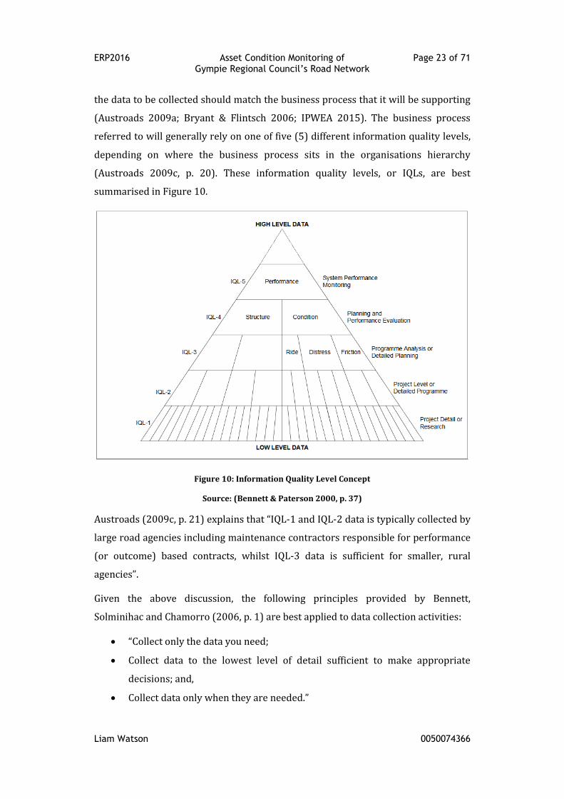
ERP2016 Asset Condition Monitoring of Page 23 of 71 Gympie Regional Council’s Road Network
Liam Watson 0050074366
the data to be collected should match the business process that it will be supporting
(Austroads 2009a; Bryant & Flintsch 2006; IPWEA 2015). The business process
referred to will generally rely on one of five (5) different information quality levels,
depending on where the business process sits in the organisations hierarchy
(Austroads 2009c, p. 20). These information quality levels, or IQLs, are best
summarised in Figure 10.
Figure 10: Information Quality Level Concept
Source: (Bennett & Paterson 2000, p. 37)
Austroads (2009c, p. 21) explains that “IQL-1 and IQL-2 data is typically collected by
large road agencies including maintenance contractors responsible for performance
(or outcome) based contracts, whilst IQL-3 data is sufficient for smaller, rural
agencies”.
Given the above discussion, the following principles provided by Bennett,
Solminihac and Chamorro (2006, p. 1) are best applied to data collection activities:
“Collect only the data you need;
Collect data to the lowest level of detail sufficient to make appropriate
decisions; and,
Collect data only when they are needed.”
ERP2016 Asset Condition Monitoring of Page 24 of 71 Gympie Regional Council’s Road Network
Liam Watson 0050074366
The data that has been collected also needs to be validated and checked for
repeatability and bias.
2.6 Condition Data Collection
The techniques of assessment of condition data covered by the literature generally
fall into the following categories:
Manual
Semi-automated
Fully automated
“In general for network purposes, a higher level of automation in the methodology
may be expected to offer benefits over manual methods in improved personnel
safety, more rapid and cost effective data collection, better reporting and planning
capabilities, and the production of higher quality data in terms of repeatability”
(Austroads 2006b, p. 10). Whilst automated methods may be most suited to large
scale data capture, the following section will still look into all the available
categories of data collection.
Manual surveys
Manual surveys are generally visual assessments of the road conditions conducted
by an inspector who views the pavement through the windshield of a vehicle or as
they walk the pavement (AASHTO 2012, pp. 4-21). Distresses are generally recorded
on predefined forms, but there is an increasing trend to enter the survey results
directly into computers or hand-held devices (Pierce, McGovern & Zimmerman
2013, p. 14). This method does allow very detailed data collection, but is very labour
intensive and it does require more time per asset than automated or semi-
automated methods (Bryant & Flintsch 2006, p. 24). As a result, fully automated and
semi-automated technologies have gained wide acceptance in pavement condition
data collection, however manual surveys are still used by many highway agencies
(Pierce, McGovern & Zimmerman 2013, p. 15).
Fully-automated surveys
Automated surveys typically incorporate the use of specially fitted out vehicles for
collecting pavement and roadway features at normal speed through lasers, high-
speed cameras, and computers (Attoh-Okine & Adarkwa 2013; Pierce, McGovern &
ERP2016 Asset Condition Monitoring of Page 25 of 71 Gympie Regional Council’s Road Network
Liam Watson 0050074366
Zimmerman 2013). The captured data is then automatically processed, either in
real-time or post-processed, using a suite of computer applications depending on
the defect to be measured (AASHTO 2012, pp. 4-23). The newest data collection
equipment has achieved high automation and accuracy and is capable of very fast,
comprehensive data collection (Bryant & Flintsch 2006, p. 25). However, fully
integrated equipment is expensive and it must be updated regularly to take
advantage of new technology (AASHTO 2012; Attoh-Okine & Adarkwa 2013).
Semi-automated surveys
Semi-automated surveys involve similar equipment as the completely automated
method but with a lesser degree of automation (Bryant & Flintsch 2006, p. 25). The
data processing stage is carried out by a human who views the automatically
captured data and determines a condition rating (AASHTO 2012, pp. 4-24). It is very
popular within transportation agencies and yields comprehensive and accurate data
collection when properly implemented (Bryant & Flintsch 2006, p. 25).
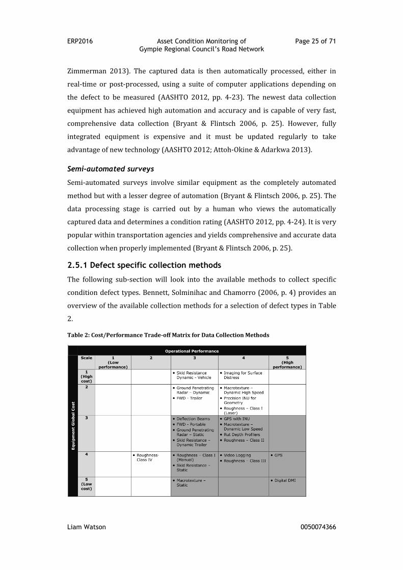
2.5.1 Defect specific collection methods
The following sub-section will look into the available methods to collect specific
condition defect types. Bennett, Solminihac and Chamorro (2006, p. 4) provides an
overview of the available collection methods for a selection of defect types in Table
2.
Table 2: Cost/Performance Trade-off Matrix for Data Collection Methods
ERP2016 Asset Condition Monitoring of Page 26 of 71 Gympie Regional Council’s Road Network
Liam Watson 0050074366
“As a general rule, if an agency has budgetary restrictions, equipment selected for
pavement data collection should be located in the right bottom boxes shaded in the
matrix (cost ranging between 3 to 5 and operational performance from 3 to 5)”
(Bennett, Solminihac & Chamorro 2006, p. 3).
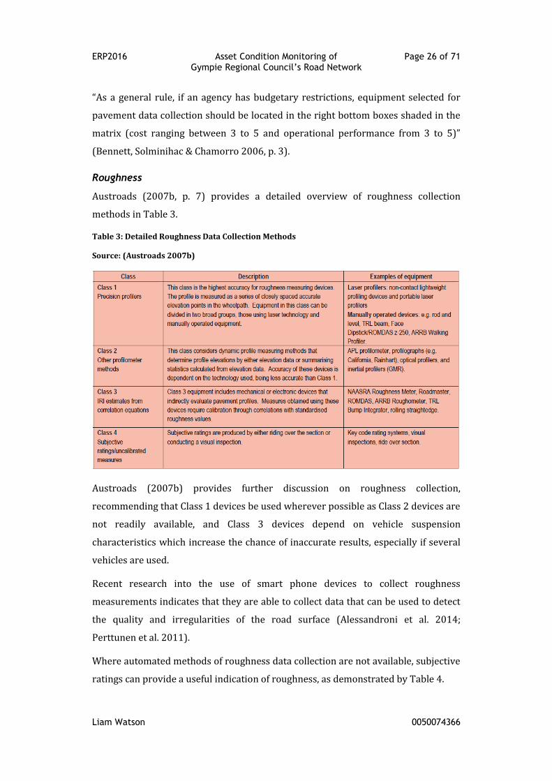
Roughness
Austroads (2007b, p. 7) provides a detailed overview of roughness collection
methods in Table 3.
Table 3: Detailed Roughness Data Collection Methods
Source: (Austroads 2007b)
Austroads (2007b) provides further discussion on roughness collection,
recommending that Class 1 devices be used wherever possible as Class 2 devices are
not readily available, and Class 3 devices depend on vehicle suspension
characteristics which increase the chance of inaccurate results, especially if several
vehicles are used.
Recent research into the use of smart phone devices to collect roughness
measurements indicates that they are able to collect data that can be used to detect
the quality and irregularities of the road surface (Alessandroni et al. 2014;
Perttunen et al. 2011).
Where automated methods of roughness data collection are not available, subjective
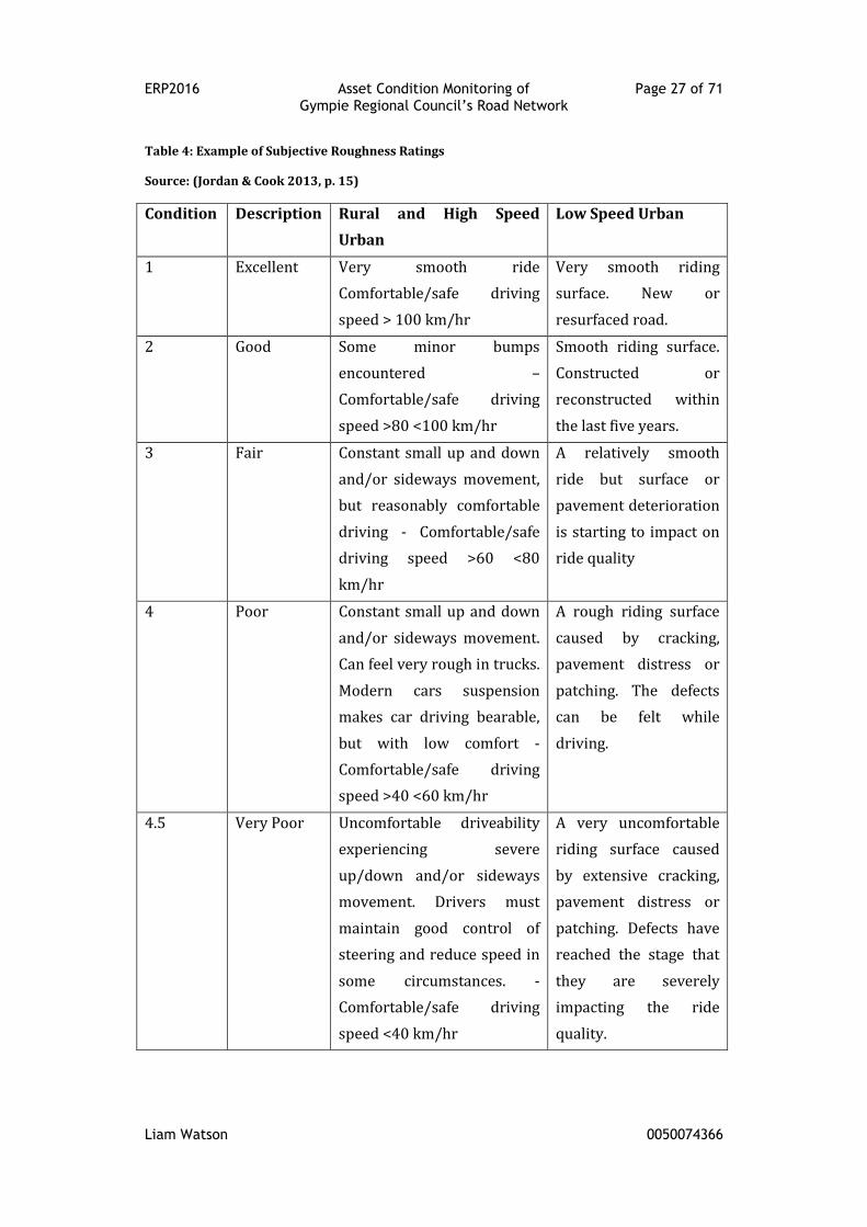
ratings can provide a useful indication of roughness, as demonstrated by Table 4.
ERP2016 Asset Condition Monitoring of Page 27 of 71 Gympie Regional Council’s Road Network
Liam Watson 0050074366
Table 4: Example of Subjective Roughness Ratings
Source: (Jordan & Cook 2013, p. 15)
Condition Description Rural and High Speed
Urban
Low Speed Urban
1 Excellent Very smooth ride
Comfortable/safe driving
speed > 100 km/hr
Very smooth riding
surface. New or
resurfaced road.
2 Good Some minor bumps
encountered –
Comfortable/safe driving
speed >80 <100 km/hr
Smooth riding surface.
Constructed or
reconstructed within
the last five years.
3 Fair Constant small up and down
and/or sideways movement,
but reasonably comfortable
driving - Comfortable/safe
driving speed >60 <80
km/hr
A relatively smooth
ride but surface or
pavement deterioration
is starting to impact on
ride quality
4 Poor Constant small up and down
and/or sideways movement.
Can feel very rough in trucks.
Modern cars suspension
makes car driving bearable,
but with low comfort -
Comfortable/safe driving
speed >40 <60 km/hr
A rough riding surface
caused by cracking,
pavement distress or
patching. The defects
can be felt while
driving.
4.5 Very Poor Uncomfortable driveability
experiencing severe
up/down and/or sideways
movement. Drivers must
maintain good control of
steering and reduce speed in
some circumstances. -
Comfortable/safe driving
speed <40 km/hr
A very uncomfortable
riding surface caused
by extensive cracking,
pavement distress or
patching. Defects have
reached the stage that
they are severely
impacting the ride
quality.

ERP2016 Asset Condition Monitoring of Page 28 of 71 Gympie Regional Council’s Road Network
Liam Watson 0050074366
Deformation
Deformation defects are primarily collected via automated methods as it is not
feasible to measure deformation manually at a network level (Austroads 2007a, p.
10). “By 2003, all Austroads Member Authorities were using laser profilometers”
(Austroads 2007a, p. 11) to measure rutting. An alternative automated method of
collection is the use of 3D point cloud data to identify depressions (Koch et al. 2015,
p. 206). The most viable manual method for measuring and reporting pavement
surface rutting involves the use of a physical straight edge (Austroads 2007a, p. 10)
and measuring the height difference between the straight edge and the distressed
pavement.
Cracking
Austroads (2006b) provides an extensive overview of the available methods of crack
detection, which have been summarised below:
Manual: this method is suitable only for sampling type investigations. It has
an advantage in that it can detect fine crack sizes, however it is associated
with high subjectivity, high costs and slow progress.
Windshield: this method is limited in the size of crack identification, with
only wide cracks being readily identifiable. It is much faster than the manual
method, however the results will still be highly subjective with low
repeatability.
Video capture, manual review: again, this method is susceptible to high
levels of subjectivity. Depending on the quality of the video, crack size
detection will vary. As the video is recorded, it does allow for auditing of the
survey results at a later date. It also presents a much safer environment for
the rater to work in.
Fully automated: this method provides an objective assessment of cracks,
resulting in a high level of repeatability. As it utilises a specially design
vehicle to undertake the survey, it does have a high associated costs. The
upside is that the survey can be undertaken within the traffic stream and
processed in real time. Depending on the quality of the devices optics, crack
seize detection will vary, however it has the potential to identify cracks
down to 1mm wide.
ERP2016 Asset Condition Monitoring of Page 29 of 71 Gympie Regional Council’s Road Network
Liam Watson 0050074366
Wearing Course Defects and Maintenance Patching
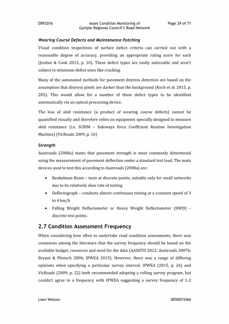
Visual condition inspections of surface defect criteria can carried out with a
reasonable degree of accuracy, providing an appropriate rating score for each
(Jordan & Cook 2013, p. 10). These defect types are easily noticeable and aren’t
subject to minimum defect sizes like cracking.
Many of the automated methods for pavement distress detection are based on the
assumption that distress pixels are darker than the background (Koch et al. 2015, p.
205). This would allow for a number of these defect types to be identified
automatically via an optical processing device.
The loss of skid resistance (a product of wearing course defects) cannot be
quantified visually and therefore relies on equipment specially designed to measure
skid resistance (i.e. SCRIM – Sideways force Coefficient Routine Investigation
Machine) (VicRoads 2009, p. 16)
Strength
Austroads (2008a) states that pavement strength is most commonly determined
using the measurement of pavement deflection under a standard test load. The main
devices used to test this according to Austroads (2008a) are:
Benkelman Beam – tests at discrete points, suitable only for small networks
due to its relatively slow rate of testing
Deflectograph – conducts almost continuous testing at a constant speed of 3
to 4 km/h
Falling Weight Deflectometer or Heavy Weight Deflectometer (HWD) –
discrete test points.
2.7 Condition Assessment Frequency
When considering how often to undertake road condition assessments, there was
consensus among the literature that the survey frequency should be based on the
available budget, resources and need for the data (AASHTO 2012; Austroads 2007b;
Bryant & Flintsch 2006; IPWEA 2015). However, there was a range of differing
opinions when specifying a particular survey interval. IPWEA (2015, p. 26) and
VicRoads (2009, p. 22) both recommended adopting a rolling survey program, but
couldn’t agree to a frequency with IPWEA suggesting a survey frequency of 1-2
ERP2016 Asset Condition Monitoring of Page 30 of 71 Gympie Regional Council’s Road Network
Liam Watson 0050074366
years for high function roads and 2-3 years for lower function roads, whilst
VicRoads suggested 1-3 years regardless of road function. Austroads (2009a)
consistently recommended a frequency between 1-5 years depending on road
function. Jeff Roorda and Associates (2006, p. 19), via a survey of Victorian Local
Governments, found that they carried out condition assessment every 3-5 years.
2.8 Condition Data Modelling
The accurate prediction of pavement performance (or deterioration), and its impact
on road agency and road user costs, significantly improves asset management
processes and long-term infrastructure planning (Austroads 2009b; Mubaraki
2013). Whilst the benefits of modelling are obvious, “there are considerable
difficulties in modelling deterioration and despite ongoing worldwide research,
exhaustive analytical models are not yet a practical option for modelling (Austroads
2003, p. 21). However, through the continual collection of road condition data, a
trend can be established and extrapolated to predict deterioration (Austroads 2003,
2007b). Without adequate data though, the road deterioration cannot be quantified
or evaluated accurately, and the planning decisions tend to become short term
(Mubaraki 2013, p. 240).
2.9 Conclusion
The literature review explored many aspects pertaining to road condition
assessment including the defects encountered, the techniques of measurement and
the type of data that needs to be collected.
There is a definite consistency to the content in the literature when considering the
individual components of condition assessment, suggesting that the theoretical
aspect of condition assessment is well developed. However, the overriding
sentiment encountered throughout the literature is best summarised by IPWEA
(2015, p. 4):
“Practitioners need to employ the best practices appropriate to the
organisation size and capacity that will provide the most suitable and
cost effective, decision making process.”
Phrases like “… limited to budget constraints” and “… as funding permits” are
frequently used throughout the literature. It suggests that road condition
ERP2016 Asset Condition Monitoring of Page 31 of 71 Gympie Regional Council’s Road Network
Liam Watson 0050074366
assessment is still yet to command enough authority to drive sufficient budget
allocations in road authorities. This lack of authority stems from an inconsistent and
haphazard implementation of condition assessment practices, often leading “many
local governments and data collection contractors to develop their own condition
data collection manuals” (Jordan & Cook 2013, p. 4). This results in a lack of
consistent outcomes when applying road condition assessments, which in turn fails
to provide road authorities with sufficient evidence to support their claims for
increased funding for condition assessment.
More guidance is needed from state and national road authorities that links the
roads function and traffic carrying capacity to the collection and assessment of
specific road condition parameters.
ERP2016 Asset Condition Monitoring of Page 32 of 71 Gympie Regional Council’s Road Network
Liam Watson 0050074366
Chapter 3: Review of Gympie Regional Council’s
Road Condition Assessment Practices
Gympie Regional Council does not have a formally developed asset condition
monitoring process for its road network. This project was undertaken with the
intention that its outcomes will be adopted by GRC. “This will ultimately result in a
review of the existing Asset Management Plan to include long term predictive
modelling of pavement renewal needs” (GRC 2016, p. 16). The following chapter will
cover the
3.1 Organisational Structure
When considering GRCs daily operating practices, an important to aspect to consider
is its existing Organisational Structure (HRI052). HRI052 (see Appendix E) provides
a concise overview of the GRCs organisational structure. The key feature to absorb
when addressing the management of GRCs road network is that:
“Infrastructure Services Construction and Maintenance Branch operates
as council’s preferred contractor for delivery of construction,
maintenance and operation activities. Engineering Services general role
is that of the asset owner and provider of capital works.” (GRC 2015, p.
4)
3.2 Policies and Procedures
GRC has adopted a large number of policies and procedures to ensure a consistent
approach to its road network management practices. These corporate documents
are listed below in Table 5 and are available on GRCs intranet.
Table 5: Summary of Road Network Management Policies and Procedures
Source: (GRC 2016, pp. 42-3)
Policy Title Ref No. Summary
Strategic planning and program development
Road Network Policy ESPOL-015 Policy addresses council’s
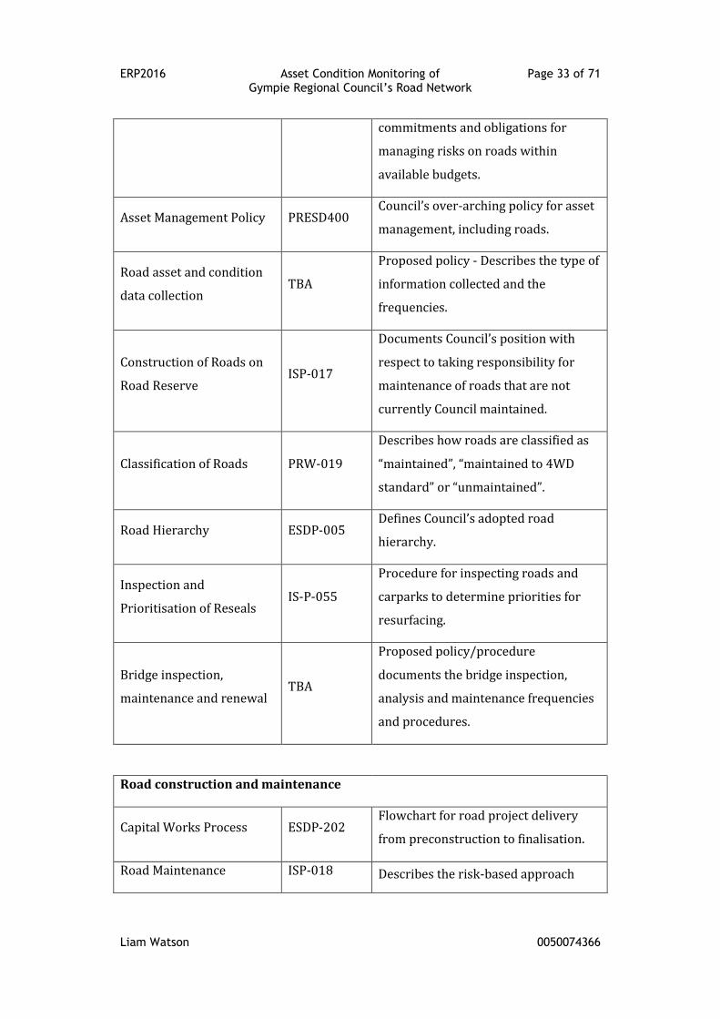
ERP2016 Asset Condition Monitoring of Page 33 of 71 Gympie Regional Council’s Road Network
Liam Watson 0050074366
commitments and obligations for
managing risks on roads within
available budgets.
Asset Management Policy PRESD400 Council’s over-arching policy for asset
management, including roads.
Road asset and condition
data collection TBA
Proposed policy - Describes the type of
information collected and the
frequencies.
Construction of Roads on
Road Reserve ISP-017
Documents Council’s position with
respect to taking responsibility for
maintenance of roads that are not
currently Council maintained.
Classification of Roads PRW-019
Describes how roads are classified as
“maintained”, “maintained to 4WD
standard” or “unmaintained”.
Road Hierarchy ESDP-005 Defines Council’s adopted road
hierarchy.
Inspection and
Prioritisation of Reseals IS-P-055
Procedure for inspecting roads and
carparks to determine priorities for
resurfacing.
Bridge inspection,
maintenance and renewal TBA
Proposed policy/procedure
documents the bridge inspection,
analysis and maintenance frequencies
and procedures.
Road construction and maintenance
Capital Works Process ESDP-202 Flowchart for road project delivery
from preconstruction to finalisation.
Road Maintenance ISP-018 Describes the risk-based approach
ERP2016 Asset Condition Monitoring of Page 34 of 71 Gympie Regional Council’s Road Network
Liam Watson 0050074366
which is followed by Council for
inspecting and maintaining roads
Standards and Procedures
for New Roads Not
Associated with a
Development
TBA
Draft policy Defines the minimum
standards that Council will consider
when a property owner/s wishes to
upgrade an existing track in a road
reserve (or construct a new road in
road reserve) which is not associated
with a development application.
Development Standards
Planning
Scheme
Policy 1
Part of the Planning Scheme.
Describes the standards for roadworks
associated with a development
application.
Land Acquisition for Road
Projects TBA
Draft policy Describes how
compensation is determined for the
acquisition of land for roadworks and
the preferred acquisition process.
Upgrading of Gravel Roads
with Bitumen Seals ISP-016
Allows Council to apply bitumen seals
to sections of gravel road where
landowners agree to fund the works.
Signs and line marking TBA
Proposed policy/procedure Defines
how signs and linemarking are
inspected and priorities determined
for upgrades and new installations.
3.3 Road Asset Register
The road asset register is administered by the Assets Section within GRCs Design
Services Branch. It is the data repository for all the road data held by GRC, which
includes the road inventory and road valuation data. The asset management
software that contains the road asset register was recently upgraded. At present, the
ERP2016 Asset Condition Monitoring of Page 35 of 71 Gympie Regional Council’s Road Network
Liam Watson 0050074366
adopted road asset register still resides in the existing software as the data
migration process continues.
The inventory data held in the asset register is guided by the following document:
Classification of Roads (PRW-019)
Road Hierarchy (ESDP-005)
Standard Measurement Calculations (addresses road componentisation)
Capital Works Process (ESDP202)
As Constructed Data Flow Process (ESDP206)
Request for Asset Component Survey (ESDF205)
These documents ensure that consistent inventory data is entered into the system.
At present, there isn’t a procedure which addresses the segmentation of the road
asset.
The valuation data holds the expected and remaining useful life data of the road
assets. Current practice at GRC has the following expected life for the given
components:
Bitumen spray seal – 20 years
Asphalt Concrete seal – 35 years
Granular Pavement – 80 years
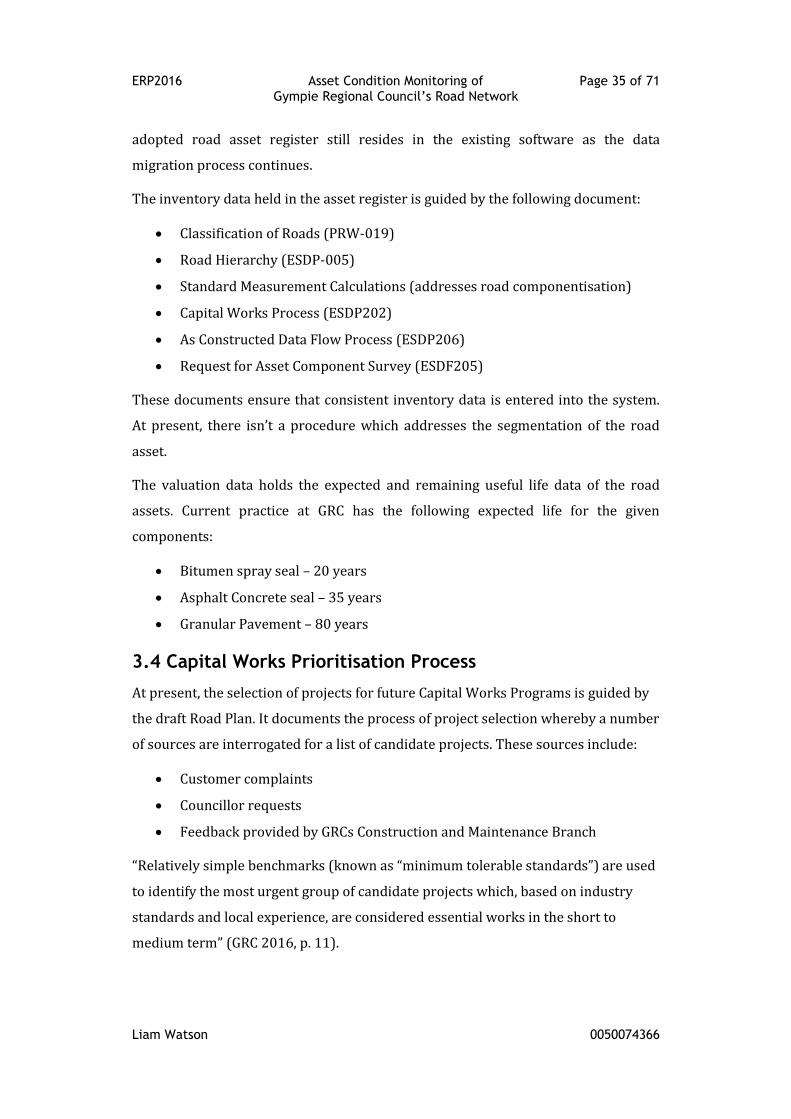
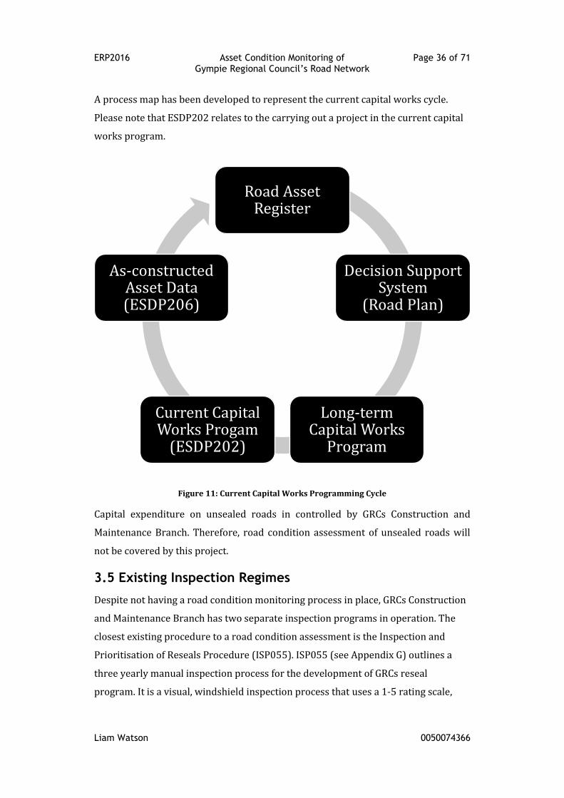
3.4 Capital Works Prioritisation Process
At present, the selection of projects for future Capital Works Programs is guided by
the draft Road Plan. It documents the process of project selection whereby a number
of sources are interrogated for a list of candidate projects. These sources include:
Customer complaints
Councillor requests
Feedback provided by GRCs Construction and Maintenance Branch
“Relatively simple benchmarks (known as “minimum tolerable standards”) are used
to identify the most urgent group of candidate projects which, based on industry
standards and local experience, are considered essential works in the short to
medium term” (GRC 2016, p. 11).
ERP2016 Asset Condition Monitoring of Page 36 of 71 Gympie Regional Council’s Road Network
Liam Watson 0050074366
A process map has been developed to represent the current capital works cycle.
Please note that ESDP202 relates to the carrying out a project in the current capital
works program.
Figure 11: Current Capital Works Programming Cycle
Capital expenditure on unsealed roads in controlled by GRCs Construction and
Maintenance Branch. Therefore, road condition assessment of unsealed roads will
not be covered by this project.
3.5 Existing Inspection Regimes
Despite not having a road condition monitoring process in place, GRCs Construction
and Maintenance Branch has two separate inspection programs in operation. The
closest existing procedure to a road condition assessment is the Inspection and
Prioritisation of Reseals Procedure (ISP055). ISP055 (see Appendix G) outlines a
three yearly manual inspection process for the development of GRCs reseal
program. It is a visual, windshield inspection process that uses a 1-5 rating scale,
Road Asset Register
Decision Support System
(Road Plan)
Long-term Capital Works
Program
Current Capital Works Progam
(ESDP202)
As-constructed Asset Data (ESDP206)
ERP2016 Asset Condition Monitoring of Page 37 of 71 Gympie Regional Council’s Road Network
Liam Watson 0050074366
where a rating 1 would indicate the seal is in very poor condition and a rating 5 is in
very good condition. Each rating increment is defined by a short description. The
results of these inspections are stored in a database managed by the Construction
and Maintenance Branch.
“Asset maintenance inspections, separate from asset condition inspections(GRC
2015, p. 6) are undertaken on a quarterly basis over GRCs entire road network. It is
an entirely manual inspection process that involves the recording of a predefined set
of road defects (see Appendix F). Again, it is predominantly a visual, windshield style
inspection method. As this inspection is more generalised than ISP055, it does
contain a greater list of defects to record, with each defect given a short description
to classify its severity. The inspection results are recorded on-site, using a laptop
computer to enter the data into a spreadsheet template. The spreadsheets are
analysed by the Construction and Maintenance Branch, with the resulting data used
exclusively for short to medium term maintenance planning.
ERP2016 Asset Condition Monitoring of Page 38 of 71 Gympie Regional Council’s Road Network
Liam Watson 0050074366
Chapter 4: Current Best Practice and Gap
Analysis
4.1 Introduction
This chapter will be used to review current best practices in the field of road
condition assessments and then conduct a gap analysis to GRCs current condition
assessments practices as identified in Chapter 3: Review of Gympie Regional
Council’s Road Condition Assessment Practices. The review will focus on the key
components of road condition assessment as identified by the literature. A
benchmark for these components will then be ascertained and used in the gap
analysis.
4.2 Best Practice
A survey conducted by Austroads (2002, p. 9) found that only 55% of rural
Australian council’s collected road condition data, as compared to 92% of urban
council’s. According to Jordan and Cook (2013, p. 4), this large disparity exists
because: there isn’t an appropriately recognised standard for carrying out road
surface and pavement condition assessments; and the current methods of road
condition assessment are too intensive for rural local governments.
In response to comments similar to those made above by Jordan and Cook, IPWEA
released a practice note (PN 9) for the visual assessment of road pavements. “The
primary purpose of the Practice Note is to develop consistency in the collection and
interpretation of data carried out by visual inspection” (IPWEA 2016, p. 1). This
guide addresses visual condition assessments of both sealed and unsealed roads via
two different inspection regimes. The basic level of investigation, or core approach,
involves estimating the condition across the whole of the road segment. The
advanced approach involves measuring the condition over a 50m gauging length
within the road segment, which is then adopted as representative for the whole
segment. The advanced approach is based on the RoCond90 method developed by
the RTA.
Austroads, through Part 5 of its Guide to Asset Management (AGAM05), seeks to
“promote a framework and consistency of approach for the collection, storage,
ERP2016 Asset Condition Monitoring of Page 39 of 71 Gympie Regional Council’s Road Network
Liam Watson 0050074366
analysis and reporting of pavement performance related road condition data”
(Austroads 2009a, p. 1). Whilst this part addresses both visual and automated
condition assessment methods of sealed roads, the majority of the discussion is
dedicated to automated measuring methods. As alluded to by South West RRTG
above, the methods employed by this guide may be too intensive for local
governments, especially those with limited resources.
VicRoads Technical Bulletin 50 Guide to Surface Inspection Rating for Pavements
Surfaced with Sprayed Seals and Asphalt (SIR) is “a tool to uniformly assess the
existing condition and estimate the remaining service life of sprayed seals and
asphalt wearing surfaces” (VicRoads 2009, p. 7). This guide is similar in application
to the IPWEA PN 9 in that it is a visual inspection regime. As it is the adopted
procedure for a State Road Authority, it was included as the intermediary best
practice standard between the two previously mentioned methods.
4.3 Gap Analysis
The above publications will form the basis of the gap analysis between GRCs existing
practices and the current best practice in road condition assessments.
For the purpose of this exercise, the GRCs road asset maintenance inspections and
reseal inspections will be used as the base comparison. Whilst these inspections are
not identified as ‘condition assessments’, this gap analysis may reveal pre-existing
practices that can be directly utilised by the new condition assessment process. If
this happens to be the case, it presents an opportunity to form a base dataset of
condition information that could be used to supplement the data collected by the
new framework.
Given the findings of the literature review, it is obvious that there isn’t a single best
practice approach for road condition assessment. It depends heavily on the level of
funding available, the type of roads to be surveyed and the existing asset
management capability of the organisation. For this reason, the gap analysis was
limited to components that were relatively consistent in light of the aforementioned
constraints. In the end, two components were selected for the gap analysis:
inspection frequency, and
distress modes recorded.
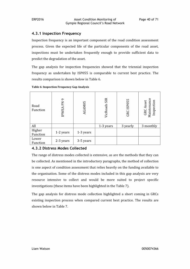
ERP2016 Asset Condition Monitoring of Page 40 of 71 Gympie Regional Council’s Road Network
Liam Watson 0050074366
4.3.1 Inspection Frequency
Inspection frequency is an important component of the road condition assessment
process. Given the expected life of the particular components of the road asset,
inspections must be undertaken frequently enough to provide sufficient data to
predict the degradation of the asset.
The gap analysis for inspection frequencies showed that the triennial inspection
frequency as undertaken by ISP055 is comparable to current best practice. The
results comparison is shown below in Table 6.
Table 6: Inspection Frequency Gap Analysis
Road Function
IPW
EA
PN
9
AG
AM
05
Vic
Ro
ads
SIR
GR
C I
SP
05
5
GR
C A
sset
M
ain
ten
ance
In
spec
tio
n
All 1-3 years 3 yearly 3 monthly Higher Function
1-2 years 1-3 years
Lower Function
2-3 years 3-5 years
4.3.2 Distress Modes Collected
The range of distress modes collected is extensive, as are the methods that they can
be collected. As mentioned in the introductory paragraphs, the method of collection
is one aspect of condition assessment that relies heavily on the funding available to
the organisation. Some of the distress modes included in this gap analysis are very
resource intensive to collect and would be more suited to project specific
investigations (these items have been highlighted in the Table 7).
The gap analysis for distress mode collection highlighted a short coming in GRCs
existing inspection process when compared current best practice. The results are
shown below in Table 7.
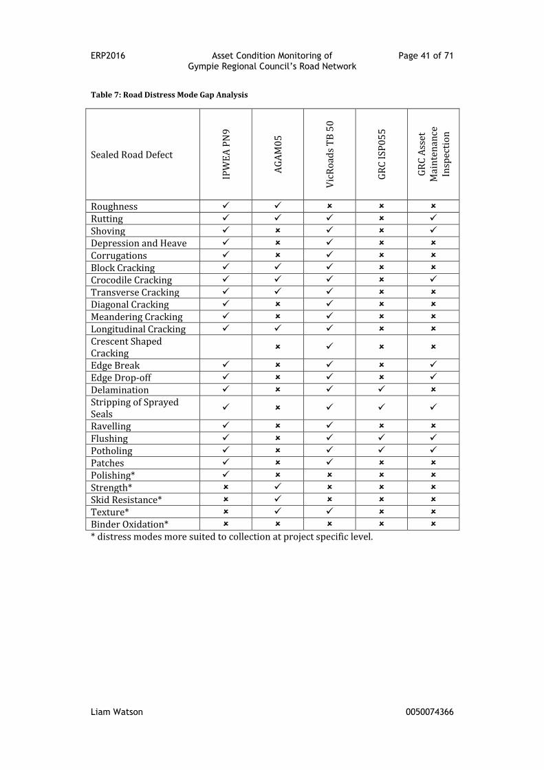
ERP2016 Asset Condition Monitoring of Page 41 of 71 Gympie Regional Council’s Road Network
Liam Watson 0050074366
Table 7: Road Distress Mode Gap Analysis
Sealed Road Defect
IPW
EA
PN
9
AG
AM
05
Vic
Ro
ads
TB
50
GR
C I
SP
05
5
GR
C A
sset
M
ain
ten
ance
In
spec
tio
n
Roughness Rutting Shoving Depression and Heave Corrugations Block Cracking Crocodile Cracking Transverse Cracking Diagonal Cracking Meandering Cracking Longitudinal Cracking Crescent Shaped Cracking
Edge Break Edge Drop-off Delamination Stripping of Sprayed Seals
Ravelling Flushing Potholing Patches Polishing* Strength* Skid Resistance* Texture* Binder Oxidation* * distress modes more suited to collection at project specific level.
ERP2016 Asset Condition Monitoring of Page 42 of 71 Gympie Regional Council’s Road Network
Liam Watson 0050074366
Chapter 5: Road Condition Assessment
Framework for Gympie Regional Council
The main objective of this project is to produce a framework for road condition
assessments which Gympie Regional Council can adopt and implement. As such, the
following chapter will outline the proposed framework, the individual elements
(procedures) of the framework, the proposed operational responsibilities and an
updated capital works process as originally defined in Chapter 3: Review of Gympie
Regional Council’s Road Condition Assessment Practices.
5.1 Proposed Framework
The purpose of this framework is to define how Gympie Regional Council will
undertake the condition assessment of its sealed road network. The major elements
of the framework have been identified through an extensive literature review, a
review of GRCs existing practices and a gap analysis to current best practice. The
intention is that the framework will remain relatively constant with the individual
procedures being updated as part of an ongoing continuous improvement process as
“business drivers and available condition assessment technologies will change”
(IPWEA & NAMS 2011, p. 2|73).
This framework will become an integral part of the Road Plan, assisting with project
selection for future capital works programs. It specifically applies to the condition of
the road surface and pavement. As the demand for condition data for other roadway
components arises (such as kerb and channel, footpaths etc.), this framework has
the potential to be transferable.
The proposed framework will be undertaken as part of a three year rolling
inspection program, similar to that of the existing ISP055, and identified as current
best practice in the gap analysis. Austroads (2007b, p. 26) supports this frequency,
citing that “annual surveys are not expected to show measurable changes” and that
“intervals of two to three years would appear to be a more practical and cost-
effective approach”. The remaining components of the framework are best
summarised in Figure 12.
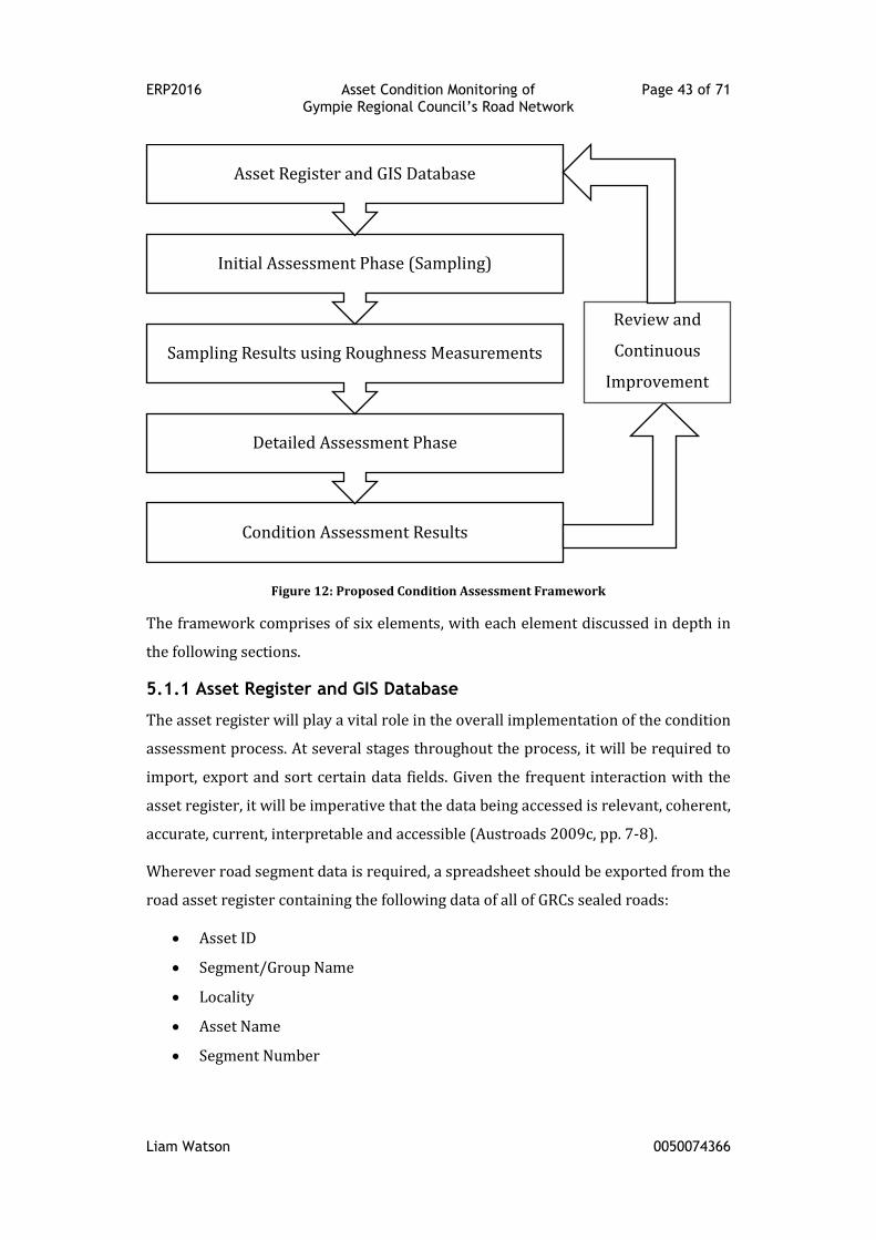
ERP2016 Asset Condition Monitoring of Page 43 of 71 Gympie Regional Council’s Road Network
Liam Watson 0050074366
Figure 12: Proposed Condition Assessment Framework
The framework comprises of six elements, with each element discussed in depth in
the following sections.
5.1.1 Asset Register and GIS Database
The asset register will play a vital role in the overall implementation of the condition
assessment process. At several stages throughout the process, it will be required to
import, export and sort certain data fields. Given the frequent interaction with the
asset register, it will be imperative that the data being accessed is relevant, coherent,
accurate, current, interpretable and accessible (Austroads 2009c, pp. 7-8).
Wherever road segment data is required, a spreadsheet should be exported from the
road asset register containing the following data of all of GRCs sealed roads:
Asset ID
Segment/Group Name
Locality
Asset Name
Segment Number
Condition Assessment Results
Detailed Assessment Phase
Sampling Results using Roughness Measurements
Initial Assessment Phase (Sampling)
Asset Register and GIS Database
Review and
Continuous
Improvement
ERP2016 Asset Condition Monitoring of Page 44 of 71 Gympie Regional Council’s Road Network
Liam Watson 0050074366
Start Chainage
End Chainage
Segment Length
Change Type
A template for the export can be developed in the asset management software as it
is important that the spreadsheet format is maintained throughout the assessment
process to allow for simple import and export operations.
The GIS database will have little input in the initial implementation of the
framework. It is envisaged that as the procedures develop over time, the importance
of geo-referencing road asset data will increase and therefore the interaction with
the GIS database will also increase.
5.1.2 Initial Assessment Phase (Screening)
The initial assessment phase involves screening the entire sealed road network to
highlight roads that are approaching the end of their useful lives. This will be
determined by capturing the roughness of the sealed road segments. The roughness
measurements will be undertaken once and will indicate the commencement of the
three year rolling inspection program. Roughness is the most suitable condition data
to serve this purpose as acknowledged by Austroads (2007b, p. 14):
“A key application of roughness data is to allow a network manager to
screen an entire network and separate those lengths of road whose
condition warrants further investigation from the larger portion of the
network which does not.”
Not only will roughness allow for the screening of the road network, it will also
provide a relatable condition dataset for customers. Research by Blom, Marco and
Guthrie (2015, p. 31) indicates that road smoothness is a frequent and a critical
concern of customers. The initial assessment phase will deliver this data, opening
the door to greater customer understanding of the decision making processes.
Further to this endorsement from Austroads, “pavement roughness is a decisive
criterion of deterioration” (Papageorgiou & Mouratidis 2015, p. 244). There is also a
clear link between increased IRI values and vehicular accident rates (King 2014, p.
34).
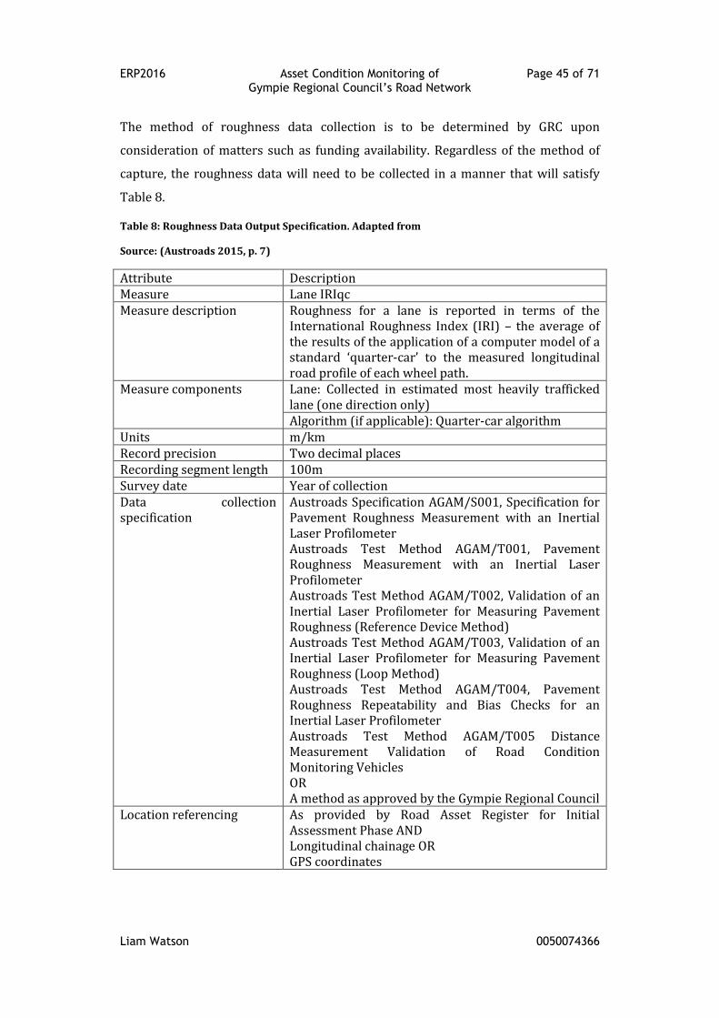
ERP2016 Asset Condition Monitoring of Page 45 of 71 Gympie Regional Council’s Road Network
Liam Watson 0050074366
The method of roughness data collection is to be determined by GRC upon
consideration of matters such as funding availability. Regardless of the method of
capture, the roughness data will need to be collected in a manner that will satisfy
Table 8.
Table 8: Roughness Data Output Specification. Adapted from
Source: (Austroads 2015, p. 7)
Attribute Description Measure Lane IRIqc Measure description Roughness for a lane is reported in terms of the
International Roughness Index (IRI) – the average of the results of the application of a computer model of a standard ‘quarter-car’ to the measured longitudinal road profile of each wheel path.
Measure components Lane: Collected in estimated most heavily trafficked lane (one direction only) Algorithm (if applicable): Quarter-car algorithm
Units m/km Record precision Two decimal places Recording segment length 100m Survey date Year of collection Data collection specification
Austroads Specification AGAM/S001, Specification for Pavement Roughness Measurement with an Inertial Laser Profilometer Austroads Test Method AGAM/T001, Pavement Roughness Measurement with an Inertial Laser Profilometer Austroads Test Method AGAM/T002, Validation of an Inertial Laser Profilometer for Measuring Pavement Roughness (Reference Device Method) Austroads Test Method AGAM/T003, Validation of an Inertial Laser Profilometer for Measuring Pavement Roughness (Loop Method) Austroads Test Method AGAM/T004, Pavement Roughness Repeatability and Bias Checks for an Inertial Laser Profilometer Austroads Test Method AGAM/T005 Distance Measurement Validation of Road Condition Monitoring Vehicles OR A method as approved by the Gympie Regional Council
Location referencing As provided by Road Asset Register for Initial Assessment Phase AND Longitudinal chainage OR GPS coordinates

ERP2016 Asset Condition Monitoring of Page 46 of 71 Gympie Regional Council’s Road Network
Liam Watson 0050074366
To clarify the measure components of Table 8, it is appropriate to record roughness
in one lane in one direction only, and assume similar roughness in the other lane for
a typical two-lane two-way roads (Austroads 2007b, p. 26).
Along with the roughness data, the initial assessment phase will involve the capture
of video footage of the road. The video setup will be paired with a DMI for linear
referencing of the road segments. It will be used to validate sections of road that
show outlier roughness values.
Figure 13: Example of GRC Video Footage
5.1.3 Screening Results using Initial Assessment Results
The roughness data will be imported into GRCs asset management software, with
the roughness data to align with the predefined road segments. The asset register
will then produce a report (in .csv format) that sorts the road segments according to
the measured roughness values in descending order. The roughest 25 percent of the
entire sealed network will then make up the shortlist that is subject to a detailed
investigation.
Justification of screening value
A review of past capital works programs found that GRC averaged approximately
65km of capital works on roads per year (2013/14 ≈ 41km, 2014/15 ≈ 59km,
2015/16 ≈ 80km). Considering a three-year capital works program (to match the
cycle of the rolling inspection program), 195km of road may be subject to capital
works. Allowing a further 50% contingency as it is long-range planning, 300km of
road should be considered for capital works during the three-year program period.
At present, this equates to 25% of the sealed road network.
ERP2016 Asset Condition Monitoring of Page 47 of 71 Gympie Regional Council’s Road Network
Liam Watson 0050074366
Exceptions to network screening
Roughness data collected at low speeds (less than 25km/h) or for less than 50m will
be misleading (Austroads 2007b, p. 32). Intersections, short road segments and
LATM controlled town centres will therefore require visual inspections for condition
assessment.
5.1.4 Detailed Assessment Phase
The detailed assessment phase will subject those road segments highlighted in the
screening phase to a visual inspection in accordance with IPWEA Practice Note Nine
(core approach). The guide was developed “to provide direction and national
consistency in the process of carrying out condition and performance assessment
for road pavement assets” (IPWEA 2015, p. viii). Heeding the warnings from the
literature review, the core approach was selected so as not to overwhelm the still
developing road asset register and risk the assessment process being abandoned
due to an unsustainable amount of data collection. The core approach will allow a
manageable build-up of condition data that “will ultimately lead to a more advanced
asset management process“ (IPWEA 2015, p. 6).
By adopting a visual assessment process, it will also allow GRC to utilise its existing
staff base with extensive experience in visual inspections. This will also allow for the
visual inspection of those segments identified in Exceptions to network screening.
Condition assessments will be recorded electronically, utilising a similar format to
that currently utilised by the asset maintenance inspectors (see Appendix F: GRC
Asset Maintenance Inspection Form (Partial Copy)). The updated format for
collection will need to match a predefined order to allow for a straight forward
import process into the road asset register.
5.1.5 Condition Assessment Results
The recorded condition data will be imported into GRCs asset management software
straight from the inspection spreadsheet, with the data to align with the predefined
road segments. Once imported, the condition data will populate the relevant field it
the asset register, as shown in Figure 14.
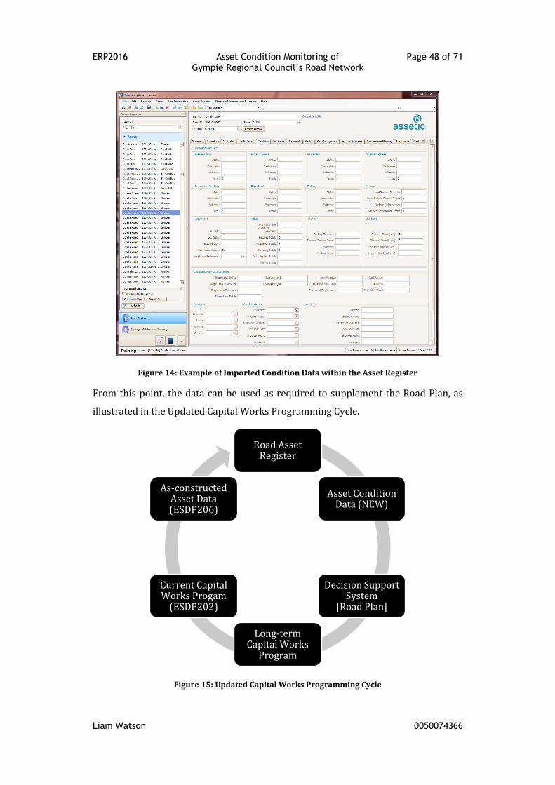
ERP2016 Asset Condition Monitoring of Page 48 of 71 Gympie Regional Council’s Road Network
Liam Watson 0050074366
Figure 14: Example of Imported Condition Data within the Asset Register
From this point, the data can be used as required to supplement the Road Plan, as
illustrated in the Updated Capital Works Programming Cycle.
Figure 15: Updated Capital Works Programming Cycle
Road Asset Register
Asset Condition Data (NEW)
Decision Support System
[Road Plan]
Long-term Capital Works
Program
Current Capital Works Progam
(ESDP202)
As-constructed Asset Data (ESDP206)
ERP2016 Asset Condition Monitoring of Page 49 of 71 Gympie Regional Council’s Road Network
Liam Watson 0050074366
5.1.6 Review and Continuous Improvement
This component of the framework will be critical in the long-term success of
condition assessments. As previously mentioned, the framework has been set up at
the core or basic level of asset management. This was done purposely to ensure that
the condition assessment process had room to develop as GRC became more
accustomed to the framework. Items that would be considered include:
Monitoring the developments in state-of-the-art data collection techniques
Incorporating asset component age into the screening process along with
roughness.
Aligning maintenance and capital works activities with the specific road
segment to allow better capture of the actual age of the component.
Further items that could be considered are included in 6.1
Recommendations/Further Research.
ERP2016 Asset Condition Monitoring of Page 50 of 71 Gympie Regional Council’s Road Network
Liam Watson 0050074366
6.0: Conclusion
The driving factor behind this project is to aid in the capital works prioritisation
process for GRC by providing a framework that will ultimately deliver a quantifiable
base of road condition data. In order to develop this framework, a literature review
was undertaken.
The review examined literature covering the road condition assessments, seeking
information on road defects, defect collection methods, assessment frequency and
condition data needs. It unearthed a broad range of information, including the
suitability of utilising road roughness measurement as a screening tool. Ultimately
though, the review did reveal a gap in the literature when it comes to definitive
recommendations on the extent of condition data to record and how often to record
it.
A review of GRCs existing practices followed the literature review. It looked into
several aspects including the existing road asset register and the existing inspection
regimes. The most notable items identified in the review were:
the lack of a road segmentation procedure in the road asset register, and
the lack on integration of existing inspection results and the asset register.
This internal review provided the foundation for a gap analysis to current best
practice. The gap analysis confirmed that the frequency of the existing reseal
inspection program was satisfactory; however, it did identify a shortfall in the scope
of road defects collected and the method of collection.
The new framework was developed after considering all the above matters, with the
aim to produce a process that is economical and purpose-built for the region. The
framework utilises an over-arching condition data (roughness) to screen the
network. The shortlisted roads produced from the screening process can then be
assessed in detail using the existing inspection personnel employed by GRC, who
have experience undertaking visual inspections and have an intimate knowledge of
the regions road network.
ERP2016 Asset Condition Monitoring of Page 51 of 71 Gympie Regional Council’s Road Network
Liam Watson 0050074366
6.1 Recommendations/Further Research
The following recommendations have been identified to assist with the
implementation of the proposed framework. They are in no particular order.
1. Undertake a pilot inspection program to test the framework. The pilot
program will be useful to determine the type of roughness measuring device
to use. It is suggested that an inertial laser profilometer (class 1) and a
smartphone (class 4) roughness application (RoadBump, or similar) be field
tested and the results compared prior to selecting which tool to use.
2. Develop and implement a road segmentation procedure for the asset
register. The effectiveness of condition data can be greatly reduced by
excessively long segments.
3. Development and implement a check that ensures the most current as-
constructed data has been integrated into the asset register prior to starting
the condition assessment cycle.
4. Review the frequency of asset maintenance inspections. If the frequency of
these inspections could be justifiably increased to half yearly (see.Austroads
(2006a, p. 34) for further information), it could allow the incorporation of
the detailed condition assessment phase with only a minimal increase in
work load.
5. Implement the framework methodically. Diving into the framework and
collecting condition data en masse could result in poor data being collected.
This will increase the probability of misguided funding allocations, therefore
reducing the trust in the condition assessment process. In the worst case,
this could lead to abandonment of the entire process.
6. Unsealed roads have been identified as fundamentally different in funding
application and maintenance operations to sealed roads. Therefore, a
separate framework will be required.
7. Make the video footage captured in the initial assessment phase available to
whole of Council either by linking the corporate GIS application or through a
network location.
8. The framework will be the responsibility of the Manager – Assets Section. It
is envisaged that the majority of the work will need to be incorporated into

ERP2016 Asset Condition Monitoring of Page 52 of 71 Gympie Regional Council’s Road Network
Liam Watson 0050074366
the Design Services Branch budget, with only the detailed assessment phase
being undertaken by the Construction and Maintenance Branch.
ERP2016 Asset Condition Monitoring of Page 53 of 71 Gympie Regional Council’s Road Network
Liam Watson 0050074366
References
AASHTO 2012, 'Pavement Condition Assessment', in Pavement Management Guide
(2nd Edition), American Association of State Highway and Transportation Officials
(AASHTO), ch 4.
Alessandroni, G, Klopfenstein, LC, Delpriori, S, Dromedari, M, Luchetti, G, Paolini, BD,
Seraghiti, A, Lattanzi, E, Freschi, V, Carini, A & Bogliolo, A 2014, 'SmartRoadSense:
Collaborative Road Surface Condition Monitoring', in UBICOMM 2014: The Eighth
International Conference on Mobile Ubiquitous Computing, Systems, Services and
Technologies: Proceedings of the UBICOMM 2014: The Eighth International Conference
on Mobile Ubiquitous Computing, Systems, Services and Technologies IARIA.
Attoh-Okine, N & Adarkwa, O 2013, Pavement Condition Surveys - Overview of
Current Practices, Delaware Center for Transportation, USA.
Austroads 2002, Heavy Vehicle Loading of Low Trafficked Roads: Part 1 - Strategic
Framework for Reviewing Expenditure, Austroads Inc., Sydney, NSW.
Austroads 2003, Remaining Life of Road Infrastructure Assets: An Overview,
Austroads Inc., Sydney, NSW.
Austroads 2006a, Guide to Asset Management Part 1: Introduction to Asset
Management, Austroads Inc., Sydeny, NSW.
Austroads 2006b, Guide to Asset Management Part 5E: Cracking, Austroads Inc.,
Sydney, NSW.
Austroads 2007a, Guide to Asset Management Part 5C: Rutting, Austroads Inc.,
Sydney, NSW.
Austroads 2007b, Guide to Asset Management Part 5B: Roughness, Austroads Inc.,
Sydney, NSW.
Austroads 2008a, Guide to Asset Management Part 5D: Strength, Austroads Inc.,
Sydney, NSW.
Austroads 2008b, Guide to Pavement Technology Part 5: Pavement Evaluation and
Treatment Design, Austroads Inc., Sydney, NSW.
Austroads 2009a, Guide to Asset Management Part 5: Pavement Performance,
Austroads Inc., Sydney, NSW.
Austroads 2009b, Guide to Asset Management Part 5H: Performance Modelling,
Austroads Inc., Sydney, NSW.

ERP2016 Asset Condition Monitoring of Page 54 of 71 Gympie Regional Council’s Road Network
Liam Watson 0050074366
Austroads, 2009c, Guide to Asset Management Part 5A: Inventory. Austroads Inc.,
Sydnew, NSW.
Austroads 2009d, Guide to Pavement Technology Part 1: Introduction to Pavement
Technology, Austroads Inc., Sydnew, NSW.
Austroads 2009e, Guide to Asset Management Part 2: Community and Stakeholder
Requirements, Austroads Inc., Sydney, NSW.
Austroads 2009f, Guide to Asset Management Part 4: Program Development and
Implementation, Austroads Inc., Sydney, NSW.
Austroads 2009g, Guide to Asset Management Part 8: Assets Valuation and Audit,
Austroads Inc., Sydney, NSW.
Austroads 2015, A Common Data Output Specification for Texture, Cracking, Strength
and Skid Resistance, Austroads, Sydney, NSW.
Bennett, C & Paterson, W 2000, A guide to the calibaration and adaption of HDM-4,
World Roads Association (PIARC), Paris, France.
Bennett, CR, Solminihac, Hd & Chamorro, A 2006, Transport Note No. 30: Data
Collection Technologies for Road Management, The World Bank, Washington, USA.
BITRE 2011, Public road-related expenditure and revenue in Australia, Information
Sheet 40, BITRE, Canberra.
Blom, CM, Marco, LD & Guthrie, PM 2015, 'Customer perceptions of road
infrastructure surface conditions', Infrastructure Asset Management, vol. 2, no. 1, pp.
23-38.
Bryant, J & Flintsch, G 2006, Asset Management Data Collection for Supporting
Decision Processes, U.S. Department of Transportation, USA.
Bryce, JM, Hosten, AM, Priddy, LP, Flintsch, GW, Izeppi, EdL & Nelson, WO 2013,
'Using Pavment Management to Support Maintenance and Engineering Policy
Decisions for Small and Mid-Sized Municipalities', Public Works Management &
Policy, vol. 19, pp. 148-63.
EA 2010, Code of Ethics, Engineers Australia, ACT.
Eppell, V, McClurg, BA & Bunker, JM 2001, 'A four level road hierarchy for network
planning and management'.
Evans, M & Sansom, G 2015, A Federation for Communities and Places: Australia in a
Century of Local Governance, Draft, Local Government Professionals Australia.
ERP2016 Asset Condition Monitoring of Page 55 of 71 Gympie Regional Council’s Road Network
Liam Watson 0050074366
GRC 2015, Construction and Maintenance Branch Business Plan, Version 1,
Queensland, Discussion Paper.
GRC 2016, Road Plan, Draft, Queensland.
Hunt, PD 2002, Analysis of Roughness Deterioration of Bitumen Sealed Unbound
Granular Pavements for use in Road Asset Management Modelling, Queensland
University of Technology, Australia, Master's Thesis.
IPWEA 2015, Condition Assessment and Asset Performance Guidelines Practice Note 9
- Road Pavement Assets, IPWEA, Sydney, NSW.
IPWEA 2016, Condition Assessment and Asset Performance Guidelines Practice Note
9.1 - How to: Assess Road Pavement Condition, IPWEA, Sydney, NSW.
IPWEA & NAMS 2011, International Infrastructure Management Manual, NAMS
Limited, Wellington, N.Z.
Jeff Roorda and Associates 2006, Guidelines for Measuring and Reporting the
Condition of Road Assets, Local Government Victoria, Melbourne, Vic.
Jones, D & Paige-Green, P 2000, Draft TMH12 Pavement Management Systems:
Standard Visual Assessment Manual for Unsealed Roads, CSIR Transportek, South
Africa.
Jordan, G & Cook, G 2013, Road Condition Assessment Manual, South West RRTG,
Queensland.
King, B-A 2014, 'The effect of road roughness on traffic speed and road safety',
University of Southern Queensland, Toowoomba, Qld.
Koch, C, Georgieva, K, Kasireddy, V, Akinci, B & Fieguth, P 2015, 'A review on
computer vision based defect detection and condition assessment of concrete and
asphalt civil infrastructure', Advanced Engineering Informatics, vol. 29, no. 2, pp.
196-210.
Mubaraki, M 2013, 'Proposed integrated road surface management system for small
municipalities', Proceedings of the Institution of Civil Engineers - Municipal Engineer,
vol. 166, no. 4, pp. 239-49.
Papageorgiou, G & Mouratidis, A 2015, 'Defining threshold values for pavement
surface characteristics', Proceedings of the Institution of Civil Engineers - Transport,
vol. 168, no. 3, pp. 223-30.
Perttunen, M, Mazhelis, O, Cong, F, Kauppila, M, Leppänen, T, Kantola, J, Collin, J,
Pirttikangas, S, Haverinen, J, Ristaniemi, T & Riekki, J 2011, 'Distributed Road
ERP2016 Asset Condition Monitoring of Page 56 of 71 Gympie Regional Council’s Road Network
Liam Watson 0050074366
Surface Condition Monitoring Using Mobile Phones', in C-H Hsu, et al. (eds),
Ubiquitous Intelligence and Computing: 8th International Conference, UIC 2011, Banff,
Canada, September 2-4, 2011. Proceedings, Springer Berlin Heidelberg, Berlin,
Heidelberg, pp. 64-78.
Pierce, LM, McGovern, G & Zimmerman, KA 2013, Practical Guide for Quality
Management of Pavement Condition Data Collection, U.S. Department of
Transportation, Federal Highway Administration, Washington DC, USA.
Ruotoistenmäki, A, Seppälä, T & Kanto, A 2006, 'Comparison of Modeling and
Measurement Accuracy of Road Condition Data', Journal of Transportation
Engineering, vol. 132, no. 9, pp. 715-21.
Saliminejad, S & Gharaibeh, NG 2016, 'Proximity-Based Outlier Detection Method for
Roadway Infrastructure Condition Data', Journal of Computing in Civil Engineering,
vol. 30, no. 1, p. 04015001.
Sun, L & Gu, W 2011, 'Pavement Condition Assessment Using Fuzzy Logic Theory
and Analytic Hierarchy Process', Journal of Transportation Engineering, vol. 137, no.
9, pp. 648-55.
TMR 2012, Pavement Rehabiliation Manual, Brisbane, QLD.
TMR 2015, The Roads and Transport Alliance, Queensland Government.
VicRoads 2009, Technical Bulletin 50: Guide to Surface Inspection Rating, VicRoads,
Victoria.
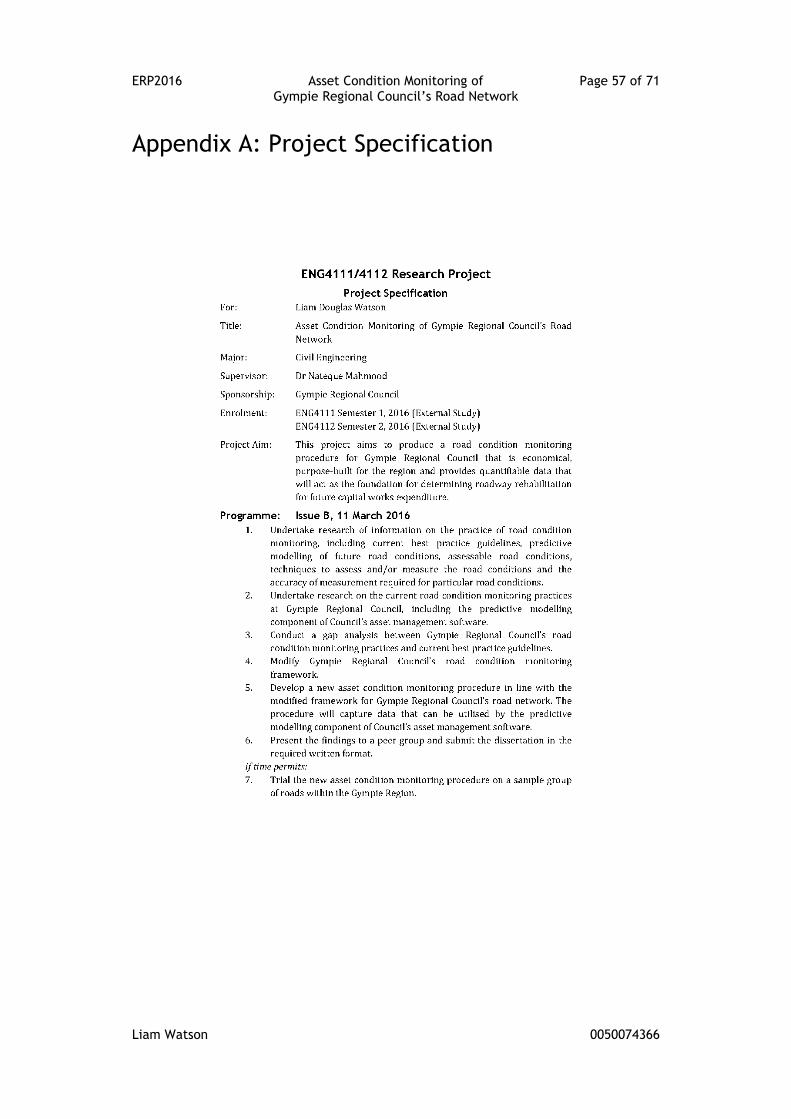
ERP2016 Asset Condition Monitoring of Page 57 of 71 Gympie Regional Council’s Road Network
Liam Watson 0050074366
Appendix A: Project Specification
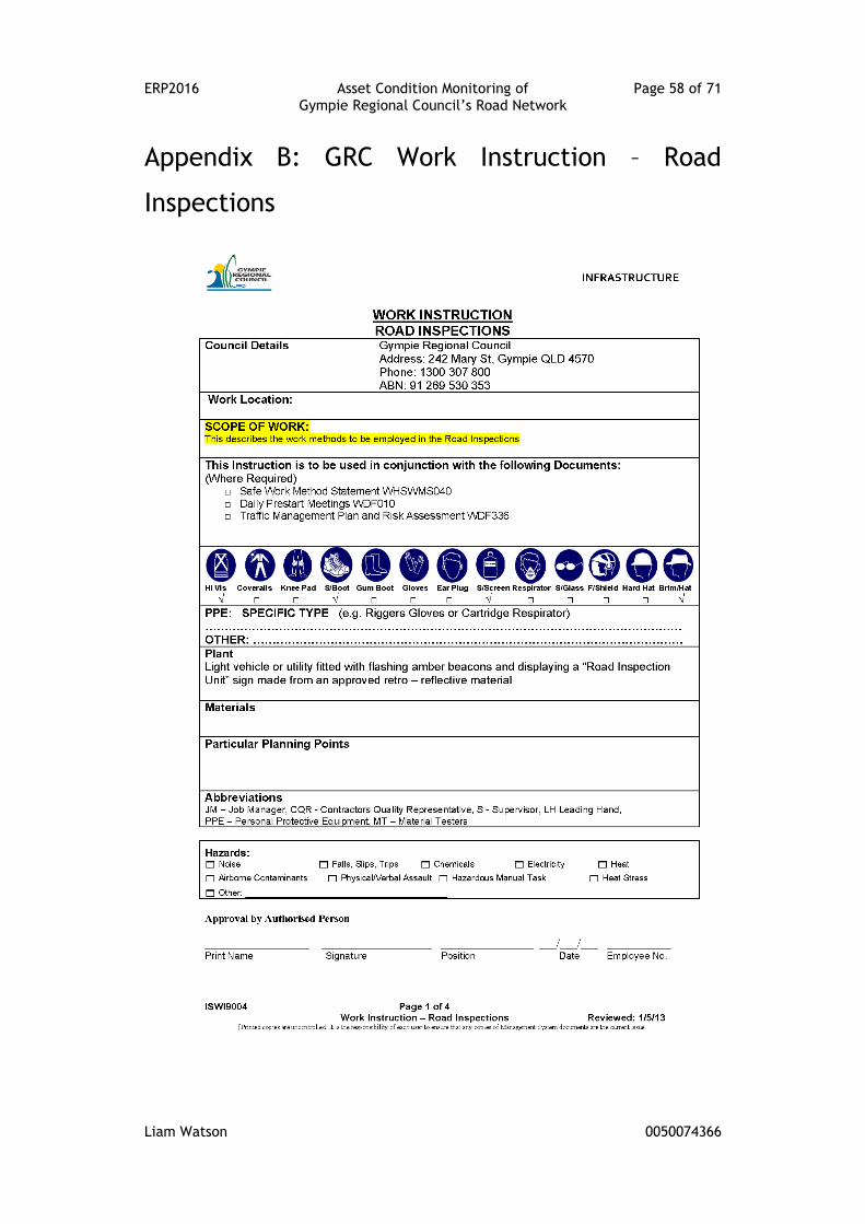
ERP2016 Asset Condition Monitoring of Page 58 of 71 Gympie Regional Council’s Road Network
Liam Watson 0050074366
Appendix B: GRC Work Instruction – Road
Inspections
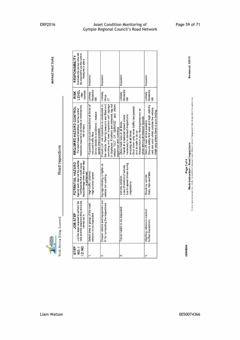
ERP2016 Asset Condition Monitoring of Page 59 of 71 Gympie Regional Council’s Road Network
Liam Watson 0050074366
ERP2016 Asset Condition Monitoring of Page 60 of 71 Gympie Regional Council’s Road Network
Liam Watson 0050074366
ERP2016 Asset Condition Monitoring of Page 61 of 71 Gympie Regional Council’s Road Network
Liam Watson 0050074366
ERP2016 Asset Condition Monitoring of Page 62 of 71 Gympie Regional Council’s Road Network
Liam Watson 0050074366
Appendix C: GRC Enterprise Risk Management
Procedure
ERP2016 Asset Condition Monitoring of Page 63 of 71 Gympie Regional Council’s Road Network
Liam Watson 0050074366
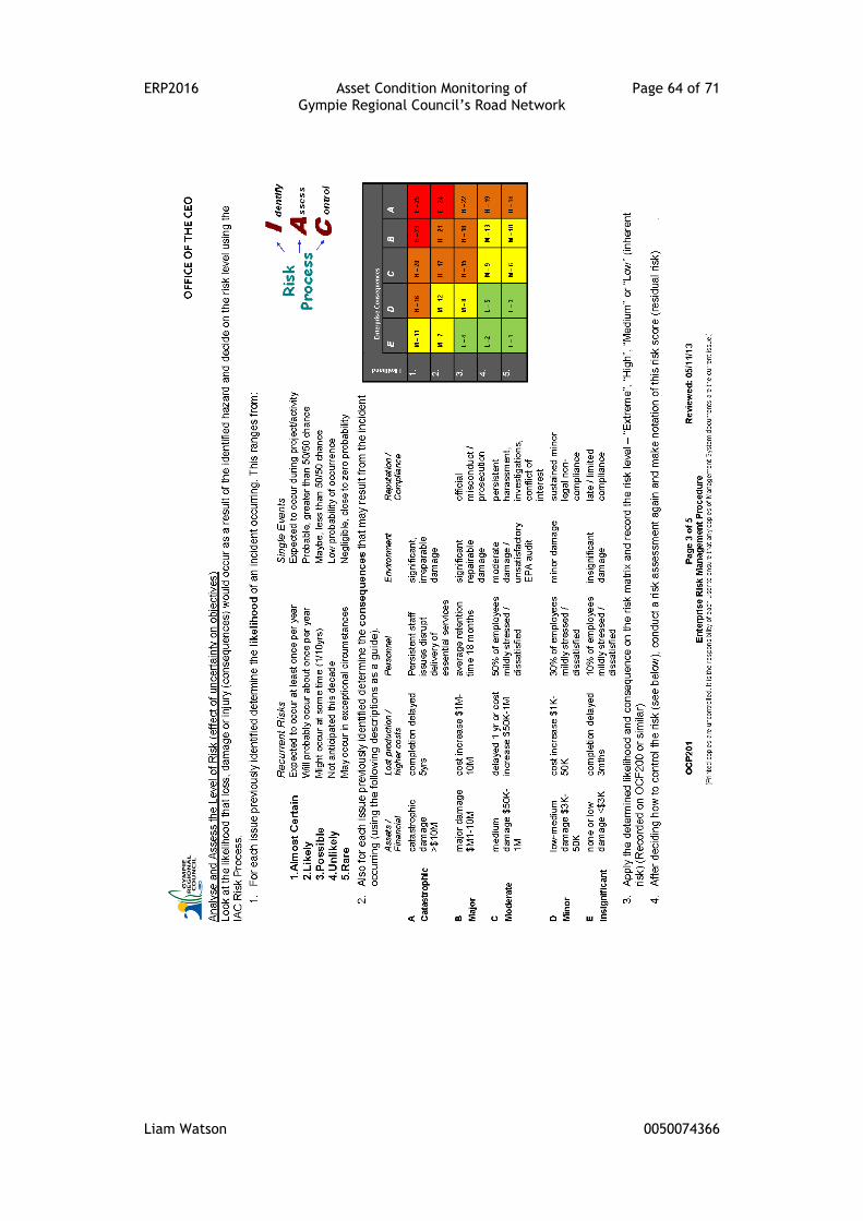
ERP2016 Asset Condition Monitoring of Page 64 of 71 Gympie Regional Council’s Road Network
Liam Watson 0050074366
ERP2016 Asset Condition Monitoring of Page 65 of 71 Gympie Regional Council’s Road Network
Liam Watson 0050074366
ERP2016 Asset Condition Monitoring of Page 66 of 71 Gympie Regional Council’s Road Network
Liam Watson 0050074366

ERP2016 Asset Condition Monitoring of Page 67 of 71 Gympie Regional Council’s Road Network
Liam Watson 0050074366
Appendix D: GRC Enterprise Risk Assessment
Record
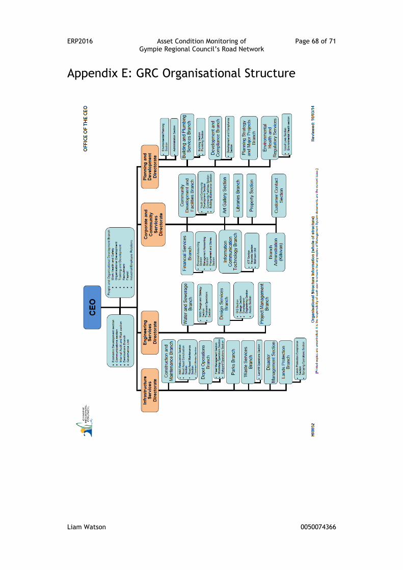
ERP2016 Asset Condition Monitoring of Page 68 of 71 Gympie Regional Council’s Road Network
Liam Watson 0050074366
Appendix E: GRC Organisational Structure
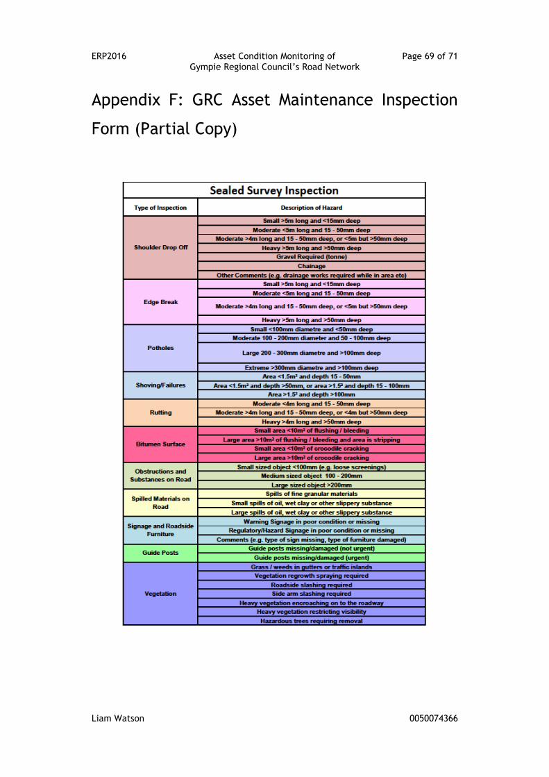
ERP2016 Asset Condition Monitoring of Page 69 of 71 Gympie Regional Council’s Road Network
Liam Watson 0050074366
Appendix F: GRC Asset Maintenance Inspection
Form (Partial Copy)
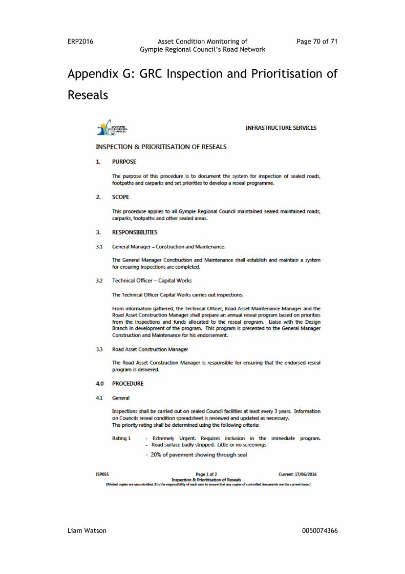
ERP2016 Asset Condition Monitoring of Page 70 of 71 Gympie Regional Council’s Road Network
Liam Watson 0050074366
Appendix G: GRC Inspection and Prioritisation of
Reseals

ERP2016 Asset Condition Monitoring of Page 71 of 71 Gympie Regional Council’s Road Network
Liam Watson 0050074366