Embed Size (px)
Citation preview
Po
lic
ybr
ief
Assessment of Coastal Management Issues Through Socioeconomic Monitoring (SocMon) Methodology at the Four Coastal Villages in Oriental Mindoro and
Palawan Provinces in the Philippines: Program Recommendations and Policy Directions
M.D. Pidoa, M.S. Pontillasa, E.G. Piolb, M.T.U. Macasaetc, J.F.A. Pontillasd, E.M.C. Ponce Leona, D. Martinezc, N.I. Mendozaa, R. de Guzmanb, R. Quitainb and J. Buenconsejoa
aPalawan State University, Puerto Princesa City, Palawan, Philippines bMindoro State College of Agriculture and Technology,
Bongabong, Oriental Mindoro, PhilippinescCity Government of Puerto Princesa, Puerto Princesa City, Palawan, Philippines
dPalawan Council for Sustainable Development Staff, Puerto Princesa City, Palawan, Philippines
Summary
The information presented in this ‘Policy Brief ’ is derived from a collaborative project titled Socioeconomic Monitoring (SocMon) Program in the Philippines to Support Effective Coral Reef Conservation and Coastal Resources Management: Initiation in Oriental Mindoro Province and Continuation in Puerto Princesa City, Palawan Province. Its focus is on the use of SocMon methodology for assessment of coastal management issues at four coastal villages in Oriental Mindoro and Palawan Provinces in the Philippines.
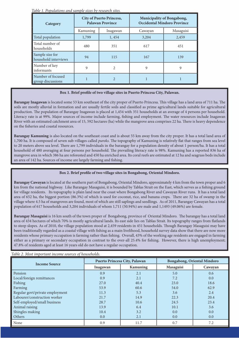
As a participatory tool, five institutions were involved in the assessment: two academic institutions (Palawan State University and Mindoro State College of Agriculture and Technology); two local government units (City Government of Puerto Princesa and Municipality of Bongabong); and one national government agency (Palawan Council for Sustainable Development Staff. Funding support for this research project was provided by the US National Oceanic and Atmospheric Administration as an external donor. The respondents included the following: 515 for household interviews, 30 key informants, and 5 focused group discussions.
Several coastal threats were identified. Those specific for mangroves include: cutting for household and commercial uses, charcoal making and natural phenomena (typhoons, big waves), conversion into fish pond, and clearing for settlements. Threats to coral reefs include: cyanide/compressor fishing, dynamite fishing, natural phenomenon (typhoon, waves), illegal fishing activities, and coral gathering for household/commercial use. In the case of seagrass beds, the perceived threats are clearing, fishing using dragnets, natural phenomenon (typhoon, waves), gathering for household use, illegal fishing activities, gathering for commercial use, and pollution/dumping of garbage.
Coastal management and/or community issues are categorized into three; these issues are non-linear but are intricately inter-connected. Bio-physical issues include marine-related (coastal erosion, coastal pollution from all sources, depleted fishery resources, degraded coastal habitats, destructive fishing, sea level rise and marine litter), terrestrial-based (forest destruction, sanitation, sewage, and solid waste), and cross-cutting concerns (climate change and natural calamities). Socio-economic issues - the second category – include limited employment, inadequate infrastructure facilities, poor nutrition, post harvest losses, and poverty. Institutional/governance issues include inadequate/inconsistent fisheries policies, lack of harmonization of plans and programs, lack of stakeholder participation, limited institutional capabilities, low level of awareness, unclear property rights, weak institutional partnerships, and weak law enforcement.
Management measures and/or interventions that are proposed to address the above issues/problems are clustered into three major categories. Regulatory measures include registration and licensing as well as size limits. The second category, conservation and protection measures, include area/season closures, coastal clean-ups, habitat restoration/rehabilitation, and waste management. Thirdly, economic measures consist of credit support, infrastructure development, livelihoods promotion, and marketing assistance. Governance/institutional measures include capacity-building, information and education campaign, law enforcement, management planning, policy development and private-public sector partnership. Overall, SocMon has been found as a useful tool in identifying problems/issues – as well as relevant policy recommendations and program interventions.
1. Background
It is becoming increasingly clear in the tropical developing countries that coral reef and marine conservation is about understanding people as much as it is about understanding ecological processes. Integration of socioeconomic monitoring (SocMon) at conservation sites can serve to involve local communities in resource management, provide adaptive management strategies to reflect the local needs, and facilitate understanding of the importance of marine and coastal resources. Understanding socioeconomic factors and the communities’ relationship to coastal and marine resources is crucial for the success of marine conservation. As such, the Global Socioeconomic Monitoring Initiative for Coastal Management (SocMon Global) has been undertaken to pursue this worldwide conservation initiative (Loper, 2009). This global program has several regional nodes, one of which is southeast Asia (SocMon SEA).
The stewardship of Socioeconomic Monitoring Southeast Asia (SocMon SEA) has been undertaken by the Palawan State University (PSU) since 2009. Together with Conservation International-Philippines (CIP), PSU has been undertaking SocMon-related activities in Palawan Province, Philippines, in collaboration with the local government units (LGUs), national government agencies (NGAs), non-governmental organizations (NGOs), academe and local communities (Pido, 2009). The information presented here are results of the collaborative project titled Socioeconomic Monitoring (SocMon) Program in the Philippines to Support Effective Coral Reef Conservation and Coastal Resources Management: Initiation in Oriental Mindoro Province and Continuation in Puerto Princesa City, Palawan Province.
The purposes of this Policy Brief are two-fold. First, it describes the key threats to the coastal resources as well as major coastal management/community problems. Secondly, it presents the clusters of program interventions and/or policy recommendations in relation to these identified issues. It concludes with a reflection about SocMon’s utility as a diagnostic tool.
2. Methodology
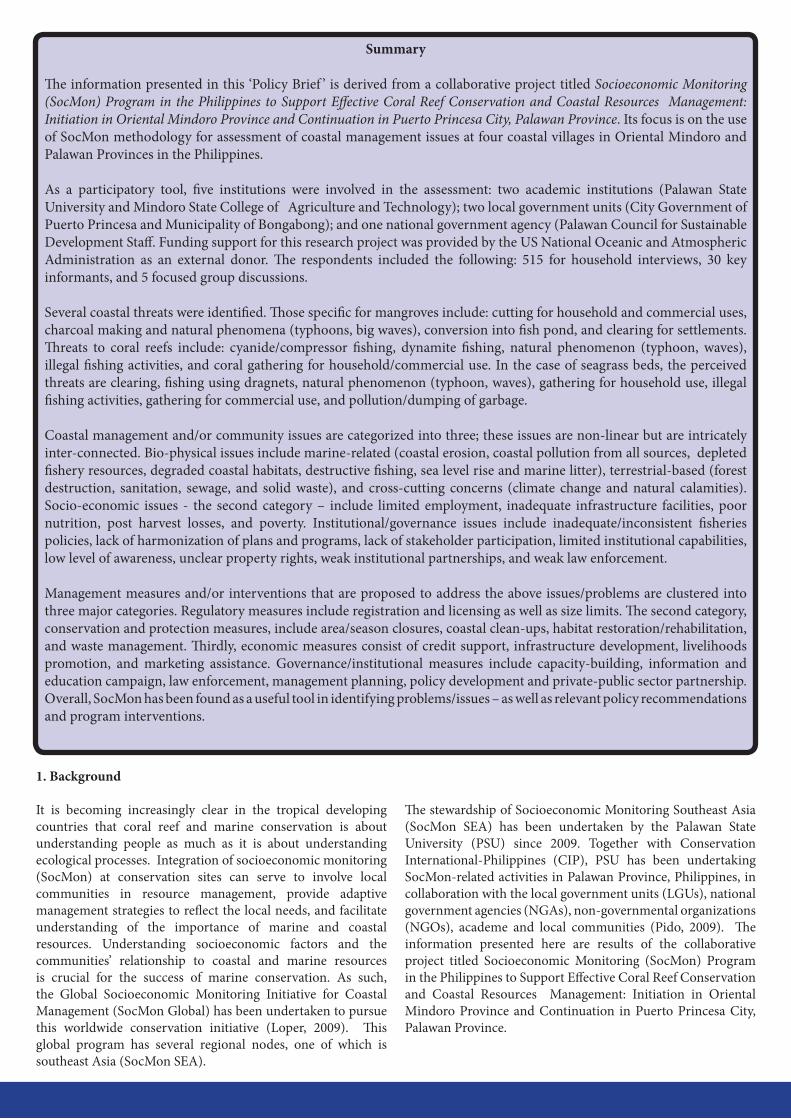
The SocMon methodology (Bunce and Pomeroy 2000, Bunce et al., 2003) was adopted in this project. The SocMon process basically follows three major steps (see Figure 1). The first part is advance preparation that includes defining the objectives of SocMon, establishing the SocMon team and preparing the logistics.
The second part is data collection, which is concerned with the generation of field data. Three complementary research methods were employed in this study namely household interview (HHI), key informant interview (KII), and focused
group discussions (FGD). The number of respondents is as follows: HHI – 515; KII – 30; and FGD – 9 (see Table 1). Data analysis consisted of qualitative and quantitative analysis while communication included the dissemination of results to the relevant stakeholders.
The five partner institutions involved in project planning and implementation belonged to different categories. PSU and Mindoro State College of Agriculture & Technology (MinSCAT) are academic institutions classified as state universities and colleges (SUCs) in the Philippines; the institutions are also partner SUCs within the Southern Tagalog Islands Research and Development Consortium. The City Government of Puerto Princesa (CGPP) and Municipality of Bongabong are classified as local government units (LGUs) while the Palawan Council for Sustainable Development Staff (PCSDS) is a national government agency. Funding support for this research project was provided by the US National Oceanic and Atmospheric Administration (NOAA) as an external donor.
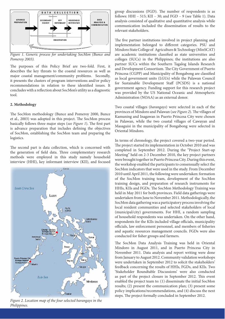
Two coastal villages (barangays) were selected in each of the provinces of Mindoro and Palawan (see Figure 2). The villages of Kamuning and Inagawan in Puerto Princesa City were chosen in Palawan, while the two coastal villages of Cawayan and Masaguisi in the municipality of Bongabong were selected in Oriental Mindoro.
In terms of chronology, the project covered a two-year period. The project started its implementation in October 2010 and was completed in September 2012. During the “Project Start-up Meeting” held on 2-3 December 2010, the key project partners were brought together in Puerto Princesa City. During this event, the workshop enabled the participants to consensually select the SocMon indicators that were used in the study. From December 2010 until April 2011, the following were undertaken: formation of the SocMon training team, development of the SocMon training design, and preparation of research instruments for HHIs, KIIs and FGDs. The SocMon Methodology Training was held in May 2011 for both provinces. Field data gatherings were undertaken from June to November 2011. Methodologically, the SocMon data gathering was a participatory process involving the local resident communities and selected stakeholders of local (municipal/city) governments. For HHI, a random sampling of household respondents was undertaken. On the other hand, respondents for the KIIs included village officials, municipality officials, law enforcement personnel, and members of fisheries and aquatic resources management councils. FGDs were also conducted for fisher groups and farmers.
The SocMon Data Analysis Training was held in Oriental Mindoro in August 2011, and in Puerto Princesa City in November 2011. Data analysis and report writing were done from January to August 2012. Community validation workshops were undertaken in September 2012 to solicit the stakeholders’ feedback concerning the results of HHIs, FGDs, and KIIs. Two ‘Stakeholder Roundtable Discussions’ were also conducted as part of the project closure in September 2012. This event enabled the project team to: (1) disseminate the initial SocMon results; (2) present the communication plan; (3) present some policy implications/recommendations, and (4) discuss the next steps. The project formally concluded in September 2012.
Figure 1. Generic process for undertaking SocMon (Bunce and Pomeroy 2003).
Figure 2. Location map of the four selected barangays in the Philippines.
CategoryCity of Puerto Princesa,
Palawan ProvinceMunicipality of Bongabong,
Occidental Mindoro Province
Kamuning Inagawan Cawayan MasaguisiTotal population 1,799 1, 454 3,204 2,459Total number of households 480 351 617 451
Sample size for household interviews 94 115 167 139
Number of key informants 9 2 9 9
Number of focused group discussions 1 2 1 1
Box 1. Brief profile of two village sites in Puerto Princesa City, Palawan.
Barangay Inagawan is located some 53 km southeast of the city proper of Puerto Princesa. This village has a land area of 711 ha. The soils are mostly alluvial in formation and are usually fertile soils and classified as prime agricultural lands suitable for agricultural production. The population of Barangay Inagawan is placed at 1,454 with 351 households at an average of 4 persons per household. Literacy rate is at 99%. Major sources of income include farming, fishing and employment. The water resources include Inagawan River with an estimated catchment area of 15, 592 hectares (ha) while the mangrove area comprises 22 ha. There is heavy dependence on the fisheries and coastal resources.
Barangay Kamuning is also located on the southeast coast and is about 55 km away from the city proper. It has a total land area of 1,700 ha. It is composed of seven sub-villages called puroks. The topography of Kamuning is relatively flat that ranges from sea level to 20 meters above sea level. There are 1,799 individuals in the barangay for a population density of about 1 person/ha. It has a total household of 480 averaging at four persons per household. The prevailing literacy rate is 98%. Kamuning has a reported 836 ha of mangrove area in which 386 ha are reforested and 450 ha enriched area. Its coral reefs are estimated at 12 ha and seagrass beds include an area of 142 ha. Sources of income are largely farming and fishing.
Box 2. Brief profile of two village sites in Bongabong, Oriental Mindoro.
Barangay Cawayan is located at the southern part of Bongabong, Oriental Mindoro, approximately 4 km from the town proper and 6 km from the national highway. Like Barangay Masaguisi, it is bounded by Tablas Strait on the East, which serves as a fishing ground for village residents. Its topography is plain land near the coast where Bongabong River and Cawayan River runs. It has a total land area of 652 ha, the biggest portion (86.3%) of which is used for coconut, rice, and banana crops. There are 32 ha of swamp in the village where 4.5 ha of mangroves are found, most of which are still saplings and seedlings. As of 2011, Barangay Cawayan has a total population of 617 households and 3,204 individuals of whom 1,711 (50.94%) are male and 1,1493 (49.06%) are female.
Barangay Masaguisi is 16 km south of the town proper of Bongabong, province of Oriental Mindoro. The barangay has a total land area of 434 hectares of which 70% is mostly agricultural lands. Its east side lies on Tablas Strait. Its topography ranges from flatlands to steep slopes. As of 2010, the village population stood at 2,459 residents in 451 households. Though Barangay Masaguisi may have been traditionally regarded as a coastal village with fishing as a main livelihood, household survey data show that there are now more residents whose primary occupation is farming rather than fishing. Overall, 43% of the working age residents are engaged in farming either as a primary or secondary occupation in contrast to the over-all 25.4% for fishing. However, there is high unemployment; 47.8% of residents aged at least 16 years old do not have a regular occupation.
Table 1. Populations and sample sizes by research sites.
Income SourcePuerto Princesa City, Palawan Bongabong, Oriental Mindoro
Inagawan Kamuning Masaguisi CawayanPensionLocal/foreign remittancesFishingFarmingRegular govt/private employmentLabourer/construction workerSelf-employed/small businessAnimal raisingShingles makingOthers
0.90.9
27.053.911.321.728.713.910.40.0
2.12.1
40.460.65.3
14.910.66.43.22.1
5.07.2
23.054.03.6
22.324.510.10.00.0
0.60.0
18.662.92.4
20.423.43.60.00.0
None 0.9 11.7 0.7 7.2
Table 2. Most important income sources of households.
Demographic CharacteristicPuerto Princesa City, Palawan Bongabong, Oriental Mindoro
Inagawan Kamuning Masaguisi CawayanHOUSEHOLD SIZE 1 to 3 members 4 to 6 members 7 or more members
33.053.913.1
43.647.98.5
40.341.718.0
28.150.321.6
SEX Male Female
53.446.6
47.252.8
51.948.1
52.147.9
AGE (as of last birthday) 0 to 9 years 10 to 19 years 20 to 39 years 40 to 59 years 60 and above
18.123.128.622.97.4
21.5 22.326.120.49.6
20.426.126.619.77.2
24.226.925.117.66.2
HIGHEST EDUCATIONAL ATTAINMENT (for > 16 years) At most elementary grad High school level Vocational/College-level and beyond
23.146.030.9
28.446.125.5
35.544.020.5
37.946.415.7
BIRTHPLACE Barangay locale Municipal/provincial locale Others
63.722.913.4
48.730.620.7
72.012.815.2
69.614.715.7
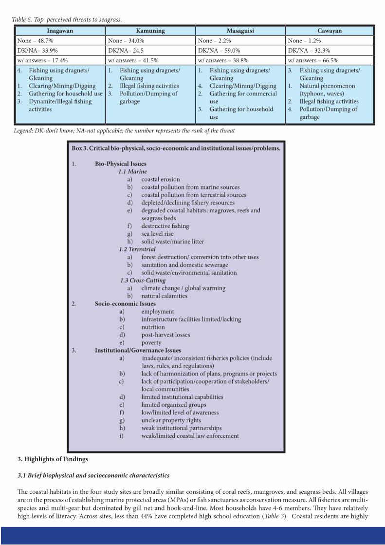
Inagawan Kamuning Masaguisi CawayanNone - 34.8% None – 16.0% None – 2.9% None - 1.8%DK/NA– 24.3% DK/NA– 14.9% DK/NA – 48.9% DK/NA - 33.6%w/ answers – 40.9% w/ answers – 69.1% w/ answers – 48.2% w/ answers – 64.6%1. Cyanide/Compressor fishing2. Illegal fishing3. Dynamite/Blast fishing
1. Cyanide/Compressor fishing
2. Illegal fishing3. Dynamite/blast fishing
2. Cyanide/Compressor fishing
1. Dynamite/Blast fishing3. Coral gathering for
household/Commercial use4. Clearing/Mining/Digging
5. Cyanide/Compressor fishing
2. Illegal fishing activities3. Dynamite/Blast fishing1. Natural phenomenon
(typhoon, waves)4. Clearing/Mining/Digging
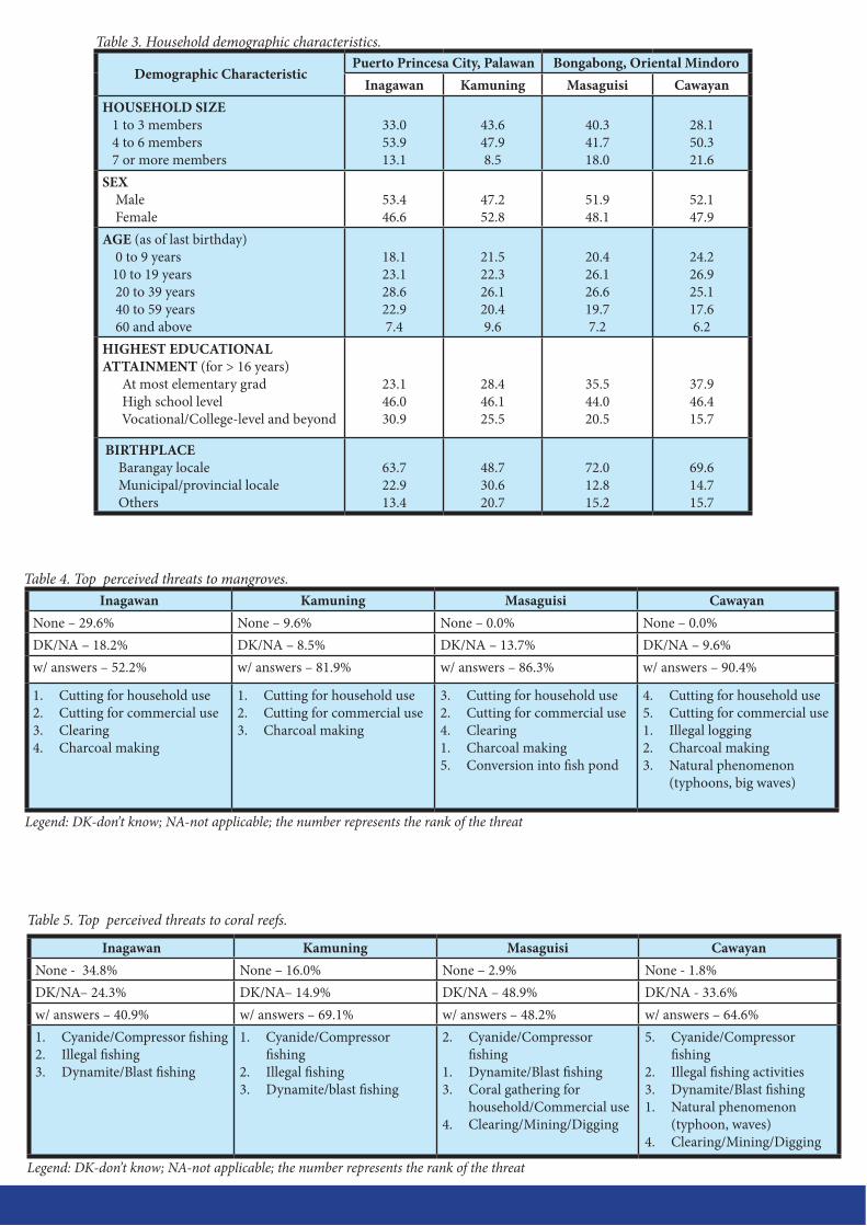
Table 3. Household demographic characteristics.
Table 5. Top perceived threats to coral reefs.
Legend: DK-don’t know; NA-not applicable; the number represents the rank of the threat
Inagawan Kamuning Masaguisi CawayanNone – 29.6% None – 9.6% None – 0.0% None – 0.0%DK/NA – 18.2% DK/NA – 8.5% DK/NA – 13.7% DK/NA – 9.6%w/ answers – 52.2% w/ answers – 81.9% w/ answers – 86.3% w/ answers – 90.4%
1. Cutting for household use2. Cutting for commercial use3. Clearing4. Charcoal making
1. Cutting for household use2. Cutting for commercial use3. Charcoal making
3. Cutting for household use2. Cutting for commercial use4. Clearing1. Charcoal making5. Conversion into fish pond
4. Cutting for household use5. Cutting for commercial use1. Illegal logging2. Charcoal making3. Natural phenomenon
(typhoons, big waves)
Table 4. Top perceived threats to mangroves.
Legend: DK-don’t know; NA-not applicable; the number represents the rank of the threat
3. Highlights of Findings
3.1 Brief biophysical and socioeconomic characteristics
The coastal habitats in the four study sites are broadly similar consisting of coral reefs, mangroves, and seagrass beds. All villages are in the process of establishing marine protected areas (MPAs) or fish sanctuaries as conservation measure. All fisheries are multi-species and multi-gear but dominated by gill net and hook-and-line. Most households have 4-6 members. They have relatively high levels of literacy. Across sites, less than 44% have completed high school education (Table 3). Coastal residents are highly
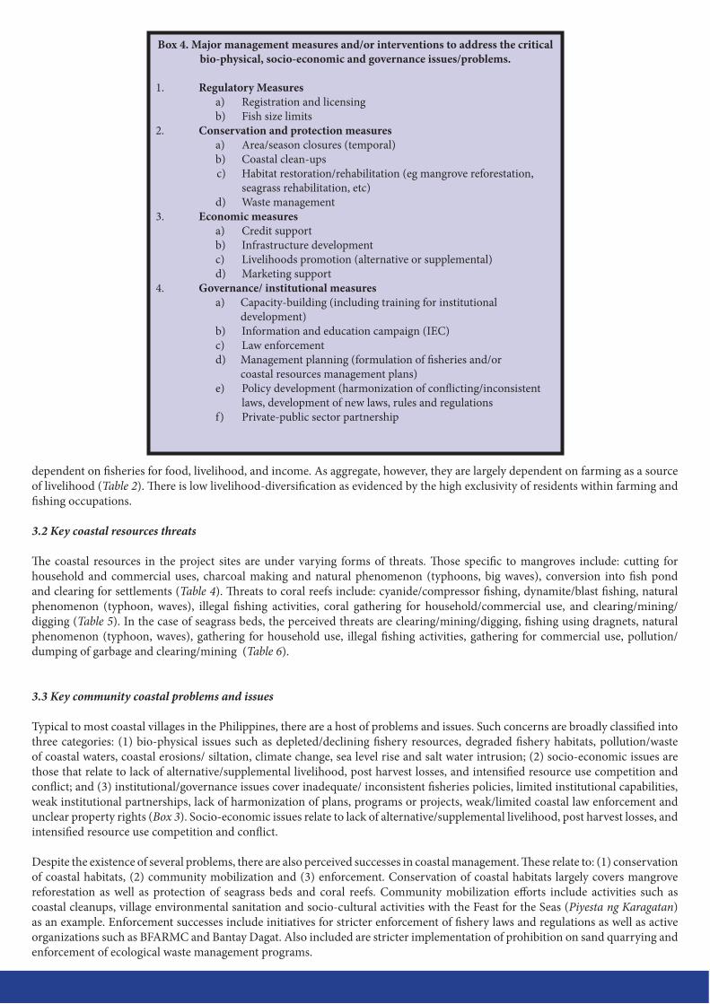
Box 3. Critical bio-physical, socio-economic and institutional issues/problems.
1. Bio-Physical Issues 1.1 Marine
a) coastal erosionb) coastal pollution from marine sources c) coastal pollution from terrestrial sources d) depleted/declining fishery resourcese) degraded coastal habitats: magroves, reefs and
seagrass bedsf) destructive fishing g) sea level riseh) solid waste/marine litter
1.2 Terrestriala) forest destruction/ conversion into other usesb) sanitation and domestic seweragec) solid waste/environmental sanitation
1.3 Cross-Cuttinga) climate change / global warmingb) natural calamities
2. Socio-economic Issuesa) employmentb) infrastructure facilities limited/lackingc) nutritiond) post-harvest lossese) poverty
3. Institutional/Governance Issuesa) inadequate/ inconsistent fisheries policies (include
laws, rules, and regulations)b) lack of harmonization of plans, programs or projects c) lack of participation/cooperation of stakeholders/
local communitiesd) limited institutional capabilities e) limited organized groups f) low/limited level of awarenessg) unclear property rights h) weak institutional partnerships i) weak/limited coastal law enforcement
Inagawan Kamuning Masaguisi CawayanNone – 48.7% None – 34.0% None – 2.2% None – 1.2%DK/NA– 33.9% DK/NA– 24.5 DK/NA – 59.0% DK/NA – 32.3%w/ answers – 17.4% w/ answers – 41.5% w/ answers – 38.8% w/ answers – 66.5%4. Fishing using dragnets/
Gleaning1. Clearing/Mining/Digging2. Gathering for household use3. Dynamite/Illegal fishing
activities
1. Fishing using dragnets/Gleaning
2. Illegal fishing activities3. Pollution/Dumping of
garbage
1. Fishing using dragnets/ Gleaning
4. Clearing/Mining/Digging2. Gathering for commercial
use3. Gathering for household
use
3. Fishing using dragnets/Gleaning
1. Natural phenomenon (typhoon, waves)
2. Illegal fishing activities4. Pollution/Dumping of
garbage
Table 6. Top perceived threats to seagrass.
Legend: DK-don’t know; NA-not applicable; the number represents the rank of the threat
dependent on fisheries for food, livelihood, and income. As aggregate, however, they are largely dependent on farming as a source of livelihood (Table 2). There is low livelihood-diversification as evidenced by the high exclusivity of residents within farming and fishing occupations.
3.2 Key coastal resources threats
The coastal resources in the project sites are under varying forms of threats. Those specific to mangroves include: cutting for household and commercial uses, charcoal making and natural phenomenon (typhoons, big waves), conversion into fish pond and clearing for settlements (Table 4). Threats to coral reefs include: cyanide/compressor fishing, dynamite/blast fishing, natural phenomenon (typhoon, waves), illegal fishing activities, coral gathering for household/commercial use, and clearing/mining/digging (Table 5). In the case of seagrass beds, the perceived threats are clearing/mining/digging, fishing using dragnets, natural phenomenon (typhoon, waves), gathering for household use, illegal fishing activities, gathering for commercial use, pollution/dumping of garbage and clearing/mining (Table 6).
3.3 Key community coastal problems and issues
Typical to most coastal villages in the Philippines, there are a host of problems and issues. Such concerns are broadly classified into three categories: (1) bio-physical issues such as depleted/declining fishery resources, degraded fishery habitats, pollution/waste of coastal waters, coastal erosions/ siltation, climate change, sea level rise and salt water intrusion; (2) socio-economic issues are those that relate to lack of alternative/supplemental livelihood, post harvest losses, and intensified resource use competition and conflict; and (3) institutional/governance issues cover inadequate/ inconsistent fisheries policies, limited institutional capabilities, weak institutional partnerships, lack of harmonization of plans, programs or projects, weak/limited coastal law enforcement and unclear property rights (Box 3). Socio-economic issues relate to lack of alternative/supplemental livelihood, post harvest losses, and intensified resource use competition and conflict.
Despite the existence of several problems, there are also perceived successes in coastal management. These relate to: (1) conservation of coastal habitats, (2) community mobilization and (3) enforcement. Conservation of coastal habitats largely covers mangrove reforestation as well as protection of seagrass beds and coral reefs. Community mobilization efforts include activities such as coastal cleanups, village environmental sanitation and socio-cultural activities with the Feast for the Seas (Piyesta ng Karagatan) as an example. Enforcement successes include initiatives for stricter enforcement of fishery laws and regulations as well as active organizations such as BFARMC and Bantay Dagat. Also included are stricter implementation of prohibition on sand quarrying and enforcement of ecological waste management programs.
Box 4. Major management measures and/or interventions to address the critical bio-physical, socio-economic and governance issues/problems.
1. Regulatory Measuresa) Registration and licensingb) Fish size limits
2. Conservation and protection measuresa) Area/season closures (temporal)b) Coastal clean-upsc) Habitat restoration/rehabilitation (eg mangrove reforestation,
seagrass rehabilitation, etc) d) Waste management3. Economic measures a) Credit support
b) Infrastructure developmentc) Livelihoods promotion (alternative or supplemental)d) Marketing support
4. Governance/ institutional measuresa) Capacity-building (including training for institutional
development)b) Information and education campaign (IEC)c) Law enforcementd) Management planning (formulation of fisheries and/or
coastal resources management plans)e) Policy development (harmonization of conflicting/inconsistent
laws, development of new laws, rules and regulationsf) Private-public sector partnership
3.4 Program recommendations and policy directionsSeveral program recommendations are forwarded to address these concerns (Box 4). These program recommendations are clustered into four categories: (1) regulatory measures, (2) conservation and protection measures, (3) economic measures, and (4) governance/institutional measures. Examples of regulatory measures includes registration, licensing of boats and fish size limits. On the other hand, conservation and protection measures include ban on catching of threatened species, establishment of fish sanctuaries, habitat restoration, zoning and seasonal closures (on-and-off seasons), while economic measures cover livelihoods promotion (both alternative and supplemental employment, including their sustainability), credit support, fishery subsidies, and marketing assistance. Examples of governance/institutional measures are information and education campaign, capacity-building, constituency-building, law enforcement, management planning, policy development, organizational development and private-public sector partnership.
The above program recommendations point toward certain policy directions. An obvious direction is ‘development’ whereby employment must be generated to address the issue of poverty and rural deprivation. The concerns for alternative and supplemental livelihoods to generate income have been highlighted in the four villages. As the need arises, fisheries and tourism development may be pursued in appropriate geographical areas. Another policy direction is ‘protection’ of the coastal habitats which includes coral reefs, mangroves, seagrass beds, and soft-bottom communities. Either mitigative or preventive measures need to be undertaken to protect the coastal resources and ecosystems against the negative impacts of development endeavors. To the extent possible, land-based sources of pollutants, which in these cases are agricultural effluents, must be minimized.
There must be a policy direction towards ‘sustainability’ for the rational use of the coastal resources for the benefit of both current and future generations. In the case of fisheries, for example, species must be harvested within their sustainable yields. The same principle holds true for the more rational utilization of freshwater resources. Institutionally, ‘Capacitation’ of the local government units is necessary since there are many technical and/or substantive requirements to effectively manage the coastal environments. These include the various forms of training related to livelihoods, habitat restoration and environmental sanitation, among others.
Another crucial direction is policy towards ‘integration’ or integrated coastal management. There is the need for physical integration that involves an ecosystem approach that considers land, sea and people connectivity and interphase. Operations of various economic sectors must be harmonized. The initiatives of various organizations/institutions involved in coastal management need to be synchronized to achieve maximum benefits. Efforts of external donors must be channelled to address critical concerns in appropriate geography. Policy direction for effective ‘communication’ is needed. The local academic institutions must be fully-tapped to generate the necessary data and/or information for effective policy making and on-the-ground actions. A healthy exchange of ideas and information among relevant stakeholders is essential for effective coastal governance. It also includes the use of scientific knowledge for adaptive management.
In pursuit of diverse societal objectives, the governance of coastal areas will continue to be a delicate balancing act. The situation in these four SocMon villages somehow exemplify that management is complicated as all of these objectives may either be in conflict over the short-term – or difficult to achieve simultaneously. It is hoped that the SocMon methodology will help in achieving this sustainable development balance.
4. ReferencesBunce L. and R. S. Pomeroy. 2003. Socioeconomic monitoring guidelines for coastal managers in southeast Asia: SocMon SEA. World Commission on
Protected Areas and Australian Institute of Marine Science. 82 p.Bunce L., Townsley P., Pomeroy R. and R. Pollnac. 2000. Socioeconomic manual for coral reef management. Australian Institute of Marine Science. 251 p.Loper, C., R. Pomeroy, V. Hoon, P. McCooney, Maria Pena, A. Sanders, G. Sriskanthan, S. Vergara, M. Pido, R. Vave, C. Vieux and I. Wanyonyi. 2008.
Socioeconomic conditions along the world’s tropical coasts: 2008. National Oceanic and Atmospheric Administration, Global Coral Reef Monitoring Network and Conservation International. Washington, D.C. 52 p.
Pido, M.D., S.G. Vergara, M.T.U. Macasaet, J.F.A. Pontillas, M.S. Pontillas, E.M.C. Ponce de Leon, D. Martinez, F. Racuya, M.C.A. Pontillas, and N.I. Mendoza. 2009. Socioeconomic Monitoring (SocMon) as a Tool in the Management of Marine Protected Areas: Participatory Process and Initial Survey Results in Binduyan Fish Sanctuary, Palawan, Philippines. p. 835-839. Proceedings of the 11th International Coral Reef Symposium, Ft. Lauderdale, Florida.
This publication may be cited as:Pido, M.D., M.S. Pontillas, E.G. Piol, M.T.U. Macasaet, J.F.A. Pontillas, E.M.C. Ponce Leon, D. Martinez, N.I. Mendoza, R. de Guzman, R. Quitain and J. Buenconsejo. 2012. Assessment of Coastal Management Issues Through Socioeconomic Monitoring (SocMon) Methodology at the Four Coastal Villages in Oriental Mindoro and Palawan Provinces in the Philippines. Palawan State University, Mindoro State College of Agriculture & Technology, City Government of Puerto Princesa, Palawan Council for Sustainable Development Staff and Puerto Princesa City, Philippines. 8 p.