Embed Size (px)
Citation preview

Assessing the Vulnerability of Tennessee Transportation Assets to Extreme Weather
A Pilot Project
First International Conference on Surface Transportation System Resilience to Climate Change and Extreme Weather Events
September 16-18, 2015
Washington, D.C.
Alan Jones, Tennessee Department of Transportation
Leah Dundon, Vanderbilt University
Mark Abkowitz, Vanderbilt University

Source:

Requires states to • Evaluate performance of roads, traffic
congestion and freight • Develop a risk-based asset management
plan for the National Highway System
Assessing transportation asset vulnerability to extreme weather a key step in this process
FHWA Notice of Proposed Rulemaking, 80 Fed. Reg. 34, 9231 (February 20, 2015)
“State DOT would be required to establish a process for undertaking a risk management analysis for assets in the plan. As part of this process, State DOTs would identify and assess risks (e.g., extreme weather) that can affect asset condition or the effectiveness of the NHS as it relates to physical assets. The process for risk management analysis would have to include addressing the risks to assets and to the highway system associated with current and future environmental conditions, including extreme weather events, climate change, and seismic activity, in order to provide information for decisions about how to minimize their impacts and increase asset and system resiliency. The process for risk management analysis also would be required to take into account, for assets in the plan, the results of the State DOT’s evaluation of roads, highways, and bridges that have repeatedly required repair or reconstruction due to emergency events . . .”

Extreme weather events demonstrate the vulnerability of Tennessee’s transportation assets
Polk County Rock Slide - August 2013 Flooding on Briley Parkway - August 2013
Sinkhole, I-24 Clarksville - August 2013
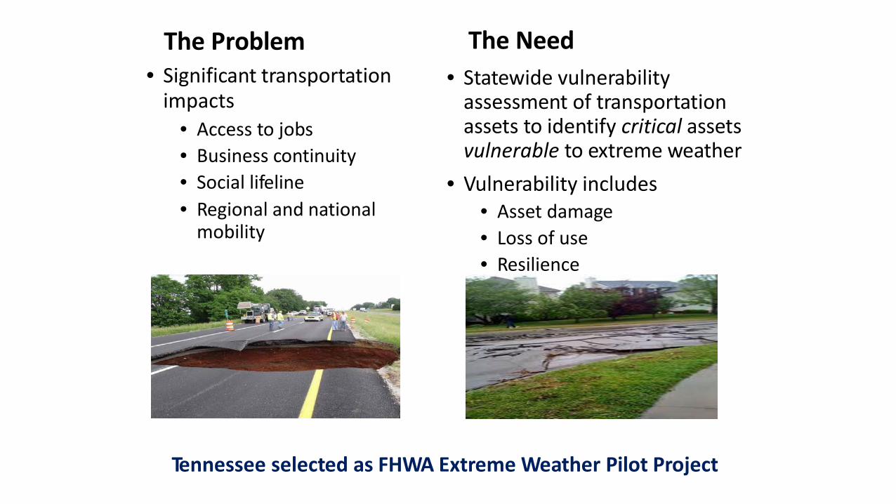
The Problem The Need • Statewide vulnerability
assessment of transportation assets to identify critical assets vulnerable to extreme weather
• Vulnerability includes • Asset damage • Loss of use • Resilience
• Significant transportation impacts
• Access to jobs • Business continuity • Social lifeline • Regional and national
mobility
Tennessee selected as FHWA Extreme Weather Pilot Project

Stakeholder Involvement • Tennessee Department of Transportation (TDOT)
• Division Directors appoint senior staff as project liaisons • Divisions (headquarters and regions) provide information
• TEWTAP (Tennessee Extreme Weather and Transportation Adaptation Partnership)
• Comprised of endorsing organizations, other state and federal agencies, MPOs and transportation providers
• Guide and advise project and review project results
• Regional Focus Groups • Public invited to four regional meetings • Obtain local/regional feedback • Obtain access to data

Project Overview
Project made extensive use of color-coded GIS maps to visually display critical assets, extreme weather exposure, impacts and overall vulnerability

Asset Inventory
• Roads (interstate, state and U.S. highways) • Rail • Navigable waterways (rivers and locks) • Airports • Pipelines (oil and natural gas) • Mass transit systems • Support systems (traffic control centers,
maintenance facilities)

Criteria for Determining Asset Criticality
• Volume of activity • Strategic importance • Bypass detour length • Use as emergency response resource • Redundant capability • Network connectivity • Local knowledge and experience

Tennessee Critical Assets by TDOT Region
Example critical asset map

Extreme Weather Impacts
• Extreme temperatures (high and low)
• Heavy rain • Drought • Wind • Tornado • Ice • Snow
High temperatures
Heavy rains
Ice
Wind
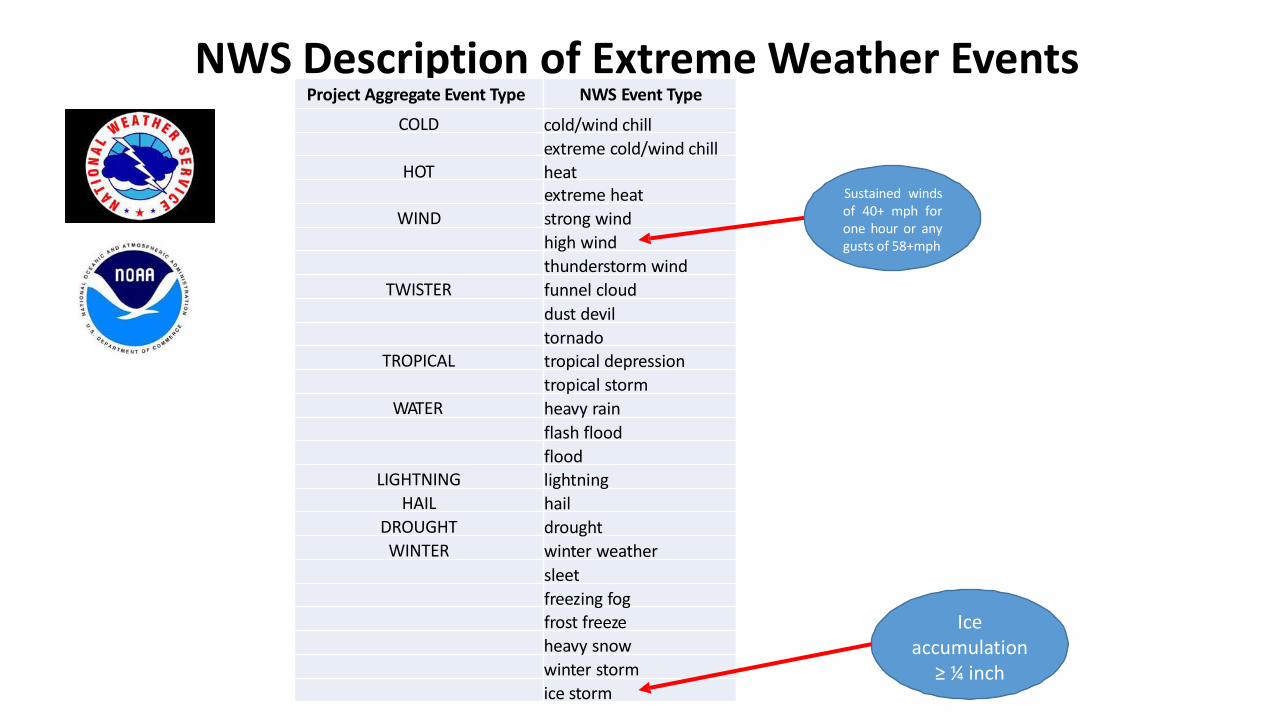
NWS Description of Extreme Weather Events Project Aggregate Event Type NWS Event Type
COLD cold/wind chill extreme cold/wind chill
HOT heat
Project Severity Level moderate
high moderate
high moderate
high high
moderate moderate
high moderate
high moderate
high high
moderate moderate moderate moderate moderate moderate moderate
high high high
extreme heat WIND strong wind
high wind thunderstorm wind
TWISTER funnel cloud dust devil tornado
TROPICAL tropical depression tropical storm
WATER heavy rain flash flood flood
LIGHTNING lightning HAIL hail
DROUGHT drought WINTER winter weather
sleet freezing fog frost freeze heavy snow winter storm ice storm
Sustained winds of 40+ mph for one hour or any gusts of 58+mph
Ice accumulation
≥ ¼ inch
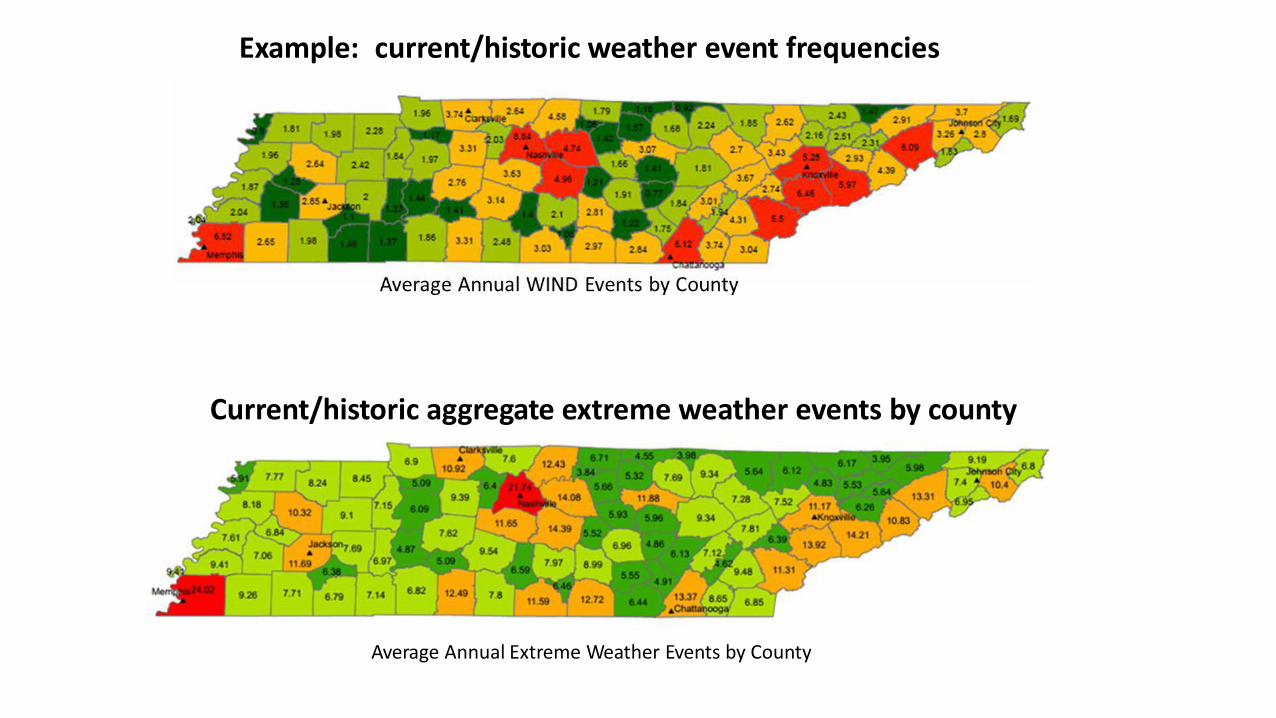
Average Annual Extreme Weather Events by County
Current/historic aggregate extreme weather events by county
Example: current/historic weather event frequencies

Assessing future climate events using projected climate models and analysis of historical data
University of Georgia compiled CMIP3 Data

Assessing Damage and Loss
• Unique challenges to a state-wide assessment • Asset damage caused by the extreme weather event in terms
of repair or replacement cost, economic impact of loss of use due to delays/disruption (resilience)
• Utilize survey data and maintenance records to identify extent of damage & delays/disruption associated with specific extreme weather events
Harpeth River, 2010 Stewart County, April 2013 I-75 Sinkhole, 2012
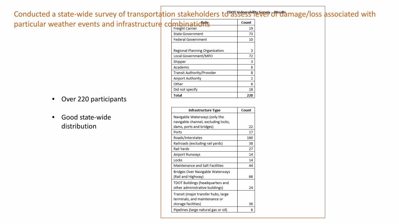
• Over 220 participants
• Good state-wide distribution
Conducted a state-wide survey of transportation stakeholders to assess level of damage/loss associated with particular weather events and infrastructure combinations

• Tennessee has three major river systems with over a dozen locks - Tennessee River, Cumberland River, and Clinch River (no locks on the Mississippi)
• Average age of locks is
over 60 years old (source, USACE)
Barkley Navigation Lock, Cumberland River

Survey Impact Scores (by weather category)
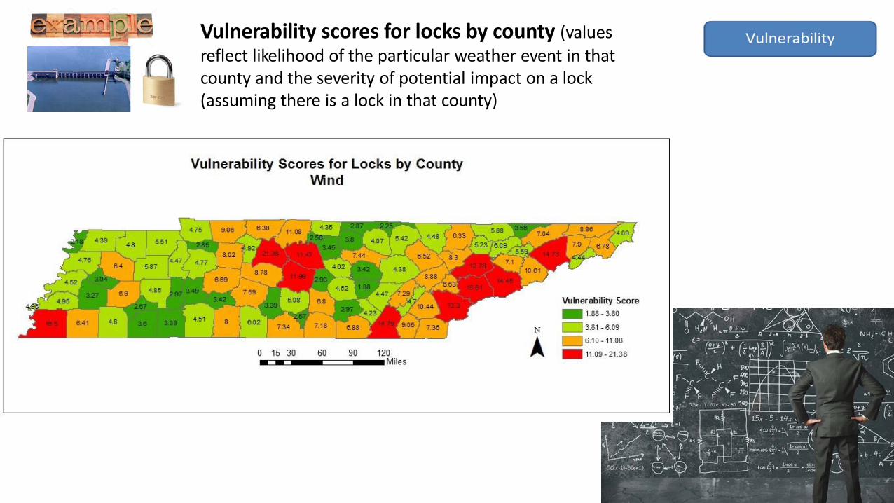
Vulnerability scores for locks by county (values reflect likelihood of the particular weather event in that county and the severity of potential impact on a lock (assuming there is a lock in that county)

Overlay vulnerability scores on critical assets: Tennessee locks most vulnerable to wind in the future
• Statewide assessment was ambitious
• Required grouping assets into generic asset categories (such as “roads”); Could not differentiate unique characteristics of specific roads (such as by pavement binder, age, etc.)
• Study served as an important screening tool to identify transportation assets that warrant a more detailed study
• More time • Initial challenge of getting contracts in place delayed project start • Significant effort to assemble and analyze data and meet with stakeholders

• TDOT’s first formal effort to understand extreme weather impacts on state transportation system
• Study a starting point for integrating extreme weather risks into TDOT’s management and operational policies
• Select 15-20 of the most vulnerable assets identified by the study and conduct a more targeted analysis of vulnerabilities and potential adaptation strategies
• Meetings at 4 TDOT regions to communicate results of study
• Develop short “briefing books” tailored to each region and condensed to communicate vulnerabilities so they can be easily understood and quickly referenced
• Potential tool development

Alan Jones Manager, Policy Office Research and Policy Office Long Range Planning Division Tennessee Department of Transportation Phone: 615-741-6832 [email protected] Mark Abkowitz Vanderbilt University Phone: 615-343-3436 [email protected] Leah Dundon Vanderbilt University Phone: 615-428-0643 [email protected]
Thank You!