Embed Size (px)
Citation preview

armasuisseSwiss Federal Office of Topography swisstopo
National Report of Switzerland
E. Brockmann, D. Ineichen, M. Kistler, U. Marti, S. Schaer, A. Schlatter, B. Vogel, A. Wiget, U. Wild

2 Swiss Federal Office of Topography swisstopo
EUREF09: National Report of Switzerland
Geostation Zimmerwald
• New SLR system since more than 1 year in stable operation- more observations to the high satellites at day-time - improved precision of single shots by a factor of roughly
two (from 80 ps / 12 mm to 40 ps / 6 mm) - improved stability of the system biases
• Local Tie (Sept. 2008): SLR – ZIMM – ZIM2
ZIM2 antenna and terrestrial target

3 Swiss Federal Office of Topography swisstopo
EUREF09: National Report of Switzerland
Local tie results: ZIMM - SLR
-14.735
-14.733
-14.731
-14.729
-14.727
-14.725
-14.723
4.179 4.181 4.183 4.185 4.187 4.189 4.191
east [m]
no
rth
[m
]
1995.2
1998
2003
2008
logfile
5.768
5.769
5.770
5.771
5.772
5.773
5.774
5.775
1994 1999 2004 2009
time
hei
gh
t [m
]1995.2
1998
2003
2008
logfile
7 mm displacement 5 mm rising of GPS
horizontally vertically
(in 13 years)
Conclusion from other points: Movement of top of the 9-meter mast

4 Swiss Federal Office of Topography swisstopo
EUREF09: National Report of Switzerland
Permanent GNSS Network AGNES
• Faster CPUs for variousprocessing chains: 3-10times faster
• Snow and antenna performance tests: Zephyr – Choke-ring
Processing start at ":15"
SANB
SANT
SANB
SANT
+1h+2h+3h

5 Swiss Federal Office of Topography swisstopo
EUREF09: National Report of Switzerland
Permanent GNSS Network AGNES
• Kinematic GNSS coordinate estimation: gain of 30-40% in repeatability for GNSS choke-ring antenna
• 6 antennas purchased, calibrated and installed on most stable “class A” permanent stations May, 12-14 - e.g. ZIM2
-0.06
-0.04
-0.02
0
0.02
0.04
0.06
[m]
SANB
SANT
East
7 days (4.1.-10.1.09)
SANB: Zephyr SANT: Choke-ring

6 Swiss Federal Office of Topography swisstopo
EUREF09: National Report of Switzerland
Combined multi-annual solutions: vertical velocities
• 10 years normal equations
• Reference: min. constraint ITRF2005
• WTZR – ZIMM: 2.5 mm/yr
• +1.5 mm/yr Alpine rise from 100 years levelling
• STD to EUREF densification: 2 mm hor., 5 mm vertical
downward movementrise
1 mm/yr
7 Swiss Federal Office of Topography swisstopo
EUREF09: National Report of Switzerland
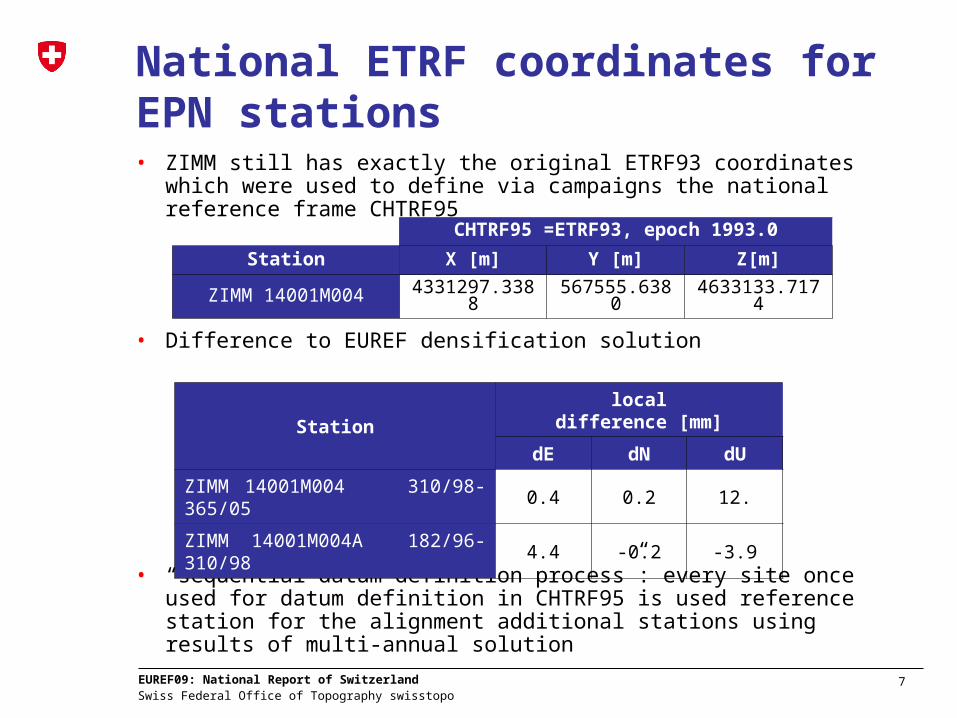
National ETRF coordinates for EPN stations• ZIMM still has exactly the original ETRF93 coordinates which were
used to define via campaigns the national reference frame CHTRF95
• Difference to EUREF densification solution
• “sequential datum definition process”: every site once used for datum definition in CHTRF95 is used reference station for the alignment additional stations using results of multi-annual solution
CHTRF95 =ETRF93, epoch 1993.0
Station X [m] Y [m] Z[m]
ZIMM 14001M004 4331297.3388 567555.6380 4633133.7174
Station
localdifference [mm]
dE dN dU
ZIMM 14001M004 310/98-365/05 0.4 0.2 12.
ZIMM 14001M004A 182/96-310/98
4.4 -0.2 -3.9