Embed Size (px)
Citation preview
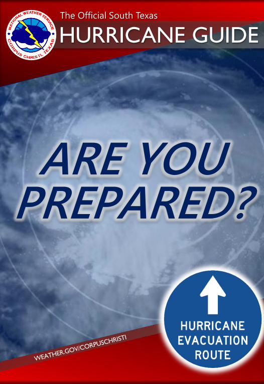
992017 South Texas Hurricane Guide
COVER
1
HURRICANE GUIDEThe Official South Texas
ARE YOUPREPARED?
992017 South Texas Hurricane Guide
2
Hello South Texas Residents,
Texas has a long history of hurricanes with 63 storms crossing our coast in the
150 years that records have been kept. Twenty-two of these storms were
major hurricanes (category 3 through 5) with maximum sustained winds in
excess of 111 mph. However, in the last 45 years, the Middle Texas Coast has
not experienced a major hurricane. Two generations of citizens have now
grown up here in the Coastal Bend having never experienced a major storm.
Statistics suggest that a storm is coming, and we must be prepared.
Hurricanes pose the greatest threat to our daily lives and can potentially
change our communities forever. Hazards from hurricanes include: deadly
storm surge, damaging winds, flooding rainfall and tornadoes. This is why
residents should take planning for hurricanes very seriously. This updated
guide can help you and your family get prepared. Learn what to do before,
during, and after a storm. Your plan should include preparations for your
home, gathering supplies, ensuring your insurance is up to date, and planning
for evacuation.
Don’t be distracted by the hurricane season outlook. While valuable, these
predictions do not tell us whether a storm will impact South Texas. Regardless
of predictions, we should prepare in the same way each hurricane season.
Please take the valuable information contained in this guide and prepare
before a storm threatens.
Sincerely,
John MetzWarning Coordination MeteorologistNational Weather ServiceCorpus Christi, Texas
A Letter to Residents
992017 South Texas Hurricane Guide
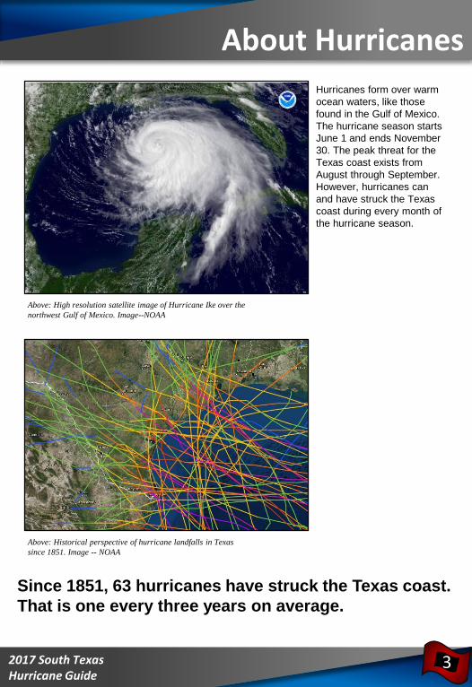
Above: Historical perspective of hurricane landfalls in Texas
since 1851. Image -- NOAA
Hurricanes form over warm
ocean waters, like those
found in the Gulf of Mexico.
The hurricane season starts
June 1 and ends November
30. The peak threat for the
Texas coast exists from
August through September.
However, hurricanes can
and have struck the Texas
coast during every month of
the hurricane season.
Above: High resolution satellite image of Hurricane Ike over the
northwest Gulf of Mexico. Image--NOAA
Since 1851, 63 hurricanes have struck the Texas coast.
That is one every three years on average.
About Hurricanes
3
992017 South Texas Hurricane Guide
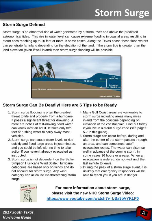
Storm Surge Defined
Storm surge is an abnormal rise of water generated by a storm, over and above the predicted
astronomical tides. This rise in water level can cause extreme flooding in coastal areas resulting in
storm tides reaching up to 20 feet or more in some cases. Along the Texas coast, these flood waters
can penetrate far inland depending on the elevation of the land. If the storm tide is greater than the
land elevation (even if well inland) then storm surge flooding will be possible.
Storm Surge Can Be Deadly! Here are 6 Tips to be Ready
For more information about storm surge,
please visit the new NHC Storm Surge Video:
https://www.youtube.com/watch?v=bBa9bVYKLP0
Storm Surge
4
1. Storm surge flooding is often the greatest
threat to life and property from a hurricane.
It poses a significant threat for drowning. A
mere six inches of fast-moving flood water
can knock over an adult. It takes only two
feet of rushing water to carry away most
vehicles.
2. Storm surge can cause water levels to rise
quickly and flood large areas in just minutes,
and you could be left with no time to take
action if you haven’t already evacuated as
instructed.
3. Storm surge is not dependent on the Saffir-
Simpson Hurricane Wind Scale. Hurricane
categories are based only on winds and do
not account for storm surge. Any wind
category can all cause life-threatening storm
surge.
4. Many Gulf Coast areas are vulnerable to
storm surge including areas many miles
inland from the coastline depending on
elevation of the coastal plain. Find out today
if you live in a storm surge zone (see pages
5-7 in this guide).
5. Storm surge can occur before, during and
after the center of the storm passes through
an area, and can sometimes cutoff
evacuation routes. The water can also rise
well in advance of the coming storm, in
some cases 36 hours or greater. When an
evacuation is ordered, do not wait until the
last minute to leave.
6. During the peak of a storm surge event, it is
unlikely that emergency responders will be
able to reach you if you are in danger.
992017 South Texas Hurricane Guide
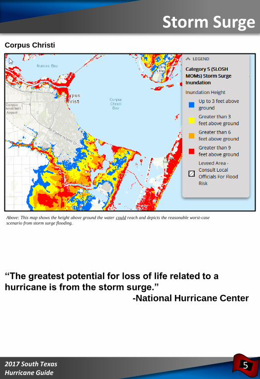
Storm SurgeCorpus Christi
Above: This map shows the height above ground the water could reach and depicts the reasonable worst-case
scenario from storm surge flooding.
‘‘The greatest potential for loss of life related to a
hurricane is from the storm surge.”
-National Hurricane Center
5
992017 South Texas Hurricane Guide
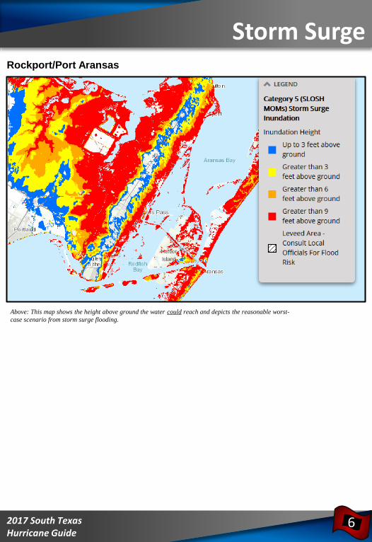
Rockport/Port Aransas
Above: This map shows the height above ground the water could reach and depicts the reasonable worst-
case scenario from storm surge flooding.
Storm Surge
6
992017 South Texas Hurricane Guide
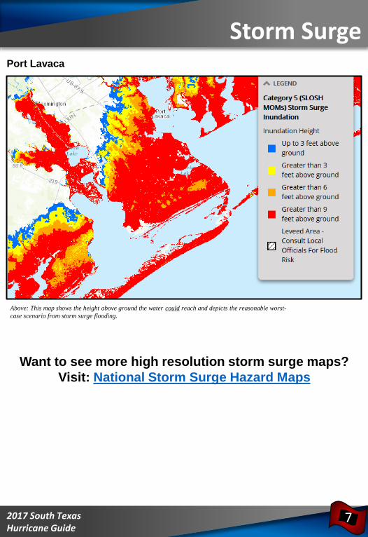
Port Lavaca
Above: This map shows the height above ground the water could reach and depicts the reasonable worst-
case scenario from storm surge flooding.
Want to see more high resolution storm surge maps?
Visit: National Storm Surge Hazard Maps
Storm Surge
7
992017 South Texas Hurricane Guide
Five Practical Ways to Protect
Yourself and Others From the
Dangers of Inland Flooding
Protect Your Personal Documents
and Special Items
• Store valuables in plastic tubs with locking tops
• In case of an evacuation, you should be able to
secure and move all your valuables within 15 minutes
Buy Flood Insurance – A Plan for Replaceable Items
• The National Flood Insurance Program (NFIP) is available from an insurance agent or
the NFIP
• For more information see www.floodsmart.gov
Flood Proof Your Home – Take Steps to Minimize Flood Damage
• Shut off the main circuit breaker to prevent appliances from short circuiting and
eliminate the threat of electrocution
• Raise outside air conditioning units onto platforms above ground level
• Store rarely used or expensive items in the attic or on high shelves
Develop a Family Flood Plan
• Develop a plan of action to keep from panicking or withdrawing during an emergency
• Have an evacuation route and alternatives planned in the event you are asked to
evacuate
• Communicate your plans with friends or family outside of your home area
• Battery powered radios or televisions can be used in the event of a power outage
Never Drive on Flooded Roads
• Driving into flooded roadways puts your life and the lives of others at risk
• Unless told to evacuate, you are probably safest staying at your current location
• If you encounter flood waters when driving, Turn Around, Don’t Drown!
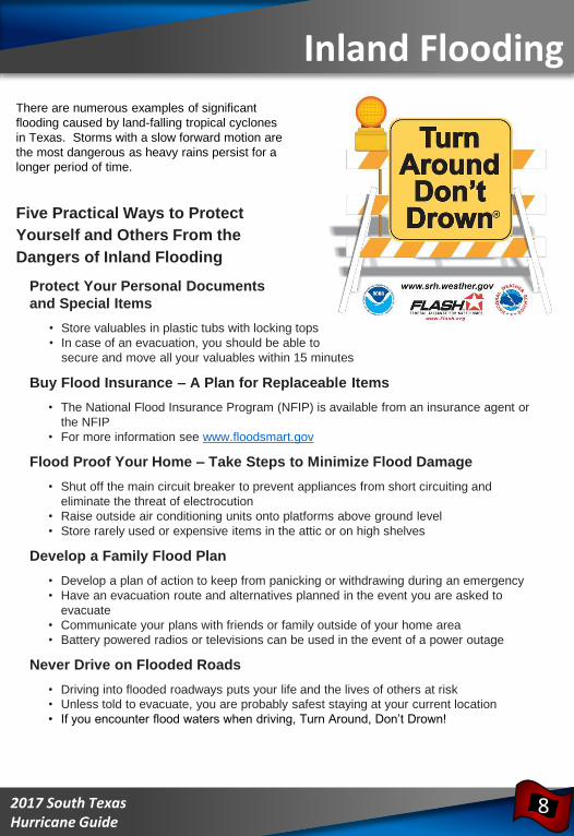
There are numerous examples of significant
flooding caused by land-falling tropical cyclones
in Texas. Storms with a slow forward motion are
the most dangerous as heavy rains persist for a
longer period of time.
Inland Flooding
8
992017 South Texas Hurricane Guide
Tornadoes and Destructive Winds
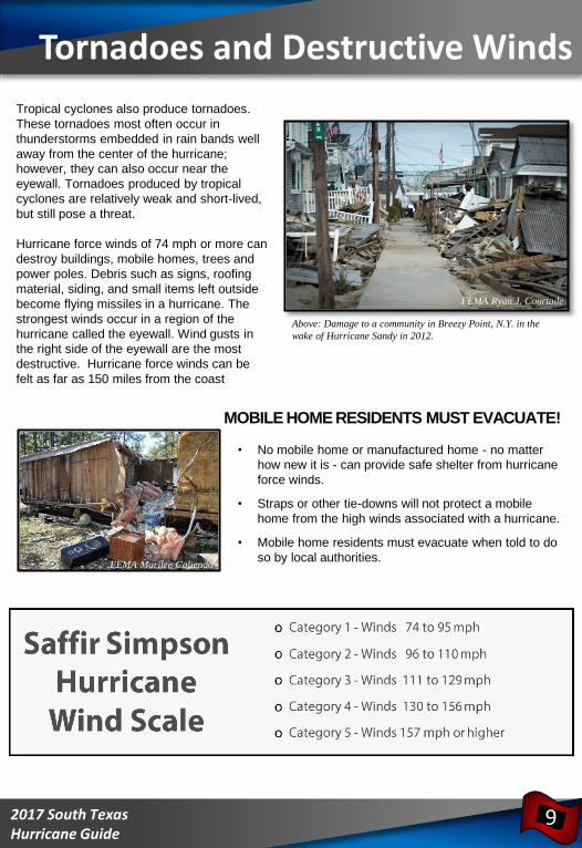
Above: Damage to a community in Breezy Point, N.Y. in the
wake of Hurricane Sandy in 2012.
Tropical cyclones also produce tornadoes.
These tornadoes most often occur in
thunderstorms embedded in rain bands well
away from the center of the hurricane;
however, they can also occur near the
eyewall. Tornadoes produced by tropical
cyclones are relatively weak and short-lived,
but still pose a threat.
Hurricane force winds of 74 mph or more can
destroy buildings, mobile homes, trees and
power poles. Debris such as signs, roofing
material, siding, and small items left outside
become flying missiles in a hurricane. The
strongest winds occur in a region of the
hurricane called the eyewall. Wind gusts in
the right side of the eyewall are the most
destructive. Hurricane force winds can be
felt as far as 150 miles from the coast
MOBILE HOME RESIDENTS MUST EVACUATE!
• No mobile home or manufactured home - no matter
how new it is - can provide safe shelter from hurricane
force winds.
• Straps or other tie-downs will not protect a mobile
home from the high winds associated with a hurricane.
• Mobile home residents must evacuate when told to do
so by local authorities.
9
FEMA Marilee Caliendo
FEMA Ryan J. Courtade
992017 South Texas Hurricane Guide
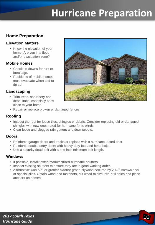
Home Preparation
Elevation Matters
• Know the elevation of your
home! Are you in a flood
and/or evacuation zone?
Mobile Homes
• Check tie-downs for rust or
breakage.
• Residents of mobile homes
must evacuate when told to
do so!!
Landscaping
• Trim trees, shrubbery and
dead limbs, especially ones
close to your home.
• Repair or replace broken or damaged fences.
Roofing
• Inspect the roof for loose tiles, shingles or debris. Consider replacing old or damaged
shingles with new ones rated for hurricane force winds.
• Clear loose and clogged rain gutters and downspouts.
Doors
• Reinforce garage doors and tracks or replace with a hurricane tested door.
• Reinforce double entry doors with heavy duty foot and head bolts.
• Use a security dead bolt with a one inch minimum bolt length.
Windows
• If possible, install tested/manufactured hurricane shutters.
• Inspect existing shutters to ensure they are in good working order.
• Alternative: Use 5/8” or greater exterior grade plywood secured by 2 1/2” screws and/
or special clips. Obtain wood and fasteners, cut wood to size, pre-drill holes and place
anchors on homes.
Hurricane Preparation
10
992017 South Texas Hurricane Guide
Business and Employee Preparation• Identify and protect vital records. Backup and store key files off site.
• Protect electronic equipment from possible water damage.
• Have extra cash and blank checks in case extra money is needed after the storm.
• Develop a 24-hour emergency contact with phone numbers of key employees.
• Set up telephone numbers for employees to check in and receive company information.
• Establish a temporary location for business operations in case your facility is damaged.
• Give employees enough time to secure their homes and families.
• Consider paying employees before they leave to prepare their homes.
Marine Preparations• Check with the manufacturer for proper ways to secure your boat during a storm.
• Purchase necessary hurricane materials such as additional mooring lines, crew
anchors, fenders, fender boards, chafing gear, and anchors.
• Safe storm moorings should consist of good condition ropes of sufficient diameter and
length, with at least three or four substantial anchor points.
• Do not moor parallel to bank. Receding tides often capsize boats in this type of
anchorage.
Preparing for Your Pet’s Safety• Your pet should be part of your overall hurricane preparation plans. Below are a few
important things to help you prepare:
• Make sure your pet’s vaccinations are current and have proof they are current. DO NOT
assume that a public shelter or hotel will accept your pet.
• Be sure to have a current photo of your pet.
• Each animal should have a properly sized pet carrier. The carrier should be large
enough for the animal to stand up and turn around.
• Pack enough food and bottled water for the duration of your evacuation. DO NOT let
your pet eat food or drink water from outside that may have become contaminated.
• Be sure to pack all medications your pet may need along with a muzzle, collar, leash,
paper towels, and trash bags.
• Make sure your pet has a proper ID collar.
Additional Preparation
11
992017 South Texas Hurricane Guide
Important
Online
Insurance
Information
• National Flood Insurance Program
www.floodsmart.gov
• Texas Windstorm Insurance Association
www.twia.org
Consumer help line 800-788-8247
• Texas Department of Insurance
www.tdi.texas.gov
Consumer Help Line 800-252-3439
Insurance Tips
12
Before the Storm
• New and existing policies will not be written or modified when a storm nears the Gulf of
Mexico.
• Make sure you fully understand what perils are covered and excluded in your policy.
• Make sure your coverage is adequate to replace your home and contents in today’s
dollar.
• Determine whether your policy covers additional living expenses for a temporary
residence if you are unable to live in your home because of damage from a disaster.
• Before hurricane season, prepare detailed written and/or photographic inventory of your
home’s contents and store it in a safe place with your policy.
• If your insurance company does not cover flood or windstorm perils, ask about coverage
through the Texas Windstorm Insurance Association or the National Flood Insurance
Program.
After the Storm
• Give prompt written notice to your insurance company.
• Photograph or videotape damaged structures and all damaged property. Make a list of
damaged or lost items.
• DO NOT throw out damaged property before your adjuster has inspected the debris
unless it is a health hazard or impedes local cleanup.
• Protect your property from further damage.
• Keep an accurate record of temporary repair and living expenses if a loss of use is
suffered.
992017 South Texas Hurricane Guide
Your local Texas Chapter of the American
Red Cross recommends that you have
the following items in your Hurricane
Supply Kit. Do not forget to have a family
meeting before hurricane season and
review your communication information
and evacuation plan. Make sure the
contact information such as home, work,
school, cell phone numbers, and your
“Out of Town” contact person’s
information is current.
Emergency Contact Information
Out of Town Contact Address: ________________________________________
Out of Town Contact Phone Number: ___________________________________
Work Telephone Number: ____________________________________________
Cell Number/Spouse Cell Number: _____________________________________
Children Cell Number: ______________________________________________
School Telephone Number: __________________________________________
Doctor Telephone Number: __________________________________________
Bank/Credit Card Telephone Number: __________________________________
Insurance Company Information: ______________________________________
24 hour number to
call for assistance
1-800-RED CROSS
(1-800-733-2767)
Contact Info and Supplies
13
992017 South Texas Hurricane Guide
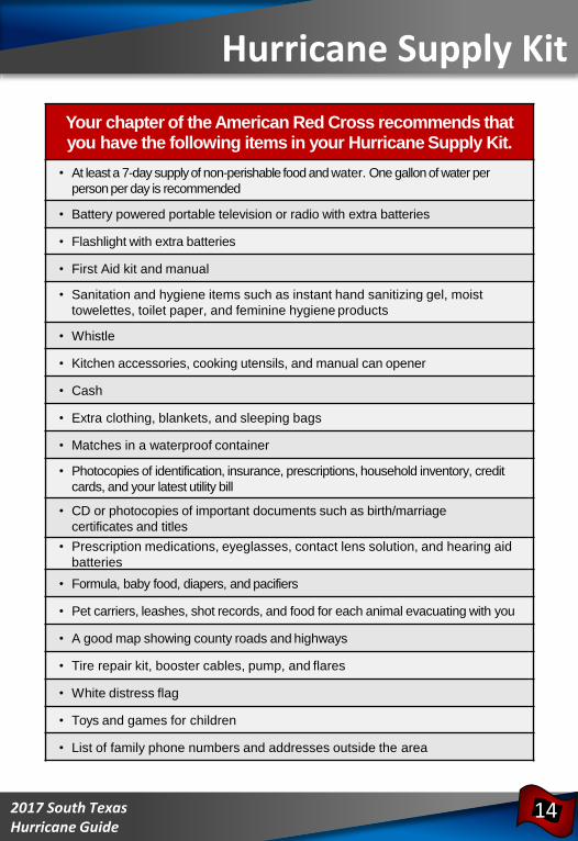
Your chapter of the American Red Cross recommends that you have the following items in your Hurricane Supply Kit.
• At least a 7-day supply of non-perishable food and water. One gallon of water per
person per day is recommended
• Battery powered portable television or radio with extra batteries
• Flashlight with extra batteries
• First Aid kit and manual
• Sanitation and hygiene items such as instant hand sanitizing gel, moist
towelettes, toilet paper, and feminine hygiene products
• Whistle
• Kitchen accessories, cooking utensils, and manual can opener
• Cash
• Extra clothing, blankets, and sleeping bags
• Matches in a waterproof container
• Photocopies of identification, insurance, prescriptions, household inventory, credit
cards, and your latest utility bill
• CD or photocopies of important documents such as birth/marriage
certificates and titles
• Prescription medications, eyeglasses, contact lens solution, and hearing aid
batteries
• Formula, baby food, diapers, and pacifiers
• Pet carriers, leashes, shot records, and food for each animal evacuating with you
• A good map showing county roads and highways
• Tire repair kit, booster cables, pump, and flares
• White distress flag
• Toys and games for children
• List of family phone numbers and addresses outside the area
Hurricane Supply Kit
14
992017 South Texas Hurricane Guide
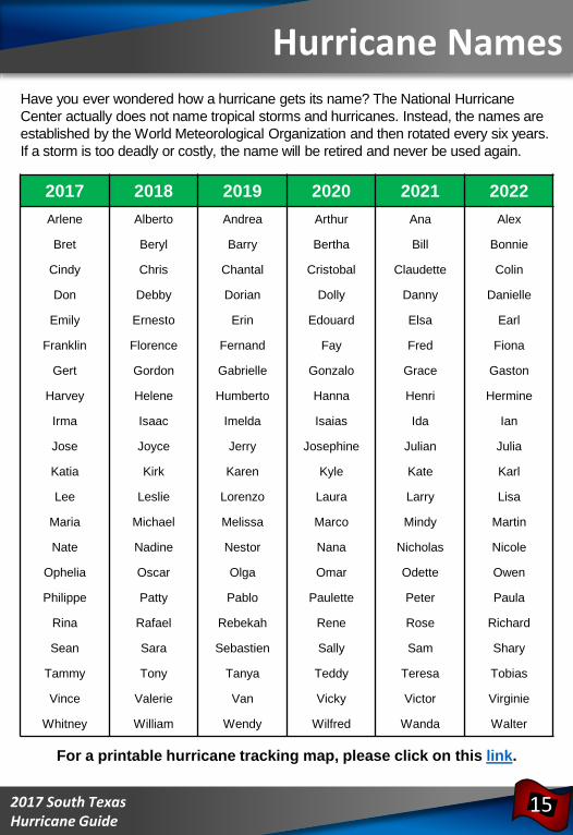
Hurricane Names
15
2017 2018 2019 2020 2021 2022
Arlene Alberto Andrea Arthur Ana Alex
Bret Beryl Barry Bertha Bill Bonnie
Cindy Chris Chantal Cristobal Claudette Colin
Don Debby Dorian Dolly Danny Danielle
Emily Ernesto Erin Edouard Elsa Earl
Franklin Florence Fernand Fay Fred Fiona
Gert Gordon Gabrielle Gonzalo Grace Gaston
Harvey Helene Humberto Hanna Henri Hermine
Irma Isaac Imelda Isaias Ida Ian
Jose Joyce Jerry Josephine Julian Julia
Katia Kirk Karen Kyle Kate Karl
Lee Leslie Lorenzo Laura Larry Lisa
Maria Michael Melissa Marco Mindy Martin
Nate Nadine Nestor Nana Nicholas Nicole
Ophelia Oscar Olga Omar Odette Owen
Philippe Patty Pablo Paulette Peter Paula
Rina Rafael Rebekah Rene Rose Richard
Sean Sara Sebastien Sally Sam Shary
Tammy Tony Tanya Teddy Teresa Tobias
Vince Valerie Van Vicky Victor Virginie
Whitney William Wendy Wilfred Wanda Walter
Have you ever wondered how a hurricane gets its name? The National Hurricane
Center actually does not name tropical storms and hurricanes. Instead, the names are
established by the World Meteorological Organization and then rotated every six years.
If a storm is too deadly or costly, the name will be retired and never be used again.
For a printable hurricane tracking map, please click on this link.
992017 South Texas Hurricane Guide
Forecast Information
16
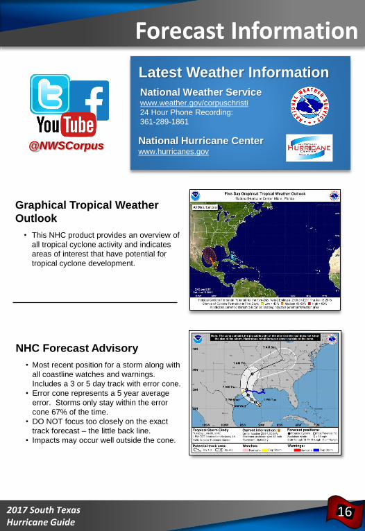
Graphical Tropical Weather
Outlook
• This NHC product provides an overview of
all tropical cyclone activity and indicates
areas of interest that have potential for
tropical cyclone development.
@NWSCorpus
National Weather Servicewww.weather.gov/corpuschristi
24 Hour Phone Recording:
361-289-1861
National Hurricane Centerwww.hurricanes.gov
Latest Weather Information
NHC Forecast Advisory
• Most recent position for a storm along with
all coastline watches and warnings.
Includes a 3 or 5 day track with error cone.
• Error cone represents a 5 year average
error. Storms only stay within the error
cone 67% of the time.
• DO NOT focus too closely on the exact
track forecast – the little back line.
• Impacts may occur well outside the cone.
992017 South Texas Hurricane Guide
Forecast Information
17
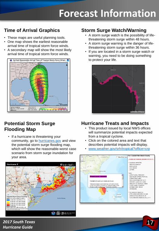
Time of Arrival Graphics
• These maps are useful planning tools.
• One map shows the earliest reasonable
arrival time of tropical storm force winds.
• A secondary map will show the most likely
arrival time of tropical storm force winds.
Potential Storm Surge
Flooding Map
• If a hurricane is threatening your
community, go to hurricanes.gov and view
the potential storm surge flooding map,
which will show the reasonable-worst case
scenario from storm surge inundation for
your area.
Storm Surge Watch/Warning• A storm surge watch is the possibility of life-
threatening storm surge within 48 hours.
• A storm surge warning is the danger of life-
threatening storm surge within 36 hours.
• If you are located in a storm surge watch or
warning, you need to be doing something
to protect your life.
Hurricane Treats and Impacts • This product issued by local NWS offices
will summarize potential impacts expected
from a tropical cyclone.
• Click on the colored area and text that
describes potential impacts will display.
• www.weather.gov/srh/tropical?office=crp
992017 South Texas Hurricane Guide
Actions to Take When a Storm is in the Gulf• Listen frequently to radio, TV, or NOAA weather radio for bulletins and forecasts of
the storm’s progress.
• Double check items in your emergency supply kit.
• Fuel and service your vehicles.
• Inspect and secure mobile home tie-downs.
• Board up windows (if shutters do not exist) in case storm moves quickly and you have
to leave!
TAPE PROVIDES NO PROTECTION!
• Store lawn furniture and other loose, light weight objects, such as garbage cans and
garden tools.
• Garage or store vehicles that are not being used.
• Follow instructions issued by local officials.
EVACUATE IMMEDIATELY IF ORDERED TO DO SO!
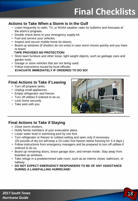
Final Actions to Take if Leaving• Turn off propane tanks.
• Unplug small appliances.
• Empty refrigerator and freezer.
• Turn off utilities if ordered to do so.
• Lock home securely.
• Take pets with you.
Final Actions to Take if Staying• Close storm shutters.
• Notify family members of your evacuation plans.
• Lower water level in swimming pool by one foot.
• Turn refrigerator or freezer to coldest setting and open only if necessary.
(25 pounds of dry ice will keep a 10-cubic foot freezer below freezing for 3-4 days.)
• Follow instructions from emergency managers and be prepared to turn off utilities if
ordered to do so.
• Board up remaining doors, brace garage door, and remain inside. Stay away from
boarded up windows.
• Take refuge in a predetermined safe room, such as an interior closet, bathroom, or
hallway.
• DO NOT EXPECT EMERGENCY RESPONDERS TO BE OF ANY ASSISTANCE
DURING A LANDFALLING HURRICANE!
Final Checklists
18
U.S. Navy
992017 South Texas Hurricane Guide
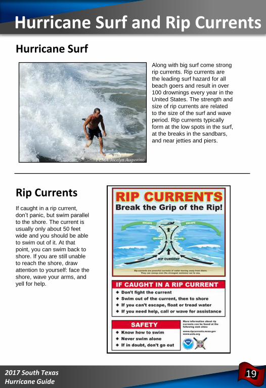
Along with big surf come strong
rip currents. Rip currents are
the leading surf hazard for all
beach goers and result in over
100 drownings every year in the
United States. The strength and
size of rip currents are related
to the size of the surf and wave
period. Rip currents typically
form at the low spots in the surf,
at the breaks in the sandbars,
and near jetties and piers.
Hurricane Surf
FEMA Jocelyn Augustino
Rip CurrentsIf caught in a rip current,
don’t panic, but swim parallel
to the shore. The current is
usually only about 50 feet
wide and you should be able
to swim out of it. At that
point, you can swim back to
shore. If you are still unable
to reach the shore, draw
attention to yourself: face the
shore, wave your arms, and
yell for help.
Hurricane Surf and Rip Currents
19
Along with big surf come strong
rip currents. Rip currents are
the leading surf hazard for all
beach goers and result in over
100 drownings every year in the
United States. The strength and
size of rip currents are related
to the size of the surf and wave
period. Rip currents typically
form at the low spots in the surf,
at the breaks in the sandbars,
and near jetties and piers.
992017 South Texas Hurricane Guide
• Assure that all contact information and emergency contact information is
accurate with your campus’ registrar’s office.
• If your campus offers an emergency management communication system, register
as a user of the system.
• Plan your method of evacuation and your destination before a storm enters the gulf.
• Monitor local radio and TV stations for updates.
• Contact your campus Student Affairs Office if you need assistance with evacuation.
• If you require any assistance due to a disability-related accommodation, please
contact your campus Disability Services Office to make necessary arrangements.
• Communicate with your family regarding status and location
• If your campus is evacuating, you will not be allowed to remain on-campus and it
is highly recommended that you leave the city. Do not go to a coastal location.
• Take your driver’s license, student I.D. card, and a copy of your housing lease as
well as medical insurance cards and other important documents when you
evacuate.
• If you bank with a local bank or credit union whose infrastructure may be damaged
by the storm, withdraw some funds as you may not have access to them once you
leave the area.
• International students must take passports with US student visa inside, I-20, I-
94, student I.D. and class schedule.
• If using personal transportation, take as many of your valuable or irreplaceable
items as you are able.
• If driving, make sure all roads that you are driving are open and safe. You can call
the Department of Transportation at 1-800-452-9292 or check on-line for
conditions at www.txdot.gov
• Follow baggage limits if participating in an assisted evacuation program.
• Take a 30-day supply of medications in original pharmacy containers.
• Make a record of any valuables left behind (description, serial numbers, etc).
Take pictures of all belongings.
• If you are evacuating to a shelter, make appropriate arrangements for pets.
Most shelters do not accept pets.
• Do not plan to return to campus until an all-clear is given (monitor media and
campus web-site).
Student Information Checklist
20
992017 South Texas Hurricane Guide
Evacuation Routes
21
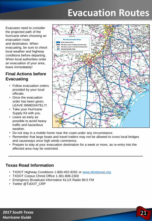
Evacuees need to consider
the projected path of the
hurricane when choosing an
evacuation route
and destination. When
evacuating, be sure to check
local weather and highway
conditions before departing.
When local authorities order
an evacuation of your area,
leave immediately!
Final Actions before
Evacuating
• Follow evacuation orders
provided by your local
officials.
• Once the evacuation
order has been given,
LEAVE IMMEDIATELY!
• Take your Hurricane
Supply Kit with you.
• Leave as early as
possible to avoid heavy
traffic and hazardous
weather.
• Do not stay in a mobile home near the coast under any circumstance.
• Remember that large boats and travel trailers may not be allowed to cross local bridges
and causeways once high winds commence.
• Prepare to stay at your evacuation destination for a week or more, as re-entry into the
affected area may be restricted.
Texas Road Information
• TXDOT Highway Conditions 1-800-452-9292 or www.drivetexas.org
• TXDOT Corpus Christi Office 1-361-808-2300
• Emergency Broadcast Information KLUX Radio 89.5 FM
• Twitter @TxDOT_CRP
992017 South Texas Hurricane Guide
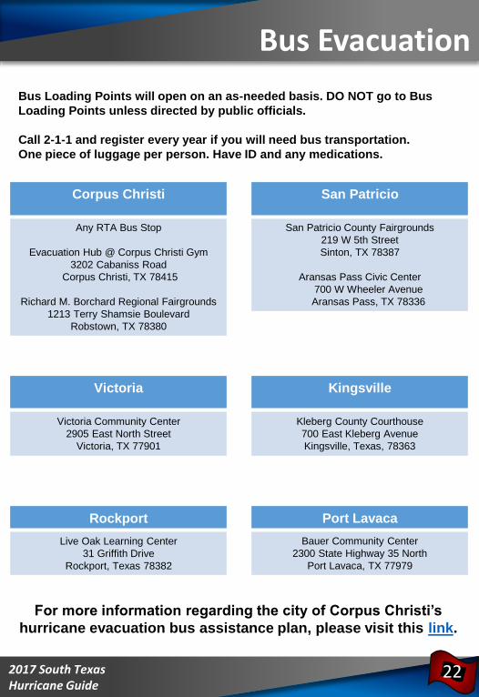
Bus Evacuation
Bus Loading Points will open on an as-needed basis. DO NOT go to Bus
Loading Points unless directed by public officials.
Call 2-1-1 and register every year if you will need bus transportation.
One piece of luggage per person. Have ID and any medications.
22
Corpus Christi
Any RTA Bus Stop
Evacuation Hub @ Corpus Christi Gym
3202 Cabaniss Road
Corpus Christi, TX 78415
Richard M. Borchard Regional Fairgrounds
1213 Terry Shamsie Boulevard
Robstown, TX 78380
Victoria
Victoria Community Center
2905 East North Street
Victoria, TX 77901
Kingsville
Kleberg County Courthouse
700 East Kleberg Avenue
Kingsville, Texas, 78363
Rockport
Live Oak Learning Center
31 Griffith Drive
Rockport, Texas 78382
Port Lavaca
Bauer Community Center
2300 State Highway 35 North
Port Lavaca, TX 77979
San Patricio
San Patricio County Fairgrounds
219 W 5th Street
Sinton, TX 78387
Aransas Pass Civic Center
700 W Wheeler Avenue
Aransas Pass, TX 78336
For more information regarding the city of Corpus Christi’s
hurricane evacuation bus assistance plan, please visit this link.
992017 South Texas Hurricane Guide
Returning Home
23
IF YOU EVACUATED THE AREA, WAIT FOR AN ALL CLEAR FROM THE CITY OR
COUNTY BEFORE ATTEMPTING TO RETURN TO YOUR HOME. BE PREPARED
TO SHOW PROOF OF RESIDENCE BY HAVING A COPY OF YOUR LATEST
UTILITY BILL.
Debris Cleanup
• Cities and counties will publish a schedule
for debris pick-up and removal. Debris
cannot be removed from private property.
• Construction materials, vegetative debris,
household hazardous waste and
household appliances will need to be
placed into separate piles and moved to
the curbside for pick-up.
General Cleanup
• Be cautious of structural damage and downed power lines.
• DO NOT attempt to move structural supports or large pieces of debris.
• DO NOT run power generators indoors. Inhalation of carbon monoxide from the
exhaust can cause death. Ensure exhaust is well ventilated.
• DO NOT use open flames indoors.
• Restrict your driving to emergency use only. Road conditions may not be safe until
road debris is cleared.
Water
• Listen for instructions regarding public water supply. Use only bottled, boiled or treated
water until you know that your water supply is safe.
• You can use household chlorine bleach to treat water for drinking or cleaning. Add 1/8
teaspoon of bleach per gallon of clear water or 1/4 teaspoon of bleach per gallon if
water is cloudy. Allow water to stand for 30 minutes before using.
Interior Cleanup
• Disinfect and dry interior buildings and items inside. This will prevent growth of some
bacteria, viruses, mold, and mildew that can cause illness.
• Clean walls, floors, and counter tops with soap and water. Disinfect them with a
solution of 1 cup of bleach to 5 gallons of water.
• Wash all clothes and linens in hot water. Air dry and spray all unwashable items with
disinfectant. Steam clean carpets. Throw away all items touched by water that cannot
be disinfected.
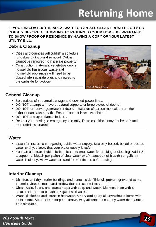
FEMA Mike Moore
992017 South Texas Hurricane Guide
Returning Home
24
Utility Cleanup
• Check for gas leaks. If you smell
or hear gas leaking, leave
immediately. DO NOT use the
phone or turn on lights in your
home. Call the gas company from
a neighbor’s phone.
• Report any visible damage of
power lines to the electric
company. Turn off power at main
breaker if any electrical equipment
or circuits have been exposed to
water.
• DO NOT connect generators to
your home’s electrical circuits. If a
generator is on line when
electrical service is restored, it can
become a major fire hazard. Also,
line workers working to restore
power will be endangered if a
generator is hooked up to the
home’s circuits.
• It is likely that an electric company other than your own will reconnect the lines to your
home; however, they cannot turn the service back on. Only your electric company can
actually turn the power back on to your house.
Sewage Cleanup
• If you suspect water or sewage lines are damaged, do not use your plumbing (toilets,
sinks, etc.). Contact the water company or a plumber for repairs.
• A chemical portable commode can be created by the following:
• Use 5 gallon buckets with tight lids, lined with heavy duty plastic garbage
bags.
• Add kitty litter to the bucket as a disinfectant and deodorizer. Keep lids on
firmly.
• Keep buckets in a cool, dark place. Clean and disinfect buckets immediately.
• Your toilet can also be used by flushing until the bowl has no water. Then, line with
heavy duty trash bags and disinfect with chlorine bleach after each use. Remove
waste to an outside location.
• If significant sewer outages have occurred, instructions for disposal of human wastes
will be announced.
• DO NOT dispose of human waste through your regular trash!
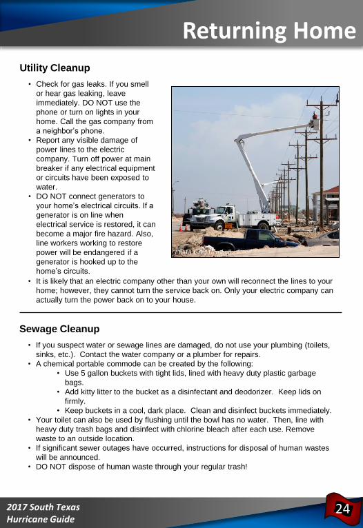
FEMA Greg Henshall
992017 South Texas Hurricane Guide
Emergency Information
25
ARANSAS COUNTY• Rockport Police
361-729-1111
• County Sheriff
361-729-2222
• Fulton Police
361-729-5533
BEE COUNTY• County Emergency Management
361-621-1550 ext. 8181
www.co.bee.tx.us
• Bee Police
361-358-8100
• County Sheriff
361-362-3221
CALHOUN COUNTY• County Emergency Management
361-553-4400
www.calhouncotx.org
• County Sheriff
361-553-4646
GOLIAD COUNTY• Goliad County Judge
361-645-3337
• County Sheriff
361-645-3451
JIM WELLS COUNTY• County Emergency Management
361-668-1018
• Alice Emergency Management
361-664-3111
• Jim Wells County Sheriff
361-668-0341
KLEBERG COUNTY• County Emergency Management
361-595-8527
• County Sheriff
361-595-8500
LIVE OAK COUNTY• County Sheriff
361-449-2271
NUECES COUNTY• County Emergency Management
361-888-0513
www.co.nueces.tx.us
• City of Corpus Christi
361-826-1100
Ready Corpus Christi
Facebook: Ready CC
Twitter: ReadyCC
• Port Aransas City Hall
361-749-4111
www.cityofportaransas.org
• City of Robstown
361-387-2522
www.cityofrobstown.com
• Bishop Police
361-584-2443
• Driscoll Police
361-221-2902
REFUGIO COUNTY• County Emergency Management
361-526-2820
• County Sheriff
361-526-2351
Do Not Call 911 for Non-Emergencies!
992017 South Texas Hurricane Guide
Emergency Notes
26
SAN PATRICIO COUNTY• County Emergency
Management
361-587-3560
• Ingleside Police
361-776-2531
• Portland Police
361-777-4444
• County Sheriff
361-364-9600
• Aransas Pass Police
361-758-5224
VICTORIA COUNTY• City/County Emergency
Management
361-580-5770
• Victoria Police
361-573-3221
• County Sheriff
361-575-0651
Additional Information• US Department of
Homeland Security
www.ready.gov
• American Red Cross
www.redcross.org
(enter zip code for local office)
24 hour number to call for assistance
1-800-RED CROSS
(1-800-733-2767)
___________________________________
___________________________________
___________________________________
___________________________________
___________________________________
___________________________________
___________________________________
___________________________________
___________________________________
___________________________________
___________________________________
___________________________________
___________________________________
___________________________________
___________________________________
___________________________________
___________________________________
___________________________________
___________________________________
___________________________________
___________________________________
___________________________________
___________________________________
___________________________________
___________________________________
___________________________________
___________________________________
___________________________________
___________________________________
992017 South Texas Hurricane Guide
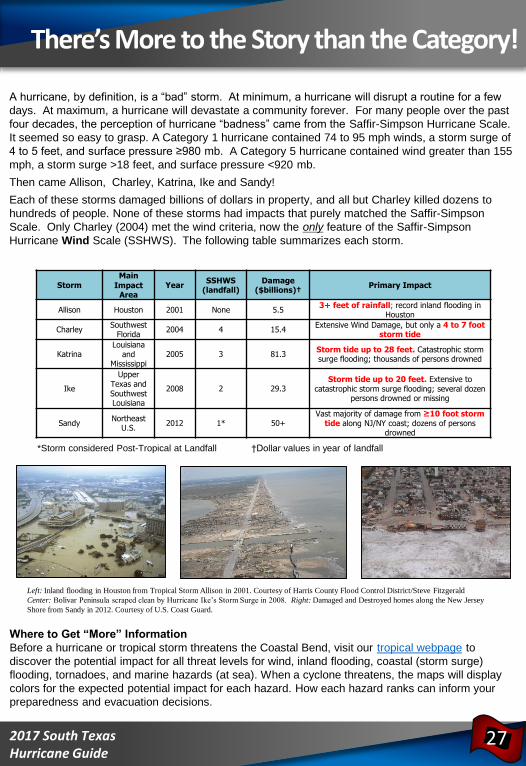
There’s More to the Story than the Category!
StormMain
Impact Area
YearSSHWS
(landfall)Damage
($billions)†Primary Impact
Allison Houston 2001 None 5.53+ feet of rainfall; record inland flooding in
Houston
CharleySouthwest
Florida2004 4 15.4
Extensive Wind Damage, but only a 4 to 7 foot storm tide
KatrinaLouisiana
and Mississippi
2005 3 81.3Storm tide up to 28 feet. Catastrophic storm surge flooding; thousands of persons drowned
Ike
Upper Texas and Southwest Louisiana
2008 2 29.3Storm tide up to 20 feet. Extensive to
catastrophic storm surge flooding; several dozen persons drowned or missing
SandyNortheast
U.S.2012 1* 50+
Vast majority of damage from ≥10 foot storm tide along NJ/NY coast; dozens of persons
drowned
A hurricane, by definition, is a “bad” storm. At minimum, a hurricane will disrupt a routine for a few
days. At maximum, a hurricane will devastate a community forever. For many people over the past
four decades, the perception of hurricane “badness” came from the Saffir-Simpson Hurricane Scale.
It seemed so easy to grasp. A Category 1 hurricane contained 74 to 95 mph winds, a storm surge of
4 to 5 feet, and surface pressure ≥980 mb. A Category 5 hurricane contained wind greater than 155
mph, a storm surge >18 feet, and surface pressure <920 mb.
Then came Allison, Charley, Katrina, Ike and Sandy!
Each of these storms damaged billions of dollars in property, and all but Charley killed dozens to
hundreds of people. None of these storms had impacts that purely matched the Saffir-Simpson
Scale. Only Charley (2004) met the wind criteria, now the only feature of the Saffir-Simpson
Hurricane Wind Scale (SSHWS). The following table summarizes each storm.
*Storm considered Post-Tropical at Landfall †Dollar values in year of landfall
Left: Inland flooding in Houston from Tropical Storm Allison in 2001. Courtesy of Harris County Flood Control District/Steve Fitzgerald
Center: Bolivar Peninsula scraped clean by Hurricane Ike’s Storm Surge in 2008. Right: Damaged and Destroyed homes along the New Jersey
Shore from Sandy in 2012. Courtesy of U.S. Coast Guard.
27
Where to Get “More” Information
Before a hurricane or tropical storm threatens the Coastal Bend, visit our tropical webpage to
discover the potential impact for all threat levels for wind, inland flooding, coastal (storm surge)
flooding, tornadoes, and marine hazards (at sea). When a cyclone threatens, the maps will display
colors for the expected potential impact for each hazard. How each hazard ranks can inform your
preparedness and evacuation decisions.

992017 South Texas Hurricane Guide 28
www.weather.gov/corpuschristi
National Weather Service
WFO Corpus Christi, TX
426 Pinson Drive
Corpus Christi, TX 78406
Phone: 361-289-0959
Fax: 361-289-7823 @NWSCorpus
BECOME A WEATHER-READY NATION
AMBASSADORTM TODAY!
Visit: www.weather.gov/wrn/ambassadors1
To become an Ambassador, click this link2
Accept the Terms of Use of the Weather-Ready
Nation Ambassadors™ Logo and Service Mark3
Fill out the WRN Ambassador Application4
Weather-Ready Nation (WRN) Ambassadors
inspire others to be a force of nature by being
ready, responsive, and resilient to the dangerous
impacts of extreme weather.
![CHRIS MOONEY STORM WORLD · Storm world: hurricanes, politics, and the battle over global warming/[Chris Mooney].—1st ed. p. cm. Includes bibliographical references and index. 1](https://img.pdfslide.us/doc/110x75/5f6cc89ab34cb0660533255b/chris-mooney-storm-world-storm-world-hurricanes-politics-and-the-battle-over.jpg)