Embed Size (px)
Citation preview
ARCHITECTURESHOWBOOK
Future is our business.Zukunft ist unser Thema.
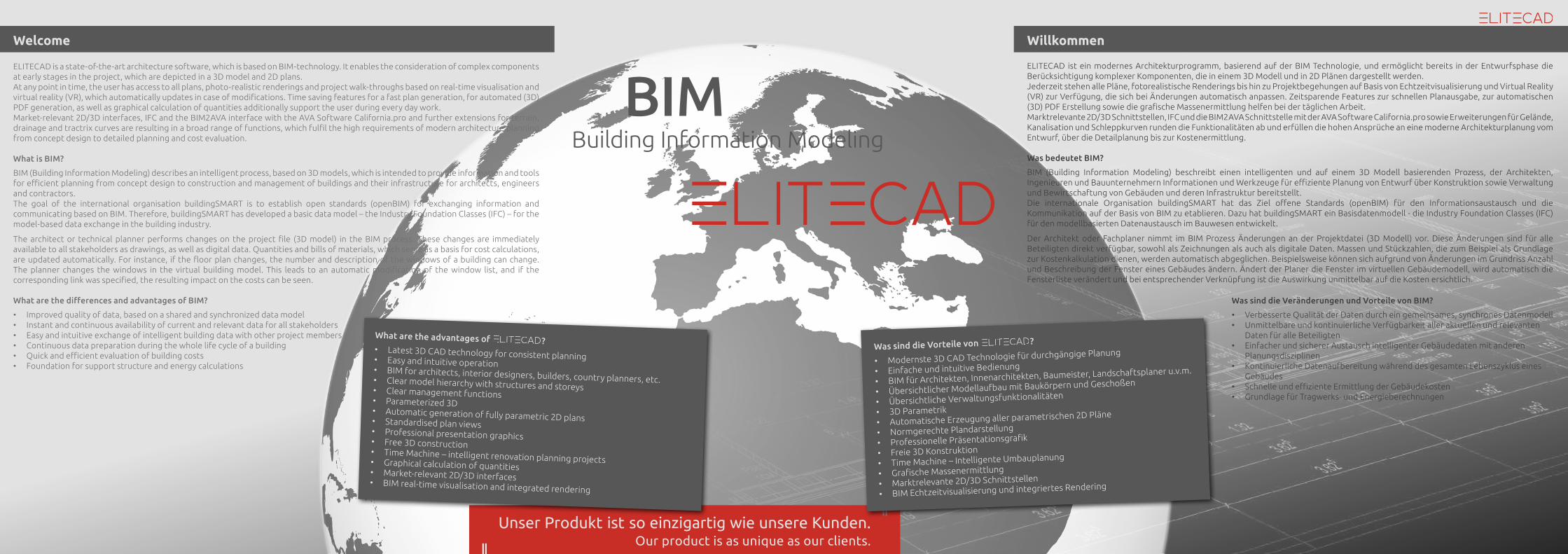
ELITECAD is a state-of-the-art architecture software, which is based on BIM-technology. It enables the consideration of complex components at early stages in the project, which are depicted in a 3D model and 2D plans. At any point in time, the user has access to all plans, photo-realistic renderings and project walk-throughs based on real-time visualisation and virtual reality (VR), which automatically updates in case of modifications. Time saving features for a fast plan generation, for automated (3D) PDF generation, as well as graphical calculation of quantities additionally support the user during every day work.Market-relevant 2D/3D interfaces, IFC and the BIM2AVA interface with the AVA Software California.pro and further extensions for terrain, drainage and tractrix curves are resulting in a broad range of functions, which fulfil the high requirements of modern architecture planning from concept design to detailed planning and cost evaluation.
What is BIM?
BIM (Building Information Modeling) describes an intelligent process, based on 3D models, which is intended to provide information and tools for efficient planning from concept design to construction and management of buildings and their infrastructure for architects, engineers and contractors. The goal of the international organisation buildingSMART is to establish open standards (openBIM) for exchanging information and communicating based on BIM. Therefore, buildingSMART has developed a basic data model – the Industry Foundation Classes (IFC) – for the model-based data exchange in the building industry.
The architect or technical planner performs changes on the project file (3D model) in the BIM process. These changes are immediately available to all stakeholders as drawings, as well as digital data. Quantities and bills of materials, which serve as a basis for cost calculations, are updated automatically. For instance, if the floor plan changes, the number and description of the windows of a building can change. The planner changes the windows in the virtual building model. This leads to an automatic modification of the window list, and if the corresponding link was specified, the resulting impact on the costs can be seen.
What are the differences and advantages of BIM?
• Improved quality of data, based on a shared and synchronized data model • Instant and continuous availability of current and relevant data for all stakeholders• Easy and intuitive exchange of intelligent building data with other project members• Continuous data preparation during the whole life cycle of a building• Quick and efficient evaluation of building costs• Foundation for support structure and energy calculations
Welcome Willkommen
ELITECAD ist ein modernes Architekturprogramm, basierend auf der BIM Technologie, und ermöglicht bereits in der Entwurfsphase die Berücksichtigung komplexer Komponenten, die in einem 3D Modell und in 2D Plänen dargestellt werden. Jederzeit stehen alle Pläne, fotorealistische Renderings bis hin zu Projektbegehungen auf Basis von Echtzeitvisualisierung und Virtual Reality (VR) zur Verfügung, die sich bei Änderungen automatisch anpassen. Zeitsparende Features zur schnellen Planausgabe, zur automatischen (3D) PDF Erstellung sowie die grafische Massenermittlung helfen bei der täglichen Arbeit.Marktrelevante 2D/3D Schnittstellen, IFC und die BIM2AVA Schnittstelle mit der AVA Software California.pro sowie Erweiterungen für Gelände, Kanalisation und Schleppkurven runden die Funktionalitäten ab und erfüllen die hohen Ansprüche an eine moderne Architekturplanung vom Entwurf, über die Detailplanung bis zur Kostenermittlung.
Was bedeutet BIM?
BIM (Building Information Modeling) beschreibt einen intelligenten und auf einem 3D Modell basierenden Prozess, der Architekten, Ingenieuren und Bauunternehmern Informationen und Werkzeuge für effiziente Planung von Entwurf über Konstruktion sowie Verwaltung und Bewirtschaftung von Gebäuden und deren Infrastruktur bereitstellt.Die internationale Organisation buildingSMART hat das Ziel offene Standards (openBIM) für den Informationsaustausch und die Kommunikation auf der Basis von BIM zu etablieren. Dazu hat buildingSMART ein Basisdatenmodell - die Industry Foundation Classes (IFC) für den modellbasierten Datenaustausch im Bauwesen entwickelt.
Der Architekt oder Fachplaner nimmt im BIM Prozess Änderungen an der Projektdatei (3D Modell) vor. Diese Änderungen sind für alle Beteiligten direkt verfügbar, sowohl als Zeichnungen als auch als digitale Daten. Massen und Stückzahlen, die zum Beispiel als Grundlage zur Kostenkalkulation dienen, werden automatisch abgeglichen. Beispielsweise können sich aufgrund von Änderungen im Grundriss Anzahl und Beschreibung der Fenster eines Gebäudes ändern. Ändert der Planer die Fenster im virtuellen Gebäudemodell, wird automatisch die Fensterliste verändert und bei entsprechender Verknüpfung ist die Auswirkung unmittelbar auf die Kosten ersichtlich.
BIMBuilding Information Modeling
Was sind die Veränderungen und Vorteile von BIM?
• Verbesserte Qualität der Daten durch ein gemeinsames, synchrones Datenmodell • Unmittelbare und kontinuierliche Verfügbarkeit aller aktuellen und relevanten
Daten für alle Beteiligten• Einfacher und sicherer Austausch intelligenter Gebäudedaten mit anderen
Planungsdisziplinen• Kontinuierliche Datenaufbereitung während des gesamten Lebenszyklus eines
Gebäudes• Schnelle und effiziente Ermittlung der Gebäudekosten• Grundlage für Tragwerks- und Energieberechnungen
Unser Produkt ist so einzigartig wie unsere Kunden.Our product is as unique as our clients.
What are the advantages of ?• Latest 3D CAD technology for consistent planning• Easy and intuitive operation• BIM for architects, interior designers, builders, country planners, etc. • Clear model hierarchy with structures and storeys• Clear management functions• Parameterized 3D• Automatic generation of fully parametric 2D plans• Standardised plan views • Professional presentation graphics• Free 3D construction• Time Machine – intelligent renovation planning projects• Graphical calculation of quantities• Market-relevant 2D/3D interfaces• BIM real-time visualisation and integrated rendering
Was sind die Vorteile von ?
• Modernste 3D CAD Technologie für durchgängige Planung
• Einfache und intuitive Bedienung
• BIM für Architekten, Innenarchitekten, Baumeister, Landschaftsplaner u.v.m.
• Übersichtlicher Modellaufbau mit Baukörpern und Geschoßen
• Übersichtliche Verwaltungsfunktionalitäten
• 3D Parametrik• Automatische Erzeugung aller parametrischen 2D Pläne
• Normgerechte Plandarstellung
• Professionelle Präsentationsgrafik
• Freie 3D Konstruktion
• Time Machine – Intelligente Umbauplanung
• Grafische Massenermittlung
• Marktrelevante 2D/3D Schnittstellen
• BIM Echtzeitvisualisierung und integriertes Rendering
Parametrics allow you to create and adapt complex models easily and efficiently.
BIM (Building Information Modeling) is changing and revolutionising the current processes in the building sector. Therefore, this technology will be more and more relevant in practice in the next years.
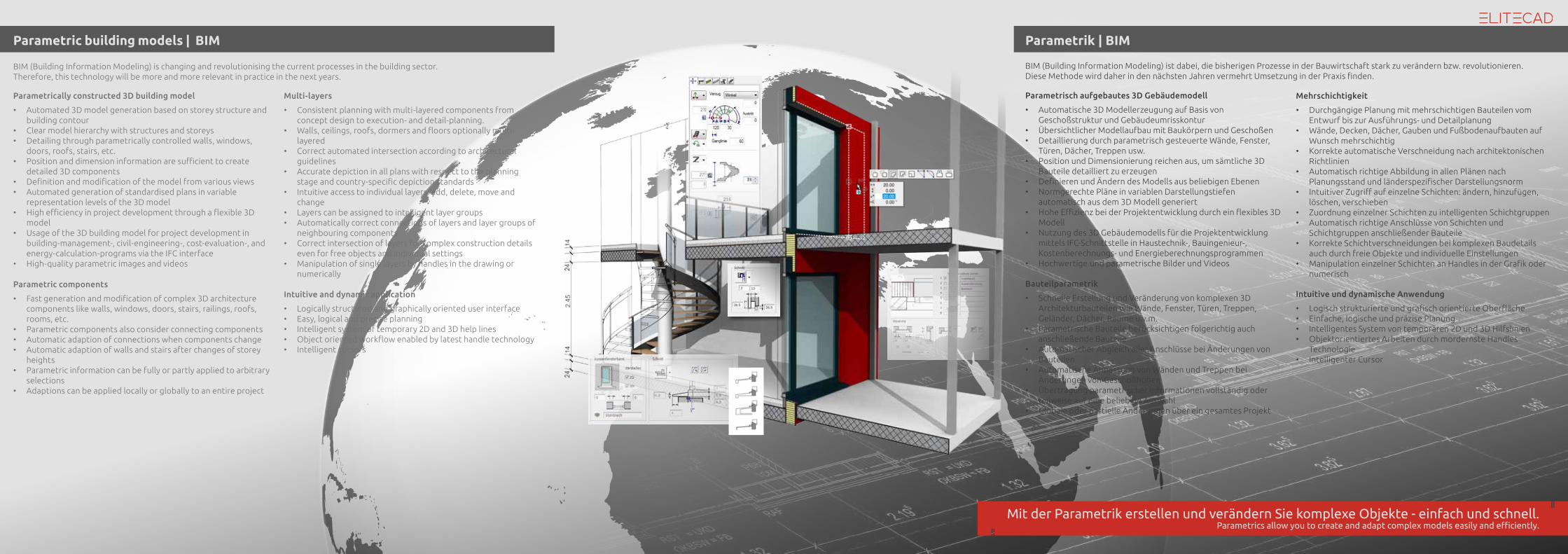
Parametric building models | BIM
Intuitive and dynamic application
• Logically structured and graphically oriented user interface• Easy, logical and precise planning• Intelligent system of temporary 2D and 3D help lines• Object oriented workflow enabled by latest handle technology• Intelligent cursors
Parametric components
• Fast generation and modification of complex 3D architecture components like walls, windows, doors, stairs, railings, roofs, rooms, etc.
• Parametric components also consider connecting components• Automatic adaption of connections when components change• Automatic adaption of walls and stairs after changes of storey
heights• Parametric information can be fully or partly applied to arbitrary
selections • Adaptions can be applied locally or globally to an entire project
Multi-layers
• Consistent planning with multi-layered components from concept design to execution- and detail-planning.
• Walls, ceilings, roofs, dormers and floors optionally multi-layered
• Correct automated intersection according to architectural guidelines
• Accurate depiction in all plans with respect to the planning stage and country-specific depiction standards
• Intuitive access to individual layers: add, delete, move and change
• Layers can be assigned to intelligent layer groups• Automatically correct connections of layers and layer groups of
neighbouring components• Correct intersection of layers for complex construction details
even for free objects and individual settings• Manipulation of single layers by handles in the drawing or
numerically
Parametrically constructed 3D building model
• Automated 3D model generation based on storey structure and building contour
• Clear model hierarchy with structures and storeys • Detailing through parametrically controlled walls, windows,
doors, roofs, stairs, etc.• Position and dimension information are sufficient to create
detailed 3D components• Definition and modification of the model from various views• Automated generation of standardised plans in variable
representation levels of the 3D model• High efficiency in project development through a flexible 3D
model• Usage of the 3D building model for project development in
building-management-, civil-engineering-, cost-evaluation-, and energy-calculation-programs via the IFC interface
• High-quality parametric images and videos
Parametrik | BIM
BIM (Building Information Modeling) ist dabei, die bisherigen Prozesse in der Bauwirtschaft stark zu verändern bzw. revolutionieren.Diese Methode wird daher in den nächsten Jahren vermehrt Umsetzung in der Praxis finden.
Parametrisch aufgebautes 3D Gebäudemodell
• Automatische 3D Modellerzeugung auf Basis von Geschoßstruktur und Gebäudeumrisskontur
• Übersichtlicher Modellaufbau mit Baukörpern und Geschoßen • Detaillierung durch parametrisch gesteuerte Wände, Fenster,
Türen, Dächer, Treppen usw.• Position und Dimensionierung reichen aus, um sämtliche 3D
Bauteile detailliert zu erzeugen• Definieren und Ändern des Modells aus beliebigen Ebenen• Normgerechte Pläne in variablen Darstellungstiefen
automatisch aus dem 3D Modell generiert• Hohe Effizienz bei der Projektentwicklung durch ein flexibles 3D
Modell• Nutzung des 3D Gebäudemodells für die Projektentwicklung
mittels IFC-Schnittstelle in Haustechnik-, Bauingenieur-, Kostenberechnungs- und Energieberechnungsprogrammen
• Hochwertige und parametrische Bilder und Videos
Intuitive und dynamische Anwendung
• Logisch strukturierte und grafisch orientierte Oberfläche• Einfache, logische und präzise Planung• Intelligentes System von temporären 2D und 3D Hilfslinien• Objektorientiertes Arbeiten durch mordernste Handles
Technologie• Intelligenter Cursor
Bauteilparametrik
• Schnelle Erstellung und Veränderung von komplexen 3D Architekturbauteilen wie Wände, Fenster, Türen, Treppen, Geländer, Dächer, Räume u.v.m.
• Parametrische Bauteile berücksichtigen folgerichtig auch anschließende Bauteile
• Automatischer Abgleich aller Anschlüsse bei Änderungen von Bauteilen
• Automatische Anpassung von Wänden und Treppen bei Änderungen von Geschoßhöhen
• Übertragung parametrischer Informationen vollständig oder teilweise auf eine beliebige Auswahl
• Globale oder partielle Änderungen über ein gesamtes Projekt
Mehrschichtigkeit
• Durchgängige Planung mit mehrschichtigen Bauteilen vom Entwurf bis zur Ausführungs- und Detailplanung
• Wände, Decken, Dächer, Gauben und Fußbodenaufbauten auf Wunsch mehrschichtig
• Korrekte automatische Verschneidung nach architektonischen Richtlinien
• Automatisch richtige Abbildung in allen Plänen nach Planungsstand und länderspezifischer Darstellungsnorm
• Intuitiver Zugriff auf einzelne Schichten: ändern, hinzufügen, löschen, verschieben
• Zuordnung einzelner Schichten zu intelligenten Schichtgruppen• Automatisch richtige Anschlüsse von Schichten und
Schichtgruppen anschließender Bauteile• Korrekte Schichtverschneidungen bei komplexen Baudetails
auch durch freie Objekte und individuelle Einstellungen• Manipulation einzelner Schichten an Handles in der Grafik oder
numerisch
Mit der Parametrik erstellen und verändern Sie komplexe Objekte - einfach und schnell.
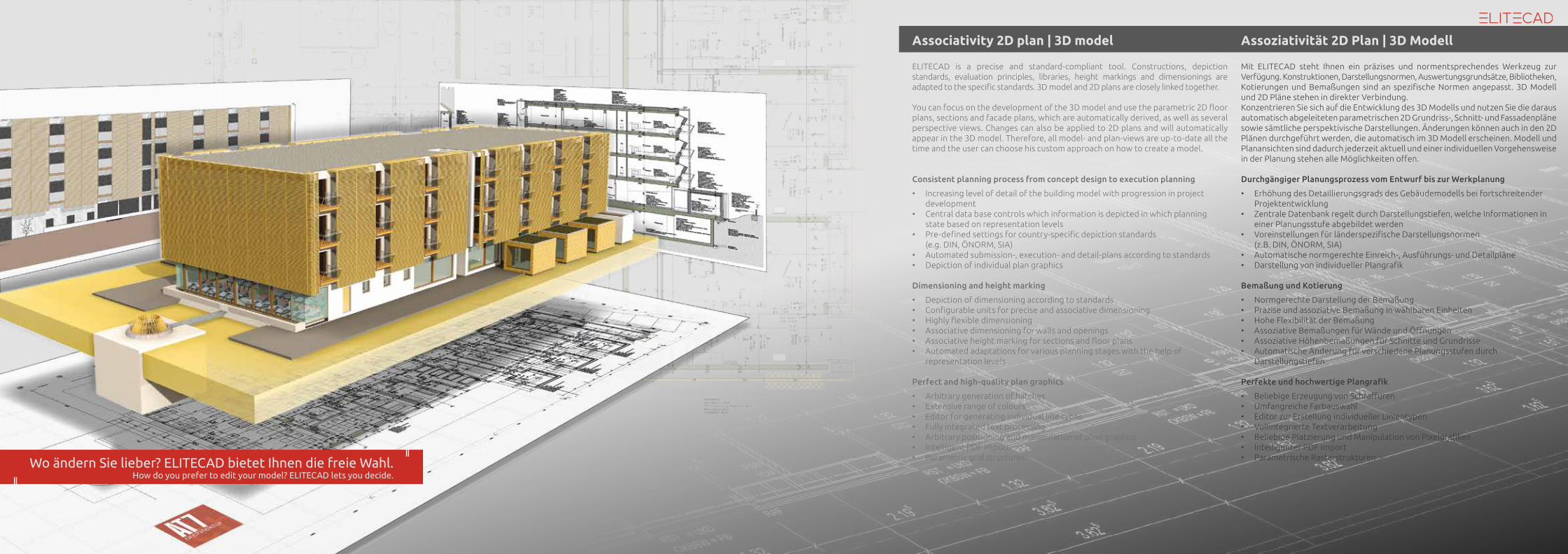
Associativity 2D plan | 3D model
ELITECAD is a precise and standard-compliant tool. Constructions, depiction standards, evaluation principles, libraries, height markings and dimensionings are adapted to the specific standards. 3D model and 2D plans are closely linked together.
You can focus on the development of the 3D model and use the parametric 2D floor plans, sections and facade plans, which are automatically derived, as well as several perspective views. Changes can also be applied to 2D plans and will automatically appear in the 3D model. Therefore, all model- and plan-views are up-to-date all the time and the user can choose his custom approach on how to create a model.
Consistent planning process from concept design to execution planning
• Increasing level of detail of the building model with progression in project development
• Central data base controls which information is depicted in which planning state based on representation levels
• Pre-defined settings for country-specific depiction standards (e.g. DIN, ÖNORM, SIA)
• Automated submission-, execution- and detail-plans according to standards• Depiction of individual plan graphics Dimensioning and height marking
• Depiction of dimensioning according to standards• Configurable units for precise and associative dimensioning• Highly flexible dimensioning• Associative dimensioning for walls and openings• Associative height marking for sections and floor plans• Automated adaptations for various planning stages with the help of
representation levels
Perfect and high-quality plan graphics
• Arbitrary generation of hatches• Extensive range of colours• Editor for generating individual line types• Fully integrated text processing• Arbitrary positioning and manipulation of pixel graphics• Intelligent PDF import• Parametric grid structures
Assoziativität 2D Plan | 3D Modell
Mit ELITECAD steht Ihnen ein präzises und normentsprechendes Werkzeug zur Verfügung. Konstruktionen, Darstellungsnormen, Auswertungsgrundsätze, Bibliotheken, Kotierungen und Bemaßungen sind an spezifische Normen angepasst. 3D Modell und 2D Pläne stehen in direkter Verbindung.Konzentrieren Sie sich auf die Entwicklung des 3D Modells und nutzen Sie die daraus automatisch abgeleiteten parametrischen 2D Grundriss-, Schnitt- und Fassadenpläne sowie sämtliche perspektivische Darstellungen. Änderungen können auch in den 2D Plänen durchgeführt werden, die automatisch im 3D Modell erscheinen. Modell und Planansichten sind dadurch jederzeit aktuell und einer individuellen Vorgehensweise in der Planung stehen alle Möglichkeiten offen.
Durchgängiger Planungsprozess vom Entwurf bis zur Werkplanung
• Erhöhung des Detaillierungsgrads des Gebäudemodells bei fortschreitender Projektentwicklung
• Zentrale Datenbank regelt durch Darstellungstiefen, welche Informationen in einer Planungsstufe abgebildet werden
• Voreinstellungen für länderspezifische Darstellungsnormen (z.B. DIN, ÖNORM, SIA)
• Automatische normgerechte Einreich-, Ausführungs- und Detailpläne• Darstellung von individueller Plangrafik
Bemaßung und Kotierung
• Normgerechte Darstellung der Bemaßung• Präzise und assoziative Bemaßung in wählbaren Einheiten• Hohe Flexibilität der Bemaßung• Assoziative Bemaßungen für Wände und Öffnungen• Assoziative Höhenbemaßungen für Schnitte und Grundrisse• Automatische Änderung für verschiedene Planungsstufen durch
Darstellungstiefen
Perfekte und hochwertige Plangrafik
• Beliebige Erzeugung von Schraffuren• Umfangreiche Farbauswahl• Editor zur Erstellung individueller Linientypen• Vollintegrierte Textverarbeitung• Beliebige Platzierung und Manipulation von Pixelgrafiken• Intelligenter PDF Import• Parametrische RasterstrukturenWo ändern Sie lieber? ELITECAD bietet Ihnen die freie Wahl.
How do you prefer to edit your model? ELITECAD lets you decide.
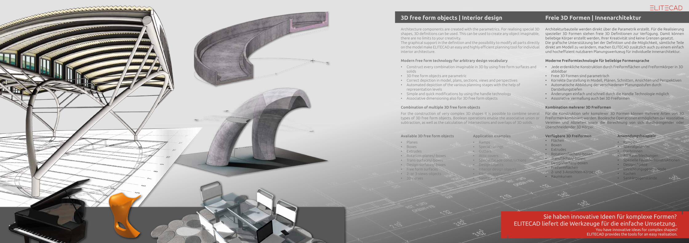
3D free form objects | Interior design
You have innovative ideas for complex shapes?ELITECAD provides the tools for an easy realisation.
Architecture components are created with the parametrics. For realising special 3D shapes, 3D definitions can be used. This can be used to create any object imaginable, there are no limits to your creativity.The graphical support in the definition and the possibility to modify all parts directly on the model make ELITECAD an easy and highly efficient planning tool for individual interior architecture.
Modern free form technology for arbitrary design vocabulary
• Construct every combination imaginable in 3D by using free form surfaces and solids
• 3D free form objects are parametric • Correct depiction in model, plans, sections, views and perspectives• Automated depiction of the various planning stages with the help of
representation levels• Simple and quick modifications by using the handle technology• Associative dimensioning also for 3D free form objects
Combination of multiple 3D free form objects
For the construction of very complex 3D shapes it is possible to combine several types of 3D free form objects. Boolean operations enable the associative union or subtraction, as well as the calculation of intersections and overlaps of 3D solids.
Available 3D free form objects
• Planes• Boxes• Extrudes• Rotation-planes/-boxes• Trans-surfaces/-boxes• Design-surfaces/-boxes• Free form surfaces• 2- or 3-views-objects• 3D curves
Application examples
• Ramps• Special railings• Gutters• Attic covers• Special facade constructions • Design objects• Interior design objects• Kitchen appliances• Sanitary items
Freie 3D Formen | Innenarchitektur
Architekturbauteile werden direkt über die Parametrik erstellt. Für die Realisierung spezieller 3D Formen stehen freie 3D Definitionen zur Verfügung. Damit können beliebige Körper erstellt werden, Ihrer Kreativität sind keine Grenzen gesetzt.Die grafische Unterstützung bei der Definition und die Möglichkeit, sämtliche Teile direkt am Modell zu verändern, machen ELITECAD zusätzlich auch zu einem einfach und hocheffizient nutzbaren Planungswerkzeug für individuelle Innenarchitektur.
Moderne Freiformtechnologie für beliebige Formensprache
• Jede erdenkliche Konstruktion durch Freiformflächen und Freiformkörper in 3D abbildbar
• Freie 3D Formen sind parametrisch• Korrekte Darstellung in Modell, Plänen, Schnitten, Ansichten und Perspektiven• Automatische Abbildung der verschiedenen Planungsstufen durch
Darstellungstiefen • Änderungen einfach und schnell durch die Handle Technologie möglich• Assoziative Vermaßung auch bei 3D Freiformen
Kombination mehrerer 3D Freiformen
Für die Konstruktion sehr komplexer 3D Formen können mehrere Arten von 3D Freiformen kombiniert werden. Boolesche Operationen ermöglichen das assoziative Vereinen und Abziehen sowie die Berechnung von sich durchdringender oder überschneidender 3D Körper.
Verfügbare 3D Freiformen• Flächen• Boxen• Extrudes• Rotationsflächen/-boxen• Transflächen/-boxen• Designflächen/-boxen• Freiformflächen• 2- und 3-Ansichten-Körper• Raumkurven
Anwendungsbeispiele
• Rampen• Spezialgeländer• Dachrinnen• Attikaverblechungen• Spezielle Fassadenkonstruktionen • Designobjekte• Einrichtungsgegenstände• Küchen• Sanitärgegenstände
Sie haben innovative Ideen für komplexe Formen?ELITECAD liefert die Werkzeuge für die einfache Umsetzung.
A miracle of technology.
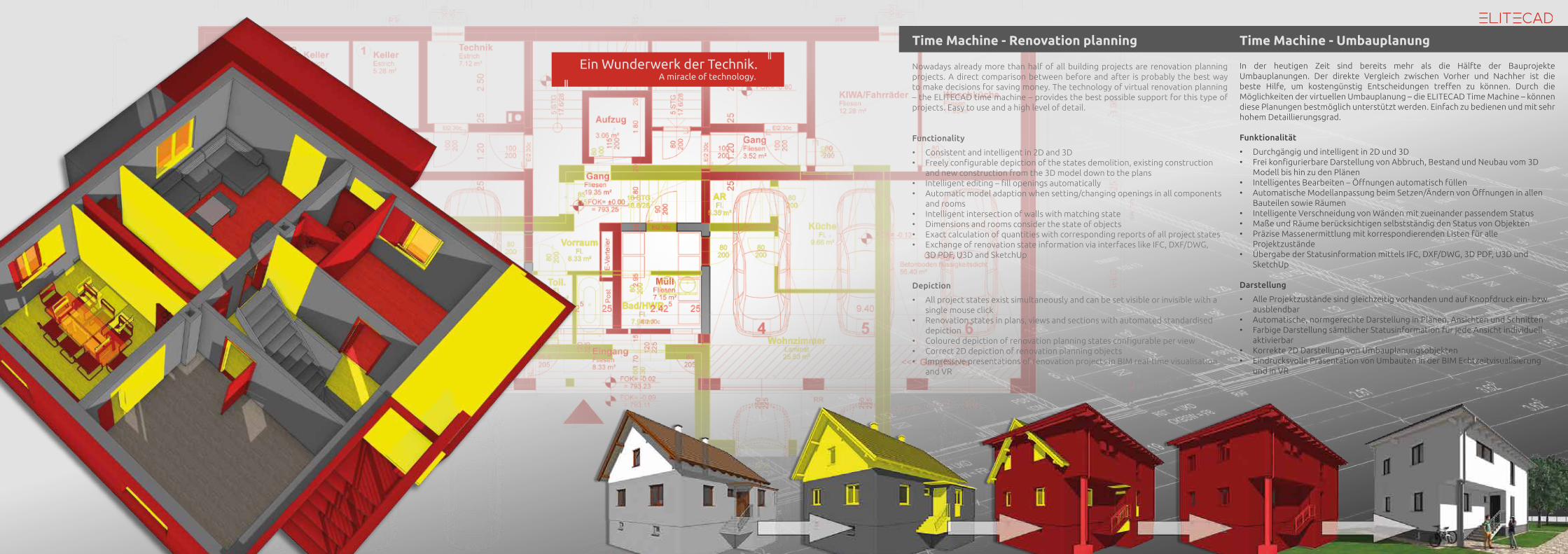
Time Machine - Renovation planning
Nowadays already more than half of all building projects are renovation planning projects. A direct comparison between before and after is probably the best way to make decisions for saving money. The technology of virtual renovation planning – the ELITECAD time machine – provides the best possible support for this type of projects. Easy to use and a high level of detail.
Functionality
• Consistent and intelligent in 2D and 3D• Freely configurable depiction of the states demolition, existing construction
and new construction from the 3D model down to the plans• Intelligent editing – fill openings automatically• Automatic model adaption when setting/changing openings in all components
and rooms• Intelligent intersection of walls with matching state• Dimensions and rooms consider the state of objects• Exact calculation of quantities with corresponding reports of all project states• Exchange of renovation state information via interfaces like IFC, DXF/DWG,
3D PDF, U3D and SketchUp
Depiction
• All project states exist simultaneously and can be set visible or invisible with a single mouse click
• Renovation states in plans, views and sections with automated standardised depiction
• Coloured depiction of renovation planning states configurable per view• Correct 2D depiction of renovation planning objects• Impressive presentations of renovation projects in BIM real-time visualisation
and VR
Time Machine - Umbauplanung
In der heutigen Zeit sind bereits mehr als die Hälfte der Bauprojekte Umbauplanungen. Der direkte Vergleich zwischen Vorher und Nachher ist die beste Hilfe, um kostengünstig Entscheidungen treffen zu können. Durch die Möglichkeiten der virtuellen Umbauplanung – die ELITECAD Time Machine – können diese Planungen bestmöglich unterstützt werden. Einfach zu bedienen und mit sehr hohem Detaillierungsgrad.
Funktionalität
• Durchgängig und intelligent in 2D und 3D • Frei konfigurierbare Darstellung von Abbruch, Bestand und Neubau vom 3D
Modell bis hin zu den Plänen• Intelligentes Bearbeiten – Öffnungen automatisch füllen • Automatische Modellanpassung beim Setzen/Ändern von Öffnungen in allen
Bauteilen sowie Räumen • Intelligente Verschneidung von Wänden mit zueinander passendem Status• Maße und Räume berücksichtigen selbstständig den Status von Objekten• Präzise Massenermittlung mit korrespondierenden Listen für alle
Projektzustände• Übergabe der Statusinformation mittels IFC, DXF/DWG, 3D PDF, U3D und
SketchUp
Darstellung
• Alle Projektzustände sind gleichzeitig vorhanden und auf Knopfdruck ein- bzw. ausblendbar
• Automatische, normgerechte Darstellung in Plänen, Ansichten und Schnitten• Farbige Darstellung sämtlicher Statusinformation für jede Ansicht individuell
aktivierbar • Korrekte 2D Darstellung von Umbauplanungsobjekten• Eindrucksvolle Präsentation von Umbauten in der BIM Echtzeitvisualisierung
und in VR
Ein Wunderwerk der Technik.
Everything happens now.
Walking mode
• Experience the model with your customer in a realistic real-time visualisation
• Navigate with the help of controllers (e.g. Playstation® or Xbox®) as well as mouse and keyboard
• Collision detection, gravity, flying, jumping, teleportation and many more
VR devices (Oculus Rift)
• Dive into virtual reality and find yourself again inside your model
• Experiencing the 3D model first hand, true immersion
• Native integration
Export and control
• Save your virtual walks as intelligent camera paths
• High-resolution images and videos within seconds – up to 16K!
• 360° panorama images and 360° videos by clicking one button
• Presets for YouTube, Facebook, Oculus Rift and many more
Radiosity and rendering
• Photo-realistic image calculations based on physical rendering
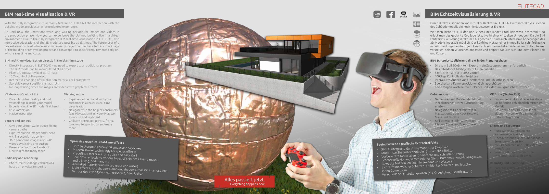
BIM real-time visualisation & VR
With the fully integrated virtual reality feature of ELITECAD the interaction with the building model provides an unprecedented experience.
Up until now, the limitations were long waiting periods for images and videos in the production phase. Now you can experience the planned building live in a virtual environment. Due to the fully integrated BIM real-time visualisation in ELITECAD, also interactive adaptations of the 3D model are possible at all times. The future user of a real estate is involved into decisions at an early stage. The user has a better visual image of the building or renovation project and can adapt it to specific requirements early on, which saves time and costs.
BIM real-time visualisation directly in the planning stage
• Directly integrated in ELITECAD – no need to export to an additional program• The BIM model can be manipulated at all times• Plans are constantly kept up-to-date• 100% control of the project• Interactive changing of visualisation materials or library parts• Storable camera positions (snapshots)• No long waiting times for images and videos with graphical effects
BIM Echtzeitvisualisierung & VR
Durch direktes Einbinden von virtueller Realität in ELITECAD wird interaktives Erleben des Gebäudemodells ein noch nie dagewesenes Ereignis.
War man bisher auf Bilder und Videos mit langer Produktionszeit beschränkt, so erlebt man das geplante Gebäude jetzt live in einer virtuellen Umgebung. Da die BIM Echtzeitvisualisierung direkt im CAD geschieht, sind auch interaktive Änderungen des 3D Modells jederzeit möglich. Der künftige Nutzer einer Immobilie ist sehr frühzeitig in Entscheidungen einbezogen, kann sich ein Bauvorhaben oder einen Umbau besser vorstellen, seinen Wünschen anpassen und erspart dadurch sich und dem Planer Zeit und Kosten.
BIM Echtzeitvisualisierung direkt in der Planungsphase
• Direkt in ELITECAD – kein Export in ein Zusatzprogramm erforderlich • Das BIM Modell bleibt jederzeit manipulierbar • Sämtliche Pläne sind stets aktuell • 100%ige Kontrolle des Projektes • Interaktives Ändern von Oberflächen und Bibliotheksteilen • Speicherbare Kamerapositionen (Schnappschüsse)• Keine langen Wartezeiten für Bilder und Videos mit grafischen Effekten
Gehenmodus
• Gemeinsam mit Kunden das Modell in realistischer Echtzeitvisualisierung erleben
• Navigation mit Controllern (z.B. Playstation® oder Xbox®) sowie Maus und Tastatur
• Kollisionskontrolle, Gravitation, Fliegen, Springen, Teleportieren u.v.m.
VR Brille (Oculus Rift)
• Eintauchen in die virtuelle Realität – Sie befinden sich plötzlich mitten im Modell
• Das Erleben des 3D Modells am eigenen Körper, wahre Immersion
• Native Integration
Export und Steuerung
• Rundgänge als intelligente Kamerawege speichern
• Hochauflösende Bilder und Videos in Sekunden – bis zu 16K!
• 360° Panoramen und 360° Videos auf Knopfdruck
• Voreinstellungen für YouTube, Facebook, Oculus Rift u.v.m.
Radiosity und Rendering
• Fotorealistische Bildberechnung auf Basis von physikalischem Rendering
Alles passiert jetzt.
Impressive graphical real-time effects• 360° background through Skymaps and Skyboxes• Modern shader technology for special effects• Predefined materials for a quick and easy start• Real-time reflections, various types of shininess, bump maps, anti-aliasing, and many more• Animated materials (animated grass and water)• Light effects, soft shadows, ambient shadows, realistic interiors, etc.• Various depiction types (e.g. greyscale, pencil, etc.)
Beeindruckende grafische Echtzeiteffekte
• 360° Hintergrund durch Skymaps oder Skyboxen
• Modernste Shadertechnologie für spezielle Effekte
• Vorbereitete Materialien für einfache und schnelle Nutzung
• Echtzeitreflexionen, verschiedener Glanz, Bumpmap, Anti-Aliasing u.v.m.
• Bewegte Materialien (animiertes Gras und Wasser)
• Lichteffekte, weicher Schatten, ambienter Schatten, realistische
Innenräume u.v.m.
• Verschiedene Darstellungsarten (z.B. Graustufen, Bleistift u.v.m.)
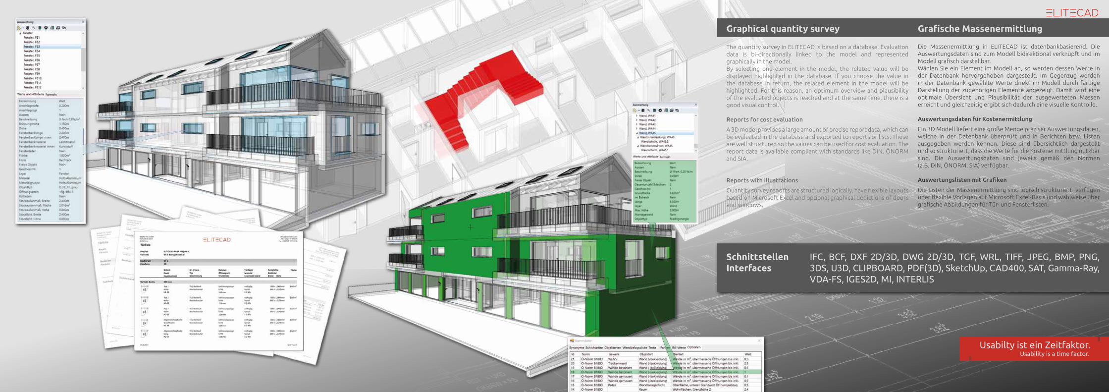
The quantity survey in ELITECAD is based on a database. Evaluation data is bi-directionally linked to the model and represented graphically in the model. By selecting one element in the model, the related value will be displayed highlighted in the database. If you choose the value in the database in return, the related element in the model will be highlighted. For this reason, an optimum overview and plausibility of the evaluated objects is reached and at the same time, there is a good visual control.
Reports for cost evaluation
A 3D model provides a large amount of precise report data, which can be evaluated in the database and exported to reports or lists. These are well structured so the values can be used for cost evaluation. The report data is available compliant with standards like DIN, ÖNORM and SIA.
Reports with illustrations
Quantity survey reports are structured logically, have flexible layouts based on Microsoft Excel and optional graphical depictions of doors and windows.
Graphical quantity survey
Usability is a time factor.
Grafische Massenermittlung
Die Massenermittlung in ELITECAD ist datenbankbasierend. Die Auswertungsdaten sind zum Modell bidirektional verknüpft und im Modell grafisch darstellbar. Wählen Sie ein Element im Modell an, so werden dessen Werte in der Datenbank hervorgehoben dargestellt. Im Gegenzug werden in der Datenbank gewählte Werte direkt im Modell durch farbige Darstellung der zugehörigen Elemente angezeigt. Damit wird eine optimale Übersicht und Plausibilität der ausgewerteten Massen erreicht und gleichzeitig ergibt sich dadurch eine visuelle Kontrolle.
Auswertungsdaten für Kostenermittlung
Ein 3D Modell liefert eine große Menge präziser Auswertungsdaten, welche in der Datenbank überprüft und in Berichten bzw. Listen ausgegeben werden können. Diese sind übersichtlich dargestellt und so strukturiert, dass die Werte für die Kostenermittlung nutzbar sind. Die Auswertungsdaten sind jeweils gemäß den Normen (z.B. DIN, ÖNORM, SIA) verfügbar.
Auswertungslisten mit Grafiken
Die Listen der Massenermittlung sind logisch strukturiert, verfügen über flexible Vorlagen auf Microsoft Excel-Basis und wahlweise über grafische Abbildungen für Tür- und Fensterlisten.
Usabilty ist ein Zeitfaktor.
SchnittstellenInterfaces
IFC, BCF, DXF 2D/3D, DWG 2D/3D, TGF, WRL, TIFF, JPEG, BMP, PNG, 3DS, U3D, CLIPBOARD, PDF(3D), SketchUp, CAD400, SAT, Gamma-Ray, VDA-FS, IGES2D, MI, INTERLIS
BCF
Enterprise
Sales
House technology
Client
IFC | BCF | buildingSMART
3D planning is not only the basis for visualisation for costumers, but also the foundation for BIM.
IFC | BCF | buildingSMART
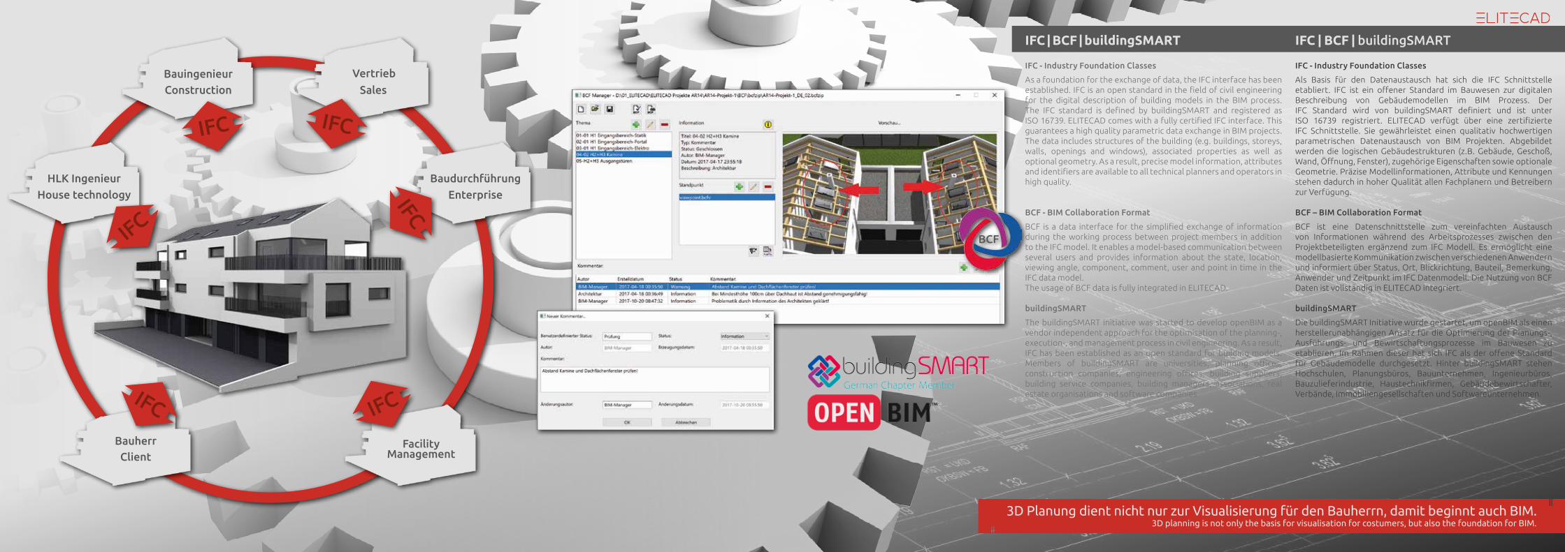
IFC - Industry Foundation Classes
Als Basis für den Datenaustausch hat sich die IFC Schnittstelle etabliert. IFC ist ein offener Standard im Bauwesen zur digitalen Beschreibung von Gebäudemodellen im BIM Prozess. Der IFC Standard wird von buildingSMART definiert und ist unter ISO 16739 registriert. ELITECAD verfügt über eine zertifizierte IFC Schnittstelle. Sie gewährleistet einen qualitativ hochwertigen parametrischen Datenaustausch von BIM Projekten. Abgebildet werden die logischen Gebäudestrukturen (z.B. Gebäude, Geschoß, Wand, Öffnung, Fenster), zugehörige Eigenschaften sowie optionale Geometrie. Präzise Modellinformationen, Attribute und Kennungen stehen dadurch in hoher Qualität allen Fachplanern und Betreibern zur Verfügung.
BCF – BIM Collaboration Format
BCF ist eine Datenschnittstelle zum vereinfachten Austausch von Informationen während des Arbeitsprozesses zwischen den Projektbeteiligten ergänzend zum IFC Modell. Es ermöglicht eine modellbasierte Kommunikation zwischen verschiedenen Anwendern und informiert über Status, Ort, Blickrichtung, Bauteil, Bemerkung, Anwender und Zeitpunkt im IFC Datenmodell. Die Nutzung von BCF Daten ist vollständig in ELITECAD integriert.
buildingSMART
Die buildingSMART Initiative wurde gestartet, um openBIM als einen herstellerunabhängigen Ansatz für die Optimierung der Planungs-, Ausführungs- und Bewirtschaftungsprozesse im Bauwesen zu etablieren. Im Rahmen dieser hat sich IFC als der offene Standard für Gebäudemodelle durchgesetzt. Hinter buildingSMART stehen Hochschulen, Planungsbüros, Bauunternehmen, Ingenieurbüros, Bauzulieferindustrie, Haustechnikfirmen, Gebäudebewirtschafter, Verbände, Immobiliengesellschaften und Softwareunternehmen.
Baudurchführung
VertriebBauingenieur
HLK Ingenieur
Bauherr
3D Planung dient nicht nur zur Visualisierung für den Bauherrn, damit beginnt auch BIM.
FacilityManagement
IFC - Industry Foundation Classes
As a foundation for the exchange of data, the IFC interface has been established. IFC is an open standard in the field of civil engineering for the digital description of building models in the BIM process. The IFC standard is defined by buildingSMART and registered as ISO 16739. ELITECAD comes with a fully certified IFC interface. This guarantees a high quality parametric data exchange in BIM projects. The data includes structures of the building (e.g. buildings, storeys, walls, openings and windows), associated properties as well as optional geometry. As a result, precise model information, attributes and identifiers are available to all technical planners and operators in high quality.
BCF - BIM Collaboration Format
BCF is a data interface for the simplified exchange of information during the working process between project members in addition to the IFC model. It enables a model-based communication between several users and provides information about the state, location, viewing angle, component, comment, user and point in time in the IFC data model. The usage of BCF data is fully integrated in ELITECAD.
buildingSMART
The buildingSMART initiative was started to develop openBIM as a vendor independent approach for the optimisation of the planning-, execution-, and management process in civil engineering. As a result, IFC has been established as an open standard for building models. Members of buildingSMART are universities, planning offices, construction companies, engineering offices, building suppliers, building service companies, building managers, associations, real estate organisations and software companies.
Construction
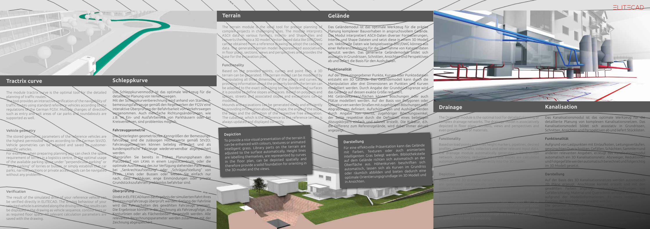
The terrain module is the ideal tool for precise planning of complex projects in challenging sites. The module interprets ASCII data in various formats, Interlis- and Shape files and converts them into a 3D model. Vector-based data like DXF/DWG can be obtained from a reference drawing to adopt the cadastre data. The generated terrain model is represented associatively in floor plans, sections, views and perspectives and provides the base for the excavation plan.
Functionality
Based on the provided points, curves and point files, a 3D terrain can be generated. The terrain model can be modelled by manipulating all three dimensions of the points and curves. By providing information about the property border, the terrain can be adapted to the exact size. Using terrain borders and surfaces it is possible to define slopes and places. Based on polygons and splines, streets and associated slopes and excavations can be modelled. Mounds and excavations can be generated easily and efficiently by providing information about the shape, the angle of the slope, the soles and the definition of the respective free excavation. The cubature, which is the difference to the reference terrain is always updated and displayed correctly.
Terrain Gelände
Das Geländemodul ist das optimale Werkzeug für die präzise Planung komplexer Bauvorhaben in anspruchsvollem Gelände. Das Modul interpretiert ASCII-Daten diverser Formatierungen, Interlis- und Shape Dateien und setzt diese in einem 3D Modell um. Vektorielle Daten wie beispielsweise DXF/DWG können aus einer Referenzzeichnung für die Übernahme von Katasterdaten genutzt werden. Das generierte Geländemodell bildet sich assoziativ in Grundrissen, Schnitten, Ansichten und Perspektiven ab und liefert die Basis für den Aushubplan.
Funktionalität
Auf der Basis eingegebener Punkte, Kurven oder Punktedateien entsteht ein 3D Gelände. Das Geländemodell kann durch die Manipulation aller drei Dimensionen an Punkten und Kurven modelliert werden. Durch Angabe der Grundstücksgrenze wird das Gelände auf dessen exakte Größe reduziert. Mit Geländekanten/-flächen können Böschungen oder auch Plätze modelliert werden. Auf der Basis von Polygonen oder Splinekurven werden Straßen mit zugehörigen Böschungen oder Abgrabungen definiert. Aufschüttungen und Aushübe werden durch Angabe von Umriss, zugehöriger Böschungswinkel, der Sohle respektive durch die Definition eines beliebigen Abzugskörpers einfach und schnell erstellt. Die Kubatur, d.h. die Differenz zum Referenzgelände, wird dabei immer aktuell angezeigt.
Kanalisation
Das Kanalisationsmodul ist das optimale Werkzeug für die detaillierte Planung von komplexen Kanalisationsnetzen. Das Kanalisationsmodell bildet sich assoziativ in Grundrissen, Schnitten, Ansichten und Perspektiven ab und liefert Stücklisten.
Funktionalität
Aufgrund von Lastpunkten mit Einlaufkoten, Leitungsverläufen, gewünschten Querschnitten, Gefällen, Schächten, Sammlern und anderen relevanten Angaben, erzeugt das Kanalisationsmodul automatisch ein 3D Kanalisationsnetz. Abzweiger, Reduktionen und Folgegefälle werden automatisch berechnet und folgerichtig im 3D Modell gesetzt.
Darstellung
Auf der Basis des 3D Kanalisationsnetzes werden automatisch 2D Pläne erzeugt, Anschlüsse korrekt erstellt und mit den gewählten Farben angelegt. Leitungsbeschriftungen wie Gefällerichtung, Material und Querschnitt erfolgen automatisch aufgrund der Modellinformationen. Es muss lediglich die Position der Beschriftung gewählt werden.Die gesamte 3D Kanalisation bildet sich auch numerisch in korrespondierenden Stücklisten ab und liefert Rohrlängen mit Querschnitten, Abzweiger, Schächte, Reduktionen und alle, für die Erstellung einer Kanalisation, erforderlichen Bauteile als Basis für Massenermittlungen und Ausschreibungen.
Schleppkurve
Das Schleppkurvenmodul ist das optimale Werkzeug für die detaillierte Planung von Verkehrswegen.Mit der Schleppkurvenberechnung wird anhand von Standard- bemessungsfahrzeuge gemäß den Regelwerken der FGSV eine interaktive Überprüfung der Befahrbarkeit von Verkehrswegen vorgenommen. Auch mehrfache Richtungsänderungen, wie z.B. im Ein- und Ausfahrbereich von Parkhäusern oder bei Kreisverkehren, sind problemlos möglich.
Fahrzeuggeometrie
Die hinterlegten geometrischen Kenngrößen der Bemessungs- fahrzeuge sind die zulässigen Höchstwerte gemäß StVZO. Fahrzeuggeometrien können beliebig verändert und als kundenspezifische Fahrzeuge wiederverwendbar abgespeichert werden. Überprüfen Sie bereits in frühen Planungsphasen den Platzbedarf von LKWs in einem Logistikzentrum, oder die optimale Ausnutzung des zur Verfügung stehenden Parkraums bei „Senkrechtaufstellung“ oder „Schrägaufstellung“ von PKWs, LKWs oder Bussen oder weisen Sie einfach nur nach, dass Parkhäuser, enge Einmündungen oder private Grundstückszufahrten problemlos befahrbar sind.
Überprüfung
Direkt in ELITECAD kann das Ergebnis der simulierten Fahrt Ihres Bemessungsfahrzeugs überprüft werden. Entlang der Fahrlinie wird das Fahrverhalten des gewählten Fahrzeugs animiert. Die Ergebnisse können in der Zeichnung als Fahrzeugfolge, als Konturlinien oder als Flächenbedarf dargestellt werden. Alle relevanten Berechnungsparameter werden zusammen mit der Zeichnung abgespeichert.
The module tractrix curve is the optimal tool for the detailed planning of traffic routes. The tool provides an interactive verification of the navigability of traffic routes using standard reference vehicles according to the regulations of the German FGSV. Multiple changes of direction such as entry and exit areas of car parks and roundabouts are supported as well.
Vehicle geometry
The stored geometric parameters of the reference vehicles are the highest permissible values according to the German StVZO. Vehicle geometries can be adapted and saved to customer-specific vehicles. For example, when preparing planning you can check the space requirement of lorries in a logistics centre, or the optimal usage of the available parking space under “perpendicular parking” or “angle parking” of lorries or busses, or simply establish that car parks, narrow junctions or private access roads can be navigated without any problems.
Verification
The result of the simulated drive of your reference vehicle can be verified directly in ELITECAD. The driving behaviour of your selected vehicle is animated along the driving line. The results can be displayed in the drawing as vehicle sequence, contour lines or as required floor space. All relevant calculation parameters are saved with the drawing.
Tractrix curve
Drainage
The Drainage module is the optimal tool for detailed planning of complex drainage networks. The drainage model is associatively depicted in floor plans, sections, views and perspectives and even provides bills of materials.
Functionality
Based on load points with inlet height markers, pipelines, desired profiles, slopes, shafts, collectors and other relevant input data, the drainage module automatically generates a 3D drainage network. Junctions, reducing pipes and slopes are calculated automatically and inserted correctly into the 3D model.
Depiction
Based on the 3D drainage network, 2D plans and connections are generated automatically and created with the correct colours. Piping labels like slopes, materials and profiles are done automatically with the help of the model information. Only the position of the label has to be selected. The entire 3D drainage is numerically mapped to the corresponding bill of materials and provides information about pipe lengths, profiles, junctions, ducts, reductions and all other parts necessary for creating a drainage as a basis for calculations of quantities as well as tendering.
Depiction
To provide a nice visual presentation of the terrain it
can be enhanced with colours, textures or animated
intelligent grass. Library parts on the terrain are
adjusted to the surface automatically. Height lines
are labelling themselves, are represented by curves
in the floor plan, can be depicted spatially and
therefore provide a solid foundation for orienting in
the 3D model and the views.
Darstellung
Für eine effektvolle Präsentation kann das Gelände
mit Farben, Texturen oder auch animiertem
intelligenten Gras belegt werden. Bibliotheksteile
auf dem Gelände richten sich automatisch an der
Oberfläche aus. Höhenkurven beschriften sich
automatisch, lassen sich als Kurven im Grundriss
oder räumlich abbilden und bieten dadurch eine
optimale Orientierungsgrundlage im 3D Modell und
in Ansichten.
Austria
Germany
Switzerland
France
Poland
Belgium
Russia
Greece
Turkey
Cyprus
Latvia
Lithuania
USA
Canada
Australia
© GmbHHamoderstraße 4
4020 Linz | Austria
www.elitecad.eu
Subscribe and like
Bund Deutscher BaumeisterArchitekten und Ingenieure e.V.
ELITECAD AR Features
All products
Free ELITECAD AR Study-version
Free ELITECAD AR Trial-versionKostenfreie ELITECAD AR Demoversion
Kostenfreie ELITECAD AR Studienversion
Alle Produkte
ELITECAD AR Features