Embed Size (px)
Citation preview

ARCHAEOLOGICAL SURVEY OF THE PROPOSED
AIRSTRIP AT ANDRANANGOO MINE SITE,
MELVILLE ISLAND, NT.
A report for URS
On behalf of Matilda Minerals
Begnaze Pty Ltd Christine Crassweller 8 Wanguri Tce Wanguri NT 0810 November 2006

SUMMARY
Begnaze was engaged by URS to locate any archaeological or historic sites or objects that may be impacted upon by the proposed airstrip directly south of the Andranangoo Mine operated by Matilda Minerals Ltd. The mine is located on the north coast of Melville Island, Northern Territory.
No archaeological or historic sites or objects were identified during the survey.
Therefore no further action is required for compliance with the provisions of the Northern Territory Heritage Conservation Act 1991.
2
TABLE OF CONTENTS
SUMMARY.......................................................................................................................... 2 1.0. INTRODUCTION ................................................................................................... 4
1.1. Consultancy Brief............................................................................................ 4 2.0 ENVIRONMENTAL BACKGROUND.................................................................. 4 3.0. CULTURAL BACKGROUND ............................................................................... 5
3.1. Historic record and ethnographic data............................................................. 5 3.2. Archaeological background............................................................................. 5 3.3. Predictive model for location of sites.............................................................. 6
4.0. FIELDWORK PROCEDURES ............................................................................... 6 4.1. Types of archaeological sites. ......................................................................... 6 4.2. Site definition. ................................................................................................. 7 4.3. Artefact identification...................................................................................... 7 4.4. Assessment of significance and heritage management principles................... 8
5.0. RESULTS ................................................................................................................ 8 6.0. CONCLUSIONS AND RECOMMENDATIONS .................................................. 9
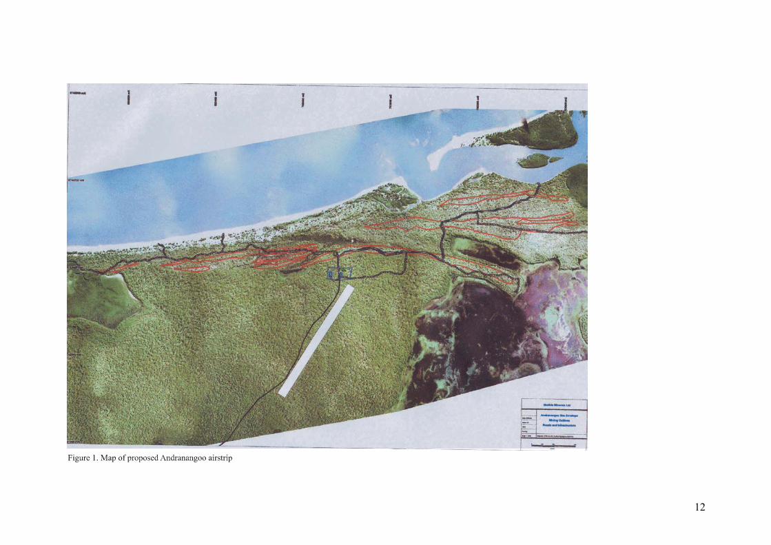
REFERENCES ............................................................................................................... 10 FIGURES Figure 1. Map of Andranangoo mine and proposed airstrip………………………………….12 PHOTOS Photo 1. Area of proposed Airstrip at Andranangoo………………………………...Front page
3

1.0. INTRODUCTION
This report describes the archaeological survey that was carried out over the areas to be disturbed by a proposed airstrip to be constructed directly south of the Andranangoo Mine site on the north coast of Melville Island (Figure 1). Melville Island is the larger island of the Tiwi Islands group located approximately 80 kilometres north of Darwin.
The airstrip will run for 1.5 kilometres in a north- south direction and be 150 metres wide. Begnaze Pty Ltd was engaged by URS for Matilda Mines to undertake the archaeological survey.
The archaeological survey took one day in November 2006 and was carried out by
Christine Crassweller.
1.1. Consultancy Brief. The aim of the study is to locate and record any archaeological objects or places to
ensure that the provisions of the Northern Territory Heritage Conservation Act 1991 are not contravened. The archeological survey will be carried out as follows: • The archaeological and heritage study will identify archaeological material within the designated areas by means of a survey carried out in a manner that will ensure the highest possible coverage of the area. • Any archaeological or heritage places, objects or classes of objects located during the survey will be recorded in such detail as to permit independent assessment of their significance. The location of any archaeological places and objects will include coordinates obtained by a Global Positioning System (GDA94). All sites will be named in order to identify the sites on the ground. • After assessing the significance of the archaeological places or objects that will be disturbed by the development, recommendations will be made regarding compliance with the provisions of the Northern Territory Heritage Conservation Act 1991. 2.0 ENVIRONMENTAL BACKGROUND
Melville Island is characterized by relatively low relief dominated by a partially dissected plateau rising to 100 m above sea level and interspersed by broad valleys, riverine lagoons and estuarine tidal flats (Matilda Minerals 2004). Unconsolidated Quaternary deposits that are intensely weathered and laterised on the surface with no hard rock exposure overlie the Cretaceous Moonkina Member of very fine sandstone and carbonaceous mudstone and siltstone and the Tertiary Van Dieman quartzose sandstone which is exposed at the northwestern tip of Melville Island (Matilda Minerals 2005: 8.1.1.). Thorley (1992) suggests that this would have restricted the range of opportunities for a source of the raw material needed in the manufacture of stone artefacts.
The vegetation in the region of the proposed airstrip consists of a typical Top End
community of Eucalyptus forests and woodlands dominated by Eucalyptus miniata and Eucalptus tetradonta. Between 500 metres to a kilometre north of the proposed airstrip are communities of Casuarina sp. and beach spinifex along the beach strand, pockets of vine thickets on sand dunes and swales, dense mangroves associated with the tidal creeks, and Melaleuca woodlands (Metcalfe 2005). Freshwater is present in a perennial spring upstream of the mining area on Andranangoo Creek. (URS 2005: 7.1).
The area is now used for recreational hunting and fishing by people from Milikapiti.
4
3.0. CULTURAL BACKGROUND 3.1. Historic record and ethnographic data Basedow (1907) and Foelsche (1882) give early accounts of subsistence activities of Aboriginal groups in the Top End of Australia and they describe swamps and lagoons as being focal points of subsistence activities providing sources of fish, geese, ducks, turtles, crocodiles and their eggs, shell fish and the roots of water lilies and rushes. Away from the lagoons, wallabies, snakes, goannas and other small game were hunted. On the Tiwi Islands Pye (1989:18) records that fish and wallabies were speared, goannas bandicoots, possums and snakes were caught by hand and throwing sticks were used to bring down geese and flying foxes. Major Campbell (1834:156) who was at the first European settlement on Melville Island at Fort Dundas described their weapons and tools.
“The spears are from ten to twelve feet long made of a heavy wood, and very sharp pointed: some are plain some are barbed……” “The waddies are used as weapons for attack, as well as for killing wild animals and birds. They are made of a heavy wood, twenty two inches long, one and a half in diameter, pointed sharp at one end….” . “Their canoes, water buckets and baskets were made of bark, sown with strips of split cane” Campbell (1834: 157) also observed that the Aboriginal inhabitants dispersed in the
dry season when they generally camped on sandy banks, amongst the mangroves or near swamps and in the wet season their camps were near the sea.
Contact was made with the Aboriginal mainlanders when the Melville Islanders
crossed to the mainland in canoes to capture women (Foelsch 1882) or to collect resources (Sunter 1997: 35-36).
The first continuous outside contact that the Aboriginals had on the Tiwi Islands was with the Macassan trepangers. While there are no recorded Macassan trepang sites on either Melville or Bathurst Island (Baker 1984: 11), Searcy (1909:45-46) stated that there are the remains of old fireplaces and smoke houses on the north of Melville Island and Pye (1989:7) noted that there is evidence that they visited the islands at Port Cockburn in the Aspley Strait near Garden Point and of wrecked praus in the area.
The first European settlement was made at Fort Dundas between 1824 and 1828 on
the east side of the Aspley Strait on Melville Island. Further contact with the Tiwi Islanders was hampered by their reputation for resisting intruders. The coast of the Tiwi Islands brought a modest boom in the pearling industry in the 1880s and in 1895. Joe and Harry Cooper went to Melville Island to shoot buffalo, the descendants of animals left after Fort Dundas. In 1906 the first catholic mission was set up on the south west of Bathurst Island at Ngui and the Tiwi Islands were declared an Aboriginal Reserve in 1941.
During World War 11 radar stations and camps were set up on Bathurst Island.
Melville Islanders formed a coast watch that patrolled the north coast of the island. They also set up food and supply caches at points along the coast in 1942 (Alford 2005).
3.2. Archaeological background
There are no Aboriginal archaeological sites on Melville Island listed on the Archaeological Site Register held at the NT Heritage Conservation Services or on any of the registers held by the Commonwealth Government. There are two possible Macassan sites,
5

both wells. Neither of these sites are located near the Andranangoo mine site (Bathgate and Lewis 1999). Crassweller (2005) located a small scatter of marine shell on a sand dune adjacent to the coast at Andranangoo. There has only been one other recorded archaeological survey on Melville Island (Thorley 1992). It covered only a small area and no archaeological material was identified. The lack of Aboriginal archaeological sites on the Tiwi Islands is a reflection of the lack of archaeological investigations on Melville Island and cannot be used to assume that the potential for the presence of archaeological material is low.
A review of prehistoric resources on the mainland adjacent to the Tiwi Islands
(Richardson 1996) revealed that sites recorded in the region included human skeletal remains, artefact scatters, stone arrangements and less frequently knapping floors and quarries. The most common site type are shell middens that are located within 300 metres from mangrove communities (Bourke 2000).
3.3. Predictive model for location of sites
As the geology of Melville Island indicates that there would have been a scarcity of a suitable raw material used in the manufacture of stone artefacts there is a low potential for locating numerous stone artefact scatters on the island. The ethnographic evidence indicates that camps were observed along the coastline and the remains of marine resources may indicate their presence. While there is a wide of range of other resources in the region of the airstrip the survey area itself consists of a weathered and laterised plain with no other landscape feature such as creeks or higher ground that could have been a focus for resource use in the past. Consequently there is only a low potential for the presence of archaeological material on the proposed airstrip.
There is also a low potential for the presence of historic material in the area as the
background research suggests that any historic activities in the area would have been fleeting. 4.0. FIELDWORK PROCEDURES
The proposed airstrip was surveyed by 30 pedestrian transects 150 metres long in an east west direction. This resulted in one transect approximately 50 metres apart across the area to be disturbed. The area surveyed was between:
1. NW corner 700550E 8742900N (Jahleel 5175 1:100,000 map sheet) 2. NE corner 700670E 8742830N 3. SW corner 699740E 8741610N 4. SE corner 699870E 8741540N
4.1. Types of archaeological sites. There are five types of sites previously recorded in the coastal regions in the top end and can broadly be defined as follows: • Artefact scatters. These may contain flaked or ground artefacts and hearthstones. They occur as surface scatters of materials or as stratified deposits when there has been repeated occupations. • Stone arrangements. These can range from simple cairns to more elaborate arrangements. These stone arrangements were used in ceremonial activities and represent sacred or totemic sites. Other stone arrangements were constructed for route or territory markers, the walls of huts, fish traps or small walls to stop water from entering a rock shelter or retain the floor. • Art sites include stencils and paintings where material was added to the rock surfaces, or engravings or poundings where the pictures or designs are produced by the removal of material from the rock surface.
6
• Stone quarries are generally sites where stone for flaked or edge ground artefacts have been extracted from an outcropping source of rock. • Shell middens contain mollusc material in the form of surface scatters or mounded deposits and represent the remains of human meals. 4.2. Site definition. An archaeological site is defined for this survey as a concentration of artefactual material, such as stone artefacts or shell, with an average density that is 5 times greater than the average density of the background scatter and there are more than ten artefacts or shells which cover an area of at least 2m2. A site will have an identifiable boundary where either artefact densities decrease to the extent as to be classified as background scatter or environmental features determine the boundary. A background scatter is generally a very low density, more or less continuous distribution of isolated artefacts or shell over the landscape. Although these artefacts do not constitute a site they will be given location details for research purposes. 4.3. Artefact identification. A requirement for a successful archaeological project involves the accurate identification of archaeological materials. For an object to be identified as a flaked object it needs to possess one or more of the following: • a positive or negative ring crack. • a distinct positive or negative bulb of percussion. • a distinct eraillure scar in an appropriate position below the platform. • definite remnants of flake scars on dorsal surface or ridges. Stone artefacts are divided into 4 main types (Hiscock 1984:128-129). They are defined as follows: • Cores are pieces of stone that have one or more negative scars and the absence of positive flake scars. • Unretouched flakes are pieces of stone that have been struck off another piece of stone and ideally possess platforms, positive bulbs of percussion, concentric ripples, ring cracks and /or eraillure scars on the ventral surface. • Retouched flakes are flaked flakes. They are identified by the presence of negative scars that must have been created after the ventral surface of the flake had been created. There will be either negative scars on the ventral surface or negative scars on the dorsal surface, which have been formed by the flake being hit on the ventral surface. • Flaked pieces are stone artefacts that have been formed by knapping but cannot be identified as either a core or a flake.
Other artefact and implement types that have been identified in the region are listed below following characteristics outlined by McCarthy (1976) and Holdaway and Stern (2004). • Unifacial points are flakes that have been retouched along the margins from one surface, either ventral or dorsal to give or enhance its pointed shape. They are sometimes symmetrical or leaf shaped. • Bifacial points are retouched along both ventral and dorsal surfaces of a flake to enhance or give the artefact its pointed shape. They may have the platform removed and the proximal end rounded. • Edge ground axes have been shaped by the process of flaking, pecking and polishing. They generally have only one working edge that has been ground to a sharp margin although occasionally they may have two leading edges.
7

• Grindstones are characterized by a worn and abraded surface or surfaces. There also may be a concave surface. • Hammerstones have use-wear on the surface in the form of abrasion, pitting, edge fracturing with some negative scarring. • Manuports are stone material that are not found naturally in an area and must have been carried in by humans. 4.4. Assessment of significance and heritage management principles
According to Sullivan and Bowdler (1984) archaeological significance means that it has scientific, archaeological or research value, that is, it has the potential to assist current or future research into problems of human history or other areas of enquiry. The Australian ICIMOS Charter for the Conservation of Places of Cultural Significance, otherwise known as the Burra Charter (Maquis-Kyle and Walker 1992:73) states that the scientific value or research potential of a place depends upon the importance of the data involved, on its rarity, quality or representativenesss, and on the degree to which the place or object may contribute to further substantial information. Therefore the significance of a site is firstly related to the intactness or integrity of a site, that is the state of preservation as well as the stratigraphic reliability of the cultural material. Secondly, the representativeness of a site is important either because a site is unusual or because the site has research potential when taken in conjunction with other sites. Thirdly a site may provide chronology extending back into the past.
When assessing the significance of historic sites their aesthetic, historic and social value
are also considered and consequently further criteria are used. These consist of:
• A site is associated with events, developments or cultural phases in human occupation.
• A site demonstrates a way of life, no longer practiced or in danger of being lost or of exceptional interest
• A site provides information contributing to a broader understanding of the history of human occupation.
It should be noted that historical significance would not necessarily be equated with
archaeological significance, as some events may leave nothing in the archaeological record. In order to effectively manage any archaeological and historic material recorded during the survey they have been ranked according to their perceived significance. 5.0. RESULTS
The survey area consisted of a plain that ranged from red soils with gravel patches, occasional low outcrops of ironstone and dominated by open Eucalypt forests in the south, to silty, sandy soils, patches of gravel and low ironstone outcrops and dominated by tall open woodlands in the north. The understorey consisted of Cycads, Pandanus and Livistonia palms. The average surface visibility was 85% and ranged from 50% when leaf litter was frequent to 95% in the open burnt areas.
No archaeological sites or objects were identified during the survey. The absence of
any archaeological material corresponded to the model that predicted the lack of any particular resource that could have attracted people to the area in the past would result in a low potential for the presence of archaeological material.
8

6.0. CONCLUSIONS AND RECOMMENDATIONS
As the survey did not locate any archaeological or historic material in the area to be disturbed by the proposed airstrip at Andranangoo no further action is required to ensure that there is compliance with the provisions of the Northern Territory Heritage Conservation Act 1991.
9

REFERENCES Alford, B. 2005. A report on field surveys to determine the existence of any European cultural
sites for a proposed mineral extraction venture, Melville Island NT. A report for URS on behalf of Matilda Minerals Ltd
Baker, R. 1984. Macassan site survey and bibliography. Unpublished report to the Museums
and Art Galleries of the Northern Territory, Darwin Basedow. H. 1907 Anthropological notes on the western coastal tribes of the Northern
Territory of south Australia. Transactions and Proceedings and Report of the Royal Society of South Australia, 31:1-55.
Bathgate, J. & Lewis, D. 1999 Nginaki Ngirramini Ngini Tiwi Amintiya Mamurruntawi.This
is a story about Tiwi and non-Tiwi. A report for the National Trust (N.T.) and the Tiwi Land Council.
Bourke, P. 2000. Late Holocene indigenous economies of the tropical Australian coast: an
archaeological study of the Darwin region. An unpublished PhD thesis, Department of Anthropology, NTU, Darwin.
Campbell, L.A. 1834. Geographical memoir of Melville Island and Port Essington, on the
Couburg Peninsula, northern Australia; with some observations on the settlements which have been established on the north coast of New Holland. Journal of the Royal Geographic Society of London. Vol.4:129-181.
Crassweller, C. 2005. Archaeological surveys at Lethbridge West and Andranangoo West,
Melville Island, NT.A report for URS on behalf of Matilda Minerals Ltd. Foelsche, P. 1882. Notes on the Aborigines of North Australia. Transactions of the Royal
Society of South Australia, 5:1-18. Hiscock, P. 1984. A preliminary report on the stone artefacts from Colless Creek Cave,
Northwest Queensland. Queensland Archaeological Research, 1:120-151. Holdaway, S. and Stern, N. 2004 A Record in Stone. The Study of Australia’s Flaked Stone
Artefacts. Museum Victoria and AIATSIS. Matilda Minerals 2004 Mining Management Plan 2004/2005 for Tiwi Islands Exploration
Programme Metcalfe, K. 2005 Tiwi Islands Project Flora Survey – Lethbridge and Andranangoo
prospects. An unpublished report for URS on behalf of Matilda Minerals Ltd. Maquis-Kyle, P. and M. Walker, 1992. The Illustrated Burra Charter: Making good
decisions about the care of important places. Australian Heritage Commission, Canberra.
McCarthy, FD 1976. Australian Aboriginal Stone Implements. The Australian Museum Trust,
Canberra. Pye, J. 1989. The Tiwi Islands. Colemans Printing, Darwin.
10

11
Richardson, N. 1996. Archeological site survey and documentation. Darwin region. An Unpublished report to the Australian Heritage Commission
Searcy, A. 1909. In Tropical Australia. George Roberston and Co. London Sullivan, ME. and S. Bowdler 1984. Site Surveys and Significance Assessment in Australian
Archaeology. Department of Prehistory, Research School of Pacific Studies, ANU, Canberra.
Sunter, G.H. 1997. Adventures of a Trepang Fisher. Hesperian Press Western Australia. Thorley, P. 1992. An archaeological survey of the proposed “Tiwi Islands HCRC”, NT. A
report for Telecom Australia. URS 2005. Andranangoo Creek West and Lethbridge Bay West Mineral Sands Mining
Project. Draft Environmental Impact Statement. Volume 1. Main Report. Prepared for Matilda Minerals Ltd.
12