Embed Size (px)
Citation preview

ARCBlAEOLOGICAL INVl3STIGATIONS OF
SITE 44CF7, FALLI1MG CREEK m y
CHESTEmLD COUNTY, VIRGINIA
Virginia Department of Historic Resources Survey and Planning Report Series No. 4
Prepared by:
William and Mary Center for Archaeological Research Department of Anthropology
The College of William and Mary Williamsburg , Virginia 23 1 87
Project Directors Donald W. Linebaugh
Dennis B. Blanton
Authors Thomas F. Higgins I11 Charles M. Downing Donald W. Linebaugh Antony F. Opperman
E. Randolph Turner I11

The preparation of Archaeolo~ical Investigations of Site 44CF7. Falling Creek Iron Works.. . was financed in part with federal funds from the U. S. Department of the Interior, through the Department of Historic Resources, Commonwealth of Virginia. Under Title VI of the Civil Rights Act of 1964 and Section 504 of the Rehabilitation Act of 1973, the U. S. Department of the Interior prohibits discrimination on the basis of race, color, national origin or handicap in its federally assisted programs. If you believe that you have been discriminated against in any program or activity described herein, or if you desire further information, please write to: Office of Equal Opportunity, U. S. Department of the Interior, Washington, D. C. 20240. The contents and opinions of this book do not necessarily reflect the views or policies of the Department of the Interior, nor does any mention of trade names or commercial products constitute endorsement or recommendation by the Department of the Interior. The Virginia Department of Historic Resources, in accordance with the Americans with Disabilities Act, will make this publication available in braille, large print or audio tape upon request. Please allow 4-6 weeks for delivery.

MANAGEMENT SUMMARY
From October 11 through November 10, 1993, staff members from the William and Mary Center for Archaeological Research (WMCAR) conducted archaeological investigations at Site 44CF7, in Chesterfield County, Virginia. This investigation was undertaken for the Virginia Department of Historic Resources (VDHR) as part of the VDHR's long-term effort to identify and evaluate Virginia Company-period (1 607- 1624) sites. The purpose of this study was to evaluate the site's eligibility for nomination to the National Register of Historic Places. This work sought to verify archaeological resources reportedly associated with the seventeenth-century ironworks (MacCord 1964), to assess the present integrity of the site, and to define the entire site area through additional survey and testing in an attempt to identify potentially related components, such as workers7 housing.
Site 44CF7 was previously investigated by Howard A. MacCord, Sr., with the assistance of members of the Archeological Society of Virginia, during the summer of 1963. MacCord identified several features/deposits related to the ironworks including thick charcoal and slag deposits, a foundation, possibly an auxiliary structure such as a chafery, and rock cuts that may have carried posts for a dam and flume. In addition, MacCord found artifactual evidence including slag-coated bricks, chisels, and iron spikes (MacCord 1964:9-12). Staff members of the VDHR also investigated the site through additional historical research and field checking, concurring that MacCord has identified the early ironworks site.
The results of current research agree with most of the findings of previous studies at 44CF7. The research indicates that 44CF7 is the location of an ironworks established by the Virginia Company on Falling Creek in 16 19 and that it contains significant archaeological resources. Although limited testing found no conclusive evidence of structures or domestic areas, thick slag and charcoal deposits associated with the ironworks were identified adjacent to the current access road near the southern boundary of the site. These deposits are relatively intact. Similar deposits have been documented on other ironworks sites (i.e., Saugus) and are usually associated with furnaces and related structures. As a result of both historical and archaeological investigations summarized in this report, the Falling Creek Ironworks recently was nominated for listing on the Virginia Landmarks Register and National Register of Historic Places.


Authors:
Graphics and Report Production Editors:
Graphics Contributor:
Historical Researcher:
Artifact Inventory:
Copy Editor:
REPORT CONTRIBUTORS
Thomas F. Higgins I11 Charles M. Downing Donald W. Linebaugh Antony IF. Opperman E. Randolph Turner I11
Donald W. Linebaugh David W. Lewes
John D. Roberts Yujin Asai
Charles M. Downing
Deborah L. Davenport Veronica Deitrick
Katherine Rawson


TABLE OF CONTENTS
Page
Management Summary . . . . . . . . . . . . . . . . . . . . . . . . . . . . . . . . . . . . . . . . . . . . . . . . . . . . ii
- 0 . Report Contributors . . . . . . . . . . . . . . . . . . . . . . . . . . . . . . . . . . . . . . . . . . . . . . . . . . . . 111
Table of Contents . . . . . . . . . . . . . . . . . . . . . . . . . . . . . . . . . . . . . . . . . . . . . . . . . . . . iv
List of Figures . . . . . . . . . . . . . . . . . . . . . . . . . . . . . . . . . . . . . . . . . . . . . . . . . . . . v
. . . . . . . . . . . . . . . . . . . . . . . . . . . . . . Chapter 1: Background Information (Thomas F. Higgins 111) 1
Chapter 2: Historical Context (Charles M. Downing, Donald W. Linebaugh, Antony F. Opperman, and E. Randolph Turner 111) . . . . . . . . . . . . . . . . . . . . . 5
Chapter 3: Research Design and Methods (Thomas F. Higgins 111) . . . . . . . . . . . . . . . . . . . . . . . . . . 23
. . . . . . . . . . . . . . . Chapter 4: Research Results and Archaeological Evaluation (Thomas F. Higgins 111) 33
. . . . . . . . . . . . . . . . . . . . . . . . . . . . . . . . . Chapter 5: Research Summary (Thomas F. Higgins 111) 57
References Cited . . . . . . . . . . . . . . . . . . . . . . . . . . . . . . . . . . . . . . . . . . . . . . . . . . . . 61
Appendix A: Artifact Inventory
Appendix B: Archaeological Site Inventory Form
Appendix C : Roland W. Robbins 195 1 Field Notes (from Saugus Daily Log)


LIST OF FIGURES
Page
1 Project area location . . . . . . . . . . . . . . . . . . . . . . . . . . . . . . . . . . . . . . . . . . . . . . . . . . 1
2 Project area and environs (U.S. Geological Survey [USGS] 7.5.minute Drewrys Bluff topographic quadrangle 1987) . . . . . . . . . . . . . . . . . . . . . . . 2
3 Plan of current investigations showing archaeological areas. sites. and locations . . . . . . . . . . . . . . 3
4 Map of the Ampthill and Chesterhill Lands (Winfrey 1802) . . . . . . . . . . . . . . . . . . . . . . . . . . 8
. . . . . . . . . . . . . . . . . . . . . . . . . . . . . . . . . . . . . 5 Map of Chesterfield County (Wood 1820) 9
6 Plat of Ampthill Farm (Le Prade 1838) . . . . . . . . . . . . . . . . . . . . . . . . . . . . . . . . . . . . . . 11
7 Map of Chesterfield County (Gilmer 1863) . . . . . . . . . . . . . . . . . . . . . . . . . . . . . . . . . . . . 12
8 Plat of Parcel No . 3 of Chesterhill property in 1908 (CCR DB 1 16:306) . . . . . . . . . . . . . . . . . . 13
9 Site 44CF7. falls and mill. looking west (October 1993) . . . . . . . . . . . . . . . . . . . . . . . . . . . . 13
10 Looking west from railroad bridge. 44CF7 area to left of photo and gristmill ruins about 700 ft . west along the north bank of Falling Creek. March 29. 195 1 . Note that vegetation is similar to present conditions (Photo by Roland Wells Robbins) . . . . . . . . . . . . . . . . 15
11 Roland W . Robbins and Frederick Pease standing along access road to marina at "controversial site of Falling Creek. " February 22. 1962 (Photo by Roland Wells Robbins) . . . . . . . . . . . . . . . . . . . . 17
12 Site 44CF7. plan of previous excavations (MacCord 1964:3) . . . . . . . . . . . . . . . . . . . . . . . . . 18
13 Site 44CF7. plan of rock cuts recorded during previous excavations (MacCord 1964:8) . . . . . . . . . 19
14 "Supposed site of ironworks" looking northeast. Falling Creek. VA. February 24. 1968 . Note the basketball and volleyball courts on the site area between the road and the creek (Photo by Roland Wells Robbins) . . . . . . . . . . . . . . . . . 20
15 "Supposed site of ironworks" looking northwest toward falls. Falling Creek. VA. February 24. 1968 . Note the apartment buildings in background and cleared site area in foreground (Photo by Roland Wells Robbins) . . . . . . . . . . . 21
16 Conjectural drawing of Saugus Ironworks (Hartley 1957:facing p . 113) . . . . . . . . . . . . .. . . . . . 25
. . . . . . . . . . . . . . . . . . . . . . . . . 17 Conjectural drawing of Marlboro Furnace (Salmon 1986:24) 25
18 Excavation of waterwheel and timber-lined pit from . . . . . . . . . . . . . . . . . . . . . . . . . waterlogged deposits at Saugus (Robbins and Jones 195957) 26
. . . . . . . . . . . . . . . . . . . . 19 Area C. plan showing 44CF7. Location 2. shovel tests. and test units 29


Area A. plan showing Location 1 and shovel tests . . . . . . . . . . . . . . . . . . . . . . . . . . . . . . . . 30
Area B. plan showing Site 44CF506 and shovel tests . . . . . . . . . . . . . . . . . . . . . . . . . . . . . . 31
. . . . . . . . . . . . . . . . . . . . . . . . . . . . . . . . . . . . . . . . . . . Area A. profile of Shovel Test 2 34
. . . . . . . . . . . . . . . . . . . . . . . . . . . . . . . . . . Area A. Location 1. profile of Shovel Test 21 34
. . . . . . . . . . . . . . . . . . . . . . . . . . . . . . . . . . . . . . . . . . Area A. profile of Shovel Test 46 35
. . . . . . . . . . . . . . . . . . . . . . . . . . . . . . . . . . . . . . . . . . Area A. profile of Shovel Test 41 35
Area B. profile of Shovel Test 53 . . . . . . . . . . . . . . . . . . . . . . . . . . . . . . . . . . . . . . . . . . 36
Area B. profile of Shovel Test 48 . . . . . . . . . . . . . . . . . . . . . . . . . . . . . . . . . . . . . . . . . . 36
Area B. Site 44CF506. profile of Shovel Test 61 . . . . . . . . . . . . . . . . . . . . . . . . . . . . . . . . . 37
. . . . . . . . . . . . . . . . . . . . . . . . . . . . . . . . . . . . . . . . . . Area C. profile of Shovel Test 155 37
Area C. profile of Shovel Test 94 . . . . . . . . . . . . . . . . . . . . . . . . . . . . . . . . . . . . . . . . . . 38
Area C. profile of Shovel Test 164 . . . . . . . . . . . . . . . . . . . . . . . . . . . . . . . . . . . . . . . . . 38
. . . . . . . . . . . . . . . . . . . . . . . . . . . . . . . . . . . . . Site 44CF7. distribution of slag by count 39
. . . . . . . . . . . . . . . . . . . . . . . . . . . . . . . . . . Site 44CF7. distribution of slag by weight (g) 39
Site 44CF7. profile of Shovel Test 86 . . . . . . . . . . . . . . . . . . . . . . . . . . . . . . . . . . . . . . . 40
Site 44CF7. profile of Shovel Test 132 . . . . . . . . . . . . . . . . . . . . . . . . . . . . . . . . . . . . . . . 40
. . . . . . . . . . . . . . . . . . . . . . . . . . . . . . . . . . . . . . . Site 44CF7. profile of Shovel Test 101 41
Site 44CF7. profile of Shovel Test 91 . . . . . . . . . . . . . . . . . . . . . . . . . . . . . . . . . . . . . . . 41
. . . . . . . . . . . . . . . . . . . . . . . . . . . . . . . . . . . . . . . Site 44CF7. profile of Shovel Test 112 42
. . . . . . . . . . . . . . . . . . . . . . . . . . . . . . . . . . . . . . . Site 44CF7. profile of Shovel Test 107 42
. . . . . . . . . . . . . . . . . . . . . . . . . . . . . . . . . . . . . . . Site 44CF7. profile of Shovel Test 109 43
. . . . . . . . . . . . . . . . . . . . . . . . . . . . . . . . . . . . . . . Site 44CF7. profile of Shovel Test 116 43
. . . . . . . . . . . . . . . . . . . . . . . . . . . . . . . . . . Site 44CF7. east profile of Test Units 1 and 3 44
. . . . . . . . . . . . . . . . . . . . . . . . . . Site 44CF7. plan of Features 1 and 2 in Test Units 1 and 3 46
. . . . . . . . . . . . . . . . . . . . . . . . . . . . . . . . . Site 44CF7. north profile of Test Units 1 and 3 47
. . . . . . . . . . . . . . . . . . . . . . . . . . . . . . . . . . . . . . . Site 44CF7. east profile of Test Unit 5 47


46 Site 44CF7. plan and west profile of Feature 4 in Test Unit 5 . . . . . . . . . . . . . . . . . . . . . . . . . 48
. . . . . . . . . . . . . . . . . . . . . . . . . . . . . . . . . . . . . . 47 Site 44CF7. south profile of Test Unit 4 49
. . . . . . . . . . . . . . . . . . . . . . . . . . . . . . . . . . . . . . 48 Site 44CF7. north profile of Test Unit 8 49
49 Site 44CF7. west profile of Test Unit 2 . . . . . . . . . . . . . . . . . . . . . . . . . . . . . . . . . . . . . . 50
50 Site 44CF7. south profile of Test Unit 6 . . . . . . . . . . . . . . . . . . . . . . . . . . . . . . . . . . . . . . 51
51 Site 44CF7. west profile of Test Unit 6 . . . . . . . . . . . . . . . . . . . . . . . . . . . . . . . . . . . . . . 52
52 Site 44CF7. west profile of Test Unit 7 . . . . . . . . . . . . . . . . . . . . . . . . . . . . . . . . . . . . . . 52
. . . . . . . . . . . . . . . . . . . . . . . . . . . . . . . . . . . . . . . . . 53 Site 44CF7. plan showing rock cuts 54
54 Site 44CF7. Feature 30 rock cut. plan view. looking west . . . . . . . . . . . . . . . . . . . . . . . . . . . 55
55 Site 44CF7. Features 13. 14. and 15 rock cuts. plan view . . . . . . . . . . . . . . . . . . . . . . . . . . . 56
vii

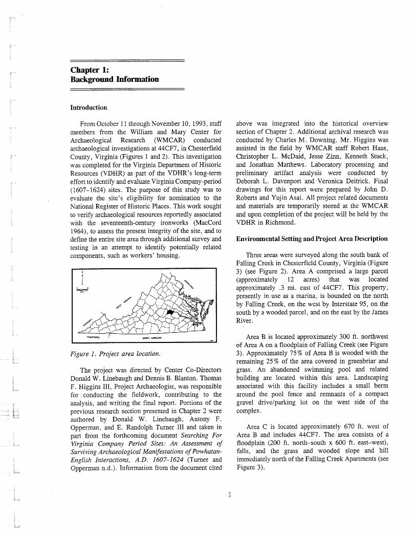
Chapter 1: Background Information
Introduction
From October 11 through November 10, 1993, staff members from the William and Mary Center for Archaeological Research (WMCAR) conducted archaeological investigations at 44CF7, in Chesterfield County, Virginia (Figures 1 and 2). This investigation was completed for the Virginia Department of Historic Resources (VDHR) as part of the VDHR7s long-term effort to identify and evaluate Virginia Company-period (1607-1624) sites. The purpose of this study was to evaluate the site's eligibility for nomination to the National Register of Historic Places. This work sought to verify archaeological resources reportedly associated with the seventeenth-century ironworks (MacCord 1964), to assess the present integrity of the site, and to define the entire site area through additional survey and testing in an attempt to identify potentially related components, such as workers7 housing.
Figure I . Project area location.
The project was directed by Center Co-Directors Donald W. Linebaugh and Dennis B. Blanton. Thomas F . Higgins 111, Project Archaeologist, was responsible for conducting the fieldwork, contributing to the analysis, and writing the final report. Portions of the previous research section presented in Chapter 2 were authored by Donald W. Einebaugh, Antony F. Opperman, and E. Randolph Turner I11 and taken in part from the forthcoming document Searching For Virginia Company Period Sites: An Assessment of Surviving Archaeological Manifestations of Powhatan- English Interactions, A. D. 1607-1 624 (Turner and Opperman n.d.). Information from the document cited
above was integrated into the historical overview section of Chapter 2. Additional archival research was conducted by Charles M. Downing. Mr. Higgins was assisted in the field by WMCAR staff Robert Haas, Christopher L. McDaid, Jesse Zinn, Kenneth Stuck, and Jonathan Matthews. Laboratory processing and preliminary artifact analysis were conducted by Deborah L. Davenport and Veronica Deitrick. Final drawings for this report were prepared by John D. Roberts and Yujin Asai. All project related docunlents and materials are temporarily stored at the WMCAR and upon completion of the project will be held by the VDHR in Richmond.
Environmental Setting and Projed Area Description
Three areas were surveyed along the south bank of Falling Creek in Chesterfield County, Virginia (Figure 3) (see Figure 2). Area A comprised a large parcel (approximately 12 acres) that was located approximately .3 mi. east of 44CF7. This property, presently in use as a marina, is bounded on the north by Falling Creek, on the west by Interstate 95, on the south by a wooded parcel, and on the east by the James River.
Area B is located approximately 300 ft. northwest of Area A on a floodplain of Falling Creek (see Figure 3). Approximately 75 % of Area B is wooded with the remaining 25% of the area covered in greenbriar and grass. An abandoned swimming pool and related building are located within this area. Landscaping associated with this facility includes a small berm around the pool fence and remnants of a compact gravel drivelparking lot on the west side of the complex.
Area C is located approximately 670 ft. west of Area B and includes 44CF7. The area consists of a floodplain (200 ft. north-south x 600 ft. east-west), falls, and the grass and wooded slope and hill immediately north of the Falling Creek Apartments (see Figure 3).
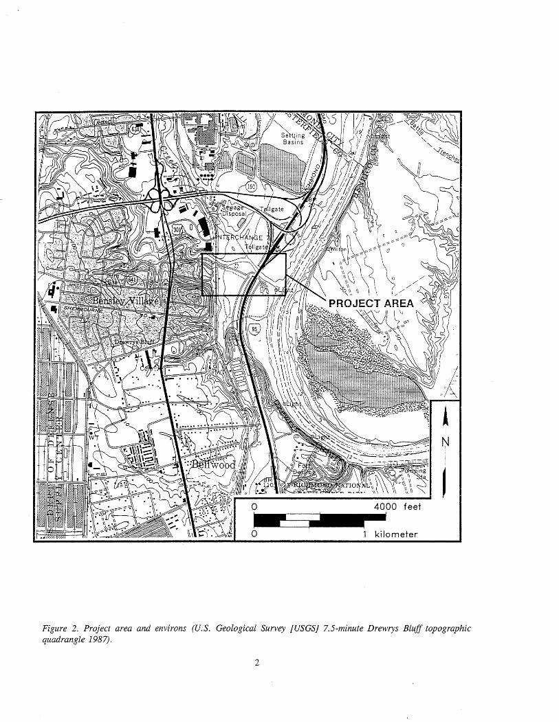
Figure 2. Project area and environs (U.S. Geological' Survey [USGS] 7.5-minute Brewrys Bluff topographic quadrangle 1987).

Figure 3. Plan of current investigations showing archaeological areas, sites, and locations.
Site 44CF7, which is located in Area C, lies approximately 6 mi. south of Richmond. The site encompasses approximately 3.5 acres. The main part of the site is located on the south stream bank just below the falls of Falling Creek and approximately .75 mi. west of the creek's confluence with the James River (see Figure 2). Howard A. MacCord, Sr., who investigated the site in 1963, noted that it
lies in a narrow valley with steep hills abutting on the creek on the north side. On the west, the creek winds through a still more narrow valley before tumbling over two rough ledges of granitic rock which form the fall line and which gave the creek its name. On the south side,
steep hills lie about 150 feet from the creek and extend eastward until the hills diminish and the valley widens and merges into the James River Floodplain (MacCord 1964:2).
The project area is located in the Coastal Plain physiographic province of Virginia but is only about 3 mi. east of the transition to the Piedmont Uplands. Soils within the project area consist predominantly of Chewacla loam, which is found along floodplains along streams, and Fluvaquents, which is mixed alluvium found in Pow-lying areas adjacent to streams and major drainageways (Hodges 1978). Elevations in the project area range from approximately 10 to 50 ft. above mean sea level (amsl).


Chapter 2: Historical Context
Historical Overview
The history of the Falling Creek Ironworks is better known than that of most English settlements established during the Virginia Company period. This is due in large measure to the research of Charles Hatch and Thurlow Gates Gregory (Gregory 1957, 1960; Hatch and Gregory 1962), whose combined works provide considerable historical and technological detail.
The Falling Creek Ironworks is recognized as the first successful, integrated iron production facility in English North America. The exploitation of natural commodities was a principal objective of the Virginia Company of London from the earliest period of their Virginia venture. Samples of iron ore were returned to England with Captain Christopher Newport after the first supply in 1608 and again after the second supply later that year. The latter material, possibly obtained from the Falling Creek area, was apparently processed into iron with considerable success. Archaeological and historical evidence suggests that limited forge experimentation was also conducted in Virginia during the Virginia Company period (Cotter 1958: 1 1).
The onset of Sir Edwin Sandys' term as treasurer of the Virginia Company in London in 16 18 resulted in a renewed commitment to industrial development, particularly to iron production. In cooperation with Southampton Hundred plantation, an expedition of 80 persons under the command of a Captain Blewett was dispatched "wth all manner of prouisions for the settinge vp of an Iron Worke in Virginia" (Kingsbury 1906:587-588). Unfortunately, the high mortality rate resulted in the death of Blewett and his principal associates upon their arrival. The importance of the
site for the facility that probably had been selected by Blewett7s party because there was "excellent water and good oare" (Kingsbury 1933: 128- 129).
Despite the death at sea of "the Chiefe men for the Iron worke," the relief supply apparently succeeded in completing a portion of the ironworks in 1620 and producing a sample of iron prior to the arrival of three replacements later that year (Kingsbury 1906:472, 1933:240). In addition to the three replacement workers, by late June 1621 a fourth individual, John Berkeley (along with his son, Maurice, and three family servants), was dispatched to Virginia as Master of the ironworks with 20 men skilled in ironworking. Berkeley's party specifically included workers to "be employed upon the Furnace" and "upon the Forge," explicit evidence for an integrated operation producing both cast and wrought iron (Kingsbury 1906:472). Correspondence received in England from Berkeley indicated his considerable satisfaction with the location of the facility at "The falling Creeke" and that increased production would be achieved by spring of 1622 (Kingsbury 1933:548).
The continued development of the ironworks by Berkeley's party was also linked to a shipbuilding venture proposed by the Virginia Company to commence during the spring of 1622. In August 162 1, the governor and Council were directed to commence cutting timber during the winter in anticipation of the arrival of a "Shipwright wth a ginge of thirty or fortie Carpenters and boatwrights" the following spring (Kingsbury 1933 :496-497). The colonists were particularly directed to choose the site to be timbered
iron-making venture, however, is reflected by the with "respect vnto the nearness of the iron works, and subsequent provision in 1619 of a 150 person relief of the Saw Mills" (Kingsbury 1933:496-497). This supply "to set vp three Iron workes; proofe hauing comment suggests that the Falling Creek Ironworks been made of the extraordinary goodnesse of that iron" may have also included a sawmill, or that such a (Kingsbury 1933: 1 15- 1 18). It should be recognized that facility was located nearby. the "three Iron workes" almost certainly represented the Company's intent of a single three-component The production of iron was abruptly halted by the facility of blast furnace, refinery, and chafery (forge?) Powhatan/English conflict of 1622. Twenty-seven rather than three separate plants (Hatch and Gregory persons were slain at the ironworks, including John 1962:269). The relief supply would be placed upon a Berkeley (Kingsbury 1933 :565). Beverley (1 94754)

and Stith (1965:218) reported the escape of two children, indicating a total resident population of 29 persons (23 men, 2 women, and 4 children). The number of men is consistent with the skilled labor force that accompanied Berkeley to Virginia and is indicative of the level of effort needed to maintain production once the facility had been established. The slaughter of the inhabitants of the Falling Creek settlement was compounded by the thorough destruction of the facility by the Indians (Beverley 194754-55; Stith 1965 :218). Though there was considerabl~ ; - to rno t in m n o t ~ R 1 ; o h ; m n
Ib 1 1 1 L b L b J L 111 I b ~ J L U U I l J l l l l l f j
the operation through the end of the Virginia Company period, the level of destruction effectively terminated this apparently successful endeavor. Alexander Spotswood7s "Tuba1 Furnace" was to be the next successful iron furnace in colonial Virginia, established over a century later.
There have been several industrial and commercial enterprises along Falling Creek near 44CF7 since the demise of the Virginia Company Ironworks in 1622. According to a 1962 article by Charles E. Hatch and Thurlow Gates Gregory, the English entrepreneur Sir John Zouch attempted and failed in 1634 to re-establish the ironworks on land he had been granted at Falling Creek. Long after Zouch's death in England, his land escheated. While holding office as the colony's escheator, William Byrd I had declared the property to be "King's land" and eventually came to own it. Hatch and Gates cite the nineteenth-century historian R. A. Brock who stated that Byrd purchased the Falling Creek tract from Abel Gower (Hatch and Gregory 1962:279). In Nell Marion Nugent7s Cavaliers and Pioneers (1992), mention is made of a 4,250-acre patent in Henrico County granted to Byrd in 1682. The Falling Creek site was situated in Henrico until the creation of Chesterfield County in 1749. No physical description of the land is given save that it was situated in Henrico County. According to Nugent's abstract, the immense tract was the same that "John Zouch, Esqr. died seized of & which was found to escheat, as by inquisition under William Bird, Esqr., Escheator. " The patent explains that the land had been "Granted to Abell Gower, who assigned to said Bird" (Nugent 1992:11:229). The document presents no dates for these past transactions and seems to suggest that the newly escheated property was granted directly to Gower and then to Byrd. Since no description of the Zouch patent was apparently ever recorded, it is important to consider that other patents were issued in the area which also came to be owned by William Byrd 1.
In 1639, a surgeon named Thomas Mathews received a patent for 1,100 acres on the north bank of Falling Creek which probably lay directly across from 44CF7. Mathews7 patent bore "westerly on the falls." According to the slightly skewed compass directions, the Mathews patent was bounded "North on the river, South on the woods, and East upon the [Falling] Creek" (Nugent 1992:I: 109). In 1646, Jeremiah Blackman, a mariner, obtained 1,337 acres on the south side of Falling Creek. By 1665, Blackman had died zld his so2 then sold the patent to Richard Ward. At that time the Blackman-Ward patent ran "along the river N.N. W. then N.W. by N. & c." which clearly indicates that the boundary line was being described as it extended upriver. The survey line continued "to the mouth of Falling Creek, [and] up the Creek W .N. W. & c. " (Nugent 1992:I: 103,447). No indication is given as to how far the line extended up Falling Creek. The Mathews patent recorded in 1639 and the Blackman- Ward patent recorded in 1665 mention neither a shared boundary with Zouch nor do they mention him as a previous owner.
In 1683, William Byrd I obtained three patents in Henrico County totalling almost 8,000 acres. The first two of the three 1683 patents listed included extensive acreage in what was to become Chesterfield County and within the original bounds of the city of Richmond. The third of the patents contained 1,820 acres "in Virina Parish, on the South side of James River" and comprised at least part of what would become Byrd9s Falling Creek plantation. Byrd had purchased 300 acres of the total from William Gyles and the "residue" of 1,520 acres had been designated as "King's land." The 1683 survey of the Falling Creek property began "at a corner in Grindon's Run [now Grindall Creek]" and followed the eastern boundaries of three landowners before "crossing the main branch of Falling Creek nigh Seth Ward, to the mouth of Spring Run" (Nugent 1992:11:305). There is no mention of Byrd7s 1683 Falling Creek land grant bordering the James River.
From the vague boundary information provided in these records, no absolute connection can be drawn between the patents. If Sir John Zouch initiated (or at least planned) his ironworks on his own land and at the same location as the Virginia Company's operation and if these correspond to 44CF7, then Jeremiah Blackman and Richard Ward also may have owned the property before it was granted to Abel Gower and sold to

William Byrd I. It appears equally likely that the Blackman-Ward patent did not derive from the Zouch patent. If that were the case, then the Zouch patent probably had no river frontage and was only "connected" with the James River shore under the ownership of William Byrd I.
By 1683, William Byrd I apparently owned in excess of 6,000 acres in the Falling Creek area. In 1687 and again in 1693, Byrd at least contemplated erecting an iron-making facility at the site (Hatch and Gregory 1962:280). William Byrd I1 inherited his father's Falling Creek plantation and made several references to it in his "Secret Diary" covering the years 1709 through 17 12. From Byrd's entries it seems he employed several slaves as well as white laborers and artisans at Falling Creek. There Byrd operated a saw mill and tannery (Byrd 1941:121, 227, 529).
In 1732, William Byrd I1 visited his mills on the south bank of the James River across from the present site of Richmond. Finding that his mills were "both" idle "for the want of Water," he ordered his workmen to "make use of the lowness ... for blowing up the Rocks at the Mouth of the Canal." Byrd directed his "Engineers" to drill holes in the rocks and pack each with a three-ounce powder cartridge. The scheme did not work as well as hoped and Byrd attributed the failure to the fact that his men drilled perpendicular holes in the rocks while they should have "humour7d the grain of the Stone for more effectual Execution" (Byrd 1901:334).
William Byrd eventually began selling off portions of his Falling Creek property to Henry Cary. In 1732, Cary built his Ampthill plantation house on a 306-acre tract he had purchased from Byrd. After Henry Cary had acquired a portion of the Falling Creek property, he established a furnace and foundry. Cary also owned flour mills at Warwick, an eighteenth-century village a short distance up the James River from Ampthill (Brock 1937: 12).
In 1749, Archibald Cary inherited his father's Ampthill plantation and "greatly extended" the "manufacturing enterprises" (Brock 1937: 12). About 1760, Archibald Cary is believed to have established a foundry on the north bards of Falling Creek. In 1769, a British traveler recorded his favorable impressions of the "extremely valuable mills, iron works & c. . . . near
the town of Warwick." Cary7s ironworks were apparently not as profitable as they appeared at first glance. It is thought that he eventually converted the forge site and pond for use as a grist mill (Hatch and Gregory 1962:28 1). During the American Revolution Cary's mills were destroyed by British troops under the command of Benedict Arnold. In a letter to Sir Henry Clinton, Arnold stated that his force returned io Warwick on April 30, three days after an engagement at Osborn7s. "We destroyed a magazine of five hundred barrels of flour," Arnold reported, "and Colonel Cary's fine mills were destroyed in burning the magazine of flour. We also burned several warehouses" (Tarleton 1787:346). Arnold did not specifically identify the demolition as having occurred on Falling Creek nor, as Hatch and Gregory point out, did he mention the existence of an iron foundry (Hatch and Gregory 1962:28 1). In his 1919 genealogy of the Cary family, Fairfax Harrison interpreted Arnold's report to indicate that the Falling Creek mill had in fact been destroyed along with those at Warwick (Harrison 1919:92).
Archibald Cary died in 1787. In his will he bequeathed his estate to his three surviving daughters: Anne Randolph, Mary Page, and Betty Cary and the sons of his two deceased daughters: Archibald Cary Raridolph and Archibald Cary Bolling (Harrison 19 19: 177). Research in the Chesterfield County records failed to establish a direct chain of title for 44CF7 back to the Cary period of ownership. The earliest reference dated to 18 1 1 when William Goode owned the 44CF7 property which had by then been separated from Ampthill and was known as Chesterhill (Chesterfield County Records [CCR] Deed Book [DB] 21 :360). The deed by which Goode acquired Chesterhill was entered only in the records of the General Court of the Commonwealth. Those records were destroyed in the Richmond fire of 1865. No direct chain could be established through the existing land tax books for that period.
In 1802, a surveyor named H. Winfrey prepared a plat of Ampthill and Chester Hill which may suggest that the former was about to be sold off from the Cary estate. The 1802 Winfrey plat shows the location of both the Chester Hill and Ampthill houses (Winfrey 1802) (Figure 4). Winfrey also depicted the Ampthill "Mill & Houses" on Falling Creek. It is likely that Winfrey7s sketches of the mill and houses are fairly

Figure 4. Map of the Ampthill and Chesterhill Lands (Winfrey 1802).
8
- -.-. .
PROJECT AREA
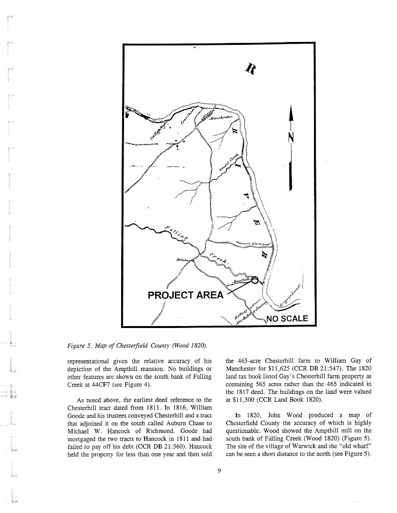
Figure 5. Map of ChesteGeld County (Wood 1820).
representational given the relative accuracy of his depiction of the Ampthill mansion. No buildings or other features are shown on the south bank of Falling Creek at 44CF7 (see Figure 4).
As noted above, the earliest deed reference to the Chesterhill tract dated from 18 1 1. In 18 16, William Goode and his trustees conveyed Chesterhill and a tract that adjoined it on the south called Auburn Chase to Michael W. Hancock of Richmond. Goode had mortgaged the two tracts to Hancock in 181 1 and had failed to pay off his debt (CCR DB 21 :360). Hancock held the property for less than one year and then sold
the 465-acre Chesterhill farm to William Gay of Manchester for $1 1,625 (CCR DB 2 1 :547). The 1820 land tax book listed Gay's Chesterhill farm property as containing 565 acres rather than the 465 indicated in the 1817 deed. The buildings on the land were valued at $1 1,300 (CCR Land Book 1820).
In 1820, John Wood produced a map of Chesterfield County the accuracy of which is highly questionable. Wood showed the Ampthill mill on the south bank of Falling Creek (Wood 1820) (Figure 5). The site of the village of Wanvick and the "old wharf" can be seen a short distance to the north (see Figure 5).

William Gay also lost the Chesterhill tract by his failure to pay off a mortgage. In May 1826, Judith Nicholson bought the property at an auction held at the Eagle Hotel in Richmond for the surprisingly low sum of $1,550. Nicholson held four of Gay's notes on the property as executrix of her husband, Andrew Nicholson (CCR DB 27 : 169). In 183 1, Mrs. Nicholson sold Chesterhill to Jeremiah Hobbs for $3,000 (CCR DB 28:487).
D. Le Prade's 1838 map of Ai~ipthil! shows the mi!! tract but does not indicate whether it was still in operation. The Chesterhill property is not depicted on the map. According to Le Prade7s map, another mill was in operation on Falling Creek west of the turnpike and railroad and well upstream from 44CF7 (Le Prade 1838) (Figure 6).
In 1842, John E. and Ira M. Hobbs, the sons of Jeremiah Hobbs, sold Chesterhill to Benajah Thomas and John F. Davis of Richmond for $4,250. Thomas was Davis's father-in-law (CCR DB 34:140). Davis and his wife apparently made their home at Chesterhill (CCR DB 45531). J. F. Gilmer's 1863 map of Chesterfield County shows the Davis house at Chesterhill, but does not show the site of the old Ampthill mill (Gilmer 1863) (Figure 7). Mrs. Davis remained at Chesterhill after she was widowed and finally sold the property in 1884 when Albert W. Bensley paid $6,000 for the 430-acre farm (CCR DB 76: 1).
In 1908, Albert Bensley granted his son Roger C. Bensley an "undivided one-half interest" in two tracts of the Chesterhill property and complete ownership of a third parcel, Site 44CF7 is situated on the 22.8-acre tract designated as "Parcel No. 3" which was granted in fee simple to Roger Bensley. Surveyor D. F. Le Prade exezuted a plat of the tract which shows the site of the old mill on the north bank of Falling Creek (CCR DB 1 16:304) (Figures 8 and 9). The impact of Roger C. Bensley7s excavations on the property and on 44CF7 and his development of the land as "Bensley Village" are discussed below.
In 1910, Bensley conveyed 5.5 acres of riverfront land to the Richmond Yacht Club which did not include 44CF7. However, according to an agreement in the deed, the yacht club received permission to "build, maintain, and repair a concrete reservoir around the spring on the hillside above Falling Creek and opposite
the old Ampthill Mill." The yacht club was also granted "further right to lay, maintain, and repair a pipe from the said spring and reservoir along the banks of Falling Creek to [their] club house" (CCR DB 12 1 : 145). The remains of the reservoir and pipe are almost certainly located within the boundary of 44CF7.
Roger C. Bensley died in 1957. In 1959, William Eldridge Spain, the executor of Bensley's estate, conveyed three tracts including the 22.8-acre tract that contained 44CF7 to George D. Thomas (CCR Dl3 586:340). In 1962, Thomas sold two tracts of land including 44CF7 to James T. Sloan (CCR DB 694: 161). The Central National Bank of Richmond eventually acquired the property. In 1976, the bank sold a 33.18-acre parcel including 44CF7 to Henry A. Houck who is the current owner (CCR DB 139 1 : 376).
Previous Research
The first contemporary reconnaissance of the Falling Creek Ironworks site was undertaken by R. A. Brock in 1876 (Brock 1885). He identified a location (44CF7) on the "west" (south) bank of Falling Creek approximately 60 yd. from a gristmill, the ruins of which still exist on the north bank opposite the site area. Brock recovered "several small pieces of furnace cinder, presumptive relics of the ironworks of 1622" and observed that the "exact original site" had been covered by "repeated washings of the soil" (1885:79). Of particular significance is the fact that Brock (1 885:79-80) distinguished the location of the Virginia Company ironworks from the site of Archibald Cary7s forge on the north bank of Falling Creek and east of the gristmill, the latter being manifested by extensive deposits of "slag or cinder" that covered an area of approximately one acre to a depth of 2 ft. Brock also identified a possible ore (limonite) mining site at a nearby tract, laown locally as "Iron Bottom, where may be found plentifully what is known as bog iron on the surface" (1 885: 80).
Nearly half a century later, the site of the Falling Creek Ironworks became subjected to indiscriminate digging that continued sporadically for 30 years. In 1925, Roger C. Bensley, developer of the nearby "Bensley Village" community and owner of the site at that time, "unearthed" apparent industrial remains that he interpreted to be elements of the ironworks complex (Gregory 1957:20-2 1). These remains were variably described as being between 4 and 11 ft. below the

L .-.- , -+-jW 7 * *?*y 1
v \
q , I I
I . V $
I
I b - ! I . > t
y i M A
. -
- - - - . * . - h
0 2000 feet C . ?
. - - L
Figure 6. Plat of Ampthill Farm (Le Prade 1838).

Figure 7. Map of Chesterfield County (Gilmer 186.3).

Figure 8. Plat of Parcel No. 3 of Chesterhill property in 1908 (CCR DB 116:306).
Figure 9. Site 44CF7, falls and mill, looking west (October 1993).
13

surface of the ground in association with considerable quantities of charcoal, "blast furnace slag," and metallic objects. Bensley apparently observed both undisturbed deposits and structural remains including a "charcoal pit . . . about fifty feet in diameter, " portions of "the foundation and a part of the walls of the original ironworks," and the remains of a timber frame wharf adjacent to Falling Creek (Gregory 1957:20, 47; Richmond News Leader 1925). Digging again in 1942, Bensley "uncovered relatively nearby" the remains of what he referred t , ~ as the "hide-ogt or barrir,ade protect the workmen ... in the event of Indian attack" (Gregory 1957:21). This "barricade" was described as "built in the general form of a cart wheel with a central room and corridors leading off like spokes of a wheel from a hub" (Gregory 1957:21). Bensley7s last episode of digging occurred in 1955 when "he was running a bulldozer doing some landscaping" at the ironworks site (Gregory 1957:21). At that time, he observed "a part of the blast furnace . .. and that the inside was circular in shape" (Gregory 1957:21). "A great many pieces.. .of ancient and original iron works materials" including "rounded billets or pigs" were recovered at that time and distributed to "his acquaintances" (Gregory 1957:2 1).
Tangible evidence of the Falling Creek Ironworks has also been observed in areas away from 44CF7. Gregory (1 957 :4 1-43) suggested that the granite and sandstone used for the construction of the nearby turnpike bridge over Falling Creek and a culvert at Grindall Creek (1 828- 1829) were salvaged from the remains of the early seventeenth-century blast furnace. Inspection of the bridge by staff ~nenlbers of the VDHR revealed the occasional presence of granite blocks coated with an iron residue indicating that Gregory's suggestion may be correct. According to Howard A. MacCord, Sr. (personal communication 1990), similar remains cm be observed in the stonework of the Ampthill Mill ruins on the north side of the creek. Though no direct historical evidence is available to indicate that the furnace remains were salvaged in the early nineteenth century, the reuse of available construction material is a reasonable expectation.
While Bensley's activities certainly affected the integrity of the ironworks site, they did serve to positively identify the presence of industrial remains associated with the operation of a furnace on the south bank of Falling Creek. Several metallurgical assays of
specimens recovered from the site revealed that the iron had been in a molten state, which required a furnace temperature of at least 1,500" C (Gregory 1957: 17- 19). These analyses served to confirm the distinction observed earlier by Brock between the remains of Archibald Cary's forge on the north bank of Falling Creek and the furnace remains on the south bank.
The indiscriminate digging by Bensley is best cu~~?-r?lxized in a letter from Bens!el te archize~!ogist I' Roland Wells Robbins in 1952: "this property had a very interesting past and I derive quite a lot of pleasure plundering and digging and dreaming of how it once was" (Roger Bensley to Roland Wells Robbins, 27 July 1952). In 195 1, Robbins visited the Falling Creek site at the request of the American Iron and Steel Institute to take a "quick look." Robbins was then excavating the remains of the Saugus Ironworks in Massachusetts for the First Ironworks Association, a project funded by the American Iron and Steel Institute. Both groups were aware of the early Falling Creek site and concerned about their claim that the Saugus facility was the "first" ironworks site in colonial America. Robbins was asked to investigate the site to determine whether evidence existed that would confirm that the Falling Creek site actually operated before its destruction during the 1622 massacre.
Robbins recorded his Falling Creek visit in his Saugus daily log for 195 1, providing an interesting sketch map of the site (Robbins 1951 :38A) (see Appendix C). He reported that he located evidence of a11 old darn and deserted canal that ran along the north side of the river from the early dam to the gristmill ruins. Robbins observed that the stream banks from the dam upstream to Route 1 were steeply sloped and that the area "permits no working area for casting, etc." (Robbins 195 1 :38B) (see Appendix C) . Me contimed his observations by recording that "the general area where the ruins of the grist mill stand [are] most desirable for blast furnace operations. Here, either side of Falling Creek provides ideal elevations for a furnace bridge, as well as working area ...." (Robbins 195 1 :38B). Robbins further favored this area, he said, because it provided navigable waters that terminate at the falls. He also calculated that a dam at the "cascades" would provide a good head of water to power the furnace (Figure 10). The area between the James River and the railroad trestle could be ruled

Figure 10. Looking west from railroad bridge, 44CF7 area to left of photo and gristmill ruins about 700ft. west along the north bank of Falling Creek, March 29, 1951. Note that vegetation is similar topresent conditions (Photo by Roland Wells Robbins).
out, Robbins determined, because it provided no elevations for the furnace bridge and was prone to flooding.
Robbins stated that he "carefully" looked at the conjectured furnace site area located on Bensley's property, but notes that he found no slag or other evidence. He reported that he found metal waste, metal, brick, and refractory brick, 20 to 25 ft. west of the gristmill ruins, and noted that "this evidence indicates that forge activity took place in this area some time ago" (Robbins 1951:38C). He estimated this site, probably Archibald Cary's forge, as approximately 40 ft. square and about 50 ft. from the north bank of Falling Creek. Robbins ended his report by recommending that further work be concentrated on "the area to either side of Falling Creek at the cascades" (Robbins 195 1 :38C).
Robbins returned his attention to the Falling Creek site in early 1961, as he neared the end of a five-year project for Sleepy Hollow Restorations at the
Phillipsburg Manor Upper Mills site in North Tarrytown, New York. As Robbins began to consider his next project, he wrote to Jamestown curator J. Paul Hudson: "I now want to concentrate on seeing if we can get something going on the Falling Creek site" (Roland Wells Robbins to J. Paul Hudson, 3 January 196 1). He went on to request information from Hudson on digging that had occurred at the site since he had last visited and proposed a "walking and probing survey" to determine "what there was to work with" (Roland Wells Robbins to J. Paul Hudson, 3 January 196 1). Hudson responded to Robbins by suggesting that he should write to Frederick Pease of the Chesterfield County Historical Society and to state Senator Lloyd C. Bird, to propose his plan and find out who owned the property. He also suggested that Robbins contact John D. Capron of the Lynchburg Foundry Company about possibly funding the work. Hudson ended the letter with the following endorsement, "I don't know of any other archaeologist in America more capable than you to excavate the site of a Colonial period ironworks. Your experience at John Winthrop, Saugus, Sterling,

and elsewhere makes you the only logical choice" (J. Paul Hudson to Roland Wells Robbins, 3 January 1961).
While Robbins spent most of 1961 "renewing" major excavations at Sterling Furnace in New York, he again wrote to Hudson concerning Falling Creek late in the year. In January of 1962, Robbins wrote to Frederick Pease, who responded enthusiastically to Robbins' recommendation for a survey of the site and invited him to visit the sire in the n e x future. Pease wrote Robbins, "anything you can do about restoring the furnace on Falling Creek will meet with much approval with the people of Chesterfield" (Frederick H. Pease to Roland Wells Robbins, 6 January 1962). In a subsequent letter to Hudson, Robbins noted that Pease did not mention financial support for the project, but felt that this was not unexpected as Robbins had not specifically discussed costs. Robbins explained that his normal fee was $100 per day plus expenses, and that the survey that he had in mind would "run under one- thousand dollars" (Robbins to Hudson, 17 January 1962). Robbins continued the letter: "the Falling Creek furnace is a very controversial subject; did it or didn't it exist; if it existed, did it produce? How much? The survey that I want to conduct would probably answer the question whether the site that Mr. Pease, the late Roger Bensley, and others believe to be the site of the 1622 furnace, is just that" (Robbins to Hudson, 17 January 1962).
Robbins continued his correspondence with both Hudson and Pease during January and February attempting to arrange funding for the project through a variety of sources including federal and state- government agencies, the county government, and the county historical society. His ongoing discussions with Pease resulted in his return visit to the site in February of 1962. Robbins notes that while he had plmaed to take transit readings and make tests, the weather was very bad causing him to limit his work. He summarized his 1962 field investigation and thoughts on the Falling Creek site in a March letter to J. Paul Hudson (Figure 1 1):
The area containing a deposit of charcoal and slag is located below the roadway to a marina. The iron works evidence extends to the southerly side of this road some 15' to 207, terminating at the base of a knoll. Erosion is, and has been cutting away the northerly slope of the knoll. This has been created by a marsh at
the top of the knoll which drains from the northerly slope. While I inspected the top of the knoll for evidence of charcoal, ore, and flux materials, none of these materials were noted. This could have been suitably situated for the charging bridge, although it seemed quite high. The small pond there must not be ruled out as a possible source of water for the furnace waterwheel. To eliminate the knoll as the site of the charging bridge, leaves but one area to be considered. This wou!d be wester@ cf the possible site of the furnace and below the site of the road to the marina. Maybe I shouldn't say below the roadway, as it would appear that the area was cut down from its original height, grading it to the lower area which, fortunately, was built up. Some 40' or so to the northerly side of the ironworks evidence exists of a partially filled canal [probably the ravine noted on MacCord's map, Figure 121. This canal originates just to the northwest of the site and runs easterly for 250' to 300,' emptying into the tidal waters. In places it is only 7'-8' wide at the present bottom. This would have given good protection for small boats when the waters of Falling Creek were flooded. If this canal is of early vintage, then the land to the southerly side of the canal over to where the ironworks evidence exists would have been tied in together. This is not the case today. It appears as though it has been both washed out and taken out in places. If this is true, and the furnace units occupied some of the areas, basic foundations were destroyed.
As I studied the elevation of the Falling Creek water and the head it would provide for a waterwheel for a furnace located at the site of the charcoal md slag, it seemed doubtful it would operate even a breastwheel. Also, to run a flume from the stream, just above tide head, to a waterwheel located here presents problems. It would have had to been [sic] a suspended flume, which is not good considering the danger of the flood waters which would harass the uprights. Between the stream water above the tide head, and the possible site of the wheel, protrudes a natural outcrop of ledge which extends into the stream. As its top is higher than the headwaters of Falling Creek, and there is noevidence of the ledge having been cut thru, then the flume would have had to go around the

Figure 11. Roland W. Robbins (left) and Frederick Pease (right) standing along access road to marina at "controversial site of Falling Creek," February 22, 1962 (Photo by Roland Wells Robbins).
ledge. However, if the land was once level over until a survey was completed to determine the to the canal, a straight flume could have been "potential of the site" (Robbins to Hudson, 1 March used. . 1962).
It is my opinion, based on the limited inspection I made, that if any evidence of a blast furnace and its supporting units are to be found at the controversial site, they will be located below and possibly to the southerly side of the present roadway to the marina. If the furnace stood between the roadway and the canal, remnants may be found. While this site should be carefully tested before other areas should be given consideration, I would not rule out the northerly side of the stream, nor possibly, other sites to the southerly side of the creek (Roland Wells Robbins to J. Paul Hudson, 1 March 1962).
Robbins ends the letter with the observation that grading was taking place on the property along Route 1, probably indicating that development was imminent. He recommended that the furnace site not be purchased
Following his 1962 visit to the Falling Creek site, Robbins continued his attempts to obtain funds for a survey and excavation project, writing to both J. Paul Hudson at Jamestown about federal and state funding and Mr. Marcus Elcan of the Lynchburg Foundry Company about private donations. He also stayed in touch with Mr. Frederick Pease, who informed him that the property was for sale by the firm of Rucker and Richardson in Richmond. They would sell a 300 ft. wide strip along the river, an 8-acre tract, for approximately $20,000. Robbins corresponded with Thurlow G. Gregory in the fall of 1962 after reading his article in the Virginia Magazine of History and Biography, noting that while he was not "close to the Falling Creek Furnace controversy, naturally I have been very much interested in it" (Robbins to Thurlow G. Gregory, 21 September 1962). Gregory responded by challenging Robbins' use of the word controversy,

Figure 12. Site 44CF7, plan of previous excavations (MacCord 1964:3).
stating that "I do not concede that there is a controversy .... I accept the Virginia Company of London: as being the final authority tipon that matter" (Gregory to Robbins , 24 September 1962).
In 1963, Frederick Pease wrote to Robbins to report that he had worked on an excavation of the Falling Creek site conducted by Howard A. MacCord, Sr., of the Virginia State Library (Pease to Robbins, 19 August 1963). This more extensive formal archaeological testing was carried out by MacCord and the Archeological Society of Virginia in July 1963 (MacCord 1964) (see Figure 12). A total of 13 trenches was exposed by a "traxcavator" and hand excavation in the low-lying area between an access road (to a marina) and Falling Creek. Excavation of these trenches
revealed the presence of industrial deposits (slag, charcoal) covering an area approximately 75 ft. in diameter immediately adjacent to the access road. A discrete charcoal deposit was also observed nearby on the south side of the road, possibly corresponding to the "charcoal pit" discovered by Bensley . Excavation of the industrial deposits resulted in the identification of possible structural remains, though continued digging appropriately was halted and the remains covered. The industrial debris and the possible structural remains, however, suggested that the "main blast furnace . . . will be found under the existing road" immediately to the south (MacCord 1964: 12). The location of the principal structural remains under the existing road would be consistent with the report that Bensley "encountered iron ore and slag as he dug a road eo his new

Figure 13. Sire 44CF7, plan of rock cuts recorded during previous excavations (MacCord 1964:8).
swimming pool in 1925," and with the observations made by Robbins (Richmond News Leader 1925). MacCord also identified three "groups" of notches that were carved into the rocks at the falls of Falling Creek to the west, associated with either the ironworks or with Archibald Cary's gristmill and forge operation on the north bank of the creek (Figure 13). Finally, reexamination of the archaeological assemblage recovered by MacCord (curated by the VDHR, Richmond) revealed the presence of a previously unidentified fragment of iron "pig, " further confirmation of the presence of a furnace producing cast-iron from ore at 44CF7.
Following his 1963 excavations, MacCord and Roland Robbins carried on a brief correspondence concerning the ironworks that resulted in Robbins'
third and final visit to the site, with MacCord, in 1968. At this point, the site area seems to have been cleared of all vegetation, probably as part of the work for the apartment complex pool (Figures 14 and 15).
To better understand the archaeological character and potential of the Falling Creek Ironworks, VDHR staff conducted a brief on-site reconnaissance on February 1, 1990. Accompanied by Howard A. MacCord, Sr., six auger tests were excavated along the road to the Marina in the approximate area where MacCord had recovered evidence of the ironworks in 1963. Though only limited slag was revealed, an extensive charcoal deposit corresponding to that observed by Bensley and MacCord was identified. That deposit, located on the south shoulder of the marina

Figure 14. "Supposed site of ironworks" looking northeast, Falling Creek, VA, February 24, 1968. Note the basketball and volleyball courts on the site area between the road and the creek (Photo by Roland Wells Robbins).
road at the base of the slope, was found to be up to 2 ft. thick and extended nearly 3 ft. below modern grade. A sample of the charcoal was submitted for radiocarbon analysis and an uncorrected date of 390 +I- 70 years B.P. was obtained (A.D. 1490-1630, Beta-35886). Though "late" radiocarbon dates need to be interpreted with caution, the range reasonably excludes any association of the charcoal with Archibald Cary7s forge operztion during the eighteenth century.
The land-based reconnaissance was supplemented by an underwater exploration. Underwater archaeologists from the VDHR examined the large pool at the base of the falls adjacent to the Ampthill Mill ruins in an effort to identify any remains of the "tools thrown into the river" by the Indians during the 1622 uprising (Hening 1969: 135). Little siltation- was observed in the pool due to the continuous scouring of that area by the falls of Falling Creek. At the southern base of the falls, a large stone was observed that
exhibited an "L-shaped" notch used to support a dam post, similar to those still in situ above water. The stone, however, appeared to be resting on an iron bar with characteristics suggesting a "pig" of cast iron. The iron bar was left in situ for future recordation and retrieval.
The various episodes of exploration at 44CF7 have demonstrated the presence of undisturbed deposits associated with the Falling Creek Ironworks. Unfortunately, only limited information was obtained under controlled scientific conditions. Existing data also addresses only the industrial component of a much larger community that existed in the vicinity of Falling Creek prior to the uprising of 1622. The location of the residential area has not been determined nor has the presence of suitable limonite deposits at "Iron Bottom" been confirmed. The ironworks site therefore exists as a discrete entity as yet unevaluated in relation to its associated archaeological context.

Figure 15. "Supposed site of ironworks" looking northwest toward falls, Falling Creek, VA, February 24, 1968. Note the apartment buildings in background and cleared site area in foreground (Photo by Roland Wells Robbins).


Chapter 3: Research Design and Methods
Introduction
The results of Robbins7 1951, 1962, and 1968 visits, MacCord7s 1963 archaeological investigations, and the 1990 VDHR field inspection served as a basis for developing a research design for the present investigation of 44CF7. Previous research established the historical context of the property and documented the presence of features and deposits associated with the Falling Creek Ironworks. As discussed in Chapter 2, 44CF7 reportedly dates to the Virginia Company period (1607-1624) and is the site of the first blast furnace in British America. Comparative archaeological data for 44CF7 is relatively sparse due to its early age and the specific type of ironworks. A review of archaeological research on colonial period ironworks sites in Tidewater Virginia and outside this region, however, provides some indication of the types of (industrial and domestic) resources anticipated for the site. Familiarity with specific research questions raised at similar sites allows the archaeological component of 44CF7 to be evaluated in terms of its research potential. In addition, this information contributes to the larger historical significance of the site as it relates to the development of the first iron industry in Virginia and the English New World during the early seventeenth century, and its relationship to the early development of Tidewater Virginia.
Overview of Historic Resources and Research Considerations
Industrial/Dornestic Resources
The archaeological data base for ironworking sites in Virginia is inadequately documented when compared to other historic site types. Iron furnace sites, in particular, have not been subject to extensive archaeological investigation because of the small number of these sites that exist and/or have been identified, and the perception of their research potential (Noel Hume 1975: 174-175; Wittkofski et al. 1989).
Site 44CF7 is the only seventeenth-century blast furnace site documented in Virginia; however,
historical and archaeological evidence indicates that limited forge experimentation, including some iron smelting, was undertaken earlier at Jamestown (Cotter 1958: 1 10, 165). The best-documented seventeenth- century comparison with 44CF7 is the ca. 1640 Saugus Ironworks located in Massachusetts.
Most of the ironworks sites in Virginia that have been investigated date to the eighteenth and nineteenth centuries. Six of these sites include the Neabsco Mills Ironworks (44PW629) in Prince William County, the Washington Iron Works in Franklin County, the Potts, Wilson Iron Forge/Foundry (44FX7) at Great Falls in Fairfax County, the Accokeek Furnace (44ST53) and Hunter's Iron Works (44ST7) in Stafford County, and Tubal Furnace (44SP12) in Spotsylvania County. Comparatively smaller, yet well-documented late eighteenth-century sites include the Anderson and Draper Forges in Williamsburg (Foss 1977; Brown et al. 1990).
Forges were not as expensive to build or operate as their furnace/foundry counterparts; hence, they were more common. "They [blacksmith shops] existed in every township from coast to coast as well as on most large farms and plantations from the early seventeenth- century to the early twentieth-century" (Noel Hume 1975 : 179). During the earliest years of colonization "the shortage of pig iron and the difficulties of transporting it ... prompted blacksmiths to make their own iron by the bloomery process" (Noel Hume 1975:181).
Traditional iron making, like other industrial trades, was characterized by different stages and/or processes. To clarify the kind of operation at 44CF7 and its relation to other sites, it is useful to summarize iron production processes, site composition, and variables that influenced the success of ironworks operations. This information, integrated with an overview of other documented sites, helps to explain the technology and production methods probably used at 44CF7.

Capron summarizes the main processes used in the production of wrought and cast iron:
Iron ore was converted to a usable form as wrought iron or cast iron by quite different procedures.
In making wrought iron, the iron ore was not melted but was heated to a pasty mass which was hammered or rolled to eliminate the impurities and form a bloom or billet. This done in a bloornery . Sometimes specially designed pigs of cast iron were used as raw material for a bloomery. However it was worked in the same way as the ore. In a forge the bloom or billet was brought to a red heat and again hammered or rolled until the final stage was reached.
In making cast iron, the iron ore was melted in the presence of lime. When molten the impurities were skimmed off the top. This process took place in an iron blast] furnace.
Then the iron was poured into the pig moulds forming the pig iron which was the intermediate product in making castings. Occasionally the molten iron was poured into the moulds at the furnace.
In a foundry the pig iron is remelted and poured into molds forming the finished casting (1968, quoted in Troup et al. 1978:44-45).
Work at 44CF7 probably focused on smelting iron ore for the production of both cast and wrought iron, a process that involved the use of a charcoal-fueled blast furnace (Hatch and Gregory 1962; Kingsbury 1906a:472). Often such production included the refinement of the iron in a refinery furnace on the site. This process involved reheating the iron and subsequently beating out impurities with a watenvheel- driven hammer (Noel Hume 1975: 178). The bar iron that resulted from this process eventually made its way to plantation and settlement forges where it was shaped by blacksmiths.
The same type of operation was undertiken at the Saugus Ironworks beginning in the 1640s. The site of the Saugus Ironworks was subject to extensive archaeological and historical research from 1948 to 1953, resulting in the restoration of a Parge industrial
complex. The site consists of blast and refinery furnaces, a rolling and slitting mill, a warehouse, and the ironmaster's house (Hartley 1957:facing page 1 13, 165- 184) (Figure 16).
Most ironworks sites documented in Virginia date to the eighteenth and nineteenth centuries. One of the earliest and best known of these is the Tubal Furnace (44SP12) which was in operation from ca. 1720 until the mid- to late eighteenth century. "Tubal was perhaps the most technoiogicaiiy advanced iron furnace of its time and was the first iron manufacturing facility in Virginia and the Chesapeake to achieve financial success" (Sanford et al. 1993: 107).
The Neabsco Mills Ironworks site (44PW629) dates to the mid-eighteenth century and encompasses approximately 150 acres of a 5,000-acre plantation. Archaeological research at Site 44PW629 has identified the remains of several furnaces, pit mines, road traces, and domestic features (Sanford, personal commlinication 1 993; Sanford et al. 1993). Historical and/or archaeological research on the Accokeek Furnace (44ST53), Hunter's Iron Works, and the Washington Iron Works indicates a similar composition (Sanford et al. 1993; Salmon 1986). The latter operation, for example, began as a bloomery in the 1770s but became a larger, more complex operation by the end of the colonial period. As Salmon states:
In addition to the furnace and forge, a sawmill and gristmill were constructed. To house the increased number of workers new dwellings were built, as were stables for the horses; sheds for storing ore, charcoal, and iron; a blacksmith's shop to shoe the horses and repair the tools; and an office for conducting business of the ironworks (198627).
Archaeological research at the Potts and Wilson Ironworks (ca. 1793-1828) indicates that this site was also a substantial operation. Although no evidence of a blast furnace was found at this site, structural remains of a bloomery or refining forge and foundry were identified (Troup et al. 1978).
The blast furnaces represented at the Saugus, Neabsco, and Washington sites were of a fairly standard design and operation for the colonial and early postcolonial periods (Noel Hume 1975 : 175; French 1858, quoted in Troup et al. 1978; Salmon 198694) (Figure 17). In terms of furnace construction:

Figure 16. Conjectural drawing of Saugus Ironworks (Hartley 1957facing p. 11 3).
Figure 1 7. Conjectural drawing of Marlboro Furnace (Salmon 1986:24).

Figure 18. Excavation of waterwheel and timber-lined pit from waterlogged deposits at Saugus (Robbins and Jones 1959:5 7).
Where possible, furnaces were built into the side of a hill, for they stood some thirty feet high and had to be charged from the top. They also had to be close to water power to drive the wheel that pumped the bellows. The stacks were usually about twenty-five feet square at the bottom, tapering somewhat toward the top, and with the walls about six feet thick (Noel Hume: 1975: 175).
A principal component of the furnace was the casting floor, which was generally located opposite the bellows and within an attached shed constructed of heavy timber or stone (Noel Hume 1975: 176). The casting floor consisted of
sand, with a channel scored into it running away from the hearth and with forms molded into the sand from wooden blocks on either side. When the door of the hearth was raised, the molten iron rushed out into the main channel and was skillfully ferried by the workers into the lateral
forms or beds. As the level of the iron in the hearth dropped, the last of it emerged mixed with the slag riding on its surface. But by this time the forms had been filled, and the contaminated metal. remained in the main channel. The result would closely resemble the way in which the kits for plastic models are sold, the key pieces attached by stalks to a central co lum of waste. That co lum was known as the sow and was broken up for remelting, while the good-quality moulded bars were, and still are, called the pigs (Noel Hume 1975: 176-177).
The environment can influence the types of archaeological remains that are recovered. Deep, wet deposits, for example, may yield pieces of the wooden waterwheel or other organic components of the works. At the Saugus Ironworks, for example, parts of waterwheels and bellows were found in water-logged deposits (Noel Hume 1975: 177; Hartley 1957:facing page 33; Robbins and Jones 1959:57) (Figure 18).

Evidence for the workers' housing and related domestic remains (including dwellings, outbuildings, fences, and trash deposits) may exist near the ironworking complex. While comparatively little is known of this aspect of ironworks operations, workers7 housing has been documented for the Saugus Ironworks as well as the Neabsco Mills Ironworks site (44PW629) (Hartley 1957: 130-13 1 ; Sanford, personal communication 1993). Residential villages at this latter site were linked to principal work areas by a road network (Sanford, personal communication 1993).
Several variables influenced the success or failure of an ironworks, including the skill of the ironworks master and his workers, an adequate source and manipulation of water, close proximity to suitable limonite deposits, and abundant timber for the production of charcoal. The difficulties of iron production were noted by B. F. French in his mid- nineteenth-century publication on the iron industry:
The furnaces, up to this time were blown by wooden and leather bellows, and the cold blast, and one tuyere, and their working profitably was greatly influenced by the skill and influence of the founder. With the greatest skill and every precaution, the yield still depended much upon the blast, and this was invariably produced by water power, which was often very irregular and weak, and in dry seasons incapable of furnishing the necessary power, it will account for the small annual product of the furnaces of that day (1858:n.p., quoted in Troup et al. 1978:41).
Boyer (1931), in his study of forges and furnaces in New Jersey, commented on important considerations in establishing an ironworks:
The location for the successful operation of the early charcoal furnaces and forges was determined by two very essential elements-streams and forests. The first furnished the power and the other produced the wood from which charcoal, or "coal, " as it was called, was made. To provide sufficient water power at all seasons required an outlay of large sums of money in the building of dams and sluiceways and the installation of water wheels, while the large amount of charcoal needed for even a moderate size furnace or forge
necessitated extensive tracts of land (193 1 :n.p., quoted in Troup et al. 1978:41).
Anticipated Resources
A variety of archaeological deposits and features may be present at 44CF7. As discussed above, previous research at the site has identified charcoal and slag deposits and possible structural remains. It is possible that additional testing may reveal the furnace's trunk and the foundation of the casting shed, and the possible remains of the tuyere arch, crucible, and hearth (Noel Hume 1975 : 177). In addition, the remains of auxiliary structures like a refining furnace and chafery may be present as well as other work and storage areas. Some evidence for structures may already have been found (MacCord 1964:9).
Furnace sites are usually characterized by substantial deposits of slag and charcoal. MacCord (1964:6-8) found thick slag and charcoal deposits at 44CF7 that most likely represent fuel stockpiles and waste piles. These deposits are concentrated near the base of a hill at the suspected location of the main furnace (MacCord 1964:7, 9).
Less obvious features "but equally important, will be post holes or sockets cut into the native rock that carried the vertical members supporting the flume and charging platform" (Noel Hume 1975 : 177). Rock cuts, believed to be associated with a trestlelflume and a dam have been identified at 44CF7 (MacCord 1964: 8-9).
Domestic resources may also be present in the vicinity of 44CF7. The most probable locations of these remains are on parcels near the site and adjacent to Falling Creek, close to the James River, and/or on the hilltop located immediately south of the site. The workers' housing would be evidenced by artifact scatter, trash deposits, and features (i.e., cellars, postholes) indicative of dwellings, outbuildings, and fences.
Research Goals
The primary goal of the present investigation was to evaluate the eligibility of the site for nomination to the National Register of Historic Places. To this end, the archaeological investigation attempted to verify MacCord7s work, to assess the present integrity of the site, and to define the entire site area through

additional survey and testing in an attempt to identify related components, such as workers7 housing. The synthesis of the site's historical context with regard to its use as an ironworks permits the identified archaeological resources to be assessed in terms of current research issues pertaining to such sites.
Project Limitations
Relatively extensive work has been completed at 44CF7 during the twentieth century. As discussed in Chapter 2, indiscriminate digging occurred during the first half of this century followed by archaeological testing in the early 1960s. Although the archaeological investigation was well documented and efforts were made to protect potentially significant features for future study (MacCord 1964:7), this work, as is inherent in all archaeological work, had a destructive impact on the site. Disturbances from previous activities on 44CF7 are documented in this study, and subsequent analyses were completed with these impacts in mind.
Field Methods
In view of the amount of previous work at 44CF7, the present study sought to minimize additional impact to the site while providing comprehensive systematic coverage of the core area of the site and adjacent survey areas peripheral to the site (Survey Areas A, B, and C) (see Figure 3). The testing plan utilized a reference baseline and grid transects established at the beginning of the investigation. A combined total of 177 shovel tests was dug at intervals of 30 ft. or less at three locations within the project area (Figures 19, 20, and 21). Fifty-three of the shovel tests were dug in Survey Area A, 27 shovel tests in Survey Area B, and 97 shovel tests in Survey Area C. Site 44CF7 lies within Survey Area C. Seventy-two of the 97 shovel tests were placed at 44CF7 and its immediate environs. The shovel test results were plotted on a site plan to identify areas of artifact concentration. Two 7 x 7 ft. test units, one 5 x 5 ft. test unit, and three 2.5 x 2.5 ft. test units were hand-excavated at 44CF7 in Survey Area C. No test units were excavated in Survey Areas A or B. The placement of the test units at 44CF7 was based on positive shovel tests and the approximate locations of previously identified features and deposits
(MacCord 1964) (see Figures 12, 19, 20, and 2 1). Soil layers were excavated by natural boundaries and removed to subsoil. Upon exposure of the subsoil, the units were cleaned and inspected for cultural depositsifeatures. All features, including the cut features in the rock ledges along the falls, were documented by measured drawings and by black-and- white and color photography. Soils, profiles, and artifacts were documented on unitilevel record forms. In general, features were not excavated; however, featuresideposits that could not be identified in pian were tested to determine their age and function. Elevations were recorded from a temporary datum located .5 ft. above ground surface at the southwest corner of each unit. Each temporary datum was then tied into a permanent datum represented by a 1.0 ft. iron pipe at the base of the rock cliff on the western half of the site. The permanent datum (arbitrary elevation of 10 ft. amsl) is located at grid coordinate 1005.5N 962E. All elevations cited in this report are referenced to the permanent datum. Artifacts were collected according to soil layer/level .
Laboratory Methods
All artifacts recovered during the investigation were arranged by provenience each day and processed in that order. Artifacts were washed, sorted into ceramic, glass, metal, and miscellaneous groups, and labeled.
All artifacts were catalogued for analysis according to a standard descriptive format including artifact group, class, object, datable attribute, and quantity (see Appendix A). The WMCAR has developed a hierarchical coding system that operates using Paradox relational database software. With this system, artifacts are coded during analysis on standard data sheets for entry into a data file. Using this file, overall project inventories as well as particularistic data reports can be readily generated for inclusion into reports or routine analysis. Each provenience was assigned a terminus post quem (TPQ) representing the date after which the context was deposited. The TPQ is determined from the artifact recovered with the most recent date of manufacture. All artifacts were placed in polyethylene bags for temporary storage at the WMCAR. The artifacts will ultimately be curated by the VDHR.

Figure 19. Area C, plan showing Site 44CF7, Location 2, shovel tests, and test units.
29

Figure 20. Area A, plan showing Location 1 and shovel tests.

POSITIVE SHOVEL TEST 0 NEGATIVE SHOVEL TEST
Figure 21. Area B, plan showing Site 44CF.506 and shovel tests.


CI&APTER 4: Research Results and Archaeological Evaluation
The evaluation study of 44CF7 included systematic which in turn was over a dark yellowish brown shovel testing of three areas that were peripheral to the (10YR416) sand mottled with black (10YR211) silty site. These areas, designated as Areas A, B, and C, sand (Layer C) . Below Layer C was a very dark brown were surveyed in an attempt to identify domestic sites (10YR212) sandy sludge deposit (Layer D). This associated with the ironworks. Site 44CF7 is located deposit was over very dark gray (10YR311) silty clay within Area C and will be discussed within the context (Layer E). Water was encountered in many of the of this area. shovel tests at 2.7 ft. below ground surface.
Shovel Test Results
Area A
Area A comprised a large parcel (approximately 12 acres) that was located approximately .30 mi. east of 44CF7 (see Figures 3 and 20). This property, presently in use as a marina, is bounded on the north by Falling Creek, on the west by Interstate 95, on the south by a wooded parcel, and on the east by the James River.
Fifty-three shovel tests (Shovel Tests 1-47 and 172-177) were systematically placed at intervals of 30 ft. or less along grid transects across this area (see Figure 20). Eighteen of the 53 shovel tests were positive, yielding a combined total of 61 artifacts. All but 2 of the 59 historic artifacts, a fragment of water- worn pearlware ceramic and a piece of handmade brick, date to the twentieth century. Modem artifacts consist primarily of pieces of bottle and window glass, drain pipe, and wire nails (see Appendix A). Prehistoric material was limited to 2 artifacts, 1 single piece of punctatelnet-impressed, grog-/grit-tempered ceramic found in Shovel Test 21 and 1 piece of quartz debitage found on the ground surface approximately 15 ft. south of that shovel test. The prehistoric material and historic ceramic were designated as Location 1. Location 1 measures approximately 220 ft . north-south and 120 ft. east-west.
Soils varied across the area; however, all appeared to represent modern fill. In general, the soil profile for the southern half of the area consisted of a top layer of dark yellowish brown (10YR414) sand fill (Layer A) (Figure 22). Below the sand was a layer of dark yellowish brown (10YR314) sandy clay (Layer B),
In the middle of the survey area at Location 1, soils typically consisted of a dark yellow brown (10YR316) silty sandy loam fill (Layer A) (Figure 23). Beneath this layer at approximately 1.2 ft. below ground surface was a dark yellowish brown (10YR414) sand (Layer B). Layer B was over a dark gray (10YR311) silty clay fill (Layer C).
Testing on the extreme northern portion of the area at the location of the marina also revealed modern fill deposits. The soil profile for Shovel Test 46, for example, consisted of a gravel deposit (Layer A) over a dark yellowish brown (10YR416) silty clay (Layer B) (Figure 24). Below the clay was a dark yellowish brown (10YR414) sand (Layer C). This layer was over a yellowish brown (10YR516) sand (Layer D) that extended to at least 2.2 ft. below ground surface.
Shovel tests placed closer to the James River revealed fill typically represented by variations of dark yellowish brown (10YR416, 10YR414) silty clay soil (Figure 25). This deposit, mixed with pieces of modern bottle glass, large rock, and gravel, measured at least 1.5 ft . below ground surface.
Extensive filling has occurred in Area A during the twentieth century. This is evident from the shovel test results and from the project area base map. The survey area is no longer wooded, as indicated on the base map, nor does the wet, low-lying portion of the survey area shown just south of the large building still exist. According to the property manager, Area A was cleared of trees and portions filled within the past 20 years. Prior to this, dredged sand from the James River was dumped in the area (Waldrop, personal communication 1993).

A
10-
20 -
30 -
40 -
50 -
60 -
70 -
80 -
90 - centimeters I I
KEY
A - Dark Yellowish Brown (1 OYR4/4) Sand (Fill) B - Dark Yellowish Brown (lOYR3/4) KEY
Sandy Clay (Fill) C - Dark Yellowish Brown (lOYR4/6) Sand Mottled A - Dark Yellow Brown (lOYR3/6)
with Black (lOYR2/1) Silty Sand (Fill) Silty Sandy Loam (Fill) D - Very Dark Brown (1 0YR2/2) Sandy Sludge (Fill) B - Dark Yellowish Brown (1 OYR4/4) Sand
E - Very Dark Gray (lOYR3/1) Silty Clay (Fill) C - Dark Gray (lOYR3/1) Silty Clay (Fill)
Figure 22. Area A, profile of Shovel Test 2. Figure 23. Area A, Location 1, profile of Shovel Test

0 -
10-
20 -
30-
40 -
50 -
60 -
70-
KEY
0 - 10-
20 -
30 -
40 -
50 -
A - Dark Yellowish Brown (lOXR4/6) Silty Clay (Fill)
cent imeters inches A
1
KEY
C
-
-
-12
-16
- 20
- 24
28
cen t imete rs inches
A
Figure 25. Area A, profile of Shovel Test 41.
C
-12
-16
A - Gravel (Fill) B - Dark Yellowish Brown (lOXR4/6) Silty Clay (Fill)
C - Dark Yellowish Brown (lOm4/4) Sand D - Yellowish Brown (1 OYR5/6) Sand
Figure 24. Area A, profile of Shovel Test 46.
--\&-
Area B
- 20
Area B is located approximately 300 ft. northwest of Area A on a floodplain of Falling Creek (see Figures 3 and 2 1). Approximately 75 % of Area B is wooded with the remaining 25 % of the area covered in greenbriar and grass. An abandoned swimming pool and related building are located within this area. Landscaping associated with this facility includes a small berm around the pool fence and remnants of a compact gravel drive/parking lot on the west side of the complex.
Twenty-seven shovel tests (Shovel Tests 48-74) were systematically placed at intervals of 30 ft. or less along grid transects across this area (see Figure 21). Fifteen of the 27 shovel tests were positive, yielding a total of 66 artifacts. The historic assemblage, consisting of pieces of machine made brick, concrete, asphalt, and modern bottle glass, comprised 41 % (n =27) of the total artifact assemblage while the prehistoric material comprised 56 % (n=39) of this total. The prehistoric
artifacts included pieces of quartz, quartzite, and chalcedony debitage, and fire-cracked rock (see Appendix A). The majority of the historic material was scattered in the area immediately adjacent to the swimming pool and road (Shovel Tests 48, 52, 53, 54, 57, and 58) while the prehistoric artifacts were concentrated in Shovel Tests 56, 59, 61, and 71 in the woods near the center of the landform. The largest quantity of prehistoric artifacts (51 % [n=20] of the total prehistoric assemblage from Area B, excluding unmodified stone) was found in Shovel Test 61. Almost 50% of the total prehistoric artifacts recovered during the survey was found in Survey Area B.
Soils varied across the survey area. Shovel Test 53, located west of the pool at grid point 560N 530E, contained a thin deposit of black (10YR2/1) sand mixed with pieces of gravel (Layer A) (Figure 26). This layer was over a thin layer of gray (10YR6/1) sand and concrete (Layer B). Beneath this layer was a brown (10YR5/3) sandy clay that extended up to 1.4 ft. below ground surface.
Approximately 180 ft. east of this area and adjacent to the road, soils consisted of fill deposits. Shovel Test 48 (500N 700E) consisted of a dark yellowish brown (10YR4/4) silty clay fill (Layer A) (Figure 27). This deposit was over a dark brown (10YR4/3) sandy silty

cent imeters inches
KEY
A - Black (lOYR2/1) Sand Mixed with Pieces of Gravel
B - Gray (lOYR6/1) Sand and Concrete C - Brown (1 OYR5/3) Sandy Clay
Figure 26. Area B, profile of Shovel Test 53.
clay (Layer B), which in turn was over a gray (10YR511) clay fill (Layer C). Subsoil (Layer D) was characterized by yellowish brown (10YR516) clay which was identified at 2.0 ft. below ground surface. Eight pieces of modern bottle glass were recovered from Shovel Test 48.
In general, the soils on the eastern half of Area B at the location of the prehistoric artifact concentration, designated as Site 44CF506, consisted of a top layer of dark yellow brown (10YR414) silty clay loam (Layer A) that measured approximately .30 ft. deep (Figure 28). Layer B was a yellowish brown (10YR516) silty clay that measured up to 1.0 ft. below ground surface. Beneath Layer B was a yellowish brown (10YR518) silty clay subsoil.
Layers A and B were mixed with small fragments of charcoal in three of the shovel tests (Shovel Tests 56, 61, and 63). As discussed above, Shovel Test 61 contained 19 pieces of debitage and 1 piece of fire- cracked rock. Most of the artifacts found in this shovel test appeared to be contained in Layer A. Site 44CF506 measures approximately 100 ft. north-south and 220 ft. east-west. The core of the site appears to be located in the area of Shovel Tests 56, 61, and 71, which had the highest artifact densities.
I cent imeters inches I
KEY
A - Dark Yellowish Brown (lOYR4/4) Silty Clay (Fill) B - Dark Brown (lOYR4/3) Sandy Silty Clay
C - Gray (1 OYR5/1) Clay (Fill) D - Yellowish Brown (lOYR5/6) Clay (Subsoil)
Figure 27. Area B, profile of Shovel Test 48.
The survey results indicate that Site 44CF506 probably served as a campsite for prehistoric groups. The low density and range of artifacts suggest that the site functioned as a procurement camp where activities focused on food processing and to a lesser extent, on tool resharpening. The absence of diagnostic artifacts recovered from the site does not permit its age to be determined.
Area C
Area C is located approximately 670 ft. west of Area B and includes 44CF7. The area consists of a floodplain (200 ft. north-south x 600 ft. east-west), falls, and the grass and wooded slope and hill immediately north of the Falling Creek Apartments (see Figures 3 and 19).
A total of 25 shovel tests was placed on the wooded slope and hill immediately adjacent to the apartment

30 ii*4;4$ - < 12
LIIIIIII
40 16
cent imeters inches *
KEY
A - Dark Yellow Brown (lOYR4/4) Silty Clay Loam B - Yellowish brown (lOYR5/6) Silty Clay
C - Yellowish Brown (lOYR5/8) Silty Clay (Subsoil)
Figure 28. Area B, Site 44CF506, profile of Shovel Test 61.
complex. Nine of the 25 shovel tests were positive (see Figure 19). Historic material was characterized mainly by modem construction debris such as pieces of machine-made bricks, asphalt, tiles, and cinder blocks. Mixed with some of this twentieth-century material was a piece of slag from Shovel Test 160 and a piece of cinder from Shovel Test 158. Prehistoric material was limited to an informal tool made of quartz from Shovel Test 159. All of the artifacts were recovered from modern deposits. The location of the prehistoric material and the pieces of slag and cinder was designated as Location 2. Location 2 measures approximately 30 ft. north-south x 50 ft. east-west.
Soils varied across this portion of Area C. The typical soil profile for the southwestern part of the area consisted of a yellowish brown (10YR516) compact clay fill (Layer A) (Figure 29). Beneath Eayer A was a brownish yellow (10YR616) clay subsoil (Eayer B).
Soils on the wooded slope on the southeastern part of Area C generally consisted of a thin layer of dark brown (10YR313) humus (Layer A) over a thick, yellowish brown (10YR516) clay subsoil (Layer B) (Figure 30). This layer was excavated to 3.0 ft. below ground surface to ensure that no cultural deposits were present.
20 ------ 30 12
centimeters inches .
KEY
A - Yellowish Brown (lOYR5/6) Compact Clay (Fill) B - Brownish Yellow (1OYR6/6) Clay (Subsoil)
Figure 29. Area C, profile of Shovel Test 155.
The grassy slope east of the woods appeared to be a drainfield for the apartment complex. Soils at this location typically consisted of a top layer of dark brown (10YR313) sandy loam ((Layer A) (Figure 31). Beneath this layer at .20 ft. below ground surface was dark yellowish brown (10YR416) clay fill mixed with gravel (Layer B). Virtually identical soils less the gravel were found uphill from this area at Location 2.
In summary, the shovel test results indicate that much of Area C is disturbed. The soils on the eastern and western portions of the area, in particular, consist of modem deposits that are probably associated with the' construction of the apartment complex in the 1960s.
Site 44CF7, located on the northern half of Area C, consists of approximately 3.5 acres. It is comprised of a large portion of a broad floodplain of the creek and an area that extends southward beneath the paved access road to the adjacent uphill slope (see Figures 3 and 19). The site extends approximately 190 ft . west to the falls and east to within 150 ft. of a railroad bridge. The site measures approximately 800 ft. east-west x 300 ft. north-south.
As discussed in Chapter 2, both Robbins (1951, 1962) and MacCord (1 964 :7) identified features adjacent to the road on the western half of the site (see Figure 12). These remains included a charcoal (Feature 1) and/or slag deposits in MacCord7s Trenches 2, 3, and 13. These deposits measured up to 2.17 ft . thick

KEY
A - Dark Brown (lOYR3l3) Humus B - Yellowish Brown (lOYR5/6) Clay (Subsoil)
Figure 30. Area C, profile of Shovel Test 94.
and were found over an area that was approximately 62 ft. east-west x 50 ft. north-south (MacCord 1964:7). The depth and horizontal extent of Feature 1 indicated that "it was probably the stockpile of charcoal made and maintained for charging the blast furnace and was located near the up-hill side of the furnace for convenience in loading the furnace from the top" (MacCord 1964: 8). While the charcoal feature was not dug by MacCord, iron artifacts, i.e., chisels and spikes, were recovered from the slag deposit that he excavated on the north side of the road (MacCord 1964:9-12).
Just westlnorthwest of Feature 1. were the remains of a possible stone and brick foundation (Feature 4) in Trench 13. "It lies under the undisturbed slag layer at a depth of two and one-half feet from the surface ..., and extended downward for over one foot to a wet,
20
------ 30 12
c e n t i m e t e r s i n c h e s
KEY
A - Dark Brown (lOYR3/3) Sandy Loam B - Dark Yellowish Brown (lOYR4/6) Clay Mixed
with Gravel (Fill)
Figure 31. Area C, profile of Shovel Test 164.
sand subsoil" (MacCord 1964:9). Feature 4 was interpreted as an auxiliary forge to the main furnace. The main furnace was believed to be located beneath the access road (MacCord 1964: 12). The location and depths of Features 1 and 4 recorded by MacCord served as a guide for the current examination of the site.
The initial step in the investigation involved intensive shovel testing of the floodplain and part of the area immediately south of the access road. The purpose of these shovel tests was to determine areas of high artifact density that could serve, in conjunction with Robbins7 and MacCord's results, as a guide for the placement of test units.
A total of 72 shovel tests was systematically placed at intervals of 30 ft. or less across the site (see Figure 19). Forty-five of the 72 shovel tests were positive, yielding a total of 322 historic artifacts and 11 prehistoric artifacts (see Appendix A). Forty-one percent (n = 132) of the historic artifact assemblage dates to the twentieth century. It includes pieces of machine-made brick, concrete, asphalt, and bottle glass. Slag and charcoal, found in 33 % (n=24) of the shovel tests, is most heavily concentrated on the western half of the site. In general, charcoal and slag lenses and/or layers were most pronounced near the road; however, they were found across the entire floodplain (Figures 32 and 33). Shovel Test 86, on the northwest portion of the floodplain, for example,
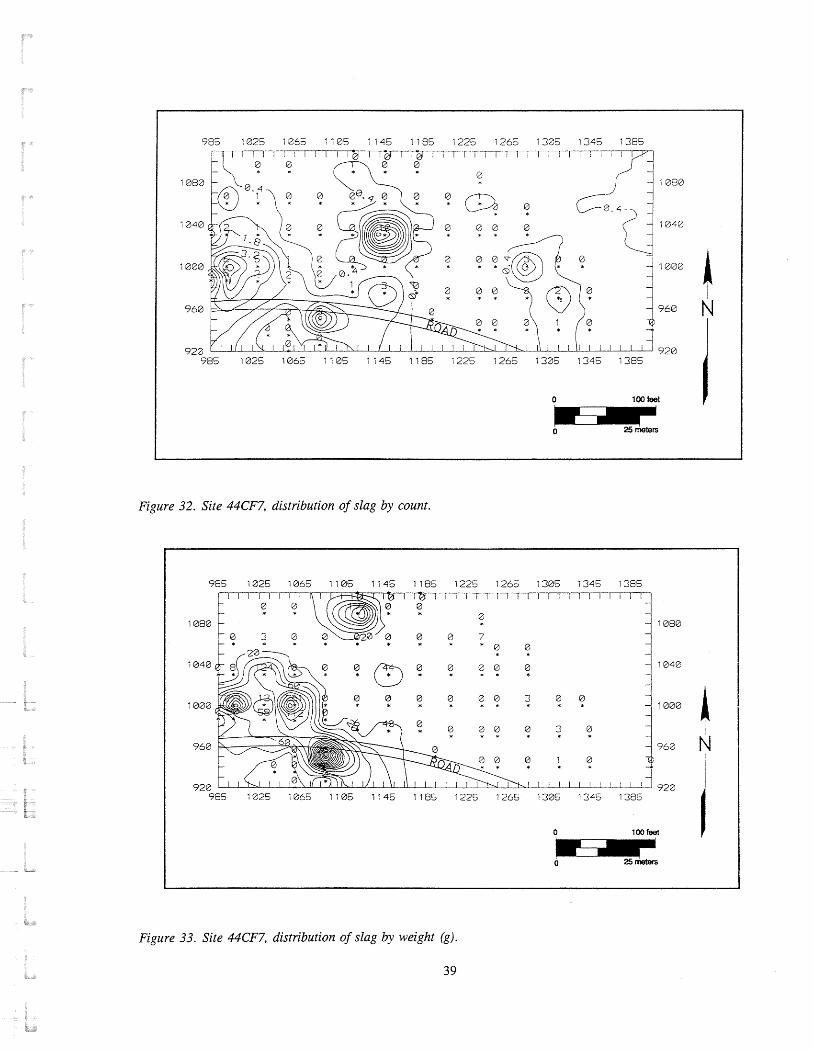
0 100 feet
Figure 32. Site 44CF7, distribution of slag by count.
Figure 33. Site 44CF7, distribution of slag by weight (g).
39

KEY
A - Brown (1OYR4/3) Sand B - Charcoal Mixed with Slag
C - Dark Yellowish Brown (1 OYR4/6) Sandy Clay (Subsoil)
Figure 34. Site 44CF7, profile of Shovel Test 86.
consisted of a top layer of brown (10YR413) sand (Layer A) that was 1.0 ft. thick (Figure 34). Beneath Layer A was a charcoal layer (Layer B) that contained pieces of slag. Layer B was over a dark yellow brown (10YR416) sandy clay subsoil (Layer C) at 1.20 ft. below ground surface. Embedded in the subsoil were several medium size cobbles.
Shovel Test 132, located 208 ft. east of Shovel Test 86, consisted of a light yellowish brown (10YR614) sand (Layer A) over a dark yellowish brown (10YR414) silty sandy clay (Layer B) (Figure 35). Below Layer B was a dark yellowish brown (10YR416) silty sand (Layer C). This deposit was over a brown (10YR513) silty clay (Layer D) that measured up to at least 2.5 ft. below ground surface. A large piece of unidentified iron was embedded in this layer at 2.3 ft. below ground surface. Artifacts included 18 pieces of iron, 1 fragment of modern bottle glass, and 1 piece of slag (see Appendix A).
KEY
A - Light Yellowish Brown (10YR6/4) Sand B - Dark Yellowish Brown (1 OYR4/4)
Silty Sandy Clay C - Dark Yellowish Brown (lOYR4/6) Silty Sand
D - Brown (lOI715/3) Silty Clay
Figure 35. Site 44CF7, profile of Shovel Test 132.
The soil profile for Shovel Test 101, located on the eastern half of the site, consisted of variations of brown sand and sandy clay soils (Layers A-F) over a yellowish brown (10YR416) sandy clay subsoil (Layer G) (Figure 36). Layers A and B appeared to be modem fill layers while Layers C-E represented alluvial deposits. These latter deposits contained several pieces of slag and charcoal.
Shovel Test 91, located 134 ft. west of Shovel Test 101, contained no slag or charcoal; however, a large piece of unidentified iron was found at approximately 1.6 ft. below ground surface (Figure 37). The iron object was contained within a brownish yellow (10YR616) sand (Layer C) and was beneath yellowish brown (10YR414) sandy clay (Layer B) and a yellowish brown (10YR514) sand (Layer A). Layer D consisted

KEY
A - Dark Brown (lOYR3/3) Sandy Loam (Fill) B - Brown (lOYR4/3) Sand Mottled with
Yellowish Brown (lOYR5/6) Clay and Dark Brown (1 OYR3/2) Sand (Fill)
C - Brownish Yellow (lOYiF26/6) Sand D - Dark Yellowish Brown (lOYR4/4) Sand
E - Brownish Yellow (lOYR6/6) Sand F - Dark Grayish Brown (1OYR4/2) Sandy Silty Clay
G - Dark Yellowish Brown (lOYR4/6) Sandy Clay
- - - -12
-16
- 20
- 24
- 28
- 32
0 - 10-
20 -
30 - 40 -
50 -
60 -
70 -
80 - centimeters inches
_I A
1
KEY
A - Yellowish Brown (lOYR5/4) Sand B - Yellowish Brown (I OYR4/4) Sandy Clay
C - Brownish Yellow (IOYR6/6) Sand D - Dark Yellowish Brown (lOYR4/6) Sand
E - Dark Grayish Brown (1OYR4/2) Sandy Clay
YO
- -
-12
-16
- 20
- 24
- 28
- 32
- 36
inches
0 - 10-
20 -
30 - 40 -
50 -
60 -
70 -
80 -
90 -
Figure 37. Site 44CF7, profile of Shovel Test 91.
>
centimeters
Figure 36. Site 44CF7, profile of Shovel Test 101.
of a dark yellowish brown (10YR416) sand. This layer was over a dark grayish brown (10YR412) sandy clay (Layer E) that was identified at 2.9 ft. below ground surface.
Shovel tests on the immediate north and south sides of the road contained the heaviest concentrations of slag and charcoal. These deposits were identified in Shovel Tests 75, 90, 107, 109, 111, 112, 113, 116, and 121. The typical soil profile for this group consisted of an upper layer of dark brown (10YR313) silty clay fill (Layer A) (Figure 38). Below Layer A was a yellowish brown (10YR.516) clay fill (Layer B) that measured up to 1.4 ft. below ground surface.
This layer was over a very dark grayish brown (lOYR312) sandy clay (Layer C). Layer D, identified at 2.0 ft. below ground surface, consisted of a layer of charcoal mixed with pieces of slag. Beneath this deposit was a layer of dark grayish brown (10YR412) sandy clay (Layer E). Layer E was over a relatively thick (.90 ft.) charcoal layer (Layer F) which also contained pieces of slag. Below this layer was a dark gray (10YR611) clay (Layer G). Water was encountered at 4.10 ft . below ground surface.
Soils to the far west of this group of shovel tests near Shovel Test 107 were typically characterized by as many as 10 different sandy and silty clay deposits. While the upper two layers (Layers A and B) were

0 - -0
10- - 20- - 30 - -12
40 - -16
50 - - 20
60 - - 24
70 - - 28
80 - - 32
90 - - 36
100- - 40
- 44
120 - 48
-----.ID
centimeters inches
KEY
A - Dark Brown (IOYR3/3) Silty Clay (Fill) B - Yellowish Brown (IOYR5/6) Clay (Fill) C - Very Dark Grayish Brown (IOYR3/2)
Sandy Clay (Fill) D - Charcoal Mixed with Pieces of Slag
E - Dark Grayish Brown (IOYR4/2) Sandy Clay F - Charcoal Mixed with Pieces of Slag
G - Dark Gray (I OYR6/1) Clay
Figure 38. Site 44CF7, profile of Shovel Test 112.
I centimeters inches 1
KEY
A - Dark Brown (lOYR3/3) Sandy Silty Clay (Fill) B - Dark Yellowish Brown (lOYR4/4)
Sandy Clay (Fill) C - Dark Brown (I OYR4/3) Sandy Clay D - Yellowish Brown (IOYR5/8) Sand
E - Black (IOYR2/1) Charcoal F - Yellowish Brown (IOYR5/6) Sandy Silty Clay
G - Dark Yellowish Brown (lOYR4/6) Clay H - Dark Grayish Brown (IOYR4/2) Silty Clay
1 - Yellowish Brown (lOYR5/6) Silty Clay J - Dark Gray (I OYR4/1) Sandy Clay
Figure 39. Site 44CF7, profile of Shovel Test 107.

KEY KEY
0 --r
10-
20 - 30 -
40 -
50 -
60 -
70 -
80 -
90 -
100-
110-
A - Dark Brown (lOYR3/3) Silty Sandy Loam (Fill) A - Brown (lOYR4/3) Silty Sandy Clay (Fill) B - Dark Yellowish Brown (lOYR4/6) Silly Clay B - Reddish Brown (5lR4/4) Clay with Gravel (Fill)
Mottled with Gray (lOYR6/1) Clay (Fill) C - Asphalt C - Slag and Charcoal D - Dark Yellowish Brown (lOYR4/4)
Sandy Clay (Fill) Figure 40. Site 44CF7, projile of Shovel Test 109. E - Charcoal Mixed with Slag
- - -
-12
-16
- 20
- 24
-28
- 32
- 36
- 40
- 44
obviously modern fill, apparent intact layers of slag and charcoal (Layers D and E) were identified at 1.5 ft. below ground surface (Figure 39). Below these layers, Layers F-I contained a light concentration of charcoal and slag and extended up to at lease 4.0 ft. below ground surface.
centimeters inches
The most distinct slag and charcoal deposits identified during the shovel testing phase were found in Shovel Tests 109 and 116, which were located 60 ft. and 96 ft. east of Shovel Test 107 respectively. The profile for Shovel Test 109 consisted of a top layer of dark brown (10YR313) silty sandy loam fill (Layer A) (Figure 40). Layer A was over a dark yellowish
Figure 41. Site 44CF7, projile of Shovel Test 116.
brown (10YR416) silty clay fill mottled with gray (10YR611) clay (Layer B). This layer was mixed with pieces of charcoal as well as fragments of modem bottle glass. Layer C, identified at 1.7 ft. below ground surface, consisted of a deep layer of slag and charcoal (Layer C). This deposit extended at least 2.9 ft. below ground surface.
Shovel Test 1 16, located 45 ft. southeast of Shovel Test 109 on the south side of the road, contained road- related fill deposits (Layers A-D) that measured up to 2.0 ft. below ground surface (Figure 41). Beneath

LINE LEVEL
FEA. 1C ROOT HOLE
L --------------- --- TEST UNIT 3 ,ROOT HOLE
__---- FEA. 1 SECTION
KEY
A - Very Dark Grayish Brown (lOYR3/2) Silty Loam (Topsoil) B - Pale Brown (lOYR6/3) Sand
C - Brown (I OYR4/3) Sand D - Brown (IOYR5/3) Coarse Sand Mottled with Yellowish Brown (lOYR5/6)
Sandy Clay and Yellowish Brown (lOYR5/8) Sand Feature IA - Olive Brown (2.5Y4/4) Silty Sand Feature IB - Very Pale Brown (I OI.117/4) Sand
Feature I C - Yellowish Brown Silty Sandy Clay Mottled with Brown Silty Clay
Figure 42. Site 44CF7, east profile of Test Units I and 3.
these layers was a layer of charcoal and slag (Layer E) that measured at least 1.3 ft. deep. Water was encountered at 3.3 ft. below ground surface.
Test Unit Results
Test units were placed in areas that the shovel test results indicated had the highest potential for containing features and deposits. The results of Robbins' testing and MacCord7s excavation work (1964) also factored into the placement of test units. Eight test units were excavated, including two 7 x 7 ft. test units (Test Unit 1 and 2), one 5 x 5 ft. test unit (Test Unit 6), and five 2.5 x 2.5 ft. test units (Test Units 3, 4, 5, 7, and 8) (see Figure 19).
Test Unit 1 was placed at the location of Shovel Test 132. As discussed in the preceding section, this shovel test contained pieces of slag and charcoal as well as an unidentified iron object located approximately 2.3 ft. below ground surface. The soils identified in Test Unit 1 differed from those found in Shovel Test 132. Layer A consisted of a very dark grayish brown (10YR312) silty loam topsoil and root mat that ranged from .05 to .50 ft. thick (Figure 42). Beneath Layer A was a pale brown (10YR613) sand (Layer B), containing pieces of coal and cinder, machine-made brick, plastic, and unidentified nails. Layer C, consisting of a brown (10YR413) sand, was identified at .90 ft. below ground surface (5.92 ft. below datum) and measured from .35 ft. to .60 ft.

thick. Contained within this layer were pieces of slag, charcoal, and coal, as well as pieces of plastic, machine-made brick, and modern bottle glass. Prehistoric artifacts included 2 pieces of quartz debitage and 1 piece of quartz fire-cracked rock. Layer D was identified at 1.2 ft. below ground surface (6.22 ft. below datum). This layer was a brown (10YR5/3), coarse sand mottled with yellowish b~owii (10YR5/6) sandy clay and yellowish brown (10YR.518) sand. Layer D was not excavated; however, 19 artifacts were recovered from the surface of the layer. This assemblage included a mix of slag, charcoal, modem bottle glass, and wire nails. Prehistoric artifacts consisted of 3 pieces of quartzite and 1 piece of quartz debitage.
Layers A-D represent grading activities and alluvial deposits that date to the twentieth century (see Figure 14). The mix of charcoal and slag with modern artifacts throughout relatively thick sand and silt layers attests to the extent of wash activity associated with flooding at this location.
A large circular feature was identified at the top of Layer D in the southeast comer of the test unit (Figure 43) (see Figure 42). Partial excavation of the feature revealed three deposits. Layer 1A was a olive brown (2.5Y414) silty sand. This layer contained pieces of charcoal and a fragment of asphalt. Layer A was over a very pale brown (10YR714) sand (Layer 1B) which in turn, was over a yellowish brown silty, sandy clay mottled with brown silty clay (Layer 1C). Layer 1B contained a piece of coal, and 1C, pieces of slag, modem bottle glass, and unidentified nail fragments.
The feature's sandylsilty deposits, its mixed artifact assemblage, and the presence of apparent root holes near its base indicate that Feature 1 is probably the remains of a tree. It is likely that the feature is a hole left by a tree fall and was subsequently filled by rain wash and flood deposits.
Traces of a second feature (Feature 2) were identified at the surface of Layer D in the northeast quadrant of the unit and corresponded to the location of Shovel Test 132 (Figure 44) (see Figure 43). The shape of the feature and its size could not be clearly discerned; hence, a 2.5 x 2.5 ft. unit (Test Unit 3) was excavated at this location. The grayish brown (10YR512) sand fill of Feature 2 dipped to the west and was distinguished from Layer D on the east side of the test unit. The similarity of the fill with Feature 1C
suggests that the deposits could be related, perhaps as ditch or gully fill, possibly the edge of the ravine illustrated by MacCord (see Figure 12). Feature 2 dates to the twentieth century as indicated by a large, modern iron artifact recovered from it.
A 2.5 x 2.5 ft. test unit (Test Unit 5) was placed 200 fi. west of Test Unit 1 at the location sf Shovel Test 86 (see Figure 19). As discussed above, Shovel Test 86 contained a charcoal-bearing layer and cobbles at its base. Pieces of slag were associated with these deposits. In general, the layers identified in the test unit were consistent with those found in the shovel test. Layer A consisted of a loose brown (10YR413) sand (Figure 45). This layer contained pieces of charcoal and a 1974 nickel. Layer B was located at .35 ft. below ground surface (4.66 ft. below datum). This layer consisted of a brown (10YR413) sand mixed with lenses of charcoal. Mixed within the layer were twentieth-century artifacts including pieces of machine- made brick, bottle glass, and a 1968 quarter. Layer C was a dark brown (10YR313) coarse sand mottled with yellowish brown (10YR514) sand and dark yellowish brown (10YR4/4) sandy clay. Layer C contained pieces of slag and charcoal mixed with twentieth-century bottle glass.
" Layer C was cut by Feature 4 on the northern half of the test unit (Figure 46). Partial excavation of the feature revealed a dark yellowish brown (10YR416) silty sand fill that measured from .10 to -80 ft. deep (see Figure 46). It contained pieces of modern bottle glass as well as chunks of slag and charcoal. At the base of the feature were pieces of a tree stump, indicating that Feature 4 was a tree hole. The cobbles identified along the southern edge of the feature (and at the base of Shovel Test 86) were embedded in strong brown (7.5YR416) sandy clay subsoil (Layer D). These stones represented natural deposition.
Layers A-C and feature fill in Test Unit 5 represent twentieth-century rain wash and flood deposits. These deposits are similar to those found in Test Unit 1 on the eastern part of the site.
Test Unit 4 was placed at the location of Shovel Test 91 and was located approximately 128 ft. southeast of Test Unit 5 and 100 ft. from Test Unit 1 (see Figure 19). This 2.5 x 2.5 ft. test unit consisted of five deposits. The top layer consisted of a brown (10YR513) sandy loam mixed with gravel (Layer A) (Figure 47). This layer contained twentieth-century

1061 N 1241 E
TEST UNlT 3 ,-'
:-I 20 centimeten
d
TEST UNlT 1
KEY
Layer D - Brown (IOMi5/3) Coarse Sand Mottled with Yellowish Brown (IOYR5/6) Sandy Clay and Yellowish Brown (IOYR5/8) Sand
Feature IA - Olive Brown (2,5Y4/4) Silty Sand Feature IB - Very Pale Brown (IOMi7/4) Sand
Feature 2 - Grayish Brown (IOYR5/2) Sand
Figure 43. Site 44CF7, plan of Features I and 2 in Test Units I and 3.
artifacts including 30 pieces of bottle glass. Layer A covered a very dark grayish brown (10YR3J2) sandy loam (Layer B). Beneath Layer B was a dark brown (10YR3J3) sandy loam (Layer C) mottled with variations of brown (10YR4/3, IOYR3/2) and red (5YR5/8) sandy clay. Layer D, located at .10 ft. below ground surface (3.87 ft. below datum), consisted of a brown (10YR5/3) sandy clay mottled with lenses of red (5YR5/8) clay, very dark grayish brown (10YR3J2) clay loam, and grayish brown (10YR5/2) sand. Layer E consisted of a thick layer of very pale brown
(10YR7/4) sand. A large iron object, initially identified in Shovel Test 91, was found in Layer E at 1.6 ft. below ground surface (4.47 ft. below datum). The iron was determined to be modern and was not excavated.
In s u m a r y , Layers A-E in Test Unit 4 were twentieth-century fill and flood deposits. This is indicated by the presence of mottled sandy clay and sand deposits, and modern artifacts mixed throughout the layers.

LlNE LEVEL
cm f e d
TEST UNIT 3
KEY
A - Very Dark Grayish Brown (lOYR3/2) Silty Loam (Topsoil) B - Pale Brown (lOYR6/3) Sand
C - Brown (1 OYR4/3) Sand D - Brown (lOYR5/3) Coarse Sand Mottled with Yellowish Brown (IOYR5/6)
Sandy Clay and Yellowish Brown (1 OYR5/8) Sand Feature 2 - Grayish Brown (IOYR5/2) Sand
Figure 44. Site 44CF7, north profile of Test Units 1 and 3.
t LlNE LEVEL 1 0 3 2 E
I
cm foot
FEA. 4 ]I-ed KEY
A - Brown (lOYR4/3) Sand B - Brown (lOYR4/3) Sand Mixed with Lenses of Charcoal
C - Dark Brown (lOYR3/3) Coarse Sand Mottled with Yellowish Brown (1 OYR5/4) Sand and Dark Yellowish Brown (1 OYR4/4) Sandy Clay
D - Strong Brown (7.5YR4/6) Sandy Clay (Subsoil) Feature 4 - Dark Yellowish Brown (lOYR4/6) Silty Sand
Figure 45. Site 44CF7, east profile of Test Unit 5.

LAYER D
KEY
Layer D - Strong Brown (7.5m4/6) Sandy Clay (Subsoil) Feature 4 - Dark Yellowish Brown (10I114/6) Silty Sand
Figure 46. Site 44CF7, plan and west profile of Feature 4 in Test Unit 5.

997.5N
t LlNE LEVEL 1147.5E
KEY
A - Brown (lOYR5/3) Sandy Loam Mixed with Gravel B - Very Dark Grayish Brown
(lOYR3/2) Sandy Loam C - Dark Brown (lOYR3/3) Sandy Loam Mottled with
Variations of Brown (1 OYR4/3, 1 OlX3/2) and Red (5YR5/8) Sandy Clay
D - Brown (lOYR5/3) Sandy Clay Mottled with Lenses of Red (5YR5/8) Clay, Very Dark Grayish
Brown (lOYR3/2) Clay Loam, and Grayish Brown (lOYR5/2) Sand
E - Very Pale Brown (1 OYR7/4) Sand
Figure 47. Site 44CF7, south profile of Test Unit 4.
Test Unit 8 was placed approximately 44 ft. southeast of Test Unit 4 (see Figure 19). This test unit contained modem fill deposits to a depth of at least 1.6 ft. below ground surface (4.44 ft. below datum). The top layer (Layer A) consisted of dark brown (10YR313) sandy loam and root mat (Figure 48). Layer B, identified at .30 ft. below ground surface (3.14 ft. below datum) was a brownish yellow (10YR618) sandy clay fill mottled with dark yellowish brown (10YR516) sandy clay and gray (10YR611) clay. Within this layer at 1.30 ft . below ground surface (4.14 ft. below datum) was a large log and decaying wood. The wood was found in association with pieces of modern bottle glass and brick. The size of the log prevented further excavation of the unit.
LlNE LEVEL
-_I______-------___
LIMIT OF EXCAVATION
L ---- --- ------,----- TOP OF CHARCOAL/BLACK LAYER
(BASED ON AUGER)
KEY
A - Dark Brown (10YR3/3) Sandy Loam B - Brownish Yellow (lOYR6/8) Sandy Clay Mottled with Dark Yellowish Brown (I 0lX5/6) Sandy Clay
and Gray (1OlX6/1) Clay (Fill)
Figure 48. Site 44CF7, north profile of Test Unit 8.
Although the unit was not excavated below this depth, a soil auger test detected a charcoal layer at 3.5 ft. (1.06 m) below ground surface (6.34 ft. below datum). This layer probably corresponds to a charcoal deposit found at the same depth in nearby Shovel Test 113.
Three test units were placed near the road in the approximate area of MacCord7s test excavations. Test Unit 2 was located near the rock cliff on the western half of the site (see Figures 12 and 19). This test unit, measuring 7 ft. square, revealed modem fill deposits (Figure 49). These deposits extended up to at least 3.4 ft. below ground surface (3.98 ft. below datum) and consisted of variations of brown sandy and silty clays. Beneath the fill was a damp, dark gray (10YR411) sandy clay.

LINE LEVEL
KEY
A - Dark Brown (lOYR3/3) Silty Loam (Fill) B - Light Brownish Gray (lOYR6/2) Clay Mottled with
Yellowish Brown (1 OYR5/6) Clay and Dark Brown (lOYR3/3) Silty Loam (Fill) C - Dark Brown (1 OYR3/3) Sandy Loam (Fill)
D - Black (lOYR2/1) Charcoal E - Yellowish Brown (lOYR5/4) Sandy Loam
F - Very Dark Grayish Brown (1 OYR3/2) Sandy Loam (Fill) G - Yellowish Brown (1 OYR5/4) Sandy Loam (Fill)
H - Dark Yellowish Brown (lOYR4/4) Silty Clay Mottled with Dark Brown (lOYR3/3) Sandy Loam (Fill)
1 - Dark Gray (lOYR4/1) Sandy Clay
Figure 49. Site 44CF7, west profile of Test Unit 2.
Three hundred and ninety-three artifacts were recovered from Test Unit 2. With the exception of 20 pieces of slag, this assemblage is essentially modern, including pieces of bottle glass, machine-made brick, and wire nails (see Appendix A).
The results indicate that this location has been heavily disturbed during the twentieth century. The deposits may be trench backfill associated with MacCord's excavations in 1963, clearing for the apartment complex recreation area, or fill deposits
related to machine work on the property during the first half of the century (see Chapter 2).
Test Unit 6 was placed approximately 60 ft. east of Test Unit 2 and near the location of MacCord's Trench 13 (see Figures 12 and 19). Four modern fill deposits were identified within the test unit. The deposits had combined depths ranging from 1.4 ft. below surface on the east to 3 ft. below surface on the west (3.86 ft. to 5.46 ft . below datum) (Figure 50). Layer A consisted of a very dark brown (10YR212) sandy loam.

987N
LINE LEVEL 1065E
v i -0'
--z
B
C r
----....---- -- crn feet 'N.
D '. '. . --\. E \\\.
\ . \ ' \ \-. ---- -
KEY
A - Very Dark Brown (1 OKU2/2) Sandy Loam (Fill) B - Gray (lOYR6/1) Sand (Fill)
C - Dark Grayish Brown (lOYR4/2) Silty Clay (Fill) D - Yellowish Brown (1OYR5/8) Clay (Fill)
E - Slag
Figure 50. Site 44CF7, south profile of Test Unit 6.
Beneath this layer was a layer of gray (10YR611) sand layer contained pieces of charcoal but was made up (Layer B). Beneath the sand was a deposit of dark predominantly of slag. A large chunk of slag, grayish brown (10YR412) silty clay (Layer C). Eayer measuring at least 1.5 ft. long and .4 ft. wide was C was over a thick layer of yellowish brown embedded in the surface of Layer E on the west side of (10YR5/8) clay (Layer D). the test unit (see Figure 5 1).
The recent age of Layers A-D is evident from the artifacts found in the deposits, that include pieces of modern bottle glass, machine-made brick, and asphalt. Of the combined total (n= 302), 244 artifacts were found in Layer D. Eighty-three percent (n=203) of this assemblage consists of pieces of slag with the remainder comprised of twentieth-century window and bottle glass fragments, file, and machine-made brick.
A slag and charcoal layer (Eayer E) was identified beneath Layer B at 1.4 fa. below ground surface (3.86 ft. below datum) (Figure 51). This layer was not excavated, but was augured with limited success. Although the slag did not permit the auger to completely penetrate the deposit, the layer measured at least .5 ft. deep on the western half of the unit. The
The slag and charcoal dipped beneath the fill to the west, indicating that part of the deposit had been removed during prior excavation. The location of the test unit relative to MacCordYs work indicates that Layer E is most likely the same slag and charcoal deposit that he encountered in his Trench 13 (MacCord 1964:6-7). Furthermore, MacCord (1964:7) states that "near the center of the trench [Trench 131, we encountered a concentration of stones, bricks, and large lumps of slag which appeared eo be a foundation [Feature 41." He interpreted this feature as the foundation of "one of the auxiliary forges, possibly the chafery , which complemented the blast furnace" (MacCord 1964: 9). - The large piece of slag embedded in the surface of Layer E in Test Unit 6 is probably part of the structural feature that he identified. It was
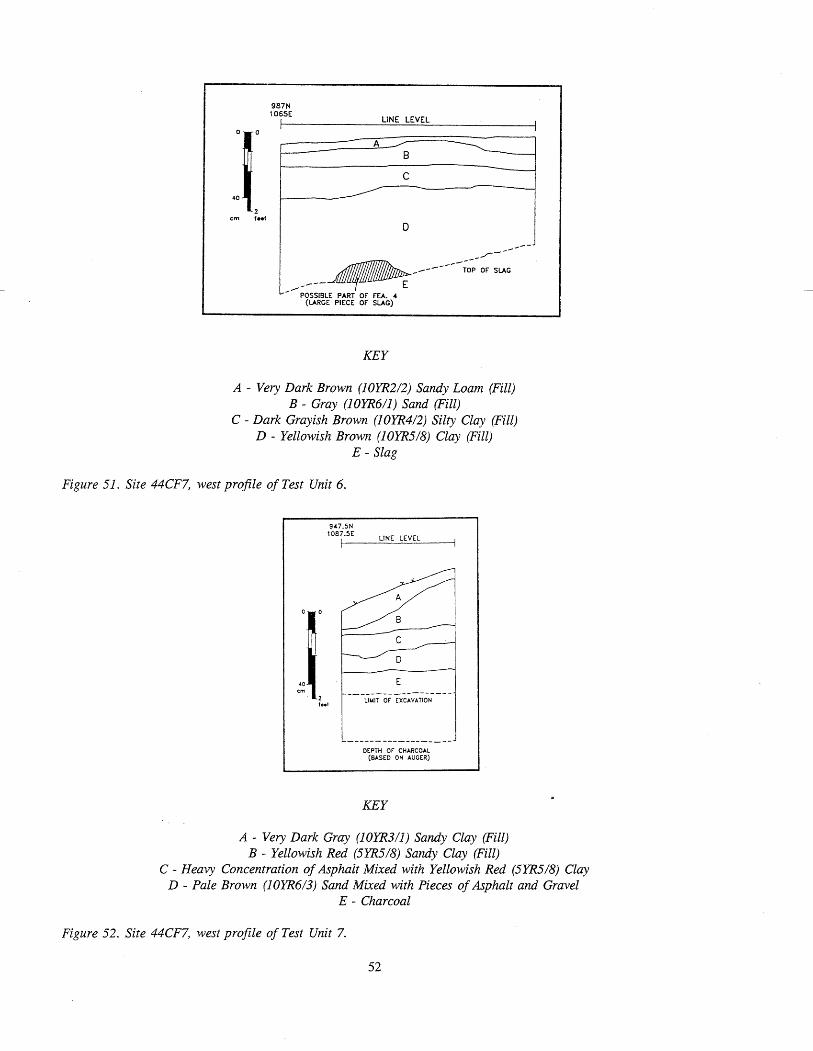
LINE LEVEL
KEY
A - Very Dark Brown (lOYR2/2) Sandy Loam (Fill) B - Gray (lOYR6/1) Sand (Fill)
C - Dark Grayish Brown (lOYR4/2) Silty Clay (Fill) D - Yellowish Brown (lOYR.5/8) Clay (Fill)
E - Slag
Figure 51. Site 44CF7, west profile of Test Unit 6.
LIMIT OF EXCAVATION
-___-----____-_ ___- - DEPTH OF CHARCOAL
(BASED ON AUGER)
KEY
A - Very Dark Gray (lOYR3/1) Sandy Clay (Fill) B - Yellowish Red (5YR5/8) Sandy Clay (Fill)
C - Heavy Concentration of Asphalt Mixed with Yellowish Red (5Y115/8) Clay D - Pale Brown (lOYR6/3) Sand Mixed with Pieces of Asphalt and Gravel
E - Charcoal
Figure 52. Site 44CF7, west profile of Test Unit 7.

located at 2.5 ft. below ground surface, approximately the same depth as Feature 4 (MacCord 1964:7, 9). The results indicate that most of the feature is located immediately west of Test Unit 6.
A 2.5 x 2.5 ft. test unit (Test Unit 7) was placed approximately 41 ft. southeast of Test Unit 6 (see Figure i 9). It was situated on the south shoulder of the access road and at the approximate location of MacCord's Trench 2 and the VDHR auger test (1990). The top layer (Layer A) consisted of a very dark gray (10YR3/1) sandy clay fill (Figure 52). This layer contained pieces of plastic and asphalt. Beneath Layer A was a yellowish red (5YR5/8) sandy clay fill (Layer B). Below Layer B was a heavy concentration of asphalt mixed with some yellowish red (5YR5/8) clay (Layer C). Beneath the asphalt layer was a deposit of pale brown (10YR6/3) sand (Layer D) that was mixed with pieces of asphalt and gravel.
Layer E, identified at 1.3 ft. below ground surface (. 16 ft . below datum), consisted of charcoal (see Figure 52). This deposit was excavated to .60 ft. below its surface. An auger test at this depth revealed that the charcoal measured an additional 1.3 ft. deep. The depth of the charcoal and its location indicate that it is the same deposit as MacCord's Feature 1 and yielded the charcoal samples collected by VDHR archaeologists. The predominant type of wood identified from the charcoal samples is yellow pine with lesser amounts of red oak and hickory (MacCord 1964:8). Samples recently taken from the deposit have provided a radiocarbon date of A. D . 1490- 1630. The period of the ironworks, 16 19-1622, falls within this date range.
The research results of the archaeological evaluation correspond with those of MacCord's work and generally support his conclusions about the types and distribution of historic archaeological resources. The thick slag deposit on the north side of the access road and charcoal layer on the south cover an area of approximately 145 ft. east-west x 45 ft. north-south. Although a light scatter of slag and charcoal was found across the site, the materials identified adjacent to the road indicate that it is the main activity area on the site (see Figures 32 and 33). The slag and charcoal deposits appear to be associated with different functional areas. The charcoal "was probably the stockpile of charcoal made and maintained for charging the blast furnace and was located near the up-hill side of the furnace for convenience in loading the furnace from the top" (MacCord 1964: 8). The slag deposit identified opposite
the charcoal is waste from the furnace as well as the possible location of an auxiliary forge such as a chafery (MacCord 1964: 9). Similar deposits have been documented on other ironworks sites, i.e., Saugus, and are usually separated by furnaces and related structures. The research results indicate that the main furnace may be located beneath the road just west of Test Units 6 and 7.
In addition to the historic resources, testing identified the presence of a small prehistoric component at 44CF7. Prehistoric remains are represented by a light (n=41) scatter of artifacts, which consist of quartz, quartzite, and chert debitage, fire-cracked rock, and bifaces. This component most likely represents a campsite. The low density and range of artifacts suggest that the site served as a procurement camp where activities focused on food procurement and to a lesser extent, tool resharpening . The absence of diagnostic artifacts does not permit its age to be determined.
Cut Features in Rocks
The archaeological evaluation of 44CF7 included the reexamination of a series of man-made cuts posthole^'^ or sockets) in the rock ledges along the falls (Figure 53) (see Figure 13). The features were first documented by MacCord (1964) as part of his investigation of 44CF7 and believed to have held timber bracing for a dam and flume trestle (see Figure 13). The purpose of the current work was to map the features relative to 44CF7 and the adjacent eighteenth- century gristmill complex and to determine their historical association.
MacCord (1 964: 8-9) documented three groups of cuts (n =22) at the falls. He noted that the cuts along the central portion of the lower falls measured 4 in. square while those on rocks on the north and south banks measured 10 in. square. The smaller cuts were noticeably lower in elevation than the larger features.
The current investigation identified most of the cuts documented by MacCord; however, the number and precise location of some of the features are different. A total of 50 cuts was identified (see Figure 53). Pn general, the features were square or rectangular, and the majority were represented by three sides. The features ranged from .4 to 1.5 ft . along their sides. As noted by MacCord, the small cuts were aligned roughly north-south along the three major rocks of the lower
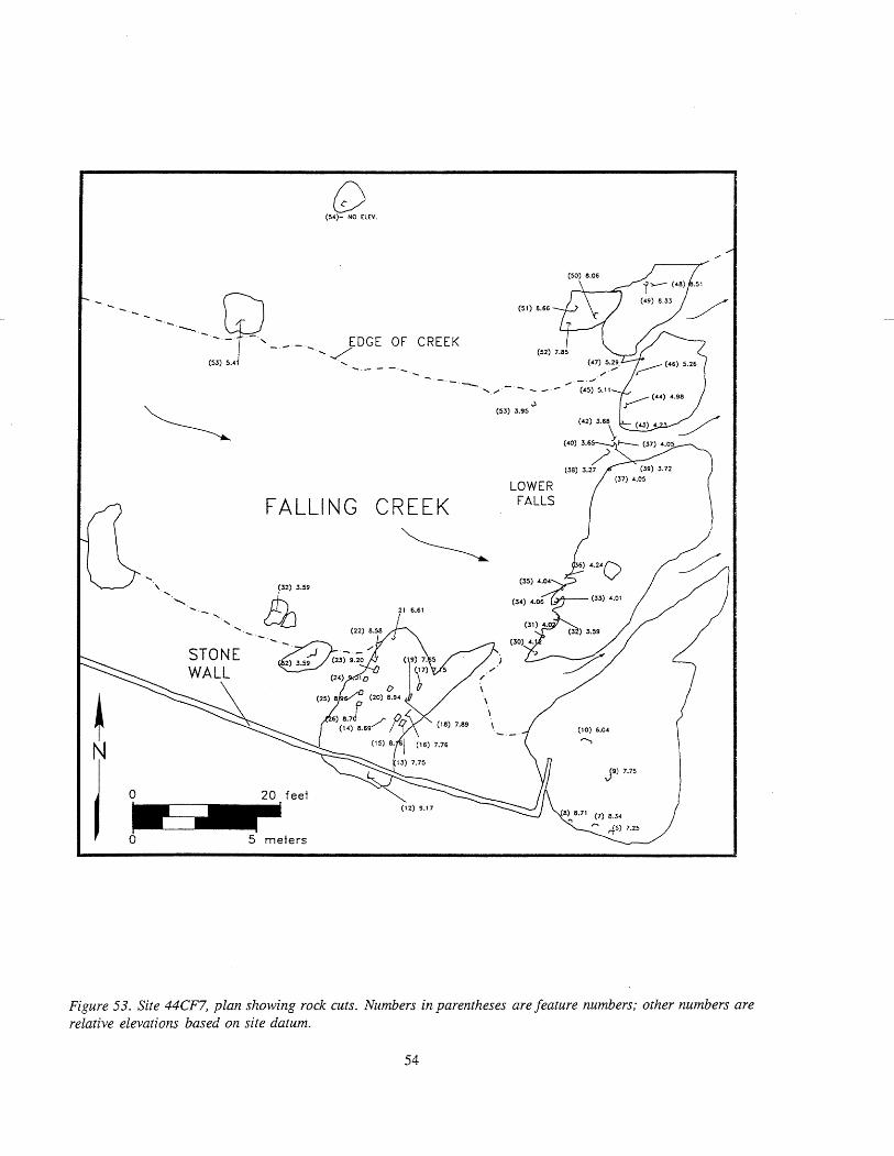
(54)- NO ELEV
/ /
EDGE OF CREEK
2 - - - \ . - - - - - \ - (45)5.11
FALLING CREEK
5 meters
LOWER FALLS
Figure 53. Site 44CF7, plan showing rock cuts. Numbers in parentheses are feature numbers; other numbers are relative elevations based on site datum.

Figure 54. Site 44CF7, Feature 30 rock cut, plan view, looking west.
falls, and the larger features clustered on rock outcrops on the north and south banks of the creek (Figures 54 and 55). The smaller cuts averaged approximately 4 ft. lower than the larger features. Several of the cuts within the smaller group were fairly large (.80 ft.) compared to the typical size (.40 ft.) in this group and were located underwater. These cuts tended to be clustered at the head of a cascade near the north end of the falls.
MacCord (1964:9) concluded that the differences in size, location, and elevation of the features correspond to different functions and construction periods. The small cuts, spaced some 2.5 ft. apart, most likely held timber braces for a dam. The braces probably sat at 45" angles to the dam, which was located slightly upstream from the main line of rocks on the lower falls (MacCord 1964:8). The cuts beneath the water at the head of the cascade may also have held braces for a dam or part of the dam structure such as a Watergate. The smaller size and lower elevations of the cuts compared to the larger cuts may be a reflection of the different structures they supported andlor periods of their construction.
The larger cuts may have held trestle posts for a flume that carried water from a pond to an overshot
waterwheel at the furnace. The furnace and waterwheel were probably located near Test Unit 6. The ground surface at Test Unit 6 is approximately the same elevation as the large cuts, indicating that the trestle was probably raised several feet higher than its eastern end. This permitted the flume to clear the rock outcrop located between the cuts and the furnace, and to provide an adequate volume of water to operate the wheel. The weight and height of the flume and force of the water would have required stabilization of trestle posts located on the rocks, hence the size of the features (MacCord 1964:9). Several of the larger features share the same spacing and alignment while others do not, which suggests different periods of construction. These data, coupled with the presence of large cuts on both sides of the creek, indicate that the trestlelflume was repaired, replaced, or relocated over time. MacCord concludes:
There is a good possibility that Group A [smaller cuts] was a first effort-lighter construction, lower elevations, and nearer the furnace. If this combination did not consistently produce the power and volume of water wanted, a relocation to a higher elevation with heavier and stronger construction during a period of rebuilding would not only have been desirable,

but would be in keeping with the usual trend toward improved facilities as time passed (1964:9).
MacCord7s interpretation of the features as components of the ironworks is plausible; however, it is possible that they may be associated with later activities. The Ampthill gristmill complex, located adjacent to the falls on the north bank of the creek, was built during the eighteenth century and used well into the nineteenth century. The close proximity of the rock cuts to the mill suggests that these features could have been part of a dam associated with this structure.
The association between the rock cuts and the mill is tenuous at best given the location and elevation of the mill raceway relative to the falls. The raceway/sluice, shown on several historic maps, is presently located at the southwest corner of the mill building (see Figure 3). It has a northwest-southeast orientation and is located several feet above the falls. Archaeologist Roland W. Robbins (195 1 :38B) (see Appendix C) commented on the source of water for the mill and the apparent age of its raceway in his investigation of the site in 195 1 :
I did locate evidence of an old dam just easterly of present army dam. An old, deserted canal led from the site of this early dam along the north side of the creek to the ruins at the grist mill. This canal furnished water for power purposes at the grist mill. Whether or not the canal furnished power for an earlier activity at site of grist mill I cannot say, however, it is possible.
Robbins observed that the canal joined to "a large round sluice (it had been a metal pipe) . . . " that carried water below the falls to the water wheel near the southeast corner of the mill (Robbins 1951 :38C).
The sluice described by Robbins appears to be associated with a later period of the mill operation, but may have been adapted for use from an earlier feature. The 1802 Winfrey map suggests that the later sluice followed the same path as the original sluice and was associated with either the canal, as Robins indicates, or a large pond dammed at the falls (see Figure 3). The -
variations in the size and spacing of the cut features in the rocks may indicate that portions of ehe dam required stronger construction and/or were repaired over time. The earlier ironworks dam adjacent to the mill may have been replaced by a dam and canal
Figure 55. 44CF7, Features 13, 14, and 15 rock cuts, plan view.
upstream to provide the necessary water flow to operate the mill.
During the course of the investigation, rock outcrops located east of the falls on the north bank of the creek were also examined for cut features. A group of six cuts was identified on a large rock approximately 260 ft. east of the mill (see Figure 3). The features are roughly square and measure approximately -3 ft. wide. They range from .2 ft. to .4 ft. apart and are oriented northwest-southeast. The cuts are located approximately 6 ft. from the southern edge of the rock. The age and function of the features are unknown. The features are more crudely made than the cuts at the falls and do not appear to be associated with that complex. Given their relatively close proximity to this latter group and location within the boundaries of 44CF7, however, it is possible that they are associated with the ironworks or later gristmill.

Chapter 5: Research Summary
The primary goal of the present investigation was to evaluate the eligibility of 44CF7 for norninatioa! to the National Register of Historic Places. To this end, the archaeological investigation attempted to verify the results of previous archaeological testing (MacCord 1964) and assess the present integrity of the site. Furthermore, the investigation sought to define the entire site area through additional survey and testing in an attempt to identify potentially related components outside of the known site such as housing or other activity areas or facilities. The synthesis of the site's historical context with regard to its use as an ironworks permitted the archaeological resources identified to be assessed in terms of current research pertaining to such sites.
The Falling Creek Ironworks is recognized as the first successful, integrated iron production facility in English North America. The exploitation of natural commodities was a principal objective of the Virginia Company of London from the earliest period of their Virginia venture.
The onset of Sir Edwin Sandys' term as treasurer of the Virginia Company in London in 1618 resulted in a renewed commitment to industrial development, particularly to iron production. In cooperation with Southhampton Hundred plantation, an expedition of 80 persons under the command of Captain Blewett was dispatched "wth all manner of prouisions for the settinge vp of an Iron Worke in Virginia" (Kingsbury 1906:587-588).
Despite the death at sea of "the Chiefe men for the Iron worke," the relief supply apparently succeeded in completing a portion of the ironworks at Falling Creek in 1620 and produced a sample of iron prior to the arrival of three replacements later that year (Kingsbury 1906:472; 1933:240). In addition to the three replacement workers, by late June 1621 a fourth individual, John Berkeley (along with his son, Maurice, and three family servants), was dispatched to Virginia as Master of the ironworks with 20 men skilled in ironworking. Berkeley's party specifically included workers to "be employed upon the Furnace" and "upon the Forge," explicit evidence for an integrated
operation producing both cast and wrought iron (Kingsbury l906a:472).
The production of iron was abruptly halted by the PowhatanIEnglish conflict of 1622. A total of 27 persons were slain at the ironworks, including John Berkeley (Kingsbury 1933 565). The slaughter of the inhabitants of the Falling Creek settlement was compounded by the thorough destruction of the facility by the Indians (Beverley 194754-55 ; Stith 1965 :2 18). Though there was considerable interest in reestablishing the operation through the end of the Virginia Company period, the level of destruction effectively terminated this apparently successful endeavor.
Extensive work has been undertaken within the project area during the twentieth century. This work includes the construction of bridges over Falling Creek for a railroad and Interstate 95 and commercial development. Part of the latter development involved the construction of the Falling Creek Apartments and an access road paralleling Falling Creek to the James River. A survey of parcels near 44CF7 was conducted in an attempt to identify potentially related housing or other activity areas or facilities associated with the site.
Survey Area A lies at the terminus of the access road and adjacent to the James River. The survey results indicate that extensive modem filling has occurred in this area. Modem fill deposits characterized Location 1, which was identified in the middle of the survey area. This location yielded a fragment of pearlware ceramic, a piece of quartz debitage, and a piece of punctatelnet-impressed ceramic.
Survey Area B is located several hundred feet west of Survey Area A on the floodplain of Falling Creek. The survey indicates that the western one-third of Area B has been disturbed by the construction of a swimming pool, parking lot, and access road. A small prehistoric site was identified near the center of the parcel just east of this development. Site 44CF506 probably served as a campsite for prehistoric groups. The low density and range of materials recovered suggest that the site functioned as a procurement camp

where activities focused on food processing and to a lesser extent, tool resharpening. The absence of diagnostic artifacts recovered from the site does not permit its age to be determined.
Survey Area C consists of a floodplain, falls, and the grass and wooded slope and hill immediately north of the Falling Creek Apartments. It also includes 44CF7, which encompasses the northern half of the survey area. The survey indicates that the southern half of Area C has been heavily disturbed by development. The southeastern and southwestern portions of the area, in particular, consist of modern fill deposits that are probably associated with the construction and landscaping for the apartments. No sites were identified on the southern half of Area C; however, Location 2 was found on the southeastern half of the area. Location 2 yielded a prehistoric quartz tool, pieces of slag and cinder, and twentieth-century artifacts.
Site 44CF7 occupies the northern half of Area C. Testing at the site identified both prehistoric and historic resources. Prehistoric remains are represented by a light (n=41) scatter of artifacts which consist of quartz, quartzite, and chert debitage, fire-cracked rock, and bifaces. These materials were concentrated on the eastern and western portions of the site and found in association with modern artifacts. This component most likely represents a campsite. The low density and range of artifacts suggest that the site served as a procurement camp where activities focused on food procurement and, to a lesser extent, tool resharpening . The absence of diagnostic artifacts does not permit its age to be determined.
The historic remains comprise the major component. These resources generally correspond with those found by Robbins and MacCord and support some of their conclusions about the types and distribution of archaeological resources. Analyses of the site's archaeological remains, its physiographic setting, and the historical data, support the interpretation of 44CF7 as the location of the Falling Creek Ironworks established by the Virginia Company in 1619.
Shovel testing revealed a Bight scatter of charcoal and slag over a floodplain that measured approximately 300 ft. east-west x 100 ft. north-south. This low density scatter generally consisted of small pieces mixed in alluvial deposits. In contrast, virtually pure layers of charcoal and slag were found adjacent to an
access road near the southern boundary of the site. A thick deposit of slag was identified on the immediate north side of the road, and the charcoal layer on the south side. Together, these remains extended over an area of approximately 145 ft. east-west x 45 ft. north-south.
The charcoal and slag layers are the same deposits identified by MacCord in 1963. While no artifacts were recovered from these deposits during the current survey, they yielded several wrought-iron tools, spikes, and brick bats during the earlier investigation (MacCord 1964:9-12). Several of the bricks were coated with slag suggesting that the furnace or auxiliary forge may have been brick lined. Traces of crushed oyster shell found beneath the slag during that investigation possibly represent mortar for the furnace brickwork or flux added during the smelting process (MacCord 1964: 7).
Analyses of charcoal and slag samples provide information on the age of the deposits as well as the ironworking processes undertaken. It is known, for example, that the predominate type of wood burned for charcoal fuel was yellow pine with lesser amounts of red oak and hickory (MacCord 1964:8). The predominance of pine is unusual given that hardwoods were generally preferred because they burned hotter (Salmon 1986: 15).
Radiocarbon analyses of charcoal samples recently collected by VDHR archaeologists provide a date of A. D . ,1490- 1630, supporting the association of the deposits with the seventeenth-century ironworks. Metallurgical assays of slag specimens indicate that these deposits were by-products of a blast furnace and distinguishes them from the remains of Archibald Cary's eighteenth-century forge on the north bank of Falling Creek (Gregory 1957: 17-19).
The separate locations of the slag and charcoal deposits indicate the existence of distinct functional areas and imply a relatively high degree of integrity to this part of the site. The charcoal "was probably the stockpile of charcoal made and maintained for charging the blast furnace and was located near the uphill side of the furnace for convenience in loading the furnace from the top"(MacCord 1964:8). The slag deposit, on the other hand, was a waste pile as well as the possible location of an auxiliary forge. Similar deposits have been documented on other ironworks sites, i.e., Saugus, and are usually separated by furnaces and

related structures. The research results indicate that the main furnace may be located beneath the road just west of Test Units 6 and 7. Although no clear evidence of a structure was found during the current research, a large chunk of slag was identified that may be associated with the building remains described by MacCord (1 964:9).
The site chosen for the ironworks and the manner in which the facility was constructed were similar to other colonial furnaces (Hartley 1957; Salmon 1986; Troup, Barnes, and Barka 1978; Sanford, personal communication 1993). The success of this venture was in large measure dependent upon the skill of the ironworks master and his workers. The availability of natural resources also factored into its success including an adequate water source; close proximity to suitable limonite deposits, and abundant timber for the production of charcoal. Site 44CF7 was located relatively close to an ore source, a tract known locally as Iron Bottom. However, the archaeological evidence indicates that this tract is located outside of the surveyed areas. Stone and timber were also available on the 100 acres "surrendered for use of the Iron Works" by property owner, John Blower (Hatch 1957:59). Ironmaster of the Falling Creek works, John Berkeley, and Sir Edwin Sandys, representative of the Virginia Company, considered the Falling Creek site to be ideally suited for the facility (Hartley 1957:36-37).
Stone construction at 44CF7 is not clear from the archaeological evidence; however, furnaces were usually built of stone blocks with lesser amounts of bricks. The typical furnace stack measured about 25 ft. square at its base and tapered toward the top; it usually stood 30 ft. high and often was constructed in the side of a hill. Crossing a wooden bridge from the hilltop to the top of the stack, workmen (known as fillers) charged or fueled the furnace with alternating layers of charcoal and ore. As noted above, the charcoal and slag identified at 44CF7 are the remains of fuel and waste piles associated with this operation.
Site 44CF7's furnace was probably situated at the present location of the access road or immediately adjacent to it on the north. In addition, auxiliary structures such as a refining furnace, chafery, and sheds may have been close by (Hatch and Gregory 1962:269; Noel Hume 1975: 177-1178). Traces of at least one of these structures may have been found (MacCord 1964:9).
Site 44CF7 was much better suited for a furnace and auxiliary structures in terms of its elevation, working space, and access to navigable water than the creek's banks above (west of) the falls (Robbins 1951) (see Appendix C). The site lay approximate 150 ft. downstream of the falls. The presence of postholes or sockets cut into the stones at the falls are evidence of a d m md possibly a flume thiii may have besii associated with 44CF7. These structures would have been essential components of the ironworks, providing the necessary flow and volume of water to operate the furnace(s) .
Historical data suggests that 44CF7 was intended to be an integrated works to include a blast furnace, a refinery furnace, and a chafery. 'While the establishment of the ironworks was slow to develop, iron was apparently being produced on the site by 1620. It is possible that only part of the facility had been completed at that time. Soon after Berkeley's arrival in the summer of 1621, he indicated that increased iron production would be achieved by the spring of 1622 (Kingsbury 1933 :548). This information coupled with the archaeological results raise some question as to the size of the operation at the time of Berkeley's arrival. The principal work area, for example, appears to have been relatively small for a typical complex of furnaces and related structures. It is possible that at least some of the auxiliary structures for the main furnace were still in the planning stages or under construction at the time the site was destroyed in 1622 (Hartley 1957:41-42).
In summary, the research results concur with most of the findings of previous research at 44CF7. The results indicate that the site is the location of the ironworks established by the Virginia Company on Falling Creek in 1619 and that it contains significant archaeological resources. Although the research effort found no conclusive evidence of structures or domestic areas, thick slag and charcoal deposits associated with the blast furnace operation were identified adjacent to the current access road near the southern boundary of the site. These deposits are relatively intact. As a result of both historical and archaeological investigations summarized in this report, the Falling Creek Ironworks, as represented at 44CF7, was recently nominated for listing on the Virginia Landmarks Register and National Register of Historic Places.


REFERENCES CITED
Beverley, Robert 1947 The History and Present State of Virginia. Reprinted. University of North Carolina Press,
Chapel Hill. Originally published in 1705.
Brock, R. A. 1885 Early Iron Manufacture in Virginia - 1619-1776. Proceedings of the United States
National Museum 8:77-80.
Brock, Robert K. 1937 Archibald Cary of Ampthill: Wheelhorse of the Revolution. Garrett and Massie, Richmond.
Boyer, Charles S. 193 1 Early Forges and Furnaces in New Jersey. University of Pennsylvania Press, Philadelphia.
Brown, Gregory J., Thomas F. Higgins 111, David F. Muraca, S. Kathleen Pepper, and Roni H. Polk 1990 Archaeological Investigations of the Shields Tavern Site, Williamsburg, Virginia. On file,
Department of Archaeological Research, Colonial Williamsburg Foundation, Williamsburg, Virginia.
Byrd, William 1901 A Progress to the Mines in the Year 1732. In The Writings of "Colonel William Byrd of
Westover in Virginia, Esqr, " edited by John Spencer Bassett, pp. 33 1-386. Doubleday, Page & Company, New York.
1941 The Secret Diary of William Byrd of Westover, 1709-1 712, edited by Louis B. Wright and Marion Tinling. Dietz Press, Richmond.
Chesterfield County Records n.d. Deed Books on file, Office of the Clerk of the Circuit Court, Chesterfield, Virginia.
Cotter, John L. 1958 Archeological Excavations at Jamestown Colonial National Historical Park and Jamestown
National Historic Site. National Park Service, Archeological Research Series No. 4. U . S . Department of the Interior, Washington, D. C.
Foss, Robert 1977 Report on the 1975 Archaeological Investigations at the James Anderson House. On file,
Foundation Library, Colonial Williamsburg Foundation, Williamsburg, Virginia.
Gilmer, J. F. 1863 Map of Chesterfield County. On file, Virginia Historical Society.
Gregory, Thurlow Gates 1957 Iron of America Was Made First in Virginia. On file, Virginia Historical Society,
Richmond.
1960 Supplement to the Report Titled Iron Was Made First in Virginia. On file, Virginia Historical Society, Richmond.

Harrison, Fairfax 1919 The Virginia Carys: An Essay in Genealogy. De Vinne Press, New York.
Hartley, E. N. 1957 Ironworks on the Saugus: The Lynn and Braintree Ventures of the Company of Undertakers
of the Ironworks in New England. University of Oklahoma Press, Norman.
Hatch, Charles, E. 1957 The First Seventeen Years, Virginia, 1607-1624. The University Press of Virginia,
Charlottesville.
Hatch, Charles E., and Thurlow Gates Gregory 1962 The First American Blast Furnace, 1619-1622: The Birth of a Mighty Industry on Falling
Creek in Virginia. Virginia Magazine of History and Biography 70(3):258-296.
Hening, William Waller 1969 The Statutes at Large; Being a Collection of All the Laws of Virginia from the First Session
of the Legislature in the Year 1619. Reprinted. University Press of Virginia, Charlottesville. Originally published 1823, R., W., and G. Bartow, New York.
Hodges, R. L. 1978 Soil S u w q of Chesterfield County, Virginia. U.S. Department of Agriculture, Soil
Conservation Service, Washington, D .C.
Kingsbury, Susan Myra (editor) 1906-1935 The Records of the Virginia Company of London. 4 vols. U. S. Government Printing Office,
Washington, D.C.
Le Prade, D. 1838 Map of Ampthill Farm. On file, Virginia Historical Society, Richmond.
MacCord, Howard A. 1964 Exploratory Excavations at the First Ironworks in America (44CF7). Archeological Society
of Virginia Quarterly Bulletin 19(1):2- 13
1990 Personal communication.
Noel Hume, Ivor 1975 Historical Archaeology. Norton, New York.
Nugent, Nell Marion 1992 Cavaliers and Pioneers: Abstracts of Virginia Land Patents and Grants. 3 vols. Reprinted.
Virginia State Library and Archives, Richmond. Originally published 1934, Dietz Press, Richmond.
Richmond News Leader 1925 Wharf is Found Buried 8 Feet. Richmond News Leader 8659:4.
Robbins, Wollin Wells 1951 Saugus Daily Log, 195 1. Manuscript on file in Papers of Roland Wells Robbins, Lincoln,
Massachusetts.

1952-1963 Correspondence. On file in Papers of Roland Wells Robbins, Lincoln, Massachusetts.
Robbins, Roland Wells, and Evan Jones 1959 Hidden America. Knopf, New York.
Salmon, John S. 1986 The Washington Iron Works of Franklin County, Virginia, 1 773-1 850. Virginia State
Library, Richmond.
Sanford, Douglas W. 1993 Personal communication.
Sanford, Douglas W., et al. 1993 The Neabsco Mills Ironworks: A Phase I and Phase I1 Archaeological Survey, Prince
William County, Virginia. Draft on file, Virginia Department of Historic Resources, Richmond.
Stith, William 1965 The History of the First Discovery and Settlement of Virginia. Reprinted. Reprint Company,
Spartanburg. Originally published 1747.
Tarleton, Banastre 1787 A History of the Campaigns of 1780 and 1781 in the Southern Provinces of North America.
Dublin. First edition copy on file at the Virginia Historical Society, Richmond.
Troup, Charles G., Arthur G. Barnes, and Norman F. Barka 1978 The Potts and Wilson Iron ForgdFoundry, Patowmack Canal, Great Falls Park, Virginia.
On file, William and Mary Center for Archaeological Research, Williamsburg, Virginia.
Turner, E. Randolph, 111, and Antony F. Opperman n.d. Searching For Virginia Company Period Sites: An Assessment of Surviving ArchaeoLogical
Manifestations of Powhatan-English Interactions, A. D. 1607-1 624. Forthcoming, Virginia Department of Historic Resources Survey and Planning Series. VDHR, Richmond.
Waldrop, Charles 1993 Personal communication.
Winfrey , H. 1802 A Map of the Ampthill and Chesterhill Lands lying on James River and Falling Creek. On
file, Virginia Historical Society, Richmond.
Wittkofski, J. Mark, Elizabeth P. Hoge, Mary Ellen Norrisey Hodges, Keith Egloff, and E. Randolph Turner I11 1989 Virginia Unpublished Archaeological Reports: An Annotated Bibliography. Bibliography
Series No. 1 (Revised). Virginia Department of Historic Resources, Richmond.
Wood, John 1820 Map of Chesterfield County. On file, Virginia Historical Society, Richmond.


F a l l i n g Creek Phase I P r e h i s t o r i c Inventory Page 1
Provenience Class Subclass 1 . . . . . . . . . . . . . . . . . . . . . . . . . . . . . . B ipo la r Flake
Primary/Reduction Flake
Subclass 2 . . . . . . . . . . . . . . . . . . . . . . . . . . . . . .
Raw Mate r ia l Ueight(g1 - - - - - - - - - - - - - - - - - - - - - - - - - - - - - - -
Quan t i t y
44CF007 ST 086 Debitage
44CF007 ST 086 Debitage
Quar t z i t e
Q u a r t z i t e
Provenience Tota l :
U n i d e n t i f i e d Ma te r i a l
Provenience To ta l :
Q u a r t z i t e
Unident. Chert
Provenience Tota l :
Quartz
Quartz
Quar tz
Quar t z i t e
Provenience Tota l :
Quar tz
Provenience Tota l :
Quar tz
Quar tz
Quar tz
Provenience Total :
Quar t z
Q u a r t z i t e
Q u a r t z i t e
Q u a r t z i t e
Provenience Tota l :
Quar t z i t e
Quar tz
Quartz
Q u a r t z i t e
Quar t z i t e
Quar tz
Q u a r t z i t e
Q u a r t z i t e
Provenience Tota l :
Quar t z
Quar tz
Noncor t i ca l
44CF007 ST 093 Misc./Umnodified Stone
44CF007 ST 105 Debitage
44CF007 ST 105 Debitage
B ipo la r Flake
Flake Frag./Shatter
1-74% Cortex
1-74% Cortex
44CF007 ST 107 Debitage
44CF007 ST 107 Debitage
44CF007 ST 107 Debi tage
44CF007 ST 107 Debitage
Angular, Blocky Frag/Chunks
Flake Frag./Shatter
Ftake Frag./Shatter
Flake Frag./Shatter
Noncor t ica l
>75% Cortex
Noncor t ica l
Noncor t ica l
44CF007 ST 112 Debitage Angular, Blocky Frag/Chunks Noncor t ica l
44CF007 TUOIL.C Debitage
44CF007 TUOIL.C Debitage
44CF007 TUOIL.C F i re-cracked Rock
B ipo la r Flake
Flake Frag./Shatter
>75% Cortex
>75% Cortex
44CF007 TUOIL.D Debitage
44CF007 TUOIL.D Debitage
44CF007 TUOIL.D Debitage
44CF007 TUOIL.D Debitage
B ipo la r Flake
Flake Frag./Shatter
Flake Frag./Shatter
Prirnary/Reduction F lake
>75% Cortex
1-74% Cortex
Noncor t ica l
>75% Cortex
44CF007 TU02L.B B i face
44CF007 TU02L.B B i face
44CF007 TUO2L .B Debi tage
44CF007 TU02L.B Debitage
G4CF007 TU02L.B Debitage
44CF007 TU02L .B Debi tage
C4CF007 TU02L.B Debitage
C4CF007 TU02L.B Debitage
Stage 1 Stage 3 Angular, Blocky Frag/Chunks
B ipo la r Flake
Flake Frag./Shatter
Flake Frag./Shatter
Ftake Frag./Shatter
Primary/Reduction Flake
Proximal Fragment
D i s t a l Fragment
Noncor t i ca l >75% Cortex
1-74% Cortex
Noncor t ica l
Noncor t ica l
>75% Cortex
C4CF007 TU02L.C Debitage
i4CF007 TUO2L .C Debi tage Angular, Blocky Frag/Chunks
Angular, Blocky Frag/Chunks
1-74% Cortex
NoncorticaC

F a l l i n g Creek Phase I P r e h i s t o r i c inventory Page 2
Proveni ence C 1 ass - - - - - - - - - - - - - - - . . . . . . . . . . . . . . . . . . . . . . . . . 44CF007 TU02L.C Debitage
44CF007 TU02L.C Debitage
44CF007 TU02L.C Debi tage
44CF007 TU02L . C Debi tage
44CF007 TU02L .C Debi tage
44CF007 TU02L.C Debitage
Subclass 1
Bipo la r Flake
Flake Frag./Shatter
F lake Frag./Shatter
Flake Frag./Shatter
Flake Frag./Shatter
Primary/Reduction Flake
Subclass 2 - - - - - - - - - - - - - - - - - - - - - - - - - - - - - *
>75% Cortex
1-74% Cortex
1-74% Cortex
1 - 74% or tex
>75% Cortex
>75% Cortex
Raw Mate r ia l - - - - - - - - - - - - - Quartz
Quartz
Quartz
Quar t z i t e
Quar t z
Quar t z i t e
Quant i ty
Provenience Totai :
44CF506 ST 056 Debi tage
44CF506 ST 056 Debitage
44CF506 ST 056 Debitage
44CF506 ST 056 Debitage
44CF506 ST 056 F i re-cracked Rock
2ndry/Bi face Thinning Flake
2ndry/Bi face Thinning Flake
Flake Frag./Shatter
Flake Frag./Shatter
Noncor t ica l
Noncor t ica l
Noncor t ica l
Noncor t ica l
Chalcedony
Quar t z i t e
Quartz
Quar t z i t e
Quar t z i t e
Provenience Total :
Provenience Total :
Provenience Total :
44CF506 ST 059 Debitage Flake Frag./Shatter Noncor t i ca 1 Quartz
44CF506 ST 060 Misc./Unmodified Stone
2ndry/B i face Thinning Flake
2ndry/Bi face Thinning Flake
Flake Frag./Shatter
Flake Frag./Shatter
Tert iary/Retouch F lake
Noncos t i ca l
Noncor t ica l
Noncort icat
Noncor t i ca 1
Noncor t i ca l
44CF506 ST 061 Debi tage
44CF506 ST 061 Debitage
44CF506 ST 061 Debi tage
44CF506 ST 061 Debitage
44CF506 ST 061 Debitage
44CF506 ST 061 F i re-cracked Rock
Quar t z
Quar t z i t e
Quartz
Quar t z i t e
Quar t z i t e
Quar t z i t e
Provenience Total :
Provenience Totai :
Provenience Tota l :
Flake Frag./Shatter Noncor t ica l 44CF506 ST 063 Debitage Quartz
44CF506 ST 068 Debitage Flake Frag./Shatter Noncor t ica l Quar t z i t e
2ndry/B i f ace Thinning F 1 ake 1 - 74% Cortex
Flake Frag./Shatter Noncor t ica l
Flake Frag./Shatter Noncor t ica l
44CF506 ST 071 Debitage
44CF506 ST 071 Debitage
44CF506 ST 071 Debi tage
Quar t z i t e
Quartz
Quar t z i t e
Provenience Total :
Provenience Total :
Provenience Total :
LOC 1 ST 021 Body Sherd Punctate/Net Impressed Grog/Gr i t Tempered
LOC 1 SURFACE Debi tage .Flake Frag./Shatter >75% Cortex Quartz

F a l l i n g Creek Phase I P r e h i s t o r i c Inventory Page 3
Provenience Class Subclass 1 Subct ass 2 Raw M a t e r i a l Ueight(g) Q u a n t i t y _ _ _ _ _ _ - - - _ _ - - - - . . . . . . . . . . . . . . . . . . . . . . . . . . . . . . . . . . . . . . . . . . . . . . . . . . . . . . . . . . . . . . . . . . . . . . . . . . . . . . . . . . . . . . . . . . . . . . . . . . . . . . . . . . . . . . _ _ _ _ _ _ - - - - - - - - LOC 2 ST 159 Informal Tool F lake Frag. /Shat ter Noncort ical Quar tz 1
Provenience Tota l : 1 S i t e Tota l : 87


F a l l i n g Creek Phase I H i s t o r i c Inventory Page 1
Provenience Class Object _ _ _ _ r _ - _ _ - - - _ - - - - - - - - * - - - _ - - - - - _ - _ - - - - - - . . . . . . . . . . . . . . . . . . . . . . . . .
44CF007ST075 Const ruct ionMater ia ls Br ick
44CF007 ST 075 Glass Storage Containers B o t t l e
44CF007 ST 075 Misc. Mater ia l Mineral
44CF007 ST 075 Misc. Mater ia l Scrap Metal
44CF007 ST 075 Misc. Mater ia l Wire
44CF007 ST 075 Nai l s Nai l ( s )
Datable A t t r i b u t e - - - - - - - - - - - - - - * - - - - - - - - - - - -
Machine Made
Colored G 1 ass
Coa 1 /Cinder
Ferrous
Ferrous
Wire
Comnents Descr ip tor Ueight(g1 - - - - - - - - - - - - - - - - - - - - -
51 .OO
Green
21 1.40
modern
s 1 ag
Provenience Total : 14
97.00
5.90
13.10 Provenience Total : 9
Amber B r i g h t Green Green
Machine Made 44CF007 ST 076 Construction Mater ia ls B r i ck
44CF007 ST 076 Misc. Items 44CF007 ST 076 Misc. Mater ia l Mineral
charcoal
s 1 ag Coa 1 /Cinder
44CF007 ST 077 Glass Storage Containers B o t t l e
44CF007 ST 077 Glass Storage Containers B o t t l e
44CF007 ST 077 Glass Storage Containers B o t t l e
44CF007 ST 077 Glass Storage Containers B o t t l e
44CF007 ST 077 Glass Storage Containers B o t t l e
44CF007 ST 077 Glass Storage Containers Closure
G4CF007 ST 077 Misc. Mater ia l Mineral
Colored Glass
Colored Glass Colored Glass
Color less Glass
Machine Made Crown Cap
Coat/Cinder
modern
modern modern modern
amber Base
s lag 261.40 Provenience Total : 47
Amber Colored Glass
Colorless Glass 54CF007 ST 078 G\ass Storage Containers B o t t l e
k4CF007 ST 078 Glass Storage Containers B o t t l e
i4CF007 ST 078 Window Glass Pane Glass
modern
modern
modern
Provenience Total : 9 Colorless Glass
Coal/Cinder i4CF007 ST 080 Glass Storage Containers B o t t l e
i4CF007 ST 080 Misc. Mater ia l Mineral
moder n
s lag 8.10 Provenience Tota l : 3
123.50 Provenience Tota l : 1
i4CF007 ST 081 Misc. Mater ia l Mineral s l a g
r4CF007 ST 083 Glass Storage Containers B o t t l e
14CF007 ST 083 Misc. Items
Colorless Glass modern
charcoa 1 4.70 Provenience Tota l : 3
2.80 Provenience Total : 1
14CF007 ST 086 Misc. Mater ia l Mineral s lag
,4CF007 ST 088 Misc. Items
4CF007 ST 088 Nai l s
4CF007 ST 088 Nai 1s
Un iden t i f i ed
Nai l ( s )
Nai l ( s )
P l a s t i c
Uni dent i f i ed
Un iden t i f i ed Fragments
discarded

Fat t i ng Creek Phase I H i s t o r i c Inventory Page 2
Provenience Class Object . . . . . . . . . . . . . . . . . . . . . . . . .
Datable A t t r i b u t e Comnen t s . . . . . . . . . . . . . . . . . . . . . . . . . . . . P las t i c discarded
Descriptor Weight(g1 - - - - - - - - * - - - - - - - - - - - -
44CF007 ST 088 Toys and Leisure Phonograph Record Provenience Total: 4
44CF007 ST 090 Glass Storage Containers B o t t l e
44CF007 ST 090 Misc. Mater ia l Mineral
Colorless Glass
~ o a l / ~ i nder
modern
s lag 43.90
F(rovenience Total: 28
44CF007 ST 091 Glass Storage Containers B o t t l e
44CF007 ST 091 Misc. Mater ia l Un iden t i f i ed
Colorless Glass
Ferrous
modern
f t a t fragments
Provenience Total: 16
44CF007 ST 092 Misc. Mater ia l Un iden t i f i ed Ferrous f l a t fragments Provenience Total: 18
2.10 Provenience Total: 8
44CF007 ST 093 Misc. Items charcoal
44CF007 ST 095 H is to r i c Bone Unsorted Bone Provenience Total: 1
4.70 Provenience Total: 3
Dark Green
2.80 Provenience Total: 7
44CF007 ST 098 Misc. Mater ia l Mineral coa 1
44CF007 ST 099 Glass Storage Containers Un iden t i f i ed
44CF007 ST 099 Misc. Items
Colored Glass l a t e 19th-20th c.?
charcoal
44CF007 ST 100 Glass Storage Containers B o t t l e
44CF007 ST 100 Misc. Mater ia l Mineral
Co1orles.s Glass Coal/Cinder
modern coa 1 2.20
Provenience Total: 3
.70
3.10 Provenience Total: 4
56.00
.50
2.60
Provenience Total: 5 1.80
44CF007 ST 101 Misc. Mater ia l Mineral
44CF007 ST 101 Misc. Mater ia l Mineral
coal
s 1 ag
44CF007 ST 103 Construction Mater ia ls B r i ck
44CF007 ST 103 Misc. Mater ia l Mineral
44CF007 ST 103 Misc. Ma te r ia i Mineral
Machine Made
Coal/Cinder
Coal/Cinder
coa 1
stag
44CF007 ST 104 Construction Mater ia ls B r i ck
44CF007 ST 104 Glass Storage Containers B o t t l e
44CF007 ST 104 Misc. Mater ia l Mineral
44CF007 ST 104 Misc. Mater ia l Mineral
Un iden t i f i ed
Color less Glass
Coaticinder Coal/Cinder
modern
cinder s L ag
.40 -30
Provenience Total : 6
44CF007 ST 105 Construction Mater ia ls
44CF007 ST 105 Construction Mater ia ls B r i c k
44CF007 ST 105 Window Glass Pane Glass
Concrete
Machine Made modern
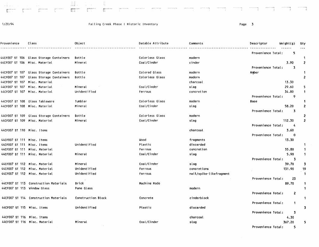
1 /20/94 F a l l i n g Creek Phase I H i s t o r i c Inventory Page 3
Proven i ence C lass Object - - - - - - - - - - - - - - - . . . . . . . . . . . . . . . . . . . . . . . . . - * - - - - - - - - - - - - - - - - - - - - - - - - -
Datable A t t r i b u t e . . . . . . . . . . . . . . . . . . . . . . . . . . . .
Descr ip tor Weight(g) - - - - - -
Provenience Tota l : 5
44CF007 ST 106 Glass Storage Containers B o t t l e
44CF007 ST 106 Misc. Mater ia t Mineral
Co lor less Glass
Coa 1 /C i nder
modern
c inde r 3.90
Provenience Total : 3
Arpber Colored Glass
Color less Class
44CF007 ST 107 Glass Storage Containers B o t t l e
44CF007 ST 107 Glass Storage Containers B o t t l e
44CF007 ST 107 Misc. Ma te r i a l
44CF007 ST 107 Misc. Ma te r i a l Mineral 44CF007 ST 107 Misc. Ma te r i a l U n i d e n t i f i e d
modern
modern
charcoal
s l a g conc re t i on
13.30
29.60 34.80
Provenience TotaL: 9 Base
58.20 Provenience Tota l : 3
Coa 1 /C i nder Ferrous
44CF007 ST 108 Glass Tableware Tumbler
44CF007 ST 108 Misc. Ma te r i a l Mineral
Co lor less Glass Coal/Cinder
modern s l a g
44CF007 ST 109 Glass Storage Containers B o t t l e
44CF007 ST 109 Misc. Ma te r i a l Mineral
Co lor less Glass
Coal/Cinder modern
s l a g 112.30
Provenience Total : 4
3.60 Provenience Tota l : 0
13.30
charcoa l 44CF007 ST 110 Misc. Items
44CF007 ST 111 Misc. Items 44CF007 ST 111 Misc. Items U n i d e n t i f i e d 44CF007 ST 111 Misc. Ma te r i a l
44CF007 ST 111 Misc. Ma te r i a l Mineral
f ragrnents d iscarded conc re t i on
s l a g
Wood P l a s t i c Ferrous
Coal/Cinder 55.80
5.90
Provenience Total : 3
39.70
131.90
44CF007 ST 112 Misc. Ma te r i a l
44CF007 ST 112 Misc. Ma te r i a l
44CF007 ST 112 Misc. Ma te r i a l
Mineral
U n i d e n t i f i e d
U n i d e n t i f i e d
s l a g
concret ions
n a i l / s p i ke- l i ke f ragment
Ferrous
Ferrous
Provenience Tota l : 23
89.70 44CF007 ST 113 Construct ion Ma te r i a l s B r i ck
44CF007 ST 113 Window Glass Pane Glass
Machine Made
modern
Provenience Total : 2 44CF007 ST 114 Construct ion Ma te r i a l s Const ruc t ion Block Concrete
P l a s t i c
c inderb lock
Provenience Tota l : 1 44CF007 ST 115 Misc. Items U n i d e n t i f i e d d iscarded
Provenience Tota l : 3
4.30 367.20
Provenience Tota l : 5
44CF007 ST 116 Misc. Items 44CF007 ST 116 Misc. Ma te r i a l Mineral
charcoa 1 s l a g

F a l l i n g Creek Phase I H is to r i c Inventory Page 4
Provenience Class Object - - - - - - - - - - - - - - - - - - -- . ------------------- 44CF007 ST 117 Ceramic Tableware Un iden t i f i ed
Datable A t t r i b u t e
Refined Earthenware
Comnen t s Descriptor Weight(g) - - - - - . . - - - - - - - - - - - - - - -
yel low glazed, modern
Provenience Total : 1
2.10 44CF007 ST 119 Misc. Items
44CF007 ST 119 Window Glass
charcoal
modern Pane Glass
Trovenience Total: 1 84.00
Provenience Total: 1 139.80
Br igh t Green
Machine Made 44CF007 ST 120 Construct ion Mater ia ls Br ick
discarded
modern
modern
44CF007 ST 121 Construct ion Mater ia ls Paving Mater ia l
44CF007 ST 121 Glass Storage Containers B o t t l e
44CF007 ST 121 Glass Storage Containers B o t t l e
Aspha l t
Colored Glass
Color less Glass
Provenience Total: 19 Color less Glass
Ferrous
Ferrous
44CF007 ST 125 Glass Storage Containers B o t t l e
44CF007 ST 125 Misc. Mater ia l Scrap Metal
44CF007 ST 125 Misc. Mater ia l W i r e
modern
f t a t
Provenience Total : 17
1.30
.60
Provenience Total: 1
44CF007 ST 130 Misc. Items
44CF007 ST 130 Misc. Mater ia l Mineral
charcoal
c i nder
44CF007 ST 132 Glass Storage Containers B o t t l e
44CF007 ST 132 Misc. Mater ia l Mineral
44CF007 ST 132 Misc. Mater ia l Scrap Metal
Color less Glass
Coal/Cinder Ferrous
modern
s lag
Provenience Total : 20
8.40
Provenience Total: 1 196.60
Provenience Total : 1
.20
Provenience Total: 0
44CF007 ST 139 Misc. Mater ia l concret ion
s lag
charcoal
Ferrous
Mineral 44CF007 ST 140 Misc. Mater ia l
44CF007 ST 144 Misc. Items
44CF007 ST 145 Agr i cu l t /Hor t i cu l tu re Barbed Wire Provenience Total: 1
8.40
Provenience Total: 4 Machine Made 44CF007 ST 146 Construction Mater ia ls B r i ck
c i nderbl ock modern
44CF007ST171 Const ruct ionMater ia ls Const ruct ionBlock
44CF007 ST 171 Glass Storage Containers B o t t l e
44CF007 ST 171 Metal Containers Can
Concrete Colored Glass
Ferrous
Green
Provenience Total: 4 2.30 Asphalt discarded 44CF007 VUOlFlA Construction Mater ia ls Paving Mate r ia l

1 / 2 0 / 9 4 F a l l i n g Creek Phase I H i s t o r i c Inventory Page 5
Proveni ence C l ass - - - - - - - - - - - - - - - . . . . . . . . . . . . . . . . . . . . . . . . .
Object . . . . . . . . . . . . . . . . . . . . . . . . . . . . . . . . . . .
Datable A t t r i b u t e . . . . . . . . . . . . . . . . . . . . . . . . . . . .
Conen t s - - - - - - - - - - - - - - -
Descr ip tor Ueight(g) - - - - - - - - - - - - - - - -..----
1.20 Provenience Tota l : 1
1.10
Provenience Tota l : 1
44CF007 TUO1F1A Misc. Items charcoal
44CF007 TUOlFlB Misc. Mater ia l M i nera 1 coa 1
44CF007 TUOlFlC Glass Storage Containers
44CF007 TUOlFlC Misc. Mater ia l
44CF007 TUOlFlC N a i l s
B o t t l e
Minera l
Nai l ( s )
Co lor less Glass
Coal/Cinder
U n i d e n t i f i e d Fragments
modern
s lag
Provenience Tota l : 5
178.30
2.90
44CF007 TUOIL.B Const ruc t ion Ma te r i a l s
44CF007 TUOIL.B Misc. Items
44CF007 TUOIL.B Misc. Items
44CF007 TUOIL.B Misc. Mater ia l
44CF007 TUOIL.B Misc. Mater ia l
44CF007 TUOIL.B N a i l s
44CF007 TUOIL.B N a i l s
B r i ck Machine Made
charcoal
discarded
c i nder
coa l
a t tached t o
U n i d e n t i f i e d
Minera l
Mineral
Nai l ( s )
Nai l ( s )
P l a s t i c
Coal/Cinder
Coal/Cinder
Unident i f i ed
U n i d e n t i f i e d Fragments
wood
44CF007 TUOIL.C Construct ion Ma te r i a l s
44CF007 TUOIL.C Construct ion Ma te r i a l s
44CF007 TUOIL.C Glass Storage Containers
44CF007 TUOIL.C Glass Storage Containers
44CF007 TUO1L .C Misc. I tems
44CF007 TUOIL.C Misc. Items
44CF007 TUOIL.C Misc. Mater ia l
44CF007 TUOIL.C Misc. Mater ia l
44CF007 TUOIL.C Misc. Ma te r i a l
B r i ck
B r i c k
B o t t l e
Jar
Machine Made
U n i d e n t i f i e d
Color less Glass
Machine Made
modern
threaded f i n i s h c o l o r l e s s
charcoal
discarded
coa 1
s lag
na i l / w i r e f rag
Neck
Unident i f i ed
Minera l
Minera l
U n i d e n t i f i e d
P l a s t i c
Coal/Cinder
Coal/Cinder
Ferrous
Provenience Tota l : 12
44CF007 TUOIL .D Glass Storage Containers
44CF007 TUO1L.D Misc. I tems
44CF007 TUOIL.D Misc. Ma te r i a l
44CF007 TUOIL.D Misc. Mater ia l
44CF007 TUO1L .D Misc. Mater ia l
44CF007 TUOIL.D N a i l s
B o t t l e Color less Glass modern
charcoal
s l ag Mineral
Scrap Metal
U n i d e n t i f i e d
Nai l ( s )
Coal/Cinder
Ferrous
Ferrous
Unident i f ied nai l / w i r e f rags
Provenience Total : 15
Green 44CF007 TUO2L.A Glass Bev. Containers
44CF007 TU02L.A Glass Bev. Containers
44CF007 TU02L.A Glass Bev. Containers
44CF007 TU02L.A Glass Bev. Containers
Pop B o t t l e
Pop B o t t l e
Pop B o t t l e
Pop B o t t l e
Coiored Glass
Color less Glass
Machine Made
Machine Made
Dr. Pepper
i nc l udes Peps i Dr. Pepper
includes Pepsi ,solor less Base
Base

F a l l i n g Creek Phase I H i s t o r i c inventory
Provenience C 1 ass Object - - - - - - - - - - - - - - - . . . . . . . . . . . . . . . . . . . . . . . . . . . . . . . . . . . . . . . . . . . . . . . . . . . . . . . . . . . . 44CF007 TU02L.A Glass Bev. Containers Pop B o t t l e
44CF007 TU02L.A Glass Storage Containers B o t t l e
44CF007 TU02L.A Glass Storage Containers B o t t l e
44CF007 TU02L.A Window Glass Pane Glass
44CF007 TU02L.B A g r i c u l t / H o r t i c u l t u r e
44CF007 TU02L.B Ceramic Tableware
44CF007 TU02L.B Const ruc t ion Ma te r i a l s
44CF007 TU02L.B Const ruc t ion Ma te r i a l s
44CF007 TU02L.B Glass Bev. Containers
44CF007 TU02L.B Glass Bev. Containers
44CF007 TU02L.B Glass Bev. Containers
44CF007 TU02L.B Glass Storage Containers
44CF007 TU02L.B Glass Storage Containers
44CF007 TUO2L .B Glass Storage Containers
44CF007 TU02L. B Glass Storage Containers
44CF007 TUO2L .B Glass Storage Contai ners
44CF007 TU02L.B H i s t o r i c Bone
44CF007 TU02L.B H i s t o r i c She l l
44CF007 TU02L.B Misc. Hardware
44CF007 TU02L.B Misc. Items
44CF007 TU02L.B Misc. Ma te r i a l
44CF007 TU02L.B Misc. Ma te r i a l
44CF007 TUO2L.B Misc. Ma te r i a l
44CF007 TU02L.B Misc. Ma te r i a i
44CF007 TU02L. B Na i t s
44CF007 TU02L.B Pharmaceutical Contain.
44CF007 TU02L .C Ceramic Bev. Containers
44CF007 TU02L .C Glass Storage Containers
44CF007 TUO2L.C Gtass Storage Containers
44CF007 TU02L.C Glass Storage Containers
44CF007 TU02L .C Glass Storage Containers
44CF007 TU02L.C Glass Storage Containers
44CF007 TU02L.C Glass Storage Containers
44CF007 TU02L.C Glass Storage Containers
44CF007 TUO2L .C Glass Storage Containers
Barbed Wire
U n i d e n t i f i e d
B r i c k
Paving Ma te r i a l
Pop B o t t l e
Pop B o t t l e
Pop B o t t l e
B o t t l e
B o t t l e
B o t t l e
B o t t l e
Closure
Unsorted Bone
Mol lusk
B o l t
Minera l
Mineral
Minera l
Scrap Metal
Nai 1 ( s )
Toi letry/Perfume B o t t l e
B o t t l e
B o t t l e
B o t t l e
B o t t l e
B o t t l e
B o t t l e B o t t l e
B o t t l e
C 1 osure
Page 6
Datable A t t r i b u t e Comnents . . . . . . . . . . . . . . . . . . . . . . . . . . . . . . . . . . . . . . . . . . . . . . . . . . . . . . . . . . . . . Machine Made includes Peps i ,co lor less
Colored Glass modern
Colored Glass modern
modern
Whi teware
Machine Made
Aspha 1 t
Color less Glass
Crown F in i sh
Machine Made
Colored Glass
Col ored Glass
Colored Glass
Color less Glass
Crown Cap
Ferrous
Coal/Cinder
Coal/Cinder
Coal/Ci nder
Ferrous
U n i d e n t i f i e d
Machine Made
Stoneware
Colored Glass
Colored Glass
Colored Glass
Colored Glass
Colored Glass
Color less Glass
Crown F in i sh
Glass L i d L ine r
modern
discarded
Peps i
machine-made, c o l o r l e s s
Dr. Pepper?
modern
modern
modern
modern
oyster
charcoal
coal
s lag
s lag
co lor less
l a t e 19th-20th c.? l a t e 19th-20th c.? modern
modern
modern
modern
modern
co lor less , modern
modern
Descr ip tor Ueight(g) Q t y - - - - - - - - - - - - - - - - - - - - - - - - Neck 2
Amber 7 B r i g h t Green 2
1
f'rovenienceTota1: 128
1 2
321.90 6 97.00 13
1
1
1 2 1 2
18
1
2
Neck
Base
Amber
B r igh t Green
Green
Base
Provenience Total :
Dark Green
Amber
Aqua
B r i g h t Green
Green
Neck
Opaque White
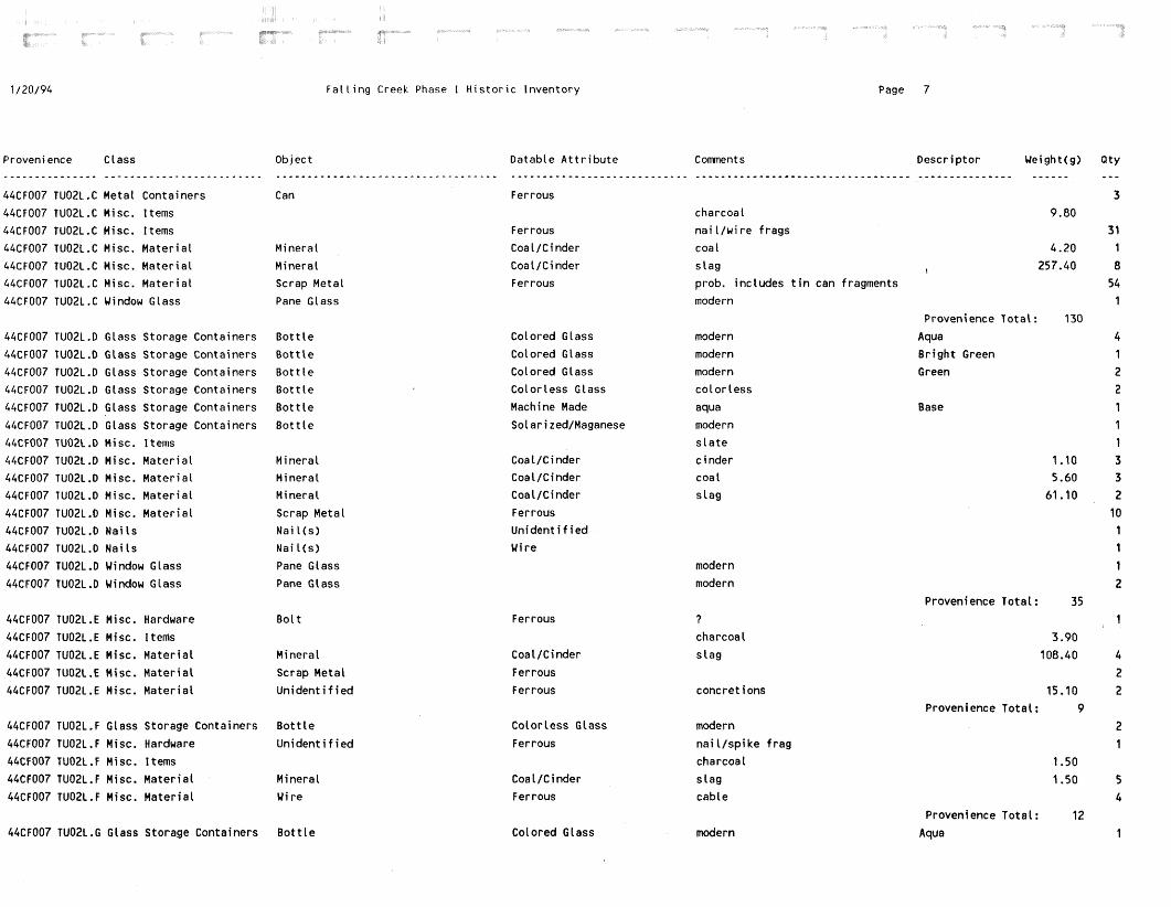
1 / 2 0 / 9 4 F a l l i n g Creek Phase I H i s t o r i c Inventory Page 7
Proveni ence C 1 ass Object - - - - - - - - - - - - - - - - - - - - - - - - - - - - - - - - - - - - - - - -
Datable A t t r i b u t e . . . . . . . . . . . . . . . . . . . . . . . . . . . . Ferrous
Descr ip tor Ueight(g) - - - - - - - - - - - - - - - - - - - - -
44CF007 TU02L.C Metal Containers Can
44CF007 TU02L.C Misc. Items
44CF007 TU02L.C Misc. Items
44CF007 TUO2L.C Misc. Ma te r i a l Mineral
44CF007 TU02C.C Misc. Ma te r i a l Mineral
44CF007 TU02L.C Misc. Ma te r i a l Scrap Metal
44CF007 TU02L.C Window Glass Pane Glass
charcoal
n a i l / w i r e f rags
coa l
s l a g
prob. includes t i n can fragments
modern
Ferrous
Coal/Cinder
Coal/Cinder
Ferrous
Provenience Tota l : 130
Aqua
B r i g h t Green
Green
44CF007 TU02L.D Glass Storage Containers
44CF007 TU02L.0 Glass Storage Containers
44CF007 TU02L.D Glass Storage Containers
44CF007 TU02L.D Glass Storage Containers
44CF007 TU02L.D Glass Storage Containers
44CF007 TU02L.D Glass Storage Containers
44CF007 TU02L .D Mi sc. I terns
44CF007 TU02L.D Misc. Ma te r i a l
44CF007 TU02L.D Misc. Ma te r i a l
44CF007 TU02L.D Misc. Mater ia t
44CF007 TU02L.D Misc. Ma te r i a l
44CF007 TU02L .D Nai 1s
44CF007 TU02L.D Nai 1s
44CF007 TU02L.D Window Glass
44CF007 TU02L .D Window Glass
B o t t l e
B o t t l e
B o t t l e
B o t t l e
B o t t l e
B o t t l e
Colored Glass
Colored Class
Colored Glass
Color less Glass
Machine Made
Solarized/Maganese
modern
modern
modern
co lo r l ess
aqua
modern
s l a t e
c inder
coa 1
s l a g
Base
Coal/Cinder
Coal /Ci nder
Coa 1 /Cinder
Ferrous
U n i d e n t i f i e d
Wire
Mineral
Mineral
Mineral
Scrap Metal
Nai l ( s )
Nai l ( s )
Pane Glass
Pane Glass
modern
modern
Provenience Total : 35 Ferrous 44CF007 TU02L.E Misc. Hardware B o l t
44CF007 TU02L.E Misc. Itenis
44CF007 TU02L .E Misc. Ma te r i a l Mineral
44CF007 TU02L.E Misc. Ma te r i a l Scrap Metai
44CF007 TU02L.E Misc. Ma te r i a l U n i d e n t i f i e d
?
charcoal
s l a g Coal/Cinder
Ferrous
Ferrous concret ions 15.10
Provenience Tota l : 9 44CF007 TU02L.F GLass Storage Containers B o t t l e
44CF007 TU02L.F Misc. Hardware U n i d e n t i f i e d
44CF007 TUO2L . F Mi sc. I t ems
44CF007 TUO2L.F Misc. Ma te r i a l Mineral
44CF007 TU02L.F Misc. Ma te r i a l Wire
Color less Glass
Ferrous
modern
na i l / s p i ke f rag
charcoa 1
s l a g
cable
Coal/Cinder
Ferrous
Provenience Tota l : 12
Aqua 44CF007 TU02L .G Glass Storage Containers B o t t l e Colored Glass modern

F a l l i n g Creek Phase I H i s t o r i c Inventory Page 8
Provenience Class - - - * - - - - - - - - - - -
44CF007 TU02L.G Misc. Ma te r i a l
Object . . . . . . . . . . . . . . . . . . . . . . . . . . . . . . . . . . .
Mineral
Datable A t t r i b u t e - - - - - - - - - - - - - - - - - - - - - - - - * - - -
Coal/Cinder
Comnents - - - - - - - - - - - - - - - s l a g
Descr ip tor Ueight(g1 - - - - - - - - - - - - - - - - - - - - -
5.90
Provenience Tota l : 2 42.70 44CF007 TU03F2 Misc. Ma te r i a l
44CF007 TU03F2 Misc. Ma te r i a l
44CF007 TU03F2 Misc. Ma te r i a l
44CF007 TU03F2 Misc. Ma te r i a l
44CF007 TU03F2 Misc. Ma te r i a l
44CF007 TU03F2 N a i l s
Minerat
Scrap Metal
U n i d e n t i f i e d
U n i d e n t i f i e d
Wire
Nai l ( s )
Coa l / C i nder
Ferrous
Ferrous
Ferrous
Ferrous
U n i d e n t i f i e d Fragments
s l a g
concret ions
modern, 22" x
Provenience Tota l : 18
44CF007 TU03L.A Glass Storage Containers
44CF007 TU03L.A Glass Storage Containers
44CF007 TU03L.A Misc. ltems
44CF007 TU03L.A Misc. Ma te r i a l
44CF007 TU03L.A Misc. Ma te r i a l
44CF007 TU03L.A Misc. Ma te r i a l
44CF007 TU03L .A Nai l s
B o t t l e
B o t t l e
Color less Glass
Color less Glass
modern
modern
charcoal
c i nder
coa l
s l a g
Mi nera l
Minerat
Mineral
Nai l ( s )
Coal/Cinder
Coal/Cinder
Coal/Cinder
U n i d e n t i f i e d
Provenience Total : 11
Amber
B r i g h t Green 44CF007 TU04L.A Glass Storage Containers
44CF007 TU04L.A Glass Storage Containers
44CF007 TU04L.A Glass Storage Containers
44CF007 TU04L.A Glass Storage Containers
44CF007 TU04L.A Glass Storage Containers
44CF007 TU04L.A Glass Storage Containers
44CF007 TU04L.A Glass Storage Containers
44CF007 TU04L .A Misc. Ma te r i a l
B o t t l e
B o t t l e
B o t t l e
B o t t l e
B o t t l e
B o t t t e
B o t t l e
Scrap Metal
Co l ored G 1 ass
Colored Glass
Color less Glass
Crown F in i sh
Machine Made
Machine Made
Machine Made
Ferrous
modern
modern
modern
c o l o r l e s s
amber
b r i g h t green
cot or 1 ess
Neck
Base
Base
Base
Provenience Total : 44
modern
charcoa 1
Color less Glass 44CF007 TU04L.B Glass Storage Containers
44CF007 TU04L.B Misc. Items 3.80
Provenience Tota t : 4 Black
11.00
Porce la in decorated, modern
charcoal
discarded
44CF007 TU04L.C Ceramic Tableware
44CF007 TU04L.C Misc. ltems
44CF007 TU04L .C Misc. I tems
U n i d e n t i f i e d
P l a s t i c Provenience Total : 2
1.10 44CF007 TUO4L .D Misc. I tems
44CF007 TU04L .D Misc. Ma te r i a l
charcoal
Scrap Metal
Scrap Metal
Ferrous
Ferrous
Provenience Tota l : 10
44CF007 TU04L.E Misc. Ma te r i a l

1 /20/94 F a l l i n g Creek Phase I H i s t o r i c Inventory Page 9
Provenience C lass - - - - - - - - - - - - - - - . . . . . . . . . . . . . . . . . . . . . . . . .
Object . . . . . . . . . . . . . . . . . . . . . .
Datable A t t r i b u t e Comnents Descriptor Ueight(g1 Qty - - - - - - - - - - - - - - - - - - - - - - - - - - - - - - - - - - - - - * - - - - - - - - - - - - - - - - - - - a
Provenience Total : 1
334.10 1 2
Base 1
\ 3.60 107.60 2
Provenience Total : 6 1
2.20
Provenience Total : 1
3.10
.80
44CF007 TU05F4 Construct ion Mater ia ls
44CF007 TU05F4 Glass Storage Containers 44CF007 TU05F4 Glass Storage Containers
44CF007 TU05F4 Misc. I tems
44CF007 TU05F4 Misc. Mater ia l
B r i ck B o t t l e
B o t t l e
Hand Made
Color less Glass Machine Made
modern co lor less
charcoal
s lag Mineral
Coin 1974 Jefferson n icke l
charcoal 44CF007 TU05L.A Currency 44CF007 TU05L.A Misc. Items
Br i ck
Br i ck Coin
B o t t l e
Machine Made
Un iden t i f i ed > 1950 Colorless Glass
44CF007 TU05L.B Construct ion Materiats
44CF007 TU05L.B Construction Mater ia ls 44CF007 TU05L.B Currency
44CF007 TU05L.B Glass Storage Containers
44CF007 TU05L .B Misc. I terns 44CF007 TU05L.B Misc. Mater ia l
44CF007 TU05L .El Nai l s
44CF007 TU05L.B Na i l s
1968 quarter
modern
charcoal s lag Mineral
Nai l ( s )
Nai l ( s )
Coal/Cinder
Un iden t i f i ed
Un iden t i f i ed Fragments
Provenience Total : 23
12.10 Aqua
44CF007 TU05L.C Construct ion Mater ia ls 44CF007 TU05L.C Glass Storage Containers 44CF007 TU05L.C Glass Storage Containers
44CF007 TU05L.C Misc. Items
44CF007 TU05L.C Misc. Ma te r ia l
B r i ck B o t t l e B o t t l e
Hand Made Colored Glass
Colorless Glass
?
modern
modern
charcoal
s l ag 13.60
238.40 Provenience Total : 15 ,
80.10
Neck
Provenience Total : 2
Amber Provenience Total : 3
Amber
Br igh t Green
68.90 157.00
Mineral Coal/Ci nder
44CF007 TU06L.A Construction Mater ia ls
44CF007 TU06L.A Glass Bev. Containers
Br i ck
Beer B o t t l e
Machine Made
Machine Made co lo r less
44CF007 TU06L.B Glass Bev. Containers Colored Glass Beer B o t t l e modern
44CF007 TU06L.C Ceramic Tableware
44CF007 TU06L.C Ceramic Tableware
44CF007 TU06L.C Construction Mater ia ls 44CF007 TU06L.C Construction Mater ia ls 44CF007 TU06L.C Glass Bev. Containers
44CF007 TU06L.C Glass Storage Containers
44CF007 TU06L.C Glass Storage Containers
B o t t l e
B o t t l e
B r i c k Paving Mater ia l Pop B o t t l e
B o t t l e
B o t t l e
Colored Glass
Colored Glass
Un iden t i f i ed Aspha 1 t Colorless Glass
Machine Made
Machine Made
modern
modern
d i scarded
i nc l udes Peps i co lo r less
green Base
Base

F a l l i n g Creek Phase 1 H i s t o r i c Inventory Page 10
Provenience Class - - - - - - - - - - - - - - - . . . . . . . . . . . . . . . . . . . . . . . . .
44CF007 TU06L.C Misc. Hardware
44CF007 TU06L.C Misc. Ma te r i a l
44CF007 TU06L.C Misc. Ma te r i a l
44CF007 TU06L.C Personal Items
44CF007 TU06L.C Toys and Le isure
Object . . . . . . . . . . . . . . . . . . . . . . . . . . . . . . . . . . . U n i d e n t i f i e d
Minera l
Scrap Metal
Eyeglass Par t
TOY
Datable A t t r i b u t e
Ferrous
Coal/Cinder
Ferrous
P l a s t i c
P l a s t i c
Comnen t s
n a i l / w i r e f r a g
s 1 ag
Descr l" p t o r Ueight(g) - - - - - - - - - - *
d i scarded
b a l l , d iscarded
Black
Blue
, Provenience Tota l : 53 1000.00 44CF007 TU06L.D Const ruc t ion Ma te r i a l s
44CF007 TU06L.D Const ruc t ion Ma te r i a l s
44CF007 TU06L.D Glass Storage Containers
44CF007 TU06L.D Misc. Hardware
44CF007 TU06L.D Misc. Hardware
44CF007 TU06L.D Misc. Items
44CF007 TU06L.D Misc. Ma te r i a l
44CF007 TU06L.D Misc. Ma te r i a l
.44CF007 TUO6L .D Window Glass
B r i c k
Wall F in i sh ing
B o t t l e
B o l t
U n i d e n t i f i e d
Machine Made
Ceramic
Color less Glass
Ferrous
Ferrous
t i l e , modern
modern
machinery, modern
charcoal
s l a g
concret i ons
modern
Mi n e r a l
U n i d e n t i f i e d
Pane Glass
Coal/Cinder
Ferrous
Provenience Tota l : 244
32.80 44CF007 TU07L.A Const ruc t ion Ma te r i a l s
44CF007 TU07L.A U t e n s i l s
Paving Mater ia l d iscarded
spatula, d isc .
Aspha l t
P l a s t i c
Provenience Tota l : 2
30.30 44CF007 TU07L.C Const ruc t ion Ma te r i a l s
44CF007 TU07L.C Glass Storage Containers
44CF007 TU07L.C Misc. Items
Paving Ma te r i a l
B o t t l e
Aspha 1 t
Color less Glass
discarded
modern
charcoal 1.90
Provenience Tota l : 2
6.90
Provenience Tota l : 1
44CF007 TU07L.D Construct ion Ma te r i a l s Paving Ma te r i a l Asphal t discarded
charcoal
s l ag
45.30
19.60
Provenience Total : 2
44CF007 TU07L.E Misc. Items
44CF007 TU07L.E Misc. Ma te r i a l Minera l
44CF007 TU08L.A Glass Storage Containers
44CF007 TU08L.A Glass Storage Containers
44CF007 TU08L.A Glass Storage Containers
B o t t l e
B o t t l e
B o t t l e
Color less Glass
Machine Made
Machine Made
modern
co lo r l ess
co lo r l ess
Base
Neck
Provenience Total : 18
80.10
130.70
Green
44CF007 TU08L.B Construct ion Ma te r i a l s
44CF007 TU08L.B Construct ion Ma te r i a t s
44CF007 TU08L.B Glass Storage Containers
44CF007 TU08L.B Glass Storage Containers
44CF007 TU08L.B Misc. Ma te r i a l
B r i c k
B r i c k
B o t t l e
B o t t l e
Minera l
Hand Made
Machine Made
Colored Glass
Color less Glass
Coal/C inder
modern
modern
coa l

1 /20 /94 F a l l i n g Creek Phase I H i s t o r i c Inventory Page 11
Provenience Class Object - - - - - - - - - - - - - - - . . . . . . . . . . . . . . . . . . . . . . . . . - - - - - - - - - - - - - - - - - - - * - - - - - - - - - - - - - - -
Datable A t t r i b u t e . . . . . . . . . . . . . . . . . . . . . . . .
Comnents Descr ip tor Ueight(g) - - - - - - - - - - - - - - - - - - - - - - - - - - - - - - - - - - - - - - - - - - - - - - - - - - - - - - -
Provenience Total : 7 modern
Provenience To ta l : 1
241.90
Yrovenience Tota l : 2 1.80
1.10
Provenience Tota l : 3
44CF506 ST 059 Glass Storage Containers B o t t l e Col or 1 ess G 1 ass
Machine Made 44CF506 ST 060 Const ruc t ion Ma te r i a l s B r i ck
?, o r f i r e d c l a y
charcoat
44CF506 ST 063 Const ruc t ion Ma te r i a l s B r i ck
44CF506 ST 063 Misc. Items
Hand Made
44CF506 ST 068 Const ruc t ion Ma te r i a l s
44CF506 ST 068 Glass Storage Containers B o t t l e
Concrete
Color 1 ess Glass modern
Provenience Tota l : 3
AREA A ST 002 Const ruc t ion Ma te r i a l s D ra in P ipe /T i l e
AREA A ST 002 Glass Storage Containers B o t t l e
AREA A ST 002 Misc. Ma te r i a l Mineral
Ceramic
Colored Glass
Coai/Cinder
Amber
11.30
Provenience Tota l : 5
mocern
coa l
AREA A ST 003 Glass Storage Containers B o t t l e
AREA A ST 003 Misc. Ma te r i a l Mineral
Color 1 ess Glass
Coal/Cinder
modern
coa 1 5.90
Provenience Total : 5
AREA A ST 009 Glass Storage Containers B o t t l e
AREA A ST 009 Window Glass P l a t e Glass
Color less Glass modern
modern
Provenience Tota l : 3 .40
Provenience Tota l : I grooved
l a t e 19th- 20th c.? Green
modern B r i g h t Green
modern
Provenience Total : 5 modern Amber
Provenience Tota l : 1 worked stone, l i d - l i k e ob jec t f r a
Provenience Tota l : 1
modern Amber
AREA A ST 010 Const ruc t ion Ma te r i a l s B r i ck Uni dent i f i ed
AREA A ST 015 Amnun i t i on /A r t i l l e r y Bul l e t
AREA A ST 015 Glass Storage Containers B o t t l e
AREA A St 015 G\ass Storage Containers B o t t l e
AREA A ST 015 Glass Storage Containers B o t t l e
Lead
Colored Glass
Colored Glass
Color 1 ess G 1 ass
AREA A ST 032 Glass Storage Containers B o t t l e Colored Glass
AREA A ST 033 Misc. Items U n i d e n t i f i e d
AREA A ST 037 Glass Storage Containers B o t t l e
AREA A ST 037 N a i l s Nai l ( s )
Colored Glass
U n i d e n t i f i e d Fragments
Provenience Tota l : 2
AREA A ST 039 Misc. Hardware B o l t
AREA A ST 039 N a i l s Nai l ( s )
Copper-Alloy
Ui r e
car r i age

F a l l i n g Creek Phase I H i s t o r i c Inventory Page 42
Provenience - - - - - - - - - - - - - - -
Class Object . . . . . . . . . . . . . . . . . . . . . . . . . . . . . . . . . . . . . . . . . . . . . . . . . . . . . . . . . . .
Datable A t t r i b u t e Comnent s - . . . . . . . . . . . . . . . . . . . . . . . . . . . . - - - - - - - - - - - - - - - - - - - - - - - - - - - - - - - - - -
Descr ip tor Weight(g) - - - - - - - - - - - - - - - - - - - - - Provenience Tota l : 2
A R E A A ST 040
A R E A A ST 040
Glass Storage Containers B o t t l e
Misc. Items
Color less Glass modern
f oss i l rock
Provenience Tota l : 2
\
Provenience Total : 5
A R E A A ST 041
A R E A A ST 041
Glass Storage Containers B o t t l e
Window Glass Pane Glass
Color less Glass modern
modern
A R E A A ST 046
A R E A A ST 046
Misc. Hardware
Nai 1s
Screw
Nai l ( s )
machine, s t e e l
Wire
Provenience Tota l : 2
Green A R E A B ST 048
A R E A B ST 048
Glass Storage Containers B o t t l e
Glass Storage Containers B o t t l e
Colored Glass
Color less Glass
modern
modern
Provenience Tota l : 8
A R E A B ST 052 A R E A B ST 052
A R E A 8 ST 052
Const ruc t ion Ma te r i a i s Paving Ma te r i a l
Glass Storage Containers B o t t l e
Glass Storage Containers B o t t l e
Aspha l t Color less Glass
Machine Made
d iscarded
modern
c o l o r less Base
Provenience To ta l : 3 A R E A B ST 053 Const ruc t ion Ma te r i a l s Paving Ma te r i a l Aspha 1 t d iscarded
Provenience Tota l : 3 A R E A 8 ST 054 Toys and Le isure Skeet t a rge t , d isc .
Provenience Total : 1
A R E A B ST 057 A R E A B ST 057
Const ruc t ion Ma te r i a l s Paving Ma te r i a l
Misc. Items U n i d e n t i f i e d
Aspha l t d iscarded
t i t e - l i k e , glazed t e r r a c o t t a
Provenience Tota l : 2
Aspha 1 t A R E A B ST 058 Const ruc t ion Ma te r i a l s Paving Ma te r i a l d iscarded
Provenience Tota l : 1
A R E A B ST 065
A R E A El ST 065
Const ruc t ion Ma te r i a l s
Const ruc t ion Ma te r i a l s Const ruc t ion Block
Concrete
Concrete c inderb lock
Provenience Tota l : 2
51.20 Provenience Tota l : 1
5.40
A R E A B ST 066 Const ruc t ion Ma te r i a l s B r i c k Machine Made
A R E A C ST 149 A R E A C ST 149
Const ruc t ion Ma te r i a l s B r i c k
Const ruc t ion Ma te r i a l s Paving Ma te r i a l
Machine Made
Asphalt d iscarded
Provenience Tota l : 2
100.00 Machine Made
Ceramic
Colored Glass
A R E A C ST 155 A R E A C ST 155 A R E A C ST 155
Construct i o n M a t e r i a l s B r i c k
Const ruc t ion Ma te r i a l s Wal l F in i sh ing
Glass Storage Containers Bot tae
t i l e , modern
modern Amber

1 / 2 0 / 9 4 F a l l i n g Creek Phase I H i s t o r i c Inventory Page 13
Proveni ence - - - - - - - - - - - - - - -
C 1 ass Object . . . . . . . . . . . . . . . . . . . . . . . . . . . . . . . . . . . . . . . . . . . . . . . . . . . . . . . . . . . .
Datable A t t r i b u t e . . . . . . . . . . . . . . . . . . . . . . . . . . . .
Comnent s . . . . . . . . . . . . . . . . . . . . . . . . . . . . . . . . . .
Descr ip tor Weight (g)
Provenience Total : 11
7.30 AREA C ST 158 AREA C ST 158 AREA C ST 158
Construction Mater ia ls Br ick
Glass Storage Containers B o t t l e
Misc. Mater ia l Mineral
Machine Made
Colorless Glass
~ o a l /C i nder
modern
c i nder
Trovenience Total : 10 5 -30 1 .so 1.40
Provenience Total : 5
Machine Made
Sand
Coal/Cinder
AREA C ST 160 AREA C ST 160 AREA C ST 160
Construction Mater ia ls Br ick
Construction Mater ia ls Mortar
Misc. Mater ia\ Mineral s lag
AREA C ST 162 Misc. Mater ia l Scrap Metal Ferrous
Provenience Total : 2 7.60 AREA C ST 163
AREA C ST 163 Construction Mater ia ls B r i ck
Misc. Mater ia l Scrap Metal
Hand Made
Ferrous
Provenience Total : 9 7.30
Provenience Total : 3 Base
Provenience Total : 1 Amber
Green
AREA C ST 168 Construction Mater ia ls Br ick Machine Made
Machine Made LOC 1 ST 018 Glass Storage Containers B o t t l e green
LOC 1 ST 021 LOC 1 ST 021 LOC 1 ST 021
G\ass Storage Containers B o t t l e
Glass Storage Containers B o t t l e
Glass Storage Containers B o t t l e
Colored Glass
Colored Glass
Color less Glass
modern
modern
modern
Provenience Total : 6
0 l ue
Provenience Total : 1 Amber
Ultramarine
Ceramic Tableware Un iden t i f i ed Pearlware: Painted LOC 1 ST 023 very worn
LOC 1 ST 025 LOC 1 ST 025 LOC 1 ST 025 LOC 1 ST 025 LOC 1 ST 025 LOC 1 ST 025 LOC 1 ST 025
Glass Storage Containers B o t t l e
Glass Storage Containers B o t t l e
Glass Storage Containers B o t t l e
Misc. Hardware B o l t
Misc. Mater ia l Mineral
Uindow Glass Pane Glass
Ui ndow Glass P la te Glass
Cotored Glass
Colored Glass
Color less Glass
Ferrous
Coal/Cinder
modern
modern
modern
coa 1
modern
modern
Provenience Tota l : 17 S i t e Total : 1365


VIRGINIA DEPARTMENT OF HISTORIC RESOURCES ARCHAEOLOGICAL SITE INVENTORY FORM
SUPPLEMENTAL FORM
CitylCounty: Chesterfield County Site Name: T e m p rary Designation:
VDHR S i t e Number: 4 4 ~ ~ 7 Other VDHR Number:
Culturalfrempral Affiliation: Euro-American/l7th century/lst quarter
Site CJms: )?; Temstzial, Opn-Air T e m s t i i a l , Cave/TCo@kshelter -Underwater
Thematic Contexts: Indusuy/Processing/Extraction
Site Function: Manufacturing facility: furnace
Specialized Contexts: Virginia Company period site
USGS Quadrwglc: Dre\\)'ys Bluff, VA 7.5 minute 1987 LTM Zone: 18 &sting: 284480
Lo ran: Northing: 4 146 120
(Attach photocopy of ap1)n)priate section of USGS 7.5 minute series topogmphical map showing site boundaries.)
Physiogmphic Pmvince: Coastal plain but near transition to Piedmont Uplands Drainage: Falling CreeWJames River Landform: Floodplain Aspect: Elevation: 10- 1 5 feet amsl Slope: <15% Site Soils: Grover fine sandy loam, 6 to 12 percent slopes Adjacent Soils: Neumst Water Sourre: Falling Creek Distance: Adjacent
Ownership Status: 3 Private - PuhlirILocaI:
- Public/State: - Puhlic/Fcdeml:
Chvner Name (if private): Owner Telephone: Owner Addlrss:
Infomutt Name: Infomuurt Addless:
Informant Telephone:
S u n ~ c y l By: Thomas F. Higgins, 111 Affiliation: William and Mary Center for Date: 12- 16-93 Acltlmss: Williamsburg, VA 23 187 Archaeological Research (WMCAR)
Site Dimensions: Appro-ely 3.5
Sun7ey Strategy: - Historic Map Pmjeetian - Informant Obsentation - Surface Testing - X Subsurface ~ z n ~
Sumey Description: Site was previously tested by Howard MacCord (1963) in association with the Archaeological Society of Virginia (ASV). WMCAR investigation consisted of screened (1/4-inch mesh) shovel testing at intervals of 30 feet or less and test units placed at selected locations.
Site Condition: Destruction of' surface and subsurface Jcposlts/25-49% of' site destroyed.
Cunrnt h d Use: Unoccupied land: floodplain, and road-related: road.
Specimc-ns Ohhined: X Yes - No Dcpsi toy: WMCAR Assemblage Desc~iption: Pieces of slag and charcoal.

Specimens Reported: 11 Ycs - No Owner Name: Stored at VDHR Owner Address: Assemblage Description: Pieces of slag, pig iron, and iron artifacts including spikes, chisel, and brick
Ficid Notcs: X Yes - No D c p o s i t o ~ : WMCAR
Photographic Documentation: X Ycs - No D e p s i t o v : WMCAR
Report(s): X Yes - No Depository WMCAR Rcfcrcncc(s): See the reports, Esploratory Excavations at thc First Ironworks in America (44CF7) by Howard A MxCord . Sr. Archaeolog~cal Society of Virginia Quarterly Bulletin, Vol. 19, No. 1 1964. The First American Blast Furnace, 1619-1623: 'I'hc Birth oT a Mighty Industry of Falling Creek in Virginia by Charles E. Hatch, Jr., and Thurlow Cialcs Circgor~., Virginla Magazine of Histon. and Biography, Vol. 70, July 1963, No. 3.
Form Complctccl By: Thomas F. Higgins. 111 Affiliation: WMCAR Acitlrcss: Williamsbusg, VA 73 187
Datc: 12-16-93
F o r VDHR Staff Onby V i r g i n i a R e g i s t e r S t a t u s : N a t i o n a l R e g i s t e r S t a t u s : E a s e m e n t S t a t u s : VDHR L i b r a r y R e f e r e n c e Number ( s ) : VDHR Number A s s i g n e d B y : D a t e : D a t a E n t e r e d B y : D a t e : ~ e v i s i o n s / U p d n t e s BY: D a t e :
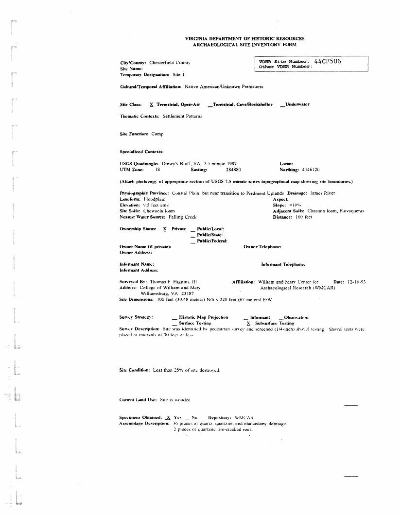
VIRGINIA DEPARTMENT OF HISTORIC RESOURCES ARCHAEOLOGICAL SITE INVENTORY FORM
CityICounty: Chesterlield Count) Sitc N u w : Tempomy Designation: Site 1
VDEtR S i t e Number: 44CF506 Other VDER N u m b e r : I -
CultunrlTTempnl Afliliation: Native American/Unlmown Prehistoric
Site Clyss: X Tenestrid, Open-Air -Ternstrid, CavelRockrhelter -Undematcr
Thematic Contexts: Settlement Patterns
Site Function: Camp
Specialized Contexts:
USCS Quadmglc: D r e y ' s Bluff, VA 7.5 m~nute 1987 UTM Gnc: 18 Eus ting: 284880
(Attach photttcop? o f aplbn~priatr srction o f USCS 7.5 minutc retics topgmphicvl map shovving site Iwundarics.)
Physiognphic Pn~vincc: Coastal I'li~~n. but near transition to Piedmont Uplands Dminagc: James River Landform: i..loodpla~n Aslwct: Elevation: 9.5 i ~ c i umsl s l o p : < I o'%, Sitc S~ i l x : Cheivacla loam Adjacent Soils: Chastain loam, Fluvaquents Ncawst Water Soume: Falling Creek Distance: 160 lket
OHncnhip Status: Private - PubliclLucaI:
- PuhiiclState: - Public/Fc&nI:
Owner Name (if private): Owner Telephone: Olvnrr AtlclWss:
Suncyctl By: 'I'homas 1.'. f-ilggins. 111 Affiliation: William and M a n Ccntcr for Date: 12- 16-93 Atlclwxs: College of Wiillani and M a c Archaeological Kcscnrch (WMCAK)
Williamsburg, VA 33 187 Sitc Dimnsions: 100 feet (30.48 meters) N/S s 220 feet (67 metcrs) E/W
Suncy Stmte~v: - Historic Map Pn~jcction - Inforrrmnt -0hsrnatictn
- Surface Testing - ); Suhsulf;rrr Testing Sunry Description: Site \vils ~dcntil'lcd h> ~>cdcstrlan survey and scrccncd (1/4-inch) sho\.cl icsiing Sl~o\,cl tests \vcrc placed at ~t~ tc r \ a l s 01' 30 I'cct t,r ICY.
Sitc Condition: Less than 2 j ' X of sric dcstro\cd
Cumnr h n t l Usr: Site IS \\oodcd
S~wcinwn* Ol~twinrcl: 2 Ycs - I\;o Uclw~sitor?.: U:MCAI< Asscn~l~lwgc Drscription: 30 p~cccs <)I' quartf. quartzrts. and chalcedony debitage
2 prcccs o i quartztic i~rc-crackcd rock.

Specimens Reported: - Yes X No Owner Name: Asaemblagc Description:
e
Reld Notes: X Yes - No
Owner Address:
Dcps i tov : WMCAR
Photoglrphic Docutnentation: Yc.5 - No Dcps i toy : WMCAR
Rcp)rl(s): X Ycs - No Depnsitor?.: WMCAR Rcfcn.nce(s): See thc rcporr. "Arch;tct)loglcaI In\~csilg;~~lc)ns of Sire 44CF7, Falling Creek Ironworks, Chesterfield Caunl) . Vlrgmi;~' by 'I ' . I : t l ~ g g ~ n s GI. .I.. 1993, 011 lilc .I Vsg~nla Dirlsion of Historic Resources, Rishn~ond, Virginia. k'lcid n o r s on file a1 the Center lor Archaeological Keaarch, College of William and Mary. Williamsburg, VA.
Adrlitinnal Comments:
Affiliation: WMCAR
F o r VDHR S t a f f On ly V ~ r g ~ n i a Register Status: Nat~onal Register Status: Easement Status: VDEiR Library Reference Number (s) : MBR Number Assigned By: D a t e : Data Entered By: D a t e : Revisions/Updates By: D a t e :


I - - A . ,: -rs,.*t?̂ -
38; B. ; - . s. -- .'.- . . -
I , - - 4-" ---- <*+. . -. e, -. P : . + .- - -. , - - - 5 . . - ..,
I =. . . . - ' . . .,., , -., ,w .,,A,,,. . IILcxx% ,3!2..#i5 rE ,-I C -2. 1 -.us . 4 ,- C -... -C -.rr .-,).---- 2 - - a*--. --
* :-ottet-, * -mop ,xr'uek9irtattfc I- l & 1 - 4
Unq-Cra&- F!-78 me W ' F e h?d baan u tn - I n ~ r d e ~ n - t i - ~ t tke firncce 2 d b--en briilt in
t: 3 cener~jl P ~ S P wkera p a n 01: PEEJ r 3 3 ~ . gf 73- rs'r. Putmam
d l n t = ~ . ' t ~ 1 9 8 l t e out to Fim. Xr. 5lcF~rCson rag .workad. for- . t r ownars ~ n i a~-pro -
y--W4=+-3 V - 6 3 *??W=G3 g a f +-e ??I 7 nnr! h-- a m a r t f
of t ~ - 2 ~j12t.rr.r ~ r 3 r v z I i n ~ e ' ~ ~ t . 2 - t ~ i s er3e quit; ' oroug?-lly, ae2k lng s l r g av3 dence , crarcoa ore, e5c.0 , -rU
I _ - = f ; , ~ ~ $ i % n ~ ~ 2 ~ ~ 0 ~ ~ * *+ - 8 d . a !i~i=t--
- er17 o f pbarant' rr-v d m . Im old, deb-rtsd . . - c a f i f i $ . ~ l ~ from t?% 9 s o . s j e r y -8FiFX~odg tt a ~ p c t @ ~ . 8 ~ a e - nr - me--
I - l L k j - - u J Q U C T : ~ R * ~ ~ up& 90;: m z F ~ r s z s -- ~t t t -a - grist r n l l l . Y t e t E a r or not tke.kehel f'urriistad powsr for
.-
. - -
-1-r-ni7; 3 i ; r s m m - - f u - r m - ~ j n r - L B t & e r , n n 3 a y g t d
e f a a - ) -rbfost c s r t r i c l r t r a pra: 2 m -m - - l. 1 . . .F~mn-oja-%z
v3-t m~ P q r E t c m ) r q A n r & , ~ n . - p f 4 y t f i . - f2aap of -t! d cf32.k -2-t. t ? - 3 C' S C ? ' ~
a f'um-br 2 c 3 2 "E'=':, - z r z we-3 c. ( w F ~ . ~ F 3~ t t r r n t I X ~ P P 9 1 3 t ~ ) t? ?
.--- ., ~ F ~ . C - Q C - ~ ~ C - v r : ~ ~ ~ e - ~ r % t 3 e ?ood -.T -- - , b< m~~sl~~~ OF&S tt J ~ e i S - ~ ~ 6 2 - i . u r - e m 333.-.----
Cr3..i!r tL2--- r~- l_~t&-L. (3n.f a c t l h 3 ? 3 ~ s ?z awzs 12re f r ~ n t: a --
- - - - - c ' ^ c p 4 3 r to ???lt- I,) 1 we? !r*,y--& t l - r t m, Dace13r 3 s 2n - - - - - - - _____ _ _ _ _ - - -- ---------__

Took bus to ~ i l l l i ~ m s b u r ~ (-om Rictmond, Ve.). R - ~ U X I L ~ a a to R W h . aond ~t 5:3C .P.?!.. . - + 7 , y - : :.<+ , . % - - . - - - - - ::.- - - .._ . .