Embed Size (px)
Citation preview
Southeast Wales Industrial Ironworks Landscapes
1
Contents Page
1 Introduction and Acknowledgements ..................................................................................... 4 1.1 Introduction..................................................................................................................... 4 1.2 Acknowledgements......................................................................................................... 5 1.3 Copyright Notice............................................................................................................. 5
2 The Study Area ....................................................................................................................... 6 3 Purpose of the Report – aims and applications....................................................................... 7 4 Methodology......................................................................................................................... 10
4.1 General Methodology ................................................................................................... 10 4.2 Year Four Methodology................................................................................................ 10 4.3 Task Breakdown ........................................................................................................... 11
5 Industrial Ironworks Landscapes (after year 3 report).......................................................... 13 5.1 Review of Project: Year 1 The Core Ironwork Areas................................................... 13 5.2 Review of Project: Year 2 Transport Networks............................................................ 18 5.3 Review of Project: Year 3 Water Management Features.............................................. 24
6 Extractive Landscapes .......................................................................................................... 28 6.1 Introduction................................................................................................................... 28 6.2 The Existing Baseline Data........................................................................................... 29 6.3 Current Protection of Ironworks Related Extraction Features...................................... 31 6.4 Baseline Extractive Area Data ...................................................................................... 33 6.5 Potential Survival and Archaeological Value ............................................................... 37 6.6 Valley Area Analysis .................................................................................................... 44 6.7 Threats and Recommendations ..................................................................................... 46 6.8 The Extractive Valley Landscapes................................................................................ 46
7 Conclusions and Recommendations ..................................................................................... 52 7.1 Introduction................................................................................................................... 52 7.2 Extractive Features and Landscapes ............................................................................. 52 7.3 Provisional Historic Industrial Ironworks Landscapes ................................................. 53
Figures........................................................................................................................................... 62 Appendices.................................................................................................................................... 84 Appendix I Extractive Areas (based on OS First Edition 1:2500 Map) ....................................... 84 Appendix II HER Extractive Features ........................................................................................ 135 Appendix III NMR Extractive Features...................................................................................... 199 Appendix IV Cynon Coal Sites................................................................................................... 297 Bibliography ............................................................................................................................... 311 Cartographic and Aerial Photographic Sources.......................................................................... 315
Southeast Wales Industrial Ironworks Landscapes
2
List of Figures Page
Figure 1. Revised study area to the Heads of the Valleys Initiative and areas entered on the Historic Landscapes Registers………………………………………………………………….…
63
Figure 2. Extractive features: HER/NMR data and additional point data (Cynon Coal)………… 64
Figure 3. Extractive features: HER/NMR data and additional point data (detail of western area). 65
Figure 4. Extractive features: HER/NMR data (detail of eastern area)…………………………... 66
Figure 5. Extractive features: HER/NMR data (detail of eastern area)…………………………... 67
Figure 6. Extraction areas from 1st edition OS maps…………………………………………….. 68
Figure 7. Extraction areas from 1st edition OS maps (detail of western area)…………………… 69
Figure 8. Extraction areas from 1st edition OS maps (detail of eastern area)……………………. 70
Figure 9. Extraction areas from 1st edition OS maps (detail of eastern area)……………………. 71
Figure 10. Extraction areas from 1st edition OS maps (detail of eastern area)…………………... 72
Figure 11. Surviving extraction areas…………………………………………………………….. 73
Figure 12. Surviving extraction areas (detail of western area)…………………………………… 74
Figure 13. Surviving extraction areas (detail of eastern area)……………………………………. 75
Figure 14. Surviving extraction areas (detail of eastern area)……………………………………. 76
Figure 15. Surviving extraction areas (detail of eastern area)……………………………………. 77
Figure 16. Extractive features: statutory protection within year 4 study area……………………. 78
Figure 17. Archaeological constraints map (landscape level) showing provisional historic industrial ironworks landscapes of significance…………………………………………………..
79
Figure 18. Archaeological constraints map (detail of western area)……………………………... 80
Figure 19. Archaeological constraints map (detail of eastern area)……………………………… 81
Figure 20. Archaeological constraints map (detail of eastern area)……………………………… 82
Figure 21. Archaeological constraints map (detail of eastern area)……………………………… 83
Southeast Wales Industrial Ironworks Landscapes
3
List of Tables Page Table 1. Identified core ironworks areas................................................................................. 13 Table 2. The core ironworks areas: condition and archaeological value ................................ 16 Table 3. Ironworks transport networks giving condition and archaeological value/significance
and associated ironwork core areas........................................................................... 19 Table 4. Water management systems in relation to individual ironworks using reservoirs and
leats (survival value B only) as indicators of survival.............................................. 25 Table 5. Assessment of water management systems using reservoirs and leats as indicators of
survival...................................................................................................................... 26 Table 6. List of ironworks in revised study area based on the Heads of the Valleys Initiative
area excluding Merthyr Tydfil UA and the Blaenavon World Heritage Site ........... 28 Table 7. Existing extractive features from HER data by Type ............................................... 29 Table 8. Existing Extractive features from NMR data by Type ............................................. 30 Table 9. Summary of extractive related features currently subject to statutory protection
(Scheduled Ancient Monuments) ............................................................................. 31 Table 10. Summary of extractive related features currently subject to statutory protection
(Listed Buildings) ..................................................................................................... 32 Table 11. Potential ironworks related extractive areas identified from the 1st edition OS maps
................................................................................................................................... 34 Table 12. Incidence of archaeological survival value (all extractive areas and ironworks
related) ...................................................................................................................... 38 Table 13. Estimated extractive area survival as a percentage of the original resource identified
from first edition OS maps categorised by potential archaeological significance.... 39 Table 14. Estimated valley area survival as a percentage of the original valley area resource
identified from first edition OS maps categorised by extractive landscape based on combined extractive areas within valley groupings.................................................. 44
Table 15. Maximum incidence of archaeological significance categorised by extractive landscape based on combined extractive areas within valley groupings.................. 45
Table 16. South East Wales industrial ironworks summary with provisional historic ironworks landscapes ................................................................................................................. 54
Southeast Wales Industrial Ironworks Landscapes
4
1 Introduction and Acknowledgements
1.1 Introduction
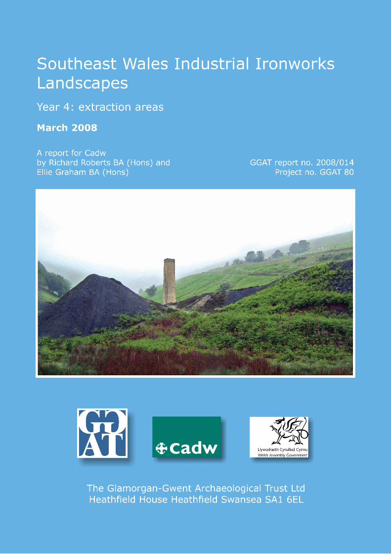
The landscapes of the iron making industry of South East Wales represent an increasingly rare and important historic landscape and archaeological resource, which remains under considerable threat from a variety of developments from reclamation and landscape renewal to residential and industrial development. For this reason the current project has been instigated, to assess the current state of survival/preservation of the ironworks landscapes of the northern coalfield rim, and inform conservation, protection and management requirements through providing recommendations for the proactive and long-term management the ironwork areas. In essence the work will help to ensure that any necessary change to industrial ironworks landscape is accommodated without sacrificing the essential integrity and coherence of the historic environment. The latter half of the twentieth century saw the wholesale clearance, reclamation and development of many industrial sites in the South East Wales region. Ironworks, in particular have been vulnerable to landscape reclamation and renewal schemes, to such an extent that the vast majority of ironworks have at least in part been affected, and the process is ongoing. Therefore, it is both opportune and welcome that this project has been instigated, commissioned and funded by Cadw as part of an on-going initiative. It is hoped that this report will provide the catalyst for the urgent consideration of the future conservation of ironworks and their associated landscapes. The current report sets out the results of the project, with a section defining the aims, and methodology. It also summarises the known and potential threats and provides general recommendations and establishes management/conservation priorities. The main body of the report, Section 6, identifies and briefly describes the extraction areas and landscapes identified from the rapid review of the 1st edition mapping. These have been digitally mapped using a MapInfo Geographical Information System, and figures have been produced to illustrate the various interests. The extraction areas mapped are based on the first edition 1:2500 OS map, Landmark mapping, kindly provided by Cadw under licence agreement.
Southeast Wales Industrial Ironworks Landscapes
5
1.2 Acknowledgements
The project was commissioned by Cadw and undertaken by the Glamorgan-Gwent Archaeological Trust (GGAT) in their remit as the regional archaeological body responsible for the understanding and preservation of the archaeological resource in southeast Wales. The Trust would like to thank the staff of the Glamorgan Record Offices, Cardiff and Swansea, Gwent Record Office and the National Library of Wales for their assistance, The National Assembly for Wales for their helpful assistance and the staff at the National Monuments Record (NMR), RCAHMW, Aberystwyth, in particular Medwyn Parry. The Trust would also like to thank Judith Alfrey of Cadw for providing comments and advice during the project. Thanks are also due to Jessica Mills and Philip Hobson, Archaeological Records Officers, at Cadw. For advice in obtaining information on opencast and reclaimed land, the Trust would like to thank the staff of Unitary Authorities, especially Dave Whetter of Caerphilly CBC’s Planning Department. The Trust would also like to thank Anthea Brown of the British Geological Survey, and David Clarke, Joe Dearden, Graham Martin and Mike Sheldon of the Coal Authority for their assistance. Digital mining information – past opencast site data was kindly provided by the Coal Authority (ref: CA29/03/02). The report has been prepared by Richard Roberts and Ellie Graham, with the assistance of other staff of the Glamorgan-Gwent Archaeological Trust, notably Charina Jones, Historic Environment Record Manager. The digital mapping has been prepared by Ellie Graham, Charina Jones, Richard Roberts and Paul Jones of the GGAT Illustration Department.
1.3 Copyright Notice
The copyright of this report is held by Cadw: Welsh Historic Monuments and the Glamorgan-Gwent Archaeological Trust Ltd. The maps are based on Ordnance Survey mapping provided by the National Assembly for Wales with the permission of the Controller of Her Majesty’s Stationary Office, Crown Copyright. All rights reserved. Unauthorised reproduction infringes Crown Copyright and may lead to prosecution or civil proceedings. Licence No: 100017916 (2008).
Southeast Wales Industrial Ironworks Landscapes
6
2 The Study Area The overall project entailed work on the ironworks and related features within the northern coal rim area. These are located within the respective Unitary Authorities: Blaenau-Gwent, Caerphilly, Merthyr Tydfil, Monmouthshire, Neath Port-Talbot, Rhondda Cynon Taff, and Torfaen. The study was initially limited to the northern coalfield rim, specifically those sites described in L Ince 1993 The South Wales Iron Industry 1750-1885, Merton Press. The northern coalfield rim of South East Wales supplied over 30 major blast furnace iron-producing sites. However, this years project was limited to the Heads of the Valleys Region, specifically to the area designated by the Heads of the Valleys Initiative Strategy. Between the 1790s and 1840s the Heads of the Valleys in particular was the largest producer of iron in Britain, if not the world. Whilst the key areas of Blaenavon and Merthyr Tydfil have undergone intensive study much of the rest of the northern coalfield rim remains have been afforded little in the way of recording. The RCAHMW through their upland survey and aerial mapping have studied this area as a priority and a lot of data is and will become available from them. There are many other local historians/archaeologists who have published work on different parts of the area and the first edition OS map contains an extraordinary picture of this landscape at the end of its productive life. Due to the large amount of work already completed in the areas of Merthyr Tydfil and Blaenavon, these areas were omitted from this study but known results have been mapped as part of the project. The first three years of this project studied the core Ironworks areas themselves, and their associated transport links (restricted to limestone railways and tramroads) and extensive water management systems through out the northern coal rim area. Also associated with the ironworks are extensive extractive landscapes, the subject of the current years study. As a whole all these components contribute to a complex, integrated landscape within and extending between each valley region. For years three and four modifications were made to the remit, scale and with these the extent of the study area to allow the project to tie into the requirements of programmes, such as the Heads of the Valleys Initiative, and to provide results on a landscape scale through increasing available baseline data in a rapid way. The study area was revised to cover the area of the Heads of the Valleys initiative, thereby excluding ironworks sites, to the west of Hirwaun and beyond the eastern boundary of the Initiative area, excluding the Clydach Valley. Because of this, the need to cover a larger geographic area in the third and fourth year than originally proposed, combined with the complexity and large scale of the water management systems and extractive areas, and the need to rapidly provide baseline data, it was decided to restrict the third and current years’ project almost exclusively to mapping exercises.
Southeast Wales Industrial Ironworks Landscapes
7
3 Purpose of the Report – aims and applications. A number of Industrial Iron working landscapes are well known and well protected. Notably the World Heritage Designation at Blaenavon, but some protection is also afforded through inclusion on the Historic Landscape Register at for example Merthyr Tydfil and Cwm Clydach. In other areas only those elements that are Scheduled or Listed are protected and consequently other elements of the landscape relating to the monument are more exposed to removal or impairment through re-development. Industrial landscape reclamation and opencast are considered to be the main threats to these endangered and rapidly disappearing landscapes and their component elements whilst other developments could also have impacts.
It was proposed that the study be initially limited to the northern coalfield rim, specifically those sites described in L Ince 1993 The South Wales Iron Industry 1750-1885, Merton Press. The northern coalfield rim supplied 30 major blast furnace iron-producing sites. A simple but valuable exercise comprised comparing evidence from depictions of the core ironwork areas on the first edition OS map with modern maps and aerial photographic material, with the intention of identifying what survives and is visible, what survives and is buried, and what has been destroyed. The boundaries of the initial study were taken as the limits of the core ironworks areas and did not extend to wider transport links, waterworks and associated extraction sites, which were to be covered in the future. Validation was through site visits, consultation with local land reclamation departments and talking to local experts. Each ironworks core area was categorised as archaeologically sensitive areas, areas of archaeological potential or sterile areas. As a separate document a review of the scheduling of these sites could then be undertaken.
Large-scale regeneration proposals, such as the Heads of the Valleys Initiative, represent as much an opportunity as a threat to this existing and as yet largely unquantified heritage resource. Whilst environmental enhancement work is potentially damaging to the archaeological resource, the Heads of the Valleys programme proposes five key strategic goals, the leader of which is ‘an attractive and well-used natural, historic and built environment’, and it is envisaged that this will be achieved through strategic landscape-scale environmental enhancements. A further goal refers to ‘an appealing and coherent tourism and leisure experience’, which would include for large regional-scale projects. There is considerable opportunity for integrated heritage management, and for this reason it has been attempted to tailor the ironworks landscape project to fit the landscape-scale focus of the Heads of the Valleys programme. Local conservation initiatives, which could allow the industrial monuments to be tied in with ecological protection in amenity developments, offer further example of the potential of proactive management.
Whilst there is this wealth of information Cadw are endeavouring to improve the protection and management of what is perhaps one of the most important aspects of Wales’ history. Cadw would like to see this project attempt at building a consensus and partnership over how to tackle the protection and management issues and assimilate the information gathered into these processes. This may in effect act as a scoping for a larger project to be taken forward in future years.
Southeast Wales Industrial Ironworks Landscapes
8
The study should ultimately provide the information necessary to: assess the current state of survival/preservation, conservation and the recording requirements
(of the ironworks landscapes of the northern coal rim) inform future protection and management issues, including future scheduling proposals
(regarding the ironworks landscapes of the northern coal rim) inform the relevant Unitary Authorites on industrial ironworks landscape issues in the
planning process, including forward planning assist in assessing the wider impact of future proposed development on industrial ironworks
landscapes assist in the evaluation of the aesthetic or amenity value of the industrial ironworks landscape assist in measuring the effect of individual development proposals on the overall historic
integrity and coherence of industrial ironworks landscapes, with particular reference to the issues of outright removal, severance, fragmentation or dislocation of the historic elements.
assess the cumulative effects of secondary or piecemeal changes over time. An important component of this project has and will continue to be the engagement of those who have a direct interest in the industrial ironworks landscape study and the applications that will be derived from it. It is hoped that this should enable decisions on the protection of the historic environment to be made in a more informed way. It is intended therefore to keep interested parties such as Cadw, RCAHMW, CCW, DEIN, the Local Unitary Authorities, and the Brecon Beacons National Park informed on the progress and findings of the studies. Several of these objectives are directly applicable to the Heads of the Valleys programme, notably informing authorities on landscape issues, and assisting in the enhancement of the amenity value of sites. In essence the work will help to ensure that any necessary change to industrial ironworks landscape is accommodated without sacrificing the essential integrity and coherence of the historic environment. The Ironworks were the key stimulant for the development of the surviving communities; as such these are iconic markers in the Welsh industrial landscape. This project aims to provide a deeper understanding and appreciation of these remains leading not just to a better and wider appreciation of their importance as continuing focal points in the South Wales landscape but with the intention that raised awareness and protection can be used as an impetus for sensitive regeneration and community focus. The results of this project would seek to link into and inform existing strategies such as the ‘Wales Spatial Plan’ (Welsh Assembly Government 2004) and the related ‘Heads of Valleys Strategy’ (Welsh Assembly Government 2005), informing the process of promoting and enhancing local heritage sites within a framework of sustainable development. The latter, detailed in the document ‘Heads – We Win...’ A Strategic Framework for the Heads of the Valleys', (Welsh Assembly Government’s vision for the Heads of the Valleys within the context of the Wales Spatial Plan), includes the overarching aim that by ‘the year 2020, the [Heads of the Valleys] area will be: a culturally rich, dynamic network of vibrant and safe communities a place where people want to live, work and play with a sustainable, high quality of life and a thriving population helping to drive the success of South East Wales as an internationally recognised Capital Region.’
Southeast Wales Industrial Ironworks Landscapes
9
Among the key themes of the Heads of the Valleys Programme are the following: ‘An attractive and well-used natural, historic and built environment’, which would provide an ‘appealing and coherent tourism and leisure experience’. The Heads of the Valleys Initiative’s strategic goals and programmes, produced through stakeholder consultation and analysis of the available research and evidence, has been developed around five priority themes, each underpinned by a number of key Strategic Programmes (SPs):
An attractive and well-used natural, historic and built environment SP1: A sub-regional approach to the regeneration of settlements SP2: A perception-changing landscape SP3: Well-used and easily accessed amenities
A vibrant economic landscape offering new opportunities SP4: Directly linking people with work SP5: Joined-up solutions for business SP6: Linked opportunities for businesses and individuals
A well-educated, skilled and healthier population SP7: Improving health through prevention SP8: Integrated lifelong learning
An appealing and coherent tourism and leisure experience SP9: Linked local and regional attractions and facilities SP10: An integrated ’offer’
Public confidence in a shared bright future SP11: Visualising the Strategy SP12: Pro-active communications and engagement
The following identified strategic programmes SP1, SP2, SP3, and SP9 all have implications for the heritage resource across the Heads of the Valleys region; these should, however, be viewed as opportunities to allow the quantification, assessment, and sensitive management and promotion of the Heritage resource of the Heads of the Valleys area. The DEIN strategy ‘Working Together For Wales’ is viewed as having the potential to tie in with the broad tourism and regeneration, in addition to ‘urban and rural renewal activities, land reclamation and environmental improvements to sites and property’. A raft of numerous supporting plans, policies, strategies and guidance exists to underpin the Heads of the Valleys Initiative and are relevant to the future preservation and management of the heritage resource in the Heads of the Valleys area; these have been summarised in ‘Annex A: Review of Relevant Plans, Policies and Strategies’, and include the following: Environment Strategy for Wales; Learning to Work Differently – Sustainable Development – WDA; Planning Policy Wales (March 2002); Circular 60/96; Circular 61/96; Enter the Dragon Economy – SE Wales Development Strategy (Capital Wales); Wales: A Better Country – The Strategic Agenda of the Welsh Assembly Government.
Southeast Wales Industrial Ironworks Landscapes
10
4 Methodology
4.1 General Methodology
The project involved a rapid interrogation of the computerised Regional Historic Environment Record (henceforth HER), supplemented by other readily available primary and secondary data, such as a search of National Monuments Record (henceforth NMR) data available through ENDEX, and online through the Coflein website. More general works and articles and other sources were also consulted where readily available, though few secondary sources were found to be directly relevant to the study of water management features; where consulted these sources are provided in the bibliography along with other general sources. The report has been presented in such a way that upgrading of information can be considered through the medium of a GIS system. This allows data storage, manipulation, analysis, interrogation, presentation and future revision of information. Information Technology has therefore been a major component of this project and the current years work contributes to the production of a dynamic and multi-layered digital model for the study area(s).
4.2 Year Four Methodology
During year four the main element of the project was a Heads of the Valleys area-wide mapping exercise based on the first edition 25-inch OS map (LANDMARK Historic Mapping). This allowed specific ironwork related extraction areas to be identified and quantified at a landscape scale. It was decided to base the mapping exercise on the first edition OS map (c. 1875-1880) as this period represented a hiatus in iron production across the Heads of the Valleys area, with the relevant extraction areas in place. Later OS editions detail the extraction areas as they were modified for steel production and non-ironworks coal supply. The mapping exercise was undertaken using a GIS mapping package (MapInfo 7). The digital mapping information in MapInfo and Pdf format will be made available on completion of this year’s project. Information on statutory protection (both for Scheduled Ancient Monuments and Listed Buildings) relevant to ironworks extraction sites in the Heads of the Valleys area was obtained from Cadw to assess current levels of protection. Digital polygonal was produced to locate individual extractive areas (patch workings, collieries, etc) features based on the first edition maps, with point data data being produced to map other individual data, e.g. the Cynon Coal data. Valley Landscape areas, potentially surviving and surviving extractive areas, and areas of complex or ambiguous associations were conceived and mapped in polygonal form. The survival of the resource was assessed through comparison of information obtained from historic maps and modern mapping (OS Landline) supplemented by information obtained from digitally available aerial photographs (Get Mapping 2000; COWI 2006), and as a check high resolution aerial photographs of the 1940s, were viewed. In addition readily available map information on areas of opencast was also sourced and used to aid this process; this primarily comprised digital mining information (past opencast site data) kindly provided by the Coal Authority under licence (ref: CA29/03/02). Additional information on land reclamation was requested from the individual UAs within the study area. It was found that this information was
Southeast Wales Industrial Ironworks Landscapes
11
either not available, or could not be provided in a readably accessible format compatible with the scope of the current project. Copies of available current Unitary Authority development plans were obtained and examined for their bearing on the heritage resource, and the way in which they could potentially affect that resource positively or adversely. In addition available information on DEIN and Environment Agency programmes, and the ‘The Heads of the Valleys Strategy’ and Wales Spatial plan were obtained, and examined for ways in which the current project could specifically inform or assist in the overall aims of the programmes/plans. The results of previous years work following the review carried out during year three were incorporated and revised to allow the final identification and mapping of areas of special industrial ironworks landscape significance. These areas will form the basis of more detailed studies in following years.
4.3 Task Breakdown
1. Review and compile baseline documentation Compilation of necessary documentation/HER/NMR data, Cadw Information Review first edition 1:2500 OS maps for Heads of the Valleys area Compile source list and bibliography for project
2. Review current state of protection and threats for newly identified sites/areas Establish current extent of scheduling / listing Establish extent of opencast and reclaimed areas Investigate details, where available, of current UA plans/DEIN and Environment Agency
programmes and other management strategies, eg. ‘The Heads of the Valleys Strategy’ 3. Undertake historical mapping and production of constraint maps Undertake rapid mapping (digital MapInfo point and polygon data) Ascertain extent of surviving remains (against modern map, aerial photographic data, etc) Revise existing GGAT lists and produce distribution/area maps
4. Review the assembled data Consider proposals for protection (where identifiable at this stage) Prepare integrated summary/constraints map including information from earlier years. Discuss conclusions with Cadw
5. Compile and disseminate reports Compile text
o Briefly review background history of the ironworks of the northern coal rim, historiography, recent research, and significance and importance of individual ironwork landscapes
o Review relative historical significance and importance of individual ironworks landscapes based on years 1, 2 and 3 findings
o Provide summary description of surviving ironworks related extractive resource and review significance
o Review current levels of statutory protection relating to ironworks related extractive features
o Review threats and current management proposals/priorities relating to ironworks related extractive features
o Make recommendations for detailed follow on study to be carried out during years 5 and 6 (as required)

Southeast Wales Industrial Ironworks Landscapes
12
Make any additional recommendations, eg proposals for protection (years 5 and 6 unless immediately required)
Prepare illustrations for report Produce reports using DTP facilities Submit reports to Cadw Provide copies to interested parties (HER and NMR, RCAHMW, UDP planning
departments, etc)
Southeast Wales Industrial Ironworks Landscapes
13
5 Industrial Ironworks Landscapes (after year 3 report)
5.1 Review of Project: Year 1 The Core Ironwork Areas
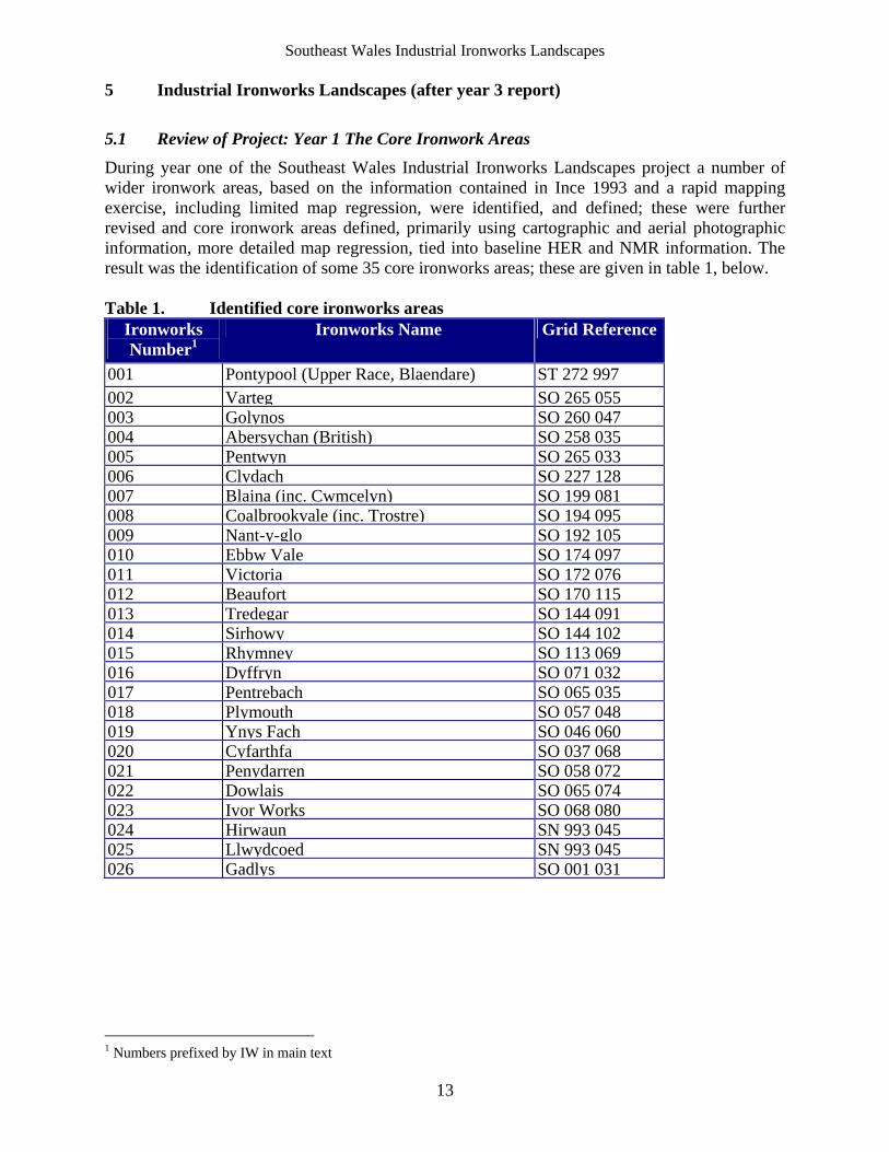
During year one of the Southeast Wales Industrial Ironworks Landscapes project a number of wider ironwork areas, based on the information contained in Ince 1993 and a rapid mapping exercise, including limited map regression, were identified, and defined; these were further revised and core ironwork areas defined, primarily using cartographic and aerial photographic information, more detailed map regression, tied into baseline HER and NMR information. The result was the identification of some 35 core ironworks areas; these are given in table 1, below. Table 1. Identified core ironworks areas
Ironworks Number1
Ironworks Name Grid Reference
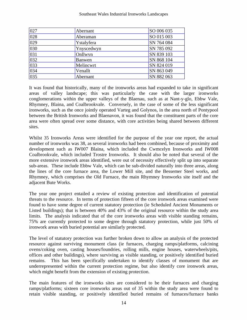
001 Pontypool (Upper Race, Blaendare) ST 272 997 002 Varteg SO 265 055003 Golynos SO 260 047004 Abersychan (British) SO 258 035005 Pentwyn SO 265 033006 Clydach SO 227 128007 Blaina (inc. Cwmcelyn) SO 199 081008 Coalbrookvale (inc. Trostre) SO 194 095009 Nant-y-glo SO 192 105010 Ebbw Vale SO 174 097011 Victoria SO 172 076012 Beaufort SO 170 115013 Tredegar SO 144 091014 Sirhowy SO 144 102015 Rhymney SO 113 069016 Dyffryn SO 071 032017 Pentrebach SO 065 035018 Plymouth SO 057 048019 Ynys Fach SO 046 060020 Cyfarthfa SO 037 068021 Penydarren SO 058 072022 Dowlais SO 065 074023 Ivor Works SO 068 080024 Hirwaun SN 993 045025 Llwydcoed SN 993 045026 Gadlys SO 001 031
1 Numbers prefixed by IW in main text
Southeast Wales Industrial Ironworks Landscapes
14
027 Abernant SO 006 035 028 Aberaman SO 015 003 029 Ystalyfera SN 764 084 030 Ynyscedwyn SN 785 092 031 Onllwyn SN 839 103032 Banwen SN 868 104033 Melincwrt SN 824 019034 Venallt SN 863 049 035 Abernant SN 882 063 It was found that historically, many of the ironworks areas had expanded to take in significant areas of valley landscape; this was particularly the case with the larger ironworks conglomerations within the upper valleys of the Blaenau, such as at Nant-y-glo, Ebbw Vale, Rhymney, Blaina, and Coalbrookvale. Conversely, in the case of some of the less significant ironworks, such as the once jointly operated Varteg and Golynos, in the area north of Pontypool between the British Ironworks and Blaenavon, it was found that the constituent parts of the core area were often spread over some distance, with core activities being shared between different sites. Whilst 35 Ironworks Areas were identified for the purpose of the year one report, the actual number of ironworks was 38, as several ironworks had been combined, because of proximity and development such as IW007 Blaina, which included the Cwmcelyn Ironworks and IW008 Coalbrookvale, which included Trostre Ironworks. It should also be noted that several of the more extensive ironwork areas identified, were out of necessity effectively split up into separate sub-areas. These include Ebbw Vale, which can be sub-divided naturally into three areas, along the lines of the core furnace area, the Lower Mill site, and the Bessemer Steel works, and Rhymney, which comprises the Old Furnace, the main Rhymney Ironworks site itself and the adjacent Bute Works. The year one project entailed a review of existing protection and identification of potential threats to the resource. In terms of protection fifteen of the core ironwork areas examined were found to have some degree of current statutory protection (ie Scheduled Ancient Monuments or Listed buildings); that is between 40% and 43% of the original resource within the study area limits. The analysis indicated that of the core ironworks areas with visible standing remains, 75% are currently protected to some degree through statutory protection, while just 50% of ironwork areas with buried potential are similarly protected. The level of statutory protection was further broken down to allow an analysis of the protected resource against surviving monument class (ie furnaces, charging ramps/platforms, calcining ovens/coking oven, casting houses/foundries, rolling mills, engine houses, waterwheels/pits, offices and other buildings), where surviving as visible standing, or positively identified buried remains. This has been specifically undertaken to identify classes of monument that are underrepresented within the current protection regime, but also identify core ironwork areas, which might benefit from the extension of existing protection. The main features of the ironworks sites are considered to be their furnaces and charging ramps/platforms; sixteen core ironworks areas out of 35 within the study area were found to retain visible standing, or positively identified buried remains of furnaces/furnace banks
Southeast Wales Industrial Ironworks Landscapes
15
(including a count of two for Abersychan – with the scheduled air furnace). The nationally important furnaces (and engine house) at Banwen (SAM Gm420), despite protection through scheduling are in urgent need of conservation. Twelve of the 17 furnaces/furnace banks identified are currently protected by statutory protection: notably the furnace bank at IW010 Ebbw Vale (Listed Building Grade II*, Cadw ref: 22,531) is not scheduled. The furnaces at IW004 Abersychan, IW029 Ystalyfera, IW022 Dowlais (buried) and IW018 Plymouth (buried) are also of particular significance and are currently unprotected through legislation. The number of charging ramps/platforms similarly protected mirrors the figures identified for furnaces with 11 protected out of 18 identified, with that at IW010 Ebbw Vale listed (LBII*, Cadw ref: 22,531) but not scheduled. Significant unprotected charging ramps/platforms survive at IW029 Ystalyfera, IW004 Abersychan, IW021 Penydarren, and possibly also at IW009a Nant-y-glo, Other unprotected remains of charging ramps/platforms might also survive at IW012 Beaufort, IW013 Tredegar and IW025 Llwydcoed. The survival and protection of ancillary features displayed a slightly different pattern to the main ironworks features; in general survival of ancillary features within the study area such as calcining ovens/coking ovens, casting houses and foundries, was found to be relatively low and where these features did survive they were, with a few exceptions, invariably protected. Remains of calcining ovens/coking ovens survive at five ironworks, though generally in a fragmentary or buried condition. Of the calcining ovens/coking ovens identified four are protected through legislation; that at IW026 Gadlys, which had recently been conserved, was listed (LBII, Cadw ref: 10,846), but not scheduled. The latter in terms of condition was the best surviving example of those within the study area; most remain as ‘sites of’, or buried. Of the five ranks of ovens originally located at IW004 Abersychan, one recorded in 1994 (Ironbridge Institute and RCAHMW 1994) survives apparently in poor condition (Riden 1994); the site is currently unprotected. Casting houses/foundries were identified within five ironwork core areas; all are currently protected through legislation. The only unscheduled example is the foundry at IW004 Abersychan, which is a grade II* listed building (Cadw ref: 14,870). Mills and forges are similarly well-protected: these include both the forge/workshop (occupied) at IW015 Rhymney a grade II listed building (Cadw ref: 16,882), and the remains of two possible mills within the scheduled area (SAM BR157) at IW024 Hirwaun. Unusually the well-conserved brick-built mill/engine house and adjacent chimney (NPRN 34,037) at IW030 Ynyscedwyn is as yet unprotected through statutory legislation. The level of protection afforded to surviving ironworks related engine houses is generally high with eight of the ten identified examples adequately protected through listing and scheduling. Those Engine houses, which are listed rather than scheduled (eg Grade II* Listed engine house at IW019 Ynys Fach, and the Grade II Listed examples at IW022 Dowlais and IW026 Gadlys) are occupied and have been found alternative uses. As yet unprotected, in addition to the aforementioned example at Ynyscedwyn, are the buried remains of two identified engine houses at IW010 Ebbw Vale; these located to either end of the grade II* listed furnace. Only three waterwheels/wheel pits have been identified within the study area; these are all protected through scheduling; one at IW014 Sirhowy also being grade II* listed (Cadw ref: 22,496). It should be noted that due to the nature of these features a strong likelihood exists that buried remains might survive elsewhere, as yet unknown.
Southeast Wales Industrial Ironworks Landscapes
16
Of the twenty or so miscellaneous features such as offices and other buildings identified five are currently unprotected by legislation. The more significant are the tramroad tunnel beneath the furnace bank at IW018 Plymouth, the weighbridge and weighbridge house, and the smithy and carpenter’s shop at IW032 Banwen, the Company shop/office at IW009 Nant-y-glo (within 009a), the office at IW027 Abernant, and the Company shop and offices at IW034 Venallt; the latter three sites are all now occupied domestic properties. The unprotected features at Banwen have considerable group value with the nationally important features within scheduled area to the north (SAM Gm420), and it was noted that protection should be considered. A review of identified threats undertaken during year one using Unitary Authority development plans as a basis. Other potential threats, mainly from dereliction were identified in particular from the site visits. The year one project included rapid site validation visits; in fact a cross-section of ironworks (nineteen of the thirty-five) within the study area were visited, with the exception of the Merthyr Tydfil area (previously covered by Historic Landscape Characterisation work). The site visits in conjunction with documentary and cartographic sources were undertaken to validate the ironwork boundaries in their current state and to establish the current condition/survival, potential for survival of the archaeological resource within the identified ironwork areas. The archaeological resource for each ironwork core area was assessed in relation to the level of current statutory protection as well as condition, archaeological value, presence of visible remains and buried potential. It was found that of the 35 core ironwork areas (ie or a maximum 38 ironworks) 21 retained visible remains, while 30 were considered to have some level of buried potential. The results are summarised in Table 2, below.
Table 2. The core ironworks areas: condition and archaeological value Ironworks Number
Ironworks Name General Condition of Site2 Archaeological Value (Grading on figures)
001 Pontypool (Upper Race, Blaendare)
Reclaimed and landscaped C
002 Varteg Cleared and landscaped C
003 Golynos Reclaimed and partly redeveloped C
004 Abersychan (British) Intact (SAMs/LBs)/partly buried A
005 Pentwyn Reclaimed and landscaped C
006 Clydach Intact (SAM/LBs)/cleared and partly redeveloped
A
007 Blaina (inc. Cwmcelyn) Reclaimed and redeveloped C
008 Coalbrookvale (inc. Trostre)
Reclaimed and redeveloped C
009 Nant-y-glo Intact (009b: LB)/cleared and redeveloped
A-B
010 Ebbw Vale Intact (LB)/partly cleared and redeveloped
A-C
011 Victoria Reclaimed and partly redeveloped C
012 Beaufort Cleared and redeveloped C
013 Tredegar Cleared and partly redeveloped C
014 Sirhowy Intact (SAM/LB)/partly buried A
2 Based on cartographic, documentary and aerial photographic evidence alone, where not visited.
Southeast Wales Industrial Ironworks Landscapes
17
015 Rhymney Intact (015a: SAM/LBs)/reclaimed and redeveloped
A-C
016 Dyffryn Reclaimed and redeveloped C
017 Pentrebach Reclaimed and redeveloped D
018 Plymouth Tunnel intact/rest reclaimed and partly redeveloped
A
019 Ynys Fach Intact (SAM)/partly cleared and redeveloped
A
020 Cyfarthfa Intact (SAMs/LBs)/ partly cleared A
021 Penydarren Cleared and redeveloped B
022 Dowlais Intact (LB)/partly reclaimed and redeveloped
A
023 Ivor Works Intact (LB)/cleared site redeveloped A
024 Hirwaun Intact (SAMs/LBs)/partly cleared A
025 Llwydcoed Intact?/partly cleared A
026 Gadlys Intact (SAMs/LBs)/partly cleared and redeveloped
A
027 Abernant Cleared and partly reclaimed C
028 Aberaman Cleared and reclaimed D
029 Ystalyfera Partly cleared and redeveloped A/B
030 Ynyscedwyn Partly cleared and redeveloped A/B
031 Onllwyn Opencasted and reclaimed D
032 Banwen Intact (SAM)/derelict state A
033 Melincwrt Intact (SAM)/derelict state A
034 Venallt Intact (SAM)/conserved A
035 Abernant Reclaimed/partly redeveloped D
The analysis of cartographic, documentary and aerial photographic material not only allowed the boundaries of the core ironworks areas to be identified, but also allowed a general overview of site condition to be established. In this way the archaeological significance or potential of the resource could be estimated and broken down into the following:
archaeologically sensitive areas - Grade A areas of archaeological potential (moderate-high) - Grade B areas of archaeological potential (low-moderate) - Grade C sterile areas/low potential - Grade D
The value of the remains in the individual ironworks (IW) areas was considered in terms of certain remains, or where not visible, potential. Of the 35 core ironworks areas examined during year one some 14 (40% of the total areas) were considered to be straight archaeologically sensitive areas, with an additional 5 (14.3% of the total) archaeologically sensitive in combination (Category A taking president), a single area of moderate-high archaeological potential (2.9% of the total), and 11 areas (31.4% of the total) of low-moderate archaeological potential, whilst the remainder were areas of low or sterile archaeological potential. Of these core areas, only those considered to be archaeologically sensitive or of moderate to high potential have been viewed as considerations, when identifying historic ironworks landscape areas (see section 7.3, below).
Southeast Wales Industrial Ironworks Landscapes
18
5.2 Review of Project: Year 2 Transport Networks
Between the 1790s and 1840s the Heads of the Valleys in particular was the largest producer of iron in Britain, if not the world. A major system of tramroads and railroads was developed to furnish the ironworks with raw materials; this system, with the possible exception of the North Eastern Coalfield of England, was ‘by far the most extensive in Britain and therefore the World’ (van Laun 2001). The transport networks of South Wales were notable for a number of important technological advancements, such as the first use of the all-iron edge rail, and here the tramroad was developed to its highest form, with implications for the later development of public railways.
Three major components of the ironworks related transport system were identified:
the supply lines which extended from the limestone quarries of the northern outcrop to the furnaces (c.100km overall length)
the supply lines which conveyed coal from the coal and iron ore mines, which generally lay closer to the ironworks than the quarries (comprising a vast network of underground track)
the exit lines from the ironworks to the ports and canals and nearby markets (originally c. 190km)
The best surviving of these routes were the feeder routes from the limestone quarries, these were considered by van Laun (2001b) to be the most productive for further archaeological research; the routes to the coal and iron ore mines being largely underground or inaccessible, having been tipped over by continued workings or removed by land reclamation and urban development, whilst the exit routes have by and large been obscured by later railways, and road development with the notable exception of the Merthyr Tramroad, which has been excluded from the current study. It was considered that any meaningful examination of the routes to the coal and iron ore extraction sites would have required a substantial amount of desk-top study and original research, which whilst being beyond the scope of the project would have been largely unproductive, and as a result year two Southeast Wales Industrial Ironworks Landscapes project concentrated on identifying and investigating the best surviving element of the ironworks’ related transport networks, the supply lines from the limestone quarries. The year two study was necessarily fieldwork orientated to allow the presence/absence of surviving remains along the various transport routes (i.e. of the main routes and branches) to be recorded with each surviving transport route subdivided according to condition; condition ratings were devised and used in relation to the overall condition of each section, as was the overall archaeological significance or potential of the resource on a network-by-network basis and allocated one of the following values:
High Medium Low Unknown
Of the forty-three transport networks and branches ten, that is only 4.3%, were found to have routes surviving to 50% or more of their original length. In terms of overall archaeological significance twelve networks and branches were considered to be of high overall archaeological significance, six of high-medium significance, whilst the remainder were considered to be of medium, medium-low, low, or unknown significance. Those transport networks and branches
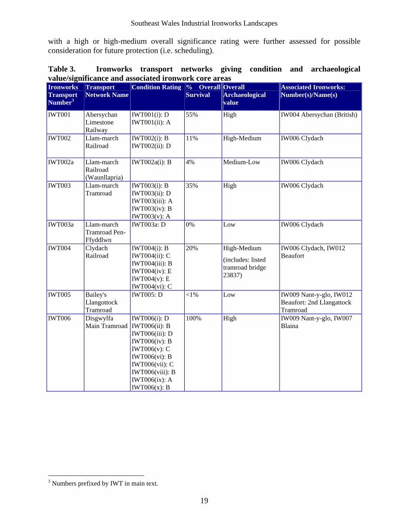
Southeast Wales Industrial Ironworks Landscapes
19
with a high or high-medium overall significance rating were further assessed for possible consideration for future protection (i.e. scheduling). Table 3. Ironworks transport networks giving condition and archaeological value/significance and associated ironwork core areas Ironworks Transport Number3
Transport Network Name
Condition Rating % Overall Survival
Overall Archaeological value
Associated Ironworks: Number(s)/Name(s)
IWT001 Abersychan Limestone Railway
IWT001(i): D IWT001(ii): A
55% High IW004 Abersychan (British)
IWT002 Llam-march Railroad
IWT002(i): B IWT002(ii): D
11% High-Medium
IW006 Clydach
IWT002a Llam-march Railroad (Waunllapria)
IWT002a(i): B 4% Medium-Low IW006 Clydach
IWT003 Llam-march Tramroad
IWT003(i): B IWT003(ii): D IWT003(iii): A IWT003(iv): B IWT003(v): A
35% High
IW006 Clydach
IWT003a Llam-march Tramroad Pen-Ffyddlwn
IWT003a: D 0% Low IW006 Clydach
IWT004 Clydach Railroad
IWT004(i): B IWT004(ii): C IWT004(iii): B IWT004(iv): E IWT004(v): E IWT004(vi): C
20% High-Medium
(includes: listed tramroad bridge 23837)
IW006 Clydach, IW012 Beaufort
IWT005 Bailey's Llangottock Tramroad
IWT005: D <1% Low IW009 Nant-y-glo, IW012 Beaufort: 2nd Llangattock Tramroad
IWT006 Disgwylfa Main Tramroad
IWT006(i): D IWT006(ii): B IWT006(iii): D IWT006(iv): B IWT006(v): C IWT006(vi): B IWT006(vii): C IWT006(viii): B IWT006(ix): A IWT006(x): B
100% High IW009 Nant-y-glo, IW007 Blaina
3 Numbers prefixed by IWT in main text.
Southeast Wales Industrial Ironworks Landscapes
20
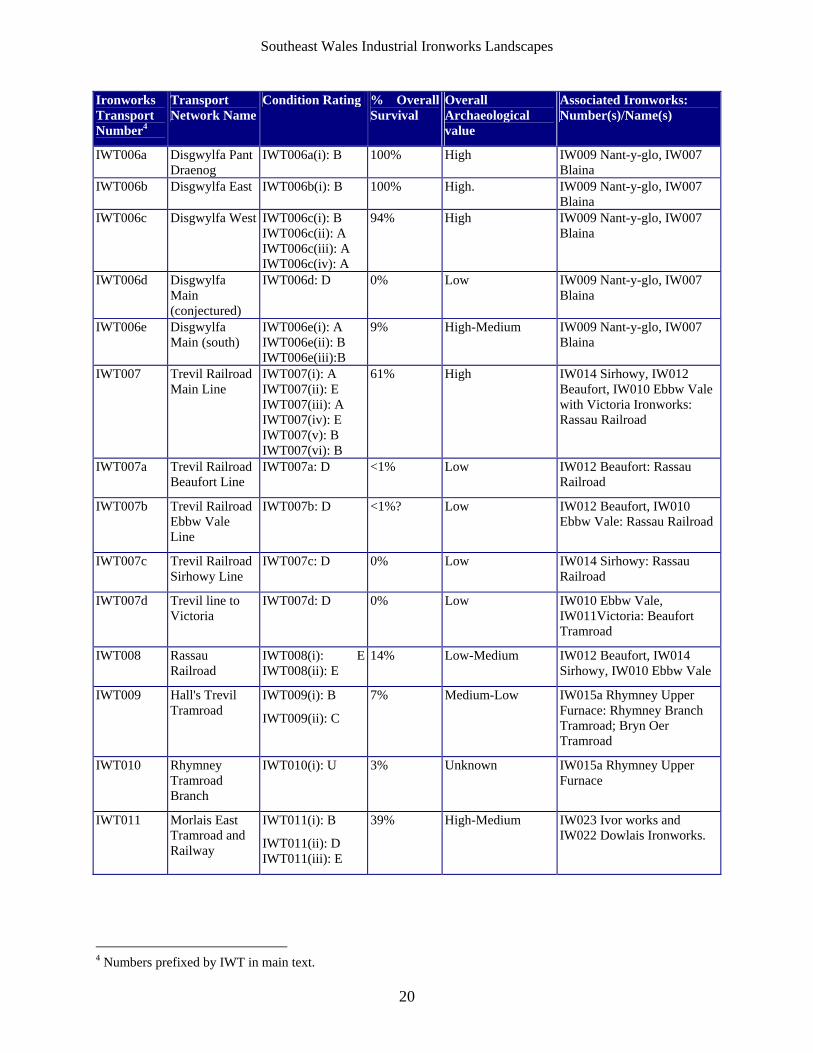
Ironworks Transport Number4
Transport Network Name
Condition Rating % Overall Survival
Overall Archaeological value
Associated Ironworks: Number(s)/Name(s)
IWT006a Disgwylfa Pant Draenog
IWT006a(i): B 100% High IW009 Nant-y-glo, IW007 Blaina
IWT006b Disgwylfa East IWT006b(i): B 100% High. IW009 Nant-y-glo, IW007 Blaina
IWT006c Disgwylfa West IWT006c(i): B IWT006c(ii): A IWT006c(iii): A IWT006c(iv): A
94% High IW009 Nant-y-glo, IW007 Blaina
IWT006d Disgwylfa Main (conjectured)
IWT006d: D 0% Low IW009 Nant-y-glo, IW007 Blaina
IWT006e Disgwylfa Main (south)
IWT006e(i): A IWT006e(ii): B IWT006e(iii):B
9% High-Medium IW009 Nant-y-glo, IW007 Blaina
IWT007 Trevil Railroad Main Line
IWT007(i): A IWT007(ii): E IWT007(iii): A IWT007(iv): E IWT007(v): B IWT007(vi): B
61% High IW014 Sirhowy, IW012 Beaufort, IW010 Ebbw Vale with Victoria Ironworks: Rassau Railroad
IWT007a Trevil Railroad Beaufort Line
IWT007a: D <1% Low IW012 Beaufort: Rassau Railroad
IWT007b Trevil Railroad Ebbw Vale Line
IWT007b: D <1%? Low IW012 Beaufort, IW010 Ebbw Vale: Rassau Railroad
IWT007c Trevil Railroad Sirhowy Line
IWT007c: D 0% Low IW014 Sirhowy: Rassau Railroad
IWT007d Trevil line to Victoria
IWT007d: D 0% Low IW010 Ebbw Vale, IW011Victoria: Beaufort Tramroad
IWT008 Rassau Railroad
IWT008(i): E IWT008(ii): E
14% Low-Medium IW012 Beaufort, IW014 Sirhowy, IW010 Ebbw Vale
IWT009 Hall's Trevil Tramroad
IWT009(i): B
IWT009(ii): C
7% Medium-Low IW015a Rhymney Upper Furnace: Rhymney Branch Tramroad; Bryn Oer Tramroad
IWT010 Rhymney Tramroad Branch
IWT010(i): U 3% Unknown IW015a Rhymney Upper Furnace
IWT011 Morlais East Tramroad and Railway
IWT011(i): B
IWT011(ii): D IWT011(iii): E
39% High-Medium IW023 Ivor works and IW022 Dowlais Ironworks.
4 Numbers prefixed by IWT in main text.
Southeast Wales Industrial Ironworks Landscapes
21
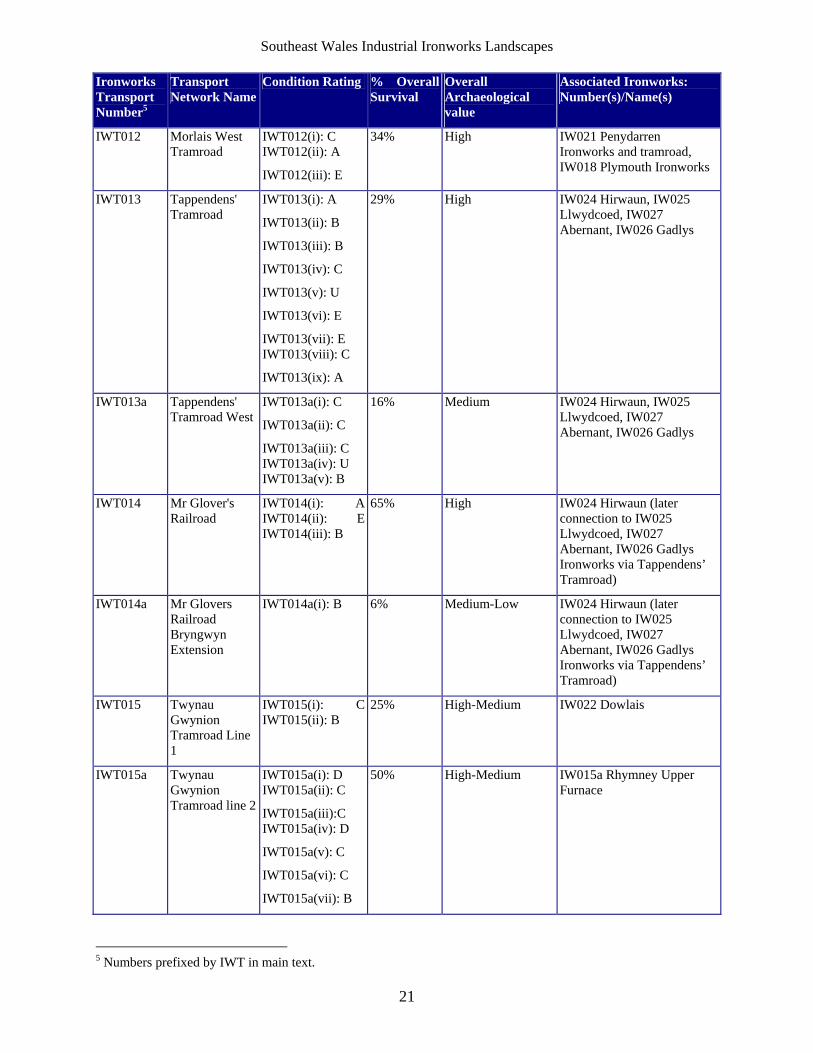
Ironworks Transport Number5
Transport Network Name
Condition Rating % Overall Survival
Overall Archaeological value
Associated Ironworks: Number(s)/Name(s)
IWT012 Morlais West Tramroad
IWT012(i): C IWT012(ii): A
IWT012(iii): E
34% High IW021 Penydarren Ironworks and tramroad, IW018 Plymouth Ironworks
IWT013 Tappendens' Tramroad
IWT013(i): A
IWT013(ii): B
IWT013(iii): B
IWT013(iv): C
IWT013(v): U
IWT013(vi): E
IWT013(vii): E IWT013(viii): C
IWT013(ix): A
29% High IW024 Hirwaun, IW025 Llwydcoed, IW027 Abernant, IW026 Gadlys
IWT013a Tappendens' Tramroad West
IWT013a(i): C
IWT013a(ii): C
IWT013a(iii): C IWT013a(iv): U IWT013a(v): B
16% Medium IW024 Hirwaun, IW025 Llwydcoed, IW027 Abernant, IW026 Gadlys
IWT014 Mr Glover's Railroad
IWT014(i): A IWT014(ii): E IWT014(iii): B
65% High IW024 Hirwaun (later connection to IW025 Llwydcoed, IW027 Abernant, IW026 Gadlys Ironworks via Tappendens’ Tramroad)
IWT014a Mr Glovers Railroad Bryngwyn Extension
IWT014a(i): B 6% Medium-Low IW024 Hirwaun (later connection to IW025 Llwydcoed, IW027 Abernant, IW026 Gadlys Ironworks via Tappendens’ Tramroad)
IWT015 Twynau Gwynion Tramroad Line 1
IWT015(i): C IWT015(ii): B
25% High-Medium IW022 Dowlais
IWT015a Twynau Gwynion Tramroad line 2
IWT015a(i): D IWT015a(ii): C
IWT015a(iii):C IWT015a(iv): D
IWT015a(v): C
IWT015a(vi): C
IWT015a(vii): B
50% High-Medium IW015a Rhymney Upper Furnace
5 Numbers prefixed by IWT in main text.
Southeast Wales Industrial Ironworks Landscapes
22
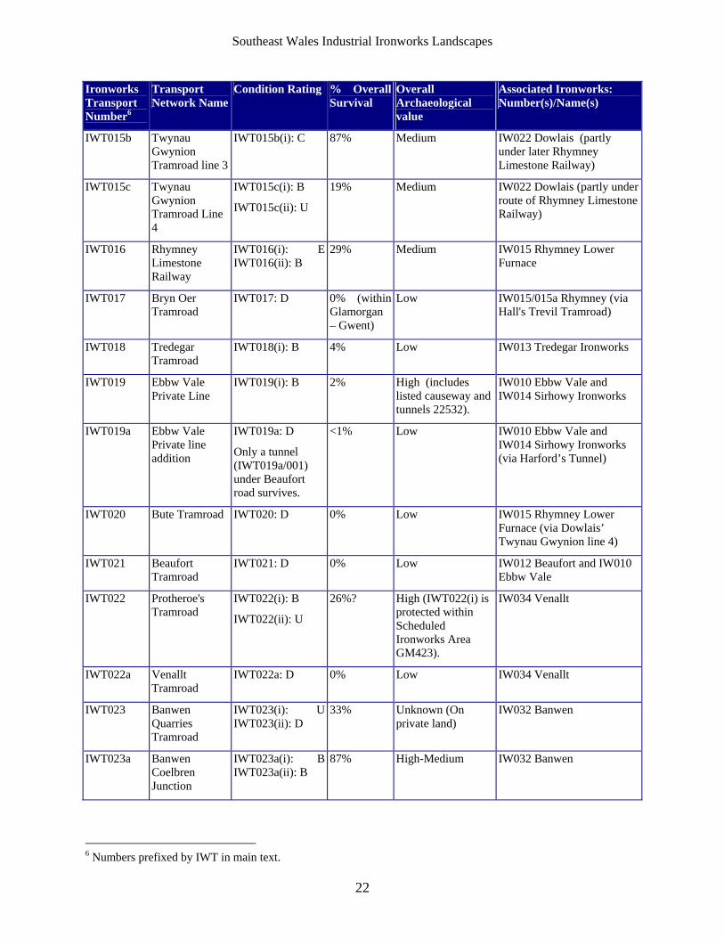
Ironworks Transport Number6
Transport Network Name
Condition Rating % Overall Survival
Overall Archaeological value
Associated Ironworks: Number(s)/Name(s)
IWT015b Twynau Gwynion Tramroad line 3
IWT015b(i): C 87% Medium IW022 Dowlais (partly under later Rhymney Limestone Railway)
IWT015c Twynau Gwynion Tramroad Line 4
IWT015c(i): B
IWT015c(ii): U
19% Medium IW022 Dowlais (partly under route of Rhymney Limestone Railway)
IWT016 Rhymney Limestone Railway
IWT016(i): E IWT016(ii): B
29% Medium IW015 Rhymney Lower Furnace
IWT017 Bryn Oer Tramroad
IWT017: D 0% (within Glamorgan – Gwent)
Low IW015/015a Rhymney (via Hall's Trevil Tramroad)
IWT018 Tredegar Tramroad
IWT018(i): B 4% Low IW013 Tredegar Ironworks
IWT019 Ebbw Vale Private Line
IWT019(i): B 2% High (includes listed causeway and tunnels 22532).
IW010 Ebbw Vale and IW014 Sirhowy Ironworks
IWT019a Ebbw Vale Private line addition
IWT019a: D
Only a tunnel (IWT019a/001) under Beaufort road survives.
<1% Low IW010 Ebbw Vale and IW014 Sirhowy Ironworks (via Harford’s Tunnel)
IWT020 Bute Tramroad IWT020: D 0% Low IW015 Rhymney Lower Furnace (via Dowlais’ Twynau Gwynion line 4)
IWT021 Beaufort Tramroad
IWT021: D 0% Low IW012 Beaufort and IW010 Ebbw Vale
IWT022 Protheroe's Tramroad
IWT022(i): B
IWT022(ii): U
26%? High (IWT022(i) is protected within Scheduled Ironworks Area GM423).
IW034 Venallt
IWT022a Venallt Tramroad
IWT022a: D 0% Low IW034 Venallt
IWT023 Banwen Quarries Tramroad
IWT023(i): U IWT023(ii): D
33% Unknown (On private land)
IW032 Banwen
IWT023a Banwen Coelbren Junction
IWT023a(i): B IWT023a(ii): B
87% High-Medium IW032 Banwen
6 Numbers prefixed by IWT in main text.
Southeast Wales Industrial Ironworks Landscapes
23
Ironworks Transport Number7
Transport Network Name
Condition Rating % Overall Survival
Overall Archaeological value
Associated Ironworks: Number(s)/Name(s)
IWT024 Ystalyfera IWT024: D 0% Low IW029Ystalyfera
IWT025 Nant-y-glo -Beaufort
IWT025: D 0% Low IW012 Beaufort (also IW009 Nant-y-glo via Bailey’s Llangattock Tramroad)
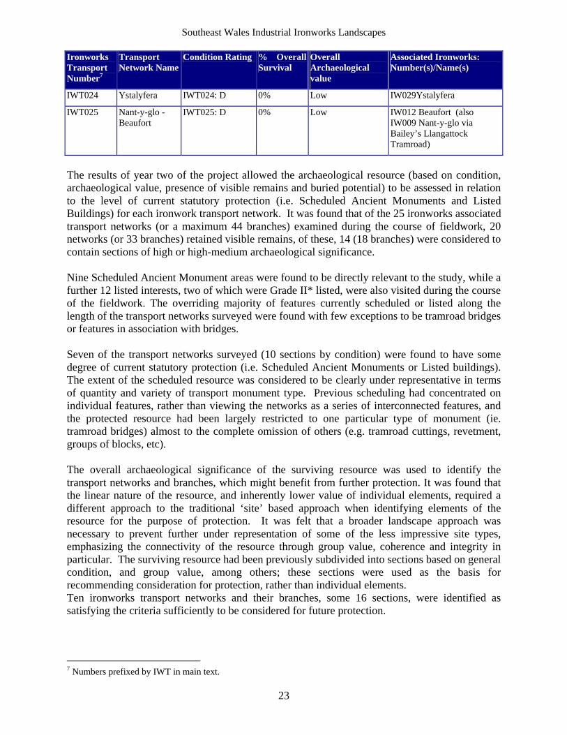
The results of year two of the project allowed the archaeological resource (based on condition, archaeological value, presence of visible remains and buried potential) to be assessed in relation to the level of current statutory protection (i.e. Scheduled Ancient Monuments and Listed Buildings) for each ironwork transport network. It was found that of the 25 ironworks associated transport networks (or a maximum 44 branches) examined during the course of fieldwork, 20 networks (or 33 branches) retained visible remains, of these, 14 (18 branches) were considered to contain sections of high or high-medium archaeological significance. Nine Scheduled Ancient Monument areas were found to be directly relevant to the study, while a further 12 listed interests, two of which were Grade II* listed, were also visited during the course of the fieldwork. The overriding majority of features currently scheduled or listed along the length of the transport networks surveyed were found with few exceptions to be tramroad bridges or features in association with bridges. Seven of the transport networks surveyed (10 sections by condition) were found to have some degree of current statutory protection (i.e. Scheduled Ancient Monuments or Listed buildings). The extent of the scheduled resource was considered to be clearly under representative in terms of quantity and variety of transport monument type. Previous scheduling had concentrated on individual features, rather than viewing the networks as a series of interconnected features, and the protected resource had been largely restricted to one particular type of monument (ie. tramroad bridges) almost to the complete omission of others (e.g. tramroad cuttings, revetment, groups of blocks, etc). The overall archaeological significance of the surviving resource was used to identify the transport networks and branches, which might benefit from further protection. It was found that the linear nature of the resource, and inherently lower value of individual elements, required a different approach to the traditional ‘site’ based approach when identifying elements of the resource for the purpose of protection. It was felt that a broader landscape approach was necessary to prevent further under representation of some of the less impressive site types, emphasizing the connectivity of the resource through group value, coherence and integrity in particular. The surviving resource had been previously subdivided into sections based on general condition, and group value, among others; these sections were used as the basis for recommending consideration for protection, rather than individual elements. Ten ironworks transport networks and their branches, some 16 sections, were identified as satisfying the criteria sufficiently to be considered for future protection.
7 Numbers prefixed by IWT in main text.
Southeast Wales Industrial Ironworks Landscapes
24
The year two works extended to a review of threats largely identified on the basis of available Unitary Authority development plans. Other potential threats, such as dereliction were identified from the site visits. As a result general conservation management recommendations were made for the surviving networks. This identified a need for future detailed survey for many of the networks, or parts thereof; 17 sites were sufficiently well preserved, or complex, to warrant recommendations for further detailed survey (possibly to include trial excavation).
5.3 Review of Project: Year 3 Water Management Features
The project study area was revised during year 3 to reflect that of the Heads of the Valleys Initiative, in addition to areas considered to be well-covered by previous studies, such as the Blaenavon World Heritage site, and Merthyr Tydfil UA, the area of Cwm Clydach to the east and the iron working areas of the upper Swansea and Neath Valleys were also excluded. With a few notable exceptions on the systems within Ebbw Vale and Merthyr Tydfil (mostly outside the study area), previous work on the water management component of industrial ironworks landscapes within the Heads of the Valleys Initiative area has been limited:
The RCAHMW (Malaws and Wakelin 1993; Percival 2004) and GGAT (Roberts 1997b, 2001 and 2002; Roberts and Lawler 2003) have carried out survey and other work on the Dowlais Free Drainage System, parts of which have been scheduled as an Ancient Monument. This is ‘a gravity-fed drainage’ system, which supplied water to the ironworks of the Dowlais area including the Ivor (Ifor), “Old” and Penydarren Works (Owen 1977). Other more general work has been published on the water supply system for the iron and steel works of Merthyr Tydfil (e.g.Gross 2001).
Elsewhere in Merthyr Tydfil assessment work has been carried out on the water system
associated with Cyfarthfa and its mineral field on the western side of Merthyr Tydfil (see Roberts 1997; Williams 1997; Frost & Scott Jones 2000; and Oakey and van Laun 2004).
Archaeological Investigations Ltd undertook an assessment on the drainage system of
Ebbw Vale/Glyn Ebwy in Blaenau Gwent (Oakey 2005) with particular emphasis on four reservoir sites: Long Feeder Pond, Guide Mill Pond, and Rhyd-y-blew Reservoir in Ebbw Vale, and Farmers Pond in Bryn Mawr. This work included detailed analysis of the documentary evidence, and provides a developmental history and has mapped much of the system.
The work carried out during Year 3 of the project identified 101 water management related features (81 HER and 20 NMR sites) from searches of the HER and NMR within the revised study area, of these registers, 67 were associated directly or indirectly to ironworks (with an additional four possibly related). Only one water management ironworks related feature within the revised study area was found to be protected through statutory legislation, the Colliery Pumping Engine House (MM216) at the British Ironworks (both a Scheduled Ancient Monument and a listed building). A rapid review of the first edition OS map effectively increased the baseline data allowing the identification of 601 water management features (including 563 previously unidentified sites), which were subsequently mapped as point, linear and polygon data. These features were subsequently divided into ‘systems’ on a valley-by-valley basis, with the larger water
Southeast Wales Industrial Ironworks Landscapes
25
management features (i.e. reservoirs and leats) used as indicators against which the survival and hence potential archaeological significance of each system could be measured. Archaeological survival values for water management features identified from the first edition OS maps were given as follows:
A: Intact (original condition) - High Value (not assigned) B: Surviving (condition unestablished) - Moderate-High Value U: Potentially Surviving (ie buried or drained state) - Unknown Value D: Destroyed - Low Value
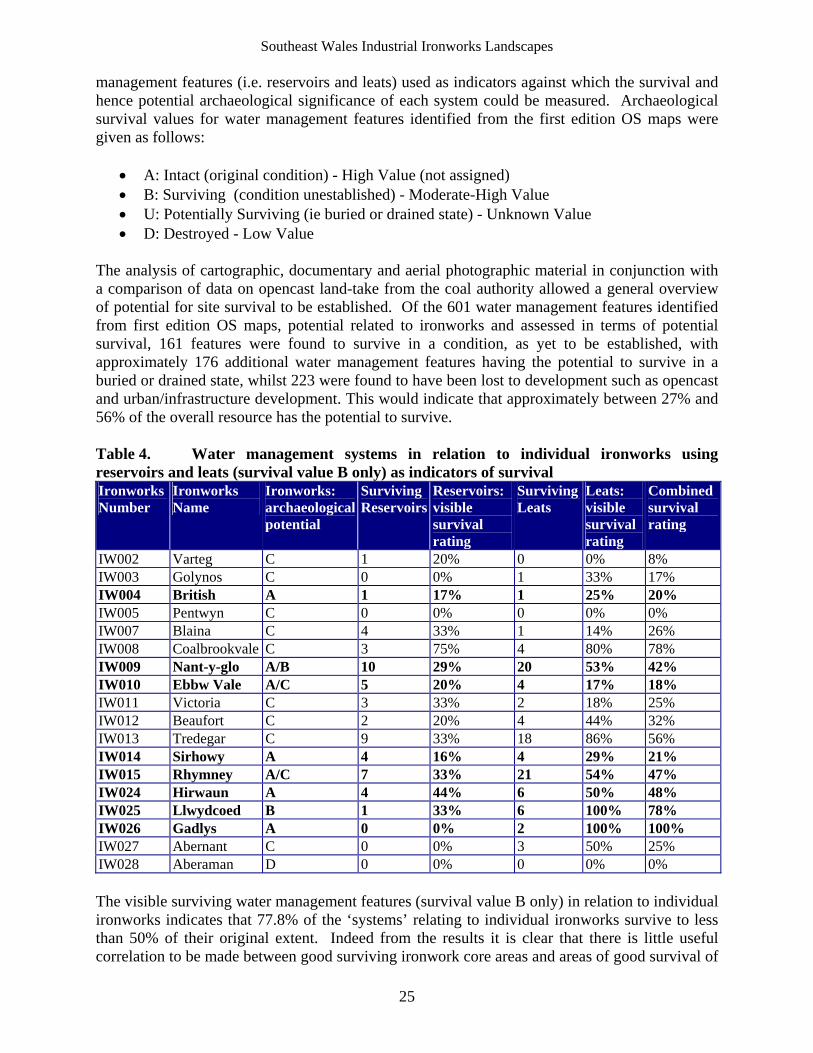
The analysis of cartographic, documentary and aerial photographic material in conjunction with a comparison of data on opencast land-take from the coal authority allowed a general overview of potential for site survival to be established. Of the 601 water management features identified from first edition OS maps, potential related to ironworks and assessed in terms of potential survival, 161 features were found to survive in a condition, as yet to be established, with approximately 176 additional water management features having the potential to survive in a buried or drained state, whilst 223 were found to have been lost to development such as opencast and urban/infrastructure development. This would indicate that approximately between 27% and 56% of the overall resource has the potential to survive. Table 4. Water management systems in relation to individual ironworks using reservoirs and leats (survival value B only) as indicators of survival Ironworks Number
Ironworks Name
Ironworks: archaeological potential
Surviving Reservoirs
Reservoirs: visible survival rating
Surviving Leats
Leats: visible survival rating
Combined survival rating
IW002 Varteg C 1 20% 0 0% 8% IW003 Golynos C 0 0% 1 33% 17% IW004 British A 1 17% 1 25% 20% IW005 Pentwyn C 0 0% 0 0% 0% IW007 Blaina C 4 33% 1 14% 26% IW008 Coalbrookvale C 3 75% 4 80% 78% IW009 Nant-y-glo A/B 10 29% 20 53% 42% IW010 Ebbw Vale A/C 5 20% 4 17% 18% IW011 Victoria C 3 33% 2 18% 25% IW012 Beaufort C 2 20% 4 44% 32% IW013 Tredegar C 9 33% 18 86% 56% IW014 Sirhowy A 4 16% 4 29% 21% IW015 Rhymney A/C 7 33% 21 54% 47% IW024 Hirwaun A 4 44% 6 50% 48% IW025 Llwydcoed B 1 33% 6 100% 78% IW026 Gadlys A 0 0% 2 100% 100% IW027 Abernant C 0 0% 3 50% 25% IW028 Aberaman D 0 0% 0 0% 0% The visible surviving water management features (survival value B only) in relation to individual ironworks indicates that 77.8% of the ‘systems’ relating to individual ironworks survive to less than 50% of their original extent. Indeed from the results it is clear that there is little useful correlation to be made between good surviving ironwork core areas and areas of good survival of
Southeast Wales Industrial Ironworks Landscapes
26
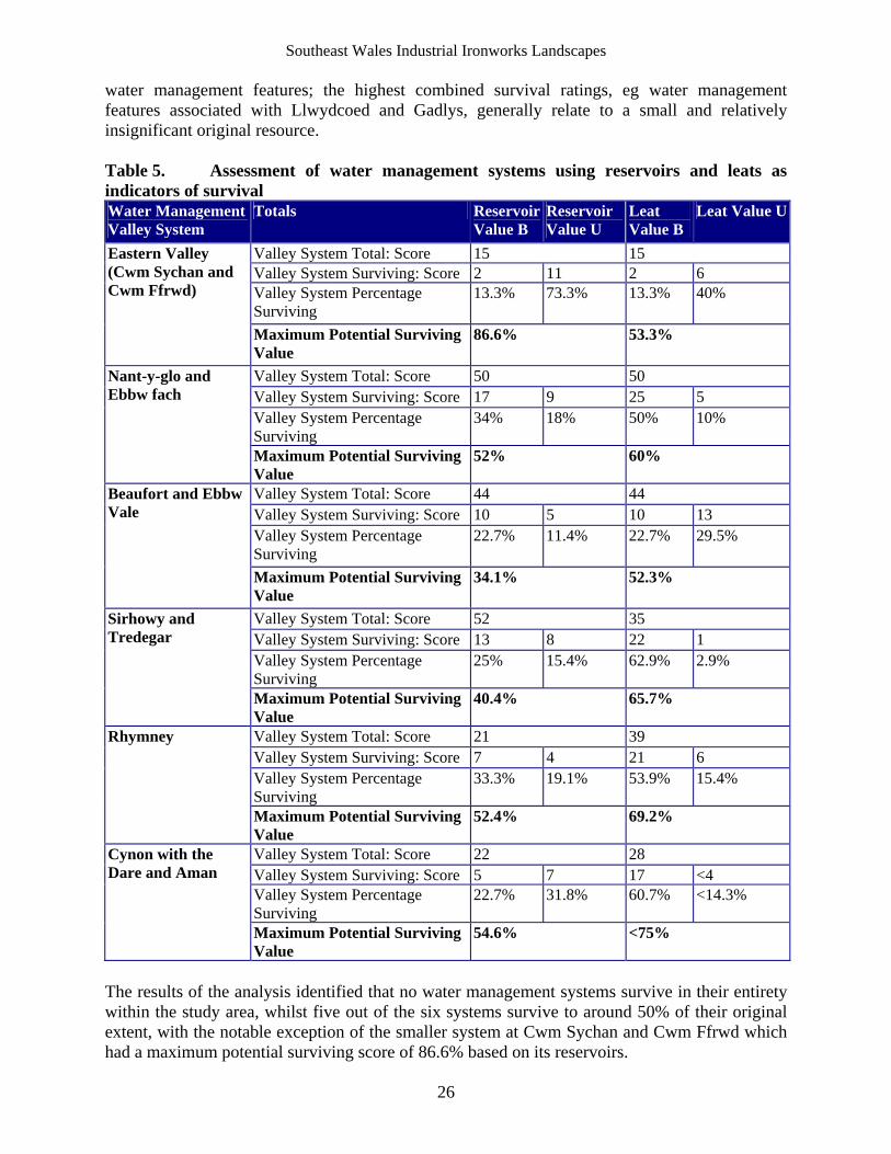
water management features; the highest combined survival ratings, eg water management features associated with Llwydcoed and Gadlys, generally relate to a small and relatively insignificant original resource. Table 5. Assessment of water management systems using reservoirs and leats as indicators of survival Water Management Valley System
Totals Reservoir Value B
Reservoir Value U
Leat Value B
Leat Value U
Valley System Total: Score 15 15 Valley System Surviving: Score 2 11 2 6 Valley System Percentage Surviving
13.3% 73.3% 13.3% 40%
Eastern Valley (Cwm Sychan and Cwm Ffrwd)
Maximum Potential Surviving Value
86.6% 53.3%
Valley System Total: Score 50 50 Valley System Surviving: Score 17 9 25 5 Valley System Percentage Surviving
34% 18% 50% 10%
Nant-y-glo and Ebbw fach
Maximum Potential Surviving Value
52% 60%
Valley System Total: Score 44 44 Valley System Surviving: Score 10 5 10 13 Valley System Percentage Surviving
22.7% 11.4% 22.7% 29.5%
Beaufort and Ebbw Vale
Maximum Potential Surviving Value
34.1% 52.3%
Valley System Total: Score 52 35 Valley System Surviving: Score 13 8 22 1 Valley System Percentage Surviving
25% 15.4% 62.9% 2.9%
Sirhowy and Tredegar
Maximum Potential Surviving Value
40.4% 65.7%
Valley System Total: Score 21 39 Valley System Surviving: Score 7 4 21 6 Valley System Percentage Surviving
33.3% 19.1% 53.9% 15.4%
Rhymney
Maximum Potential Surviving Value
52.4% 69.2%
Valley System Total: Score 22 28 Valley System Surviving: Score 5 7 17 <4 Valley System Percentage Surviving
22.7% 31.8% 60.7% <14.3%
Cynon with the Dare and Aman
Maximum Potential Surviving Value
54.6% <75%
The results of the analysis identified that no water management systems survive in their entirety within the study area, whilst five out of the six systems survive to around 50% of their original extent, with the notable exception of the smaller system at Cwm Sychan and Cwm Ffrwd which had a maximum potential surviving score of 86.6% based on its reservoirs.
Southeast Wales Industrial Ironworks Landscapes
27
The project allowed for a brief description of the respective valley systems and made conservation/management recommendations. The level of available study undertaken for water management features in general is low, with the exception to an extent of the Dowlais free drainage system, parts of the systems, which supplied Cyfarthfa and Ebbw Vale. Whilst the study allowed a rapid establishment of baseline data across the Heads of the Valleys area, it was by its very nature limited, for this reason follow on detailed documentary work and targeted field survey are among the recommendations made.
Southeast Wales Industrial Ironworks Landscapes
28
6 Extractive Landscapes
6.1 Introduction
The study area was revised to reflect that of the Heads of the Valleys Initiative area in the previous year (2006-07), whilst excluding areas considered to be well-covered by previous studies. Excluded therefore are the areas of the Blaenavon World Heritage site, and Merthyr Tydfil UA, both previously the subject of historic landscape characterisation. The area of Cwm Clydach, also the subject of historic landscape characterisation and which lies largely outside the boundaries of the Heads of the Valleys Initiative has also been largely excluded from this years project. Little previous archaeological work has been carried out on the extractive area component of industrial ironworks landscapes within the Heads of the Valleys Initiative area with a few notable exceptions on the areas within Merthyr Tydfil and Blaenavon, areas excluded from the current project. The Glamorgan-Gwent archaeological Trust has worked extensively in the Ffos-y-fran area carrying out a number of assessments and surveys recording extractive features in the area between 1993 and 2003 (the latest reports include Roberts 2001 and 2002, Roberts and Lawler 2003). Part of the surviving mineral fields associated with the Rhymney Ironworks, on the western flanks of the Rhymney Valley within Caerphilly UA has been covered by an assessment of the Nant Llesg area (Roberts 1997b). Further work has been undertaken by the RCAHMW on the extractive landscapes between Aberdare and Cyfarthfa, and between Dowlais and Gelligaer Common. Elsewhere in Merthyr Tydfil (outside the boundaries of the current study) assessment work has been carried out on the extractive landscapes associated with Cyfarthfa in particular its mineral field on the western side of Merthyr Tydfil (see Roberts 1997; Williams 1997; Frost & Scott Jones 2000; and Oakey and van Laun 2004). This assessment work would benefit from integration in the future with the current project through mapping. The study area boundary was changed in 2006-07 to reflect the Heads of the Valley Initiative area, as a result a reduced amount of core ironwork areas were taken forward. The core ironwork areas within the revised study area are given in Table 6, below. Table 6. List of ironworks in revised study area based on the Heads of the Valleys Initiative area excluding Merthyr Tydfil UA and the Blaenavon World Heritage Site IW number Potential Association IW002 Varteg IW003 Golynos IW004 British IW005 Pentwyn IW007 Blaina IW008 Coalbrookvale IW009 Nant-y-glo IW010 Ebbw Vale IW011 Victoria
IW number Potential Association IW012 Beaufort IW013 Tredegar IW014 Sirhowy IW015 Rhymney IW024 Hirwaun IW025 Llwydcoed IW026 Gadlys IW027 Abernant IW028 Aberaman
Southeast Wales Industrial Ironworks Landscapes
29
6.2 The Existing Baseline Data
Initial searches of the HER and NMR8 identified 351 and 294 extractive features respectively within the revised study area; not all of the features are necessarily related to ironworks; further information on these are presented in the gazetteers within the Appendices. The incidence of this data, together with the point data generated by the current project, is illustrated in s 2-5. The following tables (Tables 7 and 8) summarise HER and NMR registers by type: Table 7. Existing extractive features from HER data by Type
HER Feature by TYPE
Number of features by TYPE
Adit 26Bell Pit 1Building 2Chimney 1Colliery 82Drift Mine 2Earthwork 8Embankment 1Engine 1Engine House 6Extractive Pit 2Gravel Pit 1Inclined Plane 5Ironstone Mine 4Level 1Limekiln 1Linear Feature 3Mine 30Pit 2Pit Cluster 1Quarry 101Shaft 11Slag Heap 1Spoil Heap 21Steam Engine 1Structure 5Trackway 1Tramroad 3Ventilation Shaft 25Winder House 1Winding Engine 1Total 351
8 Additional NMR data has come to light subsequent to the writing of this year’s report; this relates in particular to upland survey carried out in 2005 on behalf of the RCAHMW within the area north of Bryn Mawr. This additional data will be incorporated within next year’s project.
Southeast Wales Industrial Ironworks Landscapes
30
Table 8. Existing Extractive features from NMR9 data by Type NMR Feature by TYPE Number of
features by TYPE
Boiler House 1Chimney 3Coal Mine 88Coal Mine; Ironstone Mine Leat 2Coal Mine; Level 2Coal Workings 7Coal Workings; Ironstone Workings 4Drift Mine 1Earthwork 1Engine House 22Extractive Pit 3Gravel Pit 1Ironstone Workings 10Lamp Room 1Level 25Lime Workings 5Mine 1Mine Shaft 7Mining Feature 6Opencast Mine 2Pit 2Quarry 27Shaft 12Spoil Heap 8Spoil Tip 38Storeroom 1Trackway 1Ventilation Shaft 9Weigh House 1Winding Engine 1Winding Gear 1Workshop 1Total 294
It was found that was not possible to effectively confirm the relationship of the identified HER and NMR resource either directly, or indirectly to ironworks related extraction. Most of the available site information was found to be of an insufficient level to allow a relationship with ironworks to be definitely established. Further detailed documentary and cartographic research,
9 Additional NMR data has come to light subsequent to the writing of this year’s report; this relates in particular to upland survey carried out in 2005 on behalf of the RCAHMW within the area north of Bryn Mawr. This additional data will be incorporated within next year’s project.
Southeast Wales Industrial Ironworks Landscapes
31
beyond the scope of the current year’s project will be required to establish the exact association of much of the extractive resource in the area. The current years’ project does not allow for detailed historic documentary analysis, and without this it is impossible to establish whether particular extractive features are definitely ironworks related. However, as an approximate minimum indication, those extractive features found to lie within general extractive areas connected by tramroad or located within close proximity to core ironwork’s areas, have been tentatively considered as being potentially ironworks related. In this way at least 124 of the 351 HER extraction sites are considered to relate directly or indirectly to ironworks, whilst at least 184 of the 294 NMR registers are considered to be ironworks related within the study area. Given the lack of firm constraint data the project utilised rapid mapping of extractive areas identified from the first edition OS map as a first step to effectively increase the level of available baseline data across the Heads of the Valleys area. Additional readily available data on the coal workings of the Cynon Valley was extracted from the Table of Mines (Davies/Godsall list) presented as an Appendix in the Cynon Valley History Society’s publication Cynon Coal (Cynon Valley History Society 2001 Appendix A 199-244). The latter identified a further 66 interests, including levels, collieries, pits, patch workings, and drift workings. It is evident that the number of individual features could be considerably increased through further intensive documentary research and field survey. Recommendations for further intensive archaeological documentary and fieldwork are presented later in this report.
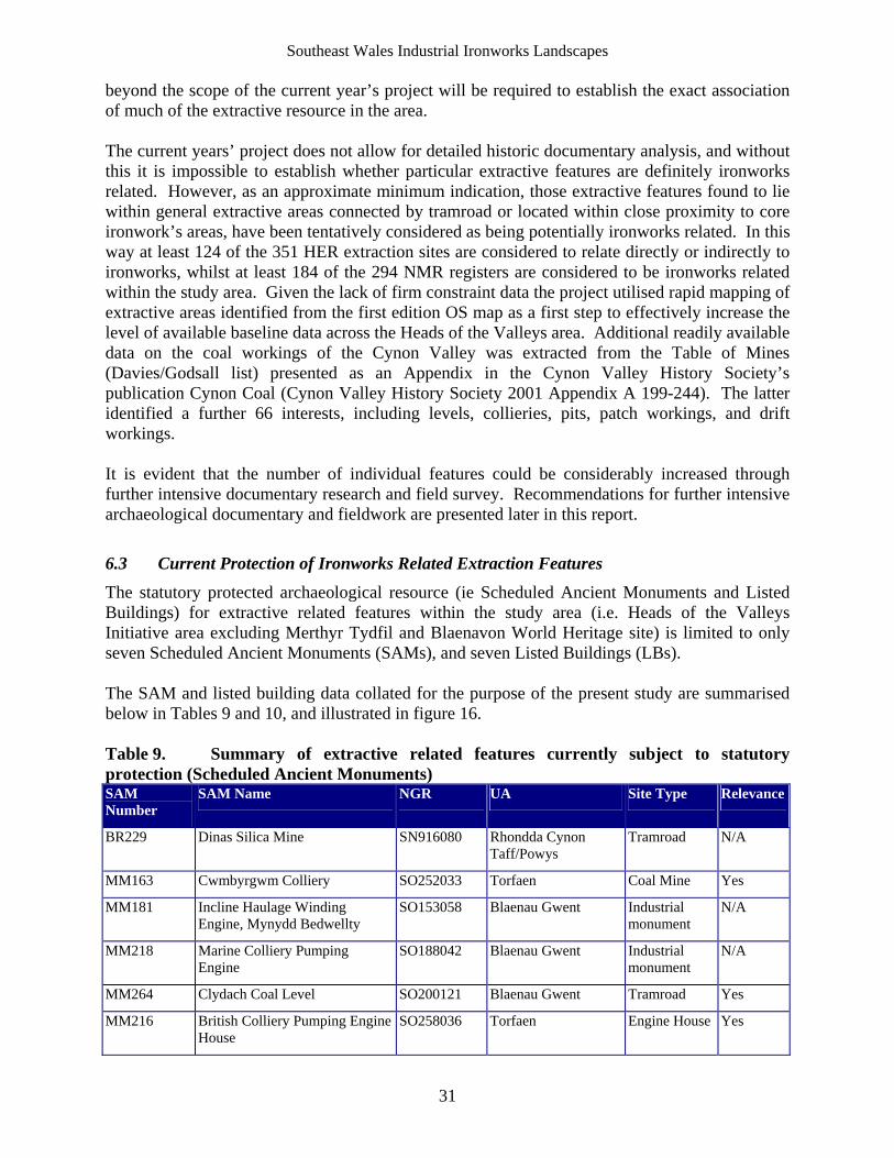
6.3 Current Protection of Ironworks Related Extraction Features
The statutory protected archaeological resource (ie Scheduled Ancient Monuments and Listed Buildings) for extractive related features within the study area (i.e. Heads of the Valleys Initiative area excluding Merthyr Tydfil and Blaenavon World Heritage site) is limited to only seven Scheduled Ancient Monuments (SAMs), and seven Listed Buildings (LBs). The SAM and listed building data collated for the purpose of the present study are summarised below in Tables 9 and 10, and illustrated in figure 16. Table 9. Summary of extractive related features currently subject to statutory protection (Scheduled Ancient Monuments) SAM Number
SAM Name NGR UA Site Type Relevance
BR229 Dinas Silica Mine SN916080 Rhondda Cynon Taff/Powys
Tramroad N/A
MM163 Cwmbyrgwm Colliery SO252033 Torfaen Coal Mine Yes
MM181 Incline Haulage Winding Engine, Mynydd Bedwellty
SO153058 Blaenau Gwent Industrial monument
N/A
MM218 Marine Colliery Pumping Engine
SO188042 Blaenau Gwent Industrial monument
N/A
MM264 Clydach Coal Level SO200121 Blaenau Gwent Tramroad Yes
MM216 British Colliery Pumping Engine House
SO258036 Torfaen Engine House Yes
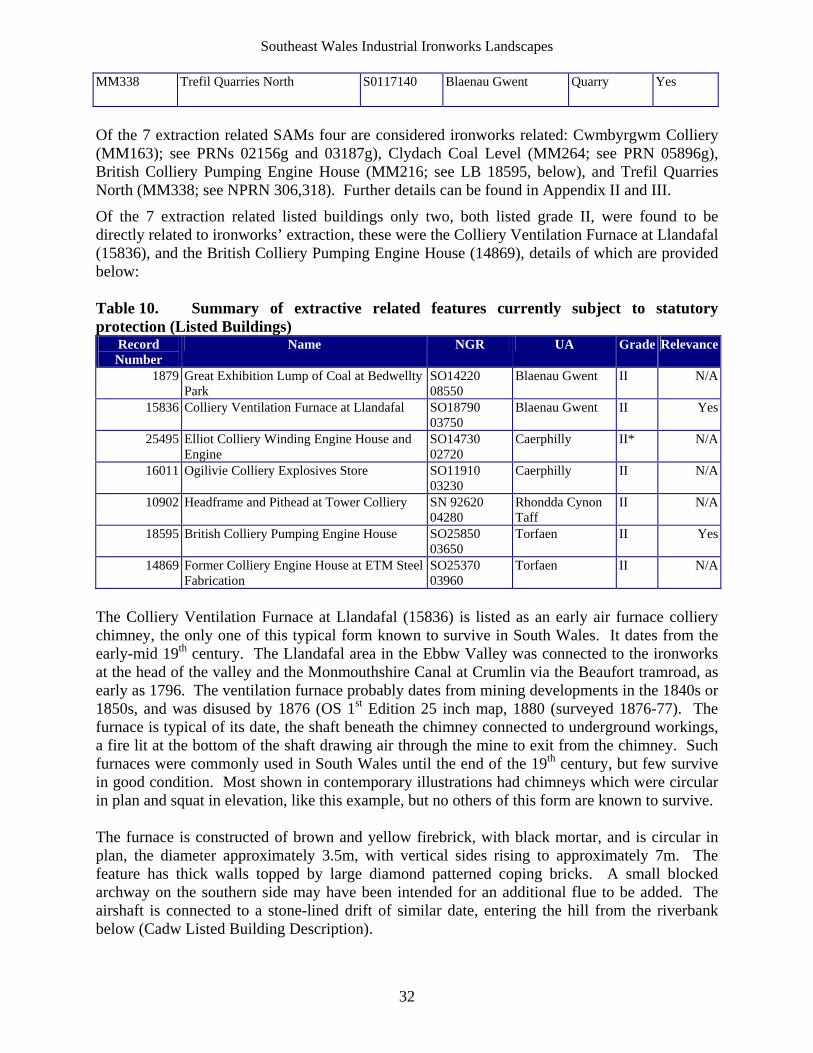
Southeast Wales Industrial Ironworks Landscapes
32
MM338 Trefil Quarries North S0117140 Blaenau Gwent Quarry Yes
Of the 7 extraction related SAMs four are considered ironworks related: Cwmbyrgwm Colliery (MM163); see PRNs 02156g and 03187g), Clydach Coal Level (MM264; see PRN 05896g), British Colliery Pumping Engine House (MM216; see LB 18595, below), and Trefil Quarries North (MM338; see NPRN 306,318). Further details can be found in Appendix II and III.
Of the 7 extraction related listed buildings only two, both listed grade II, were found to be directly related to ironworks’ extraction, these were the Colliery Ventilation Furnace at Llandafal (15836), and the British Colliery Pumping Engine House (14869), details of which are provided below: Table 10. Summary of extractive related features currently subject to statutory protection (Listed Buildings)
Record Number
Name NGR UA Grade Relevance
1879 Great Exhibition Lump of Coal at Bedwellty Park
SO14220 08550
Blaenau Gwent II N/A
15836 Colliery Ventilation Furnace at Llandafal SO18790 03750
Blaenau Gwent II Yes
25495 Elliot Colliery Winding Engine House and Engine
SO14730 02720
Caerphilly II* N/A
16011 Ogilivie Colliery Explosives Store SO11910 03230
Caerphilly II N/A
10902 Headframe and Pithead at Tower Colliery SN 92620 04280
Rhondda Cynon Taff
II N/A
18595 British Colliery Pumping Engine House SO25850 03650
Torfaen II Yes
14869 Former Colliery Engine House at ETM Steel Fabrication
SO25370 03960
Torfaen II N/A
The Colliery Ventilation Furnace at Llandafal (15836) is listed as an early air furnace colliery chimney, the only one of this typical form known to survive in South Wales. It dates from the early-mid 19th century. The Llandafal area in the Ebbw Valley was connected to the ironworks at the head of the valley and the Monmouthshire Canal at Crumlin via the Beaufort tramroad, as early as 1796. The ventilation furnace probably dates from mining developments in the 1840s or 1850s, and was disused by 1876 (OS 1st Edition 25 inch map, 1880 (surveyed 1876-77). The furnace is typical of its date, the shaft beneath the chimney connected to underground workings, a fire lit at the bottom of the shaft drawing air through the mine to exit from the chimney. Such furnaces were commonly used in South Wales until the end of the 19th century, but few survive in good condition. Most shown in contemporary illustrations had chimneys which were circular in plan and squat in elevation, like this example, but no others of this form are known to survive. The furnace is constructed of brown and yellow firebrick, with black mortar, and is circular in plan, the diameter approximately 3.5m, with vertical sides rising to approximately 7m. The feature has thick walls topped by large diamond patterned coping bricks. A small blocked archway on the southern side may have been intended for an additional flue to be added. The airshaft is connected to a stone-lined drift of similar date, entering the hill from the riverbank below (Cadw Listed Building Description).
Southeast Wales Industrial Ironworks Landscapes
33
The British Colliery Pumping Engine House (18595; and Scheduled Ancient Monument MM216) is listed as an unusually complete example of a Cornish engine house, itself a rarity in Wales. It also has important group value with the nearby former British Ironworks office and foundry quadrangle. The Cornish beam pumping engine-house was built by the British Iron Company to drain its mines. The engine-house stood within the complex of buildings of the British Ironworks, most of which were dismantled in the 1880's following closure of the ironworks in 1883. The British Ironworks began production in 1827 and operated several coalmines in the vicinity. The pumping engine was installed in 1845 to assist drainage from the deep levels (Colebrook 1983, pp.6-29; Riden 1994; and Ironbridge Institute and RCAHMW, 1994). Externally the structure is a sandstone engine house of standard 'Cornish' type, but better finished than many. It has the remains of a Welsh slate roof of low pitch. It comprises a rectangular three storeyed tower of coursed squared stone, the long walls have an arched opening on each floor with cill and voussoir head; these have all been blocked with brick. The north gable wall likewise, but with three different sized openings, of which only the ground floor one is blocked. The south gable 'bob' wall has a partly blocked doorway on the ground floor and the large arched 'bob' opening in the gable with two projecting iron brackets for a gallery below. Cornish examples almost always have attached chimneys but no evidence for this or for a boiler house remains. No surface remains of the shaft are visible. The interior is very unusual in retaining some of the timber beams and stairs on the upper floors. There are also cast and wrought iron brackets, bolts and plates. All traces of the Cornish beam pumping engine are long removed (Cadw Listed Building Description 1997). The scope of the current year’s project was not designed to provide a level of site specific information, especially on current condition and archaeological/historic value, detailed enough to allow identification of potential sites, which would benefit from protection; this is to follow in future years.
6.4 Baseline Extractive Area Data
Extractive areas were identified from the 1st edition OS maps and mapped in digital polygon format using MapInfo professional version 7; in this way 156 polygon areas of varying sizes were identified and subject to rapid digital mapping, of these 119 were further identified as being potentially related to ironworks due to proximity and tramroad/rail links; the digital mapping of these 119 areas was then further refined to accurately reflect boundaries on the 1st edition OS maps. The 119 potentially ironworks related areas are listed below giving potential associated ironworks and condition surviving rating (see Table 11, below). The actual number of registers could be considerably increased were individual areas broken down into constituent features (ie shafts/Levels and adits, tips etc), and single features were identified elsewhere. Given time restraints a landscape approach was used identifying areas rather than individual features in isolation as point data (where it was felt useful to note constituent features named on the first edition OS maps at this stage, these have been referred to in the area descriptions). Future cartographic and documentary work will naturally allow the identification of many more individual extractive sites and features, whilst further field survey within most of the 119 identified areas, should on previous experience be likely to increase the number of registers even further.
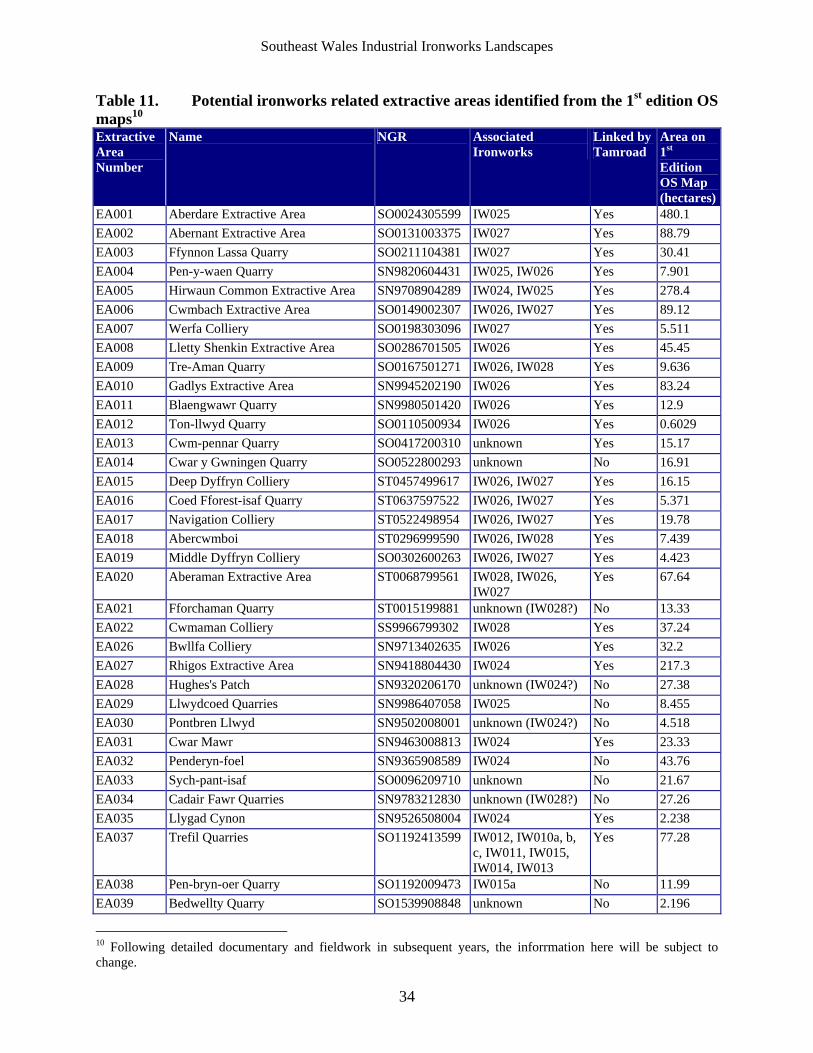
Southeast Wales Industrial Ironworks Landscapes
34
Table 11. Potential ironworks related extractive areas identified from the 1st edition OS maps10 Extractive Area Number
Name NGR Associated Ironworks
Linked by Tamroad
Area on 1st Edition OS Map (hectares)
EA001 Aberdare Extractive Area SO0024305599 IW025 Yes 480.1
EA002 Abernant Extractive Area SO0131003375 IW027 Yes 88.79
EA003 Ffynnon Lassa Quarry SO0211104381 IW027 Yes 30.41
EA004 Pen-y-waen Quarry SN9820604431 IW025, IW026 Yes 7.901
EA005 Hirwaun Common Extractive Area SN9708904289 IW024, IW025 Yes 278.4
EA006 Cwmbach Extractive Area SO0149002307 IW026, IW027 Yes 89.12
EA007 Werfa Colliery SO0198303096 IW027 Yes 5.511
EA008 Lletty Shenkin Extractive Area SO0286701505 IW026 Yes 45.45
EA009 Tre-Aman Quarry SO0167501271 IW026, IW028 Yes 9.636
EA010 Gadlys Extractive Area SN9945202190 IW026 Yes 83.24
EA011 Blaengwawr Quarry SN9980501420 IW026 Yes 12.9
EA012 Ton-llwyd Quarry SO0110500934 IW026 Yes 0.6029
EA013 Cwm-pennar Quarry SO0417200310 unknown Yes 15.17
EA014 Cwar y Gwningen Quarry SO0522800293 unknown No 16.91
EA015 Deep Dyffryn Colliery ST0457499617 IW026, IW027 Yes 16.15
EA016 Coed Fforest-isaf Quarry ST0637597522 IW026, IW027 Yes 5.371
EA017 Navigation Colliery ST0522498954 IW026, IW027 Yes 19.78
EA018 Abercwmboi ST0296999590 IW026, IW028 Yes 7.439
EA019 Middle Dyffryn Colliery SO0302600263 IW026, IW027 Yes 4.423
EA020 Aberaman Extractive Area ST0068799561 IW028, IW026, IW027
Yes 67.64
EA021 Fforchaman Quarry ST0015199881 unknown (IW028?) No 13.33
EA022 Cwmaman Colliery SS9966799302 IW028 Yes 37.24
EA026 Bwllfa Colliery SN9713402635 IW026 Yes 32.2
EA027 Rhigos Extractive Area SN9418804430 IW024 Yes 217.3
EA028 Hughes's Patch SN9320206170 unknown (IW024?) No 27.38
EA029 Llwydcoed Quarries SN9986407058 IW025 No 8.455
EA030 Pontbren Llwyd SN9502008001 unknown (IW024?) No 4.518
EA031 Cwar Mawr SN9463008813 IW024 Yes 23.33
EA032 Penderyn-foel SN9365908589 IW024 No 43.76
EA033 Sych-pant-isaf SO0096209710 unknown No 21.67
EA034 Cadair Fawr Quarries SN9783212830 unknown (IW028?) No 27.26
EA035 Llygad Cynon SN9526508004 IW024 Yes 2.238
EA037 Trefil Quarries SO1192413599 IW012, IW010a, b, c, IW011, IW015, IW014, IW013
Yes 77.28
EA038 Pen-bryn-oer Quarry SO1192009473 IW015a No 11.99
EA039 Bedwellty Quarry SO1539908848 unknown No 2.196
10 Following detailed documentary and fieldwork in subsequent years, the inforrmation here will be subject to change.
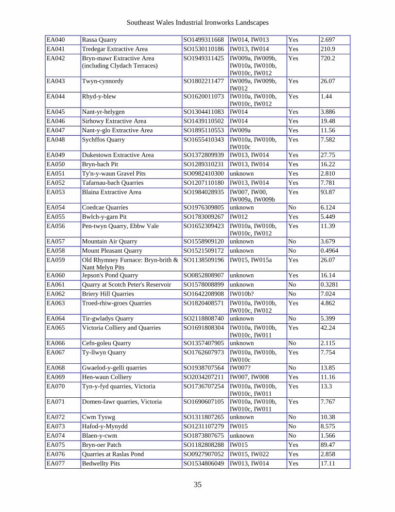
Southeast Wales Industrial Ironworks Landscapes
35
EA040 Rassa Quarry SO1499311668 IW014, IW013 Yes 2.697
EA041 Tredegar Extractive Area SO1530110186 IW013, IW014 Yes 210.9
EA042 Bryn-mawr Extractive Area (including Clydach Terraces)
SO1949311425 IW009a, IW009b, IW010a, IW010b, IW010c, IW012
Yes 720.2
EA043 Twyn-cynnordy SO1802211477 IW009a, IW009b, IW012
Yes 26.07
EA044 Rhyd-y-blew SO1620011073 IW010a, IW010b, IW010c, IW012
Yes 1.44
EA045 Nant-yr-helygen SO1304411083 IW014 Yes 3.886
EA046 Sirhowy Extractive Area SO1439110502 IW014 Yes 19.48
EA047 Nant-y-glo Extractive Area SO1895110553 IW009a Yes 11.56
EA048 Sychffos Quarry SO1655410343 IW010a, IW010b, IW010c
Yes 7.582
EA049 Dukestown Extractive Area SO1372809939 IW013, IW014 Yes 27.75
EA050 Bryn-bach Pit SO1289310231 IW013, IW014 Yes 16.22
EA051 Ty'n-y-waun Gravel Pits SO0982410300 unknown Yes 2.810
EA052 Tafarnau-bach Quarries SO1207110180 IW013, IW014 Yes 7.781
EA053 Blaina Extractive Area SO1984028935 IW007, IW00, IW009a, IW009b
Yes 93.87
EA054 Coedcae Quarries SO1976309805 unknown No 6.124
EA055 Bwlch-y-garn Pit SO1783009267 IW012 Yes 5.449
EA056 Pen-twyn Quarry, Ebbw Vale SO1652309423 IW010a, IW010b, IW010c, IW012
Yes 11.39
EA057 Mountain Air Quarry SO1558909120 unknown No 3.679
EA058 Mount Pleasant Quarry SO1521509172 unknown No 0.4964
EA059 Old Rhymney Furnace: Bryn-brith & Nant Melyn Pits
SO1138509196 IW015, IW015a Yes 26.07
EA060 Jepson's Pond Quarry SO0852808907 unknown Yes 16.14
EA061 Quarry at Scotch Peter's Reservoir SO1578008899 unknown No 0.3281
EA062 Briery Hill Quarries SO1642208908 IW010b? No 7.024
EA063 Troed-rhiw-groes Quarries SO1820408571 IW010a, IW010b, IW010c, IW012
Yes 4.862
EA064 Tir-gwladys Quarry SO2118808740 unknown No 5.399
EA065 Victoria Colliery and Quarries SO1691808304 IW010a, IW010b, IW010c, IW011
Yes 42.24
EA066 Cefn-goleu Quarry SO1357407905 unknown No 2.115
EA067 Ty-llwyn Quarry SO1762607973 IW010a, IW010b, IW010c
Yes 7.754
EA068 Gwaelod-y-gelli quarries SO1938707564 IW007? No 13.85
EA069 Hen-waun Colliery SO2034207211 IW007, IW008 Yes 11.16
EA070 Tyn-y-fyd quarries, Victoria SO1736707254 IW010a, IW010b, IW010c, IW011
Yes 13.3
EA071 Domen-fawr quarries, Victoria SO1690607105 IW010a, IW010b, IW010c, IW011
Yes 7.767
EA072 Cwm Tyswg SO1311807265 unknown No 10.38
EA073 Hafod-y-Mynydd SO1231107279 IW015 No 8.575
EA074 Blaen-y-cwm SO1873807675 unknown No 1.566
EA075 Bryn-oer Patch SO1182808288 IW015 Yes 89.47
EA076 Quarries at Raslas Pond SO0927907052 IW015, IW022 Yes 2.858
EA077 Bedwellty Pits SO1534806049 IW013, IW014 Yes 17.11
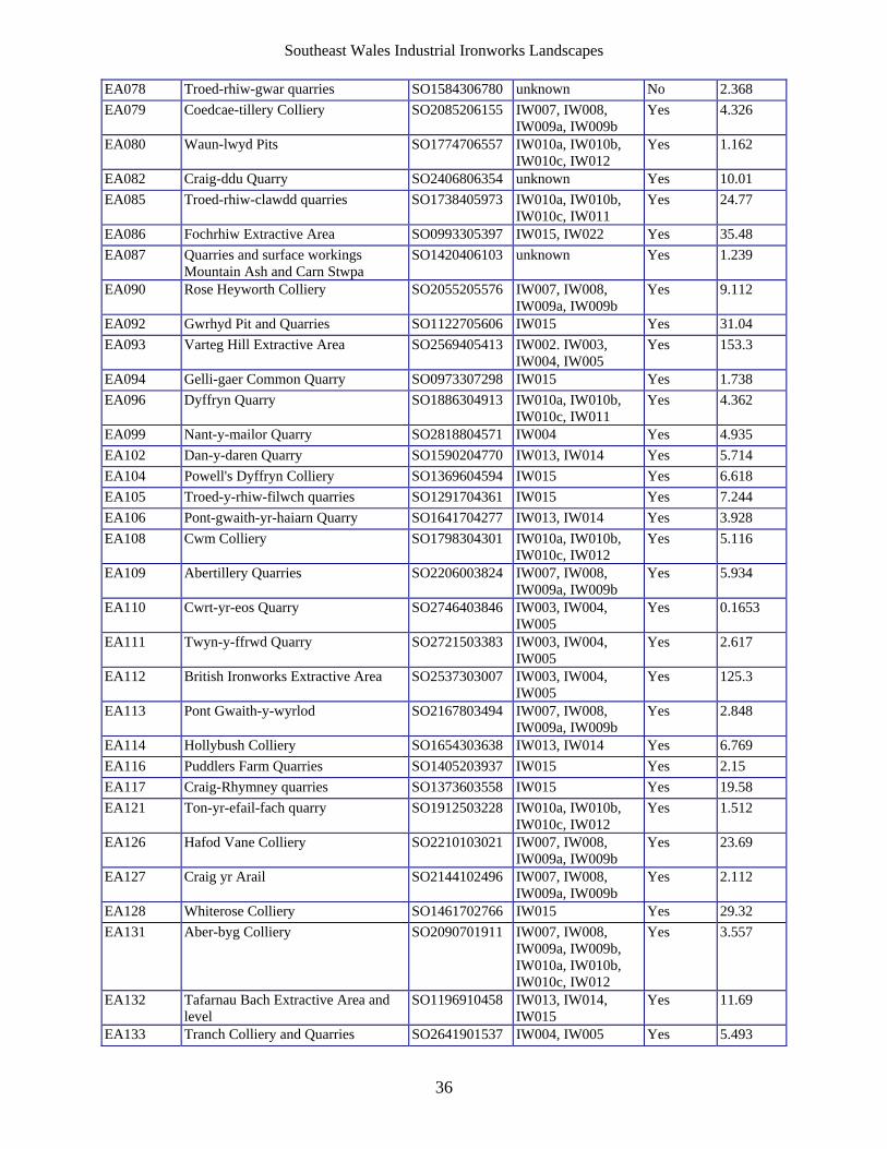
Southeast Wales Industrial Ironworks Landscapes
36
EA078 Troed-rhiw-gwar quarries SO1584306780 unknown No 2.368
EA079 Coedcae-tillery Colliery SO2085206155 IW007, IW008, IW009a, IW009b
Yes 4.326
EA080 Waun-lwyd Pits SO1774706557 IW010a, IW010b, IW010c, IW012
Yes 1.162
EA082 Craig-ddu Quarry SO2406806354 unknown Yes 10.01
EA085 Troed-rhiw-clawdd quarries SO1738405973 IW010a, IW010b, IW010c, IW011
Yes 24.77
EA086 Fochrhiw Extractive Area SO0993305397 IW015, IW022 Yes 35.48
EA087 Quarries and surface workings Mountain Ash and Carn Stwpa
SO1420406103 unknown Yes 1.239
EA090 Rose Heyworth Colliery SO2055205576 IW007, IW008, IW009a, IW009b
Yes 9.112
EA092 Gwrhyd Pit and Quarries SO1122705606 IW015 Yes 31.04
EA093 Varteg Hill Extractive Area SO2569405413 IW002. IW003, IW004, IW005
Yes 153.3
EA094 Gelli-gaer Common Quarry SO0973307298 IW015 Yes 1.738
EA096 Dyffryn Quarry SO1886304913 IW010a, IW010b, IW010c, IW011
Yes 4.362
EA099 Nant-y-mailor Quarry SO2818804571 IW004 Yes 4.935
EA102 Dan-y-daren Quarry SO1590204770 IW013, IW014 Yes 5.714
EA104 Powell's Dyffryn Colliery SO1369604594 IW015 Yes 6.618
EA105 Troed-y-rhiw-filwch quarries SO1291704361 IW015 Yes 7.244
EA106 Pont-gwaith-yr-haiarn Quarry SO1641704277 IW013, IW014 Yes 3.928
EA108 Cwm Colliery SO1798304301 IW010a, IW010b, IW010c, IW012
Yes 5.116
EA109 Abertillery Quarries SO2206003824 IW007, IW008, IW009a, IW009b
Yes 5.934
EA110 Cwrt-yr-eos Quarry SO2746403846 IW003, IW004, IW005
Yes 0.1653
EA111 Twyn-y-ffrwd Quarry SO2721503383 IW003, IW004, IW005
Yes 2.617
EA112 British Ironworks Extractive Area SO2537303007 IW003, IW004, IW005
Yes 125.3
EA113 Pont Gwaith-y-wyrlod SO2167803494 IW007, IW008, IW009a, IW009b
Yes 2.848
EA114 Hollybush Colliery SO1654303638 IW013, IW014 Yes 6.769
EA116 Puddlers Farm Quarries SO1405203937 IW015 Yes 2.15
EA117 Craig-Rhymney quarries SO1373603558 IW015 Yes 19.58
EA121 Ton-yr-efail-fach quarry SO1912503228 IW010a, IW010b, IW010c, IW012
Yes 1.512
EA126 Hafod Vane Colliery SO2210103021 IW007, IW008, IW009a, IW009b
Yes 23.69
EA127 Craig yr Arail SO2144102496 IW007, IW008, IW009a, IW009b
Yes 2.112
EA128 Whiterose Colliery SO1461702766 IW015 Yes 29.32
EA131 Aber-byg Colliery SO2090701911 IW007, IW008, IW009a, IW009b, IW010a, IW010b, IW010c, IW012
Yes 3.557
EA132 Tafarnau Bach Extractive Area and level
SO1196910458 IW013, IW014, IW015
Yes 11.69
EA133 Tranch Colliery and Quarries SO2641901537 IW004, IW005 Yes 5.493
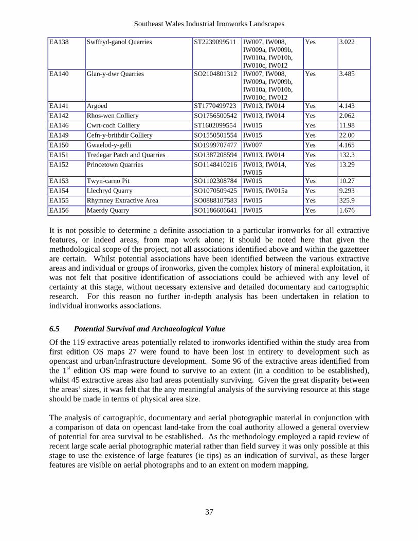
Southeast Wales Industrial Ironworks Landscapes
37
EA138 Swffryd-ganol Quarries ST2239099511 IW007, IW008, IW009a, IW009b, IW010a, IW010b, IW010c, IW012
Yes 3.022
EA140 Glan-y-dwr Quarries SO2104801312 IW007, IW008, IW009a, IW009b, IW010a, IW010b, IW010c, IW012
Yes 3.485
EA141 Argoed ST1770499723 IW013, IW014 Yes 4.143
EA142 Rhos-wen Colliery SO1756500542 IW013, IW014 Yes 2.062
EA146 Cwrt-coch Colliery ST1602099554 IW015 Yes 11.98
EA149 Cefn-y-brithdir Colliery SO1550501554 IW015 Yes 22.00
EA150 Gwaelod-y-gelli SO1999707477 IW007 Yes 4.165
EA151 Tredegar Patch and Quarries SO1387208594 IW013, IW014 Yes 132.3
EA152 Princetown Quarries SO1148410216 IW013, IW014, IW015
Yes 13.29
EA153 Twyn-carno Pit SO1102308784 IW015 Yes 10.27
EA154 Llechryd Quarry SO1070509425 IW015, IW015a Yes 9.293
EA155 Rhymney Extractive Area SO0888107583 IW015 Yes 325.9
EA156 Maerdy Quarry SO1186606641 IW015 Yes 1.676
It is not possible to determine a definite association to a particular ironworks for all extractive features, or indeed areas, from map work alone; it should be noted here that given the methodological scope of the project, not all associations identified above and within the gazetteer are certain. Whilst potential associations have been identified between the various extractive areas and individual or groups of ironworks, given the complex history of mineral exploitation, it was not felt that positive identification of associations could be achieved with any level of certainty at this stage, without necessary extensive and detailed documentary and cartographic research. For this reason no further in-depth analysis has been undertaken in relation to individual ironworks associations.
6.5 Potential Survival and Archaeological Value
Of the 119 extractive areas potentially related to ironworks identified within the study area from first edition OS maps 27 were found to have been lost in entirety to development such as opencast and urban/infrastructure development. Some 96 of the extractive areas identified from the 1st edition OS map were found to survive to an extent (in a condition to be established), whilst 45 extractive areas also had areas potentially surviving. Given the great disparity between the areas’ sizes, it was felt that the any meaningful analysis of the surviving resource at this stage should be made in terms of physical area size. The analysis of cartographic, documentary and aerial photographic material in conjunction with a comparison of data on opencast land-take from the coal authority allowed a general overview of potential for area survival to be established. As the methodology employed a rapid review of recent large scale aerial photographic material rather than field survey it was only possible at this stage to use the existence of large features (ie tips) as an indication of survival, as these larger features are visible on aerial photographs and to an extent on modern mapping.
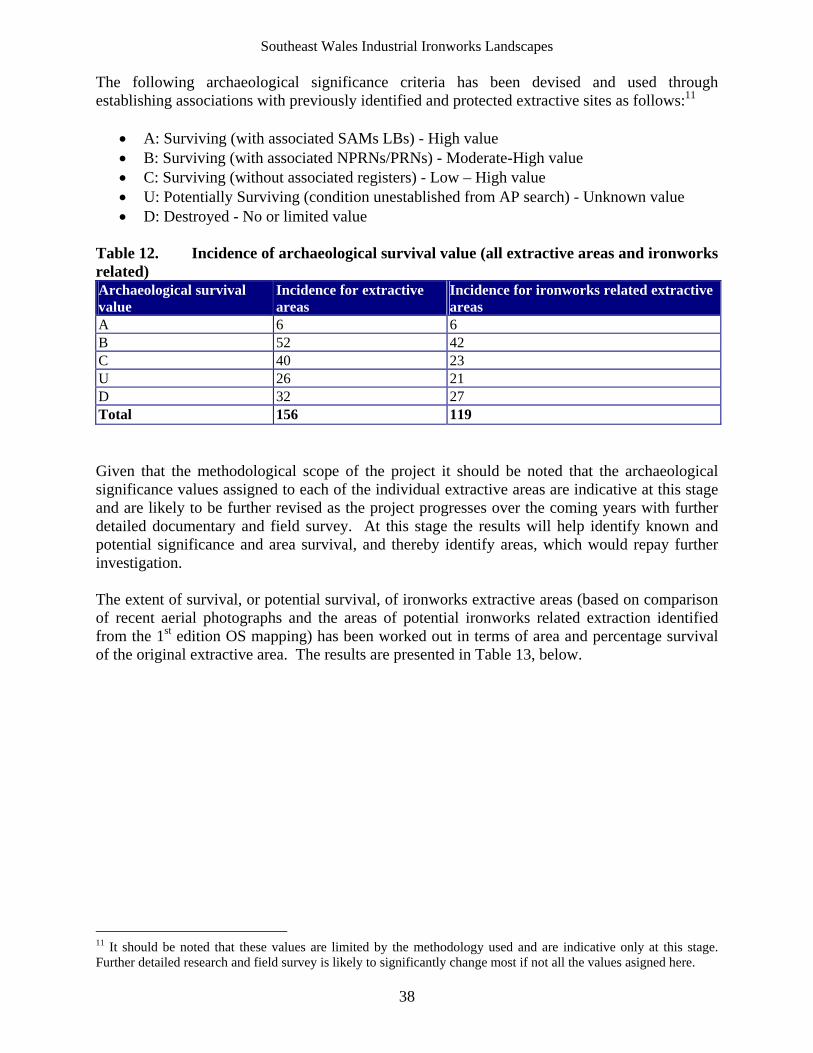
Southeast Wales Industrial Ironworks Landscapes
38
The following archaeological significance criteria has been devised and used through establishing associations with previously identified and protected extractive sites as follows:11
A: Surviving (with associated SAMs LBs) - High value B: Surviving (with associated NPRNs/PRNs) - Moderate-High value C: Surviving (without associated registers) - Low – High value U: Potentially Surviving (condition unestablished from AP search) - Unknown value D: Destroyed - No or limited value
Table 12. Incidence of archaeological survival value (all extractive areas and ironworks related) Archaeological survival value
Incidence for extractive areas
Incidence for ironworks related extractive areas
A 6 6 B 52 42 C 40 23 U 26 21 D 32 27 Total 156 119 Given that the methodological scope of the project it should be noted that the archaeological significance values assigned to each of the individual extractive areas are indicative at this stage and are likely to be further revised as the project progresses over the coming years with further detailed documentary and field survey. At this stage the results will help identify known and potential significance and area survival, and thereby identify areas, which would repay further investigation. The extent of survival, or potential survival, of ironworks extractive areas (based on comparison of recent aerial photographs and the areas of potential ironworks related extraction identified from the 1st edition OS mapping) has been worked out in terms of area and percentage survival of the original extractive area. The results are presented in Table 13, below.
11 It should be noted that these values are limited by the methodology used and are indicative only at this stage. Further detailed research and field survey is likely to significantly change most if not all the values asigned here.
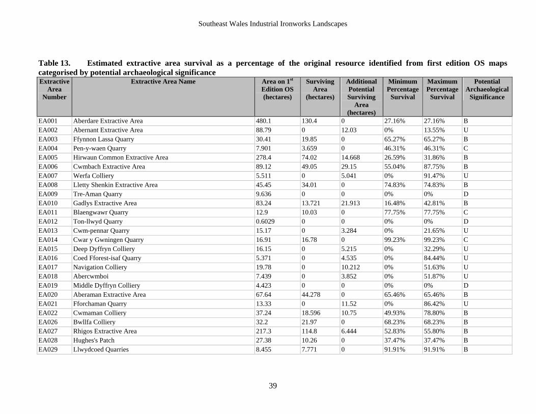
Southeast Wales Industrial Ironworks Landscapes
39
Table 13. Estimated extractive area survival as a percentage of the original resource identified from first edition OS maps categorised by potential archaeological significance Extractive
Area Number
Extractive Area Name Area on 1st Edition OS (hectares)
Surviving Area
(hectares)
Additional Potential Surviving
Area (hectares)
Minimum Percentage
Survival
Maximum Percentage
Survival
Potential Archaeological
Significance
EA001 Aberdare Extractive Area 480.1 130.4 0 27.16% 27.16% B EA002 Abernant Extractive Area 88.79 0 12.03 0% 13.55% U EA003 Ffynnon Lassa Quarry 30.41 19.85 0 65.27% 65.27% B EA004 Pen-y-waen Quarry 7.901 3.659 0 46.31% 46.31% C EA005 Hirwaun Common Extractive Area 278.4 74.02 14.668 26.59% 31.86% B EA006 Cwmbach Extractive Area 89.12 49.05 29.15 55.04% 87.75% B EA007 Werfa Colliery 5.511 0 5.041 0% 91.47% U EA008 Lletty Shenkin Extractive Area 45.45 34.01 0 74.83% 74.83% B EA009 Tre-Aman Quarry 9.636 0 0 0% 0% D EA010 Gadlys Extractive Area 83.24 13.721 21.913 16.48% 42.81% B EA011 Blaengwawr Quarry 12.9 10.03 0 77.75% 77.75% C EA012 Ton-llwyd Quarry 0.6029 0 0 0% 0% D EA013 Cwm-pennar Quarry 15.17 0 3.284 0% 21.65% U EA014 Cwar y Gwningen Quarry 16.91 16.78 0 99.23% 99.23% C EA015 Deep Dyffryn Colliery 16.15 0 5.215 0% 32.29% U EA016 Coed Fforest-isaf Quarry 5.371 0 4.535 0% 84.44% U EA017 Navigation Colliery 19.78 0 10.212 0% 51.63% U EA018 Abercwmboi 7.439 0 3.852 0% 51.87% U EA019 Middle Dyffryn Colliery 4.423 0 0 0% 0% D EA020 Aberaman Extractive Area 67.64 44.278 0 65.46% 65.46% B EA021 Fforchaman Quarry 13.33 0 11.52 0% 86.42% U EA022 Cwmaman Colliery 37.24 18.596 10.75 49.93% 78.80% B EA026 Bwllfa Colliery 32.2 21.97 0 68.23% 68.23% B EA027 Rhigos Extractive Area 217.3 114.8 6.444 52.83% 55.80% B EA028 Hughes's Patch 27.38 10.26 0 37.47% 37.47% B EA029 Llwydcoed Quarries 8.455 7.771 0 91.91% 91.91% B
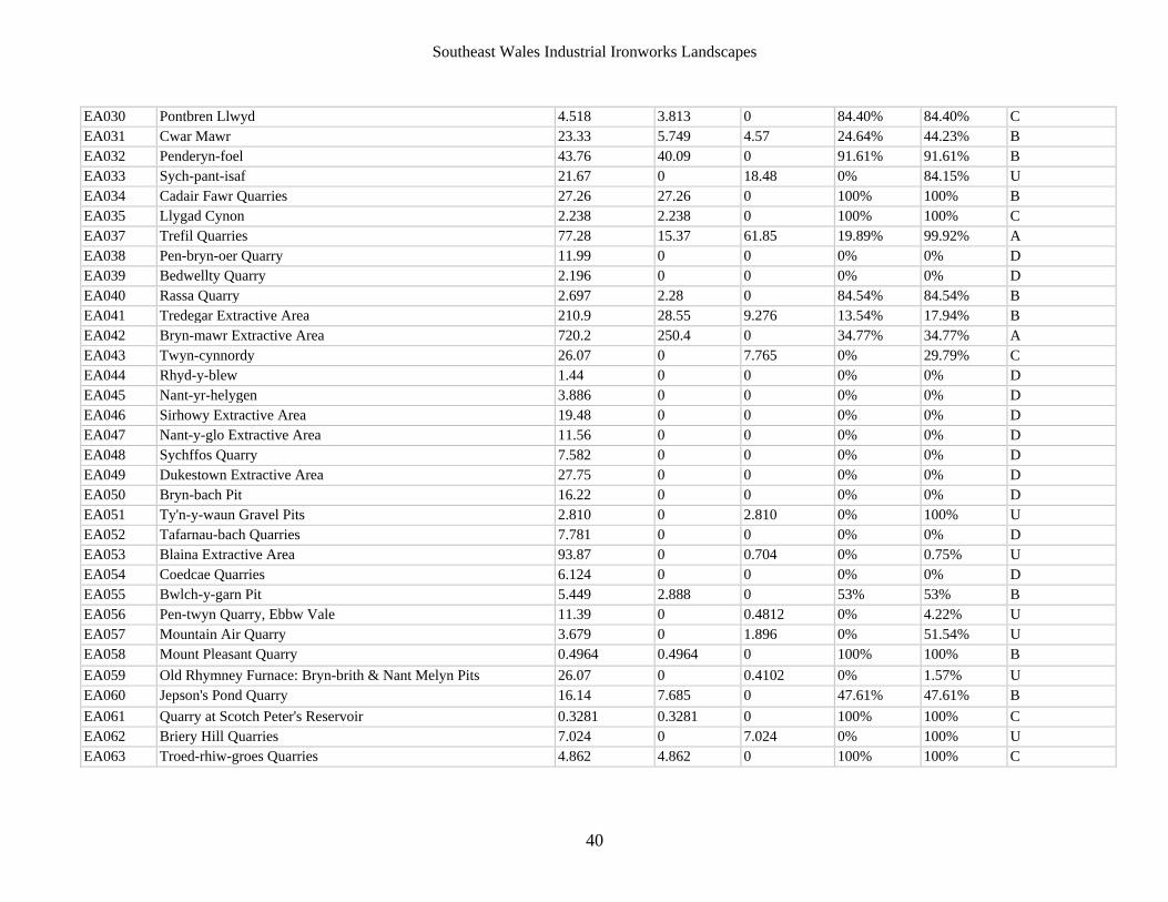
Southeast Wales Industrial Ironworks Landscapes
40
EA030 Pontbren Llwyd 4.518 3.813 0 84.40% 84.40% C EA031 Cwar Mawr 23.33 5.749 4.57 24.64% 44.23% B EA032 Penderyn-foel 43.76 40.09 0 91.61% 91.61% B EA033 Sych-pant-isaf 21.67 0 18.48 0% 84.15% U EA034 Cadair Fawr Quarries 27.26 27.26 0 100% 100% B EA035 Llygad Cynon 2.238 2.238 0 100% 100% C EA037 Trefil Quarries 77.28 15.37 61.85 19.89% 99.92% A EA038 Pen-bryn-oer Quarry 11.99 0 0 0% 0% D EA039 Bedwellty Quarry 2.196 0 0 0% 0% D EA040 Rassa Quarry 2.697 2.28 0 84.54% 84.54% B EA041 Tredegar Extractive Area 210.9 28.55 9.276 13.54% 17.94% B EA042 Bryn-mawr Extractive Area 720.2 250.4 0 34.77% 34.77% A EA043 Twyn-cynnordy 26.07 0 7.765 0% 29.79% C EA044 Rhyd-y-blew 1.44 0 0 0% 0% D EA045 Nant-yr-helygen 3.886 0 0 0% 0% D EA046 Sirhowy Extractive Area 19.48 0 0 0% 0% D EA047 Nant-y-glo Extractive Area 11.56 0 0 0% 0% D EA048 Sychffos Quarry 7.582 0 0 0% 0% D EA049 Dukestown Extractive Area 27.75 0 0 0% 0% D EA050 Bryn-bach Pit 16.22 0 0 0% 0% D EA051 Ty'n-y-waun Gravel Pits 2.810 0 2.810 0% 100% U EA052 Tafarnau-bach Quarries 7.781 0 0 0% 0% D EA053 Blaina Extractive Area 93.87 0 0.704 0% 0.75% U EA054 Coedcae Quarries 6.124 0 0 0% 0% D EA055 Bwlch-y-garn Pit 5.449 2.888 0 53% 53% B EA056 Pen-twyn Quarry, Ebbw Vale 11.39 0 0.4812 0% 4.22% U EA057 Mountain Air Quarry 3.679 0 1.896 0% 51.54% U EA058 Mount Pleasant Quarry 0.4964 0.4964 0 100% 100% B
EA059 Old Rhymney Furnace: Bryn-brith & Nant Melyn Pits 26.07 0 0.4102 0% 1.57% U EA060 Jepson's Pond Quarry 16.14 7.685 0 47.61% 47.61% B
EA061 Quarry at Scotch Peter's Reservoir 0.3281 0.3281 0 100% 100% C EA062 Briery Hill Quarries 7.024 0 7.024 0% 100% U EA063 Troed-rhiw-groes Quarries 4.862 4.862 0 100% 100% C
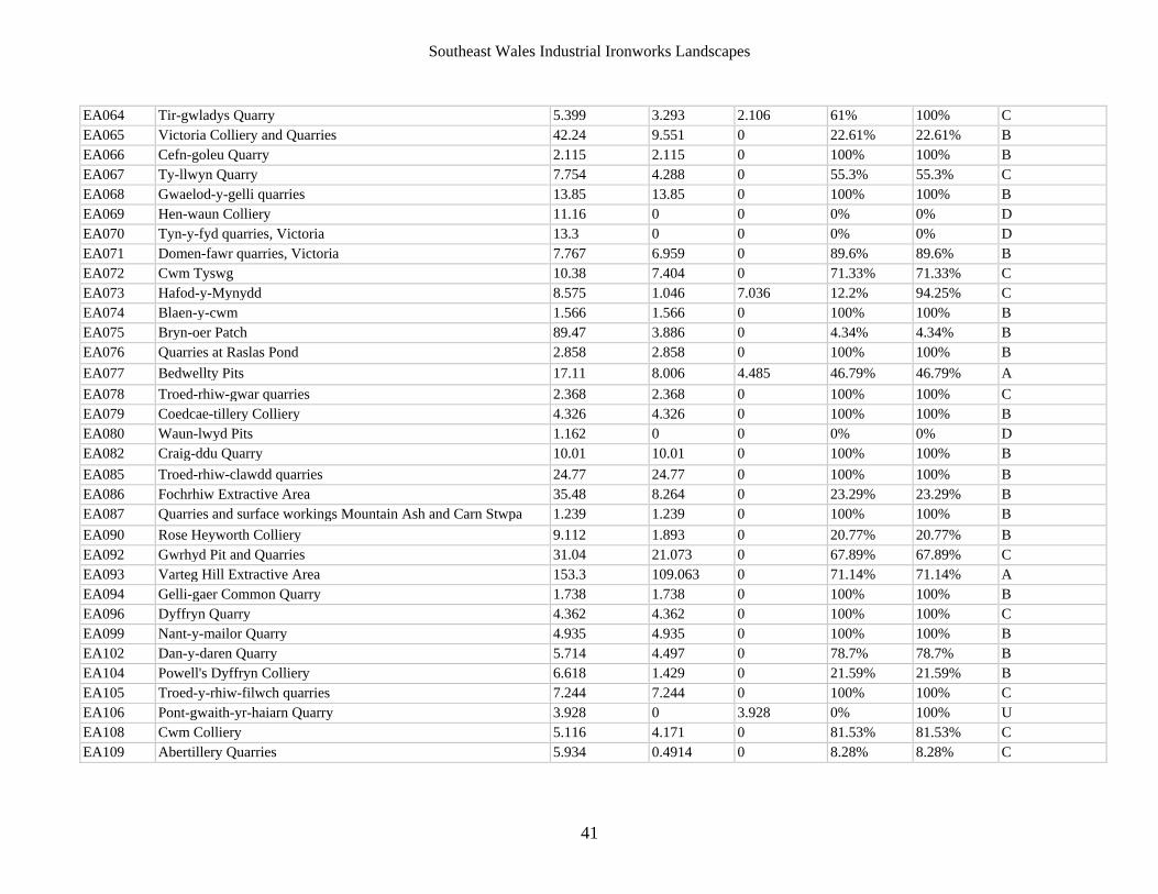
Southeast Wales Industrial Ironworks Landscapes
41
EA064 Tir-gwladys Quarry 5.399 3.293 2.106 61% 100% C EA065 Victoria Colliery and Quarries 42.24 9.551 0 22.61% 22.61% B EA066 Cefn-goleu Quarry 2.115 2.115 0 100% 100% B EA067 Ty-llwyn Quarry 7.754 4.288 0 55.3% 55.3% C EA068 Gwaelod-y-gelli quarries 13.85 13.85 0 100% 100% B EA069 Hen-waun Colliery 11.16 0 0 0% 0% D EA070 Tyn-y-fyd quarries, Victoria 13.3 0 0 0% 0% D EA071 Domen-fawr quarries, Victoria 7.767 6.959 0 89.6% 89.6% B EA072 Cwm Tyswg 10.38 7.404 0 71.33% 71.33% C EA073 Hafod-y-Mynydd 8.575 1.046 7.036 12.2% 94.25% C EA074 Blaen-y-cwm 1.566 1.566 0 100% 100% B EA075 Bryn-oer Patch 89.47 3.886 0 4.34% 4.34% B EA076 Quarries at Raslas Pond 2.858 2.858 0 100% 100% B
EA077 Bedwellty Pits 17.11 8.006 4.485 46.79% 46.79% A
EA078 Troed-rhiw-gwar quarries 2.368 2.368 0 100% 100% C EA079 Coedcae-tillery Colliery 4.326 4.326 0 100% 100% B EA080 Waun-lwyd Pits 1.162 0 0 0% 0% D EA082 Craig-ddu Quarry 10.01 10.01 0 100% 100% B
EA085 Troed-rhiw-clawdd quarries 24.77 24.77 0 100% 100% B EA086 Fochrhiw Extractive Area 35.48 8.264 0 23.29% 23.29% B EA087 Quarries and surface workings Mountain Ash and Carn Stwpa 1.239 1.239 0 100% 100% B
EA090 Rose Heyworth Colliery 9.112 1.893 0 20.77% 20.77% B EA092 Gwrhyd Pit and Quarries 31.04 21.073 0 67.89% 67.89% C EA093 Varteg Hill Extractive Area 153.3 109.063 0 71.14% 71.14% A EA094 Gelli-gaer Common Quarry 1.738 1.738 0 100% 100% B EA096 Dyffryn Quarry 4.362 4.362 0 100% 100% C EA099 Nant-y-mailor Quarry 4.935 4.935 0 100% 100% B EA102 Dan-y-daren Quarry 5.714 4.497 0 78.7% 78.7% B EA104 Powell's Dyffryn Colliery 6.618 1.429 0 21.59% 21.59% B EA105 Troed-y-rhiw-filwch quarries 7.244 7.244 0 100% 100% C EA106 Pont-gwaith-yr-haiarn Quarry 3.928 0 3.928 0% 100% U EA108 Cwm Colliery 5.116 4.171 0 81.53% 81.53% C EA109 Abertillery Quarries 5.934 0.4914 0 8.28% 8.28% C
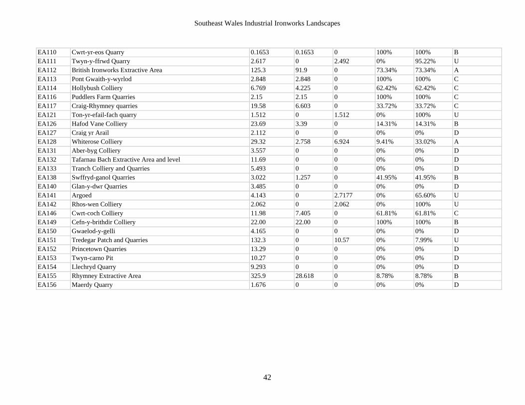
Southeast Wales Industrial Ironworks Landscapes
42
EA110 Cwrt-yr-eos Quarry 0.1653 0.1653 0 100% 100% B EA111 Twyn-y-ffrwd Quarry 2.617 0 2.492 0% 95.22% U EA112 British Ironworks Extractive Area 125.3 91.9 0 73.34% 73.34% A EA113 Pont Gwaith-y-wyrlod 2.848 2.848 0 100% 100% C EA114 Hollybush Colliery 6.769 4.225 0 62.42% 62.42% C EA116 Puddlers Farm Quarries 2.15 2.15 0 100% 100% C EA117 Craig-Rhymney quarries 19.58 6.603 0 33.72% 33.72% C EA121 Ton-yr-efail-fach quarry 1.512 0 1.512 0% 100% U EA126 Hafod Vane Colliery 23.69 3.39 0 14.31% 14.31% B EA127 Craig yr Arail 2.112 0 0 0% 0% D EA128 Whiterose Colliery 29.32 2.758 6.924 9.41% 33.02% A EA131 Aber-byg Colliery 3.557 0 0 0% 0% D EA132 Tafarnau Bach Extractive Area and level 11.69 0 0 0% 0% D EA133 Tranch Colliery and Quarries 5.493 0 0 0% 0% D EA138 Swffryd-ganol Quarries 3.022 1.257 0 41.95% 41.95% B EA140 Glan-y-dwr Quarries 3.485 0 0 0% 0% D EA141 Argoed 4.143 0 2.7177 0% 65.60% U EA142 Rhos-wen Colliery 2.062 0 2.062 0% 100% U EA146 Cwrt-coch Colliery 11.98 7.405 0 61.81% 61.81% C EA149 Cefn-y-brithdir Colliery 22.00 22.00 0 100% 100% B EA150 Gwaelod-y-gelli 4.165 0 0 0% 0% D EA151 Tredegar Patch and Quarries 132.3 0 10.57 0% 7.99% U EA152 Princetown Quarries 13.29 0 0 0% 0% D EA153 Twyn-carno Pit 10.27 0 0 0% 0% D EA154 Llechryd Quarry 9.293 0 0 0% 0% D EA155 Rhymney Extractive Area 325.9 28.618 0 8.78% 8.78% B EA156 Maerdy Quarry 1.676 0 0 0% 0% D
Southeast Wales Industrial Ironworks Landscapes
43
Less than half of the original area of extractive land identifiable from the 1st edition OS, as potentially being related to ironworks extraction survives to the present day. Recourse to the OS 1st edition mapping identified an original baseline resource of around 4401.23 ha in total of ironworks related extractive land. The analysis of the data in relation to surviving and potential surviving extractive areas established that the surviving resource lay in the region of 1705.74 ha (comprising a total area of 1411.22 ha of surviving extractive land and 297.71 ha potential surviving extractive land), that is 38.81% of the overall original area resource. The analysis was further broken down along the following lines: Of the original 119 extractive areas identified from the 1st edition OS maps, 27 areas (i.e. 22.69%) appear to have been completely destroyed, ie category ‘D’ areas (a loss of 221.32 ha in total area) representing 5.03% of the entire original area resource within the study area. In terms of those ironworks related extractive areas that survive, 14 extractive areas (i.e. 11.77% of the 119 identified) have been identified with a maximum survival rating of less than 25% of their original area, amounting to a total of 114.65 ha (of an original resource of 1081.454 ha) and represents 2.61% of the entire original area resource across the study area. Included within this percentage band are 7 category ‘B’ areas, 1 category ‘C’, and 6 Category ‘U’ areas. Extractive areas with a survival rating of between 25% and 50% of their original area number 15 (i.e. 12.61% of the 119 identified), amount to a total of 588.32 ha of land (of an original resource of 1783.423 ha) and represents 13.37% of the entire original area resource across the study area. Included within this percentage band are 3 category ‘A’ areas, 8 category ‘B’ areas, 3 category ‘C’ areas, and 1 Category ‘U’ area. Extractive areas with a survival rating of between 50% and 75% of their original area number 17 (i.e. 14.29% of the 119 identified), and amount to a total of 508.28 ha of land (of an original resource of 780.01 ha) and represents 11.55% of the entire original area resource within the study area. Included within this percentage band are 2 category ‘A’ areas, 6 category ‘B’ areas, 5 category ‘C’ areas, and 4 Category ‘U’ areas. Whilst areas having a survival rating of between 75% and 100% of their original area number 46 (i.e. 38.66% of the 119 identified) and amount to a total of 497.77 ha of land (of an original resource of 535.02 ha) and represents 11.31% of the entire original area resource within the study area. Included within this percentage band are 1 category ‘A’, 21 category ‘B’ areas, 14 category ‘C’ areas, and 10 Category ‘U’ areas. The results would indicate that despite some complete losses, a considerable area of potential iron working extractive landscapes survive within the study area. The majority potential ironworks related extractive areas retain between 25% and 100% of their original areas, landscapes, with a corresponding high incidence of ‘A’ and ‘B’ Category areas (reflecting incidence of protected and other identified related interests) in particular, adding to the potential significance of the resource. The initial results, summarised in Table 13, above, indicate that sufficient potentially survives of the resource to allow an understanding of the ironworks’ related extraction areas, a formerly important characteristic of the industrial ironworks landscapes, and that further detailed documentary and field based work is required to confirm the full extent, condition and value of the surviving resource.
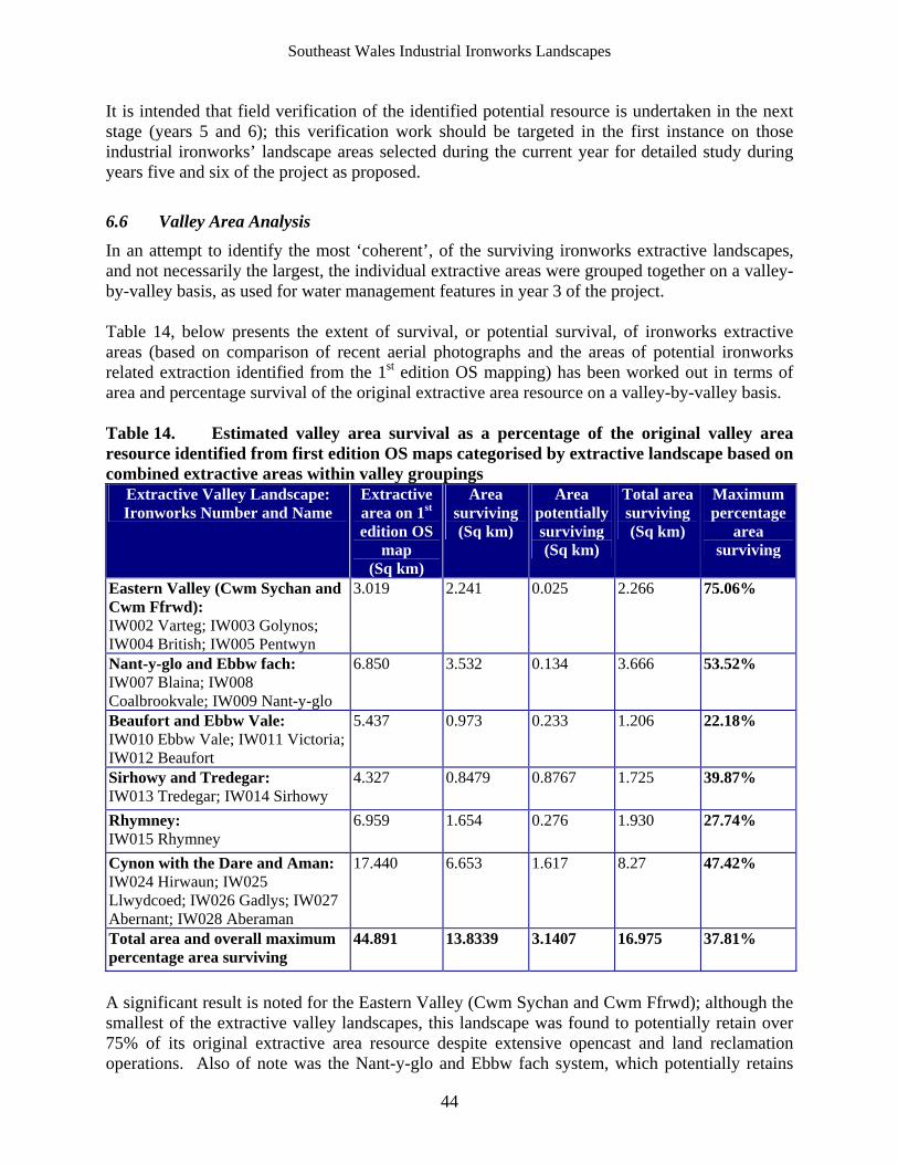
Southeast Wales Industrial Ironworks Landscapes
44
It is intended that field verification of the identified potential resource is undertaken in the next stage (years 5 and 6); this verification work should be targeted in the first instance on those industrial ironworks’ landscape areas selected during the current year for detailed study during years five and six of the project as proposed.
6.6 Valley Area Analysis
In an attempt to identify the most ‘coherent’, of the surviving ironworks extractive landscapes, and not necessarily the largest, the individual extractive areas were grouped together on a valley-by-valley basis, as used for water management features in year 3 of the project. Table 14, below presents the extent of survival, or potential survival, of ironworks extractive areas (based on comparison of recent aerial photographs and the areas of potential ironworks related extraction identified from the 1st edition OS mapping) has been worked out in terms of area and percentage survival of the original extractive area resource on a valley-by-valley basis. Table 14. Estimated valley area survival as a percentage of the original valley area resource identified from first edition OS maps categorised by extractive landscape based on combined extractive areas within valley groupings
Extractive Valley Landscape: Ironworks Number and Name
Extractive area on 1st edition OS
map (Sq km)
Area surviving (Sq km)
Area potentially surviving (Sq km)
Total area surviving (Sq km)
Maximum percentage
area surviving
Eastern Valley (Cwm Sychan and Cwm Ffrwd): IW002 Varteg; IW003 Golynos; IW004 British; IW005 Pentwyn
3.019 2.241 0.025 2.266 75.06%
Nant-y-glo and Ebbw fach: IW007 Blaina; IW008 Coalbrookvale; IW009 Nant-y-glo
6.850 3.532 0.134 3.666 53.52%
Beaufort and Ebbw Vale: IW010 Ebbw Vale; IW011 Victoria; IW012 Beaufort
5.437 0.973 0.233 1.206 22.18%
Sirhowy and Tredegar: IW013 Tredegar; IW014 Sirhowy
4.327 0.8479 0.8767 1.725 39.87%
Rhymney: IW015 Rhymney
6.959 1.654 0.276 1.930 27.74%
Cynon with the Dare and Aman: IW024 Hirwaun; IW025 Llwydcoed; IW026 Gadlys; IW027 Abernant; IW028 Aberaman
17.440 6.653 1.617 8.27 47.42%
Total area and overall maximum percentage area surviving
44.891 13.8339 3.1407 16.975 37.81%
A significant result is noted for the Eastern Valley (Cwm Sychan and Cwm Ffrwd); although the smallest of the extractive valley landscapes, this landscape was found to potentially retain over 75% of its original extractive area resource despite extensive opencast and land reclamation operations. Also of note was the Nant-y-glo and Ebbw fach system, which potentially retains
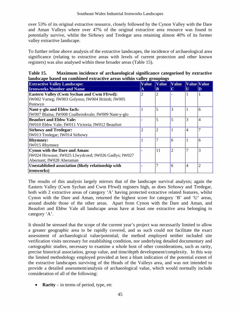
Southeast Wales Industrial Ironworks Landscapes
45
over 53% of its original extractive resource, closely followed by the Cynon Valley with the Dare and Aman Valleys where over 47% of the original extractive area resource was found to potentially survive, whilst the Sirhowy and Tredegar area retaining almost 40% of its former valley extractive landscape. To further refine above analysis of the extractive landscapes, the incidence of archaeological area significance (relating to extractive areas with levels of current protection and other known registers) was also analysed within these broader areas (Table 15). Table 15. Maximum incidence of archaeological significance categorised by extractive landscape based on combined extractive areas within valley groupings Extractive Valley Landscape: Ironworks Number and Name
Value A
Value B
Value C
ValueU
Value D
Eastern Valley (Cwm Sychan and Cwm Ffrwd): IW002 Varteg; IW003 Golynos; IW004 British; IW005 Pentwyn
2 2 - 1 1
Nant-y-glo and Ebbw fach: IW007 Blaina; IW008 Coalbrookvale; IW009 Nant-y-glo
1 5 3 1 6
Beaufort and Ebbw Vale: IW010 Ebbw Vale; IW011 Victoria; IW012 Beaufort
- 5 5 3 4
Sirhowy and Tredegar: IW013 Tredegar; IW014 Sirhowy
2 2 1 4 7
Rhymney: IW015 Rhymney
1 7 6 1 6
Cynon with the Dare and Aman: IW024 Hirwaun; IW025 Llwydcoed; IW026 Gadlys; IW027 Abernant; IW028 Aberaman
- 11 2 7 3
Unestablished association (likely relationship with ironworks)
- 7 6 4 2
The results of this analysis largely mirrors that of the landscape survival analysis; again the Eastern Valley (Cwm Sychan and Cwm Ffrwd) registers high, as does Sirhowy and Tredegar, both with 2 extractive areas of category ‘A’ having protected extractive related features, whilst Cynon with the Dare and Aman, returned the highest score for category ‘B’ and ‘U’ areas, around double those of the other areas. Apart from Cynon with the Dare and Aman, and Beaufort and Ebbw Vale all landscape areas have at least one extractive area belonging to category ‘A’. It should be stressed that the scope of the current year’s project was necessarily limited to allow a greater geographic area to be rapidly covered, and as such could not facilitate the exact assessment of archaeological value/potential; the method employed neither included site verification visits necessary for establishing condition, nor underlying detailed documentary and cartographic studies, necessary to examine a whole host of other considerations, such as rarity, precise historical association, group value, and time/depth development/complexity. In this way the limited methodology employed provided at best a blunt indication of the potential extent of the extractive landscapes surviving of the Heads of the Valleys area, and was not intended to provide a detailed assessment/analysis of archaeological value, which would normally include consideration of all of the following:
Rarity – in terms of period, type, etc
Southeast Wales Industrial Ironworks Landscapes
46
Representativeness – representative range of elements Survival – percentage survival Condition – overall condition of surviving elements Group Value – structural/functional coherence of surviving features, but also wider
ironwork group value Coherence – retention of historic meaning and significance Integrity – survival of original character or form Potential – potential for future study or analysis Amenity – potential for development for public educational recreational amenity Association – to events, figures, technological advancement, or availability of
documentary evidence Status – statutory protection
6.7 Threats and Recommendations
General potential threats to extractive areas range from general dereliction reclamation, opencast and road schemes and in the areas close to the core ironworks themselves from urban and industrial renewal. It was considered in the initial project proposals that specific threats to extractive areas might be identified using Unitary Authority development plans as a basis. However, as Unitary Authority development plans are currently under review, identification of specific threats on this basis has been deferred until a later stage in the project.
6.8 The Extractive Valley Landscapes
For practical reasons the current study has identified five general extractive landscapes within the study area, broadly corresponding to the major river valleys, and the same as those areas used for water management systems during year 3 of the project; these landscapes are as follows: Eastern Valley (Cwm Sychan and Cwm Ffrwd); Nant-y-glo and Ebbw fach; Beaufort and Ebbw Vale; Sirhowy and Tredegar; and the Rhymney, Cynon with the Dare and Aman extractive landscapes. At this stage it is felt there is insufficient information and detail available to describe the extractive areas in these Valley Landscapes in any meaningful way. Summary descriptions of the individual extractive areas identified from the OS mapping exercise are given within Appendix I, and whilst these contain brief details of the extractive features contained in each area this information is both limited in scope and detail at this stage, and requires further confirmation. Eastern Valley (Cwm Sychan and Cwm Ffrwd) A fairly small-scale extractive landscape (14 polygon areas mapped amounting to 3.019 sq km in total area) by comparison with those noted elsewhere in the study area, that within the Cwm Sychan and Cwm Ffrwd tributary valleys exploited the southeastern flanks of Mynydd Varteg fach, and eastern flanks of Waun-wen and Byrgwm including Cwmbyrgwm Colliery, and workings in Cwm Sychan and Cwm Du, with outlying quarries and workings at Blaenmelyn on the southern flank of Mynydd Varteg Fawr. Other smaller outlying workings, chiefly quarries are to be found on the eastern side of the Cwm Afon Valley within Lasgarn Wood and Cwm Lasgarn itself, linked by a disused tramroad and incline system to the ironworks of the area on
Southeast Wales Industrial Ironworks Landscapes
47
the lower western flanks of the valley. The extractive areas of this area served the following ironworks IW002 Varteg, IW003 Golynos, IW004 the British, and IW005 Pentwyn. A potential total surviving extractive landscape area of 2.266 sq km, ie 75.06% of the original valley resource survives made up of 11 surviving polygon areas (2.241 sq km), increased by 1 potentially surviving polygon area (0.025 sq km). The extractive landscape within this valley area appears to largely survive (total potential surviving area:), though extensive opencast operations in particular on Mynydd Varteg Fach, and to the west of Cwm Ffrwd have removed some of the resource. Aerial photographic and other baseline documentary evidence indicates that much of significance survives in the area around the British Ironworks, including Levels, tips and colliery workings within Cwm Sychan within the Varteg Hill area (EA093), and also Cwm Byrgwm (including the scheduled colliery SAM MM163), and Cwm Du within the British Ironworks Extractive area (EA112), as well as within the core ironworks area of the British itself, with its scheduled and listed Pumping Engine House (SAM MM216; LB 18595). Other potential areas of surviving extractive remains are Cwrt-yr-eos Quarry (EA110), Nant-y-mailor Quarry (EA099) and Twyn-y-ffrwd Quarry (EA111) within Lasgarn Wood and Cwm Lasgarn on the eastern side of the Cwm Afon valley. It should be noted that the current assertions remain to be proven in the field. A provisional historic ironworks landscape of 3.444 sq km (taking in 13 polygon areas, or parts thereof) has been identified and plotted on the basis of the results of the previous years of the project augmented by the potential surviving extractive areas which can be demonstrated to be potentially closely associated with the best of the surviving core areas (see figures 17 and 21). Nant-y-glo and Ebbw-fach This extractive landscape comprised extensive areas of workings around Bryn-mawr, the northwest of Nant-y-glo and Blaina including an area on the slopes of Mulfran, and to the east quarries on Mynydd Carn-y-cefn. A review of the first edition OS map allowed the identification of 19 extraction polygon areas mapped amounting to 6.850 sq km in total area. This extractive landscape served the ironworks of IW007 Blaina, IW008 Coalbrookvale, IW009 Nant-y-glo, (and was also linked to Beaufort in the next valley) and extended from Blaen Clydach in the north to Cwm-celyn in the south. A small scatter of quarries, collieries and other workings, which may not be primarily ironworks related, are located to the south in the Abertillery area. Part of the extractive has been lost to opencast, north west of Winchestown and to the east of Bryn mawr. Other areas have been lost to urban and industrial estate developments and a level of fragmentation has occurred to the extractive ironwork’s landscape as a result. From examination of aerial photographs and modern mapping it would appear that a potential total surviving extractive landscape area of 3.666 sq km, ie 53.52% of the original valley resource survives. This is made up of 27 surviving polygon areas (3.532 sq km), increased by 7 potentially surviving polygon areas (0.134 sq km). The most significant identified remains are to be found at Bryn-mawr Extractive Area (EA042), which includes the scheduled Clydach Coal Level (MM264), the exstensive and well preserved workings of the Clydach Terrace, Gwaun-y-ffa, and Coedcae Mawr, which includes early evidence of hushing, scouring, patchworking and other significant extractive remains, and the following areas, where known industrial extractive related features have been noted: Coedcae-tillery Colliery (EA079); Hafod Vane Colliery (EA126); Rose Heyworth Colliery (EA090); Swffryd-ganol Quarries (EA138); and Gwaelod-y-gelli quarries (EA068).
Southeast Wales Industrial Ironworks Landscapes
48
A provisional historic ironworks landscape of 6.099 sq km (taking in 5 polygon areas, or parts thereof) has been identified and plotted on the basis of the results of the previous years of the project augmented by the potential surviving extractive areas which can be demonstrated to be potentially closely associated with the best of the surviving core areas (see figures 17 and 20). Beaufort and Ebbw Vale A narrow linear extractive landscape with 24 polygon extractive areas mapped from the evidence of the first edition OS map (amounting to 5.437 sq km in total area), which formerly extended in almost uninterrupted southwards down the Ebbw Valley from Blaen Clydach in the north. The main ironworks in the area are Ebbw Vale (IW010a, IW010b, and IW010c), Victoria (IW011), and Beaufort (IW012) ironworks, are all located within the northern half of the valley. From the comparison of modern mapping and aerial photographic material a considerable area of former extractive land has been lost to opencast within the north of the area to the east and west of Beaufort ironworks, urban and industrial estate development has removed and fragmented the resource elsewhere. A potential total surviving extractive area of 1.206 sq km, ie 22.18% of the original valley resource survives made up of 12 surviving polygon areas (0.973 sq km), increased by 3 potentially surviving polygon areas (0.233 sq km). From examination of aerial photographs and modern mapping it would appear that the physical connection of extractive landscape to the ironwork core areas has been largely severed through the removal of much of the valley bottom core ironworks features, associated transport networks and extraction. Piecemeal linear fragments of extraction survive largely in isolation along the east facing flanks of Cefn Manmoel and the western side of Mynydd Carn-y-cefn. Perhaps, the most significant of the surviving areas is that part of the Bryn-mawr Extractive Area (EA042) which survives closest to Ebbw Vale ironworks; this formerly more extensive extractive area lies largely within adjacent valley landscape of Nant-y-glo and Ebbw fach to the east, though extends down the eastern side of the upper Ebbw valley as far south as Ebbw Vale ironworks. Other extractive areas known to include relevant remains include: Troed-rhiw-clawdd quarries (EA085); Domen-fawr quarries, Victoria (EA071); Victoria Colliery and Quarries (EA065); and Bwlch-y-garn Pit (EA055). A provisional historic ironworks landscape of 4.651 sq km (taking in 13 polygon areas, or parts thereof) has been identified and plotted on the basis of the results of the previous years of the project augmented by the potential surviving extractive areas which can be demonstrated to be potentially closely associated with the best of the surviving core areas, this has effectively excluded those areas south of Troed-rhiw-clawdd, including the listed but isolated colliery ventilation furnace (LB 15836), at Llandafal (see figures 17, 19 and 20). Sirhowy and Tredegar A formerly compact extractive landscape, which supplied IW013 Tredegar and IW014 Sirhowy Ironworks; this extractive valley landscape is largely limited to the valley head east and west of Tredegar and Sirhowy comprising 4.327 sq km in total area (with 25 polygon areas mapped). The area extended from the Trefil Quarries at the north, taking in the extractive areas of Tafarnau Bach, Bryn-bach pit, and the Tredegar patches and quarries, as well as a few smaller workings to the south. Major opencast and urban/industrial development adjacent to the Heads of the Valleys Road has removed the bulk of the extractive landscape here, including almost all the Tredegar patch workings. In terms of surviving areas, identified through comparing modern mapping and aerial
Southeast Wales Industrial Ironworks Landscapes
49
photographic material with the original identified resource, there area has a potential total surviving extractive landscape area of 1.725 sq km, ie 39.87% of the original valley resource survives made up of 14 surviving polygon areas (0.8479 sq km), increased by 11 potentially surviving polygon areas (0.8767 sq km). From examination of aerial photographs and modern mapping it would appear that the connection of the extractive landscape to the ironwork core areas is now severed, though the tramroad network connection to perhaps the most significant extractive landscape of the area, the quarries at Trefil (EA037), part of which are now scheduled (Trefil Quarries North SAM MM338), remains largely in place north of the Heads of the Valleys Road. This landscape area includes the Bedwellty pits area (EA077) at its southern boundary approximately 3km to the south of Tredegar Ironworks; whilst this area is not strictly ironworks related, it has been included on account of the importance of the scheduled extractive remains, Bedwellty Pits with its scheduled incline haulage winding engine (SAM MM181). Other extractive areas with noted extractive features include Tredegar Extractive Area (EA041), Dan-y-daren Quarry (EA102) and Rassa Quarry (EA040). The latter two areas as well as Trefil Quarry, Hollybush Colliery (EA114) and the Bedwellty Pits form the most extensive surviving extractive areas within the valley landscape. An area of surviving extractive landscape (28.55 hectares) to the east of Tredegar ironworks identified from aerial photographs, lies immediately adjacent and south of the Tredgar Extractive area, whilst not appearing on the 1st edition OS map this has been included as it has the appearance of potentially being of early date. A provisional historic ironworks landscape of 4.035 sq km (taking in 12 polygon areas, or parts thereof) has been identified and plotted on the basis of the results of the previous years of the project augmented by the potential surviving extractive areas which can be demonstrated to be potentially closely associated with the best of the surviving core areas (see figures 17, 19 and 20). Rhymney Consultation of the first edition OS maps of the area allowed the identification of 21 polygon areas and amounts to 6.959 sq km in total area; the extractive landscape of the Rhymney Valley was closely interconnected with Dowlais in Merthyr Tydfil to the east, through extensive workings on Bryn Pyllog and Gelligaer Common, and also linked to Sirhowy and Tredegar through the extensive Bryn-oer patch, which is coterminous with the Tredegar patch and quarries, further east. Extending as far north as Blaen Rhymney, the majority of the identified extractive areas lay north of Pontlottyn. Further south in the Rhymney Valley beyond Abertysswg is a series of linear valley side extractive areas (quarries pits and other workings) and a scattering of extractive areas within the neighbouring Darren Valley; given the distance of these extractive areas from the core ironworks, the Rhymney Ironworks IW015 and the Old Rhymney Ironworks IW015a at the head of the valley, it is unlikely that the workings in this area were primarily ironworks related. On the basis of the most recent aerial photographs, information on areas lost to opencast and modern mapping, a total potential surviving extractive area of 1.930 sq km, ie 27.74% of the original valley resource has been identified made up of 23 surviving polygon areas (1.654 sq km), and 6 potentially surviving polygon areas (0.276 sq km). As is common elsewhere the relationship and interconnectivity of the extractive areas, the transport network and the ironwork core areas has been severed, largely due to opencast, but also infrastructure and industrial estate development. Despite significant losses to opencast activities to the east at Bryn-brith and on the
Southeast Wales Industrial Ironworks Landscapes
50
west around Blaen Carno and Bryn Pyllog, the surviving pockets of extractive features, such as the remnant of the formerly extensive Rhymney Extractive Area (EA155) within the Nant Llesg, and surviving fragment of extractive landscape towards the southern end of the Bryn-oer Patch (EA075) provide an indication of what would have been a dominant landscape of the entire valley landscape. Whilst a number of surviving extractive areas with the valley landscape contain previously identified extractive features such as the listed Elliot Colliery engine winding house and engine (LB 25495) within Whiterose Colliery (EA128) near the southern end of valley, not all are necessarily associated with ironworks extraction. The following are perhaps the most significant areas in terms of identified ironworks related extractive features: Gelli-gaer Common Quarry (EA094); Bryn-oer Patch (EA075); Rhymney Extractive Area (EA155); Quarries at Raslas Pond (EA076); and the Fochrhiw Extractive Area (EA086). A provisional historic ironworks landscape of 10.76 sq km (taking in 8 polygon areas, or parts thereof) has been identified and plotted on the basis of the results of the previous years of the project augmented by the potential surviving extractive areas which can be demonstrated to be potentially closely associated with the best of the surviving core areas. Excluded are the extractive areas within the Lower half of the Rhymney Valley within the study area and the adjacent Darren Valley south of Fochriw, where the association with ironworks is considered to be less likely (see figures 17 and 19). Cynon with the Dare and Aman The consultation of the first edition OS maps revealed an extractive valley landscape comprising 35 separate polygon areas amounting to 17.44 sq km in total area within the Cynon, Dare and Aman Valleys. This was an extensive extractive landscape area extending from limestone quarries at Penderyn in the north to patch and other workings to the west and southwest on Hirwaun Common, at Rhigos and elsewhere serving Hirwaun Ironworks, and to the north east of Aberdare including Fothergill’s Patches, the latter forming part of a wider Aberdare Extractive area (EA001). Extractive areas associated with Llwydcoed, Gadlys and Abernant form the core, whilst extraction extends further south from Cwm-bach (EA006) and Lletty Shenkin (EA008). The extractive areas in this valley landscape would have supplied the ironworks of IW024 Hirwaun, IW025 Llwydcoed, IW026 Gadlys, and IW027 Abernant. Further south and slightly separate were a cluster of smaller workings probably associated with the Aberaman Ironworks (IW028), or earlier ironworks further up the Aman Valley. In the area south of Cwmbach, discrete areas of extraction follow the valley towards Mountain Ash, these include Deep Duffryn Colliery (EA015) and Navigation Colliery (EA017), and a number of quarries; on current evidence these are considered unlikely to have been ironworks related, at least during their main period of exploitation.
A potential total surviving extractive area of 8.27sq km, ie 47.42% of the original valley resource, has been identified from aerial photographs, National Coal Board opencast information, and modern mapping. This area comprises 38 surviving polygon areas (6.653 sq km), to which has been added a further 21 polygon areas of potentially surviving extraction (1.617 sq km). The valley landscape area has 13 surviving extractive areas with previously noted extractive features, none of which are currently protected through legislation, these areas are: Aberdare Extractive Area (EA001); Ffynnon Lassa Quarry (EA003); Hirwaun Common
Southeast Wales Industrial Ironworks Landscapes
51
Extractive Area (EA005); Cwmbach Extractive Area (EA006); Lletty Shenkin Extractive Area, (EA008); Gadlys Extractive Area (EA010); Aberaman Extractive Area (EA020); Cwmaman Colliery (EA022); Bwllfa Colliery (EA026); Rhigos Extractive Area (EA027); Llwydcoed Quarries (EA029); Cwar Mawr, (EA031); and Penderyn-foel (EA032).
A provisional historic ironworks landscape of 11.65sq km (taking in 31 polygon areas, or parts thereof) has been identified and plotted on the basis of the results of the previous years of the project augmented by the potential surviving extractive areas which can be demonstrated to be potentially closely associated with the best of the surviving core areas (see figures 17 and 18). This area excludes the extractive areas associated with Aberaman Ironworks IW028, because of the ironworks poor survival, and areas to the south of Aberaman within the Cynon Valley as these are not considered to be primarily ironworks related.
Southeast Wales Industrial Ironworks Landscapes
52
7 Conclusions and Recommendations
7.1 Introduction
The Heads of the Valleys Initiative identifies among its opportunities ‘vast areas of accessible countryside within a rich historic and built environment’ and notes that these are subject to issues of ‘poor maintenance and management of key natural and historic assets’. The ‘protection and enhancement of such sites, as well as the historic landscape and its components, are significant issues, as is the general quality of the natural and semi-natural environment’. The industrial ironworks landscapes of the Heads of the Valleys area provide a valuable resource both regionally and nationally, and water management features and systems form an integral element of that resource. Industrial ironworks landscapes have definite and potential relevance and value in relation to a number of areas set out in WAG strategies, such as the Heads of the Valleys Initiative, the Wales Spatial Plan, the DEIN’s Business Plan; these range from heritage, wildlife/ecological value (for maintenance and development of habitat) to activities obviously related to leisure, tourism and sustainable development (eg. micro-generation), urban and rural renewal.
7.2 Extractive Features and Landscapes
The level of available study or survey undertaken for extractive areas is generally low with the exception of areas within and immediately adjacent to Merthyr Tydfil and Blaenavon, where for instance geographically limited but intensive survey work carried out by the Royal Commission has led to the distortion of the record (see Figure 2). These relate to workings related to Llwydcoed, Cyfarthfa, Dowlais and Rhymney, in addition to Blaenavon and Varteg ironworks. It is highly likely that additional detailed survey would have similar results elsewhere within the study area. Whilst the current study allowed a rapid establishment of baseline data across the Heads of the Valleys area, it has been by its very nature limited in scope and detail. On this basis further detailed documentary work and targeted field survey is recommended. This further work would aim to increase the level of data and information on extractive landscapes, and, as well as identifying additional features, would in particular ascertain the condition of the resource fully, provide developmental history, and if where possible, attempt to confirm the exact associations. The following recommendations for further archaeological work are made:
Undertake detailed review of available cartographic and documentary sources, including map regression, to increase the level of detailed information available on the following extractive landscapes: Eastern Valley (Cwm Sychan and Cwm Ffrwd); Nant-y-glo and Ebbw fach; Sirhowy and Tredegar; Rhymney; Cynon with the Dare and Aman, and the Beaufort and Ebbw Vale valley areas as identified on figures 17-21.
Undertake site visits to inform site descriptions and assess condition of the resource in detail on the following extractive areas: Eastern Valley (Cwm Sychan and Cwm Ffrwd); Nant-y-glo and Ebbw fach; Sirhowy and Tredegar; Rhymney; and Cynon with the Dare and Aman systems, and the Beaufort and Ebbw Vale areas as identified on figures 17-21.
Production of detailed management and conservation recommendations (based on the above)
Production of protection recommendations (as necessary) Undertake topographic surveys and detailed recording (as necessary)
Southeast Wales Industrial Ironworks Landscapes
53
The extractive areas of the Heads of the Valleys area offer particular opportunities and challenges, as they are frequently located in close proximity to urban, or semi-urban areas, areas targeted for renewal under Welsh Assembly Government Initiatives. The appropriate management of surviving relict extractive landscapes would lead not only to environmental, educational and leisure benefits, but would ultimately lead to the retention and maintenance of what is now an increasingly scarce relict archaeological resource. Sensitive conservation and management of the relict extractive landscapes could be linked to environmental projects such as habitat restoration/creation, improving ecological diversity and nature conservation. Much of the surviving relict extractive areas are located within areas of open access land or are adjacent to public rights of way. The potential for improvements in public access to the best landscapes, subject to necessary Health & Safety requirements might also be explored; the proximity of current access to many of the areas, indicate it should be possible to design and set out heritage trails, which largely use the existing footpath networks and wherever possible surviving relict industrial rail and tramroad routes, to link up the core ironworks areas with their surviving extraction areas, taking in the best surviving elements of related water management systems along the route.
7.3 Provisional Historic Industrial Ironworks Landscapes
On the results of years one, two and three of the project reviewed in section 5 of this report, with the additional information provided by the results of this years rapid cartographic based study of the extractive areas and wider extractive landscapes, the most significant surviving ironworks landscapes within the study area have been provisionally identified and mapped (see Table 15, and Figures 17-21). The process of identifying the boundaries of the wider provisional historic industrial ironworks landscape areas, is to an extent subjective: the provisional historic industrial ironworks areas were based firstly on core ironwork areas having the highest archaeological potential, (ie the most significant and best surviving), as identified during year one of the project (category ‘A’ and ‘B’ core areas), expanding these areas to take into account related surviving transport networks, water management features, and surviving extractive areas selected from year’s two to four of the project. This has been carried out on grounds of overall survival, condition and archaeological significance (transport networks), ‘potential’ combined survival rating (category ‘B’ water management sites), and for the identified surviving relict extractive areas on the basis of ‘potential’ combined area survival rating. Included within the boundaries are the surviving ironworks extractive areas of the Eastern Valley, whilst the most extraneous extractive areas, mostly within the lower the extents of the Rhymney, Sirhowy and Ebbw Valleys away from the main core ironworks areas towards the southern limits of the study area (figures 19 and 20), have been excluded. These include the area around the reclaimed Aberaman Ironworks - IW028, (see figure 18), due to the low value rating of the core area. Whilst some fragmentation and severance had occurred to transport networks, the water management systems and extractive landscapes, it was considered that where sufficient articulation survived to provide a reasonable level of coherence, visual reference and setting, then these features/areas should be included within historic industrial ironworks landscapes.
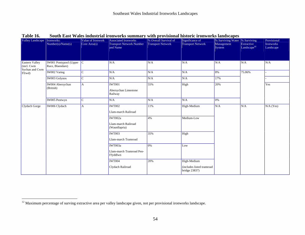
Southeast Wales Industrial Ironworks Landscapes
54
Table 16. South East Wales industrial ironworks summary with provisional historic ironworks landscapes Valley Landscape Ironworks:
Number(s)/Name(s) Value of Ironwork Core Area(s)
Associated Ironworks Transport Network Number and Name
% Overall Survival of Transport Network
Significance of Transport Network
% Surviving Water Management System
% Surviving Extractive Landscape12
Provisional Ironworks Landscape
IW001 Pontypool (Upper Race, Blaendare)
C N/A N/A N/A N/A N/A N/A
IW002 Varteg C N/A N/A N/A 8% -
IW003 Golynos C N/A N/A N/A 17% -
IW004 Abersychan (British)
A IWT001
Abersychan Limestone Railway
55% High 20%
Eastern Valley (incl. Cwm Sychan and Cwm Ffrwd)
IW005 Pentwyn C N/A N/A N/A 0%
75.06%
Yes
IWT002
Llam-march Railroad
11% High-Medium
IWT002a
Llam-march Railroad (Waunllapria)
4% Medium-Low
IWT003
Llam-march Tramroad
35% High
IWT003a
Llam-march Tramroad Pen-Ffyddlwn
0% Low
Clydach Gorge IW006 Clydach A
IWT004
Clydach Railroad
20% High-Medium
(includes listed tramroad bridge 23837)
N/A N/A N/A (Yes)
12 Maximum percentage of surving extractive area per valley landscape given, not per provisional ironworks landscape.
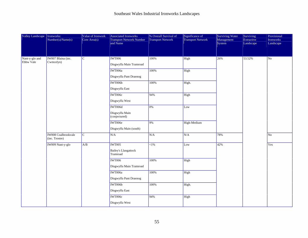
Southeast Wales Industrial Ironworks Landscapes
55
Valley Landscape Ironworks: Number(s)/Name(s)
Value of Ironwork Core Area(s)
Associated Ironworks Transport Network Number and Name
% Overall Survival of Transport Network
Significance of Transport Network
Surviving Water Management System
Surviving Extractive Landscape
Provisional Ironworks Landscape
IWT006
Disgwylfa Main Tramroad
100% High
IWT006a
Disgwylfa Pant Draenog
100% High
IWT006b
Disgwylfa East
100% High.
IWT006c
Disgwylfa West
94% High
IWT006d
Disgwylfa Main (conjectured)
0% Low
IW007 Blaina (inc. Cwmcelyn)
C
IWT006e
Disgwylfa Main (south)
9% High-Medium
26% No
IW008 Coalbrookvale (inc. Trostre)
C N/A N/A N/A 78% No
IWT005
Bailey's Llangattock Tramroad
<1% Low
IWT006
Disgwylfa Main Tramroad
100% High
IWT006a
Disgwylfa Pant Draenog
100% High
IWT006b
Disgwylfa East
100% High.
Nant-y-glo and Ebbw Vale
IW009 Nant-y-glo A/B
IWT006c
Disgwylfa West
94% High
42%
53.52%
Yes
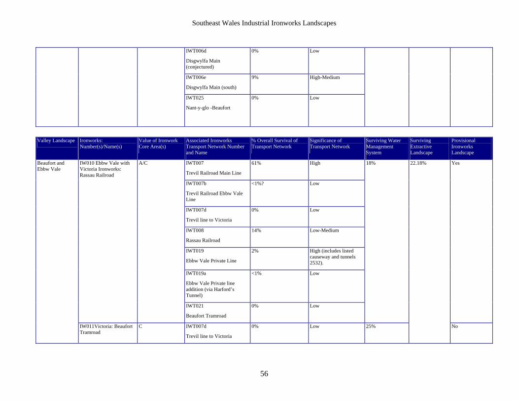
Southeast Wales Industrial Ironworks Landscapes
56
IWT006d
Disgwylfa Main (conjectured)
0% Low
IWT006e
Disgwylfa Main (south)
9% High-Medium
IWT025
Nant-y-glo -Beaufort
0% Low
Valley Landscape Ironworks: Number(s)/Name(s)
Value of Ironwork Core Area(s)
Associated Ironworks Transport Network Number and Name
% Overall Survival of Transport Network
Significance of Transport Network
Surviving Water Management System
Surviving Extractive Landscape
Provisional Ironworks Landscape
IWT007
Trevil Railroad Main Line
61% High
IWT007b
Trevil Railroad Ebbw Vale Line
<1%? Low
IWT007d
Trevil line to Victoria
0% Low
IWT008
Rassau Railroad
14% Low-Medium
IWT019
Ebbw Vale Private Line
2% High (includes listed causeway and tunnels 2532).
IWT019a
Ebbw Vale Private line addition (via Harford’s Tunnel)
<1% Low
IW010 Ebbw Vale with Victoria Ironworks: Rassau Railroad
A/C
IWT021
Beaufort Tramroad
0% Low
18% Yes Beaufort and Ebbw Vale
IW011Victoria: Beaufort Tramroad
C IWT007d
Trevil line to Victoria
0% Low 25%
22.18%
No
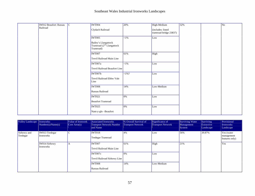
Southeast Wales Industrial Ironworks Landscapes
57
IWT004
Clydach Railroad
20% High-Medium
(includes: listed tramroad bridge 23837)
IWT005
Bailey’s Llangattock Tramroad (2nd Llangattock Tramroad)
<1% Low
IWT007
Trevil Railroad Main Line
61% High
IWT007a
Trevil Railroad Beaufort Line
<1% Low
IWT007b
Trevil Railroad Ebbw Vale Line
<1%? Low
IWT008
Rassau Railroad
14% Low-Medium
IWT021
Beaufort Tramroad
0% Low
IW012 Beaufort: Rassau Railroad
C
IWT025
Nant-y-glo –Beaufort
0% Low
32% No
Valley Landscape Ironworks: Number(s)/Name(s)
Value of Ironwork Core Area(s)
Associated Ironworks Transport Network Number and Name
% Overall Survival of Transport Network
Significance of Transport Network
Surviving Water Management System
Surviving Extractive Landscape
Provisional Ironworks Landscape
IW013 Tredegar Ironworks
C IWT018
Tredegar Tramroad
4% Low 56% Yes (water management features only)
IWT007
Trevil Railroad Main Line
61% High
IWT007c
Trevil Railroad Sirhowy Line
0% Low
Sirhowy and Tredegar
IW014 Sirhowy Ironworks
A
IWT008
Rassau Railroad
14% Low-Medium
21%
39.87%
Yes
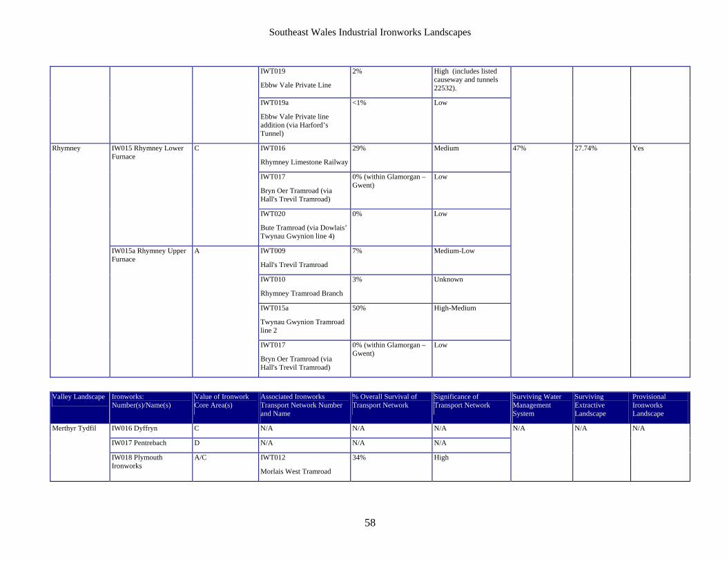
Southeast Wales Industrial Ironworks Landscapes
58
IWT019
Ebbw Vale Private Line
2% High (includes listed causeway and tunnels 22532).
IWT019a
Ebbw Vale Private line addition (via Harford’s Tunnel)
<1% Low
IWT016
Rhymney Limestone Railway
29% Medium
IWT017
Bryn Oer Tramroad (via Hall's Trevil Tramroad)
0% (within Glamorgan – Gwent)
Low
IW015 Rhymney Lower Furnace
C
IWT020
Bute Tramroad (via Dowlais’ Twynau Gwynion line 4)
0% Low
IWT009
Hall's Trevil Tramroad
7% Medium-Low
IWT010
Rhymney Tramroad Branch
3% Unknown
IWT015a
Twynau Gwynion Tramroad line 2
50% High-Medium
Rhymney
IW015a Rhymney Upper Furnace
A
IWT017
Bryn Oer Tramroad (via Hall's Trevil Tramroad)
0% (within Glamorgan – Gwent)
Low
47% 27.74% Yes
Valley Landscape Ironworks: Number(s)/Name(s)
Value of Ironwork Core Area(s)
Associated Ironworks Transport Network Number and Name
% Overall Survival of Transport Network
Significance of Transport Network
Surviving Water Management System
Surviving Extractive Landscape
Provisional Ironworks Landscape
IW016 Dyffryn C N/A N/A N/A
IW017 Pentrebach D N/A N/A N/A
Merthyr Tydfil
IW018 Plymouth Ironworks
A/C IWT012
Morlais West Tramroad
34% High
N/A N/A N/A

Southeast Wales Industrial Ironworks Landscapes
59
IW019 Ynys Fach A N/A N/A N/A
IW020 Cyfarthfa A N/A N/A N/A
IW021 Penydarren Ironworks and tramroad
B IWT012
Morlais West Tramroad
34% High
IWT011
Morlais East Tramroad and Railway
39% High-Medium
IWT015
Twynau Gwynion Tramroad Line 1
25% High-Medium
IWT015b
Twynau Gwynion Tramroad line 3 (partly under later Rhymney Limestone Railway)
87% Medium
IW022 Dowlais Ironworks A/B
IWT015c
Twynau Gwynion Tramroad Line 4 (partly under route of Rhymney Limestone Railway)
19% Medium
IW023 Ivor works A/B IWT011
Morlais East Tramroad and Railway
39% High-Medium
Valley Landscape Ironworks: Number(s)/Name(s)
Value of Ironwork Core Area(s)
Associated Ironworks Transport Network Number and Name
% Overall Survival of Transport Network
Significance of Transport Network
Surviving Water Management System
Surviving Extractive Landscape
Provisional Ironworks Landscape
IWT013
Tappendens’ Tramroad
29% High
Cynon with the Dare and Aman
IW024 Hirwaun A
IWT013a
Tappendens’ Tramroad West
16% Medium
48% 47.42% Yes
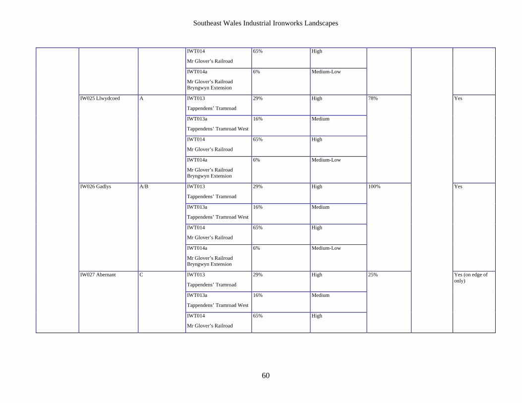
Southeast Wales Industrial Ironworks Landscapes
60
IWT014
Mr Glover’s Railroad
65% High
IWT014a
Mr Glover’s Railroad Bryngwyn Extension
6% Medium-Low
IWT013
Tappendens’ Tramroad
29% High
IWT013a
Tappendens’ Tramroad West
16% Medium
IWT014
Mr Glover’s Railroad
65% High
IW025 Llwydcoed A
IWT014a
Mr Glover’s Railroad Bryngwyn Extension
6% Medium-Low
78% Yes
IWT013
Tappendens’ Tramroad
29% High
IWT013a
Tappendens’ Tramroad West
16% Medium
IWT014
Mr Glover’s Railroad
65% High
IW026 Gadlys A/B
IWT014a
Mr Glover’s Railroad Bryngwyn Extension
6% Medium-Low
100% Yes
IWT013
Tappendens’ Tramroad
29% High
IWT013a
Tappendens’ Tramroad West
16% Medium
IW027 Abernant C
IWT014
Mr Glover’s Railroad
65% High
25%
Yes (on edge of only)
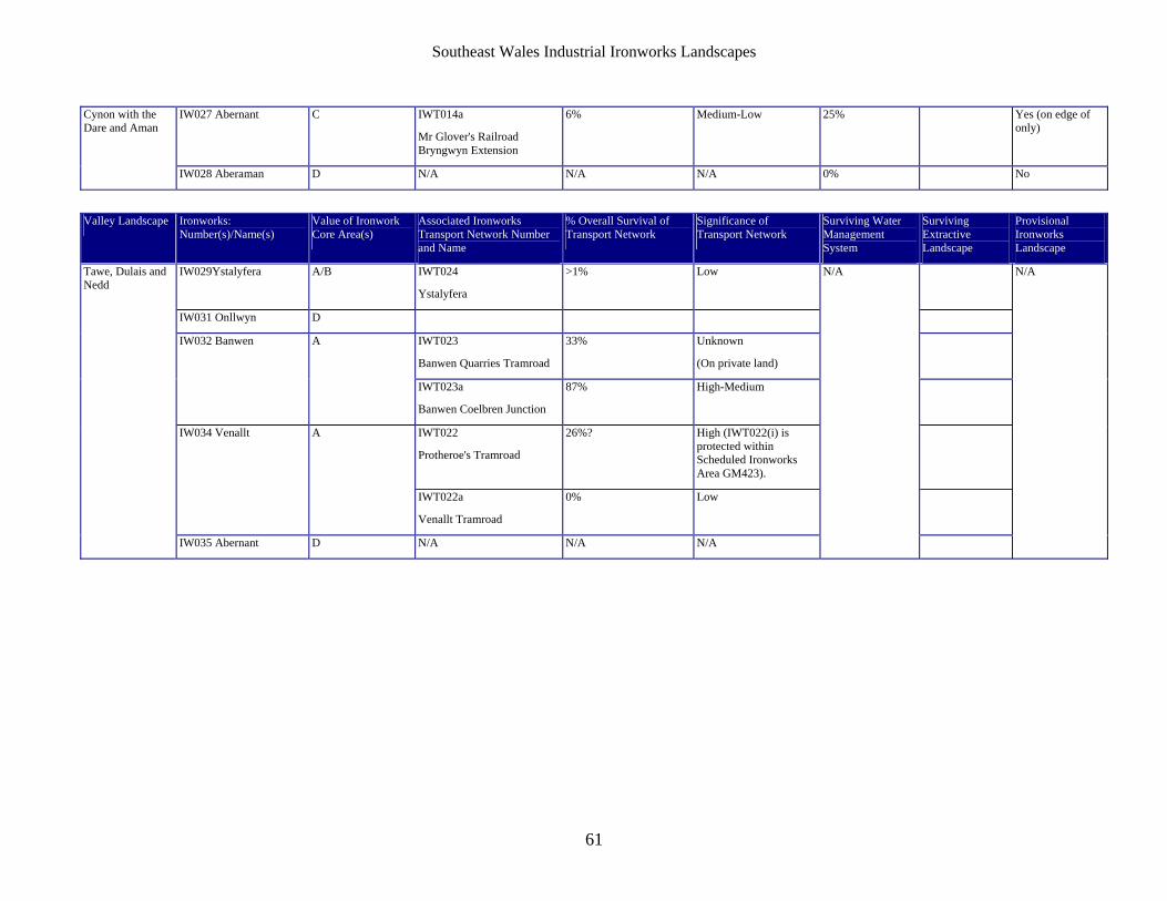
Southeast Wales Industrial Ironworks Landscapes
61
IW027 Abernant C IWT014a
Mr Glover's Railroad Bryngwyn Extension
6% Medium-Low 25% Yes (on edge of only)
Cynon with the Dare and Aman
IW028 Aberaman D N/A N/A N/A 0% No
Valley Landscape Ironworks: Number(s)/Name(s)
Value of Ironwork Core Area(s)
Associated Ironworks Transport Network Number and Name
% Overall Survival of Transport Network
Significance of Transport Network
Surviving Water Management System
Surviving Extractive Landscape
Provisional Ironworks Landscape
IW029Ystalyfera A/B IWT024
Ystalyfera
>1% Low
IW031 Onllwyn D
IWT023
Banwen Quarries Tramroad
33% Unknown
(On private land)
IW032 Banwen A
IWT023a
Banwen Coelbren Junction
87% High-Medium
IWT022
Protheroe's Tramroad
26%? High (IWT022(i) is protected within Scheduled Ironworks Area GM423).
IW034 Venallt A
IWT022a
Venallt Tramroad
0% Low
Tawe, Dulais and Nedd
IW035 Abernant D N/A N/A N/A
N/A
N/A