Embed Size (px)
Citation preview
Paynes Creek Historic State Park
Approved Plan Unit Management Plan
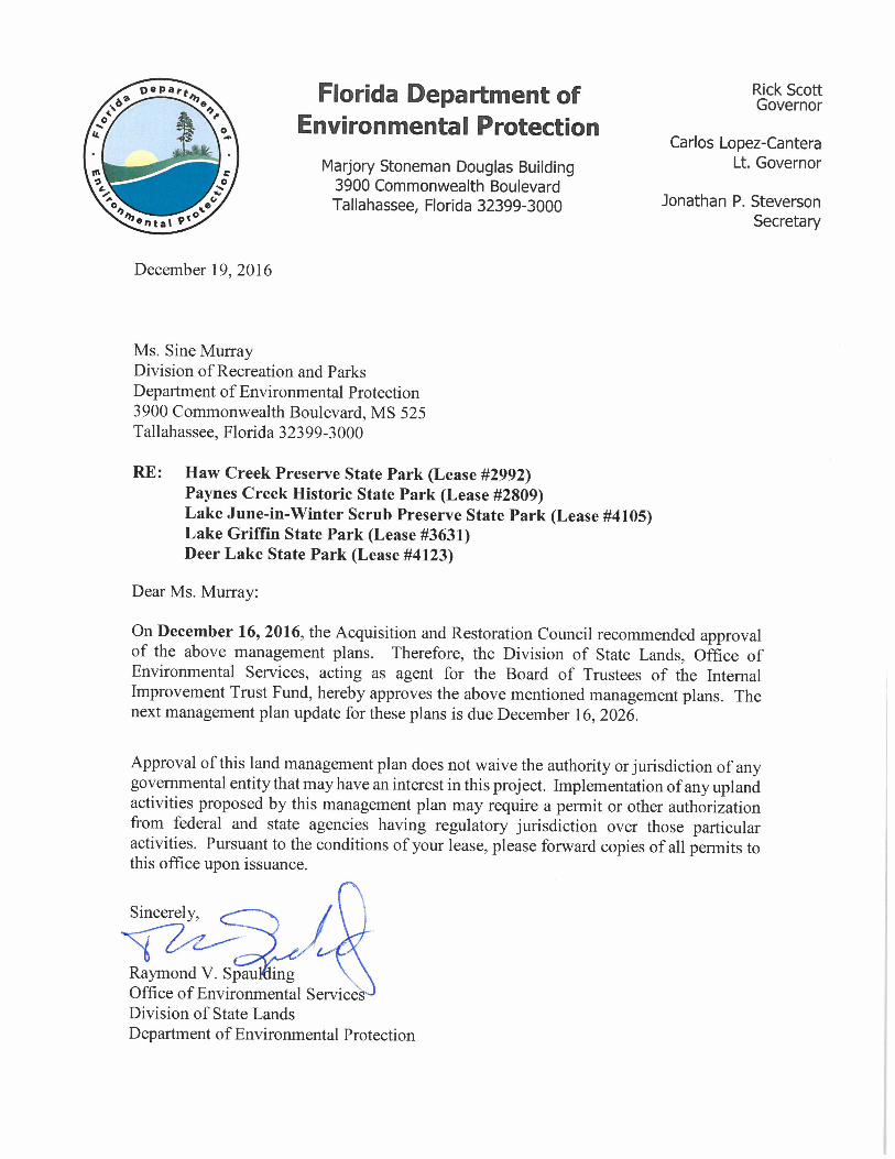
STATE OF FLORIDA DEPARTMENT OF ENVIRONMENTAL PROTECTION
Division of Recreation and Parks December 16, 2016


i
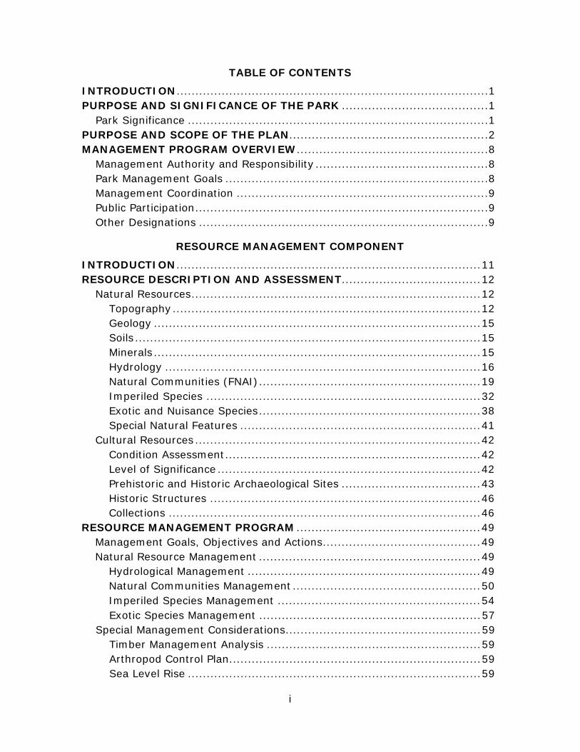
TABLE OF CONTENTS
INTRODUCTION ................................................................................... 1 PURPOSE AND SIGNIFICANCE OF THE PARK ....................................... 1 Park Significance ................................................................................ 1 PURPOSE AND SCOPE OF THE PLAN..................................................... 2 MANAGEMENT PROGRAM OVERVIEW ................................................... 8 Management Authority and Responsibility .............................................. 8 Park Management Goals ...................................................................... 8 Management Coordination ................................................................... 9 Public Participation .............................................................................. 9 Other Designations ............................................................................. 9
RESOURCE MANAGEMENT COMPONENT
INTRODUCTION ................................................................................. 11 RESOURCE DESCRIPTION AND ASSESSMENT..................................... 12 Natural Resources ............................................................................. 12 Topography .................................................................................. 12 Geology ....................................................................................... 15 Soils ............................................................................................ 15 Minerals ....................................................................................... 15 Hydrology .................................................................................... 16 Natural Communities (FNAI) ........................................................... 19 Imperiled Species ......................................................................... 32 Exotic and Nuisance Species ........................................................... 38 Special Natural Features ................................................................ 41 Cultural Resources ............................................................................ 42 Condition Assessment .................................................................... 42 Level of Significance ...................................................................... 42 Prehistoric and Historic Archaeological Sites ..................................... 43 Historic Structures ........................................................................ 46 Collections ................................................................................... 46 RESOURCE MANAGEMENT PROGRAM ................................................. 49 Management Goals, Objectives and Actions .......................................... 49 Natural Resource Management ........................................................... 49 Hydrological Management .............................................................. 49 Natural Communities Management .................................................. 50 Imperiled Species Management ...................................................... 54 Exotic Species Management ........................................................... 57 Special Management Considerations .................................................... 59 Timber Management Analysis ......................................................... 59 Arthropod Control Plan ................................................................... 59 Sea Level Rise .............................................................................. 59

ii
Cultural Resource Management .......................................................... 60 Resource Management Schedule ......................................................... 62 Land Management Review ................................................................. 62
LAND USE COMPONENT
INTRODUCTION ................................................................................. 63 EXTERNAL CONDITIONS .................................................................... 63 Existing Use of Adjacent Lands ........................................................... 64 Planned Use of Adjacent Lands ........................................................... 65 PROPERTY ANALYSIS ........................................................................ 66 Recreation Resource Elements ............................................................ 66 Land Area .................................................................................... 66 Water Area ................................................................................... 67 Natural Scenery ............................................................................ 67 Significant Habitat ......................................................................... 67 Archaeological and Historic Features ................................................ 67 Assessment of Use ............................................................................ 68 Past Uses ..................................................................................... 68 Future Land Use and Zoning ........................................................... 68 Current Recreation Use and Visitor Programs .................................... 68 Protected Zones ............................................................................ 68 Existing Facilities .............................................................................. 71 Recreation Facilities ....................................................................... 71 Support Facilities .......................................................................... 71 CONCEPTUAL LAND USE PLAN ........................................................... 72 Potential Uses .................................................................................. 72 Public Access and Recreational Opportunities .................................... 72 Proposed Facilities ............................................................................ 75 Capital Facilities and Infrastructure ................................................. 75 Facilities Development ....................................................................... 77 Recreational Carrying Capacity ........................................................... 77 Optimum Boundary ........................................................................... 78
IMPLEMENTATION COMPONENT
MANAGEMENT PROGRESS .................................................................. 83 Acquisition ....................................................................................... 83 Park Administration and Operations .................................................... 83 Resource Management ...................................................................... 83 Natural Resources ..................................................................... 83 Recreation and Visitor Services ........................................................... 84 Park Facilities ................................................................................... 84 MANAGEMENT PLAN IMPLEMENTATION ............................................ 84
iii
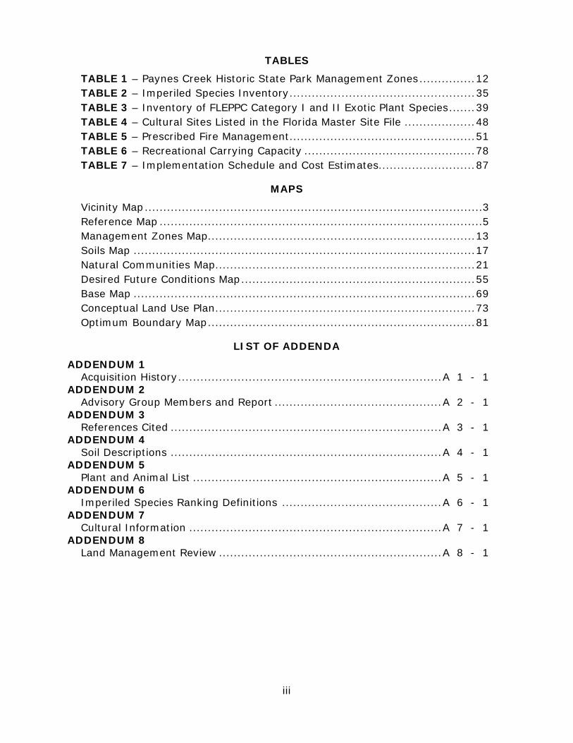
TABLES
TABLE 1 – Paynes Creek Historic State Park Management Zones ............... 12 TABLE 2 – Imperiled Species Inventory .................................................. 35 TABLE 3 – Inventory of FLEPPC Category I and II Exotic Plant Species ....... 39 TABLE 4 – Cultural Sites Listed in the Florida Master Site File ................... 48 TABLE 5 – Prescribed Fire Management .................................................. 51 TABLE 6 – Recreational Carrying Capacity .............................................. 78 TABLE 7 – Implementation Schedule and Cost Estimates.......................... 87
MAPS
Vicinity Map ........................................................................................... 3 Reference Map ....................................................................................... 5 Management Zones Map........................................................................ 13 Soils Map ............................................................................................ 17 Natural Communities Map ...................................................................... 21 Desired Future Conditions Map ............................................................... 55 Base Map ............................................................................................ 69 Conceptual Land Use Plan ...................................................................... 73 Optimum Boundary Map ........................................................................ 81
LIST OF ADDENDA
ADDENDUM 1 Acquisition History ....................................................................... A 1 - 1 ADDENDUM 2 Advisory Group Members and Report ............................................. A 2 - 1 ADDENDUM 3 References Cited ......................................................................... A 3 - 1 ADDENDUM 4 Soil Descriptions ......................................................................... A 4 - 1 ADDENDUM 5 Plant and Animal List ................................................................... A 5 - 1 ADDENDUM 6 Imperiled Species Ranking Definitions ........................................... A 6 - 1 ADDENDUM 7 Cultural Information .................................................................... A 7 - 1 ADDENDUM 8 Land Management Review ............................................................ A 8 - 1

1
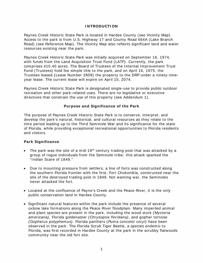
INTRODUCTION
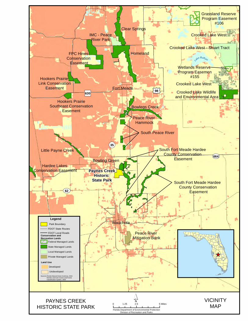
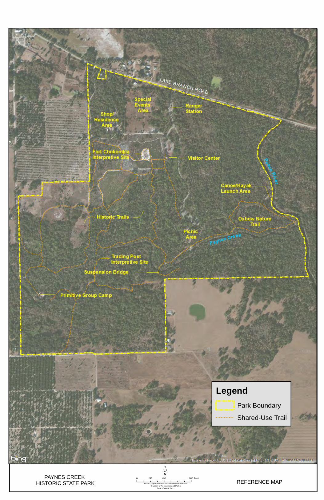
Paynes Creek Historic State Park is located in Hardee County (see Vicinity Map). Access to the park is from U.S. Highway 17 and County Road 664A (Lake Branch Road) (see Reference Map). The Vicinity Map also reflects significant land and water resources existing near the park. Paynes Creek Historic State Park was initially acquired on September 16, 1974, with funds from the Land Acquisition Trust Fund (LATF). Currently, the park comprises 410.40 acres. The Board of Trustees of the Internal Improvement Trust Fund (Trustees) hold fee simple title to the park, and on April 16, 1975, the Trustees leased (Lease Number 2809) the property to the DRP under a ninety-nine-year lease. The current lease will expire on April 15, 2074. Paynes Creek Historic State Park is designated single-use to provide public outdoor recreation and other park-related uses. There are no legislative or executive directives that constrain the use of this property (see Addendum 1).
Purpose and Significance of the Park The purpose of Paynes Creek Historic State Park is to conserve, interpret, and develop the park’s natural, historical, and cultural resources as they relate to the time period leading up to the Third Seminole War and its significance for the state of Florida, while providing exceptional recreational opportunities to Florida residents and visitors. Park Significance • The park was the site of a mid-19th century trading post that was attacked by a
group of rogue individuals from the Seminole tribe; this attack sparked the “Indian Scare of 1849.”
• Due to mounting pressure from settlers, a line of forts was constructed along the southern Florida frontier with the first, Fort Chokonikla, constructed near the site of the destroyed trading post in 1849. Not wanting war, the Seminoles never attacked the fort.
• Located at the confluence of Payne’s Creek and the Peace River, it is the only public conservation land in Hardee County.
• Significant natural features within the park include the presence of several
oxbow lake formations along the Peace River floodplain. Many imperiled animal and plant species are present in the park, including the wood stork (Mycteria americana), Florida goldenaster (Chrysopsis floridana), and gopher tortoise (Gopherus polyphemus). Florida panthers (Puma concolor coryi) have been observed in the park. The Florida Scrub Tiger Beetle, a species endemic to Florida, was first recorded in Hardee County at the park in the scrubby flatwoods community near the old fort site.
2
• Unique educational exhibits are located within the park’s visitor center to interpret significant events in Florida’s history that occurred within the park relating to the Third Seminole War.
Paynes Creek Historic State Park is classified as a State Special Feature Site in the DRP’s unit classification system. A special feature is a discrete and well-defined object or condition that attracts public interest and provides recreational enjoyment through visitation, observation and study. A state special feature site is an area which contains such a feature, and which is set aside for controlled public enjoyment. Special feature sites for the most part are either historical or archaeological by type, but they may also have a geological, botanical, zoological, or other basis. State special feature sites must be of unusual or exceptional character, or have statewide or broad regional significance. Management of special feature sites places primary emphasis on protection and maintenance of the special feature for long-term public enjoyment. Permitted uses are almost exclusively passive in nature and program emphasis is on interpretation of the special feature. Development at special feature sites is focused on protection and maintenance of the site, public access, safety and the convenience of the user.
Purpose and Scope of the Plan This plan serves as the basic statement of policy and direction for the management of Paynes Creek Historic State Park as a unit of Florida's state park system. It identifies the goals, objectives, actions and criteria or standards that guide each aspect of park administration, and sets forth the specific measures that will be implemented to meet management objectives and provide balanced public utilization. The plan is intended to meet the requirements of Sections 253.034 and 259.032, Florida Statutes, Chapter 18-2, Florida Administrative Code, and is intended to be consistent with the State Lands Management Plan. With approval, this management plan will replace the 2004 approved plan. The plan consists of three interrelated components: the Resource Management Component, the Land Use Component and the Implementation Component. The Resource Management Component provides a detailed inventory and assessment of the natural and cultural resources of the park. Resource management needs and issues are identified, and measurable management objectives are established for each of the park’s management goals and resource types. This component provides guidance on the application of such measures as prescribed burning, exotic species removal, imperiled species management, cultural resource management and restoration of natural conditions. The Land Use Component is the recreational resource allocation plan for the park, based on considerations such as access, population, adjacent land uses, the natural and cultural resources of the park, current public uses and existing development. Measurable objectives are set to achieve the desired allocation of the physical space of the park. These objectives identify use areas and propose the types of facilities and programs as well as the volume of public use to be provided.
South Prong Alafia River
Hardee Lakes Conservation Easement
Peace River Mitigation Bank
Hookers Prairie Southeast Conservation
Easement
Hookers Prairie Link Conservation
Easement
FPC Hines Conservation
Easement
IMC - PeaceRiver Park
Clear Springs
Homeland
Grassland Reserve Program Easement
#106
Bowlegs Creek
Peace River Hammock
South Peace River
Little Payne Creek
Crooked Lake West - Stuart Tract
Crooked Lake West
Crooked Lake West
Wetlands Reserve Program Easemen
#155
Crooked Lake Wildlife and Environmental Area
South Fort Meade Hardee County Conservation
Easement
Paynes CreekHistoric
State Park
South Fort Meade Hardee County Conservation
Easement
¬«35
UV664Bowling Green
UV62
£¤98Fort Meade
Wauchula
Lake Buffum
")630
PAYNES CREEKHISTORIC STATE PARK
VICINITYMAP
Florida Department of Environmental ProtectionDivision of Recreation and Parks
0 2.5 51.25 Miles´
_̂
Sources:Florida Natural Areas Inventory, 2015 Florida Land Use Covers and Forms Classification System, 2004
LegendPark Boundary
Land Use
Conservation and Recreation Lands
FDOT State Routes
FDOT Local Roads
Federal Managed Lands
State Managed Lands
Local Managed Lands
Private Managed Lands
Developed
Undeveloped

PAYNES CREEK HISTORIC STATE PARK Florida Department of Environmental Protection
Division of Recreation and ParksDate of aerial; 2011
0 490 980245 Feet
´REFERENCE MAP
LegendPark Boundary
Shared-Use Trail

7
The Implementation Component consolidates the measurable objectives and actions for each of the park’s management goals. An implementation schedule and cost estimates are included for each objective and action. Included in this table are (1) measures used to evaluate the DRP’s implementation progress, (2) timeframes for completing actions and objectives and (3) estimated costs to complete each action and objective. All development and resource alteration proposed in this plan are subject to the granting of appropriate permits, easements, licenses, and other required legal instruments. Approval of the management plan does not constitute an exemption from complying with the appropriate local, state or federal agencies. In the development of this plan, the potential of the park to accommodate secondary management purposes was analyzed. These secondary purposes were considered within the context of the DRP’s statutory responsibilities and the resource needs and values of the park. This analysis considered the park natural and cultural resources, management needs, aesthetic values, visitation and visitor experiences. For this park, it was determined that no secondary purposes could be accommodated in a manner that would not interfere with the primary purpose of resource-based outdoor recreation and conservation. Uses such as water resource development projects, water supply projects, stormwater management projects, linear facilities and sustainable agriculture and forestry (other than those forest management activities specifically identified in this plan) are not consistent with this plan. The potential for generating revenue to enhance management was also analyzed. Visitor fees and charges are the principal source of revenue generated by the park. It was determined that multiple-use management activities would not be appropriate as a means of generating revenues for land management. Instead, techniques such as entrance fees, concessions and similar measures will be employed on a case-by-case basis as a means of supplementing park management funding. DRP may provide the services and facilities outlined in this plan either with its own funds and staff or through an outsourcing contract. Private contractors may provide assistance with natural resource management and restoration activities or a concessionaire may provide services to park visitors in order to enhance the visitor experience. For example, a concessionaire could be authorized to sell merchandise and food and to rent recreational equipment for use in the park. A concessionaire may also be authorized to provide specialized services, such as interpretive tours, or overnight accommodations when the required capital investment exceeds that which DRP can elect to incur. Decisions regarding outsourcing, contracting with the private sector, the use of concessionaires, etc., are made on a case-by-case basis in accordance with the policies set forth in DRP’s Operations Manual (OM).
8
Management Program Overview Management Authority and Responsibility In accordance with Chapter 258, Florida Statutes and Chapter 62D-2, Florida Administrative Code, the Division of Recreation and Parks (DRP) is charged with the responsibility of developing and operating Florida's recreation and parks system. These are administered in accordance with the following policy: It shall be the policy of the Division of Recreation and Parks to promote the state park system for the use, enjoyment, and benefit of the people of Florida and visitors; to acquire typical portions of the original domain of the state which will be accessible to all of the people, and of such character as to emblemize the state's natural values; conserve these natural values for all time; administer the development, use and maintenance of these lands and render such public service in so doing, in such a manner as to enable the people of Florida and visitors to enjoy these values without depleting them; to contribute materially to the development of a strong mental, moral, and physical fiber in the people; to provide for perpetual preservation of historic sites and memorials of statewide significance and interpretation of their history to the people; to contribute to the tourist appeal of Florida. The Board of Trustees of the Internal Improvement Trust Fund (Trustees) has granted management authority of certain sovereign submerged lands to the DRP under Management Agreement MA 68-086 (as amended January 19, 1988). The management area includes a 400-foot zone from the edge of mean high water where a park boundary borders sovereign submerged lands fronting beaches, bays, estuarine areas, rivers or streams. Where emergent wetland vegetation exists, the zone extends waterward 400 feet beyond the vegetation. The agreement is intended to provide additional protection to resources of the park and nearshore areas and to provide authority to manage activities that could adversely affect public recreational uses. Many operating procedures are standardized system-wide and are set by internal direction. These procedures are outlined in the OM that covers such areas as personnel management, uniforms and personal appearance, training, signs, communications, fiscal procedures, interpretation, concessions, public use regulations, resource management, law enforcement, protection, safety and maintenance. Park Management Goals The following park goals express the DRP’s long-term intent in managing the state park: • Provide administrative support for all park functions. • Protect water quality and quantity in the park, restore hydrology to the extent
feasible and maintain the restored condition.
9
• Restore and maintain the natural communities/habitats of the park. • Maintain, improve or restore imperiled species populations and habitats in the
park. • Remove exotic and invasive plants and animals from the park and conduct
needed maintenance-control. • Protect, preserve and maintain the cultural resources of the park. • Provide public access and recreational opportunities in the park. • Develop and maintain the capital facilities and infrastructure necessary to meet
the goals and objectives of this management plan. Management Coordination The park is managed in accordance with all applicable laws and administrative rules. Agencies having a major or direct role in the management of the park are discussed in this plan. The Florida Department of Agriculture and Consumer Services (FDACS), Florida Forest Service (FFS), assists DRP staff in the development of wildfire emergency plans and provides the authorization required for prescribed burning. The Florida Fish and Wildlife Conservation Commission (FWC) assists staff in the enforcement of state laws pertaining to wildlife, freshwater fish and other aquatic life existing within the park. In addition, the FWC aids the DRP with wildlife management programs, including imperiled species management. The Florida Department of State (FDOS), Division of Historical Resources (DHR) assists staff to ensure protection of archaeological and historical sites. Public Participation The DRP provided an opportunity for public input by conducting a public workshop and an Advisory Group meeting to present the draft management plan to the public. These meetings were held on July 13 and 14, respectively. Meeting notices were published in the Florida Administrative Register, July 1, 2016 [VOL 42/128], included on the Department Internet Calendar, posted in clear view at the park, and promoted locally. The purpose of the Advisory Group meeting is to provide the Advisory Group members an opportunity to discuss the draft management plan (see Addendum 2). Other Designations Paynes Creek Historic State Park is not within an Area of Critical State Concern as defined in Section 380.05, Florida Statutes, and it is not presently under study for such designation. The park is a component of the Florida Greenways and Trails System (FGTS), administered by the Division’s Office of Greenways and Trails. All waters within the park are Outstanding Florida Waters, pursuant to Chapter 62-302, Florida Administrative Code. Surface waters in this park are also classified as Class III waters by the Department. This park is not within or adjacent to an aquatic preserve as designated under the Florida Aquatic Preserve Act of 1975 (Section 258.35, Florida Statutes).

10
11
RESOURCE MANAGEMENT COMPONENT
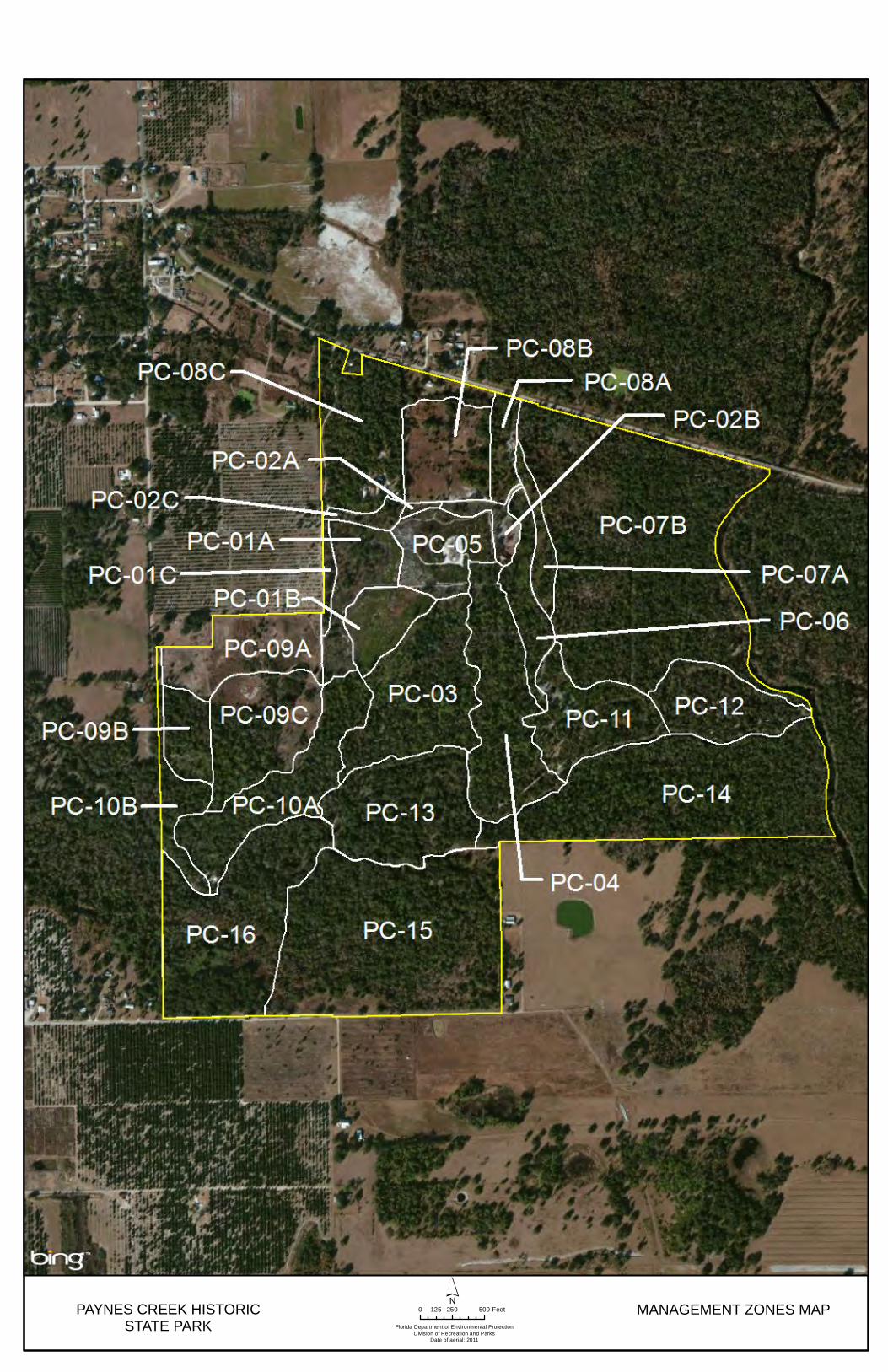
Introduction The Florida Department of Environmental Protection (DEP), Division of Recreation and Parks (DRP) in accordance with Chapter 258, Florida Statutes, has implemented resource management programs for preserving for all time the representative examples of natural and cultural resources of statewide significance under its administration. This component of the unit plan describes the natural and cultural resources of the park and identifies the methods that will be used to manage them. Management measures expressed in this plan are consistent with the DRP’s overall mission in natural systems management. Cited references are contained in Addendum 3. The DRP’s philosophy of resource management is natural systems management. Primary emphasis is placed on restoring and maintaining, to the degree possible, the natural processes that shaped the structure, function and species composition of Florida’s diverse natural communities as they occurred in the original domain. Single species management for imperiled species is appropriate in state parks when the maintenance, recovery or restoration of a species or population is complicated due to constraints associated with long-term restoration efforts, unnaturally high mortality or insufficient habitat. Single species management should be compatible with the maintenance and restoration of natural processes and should not imperil other native species or seriously compromise the park values. The DRP’s management goal for cultural resources is to preserve sites and objects that represent Florida’s cultural periods, significant historic events or persons. This goal often entails active measures to stabilize, reconstruct or restore resources, or to rehabilitate them for appropriate public use. Because park units are often components of larger ecosystems, their proper management can be affected by conditions and events that occur beyond park boundaries. Ecosystem management is implemented through a resource management evaluation program that assesses resource conditions, evaluates management activities and refines management actions, and reviews local comprehensive plans and development permit applications for park/ecosystem impacts. The entire park is divided into management zones that delineate areas on the ground that are used to reference management activities (see Management Zones Map). The shape and size of each zone may be based on natural community type, burn zone, and the location of existing roads and natural fire breaks. It is important to note that all burn zones are management zones; however, not all management zones include fire-dependent natural communities. Table 1 reflects the management zones with the acres of each zone.
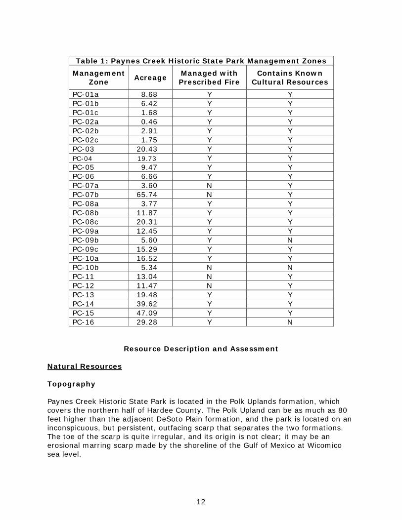
12
Table 1: Paynes Creek Historic State Park Management Zones
Management Zone Acreage Managed with
Prescribed Fire Contains Known
Cultural Resources PC-01a 8.68 Y Y PC-01b 6.42 Y Y PC-01c 1.68 Y Y PC-02a 0.46 Y Y PC-02b 2.91 Y Y PC-02c 1.75 Y Y PC-03 20.43 Y Y PC-04 19.73 Y Y PC-05 9.47 Y Y PC-06 6.66 Y Y PC-07a 3.60 N Y PC-07b 65.74 N Y PC-08a 3.77 Y Y PC-08b 11.87 Y Y PC-08c 20.31 Y Y PC-09a 12.45 Y Y PC-09b 5.60 Y N PC-09c 15.29 Y Y PC-10a 16.52 Y Y PC-10b 5.34 N N PC-11 13.04 N Y PC-12 11.47 N Y PC-13 19.48 Y Y PC-14 39.62 Y Y PC-15 47.09 Y Y PC-16 29.28 Y N
Resource Description and Assessment Natural Resources Topography Paynes Creek Historic State Park is located in the Polk Uplands formation, which covers the northern half of Hardee County. The Polk Upland can be as much as 80 feet higher than the adjacent DeSoto Plain formation, and the park is located on an inconspicuous, but persistent, outfacing scarp that separates the two formations. The toe of the scarp is quite irregular, and its origin is not clear; it may be an erosional marring scarp made by the shoreline of the Gulf of Mexico at Wicomico sea level.
PAYNES CREEK HISTORICSTATE PARK Florida Department of Environmental Protection
Division of Recreation and ParksDate of aerial; 2011
0 250 500125 Feet MANAGEMENT ZONES MAP

15
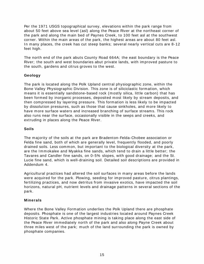
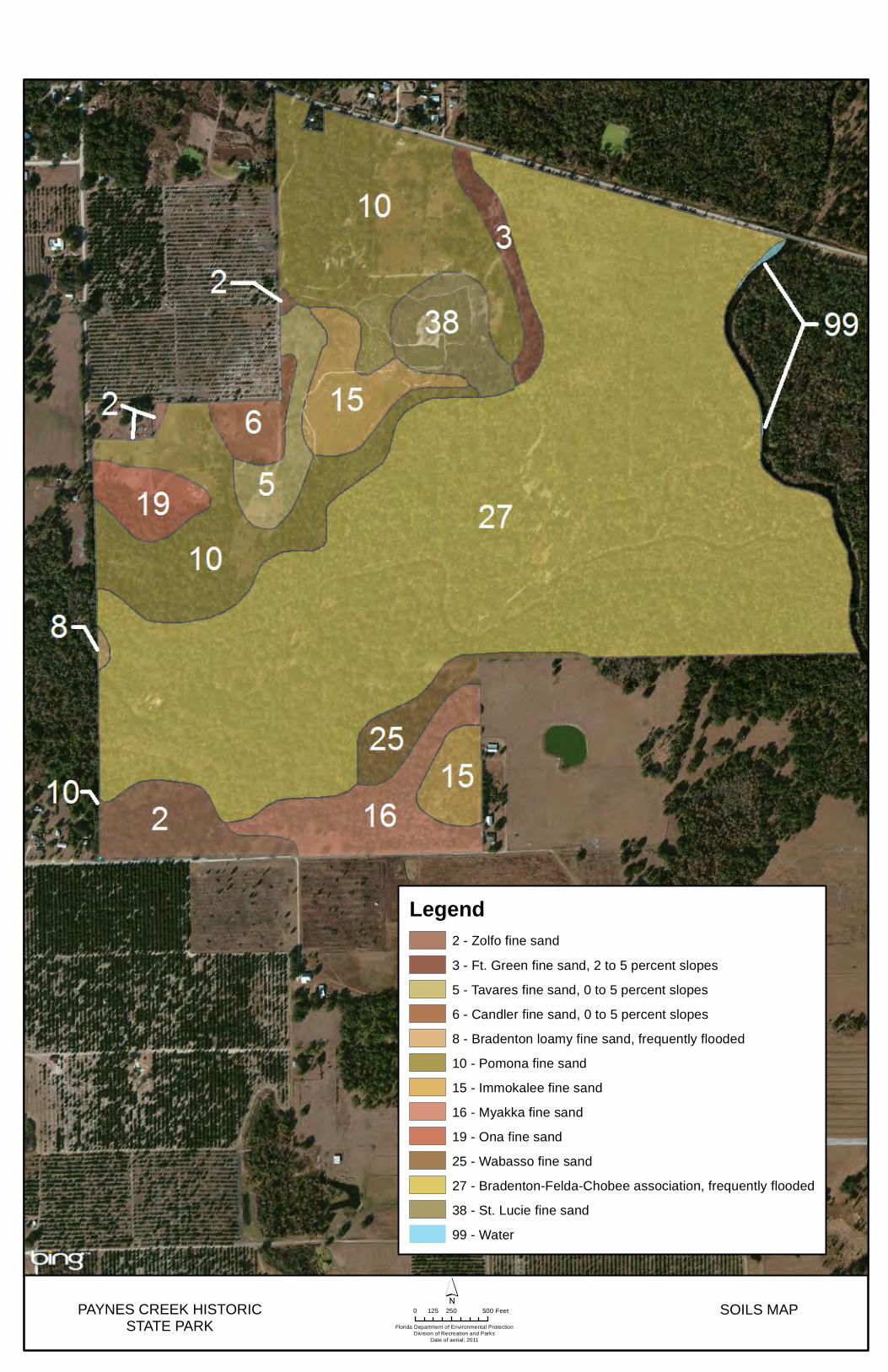
Per the 1971 USGS topographical survey, elevations within the park range from about 50 feet above sea level (asl) along the Peace River at the northeast corner of the park and along the main bed of Paynes Creek, to 100 feet asl at the southwest corner. Within the main areas of the park, the highest areas are about 80 feet asl. In many places, the creek has cut steep banks; several nearly vertical cuts are 8-12 feet high. The north end of the park abuts County Road 664A; the east boundary is the Peace River; the south and west boundaries abut private lands, with improved pasture to the south, gardens and citrus groves to the west. Geology The park is located along the Polk Upland central physiographic zone, within the Bone Valley Physiographic Division. This zone is of siliciclastic formation, which means it is essentially sandstone-based rock (mostly silica, little carbon) that has been formed by inorganic processes, deposited most likely by stream deposits, and then compressed by layering pressure. This formation is less likely to be impacted by dissolution pressures, such as those that cause sinkholes, and more likely to have more surface waters and increased branching of surface streams. This rock also runs near the surface, occasionally visible in the seeps and creeks, and extruding in places along the Peace River. Soils The majority of the soils at the park are Bradenton-Felda-Chobee association or Felda fine sand, both of which are generally level, frequently flooded, and poorly drained soils. Less common, but important to the biological diversity at the park, are the Immokalee and Myakka fine sands, which tend to drain a little better; the Tavares and Candler fine sands, on 0-5% slopes, with good drainage; and the St. Lucie fine sand, which is well-draining soil. Detailed soil descriptions are provided in Addendum 4. Agricultural practices had altered the soil surfaces in many areas before the lands were acquired for the park. Plowing, seeding for improved pasture, citrus plantings, fertilizing practices, and now detritus from invasive exotics, have impacted the soil horizons, natural pH, nutrient levels and drainage patterns in several sections of the park. Minerals Where the Bone Valley Formation underlies the Polk Upland there are phosphate deposits. Phosphate is one of the largest industries located around Paynes Creek Historic State Park. Active phosphate mining is taking place along the east side of the Peace River immediately north of the park and also along Payne Creek about three miles west of the park; much of the land surrounding the park is owned by phosphate companies.

16
Of all the mined lands within the Peace River watershed, 90% occur in the Payne Creek sub-basin and the sub-basin just to the south, Zolfo Springs (SWFWMD 2005). The mineralogy of the soils’ sand fraction is siliceous; quartz is dominant in all soils. Small amounts of heavy minerals, mostly ilmenite, occur in most horizons; the greatest concentration of them is in the very fine sand fraction. The crystalline mineral components of the clay fraction include montmorillonite, kaolinite, and quartz. The variability of the concentration of these minerals creates variability of cation-exchange capacity and plant nutrient retention. In soils that contain appreciable amounts of montmorillonitic clay, significant changes in volume can result from soil shrinking when it is dry and swelling when it is wet. Hydrology The park is situated along the Peace River, southeast of Bowling Green city limits. The Peace River originates at the south end of the Green Swamp and flows southwest to Punta Gorda into the Gulf of Mexico. The Peace River has fairly distinct flow periods, the highs and lows of which have been established to be explained by climate (SWFWMD 2005). The lowest flows tend to be in late spring, May to June. The highest water flows build with the rains from late June through October, with peak flows usually in September; it is during this time that the floodplains and other hydric communities in the park tend to be inundated. The minimum flow levels set by Southwest Florida Water Management District (SWFWMD) are for the Arcadia point of the Peace River, roughly 20 miles downstream of the park. Flow levels for April 20-June 24 are 65 cubic feet/second (cfs); for October 2 – April 19, 124 cfs; and for June 25 – October 27, 176 cfs. An unnamed small stream enters the park at the northwest corner. This stream receives secondary-treatment effluent from the town’s water treatment plant, as well as stormwater runoff from the groves, gardens and pastures along its path before it reaches the Peace River above the park. This stream may be related to the small creek just south of it, known as Hog Creek, which runs under the entrance road to the park and then flows into the slough system going into the bottomland forest and floodplain swamp and eventually the Peace River to the east. Payne Creek originates near the town of Fort Green, enters the park near the southwest corner, crosses to the east and feeds into the Peace River within the park boundaries. Payne Creek is fed by many smaller streams and seepage points along its path. Payne Creek watershed discharges more water during low flows than generally anticipated for a watershed of its size, based on a comparison with other Peace River sub-basins (SWFWMD 2005). Several oxbow lakes are located in the floodplain near the juncture where Payne Creek meets the Peace River. The frequent branching, the formation of oxbows, the long periods of hydric conditions, are all fairly typical results of the poorly-draining soils present along Payne Creek and this section of the Peace River. In past years, the quality of the water in Payne Creek has been negatively impacted by the phosphate mining and its associated
PAYNES CREEK HISTORICSTATE PARK Florida Department of Environmental Protection
Division of Recreation and ParksDate of aerial; 2011
0 250 500125 Feet SOILS MAP
Legend2 - Zolfo fine sand
3 - Ft. Green fine sand, 2 to 5 percent slopes
5 - Tavares fine sand, 0 to 5 percent slopes
6 - Candler fine sand, 0 to 5 percent slopes
8 - Bradenton loamy fine sand, frequently flooded
10 - Pomona fine sand
15 - Immokalee fine sand
16 - Myakka fine sand
19 - Ona fine sand
25 - Wabasso fine sand
27 - Bradenton-Felda-Chobee association, frequently flooded
38 - St. Lucie fine sand
99 - Water

19
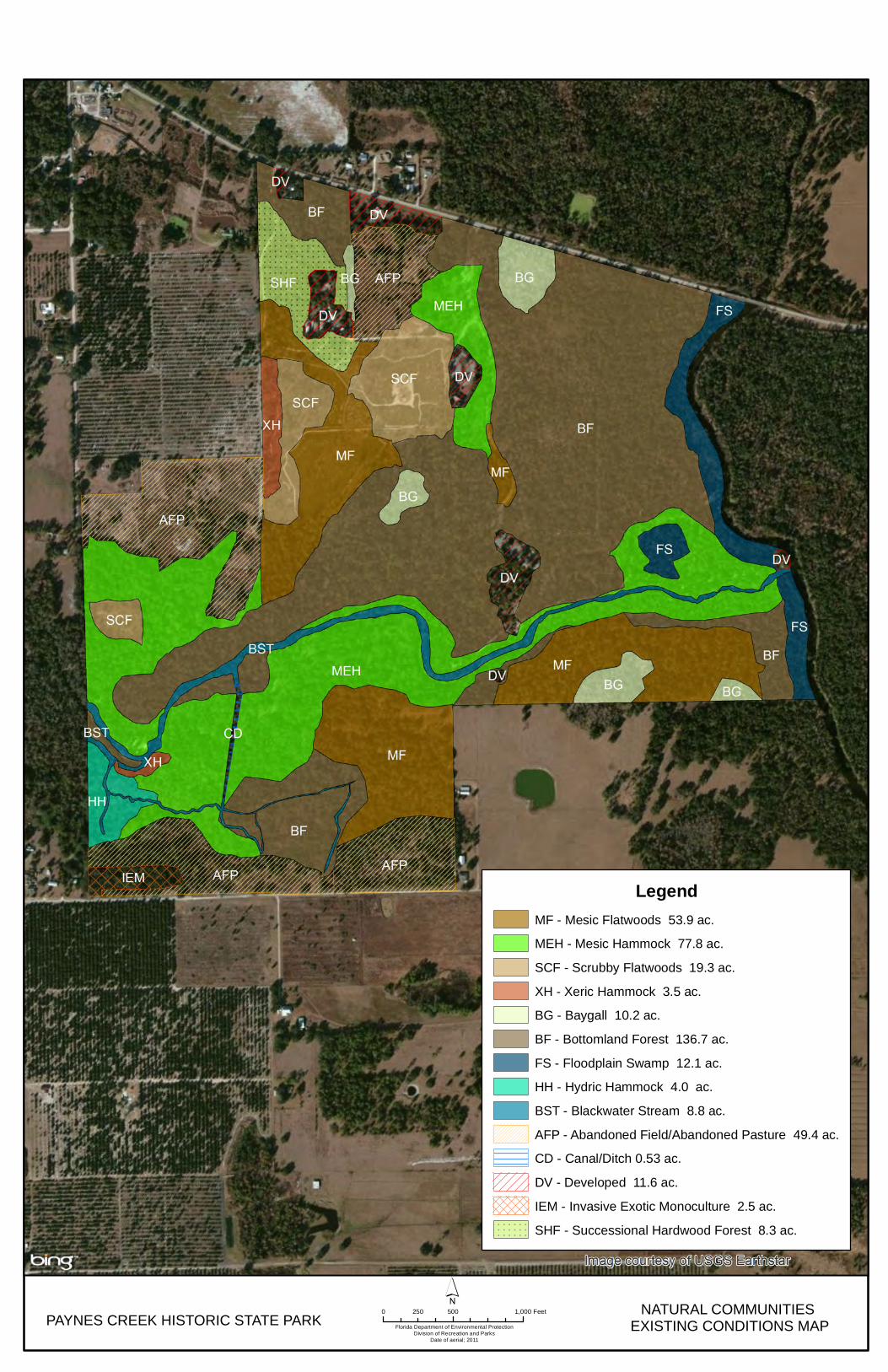
activities, including spills, that occur upstream, and from tributary Little Paynes Creek. Payne Creek also receives runoff during heavy rainfall that includes debris, silt and various organic and inorganic pollutants from groves, gardens and pastures. Areas susceptible to erosion include the stormwater flows funneled along the southwest boundary at Torrey Road and the southeast boundary from the pasture fenceline to Payne Creek; the impacts from off-trail paths for boat and foot traffic; and the natural erosion along Payne Creek and portions of Peace River. Park staff will block any emerging new trails or paths with limbs or branches, as quickly as possible. Stormwater erosion management considerations are discussed in the relevant natural communities’ sections of this plan. Natural Communities This section of the management plan describes and assesses each of the natural communities found in the state park. It also describes the desired future condition (DFC) of each natural community and identifies the actions that will be required to bring the community to its desired future condition. Specific management objectives and actions for natural community management, exotic species management, and imperiled species management are discussed in the Resource Management Program section of this component. The system of classifying natural communities employed in this plan was developed by the Florida Natural Areas Inventory (FNAI). The premise of this system is that physical factors such as climate, geology, soil, hydrology, and fire frequency generally determine the species composition of an area, and that areas that are similar with respect to those factors will tend to have natural communities with similar species compositions. Obvious differences in species composition can occur, however, despite similar physical conditions. In other instances, physical factors are substantially different, yet the species compositions are quite similar. For example, coastal strand and scrub--two communities with similar species compositions--generally have quite different climatic environments, and these necessitate different management programs. Some physical influences, such as fire frequency, may vary from FNAI’s descriptions for certain natural communities in this plan. The park contains ten distinct natural communities as well as four altered landcover types (see Natural Communities Map). A list of known plants and animals occurring in the park is contained in Addendum 5. Mesic Flatwoods Desired future condition: Mesic flatwoods are characterized by an open canopy of tall pines, typically longleaf pine (Pinus palustris) or south Florida slash pine (Pinus elliottii), and a dense, low ground layer of low shrubs, grasses and forbs. Saw palmetto (Serenoa repens) will generally be present but not overly dominant. Other shrub species may include gallberry (Ilex glabra), fetterbush (Lyonia lucida), runner oak (Quercus elliottii), dwarf live oak (Quercus minima), shiny blueberry (Vaccinium myrsinites), and dwarf huckleberry (Gaylussacia dumosa). The
20
herbaceous layer is primarily grasses, including wiregrass (Aristida stricta var. beyrichiana), witchgrasses (Dicanthelium spp.), and broomsedge (Andropogon spp.). This community has minimal topographic relief and the soils contain a hardpan layer within a few feet of the surface that impedes percolation. Due to these factors, water can saturate the sandy surface soils for extended periods during the wet season but lengthy droughts also commonly occur during the dry season. Cover from invasive exotic plant species will be 5% or less. The optimal fire return interval for this community is 1-3 years. Description and assessment: The mesic flatwoods south of Payne Creek are in Fair condition. The native plants and diversity representative of this community are clearly present, but earlier disturbances such as grazing and citrus farming and the lack of fire have left their impacts. Portions of this community, such as in PC-14 and PC-15, had earlier been designated xeric hammock, which established an incorrect fire return interval that can now be adjusted. Fire may be sufficient to address hardwood encroachment, but some manual removal may be needed. There are potential erosion issues at the very west end of PC-14, where seasonal runoff from the adjacent field appears to be wearing through the root systems on the way to Payne Creek. Invasive species include cogongrass (Imperata cylindrica), Caesar’s weed (Urena lobata), and Japanese climbing fern (Lygodium japonicum). Improvements are needed to reduce hardwood and invasives cover and to correct hydrology in spots. General management measures: Restore fire to 1-3 year intervals. Remove exotic invasives. Mesic Hammock Desired future condition: Mesic hammock is a well-developed evergreen hardwood and/or palm forest which can occur, with variation, through much of peninsular Florida. The often dense canopy will typically be dominated by live oak (Quercus virginiana), with cabbage palm (Sabal palmetto), the occasional pine, southern magnolia (Magnolia grandiflora) and pignut hickory (Carya glabra) mixed in. The shrubby understory may be dense or open, tall or short, and will typically be composed of saw palmetto, beautyberry (Callicarpa americana), gallberry and sparkleberry (Vaccinium arboreum). The groundcover may be sparse and patchy but generally contains panicgrasses (Panicum spp.), switchgrass (Panicum
PAYNES CREEK HISTORIC STATE PARK Florida Department of Environmental ProtectionDivision of Recreation and Parks
Date of aerial; 2011
0 500 1,000250 Feet´
NATURAL COMMUNITIES EXISTING CONDITIONS MAP
LegendMF - Mesic Flatwoods 53.9 ac.
MEH - Mesic Hammock 77.8 ac.
SCF - Scrubby Flatwoods 19.3 ac.
XH - Xeric Hammock 3.5 ac.
BG - Baygall 10.2 ac.
BF - Bottomland Forest 136.7 ac.
FS - Floodplain Swamp 12.1 ac.
HH - Hydric Hammock 4.0 ac.
BST - Blackwater Stream 8.8 ac.
AFP - Abandoned Field/Abandoned Pasture 49.4 ac.
CD - Canal/Ditch 0.53 ac.
DV - Developed 11.6 ac.
IEM - Invasive Exotic Monoculture 2.5 ac.
SHF - Successional Hardwood Forest 8.3 ac.

23
virgatum), sedges, and longleaf woodoats (Chasmanthium laxus). Abundant vines and epiphytes will occur on live oaks and cabbage palms and other subcanopy trees. Mesic hammocks will generally contain sandy soils with organic materials and may have a thick layer of leaf litter at the surface. Mesic hammocks will rarely be inundated and will typically be shielded from fire, although the edges will occasionally burn, as fires originating in adjacent upland natural communities would naturally burn across ecotones. Cover from invasive exotic plant species will be 5% or less. Description and assessment: Much of the acreage along the south and central portions of the park that is now designated mesic hammock in this plan was designated xeric hammock in the last plan. The predominant soil type (Bradenton-Felda-Chobee association, frequently flooded) is too moist with organic materials and too poorly-draining to support most xeric species, and as there are far more mesic to hydric oak species and other indicators, this classification has been updated. Most of the park’s mesic hammock is in Fair to Good condition, with the greatest negative impact coming from invasive exotic plants. All the indicator species -- live oak, southern magnolia, cabbage palm, pignut hickory, American beautyberry -- are well represented. Threats from exotic plants include rosary pea (Abrus precatorius), air-potato (Dioscorea bulbifera), Japanese climbing fern, tropical soda apple (Solanum viarum), and Caesar’s weed. Damage from wild pigs (Sus scrofa) is also a significant threat to this community. Generally, mesic hammock is not considered a pyric community, but letting fire into the edges of the community from adjacent burns is good practice. The park has put fire into the mesic hammock near the entrance (PC-07) as a means to reduce the mid-story canopy, to enhance views for visitors. General management measures: Management control of invasive exotic species, plants and animals. Improvement of hydrology. Sandhill (on Desired Future Conditions Map only) Desired future condition: The dominant pines of sandhill in this area will be longleaf pine and south Florida slash pine. Herbaceous cover will be very dense, principally of wiregrass, and low in stature. Most of the plant diversity is contained in the herbaceous layer, including three-awns (Aristida spp.), pineywoods dropseed (Sporobolus junceus), lopsided indiangrass (Sorghastrum secundum), and various bluestems (Andropogon spp., Schizachyrium spp.). In addition to groundcover and pines, there will be scattered individual trees, clumps, or ridges of oak species, such as turkey oaks (Quercus laevis). The optimal fire return interval for this community is 1-3 years. Cover from invasive exotic plant species will be 5% or less. Description and assessment: Currently no areas are designated sandhill, but soil types and remnant vegetation indicate that sandhill was once found in the park. All the longleaf pines were timbered before the park was acquired. Agriculture and associated topographical changes, the exclusion of fire and subsequent hardwood encroachment, and the invasion of exotic plants, have all resulted in the loss of most of this community. As these activities have been felt across the state, sandhill is one of Florida’s most threatened community types.
24
However, sandhill could be restored at the park with reasonable effort. There is already a presence of the native species that are good indicators for this community type, including scattered pockets of turkey oak, wiregrass and other three-awn species, the bluestems, Florida green-eyes (Berlandiera subacaulis), Florida sensitive-brier (Mimosa quadrivalvis var. floridana), the high density of gopher tortoise (Gopherus gomphremus) burrows in PC-9a, and even several patches of pocket gopher (Geomys pinetis) mounds in the same areas. Such restoration would not only assist with the preservation of this habitat type, but would likely help to bring Florida wildlife, such as Sherman fox squirrels (Sciurus niger shermani), back to the park. In particular, the 15 acres on high ground in the southwest portion of zones PC-16 and PC-15, and the 20-plus acres across most of PC-09A and the northern portion of PC-09C should be cleared of hardwoods and invasives, and then replanted to restore sandhill. These zones are currently designated on the Natural Communities Map as Abandoned Field/Pasture, with some Invasive Exotic Monoculture in PC-16. The soil in the southwest portion is mostly Zolfo fine sands, which has “moderately high potential productivity for longleaf pine and especially for slash pine…and moderately high potential for creeping bluestem, indiangrass, chalky bluestem” (USDA 1984). The soils in the northern area to be restored include Candler and Tavares Fine Sands, both of which are known to support sandhill vegetation. Frequent (1-3 years), low-intensity ground fires in the growing season will reduce hardwood competition and perpetuate pines and grasses. Another potential area of sandhill is in PC-05; see the discussion about the sandhill species in the Scrubby Flatwoods, below. General management measures: Continue to implement optimal fire regime; this is the most important management tool for improving sandhill and maintaining it in Good condition. Control invasive exotic species. Improve hydrology. Nearly 34 acres of sandhill community require restoration efforts to reach the desired future condition. Restoration of 20 of these acres is discussed in the Resource Management Program section of this component. Scrubby Flatwoods Desired future condition: In the Hardee County area, the dominant tree species of the interior of scrubby flatwoods will usually be longleaf pine and slash pine. Mature sand pines (Pinus clausa) will typically not be present. There will be a diverse shrubby understory, mostly a scrub-type oak “canopy” that will contain a variety of oak age classes and heights across the landscape. Dominant shrubs will include sand live oak (Quercus geminata), myrtle oak (Quercus myrtifolia), Chapman’s oak (Quercus chapmanii), saw palmetto, rusty staggerbush (Lyonia ferruginea), and tarflower (Bejaria racemosa). Cover by herbaceous species will vary from moderately dense with wiregrasses and a variety of herbaceous plants, to patches of bare white sand. Bare patches of sand are essential to support various imperiled or endemic plant and animal species; such plants will be regularly flowering and replenishing their seed banks. Cover from invasive exotic plant species will be 5% or less. The optimal fire return interval for this community will be regionally variable; typically, 5-15 years when aiming to achieve a mosaic of burned and unburned areas.
25
Description and assessment: Generally, the majority of the scrubby flatwoods is in Fair condition. The dense growths of sand live oak and myrtle oak are problems for this community. These oaks are native to Florida’s xeric systems but become a problem when natural fire regimes or other natural successional stages are interrupted. Years of mowing or roller chopping have served to remove the taller canopy from the scrub but have also produced dense clonal populations of these oaks. A few small patches are in good condition, even approaching scrub community characteristics, such as where there has been a successful introduction of the federally-endangered Florida goldenaster (Chrysopsis floridana), with that population now flourishing. This community also hosts populations of the scabrous or scrub tiger beetle (Cicindela scabrosa), recently discovered as a new location record for this secretive species (Mosley 2009); most often found in sand pine scrub, this tiger beetle also inhabits roads or openings cut through scrubby flatwoods. The unicolored tiger beetle (Cicindela scutellaris unicolor), another inhabitant of this community, has more visible, brilliant coloring. There are several Florida scrub/scrubby flatwoods endemic plants in these areas, including Florida scrub roseling (Callisia ornata) and false vanillaleaf (Carphephorus odoratissimus var. subtropicanus). Threats to this community include cogongrass, natal grass (Melinis repens), and Japanese climbing fern. Within the scrubby flatwoods in PC-05 are areas that have all the characteristics of sandhill community, with turkey oak, the relevant grasses, and Florida green-eyes growing together. For this reason, a shorter fire return interval is suggested for this management zone, possibly every 3 years while this plan is in effect, as a means to encourage any possibility of sandhill. As, or if, the sandhill emerges then planting longleaf pine in this area should be considered and the FRI adjusted accordingly. General management measures: Maintain the optimal fire return interval in all zones with scrubby flatwoods, shorten the fire return interval in PC-05 to benefit small areas of potential sandhill. Continue control of invasive exotic species. Continue to develop and implement rare species monitoring protocols. Xeric Hammock Desired future condition: Xeric hammock is essentially the late-succession stage of scrub or sandhill communities that results from years of fire exclusion or from lengthened fire return intervals combined with low intensity winter burning. Vegetation will consist of a low closed canopy dominated by sand live oak, which provides shady conditions. Typical plant species may also include Chapman’s oak, turkey oak, and laurel oak (Quercus laurifolia). Where more mesic conditions integrate within the community, there may be some live oak in the canopy. Sand pine, slash pine, or longleaf pine may also be a minor component. Understory species are likely to include saw palmetto, myrtle oak, staggerbush and fetterbush. Groundcover is typically sparse, but will usually have some wiregrass and a few other herbaceous species. A continuous leaf litter layer may be present. Cover from invasive exotic plant species will be 5% or less. The desired future condition for the xeric hammock community at this park is generally to return it to scrubby flatwoods, though the park may choose to leave some pockets at the current successional level.
26
Description and assessment: Most of management zones PC-15, PC-16 and the southern portion of PC-13 were designated xeric hammock on past natural community maps; however, the lack of the indicator species (sand live oak) and other factors throughout the predominance of those zones means that most of those acreages are more appropriately designated mesic hammock. The areas that do qualify as xeric hammock at the park are probably overgrown scrub or scrubby flatwoods. The xeric hammock in PC-01C serves as a boundary buffer for the park. Many pockets of xeric hammock are also scattered within the mesic hammock and along the creek’s levees, but are too small to map. Where the hammock is not yet choked by exotics or by sand live oak or myrtle oak clones, it is in Good condition. The endemic scrub wild olive (Cartrema floridana) is found on a xeric, high sandy ridge above Payne Creek, likely a persistent levee. The invasive exotic plants found in the xeric hammock at the park tend to be rosary pea, caesar weed, and air potato (Dioscorea bulbifera). General management measures: Continue management of invasive exotic species. Where not too enclosed by mesic hammock or where otherwise feasible to burn, prescribed summer burns should be considered at the 15-year cycle of the fire return interval for scrub or scrubby flatwoods. Baygall Desired future condition: Baygall consists of a wet, densely-forested, peat-filled depression typically near the base of a slope. Seepage from adjacent uplands will maintain saturated conditions. Medium to tall trees will mainly consist of sweetbay (Magnolia virginiana), loblolly bay (Gordonia lasianthus), and/or swamp bay (Persea palustris). Occasionally, a few pines may also exist. A thick understory consisting of gallberry, fetterbush, and red maple (Acer rubrum) will be typical, with climbing vines such as greenbriar (Smilax spp.) and various grape species (Vitis spp.), generally abundant. The dominant baygall species are fire intolerant, indicating an infrequent optimal fire return interval of 25-100 years. Frequent fires from adjacent communities should be allowed to enter baygall ecotone, however, while being aware of the problems associated with peat fires. Cover from invasive exotic plant species will be 5% or less. Description and assessment: Other than in the baygall in PC-14, bay species are less common than expected, and widely scattered. The condition of the baygall in PC-14 is generally Fair to Good, with threats primarily being from exotic invasives, plant and animal. General management measures: Manage/control invasive exotic species. Monitor and improve hydrology as needed. Include ecotone into the baygall in prescription fires in adjacent communities. Bottomland Forest Desired future condition: Bottomland forest is a fairly low lying, mesic to hydric community prone to periodic flooding. Vegetation will consist of a mature closed
27
canopy of deciduous and evergreen trees. Dominant overstory species may consist of sweetgum (Liquidambar styraciflua), sweetbay, loblolly bay, water oak (Quercus nigra), and live oak. Red maple and bald cypress may also be present. Understory may be open or dense. Understory species will include American hornbeam (Carpinus caroliniana), swamp dogwood (Cornus foemina), possumhaw (Ilex decidua), and wax myrtle (Myrica cerifera). Presence of groundcover will be variable and may consist of witchgrasses and various sedges. Cover from invasive exotic plant species will be 5% or less. Description and assessment: Overall, the condition of the bottomland forest is Good. There is a diversity of the community’s indicator plant species, as well as a few wetland Florida endemics such as Florida bellflower (Campanula floridana). Mignonette orchid (Habenaria floribunda) is fairly common. There are some old road-beds going through the bottomland forest, especially in PC-07B, but as there are also the characteristic naturally-occurring uneven grounds and levees created by varying degrees of seasonal flooding, the disturbed areas may not need improvement or restoration. The bottomland forest in this zone also has scattered pockets of vegetation more closely aligned with alluvial forest, mesic hammock, baygall and floodplain swamp – a mosaic typical of bottomland forest. Iris (Iris hexagona), lizard’s-tail (Saururus cernuus) and spatterdock (Nuphar advena) can be found in the lower spots. There are areas of dense, shrubby understory, particularly in the drier spots where native plants such as sparkleberry (Vaccinium arboretum) are common; however, most of the community is open under the canopy. The largest threats to this community include potential monocultural infestations of Peruvian primrosewillow; the presence of taro (Colocasia esculenta), Japanese climbing fern, Asian and tuberous swordferns (Nephrolepis brownii and N. cordifolia), and caesar weed; and the damages caused by wild hogs. This community is an important resource, as large mammals such as Florida black bears (Ursus americanus floridanus) often rely on corridors of these types of wetlands. General management measures: Manage/control invasive exotic species. Include ecotone in prescription fires in adjacent communities. Floodplain Swamp Desired future condition: Floodplain swamp will be a frequently or permanently flooded community in low lying areas (floodplain) along streams and rivers. While they often immediately border stream or river channels, floodplain swamps also may be isolated from the main channel by riverbank levees and be found around oxbows, overflow channels, or old stream bed. Soils will consist of a mixture of sand, organics, and alluvial materials. The closed canopy will typically be dominated by bald cypress (Taxodium distichum) and include tupelo species (Nyssa spp.), and the “knees” arising from the root systems of both tress are also common features. Other trees include water hickory (Carya aquatica) and red maple. Trees bases are typically buttressed. Understory and groundcover will typically be sparse, but may include lizard’s tail or savannah panicum (Phanopyrum gymnocarpon). Cover from invasive exotic plant species will be 5% or less.
28
Description and assessment: The floodplain swamp community essentially borders the Peace River. This community is generally in Good condition, with threats primarily coming from exotic invasive species. The indicator species for floodplain swamp are fully present, with cypress found scattered along the river and clustered in oxbows. There are swamp tupelo (Nyssa sylvatica var. biflora), water hickory and red maple in the canopy; Carolina ash (Fraxinus caroliniana), buttonbush (Cephalanthus occidentalis), and needle palm (Rhapidophyllum hystrix) in the subcanopy, and savannah panicum, royal fern (Osmunda regalis), and swamp milkweed (Asclepias perennis) in the groundcover. Invasives particular to this community include wax begonia (Begonia cucullata), sessile joyweed (Alternanthera sessilis), Peruvian primrosewillow, and Japanese climbing fern at the edges; cogongrass patches have started threatening this community. This community at the park includes several interesting oxbows. Created by the meander and levee processes of the Peace River and Payne Creek, these areas are important breeding grounds for fish when high water connects them to the river. The oxbow in PC-12 is nearly permanently flooded and the canopy there is mostly open, although it does have a large cypress growing in its center. General management measures: Management control of invasive exotic species. Protection of natural hydroperiods and water quality in the river and creeks. Hydric Hammock Desired future condition: Hydric hammock is characterized with a closed canopy, evergreen hardwood and/or palm forest with a variable understory dominated by palms, with sparse to moderate ground cover of grasses and ferns. Typical canopy species will include laurel oak, cabbage palm, live oak, sweetbay, swamp tupelo, American elm (Ulmus americana), red maple and other hydrophytic tree species. Soils will be poorly drained but only occasionally flooded. Hydric hammock will occasionally burn as fires originating in adjacent upland natural communities would naturally burn across ecotones. Cover from invasive exotic plant species will be 5% or less. Description and assessment: While there are hydric hammock species scattered throughout the bottomlands of the park, there is only one area with a collection of indicator characteristics large enough to map (in PC-16) – and even this area shares some characteristics of alluvial forest. This community is essentially in Good condition, though it is threatened with invasive exotics. There are several prime examples of buttressing water hickory and red maple. Sweetbay, American elm, sweetgum are common; American hornbeam and cabbage palm are present, though not common. A diversity of ferns are found in the groundcover. The threats to this community include erosion from a neighboring yard, and invasive plants such as bamboo and taro. General management measures: Control invasive exotic species. Improve hydrology entering system.
29
Blackwater Stream Desired future condition: Blackwater streams are characterized as perennial or intermittent watercourses originating in lowlands where extensive wetlands with organic soils collect rainfall and runoff, discharging it slowly to the stream. The stained waters will be laden with tannins, particulates, and dissolved organic matter derived from drainage through adjacent swamps, resulting in sandy bottoms overlain by organic matter. Emergent and floating vegetation, such as golden club (Orontium aquaticum) and smartweeds (Polygonum spp.), may occur but is often limited by steep banks and dramatic seasonal fluctuations in water levels. Desired conditions include maintaining good water quality and clarity, minimizing disturbance and alterations, and preserving adjacent natural communities. Cover from invasive exotic plant species will be 5% or less. Description and assessment: Payne Creek is a blackwater stream community. The smaller runnels and streams in this community type may have been designated seepage stream in the past; however, even though many begin as seeps, at the park these lack the slope changes and slope forest characteristics of FNAI’s current seepage stream designation. The larger streams do have sufficient relevant characteristics, such as tinted coloring and the occasional presence of emergent and floating vegetation, including golden club, to put them into the blackwater stream category. Roughly nine acres are mapped as blackwater stream, but not all minor streams or runnels are included in the mapping. Generally, the blackwater streams are in Fair to Good condition at PCHSP. The streams usually run clear, although days of cloudy waters in Payne Creek have been observed by the Park Manager. The quality of the blackwater systems is important to the health of the palustrine communities occupying the adjacent floodplain; threats to this quality come from stormwater runoff funneled into Payne Creek and its tributaries, and from the effluent from phosphate mining activities upstream. Stretches of the blackwater streams have dense exotic plant infestations, such as wild taro, that need to be removed. General management measures: Management control of invasive exotic species. Monitor and protect hydrology and water quality. Abandoned Field/Pasture Desired future condition: The abandoned field/pasture community is found in several areas of the park. The majority of the acres are designated to be restored to sandhill. The area in PC-08B is to be designated developed. Please see the desired future condition statements for those communities. Description and assessment: These areas include a composite of abandoned pasture and citrus groves, long ago cleared of large patches of their native vegetation and their natural topography disrupted. In addition to the introduced grasses, such as bahiagrass (Paspalum notatum), weedy native species are present, including dogfennel (Eupatorium capillifolium), flatsedges (Cyperus spp.), carpetgrasses (Axonopus spp.), crabgrasses (Digitaria spp.), rustweed (Polypremum procumbens), blackberries (Rubus spp.), and wax myrtle. Included in the areas with abandoned field/pasture designation, there is a mosaic of
30
successional hardwood forest, invasive exotic monocultures, and remnants of mesic flatwoods, mesic hammock and sandhill. Condition is Poor, requiring reduction of exotics cover and re-introduction of fire in many areas. Natal grass is a particularly insidious invader. Almost all of the 50-plus acres of abandoned field/pasture have been assigned developed or natural community DFC, with improvement or restoration goals. Sections of abandoned field/pasture community were addressed in the 2013 Land Management Review and are included in the sandhill restoration discussed earlier in this plan. General management measures: See Desired Future Conditions Map, and apply management measures for each of the relevant desired communities. See also restoration discussion under sandhill. Developed Desired future condition: The developed areas within the park will be managed to minimize the effect of the developed areas on adjacent natural areas. Mowing schedules and heights clearly encourage seeding and growth of native plant ground covers. Landscaping activities do not introduce species, native or exotic, that are not already naturally distributed at the park. Priority invasive plant species (FLEPPC Category I and II species) will be removed from all developed areas, as will the local region’s Early Detection invasive plant species; cover from invasive exotic plant species will be 5% or less. Seasonal water levels and stormwater flows do not create significant erosion issues. Description and assessment: The developed areas at the park include the areas around the Visitor’s Center, picnic grounds, monuments, residences, shop complex, canoe launch, and parking areas whether paved or grass fields. On the DFC map, developed areas total a little over 20 acres. These are generally in Fair to Good condition. Exotic invasives need to be controlled. Hydrological impact from roads or parking lots will need to be monitored and addressed. General management measures: Continue management of invasive exotic species. Mowing follows practices that encourage native plant diversity and growth. Landscaping activities do not introduce species, native or exotic, that are not already naturally distributed at the park. Stormwater and development activities are compatible with erosion management and with prescribed fire management in adjacent natural areas. Invasive Exotic Monoculture Desired future condition: The long-term desired future condition for the monoculture is to restore the altered landcover type to mostly sandhill, with a little mosaic of mesic and hydric hammocks. Please see the desired future condition statement for those natural communities, above. Description and assessment: Disturbances in several border areas of the park have left stands of invasive exotic plant species that have eliminated the native
31
vegetation, or nearly so, producing a condition assessment of Poor for the zone. In south PC-16, especially, the exotic plants are at cover class of 70% or more over an area of nearly three acres. Both exotic yams are present in this area, as are representatives of most exotics listed for the park. In addition, arrow bamboo (Pseudosasa japonica) has expanded from adjacent property plantings, and old plantings of citrus trees (Citrus x aurantium) have produced nearly closed canopy of doghair stands. Note that FNAI does not reference any FLEPPC categories for an area to be considered an Invasive Exotic Monoculture; the bamboo and the citrus must be removed, regardless of FLEPPC status or lack thereof. Also, the same area has some hydrology concerns, where runoff from the neighboring citrus farm and roads has been funneled into the park at the southwest corner; there is a small, naturalized tributary to Payne Creek at the base of this slope, and it should be possible to manage the influx of water to reach this tributary without significant erosion. A concerted effort of exotics removal, erosion control, and the cultivation/introduction of native plant species is needed to correct this altered community. This section is part of the areas noted in the 2013 Land Management Review as needing more resource management and is also part of the sandhill restoration described earlier in this plan. General management measures: Removal and control of exotic invasive species. Reduction of hardwood species in the area to become sandhill, as well as re-introduction of fire in this same area. (See restoration notes in the sandhill General Management Measures section). Establish better erosion controls for water flowing from neighboring yards to the Payne Creek “tributary” in this area. Successional Hardwood Forest Desired future condition: This altered community should be managed to become primarily mesic hammock, serving as an ecotone between the bottomland forest community to the north and the mesic flatwoods to the south. See the Desired Future Condition discussion for mesic hammock. Description and assessment: Successional hardwood forest is closed-canopied forest dominated by fast growing hardwoods such as laurel oak, water oak, or sweetgum, often with remnant pines. The subcanopy and shrub layers of these forests are dominated by smaller individuals of the canopy species. At Paynes Creek Historic State Park, these forests are old fields that have succeeded to forest, with some remnant species of the former natural community. Restoration of these forests usually requires mechanical tree removal, reintroduction of fire, and may require supplemental plantings. When the predominance of species are native, it may serve the park better to maintain a forest or hammock community even if this is not what was there before the initial disturbance. The successional hardwood forest in the north part of the park (PC-08b) was previously designated scrubby flatwoods, but with the current level of leaf litter and fire resistant vegetation there is no useful value in attempting to manage this section as flatwoods. This area would be more feasibly managed as mesic hammock, serving as an ecotone between the bottomland forest and the mesic flatwoods while at the same time allowing the retention of native species to
32
continue to serve as a vegetative buffer for the park’s shop area. The successional hardwood forest is currently in Poor to Fair condition, as the cover of exotic invasive plants is high. General management measures: Removal and control of exotic invasive species. Reduction of hardwood species not relevant to mesic hammock or to adjacent bottomland forest or mesic flatwoods. See General Management Measures for mesic hammock. Imperiled Species Imperiled species are those that are (1) tracked by FNAI as critically imperiled (G1, S1) or imperiled (G2, S2); or (2) listed by the U.S. Fish and Wildlife Service (USFWS), Florida Fish and Wildlife Conservation Commission (FWC) or the Florida Department of Agriculture and Consumer Services (FDACS) as endangered, threatened or of special concern. Data on the presence and locations of these species at the park are to be sent in to FNAI on an annual basis. Plants The Florida goldenaster is a federally endangered plant. The population at the park began as one of a series of experimental introductions of this species into the wild; this was at a time when this goldenaster was critically endangered and population expansion was essential for its survival. Bok Tower Gardens’ Rare Plant Conservation Program provided seedlings grown from seeds and cuttings collected from different existing populations. Placement of the seedlings was based on soil type and good quality scrub/scrubby flatwoods community characteristics, jointly determined by DRP biologists and Bok Tower Gardens conservation program scientists (emails Gandy 2010). The planted area is part of an intense (Tier 3/Tier 4) monitoring program run by Bok Tower Gardens staff. This population has been clearly successful, with expanding numbers of runners and new seedlings each year. If this success continues, and assuming the scrub is kept in maintenance condition, after the Bok Tower Gardens follow-up is complete, the park monitoring of this species could be set to Tier 2. Two state-threatened plant species, Giant orchid (Pteroglossaspis ecristata) and Simpson’s or red-margin zephyrlily (Zephyranthes simpsonii), are found at the park. Giant orchid can be found in sandhill, scrub and pine flatwoods, and tends to like open areas. Simpson’s zephyrlily may be found in the wetter spots of mesic flatwoods. Both respond well to fire. Tier 1 monitoring will serve these species, especially if park staff is alert to the presence and locations of these plants in order to protect them from visitors. Animals Eastern indigo snake (Drymarchon couperi) is a federally-threatened species. No formal surveys for this snake have been conducted in the park. Between 1991 and 1997, nearly forty different sightings were reported; none recorded since 1997 (VB 2013). The eastern indigos are habitat generalists. Protection of gopher tortoises and their burrows is important for indigos. The biggest threat to this wide-ranging
33
species is on the roadways in and around the park, since road mortality is a leading cause of decline. Park visitors should also be educated, so they do not deliberately kill indigo and other snakes species protected at the park. Alone, the park is too small in size to sustain a viable long-term population of indigo snakes (USFWS suggests a minimum of 2,500 acres), so connectivity to natural habitats and other protected conservation lands is important for the species to persist here. Tier 1 monitoring should at least result in annually updated reports of presence. Gopher tortoise is a state-threatened species. This tortoise generally requires the deep sandy soils and vegetation of sandhill, flatwoods and scrub communities. At Paynes Creek Historic State Park, a post-burn survey conducted by a district biologist in September 1994 revealed 34 burrows in the 19-acre mesic flatwoods area then designated Zone 1 (now essentially PC-01A and PC-01B); five burrows were active, 16 inactive, and 13 old or abandoned burrows. This is roughly one third the population that could be expected in this area, but the presence of smaller burrow size classes were considered indication of reproduction and recruitment occurring. The next tortoise survey was conducted post-burn in 1997 on Zone 5 (now the east half of PC-05 and PC-07A), which is seven acres of primarily scrub, overgrown scrub and some mesic flatwoods. Twelve active, nine inactive, and 22 abandoned burrows were found. The most recent survey report is from 2000, in then Zones 3,4,6,7, and 8, but only in areas that had been burned. These Zones are primarily mesic flatwoods and hammock communities grading into bottomland forest, or areas altered by development, many in areas of heavy visitor use; only one burrow was found, and it was long abandoned. Although no formal survey has been conducted in PC-09A and PC_09C, many burrows are evident. Overall, the surveys do not yet represent the full extent of potential gopher tortoise habitat at PCHSP. The sandhill restoration will help with this population, as will hardwood reduction from continued prescribed burning. It is especially important to protect gopher tortoises from cogongrass infestations, as this plant can completely disorient and thus debilitate a tortoise (Muchinsky 2013). Beyond the need to protect their imperiled status, healthy gopher tortoise populations are important because they are the keystone species for the survival of over 30 other Florida species, many of which are imperiled, and thus help support healthy ecosystems. At the time of writing this plan, monitoring protocols for this tortoise were being updated by FWC; PCHSP will adopt the new FWC protocols when they are complete. The wood stork (Mycteria americana) is federally- and state-endangered, and is the only species of stork that breeds in the U.S. Wood storks forage mainly in shallow freshwater areas where falling water levels concentrate food sources, particularly fish. They nest in colonies in a variety of inundated forested wetlands, where annual and long-term use of nesting sites is dependent on feeding conditions, which are in turn affected dramatically by hydrologic patterns. Successful breeding depends on normal hydroperiods, for bringing in food but also for protection against predation; raccoons, for instance can get to nests if water levels are too low. No wood stork sightings have officially been reported for PCHSP since 2006; Tier 1 monitoring should at least result in annually updated reports of presence.
34
Florida sandhill cranes (Grus canadensis pratensis) are a state-threatened species. These cranes are a non-migratory, monogamous species that inhabit freshwater marshes, prairies, and pastures, and nest in freshwater ponds and marshes. The diet of the Florida sandhill crane primarily consists of grain, berries, seeds, insects, worms, mice, small birds, snakes, lizards, and frogs. Both male and female participate in incubating the eggs (Nesbitt 1996). The offspring begin traveling from the nest with their parents just 24-hours after hatching, and at ten months old, juveniles are able to leave their parents (Nesbitt 1996); bonding between pairs begins at two years old. Degradation or direct loss of habitat are the primary threats facing Florida sandhill cranes. Tier 1 monitoring should at least result in updated reports of presence. With the proximity to freshwater, the restoration of sandhill should provide an increase in the Florida sandhill cranes seen at the park. Several bird species at the park are not on the imperiled species lists, but are protected by the U.S. Migratory Bird Treaty Act and the Florida State Wildlife code, Florida’s Endangered and Threatened Species Rule; under this protection, any take of birds, nests or eggs is prohibited. Included are the bald eagle, the osprey (Pandion haliaetus), last reported for the park in 1993, and the swallow-tailed kite (Elanoides forficatus), last reported in 1996. FNAI ranks these birds S2. Tier 1 monitoring should at least result in updated annual reports of presence of these birds, with tracking data submitted to FNAI. DRP still observes FWC protections for active eagle nests, but at the time this plan was written there were no known actively breeding bald eagles in the park. Sherman’s fox squirrel (Scurius niger shermanii) is listed as Species of Concern by FWC. The population number at the park is unknown, with the last reported sighting in 2006. With the planned sandhill restoration and continued resource management activities, such as prescribed burning and tree thinning, Sherman’s fox squirrel appearances could increase. Where necessary, park staff will consult with FWC staff on appropriate resource management actions. Tier 1 monitoring should at least result in updated annual reports of presence. Florida black bear (Ursus americanus floridanus) was taken off the imperiled species list in 2012, but still has protections as defined under Florida Black Bear Conservation Rule 68A-4.009. Under this rule, it is still unlawful to “take” a bear, which means is it unlawful to pursue, hunt, molest, capture, or kill, or to attempt any of those actions, and generally prohibits anyone from possessing, injuring, shooting, wounding, trapping, collecting, or selling bears without prior authorization from FWC (FWC may issue permits to allow the intentional take of bears for collection of scientific data needed for conservation or management of the species, or for removing bears from situations that constitute a human safety risk or a risk to the well-being of the bear). Only two bear sightings are recorded for the park, but other bear indications, such as tree scratches and paw prints, have been noted for the park. The park falls in the secondary bear range of FWC’s South Central Bear Management Unit (BMU), where conservation lands are rarely continuous; populations in this BMU are vulnerable to habitat conversion and to genetic isolation. Tier 1 monitoring should at least result in updated annual reports of presence.
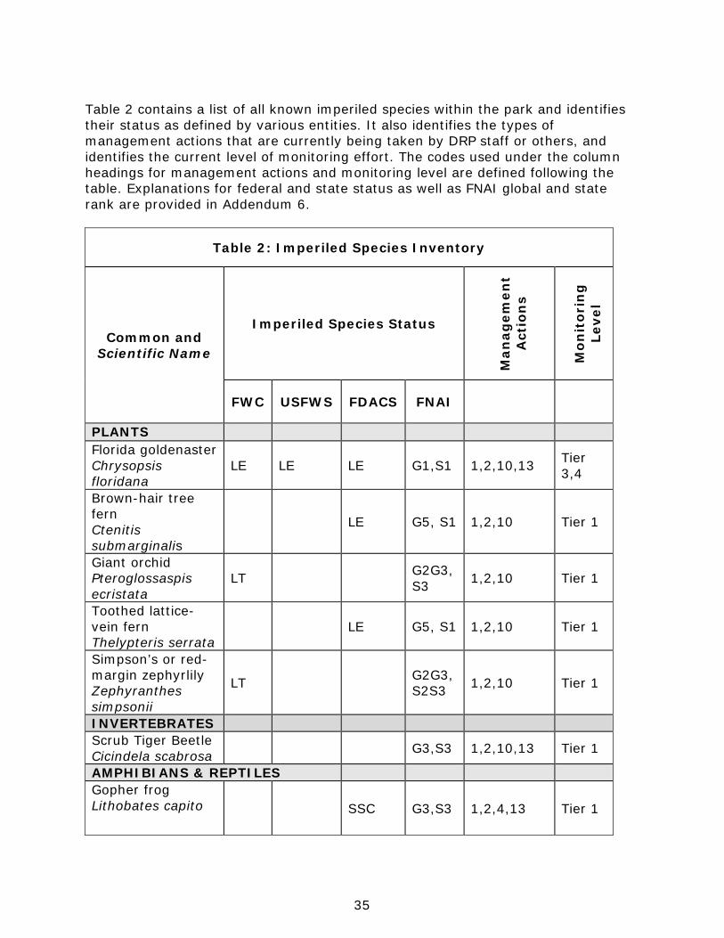
35
Table 2 contains a list of all known imperiled species within the park and identifies their status as defined by various entities. It also identifies the types of management actions that are currently being taken by DRP staff or others, and identifies the current level of monitoring effort. The codes used under the column headings for management actions and monitoring level are defined following the table. Explanations for federal and state status as well as FNAI global and state rank are provided in Addendum 6.
Table 2: Imperiled Species Inventory
Common and Scientific Name
Imperiled Species Status
Man
agem
ent
Act
ion
s
Mon
itor
ing
Le
vel
FWC USFWS FDACS FNAI
PLANTS Florida goldenaster Chrysopsis floridana
LE LE LE G1,S1 1,2,10,13 Tier 3,4
Brown-hair tree fern Ctenitis submarginalis
LE G5, S1 1,2,10 Tier 1
Giant orchid Pteroglossaspis ecristata
LT G2G3,S3 1,2,10 Tier 1
Toothed lattice-vein fern Thelypteris serrata
LE G5, S1 1,2,10 Tier 1
Simpson’s or red-margin zephyrlily Zephyranthes simpsonii
LT G2G3,S2S3 1,2,10 Tier 1
INVERTEBRATES Scrub Tiger Beetle Cicindela scabrosa G3,S3 1,2,10,13 Tier 1
AMPHIBIANS & REPTILES Gopher frog Lithobates capito SSC G3,S3 1,2,4,13 Tier 1
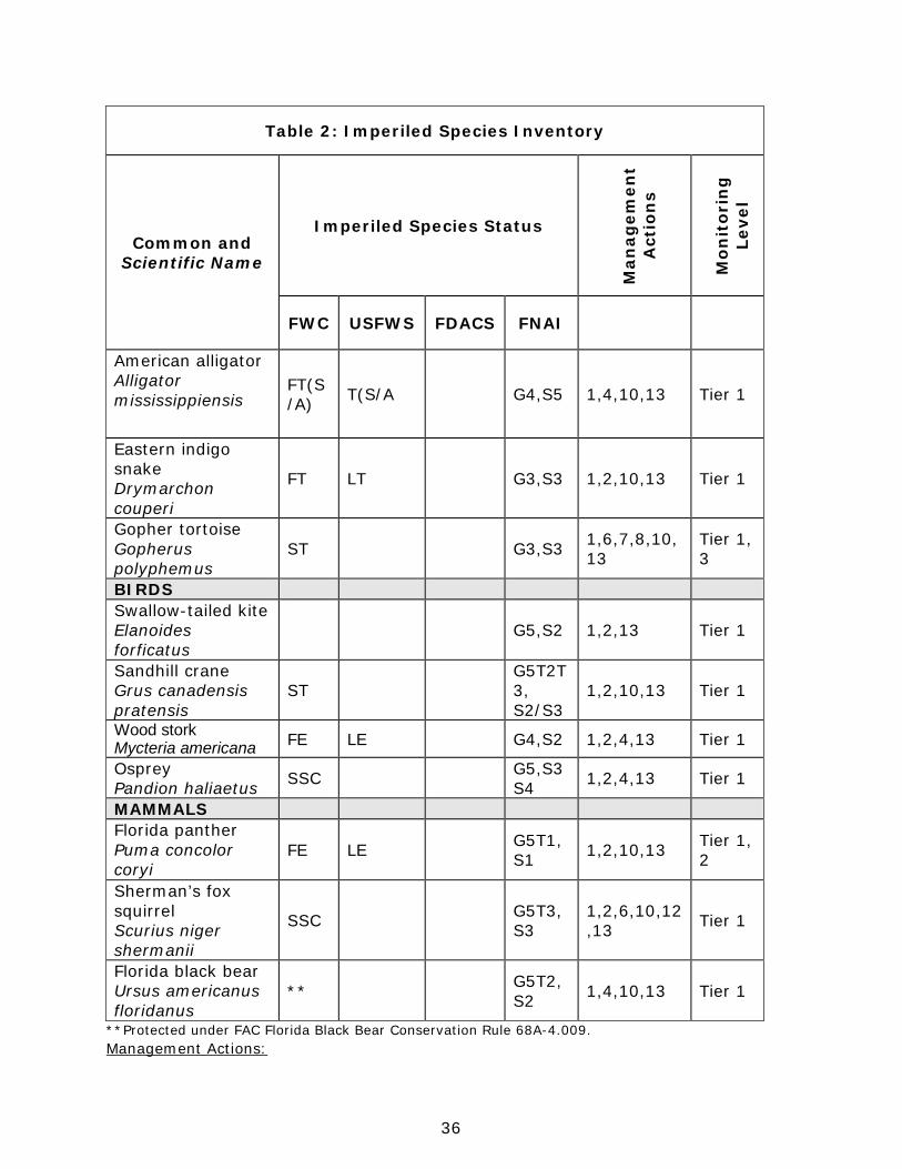
36
Table 2: Imperiled Species Inventory
Common and Scientific Name
Imperiled Species Status
Man
agem
ent
Act
ion
s
Mon
itor
ing
Le
vel
FWC USFWS FDACS FNAI
American alligator Alligator mississippiensis
FT(S/A) T(S/A G4,S5 1,4,10,13 Tier 1
Eastern indigo snake Drymarchon couperi
FT LT G3,S3 1,2,10,13 Tier 1
Gopher tortoise Gopherus polyphemus
ST G3,S3 1,6,7,8,10,13
Tier 1, 3
BIRDS Swallow-tailed kite Elanoides forficatus
G5,S2 1,2,13 Tier 1
Sandhill crane Grus canadensis pratensis
ST G5T2T3, S2/S3
1,2,10,13 Tier 1
Wood stork Mycteria americana FE LE G4,S2 1,2,4,13 Tier 1
Osprey Pandion haliaetus SSC G5,S3
S4 1,2,4,13 Tier 1
MAMMALS Florida panther Puma concolor coryi
FE LE G5T1,S1 1,2,10,13 Tier 1,
2
Sherman’s fox squirrel Scurius niger shermanii
SSC G5T3,S3
1,2,6,10,12,13 Tier 1
Florida black bear Ursus americanus floridanus
** G5T2,S2 1,4,10,13 Tier 1
**Protected under FAC Florida Black Bear Conservation Rule 68A-4.009. Management Actions:
37
1. Prescribed Fire 2. Exotic Plant Removal 3. Population Translocation/Augmentation/Restocking 4. Hydrological Maintenance/Restoration 5. Nest Boxes/Artificial Cavities 6. Hardwood Removal 7. Mechanical Treatment 8. Predator Control 9. Erosion Control 10. Protection from visitor impacts (establish buffers)/law enforcement 11. Decoys (shorebirds) 12. Vegetation planting 13. Outreach and Education 14. Other Monitoring Level: Tier 1. Non-Targeted Observation/Documentation: includes documentation of species presence through
casual/passive observation during routine park activities (i.e. not conducting species-specific searches). Documentation may be in the form of Wildlife Observation Forms, or other district specific methods used to communicate observations.
Tier 2. Targeted Presence/Absence: includes monitoring methods/activities that are specifically intended to document presence/absence of a particular species or suite of species.
Tier 3. Population Estimate/Index: an approximation of the true population size or population index based on a widely accepted method of sampling.
Tier 4. Population Census: A complete count of an entire population with demographic analysis, including mortality, reproduction, emigration, and immigration.
Tier 5. Other: may include habitat assessments for a particular species or suite of species or any other specific methods used as indicators to gather information about a particular species.
Detailed management goals, objectives and actions for imperiled species in this park are discussed in the Resource Management Program section of this component and the Implementation Component of this plan. Exotic and Nuisance Species Exotic species are plants or animals not native to Florida. Invasive exotic species are able to out-compete, displace or destroy native species and their habitats, often because they have been released from the natural controls of their native range, such as diseases, and predatory insects. If left unchecked, invasive exotic plants and animals alter the character, productivity and conservation values of the natural areas they invade. Exotic animal species include non-native wildlife species, free-ranging domesticated pets or livestock, and feral animals. Because of the negative impacts to natural systems attributed to exotic animals, the DRP actively removes exotic animals from state parks, with priority being given to those species causing the greatest ecological damage. In some cases, native wildlife may also pose management problems or nuisances within state parks. A nuisance animal is an individual native animal whose presence or activities create special management problems. Examples of animal species from which nuisance cases may arise include venomous snakes or raccoons and alligators that are in public areas. Nuisance animals are dealt with on a case-by-
38
case basis in accordance with the DRP’s Nuisance and Exotic Animal Removal Standard. Detailed management goals, objectives and actions for management of invasive exotic plants and exotic and nuisance animals are discussed in the Resource Management Program section of this component. Invasive exotic species present a moving target. PCHSP has over 66 known exotic plants and animals. FLEPPC re-evaluates the threats from plants every two years, but by the time an exotic shows up on the FLEPPC list, it may already be established as a serious control problem for the park. Good management practices for invasive exotics dictate that managers be aware of what is not native to their park. Staying current with FLEPPC findings is certainly essential, as is effective response to such species when they appear, however managers must also be pro-active, attending to exotics alerts put out by the Institute of Food and Agricultural Science (IFAS) or FWC, and learning the Early Detection priority list put out by their local Cooperative Invasive Species Management Area (CISMA). Using the exotic plants survey data at the time of writing this plan, the overall cover of FLEPPC I and II invasive plants at the park is around 18%. This is probably somewhat understated, since some species, particularly aquatic species such as hydrilla (Hydrilla verticillata) and West Indian marshgrass (Hymenachne amplexicaulis) are present but not currently included in the database surveys. The heaviest concentrations of infestations are in altered community areas, and in and along Payne Creek and the Peace River. Overall, the park’s treatment history reflects increased attention to the problem. The treatment records start at around nine gross acres per year in 2005, to over 149 gross acres worked in 2012. If this increase in gross acres treated were only a reflection of increases in infestation, then the invasives cover percentage would be much higher than it is. Park staff is to be commended for its efforts. Treatment challenges include a shortage of personnel, and long wet periods where areas cannot be successfully treated or even accessed. Control work has been handled primarily by staff, with some volunteer support and with some assistance from the State’s Invasive Plant Management (IPM) programs. The park maintains its chemical supplies through the IPM Herbicide Bank and obtained contracted treatment assistance from IPM in 2008, 2010 and 2011, for work totaling approximately 106 gross acres. Wild pigs are a problem at the park. Damage from rooting can affect native plant species diversity and local hydrology. Pig traffic is a major vector for exotic invasive species. Control has been limited to efforts that the few available staff can manage for occasional trapping. Attempts to attract trapper contracts to assist with this problem have not had positive results, mostly due to the few available trappers not finding the DRP contract terms conducive to the work involved. Table 3 contains a list of the Florida Exotic Pest Plant Council (FLEPPC) Category I and II invasive, exotic plant species found within the park (FLEPPC 2013). The table also identifies relative distribution for each species and the management zones in which they are known to occur. An explanation of the codes is provided following
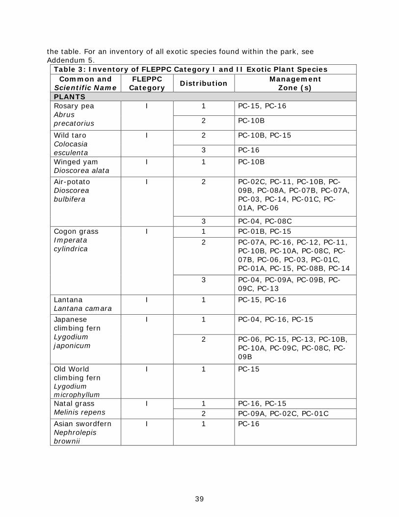
39
the table. For an inventory of all exotic species found within the park, see Addendum 5.
Table 3: Inventory of FLEPPC Category I and II Exotic Plant Species Common and
Scientific Name FLEPPC
Category Distribution Management Zone (s)
PLANTS Rosary pea Abrus precatorius
I 1 PC-15, PC-16
2 PC-10B
Wild taro Colocasia esculenta
I 2 PC-10B, PC-15
3 PC-16 Winged yam Dioscorea alata
I 1 PC-10B
Air-potato Dioscorea bulbifera
I 2 PC-02C, PC-11, PC-10B, PC-09B, PC-08A, PC-07B, PC-07A, PC-03, PC-14, PC-01C, PC-01A, PC-06
3 PC-04, PC-08C Cogon grass Imperata cylindrica
I 1 PC-01B, PC-15 2 PC-07A, PC-16, PC-12, PC-11,
PC-10B, PC-10A, PC-08C, PC-07B, PC-06, PC-03, PC-01C, PC-01A, PC-15, PC-08B, PC-14
3 PC-04, PC-09A, PC-09B, PC-09C, PC-13
Lantana Lantana camara
I 1 PC-15, PC-16
Japanese climbing fern Lygodium japonicum
I 1 PC-04, PC-16, PC-15
2 PC-06, PC-15, PC-13, PC-10B, PC-10A, PC-09C, PC-08C, PC-09B
Old World climbing fern Lygodium microphyllum
I 1 PC-15
Natal grass Melinis repens
I 1 PC-16, PC-15 2 PC-09A, PC-02C, PC-01C
Asian swordfern Nephrolepis brownii
I 1 PC-16
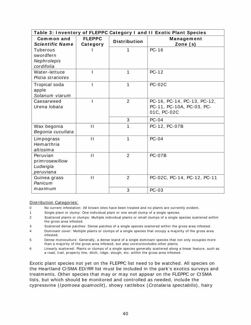
40
Table 3: Inventory of FLEPPC Category I and II Exotic Plant Species Common and
Scientific Name FLEPPC
Category Distribution Management Zone (s)
Tuberous swordfern Nephrolepis cordifolia
I 1 PC-16
Water-lettuce Pistia stratiotes
I 1 PC-12
Tropical soda apple Solanum viarum
I 1 PC-02C
Caesarweed Urena lobata
I 2 PC-16, PC-14, PC-13, PC-12, PC-11, PC-10A, PC-03, PC-01C, PC-02C
3 PC-04 Wax begonia Begonia cucullata
II 1 PC-12, PC-07B
Limpograss Hemarthria altissima
II 1 PC-04
Peruvian primrosewillow Ludwigia peruviana
II 2 PC-07B
Guinea grass Panicum maximum
II 2 PC-02C, PC-14, PC-12, PC-11
3 PC-03 Distribution Categories: 0 No current infestation: All known sites have been treated and no plants are currently evident. 1 Single plant or clump: One individual plant or one small clump of a single species. 2 Scattered plants or clumps: Multiple individual plants or small clumps of a single species scattered within the gross area infested. 3 Scattered dense patches: Dense patches of a single species scattered within the gross area infested. 4 Dominant cover: Multiple plants or clumps of a single species that occupy a majority of the gross area infested. 5 Dense monoculture: Generally, a dense stand of a single dominant species that not only occupies more than a majority of the gross area infested, but also covers/excludes other plants. 6 Linearly scattered: Plants or clumps of a single species generally scattered along a linear feature, such as a road, trail, property line, ditch, ridge, slough, etc. within the gross area infested. Exotic plant species not yet on the FLEPPC list need to be watched. All species on the Heartland CISMA ED/RR list must be included in the park’s exotics surveys and treatments. Other species that may or may not appear on the FLEPPC or CISMA lists, but which should be monitored and controlled as needed, include the cypressvine (Ipomoea quamoclit), showy rattlebox (Crotalaria spectabilis), hairy
41
indigo (Indigofera hirsuta), fivestamen burrbark (Triumfetta pentandra), and the bamboo and citrus already discussed in the natural communities section. Special Natural Features Peace River is important biologically and historically. Biologically, the River offers an abundance of invertebrate species, such as fresh clams (Corbicula spp.) and snails (Spilochlamys spp.), environmentally sensitive arthropod species, such as mayflies (Callibaetis spp. and Brachycercus spp.), caddisflies (Oecetis georgia), and crustaceans (Palaemonetes spp.). Marine species such as snook and mullet annually travel upstream and are frequently documented by sport fisherman. Tarpon (Megalops atlanticus) also have been documented in the Peace River at Paynes Creek. Typical freshwater fish are abundant as a result of a healthy food chain. The Peace River attracts wading birds and aerial predatory species such as the osprey and belted king fisher. Alligators are the top predators. Historically, the Peace River was used for transportation by the Seminole, pioneering Europeans and their settlements, and the U.S. Army. At the southern boundary of the park, there are remains of a military bridge that can be seen when water levels are at seasonally low levels. Other areas of the Peace River are known for producing fossils, such as shark teeth and mega-fauna, and human artifacts, such as projectile points; the section of the River along the park boundaries may also contain these items. Tucked into the floodplain swamp and bottomland forest areas, near the junction of Paynes Creek and the Peace River, are several oxbow ponds. An oxbow lake or pond is a U-shaped body of water that forms when a meander from the main stem of a river or creek is cut off, creating a free-standing body of water. These special natural features result from seasonal flooding patterns, which build levees and point bars, scour channels and depressions, and introduce flowing water into backswamps. They tell a story about the nearby stream’s changes over time. While the oxbows at the park are not large, they serve as important breeding grounds for frogs (such as southern leopard frogs (Lithobates sphenocephalus) and, when high water connects them to the river, for fish. They provide a resource for wading birds. Alligators nest near the park’s oxbow lakes, where juveniles are frequently observed migrating to the Peace River. Cultural Resources This section addresses the cultural resources present in the park that may include archaeological sites, historic buildings and structures, cultural landscapes and collections. The Florida Department of State (FDOS) maintains the master inventory of such resources through the Florida Master Site File (FMSF). State law requires that all state agencies locate, inventory and evaluate cultural resources that appear to be eligible for listing in the National Register of Historic Places. Addendum 7 contains the FDOS, Division of Historical Resources (DHR) management procedures for archaeological and historical sites and properties on state-owned or controlled properties; the criteria used for evaluating eligibility for listing in the National

42
Register of Historic Places, and the Secretary of Interior’s definitions for the various preservation treatments (restoration, rehabilitation, stabilization and preservation). For the purposes of this plan, significant archaeological site, significant structure and significant landscape means those cultural resources listed or eligible for listing in the National Register of Historic Places. The terms archaeological site, historic structure or historic landscape refer to all resources that will become 50 years old during the term of this plan. Condition Assessment Evaluating the condition of cultural resources is accomplished using a three-part evaluation scale, expressed as good, fair and poor. These terms describe the present condition, rather than comparing what exists to the ideal condition. Good describes a condition of structural stability and physical wholeness, where no obvious deterioration other than normal occurs. Fair describes a condition in which there is a discernible decline in condition between inspections, and the wholeness or physical integrity is and continues to be threatened by factors other than normal wear. A fair assessment is usually a cause for concern. Poor describes an unstable condition where there is palpable, accelerating decline, and physical integrity is being compromised quickly. A resource in poor condition suffers obvious declines in physical integrity from year to year. A poor condition suggests immediate action is needed to reestablish physical stability. Level of Significance Applying the criteria for listing in the National Register of Historic Places involves the use of contexts as well as an evaluation of integrity of the site. A cultural resource’s significance derives from its historical, architectural, ethnographic or archaeological context. Evaluation of cultural resources will result in a designation of NRL (National Register or National Landmark Listed or located in an NR district), NR (National Register eligible), NE (not evaluated) or NS (not significant) as indicated in the table at the end of this section. There are no criteria for determining the significance of collections or archival material. Usually, significance of a collection is based on what or whom it may represent. For instance, a collection of furniture from a single family and a particular era in connection with a significant historic site would be considered highly significant. In the same way, a high quality collection of artifacts from a significant archaeological site would be of important significance. A large herbarium collected from a specific park over many decades could be valuable to resource management efforts. Archival records are most significant as a research source. Any records depicting critical events in the park’s history, including construction and resource management efforts, would all be significant. The following is a summary of the FMSF inventory. In addition, this inventory contains the evaluation of significance.
43
Prehistoric and Historic Archaeological Sites Desired future condition: All significant archaeological sites within the park that represent Florida’s cultural periods or significant historic events or persons are preserved in good condition in perpetuity, protected from physical threats and interpreted to the public. Description: There are two historic sites recorded for the park, the Paynes Creek Massacre – Fort Chokonikla Site and the Kennedy and Darling Store. Together, they mark an important series of events in Florida’s history. In July of 1849, “several dissident Seminole warriors” arrived at the Kennedy and Darling Store, a trading post being supervised by Capt. George S. Payne. The warriors broke into the store while Payne and two employees, Dempsey Whiddon and William McCullough were having dinner; they killed Payne and Whiddon and wounded McCullough. As the news of this incident was spread and possibly exaggerated, the fear of such attacks resulted in the move of all settlers south of the Ocala area into fortified settlements (the “Indian Scare of 1849”). A ring of fortified civilian and military stockades was forged across much of the troubled southwestern zone, the first of these was Fort Chokonikla (“spelled at least six different ways and reputed to be Seminole for ‘burnt store’” [Simpson 1956]). Chokonikla served as headquarters for the forts in the Western Division and was part of the development of military roads in the region, particularly the “Twiggs Wagon Road.” Also, in January 1850, General Twiggs met and negotiated an agreement with Chief Billy Bowlegs and four lesser leaders at the fort that ultimately resulted in settlers feeling more secure about returning to their homesteads. Chokonikla is one of the few remaining fort sites that have not been lost to development. Later, according to archaeological surveys (ARS 1979), a granite marker was erected at the approximate location of the grave sites of Payne and Whiddon. The marker is described below under Historic Structures. Both of the park’s recorded archaeological sites include a prehistoric component, about which little is known. The 1983 survey (Baker) reported discovering prehistoric artifacts at both the fort and store site. Unworked chert flakes, a point and preform, and plain ceramic sherds were found in over ½ of the units at the fort site; one chert flake and one point with a broken stem were found at the store site. These lithic materials probably represent the Middle Archaic period 7,000 – 5,000 B.P. Ceramics from a later period have also been found, but their lack of diagnostic attributes make them hard to date. The Paynes Creek Massacre Fort Chokonikla Site was listed on the National Register of Historic Places on November 21, 1978 (HR00023). The site extends beyond park boundaries to include an area in the southeast between the park and the Peace River that encompasses the bridge and blockhouse. The 300 acres within this registered site contain multiple historic elements, including four sites and one monument, all of which are found within the park boundaries:
1. Site of the Kennedy-Darling store or trading post (HR00023A), 1849 2. Site of the Fort Chokonikla, 1849-50 3. Site of the military blockhouse and bridge, 1849-50
44
4. Graveyard (military?) –18? 5. Sites of several early roads, including Twiggs military road, 1840s -1850s 6. Monument to Payne and Whiddon, c. 1895
Two professional archaeological surveys have been conducted at the state park (Miller and Schene 1979; Baker 1983). The investigations used a variety of methods, including archival research, landscape identification, surface reconnaissance, extensive post-holing, metal probing, metal detection, test units, and trenching. The fort site was found to be a shallow archaeological deposit that represents the brief occupation period of October 1849 through July 1850. The two archaeological investigations to date have located several trash pits, as well as miscellaneous artifacts scattered over the larger area. Data recovered indicate that the fort was constructed without a palisade and that upon abandonment it was intentionally dismantled and disposed of in order to clear the area for cultivation. The Kennedy and Darling Store (HR00023A) site is a similar shallow archaeological deposit that represents a brief occupation period, 1849. Low density artifact scatter related to the store was found, but no structural evidence. An archaeological sensitivity model project was completed for the park in 2013; this resulted in a map depicting areas of relative probability (“sensitivity”) for discovering archaeological resources. The project also produced a correction for the recorded location of the Kennedy-Darling Trading Post site (HR23A). It had previously been recorded with the FMSF as located approximately 200 yards southwest, away from Payne Creek. The correction brings HR23A within the boundaries of the larger Payne Creek Massacre Fort Chokonikla site (Collins 2013). Condition assessment: The fort and store sites, while more protected today, have substantial disturbance from past plowing, cultivation, road construction, and artifact hunting, a reported popular local pastime. The fort site is presently maintained as a large open clearing with rough patches of wiry grass, flanked by a short, scrubby oak cover. Florida golden aster has been planted in several areas within the fort clearing as part of a larger reintroduction project, and the area has a number of active gopher tortoise burrows; there was no evidence of archaeological material observed in these disturbances. The store site is not presently open to the public. It sits adjacent to a bluff above Payne Creek. A fire line running along the bluff was recently re-disked and no archaeological material was observed in the freshly disked lane or while walking around the site. The 1979 survey (Miller and Schene) reported locating two of the four roads depicted on the historical 1855 township/range map prepared by W.G. Moseley for the State of Florida. None are presently recorded with the FMSF. It is recommended that remnants of the historic roads be relocated, mapped, recorded and protected. All sites face potential threats from human vandalism and impacts by natural events such as hurricanes. Sites close to Payne Creek are also threatened by flooding caused by natural events. In addition, unchecked woody growth on buried
45
sites poses the threat of root disturbance, and aerial vegetation may contribute to superficial degradation to the Payne and Whiddon Monument. Level of significance: Paynes Creek Historic State Park contains two archaeological sites that are listed on the National Register of Historic Places (NRHP). The Paynes Creek Massacre Fort Chokonikla site (HR23) was listed on the National Register on November 21, 1978. The Kennedy Darling Trading Post (HR23A) is included as a component of this listing. The NRHP listing recognized the site for its information potential in the areas of exploration/settlement, non-aboriginal history, and military; and for the periods 1825–1849 and 1850–1874. The Kennedy Darling Trading Post was the site of a Seminole raid on a store located on a southern bluff of Paynes Creek in 1849 that left two men dead, another injured, and the business destroyed. The event is significant for the panic it and other attacks on isolated white settlements engendered, prompting them to move to fortified locations and government and civilian troops to mobilize in defense, opposition and aggression that ultimately culminated in the 3rd Seminole War. Fort Chokonikla was the first of a series of forts ordered built at ten mile intervals across the Florida peninsula following these attacks. At times it served as the headquarters for forts in the Western Division when Major General David E. Twiggs, commanding officer for the U.S. Army troops in Florida, visited. On January 21, 1850, the fort was site of a meeting at which General Twiggs negotiated an agreement between Billy Bowlegs and three other Seminole leaders for their departure to reservation lands west of the Mississippi, a pact never fulfilled. Nonetheless, fort construction and the semblance of agreement helped ease public sentiment and settlers’ fears. General management measures: Update the FMSF as needed. General management measures to preserve the sites include routine inspection by park staff to determine impacts by resource management, natural causes, vandalism, and construction activity. Park staff routinely manages threats of vegetation encroachment and monitors each site for erosion. Historic Structures Desired future condition: All significant historic structures and landscapes that represent Florida’s cultural periods or significant historic events or persons are preserved in good condition in perpetuity, protected from physical threats and interpreted to the public. Description: The Captain George S. Payne and Dempsey Whiddon Monument consists of a granite marker, which measures roughly 23 x 37 x 47 inches, on a slightly larger four-sided base. It was encased in concrete as a measure of protection against vandalism. Measurements are as close as possible as the granite marker is encased in concrete; it is difficult to determine how far, if at all, it extends below ground. Condition assessment: The monument site that is presumed to mark the location of Whiddon and Payne graves, though this has not been confirmed, has the appearance of being well maintained. The grass is mown, its immediate surrounds
46
mulched and fenced, the monument painted white and unblemished, and the letters periodically blackened to facilitate legibility; the grounds offer visitors a serene place of reflection. The inscribed granite slab itself is pocked and cracked at mid-point, but the damage is no more than what was observed during the last resource management evaluation, a decade ago. The monument itself is historic. Level of significance: The Payne-Whiddon monument contributes to a historic district, and is mentioned in the National Register nomination, but is likely not individually eligible for the National Register. General management measures: Continue to monitor and maintain the monument condition. General management measures to preserve the site include routine inspection by park staff to determine impacts by resource management, natural causes, vandalism, and construction activity. Park staff routinely manage threats of vegetation encroachment and monitor the site for erosion. Collections Desired future condition: All historic, natural history and archaeological objects within the park that represent Florida’s cultural periods, significant historic events or persons, or natural history specimens are preserved in good condition in perpetuity, protected from physical threats and interpreted to the public. Description: Collections on permanent display are housed in the park’s Visitor Center; most of these items were donated. Collection items not on display may be used for park interpretive programs; these items were either donated or collected from the park. Many of the artifacts have not been formally registered or documented, and many are incomplete, small, or damaged. On display at Visitor Center (BL118009):
• Donated Items: Period bayonet attachment, six pound and eight pound cannon balls
• Loaned artifacts: Ceramic shards, bullets, pipes, buttons, • 2 Seminole manikins dressed in Scottish-influenced garments with rifles and
Seminole dress jewelry (alarmed) • 3 United States Soldiers (Captain, sergeant, private) dressed in period
uniforms and weapons (alarmed). • 1 six pound cannon with carriage and ammunition storage compartment • 1 mural of General Twiggs and Chief Billy Bowlegs meeting at Payne Creek • 1 mural of Seminoles attacking Kennedy-Darling Trading Station • 1 Replica Kennedy-Darling Trading Station exhibit with store items (behind
glass, table and chair, and wood rafters with windows (alarmed) and mounted white-tailed deer
• 4 Seminole Chief paintings • 1 Regional Township/Range map from 1855
Collections not displayed:
Natural History • Mounted Gray fox
47
• Gopher tortoise skeletal remains: carapace and plastron intact • Florida box turtle skeletal remains: carapace and plastron intact • Bald face hornet nest: complete and attached to branch
Cultural History • Duplicate of the letter from John Darling to Miss Mary Payne confirming
the death of her brother Captain George S. Payne • Green wine bottle glass fragments • Pottery shards • Arrow heads • Various sizes of construction nails
Condition assessment: Most of the collection is on permanent display and generally in good condition. Informal and non-display collections are maintained at the visitor center; the conditions of these items vary and improved storage for informal collections is needed as protection against threats. The excavated metal objects that were donated to the park are heavily corroded, and in need of stabilization. The park does not currently have a Scope of Collection Statement in place yet; this is required by Division policy and would assist the park in accepting or declining offers of collection objects. Level of significance: Collections on display depict life during the mid-19th century in Florida for Seminoles and early settlers. Some collections relate directly to the historical events that occurred on site and provide a visual documentation of the park’s historical accounts. Collections display have pertinent research and educational value, particularly with loaned artifacts collected from archaeological investigations conducted at the park. Informal collections, that have been verified, can be useful for close examination and other detailed analysis. General management measures: Scope of Collections Statement should be developed and a recording keeping system implemented. Resources such as storage cabinets for collections will improve the current management measures significantly. Detailed management goals, objectives and actions for the management of cultural resources in this park are discussed in the Cultural Resource Management Program section of this component. Table 4 contains the name, reference number, culture or period, and brief description of all the cultural sites within the park that are listed in the FMSF. The table also summarizes each site’s level of significance, existing condition and recommended management treatment. An explanation of the codes is provided following the table.
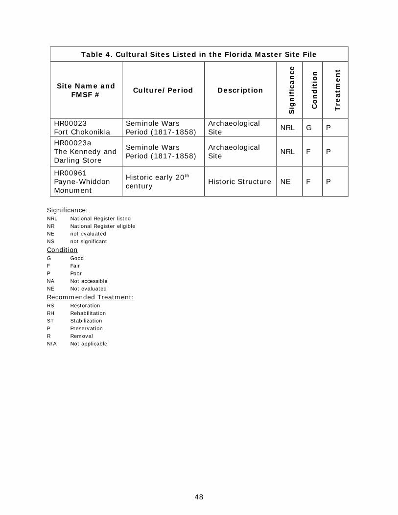
48
Table 4. Cultural Sites Listed in the Florida Master Site File
Site Name and FMSF # Culture/Period Description
Sig
nif
ican
ce
Con
dit
ion
Trea
tmen
t
HR00023 Fort Chokonikla
Seminole Wars Period (1817-1858)
Archaeological Site NRL G P
HR00023a The Kennedy and Darling Store
Seminole Wars Period (1817-1858)
Archaeological Site NRL F P
HR00961 Payne-Whiddon Monument
Historic early 20th century Historic Structure NE F P
Significance: NRL National Register listed NR National Register eligible NE not evaluated NS not significant
Condition G Good F Fair P Poor NA Not accessible NE Not evaluated
Recommended Treatment: RS Restoration RH Rehabilitation ST Stabilization P Preservation R Removal N/A Not applicable
49
Resource Management Program Management Goals, Objectives and Actions Measurable objectives and actions have been identified for each of the DRP’s management goals for Paynes Creek Historic State Park. Please refer to the Implementation Schedule and Cost Estimates in the Implementation Component of this plan for a consolidated spreadsheet of the recommended actions, measures of progress, target year for completion and estimated costs to fulfill the management goals and objectives of this park. While the DRP utilizes the ten-year management plan to serve as the basic statement of policy and future direction for each park, a number of annual work plans provide more specific guidance for DRP staff to accomplish many of the resource management goals and objectives of the park. Where such detailed planning is appropriate to the character and scale of the park’s natural resources, annual work plans are developed for prescribed fire management, exotic plant management and imperiled species management. Annual or longer- term work plans are developed for natural community restoration and hydrological restoration. The work plans provide the DRP with crucial flexibility in its efforts to generate and implement adaptive resource management practices in the state park system. The work plans are reviewed and updated annually. Through this process, the DRP’s resource management strategies are systematically evaluated to determine their effectiveness. The process and the information collected is used to refine techniques, methodologies and strategies, and ensures that each park’s prescribed management actions are monitored and reported as required by Sections 253.034 and 259.037, Florida Statutes. The goals, objectives and actions identified in this management plan will serve as the basis for developing annual work plans for the park. The ten-year management plan is based on conditions that exist at the time the plan is developed. The annual work plans provide the flexibility needed to adapt to future conditions as they change during the ten-year management planning cycle. As the park’s annual work plans are implemented through the ten-year cycle, it may become necessary to adjust the management plan’s priority schedules and cost estimates to reflect these changing conditions. Natural Resource Management Hydrological Management Goal: Protect water quality and quantity in the park, restore hydrology to the extent feasible and maintain the restored condition. The natural hydrology of most state parks has been impaired prior to acquisition to one degree or another. Florida’s native habitats are precisely adapted to natural drainage patterns and seasonal water level fluctuations, and variations in these
50
factors frequently determine the types of natural communities that occur on a particular site. Even minor changes to natural hydrology can result in the loss of plant and animal species from a landscape. Restoring state park lands to original natural conditions often depends on returning natural hydrological processes and conditions to the park. This is done primarily by filling or plugging ditches, removing obstructions to surface water “sheet flow,” installing culverts or low-water crossings on roads, and installing water control structures to manage water levels. Objective A: Conduct/obtain an assessment of the park’s hydrological restoration needs.
Action 1 Monitor and analyze resources of the park. Map all erosion problems and analyze impacts.
Action 3 Determine needs for restoration. A detailed assessment of the hydrology and hydrological restoration needs is required. This includes developing a detailed map of erosion problems and an analysis of impacts. Such an analysis will help determine the most appropriate solutions and approaches to restoration. Objective B: Restore natural hydrological conditions and functions to approximately 2 acres of sandhill and mesic hammock natural communities.
Action 1 Adjust topography to reroute stormwater along southwest corner of property, PC-16.
Action 2 Plan sandhill plantings to support new stormwater flow patterns. There is a known problem with erosion, where stormwater runoff enters the park along the southwest corner of the property. The park is working with the County and other agencies to address the issue, but adjustment of the topography inside the park, as well as outside, will be needed. This corner is part of the sandhill restoration plan for the park and planting plans should support the new stormwater flow patterns. Natural Communities Management Goal: Restore and maintain the natural communities/habitats of the park. The DRP practices natural systems management. In most cases, this entails returning fire to its natural role in fire-dependent natural communities. Other methods to implement this goal include large-scale restoration projects as well as smaller scale natural communities’ improvements. Following are the natural community management objectives and actions recommended for the state park. Prescribed Fire Management Prescribed fire is used to mimic natural lightning-set fires, which are one of the primary natural forces that shaped Florida’s ecosystem. Prescribed burning increases the abundance and health of many wildlife species. A large number of Florida’s imperiled species of plants and animals are dependent on periodic fire for
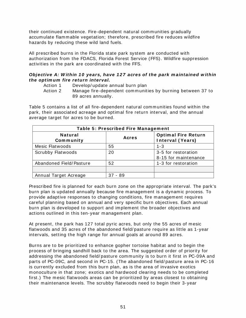
51
their continued existence. Fire-dependent natural communities gradually accumulate flammable vegetation; therefore, prescribed fire reduces wildfire hazards by reducing these wild land fuels. All prescribed burns in the Florida state park system are conducted with authorization from the FDACS, Florida Forest Service (FFS). Wildfire suppression activities in the park are coordinated with the FFS. Objective A: Within 10 years, have 127 acres of the park maintained within the optimum fire return interval.
Action 1 Develop/update annual burn plan Action 2 Manage fire-dependent communities by burning between 37 to
89 acres annually. Table 5 contains a list of all fire-dependent natural communities found within the park, their associated acreage and optimal fire return interval, and the annual average target for acres to be burned.
Table 5: Prescribed Fire Management Natural
Community Acres Optimal Fire Return Interval (Years)
Mesic Flatwoods 55 1-3 Scrubby Flatwoods 20 3-5 for restoration
8-15 for maintenance Abandoned Field/Pasture 52 1-3 for restoration Annual Target Acreage 37 - 89
Prescribed fire is planned for each burn zone on the appropriate interval. The park’s burn plan is updated annually because fire management is a dynamic process. To provide adaptive responses to changing conditions, fire management requires careful planning based on annual and very specific burn objectives. Each annual burn plan is developed to support and implement the broader objectives and actions outlined in this ten-year management plan. At present, the park has 127 total pyric acres, but only the 55 acres of mesic flatwoods and 35 acres of the abandoned field/pasture require as little as 1-year intervals, setting the high range for annual goals at around 89 acres. Burns are to be prioritized to enhance gopher tortoise habitat and to begin the process of bringing sandhill back to the area. The suggested order of priority for addressing the abandoned field/pasture community is to burn it first in PC-09A and parts of PC-09C, and second in PC-15. (The abandoned field/pasture area in PC-16 is currently excluded from this burn plan, as is the area of invasive exotics monoculture in that zone; exotics and hardwood clearing needs to be completed first.) The mesic flatwoods areas can be prioritized by areas closest to obtaining their maintenance levels. The scrubby flatwoods need to begin their 3-year
52
intervals as soon as possible in order to restore this community to good condition. As prescribed fire implementation approaches maintenance stage, the natural communities in the park will more clearly take on their typical character and species diversity. All the rare upland plants discussed in the Imperiled Species section will show significant improvement in their health and spread when fire is included in management. Without fire, shrub and tree density, canopy cover and leaf litter increase, which chokes out the habitat needs of the gopher tortoise, as well as the Sherman’s fox squirrel. There is currently a good network of firebreaks or firelines in place that allows staff to work with one or many zones on any given burn. Perimeter and internal firebreaks should be maintained and established according to agency policy. They should provide for adequate park protection and safe prescribed fire application. The complexity of the burn unit, including the structure and height of the fuel within the zone and the receptiveness of fuels adjacent to the zone, should be taken into account when preparing the firebreaks. Fire lines twice as wide as the fuel heights adjacent to the fireline is a general guideline for fire line preparation (for example, for ten-foot fuel heights adjacent to line, there should be a 20 foot wide firebreak). Mechanical treatment of fuels adjacent to the firebreak may be needed to burn the zone safely. Perimeter lines need to be wide enough for defense and to allow a type 6 fire engine to move safely down the line. When widening the firebreaks, the vegetation along the boundary/fence line should be removed first to allow the perimeter break to function as such (the presence of wetlands, large native trees or protected plant species that pose no line defense threat may be an exception). Any additional widening can then be made on the zone side of the firebreak. In order to track fire management activities, the DRP maintains a statewide burn database. The database allows staff to track various aspects of each park’s fire management program including individual burn zone histories and fire return intervals, staff training and experience, backlog, etc. The database is also used for annual burn planning which allows the DRP to document fire management goals and objectives on an annual basis. Each quarter the database is updated and reports are produced that track progress towards meeting annual burn objectives. Natural Community Restoration In some cases, the reintroduction and maintenance of natural processes is not enough to reach the desired future conditions for natural communities in the park, and active restoration programs are required. Restoration of altered natural communities to healthy, fully functioning natural landscapes often requires substantial efforts that may include mechanical treatment of vegetation or soils and reintroduction or augmentation of native plants and animals. For the purposes of this management plan, restoration is defined as the process of assisting the recovery and natural functioning of degraded natural communities to desired future condition, including the re-establishment of biodiversity, ecological processes, vegetation structure and physical characters. Examples that would qualify as natural community restoration, requiring annual restoration plans, include large mitigation projects, large-scale hardwood removal

53
and timbering activities, roller-chopping and other large-scale vegetative modifications. The key concept is that restoration projects will go beyond management activities routinely done as standard operating procedures such as routine mowing, the reintroduction of fire as a natural process, spot treatments of exotic plants, and small-scale vegetation management. Following are the natural community/habitat restoration and maintenance actions recommended to create the desired future conditions in the sandhill community (see Desired Future Conditions Map). Objective B: Conduct habitat/natural community restoration activities on 20 acres of sandhill natural community
Action 1 Develop site specific sandhill restoration plan and calendar. Action 2 Begin implementing optimal restoration fire return interval (1-3
year) as soon as practicable. Action 3 Remove encroaching vegetation that is not part of the sandhill
system. Action 4 As canopy is opened by fire and other removal techniques,
begin restoration plantings. Action 5 Begin maintenance and survey activities that will be needed to
protect the sandhill. FWC and FFS provide Best Management Practices for developing site-specific sandhill restoration plans and calendars. Areas to ultimately be restored to sandhill include nearly 15 acres in PC-16 and roughly 20 acres in PC-09A; the 20 acres in PC- 09A are the ones designated for this portion of the plan. An assessment of gopher tortoise presence and activity is needed to determine techniques to be followed for removing inappropriate vegetation, but also those to be followed for planting. Begin implementing optimal restoration fire restoration interval (1-3 year) as soon as practicable. Fire opens the mid-story and invigorates the remaining intact ground cover in the community; for example, wiregrass seed developed post-fire is particularly more viable. The site plan will determine if roller-chopping or other mechanical treatment is necessary before the first burn and if fire should be applied during the dormant or the growing season. Along these lines, remove encroaching vegetation that is not part of the sandhill system, including exotic and native shrubs and hardwoods. This will require chemical and mechanical treatments. Soil disturbance is to be minimal. As canopy is opened by fire and other removal techniques, begin restoration plantings. Note that the reestablishment of grasses is a critical part of the restoration process because of their importance as fuel to support recurrent fire. Minimal plantings will include seeding wiregrass and planting wiregrass plugs, and planting longleaf pine seedlings. Rolling sown seed into the soil can improve wiregrass establishment and survival (Hattenbach 1998). Wiregrass plugs can be successfully introduced at the rate of 0.5 to 1 seedling/m2 (Outcalt 1999). Longleaf seedlings may be introduced using 1- to 3-gallon container stock in clustered/grouped plantings, up to 300 trees per acre. The longleaf pine planting calendar should provide for creating uneven-aged stands over time. Other seeding efforts or plantings can include gayfeathers (Liatris spp.), pineywoods dropseed, broomsedge or Elliott bluestems (Andropogon virginicus, A. gyrans), little
54
bluestem (Schizachyrium scoparium), and lopsided indiangrass. These species are already present in the park and may provide sufficient source material for introductions into the sandhill areas. Maintenance and survey activities will be needed to protect the sandhill, including continued gopher tortoise monitoring, exotic species surveys and control, and proper prescribed fire applications Natural Community Improvement Improvements are similar to restoration but on a smaller, less intense scale. This typically includes small-scale vegetative management activities or minor habitat manipulation. Following are the natural community/habitat improvement actions recommended at the park. Objective C: Conduct natural community/habitat improvement activities on 8.5 acres of mesic hammock natural community.
Action 1 Diminish hardwood and exotic invasives encroachment in PC-02, in the successional hardwood forest area designated to become mesic hammock.
Management zone PC-02 is predominantly successional hardwood forest and invasive exotics at the time of writing this plan. There is currently some diversity of the native trees and other plants that belong a mesic hammock. Working around the existing appropriate species (e.g., live oak, cabbage palm, southern magnolia beautyberry, gallberry and sparkleberry), use mechanical and chemical methods to reduce the numbers of encroaching native species, such as laurel and water oak, sweetgum, and black cherry (Prunus serotina), in addition to the exotic species. Imperiled Species Management Goal: Maintain, improve or restore imperiled species populations and habitats in the park. The DRP strives to maintain and restore viable populations of imperiled plant and animal species primarily by implementing effective management of natural systems. Single species management is appropriate in state parks when the maintenance, recovery or restoration of a species or population is complicated due to constraints associated with long-term restoration efforts, unnaturally high mortality or insufficient habitat. Single species management should be compatible with the maintenance and restoration of natural processes, and should not imperil other native species or seriously compromise park values. In the preparation of this management plan, DRP staff consulted with staff of the FWC’s Imperiled Species Management or that agency’s Regional Biologist and other appropriate federal, state and local agencies for assistance in developing imperiled animal species management objectives and actions. Likewise, for imperiled plant species, DRP staff consulted with FDACS. Data collected by the USFWS, FWC, FDACS and FNAI as part of their ongoing research and monitoring programs will be reviewed by park staff periodically to inform management of decisions that may have an impact on imperiled species at the park.
PAYNES CREEK HISTORIC STATE PARKFlorida Department of Environmental Protection
Division of Recreation and ParksDate of aerial; 2011
0 500 1,000250 Feet´ NATURAL COMMUNITIES
DESIRED FUTURE CONDITIONS MAP
LegendAFP - Abandoned Field/Abandoned Pasture 9.4 ac.
BF - Bottomland Forest 136.7 ac.
BG - Baygall 10.2 ac.
BST - Blackwater Stream 8.1 ac.
CD - Canal/Ditch 0.5 ac.
DV - Developed 20.2 ac.
FS - Floodplain Swamp 12.1 ac.
HH - Hydric Hammock 12.6 ac.
MEH - Mesic Hammock 78.1 ac.
MF - Mesic Flatwoods 53.9 ac.
SCF - Scrubby Flatwoods 19.3 ac.
SH - Sandhill 33.9 ac.
XH - Xeric Hammock 3.5 ac.

57
Ongoing inventory and monitoring of imperiled species in the state park system is necessary to meet the DRP’s mission. Long-term monitoring is also essential to ensure the effectiveness of resource management programs. Monitoring efforts must be prioritized so that the data collected provides information that can be used to improve or confirm the effectiveness of management actions on conservation priorities. Monitoring intensity must at least be at a level that provides the minimum data needed to make informed decisions to meet conservation goals. Not all imperiled species require intensive monitoring efforts on a regular interval. Priority must be given to those species that can provide valuable data to guide adaptive management practices. Those species selected for specific management action and those that will provide management guidance through regular monitoring are addressed in the objectives below. Objective A: Develop/Update baseline imperiled species occurrence inventory lists for plants and animals. Objective B: Monitor and document one selected imperiled animal species in the park.
Action 1 Use existing FWC protocols for gopher tortoise monitoring; adopt new FWC protocols when those are complete.
Action 2 Update protocols as needed as new imperiled animal species are either identified at the park or known species are assigned new status designations.
Gopher tortoise monitoring protocols are provided in the FWC’s Gopher Tortoise Management Plan (FWC 2012). The best time to implement most monitoring protocols is soon after a burn. If, or as, the park observes other imperiled animal species, protocols for monitoring those species are to be researched and adopted. Objective C: Monitor and document at least two imperiled plant species in the park.
Action 1 Research or develop monitoring protocols for giant orchid and Simpson’s zephyrlily.
Action 2 Implement monitoring protocols.
As relevant prescribed fire, exotics removal, and Tier 1 monitoring is implemented throughout the park, as it must be for the already known imperiled species, there is a possibility that other imperiled plant species will be discovered. Resource managers at the park are expected to consider and update protocols as needed. Exotic Species Management Goal: Remove exotic and invasive plants and animals from the park and conduct needed maintenance control. The DRP actively removes invasive exotic species from state parks, with priority being given to those causing the ecological damage. Removal techniques may include mechanical treatment, herbicides or biocontrol agents.
58
Objective A: Annually treat 30 acres of exotic plant species in the park. Action 1 Develop/update exotic plant management work plan based on
updated surveys of management zones. Action 2 Ensure staff is trained to identify relevant exotic plant species
and is able to distinguish them from native look-alike plants. Action 3 Implement annual work plan by treating 30 infested acres in
park, annually, and continuing maintenance and follow-up treatments as needed.
Action 4 Park management participates in local CISMA Early Detection species identifications and lists, and includes these species in their infested area acreages.
The average number of infested acres of invasive exotic plants to be treated annually during this ten-year plan period will depend on the infestation densities and distributions assessed during annual surveys. The park is small enough that surveys can be performed and the IEPD updated annually. A treatment plan will be defined each year and include a treatment calendar to ensure that the target species are treated when the control work will be most effective; for example, cogongrass is most successfully controlled if treated during the early fall while it is increasing storage in its root system. Treatment techniques and schedules will follow the current Best Management Practices as published by FWC and IFAS. Park staff is expected to stay current with: the FLEPPC invasive species lists and plant identification; the BMPs for control techniques for the different species (these are usually available through IFAS or through EPPC); and the proper training and supervision of volunteers and others on the identification and treatment of invasive plant species. At the time of writing this plan, all of the known exotic invasive plants at the park can be controlled manually and by using herbicides that do not require special license for applicators. Proper protective personal equipment (PPE) required by the product label is to be worn every time herbicide product is being handled. Material Safety Data Sheets are to be kept up to date, readable, and within easy reach of all herbicide handling activities. As part of its exotic invasive plant control efforts, the Park will participate in local Early Detection/Rapid Response (EDRR) efforts. EDRR efforts tend to result in eradication of the threat, rather than just provide control of spread. In order to meet this objective, park staff and volunteers will work with the local CISMA (which is the Heartland CISMA) and the Weed Risk Assessment programs being conducted by APHIS and IFAS, to learn what to watch for and for identification information. Treatment techniques and schedules will follow the current Best Management Practices as published by FWC and IFAS. Objective B: Implement control measures on one exotic animal species in the park.
Action 1 Work with DRP to develop contract that would attract local assistance for removal of wild pigs.
59
Special Management Considerations Timber Management Analysis Chapters 253 and 259, Florida Statutes, require an assessment of the feasibility of managing timber in land management plans for parcels greater than 1,000 acres if the lead agency determines that timber management is not in conflict with the primary management objectives of the land. The feasibility of harvesting timber at this park during the period covered by this plan was considered in context of the DRP’s statutory responsibilities and an analysis of the park’s resource needs and values. The long-term management goal for forest communities in the state park system is to maintain or re-establish old-growth characteristics to the degree practicable, with the exception of those communities specifically managed as early successional. A timber management analysis was not conducted for this park since its total acreage is below the 1,000-acre threshold established by statute. Timber management will be re-evaluated during the next revision of this management plan. Arthropod Control Plan All DRP lands are designated as “environmentally sensitive and biologically highly productive” in accordance with Ch. 388.4111, Florida Statutes. If a local mosquito control district proposes treatment, the DRP works with them to adopt a mutually agreeable plan. By policy of the DEP since 1987, treatment plans may not include aerial adulticiding but typically allow larviciding. DRP policy also allows park managers to request typical truck spraying (adulticide fogging) in public use areas even in the absence of a treatment plan. The DRP does not authorize new physical alterations of marshes through ditching or water control structures. Mosquito control plans temporarily may be set aside under declared threats to public or animal health, or during a Governor’s Emergency Proclamation. There has not been an Arthropod control plan specific to Paynes Creek Historic State Park. Sea Level Rise Potential sea level rise is now under study and will be addressed by Florida’s residents and governments in the future. The DRP will stay current on existing research and predictive models, in coordination with other DEP programs and federal, state, and local agencies. The DRP will continue to observe and document the changes that occur to the park’s shorelines, natural features, imperiled species populations, and cultural resources. This ongoing data collection and analysis will inform the Division’s adaptive management response to future conditions, including the effects of sea level rise and saltwater intrusion into the aquifer as they develop.
60
Cultural Resource Management Cultural resources are individually unique, and collectively, very challenging for the public land manager whose goal is to preserve and protect them in perpetuity. The DRP will implement the following goals, objectives and actions, as funding becomes available, to preserve the cultural resources found in the park. Goal: Protect, preserve and maintain the cultural resources of the park. The management of cultural resources is often complicated because these resources are irreplaceable and extremely vulnerable to disturbances. The advice of historical and archaeological experts is required in this effort. All activities related to land clearing, ground disturbing activities, major repairs or additions to historic structures listed or eligible for listing in the National Register of Historic Places must be submitted to the FDOS, Division of Historical Resources (DHR) for review and comment prior to undertaking the proposed project. Recommendations may include, but are not limited to concurrence with the project as submitted, pre-testing of the project site by a certified archaeological monitor, cultural resource assessment survey by a qualified professional archaeologist, modifications to the proposed project to avoid or mitigate potential adverse effect. In addition, any demolition or substantial alteration to any historic structure or resource must be submitted to the DHR for consultation and the DRP must demonstrate that there is no feasible alternative to removal and must provide a strategy for documentation or salvage of the resource. Florida law further requires that DRP consider the reuse of historic buildings in the park in lieu of new construction and must undertake a cost comparison of new development versus rehabilitation of a building before electing to construct a new or replacement building. This comparison must be accomplished with the assistance of the DHR. Objective A: Assess and evaluate 3 of 3 recorded cultural resources in the park.
Action 1 Complete 3 assessments/evaluations of archaeological sites. Prioritize site most in need of preservation and stabilization work.
Action 2 Complete 1 Cultural Landscape Survey.
This assessment should include an examination of each of the two sites, with a discussion of any threats to the site’s condition such as natural erosion; vehicular damage; horse, bicycle or pedestrian damage; looting; construction including damage from firebreak construction; animal damage; plant or root damage or other factors that might cause deterioration of the site. The final assessment or evaluation should prioritize the site most in need of preservation and stabilization, and this evaluation should attempt to compare the current condition with previous evaluations using photo points or high resolution scanning or similar techniques.
61
Objective B: Compile reliable documentation for historic and archaeological resources.
Action 1 Ensure all known sites are recorded or updated in the Florida Master Site File.
Action 2 Conduct Level 1 archaeological survey for 1 priority area identified by predictive model or other previous study.
Action 3 Develop and adopt a Scope of Collections Statement. Action 4 Locate or update supplemental documentation to accompany
Collections, whether from park or donations. Currently known items that need to be recorded or updated in FMSF include the Payne and Whidden monument and the remnants of the historic roads. The latter need to be re-located, mapped, recorded with FMSF, and protected. As exotics and hardwood clearing opens PC-16 in preparation for sandhill restoration work, it might be appropriate to conduct a Level 1 archaeological survey in this High Sensitivity area. This area includes the old location for HR23A. The park does not have a Scope of Collections Statement in place yet. This is required by Division policy and would assist the park in accepting or declining offers of collection objects. It is recommended that the donor of the archaeological excavations of the Seminole War period sites is approached for two types of paperwork: firstly, signed donation forms legitimizing the transfer of objects to the Division, and secondly, a written narrative documenting their origin (dates, names and details of the excavation). If sites can be relocated, these too need to be recorded with FMSF. Also, artifacts found in the park fall under the jurisdiction of Bureau of Archaeological Resources (BAR). Park staff will contact the BAR Research and Conservation Lab to discuss what they want to be done with the artifacts; possibilities include sending it to their facility in Tallahassee, loaning it to the park, giving it to the park, or disposing of it. The BAR would also be of assistance with excavated metal objects that are in need of stabilization (but there may be a nominal fee involved, as this is not an archaeological artifact that falls under their jurisdiction proper). Objective C: Bring 3 of 3 recorded cultural resources into good condition.
Action 1 Design and implement regular monitoring programs for 2 cultural sites.
Action 2 Create and implement a cyclical maintenance program for each cultural resource.
The fort and store sites will be regularly monitored. The monument and historic road remnants will be recorded in the FMSF and included in the monitoring program. A cyclical maintenance plan will be developed and implemented to help guide the park with needed preservation of each cultural resources.
62
Resource Management Schedule A priority schedule for conducting all management activities that is based on the purposes for which these lands were acquired, and to enhance the resource values, is located in the Implementation Component of this management plan. Land Management Review Section 259.036, Florida Statutes, established land management review teams to determine whether conservation, preservation and recreation lands titled in the name of the Board of Trustees are being managed for the purposes for which they were acquired and in accordance with their approved land management plans. The considered recommendations of the land management review team and updated this plan accordingly. Paynes Creek Historic State Park was subject to a land management review on April 26, 2013. The review team made the following determinations:
• The land is being managed for the purpose for which it was acquired. • The actual management practices, including public access, complied with the
management plan for this site.
63
LAND USE COMPONENT
Introduction Land use planning and park development decisions for the state park system are based on the dual responsibilities of the Florida Department of Environmental Protection (DEP), Division of Recreation and Parks (DRP). These responsibilities are to preserve representative examples of original natural Florida and its cultural resources, and to provide outdoor recreation opportunities for Florida's citizens and visitors. The general planning and design process begins with an analysis of the natural and cultural resources of the unit, and then proceeds through the creation of a conceptual land use plan that culminates in the actual design and construction of park facilities. Input to the plan is provided by experts in environmental sciences, cultural resources, park operation and management. Additional input is received through public workshops, and through environmental and recreational-user groups. With this approach, the DRP objective is to provide quality development for resource-based recreation throughout the state with a high level of sensitivity to the natural and cultural resources at each park. This component of the unit plan includes a brief inventory of the external conditions and the recreational potential of the unit. Existing uses, facilities, special conditions on use, and specific areas within the park that will be given special protection, are identified. The land use component then summarizes the current conceptual land use plan for the park, identifying the existing or proposed activities suited to the resource base of the park. Any new facilities needed to support the proposed activities are expressed in general terms.
External Conditions An assessment of the conditions that exist beyond the boundaries of the unit can identify any special development problems or opportunities that exist because of the unit's unique setting or environment. This also provides an opportunity to deal systematically with various planning issues such as location, regional demographics, adjacent land uses and park interaction with other facilities. Paynes Creek Historic State Park is located within Hardee County about 2 miles south of Bowling Green, 7 miles north of Wauchula, and 10 miles south of Fort Meade in the central part of the state. Approximately 514,000 people live within 30 miles of the park (U.S. Census 2010). The population of Hardee County is diverse in terms of demographic characteristics. According to the U.S. Census Data (2013), approximately 54% of residents in the county identify as black, Hispanic or Latino, or another minority group. Hispanics alone account for 43% of the population, well over the state average of 22.5%. Over half (52%) of residents can be described as youth or seniors (U.S. Census 2010). 64% of the population is of working age (16 to 65) (U.S. Census Bureau 2010). In 2013, Hardee County’s per capita
64
personal income was $25,752 (below the statewide average of $41,497) (U.S. Bureau of Economic Analysis 2013). In Polk County, just to the north of the park, over one-third of the population identifies as black, Hispanic or Latino, or another minority group. 50% of residents can be described as youth or seniors (U.S. Census 2010). 63% of the population is of working age (16 to 65) (U.S. Census Bureau 2010). Polk County’s per capita personal income was $34,393 in 2013 (below the statewide average of $41,497) (U.S. Bureau of Economic Analysis 2013). A significant amount of resource-based recreation opportunities exist within 15 miles of Paynes Creek Historic State Park. Highlands Hammock and Alafia River State Parks offer opportunities for birding, camping, bicycling, and hiking. Lake Wales Ridge Wildlife and Environmental Area allows hunting; during non-hunting periods, visitors can hike, bike, and horseback throughout the property. Several municipally-owned properties are in close vicinity to the park. Duette Preserve, Crooked Lake Prairie, and the Preserve at Sun ‘N Lake have a series of hiking and nature trails, fishing, hunting, horseback riding, biking, primitive camping, and picnicking. The park is located in the Central Vacation Region, which includes Hardee, Highlands, Lake, Marion, Orange, Osceola, Polk, Seminole, and Sumter counties (Visit Florida 2013). According to the 2013 Florida Visitor Survey, approximately 34.7% of domestic visitors to Florida visited this region. Roughly 88% of visitors to the region traveled to the Central Region for leisure purposes. The top activities for domestic visitors were theme/amusement/water parks and shopping. Summer was the most popular travel season, but visitation was generally spread throughout the year. More than half of visitors traveled by non-air (51%), reporting an average of 4.6 nights and spending an average of $170 per person per day (Visit Florida 2013). Florida’s Statewide Comprehensive Outdoor Recreation Plan (SCORP) indicates that participation rates in this region for freshwater beach activities, freshwater fishing, freshwater boat-ramp use, wildlife viewing, hiking, camping, off-highway vehicle riding, horseback riding, and hunting are higher than the state average with demand for additional facilities increasing through 2020 (FDEP 2013). To address this need, shared-use trails, camping, and paddling support facilities will be provided in the park. Existing Use of Adjacent Lands Hardee County is a predominantly rural county with sparse urbanization. Agriculture is still the dominant economic activity in the region with nearly one out of five jobs in farming, forestry, or fishing (City of Wauchula CRA 2010). The county is in a region known as “Bone Valley,” with a large source of phosphate. Thus, phosphate mining is one of the largest industries in the county, employing about 23% of the working population (U.S. Census 2010). The major employers in the area are Mosaic Fertilizer, Florida Institute for Neurological Rehabilitation, and Walmart. Mosaic Fertilizer, L.L.C., operates the
65
South Fort Meade Mine, a 19,856-acre phosphate mine. Mosaic has agreed to set aside 2,100 acres along the Peace River for protection and recreation. Adjacent lands surrounding the park serve agricultural uses. The park is bound to the east by the Peace River, north by Lake Branch Road (County Road 664A), west by Edison Avenue, and south by Torrey Road. Planned Use of Adjacent Lands Historic trends indicate that Hardee County will continue to grow moderately. By 2030, Hispanics are expected to make up over 75% of the population. The huge inflow of minority populations is due to planting, tending, and harvesting jobs in the citrus and truck farming industries (Central Florida Regional Planning Council 1997). Nearly 50% of job growth is anticipated in the healthcare and social assistance industries, with government and transportation/warehousing following (City of Wauchula CRA 2010). Heartland 2060 is a vision for Central Florida, including Hardee and its adjacent counties. The Central Florida Regional Planning Council leads the effort to plan future land use, guide transportation, and establish priorities for conservation. The combined population projections for rural counties in the Heartland region forecast a population of 336,600 by 2040 (Heartland 2060 2010). From 2011 to 2060, Hardee is expected to have an annual growth rate of 0.58%. Nearby properties are low-density residential sprawled out on agricultural rural lands. Extensive phosphate mining operations are located northwest of the park. Lands to the east of the park include commercial uses follow along U.S. Highway 17, which is just a few miles to the west of the park property. Lands to the north of Paynes Creek Historic State Park are designated for residential mixed use on the Future Land Use Map Hardee County (2013). This classification is intended to provide a transition between urban and rural land uses with medium density residential activities while maintaining agricultural lands and open space. Along U.S. 17 is a highway mixed use district. Highway mixed uses accommodates higher intensities of use along primary transportation corridor from general commercial use to industrial development. Agricultural uses are specified to the east and south along the Peace River to protect the river from development and maintain open space. The Heartland plan designed a regional generalized future land use map, with Paynes Creek Historic State Park designated for recreation and open space and mixed uses indicated along U.S. 17. In the Heartland 2060 plan, agriculture makes up the predominant future land area in Hardee County at 90.5% (Heartlands 2060 2010). The zoning designation for all adjacent property is Agriculture with a maximum density of one dwelling unit per five acres (Hardee County 2015). Florida Greenways and Trails System (FGTS) The Florida Greenways and Trails System (FGTS), pursuant to the Florida Greenways and Trails Act (Chapter 260, Florida Statutes) is made up of existing, planned and conceptual non-motorized trails and ecological greenways that form a connected, integrated statewide network. The FGTS serves as a green infrastructure plan for Florida, tying together the greenways and trails
66
plans and planning activities of communities, agencies and non-profit organizations throughout Florida. Trails include paddling, hiking, biking, multi-use and equestrian trails. The Division’s Office of Greenways and Trails (OGT) maintains a priority trails map and gap analysis for the FGTS to focus attention and resources on closing key gaps in the system. In some cases, existing or planned priority trails run through or are adjacent to state parks, or they may be in close proximity and can be connected by a spur trail. State parks can often serve as trailheads, points-of-interest, and offer amenities such as camping, showers and laundry, providing valuable services for trail users while increasing state park visitation. The OGT also maintains a Land Trails Opportunity Map (Updated in 2015). The Paynes Creek Trail Corridor begins in Manatee County, east through Hardee County and the state park, terminating at the Peace River, a state designated paddling trail in the FGTS. The Peace River Paddling Trail follows the river along the east side of Paynes Creek Historic State Park. The park is Access Point 6 on the trail, with a canoe and kayak launching area.
Property Analysis Effective planning requires a thorough understanding of the unit's natural and cultural resources. This section describes the resource characteristics and existing uses of the property. The unit's recreation resource elements are examined to identify the opportunities and constraints they present for recreational development. Past and present uses are assessed for their effects on the property, compatibility with the site, and relation to the unit's classification. Recreation Resource Elements This section assesses the park’s recreational resource elements, those physical qualities that, either singly or in certain combinations, can support various resource-based recreation activities. Breaking down the property into such elements provides a means for measuring the property's capability to support potential recreational activities. This process also analyzes the existing spatial factors that either favor or limit the provision of each activity. Land Area Approximately 75% of the park’s 410 acres can be classified as uplands. Upland acreage is distributed equally on the north and south sides of the park with Paynes Creek and a block of bottomland forest in between. The uplands consist mostly of mesic flatwoods, mesic hammocks, and abandoned fields. These areas provide opportunities for hiking, biking, picnicking, and camping. Several small parcels of scrub, including the fort site, are located in the park’s northwest quadrant. These areas are designated as protected zones providing limited opportunities for hiking. Hiking in the bottomland forest is possible except during wet periods these areas are flooded.
67
Water Area The park’s primary water areas are Paynes Creek and Peace River, both classified as blackwater streams. The last mile of Paynes Creek bisects the park as it flows east into the Peace River. Peace River, a designated state paddling trail, forms the park’s eastern boundary. Both water bodies provide opportunities for fishing and paddling. Natural Scenery The visual experience for park visitors is a sequence of relatively short and narrow views along road, trail, and stream corridors enclosed by dense, screening vegetation. This cool, shady experience contrasts sharply with the very open, agricultural and mining landscapes that characterize the surrounding region. An exception is the fort site, where the low scrubby vegetation on this hilltop location allows for a more open, panoramic view. Significant Habitat The natural communities of Paynes Creek Historic State Park represent a diverse cross section from dry scrubby flatwoods at the highest elevations down to floodplain swamps and blackwater streams. The diversity of habitats provides visitors with important wildlife viewing opportunities ranging from Florida’s largest to its smallest fauna. The Peace River and associated floodplains and tributaries serve as important wildlife travel corridors in central and southwestern Florida. Florida black bears and Florida panthers rely on these corridors to move throughout their territories. On rare ocassions, bears pass through the park, and panther sightings have been reported. The Florida scrub tiger beetle, a species endemic to Florida, was first recorded in Hardee County at the park in the scrubby flatwoods community near the old fort site. The oxbow ponds near the confluence of Paynes Creek and Peace River are a favorite wildlife viewing area in the park. These serve as important breeding grounds for reptiles and amphibians and an important wading bird feeding area. Natural Features The most significant natural features in the park are the Peace River, Paynes Creek and associated floodplain swamps. These wetland communities are important interpretive elements to help park visitors understand the regional ecology, hydrology, and history of central and southwestern Florida. Archaeological and Historical Features The park contains two historic sites including the 1849 trading post and Fort Chokonikla. These sites are important cultural resources and interpretive features that help tell the story of the tensions between settlers and Seminole Indians in mid-19th century central Florida.
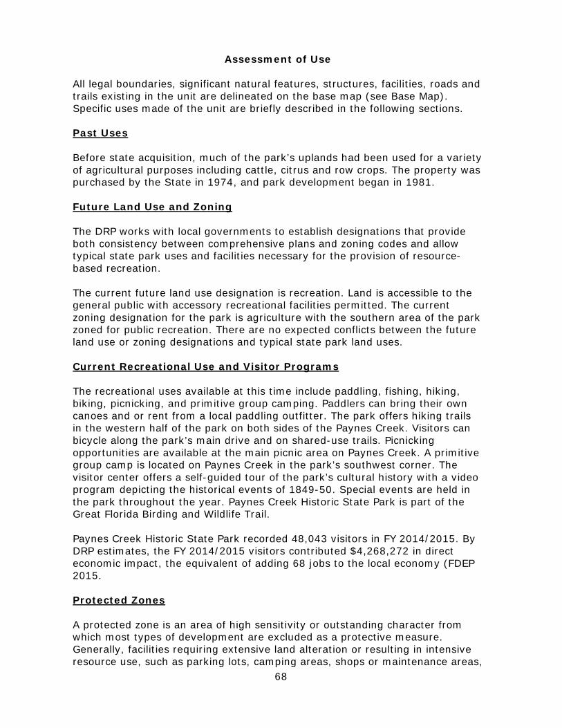
68
Assessment of Use All legal boundaries, significant natural features, structures, facilities, roads and trails existing in the unit are delineated on the base map (see Base Map). Specific uses made of the unit are briefly described in the following sections. Past Uses Before state acquisition, much of the park’s uplands had been used for a variety of agricultural purposes including cattle, citrus and row crops. The property was purchased by the State in 1974, and park development began in 1981. Future Land Use and Zoning The DRP works with local governments to establish designations that provide both consistency between comprehensive plans and zoning codes and allow typical state park uses and facilities necessary for the provision of resource-based recreation. The current future land use designation is recreation. Land is accessible to the general public with accessory recreational facilities permitted. The current zoning designation for the park is agriculture with the southern area of the park zoned for public recreation. There are no expected conflicts between the future land use or zoning designations and typical state park land uses. Current Recreational Use and Visitor Programs The recreational uses available at this time include paddling, fishing, hiking, biking, picnicking, and primitive group camping. Paddlers can bring their own canoes and or rent from a local paddling outfitter. The park offers hiking trails in the western half of the park on both sides of the Paynes Creek. Visitors can bicycle along the park’s main drive and on shared-use trails. Picnicking opportunities are available at the main picnic area on Paynes Creek. A primitive group camp is located on Paynes Creek in the park’s southwest corner. The visitor center offers a self-guided tour of the park’s cultural history with a video program depicting the historical events of 1849-50. Special events are held in the park throughout the year. Paynes Creek Historic State Park is part of the Great Florida Birding and Wildlife Trail. Paynes Creek Historic State Park recorded 48,043 visitors in FY 2014/2015. By DRP estimates, the FY 2014/2015 visitors contributed $4,268,272 in direct economic impact, the equivalent of adding 68 jobs to the local economy (FDEP 2015. Protected Zones A protected zone is an area of high sensitivity or outstanding character from which most types of development are excluded as a protective measure. Generally, facilities requiring extensive land alteration or resulting in intensive resource use, such as parking lots, camping areas, shops or maintenance areas,
PAYNES CREEK HISTORICSTATE PARK Florida Department of Environmental Protection
Division of Recreation and ParksDate of aerial; 2011
0 250 500125 Feet BASE MAP
LegendPark Boundary
State Road
Park Road Paved
Park Road Stabilized
Park Road Unstabilized
Hiking
Hiking/Biking
Nature/Interpretive
Bridges
Structures
Parking Lot
Walkways

71
are not permitted in protected zones. Facilities with minimal resource impacts, such as trails, interpretive signs and boardwalks are generally allowed. All decisions involving the use of protected zones are made on a case-by-case basis after careful site planning and analysis. At Paynes Creek Historic State Park all wetlands and floodplains and known imperiled species habitat have been designated as protected zones. The park’s current protected zones are delineated on the Conceptual Land Use Plan.
Existing Facilities Recreational Facilities The visitor center is the interpretive focal point of the park. Exhibits and an audiovisual presentation chronicle the historic events that led to the third and final Seminole War. The visitor center has an adjacent paved parking area, which accommodates about 30 vehicles. The picnic area contains three medium-sized picnic shelters, an unimproved canoe launch, a restroom building, and paved parking for about 60 vehicles. An interpretive cultural trail provides access to the park’s historic features. A suspension bridge was constructed across Paynes Creek, connecting the trail system to the monument on the south side of the creek. A small primitive group camping area has also been established on the north bank of Paynes Creek near the southwest corner of the park property. Support Facilities Support facilities include a ranger station, a shop building, a ranger residence, a flammable storage building, two pump houses, and a new equipment shelter (see Base Map). Fort Chokonikla Interpretive Area Visitor center Fort site Interpretive trail Picnic Area Picnic pavilions (3) Restroom Parking Paddling Launch Area Primitive Group Camping Area Shared-use Trails
Hiking Trails Oxbow Nature Trail Observation platform Special Events Area Parking area Entrance Area Ranger station Shop/Residence Area Shop building Equipment shelter Flammable storage building Pump houses (2) Staff residences (2)
72
Conceptual Land Use Plan The following narrative represents the current conceptual land use proposal for this park. The conceptual land use plan is the long-term, optimal development plan for the park, based on current conditions and knowledge of the park’s resources, landscape and social setting (see Conceptual Land Use Plan). The conceptual land use plan is modified or amended, as new information becomes available regarding the park’s natural and cultural resources or trends in recreational uses, in order to adapt to changing conditions. Additionally, the acquisition of new parkland may provide opportunities for alternative or expanded land uses. The DRP develops a detailed development plan for the park and a site plan for specific facilities based on this conceptual land use plan, as funding becomes available. During the development of the conceptual land use plan, the DRP assessed the potential impact of proposed uses or development on the park resources and applied that analysis to determine the future physical plan of the park as well as the scale and character of proposed development. Potential resource impacts are also identified and assessed as part of the site planning process once funding is available for facility development. At that stage, design elements (such as existing topography and vegetation, sewage disposal and stormwater management) and design constraints (such as imperiled species or cultural site locations) are investigated in greater detail. Municipal sewer connections, advanced wastewater treatment or best available technology systems are applied for on-site sewage disposal. Creation of impervious surfaces is minimized to the greatest extent feasible in order to limit the need for stormwater management systems, and all facilities are designed and constructed using best management practices to limit and avoid resource impacts. Federal, state and local permit and regulatory requirements are addressed during facility development. This includes the design of all new park facilities consistent with the universal access requirements of the Americans with Disabilities Act (ADA). After new facilities are constructed, park staff monitors conditions to ensure that impacts remain within acceptable levels. Potential Uses Public Access and Recreational Opportunities Goal: Provide public access and recreational opportunities in the park. The existing recreational activities and programs of this state park are appropriate to the natural and cultural resources contained in the park and should be continued. New and improved activities and programs are also recommended and discussed below. Objective: Maintain the park’s current recreational carrying capacity of 1090 users per day. The park will continue to provide opportunities for picnicking, paddling, fishing, hiking, nature walks, biking, primitive group camping, and interpretation of natural and cultural resources. Special events will continue to be offered on a regular basis.
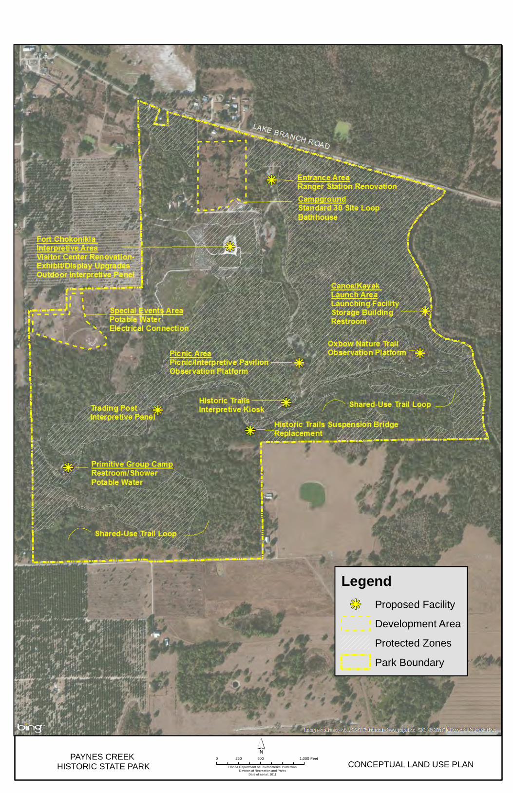
PAYNES CREEK HISTORIC STATE PARK Florida Department of Environmental Protection
Division of Recreation and ParksDate of aerial; 2011
0 500 1,000250 Feet
´CONCEPTUAL LAND USE PLAN
Legendkj Proposed Facility
Development Area
Protected Zones
Park Boundary

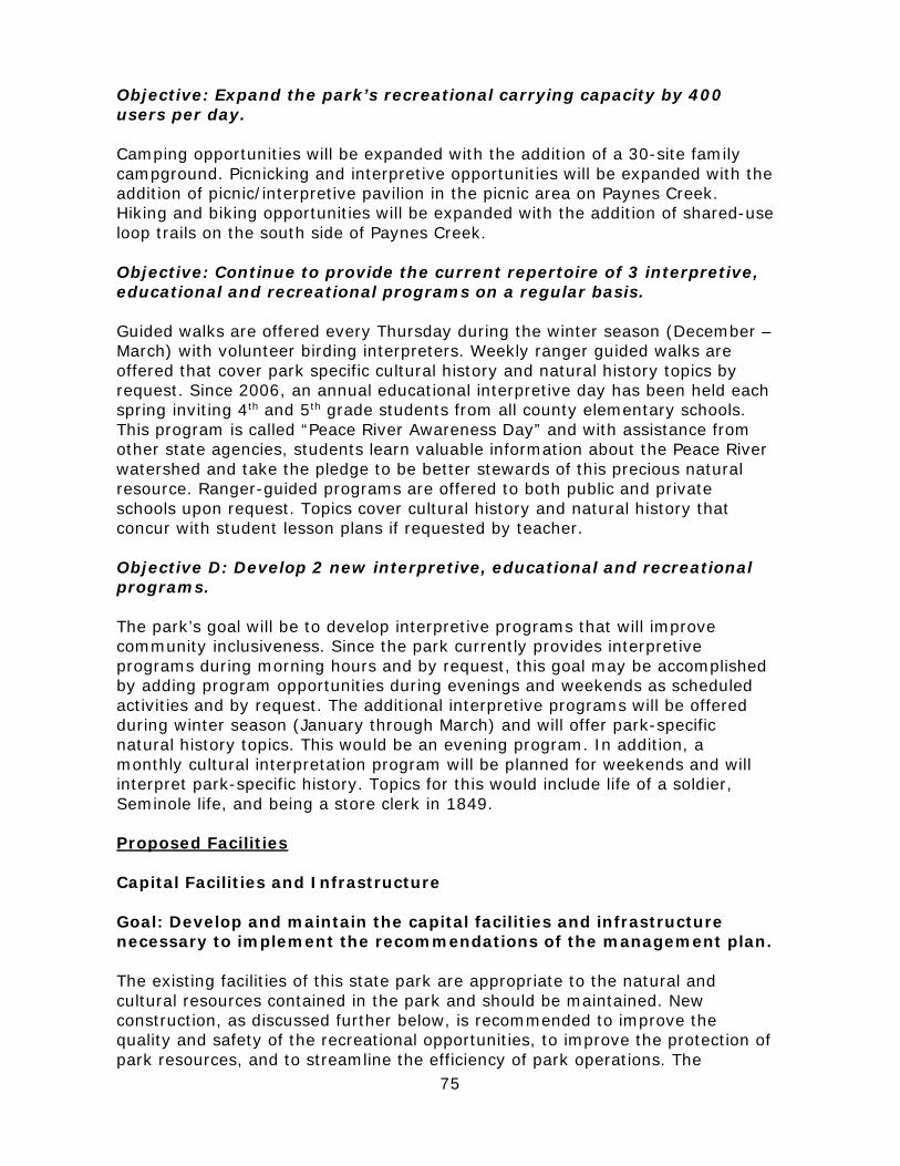
75
Objective: Expand the park’s recreational carrying capacity by 400 users per day. Camping opportunities will be expanded with the addition of a 30-site family campground. Picnicking and interpretive opportunities will be expanded with the addition of picnic/interpretive pavilion in the picnic area on Paynes Creek. Hiking and biking opportunities will be expanded with the addition of shared-use loop trails on the south side of Paynes Creek. Objective: Continue to provide the current repertoire of 3 interpretive, educational and recreational programs on a regular basis. Guided walks are offered every Thursday during the winter season (December – March) with volunteer birding interpreters. Weekly ranger guided walks are offered that cover park specific cultural history and natural history topics by request. Since 2006, an annual educational interpretive day has been held each spring inviting 4th and 5th grade students from all county elementary schools. This program is called “Peace River Awareness Day” and with assistance from other state agencies, students learn valuable information about the Peace River watershed and take the pledge to be better stewards of this precious natural resource. Ranger-guided programs are offered to both public and private schools upon request. Topics cover cultural history and natural history that concur with student lesson plans if requested by teacher. Objective D: Develop 2 new interpretive, educational and recreational programs. The park’s goal will be to develop interpretive programs that will improve community inclusiveness. Since the park currently provides interpretive programs during morning hours and by request, this goal may be accomplished by adding program opportunities during evenings and weekends as scheduled activities and by request. The additional interpretive programs will be offered during winter season (January through March) and will offer park-specific natural history topics. This would be an evening program. In addition, a monthly cultural interpretation program will be planned for weekends and will interpret park-specific history. Topics for this would include life of a soldier, Seminole life, and being a store clerk in 1849. Proposed Facilities Capital Facilities and Infrastructure Goal: Develop and maintain the capital facilities and infrastructure necessary to implement the recommendations of the management plan. The existing facilities of this state park are appropriate to the natural and cultural resources contained in the park and should be maintained. New construction, as discussed further below, is recommended to improve the quality and safety of the recreational opportunities, to improve the protection of park resources, and to streamline the efficiency of park operations. The
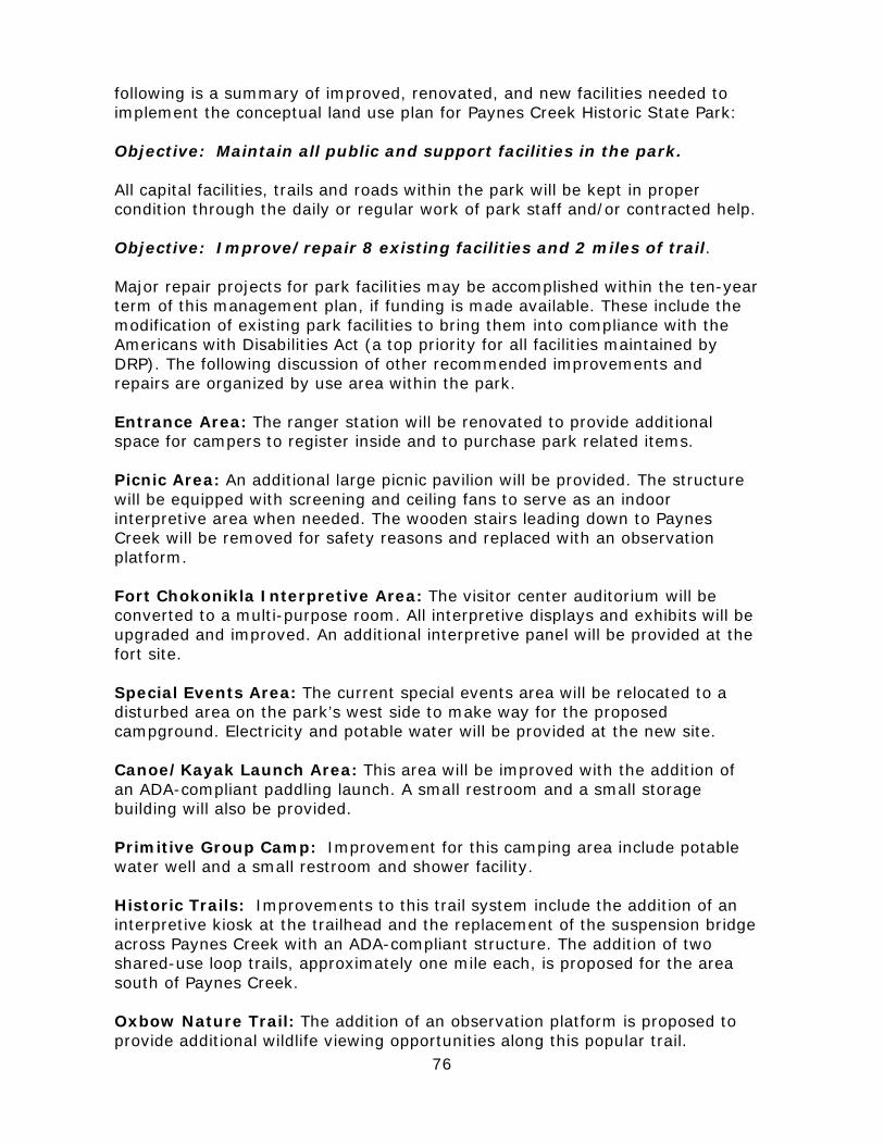
76
following is a summary of improved, renovated, and new facilities needed to implement the conceptual land use plan for Paynes Creek Historic State Park: Objective: Maintain all public and support facilities in the park. All capital facilities, trails and roads within the park will be kept in proper condition through the daily or regular work of park staff and/or contracted help. Objective: Improve/repair 8 existing facilities and 2 miles of trail. Major repair projects for park facilities may be accomplished within the ten-year term of this management plan, if funding is made available. These include the modification of existing park facilities to bring them into compliance with the Americans with Disabilities Act (a top priority for all facilities maintained by DRP). The following discussion of other recommended improvements and repairs are organized by use area within the park. Entrance Area: The ranger station will be renovated to provide additional space for campers to register inside and to purchase park related items. Picnic Area: An additional large picnic pavilion will be provided. The structure will be equipped with screening and ceiling fans to serve as an indoor interpretive area when needed. The wooden stairs leading down to Paynes Creek will be removed for safety reasons and replaced with an observation platform. Fort Chokonikla Interpretive Area: The visitor center auditorium will be converted to a multi-purpose room. All interpretive displays and exhibits will be upgraded and improved. An additional interpretive panel will be provided at the fort site. Special Events Area: The current special events area will be relocated to a disturbed area on the park’s west side to make way for the proposed campground. Electricity and potable water will be provided at the new site. Canoe/Kayak Launch Area: This area will be improved with the addition of an ADA-compliant paddling launch. A small restroom and a small storage building will also be provided. Primitive Group Camp: Improvement for this camping area include potable water well and a small restroom and shower facility. Historic Trails: Improvements to this trail system include the addition of an interpretive kiosk at the trailhead and the replacement of the suspension bridge across Paynes Creek with an ADA-compliant structure. The addition of two shared-use loop trails, approximately one mile each, is proposed for the area south of Paynes Creek. Oxbow Nature Trail: The addition of an observation platform is proposed to provide additional wildlife viewing opportunities along this popular trail.
77
Objective C: Construct 1 new facility. Campground: A standard 30-site campground is proposed for an area on the park’s north side that is currently being used for special events. Each site will be furnished with a picnic table, fire ring, water, and electrical hook-up. One bathhouse will be provided. Facilities Development Preliminary cost estimates for these recommended facilities and improvements are provided in the Ten-Year Implementation Schedule and Cost Estimates (Table 7) located in the Implementation Component of this plan. These cost estimates are based on the most cost-effective construction standards available at this time. The preliminary estimates are provided to assist DRP in budgeting future park improvements, and may be revised as more information is collected through the planning and design processes. New facilities and improvements to existing facilities recommended by the plan include: Entrance Area Ranger station renovation Picnic Area Large picnic/interpretive pavilion Observation platform Fort Chokonikla Interpretive Area Visitor center renovation Interpretive exhibit/display upgrades Outdoor interpretive panel Special Events Area Potable water Electrical connection
Canoe/Kayak Launch Area Launching/landing platform Small restroom Storage building Primitive Group Camp Potable water Restroom/shower Historic Trails Interpretive kiosk Suspension bridge replacement Shared-use loop trails (2) Oxbow Nature Trail Observation platform Campground Standard campsites (30) Bathhouse
Recreational Carrying Capacity Carrying capacity is an estimate of the number of users a recreation resource or facility can accommodate and still provide a high quality recreational experience and preserve the natural values of the site. The carrying capacity of a unit is determined by identifying the land and water requirements for each recreation activity at the unit, and then applying these requirements to the unit's land and water base. Next, guidelines are applied that estimate the physical capacity of the unit's natural communities to withstand recreational uses without significant degradation. This analysis identifies a range within which the carrying capacity
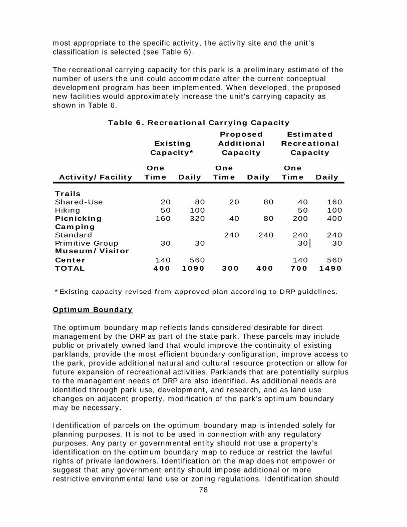
78
most appropriate to the specific activity, the activity site and the unit's classification is selected (see Table 6). The recreational carrying capacity for this park is a preliminary estimate of the number of users the unit could accommodate after the current conceptual development program has been implemented. When developed, the proposed new facilities would approximately increase the unit's carrying capacity as shown in Table 6.
Activity/FacilityOne Time Daily
One Time Daily
One Time Daily
TrailsShared-Use 20 80 20 80 40 160Hiking 50 100 50 100Picnicking 160 320 40 80 200 400CampingStandard 240 240 240 240Primitive Group 30 30 30 30Museum/Visitor Center 140 560 140 560TOTAL 400 1090 300 400 700 1490
Table 6. Recreational Carrying Capacity
*Existing capacity revised from approved plan according to DRP guidelines.
Proposed Additional Capacity
Existing Capacity*
Estimated Recreational
Capacity
Optimum Boundary The optimum boundary map reflects lands considered desirable for direct management by the DRP as part of the state park. These parcels may include public or privately owned land that would improve the continuity of existing parklands, provide the most efficient boundary configuration, improve access to the park, provide additional natural and cultural resource protection or allow for future expansion of recreational activities. Parklands that are potentially surplus to the management needs of DRP are also identified. As additional needs are identified through park use, development, and research, and as land use changes on adjacent property, modification of the park’s optimum boundary may be necessary. Identification of parcels on the optimum boundary map is intended solely for planning purposes. It is not to be used in connection with any regulatory purposes. Any party or governmental entity should not use a property’s identification on the optimum boundary map to reduce or restrict the lawful rights of private landowners. Identification on the map does not empower or suggest that any government entity should impose additional or more restrictive environmental land use or zoning regulations. Identification should

79
not be used as the basis for permit denial or the imposition of permit conditions. The optimum boundary for Paynes Creek Historic State Park includes five parcels totaling approximately 250 acres. These acquisitions would improve park operations and management, enhance the park’s resource base, and allow for potential future expansion of recreational activities and facilities (see Optimum Boundary Map).

80
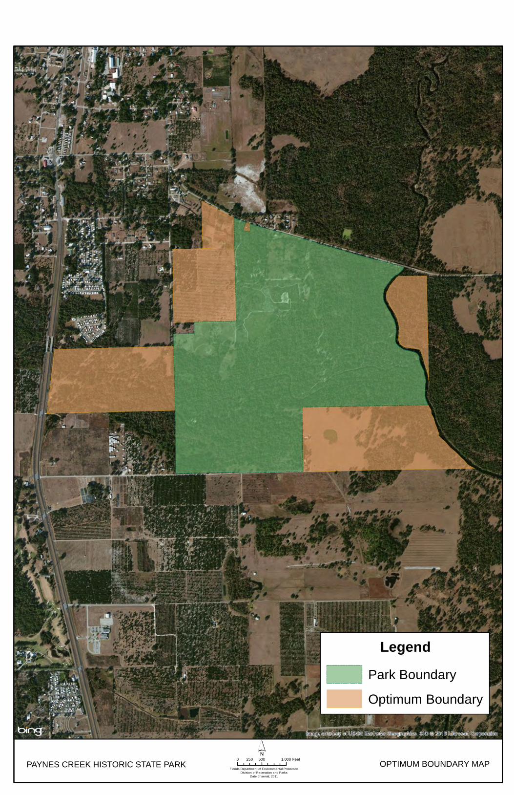
PAYNES CREEK HISTORIC STATE PARKFlorida Department of Environmental Protection
Division of Recreation and ParksDate of aerial; 2011
0 500 1,000250 Feet´
OPTIMUM BOUNDARY MAP
LegendPark Boundary
Optimum Boundary

83
IMPLEMENTATION COMPONENT
The resource management and land use components of this management plan provide a thorough inventory of the park’s natural, cultural and recreational resources. They outline the park’s management needs and problems, and recommend both short and long-term objectives and actions to meet those needs. The implementation component addresses the administrative goal for the park and reports on the Division of Recreation and Parks (DRP) progress toward achieving resource management, operational and capital improvement goals and objectives since approval of the previous management plan for this park. This component also compiles the management goals, objectives and actions expressed in the separate parts of this management plan for easy review. Estimated costs for the ten-year period of this plan are provided for each action and objective, and the costs are summarized under standard categories of land management activities.
Management Progress Since the approval of the last management plan for Paynes Creek Historic State Park in 2004, significant work has been accomplished and progress made towards meeting the DRP’s management objectives for the park. These accomplishments fall within three of the five general categories that encompass the mission of the park and the DRP.
Acquisition
• 2006 acquisition: 15-acre parcel identified as part of optimum boundary was acquired. This provided an additional staff residence.
Park Administration and Operations
• Established working agreements with Experience Works/American Association of Retired Persons to provide additional administrative assistance. Since 2011, five employees from the agencies have worked at the park.
• Established a park Citizen Support Organization (CSO) in 2005.
Resource Management Natural Resources
• Introduced federally-endangered plant Florida golden aster (Chrysopsis floridana).
• Applied exotic plant removal methods to 287 acres. • Obtained FWC funding ($480,000 approx.) for exotic plant removal. • Prescribed fire: Pyric acres have increased 95% since last UMP through
improved resource management methods. • Managed exotic animals: 9 species of exotic animals are removed from the
park annually with assistance from contracted trappers.
84
Recreation and Visitor Services
• 2006 opened 1.3 mile hiking trail. • 2007 designated an area for park special events and activities. • 2007 established annual reenactment event. • 2008 established and opened canoe access. • 2009 established annual holiday event. • 2010 improved video and audio system in visitor center auditorium. • 2013 received a $50,000 grant to improve park history video through the
CSO.
Park Facilities
• Improvements to the Visitor center included accessible entry/exit doors, hand rails, and 300 foot accessible sidewalk to fort site.
• Installed Oxbow Trail overlook to improve visitor experience. • Improved primitive youth camp by adding gated entrance, small pavilion with
picnic tables, and campfire benches. • Added replica ruins to Kennedy-Darling Store site for visual interpretation. • Erected replica flag with 30 star flag at Fort Chokonikla Site.
Management Plan Implementation
This management plan is written for a timeframe of ten years, as required by Section 253.034 Florida Statutes. The Ten-Year Implementation Schedule and Cost Estimates (Table 7) summarizes the management goals, objectives and actions that are recommended for implementation over this period, and beyond. Measures are identified for assessing progress toward completing each objective and action. A time frame for completing each objective and action is provided. Preliminary cost estimates for each action are provided and the estimated total costs to complete each objective are computed. Finally, all costs are consolidated under the following five standard land management categories: Resource Management, Administration and Support, Capital Improvements, Recreation Visitor Services and Law Enforcement. Many of the actions identified in the plan can be implemented using existing staff and funding. However, a number of continuing activities and new activities with measurable quantity targets and projected completion dates are identified that cannot be completed during the life of this plan unless additional resources for these purposes are provided. The plan’s recommended actions, time frames and cost estimates will guide the DRP’s planning and budgeting activities over the period of this plan. It must be noted that these recommendations are based on the information that exists at the time the plan was prepared. A high degree of adaptability and flexibility must be built into this process to ensure that the DRP can adjust to changes in the availability of funds, improved understanding of the park’s natural and cultural resources, and changes in statewide land management issues, priorities and policies.

85
Statewide priorities for all aspects of land management are evaluated each year as part of the process for developing the DRP’s annual legislative budget requests. When preparing these annual requests, the DRP considers the needs and priorities of the entire state park system and the projected availability of funding from all sources during the upcoming fiscal year. In addition to annual legislative appropriations, the DRP pursues supplemental sources of funds and staff resources wherever possible, including grants, volunteers and partnerships with other entities. The DRP’s ability to accomplish the specific actions identified in the plan will be determined largely by the availability of funds and staff for these purposes, which may vary from year to year. Consequently, the target schedules and estimated costs identified in Table 7 may need to be adjusted during the ten-year management planning cycle.

86
Table 7Paynes Creek Historic State Park Ten-Year Implementation Schedule and Cost Estimates
Sheet 1 of 5
DRAFTPCHSP_Spreadsheet_20160613_dc
Measure Planning Period
Estimated Manpower and
Expense Cost* (10-years)
Objective A Continue day-to-day administrative support at current levels. Administrative support ongoing
C$192,000
Objective B Expand administrative support as new lands are acquired, new facilities are developed, or as other needs arise. Administrative support expanded
UFN$70,000
Measure Planning Period
Estimated Manpower and
Expense Cost* (10-years)
Objective A Conduct/obtain an assessment of the park's hydrological needs. Assessment conducted LT $40,000Action 1 Monitor and analyze resources of the park. Map all erosion problems and analyze impacts. Resources
monitored/analyzedUFN
$37,000Action 2 Determine needs for restoration Needs determined ST $3,000
Objective B Restore natural hydrological conditions and function to approximately 2 acres of sandhill and mesic hammock natural communities.
~2 Acres restored or with restoration underway
UFN$8,000
Action 1 Adjust topography to reroute stormwater along southwest corner of property. .2 Miles of ditches filled UFN $6,000Action 2 Plan sandhill plantings plantings to support new stormwater flow patterns est 2 crossings/culverts
installedUFN
$2,000
Goal II: Protect water quality and quantity in the park, restore hydrology to the extent feasible, and maintain the restored condition.
Goal I: Provide administrative support for all park functions.
NOTE: THE DIVISION'S ABILITY TO COMPLETE THE OBJECTIVES OUTLINED BY THE MANAGEMENT PLAN IS CONTINGENT ON THE AVAILABILITY OF FUNDING AND OTHER RESOURCES FOR THESE PURPOSES.
* 2015 DollarsST = actions within 2 years
LT = actions within 10 yearsC = long term or short term actions that are continuous or cyclical
UFN = currently unfunded need

Table 7Paynes Creek Historic State Park Ten-Year Implementation Schedule and Cost Estimates
Sheet 2 of 5
DRAFTPCHSP_Spreadsheet_20160613_dc
NOTE: THE DIVISION'S ABILITY TO COMPLETE THE OBJECTIVES OUTLINED BY THE MANAGEMENT PLAN IS CONTINGENT ON THE AVAILABILITY OF FUNDING AND OTHER RESOURCES FOR THESE PURPOSES.
Measure Planning Period
Estimated Manpower and
Expense Cost* (10-years)
Objective A Within 10 years have 127 acres of the park maintained within optimal fire return interval. # Acres within fire return interval target
LT$34,000
Action 1 Develop/update annual burn plan. Plan updated C $2,000Action 2 Manage fire dependent communities for ecosystem function, structure and processes by burning between 37 - 89
acres annually, as identified by the annual burn plan.Average # acres burned annually
C$32,000
Objective B Conduct habitat/natural community restoration activities on 20 acres of sandhill natural community. # Acres restored or with restoration underway
UFN$26,000
Action 1 Develop/update site specific restoration plan Plan developed/updated LT $8,000Action 2 Begin implementing restoration fire interval (1-3 yr) Fire frequency, # acres burned UFN
$5,000Action 3 Remove encroaching vegetation Vegetation removed
(fire & mechanical)UFN
$4,000Action 4 Begin restoration plantings - plants acquired, planting implemented Plants acquired, planted UFN $6,000Action 5 Begin maintenance and survey activity Maintanance and survey
activity intitiatedLT
$3,000Objective C Conduct habitat/natural community improvement activities on 8.5 acres of mesic hammock natural community. # Acres improved or with
improvements underwayUFN
$8,000Action 1 Control hardwood and exotic invasive encroachment Vegetation controlled UFN $8,000
Measure Planning Period
Estimated Manpower and
Expense Cost* (10-years)
Objective A Update baseline imperiled species occurrence inventory lists for plants and animals, as needed. List [developed] updated C $21,000Objective B Monitor and document 1 selected imperiled animal species in the park. 1 Species monitored C $7,000
Action 1 Use existing FWC protocols for gopher tortoise monitoring; adopt new FWC protocols when those are complete. # Protocols developed ST $6,000
Action 2 Update protocols as needed as new imperiled animal species are either identified at the park or known species are assigned new status designations.
# Species monitored C$1,000
Objective C Monitor and document 2 selected imperiled plant species in the park. # Species monitored C $4,000Action 1 Research or develop monitoring protocols for giant orchid and Simpson's zephyrlily. # Protocols developed ST $1,000Action 2 Implement monitoring protocols. # Species monitored C $3,000
Goal III: Restore and maintain the natural communities/habitats of the park.
Goal IV: Maintain, improve or restore imperiled species populations and habitats in the park.
* 2015 DollarsST = actions within 2 years
LT = actions within 10 yearsC = long term or short term actions that are continuous or cyclical
UFN = currently unfunded need

Table 7Paynes Creek Historic State Park Ten-Year Implementation Schedule and Cost Estimates
Sheet 3 of 5
DRAFTPCHSP_Spreadsheet_20160613_dc
NOTE: THE DIVISION'S ABILITY TO COMPLETE THE OBJECTIVES OUTLINED BY THE MANAGEMENT PLAN IS CONTINGENT ON THE AVAILABILITY OF FUNDING AND OTHER RESOURCES FOR THESE PURPOSES.
Measure Planning Period
Estimated Manpower and
Expense Cost* (10-years)
Objective A Annually treat 30 acres of exotic plant species in the park. # Acres treated C $67,000Action 1 Develop/update exotic plant management work plan based on updated surveys of management zones. Plan developed/updated C $16,000Action 2 Ensure staff is trained to identify relevant exotic plant species and is able to distinguish them from native look-alike
plants.Training Implemented C
$2,500Action 3 Implement annual work plan by treating 30 acres in park, annually, and continuing maintenance and follow-up
treatments, as needed.Plan implemented C
$46,000Action 4 Park management participates in local CISMA Early Detection species identifications and lists, and includes these
species in their infested area acreages.Participation documented C
$2,500Objective B Implement control measures on 1 exotic and nuisance animal species in the park. # Species for which control
measures implementedC
$25,000Action 1 Contract for wild pig removal services. Contract implemented UFN $25,000
Measure Planning Period
Estimated Manpower and
Expense Cost* (10-years)
Objective A Assess and evaluate 2 of 2 recorded cultural resources in the park. Documentation complete LT $13,000Action 1 Complete 1 assessments/evaluations of archaeological sites. Prioritize preservation and stabilization projects. Assessments complete UFN $3,000Action 2 Complete 1 Cultural Landscape Survey. Reports and priority lists
completedUFN
$10,000Objective B Compile reliable documentation for all recorded historic and archaeological sites. Documentation complete LT $29,000
Action 1 Ensure all known sites are recorded or updated in the Florida Master Site File. # Sites recorded or updated ST$2,000
Action 2 Conduct Level 1 archaeological survey for 1 [#] priority areas identified by the predictive model study. Survey completed UFN$20,000
Action 3 Develop and adopt a Scope of Collections Statement. Document completed ST $1,000Action 4 Locate and update Collections documentation Documentation
located/updatedLT
$6,000Objective C Bring 2 of 2 recorded cultural resources into good condition. # Sites in good condition LT $23,000
Action 1 Design and implement regular monitoring programs for 2 cultural sites # Sites monitored C $8,000Action 2 Create and implement a cyclical maintenance program for each cultural resource. Programs implemented C $15,000
Goal V: Remove exotic and invasive plants and animals from the park and conduct needed maintenance-control.
Goal VI: Protect, preserve and maintain the cultural resources of the park.
* 2015 DollarsST = actions within 2 years
LT = actions within 10 yearsC = long term or short term actions that are continuous or cyclical
UFN = currently unfunded need

Table 7Paynes Creek Historic State Park Ten-Year Implementation Schedule and Cost Estimates
Sheet 4 of 5
DRAFTPCHSP_Spreadsheet_20160613_dc
NOTE: THE DIVISION'S ABILITY TO COMPLETE THE OBJECTIVES OUTLINED BY THE MANAGEMENT PLAN IS CONTINGENT ON THE AVAILABILITY OF FUNDING AND OTHER RESOURCES FOR THESE PURPOSES.
Measure Planning Period
Estimated Manpower and
Expense Cost* (10-years)
Objective A Maintain the park's current recreational carrying capacity of 1090 users per day. # Recreation/visitor C $577,000Objective B Expand the park's recreational carrying capacity by 400 users per day. # Recreation/visitor UFN $212,000Objective C Continue to provide the current repertoire of 3 interpretive, educational and recreational programs on a regular
basis.# Interpretive/education programs
C$20,000
Objective D Develop 2 new interpretive, educational and recreational programs. # Interpretive/education programs
UFN$15,000
Measure Planning Period
Estimated Manpower and
Expense Cost* (10-years)
Objective A Maintain all public and support facilities in the park. Facilities maintained C $673,000Objective B Continue to implement the park's transition plan to ensure facilities are accessible in accordance with the
American with Disabilities Act of 1990.Plan implemented LT
$200,000Objective C Improve and/or repair 8 existing facilities and 2 miles of trail as identified in the Land Use Component. # Facilities/Miles of Trail UFN
$1,862,000Objective D Construct 1 new facility as identified in the Land Use Component. # Facilities UFN
$3,045,000Objective E Expand maintenance activities as existing facilities are improved and new facilities are developed. Facilities maintained C
$400,000
Goal VII: Provide public access and recreational opportunities in the park.
Goal VIII: Develop and maintain the capital facilities and infrastructure necessary to meet the goals and objectives of this management plan.
* 2015 DollarsST = actions within 2 years
LT = actions within 10 yearsC = long term or short term actions that are continuous or cyclical
UFN = currently unfunded need

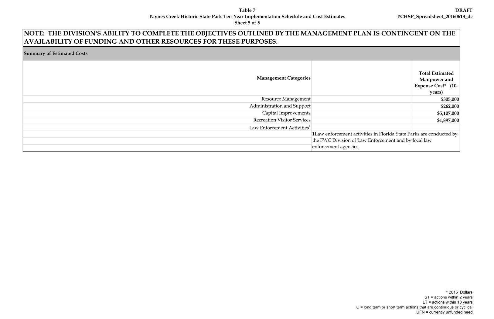
Table 7Paynes Creek Historic State Park Ten-Year Implementation Schedule and Cost Estimates
Sheet 5 of 5
DRAFTPCHSP_Spreadsheet_20160613_dc
NOTE: THE DIVISION'S ABILITY TO COMPLETE THE OBJECTIVES OUTLINED BY THE MANAGEMENT PLAN IS CONTINGENT ON THE AVAILABILITY OF FUNDING AND OTHER RESOURCES FOR THESE PURPOSES.
Total Estimated Manpower and
Expense Cost* (10-years)
$305,000$262,000
$5,107,000$1,897,000
Capital ImprovementsRecreation Visitor Services
Law Enforcement Activities1
1Law enforcement activities in Florida State Parks are conducted by the FWC Division of Law Enforcement and by local law enforcement agencies.
Administration and Support
Management Categories
Summary of Estimated Costs
Resource Management
* 2015 DollarsST = actions within 2 years
LT = actions within 10 yearsC = long term or short term actions that are continuous or cyclical
UFN = currently unfunded need


Addendum 1—Acquisition History

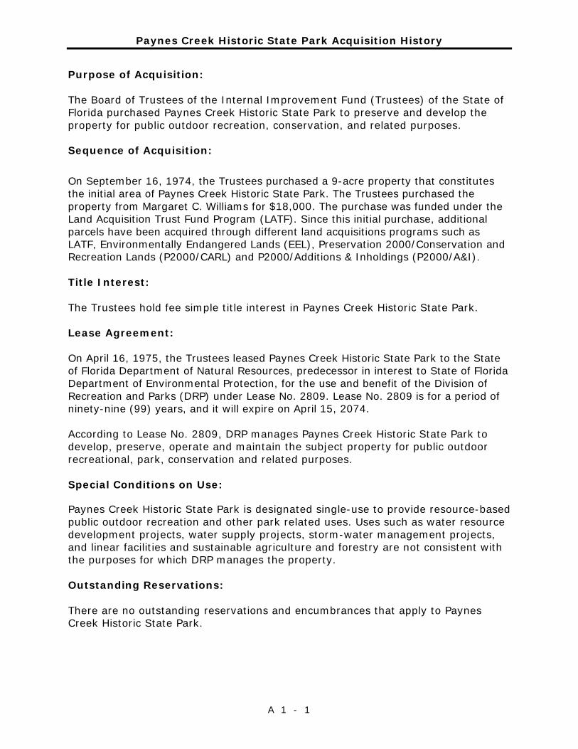
Paynes Creek Historic State Park Acquisition History
A 1 - 1
Purpose of Acquisition: The Board of Trustees of the Internal Improvement Fund (Trustees) of the State of Florida purchased Paynes Creek Historic State Park to preserve and develop the property for public outdoor recreation, conservation, and related purposes. Sequence of Acquisition:
On September 16, 1974, the Trustees purchased a 9-acre property that constitutes the initial area of Paynes Creek Historic State Park. The Trustees purchased the property from Margaret C. Williams for $18,000. The purchase was funded under the Land Acquisition Trust Fund Program (LATF). Since this initial purchase, additional parcels have been acquired through different land acquisitions programs such as LATF, Environmentally Endangered Lands (EEL), Preservation 2000/Conservation and Recreation Lands (P2000/CARL) and P2000/Additions & Inholdings (P2000/A&I). Title Interest: The Trustees hold fee simple title interest in Paynes Creek Historic State Park. Lease Agreement: On April 16, 1975, the Trustees leased Paynes Creek Historic State Park to the State of Florida Department of Natural Resources, predecessor in interest to State of Florida Department of Environmental Protection, for the use and benefit of the Division of Recreation and Parks (DRP) under Lease No. 2809. Lease No. 2809 is for a period of ninety-nine (99) years, and it will expire on April 15, 2074. According to Lease No. 2809, DRP manages Paynes Creek Historic State Park to develop, preserve, operate and maintain the subject property for public outdoor recreational, park, conservation and related purposes. Special Conditions on Use: Paynes Creek Historic State Park is designated single-use to provide resource-based public outdoor recreation and other park related uses. Uses such as water resource development projects, water supply projects, storm-water management projects, and linear facilities and sustainable agriculture and forestry are not consistent with the purposes for which DRP manages the property. Outstanding Reservations: There are no outstanding reservations and encumbrances that apply to Paynes Creek Historic State Park.

Paynes Creek Historic State Park Acquisition History
A 1 - 2

Addendum 2—Advisory Group Members and Report

Paynes Creek Historic State Park Advisory Group and Staff Report
A 2 - 3
Elected Officials The Honorable Colon Lambert, Hardee County Board of County Commissioners Agency Representatives Jackson Mosley, Park Manager Paynes Creek Historic State Park Jeff McGrady, Regional Wildlife Biologist Florida Fish and Wildlife Conservation Commission Michael Edwards, Senior Forester Florida Forest Service Other Public Lands Region 4 Charles Matheny, Chair Hardee Soil and Water Conservation District Mike Wisenbaker, Archaeology Supervisor Bureau of Archaeological Research Florida Division of Historical Resources Tourism/Economic Development Representative Bill Lambert, Economic Development Director Hardee County Economic Development Council Environmental Groups Bob Hummel, President Highlands County Audubon Society Ed Murawski, President Heartland Chapter, Florida Native Plant Society
Recreational User Groups David Waldrop, Chair Heartland Chapter Florida Trail Association Tom McLaughlin Florida Paddling Trails Association Citizen Support Organization Emogene Gilmore, President Friends of Paynes Creek Historic State Park Adjacent Landowner Loyd M. Larramore
Paynes Creek Historic State Park Advisory Group Staff Report
A 2 - 4
The Advisory Group meeting for Paynes Creek Historic State Park was held at the Hardee Junior High School Library on July 14, 2016. Dwight Myers represented Jeff McGrady. Michael Edwards, Bill Lambert, Mike Wisenbaker, Ed Murawski, David Waldrop, Tom McLaughlin, Emogene Gilmore, and Loyd Larramore were unable to attend. Mike Wisenbaker sent written comments before the meeting. Michael Edwards and Ed Murawski submitted written comments after the meeting. All other Advisory Group members were in attendance. Attending staff were Valinda Subic, Chris Becker, Rosalind Rowe, Jackson Mosley, and David Copps. Mr. Copps began the meeting by explaining the purpose of the Advisory Group, reviewing the meeting agenda, and summarizing the comments from the public hearing that was held the previous evening. Mr. Copps then asked each member of the Advisory Group to express his or her comments on the draft plan. Summary of Advisory Group Comments________________________ Colon Lambert (Hardee County, Board of County Commissioners) asked how the existing paddle launch area on the Peace River is currently being used. Mr. Mosley said that the majority of use is by down and back day use paddlers. He said that many paddlers engage in fossil hunting in the river bed (outside of park boundaries). Commissioner Lambert stressed the need to promote the recreational facilities in the park to attract more tourist to Hardee County. He asked if the park works with local tourism organization to attract more visitors to the area. Mr. Mosley said that the park partners with the Visit Florida to promote the park and is willing to work with other groups to that end. He said that one of the park’s goals is to improve existing recreational facilities and provide new camping opportunities to attract more visitors. Commissioner Lambert expressed concern about the litter problem on the Peace River. He said that the majority of the problem is caused from visitors from outside the area that don’t understand resource stewardship. Commissioner Colon said that he would like to see an educational effort in the region to educate visitors about the negative impacts of litter pollution on the Peace River. He recommended that educational materials be developed and provided at all boat access areas along the river. Ms. Subic said that the park can help get the message out by posting informational/educational signs on kiosks. Mr. Colon said that paddling concessionaires should help get this message out. Mr. Mosley said that the pledge form signed by Hardee County students stating that they will be good river stewards could be adapted for use by paddling related businesses. Bob Hummel (Highlands County Audubon Society) stated that he supports the campground addition. He asked about the status of the proposed Peace River Hiking Trail. Mr. Mosley said that the park has not been approached about participating in this Polk County sponsored project. Mr. Mosley said that he is not sure of the project’s current status. Mr. Hummel said that
Paynes Creek Historic State Park Advisory Group Staff Report
A 2 - 5
paddling is an important recreational activity at the park and he hopes that the state will fund the proposed paddling launch. He said that the park should be provided with more staff. He recommended that the picnic area sidewalks be resurfaced. Mr. Hummel described the unique character of the suspension bridge and recommended that it be improved rather than replaced. He recommended that additional kiosks with interpretative information be provided in the park to address the themes of the Seminole Wars, the Peace River, and imperiled species habitat, particularly the Florida scrub-jay. Mr. Hummel described the confluence of Paynes Creek and the Peace River as a very scenic location that characterizes the “Real Florida.” He stressed the importance of protecting and preserving this spot. Dwight Myers (Florida Fish and Wildlife Conservation Commission) stated his support of the plan. He said that the park may be relatively small but it serves as an important refuge within the surrounding mining and agricultural landscape. Mr. Myers said the plan does a good job in addressing prescribed burning, habitat restoration and improvement, and exotic plant and animal control. Mr. Mosley said that hog trapping has been successful lately but the hogs move in and out the park so the trapper has to be especially crafty. Mr. Myers asked how panther sightings are documented. Mr. Mosley said by trail camera. Mr. Myers stated that more bears are moving north along the Peace River corridor. Jackson Mosley (Manager, Paynes Creek Historic State Park) said he would like to see the park play a larger role on the local ecotourism stage. Summary of Written Comments Mike Wisenbaker (Division of Historical Resources) said that he is pleased with how the archaeological and historical resources were addressed in the plan update. He recommended a date change for the Middle Archaic period on page 44 to 7,000 to 5,000 B.P. He recommended that the Florida Master Site File be updated to include the location corrections made by the University of South Florida during their work on the archaeological sensitivity model for the park. Mr. Wisenbaker recommended that the statement on page 47 claiming that artifacts were donated to the park that were recovered from an archaeological excavation of a Seminole War period site be deleted unless this can be verified by Miller or Baker’s field notes. He strongly encouraged the park to develop two more interpretive programs as stated in the plan. Mr. Wisenbaker noted that the park is named for the same individual that Paynes Prairie is named for. Michael Edwards (Florida Forest Service) said that although a timber analysis in not required for the park, there are degraded community types where restoration and reforestation can be implemented to bring them into maintenance or restored condition. He provided some strategies and techniques for reforesting mesic flatwoods and restoring sandhills. Mr.
Paynes Creek Historic State Park Advisory Group Staff Report
A 2 - 6
Edwards suggested that the park contact the Florida Forest Serice Mitigation Specialist to determine what assistance might be available in the way of property boundary fuels mitigation and prescribed burning. He suggested that the park contact the FWC Upland Invasives Plant Management Program to apply for invasive species project grants. He also suggested that park staff participate in the Heartland CISMA. Ed Murawski (Florida Native Plant Society, Heartland Chapter) suggested that the exotic species management section should provide more elaboration and discussion on using early detection of exotic species during any construction or other land disturbance since these places create ideal conditions for exotics to proliferate. He suggested that these areas receive extra attention for the first six months to a year after disturbance. Mr. Murawski stated that the fire plan should take extra precautions for the Florida goldenaster. Summary of Public Comments Richard Barone stated that the City of Bowling Green supports the management plan update particularly the addition of a campground and canoe/kayak launch. He said that these improvements should provide an economic boost for local businesses. Mr. Barone said that Bowling Green has sponsored a canoe race in the past and suggested that they may do so again in the future. He suggested that the park may serve as a good starting point for the race. Mr. Mosley said the park would consider partnering with the City on such an event. Mr. Barone stated that the park needs to take advantage of all available technology, including the internet and phone apps, to promote itself. Andrea Thompson stated her support for the campground and said that more overnight opportunities in the region will encourage visitors to stay longer and spend more money thus providing a boost to the local economy. She said that camping is a good fit for the region because it promotes habitat protection, is affordable for families, and stimulates the economy. She recommended that the park partner with other agencies and businesses in the region to collaborate on ecotourism marketing strategies. Ms. Thompson described the appeal of the suspension bridge experience and recommended that the existing character be preserved as much as possible when improvements are made. She said that she is in favor of improving the canoe/kayak launching area. Ms. Thompson said that she would like to see more community involvement for the reenactment event. Mr. Mosley said that he would like to see the citizen support organization help to better promote this event. Ms. Thompson stated that she would like to see the park incorporate the “Leave No Trace” message on its website in a way that is consistent with other organizations and entities in the region to provide a region-wide branding effect. Mr. Mosley said that he has some ideas on how to work with other entities to provide a consistent message. Ms. Thompson
Paynes Creek Historic State Park Advisory Group Staff Report
A 2 - 7
asked if the park can rent canoes. Mr. Jackson answered yes but said that a concessionaire could be the best option for this service. Becky Bragg recommended that the park apply for a grant from Visit Florida to develop promotional programs such as the Peace River information app that has been developed for DeSoto County. Commissioner Lambert said that such an app should consider incorporating a river safety feature to alert paddlers of dangerous river conditions. Ms. Bragg said education of the paddling public about river stewardship is an ongoing process. She said that she supports the addition of educational kiosks in the park. Ms. Bragg said that paddler’s prefer a simple approach for canoe/kayak launches. She said that the park should be outfitter friendly as outfitters can help to promote park facilities. She asked if the park still hosts the fossil show. Mr. Mosley yes and that the park is interested in continuing with fossil interpretation on a regular basis. Ms. Bragg recommended that the park collaborate with the Southwest Florida Fossil Club on fossil interpretive programs. She expressed support for the campground addition. Ms. Bragg asked if park has dedicated bike trails. Mr. Mosley said that biking opportunities are provided on the share-use trail system. Staff Recommendations____________________________________ Comments received at the Advisory Group meeting resulted in the following modification to the draft management plan: • The dates for the Middle Archaic period listed on page 44 will be changed
to 7,000 to 5,000 B.P. • The claim on page 47 that artifacts were donated from a Seminole War
archaeological site will be deleted unless verified in the Miller and Baker field notes.
With this modification, DRP staff recommends approval of the proposed management plan for Paynes Creek Historic State Park. Notes on Composition of the Advisory Group____________________ Florida Statutes Chapter 259.032 Paragraph 10(b) establishes a requirement that all state land management plans for properties greater than 160 acres will be reviewed by an advisory group: “Individual management plans required by s. 253.034(5), for parcels over 160 acres, shall be developed with input from an advisory group. Members of this advisory group shall include, at a minimum, representatives of the lead land managing agency, co-managing entities, local private property owners, the appropriate soil and water conservation district, a local conservation organization, and a local elected official.”
Paynes Creek Historic State Park Advisory Group Staff Report
A 2 - 8
Advisory groups that are composed in compliance with these requirements complete the review of State park management plans. Additional members may be appointed to the groups, such as a representative of the park’s Citizen Support Organization (if one exists), representatives of the recreational activities that exist in or are planned for the park, or representatives of any agency with an ownership interest in the property. Special issues or conditions that require a broader representation for adequate review of the management plan may require the appointment of additional members. DRP’s intent in making these appointments is to create a group that represents a balanced cross-section of the park’s stakeholders. Decisions on appointments are made on a case-by-case basis by DRP staff.

Addendum 3—References Cited

Paynes Creek Historic State Park References Cited
A 3 - 3
Albritton, Tim. 2012. The Longleaf Planting Density Debate. Natural Resources Conservation Service. http://www.forestry.state.al.us/Publications/TREASURED_Forest_Magazine/2012%20Fall/The%20Longleaf%20Planting%20Density%20Debate.pdf
Baker, Henry A. 1983. The Archaeology of Paynes Creek State Historic Site.
Bureau of Archaeological Research. Barnett, J.P. 1992. Longleaf Pine: Why Plant It? Why Use Containers?
http://www.bugwood.org/container/PDF_links/00_longleaf_3_barnett.pdf Barnett, J.P. 1992. The South’s longleaf pine: it can rise again! Referenced in
Shibu 2006. Brockway, Dale G., Outcalt et al., July 2005. Restoration of Longleaf Pine
Ecosystems. United States Department of Agriculture Forest Service, Southern Research Station General Technical Report SRS-83
Central Florida Regional Planning Council. 1997. Strategic Regional Policy Plan of
the Central Florida Regional Planning Council. Bartow, Florida. Central Florida Regional Planning Council. 2010. Heartland 2060. Bartow, Florida. Chafin, Linda G. 2000. Field Guide to the Rare Plants of Florida. Florida Natural
Areas Inventory, Tallahassee FL Charlotte Harbor NEP Water Atlas, 2013. Paynes Creek CHNEP WaterQ map.
http://maps.wateratlas.usf.edu/chnep/MapApp City of Wauchula Community Redevelopment Agency. 2010. Community
Redevelopment Plan Update 2010. City of Wauchula, Florida. Collins, Lori D. Ph,D., et al. 2013. Archaeological Resource Sensitivity Modeling in
Florida State Parks, Districts 4 and 5 – The Southwest and Southeast Florida Regions. Alliance for Integrated Spatial Technologies (AIST), University of South Florida
Florida Department of Environmental Protection. 2013. Outdoor Recreation in
Florida 2013. Tallahassee, Florida. Florida Department of Environmental Protection. 2014. Florida State Park System
Economic Impact Assessment for Fiscal Year 2013/2014. Tallahassee, FL. Florida Fish and Wildlife Conservation Commission. 2012. Gopher Tortoise
Management Plan. Tallahassee, FL. Hardee County. 2013. Hardee County 2030 Comprehensive Plan. Hardee County,
Florida.
Paynes Creek Historic State Park References Cited
A 3 - 4
Hardee County. 2015. Hardee County Unified Land Development Code. Hardee County, Florida
Heartland CISMA ED/RR list, 2010.
http://www.floridainvasives.org/Heartland/links/EDRR_top_12_ID_guide_w_treatment_2010.pdf
Hipes, Dan, et al. 2001. Field guide to the rare animals of Florida. Florida
Natural Areas Inventory. Institute for Regional Conservation. (2010). The Floristic Inventory of South
Florida Database Online. Retrieved Mar. 23, 2010, from IRC database. International Crane Foundation. (n.d.). Sandhill Cranes. Retrieved March 8, 2011,
from Species Field Guide: http://www.savingcranes.org/sandhill-crane.html Meerow, Alan W. 2004. Native Ground Covers for South Florida. Doc EES60.
Environmental Horticulture Department, Florida Cooperative Extension Service, Institute of Food and Agricultural Sciences, University of Florida.
Meine, C.D. and G.W. Archibald (Eds.). 1996. Sandhill Crane (Grus canadensis) in
The cranes: status survey and conservation action plan. IUCN, Gland, Switzerland and Cambridge, U.K. http://www.npwrc.usgs.gov/resource/birds/cranes/gruscana.htm
Miller, James J. and Michael G. Schene, 1979. Archaeological and Historical
Survey of Paynes Creek – Fort Chokonikla State Historical Site, Hardee County, Florida. Report #47. Bureau of Historic Sites and Properties.
Mosley, Jackson. 2009. A New Record for Cicindela scabrosa (Coleoptera:
Carabidae: Cicindelinae) from Hardee County, Florida. Florida Entomologist (Impact Factor: 1.16). 09/2009; DOI:10.1653/024.092.0319
Muchinsky, Henry, and Earl McCoy, 2013. New insights regarding challenges
associated with gopher tortoise translocations. Presentation at the Lake Wales Ridge Ecosystem Working Group meeting, Sept. 4, 2013. Bok tower Gardens, Lake Wales, FL.
Nesbitt, S.A., 1996. Florida Sandhill Crane. Pages 219- 229 in J.A. Rodgers, Jr.,
H.W. Kale II, and H.T. Smith (Eds.). Rare and endangered biota of Florida, Vol. V: Birds. University Press of Florida, Gainesville, FL.
Ogden, John C. (n.d.) Habitat Management Guidelines for the Wood Stork in
the Southeast Region. Southeast Region U.S. Fish and Wildlife Service
Paynes Creek Historic State Park References Cited
A 3 - 5
Shibu, Jose, et al. 2006. The Longleaf Pine Ecosystem – Ecology, Silviculture and Restoration. Springer Science-Business Media, LLC
Simpson, J. Clarence, 1956. Florida Place Names of Indian Derivation. Florida
Geological Survey Special Publication No. 1. Tallahassee Society for Ecological Restoration, 1996. Ecosystem Restoration Workshop
Proceedings, April 25-26,1996. Sponsored by Florida Institute of Phosphate Research and Society for Ecological Restoration http://fipr1.state.fl.us/fipr/fipr1.nsf/0/299f0a69d1488c3b85256b2f0054bebc/$FILE/03-000-143Final.pdf
Southwest Florida Water Management District 2005. Proposed Minimum Flows
and Levels for the Middle Segment of the Peace River. Brooksville, Florida
University of Florida, Bureau of Economic and Business Research (UFL BEBR). 2014.
Florida Statistical Abstract 2013. U.S. Department of Commerce, Bureau of Economic Analysis. 2014. 2013 Personal
Income Summary/Per Capital Personal Income. http://www.bea.gov/itable/. U.S. Census Bureau. 2013. State and County Quickfacts.
http://quickfacts.census.gov/qfd/index.html, 2014. USDA Soil Conservation Service, 1984. Soil Survey of Hardee County. USDA Natural Resource Conservation Service, 2013. Web Soil Survey, online
custom maps. http://websoilsurvey.nrcs.usda.gov/app/WebSoilSurvey.aspx USFWS Environmental Conservation Online System.
http://ecos.fws.gov/tess_public/SpeciesReport.do Visit Florida! 2013. 2013 Florida Visitor Survey. Tallahassee, Florida.


Addendum 4—Soil Descriptions

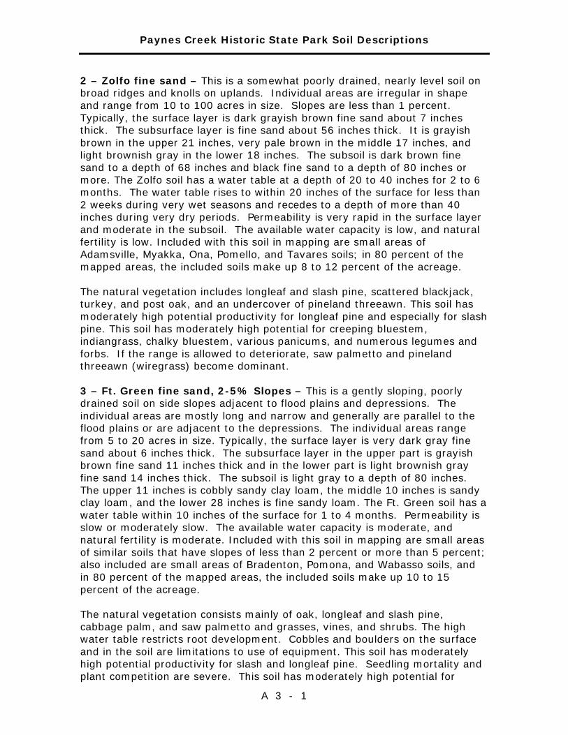
Paynes Creek Historic State Park Soil Descriptions
A 3 - 1
2 – Zolfo fine sand – This is a somewhat poorly drained, nearly level soil on broad ridges and knolls on uplands. Individual areas are irregular in shape and range from 10 to 100 acres in size. Slopes are less than 1 percent. Typically, the surface layer is dark grayish brown fine sand about 7 inches thick. The subsurface layer is fine sand about 56 inches thick. It is grayish brown in the upper 21 inches, very pale brown in the middle 17 inches, and light brownish gray in the lower 18 inches. The subsoil is dark brown fine sand to a depth of 68 inches and black fine sand to a depth of 80 inches or more. The Zolfo soil has a water table at a depth of 20 to 40 inches for 2 to 6 months. The water table rises to within 20 inches of the surface for less than 2 weeks during very wet seasons and recedes to a depth of more than 40 inches during very dry periods. Permeability is very rapid in the surface layer and moderate in the subsoil. The available water capacity is low, and natural fertility is low. Included with this soil in mapping are small areas of Adamsville, Myakka, Ona, Pomello, and Tavares soils; in 80 percent of the mapped areas, the included soils make up 8 to 12 percent of the acreage. The natural vegetation includes longleaf and slash pine, scattered blackjack, turkey, and post oak, and an undercover of pineland threeawn. This soil has moderately high potential productivity for longleaf pine and especially for slash pine. This soil has moderately high potential for creeping bluestem, indiangrass, chalky bluestem, various panicums, and numerous legumes and forbs. If the range is allowed to deteriorate, saw palmetto and pineland threeawn (wiregrass) become dominant. 3 – Ft. Green fine sand, 2-5% Slopes – This is a gently sloping, poorly drained soil on side slopes adjacent to flood plains and depressions. The individual areas are mostly long and narrow and generally are parallel to the flood plains or are adjacent to the depressions. The individual areas range from 5 to 20 acres in size. Typically, the surface layer is very dark gray fine sand about 6 inches thick. The subsurface layer in the upper part is grayish brown fine sand 11 inches thick and in the lower part is light brownish gray fine sand 14 inches thick. The subsoil is light gray to a depth of 80 inches. The upper 11 inches is cobbly sandy clay loam, the middle 10 inches is sandy clay loam, and the lower 28 inches is fine sandy loam. The Ft. Green soil has a water table within 10 inches of the surface for 1 to 4 months. Permeability is slow or moderately slow. The available water capacity is moderate, and natural fertility is moderate. Included with this soil in mapping are small areas of similar soils that have slopes of less than 2 percent or more than 5 percent; also included are small areas of Bradenton, Pomona, and Wabasso soils, and in 80 percent of the mapped areas, the included soils make up 10 to 15 percent of the acreage. The natural vegetation consists mainly of oak, longleaf and slash pine, cabbage palm, and saw palmetto and grasses, vines, and shrubs. The high water table restricts root development. Cobbles and boulders on the surface and in the soil are limitations to use of equipment. This soil has moderately high potential productivity for slash and longleaf pine. Seedling mortality and plant competition are severe. This soil has moderately high potential for

Paynes Creek Historic State Park Soil Descriptions
A 3 - 2
creeping bluestem, indiangrass, chalky bluestem, various panicums, and numerous legumes and forbs. If the range is allowed to deteriorate, saw palmetto and pineland threeawn (wiregrass) become dominant. 5 – Tavares fine sand, 0 to 5% slopes – This is a moderately well drained soil on low ridges and knolls throughout the county. Individual areas are irregular in shape and range from 5 to 40 acres in size. Slopes are smooth to concave. Typically, the surface layer is very dark grayish brown fine sand about 5 inches thick. The underlying material to a depth of 80 inches is fine sand. The upper 19 inches is light yellowish brown, the next 26 inches is very pale brown, the next 19 inches is white, and the lower 11 inches is very pale brown. In most years, this Tavares soil has a water table at a depth of 40 to 80 inches for 6 to 10 months and at a depth below 80 inches during very dry periods. The available water capacity is very low, and natural fertility is low. Permeability is rapid. Included with this soil in mapping are small areas of Adamsville, Candler, Sparr, and Zolfo soils. Also included are a few areas of soils that have a dark surface layer more than 10 inches thick. In 80 percent of the mapped areas, the included soils make up 8 to 12 percent of the acreage. The natural vegetation includes slash and longleaf pine, blackjack, turkey, and post oak, and an understory of pineland threeawn, low panicums, and broomsedge bluestem. This soil has moderately high potential productivity for pine trees, especially for slash pine. 6 – Candler fine sand, 0 to 5% slopes – This is a nearly level to gently sloping, excessively drained soil in small to very large areas on uplands. Slopes are smooth to concave. Typically, the surface layer is very dark grayish brown fine sand about 7 inches thick. The subsurface layer is fine sand to a depth of about 48 inches. The upper 28 inches is yellowish brown, and the lower 13 inches is yellow. At a depth below 48 inches there is yellow fine sand that has lamellae of yellowish brown loamy fine sand about 1/16 to 1/8 inches thick and 1 to 4 inches long, and at a depth below 66 inches there are white mottles. The available water capacity is very low to a depth of 48 inches and low below that depth. Permeability is very rapid to a depth of 48 inches and rapid below that depth. Natural fertility is low. The water table is at a depth below 80 inches. Included with this soil in mapping are small areas of Apopka and Tavares soils and small areas of Candler soils that have slopes of more than 5 percent; in 80 percent of the mapped areas, the included soils make up 5 to 10 percent of the acreage. The natural vegetation consists mainly of bluejack, post, and turkey oak, scattered longleaf and slash pine, and a sparse understory of indiangrass, chalky bluestem, pineland threeawn, panicums, and annual forbs. 8 – Bradenton loamy fine sand, frequently flooded – This is a poorly drained, nearly level soil along streams and rivers and on low-lying ridges and hammocks in flood plains. Individual areas are long and narrow, generally are adjacent to streams, and range from 5 to 20 acres in size. Slopes are smooth
Paynes Creek Historic State Park Soil Descriptions
A 3 - 3
to concave and range from 0 to 1 percent. Typically, the surface layer is very dark gray loamy fine sand about 4 inches thick. The subsurface layer is fine sand to a depth of about 15 inches. The upper 7 inches is gray, and the lower 8 inches is grayish brown. The subsoil is light gray sandy clay loam about 21 inches thick. The substratum is light brownish gray sandy loam to a depth of 66 inches and light gray loamy sand to a depth of 80 inches. This Bradenton soil has a water table at a depth of less than 10 inches for 2 to 6 months each year. Generally, the soil is flooded every year and more than once in most years. Flooding is a severe hazard. Permeability is moderate. The available water capacity is low. Natural fertility is medium, and organic matter content is low. Included with this soil in mapping are small areas of similar soils that have limestone boulders below the subsoil. Also included are small areas of Felda, Pomona, and Wabasso soils. In 80 percent of the mapped areas, the included soils make up 10 to 15 percent of the acreage. The natural vegetation consists mainly of slash pine, laurel and live oak, cabbage palm, saw palmetto, and pineland threeawn. This soil has high potential productivity for longleaf and slash pine. 10 – Pomona fine sand – This is a nearly level, poorly drained soil in large areas on low ridges in the flatwoods. Slopes are smooth to concave and range from 0 to 2 percent. Individual areas are broad and oblong and range from 15 to 200 acres in size. Typically, the surface layer is black fine sand about 3 inches thick. The subsurface layer is fine sand about 24 inches thick. The upper 7 inches is gray, and the lower 17 inches is light gray. The subsoil extends to a depth of 80 inches. The upper 8 inches is dark reddish brown fine sand coated with organic matter, the middle 22 inches is brown fine sand, and the lower 23 inches is gray fine sandy loam. The available water capacity is very low to low in all layers except the lower part of the subsoil, where it is moderate. Natural fertility is low. Permeability is moderate in the upper part of the subsoil, moderately slow in the lower part of the subsoil, and rapid in the other layers. Included with this soil in mapping are small areas of Basinger, Myakka, Smyrna, and Wauchula soils. In 80 percent of the mapped areas, the included soils make up 10 to 15 percent of the acreage. The natural vegetation includes longleaf and slash pine and saw palmetto, gallberry, waxmyrtle, and pineland threeawn. This soil has moderately high potential productivity for pine trees, especially for slash pine. 12 – Felda fine sand, frequently flooded – This is a nearly level, poorly drained soil along the small streams and creeks throughout the county. The areas are mainly long and narrow and generally are adjacent to the streams. Individual areas range from 5 to 25 acres. Slopes are smooth to concave and range from 0 to 1 percent. Typically, the surface layer is black fine sand about 5 inches thick. The subsurface layer is fine sand to a depth of about 26 inches. The upper 5 inches is grayish brown, and the lower 16 inches is light gray. The subsoil is sandy loam about 22 inches thick. The upper 10 inches is gray, and the lower 12 inches is grayish brown. The substratum is light gray fine sand to a depth of 80 inches. Generally, this soil is flooded every year.
Paynes Creek Historic State Park Soil Descriptions
A 3 - 4
Every 2 years, on the average, it is flooded more than once during the year. The flooding results in yearly deposition on or scouring of the surface. In addition, there is debris on the surface. Floodwater marks are evident on trees, fences, and bridges. During periods when the soil is not flooded, the water table is within 10 inches of the surface for 2 to 6 months. Permeability is moderate to moderately rapid. The available water capacity is low, and natural fertility is low. The content of organic matter is low. Included with this soil in mapping are small areas of Bradenton and Pompano soils. Also included are a few small areas of organic soils. n 80 percent of the mapped areas, the included soils make up about 12 percent of the acreage. This soil is used mainly as woodland. The natural vegetation consists mainly of cypress, water oak, pond and slash pine, cabbage palm, and vines and shrubs. This soil has high potential for blue maidencane, chalky bluestem, and various panicums. 15 – Immokalee fine sand – This is a poorly drained, nearly level soil on broad low ridges and low knolls in the flatwoods. Individual areas are irregular in shape and range from 10 to 60 acres in size. Slopes are smooth to concave and range from 0 to 2 percent. Typically, the surface layer is very dark gray fine sand about 5 inches thick. The subsurface layer is gray fine sand to a depth of about 44 inches. The subsoil is fine sand to a depth of 80 inches. The upper 4 inches is black, and the lower 32 inches is dark reddish brown. In most years, the water table is at a depth of less than 10 inches for 2 months and at a depth of 10 to 40 inches for more than 8 months. It is at a depth of more than 40 inches during dry periods. The available water capacity is low. Permeability is rapid in the surface and subsurface layers and moderate in the subsoil. Natural fertility is low. Included with this soil in mapping are small areas of Myakka, Ona, Placid, and Pomello soils. In 80 percent of the mapped areas, the included soils make up 10 to 15 percent of the acreage. In 20 percent of the mapped areas, the included soils make up either less than 10 or more than 15 percent. The natural vegetation consists mainly of longleaf and slash pine and an undergrowth of saw palmetto, gallberry, waxmyrtle, and pineland threeawn. This soil has moderately high potential for creeping bluestem, indiangrass, chalky bluestem, various panicums, and numerous legumes and forbs. 16 – Myakka fine sand – This is a nearly level, poorly drained soil in broad areas in the flatwoods. Slopes are smooth to concave and range from 0 to 2 percent. Typically, the surface layer is very dark grayish brown fine sand about 6 inches thick. The subsurface layer is light gray fine sand to a depth of 21 inches. The subsoil is fine sand about 25 inches thick. The upper 4 inches is very dark gray, the next 5 inches is dark reddish brown, the next 10 inches is dark brown, and the lower 6 inches is brown. The substratum is pale brown and light brownish gray fine sand to a depth of 80 inches. In most years, this Myakka soil has a water table at a depth of less than 10 inches for 1 to 4 months. The water table recedes to a depth of more than 40 inches during very dry seasons. The available water capacity is moderate in the subsoil but
Paynes Creek Historic State Park Soil Descriptions
A 3 - 5
is very low in the other layers. Permeability is rapid in the surface layer and substratum and moderate or moderately rapid in the subsoil. Internal drainage is slow, and runoff is slow. Natural fertility is low. Included with this soil in mapping are areas of similar soils that have a black surface layer more than 8 inches thick. Also included are small areas of Adamsville, Basinger, Pomona, Smyrna, and Pompano soils. In 85 percent of the mapped areas, the included soils make up 10 to 15 percent of the acreage. This soil is mainly wooded. The natural vegetation includes longleaf and slash pine and an understory of saw palmetto, running oak, gallberry, waxmyrtle, huckleberry, pineland threeawn, and scattered fetterbushes. This soil has moderately high potential for creeping bluestem, indiangrass, chalky bluestem, various panicums, and numerous legumes and forbs. 19 – Ona fine sand – This is a poorly drained, nearly level soil in the flatwoods. Individual areas are irregular in shape and range from 3 to 100 acres in size. Slopes are smooth to concave and range from 0 to 2 percent. Typically, the surface layer is black fine sand about 9 inches thick. The subsoil is dark reddish brown loamy fine sand to a depth of 16 inches. The substratum is fine sand to a depth of 80 inches or more. The upper 8 inches is brown, the next 18 inches is pale brown, the next 18 inches is light gray, and the lower 20 inches is brown. The water table is at a depth of 40 to 60 inches for 1 to 4 months or at a depth of 36 inches for brief periods. It is at a depth of more than 60 inches for the rest of the year. Permeability is rapid in the surface and subsurface layers and slow or very slow in the subsoil. The available water capacity is very low. Included with this soil in mapping are small areas of Basinger, Immokalee, Myakka, and Placid soils. Also included are wet spots and small ponds. In 80 percent of included soils make up either less than 8 percent or more than 12 percent. The natural vegetation consists mainly of dwarf and scrub oak, saw palmetto, sand pine, pricklypear, and pineland threeawn. This soil has low potential productivity for pine trees. Sand pine is better suited than other trees. 25 – Wabasso fine sand – This is a nearly level, poorly drained soil in broad areas in the flatwoods. Individual areas are irregular in shape and range from 10 to 60 acres in size. Slopes are less than 2 percent. Typically, the surface layer is black fine sand about 4 inches thick. The subsurface layer is fine sand 20 inches thick. The upper 14 inches is gray, and the lower 6 inches is light brownish gray. The subsoil extends to a depth of 70 inches. It is very dark grayish brown fine sand coated with organic material to a depth of about 32 inches and light brownish gray sandy loam to a depth of 52 inches. Below that, it is gray sandy loam to a depth of 64 inches and light olive gray sandy loam to a depth of 70 inches. The substratum is olive gray loamy sand to a depth of 80 inches or more. In most years, the water table is at a depth of 10 to 40 inches for more than 6 months. It is at a depth of less than 10 inches for less than 60 days during wet seasons and at a depth of more than 40 inches during very dry seasons. The available water capacity is low. Permeability is rapid in the surface and subsurface layers, moderate in the
Paynes Creek Historic State Park Soil Descriptions
A 3 - 6
upper part of the subsoil, and slow in the lower part of the subsoil. Natural fertility is low. Included with this soil in mapping are small areas of Felda and Pomona soils. In 80 percent of the mapped areas, the included soils make up 12 to 17 percent of the acreage. The natural vegetation includes longleaf and slash pine, and scattered cabbage palm, and an understory of saw palmetto, inkberry, waxmyrtle, creeping bluestem, indiangrass, little bluestem, Florida paspalum, pineland threeawn, panicums, deertongue, grassleaf goldaster, huckleberry, and running oak. This soil has moderately high potential productivity for pine trees, especially for slash pine. This soil has moderately high potential for creeping bluestem, indiangrass, chalky bluestem, various panicums, and numerous legumes and forbs. 27 – Bradenton-Felda-Chobee association, frequently flooded – This association consists of poorly drained Bradenton and Felda soils and very poorly drained Chobee soils. The Bradenton soils make up about 35 percent of the association, Felda soils make up 25 percent, Chobee soils make up 20 percent, and minor soils make up 20 percent. The soils are in regular and repeating patterns along streams and rivers throughout the county. Most areas are long and narrow and are adjacent to the Peace River, Felda and Bradenton soils are in the higher places, and Chobee soils are in the lower places. The individual areas of each soil range from 5 to 120 acres. Slopes are 0 to 2 percent. The soils are subject to frequent flooding. Bradenton soils have a surface layer of dark gray loamy fine sand about 6 inches thick. The subsurface layer is grayish brown fine sand about 10 inches thick. The subsoil is light brownish gray sandy clay loam about 13 inches thick. The substratum is gray sandy clay loam to a depth of 80 inches. Bradenton soils have a water table at a depth of less than 10 inches for 1 to 4 months of the year, and at a depth of 10 to 40 inches for more than 8 months. Permeability is moderate. The available water capacity is low. Natural fertility is medium, and the content of organic matter is low. Felda soils have a surface layer of black fine sand about 5 inches thick. The subsurface layer is fine sand about 21 inches thick. In the upper 5 inches it is grayish brown, and in the lower 16 inches it is light gray. The subsoil is sandy loam about 22 inches thick. In the upper 10 inches it is gray, and in the lower 12 inches it is grayish brown. The substratum is light gray fine sand to a depth of 80 inches. Felda soils have a water table within 10 inches of the surface for 2 to 6 months of the year. Permeability is moderate to moderately rapid. The available water capacity is low. Natural fertility is low, and the content of organic matter is low. Chobee soils have a surface layer of black fine sandy loam about 8 inches thick. The subsoil is sandy clay loam about 47 inches thick. It is black in the upper 10 inches and very dark gray in the lower 37 inches. The substratum is gray loamy fine sand to a depth of 80 inches. Chobee soils have a water table at a depth of less than 10 inches for 6 or more months of the year. The water
Paynes Creek Historic State Park Soil Descriptions
A 3 - 7
table seldom recedes to a depth of more than 10 inches. Permeability is slow or very slow. The available water capacity is moderate. Natural fertility is high, and the content of organic matter is high. The minor soils that were included in mapping are Holopaw, Manatee, and Pompano soils and small areas of organic soils. In 25 percent of the mapped areas or less, the minor soils make up either less than 20 percent or more than 20 percent of the acreage. The soils making up this association are mainly in dense vegetation consisting of water oak, cypress, sweetgum, hickory, cutgrass, maidencane, sawgrass, swamp primrose, buttonbush, smartweed, sedges, and other water-tolerant plants. Bradenton and Chobee soils have high potential productivity for pine, and Felda soils have moderately high potential productivity. These soils have moderate potential for forage because of the dense canopy of palm trees. 38 – St. Lucie fine sand – This is an excessively drained, nearly level soil on ridgetops, knolls, and dunes in areas of sand hills. Individual areas range from 50 to 20 acres in size. Slopes are smooth to concave and range from 0 to 1 percent. Typically, the surface layer is dark gray fine sand about 4 inches thick. The underlying material is white fine sand to a depth of 80 inches. This St. Lucie soil has a water table at a depth of 72 to 120 inches. The available water capacity is very low. Natural fertility is very low. Permeability is very rapid throughout. Included with this soil in mapping are small areas of Pomello and Tavares soils. The soils on the small ridges in the flatwoods are likely to have a water table during the rainy season. In 80 percent of the mapped areas, the included soils make up 5 to 10 percent of the acreage. The natural vegetation includes sand pine, scrub live oak, scattered turkey and bluejack oak, and an understory of scattered saw palmetto, creeping dodder, rosemary cactus, moss, and lichens.


Addendum 5—Plant and Animal List

Paynes Creek Historic State Park Species
Primary Habitat Codes Common Name Scientific Name (for imperiled species)
A 5 - 1
LICHENS
Resurrection cladonia ....................... Cladonia prostrata Reindeer lichen ................................ Cladonia spp.
PTERIDOPHYTES
Toothed midsorus fern ...................... Blechnum serrulatum Brown-hair comb fern ....................... Ctenitis submarginalis .............................. FS Southern wood fern .......................... Dryopteris ludoviciana Creeping bramble fern ...................... Hypolepis repens Club moss ....................................... Lycopodium alopecuroides Japanese climbing fern * ................... Lygodium japonicum Old World climbing fern * .................. Lygodium microphyllum Marianna maiden fern * .................... Macrothelypteris torresiana Asian sword fern * ........................... Nephrolepis brownii Tuberous sword fern * ...................... Nephrolepis cordifolia Sword fern; wild Boston fern ............. Nephrolepis exaltata Cinnamon fern ................................. Osmunda cinnamomea Royal fern ....................................... Osmunda regalis var. spectabilis Golden polypody .............................. Phlebodium aureum Resurrection fern ............................. Pleopeltis polypodioides var. michauxiana Tailed bracken ................................. Pteridium aquilinum var. pseudocaudatum Water spangles * ............................. Salvinia minima Downy maiden fern * ....................... Thelypteris dentata Widespread maiden fern ................... Thelypteris kunthii Marsh fern ...................................... Thelypteris palustris var. pubescens Toothed lattice-vein fern ................... Thelypteris serrata................................. BST Shoestring fern ................................ Vittaria lineata Netted chain fern ............................. Woodwardia areolata Virginia chain fern ............................ Woodwardia virginica
GYMNOSPERMS Slash pine ....................................... Pinus elliottii Longleaf pine ................................... Pinus palustris Bald-cypress ................................... Taxodium distichum
ANGIOSPERMS
Rosary pea * ................................... Abrus precatorius Red maple....................................... Acer rubrum Shyleaf ........................................... Aeschynomene americana Hammock snakeroot ......................... Ageratina jucunda Alligatorweed * ................................ Alternanthera philoxeroides False moneywort * ........................... Alysicarpus ovalifolius
Paynes Creek Historic State Park Species
Primary Habitat Codes Common Name Scientific Name (for imperiled species)
A 5 - 2
Spiny amaranth * ............................ Amaranthus spinosus Common ragweed ............................ Ambrosia artemisiifolia Pink redstem; toothcups ................... Ammannia latifolia False indigobush .............................. Amorpha fruticosa Pepper-vine ..................................... Ampelopsis arborea Bushy bluestem ............................... Andropogon glomeratus var. pumilus Long-beard bluestem ........................ Andropogon longiberbis Broomsedge bluestem ...................... Andropogon virginicus Chalky bluestem .............................. Andropogon virginicus var. glaucus Jack-in-the-pulpit ............................. Arisaema triphyllum Corkscrew threeawn ......................... Aristida gyrans Threeawn ........................................ Aristida purpurascens Hillsborough threeawn ...................... Aristida purpurascens var. tenuispica Bottlebrush threeawn ....................... Aristida spiciformis Wiregrass........................................ Aristida stricta var. beyrichiana Florida Indian plantain ...................... Arnoglossum floridanum Florida milkweed .............................. Asclepias feayi Savannah milkweed ......................... Asclepias pedicellata Swamp milkweed ............................. Asclepias perennis Velvetleaf milkweed ......................... Asclepias tomentosa Butterflyweed .................................. Asclepias tuberosa Green antelopehorn .......................... Asclepias viridis Showy milkwort ............................... Asemeia violacea Bigflower pawpaw ............................ Asimina obovata Smallflower pawpaw ......................... Asimina parviflora Netted pawpaw ................................ Asimina reticulata Silverling ........................................ Baccharis glomeruliflora Groundsel tree ................................. Baccharis halimifolia Coastalplain honeycombhead ............. Balduina angustifolia Wax begonia * ................................. Begonia cucullata Tarflower ........................................ Bejaria racemosa Florida greeneyes ............................. Berlandiera subacaulis Beggarticks ..................................... Bidens alba Smallfruit beggarticks ....................... Bidens mitis False-nettle ..................................... Boehmeria cylindrica American bluehearts ......................... Buchnera americana Watergrass...................................... Bulbostylis barbata Capillary hairsedge ........................... Bulbostylis ciliatifolia Sandyfield hairsedge ........................ Bulbostylis stenophylla American beautyberry ...................... Callicarpa americana Florida scrub roseling ....................... Callisia ornata Hedge false bindweed ....................... Calystegia sepium subsp. limnophila Florida bellflower.............................. Campanula floridana Trumpet creeper .............................. Campsis radicans Golden canna .................................. Canna flaccida Tropical bushmint* ........................... Cantinoa mutabilis
Paynes Creek Historic State Park Species
Primary Habitat Codes Common Name Scientific Name (for imperiled species)
A 5 - 3
Sacatrapo * ..................................... Caperonia palustris Pennsylvania bittercress ................... Cardamine pensylvanica False hop sedge ............................... Carex lupuliformis Hop sedge ....................................... Carex lupulina Florida paintbrush ............................ Carphephorus corymbosus False vanillaleaf ............................... Carphephorus odoratissimus var. subtropicanus Hairy chaffhead ............................... Carphephorus paniculatus American hornbeam ......................... Carpinus caroliniana Scrub wild olive ............................... Cartrema floridana Water hickory .................................. Carya aquatica Pignut hickory ................................. Carya glabra Southern sandpur ............................ Cenchrus echinatus Slender sandspur ............................. Cenchrus gracillimus Spadeleaf coinwort ........................... Centella asiatica Spurred butterfly pea ....................... Centrosema virginianum Buttonbush ..................................... Cephalanthus occidentalis Partridge pea ................................... Chamaecrista fasciculata Sensitive pea ................................... Chamaecrista nictitans var. aspera Florida alicia .................................... Chapmannia floridana Shiny wood oats .............................. Chasmanthium nitidum Pigweed * ....................................... Chenopodium album White fringetree ............................... Chionanthus virginicus Florida goldenaster ........................... Chrysopsis floridana ......................... SC, SCF Coastalplain goldenaster ................... Chrysopsis scabrella Water hemlock ................................ Cicuta maculata Purple thistle ................................... Cirsium horridulum Nuttall's thistle ................................ Cirsium nuttallii Lemon ............................................ Citrus x limon Sawgrass ........................................ Cladium jamaicense Pine-hyacinth .................................. Clematis baldwinii Swamp leatherflower ........................ Clematis crispa Net-leaf leatherflower ....................... Clematis reticulata Turk’s turban * ................................ Clerodendrum indicum Tread-softly..................................... Cnidoscolus stimulosus Wild taro * ...................................... Colocasia esculenta Common dayflower * ........................ Commelina diffusa Erect dayflower ................................ Commelina erecta John Charles * ................................. Condea verticillata Blue mistflower ................................ Conoclinium coelestrinum Coastalplain tickseed ........................ Coreopsis gladiata Leavenworth's tickseed ..................... Coreopsis leavenworthii Swamp dogwood .............................. Cornus foemina String-lily ........................................ Crinum americanum Rabbitbells ...................................... Crotalaria rotundifolia Showy rattlebox * ............................ Crotalaria spectabilis
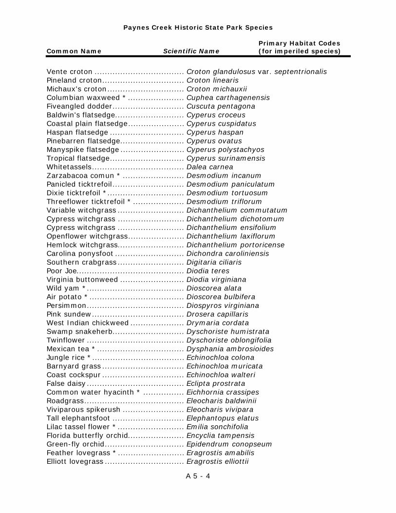
Paynes Creek Historic State Park Species
Primary Habitat Codes Common Name Scientific Name (for imperiled species)
A 5 - 4
Vente croton ................................... Croton glandulosus var. septentrionalis Pineland croton ................................ Croton linearis Michaux's croton .............................. Croton michauxii Columbian waxweed * ...................... Cuphea carthagenensis Fiveangled dodder ............................ Cuscuta pentagona Baldwin's flatsedge ........................... Cyperus croceus Coastal plain flatsedge ...................... Cyperus cuspidatus Haspan flatsedge ............................. Cyperus haspan Pinebarren flatsedge ......................... Cyperus ovatus Manyspike flatsedge ......................... Cyperus polystachyos Tropical flatsedge ............................. Cyperus surinamensis Whitetassels .................................... Dalea carnea Zarzabacoa comun * ........................ Desmodium incanum Panicled ticktrefoil ............................ Desmodium paniculatum Dixie ticktrefoil * .............................. Desmodium tortuosum Threeflower ticktrefoil * .................... Desmodium triflorum Variable witchgrass .......................... Dichanthelium commutatum Cypress witchgrass .......................... Dichanthelium dichotomum Cypress witchgrass .......................... Dichanthelium ensifolium Openflower witchgrass ...................... Dichanthelium laxiflorum Hemlock witchgrass .......................... Dichanthelium portoricense Carolina ponysfoot ........................... Dichondra caroliniensis Southern crabgrass .......................... Digitaria ciliaris Poor Joe.......................................... Diodia teres Virginia buttonweed ......................... Diodia virginiana Wild yam * ...................................... Dioscorea alata Air potato * ..................................... Dioscorea bulbifera Persimmon ...................................... Diospyros virginiana Pink sundew .................................... Drosera capillaris West Indian chickweed ..................... Drymaria cordata Swamp snakeherb ............................ Dyschoriste humistrata Twinflower ...................................... Dyschoriste oblongifolia Mexican tea * .................................. Dysphania ambrosioides Jungle rice * .................................... Echinochloa colona Barnyard grass ................................ Echinochloa muricata Coast cockspur ................................ Echinochloa walteri False daisy ...................................... Eclipta prostrata Common water hyacinth * ................ Eichhornia crassipes Roadgrass ....................................... Eleocharis baldwinii Viviparous spikerush ........................ Eleocharis vivipara Tall elephantsfoot ............................ Elephantopus elatus Lilac tassel flower * .......................... Emilia sonchifolia Florida butterfly orchid...................... Encyclia tampensis Green-fly orchid ............................... Epidendrum conopseum Feather lovegrass * .......................... Eragrostis amabilis Elliott lovegrass ............................... Eragrostis elliottii
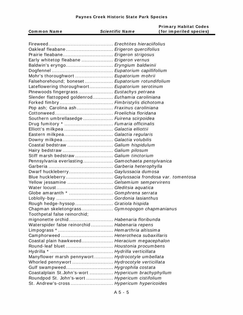
Paynes Creek Historic State Park Species
Primary Habitat Codes Common Name Scientific Name (for imperiled species)
A 5 - 5
Fireweed ......................................... Erechtites hieraciifolius Oakleaf fleabane .............................. Erigeron quercifolius Prairie fleabane ................................ Erigeron strigosus Early whitetop fleabane .................... Erigeron vernus Baldwin's eryngo .............................. Eryngium baldwinii Dogfennel ....................................... Eupatorium capillifolium Mohr's thoroughwort ........................ Eupatorium mohrii Falsehorehound; boneset .................. Eupatorium rotundifolium Lateflowering thoroughwort ............... Eupatorium serotinum Pinewoods fingergrass ...................... Eustachys petraea Slender flattopped goldenrod ............. Euthamia caroliniana Forked fimbry .................................. Fimbristylis dichotoma Pop ash; Carolina ash ....................... Fraxinus caroliniana Cottonweed ..................................... Froelichia floridana Southern umbrellasedge ................... Fuirena scirpoidea Drug fumitory * ............................... Fumaria officinalis Elliott's milkpea ............................... Galactia elliottii Eastern milkpea ............................... Galactia regularis Downy milkpea ................................ Galactia volubilis Coastal bedstraw ............................. Galium hispidulum Hairy bedstraw ................................ Galium pilosum Stiff marsh bedstraw ........................ Galium tinctorium Pennsylvania everlasting ................... Gamochaeta pensylvanica Garberia ......................................... Garberia heterophylla Dwarf huckleberry ............................ Gaylussacia dumosa Blue huckleberry .............................. Gaylussacia frondosa var. tomentosa Yellow jessamine ............................. Gelsemium sempervirens Water locust .................................... Gleditsia aquatica Globe amaranth * ............................ Gomphrena serrata Loblolly-bay .................................... Gordonia lasianthus Rough hedge-hyssop ........................ Gratiola hispida Chapman skeletongrass .................... Gymnopogon chapmanianus Toothpetal false reinorchid; mignonette orchid ............................ Habenaria floribunda Waterspider false reinorchid .............. Habenaria repens Limpograss * ................................... Hemarthria altissima Camphorweed ................................. Heterotheca subaxillaris Coastal plain hawkweed .................... Hieracium megacephalon Round-leaf bluet .............................. Houstonia procumbens Hydrilla * ........................................ Hydrilla verticillata Manyflower marsh pennywort ............ Hydrocotyle umbellata Whorled pennywort .......................... Hydrocotyle verticillata Gulf swampweed .............................. Hygrophila costata Coastalplain St.John’s-wort ............... Hypericum brachyphyllum Roundpod St. John's-wort ................. Hypericum cistifolium St. Andrew's-cross ........................... Hypericum hypericoides
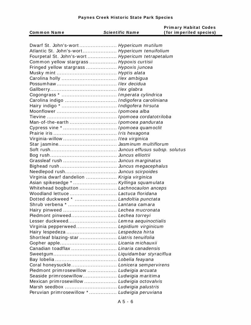
Paynes Creek Historic State Park Species
Primary Habitat Codes Common Name Scientific Name (for imperiled species)
A 5 - 6
Dwarf St. John's-wort ....................... Hypericum mutilum Atlantic St. John's-wort ..................... Hypericum tenuifolium Fourpetal St. John's-wort .................. Hypericum tetrapetalum Common yellow stargrass ................. Hypoxis curtisii Fringed yellow stargrass ................... Hypoxis juncea Musky mint ..................................... Hyptis alata Carolina holly .................................. Ilex ambigua Possumhaw ..................................... Ilex decidua Gallberry ......................................... Ilex glabra Cogongrass * .................................. Imperata cylindrica Carolina indigo ................................ Indigofera caroliniana Hairy indigo * .................................. Indigofera hirsuta Moonflower ..................................... Ipomoea alba Tievine ........................................... Ipomoea cordatotriloba Man-of-the-earth ............................. Ipomoea pandurata Cypress vine * ................................. Ipomoea quamoclit Prairie iris ....................................... Iris hexagona Virginia-willow ................................. Itea virginica Star jasmine .................................... Jasminum multiflorum Soft rush ......................................... Juncus effusus subsp. solutus Bog rush ......................................... Juncus elliottii Grassleaf rush ................................. Juncus marginatus Bighead rush ................................... Juncus megacephalus Needlepod rush................................ Juncus scirpoides Virginia dwarf dandelion ................... Krigia virginica Asian spikesedge * ........................... Kyllinga squamulata Whitehead bogbutton ....................... Lachnocaulon anceps Woodland lettuce ............................. Lactuca floridana Dotted duckweed * .......................... Landoltia punctata Shrub verbena * .............................. Lantana camara Hairy pinweed ................................. Lechea mucronata Piedmont pinweed ............................ Lechea torreyi Lesser duckweed.............................. Lemna aequinoctialis Virginia pepperweed ......................... Lepidium virginicum Hairy lespedeza ............................... Lespedeza hirta Shortleaf blazing-star ....................... Liatris tenuifolia Gopher apple ................................... Licania michauxii Canadian toadflax ............................ Linaria canadensis Sweetgum ....................................... Liquidambar styraciflua Bay lobelia ...................................... Lobelia feayana Coral honeysuckle ............................ Lonicera sempervirens Piedmont primrosewillow .................. Ludwigia arcuata Seaside primrosewillow ..................... Ludwigia maritima Mexican primrosewillow .................... Ludwigia octovalvis Marsh seedbox ................................ Ludwigia palustris Peruvian primrosewillow * ................. Ludwigia peruviana
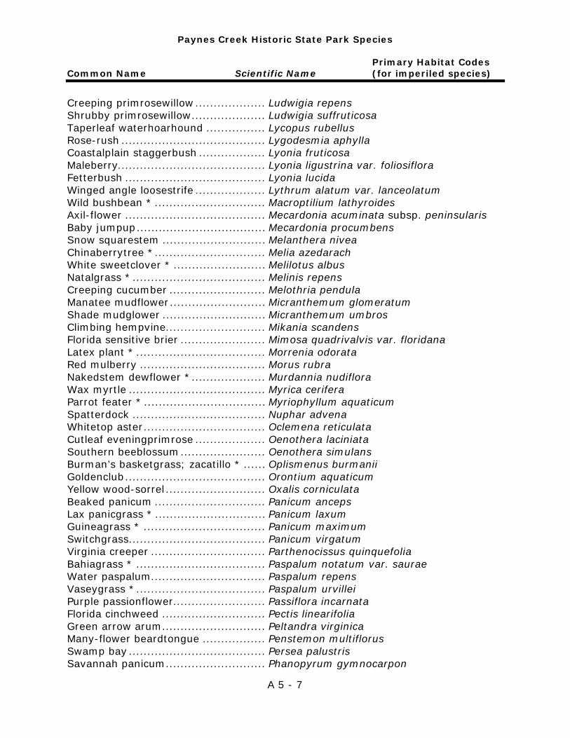
Paynes Creek Historic State Park Species
Primary Habitat Codes Common Name Scientific Name (for imperiled species)
A 5 - 7
Creeping primrosewillow ................... Ludwigia repens Shrubby primrosewillow .................... Ludwigia suffruticosa Taperleaf waterhoarhound ................ Lycopus rubellus Rose-rush ....................................... Lygodesmia aphylla Coastalplain staggerbush .................. Lyonia fruticosa Maleberry........................................ Lyonia ligustrina var. foliosiflora Fetterbush ...................................... Lyonia lucida Winged angle loosestrife ................... Lythrum alatum var. lanceolatum Wild bushbean * .............................. Macroptilium lathyroides Axil-flower ...................................... Mecardonia acuminata subsp. peninsularis Baby jumpup ................................... Mecardonia procumbens Snow squarestem ............................ Melanthera nivea Chinaberrytree * .............................. Melia azedarach White sweetclover * ......................... Melilotus albus Natalgrass * .................................... Melinis repens Creeping cucumber .......................... Melothria pendula Manatee mudflower .......................... Micranthemum glomeratum Shade mudglower ............................ Micranthemum umbros Climbing hempvine ........................... Mikania scandens Florida sensitive brier ....................... Mimosa quadrivalvis var. floridana Latex plant * ................................... Morrenia odorata Red mulberry .................................. Morus rubra Nakedstem dewflower * .................... Murdannia nudiflora Wax myrtle ..................................... Myrica cerifera Parrot feater * ................................. Myriophyllum aquaticum Spatterdock .................................... Nuphar advena Whitetop aster ................................. Oclemena reticulata Cutleaf eveningprimrose ................... Oenothera laciniata Southern beeblossum ....................... Oenothera simulans Burman’s basketgrass; zacatillo * ...... Oplismenus burmanii Goldenclub ...................................... Orontium aquaticum Yellow wood-sorrel ........................... Oxalis corniculata Beaked panicum .............................. Panicum anceps Lax panicgrass * .............................. Panicum laxum Guineagrass * ................................. Panicum maximum Switchgrass ..................................... Panicum virgatum Virginia creeper ............................... Parthenocissus quinquefolia Bahiagrass * ................................... Paspalum notatum var. saurae Water paspalum ............................... Paspalum repens Vaseygrass * ................................... Paspalum urvillei Purple passionflower ......................... Passiflora incarnata Florida cinchweed ............................ Pectis linearifolia Green arrow arum ............................ Peltandra virginica Many-flower beardtongue ................. Penstemon multiflorus Swamp bay ..................................... Persea palustris Savannah panicum ........................... Phanopyrum gymnocarpon

Paynes Creek Historic State Park Species
Primary Habitat Codes Common Name Scientific Name (for imperiled species)
A 5 - 8
Florida false sunflower ...................... Phoebanthus grandiflorus Red chokeberry ............................... Photinia pyrifolia Fog fruit .......................................... Phyla nodiflora Chamberbitter * .............................. Phyllanthus urinaria Cypress-head ground-cherry ............. Physalis arenicola Slenderleaf false dragonhead ............. Physostegia leptophylla Pokeweed ....................................... Phytolacca americana Wild pennyroyal ............................... Piloblephis rigida Pitted stripeseed .............................. Piriqueta cistoides subsp. caroliniana Water-lettuce *................................ Pistia stratiotes Narrowleaf goldenaster ..................... Pityopsis graminifolia Rosy camphorweed .......................... Pluchea baccharis Camphorweed ................................. Pluchea camphorata Sweetscent ..................................... Pluchea odorata Candyroot ....................................... Polygala nana Yellow milkwort ............................... Polygala rugelii Coastal plain milkwort ...................... Polygala setacea Hairy smartweed .............................. Polygonum hirsutum Curlytop knotweed * ........................ Polygonum lapathifolium Pennsylvania smartweed ................... Polygonum pensylvanicum Dotted smartweed ............................ Polygonum punctatum Bog smartweed ................................ Polygonum setaceum Rustweed ........................................ Polypremum procumbens Pickerelweed ................................... Pontederia cordata Paraquayan purslane * ..................... Portulaca amilis Pink purslane ................................... Portulaca pilosa Illinois pondweed ............................. Potamogeton illinoensis Black cherry .................................... Prunus serotina Sweet everlasting ............................ Pseudognaphalium obtusifolium Arrow bamboo * .............................. Pseudosasa japonica Wild coffee ...................................... Psychotria nervosa Blackroot ........................................ Pterocaulon pycnostachyum Giant orchid .................................... Pteroglossaspis ecristata ............ SH, SC, SCF Mock bishopsweed ........................... Ptilimnium capillaceum Chapman’s oak ................................ Quercus chapmanii Sand live oak................................... Quercus geminata Turkey oak ...................................... Quercus laevis Laurel oak; diamond oak................... Quercus laurifolia Dwarf live oak ................................. Quercus minima Myrtle oak ....................................... Quercus myrtifolia Water oak ....................................... Quercus nigra Chapman's oak ................................ Quercus pumila Live oak .......................................... Quercus virginiana Needle palm .................................... Rhapidophyllum hystrix West Indian meadowbeauty .............. Rhexia cubensis Pale meadowbeauty ......................... Rhexia mariana
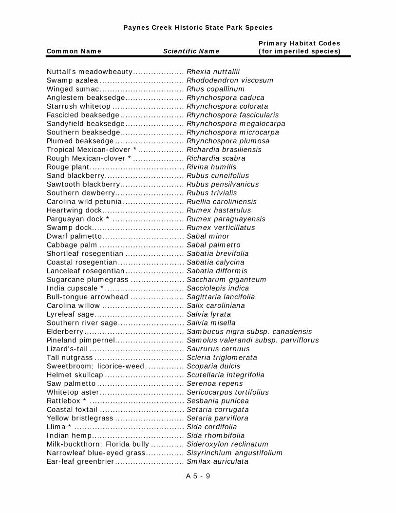
Paynes Creek Historic State Park Species
Primary Habitat Codes Common Name Scientific Name (for imperiled species)
A 5 - 9
Nuttall's meadowbeauty .................... Rhexia nuttallii Swamp azalea ................................. Rhododendron viscosum Winged sumac ................................. Rhus copallinum Anglestem beaksedge ....................... Rhynchospora caduca Starrush whitetop ............................ Rhynchospora colorata Fascicled beaksedge ......................... Rhynchospora fascicularis Sandyfield beaksedge ....................... Rhynchospora megalocarpa Southern beaksedge ......................... Rhynchospora microcarpa Plumed beaksedge ........................... Rhynchospora plumosa Tropical Mexican-clover * .................. Richardia brasiliensis Rough Mexican-clover * .................... Richardia scabra Rouge plant ..................................... Rivina humilis Sand blackberry ............................... Rubus cuneifolius Sawtooth blackberry ......................... Rubus pensilvanicus Southern dewberry........................... Rubus trivialis Carolina wild petunia ........................ Ruellia caroliniensis Heartwing dock ................................ Rumex hastatulus Parguayan dock * ............................ Rumex paraguayensis Swamp dock .................................... Rumex verticillatus Dwarf palmetto ................................ Sabal minor Cabbage palm ................................. Sabal palmetto Shortleaf rosegentian ....................... Sabatia brevifolia Coastal rosegentian .......................... Sabatia calycina Lanceleaf rosegentian ....................... Sabatia difformis Sugarcane plumegrass ..................... Saccharum giganteum India cupscale * ............................... Sacciolepis indica Bull-tongue arrowhead ..................... Sagittaria lancifolia Carolina willow ................................ Salix caroliniana Lyreleaf sage ................................... Salvia lyrata Southern river sage .......................... Salvia misella Elderberry ....................................... Sambucus nigra subsp. canadensis Pineland pimpernel ........................... Samolus valerandi subsp. parviflorus Lizard's-tail ..................................... Saururus cernuus Tall nutgrass ................................... Scleria triglomerata Sweetbroom; licorice-weed ............... Scoparia dulcis Helmet skullcap ............................... Scutellaria integrifolia Saw palmetto .................................. Serenoa repens Whitetop aster ................................. Sericocarpus tortifolius Rattlebox * ..................................... Sesbania punicea Coastal foxtail ................................. Setaria corrugata Yellow bristlegrass ........................... Setaria parviflora Llima * ........................................... Sida cordifolia Indian hemp .................................... Sida rhombifolia Milk-buckthorn; Florida bully ............. Sideroxylon reclinatum Narrowleaf blue-eyed grass ............... Sisyrinchium angustifolium Ear-leaf greenbrier ........................... Smilax auriculata
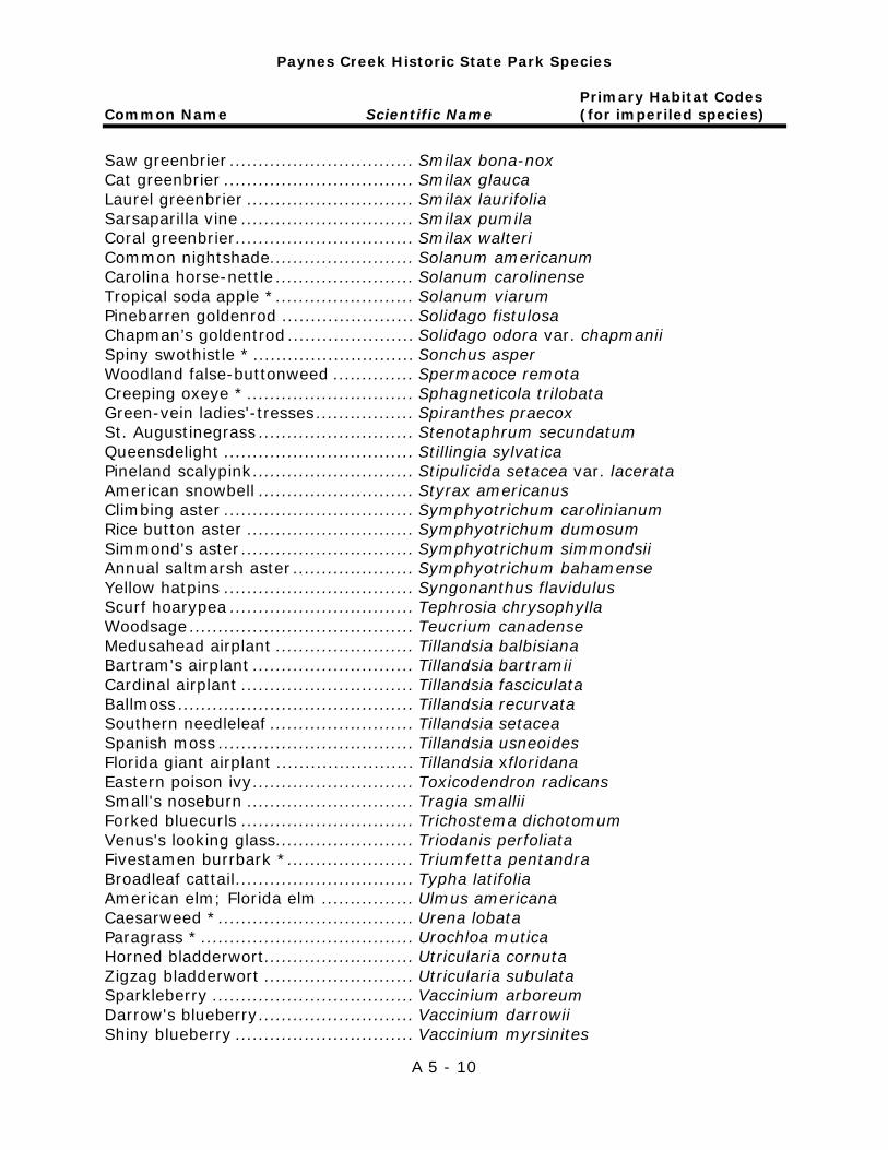
Paynes Creek Historic State Park Species
Primary Habitat Codes Common Name Scientific Name (for imperiled species)
A 5 - 10
Saw greenbrier ................................ Smilax bona-nox Cat greenbrier ................................. Smilax glauca Laurel greenbrier ............................. Smilax laurifolia Sarsaparilla vine .............................. Smilax pumila Coral greenbrier ............................... Smilax walteri Common nightshade......................... Solanum americanum Carolina horse-nettle ........................ Solanum carolinense Tropical soda apple * ........................ Solanum viarum Pinebarren goldenrod ....................... Solidago fistulosa Chapman’s goldentrod ...................... Solidago odora var. chapmanii Spiny swothistle * ............................ Sonchus asper Woodland false-buttonweed .............. Spermacoce remota Creeping oxeye * ............................. Sphagneticola trilobata Green-vein ladies'-tresses ................. Spiranthes praecox St. Augustinegrass ........................... Stenotaphrum secundatum Queensdelight ................................. Stillingia sylvatica Pineland scalypink ............................ Stipulicida setacea var. lacerata American snowbell ........................... Styrax americanus Climbing aster ................................. Symphyotrichum carolinianum Rice button aster ............................. Symphyotrichum dumosum Simmond's aster .............................. Symphyotrichum simmondsii Annual saltmarsh aster ..................... Symphyotrichum bahamense Yellow hatpins ................................. Syngonanthus flavidulus Scurf hoarypea ................................ Tephrosia chrysophylla Woodsage ....................................... Teucrium canadense Medusahead airplant ........................ Tillandsia balbisiana Bartram's airplant ............................ Tillandsia bartramii Cardinal airplant .............................. Tillandsia fasciculata Ballmoss ......................................... Tillandsia recurvata Southern needleleaf ......................... Tillandsia setacea Spanish moss .................................. Tillandsia usneoides Florida giant airplant ........................ Tillandsia xfloridana Eastern poison ivy ............................ Toxicodendron radicans Small's noseburn ............................. Tragia smallii Forked bluecurls .............................. Trichostema dichotomum Venus's looking glass ........................ Triodanis perfoliata Fivestamen burrbark * ...................... Triumfetta pentandra Broadleaf cattail ............................... Typha latifolia American elm; Florida elm ................ Ulmus americana Caesarweed * .................................. Urena lobata Paragrass * ..................................... Urochloa mutica Horned bladderwort .......................... Utricularia cornuta Zigzag bladderwort .......................... Utricularia subulata Sparkleberry ................................... Vaccinium arboreum Darrow's blueberry ........................... Vaccinium darrowii Shiny blueberry ............................... Vaccinium myrsinites
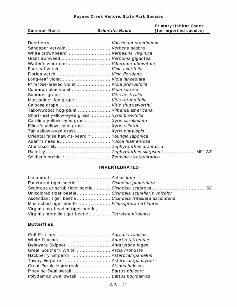
Paynes Creek Historic State Park Species
Primary Habitat Codes Common Name Scientific Name (for imperiled species)
A 5 - 11
Deerberry ....................................... Vaccinium stamineum Sandaper vervain ............................. Verbena scabra White crownbeard ............................ Verbesina virginica Giant ironweed ................................ Vernonia gigantea Walter's viburnum ............................ Viburnum obovatum Fourleaf vetch ................................. Vicia acutifolia Florida vetch ................................... Vicia floridana Long-leaf violet ................................ Viola lanceolata Primrose-leaved violet ...................... Viola primulifolia Common blue violet ......................... Viola sororia Summer grape ................................ Vitis aestivalis Muscadine; fox grape ....................... Vitis rotundifolia Caloose grape .................................. Vitis shuttleworthii Tallowwood; hog-plum ..................... Ximenia americana Short-leaf yellow-eyed grass ............. Xyris brevifolia Carolina yellow-eyed grass ................ Xyris caroliniana Elliott's yellow-eyed grass ................. Xyris elliottii Tall yellow-eyed grass ...................... Xyris platylepis Oriental false hawk's-beard * ............ Youngia japonica Adam's needle ................................. Yucca filamentosa Atamasco-lily................................... Zephyranthes atamasca Rain-lily .......................................... Zephyranthes simpsonii..................... MF, WF Soldier's orchid * ............................. Zeuxine strateumatica
INVERTEBRATES
Luna moth ...................................... Actias luna Punctured tiger beetle ...................... Cicindela punctulata Scabrous or scrub tiger beetle ........... Cicindela scabrosa ................................... SC Unicolored tiger beetle ...................... Cicindela scutellaris unicolor Ascendant tiger beetle ...................... Cicindela trifasiata ascendens Mustached tiger beetle ..................... Ellipsoptera hirtilabris Virginia big-headed tiger beetle, Virginia metallic tiger beetle .............. Tetracha virginica Butterflies Gulf Fritillary .................................. Agraulis vanillae White Peacock ................................. Anartia jatrophae Delaware Skipper ............................ Anatrytone logan Great Southern White ...................... Ascia monuste Hackberry Emperor ......................... Asterocampa celtis Tawny Emperor .............................. Asterocampa clyton Great Purple Hairstreak ................... Atlides halesus Pipevine Swallowtail ........................ Battus philenor Polydamas Swallowtail ..................... Battus polydamas
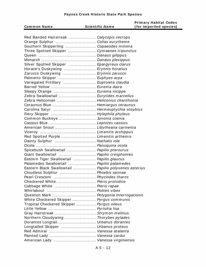
Paynes Creek Historic State Park Species
Primary Habitat Codes Common Name Scientific Name (for imperiled species)
A 5 - 12
Red Banded Hairstreak ..................... Calycopis cecrops Orange Sulphur .............................. Colias eurytheme Southern Skipperling ....................... Copaeodes minima Three Spotted Skipper ..................... Cymaenes tripunctus Queen ........................................... Danaus gilippus Monarch ......................................... Danaus plexippus Silver Spotted Skipper ..................... Epargyreus clarus Horace’s Duskywing ........................ Erynnis horatius Zarucco Duskywing ......................... Erynnis zarucco Palmetto Skipper ............................ Euphyes arpa Variegated Fritillary ......................... Euptoieta claudia Barred Yellow .................................. Eurema daira Sleepy Orange ................................ Eurema nicippe Zebra Swallowtail ............................ Eurytides marcellus Zebra Heliconian ............................. Heliconius charithonia Ceraunus Blue ................................. Hemiargus ceraunus Carolina Satyr ................................ Hermeuptychia sosybius Fiery Skipper .................................. Hylephila phyleus Common Buckeye ............................ Junonia coenia Cassius Blue .................................... Leptotes cassius American Snout ............................... Libytheana carinenta Viceroy .......................................... Limenitis archippus Red Spotted Purple .......................... Limenitis arthemis Dainty Sulphur ............................... Nathalis iole Ocola ............................................. Panoquina ocola Spicebush Swallowtail ...................... Papilio pterourus Giant Swallowtail ............................ Papilio cresphontes Eastern Tiger Swallowtail ................. Papilio glaucus Palamedes Swallowtail ..................... Papilio palamedes Eastern Black Swallowtail ................. Papilio polyxenes asterius Cloudless Sulphur ........................... Phoebis sennae Pearl Crescent ................................ Phyciodes tharos Checkered White .............................. Pieris protodice Cabbage White ............................... Pieris rapae Whirlabout ..................................... Polites vibex Question Mark ................................. Polygonia interrogationis White Checkered Skipper .................. Pyrgus communis Tropical Checkered Skipper ............... Pyrgus oileus Little Yellow .................................... Pyrisitia lisa Gray Hairstreak ............................... Strymon melinus Northern Cloudywing ........................ Thorybes pylades Dorantes Longtail ............................. Urbanus dorantes Longtailed Skipper .......................... Urbanus proteus Red Admiral ................................... Vanessa atalanta Painted Lady ................................... Vanessa cardui American Lady ................................ Vanessa virginiensis
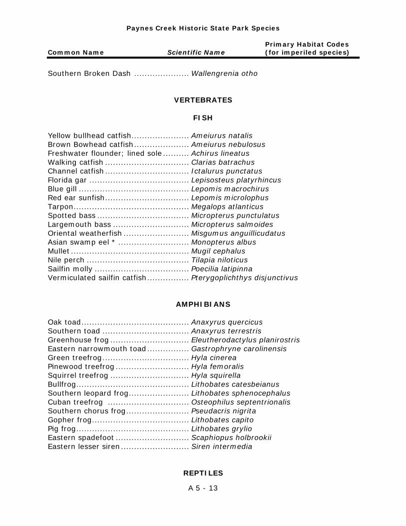
Paynes Creek Historic State Park Species
Primary Habitat Codes Common Name Scientific Name (for imperiled species)
A 5 - 13
Southern Broken Dash ..................... Wallengrenia otho
VERTEBRATES
FISH
Yellow bullhead catfish ...................... Ameiurus natalis Brown Bowhead catfish ..................... Ameiurus nebulosus Freshwater flounder; lined sole .......... Achirus lineatus Walking catfish ................................ Clarias batrachus Channel catfish ................................ Ictalurus punctatus Florida gar ...................................... Lepisosteus platyrhincus Blue gill .......................................... Lepomis macrochirus Red ear sunfish ................................ Lepomis microlophus Tarpon ............................................ Megalops atlanticus Spotted bass ................................... Micropterus punctulatus Largemouth bass ............................. Micropterus salmoides Oriental weatherfish ......................... Misgumus anguillicudatus Asian swamp eel * ........................... Monopterus albus Mullet ............................................. Mugil cephalus Nile perch ....................................... Tilapia niloticus Sailfin molly .................................... Poecilia latipinna Vermiculated sailfin catfish ................ Pterygoplichthys disjunctivus
AMPHIBIANS
Oak toad ......................................... Anaxyrus quercicus Southern toad ................................. Anaxyrus terrestris Greenhouse frog .............................. Eleutherodactylus planirostris Eastern narrowmouth toad ................ Gastrophryne carolinensis Green treefrog ................................. Hyla cinerea Pinewood treefrog ............................ Hyla femoralis Squirrel treefrog .............................. Hyla squirella Bullfrog ........................................... Lithobates catesbeianus Southern leopard frog ....................... Lithobates sphenocephalus Cuban treefrog ............................... Osteophilus septentrionalis Southern chorus frog ........................ Pseudacris nigrita Gopher frog ..................................... Lithobates capito Pig frog ........................................... Lithobates grylio Eastern spadefoot ............................ Scaphiopus holbrookii Eastern lesser siren .......................... Siren intermedia
REPTILES
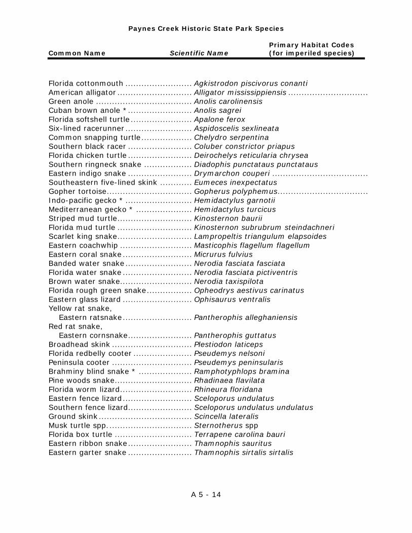
Paynes Creek Historic State Park Species
Primary Habitat Codes Common Name Scientific Name (for imperiled species)
A 5 - 14
Florida cottonmouth ......................... Agkistrodon piscivorus conanti American alligator ............................ Alligator mississippiensis .............................. Green anole .................................... Anolis carolinensis Cuban brown anole * ........................ Anolis sagrei Florida softshell turtle ....................... Apalone ferox Six-lined racerunner ......................... Aspidoscelis sexlineata Common snapping turtle ................... Chelydro serpentina Southern black racer ........................ Coluber constrictor priapus Florida chicken turtle ........................ Deirochelys reticularia chrysea Southern ringneck snake .................. Diadophis punctataus punctataus Eastern indigo snake ........................ Drymarchon couperi .................................... Southeastern five-lined skink ............ Eumeces inexpectatus Gopher tortoise ................................ Gopherus polyphemus .................................. Indo-pacific gecko * ......................... Hemidactylus garnotii Mediterranean gecko * ..................... Hemidactylus turcicus Striped mud turtle ............................ Kinosternon baurii Florida mud turtle ............................ Kinosternon subrubrum steindachneri Scarlet king snake ............................ Lampropeltis triangulum elapsoides Eastern coachwhip ........................... Masticophis flagellum flagellum Eastern coral snake .......................... Micrurus fulvius Banded water snake ......................... Nerodia fasciata fasciata Florida water snake .......................... Nerodia fasciata pictiventris Brown water snake........................... Nerodia taxispilota Florida rough green snake ................. Opheodrys aestivus carinatus Eastern glass lizard .......................... Ophisaurus ventralis Yellow rat snake, Eastern ratsnake .......................... Pantherophis alleghaniensis Red rat snake, Eastern cornsnake ........................ Pantherophis guttatus Broadhead skink .............................. Plestiodon laticeps Florida redbelly cooter ...................... Pseudemys nelsoni Peninsula cooter .............................. Pseudemys peninsularis Brahminy blind snake * .................... Ramphotyphlops bramina Pine woods snake ............................. Rhadinaea flavilata Florida worm lizard ........................... Rhineura floridana Eastern fence lizard .......................... Sceloporus undulatus Southern fence lizard........................ Sceloporus undulatus undulatus Ground skink ................................... Scincella lateralis Musk turtle spp. ............................... Sternotherus spp Florida box turtle ............................. Terrapene carolina bauri Eastern ribbon snake ........................ Thamnophis sauritus Eastern garter snake ........................ Thamnophis sirtalis sirtalis
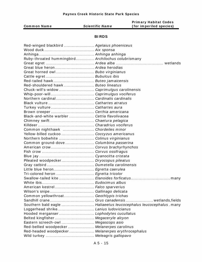
Paynes Creek Historic State Park Species
Primary Habitat Codes Common Name Scientific Name (for imperiled species)
A 5 - 15
BIRDS Red-winged blackbird ....................... Agelaius phoeniceus Wood duck ...................................... Aix sponsa Anhinga .......................................... Anhinga anhinga Ruby-throated hummingbird .............. Archilochus colubrismany Great egret ..................................... Ardea alba .................................... wetlands Great blue heron .............................. Ardea herodias Great horned owl ............................. Bubo virginianus Cattle egret ..................................... Bubulcus ibis Red-tailed hawk ............................... Buteo jamaicensis Red-shouldered hawk ....................... Buteo lineatus Chuck-will's-widow ........................... Caprimulgus carolinensis Whip-poor-will ................................. Caprimulgus vociferus Northern cardinal ............................. Cardinalis cardinalis Black vulture ................................... Cathartes atratus Turkey vulture ................................. Cathartes aura Brown creeper ................................. Certhia americana Black-and-white warbler ................... Cettia flavolivacea Chimney swift .................................. Chaetura pelagica Killdeer ........................................... Charadrius vociferus Common nighthawk ........................ Chordeiles minor Yellow-billed cuckoo ......................... Coccyzus americanus Northern bobwhite ........................... Colinus virginianus Common ground-dove ...................... Columbina passerina American crow ................................. Corvus brachyrhynchos Fish crow ........................................ Corvus ossifragus Blue jay .......................................... Cyanocitta cristata Pileated woodpecker ......................... Dryocopus pileatus Gray catbird .................................... Dumetella carolinensis Little blue heron............................... Egretta caerulea Tri-colored heron ............................. Egretta tricolor Swallow-tailed kite ........................... Elanoides forficatus .............................. many White ibis ........................................ Eudocimus albus American kestrel .............................. Falco sparverius Wilson's snipe .................................. Gallinago delicata Common yellowthroat ....................... Geothlypis trichas Sandhill crane .................................. Grus canadensis ..................... wetlands,fields Southern bald eagle ......................... Haliaeetus leucocephalus leucocephalus . many Loggerhead shrike ............................ Lanius ludovicianus Hooded merganser ........................... Lophodytes cucullatus Belted kingfisher .............................. Megaceryle alcyon Eastern screech-owl ......................... Megascops asio Red-bellied woodpecker .................... Melanerpes carolinus Red-headed woodpecker ................... Melanerpes erythrocephalus Wild turkey ..................................... Meleagris gallopavo
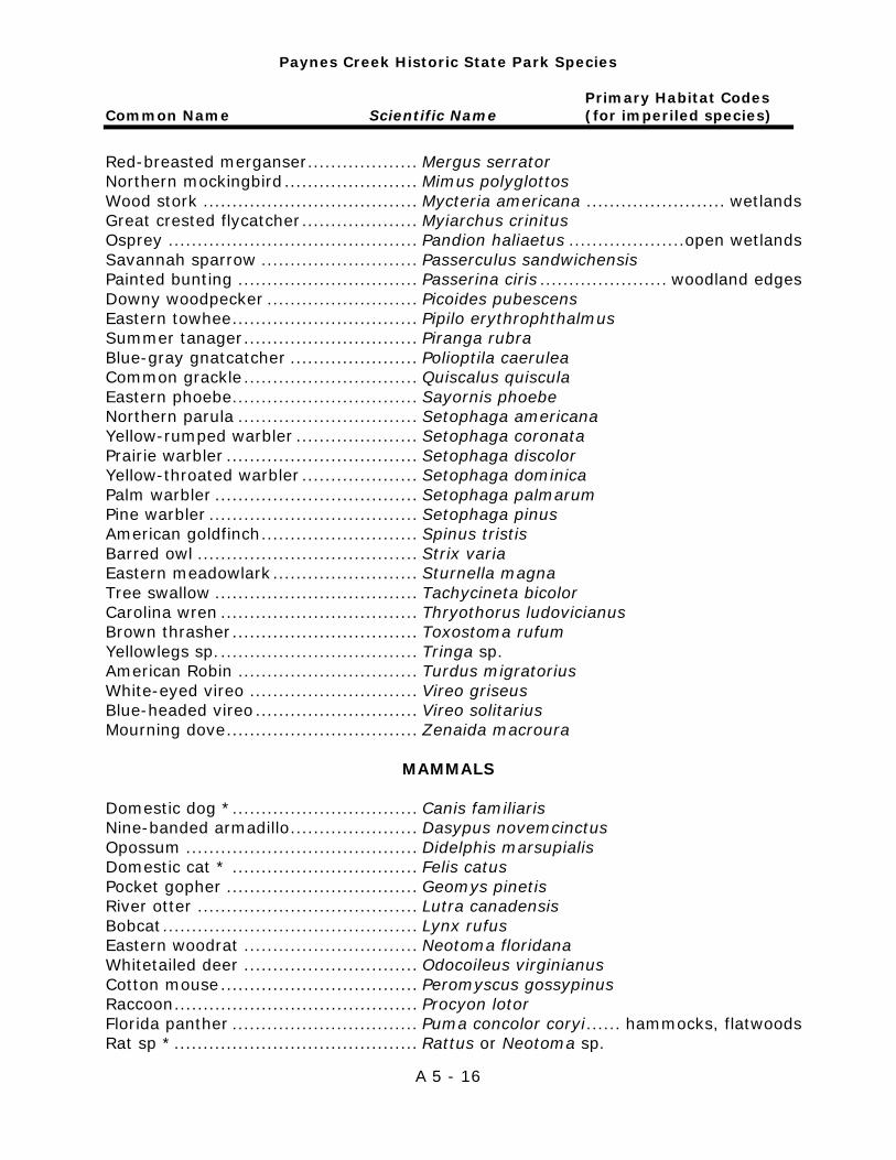
Paynes Creek Historic State Park Species
Primary Habitat Codes Common Name Scientific Name (for imperiled species)
A 5 - 16
Red-breasted merganser ................... Mergus serrator Northern mockingbird ....................... Mimus polyglottos Wood stork ..................................... Mycteria americana ........................ wetlands Great crested flycatcher .................... Myiarchus crinitus Osprey ........................................... Pandion haliaetus ....................open wetlands Savannah sparrow ........................... Passerculus sandwichensis Painted bunting ............................... Passerina ciris ...................... woodland edges Downy woodpecker .......................... Picoides pubescens Eastern towhee ................................ Pipilo erythrophthalmus Summer tanager .............................. Piranga rubra Blue-gray gnatcatcher ...................... Polioptila caerulea Common grackle .............................. Quiscalus quiscula Eastern phoebe ................................ Sayornis phoebe Northern parula ............................... Setophaga americana Yellow-rumped warbler ..................... Setophaga coronata Prairie warbler ................................. Setophaga discolor Yellow-throated warbler .................... Setophaga dominica Palm warbler ................................... Setophaga palmarum Pine warbler .................................... Setophaga pinus American goldfinch ........................... Spinus tristis Barred owl ...................................... Strix varia Eastern meadowlark ......................... Sturnella magna Tree swallow ................................... Tachycineta bicolor Carolina wren .................................. Thryothorus ludovicianus Brown thrasher ................................ Toxostoma rufum Yellowlegs sp. .................................. Tringa sp. American Robin ............................... Turdus migratorius White-eyed vireo ............................. Vireo griseus Blue-headed vireo ............................ Vireo solitarius Mourning dove ................................. Zenaida macroura
MAMMALS Domestic dog * ................................ Canis familiaris Nine-banded armadillo ...................... Dasypus novemcinctus Opossum ........................................ Didelphis marsupialis Domestic cat * ................................ Felis catus Pocket gopher ................................. Geomys pinetis River otter ...................................... Lutra canadensis Bobcat ............................................ Lynx rufus Eastern woodrat .............................. Neotoma floridana Whitetailed deer .............................. Odocoileus virginianus Cotton mouse .................................. Peromyscus gossypinus Raccoon .......................................... Procyon lotor Florida panther ................................ Puma concolor coryi ...... hammocks, flatwoods Rat sp * .......................................... Rattus or Neotoma sp.
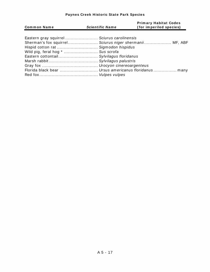
Paynes Creek Historic State Park Species
Primary Habitat Codes Common Name Scientific Name (for imperiled species)
A 5 - 17
Eastern gray squirrel ........................ Sciurus carolinensis Sherman’s fox squirrel ...................... Sciurus niger shermanii .................... MF, ABF Hispid cotton rat .............................. Sigmodon hispidus Wild pig, feral hog * ......................... Sus scrofa Eastern cottontail ............................. Sylvilagus floridanus Marsh rabbit .................................... Sylvilagus palustris Gray fox ......................................... Urocyon cinereoargenteus Florida black bear ............................ Ursus americanus floridanus ................. many Red fox ........................................... Vulpes vulpes
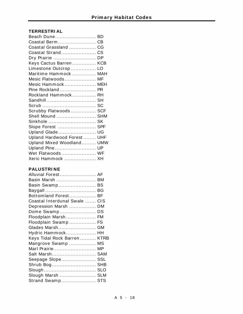
Primary Habitat Codes
A 5 - 18
TERRESTRIAL Beach Dune .......................... BD Coastal Berm ........................ CB Coastal Grassland ................. CG Coastal Strand ...................... CS Dry Prairie ........................... DP Keys Cactus Barren ............... KCB Limestone Outcrop ................ LO Maritime Hammock ............... MAH Mesic Flatwoods .................... MF Mesic Hammock .................... MEH Pine Rockland ....................... PR Rockland Hammock ............... RH Sandhill ............................... SH Scrub .................................. SC Scrubby Flatwoods ................ SCF Shell Mound ......................... SHM Sinkhole .............................. SK Slope Forest ........................ SPF Upland Glade ........................ UG Upland Hardwood Forest ........ UHF Upland Mixed Woodland ......... UMW Upland Pine .......................... UP Wet Flatwoods ...................... WF Xeric Hammock .................... XH PALUSTRINE Alluvial Forest ....................... AF Basin Marsh ......................... BM Basin Swamp ........................ BS Baygall ................................ BG Bottomland Forest ................. BF Coastal Interdunal Swale ....... CIS Depression Marsh ................. DM Dome Swamp ....................... DS Floodplain Marsh ................... FM Floodplain Swamp ................. FS Glades Marsh ........................ GM Hydric Hammock ................... HH Keys Tidal Rock Barren .......... KTRB Mangrove Swamp ................. MS Marl Prairie........................... MP Salt Marsh ............................ SAM Seepage Slope ...................... SSL Shrub Bog ............................ SHB Slough ................................. SLO Slough Marsh ....................... SLM Strand Swamp ...................... STS
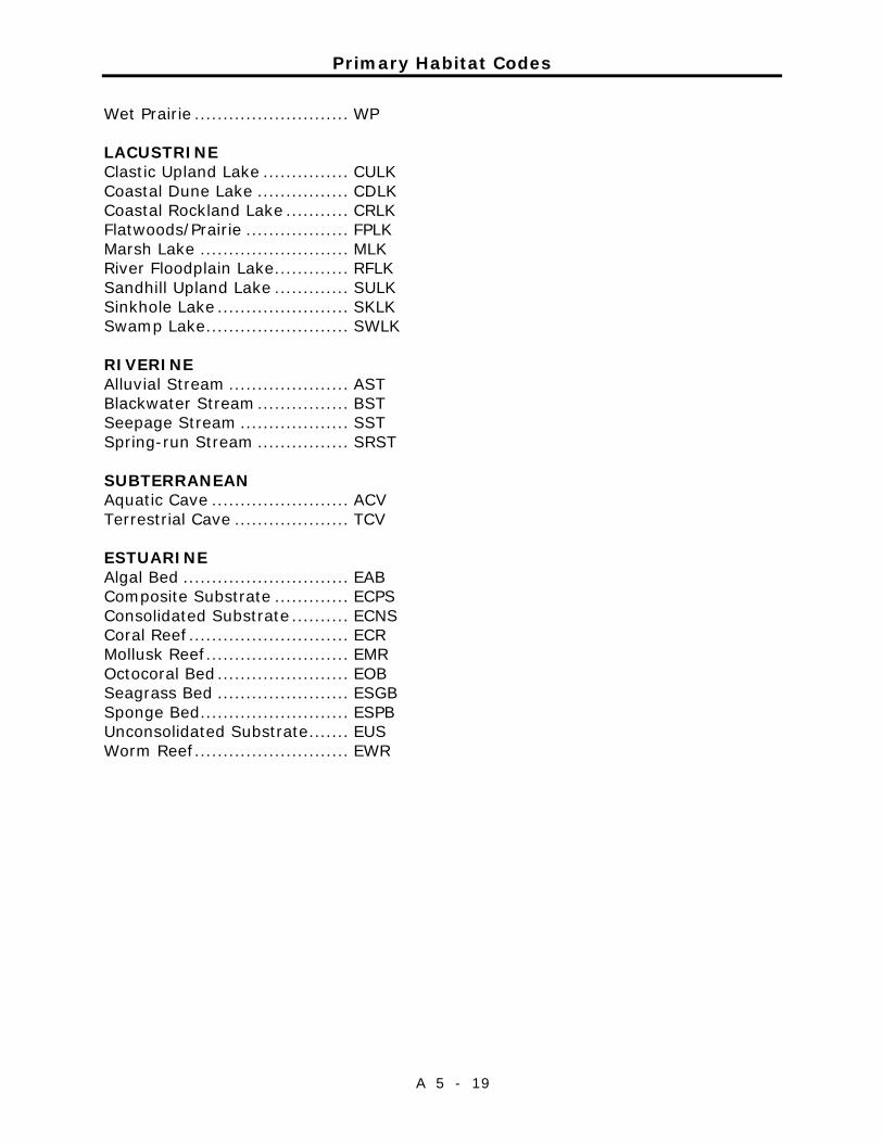
Primary Habitat Codes
A 5 - 19
Wet Prairie ........................... WP LACUSTRINE Clastic Upland Lake ............... CULK Coastal Dune Lake ................ CDLK Coastal Rockland Lake ........... CRLK Flatwoods/Prairie .................. FPLK Marsh Lake .......................... MLK River Floodplain Lake ............. RFLK Sandhill Upland Lake ............. SULK Sinkhole Lake ....................... SKLK Swamp Lake ......................... SWLK RIVERINE Alluvial Stream ..................... AST Blackwater Stream ................ BST Seepage Stream ................... SST Spring-run Stream ................ SRST SUBTERRANEAN Aquatic Cave ........................ ACV Terrestrial Cave .................... TCV ESTUARINE Algal Bed ............................. EAB Composite Substrate ............. ECPS Consolidated Substrate .......... ECNS Coral Reef ............................ ECR Mollusk Reef ......................... EMR Octocoral Bed ....................... EOB Seagrass Bed ....................... ESGB Sponge Bed .......................... ESPB Unconsolidated Substrate ....... EUS Worm Reef ........................... EWR
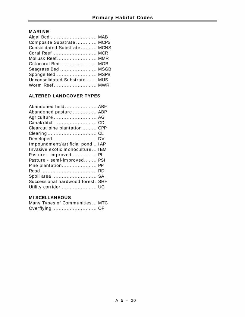
Primary Habitat Codes
A 5 - 20
MARINE Algal Bed ............................. MAB Composite Substrate ............. MCPS Consolidated Substrate .......... MCNS Coral Reef ............................ MCR Mollusk Reef ......................... MMR Octocoral Bed ....................... MOB Seagrass Bed ....................... MSGB Sponge Bed .......................... MSPB Unconsolidated Substrate ....... MUS Worm Reef ........................... MWR ALTERED LANDCOVER TYPES Abandoned field .................... ABF Abandoned pasture ............... ABP Agriculture ........................... AG Canal/ditch .......................... CD Clearcut pine plantation ......... CPP Clearing ............................... CL Developed ............................ DV Impoundment/artificial pond .. IAP Invasive exotic monoculture ... IEM Pasture - improved ................ PI Pasture - semi-improved ........ PSI Pine plantation...................... PP Road ................................... RD Spoil area ............................ SA Successional hardwood forest . SHF Utility corridor ...................... UC MISCELLANEOUS Many Types of Communities ... MTC Overflying ............................ OF

Addendum 6—Imperiled Species Ranking Definitions

Imperiled Species Ranking Definitions
A 6 - 1
The Nature Conservancy and the Natural Heritage Program Network (of which FNAI is a part) define an element as any exemplary or rare component of the natural environment, such as a species, natural community, bird rookery, spring, sinkhole, cave or other ecological feature. An element occurrence (EO) is a single extant habitat that sustains or otherwise contributes to the survival of a population or a distinct, self-sustaining example of a particular element. Using a ranking system developed by The Nature Conservancy and the Natural Heritage Program Network, the Florida Natural Areas Inventory assigns two ranks to each element. The global rank is based on an element's worldwide status; the state rank is based on the status of the element in Florida. Element ranks are based on many factors, the most important ones being estimated number of Element occurrences, estimated abundance (number of individuals for species; area for natural communities), range, estimated adequately protected EOs, relative threat of destruction, and ecological fragility. Federal and State status information is from the U.S. Fish and Wildlife Service; and the Florida Fish and Wildlife Conservation Commission (animals), and the Florida Department of Agriculture and Consumer Services (plants), respectively.
FNAI GLOBAL RANK DEFINITIONS
G1 ............. Critically imperiled globally because of extreme rarity (5 or fewer
occurrences or less than 1000 individuals) or because of extreme vulnerability to extinction due to some natural or fabricated factor.
G2 ............. Imperiled globally because of rarity (6 to 20 occurrences or less than 3000 individuals) or because of vulnerability to extinction due to some natural or man-made factor.
G3 ............. Either very rare or local throughout its range (21-100 occurrences or less than 10,000 individuals) or found locally in a restricted range or vulnerable to extinction of other factors.
G4 ............. apparently secure globally (may be rare in parts of range) G5 ............. demonstrably secure globally GH ............. of historical occurrence throughout its range may be rediscovered
(e.g., ivory-billed woodpecker) GX ............. believed to be extinct throughout range GXC ........... extirpated from the wild but still known from captivity or cultivation G#? ........... Tentative rank (e.g.,G2?) G#G# ........ range of rank; insufficient data to assign specific global rank (e.g.,
G2G3) G#T# ......... rank of a taxonomic subgroup such as a subspecies or variety; the G
portion of the rank refers to the entire species and the T portion refers to the specific subgroup; numbers have same definition as above (e.g., G3T1)
Imperiled Species Ranking Definitions
A 6 - 2
G#Q ........... rank of questionable species - ranked as species but questionable whether it is species or subspecies; numbers have same definition as above (e.g., G2Q)
G#T#Q ....... same as above, but validity as subspecies or variety is questioned. GU ............. due to lack of information, no rank or range can be assigned (e.g.,
GUT2). G? .............. Not yet ranked (temporary) S1 .............. Critically imperiled in Florida because of extreme rarity (5 or fewer
occurrences or less than 1000 individuals) or because of extreme vulnerability to extinction due to some natural or man-made factor.
S2 .............. Imperiled in Florida because of rarity (6 to 20 occurrences or less than 3000 individuals) or because of vulnerability to extinction due to some natural or man-made factor.
S3 .............. Either very rare or local throughout its range (21-100 occurrences or less than 10,000 individuals) or found locally in a restricted range or vulnerable to extinction of other factors.
S4 .............. apparently secure in Florida (may be rare in parts of range) S5 .............. demonstrably secure in Florida SH ............. of historical occurrence throughout its range, may be rediscovered
(e.g., ivory-billed woodpecker) SX.............. believed to be extinct throughout range SA.............. accidental in Florida, i.e., not part of the established biota SE .............. an exotic species established in Florida may be native elsewhere in
North America SN ............. regularly occurring but widely and unreliably distributed; sites for
conservation hard to determine SU ............. due to lack of information, no rank or range can be assigned (e.g.,
SUT2). S? .............. Not yet ranked (temporary) N .............. Not currently listed, nor currently being considered for listing, by state
or federal agencies.
LEGAL STATUS
FEDERAL
(Listed by the U. S. Fish and Wildlife Service - USFWS) LE .............. Listed as Endangered Species in the List of Endangered and
Threatened Wildlife and Plants under the provisions of the Endangered Species Act. Defined as any species that is in danger of extinction throughout all or a significant portion of its range.
PE .............. Proposed for addition to the List of Endangered and Threatened Wildlife and Plants as Endangered Species.
LT .............. Listed as Threatened Species. Defined as any species that is likely to become an endangered species within the near future throughout all or a significant portion of its range.

Imperiled Species Ranking Definitions
A 6 - 3
PT .............. Proposed for listing as Threatened Species. C ............. Candidate Species for addition to the list of Endangered and
Threatened Wildlife and Plants. Defined as those species for which the USFWS currently has on file sufficient information on biological vulnerability and threats to support proposing to list the species as endangered or threatened.
E(S/A) ........ Endangered due to similarity of appearance. T(S/A) ........ Threatened due to similarity of appearance. EXPE, XE ..... Experimental essential population. A species listed as experimental and essential. EXPN, XN .... Experimental non-essential population. A species listed as experimental and non-essential. Experimental, nonessential populations of endangered species are treated as threatened species on public land, for consultation purposes.
STATE
ANIMALS .. (Listed by the Florida Fish and Wildlife Conservation
Commission - FWC) FE .............. Federally-designated Endangered FT .............. Federally-designated Threatened FXN ............ Federally-designated Threatened Nonessential Experimental Population FT(S/A) ...... Federally-designated Threatened species due to similarity of
appearance ST .............. Listed as Threatened Species by the FWC. Defined as a species,
subspecies, or isolated population, which is acutely vulnerable to environmental alteration, declining in number at a rapid rate, or whose range or habitat, is decreasing in area at a rapid rate and therefore is destined or very likely to become an endangered species within the near future.
SSC ............ Listed as Species of Special Concern by the FWC. Defined as a population which warrants special protection, recognition or consideration because it has an inherent significant vulnerability to habitat modification, environmental alteration, human disturbance or substantial human exploitation that, in the near future, may result in its becoming a threatened species.
Imperiled Species Ranking Definitions
A 6 - 4
PLANTS .... (Listed by the Florida Department of Agriculture and Consumer Services - FDACS)
LE .............. Listed as Endangered Plants in the Preservation of Native Flora of
Florida Act. Defined as species of plants native to the state that are in imminent danger of extinction within the state, the survival of which is unlikely if the causes of a decline in the number of plants continue, and includes all species determined to be endangered or threatened pursuant to the Federal Endangered Species Act of 1973,as amended.
LT .............. Listed as Threatened Plants in the Preservation of Native Flora of Florida Act. Defined as species native to the state that are in rapid decline in the number of plants within the state, but which have not so decreased in such number as to cause them to be endangered.

Imperiled Species Ranking Definitions
A 6 - 5


Addendum 7—Cultural Information

Management Procedures for Archaeological and Historical Sites and Properties on State-Owned or Controlled Properties (revised March 2013)
A 7 - 1
These procedures apply to state agencies, local governments, and non-profits that manage state-owned properties. A. General Discussion Historic resources are both archaeological sites and historic structures. Pursuant to Chapter 267, Florida Statutes, ‘Historic property’ or ‘historic resource’ means any prehistoric district, site, building, object, or other real or personal property of historical, architectural, or archaeological value, and folklife resources. These properties or resources may include, but are not limited to, monuments, memorials, Indian habitations, ceremonial sites, abandoned settlements, sunken or abandoned ships, engineering works, treasure trove, artifacts, or other objects with intrinsic historical or archaeological value, or any part thereof, relating to the history, government, and culture of the state.” B. Agency Responsibilities Persuant to State Policy relative to historic properties, state agencies of the executive branch must allow the Division of Historical Resources (Division) the opportunity to comment on any undertakings, whether these undertakings directly involve the state agency, i.e., land management responsibilities, or the state agency has indirect jurisdiction, i.e. permitting authority, grants, etc. No state funds should be expended on the undertaking until the Division has the opportunity to review and comment on the project, permit, grant, etc. State agencies shall preserve the historic resources which are owned or controlled by the agency. Regarding proposed demolition or substantial alterations of historic properties, consultation with the Division must occur, and alternatives to demolition must be considered. State agencies must consult with Division to establish a program to location, inventory and evaluate all historic properties under ownership or controlled by the agency. C. Statutory Authority Statutory Authority and more in depth information can be found at: http://www.flheritage.com/preservation/compliance/guidelines.cfm D. Management Implementation Even though the Division sits on the Acquisition and Restoration Council and approves land management plans, these plans are conceptual. Specific information regarding individual projects must be submitted to the Division for review and recommendations.

Management Procedures for Archaeological and Historical Sites and Properties on State-Owned or Controlled Properties (revised March 2013)
A 7 - 2
Managers of state lands must coordinate any land clearing or ground disturbing activities with the Division to allow for review and comment on the proposed project. Recommendations may include, but are not limited to: approval of the project as submitted, cultural resource assessment survey by a qualified professional archaeologist, modifications to the proposed project to avoid or mitigate potential adverse effects. Projects such as additions, exterior alteration, or related new construction regarding historic structures must also be submitted to the Division of Historical Resources for review and comment by the Division’s architects. Projects involving structures fifty years of age or older, must be submitted to this agency for a significance determination. In rare cases, structures under 50 years of age may be deemed historically significant. These must be evaluated on a case by case basis. Adverse impacts to significant sites, either archaeological sites or historic buildings, must be avoided. Furthermore, managers of state property should make preparations for locating and evaluating historic resources, both archaeological sites and historic structures. E. Minimum Review Documentation Requirements To have a proposed project reviewed by the Division, certain information must be submitted for comments and recommendations. The minimum review documentation requirements can be found at: http://www.flheritage.com/preservation/compliance/docs/minimum_review_documentation_requirements.pdf .
* * * Questions relating to the treatment of archaeological and historic resources on state lands should be directed to: Deena S. Woodward Division of Historical Resources Bureau of Historic Preservation Compliance and Review Section R. A. Gray Building 500 South Bronough Street Tallahassee, FL 32399-0250 Phone: (850) 245-6425 Toll Free: (800) 847-7278 Fax: (850) 245-6435
Eligibility Criteria for National Register of Historic Places
A 7 - 3
The criteria used for evaluating eligibility for listing in the National Register of Historic Places are: 1) Districts, sites, buildings, structures, and objects may be considered to have
significance in American history, architecture, archaeology, engineering, and/or culture if they possess integrity of location, design, setting, materials, workmanship, feeling, and association, and:
a) are associated with events that have made a significant contribution to
the broad patterns of our history; and/or b) are associated with the lives of persons significant in our past; and/or c) embody the distinctive characteristics of type, period, or method of
construction, or that represent the work of a master, or that possess high artistic values, or that represent a significant and distinguishable entity whose components may lack individual distinction; and/or
d) have yielded, or may be likely to yield, information important in prehistory or history.
2) Ordinarily cemeteries, birthplaces, or graves of historical figures; properties
owned by religious institutions or used for religious purposes; structures that have been moved from their original locations; reconstructed historic buildings; properties primarily commemorative in nature; and properties that have achieved significance within the past 50 years shall not be considered eligible for the National Register. However, such properties will qualify if they are integral parts of districts that do meet the criteria or if they fall within the following categories:
a) a religious property deriving its primary significance from architectural
or artistic distinction or historical importance; or b) a building or structure removed from its original location but which is
significant primarily for architectural value, or which is the surviving structure most importantly associated with a historic person or event; or
c) a birthplace or grave of an historical figure of outstanding importance if there is no appropriate site or building directly associated with his productive life; or
d) a cemetery which derives its primary significance from graves of persons of transcendent importance, from age, distinctive design features, or association with historic events; or

Eligibility Criteria for National Register of Historic Places
A 7 - 4
e) a reconstructed building, when it is accurately executed in a suitable environment and presented in a dignified manner as part of a restoration master plan, and no other building or structure with the same association has survived; or a property primarily commemorative in intent, if design, age, tradition, or symbolic value has invested it with its own exceptional significance; or
f) a property achieving significance within the past 50 years, if it is of exceptional importance.
Preservation Treatments as Defined by Secretary of Interior’s Standards and Guidelines
A 7 - 5
Restoration is defined as the act or process of accurately depicting the form, features, and character of a property as it appeared at a particular period of time by means of the removal of features from other periods in its history and reconstruction of missing features from the restoration period. The limited and sensitive upgrading of mechanical, electrical and plumbing systems and other code-required work to make properties functional is appropriate within a restoration project. Rehabilitation is defined as the act or process of making possible a compatible use for a property through repair, alterations and additions while preserving those portions or features that convey its historical, cultural or architectural values. Stabilization is defined as the act or process of applying measures designed to reestablish a weather resistant enclosure and the structural stability of an unsafe or deteriorated property while maintaining the essential form as it exists at present. Preservation is defined as the act or process of applying measures necessary to sustain the existing form, integrity and materials of an historic property. Work, including preliminary measures to protect and stabilize the property, generally focuses upon the ongoing maintenance and repair of historic materials and features rather than extensive replacement and new construction. New exterior additions are not within the scope of this treatment; however, the limited and sensitive upgrading of mechanical, electrical and plumbing systems and other code-required work to make properties functional is appropriate within a preservation project.

Preservation Treatments as Defined by Secretary of Interior’s Standards and Guidelines
A 7 - 6

Addendum 8 —Land Management Review

Paynes Creek Historic State Park Land Management Review
A 8 - 1
Paynes Creek Historic State Park Land Management Review
A 8 - 2
Paynes Creek Historic State Park Land Management Review
A 8 - 3
Paynes Creek Historic State Park Land Management Review
A 8 - 4