Embed Size (px)
Citation preview
Planning committee 8 September 2021.docx
APPLICATION NO PA/2021/824
APPLICANT Mr Jonathan Wroot DEVELOPMENT Outline planning permission for five dwellings with appearance,
landscaping and scale reserved for subsequent consideration
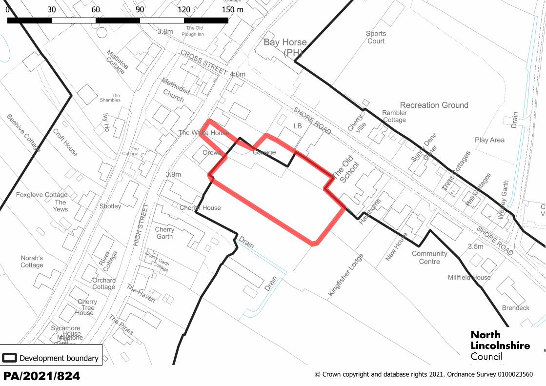
LOCATION Land to the rear of The White House, High Street, Garthorpe, DN17 4RP
PARISH Garthorpe and Fockerby
WARD Axholme North
CASE OFFICER Brian McParland
SUMMARY RECOMMENDATION
Refuse permission
REASONS FOR REFERENCE TO COMMITTEE
Member ‘call in’ (Cllrs Julie Reed and John Briggs – significant public interest)
Departure from the development plan
POLICIES
National Planning Policy Framework:
Paragraph 11 – Plans and decisions should apply a presumption in favour of sustainable development:
(d) where there are no relevant development plan policies, or the policies which are most important for determining the application are out-of-date, granting permission unless:
(i) the application of policies in this Framework that protect areas or assets of particular importance provides a clear reason for refusing the development proposed; or
(ii) any adverse impacts of doing so would significantly and demonstrably outweigh the benefits, when assessed against the policies in this Framework taken as a whole.
Paragraph 12 – The presumption in favour of sustainable development does not change the statutory status of the development plan as the starting point for decision making. Where a planning application conflicts with an up-to-date development plan (including any neighbourhood plans that form part of the development plan), permission should not usually be granted. Local planning authorities may take decisions that depart from an up-to-date development plan, but only if material considerations in a particular case indicate that the plan should not be followed.
North Lincolnshire Local Plan: DS1, DS7, DS14, DS16, RD2, T2, T19
North Lincolnshire Core Strategy: CS1, CS2, CS3, CS5, CS7, CS8, CS18, CS19
Planning committee 8 September 2021.docx
CONSULTATIONS
Environment Agency: No objection but recommended a condition relating to the Flood Risk Assessment.
Highways: No objection but recommended conditions relating to access, parking, loose material, splays, turning and private drives.
Drainage (Lead Local Flood Authority): No objection but recommended conditions relating to the submission of a surface water drainage scheme.
Environmental Protection: No objection but recommended a contaminated land condition.
Historic Environment Record: No objection.
Recycling: Please refer to the North Lincolnshire Council's Waste Planning Guidance regarding unadopted roads. Bin collection areas will need to be created and where properties are situated on or accessed by unadopted private roads they should be provided with a refuse collection point nearest to the highway accessible by the refuse collection vehicles. This collection point should be sufficient to accommodate the number of bins likely to be placed out on a given collection day.
PARISH COUNCIL
‘Items of concern are access to the site, vehicular access for 10 cars and parking issues for visitors and properties who have more than two cars. The visibility splays need to be established due to the blind crossroads nearby and the school bus stop. Drainage issues currently exist in the village and are being worked on by contractors. The properties are not in keeping with the village, no back building has been permitted to date. Wheely bins for the properties will present an issue when due for collection. The properties will be detrimental to properties on three sides.’
PUBLICITY
Advertised by site and press notice. Fifteen responses have been received objecting to the proposals on the following grounds:
impact on traffic and character of the area
increased parking on road and impact on privacy (backland development)
drainage and flood risk issues
poor access and the repositioning of the bus stop would impact road safety.
ASSESSMENT
The main issue to be considered is whether adequate justification can be demonstrated with regard to the principle of the proposed development, including access and layout.
Planning committee 8 September 2021.docx
The site
The application site is on the east side of High Street to the rear of a property known as The White House. The site appears to be flat garden land with outbuildings. Access to the site is directly opposite a Methodist Church, between The White House and the neighbouring property, Orewa. The majority of the site is within the open countryside but also abuts the edge of the Garthorpe settlement boundary. It is not within a conservation area, does not affect any listed buildings and there are no tree preservation orders on the site or in the nearby vicinity. The site is within SFRA flood zone 2/3 (a) Tidal.
Proposal
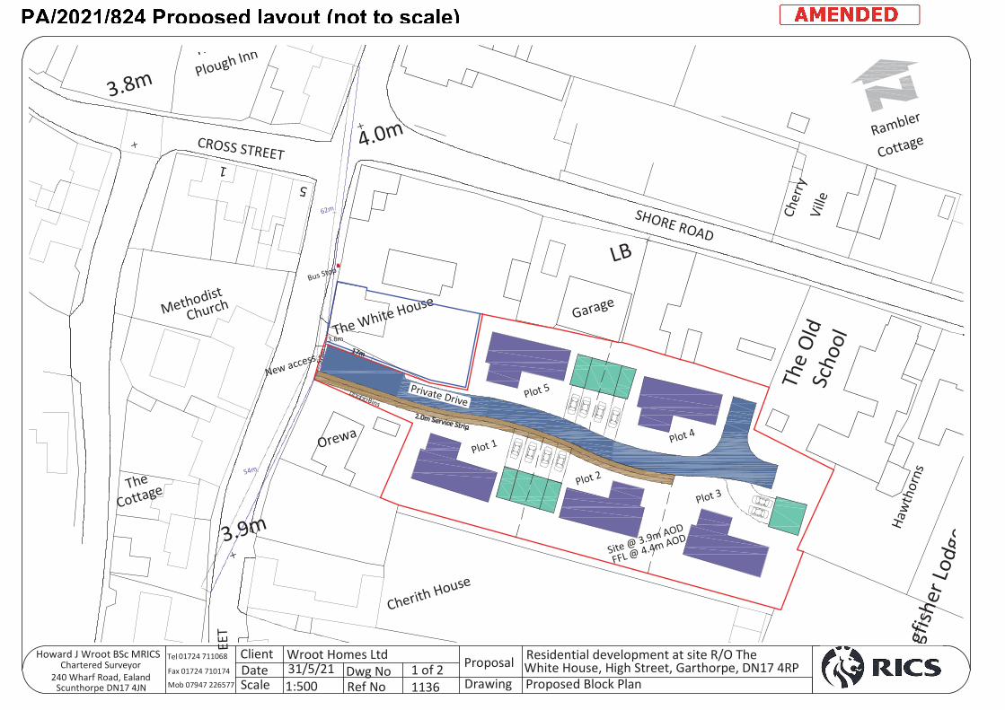
Outline planning permission is sought for five dwellings (including access and layout), with some matters reserved.
Principle of development
The majority of the site is outside the adjacent settlement boundary of Garthorpe and the proposal would represent a departure from the development plan. In determining whether the principle of residential development outside the settlement boundary is acceptable in this instance, it is necessary to consider whether the proposed development is sustainable in planning policy terms.
The development plan for North Lincolnshire comprises three parts: those policies of the North Lincolnshire Local Plan (2003) (LP) which were saved by a direction of the Secretary of State in September 2007, the North Lincolnshire Core Strategy DPD (2011) (CS), and the Housing and Employment Land Allocations DPD (2016) (HELADPD).
Local plan saved policy RD2 restricts development in the open countryside other than in exceptional circumstances. This policy only supports residential development outside defined development limits where it is to meet an essential proven need and the open countryside is the only appropriate location for the development. Whilst this policy remains, it has largely been overtaken by policies in subsequent plans addressing the same issue (such as policies CS2 and CS3 referenced above).
The aforementioned policies are aimed at focusing housing within settlement limits as defined in the Housing and Employment Land Allocations DPD. The majority of the application site is outside the nearest settlement boundary for Garthorpe and would not meet the criteria for development within the open countryside as outlined in policy RD2 of the local plan. The proposal is thereby considered to conflict with policies CS2, CS3 and CS8 of the Core Strategy and policy RD2 of the North Lincolnshire Local Plan.
It is acknowledged the development would provide limited benefits in terms of open market housing and delivery of economic benefits during construction and through the spending of future occupiers. The proposal would also provide some benefit in terms of housing provision, however the weighting to be attached to this benefit is considered to be limited given the majority of the siting would be within the open countryside and given the strong housing provision within North Lincolnshire. Importantly, North Lincolnshire can demonstrate a five-year supply of deliverable housing sites, as illustrated within the North Lincolnshire Council Five Year Housing Land Supply Statement August 2021. Therefore, in accordance with paragraph 12 of the NPPF, the relevant policies concerning the supply of housing should be considered up-to-date and consequently the ‘tilted balance’ as per paragraph 11 d (ii) of the NPPF is not engaged.
Planning committee 8 September 2021.docx
In light of the above, the proposed development would be unsustainable as the majority of the site is within the open countryside and would not meet any of the exceptions noted for development. Therefore, in principle, the proposal would prejudice the local area and, as such, would be in conflict with policy RD2 of the local plan, and policies CS2 and CS3 of the Core Strategy.
Flood risk
The site is situated within SFRA Flood Zone 2/3 (a) Tidal and the applicant has submitted the requisite FRA (Flood Risk Assessment). Given the development is for a ‘more vulnerable’ residential development in a high flood risk zone, the proposal will only be supported where it can be demonstrated that the sequential and exception tests set out by the NPPF (sections 158 and 160) have been passed.
The applicant has provided a sequential test as part of the flood risk assessment.
Paragraph 158 of the NPPF notes that the purpose of the sequential test is to steer new development to areas with the lowest probability of flooding. The aim is to steer new development to Flood Zone 1. Paragraph 159 states that only where there are no reasonably available sites in Flood Zone 1 or 2 should the suitability of sites in Flood Zone 3 be considered, taking into account the flood risk vulnerability of land uses and applying the exception test if necessary.
Within the FRA the search for alternative development sites was limited to the settlement of Garthorpe. It is considered there are no sequentially preferable sites of lesser flood risk suitable for the development within Garthorpe as the entire settlement of Garthorpe is within the same flood zone. It is considered there are no sequentially preferable sites of lesser flood risk suitable for the development. As such, the sequential test is passed.
The exceptions test is then applied.
The exception test as set out in paragraph 160 of the NPPF is a method to demonstrate and help ensure that flood risk to people and property will be managed satisfactorily, while allowing necessary development to go ahead in situations where suitable sites at lower risk of flooding are not available.
For the exception test to be passed it should be demonstrated that:
(a) the development would provide wider sustainability benefits to the community that outweigh the flood risk; and
(b) the development would be safe for its lifetime taking account of the vulnerability of its users, without increasing flood risk elsewhere and, where possible, would reduce flood risk overall.
Criterion a: In terms of sustainability, the dwellings would provide employment for local tradespeople during construction of the dwellings. The location of the development and its proximity to local services, together with good access to public transport, all demonstrate a sustainable location. The provision of additional residential units and the self-build nature of this application are also sustainability benefits of the proposal. The residential units would be designed to minimise any risk of crime and would provide added surveillance. The residential units would support local services, contribute to the economy of the area and
Planning committee 8 September 2021.docx
improve the appearance of the land in the interest of placemaking. On this basis, it is considered the wider sustainability benefits of the development outweigh the flood risk.
Criterion b: Consideration has been given to ensure that the proposal is safe and will not increase flood risk elsewhere. Flood resilience and flood warning measures have been included within the FRA. In addition, the council’s LLFA drainage team has no objection, and the Environment Agency has confirmed, subject to a condition, that the development is safe from flooding and would not increase flood risk elsewhere. The exceptions test is therefore considered to be passed.
The proposal, subject to conditions, accords with guidance in the NPPF, policy DS16 of the North Lincolnshire Local Plan and policy CS19 of the Core Strategy.
Impact on the amenity of the locality
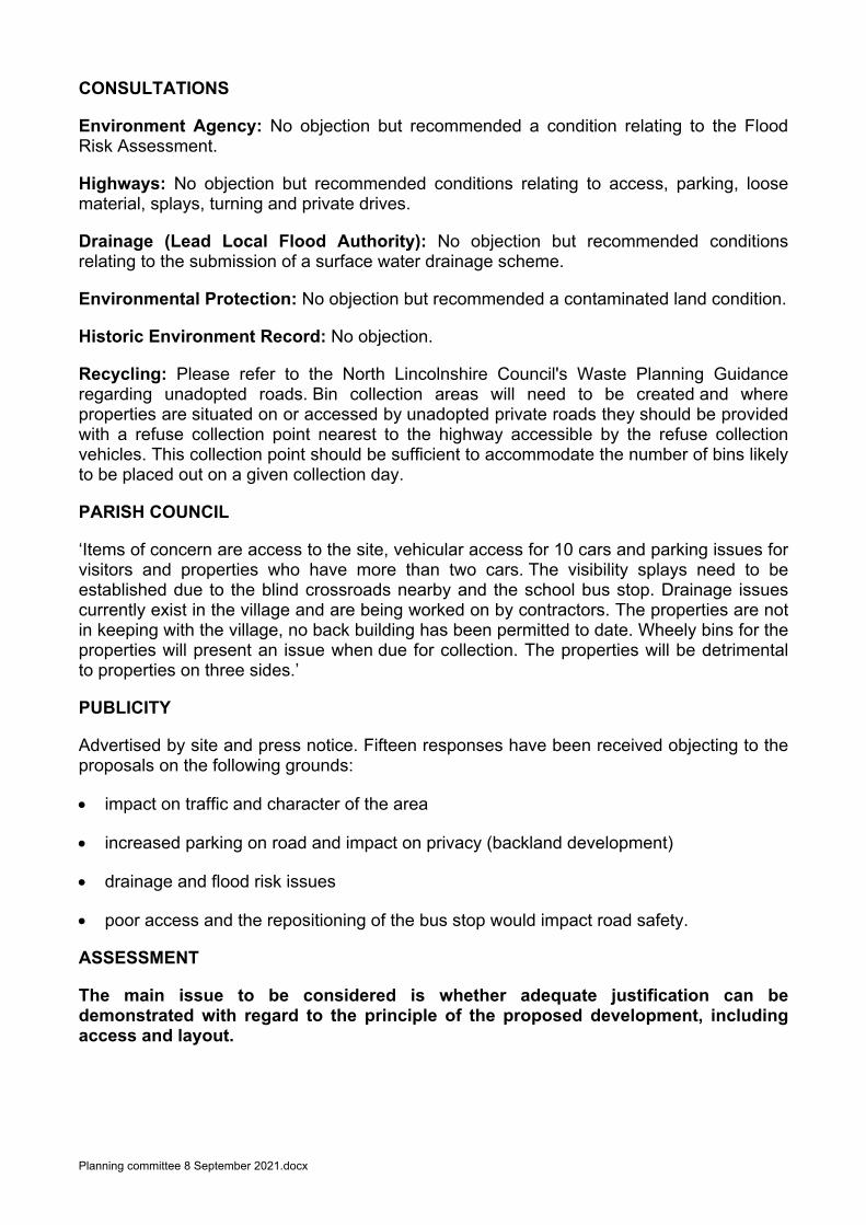
In terms of layout, the five dwellings are to be detached properties served by two parking spaces each. The site would be of a cul-de-sac design set in from the site curtilages. A proposed block plan has been submitted which outlines the design of the development. It is considered the development would not appear cramped and would not prejudice the pattern of development within the locality. In terms of landscape, appearance and scale, this would be dealt with under a subsequent reserved matters application and would be needed in order to address the proposal’s overall impact on the character of the area.
The proposal would therefore accord with the NPPF, policies CS1, CS2, CS5, CS7 and CS8 of the Core Strategy, and policy DS1 of the North Lincolnshire Local Plan.
Impact on residential amenity
In terms of impact on residential amenity, the council is satisfied that five dwellings could be sited on this substantially sized plot without adversely affecting the amenity of adjoining residents and without causing demonstrable harm to the amenity of nearby residents.
Within the design and access statement, the applicant has outlined the proposed dwellings would be bungalows (indicative); this would be favourable. The impact on neighbouring residential amenity would be assessed in more detail through the submission of a subsequent reserved matters application where the appearance and scale would be considered. The proposal would therefore accord with the NPPF, policies CS1, CS2, CS5, CS7 and CS8 of the Core Strategy, and policy DS1 of the North Lincolnshire Local Plan.
Highways
In terms of access, this would be from High Street into a new private drive. Two parking spaces are to be provided for each dwelling which meets planning guidance requirements. No further on-street parking would be required along High Street. The new access would be 6m north of Orewa and 3m south of The White House, which is owned by the applicant.
Highways have raised no objections to the proposal subject to conditions. The proposal would therefore accord with policies T2 and T19 of the North Lincolnshire Local Plan.
Land quality
Policy DS7 of the local plan is concerned with contaminated land. It states that permission will only be granted on contaminated sites where a detailed site survey has been submitted,
Planning committee 8 September 2021.docx
and a suitable scheme of remedial measures has been agreed to overcome any existing contamination.
The council’s Environmental Protection team has recommended a contaminated land condition given the proposed development of residential properties is a sensitive end use and historic mapping shows there have been outbuildings on the site, which has the potential to have introduced contaminants.
Other matters
With regard to impact on drainage, the council’s drainage team has recommended conditions.
The existing bus stop would be repositioned further north by approximately 10m; however, the repositioning of the bus stop would not prejudice existing highway safety.
Conclusion
The proposed development is contrary to relevant development plans. It is considered the limited benefits of additional housing provision outside the development boundary would not outweigh the adverse impact on the locality in light of the council’s five-year land supply. As such, it is considered the development does not constitute sustainable development and should therefore be refused.
RECOMMENDATION Refuse permission for the following reason:
The proposed development would be unsustainable as the majority of the site is located within the open countryside and would not meet any of the exceptions noted for development. Therefore, in principle, the proposal would prejudice the local area. As such, the proposal would be in conflict with policy RD2 of the North Lincolnshire Local Plan, and policies CS2 and CS3 of the Core Strategy. Informative 1 In determining this application, the council, as local planning authority, has taken account of the guidance in paragraph 38 of the National Planning Policy Framework in order to seek to secure sustainable development that improves the economic, social and environmental conditions of the area.
PA/2021/824 © Crown copyright and database rights 2021. Ordnance Survey 0100023560
Development boundary
1
Church
ThPlough Inn
Cherith House
Methodist
3.8m
The
Orewa
Cottage
The White House
3.9m
Garage
Scho
ol
CROSS STREET
Cottage
SHORE ROAD
ngfis
her L
odge
Ville
Haw
thor
ns
The
Old
4.0m Rambler
Cher
ry5
EET
LB
5393054m
61783.562m
Bins
Plot 1
Plot 2
Plot 3
Plot 4
Plot 5
Bus Stop
New access
Private Drive
Site @ 3.9m AOD
FFL @ 4.4m AOD
3604.3
3.6m
5.5m
ProposalDrawing
Dwg NoRef No
ClientDateScale
Howard J Wroot BSc MRICSChartered Surveyor
240 Wharf Road, Ealand Scunthorpe DN17 4JN
Wroot Homes Ltd31/5/211:500
1 of 21136
Residential development at site R/O TheWhite House, High Street, Garthorpe, DN17 4RPProposed Block Plan
01724 711068
Fax 01724 710174Mob 07947 226577
Tel