Embed Size (px)
Citation preview
Planning Committee 21 September 2016 Page 20
APPLICATION NO PA/2016/995
APPLICANT Aldi Stores Ltd & Ancholme Estates DEVELOPMENT Planning permission for demolition of existing buildings and
erection of a retail unit (Use Class A1) with car parking, landscaping and associated works
LOCATION Bridge Street, Brigg, DN20 8NF
PARISH Brigg
WARD Brigg and Wolds
CASE OFFICER Scott Jackson
SUMMARY RECOMMENDATION
Grant permission subject to conditions
REASONS FOR REFERENCE TO COMMITTEE
Departure from policy (part of the site is located outside the settlement boundary for Brigg)
POLICIES
National Planning Policy Framework (NPPF): Paragraph 24 states local planning authorities should apply a sequential test to planning applications for main town centre uses that are not in an existing centre and are not in accordance with an up-to-date local plan. They should require applications for main town centre uses to be located in town centres, then in edge-of-centre locations, and only if suitable sites are not available should out-of-centre sites be considered. When considering edge-of-centre and out-of-centre proposals, preference should be given to accessible sites that are well connected to the town centre. Applicants and local planning authorities should demonstrate flexibility on issues such as format and scale.
Paragraph 34 states that plans and decisions should ensure developments that generate significant movement are located where the need to travel will be minimised and the use of sustainable transport modes can be maximised.
Paragraph 56 states that the Government attaches great importance to the design of the built environment. Good design is a key aspect of sustainable development, is indivisible from good planning, and should contribute positively to making places better for people.
Paragraph 100 states that inappropriate development in areas at risk of flooding should be avoided by directing development away from areas at highest risk, but where development is necessary, making it safe without increasing food risk elsewhere.
Paragraphs 101-103 also apply.
Paragraph 128 states that in determining applications, local planning authorities should require an applicant to describe the significance of any heritage assets affected, including any contribution made by their setting. The level of detail should be proportionate to the
Planning Committee 21 September 2016 Page 21
assets’ importance and no more than is sufficient to understand the potential impact of the proposal on their significance.
North Lincolnshire Local Plan: Policies RD2, S7, T1, T2, LC15, HE5, DS1, DS3, DS14 and DS16 apply.
North Lincolnshire Core Strategy: Policies CS1, CS2, CS3, CS5, CS6, CS14, CS16, CS17, CS18, CS19 and CS25 apply.
Housing and Employment Land Development Plan Document (DPD): Policies TC1 and PS1 apply.
CONSULTATIONS
Highways: No objection, but recommend a condition in respect of works within the highway, safety audits, details of the private access road and pedestrian crossing point, completion of the access road and servicing, cycle parking and parking spaces. Conditions are also recommended in respect of service/delivery management, approval and monitoring of a travel plan, phased traffic management plan and prohibiting signage within the highway.
Historic England: The application should be determined in accordance with national and local policy guidance, and on the basis of your specialist conservation and archaeological advice, specifically in relation to the setting of the Grade II bridge and the archaeological impact on the nearby scheduled monument.
Ancholme Internal Drainage Board: If surface water is to be discharged to any watercourse then consent would be required and restricted to a rate of 1.4 litres per second. No obstructions are permitted within 9 metres of the edge of a watercourse without consent.
Historic Environment Record: The application site is situated adjacent to the New River Ancholme Bridge, a Grade II listed building and within 300 metres of the scheduled monument of Castlethorpe Moated Site. The application site lies within an area where archaeological remains may be anticipated. The proposal will not adversely affect the setting of the scheduled monument. With regard to the heritage assets of archaeological interest, no objection subject to conditions securing a programme of archaeological and palaeo-environmental work prior to and during construction work.
Ecology: The site has limited biodiversity value at present and low potential for protected species. Recommend conditions in respect of the submission and implementation of a biodiversity management plan. Welcome the widening of the landscape buffer and the additional planting species.
Environment Agency: No objection, but recommend a condition requiring the development to take place in accordance with the mitigation measures set out in the flood risk assessment.
Spatial Planning: This proposal would be broadly acceptable in principle. However, the issue relating to part of the proposal being located outside the defined settlement development limit should be considered. In doing so, it needs to be considered whether this can be outweighed when the proposal is assessed against other relevant policies in the development plan as well as its environmental, social and economic benefits/impacts.
Planning Committee 21 September 2016 Page 22
Conservation Officer: No objection. The proposed supermarket sits on the south-eastern aspect of the listed 19th century stone New River Ancholme Bridge. Because of its relatively low-level roof and mono-pitch roof the new building does not stand out predominately in the listed bridge surroundings. It is of similar level to the buildings that are going to be removed from the site. The neutral grey and brown colour is acceptable as it does not stand out predominately. The new building does not block any key views from the riverside. Whilst there is some impact on the setting of the listed building it is seen as acceptable.
Humberside Fire and Rescue: Adequate access and provision of water supplies for fire-fighting should be provided to all buildings or extensions to buildings.
Environmental Health: Recommend conditions in respect of contaminated land investigation, submission of a noise impact assessment, delivery, opening and waste collection hours, noise from fixed plant and construction working hours. Additional comments received via email confirming that deliveries will be acceptable on Mondays (bank holidays) provided that any noise mitigation measures identified in the noise assessment are implemented.
Drainage Team: No objection, but recommend conditions in respect of a strategy for the management of surface water drainage and implementation of the approved drainage scheme.
Anglian Water Developer Services: No objection, but recommend conditions in respect of the disposal of foul drainage.
Head of Environment Team: Having considered the landscaping proposals no further comments to add to those previously made by the council’s ecologist.
TOWN COUNCIL
Supports the application but requests that the developer considers pedestrian refuges on Island Carr Road and Bridge Street, a pedestrian crossing on the access road and a left-turn-only access from Waters Edge.
PUBLICITY
Site and press notices have been posted. Forty-eight letters of support have been received relating to the following matters:
• increased choice
• island crossing is needed
• roundabout will improve traffic
• enhances the town
• good location
• improved facilities
• improves road safety
Planning Committee 21 September 2016 Page 23
• increased jobs
• accessible location
• it will tidy up the site
• sustainable location
• increased visitors to the town
• it is welcomed
• it is served by a bus route.
Two letters of objection/comment have been received raising the following issues:
• concern over the roundabout
• traffic generation
• close to the bridge with poor visibility
• impact on Brigg town centre.
STATEMENT OF COMMUNITY INVOLVEMENT
The design and access statement sets out the extent and nature of the public consultation which took place prior to the submission of this planning application. It states that the applicant engaged with local ward councillors in April 2016, a meeting was held with town councillors in May 2016 and a public exhibition was held on 26 May 2016 for local residents. In addition a newsletter was sent to 1417 local residents in advance of the public consultation and to inform them of the proposals. Following the public exhibition the roundabout on Bridge Street was added to the proposals.
ASSESSMENT
The application site comprises two businesses which are a car dealership and a motor springs company located within the settlement boundary for Brigg. Part of the site to the south is located outside the defined settlement boundary for Brigg adjacent to the River Ancholme (to the east) and is located within Flood Zone 2/3a. Bridge Street (the principal traffic route) runs in an east to west direction to the north of the site and Island Carr Industrial Estate is located to the north. The site extends to 0.7 hectares in area and slopes away from Bridge Street to the north. The site levels fall from north to south, east to west with the most severe falls from Bridge Street down to the rear of the site. The west boundary falls 2.94 metres north to south, the north boundary 2.395 metres from east to west, the south boundary 1.4 metres east to west and the east boundary falling approximately 1.8 metres north to south. The site is located approximately 300 metres to the west of Brigg town centre. The proposal seeks the erection of an Aldi food store with a sales floor area of 1254 square metres. It will be served by 107 car parking spaces, 10 cycle spaces, associated landscaping and the creation of a new private access from Bridge Street together with the introduction of a new roundabout.
Planning Committee 21 September 2016 Page 24
The main issues in the determination of this planning application are the principle of development (incorporating the impact on Brigg town centre), design, highway issues, impact on residential amenity and flood risk.
Principle
The proposal is for the erection of a retail food store with associated parking and access on a brownfield site which would be considered as being located in an edge-of-centre location, within 300 metres of Brigg town centre. Policy S7 of the North Lincolnshire Local Plan applies and states that a site will be considered as an edge-of-centre retail location and developments will be permitted where:
i) a clear need for the development has been demonstrated;
ii) the developer can demonstrate that there are no sites for the proposed use within the town or district centre that are suitable, viable for the proposed use and likely to become available within a reasonable time period;
iii) the site shall be within easy walking distance of the primary shopping area of the centre;
iv) the developer can demonstrate that there are clear, unrestricted pedestrian linkages to the town or district centre or that such linkages can be established as part of the proposed development, and that the scale of the development is compatible with the size, function and character of that centre.
Where a proposal site does not meet all the above criteria, the site will be considered as an out-of-centre location and assessed accordingly.
In addition, the NPPF, at paragraph 24, echoes a similar approach as policy S7, requires a sequential test to be applied and requests that preference is given to accessible sites that are well connected to the town centre. The applicant has submitted a joint planning and retail statement with the planning application, which seeks to justify this location in retail terms. In retail terms the document states that there has been an uplift in convenience and comparison turnover and this has left an identified need for additional retail floorspace in Brigg. Within the retail survey the applicant has set out the retail catchment for Brigg and concluded that £31.22 million of convenience goods expenditure is leaked to other centres outside the shopping catchment area. The document concludes that the proposed Aldi foodstore represents an opportunity to claw back convenience goods expenditure. With regard to trade diversion, the document states the proposed Aldi will not have a significant impact on the large retail stores established in Brigg and overall will have a 4.2% (in trade diversion expenditure) impact on the town centre. The planning permission for the existing Tesco site in Brigg for a new supermarket to serve Tesco has expired. In addition the document states that the proposal offers the opportunity for linked trips given its proximity to Brigg town centre and transport links and that the Aldi store will need to be of a certain size in order to provide a full range of goods and choice and to compete with shops of a similar size and nature outside the catchment area. In terms of a sequential approach, six sites in Brigg town centre (vacant units in the town centre, Existing Tesco and Former Lidl, Old Courts Road Car Park, Land to the east of Cary Lane, Land between Ancholme Way and River Ancholme and Angel Car Park) were considered; the conclusion was that no suitable sequential sites were identified for the proposed development.
Planning Committee 21 September 2016 Page 25
Based on the information submitted in the planning and retail statement, it is considered that the need for the development has been demonstrated, that there are no alternative, sequentially preferable sites available in Brigg town centre to accommodate the proposal, the site is within easy walking distance of the town centre (in an accessible location) and there is the potential for linked trips, particularly given the prominent location of the site. In addition the scale of development is considered to be compatible with the size and function of Brigg town centre, particularly given its low vacancy rate of 5.2% and only 8% of retail units providing convenience goods retailing, and that the proposed highway improvements will enable clear, unrestricted linkages to the site from the town centre. To this end it is considered that it has been satisfactorily demonstrated the proposal is broadly consistent with guidance set out in policies S7 of the North Lincolnshire Local Plan, TC1 of the Housing and Employment Land DPD and guidance set out in the NPPF. In conclusion, the proposal, whilst in an edge-of-centre location, is considered to ensure the vitality and viability of Brigg town centre is retained. The site is considered to be a sustainable location close to Brigg town centre and residential properties, and is accessible by various means of transport including bus, cycle and on foot, and is adjacent to the river with moorings.
There is a requirement to consider the impact on the character and appearance of the countryside, particularly as part of the site (along the southern boundary) is located outside the defined settlement boundary for Brigg. Policy RD2 of the North Lincolnshire Local Plan is strict in relation to the types of development permitted in the countryside. The proposal has the potential to deliver a number of benefits to the market town of Brigg through the creation of 40 jobs (including additional construction jobs), increasing customer choice and visitors to the town, reducing expenditure leakage to other towns, resulting in highway improvements along Bridge Street, redeveloping a brownfield site, providing a comprehensive landscaping scheme along the western boundary with the River Ancholme and removing the unsightly metal sheeted fencing and wire mesh. Whilst it is acknowledged that the erection of a retail foodstore and parking do not strictly fall within the permitted uses outlined in policy RD2, it is considered that the majority of supermarket and car parking will be positioned within the defined settlement boundary for Brigg (where the principle of retail development has been assessed as being acceptable) and it will be viewed against the built framework of Brigg to the north and east. In addition it is considered that the economic, social and environmental benefits of the proposal outweigh the harm to the character and appearance of the open countryside. It is worth noting that the part of the site which is located outside the settlement boundary has been in use previously for storage.
Design
The proposal is for the erection of a supermarket which features a mono-pitched roof design set above two prominent elevations (northern and eastern) which contain a mix of horizontal grey cladded panels (coloured in silver and dark grey) and glazed units broken up by two sections of terracotta coloured rain screen cladding. This mix of materials is considered to add visual interest to the scheme and the introduction of double height glazing to the front entrance provides visual emphasis to the principal elevation of the retail unit. Given the difference in ground levels (with the site level below that of Bridge Street) and the existing trees along the western boundary of the site, it is considered that the bulk and height of this proposed retail store will be significantly reduced when viewed from approach to the site along Bridge Street to the west. In addition the position of the existing single-storey building to the front of the adjacent site (Farmstar Ltd) will partially screen views of the proposed supermarket when viewed from the east. Buildings in the vicinity of the site are of metal and brick construction, therefore the introduction of a modern supermarket which is set below the level of the public highway and set back 22 metres from
Planning Committee 21 September 2016 Page 26
the highway footpath is not considered to result in an alien or discordant feature within the street scene.
A comprehensive landscaping plan has been submitted with the planning application; this includes the provision of a semi-native buffer interspersed with tree planting containing varying heights of planting of native species along the western boundary of the site. The provision of a denser planting regime along the western boundary with the River Ancholme accords with policy LC15 of the North Lincolnshire Local Plan which requires proposals to achieve landscape enhancement along the bank of the River Ancholme. It is noted that the landscaping proposals do partially encroach into the area designated for landscape enhancement under local plan policy LC15-10 River Ancholme. However it is considered that the proposals here will achieve the enhancement along this important riverside corridor whilst also serving as an area of potential nature conservation value, providing improvements to the visual amenity of the area along the public footpath and be located in an area where landscaping can be easily managed and maintained. The landscaping schedule has been considered by the council’s ecologist and the head of the council’s Environment Team and no objections have been received.
Highways
The proposal includes the provision of a new access formed from Bridge Street to serve the proposed supermarket and the 107 car parking spaces associated with it. In order to achieve vehicular access to the site a new roundabout is proposed along Bridge Street, which will also provide an improved exit from the Island Carr Industrial Estate to the north. It is also proposed to provide a new pedestrian crossing on Bridge Street and a condition is recommended that further provision is made for a suitable pedestrian crossing across the private access road to be formed from Bridge Street. No objections are raised by Highways in respect of pedestrian or vehicular access, level of parking provision and the introduction of works within the public highway; these works (including the roundabout, improved access points and pedestrian crossings) within the highway will be secured by way of planning condition.
Residential amenity
The separation distance from the proposed supermarket to the nearest sensitive receptor (or residential property) is 100 metres; this distance is considered sufficient to protect residential amenity from the effects of noise, light spillage and having an overbearing impact. Conditions are recommended by Environmental Health in respect of delivery hours, opening hours, waste collection, construction working hours, lighting and noise assessments and details of plant and machinery. It is considered that the site is large enough to accommodate construction vehicles during the construction period and given the separation distance to residential properties it is not necessary to recommend a condition in respect of construction working hours.
It is considered that the remainder of the conditions recommended by Environmental Health are sufficient to protect residential amenity in this case. Dialogue has taken place between the agent and Environmental Health in respect of the proposed delivery hours. Environmental Health has subsequently accepted that the delivery hours can be revised to commence from 6am on a daily basis (including bank/public holidays) and 9am on Sundays on the understanding that the noise assessment (recommended by planning condition) will take into account and put forward any noise mitigation measures considered necessary. It is considered that the additional three hours requested by the applicant on Sundays for
Planning Committee 21 September 2016 Page 27
deliveries until 10pm will not result in loss of amenity to residential properties; in addition the noise assessment will identify noise mitigation measures necessary to protect residential amenity. The hours of opening stated in the Planning and Retail Statement are 8am to 10pm Monday to Saturday (including bank/public holidays) and 10am to 6pm on Sundays. No objection is raised by Environmental Health in respect of these hours of operation.
Flood risk and drainage
The application site is located within Flood Zone 2/3a as set out in the North Lincolnshire Strategic Flood Risk Assessment. A Flood Risk Assessment (FRA) has been submitted with the planning application, which proposes mitigation in the form of finished floor levels set at 2.99 metres above Ordnance Datum (300 millimetres above the 1 in 100 year flood level). The proposal is for a retail store, which is classed as a ‘less vulnerable’ use in the Planning Practice Guidance; less vulnerable uses in a high flood risk zone are considered appropriate in flood risk terms. The Environment Agency has considered the content of the FRA and recommend a condition that the proposed development takes place in accordance with the mitigation measures set out therein.
With regard to drainage, the FRA makes provision for the means of disposal of drainage from the site. It is proposed to dispose of surface water via a suitable flow control device with surface water attenuation provided below ground. This water shall then be discharged to a local watercourse, subject to the approval of the Internal Drainage Board (IDB). The FRA makes reference to the potential to introduce SuDs techniques onto the site for surface water attenuation, however no specific details are provided within the content of the document. With regard to foul water drainage, it is proposed to connect to the mains sewer in Brigg, subject to an agreement from Anglian Water. Given the lack of specific detail in relation to the method of both surface and foul water disposal, it is considered prudent to recommend a condition for drainage disposal; this is consistent with the consultation responses received from the IDB, the Drainage Team and Anglian Water.
Other issues
The supermarket is proposed to be positioned 20 metres to the south-east of the Ancholme Bridge, which is a Grade II listed structure. Given the separation distance involved, the setting down of the supermarket into the site and the intervening vegetation, it is considered that the setting, character and appearance of the listed bridge will be preserved. In addition no objections have been received from the conservation officer in respect of the impact on the listed structure.
RECOMMENDATION Grant permission subject to the following conditions:
1. The development must be begun before the expiration of three years from the date of this permission. Reason To comply with section 91 of the Town and Country Planning Act 1990. 2. The development hereby permitted shall be carried out in accordance with the following approved plans: 1362-50, 1362-100, 1362-101, 1362-102, 1362-103, 1362-104, 1362GOLD-V100, V1362 L01 B and T345_10.DWG.
Planning Committee 21 September 2016 Page 28
Reason For the avoidance of doubt and in the interests of proper planning. 3. The development permitted by this planning permission shall be carried out in accordance with the approved Flood Risk Assessment by 3E Consulting Engineers, May 2016, including the setting of finished floor levels no lower than 2.9 metres above Ordnance Datum. In addition, appropriate flood resilience and/or resistance construction techniques should be used for the proposed development. Reason To ensure that the development takes place in accordance with the agreed flood mitigation measures and to ensure that the development is safe from flooding in accordance with policies DS16 of the North Lincolnshire Local Plan and CS19 of the North Lincolnshire Core Strategy.
4. No development shall take place until an archaeological mitigation strategy, as defined in a brief prepared by the North Lincolnshire Historic Environment Record, has been submitted to and approved in writing by the local planning authority. The strategy shall include details of the following: (i) the proper identification and evaluation of the extent, character and significance
of archaeological and palaeo-environmental remains within the application area (ii) measures to ensure the preservation in situ or by record of archaeological features
of identified importance (iii) methodologies for the recording and recovery of archaeological remains, including
artefacts and ecofacts (iv) post-fieldwork methodologies for assessment and analyses (v) report content and arrangements for dissemination, and publication proposals (vi) archive preparation and deposition with recognised repositories (vii) a timetable of works in relation to the proposed development, including sufficient
notification and allowance of time to ensure that the site work is undertaken and completed in accordance with the strategy
(viii) monitoring arrangements, including the notification in writing to the North
Lincolnshire Historic Environment Record of the commencement of archaeological works and the opportunity to monitor such works
(ix) a list of all staff involved in the implementation of the strategy, including sub-
contractors and specialists, their responsibilities and qualifications. Reason
Planning Committee 21 September 2016 Page 29
To comply with policy HE9 of the North Lincolnshire Local Plan because the site lies in an area of archaeological interest. 5. The archaeological mitigation strategy shall be carried out in accordance with the approved details and timings, subject to any variations agreed in writing by the local planning authority. Reason To comply with policy HE9 of the North Lincolnshire Local Plan because the site lies in an area of archaeological interest. 6. A copy of any analysis, reporting, publication or archiving required as part of the mitigation strategy shall be deposited at the North Lincolnshire Historic Environment Record within six months of the date of completion of the development hereby approved by this permission or such other period as may be agreed in writing by the local planning authority. Reason To comply with policy HE9 of the North Lincolnshire Local Plan because the site lies in an area of archaeological interest. 7. No development shall take place until a biodiversity management plan has been submitted to and approved in writing by the local planning authority. The plan shall include: (a) details of measures to avoid harm to reptiles and nesting birds during demolition,
vegetation clearance and construction works; (b) details of bat roosting features to be installed on the western elevation of the
proposed building; (c) details of nestboxes to be installed in retained trees; (d) restrictions on lighting to avoid impacts on bat roosts, bat foraging areas, bird nesting
sites and sensitive habitats; (e) prescriptions for the planting and ongoing management of trees and shrubs of high
biodiversity value; (f) proposed timings for the above works in relation to the completion of the building. Reason To conserve and enhance biodiversity in accordance with policies CS5 and CS17 of the North Lincolnshire Core Strategy. 8. The biodiversity management plan shall be carried out in accordance with the approved details and timings, and the approved features shall be retained thereafter, unless otherwise approved in writing by the local planning authority. Prior to the opening of the new
Planning Committee 21 September 2016 Page 30
building, the applicant or their successor in title shall submit a report to the local planning authority, providing evidence of compliance with the biodiversity management plan. Reason To conserve and enhance biodiversity in accordance with policies CS5 and CS17 of the North Lincolnshire Core Strategy. 9. Prior to the commencement of development, details shall be submitted to the local planning authority to show the incorporation within the scheme of renewable energy to provide at least 20% of the proposed building's total predicted energy requirements. Such equipment as approved in writing by the local planning authority shall be fully installed and in operation prior to the commencement of use of any part of the building hereby permitted. Reason To ensure compliance with policy CS18 of the North Lincolnshire Core Strategy relating to climate change and in order to reduce carbon emissions. 10. The scheme of landscaping and tree planting shown on drawing no. V1362 L01 B shall be carried out in its entirety within a period of 12 months beginning with the date on which development is commenced or within such extended time period as may be agreed in writing with the local planning authority. Any trees, shrubs or bushes removed, dying, being severely damaged or becoming seriously diseased within five years of planting shall be replaced with trees, shrubs or bushes of similar size and species to those originally required to be planted unless the local planning authority have given written consent to any variation. Reason To ensure the implementation and maintenance of the submitted scheme of landscaping for the proposed development. 11. Unless otherwise agreed by the local planning authority, development other than that required to be carried out as part of an approved scheme of remediation must not commence until parts 1 to 4 below have been complied with. If unexpected contamination is found after development has begun, development must be halted on that part of the site affected by the unexpected contamination to the extent specified by the local planning authority in writing until part 4 has been complied with in relation to that contamination. Part 1: Site Characteristics An investigation and risk assessment, in addition to any assessment provided with the planning application, must be completed in accordance with a scheme to assess the nature and extent of any contamination on the site, whether or not it originates on the site. The contents of the scheme are subject to the approval in writing of the local planning authority. The investigation and risk assessment must be undertaken by competent persons and a written report of the findings must be produced. The written report is subject to the approval in writing of the local planning authority. The report of the findings must include: (i) a survey of the extent, scale and nature of contamination; (ii) an assessment of the potential risks to:
Planning Committee 21 September 2016 Page 31
- human health - property (existing or proposed), including buildings, crops, livestock, pets,
woodland and service lines and pipes - adjoining land - groundwaters and surface waters - ecological systems - archaeological sites and ancient monuments;
(iii) an appraisal of remedial options, and a proposal of the preferred option(s). This must be conducted in accordance with DEFRA and the Environment Agency's 'Model Procedures for the Management of Land Contamination, CLR 11'. Part 2: Submission of Remediation Scheme A detailed remediation scheme to bring the site to a condition suitable for the intended use by removing unacceptable risks to human health, buildings and other property and the natural and historical environment must be prepared, and is subject to the approval in writing of the local planning authority. The scheme must include all works to be undertaken, proposed remediation objectives and remediation criteria, a timetable of works and site management procedures. The scheme must ensure that the site will not qualify as contaminated land under Part 2A of the Environmental Protection Act 1990 in relation to the intended use of the land after remediation. Part 3: Implementation of Approved Remediation Scheme The approved remediation scheme must be carried out in accordance with its terms prior to the commencement of development other than that required to carry out remediation, unless otherwise agreed in writing by the local planning authority. The local planning authority must be given two weeks written notification of commencement of the remediation scheme works. Following completion of measures identified in the approved remediation scheme, a verification report (referred to in PPS23 as a validation report) that demonstrates the effectiveness of the remediation carried out must be produced, and is subject to the approval in writing of the local planning authority. Part 4: Reporting of Unexpected Contamination In the event that contamination is found at any time when carrying out the approved development that was not previously identified it must be reported in writing immediately to the local planning authority. An investigation and risk assessment must be undertaken in accordance with the requirements of Part 1, and where remediation is necessary a remediation scheme must be prepared in accordance with the requirements of Part 2, which is subject to the approval in writing of the local planning authority.
Planning Committee 21 September 2016 Page 32
Following completion of measures identified in the approved remediation scheme a verification report must be prepared, which is subject to the approval in writing of the local planning authority in accordance with Part 3. Reason To ensure that risks from land contamination to the future users of the land and neighbouring land are minimised, together with those to controlled waters, property and ecological systems, and to ensure that the development can be carried out safely without unacceptable risks to workers, neighbours and other off-site receptors in accordance with policy DS7 of the North Lincolnshire Local Plan. 12. No development shall take place until a noise impact assessment has been submitted to and approved in writing by the local planning authority prior to development. The noise impact assessment shall be carried out with reference to: • National Planning Practice Guidance (2014);
• BS 4142 (1997) Rating Industrial Noise Affecting Mixed Residential and Industrial Areas;
• World Health Organisation Guidelines for Community Noise (1999);
• World Health Organisation Night Noise Guidelines for Europe (2009);
• BS8233 (2014) Guidance on sound insulation and noise reduction for buildings;
• BS5228 (2009) Code of practice for noise and vibration control on construction and open sites (consider this for demolition and construction).
The noise impact assessment report shall provide details of existing background noise levels, likely noise sources (deliveries and fixed plant such as air conditioning and refrigeration units) which will impact upon the proposed residential property and others surrounding the site, mitigation methods to be employed and the resulting predicted level of noise at sensitive locations. Any approved mitigation measures shall be carried out in their entirety before the use of the site commences and shall be retained thereafter. Reason In order to protect the living conditions presently enjoyed by the occupants of residential properties in the area in accordance with policy DS1 of the North Lincolnshire Local Plan. 13. Hours of delivery to this development shall be: • Monday to Saturday 6am to 11pm; and
• Sundays 9am to 10pm.
All waste collections from the proposed development shall be restricted to the hours of: • Monday to Saturday 7am to 9pm; and
• Sundays and public/bank holidays 9am to 7pm.
Planning Committee 21 September 2016 Page 33
Reason In order to protect the living conditions presently enjoyed by the occupants of residential properties in the area in accordance with policy DS1 of the North Lincolnshire Local Plan. 14. Opening hours shall be restricted to the following hours: • Monday to Saturday 8am to 10pm
• Sundays 10am to 6pm.
Reason To protect the living conditions presently enjoyed by the occupants of residential properties in the area in accordance with policy DS1 of the North Lincolnshire Local Plan. 15. No plant for refrigeration, ventilation or air-conditioning shall be installed until the details have been submitted to and approved in writing by the local planning authority. The details shall include an assessment of likely impact of the plant on residential amenity, specifying noise output and any mitigation measures necessary. All plant shall be installed and maintained in accordance with the details approved by the local planning authority. Reason To protect the living conditions presently enjoyed by the occupants of residential properties in the area in accordance with policy DS1 of the North Lincolnshire Local Plan. 16. No development shall take place until a strategy for the management of surface water drainage, that includes the implementation of SuDS and their adoption & maintenance arrangements, has been submitted to and agreed in writing by the local planning authority. The strategy shall be based around the principles of the submitted Flood Risk Assessment by 3E Consulting Engineers dated May 2016 Issue 1. Reason To prevent the increased risk of flooding to themselves and others, to improve and protect water quality, and to ensure the implementation and future adoption and maintenance of the sustainable drainage structures in accordance with policy DS16 of the North Lincolnshire Local Plan and policies CS18 and CS19 of the North Lincolnshire Core Strategy. 17. The drainage scheme shall be implemented in accordance with the approved submitted details required by condition 16, shall be completed prior to the occupation of the building within each phase or sub-phase of the development on site, and thereafter retained and maintained in accordance with the scheme for the life of the development unless otherwise agreed in writing with the local planning authority. Reason To prevent the increased risk of flooding to themselves and others, to improve and protect water quality, and to ensure the implementation and future adoption and maintenance of the sustainable drainage structures in accordance with policy DS16 of the North
Planning Committee 21 September 2016 Page 34
Lincolnshire Local Plan and policies CS18 and CS19 of the North Lincolnshire Core Strategy. 18. No development shall take place until a scheme for the disposal of foul and surface water has been agreed in writing by the local planning authority and the retail unit hereby approved shall not come into use until it is connected to the approved drainage system. Reason To ensure satisfactory drainage is provided in accordance with policy DS14 of the North Lincolnshire Local Plan. 19. No development shall take place until details showing all within-highway works including: • the method of constructing the proposed new roundabout feature, including any kerb
realignment, pedestrian crossing points with refuge islands to both the north and south sides of Bridge Street, carriageway and footway construction, lining, signing and tactile paving;
• the provision of the pedestrian crossing point to the western side of the site frontage on Bridge Street;
have been submitted, subjected to a stage 1/2 safety audit, and approved in writing by the local planning authority. Reason In the interests of highway safety and to comply with policy T19 of the North Lincolnshire Local Plan. 20. The proposed new store shall not be brought into use until all works approved under condition 19 have been completed and subjected to a stage 3 safety audit. Reason In the interests of highway safety and to comply with policy T19 of the North Lincolnshire Local Plan. 21. No development shall take place until details of the private access road, including construction, drainage, lighting, servicing and the provision of a suitable pedestrian crossing point into the pedestrian access to the store, have been submitted to and approved in writing by the local planning authority. Reason In the interests of highway safety and to comply with policy T2 of the North Lincolnshire Local Plan. 22. The proposed new store shall not be brought into use until the private access road has been completed in accordance with the approved details.
Planning Committee 21 September 2016 Page 35
Reason In the interests of highway safety and to comply with policy T2 of the North Lincolnshire Local Plan. 23. The proposed new store shall not be brought into use until: • the access roads to the service and customer parking area;
• adequate cycle parking;
• the loading, off-loading and turning areas for all vehicles; and
• the parking spaces and access aisles (including surface markings);
have been provided in accordance with drawing number T345_10.DWG, and once provided all of these facilities shall thereafter be so retained. Reason In the interests of highway safety and to comply with policies T2 and T19 of the North Lincolnshire Local Plan. 24. No development shall take place until details of a servicing/delivery management plan have been submitted to and approved in writing by the local planning authority. Once approved the plan shall be implemented upon opening the store and shall not be varied without the express written permission of the local planning authority. Reason In the interests of highway safety and to comply with policies T2 and T19 of the North Lincolnshire Local Plan. 25. The final travel plan shall be submitted to and approved in writing by the local planning authority within six months of the proposed development being brought into use, and all conditions and requirements of the plan, once approved, shall be implemented and retained at all times. Reason To ensure that the proposed development operates in a safe and sustainable manner with minimal disruption to the highway network. 26. The travel plan, once approved and in place, shall be subject to monitoring on an annual basis for a period of three years from the approval date. The monitoring report on the impact of the travel plan shall be submitted to the local planning authority on the first of January each year following the grant of planning permission. All amendments to the approved travel plan identified as a result of the monitoring process shall be implemented and retained. Reason
Planning Committee 21 September 2016 Page 36
To ensure that the proposed development operates in a safe and sustainable manner with minimal disruption to the highway network. 27. No development shall take place until a construction phase traffic management plan showing details of all associated traffic movements, including delivery vehicles and staff/construction movements, any abnormal load movements, contractor parking and welfare facilities, storage of materials and traffic management requirements on the adjacent highway, has been submitted to and approved in writing by the local planning authority. Once approved the plan shall be implemented, reviewed and updated as necessary throughout the construction period. Reason In the interests of highway safety and to comply with policy T19 of the North Lincolnshire Local Plan. Informative 1 The landscaping plan should omit Cotoneaster species. Several Cotoneaster species are listed on Schedule 9 of the Wildlife and Countryside Act, with the result that they cannot be allowed to spread in the wild. These species are difficult to identify, so it will aid future management if all Cotoneasters are omitted. Informative 2 The development hereby granted planning permission requires works to be carried out within the limits of the adopted (public) highway. Therefore: - before ANY construction works take place within the limits of the highway you MUST
contact the highway authority on telephone number 01724 297000 to arrange for the relevant permissions/licenses to be issued;
- before ANY service (utility) connections take place within the limits of the highway you
MUST contact the highway authority on telephone number 01724 297319 to arrange for the relevant permissions/licenses to be issued.
Informative 3 No signage associated with the store shall be positioned within the limits of the adopted highway at any time in the interests of pedestrian and highway safety. Informative 4 In determining this application, the council, as local planning authority, has taken account of the guidance in paragraphs 186 and 187 of the National Planning Policy Framework in order to seek to secure sustainable development that improves the economic, social and environmental conditions of the area.
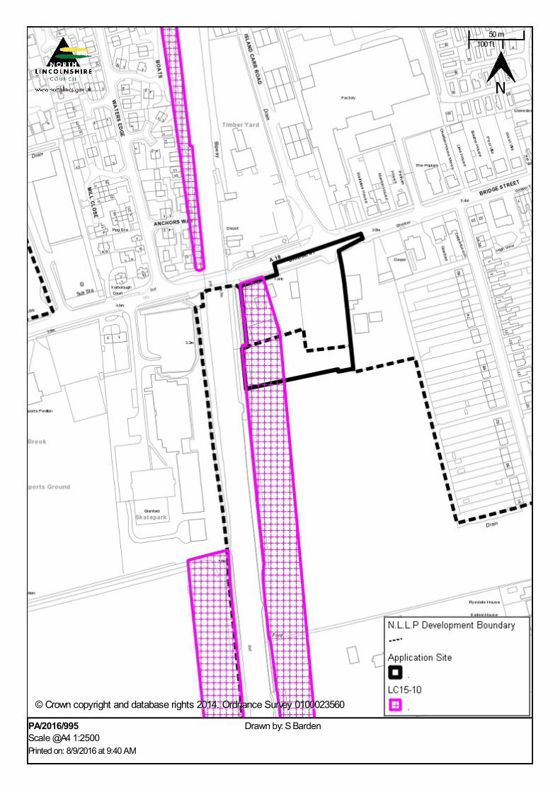
PA/2016/995Scale @A4 1:2500Printed on: 8/9/2016 at 9:40 AM
Drawn by: S Barden
© Crown copyright and database rights 2014. Ordnance Survey 0100023560© Crown copyright and database rights 2014. Ordnance Survey 0100023560
50 m100 f t
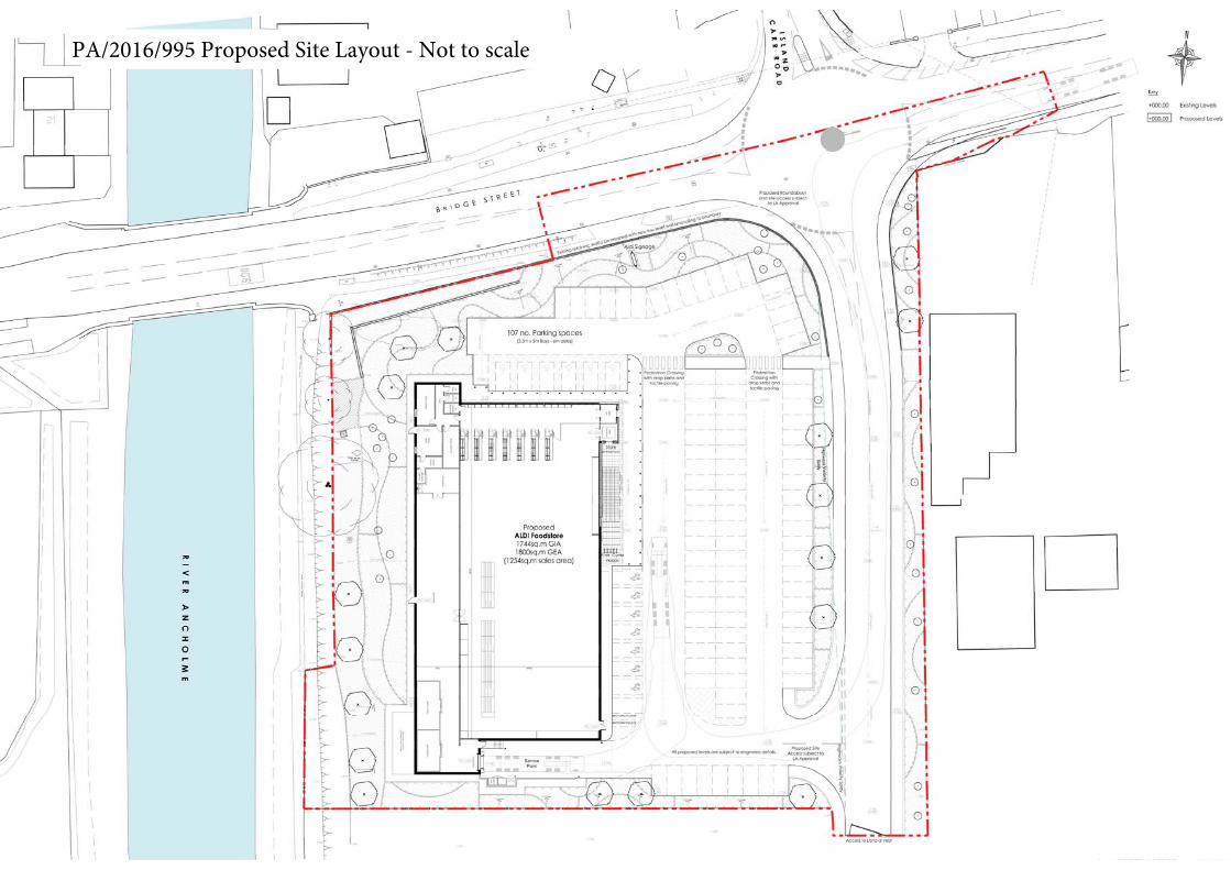
PA/2016/995 Proposed Site Layout - Not to scale
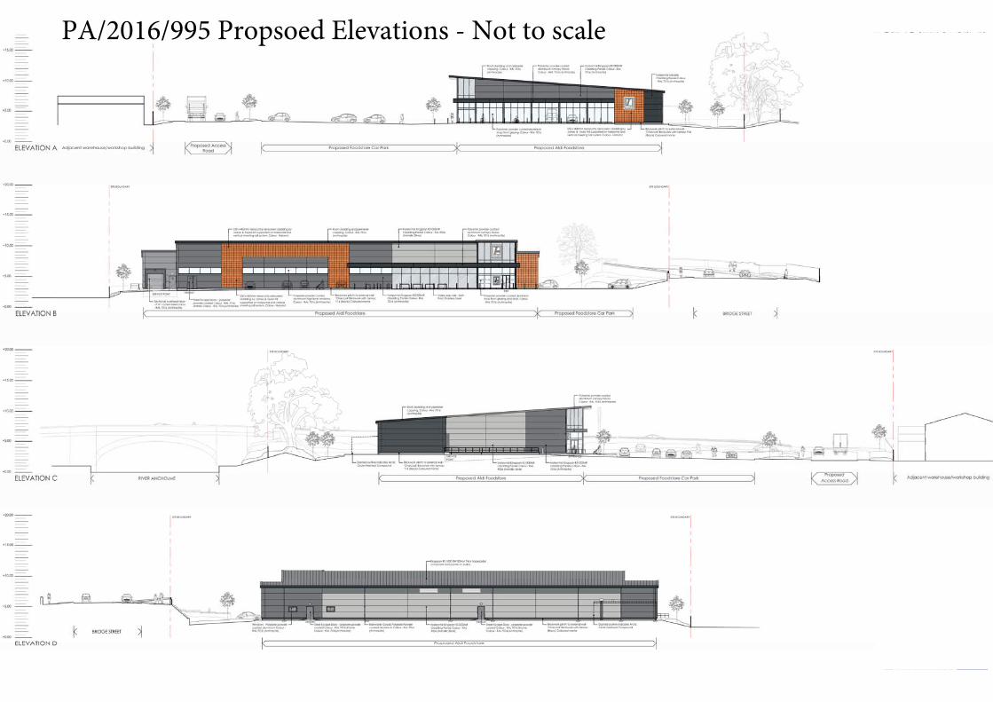
PA/2016/995 Propsoed Elevations - Not to scale