Embed Size (px)
Citation preview

APPENDIX E ABORIGINAL HERITAGE DUE DILIGENCE ASSESSMENT

View south to a stand of native vegetation in the study area.
ABORIGINAL DUE DILIGENCE ASSESSMENT REPORT
CLERGATE INDUSTRIAL ESTATE EXPANSION
ORANGE LOCAL GOVERNMENT AREA
DECEMBER 2020
Report prepared by
OzArk Environment & Heritage
for Orange City Council
OzArk
OzArk Environment & Heritage
145 Wingewarra St (PO Box 2069)
Dubbo NSW 2830 Phone: (02) 6882 0118 Fax: (02) 6882 0630
[email protected] www.ozarkehm.com.au

This page has intentionally been left blank.

OzArk Environment & Heritage
DOCUMENT CONTROLS
Proponent Orange City Council
Client Premise
Document Description Aboriginal Due Diligence Assessment Report. Clergate Industrial Estate
Expansion, Orange Local Government Area.
File Location OzArk Job No.
S \OzArk EHM Data\Clients\Premise 2685
(Orange, Geolyse)
Document Status V1.0 DRAFT Date 28 September 2020
Draft V1.0 Author to editor OzArk 15 internal V1.0HR author 17/9/20
(Series V1 = OzArk internal edits) V1 .1 SR review 28/9/20
Draft V2.0 Report Draft for release to client V2.0 OzArk to Client 28/9/20
(Series V2 = OzArk and client edits)
FINAL V3.0 = Final report V3.0 Final 23/12/20
Prepared For Prepared By
David Walker Stephanie Rusden and Harrison Rochford
Senior Town Planner Senior Archaeologist and Heritage Officer
Premise OzArk Environment & Heritage 154 Peisley St 145 Wingewarra Street (PO Box 2069) Orange NSW 2800 Dubbo NSW 2830
P 02 6882 011 8
F 02 6882 6030
Stephanie@ozarkehm com au
COPYRIGHT
© OzArk Environment & Heritage 2020 and© Orange City Council 2020
All intellectual property and copyright reserved.
Apart from any fair dealing for private study, research, criticism or review, as permitted under the Copyright Act,
1968, no part of this report may be reproduced, transmitted, stored in a retrieval system or adapted in any form
or by any means (electronic, mechanical, photocopying, recording or otherwise) without written permission.
Enquiries should be addressed to OzArk Environment & Heritage.
Aboriginal Due Diligence Assessment Clergate Industrial Estate Expansion, Orange Local Government Area.

OzArk Environment & Heritage
Acknowledgement
OzArk acknowledge Traditional Owners of the area on which this assessment took place and pay respect
to their beliefs, cultural heritage and continuing connection with the land. We also acknowledge and pay
respect to the post-contact experiences of Aboriginal people with attachment to the area and to the elders,
past and present, as the next generation of role models and vessels for memories, traditions, culture and
hopes of local Aboriginal people.
Aboriginal Due Diligence Assessment: Clergate Industrial Estate Expansion, Orange Local Government Area

OzArk Environment & Heritage
EXECUTIVE SUMMARY
OzArk Environment & Heritage (OzArk) has been engaged by Premise (the client), on behalf of
Orange City Council (the proponent) to complete an Aboriginal Due Diligence heritage
assessment for the proposed expansion of the Clergate Industrial Estate (the proposal). The
proposal is in the Orange City Council Local Government Area.
The study area includes Lot 1 DP 1085646, which encompasses approximately 28 hectares (ha)
of land located to the east of Clergate Road, on the northern outskirts of Orange.
Visual inspection of the study area was undertaken by OzArk Senior Archaeologist, Stephanie
Rusden, on 4 September 2020. The visual inspection did not record any Aboriginal sites or
identify any landforms that have potential to contain further, subsurface archaeological deposits.
Further, there are no previously recorded sites that will be harmed by the proposal.
The undertaking of the Due Diligence process resulted in the conclusion that the proposed works
will have an impact on the ground surface, however, no Aboriginal objects or intact archaeological
deposits will be harmed by the proposal.
To ensure the greatest possible protection to the area's Aboriginal cultural heritage values, the
following recommendations are made:
1) The proposed work may proceed at the study area without further archaeological
investigation under the following conditions:
a) All land and ground disturbance activities must be confined to within the study
area, as this will eliminate the risk of harm to Aboriginal objects in adjacent
landforms. Should the parameters of the proposal extend beyond the assessed
areas, then further archaeological assessment may be required.
b) All staff and contractors involved in the proposed work should be made aware of
the legislative protection requirements for all Aboriginal sites and objects.
2) This assessment has concluded that there is a low likelihood that the proposed work will
adversely harm Aboriginal cultural heritage items or sites. However, during works, if
Aboriginal artefacts or skeletal material are noted, all work should cease and the
procedures in the Unanticipated Finds Protocol (Appendix 2) should be followed.
3) Work crews should undergo cultural heritage induction to ensure they recognise
Aboriginal stone artefacts, particularly those commonly found within the Orange area (see
(see Appendix 3) and are aware of the legislative protection of Aboriginal objects under
the National Parks and Wildlife Act 1974 and the contents of the Unanticipated Finds
Protocol.
Aboriginal Due Diligence Assessment: Clergate Industrial Estate Expansion, Orange Local Government Area. iii

OzArk Environment & Heritage
4) The information presented here meets the requirements of the Due Diligence Code of
Practice for the Protection of Aboriginal Objects in New South Wales. It should be retained
as shelf documentation for five years as it may be used to support a defence against
prosecution in the event of unanticipated harm to Aboriginal objects.
Aboriginal Due Diligence Assessment: Clergate Industrial Estate Expansion, Orange Local Government Area. iv
OzArk Environment & Heritage
CONTENTS
EXECUTIVE SUMMARY Ill
1 INTRODUCTION 1
1.1
1.2
1.3
Brief description of the proposal .
Study area .
Assessment approach .
. 1
. 1
................................................. 2
2 ABORIGINAL DUE DILIGENCE ASSESSMENT 3
2.1
2.2
2.2.1
2.2.2
2.3
2.3.1
2.3.2
2.3.3
2.3.4
Introduction .
Defences under the NPW Regulation 2009 .
Low impact activities .
Disturbed lands
............................................................. 3
···························································3
······························································3
·············································································································3
Application of the Due Diligence Code of Practice to the proposal .
Step 1 .
Step 2a .
Step 2b .
Step 2c .
. .4
. .4
. .4
. 6
.8
3 VISUAL INSPECTION RESULTS 10
3.1
3.2
Results
Conclusion .
······························ 10
............................. 11
4 MANAGEMENT RECOMMENDATIONS 12
REFERENCES 13
PLATES 15
APPENDIX 1: AHIMS SEARCH RESULTS 19
APPENDIX 2: ABORIGINAL HERITAGE: UNANTICIPATED FINDS PROTOCOL 21
APPENDIX 3: ABORIGINAL HERITAGE: ARTEFACT IDENTIFICATION 22
FIGURES
Figure 1-1. Map showing the location of the proposal. ····························································•·•1
Figure 1-2: Aerial showing the study area. .. . 2
Figure 2-2. Previously recorded sites in relation to the study area 5
Figure 3-1: Survey coverage within the study area. . . 11
Aboriginal Due Diligence Assessment: Clergate Industrial Estate Expansion, Orange Local Government Area. V

OzArk Environment & Heritage
TABLES
Table 2-1: Determination of whether Due Diligence Code applies .
Table 2-1: Site types and frequencies of AHIMS sites near the study area .
Table 2-3: Due Diligence Process application .
.4
. 5
..11
PLATES
Plate 1: View south to a stand of native vegetation in the south of a study area on a crest. 15
Plate 2: View north across gentle slopes in the north of the study area which has been cleared of
vegetation. . . . . . . . . . . . . . . . . . . . . . . . . . . . . . . . . . . . . . . . . . . . . . . . . . . . . . . . . . . . . . . . . . . . . . . . . . . . . . 15
Plate 3: View of outcropping rock on the crest............................ . 16
Plate 4: View north across gentle slopes in the north of the study area which has been cleared of
vegetation. . . . . . . . . . . . . . . . . . . . . . . . . . . . . . . . . . . . . . . . . . . . . . . . . . . . . . . . . . . . . . . . . . . . . . . . . . . . . . 16
Plate 5: View west a long, gentle slope in the northern portion of the study area.................. . 17
Plate 6: View north across the western portion of the study area.................................. . 17
Plate 7: View across the ephemeral drainage line intersecting the study area. . . . . .. . . . . . . . . 18
Plate 8: View of a cutting on the side of a slope exposing thin A-Horizon soils above a highly fragmented
rock material.................. . . . . . . . . . . . . . . . . . . . . . . . . . . . . . . . . . . . . . . . . . . . . . . . . . . . . . . . . . 18
Aboriginal Due Diligence Assessment: Clergate Industrial Estate Expansion, Orange Local Government Area. vi

OzArk Environment & Heritage
1 INTRODUCTION
1.1 BRIEF DESCRIPTION OF THE PROPOSAL
OzArk Environment & Heritage (OzArk) has been engaged by Premise (the client), on behalf of
Orange City Council (the proponent) to complete an Aboriginal Due Diligence heritage
assessment for the proposed expansion of the Clergate Industrial Estate (the proposal). The
proposal is in the Orange City Council Local Government Area (LGA) (Figure 1-1).
Figure 1-1. Map showing the location of the proposal.
69000E 7o00oE 7l!2t)Ul)t
1 · Mitchell Highway
Orange
Ophir Road l
z
0 4km r/;J;_ maa.a..a GzArk
Scale 1 40000 GDA 2020 255 Source: OPIE
D Study area
1.2 STUDY AREA
The study area includes Lot 1 DP 1085646, which encompasses approximately 28 hectares (ha)
of land located to the east of Clergate Road (Figure 1-2), 4.3 kilometres (km) north of the Orange
central business district.
Aboriginal Due Diligence Assessment Clergate Industrial Subdivision.

OzArk Environment & Heritage
Figure 1-2: Aerial showing the study area.
0 100 200 300 400 m 4 OzArk
Scale 1: 6 000 GDA 2020 255 Source: Gooale
CJ st area
1.3 ASSESSMENT APPROACH
The desktop and visual inspection component for the study area follows the Due Diligence Code
of Practice for the Protection of Aboriginal Objects in New South Wales (Due Diligence; DECCW
2010). The field inspection followed the Guide to Investigating, Assessing and Reporting on
Aboriginal Cultural Heritage in New South Wales (OEH 2011)
Aboriginal Due Diligence Assessment Clergate Industrial Subdivision. 2

OzArk Environment & Heritage
2 ABORIGINAL DUE DILIGENCE ASSESSMENT
2.1 INTRODUCTION
The National Parks and Wildlife Regulation 2009 (NPW Regulation) made under the National
Parks and Wildlife Act 1974 (NPW Act) advocates a Due Diligence process to determining likely
impacts on Aboriginal objects. Carrying out Due Diligence provides a defence to the offence of
harming Aboriginal objects and is an important step in satisfying Aboriginal heritage obligations
in NSW.
2.2 DEFENCES UNDER THE NPW REGULATION 2009
2.2.1 Low impact activities
The first step before application of the Due Diligence process itself is to determine whether the
proposed activity is a "low impact activity" for which there is a defence in the NPW Regulation.
The exemptions are listed in Section 80B (1) of the NPW Regulation (DECCW 2010: 6).
While the assessment has been triggered by subdivision, the study area will be eventually be
impacted by construction works associated with the expansion of the Clergate Industrial Estate.
As such, the low impact activities defence does not applicable and the Due Diligence process
must be applied.
2.2.2 Disturbed lands
Relevant to this process is the assessed levels of previous land-use disturbance.
The NPW Regulation Section 80B (4) (DECCW 2010: 18) define disturbed land as follows:
Land is disturbed if it has been the subject of a human activity that has changed
the land's surface, being changes that remain clear and observable.
Examples include ploughing, construction of rural infrastructure (such as dams
and fences), construction of roads, trails and tracks (including fire trails and tracks
and walking tracks), clearing vegetation, construction of buildings and the
erection of other structures, construction or installation of utilities and other similar
services (such as above or below ground electrical infrastructure, water or
sewerage pipelines, stormwater drainage and other similar infrastructure) and
construction of earthworks.
While the study area has been largely subject to vegetation clearance, there are no changes to
the land, apart from minor localised impacts i.e. dams, that remains disturbed in a 'clear and
observable' manner as per the Due Diligence guidelines. As such, the Due Diligence process
must be applied.
Aboriginal Due Diligence Assessment: Clergate Industrial Subdivision. 3

OzArk Environment & Heritage
In summary, it is determined that the proposal must be assessed under the Due Diligence Code.
The reasoning for this determination is set out in Table 2-1.
Table 2-1: Determination of whether Due Diligence Code applies.
Item Reasoning Answer
Is the activity a Part 3A project declared The proposal is assessed under Part 4 of the EP&A Act. No under section 758 of the EP&A Act?
Is the activity exempt from the NPW Act The proposal is not exempt under this Act or Regulation. No or NPW Regulation?
Do either or both of these apply: No
Is the activity in an Aboriginal place? The activity will not occur in an Aboriginal place.
Have previous investigations that meet No previous investigations have been conducted within the study the requirements of this Code identified area. Aboriginal objects?
Is the activity a low impact one for which The proposal is not a low impact activity for which there is a No there is a defence in the NPW defence in the NPW Regulation. Regulation?
Is the activity occurring entirely within The proposal is not within areas which are considered to be No areas that are assessed as 'disturbed disturbed as per the Due Diligence guidelines. lands'?
Due Diligence Code of Practice assessment is required
2.3 APPLICATION OF THE DUE DILIGENCE CODE OF PRACTICE TO THE PROPOSAL
To follow the generic Due Diligence process, a series of steps in a question/answer flowchart
format (DECCW 2010: 10) are applied to the proposed impacts and the study area, and the
responses documented.
2.3.1 Step 1
Will the activity disturb the ground surface or any culturally modified trees?
Yes, the proposal will impact the ground surface and may impact culturally modified trees.
The proposal involves the subdivision of Lot 1 DP 1085646 in preparation for the expansion of
the Clergate Industrial Estate. The subdivision of land is a local government administrative
procedure that does not involve surface ground disturbance and will not affect any culturally
modified trees. However, industrial development is proposed to occur after the subdivision is
complete and this development will disturb the ground surface and could affect culturally modified
trees, if present.
The current assessment is working under the assumption that future development of the study
area will involve ground disturbances related to construction, such as clearing and excavation.
2.3.2 Step 2a
Are there any relevant confirmed site records or other associated landscape feature information
on AHIMS?
No, there are no previously recorded sites within the study area.
Aboriginal Due Diligence Assessment Clergate Industrial Subdivision. 4

OzArk Environment & Heritage
A search of the Aboriginal Heritage Information Management System (AHIMS) database
completed on 31 August 2020 returned 26 results for Aboriginal heritage sites within a 6 x 6 km
search area centred over the study area (GOA 2020 Zone 55 Eastings: 693305 - 699305,
Northings: 6317021 - 6323021)
Figure 2-1 shows all previously recorded sites in relation to the study area and Table 2-2 shows
the types of sites that are close to the study area.
Table 2-2: Site types and frequencies of AHIMS sites near the study area.
Site Type Number % Frequency
Potential Archaeological Deposit (PAD) 8 31
Artefact site and PAD 8 31
Artefact site 7 27
Modified tree 1 4
Stone quarry 1 4
Site information restricted 1 4
Total 26 100
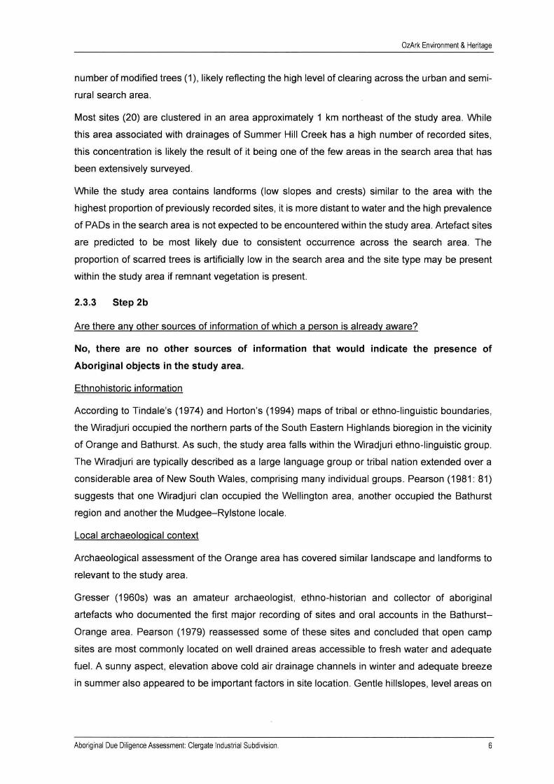
Figure 2-1: Previously recorded sites in relation to the study area.
I Ill
• t'
Artefact O Modified Tree (Carved or Scarred) Stone Quarry A Artefact and Potential Archaeological Deposit (PAD) Potential Archaeological Deposit (PAD) [ Study area
Drainage 4 OzArk
The most common site feature across the search area are potential archaeological deposits
(PADs) (16), half of which are associated with a surface artefact expression (8). There are a low
Aboriginal Due Diligence Assessment Clergate Industrial Subdivision. 5
OzArk Environment & Heritage
number of modified trees (1), likely reflecting the high level of clearing across the urban and semi
rural search area.
Most sites (20) are clustered in an area approximately 1 km northeast of the study area. While
this area associated with drainages of Summer Hill Creek has a high number of recorded sites,
this concentration is likely the result of it being one of the few areas in the search area that has
been extensively surveyed.
While the study area contains landforms (low slopes and crests) similar to the area with the
highest proportion of previously recorded sites, it is more distant to water and the high prevalence
of PADs in the search area is not expected to be encountered within the study area. Artefact sites
are predicted to be most likely due to consistent occurrence across the search area. The
proportion of scarred trees is artificially low in the search area and the site type may be present
within the study area if remnant vegetation is present.
2.3.3 Step 2b
Are there any other sources of information of which a person is already aware?
No, there are no other sources of information that would indicate the presence of
Aboriginal objects in the study area.
Ethnohistoric information
According to Tindale's (1974) and Horton's (1994) maps of tribal or ethno-linguistic boundaries,
the Wiradjuri occupied the northern parts of the South Eastern Highlands bioregion in the vicinity
of Orange and Bathurst. As such, the study area falls within the Wiradjuri ethno-linguistic group.
The Wiradjuri are typically described as a large language group or tribal nation extended over a
considerable area of New South Wales, comprising many individual groups. Pearson (1981: 81)
suggests that one Wiradjuri clan occupied the Wellington area, another occupied the Bathurst
region and another the Mudgee-Rylstone locale.
Local archaeological context
Archaeological assessment of the Orange area has covered similar landscape and landforms to
relevant to the study area.
Gresser (1960s) was an amateur archaeologist, ethno-historian and collector of aboriginal
artefacts who documented the first major recording of sites and oral accounts in the Bathurst
Orange area. Pearson (1979) reassessed some of these sites and concluded that open camp
sites are most commonly located on well drained areas accessible to fresh water and adequate
fuel. A sunny aspect, elevation above cold air drainage channels in winter and adequate breeze
in summer also appeared to be important factors in site location. Gentle hillslopes, level areas on
Aboriginal Due Diligence Assessment Clergate Industrial Subdivision. 6

OzArk Environment & Heritage
ridges, river flats and creek banks were the most common places in which open camp sites were
located.
An assessment of the Suma Park and Spring Creek Reservoirs near Orange was undertaken by
Oakley (2002). Seven sites were located on low gradient spurs, and many were either just visible
above the water line of both reservoirs.
In 2006, OzArk undertook survey of 212 ha between Leeds Parade and the Ophir Road Orange,
NSW for the Orange City Council Local Environmental Study. The Aboriginal heritage study
occurred on hilly country interspersed with ephemeral and permanent creeks (Summer Hill Creek
and a tributary of Blackmans Swamp Creek). The assessment recorded nine Aboriginal sites and
one PAD. Recorded sites types included isolated finds and scarred trees. Artefacts were
manufactured from quartz sources with a volcanic scraper also recorded. All recorded scarred
trees were yellow box trees and were identified in a cluster.
OzArk (2009) also conducted an archaeological assessment of an area referred to as 'Area 51
Recreation Park'. Seven Aboriginal sites were recorded, including five artefact scatters, one
scarred tree, and one isolated find. Open artefact scatters were commonly located on valley
floors, including creek banks and nearby terraces, and the gently sloping lower slopes of adjacent
hills. Common stone artefact material types included: quartz, quartzite and fine-grained siliceous
materials, with greywhacke, hornfels and chert also present in low quantities.
In 2014, OzArk completed the salvage on SPR-5 (44-2-0128) in accordance with Aboriginal
Heritage Impact Permit (AHIP) C0000423. SPR-5 was one of eight sites recorded during part of
a broader assessment area for a previous design for the project (Oakley 2002). A total of 298
artefacts were salvaged from SPR-5. All but two of these artefacts were retrieved from within
10 m of the waterline of the Suma Park Reservoir. Two main trends were identified from the
salvaged artefacts: many artefacts are flakes and the vast majority are made from the same grey
volcanic material. Among the artefact types there was also a significant amount of debitage and
shatter. Five scrapers were recorded in the salvage and five other artefacts (blades and flakes)
were also backed. Many more artefacts were salvaged from SPR-5 than was expected based on
previous recordings of the site. Only three artefacts were recorded within SPR-5 during the 2013
inspection, although it is important to note that water levels were significantly higher than in 2002
and 2014.
In 2016, Biosis assessed a proposed rezoning area approximately 1 km north of the current study
area. 20 Aboriginal sites were recorded during the assessment, 16 of which include PADs. Most
sites were recorded on ridge/slope landforms that comprise the majority of landforms within the
study area.
Aboriginal Due Diligence Assessment: Clergate Industrial Subdivision. 7

OzArk Environment & Heritage
Archaeological context: conclusion
In summary, artefact scatters and isolated artefacts are the most likely site types to be
encountered in the Orange region. Artefacts are most likely to have been manufactured from
quartz, silcrete, quartzite, chert and volcanics. Artefact scatters are more likely to be located
adjacent to drainage lines, particularly on flat or gently sloping landforms, or on the crests saddles
and benches of ridge and spur landforms. Artefact scatters are less likely to be identified on low
lying areas adjacent to drainage lines due to poor drainage and cold temperatures experienced
in the winter months. Culturally modified trees are more likely to be located close to the drainage
lines or where mature trees exist. Quarries for the procurement of raw materials used to
manufacture stone tools are known to be present where outcropping material of good quality is
present.
No Aboriginal cultural heritage assessments appear to have been undertaken in the study area.
As such, there are no known cultural values or Aboriginal sites pertaining directly to the location
of the proposed work. No Aboriginal community members accompanied the current visual
inspection.
2.3.4 Step 2c
Are there any landscape features that are likely to indicate presence of Aboriginal objects?
No. The study area does not contain landforms with identified archaeological sensitivity.
The study area is gently undulating with a low crest in the southwest. A highly ephemeral drainage
line intersects the central portion of the study area on an east-west alignment. The closest semi
permanent sources of water to the study area include Summer Hill Creek, located 2.7 km to the
east and Goulding Creek, located 920 m to the west. Remnant box tress are present in the south
of the study area on the rounded crest. The remainder of the study area has likely to be subject
to vegetation clearance.
Due Diligence assessment
The Due Diligence Code (DECCW 2010) specifies a number of landscape features which are
most associated with the likely presence of Aboriginal objects and which therefore require further
assessment if present. These are areas that are: within 200 m of waters; located within a sand
dune system; located on a ridge top, ridge line or headland; located within 200 m below or above
a cliff face; within 20 m of or in a cave, rock shelter, or a cave mouth and is located on land that
is not disturbed.
The study area is not located near to, or contain any landforms identified as having increased
archaeological potential. The most relevant landscape feature to the study area and surrounds is
'waters'. The drainage line which intersects the study area would only contain water immediately
following substantial rain events and only hold water for short periods of time. An ephemeral
Aboriginal Due Diligence Assessment Clergate Industrial Subdivision. 8

OzArk Environment & Heritage
drainage line such as this would not have attracted Aboriginal occupation for periods of time
which would be the case for semi-permanent or permanent water resources. As such, it is not
regarded that this type of waterway satisfies the term 'waters' in the Due Diligence guidelines.
A 'no' answer for Step 4, results in the following outcome (DECCW 2010):
AHIP (Aboriginal Heritage Impact Permit) application not necessary. Proceed with
caution. If any Aboriginal objects are found, stop work and notify Heritage NSW (131
555 or [email protected]). If human remains are found, stop work,
secure the site and notify NSW Police and Heritage NSW.
Although not required by the Due Diligence process, the proponent has elected to apply the
precautionary principle and proceed to visual inspection of the study area (Section Error!
Reference source not found.) in order to ground-truth the findings of the above desktop level
assessment.
Predictive model
Through examination of the landscape features present and previous assessments completed in
the surrounding region, it is predicted that there is a low potential for Aboriginal sites to be
recorded. Culturally modified trees could exist in the study area given the presence of mature,
native trees however the likelihood of such sites being identified distant from semi-permanent
and permanent water sources is reduced. Artefact scatters are also a commonly recorded site
type within the local area. As the study area is generally undulating and distant to semi-permanent
and permanent water, this site type is not predicted to be common within the study area. It is
likely that any sites associated with such landforms are likely to have a low artefact density and
a low complexity of tool types as the sites are either one-off events or only infrequently used.
These site types also have a high likelihood of being disturbed from a variety of land use practices.
Quarries for the procurement of raw materials used to manufacture stone tools are possible if
suitable sources of outcropping stone exist in the study area.
Aboriginal Due Diligence Assessment: Clergate Industrial Subdivision. 9

OzArk Environment & Heritage
3 VISUAL INSPECTION RESULTS
3.1 RESULTS
Visual inspection of the study area was undertaken by OzArk Senior Archaeologist, Stephanie
Rusden, on 4 September 2020. Standard archaeological field survey and recording methods were
employed (Burke and Smith 2004). The study area was inspected via pedestrian means with
emphasis placed on landforms with increased archaeological potential and adequate ground
surface visibility (GSV). All trees deemed to be of sufficient age to contain Aboriginal scarring or
carving were inspected for cultural modifications.
GSV and exposure were utilised in conjunction with background research regarding the potential
for Aboriginal site locations to assess the archaeological potential of the landforms present.
Pedestrian track data was captured via handheld GPS as shown in Figure 3-1. Representative
photos of the study area are shown in Plates 1 to 8.
Exposure across the study area was generally low (20 per cent) with the majority of the study
area covered in thick grass. GSV was afforded by ant hills, exposures along fence lines, along
dams and areas of erosion along the drainage line. GSV within exposures was generally high at
70 per cent. GSV within exposures was obscured by leaf litter, bark, branches and rocks.
Fragments of quartz were observed throughout the study area however the quartz observed was
determined to be of relatively poor quality for procurement and subsequent stone tool making.
Additionally, outcropping rock was identified within the study area, particularly the crests, however
the outcropping material present was naturally fragmented and not considered suitable for the
manufacture of stone artefacts. Cuttings along the crests also exposed the soil profile of these
landform which show that they have thin A-Horizon soils (approximately 5 centimetres [cm])
before bedrock is encountered.
The predictive model discussed in Section 2.3.4 indicated that site types such as isolated finds,
artefact scatters and scarred trees were the most likely sites to be present within the study area.
However, no Aboriginal sites were recorded during the field inspection and all landforms were
assessed as having low potential to contain Aboriginal objects in subsurface archaeological
deposits.
Aboriginal Due Diligence Assessment Clergate Industrial Subdivision. 10

OzArk Environment & Heritage
Figure 3-1: Survey coverage within the study area.
0 100 200 300 400 m A OzArk
Scale I: 6 000 GDA 2020 255 Source: Google
Pedestrian transect D Study area
3.2 CONCLUSION
The Due Diligence process has resulted in the outcome that an AHIP is not required. The
reasoning behind this determination is set out in Table 3-1.
Table 3-1: Due Diligence Process application.
Item Reasoning Answer
Will the activity disturb either of the The proposal will lead to works that would disturb the ground surface Yes following through excavation and construction. . the ground surface where The proposal will impact mature, native vegetation.
archaeological deposits are likely
• mature, native trees that may be culturally modified.
Are there any relevant records of AHIMS indicated no Aboriginal sites within the study area. No Aboriginal heritage on site (AHIMS or No landscape features in the study area indicate the likely presence from other sources), or landscape of Aboriginal objects. features that are likely to indicate presence of Aboriginal objects?
Will the activity impact Aboriginal objects There are no known items of Aboriginal significance present in the No or landforms with archaeological study area, and landforms with identified archaeological sensitivity potential? are not present.
Does the desktop and/or visual Desktop searches found no known items of Aboriginal heritage in the No assessment confirm that Aboriginal study area. objects will be harmed? The visual inspection did not record any Aboriginal sites and it is
assessed that there is a low likelihood of there being subsurface archaeological deposits within the study area.
AHIP not necessary Proceed with caution
Aboriginal Due Diligence Assessment Clergate Industrial Subdivision. 11

OzArk Environment & Heritage
4 MANAGEMENT RECOMMENDATIONS
The undertaking of the Due Diligence process resulted in the conclusion that the proposed works
will have an impact on the ground surface, but, no Aboriginal objects or intact archaeological
deposits will be harmed by the proposal.
To ensure the greatest possible protection to the area's Aboriginal cultural heritage values, the
following recommendations are made:
1) The proposed work may proceed at the study area without further archaeological
investigation under the following conditions:
a) All land and ground disturbance activities must be confined to within the study
area, as this will eliminate the risk of harm to Aboriginal objects in adjacent
landforms. Should the parameters of the proposal extend beyond the assessed
areas, then further archaeological assessment may be required.
b) All staff and contractors involved in the proposed work should be made aware of
the legislative protection requirements for all Aboriginal sites and objects.
2) This assessment has concluded that there is a low likelihood that the proposed work will
adversely harm Aboriginal cultural heritage items or sites. However, during works, if
Aboriginal artefacts or skeletal material are noted, all work should cease and the
procedures in the Unanticipated Finds Protocol (Appendix 2) should be followed.
3) Work crews should undergo cultural heritage induction to ensure they recognise
Aboriginal stone artefacts, particularly those commonly found within the Orange area (see
Appendix 3) and are aware of the legislative protection of Aboriginal objects under the
NPW Act and the contents of the Unanticipated Finds Protocol.
4) The information presented here meets the requirements of the Due Diligence Code of
Practice for the Protection of Aboriginal Objects in New South Wales. It should be retained
as shelf documentation for five years as it may be used to support a defence against
prosecution in the event of unanticipated harm to Aboriginal objects.
Aboriginal Due Diligence Assessment Clergate Industrial Subdivision. 12

OzArk Environment & Heritage
REFERENCES
Burra Charter 2013 International Council on Monuments and Sites 2013. The Burra Charter: The
Australia ICOMOS Charter for Places of Cultural Significance.
DECCW 2010
Gresser 1965
Horton 1994
DECCW. 2010. Due Diligence Code of Practice for the Protection of
Aboriginal Objects in NSW. Department of Environment, Climate Change
and Water, Sydney.
Gresser, P. 1965. Unpublished Notes on Aboriginal Sites in the Bathurst
District (1962-1965). Unpublished manuscript: NSW Office of Environment
& Heritage.
Horton, David (ed.). 1994. The Encyclopedia of Aboriginal Australia.
Aboriginal Studies Press, Canberra.
Mitchell 2002
OEH 2011
OzArk 2006
Mitchell, Dr. Peter. 2002. Description for NSW (Mitchell) Landscapes
Version 2. Department of Environment and Climate Change NSW.
Office of Environment and Heritage. 2011. Guide to Investigating, Assessing
and Reporting on Aboriginal Cultural Heritage in New South Wales.
Department of Environment, Climate Change and Water, Sydney.
OzArk Environment and Heritage Management. 2006. Flora, Fauna &
Heritage Assessment: Orange Local Environmental Study, Ophir Road &
Leeds Parade, NSW. Report to Newplan.
OzArk 2009 OzArk Environmental & Heritage Management. 2009. Indigenous Heritage
Assessment: Area 51 Recreation Park, 33km Northwest of Bathurst, NSW.
Report to: Ben Anderson.
OzArk 2014
Pearson 1979
Pearson 1981
Tindale 1974
OzArk Environmental & Heritage Management. 2014. Aboriginal
Archaeological Salvage Report: Suma Park Reservoir Upgrade. Report to
Orange City Council.
Pearson, M. 1979. Aboriginal sites in the Bathurst-Orange development
area: A pilot survey Report to National Parks and Wildlife Services.
Pearson, M. Seen through Different Eyes: Changing Land Use and
Settlement Patterns in the Upper Macquarie River Region of NSW from
Prehistoric Times to 1860. [PhD thesis] Submitted to the Department of
Prehistory and Anthropology, The Australian National University.
Tindale, A. 1974. Aboriginal Tribes of Australia. University of California
Press.
Aboriginal Due Diligence Assessment Clergate Industrial Subdivision. 13

OzArk Environment & Heritage
Whitehead 2003 Whitehead, John. 2003. Tracking and Mapping the Explorers: Volume 1.
John Whitehead, Coonabarabran.
Aboriginal Due Diligence Assessment Clergate Industrial Subdivision. 14

OzArk Environment & Heritage
PLATES
Plate 1: View south to a stand of native vegetation in the south of a study area on a crest.
Plate 2: View north across gentle slopes in the north of the study area which has been cleared of vegetation.
Aboriginal Due Diligence Assessment Clergate Industrial Subdivision. 15

OzArk Environment & Heritage
Plate 3: View of outcropping rock on the crest.
Plate 4: View north across gentle slopes in the north of the study area which has been cleared of vegetation.
Aboriginal Due Diligence Assessment Clergate Industrial Subdivision. 16

OzArk Environment & Heritage
Plate 5: View west a long, gentle slope in the northern portion of the study area.
Plate 6: View north across the western portion of the study area.
Aboriginal Due Diligence Assessment: Clergate Industrial Subdivision. 17

OzArk Environment & Heritage
Plate 7: View across the ephemeral drainage line intersecting the study area.
Plate 8: View of a cutting on the side of a slope exposing thin A-Horizon soils above a highly fragmented rock material.
Aboriginal Due Diligence Assessment Clergate Industrial Subdivision. 18

OzArk Environment & Heritage
APPENDIX 1: AHIMS SEARCH RESULTS
Office of Environment 8. Heritage
AHIMS Web Services (AWS) Extensive search - Site list report
lour P.ef/PO Number Cleigate
Clie-11tSe-n:ice- ID: 531606
S1te1D S1te-S.lll1''
4-+-2-014 7 Bioomheld Hospt;il Grounds Datu Zone Lasting Nortlung Context AGD 35 6'153C-O 63~70CO Ope-nme-
Contact .U-2-0218 PA.Dot
Re-cordrP Jm1 V.1iC"Cler GDA SS 697024 6322041 Opellsite - H·.:':-0219 PADOS
TRtcssell
GDA 55 u97250 63.:':H,33 Ope-nsite
Contact '4-2-0220 PAD 06
Recorder:: Miss.Sh.am1on Smith CiDA. 55 6975 22 632099 1 Op11ui112
H-2-0221 OA.01
Contact 44-2-0222 QM2 - H-2-0223 0A03
GDA 55 696528 0320390 O~n SIU
Recorrler,; B1osis ?ty Uri - Wollongong,~1~~.Sh;mnon Sllllth GOA 55 696414 632%282 ape.,tte Valid
llrlnlla .,.PtJUd -w•ma l,MlnS!:- 5alith GOA 55 t,97Q'l<;l 6322253 OJ:-N)Slte
f.oat.act 44-Z-G224 OM4
~ B1os1:i Pty L:d - Wollongon~••H~.S~nnon Sm.it!l GOA 55 697Q21 6321577 Opolll9 Valid - H-2-0225 OA05 Recorders Bio Pry Ld - Wollongong.Miss.Shannon Sith GOA
BlOSlS ~ L'.d - Wollongo:1g,M1~~.Sha.11non ,;nuth 55 697313 6321386 Opnuite - -U->0.:'.:'7 0A0"7
Contact 44-2-0228 0A09
- GOA Bosis Pry Ltd -Wollongong.Miss.Shannon Sith 55 697229 6321788 Open site
.ill<..llim. Val;d
Y,lid
Valid
Valid
Valid
Valid
~ B10sis ~· Ltd \\'ollongong,Mt~~.Shaunon S1mth GOA 5S 697211 63211-47 Opellialll' Yalid
Ste Features Potentlal Archaeoiogic.l.l D1:-pos1t (PAD): >
Pf'rtll!tS
Potl"ntlal Archaeologcal Dt-pom (PAD)
Artefact - Artefart: -.Potentul Archeologcal Dt-p,:.•!lt (PAD)
Pents Artafatt,.,Pateatial Archaeological -(PAD),- - Artefar::, .Potential Archaeologcal D1:pcmt (PAD)
Pent Artafact 1•,PICellt:ul -......... -(PAD),- - Artefact·
Repo1-t;
100685
Rf'p.:,rt genn-at~ b,· ,\Hl~IS We-b Sf-1,1ce ou 31-08; 1020 for Steph.1uu• Rusden fo1- the foUowmg a~a .1t Da.tum :GO,\. Zone: 55 E-lstiugs: 693305 - 699305 Northmgs: 6317011 <•32302:1 with J Buffe-r of O nu>lf'rs Arldthon;;i] Info: S:nn.·e-,· Nmnbe-r of Abonguul ~•te-~ .u1d Ahong111al nhJN'ts found•~ lb
• Office of AHIMS Web Services (AWS) Environment NSW '!. Heritage Extensive search - Site list report
Site1D Srteat D.:itum - - H-2-02.:'9 OAE· GDA
""'""'1 Becardet 44-2-0230 OAU -
C1i.-1n :,t'n.i.-:f' ID• S":Jr,06
- H-2-02H 0Al2 - GD.!\
- 4.:.-.'-0.'>' OAl-l.
f.out.act M-2-0234 PADOl - -t.:.-~-0235 ?AJ O:
Contact U-2.0?36 PAD03 - 4.:.-:-/J2"i-;" OAD3
c=...t U--2-0094 ltesb1diallappied.l'leaNCDllbct:
alwmO ♦iiW..t.dSW.gov.au. - .;-.-2-02C: '.'-IPAPAS . .i..2
Zone ~ Sortinng ~ BillitisptyUd WI I g,Mt-S!t-~ 55 697380 6320984 Open te
Bos Pry Ltd -Wollongong.Mrs.Shanon Sutt 55 697038 6321 lJ7 Opea-.
biosis Py Ltd - Wolle ... ,_ • ..,,__,, .... - 55 696729 631190 Open ate
Becarders Boss Pry Ltd Wollongong.Miss.Shannon Smith GOA 55 6970 26 6!21888 Opell* Ydd
corder Bos Pry Ld -wollongong Mrs Shannon 5mutt GOA SS 696Z75 6321406 Opmta Valid
- _,,,.IJd.,...____ GDA
Recorder; Bos Pry Ltd -Wollongong Ms Shannon Smtt GOA 55 696186 63221!8 Op!llslte Valid
lmmlm. BIOlilPtyLtd-Wda1tpagMt-'ihmnan~ GOA
Yalid
vahd
Becarde Bos Pry Ltd -Wollongong Ms. Shannon Smth Open site Valid
S1to!'fl".1.hires - Art !"far.
.E=wll ----- --..,.. -(PAD),- - Deposit (PAD)
Pett ----- -........... -(PAD),- - ;toni!'Q-,1arn:
P•Jtenti.J.! Archaeologc al Depom(PAD)
Pet;
Archeologcal Dff>('Ol'iPAD):;
Pet
SiteTvpe5
1-03106
11.t"portgener;itHt ln ,\HIMS Wrb Sernceon 31,'08, !020 for Stephane Ruden for the followng area at D..itum :GOA Zone• 55 £..1rtmgs: t,9.3305 - u9QJOS J\io11111ng~: 03170ZI - U3!3021 \lllh ~ Bufll'r of O ml"tl'rs. ~dditio1u! Info: S111....-e1·. Number of Abongm.1.I ~ltl"~ .md ,\honguu.l oh1trt$ found 1:; 20
ot gruntedtob fr trom error ono 0Me st Environment ad Hert [NW)nd ts mpiovs duel babbitv for Any et do r omo md nth for ton and conequenaotuch
Aboriginal Due Diligence Assessment Clergate Industrial Subdivision. 19

OzArk Environment & Heritage
..W... OHiceof
...... Environment NSW 3ertag AHIMS Web Sei-vices (AWS) Extensive search - Site list report C!ic-nt Sen.ice- lD: 531600
Step SteNme
4+2-0183 MPAl
Lon¢ La:ting
55 699 166 Arldal:l1l.Plllllllbal .......... Depot (PAD) +1 ____ ..,,__,,_.,.,.__.. __ 63.17107 -- - - H-2-0164 MPA2 GOA
Coutact R.ru..rn.ru. 44-2-014-fi __..,., .,., - Recorder
55 oQ9066 o3.::.:09L 0pens1tc- Valid
Nawn Offeer Hentage Consultants Pry Ltd.Mr Adran Cressey ss 694600 6318044 operuo. valid MtJ<,uAppl<Ooo
AI":efact:l
perts - Reports
Report generated b AHIMS \\"e-1., >"nKc- 1;111 31:08. 2020 fo1· Stl"ph,111H' Ru:.dru io1 tlu· ioilowmg AH·A .1t D.llhnn :GD.\. Z<.>nc-: 55. [,1~t111gs: f>C/3305 - 699305 Nortlungs. 631701 l - 632:30.:: l "1th Buffer of 0 ueter. Additional Info; Survey. Nuber of Abong@al sites and Abong.al objects found1 26
Aboriginal Due Diligence Assessment: Clergate Industrial Subdivision. 20

OzArk Environment & Heritage
APPENDIX 2: ABORIGINAL HERITAGE: UNANTICIPATED FINDS PROTOCOL
An Aboriginal artefact is anything which is the result of past Aboriginal activity. This includes stone
(artefacts, rock engravings etc.), plant (culturally scarred trees) and animal (if showing signs of
modification; i.e. smoothing, use). Human bone (skeletal) remains may also be uncovered while
onsite.
Cultural heritage significance is assessed by the Aboriginal community and is typically based on
traditional and contemporary lore, spiritual values, and oral history, and may also take into
account scientific and educational value.
Protocol to be followed in the event that previously unrecorded or unanticipated Aboriginal
object(s) are encountered:
1. If any Aboriginal object is discovered and/or harmed in, or under the land, while undertaking
the proposed development activities, the proponent must:
a. Not further harm the object;
b. Immediately cease all work at the particular location;
c. Secure the area so as to avoid further harm to the Aboriginal object;
d. Notify Heritage NSW as soon as practical on 131 555, providing any details of the
Aboriginal object and its location; and
e. Not recommence any work at the particular location unless authorised in writing by
Heritage NSW.
2. In the event that Aboriginal burials are unexpectedly encountered during the activity, work
must stop immediately, the area secured to prevent unauthorised access and NSW Police
and Heritage NSW contacted.
3. Cooperate with the appropriate authorities and relevant Aboriginal community
representatives to facilitate:
a. The recording and assessment of the find(s);
b. The fulfilment of any legal constraints arising from the find(s), including complying with
Heritage NSW directions; and
c. The development and implementation of appropriate management strategies, including
consultation with stakeholders and the assessment of the significance of the find(s).
4. Where the find(s) are determined to be Aboriginal object(s), recommencement of work in the
area of the find(s) can only occur in accordance with any consequential legal requirements
and after gaining written approval from Heritage NSW (normally an Aboriginal Heritage Impact
Permit).
Aboriginal Due Diligence Assessment Clergate Industrial Subdivision. 21

OzArk Environment & Heritage
APPENDIX 3: ABORIGINAL HERITAGE: ARTEFACT IDENTIFICATION
' 0 2 3 4 5cm
Volcanic blades Quartzite scraper and flake
'
0
Quartz flakes Volcanic scraper
Flake characteristics (scale = 1 cm) Core from which flakes have been removed (scale = 1 cm)
Aboriginal Due Diligence Assessment Clergate Industrial Subdivision. 22

Premise . com au premise. .