Embed Size (px)
Citation preview
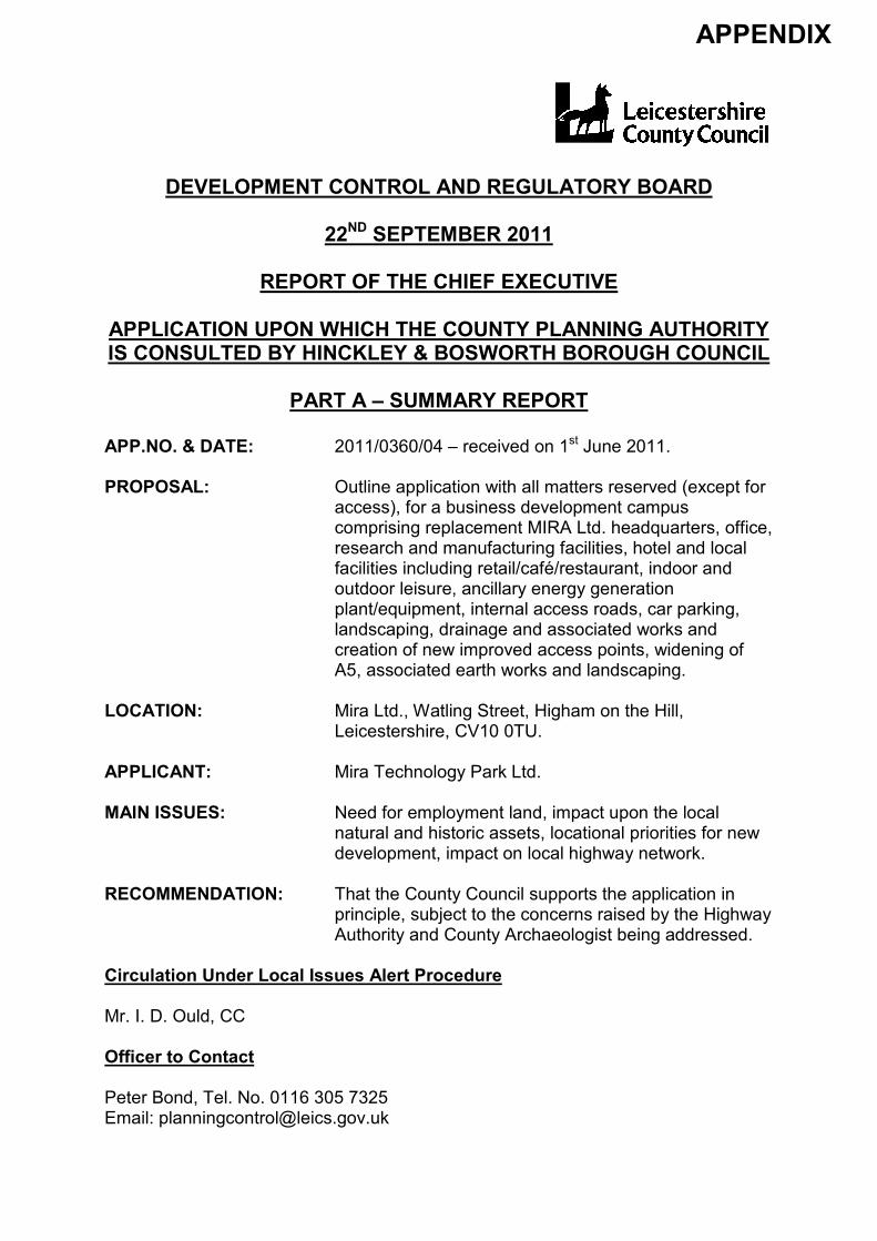
DEVELOPMENT CONTROL AND REGULATORY BOARD
22ND SEPTEMBER 2011
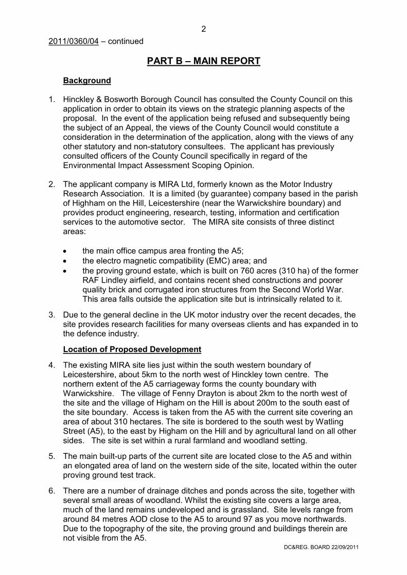
REPORT OF THE CHIEF EXECUTIVE
APPLICATION UPON WHICH THE COUNTY PLANNING AUTHORITY IS CONSULTED BY HINCKLEY & BOSWORTH BOROUGH COUNCIL
PART A – SUMMARY REPORT
APP.NO. & DATE: 2011/0360/04 – received on 1st June 2011. PROPOSAL: Outline application with all matters reserved (except for
access), for a business development campus comprising replacement MIRA Ltd. headquarters, office, research and manufacturing facilities, hotel and local facilities including retail/café/restaurant, indoor and outdoor leisure, ancillary energy generation plant/equipment, internal access roads, car parking, landscaping, drainage and associated works and creation of new improved access points, widening of A5, associated earth works and landscaping.
LOCATION: Mira Ltd., Watling Street, Higham on the Hill,
Leicestershire, CV10 0TU. APPLICANT: Mira Technology Park Ltd. MAIN ISSUES: Need for employment land, impact upon the local
natural and historic assets, locational priorities for new development, impact on local highway network.
RECOMMENDATION: That the County Council supports the application in
principle, subject to the concerns raised by the Highway Authority and County Archaeologist being addressed.
Circulation Under Local Issues Alert Procedure Mr. I. D. Ould, CC Officer to Contact Peter Bond, Tel. No. 0116 305 7325 Email: [email protected]
APPENDIX
DC®. BOARD 22/09/2011
2
2011/0360/04 – continued
PART B – MAIN REPORT Background 1. Hinckley & Bosworth Borough Council has consulted the County Council on this
application in order to obtain its views on the strategic planning aspects of the proposal. In the event of the application being refused and subsequently being the subject of an Appeal, the views of the County Council would constitute a consideration in the determination of the application, along with the views of any other statutory and non-statutory consultees. The applicant has previously consulted officers of the County Council specifically in regard of the Environmental Impact Assessment Scoping Opinion.
2. The applicant company is MIRA Ltd, formerly known as the Motor Industry
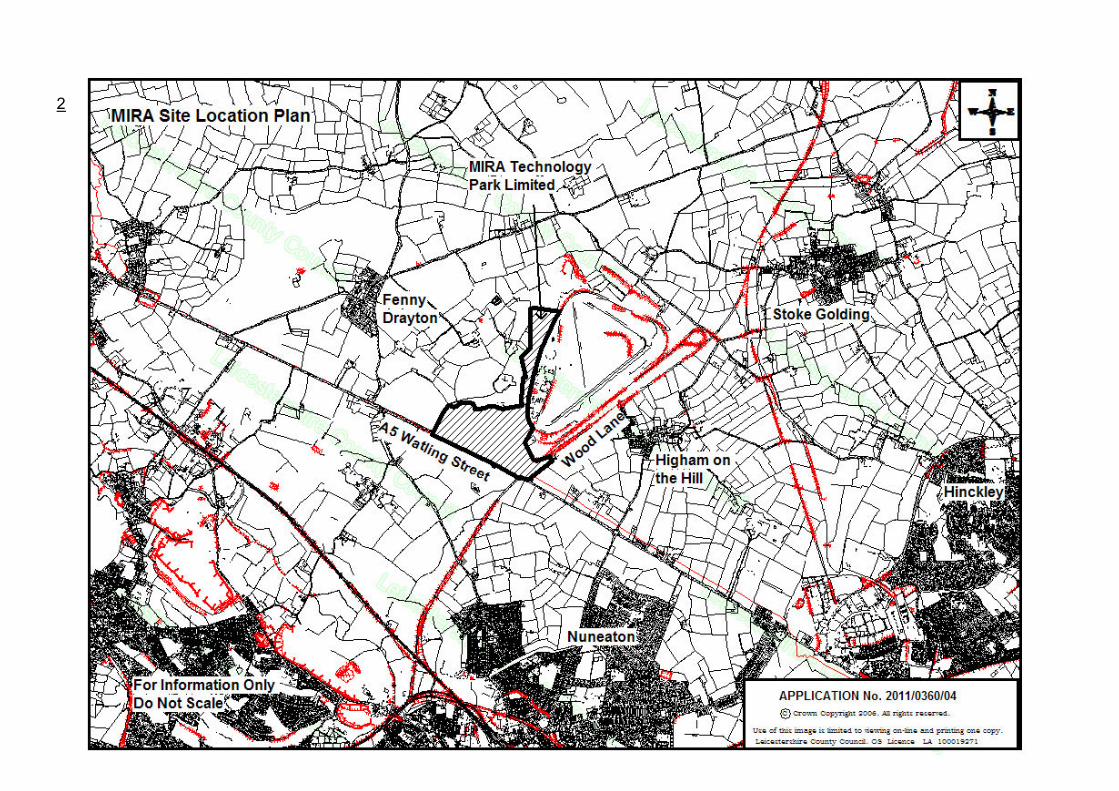
Research Association. It is a limited (by guarantee) company based in the parish of Highham on the Hill, Leicestershire (near the Warwickshire boundary) and provides product engineering, research, testing, information and certification services to the automotive sector. The MIRA site consists of three distinct areas:
• the main office campus area fronting the A5;
• the electro magnetic compatibility (EMC) area; and
• the proving ground estate, which is built on 760 acres (310 ha) of the former RAF Lindley airfield, and contains recent shed constructions and poorer quality brick and corrugated iron structures from the Second World War. This area falls outside the application site but is intrinsically related to it.
3. Due to the general decline in the UK motor industry over the recent decades, the site provides research facilities for many overseas clients and has expanded in to the defence industry.
Location of Proposed Development
4. The existing MIRA site lies just within the south western boundary of Leicestershire, about 5km to the north west of Hinckley town centre. The northern extent of the A5 carriageway forms the county boundary with Warwickshire. The village of Fenny Drayton is about 2km to the north west of the site and the village of Higham on the Hill is about 200m to the south east of the site boundary. Access is taken from the A5 with the current site covering an area of about 310 hectares. The site is bordered to the south west by Watling Street (A5), to the east by Higham on the Hill and by agricultural land on all other sides. The site is set within a rural farmland and woodland setting.
5. The main built-up parts of the current site are located close to the A5 and within an elongated area of land on the western side of the site, located within the outer proving ground test track.
6. There are a number of drainage ditches and ponds across the site, together with several small areas of woodland. Whilst the existing site covers a large area, much of the land remains undeveloped and is grassland. Site levels range from around 84 metres AOD close to the A5 to around 97 as you move northwards. Due to the topography of the site, the proving ground and buildings therein are not visible from the A5.
2011/0360/04 – continued
2011/0360/04 – continued
DC®. BOARD 22/09/2011
5
2011/0360/04 – continued
DC®. BOARD 22/09/2011
6
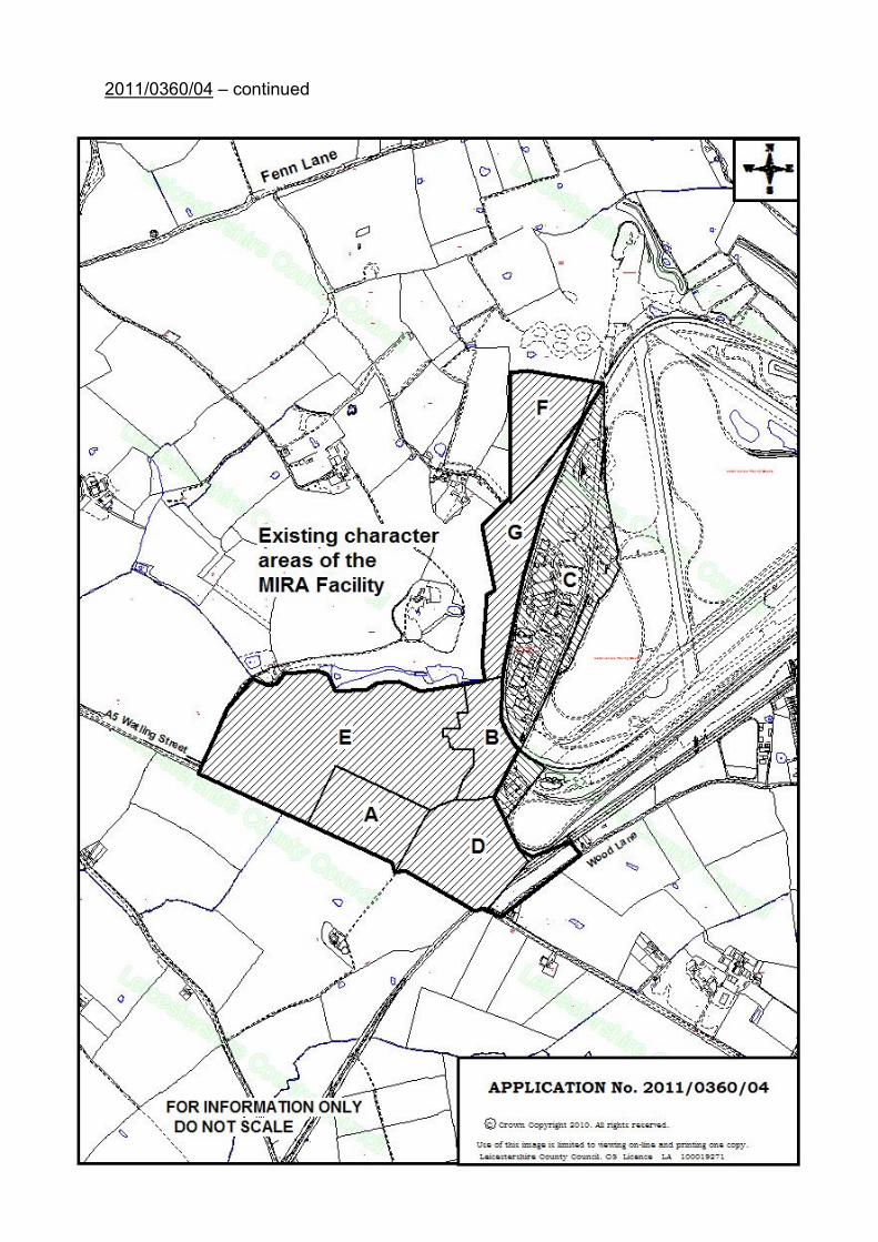
2011/0360/04 – continued 7. The application covers the southern and western part of the wider MIRA site, but
excludes the proving ground tracks. The application proposes the widening of the A5 along the front of the application area, which extends the site in to Warwickshire and, therefore, a separate application has also been submitted to North Warwickshire District Council. The application site area measures 71.5 hectares, of which some 43.6 hectares is currently arable farmland that would be lost.
8. The application site can been split into seven discrete areas to categorise the
character of the site – Areas A-G inclusive: 9. Area A is characterised as relatively flat and measures approximately 6.3
hectares and houses the main MIRA campus area fronting the A5. The area comprises 20,694 square metres of Use Class B1 floorspace and 365 car parking spaces. The site levels range from 84 – 88 metres AOD. The main MIRA complex comprises a series of interlinked two-storey red brick buildings running some 235 metres along the A5 frontage. These buildings accommodate the main reception, meeting rooms, engine laboratories, vehicle dynamics chambers, workshops, stores and offices. There are also a series of buildings running parallel to those fronting the A5. These are a mix of 1 and 2 storey brick and warehouse type structures and host the crash vehicle storage impact simulation and maintenance rooms.
10. Area B is known as the Electro Magnetic Compatibility (EMC) site and located
some 300 metres north of the site entrance. The area covers some 7.2 hectares and houses 3,717 square metres of B1 floorspace and 70 car parking spaces. The site levels for this area range from 93-95.5 metres AOD. The buildings are a mix of two and three-storey high bay warehouse structures and host the EMC preparatory bays, laboratories and chambers, with ancillary hard standing and car parking spaces. This area is also home to the unlisted 19th Century Lindley Grange Farmhouse, which sits within its own setting, including a lawned area to the front and rear and a small wood. There are also two cottages and two barns within this area associated with the farmhouse. This area also contains the campus’ football pitch and tennis courts.
11. Area C is located within the test track and proving ground area. It is not part of
the planning application area, but has been tested in traffic terms for the potential future provision of an additional 3,000 square metres of B1 floorspace. The area comprises recent warehouse type sheds, together with poor quality brick garage and storage areas and corrugated iron structures from the post WWII period. There are also a number of WWII buildings of historical interest, including two Nissen huts, a T2 Hanger which now houses the wind tunnel and the original control tower. The average height of the buildings is seven metres with a total of 19,519 square metres of floorspace and 433 car parking spaces being provided in this area.
12. Area D is bounded to the south by the A5, Wood Lane is to the east and the main
MIRA access drive to the west. A large proportion of this area (8Ha) is owned and farmed by the ENSOR Trust. It is under arable production and is classified as Grade 3 agricultural land. It also includes a water body, which would provide suitable habitat for great crested newts.
DC®. BOARD 22/09/2011
7
2011/0360/04 – continued
13. Area E is bounded to the west and north by the access track and associated hedgerows serving Rowden Lodge and Lindley House. The A5 forms the southern boundary with Area A to the east. This area measures about 27.7 hectares made up solely of arable land, again owned by the ENSOR Trust and falls within Grade 3. The site levels range from 86mAOD to the south west to 93.7mAOD to the north east and east of this area.
14. Area F is located to the north west of the site and measures approximately 7.6Ha. The site falls within the MIRA site but it is arable land and subject to an agricultural tenancy. The area is bounded by low lying hedging and tree planting on all sides, with the western extent of the test track immediately to the east of this area.
15. Area G is located immediately to the south of Area F and measures 8ha. The area is predominantly lawned and consists of some development, comprising the the Free Field facility and the Climatic Wind Tunnel. The area is bounded by trees and hedges to the west and the test track to the east.
16. In addition to the above areas, the application site also includes the stretch of the A5 running along the length of the site’s southern frontage, which is bounded by hedges and verges. To the south of the A5 (in Warwickshire) a small area of agricultural land is included to allow for highway improvements.
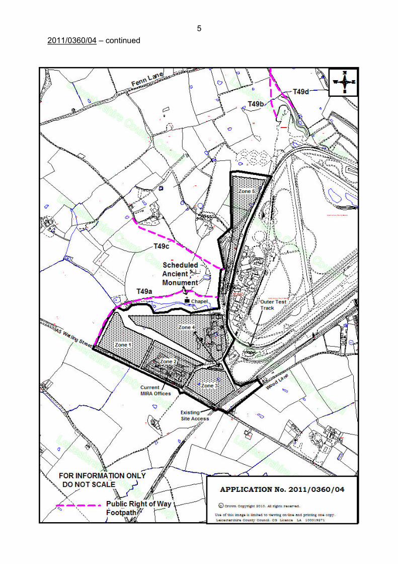
17. The Bosworth Battlefield site is located approximately 500 metres to the north of the site. A Scheduled Ancient Monument (SAM) is located immediately to the north of the site boundary and is the site of the remains of the chapel in the deserted medieval village of Lindley.
18. The applicant states that ‘the MIRA research and development campus provides a unique environment and research and development facilities which are unparalleled in the UK, with over 58 miles of test track comprising various testing facilities allowing vehicles to be developed for global markets.’
Description of Proposal
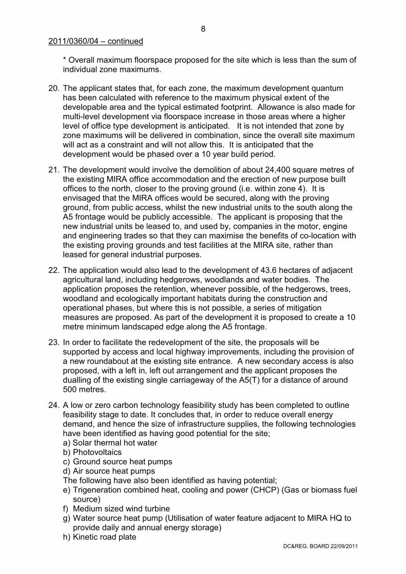
19. The application seeks outline planning permission to demolish the existing office buildings next to the A5 and develop a mixed use business/technology campus including B1 industrial use, ancillary retail, restaurants, fitness club and a 100-bed hotel. It is proposed to divide the development in to five zones. The main land use/s and amount of development associated with the development and respective zones are outlined in Table 1 below:
Zone Use Minimum (m2) Maximum (m
2)
1 B1 27,514 54,326
2 B1 12,272 38,210
Retail/Services 500
Restaurants 1,000
Fitness Club
} 1,000 2,819
100 bed Hotel 4,500
3 B1 9,761 29,399
4 B1 31,756 76,624
5 B1 6,100 10,918
Sub-Station n/a plant n/a plant
Overall Maximum* 92,334 139,716
DC®. BOARD 22/09/2011
8
2011/0360/04 – continued * Overall maximum floorspace proposed for the site which is less than the sum of individual zone maximums.
20. The applicant states that, for each zone, the maximum development quantum
has been calculated with reference to the maximum physical extent of the developable area and the typical estimated footprint. Allowance is also made for multi-level development via floorspace increase in those areas where a higher level of office type development is anticipated. It is not intended that zone by zone maximums will be delivered in combination, since the overall site maximum will act as a constraint and will not allow this. It is anticipated that the development would be phased over a 10 year build period.
21. The development would involve the demolition of about 24,400 square metres of the existing MIRA office accommodation and the erection of new purpose built offices to the north, closer to the proving ground (i.e. within zone 4). It is envisaged that the MIRA offices would be secured, along with the proving ground, from public access, whilst the new industrial units to the south along the A5 frontage would be publicly accessible. The applicant is proposing that the new industrial units be leased to, and used by, companies in the motor, engine and engineering trades so that they can maximise the benefits of co-location with the existing proving grounds and test facilities at the MIRA site, rather than leased for general industrial purposes.
22. The application would also lead to the development of 43.6 hectares of adjacent agricultural land, including hedgerows, woodlands and water bodies. The application proposes the retention, whenever possible, of the hedgerows, trees, woodland and ecologically important habitats during the construction and operational phases, but where this is not possible, a series of mitigation measures are proposed. As part of the development it is proposed to create a 10 metre minimum landscaped edge along the A5 frontage.
23. In order to facilitate the redevelopment of the site, the proposals will be supported by access and local highway improvements, including the provision of a new roundabout at the existing site entrance. A new secondary access is also proposed, with a left in, left out arrangement and the applicant proposes the dualling of the existing single carriageway of the A5(T) for a distance of around 500 metres.
24. A low or zero carbon technology feasibility study has been completed to outline feasibility stage to date. It concludes that, in order to reduce overall energy demand, and hence the size of infrastructure supplies, the following technologies have been identified as having good potential for the site; a) Solar thermal hot water b) Photovoltaics c) Ground source heat pumps d) Air source heat pumps The following have also been identified as having potential; e) Trigeneration combined heat, cooling and power (CHCP) (Gas or biomass fuel
source) f) Medium sized wind turbine g) Water source heat pump (Utilisation of water feature adjacent to MIRA HQ to
provide daily and annual energy storage) h) Kinetic road plate
DC®. BOARD 22/09/2011
9
2011/0360/04 – continued The feasibility study will be developed further at detailed design stage to identify the final low or zero carbon strategy for the site.
25. The application is accompanied by a raft of documents including a Planning and Consultation Statement, a Design & Access Statement, an Environmental Impact Assessment including a Transport Assessment and Travel Plan and a Sustainability Statement.
26. The Transport Statement proposes a comprehensive package of off-site
transport improvements, with the emphasis on improvements to walking, cycling and public transport. The applicant proposes a MIRABus concept to provide public transport access to the site from the two closest major communities, Nuneaton and Hinckley. Walking/cycling improvements would include continuous pedestrian/cycle links along the entire MIRA frontage on the A5, improvements to the existing pedestrian/cycle route between the MIRA site and the A444 Redgate junction to the west and the Highham Roundabout to the east.
27. Additional improvements would be made to the existing site access. These
would include the provision of a new roundabout and the dualling of the A5 for about 500 metres along the frontage of the MIRA site. The new site would also have a second access created with a left in – left out system. There would also be several other junction improvements along the A5, in the vicinity of the site.
28. The aforementioned transport improvements would be phased as the site develops. To this end the applicant proposes that the required S278 legal agreement covering highway improvements be phased with some measures being implemented, for example, after 50,000 square metres of the development is occupied.
29. A Design & Access Statement has been submitted with the application to
address how the development meets relevant design components of legislation, in respect of how the site relates to the existing transport network and how it would be accessed. The statement explains the principles adopted to design the masterplan. These principles include retaining, where feasible, existing hedgrows, small woodland areas and the exploitation of, and improvements to, existing highways, footpaths and rights of way in the vicinity of the site.
Environmental Impact Assessment
30. The application is accompanied by an Environmental Statement which provides
detailed information concerning (inter alia) landscape, ecology, water resources, cultural heritage and archaeology, noise and vibration, air quality, socio-economic impacts, cumulative impacts and infrastructure and services for the construction and operational phases of the development. The statement deals with those matters, with a summary of the conclusions on the environmental impacts, whether they are positive/negative; their magnitude, and any mitigation measures to address these impacts:
DC®. BOARD 22/09/2011
10
2011/0360/04 – continued
Master Plan Evolution
31. The master plan evolution included the early identification of key environmental constraints which helped the design to evolve. This evolution has considered the alternative layouts for the development, based upon the desire to deliver new head offices for MIRA in a secure environment with easy access to the proving ground and develop further industrial units for long term leases to businesses in the automotive/engineering sectors who would also benefit from the closeness to the proving ground and existing MIRA research facilities, such as the wind tunnels available on site. This masterplan will be underpinned by a series of parameter plans. It is anticipated that these parameter plans will identify limits of deviation of building dimensions. As appropriate, for example in terms of visual impacts, the larger building envelope defined by these parameter plans will form the basis of the assessment to ensure that environmental effects are fully assessed.
Planning Policies
32. The applicant has considered the Adopted Regional Spatial Strategy (the RSS) for the East Midlands (2009), the Hinckley and Bosworth Core Strategy (2009) and saved policies of the Hinckley and Bosworth Local Plan (2001). The national policies considered include PPS1 [Delivering Sustainable Development (2005) & Planning Policy Statement: Planning and Climate Change - Supplement to Planning Policy Statement 1 (2007)], PPS4 [Planning for Sustainable Economic Growth (2009)], PPS7 [Sustainable Development in Rural Areas], PPS9 [Biodiversity and Geological Conservation (2005)], PPG13 (Transport (2001)], PPS22 [Renewable energy (2004)], PPS23: [Planning and Pollution Control (2004)] and PPS25 [Development and Flood Risk (2006)]. The applicant states how the development addresses the key principles of each policy document.
Landscape and Visual Amenity
33. The landscape assessment explores the impacts of the proposed development on the resource of the landscape as an entity in itself, resulting from changes in the physical landscape and its character. The visual impact assessment explores the impacts of the proposed development on the visual amenity value of the landscape resulting from changes in the composition of a view. It identifies the extent to which the existing site is visible from the surrounding area, establishes who the view receptors are likely to be, and how sensitive they are to changes. The visual assessment covers a wider geographical area than the landscape assessment. This section concludes that, despite the increase in built form, with the implementation of the mitigation proposals, the impact of the development will have a beneficial effect on the majority of landscape and visual receptors.
Ecology & Nature Conservation
34. Very little of the proposed site area supports habitat that is of intrinsically high ecological value, being in general managed for amenity and agricultural use or supporting office and warehouse buildings. Notwithstanding this, protected species are an issue for parts of the site and vulnerable to direct and indirect
DC®. BOARD 22/09/2011
11
2011/0360/04 – continued
impacts from development. An extended Phase 1 Habitat Survey was undertaken in April 2010 in accordance with the Joint Nature Conservation Committee’s Handbook for Phase 1 habitat survey: A technique for environmental audit (2007). Additional target notes of bird territories were recorded. A survey for great crested newts in ponds within 500m of the proposed development was also undertaken. In most instances, habitats with ecological value are retained and protected. Where this has not been possible compensation measures will be implemented involving habitat creation, species translocation, and habitat restoration. The result of these measures and further habitat enhancement proposals for areas outside of the application site boundary are anticipated to bring about a net ecological benefit effect to the local area.
Cultural Heritage & Archaeology
35. This chapter considers two types of Heritage Asset: - Archaeological Remains: can include artefacts, field monuments, structures,
landscape features and can be visible or buried. - Historic Buildings: these are architectural or designed structures with a
significant historical value and can be of any date.
36. There are no Listed buildings within the application area. There are no identified impacts on the settings of any Listed buildings in Higham village to the north east, Caldecote or Weddington in Nuneaton and also in Bedworth parish, to the south of the site in Warwickshire. There will be no physical impact on the Scheduled Monument at Lindley, and the ES states that there would also be no impact on the setting of the monument. The buildings to be potentially affected by the proposals are mostly of mid-20th century and later date and of little architectural or historical merit. Lindley Grange farmhouse, which is to be demolished, is unlisted and not included on the HER. The use of the site by MIRA has led to extensive re-development, but has also preserved a number of the World War II buildings of interest, including two Nissen Huts, a T2 Hanger, now housing the wind tunnel and the original control tower, acting as a control tower for the Proving Ground.
37. In terms of historic landscapes, an examination of the Historic Landscape Characterisation data for the area indicates that the surviving landscapes are of little or no significant historic interest. After mitigation it has been assessed that there will be ‘minor adverse’ effects on the potential archaeological remains, a ‘negligible’ effect on the settings of the Scheduled Monuments in the vicinity of the proposed development area, a ‘negligible’ effect on the setting of listed buildings in the vicinity of the area and there will be a ‘minor adverse’ effect on unlisted buildings of historical significance. The overall assessment of the significance of effects on heritage assets is that after mitigation there will be a ‘minor adverse’ effect.
Noise
38. A noise survey has been undertaken in connection with the proposed development, taking into account existing background noise levels. The baseline daily traffic flows for the A5 close to MIRA are identified as being in excess of 20,000 vehicle movements and therefore traffic noise is a key contributor to the background levels. The ES identifies local sensitive residential receptors and sets out maximum
DC®. BOARD 22/09/2011
12
2011/0360/04 – continued
permissible noise levels for each receptor, bearing in mind the existing baseline noise levels. The ES goes on to propose mitigation control measures to ensure that noise levels remain within the parameters at each receptor.
Air Quality
39. Existing air quality in and around the proposed development site is primarily affected by emissions from traffic on the surrounding road network. Nevertheless, air quality in and around the development is known to be currently meeting EU Limit Values and UK Air Quality Objectives. Given the nature, scale and duration of the construction work required a number of mitigation measures will be adopted based on best practice guidance to minimise emissions of dust and exposure to respirable particles. The assessment of the operational phase of the development proposals identifies that the changes in exposure of key receptors to traffic emissions will be negligible in terms of significance.
Site Access, Traffic and Transport
40. This section draws on analysis included in the associated Transport Assessment. An automated traffic count was conducted in February 2010 which determined that, on average, about 826 vehicles attend the MIRA site on a daily basis, 95% of which are cars. Whilst there is a shared footway / cycleway provided adjacent to the north-eastern side of the A5(T) Watling Street along the frontage of the MIRA site, due to the rural location there is only limited scope for workers and visitors to access the site other than by car. There are currently no regular commercial bus services in the immediate proximity to the MIRA site. The nearest bus stops are located on Nuneaton Lane immediately north of the A5(T) Watling Street / Higham Lane roundabout, which is some 1.25 kilometres south east of the MIRA site.
41. As part of the development it is intended that the following works will take place:
the current access will be converted to a major 50 metre diameter roundabout, the A5 will be widened along the frontage of the site for a length of about 820 metres and a new left in – left out junction to the north west of the new roundabout access will be provided. There would also be two new bus lay-bys and the provision of a 2-metre verge and 4-metre wide pedestrian/cycle route along the majority of the site’s frontage. From the assessment of impacts related to the construction and operational phases of the MIRA Technology Park, the ES concludes that there would be no significant adverse impacts and that, where minor impacts have been identified, these would be addressed by the suite of mitigation measures identified.
Socio-economic
42. As of year 2010 a total of 694 staff were employed within the overall MIRA site. This total can be broken down as follows: MIRA permanent staff: 405, MIRA Contractors: 89 and Customers permanently on-site: 200. During the construction period, local residents and businesses may experience disruption as a result of visual intrusion and an increase in noise, construction dust and traffic. Throughout the demolition and construction period it is estimated that there will be approximately 400 full time equivalent (FTE) jobs created. This additional
DC®. BOARD 22/09/2011
13
2011/0360/04 – continued
number of jobs will have a temporary, short to medium term moderate beneficial impact. There will also be a range of indirect benefits to the local economy during the construction phase, which will have a minor beneficial impact.
43. Following completion of the development, it is estimated that there would be up
to 2,391 new jobs created. Along with the existing 694 employees it is considered that the new MIRA Technology Park could provide a total of 3,085 jobs. The ES concludes that this would have a long term, major beneficial effcet upon socio-economic factors.
Cumulative Impacts
44. An assessment of the cumulative impacts has been completed, taking into account two types of impact. Type 1, the combined effects of individual impacts, such as noise, dust, visual intrusion etc. from one development on a particular receptor and Type 2, the effects from committed developments, which when considered together could cause a significant cumulative effect. The ES concludes that the cumulative effects of the development are considered to be negligible in general terms and minor adverse from a traffic perspective. Planning Policy (see Appendix)
45. National planning policy relevant to the development is contained in PPS1 [Delivering Sustainable Development (2005) & Planning Policy Statement: Planning and Climate Change - Supplement to Planning Policy Statement 1 (2007)], PPS4 [Planning for Sustainable Economic Growth (2009)], PPS5 [Planning for the Historic Environment (2010)], PPS9 [Biodiversity and Geological Conservation (2005)], PPG13 (Transport (2001)], PPS22 [Renewable energy (2004)], PPS23: [Planning and Pollution Control (2004)] and PPS25 [Development and Flood Risk (2006)].
46. The development plan in this instance is the East Midlands Regional Plan, the
adopted Hinckley and Bosworth Core Strategy and saved development control policies from the Hinckley and Bosworth Local Plan.
Highway Considerations
47. To be reported verbally at the meeting.
Assessment of Proposal 48. In reaching a decision on this planning application, Hinckley and Bosworth
Borough Council (and North Warwickshire District Council) should determine it in accordance with the policies of the development plan, unless other material considerations indicate otherwise. The Borough Council has an adopted Core Strategy and a Local Plan containing saved policies which, along with the East Midlands Regional Plan, form ‘the development plan’.
49. The main issues for consideration by the County Council relate to the strategic
aspects of the development, which in this case are considered to be the need for the development, particularly the impact upon land for employment and any large
DC®. BOARD 22/09/2011
14
2011/0360/04 – continued
scale impacts that the development may give rise to. These are considered to be impacts upon transport networks, landscape impacts, impacts upon local historic assets, and any impacts upon Leicestershire residents.
Employment Land provision 50. Policy 3 of the East Midlands Regional Plan sets out a sequential approach for
the provision of development and economic activity, which seeks to direct significant new economic development to the region’s five Principal Urban Areas (PUAs) and the growth towns of Corby, Kettering and Wellingborough. It goes on to state that appropriate development of a lesser scale should be located in the Sub-Regional centres (e.g. Hinckley). Finally, it states that the development needs of other settlements and rural areas should also be provided for. Policy 12 states that development in the Three Cities Sub-area should (inter alia) be located within and adjoining settlements.
51. Spatial Objective 1 of the Hinckley and Bosworth Core Strategy states (inter alia)
‘The focus for new employment will be Hinckley, reflecting its status as a sub regional centre and in Earl Shilton and Barwell to support the regeneration of these areas, with smaller scale employment in the key rural centres to support the rural areas of the borough.’ Spatial Objective 2 is ‘To deliver the regeneration of Hinckley town centre, as a vibrant, thriving sub regional centre, which provides opportunities for retail, leisure and commercial activities, whilst supporting the vibrancy and vitality of Earl Shilton, Barwell and Burbage as important urban local centres.’ Spatial Objective 13 seeks ‘to reduce the high reliance on car travel in the borough and to increase the opportunities for other forms of transport by focusing the majority of development in the Hinckley urban area where there is a range of transport options available and through securing improvement to public transport infrastructure and facilities that promote walking and cycling and through the use of travel plans.’
52. In the light of the above, it is considered that the proposed rural location for the
development does not conform to the thrust of the regional and local policies on employment land provision and, in particular, the desire to direct employment development opportunities towards the built up area of Hinckley.
53. Notwithstanding the above, the Hinckley and Bosworth Employment Land and
Premises study (May 2010) recognises the importance of the MIRA site in the local economy, highlighting its “significant draw for inward investment, attracting both national and international interest from the automotive sector”. There are also saved policies in the Local Plan relating to the possible future expansion of the MIRA site because of the facilities ‘unique place in the Borough’s employment structure’.
54. Also, given its likely scale, the specialised nature of the majority of the proposed B1 use and the benefits of co-location adjacent to the MIRA test track and associated facilities, it is not felt that alternative developments in the Sub-Regional Centre of Hinckley, Burbage and the new SUEs at Barwell or Earl Shilton would be able to provide realistic alternative options.
55. The Leicester and Leicestershire Enterprise Partnership has recently submitted a bid to CLG proposing the expansion of MIRA Technology Park as one of 11
DC®. BOARD 22/09/2011
15
2011/0360/04 – continued
additional new Enterprise Zones. The Zones aim to attract hundreds of new start up firms, with simplified planning rules, super-fast broadband and over £150 million tax breaks for new businesses over the next 4 years.The MIRA facility is one of a few Research and Development facilities worldwide that can provide the specialist facilities and engineering resources essential to develop automotive and wider transport related products and services. On 17th August 2011 the bid was confirmed by the Government as being successful and the site now benefits from Enterprise Zone status and this is expected to expedite the development of the site.
56. The expansion of MIRA Technology Park could create an additional 2391 jobs and provides a unique opportunity in an established and successful location with the potential for both localised and far reaching economic benefits.
Waste Management 57. The proposed development would generate waste from the use of construction
materials, removal of construction arisings, construction phase waste, and on-going commercial and industrial waste produced by the use of the new development in its operational life.
58. In terms of construction, the applicant has not assessed in detail the amount of
waste to be generated during these operations. This could very much depend upon the design and construction of the new industrial units, and to what extent natural ground levels are utilised on the site. The applicant states that, prior to commencement of construction, a Site Waste Management Plan (SWMP) will be created in accordance with the DTI’s guidance document. The SWMP will set out procedures and commitments for minimising non-hazardous waste, procedures for monitoring waste arisings and for the sorting, reusing and recycling of construction waste into defined waste groups, either on site or through a licensed external contractor.
59. Once the development is operational, there will be designated waste storage
areas for segregated recycling waste streams allocated to relevant buildings. A Waste Management Strategy will be developed for the operational phases of the site, which will seek to achieve zero waste to landfill from the site, through measures such as: - monitoring and target setting for waste types; - regular waste audits; - provision for the segregation of waste at source before being gathered at a
centralised collection point; and - provision of compactor/s in a waste compound or dedicated recyclable storage
area.
60. Subject to suitable detail being integrated at the ‘reserved matters’ phase in accordance with PPS10, the proposed development is acceptable on this basis.
Impact upon the Natural Environment 61. For a site of this size, the development site has limited ecological merit. Relatively
little of the proposed site area supports habitat that can be described as ‘natural’ or of intrinsic high ecological value, as most of the site is managed for
DC®. BOARD 22/09/2011
16
2011/0360/04 – continued
amenity or agriculture, or supports office and warehouse buildings. There are a few exceptions to this, including a number of ponds (some supporting great crested newts) and wooded field boundaries. Various mitigation measures have been built into the outline design of the scheme e.g. retention of habitats of ecological value, habitat creation, species translocation and habitat restoration.
62. Further habitat enhancement measures are also proposed for habitats that are
outside of the application site but within MIRA ownership. As a result of the habitat creation, restoration and enhancement, the ES concludes that the proposed scheme will bring about a net major beneficial effect within a local context.
Impact upon the Historic Environment 63. The County Archaeologist (CA) has been consulted directly and has responded
with detailed comments. The main issues raised by the CA relate to the recent archaeological investigation into the Battle of Bosworth, which has revealed that the battle was much closer to the MIRA site than previously thought (c500m to the north west). The active development of a Conservation Management Plan for Bosworth Battlefield needs to be taken into account in relation to this proposal and the future development of the Enterprise Zone. The County Council wish to see a proactive, integrated approach to developing both the Battlefield Conservation Management Plan and the Enterprise Zone. The CA also requested that further investigations be undertaken relating to the Lindley deserted medieval village.
64. The ES states that there will be no physical impact on the Scheduled Monument
at Lindley, nor on the setting of the monument. Notwithstanding this, the CA considers that further consideration should be given to the impact of the proposals on the setting of the monument and associated medieval village, along with the remains of the WWII airfield.
65. There are no listed buildings within the area of proposed development and the
buildings to be potentially affected by the proposals are mostly of mid-20th century and later date and of little architectural or historical merit.
66. From the plans provided there will be no impact on the settings of any listed
buildings in Higham village to the north-east or Weddington village to the south in Warwickshire.
67. The ES concludes that, after mitigation there will be minor adverse effects on the
potential archaeological remains, a negligible effect on the settings of the Scheduled Monuments in the vicinity of the proposed development area and negligible effects on the settings of listed buildings in the vicinity of the area. The overall assessment of the significance of effects on heritage assets is that, after mitigation, there will be a minor adverse effect.
DC®. BOARD 22/09/2011
17
2011/0360/04 – continued
Highway Impacts
68. The highway implications of the proposal are being considered separately by the Highway Authority. However, the site is accessed from a trunk road and the Highways Agency will also be key consultees from a highway perspective. At the time of writing this report, additional information has been requested by the County Highway Authority. If there are significant amendments to the data that have implications for any of the above issues, then the Borough Council should ensure that the Environmental Statement is revised to reflect this additional information, and appropriate consultation undertaken on any changes.
69. Due to the creation of the airfield in the second world war, several dead end
footpaths have been created. Since the applicant has control of the land to the south of the official termination points of footpaths T49b and T49d as recorded on the Definitive Map, it is considered appropriate for any planning consent granted to include provision for the extension of both these routes so that they will link with footpaths T49a and T49c. Also, in conjunction with the development of the land, it would seem appropriate for the Company to dedicate a public right of way on foot inside the western boundary of the application site for the purpose of linking footpaths T49a and T49c. If enclosed between boundary features, the footpath should have a width of not less than 2 metres and be surfaced to a specification approved by the Highway Authority.
Conclusion 70. The proposed development would lead to a net increase of some 43.6 hectares
in employment land at the MIRA site. The 2010 Employment Land and Premises Study for Hinckley and Bosworth Borough recommends that the Borough needs 72.45 ha of employment land over the period to 2026, and also that the Council needs to ensure that 39 hectares of employment land at Burbage and the proposed SUEs are delivered. The report also states that ‘The application of economic forecasts indicates the Borough needs less employment land than is already available.’
71. PPS4, ‘Planning for Sustainable Economic Growth’ states that ‘planning
applications that secure sustainable economic growth should be treated favourably’. This element of PPS4 was given increased emphasis by The Minister of State for Decentralisation (Mr. Greg Clark) in the written Ministerial Statement: Planning for Growth dated 23rd March 2011. The Ministerial Statement states that, ‘In determining planning applications, local planning authorities are obliged to have regard to all relevant considerations. They should ensure that they give appropriate weight to the need to support economic recovery, that applications that secure sustainable growth are treated favourably (consistent with policy in PPS4), and that they can give clear reasons for their decisions’.
72. In July 2011 the Government published a consultation draft National Planning
Policy Framework, which is intended to replace all existing planning policy statements and guidance notes (except for PPS10). Whilst still only in draft form, the NPPF seeks to make the planning system less complex and promotes ‘sustainable’ growth, and includes the formal introduction of a presumption in
DC®. BOARD 22/09/2011
18
2011/0360/04 – continued
favour of sustainable development wherever a local authorities’ development plan is ‘absent, silent, indeterminate or where relevant policies are out of date’.
73. Whilst the Hinckley and Bosworth Employment Land and Premises study (May 2010) recognises the importance of the MIRA site in the local economy, highlighting its “significant draw for inward investment, attracting both national and international interest from the automotive sector”, the site does not conform to the thrust of the regional and local policies on employment land provision and, in particular, the desire to drive employment towards the built up area of Hinckley.
74. Notwithstanding this, the MIRA site is an established facility based on the
provision of specialist technological services to the automotive, engine and engineering sectors. It is considered that the adjacent proving ground and testing facilities provide the necessary facilities to expand the skilled workforce currently utilising the MIRA facilities, which would not be available in the built up areas of Hinckley or the proposed SUEs. In the light of the above, it is considered essential, therefore, that the Borough Council seeks to ensure that the use of the new employment facilities is limited strictly to uses benefiting from the co-location with the established MIRA facilities, rather than just a generic business use.
75. The redevelopment of the MIRA facility would lead to the creation of up to 2,391 new jobs. This potential for long term job creation within the County is welcomed and supported and should be given significant weight. The recent decision to allocate the site as an Enterprise Zone will raise the profile of the site and should make it easier for the developers to bring their plans forward to achieve the maximum economic benefits for the wider area.
76. Notwithstanding the economic benefits, it is important that the impacts on the
local highway networks (including rights of way) are mitigated and improvements made where necessary. The proposed bus links to the site should reduce the need for local employees to use private cars and these bus links and other highway improvements should be secured through a legal agreement. There are also outstanding concerns relating to archaeology and important heritage assets that need to be addressed fully prior to the grant of planning permission.
Recommendation The Cabinet be recommended to forward the following as the views of the County Planning Authority - Hinckley and Bosworth Borough Council be advised that:
The County Council supports the planning application for the following reasons: Whilst the Borough Council is unlikely to find it difficult to meet its own employment land requirements in the foreseeable future and the site does not conform well to the policies relating to locational requirements for new employment land in the development plan, it is acknowledged that the MIRA site provides unique testing facilities that cannot be offered in the built area of Hinckley or the proposed SUEs. To prevent the undermining of policy objectives
DC®. BOARD 22/09/2011
19
2011/0360/04 – continued for Hinckley and the proposed SUEs, the Borough Council should seek to restrict occupancy of the new business units to appropriate uses that would benefit specifically from co-location with the MIRA facilities. The site has been awarded Enterprise Zone status which should assist in attracting developers and potential uses of the site upon completion of the construction works. The site has the potential to create some 2,400 new, mainly skilled engineering jobs and this should be given significant weight. The Borough Council should ensure that all works considered necessary by the Highway Authority and the Highways Agency are secured either by way of a Grampian style condition or by a legal agreement so that the new development does not have an unacceptable impact on the local highway network. The Borough Council should ensure that, prior to the commencement of any development on the site, the concerns of the County Archaeologist in relation to the potential for impacts on the Bosworth Battlefield, Lindley deserted village and the Scheduled Ancient Monument at Lindley have been addressed in full and that conditions are attached to any permission securing any necessary future archaeological works.
In relation to Bosworth Battlefield, the Borough Council should ensure that the development of the Bosworth Battlefield Conservation Management Plan is taken into account, particularly with regard to bringing forward proposals for the Enterprise Zone.
The applicant, when submitting reserved matters, should also include details of waste segregation facilities to be provided at the site to ensure that the recycling of commercial and industrial waste streams can be maximised. The Site Waste Management Plan should also specify the steps to be taken for the reduction, reuse and recycling of materials arising as part of the construction phase of the development. Given the relatively isolated location of the site, it is considered appropriate that the Borough Council, if minded to grant permission, should specifically restrict the use of any of the proposed buildings on the site from waste management operations. The Borough Council should ensure that the potential for renewable energy provision, such as combined heat and power, is maximised across the Enterprise Zone development.
DC®. BOARD 22/09/2011
20
2011/0360/04 – continued
National Policy Guidance 1. Planning Policy Statement 1 (PPS 1) (Delivering Sustainable Development) deals
with the Government’s overall objectives for the planning system through a plan-led system, and retains the primacy of the development plan (Section 38(6) of the Planning and Compulsory Purchase Act 2004). It sets out the Government's overarching planning policies on the delivery of sustainable development and creating sustainable urban and rural communities while achieving other objectives such as protecting and enhancing the natural environment and the quality and character of the countryside and existing communities; and ensuring that new development is located where everyone can access services or facilities on foot, bicycle or public transport rather than having to rely on access by car.
2. Planning Policy Statement 4 (PPS4) (Planning for Sustainable Economic Growth)
was published in December 2009. To help achieve sustainable economic growth, the Government’s objectives for planning are to: build prosperous communities by improving the economic performance of cities, towns, regions, sub-regions and local areas; reduce the gap in economic growth rates between regions, promoting regeneration and tackling deprivation; deliver more sustainable patterns of development, reduce the need to travel, especially by car; and, respond to climate change and promote the vitality and viability of town and other centres as important places for communities.
3. Planning Authorities should assess the detailed need for land or floorspace for
economic development, including for all main town centre uses over the plan period. All planning applications for economic development should be assessed against: the accessibility of the proposal by a choice of means of transport including walking, cycling, public transport and the car, the effect on local traffic levels and congestion (especially to the trunk road network) after public transport and traffic management measures have been secured; and, the impact on economic and physical regeneration in the area including the impact on deprived areas and social inclusion objectives the impact on local employment.
4. Planning Policy Statement 5 (PPS5) (Planning and the Historic Environment) was
published in March 2010 and sets out the Government’s intentions for ‘Planning and the Historic Environment’. The Government’s overarching aim is that the historic environment and its heritage assets should be conserved and enjoyed for the quality of life they bring to this and future generations. Para 5 sets out the aim to conserve England’s heritage assets in a manner appropriate to their significance. The effect of an application on the significance of such a heritage asset or its setting is a material consideration in determining the application.
5. Policy HE7 states that, in considering the impact of a proposal on any heritage
asset, planning authorities should take into account the particular nature of the significance of the heritage asset and the value that it holds for this and future generations. HE9 states that where a proposal has a harmful impact on the significance of a designated heritage asset which is less than substantial harm, authorities should weigh the public benefit of the proposal against the harm;
6. Planning Policy Statement 7 (PPS 7) (Sustainable Development in Rural Areas)
applies to the rural areas, including country towns and villages and the wider
Appendix
DC®. BOARD 22/09/2011
21
2011/0360/04 – continued largely undeveloped countryside up to the fringes of larger urban areas. It states
that development in the open countryside away from existing settlements, or outside areas allocated for development in development plans, should be strictly controlled. Priority should be given to the re-use of previously developed (brownfield sites) in preference to the development of greenfield sites, except where there are no brownfield sites available, or these sites perform so poorly in terms of sustainability considerations (for example in their remoteness from settlements and services) in comparison with greenfield sites.
7. Planning Policy Statement 9 (PPS9) (Biodiversity and Geological Conservation)
(August 2005) sets out planning policies on protection of biodiversity and geological conservation through the planning system. Planning decisions should be based upon up-to-date information about the environmental characteristics of their areas. These characteristics should include the relevant biodiversity and geological resources of the area. In reviewing environmental characteristics local authorities should assess the potential to sustain and enhance those resources.
8. Where granting planning permission would result in significant harm to interests,
local planning authorities will need to be satisfied that the development cannot reasonably be located on any alternative sites. In the absence of any such alternatives, local planning authorities should ensure that, before planning permission is granted, adequate mitigation measures are put in place. Where a planning decision would result in significant harm to biodiversity and geological interests which cannot be prevented or adequately mitigated against, appropriate compensation measures should be sought. If that significant harm cannot be prevented, then planning permission should be refused.
9. Planning Policy Statement 10 (PPS10) (Planning for Sustainable Waste
Management) states that the overall objective of Government policy on waste, is to protect human health and the environment by producing less waste and by using it as a resource wherever possible. In determining planning applications, all planning authorities should, where relevant, consider the likely impact of proposed, non-waste related, development on existing waste management facilities, and on sites and areas allocated for waste management. Where proposals would prejudice the implementation of the waste strategy in the development plan, consideration should be given to how they could be amended to make them acceptable or, where this is not practicable, to refusing planning permission.
10. Proposed new development should be supported by site waste management
plans. Planning authorities should ensure that new development makes sufficient provision for waste management and promote designs and layouts that secure the integration of waste management facilities without adverse impact on the street scene or, in less developed areas, the local landscape
11. Planning Policy Guidance Note 13 (PPG13) (Transport) sets out the
Government’s intentions to secure an integrated land use-transportation policy that reduces the growth in use of the private car and encourages alternative means of transport.
DC®. BOARD 22/09/2011
22
2011/0360/04 – continued 12. When considering planning applications, local authorities should (inter-alia):
actively manage the pattern of urban growth to make the fullest use of public transport, and focus major generators of travel demand in city, town and district centres and near to major public transport interchanges; and accommodate housing principally within existing urban areas, plan for increased intensity of development for both housing and other uses at locations which are highly accessible by public transport, walking and cycling.
13. Planning Policy Guidance Note 17 (PPG17) (Planning for open space, sport and
recreation) states that the countryside around towns provides a valuable resource for the provision of sport and recreation. Generally local authorities should encourage the creation of sports and recreational facilities in such areas and the development of areas of managed countryside, such as country parks, community forests, and agricultural showgrounds. Where planning permission is to be granted for such land uses, local planning authorities should ensure that facilities are accessible by walking, cycling and public transport as alternatives to the use of the car.
14. Planning Policy Statement 23 (PPS23) (Planning and Pollution Control) sets out
the government’s policies on pollution control of both potentially polluting development, and development that may be subject to the impacts of pollution. It advises that any consideration of the quality of land, air or water and potential impacts arising from development, possibly leading to impacts on health, is capable of being a material planning consideration, in so far as it arises or may arise from or may affect any land use.
15. Planning Policy Statement 25 (PPS25) (Development and Flood Risk) states that
the aims of planning policy on development and flood risk are to ensure that flood risk is taken into account at all stages in the planning process to avoid inappropriate development in areas at risk of flooding, and to direct development away from areas at highest risk. Where new development is, exceptionally, necessary in such areas, policy aims to make it safe without increasing flood risk elsewhere and where possible, reducing flood risk overall.
Regional Policy Guidance 16. The EMRP does not set out any specific figures for the provision of employment
land. However, Policy 3 sets out a sequential approach for the provision of development and economic activity, which seeks to direct significant new economic development to the region’s five Principal Urban Areas (PUAs) and the growth towns of Corby, Kettering and Wellingborough. It goes on to state that appropriate development of a lesser scale should be located in the Sub-Regional centres (e.g. Hinckley). Finally, it states that the development needs of other settlements and rural areas should also be provided for. Policy 12 states that development in the Three Cities Sub-area should (inter alia) be located within and adjoining settlements.
17. Policy 20 (Regional Priorities for Employment) does require (inter alia) that
allocated sites should serve to improve the regeneration of urban areas and be concentrated in and around the Principal Urban Areas.

DC®. BOARD 22/09/2011
23
2011/0360/04 – continued
Local Planning Policy 18. The Hinckley and Bosworth Local Plan was adopted in February 2001. The
following policies were saved, which are relevant to the strategic aspects of the proposal.
19. Proposal EMP1 (existing employment sites) states that, the local planning
authority will ‘actively seek to retain the following sites for employment purposes during the plan period: (inter alia) – Higham on the Hill – MIRA works and proving ground.
20. Policy EMP2 (Expansion of existing employment uses) states that, planning
permission for development involving the expansion of existing firms will be permitted subject to: a) meeting design, layout, landscaping, access, parking and highway
requirements; b) safeguarding any amenities enjoyed by the occupants of adjoining or
neighbouring properties; and c) protecting and where possible improving the character, appearance and
quality of the site and its immediate environment. 21. Policy EMP5 (MIRA, built development for employment purposes) states that,
within the areas shown shaded on the proposals map, proposals for industrial and research purposes which are related to the operation of the MIRA test facility will be granted planning permission unless:
a) the proposed development would detract from the character, appearance and environment of the site and the surrounding area;
b) the proposed development fails to meet appropriate design, layout, highways and parking standards;
c) the proposed development fails to make provision for satisfactory landscaping and screening; and
d) the proposed development does not make satisfactory provision for the storage of waste material.
22. Policy EMP6 (MIRA, surface test facilities and landscaping to proving ground)
states that, within the remainder of the MIRA site, as shown hatched on the proposals map, proposals for surface test facilities will generally be permitted unless:
a) the proposed development would be detrimental to the amenities enjoyed by the occupiers of nearby dwellings by reason of visual intrusion, noise and the effect on the general character and amenities of the area; and
b) the proposed development fails to make provision for satisfactory landscaping and screening.
23. Policy BE1 (design and siting of development) states that, the Borough Council
will seek to ensure a high standard of design in order to secure attractive development and to safeguard and enhance the existing environment. Planning permission will be granted where the development: (inter alia) a) complements or enhances the character of the surrounding area with
regard to scale, layout, density, mass, design, materials and architectural features;
DC®. BOARD 22/09/2011
24
2011/0360/04 – continued
b) avoids the loss of open spaces, important gaps in development, vegetation and features which contribute to the quality of the local environment;
c) has regard to the safety and security of both individuals and property; d) incorporates design features which reduce energy consumption, encourage
recycling and minimise the impact of the development on the local environment;
e) incorporates landscaping to a high standard where this would add to the quality of the design and siting; f) to which the general public would have access, has regard to the needs of wheelchair users, other people with disabilities, elderly people and those with young children; g) ensures that there is adequate highway visibility for road users and adequate provision for on and off street parking for residents and visitors, and manoeuvring facilities; h) is not adversely affected by activities in the vicinity of the site which are likely to cause a nuisance to the occupiers of the proposed development; i) does not adversely affect the occupiers of neighbouring properties; and j) the development of the site is not prejudicial to the comprehensive Development of the larger area of land of which the development forms Part.
24. Policy BE2 (access to buildings) states that, the design and layout of new
development to which the general public would have access should have regard to the needs of wheelchair users, other people with disabilities, elderly people and those with young children.
25. Policy BE5 (the setting of a listed building) states that, the settings of listed buildings will be preserved and enhanced by appropriate control through the design of new development in the vicinity, having regard to the scale, form, siting and design of the proposal in relation to the listed building and its setting. Subdivision of the curtilage, and any other proposal, will be discouraged where it would threaten the future economic viability of a listed building. Where appropriate, regard should also be had to the preservation of trees and landscape features.
26. Policy BE12 (Scheduled Ancient Monuments and Nationally Important Archaeological Sites) states that, planning permission will not be generated for any proposed development which would adversely affect a scheduled ancient monument or other nationally important archaeological site or its setting.
27. Policy BE13 (initial assessment of sites of archaeological interest and potential) states that, any application for planning permission for a site of 0.4ha (1.0 acre) or more in area, or where development would affect a site registered in the Leicestershire archaeological sites and monuments record, or the setting of such a site, should be accompanied by an initial assessment of whether the site is known or likely to contain archaeological remains.
28. Policy BE14 (archaeological field evaluation of sites) states that, where an initial assessment indicates that archaeological remains may exist, the local planning authority will require the prospective developer to arrange for an archaeological field evaluation to be carried out by a professionally qualified archaeological organisation or archaeologist. The results of the evaluation should be made available to the local planning authority before it determines the application.
DC®. BOARD 22/09/2011
25
2011/0360/04 – continued 29. Policy BE15 (preservation of archaeological remains in situ) states that, when the
archaeological field evaluation indicates the presence of important archaeological remains and the local planning authority considers that their preservation in situ is justified and feasible, it will apply planning conditions to any planning permission requiring the remains to be left in situ and any damage to the remains to be avoided or minimised through appropriate design, layout, ground levels, foundations and site work methods.
30. Policy BE 16 (archaeological investigation and recording) states that, when an
archaeological field evaluation indicates the presence of important archaeological remains and the local planning authority considers that their preservation in situ is not feasible and/or not justified, it will seek to enter into a legal agreement, or impose conditions on any planning permission requiring that satisfactory archaeological investigation and recording be carried out by an approved archaeological organisation, before development commences in the area of archaeological interest.
31. Policy BE17 (historic battlefields) states that planning permission will not be
granted for development that would have an adverse effect on the character or setting of the Bosworth Battlefield area.
32. Policy BE26 (light pollution) states that planning permission will be granted for
development which incorporates a lighting scheme provided that the proposal would not unacceptably: a) create a nuisance to nearby residents and/or road users in terms of glare; b) create light spillage or unnecessarily high levels of light; or c) affect the character or appearance of the area.
33. Policy NE5 (development in the countryside) states that the countryside will be
protected for its own sake. Planning permission will be granted for built and other forms of development in the countryside provided that the development is either: a) important to the local economy and cannot be provided within or adjacent
to an existing settlement; or b) for the change of use, reuse or extension of existing buildings, particularly
those of historic value; or c) for sport or recreation purposes.
And only where the following criteria are met: (i) it does not have an adverse effect on the appearance or character of the
landscape. (ii) it is in keeping with the scale and character of existing buildings and the
general surroundings. (iii) where necessary it is effectively screened by landscaping or other methods;
and (iv) the proposed development will not generate traffic likely to exceed the capacity of the highway network or impair road safety.
34. Policy NE10 (local landscape improvement areas) states that the following areas
as shown on the proposals map are defined as local landscape improvement areas: a) land around Stanton under Bardon, Bagworth and Nailstone;
DC®. BOARD 22/09/2011
26
2011/0360/04 – continued
b) urban fringe land to the north and west of Hinckley and Earl Shilton/Barwell, and to the north and east of Atherstone;
c) land along the A5 corridor to the south of the borough; d) open field landscapes to the west of the borough in the vicinity of Sheepy
Magna, Sibson and Fenny Drayton.
Within these areas, any development permitted should include comprehensive landscaping proposals. On sites of over 0.5 hectares the borough council will seek to negotiate a minimum of 10% of the development site set aside for tree planting, including, where appropriate a proportion of native tree species, either within or at the boundary of the development site. The local planning authority will also take measures to enhance the landscape of these areas.
35. Policy NE16 (storage of oils, fuels and chemicals) states that development involving the use or storage of oils, fuels and chemicals will not be permitted unless adequate measures are taken to prevent the discharge to surface waters and ground waters in the event of spillage and/or leakage.
36. Policy T11 (traffic impact assessment) states that, proposals for development likely to generate significant traffic flows, especially heavy goods vehicles, should not have a detrimental effect on the local traffic situation. Where this may occur developers should provide a Traffic Impact Assessment of their proposals at the planning application stage.
37. The Hinckley and Bosworth Core Strategy was adopted in December 2009 and relates to the period up to 2026. Policy 1: Development in Hinckley states that: To support Hinckley’s role as a sub-regional centre the council will: • Allocate land for the development of a minimum of 1120 new residential
dwellings. In particular, the council will seek to diversify the existing housing stock in the town centre to cater for a range of house types and sizes as supported by Policy 15 and Policy 16
• Ensure there is a range of employment opportunities within Hinckley • Allocate land for the development of 6 ha for new office development (to
provide 34,000 sqm of office space) within or adjoining the Hinckley Town Centre Area Action Plan boundary
• Support the expansion of the creative industries job market, in particular through the redevelopment of the Atkins factory into a Creative Enterprise Centre. Further details are provided in the Hinckley Town Centre Area Action Plan
• Support the development of approximately 21,100 sqm (net) of new comparison sector sales floorspace (13,100 sqm to 2021 and 8,000 sqm from 2021- 2026), primarily located in a redeveloped Britannia Centre and on the bus station redevelopment site and the development of an additional 5,300 sqm (net) up to 2021 of convenience floorspace, primarily located on the bus station redevelopment site. Further details are provided in the Hinckley Town Centre Area Action Plan
• Require the redevelopment of the railway station site to deliver a transport interchange and improved facilities at the Hinckley Railway Station. This will be delivered by the private sector as part of the redevelopment of the railway station site in partnership with Network Rail/train operating company. Further details are provided in the Hinckley Town Centre Area Action Plan
DC®. BOARD 22/09/2011
27
2011/0360/04 – continued
• Support the provision of a new bus station plus efficient provision and management of town centre car parking and transport to reflect Hinckley’s role as a sub regional centre. This will be delivered by the private sector as part of the redevelopment of the town centre. Further details are provided in the Hinckley Town Centre Area Action Plan
• Require transport improvements in line with Policy 5 • Support the development of the tourism industry in line with Policy 23 • Support the development of new leisure facilities and sporting hub on land off
the A47 in the vicinity of Hinckley United Football Stadium supported by sustainable public transport links including enhanced walking and cycling connections from Barwell, Earl Shilton, Hinckley and Burbage
To ensure development contributes to Hinckley’s character and sense of place and that the town’s infrastructure can accommodate the new development, the council will:
• Support the extension of the existing Hinckley & Bosworth Community Hospital into a ‘one stop health hub’ to provide core community hospital services (inpatient beds, theatres, outpatient and diagnostic services) from one location linked by excellent public transport, walking and cycling routes from the Hinckley town centre, Barwell and Earl Shilton. This will be delivered by the Primary Care Trust
• Address the existing deficiencies in the quality, quantity and accessibility of green space and play provision in Hinckley as detailed in the council’s most up to date strategy and the Play Strategy, particularly in the south west and north east of Hinckley. New green space and play provision will be provided where necessary to meet the standards set out in Policy 19
• Deliver the strategic green infrastructure network detailed in Policy 20. To achieve this, strategic interventions involving Burbage Common and Woods, Hinckley Town Centre, Harrow Brook Corridor, Disused Railway Line (Nuneaton – Shenton Station), and Hinckley/Barwell/Earl Shilton/Burbage Green Wedge will be implemented
• Deliver safe, high quality cycling routes as detailed in Policy 5 with particular focus on the routes to Hinckley town centre and schools, existing and proposed residential and employment areas, community and leisure facilities, the Hinckley railway station and bus station and into the countryside to provide an alternative to car travel and encourage physical exercise
• Expect development to respect Hinckley’s industrial heritage through sympathetic reuse of existing buildings unless it can be demonstrated that this is not achievable
• Require new development to respect the character and appearance of the Hinckley Conservation Areas by incorporating locally distinctive features of the conservation area into the development
• Require new development to enhance the poor public realm within the town centre
• Require development to be of the highest environmental standards in line with Policy 24
38. Policy 5: Transport Infrastructure in the Sub-regional Centre states (inter alia) the following transport interventions (as detailed in the Hinckley Core Strategy Transport Review 2007) are proposed to support the additional development in and around the Hinckley sub-regional centre, particularly the urban extensions at Barwell and Earl Shilton, to promote sustainable development within the area:

DC®. BOARD 22/09/2011
28
2011/0360/04 – continued
• Improvements to the A47/A5 ‘The Long Shoot’ junction to provide for additional public transport priority measures
DC®. BOARD 22/09/2011
29
DEVELOPMENT CONTROL AND REGULATORY BOARD
The considerations set out below apply to all the following applications. EQUAL OPPORTUNITIES IMPLICATIONS Unless otherwise stated in the report there are no discernible equal opportunities implications. IMPLICATIONS FOR DISABLED PERSONS On all educational proposals the Director of Children and Young People's Service and the Director of Corporate Resources will be informed as follows: Note to Applicant Department Your attention is drawn to the provisions of the Chronically Sick and Disabled Person’s Act 1970 and the Design Note 18 “Access for the Disabled People to Educational Buildings” 1984 and to the Equality Act 2010. You are advised to contact the County Council’s Human Resources Department if you require further advice on this aspect of the proposal. COMMUNITY SAFETY IMPLICATIONS Section 17 of the Crime and Disorder Act 1998 places a very broad duty on all local authorities 'to exercise its various functions with due regard to the likely effect of the exercise of those functions on, and the need to do all reasonably can to prevent, crime and disorder in its area'. Unless otherwise stated in the report, there are no discernible implications for crime reduction or community safety. BACKGROUND PAPERS Unless otherwise stated in the report the background papers used in the preparation of this report are available on the relevant planning application files. SECTION 38(6) OF PLANNING AND COMPULSORY PURCHASE ACT 2004 Members are reminded that Section 38(6) of the 2004 Act requires that: “If regard is to be had to the development plan for the purpose of any determination to be made under the planning Acts the determination must be made in accordance with the plan unless material considerations indicate otherwise.” Any relevant provisions of the development plan (i.e. any approved Local Plans) are identified in the individual reports. The circumstances in which the Board is required to “have regard” to the development plan are given in the Town and Country Planning Act 1990: Section 70(2) : determination of applications; Section 77(4) : called-in applications (applying s. 70); Section 79(4) : planning appeals (applying s. 70); Section 81(3) : provisions relating to compensation directions by Secretary of State (this
section is repealed by the Planning and Compensation Act 1991); Section 91(2) : power to vary period in statutory condition requiring development to be
begun; Section 92(6) : power to vary applicable period for outline planning permission; Section 97(2) : revocation or modification of planning permission; Section 102(1) : discontinuance orders; Section 172(1) : enforcement notices; Section 177(2) : Secretary of State’s power to grant planning permission on enforcement
appeal; Section 226(2) : compulsory acquisition of land for planning purposes; Section 294(3) : special enforcement notices in relation to Crown land; Sched. 9 para (1) : minerals discontinuance orders.