Embed Size (px)
Citation preview

APPENDIX E TO SULLIVAN CREEK SETTLEMENT AGREEMENT
MILL POND DECOMMISSIONING PLAN

Sullivan Creek Hydroelectric Project Pend Oreille PUD FERC No. 2225 1
APPENDIX E TO SETTLEMENT AGREEMENT
APPENDIX A-2 TO LICENSE SURRENDER APPLICATION
MILL POND DECOMMISSIONING PLAN Sullivan Creek Project
Surrender of FERC License No. 2225
1 INTRODUCTION
This Mill Pond Decommissioning Plan (“Plan”) describes the measures that the Pend Oreille County Public Utility District (“PUD” or “Licensee”) will perform to decommission Mill Pond Dam pursuant to the FERC order regarding the surrender of its license for the Sullivan Creek Project. It is expected that FERC will require the Plan measures as a condition to its order approving surrender of the Sullivan Creek Project license (“License Surrender Order”). The timeframe for completing the Plan removal and restoration measures is within 5 years of FERC’s issuance of the License Surrender Order. Once additional site specific information has been gathered, the PUD will revise the Plan to include final site specific design and adaptive management provisions. This final Mill Pond Dam Removal and Restoration Design Plan (“Final Design Plan”) will be developed in consultation pursuant to Section 1.1.6 below with Seattle City Light (“SCL”), the permitting agencies, Kalispel Tribe, and subject to the approval of the USDA Forest Service (“USFS”) and Washington State Department of Ecology (“Ecology”) prior to filing it with FERC. The Final Design Plan shall be completed and filed with FERC no later than 24 months following issuance of FERC’s License Surrender Order. Upon completion of the Final Design Plan removal and restoration measures, the PUD shall prepare a report documenting the completion of the removal and restoration measures, including as-built drawings of the work, for submittal first to USFS and Ecology for agency approval, and then to FERC. Upon FERC’s approval of the as-built drawings, confirmation that the work required by the Final Design Plan has been completed, and termination of the License, Seattle City Light (“SCL”) will be required pursuant to the terms of its new license for the Boundary Project to provide monitoring and maintenance as specified in Boundary License Article 9(F). The Mill Pond, Mill Pond Dam and log crib dam are contributing elements to a site eligible for listing on the National Register of Historic Places as an historic district. A Memorandum of Agreement (“MOA”) will be executed among the PUD, SCL, SHPO, USFS, Kalispel Tribe, and other interested parties to address adverse effects of the proposed Mill Pond Dam removal to National Register of Historic Places eligible resources. 1.1. Mill Pond Dam Removal, Sediment Management, and Site Restoration
Within five years of FERC’s issuance of the License Surrender Order, including authorization for the decommissioning of Mill Pond Dam, the PUD shall remove Mill Pond Dam and the associated log crib dam, manage sediment, restore the stream channel, implement site
Sullivan Creek Hydroelectric Project Pend Oreille PUD FERC No. 2225 2
restoration measures for the Affected Area, and conduct short term monitoring and maintenance as outlined in the following subsections and as detailed in the Mill Pond Dam Removal and Restoration: Alternatives Analysis and Evaluation of Recommended Alternative (McMillen 2010) (the “McMillen Report”). The PUD shall provide semi-annual status reports on Mill Pond Dam removal activities to the Parties to the Sullivan Creek Settlement Agreement. The Affected Area shall include the stream channel, floodplain, and upland areas, from immediately downstream of Mill Pond Dam to Outlet Creek, and shall include any areas impacted by restoration or construction activity. The PUD shall implement these activities through SCL as a cooperating agency pursuant to an Interlocal Agreement between the PUD and SCL. Except as expressly provided references to “PUD” below include SCL as the PUD’s cooperating agency under an Interlocal Agreement. 1.1.1. Scope
The PUD shall remove both the concrete and log crib dams and artificial foundations to facilitate natural stream functions in Sullivan Creek. The PUD shall also remedy any barrier to upstream fish passage caused by the construction, operation, or removal of Mill Pond Dam (not including any natural barriers that may be present at the site). The PUD shall use the wooden material from the log crib dam1 in stream channel restoration efforts, as appropriate, or dispose of the material off-site. The PUD shall take appropriate measures to protect fish in Sullivan Creek during the dam removal and site restoration activities. The PUD shall remove the minimum amount of sediment from Mill Pond necessary to facilitate dam removal and site restoration and permanently dispose of sediment not left in place or placed in the on-site depositional zone at a non-National Forest System (“NFS”) site. If possible, the existing bridge to the heritage interpretative site will be retained; but if necessary the PUD shall construct and install a new bridge that meets USFS standards. The PUD, not SCL, shall be directly responsible for any and all cultural resources assessments and subsequent monitoring, and mitigation actions deemed necessary as the result of implementing the Final Design Plan for Mill Pond Dam removal, sediment management, and site restoration. The PUD shall implement specific measures related to site restoration at the Mill Pond site as described in the McMillen Report to meet the following objectives:
• Restore the Mill Pond reservoir inundated area. Restoration shall include revegetation of the inundated area to plant communities consistent with the site and surrounding vegetation. The inundated area is defined as the area when the water surface elevation is 2,520 feet NAVD 88, i.e., the average water surface elevation when the concrete dam was completed.
• Restore the Affected Area, to a self-functioning system consistent with the Sullivan Creek channel upstream and downstream of Mill Pond. The restored stream channel,
1 After both the concrete and log crib dams have been formally recorded based on the Historic American Buildings Survey (“HABS”) and the Historic American Engineering Record (“HAER”).
Sullivan Creek Hydroelectric Project Pend Oreille PUD FERC No. 2225 3
floodplain, and upland area will be designed to function up to, and including a flood event having a 100-year flood recurrence interval.
• Provide for the prevention, suppression, containment, eradication and/or control of invasive, non-native plant species in the Affected Area.
• Stabilize sediment left in place within the Affected Area.
• Deposit sediment material removed during site restoration in locations and at elevations to avoid mobilization and transport into the restored stream channel during flows up to, and including a flood event having a 100-year flood recurrence interval. Permanently dispose of sediment not left in place or utilized in restoration efforts at a non-NFS site.
• Implement floodplain and upland area restoration measures to prevent erosion and run-off of sediment materials into the restored stream channel during large rain events.
• Initiate stream restoration activities as soon as practicable after the start of dam
removal activities so that the restoration and removal activities occur concurrently. • Restore Sullivan Creek between Mill Pond and the confluence with Outlet Creek in a
downstream direction. • Remove Mill Pond dam and the associated crib dam in dry conditions behind the
coffer dam. • Restore the Affected Area, including any wetland areas receiving temporary direct
impacts from equipment trampling. These areas shall be planted with native vegetation and restored to their pre-construction condition upon completion of restoration activities.
1.1.2. Background Information
Mill Pond, located at RM 3.5 on Sullivan Creek, was created when a log crib dam was constructed in 1909 by the Portland Cement Company. The un-gated concrete dam, built in 1921 just below the log crib dam, is 134 feet long and about 55 feet high and historically maintained the water surface elevation of Mill Pond at approximately 2,520 feet NAVD 88. In 1956, the powerhouse was shut down because of maintenance problems with the wooden flume that conveyed water from Mill Pond to the powerhouse. In 1958, the Federal Power Commission, now FERC, licensed the Project as a non-generating project, with provisions for adding generating capabilities. In 1973, the supporting pillars were removed from the top of the dam creating an open spillway and establishing the current elevation at 2505.7 feet. Mill Pond Dam is a complete barrier to the upstream movement of resident fish (SCL 2009).
Sullivan Creek Hydroelectric Project Pend Oreille PUD FERC No. 2225 4
Mill Pond Dam has altered the natural sediment transport processes in Sullivan Creek by trapping all bedload material behind the dam (USFS 1996). This has created a condition where Sullivan Creek downstream of Mill Pond Dam is sediment depleted (USFS 1996). Therefore, the sediment transport capacity exceeds the sediment supply in the reach below the dam, which has resulted in a lack of appropriately sized spawning gravel for local trout populations and extensive armoring of the bed surface. Mill Pond Dam has also altered to some extent the downstream transport of LWD (USFS 1996). Warm water temperatures, measured at approximately RM 1.7 by R2 Resource Consultants (1998), demonstrated the warming effect of Mill Pond Dam on waters discharged from Sullivan Lake and flowing towards the mouth of Sullivan Creek. During the summer months, water temperatures can exceed 16 ºC, with Mill Pond Dam increasing water temperature by approximately 2.0 to 2.4 ºC (Doug Robison, WDFW, pers. comm. 2009). Benefits of Mill Pond Dam removal and associated site restoration will include elimination of the man-made barrier to upstream fish passage, an increase in the quantity and quality of habitat for native salmonids, restoration of downstream transport of coarse sediment and LWD, and benefits to water quality in the form of reduced summer water temperatures due to reductions in water surface area and increases in water velocity in the area of Mill Pond. In 2009 a Mill Pond Bathymetry and Sediment Evaluation was conducted by Tetra Tech for SCL and the PUD in support of the decommissioning of the Sullivan Creek Project. The results of bathymetry and evaluation were documented in Mill Pond Bathymetry and Sediment Evaluation Final Report (Tetra Tech 2009). The results of the field investigation activities are summarized below:
• No abrupt grade changes (“falls”) are evident in the exposed channel. • The prior creek channel is still evident within the pond everywhere except in the SE corner of the pond where the current delta deposits have filled it in. • The sub-bottom data did not resolve the channel where it is buried within the in-filled area by the delta. • The pond bottom sediments did contain some biogenic gas that limited sub-bottom acoustic energy penetration. • There is no clear stratigraphic layer evident in the data (discontinuity) that defines the transition between pre and post impoundment sediments. • Sub-bottom data were not obtained all the way down to bedrock. • The amount of fine grained sediment located behind the dam is estimated to be 465,800 cubic yards. • The lithology of Mill Pond is dominated by silt underlain by coarse sand or gravel. • The analytical results showed no detections above screening levels.
During the Boundary Relicensing Settlement Process, SCL contracted with McMillen LLC to develop and evaluate alternatives for the removal of Mill Pond Dam. After a review of the available Mill Pond information and conducting a site visit to determine site access, constraints, and materials availability, five conceptual alternatives were identified that considered immediate
Sullivan Creek Hydroelectric Project Pend Oreille PUD FERC No. 2225 5
construction impacts and post-construction issues. The available information that was reviewed included the documents listed in the references section of the McMillen Report. Each of the five alternatives was evaluated to identify the strengths and weaknesses. Evaluation criteria included construction issues, environmental impacts, cultural/community impacts, design, and cost. This evaluation is described in detail in section 6, Recommended Alternative Environmental Analysis, of the McMillen Report. The recommended alternative for the removal of Mill Pond Dam consisted of a combination of two of the alternatives and is considered to be the most effective for removal of the log-crib and concrete dams while reducing environmental impacts. The procedures to be implemented under the recommended alternative are discussed in section 1.1.3. The conceptual drawings for the recommended alternative are contained in the McMillen Report. 1.1.3. Procedures
The PUD shall develop a more site specific Final Design Plan. The Final Design Plan will provide detailed guidance for the removal of Mill Pond Dam, the management of sediment during and after dam removal, and the restoration of the affected area including Sullivan Creek from Mill Pond to its confluence with Outlet Creek. The Plan shall also include a short term compliance and effectiveness monitoring program. This Final Design Plan shall be developed in consultation with SCL, the permitting agencies, Kalispel Tribe, and subject to the approval of the USFS and Ecology. The PUD shall file the detailed Final Design Plan with FERC no later than 24 months following issuance of the License Surrender Order. The PUD shall implement the Final Design Plan upon FERC approval. Long term monitoring and maintenance will be performed by SCL pursuant to Article 9(F) of the Boundary License.
1.1.3.1. Dam Removal
This section provides an overview of procedures that will be undertaken to remove Mill Pond Dam and restore the Sullivan Creek channel from Mill Pond Dam to the confluence of Sullivan and Outlet creeks. Additional detail regarding these procedures, including a description of the construction sequence and conceptual engineering drawings, can be found in the McMillen Report. The PUD shall implement a dam bypass and gradual flow release approach for removal of the log-crib and concrete dams at the site. Mill Pond reservoir will be drained and diverted to Sullivan Creek below the dam through the installation of a main siphon pipe located through the dike to the west of the dam. The reservoir will be lowered approximately 20 to 25 feet by this means. PUD shall be responsible for undertaking appropriate measures to mitigate for impacts to heritage resources as a result of removal of Mill Pond Dam. The PUD shall be responsible for an archaeological survey and monitoring within the Area of Potential Effect prior to and during stream restoration activities. The PUD will consult with the Washington State Historic Preservation Office, the USFS, FERC, Kalispel Tribe, and other entities required by Section 106 requirements to develop mitigation measures to address adverse effects of the proposed Mill Pond Dam removal to National Register of Historic Places eligible resources. The agreed upon mitigation measures will be expressed in an MOA to be signed by the PUD, the USFS, SCL, the
Sullivan Creek Hydroelectric Project Pend Oreille PUD FERC No. 2225 6
Kalispel Tribe, the Washington State Historic Preservation Officer and the Advisory Council on Historic Preservation (if they choose). Implementation of the MOA will conclude the Project’s National Historic Preservation Act Section 106 requirements. A cofferdam will be installed upstream of the log-crib dam to keep incoming water out of the dam removal area, and a siphon and/or pump will be used to drain the water in between the concrete dam, log crib dam and cofferdam areas. Once the concrete and log crib dams are visible, the PUD can implement measurements, photos and other recording methods to complete necessary Historic American Buildings Survey (“HABS”) and Historic American Engineering Record (“HAER”) assessments as partial mitigation for adverse effect to the Historic District. Because of the high water velocity in the main siphon pipe, downstream fish passage would involve unacceptable injury and mortality. Therefore, fish exclusionary devices will be placed in the vicinity of the main siphon pipe inlet to prevent fish mortality. As part of the construction of the coffer dam, a decanting tower upstream of the cofferdam, connected to a low-level pipe through the bottom of the coffer dam will be installed. The decanting tower and pipe will allow the lowering of the reservoir level down to the base of the coffer dam, approximately an additional 15 feet in elevation. After the dam area has been dewatered and stabilized and the HABS/HAER assessments are complete, the concrete dam will be removed using a concrete diamond wire saw. Large blocks of concrete will be cut out of the dam and removed using a crane and/or excavator. Concrete produced from the dam removal process will be disposed of off-site at a non-NFS location. After the concrete dam is removed, the log-crib dam will be removed using an excavator, and the spoils (including logs) disposed of or utilized in an approved manner. Following removal of both dams, the stream channel through the dam removal area may be reconstructed to the designed configuration or stabilized to withstand the flow out of the decant tower and pipe through the coffer dam. Water behind the cofferdam that has not been siphoned downstream may then be released using the decant tower and outlet gate on the cofferdam, lowering the reservoir level approximately another 15 feet. In conjunction with the lowering of the reservoir through the main siphon pipe, the streambed in the upper portion of Reach 2, into Reach 3 (shown and described in the McMillen Report) will be excavated and stabilized to prevent head cutting in the upstream channel, and to establish the flow of Sullivan Creek into a stable channel as the reservoir surface elevation drops. The drop in the reservoir surface elevation will occur at such a rate that the suspension of sediment in the reservoir from the excavation activities is held at acceptable levels. Once the original streambed is found in the excavation of the new channel, the old streambed can be used as the stable channel for flows within the construction period. As the reservoir surface is lowered to a point that fish are concentrated enough to trap and relocate, this work shall start to relocate fish out of the construction area. As the reservoir surface elevation is lowered and the sediment deposited on the reservoir bottom dries and is suitable for moving into the fill areas, the final excavation and shaping of the streambed and floodplain in Reach 2 may occur. Where excavation has the potential to extend into the pre-dam (1909) soil surface, archaeological monitoring will take place. Once the level of the reservoir surface reaches the bottom of the coffer dam, the coffer dam may be removed
Sullivan Creek Hydroelectric Project Pend Oreille PUD FERC No. 2225 7
and the stream channeled through that area. Placement of sediment in the fill areas and restoration work would take place after the sediment material is dry enough to work with and operate equipment on. The Final Design Plan will include a contingency plan to address the event that more than one construction season is needed to complete the stream channel restoration work. The contingency plan should provide protection from flood flows for all the un-stabilized portions of the reservoir and/or stream channel to minimize erosion and movement of sediment downstream. 1.1.3.2. Sediment Management During Construction
By lowering the reservoir water surface level in a controlled manner with the main siphon pipe, the volume of sediment entering into suspension will be minimized, thereby preventing a large downstream sediment release. As the water level is lowered, the PUD shall sequence reservoir lowering and upstream streambed construction in the upper end of Reach 2 and Reach 3 to minimize any diversions from the proposed stream alignment, head cutting in the alluvial material in Reach 3 (which extends approximately 0.25 miles upstream from the delta) or mobilization of sediment into the lowering reservoir. The PUD shall install initial erosion control measures in the affected area, monitor them and implement corrective measures in accordance with an approved Storm Water Pollution Prevention Plan (“SWPP”). Measures will be taken to work in the dry when excavating the proposed streambed and floodplain. BMPS will be followed according to the NPDES general permit requirements to limit sediment resulting from construction activities in Sullivan Creek. Where water is concentrated in channels on the soil surface whether from storm runoff or stream flow (Sullivan Creek, or stream flow from side channels running into the reservoir area), the channel will be armored effectively to limit erosion of the channel bottom. The proposed stream channel and floodplain construction will require excavation and grading of approximately 40,000 cubic yards of material, which will be deposited and graded into the fill areas shown in the McMillen Report. The remaining 360,000-380,000 cubic yards of sediment above the proposed floodplain will be stabilized in place. Excavation of sediment will occur in the dry through the use of a bypass pipe to divert flow around the work site. Sediment material will be deposited in fills of minimal depth, on historic terraces with low gradient slopes, away from the proposed floodplain, to avoid mobilization and transport into the restored stream channel during flows up to, and including a flood event having a 100-year recurrence interval. The PUD shall stabilize fill areas where excavated sediment is stored on site in a geotechnically stable configuration. The PUD shall compact fill material to a level balanced between a density ideally suitable for growing plants and the most geotechnically stable, maximum density of the fill material. Following grading and compaction of the newly created upland and floodplain habitat, the PUD will implement final erosion control measures according to the SWPP. These measures may include grass and forb seeding, mulch and/or erosion control fabric application, sediment traps including coir logs and silt fence, and other means to limit erosion of the constructed site until permanent vegetative cover is in place. Native trees, shrubs, forbs and grasses will also be

Sullivan Creek Hydroelectric Project Pend Oreille PUD FERC No. 2225 8
installed in the fall for increased stabilization. A second phase of revegetation is expected the following spring to ensure site stabilization and long-term successful restoration.
1.1.3.3. Site Restoration
Stream and Floodplain Restoration Site restoration will occur in dry conditions under a controlled low water elevation via the reservoir siphon and the use of bypass pipes to channel flow around the immediate work area. The PUD shall use a reference reach design process to determine stream morphology and streambed material values for design of Reaches 1, 2 and 3. The proposed streambed and floodplain will be designed to withstand velocities of a flood event having a 100-year recurrence interval. The PUD shall utilize the existing stream channel alignment as the new stream channel wherever it shows on the Mill Pond bathymetry map in Reach 2, and where it is determined that the existing stream channel is in a stable condition considering current hydrology. The PUD shall design in-stream structures with the goal of protecting stream banks, to minimize streambed degradation and the forming of terraces directly adjacent to the streambed, and to provide roughness in the channel to lower water velocities.
The PUD shall design Reach 3 with a hydrologically connected streambed and floodplain. In Reach 3, the floodplain is intended to be the existing wetland areas adjacent to the proposed streambed where possible. In conjunction with the proposed streambed, the PUD shall design restoration and stabilization measures within Reach 3 of Sullivan Creek to prevent head-cutting in the creek that could dewater the southern wetland areas. Monitoring and adaptive management are to be implemented and measures such as grade controls (e.g. rock weirs) are to be considered to maintain the existing wetland water surface elevation. The PUD shall design the bankfull channel to carry the effective discharge and highest frequency flood levels (2-year flood events). In Reach 1, where the channel is the steepest, there will be no floodplain because it is confined in bedrock. In Reaches 2 and 3, there will be a floodplain to provide riparian habitat and wood species recruitment. Above the designed floodplain, the channel will taper up approximately 1:3 to an upland area. The PUD shall install and anchor logs, branches and root wads (LWD) in the stream channel and floodplain to provide flow resistance in varied flow conditions, habitat complexity, bank protection, sediment filtering, and mimic natural floodplain dynamics. Engineered LWD jams will be anchored in appropriate locations to provide roughness and flow dissipation. The LWD jams will serve as an alternative to extensive rock treatments and are expected to provide more varied aquatic habitat than would be provided by rock structures. The PUD shall place rock weir structures and appropriately sized stream bed material in the stream channel for hydraulic stability, increased roughness, increased habitat complexity, fish
Sullivan Creek Hydroelectric Project Pend Oreille PUD FERC No. 2225 9
passage, and to provide fish resting locations. The weirs will be used to dissipate energy and create pools. They will be spaced approximately five to seven channel widths apart to avoid backwatering effects and allow for the existence of intervening riffles or shallows between structures. Prior to the placement of any instream structure, the PUD shall consult with and obtain the approval of the USFS, Ecology and WDFW. Where needed, the PUD shall treat the steepest and/or narrowest portions of the new stream channel with several large boulder clusters to provide flow energy dissipation and fish resting habitat and refugia. These will be designed in a manner similar to a step-pool ladder to allow fish passage under the majority of stream flow conditions. The structures are expected to provide ample resting opportunities and assist fish traveling upstream. Upland Restoration The PUD shall implement stabilization and erosion control measures in the upland areas. These measures shall be detailed in an Erosion and Sediment Control Plan developed during the design phase and include items similar to those described in the McMillen Report (Section 5.2.2 Upland and Depositional Area Sediment Management).
Revegetation The generalized revegetation approach for the area that is exposed after the removal of both dams is described below. The proposed revegetation plan will consist of creating diverse fish and wildlife habitat, providing stream shading during the summer months, and controlling stream bank erosion and moderating water velocities in Sullivan Creek. All vegetation and seeding shall meet USFS standards and requirements. The PUD shall revegetate with native plants suitable for the specific location – streambank, floodplain and upland locations. Native plant material propagated from seeds, roots or cuttings taken from plants in a similar elevation band within the Pend Oreille County shall be utilized. The revegetation areas are divided into four planting zones depending on soil hydrology and position within the riparian valley. Hydroseed will be applied to areas on the site that are not extremely saturated with water or receive regular flows from flood events. The hydroseed will be primarily designed for erosion control purposes; however, native herbaceous species approved by the CNF will be used to add habitat value to the site. The four zones are listed and described below and their proposed location within the restoration area is depicted in the Conceptual Alternatives Report.
• Riparian Zone: This zone is designed for areas adjacent to Sullivan Creek and includes portions of the streambank above the edge of the stream channel up to the 5-year flood elevation. Native riparian plants will be selected and a native herbaceous seed mix will be used to meet both the CNF standards for native plants and weed control. Live stakes and potted plants will be installed in this zone.
Sullivan Creek Hydroelectric Project Pend Oreille PUD FERC No. 2225 10
• Wet Zone: This zone is designed for wetland areas near the inlet of Sullivan Creek into
Mill Pond and will include the areas from the edge of the stream channel up to the 2-year flood elevation. Plantings in this zone will consist of live stakes collected from native trees and native shrubs from the surrounding area and native containerized plants that meet the standards of the CNF. The wet zone will be designed to be inundated when the stream reaches the 2-year flood elevation.
• Upland Zone: This zone is designed for areas above the 5-year flood elevation and will
include upland trees and shrubs. However, plants suited to riparian conditions (those that can withstand variable hydrology) will be intermixed near the bottom of the upland zone to reduce water velocities and add roughness during elevated flows. Upland areas that are not adjacent to streams will use plants suited for drier conditions. This zone will also be underseeded with a native herbaceous seed mix that meets the native plant standards of the CNF.
• Sediment Depositional Zone: This zone is designed for areas above the 100-year flood
elevation where sediment removed from the channel has been placed in compacted layers. The soils are expected to be sterile and have little structure, other than the structure developed by the placement and compaction process. The planting plan developed during the final design will address soil fertility as well as developing a plant community that can progress through the successional stages. This zone will not be exposed to channel flows and will likely be graded to reduce upslope soil erosion entering the stream. Therefore, the plant community will be selected to resist localized surficial erosion while providing the other characteristics expected from upland zones in the area. Trees and shrubs will be suited to drier conditions and meet the CNF native plant and weed control standards. This zone will also be underseeded with a native herbaceous seed mix.
A program will be implemented to provide for the prevention, suppression, containment, eradication and/or control of invasive, non-native plant species, as appropriate, within the area of restoration and revegetation. 1.1.4. Compliance, Effectiveness, and Adaptive Management
1.1.4.1 Compliance and Short Term Effectiveness Monitoring
The PUD, in consultation with SCL, the permitting agencies, Kalispel Tribe, and subject to the approval of the USFS and Ecology, shall develop protocols for collecting compliance and effectiveness monitoring information. The PUD shall begin compliance monitoring in the same construction season as the completion of dam removal, sediment management and site restoration activities covered by this Plan. At a minimum, compliance monitoring will include documentation collected during implementation of the Plan, such as survey data, records of purchased materials (LWD pieces, ballast, etc), and photographs of the site before and after dam removal and implementation of site restoration measures. The PUD shall develop a compliance report, subject to review and approval by the USFS and Ecology, which will be filed with FERC

Sullivan Creek Hydroelectric Project Pend Oreille PUD FERC No. 2225 11
no later than one year after completion of the dam removal, sediment management and site restoration activities. The PUD shall monitor the effectiveness of the work in the Affected Area starting one year after completion of dam removal, sediment management and site restoration, and in the two following years, such that there will be effectiveness monitoring activities for three consecutive years following compliance monitoring. Based upon effectiveness monitoring results, additional stabilization work and/or repair of existing restoration measures may be needed to maintain the streambed and the constructed floodplain and uplands in their designed configuration. The PUD shall develop an effectiveness monitoring report, subject to review and approval by USFS and Ecology, which will be filed with FERC within one year of the completion of effectiveness monitoring activities. For areas suitable for establishing vegetation, mitigation planting success and any remedial measures shall achieve at least 80 percent survival of trees and shrubs and 50 percent canopy cover of native species after 3 years from the date of planting. Grasses, forbs, shrubs, and trees shall be planted to achieve the desired structure and function for site-specific habitat conditions. 1.1.4.2 Adaptive Management The actual number, type, size, design and location of each structure to be placed within Sullivan Creek are not known at this time. As the original stream channel is excavated, the underlying composition of the streambed may or may not be sufficient to maintain its integrity without the addition of structure. The Plan incorporates this structure in its design. The PUD shall, in consultation with the SCL, the permitting agencies, Kalispel Tribe, and subject to the approval of the USFS and Ecology evaluate and modify the placement of instream structure based upon surveys of the newly uncovered stream channel. Modifications shall be based upon stream conditions which will indicate where and what type and size of structure is necessary and determine the objective of the structure. 1.1.5. Reporting and Schedule
The reporting and implementation schedule for Mill Pond Dam removal, sediment management, and site restoration is summarized in Table 1.

Sullivan Creek Hydroelectric Project Pend Oreille PUD FERC No. 2225 12
Table 1. Reporting and implementation schedule for Mill Pond Dam removal, sediment management and site restoration.
PM&E Measure Activity Schedule Implementation Planning Years 1 – 2 (after issuance of License Surrender Order)Implementation Years 3 – 5
Compliance Monitoring and Reporting
Upon completion of dam removal, sediment management and site restoration activities; develop report, subject to USFS and Ecology approval, and file with FERC within 1 year of completion of removal, management and restoration activities.
Effectiveness Monitoring of Site Restoration
Starting one year after completion of dam removal, sediment management and site restoration, and in the two following years, such that there will be effectiveness monitoring activities for three consecutive years following compliance monitoring.
Effectiveness Monitoring Report Develop report within one year following completion of effectiveness monitoring, subject to approval by USFS and Ecology, and file with FERC.
Completion of all requirements of this Plan; FERC confirmation that license has been surrendered
Upon Approval of Final Effectiveness Monitoring Report
Long term monitoring and maintenance Per SCL’s Boundary License In the event that the Sullivan Creek License is not surrendered within the above timeframe, monitoring and maintenance obligations will be performed by SCL as a cooperating agency pursuant to an Interlocal Agreement between the PUD and SCL until such time as FERC confirms surrender of the Sullivan Creek license. 1.1.6. Consultation and Dispute Resolution Processes
The following procedures govern the conduct of any consultation under this Plan and resolution of any disputes regarding the interpretation or implementation of this Plan, other than consultation under Section 106 of the National Historic Preservation Act or disputes relating thereto.
1.1.6.1. Consultation
The PUD will conduct consultation on the development and the implementation, including adaptive management, of the Final Design Plan with SCL, the permitting agencies, the Kalispel Tribe, Ecology, and USFS. These consulting parties will convene as needed to develop the Final Design Plan for submittal to Ecology and the USFS for approval prior to filing with the Commission.
1.1.6.2. Federal Advisory Committee Act
Participation in this consultation process by state or federal agencies does not affect their statutory responsibilities and authorities. Issues involving the exercise of agencies’ specific

Sullivan Creek Hydroelectric Project Pend Oreille PUD FERC No. 2225 13
authorities can be discussed, but decisions are not delegated to the consulting parties. The consulting parties do not provide consensus advice to any federal agency (consistent with the Federal Advisory Committee Act).
1.1.6.3. Consensus
The consulting parties will try to reach agreement, including an agreement on the Final Design Plan, by consensus. Consensus is achieved when all consulting parties cast a supportive or neutral “vote” or have abstained from a decision.
1.1.6.4. Dispute Resolution
If consensus is not achieved, a consulting party may choose to elevate the issue for dispute resolution as provided in Section 9 of the Sullivan Creek Settlement Agreement. The party objecting to a given element of the Final Design Plan must provide a rationale, supporting documentation, and a proposed resolution of the issue for review.
1.1.6.5. Impact of Dispute Resolution and Agency Approval Process on FERC Filing Deadlines
If the dispute is not resolved prior to the date the Licensee is required to file the Final Design Plan with the Commission, the Licensee shall make the filing and shall describe to the Commission how the Licensee’s filing accommodates any comments and recommendations of the consulting parties. If the Licensee’s filing does not adopt a recommendation, the filing will include the Licensee’s reasons based on Project-specific information. If any necessary agency approval has not been obtained, the Licensee also shall provide an explanation of why the approval was not obtained. The Licensee shall provide the Commission with a copy of any comments and recommendations provided during consultation. Consulting parties may submit their own comments to the Commission. Implementation of the Final Design Plan shall not proceed until the Licensee has received approval on the Final Design Plan from Ecology and the USFS.
1.1.6.6. Consultation Process
Where this Plan requires consultation on the Final Design Plan and reports required by this Plan to be filed with the Commission (collectively, “Work Products”), the PUD shall strive to, at a minimum, provide consulting parties with a draft of any proposed Work Product for at least 60 days to review and comment (which the PUD may reasonably extend upon request of a voting member if needed to facilitate consultation). At the conclusion of this review period, if needed, the PUD shall convene at least one meeting to discuss the draft Work Product and attempt to reach consensus. If consensus is achieved, the PUD shall file with the Commission the Work Product and documentation of all consultations, any concerns and responses thereto, and any other written comments provided to the PUD.
Seattle City Light
Mill Pond Removal and
Restoration: Alternatives Analysis and Evaluation of Recommended Alternative
Morton D. McMillen
Project Manager
March 2010
Seattle City Light Mill Pond Removal and Restoration
Report Page i March 2010
TABLE OF CONTENTS Section 1 Introduction ...................................................................................................................... 1 1.0 Purpose .................................................................................................................................. 1 1.1 Scope ..................................................................................................................................... 1 1.2 Background ........................................................................................................................... 1 Section 2 Pertinent Data .................................................................................................................. 3 2.0 Introduction ........................................................................................................................... 3 2.1 Data Sources ......................................................................................................................... 3 2.2 Pertinent Data ........................................................................................................................ 3 2.2.1 Location ................................................................................................................................ 3 2.2.2 Physical Description ............................................................................................................. 4 2.2.3 Hydraulic/Hydrology ............................................................................................................ 4 Section 3 Design Criteria ................................................................................................................. 7 3.0 Introduction ........................................................................................................................... 7 3.1 Design Criteria ...................................................................................................................... 7 3.1.1 Sediment Management .......................................................................................................... 7 3.1.2 Channel Design ..................................................................................................................... 7 3.1.3 In-Stream Construction Window .......................................................................................... 8 3.1.4 Exposed Sediment Treatment ............................................................................................... 8 3.1.5 Whitewater Recreation .......................................................................................................... 9 3.1.6 Engineering-During-Construction ......................................................................................... 9 3.1.7 Adaptive Management .......................................................................................................... 9 Section 4 Conceptual Alternatives Development .......................................................................... 10 4.0 Introduction ......................................................................................................................... 10 4.1 Alternatives Description ..................................................................................................... 10 4.1.1 Alternative 1 – Total Bypass, Work in Dry ........................................................................ 10 4.1.1.1 Description ................................................................................................................... 10 4.1.1.2 Hydraulic Conditions .................................................................................................... 11 4.1.1.3 Sediment Management ................................................................................................. 11 4.1.1.4 Biological Impacts ........................................................................................................ 11 4.1.2 Alternative 2 – Dam Bypass, Channel Sediment Flush ...................................................... 12 4.1.2.1 Description ................................................................................................................... 12 4.1.2.2 Hydraulic Conditions .................................................................................................... 12 4.1.2.3 Sediment Management ................................................................................................. 13 4.1.2.4 Biological Impacts ........................................................................................................ 13 4.1.3 Alternative 3 – Blow and Go .............................................................................................. 13 4.1.3.1 Description ................................................................................................................... 13 4.1.3.2 Hydraulic Conditions .................................................................................................... 14 4.1.3.3 Sediment Management ................................................................................................. 14 4.1.3.4 Biological Impacts ........................................................................................................ 15 4.1.4 Alternative 4 – Incremental Removal ................................................................................. 15 4.1.4.1 Description ................................................................................................................... 15 4.1.4.2 Hydraulic Conditions .................................................................................................... 15 4.1.4.3 Sediment Management ................................................................................................. 16 4.1.4.4 Biological Impacts ........................................................................................................ 16 4.1.5 Alternative 5 – Dam Bypass, Gradual Flow Release .......................................................... 16 4.1.5.1 Description ................................................................................................................... 16 4.1.5.2 Hydraulic Conditions .................................................................................................... 17 4.1.5.3 Sediment Management ................................................................................................. 17 4.1.5.4 Biological Impacts ........................................................................................................ 17
Seattle City Light Mill Pond Removal and Restoration
Report Page ii March 2010
4.1.6 Alternative 6 – No Action ................................................................................................... 18 4.1.6.1 Description ................................................................................................................... 18 4.1.6.2 Hydraulic Conditions .................................................................................................... 18 4.1.6.3 Sediment Management ................................................................................................. 18 4.1.6.4 Biological Impacts ........................................................................................................ 18 4.2 Alternatives Evaluation ....................................................................................................... 18 4.2.1 Evaluation Criteria .............................................................................................................. 18 Section 5 Recommended Alternative ............................................................................................. 20 5.0 Introduction ......................................................................................................................... 20 5.1 Construction Sequence ........................................................................................................ 20 5.2 Sediment Management ........................................................................................................ 23 5.2.1 Background ......................................................................................................................... 23 5.2.2 Additional Studies ............................................................................................................... 24 5.2.3 Upland and Sediment Disposal Area Sediment Management............................................. 24 5.2.4 Delta Treatment - Mechanical Screening and Stabilization ................................................ 26 5.3 Sediment Transport within Channel.................................................................................... 26 5.3.1 Dam Removal Sediment Release and Extent of Transport ................................................. 27 5.3.2 Phase 1: Initial Recovery (0 – 3 Years) ............................................................................. 27 5.3.3 Phase 2: Long Term Recovery ........................................................................................... 27 5.3.4 Downstream Channel Sediment Transport Capacity .......................................................... 28 5.3.5 Quantitative Assessment ..................................................................................................... 28 5.3.6 Redistribution of Upstream Delta Gravels .......................................................................... 29 5.4 Restoration Plan .................................................................................................................. 30 5.4.1 Plan and Profile ................................................................................................................... 30 5.4.2 Cross Sections ..................................................................................................................... 31 5.4.3 Features ............................................................................................................................... 31 5.4.3.1 Large Woody Debris .................................................................................................... 31 5.4.3.2 Rock Protection ............................................................................................................ 32 5.4.3.3 Fish Passage Boulder Clusters ...................................................................................... 32 5.4.3.4 Erosion Control ............................................................................................................ 32 5.4.3.5 Stabilization Upstream of Mill Pond Delta .................................................................. 32 5.4.4 Revegetation........................................................................................................................ 32 5.4.4.1 Planting Zones .............................................................................................................. 33 5.5 Additional Studies ............................................................................................................... 34 Section 6 Recommended Alternative Environmental Analysis ..................................................... 35 6.0 Introduction ......................................................................................................................... 35 6.0.1 Background and Purpose .................................................................................................... 35 6.0.2 Methodology ....................................................................................................................... 35 6.0.3 Data Collection / Review .................................................................................................... 35 6.0.4 General Setting .................................................................................................................... 35 6.0.5 Study Area and General Definitions ................................................................................... 36 6.1 Geological and Soil Resources............................................................................................ 37 6.1.1 Affected Environment ......................................................................................................... 37 6.1.1.1 Geological and Soil Characteristics .............................................................................. 37 6.1.1.2 Site Characteristics ....................................................................................................... 39 6.1.1.2.1 Mill Pond .................................................................................................................. 39 6.1.1.2.2 Sullivan Creek .......................................................................................................... 40 6.1.1.3 Geological / Soil Hazards ............................................................................................. 40 6.1.1.3.1 Environmental Hazards ............................................................................................ 41 6.1.1.4 River Bank / Shoreline Erosion .................................................................................... 41 6.1.1.5 Accumulated Sediment / Sediment Transport .............................................................. 41

Seattle City Light Mill Pond Removal and Restoration
Report Page iii March 2010
6.1.1.6 Existing Erosion Control Measures .............................................................................. 42 6.1.1.7 Seismology ................................................................................................................... 43 6.1.2 Environmental Effects ......................................................................................................... 43 6.1.2.1 Effects of the Recommended Alternative on Geology and Soils ................................. 43 6.1.2.2 Effects of the Recommended Alternative on Sediment Accumulation and Transport . 44 6.1.2.3 Effects of the Recommended Alternative on Sediment/Hazardous Waste Removal and Disposal ...................................................................................................................................... 44 6.1.2.4 Effects of Recommended Alternative on Soil Erosion ................................................. 44 6.1.2.5 Protection, Mitigation and Enhancement ..................................................................... 44 6.1.2.6 Cumulative Effects ....................................................................................................... 45 6.1.2.7 Unavoidable Adverse Impacts ...................................................................................... 45 6.1.2.8 Consistency with Comprehensive Plans ....................................................................... 45 6.2 Aquatic Resources ............................................................................................................... 46 6.2.1 Affected Environment ......................................................................................................... 46 6.2.1.1 Water Resources ........................................................................................................... 46 6.2.1.1.1 General Aquatic Habitat ........................................................................................... 46 6.2.1.1.2 Water Quantity and Flow Regime ............................................................................ 48 6.2.1.1.3 Outlet Creek ............................................................................................................. 48 6.2.1.1.4 Sullivan Creek .......................................................................................................... 48 6.2.1.1.5 Mill Pond .................................................................................................................. 49 6.2.1.1.6 North Fork Sullivan Creek ....................................................................................... 49 6.2.1.1.7 Annual Runoff Patterns ............................................................................................ 49 6.2.1.1.8 Storage and Release of Project Inflow ..................................................................... 49 6.2.1.1.9 Water Rights ............................................................................................................. 49 6.2.1.1.10 Water Quality ........................................................................................................... 50 6.2.1.1.10.1 Washington State Water Quality Standards ......................................................... 50 6.2.1.1.10.2 Temperature ......................................................................................................... 51 6.2.1.2 Fisheries Resources ...................................................................................................... 54 6.2.1.2.1 Fish Species .............................................................................................................. 54 6.2.1.2.2 Invertebrate Species ................................................................................................. 65 6.2.1.2.3 Rare, Threatened and Endangered Aquatic Species ................................................. 66 6.2.1.2.4 Fish Passage ............................................................................................................. 67 6.2.1.2.5 Recreational Value of Fishery .................................................................................. 68 6.2.1.2.6 Management Objectives – Essential Fish Habitat .................................................... 68 6.2.1.2.7 Sport Fishery Maintenance....................................................................................... 69 6.2.1.2.8 Fish Stocking ............................................................................................................ 69 6.2.1.2.9 Wetlands ................................................................................................................... 69 6.2.2 Environmental Effect .......................................................................................................... 70 6.2.2.1 Water Resources ........................................................................................................... 70 6.2.2.1.1 401 Water Quality Certification ............................................................................... 70 6.2.2.1.2 Effects of the Recommended Alterative on Water Quality Parameters ................... 70 6.2.2.1.3 Water Quality Monitoring Plans .............................................................................. 71 6.2.2.1.4 Effects of the Recommended Alternative on Water Resources ............................... 71 6.2.2.1.5 Changes in Minimum Flow to protect Water Quality .............................................. 73 6.2.2.1.6 Effects of the Recommended Alternative on Wetlands ........................................... 73 6.2.2.2 Fishery Resources ......................................................................................................... 73 6.2.2.2.1 Effects of the Recommended Alternative on Fish Resources .................................. 73 6.2.2.2 Effects on Management Goals and Essential Fish Habitat ........................................... 74 6.2.2.3 Cumulative Effects ....................................................................................................... 74 6.2.2.4 Unavoidable Adverse Effects ....................................................................................... 74 6.2.2.5 Consistency with Comprehensive Plans ....................................................................... 74

Seattle City Light Mill Pond Removal and Restoration
Report Page iv March 2010
6.3 Terrestrial Resources ........................................................................................................... 75 6.3.1 Affected Environment ......................................................................................................... 75 6.3.1.1 Botanical Resources ..................................................................................................... 75 6.3.1.1.1 Dominant Cover Types and Plant Species ............................................................... 76 6.3.1.1.2 Rare, Threatened, and Endangered Plant Species .................................................... 78 6.3.1.1.3 Commercial, Recreational or Cultural Value of Plant Species ................................ 83 6.3.1.1.4 Noxious Weeds and Invasive Plant Species ............................................................. 83 6.3.1.2 Wildlife Resources ....................................................................................................... 85 6.3.1.2.1 Wildlife Habitat ........................................................................................................ 86 6.3.1.2.2 Mammals .................................................................................................................. 86 6.3.1.2.3 Birds ......................................................................................................................... 88 6.3.1.2.4 Amphibians and Reptiles ......................................................................................... 90 6.3.1.2.5 Commercial, Recreational or Cultural Value of Wildlife Species ........................... 91 6.3.1.2.5.1 Culturally Significant Species .................................................................................. 93 6.3.1.2.5.2 CNF Management Indicator Species ........................................................................ 93 6.3.1.2.6 Rare, Threatened and Endangered Wildlife Species ................................................ 95 6.3.2 Environmental Effects ....................................................................................................... 102 6.3.2.1 Botanical Resources ................................................................................................... 102 6.3.2.1.1 Dominant Cover / Plant Species ............................................................................. 102 6.3.2.1.2 Rare Threatened and Endangered Plant Species .................................................... 103 6.3.2.1.3 Noxious Weeds and Invasive Plant Species ........................................................... 104 6.3.2.1.4 Cumulative Effects ................................................................................................. 104 6.3.2.1.5 Unavoidable Adverse Impacts ............................................................................... 104 6.3.2.1.6 Consistency with Comprehensive Plan .................................................................. 104 6.3.2.2 Wildlife Resources ..................................................................................................... 105 6.3.2.2.1 Mammals ................................................................................................................ 105 6.3.2.2.2 Birds ....................................................................................................................... 106 6.3.2.2.3 Amphibians and Reptiles ....................................................................................... 106 6.3.2.2.4 Rare Threatened and Endangered Wildlife Species ............................................... 107 6.3.2.2.5 Cumulative Effects ................................................................................................. 107 6.3.2.2.6 Unavoidable Adverse Impacts ............................................................................... 107 6.3.2.2.7 Consistency with Comprehensive Plan .................................................................. 107 6.4 Threatened and Endangered Species ................................................................................. 108 6.4.1 Affected Environment ....................................................................................................... 108 6.4.1.1 Canada Lynx ............................................................................................................... 109 6.4.1.1.1 Background and Requirements .............................................................................. 109 6.4.1.1.2 Habitat Description and Use .................................................................................. 109 6.4.1.1.3 Occurrence in Project Area .................................................................................... 109 6.4.1.1.4 Critical Habitat ....................................................................................................... 109 6.4.1.1.5 Recovery Plans ....................................................................................................... 109 6.4.1.2 Woodland Caribou ...................................................................................................... 110 6.4.1.2.1 Background and Requirements .............................................................................. 110 6.4.1.2.2 Habitat Description and Use .................................................................................. 110 6.4.1.2.3 Occurrence in Project Area .................................................................................... 111 6.4.1.2.4 Critical Habitat ....................................................................................................... 111 6.4.1.2.5 Recovery Plans ....................................................................................................... 111 6.4.1.3 Grizzly Bear ................................................................................................................ 111 6.4.1.3.1 Background and Requirements .............................................................................. 111 6.4.1.3.2 Habitat Description and Use .................................................................................. 112 6.4.1.3.3 Occurrence in Project Area .................................................................................... 112 6.4.1.3.4 Critical Habitat ....................................................................................................... 112

Seattle City Light Mill Pond Removal and Restoration
Report Page v March 2010
6.4.1.3.5 Recovery Plans ....................................................................................................... 112 6.4.1.4 Bull Trout ......................................................................................................................... 113 6.4.1.4.1 Background and Requirements .............................................................................. 113 6.4.1.4.5 Recovery Plans ....................................................................................................... 115 6.4.2 Environmental Effects ....................................................................................................... 115 6.4.2.1 Terrestrial Species Impacts ......................................................................................... 116 6.4.2.1.1 Canada Lynx .......................................................................................................... 116 6.4.2.1.2 Woodland Caribou ................................................................................................. 117 6.4.2.1.3 Grizzly Bear ........................................................................................................... 118 6.4.2.1.4 Terrestrial Species Consistency with Recovery and Comprehensive Plans ........... 119 6.4.2.3 Aquatic Species Impacts ............................................................................................. 119 6.4.2.3.1 Bull Trout ............................................................................................................... 119 6.4.2.3.2 Aquatic Species Consistency with Recovery and Comprehensive Plans ............... 121 6.5 Recreation and Land Use .................................................................................................. 122 6.5.1 Affected Environment ....................................................................................................... 122 6.5.1.1 Existing Recreational Uses ......................................................................................... 122 6.5.1.2 Existing Recreational Facilities .................................................................................. 123 6.5.1.3 Fishing and Migratory Game Seasons ........................................................................ 125 6.5.1.4 Recreational Whitewater Boating Resources ............................................................. 125 6.5.1.5 Land Ownership and Use ........................................................................................... 126 6.5.2 Environmental Effects ....................................................................................................... 127 6.5.2.1 Effects of the Recommended Alternative on Recreation Resources .......................... 127 6.5.2.2 Measures to Provide for the Recreation Needs at the Site .......................................... 128 6.5.2.3 Effects on Land Use Patterns...................................................................................... 128 6.5.2.5 Unavoidable Adverse Impacts .................................................................................... 129 6.5.2.6 Consistency with Comprehensive Plan ...................................................................... 129 6.6 Aesthetic Resources .......................................................................................................... 129 6.6.1 Affected Environment ....................................................................................................... 129 6.6.1.2 Visual and Aesthetic Quality and Character of the Project Area ............................... 129 6.6.1.3 Public Viewing Points ................................................................................................ 130 6.6.2 Environmental Effects ....................................................................................................... 130 6.6.2.1 Effects of the Recommended Alternative on Aesthetic Resources ............................ 130 6.6.2.2 Cumulative Effects ..................................................................................................... 131 6.6.2.3 Unavoidable Adverse Impacts .................................................................................... 131 6.6.2.4 Consistency with Comprehensive Plans ..................................................................... 131 6.7 Socioeconomics ................................................................................................................ 131 6.7.1 Affected Environment ....................................................................................................... 131 6.7.1.1 Existing Social and Economic Conditions ................................................................. 131 6.7.1.2 Population and Demographics .................................................................................... 132 6.7.2 Environmental Effects ....................................................................................................... 132 6.7.2.1 Effects of the Recommended Alternative on Economic and Social Resources.......... 132 6.7.2.2 Cumulative Effects ..................................................................................................... 133 6.7.2.3 Unavoidable Adverse Impacts .................................................................................... 133 6.7.2.4 Consistency with Comprehensive Plans ..................................................................... 133 6.7.2.5 Environmental Justice................................................................................................. 133 Section 7 Conclusions and Recommendations ............................................................................ 134 7.0 Conclusion ........................................................................................................................ 134 7.1 Recommendations ............................................................................................................. 134 Section 8 References .................................................................................................................... 135
Seattle City Light Mill Pond Removal and Restoration
Report Page vi March 2010
LIST OF TABLES Table 2-1. Sullivan Creek Hydrologic Data near Mill Pond Dam ................................................................ 5Table 2-2. Flood Magnitude for Sullivan Creek, Gage #12398000 (near Metaline Falls) ........................... 6Table 2-3. Estimated Streamflow at Mill Pond Dam .................................................................................... 6Table 4-1. Approximate Hole Discharge Rate ............................................................................................ 14Table 4-2. Mill Pond Removal Alternatives Evaluation Matrix ................................................................. 19Table 5-1. Approximate Timeframe for Phase 1 Construction Sequencing ............................................... 20Table 5-2. Parameters used in Preliminary Bankfull Channel Design Geometry ....................................... 29Table 5-3. Plant Zone Descriptions ............................................................................................................. 33Table 6-1. Soils Types in the Study Area ................................................................................................... 38Table 6-2. Periodicity, Life History, and Spawning and Rearing Habitat of Fish Species ......................... 56Table 6-3. RTE Aquatic List ....................................................................................................................... 67Table 6-4. NWI Wetland Classification ...................................................................................................... 77Table 6-5. RTE Plant List ........................................................................................................................... 80Table 6-6. Pend Oreille County Noxious Weeds ........................................................................................ 84Table 6-7. Pend Oreille County Small Game Harvest ................................................................................ 92Table 6-8. CNF MIS ................................................................................................................................... 93Table 6-9. RTE Wildlife List ...................................................................................................................... 97Table 6-10. Federally Listed Species and Critical Habitat within Pend Oreille County ........................... 108Table 6-11. Selkirk Caribou Seasonal Habitats ........................................................................................ 110
FIGURES Figure 2-1. Stage/Discharge Rating Curve for Lower Sullivan Creek............................................. ............ 6
DRAWINGS Drawing 1 Vicinity Map Drawing 2 Stream and Lake Map Drawing 3 Alternative 1 – Total Bypass, Work in Dry Drawing 4 Alternative 2 – Dam Bypass, Channel Sediment Flush Drawing 5 Alternative 3 – Blow and Go Drawing 6 Alternative 4 – Incremental Removal Drawing 7 Alternative 5 – Dam Bypass, Gradual Flow Release Drawing 8 Baseline Study Area Map Drawing 9 USGS Topographic Quadrangle Map Drawing 10 Surficial Geology Map Drawing 11 USDA NRCS Soils Map Drawing 12 Water Quality Map Drawing 13 NWI Wetlands and Streams Map Drawing 14 Rare, Threatened and Endangered Species Map Drawing 15 Land Cover and Use Map Drawing 16 Developed Recreation Sites Map Drawing 17 Land Ownership Map Drawing R-1 Site Plan & Index of Drawings Drawing R-2 Plan Sheet Schedule Drawing R-3 Potential Fill Areas for Excavated Channel Floodplain Drawing R-4 Siphon System Plan & Elevation Drawing R-5 Decanting Tower Plan & Elevation Drawing R-6 Demolition Plan & Elevation

Seattle City Light Mill Pond Removal and Restoration
Report Page vii March 2010
Drawing R-7 Reach 1 Downstream - Plan & Profile Sta 1+00 – 16+00 Drawing R-8 Reach 2 Directly Upstream - Plan & Profile Sta 16+00 – 32+00 Drawing R-9 Reach 3 Delta - Plan & Profile Sta 32+00 – 44+50.5 Drawing R-10 Typical Cross Sections of New Channel 1 Drawing R-11 Typical Cross Sections of New Channel 2 Drawing R-12 Typical Cross Sections of New Channel 3 Drawing R-13 New Channel Details 1 Drawing R-14 New Channel Details 2 Drawing R-15 Stabilization & Erosion Control Concept Plan Drawing R-16 Typical Cross Section for Construction & Permanent Stabilization – Reach 2 Drawing R-17 Typical Cross Section for Construction & Permanent Stabilization – Reach 3 Drawing R-18 Erosion & Sediment Control Details 1 Drawing R-19 Erosion & Sediment Control Details 2 Drawing R-20 Revegetation Plan Drawing R-21 Delta Plan View
APPENDICES Appendix A Hydraulic Calculations Appendix B Photographs Appendix C Geotechnical Investigations Appendix D SWPPP Elements
Seattle City Light Mill Pond Removal and Restoration
Report Page 1 March 2010
SECTION 1 INTRODUCTION
1.0 Purpose McMillen, LLC (McMillen) prepared this Alternatives Analysis and Evaluation of Recommended Alternative report to develop and evaluate alternatives for the removal and restoration of Mill Pond Dam on Sullivan Creek. Conceptual dam decommissioning techniques are discussed and evaluated, a Recommended Alternative is selected, and an environmental analysis is performed on the Recommended Alternative. 1.1 Scope McMillen’s scope of work for the conceptual alternatives design phase of the Mill Pond Removal and Restoration project includes the following elements:
Review the available information developed by EES Consulting, Inc. in January 2009, information provided at the U. S. Institute's Sullivan Creek Project Website, information provided by Seattle City Light (SCL) and information provided by the Colville National Forest (CNF). Determine other information needs and request from SCL prior to the site visit.
Task 1
Perform a site visit to investigate site access and materials availability (large woody debris [LWD] and rock). Document the site visit with notes describing observations, photos, constraints, and the proposed alternatives that were developed on site.
Task 2
Prepare a report supported by drawings for five construction alternatives and one no action alternative. Develop a concept description, including how it has been successfully applied at other locations and conceptual level drawings. A Recommended Alternative will be chosen for dam removal. McMillen will attend an agency meeting regarding the removal of Mill Pond Dam. McMillen will incorporate comments from SCL and the agencies and submit the revised report to SCL.
Task 3
Prepare an environmental analysis of the Recommended Alternative that will describe the affected environment and determine environmental effects within the Study Area.
Task 4
This Alternatives Analysis and Evaluation of Recommended Alternative report describes the alternatives development, details of the selection process and work effort, and conceptual designs for each alternative. The Recommended Alternative will be described in greater detail than the other alternatives to aid in the engineering design phase. 1.2 Background Mill Pond Dam is located in Pend Oreille County, Washington and is owned by the Pend Oreille County Public Utility District No. 1 (PUD). The Sullivan Creek Hydroelectric Project (originally the Sullivan Creek Project), Federal Energy Regulatory Commission (FERC) No. 2225, was constructed in 1909 by the Inland Portland Cement Company. The Sullivan Creek Hydroelectric Project was comprised of Sullivan Lake and Dam, Mill Pond and Dam, a flume and canal between Mill Pond and the powerhouse,

Seattle City Light Mill Pond Removal and Restoration
Report Page 2 March 2010
and the Sullivan Creek Powerhouse. Power generation at the powerhouse was discontinued in 1958 after severe maintenance issues occurred on the wooden flume. Pend Oreille PUD began maintaining the project on November 25, 1958 under a FERC non-power license and purchased the project in 1959. The project is located on National Forest System land and this use was authorized under the FERC non-power license. The 50-year FERC non-power license for Pend Oreille PUD expired on October 1, 2008. The existing Mill Pond Dam does not perform hydroelectric functions or store water within the Sullivan Creek system. Pend Oreille County PUD, acting through SCL as a cooperating agency under an Interlocal Agreement, is proposing to remove Mill Pond Dam and restore the natural stream channel of Sullivan Creek.

Seattle City Light Mill Pond Removal and Restoration
Report Page 3 March 2010
SECTION 2 PERTINENT DATA
2.0 Introduction Section 2 presents the data sources where information was obtained and pertinent data related to the project used to support the conceptual alternatives design development. 2.1 Data Sources The data presented within this section was collected from Pend Oreille County PUD, EES Consulting, Inc., SCL, the U.S. Institute’s Sullivan Creek Project website, and the CNF. A complete list of references used is located in References section. The majority of the data used in the preparation of these conceptual alternative designs was obtained from the following sources:
• As-built Drawings for Mill Pond Dam. • Sullivan Creek stream flow data. • FERC Project No. 2225 licensing documents. • FERC Project No. 2144 relicensing documents. • SCL, Sullivan Creek Hydroelectric Project Existing Information Analysis, Revised 2008. • Tetra Tech (2009i), Mill Pond Bathymetry and Sediment Evaluation, June 30, 2009. • HDR, Sullivan Creek Hydroelectric Project Hydrology Information Phase I and II Study, 1992. • Washington Department of Fish and Wildlife (WDFW), Draft Fishway Guidelines for
Washington State April 25, 2000. • National Marine Fisheries Service, Anadromous Salmonid Passage Facility Design, February
2008. • Site visit conducted on November 11, 2009 to Mill Pond Dam.
2.2 Pertinent Data Specific pertinent data which was reviewed and summarized include, but was not limited to the following:
• Geographic location • Aerial photographs • Dam physical characteristics • Hydrologic and hydraulic conditions • Sedimentation and bathymetry information
2.2.1 Location Mill Pond Dam is located in Pend Oreille County, Washington approximately three miles east of Metaline Falls, Washington. The dam is located on Sullivan Creek in the CNF. The pond itself is located in a valley and a dam and dike are situated on the western edge of the pond. Access to the dam is provided on CNF land via Sullivan Lake Road off of State Highway 31. This pond is situated approximately one mile downstream of Sullivan Lake and Dam and approximately three miles upstream of Boundary Reservoir. The specific location of Mill Pond is depicted on Drawing 1, Vicinity Map.

Seattle City Light Mill Pond Removal and Restoration
Report Page 4 March 2010
2.2.2 Physical Description Mill Pond Dam was originally constructed by Inland Portland Cement Company in 1909 out of a log-crib which was filled and surrounded by earth and rocks. The log-crib dam was originally built to divert water through a three-mile wooden flume which exited the pond at the southwestern corner. This wooden flume transported water to a powerhouse on Sullivan Creek (upstream of the Highway 31 Bridge) which created electricity for the town of Metaline Falls. A new concrete dam was constructed in 1922 approximately 100 ft below the log-crib dam. The dimensions of the new dam were approximately 130 ft long by about 55 ft high. The log-crib dam was not removed and the top of dam is approximately 5 ft below the surface water elevation of the pond (at the November site visit). The powerhouse was shutdown in 1956 due to maintenance problems with the wooden flume. Mill Pond has not been used for hydroelectric power generation since then. The water level of Mill Pond remains relatively constant at 2,506 ft above mean sea level (fmsl). There are no existing gates on the dam and all of the water that enters the pond flows over the spillway. A log boom is present upstream of the dam to prevent LWD from flowing over the spillway. The dam has been retrofitted several times to date and the dam is now 134 ft long by 55 ft high with an 84 ft long ogee spillway. An earthen dike is present along the left abutment of Mill Pond that is 850 ft long which leads over to the abandoned wooden flume inlet. The wooden flume has deteriorated and the majority of it is missing from the original alignment. Lower Sullivan Creek (downstream of the confluence with Outlet Creek) follows a plane-bed geomorphology defined as moderate to high slopes in relatively straight channels. Several places along the streambanks have eroded due to lack of sediment directly downstream from Mill Pond Dam, the creation of roads, and an incising channel. The substrate in Lower Sullivan Creek is comprised mainly of larger cobbles and boulders and lacks the smaller gravels and sediment suitable for fish spawning. The gravel and sediment that travels in Upper Sullivan Creek and Outlet Creek is captured in Mill Pond and does not transport downstream of the dam. 2.2.3 Hydraulic/Hydrology The location of stream and lake features within the vicinity of Mill Pond is depicted on Drawing 2, Stream and Lake Map. Mill Pond is located approximately one mile downstream of Sullivan Lake Dam and approximately 0.5 miles downstream from the confluence of Upper Sullivan Creek and Outlet Creek. There are no other major impoundments upstream of Mill Pond other than Sullivan Lake Dam. Pend Oreille PUD stores water in Sullivan Lake during the spring and releases water during the summer and fall to give Lower Sullivan Creek and Outlet Creek augmented stream flows. The Lower Sullivan Creek hydrograph is partially controlled by Sullivan Lake Dam and Mill Pond Dam, while the remainder is natural discharge from Upper Sullivan Creek and associated tributaries. Table 2-1 provides a summary of the mean monthly discharge through Mill Pond Dam based on three previous hydrologic studies and the sum of Outlet Creek and Upper Sullivan Creek. Peak flow occurs in May and June and then tapers to annual low flow in August and September. It is assumed that these flows can be partially controlled due to the operation of upstream Sullivan Lake Dam.

Seattle City Light Mill Pond Removal and Restoration
Report Page 5 March 2010
Table 2-1. Sullivan Creek Hydrologic Data near Mill Pond Dam
Data Source Jan Feb Mar Apr May June July Aug Sept Oct Nov Dec Annual Average
1992 HDR Study (1931-1990) 55.4 53.6 70.2 242.9 781.1 630.4 188.3 85.8 63.8 66.5 73.9 68.8 198.4
1964 Study (1926- 1961) 71 67 76 227 640 565 170 74 68 76 72 87 182.8
1983 FERC Application (1928-1968) 56 56 66 221 764 534 148 68 48 65 57 71 179.5
Outlet Creek 48.3 30.1 24.6 24.9 33 130.6 46.3 23.2 28 212.3 203.5 76 73.4 Upper Sullivan Creek 37.8 31.6 46.7 334.9 366.2 403.2 97.7 49.2 36.6 38.1 42.4 39.5 127.0 Sum of Outlet and Upper Sullivan Creek 86.1 61.7 71.3 359.8 399.2 533.8 144 72.4 64.6 250.4 245.9 115.5 200.4
Total Average 67.1 59.6 70.9 262.7 646.1 565.8 162.6 75.1 61.1 114.5 112.2 85.6 190.3 United States Geological Survey (USGS) Stream Gage #12398000 is located on Lower Sullivan Creek just east of Highway 31. The gage data was used to develop a stage/discharge curve based on peak flows in Sullivan Creek (Figure 2-1). This stage/discharge data represents a typical stream section on Lower Sullivan Creek and will be used as a reference for channel design when developing flow volumes through the Mill Pond site. Peak flows from the Sullivan Creek gage (#12398000) were used to determine the flood frequency through PKFQWin (USGS software). The peak discharges were estimated according to Bulletin 17B requirements and presented in Table 2-2. Using a flood recurrence interval of 1.5 years, the bankfull discharge on Lower Sullivan Creek is estimated to be 1,043 cubic feet per second (cfs). At the gage location, the drainage area is 142.5 square miles. The drainage area at Mill Pond Dam is approximately 127 square miles. Based on the ratio of drainage areas, the bankfull discharge at Mill Pond Dam is estimated at 986 cfs; the 100-year event is estimated at 4,323 cfs (Table 2-3).

Seattle City Light Mill Pond Removal and Restoration
Report Page 6 March 2010
Figure 2-1. Stage/Discharge Rating Curve for Lower Sullivan Creek
Table 2-2. Flood Magnitude for Sullivan Creek, Gage #12398000 (near Metaline Falls)
Flood Event
Flow (cfs) 95% Confidence Limits Minimum Maximum
1.5-Year 1,043 855 1,237 2-Year 1,309 1,098 1,559 5-Year 2,048 1,708 2,583
10-Year 2,594 2,116 3,437 25-Year 3,342 2,640 4,707 50-Year 3,940 3,040 5,791 100-Year 4,571 3,448 6,991
Table 2-3. Estimated Streamflow at Mill Pond Dam
Flood Event Flow (cfs)
2-Year 986 10-Year 2,453 100-Year 4,323

Seattle City Light Mill Pond Removal and Restoration
Report Page 7 March 2010
SECTION 3 DESIGN CRITERIA
3.0 Introduction Section 3 presents the basic design criteria for the dam removal project at Mill Pond. These criteria served as the foundation for preparing dam removal alternatives, conceptual design drawings, development of construction sequencing for each alternative, and the selection of the Recommended Alternative. 3.1 Design Criteria General design criteria were used to prepare the conceptual designs of each alternative. The following paragraphs present a brief discussion of specific elements of the dam removal and stream restoration process to be considered for the project. 3.1.1 Sediment Management The dam removal design requires the development of a sediment management plan to consider engineering and environmental issues during and post-construction. In general, sediment management alternatives can be grouped into three categories (or a combination thereof) to include:
• River Erosion
: This management option allows the creek to erode sediments through natural processes through the reservoir bed material.
• Mechanical Removal
: This management option involves large equipment for dredging or excavation and disposal at an appropriate location.
• Engineered Stabilization
: This management option describes an engineered river channel through the reservoir sediments with erosion protection to stabilize sediments outside of the channel in the long term.
3.1.2 Channel Design The following terminology applies to the channel design:
• Bankfull Channel
: Geomorphic concept describing the primary channel cross-sectional area below the floodplain elevation; conveys the effective discharge (primary sediment load).
• Floodplain
: Relatively flat, depositional surface adjacent to the channel; overflowed during moderate peak flow events (2-year flood); planted with riparian vegetation. For purposes of this study, the design floodplain includes the 100-year flood event.
• Upland
: Area above the floodplain elevation, vegetated to control hillslope erosion. For purposes of this study, the upland area will include anything above the 100-year flood event.
The new stream channel formation will include techniques involving either natural river erosion, engineered stabilization, or a combination of both. Engineered stabilization involves excavation of a channel and placement of stabilization features in the floodplain and upland areas to promote plant
Seattle City Light Mill Pond Removal and Restoration
Report Page 8 March 2010
survival. The channel design will be based on data that includes, but is not limited to: historical aerial photographs, unregulated river reaches in the vicinity with similar features, stage/discharge data for bankfull stage determination, and fluvial geomorphologic characteristics. Channel design will be developed in the engineering design phase with conceptual aspects only included at this design level. Design criteria for the final channel restoration will include a process-based design based upon the following information:
• Downstream channel geometry and bankfull determination, • Upstream channel geometry and bankfull determination, • Historical aerial photographs, • Reference reach surveys, • Topographic survey information , • Sediment budget and grain-size determination for bedload material, • Bioengineering structures for grade stability where necessary (rock vane weirs, large woody
debris, boulder clusters), and • Aquatic habitat.
3.1.3 In-Stream Construction Window The regulatory agencies have developed approved in-water work windows for fish protection in freshwater lakes and streams in Washington. These in-water construction work windows specify the starting and ending dates that construction is allowed to occur below the ordinary high water mark of a lake or stream. The approved in-water construction work window for the removal of Mill Pond Dam during any given year is listed below:
• Mill Pond – July 1 through August 15 • Sullivan Creek – July 1 through August 31
These dates specify the time when impacts to fish and aquatic life is minimized from construction activities. Variances can be made to these dates to begin in-water work earlier or extend beyond; however, the permitting agencies must agree to these variances prior to construction outside of the work window. 3.1.4 Exposed Sediment Treatment Erosion and sediment control design criteria will follow national and state guidelines for large parcel construction sites. The following standards will serve as the general design criteria for the sediment stabilization at the Mill Pond Dam and reservoir site:
• Stormwater Management Manual for Eastern Washington, Washington State Department of Ecology (Ecology), Publication No. 04-10-076, September 2004;
• Federal Clean Water Act (FCWA, 1972, and later modifications 1977, 1981, 1987); • National Pollutant Discharge Elimination System (NPDES) permit program, delegated from the
U.S. Environmental Protection Agency (EPA) to the State of Washington by Chapter 90.48 of the Revised Code of Washington (RCS);
• Water quality criteria for surface and ground waters (Washington Administrative Code (WAC) Chapters 173-201A and 200);
• Sediment Management Standards (WAC, Chapter 173-204); and • Construction activity permit procedures (WAC, Chapter 173-226).

Seattle City Light Mill Pond Removal and Restoration
Report Page 9 March 2010
3.1.5 Whitewater Recreation Design considerations to create safe whitewater recreation passage through the restored portion of Sullivan Creek will be addressed during the engineering design phase of the Mill Pond dam removal project. American Whitewater offered to assist in the design phase by providing review for safe whitewater passage on Sullivan Creek. 3.1.6 Engineering-During-Construction Due to the large amounts of exposed sediment that will occur during the lowering of the Mill Pond water surface, engineering and construction management during construction activities will be included in the engineering design phase. The provision of engineering during construction will provide the resources and expertise needed to review, analyze, evaluate, and provide technical assistance for design related issues that arise during the construction performance period. This includes, but is not limited to, answering contractor questions, review of construction submittals for conformance to design requirements, participating in resolving design issues, and providing guidance on document discrepancies. 3.1.7 Adaptive Management Adaptive management is necessary in natural channel restoration design to allow physical and ecological reaction time to environmental modifications. This process involves adjusting management direction as new information becomes available. The second phase of the dam removal project will heavily involve monitoring and adaptive management principles. Through adaptive management, specific problems can be focused on and corrected. Adaptive management will be used to determine the extents of upstream grade control and mechanical stabilization to avoid overuse of artificial stability measures. The following design criteria for monitoring, evaluating, and applying adaptive management principles will be followed for the channel and bank stability portion of the project:
• Stream Habitat Restoration Guidelines. WDFW, United States Fish and Wildlife Service (USFWS) and Ecology. September 2004.
• Stream Corridor Restoration: Principles, Processes, and Practices. Federal Interagency Stream Restoration Working Group, August 2001.
• The WES Stream Investigation and Streambank Stabilization Handbook. U.S. Army Engineer Waterways Experiment Station (WES), October 1997.
Seattle City Light Mill Pond Removal and Restoration
Report Page 10 March 2010
SECTION 4 CONCEPTUAL ALTERNATIVES DEVELOPMENT
4.0 Introduction Section 4 outlines the conceptual alternatives development design efforts and development process for the proposed engineering and construction activities associated with the Mill Pond Dam removal and restoration. One of the alternatives in this section will be recommended for further analysis and will be described in detail in Section 5. 4.1 Alternatives Description Five potential alternatives for removing the log-crib and concrete dam at Mill Pond and one no action alternative were developed by McMillen. The five different approaches outlined in the following paragraphs consider immediate construction impacts as well as post-construction issues. Construction impacts include cofferdam and dewatering requirements, anticipated sediment removal methods, water quality impacts, fish salvage during construction, disposal areas, and general construction requirements. Post-construction issues include impacts on downstream habitat and aquatic resources from sediment transport, impact on the surrounding riparian areas during dam removal, and stream restoration efforts. Impacts may occur both upstream and downstream from the dam. Four of the five dam removal techniques have been utilized or are under consideration in the Pacific Northwest by government agencies and various private utilities. A description of each alternative is presented in the following paragraphs and depicted in Drawings 3 through 7. 4.1.1 Alternative 1 – Total Bypass, Work in Dry 4.1.1.1 Description Alternative 1 consists of diverting all flow in Sullivan Creek into a bypass pipe before it enters Mill Pond and is depicted in Drawing 3, Alternative -1 Total Bypass, Work in Dry. An inlet structure on Sullivan Creek will be installed at the upstream end of Mill Pond. The pipe will lie along the northern edge of the pond to the existing dike west of the dam. A notch in the dike will be excavated and the pipe will be laid through the dike and then drop into Sullivan Creek downstream of the dam. An energy dissipation structure will be installed on the end of the pipe to prevent excessive scouring or impacts to the stream. If required, the pipe will be buried into the pond floor to obtain gravity flow to deliver the Sullivan Creek discharge. The two additional tributaries that enter into Mill Pond, Elk Creek and an unnamed tributary, will also be piped to divert flows out of the pond area. Once the flows have been diverted, the Mill Pond water level will be dropped using a siphon pipe over the dam or dike. Once the dam area has been dewatered and stabilized, the concrete dam will be removed using a concrete diamond wire saw. The pedestrian bridge will be removed prior to the start of the concrete dam removal activities. The concrete saw will cut large blocks of concrete out of the dam and these blocks will be removed using a crane. Once the concrete dam is removed, the log-crib dam will be removed using an excavator. The newly exposed upland bare areas will have been drained prior to excavation and stream restoration work. Sediment excavated out of the stream channel area will be graded, reseeded, and stabilized in the western portion of the pond adjacent to the dike. Elk Creek Dam removal in southwest Oregon was designed by McMillen using the same flow bypass technique. This dam removal project was unique in that the river was flowing through the original dam diversion tunnel. The creek was diverted through the diversion tunnel and a 48-in diameter temporary
Seattle City Light Mill Pond Removal and Restoration
Report Page 11 March 2010
diversion pipe. It reentered the stream downstream of the project limits. This allowed demolition and restoration activities to be accomplished in the dry. Once restoration activities were complete, the river was restored to its original channel. The project construction occurred in 2008-2009 resulting in a well formed stream channel and riparian area. 4.1.1.2 Hydraulic Conditions During dam demolition, Sullivan Creek will be continuously bypassed around Mill Pond. The reservoir level will be dropped using a siphon and or dewatering pumps to provide a completely dewatered work area throughout the Mill Pond site. This alternative will release Mill Pond through a siphon at a rate of roughly 150 to 200 cfs (Appendix A), which will empty the reservoir in approximately one week. The extra 200 cfs above typical seasonal flow that enters Lower Sullivan Creek will have no downstream impact since this reach of stream typically flows between 500 to 600 cfs as the mean average in the months of May and June. The upstream creek flows will be continuously bypassed through a pipeline placed along the northern edge of Mill Pond. The only portion of Lower Sullivan Creek that will be dry during construction activities will be from the point of diversion upstream to the outlet of the bypass pipe downstream of the dam. Due to the high velocity of water in the bypass and siphon pipes, downstream fish passage will not be obtainable. Therefore, fish screens or exclusion nets will be placed upstream of all diversion inlets. 4.1.1.3 Sediment Management By lowering the reservoir over one week versus a large surge, the majority of sediment will not experience the critical shear velocity required to enter into suspension. The majority of the sediment will remain in place during removal of both the timber crib and concrete dams. The newly exposed sediment should dry sufficiently to be removed or graded with excavators during the in-water construction window. The reconstructed stream channel will be dredged with a suction dredge or a drag line, or using an excavator if conditions are dry enough. Construction of the new river channel following dam demolition will further allow the overbank sediment time to dry before it is graded, compacted and stabilized. The river channel will require excavation of approximately 40,000 cubic yards of material, which will be disposed of and graded into the southwest and north central sides of the existing reservoir. Following gradation and compaction of the newly created upland and floodplain habitat, the area will be seeded and coir fabric will be placed for stabilization through the first winter and spring runoff season. Plants will also be installed in the fall for increased stabilization. Best Management Practices (BMP’s) will be followed to reduce sediment erosion into the downstream watershed during and after construction. A second phase of revegetation will be necessary the following spring to ensure stabilization and restoration with adaptive management. 4.1.1.4 Biological Impacts Alternative 1 involves placing two, 4-ft pipes to divert flow around the dam and release it back into Lower Sullivan Creek downstream of the dam. The temporary cofferdam and bypass pipe inlet in Lower Sullivan Creek upstream of the pond will require significant disturbance of the streambed and the surrounding area (wetlands and vegetation) for access and construction. Approximately 3,500 ft of pipe will be required to divert flows around Mill Pond Dam. The risk of pipe failure and/or malfunction increases as the amount of pipe increases. A major sediment release could be triggered from a pipe failure leading to negative impacts downstream in Lower Sullivan Creek. This

Seattle City Light Mill Pond Removal and Restoration
Report Page 12 March 2010
sediment release could possibly impact fish and macroinvertebrates, their habitat or their spawning areas in the stream downstream of the dam. This option allows some flood storage in Mill Pond if a storm event occurred during dam removal. However, the amount of storage would depend on the amount of the log-crib dam that has been removed. Alternative 1 will also require clearing of existing vegetation on the dike for the diversion and siphon pipe access, in the vicinity of the delta, and at the campground for construction access. 4.1.2 Alternative 2 – Dam Bypass, Channel Sediment Flush 4.1.2.1 Description Alternative 2 consists of diverting Sullivan Creek through bypass pipes located on the dike to the west of the dam and is depicted in Drawing 4, Alternative 2 - Dam Bypass, Channel Sediment Flush. A temporary sediment cofferdam will be installed upstream of the log-crib dam to keep water out of the dam removal area. The pedestrian bridge will be removed prior to the start of the concrete dam removal activities. Once the dam area has been dewatered and stabilized, the concrete dam will be removed using a concrete diamond wire saw. Large blocks of concrete will be cut out of the dam and removed using a crane. Once the concrete dam is removed, the log-crib dam will removed using an excavator. Once both dams have been removed, water will be allowed to pool behind the cofferdam. During the first storm event of the year, the cofferdam will be breached allowing sediments to flush downstream. There will be no excavation of sediment in the pond area prior to diverting water back into the main channel. Once the channel has flushed itself in the new alignment, restoration activities will be performed to stabilize the area. Marmot Dam in northwest Oregon was removed in 2007 using this technique. During the first large storm event in the early winter, the cofferdam was breached allowing the sediment to be flushed from the reservoir and re-distributed downstream. Gold Ray Dam in southwest Oregon will also be removed using this approach. However, metal cofferdams will be used instead of a sediment dam and the channel will be allowed to redistribute sediment behind the dam during the first large storm event in the fall. 4.1.2.2 Hydraulic Conditions Similar to Alternative 1, Alternative 2 will release water through two, 4-ft-diameter siphons over the existing dike with the difference being that the reservoir will not empty. During dam removal, Sullivan Creek will be bypassed around the existing dams through siphon pipes and an outlet structure located on the dike structure. The water surface elevation will be lowered and a coffer dam will be constructed upstream to allow both the concrete and the log-crib dam to be removed in dry conditions. The flow from Lower Sullivan Creek and the two tributaries will be allowed to drain into Mill Pond with water surface elevations being controlled downstream through the temporary siphon pipes. Due to the high velocity of water in the siphon pipe, downstream fish passage will not be obtainable. Therefore, fish screens or exclusion nets will be placed on the siphon pipe inlet. Following demolition of the log-crib and concrete dams, the coffer dam will be breached during the first storm event and the water in Mill Pond released downstream. By allowing Mill Pond to drain suddenly past the former dam sites, the river will erode into a newly formed river channel. The channel will form naturally and a surge of silt-laden water will be released downstream. The surge may be controlled by incrementally removing the coffer dam in order to prevent a discharge that would exceed a specified flood level, such as the bankfull discharge of 986 cfs.

Seattle City Light Mill Pond Removal and Restoration
Report Page 13 March 2010
4.1.2.3 Sediment Management The new river channel will be initially formed through erosion of the silt-laden reservoir substrate, which will release an estimated 20,000 cubic yards of material into Lower Sullivan Creek. After the river channel has formed itself with the release of the stored water, excavators can be used to further excavate a terraced floodplain, grade, compact, and stabilize the upland and floodplain sediments. This alternative does not allow the design of the channel alignment due to the potential of a storm event dictating the discharge and shear velocity when the coffer dam is released. Following gradation and compaction of the newly created upland and floodplain habitat, the area will be seeded, planted and coir fabric will be placed for stabilization through the first winter and spring runoff season. BMP’s will be followed to reduce sediment erosion into the downstream watershed. A second phase of revegetation will be necessary the following spring to add additional stabilization and restoration measures with adaptive management. 4.1.2.4 Biological Impacts Alternative 2 involves allowing the stream to flush out pond sediments without mechanical removal. Sullivan Creek is not a flash-flood system and flows vary depending on the amount of snowmelt and rainfall during the winter and spring. Excessive flows during typically low-flow seasons can result in sediment transport during sensitive spawning times, which may destroy reds, macroinvertebrates, and vegetation. However, the stretch of stream below the dam has been documented to lack sediment and smaller gravels primarily due to sediment deposition in Mill Pond. This alternative could improve long-term fish habitat downstream of the dam with the release of large amounts of sediments and gravels from the project area with a resulting redistribution in sediment starved areas downstream. Alternative 2 will also require clearing of existing vegetation between the dike and Lower Sullivan Creek downstream of the dam for the siphon pipe access, in the vicinity of the delta, and at the campground for construction access. The site may be clear of vegetation for a year in some areas while waiting for a large enough storm event to flush sediments downstream; thus, increasing the risk of noxious weed infestation within disturbed areas. 4.1.3 Alternative 3 – Blow and Go 4.1.3.1 Description This technique involves mining a tunnel at the base of the concrete dam and placing an explosive charge in the tunnel and is depicted in Drawing 5, Alternative 3 – Blow and Go. The charge will be detonated to create a hole in the bottom of the dam ranging from two to eight ft in diameter. The reservoir water and accumulated sediment behind the concrete dam will then flow out through the hole and continue down Lower Sullivan Creek. The log-crib dam is proposed for removal prior to the concrete dam removal. The pedestrian bridge will be removed prior to the start of the concrete dam removal activities. A siphon pipe will be installed, similar to Alternative 2, to drain the reservoir enough to expose the top of the log-crib dam. Sullivan Creek will be bypassed through the siphon pipe during mining of the tunnel through the concrete dam and removal of the timber crib dam. This exposed portion, as well as the inundated portion of the dam, will then be removed using an excavator. Once the dam has been sufficiently removed to allow the majority of the water to drain from the pond, the concrete dam will be removed with controlled explosive charges as discussed in the previous paragraph. Once the concrete dam area has been dewatered and stabilized, the remaining portions of the concrete dam will be removed using a concrete diamond wire saw. The

Seattle City Light Mill Pond Removal and Restoration
Report Page 14 March 2010
concrete saw will cut large blocks of concrete out of the dam and these blocks will be removed using a crane. When the channel has flushed itself in the new alignment, restoration activities will be performed to stabilize the area. Condit Dam in southwest Washington is proposed for removal using this technique in 2010. A charge will be placed in the bottom of the dam and detonated allowing the dam to break and all of the water behind the dam to flush down through the stream system. This flushing action will redistribute sediment and gravels in the downstream river section. 4.1.3.2 Hydraulic Conditions Before completely removing the existing concrete dam, the water surface elevation will be lowered as much as possible through the siphons. Due to the lack of precision in the size of hole that will be formed, it will be challenging to control the amount of water discharged in one episode. Again the precision of removal speed is unknown which makes it difficult to predict how much water and sediment will be released downstream. Table 4-1 shows some estimates of discharge based on a 5 to 8-ft diameter hole in the base of the concrete dam with both 20 ft and 60 ft of water above the hole. With the use of a siphon pipe, the water column can be lowered at least 10 ft. A pump can be used to further lower the water surface elevation once the siphon pipe is ineffective. Due to the high velocity of water in the siphon pipe, downstream fish passage will not be obtainable. Therefore, temporary fish screens will be placed on the siphon pipe inlet.
Table 4-1. Approximate Hole Discharge Rate
Diameter (ft)
Depth of water (ft)
Flow (cfs)
Velocity (ft/s)
5 20 500 36 5 60 800 62 8 20 1200 36 8 60 2000 62
4.1.3.3 Sediment Management Similar to Alternative 2, the new river channel will be formed through erosion of the silt-laden reservoir substrate. However because the discharge will be higher with an immediate release, a higher volume of sediment will be released downstream. If the water levels are drawn down prior to dam demolition, the sediment management plan will be similar to Alternative 2. If the water levels remain high, the potential to erode sediment throughout the reservoir area exists. This could occur as rill erosion or as a mass wasting event. Estimates of sediment discharges range from 20,000 to 40,000 cubic yards with this alternative. After the river channel has formed through erosion, the remaining upland and floodplain sediment will be graded and compacted as in all the alternatives. Similarly, the area will be seeded, planted and coir fabric will be placed for stabilization through the first winter and spring runoff season. BMP’s will be followed to reduce sediment erosion into the downstream watershed. A second phase of revegetation will be necessary the following spring to add additional stabilization and restoration measures with adaptive management.
Seattle City Light Mill Pond Removal and Restoration
Report Page 15 March 2010
4.1.3.4 Biological Impacts Alternative 3 involves flushing a large volume of water down the stream system at one time. Sullivan Creek is not a flash flood system and flows vary depending on the amount of snowmelt and rainfall during the winter and spring. Excessive flow during typically low-flow seasons can result in sediment transport during sensitive spawning times, which may destroy redds, macroinvertebrates, and vegetation. This excessive release of sediment from the pond may also infill portions of the stream creating non-suitable habitat for survival of fish and macroinvertebrate. However, the stretch of stream below the dam has been documented to lack sediment and smaller gravels primarily from it settling out in Mill Pond. This alternative could improve fish habitat downstream of the dam from the addition of sediments and gravels. This alternative will also require clearing of existing vegetation between the dike and Lower Sullivan Creek downstream of the dam for the siphon pipe access, in the vicinity of the delta, and at the campground for construction access. 4.1.4 Alternative 4 – Incremental Removal 4.1.4.1 Description This technique involves removing the concrete dam in vertical segments allowing a portion of Mill Pond and accumulated sediment to be lowered with each removed segment of the dam and is depicted in Drawing 6, Alternative 4 – Incremental Removal. This approach controls the amount of water and sediment released downstream within any given point of time during the year. The pedestrian bridge will be removed prior to the start of the concrete dam removal activities. A cofferdam would be built to isolate a portion of the concrete dam from the pond and allow removal of the dam segment in the dry. The concrete dam will be removed using a concrete diamond wire saw. The concrete saw will cut large blocks of concrete out of the dam and these blocks will be removed using a crane. Once the dam segment has been removed, flow would be diverted to the lower segment and the higher segment would be isolated with a cofferdam and then removed. This procedure would continue until the concrete dam has been completely removed. A siphon pipe would also be installed on the dike as discussed in the previous alternatives to help reduce water forces on the dams and control water elevation in the pond. Once the concrete dam is removed, the log-crib dam would be removed in incremental segments also using an excavator. This would allow water to gradually flow over the dam as the elevation is lowered. Once the dams have been removed, the restoration work can begin on the upstream and downstream portions of the pond area and stream. The Elwa River Dam in northwestern Washington is proposed for removal in 2012 and will utilize the incremental dam removal technique. This technique is proposed because the dam is very tall and narrow and bypass options are limited due to limited access and space on the abutments of Elwa Dam. 4.1.4.2 Hydraulic Conditions By removing the dam incrementally, the hydraulic conditions would be similar to Alternative 2 where the water levels will initially be lowered using a siphon over the existing dike to expose portions of both dams. A 4-ft-diameter siphon would be used to send approximately 150 cfs downstream (Appendix A) until the log-crib dam was exposed sufficiently to begin removal. The flow from Lower Sullivan Creek and the two tributaries will be allowed to drain into Mill Pond with water surface elevation being controlled downstream through the temporary siphon. Due to the high velocity of water in the siphon

Seattle City Light Mill Pond Removal and Restoration
Report Page 16 March 2010
pipe, downstream fish passage will not be obtainable. Therefore, fish screens will be placed on the siphon pipe inlet. Incremental removal will allow controlled flow through Lower Sullivan Creek, where we can maintain discharge at a certain level (for example, near the estimated bankfull flow or 985 cfs). 4.1.4.3 Sediment Management The new river channel will be formed through erosion of the silt-laden reservoir substrate, which will release approximately 20,000 cubic yards of material into Lower Sullivan Creek. After the river channel has formed itself with the release of the stored water, excavators can be used to grade, compact, and stabilize the upland and floodplain sediments. Following gradation and compaction of the newly created upland and floodplain habitat, the area will be seeded, planted and coir fabric will be placed for stabilization through the first winter and spring runoff season. BMPs will be followed to reduce sediment erosion into the watershed. A second phase of revegetation will be necessary the following spring to add additional stabilization and restoration measures with adaptive management. 4.1.4.4 Biological Impacts Alternative 4 involves lowering the level of Mill Pond in increments as segments of both dams are removed, allowing control of downstream sediment release. This alternative will prevent an excessive increase in water or sediment with a surge event, thereby preventing erosion that may disrupt fish and macroinvertebrates habitat downstream. This alternative will also require clearing of existing vegetation between the dike and Lower Sullivan Creek downstream of the dam for the siphon pipe access, in the vicinity of the delta, and at the campground for construction access. 4.1.5 Alternative 5 – Dam Bypass, Gradual Flow Release 4.1.5.1 Description Alternative 5 involves a combination of Alternatives 1 and 2 to remove both the log-crib and the concrete dam in dry conditions behind a coffer dam. The work elements associated with this alternative are depicted in Drawing 7, Alternative 5 – Dam Bypass, Gradual Flow Release. This alternative consists of draining the existing Mill Pond reservoir and diverting Sullivan Creek through a siphon bypass pipe located on the dike to the west of the dam. A cellular cofferdam will be installed upstream of the log-crib dam to keep incoming water out of the dam removal area, while a siphon and/or pump will drain the water in between the concrete and cofferdam areas. A decanting tower will be installed upstream of the cofferdam with a low-level pipe located through the bottom of the dam to drain the pond following dam demolition. After the dam area has been dewatered and stabilized, the concrete dam will be removed using a concrete diamond wire saw. Large blocks of concrete will be cut out of the dam and removed using a crane and/or excavator. Once the concrete dam is removed, the log-crib dam will removed using an excavator. Following removal of both dams, the water behind the cofferdam not siphoned downstream will be released using the decant tower and outlet gate on the coffer dam. Channel restoration will occur in dry conditions with controlled low-level water via the pond siphon. The cofferdam will then be removed and

Seattle City Light Mill Pond Removal and Restoration
Report Page 17 March 2010
Sullivan Creek will be routed through the restored area. After the channel is realigned, restoration activities will be performed on the remainder of the site to stabilize the area. 4.1.5.2 Hydraulic Conditions The hydraulic conditions in this option will be similar to that of Alternative 2, in which water levels will be lowered in an initial release through siphons over the dike. A cofferdam will allow a dry construction area. Following demolition of the two dams, a decanting tower upstream of the cofferdam will release water from a surface outlet in a controlled flow, preventing a large sediment release. The flow from Lower Sullivan Creek and the two tributaries will be allowed to drain into Mill Pond with water surface elevations being controlled downstream through the temporary siphon. The stream flow will be bypassed through the siphon structure during the dam removal process. Due to the high velocity of water in the siphon pipes, downstream fish passage will not be obtainable. Therefore, fish screens or exclusion nets will be placed on the siphon pipe inlet. 4.1.5.3 Sediment Management By lowering the water in a controlled manner with an upstream surface inlet at the coffer dam, the sediment entering into suspension will be minimal, thereby preventing a large downstream sediment release. The majority of reservoir sediment will either remain in place or be transported to the area contained by the cofferdam, which will act as a sedimentation pond. The newly exposed upland sediment should dry sufficiently during dam demolition to be removed with excavators during the in-water construction window. The reconstructed stream channel can be dredged with a suction dredge or a drag line, or using an excavator if conditions are dry enough. When the water surface elevation is lowered through the siphon structure, the river channel will begin to form in the upstream portion by eroding the finer sediments downstream. This will allow the overbank portion of the new channel to begin to dry during dam removal. If necessary, a pump can be used to further lower the reservoir storage so the river channel can be exposed, the sediments begin drying, and channel construction can begin. The river channel will require excavation and grading of approximately 40,000 cubic yards of material, which will be disposed of and graded into the southwest and northern sides of the existing reservoir. Or, if it is decided to allow some channel formation to occur through river erosion with runoff events, portions of the 40,000 cubic yards could be released downstream. Following gradation and compaction of the newly created upland and floodplain habitat, the area will be seeded and coir fabric will be placed for stabilization through the first winter and spring runoff season. Plants will also be installed in the fall for increased stabilization. BMPs will be followed to reduce sediment erosion into the downstream watershed during and after construction. A second phase of revegetation will be necessary the following spring to ensure stabilization and restoration with adaptive management. 4.1.5.4 Biological Impacts This alternative involves controlling the downstream sediment release. This alternative will prevent an excessive increase in water or sediment with a surge event, thereby preventing erosion that may disrupt fish and macroinvertebrates habitat downstream. This alternative will also require clearing of existing vegetation between the dike and Lower Sullivan Creek downstream of the dam for the siphon pipe access, in the vicinity of the delta, and at the campground for construction access. The site will be temporarily bare of vegetation while waiting for plant establishment which could increase the risk of noxious weed infestation within disturbed areas.

Seattle City Light Mill Pond Removal and Restoration
Report Page 18 March 2010
4.1.6 Alternative 6 – No Action 4.1.6.1 Description The No Action Alternative is defined as not implementing actions proposed under this analysis. The dam would not be removed, Mill Pond would remain in its existing condition and stream restoration would not occur. 4.1.6.2 Hydraulic Conditions Hydraulic conditions with the Study Area would remain as a passive system. 4.1.6.3 Sediment Management Sediment management would not be conducted. Therefore, sediment would continue in the delta, behind Mill Pond Dam and there would continue to be no transport of sediment to the Lower Sullivan Creek. 4.1.6.4 Biological Impacts Increased water temperatures, reduced dissolved oxygen and reduced sediment loads would perpetuate the lack of potential fish spawning and rearing habitat. 4.2 Alternatives Evaluation Each of the six alternatives described above was evaluated to assist in determining which alternative is the preferred method for dam removal. This alternatives evaluation was not the deciding factor for the Recommended Alternative selection, but was only used in helping to identify the strengths and weaknesses of each alternative. 4.2.1 Evaluation Criteria The following criteria were used in the evaluation of each alternative: construction issues, environmental impacts, cultural/historical, design and cost. Each of the sub-criteria was given a qualitative ranking based on McMillen’s judgment: Good, Fair, Poor; or High, Moderate, Low. Table 4-2 presents the evaluation matrix used in helping determine the Recommended Alternative.

Seattle City Light Mill Pond Removal and Restoration
Report Page 19 March 2010
Table 4-2. Mill Pond Removal Alternatives Evaluation Matrix
Criteria
Evaluation
Alternative 1 – Total Bypass, Work in Dry
Alternative 2 – Dam Bypass and
Channel Sediment Flush
Alternative 3 – Blow and Go
Alternative 4 – Incremental
Removal
Alternative 5 – Dam Bypass, Gradual Flow
Release
Alternative 6 – No Action
Construction Access Good Good Good Good Good N/A Safety Good Good Fair Fair Good N/A Environmental Impact Water Quality Good Fair Poor Fair Fair Poor Downstream Erosional Impact
Low Low High Low Low Low
Fish Fair Fair Poor Good Fair Poor Wildlife Good Good Fair Good Good Fair Plants Good Good Fair Good Good Good Cultural/Community Historical preservation High High Moderate High High High Cement kiln leachate flood potential*
Low
Low
Moderate
Low Low Low
Road protection Good Good Poor Good Good Good Flood Safety Good Good Fair Good Good Good Design Complexity High Moderate High High High N/A Proven Technology Good Good Good Good Good N/A Cost Capital High High Low High High N/A Monitoring Same Same Same Same Same N/A
*Cement kiln leachate treatment facility located in Metaline Falls, photo in Appendix B.

Seattle City Light Mill Pond Removal and Restoration
Report Page 20 March 2010
SECTION 5 RECOMMENDED ALTERNATIVE
5.0 Introduction The Recommended Alternative for the removal of Mill Pond Dam is Alternative 5. This alternative consists of a combination of Alternatives 1 and 2 that will provide the best opportunity for removal of the log-crib and concrete dam while reducing potential environmental impacts. Potential impacts to the surrounding environment and downstream of Mill Pond in Lower Sullivan Creek will be reduced by using Alternative 5 to minimize clearing of vegetation, minimize in-stream and in-wetlands work, and allowing gradual release of water and sediments from Mill Pond into Lower Sullivan Creek. This section presents a more in-depth analysis of the Recommended Alternative. The stream restoration area has been broken into three reaches for analysis in this conceptual report as outlined below:
• Reach 1: Station 1+00 through 16+00 (Drawing R-7) • Reach 2: Station 16+00 through 32+00 (Drawing R-8) • Reach 3: Station 32+00 through 44+50.5 (Drawing R-9)
Requests have been made by the reviewing agencies (CNF, Ecology, WDFW and American Whitewater) to break the stream restoration area into seven reaches. This conceptual design will be analyzed according to the three reaches described above; however, the stream restoration area will be broken into additional reaches during the future engineering design phase of the project as requested. 5.1 Construction Sequence The Recommended Alternative involves a combination of Alternatives 1 and 2 to remove both the log-crib and the concrete dam. Table 5-1 provides an estimated timeframe schematic for the Phase 1 dam removal, initial channel construction, and upland stabilization. A more detailed schedule of construction sequencing will be included as part of the engineering design phase. Attempts will be made to complete instream construction within the agency-specified in-water construction work windows. However, special allowances and or extensions may be requested to complete the proposed construction activities within the work season due to difficulty in drying the sediment for on-site or off-site disposal.
Table 5-1. Approximate Timeframe for Phase 1 Construction Sequencing
Activity Jan. Feb. Mar. April May June July Aug. Sept. Oct. Nov. Dec. Mobilization/Site Preparation Water Decanting Dam Removal1 Stream Channel Restoration1 Upland Restoration In-water Work Window2
1 Construction activity involves working in-water. 2 In-water work defined from United States Army Corps of Engineers regulations.

Seattle City Light Mill Pond Removal and Restoration
Report Page 21 March 2010
Drawings R-1 through R-21 illustrate the conceptual level construction and channel restoration associated with the Recommended Alternative. The work elements for the Recommended Alternative will be completed during two work seasons and include the following activities:
1. Mobilize to the project site. 2. Construct a temporary access bridge across the river immediately upstream from the concrete
dam. 3. Remove the existing pedestrian bridge in one piece using a crane. 4. Construct erosion control measures and BMPs to allow access to the dike and dam with minimal
soil disturbance. Construct a siphon release structure on the left abutment allowing the reservoir to be drawn down 20 to 25 ft (Drawing R-4). This will also function as the Sullivan Creek bypass past the dams during the dam removal process. The inlet will be placed in the lowest portion of the pond upstream of the log-crib dam, and will be located through the dike near the dam with the outlet located in Sullivan Creek downstream of the dam. The inlet will have a temporary fish screen and the outlet will have an energy dissipation device to prevent excessive scouring in the downstream streambed. A siphon rating curve has been developed to determine the pipe size necessary to lower the reservoir water levels and is included in Appendix A.
5. Construct a cellular coffer dam upstream of the log-crib dam, designed with a decant tower release gate and removable stop logs. The decant tower will be installed on the upstream side of the cofferdam with an outlet pipe located at the invert of the channel. This low-level outlet pipe will be placed at the bottom of the cofferdam during installation.
6. Once the siphon pipe has dropped the Mill Pond water level low enough, the water trapped between the concrete dam and the log-crib dam, and the log-crib dam and the coffer dam will be pumped out prior to start of construction. Fish will be salvaged from this area and transported to an agency-specified release point.
7. The existing log-crib dam and concrete dam will be removed in dry conditions. Creek flows will be bypassed through the siphon during construction. The concrete dam will be removed using a concrete diamond wire saw and a demolition hammer. The large concrete blocks and debris will be removed using an excavator and disposed of off-site at an appropriate disposal site.
8. Once the dams have been removed, an additional 15 ft of water will be gradually decanted from Mill Pond using the removable stop logs on the coffer dam at a rate determined in engineering design phase that minimizes the negative impacts of sediment release. This gradual lowering will allow the top layer of the water column to release downstream preventing transport of sediment and gravels in the lower layers of the water column. Once the dam removal is complete and the flows in Sullivan Creek are re-established, both the fine and coarse sediments will be transported downstream as intended in the final design of the project. Once Mill Pond is drained, Sullivan Creek flows will be routed through the low-level outlet gate for the remainder of construction until the cofferdam is removed.
9. Install channel BMPs and perform channel work. As the sediments become exposed due to lowering of pond water levels, the sediments will begin to dry. As these sediments begin to dry, multiple silt fences and multiple temporary stormwater retention berms (sediment basins) will be constructed around the disposal area perimeter.
10. Excavate sediment out of the stream channel alignment following reservoir decanting. If possible, this would be done coinciding with dam removal during the in-stream construction window (timing to be determined in the engineering design phase). Construction activities in the stream channel will be performed along the edges and in the stream channel itself. The final design will determine exact excavation methods.
a. If some streamwork is done in wet conditions, a boat mounted vacuum dredge or similar can be used for the in-stream work to create the designed floodplain and channel geometry. The dredged slurry can be pumped from the channel onto the sloped sediment disposal areas (Drawing R-3), with the draining water being captured by temporary

Seattle City Light Mill Pond Removal and Restoration
Report Page 22 March 2010
sediment slurry catch basins (as shown on Drawing R-15 and R-18). The process will rotate the slurry deposition throughout the sediment basins to allow drying time needed before placement and stabilization of sediment on the disposal areas can begin. The size and number of the temporary sediment basins will be determined based on the reservoir drawdown capability and provided in detail in the final engineering design. The dredge will be used to prevent rill erosion of the channel. Based on agency preferences and design considerations, the remaining sediment within the channel may be washed downstream and will be determined in the engineering design phase. As the disposal areas become dry, the sediment will be moved and graded according to methods discussed in Appendix C.
b. Certain stream restoration activities will be performed in the dry and the stream will be diverted around these areas using a stream bypass system to be installed upstream of each construction area. Flow would then be diverted around construction activities before re-entering Sullivan Creek downstream. Further detail of this stream bypass system will be described during the engineering design phase of the project.
11. Install rock weirs/riffles intended to control or moderate channel incision between the sediment flushing stage and the restoration efforts in Phase 2. Not all of the restored stream channel will require structural stabilization. Portions of the channel that are noted to be stable following construction will be left and the unstable portions will be structurally stabilized using the methods described below. Specific reaches of the restored channel that will be stabilized structurally or naturally will be determined after further geotechnical and bathymetric studies are performed as well as engineering-during-construction observations and through adaptive management. The rock weirs/riffles will be engineered to provide channel stability and fish habitat as well as safe whitewater recreation passage.
12. Install slope protection consisting of bio-degradable coir fabric within the 100-year flood plain. 13. Install a layer of cobbles from the delta area on the stream channel floor, if necessary, to
moderate the channel incision between the sediment flushing stage and the restoration efforts in Phase 2. Cobbles will be sized based on permissible shear stress information obtained during future data collection to proceed the engineering design phase. The existing delta gravels can be screened on-site to select the pre-determined cobble size to resist erosion during a selected flood event. Information to be collected in order to determine grain size includes upstream channel gradient and geometry.
14. Regrade soil surface to create a floodplain area. 15. Install LWD and large boulders along the banks and in the stream for stability and fish habitat,
with whitewater recreation safety also in mind. 16. Install erosion control measures to control sediment movement and stabilize the banks until
sufficient vegetation has been established. Erosion control measures include coir matting, hydromulching, hydroseeding, compacting, and installing quick-rooting vegetation.
17. Unforeseen flood events that may cause excessive erosion on the site will be controlled by either maintaining the cofferdam or a flow bypass pipe throughout construction, to be determined in the final engineering design. Once restoration is complete, the flow bypass or coffer dam and low-level pipe will be removed.
18. Remove the siphon structure. 19. Regrade existing contours to create “upland areas” with smooth transitions to the surrounding
topography. 20. Fill depressional areas with excavated material to create “sediment disposal areas” exhibiting
upland conditions. These areas will be stabilized using the methods described in Appendix C and D.
21. Install vegetation and habitat structures in the upland, riparian and wetland areas. 22. Restoration efforts outside of the channel in the upland and surrounding areas will occur as the
reservoir water levels lower and the bed becomes exposed.

Seattle City Light Mill Pond Removal and Restoration
Report Page 23 March 2010
23. Demobilize from the project site. 24. The stabilized site will be subject to storm events and natural stream flow (partially regulated by
Sullivan Lake Dam) for several months following dam removal and temporary stream stabilization work. Once the flood season has ended the following spring, a second phase will apply adaptive management activities which will include planting the riparian area with plants meeting project goals and objectives as well as meeting CNF standards for native plants and weed control. These plantings will shade Sullivan Creek, stabilize the banks, provide future small and LWD input to the channel, and cover for aquatic organisms. Another important function of the riparian plantings is to roughen the channel banks, reducing velocity and promoting recruitment of LWD.
25. The floodplain from the 100-yr water surface edge to the riparian area will be planted with a variety of plants that provide different characteristics than the riparian area plantings. This palette of plants will be selected to provide stability to the floodplain with terrestrial organism benefits while meeting CNF native plant and weed control standards. The floodplain vegetation should also provide a long term source of LWD. Roughness in the channel and 100-year floodplain will include the placement of LWD, boulders, erosion control and vegetation. Conceptual placement of roughness structures includes both the floodplain and river channel and is depicted in Drawings R-8, R-9, R-16, and R-17. Specific details of the locations, quantities and types will be provided during the engineering design phase of the project.
26. Upland planting will focus on reestablishing an upland plant community that provides the opportunity for an appropriate successional plant community to develop. The plant community planned during the engineering design phase will address the effects of several feet of fine sediment (deposited during Mill Ponds existence) overlaying the native fluvially deposited gravels, sands and silts. The plant community will provide terrestrial organism habitat, erosion protection and function in concert with the existing upland vegetation in the area. Plants chosen for this zone will meet CNF native plant and weed control standards.
27. Sediment disposal area planting plans developed during the engineering design phase will have diverse goals. One of the goals is to stabilize up to five feet of sediment placed in a geotechnically stable manner; i.e. sediment that is excavated, dried and compacted to 80-90 percent of maximum density. The other goal is to develop a plant community that functions in a similar manner as the upland area and over time becomes indistinguishable from the surrounding upland areas. Additional geotechnical studies will provide information necessary to detail the stabilization techniques. Appendix C includes a discussion of slope stability on the sediment disposal areas.
28. Remove the temporary access bridge. 29. Install a pedestrian bridge.
If the removal and restoration of Mill Pond Dam takes longer than one season to complete, contingency actions will be implemented to stabilize the construction site between seasons. These contingency actions will provide protection from flood flows for all the unstabilized portions of the reservoir and/or stream channel to minimize erosion and movement of sediment downstream. 5.2 Sediment Management 5.2.1 Background Based on a previous study (Tetra Tech 2009i), the total volume of fine-grained sediment currently impounded upstream of Mill Pond Dam is likely in excess of 400,000 cubic yards. Because the relative width of the existing reservoir is much greater than Lower Sullivan Creek, not all of this sediment will be transported downstream. Only that sediment within the actual bankfull stream channel flow path (including delta) is expected to be mobilized. Outside of the bankfull flow path, the sediments will be

Seattle City Light Mill Pond Removal and Restoration
Report Page 24 March 2010
graded, compacted, and planted to stabilize slopes. The new channel floodplain will be sized to carry flood events having a 100-year recurrence interval (4,300 cfs). It is only within the new bankfull Sullivan Creek channel alignment that the fine sediment will be transported downstream to eventually be deposited in Lower Sullivan Creek and Boundary Reservoir. This volume is estimated to be between 20,000 and 40,000 cubic yards. The remaining 360,000-380,000 cubic yards of sediment in and above the floodplain will be stabilized and revegetated and will not be transported downstream. The larger sediment size classes (cobbles and gravels) will be transported as bedload to be temporarily deposited in low flow events and eventually become part of the natural sediment regime. Over time, pre-dam sediment transport regimes will be re-established (although somewhat regulated by Sullivan Lake Dam discharge operations) and much of the downstream creek channel character will be restored to pre-dam stream bed conditions. 5.2.2 Additional Studies The sediment analysis presented in this section was performed using existing information of the Mill Pond area. This information was limited to the Mill Pond Bathymetry and Sediment Evaluation (Tetra Tech 2009i) and existing topographic information. Further studies may be required to obtain the necessary site and sediment characteristics during the engineering design phase of the project. A description of the studies that may provide engineering design for Mill Pond Dam removal Alternative 5 is located in Appendix C. These studies may include, but are not limited to, the following: Topographic and bathymetric survey (Mill Pond, upstream and downstream channel reaches); Grain-size distribution and other soil characteristics analysis to determine sediment budget; Hydraulic modeling (HEC-RAS) to predict areas of backwater effects and roughness elements; and Geotechnical studies to include depth to bedrock, potential for erosion, and slope stability analysis. 5.2.3 Upland and Sediment Disposal Area Sediment Management This area includes all reservoir sediment above the 100-year floodplain that will either be in the Sediment Disposal Zone or the Upland Zone (as shown in Drawing R-3, R-15, and R-20). The use of BMPs will be followed according to the National Pollutant Discharge Elimination System (NPDES) permit requirements to limit movement of sediment into the Sullivan Creek system due to construction activity. Sediment will be placed in the disposal areas of Reaches 2 and 3 using the process outlined below:
1. The dredged or excavated wet sediments will be pumped or hauled from the channel onto the sloped sediment disposal areas, with the draining water being conveyed through silt fences and into temporary excavated sediment slurry catch basins (stormwater retention berms), shown on Drawings R-15 and R-18.
2. The process will rotate the slurry deposition throughout the sediment basins to allow drying time needed before placement and stabilization of sediment on the disposal areas can begin. The size and number of the temporary sediment basins will be determined based on the reservoir drawdown capability and provided in detail in the final engineering design.
3. Based on agency preferences or design parameters, the remaining sediment within the channel may be washed downstream and will be determined in the engineering design phase.
4. As the sediment in the disposal areas becomes dry, it will be graded and compacted according to methods discussed in Appendix C.
Once the sediment has been placed in the disposal area (as specified in Drawing R-3), the stabilization and erosion control in the upland areas will include the following concepts (additional details to be included in an Erosion and Sediment Control Plan during the engineering design phase):

Seattle City Light Mill Pond Removal and Restoration
Report Page 25 March 2010
1. Apply temporary and permanent soil stabilization measures on all disturbed areas as grading
progresses. Measures will include recommended BMPs from Ecology and the Stormwater Pollution Prevention Plan (SWPPP).
2. Construction activities must avoid or minimize excavation and creation of bare ground from October 1 through May 31.
3. During wet weather periods, temporary stabilization of the site must occur at the end of each work day if rainfall is forecasted in the next 24 hours.
4. All erosion and sediment controls not in the direct path of work must be installed prior to any land disturbance.
5. Preserve existing vegetation and re-vegetate open areas when practicable before and after grading or construction.
6. All temporary sediment controls are to remain in place and maintained until permanent vegetation or other permanent covering of exposed soil is established.
7. Sediment controls must be installed and maintained on all down gradient sides of the construction site at all times during construction.
8. Temporary stabilization or covering of soil stockpiles must occur at the end of each work day or other BMPs must be implemented to prevent turbid discharges to surface waters.
9. Develop and maintain onsite a written spill prevention and response procedure. 10. Any used or toxic or other hazardous materials must include proper storage, application and
disposal off-site. 11. The permittee must properly prevent and manage hazardous waste, liquid waste, or other toxic
substances discovered or generated during construction. 12. Significant amounts of sediment which leave the site on vehicle tires must be cleaned up within
24 hours and placed back on the site, stabilized or properly disposed of at another location. The cause of the sediment release must be found and prevented from causing a reoccurrence of the discharged sediment within the same 24 hours. Any in-stream clean up of sediment shall be performed according to Ecology and CNF within required time frame.
13. Sediment must not be intentionally washed into storm sewers, drainage ways, or waterbodies. Dry sweeping must be used to clean up released sediments.
14. Granular fertilizer shall not be used. 15. Sediment must be removed from behind sediment fence when it has reached a height of 1/3 the
height of the fence above ground, and before fence removal. 16. Sediment must be removed from behind bio bags and other barriers when it has reached a height
of 2 in and before BMP removal. 17. Removal of trapped sediment in a sediment basin or sediment trap must occur when the sediment
retention capacity has been reduced by 50 percent, and at completion of the project. 18. Ecology must approve any treatment system and operational plan that may be necessary to treat
contaminated construction dewatering or sediment and turbidity in stormwater runoff. 19. Should all construction activities cease for 30 days or more, the entire site must be temporarily
stabilized using vegetation or a heavy mulch layer, temporary seeding, or other method. 20. Should construction activities cease for 14 days or more on any significant portion of a
construction site, temporary stabilization is required for that portion of the site with straw, compost, or other tackified covering that will prevent soil or wind erosion until work resumes on that portion of the site.
21. All sediment barriers shall be installed immediately following establishment of finished grade. 22. Long term slope stabilization measures shall include the establishment of permanent vegetative
cover via seeding with a CNF approved mix and application rate. 23. Use BMPs such as check-dams, berms, and inlet protection to prevent runoff from reaching
discharge points.

Seattle City Light Mill Pond Removal and Restoration
Report Page 26 March 2010
24. Long term slope stabilization measures shall be in place over all exposed soils by October 1 of the construction season.
25. Surface layers of upland areas are to be disked and recompacted to 80 to 85 percent prior to seeding.
26. Coir blankets will cover all exposed slopes of 2% or greater following compaction. 27. Wattles will be installed on sloped surfaces to control surficial erosion. 28. Silt fencing will be installed parallel to new channel on right and left banks above floodplain area. 29. All vegetation and seeding will meet CNF standards and requirements. 30. Additional BMP measures will be determined in a final Erosion and Sediment Control Plan.
As outlined in the Stormwater Management Manual for Eastern Washington (Ecology 2004), grading and soil stabilization in the Mill Pond Area will follow the twelve elements for construction SWPPP development. The twelve elements of a SWPPP are described in detail in Appendix D. 5.2.4 Delta Treatment - Mechanical Screening and Stabilization In order to ensure stabilization of the floodplain and redistribution of the delta gravel material that exists outside of the new channel, some mechanical removal will be required (to be determined in the engineering design phase based on additional data collection). This will involve excavation of the delta gravels located outside of the new channel floodplain. These gravels will be screened in the construction process to separate the fines from the gravel substrate. The gravel will then be redistributed within the channel confines directly downstream of the delta. This gravel redistribution allows the desirable gravel material to be used within the bankfull channel for immediate stabilization and aquatic habitat improvement. The fine sediments will be graded into the restored sediment disposal areas (Drawing R-3). This will also decrease lateral channel migration thereby protecting the delta area wetlands. The stream channel through the delta and further upstream will be left to form naturally with some amount of natural incision to be expected. Structural stabilization such as rock weirs or boulder cluster support will only be considered in reaches that appear to be degrading or eroding and will be addressed through adaptive management. More information regarding treatment of this area will be known following additional data collection and determined in the final engineering design. Site specific guidelines for screening and stabilization will be prepared during the engineering design phase. 5.3 Sediment Transport within Channel Sediment will be removed from the restored stream channel using a combination of mechanical removal and natural removal. Initial natural flushing of sediment would occur immediately following removal of the dam due to the river incising through the sediment deposits. This incision process and sediment flushing would continue until a stable channel gradient is reached upstream from the dam site. The time for that to occur would be highly dependent on the grain size and the depth to bedrock (unknown parameters at this time). Sediment concentrations will be much higher than natural bedload conditions during the first high flow following dam removal, and then will decrease toward natural levels with each subsequent high flow. After the stream channel has been allowed to flush sediment, monitoring will be performed to determine the unstable stream reaches and excess sediment disposal areas. The monitoring will provide the basis for developing methods and locations for applying adaptive management techniques to stabilize and restore the channel functions. Following the initial sediment surge during the first high flow event, there will be a gradually shifting river alignment, the average of which will be fairly stable over a long stretch. Fine sediment will move downstream more rapidly than coarse sediment. Over the long term, finer grain sediment is expected to be transported through the downstream reaches of Sullivan Creek without aggrading the channel, as even the lower gradient reaches are steep enough to provide the required stream

Seattle City Light Mill Pond Removal and Restoration
Report Page 27 March 2010
power and turbulence to move the fine grain sediment to the reservoir. A brief summary of the expected sediment transport mechanisms and timeline is presented in the following paragraphs. 5.3.1 Dam Removal Sediment Release and Extent of Transport The rate of sediment release can be controlled to a certain extent by controlling the rate of dam removal, reservoir drawdown, conducting the work during the low-flow period and installing stream bypasses in the sections of stream that will be restored structurally. A slow rate of dam removal will reduce the short-term effects of suspended sediment and turbidity. A higher rate of release may increase the suspended sediment concentrations; however, the duration of high turbidity may be shortened. Drawing down the pond in increments (described previously) should prevent deep incision of the delta and erosion of large volumes of delta sediment. The larger-size cobble sediments in the delta area, outside of the new channel and floodplain, will then be excavated and screened to use as erosion protection or gravel substrate. Cobbles located outside of the new channel and floodplain will be screened to eliminate fines with the larger, more stream habitat suitable gravels being placed back into the stream channel. 5.3.2 Phase 1: Initial Recovery (0 – 3 Years) A portion of the reservoir sediment will flush downstream immediately following removal of the cofferdam. As the cofferdam and low-level outlet pipe are removed, the stream will seek the lowest base level and begin incising through the sediment deposits behind the dam. The incision and sediment flushing will continue until a stable stream gradient is reached upstream from the dam site. Sediment concentrations in the stream will be much higher than natural conditions during the first high flow or flush following dam removal. The majority of the reservoir sediment within the new channel will be transported downstream in the first few years. The volume and timing of sediment transport depends on the frequency and magnitude of high-flow periods following dam removal. A series of high-flow years would reduce the time required for the creek system to reach equilibrium, while a series of low-water years would increase the time required for the creek system to reach equilibrium. Most sediment will be transported during high flows. Flows in the Mill Pond reach and Lower Sullivan Creek can also be partially regulated through the control of Sullivan Lake Dam discharges. Following the first year, relatively low sediment concentration and transport rates will occur between high flows (near natural levels). The sediment eroded from the flushing of Mill Pond would temporarily deposit in pools and eddies in Lower Sullivan Creek. Sediment deposition in pools and eddies would most likely occur during low-flow periods. High-flow periods would then scour and transport fine sediment from pools until the fine sediment reaches Boundary Reservoir and may be deposited in the existing delta at the mouth of Sullivan Creek. This delta may move further into and through the Boundary Reservoir depending on changes in the operating water surface of the Boundary Reservoir, flows in Sullivan Creek and flows in the Pend Oreille River. However, the extent of sediment transport cannot be determined until further analysis is performed. 5.3.3 Phase 2: Long Term Recovery It is estimated that the sediment transport regime for Lower Sullivan Creek will follow a natural pattern after the first few years following dam removal. However this could be extended due to periods of low flow occurrence. The amount of time for the sediments to reach Boundary Reservoir depends on the frequency and magnitude of high-flow events. Precluding a drought period or repetitive low-flow years following dam removal, most of the sediments will reach Boundary Reservoir within the first few years.

Seattle City Light Mill Pond Removal and Restoration
Report Page 28 March 2010
However, if long periods of low flows occur it could take several years for the majority of reservoir sediment to be transported downstream from the Mill Pond site. 5.3.4 Downstream Channel Sediment Transport Capacity The gradient of Sullivan Creek is generally steep until it reaches the confluence with the Pend Oreille River (Boundary Reservoir) near Metaline Falls. Approximate channel gradients estimated from USGS topographic maps are:
• 0.6 percent between Sullivan Lake outlet and Mill Pond inlet, • 0.7 percent between Mill Pond inlet to just below Mill Pond Dam, • 2.4 percent downstream of Mill Pond Dam to the Highway 31 bridge, and • 2.1 percent between the bridge and the confluence with Pend Oreille River.
To remain in suspension, the settling of suspended particles must be balanced by the upward movement of sediment due to turbulent fluctuations in steady conditions. The steep slope between Mill Pond Dam and Boundary Reservoir will maintain the Sullivan Creek’s upward turbulence and therefore its capacity to transport sediment until it reaches the low velocities in Boundary Reservoir. Boundary Reservoir will become the deposition zone for the majority of fine sediments released following Mill Pond dam removal. The fine sediment will be carried in suspension into the reservoir or deposited at the existing delta at the mouth of Sullivan Creek. Gravels and cobbles that are conveyed through Lower Sullivan Creek are most likely to deposit at the Sullivan Creek delta where it flows into Boundary Reservoir. 5.3.5 Quantitative Assessment Channel characteristics influence channel hydraulics and sediment transport potential. The new channel alignment is based on a conceptual cross-section to contain the bankfull flow derived from available hydrology and creek gradient information (Table 5-2). The floodplain is designed to carry the 100-year flow. The following information characterizes sediment within Mill Pond:
1. Sediment sampling indicates that the pre-dam creek channel is still evident within the pond
everywhere except in the southeast corner of the pond where the current delta deposits have filled the historic channel.
2. Sediment thickness as interpreted from the Tetra Tech (2009i) profiling data had a maximum of 12.4 ft and an average of 4.8 ft. The total sediment volume is estimated at approximately 466,000 cubic yards (Tetra Tech 2009i).
3. Core logs show that the upper 3.8 to 6.5 ft consist of silt, underlain by either poorly graded sand, well-graded sands, or gravels. Aside from the delta, the soil type of the surface samples is dominated by silt.
4. Eight (8) samples were documented based on the Unified Soil Classification system. A grain size distribution was not completed; quantitative sediment transport requires a grain size distribution.
5. The sediment that is estimated to be within the new bankfull channel area is estimated to be 20,000 to 40,000 cubic yards, with an additional 20,000 cubic yards within the 100-year floodplain area. The floodplain area will be excavated, graded, stabilized, and planted. The final Mill Pond dam removal and channel restoration design will determine how much of the 20,000 to 40,000 cubic yards of sediment will be excavated.

Seattle City Light Mill Pond Removal and Restoration
Report Page 29 March 2010
Table 5-2. Parameters used in Preliminary Bankfull Channel Design Geometry
Reach
Reach Name
Bankfull Flow (Q1.5) (cfs)
Manning’s n
Channel Gradient
(ft/ft)
Width (ft)
Depth* (ft)
1 Downstream 986 0.07 0.03 40 3.13
2 Directly
Upstream 986 0.07 0.013 50 3.52 3 Delta 986 0.05 0.011 70 2.47
* Assuming a confined floodplain. Predicting channel formation through an impounded mass of sediment following dam removal is a difficult task and may yield very little valuable information. Most sediment transport models are rather primitive from the standpoint of predicting downstream effects of reservoir evacuation; they do not handle the mixed grain sizes and staged export of materials very well (The Heinz Center 2002). However, the fate of the released sediment downstream of the removed dam can be predicted. Due to the steepness of the downstream reach and the channel’s confined nature, released sediment is expected to travel rapidly through Lower Sullivan Creek. 5.3.6 Redistribution of Upstream Delta Gravels Deltas are depositional zones that form where flowing water is slowed by an intercepting flatter gradient water body, resulting in deposits of coarser materials (sand and gravels). Such deposits are influenced by the particle size distribution, flows, the sediment volume, and the water surface elevation of the static water body. The sources of sediment supply to the Mill Pond delta are Upper Sullivan Creek, Outlet Creek and their tributary watersheds. The delta is composed of both bedload and wash load (suspended sediment), although the primary component is coarser grains as most of the wash load continues downstream for deposition in the reservoir. Since the existing delta does not have a defined channel, a defined channel will have to be constructed to divert flow in the appropriate location of the new stream channel. The channel geometry and location will be determined based on historical aerial photographs, similar reference reaches, surveyed topographical data, flow parameters, agency input, and professional judgment. Depth and length of channel construction through the delta will be determined based on geotechnical and topographical survey data to be collected before final design. Based on survey results and additional data, the determination will be made whether to allow natural stabilization or mechanical stabilization of this area during the initial dewatering of Mill Pond. This analysis and decision will be made during the engineering design phase of the project. A temporary flow bypass pipe will be installed to allow channel construction in dry conditions when required. Excavators will be used to temporarily stockpile the gravels and cobbles, which will be later screened (as described in Section 5.2.4) and used for bed stability material. Following removal of Mill Pond dam, the water surface elevation will drop, altering the forces maintaining the delta erosion and deposition regime. Two primary forces will disrupt the delta upon dam removal:
1. River incision (head-cutting) from the dam site. 2. Changes in the water velocity regime (the water surface currently has a very flat slope- after the
dam removal the water surface slope will mimic the channel slope).
Seattle City Light Mill Pond Removal and Restoration
Report Page 30 March 2010
Upon removal of the dam, the river will incise a new channel that will move upstream as it seeks a natural slope stabilization point. As the channel incises, localized velocities will increase due to decreasing channel cross-sectional area, increasing depth and increased water surface slope. This results in downstream transport of sediment particles, including the coarser material in the delta. Based on the provided reservoir bottom information (Tetra Tech 2009i), a natural slope grade-break may exist in Reach 3 which may likely become a natural stop for the incision point. If a natural incision point does not exist, the channel formation will continue upstream until an equilibrium point is reached. This process could impact the existing wetlands surrounding the delta. Due to the changes in water velocity, permanent deposition in the delta will most likely discontinue. Upon dam removal, the delta will no longer be a location where flowing water meets static water. Instead, it will become part of a continuous river channel and the material that makes up the delta will become part of the bedload transported downstream. Due to the size of the material, the coarser bedload will likely not make it all the way to Boundary Reservoir after the initial flush of sediment, but instead become deposited in natural pools and gravel bars in Lower Sullivan Creek. The smaller silt material could be expected to be transported through Lower Sullivan Creek and into Boundary Reservoir and may be deposited at the Sullivan Creek delta. Lower Sullivan Creek is a steep channel characterized by large cobbles with a relatively flat bottom. Gravels released from the reservoir delta would help restore suitable fish habitat in downstream reaches. These are the desirable gravels that can provide improved fish and aquatic habitat to the “sediment starved” portions of Lower Sullivan Creek. Inevitably, a portion of the delta material will reach Boundary Reservoir and potentially be deposited in the Lower Sullivan Creek delta. Downstream from Mill Pond, the riverbed primarily consists of boulders, cobbles, and bedrock (Appendix B-Photograph 13). Gravels trapped in the upstream delta of Mill Pond (Appendix B-Photograph 6) are desirable to provide suitable fish habitat and a healthy aquatic ecosystem. With dam removal, some of this delta gravel will be redistributed in the downstream reaches and on downstream point-bars which have previously eroded. The bed-material load will increase and is expected to result in a more dynamic channel in the alluvial reaches of Lower Sullivan Creek. Following dam removal, pools may aggrade but velocities in the riffles will likely be too high for significant or long term aggradation. 5.4 Restoration Plan The following sections describe the proposed conceptual restoration plan for the removal of both the log-crib and concrete dams as well as the draining of Mill Pond. Additional details, plan view, section view, and profiles are shown in Drawings R-7 through R-20. As this is just a conceptual plan, additional details will be developed as part of the engineering design phase when additional information becomes available. All restoration and re-vegetation will be developed in cooperation with the CNF. 5.4.1 Plan and Profile The Sullivan Creek plan and profile of the Recommended Alternative is shown on Drawings R-7 through R-9. Reference reaches of Lower Sullivan Creek were used to determine the channel and bankfull widths as well as the grade for restoration purposes. During the engineering design phase of the project, reference reaches in Upper Sullivan Creek will also be examined to supplement the design process. The bottom of the channel may be layered with selectively placed cobbles (depending on existing conditions) to begin stabilization of the channel bed. This material will be washed in-situ or screened prior to placement to expose more of the cobbles and seal the bottom of the channel. Boulder clusters and LWD will be placed in Reach 1 downstream of the dam to provide instream habitat, stabilize sediment and dissipate energy as flows move through the former dam location and the narrow canyon section. Rock

Seattle City Light Mill Pond Removal and Restoration
Report Page 31 March 2010
weirs will be used in the pond area for energy dissipation on steeper portions and around meanders. Several LWD structures will be placed and partially anchored to increase habitat complexity and begin recruitment for additional willows and riparian vegetation. Pools and riffles will be formed into the cobble material. Multiple structures will be used to provide increased complexity and channel stability in varied flow conditions. 5.4.2 Cross Sections The majority of the earthwork will be concentrated on constructing a new stream channel and floodplain. Cross sections of the stream channel and floodplain are shown on Drawing R-10, R-11, R-12, R-16, and R-17. The configuration presented provides several key features. The bankfull channel will be designed to carry the effective discharge and highest frequency flood levels (2-year flood events). In Reach 1, where the channel is the steepest, there will be no floodplain because it is confined in bedrock. Boulder clusters will be used in this area. In Reaches 2 and 3, there will be a terraced floodplain to provide riparian habitat and woody species recruitment. Above the designed floodplain, the channel will taper up approximately 1H:3V to an upland area. Surface treatments will consist of stream cobbles, large boulders, rock weirs, coir geotextile, plantings, and strategic placement of LWD structures. 5.4.3 Features Features of the restoration design will mimic the natural environment of Sullivan Creek and other local streams and will include fish habitat as well as channel stabilization elements. Natural channel design is based on the premise that “natural” channels tend toward equilibrium between channel form and sediment and hydrologic inputs (Leopold and Maddock, 1953). Additional data is required for a process-based natural channel design that will incorporate physically based governing relationships to determine channel geometry and form. Data to be used in the design of a natural channel includes the computation of a sediment budget, discharge duration, historical aerial photographs, and reference reach information. Roughness in the channel and 100-year floodplain will include the placement of LWD, boulders, erosion control and vegetation. These features are summarized in the following paragraphs; however, specific details of the locations, quantities and types will be provided during the engineering design phase of the project. 5.4.3.1 Large Woody Debris Lower Sullivan Creek has lower densities of LWD than Upper Sullivan Creek due to the presence of Mill Pond Dam blocking downstream movement over the past 100 years. The number of LWD structures in the restored channel and floodplain will be similar or larger than the natural levels in Upper Sullivan Creek. The LWD will also recruit additional wood and seed stock that will be transported downstream to eventually increase Lower Sullivan Creek’s LWD densities. LWD in the form of logs, branches, and root wads are designed to provide flow resistance and mimic natural floodplain systems where trees are commonly observed inside and outside of the meander belt width of the channel. LWD provides channel stability, habitat complexity, varied flow velocities, and wood recruitment. Its presence is necessary for proper riparian-wetland functioning due to its ability to dissipate stream energy and thereby reducing erosion and improving water quality, filter sediments, capture bedload, aid in floodplain development, improve floodwater retention and ground water storage, recruit additional wood to help stabilize stream banks, and support greater habitat complexity and biodiversity. It will encourage additional wood species recruitment which will provide detritus and stream shading.
Seattle City Light Mill Pond Removal and Restoration
Report Page 32 March 2010
In certain locations, the LWD will act as engineered log jams with anchoring to provide roughness and flow dissipation. The log jams are an alternative to extensive rock treatments and should provide more varied habitat features than rock structures. The primary function for LWD placement is for channel stability and fish habitat complexity; however, whitewater recreation safety will be considered during the design process. 5.4.3.2 Rock Protection Rock weir/riffle structures and stream cobbles will be placed in the stream channel for hydraulic stability, increased roughness, increased habitat complexity, fish passage, and fish resting locations. The weirs will be used to dissipate energy and create pools. They will be spaced at least five to seven channel widths apart to avoid backwatering effects and allow intervening riffles or shallows between structures. 5.4.3.3 Fish Passage Boulder Clusters Numerous areas within the steepest portions of the new stream channel will be treated with several large boulder clusters to provide flow energy dissipation and fish resting and refugia. These will be designed similar to a step-pool ladder to allow fish passage in the majority of stream flow conditions. The structures are expected to provide ample resting opportunities and assist fish traveling upstream. The primary function for boulder cluster placement is for channel stability and fish habitat complexity; however, whitewater recreation safety will be considered during the design process. 5.4.3.4 Erosion Control Erosion control measures listed in Section 5.2 will be used within the channel to minimize temporary and permanent erosion. Additional features included within the bankfull channel will be installed to minimize channel gradient and bank erosion, as shown in Drawings R-13 through R-20. These measures will primarily consist of cobbles, boulders, rock weirs, coir fabric, log jams, and vertical posts and/or root wads. The application of native hydroseed will also aid in reducing erosion susceptibility. Details will be developed further in the engineering design phase with submittal of an Erosion and Sediment Control Plan. 5.4.3.5 Stabilization Upstream of Mill Pond Delta Stabilization efforts may be necessary upstream of the delta in Mill Pond (up to Station 62+00) to prevent head-cutting of the stream and erosion of the banks. As discussed previously, the channel through the delta will be restored to natural-like conditions tending towards equilibrium and managed through adaptive management. This will require additional data collection such as topography and reference reach surveys and the development of a sediment budget. Because this area has not been examined in detail in this conceptual report, it will be further analyzed and developed in the engineering design phase to include appropriate stabilization efforts, if required. 5.4.4 Revegetation The generalized revegetation approach for the area that is exposed after the removal of both dams and dewatering of Mill Pond is described below. Proposed revegetation plans will consist of creating diverse fish and wildlife habitat, providing stream shading during the summer months, and controlling stream bank erosion and moderating water velocities in Sullivan Creek. The restoration planting designs will be approved by the CNF landscape architect for aesthetics and native plant use and will be designed to replicate habitat conditions within the Sullivan Creek watershed.

Seattle City Light Mill Pond Removal and Restoration
Report Page 33 March 2010
5.4.4.1 Planting Zones The revegetation areas outlined in this report have been divided into four planting zones depending on soil hydrology and position within the riparian valley. Hydroseed will be applied to areas on the site that are not extremely saturated with water or receive regular flows from flood events. The hydroseed will be primarily designed for erosion control purposes; however, native herbaceous species approved by the CNF will be used to add habitat value to the site. The four zones are listed and described below and their proposed location within the restoration area is depicted on Drawing R-20. Riparian Zone
: This zone is designed for areas adjacent to Sullivan Creek and includes portions of the streambank above the edge of the stream channel up to the 5-year flood elevation. Native riparian plants will be selected and a native herbaceous seed mix will be used to meet both the CNF standards for native plants and weed control. Live stakes and potted plants will be installed in this zone.
Wetland Zone
: This zone is designed for wetland areas near the inlet of Sullivan Creek into Mill Pond and may include several areas from the edge of the stream channel up to the 2-year flood elevation. Plantings in this zone will consist of live stakes collected from native trees and native shrubs from the surrounding area and native containerized plants that meet the standards of the CNF. The wetland zone will be designed to be inundated when the stream reaches the 2-year flood elevation.
Upland Zone
: This zone is designed for areas above the 5-year flood elevation and will include upland trees and shrubs. However, plants suited to riparian conditions (those that can withstand variable hydrology) will be intermixed near the bottom of the upland zone to reduce water velocities and add roughness during elevated flows. Upland areas that are not adjacent to streams will use plants suited for drier conditions. This zone will also be underseeded with a native herbaceous seed mix that meets the native plant standards of the CNF.
Sediment Disposal Zone
: This zone is designed for areas above the 100-year flood elevation where sediment removed from the channel has been placed in compacted layers. The soils are expected to be sterile and have little structure, other than the structure developed by the placement and compaction process. The planting plan developed during the engineering design phase will address soil fertility as well as developing a plant community that can progress through the succesional stages. This zone will not be exposed to channel flows and will likely be graded to prevent upslope runoff from entering this sediment disposal zone. Therefore, the plant community will be selected to resist localized surficial erosion while providing the other characteristics expected from upland zones in the area. Trees and shrubs will be suited to drier conditions and meet the CNF native plant and weed control standards. This zone will also be underseeded with a native herbaceous seed mix.
Table 5-3 lists the native woody and herbaceous plant species proposed for each zone. Restoration planting designs will be approved by the CNF landscape architect for aesthetics and native plant use.
Table 5-3. Plant Zone Descriptions
Common Name Scientific Name Layer
Riparian Zone Black cottonwood Populus balsamifera ssp trichocarpa Tree Sitka alder Alnus viridis spp. sinuata Tree Western red cedar Thuja plicata Tree Ninebark Physocarpus malvaceus Shrub

Seattle City Light Mill Pond Removal and Restoration
Report Page 34 March 2010
Common Name Scientific Name Layer
Nootka rose Rosa nutkana Shrub Red-osier dogwood Cornus sericea Shrub Thimbleberry Rubus parviflorus Shrub Bentgrass Agrostis sp. Herb Sedges Carex sp. Herb Wetland Zone Black cottonwood Populus trichocarpa Tree Western red cedar Thuja plicata Tree Sitka alder Alnus sinuata Tree Red-osier dogwood Cornus sericea Shrub Willow sp. Salix spp. Shrub Sedges Carex sp. Herb Upland Zone Douglas-fir Psuedotsuga menziesii Tree Grand fir Abies grandis Tree Lodgepole pine Pinus contorta Tree Paper birch Betula papyrifera Tree Western larch Larix occidentalis Tree Mockorange Philadelphus coronarius Shrub Rocky mountain maple Acer glabrum Shrub Serviceberry Amelanchier arborea Shrub Snowberry Symphoricarpos albus Shrub Thinleaf huckleberry Vaccinium membranaceum Shrub Bentgrass Agrostis sp. Herb Pinegrass Calamagrostis rubescens Herb Strawberry Fragaria sp. Herb
5.5 Additional Studies As mentioned in Section 5.2.2, additional studies may be necessary to determine the sediment fate and transport and delta channel design. In addition to the above mentioned sediment and stream surveys/studies, potential additional surveys/studies may include, but are not limited to, the following:
• Topographic and bathymetric survey (Mill Pond, upstream and downstream channel reaches), • Grain-size distribution analysis to determine sediment budget, • Sediment transport modeling to predict rate, extent, and effects of sediment movement, • Geotechnical studies to include depth to bedrock, potential for erosion, and slope stability
analysis, • Wetland and ordinary high water mark delineation, • Wildlife and fish study, • Botanical study, • Recreational use study, • Aesthetic study, and • Cultural resource study.

Seattle City Light Mill Pond Removal and Restoration
Report Page 35 March 2010
SECTION 6 RECOMMENDED ALTERNATIVE ENVIRONMENTAL ANALYSIS
6.0 Introduction The information presented in Sections 1 through 5 identified five construction alternatives for the removal of Mill Pond Dam and one no action alternative. Section 6 documents the existing site conditions and the effects on the environment from implementing the Recommended Alternative (Alternative 5) as described in detail in Section 5. 6.0.1 Background and Purpose As previously stated in Section 1.2, Mill Pond Dam is part of the Sullivan Creek Hydroelectric Project which was constructed in 1909 by the Inland Portland Cement Company. Use of the powerhouse associated with Mill Pond Dam was discontinued in 1958 due to issues derived from the lack of maintenance. Pend Oreille PUD began maintaining the project on November 25, 1958 under a FERC non-power license and purchased the project in 1959. The 50-year FERC non-power license for Pend Oreille PUD expired on October 1, 2008 but they still own and manage the Sullivan Creek Hydroelectric Project. The existing Mill Pond Dam no longer performs hydroelectric functions and does not actively store water within the Sullivan Creek system. Pend Oreille County PUD, through SCL as a cooperating agency under an Interlocal Agreement, is proposing to remove Mill Pond Dam and to restore the natural stream channel of Sullivan Creek and the associated riparian and upland habitat through the dam reach. The information presented within this section is intended to provide a baseline understanding of the existing site conditions as well as analyze the potential effects the Recommended Alternative may have on human health and the environment. The section will also provide the foundation for FERC’s National Environmental Policy Act (NEPA) analysis. 6.0.2 Methodology The environmental analysis presented in this section follows the FERC NEPA standards as outlined in their guidance document Preparing Environmental Documents - Guidelines for Applicants, Contractors, and Staff (FERC 2008). The information in this section is a summary of existing reports that were previously developed by others for the Sullivan Creek Hydroelectric Project and the Boundary Project as well as readily available information from federal, state, and local agencies that pertained to the Study Area and adjacent properties. No additional project related studies were conducted as part of this environmental analysis. 6.0.3 Data Collection / Review McMillen obtained and reviewed available data from federal, state, and local agencies in conjunction with previous reports obtained from Pend Oreille PUD, SCL and the CNF. A complete bibliography of the reports that were reviewed during this environmental analysis is provided in Section 8. 6.0.4 General Setting Mill Pond Dam is located in Pend Oreille County, Washington approximately three miles east of Metaline Falls, Washington. The dam is located on Sullivan Creek in the CNF. The pond itself is located in a valley and the dam and dike are situated on the western edge of the pond. Access to the dam is provided

Seattle City Light Mill Pond Removal and Restoration
Report Page 36 March 2010
on CNF land via Sullivan Lake Road off of State Highway 31. The pond is situated approximately one mile downstream of Sullivan Lake and Dam and approximately three miles upstream of Boundary Reservoir. The specific location of Mill Pond Dam is depicted on Drawing 1. Mill Pond Dam is located in the Selkirk Mountains. The regional climate for this area is considered to have both continental and maritime air mass influence. Winters are relatively long due to the influence of the Canadian Arctic and summers are generally warm with light rainfall. Daily temperatures can range from 15 degrees Fahrenheit (°F) to 30°F in the winter and 46°F to 76°F in the summer. Annual precipitation varies from approximately 15 to 25 inches in the valleys and up to 40 inches in the mountains. The topography of the region is steep, rugged and mountainous. Vegetative cover within the general vicinity of Mill Pond (Study Area) primarily consists of coniferous forest with intermixed patches of deciduous forest which is typical in this region. The average pool elevation of Mill Pond is approximately 2,513 fmsl, occupies approximately 63 acres and depths reach up to approximately 35 ft. The dam is 134 ft long by 55 ft high with an 84-ft long ogee spillway. An earthen dike is present along the left abutment of Mill Pond that is approximately 850 ft long. From Mill Pond, Sullivan Creek flows west for approximately three miles to the confluence with the Pend Oreille River near the town of Metaline Falls. The two main tributaries that flow into Mill Pond are Upper Sullivan Creek and Outlet Creek (includes Harvey Creek). Lower Sullivan Creek drains the Sullivan Creek Watershed as well as the Harvey Creek Watershed. The two watersheds include a combined estimated area of approximately 142.5 square miles. A detailed physical description of the dam and hydraulic/hydrology characteristics of Sullivan Creek are presented in Sections 2.2.2 and 2.2.3. 6.0.5 Study Area and General Definitions The baseline Study Area for the project includes the following areas and is depicted on Drawings 8 and 9:
• 100 ft around the edge of Mill Pond, • 100 ft from each side of Lower Sullivan Creek from Mill Pond Dam to the confluence of the
Boundary Reservoir, and • 100 ft from each side of Lower Sullivan Creek starting at the delta area in Mill Pond and
extending 500 ft upstream. At times throughout this environmental analysis, a broader geographic area than the above mentioned baseline Study Area may be required to properly address particular project elements and affected resources. If the resource warrants a modified Study Area, it will be described at the beginning of each resource section. The following terms are used throughout Section 6 to define resources in the Study Area and resource related impacts from the implementation of the Recommended Alternative.
• Affected Environment
•
: Briefly describes the existing environment based on information from existing documents, study reports and available information. Environmental Effects
• : Describes the impacts to resources from the Recommended Alternative.
Cumulative Impacts
•
: Identifies those resources for which cumulative effects have been identified and indicates whether the proposed action would contribute to such cumulative effects. Unavoidable Adverse Impacts
: Characterizes any adverse impacts that will occur despite the implementation of the Recommended Alternative.

Seattle City Light Mill Pond Removal and Restoration
Report Page 37 March 2010
6.1 Geological and Soil Resources The modified Study Area for geological and soil resources include the following area (Drawings 10 and 11):
• 0.25 miles around Mill Pond and Lower Sullivan Creek starting at Mill Pond Dam. 6.1.1 Affected Environment 6.1.1.1 Geological and Soil Characteristics The Study Area is located within the Okanogan Highlands physiographic province. Geology in this area resulted from volcanism, intrusion of granitic rock, and deformation and metamorphism of accreted marine sediments (William et al. 1995; Alt and Hyndman 1984, as cited by SCL 2009a). Continental glaciation approximately 20,000 to 10,000 years ago (Stoffel et al. 1991, as cited by SCL 2009a) deeply eroded the bedrock and left areas of thick glacial and post glacial sediments. The Pend Oreille River in this province bisects the Selkirk Mountains and cuts through Metaline Limestone and Ledbetter Slate. The underlying geology within the Sullivan Creek drainage is metamorphic and mostly metasedimentary (marine metasediments, metaconglomerates, metacarbonate, quartzite and argillites) with rocks that have been folded and sheared by a number of faults (USFS 1996). The predominate bedrock unit in the Mill Pond area is Maitlen Phyllite and valuable mineral deposits, including lead, zinc, gold and limestone, can be found in the general area of the Sullivan Creek watershed. Placer gold historically was mined along Sullivan Creek (USFS 1996) and recreational small suction dredge mining still continues. Glacial material generally fills the valley bottoms and many upland slopes in the Sullivan Creek drainage (USFS 1996). The soils in the drainage are formed from colluvial bedrock material, glacial material, and volcanic ash (USFS 1996). Erosion throughout the drainage primarily occurs in the form of landslides, and the channel is deeply entrenched and confined as it cuts through a rock canyon (USFS 1996; Andonaegui 2003, as cited by SCL 2009a). Sections of Sullivan Creek downstream and upstream from Mill Pond Dam are historically prone to landslide activity (USFS 1996; Andonaegui 2003, as cited by SCL 2009a). Throughout the Sullivan Creek drainage, channels primarily comprise narrow V- or U-shaped valley forms (Rosgen A and B channel types) and do not and did not historically have many oxbows, backwater habitat, or ponds (USFS 1996; Andonaegui 2003, as cited by SCL 2009a). Surficial geology within the boundary of the Study Area was collected from the Washington Department of Natural Resources ([DNR] 2005) and is presented in Drawing 10, Surficial Geology Map. The following geologic units were identified within the Study Area:
• Qgd: Quaternary continental glacial drift • Qgl: Quaternary glaciolacustrine deposits • Cph(m): Maitlen Phyllite • OCcb(d): Metaline formation, bedded dolomite • Kig(s): Monzongranite
Predominate soil types and characteristics (USDA 1992) identified in the Study Area include the following as listed in Table 6-1 and presented on Drawing 11:

Seattle City Light Mill Pond Removal and Restoration
Report Page 38 March 2010
Table 6-1. Soils Types in the Study Area
Soil Number Soil Name
1 Ahren loam, 2 to 20 percent slopes 2 Ahren loam, 20 to 40 percent slopes 3 Ahren loam, 40 to 65 percent slopes 4 Aits loam, high precipitation, 0 to 15 percent slopes 6 Aits loam, high precipitation, 25 to 40 percent slopes 7 Aits loam, high precipitation, 40 to 65 percent slopes
16 Belzar silt loam, high precipitation, 40 to 65 percent slopes 17 Belzar, high precipitation-rock outcrop complex, 5 to 40 percent slopes 20 Bonner silt loam, 0 to 10 percent slopes 22 Borosaprists, ponded 50 Hartill-rock outcrop complex, 40 to 65 percent slopes 55 Inkler gravelly silt loam, 0 to 20 percent slopes 56 Inkler gravelly silt loam, 20 to 40 percent slopes 59 Inkler-rock outcrop complex, 40 to 65 percent slopes 60 Kaniksu sandy loam, 0 to 15 percent slopes 61 Kaniksu sandy loam, 15 to 40 percent slopes 63 Kiehl gravelly silt loam, 0 to 10 percent slopes 65 Manley silt loam, 40 to 65 percent slopes 70 Martella silt loam, 0 to 5 percent slopes 73 Martella silt loam, 25 to 40 percent slopes 86 Newbell silt loam, 0 to 25 percent slopes 87 Newbell silt loam, 25 to 40 percent slopes 90 Newbell stony silt loam, 40 to 65 percent slopes 94 Newbell-rock outcrop complex, 40 to 65 percent slopes 99 Pits 110 Riverwash 113 Rock outcrop 119 Rock outcrop-Orthents complex, 40 to 65 percent slopes 122 Rubble land 127 Sacheen variant silt loam 128 Scotia fine sandy loam, 0 to 7 percent slopes 129 Scotia fine sandy loam, 7 to 15 percent slopes 139 Smackout loam, 40 to 65 percent slopes 142 Threemile silt loam, 0 to 25 percent slopes 143 Threemile silt loam, 25 to 40 percent slopes 144 Threemile silt loam, 40 to 65 percent slopes 145 Typic Xerorthents, 30 to 65 percent slopes 159 Waits loam, 40 to 65 percent slopes 160 Waits-rock outcrop complex, 25 to 40 percent slopes 162 Xerochrepts-Aquic Xerofluvents complex, 0 to 5 percent slopes 163 Water
A brief description of the predominate soil types in the immediate vicinity of Mill Pond where construction and restoration activities will occur is presented below. The soils consist primarily of silt,
Seattle City Light Mill Pond Removal and Restoration
Report Page 39 March 2010
sand, clay and muck (muck defined as very fine silt and organics) and the particle size of these soils is a direct function of the Mill Pond Environment. Currently, the velocity of stream flow through Mill Pond is reduced by the presence of the dam. As stream velocity is reduced, sediment load or suspended soil load drops out with the largest soil particles – small diameter gravel, coarse sand dropping out first, followed by smaller diameter soil particles (silt/clay) followed last by muck. Removal of the dam will provide a consistent stream velocity through the Mill Pond area. A consistent stream velocity will carry larger sediment loads through this area. Future soil particles in the Mill Pond area (post dam removal) will consist of more gravel (aggregate diameter ranging from 0.5 to 3 inches in size).
• Aits
: The Aits soil unit consists of silt to sandy loam at shallow depths of less than 12 in, becoming a gravelly loam to very gravelly clay loam from 12 to 60 in of depth.
• Bonner
: The Bonner soil unit consists of gravelly silt loam to a depth of 24 in. From 24 to 60 in the Bonner changes to very cobbly loamy sand that is extremely gravelly sand.
• Borosaprists
: The Borosaprists soil unit consist of bottom Mill Pond sediments or muck at 40 to 60 in of depth the muck changes over to a very fine sandy loam, silt loam and silty clay loam.
• Hartill-rock
: The Hartill-rock unit consists of silt loam to 5 in becoming a very sandy to gravelly loam or a very gravelly silt loam from 5 to 60 in. At some locations the Hartill rock changes to unweathered bedrock at 36 in within the Mill Pond Area. At 42 in or deeper, in those areas not underlain by bedrock, the Hartill-rock soil unit contains very cobbly sandy clay loam to very gravelly silt loam.
• Inkler
: The Inkler soil unit consists of a very gravelly loam, gravelly silt loam, to very cobbly loam. The Inkler soil unit is consistent from 0 to 60 in.
• Smackout
: The Smackout soil unit consists of gravelly sandy clay loam – gravelly silty clay loam to gravelly loam to 60 in.
• Xerochrepts-Aquic Xerofluvents Complex
: The Xerochrepts-Aquic Xerofluvent complex consists of Gravelly silty loam to sandy loam. At 20 in of depth the Xerochrepts becomes extremely gravelly loamy sand to gravelly sand. The Aquic Xerofluvents complex portion is silt loam. At 20 in the Aquic Xerofluvents changes to a stratified very cobbly sand to sandy loam.
6.1.1.2 Site Characteristics 6.1.1.2.1 Mill Pond Mill Pond is a man-made feature impoundment which occurs in a low gradient segment (approximately 0.5 percent) of the Sullivan Creek corridor. The surrounding valley bedrock at Mill Pond consists of Maitlen Phyllite of Paleozoic-Precambrian age, but the slopes immediately adjacent to the pond are formed in glacial till of Pleistocene age. The Pleistocene age is from 2.5 million to 12,000 years before present time. The Pleistocene covers the most recent period of repeated glaciations in North America. The side slopes range from about 20 to 40 percent. Soils within the Study Area include Bonner, Smackout and Xerochrepts-Aquic Xerofluvents on the south side and Aits on the north side, all of which formed over glacial till and are deep to bedrock (USDA 1992). Because water levels do not fluctuate significantly in Mill Pond, riparian vegetation and topsoil generally occur to the water’s edge (SCL 2008).

Seattle City Light Mill Pond Removal and Restoration
Report Page 40 March 2010
The Mill Pond impoundment feature consists of an earthen dike and concrete dam structure. The earthen dike is approximately 850 ft long by approximately 50 ft wide and located to the west of the concrete dam. The concrete dam structure is approximately 100 ft long by 10 ft wide and 50 ft tall with a fixed-elevation outlet spillway. Outlet Creek flows into Sullivan Creek prior to emptying into Mill Pond. A large sediment depositional area is located at the inlet of Mill Pond where bed-load in Sullivan Creek has deposited. Based on historical aerial photos, much of the bed-load in Mill Pond was deposited prior to the 1960’s. A large portion of the material appears to have originated from a series of landslides and road failures upstream in the main stem of Outlet and Sullivan Creeks. The depositional area at the mouth of Mill Pond is approximately 1,500 ft long, by approximately 500 ft wide, and covers approximately 17 acres. Most of the soil deposits are well-vegetated with alder and shrubs. The shape and condition of the submerged portions of these deposits are unknown. Once the dam is removed, these deposits under the surface water will be exposed (SCL 2008). 6.1.1.2.2 Sullivan Creek Sullivan Creek can be divided into two segments below Mill Pond. The first segment is approximately 0.9 miles long and extends from Mill Pond Dam to the confluence with North Fork Sullivan Creek. This gradient is low to moderate and is surrounded by Maitlen Phyllite bedrock. The soils through this reach generally consist of Bonner silt loam and Kiehl loam, found on the low floodplain, and Newbell silt loam, Aits loam, Threemile silt loam and Waits loam, which are found on the upland slopes. The low gradient stream meanders in a moderately confining valley ranging from approximately 100-to-300-ft wide. Landslides have occurred where the stream has undercut the upland slopes. The soil(s) in the upland slopes consists of fine to medium grained sand and silty loams, to very gravely clay loams with limited to no cohesion. In the spring of 1997, the Sullivan/Outlet stream undercut the adjacent valley hill slopes, causing a landslide that closed Sullivan Lake Road (SCL 2008). The second or lower segment of Sullivan Creek extends from the confluence with North Fork Sullivan Creek to the confluence with Pend Oreille River (Boundary Reservoir) at Metaline Falls and is approximately 2.35 miles in length. The gradient increases, the canyon become incised, and the stream straightens through this reach of stream. The channel is bedrock controlled with the lower slopes dominated by rock outcrops, while the upper slopes are composed of rock outcrops and glacial till deposits. During the years of the hydropower supply flume operations (1909-1956), landslides in the upper slopes of this area destroyed or damaged the flume system to the powerhouse several times (SCL 2008). 6.1.1.3 Geological / Soil Hazards As noted in previous reports:
• Old landslide scars are visible along Outlet/Sullivan Creek between Sullivan Lake Dam and Mill Pond. The narrow valley constrains the meanders, causing slumps along the canyon walls. Landslides along Sullivan Creek are discussed in newspaper articles dating from the late 1800’s (SCL 2008).
• Landslides below Mill Pond Dam have occurred where the stream has undercut the upland slopes. In the spring of 1997, Sullivan Creek undercut the adjacent valley hill slopes, causing a landslide that closed Sullivan Lake Road (SCL 2008).
• During the operation of the hydropower project (1909-1956), landslides in the upper slopes of this area destroyed or damaged the flume system to the powerhouse several times (SCL 2008).
Seattle City Light Mill Pond Removal and Restoration
Report Page 41 March 2010
The predominate geological soil hazard within the Study Area is the potential for landslides in the upland slope soil units along the stream embankments below and above Mill Pond. Within the Study Area, once water levels have been lowered, the potential for soft, cohesion-less, or saturated soil slumps in the original Sullivan Creek channel embankments are possible. There are no other known or identified soil hazards. There are no mapped faults, fissures, or voids in the Study Area (DNR 2005). 6.1.1.3.1 Environmental Hazards The Mill Pond bottom sediments did contain some biogenic gas (naturally occurring) that limited sub-bottom acoustic energy penetration. Three surface sediment samples were selected and analyzed for dioxins and furans in the Sediment Evaluation (Tetra Tech 2009i). The toxicity equivalency quotient (TEQ) was calculated by multiplying the analytical result for each congener by the toxicity equivalency factor (TEF). The TEFs used were from the World Health Organization (Van den Berg et al. 1998, as cited by Tetra Tech 2009i). Very few dioxin and furan congeners were detected above the method reporting limit, consequently the TEQs calculated for each sample were very low and did not exceed screening level concentrations. The same surface sediment samples were also analyzed for 17 Polybrominated Diphenyl Ethers (PBDE) congeners. None of the samples analyzed for PBDEs were detected above the method reporting limit (MRL). The MRL is the lowest amount of an analyte in a sample (soil or water) that can be quantitatively determined with stated, acceptable precision and accuracy under stated analytical conditions (i.e. the lower limit of quantitation). Therefore, laboratory analyses are calibrated to the MRL, or lower. 6.1.1.4 River Bank / Shoreline Erosion Characteristics of the geology and soils relevant to erosion are described in the Erosion Study Final Report (Tetra Tech 2009a). The erosion susceptibility of the primary geologic units in the Study Area is identified as: Quaternary glacial deposits (Till)
: These glacial deposits are unconsolidated and susceptible to erosion by all erosional processes. Samples collected for the Erosion Study Final Report (Tetra Tech 2009a) indicated that the till ranged from boulder gravel with sand to gravely sand with minor fines to silty sand.
Quaternary lacustrine/alluvium
: The Quaternary alluvium/lacustrine deposits are slightly compacted but still moderately susceptible to erosion by wave action, pond fluctuations and stream currents. The lacustrine/alluvium is composed of silty sand with approximately 10 to 20 percent clay.
Common or Road Fill
: The composition and erodibility of fill varies depending on the mix of fill materials. In most road locations adjacent to Mill Pond, the fill was placed on the side of an already steep slope and left at the angle of repose of the fill material. The material can be susceptible to erosion from road runoff or wave action if not protected by riprap.
Riprap
: The riprap placed in the Mill Pond area is imported from local gravel pit sources. Gravel in the Mill Pond area originates from the Quaternary glacial deposits. The rip rap is not susceptible to erosion due to its large size (diameter) or specific gravity (mass or weight).
6.1.1.5 Accumulated Sediment / Sediment Transport Past land management activities within the Study Area have created excessive sediment transport from the upper watershed with subsequent deposition of coarse particles within the transition zone and finer clays and silts into the lacustrine zone of Mill Pond, thereby decreasing pool volume of the reservoir over
Seattle City Light Mill Pond Removal and Restoration
Report Page 42 March 2010
time. Mill Pond Dam intercepts large woody debris and all sizes of sediment load being transported downstream to lower reaches of Sullivan Creek (SCL 2009a). In addition to the altered sediment transport processes resulting from the presence of Mill Pond Dam, Sullivan Creek morphology and hydrology have been affected by the release of water from Sullivan Lake Dam, channel straightening activities, Sullivan Lake Road, and the historic removal of large woody debris from the Sullivan Creek drainage (USFS 1996, as cited by SCL 2009a). For example, according to the USFS, the Sullivan Creek channel between the North Fork Sullivan Creek confluence (RM 2.35 in Sullivan Creek) and Mill Pond Dam (RM 3.25) most likely historically consisted of pool-riffle morphology. Now this reach has a predominately plane-bed morphology, likely the result of altered sediment transport processes, channel straightening activities, Sullivan Lake Road, and removal of large woody debris. The CNF (1996, as cited by SCL 2009a) also notes that these same activities have altered the stream morphology of Sullivan Creek from Mill Pond upstream to Gypsy Creek. In 1971, the CNF estimated that sediment was being deposited into Mill Pond at the rate of 2,000 to 2,500 cubic yards per year (SCL 2009a). Sediment accumulation as interpreted from the bathymetry profiling data in Mill Pond (Tetra Tech 2009i) shows a maximum thickness of 12.4 ft, with an average thickness of 4.8 ft. The isopac of Mill Pond shows a sediment volume of approximately 465,800 cubic yards. This thickness likely underestimates the post-impoundment sediment thickness in areas where biogenic gas is present, but it could also overestimate the thickness in areas where greater penetration was achieved, since there is no clearly identified stratigraphic layer evident in the data (discontinuity) that defines the transition between pre- and post-impoundment sediments in Mill Pond. The CNF estimated in 1971, that sediment was being deposited into Mill Pond at the rate of 2,000 to 2,500 cubic yards per year. The average length of sediment recovered in core drilling completed on Mill Pond is 6 ft with an average recovery percentage of 81 percent. The core logs show that in most of the Mill Pond cores, the upper 3.8 to 6.5 ft consist of silt (ML), underlain by poorly graded sand (SP) of well-graded sands (SW) or gravels (GW). The well-graded gravels (GW) identified in the cores potentially outlines the separation between historical sediments (Pre Mill Pond Dam) and sediments deposited in Mill Pond after the construction of the dam in 1909. The dam at Mill Pond has changed the amount of sediment and bed load entering Lower Sullivan Creek. Given the background of landslides in this terrain, it is unclear to what extent this may have increased down cutting or lateral cutting, thereby potentially increasing the amount or size of landslides below Mill Pond (SCL 2009a). An evaluation of sediment transport in Sullivan Creek during and post construction activities is located in Section 5. 6.1.1.6 Existing Erosion Control Measures Sullivan Lake Dam operations have changed the magnitude of the peak flow events into Outlet Creek and downstream in Lower Sullivan Creek. The two streams would have peaked at or near the same time, primarily in the spring season and during heavy rain storm events. With dam operations at Sullivan Lake and at Mill Pond, the spring flow velocity from Outlet and Sullivan Creeks are significantly reduced so the overall peak flow(s) is half of what occurred under pre-dam conditions. Study Report 14 for the Boundary Hydroelectric Project (Tetra Tech 2009c) indicate that some stream reaches with the Study Area are receiving heavy amounts of sediment while others are experiencing a deficit of sediment due to trapping of bed-load material behind the Mill Pond Dam. With a reduction of peak flows, the extent, size, and frequency of stream bank erosion and landslides have been reduced along the lower Sullivan Creek corridor (SCL 2008).

Seattle City Light Mill Pond Removal and Restoration
Report Page 43 March 2010
6.1.1.7 Seismology Based on historical data from the National Geophysical Data Center ([NGDC] 2009), the Study Area has never had a registered seismic event. However, one registered seismic event occurred in 1939 at Sullivan Lake. The Sullivan Lake seismic event was so small that it did not register over one magnitude on the Modified Mercalli Intensity scale. Metaline Falls has reported 10 seismic events since 1936. Only two seismic events of magnitude 4 or higher were noted and they occurred in 1942 and 1946. The last reportable seismic event was in 1983 and no other seismic events have been reported in Metaline Falls since then (NGDC 2009). 6.1.2 Environmental Effects 6.1.2.1 Effects of the Recommended Alternative on Geology and Soils Temporary and permanent direct effects will be created by the implementation of the Recommended Alternative. These direct effects will include: Temporary Direct Effects
• Erosion
•
: The potential for erosion to occur during the implementation of the Recommended Alternative would increase during dam removal and stream restoration activities. Removal of sediment plugs, movement of heavy machinery over newly exposed shoreline, and earth moving activities will increase the potential for sediment movement. Shallow Translational Slides
•
: Shallow translational slides can be initiated by removal of toe support or by saturated soils within or at the base of the slope. This may occur with the “draining” activities associated with the stream restoration process. Slumping
•
: Slumping is a deep-seated, rotational mass movement of material that may occur in more homogeneous, fine-grained sediment areas and can also be initiated by removal of toe support or saturated soils within or at the base of the slope during project implementation. Raveling
•
:Raveling is the grain-by-grain movement of material down slope that may occur on hills with loose materials. It often occurs in unconsolidated material on steep slopes when vegetative cover is removed or not yet established and could increase as areas are exposed and restored. Rills/gullies
•
: Rills and gullies may form if surface runoff becomes concentrated and has enough energy to erode and transport soil particles. Again, this type of erosion often occurs when vegetative cover is removed or not yet well established. Trampling
•
: Trampling will increase in locations where people or machinery work on the site, trample vegetation, and scuff or agitate underlying soils. Road Erosion: Road erosion occurs on unpaved road surfaces (temporary construction roads within Mill Pond construction site) and on road-fill embankment slopes. The roads in this category include temporary construction-related roads within the Mill Pond Area and the paved roads located between Sullivan Lake Dam and the Mill Pond area. There are approximately four miles of paved roads adjacent to Sullivan Creek. Potential erosion may occur on the fill embankments that are immediately adjacent to Sullivan Creek during pond dewatering activities. However, severe erosion is not expected due to the installment of rip rap along the majority of the roads. Additional rip rap may need to be installed on the lower embankment portions after Mill Pond water levels are lowered.
Seattle City Light Mill Pond Removal and Restoration
Report Page 44 March 2010
Permanent In-direct Effects:
• The stream banks above Sullivan Creek are densely vegetated with coniferous forest and riparian plant communities. The USFS described the banks along Sullivan Creek as “generally stable” (USFS 1996). However, sections of the Study Area are historically prone to landslide activity (USFS 1996; Andonaegui 2003, as cited by SCL 2009a). The Recommended Alternative may result in very localized increased velocities in Lower Sullivan Creek from the aggradation of pools and eddies which may cause minor erosion along the banks. Unforeseen factors such as excessive snow melt or precipitation events may contribute to erosion during the project.
6.1.2.2 Effects of the Recommended Alternative on Sediment Accumulation and Transport An evaluation of sediment transport in Sullivan Creek corridor during and post construction activities in the Mill Pond area is located in Section 5.3. 6.1.2.3 Effects of the Recommended Alternative on Sediment/Hazardous Waste Removal and Disposal The Mill Pond bottom sediments did contain some biogenic gas (naturally occurring). Three surface sediment samples were selected and analyzed for dioxins and furans in a previously completed Sediment Evaluation (Tetra Tech 2009i). Very few dioxin and furan congeners were detected above the method reporting limit. The same surface sediment samples were also analyzed for 17 Polybrominated Diphenyl Ethers (PBDE) congeners. None of the samples analyzed for PBDEs were detected above the method reporting limit. Therefore, hazardous waste removal or disposal is not anticipated during the implementation of the Recommended Alternative based on the Tetra Tech 2009 sampling event. 6.1.2.4 Effects of Recommended Alternative on Soil Erosion To increase the retention of desirable sediment sizes within portions of the Sullivan Creek corridor, utilization of large woody debris or other enhancement measures will be required. A full description of methods for controlling soil erosion is identified in Section 5.2. 6.1.2.5 Protection, Mitigation and Enhancement The environmental measures proposed below are designed to reduce erosion where important resources are at risk and to mitigate for Project-related erosion losses within the Study Area. Bank and slope stabilization practices that may be used:
• Hydro-seeding, • Wattle placement, • Re-establishing live cuttings/stake willows and dogwood, • Installation of seeded erosion control blankets, • Minor slope grading, • Anchoring of slope toes, • Prevent surface runoff from disturbed areas during construction, and • Tree revetments.

Seattle City Light Mill Pond Removal and Restoration
Report Page 45 March 2010
All stabilization techniques should be carefully planned to minimize further destruction of established vegetation along the shorelines. A list of suggested BMPs to protect and stabilize potential soil erosion in the Mill Pond Area is outlined in Section 5.2.3. 6.1.2.6 Cumulative Effects Cumulative effects in the Study Area may result from, but are not limited to, the following items:
• Change in water management at Sullivan Lake Dam, • Alternations to land and stream management that may include:
o Stream restoration o Bank stabilization o Forestry activities (clear cuts) o Road construction
• Change in recreation management requirements in Sullivan Creek and Sullivan Lake. These items may alter the Study Area flow regimes resulting in stream bank erosion and increasing the potential for landslides. Future agency project actions outside the scope of this project are unforeseeable at this time and the impacts from them are unknown. 6.1.2.7 Unavoidable Adverse Impacts The unavoidable adverse impacts on geological and soil resources in the Study Area may include both temporary and long term erosion. However, erosion is expected to be minimal because erosion control structures (BMPs) will be installed in potential erosion areas with Mill Pond to reduce impacts. Localized erosion during pond dewatering and construction activities in the Mill Pond area may include under cutting of banks, shallow translational slides, slumping, raveling, rills/gullies, trampling and non-project road erosion. Long term erosion of the Study Area may include the development of new erosion areas along the Sullivan Creek Corridor from the Sullivan Lake Dam outlet to the Historical Power House at Metaline Falls as the overall gradient of this corridor will return to pre-1909 conditions. 6.1.2.8 Consistency with Comprehensive Plans The geology and soils related management goals and policies associated with relevant comprehensive resource management plans were reviewed to assess Project consistency. The Recommended Alternative for the Study Area will comply with the following comprehensive plans.
• CNF Land and Resource Management Plan (CNF 1988) - The CNF land and resource management plan contains a number of forest-wide standards and guidelines related to soils and erosion. These were reviewed, and the Recommended Alternative was determined to be consistent with the Land and Resource Management Plan guidelines applicable to Project activities and erosion, including:
o National Forest system lands will be managed under the principle of multiple use and sustained yield without permanent impairment of land productivity.
o Identify areas of high soil erosion or mass failure potential and evaluate probable impacts of resource development.
o Comply with State requirements in accordance with the Clean Water Act through the selection and implementation of BMPs. These BMPs include practices to prevent or minimize erosion and runoff from roads, protection of riparian areas, and prompt revegetation of disturbed areas (CNF 1988).

Seattle City Light Mill Pond Removal and Restoration
Report Page 46 March 2010
o Revegetate cut and fill slopes and other large areas of disturbed soil as quickly as possible with vegetation suitable for the management goals of the area.
o Suspended and bed load sediment and/or changes in bank stability caused by management activity will be considered excessive and mitigation will be implemented.
o Emphasize the protection and improvement of soil, water, vegetation, fish, and wildlife resources while managing riparian areas.
6.2 Aquatic Resources The Study Area for aquatic resources includes the baseline Study Area (Drawings 8 and 9). 6.2.1 Affected Environment 6.2.1.1 Water Resources 6.2.1.1.1 General Aquatic Habitat Aquatic habitat in Sullivan Creek and its tributaries ranges from fair to excellent in quality. Limiting factors in this stream include scarcity of in-stream LWD and pool habitat, substrate embeddedness and marginal summer water temperatures on main Sullivan Creek. These limiting factors can be traced back to past historic riparian logging, stream cleaning and the location of the existing road system. The habitat of the tributaries of Sullivan Creek above Mill Pond tends to be more complex and of better quality with steep gradients being the limiting factor (SCL 2008).
Past land management activities initiated excessive sediment transport from the upper watershed with subsequent deposition of coarse particles within the transition zone and finer clays and silts into the lacustrine zone of Mill Pond, thereby decreasing pool volume of the reservoir over time. Very little habitat data exists on Mill Pond reservoir.
Land Management Activities
Considerable timber harvest has occurred in the Sullivan Creek watershed (USFS 1996, as cited by WSCC 2003). From 1955 through the mid-1970s, extensive logging occurred in the watershed using the Idaho Jammer system. Jammer “roads” were built every 100-500 ft and trees were yarded to these roads. Generally the “roads” had no culverts or other drainage structures, and were closed after harvest (USFS 1996, as cited by WSCC 2003). Some channel straightening from RM 0.5 – 2.1 and riprapping and gabion placement was undertaken along Sullivan Creek as far back as the 1950s to mid-1960s. Evidence was found of one section of Sullivan Creek being straightened in 1962 under a federal work program. Aerial photo interpretation confirms that Sullivan Creek is straighter today than it was in 1949 (USFS 1996, as cited by WSCC 2003). Historically, Sullivan Creek appears to be prone to landslide activity, especially where the stream channel intercepted slide areas. The armoring and straightening were apparently done to stop small rotational slides along the valley sides and to protect U.S. Forest Roads 2200 and 2220 (Sullivan Creek Road) where construction of roads cutting the toe of slopes, may have reactivated old slide areas. Also, in the 1970s riprap was placed and LWD was removed to prevent lateral migration of the stream after high flows damaged the road. Currently, the channel has deepened somewhat and stabilized. Mid-channel bars have generally disappeared. Bank cutting and lateral migration have generally ceased (some bank cutting continues due to dredging. The extent to which this has been exacerbated by human-induced activities in the watershed, like timber harvest, road widening, channel straightening, and bank armoring, is uncertain (USFS 1996, as cited by WSCC 2003). Debris torrents within Sullivan Creek, triggered by road systems associated with extensive jammer logging from 1955 through the mid-1970s, put a lot of bedload and organic debris into Sullivan Creek

Seattle City Light Mill Pond Removal and Restoration
Report Page 47 March 2010
(combined with probable surface erosion from the jammer logging). Aerial photo examinations by the CNF showed evidence of several hundred-year-old landslides in road cuts made along U.S. Forest Rd. 2212 near Totem (RM 10.75) and Rainy creeks (RM 11.7) (USFS 1996, as cited by WSCC 2003). Portions of Sullivan Creek from the North Fork Sullivan Creek (RM 2.35) upstream to Gypsy Creek (RM 13.8) have been straightened (USFS 1996, as cited by WSCC 2003). Evidence was found that a section of channel was straightened in 1962 under a Federal work program. Aerial photo interpretation by the CNF, comparing 1949 and 1972 photos confirmed that the channel is straighter today than in 1949, and that the straightening was done in the late 1950s to mid 1960s. Upstream of Mill Pond Dam (RM 3.25), the riparian areas along Sullivan Creek and Harvey Creek and its tributaries have been heavily logged historically. Past harvest and wildfires have removed most of the largest components of the riparian stands (old growth), although species composition of the vegetation community is primarily composed of species expected of the natural community. The riparian areas are also continuous in nature with limited road crossings. Portions of the riparian areas have been replaced by CNF and county road systems limiting the total riparian area from historic levels (USFS 1999, as cited by WSCC 2003). Sullivan Lake Road and USFS Road 2220 are located within a major portion of the Sullivan Creek valley bottom. While the riparian vegetation is not at climax conditions, over 50 percent of the existing vegetation is what would be expected of these conditions. The riparian area is presently providing adequate shade, detritus, and LWD for the stream system. In some areas, particularly valley bottoms, the width of the existing riparian buffer may not be adequate to filter all the sediment that leaves the road surfaces during the year (USFS 1999, as cited by WSCC 2003).
Mill Pond Dam also intercepts large woody debris and gravel being transported downstream (SCL 2008), resulting in a deficit conditions downstream. Woody debris is generally located in Sullivan Creek below Mill Pond Dam. High winter flows through the steep-walled canyon appear to flush woody debris out of the lower system (CES 1996, pg. 25, as cited by WSCC 2003). Nine out of 19 reaches of Sullivan Creek had less than 20 pieces per mile of LWD. LWD occurred in low densities in Sullivan Creek (McLellan 2001, pg. 119, as cited by WSCC 2003). The riparian areas along Sullivan Creek have been historically harvested and have roads located within some of the riparian areas. Dams on Sullivan Lake and on Sullivan Creek have prevented and continue to prevent the downstream movement of large wood into Lower Sullivan Creek. Upstream of Sullivan Lake and Mill Pond dams, the ability of the existing riparian areas to provide future recruitment source for LWD in the long term is good (USFS 1996, as cited by WSCC 2003).
Large Woody Debris
Woody debris removal in Sullivan Creek and channel straightening in portions of Sullivan Creek from North Fork Sullivan Creek (RM 2.35) upstream to Gypsy Creek (RM 13.8), may have contributed to a more simplified channel (USFS 1996, as cited by WSCC 2003). Woody debris jams were removed in the 1970s to reduce lateral migration and bank cutting around the jams (USFS 1996, as cited by WSCC 2003). Low LWD levels are causing major channel instability. Historically, Sullivan Creek had large debris jams that stored sediment, provided bank armoring, deepened the channel, and provided resistance to flow. Historic riparian harvest, road building, and dispersed recreation have greatly diminished the supply of LWD that make up debris jams.
The reaches of Sullivan Creek that were surveyed by the CNF (RM 0 – 21) had embeddedness levels of less than 35 percent. The natural level of embeddedness is not known for these channels and geologic types due to lack of reference streams (USFS 1999ce, pg. 9, as cited by WSCC 2003). Flooding and scouring in Sullivan Creek are likely occurrences in Lower Sullivan Creek. Stream flows in the Sullivan Creek reach downstream of the powerhouse (RM 0.6) are not regulated. High flows during snowmelt are
Bedload/Embeddedness
Seattle City Light Mill Pond Removal and Restoration
Report Page 48 March 2010
typical and can exceed 1,000 cfs during times of the year when bull trout eggs and alevins are still in the gravel (CES 1996, pg. 25, as cited by WSCC 2003). In Lower Sullivan Creek, downstream of Mill Pond Dam (RM 3.25), channel bedload material is deficient. All bedload sediment, and most suspended sediment that enters Mill Pond, is deposited behind the dam (USFS 1996, as cited by WSCC 2003). A delta has developed in Mill Pond, estimated to contain 72,719 cubic yards of material (cited to Jones 1977, an unpublished USFS rept. on Sullivan Creek watershed, in USFS 1996, as cited by WSCC 2003). Spawning habitat upstream of Mill Pond (RM 3.25) is poor due to the lack of habitat to trap spawning gravels (USFS 1996, as cited by WSCC 2003). 6.2.1.1.2 Water Quantity and Flow Regime The Sullivan Creek watershed receives hydrology from rainfall and snowmelt in the Selkirk Mountains (Tables 2-1, 2-2 and Figure 2-1). Two major tributaries, Harvey Creek and Sullivan Creek originate at the peaks of the Monumental and Salmon Mountains at an elevation of approximately 5,711 and 6,400, respectively. Upper Sullivan Creek flows westerly through the watershed until it is joined by Outlet Creek which is fed by Sullivan Lake. Lower Sullivan Creek begins at the confluence of Upper Sullivan Creek and Outlet Creek (Drawing 2), and flows into Mill Pond. Downstream from Mill Pond Dam, approximately 1.5 miles, Sullivan Creek is joined by the North Fork Sullivan Creek before it continues on for another approximate 1.5 miles to the confluence of Pend Oreille River (Boundary Reservoir) near Metaline Falls, Washington. Flows in Lower Sullivan Creek are partially regulated by the Pend Oreille County PUD at Sullivan Lake Dam on Outlet Creek. The PUD stores water in Sullivan Lake during the spring and summer and releases these stored volumes typically between the beginning of October and the end of December (Tetra Tech 2009c) until the lake reaches its natural level. 6.2.1.1.3 Outlet Creek Flows in Outlet Creek are currently controlled by Sullivan Lake Dam. Sullivan Lake was a natural lake in this watershed and Harvey Creek, which has a total drainage area of approximately 52 square miles (SCL 2008), flowed into this lake. Prior to the construction of Sullivan Lake Dam peak flows for Outlet Creek typically occurred in the spring. The construction of the dam raised the existing water level by approximately 24 ft (31,000 acre-ft) and now peak flows occur in October with minimum flows occurring in August due to the controlled release from Sullivan Lake Dam by Pend Oreille County PUD. Typical maximum flows in Outlet Creek range from approximately 100 cfs to approximately 300 cfs (SCL 2008). The flow regime in Outlet Creek is controlled by the outflow of Sullivan Lake Dam. Average monthly flows vary from a low of approximately 23 cfs in August to a high of approximately 212 cfs in October (HDR 1992) as referenced in Table 2-1. 6.2.1.1.4 Sullivan Creek Sullivan Creek drains the Sullivan Creek Watershed and the Harvey Creek Watershed which is approximately 142.5 square acres in size. Maximum flows for Upper Sullivan Creek occur in May and June primarily from snowmelt, and minimum flows occur in the fall or winter (SCL 2008). Typical maximum flows in Sullivan Creek range from approximately 500 to approximately 900 cfs (SCL 2008). Average monthly flows for Sullivan Creek vary from a low of approximately 31 cfs in February to a high approximately 403 cfs in June (HDR 1992) as referenced in Table 2-1. Since Mill Pond dam does not actively control water outflow, the estimated monthly flows entering Mill Pond are directly released back into Lower Sullivan Creek. The average annual flow in Lower Sullivan Creek is approximately 198 cfs measured near the mouth of Lower Sullivan Creek (HDR 1992). Average monthly flows can vary from a
Seattle City Light Mill Pond Removal and Restoration
Report Page 49 March 2010
high of approximately 781 cfs in May to a low of approximately 53 cfs in February as referenced in Table 2-1. Flood flows in Sullivan Creek can range from approximately 1,045 cfs at the 1.5-year peak flow to approximately 4,570 cfs at the 100-year peak flow as referenced in Table 2-2. 6.2.1.1.5 Mill Pond Mill Pond is formed by a man-made impoundment on Sullivan Creek. Mill Pond Dam has approximately 1,962 acre-ft capacity and covers approximately 80.5 acres at its normal peak elevation of approximately 2,505.7 ft (SCL 2008). Maximum inflows into Mill Pond typically occur in May or June, with minimum inflows occurring in September (HDR 1992). Average monthly flow just downstream of the confluence of Sullivan Creek and Outlet Creek is approximately 200 cfs and can vary from a low of approximately 62 cfs in February to approximately 533 cfs in June as referenced in Table 2-1. 6.2.1.1.6 North Fork Sullivan Creek Approximately 9,700 ft below Mill Pond dam, the North Fork Sullivan Creek joins Lower Sullivan Creek (CES 1994). Previous reports that were reviewed as part of this analysis did not identify flow rates or volumes for the North Fork Sullivan Creek. Additional research of available data through the USGS historical gauging stations and real time data webpage (USGS 2010) indicated that there have been no formal reports or gauging stations developed for the North Fork Sullivan Creek. Previous reports that were reviewed as part of this analysis did not identify flow rates or volumes for the North Fork Sullivan Creek. Additional research of available data through the USGS historical gauging stations and real time data webpage (USGS 2010) indicated that there have been no formal reports or gauging stations developed for the North Fork Sullivan Creek. 6.2.1.1.7 Annual Runoff Patterns The Study Area is located within the Selkirk Mountains and the surrounding landscape is rugged and abrupt. Harvey Creek originates near Monumental Mountain and Sullivan Creek originates near Salmo Mountain. Annual precipitation in the project region varies between approximately 15 to 25 in in the valleys and up to approximately 40 in in the mountains (SCL 2008). Annual runoff flows tend to increase in the spring due to snowmelt and gradually decrease over the summer and into the fall. 6.2.1.1.8 Storage and Release of Project Inflow Under the Sullivan Creek Hydroelectric Project License, Pend Oreille County PUD stores and releases approximately 31,000 acre-ft of water every year from Sullivan Lake stores water during the summer months prior to its release in October (SCL 2008). However, none of this stored water is used for hydroelectric power generation associated with the Sullivan Creek Hydroelectric Project. Mill Pond Dam is passive and does not actively control water storage and release. Mill Pond’s inflow and outflow are considered to be equal. 6.2.1.1.9 Water Rights Available water rights information within the vicinity of the Study Area includes:
• Pend Oreille County PUD (1994c) holds three water rights on Sullivan Creek. Two of which are for power production purposes (110 cfs and 550 cfs) and one is for municipal water supply from the North Fork Sullivan Creek for the Town of Metaline Falls (2.5 cfs). The water right for the 110 cfs has no minimum instream flow requirements while the 550 cfs water right requires a

Seattle City Light Mill Pond Removal and Restoration
Report Page 50 March 2010
minimum instream flow of 10 cfs as recorded at the Highway 31 Bridge over Sullivan Creek and is to be maintained from April 1 to September 30 every year (Pend Oreille County PUD 1994c).
• Three private water rights, pertaining to surface withdrawal, exist along Sullivan Creek. These three water rights are allocated 0.3 cfs for domestic water supply purposes (Pend Oreille County PUD 1994c).
• CNF holds two water rights for subsurface withdrawal for a total of 40 cfs for domestic and irrigation purposes, as recorded with Ecology (Pend Oreille County PUD 1994c).
6.2.1.1.10 Water Quality 6.2.1.1.10.1 Washington State Water Quality Standards Section 303(d) of the federal Clean Water Act requires Washington State to periodically prepare a list of all surface waters in the state for which beneficial uses (such as for drinking, recreation, aquatic habitat, and industrial use) are impaired by pollutants. These are water quality limited estuaries, lakes, and streams that fall short of state surface water quality standards, and are not expected to improve within two years. Waters placed on the 303(d) list require the preparation of Total Maximum Daily Loads (TMDLs), a key tool in the cleanup of polluted waters. TMDLs identify the maximum amount of a pollutant to be allowed to be released into a water body so as not to impair uses of the water, and allocate that amount among various sources. In addition, even before a TMDL is completed, the inclusion of a water body on the 303(d) list can reduce the amount of pollutants allowed to be released under permits issued by Ecology. Ecology’s assessment of which waters to place on the 303(d) list is guided by federal laws, state water quality standards, and the Policy on the Washington State Water Quality Assessment. This policy describes how the standards are applied, requirements for the data used, and how to prioritize TMDLs, among other issues. The goal is to make the best possible decisions on whether each body of water is impaired by pollutants, to ensure that all impaired waters are identified, and that no water bodies are mistakenly identified. Washington's Water Quality Assessment lists the status of water quality for a particular location in one of 5 categories recommended by EPA.
• Category 1:
•
Meets tested standards for clean waters: placement in this category does not necessarily mean that a water body is free of all pollutants. Most water quality monitoring is designed to detect a specific array of pollutants, so placement in this category means that the water body met standards for all the pollutants for which it was tested. Specific information about the monitoring results may be found in the individual listings. Category 2:
TMDL
Waters of concern: waters where there is some evidence of a water quality problem, but not enough to require production of a water quality improvement project (also known as a
) at this time. There are several reasons why a water body would be placed in this category. A water body might have pollution levels that are not quite high enough to violate the water quality standards, or there may not have been enough violations to categorize it as impaired according to Ecology’s listing policy. There might be data showing water quality violations, but the data were not collected using proper scientific methods.
• Category 3: Insufficient data: this category will be largely empty. Water bodies that have not been tested will not be individually listed, but if they do not appear in one of the other categories, they are assumed to belong here.
Seattle City Light Mill Pond Removal and Restoration
Report Page 51 March 2010
• Category 4:
o
Polluted waters that do not require a TMDL: waters that have pollution problems that are being solved in one of three ways:
Category 4a
o
- has a TMDL: water bodies that have an approved TMDL in place and are actively being implemented. Category 4b - has a pollution control program: water bodies that have a program in place that is expected to solve the pollution problems. While pollution control programs are not TMDLs, they must have many of the same features and there must be some legal or financial guarantee that they will be implemented.
o Category 4c
•
- is impaired by a non-pollutant: water bodies impaired by causes that cannot be addressed through a TMDL. These impairments include low water flow, stream channelization, and dams. These problems require complex solutions to help restore streams to more natural conditions.
Category 5: TMDL Polluted waters that require a : the traditional list of impaired water bodies known as the 303(d) list. Placement in this category means that Ecology has data showing that the water quality standards have been violated for one or more pollutants, and there is no TMDL or pollution control plan. TMDLs are required for the water bodies in this category.
This assessment represents the integrated report for Sections 303(d) and 305(b) of the Clean Water Act. The Section 305(b) report, required by the Federal Clean Water Act, describes the current conditions of the state's waters to the U.S. Congress and the public. It is a state-wide assessment of the status of all the state's waters, whereas the 303(d) list reports just on impaired Category 5 waters of the state. Waters placed under Category 5 require the preparation of a plan to improve water quality by limiting pollutant loads. A map showing the location of impaired waters within the Study Area is located on Drawing 12, Water Quality Map (Ecology 2008).
• Waters identified as 303(d) Category 5: o Within the study area
Upper and Lower Sullivan Creek above Mill Pond - Dissolved Oxygen (DO) North Fork of Sullivan Creek at the confluence with Sullivan Creek - DO
o Adjoining the study area Pend Oreille River – pH, Water Temperature, and PCBs North Fork of Sullivan Creek upstream of the confluence with Sullivan Creek -
DO • Waters identified as 305(b) Category 4a:
o Within the study area Lower Sullivan Creek – Water Temperature
o Adjacent to the Study Area 6.2.1.1.10.2 Temperature Temperature water quality parameters in the Sullivan Creek drainage have been identified above and beyond Ecology’s parameters. However, a TMDL has been prepared for this parameter in Sullivan Creek. The following exerpt is from Ecology’s website pertaining to why Sullivan Creek is listed as a Category 4a stream for Temperature (Ecology 2008).
“Location ID [2220] -- between 7/29/2004 and 10/18/2004 there were 12 occurrences in which the 7-day mean of daily maximum values (7DADmax) exceeded the temperature criterion for this waterbody, (criterion = 17.5°C); the maximum exceedance during this period was 18.89°C for the 7-day period ending August 19, 2004. Colville National

Seattle City Light Mill Pond Removal and Restoration
Report Page 52 March 2010
Forest Temperature TMDL Study unpublished data shows a 7-day mean of daily maximum values of 16.9 from continuous measurements collected in 2002. Colville National Forest data (submitted by Albertus Wasson on 16 December 2002) at the station named “Sullivan Site 1 @ Pwr” show no excursions beyond the criterion from measurements collected in 1994. Part of the Colville National Forest Fecal coliform Bacteria and Temperature TMDL, approved by EPA on 08/05/2005. This waterbody is part of a TMDL study that will determine whether or not excursions are due to natural conditions. Murray (Ecy, ERO 2003) believes the high temperatures are a natural condition due to the influence of Sullivan Lake and Mill Pond. No management activities are causing a temperature increase.”
Although water quality data is relatively limited for the Study Area, water temperature data was obtained from the document titled Study No. 14 Assessment of Factors Affecting Aquatic Productivity in Tributary Habitats (Tetra Tech 2009c) which focused on Boundary Reservoir. However, the report did include the following water temperature data for various reaches along Sullivan Creek and the following data presented below is referenced from the Tetra Tech (2009c) document and Ecology (2005).
• From August 15 through October 27, 1996, and again from July 25 through November 11, 1997, hourly recordings of water temperatures were collected at the outlet of Sullivan Creek into Boundary Reservoir. The 7-day average maximum temperature during the period of record was 16.9ºC (62.4ºF) between August 24 and 30, 1996.
Temperatures at approximate RM 0.0
• During bull trout incubation, rearing, and spawning periods (September 15 – December 30 with peak from October 1 – November 30) in Lower Sullivan Creek, the CNF calculated the 7-day average maximum temperatures to be 9.6ºC (49.2ºF), 18.3ºC (64.9ºF), and 14.9ºC (58.9ºF), respectively.
• Between May 19, 1993, and October 17, 1997, stream temperatures were recorded weekly, and the maximum temperature was 19.7ºC (67.4ºF) recorded in July and August 1994. The minimum stream temperature between May 1993 and October 1997 was -4.8ºC (23.3ºF) recorded in February 1994. During the stream temperature recording from May 1993 to October 1997, the 7-day average minimum temperature was -1.8ºC (28.8ºF) (January 4 through 10, 1995), and the 7-day average maximum temperature was 24.7ºC (76.4ºF) (July 22 through 29, 1994).
Temperatures at approximate RM 0.6
• Throughout the 1997 monitoring period, warm water temperatures, measured at approximately river mile (RM) 1.7, demonstrated the warming effect of Mill Pond Dam on waters discharged from Sullivan Lake through the mouth of Sullivan Creek into Boundary Reservoir. From August 15 through October 27, 1996, and again from July 25 through November 11, 1997, hourly recordings of water temperatures were collected midway between the Lime Lake Road turnoff (approximately RM 1.2) and the North Fork confluence with Sullivan Creek (RM 2.35). The 7-day average maximum temperature during the period of record was 14.0ºC (57.2ºF) between August 1 and 7, 1997. A difference of nearly 6.5ºC (43.7ºF) in the maximum daily temperature was determined between the thermograph stations at the mouth of Sullivan Creek (RM 0.0) and the station at approximately RM 1.7.
Temperature at approximate RM 1.7
• Between June 28 and October 19, 2000, the water temperature of Sullivan Creek (upstream of RM 2.35) was measured with an electronic thermograph. The maximum temperature recorded
Temperature upstream of RM 2.35

Seattle City Light Mill Pond Removal and Restoration
Report Page 53 March 2010
for lower Sullivan Creek in 2000 was 18.86ºC (66.0ºF) on August 9, and the minimum was 4.93ºC (40.87ºF) on September 23. The 7-day average maximum temperature during the period of record was 18.2ºC (64.8ºF) between August 8 and August 14, 2000. The CNF deployed a thermograph at the CNF boundary on Sullivan Creek from July 24 to October 28, 2002, and determined the 7-day average maximum temperature to be 17.1ºC (62.8ºF).
• During the summer months water temperatures can exceed 16ºC (60.8ºF), with release from Mill Pond Dam increasing water temperature by approximately 0.5 to 1ºC (32.9 to 33.8ºF). The CNF TMDL reported average July – August flow to be 0.02 m3/s (0.76 ft3/s). Pickett (2004) reported that Sullivan Creek required a TMDL. The POSRT documented elevated stream temperature as a bull trout habitat limiting factor.
Temperature downstream of RM 3.25
• Temperature at approximately RM 3.25: Stream temperatures were collected at Mill Pond Dam (RM 3.25) from March 1, 1993 to June 26, 1993, and again from August 13, 1993 to October 17, 1995, and the maximum temperature recorded was 18.9ºC (66.0 ºF) recorded in July 1994. The minimum stream temperature during the period of record was -0.8ºC (30.6ºF) recorded in January 1995. Throughout both stream temperature recording periods, the 7-day average minimum temperature was -0.5ºC (31.1ºF) (January 2 through 8, 1995), and the 7-day average maximum temperature was 18.3ºC (64.9ºF) (July 24 through 30, 1994).
• Water temperatures of Mill Pond were the lowest of the three lakes (Mill Pond, Browns Lake, and Ledbetter Lake) surveyed in 2003, which ranged from 10 ºC to 20 ºC (50ºF to 68ºF). Thermal stratification was only recorded in July with an epilimnetic temperature of 16 ºC (60.8 ºF), with thermocline between 5 and 8 meters below water surface, and a hypolimnetic temperature of 13 ºC (55.4ºF). Short water residence time in the reservoir likely limits stratification, and outflow from Sullivan Lake filling Mill Pond maintains lower temperatures than the other lakes in the survey.
Temperature at Mill Pond
6.2.1.1.10.3 Dissolved Oxygen Dissolved Oxygen water quality parameters in the Sullivan Creek drainage have been identified above and beyond Ecology’s parameters. The following excerpt is from Ecology’s website pertaining to why Sullivan Creek is listed as a Category 5 stream for Dissolved Oxygen (Ecology 2008).
“A rationale submitted by Albertus Wasson on 16 December 2002 suggests the low dissolved oxygen values are a natural condition caused by a lower atmospheric pressure at higher elevations and warm temperatures that reduce the saturation potential. This waterbody is part of a TMDL study that will determine whether or not excursions are due to natural conditions. Ecology staff reviewed this listing in 2003 for natural conditions, but could not rule out the possibility that human activities contributed to the excursion(s). Colville National Forest data (submitted by Albertus Wasson on 16 December 2002) at the station named 'Sullivan Site 5 Bridge' show excursions beyond the criterion from measurements collected in 1993, 1994, and 1996.”
6.2.1.1.10.4 Sediment Evaluations A bathymetry and sediment evaluation study was completed for Mill Pond titled Mill Pond Bathymetry and Sediment Evaluation (Tetra Tech 2009i). This report indicated that none of the samples collected from the sediment of Mill Pond exceeded the Washington State Screening Levels. The analytical results
Seattle City Light Mill Pond Removal and Restoration
Report Page 54 March 2010
for the metals samples did not show statistically significant increases with depth or across horizons on Mill Pond. Pyrene (n = 2) and fluoranthene (n = 2) were the only poly-aromatic hydrocarbons (PAHs) detected. Only two semi volatile organic compounds (SVOCs), 4-methylphenol and chrysene, were detected above the method reporting limit (19 micrograms per kilogram [μg/kg]) and the two detections (at 20 μg/kg) slightly exceeded the laboratory reporting limit. Neither polychlorinated biphenyls (PCBs) nor pesticides were detected above the method reporting limit. Three surface sediment samples were selected and analyzed for dioxins and furans. The toxicity equivalency quotient (TEQ) was calculated by multiplying the analytical result for each congener by the toxicity equivalency factor (TEF). The TEFs used were from the World Health Organization (Van den Berg et al. 1998, as cited by Tetra Tech 2009i). Very few dioxin and furan congeners were detected above the method reporting limit, consequently the TEQs calculated for each sample were very low and did not exceed screening level concentrations. The same surface sediment samples were also analyzed for 17 PBDE congeners. None of the samples analyzed for PBDEs were detected above the method reporting limit (Tetra Tech 2009c). 6.2.1.2 Fisheries Resources According to information obtained from Bonneville Power Administration’s (BPA) 2006 Resident Fish Stocking Status above Chief Joseph and Grand Coulee Dams 2002 through 2003 Annual Report (BPA 2006), seven species of fish were collected from Mill Pond in 2003. These species included brown trout (Salmo trutta), cutthroat trout (Oncorhynchus clarki lewisi), rainbow trout (Oncorhynchus mykiss), mountain whitefish (Prosopium williamsoni), kokanee (Oncorhynchus nerka), redside shiner (Richardsonius balteatus) and longnose sucker (Catostomus catos). Six species of fish were observed in Sullivan Creek below Mill Pond Dam during snorkel surveys conducted in 2000. Cutthroat trout, rainbow trout, brown trout, mountain whitefish, largescale sucker, and sculpin (Myoxocephalus spp.) were observed, although all were at low densities (<3 fish/100 m2) (McLellan 2001, as cited by BPA, 2006). Rainbow trout are the only species that have been planted by the WDFW in the area since 1939; with annual plants of approximately 10,000 fish occurring since 1974 (WDFW unpublished hatchery records, Appendix 2, as cited by BPA 2006). Rainbow trout were absent from the summer sample and only accounted for approximately 12 percent of the relative abundance (n=3) in the fall sample. It is unknown whether limiting factors such as habitat conditions or inter/intraspecific competition, entrainment over Mill Pond Dam, or an inability to capture fish with the available equipment lead to the low capture rates that were observed. Zooplankton abundance and biomass were very low and only two species Bosmina and Diacyclops exceeded 5 ug/l (Black et al. 2005, Appendix 1, as cited by BPA 2006). Lack of zooplankton abundance is likely due to short water retention times, and most likely limits fishery production. This was reflected in the low relative weights and condition factors observed in the fish species surveyed from Mill Pond. Relative weights of gamefish in Mill Pond were the lowest of the three lakes surveyed in 2003, and lower than many other lakes that have been surveyed (Connor et al. 2003b, KNRD unpublished data, as cited by BPA 2006). 6.2.1.2.1 Fish Species The following is a list of fish species that have been identified within or adjacent to the Study Area (Sullivan Creek watershed) and their attributes are listed in Table 6-2 (SCL 2008).
• Bull trout (Salvelinus confluentus) • Westslope cutthroat trout (Oncorhynchus clarki lewisi)

Seattle City Light Mill Pond Removal and Restoration
Report Page 55 March 2010
• Inland redband trout (all species) • Mountain whitefish (Prosopium williamsoni) • Slimy sculpin (Cottus cognatus) • Largescale sucker (Catostomus macrocheilus) • Redside shiner (Richardsonius balteatus) • Longnose sucker (Catostomus catos) • Burbot (Lota lota) • Rainbow trout (Oncorhynchus mykiss) • Brown trout (Salmo trutta) • Brook trout (Salvelinus fontinalis) • Kokanee (Oncorhynchus nerka) • Umatilla dace (Rhinichthys umatilla) • River lamprey (Lampetra ayresi) • Pacific lamprey (Lamperta tridentata) • Western brook lamprey (Lampetra richardsoni) • Pygmy whitefish (Prosopium coulteri)
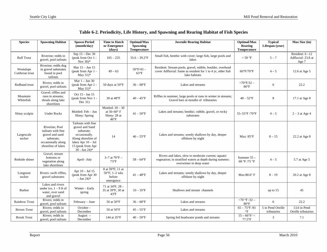
Seattle City Light Mill Pond Removal and Restoration
Report Page 56 March 2010
Table 6-2. Periodicity, Life History, and Spawning and Rearing Habitat of Fish Species
Species Spawning Habitat Spawn Period (month/day)
Time to Hatch or Emergence
(days)
Optimal/Max Spawning
Temperature
Juvenile Rearing Habitat Optimal/Max Rearing
Temperature
Typical Lifespan (year)
Max Size (in)
Bull Trout Riverine; redds in gravel, pool tailouts
Sep 15 – Dec 30 (peak from Oct 1 -
Nov 30)* 165 – 235 35.6 – 39.2°F Small fish, benthic with cover; large fish, large pools and
lakes < 59 °F 5 – 7 Resident: 6 –12
Adfluvial: 23.8 at Age 7
Westslope Cutthroat trout
Riverine; redds dug in gravel substrates
found in pool tailouts
Mar 15 – Jun 15 (peak from Apr 1 -
May 31)* 49 – 63 50°F/43 –
63°F
Resident: Stream pools, gravel, rubble, boulder, overhead cover Adfluvial: Same as resident for 1 to 4 yr, older fish
lake habitats 60°F/70°F 4 – 5 12.6 at Age 5
Redband trout Rivers; redds in gravel, pool tailouts
Mar 1 – Jun 30 (peak from Apr 1 -
May 31)* 50 days at 50°F 36 – 68°F Lakes and streams <70°F/32 –
80°F 6 22.2
Mountain Whitefish
Gravel; riffles and runs in streams;
shoals along lake shorelines
Oct 15 - Jan 15 (peak from Nov 1 -
Dec 31) 30 at 48°F 40 – 45°F Riffles in summer, large pools or runs in winter in streams;
Gravel bars at mouths of tributaries 48 – 52°F 8 17.1 at Age 8
Slimy sculpin Under Rocks Mottled: Feb – Jun Slimy: Spring
Mottled: 20 – 30 at 50–60° F Slimy: 28 at
46°F
41 – 50°F Lakes and streams; benthic; rubble, gravel, or rocky substrates 55–55°F /70°F 4 – 5 2 – 3 at Age 4
Largescale sucker
Riverine; Pool tailouts with fine gravel and sand
substrate; occasionally along shoreline of lakes
Tailouts with fine gravel and Sand
substrate; occasionally.
Along shoreline of lakes Apr 10 – Jul 15 (peak from Apr
30 - Jun 24)*
14 46 – 55°F Lakes and streams; weedy shallows by day, deeper offshore by night Max: 85°F 8 – 15 22.2 at Age 8
Redside shiner
Gravel, stream bottoms or
vegetation along lake shorelines
April– July 3–7 at 70°F – 73°F 58 – 64°F
Rivers and lakes, slow to moderate current; aquatic vegetation; in stratified waters at depth during summer;
overwinter in deep water
Summer 55 – 68 °F /75 °F 4 – 5 5.7 at Age 5
Longnose sucker
Rivers: swift riffles, gravel substrates
Apr 10 – Jul 15 (peak from Apr 30
- Jun 24)*
8 at 59°F; 11 at 50°F; 1–2 wks
before emergence
41 – 48°F Lakes and streams; weedy shallows by day, deeper offshore by night Max:80.6° F 8 – 19 20.2 at Age 8
Burbot
Lakes and rivers under ice, 1 – 9 ft of
water, over sand and gravel
Winter – Early spring
71 at 34ºF, 28 – 35 at 39ºF, 30 at
43ºF 33 – 35ºF Shallows and stream channels up to 15 45
Rainbow Trout Rivers; redds in gravel, pool tailouts February – June 50 at 50°F 36 – 68°F Lakes and streams <70 °F /32 –
80°F 6 22.2
Brown Trout Rivers; redds in gravel, pool tailouts
October – December 50 at 50°F 45 – 55°F Lakes and streams 65 – 75°F /81
°F 5 in Pend Oreille
tributaries 13.6 in Pend
Oreille tributaries
Brook Trout Rivers; redds in gravel, pool tailouts
August – December 144 at 35°F 40 – 50°F Spring fed headwater ponds and streams 55 – 66°F/ <
77.5°F 3 7.1

Seattle City Light Mill Pond Removal and Restoration
Report Page 57 March 2010
Species Spawning Habitat Spawn Period (month/day)
Time to Hatch or Emergence
(days)
Optimal/Max Spawning
Temperature
Juvenile Rearing Habitat Optimal/Max Rearing
Temperature
Typical Lifespan (year)
Max Size (in)
Kokanee Riverine; redds in gravel, pool tailouts
September – December 56 – 84 41 – 55°F Lake pelagic zone 50°F 4 16.7– 17.7
Umatilla Dace
Cobble or stone bottom and
relatively warm, productive waters
Late Spring and Summer No Data No Data No Data No Data No Data 2 - 4
River, Pacific, and Western
Brook Lamprey
Freshwater streams, migrate out to the
ocean, and return to fresh water as
mature adults to spawn.
Spring 2 – 3 weeks 50 - 60°F Low stream velocity where sediments are soft and rich in dead plant materials. No Data 2 – 3 Years 6 - 40
Pygmy Whitefish
Cool lakes and streams of
mountainous regions
October - December No Data No Data No Data No Data No Data 4 - 5
Note: *Fish spawning periodicities for the Project area as reported in Appendix 3 of Mainstem Aquatic Habitat Modeling Final Report (SCL 2009a). Sources: Bjornn and Reiser (1991); Bonar et al. (2000); Craig, J. F. (1996); McMahon et al. (1984); Rieman and McIntyre (1993); Scott and Crossman (1973), as cited by SCL 2009.
Seattle City Light Mill Pond Removal and Restoration
Report Page 58 March 2010
Bull trout and Dolly Varden (Salvelinus malma), both members of the char family, are similar in coloration, morphology, and life history, making distinction between the two species difficult without the use of electrophoretic samples or measurements of morphometric characteristics (WDFW 1998, as cited by SCL 2006). The State of Washington has established identical protective measures and management for the two species. Five Distinct Population Segments (DPS) of bull trout (Klamath River, Columbia River, Jarbidge River, Coastal-Puget Sound, and St. Mary-Belly River) were listed as threatened under the Endangered Species Act (ESA) by the USFWS on October 28, 1999. These population segments are geographically isolated from one another by natural and man-made barriers, and there is no genetic interchange between them. Bull trout populations in the Pend Oreille River and its associated tributaries are part of the Columbia River DSP. Dolly Varden was likewise proposed as threatened under the ESA due to their similarity of appearance to bull trout (66 FR 1628, as cited by SCL 2006). The WDFW includes bull trout as a state candidate species. Candidate species include fish and wildlife species that the WDFW will review for possible listing by the state as endangered, threatened, or sensitive. Within the Columbia River DPS, bull trout exhibit resident and adfluvial life history strategies (69 FR 59996; 64 FR 58910, as cited by SCL 2006). Bull trout spawn in cold, clear streams with complex channel characteristics. Juvenile rearing in streams occurs for 1 to 4 years. The migratory forms then begin to move downstream to take up residence in lakes (adfluvial) or remain in their natal (resident) or larger mainstem rivers (fluvial). Maturity occurs at age 4 to 7 years with spawning migrations to the natal stream. Bull trout are iteroparous and spawn annually or in alternate years (SCL 2006).
Bull Trout
Spawning in most bull trout populations occurs in September and October, though it may occur in August at elevations above 4,000 ft in the Cascades and as late as November in coastal streams (Goetz 1989; Craig 1997, as cited by SCL 2006). Most adfluvial populations spawn only every second year, while resident char may spawn every year (Armstrong and Morrow 1980; USFWS 1998, as cited by SCL 2006). Spawning habitat is characterized by low gradient, uniform flow, and a gravel substrate 0.25 to 2.0 in in diameter (Wydoski and Whitney 2003; Fraley and Shepard 1989, as cited by SCL 2006). Groundwater influence and proximity to cover are also reported as important factors in spawning site selection (Fraley and Shepard 1989, as cited by SCL 2006). Studies conducted throughout the species range indicate that spawning occurs in water from 0.75 ft to 2.0 ft deep (Wydoski and Whitney 2003; Fraley and Shepard 1989, as cited by SCL 2006) and often occurs in reaches fed by streams, or near other sources of cold groundwater (Pratt 1992, as cited by SCL 2006). Rieman and McIntyre (1993, as cited by SCL, 2006) indicate that optimum bull trout embryo incubation temperatures are between 35.6°F and 39.2°F (2 to 4ºC). These relatively cool incubation temperatures mean that bull trout generally require a long period of time from egg deposition until emergence. Embryos incubate for approximately 100 to 145 days and often hatch in late winter or early spring. The alevins remain in the streambed, absorbing the yolk sac, for an additional 65 to 90 days, and emergence from the streambed occurs in late winter/early spring (Pratt 1992, as cited by SCL 2006). Long incubation times may result in higher susceptibility to fine sediment levels in spawning substrates, but the extent to which sediment intrusion into the gravels reduces embryo survival and affects bull trout populations is not entirely known (Rieman and McIntyre 1993, as cited by SCL 2006). Bull trout fry are usually found in shallow, slow backwater side channels and eddies, in close proximity to instream cover (Pratt 1984, as cited by SCL 2006). These characteristics are similar to those reported for other species of salmonids (Fraley and Shepard 1989, as cited by SCL 2006). Juveniles are primarily bottom dwellers and are found among interstitial spaces in the substrate (Fraley and Shepard 1989; Pratt 1992, as cited by SCL 2006). Sub-adults are often found in deeper stream pools or in lakes in deep water with temperatures less than 59°F (15°C) (Pratt 1992, as cited by SCL 2006). In the proposed rule for designating critical habitat (69 FR 35768, as cited by SCL 2006), bull trout are described as opportunistic feeders that migrate between patches based upon the available foraging opportunities. Consequently, habitat utilization during rearing can be variable and dependent upon available food sources. In a riverine or lacustrine setting, bull
Seattle City Light Mill Pond Removal and Restoration
Report Page 59 March 2010
trout may forage on a variety a terrestrial and aquatic insects, zooplankton, and small fish. Larger bull trout are predominantly fish-eaters. Summer water temperatures in the Pend Oreille River reservoirs are considered to be too warm for bull trout (Stovall 2000, as cited by SCL 2006), except in thermal refugia near the outlets of coldwater tributaries such as Sullivan Creek (69 FR 59996, as cited by SCL 2006). Bull trout have rarely been observed in Boundary Reservoir between the years 1980 to 2008 (SCL 2009a) and only four observations have been made in Sullivan Creek (SCL 2009a; USFWS 2002). The first observation was made in 1994 of a dead adult female in Sullivan Creek below Mill Pond Dam during a snorkel survey (USFWS 2002). The second observation was a char species made in 1993; however, the exact species could not be identified (Andonaegui 2003, as cited by SCL 2009a). The third observation was of a gutted bull trout carcass on the bank of Sullivan Creek in 1993; however, it is unknown if the fish was captured in Sullivan Creek or caught somewhere else and discarded there by the angler (CES 1996, as cited by SCL 2009a). The fourth observation was of another char species made in 2007; however, the exact species could not be identified (SCL 2009ab, as cited by SCL 2009a). The CNF has suggested that aquatic habitat upstream of Mill Pond would contribute to the recovery of bull trout in the Pend Oreille River if migration barriers were removed (USFS 2000b, as cited by SCL 2006). In the final rule designating critical habitat for bull trout (70 FR 56212-56311), the USFWS identified short sections of lower Sullivan Creek as critical habitat. However, a proposed revision to bull trout designated critical habitat was issued on January 14, 2010 (75 FR 2270-2431). This revision now includes the entire reach of Sullivan Creek as critical habitat. Under the previous critical habitat boundaries, Boundary Reservoir was not listed but the proposed revision now lists the Pend Oreille River as critical habitat also. The Northeast Washington Unit (NWU) Recovery Team for bull trout considers Sullivan Creek to be important for the recovery of bull trout in the Pend Oreille River (SCL 2006). Recovery goals for NWU include the establishment of a local migratory bull trout subpopulation in Sullivan Creek and habitat connectivity between Sullivan Creek and other potential or existing local subpopulations in the unit (SCL 2006).
Westslope cutthroat trout is one of three cutthroat species found in Washington State, the other two being coastal cutthroat trout (Oncorhynchus clarki clarki) and Lahontan cutthroat trout (Oncorhynchus clarki henshawi). Westslope cutthroat trout are native to the vicinity of the Study Area. Historically, Westslope cutthroat trout had a broad distribution across the western United States including many tributaries in the upper Columbia River such as the Kootenai River, Clark Fork River, the Spokane River above Spokane Falls, and the Missouri River (68 FR 46989, as cited by SCL 2006). Based upon early accounts of cutthroat trout being harvested in the river, the USFWS concluded that Westslope cutthroat trout were likely present throughout the Pend Oreille River. In April 2000, the USFWS determined that Westslope cutthroat trout were not at risk of becoming threatened or endangered, although several populations had reduced abundance from historical numbers as a result of habitat degradation and other threats. Later that year a suit was filed regarding the decision and in 2002 the USFWS was ordered to reconsider the decision. In August 2003 (68 FR 46989, as cited by SCL 2006), USFWS completed its reanalysis and again determined that listing was not warranted at that time. Although Westslope cutthroat trout are not listed under the ESA and are not State listed as either an endangered or candidate species by WDFW (1999), the Upper Columbia River Fish and Wildlife Office (UCRFWO) of the USFWS and the CNF list them as a species of concern (UCRFWO 2005; USFS 2000a, as cited by SCL 2006).
Westslope Cutthroat

Seattle City Light Mill Pond Removal and Restoration
Report Page 60 March 2010
Westslope cutthroat trout begin spawning at age 4 or 5, and individuals generally spawn every other year. Westslope cutthroat trout spawn from March through July, when water temperatures warm to approximately 50°F (USFWS 1999, as cited by SCL 2006). Fry emergence is usually complete by the end of August. Similar to bull trout, Westslope cutthroat trout can exhibit resident, adfluvial, or fluvial life history patterns. Resident Westslope cutthroat trout generally mature at a smaller size than fluvial or adfluvial fish (Wydoski and Whitney 2003, as cited by SCL 2006). The USFWS (1999, as cited by SCL 2006) suggested that Westslope cutthroat trout that spawned in tributaries to the Pend Oreille River were historically either fluvial or resident fish and under current conditions the fluvial form may have converted to the adfluvial form. Juvenile trout that exhibit the resident or adfluvial life history pattern usually spend time rearing in natal streams before outmigration. During the summer, juvenile cutthroat trout rear in low velocity riffles, pool tailouts, and runs. Fall can be a period of movement between summer rearing habitat and overwintering habitat. Winter habitat for juveniles consists of pools and side channels in association with woody debris. USFWS (1999, as cited by SCL 2006) suggested that Westslope cutthroat trout are usually found in the cooler upper extents of tributaries, but suggested this utilization could be driven by competition (from other trout such as rainbow trout and brook trout that are less tolerant of cooler, higher gradient streams) rather than a preference for that habitat type. Currently, there are no federal or state plans specific to the conservation of Westslope cutthroat trout because the species has not been listed under state or federal laws. However, state and federal agencies continue to monitor the status of Westslope cutthroat trout within their jurisdictions. Cutthroat trout were observed and identified during surveys in 1993, 1994, and 1995 of Sullivan Creek between the mouth (RM 0.0) and Mill Pond Dam (RM 3.25) (CES 1996, as cited by SCL 2009a). From snorkel surveys in Sullivan Creek downstream of Mill Pond Dam, McLellan (2001, as cited by SCL 2009a) found cutthroat trout density to be less than 1 fish/100 m2.
The Columbia River redband trout, a subspecies of rainbow trout, is native to the Fraser and Columbia River drainages east of the Cascade Mountains to barrier falls on the Pend Oreille, Spokane, Snake and Kootenai rivers (Allendorf et al. 1980; Behnke 1992). Logging, mining, agriculture, grazing, dams, over harvest and hybridization and competition with other trout contributed to the decline of redband trout abundance, distribution and genetic diversity in the Columbia River Basin (Williams et al. 1989; Behnke 1992). Consequently, many populations are restricted to isolated headwater streams that may serve as refugia until effective conservation and rehabilitation strategies are implemented. Long-term persistence of these populations is threatened by loss of migratory life history forms and connectivity with other populations which are critical to maintaining genetic diversity and dispersal among populations (Rieman and McIntyre 1995).
Inland Redband Trout
Although redband rainbow trout are native in some systems in Eastern Washington, the Pend Oreille County PUD states they have seen no documentation of native redband rainbow trout in the Pend Oreille River system between Albeni Falls and Boundary dams. Rainbow trout have been planted heavily in the Pend Oreille River and tributaries. Although their spawning time is different than bull trout, brook trout and brown trout, rainbow trout could prove to be formidable competitors in areas such as lower Sullivan Creek (POPUD, 1/29/03 final draft report review comment, March 2003, as cited by WSCC 2003).
Umatilla dace is listed as a state candidate species but has no federal status. The following is summarized from Wydoski and Whitney (2003, as cited by SCL 2006). Umatilla dace are usually found in streams and associated with the bottom. Even relatively large Umatilla dace are less than 4 in in length. Similar to leopard dace and Lake Chub, Umatilla dace have a scattered distribution. In Washington, they have been found in the Columbia, Yakima, Okanogan, Similkameen, Kettle, Colville, and Snake rivers. No
Umatilla Dace

Seattle City Light Mill Pond Removal and Restoration
Report Page 61 March 2010
documented observation of this species has occurred in the Pend Oreille River or its tributaries (SCL 2006).
All three listed lamprey are genetically and morphologically similar to one another and overlap in ranges (Mecklenburg et al. 2002). The general body is elongate and eel-like with fins, caudal fin with a dark gray blotch, lobed and connected to an anal fin-like fold (anal fin well-developed in female, weakly developed in male). The mouth is generally jawless and consists of a rounded oral sucker with teeth present on and around the tongue. Body size and color are the most important distinguishing characteristics of each species, but arrangement of teeth is most useful at the generic level.
River, Pacific, and Western Brook Lamprey
Young lamprey filter feed on algae and microscopic organisms in stream water from burrows in sediment. Adults are can be parasitic on various fish species including Pacific herring, American shad, steelhead and other various species of salmon. Adults attack fish in salt or fresh water, feeding mainly on muscle tissue and body fluids (Roos et al. 1973, Bond et al. 1983). Based on the data reviewed for this environmental analysis, there are no documented occurrences of lamprey within the Study Area. However, further review may be required to support this conclusion.
Pygmy whitefish is listed as a state sensitive species but has no federal status. The following is summarized from Wydoski and Whitney (2003, as cited by SCL 2006). Pygmy whitefish usually inhabit deep lakes or reservoirs with water temperatures less than 50°F (10°C). Relict populations of pygmy whitefish are scattered across North America. In Washington, they have been found in 15 lakes. In Pend Oreille County they are present in Sullivan Lake and historically were found in Diamond, Horseshoe, and Marshall Lakes, but are currently extirpated in the latter three lakes. No documented observation of this species has occurred within the Study Area.
Pygmy Whitefish
Next to rainbow trout, mountain whitefish was the second most common fish species observed during snorkel surveys of Sullivan Creek in 1997 (R2 Resource Consultants 1998, as cited by SCL 2006). Mountain whitefish were observed in Lower Sullivan Creek during surveys conducted in 1994 and 1995 (CES 1996, as cited by SCL 2006). From snorkel surveys in Sullivan Creek downstream of Mill Pond Dam, McLellan (2001) found the average mountain whitefish density to be greater than 1 fish/100 m2.
Mountain Whitefish
The slimy sculpin is native west of the Continental Divide. It prefers clear, cold, rocky streams but will also be found along cobbly shorelines of lakes. All freshwater sculpins are spring spawners. The males select spawning sites on the undersides of rocks. The female is courted, enters the nest, and deposits a mass of adhesive eggs upside down on the ceiling of the nest. The male then guards the nest and newly-hatched young sculpins with vigilance.
Slimy Sculpin
The back and sides are brown to black with mottling; dark bands are often present. The underside is white. The first dorsal fin is fringed with orange on breeding males. No palatine teeth are present. Pelvic fins have 3 or 4 soft rays; if a fourth (inner) ray is present, it is usually two-thirds or less the length of the longest. Food is comprised of mostly immature aquatic insects and invertebrates, but also includes any small fish available (Brown 1971). Spawning occurs in spring (Brown 1971). Incubation is in 30-40 days at 48-50 degrees F. They may become sexually mature at 2 years (Weisel 1957). Populations in northern Saskatchewan spawned in early May at 46 degrees F. with eggs hatching in 4 weeks (Scott 1973).

Seattle City Light Mill Pond Removal and Restoration
Report Page 62 March 2010
Based on the data reviewed for this environmental analysis, there are no documented occurrences of slimy sculpin within the Study Area. However, they are found in Sullivan Lake and further review may be required to support this conclusion.
The largescale sucker is native to the Pacific Northwest, occurring from British Columbia south to Oregon and is widespread in the Columbia River system. This species is found in the Spokane, Pend Oreille, and Kootenai River systems. It occurs in the slower-moving portions of rivers and streams, and in lakes. Largescale suckers spawn in the spring in shallow water over sandy areas of streams or the sandy or small gravel shoals of lakes. Females may produce up to 20,000 adhesive eggs. The young feed upon small zooplankton until they become bottom dwellers. Then they feed on benthic aquatic invertebrates, diatoms, and other plant material. This species reaches a length of 24 in and 7 pounds in parts of their range.
Largescale Sucker
Based on the data reviewed for this environmental analysis, there are no documented occurrences of largescale suckers within the Study Area. However, further review may be required to support this conclusion.
Redside shiners are generally found in runs and flowing to standing pools of headwaters, creeks, and small to medium rivers, lakes, and ponds (Scott 1973). Schools area usually found in areas that are over mud or sand and often near vegetation (Scott 1973). Fry feed on diatoms, copepods, ostracods, and other small planktonic and demersal crustaceans. Diet changes to terrestrial and aquatic insects, algae, mollusks, fish eggs (including their own), and small fishes like other redside shiners, other minnows, and trout. These species are preyed upon by mergansers, loons, and mink.
Redside Shiner
Based on the data reviewed for this environmental analysis, there are no documented occurrences of redside shiners within the Study Area. However, they are found in Sullivan Lake and further review may be required to support this conclusion.
The longnose sucker has a reddish-brown, dark brassy green, or gray to black upper body and the underside is usually white. The lateral line, which is complete, is usually brownish-black, except during the breeding season when it turns reddish. Breeding males also develop tubercles (small bumps) on the head, anal fin, and the lower lobe of the caudal (tail) fin. The longnose sucker has an elongated, round body with a somewhat long snout. The mouth has large lips that are lined with papillae (small fleshy projections), which create suction for ingesting food. There are no teeth located on the jaws. Instead, there are pharyngeal teeth (teeth in the pharynx area, which is the beginning of the digestive tract) that are used by pressing food against a hard pad of cartilage. The caudal fin (tail) is forked with rounded lobes. Longnose suckers have been measured up to 25 in. The longnose sucker belongs to a group of fish (Cypriniformes, which also include the lake chubs) that have a unique feature called the Weberian apparatus. The Weberian apparatus is made up of four to five modified vertebrae in the head that connect the ear to the swim bladder, which aids in sensing sound and pressure changes.
Longnose Sucker
Longnose suckers spawn between May and July depending on location. They sometimes travel to streams with gravel bottoms and cold water. They can also spawn and thrive in lakes or ponds. Unlike salmon, the longnose sucker does not build a nest for fertilized eggs. Instead, the fertilized eggs fall into crevices in the gravel. During spawning, which usually occurs during the daylight, the male grasps the female with his pelvic fins while they vibrate to release both eggs and sperm at the same time. A female can produce up to 60,000 eggs. The eggs, which are yellow in color, take up to about two weeks to hatch, depending on water

Seattle City Light Mill Pond Removal and Restoration
Report Page 63 March 2010
temperatures. They remain as sac fry in the gravel for another one to two weeks before they begin to move around and feed. By October, longnose suckers have left the spawning areas and have moved downstream or to lakes to over-winter. Some longnose suckers spawn every year, while others skip years. The age at which a longnose sucker reaches sexual maturity varies depending on location, but can be as soon as two to three years old. The longnose sucker feeds primarily on the bottom of streams or lakes. It swims slowly along the bottom in search of invertebrates, which include insects, mollusks, snails, and crustaceans, and sometimes eats aquatic plants, algae and fish eggs. Its large lips enable it to suck up its food. Longnose suckers are a source of food for other larger fish, some mammals, and birds. Based on the data reviewed for this environmental analysis, there are no documented occurrences of longnose suckers within the Study Area. However, further review may be required to support this conclusion.
Burbot are demersal fish found in deep temperate lake bottoms and slow moving cold river bottoms between 4°C and 18°C (Riede 2004; Cohen et al. 1990). Primarily found deeper in lakes. These fish often dwell among benthic refugia such as roots, trees, rocks, and dense vegetation (
Burbot
Cohen et al., 1990; Riede, 2004; Scott and Crossman, 1973). Burbot are large fish known to grow to as much as five ft in length and weigh up to 75 pounds (lbs). These fish are yellow, light tan, or brown with dark brown or black patterning on the body, head and most fins. The underbelly and pectoral fins are pale to white (Cohen et al. 1990). The first dorsal fin is short and is followed by a long second dorsal fin at least six times the length of the first and joined to a rounded caudal fin. Burbot have neither dorsal nor anal spines and have 67 to 96 soft dorsal rays, and 58 to 79 soft anal rays (Cohen et al. 1990). Gill rakers are short, pectoral fins are rounded, and caudal fins have 40 rays. Like other cods, burbot are also characterized by a single barbel located on the chin (Cohen et al. 1990). Burbot are opportunistic piscivores with a diverse diet. They hide amongst available refugia in their epibenthic habitat such as rocks and fallen logs, and use ambush tactics to capture prey. They are crepuscular or nocturnal and seek shallow water to feed. During times of low activity, they congregate in deep holes (Riede 2004; Scott and Crossman 1973). In the winter, these fish migrate upstream and form spawning aggregations (Cohen et al.1990). Based on the data reviewed for this environmental analysis, there are no documented occurrences of burbots within the Study Area. However, they are found in Sullivan Lake and further review may be required to support this conclusion.
In Sullivan Creek, rainbow trout were the most common fish species observed during snorkel surveys in 1997 (R2 Resource Consultants 1998, as cited by SCL 2006). Electrofishing activities followed the snorkeling surveys in 1997 resulted in an intermediate amount of cutthroat captured in Sullivan Creek (R2 Resource Consultants 1998, as cited by SCL 2006). Rainbow trout were documented by the CNF (1996, as cited by SCL 2006) as found only in the mainstem of Sullivan Creek up to the confluence of Rainy Creek (Rainy Creek is beyond the focus Study Area). Rainbow trout were observed in lower Sullivan Creek during surveys in 1993, 1994, and 1995 (CES 1996, as cited by SCL 2006). From snorkel surveys in Sullivan Creek downstream of Mill Pond Dam, McLellan (2001, as cited by SCL 2006) found rainbow trout density to be greater than 1 fish/100 m2. Within the stretch of Sullivan Creek downstream of Mill Pond Dam (RM 3.25), rainbow trout can be found in this habitat competing for food and habitat, and interbreeding with cutthroat trout (Shuhda 2007, as cited by SCL 2006).
Rainbow Trout

Seattle City Light Mill Pond Removal and Restoration
Report Page 64 March 2010
Brown trout are known to occur in Sullivan Lake and throughout Sullivan Creek both downstream and upstream of Mill Pond dam, though not in its tributaries, except for Outlet Creek (T. Shuhda, USFS, pers. comm., 2002; CES 1996, Appendix B, as cited by WSCC 2003). Two adfluvial populations of brown trout are found in Sullivan Creek from the mouth upstream to the confluence of Rainy Creek (RM 11.7). The first population comes up from the Boundary Reservoir reach of the Pend Oreille River to spawn in Sullivan Creek downstream of Mill Pond (RM 3.25; USFS 1996, pg. I-13, as cited by WSCC 2003). However, biologists working for the Pend Oreille County PUD believe the lower chutes and cascades at RMs 0.6 and 0.65 on Sullivan Creek are barriers to upstream fish passage limiting the upper extent of fish use for salmonids entering Sullivan Creek from Boundary Reservoir (POPUD 1/29/03 final draft report review comments, March 2003, as cited by WSCC 2003). Furthermore, a study conducted by Waterfall Engineering (2008) concluded that fish barrier at RM 0.65 is passable by bull trout 18 in or larger at flow conditions less than 99 cfs.
Brown Trout
The second population comes up from Mill Pond to spawn in upper Sullivan Creek and its tributaries, up to the confluence of Rainy Creek (USFS 1996, as cited by WSCC 2003). Brown trout have also been found in Outlet Creek which the CNF considers the main spawning grounds for brown trout saying spawning habitat above Mill Pond in main Sullivan Creek is limited (USFS 1996, pg. I-14, as cited by WSCC 2003). Biologists working for the Pend Oreille County PUD suspect that fish in Outlet Creek either come down from Sullivan Lake when the Sullivan Lake Dam gates are open or migrate upstream from Mill Pond (POPUD 1/29/03 final draft report review comments, March 2003, as cited by WSCC 2003). Also, Biologists working for the Pend Oreille County PUD have seen extremely large brown trout spawning at the confluence of Sullivan Lake and Harvey Creek (POPUD 1/29/03 final draft report review comments, March 2003, as cited by WSCC 2003). Streams have not been stocked with non-native salmonid fish species in eastern Washington streams since the mid-1980’s (USFS 1996, as cited by WSCC 2003).
Brook trout have been observed in Sullivan Creek (R2 Resource Consultants 1998; McLellan 2001; Andonaegui 2003, as cited by SCL 2006). In the CNF (1996, as cited by SCL 2006) watershed assessment of Sullivan Creek, eastern brook trout were found throughout Sullivan Creek, spawning and rearing in tributary habitats, with very little spawning occurring in the mainstem of Sullivan Creek. From snorkel surveys of 55 sites within 20 stream reaches, McLellan (2001, as cited by SCL 2006) found brook trout density to be less than 1 fish/100 m2. Brook trout were observed between the mouth of Sullivan Creek (RM 0.0) and Mill Pond Dam (RM 3.25) during fish surveys conducted in 1993, 1994, and 1995 (CES 1996; Andonaegui 2003, as cited by SCL 2006). Brook trout were not observed in Sullivan Creek downstream of Mill Pond Dam (RM 3.25) during snorkel surveys conducted between August 7 and August 16, 2000 (McLellan 2001, as cited by SCL 2006). Within the stretch of Sullivan Creek downstream of Mill Pond Dam (RM 3.25), brook trout can be found in this habitat competing for food and habitat, and interbreeding with bull trout (Shuhda 2007, as cited by SCL 2006). R2 Resource Consultants (2006, as cited by SCL 2006) also reported the presence of brook trout in Sullivan Creek.
Brook Trout
Brook trout are found throughout Sullivan Creek, Copper Creek, first mile of Deemer Creek, Fireline, Kinyon, Mankato and Stony creeks. Brook trout are thought to use the tributaries for spawning and rearing habitat with very little spawning occurring in Sullivan Creek (USFS 1996, Sullivan Creek Watershed Assessment, as cited by WSCC 2003). Streams have not been stocked in eastern Washington since the mid-1980s (USFS 1996, as cited by WSCC 2003). During snorkeling fish surveys conducted between August 7 and August 16, 2000, brook trout were only observed upstream of the Mill Pond Dam and not downstream, although both areas were surveyed.
Seattle City Light Mill Pond Removal and Restoration
Report Page 65 March 2010
Brook trout were observed from the lowest reach above the Mill Pond upstream to the headwaters. Brown trout were also observed (McLellan 2001, pg. 82, 83, as cited by WSCC 2003). During 1995 fish surveys, CES detected brook trout from the mouth upstream to the headwaters (CES 1996, Appendix B, as cited by WSCC 2003).
Kokanee is a landlocked form of sockeye known. Upon emergence from gravel, fry at first tends to avoid light, hiding during the day and emerging at night. Kokanee are confined to lake-stream systems where most of its life is spent. They feed mainly on plankton, but also take insects and bottom organisms. Kokanee, wherever they are native, have been derived from anadromous populations, and each kokanee population apparently has evolved independently from a particular sockeye run. The lifespan of the kokanee varies from two to seven years in different stocks. The kokanee is primarily a sport fish but also makes excellent food and in some areas well regarded as food for large trout.
Kokanee
There are kokanee in Mill Pond that use Sullivan Creek for spawning and rearing habitat (WSCC 2003). It is unclear whether the kokanee are a remnant population of sockeye from before the damming of the Pend Oreille River or if they had been stocked (USFS 1996, as cited by WSC, 2003). Streams have not been stocked with kokanee in eastern Washington streams since the mid-1980’s (USFS 1996, as cited by WSCC 2003). For the Sullivan Creek kokanee to be a remnant population of Columbia River sockeye, there would need to have been salmonid fish passage at Z Canyon (RM 19.0) and Metaline Falls (RM 26.5) on the Pend Oreille River. Sullivan Creek flows into the Pend Oreille River at RM 26.9, upstream of Metaline Falls. It is most commonly accepted that upstream anadromous fish passage on the Pend Oreille River was limited by Metaline Falls (WSCC 2003). 6.2.1.2.2 Invertebrate Species The masked duskysnail (Lyogyrus n. sp. 2) is identified by the CNF as sensitive while the WDFW list this species as having a monitor status. There is no federal listing for this species at this time. According to available data (BLM 1998), Masked duskysnail has only been documented at 4 sites in two kettle lakes, Curlew Lake in Ferry County, Washington, and Fish Lake, which is partially within Wenatchee National Forest, Chelan County, Washington (Chiwawa LSR, as cited by BLM 1998). The masked duskysnail is a species that has not been studied in detail and there is little information available on the ecology of the species. All Hydrobiidae snails have gills that make them dependent upon dissolved oxygen in the water in which they live. It is a cool water, periphyton feeder (i.e., feeds on the algal and microbial film on aquatic macrophytes) and likely on detritus. Burke (pers. comm., as cited by BLM 1998) indicated that both lakes inhabited by this species are highly eutrophic with an abundant growth of aquatic macrophytes and algae. Burke (pers. comm.) speculated this may be an unhealthy situation for the species, but further studies on the basic ecology of the species are necessary. Individuals overwinter as adults and do not disperse widely, so populations remain localized in their distribution. Major predators are probably amphibians, turtles, sculpins, and trout. Typically, many individuals may be infected with trematode parasites (BLM 1998). The Masked duskysnail has not been documented within or adjacent to the Study Area.

Seattle City Light Mill Pond Removal and Restoration
Report Page 66 March 2010
6.2.1.2.3 Rare, Threatened and Endangered Aquatic Species This section discusses rare, threatened and endangered (RTE) aquatic species that are known to occur or could potentially occur in the Study Area. RTE species include all taxa with federal or state protective status and is categorized in one of the following groups:
• Federal Species – Wildlife species listed by the USFWS. o Listed or Proposed Species - Species that are listed and protected under the ESA of 1973,
as Endangered or Threatened, or proposed for listing. o Candidates - Species for which the USFWS has sufficient information on their biological
status and threats to propose them as endangered or threatened under the ESA, but for which development of a proposed listing regulation has not occurred because of other higher priority listing activities. Candidate species receive no statutory protection under the ESA. However, the USFWS encourages the formation of partnerships to conserve these species.
o Species of Concern - Species that do not have protection under the ESA but that are of management concern to the federal land managers.
• State Species – Wildlife species listed by the WDFW. o Endangered - Any wildlife species native to the state of Washington that is seriously
threatened with extinction throughout all or a significant portion of its range within the state.
o Threatened - Any wildlife species native to the state of Washington that is likely to become an endangered species within the foreseeable future throughout a significant portion of its range within the state without cooperative management or removal of threats.
o Candidates - Include fish and wildlife species that the Department will review for possible listing as State Endangered, Threatened, or Sensitive. A species will be considered for designation as a State Candidate if sufficient evidence suggests that its status may meet the listing criteria defined for State Endangered, Threatened, or Sensitive.
o Sensitive - Any wildlife species native to the state of Washington that is vulnerable or declining and is likely to become endangered or threatened throughout a significant portion of its range within the state without cooperative management or removal of threats.
o Monitor – Wildlife species that are not classifies under other listings, but are monitored for status and distribution. They are managed by WDFW, as needed, to prevent them from becoming endangered, threatened, or sensitive.
• CNF Species - Species on the Regional Forester Sensitive Status Species (RFSSS) list for the CNF (USFS 2008). Species on this list are listed only as Sensitive. The RFSSS list does not include species already protected under the ESA.
All of the information documented in this section is compiled from exiting studies and lists within the vicinity of the Study Area. Table 6-3 identifies the wildlife species on the CNF RFSSS list for the CNF (USFS 2008), USFWS Pend Oreille County list (USFWS 2009) and the WDFW PHS list (WDFW 2009a). Species identified in this list are discussed in sections 6.2.1.2.1 and 6.2.1.2.2.
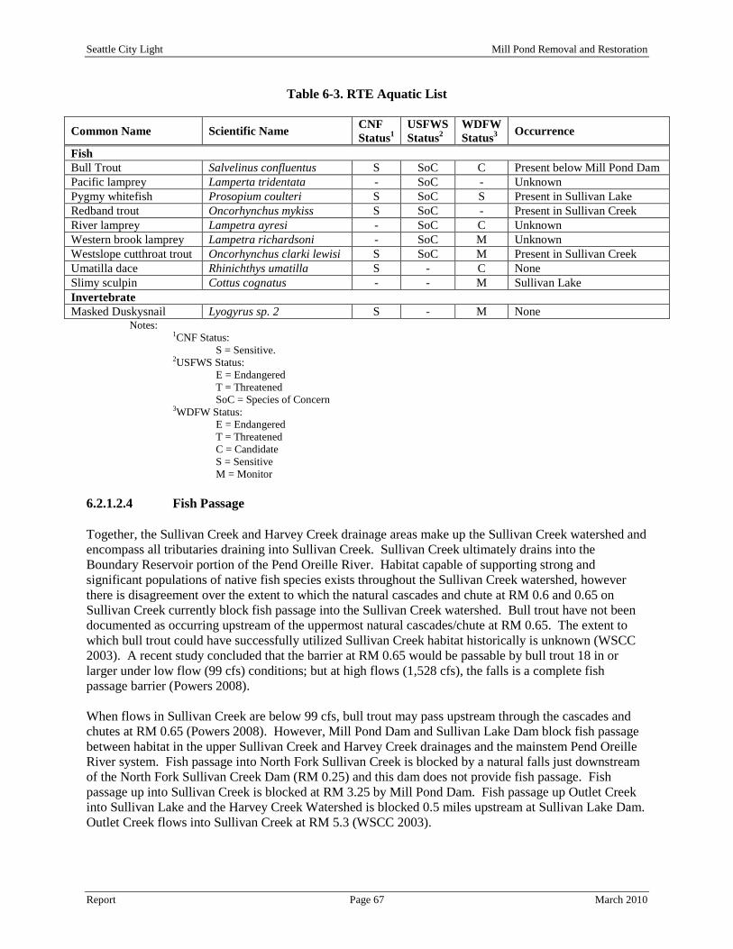
Seattle City Light Mill Pond Removal and Restoration
Report Page 67 March 2010
Table 6-3. RTE Aquatic List
Common Name Scientific Name CNF Status1
USFWS Status2
WDFW Status3 Occurrence
Fish Bull Trout Salvelinus confluentus S SoC C Present below Mill Pond Dam Pacific lamprey Lamperta tridentata - SoC - Unknown Pygmy whitefish Prosopium coulteri S SoC S Present in Sullivan Lake Redband trout Oncorhynchus mykiss S SoC - Present in Sullivan Creek River lamprey Lampetra ayresi - SoC C Unknown Western brook lamprey Lampetra richardsoni - SoC M Unknown Westslope cutthroat trout Oncorhynchus clarki lewisi S SoC M Present in Sullivan Creek Umatilla dace Rhinichthys umatilla S - C None Slimy sculpin Cottus cognatus - - M Sullivan Lake Invertebrate Masked Duskysnail Lyogyrus sp. 2 S - M None
Notes: 1CNF Status:
S = Sensitive. 2USFWS Status:
E = Endangered T = Threatened SoC = Species of Concern
3WDFW Status: E = Endangered T = Threatened C = Candidate S = Sensitive M = Monitor
6.2.1.2.4 Fish Passage Together, the Sullivan Creek and Harvey Creek drainage areas make up the Sullivan Creek watershed and encompass all tributaries draining into Sullivan Creek. Sullivan Creek ultimately drains into the Boundary Reservoir portion of the Pend Oreille River. Habitat capable of supporting strong and significant populations of native fish species exists throughout the Sullivan Creek watershed, however there is disagreement over the extent to which the natural cascades and chute at RM 0.6 and 0.65 on Sullivan Creek currently block fish passage into the Sullivan Creek watershed. Bull trout have not been documented as occurring upstream of the uppermost natural cascades/chute at RM 0.65. The extent to which bull trout could have successfully utilized Sullivan Creek habitat historically is unknown (WSCC 2003). A recent study concluded that the barrier at RM 0.65 would be passable by bull trout 18 in or larger under low flow (99 cfs) conditions; but at high flows (1,528 cfs), the falls is a complete fish passage barrier (Powers 2008). When flows in Sullivan Creek are below 99 cfs, bull trout may pass upstream through the cascades and chutes at RM 0.65 (Powers 2008). However, Mill Pond Dam and Sullivan Lake Dam block fish passage between habitat in the upper Sullivan Creek and Harvey Creek drainages and the mainstem Pend Oreille River system. Fish passage into North Fork Sullivan Creek is blocked by a natural falls just downstream of the North Fork Sullivan Creek Dam (RM 0.25) and this dam does not provide fish passage. Fish passage up into Sullivan Creek is blocked at RM 3.25 by Mill Pond Dam. Fish passage up Outlet Creek into Sullivan Lake and the Harvey Creek Watershed is blocked 0.5 miles upstream at Sullivan Lake Dam. Outlet Creek flows into Sullivan Creek at RM 5.3 (WSCC 2003).

Seattle City Light Mill Pond Removal and Restoration
Report Page 68 March 2010
Mill Pond Dam is currently a barrier to upstream fish passage. There is downstream fish passage at Mill Pond Dam via the spillway but the mortality rate of fish passing over the spillway is unknown. The original log-crib dam was constructed in 1909 with a wooden fish ladder (USFS 1996, as cited by WSCC 2003). However, in the early 1920s, the log crib dam was replaced by a concrete structure and the fish ladder was not replaced (T. Shuhda, pers. comm. cited in POCD 2001b, Part 2, pg. 6, as cited by WSCC, 2003). 6.2.1.2.5 Recreational Value of Fishery A survey conducted during the SCL Boundary Dam relicensing process (Tetra Tech 2009h), asked local area residents (147 respondents) to identify where they went fishing. Sullivan Lake and Mill Pond was identified as the second and third most frequented areas behind Boundary Reservoir. Additional information regarding recreational resources is provided in Section 6.5. According WDFW (2009b) 2003 records/surveys indicated that:
• 3,121 angler trips were made to the CNF from May to November. • Requiring an estimated 11,235 (±1,060) hours of effort (travel and preparation) • That resulted in the harvest of:
o 3,526 (±312) Kokanee o 113 (±11) Rainbow trout o 35 (±5) Cutthroat trout o 30 (±4) Burbot o 71 (±10) Longnose suckers
Estimates made by WDFW (2009b) regarding the economic value of the fishery further indicated the following:
• In 2006 the average cost associated with a fishing trip to the area was estimated at $27.00. • In 2008 the average cost associated with 3,121 fishing trips to the area was estimated at $28.45.
o Generating an estimated annual revenue of approximately $88,792 (which is underestimated because it did not factor in the winter Burbot fishery opportunities).
6.2.1.2.6 Management Objectives – Essential Fish Habitat There are no proposed or designated essential fish habitat areas within the Study Area. The Magnuson-Stevens Fishery Conservation and Management Act (MSA) is a federal law that governs marine fisheries management. The MSA, as amended by the Sustainable Fisheries Act of 1996, established procedures designed to identify, conserve, and enhance essential fish habitat for those species regulated under a federal fisheries management plan. The MSA, as amended, defines essential fish habitat as those waters and substrate necessary for fish use in spawning, rearing, feeding, or growth to maturity. The MSA requires federal agencies to consult with National Marine Fisheries Service to determine whether a proposed action would adversely affect essential fisheries habitat. Freshwater essential fish habitat for salmon in the Pacific Northwest includes all water bodies currently or historically accessible to salmon, except areas upstream of certain impassable man-made barriers. The upstream extent of essential fish habitat in the Upper Columbia River system was identified as Chief Joseph Dam in Appendix A to Amendment 14 to the Pacific Coast Salmon Plan (Pacific Fishery Management Council 1999). The Study Area is located upstream of Boundary Dam which is located 215.5 miles upstream of Chief Joseph Dam. Furthermore, since there are no proposed or designated essential fish habitat areas with the Study Area, there are no managed species to address with the Study Area.

Seattle City Light Mill Pond Removal and Restoration
Report Page 69 March 2010
6.2.1.2.7 Sport Fishery Maintenance Sterile triploid rainbow trout have been historically planted in the vicinity of the Study Area to increase sport fishing harvest while minimizing the risk of hybridization with native species. Planting triploid rainbow trout as part of a recreational fish enhancement program can help balance the demands for both consumptive fishing opportunities and conservation of native stocks (Tetra Tech 2009h). The planting of sterile triploid rainbow trout in Boundary Reservoir by SCL has ceased and there are no plans to restart this program under the proposed Boundary Reservoir settlement agreement. 6.2.1.2.8 Fish Stocking Rainbow trout is the only species that has been planted in Mill Pond since 1939; with annual plants of about 10,000 fish occurring since 1974. According to WDFW hatchery planting records, there have been 29 releases of hatchery rainbow trout and Westslope cutthroat trout by WDFW into Sullivan Lake since 1981 (Pend Oreille County PUD 1994b). According to previous reports, 292,946 were planted in Sullivan Lake from 1981 through 1986, while 282,883 Westslope cutthroat trout were planted during the same time period. There are no records of fish release into Sullivan Creek during the same time period. 6.2.1.2.9 Wetlands National Wetland Inventory (NWI) Maps obtained from the USFWS (2010) identified seven different types of wetland and deepwater habitats within the Study Area as depicted on Drawing 13, NWI Wetlands and Streams Map. A description of the wetland classes identified within the Study Area is presented in Section 6.3.1.1.1. Previous reports indicate that wetlands within portions of the Study Area were delineated in September 1994 with the results presented in the Sullivan Hydroelectric Project License Amendment. However, this wetland delineation report was not identified during the existing document review. In May 1996, the Study Area was re-examined to confirm the previous wetland delineation and to accurately map these wetlands area (CES 1996). The 1996 wetland delineation was conducted under the guidance of the 1987 Environmental Laboratory, Corps of Engineers Wetland Delineation Manual which states hydrophytic vegetation, hydric soils, and wetland hydrology must be present (all three parameters) to define an area as a wetland. The 1996 report indicated that the 1994 report identified 11 wetlands within the Study Area; however, the 1996 delineation only identified eight wetlands within the Study Area because three of the previous identified wetlands did not meet all three parameters as required by the 1987 Corps Manual as defined above. The 1996 delineation report identified a total of 3.78 acres of wetlands within the Study Area. However, a breakdown of specific wetland classification types and areas was not provided. The wetlands identified in the NWI map (Drawing 13) were drawn from aerial photograph interpretation by the USFWS and may not reflect existing wetland conditions within the Study Area. Further wetland investigations may be required to identify the extent of wetlands within the Study Area. A further discussion of wetlands is provided in section 6.3.1.1.1. No other wetland delineations or updates have been identified in the Study Area since the 1996 report was completed.

Seattle City Light Mill Pond Removal and Restoration
Report Page 70 March 2010
6.2.2 Environmental Effect 6.2.2.1 Water Resources 6.2.2.1.1 401 Water Quality Certification As part of the FERC license surrender requirements and/or subsequent permitting requirements for the removal and restoration of Mill Pond, Pend Oreille County PUD must apply for certification under Section 401 of the Clean Water Act. The application for Section 401 certification requires characterization of existing water quality conditions in the Study Area and an assessment of whether water quality meets Ecology regulatory standards. Potential water quality concerns for the Study Area appear to be limited to DO, and water temperature, with the potential of turbidity/sediment transport. The Recommended Alternative has the potential to impact water quality downstream of Mill Pond Dam. In support of Section 401 certification, potential impacts must be evaluated. Although some historical information exists, additional and ongoing data collection and analysis of specific water quality constituents may be needed to evaluate potential effects related to the Recommended Alternative. In addition, data on the productivity of the Study Area may be needed to support evaluations of potential effects on with regards to aquatic habitat and fauna. Additional studies will be specifically designed to meet Ecology certification requirements. 6.2.2.1.2 Effects of the Recommended Alterative on Water Quality Parameters Water quality parameters that appear to be the most significant to the Study Area include DO, water temperature and turbidity. The removal of Mill Pond Dam in conjunction with planned stream restoration and enhancement activities would have a significant effect on these three parameters.
The removal of Mill Pond Dam will allow flows in Lower Sullivan Creek to pass through the former pond area without becoming impounded. This new flow regime will reduce the amount of time that radiant heat is allowed to penetrate the surface layer of water in the pond. This permanent direct impact on the flow regime of Lower Sullivan Creek will reduce temperatures and potentially improve fish habitat. Revegetation of stream banks within the former pond reach with native riparian, wetland, and upland plant species will also assist with shading, cover, and cooling effects. Permanent indirect effects of temperature reduction will include the potential to attract more fish species into Sullivan Creek from Boundary Reservoir from colder water temperatures.
Temperature
The historical stream bed that will be restored through the pond reach may increase DO levels through natural flows that were not present in the impounded condition. The installation of LWD, boulders and riffles will cause greater amounts of oxygen to diffuse in the water column. The removal of Mill Pond will also remove slack water areas where DO may be reduced. However, depending on the outcome of TMDL for Sullivan Creek, the listed reaches may be naturally DO deprived areas due to its elevation in the Selkirk Mountains. Further studies should be performed to identify the cause for low DO in Sullivan Creek.
Dissolved Oxygen
Water quality issues are anticipated due to suspended sediment concentration and turbidity in the short term (during construction and post-dam flood flows). Temporary direct impacts from the release of fine lakebed sediment (silt- and clay- sized material) will affect water quality of Sullivan Creek from Mill Pond to the confluence of Boundary Reservoir. This effect will be primarily noticeable immediately following dam removal when the flow is switched from the bypass pipe to the new channel as well as
Turbidity

Seattle City Light Mill Pond Removal and Restoration
Report Page 71 March 2010
during the dewatering of Mill Pond. The first few high flow events may cause temporarily high-turbid downstream waters, which will decrease in intensity with each flood event until a natural regime is established (estimated to occur after the first several years). 6.2.2.1.3 Water Quality Monitoring Plans Water quality monitoring plans and procedures may be developed in accordance with local, state, and federal standards prior to the implementation of the Recommended Alternative. The plan will most likely include details regarding revegetation effectiveness, stream structure effectiveness, temperature reduction, fish passage effectiveness, LWD retention, DO, and sedimentation/bedload monitoring. 6.2.2.1.4 Effects of the Recommended Alternative on Water Resources The volume and caliber of sediment supplied to a given river reach can significantly influence the quality and availability of aquatic habitat. High sediment loads that exceed the transport capacity of a river may cause excessive deposition of fine-grained sediment, which can lead to a variety of impacts on aquatic ecosystems: 1) reduced quality of spawning gravels due to deposition of excess fine material; 2) decreased stability of river substrate and associated loss of invertebrate habitat; 3) increased turbidity; and 4) pool filling and general channel aggradation, resulting in shallower, warmer flows with less spatial variability of depth and velocity. The current conditions of Lower Sullivan Creek that will be potentially impacted from increased sediment releases are unknown. Further studies are recommended to determine susceptible areas that may be impacted from high sediment loads.
Deltas are depositional zones that form where flowing water is slowed by an intercepting flatter gradient water body, resulting in deposits of coarser materials (sand and gravels). Such deposits are influenced by the particle size distribution, river flows, the sediment volume, and the water surface elevation of the static water body. The sources of sediment supply to the Mill Pond delta are Sullivan Creek and its tributary watersheds. The delta is composed of both bedload and wash load (suspended sediment), although the primary component is coarser grains as most of the wash load continues downstream for deposition in the reservoir.
Redistribution of Upstream Delta Gravels
Following removal of Mill Pond dam, the water surface elevation will drop, altering the forces maintaining the delta erosion and deposition regime. Two primary forces may disrupt the delta upon dam removal: (1) river incision (head-cutting) from the dam site and (2) changes in the water velocity regime. Upon removal of the dam, the river may incise a new channel that will move upstream as it seeks a natural slope stabilization point. As the channel incises, localized velocities will increase due to decreasing channel cross-sectional area and increasing depth. This results in downstream transport of sediment particles, including the coarser material in the delta. Based on the provided reservoir bottom information (Tetra Tech 2009i), a natural slope grade-break exists in Reach 3 which may likely become a natural stop for the incision point. If so, the incision point would not move upstream of the existing delta. Stabilization features such as rock weirs or rock riffles in the existing delta area will be provided in the final design. Due to the changes in water velocity, permanent deposition in the delta will most likely be discontinued. Upon dam removal, the delta will no longer be a location where flowing water meets static water. Instead, it will become part of a continuous river channel and the material that makes up the delta will become part of the bedload transported downstream. Due to the size of the material, the coarser bedload will likely not initially make it all the way to Boundary Reservoir, but instead become temporarily deposited in natural pools and gravel bars in Lower Sullivan Creek and will be deposited into Boundary

Seattle City Light Mill Pond Removal and Restoration
Report Page 72 March 2010
Reservoir at a later time once sediment concentrations in Sullivan Creek has stabilized. The smaller silt material could be expected to be transported through Lower Sullivan Creek and into Boundary Reservoir. In order to ensure stabilization of the floodplain and redistribution of the delta gravel material that exists outside of the new channel, some mechanical removal will be required. Mechanical removal and extent of excavation will be determined in the final engineering design. Excavation of the delta channel gravels will be screened in the construction process to separate the fines from the gravel substrate. The gravel will then be redistributed within the channel confines directly downstream of the delta. This gravel redistribution allows the desirable gravel material to be used within the bankfull channel for immediate stabilization and aquatic habitat improvement. The fine sediments will be graded into the restored post-dam removal upland areas. This will also decrease lateral channel migration thereby protecting the delta area wetlands.
Lower Sullivan Creek is a steep channel characterized by large cobbles with a relatively flat bottom. Gravels released from the reservoir delta would help restore suitable fish habitat in downstream reaches. These are the desirable gravels that can provide improved fish and aquatic habitat to the “sediment starved” portions of Lower Sullivan Creek. Inevitably, a portion of the delta material will reach Boundary Reservoir and perhaps be deposited in the Lower Sullivan Creek delta. Downstream from Mill Pond, the riverbed primarily consists of boulders, cobbles, and bedrock (Appendix B-Photograph 13). Gravels trapped in the upstream delta of Mill Pond (Appendix B-Photograph 6) are desirable to provide suitable fish habitat and a healthy aquatic ecosystem. With dam removal, some of this delta gravel will be redistributed in the downstream reaches and on downstream point-bars which have previously eroded. The bed-material load will increase and is expected to result in a more dynamic channel in the alluvial reaches of Lower Sullivan Creek. Following dam removal, pools may aggrade but velocities in the riffles will likely be too high for significant aggradation.
Lower Sullivan Creek Aquatic Habitat
Due to the high gradient downstream of Mill Pond dam, it is predicted that sediment and turbidity effects will be highest the year following dam removal, and then will be minimal after the first year high flow season. The effects will be temporary; following the initial flush in the first year, a more normalized sediment regime will develop. Sediment related impacts to downstream river infrastructures could occur, however a survey of downstream infrastructure is necessary to make this determination. Noticeable impacts would likely not last more than a few years as the sediment in Mill Pond will eventually be relocated to Boundary Reservoir. Between the Highway 31 bridge and confluence with Boundary Reservoir, the flow divides around an island. At certain flows, this island will become a depositional zone for Mill Pond sediments. That location is a dynamic area due to the wide range of Boundary Reservoir elevations and variation in Sullivan Creek flows. The final deposition location for the fine Mill Pond sediments will be in Boundary Reservoir. Coarser materials (sands and gravels) will be transported as bedload (versus washload) down Lower Sullivan Creek, temporarily depositing in pools until final deposition in the confluence area with Boundary Reservoir.
Downstream Sediment Impacts
Over the short term, the release of fine lakebed sediment (silt- and clay- sized material) will affect water quality. Water quality issues are primarily related to suspended sediment concentration and turbidity in the short term (during construction and post-dam flood flows). This affect will be primarily noticeable immediately following dam removal with the flow switched from the bypass pipe to the new channel. The first few high flow events may cause temporarily high-turbid downstream waters, which will decrease in intensity with each flood event until a natural sediment transport regime is established over the first several years of post-dam removal stream flows.

Seattle City Light Mill Pond Removal and Restoration
Report Page 73 March 2010
6.2.2.1.5 Changes in Minimum Flow to protect Water Quality No changes in flow are anticipated at this time. Flows will remain similar to the existing conditions after implementation of the Recommended Alternative. 6.2.2.1.6 Effects of the Recommended Alternative on Wetlands According to the NWI map and aerial photographs, there are numerous wetlands located within the Study Area. However, these wetland areas generally are present along the edges of Mill Pond and at the confluence of Sullivan Creek and Boundary Reservoir with interspersed wetland areas along the banks of Lower Sullivan Creek. The wetland complex at the outlet of Sullivan Creek into Boundary Reservoir will not experience temporary or permanent direct impacts from the implementation of the Recommended Alternative. The extent of wetlands associated with Sullivan Creek below Mill Pond are unknown at this time but it is anticipated that wetlands, if present, will not receive temporary or direct impacts since the hydrology pattern in Sullivan Creek will remain constant after the implementation of the Recommended Alternative. Impacts to wetlands from increased sediment in Lower Sullivan Creek are anticipated to be minimal due to the fact that the coarser material will drop out in Sullivan Creek bed and the finer sediment will be carried into Boundary Reservoir during elevated flow conditions. The wetland complex at the outlet of Sullivan Creek into Boundary Reservoir is constantly changing due to the seasonal flow regime of Sullivan Creek and variable water level of Boundary Reservoir. These wetlands are not expected to be impacted above existing conditions from the transport of sediment out of Mill Pond into Boundary Reservoir. Wetlands associated with Mill Pond (size currently unknown) will receive both temporary and permanent direct impacts. The wetlands on the edge of Mill Pond that are not associated with the inlet will be drained from Mill Pond dewatering and restored to an upland condition resulting in a permanent loss of these wetlands. The inlet of Lower Sullivan Creek into Mill Pond contains a wetland complex that is the result of sediment deposits over the past 100 years. The reach of Sullivan Creek approximately 0.25 miles upstream of the inlet will be restored and stabilized to prevent head-cutting in the river. Portions of this wetland complex will be temporarily impacted from restoration activities and other portions will be permanently impacted from the dewatering of Mill Pond. Wetland areas receiving temporary direct impacts from equipment trampling will be planted with native vegetation and restored to their original condition upon completion of restoration activities. There are areas of scrub-shrub wetlands located in and around the Mill Pond delta that provide important terrestrial and aquatic habitat. Due to the natural grade break, it is anticipated that the incision point will not travel beyond the outlet of the southern riverine wetland located at the upstream end of Mill Pond. It is difficult to predict with the available information if the channel will continue incising to affect drainage of the riverine wetland. The channel design can prevent this with grade control (such as rock weirs) to maintain the existing wetland water surface elevation. 6.2.2.2 Fishery Resources 6.2.2.2.1 Effects of the Recommended Alternative on Fish Resources Temporary direct impacts to fish will likely occur during the dewatering of Mill Pond. Fish trapped in Mill Pond during dewatering activities will be trapped and relocated to another portion of Sullivan Creek. The risk of injury or mortality increases to fish the more they are disturbed and handled by humans. Fish handling may injure or kill fish species during trapping and/or transport. Screening structures will be present on the siphon pipe inlet so that fish are not sucked into the pipe which may harm them. Fish

Seattle City Light Mill Pond Removal and Restoration
Report Page 74 March 2010
screens will also be placed upstream of the construction area in Sullivan Creek so that fish are not allowed to enter the work area. Implementation of dam removal and stream restoration activities will, in the long term, significantly improve the general water quality of the Study Area. The Recommended Alternative will return Sullivan Creek to its historical channel which will allow an increase in the occurrences of sediment transport downstream to other sediments starved reaches, increase DO through the natural movement of water through a stream channel and increase LWD recruitment capabilities downstream of Mill Pond Dam. Water temperatures would also be reduced significantly due to the decrease in transport time. Revegetation of the corridor adjacent to the restored channel will also increase the amount riparian habitat and refugia for spawning, rearing to increase the quantity and quality of juvenile fish species. Dam removal could also potentially increase fish passage into new upstream habitat. All of these affects are considered to be positive impacts to the overall fishery of the Study Area. 6.2.2.2 Effects on Management Goals and Essential Fish Habitat As stated above in Sections 6.2.1.2.6 and 6.2.1.2.7, there are no proposed or designated essential fish habitat areas with the Study Area. Therefore, there are no effects on management goals or essential fish habitat. 6.2.2.3 Cumulative Effects Actions performed outside of the scope of the Recommended Alternative by the CNF, USFWS or WDFW in regards to fish management may affect the presence and quality of aquatic resources in the Study Area. Potential actions that may impact Lower Sullivan Creek include road maintenance, restoration activities, fish supplementation, Sullivan Lake Dam operation and management plan alterations upstream of the Mill Pond. The long-term effect on aquatic habitat and fishery resources from this project will be beneficial and would therefore not contribute to adverse cumulative effects. Furthermore, removal of Mill Pond Dam could contribute to improved genetic diversity by providing the connectivity from the stream reaches below Mill Pond and the large watershed of Sullivan Creek above if a natural barrier does not occur. 6.2.2.4 Unavoidable Adverse Effects Following the implementation of the Recommended Alternative, the open water fishery will be altered to a riverine fishery. This action will permanently eliminate open water fishing resources. Fish trapped in Mill Pond during dewatering will required to be relocated to other portions of Sullivan Creek. The likelihood for fish injury or mortality will increase as human handling increases. Fish injury or mortality will likely occur as a result of the removal of Mill Pond Dam and restoration of Sullivan Creek. Sediment transport will increase during the removal and restoration process; but should only be temporary and the restored stream channel should return to pre-dam conditions within two to ten years depending on stream flows. 6.2.2.5 Consistency with Comprehensive Plans Section 303, part (d) of the Clean Water Act requires that each state compile a list of surface waters within their jurisdiction that are not achieving water quality criteria. Once a water body is included on the list, a total maximum daily load (TMDL) study is required to address the water quality problem. The United States Environmental Protection Agency (EPA) has promulgated regulations (40 CFR 130) and developed guidance for establishing TMDLs. The primary objectives of the TMDL study are to examine

Seattle City Light Mill Pond Removal and Restoration
Report Page 75 March 2010
pollutant sources and determine the pollutant reductions (allocations) necessary to achieve the water quality criteria. The aquatic resource related management goals and policies associated with comprehensive resource management plans were reviewed to assess the implementation of the Recommended Alternative consistency. The Recommended Alternative will result in a condition that is consistent with the following relevant comprehensive plans.
• CNF Land and Resource Management Plan (CNF 1988) - The CNF land and resource management plan includes a number of forest management goals relevant to aquatic resources:
o Continual improvement in the Forest's environmental performance and the prevention of pollution and resource degradation through monitoring, compliance checks, evaluation and adaptive management.
o Complying with all laws, regulations, policies and executive orders applicable to the Forest's environmental aspects.
o Implementing and maintaining a framework that guides and documents compliance and accomplishments.
6.3 Terrestrial Resources The modified Study Area for terrestrial resources includes the original boundaries as well as the following areas (Drawing 14, Rare, Threatened and Endangered Species Map):
• 0.5 miles around Mill Pond for wildlife with large home ranges. 6.3.1 Affected Environment 6.3.1.1 Botanical Resources This section describes the botanical resources in the Study Area and also integrates discussion of surrounding habitat as they relate to botanical resources, and rare, threatened, and endangered plant species. Information outlined in this environmental analysis pertaining to botanical resources was obtained from the following sources:
• SCL Boundary Dam relicensing documents and studies. • Pend Oreille County PUD Sullivan Creek Hydroelectric Project relicensing documents and
studies. • DNR Washington Natural Heritage Program (WNHP). • CNF documents and data for the Sullivan Lake Ranger District. • Land cover GIS data obtained from the United States Geological Survey ([USGS] 2001). • 2009 Aerial Photographs. • Field reconnaissance’s to the Study Area.
The following botanical studies have been performed in the following portions of the Study Area:
• Boundary Hydroelectric Project Study 16 Inventory of Riparian Trees and Shrubs (Tetra Tech and Beck Botanical Services 2009a) at the confluence of Sullivan Creek and Boundary Reservoir.
• Boundary Hydroelectric Project Study 17 Rare, Threatened, and Endangered (RTE) Plant Species Inventory (Tetra Tech and Beck Botanical Services 2009b) at the confluence of Sullivan Creek and Boundary Reservoir.

Seattle City Light Mill Pond Removal and Restoration
Report Page 76 March 2010
• Pend Oreille County PUD Sullivan Creek Project Exhibit E – Wildlife and Botanical Resources (Pend Oreille County PUD 1994a) for the entire Study Area.
• Pend Oreille County PUD Sullivan Creek Hydroelectric Project Response to FERC’s Additional Information Request (Pend Oreille County PUD 1996) for the entire Study Area.
6.3.1.1.1 Dominant Cover Types and Plant Species Dominant cover types and plant species within the Study Area consists primarily of coniferous forest, riparian plant communities along Lower Sullivan Creek and wetlands surrounding Mill Pond. General descriptions of each of the dominant cover types as well as applicable locations were retrieved from the Boundary Dam relicensing documents (SCL 2006 and 2009a) and applied to the Study Area. A basic land cover map depicting the approximate location of land cover types within the vicinity of the Study Area is depicted in Drawing 15, Land Cover and Use Map. These dominant cover types and plant species are presented below:
The vegetation surrounding Mill Pond and Lower Sullivan Creek is primarily composed of coniferous forest outside of the riparian corridor within the Study Area. These conifer stands typically consist of Douglas-fir (Psuedotsuga menziesii), western white pine (Pinus monticola), western larch (Larix occidentalis), lodgepole pine (Pinus contorta), ponderosa pine (Pinus ponderosa), western red cedar (Thuja plicata), western hemlock (Tsugaheterophylla) and grand fir (Abies grandis). However, in the majority of the conifer stands, Douglas-fir is co-dominant with western larch and one or more species of pine (Pinus spp.) and grand fir. Black cottonwood (Populus trichocarpa), paper birch (Betula papyfira) and quaking aspen (Populus tremuloides) also often occur in these stands. Timber harvest has occurred in the project vicinity and has influenced the age and composition of the forest. The forest canopy and forest floor appear to be disturbed in numerous places due to various aged selective logging and clear-cutting activities.
Coniferous Forest
Breaks in the forest canopy include shrub and grass meadows that typically occupy extremely small portions of the overall landscape within the Study Area. The shrub cover in the meadows and in sparser amounts in the coniferous forest include mock orange (Philadelphus lewisii), ocean spray (Holodiscus discolor), beaked hazelnut (Corylus cornuta), mallow ninebark (Physocarpus malvaceus), Oregon grape (Berberis aquifolium), serviceberry (Amelanchier alnifolia), raceme pussytoes (Antennaria racemosa), thimbleberry (Rubus parviflorus) and bearberry (Arctostaphylos uva-ursi). Frequently observed herbaceous species include colonial bentgrass (Agrostis stolonifera), bracken fern (Pteridium aquilinum), Canadian goldenrod (Solidago canadensis), cow clover (Trifolium pratense), woods strawberry (Fragaria virginiana), orchard grass (Dactylis glomerata), and smooth brome (Bromus inermis).
Shrub and Grass Meadows
The Mill Pond impoundment occurs in a low gradient segment of Lower Sullivan Creek and because the pond level does not fluctuate significantly, riparian vegetation and topsoil occur to the waters edge. There are six cover types associated with littoral habitats and they include:
Lacustrine/Littoral
• Rock bottom, • Unconsolidated bottom, • Aquatic bed, • Rocky shore, • Unconsolidated shore, and • Emergent.
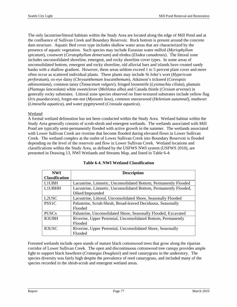
Seattle City Light Mill Pond Removal and Restoration
Report Page 77 March 2010
The only lacustrine/littoral habitats within the Study Area are located along the edge of Mill Pond and at the confluence of Sullivan Creek and Boundary Reservoir. Rock bottom is present around the concrete dam structure. Aquatic Bed cover type includes shallow water areas that are characterized by the presence of aquatic vegetation. Such species may include Eurasian water milfoil (Myriophyllum spicatum), coonwort (Ceratophyllum demersum) and elodea (Elodea canadensis). The littoral zone includes unconsolidated shoreline, emergent, and rocky shoreline cover types. In some areas of unconsolidated bottom, emergent and rocky shoreline, old alluvial bars and islands have created sandy banks with a shallow gradient. However, these areas seldom exceed 1 to 5 percent plant cover and more often occur as scattered individual plants. These plants may include St John’s wort (Hypericum perforatum), ox-eye daisy (Chrysanthemum leucanthemum), Atkinson’s tickseed (Coreopsis atkinsoniana), common tansy (Tanacetum vulgare), fringed loosestrife (Lysimachia ciliata), plantain (Plantago lanceolata) white sweetclover (Melilotus alba) and Canada thistle (Cirsium arvense) in generally rocky substrates. Littoral zone species observed on finer-textured substrates include yellow flag (Iris psuedacoras), forget-me-not (Myosotis laxa), common sneezeweed (Helenium autumnal), mudwort (Limosella aquatica), and water pygmyweed (Crassula aquatica).
A formal wetland delineation has not been conducted within the Study Area. Wetland habitat within the Study Area generally consists of scrub-shrub and emergent wetlands. The wetlands associated with Mill Pond are typically semi-permanently flooded with active growth in the summer. The wetlands associated with Lower Sullivan Creek are riverine that become flooded during elevated flows in Lower Sullivan Creek. The wetland complex at the outlet of Lower Sullivan Creek into Boundary Reservoir is flooded depending on the level of the reservoir and flow in Lower Sullivan Creek. Wetland locations and classifications within the Study Area, as defined by the USFWS NWI system (USFWS 2010), are presented in Drawing 13, NWI Wetlands and Streams Map, and listed in Table 6-4:
Wetland
Table 6-4. NWI Wetland Classification
NWI
Classification Description
L1UBH Lacustrine, Limnetic, Unconsolidated Bottom, Permanently Flooded L1UBHH Lacustrine, Limnetic, Unconsolidated Bottom, Permanently Flooded,
Diked/Impounded L2USC Lacustrine, Littoral, Unconsolidated Shore, Seasonally Flooded PSS1C Palustrine, Scrub-Shrub, Broad-leaved Deciduous, Seasonally
Flooded PUSCx Palustrine, Unconsolidated Shore, Seasonally Flooded, Excavated R3UBH Riverine, Upper Perennial, Unconsolidated Bottom, Permanently
Flooded R3USC Riverine, Upper Perennial, Unconsolidated Shore, Seasonally
Flooded Forested wetlands include open stands of mature black cottonwood trees that grow along the riparian corridor of Lower Sullivan Creek. The open and discontinuous cottonwood tree canopy provides ample light to support black hawthorn (Crataegus Douglasii) and reed canarygrass in the understory. The species diversity was fairly high despite the prevalence of reed canarygrass, and included many of the species recorded in the shrub-scrub and emergent wetland areas.
Seattle City Light Mill Pond Removal and Restoration
Report Page 78 March 2010
Scrub-shrub wetlands within the Study Area contained scrub-shrub vegetation dominated almost exclusively by sitka alder (Alnus sitchensis). The more diverse scrub-shrub wetlands support a wider variety of shrub species include red-osier dogwood (Cornus sericeus), common snowberry (Symphoricarpos albus), buffaloberry (Shepherdia canadensis) and mock orange. Emergent wetlands typically have greater than 75 percent vegetation cover. Species associated with emergent wetlands include self heal (Prunella vulgaris), purple meadowrue (Thalictrum dasycarpum), hairy sedge (Carex lanuginosa), reed canarygrass (Phalaris arundinacea), colonial bentgrass, common dogbane (Apocynum cannabinum), and various species of aster (Aster spp.). Dense patches of reed canarygrass are present in many of the wetland areas and have stifled native emergent and shrub species.
Both Sullivan Lake Dam and Mill Pond Dam affect riparian species connectivity and contribute to habitat fragmentation within Sullivan Creek. Sullivan Creek is the largest tributary stream to Boundary Reservoir with extensive stands of riparian vegetation and alluvial features. The species compositions of riparian grass, riparian shrub, and riparian deciduous tree cover types are nearly identical to emergent, scrub-shrub, and forested wetland cover types (SCL 2006).
Riverine/Riparian
The town of Metaline Falls, Sullivan Lake Road, the Mill Pond Dam historic site and Mill Pond campground are considered disturbed and/or developed sites. These sites have been cleared of native vegetation and roads and structures have been developed. There is no vegetation growing within the disturbed portions of these sites.
Disturbed/Developed
The Vegetation Cover Type map in the Pend Oreille County PUD Exhibit E (Pend Oreille County PUD 1994a) describes the location of cover types within the area examined. However, the vegetation cover types are generally separated into three types: (1) agriculture, (2) various succession stages of forest and (3) wetlands. These areas are very broad and a review of current aerial imagery suggests that these cover types inside of the Study Area may no longer be accurate due to changes in land management and flow regimes in Sullivan Creek. Therefore, the Pend Oreille County PUD 1994a map was not used in the cover type analysis presented in this section. 6.3.1.1.2 Rare, Threatened, and Endangered Plant Species RTE species include all taxa with federal or state protective status. Specifically, this section discusses species that are included in any one of the following groups:
• Federal Species – Plant species listed by the USFWS. o Listed or Proposed Species - Species that are listed and protected under the ESA of 1973,
as Endangered or Threatened, or proposed for listing. o Candidates - Species for which the USFWS has sufficient information on their biological
status and threats to propose them as endangered or threatened under the ESA, but for which development of a proposed listing regulation has not occurred because of other higher priority listing activities. Candidate species receive no statutory protection under the ESA. However, the USFWS encourages the formation of partnerships to conserve these species.
o Species of Concern - Species that do not have protection under the ESA but that are of management concern to the federal land managers.
• State Species - Species listed by the DNR WNHP on an advisory basis. o Endangered - Any taxon in danger of becoming extinct or extirpated from Washington
within the foreseeable future if factors contributing to its decline continue. Populations
Seattle City Light Mill Pond Removal and Restoration
Report Page 79 March 2010
of these taxa are at critically low levels or their habitats have been degraded or depleted to a significant degree.
o Threatened - Any taxon likely to become endangered in Washington within the foreseeable future if factors contributing to its population decline or habitat degradation or loss continue.
o Sensitive - Any taxon that is vulnerable or declining and could become endangered or threatened in the state without active management or removal of threats.
o Possibly Extinct or Extirpated - Based on recent field searches, a number of plant taxa are considered to be possibly extinct or extirpated from Washington.
o Review Group 1 - Taxon in need of additional field work before a status can be assigned. o Review Group 1 - Taxon with unresolved taxonomic questions. o Watch - Plant taxon that is more abundant and/or less threatened in Washington than
previously assumed. o Priority - At this time, there is insufficient information to assign a statewide status to the
non-vascular plant taxa. • USFS Species - Species on the Regional Forester Sensitive Status Species (RFSSS) list for the
CNF (USFS 2008). Species on this list are listed only as Sensitive. The RFSSS list does not include species already protected under the ESA.
The botanical studies conducted by Pend Oreille PUD (1994a) did not identify any RTE species within the Study Area. However, the botanical study conducted by Tetra Tech and Beck Botanical Services (2009b) identified the presence of two RTE species within the Study Area near the outlet of Sullivan Creek into Boundary Reservoir. These two species are yellow mountain avens (Dryas drummondii) and purple meadowrue (Thalictrum dasycarpum). All of the information documented in this section is compiled from exiting studies and lists within the vicinity of the Study Area. No federally (USFWS) listed threatened or endangered plant species were identified in Pend Oreille County during the document review. Table 6-5 identifies the plant species on the USFWS Pend Oreille County list (USFWS 2009), the DNR WNHP list (DNR 2009) and the USFS RFSSS list for the CNF (USFS 2008).

Seattle City Light Mill Pond Removal and Restoration
Report Page 80 March 2010
Table 6-5. RTE Plant List
Common Name Scientific Name CNF Status1
USFWS Status2
WNHP Status3
Phenology Habitats
Vascular Plants Adder’s-tongue Ophioglossum
pusillum S - T June-September Moist meadows, pastures, old fields, roadside ditches, and floodplain woods in seasonally wet, rather acid soil. 40 to 3,200 ft.
Beaked sedge Carex rostrata S - S July-August Bogs and fens. 4,600 to 5,000 ft. Black snake-root Sanicula
marilandica S - S June-Mid August Moist lowgrounds such as meadows, riparian floodplains, moist woods and marsh edges. 1,500 to 2,900 ft.
Blue-eyed grass Sisyrinchium septentrionale S - S May-Mid July Dry to moist meadows, perennial streams. 2,200-3,850 ft.
Bog clubmoss Lycopodiella inundata S - S Year Round Mostly in sphagnum bogs, seldom in other very wet places. 1,800 ft.
Bristly sedge Carex comosa S - S May-July Marshes, lake margins, drainage ditches, wet meadows, 30 to 2,000 ft. Bulb-bearing water-hemlock Cicuta bulbifera S - S August-September Marshes, bogs, wet meadows, edge of ponds, shores of beaver ponds, shallow
standing water, 2200-3720 ft. Common twinpod Physaria
didymocarpa var. didymocarpa
S - S June-August A variety of habitats, including river gravel bars, steep shale outcrops, rocky flats, gravelly prairies, talus slopes, dry hillsides, and road cuts. 2,000 ft.
Creeping snowberry Gaultheria hispidula S - S May-June Sphagnum wetlands. Moist areas in coniferous woods, 2960 to 3360 ft. Crenulate moonwort Botrychium
crenulatum S SoC S May-September Western redcedar-western hemlock forests, streambanks, floodplains, 2,030 to 4,600 ft.
Crested shield-fern Dryopteris cristata S - S June-September Wet meadows, forested wetlands. Often found on hummocks, downed woody debris or at the base of deciduous shrubs, often with alder. 2,100 to 4,100 ft.
Flat-leaved bladderwort Utricularia intermedia S - S July-August Shallow ponds, slow-moving streams, and wet sedge or rush meadows. 4,000 ft.
Green keeled cotton-grass Eriophorum viridicarinatum S - S June-July Fens and marshes, 2,900 to 4,650 ft.
Hairlike sedge Carex capillaris S - T June-August Streambanks, wet meadows, wet ledges, marshy lake shores. 2,800 to 6,500 ft. Hoary willow Salix candida S - T May-June Fens, 2,400 to 3,000 ft. Idaho gooseberry Ribes
oxyacanthoides ssp. irriguum
S - T May-July Streams, meadows openings associated with streams, slopes of moist to dry canyons. 3,000 to 5,000 ft.
Kidney-leaved violet Viola renifolia S - S May-July Moist lowland forests. 2,270 to 4,355 ft. Least bladdery milk-vetch Astragulus
microcystis S - S Late April-August Open woodlands near shorelines, riverbanks, floodplains,1,900 to 2,100 ft.
Lesser bladderwort Utricularia minor S - R1 June-August Shallow, standing or slow-moving water. 135 to 4,000 ft. Lowland toothcup Rotala ramosior S - T June-August Riparian wetlands growing below the high water level, pond and lake edges. 200 to
2,259 ft. MacCall’s willow Salix maccalliana S - S May-June Fens, 2,400 to 3,000 ft. Many-head sedge Carex
sychnocephala S - S July-August Moist or wet ground adjacent to marshes or along lake shores. Substrates vary from rather rocky to sandy and silty soils. 1,000 to 3,000 ft.

Seattle City Light Mill Pond Removal and Restoration
Report Page 81 March 2010
Common Name Scientific Name CNF Status1
USFWS Status2
WNHP Status3
Phenology Habitats
Marsh muhly Muhlenbergia glomerata S - S July-August Bogs, fens, streambanks, wet meadows, marshes, lake and pond margins. 2,950 to
3,380 ft. Meadow pussy-toes Antennaria
corymbosa S - T June-August Bogs. 5,000 ft.
Northern golden-carpet Chrysosplenium tetrandrum S - S May-July Perennial and intermittent streams, seeps in rock outcrops. 2,000 to 4,000 ft.
Nuttal’s pussy-toes Antennaria parvifolia S - S May-July Dry, open places, on sandy or gravelly riverbanks, openings of ponderosa pine forests
1,900 to 2,600 ft. Poor sedge Carex magellanica
ssp. irrigua S - S June-August Sphagnum bogs; cf. Carex limosa.
Prairie cordgrass Spartina pectinata S - S June-July Wet areas such as swales edges of marshes and ponds, and along streams and riverbanks, in both fresh and saltwater. 2,000 ft.
Purple meadowrue Thalictrum dasycarpum S - - June-August Deciduous riparian woods, damp thickets, swamps, wet meadows, often adjacent to
and/or within the flood plain. 200 to 2,200 ft. Quill sedge Carex tenera var.
tenera S - T June-August Dry to moist, open forests and meadows.
Sandberg desert parsley Lomatium sandbergii S - T May-July Open, rocky places at moderate to higher, subalpine habitats. 6,400 ft.
Slender moonwort Botrychium lineare S - T June Western redcedar-western hemlock forests, streambanks, floodplains, 2,000 to 4,000 ft.
Small northern bog-orchid Planthera obtusata S - S June-July Damp or wet places in forests, marshes, bogs, meadows, and along streambanks. Areas with Engelmann spruce and/or western red-cedar. 800 to 5,000 ft.
Smokey mountain sedge Carex proposita S - T July-August Open, rocky slopes and ridges, often on talus or granite substrate, near or above timberline, 6,000 to 7,700 ft.
Stalked moonwort Botrychium pedunculosum S SoC T May-August Dry to moist meadows, perennial streams, 2,500 to 3,300 ft.
Stellar’s rockbrake Cryptogramma stelleri S - S June-August Cliffs, 3,000-6,000 ft.
Strict blue-eyed grass Sisyrinchium montanum S - T May Steep west-facing slopes associated with small seeps/springs; elev. 700 ft.
Treelike clubmoss Lycopodium dendroideum S - S June-July Rock outcrops, talus or boulder fields, significant moss & organic debris. Between a
meadow or wetland and adjacent forest; near base of large boulders. 800 to 3,600 ft. Triangular-lobed moonwort Botrychium
ascendens S SoC S June-July Dry meadows, 3,000 to 3,400 ft.
Twin-spiked moonwort Botrychium paradoxum S SoC T May-September Dry meadows, perennial and intermittent streams, 2,500 to3,600 ft.
Velvet-leaf blueberry Vaccinium myrtilloides S - S May-August Western redcedar-western hemlock forests, 2,000 to 3,000 ft.
Water avens Geum rivale S - S June-July Wet meadows, fens, bogs, perennial streams and shrub wetlands, 2,500-6,400 ft. Western moonwort Botrychium
hesperium S - T Late May-Early June
Dry to moist meadows, 3,200 to 3,300 ft.
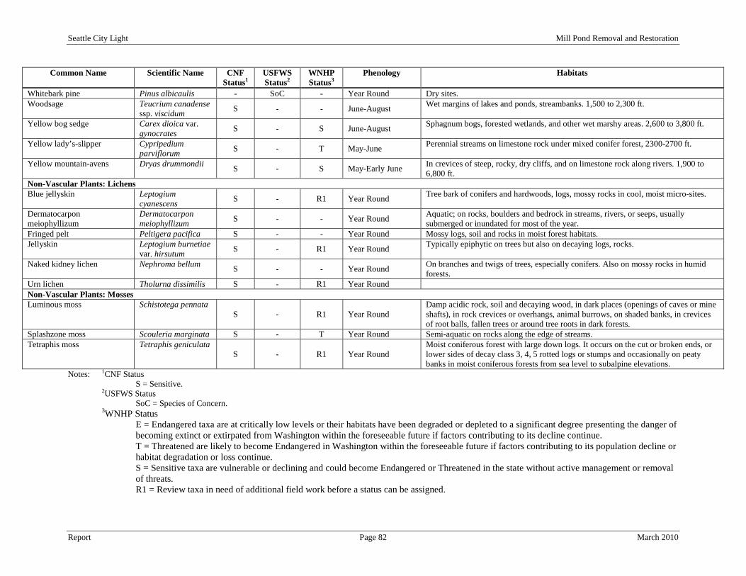
Seattle City Light Mill Pond Removal and Restoration
Report Page 82 March 2010
Common Name Scientific Name CNF Status1
USFWS Status2
WNHP Status3
Phenology Habitats
Whitebark pine Pinus albicaulis - SoC - Year Round Dry sites. Woodsage Teucrium canadense
ssp. viscidum S - - June-August Wet margins of lakes and ponds, streambanks. 1,500 to 2,300 ft.
Yellow bog sedge Carex dioica var. gynocrates S - S June-August Sphagnum bogs, forested wetlands, and other wet marshy areas. 2,600 to 3,800 ft.
Yellow lady’s-slipper Cypripedium parviflorum S - T May-June Perennial streams on limestone rock under mixed conifer forest, 2300-2700 ft.
Yellow mountain-avens Dryas drummondii S - S May-Early June In crevices of steep, rocky, dry cliffs, and on limestone rock along rivers. 1,900 to 6,800 ft.
Non-Vascular Plants: Lichens Blue jellyskin Leptogium
cyanescens S - R1 Year Round Tree bark of conifers and hardwoods, logs, mossy rocks in cool, moist micro-sites.
Dermatocarpon meiophyllizum
Dermatocarpon meiophyllizum S - - Year Round Aquatic; on rocks, boulders and bedrock in streams, rivers, or seeps, usually
submerged or inundated for most of the year. Fringed pelt Peltigera pacifica S - - Year Round Mossy logs, soil and rocks in moist forest habitats. Jellyskin Leptogium burnetiae
var. hirsutum S - R1 Year Round Typically epiphytic on trees but also on decaying logs, rocks.
Naked kidney lichen Nephroma bellum S - - Year Round On branches and twigs of trees, especially conifers. Also on mossy rocks in humid forests.
Urn lichen Tholurna dissimilis S - R1 Year Round Non-Vascular Plants: Mosses Luminous moss Schistotega pennata
S - R1 Year Round Damp acidic rock, soil and decaying wood, in dark places (openings of caves or mine shafts), in rock crevices or overhangs, animal burrows, on shaded banks, in crevices of root balls, fallen trees or around tree roots in dark forests.
Splashzone moss Scouleria marginata S - T Year Round Semi-aquatic on rocks along the edge of streams. Tetraphis moss Tetraphis geniculata
S - R1 Year Round Moist coniferous forest with large down logs. It occurs on the cut or broken ends, or lower sides of decay class 3, 4, 5 rotted logs or stumps and occasionally on peaty banks in moist coniferous forests from sea level to subalpine elevations.
Notes: 1CNF Status S = Sensitive.
2USFWS Status SoC = Species of Concern.
3WNHP Status E = Endangered taxa are at critically low levels or their habitats have been degraded or depleted to a significant degree presenting the danger of becoming extinct or extirpated from Washington within the foreseeable future if factors contributing to its decline continue. T = Threatened are likely to become Endangered in Washington within the foreseeable future if factors contributing to its population decline or habitat degradation or loss continue. S = Sensitive taxa are vulnerable or declining and could become Endangered or Threatened in the state without active management or removal of threats. R1 = Review taxa in need of additional field work before a status can be assigned.
Seattle City Light Mill Pond Removal and Restoration
Report Page 83 March 2010
6.3.1.1.3 Commercial, Recreational or Cultural Value of Plant Species During the relicensing process for SCL’s Boundary Dam, Native American tribes were contacted by SCL that may have potential interests in the relicensing of the Boundary Dam Project. The purpose of the communications was to notify the tribes about the process and timing of the relicensing and to request input from the tribes to identify any related issues that may affect tribal resources. SCL identified the potential for Culturally Sensitive Plant Species to occur in the Boundary Dam Project vicinity as a potential tribal resource issue. No formal list of such species has been obtained from the tribes. However, a list of Culturally Significant Plant Species was developed as part of the cultural resource studies conducted for the Pend Oreille County PUD’s relicensing of the Box Canyon Hydroelectric Project (Fandrich et al. 2000; FERC 2004). The list includes 175 plant taxa known to be used by tribes in northeastern Washington (for list, see Fandrich et al. 2000). Since a comprehensive plant study has not been completed on the Study Area, a comparison of this Culturally Significant Plant Species list was not performed for this environmental analysis. There was no comprehensive plant species list associated with the Pend Oreille County PUD Exhibit E document (1994) so a comparative analysis was not able to be performed. Furthermore, the comprehensive plant species list in the Tetra Tech and Beck Botanical Services document (2009b) did not identify the specific area that plants were located in; and therefore, it could not be determined which culturally sensitive plant species were physically located in the Study Area. Commercially important plants in the Study Area include all of the conifer species, with the exception of lodgepole pine, which are harvested for timber. Large western red-cedar, Douglas-fir, and ponderosa pine trees are particularly valuable timber species. There are no plants with particular recreational value, although trees are important for providing shade and cover at recreation facilities and shrubs, grasses, and forbs prevent erosion and contribute to site aesthetics. 6.3.1.1.4 Noxious Weeds and Invasive Plant Species Noxious weeds are non-native plants introduced into an area. They spread quickly and can be difficult to control. They invade croplands, rangeland, forests, prairies, rivers, lakes and wetlands causing both ecological and economical damage. Pend Oreille County has developed a list of noxious weeds and invasive plant species that occur in the entire county (Pend Oreille County 2009a) that is based off of the Washington State Noxious Weed List (Washington State Noxious Weed Control Board 2009). Neither of the two previous botanical studies (Pend Oreille County PUD 1994a; Tetra Tech and Beck Botanical Services 2009a and 2009b) had performed noxious weeds inventories within the Study Area; however, Table 6-6 identifies the noxious weeds that are present in the county and may potentially be present within the Study Area. The Washington State Noxious Weed Control Board has divided noxious weeds into the following four classes:
• Class A
•
: noxious weeds that occur at a limited distribution of sites within Pend Oreille County and are considered a serious threat to that specific area. Class B-designate
•
: noxious weeds that occur at a limited distribution of sites within Pend Oreille County and are considered a serious threat to the region. Class B
•
: noxious weeds that are mostly common in the region and Pend Oreille County has an overall goal of containment and reducing the negative impact to acceptable or below threshold levels. Class C
: noxious weeds that are mostly common and Pend Oreille County has an overall goal of containment and reducing the negative impact to acceptable or below threshold levels.

Seattle City Light Mill Pond Removal and Restoration
Report Page 84 March 2010
Table 6-6. Pend Oreille County Noxious Weeds
Common Name Scientific Name Toxicity Class A Bighead knapweed Centaurea macrocephala No Buffalobur Solanum rostratum Yes – cattle, sheep and horses Clary sage Salvia sclarea No Vochin knapweed Centaurea nigrescens No Class B-designate Annual bugloss Anchusa arvensis No Butterfly bush Buddleja davidii No Common bugloss Anchusa officianalis No Common catsear Hypochaeris radicata Yes – horses Common reed Phragmites australis No Eurasian watermilfoil (lakes) Myriophyllum spicatum No Giant, japanese & bohemian knotweeds
Polygonum sachalinense, P. cuspidatum & P. bohemicum No
Herb robert Geranium robertianum No Kochia Kochia scoparia Yes – nitrate concentrator Leafy spurge Euphorbia esula Yes – dermal Leprodiclis Lepyrodiclis holosteoides No Meadow knapweed Centaurea jacea x nigra No Musk thistle Carduus nutan No Perennial pepperweed Lepidium latifolium No Plumeless thistle Carduus acanthoides No Policeman’s helmet Impatiens glandulifera No Purple & wand loosestrife Lythrum salicaria, L. virgatum No Rush skeletonweed Chondrilla juncea No Saltcedar Tamarix ramossisma No Scotch broom Cytisus scoparius No Scotch thistle Onopordum acanthium No Spurge laurel Daphne laureola No Tansy ragwort Senecio jacobaea Yes – destroys liver Viper's bugloss Echium vulgare No Yellow starthistle Centaurea solstitialis Yes – horses Class B Dalmatian toadflax Linaria dalmatica ssp. dalmatica No Diffuse & spotted knapweed Centaurea diffusa,C. biebersteinii No Eurasian watermilfoil Myriophyllum spicatum No Hoary alyssum Bertero incana No Houndstongue Cynoglossum officianale Yes – liver toxin Meadow, orange & queen-devil Hieracium caespitosum, H. aurantiacum Yes – dermal Hawkweeds h. glomeratum Yes – dermal Oxeye daisy Leucanthemum vulgare No Sulfur cinquefoil Potentilla recta No Wild carrot (queen anne's lace) Daucus carota No Class C Babysbreath Gypsophila paniculata No Black henbane (shoofly) Hyoscyamus niger Yes – neural
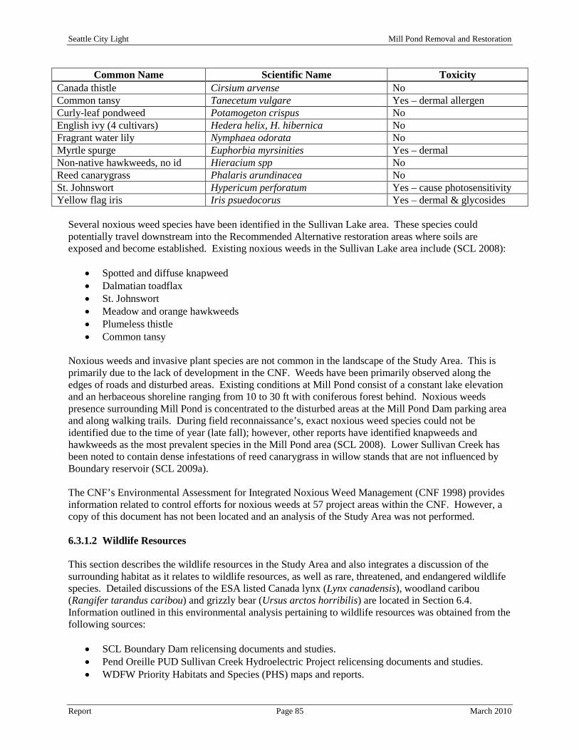
Seattle City Light Mill Pond Removal and Restoration
Report Page 85 March 2010
Common Name Scientific Name Toxicity Canada thistle Cirsium arvense No Common tansy Tanecetum vulgare Yes – dermal allergen Curly-leaf pondweed Potamogeton crispus No English ivy (4 cultivars) Hedera helix, H. hibernica No Fragrant water lily Nymphaea odorata No Myrtle spurge Euphorbia myrsinities Yes – dermal Non-native hawkweeds, no id Hieracium spp No Reed canarygrass Phalaris arundinacea No St. Johnswort Hypericum perforatum Yes – cause photosensitivity Yellow flag iris Iris psuedocorus Yes – dermal & glycosides
Several noxious weed species have been identified in the Sullivan Lake area. These species could potentially travel downstream into the Recommended Alternative restoration areas where soils are exposed and become established. Existing noxious weeds in the Sullivan Lake area include (SCL 2008):
• Spotted and diffuse knapweed • Dalmatian toadflax • St. Johnswort • Meadow and orange hawkweeds • Plumeless thistle • Common tansy
Noxious weeds and invasive plant species are not common in the landscape of the Study Area. This is primarily due to the lack of development in the CNF. Weeds have been primarily observed along the edges of roads and disturbed areas. Existing conditions at Mill Pond consist of a constant lake elevation and an herbaceous shoreline ranging from 10 to 30 ft with coniferous forest behind. Noxious weeds presence surrounding Mill Pond is concentrated to the disturbed areas at the Mill Pond Dam parking area and along walking trails. During field reconnaissance’s, exact noxious weed species could not be identified due to the time of year (late fall); however, other reports have identified knapweeds and hawkweeds as the most prevalent species in the Mill Pond area (SCL 2008). Lower Sullivan Creek has been noted to contain dense infestations of reed canarygrass in willow stands that are not influenced by Boundary reservoir (SCL 2009a). The CNF’s Environmental Assessment for Integrated Noxious Weed Management (CNF 1998) provides information related to control efforts for noxious weeds at 57 project areas within the CNF. However, a copy of this document has not been located and an analysis of the Study Area was not performed. 6.3.1.2 Wildlife Resources This section describes the wildlife resources in the Study Area and also integrates a discussion of the surrounding habitat as it relates to wildlife resources, as well as rare, threatened, and endangered wildlife species. Detailed discussions of the ESA listed Canada lynx (Lynx canadensis), woodland caribou (Rangifer tarandus caribou) and grizzly bear (Ursus arctos horribilis) are located in Section 6.4. Information outlined in this environmental analysis pertaining to wildlife resources was obtained from the following sources:
• SCL Boundary Dam relicensing documents and studies. • Pend Oreille PUD Sullivan Creek Hydroelectric Project relicensing documents and studies. • WDFW Priority Habitats and Species (PHS) maps and reports.
Seattle City Light Mill Pond Removal and Restoration
Report Page 86 March 2010
• CNF documents and data for the Sullivan Lake Ranger District. • 2009 Aerial Photographs. • Field reconnaissance’s to the Study Area.
The following list indentifies the wildlife studies that have been performed to date and the portions of the Study Area in which each study was performed:
• Boundary Hydroelectric Project Study 15 Waterfowl/Waterbird Study (Tetra Tech 2009d) at the confluence of Sullivan Creek and Boundary Reservoir.
• Boundary Hydroelectric Project Study 18 Rare, Threatened, and Endangered (RTE) Wildlife Species Study (Tetra Tech 2009e) at the confluence of Sullivan Creek and Boundary Reservoir.
• Boundary Hydroelectric Project Study 19 Big Game Study (Tetra Tech 2009f) at the confluence of Sullivan Creek and Boundary Reservoir.
• Boundary Hydroelectric Project Study 20 Bat Surveys and Habitat Inventory (Tetra Tech 2009g) at the confluence of Sullivan Creek and Boundary Reservoir.
• Pend Oreille County PUD Sullivan Creek Project Exhibit E – Wildlife and Botanical Resources (Pend Oreille County PUD 1994a) for the entire Study Area.
• Pend Oreille County PUD Sullivan Creek Hydroelectric Project Response to FERC’s Additional Information Request (Pend Oreille County PUD 1996) for the entire Study Area.
6.3.1.2.1 Wildlife Habitat Mill Pond and Lower Sullivan Creek are located within the eastern portion of the Okanogan Highlands physiographic province, which is characterized by moderate slopes and broad, rounded mountain summits (Franklin and Dyrness 1988, as cited by SCL 2006). Vegetation in the region is categorized as Interior Douglas-fir, western red cedar, and western hemlock forest (Cassidy 1997, as cited by SCL 2006). The combination of geographical location and diverse mixture of vegetation communities results in high wildlife species richness, particularly for mammals and birds (Cassidy et al. 1997, as cited by SCL 2006). The northeastern corner of Washington is unique because it encompasses the edges of several species’ ranges, and thus supports a number of species more commonly found in areas farther north and nearer to the coast, including several that occur nowhere else in the state. The following sections describe information on mammals, birds, reptiles and amphibians listed to occur with Pend Oreille County, the CNF or within the vicinity of the Study Area. 6.3.1.2.2 Mammals The Study Area and surrounding environment provides both summer and winter habitats for big game. Potential calving/fawning sites exist within the vicinity of the Study Area; in particular, along Outlet and Sullivan Creeks and their associated wetlands (SCL 2008). Numerous mammals use the Study Area and surrounding environment for habitat during certain times of the year. Mule deer (Odocoileus hemionus) and white-tailed deer (Odocoileus virginia) are the main ungulate species within the vicinity of the Study Area and elk (Cervus elaphus) and moose (Alces alces) are less abundant. Mountain goats (Oreamnos americanus) (introduced), woodland caribou (Rangifer tarandus caribou), and bighorn sheep (Ovis canadensis) (introduced), occur in the general region and may occasionally migrate within the vicinity of the project (USFS unpublished data, as cited by SCL 2006). Other large mammals that use habitats in the Study Area vicinity include the black bear (Ursis americanus) and cougar (Felis concolor), although there is no readily available information on local populations of these two species (SCL 2006).

Seattle City Light Mill Pond Removal and Restoration
Report Page 87 March 2010
Although both mule deer and white-tailed deer occur in the Project vicinity, Pend Oreille County is most known for its white-tailed deer population (USFS 1988, as cited by SCL 2006). The larger population of white-tailed deer is due to the presence of dense forests and steep hills and mountains. Deer population densities in Pend Oreille County are estimated to be 4.1 to 4.9 deer per square mile (SCL 2006). Deer populations in the region peaked during the two decades following large wildfires that occurred in the 1920s and 1930s, which created an abundance of browse in regenerating forests (USFS 1988, as cited SCL 2006). Deer live near Mill Pond and Lower Sullivan Creek year-round as evidenced from scat and tracks in the Study Area. Additional deer migrate into the area from higher elevations during the winter months to forage and find cover. Further discussion of deer is located in Section 6.3.1.2.5.
Deer
During most of the year, elk are dispersed throughout the region, but in the winter they tend to concentrate at lower elevations in the Pend Oreille River Valley. The CNF manages areas east of the Pend Oreille River for elk (USFS 1988, as cited by SCL 2009a). A significant portion of the land east of Boundary Reservoir and south of Metaline Falls, including portions of the Study Area, is managed for elk winter range, mostly at lower elevations in USFS Management Areas 6 and 8 (USFS 1988, as cited by SCL 2009a). The Selkirk elk herd (about 1,450 individuals) occupies lands east of the Pend Oreille River, with some members of the herd commonly found in the vicinity of Boundary Reservoir (SCL 2009aa, as cited by SCL 2009a). Because the Selkirk herd has expanded its range without any corresponding population increase (Big Game Study Final Report, SCL 2009aa, as cited by SCL 2009a), it is hypothesized that winter range may be limiting the size of the elk population. Much of the terrain adjacent to the lower reservoir is steep and does not represent high quality elk habitat. This steep terrain forces big game to follow topographic features, such as drainages, to access the reservoir. The WDFW PHS data (2009a) has identified a regular concentration of elk to inhabit forest in the Study Area and the location of this home range is presented on Drawing 14, Rare, Threatened and Endangered Species Map. Further discussion of elk is located in Section 6.3.1.2.5.
Elk
A small introduced population of mountain goats is known to occur on the west side of Boundary Reservoir. Only rare sightings of this herd have been documented and there has been no documentation of mountain goats on the east side of the reservoir in the vicinity of the Study Area (SCL 2006 and 2009a).
Mountain Goat
Bighorn sheep form a small population (reported to be 29 animals in 2003 [WDFW 2003], as cited by SCL 2006) that occurs primarily on Hall Mountain east of Sullivan Lake. Bighorn sheep have been observed (undocumented) in the Lower Sullivan Creek area near Mill Pond during field reconnaissance’s in the fall of 2009. However, this area is not a regularly used part of the population’s home range.
Bighorn Sheep
Moose are less common than deer and elk within the vicinity of the Study Area but are frequently observed and are thought to be increasing in local abundance (Big Game Study Final Report, SCL 2009aa, as cited by SCL 2009a). Moose typically utilize conifer forests, clearcuts, stream bottoms, lakes, and wetlands with aquatic and shrub vegetation for habitat (Johnson and Cassidy 1997; personal communication, M. Borysewicz, Wildlife Biologist, CNF Sullivan Lake Ranger District, April 12, 2005, as cited by SCL 2006).
Moose
Seattle City Light Mill Pond Removal and Restoration
Report Page 88 March 2010
Mountain lions, bobcats (Felix rufus), and black bears are common carnivores that may occur within the vicinity of the Study Area. Recent information from WDFW for five Washington counties (Chelan, Okanogan, Ferry, Stevens, and Pend Oreille) indicates that mountain lion populations in these counties have been reduced substantially as a result of hound hunting and that populations are now relatively low (WDFW 2008a, as cited by SCL 2009a). The gray wolf (Canis lupus) has recently been delisted from the ESA and populations in northeastern Washington and northern Idaho have begun to increase. Observations of wolves in Pend Oreille County that are part of the Diamond Pack have been increasing in the past several years and the DNR confirmed the presence of a pack of pups in July 2009 in Pend Oreille County (WDFW 2009c). This increase in gray wolf population may lead to an increase in wolf presence within the vicinity of the Study Area. Further discussion of black bears and cougars are located in Section 6.3.1.2.5 and further discussion of the gray wolf is located in Section 6.3.1.2.6.
Carnivores
Aquatic furbearers that use Mill Pond and Lower Sullivan Creek include beaver (Castor canadensis), muskrat (Ondatra zibethicus), river otter (Lutra canadensis), mink (Mustela vison), short-tailed weasel (Mustela erminea) and fisher (Martes pennanti). Beaver dens, trails and cuttings were observed in Mill Pond and associated wetlands. Riparian deciduous forest and shrublands that support willow (Salix spp.), quaking aspen, red-osier dogwood, sitka alder, and paper birch provide important beaver foraging habitat. Muskrats have also been observed in Mill Pond while swimming into a den near the dam. Fishers have been identified in the WDFW PHS database in the vicinity of the Study Area near the confluence of Outlet Creek and Upper Sullivan Creek (Drawing 14, Rare, Threatened and Endangered Species Map) and also to the west of Sullivan Lake. Further discussion of the fisher is described in Section 6.3.1.2.6.
Aquatic Furbearers
Small mammal trapping (September 2005) in the vicinity of Boundary Reservoir resulted in the capture of short-tailed weasels, vagrant shrews (Sorex vagrans), a red-backed vole (Clethrionomys gapperi), a bushy-tailed woodrat (Neotoma cinerea), and deer mice (Peromyscus maniculatus) (SCL 2006). The short-tailed weasel, red-backed vole, vagrant shrew, and deer mice were captured in young mixed conifer habitat; the vagrant shrew and deer mice were also found in riparian deciduous habitat, along with the bushy-tailed woodrat. Yellow pine chipmunks (Tamias amoenus), red-squirrels (Tamiasciurus hudsonicus), yellow-bellied marmots (Marmota flaviventris), mountain cottontails (Sylvilagus nuttallii), and Columbian ground squirrels (Spermophilus columbianus) have also been observed in the vicinity of Boundary Reservoir. These small and medium mammal species typically occupy conifer forests and are anticipated to occur within the vicinity of Mill Pond and Lower Sullivan Creek.
Small and Medium Mammals
Bats are commonly observed in the vicinity of Boundary Reservoir, likely due to the presence of extensive mines, mine adits, suitable forest habitat, natural caves, and large area of foraging habitat over the reservoir (Bat Study Final Report, SCL 2009aa, as cited by SCL 2009a). Six species of bats potentially occur in the vicinity Boundary Reservoir (SCL 2006). Of these, the Townsend’s big-eared bat (Corynorhinus townsendii townsendii) and big brown bat (Eptesicus fuscus) have been confirmed by USFS biologists in caves and mines on the Sullivan Lake Ranger District, within approximately five miles from Boundary Reservoir (SCL 2006). One occurrence of the Townsend’s big-eared bat has been documented by the WDFW PHS database to occur on the northern side of Sullivan Lake near the campgrounds. Further discussion of RTE bats is located in Section 6.3.1.2.6. 6.3.1.2.3 Birds Mill Pond and Lower Sullivan Creek offer a variety of habitat for various birds to use during certain times of the year. The open water component of Mill Pond attracts water and shoreline dependent birds while

Seattle City Light Mill Pond Removal and Restoration
Report Page 89 March 2010
the surrounding wetlands and forests attract raptors, songbirds and passerines. The following section discusses the different types of birds that may be present within the Study Area.
Waterfowl (ducks, geese, swans) and waterbirds (loons, grebes, coots, and cormorants) may occur within the vicinity of the Study Area based on the presence of open water at Mill Pond and wetland complex at the outlet of Sullivan Creek into Boundary Reservoir. Canada geese (Branta canadensis), mallards (Anas platyrhynchos), common mergansers (Mergus merganser), and a swan (Cygnus ssp.) were observed at Mill Pond during a fall 2009 field reconnaissance. These species were most likely resident waterfowl and waterbirds that travel between Mill Pond, Sullivan Lake and Boundary Reservoir. Harlequin ducks (Histrionicus histrionicus) nest on the banks of swift moving mountain streams and dive into the water to forage on macro-invertebrates on the stream bottom. Harlequin ducks have been noted to nest on Harvey and Sullivan Creeks above Mill Pond (Pend Oreille County PUD 1994a; SCL 2008). Further discussion of the Harlequin duck is located in Section 6.3.1.2.6.
Waterfowl, Waterbirds, and Wading Birds
Mill Pond tends to support a greater diversity of species and produce more broods than Sullivan Lake. This is primarily because Mill Pond has comparatively greater amounts of aquatic and emergent vegetation, stable shallow water areas, and areas of dense cover along its shoreline. The outlet of Sullivan Creek into Boundary Reservoir supports aquatic plant species such as Nuttall’s waterweed that provide a stable food source for waterfowl and water birds (SCL 2006). Numerous waterfowl species were observed in this area including the American coot (Fulica americana), Canada goose, common merganser, gadwall (Anas strepera), norther pintail (Anas acuta) and wood duck (Aix sponsa) (Tetra Tech 2009d). A Canada goose nest was also observed within this area in 2007 (Tetra Tech 2009d). No wading bird nesting colonies are known to occur in the Boundary Reservoir vicinity (SCL 2006). However, great blue herons (Ardea herodias) have been documented at the outlet of Sullivan Creek into Boundary Reservoir (Tetra Tech 2009d) and are expected to use Mill Pond and Lower Sullivan Creek as habitat.
Shorebirds migrate through the Boundary Reservoir vicinity and are expected to travel up Lower Sullivan Creek to Mill Pond; however, only the spotted sandpiper (Actitis macularia) has been noted to breed in the vicinity Boundary Reservoir, and it is commonly seen in the summer (SCL 2009a). The ring-billed gull (Larus delawarensis) and the California gull (Larus californicus) were the only gull species observed in the Boundary Reservoir vicinity (RTE Wildlife Study Final Report, SCL 2009aa, as cited by SCL 2009a) and are expected to occur within the vicinity of the Study Area.
Shore Birds and Gulls
Raptors documented in the vicinity of Boundary Reservoir include the bald eagle (Haliaeetus leucocephalus), golden eagle (Aquila chrysaetos), osprey (Pandion haliaetus), American kestrel (Falco sparverius), red-tailed hawk (Buteo jamaicensis), sharp-shinned hawk (Accipiter striatus), Cooper’s hawk (Accipiter cooperii), and northern goshawk (Accipiter gentilis atricapillus) (lone male) (SCL 2006). Osprey are particularly common along the Pend Oreille River, where they nest on the tops of snags or tall pilings (Fielder 1983, as cited by SCL 2006). Owl observations within the vicinity of Boundary Reservoir include the northern saw-whet owl (Aegolius acadicus), great horned owl (Bubo virginianus), barred owl (Strix varia), and longeared owl (Asio otus) (Reese and Hall 1991, as cited by SCL 2006). All of these raptor species may potentially occur within the vicinity of the Study Area. Further discussion of RTE raptor species is described in Section 6.3.1.2.6.
Raptors
Numerous different species of woodpeckers have been observed in the vicinity of Boundary Reservoir including the pileated woodpecker (Dryocopus pileatus), red-naped sapsucker (Sphyrapicus nuchalis), hairy woodpecker (Picoides villosus), northern flicker (Colaptes auratus), and downy woodpecker
Woodpeckers

Seattle City Light Mill Pond Removal and Restoration
Report Page 90 March 2010
(Picoides pubescens). A hairy woodpecker was observed at Mill Pond during the fall 2009 field reconnaissance. Habitat for woodpecker species that require mature and old-growth forests is very limited in the Study Area vicinity because of past logging and wildfires in the 1920s and 1930s. Such habitat may develop over time, although periodic mountain pine beetle (Dendroctonus ponderosae) infestations often prevent lodgepole pine from attaining maturity. For timber harvest activities on the CNF, Forest Plan standards require that enough dead and defective trees be retained to support 100 percent of the potential population of primary cavity excavators throughout a rotation cycle (USFS 1995a, as cited by SCL 2006). All of these woodpecker species may potentially occur within the vicinity of the Study Area. Further discussion regarding RTE woodpecker species is located in Section 6.3.1.2.6.
Upland gamebirds potentially occurring in the vicinity of the Study Area include ruffed grouse (Bonasa umbellus), blue grouse (Dendragapus obscurus), Franklin’s grouse (Dendragapus canadensis), and the introduced wild turkey (Meleagris gallopavo) and ring-necked pheasant (Phasianus colchicus). The ruffed grouse and wild turkey are the most common; however, all these gamebird species may potentially occur within the vicinity of the Study Area.
Gamebirds
Passerines, or perching birds, include a large number of species, such as sparrow, warblers, flycatchers, hummingbirds, chickadees, and various others. The highest species diversity associated with passerines is typically in open field and shrub habitats. Surveys conducted for breeding birds in the vicinity of Boundary Reservoir documented the black-capped chickadee (Parus atricapillus), cedar waxwing (Bombycilla cedrorum), belted kingfisher (Ceryle alcyon), red-breasted nuthatch (Sitta canadensis), winter wren (Troglodytes troglodytes), American dipper (Cinclus mexicanus), gray catbird (Dumetella carolinensis), black-headed grosbeak (Pheucticus melanocephalus), western tanager (Pirianga ludoviciana), Bullock’s oriole (Icterus bullockii), as well as hummingbird, flycatcher, swallow, corvid, thrush, kinglet, vireo, warbler, sparrow, blackbird, and finch species. In general, species diversity was relatively low in the mixed conifer forest stands that border most of the reservoir. Riparian areas characterized by a mix of deciduous woodlands, shrublands, grasslands and wetlands supported the greatest number of species (SCL 2006). Some of the best habitat for breeding passerine birds was found at the outlet of Sullivan Creek into Boundary Reservoir (SCL 2006).
Passerines
6.3.1.2.4 Amphibians and Reptiles Records from the CNF document the presence of western toads (Bufo boreas) and Columbia spotted frogs (Rana luteiventris), both RTE species, along with long-toed salamanders (Ambystoma macrodactylum), bullfrogs (Rana catesbeiana), Pacific treefrogs (Pseudacris regilla), painted turtles (Chrysemys picta), western terrestrial garter snakes (Thamnophis elegans), common garter snakes (T. sirtalis), and rubber boas (Charina bottae) in the Sullivan Lake Ranger District (Hallock 2003, as cited by SCL 2009a). Reptile species documented in the vicinity of Boundary Reservoir include the painted turtle (Chrysemys picta), common garter snake (Thamnophis sirtalis), western terrestrial garter snake (Thamnophis elegans), and northern alligator lizard (Elgaria multicarinata). Reptile habitat consisting of wetlands, meadows and rocky areas and food sources are present within the Study Area and all of these reptile species may potentially occur within the vicinity of the Study Area. Amphibian species within the vicinity of Boundary Reservoir include the Pacific treefrog (Hyla regilla) and bullfrog (Rana catesbeiana). The bullfrog is a non-native species that now occurs throughout much of the United States (Hallock 2003, as cited by SCL 2006). The only site-specific information available for Mill Pond is from surveys conducted at potential amphibian breeding ponds/lakes for the CNF Sullivan Lake Ranger District (Hallock 2003, as cited by SCL 2006). This survey documented the presence of treefrogs along the shoreline at Mill Pond. No northern leopard frogs (Rana pipiens) were
Seattle City Light Mill Pond Removal and Restoration
Report Page 91 March 2010
found in the vicinity of Boundary Reservoir or on the CNF, and no population has been documented in Pend Oreille County since the 1970s (Hallock 2003, as cited by SCL 2006). Amphibian habitat consisting of wetlands, ponds and streams and food sources are present within the Study Area and all of these amphibian species may potentially occur within the vicinity of the Study Area. Further discussion of the northern leopard frog is located in Section 6.3.1.2.6. 6.3.1.2.5 Commercial, Recreational or Cultural Value of Wildlife Species Wildlife species in the vicinity of the Study Area considered important for their commercial, recreational, and/or cultural value include big game, waterfowl, and upland game bird species with value for recreational hunting and associated commercial value, and species with cultural significance. Also specifically identified in this section are species used by the USFS for monitoring habitat management activities on the CNF, which include species with recreational value, and WDFW Priority Habitat and Species, which include species that are commercially or culturally important.
Elk use a wide variety of habitats including forested habitats for cover and forage, and non-forested shrublands and grass and forb dominated areas primarily as foraging habitat. Elk have been observed on a regular basis in areas between Boundary Reservoir and Sullivan Lake that are managed as elk winter range by the CNF. Elk hunting is a popular pastime activity in the vicinity of the Study Area during the fall months. Elk viewing has also become a popular recreation activity in Pend Oreille County with the most significant viewing occurring in the spring, and to a lesser extent summer, when elk forage in farm fields (Zender and Hickman 2001, as cited by SCL 2006). Elk harvest in WDFW Game Management Unit (GMU) 113-Selkirk was 42 in 2008 (WDFW 2008a). This total included 37 antlered and 5 antlerless deer.
Elk
The WDFW prepared a report titled Washington State Elk Herd Plan Selkirk Elk Herd (WDFW 2001a) that discussed the status of the herd and identified goals and objectives for management. The Selkirk elk population was estimated to be 1,450 in 2003, which is within the population range objective of 1,377–1,523 animals set by the WDFW (WDFW 2003, as cited by SCL 2006). The northern Selkirk elk population suffered high mortality due to the severe winter of 1996/1997 and relatively high predation from cougars since the mid-1990s (WDFW 2001a). In terms of habitat management, the quality and quantity of low elevation winter browse and early spring grass foraging areas are thought to be significant factors limiting elk populations in the northern Selkirk Herd (WDFW 2001a). The three primary goals in the WDFW Selkirk Elk Herd Plan (2001a) are:
• To manage the elk herd for a sustained yield; • To manage elk for a variety of recreational, educational and aesthetic purposes including hunting,
scientific study, cultural and ceremonial uses by Native Americans, wildlife viewing, and photography; and
• To preserve, protect, perpetuate, manage, and enhance elk and their habitats to ensure healthy, productive populations.
Mule deer and white-tailed deer occur throughout the Study Area during all times of year. Deer use forested and non-forested habitats and are especially reliant on areas with high cover of shrub species that are most palatable to deer. Deer hunting is a popular activity in the vicinity of the Study Area during the fall months and attracts a wide range of recreationists to the area. Deer harvest in GMU 113-Selkirk was 443 in 2008 (WDFW 2008a). This total included 346 antlered and 86 antlerless deer.
Deer

Seattle City Light Mill Pond Removal and Restoration
Report Page 92 March 2010
Pend Oreille County has among the highest black bear and cougar densities in the state of Washington (SCL 2006). Black bears are found in forests of all types, including clear-cut and burned forest stands, as well as meadows and subalpine parklands (Johnson and Cassidy 1997, as cited by SCL 2006). The species is omnivorous and wide-ranging, using a variety of habitats depending on availability of food (roots, nuts, grasses, fish, insects, and small mammals) and cover (Ingles 1965, as cited by SCL 2006). The presence or absence of black bears in suitable habitat greatly depends on their human tolerance thresholds (Johnson and Cassidy 1997, as cited by SCL 2006). Relatively high densities in the vicinity of the Study Area would be expected because of the habitat diversity in this area and the relatively low human population. Black bears do not migrate seasonally and would be found in the Project vicinity year round, although they are typically dormant in the winter if food supplies are adequate the remainder of the year (Ingles 1965, as cited by SCL 2006). Black bear hunting is a popular activity in the vicinity of the Study Area during the fall months and attracts a wide range of recreationists to the area. The black bear harvest in the GMU 113-Selkirk in 2008 was 32 bears (WDFW 2008a).
Black Bear and Cougar
Cougars are a wide-ranging species and require habitats that provide stalking cover and prey and that lack extensive interference from humans. Cover can be provided by almost any forest type, as well as woodlands, dense brush, rocky cliffs, or ledges. Deer are their primary prey, and cougar densities are highly correlated with those of deer (Johnson and Cassidy 1997, as cited by SCL 2006). Cougars are active year round and do not migrate seasonally, although young animals move to establish new territories. Relatively high densities of cougar would be expected within the vicinity of the Study Area given the abundance of deer, suitable cover and the fairly isolated location. Cougar hunting is a popular activity in the vicinity of the Study Area during the fall months and attracts a wide range of recreationists to the area. The cougar harvest in the GMU 113-Selkirk in 2008 was 7 cougars (WDFW 2008a).
Merriam’s turkeys were first introduced into the forests of south-central and northeastern Washington in 1960, with birds from Arizona, New Mexico and Wyoming (WDFW 2005c, as cited by SCL 2006). Wild turkeys are adaptable to a broad range of upland habitats, while optimal habitat generally includes a diverse landscape with a wide variety of trees, shrubs, forbs, and grasses at different stages of growth (WDFW 2005c, as cited by SCL 2006). These habitats are scattered throughout the Study Area vicinity. The turkey harvest in the GMU 113-Selkirk in 2008 was 103 turkeys (WDFW 2008a). In addition to turkey, ruffed grouse (Bonasa umbellus) is also a hunted upland gamebird species that was observed in forested habitats in the vicinity of the Study Area during inventories associated with Boundary Dam relicensing (SCL).
Gamebirds
Various species of waterfowl and upland game birds (grouse and turkey) are hunted within the region. Table 6-7 lists the species and amount of small game harvested in Pend Oreille County in 2008 (WDFW 2008a).
Other Wildlife
Table 6-7. Pend Oreille County Small Game Harvest
Small Game Species Harvest Number Chukar partridge 0 Cottontail rabbit 27 mourning dove 183 Duck 4,593 Canada goose 635

Seattle City Light Mill Pond Removal and Restoration
Report Page 93 March 2010
Small Game Species Harvest Number Forest grouse 4,724 Snowshoe hare 0 Gray partridge 0 Pheasant 64 Quail 0 September canada goose 82 Snipe 0
Moose hunting occurs in northern Pend Oreille County, but not in the vicinity of the Study Area due to the lack of a consistent moose population. The moose harvest in the GMU 113-Selkirk in 2008 under a special permit was 25 moose (WDFW 2008a). 6.3.1.2.5.1 Culturally Significant Species Numerous wildlife species are of significance to the Native American tribes in northeast Washington. Deer, elk, bear, moose, caribou, beaver, muskrat, porcupine, river otter, Canada lynx, yellow-bellied marmot, rabbits, and waterfowl were all used for various food, medicinal, clothing, or other uses. White-tailed deer were the most important of the Kalispel Valley ungulates (Fandrich et al. 2000, as cited by SCL 2006). Members of the Kalispel Tribe of Indians hunted grizzly bear for their spiritual significance. Feathers from bald and golden eagles, especially young golden eagles, were highly sought after for ornamentation (Fandrich et al. 2000, as cited by SCL 2006). Garter snake skins were sometimes used for spiritual purposes or as covers for bows. Current tribal hunting of elk does not significantly affect elk management objectives for the Selkirk Herd at this time (Zender and Hickman 2001, as cited by SCL 2006). Elk are present and hunted near the shared boundaries of both the Kalispel and Spokane reservations where habitat is contiguous; however, elk move both on and off the reservations. Neither tribe has off-reservation hunting rights so these elk are hunted off-reservation under the state hunting seasons and rules. 6.3.1.2.5.2 CNF Management Indicator Species The CNF utilizes Management Indicator Species (MIS) to assess management effects on habitat for all vertebrate species, monitor selected habitats, and provide sufficient populations for wildlife related recreation (CNF 1988). Management indicator species were chosen to provide habitat needs of all vertebrate species, to monitor selected habitats that could become limiting to some species through forest management activities, and to provide sufficient populations of selected species to meet demands for wildlife-related recreation. Table 6-8 displays the MIS, the habitat represented, and reason selected.
Table 6-8. CNF MIS
Species Habitat Represented and (Reason Selected) Grizzly Bear Specific habitat components and seclusion (1) Caribou Specific habitat components (1,2,4) Big Game Winter Range (2,3) Blue Grouse Winter habitat - mature trees or clumps of trees along
ridgetops. Nesting habitat - open forest with grass/shrub understory at lower elevations (2,3)
Franklin's Grouse Young lodgepole pine with interspersed mature spruce (2,3) Northern Three-toed Woodpecker
Mature lodgepole pine or subalpine fir (2,4)

Seattle City Light Mill Pond Removal and Restoration
Report Page 94 March 2010
Species Habitat Represented and (Reason Selected) Pileated Woodpecker Mature and old growth forest in Douglas-fir or
cedar/hemlock working group; Large snags and logs (2,4) Woodpeckers Special habitat component, snags (2,4) Barred Owl Lower elevation mature and old growth forest (2,4) Marten Mature & old growth mesic conifer forest, down trees at
moderate to high elevations (2,3,4) Beaver Aquatic and riparian, aspen or willow (2,3,4) Large Raptors/Great Blue Heron
Nest trees (2)
Northern Bog Lemming High elevation bogs (2,4) Trouts Lacustrine, riverine & riparian (2,3,4) Notes: (1) Endangered and threatened plant and animal species identified on state and federal lists for
planning area; (2) Species with special habitat needs that may be influenced significantly by planned management programs; (3) Species commonly hunted, fished, or trapped; and (4) Additional plant or animal species selected because their population changes are believed to indicate effects of management activities on other species of a major biological community or on water quality.
6.3.1.2.5.3 WDFW Priority Habitats and Species PHS information provides important fish, wildlife, and habitat information to federal, state and local governments, private landowners and consultants for land use planning purposes. Priority species are those species requiring protective measures and/or management guidelines to ensure their perpetuation. These include those that have state status or are commercially or culturally important. Priority habitats are those habitat types with unique or significant value to many species. Priority habitats have comparatively high fish and wildlife density or diversity, are important for breeding or seasonal uses, are migration corridors, are of limited availability, or have high vulnerability to human activities. Study Area specific PHS information was obtained from the WDFW (2009a) to identify species and/or habitats that may be impacted from the implementation of the Recommended Alternative. A map depicting the location of PHS within the Study Area is located in Drawing 14, Rare, Threatened and Endangered Species Map and a list of the priority species identified is presented below.
• Elk regular concentration • Common loon • Canada lynx • Kokanee salmon • Rainbow trout • Westslope cutthroat trout
Priority habitats that potentially may occur in the Study Area include the following (WDFW 2008b):
• Aspen stands • Old-growth/mature forest • Riparian • Freshwater wetlands and fresh deepwater • Instream

Seattle City Light Mill Pond Removal and Restoration
Report Page 95 March 2010
• Caves • Cliffs • Snags and logs • Talus
6.3.1.2.6 Rare, Threatened and Endangered Wildlife Species This section discusses RTE wildlife species that are known to occur or could potentially occur in the Study Area. RTE species include all taxa with federal or state protective status and is categorized in one of the following groups:
• Federal Species – Wildlife species listed by the USFWS. o Listed or Proposed Species - Species that are listed and protected under the ESA of 1973,
as Endangered or Threatened, or proposed for listing. o Candidates - Species for which the USFWS has sufficient information on their biological
status and threats to propose them as endangered or threatened under the ESA, but for which development of a proposed listing regulation has not occurred because of other higher priority listing activities. Candidate species receive no statutory protection under the ESA. However, the USFWS encourages the formation of partnerships to conserve these species.
o Species of Concern - Species that do not have protection under the ESA but that are of management concern to the federal land managers
• State Species – Wildlife species listed by the WDFW. o Endangered - Any wildlife species native to the state of Washington that is seriously
threatened with extinction throughout all or a significant portion of its range within the state.
o Threatened - Any wildlife species native to the state of Washington that is likely to become an endangered species within the foreseeable future throughout a significant portion of its range within the state without cooperative management or removal of threats
o Candidates - Include fish and wildlife species that the Department will review for possible listing as State Endangered, Threatened, or Sensitive. A species will be considered for designation as a State Candidate if sufficient evidence suggests that its status may meet the listing criteria defined for State Endangered, Threatened, or Sensitive.
o Sensitive - Any wildlife species native to the state of Washington that is vulnerable or declining and is likely to become endangered or threatened throughout a significant portion of its range within the state without cooperative management or removal of threats.
o Monitor – Wildlife species that are not classifies under other listings, but are monitored for status and distribution. They are managed by WDFW, as needed, to prevent them from becoming endangered, threatened, or sensitive.
• USFS Species - Species on the Regional Forester Sensitive Status Species (RFSSS) list for the CNF (USFS 2008). Species on this list are listed only as Sensitive. The RFSSS list does not include species already protected under the ESA.
RTE wildlife surveys conducted within the Study Area include efforts by Pend Oreille County PUD (1994; 1996) and Tetra Tech (2009e). Information from the WDFW PHS database detailing existing historic data collected for the Study Area and surrounding vicinity was also examined to determine RTE species and habitats present. All of the information documented in this section is compiled from exiting

Seattle City Light Mill Pond Removal and Restoration
Report Page 96 March 2010
studies and lists within the vicinity of the Study Area. Table 6-9 identifies the wildlife species on the USFS RFSSS list for the CNF (USFS 2008), USFWS Pend Oreille County list (USFWS 2009) and the WDFW PHS list (WDFW 2009a).

Seattle City Light Mill Pond Removal and Restoration
Report Page 97 March 2010
Table 6-9. RTE Wildlife List Common Name Scientific Name CNF
Status1 USFWS Status2
WDFW Status3
Habitat Occurrence
Vertebrate: Amphibians
Northern leopard frog Rana pipiens S SoC E Permanent to semi-permanent lentic habitats for breeding. Grassy pond edges in summer. Overwinter in water.
No observations for many years
Vertebrate: Birds American peregrine falcon Falco peregrinus anatum S SoC S Cliffs for nesting. Observations in Metaline Falls area. Bald eagle Haliaeetus leucocephalus S SoC S Forest stands with large trees near water. One nest near Sullivan Lake Dam. Common loon Gavia immer S - S Secluded lakes and emergent wetlands. One sighting at Mill Pond. Eared grebe Podiceps nigricollis S - - Lakes and wetlands. Unknown. Great gray owl Strix nebulosa S - M Mature mixed conifer forest. Unknown. Harlequin duck Histrionicus histrionicus S - - Lakes and wetlands. Unknown.
Northern goshawk Accipiter gentilis - SoC C Mature conifer forest. Individuals detected by CNF in Sullivan Lake Ranger District.
Olive-sided flycatcher Contopus cooperi - SoC - Mixed conifer forests. Unknown. Sandhill crane Grus canadensis S - E Emergent wetlands and meadows. Unknown. White-headed woodpecker Picoides albolarvatus S - C Ponderosa pine or mixed conifer forests. Unknown. Vertebrate: Mammals California wolverine Gulo gulo luteus S SoC C Conifer forests. Unknown.
Canada lynx Lynx canadensis S T T Various habitats secluded from human activity.
Periodic unconfirmed sightings in vicinity.
Fisher Martes pennanti S SoC E Closed canopy forests with abundant logs and snags and riparian & wetland habitats.
Unknown.
Gray wolf Canis lupus S - E Various habitats secluded from human activity.
Periodic unconfirmed sightings in vicinity.
Grizzly bear Ursus arctos S T E Various habitats secluded from human activity.
Periodic sightings in vicinity.
Kincaid meadow vole Microtus pennsylvanicus kincaid - SoC M Meadows bordered by conifer forests. Unknown.
Long-eared myotis Myotis evotis - SoC M Hibernates in caves. Summer day roosts under bark of trees in coniferous forests.
Unknown.
Pygmy shrew Sorex hoyi S - M Conifer and deciduous forests. Open wet areas.
Unknown.
Red-tailed chipmunk Tamias ruficaudus S - M Moist conifer forests on the edge of open areas.
Unknown.
Townsend's big-eared bat Corynorhinus townsendii S SoC C Maternity colonies and roosts found in caves, mines and buildings in a variety of habitats
Documented at several caves in Sullivan Lake Ranger District.
Woodland caribou Rangifer tarandus caribou S E E High elevation forests. Periodic sightings in vicinity.
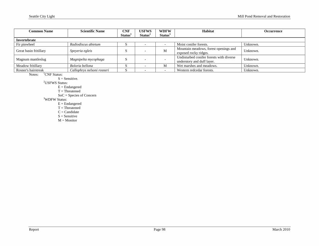
Seattle City Light Mill Pond Removal and Restoration
Report Page 98 March 2010
Common Name Scientific Name CNF Status1
USFWS Status2
WDFW Status3
Habitat Occurrence
Invertebrate Fir pinwheel Radiodiscus abietum S - - Moist conifer forests. Unknown.
Great basin fritillary Speyeria egleis S - M Mountain meadows, forest openings and exposed rocky ridges. Unknown.
Magnum mantleslug Magnipelta mycophaga S - - Undisturbed conifer forests with diverse understory and duff layer. Unknown.
Meadow fritillary Boloria bellona S - M Wet marshes and meadows. Unknown. Rosner's hairstreak Callophrys nelsoni rosneri S - - Western redcedar forests. Unknown.
Notes: 1CNF Status: S = Sensitive.
2USFWS Status: E = Endangered T = Threatened SoC = Species of Concern
3WDFW Status: E = Endangered T = Threatened C = Candidate S = Sensitive M = Monitor

Seattle City Light Mill Pond Removal and Restoration
Report Page 99 March 2010
The following is a brief discussion of non-federally listed RTE species for which there is information on potential occurrence in the Study Area or nearby regions as identified by previous studies. A detailed description of federally listed wildlife species including the Canada lynx, grizzly bear and woodland caribou is presented in the Threatened and Endangered Species Section 6.4.
Northern Leopard Frog - The northern leopard frog is state listed as endangered and a CNF sensitive species. They have been historically found in wetlands in Pend Oreille County near the town of Usk. Now they are only found in Grant County (McAllister et al. 1999, as cited by SCL 2006). Their habitat includes herbaceous plant cover around the edge of ponds and lakes and emergent wetlands that provide concealing cover. There are scrub-shrub wetlands on the edge of Mill Pond that include an emergent vegetative layer. No northern leopard frogs have been documented within the Study Area.
Amphibians
American Peregrine Falcon - The peregrine falcon is state-listed as sensitive, a CNF sensitive species and is listed by the USFWS as a species of concern. Peregrine falcons have been periodically observed in the CNF Sullivan Lake Ranger District, but nesting has not been recorded anywhere in the region (USFS 1999a, as cited by SCL 2009a). A USFS assessment of potential peregrine falcon nesting habitat determined that three sites near the Project have medium to high nesting habitat potential: Lower Linton Mountain, Linton Mountain, and Washington Rock (Pagel 1993, as cited by SCL 2006). Washington Rock is located across Boundary Reservoir from Sullivan Creek outlet and peregrine falcons have been documented to nest in these cliffs. No direct observations of peregrine falcons have been made within the Study Area; however, they are anticipated to use portions of the Study Area for foraging habitat.
Birds
Bald Eagle - The bald eagle is state-listed as sensitive and a CNF sensitive species. Numerous bald eagles have been observed in the Boundary Reservoir area, specifically at the outlet of Sullivan Creek (Tetra Tech 2009e). Bald eagles typically nest in large conifer trees and snags near open water for foraging. Lower Sullivan Creek and Mill Pond are surrounded by conifer forest with an abundance of perching and nesting trees. Occasional migrant bald eagles have been sighted in the Mill Pond area (Pend Oreille County PUD 1994a) but no nests have been observed within the Study Area. However, one documented bald eagle nest has been identified outside of the Study Area near Sullivan Lake Dam (Drawing 14, Rare, Threatened and Endangered Species Map). Common Loon - The common loon is state-listed as sensitive and a CNF sensitive species. Loons are dependent on water and prefer to nest on the edges of large (greater than 40 acre) lakes and rivers. They select the most secluded shoreline habitat available for nesting and are prone to abandoning an active nest if disturbed by human activity. Nests are typically placed in dense, concealing vegetation within a few feet of the water’s edge. Loons are awkward on land, so a gentle grade to the shoreline is desirable for nesting purposes. During migrations, non-breeding loons sometimes use Mill Pond as resting and foraging sites. The WDFW PHS map indicates that a loon was observed at Mill Pond in 1991; however, there are no known records of loons nesting on Mill Pond (SCL 2008). There are also numerous other sightings of loons on Mill Pond, but none were of nesting pairs (Pend Oreille County 1996). Eared Grebe - The eared grebe is a CNF sensitive species and occurs only as a migrant in northeastern Washington. They are typically found in lakes, ponds, and wetlands with large open water components that contain ample food sources. Numerous species were observed on Boundary Reservoir in September 2005 at the Boundary Forebay and just upstream from the Metaline Falls Bridge. Due to the small size of Mill Pond, the eared grebe is not anticipated to use it as habitat.
Seattle City Light Mill Pond Removal and Restoration
Report Page 100 March 2010
Great Gray Owl – The great gray owl is state-listed as monitor and a CNF sensitive species. They nest in dense coniferous forests near open meadows or wetlands. Their main food source consists of small rodents. The great grey owl is anticipated to use portions of the Study Area only as foraging habitat. Harlequin Duck – The harlequin duck is a CNF sensitive species. Harlequin ducks nest on the banks of swift moving mountain streams and dive into the water to forage on macro-invertebrates on the stream bottom. Surveys completed in 1995 and 1996 identified the presence of harlequin ducks in Upper Sullivan Creek in four separate locations. However, no observations were made in Lower Sullivan Creek from Mill Pond to Boundary Reservoir (Pend Oreille County PUD 1996). Northern Goshawk - The northern goshawk is a USFWS federal species of concern and a state candidate species. One goshawk was sighted by CNF biologists in recent years on the Sullivan Lake Ranger District (unpublished data CNF Sullivan Lake Ranger District, as cited by SCL 2006). No adult birds, immature birds or nest sites were noted within the Study Area as of 1996 (Pend Oreille County 1996). Goshawks nest in mature and old-growth conifer forests that are secluded from human disturbance. They forage in various forested habitats and forest openings. Olive-sided Flycatcher – The olive-sided flycatcher is a USFWS federal species of concern. They breed in coniferous forests and typically inhabit post fire landscapes. They perch on the top of trees, wait for insects and bugs to fly by and then actively pursue it. There have no observations of the olive-sided flycatcher within the Study Area (Pend Oreille County PUD 1996). Sandhill Crane – The sandhill crane is state-listed as endangered and a CNF sensitive species. Breeding habitat primarily includes emergent wetlands and meadows. They are omnivorous and feed in both shallow water and open fields. There have been no documented observations of the sandhill crane within the Study Area; however, they may use portions of the wetlands areas for foraging habitat. White-headed Woodpecker - The white-headed woodpecker is state-listed as candidate and a CNF sensitive species. They typically reside in pine forests with numerous snags and woody debris. There have been no documented observations of the white-headed woodpecker within the Study Area and they will not likely use the Study Area for habitat due to the lack of pine forest.
Wolverine - The wolverine is a federal species of concern, a state candidate species and a CNF sensitive species. Wolverines are mainly associated with subalpine fir and lodgepole pine forests but can occur in many different habitats. They move between summer habitats in high-elevation timberline areas and lower elevation conifer forest winter habitat. Den sites are usually located among uprooted trees, in caves, under rocky ledges or overhanging banks. Wolverine habitat must provide a high level of seclusion to be effective. There has been only one confirmed wolverine sighting on the CNF between the Pend Oreille River and Sullivan Lake in 1990 (USFS 1995a, as cited by SCL 2006) but there has been several sightings within the CNF Sullivan Lake Ranger District (Pend Oreille County PUD 1994a).
Mammals
Fisher - The fisher is a federal candidate species, a state endangered species and a CNF sensitive species. This species is extremely rare in Washington, and is thought to be extirpated from most regions of the state. They use a wide range of forest stands and secluded riparian areas for habitat. According to the WDFW PHS database, two observations of the fisher have been made within the vicinity of the Study Area in 1978 and 1996 (WDFW 2009a). Gray Wolf - The gray wolf is a state-listed endangered species and a CNF sensitive species. The Sullivan Lake Ranger District has 49 records of gray wolf observations in the district between 1980 and 1994, although many cannot be confirmed (unpublished data CNF Sullivan Lake Ranger District, as cited by

Seattle City Light Mill Pond Removal and Restoration
Report Page 101 March 2010
SCL 2006). A small number of the records were from locations near Boundary Reservoir. All of the reports of individual wolves on the CNF have been of wandering, lone animals. There is no evidence of denning or pack activity on CNF (USFS 1988a, as cited by SCL 2006). Gray wolves in the region rely on big game as their primary food source. Important habitat elements for the gray wolf include: (1) year-round prey base of ungulates; (2) suitable secluded denning and rendezvous sites; and (3) sufficient seclusion from human activity (USFWS 1987, as cited by SCL 2006). The Diamond Pack population has been increasing in Pend Oreille County (WDFW 2009c) over the past several decades and occurrences with humans within the CNF are expected to increase in the future. Kincaid Meadow Vole - The Kincaid meadow vole is a USFWS listed species of concern and a state-listed monitor species. This species lives in open meadows and are abundant with a high degree of herbaceous and shrub plant cover. The Study Area contains very few open meadows. However, vegetation and wildlife surveys within the Study Area have not been performed and their presence or absence has not been confirmed. Long-eared Myotis - The long-eared myotis is a USFWS listed species of concern and a state-listed monitor species. These bats live in conifer forests in mountain areas and roost in small colonies in caves, buildings and under tree bark. There have been no observations of the long-eared myotis within the vicinity of the Study Area. Pygmy Shrew - The pygmy shrew is a state-listed monitor species and a CNF sensitive species. They are found in coniferous and deciduous forest and wetlands. They are relatively uncommon and have not been observed within the vicinity of the Study Area. Red-tailed Chipmunk - The red-tailed chipmunk is a state-listed monitor species and a CNF sensitive species. They typically reside in pine forests. There have been no confirmed observations of the red-tailed chipmunk within the vicinity of the Study Area. However, vegetation and wildlife surveys within the Study Area have not been performed and their presence or absence has not been confirmed. Townsend’s Big-eared Bat - The Townsend’s big-eared bat is a USFWS listed species of concern, a state-listed candidate species and a CNF sensitive species. Since 2000, the CNF Sullivan Lake Ranger District has documented at least nine sites that support the Townsend’s big-eared bat (USFS internal data, as cited by SCL 2006). The CNF Sullivan Lake Ranger District maintains a database that currently has 77 caves, mines, and artificial structures that are targeted for bat surveys, although only about 33 have been surveyed to date. Buildings, mines, and caves are potentially used for hibernation and maternal roosts for one or more bat species (Nagorsen and Brigham 1993, as cited by SCL 2006). There have been no observations of the Townsend’s big-eared bat within the Study Area (Pend Oreille County 1996; Tetra Tech 2009g). The Washington mine is located on the western side of Boundary Reservoir across from Sullivan Creek outlet. No RTE bats were identified during surveys conducted by Tetra Tech and BLM (Tetra Tech 2009g). The outlet of Sullivan Creek in Boundary Reservoir contains cottonwood snags that are suitable for bat roosts. However, there have been no bat observations within this area during the two studies completed within the Study Area.
Fir Pinwheel – The fir pinwheel is a CNF sensitive species. They are found in moist and rocky Douglas-fir forests at mid-elevations. Typical habitat includes rocky areas and fallen logs surrounded by a rich understory of forbs, shrubs and bryophytes and may occur within the Study Area.
Invertebrates
Great Basin Fritillary – The great basin fritillary is a state-listed monitor species and a CNF sensitive species. They are typically found in mountain meadows, forest openings and exposed rocky ridges. This species is not anticipated to occur within the Study Area.
Seattle City Light Mill Pond Removal and Restoration
Report Page 102 March 2010
Magnum Mantleslug – The magnum mantleslug is a CNF sensitive species. The magnum mantleslug inhabits mesic forests having a diverse plant understory and a duff layer. Dominant trees include subalpine fir, white-bark pine, and Engelmann spruce. This species is thought to be intolerant of habitat alteration and is found only at undisturbed sites. This species is not anticipated to occur within the Study Area. Meadow Fritillary – The meadow fritillary is a state-listed monitor species and a CNF sensitive species. They inhabit wet places including wetlands, wet meadows and wet aspen groves and may occur within the Study Area. Rosner’s hairstreak – The Rosner’s hairstreak is a CNF sensitive species. This species only resides in large undisturbed stands of Western red cedar trees and is not likely to occur within the Study Area. 6.3.2 Environmental Effects 6.3.2.1 Botanical Resources The implementation of the Recommended Alternative will affect botanical resources in the Study Area. The following discussion of environmental effects related to the project was analyzed from a review of existing information for dominant cover types and plants, RTE plants and noxious weeds. 6.3.2.1.1 Dominant Cover / Plant Species Coniferous Forest – The majority of the upland vegetation surrounding Mill Pond and Lower Sullivan Creek is composed of conifer trees. There will be no temporary or permanent direct impacts to the coniferous forest along the edges of Lower Sullivan Creek and Boundary Reservoir. Permanent direct impacts from clearing conifer trees surrounding Mill Pond (estimated at less than 0.5 acres) will be limited to areas required for construction access (existing campground on east side of pond and Mill Pond Dam) and the proposed location of the siphon pipe over the existing dike (west of the dam). Once construction activities area complete, these cleared areas will be planted with native vegetation and restored to their original condition. Shrub and Grass Meadows – There are minimal shrub and grass meadows present in the Study Area. These areas will not receive any temporary or permanent direct impacts from the implementation of the Recommended Alternative. Lacustrine/Littoral – The only lacustrine/littoral habitats within the Study Area are located along the edge of Mill Pond and at the confluence of Sullivan Creek and Boundary Reservoir. There are no temporary or permanent direct impacts to the lacustrine/littoral area at the confluence of Sullivan Creek and Boundary Reservoir. The lacustrine/littoral area on the edge of Mill Pond will be permanently eliminated from the dewatering of Mill Pond. The specific habitat types that will be lost include rock bottom, unconsolidated bottom, aquatic bed, rocky shoreline, unconsolidated shoreline, and emergent. Wetland – According to the NWI map and aerial photographs, there are numerous wetlands located within the Study Area. However, these wetland areas generally are present along the edges of Mill Pond and at the confluence of Sullivan Creek and Boundary Reservoir with interspersed wetland areas along the banks of Lower Sullivan Creek. The wetland complex at the outlet of Sullivan Creek into Boundary Reservoir will not experience temporary or permanent direct impacts from the implementation of the Recommended Alternative. The wetlands associated with Lower Sullivan Creek will not receive temporary or direct
Seattle City Light Mill Pond Removal and Restoration
Report Page 103 March 2010
impacts since the hydrology pattern in Sullivan Creek will remain constant after the implementation of the Recommended Alternative. Wetlands associated with Mill Pond will receive both temporary and permanent direct impacts. The wetlands on the edge of Mill Pond that are not associated with the inlet will be drained and restored to an upland condition resulting in a permanent loss of these wetlands. The inlet of Lower Sullivan Creek into Mill Pond contains a wetland complex that is the result of sediment deposits over the past 100 years. The reach of Lower Sullivan Creek approximately 0.25 miles upstream of the inlet will be restored and stabilized to prevent head-cutting in the river. Portions of this wetland complex will be temporarily impacted from restoration activities and other portions will be permanently impacted from the dewatering of Mill Pond. Wetland areas receiving temporary direct impacts from equipment trampling will be planted with native vegetation and restored to their original condition upon completion of restoration activities. Riverine/Riparian – The reach of Lower Sullivan Creek from Mill Pond Dam to Boundary Reservoir will not receive temporary or permanent direct impacts other than vegetation clearing in the area where the siphon pipe will be located. The 0.25-mile reach of Lower Sullivan Creek above Mill Pond will be stabilized so that erosion does not occur. Riparian vegetation within these areas will receive temporary and permanent direct impacts from restoration activities including trampling and clearing from equipment access. However, these areas will be planted with native vegetation and restored to their original condition upon completion of restoration activities. Disturbed/Developed – Disturbed/developed areas within the Study Area consist of the campground on the east side of Mill Pond, the parking area and trails adjacent to the dam, Mill Pond Dam and Sullivan Lake Road. Mill Pond Dam will be permanently removed and all other areas disturbed by the implementation of the Recommended Alternative will be restored to its pre-construction condition upon completion of the Recommended Alternative. 6.3.2.1.2 Rare Threatened and Endangered Plant Species The botanical study conducted in 1994 (Pend Oreille County PUD) did not identify any RTE species within the Study Area; however, the botanical study conducted in 2007 (Tetra Tech and Beck Botanical Services 2009b) identified the presence of yellow mountain avens and purple meadowrue in the vicinity of the outlet of Sullivan Creek in Boundary Reservoir which is located within the Study Area. The 2007 RTE survey did not cover Lower Sullivan Creek or Mill Pond. Yellow mountain avens are not expected to be located with the construction area of Mill Pond due to the lack of steep, rocky, dry cliffs. Impacts to the yellow mountain avens from sediment are also not expected due to its habitat preference of dry open areas. It is anticipated at this time that there will be no temporary or permanent direct impacts to this species. Purple meadowrue could potentially be identified within the vicinity of Mill Pond due to its habitat preference of wet environments. However, a RTE study has not been completed on Lower Sullivan Creek and Mill Pond. No RTE species have been identified at Mill Pond. However, a species specific study has not been completed since the 1996 study. If RTE species are identified in the Study Area prior to the start of construction, efforts will be made to protect these species within the limitations of the Recommend Alternative construction activities. Upon identification of RTE species within the Mill Pond Study Area, impacts to these species will be analyzed.
Seattle City Light Mill Pond Removal and Restoration
Report Page 104 March 2010
6.3.2.1.3 Noxious Weeds and Invasive Plant Species Noxious weeds have been identified in the Study Area, primarily in disturbed portions of the landscape. However, since Sullivan Creek has the capability to transport weeds into the Study Area from upstream areas and transport weeds downstream of Mill Pond, weeds located upstream may impact the quality of vegetation that occurs in the restored areas of Mill Pond in the years following removal of the dam. Noxious weeds identified in the direct construction areas of Mill Pond will be sprayed and/or removed prior to the start of construction activities. Efforts will also be made during construction and post-construction to stunt the growth of new weeds and control potential seed sources from spreading through the restored area and downstream. A noxious weed control plan will be prepared for the site for pre-, during and post-construction time periods to prevent invasion by weeds brought in on construction equipment or carried downstream. Thus, temporary and permanent direct impacts to the Study Area from the implementation of the Recommended Alternative will kept to a minimum through preventative control measures. 6.3.2.1.4 Cumulative Effects A number of variables contribute to dispersal of weeds in the Study Area and the larger Sullivan Creek watershed. These variables include ground-disturbing activities upstream of the Study Area, human aquatic and terrestrial recreation activities, and the amount of traffic within the vicinity of the project. Specific locations, trends and species of weeds in the Study Area and vicinity have not been identified; however, the invasive nature of noxious weeds suggests that existing populations will continue to increase in size. It is also unforeseeable regarding outside activities that may increase traffic to the Study Area, but it can be anticipated that as weed infestations increase in other portions of Pend Oreille County, the potential for more weeds species to be brought into the Study Area will also increase with human attendance and wildlife migration. This potential increase in weed infestations may result in the decline of RTE species (if identified in the Study Area) and upland, riparian and wetland plant communities. Many of these activities are outside of the control of the implementation of Recommended Alternative; however, protection plans will be put in place to address impacts to existing plant communities and RTE species from cumulative effects of noxious weeds and land management activities outside of the Study Area. 6.3.2.1.5 Unavoidable Adverse Impacts Unavoidable adverse impacts on botanical resources in the Study Area will only include areas affected by the dewatering of Mill Pond and dam removal. Specific plant communities and types that will be lost include conifer forest, lacustrine/littoral, riverine/riparian and wetland. However, mitigation for the loss of these areas will include the creation of additional riverine/riparian and wetland areas along the restored portion of Sullivan Creek through Mill Pond. Areas cleared solely for the purpose of construction activities will be revegetated with native species and restored to its original condition. 6.3.2.1.6 Consistency with Comprehensive Plan The botanical resource related management goals and policies associated with comprehensive resource management plans were reviewed to assess the implementation of the Recommended Alternative consistency. The Recommended Alternative for the Project will result in a condition that is consistent with the following relevant comprehensive plans.
• CNF Land and Resource Management Plan (CNF 1988) - The CNF land and resource management plan includes a number of forest management goals relevant to botanical resources:
o Maintaining rare plant populations.

Seattle City Light Mill Pond Removal and Restoration
Report Page 105 March 2010
o Maintaining and enhancing important and sensitive habitat features. o Managing recreation in a compatible manner with resource protection. o Controlling weed populations. o Instituting BMPs for all land management activities.
• Ecology State Wetlands Integration Strategy (Ecology 1994) - Ecology's wetlands integration strategy brought together a variety of jurisdictions within the state to develop standardized approaches to wetland policy, implementation, permitting, and education. Any work in wetlands as part of Project operations or restoration activities will be conducted in accordance with local, state, and federal wetland regulations.
• DNR WNHP (DNR 2007) - The 1981 amendment to the Natural Area Preserves Act requires the WNHP to develop a plan each biennium regarding the Act’s implementation. Specifically, the purpose of the WNHP is to identify priority species and ecosystems to be considered in the selection of potential natural areas and establish the criteria and process by which natural areas are selected. Washington’s last WNHP update was published in 2009. There are no WNHP designated natural areas or priority plant species in the Study Area.
6.3.2.2 Wildlife Resources 6.3.2.2.1 Mammals
Large mammals identified to potentially occur within the Study Area include deer, elk, bighorn sheep, moose, mountain lions, bobcats, black bears and gray wolves. Almost all of these mammals avoid human disturbance and will find other suitable habitat when disturbed. There are no temporary or permanent direct impacts to large mammals that use Lower Sullivan Creek or the outlet in Boundary Reservoir. There will be no permanent direct impacts on large mammals since they do not use Mill Pond for regular habitat. Temporary direct impacts on large mammals will include avoidance from the Mill Pond area during dam removal and restoration construction activities due to increased human presence and noise. General construction noise disturbance may travel up to 0.5 miles from Mill Pond. However, due to the surrounding conifer forest and topographic features, noise (heavy equipment, motors and pumps) is anticipated to attenuate at approximately 0.25 miles. In many areas surrounding Mill Pond, this noise disturbance will travel to the same extents as existing human disturbance from Sullivan Lake Road and CNF trails. Noise created during the dam removal and stream restoration process temporary and limited to construction activities.
Large Mammals
Small mammals identified to potentially occur within the Study Area include beaver, muskrat, river otter, mink, short-tailed weasel, fishers, vagrant shrews, red-backed vole, bushy-tailed woodrat, deer mice, yellow pine chipmunks, red-squirrels, yellow-bellied marmots, mountain cottontails, and Columbian ground squirrels. There are no temporary or permanent direct impacts to small and medium mammals in Lower Sullivan Creek and the outlet in Boundary Reservoir.
Small and Medium-sized Mammals
Temporary direct impacts will occur to upland small and medium mammals that use upland habitat within the immediate vicinity of Mill Pond. Construction activities will displace these mammals from ground disturbance and noise. Permanent direct impacts to upland small and medium mammals will include either the destruction of their habitat from restoration activities and/or mortality. Permanent direct impacts to aquatic small and medium mammals will include the loss of open water and wetland habitat from the dewatering of Mill Pond. Long-term restoration efforts as part of the restored Sullivan Creek riparian corridor will create new wetland habitat that small and medium-sized mammals will use. Species that will be impacted from construction activities within the Study Area will be

Seattle City Light Mill Pond Removal and Restoration
Report Page 106 March 2010
identified and trapped prior to the start of construction activities and relocated to suitable habitat within the vicinity.
The Townsend’s big-eared bat and big brown bat have been identified to occur in caves and mines on the Sullivan Lake Ranger District. Bat observations have not been documented within the Study Area; however, it is assumed that bats will use Mill Pond as feeding habitat. There will be no temporary or permanent direct impacts to bats in Lower Sullivan Creek, the outlet in Boundary Reservoir or Mill Pond from the implementation of the Recommended Alternative. Permanent indirect impacts will occur to bats from the dewatering of Mill Pond and the reduction of their food source (insects) that are associated with open water environments.
Bats
6.3.2.2.2 Birds
Waterfowl (ducks, geese, swans), waterbirds (loons, grebes, coots, and cormorants) and shore birds (sandpiper, gull) typically occur within the Study Area at open water environments such as Mill Pond and the wetland complex at the outlet of Sullivan Creek into Boundary Reservoir. Harlequin ducks nest on the banks of swift moving mountain streams and dive into the water to forage on macro-invertebrates on the stream bottom. There will be no temporary or permanent direct impacts to waterfowl, waterbirds or shorebirds in Lower Sullivan Creek and the outlet in Boundary Reservoir. Permanent direct impacts will occur to waterfowl, waterbirds or shorebirds at Mill Pond from the dewatering of the pond and restoration to a riverine/riparian area. The loss of open water habitat will cause birds to relocate to other suitable habitat within the vicinity of Mill Pond which may include Sullivan Lake, Lime Lake and Boundary Reservoir. The creation of additional riparian habitat could provide additional habitat for harlequin ducks on Sullivan Creek.
Birds Associated with Water
Raptors documented in the vicinity of Boundary Reservoir include the bald eagle, golden eagle, osprey, American kestrel, red-tailed hawk, sharp-shinned hawk, Cooper’s hawk, and northern goshawk. These birds rely on large conifer trees to create nests in and perch in when foraging for food. The Recommended Alternative will not clear large conifer trees along the shoreline of Mill Pond, Lower Sullivan Creek or Boundary Reservoir. Temporary construction noise may deter raptors from the Study Area during construction activities; however, the noise will be temporary and limited to construction activities. Permanent indirect impacts will be the loss of a food source for raptors that forage on fish species in Mill Pond.
Raptors
Other birds that are noted to occur in the vicinity of the Study Area include woodpeckers, gamebirds and passerines. The Recommended Alternative involves clearing a small section of conifer trees on the dike to the west of the dam. Most of the woodpeckers, gamebirds and passerines in the vicinity of Mill Pond do not rely on open water environments for habitat. Therefore, there will be no permanent direct impacts from the implementation of the Recommended Alternative. Temporary direct impacts will include the avoidance of the Mill Pond area during construction activities from noise and human presence.
Other birds
6.3.2.2.3 Amphibians and Reptiles Surveys of the Study Area have only revealed the presence of treefrogs and bullfrogs. The implementation of the Recommended Alternative will not temporarily or permanently directly impact amphibians and reptiles in Lower Sullivan Creek and the outlet into Boundary Reservoir. However, the dewatering of Mill Pond will permanently directly impact amphibians that reside in Mill Pond.
Seattle City Light Mill Pond Removal and Restoration
Report Page 107 March 2010
6.3.2.2.4 Rare Threatened and Endangered Wildlife Species RTE species identified in this section will be impacted depending on the type of environment they live in. The analysis in the previous three sections identified impacts to certain types of wildlife families. These impacts identified above apply to any RTE species that may be present within the Study Area also. If RTE species are identified to solely rely on habitat within the Study Area in subsequent studies following this environmental analysis, efforts will be made (if possible) to relocate these species prior to the start of construction. Other efforts will be implemented, including best management practices, noise reducing equipment and duration of construction hours, to offset any direct or indirect impacts to RTE species. 6.3.2.2.5 Cumulative Effects A number of variables contribute to the densities of wildlife in the Study Area and the larger Sullivan Creek watershed. These variables include, human aquatic and terrestrial recreation activities, the amount of traffic within the vicinity of the project and land management practices. It is unforeseeable regarding outside activities that may increase traffic to the Study Area, but it can be anticipated that as human presence increases in the vicinity of the Study Area, wildlife species will not use habitat at Mill Pond, Lower Sullivan Creek or the outlet of Sullivan Creek in Boundary Reservoir. This potential increase in human presence may result in the decline of common and RTE wildlife species. Vegetation loss and modification from development, road building and maintenance and recreation in the basin cumulatively affect the distribution and quality of habitat for wildlife. Land clearing in the basin from residential and commercial development, timber harvest, and mining are likely to continue to cumulatively affect wildlife habitat. Many of these activities are outside of the control of the implementation of Recommended Alternative; however, protection plans will be put in place to address impacts to wildlife from cumulative effects of human presence and land management activities outside of the Study Area. The implementation of Recommended Alternative will remove an open water habitat but will be replaced with riparian habitat. This projects contribution to cumulative effects related to wildlife disturbance is insignificant. 6.3.2.2.6 Unavoidable Adverse Impacts Unavoidable adverse impacts on wildlife resources in the Study Area will only include areas affected by the dewatering of Mill Pond and dam removal. Specific wildlife species and habitats that will be lost include aquatic mammal habitat, foraging habitat for raptors, nesting and resting habitat for birds associated with water, and amphibian habitat in Mill Pond. However, mitigation for the loss of these areas will include the creation of additional riverine/riparian and wetland areas along the restored portion of Sullivan Creek through Mill Pond. Areas cleared solely for the purpose of construction activities will be revegetated with native species and restored to its original condition. 6.3.2.2.7 Consistency with Comprehensive Plan The wildlife resource related management goals and policies associated with comprehensive resource management plans were reviewed to assess the implementation of the Recommended Alternative consistency. The Recommended Alternative will result in a condition that is consistent with the following relevant comprehensive plans.
• CNF Land and Resource Management Plan (CNF 1988) - The CNF land and resource management plan includes a number of forest management goals relevant to botanical resources:
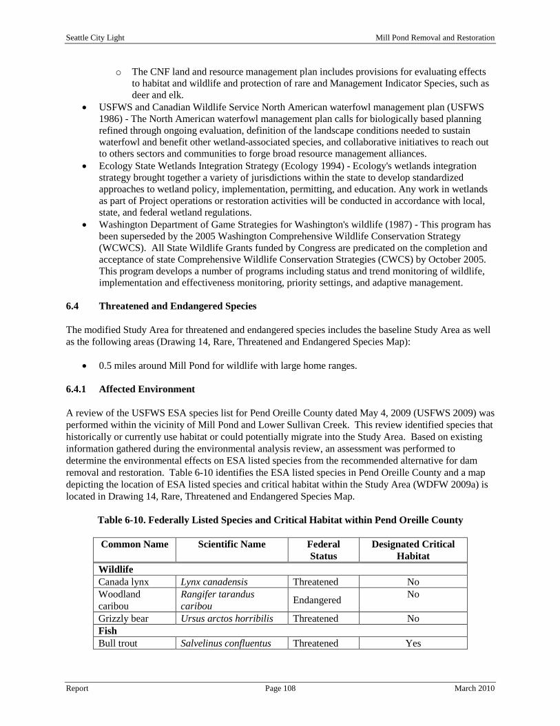
Seattle City Light Mill Pond Removal and Restoration
Report Page 108 March 2010
o The CNF land and resource management plan includes provisions for evaluating effects to habitat and wildlife and protection of rare and Management Indicator Species, such as deer and elk.
• USFWS and Canadian Wildlife Service North American waterfowl management plan (USFWS 1986) - The North American waterfowl management plan calls for biologically based planning refined through ongoing evaluation, definition of the landscape conditions needed to sustain waterfowl and benefit other wetland-associated species, and collaborative initiatives to reach out to others sectors and communities to forge broad resource management alliances.
• Ecology State Wetlands Integration Strategy (Ecology 1994) - Ecology's wetlands integration strategy brought together a variety of jurisdictions within the state to develop standardized approaches to wetland policy, implementation, permitting, and education. Any work in wetlands as part of Project operations or restoration activities will be conducted in accordance with local, state, and federal wetland regulations.
• Washington Department of Game Strategies for Washington's wildlife (1987) - This program has been superseded by the 2005 Washington Comprehensive Wildlife Conservation Strategy (WCWCS). All State Wildlife Grants funded by Congress are predicated on the completion and acceptance of state Comprehensive Wildlife Conservation Strategies (CWCS) by October 2005. This program develops a number of programs including status and trend monitoring of wildlife, implementation and effectiveness monitoring, priority settings, and adaptive management.
6.4 Threatened and Endangered Species The modified Study Area for threatened and endangered species includes the baseline Study Area as well as the following areas (Drawing 14, Rare, Threatened and Endangered Species Map):
• 0.5 miles around Mill Pond for wildlife with large home ranges. 6.4.1 Affected Environment A review of the USFWS ESA species list for Pend Oreille County dated May 4, 2009 (USFWS 2009) was performed within the vicinity of Mill Pond and Lower Sullivan Creek. This review identified species that historically or currently use habitat or could potentially migrate into the Study Area. Based on existing information gathered during the environmental analysis review, an assessment was performed to determine the environmental effects on ESA listed species from the recommended alternative for dam removal and restoration. Table 6-10 identifies the ESA listed species in Pend Oreille County and a map depicting the location of ESA listed species and critical habitat within the Study Area (WDFW 2009a) is located in Drawing 14, Rare, Threatened and Endangered Species Map.
Table 6-10. Federally Listed Species and Critical Habitat within Pend Oreille County
Common Name Scientific Name Federal Status
Designated Critical Habitat
Wildlife Canada lynx Lynx canadensis Threatened No Woodland caribou
Rangifer tarandus caribou Endangered No
Grizzly bear Ursus arctos horribilis Threatened No Fish Bull trout Salvelinus confluentus Threatened Yes

Seattle City Light Mill Pond Removal and Restoration
Report Page 109 March 2010
6.4.1.1 Canada Lynx 6.4.1.1.1 Background and Requirements The Canada lynx was listed as a federally threatened species in Pend Oreille County, Washington (USFWS 2009) on April 24, 2000 (65 FR 16052-16086). Habitat quality for the lynx is believed to be lower in the southern portion of its range (United States) than in the northern taiga (Canada). This is primarily caused by heterogeneous landscapes in the southern portion of their range in terms of topography, climate, and vegetation (Buskirk et al. 2000, as cited by SCL 2009b). Population trends of lynx in the United States have been reported to be similar to those at more northern latitudes during the decline or low phase of snowshoe hare cycles; thus, the Canada lynx population trends rely primarily on the abundance of snowshoe hares (Koehler 1990; Apps 2000, as cited by SCL 2009b). However, lynx in the southern portion of their range may prey on a wider diversity of prey because of a greater abundance of small mammal communities and lower average hare densities. An adequate prey base is probably the main factor determining lynx use, but home range shape and size are also influenced by lynx density, geographic and physiographic features, and season. Males tend to have larger home ranges than females, and they may exhibit a greater seasonal shift in core area. Individual home ranges sometimes overlap, particularly between sexes, but ranges of males are more exclusive (WDFW 2001b). 6.4.1.1.2 Habitat Description and Use Forest types used by lynx vary geographically throughout their range and include both conifers and hardwoods. Lynx are adapted to the cold temperatures and deep snows of boreal forest environments. In Washington, this includes subalpine and high elevation mixed conifer zones in the mountains, generally above 3,500 ft elevation in Pend Oreille County. However, Mill Pond sits approximately at elevation 2,500 ft and the lynx are not expected to use the Study Area except possibly during dispersal. In Pend Oreille County, lynx use lodgepole pine (Pinus contorta) about half the time, but also use western red cedar (Thuja plicata), western hemlock (Tsuga heterophylla) and subalpine fir (Abies lasiocarpa) communities (WDFW 2001b). 6.4.1.1.3 Occurrence in Project Area There have been several reported lynx sightings near the Boundary Reservoir area; however, there have been no sightings within the 0.5 mile wildlife Study Area (USFS unpublished data, CNF Sullivan Lake Ranger District, Borysewicz 2008, as cited by SCL 2009a; WDFW 2009a). Individual Canada lynx using the project area are assumed to be dispersing individuals moving between areas of more suitable habitat at higher elevations (SCL 2009b). 6.4.1.1.4 Critical Habitat Critical habitat has been designated for the Canada lynx in Washington; however, there is no critical habitat designated within Pend Oreille County (74 FR 8616-8702). 6.4.1.1.5 Recovery Plans The USFWS initiated a five-year review of the Canada lynx on April 18, 2007 (72 FR 19549-19551). This review is conducted by the USFWS to ensure that the classification of the Canada lynx as threatened is accurate. This publication of the five-year review document is currently pending.

Seattle City Light Mill Pond Removal and Restoration
Report Page 110 March 2010
The WDFW prepared a Lynx Recovery Plan (2001b) that outlines steps to increase lynx populations to a level where there is a high probability that lynx will reside in Washington State through the foreseeable future (less than 100 years). This recovery plan discusses their background, habitat requirements, population status as of 2001, management activities and factors affecting their existence. The plan further discusses recovery goals and specific objectives which include the following:
• Lynx are consistently present during 10 consecutive years in greater than 75 percent of the Lynx Analysis Units in the Lynx Management Zones (LMZs). The Salmon Priest LMZ is located approximately 1.5 miles north of the Study Area and starts at elevation 4,000 fmsl.
• Lynx surveys indicate that recruitment from local reproduction regularly occurs. • Agreements or forest management plans are in place for federal, state, and major private
landholding that assure suitable habitat will continue to be managed in a way consistent with lynx conservation after downlisting.
The USFS signed an agreement with the USFWS on February 7, 2000 regarding how the USFS will manage lynx habitat on USFS land. This agreement would minimize the impact of the listing on USFS forest management operations and also comply with the ESA (USFWS 2000, as cited in SCL 2009b). 6.4.1.2 Woodland Caribou 6.4.1.2.1 Background and Requirements The woodland caribou was listed as a federally endangered species in Pend Oreille County, Washington (USFWS 2009) on January 14, 1983. The majority of the woodland caribou populations reside in British Columbia, Canada with a small number occurring in the southern Selkirk Mountains north of the project area. Caribou were transplanted into northeastern Washington and northern Idaho, including limited numbers in the upper Sullivan Creek drainage on the Sullivan Lake Ranger District, beginning in the late 1990’s by the USFWS and WDFW (Audet and Allen 1996, as cited in SCL 2009b). During early winter, caribou move to low-elevation, old-growth cedar /hemlock forests above 4,000 ft elevation. Once snow becomes sufficiently compacted and crusted to support the caribou’s weight, they move up to subalpine fir and whitebark pine (Pinus albicaulis) stands (USFWS 1994, as cited in SCL 2009b). During the spring, caribou move downslope to forage in shrub fields, meadows, and open forest stands. The majority of the Washington caribou population resides in the Salmo-Priest Wilderness Area, which is located less than one mile east of Mill Pond. 6.4.1.2.2 Habitat Description and Use The woodland caribou population located in the Selkirk Mountains is typically found above 4,000 ft elevation in spruce (Picea sp.)/subalpine fir and western red cedar/western hemlock forest types. The population is threatened by habitat fragmentation and loss, and excessive mortality. The seasonal habitats used by the Selkirk caribou are described in Table 6-11 (USFWS 1994).
Table 6-11. Selkirk Caribou Seasonal Habitats
Season Description
Early winter Mature to old-growth cedar-hemlock and spruce-fir stands, 70%+ canopy closure, high windthrow and lichen densities.
Late winter High elevation, open-canopied spruce-fir stands, high lichen density. Spring Mature timber with canopy openings. Calving Secluded, high elevation, mature-old growth forest.

Seattle City Light Mill Pond Removal and Restoration
Report Page 111 March 2010
Season Description
Summer Relatively flat terrain, abundant understory cover, variable overstories.
Fall Mature old-growth stands with dense understories. 6.4.1.2.3 Occurrence in Project Area Over the past 25 years, woodland caribou have occasionally been observed in the general vicinity of the town of Metaline Falls and have been documented crossing the Pend Oreille river north of Metaline (CNF Sullivan Lake Ranger District Wildlife Species Occurrence database 1996; Borysewicz 2008, as cited in SCL 2009b). Observations have also been made within two miles to the northwest of Mill Pond as noted on the WDFW PHS maps (2009a). However, no observations have been recorded within the wildlife Study Area, most likely because this area lacks the age, species type and elevations typically used by woodland caribou. 6.4.1.2.4 Critical Habitat No critical habitat has been designated for the woodland caribou. 6.4.1.2.5 Recovery Plans The USFWS prepared a Recovery Plan for Woodland Caribou in the Selkirk Mountains (USFWS 1994) to address goals for caribou recovery in this area. Mill Pond and Lower Sullivan Creek were not included in the general habitat area for caribou in the Southern Selkirk Mountains. The following lists specific goals outlined in this recovery plan:
• Maintain the two existing caribou herds in the Selkirk ecosystem. • Establish a herd in the western portion of the Selkirk Mountains in Washington. • Maintain an increasing population as reflected by March aerial surveys (i.e., r>l). • Secure and enhance at least 179,000 hectares (442,317 acres) of suitable and potential caribou
habitat in the Selkirk Mountains to support a self-sustaining population. No updated information has been reported on the progress of management activities or revised recovery plans pertaining to the goals listed above. The USFWS initiated a five-year review of the woodland caribou on April 11, 2006 (71 FR 18345-18348). This review was conducted by the USFWS to ensure that the classification of the woodland caribou as endangered is accurate. This results of the five-year review concluded that “no change is needed” to the endangered listing of the woodland caribou (USFWS 2008a). 6.4.1.3 Grizzly Bear 6.4.1.3.1 Background and Requirements The grizzly bear was federally listed as a threatened species in Pend Oreille County, Washington on July 28, 1975. Although the digestive system of bears is essentially that of a carnivore, bears are successful omnivores, and in some areas may be almost entirely herbivorous. Grizzly bears must consume foods rich in protein and carbohydrates in order to survive denning and post-denning periods during the year. Grizzly bears are opportunistic feeders and will prey on almost any available food including ground squirrels, ungulates, carrion, and garbage. In areas where animal matter is less available, grasses, roots,
Seattle City Light Mill Pond Removal and Restoration
Report Page 112 March 2010
bulbs, tubers, and fungi may be important in meeting protein requirements. High quality foods such as berries, nuts, and fish are important in some areas (Interagency Grizzly Bear Committee 1987, as cited by USFWS 2004). 6.4.1.3.2 Habitat Description and Use In all areas studied, home ranges of grizzly bears encompass a mosaic of numerous habitat units or types that is typically related to their hunting and gather food habits. Use of cover varies with sex, age, reproductive status, human activity, or management (hunted or un-hunted populations). The unavailability of food, deep snow, and low air temperature appear to make winter sleep essential to bear survival (Craighead and Craighead 1972, as cited by USFWS 2004). Grizzly bears spend up to 6 months in dens beginning in October or November and exhibit a marked decline in heart and respiration rate, but only a relatively slight drop in body temperature. In the early 1990s, Wielgus et al. (1994, as cited by SCL 2009b) estimated densities of 3.65 bears per 100 square miles in the U.S. portion of the Selkirk grizzly bear recovery zone, whereas the Canadian portion had a density of 6.3 bears per 100 square miles. Grizzly bears require spring forage habitats that provide large amounts of succulent, palatable herbaceous plants when they emerge from den sites. In most cases, these habitats are restricted to wetlands and riparian areas. During the summer and fall, berry-producing shrub fields are important. Both spring and summer/fall forage habitats are limited in the portions of the CNF near the Project (USFS 1998b, as cited by SCL 2009b). Den sites are associated with high elevations farther to the east near the Salmo-Priest Wilderness Area (USFS 1998a, as cited by SCL 2009b). 6.4.1.3.3 Occurrence in Project Area There are recent records of grizzly bear sightings from both sides of Boundary reservoir and near Sullivan Creek (Borysewicz 2008; as cited by Tetra Tech 2009e). However, there have been no confirmed grizzly bear observations within the wildlife Study Area and they are not expected to use this area on a regular basis due to presence of human activity and scarcity of key forage species, particularly fruit-bearing shrubs. However, in 2004, USFS biologists observed a grizzly bear feeding on a deer carcass in the lower Sullivan Creek drainage (USFS unpublished data, CNF Sullivan Lake Ranger District, Borysewicz 2008, as cited by SCL 2009b). So bears may periodically traverse the area as they move between areas of suitable habitat or, on rare occasion, feed on available food along their travel route. 6.4.1.3.4 Critical Habitat No critical habitat has been designated for the grizzly bear. 6.4.1.3.5 Recovery Plans The Grizzly Bear Recovery Plan lists human activity, road building, forestry, and mining as factors adversely affecting the grizzly bear (USFWS 1993, as cited by SCL 2009b). Since 1975, habitat protection measures implemented by federal agencies under the ESA have focused on providing secure habitat for bears that lessens opportunities for human-caused mortality resulting from hunting, poaching, human-bear conflicts, and livestock-bear conflicts. The boundary of the Selkirk Mountain Grizzly Bear Recovery Area (Highway 31) encompasses the majority of the wildlife Study Area. Thus, Mill Pond and portions of Lower Sullivan Creek are within a designated grizzly bear recovery area. The population is estimated to be 40 to 50 animals within the 2,200 square-mile Selkirk Mountain recovery zone (USFWS 2004, as cited by SCL 2009b).

Seattle City Light Mill Pond Removal and Restoration
Report Page 113 March 2010
Recovery goals for the Selkirk Mountain grizzly bear population are largely focused on retaining breeding females and reducing the human-caused mortality to zero (USFWS 1993, as cited by SCL 2009b). These specific goals are:
• Six females with cubs over a running six-year average, both inside the recovery zone and within a 10-mile area immediately surrounding the recovery zone, including Canada.
• Seven of the 10 bear management units on the U.S. side of the border occupied by females with young from a running six-year sum of observations.
• Known human-caused mortality not to exceed 4 percent of the population estimate based on the most recent three-year sum of females with cubs; furthermore, no more than 30 percent of this 4 percent mortality limit shall be females.
• The mortality limits cannot be exceeded during any two consecutive years. The USFWS initiated a five-year review of the grizzly bear on April 18, 2007 (72 FR 19549-19551). This review was conducted by the USFWS to ensure that the classification of the grizzly bear as threatened is accurate. This publication of the five-year review document is currently pending. The CNF Forest Plan (USFS 1988, as cited by SCL 2009b) includes grizzly bear management in accordance with the Interagency Grizzly Bear Guidelines (IGBC 1986, as cited by SCL 2009b) and the CNF Guidelines for Management in Occupied Grizzly Bear Habitat. Secure bear habitat is primarily a function of the total and accessible (non-gated) motorized vehicle road density. Other guidelines are aimed at reducing bear habituation to recreation sites and other areas of human activity and reducing direct and indirect bear mortality. 6.4.1.4 Bull Trout 6.4.1.4.1 Background and Requirements The bull trout was federally listed as a threatened species in Pend Oreille County, Washington on November 1, 2009 (64 FR 58910-58933). Bull trout populations in the Pend Oreille River basin are considered either resident populations that spend their entire lives in smaller tributary streams or adfluvial populations that spawn and rear for one to four years in tributary streams, but rear for a portion of their lives in the Pend Oreille River and/or Lake Pend Oreille (SCL 2009b). Outmigration to larger water bodies, such as the Pend Oreille River, generally occurs at age 2 to 3 and at a size of 6.7 to 11.8 in (Scholz et al. 2005, as cited by SCL 2009b). Bull trout spawning migrations begin during late July and early August, spawning peaks during early September, and post-spawning migrations to overwintering habitat are completed by the end of November (Baxter and Nellestijn 2000, as cited by SCL 2009b). Sullivan Creek is the largest tributary that drains into Boundary Reservoir with a total drainage basin of 142.5 square miles. Bull trout have been documented to occur in Sullivan Creek; however, it has a partial natural barrier at RM 0.65. A recent study concluded that the barrier would be passable by bull trout 18 in or larger under low flow (99 cfs) conditions; but at high flows (1,528 cfs), the falls is a complete fish passage barrier (Waterfall Engineering 2008). In addition, the dam at Mill Pond, located 3.97 miles from the mouth of Sullivan Creek, does not include any fish passage facilities and is a complete barrier to upstream fish passage. With the exception of potential thermal refugia near its outlet, Sullivan Creek is one of only four tributaries to Boundary Reservoir considered to have any potential bull trout spawning or rearing habitat.

Seattle City Light Mill Pond Removal and Restoration
Report Page 114 March 2010
6.4.1.4.2 Habitat Description and Use Currently, adfluvial bull trout may use the Pend Oreille River on a seasonal basis, but water temperatures are too high during the summer for continuous use, although while migrating bull trout may exhibit a short-term tolerance for high water temperatures (KCDNR 2000, as cited by SCL 2009b). Juvenile bull trout, however, are particularly sensitive to changes in water temperature and are typically found in the coldest stream reaches within a basin. Researchers studying tributaries to Lake Pend Oreille found the highest densities of juvenile bull trout at sites with maximum summer temperatures between 11 and 14 °C (Saffel and Scarnecchia 1995, as cited by SCL 2009b). Based on a review of bull trout temperature studies, including those cited by the EPA in support of EPA standards, Hillman and Essig (1998, as cited by SCL 2009b) concluded that optimal water temperatures for juvenile bull trout growth and rearing range from 12 °C to 14 °C. Elevated water temperature is caused from a lack of shading on the banks of the stream and the warming of the surface water in Mill Pond and Sullivan Lake. Lower Sullivan Creek is also noted to lack finer sediments and gravels as a direct result of the Mill Pond Dam construction. Bull trout observations in the Study Area as well as in Boundary Reservoir are scarce due to the year round elevated temperatures. Since bull trout reside in colder waters than other trout species, it is assumed that they will be present most of the year in Lower Sullivan Creek and not Boundary Reservoir. Currently, bull trout cannot pass upstream of Mill Pond Dam and only bull trout 18 in or larger are able to pass over the natural barrier at RM 0.65 of Lower Sullivan Creek when there is low flow (99 cfs) in the stream (Waterfall Engineering 2008). Sullivan Creek has also been identified as a 303(d) listed stream for dissolved oxygen by Ecology and has also been classified as impaired for temperature but does not require a TMDL because a TMDL has already been completed. 6.4.1.4.3 Occurrence in Project Area Bull trout have rarely been observed in Boundary Reservoir between the years 1980 to 2008 (SCL 2009b) and only four observations have been made in Sullivan Creek (SCL 2009b; USFWS 2002). The first observation was made in 1994 of a dead adult female in Sullivan Creek below Mill Pond Dam during a snorkel survey (USFWS 2002). The second observation was a char species made in 1993; however, the exact species could not be identified (Andonaegui 2003, as cited by SCL 2009b). The third observation was of a gutted bull trout carcass on the bank of Sullivan Creek in 1993; however, it is unknown if the fish was captured in Sullivan Creek or caught somewhere else and discarded there by the angler (CES 1996, as cited by SCL 2009b). The fourth observation was of another char species made in 2007; however, the exact species could not be identified (SCL 2009b, as cited by SCL 2009b). There is no documentation of bull trout upstream of Mill Pond Dam prior to the construction of the dam in 1909. 6.4.1.4.4 Critical Habitat In the final rule designating critical habitat for bull trout (70 FR 56212-56311), the USFWS identified short sections of lower Sullivan Creek as critical habitat. However, a proposed revision to bull trout designated critical habitat was issued on January 14, 2010 (75 FR 2270-2431). This revision now includes the entire reach of Sullivan Creek as critical habitat. Under the previous critical habitat boundaries, Boundary Reservoir was not listed but the proposed revision now lists the Pend Oreille River as critical habitat also. The extent of bull trout critical habitat in Study Area is depicted on Drawing 14, Rare, Threatened and Endangered Species Map.

Seattle City Light Mill Pond Removal and Restoration
Report Page 115 March 2010
6.4.1.4.5 Recovery Plans The USFWS initiated a five-year review of the bull trout on April 13, 2004 (69 FR 19449-19450). This review was conducted by the USFWS to ensure that the classification of the bull trout as threatened is accurate. The final five-year review document (USFWS 2008b) was released in April 2008 and the review made two recommendations: 1) Retain "threatened" status for the species as currently listed throughout its range in the coterminous United States for the time being, and (2) Evaluate whether distinct population segments exist and merit the protection of the Endangered Species Act. The local population of bull trout under a recovered condition in Sullivan Creek is located in the Northeast Washington Recovery Unit (Pend Oreille Core Area). Specific recovery criteria identified for the Northeast Washington Recovery Unit for bull trout as outlined in the Draft Bull Trout Recovery Plan (USFWS 2002) include the following:
• Distribute bull trout among at least nine local populations in the Northeast Washington Recovery Unit.
• Recovered population estimates in Sullivan Creek (including Sullivan Lake and tributaries) should range from 600 to 850 adults.
• Adult bull trout should exhibit a stable or increasing trend for at least two generations at or above the recovered abundance level within the Pend Oreille Core Area.
• Specific barriers to bull trout migration in the Northeast Washington Recover Unit have been addressed.
Within the Lake Pend Oreille region downstream to the U.S.-Canada border, federal, state, tribal, and conservation groups are collaborating on the development of plans and projects designed to help recover bull trout populations. Pertinent plans and actions include:
• The Land and Resource Management Plan for the CNF (CNF 1988). • The Inland Native Fish Strategy (USFS 1995). • Joint WDFW/Tribal Wild Salmonid Policy (WDFW and Western Washington Treaty Tribes
1997). • Draft Bull Trout Recovery Plan (USFWS 2002). • The NWPPC Intermountain Province Subbasin Plan (GEI Consultants 2004). • Watershed Management Plan for WRIA 62 (Golder Associates, Inc. 2005). • Implementation of License Articles for Box Canyon Hydroelectric Project (FERC No. 2042).
6.4.2 Environmental Effects The ESA listed terrestrial species (Canada lynx, woodland caribou and grizzly bear) are wide-ranging species with territories far greater than the size of the Study Area. Only limited use by these three terrestrial species has been reported within the vicinity of the Study Area and no confirmed observations have been specifically reported in the Study Area itself. Observations of ESA listed aquatic species (bull trout) in the Study Area are uncommon and there is a partial fish passage barrier at Sullivan Creek RM 0.65 and a total fish passage barrier at Mill Pond Dam as discussed in Section 6.2.1.2.4. Only four occurrences of bull trout have been identified in Sullivan Creek over the past 15 years and only one of these occurrences could be positively identified as a bull trout species or have originated from Sullivan Creek.

Seattle City Light Mill Pond Removal and Restoration
Report Page 116 March 2010
6.4.2.1 Terrestrial Species Impacts The three federally listed terrestrial species that occur in Pend Oreille County that may occur in or within the vicinity of the Study Area are wide-ranging species with very large territories. Observations of these species within the Study Area have not been confirmed within the vicinity of the Study Area and are limited to a few sightings in the past 20 years. Potential effects from construction activities and the loss of open water habitat in the immediate vicinity of Mill Pond will occur on a localized and discrete scale compared to the expansive home ranges of these species. Species-specific effects analyses are presented in the following paragraphs. 6.4.2.1.1 Canada Lynx Canada lynx use of the Study Area is presumed to be primarily as a migration corridor to higher elevation habitats. There have been no confirmed observations of individual lynx in the Study Area and they are not anticipated to use habitat resources of Mill Pond or Sullivan Creek on a regular basis for hunting, resting or shelter. No new roads or structures are proposed for the recommended alternative that would fragment lynx habitat within the Study Area. The restoration of Mill Pond back to a riverine system will remove an obstacle and possibly allow for easier movement through this area. However, human disturbance will still be present in this area from the campground and CNF trail system and will likely deter the lynx from using this area. Direct Effects – Lynx may be disturbed by noise generated during dam removal and stream restoration activities. Construction activities will include the use of heavy machinery estimated to start in June and end in November. Temporary construction noise may travel up to 0.5 miles via line of sight. However, the conifer forest and topographic features surrounding Mill Pond are anticipated to dampen and reduce the distance that construction noise will travel from the construction area to about 0.25 miles. This temporary effect is anticipated to be minimal due to the lack of lynx use of the Study Area, the existing amount of human disturbance in the vicinity of Mill Pond, and the abundance of suitable habitat and prey at higher elevations within the surrounding CNF. There are no permanent direct adverse effects to lynx as a result of the implementation of the Recommended Alternative. No critical habitat will be affected by the implementation of the Recommended Alternative. Indirect Effects – There are no indirect adverse effects anticipated to the lynx from the implementation of the Recommended Alternative. Over time, restoration of upland and riparian habitats may result in a slight improvement in habitat conditions for lynx traveling through the area. Food sources for the lynx may increase within the restored areas of Mill Pond that result from implementation of the Recommended Alternative. The primary prey of lynx, snowshoe hare, is common within the vicinity of the Study Area, as are other small animals that lynx are known to prey upon (SCL 2006; as cited by SCL2009a). Converting Mill Pond back to a riverine system will potentially create about 50 acres of additional habitat for small mammals in the dewatered and restored areas. Thus, the likelihood of lynx using the restored area of Mill Pond may increase due to the potential increase in food sources over time. Cumulative Effects – There are no cumulative effects anticipated to the lynx from the implementation of the Recommended Alternative. However, unforeseen projects and actions implemented by the CNF and other agencies within the vicinity of the Study Area may lead to cumulative impacts on lynx that are not directly or indirectly associated with this project. Beneficial Effects – Food sources for the lynx may increase within the restored areas of Mill Pond as a result from the implementation of the Recommended Alternative. The primary prey of lynx, snowshoe hare, is common within the vicinity of the Study Area, as are other small animals that lynx are known to prey upon (SCL 2006; as cited by SCL2009a). Converting Mill Pond back to a riverine system will

Seattle City Light Mill Pond Removal and Restoration
Report Page 117 March 2010
potentially create additional habitat for small mammals in the dewatered and restored area of the pond. Thus, the likelihood of lynx using the restored area of Mill Pond may increase due to the potential increase in food sources. Interrelated Effects – There are no interrelated effects anticipated to the lynx from the implementation of the Recommended Alternative. Displacement of recreationists to other areas of the CNF will not cause increased disturbance to the lynx primarily because most of the recreationists will travel to the Sullivan Lake area which is below the 4,000 fmsl elevation that lynx typically use for habitat. Interdependent Effects – There are no interdependent effects anticipated to the lynx from the implementation of the Recommended Alternative. 6.4.2.1.2 Woodland Caribou There have been no confirmed woodland caribou sightings within the Study Area and only one observation near Mill Pond to the northwest and over 0.5 miles away in 1987 (WDFW 2009a) as shown in Drawing 14, Rare, Threatened and Endangered Species Map. This species may use the general area in the vicinity of the Study Area for winter forage grounds. However, they typically tend to shy away from human disturbance and generally avoid areas within 0.6 miles of campgrounds and up to 2,460 ft from trails (Whittington and Mercer 2004; as cited by SCL 2009b). Caribou have also been noted to avoid areas within 820 ft of linear features such as gravel roads (Dyer 1999; as cited by SCL 2009b). The displacement distances and intensity of avoidance depends on the level of human use at these areas (Whittington and Mercer 2004; as cited by SCL 2009b). Direct Effects – Caribou will tend to shy away from disturbed areas and are anticipated to avoid the Mill Pond Area during dam removal and stream restoration activities. Construction activities will include the use of heavy machinery estimated to start in June and end in November. Temporary construction noise may travel up to 0.5 miles via line of sight. However, the conifer forest and topographic features surrounding Mill Pond are anticipated to dampen and reduce the distance that construction noise will travel from the construction area to about 0.25 miles. This temporary effect is anticipated to be minimal due to the lack of caribou use of the area, which is likely the result of the existing human disturbance in the vicinity of Mill Pond, its low elevation, lack of older forests, and the abundance of suitable habitat within the surrounding CNF. There are no permanent direct effects to caribou as a result of the implementation of the Recommended Alternative. No woodland caribou critical habitat will be affected. Indirect Effects – There are no indirect effects anticipated to the caribou from the implementation of the Recommended Alternative. Over time, restoration of upland and riparian habitats may result in a slight improvement in habitat conditions for woodland caribou traveling through the area. Cumulative Effects – There are no cumulative effects anticipated to the caribou from the implementation of the Recommended Alternative. However, unforeseen projects and actions implemented by the CNF and other agencies within the vicinity of the Study Area may lead to cumulative impacts on caribou that are not directly or indirectly associated with this project. Beneficial Effects – There are no beneficial effects anticipated to the caribou from the implementation of the Recommended Alternative. Interrelated Effects – There are no interrelated effects anticipated to the caribou from the implementation of the Recommended Alternative. Displacement of recreationists to other areas of the CNF will not cause increased disturbance to the caribou primarily because most of the recreationists will travel to the Sullivan Lake area which is below the elevation that caribou typically use for habitat.

Seattle City Light Mill Pond Removal and Restoration
Report Page 118 March 2010
Interdependent Effects – There are no interdependent effects anticipated to the caribou from the implementation of the Recommended Alternative. 6.4.2.1.3 Grizzly Bear The Grizzly Bear Recovery Plan lists human activity, road building, forestry, and mining as factors adversely affecting grizzly bears (USFWS 1993). However, bears have readily habituated to high levels of human disturbance, as long as it was predictable and non-lethal (McArthur 1979; Dood et al. 1986; as cited by SCL 2009b). Grizzly bears can become habituated to roads and will regularly cross even high-traffic highways, such as Highway 31 (Gibeau et al. 2001, as cited by SCL 2009b). Despite the continued influence of human-caused mortality in the Selkirk Mountain recovery zone, the grizzly bear population appears to be expanding its range, as evidenced by an increase in sightings in the vicinity. This range expansion may also be at least partially responsible for the increase in agency removal of bears and other interactions with humans around the periphery of the recovery zone. This grizzly bear population is still small, and gains in recovery could quickly be reversed (Wakkinen and Kasworm 2004, as cited by SCL 2009b). Direct Effects – Grizzly bears have not been reported to use the Study Area and observations within the vicinity of the Study Area are very rare. Existing wetlands along the edge of Mill Pond that produce herbaceous plants that bears forage on in the spring will be converted to an upland plant community. However, herbaceous wetlands lost due to the dewatering of Mill Pond will be replaced within the restored Sullivan Creek corridor. Temporary direct effects on the grizzly bear from construction related activities are anticipated to be minimal due to their low use of the Study Area, which is likely the results of the existing amount of human disturbance in the vicinity of Mill Pond, and abundance of suitable habitat within the surrounding CNF at higher elevations. There are no permanent direct effects to the grizzly bear as a result of the implementation of the Recommended Alternative. No grizzly bear critical habitat will be affected. Indirect Effects – There are no indirect adverse effects anticipated to the grizzly bear from the implementation of the Recommended Alternative. Over time, the restored 50 acres of habitat will provide habitat for deer, bulb-producing sedges, grasses, and forbs, and berry-producing shrubs, which could result in a small benefit for any grizzly bears that move through the Study Area. Cumulative Effects – There are no cumulative effects anticipated to the grizzly bear from the implementation of the Recommended Alternative. However, unforeseen projects and actions implemented by the CNF and other agencies within the vicinity of the Study Area may lead to cumulative impacts on grizzly bears that are not directly or indirectly associated with this project. Beneficial Effects – There are no beneficial effects anticipated to the grizzly bear from the implementation of the Recommended Alternative. Interrelated Effects – There are no interrelated effects anticipated to the grizzly bear from the implementation of the Recommended Alternative. Displacement of recreationists to other areas of the CNF will not cause increased disturbance to the grizzly bears primarily because most of the recreationists will travel to the Sullivan Lake area which is below the elevation that grizzly bears typically use for habitat. Interdependent Effects – There are no interdependent effects anticipated to the grizzly bear from the implementation of the Recommended Alternative.
Seattle City Light Mill Pond Removal and Restoration
Report Page 119 March 2010
6.4.2.1.4 Terrestrial Species Consistency with Recovery and Comprehensive Plans The wildlife-resource-related management goals and policies associated with relevant comprehensive resource management plans were reviewed to assess consistency with the Recommended Alternative actions. The recovery plans for the Canada lynx, woodland caribou and grizzly bear outlined in Sections 6.4.1.1.5, 6.4.1.2.5 and 6.4.1.3.5 were also reviewed for consistency with the Recommended Alternative actions. The Recommended Alternative will comply with the details outlined in the previously stated recovery plans and the following comprehensive plans.
• CNF Land and Resource Management Plan (CNF 1988) - to the extent feasible, threatened and endangered species on CNF lands within the Study Area will be consistent with CNF management guidelines, as described in the Forest Plan. The USFS is in the process of updating the Forest Plan; as such, future Study Area-related threatened and endangered species measures should be reviewed for consistency with the updated plan as needed.
• WDFW (2005) - All State Wildlife Grants funded by Congress are predicated on the completion
and acceptance of state Comprehensive Wildlife Conservation Strategies. This program develops a number of programs including status and trend monitoring of wildlife, implementation and effectiveness monitoring, priority settings, and adaptive management. To the extent feasible, threatened and endangered species within the Study Area will be consistent with the Comprehensive Wildlife Conservation Strategy.
6.4.2.3 Aquatic Species Impacts 6.4.2.3.1 Bull Trout Bull trout have seldom been observed in Lower Sullivan Creek and never observed above Mill Pond Dam (SCL 2009b). Observations of fish species prior to the construction of the log-crib dam in 1909 are infrequent and do not detail if bull trout were observed within the Study Area. Currently, bull trout cannot pass upstream of Mill Pond Dam and only bull trout 18 in or larger are able to pass over the natural barrier at RM 0.65 of Lower Sullivan Creek when there is low flow (99 cfs) in the stream (Waterfall Engineering 2008). Sullivan Creek has also been identified as a 303(d) listed stream for dissolved oxygen by Ecology and has also been classified as impaired for temperature but does not require a TMDL because a TMDL has already been completed. Elevated water temperature is caused from a lack of shading on the banks of the stream and the warming of the surface water in Mill Pond and Sullivan Lake. Lower Sullivan Creek is also noted to lack finer sediments and gravels as a direct result of the Mill Pond Dam construction. Bull trout observations in the Study Area as well as in Boundary Reservoir are scarce due to the year round elevated temperatures. Since bull trout reside in colder waters than other trout species, it is assumed that they will be present most of the year in Lower Sullivan Creek and not Boundary Reservoir. Direct Effects – Temporary direct effects on bull trout from the implementation of the Recommended Alternative include the following:
• As bull trout are not likely present in the immediate vicinity of Mill Pond, there will be only a very remote risk of direct injury during the dam removal.
• Increased sediment turbidity in the 3.25 miles downstream of the dam and the outlet of Sullivan Creek into Boundary Reservoir during 1) Mill Pond dewatering and 2) the initial diversion of Sullivan Creek in to the restored channel.

Seattle City Light Mill Pond Removal and Restoration
Report Page 120 March 2010
• Increased flows in Lower Sullivan Creek from the dewatering of Mill Pond will occur for two to four weeks during the summer months.
Permanent direct effects on bull trout from the implementation of the Recommended Alternative include the following:
• Permanent removal of 62 acres of open water pond habitat that leads to elevated downstream water temperatures.
• Restoration of approximately 0.6 miles of riverine habitat. • Restoration of approximately 40 to 50 acres of riparian and upland forest.
Indirect Effects – Temporary indirect effects on bull trout from the implementation of the Recommended Alternative include the following:
• Sediment deposits in potential spawning areas and/or designated critical habitat. • Sediment deposits reducing macroinvertebrates habit resulting in a decreased food source for bull
trout in Sullivan Creek. • Decreased water temperatures in potential spawning areas and/or designated critical habitat. • Increased sediment turbidity in the 3.25 miles downstream of the dam and the outlet of Sullivan
Creek into Boundary Reservoir during the first elevated flow event after restoration. Cumulative Effects – The plans presented in Section 6.4.1.4.5 outline goals, objectives, and strategies for aquatic habitat and bull trout recovery in the region. Fish passage facilities are proposed to be implemented in the Lake Pend Oreille and Pend Oreille River regions over the next 30 to 50 years. SCL is proposing upstream fish passage facilities at Boundary Dam. This may bring more bull trout into Boundary Reservoir that would potentially utilize Sullivan Creek. Downstream fish passage at Box Canyon and Albeni Falls dams is also proposed and would likely increase the number of bull trout entering Boundary Reservoir from upstream, assuming that upstream tributary spawning populations are stable or increase in size. If the number of bull trout entering Boundary Reservoir increases as a result of successful implementation of the recovery plans and tributary improvements throughout the Pend Oreille River basin, then the number of bull trout that could potentially use Sullivan Creek could increase. Removing Mill Pond Dam would potentially allow fish passage upstream to Outlet Creek and Upper Sullivan Creek increasing the amount of habitat available and potentially increasing the spawning production of bull trout. Use of coldwater plumes by bull trout at Sullivan Creek mouth would also likely increase. The release of triploid rainbow trout into Boundary Reservoir will not occur under the new Boundary Dam license; and therefore, competition for space at Sullivan Creek’s coldwater plume as well as space in Sullivan Creek itself would likely be reduced. Beneficial Effects – Beneficial effects on bull trout from the Recommended Alternative include:
• Lower year round water temperature in lower Sullivan Creek from the removal of Mill Pond Dam.
• Increase in fine sediments and gravels in Lower Sullivan Creek for potential spawning and rearing habitat.
• Potential fish passage upstream of Mill Pond Dam into Upper Sullivan Creek (approximately 13 miles) and Outlet Creek (0.5 miles). Fish passage assumes there are no fish barriers upstream of Mill Pond Dam.
• Creation of fish habitat, including boulders and LWD, in the restored Mill Pond area.

Seattle City Light Mill Pond Removal and Restoration
Report Page 121 March 2010
Interrelated Effects – There are no interrelated effects anticipated to bull trout from the implementation of the Recommended Alternative. Interdependent Effects – There are no interdependent effects anticipated to bull trout from the implementation of the Recommended Alternative. 6.4.2.3.2 Aquatic Species Consistency with Recovery and Comprehensive Plans There is a regional desire expressed in the various plans to reduce the effects of ongoing anthropogenic activities on water quantity and quality and habitat quantity, quality, and accessibility to improve the beneficial uses of water for any bull trout that use the water. The implementation of these plans should improve some aspects of water quality, riparian habitat and bull trout habitat. The fish-resource-related management goals and policies associated with relevant comprehensive resource management plans outlined in Section 6.4.1.4.5 were reviewed to assess consistency with the Recommended Alternative actions. The Recommended Alternative will comply with the details outlined in the in the previously stated recovery and comprehensive plans and specific goals for the CNF and USFWS that will be adhered to are presented below.
• CNF Land and Resource Management Plan (CNF 1988) - The CNF land and resource management plan includes a number of forest management goals relevant to fish and aquatic resources:
o Fisheries - Provide a diversity of high quality aquatic habitats, which insures viable populations of fish in sufficient numbers to meet angler demands.
o Water - Provide for the continued supply of high quality water which meets established standards.
o Riparian - Provide and manage for riparian plant communities which maintain a high level of riparian dependent resources.
o The plan includes the following standards and guidelines for fisheries, to be followed when evaluating or implementing management activities: Protect existing fish habitat from degradation where feasible. Rehabilitate
habitats which have been degraded as a result of management activities where degradation is unavoidable. Mitigation will be at the affected site, when possible, but may be through off-site habitat enhancement when on-site mitigation is not possible.
Emphasize management of native fish species habitat. Non-native species may be managed for in waters where they can be expected to provide at least 15 percent more biomass production or 15 percent more angler days recreation than native species. Non-native species may be used to provide diversity only where they will not adversely affect native fish or other native organisms in the affected or adjacent waters.
Road crossings of Class I and II streams and fish-bearing Class III streams will be the minimum necessary. Existing crossings will be used whenever possible. New crossings will be located at areas of the least possible stream gradient. Stream crossing structures will provide the least resistance to upstream fish passage. Bridges or bottomless arches will be used instead of culverts unless the culvert can be installed in a manner that will allow passage of native trout during their spawning period. Drainage from roads will be dispersed prior to entering streams.

Seattle City Light Mill Pond Removal and Restoration
Report Page 122 March 2010
Maintain the general character of aquatic and riparian habitat features. Maintain a natural source of large woody debris to provide structural fish habitat.
In-stream migration barriers will normally be removed unless desired to prevent immigration by non-native, invasive fish or other aquatic organisms or when their removal would cause degradation to the stream and/or aquatic habitat.
Maintain water quality parameters within the range of good fish habitat conditions, and within State water quality standards.
• USFWS Recreational Fisheries Policy - The USFWS's goals for aquatic ecosystems are as follows:
o Protect, enhance, or restore diverse high-quality aquatic and riparian habitats for plants, animals, food webs, and communities in the watershed, and mitigate for loss or degradation of these habitats.
o Maintain and/or restore aquatic habitat connectivity in the watershed to provide movement, migration, and dispersal corridors for salmonids and other aquatic organisms and provide longitudinal connectivity for nutrient cycling processes.
o Restore naturally reproducing stocks of resident fish to historically accessible riverine habitat, using native stocks where feasible, with priority given to the restoration of listed native stocks.
o Provide an instream flow regime that meets the spawning, incubation, rearing, and migration requirements of wild salmonids and other resident fish and amphibian species, throughout the Project area.
o Meet or exceed federal and state regulatory standards and objectives for water quality in the basin.
o Minimize current and potential negative Project operation effects on water quality and downstream fishery resources.
6.5 Recreation and Land Use The modified Study Area for recreation and land use resources includes the following areas (Drawing 16, Developed Recreation Sites Map):
• 0.25 miles around Mill Pond and Lower Sullivan Creek starting at Mill Pond Dam. The regional recreation and land use analysis includes a broader geographic area than that described above and includes recreation opportunities within Pend Oreille County (not shown on Drawing). 6.5.1 Affected Environment 6.5.1.1 Existing Recreational Uses Mill Pond and Sullivan Lake recreation areas are managed under the jurisdiction of the CNF Sullivan Lake Ranger District No. 5. Some of the recreational activities in the CNF and in the Mill Pond Study Area include:
• Fishing • Hunting • Hiking/Walking • Boating/Canoeing • Wildlife Viewing • Mountain Biking
• Horseback Riding • Camping • Gold Panning • Swimming • Scenic Driving • Bicycling

Seattle City Light Mill Pond Removal and Restoration
Report Page 123 March 2010
• Snow Trails • Nordic Skiing • Snowshoeing
• Snowmobiling • Firewood Cutting • Historical Site Viewing
The CNF has provided visitors access to outdoor recreation activities since the early 1900s. It is estimated that approximately 12,000 visitors frequent the CNF on an annual basis (Pend Oreille County PUD 1994d). In addition to the recreation opportunities provided within the immediate vicinity of the Study Area, many other regional recreation areas provide public recreational opportunities which include the following areas:
• Three trails included in the National Trails System are: o Pacific Northwest National Scenic Trail [designated by Congress in 2009] that crosses
Boundary Dam o Kettle Crest National Recreation Trail o Lewis and Clark National Historic Trail
• One federally-designated wilderness area (Salmo-Priest Wilderness Area) • Boundary Reservoir • Box Canyon Reservoir • A scenic byway (North Pend Oreille Scenic Byway/International Selkirk Loop)
There are no federally-designated wild and scenic rivers in the region, although the Kettle River, which flows into the Pend Oreille River, is managed to retain its wild and scenic characteristics for potential future inclusion in the Wild and Scenic River System. Additionally, the Pend Oreille River is a Washington river of statewide significance under Chapter 173-18 of the WAC; however, the river has not been included to date in the State Scenic River System (SCL 2008). 6.5.1.2 Existing Recreational Facilities The CNF owns, manages, and maintains approximately 1.1 million acres of land, 28 developed campgrounds and 79 trails within its recreation management area. As indicated above, there are several regionally important recreation areas and trail systems that attract many users. Additionally, 15 private recreational residences (cabins) are located on CNF leased land (not within the Study Area). Within the Mill Pond study area itself, undeveloped campgrounds are located around the 63-acre Mill Pond (size at normal maximum pool elevation) and in various areas along Lower Sullivan Creek. Several developed recreational facilities (campgrounds) and eight of the private cabins are located between Mill Pond and Sullivan Lake. Sullivan Lake Road (County Road 9345), which provides access to Mill Pond and Sullivan Lake, is owned and maintained by Pend Oreille County (PUD 1994d and SCL 2008). The only developed recreational facilities within the Study Area include:
• Mill Pond Campground (approximately 10 acres in size) • One picnic area (approximately 1 acre in size) • One historic site (approximately five acres in size) • Trail heads near Mill Pond Dam (Drawing 16, Developed Recreation Sites Map):
o Trail 520 - Mill Pond Historical Interpretive Flume Trail (0.6 mile) o Trail 550 - Mill Pond Loop Trail (2.2 miles) o Trail 560 - Red Bluff Trail (2.1 miles)
Seattle City Light Mill Pond Removal and Restoration
Report Page 124 March 2010
The campground is equipped with 10 tent/trailer sites and an undeveloped boat launch. According to the CNF Campground guide, motorized boats are allowed on Mill Pond. However, due to the undeveloped condition of the boat launch, hand launching is recommended. Surveys conducted from 2002 through 2003 indicate that the Mill Pond Campground has an average annual occupancy rate of approximately 24.6 percent and the Mill Pond historical site has an average annual day use visitation rate of approximately 21.8 percent (Dean Runyan Associates 2005). Mill Pond day users typically use the site for access to the lake, viewing scenery, picnicking, hiking, and visiting the historical site. The majority of the day use activities are concentrated around the Mill Pond historic site where remnants of the early 1900 hydroelectric project can be observed. An interpretative trail (#520 Mill Pond Flume Trail) has been incorporated into the historic site that loops around Mill Pond. Day use activities at Mill Pond also include boating and fishing at much lower levels than the other activities. However, survey information from 2007, as identified in SCL’s 2009 Study 13 Recreational Fishery Study Final Report (Tetra Tech 2009b), listed Mill Pond as the third most frequently visited area (within the general fishing season) by anglers when fishing in the Boundary Reservoir area. The Mill Pond Facilities are used on a regular basis for day use due to their close proximity to local populations (SCL 2008). Surveys conducted in 2004 indicate that the day use facilities receive the most use during weekends and it was also noted that scenic byway travelers use this area as a resting point while traveling (SCL 2008). Although outside of the Study Area, Sullivan Lake is approximately 2,600 ft in elevation and approximately 1,380 square acres in size and is located approximately 1.0 mile south-southeast of Mill Pond Dam. Recreational attractions at Sullivan Lake include fishing (German brown trout, rainbow trout, kokanee, burbot), power boating (water skiing), camping, canoeing, swimming, ice fishing, scuba diving, bighorn sheep viewing during the winter months, and hiking along a 13 mile trail system. Developed recreational facilities at Sullivan Lake include:
• East Sullivan Campground – Open weekend before Memorial Day weekend through September 30. This campground has 38 overnight campsites and is equipped with tent/trailer sites, bathrooms, picnic area, fresh water, boat launch, and a swim area. The charge for camping is $14 per night. This campground also has a day use area that is close to the lake and charges a $3.00 parking fee.
• West Sullivan Campground - This campground has 10 sites and is equipped with tent/trailer sites, bathrooms, fresh water, swim area, picnic shelter and a changing house. The charge for camping is $14 per night. This campground also has a day use area that is equipped with multiple picnic spots and charges a $3.00 dollar parking fee.
• Sullivan Lake Group Campground - This campground has one site that can handle up to 50
people. It is equipped with tent/trailer parking, bathrooms, fresh water, swim area, boat launch and RV dump station. The charge for camping is $55 per night.
• Developed Trails
o Trail 504 – Lake Shore Trail (4.2 mile) o Trail 509 – Nature Trail (0.6 mile) o Trail 540 – Hall Mountain Trail (5.1 mile) o Trail 588 – Noise Creek Trail (5.3 mile)

Seattle City Light Mill Pond Removal and Restoration
Report Page 125 March 2010
6.5.1.3 Fishing and Migratory Game Seasons Fishing seasons within the Study Area (WDFW 2009-2010 Regulations) include:
• Sullivan Creek from Mill Pond upstream and tributaries o All Species (with selective gear rule) o Eastern Brook Trout
First Saturday in June through October 31 (no minimum size. Daily limit 10). o All other trout
First Saturday in June through October 31 (minimum size 8". Daily limit 2). Eastern Brook Trout do not count as part of the “other trout” daily limit. May not continue to fish for Eastern Brook Trout once two “other trout” other than Eastern Brook Trout have been retained.
o Other game fish First Saturday in June through October 31. (Statewide minimum size/daily limit).
• Mill Pond o All game fish
Last Saturday in April through October 31. (Statewide minimum size/daily limit). • Sullivan Creek from Metaline Falls to Mill Pond
o This reach is not listed for special rules therefore all Statewide Rules apply Freshwater areas are open 24 hours per day when open. All freshwater areas are closed to fishing for salmon, Dolly Varden/Bull Trout,
Columbia River smelt (eulachon), green sturgeon, lamprey, and grass carp unless listed as open in Special Rules. Fishing for common carp, white sturgeon, shad, or forage fish other than Columbia River smelt (unless specifically noted in Special Rules) is open only during open game fish or salmon seasons.
Rivers, streams, and beaver ponds are open to fishing for game fish (except Dolly Varden/Bull Trout and grass carp) the first Saturday in June through October 31.
Migratory game (waterfowl) hunting seasons with the Study Area (WDFW 2009-2010 Regulations) include:
• Ducks (Statewide) o Youth hunting only - September 26 through 27 o October 17 through 21 and October 24 through January 31
Except scaup closed October 17 through November 6 • Coots (Statewide)
o Youth hunting only - September 26 through 27 o October 17 through 21 and October 24 through January 31
• Snipe (Statewide) o October 17 through 21 and October 24 through January 31
• Canada Geese (Goose Management Area 5) o September season closed
• Geese except Brant (Goose Management Area 5) o October 17 through 21 and October 24 through January 31
6.5.1.4 Recreational Whitewater Boating Resources Whitewater boating resource data for Sullivan Creek is limited. A 1996 report titled Recreational Instream Flow Evaluation for Sullivan Creek below Mill Pond Dam was generated by Jeff Marti with
Seattle City Light Mill Pond Removal and Restoration
Report Page 126 March 2010
Ecology and serves as the only source of data. The report indicates that prior to the 1996 evaluation, Sullivan Creek was assumed to only be suitable for inflatable kayaks due to the tight channel, steepness, shallowness and portages (Johnson 1995, as cited by Ecology 1996). However, during Marti’s study, expert boaters were able to navigate Sullivan Creek’s entire length at a flow of 108 cfs with only one portage in hard-shelled kayaks. According to Marti (Ecology 1996), whitewater kayaking activities can be performed on approximately 3.25 miles of Lower Sullivan Creek from Mill Pond Dam downstream to the former powerhouse site. The 3.25 miles consists of the lower reach (confluence of the North Fork Sullivan Creek downstream to the former power house) and upper reach (Mill Pond Dam to the confluence of the North Fork Sullivan Creek). The upper reach is a distance of approximately 1.5 miles. This reach is considered to be broad, shallow and has a low average gradient of 1.4 percent (approximately 114 ft drop in elevation). The “put in” for this reach is a steep informal fisherman’s access trail on the south side of Sullivan Creek located approximately 150 ft downstream of Mill Pond Dam. This reach of Sullivan Creek is considered Class II whitewater (Johnson 1995, as cited by Ecology 1996). The lower reach is a distance of approximately 1.75 miles. Along this reach, the gradient increases (approximate 340 ft drop in elevation) and flow gradually becomes more constricted. This reach is made up of numerous cascades, ledges, drops and chutes. Stream gradients for the lower reach average approximately 3.7 percent with greater percentages in some locations. This reach of Sullivan Creek is classified Class V whitewater with portages (Johnson 1995, as cited by Ecology 1996). 6.5.1.5 Land Ownership and Use Ownership and management with the Study Area is broken up between the CNF, Pend Oreille County, Pend Oreille County PUD, the State of Washington and private parties (Drawing 17, Land Ownership Map) and is as follows:
• CNF owns, manages and maintains portions of the land within the Study Area. • Pend Oreille County maintains Sullivan Lake Road (County Road 9345). • Pend Oreille County PUD owns, manages, and maintains the concrete dam structure at Mill Pond. • State of Washington owns the water that flows through the Study Area. • Private parties own portions of the land within the Study Area.
Land management activities within the Study Area in the CNF have primarily been limited to recreation, timber harvest, and wildlife management (Pend Oreille County PUD 1994d). When the forest plan was developed in the late 1980s, the majority of the CNF land near Mill Pond Dam was designated for road and non-road recreation activities, scenery, and timber production. The current CNF plan designates the land surrounding Mill Pond Dam as a “Scenic Viewshed” (Sullivan Lake Road, Forest Plan 1988, FEIS III-102, as cited by SCL 2008). The 1995 Draft Pend Oreille County Comprehensive Plan identified goals to promote the beauty of the County’s natural attractions and preserve the scenic and high value landscape of the region (Pend Oreille County 1995, as cited by SCL 2008). With the exception of expansion and the upgrading of various recreation sites within the area, land use in the Study Area has remained relatively unchanged throughout the FERC license period (SCL 2008). Land management within and adjacent to the Study Area is under the jurisdiction of Pend Oreille County and the CNF. Of these two agencies, Pend Oreille County oversees the management of shorelines and private land within and adjacent to the Study Area through applicable plans and ordinances including the following:
Seattle City Light Mill Pond Removal and Restoration
Report Page 127 March 2010
• Pend Oreille County Shoreline Master Plan (Pend Oreille County 1974). • Pend Oreille County Regional Partnership Shoreline Master Program Update Preliminary Draft
Goals and Policies (Pend Oreille County 2009b). • Pend Oreille County Comprehensive Plan, as amended (Pend Oreille County 2005). • Pend Oreille County Critical Areas Ordinance (Pend Oreille County 1996).
Collectively, these three documents represent the primary determinants of the type, intensity, and location of development near the Study Area. Additional land use plans that the implementation of the Recommended Alternative will comply with include:
• CNF Land and Resource Management Plan (CNF 1988) - to the extent feasible, project recreation development and management on CNF lands within the Study Area will be consistent with CNF management guidelines, as described in the Forest Plan. The CNF is in the process of updating the Forest Plan; as such, future Study Area related recreation measures should be reviewed for consistency with the updated plan as needed.
• Washington Statewide Comprehensive Outdoor Recreation Plan. (Interagency Committee for Outdoor Recreation 2008). The Recreation Resource Study (SCL 2008) investigated the statewide and regional outdoor recreation needs and demand for various activities defined by the Washington State Recreation and Conservation Office.
• Washington State Outdoor Recreation and Habitat: Assessment and Policy Plan 1995-2001 (Interagency Committee for Outdoor Recreation 1995). This policy plan is one of the documents composing the Washington Statewide Comprehensive Outdoor Recreation Plan.
• Washington State Trails Plan: Policy and Action Document (Interagency Committee for Outdoor Recreation 1991). This policy plan and action document discusses existing and proposed trails in the state.
6.5.2 Environmental Effects 6.5.2.1 Effects of the Recommended Alternative on Recreation Resources Temporary and permanent direct impacts will be created by the implementation of the Recommended Alternative. These direct impacts will include:
• Mill Pond Reservoir, campground, historic site, trail and road closures – The temporary closure of Mill Pond Dam reservoir, campground, historical site, and trails 520 (Mill Pond Flume Trail) and 550 (Mill Pond Loop Trail) will be required for public safety and logistical construction needs for the full duration of the dam removal and stream restoration process. In addition, the need to close or manage traffic along Sullivan Creek Road near Mill Pond may be required from time to time as construction logistics dictate. The anticipated closure of the Mill Pond recreation sites during construction activities is from June through November.
Temporary Direct Impacts
• Construction noise – Temporary construction noise may travel up to 0.5 miles via line of sight. However, the conifer forest and topographic features surrounding Mill Pond are anticipated to dampen and reduce the distance that construction noise will travel from the construction area to 0.25 miles. Impacts from construction noise associated with the implementation of the Recommended Alternative are not anticipated to be above levels that will cause avoidance by recreationists and recreation cabin owners.
• Lower Sullivan Creek – There are no anticipated closures of Lower Sullivan Creek from the dam to Boundary Reservoir during construction activities. Construction activities will produce increased sediment in Sullivan Creek above and beyond existing conditions as described in

Seattle City Light Mill Pond Removal and Restoration
Report Page 128 March 2010
Section 5. However, these sediment increases will occur in bursts as the pond is dewatered and portions of the decant tower are removed. Thus, increased sediment in Lower Sullivan Creek will only occur for one to two days and water turbidity will then return to normal levels. Recreation activities including fishing, camping and boating along Lower Sullivan Creek is not expected to be impacted.
• Removal of open water recreation activities - Currently, Mill Pond provides opportunities for various types of open water recreation (e.g. swimming, boating, and fishing) as well as land-based recreation opportunities that are enhanced by the presence of the reservoir. Implementation of the Recommended Alternative will eliminate 62 acres of open water recreation space and replace it with approximately 0.6 miles of riverine habitat and approximately 40 to 50 acres of restored upland forest available for recreation use after restoration activities are completed. Recreationists looking for open water resources will be displaced to Sullivan Lake or will not visit the area. Sullivan Lake currently supports numerous recreation activities; however, the capability of the Sullivan Lake area to handle the displaced recreationists that use Mill Pond is unknown.
Permanent Direct Effects
• The removal of Mill Pond Dam will open almost the entire stretch of Sullivan Creek to whitewater recreational boaters. This change in stream flow will attract more whitewater recreationists to the area.
• The fishing and whitewater recreation opportunities downstream of Mill Pond will not be affected over the long-term after project completion.
6.5.2.2 Measures to Provide for the Recreation Needs at the Site The existing facilities, except for the undeveloped boat access area at Mill Pond Campground, will remain in place after the dam removal and stream restoration process. The existing pedestrian bridge over the dam will be temporarily removed during construction activities but will be replaced at the end of construction. Following the completion of restoration activities, the undeveloped boat launch will be altered so that the new restored reach of Lower Sullivan Creek will be accessible to recreationists. Therefore, no additional measures will be required to supplement existing recreational opportunities that will be temporarily unavailable or permanently altered. Many of the recreation resources associated with Mill Pond will be shifted to Sullivan Lake which is approximately one mile south of Mill Pond. However, the capability of the Sullivan Lake area to handle the displaced recreationists that use Mill Pond is unknown. 6.5.2.3 Effects on Land Use Patterns The implementation of the Recommended Alternative will not have an adverse significant effect on the existing land use patterns and/or plans. The removal of the dam and corresponding stream restoration appears to be consistent with the general recreation and wildlife management goals of the CNF (1988). The long-term effect on recreation resources based on implementation of the Recommended Alternative would be minor and therefore should not conflict with existing land use patterns.

Seattle City Light Mill Pond Removal and Restoration
Report Page 129 March 2010
6.5.2.4 Cumulative Effects The level of recreation activity within the vicinity of the Study Area is assumed to remain relatively constant compared to historical levels. Modifications to the recreation structure of the CNF may increase the cumulative impacts on the Study Area. The removal of the open water component at Mill Pond will displace recreationists to other areas within the CNF. This increase in demand may stress the other recreation resources and cause the CNF to restructure their recreation areas in the vicinity of Mill Pond. However, most of the recreation activities in the CNF are outside of the control of the implementation of Recommended Alternative. The implementation of the Recommended Alternative will remove an open water habitat that may cumulatively impact recreation resources at Sullivan Lake if additional recreation opportunities are proposed or implemented by the CNF or other agency. 6.5.2.5 Unavoidable Adverse Impacts Following the implementation of the Recommended Alternative, open water recreation will be altered to riverine recreation. This action will permanently eliminate open water recreational resources such as fishing, boating, and swimming. 6.5.2.6 Consistency with Comprehensive Plan The recreation and land use resource related management goals and policies associated with comprehensive resource management plans identified in Section 6.5.1.5 were reviewed to assess consistency. The Recommended Alternative appears to comply with relevant comprehensive plans. 6.6 Aesthetic Resources The modified Study Area for aesthetic resources includes the baseline Study Area (Drawings 8 and 9) as well as the following areas (not shown on Drawings):
• Area between Mill Pond and Lower Sullivan Creek shorelines and Sullivan Lake Road. • “Viewsheds” projected outward or inward within the Study Area which may include distances of
up to six miles in various locations. 6.6.1 Affected Environment 6.6.1.2 Visual and Aesthetic Quality and Character of the Project Area The Study Area is located within a remote, scenic reach of Sullivan Creek which includes the waters within Lower Sullivan Creek and Mill Pond as well as lands within a 100-ft buffer of these waters. The topography surrounding the Study Area consists of the Selkirk Mountains in the CNF and is generally characterized by forested hills and mountains. Views within the general “viewshed” of the Study Area include rocky outcrops, high cliffs, and forested mountains with some rural development along the Sullivan Lake Road corridor. The primary modifications that have been made to the Study Area’s scenic character include the following:
• Urban development associated with Metaline Falls (near the confluence of Sullivan Creek and Boundary Reservoir).
• Abandoned cement manufacturing facility in Metaline Falls. • Highway 31 and associated bridge.

Seattle City Light Mill Pond Removal and Restoration
Report Page 130 March 2010
• Former powerhouse near Highway 31. • Sullivan Lake Road. • Metaline Falls sewage treatment facility and lagoons near the outlet of Sullivan Creek. • Mill Pond Dam and associated pedestrian bridge.
The CNF manages visual resources according to Visual Quality Objectives developed through the Visual Management System (VMS) (USFS 1974, as cited by USFS 2006). The VMS is further specified in the Colville Land and Resource Management Plan (CNF 1988; as cited by USDA Forest Service 2006), which allocates management areas to guide resource management activities on National Forest System Lands. The CNF identifies the lands surrounding Mill Pond as a “Scenic Viewshed” (Sullivan Lake Road, Forest Plan 1988, as cited by SCL 2008) which can be defined as the landscape or topography visible from a scenic geographic point that has a relative aesthetic value. The primary visual and aesthetic characteristics in and around the general vicinity of the Study Area include:
• Steep and mountainous topography with coniferous forests typically found in this region. • Upper Sullivan Creek and Outlet Creek. • Mill Pond and Mill Pond Dam – Mill Pond is a manmade impoundment that was created on
Sullivan Creek by the construction of Mill Pond Dam in the early 1900s. • Mill Pond Dam Historic Site – The Mill Pond Dam historic site allows visitors to see the
remnants of the early 1900’s dam structure, and wood flume. An interpretive trail that also follows the path of the former flume has been incorporated it the historical site.
• Mill Pond Campground – This campground offers access to views of open water habitat, steep sloped coniferous forests, mountains, and the eastern edge of the Mill Pond Dam structure.
The upper portion of Mill Pond offers views of a primarily rural setting, with a view of one recreational residence structures that can be seen from the eastern end of Mill Pond. The majority of the views associated with Mill Pond consist of steep sloped coniferous forests, still/open water habitat, and distant exposed rock faces and mountains to the west. 6.6.1.3 Public Viewing Points Primary viewing areas in the vicinity of the Study Area include the Mill Pond historic site (Appendix B-Photographs 5, 8 & 14), Mill Pond campground (Appendix B-Photograph 15), and the former powerhouse site near Highway 31 Bridge over Sullivan Creek (Appendix B-Photograph 16). Views of Lower Sullivan Creek can be obtained in various areas by motor vehicles traveling along Sullivan Lake Road between Highway 31 and Mill Pond Dam (Pend Oreille PUD 1994). Sullivan Lake Road (between Mill Pond Dam and the upper end of Mill Pond) offers scattered views of Mill Pond and mountains between tree openings. 6.6.2 Environmental Effects 6.6.2.1 Effects of the Recommended Alternative on Aesthetic Resources Temporary and permanent environmental effects will be created by the implementation of the Recommended Alternative. Temporary direct effects will include the following:
• Increase in construction related noise will occur during normal construction/working hours for the duration of the dam removal and stream restoration process. This construction noise may deter
Seattle City Light Mill Pond Removal and Restoration
Report Page 131 March 2010
the general public from frequenting aesthetic viewpoints within the Mill Pond area during the dam removal and restoration activities.
• General views of the Mill Pond area will be temporarily altered by the presence of heavy machinery and construction activities for the duration of the dam removal and stream restoration process.
• The dewatering of Mill Pond and the restoration of the Sullivan Creek will include the installation of habitat structures and plants. The restored plant community will consist of native species to match the surrounding environment; however, the age of this new plant community will be approximately 40 to 50 years younger than the existing vegetation. The plant community in the restoration area will be younger than the surrounding forest and will be a temporary aesthetic alternation in the Mill Pond area until the restoration area vegetation blends into the adjacent forest.
Permanent direct effects include the restoration of the historical stream channel of Sullivan Creek. By doing so, the landscape will be permanently altered from a open water system to a riverine system. Therefore, it is assumed that the overall “Viewshed” of the Mill Pond area will permanently change. 6.6.2.2 Cumulative Effects Although the Recommended Alternative will change the aesthetic resources within the Study Area, the aesthetic value will shift from open water to a riverine environment. Therefore, the long-term effect on aesthetic resources would be minor and will therefore not contribute to adverse cumulative effects on aesthetic resources. 6.6.2.3 Unavoidable Adverse Impacts Following the implementation of the Recommended Alternative, open water aesthetics will be altered to riverine aesthetics. This action will permanently eliminate the open water viewshed aesthetic resource. 6.6.2.4 Consistency with Comprehensive Plans The Recommended Alternative will be consistent with aesthetic resource related management goals and policies outlined in the CNF Land and Resource Management Plan (CNF 1988). The USFS is in the process of updating the Forest Plan; as such, future Study Area-related aesthetic measures should be reviewed for consistency with the updated plan as needed. 6.7 Socioeconomics The modified Study Area for socioeconomic resources includes the baseline Study Area (Drawings 8 and 9) as well as the regional geographic area of Pend Oreille County (not shown on Drawings). 6.7.1 Affected Environment 6.7.1.1 Existing Social and Economic Conditions Mill Pond Campground is a developed CNF campground that is located on the eastern end of Mill Pond. This campground requires a fee of $14 for overnight visitors (CNF 2009). The historical site and trail system in the vicinity of Mill Pond does not have required visitor fees. There are no other known socioeconomic conditions located within the Study Area that will be impacted by the removal of Mill Pond Dam and Lower Sullivan Creek restoration activities.
Seattle City Light Mill Pond Removal and Restoration
Report Page 132 March 2010
6.7.1.2 Population and Demographics Based on market research data obtained from the 2005 Tourism Marketing and Development Assessment (Dean Runyan Associates 2005), Pend Oreille County’s population in 2000 was 11,760 and is projected to reach 14,830 by 2015, an increase of approximately 2.6 percent. The U.S. Census Bureau estimates Pend Oreille County’s 2008 population at 12,859 with the highest percentage (17.1 percent) of the population between ages 45 and 54 (U.S. Census Bureau 2009). Pend Oreille County is one of Washington’s least populated counties and is characterized by a low population-density, rural landscape separating a number of small towns and cities. Mining, timber harvest, and recreational activities are more common than urban land uses (SCL 2009a). Pend Oreille County’s largest urban area is the City of Newport (also the county seat), located in the southeastern corner of the county. Metaline, Metaline Falls, and Ione are three towns near the Study Area (approximately 35 to 40 miles from the Study Area), and each has fewer than 500 residents. In the recent past, population increases have mostly occurred in the unincorporated parts of Pend Oreille County rather than in existing towns and cities (SCL 2009). This pattern of population growth is expected to continue in the future. Relatively inexpensive land and affordable housing generally characterize the real estate market in the county. Prominent employers in the Pend Oreille County have included the Teck Cominco Company and the Ponderay Newsprint Company (SCL 2009a). Pend Oreille County predominantly consists of resource-dependent industries and rural land uses, and has comparatively low incomes and high poverty rates relative to the state as a whole (SCL 2006, as cited by SCL 2009a). Over the last 25 years, the unemployment rate has been substantially higher than the state as a whole and was one of 16 counties designated by the State as a “distressed area” in 2004 (SCL 2009a). 6.7.2 Environmental Effects 6.7.2.1 Effects of the Recommended Alternative on Economic and Social Resources There are no permanent direct impacts anticipated from the implementation of the Recommended Alternative. However, temporary direct impacts may include:
• CNF revenue loss during campground closure – The temporary closure of Mill Pond Dam Campground will be required for public safety and logistical construction needs. The Campground will be closed for the full duration of the dam removal and stream restoration process. Therefore, the CNF will lose the revenue associated with the timeframe that Mill Pond Campground will be closed.
• Revenue loss for local businesses – Local businesses in Metaline and Metaline Falls, Washington may experience a revenue loss due to the potential decline of visitors to the Mill Pond area. Closure of Mill Pond, Mill Pond Campground, picnic area, trails and historical site may deter visitors from traveling to the Metaline Falls area during the removal and restoration process.
• Population changes and local service demands – The implementation of the Recommended Alternative may temporarily increase the population of the County through the influx of construction personnel if local contractors are not available. This slight population increase will also increase the need for support services such as food, fuel, and lodging.
Seattle City Light Mill Pond Removal and Restoration
Report Page 133 March 2010
6.7.2.2 Cumulative Effects There are no adverse socioeconomic impacts associated with the implementation of the Recommended Alternative; therefore, there is no potential for a contribution to cumulative effects. 6.7.2.3 Unavoidable Adverse Impacts The temporary closure of Mill Pond, Mill Pond Campground, picnic area, trails and historical site will be required for public safety and logistical construction needs. These areas will be closed for the full duration of the dam removal and stream restoration process. Therefore, it is anticipated that the CNF and local businesses within Metaline and Metaline Falls, Washington will lose revenue associated with the timeframe that visitors will not be able to access the Mill Pond area. 6.7.2.4 Consistency with Comprehensive Plans There are no comprehensive plans pertaining directly to socioeconomic resources identified in FERC's List of Comprehensive Plans for the State of Washington (FERC 2009). SCL's Recommended Alternative will generate socioeconomic benefits for Pend Oreille County by potentially providing jobs on location, supporting local vendors through purchasing contracts, and increasing retail sales by bringing contractors to the area during construction and attracting recreational users to the area once construction activities are complete. The Recommended Alternative appears to be consistent with local and county-wide planning documents in terms of incurring benefits on the local economy. 6.7.2.5 Environmental Justice Environmental justice issues were not identified within the Study Area.
Seattle City Light Mill Pond Removal and Restoration
Report Page 134 March 2010
SECTION 7 CONCLUSIONS AND RECOMMENDATIONS
7.0 Conclusion This Alternatives Analysis and Evaluation of Recommended Alternative report for the removal and restoration of Mill Pond outlined five conceptual alternative approaches for dam removal and one no action alternative. These approaches incorporated proposed methods for the removal of other dams in the Pacific Northwest. The Recommended Alternative (5) for this project consists of creating a cofferdam upstream of the log-crib dam, draining the pond through a siphon pipe and creating a decant tower upstream of the cofferdam to gradually lower the level of Mill Pond once the log-crib and concrete dams have been removed. This will also allow the stream channel to create its own path initially, followed by mechanical removal and stabilization in selective locations through construction activities. 7.1 Recommendations McMillen recommends that Pend Oreille County PUD and SCL pursue Alternative 5 as the Recommended Alternative for the removal and restoration of Mill Pond.

Seattle City Light Mill Pond Removal and Restoration
Report Page 135 March 2010
SECTION 8 REFERENCES
64 FR 58910-58933. Department of the Interior, Fish and Wildlife Service, Endangered and Threatened
Wildlife and Plants; Determination of Threatened Status for Bull Trout in the Coterminous United States. Federal Register, Vol. 64, No. 210, pages 58910 – 58933. November 1, 1999.
65 FR 16052-16086 Department of the Interior, Fish and Wildlife Service, Endangered and Threatened
Wildlife and Plants; Determination of Threatened Status for the Contiguous U.S. Distinct Population Segment of the Canada Lynx and Related Rule. Federal Register, Vol. 65, No. 58, pages 16052 – 16086. March 24, 2000.
69 FR 19449-19450 Department of the Interior, Fish and Wildlife Service, Endangered and Threatened
Wildlife and Plants; 5-Year Review of the Bull Trout. Federal Register, Vol. 69, No. 71, pages 19449 – 19450. April 13, 2004.
70 FR 56212-56311. Department of the Interior, Fish and Wildlife Service, Endangered and Threatened
Wildlife and Plants; Designation of Critical Habitat for the Bull Trout. Federal Register, Vol. 70, No. 185, pages 56212 – 56311. September 26, 2005.
71 FR 18345-18348. Department of the Interior, Fish and Wildlife Service, Endangered and Threatened
Wildlife and Plants; Initiation of 5-year Reviews of 70 Species in Idaho, Oregon, Washington, Hawaii, and Guam. Federal Register, Vol. 71, No. 69, pages 18345 – 18348. April 11, 2006.
72 FR 19549-19551. Department of the Interior, Fish and Wildlife Service, Endangered and Threatened
Wildlife and Plants; Initiation of 5-Year Reviews of Seven Wildlife Species and Two Plan Species in the Mountain-Prairie Region. Federal Register, Vol. 72, No. 74, pages 19549 – 19551. April 18, 2007.
74 FR 8616-8702. Department of the Interior, Fish and Wildlife Service, Endangered and Threatened
Wildlife and Plants; Revised Designation of Critical Habitat for the Contiguous United States Distinct Population Segment of the Canada Lynx; Final Rule. Federal Register, Vol. 74, No. 36, pages 8616– 8702. February 25, 2009.
75 FR 2270-2431. Department of the Interior, Fish and Wildlife Service, Endangered and Threatened
Wildlife and Plants; Revised Designation of Critical Habitat for the Bull Trout in the Coterminous United States; Proposed Rule. Federal Register, Vol. 75, No. 9, pages 2270 – 2431. January 14, 2010.
Allendorf, F.W. , D.M. Esperlund, and D.T. Scow. 1980. Coexistence of native and introduced rainbow
trout in the Kootenai River Drainage. Proceedings of the Montana Academy of Sciences 39:28-36.
Behnke, R.J. 1992. Native Trout of Western North America. American Fisheries Society Monograph 6.
Bethesda, Maryland. Bond, C. E., T. T. Kan, and K. W. Myers. 1983. Notes on the marine life of the river lamprey, Lampetra
ayresi, in Yaquina Bay, Oregon, and the Columbia River estuary. Fishery Bulletin 81:165-167.
Seattle City Light Mill Pond Removal and Restoration
Report Page 136 March 2010
Bonneville Power Administration. 2006. Resident Fish Stock Status above Chief Joseph and Grand Coulee Dam Annual Report for 2002-2003.
Brown, C. J. D. 1971. Fishes of Montana. Big Sky Books, The Endowment and Research Foundation,
Montana State University, Bozeman. Bureau of Land Management. 1998. Draft Management Recommendations for Masked Duskysnail.
December 1998. http://www.blm.gov/or/plans/surveyandmanage/MR/AQMollusks/section5.htm. Accessed January 18, 2010.
Cascade Environmental Services. 1994. Draft Sullivan Creek Instream Flow Study Additional
Information. Prepared for Public Utility District No. 1 of Pend Oreille County. May 15, 1994. Cascade Environmental Services. 1996. Sullivan Creek Wetlands Report. Prepared for Public Utility
District No. 1 of Pend Oreille County. September 1996. Cohen, D., T. Inada, T. Iwamoto, N. Scialabba. 1990. Gadiform fishes of the world : Order Gadiformes,
an annotated and illustrated catalogue. Rome: Food and Agriculture Organization of the United Nations.
Colville National Forest. 1988. Colville National Forest land and resource management plan. Colville National Forest. 1998. Colville National Forest Environmental Assessment for Integrated
Noxious Weed Management. Colville National Forest. 2009. Campground Summary.
http://www.fs.fed.us/r6/colville/recreation/camping/camp-sites.shtml. Accessed January 6, 2010. Dean Runyan Associates. 2005. Pend Oreille Valley Tourism Marketing and Development Assessment.
Prepared for the Tri-County Economic Development District Newport, Washington. March 2005. Fandrich, B., L.M. Peterson, and S. Deaver. 2000. A cultural history of the Kalispel Indians. Draft report
prepared for the Kalispel Tribe Department of Natural Resources. Usk, Washington. FERC. 2004. Final Environmental Impact Statement, Box Canyon Hydroelectric Project, Washington and
Idaho (FERC Project No. 2042). Federal Energy Regulatory Commission. FERC. 2008. Preparing Environmental Documents - Guidelines for Applicants, Contractors, and Staff.
Federal Energy Regulatory Commission, Office of Energy Projects, Division of Hydropower Licensing. September 2008.
FERC. 2009. List of Comprehensive Plans. FERC Office of Energy Projects, Washington, D.C. October
2009. GEI Consultants, Inc. 2004. Intermountain Province Subbasin Plan, Pend Oreille Subbasin. Submitted to:
Northwest Power and Conservation Council, Portland, Oregon, on behalf of: Intermountain Province Oversight Committee and Intermountain Province Subbasin Work Teams.
Golder Associates. 2005. Pend Oreille River Watershed Management Plan. Report prepared for the
WRIA 62 Watershed Planning Unit. March 2005.

Seattle City Light Mill Pond Removal and Restoration
Report Page 137 March 2010
HDR. 1992. Sullivan Creek Hydroelectric Project FERC No. 2225 Hydrology Information Phase I Study. Prepared for Public Utility District No. 1 of Pend Oreille County.
Idriss, I. M., and Sun, J. L. 1992. User’s Manual for SHAKE91, Center for Geotechnical Modeling,
Department of Civil and Environmental Engineering, University of California, Davis. Interagency Committee for Outdoor Recreation. 1991. Washington State Trails Plan: Policy and Action
Document. Tumwater, Washington. Interagency Committee for Outdoor Recreation. 1995. Washington State Outdoor Recreation and
Habitat: Assessment and Policy Plan 1995-2001. Tumwater, Washington. Interagency Committee for Outdoor Recreation. 2008. Washington Statewide Comprehensive Outdoor
Recreation Plan. Kerkes, David J., Fassett, and Jeffrey B. 2006. Rapid Drawdown in Drainage Channels with Earthen Side
Slopes. Proceedings of the ASCE Texas Section Spring Meeting, Beaumont Texas. April 2006. Mecklenburg, C.W., T.A. Mecklenburg and L.K. Thorsteinson. 2002. Fishes of Alaska. American
Fisheries Society. Bethesda, MD. 1037 pp. National Geophysical Data Center. 2009. NOAA Satellite and Information Service;
http://www.ngdc.noaa.gov/hazard/hazards.shtml. Accessed January 8, 2010. National Wild and Scenic Rivers. 2010. Designated Wild and Scenic Rivers – Washington.
(http://www.rivers.gov/wildriverslist.html). Accessed January 6, 2010. Pacific Fishery Management Council. 1999. Pacific Coast Salmon Plan.
http://www.pcouncil.org/salmon/salfmp/fmpthrua14.pdf. Accessed January 29, 2010. Pend Oreille County PUD. 1994a. Sullivan Creek Project/FERC No. 2225 Exhibit E – Wildlife and
Botanical Resources. November 1994. Pend Oreille County PUD. 1994b. Sullivan Creek Project/FERC No. 2225 Exhibit E – Fishery Resources,
3.0 Fish, Wildlife, and Botanical Resources. Pend Oreille County PUD. 1994c. Sullivan Creek Project/FERC No. 2225 Exhibit E –Water Use and
Quality. Pend Oreille County PUD. 1994d. Sullivan Creek Project/FERC No. 2225 Exhibit E-Land
Management/Aesthetics. November 1994. Pend Oreille County PUD. 1996. Sullivan Creek Hydroelectric Project Response to FERC’s Additional
Information Request. September 1996. Pend Oreille County. 1974. Pend Oreille County Shoreline Master Program. Public Works Department.
Newport, WA. Pend Oreille County. 1996. Pend Oreille County Critical Areas Ordinance. Newport, Washington.

Seattle City Light Mill Pond Removal and Restoration
Report Page 138 March 2010
Pend Oreille County. 2005. Pend Oreille County Shoreline Master Plan, Comprehensive Plan, and Critical Areas Ordinance, as amended. Newport, WA. October 17, 2005
Pend Oreille County. 2009a. 2009 Pend Oreille County Noxious Weed List. Noxious Weed Control Board. Sharon L. Sorby.
Pend Oreille County. 2009b. Pend Oreille County Regional Partnership Shoreline Master Program
Update Preliminary Draft Goals and Policies. Riede, K. 2004. Global register of migratory species - from global to regional scales. Final report of the
R&D Projekt 808 05 081. Bonn, Germany: Federal Agency for Nature Conservation. Rieman, B.E., and J.D. McIntyre. 1995. Occurrence of bull trout in naturally fragmented habitat
patches of varied size. Transactions of the American Fisheries Society 124:285-296. Roos, J.F., P. Gilhousen, S.R. Killick and E.R. Zyblut. 1973. Parasitism on juvenile Pacific salmon
(Oncorhynchus) and Pacific herring (Clupea harengus pallasi) in the Strait of Georgia by the river lamprey (Lampetra ayresi). J. Fish. Res. Board Can. 30:565-568.
Scott, W. B. and E. J. Crossman. 1973. Freshwater fishes of Canada. Fisheries Res. Bd. Canada, Bull.
184. 966 pp. Seattle City Light. 2006. Pre-Application Document for the Boundary Hydroelectric Project (FERC
No.2144). Prepared by Long View Associates. Seattle, Washington. May 2006. Seattle City Light. 2008. Sullivan Creek Hydroelectric Project Existing Information Analysis, Colville
National Forest. Originally Developed in 2005, Revised 2008. Seattle City Light. 2009a. Boundary Hydroelectric Project, FERC License No. 2144, License Application,
Exhibit E. September 2009. Seattle City Light. 2009b. Boundary Hydroelectric Project, FERC License No. 2144 Application
Attachment E-9: Draft Biological Assessment. September 2009. Seed, H. B. 1979. Considerations in the Earthquake-Resistant Design of Earth and Rockfill Dams.
Geotechnique, Vol. 29, No. 3, pp. 215-263. Tetra Tech and Beck Botanical Services. 2009a. Boundary Hydroelectric Project Study 16 Inventory of
Riparian Trees and Shrubs Final Report. Prepared for Seattle City Light. March 2009. Tetra Tech and Beck Botanical Services. 2009b. Boundary Hydroelectric Project Study 17 Rare,
Threatened, and Endangered (RTE) Plant Species Inventory Final Report. Prepared for Seattle City Light. March 2009.
Tetra Tech. 2009a. Boundary Hydroelectric Project (FERC No. 2144) Study No. 01 Erosion Study Final
Report. Prepared for Seattle City Light. March 2009. Tetra Tech. 2009b. Boundary Hydroelectric Project (FERC No. 2144) Study No. 13 Recreational Fishery
Study Final Report. Prepared for Seattle City Light. March 2009. Tetra Tech. 2009c. Boundary Hydroelectric Project (FERC No. 2144) Study No. 14 Assessment of
Factors Affecting Aquatic Productivity in Tributary Habitats. September 2009.
Seattle City Light Mill Pond Removal and Restoration
Report Page 139 March 2010
Tetra Tech. 2009d. Boundary Hydroelectric Project (FERC No. 2144) Study No. 15 Waterfowl/Waterbird
Study Final Report. Prepared for Seattle City Light. March 2009. Tetra Tech. 2009e. Boundary Hydroelectric Project (FERC No. 2144) Study No. 18 Rare, Threatened,
and Endangered (RTE) Wildlife Species Study Final Report. March 2009. Tetra Tech. 2009f. Boundary Hydroelectric Project (FERC No. 2144) Study No. 19 Big Game Study Final
Report. Prepared for Seattle City Light. March 2009. Tetra Tech. 2009g. Boundary Hydroelectric Project (FERC No. 2144) Study No. 20 Bat Surveys and
Habitat Inventory Final Report. Prepared for Seattle City Light. March 2009. Tetra Tech. 2009h. Boundary Hydroelectric Project (FERC No. 2144) Study No. 21 Recreation Resources
Study Final Report Final Report. Prepared for Seattle City Light. March 2009. Tetra Tech. 2009i. Mill Pond Bathymetry and Sediment Evaluation Final Report. Prepared for Seattle
City Light. June 2009. The Heinz Center. 2002. Dam Removal: Science and Decision Making. The H. John Heinz III Center for
Science, Economics, and the Environment. University of Kentucky, Department of Civil Engineering. 2003. Guidelines for Geotechnical
Investigations and Analysis of New and Existing Earth Dams. United States Army Corps of Engineers. 2001. Geotechnical Investigations. Engineering Manual
EM1110-1-1804, United States Army Corps of Engineers, http://www.usace.army.mil/inet/usace-docs/eng-manuals.
United States Army Corps of Engineers. 2003. Procedures and Examples for Rapid Drawdown.
Engineering Manual EM 1110-2-1902, United State Army Corps of Engineers, Appendix G. United States Census Bureau. 2009. Pend Oreille County, Washington.
http://quickfacts.census.gov/qfd/states/53/53051.html. Accessed January 6, 2010. United States Department of Agriculture. 1992. Custom Soil Resource Report for Pend Oreille County
Area, Washington. Prepared by the United States Department of Agriculture – Natural Resources Conservation Service.
United States Fish and Wildlife Service. 1986. North American Waterfowl Management Plan.
http://www.fws.gov/birdhabitat/NAWMP/index.shtm. Accessed January 29, 2010. United States Fish and Wildlife Service. 1994. Recovery Plan, Selkirk Mountain Woodland Caribou
Rangifer tarandus caribou. Pacific Region, Portland, Oregon. March 1994. United States Fish and Wildlife Service. 2002. Chapter 23, Northeast Washington Recovery Unit,
Washington. 73 p. In: United States Fish and Wildlife Service. Bull Trout (Salnelinus confluentus) Draft Recovery Plan. Portland, Oregon.

Seattle City Light Mill Pond Removal and Restoration
Report Page 140 March 2010
United States Fish and Wildlife Service. 2004. Species Assessment and Listing Priority Assignment Form: Grizzly Bear. (http://www.fws.gov/mountain-prairie/species/mammals/grizzly/grizzlybearSelkirk2004.pdf). (Accessed December 29, 2009).
United States Fish and Wildlife Service. 2008a. Southern Selkirk Mountain Caribou Population (Rangifer
tarandus caribou) 5-Year Review Summary and Evaluation. December 2, 2008. U.S. Fish and Wildlife Service, Upper Columbia Fish and Wildlife Office, Spokane, Washington.
United States Fish and Wildlife Service. 2008b. Bull Trout (Salnelinus confluentus) 5-Year Review:
Summary and Evaluation. U.S. Fish and Wildlife Service, Portland, Oregon. United States Fish and Wildlife Service. 2009. Pend Oreille County Endangered, Threatened, Proposed,
and Candidate Species. May 4, 2009. United States Fish and Wildlife Service. 2010. NWI. http://www.fws.gov/wetlands/. Accessed January 13,
2010. United States Forest Service. 1995. Inland Native Fish Strategy Environmental Assessment and Decision
Notice. Intermountain, Northern, and Pacific Northwest Regions. USDA Forest Service. United States Forest Service. 1996. Sullivan Creek Ecosystem Analysis at the Watershed Scale. USDA,
Forest Service, Colville National Forest, Colville, WA 17 pp. United States Forest Service. 2006. Visual Quality Objectives Developed through the Visual Management
System. United States Forest Service. 2008. Regional Forester’s Special Status Species List. USDA Forest Service
– Pacific Northwest Region. January 2008. Interagency Special Status/Sensitive Species Program. http://www.fs.fed.us/r6/sfpnw/issssp/agency-policy. Accessed January 11, 2010.
United States Geological Survey. 2001. National Land Cover Dataset. Nation Map Seamless Server. United States Geological Survey. 2010. StreamStats. http://water.usgs.gov/osw/streamstats/index.html.
Accessed January 18, 2010. Washington Department of Fish and Wildlife and Western Washington Treaty Tribes. 1997. Final Joint
WDFW/Tribal Wild Salmonid Policy. Internet http://wdfw.wa.gov/fish/wsp/joint/final/fwsptoc.htm.
Washington Department of Fish and Wildlife. 2001a. Washington State Elk Herd Plan Selkirk Elk Herd.
Prepared by Zender, S. and J Hickman. February 2001. Washington Department of Fish and Wildlife. 2001b. Lynx Recovery Plan. March 2001. Washington Department of Fish and Wildlife. 2005. Washington’s Comprehensive Wildlife Conservation
Strategy Final Draft. September 19, 2005. Washington Department of Fish and Wildlife. 2008a. Hunting: Game Harvest Reports 2008.
http://wdfw.wa.gov/hunting/harvest/2008/index.html. Accessed January 15, 2010.
Seattle City Light Mill Pond Removal and Restoration
Report Page 141 March 2010
Washington Department of Fish and Wildlife. 2008b. Priority Habitat and Species List. Olympia, Washington. 174 pp.
Washington Department of Fish and Wildlife. 2009a. Priority Habitat and Species Map In the Vicinity of
T39R43E Section 25. December 29, 2009. Washington Department of Fish and Wildlife. 2009b. Sullivan Lake and Mill Pond Lake Fish
Management Presentation by Jason McLellan. Washington Department of Fish and Wildlife. 2009c. Gray wolf conservation and management.
http://wdfw.wa.gov/wildlife/management/gray_wolf/index.html. Accessed January 28, 2010. Washington Department of Game. 1987. Strategies for Washington's wildlife. Olympia, Washington. Washington State Conservation Commission. 2003. Bull Trout Habitat Limiting Factors for Water
Resources Inventory Area (WRIA) 62 (Pend Oreille County, Northeast Washington). Washington State Department of Ecology. 1994. State Wetlands Integration Strategy. Olympia,
Washington. 80 pgs. Washington State Department of Ecology. 1996. Recreational Instream Flow Evaluation for Sullivan
Creek below Mill Pond Dam. Prepared by Jeff Marti. Washington State Department of Ecology. 2004. Stormwater Management Manual for Eastern
Washington. Publication Number 04-10-076. September 2004. Washington State Department of Ecology. 2005. Colville National Forest Temperature, Bacteria, pH,
and Dissolved Oxygen, Total Maximum Daily Load, Water Cleanup Plan. Washington State Department of Ecology. 2008. Water Quality Assessment for Washington – Sullivan
Creek. http://apps.ecy.wa.gov/wats08/Default.aspx. Accessed January 18, 2010. Washington State Department of Natural Resources. 2005. Geology Map of Washington State. Published
by the Washington State Department of Natural Resources. Prepared by Eric J. Schuster. Washington State Department of Natural Resources. 2007. State of Washington Natural Heritage Plan.
Olympia, Washington. Washington State Department of Natural Resources. 2009. List of Plants Tracked by the Washington
Natural Heritage Program. January 2009. Washington State Noxious Weed Control Board. 2009. 2009 Washington Noxious Weed List. Waterfall Engineering. 2008. Sullivan Creek RM 0.65 Fish Barrier Assessment. Prepared by Patrick D.
Powers, P.E. for EES Consulting. December 2008. Weisel, G. F. 1957. Fish guide for intermountain Montana. Montana State University Press. (Now
University of Montana Press). Missoula, MT. 88 pp.

Seattle City Light Mill Pond Removal and Restoration
Report Page 142 March 2010
Williams, J.E., J.E Johnson, D.A. Hendrickson, S. Contreras-Balderas, J.D. Williams, M Avarro-Mendoza, D.E. McAllister, and J.E. Deacon. 1989. Fishes of North America endangered, threatened, or of special concern: 1989. Fisheries 14(6):2-20.

Seattle City Light Mill Pond Removal and Restoration
Report March 2010
DRAWINGS

THE POSITIONS OF ALL FEATURES IDENTIFIED ARE APPROXIMATE AND ARE ONLY INTENDED TO AID IN DEPICTING SITE FEATURES.
1.NOTES
MILE
1 0 1
LEGEND
= APPROXIMATE SITE BOUNDARY
SEATTLE CITY LIGHT
VICINITY MAP
MILL POND REMOVAL AND RESTORATIONPEND OREILLE COUNTY, WASHINGTON
1
11/20/2009
THE SONNA BUILDING910 MAIN ST. SUITE 258 OFFICE: 208.342.4214BOISE, ID 83702 FAX: 208.342.4216
DRAWING

THE POSITIONS OF ALL FEATURES IDENTIFIED ARE APPROXIMATE AND ARE ONLY INTENDED TO AID IN DEPICTING SITE FEATURES.
1.NOTES
MILES
0.5 0 0.5
LEGEND
= STREAM
SEATTLE CITY LIGHT
STREAM AND LAKE MAP
MILL POND REMOVAL AND RESTORATIONPEND OREILLE COUNTY, WASHINGTON
2
11/20/2009
THE SONNA BUILDING910 MAIN ST. SUITE 258 OFFICE: 208.342.4214BOISE, ID 83702 FAX: 208.342.4216
SULLIVAN LAKE
MILL POND
ELK CREEK
TRIBUTARY
LOWER SULLIVAN CREEK UPPER SULLIVAN CREEK
OUTLET CREEK
DRAWING

SEATTLE CITY LIGHT
THE POSITIONS OF ALL FEATURES IDENTIFIED ARE APPROXIMATE AND ARE ONLY INTENDED TO AID IN DEPICTING SITE FEATURES.
1.NOTES 3
11/20/2009
ALTERNATIVE 1-TOTAL BYPASS, WORK IN DRY
MILL POND REMOVAL AND RESTORATIONPEND OREILLE COUNTY, WASHINGTON
THE SONNA BUILDING910 MAIN ST. SUITE 258 OFFICE: 208.342.4214BOISE, ID 83702 FAX: 208.342.4216
FEET
1000 0 1000Legend= STREAM DIVERSION
= RESTORATION
= BYPASS PIPE
ELK CREEK DIVERSION
= DAM REMOVAL
= STREAM CHANNEL
SULLIVAN CREEK DIVERSION
LOG-CRIB DAM
TRIBUTARY DIVERSIONCONCRETE DAM
SIPHON PIPE
NEW STREAM CHANNEL
DRAWING

4SEATTLE CITY LIGHT
THE POSITIONS OF ALL FEATURES IDENTIFIED ARE APPROXIMATE AND ARE ONLY INTENDED TO AID IN DEPICTING SITE FEATURES.
1.NOTES
11/20/2009
ALTERNATIVE 2–DAM BYPASS, CHANNEL SEDIMENT FLUSH
MILL POND REMOVAL AND RESTORATIONPEND OREILLE COUNTY, WASHINGTON
THE SONNA BUILDING910 MAIN ST. SUITE 258 OFFICE: 208.342.4214BOISE, ID 83702 FAX: 208.342.4216
FEET
1000 0 1000Legend
= STREAM DIVERSION
= RESTORATION
= BYPASS PIPE
= DAM REMOVAL
= STREAM CHANNEL
LOG-CRIB DAM
TRIBUTARY DIVERSIONCONCRETE DAM
SIPHON PIPE
COFFER DAM
= TEMPORARY DAM
NEW STREAM CHANNEL
DRAWING
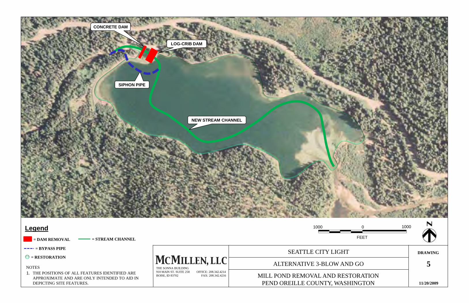
SEATTLE CITY LIGHT
THE POSITIONS OF ALL FEATURES IDENTIFIED ARE APPROXIMATE AND ARE ONLY INTENDED TO AID IN DEPICTING SITE FEATURES.
1.NOTES
11/20/2009
ALTERNATIVE 3-BLOW AND GO
MILL POND REMOVAL AND RESTORATIONPEND OREILLE COUNTY, WASHINGTON
THE SONNA BUILDING910 MAIN ST. SUITE 258 OFFICE: 208.342.4214BOISE, ID 83702 FAX: 208.342.4216
FEET
1000 0 1000Legend
= RESTORATION
= DAM REMOVAL = STREAM CHANNEL
LOG-CRIB DAM
CONCRETE DAM
5
SIPHON PIPE
NEW STREAM CHANNEL
= BYPASS PIPEDRAWING
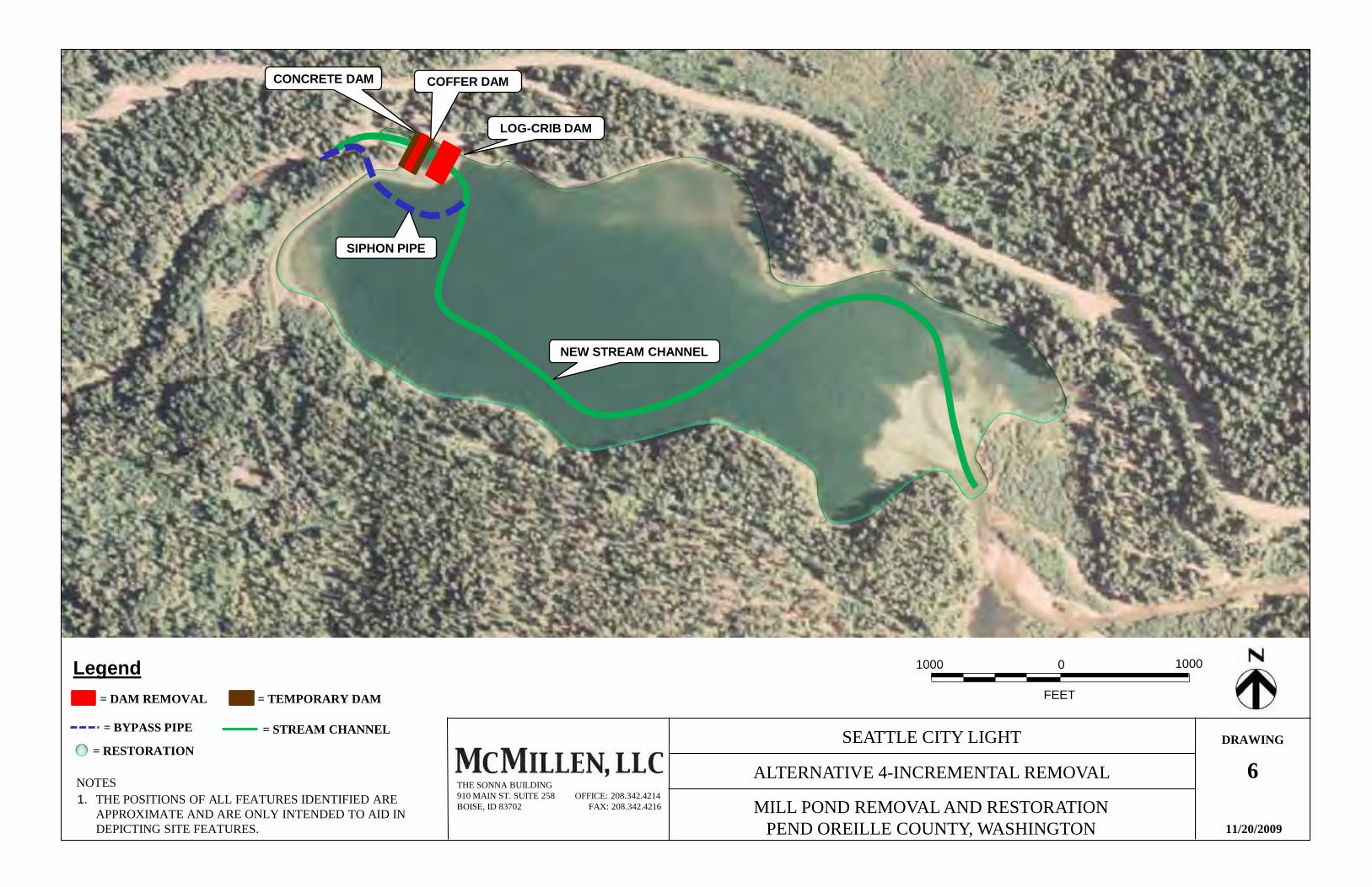
SEATTLE CITY LIGHT
THE POSITIONS OF ALL FEATURES IDENTIFIED ARE APPROXIMATE AND ARE ONLY INTENDED TO AID IN DEPICTING SITE FEATURES.
1.NOTES
11/20/2009
ALTERNATIVE 4-INCREMENTAL REMOVAL
MILL POND REMOVAL AND RESTORATIONPEND OREILLE COUNTY, WASHINGTON
THE SONNA BUILDING910 MAIN ST. SUITE 258 OFFICE: 208.342.4214BOISE, ID 83702 FAX: 208.342.4216
FEET
1000 0 1000Legend
= RESTORATION
= DAM REMOVAL
= STREAM CHANNEL
LOG-CRIB DAM
CONCRETE DAM COFFER DAM
= TEMPORARY DAM
6
SIPHON PIPE
NEW STREAM CHANNEL
= BYPASS PIPEDRAWING
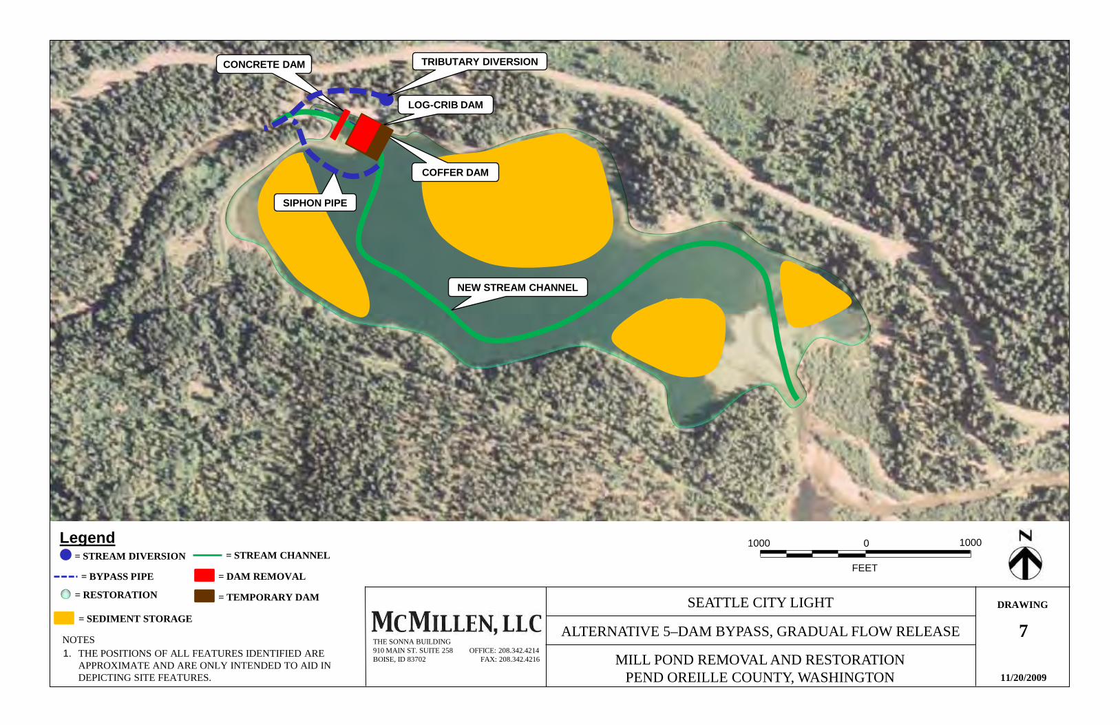
SEATTLE CITY LIGHT
THE POSITIONS OF ALL FEATURES IDENTIFIED ARE APPROXIMATE AND ARE ONLY INTENDED TO AID IN DEPICTING SITE FEATURES.
1.NOTES
11/20/2009
ALTERNATIVE 5–DAM BYPASS, GRADUAL FLOW RELEASE
MILL POND REMOVAL AND RESTORATIONPEND OREILLE COUNTY, WASHINGTON
THE SONNA BUILDING910 MAIN ST. SUITE 258 OFFICE: 208.342.4214BOISE, ID 83702 FAX: 208.342.4216
FEET
1000 0 1000Legend= STREAM DIVERSION
= RESTORATION
= BYPASS PIPE = DAM REMOVAL
= STREAM CHANNEL
LOG-CRIB DAM
TRIBUTARY DIVERSIONCONCRETE DAM
= TEMPORARY DAM
= SEDIMENT STORAGE7
COFFER DAM
SIPHON PIPE
NEW STREAM CHANNEL
DRAWING

HGFEDCBA
6
5
4
3
2
1
HGFEDCBA
By
Description
Date
Revision
Date:
9 DEC 2009
ArcGIS File Name:
MillPond.mxd
Contract Number:
Designed by:
Drawn by:
Checked by:
Submitted by:
MILL POND
REMOVAL AND RESTORATION
DRAWING 8
PEND OREILLE COUNTY
WASHINGTON
BASELINE STUDY AREA MAP
NOTES:
1. THIS MAP WAS GENERATED FROM THE FOLLOWING SOURCES:
A. USDA-APFO NATIONAL AGRICULTURAL INVENTORY PROJECT (NAIP) AERIALPHOTOGRAPH, 2009.
B. STATEWIDE HYDROGRAPHY GIS DATA FROM WASHINGTON DEPARTMENT OFNATURAL RESOURCES
2. BASELINE STUDY AREA CONSISTS OF 100-FOOT BUFFER FROM EDGE OFSTREAMS AND WATERBODIES. 01500 1500
MetalineFalls
Mill Pond
Lower Sullivan Creek
Lime LakePe
nd O
reille
Rive
r
NF Sullivan Creek
Elk Creek
Outlet Creek
SullivanLake
Sullivan Lake Dam
Mill Pond Dam
1,500 0 1,500 Feet
LegendBaseline Study Area
Statewide Hydrograph: Water Bodies
Statewide Hydrography: Streams

HGFEDCBA
6
5
4
3
2
1
HGFEDCBA
BB BByy yy
DD DDee ee
ss sscc cc
rr rrii ii pp pp
tt tt ii iioo oo
nn nnDD DD
aa aatt ttee ee
RR RRee ee
vv vvii ii ss ss
ii ii oo oonn nn
Da
te:
Da
te:
Da
te:
Da
te:
9
DE
C
20
09
9
DE
C
20
09
9
DE
C
20
09
9
DE
C
20
09
Arc
GIS
F
ile
N
am
e:
Arc
GIS
F
ile
N
am
e:
Arc
GIS
F
ile
N
am
e:
Arc
GIS
F
ile
N
am
e:
Mil
lPo
nd
.mx
dM
illP
on
d.m
xd
Mil
lPo
nd
.mx
dM
illP
on
d.m
xd
Co
ntr
ac
t N
um
be
r:C
on
tra
ct
Nu
mb
er:
Co
ntr
ac
t N
um
be
r:C
on
tra
ct
Nu
mb
er:
De
sig
ne
d
by:
De
sig
ne
d
by:
De
sig
ne
d
by:
De
sig
ne
d
by:
Dra
wn
b
y:
Dra
wn
b
y:
Dra
wn
b
y:
Dra
wn
b
y:
Ch
ec
ke
d
by:
Ch
ec
ke
d
by:
Ch
ec
ke
d
by:
Ch
ec
ke
d
by:
SS SSuu uu
bb bbmm mm
ii ii tt tttt ttee ee
dd dd
bb bbyy yy
:: ::
MIL
L
PO
ND
MIL
L
PO
ND
MIL
L
PO
ND
MIL
L
PO
ND
RE
MO
VA
L
AN
D
RE
STO
RA
TIO
NR
EM
OV
AL
AN
D
RE
STO
RA
TIO
NR
EM
OV
AL
AN
D
RE
STO
RA
TIO
NR
EM
OV
AL
AN
D
RE
STO
RA
TIO
N
DDDDRRRRAAAAWWWWIIIINNNNGGGG 9999
q
PE
ND
O
RE
ILLE
C
OU
NTY
PE
ND
O
RE
ILLE
C
OU
NTY
PE
ND
O
RE
ILLE
C
OU
NTY
PE
ND
O
RE
ILLE
C
OU
NTY
WA
SH
ING
TO
NW
AS
HIN
GTO
NW
AS
HIN
GTO
NW
AS
HIN
GTO
N
UU UUSS SS
GG GGSS SS
TT TTOO OO
PP PPOO OO
GG GGRR RR
AA AAPP PP
HH HHII II CC CC
QQ QQUU UU
AA AADD DD
RR RRAA AA
NN NNGG GG
LL LLEE EE
MM MM
AA AAPP PP
NOTES:
1. THIS MAP WAS GENERATED FROM THE FOLLOWING SOURCES:
A. PORTION OF METALINE FALLS, WA USGS 7.5 MINUTE SERIES TOPOGRAPHICQUADRANGLE MAP (1967, PHOTOREVISED 1986)
2. BASELINE STUDY AREA CONSISTS OF 100-FOOT BUFFER FROM EDGE OFSTREAMS AND WATERBODIES.
Legend
Baseline Study Area
1,500 0 1,500 Feet

HGFEDCBA
6
5
4
3
2
1
HGFEDCBA
By
Description
Date
Revision
Date:
9 DEC 2009
ArcGIS File Name:
MillPond.mxd
Contract Number:
Designed by:
Drawn by:
Checked by:
Submitted by:
MILL POND
REMOVAL AND RESTORATION
DRAWING 10
PEND OREILLE COUNTY
WASHINGTON
SURFICIAL GEOLOGY MAP
Cph(m)
Qgl
Qgd
Qgd
OCcb(d)
OCcb(b)
Qgl
Qgl
wtr
wtr
Kig(s)
OCcb(b)
OCcb(d)
OCcb(l)
OCcb(l)
OCcb(d)
OCcb(d)
CZq(5g)
OCcb(d)
wtr
wtr
Cph(m)
Cph(m)OCcb(d)
OCcb(d)
Omm(l)
wtr
OCcb(l)
OCcb(d)
Cph(m)
OCcb(d)
OCcb(d) OCcb(b)
NOTES:
1. THIS MAP WAS GENERATED FROM THE FOLLOWING SOURCES:
A. WASHINGTON DEPARTMENT OF NATURAL RESOUCES SURFACE GEOLOGY GISDATA
2. MODIFIED STUDY AREA CONSISTS OF 1/4-MILE BUFFER FROM EDGE OFSTREAMS AND WATERBODIES.
LegendModified Study Area
Roads
OCcb(d): Metaline Formation, bedded dolomite
Qgl: glaciolacustrine deposits
Cph(m): Maitlen Phyllite
Kig(s): granite
Qgd: continental glacial drift
Wtr: Water
Faults
1,500 0 1,500 Feet
Mill Pond
Pend
Ore
ille R
iver High
way 31
Sullivan Lake Rd

HGFEDCBA
6
5
4
3
2
1
HGFEDCBA
BB BByy yy
DD DDee ee
ss sscc cc
rr rrii ii pp pp
tt tt ii iioo oo
nn nnDD DD
aa aatt ttee ee
RR RRee ee
vv vvii ii ss ss
ii ii oo oonn nn
Da
te:
Da
te:
Da
te:
Da
te:
9
DE
C
20
09
9
DE
C
20
09
9
DE
C
20
09
9
DE
C
20
09
Arc
GIS
F
ile
N
am
e:
Arc
GIS
F
ile
N
am
e:
Arc
GIS
F
ile
N
am
e:
Arc
GIS
F
ile
N
am
e:
Mil
lPo
nd
.mx
dM
illP
on
d.m
xd
Mil
lPo
nd
.mx
dM
illP
on
d.m
xd
Co
ntr
ac
t N
um
be
r:C
on
tra
ct
Nu
mb
er:
Co
ntr
ac
t N
um
be
r:C
on
tra
ct
Nu
mb
er:
De
sig
ne
d
by:
De
sig
ne
d
by:
De
sig
ne
d
by:
De
sig
ne
d
by:
Dra
wn
b
y:
Dra
wn
b
y:
Dra
wn
b
y:
Dra
wn
b
y:
Ch
ec
ke
d
by:
Ch
ec
ke
d
by:
Ch
ec
ke
d
by:
Ch
ec
ke
d
by:
SS SSuu uu
bb bbmm mm
ii ii tt tttt ttee ee
dd dd
bb bbyy yy
:: ::
MIL
L
PO
ND
MIL
L
PO
ND
MIL
L
PO
ND
MIL
L
PO
ND
RE
MO
VA
L
AN
D
RE
STO
RA
TIO
NR
EM
OV
AL
AN
D
RE
STO
RA
TIO
NR
EM
OV
AL
AN
D
RE
STO
RA
TIO
NR
EM
OV
AL
AN
D
RE
STO
RA
TIO
N
DDDDRRRRAAAAWWWWIIIINNNNGGGG 11111111
q
PE
ND
O
RE
ILLE
C
OU
NTY
PE
ND
O
RE
ILLE
C
OU
NTY
PE
ND
O
RE
ILLE
C
OU
NTY
PE
ND
O
RE
ILLE
C
OU
NTY
WA
SH
ING
TO
NW
AS
HIN
GTO
NW
AS
HIN
GTO
NW
AS
HIN
GTO
N
UU UUSS SS
DD DDAA AA
NN NN
RR RRCC CC
SS SS
SS SSOO OO
II II LL LLSS SS
MM MM
AA AAPP PP
7
3
6
139
3
651
50
93
4
18
65
144
16
64
87
90
2
73
2
159
108
6
60
144
99
49
129
94
159
142
94
70
20
64
162
20
18
86
93
59
15
63
43
16
43
2
43
18
86
94
11
15
43
163
163
127
61
16
90
139
145
61
113
94
61
48
1
107
76
56
60
86
86
162
157
1
88
142
22
20
55
93
17
17
56
144
8650
88
128
142
86
18
129
70
163
8756
142
22
93
64
99
163
160
2
119
119
143
143
129
99
86
163
110
163
70
122
163
22
44
113
119
99
99
163
107
22
163
163
163
18
NOTES:
1. THIS MAP WAS GENERATED FROM THE FOLLOWING SOURCES:
A. USDA-APFO NATIONAL AGRICULTURAL INVENTORY PROJECT (NAIP) AERIALPHOTOGRAPH, 2009.
B. USDA NRCS SOIL DATA MART
2. MODIFIED STUDY AREA CONSISTS OF 1/4-MILE BUFFER FROM EDGE OFSTREAMS AND WATERBODIES
SOIL IDENTIFICATION:
1. Ahren loam, 2 to 20 percent slopes2. Ahren loam, 20 to 40 percent slopes3. Ahren loam, 40 to 65 percent slopes4. Aits loam, high precipitation, 0 to 15 percent slopes6. Aits loam, high precipitation, 25 to 40 percent slopes7. Aits loam, high precipitation, 40 to 65 percent slopes16. Belzar silt loam, high precipitation, 40 to 65 percent slopes17. Belzar, high precipitation-Rock outcrop complex, 5 to 40 percent slopes20. Bonner silt loam, 0 to 10 percent slopes22. Borosaprists, ponded50. Hartill-Rock outcrop complex, 40 to 65 percent slopes55. Inkler gravelly silt loam, 0 to 20 percent slopes56. Inkler gravelly silt loam, 20 to 40 percent slopes59. Inkler-Rock outcrop coomplex, 40 to 65 percent slopes60. Kaniksu sandy loam, 0 to 15 percent slopes61. Kaniksu sandy loam, 15 to 40 percent slopes63. Kiehl gravelly silt loam, 0 to 10 percent slopes65. Manley silt loam, 40 to 65 percent slopes70. Martella silt loam, 0 to 5 percent slopes73. Martella silt loam, 25 to 40 percent slopes
SOIL IDENTIFICATION (cont.)
86. Newbell silt loam, 0 to 25 percent slopes87. Newbell sitl loam, 25 to 40 percent slopes90. Newbell stony silt loam, 40 to 65 percent slopes94. Newbell-Rock outcrop complex, 40 to 65 percent slopes99. Pits110. Riverwash113. Rock outcrop119. Rock outcrop-Orthents complex, 50 to 90 percent slopes122. Rubble land127. Sacheen variant silt loam128. Scotia fine sandy loam, 0 to 7 percent slopes129. Scotia fine sandy loam, 7 to 15 percent slopes139. Smackout loam, 40 to 65 percent slopes142. Threemile silt loam, 0 to 25 percent slopes143. Threemile silt loam, 25 to 40 percent slopes144. Threemile silt loam, 40 to 65 percent slopes145. Typic Xerorthents, 30 to 65 percent slopes159. Waits loam, 40 to 65 percent slopes160. Waits-Rock outcrop complex, 25 to 40 percent slopes162. Xerochrepts-Aquic Xerofluvents complex, 0 to 5 percent slopes163. Water
1,500 0 1,500 Feet
Legend
Modified Study Area
USDA Soil ID/Boundary
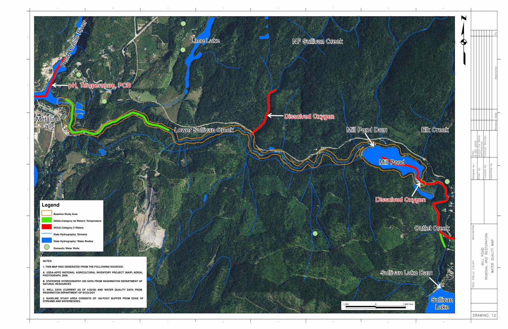
HGFEDCBA
6
5
4
3
2
1
HGFEDCBA
BB BByy yy
DD DDee ee
ss sscc cc
rr rrii ii pp pp
tt tt ii iioo oo
nn nnDD DD
aa aatt ttee ee
RR RRee ee
vv vvii ii ss ss
ii ii oo oonn nn
Da
te:
Da
te:
Da
te:
Da
te:
9
DE
C
20
09
9
DE
C
20
09
9
DE
C
20
09
9
DE
C
20
09
Arc
GIS
F
ile
N
am
e:
Arc
GIS
F
ile
N
am
e:
Arc
GIS
F
ile
N
am
e:
Arc
GIS
F
ile
N
am
e:
Mil
lPo
nd
.mx
dM
illP
on
d.m
xd
Mil
lPo
nd
.mx
dM
illP
on
d.m
xd
Co
ntr
ac
t N
um
be
r:C
on
tra
ct
Nu
mb
er:
Co
ntr
ac
t N
um
be
r:C
on
tra
ct
Nu
mb
er:
De
sig
ne
d
by:
De
sig
ne
d
by:
De
sig
ne
d
by:
De
sig
ne
d
by:
Dra
wn
b
y:
Dra
wn
b
y:
Dra
wn
b
y:
Dra
wn
b
y:
Ch
ec
ke
d
by:
Ch
ec
ke
d
by:
Ch
ec
ke
d
by:
Ch
ec
ke
d
by:
SS SSuu uu
bb bbmm mm
ii ii tt tttt ttee ee
dd dd
bb bbyy yy
:: ::
MIL
L
PO
ND
MIL
L
PO
ND
MIL
L
PO
ND
MIL
L
PO
ND
RE
MO
VA
L
AN
D
RE
STO
RA
TIO
NR
EM
OV
AL
AN
D
RE
STO
RA
TIO
NR
EM
OV
AL
AN
D
RE
STO
RA
TIO
NR
EM
OV
AL
AN
D
RE
STO
RA
TIO
N
DDDDRRRRAAAAWWWWIIIINNNNGGGG 11112222
q
PE
ND
O
RE
ILLE
C
OU
NTY
PE
ND
O
RE
ILLE
C
OU
NTY
PE
ND
O
RE
ILLE
C
OU
NTY
PE
ND
O
RE
ILLE
C
OU
NTY
WA
SH
ING
TO
NW
AS
HIN
GTO
NW
AS
HIN
GTO
NW
AS
HIN
GTO
N
WW WWAA AA
TT TTEE EE
RR RR
QQ QQUU UU
AA AALL LLII II TT TT
YY YY
MM MMAA AA
PP PP
NOTES:
1. THIS MAP WAS GENERATED FROM THE FOLLOWING SOURCES:
A. USDA-APFO NATIONAL AGRICULTURAL INVENTORY PROJECT (NAIP) AERIALPHOTOGRAPH, 2009.
B. STATEWIDE HYDROGRAPHY GIS DATA FROM WASHINGTON DEPARTMENT OFNATURAL RESOURCES
C. WELL DATA (CURRENT AS OF 4/29/09) AND WATER QUALITY DATA FROMWASHINGTON DEPARTMENT OF ECOLOGY
2. BASELINE STUDY AREA CONSISTS OF 100-FOOT BUFFER FROM EDGE OFSTREAMS AND WATERBODIES.
Metaline
Falls
Mill Pond
Lower Sullivan Creek
Lime Lake
Pend O
reill
e R
iver
NF Sullivan Creek
Elk Creek
Outlet Creek
Sullivan
Lake
Sullivan Lake Dam
Mill Pond Dam
1,500 0 1,500 Feet
Legend
Baseline Study Area
305(b)-Category 4a Waters: Temperature
303(d)-Category 5 Waters
State Hydrography: Streams
State Hydrography: Water Bodies
Domestic Water Wells
Dissolved Oxygen
Dissolved Oxygen
pH, Temperature, PCB

HGFEDCBA
6
5
4
3
2
1
HGFEDCBA
BB BByy yy
DD DDee ee
ss sscc cc
rr rrii ii pp pp
tt tt ii iioo oo
nn nnDD DD
aa aatt ttee ee
RR RRee ee
vv vvii ii ss ss
ii ii oo oonn nn
Da
te:
Da
te:
Da
te:
Da
te:
9
DE
C
20
09
9
DE
C
20
09
9
DE
C
20
09
9
DE
C
20
09
Arc
GIS
F
ile
N
am
e:
Arc
GIS
F
ile
N
am
e:
Arc
GIS
F
ile
N
am
e:
Arc
GIS
F
ile
N
am
e:
Mil
lPo
nd
.mx
dM
illP
on
d.m
xd
Mil
lPo
nd
.mx
dM
illP
on
d.m
xd
Co
ntr
ac
t N
um
be
r:C
on
tra
ct
Nu
mb
er:
Co
ntr
ac
t N
um
be
r:C
on
tra
ct
Nu
mb
er:
De
sig
ne
d
by:
De
sig
ne
d
by:
De
sig
ne
d
by:
De
sig
ne
d
by:
Dra
wn
b
y:
Dra
wn
b
y:
Dra
wn
b
y:
Dra
wn
b
y:
Ch
ec
ke
d
by:
Ch
ec
ke
d
by:
Ch
ec
ke
d
by:
Ch
ec
ke
d
by:
SS SSuu uu
bb bbmm mm
ii ii tt tttt ttee ee
dd dd
bb bbyy yy
:: ::
MIL
L
PO
ND
MIL
L
PO
ND
MIL
L
PO
ND
MIL
L
PO
ND
RE
MO
VA
L
AN
D
RE
STO
RA
TIO
NR
EM
OV
AL
AN
D
RE
STO
RA
TIO
NR
EM
OV
AL
AN
D
RE
STO
RA
TIO
NR
EM
OV
AL
AN
D
RE
STO
RA
TIO
N
DDDDRRRRAAAAWWWWIIIINNNNGGGG 11113333
q
PE
ND
O
RE
ILLE
C
OU
NTY
PE
ND
O
RE
ILLE
C
OU
NTY
PE
ND
O
RE
ILLE
C
OU
NTY
PE
ND
O
RE
ILLE
C
OU
NTY
WA
SH
ING
TO
NW
AS
HIN
GTO
NW
AS
HIN
GTO
NW
AS
HIN
GTO
N
NN NNWW WW
II II WW WW
EE EETT TTLL LLAA AA
NN NNDD DD
SS SS
AA AANN NN
DD DD
SS SSTT TTRR RR
EE EEAA AA
MM MMSS SS
MM MM
AA AAPP PP
L1UBHH
L1UBH
PSS1C
L1UBHH
PEM1F
PSS4C
PSS1C
PFO1C
PUSCx
L2USC
PUBH
PUBH
PUBH
PEM1A
R3USC
PSS1C
R3UBH
PSS1C
PEM1F
PUBHB
PFO1A
PEM1C
R3USC
PEM1C
PEM1F
PUBH
PEM1C
PSS1C
R3USC
PSS1C
R3USC
PEM1C
PUBHB
PSS1C
PUBHx
PUBH
PFO1A
PEM1C
PUBH
PUBH
PEM1F
PEM1C
PSS1C
NOTES:
1. THIS MAP WAS GENERATED FROM THE FOLLOWING SOURCES:
A. USDA-APFO NATIONAL AGRICULTURAL INVENTORY PROJECT (NAIP) AERIALPHOTOGRAPH, 2009.
B. STATEWIDE HYDROGRAPHY GIS DATA FROM WASHINGTON DEPARTMENT OFNATURAL RESOURCES
C. NATIONAL WETLANDS INVENTORY MAP LAYER FROM US FISH AND WILDLIFESERVICE
2. BASELINE STUDY AREA CONSISTS OF 100-FOOT BUFFER FROM EDGE OFSTREAMS AND WATERBODIES.
Metaline
Falls
Legend
Baseline Study Area
Streams
NWI Wetlands
ATTRIBUTE
L1UBH
L1UBHH
L2USC
PEM1A
PEM1C
PEM1F
PFO1A
PFO1C
PSS1C
PSS4C
PUBH
PUBHB
PUBHx
PUSCx
R3UBH
R3USC
1,500 0 1,500 Feet
NWI WETLAND DESCRIPTIONS:
L1UBH: Lacustrine, Limnetic, Unconsolidated Bottom, Permanently FlodedL1UBHH: Lacustrine, Limnetic, Unconsolidated Bottom, Permanently Flooded, Diked/ImpoundedL2USC: Lacustrine, Littoral, Unconsolidated Shore, Seasonally FloodedPEM1A: Palustrine, Emergent, Persistent, Temporarily FloodedPEM1C: Palustrine, Emergent, Persistent, Seasonally FloodedPEM1F: Palustrine, Emergent, Persistent, Semipermanently FloodedPFO1A: Palustrine, Forested, Broad-leaved Deciduous, Temporarily FloodedPFO1C: Palustrine, Forested, Broad-leaved Deciduous, Seasonally FloodedPSS1C: Palustrine, Scrub-Shrub, Broad-leaved Deciduous, Seasonally FloodedPSS4C: Palustrine, Scrub-Shrub, Needle-leaved Evergreen, Seasonally FloodedPUBH: Palustrine, Unconsolidated Bottom, Permanently FloodedPUBHB: Palustrine, Unconsolidated Bottom, Permanently Flooded, BeaverPUBHx: Palustrine, Unconsolidated Bottom, Permanently Flooded, ExcavatedPUSCx: Palustrine, Unconsolidated Shore, Seasonally Flooded, ExcavatedR3UBH: Riverine, Upper Perennial, Unconsolidated Bottom, Permanently FloodedR3USC: Riverine, Upper Perennial, Unconsolidated Shore, Seasonally Flooded
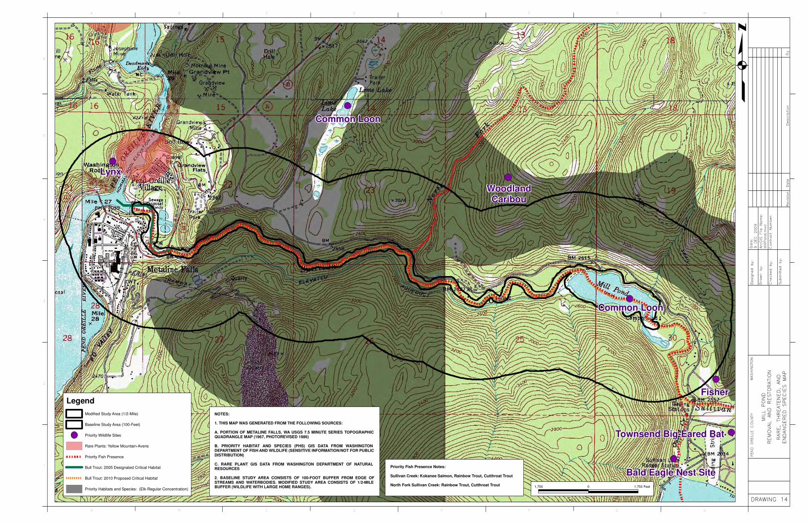
HGFEDCBA
6
5
4
3
2
1
HGFEDCBA
BB BByy yy
DD DDee ee
ss sscc cc
rr rrii ii pp pp
tt tt ii iioo oo
nn nnDD DD
aa aatt ttee ee
RR RRee ee
vv vvii ii ss ss
ii ii oo oonn nn
Da
te:
Da
te:
Da
te:
Da
te:
9
DE
C
20
09
9
DE
C
20
09
9
DE
C
20
09
9
DE
C
20
09
Arc
GIS
F
ile
N
am
e:
Arc
GIS
F
ile
N
am
e:
Arc
GIS
F
ile
N
am
e:
Arc
GIS
F
ile
N
am
e:
Mil
lPo
nd
.mx
dM
illP
on
d.m
xd
Mil
lPo
nd
.mx
dM
illP
on
d.m
xd
Co
ntr
ac
t N
um
be
r:C
on
tra
ct
Nu
mb
er:
Co
ntr
ac
t N
um
be
r:C
on
tra
ct
Nu
mb
er:
De
sig
ne
d
by:
De
sig
ne
d
by:
De
sig
ne
d
by:
De
sig
ne
d
by:
Dra
wn
b
y:
Dra
wn
b
y:
Dra
wn
b
y:
Dra
wn
b
y:
Ch
ec
ke
d
by:
Ch
ec
ke
d
by:
Ch
ec
ke
d
by:
Ch
ec
ke
d
by:
SS SSuu uu
bb bbmm mm
ii ii tt tttt ttee ee
dd dd
bb bbyy yy
:: ::
MIL
L
PO
ND
MIL
L
PO
ND
MIL
L
PO
ND
MIL
L
PO
ND
RE
MO
VA
L
AN
D
RE
STO
RA
TIO
NR
EM
OV
AL
AN
D
RE
STO
RA
TIO
NR
EM
OV
AL
AN
D
RE
STO
RA
TIO
NR
EM
OV
AL
AN
D
RE
STO
RA
TIO
N
DDDDRRRRAAAAWWWWIIIINNNNGGGG 11114444
q
PE
ND
O
RE
ILLE
C
OU
NTY
PE
ND
O
RE
ILLE
C
OU
NTY
PE
ND
O
RE
ILLE
C
OU
NTY
PE
ND
O
RE
ILLE
C
OU
NTY
WA
SH
ING
TO
NW
AS
HIN
GTO
NW
AS
HIN
GTO
NW
AS
HIN
GTO
N
RR RRAA AA
RR RREE EE
,, ,, TT TTHH HH
RR RREE EE
AA AATT TTEE EE
NN NNEE EE
DD DD,, ,,
AA AANN NN
DD DD
EE EENN NN
DD DDAA AA
NN NNGG GG
EE EERR RR
EE EEDD DD
SS SS
PP PPEE EE
CC CCII II EE EE
SS SS
MM MMAA AA
PP PP
NOTES:
1. THIS MAP WAS GENERATED FROM THE FOLLOWING SOURCES:
A. PORTION OF METALINE FALLS, WA USGS 7.5 MINUTE SERIES TOPOGRAPHICQUADRANGLE MAP (1967, PHOTOREVISED 1986)
B. PRIORITY HABITAT AND SPECIES (PHS) GIS DATA FROM WASHINGTONDEPARTMENT OF FISH AND WILDLIFE (SENSITIVE INFORMATION/NOT FOR PUBLICDISTRIBUTION)
C. RARE PLANT GIS DATA FROM WASHINGTON DEPARTMENT OF NATURALRESOURCES
2. BASELINE STUDY AREA CONSISTS OF 100-FOOT BUFFER FROM EDGE OFSTREAMS AND WATERBODIES. MODIFIED STUDY AREA CONSISTS OF 1/2-MILEBUFFER (WILDLIFE WITH LARGE HOME RANGES). 1,750 0 1,750 Feet
Common Loon
WoodlandCaribou
Common Loon
Fisher
Bald Eagle Nest Site
Townsend Big-Eared Bat
Lynx
Legend
Modified Study Area (1/2-Mile)
Baseline Study Area (100-Feet)
Priority Wildlife Sites
Rare Plants: Yellow Mountain-Avens
Priority Fish Presence
Bull Trout: 2005 Designated Critical Habitat
Bull Trout: 2010 Proposed Critical Habitat
Priority Habitats and Species: (Elk-Regular Concentration)
Priority Fish Presence Notes:
Sullivan Creek: Kokanee Salmon, Rainbow Trout, Cutthroat Trout
North Fork Sullivan Creek: Rainbow Trout, Cutthroat Trout

HGFEDCBA
6
5
4
3
2
1
HGFEDCBA
BB BByy yy
DD DDee ee
ss sscc cc
rr rrii ii pp pp
tt tt ii iioo oo
nn nnDD DD
aa aatt ttee ee
RR RRee ee
vv vvii ii ss ss
ii ii oo oonn nn
Da
te:
Da
te:
Da
te:
Da
te:
9
DE
C
20
09
9
DE
C
20
09
9
DE
C
20
09
9
DE
C
20
09
Arc
GIS
F
ile
N
am
e:
Arc
GIS
F
ile
N
am
e:
Arc
GIS
F
ile
N
am
e:
Arc
GIS
F
ile
N
am
e:
Mil
lPo
nd
.mx
dM
illP
on
d.m
xd
Mil
lPo
nd
.mx
dM
illP
on
d.m
xd
Co
ntr
ac
t N
um
be
r:C
on
tra
ct
Nu
mb
er:
Co
ntr
ac
t N
um
be
r:C
on
tra
ct
Nu
mb
er:
De
sig
ne
d
by:
De
sig
ne
d
by:
De
sig
ne
d
by:
De
sig
ne
d
by:
Dra
wn
b
y:
Dra
wn
b
y:
Dra
wn
b
y:
Dra
wn
b
y:
Ch
ec
ke
d
by:
Ch
ec
ke
d
by:
Ch
ec
ke
d
by:
Ch
ec
ke
d
by:
SS SSuu uu
bb bbmm mm
ii ii tt tttt ttee ee
dd dd
bb bbyy yy
:: ::
MIL
L
PO
ND
MIL
L
PO
ND
MIL
L
PO
ND
MIL
L
PO
ND
RE
MO
VA
L
AN
D
RE
STO
RA
TIO
NR
EM
OV
AL
AN
D
RE
STO
RA
TIO
NR
EM
OV
AL
AN
D
RE
STO
RA
TIO
NR
EM
OV
AL
AN
D
RE
STO
RA
TIO
N
DDDDRRRRAAAAWWWWIIIINNNNGGGG 11115555
q
PE
ND
O
RE
ILLE
C
OU
NTY
PE
ND
O
RE
ILLE
C
OU
NTY
PE
ND
O
RE
ILLE
C
OU
NTY
PE
ND
O
RE
ILLE
C
OU
NTY
WA
SH
ING
TO
NW
AS
HIN
GTO
NW
AS
HIN
GTO
NW
AS
HIN
GTO
N
LL LLAA AA
NN NNDD DD
CC CC
OO OOVV VV
EE EERR RR
AA AA
NN NNDD DD
UU UU
SS SSEE EE
MM MM
AA AAPP PP
NOTES:
1. THIS MAP WAS GENERATED FROM THE FOLLOWING SOURCES:
A. LAND COVER AND USE AREAS BASED ON INTERPRETATION OF USDA-APFONATIONAL AGRICULTURAL INVENTORY PROJECT (NAIP) AERIAL PHOTOGRAPH,2009. AREAS ARE APPROXIMATE AND WERE NOT FIELD VERIFIED.
B. STATEWIDE HYDROGRAPHY GIS DATA FROM WASHINGTON DEPARTMENT OFNATURAL RESOURCES
2. BASELINE STUDY AREA CONSISTS OF 100-FOOT BUFFER FROM EDGE OFSTREAMS AND WATERBODIES.
Metaline
Falls
Mill Pond
Lower Sullivan Creek
Lime Lake
Pend O
reill
e R
iver
NF Sullivan Creek
Elk Creek
Sullivan
Lake
1,500 0 1,500 Feet
Legend
Roads
Baseline Study Area
Statewide Hydrography: Streams
Agriculture/Pasture
Deciduous Forest
Developed
Quarry
Rock Cliff
Wetland
Lacustrine/Littoral/Riverine
Conifer Forest
Sullivan Lake Rd
Hig
hway
31

Mill Pond Campground
Mill Pond Picnic Area
HGFEDCBA
6
5
4
3
2
1
HGFEDCBA
BB BByy yy
DD DDee ee
ss sscc cc
rr rrii ii pp pp
tt tt ii iioo oo
nn nnDD DD
aa aatt ttee ee
RR RRee ee
vv vvii ii ss ss
ii ii oo oonn nn
Da
te:
Da
te:
Da
te:
Da
te:
9
DE
C
20
09
9
DE
C
20
09
9
DE
C
20
09
9
DE
C
20
09
Arc
GIS
F
ile
N
am
e:
Arc
GIS
F
ile
N
am
e:
Arc
GIS
F
ile
N
am
e:
Arc
GIS
F
ile
N
am
e:
Mil
lPo
nd
.mx
dM
illP
on
d.m
xd
Mil
lPo
nd
.mx
dM
illP
on
d.m
xd
Co
ntr
ac
t N
um
be
r:C
on
tra
ct
Nu
mb
er:
Co
ntr
ac
t N
um
be
r:C
on
tra
ct
Nu
mb
er:
De
sig
ne
d
by:
De
sig
ne
d
by:
De
sig
ne
d
by:
De
sig
ne
d
by:
Dra
wn
b
y:
Dra
wn
b
y:
Dra
wn
b
y:
Dra
wn
b
y:
Ch
ec
ke
d
by:
Ch
ec
ke
d
by:
Ch
ec
ke
d
by:
Ch
ec
ke
d
by:
SS SSuu uu
bb bbmm mm
ii ii tt tttt ttee ee
dd dd
bb bbyy yy
:: ::
MIL
L
PO
ND
MIL
L
PO
ND
MIL
L
PO
ND
MIL
L
PO
ND
RE
MO
VA
L
AN
D
RE
STO
RA
TIO
NR
EM
OV
AL
AN
D
RE
STO
RA
TIO
NR
EM
OV
AL
AN
D
RE
STO
RA
TIO
NR
EM
OV
AL
AN
D
RE
STO
RA
TIO
N
DDDDRRRRAAAAWWWWIIIINNNNGGGG 11116666
q
PE
ND
O
RE
ILLE
C
OU
NTY
PE
ND
O
RE
ILLE
C
OU
NTY
PE
ND
O
RE
ILLE
C
OU
NTY
PE
ND
O
RE
ILLE
C
OU
NTY
WA
SH
ING
TO
NW
AS
HIN
GTO
NW
AS
HIN
GTO
NW
AS
HIN
GTO
N
DD DDEE EE
VV VVEE EE
LL LLOO OO
PP PPEE EE
DD DD
RR RREE EE
CC CCRR RR
EE EEAA AA
TT TTII II OO OO
NN NN
SS SSII II TT TT
EE EESS SS
MM MM
AA AAPP PP
NOTES:
1. THIS MAP WAS GENERATED FROM THE FOLLOWING SOURCES:
A. USDA-APFO NATIONAL AGRICULTURAL INVENTORY PROJECT (NAIP) AERIALPHOTOGRAPH, 2009.
B. RECREATION SITES FROM US FOREST SERVICE GIS DATA FOR COLVILLE ANDOKANOGAN-WENATCHEE NATIONAL FORESTS
2. MODIFIED STUDY AREA CONSISTS OF 1/4-MILE BUFFER FROM EDGE OFSTREAMS AND WATERBODIES.
1,500 0 1,500 Feet
Mill Pond Flume Trail
Mill Pond Loop Trail
Elk River/Red Bluff Trail
Legend
Modified Study Area
Developed Recreation Sites
Trail System
Sullivan Lake Campground West

HGFEDCBA
6
5
4
3
2
1
HGFEDCBA
BB BByy yy
DD DDee ee
ss sscc cc
rr rrii ii pp pp
tt tt ii iioo oo
nn nnDD DD
aa aatt ttee ee
RR RRee ee
vv vvii ii ss ss
ii ii oo oonn nn
Da
te:
Da
te:
Da
te:
Da
te:
9
DE
C
20
09
9
DE
C
20
09
9
DE
C
20
09
9
DE
C
20
09
Arc
GIS
F
ile
N
am
e:
Arc
GIS
F
ile
N
am
e:
Arc
GIS
F
ile
N
am
e:
Arc
GIS
F
ile
N
am
e:
Mil
lPo
nd
.mx
dM
illP
on
d.m
xd
Mil
lPo
nd
.mx
dM
illP
on
d.m
xd
Co
ntr
ac
t N
um
be
r:C
on
tra
ct
Nu
mb
er:
Co
ntr
ac
t N
um
be
r:C
on
tra
ct
Nu
mb
er:
De
sig
ne
d
by:
De
sig
ne
d
by:
De
sig
ne
d
by:
De
sig
ne
d
by:
Dra
wn
b
y:
Dra
wn
b
y:
Dra
wn
b
y:
Dra
wn
b
y:
Ch
ec
ke
d
by:
Ch
ec
ke
d
by:
Ch
ec
ke
d
by:
Ch
ec
ke
d
by:
SS SSuu uu
bb bbmm mm
ii ii tt tttt ttee ee
dd dd
bb bbyy yy
:: ::
MIL
L
PO
ND
MIL
L
PO
ND
MIL
L
PO
ND
MIL
L
PO
ND
RE
MO
VA
L
AN
D
RE
STO
RA
TIO
NR
EM
OV
AL
AN
D
RE
STO
RA
TIO
NR
EM
OV
AL
AN
D
RE
STO
RA
TIO
NR
EM
OV
AL
AN
D
RE
STO
RA
TIO
N
DDDDRRRRAAAAWWWWIIIINNNNGGGG 11117777
q
PE
ND
O
RE
ILLE
C
OU
NTY
PE
ND
O
RE
ILLE
C
OU
NTY
PE
ND
O
RE
ILLE
C
OU
NTY
PE
ND
O
RE
ILLE
C
OU
NTY
WA
SH
ING
TO
NW
AS
HIN
GTO
NW
AS
HIN
GTO
NW
AS
HIN
GTO
N
LL LLAA AA
NN NNDD DD
OO OO
WW WWNN NN
EE EERR RR
SS SSHH HH
II II PP PP
MM MMAA AA
PP PP
NOTES:
1. THIS MAP WAS GENERATED FROM THE FOLLOWING SOURCES:
A. US FOREST SERVICE GIS DATA FOR COLVILLE AND OKANOGAN-WENATCHEENATIONAL FORESTS.
B. STATEWIDE HYDROGRAPHY GIS DATA FROM WASHINGTON DEPARTMENT OFNATURAL RESOURCES
2. BASELINE STUDY AREA CONSISTS OF 100-FOOT BUFFER FROM EDGE OFSTREAMS AND WATERBODIES.
Legend
Baseline Study Area
Private Ownership
BLM
USFS Colville National Forest
Statewide Hydrography: Streams
Statewide Hydrography: Water Bodies
Roads
Mill Pond
Metaline
Falls
Hig
hway
31
Sullivan Lake Rd
1,500 0 1,500 Feet
Pend O
reille R
iver


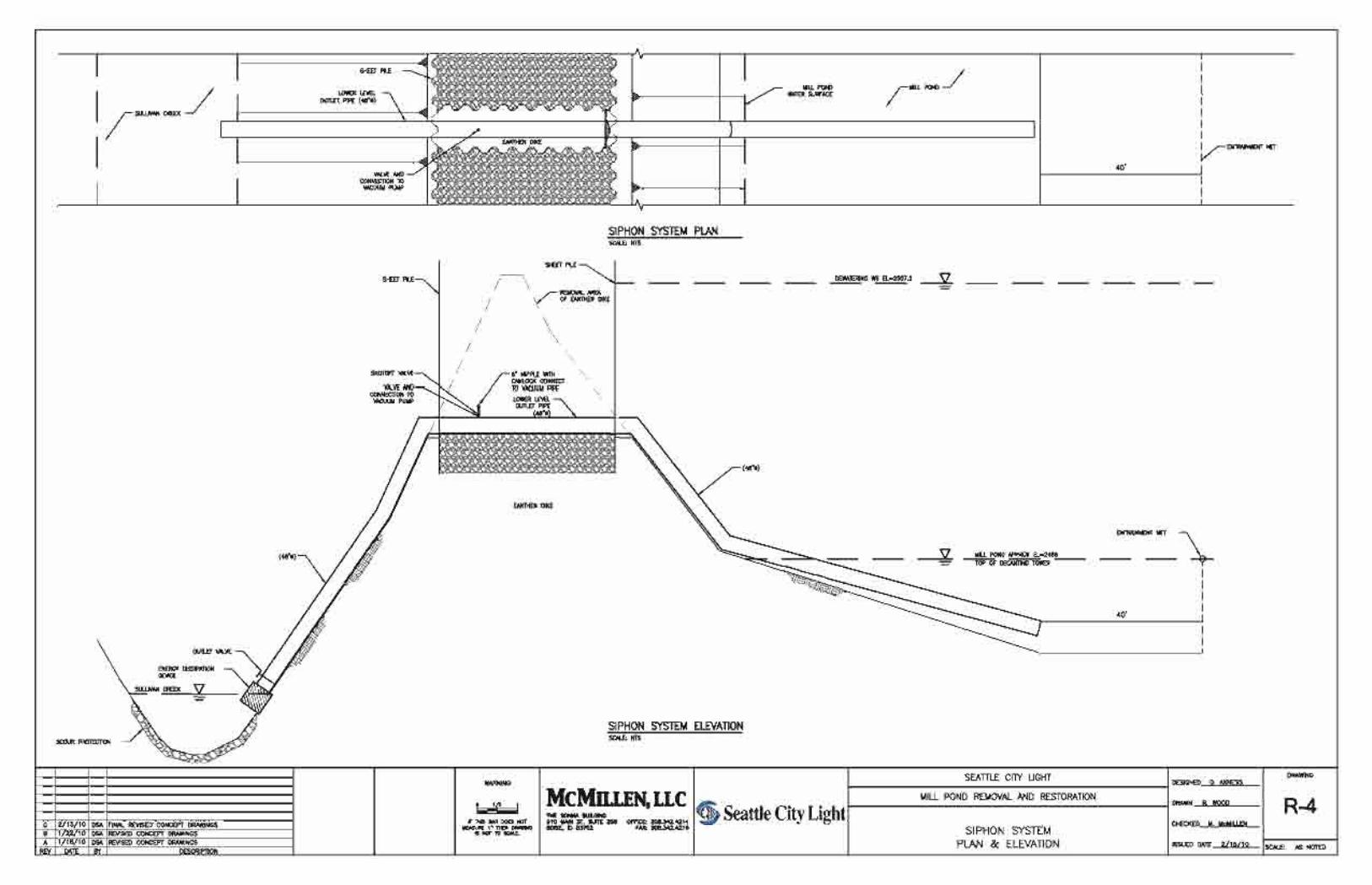
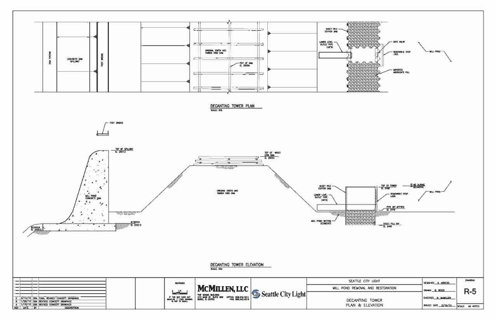


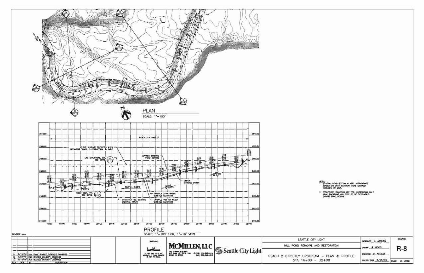

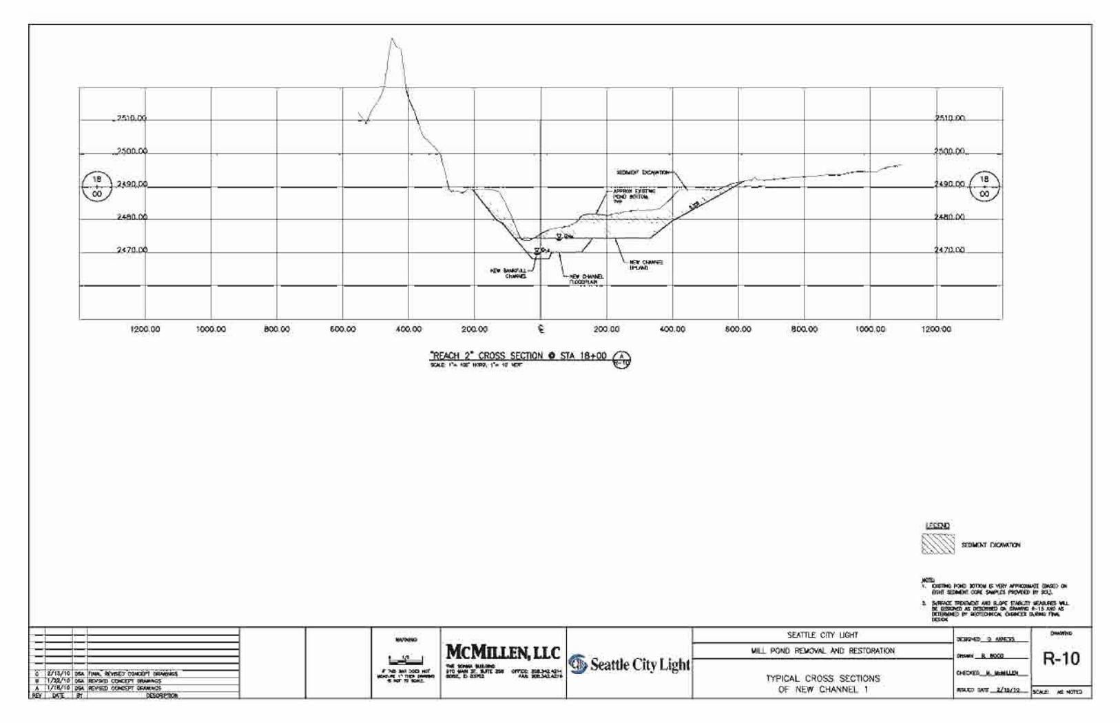
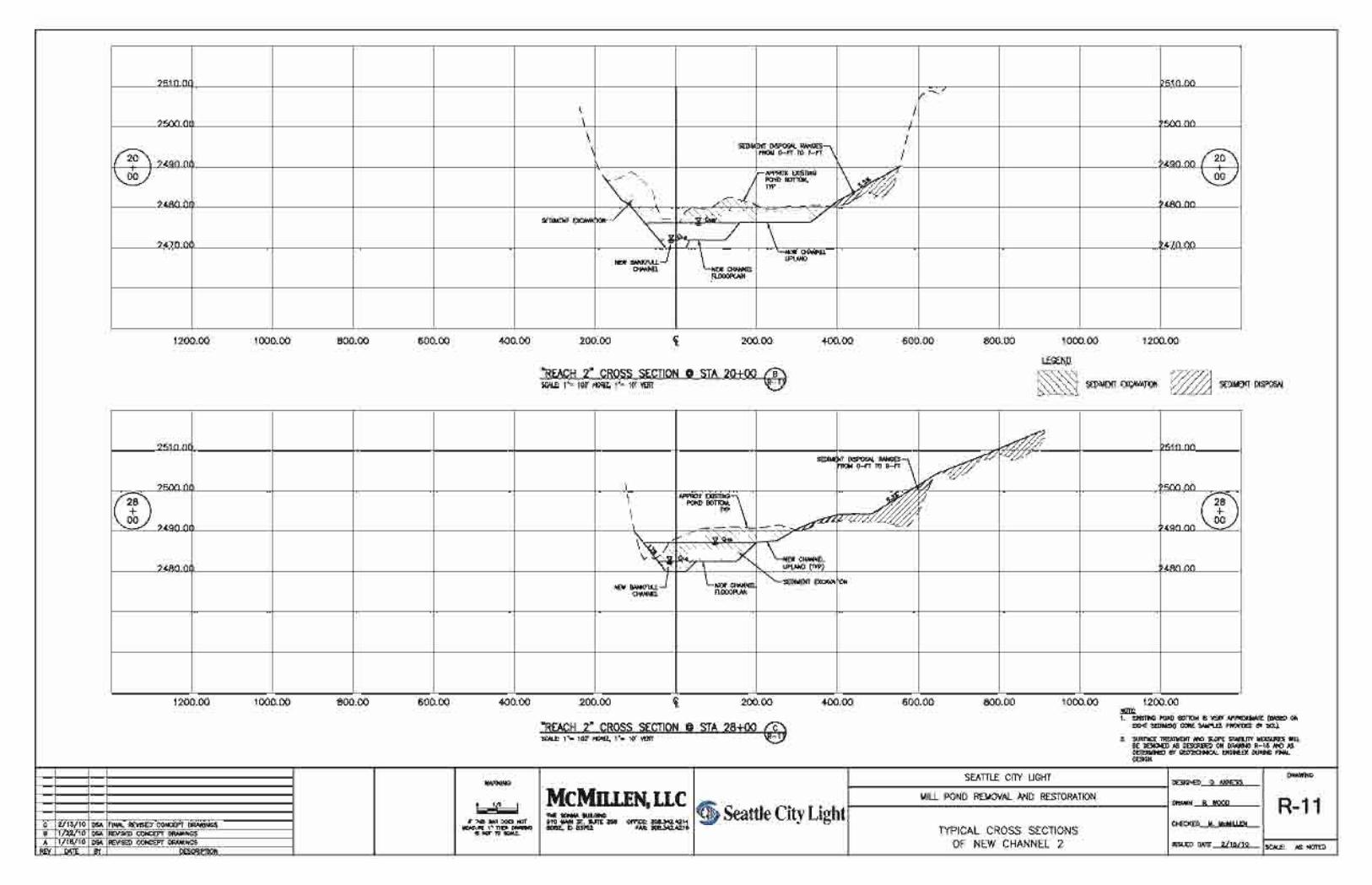
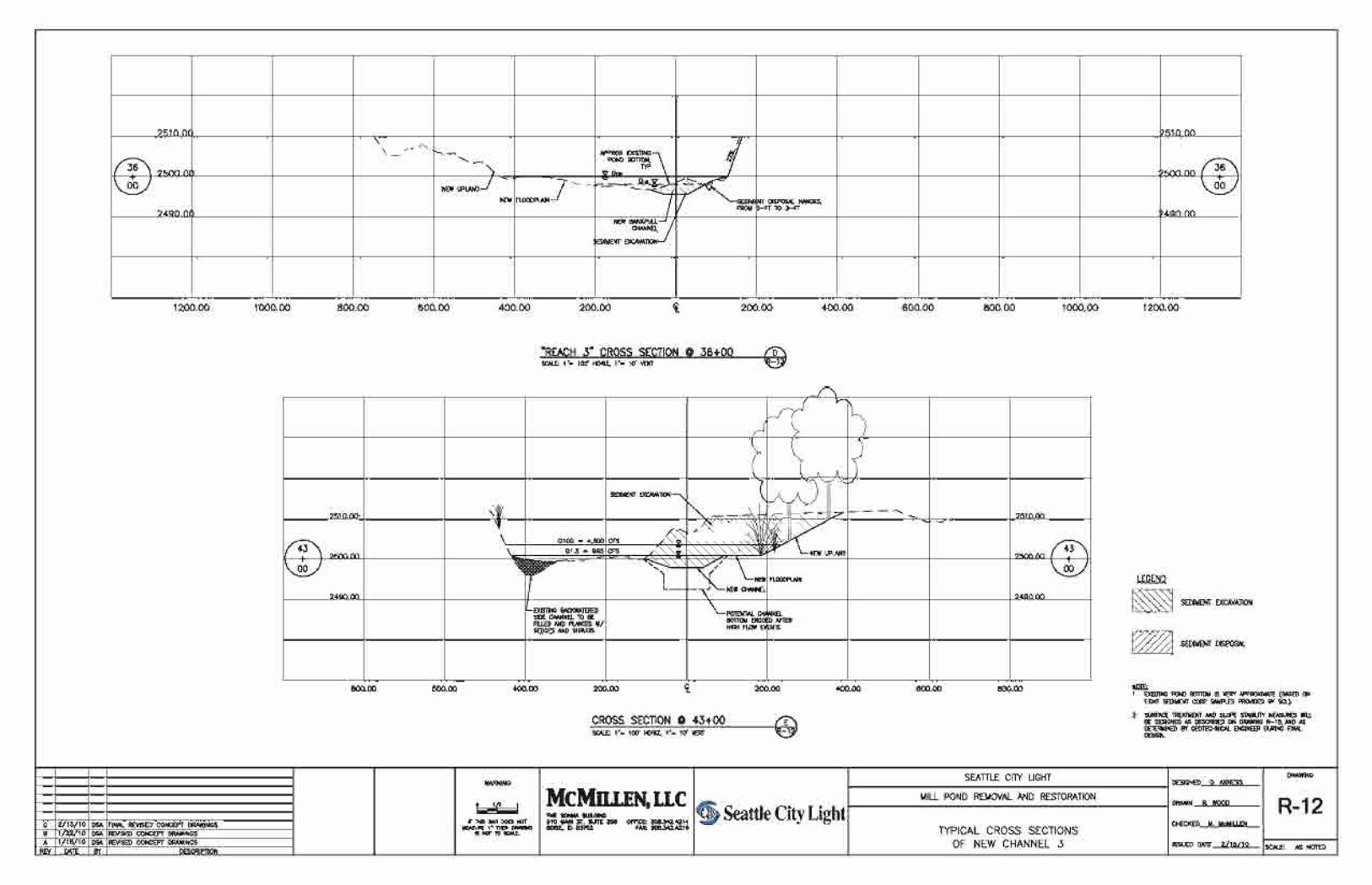


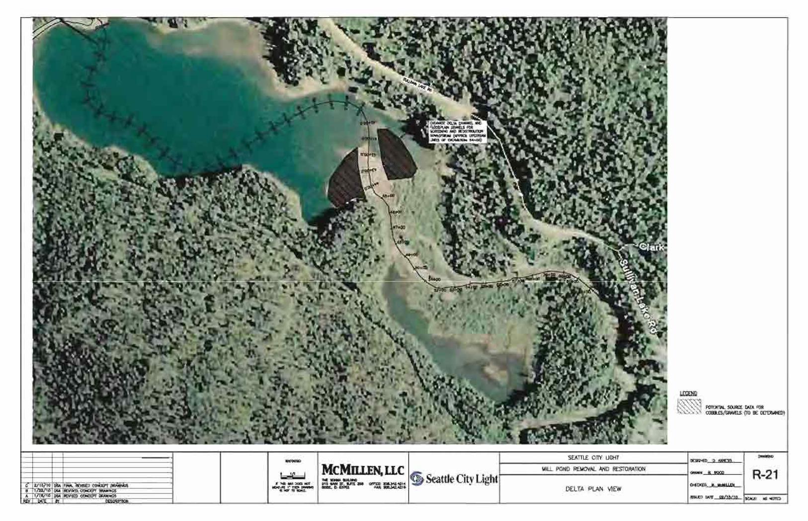

Seattle City Light Mill Pond Removal and Restoration
Report March 2010
APPENDIX A
HYDRAULIC CALCULATIONS
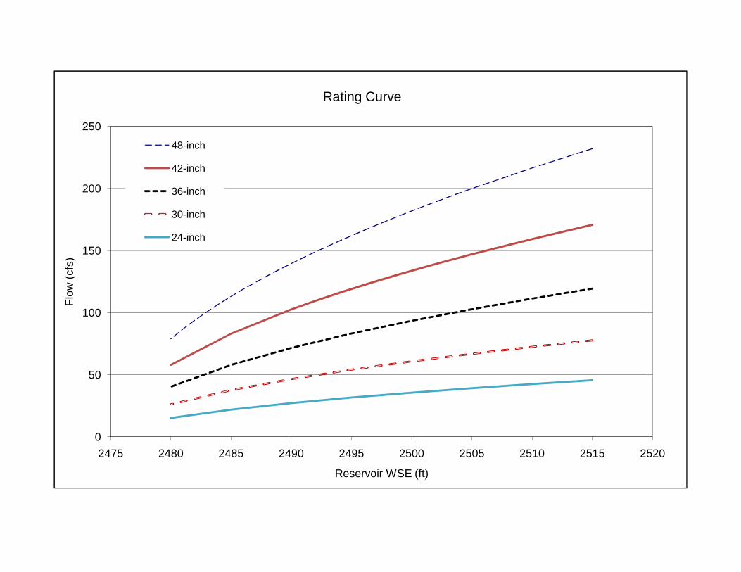
150
200
250
fs)
Rating Curve
48-inch
42-inch
36-inch
30-inch
24-inch
0
50
100
2475 2480 2485 2490 2495 2500 2505 2510 2515 2520
Flow
(cf
Reservoir WSE (ft)

McMillen Mill Pond Removal and Restoration Page: 1 of 5
LLC Siphon Calculations Date: 12/10/09JMR DSA
Job No.:Mill Pond Siphon Outlet for Dam Removal
14048500
2498 Assuming siphon is located 20 ft below top of earthen dike elevation2455
Sum of All Minor Loss Coefficients
Res. Head Flow Flow Velocity
Velocity Head K
Minor Losses
Unit Friction
Loss
Sum HL at Siphon
CrestSum HL at Outlet
Head at Siphon Crest
Head at Outlet
(ft) (cfs) (gpm) (fps) (ft) (ft) (ft/100ft) (ft) (ft) (ft) (ft)2515 232 104147 18 5.30 4 21.2 1.45 32.8 40.0 -15.8 20.02510 217 97185 17 4.61 4 18.4 1.27 28.6 35.0 -16.6 20.02505 200 89724 16 3.93 4 15.7 1.10 24.5 30.0 -17.5 20.02504 196 88161 16 3.79 4 15.2 1.06 23.7 29.0 -17.7 20.02503 193 86574 15 3.66 4 14.6 1.03 22.9 28.0 -17.9 20.02502 189 84956 15 3.52 4 14.1 0.99 22.0 27.0 -18.0 20.02501 186 83310 15 3.39 4 13.6 0.96 21.2 26.0 -18.2 20.02500 182 81633 14 3.25 4 13.0 0.92 20.4 25.0 -18.4 20.02499 178 79924 14 3.12 4 12.5 0.89 19.6 24.0 -18.6 20.02498 174 78180 14 2.98 4 11.9 0.85 18.7 23.0 -18.7 20.02497 170 76399 14 2.85 4 11.4 0.82 17.9 22.0 -18.9 20.02496 166 74578 13 2.72 4 10.9 0.78 17.1 21.0 -19.1 20.02495 162 72715 13 2.58 4 10.3 0.74 16.3 20.0 -19.3 20.02494 158 70807 13 2.45 4 9.8 0.71 15.5 19.0 -19.5 20.02493 153 68848 12 2.31 4 9.3 0.67 14.6 18.0 -19.6 20.02492 149 66837 12 2.18 4 8.7 0.64 13.8 17.0 -19.8 20.02491 144 64768 11 2.05 4 8.2 0.60 13.0 16.0 -20.0 20.02490 140 62635 11 1.92 4 7.7 0.56 12.2 15.0 -20.2 20.02489 135 60433 11 1.78 4 7.1 0.53 11.4 14.0 -20.4 20.02488 130 58155 10 1.65 4 6.6 0.49 10.5 13.0 -20.5 20.02487 124 55787 10 1.52 4 6.1 0.46 9.7 12.0 -20.7 20.02486 119 53324 9 1.39 4 5.6 0.42 8.9 11.0 -20.9 20.02485 113 50750 9 1.26 4 5.0 0.38 8.1 10.0 -21.1 20.02484 107 48049 9 1.13 4 4.5 0.35 7.3 9.0 -21.3 20.02483 101 45199 8 1.00 4 4.0 0.31 6.5 8.0 -21.5 20.02482 94 42173 7 0.87 4 3.5 0.27 5.6 7.0 -21.6 20.02481 87 38926 7 0.74 4 3.0 0.23 4.8 6.0 -21.8 20.02480 79 35408 6 0.61 4 2.4 0.20 4.0 5.0 -22.0 20.02479 70 31531 6 0.49 4 1.9 0.16 3.2 4.0 -22.2 20.02478 60 27152 5 0.36 4 1.4 0.12 2.4 3.0 -22.4 20.02477 49 21988 4 0.24 4 0.9 0.08 1.6 2.0 -22.6 20.02476 34 15330 3 0.11 4 0.5 0.04 0.8 1.0 -22.8 20.0
The head at the outlet was set to 20 feet to obtain the rating curve.
Outlet Elevation:K:
Prepared By:
Crest Elevation:
Checked:
C = Hazen-Williams constant :Pipe Diameter:
Pipe Length past Dam Crest:
Project:
Description:
Design DocumentationMcMillen, LLC
12/14/2009

McMillen Mill Pond Removal and Restoration Page: 2 of 5
LLC Siphon Calculations Date: 12/10/09
JMR DSA
Job No.:Mill Pond Siphon Outlet for Dam Removal
1404250024982455
Sum of All Minor Loss Coefficients
Res. Head Flow Flow Velocity
Velocity Head K
Minor Losses
Unit Friction
LossSum HL at Dam
Sum HL at Outlet
Head at Dam Crest
Head at Outlet
(ft) (cfs) (gpm) (fps) (ft) (ft) (ft/100ft) (ft) (ft) (ft) (ft)2515 171 76651 18 4.89 4 19.6 1.57 32.1 40.0 -15.1 20.02510 159 71512 17 4.26 4 17.0 1.38 28.1 35.0 -16.1 20.02505 147 66006 15 3.63 4 14.5 1.19 24.0 30.0 -17.0 20.02504 145 64852 15 3.50 4 14.0 1.15 23.2 29.0 -17.2 20.02503 142 63680 15 3.38 4 13.5 1.11 22.4 28.0 -17.4 20.02502 139 62488 14 3.25 4 13.0 1.08 21.6 27.0 -17.6 20.02501 137 61273 14 3.13 4 12.5 1.04 20.8 26.0 -17.8 20.02500 134 60036 14 3.00 4 12.0 1.00 20.0 25.0 -18.0 20.02499 131 58775 14 2.88 4 11.5 0.96 19.2 24.0 -18.2 20.02498 128 57488 13 2.75 4 11.0 0.92 18.4 23.0 -18.4 20.02497 125 56175 13 2.63 4 10.5 0.88 17.6 22.0 -18.6 20.02496 122 54831 13 2.50 4 10.0 0.84 16.8 21.0 -18.8 20.02495 119 53458 12 2.38 4 9.5 0.81 16.0 20.0 -19.0 20.02494 116 52050 12 2.26 4 9.0 0.77 15.2 19.0 -19.2 20.02493 113 50606 12 2.13 4 8.5 0.73 14.4 18.0 -19.4 20.02492 109 49124 11 2.01 4 8.0 0.69 13.6 17.0 -19.6 20.02490 103 46026 11 1.76 4 7.1 0.61 11.9 15.0 -19.9 20.02485 83 37269 9 1.16 4 4.6 0.41 7.9 10.0 -20.9 20.02480 58 25973 6 0.56 4 2.2 0.21 3.9 5.0 -21.9 20.0
The head at the outlet was set to 20 feet to obtain the rating curve.
Checked:
C = Hazen-Williams constant :Pipe Diameter:
Pipe Length past Dam Crest:
K:
Project:
Description:
Prepared By:
Crest Elevation:Outlet Elevation:
Design DocumentationMcMillen, LLC
12/14/2009

McMillen Mill Pond Removal and Restoration Page: 3 of 5
LLC Siphon Calculations Date: 12/10/09
JMR DSA
Job No.:Mill Pond Siphon Outlet for Dam Removal
1403650024982455
Sum of All Minor Loss Coefficients
Res. Head Flow Flow Velocity
Velocity Head K
Minor Losses
Unit Friction
LossSum HL at Dam
Sum HL at Outlet
Head at Dam Crest
Head at Outlet
(ft) (cfs) (gpm) (fps) (ft) (ft) (ft/100ft) (ft) (ft) (ft) (ft)2515 119 53581 17 4.43 4 17.7 1.71 31.4 40.0 -14.4 20.02510 111 49977 16 3.85 4 15.4 1.51 27.5 35.0 -15.5 20.02505 103 46115 15 3.28 4 13.1 1.30 23.5 30.0 -16.5 20.02500 93 41930 13 2.71 4 10.9 1.09 19.6 25.0 -17.6 20.02495 83 37320 12 2.15 4 8.6 0.88 15.6 20.0 -18.6 20.02490 72 32116 10 1.59 4 6.4 0.66 11.7 15.0 -19.7 20.02485 58 25985 8 1.04 4 4.2 0.45 7.8 10.0 -20.8 20.02480 40 18087 6 0.50 4 2.0 0.23 3.9 5.0 -21.9 20.02479 36 16093 5 0.40 4 1.6 0.18 3.1 4.0 -22.1 20.02478 31 13844 4 0.30 4 1.2 0.14 2.3 3.0 -22.3 20.02477 25 11196 4 0.19 4 0.8 0.09 1.5 2.0 -22.5 20.02476 17 7786 2 0.09 4 0.4 0.05 0.8 1.0 -22.8 20.0
The head at the outlet was set to 20 feet to obtain the rating curve.
Checked:
C = Hazen-Williams constant :Pipe Diameter:
Pipe Length past Dam Crest:
K:
Project:
Description:
Prepared By:
Crest Elevation:Outlet Elevation:
Design DocumentationMcMillen, LLC
12/14/2009

McMillen Mill Pond Removal and Restoration Page: 4 of 5
LLC Siphon Calculations Date: 12/10/09
JMR DSA
Job No.:Mill Pond Siphon Outlet for Dam Removal
1403050024982455
Sum of All Minor Loss Coefficients
Res. Head Flow Flow Velocity
Velocity Head K
Minor Losses
Unit Friction
LossSum HL at Dam
Sum HL at Outlet
Head at Dam Crest
Head at Outlet
(ft) (cfs) (gpm) (fps) (ft) (ft) (ft/100ft) (ft) (ft) (ft) (ft)2515 78 34880 16 3.89 4 15.6 1.88 30.6 40.0 -13.6 20.02510 72 32524 15 3.38 4 13.5 1.65 26.7 35.0 -14.7 20.02505 67 30001 14 2.88 4 11.5 1.42 22.9 30.0 -15.9 20.02500 61 27268 12 2.38 4 9.5 1.19 19.0 25.0 -17.0 20.02495 54 24258 11 1.88 4 7.5 0.96 15.2 20.0 -18.2 20.02490 46 20863 9 1.39 4 5.6 0.73 11.4 15.0 -19.4 20.02485 38 16865 8 0.91 4 3.6 0.49 7.6 10.0 -20.6 20.02480 26 11722 5 0.44 4 1.8 0.25 3.8 5.0 -21.8 20.02479 23 10425 5 0.35 4 1.4 0.20 3.0 4.0 -22.0 20.02478 20 8962 4 0.26 4 1.0 0.15 2.2 3.0 -22.2 20.02477 16 7242 3 0.17 4 0.7 0.10 1.5 2.0 -22.5 20.02476 11 5029 2 0.08 4 0.3 0.05 0.7 1.0 -22.7 20.0
The head at the outlet was set to 20 feet to obtain the rating curve.
Checked:
C = Hazen-Williams constant :Pipe Diameter:
Pipe Length past Dam Crest:
K:
Project:
Description:
Prepared By:
Crest Elevation:Outlet Elevation:
Design DocumentationMcMillen, LLC
12/14/2009
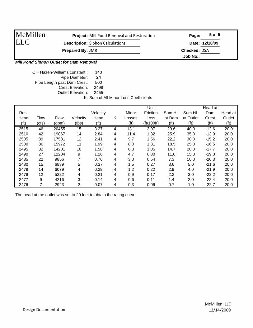
McMillen Mill Pond Removal and Restoration Page: 5 of 5
LLC Siphon Calculations Date: 12/10/09
JMR DSA
Job No.:Mill Pond Siphon Outlet for Dam Removal
1402450024982455
Sum of All Minor Loss Coefficients
Res. Head Flow Flow Velocity
Velocity Head K
Minor Losses
Unit Friction
LossSum HL at Dam
Sum HL at Outlet
Head at Dam Crest
Head at Outlet
(ft) (cfs) (gpm) (fps) (ft) (ft) (ft/100ft) (ft) (ft) (ft) (ft)2515 46 20455 15 3.27 4 13.1 2.07 29.6 40.0 -12.6 20.02510 42 19067 14 2.84 4 11.4 1.82 25.9 35.0 -13.9 20.02505 39 17581 12 2.41 4 9.7 1.56 22.2 30.0 -15.2 20.02500 36 15972 11 1.99 4 8.0 1.31 18.5 25.0 -16.5 20.02495 32 14201 10 1.58 4 6.3 1.05 14.7 20.0 -17.7 20.02490 27 12204 9 1.16 4 4.7 0.80 11.0 15.0 -19.0 20.02485 22 9856 7 0.76 4 3.0 0.54 7.3 10.0 -20.3 20.02480 15 6839 5 0.37 4 1.5 0.27 3.6 5.0 -21.6 20.02479 14 6079 4 0.29 4 1.2 0.22 2.9 4.0 -21.9 20.02478 12 5222 4 0.21 4 0.9 0.17 2.2 3.0 -22.2 20.02477 9 4216 3 0.14 4 0.6 0.11 1.4 2.0 -22.4 20.02476 7 2923 2 0.07 4 0.3 0.06 0.7 1.0 -22.7 20.0
The head at the outlet was set to 20 feet to obtain the rating curve.
Checked:
C = Hazen-Williams constant :Pipe Diameter:
Pipe Length past Dam Crest:
K:
Project:
Description:
Prepared By:
Crest Elevation:Outlet Elevation:
Design DocumentationMcMillen, LLC
12/14/2009

Seattle City Light Mill Pond Removal and Restoration
Report March 2010
APPENDIX B
PHOTOGRAPHS

Seattle City Light Mill Pond Removal and Restoration
Report Page B-1 March 2010
Photograph 1. Mill Pond Dam Spillway
Photograph 2. Mill Pond Dam Pedestrian Bridge

Seattle City Light Mill Pond Removal and Restoration
Report Page B-2 March 2010
Photograph 3. Mill Pond Dam Tailrace
Photograph 4. Log-Crib Dam Underwater

Seattle City Light Mill Pond Removal and Restoration
Report Page B-3 March 2010
Photograph 5. Mill Pond Looking Southeast from the Dam
Photograph 6. Sullivan Creek Inlet to Mill Pond Looking West
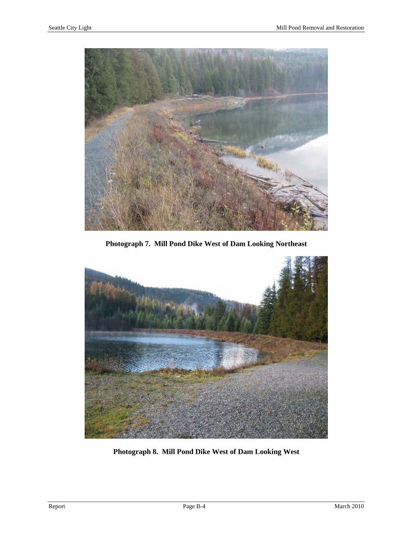
Seattle City Light Mill Pond Removal and Restoration
Report Page B-4 March 2010
Photograph 7. Mill Pond Dike West of Dam Looking Northeast
Photograph 8. Mill Pond Dike West of Dam Looking West
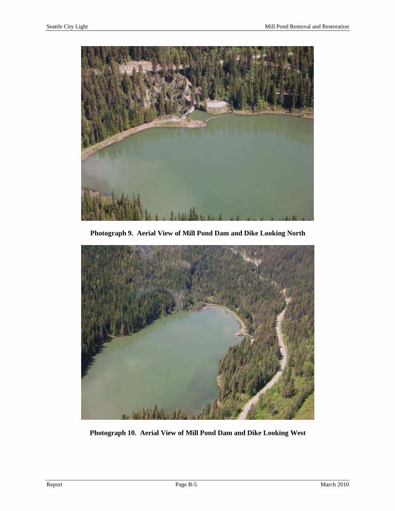
Seattle City Light Mill Pond Removal and Restoration
Report Page B-5 March 2010
Photograph 9. Aerial View of Mill Pond Dam and Dike Looking North
Photograph 10. Aerial View of Mill Pond Dam and Dike Looking West

Seattle City Light Mill Pond Removal and Restoration
Report Page B-6 March 2010
Photograph 11. Aerial View of Mill Pond Looking Northwest

Seattle City Light Mill Pond Removal and Restoration
Report Page B-7 March 2010
Photograph 12. Metaline Falls Cement Kiln Leachate Treatment Site
Photograph 13. Lower Sullivan Creek Downstream of Mill Pond Looking Downstream

Seattle City Light Mill Pond Removal and Restoration
Report Page B-8 March 2010
Photograph 14. View Looking South From the Dam
Photograph 15. View Looking Northwest from Mill Pond Campground

Seattle City Light Mill Pond Removal and Restoration
Report Page B-9 March 2010
Photograph 16. View of Lower Sullivan Creek Looking Upstream from Highway 31 Bridge at the Powerhouse

Seattle City Light Mill Pond Removal and Restoration
Report March 2010
APPENDIX C
GEOTECHNICAL INVESTIGATIONS

Seattle City Light Mill Pond Removal and Restoration
Report Page C-1 March 2010
SLOPE STABILITY OF EARTHEN SIDE SLOPES AND SEDIMENT DISPOSAL AREAS
The rapid drawdown of a pool elevation or reservoir is one of the most common loading conditions that an earthen slope (natural or man-made) can experience. While the development of deep seated failure surfaces is possible, the effect on earthen side slopes is most commonly seen in the form of relatively shallow slope failures, which if left unattended, can lead to the gradual deterioration of the channel slopes. Soil embankments become saturated by seepage during a prolonged high reservoir stage or pool elevation (as noted at Mill Pond). If the reservoir pool is drawn down faster than the pore water can escape from the embankment soils, excess pore water pressures and reduced embankment stability will result. In a rapid drawdown analysis, it is assumed that drawdown is very fast and no drainage occurs in materials with low permeability. In understanding slope stability for a soil mass within an embankment, two forces act upon the soil mass. The driving force, due to the weight of the soil, tends to move the soil mass down slope. The resisting force, due to the strength of the soil along the base of the soil mass, or “slip surface,” tends to hold the soil mass in place. If the driving force is greater than the resisting force, the soil mass will slide along the slip surface and a slope stability failure will occur. The potential for failure for a given soil mass is quantified in terms of the Factor of Safety, which is defined as the resisting force divided by the driving force. If the Factor of Safety is greater than 1.0, the soil mass will not slide. Two separate procedures for computing slope stability for rapid drawdown are recognized and presented below:
• The United States Army Corps of Engineers 1970 procedure (USACE 1970). • The Lowe and Karafiath (1960) procedure; modified by Wright and Duncan (1987) and Duncan,
Wright, and Wong (1990). The objective of the Lowe and Karafiath method is to simplify the USACE method, and account more accurately for shear strength in zones where drained strength is lower than undrained strength. This method is more rational than the first and is typically recommended. Sediment removed during removal of the dam and stream restoration will be placed in fill zones located within the Mill Pond area. The final configuration or geometry of each fill zone (fill zone height and final side slopes) will be a function of the soil strength properties. A slope stability analysis of the fill zones using commonly available modeling software programs (i.e. GeoslopeTM) will identify final slope geometry and fill zone height based on acceptable factors of safety. Technical Approach to Evaluating Slope Stability To evaluate slope stability in the Mill Pond earthen embankments and fill zones, a comprehensive approach of geotechnical field investigation, laboratory testing, and analysis is typically completed. With this standard approach, the stability of the embankment slopes with respect to identified failure mechanisms can be assessed under both present conditions and future or/ proposed conditions once the pool elevation has been lowered. The recommended sequence of events or approach to performing a geotechnical evaluation includes the following:
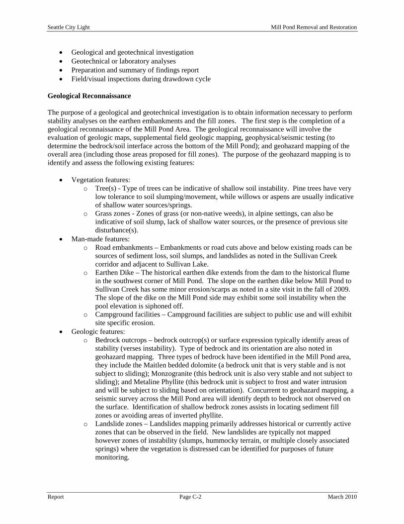
Seattle City Light Mill Pond Removal and Restoration
Report Page C-2 March 2010
• Geological and geotechnical investigation • Geotechnical or laboratory analyses • Preparation and summary of findings report • Field/visual inspections during drawdown cycle
Geological Reconnaissance The purpose of a geological and geotechnical investigation is to obtain information necessary to perform stability analyses on the earthen embankments and the fill zones. The first step is the completion of a geological reconnaissance of the Mill Pond Area. The geological reconnaissance will involve the evaluation of geologic maps, supplemental field geologic mapping, geophysical/seismic testing (to determine the bedrock/soil interface across the bottom of the Mill Pond); and geohazard mapping of the overall area (including those areas proposed for fill zones). The purpose of the geohazard mapping is to identify and assess the following existing features:
• Vegetation features: o Tree(s) - Type of trees can be indicative of shallow soil instability. Pine trees have very
low tolerance to soil slumping/movement, while willows or aspens are usually indicative of shallow water sources/springs.
o Grass zones - Zones of grass (or non-native weeds), in alpine settings, can also be indicative of soil slump, lack of shallow water sources, or the presence of previous site disturbance(s).
• Man-made features: o Road embankments – Embankments or road cuts above and below existing roads can be
sources of sediment loss, soil slumps, and landslides as noted in the Sullivan Creek corridor and adjacent to Sullivan Lake.
o Earthen Dike – The historical earthen dike extends from the dam to the historical flume in the southwest corner of Mill Pond. The slope on the earthen dike below Mill Pond to Sullivan Creek has some minor erosion/scarps as noted in a site visit in the fall of 2009. The slope of the dike on the Mill Pond side may exhibit some soil instability when the pool elevation is siphoned off.
o Campground facilities – Campground facilities are subject to public use and will exhibit site specific erosion.
• Geologic features: o Bedrock outcrops – bedrock outcrop(s) or surface expression typically identify areas of
stability (verses instability). Type of bedrock and its orientation are also noted in geohazard mapping. Three types of bedrock have been identified in the Mill Pond area, they include the Maitlen bedded dolomite (a bedrock unit that is very stable and is not subject to sliding); Monzogranite (this bedrock unit is also very stable and not subject to sliding); and Metaline Phyllite (this bedrock unit is subject to frost and water intrusion and will be subject to sliding based on orientation). Concurrent to geohazard mapping, a seismic survey across the Mill Pond area will identify depth to bedrock not observed on the surface. Identification of shallow bedrock zones assists in locating sediment fill zones or avoiding areas of inverted phyllite.
o Landslide zones – Landslides mapping primarily addresses historical or currently active zones that can be observed in the field. New landslides are typically not mapped however zones of instability (slumps, hummocky terrain, or multiple closely associated springs) where the vegetation is distressed can be identified for purposes of future monitoring.

Seattle City Light Mill Pond Removal and Restoration
Report Page C-3 March 2010
o Faults/fractures zones - Geologic maps contain information about geologic structures (faults) and stratigraphy. Certain soil zones or stratigraphy are more prone to instability, identification of these zones assist in avoiding placing road or sediment fill zones.
• Photo-Log: o A photo-log of field conditions at the time of geohazard mapping is also recorded for
cross-reference of existing conditions with future events. Geotechnical Exploration Geotechnical explorations utilizing a drill rig is necessary to obtain soil samples that will be tested to determine soil properties in the Mill Pond area. Boreholes should be located throughout the Mill Pond Area that will be subject to site/sediment disturbance. Areas proposed for geotechnical exploration include the bottom of Mill Pond (across the bottom, axially in both directions), the slope along the historical earthen dike, zones proposed for sediment filling, zones for sediment removal (gravel source pits) and the alignment of the stream channel. Data collected from the boring(s) includes collection of soil samples for testing, identification of soil stratigraphy and bedrock interfaces, and depth to groundwater (key borings will have monitoring well points installed) for long-terming monitoring of the phreatic surface(s) before lowering the Mill Pond water surface. Geological reconnaissance/geohazard mapping will be used to help identify zones requiring additional boring and sampling. If drill locations are accessible, boreholes can be advanced using truck-mounted drill rigs or a barge in the Mill Pond. Smaller hand-operated power augers or manual augers may be used on side slopes that are inaccessible to trucks. Boreholes should be drilled to penetrate the entire thickness of the embankment and/or to bedrock. Soil samples collected in the boreholes will be completed using the Standard Penetration Testing (SPT) method. The SPT method can be utilized for collecting disturbed split-spoon soil sampling, undisturbed Shelby tube soil sampling, and potentially rock coring (soft or disturbed bedrock). Soil sampling will be performed at regular five foot intervals in the boreholes, but some borings may require more frequent or even continuous logging and sampling for adequate characterization (Mill Pond Sediments). Boreholes can also be used to perform in situ hydraulic conductivity testing in suspected high-permeability zones. Geotechnical Laboratory Testing Soil samples recovered during the geotechnical exploration program will be tested in the laboratory to characterize the soil parameters for subsequent stability analyses. Soil testing is completed to the American Society for Testing and Materials (ASTM) standards. Typical test frequencies are a function of how many samples are collected in the field and the different stratigraphy types. Brief descriptions of typical soil testing are as follows:
• Atterberg Limits Test – measures plasticity of silts and clays.
• Grain Size Analysis/Soil Classification – measures particle size distribution in soil and provides classification based on general engineering properties.
• Direct Shear Test – measures shear strength of sands.
• Consolidated-Undrained Triaxial Shear Test – measures shear strength of silts and clays with
pore water pressure measurements after consolidation (i.e. R- and S-envelopes).

Seattle City Light Mill Pond Removal and Restoration
Report Page C-4 March 2010
• Consolidated-Drained Triaxial Shear Test – measures drained shear strength (i.e. Q-envelope) of silts and clays.
• One-Dimensional Consolidation Test – measures susceptibility of silts and clays to settlement.
Geotechnical Analyses After the geohazard mapping and geotechnical investigation is completed, information obtained from the Mill Pond investigation will be used to perform geotechnical analyses to assess the slope stability of embankments within the Mill Pond reach and the stability of sediment fill zones. Additional available information, such as site survey and previous reports completed by others will be incorporated into the analyses as appropriate. In completing the slope stability analysis for the Mill Pond earthen embankment(s) and proposed sediment fill zones, a slope stability model is developed for both pre- and post-site conditions. The pre-site conditions examine the existing slope geometry, in-situ soil conditions (including bedrock), soil strength parameters and location of the groundwater table. In the absence of observable landslides or soil slumps, the model assumes that site is stable and is assigned a Factor of Safety of one (1.0). Under post-site conditions, changes are incorporated into the model. These changes include lowering the phreatic surface in the Mill Pond under de-watering conditions or loading the fill zone sites with sediments. Other conditions that are incorporated into the model include a seismic loading factor to determine if instability occurs. Slope stability models are defined as follows:
• Slope stability analysis under steady-state conditions (pre-site conditions) o A slope stability analysis should be performed on Mill Pond Embankments and sites
proposed for sediment fill zones. Geological and geotechnical data will be utilized in the model. Details such as slope height, steepness, effective strength parameters of different materials, and location of the phreatic surface, is included in the cross-section to be analyzed. The computer program searches for potential slip surfaces to identify the slip surface that yields the lowest Factor of Safety.
• Slope stability analysis under rapid drawdown conditions (post-site conditions) o A slope stability analyses is performed on the embankments/slopes within the Mill Pond
basin under conditions of rapid drawdown of the reservoir. When the reservoir level is lowered “rapidly” (e.g. a foot or more per day), conditions of undrained loading are imposed upon the embankments. To properly calculate the stability of the slope, a two-stage computation should be performed. The first stage involves consolidation of the embankment under long-term conditions and is performed to calculate pre-drawdown stresses in the embankment, the second stage involves undrained unloading of the embankment.
• Slope stability analysis under load conditions for fill zones (post-site condition) o A slope stability analyses is performed on the proposed configurations/geometry of the
sediment fill zones to determine what embankment slope design is stable. The slope stability analysis will include re-drawing groundwater upwards under rain or storm events. Under stable slope conditions, revegetation will be easier to complete.
• Slope stability analysis (all models) under seismic loading conditions o As part of the geological investigation for Mill Pond, a site-specific seismic hazard
assessment should be performed. Seismic hazard assessment consists of selection of design earthquake criteria, estimation of peak ground acceleration, and estimation of spectral acceleration. Ground shaking from the Maximum Credible Earthquake (MCE) or an approximate probabilistic earthquake to be used as the design earthquake can be

Seattle City Light Mill Pond Removal and Restoration
Report Page C-5 March 2010
derived using an assumed source location, earthquake magnitude, and attenuation rate. Probabilistic earthquake data can be obtained from the USGS Seismic Hazard Mapping Project Internet web site.
At the completion of the geotechnical investigation, the results of the slope stability modeling can be utilized during the engineering design phase of the project in designing the geometry of the sediment fill zones and modeling (both x and y components) of the earthen embankment failure mechanisms in Mill Pond.

Seattle City Light Mill Pond Removal and Restoration
Report March 2010
APPENDIX D
SWPPP ELEMENTS
Seattle City Light Mill Pond Removal and Restoration
Report Page D-1 March 2010
SWPPP ELEMENTS As outlined in the Stormwater Management Manual for Eastern Washington (Ecology 2004), grading and soil stabilization in the Mill Pond Area will follow the twelve elements for construction SWPPP development. The twelve elements of a SWPPP are described below: Element #1: Mark Clearing Limits
• Prior to beginning land disturbing activities, including clearing and grading, clearly mark all clearing limits, sensitive areas and their buffers, and trees that are to be preserved within the construction area. These shall be clearly marked, both in the field and on the plans, to prevent damage and offsite impacts.
• Plastic, metal, or stake wire fence may be used to mark the clearing limits. • Suggested BMPs for the Mill Pond Area:
o BMP C101: Preserving Natural Vegetation o BMP C102: Buffer Zones o BMP C103: High Visibility Plastic or Metal Fence o BMP C104: Stake and Wire Fence
Element #2: Establish Construction Access
• Construction vehicle access and exit shall be limited to one route if possible, while linear projects (e.g., roadways) should be limited to as few as possible.
• Access points shall be stabilized with quarry spalls or crushed rock to minimize the tracking of sediment onto public roads.
• Wheel wash or tire baths should be located on site, if applicable. • If sediment is tracked off the construction site, roads shall be cleaned thoroughly at the end of
each day. Sediment shall be removed from roads by shoveling or pickup sweeping and shall be transported to a controlled sediment disposal area. Pavement washing will be allowed only after sediment is removed in this manner.
• Pavement wash wastewater shall be controlled by pumping back on site or otherwise be prevented from discharging into systems tributary to state surface waters.
• Construction access restoration shall be equal to or better than the preconstruction condition. • Suggested BMPs for the Mill Pond Area:
o BMP C105: Stabilized Construction Entrance o BMP C107: Construction Road/Parking Area Stabilization
Element #3: Control Flow Rates
• Properties and waterways downstream from Mill Pond shall be protected from erosion due to increases in the volume, velocity, and peak flow rate(s) of stormwater runoff from the project site, as required.
• Downstream analysis may be necessary if changes in offsite flows impair or alter conveyance systems, streambanks, bed sediment, or aquatic habitat.
• Sediment control ponds that provide additional stormwater flow control may be required. This may be necessary to address local site conditions or to protect waterways downstream from erosion due to increases in the volume, velocity, and peak flow rate of stormwater runoff from the Mill Pond site.
• Suggested BMPs for the Mill Pond Area: o BMP C240: Sediment Trap o BMP C241: Temporary Sediment Pond

Seattle City Light Mill Pond Removal and Restoration
Report Page D-2 March 2010
Element #4: Install Sediment Controls • The muck layer (bottom of Mill Pond), native top soil, and natural vegetation shall be retained in
an undisturbed state to the maximum extent practicable. • Prior to leaving a construction site or prior to discharge to an infiltration facility, stormwater
runoff from disturbed areas shall pass through a sediment pond or other appropriate sediment removal BMP. Runoff from fully stabilized areas may be discharged without a sediment removal BMP, but must meet the flow control performance standards. Full stabilization means rip rap used as ditch lining; or the use of rolled erosion products, a bonded fiber matrix product, or vegetative cover in a manner that will fully prevent soil erosion.
• BMPs intended to trap sediment on site shall be constructed as one of the first steps in grading. These BMPs shall be functional before other land disturbing activities take place in the Mill Pond area.
• Earthen structures such as dams, dikes, and diversions shall be stabilized. • BMPs intended to trap sediment on site shall be located in a manner to avoid interference with the
movement of resident fish species attempting to enter off-channel areas or drainages. • Suggested BMPs for the Mill Pond Area:
o BMP C230: Straw Bale Barrier o BMP C231: Brush Barrier o BMP C233: Silt Fence o BMP C234: Vegetated Strip o BMP C235: Straw Wattles o BMP C240: Sediment Trap o BMP C241: Temporary Sediment Pond
Element #5: Stabilize Soils
• Exposed soils/muck or bottom sediments shall be temporarily or permanently stabilized as soon as practical by application of effective BMPs that protect the soil from the erosive forces of rain, flowing water, and wind.
• No soils should remain exposed for more than the time periods set forth below to prevent wind and water erosion. This stabilization requirement applies to all soils on site, whether at final grade or not. This time limit may be adjusted in the field if the local precipitation data justifies a different standard. In eastern Washington the regional dry season is July 1 through September 30; the regional wet season is October 1 through June 30.
• Soil stabilization BMPs shall be appropriate for the Mill Pond site conditions, time of year, and the duration of the project.
• Suggested BMPs for the Mill Pond Area: o BMP C120: Temporary and Permanent Seeding o BMP C121: Mulching o BMP C122: Nets and Blankets o BMP C123: Plastic Covering o BMP C126: Polyacrylamide for Soil Erosion Protection o BMP C130: Surface Roughening o BMP C131: Gradient Terraces o BMP C140: Dust Control (as required)
Element #6: Protect Slopes
• Design, construct, and phase cut and fill slopes in the Mill Pond area in a manner that will minimize erosion. Consider soil type and its potential for erosion.
• Reduce slope runoff velocities by reducing continuous length of slope with terracing and diversions, reduce slope steepness, and roughen slope surface.

Seattle City Light Mill Pond Removal and Restoration
Report Page D-3 March 2010
• Divert upslope drainage and run-on waters with interceptors at top of the slope(s). Diversion of off-site storm water around the site may be a viable option in certain parts of the Mill Pond area. Diverted storm water flows shall be redirected to natural drainages at the edge of Mill Pond.
• Contain down slope flows in pipes, slope drains, or protected channels. Check dams shall be used within channels that are cut down a slope.
• Excavated material shall be placed on the uphill side of trenches, consistent with safety and space considerations.
• Suggested BMPs for the Mill Pond Area: o BMP C120: Temporary and Permanent Seeding o BMP C130: Surface Roughening o BMP C131: Gradient Terraces o BMP C200: Interceptor Dike and Swale o BMP C201: Grass-Lined Channels o BMP C204: Pipe Slope Drains o BMP C205: Subsurface Drains o BMP C207: Check Dams o BMP C208: Triangular Silt Dike (Geotextile-Encased Check Dam)
Element #7: Protect Drain Inlets
• Mechanical Storm drain/drop inlets are not applicable to the Mill Pond Area.
Element #8: Stabilize Channels and Outlets • Temporary on-site conveyance channels shall be designed, constructed, and stabilized to prevent
erosion from the expected peak flow velocity of the 6-month, 3-hour storm for the developed condition, referred to as the short duration storm.
• Stabilization, including armoring material (rip rap), adequate to prevent erosion of outlets, adjacent streambanks, slopes, and downstream reaches shall be provided at the outlets of all conveyance systems.
• Suggested BMPs for the Mill Pond Area: o BMP C202: Channel Lining o BMP C209: Outlet Protection
Element #9: Control Pollutants
• All pollutants, including waste materials and demolition debris from the Mill Pond dam removal and related infrastructure shall be handled and disposed of in a manner that does not cause contamination of stormwater.
• Cover, containment, and protection from vandalism shall be provided for all chemicals, liquid products, petroleum products, and non-inert wastes utilized on the Mill Pond site.
• Maintenance and repair of heavy equipment and vehicles involving oil changes, hydraulic system drain down, solvent and de-greasing cleaning operations, fuel tank drain down and removal, and other activities which may result in discharge or spillage of pollutants to the ground or into stormwater runoff must be conducted using spill prevention measures, such as drip pans. Contaminated surfaces shall be cleaned immediately following any discharge or spill incident. Emergency repairs may be performed on-site using temporary plastic placed beneath and, if raining, over the vehicle.
• Wheel wash or tire bath wastewater shall be discharged to a separate on-site treatment system or to the sanitary sewer.
• Application of agricultural chemicals including fertilizers and pesticides shall be conducted in a manner and at application rates that will not result in loss of chemical to stormwater runoff.

Seattle City Light Mill Pond Removal and Restoration
Report Page D-4 March 2010
• BMPs shall be used to prevent or treat contamination of storm water runoff by pH modifying sources. These sources include the concrete associated with the Mill Pond Dam removal. Stormwater discharges shall not cause a violation of the water quality standard for pH in the receiving water.
• Suggested BMPs for the Mill Pond Area: o BMP C151: Concrete Handling o BMP C152: Sawcutting
Element #10: Control De-Watering
• Mill Pond de-watering water shall be discharged into a controlled conveyance system. • Channels shall be stabilized, as specified in Element #8. • Clean, non-turbid de-watering water, can be discharged to state surface waters, as specified in
Element #8, provided the de-watering flow does not cause erosion or flooding of receiving waters. These clean waters should not be routed through stormwater sediment ponds.
• Highly turbid or contaminated dewatering water from construction equipment operation, clamshell digging, concrete removal work or work inside a cofferdam shall be handled separately from stormwater. Other disposal options, depending on site constraints, may include:
o Infiltration. o Transport off site in vehicle, such as a vacuum flush truck, for legal disposal in a manner
that does not pollute state waters. o On-site treatment using chemical treatment or other suitable treatment technologies.
Element #11: Maintain BMPs
• Temporary and permanent erosion and sediment control BMPs shall be maintained and repaired as needed to assure continued performance of their intended function. Maintenance and repair shall be conducted in accordance with BMP standards and specifications.
• Sediment control BMPs shall be inspected by project personnel every day when there is a discharge from the site (stormwater or non-stormwater), and at least weekly when there is no discharge.
• Temporary erosion and sediment control BMPs shall be removed within 30 days after final site stabilization is achieved or after the temporary BMPs are no longer needed. Trapped sediment shall be removed or stabilized on site. Disturbed soil resulting from removal of BMPs or vegetation shall be permanently stabilized.
Element #12: Manage the Project
• Construction shall be phased where feasible in order to prevent, to the maximum extent practicable, the transport of sediment from the Mill Pond Area during removal activities. Revegetation of exposed areas and maintenance of that vegetation shall be an integral part of the clearing activities for any phase.
• Clearing and grading activities for the Mill Pond Project will be permitted only if conducted pursuant to an approved site SWPPP that establishes permitted areas of clearing, grading, cutting, and filling. When establishing these permitted clearing and grading areas, consideration shall be given to minimizing removal of existing trees and minimizing disturbance and compaction of soils (native, muck and embankment) except as needed for building purposes. These permitted clearing and grading areas and any other areas required to preserve critical or sensitive areas, buffers, native growth protection easements, or tree retention areas as may be required, shall be delineated on the site plans and the development site.
• Seasonal Work Limitation may be imposed based upon local weather conditions and/or other information provided including site conditions, the extent and nature of the construction activity, and the proposed erosion and sediment control measures.

Seattle City Light Mill Pond Removal and Restoration
Report Page D-5 March 2010
• Inspection and Monitoring - All BMPs shall be inspected, maintained, and repaired as needed to assure continued performance of their intended function.
• Sampling and analysis of the stormwater discharges from the Mill Pond Area may be necessary on a case-by-case basis to ensure compliance with standards.