Embed Size (px)
Citation preview

PRELIMINARY LAND CONTAMINATION STUDY, EMPLOYMENT PRECINCT FISHERMANS BEND
7 September 2016 Report No. 1654703-001-R-Rev0
APPENDIX B Materials and Method

APPENDIX B MATERIALS AND METHOD
SEPTEMBER 2016 Project No. 1654703-001-R-Rev0 1/1
MATERIALS AND METHOD The following tasks were undertaken to support this land assessment study:
A high level review was undertaken to identify potential land contamination issues within the Employment Precinct. Key information identified during the review as well as supporting tables and text are provided in appendices. Potential land contamination within the Employment Precinct, both current and historic, have been evaluated based on the data gathered from the following sources of information:
High level review of the environmental setting of the Employment Precinct.
High level review of the readily available Environmental Audit reports for completed StatutoryEnvironmental Audit sites within and in the vicinity of the Employment Precinct, and additionalpublicly available environmental assessment reports.
High level geological and geotechnical review of the Employment Precinct.
Review of selected historical public historical records, photos, maps and aerial photographs.
Review of Golder’s general records on ground conditions.
National Pollution Inventory data for industries within the Employment Precinct.
Review of published archives, databases and online historic information.
Energy Safe Victoria database of registered cathodic protection systems to gain an understandingof the potential number and location of USTs that may be present across the Precincts.
Development of a land contamination risk ranking to assess the likelihood and significance of the remediation required to achieve identified land uses (i) Sensitive Educational Use (School / Kindergarten), ii) Recreational Open space (parks) and iii) Commercial / Industrial. The degree of potential land contamination was divided into the four broad and subjective contamination risk categories (High, Medium, Low or Not Applicable (NA)).
Overview of approaches for contamination management and remediation strategies to support site and precinct development.
Note on figures and models within the main report:
Figures and model presented within the main report were processed using the R statistical environment version 3.3.1 (R Core Team (2016). R: A language and environment for statistical computing. R Foundation for Statistical Computing, Vienna, Austria. URL https://www.R-project.org/).
The following packages were extensively used:
ggplot2 - H. Wickham. ggplot2: Elegant Graphics for Data Analysis. Springer-Verlag New York, 2009
rgeos - Roger Bivand and Colin Rundel (2016). rgeos: Interface to Geometry Engine - Open Source (GEOS). R package version 0.3-19. https://CRAN.R-project.org/package=rgeos
dplyr - Hadley Wickham and Romain Francois (2015). dplyr: A Grammar of Data Manipulation. R package version 0.4.3. https://CRAN.R-project.org/package=dplyr
\\golder.gds\gap\melbourne\jobs\env\2016\1654703 - delwp psi fishermens bend\correspondence out\1654703-001-r-precinct_report\rev0\appendix b - method\appendix b - materials
and method.docx

PRELIMINARY LAND CONTAMINATION STUDY, EMPLOYMENT PRECINCT FISHERMANS BEND
7 September 2016 Report No. 1654703-001-R-Rev0
APPENDIX C Environmental Setting Appendix C1 - Geology and Geotechnical Review
Appendix C2 - Drainage and Hydrogeology
Appendix C3 - Acid Sulfate Soils

APPENDIX C1 HIGH LEVEL GEOTECHNICAL REVIEW
SEPTEMBER 2016 Project No. 1654703-001-R-Rev0 1/3
Employment Precinct The Employment Precinct is situated within the Yarra Delta in an area of Quaternary aged (< 2 Million years old) sedimentation at the head of Port Phillip Bay. The Yarra Delta consists of several sub-horizontal geological formations, which were formed at the mouth of the Yarra River and together are known as the Yarra Delta Group. The Yarra Delta Group has infilled an ancient river valley which was cut into the underlying Tertiary and Silurian aged formations by the ancestral Yarra-Maribyrnong river system when sea levels were considerably lower than present (Neilson, 1996).
Geological Units A review of the Melbourne 1:63,360 geological map (Figure A-2 in Appendix A) and accompanying sections published by the Geological Survey of Victoria (GSV, 1974) indicates the precinct is underlain by the following geological units from oldest to youngest:
Older formations (ancient valley floor, Tertiary and Silurian aged):
Melbourne Formation (Sud) – Siltstone interbedded with Sandstone.
Werribee Formation (Tw) – dense sand and hard clay in varying proportion of fluvial origin.
Tertiary Older Volcanics (Tov) – typically weathered, closely jointed basalt flows interbedded withpyroclastic deposits such as tuffs.
Brighton Group (Tb) – dense to very dense sands and hard clays in varying proportion of fluvial andshallow marine origin.
Yarra Delta Group (filled ancient valley, Quaternary aged):
Moray Street Gravels (Qm) – dense to very dense sands with some gravel of fluvial origin.
Fishermens Bend Silt (Qf) – firm to stiff, weathered, silty clays of marine origin.
Coode Island Silt (Qc) – soft to firm highly compressible clay or silty clay with occasional sand lenses.Organic rich and known to contain gas pockets within the unit.
Port Melbourne Sand (Qp) – loose to medium dense clean sands of marine origin.
Fill – highly variable properties which typically contains varying proportions of waste materials.
The near surface stratigraphy for the Employment Precinct is anticipated to consist of the Port Melbourne Sand as indicated on the Melbourne map sheet, capped by a layer of fill over much of the area. The surface and sub-surface distribution of the Yarra Delta Group deposits beneath the fill is anticipated to be variable and relatively complex over the Employment Precinct. Neilson (1996) has attempted to map each of these units using historical borehole information, as outcrops of these units are limited. The Silurian aged Melbourne Formation forms the bedrock beneath the Employment Precinct, with overlying alluvial and volcanic deposits placed in the Tertiary age, then eroded to form the ancient Yarra-Maribyrnong river valley. Relevant sections from this paper are included in this appendix (Figure A-3 and Figure A-4 in Appendix A).
The topography of the ancient river valley in which the Yarra Delta Group was deposited had considerable influence on the distribution of the oldest formation of the group (the Moray Street Gravels), which is confined to the lower levels of this landscape and is thickest where depressions in the landscape were the deepest. The thicknesses of the overlying units (the Fishermens Bend Silt and Coode Island Silt) were also subsequently influenced by this buried topography.

APPENDIX C1 HIGH LEVEL GEOTECHNICAL REVIEW
SEPTEMBER 2016 Project No. 1654703-001-R-Rev0 2/3
Future Geotechnical Implications for Development Based on our current understanding of the geology of the Employment Precinct, the key geotechnical issues and constraints which will need to be considered in the master planning process are as follows:
The variable strength, quality and thickness of the fill soils.
The generally low strength near surface soils.
The considerable depth to suitable founding strata for piles over much of the precinct.
The potential for significant differential settlement caused by the ongoing natural and development-induced secondary consolidation of the Coode Island Silt.
Differential settlement impacting the connection between underground services and piled buildings.
Differential settlement of services and the subsequent need to allow generous falls for gravity flow structures.
The potential to trigger consolidation of the Coode Island Silt if the groundwater table is lowered during the construction of basement excavations or deep utility trenches.
The potential for gas build up in basement excavations within the Coode Island Silt.
Given the above constraints, suitable foundation solutions for the proposed mixed use developments are likely to be as follows:
Shallow spread footings or raft foundations for settlement tolerant buildings ranging in height from one to two storeys.
Piled foundations for all non-settlement structures. Note that piled foundations may be required for single or two level buildings depending on a particular structure’s tolerance for differential settlement.
Constructing shallow basements for parking or avoiding basement construction by placing parking levels above ground.
A major geotechnical risk associated with low rise structures on the Coode Island Silt is ongoing creep settlement caused by secondary consolidation. This occurs in the absence of development and can be exacerbated by development. While stand alone, settlement tolerant low rise buildings of small plan dimensions such as 15 m x 15 m, supported on appropriately designed raft slabs may perform satisfactorily, this may not be the case for structures which are not settlement tolerant and/or are of larger plan dimensions. This is due to differential settlement potentially resulting in tilt and cracking of buildings, as well as rupture of services.
The key geotechnical issues that will need to be addressed for shallow footings are:
Allowable bearing pressures.
Allowable total and differential settlement, including long term creep settlement.
Shrinkage/swelling potential.
Soil aggressivity towards buried concrete and steel.
Generally shallow depth to groundwater.
For road pavement constructions, the key geotechnical issues will be the strength, moisture condition and reactivity of the sub-grade materials, as well as the potential for long term creep settlement, which could impact cross falls and required service gradients beneath the pavements.
Targeted site specific investigations are recommended to better define each of these issues once development plans have been prepared for relevant areas.

APPENDIX C1 HIGH LEVEL GEOTECHNICAL REVIEW
SEPTEMBER 2016 Project No. 1654703-001-R-Rev0 3/3
References Neilson, J.L. (1996). The Geological Setting of the Coode Island Silt, Building on Coode Island Silt. Australian Geomechanics Society and the Structural Branch Seminar held on 10 April 1996, 20 pages.
Geological Survey of Victoria (1974). 1:63,360 Geological Mapsheet of Melbourne, Geological Survey of Victoria (GSV).
\\golder.gds\gap\melbourne\jobs\env\2016\1654703 - delwp psi fishermens bend\correspondence out\1654703-001-r-precinct_report\rev0\appendix c1 - geology and
geotechnical\app c1 geotechnical review.docx

APPENDIX C2 SUPPORTING INFORMATION RELATING TO ENVIRONMENTAL SETTING
SEPTEMBER 2016 Project No. 1654703-001-R-Rev0 1/3
TOPOGRAPHY AND DRAINAGE The Employment Precinct is situated within the Yarra Delta in an area of Quaternary aged sedimentation at the head of Port Phillip Bay. The Yarra Delta consists of several flat lying geological formations, which were formed at the mouth of the Yarra River. The main discharge environments in the Employment Precinct are the:
Yarra River is located along South Wharf, which borders the Employment Precinct to the north. The distance from Lorimer Street (the northern boundary of the Employment Precinct) to the Yarra varies from around 20 m to 100 m; and
Port Phillip Bay located at it nearest point (from the southern extent of the Westgate Park) is approximately 800 m to the southeast to Webb Dock and 1 km to the south east to Perce White Reserve.
Within the Employment Precinct there are also a number of major man-made features which could affect local drainage and therefore groundwater flow. The filled quarries may provide a local point of enhanced groundwater recharge, however this depends on the type of capping and infilled materials. The former quarries and the trunk sewer may also provide a sink to groundwater if they extend below the groundwater table. Features which can influence groundwater include:
several areas with deep fill (refer to Section 3.0 of the main report for details);
the Hobson Bay Sewer Main, which falls westward under the Yarra River Based on information provided by South Eastern Water, and was constructed around -10 metres Australian Height Datum (mAHD) and below the groundwater table;
the shallower network of storm water and sewer lines;
permanent water features at the Westgate Park; and
pervious and impervious surfaces across the area.
REGIONAL GROUNDWATER USE Groundwater Levels A review of publicly available Environmental Audit reports within and adjacent to the Employment Precinct indicates that water levels values range from approximately 1 to 3 metres below ground level (mbgl) (refer to Appendix D2 for a review of Audit reports).
Groundwater Quality It is expected that groundwater quality, as measured by salinity (total dissolved solids (TDS)), will vary across the Employment Precinct depending on whether the observed groundwater is perched (i.e. its quality may be affected more by infiltrating rain water) or connected to the regional groundwater system (affected by the nearby estuarine system and Coode Island Silt where groundwater samples from Coode Island Silt and Moray Street Gravels have typically indicated TDS in excess of 30,000 mg/L).
A review of Environmental Audit reports within and adjacent to the Employment Precinct indicates that TDS values range from approximately 910 mg/L at the 770 Lorimer Street site (CARMS. No. 42748-2) up to 30,000 mg/L reported at the Salmon Street former landfill (CARMS. No. 38456-3).
A review of the DSE Water Table Aquifers Beneficial Use map series for South Western Victoria reports the groundwater in the area is likely to be classified as Segment B. Segment B groundwater is characterised by total dissolved solids (TDS) in the range of 1,001 mg/L to 3,500 mg/L. We consider this classification would apply to groundwater within the Port Melbourne Sands rather than Coode Island Silt. In accordance with the ‘State Environmental Protection Policy (SEPP) for Groundwater of Victoria’, dated 1999, the Beneficial Uses that must be protected, applicable to sites that are classified as Segment B include:

APPENDIX C2 SUPPORTING INFORMATION RELATING TO ENVIRONMENTAL SETTING
SEPTEMBER 2016 Project No. 1654703-001-R-Rev0 2/3
Maintenance of ecosystems;
Potable mineral water:
Stock watering;
Industrial water use;
Primary contact recreation; and
Buildings and structures.
Groundwater in the area can therefore be considered to be of moderate to high sensitivity with respect to potential groundwater contamination.
Regional Groundwater Use A review of the DELWP Victorian Water Measurement Information System identified registered groundwater bores within the Employment Precinct. A figure with registered groundwater use and construction depths are attached to this appendix. In general, registered groundwater bores are used for monitoring purposes and likely associated with shallow groundwater investigation for groundwater contamination. Registered groundwater bore information was accessed through the Visualising Victoria’s Groundwater portal (www.vvvg.com.au) (FedUni, 2015).
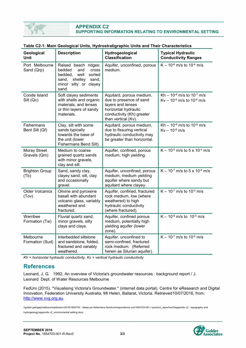
GEOLOGICAL AND HYDROSTRATIGRAPHIC UNITS Table C2-1 below provides a summary of the main geological and hydrostratigraphic units identified in the Employment Precinct. The hydraulic characteristics of each unit and typical ranges of hydraulic conductivities are included from published literature (for details see Leonard, 1992) and from Golder’s project experience within similar geological/hydrogeological settings and geological units. Beneath and around the Employment Precinct the Port Melbourne Sands are generally underlain by Coode Island Silt, Fishermens Bend Silt, Moray Street Gravels and Werribee Formation.
APPENDIX C2 SUPPORTING INFORMATION RELATING TO ENVIRONMENTAL SETTING
SEPTEMBER 2016 Project No. 1654703-001-R-Rev0 3/3
Table C2-1: Main Geological Units, Hydrostratigraphic Units and Their Characteristics Geological Unit
Description Hydrogeological Classification
Typical Hydraulic Conductivity Ranges
Port Melbourne Sand (Qrp)
Raised beach ridges: bedded and cross bedded, well sorted sand, shelley sand, minor silty or clayey sand.
Aquifer, unconfined, porous medium.
K – 10-6 m/s to 10-4 m/s
Coode Island Silt (Qc)
Soft clayey sediments with shells and organic materials, and lenses or thin layers of sandy materials.
Aquitard, porous medium, due to presence of sand layers and lenses horizontal hydraulic conductivity (Kh) greater than vertical (Kv).
Kh – 10-8 m/s to 10-7 m/s Kv – 10-9 m/s to 10-8 m/s
Fishermans Bent Silt (Qf)
Clay, silt with some sands typically towards the base of the unit (lower Fishermans Bend Silt).
Aquitard, porous medium, due to fissuring vertical hydraulic conductivity may be greater than horizontal.
Kh – 10-9 m/s to 10-8 m/s Kv – 10-8 m/s
Moray Street Gravels (Qm)
Medium to coarse grained quartz sands with minor gravels, clay and silt.
Aquifer, confined, porous medium, high yielding.
K – 10-5 m/s to 5 x 10⁻⁴ m/s
Brighton Group (Tb)
Sand, sandy clay, clayey sand, silt, clay and occasionally gravel.
Aquifer, unconfined, porous medium, medium yielding aquifer where sandy but aquitard where clayey.
K – 10-7 m/s to 5 x 10⁻⁶ m/s
Older Volcanics (Tov)
Olivine and pyroxene basalt with abundant volcanic glass, variably weathered and fractured.
Aquifer, confined, fractured rock medium, low (where weathered) to high hydraulic conductivity (where fractured).
K – 10-7 m/s to 10-5 m/s
Werribee Formation (Tw)
Fluvial quartz sand, minor gravels, silty clays and clays.
Aquifer, confined porous medium, potentially high yielding aquifer (lower zone).
K – 10-8 m/s to 10-5 m/s
Melbourne Formation (Sud)
Interbedded siltstone and sandstone, folded, fractured and variably weathered.
Aquifer, unconfined to semi-confined, fractured rock medium. (Referred herein as Silurian aquifer).
K – 10-7 m/s to 10-5 m/s
Kh = horizontal hydraulic conductivity, Kv = vertical hydraulic conductivity
References Leonard, J. G. 1992, An overview of Victoria's groundwater resources : background report / J. Leonard Dept. of Water Resources Melbourne
FedUni (2015). "Visualising Victoria's Groundwater." (internet data portal). Centre for eResearch and Digital Innovation, Federation University Australia, Mt Helen, Ballarat, Victoria. Retrieved10/07/2016, from: http://www.vvg.org.au.
\\golder.gds\gap\melbourne\jobs\env\2016\1654703 - delwp psi fishermens bend\correspondence out\1654703-001-r-precinct_report\rev0\appendix c2 - topography and
hydrogeology\appendix c2_environmental setting.docx

@A @A
@A
@A@A@A
@A
@A
@A
@A
@A
@A@A
@A@A
@A@A@A@A
@A
@A@A
@A@A@A
@A
@A
@A
@A@A@A
@A@A@A@A@A@A
@A
@A
@A
@A
@A@A@A@A
@A
@A@A@A
@A@A@A
@A@A@A@A@A@A
@A
@A
@A
@A
@A@A
@A@A
@A
@A
@A
@A
@A
@A
@A
@A
@A
@A
@A
@A
@A
@A
@A
@A
@A
@A
@A
@A
@A
@A@A
@A
@A
@A
@A
@A
@A@A
@A
WEST GATE FREEWAY
LORIMER STREET
TOD
D R
OA
D
319669
319670
78466
78468
78477
WRK982092
WRK982572
WRK983668
WRK984006
WRK984463
WRK984642
WRK985056
WRK985644
WRK986235
WRK986331
WRK986439
WRK986523
WRK986766
WRK987092
WRK988393
WRK988394
WRK988395
WRK988662
WRK989733
WRK990639
WRK991854
WRK991948
WRK991949
WRK991951
115846115847
115848
142622
142623
142624
142625
142626
78488
78489
78490 78491
7849278495
78496
78497 78498
78499
WRK059560
WRK059561
WRK059562
WRK060398WRK060399WRK060400
WRK060851
WRK062088
WRK062750
WRK066069
WRK068848
WRK069433 WRK069434
WRK070822
WRK071621WRK071622WRK071623
WRK073317
WRK959692
WRK959693 WRK959694
WRK959695
WRK959696WRK959697
WRK990986WRK990997
WRK991950
WRK992047
78458
WRK981295
CLIENT
DEPARTMENT OF ENVIRONMENT, LAND, WATER ANDPLANNING (DELWP)
LEGEND
Groundwater Bore Use
@A Domestic
@A Domestic, Stock or Irrigation
@A Irrigation
@A Observation
@A Unknown
NOTES
PROJECT
PRELIMINARY LAND CONTAMINATION STUDY - EMPLOYMENTPRECINCT, FISHERMANS BEND DISTRICT
TITLE
REGISTERED GROUNDWATER BORE USE
1654703 001-R 0 C2-1
2016-09-05
AFE
-
PDB
CJW
Path
: J:\E
nv\2
016\
1654
703
- D
ELW
P P
SI F
ishe
rmen
s B
end\
Tech
nica
l Doc
\GIS
\Pro
ject
\165
4703
-001
-R-C
2-1-
Rev
0.m
xd
IF T
HIS
ME
AS
UR
EM
EN
T D
OE
S N
OT
MA
TCH
WH
AT
IS S
HO
WN
, TH
E S
HE
ET
SIZ
E H
AS
BE
EN
MO
DIF
IED
FR
OM
: A3
CONSULTANT
PROJECT No. CONTROL Rev. FIGURE
YYYY-MM-DD
PREPARED
DESIGN
REVIEW
APPROVED
25m
m0
0 100 200 300 400 500
METR ES
PROJECTION: GDA 1994 MGA Zone 55
REFERENCE SCALE: 1:7,500 (at A3)
1. Imagery sourced from nearmap, dated20/03/2016.2. Road Data (c) The State of Victoria,Department of Environment, Land, Water &Planning, 2016.3. Employment and Previous StudyPrecincts sourced from DELWP, 2016.4. Groundwater Use Data sourced from theCentre for eResearch and DigitalInnovation, Federation University, dated10/07/2016.
Employment Precinct
Wirraway Precinct (Previous Study)
Sandridge Precinct (Previous Study)
Montague Precinct (Previous Study)
Lorimer Precinct (Previous Study)
LOCATION MAP

APPENDIX C3 ACID SULFATE SOILS
SEPTEMBER 2016 Project No. 1654703-001-R-Rev0 1/1
ACID SULFATE SOIL Potential Acid Sulfate Soil Acid sulfate soils (ASS) in Australia are commonly found in Holocene age sediments where the natural surface elevation is less than 5 mAHD and may be deeply deposited and covered by other sediments. Potential acid sulfate soils (PASS) contain iron pyrite which is stable in an un-oxidised state although can present a potential acid leachate risk if exposed to air, resulting in production of sulphuric acid by oxidation. These oxidising soils are commonly referred to as actual acid sulfate soils (AASS).
In general, the potential for soils to generate acid is a function of the geological history of the soils, and geomorphologic landscape within a given region. The Victorian Department of Primary Industries (DPI) has produced a series of maps illustrating the extent of estimated Coastal Acid Sulfate Soils along Victorian coastal regions.
Management of Acid Sulfate Soils (ASS) and Rock (ASR) EPA Government Gazette, “Industrial Waste Management Policy on Waste Acid Sulphate Soils”, dated 1999 and EPA Information Bulletin Publication 655.1 “Acid Sulfate Soil and Rock” dated July 2009 provide specific guidance on the identification, assessment and management of Acid Sulfate Soils (ASS). The policy requires that a person must not cause or permit the disposal or re-use of waste ASS at any premises, except where the occupier of the premises:
1) Is licensed under the Environment Protection Act 1970 to dispose of that type of waste; or 2) Has an environment management plan prepared in accordance with the IWMP “Waste Acid Sulfate Soils”
and approved by the Authority. In situations where acid sulfate soils may be disturbed during development (such as excavation, exposure, dewatering or placement of fill), the Victorian EPA guidelines (EPA Information Bulletin 665.1) require that the site be managed to avoid and control adverse environmental impacts. The hierarchy for management is:
1) Avoid disturbance
2) Minimise disturbance
3) Prevent oxidation
4) Treat to reduce or neutralise acidity
5) Offsite reuse or disposal Presence of Probable Acid Sulfate Soils To assign for the presence of probable acid sulfate soils we reviewed the following information:
Victorian Department of Primary Industries (DPI) series Melbourne-T7822 map sheet illustrating the extent of estimated Coastal Acid Sulphate Soils around Melbourne and along Victorian coastal regions;
Available published information on the site geology and geomorphology; and
Available information relating to the presence of ASS, the regional topography and likely depth of groundwater.
The Quaternary Yarra Delta sediments (all quaternary units except the Newer Volcanic unit), specifically the Coode Island Silt (Qri) and potentially the Fishermens Bend Silt (Qpf), may be probable acid sulfate soils.
\\golder.gds\gap\melbourne\jobs\env\2016\1654703 - delwp psi fishermens bend\correspondence out\1654703-001-r-precinct_report\rev0\appendix c3 - acid sulfate soils\appendix
c3_acid sulfate soils_updated.docx

PRELIMINARY LAND CONTAMINATION STUDY, EMPLOYMENT PRECINCT FISHERMANS BEND
7 September 2016 Report No. 1654703-001-R-Rev0
APPENDIX D Industrial Land Use Setting Appendix D1 - Land Use and Contaminants of Interest
Appendix D2 - Contaminated Land and Urban Renewal Setting
Appendix D3 – Aerial Photographs
Appendix D4 – Planning Scheme

FISHERMANS BEND CONTAMINATION STUDY - EMPLOYMENT PRECINCTTable B1 - Summary of Former and Current Site UsesDELWP
FISHERMANS BEND CONTAMINATION STUDY
Table D1 - Summary of Past and Present Land Use and Contaminants of InterestDELWP1645703
Summary of Past and Present Land Use
E01 8.6Raymond G.N. Ld (timber yard), Myttons, International Harvester Co / Fowlers Engineering, salvage yards.
Independent Cement and Lime Pty Ltd, Anacon Laboratory Services (CLPC NATA accredited lab), Dockside Business Park inc. BMW workshop, Strang Systems (distribution), sports bar, Installation Theatrical Engineering workshop.
Partially redeveloped. One Audit completed(refer to Appendix D2)
E02 14.4
Accommodation, printing, Crema Constructions, Boral, Stewarts and Lloyds Aust (warehouse), Dept of Air No.1 Stores machinery factories, , distribution, Migrant Hostel, Neales Motors Autocraft.
Citiport Business Park, Boral Plasterboard plant, Port I.T. @ Turner Business Park, Crema Camillo Constructions, PrintLinx. Partially redeveloped. No Audits completed
E03 7.2 Kraft, substation. Kraft, substation. No significant redevelopment. No Audits completed
E04 15.1
SEC workshop and yards, electrical terminal station, metal scrap yard.
Tranzport Distribution Centre (Futuris, Synetec), Toll Priority Warehouse, Siemens Rail Automation Manufacturing, ANTEC Engineering, electrical terminal station, Pappa Rich office / warehouse, distribution warehouses, BMT (Ballistic and Materials Testing).
Significant redevelopment; former SEC workshop and electrical terminal station remain.
No Audits completed
E05 12.7
GMH factories, GMH offices, Industrial and Domestic Equipment Co. (subsidiary to GM), GM Acceptance Corporation.
Portside Business Park (inc. heritage listed GMH offices), Equinix IBX Data Centres: ME1, The Bund Business Park (currently vacant) Significant redevelopment. No Audits completed
E06 37.7GM Holden plant. GM Holden plant and corporate office Partially redeveloped,
addition of new engine plant. No Audits completed
E07 8.5
Department of Works (storage yard), Hyland, D & Sons Pty Ltd (cold storage), Oakbond Cold Stores.
Gateway @ Port Business Park (CGT Printing), Salmon Street Business Park, GMH Headquarters (corporate office). Significant redevelopment No Audits completed
E08 13
Aeronautic Engine and Research Test Laboratory; Aeronautical Research Laboratories; Aeronautical and Maratime Research Laboratory.
Department of Science and Technology Group; Department of Science and Technology Organisation. Partially redeveloped
No Audits completed, however limited information about environmental site assessments made public (refer to Appendix D2)
E09 7.8
Port Melbourne Municiple Tip, CAC airfield, automotive racetrack.
Melbourne International Shooting Club, Melbourne International Karting Complex, Westgate Park.
No significant redevelopment.
No Audits completed however as audit completed for portion of landfill south of Westgate Freeway (refer toAppendix D2)
E10 5.8CAC airfield, automotive racetrack. Herald and Weekly Times print site and office. Significant redevelopment.
E11 21.6
Government Aircraft Factory (and subsequent organisations), SEC / Telecom storage, SEC training facility, PMG department.
Hawker de Havilland, Boeing Aerostructures Australia, Bridgeside Business Park (Intertek Testing Service, Oxley Net Specialists, Clamp Electrical Industries, Transfleet Transport, Bass Straight Transport, Yamaha City Port Melbourne, McMarine Metal Fabricators), Aerospace Technologies of Australia.
Significant redevelopment at Bridgeside BP; partially redeveloped at Boeing.
Two audits: a 53X for Bridgeside BP and a 53V for Boeing (refer toAppendix D2)
E12 21.1
Commonwealth Aircraft Corporation (and subsequent organisations)
Lorimer Business Park (CFMEU training facility, complete function hire, Medacta, 14 Degrees Bottlers - wine), Cititech Business Park (Supacat/ Rheinmetal Defence office and warehouse, Mercedes Benz workshop, Finsbury Press Pty Ltd, PolyNovo biodegradable polymer technology, Crommellin Waterproofing and Sealing Melbourne Service Centre), Aquatica Business Park.
Significant redevelopment; former and historic buildings removed.
One audit for Aquatica BP (refer toAppendix D2)
E13 35
CAC airfield, Westgate Freeway construction site, automotive racetrack.
Westgate Park No significant redevelopment. No Audits completed
Known past and present industries as identified by sub-precinct (refer to list at the base of this table for associated potential contaminants of interest)
Fill
Gen
eral
In
dust
rial
Adv
ance
d M
anuf
actu
ring:
A
eros
pace
Adv
ance
d M
anuf
actu
ring:
A
utom
otiv
e an
d M
achi
nery
Adv
ance
d M
anuf
actu
ring:
H
i-Tec
h
Cem
ent,
Lim
e,
Pla
ster
and
C
oncr
ete
Pro
duct
s
Shi
ppin
g /
Logi
stic
s /
Dis
tribu
tion
Com
mer
ce /
Bus
ines
s S
ervi
ces
/ W
hole
salin
g
Land
fill
Ope
n S
pace
an
d R
ecre
atio
n
Ligh
t M
anuf
actu
ring
and
Eng
inee
ring
Precinct Approximate Area (ha) (not including roadways)
Precinct wide historical use and / or activities
Sub-precinct Historical Use and / or activities Sub-precinct Current Use and / or activities Development Status (since
c1990) Environmental Audit Status
Employment Precinct, Fishermans Bend Precinct develop from 1930s with focus on heavy industry and advanced manufacturing
in automotive, aerospace, industrial research, food manufacturing, light and heavy engineering, steel
works, CLPC products and port related activities.
Westgate Park and open space located in west of
precinct.
created by: pdbupdated: 29/08/2016

FISHERMANS BEND CONTAMINATION STUDY - EMPLOYMENT PRECINCTTable B1 - Summary of Former and Current Site UsesDELWP
Fill Heavy metals (As, Cd, Cu, Cr, Hg, Pb, Ni, Zn) and potentially cyanide
Polycyclic aromatic hydrocarbons (PAHs)
Petroleum hydrocarbons (total petroleum hydrocarbons (TPH), monocyclic aromatic hydrocarbons (MAHs) and phenols
Pesticides / herbicides associated with spraying of weeds and pests
Asbestos associated with the construction and demolition of existing and former buildingsFormer Landfill Those potential contaminants of interest listed for General Industries and methane and hydrogen sulphide and other landfill gasses associated with landfill sites
Heavy metals (As, Cd, Cu, Cr, Hg, Pb, Ni, Zn) and metalloid associated with imported fill and various industrial waste streams (e.g. foundries and other metal works, timber works, paint works, printing works etc).
Polycyclic aromatic hydrocarbons (PAHs) associated with imported fill, use and storage of fuels and oils and various industrial waste streams.
Petroleum hydrocarbons (total petroleum hydrocarbons (TPH), monocyclic aromatic hydrocarbons (MAHs) and phenols associated with the use and storage of fuels and oils and various industrial waste streams.
Advanced Manufacturing: AerospaceAerospace Industries
Those potential contaminants of interest listed for General Industries and with attention to fuels and solvents (MEK, TCE, PCE, CVOC, 1,4 dioaxane, acids, cyanide, dyes and resins)Airfield / Racecourse
Those potential contaminants of interest listed for General Industries.Industrial Laboratory / Research Center
Those potential contaminants of interest listed for General Industries and with attention to radiological contamination at DSTO.
Advanced Manufacturing: AutomotiveAutomotive Industries (includes vehicle manufacturing and related plants)
Those potential contaminants of interest listed for General Industries and with attention to fuels, solvents, fluoride, methylenebis,Metal Fabrication
Those potential contaminants of interest listed for General Industries and with attention to silver for the Myttons site.
Advanced Manufacturing: Hi-TechPrint and Paint
Those potential contaminants of interest listed for General Industries.Electronics
Those potential contaminants of interest listed for General IndustriesMedical
Those potential contaminants of interest listed for General IndustriesLaboratories
Those potential contaminants of interest listed for General Industries
Light Manufacturing and EngineeringDepots and Workshops Those potential contaminants of interest listed for General IndustriesFood Industry
Those potential contaminants of interest listed for General Industries and inorganics including high salinity (TDS), nutrients (ammonia, nitrates, phosphate, sulphates), ethanol, caustic and chlorinated chemicals (alkalinity, pH, sodium hypochlorate, phosphates)Utilities and Energy Services
Those potential contaminants of interest listed for General Industries with attention to PCBs.
Mechanics and Mechanical Good Those potential contaminants of interest listed for General IndustriesTimber Industries
Those potential contaminants of interest listed for General Industries and with attention to CCA (copper, chromium and arsenic), creosotes, solvents and adhesives
Salvage Yards Those potential contaminants of interest listed for General Industries
Cement, Lime, Plaster and Concrete ProductsCement / Plaster / Precast products
Those potential contaminants of interest listed for General Industries and high alkalinity (lime)
Shipping / Logistics / DistributionShipping / Logistics / Distribution Those potential contaminants of interest listed for General Industries.
Commerce / Business Services / Wholesaling Those potential contaminants of interest listed for General Industries.
Open Space and RecreationRecreation and Sport Facilities
Those potential contaminants of interest listed for General Industries.
Perfluorooctane sulfonate (PFOS) and perfluorooctanoic acid (PFOA)associated with fire-fighting, fire training sites and facilities such as landfills, waste handing facilties and water treatment plants.
Polychlorinated biphenyls (PCBs) associated with substations.
General Industrial
Solvents (non-chlorinated solvents (e.g. kerosene, petroleum ether, white spirit, turpentine, phenol, acetone, MEK, MIBK, MBK) and chlorinated solvents (e.g. PCE, TCE, and breakdown products)) associated with the use and storage of lubricating and
Contaminants of Interest by Industrial Land Use
created by: pdbupdated: 29/08/2016

APPENDIX D1 SUB PRECINCT REVIEW OF LAND USE, GOODS AND SERVICES
SEPTEMBER 2016 Project No. 1654703-001-R-Rev0 1/32
SUB PRECINCT BOUNDARIES As part of this preliminary land contamination study, past and present businesses and industrial land use were identified across the Employment Precinct. The precinct has been divided into thirteen sub-precincts based on the footprint of current and former large industrial sites (e.g. Government Aircraft Factory, Commonwealth Aircraft Corporation, GM Holden, Department of Science and Technology Group, Kraft, State Electricity Commission, Westgate Park) or groups of smaller sites. The purpose is to define sub-precincts with shared industrial history and within which identified companies are contained, the exception being the CAC Airfield which crosses multiple sub-precincts.
Figure D1-1: Sub Precincts within the Study Area. Sub-precincts divided by roadways have borders indicated by colour.
The following sub-precincts are noted for the main occupancy by an individual company:
Sub-precinct E03 – current Kraft Foods (including the CitiPower substation)
Sub-precinct E04 – former State Electricity Commission
Sub-precinct E05 – former GM Holden Plant
Sub-precinct E06 – current GM Holden Plant
Sub-precinct E08 – current Department of Science and Technology Group
Sub-precinct E09 – former Port Melbourne Municipal Tip
Sub-precinct E10 – current Herald and Weekly Times print facility
Sub-precinct E11 – current Boeing Aerostructures Australia and former Government Aircraft Factory
E05
E08
E07E04
E12
E02
E03
E01
E10
E06
E11E09E13
5810
500
5811
000
5811
500
5812
000
315500 316000 316500 317000 317500 318000Easting
Nor
thin
g

APPENDIX D1 SUB PRECINCT REVIEW OF LAND USE, GOODS AND SERVICES
SEPTEMBER 2016 Project No. 1654703-001-R-Rev0 2/32
Sub-precinct E12 – former Commonwealth Aircraft Corporation
Sub-precinct E13 – current Westgate Park
The following sub-precincts are noted for their mixed land use and ownership. This approach is similar to that adopted in the Golder (2012) study:
Sub-precinct E01 – current mixed industry and distribution land use
Sub-precinct E02 - current mixed industry and business park land use
Sub-precinct E07 – current business parks
REVIEW OF LAND USE, GOODS AND SERVICES A review of identified business and land uses with potential to influence the contamination ranking has been summarised in this appendix. The information below is intended to as a starting point to provide the reader with a high level overview of types of past and present land use. The following information has been summarised from this review of the public record:
Past and present businesses and industrial land uses which have the potential to impact land use based on industrial sector and subsector, as presented in the Industry Sector Land Use model in the main report.
Buildings and features of interest which provide some understanding of the extent and location of production of industrial goods and services, in particular for some of the larger sites. Information and site features has been identified through the public record and precinct walkover (from publicly accessible areas) and mapped.
A summary of identified fuel storage tanks including underground storage tanks (USTs) and above ground storage tanks (ASTs) is included separately in this appendix (attached).
Periods of land use has been grouped into two categories: past (before 1990) and present (1990 onwards). This distinction is used the Environmental Audit system in Victoria began in 1989, representing a shift in the management of contaminated land in Victoria (see EPA Victoria, 2003, Publication 902, ‘Environmental Auditing in Victoria’). Land uses which existed across this distinction have been marked as both past and present.

APPENDIX D1 SUB PRECINCT REVIEW OF LAND USE, GOODS AND SERVICES
SEPTEMBER 2016 Project No. 1654703-001-R-Rev0 3/32
SUB-PRECINCT E01 Table 1: Sub precinct E01 Land Use, Goods and Services
Past
Pres
en Business / Land use of Interest
Land Use, Goods and Services Timeline Additional Sources for Product and Site Information
X
Salvage yards
‐ Salvage and storage yards operated during WW2 for a variety of raw materials being collected and processed for the war effort.
‐ Materials gathered included timber, metal, rubber and fabric.
c1940-c1945 during WW2 period
Australian War Memorial imagery: https://www.awm.gov.au/
X Raymond G.N. Ld (timber yard)
‐ Outdoor timberyard, with a possible drying kiln.
Pratt, CD & Airspy (1950), Aerial view of Fisherman's Bend, Image H2008.32/6. Pictures Collection State of Library Victoria (included in the main report)
X
Strang Systems – Melbourne Coil Center
‐ Logistics and distribution company which specialises in metal product transportation services.
‐ This site has an expanded polystyrene (EPS) block molding facility to create custom moulds for object transport in standard containers. The EPS system can also recycle polystyrene.
Company website: http://www.strangsystems.com/Lorimer.html
X X Mytton Rodd
‐ Specialised in the manufacture of jewellery, silver ware, hollowware (e.g. metal jugs). Silverware products were sold under brand names including ‘Grosvenor’, ‘Rodd’ and ‘Mytton Rodd’.
‐ Myttons were also involved in manufacturing of metal items including kitchen sinks, beer barrels, bulk liquid transport tanks (e.g. milk tanks).
‐ Mytton had a non-ferrous foundry and rolling mills to make sheet metal.
Memories of Mytton Rodd, http://www.myttonrodd.9k.com/, viewed 20 July 2016 The foundry is visible in aerial photos (see main report).
X BMW workshop ‐ BMW repair and service garage. Mid 1990s –
began operation
BMW Bodyshop website: http://www.bmwmelbourne.com.au/com/en/insights/BMW%20Bodyshop/ The site was subject to an EPA Audit Report, CARMs No. 42748-2
X Dockside Business Park
‐ The former Mytton Rodd site was redeveloped into a large warehouse and distribution site for commercial and non-industrial goods.
X X
International Harvester Co / Fowlers Engineering
‐ Manufacturers of tractors and farm machinery.
1950 – Fowler Engineering opens 1958 – International Harvester Co takes over
QUICK, G. R. (2009). International Harvester tractors and equipment in Australia and New Zealand. Dural Delivery Centre, N.S.W., Rosenberg. http://site.ebrary.com/id/10632063 The foundry is visible in aerial photos (see main report).
X X Independent Cement and Lime Pty Ltd
Supplier and wholesaler of cement and cement related products including: ‐ General blend cements from cement,
slag and fly ash. ‐ High volume supplier to construction
industry. ‐ Building product supplies (packed
cement, dry mix concrete, hydrated lime, mortar mixes, dried sands, plasters, oxides, liquid additives)
1987 – ICL established
Company website: http://www.independentcement.com.au/

APPENDIX D1 SUB PRECINCT REVIEW OF LAND USE, GOODS AND SERVICES
SEPTEMBER 2016 Project No. 1654703-001-R-Rev0 4/32
Installation Theatrical Engineering Pty LtdBuilding Products Supplies P/L
Independent Cement & Lime Pty Ltd
Steel Cement Pty Ltd
BMW MELBOURNE BODYSHOPIndependant Cement and Lime
Strang Systems
(expanded polystyrene shed)
Fowler Engineering Py Ltd, engineers
Mytton's Ltd (fctry)
Raymond G.N. Ld (timber yard)
Cyclone Double Grip Scaffolding Py Lt
Intrnational Harvester Co of Australia Pty Ltd (works)
Stro Metals, metal dealers
Mytton Grosvenor cutlery mnfctrs
Staples Office Supplies
CargoTec Logistics
ICL cement silo
5811
600
5811
700
5811
800
5811
900
5812
000
5812
100
3176
00
3178
00
3180
00
Easting
Nor
thin
g
PrecinctsEmployment
Sub-precinct
Land Usea
a
a
a
Business after 1990
Business before 1990
Partial Redevelopment since 1990
Significant Redevelopment since 1990
Past and Present Land Use: Sub Precicnt E01

APPENDIX D1 SUB PRECINCT REVIEW OF LAND USE, GOODS AND SERVICES
SEPTEMBER 2016 Project No. 1654703-001-R-Rev0 5/32
SUB PRECINCT E02 Table 2: Sub precinct E02 Land Use, Goods and Services
Past
Pres
e Business / Land use of Interest
Businesses, Goods and Services Timeline Additional Sources for Product and Site Information
X Dept. of Air no.1 Store
‐ Distribution centre for materials needed to support war effort.
‐ Associated with the salvage yards east of Salmon Street.
Salvage materials stored in vacant land visible in aerial photographs from war period. (see main report).
X Neales / AutoCraft ‐ Automobile manufacture and
assembly
1938 - Neale’s Motors relocate from Port Melbourne 1954 - Austin Motor Company take over Neale’s Motor Site (AutoCraft)
Rootes Ltd Factory [former] 19-25 Salmon Street, Port Melbourne HERITAGE ASSESSMENT
X Stewarts and Lloyds Aust. (factory)
‐ Manufacturer of products such as steel pipes, boilers, stay tubes, and water bore casing.
‐ The company was based in New Castle; unclear to what extent Fishermans Bend site used for manufacture of raw products versus distribution.
Corporate Entry: Stewart and Lloyds (Aust) Pty Ltd (1920s – 1970s), http://www.eoas.info/biogs/A001456b.htm, viewed 24 July 2016
X X Boral Plasterboard ‐ Large scale manufacturers of
plaster products and plasterboard
1965 - Boral start making plastered based products 1970 - Boral commence plasterboard production 2012 - Boral plasterboard plant upgrade; gypsum receiving system from ships installed
Company website: http://www.boral.com.au/
X X Crema Camillo Construction
‐ Construction company with specialisation in pre-fabricated concrete panels.
1980s – establishes in Fisherman’s Bend. Pre-cast factory built at this time. 1990s – Piave Premix Concrete added to business
Company website: http://www.crema.com.au/about/
X PrintLinx ‐ Print and publishing services
Company website: http://www.printlinx.com.au/ Current printing equipment: http://www.printlinx.com.au/printing.php
X Port IT @ Turner ‐ Commercial services and offices

APPENDIX D1 SUB PRECINCT REVIEW OF LAND USE, GOODS AND SERVICES
SEPTEMBER 2016 Project No. 1654703-001-R-Rev0 6/32
PrintLinx
The Cleveland Digital Printing Pty Ltd
Boral Interior LiningsCamillo Concrete Builders
Piave Concrete
Mercedes Waratah Press
Boral Plasterboard
Derite Pty Ltd
Neale's Motors (motor vehicle builders)
Autocraft (mtr vehicle builders)
Austn Plaster Industries Py LdStewarts and Lloyds (Aust) Py Ld, fctry)
Herald & Weekly Times (ppr stre)Austn Gypsum Ld (Plaster Mill)
Commonwealth Hostel (Migrant Hostel)
Dept of Air-No.1 Stores Depot George Fethers & Co Trading
Crema Constructions
Couriers Please Melbourne
Tubemakers of Australia
5811
600
5811
800
5812
000
3170
00
3172
00
3174
00
3176
00
Easting
Nor
thin
g
PrecinctsEmployment
Sub-precinct
Land Usea
a
a
a
Business after 1990
Business before 1990
Partial Redevelopment since 1990
Significant Redevelopment since 1990
Past and Present Land Use: Sub Precicnt E02

APPENDIX D1 SUB PRECINCT REVIEW OF LAND USE, GOODS AND SERVICES
SEPTEMBER 2016 Project No. 1654703-001-R-Rev0 7/32
SUB PRECINCT E03 Table 3:Sub precinct E03 Land Use, Goods and Services
Past
Pres
ent Business /
Land use of Interest
Land Use, Goods and Services Timeline Additional Sources for Product and Site Information
X X Kraft
‐ Food product manufacturer, including processed cheese, yeast extract, beef extract, meat and fish pastes.
‐ Site renowned for manufacture of Vegemite.
1940s / 50s – original plant established 1960s – plant expansion Site currently operational
National Archives of Australia A1200, L22723.
X X Substation ‐ Older style transformers observed during site walkover.
c.1935 – initial installation with GMH plant sub-station currently operational
Visible in early aerial photographs behind original GM Holden plant (see main report).

APPENDIX D1 SUB PRECINCT REVIEW OF LAND USE, GOODS AND SERVICES
SEPTEMBER 2016 Project No. 1654703-001-R-Rev0 8/32
substation
Kraft Foods (Mondelez)
SEC substation
Kraft Walker Cheese Co
5811
200
5811
400
5811
600
5811
800
3170
00
3171
00
3172
00
3173
00
3174
00
Easting
Nor
thin
g
PrecinctsEmployment
Sub-precinct
Land Usea
a
a
a
Business after 1990
Business before 1990
Partial Redevelopment since 1990
Significant Redevelopment since 1990
Past and Present Land Use: Sub Precicnt E03

APPENDIX D1 SUB PRECINCT REVIEW OF LAND USE, GOODS AND SERVICES
SEPTEMBER 2016 Project No. 1654703-001-R-Rev0 9/32
SUB PRECINCT E04 Table 4: Sub precinct E04 Land Use, Goods and Services
Past
Pres
ent Business /
Land use of Interest
Land Use, Goods and Services Timeline Additional Sources for
Product and Site Information
X
State Electricity Commission (SEC) Yard and Workshop
‐ SEC was responsible for electricity generation, transmission and distribution.
1921 - SEC formed 1924 - Latrobe Valley comes online 1992 - Vertically integrated industry split
Brady, F. A., 1997. A Dictionary on electricity : a joint project of CIGRE and AHEF contribution on Australia. , Melbourne: CIGRE.
X X
Electricity Transfer Station
1960s – station constructed 1976 - Transfer Station Extended Present - currently managed by CitiPower
X metal scrap yard ‐ Sorting and sale of scrap metal
X Futuris ‐ Head office and warehouse for Futuris, a manufacturer in car interior products.
Company website: http://futurisgroup.com/
X Toll Priority Warehouse ‐ Distribution centre
Company website: http://www.tollgroup.com/tollpriority
X Siemens Rail Automation
‐ Involved in the upgrade and automation of railways across Victoria
Company website: http://www.mobility.siemens.com/mobility/global/en/rail-solutions/rail-automation/pages/rail-automation.aspx
X ANTEC Engineering
‐ Supplier of products to mining, minerals processing, construction and infrastructure industries.
Company website: http://antec.com.au/
X Pappa Rich ‐ Food storage and supply point for food chain. Company website:
X BMT (Ballistic and Materials Testing) ‐ Laboratory for ballistic product testing
Company website: http://www.armourtesting.com/

APPENDIX D1 SUB PRECINCT REVIEW OF LAND USE, GOODS AND SERVICES
SEPTEMBER 2016 Project No. 1654703-001-R-Rev0 10/32
Onesteel Building Services
OneSteel Fire Systems
BMT (Ballistic and Materials Testing
Siemans Rail Automation
Toll Priority
Futuris
Citipower Fishermans Bend Terminal Station
SEC of Victoria (depot)
SEC Terminal Station
Broken Hill Py Ld scrap yard
Synertec Engineering & Compliance Services
ABB James Watt Electrician
ANTEC Engineering
(storage yard)
Aramex
Rocole Engineering
Lend Lease
PapaRich
5811
400
5811
600
5811
800
3172
00
3174
00
3176
00
3178
00
Easting
Nor
thin
g
PrecinctsEmployment
Sub-precinct
Land Usea
a
a
a
Business after 1990
Business before 1990
Partial Redevelopment since 1990
Significant Redevelopment since 1990
Past and Present Land Use: Sub Precicnt E04

APPENDIX D1 SUB PRECINCT REVIEW OF LAND USE, GOODS AND SERVICES
SEPTEMBER 2016 Project No. 1654703-001-R-Rev0 11/32
SUB PRECINCT E05 Table 5: Sub precinct E05 Land Use, Goods and Services
Past
Pres
ent Business /
Land use of Interest
Land Use, Goods and Services Timeline Additional Sources for
Product and Site Information
X GM Holden plant - Pre War
‐ Motor vehicle manufacture 1936 - New Assembly Plant at Fisherman’s Bend, 20 Ha
X GM Holden plant - War Time
‐ Production of various metal forged and pressed goods and vehicles, including guns, munitions, aircraft assemblies and engines, bombs, shells, torpedo components and engines, diesel marine units, folding boats, military vehicle, and spare parts.
1939 - WWII declared, Holden commits facilities to Federal Government 1943 - Military contracts slowing, design teams begin on light vehicle design.
General Motors-Holden's Ltd., [between 1940 and 1945], War production by General Motors-Holden's Ltd., http://nla.gov.au/nla.aus-vn4740564
X GM Holden plant - Post War
‐ Vehicle engine plant and assembly line
1947 – Significant investment in a mechanical fabrication, engine and transmission manufacture and foundry facilities at Fishermens Bend. 1948 - Holden Number One (body No.6) production ready car off assembly line. 1952 - Expansions announced to enlarge and modernise production 1964 - Research Facility opens at Fishermens Bend to provide state of the art automotive design and development facilities.
General Motors-Holden's Limited. 1956, About ourselves / by General Motors-Holden's Limited, Twelfth Edition, Public Relations Dept., General Motors-Holden's Limited Melbourne http://www.hrc.org.au/images/Memories/Holden/About%20Ourselves%202156.pdf
X Portside Business Park
Land use, goods and services of interest: ‐ Rentokil Melbourne office
(service providers for vermin and pest control).
‐ Taubman’s Paints (store selling paint and solvent products).
Company website: http://www.rentokil.com.au/ http://www.taubmans.com.au/
X Equinix IBX Data Centres: ME1
‐ Modern data centre and server warehouse.
Company website: http://www.equinix.com.au/locations/australia-colocation/melbourne-data-centers/me1/

APPENDIX D1 SUB PRECINCT REVIEW OF LAND USE, GOODS AND SERVICES
SEPTEMBER 2016 Project No. 1654703-001-R-Rev0 12/32
Identified layout and features of the Original GM Holden Plant

APPENDIX D1 SUB PRECINCT REVIEW OF LAND USE, GOODS AND SERVICES
SEPTEMBER 2016 Project No. 1654703-001-R-Rev0 13/32
Rentokil Melbourne
vacant (future business park)
Equinix Data Center ME1
National Automotive Srvice Co, mtr accrs dstrbtrs
Industrial Domestic Equipment Co.Taubmans Port Melbourne
5811
600
5811
700
5811
800
5811
900
5812
000
5812
100
3165
00
3167
50
3170
00
Easting
Nor
thin
g
PrecinctsEmployment
Sub-precinct
Land Usea
a
a
a
Business after 1990
Business before 1990
Partial Redevelopment since 1990
Significant Redevelopment since 1990
Past and Present Land Use: Sub Precicnt E05

APPENDIX D1 SUB PRECINCT REVIEW OF LAND USE, GOODS AND SERVICES
SEPTEMBER 2016 Project No. 1654703-001-R-Rev0 14/32
SUB PRECINCT E06 Table 6: Sub precinct E06 Land Use, Goods and Services
Past
Pres
ent Business /
Land use of Interest
Land Use, Goods and Services Timeline Additional Sources for
Product and Site Information
X X GM Holden – Plant
Engine plant and assembly line. notable site features include:
Engine plants:
‐ 6-cylinder engine plant ‐ V8 engine plant ‐ 4-cylinder engine plant ‐ V6 engine plant
Foundries
‐ Grey iron foundry ‐ Nodular iron foundry
Detailed mapping of the site was not identified on the public record during this review.
1963 - New 6-cylinder engine plant and foundry commence operations at Fisherman’s Bend; capacity is 700 engines a day. 1965 - A new, mechanised grey iron foundry begins pouring. 1967 - New nodular iron foundry opens. 1969 - A V8 engine manufacturing plant opens. 1979 - Holden announces a $300 million expansion plan, which includes a new 4 cylinder engine plant and foundry modernisation program. 2003 - $400 million V6 engine plant is opened in Port Melbourne.
General Motors-Holden's Limited. 1956, About ourselves / by General Motors-Holden's Limited, Twelfth Edition, Public Relations Dept., General Motors-Holden's Limited Melbourne
Holden Cars History, 2011, http://www.classicholdencars.com/holden-cars/, viewed 02 June 2016
Identified Layout and features of the current GM Holden plant

APPENDIX D1 SUB PRECINCT REVIEW OF LAND USE, GOODS AND SERVICES
SEPTEMBER 2016 Project No. 1654703-001-R-Rev0 15/32
GM Holden Ltd
CAC airfield
GMH - V8 Engine Plant
GMH - mechanical foundry
GMH - transmission shop
GMH - social center and canteen
GMH - Engineering Department
GMH - office
5811
000
5811
250
5811
500
5811
750
3162
50
3165
00
3167
50
3170
00
Easting
Nor
thin
g
PrecinctsEmployment
Sub-precinct
Land Usea
a
a
a
Business after 1990
Business before 1990
Partial Redevelopment since 1990
Significant Redevelopment since 1990
Past and Present Land Use: Sub Precicnt E06

APPENDIX D1 SUB PRECINCT REVIEW OF LAND USE, GOODS AND SERVICES
SEPTEMBER 2016 Project No. 1654703-001-R-Rev0 16/32
SUB PRECINCT E07 Table 7: Sub precinct E07 Land Use, Goods and Services
Past
Pres
ent Business /
Land use of Interest
Land Use, Goods and Services Timeline Additional Sources for
Product and Site Information
X
Department of Works (storage yard). Also known as the Public Works Department
‐ Department responsible for the design, construction and maintenance of government buildings such as government buildings, schools, hospitals and other public buildings.
‐ Site listed as a storage yard; site likely included workshops.
1855 – Public Works Department (Victoria) 1987 – Ministry of Housing and Construction (Victoria) 1991 – Dept. of Planning and Housing 1992 – Dept. of Planning and Development
'Victoria. Public Works Department. (1855-1987)' 2008.Trove, viewed 25 July 2016 http://nla.gov.au/nla.party-495163 Public Record Office of Victoria, Public Works Department (VA 669), http://prov.vic.gov.au/provguide-28, viewed on 07 July 2016
X Hyland, D & Sons Pty Ltd (cold storage)
‐ Inferred refrigerated storage of food goods.
Business information not identified during review.
X Oakbond Cold Stores ‐ Inferred refrigerated storage of food
goods. Business information not identified during this review.
X Gateway @ Port Business Park
Land use, goods and services of interest: ‐ Press Printing (small scale printing
service)
X Salmon Street Business Park
Land use, goods and services of interest: ‐ Scientific Services Laboratory
(industrial paint testing (part of AGAL)– has since moved to CSIRO Clayton Site)
Scientific Services Laboratory http://www.apas.gov.au/history.htm
X GM Holden Office Building
‐ No businesses were identified during this review.

APPENDIX D1 SUB PRECINCT REVIEW OF LAND USE, GOODS AND SERVICES
SEPTEMBER 2016 Project No. 1654703-001-R-Rev0 17/32
Scientific Services Laboratory - SSL
GM Holden Ltd (corporate office)
Department of Works
Oakbond Cold Stores
Hyland D & Sons Pty Ltd (cold storage)
Dept Work and Housing (storage yard)
Press Print Solutions
5811
200
5811
400
5811
600
5811
800
3168
00
3169
00
3170
00
3171
00
3172
00
Easting
Nor
thin
g
PrecinctsEmployment
Sub-precinct
Land Usea
a
a
a
Business after 1990
Business before 1990
Partial Redevelopment since 1990
Significant Redevelopment since 1990
Past and Present Land Use: Sub Precicnt E07

APPENDIX D1 SUB PRECINCT REVIEW OF LAND USE, GOODS AND SERVICES
SEPTEMBER 2016 Project No. 1654703-001-R-Rev0 18/32
SUB PRECINCT E08 Table 8: Sub precinct E08 Land Use, Goods and Services
Past
Pres
ent Business /
Land use of Interest
Land Use, Goods and Services Timeline Additional Sources for
Product and Site Information
X
Aeronautical & Engine Research Test Laboratory
‐ Research site established alongside GAF and CAC to undertake aerospace research.
1939 - Aeronautical & Engine Research Test Laboratory opens at Fisherman’s Bend
X Aeronautical Research Laboratories
Research services and activities included: ‐ aircraft and aircraft systems ‐ aerodynamics ‐ aircraft materials ‐ structural integrity ‐ propulsion and engine systems
1949 - Renamed Aeronautical Research Laboratory and transferred to Defence Scientific Service
1972 - ARL transferred to the Department of Manufacturing Industry
Australian Bureau of Statistics Yearbook, 1986
X
Aeronautical & Maritime Research Laboratory
‐ Focus on both aeronautical and maritime research.
1994 - ARL and MRL merge to form the Aeronautical & Maritime Research Laboratory (AMRL) headquartered in Fishermans Bend
X
Department of Science and Technology Organisation (DSTO)
‐ Industrial research for defence related applications.
2004 - H A Wills Structures and Materials Test Centre opened 2004 - CBRN functions transferred from Maribyrnong to Fishermans Bend. 2007 - DSTO Maribyrnong closes with personnel and facilities relocated to DSTO Fishermans Bend site.
X
Department of Science and Technology Group (DSTG)
‐ Industrial research for defence related applications. 2015 – Renamed Defence
Science and Technology Group

APPENDIX D1 SUB PRECINCT REVIEW OF LAND USE, GOODS AND SERVICES
SEPTEMBER 2016 Project No. 1654703-001-R-Rev0 19/32
Aeronautical Research Laboratory
Aeronautical and Engine Research Test Laboratory
Aeronautical and Maratime Research Laboratory
Department of Science and Technology Organisation
Department of Science and Technology Group
5811
400
5811
600
5811
800
5812
000
3162
00
3164
00
3166
00
Easting
Nor
thin
g
PrecinctsEmployment
Sub-precinct
Land Usea
a
a
a
Business after 1990
Business before 1990
Partial Redevelopment since 1990
Significant Redevelopment since 1990
Past and Present Land Use: Sub Precicnt E08

APPENDIX D1 SUB PRECINCT REVIEW OF LAND USE, GOODS AND SERVICES
SEPTEMBER 2016 Project No. 1654703-001-R-Rev0 20/32
SUB PRECINCT E09
Table 9: Sub precinct E09 Land Use, Goods and Services
Past
Pres
ent Business /
Land use of Interest
Land Use, Goods and Services Timeline Additional Sources for
Product and Site Information
X CAC airfield ‐ Airfield and runways attached to the GAF and CAC factories.
c.1937 – constructed along with CAC factories c.1970s – SW-NE runway removed; N-S runway converted into Todd Road.
X Automotive Racetrack
‐ After WW2 the newer aircraft required longer runways which were not possible at Fishermans Bend. The runway was used as a circuit for local motor car racing events.
c.1948 – c.1962 – airfield used for motor car racing
Nancy U’Ren and Noel Turnbull, A history of Port Melbourne, Oxford University Press, 1983, sourced from: Fishermans Bend, http://www.victorianplaces.com.au/fishermans-bend, viewed 03 August 2016
X Port Melbourne Municipal Tip
‐ During the 1960s the Port Melbourne municipal was operation and infilled the large excavation to the southeast of the runway.
‐ This sub precinct is inferred to be located on the northern extent of the landfill, however the depth of landfill beneath the site is unknown.
‐ The landfill ceased operation in the early 1970s with the construction of the Westgate freeway.
c.1960 – landfill activities begin c.1970 – landfill completed to allow construction of Westgate Freeway
Landfill operations are visible in the background of the mages below. High resolution images (available through the Picture Collection, State Library of Victoria) show active truck emptying at the tip face.
Refer to Section 3.0 of the main report for discussion and photographs.
X Melbourne International Shooting Club
‐ Indoor and outdoor shooting range.
1970s – moved to Fishermans Bend
Company website: http://melbourneinternational.org.au/index.php/the-club
X Melbourne International Karting Complex
‐ This site appears vacant until developed into the present karting complex.
‐ Some fill materials used to landscape the karting complex appears in aerial photos from 1982 and 1990 (Appendix D3).
1995 – The club moves to Port Melbourne from Brooklyn and the track opens
Company website: http://www.gkcv.com.au/History.aspx

APPENDIX D1 SUB PRECINCT REVIEW OF LAND USE, GOODS AND SERVICES
SEPTEMBER 2016 Project No. 1654703-001-R-Rev0 21/32
Melbourne International Kart Raceway
Melbourne International Shooting Club
CAC airfield
CAC airfield
Port Melbourne Municiple TIp
5810
800
5811
000
5811
200
3162
00
3163
00
3164
00
3165
00
3166
00
Easting
Nor
thin
g
PrecinctsEmployment
Sub-precinct
Land Usea
a
a
a
Business after 1990
Business before 1990
Partial Redevelopment since 1990
Significant Redevelopment since 1990
Past and Present Land Use: Sub Precicnt E09

APPENDIX D1 SUB PRECINCT REVIEW OF LAND USE, GOODS AND SERVICES
SEPTEMBER 2016 Project No. 1654703-001-R-Rev0 22/32
SUB PRECINCT E10 Table 10: Sub precinct E10 Land Use, Goods and Services
Past
Pres
ent Business /
Land use of Interest
Land Use, Goods and Services Timeline Additional Sources for
Product and Site Information
X CAC airfield ‐ Airfield and runways attached to the GAF and CAC factories
c.1937 – constructed along with CAC factories c.1970s – SW-NE runway removed; N-S runway converted into Todd Road.
X Automotive Racetrack
‐ After WW2 the newer aircraft required longer runways which were not possible at Fishermans Bend. The runway was used as a circuit for local motor car racing events.
c.1948 – c.1962 – airfield used for motor car racing
Nancy U’Ren and Noel Turnbull, A history of Port Melbourne, Oxford University Press, 1983, sourced from: Fishermans Bend, http://www.victorianplaces.com.au/fishermans-bend, viewed 03 August 2016
X Westgate Construction Site
‐ construction and work area for Westgate Freeway and Bridge Construction.
Site huts, equipment and materials visible in aerial image from 1970s.
X Herald and weekly Time Printing Plant
‐ Print site for newspapers including the Herald Sun.
1993 - HWT Printing Plant opens
http://www.heraldsun.com.au/news/special-features/about-the-herald-sun/story-e6frf7oo-1111112840019

APPENDIX D1 SUB PRECINCT REVIEW OF LAND USE, GOODS AND SERVICES
SEPTEMBER 2016 Project No. 1654703-001-R-Rev0 23/32
Westgate Park Printing Complex CAC airfield
5811
000
5811
100
5811
200
5811
300
5811
400
3158
00
3160
00
3162
00
Easting
Nor
thin
g
PrecinctsEmployment
Sub-precinct
Land Usea
a
a
a
Business after 1990
Business before 1990
Partial Redevelopment since 1990
Significant Redevelopment since 1990
Past and Present Land Use: Sub Precicnt E10

APPENDIX D1 SUB PRECINCT REVIEW OF LAND USE, GOODS AND SERVICES
SEPTEMBER 2016 Project No. 1654703-001-R-Rev0 24/32
SUB PRECINCT E11 Table 11: Sub precinct E11 Land Use, Goods and Services
Past
Pres
ent Business /
Land use of Interest
Land Use, Goods and Services Timeline Additional Sources for Product and Site Information
X Rifle Range ‐ An early rifle range was located across the southern end of the runway.
Kepert, J.L. (1993), FISHERMENS BEND - A CENTRE OF AUSTRALIAN AVIATION, General Document 39, Department of Defence, COMMONWEALTH OF AUSTRALIA
X
Government Aircraft Factory
Manufacture of aircraft and related components, including [1]: ‐ structural bonding ‐ surface coating and chemical milling ‐ electroplating ‐ treatment of effluent generated from
electroplating ‐ storage of liquid and solid hazardous
materials ‐ painting of aircraft and related
components ‐ hydraulic testing ‐ maintenance activities ‐ storage of waste chemicals pending
disposal ‐ photographic and chemical laboratories ‐ timber mill
1939 - Government Aircraft Factory opens
[1] Site history information included in EPA Audit CARMS No. 32409-1, http://apps.epa.vic.gov.au/EnvAuditFiles/53X/32409-1/32409-1_b_C.pdf GAF, viewed 02 June 2016 https://en.wikipedia.org/wiki/Government_Aircraft_Factories
X
GAF Extension - Structural Bonding Workshop
‐ During this period GAF was working on aircraft and guided weapons 1983 - Construction of
structural bonding workshop
NAA 12909, 4323, New manufacturing and repair workshop for the Government Aircraft Factories, Fishermen's Bend, Victoria - Related to Decision No 12726
X X AeroSpace Technologies of Australia
Goods and services include: ‐ Aircraft and system design ‐ Composite and metal alloy fabrication ‐ Structural repairs ‐ Vibration and environment testing
1987 - GAF reorganised and renamed AeroSpace Technologies of Australia Pty Ltd.
X Boeing Aerostructures Australia
‐ Design, testing and manufacturing facility for component parts used in aircraft
‐ Major exporter of components to Boeing, Airbus, Lockheed Martin, Bombardier and other airplane manufacturers.
‐ Parts for Boeing’s 787 Dreamliner.
1995 - ASTA privatised and purchased by the Boeing Company. 2000 – Hawke de Havilland purchased by Boeing and merged with ASTA to form HDH Aerospace, a division within Boeing Australia. 2009 – HDH changes name to Boeing Aerostructures Australia
Company website: http://www.boeing.com.au/boeing-in-australia/history.page Hawke de Havilland, viewed 02 June 2016, https://en.wikipedia.org/wiki/De_Havilland_Australia
X Bridgeside Business Park
Land use, goods and services of interest: ‐ Intertek Testing Service (industrial
laboratory testing services) ‐ Oxley Net Specialists (net
manufacturer) ‐ McMarine Metal Fabricators (netting
and rigging systems) ‐ Clamp Electrical Industries (electric
motor servicing) ‐ Yamaha City Port Melbourne (motorbike
service centre) ‐ Transfleet Transport (container and
freight transport)
Intertek Testing Service: http://www.intertek.com/ Oxley Net Specialists: http://oxleynets.com.au/ McMarine Metal Fabricators http://mcmarine.com.au/ Clamp Electrical Industries http://www.clampelec.com.au/ Yamaha City Port Melbourne http://www.yamahacity.com.au/ Transfleet Transport http://www.transfleet.com.au/ Bass Straight Transport http://www.bst.net.au/

APPENDIX D1 SUB PRECINCT REVIEW OF LAND USE, GOODS AND SERVICES
SEPTEMBER 2016 Project No. 1654703-001-R-Rev0 25/32
Intertek Testing Services (Aust) Pty Ltd-Caleb Brett
Advanced Building Technologies Group Pty Ltd
Clamp Electrical Industries Pty Ltd
Watters Electrical Melbourne
Yamaha City Port Melbourne
Hawker de Havilland (ASTA Components)
Bass Strait Transport Pty Ltd
Transfleet Pty Ltd
John Brown Photography
Oxley Nets Pty Ltd Government Aircraft Factory (GAF)Victorian Lighterage
Department of Air Products
Country Tel Exchange (pre installation center)
P.M.G. Storage
Boeing AeroStructures Australia
Boeing Aerostructures Australia
McDonald Marine + Industrial
Aerostaff Australia
5810
750
5811
000
5811
250
5811
500
3152
50
3155
00
3157
50
Easting
Nor
thin
g
PrecinctsEmployment
Sub-precinct
Land Usea
a
a
a
Business after 1990
Business before 1990
Partial Redevelopment since 1990
Significant Redevelopment since 1990
Past and Present Land Use: Sub Precicnt E11
‐ Bass Straight Transport (container and freight transport)
‐ STS Aerostaff Services (aircraft equipment and maintenance)
STS Aerostaff Services (none identified)

APPENDIX D1 SUB PRECINCT REVIEW OF LAND USE, GOODS AND SERVICES
SEPTEMBER 2016 Project No. 1654703-001-R-Rev0 26/32
Identified layout and features of the Government Aircraft Factory

APPENDIX D1 SUB PRECINCT REVIEW OF LAND USE, GOODS AND SERVICES
SEPTEMBER 2016 Project No. 1654703-001-R-Rev0 27/32
SUB PRECINCT E12 Table 12: Sub precinct E12 Land Use, Goods and Services
Pas
t
Pre
sent
Business / Land use of Interest Land Use, Goods and Services Timeline Additional Sources for Product
and Site Information
X Melbourne Harbour Trust (MHT)
MHT timber storage area
Melbourne and Metropolitan Board of Works plan, scale 160 feet to 1 inch. no.9, Port Melbourne, c1894, Pictures Collection State of Library Victoria
X Commonwealth Aircraft Corporation
‐ The factory was used for the construction of aircraft and engines and Liquid Alloy Foundry (aluminium and magnesium foundry) were located on site. Later test facilities were constructed for jet engine testing.
‐ Site layout information from the public record is presented in the figure below.
‐ The following aircraft were constructed on site: Avro Lincoln, the Tiger Moth, the Canberra bomber, the Sabre jet, the Beaufort, the Boomerang, the Mustang, the Winjeel, and the Jindavik (which was pilotless). [2]
‐ By the late 1960s, aircraft construction. The CAC was taken over by the then Aeronautical and Maritime Research Laboratory [2].
1937 - Airfield constructed, plant opened 1954 - Commonwealth Test Cells 1 & 2 open c.late 1960s – aircraft construction has ended.
For information on the engine test cells, refer to EPA Audit CARMs No. 32409-2 Beaufort Restoration: http://www.beaufortrestoration.com.au/Pages/ProductionChild/Manufacturers/CAC.html [2] 1948 – Fishermans Bend Aerodrome, Looking Back - 1939 to 2011 - the Autobiography of Robert V. J. Padula, OAM (2011), http://bpadula.tripod.com/autobiography/index.html, viewed 02 June 2016
X
State Electricity Commission (SEC) training facility
‐ The SEC constructed a training facility beside the GAF factory.
1948 – SEC training facility
1948 – Fishermans Bend Aerodrome, Looking Back - 1939 to 2011 - the Autobiography of Robert V. J. Padula, OAM (2011), http://bpadula.tripod.com/autobiography/index.html, viewed 02 June 2016
X Post Master Generals (PMG) Department
‐ The PMG department were responsible for the rollout of Telecommunications. AS part of the roll out a training program was established. A Lineman-in-Training scheme was set up, with a training building beside the CAC in Fishermans Bend [1].
‐ The training facility taught, amongst other things installation and maintenance of transmission line and cables [2].
‐ When converted to an engineering workshop, it constructed pre-installed small telephone exchanges.
1949 – PMG Department Linesman Training Facility 1967 – Linesman Training facility moves and site take over by PMG Engineering workshop 1975 – PMG becomes Telecom and Australia Post.
[1] 1948 – Fishermans Bend Aerodrome, Looking Back - 1939 to 2011 - the Autobiography of Robert V. J. Padula, OAM (2011), http://bpadula.tripod.com/autobiography/index.html, viewed 02 June 2016 [2] 1956 – Trainee Telecommunications Technician, Looking Back - 1939 to 2011 - the Autobiography of Robert V. J. Padula, OAM (2011), http://bpadula.tripod.com/autobiography/id14.htmll, viewed 02 June 2016 [3] Postmaster Generals Department, https://en.wikipedia.org/wiki/, viewed 03August 2016,
X Hawke de Havilland
‐ Design, testing and manufacturing facility for component parts used in aircraft.
1986 - Hawke de Havilland purchases CAC 2000 - HDH purchased by Boeing and merged with ASTA to form HDH

APPENDIX D1 SUB PRECINCT REVIEW OF LAND USE, GOODS AND SERVICES
SEPTEMBER 2016 Project No. 1654703-001-R-Rev0 28/32
Pas
t
Pre
sent
Business / Land use of Interest Land Use, Goods and Services Timeline Additional Sources for Product
and Site Information
Aerospace, a division within Boeing Australia1 c.2004 – former CAC site sold for redevelopment. Only the No.3 Aircraft Factory retained with the current Boeing facility.
X Lorimer Business Park
Land use, goods and services of interest: ‐ CFMEU training facility (includes
high rise crane and rigging training) ‐ Complete Function Hire (function
hire; small workshop attached) ‐ 14 Degrees Logistics. Bulk wine
distribution and warehouse. Site contains several large refrigerated above ground storage tanks for bulk liquid storage of food products. Bottling plant and packing line. Storage and distribution warehouse
Complete Function Hire http://www.cfhire.com.au/
X Cititech Business Park
Land use, goods and services of interest: ‐ Finsbury Green Pty Ltd
(Commercial printing services) ‐ Supacat (Office and warehouse).
Manufacturer of high mobility vehicles for military applications.
‐ Rheinmetal Defence (office and warehouse). Manufacturing for military applications, specialising in weapon and ammunition, electronics and vehicle systems.
‐ Mercedes Benz workshop. (Workshop and mechanical repairs)
‐ PolyNovo (On site manufacturing of biodegradable polymer technology. Use for treatment of burns, surgical wounds and skin repair)
‐ Crommellin Waterproofing and Sealing (store). Manufacturer of chemicals for waterproofing and sealing applications.
Finsbury Green Pty Ltd https://finsbury.com.au/ Supacat http://supacat.com/ Rheinmetal Defence http://www.rheinmetall-defence.com/ PolyNovo http://www.polynovo.com.au/ Crommlelin http://www.crommelin.com.au/
1 https://en.wikipedia.org/wiki/De_Havilland_Australia

APPENDIX D1 SUB PRECINCT REVIEW OF LAND USE, GOODS AND SERVICES
SEPTEMBER 2016 Project No. 1654703-001-R-Rev0 29/32
Wholesale Wine Services Pty Ltd
Spectrol Pty ltdFinsbury Print Pty Ltd
DPA Document Printing Australia Pty Ltd
Victorian Wine Industry Association
Nelson Wine Company
Williams International (Aust) Pty Ltd
Complete Function Hire
Essential Napery
Mercedes-Benz Autobody
C.R. Kennedy Total Survey Solutions
Hawker De Havilland Vic Ltd
vacant
vacant
CFMEU Training Building
Commonwealth Aircraft Company
NBN Warehouse
14 Degrees Logistics
Rathbone Wine Group
Schindler Lifts Australia
PolyNovo
Calendar Cheese Company
Rhein Metal
SupaCat
Astonishing Cards
CFMEU Training Yard
Biotech Engineering
Crommelin
PMG Linesman Training School
SEC Training Facility
SEC substation
CitiPower substation
5811
000
5811
250
5811
500
5811
750
3154
00
3156
00
3158
00
3160
00
3162
00
Easting
Nor
thin
g
PrecinctsEmployment
Sub-precinct
Land Usea
a
a
a
Business after 1990
Business before 1990
Partial Redevelopment since 1990
Significant Redevelopment since 1990
Past and Present Land Use: Sub Precicnt E12

APPENDIX D1 SUB PRECINCT REVIEW OF LAND USE, GOODS AND SERVICES
SEPTEMBER 2016 Project No. 1654703-001-R-Rev0 30/32
Identified layout and features of the Commonwealth Aircraft Factory

APPENDIX D1 SUB PRECINCT REVIEW OF LAND USE, GOODS AND SERVICES
SEPTEMBER 2016 Project No. 1654703-001-R-Rev0 31/32
SUB PRECINCT E13 Table 13: Sub precinct WG01 Land Use, Goods and Services
Past
Pres
ent Business /
Land use of Interest
Land Use, Goods and Services Timeline Additional Sources for
Product and Site Information
X CAC airfield
‐ Part of the former CAC airfield. The present day saltwater lagoon appeared at this time, and was likely excavated to provide sand for the runway construction.
‐ A GSV report from 1984 documents parts of the lagoon being used for waste disposal, including metal shavings.
c.1938 – runway constructed c1948 – airfield closed. 1970s – used as construction for Westgate Freeway
Video showing airfield: Demonstration of AFVs at Fisherman's Bend, 1942, 35mm/b&w /silent, F07029, Australian War Memorial, https://www.awm.gov.au/collection/F07029/ Geological Survey of Victoria, Westgate Park Groundwater Study, Mooney, A, Unpublished Report 1984/78
X Automotive Racetrack
‐ After WW2 the newer aircraft required longer runways which were not possible at Fishermans Bend. The runway was used as a circuit for local motor car racing events.
c.1948 – c.1962 – airfield used for motor car racing
Nancy U’Ren and Noel Turnbull, A history of Port Melbourne, Oxford University Press, 1983, sourced from: Fishermans Bend, http://www.victorianplaces.com.au/fishermans-bend, viewed 03 August 2016
X
Westgate freeway construction site
‐ During the construction of the Westgate freeway the sub precinct was used as a construction site.
Late 1960s to 1970s – construction for Westgate Freeway
Refer to Aerial Photo -1972 (Appendix D3).
X X Westgate Park
‐ After construction of the freeway the area was developed into the present Westgate Park. Part of the park redevelopment was to import a large volume of fill for landscaping purposes.
‐ The original salt water lake was retained, and a new freshwater lake was created within the imported material. This freshwater lake is currently supplied by stormwater from adjacent paved sites.
‐ The site has undergone extensive replanting since the park opened.
1985 – Westgate Park opens
Park website: http://www.westgatepark.org/friends-of-westgate-park/

APPENDIX D1 SUB PRECINCT REVIEW OF LAND USE, GOODS AND SERVICES
SEPTEMBER 2016 Project No. 1654703-001-R-Rev0 32/32
P.M.G. Westgate Bridge Engineering Site
CAC Airfield
5810
500
5810
750
5811
000
3150
00
3155
00
3160
00
Easting
Nor
thin
g
PrecinctsEmployment
Sub-precinct
Land Usea
a
a
Business before 1990
Partial Redevelopment since 1990
Significant Redevelopment since 1990
Past and Present Land Use: Sub Precicnt E13

APPENDIX D1 SUMMARY OF IDENTIFIED FUEL SERVICES
SEPTEMBER 2016 Project No. 1654703-001-R-Rev0 1/9
ID: 47, unknown
ID: 48, unknown
ID: 49, unknown
ID: 50, unknown
ID: 51, unknown
ID: 52, unknown
ID: 53, unknown
ID: 54, unknown ID: 55, unknown
Underground Storage Tank
5811
600
5811
700
5811
800
5811
900
5812
000
5812
100
3176
00
3178
00
3180
00
Easting
Nor
thin
g
Tank Statusa removed
Identified Fuel Services - Sub-precinctE01

APPENDIX D1 SUMMARY OF IDENTIFIED FUEL SERVICES
SEPTEMBER 2016 Project No. 1654703-001-R-Rev0 2/9
ID: 4, diesel
Above Ground Storage Tank
5811
600
5811
800
5812
000
3170
00
3172
00
3174
00
3176
00
Easting
Nor
thin
g
Tank Statusa present
Identified Fuel Services - Sub-precinctE02

APPENDIX D1 SUMMARY OF IDENTIFIED FUEL SERVICES
SEPTEMBER 2016 Project No. 1654703-001-R-Rev0 3/9
ID: 19, unknown
ID: 20, unknown
ID: 21, unknown
ID: 22, unknown
Underground Storage Tank
5811
000
5811
250
5811
500
5811
750
3162
50
3165
00
3167
50
3170
00
Easting
Nor
thin
g
Tank Statusa present
Identified Fuel Services - Sub-precinctE06

APPENDIX D1 SUMMARY OF IDENTIFIED FUEL SERVICES
SEPTEMBER 2016 Project No. 1654703-001-R-Rev0 4/9
ID: 1, waste oil
Underground Storage Tank
5811
400
5811
600
5811
800
5812
000
3162
00
3164
00
3166
00
Easting
Nor
thin
g
Tank Statusa present
Identified Fuel Services - Sub-precinctE08

APPENDIX D1 SUMMARY OF IDENTIFIED FUEL SERVICES
SEPTEMBER 2016 Project No. 1654703-001-R-Rev0 5/9
ID: 14, unknown
ID: 15, unknown
ID: 16, unknown
ID: 17, unknown
Underground Storage Tank
5811
000
5811
100
5811
200
5811
300
5811
400
3158
00
3160
00
3162
00
Easting
Nor
thin
g
Tank Statusa present
Identified Fuel Services - Sub-precinctE10

APPENDIX D1 FUEL SERVICES
SEPTEMBER 2016 Project No. 1654703-001-R-Rev0 1/9
ID: 46, waste oil
ID: 31, unknown
ID: 32, unknown
ID: 33, unknown
ID: 34, unknown
ID: 35, unknown
ID: 36, unknown
ID: 37, unknown
ID: 38, unknown
ID: 39, unknown
ID: 40, unknown
ID: 41, unknown
ID: 42, unknown
ID: 43, unknown
ID: 44, unknown
ID: 45, unknown
Above Ground Storage Tank Underground Storage Tank
5810
750
5811
000
5811
250
5811
500
3152
50
3155
00
3157
50
3152
50
3155
00
3157
50
Easting
Nor
thin
g
Tank Statusa
a
removed
unknown
Identified Fuel Services - Sub-precinctE11

APPENDIX D1 FUEL SERVICES
SEPTEMBER 2016 Project No. 1654703-001-R-Rev0 2/9
ID: 2, diesel
ID: 3, diesel
ID: 29, kerosene
ID: 30, kerosene
ID: 24, JET A1
ID: 25, JET A1
ID: 26, JET A1
ID: 27, JET A1
ID: 28, JET A1
Above Ground Storage Tank Underground Storage Tank
5811
000
5811
250
5811
500
5811
750
3154
00
3156
00
3158
00
3160
00
3162
00
3154
00
3156
00
3158
00
3160
00
3162
00
Easting
Nor
thin
g
Tank Statusa
a
present
removed
Identified Fuel Services - Sub-precinctE12

APPENDIX D1 FUEL SERVICES
SEPTEMBER 2016 Project No. 1654703-001-R-Rev0 3/9
ID: 56, unknown
Underground Storage Tank
5810
800
5811
200
5811
600
5812
000
3150
00
3160
00
3170
00
3180
00
Easting
Nor
thin
g
Tank Statusa present
Identified Fuel Services - Sub-precinctSW

APPENDIX D1 FUEL SERVICES
SEPTEMBER 2016 Project No. 1654703-001-R-Rev0 1/9
NOTE: The tanks identified above are for from service stations located just south of the Study Area in the Westgate Freeway (WGF). These have been included due to a pollution
abatement notice (notice no.0090006663) currently in place on the service station to the right of the exit ramp.
ID: 5, petrol
ID: 6, petrol
ID: 7, petrol
ID: 8, petrol
ID: 9, petrol
ID: 10, petrol
ID: 11, petrol
ID: 12, diesel
ID: 13, diesel
ID: 18, LPG
ID: 23, LPG
Underground Storage Tank
5810
900
5811
000
5811
100
5811
200
5811
300
3166
00
3168
00
3170
00
Easting
Nor
thin
g
Tank Statusa present
Identified Fuel Services - Sub-precinctWGF

Fishermans Bend Contamination StudyAppendix D1 - Summary of Identified Fuel ServicesDELWP1654703
Tank ID type Sub precinct company liquid volume.L. tank.type year_inst year_rmvd status source material comment easting northing1 UST E08 ARL/DSTO waste oil 5000 NA 1983 NA present enregy safe, volume an estimate from diagram dimensions metal NA 316328 58116172 AST E12 NBN diesel 30000 NA NA NA present driveby, volume estimated, ASTs in shipping container metal with bowser and stored in bund 315711 58113893 AST E12 NBN diesel 30000 NA NA NA present driveby, volume stimated, stored in shipping container box metal NA 315713 58113924 AST E02 Boral diesel 2000 NA NA NA present drive by metal NA 317160 58117345 UST WG Freeway Shell petrol NA type 42 NA NA present energy safe, type 42 tanks unknown NA 316870 58110796 UST WG Freeway Shell petrol NA type 42 NA NA present energy safe, type 42 tanks unknown NA 316870 58110817 UST WG Freeway Shell petrol NA type 42 NA NA present energy safe, type 42 tanks unknown NA 316862 58110968 UST WG Freeway Shell petrol NA type 42 NA NA present energy safe, type 42 tanks unknown NA 316868 58110839 UST WG Freeway Shell petrol NA type 42 NA NA present energy safe, type 42 tanks unknown NA 316867 5811085
10 UST WG Freeway Shell petrol NA type 42 NA NA present energy safe, type 42 tanks unknown NA 316866 581108711 UST WG Freeway Shell petrol NA type 42 NA NA present energy safe, type 42 tanks unknown NA 316866 581109012 UST WG Freeway Shell diesel NA type 42 NA NA present energy safe, type 42 tanks unknown NA 316859 581110313 UST WG Freeway Shell diesel NA type 42 NA NA present energy safe, type 42 tanks unknown NA 316857 581110614 UST E10 HWT unknown NA type 5 1991 NA present energy safe unknown NA 316087 581123915 UST E10 HWT unknown NA type 5 1991 NA present energy safe unknown NA 316091 581124216 UST E10 HWT unknown NA type 5 1991 NA present energy safe unknown NA 316096 581124417 UST E10 HWT unknown NA type 5 1991 NA present energy safe unknown NA 316100 581124718 UST WG Freeway Shell LPG 65000 NA 1987 NA present energy safe metal NA 316841 581112319 UST E06 GMH unknown NA type 20 1988 NA present energy safe, tanks are 100m from Salmon street (approx) not clear where metal NA 316952 581165020 UST E06 GMH unknown NA type 20 1988 NA present energy safe, tanks are 100m from Salmon street (approx) not clear where metal NA 316955 581165021 UST E06 GMH unknown NA type 20 1988 NA present energy safe, tanks are 100m from Salmon street (approx) not clear where metal NA 316950 581164822 UST E06 GMH unknown NA type 20 1988 NA present energy safe, tanks are 100m from Salmon street (approx) not clear where metal NA 316953 581164723 UST WG Freeway Coles Expressway LPG NA NA 2015 NA present energy safe, new service station, other USTs non-metalic metal NA 316767 581108424 UST E12 ASTA Facilities JET A1 56400 NA 1960 1995 removed AUDIT 32409-2 metal tank D 315945 581170125 UST E12 ASTA Facilities JET A1 56400 NA 1960 1995 removed AUDIT 32409-2 metal tank E 315945 581170326 UST E12 ASTA Facilities JET A1 2350 NA 1960 1995 removed AUDIT 32409-2 metal tank A 315978 581163827 UST E12 ASTA Facilities JET A1 47000 NA 1960 1995 removed AUDIT 32409-2 metal tank B 315980 581163928 UST E12 ASTA Facilities JET A1 47000 NA 1960 1995 removed AUDIT 32409-2 metal tank C 315979 581163529 AST E12 ASTA Facilities kerosene 47000 NA 1960 1995 removed AUDIT 32409-2 metal tank DG11 315985 581164430 AST E12 ASTA Facilities kerosene 47000 NA 1960 1995 removed AUDIT 32409-2 metal tank DG12 315987 581164131 UST E11 Boeing unknown NA NA NA NA unknown audit report 73239-1 unknown NA 315357 581113232 UST E11 Boeing unknown NA NA NA NA unknown audit report 73239-1 unknown NA 315361 581107733 UST E11 Boeing unknown NA NA NA NA unknown audit report 73239-1 unknown NA 315406 581113234 UST E11 Boeing unknown NA NA NA NA unknown audit report 73239-1 unknown NA 315412 581113035 UST E11 Boeing unknown NA NA NA NA unknown audit report 73239-1 unknown NA 315415 581112436 UST E11 Boeing unknown NA NA NA NA unknown audit report 73239-1 unknown NA 315507 581111337 UST E11 Boeing unknown NA NA NA NA unknown audit report 73239-1 unknown NA 315502 581111038 UST E11 Boeing unknown NA NA NA NA unknown audit report 73239-1 unknown NA 315499 581110639 UST E11 Boeing unknown NA NA NA NA unknown audit report 73239-1 unknown NA 315496 581110240 UST E11 Boeing unknown NA NA NA NA unknown audit report 73239-1 unknown NA 315493 581109841 UST E11 Boeing unknown NA NA NA NA unknown audit report 73239-1 unknown NA 315488 581109442 UST E11 Boeing unknown NA NA NA NA unknown audit report 73239-1 unknown NA 315553 581122643 UST E11 Boeing unknown NA NA NA NA unknown audit report 73239-1 unknown NA 315692 581118344 UST E11 Boeing unknown NA NA NA NA unknown audit report 73239-1 unknown NA 315688 581117845 UST E11 Boeing unknown NA NA NA NA unknown audit report 73239-1 unknown NA 315720 581103746 AST E12 ASTA waste oil NA NA NA 1995 removed AUDIT 32409-1b unknown NA 315377 581092347 UST E01 Mytton Rodd unknown NA NA NA 1995 removed AUDIT REPORT 42748-2B p.504 unknown unknown about removal details 317747 581196148 UST E01 Mytton Rodd unknown NA NA NA 1995 removed AUDIT REPORT 42748-2B p.504 unknown unknown about removal details 317747 581196049 UST E01 Mytton Rodd unknown NA NA NA 1995 removed AUDIT REPORT 42748-2B p.504 unknown unknown about removal details 317748 581196150 UST E01 Mytton Rodd unknown NA NA NA 1995 removed AUDIT REPORT 42748-2B p.504 unknown unknown about removal details 317749 581195951 UST E01 Mytton Rodd unknown NA NA NA 1995 removed AUDIT REPORT 42748-2B p.504 unknown unknown about removal details 317750 581196152 UST E01 Mytton Rodd unknown NA NA NA 1995 removed AUDIT REPORT 42748-2B p.504 unknown unknown about removal details 317748 581196253 UST E01 Mytton Rodd unknown NA NA NA 1995 removed AUDIT REPORT 42748-2B p.504 unknown unknown about removal details 317750 581196254 UST E01 Mytton Rodd unknown NA NA NA 1995 removed AUDIT REPORT 42748-2B p.504 unknown unknown about removal details 317748 581195955 UST E01 Mytton Rodd unknown NA NA NA 1995 removed AUDIT REPORT 42748-2B p.504 unknown unknown about removal details 317751 581196056 UST South Wharf Pier 35 Fuel Wharf unknown NA NA NA NA present driveby; location of fuel storage unknown unknown NA 315729 5811632
created by: pdbdate: 02 August 2016

APPENDIX D2 REGULATORY AND ESA REVIEW
SEPTEMBER 2016 Project No. 1654703-001-R-Rev0 1/2
BACKGROUND A regulatory review was undertaken, comprising a search of EPA Priority Sites Register and EPA list of properties for which a certificate or statement of environmental audit has been issued. The purpose of the search was to identify properties of which EPA has knowledge that might be, or have been a source of soil and / or groundwater contamination within and adjacent to the Employment Precinct. In addition, information for sites was reviewed where environmental sites assessments were either in the public records or made available for the purposes of this report.
Figure D2 - 1: Redeveloped sites and those with available environmental reports. Redeveloped since 1990s. The year 1990 used as a benchmark since from 1990 onwards EPA began to oversee regulation of industrial sites in Victoria.
PRIORITY SITES REGISTER Priority Sites are sites for which the Environment Protection Authority (EPA) Victoria has issued a Clean-up Notice pursuant to Section 62A or a Pollution Abatement Notice (relevant to land and/or groundwater) pursuant to Section 31A or 31B of the Victorian Environment Protection Act 1970. Typically, these are sites where pollution of land and/or groundwater may present an unacceptable risk to human health &/or to the environment. EPA maintains the Priority Sites Register as a listing of all priority sites identified by the EPA as requiring clean up. The Register is available to the public. It is important to note that the Priority Sites Register is not a listing of all contaminated sites in Victoria, nor is it a list of all contaminated sites of which EPA has knowledge.
As at June 2016, only one Priority Site was located just south of the Fisherman’s Bend Employment Precinct at 2 West Gate Freeway, Port Melbourne (notice no.0090006663) and listed as “Current Service Station. Requires assessment and/or clean up”). The site is currently an active service station, and recently a second service station has been installed across the road. A second priority site is located along Williamstown Road, and was also a former service station (notice no.0090006428); in addition this site is still an active service station. An extract of the Priority Sites Register is included within this appendix.
5810
500
5811
000
5811
500
5812
000
315000 315500 316000 316500 317000 317500 318000Easting
Nor
thin
g
53V AUDIT 53X AUDIT DSTG - EMP EPA PRIORITY SITE POMC - EMP

APPENDIX D2 REGULATORY AND ESA REVIEW
SEPTEMBER 2016 Project No. 1654703-001-R-Rev0 2/2
ENVIRONMENTAL AUDITS The Environmental Audit System was established in Victoria by the EPA as a means by which planning authorities, site owners, purchasers and others are provided with assurance regarding the condition of a property and its suitability for use, frequently in the context of site development. Two types of audit are defined under Sections 53X and 53V the Environment Protection Act 1970, commonly known as 53X and 53V audits. 53X audits are used in the context of site developments under the planning system to assess a site for potential land contamination so land can be used for a specific use (industrial, commercial, or residential). A 53X audit will be issued with either a certificate or statement and be made publicly available. It is important to note that the list is not a register of all contaminated or cleaned sites in Victoria, but rather that it is a list of sites where a statutory audit has been completed. Additional sites may currently be undergoing statutory environmental audit however the EPA list only includes completed audits. A 53V (‘risk of harm’) audit is commonly used for operating facilities to enable the EPA to understand risks to both on-site and off-site receptors are posed by legacy and ongoing industrial site activity and determine / validate clean-up of soil and groundwater has occurred. Copies of the audit reports within the precinct were reviewed and information relating to soil and groundwater contamination at each of the sites recorded. This information has been used to assist in developing the assumptions for the likely contamination risks for the Employment Precinct. A summary of the audit reports reviewed and the associated findings is included within this appendix.

APPENDIX D2 LEGISLATION AND POLICY
SEPTEMBER 2016 Project No. 1654703-001-R-Rev0 1/2
LEGISLATION AND POLICY Environment Protection Act The primary legislation is the Environment Protection Act 1970 (The Act), which creates the legislative framework to protect the environment. It sets environmental objectives for water land and air and mechanisms for regulation of the discharges to these elements of the environment. The Environment Protection Act 1970 establishes a number of subordinate policies and regulations.
State Environment Protection Policies State Environment Protection Policies (SEPPs) are subordinate instruments to the Act, and set out policies to establish environmental quality objectives. The SEPPs establish the ‘beneficial uses’ and values that are to be protected in different segments of the environment. ‘Beneficial use’ is described as a use of the environment or any element or segment of the environment which is conducive to public benefit, welfare, safety, health or aesthetic enjoyment and which requires protection from the effects of waste discharges, emissions or deposits or of the emission of noise. Applicable to this report are the SEPPs that have been established for the protection of land, water and groundwater:
The State Environment Protection Policy (Prevention and Management of Contaminated Land), 2002 (SEPP Land) establishes beneficial uses of land in Victoria and provides a mechanism for determining whether these uses are being protected, such as indicators and objectives for use in assessing impacts. Contamination concentrations are set for protection of beneficial uses (maintenance of ecosystems, human health, buildings and structures, aesthetics, production of food, flora and fibre). The SEPP Land applies to both historically contaminated land and current activities.
The State Environment Protection Policy (Waters of Victoria) 1997 (SEPP Groundwater) sets the framework for government agencies, businesses and the community to work together to protect and rehabilitate Victoria’s surface water environments.
The State Environment Protection Policy (Groundwaters of Victoria) 1997 (SEPP Groundwater) is a policy which provides a framework for the protection of groundwater as well as the clean-up and management of polluted groundwater throughout Victoria. The policy defines the beneficial uses to be protected based on segments of the groundwater environment. The segments are based on the total dissolved solids (TDS) loading of the background groundwater within an aquifer unit.
Waste Management Regulation and Policies Contaminated soil must be managed as a Prescribed Industrial Waste where they are to be removed from site. Producers of contaminated soil must categorise their waste into one of four categories, Category A, B, C or clean fill (EPA Publication IWRG621, 2009) (EPA, 2009). Descriptions of the threshold limit values (upper limits) of contaminants for these categories are outlined in EPA Publication IWRG621, Soil Hazard Categorisation and Management, dated June 2009. The options for the management of waste material in these categories are as follows:
Category A – on-site remediation, off-site remediation or storage pending availability of treatment (i.e. immobilisation). Category A waste cannot be disposed to landfill, as there are currently no Victorian facilities licensed to accept Category A waste.
Category B or Category C – on-site remediation, off-site remediation or disposal to a licensed facility.
Transport and disposal of Prescribed Industrial Waste is required to be carried out in vehicles licensed to carry such materials utilising EPA Waste Transport Certificates. Landfills accepting Prescribed Industrial Waste will have in place their own processes and procedures to assess the material being received.
One of the central concepts of waste management in Victoria is that of resource efficiency. The Act establishes the waste hierarchy for Victoria, which provides a list of preferences for waste management options. Subordinate legislation (Regulation and Policies) created under The Act for management of waste in Victoria are:

APPENDIX D2 LEGISLATION AND POLICY
SEPTEMBER 2016 Project No. 1654703-001-R-Rev0 2/2
Environment Protection (Industrial Waste Resource) Regulations 2009, which the handling, management and disposal of prescribed industrial waste in Victoria (including contaminated soil) due to the potential risks that it poses to human health and the environment.
Waste management policies (WMPs), which are designed to set statewide objectives and directions for waste management. Of particular relevance for the redevelopment of Fishermans Bend is the Industrial Waste Management Policy (Waste Acid Sulfate Soils).
The regulations aim to assist in promoting reuse and recovery of wastes by establishing secondary beneficial use (SBR). SBR is defined as an input or raw material substitute in a commercial, industrial, trade or laboratory activity following any form of treatment or reprocessing. Once the notification is authorised by EPA, the material is managed as a product and exempt from the regulations. For example; a secondary beneficial reuse could apply to contaminated biosolid materials redirected for use as a road embankment construction material or growing medium resource.
The Policy Impact Statement related to SEPP Land (GoV 2002), states that in seeking to apply the principle of the waste hierarchy and in seeking to achieve the best practicable environmental outcome, the following should be noted:
1. There is a preference for on-site treatment or management above off-site treatment, provided an equivalent environmental outcome can be achieved.
2. Where on-site management of contaminated soil is proposed, any ongoing management requirements must be practicable in the context of the proposed land use.
3. There is a strong preference for management approaches that involve treatment of any contamination, such that the soil is suitable for reuse without ongoing management restrictions.
To achieve the higher options on the waste management hierarchy, treatment of contaminated soil is necessary and is clearly the management option preferred by policy. This and other factors will see greater emphasis placed on treatment in favour of the traditional disposal and containment methods that have been used for contaminated soil management over the last decade.
References EPA, 2009. Soil Hazard Categorisation and Management. EPA Industrial Waste Resource Guidelines (IWRG) 621, Melbourne: Environmental Protection Authority.
EPA, 2011. IWRG622.1 - Soil Remediation Technologies in Victoria, Melbourne: Environmental Protection Authority.
GoV (1997). State Environment Protection Policy (Groundwaters of Victoria), No S160 Wednesday 17 December 1997, Government of Victoria (GoV).
GoV (2002). State Environment Protection Policy (Prevention and Management of Contamination of Land), June 2002, Government of Victoria (GoV).
GoV (2003). State Environment Protection Policy (Waters of Victoria), No S107 Wednesday 4 June 2003, Government of Victoria (GoV).
Figure D2-1: Waste management hierarchy, source: Victorian EPA, http://www.epa.vic.gov.au/your-environment/waste

FISHERMANS BEND CONTAMINATION STUDY
Appendix D2 - Review of Audit Reports
DELWP
1654703
Site Details Site History
Site Address Area (m²) EPA
CARMs No.
Year Audit
Completed
Audit type Environmental
Segments Assessed
Audit
Outcome
Historical Site Uses.
Note - does Audit identify issues at surrounding sites - e.g.
presence of quarries?
Site First
Developed
Processes and Chemicals Used on
Site
USTs or other process
infrastructure?
Years of operation
Bridgeside Business Park,
Lorimer Street, Port
Melbourne
32409-1 1998 53X soil, groundwater StatementGovernmetn Aircraft Factory, Hawke De Haviland, Boeing
Aerostructures Australia, SEC storage yard1939
heavy metals, VOC, SVOC, PCB, TPH,
cyanide, PAHformer USTs and pits on site 1939 - 1995
Boeing Aerostructure
Australia, 226 Lorimer
Street, Port Melbourne
14.5 73239-1 2015 53vgroundwater, soil
vapour
audit
completed
Governmetn Aircraft Factory, Hawke De Haviland, Boeing
Aerostructures Australia1939
TRH, solvents, MEK, CVOC, TCE, PCE,
acids, cyanides, dyes, resins, dioxane,
numerous assets, tanks USTs,
pits. Detailed maps provided.1939 to present
BMW Workshop, 770
Lorimer Street, Port
Melbourne
0.5 42748-2 2003 53X soil, groundwater Statement Former foundry, currently a BMW workshop 1940sengineering works, mechanics,
storage yardformer USTs on site (6 to 9) 1995?
Aquatica Business Park,
332 - 344 Lorimer Street,
Port Melbourne
0.6 32409-2 1998 53X soil, groundwater Statementformer ASTA jet engine testing facility, part of the
Commonwealth Aircraft Corporation1954
jet fuel, kerosene, waste oils,
solvents, PCB
5 USTs within audit area; 2
USTs just outside audit area.
ASTs may have been on site
but removed prior to the audit.
1954-1995
DSTO, Radioactive
decontamination of the
Aerotautical Research
Laboratory, Lorimer
Street, Fishermans Bend
13 ha NA Nov-90 non-audit SoilNon audit
assessment
Industrial scale research projects involved the seperation and
concentration of radioactive ores. Radioactive wastes were
subsequently buried on site with contamination to some
buildings and drainways.
1930's radiological waste Not considered 1939 - present
CitiLink 33298-9 1999 53X soil, groundwater Statement various industrial sites 1940sengineering works, storage yards,
factories, sand mine, landfillNot specifically identified.
various, long site for road
construction. CityLink
built in 1990s.
Fisherman's Bend Employment Precinct:
created by: pdb
date: 20 July 2016

FISHERMANS BEND CONTAMINATION STUDY
Appendix D2 - Review of Audit Reports
DELWP
1654703
Site Details
Site Address Area (m²) EPA
CARMs No.
Year Audit
Completed
Audit type
Bridgeside Business Park,
Lorimer Street, Port
Melbourne
32409-1 1998 53X
Boeing Aerostructure
Australia, 226 Lorimer
Street, Port Melbourne
14.5 73239-1 2015 53v
BMW Workshop, 770
Lorimer Street, Port
Melbourne
0.5 42748-2 2003 53X
Aquatica Business Park,
332 - 344 Lorimer Street,
Port Melbourne
0.6 32409-2 1998 53X
DSTO, Radioactive
decontamination of the
Aerotautical Research
Laboratory, Lorimer
Street, Fishermans Bend
13 ha NA Nov-90 non-audit
CitiLink 33298-9 1999 53X
Fisherman's Bend Employment Precinct:
Soil
Fill Type Fill Depth (m) Natural Soils Quality/ Category of Fill and Natural Soils Potential for Contaminated Soil (i.e.
following site clean up if undertaken)
sand, gravel, building
rubble
generaly up to
0.4m; in some
areas up to 2m.
Port Melbourne
sands
Soil samples collected beneath / adjancent buildings. Soil quality assessed for
Commercial / Industrial beneficial use (BU). Classified as Low Level
Contaminated soils (LLC) (old guilelines.
Site recommended to be covered by
hardstand or 0.5m of clean soil for
garden beds. Soil concentrations met
NEHF guidelines.
sandy gravel, silty sand
and sandup to 1-2mbgl
Port Melbourne
sands
Screening and deliniation of soil impacts was beyond the scope of the audit.
Current and historic sold investigations were reviewed to provide direction for
managemnt of groundwater and soil vapour issues.
not assessed.
various types of fill
including sand, clay,
rubble, gravel, foundry
slag, brock fragments,
charcoal;
max 1.7m; clean
fill (to 0.5m)
imported for
garden beds
Port Melbourne
sands
Surface soils at the site contained contamination in the form of metals and
PAHs (associated with fill). Soil quality assessed for Commercial / Industrial
beneficial use (BU). Site remediated to this level for removal of BaP. Site
considered satisfactory for Commercial / Industrial BU.
See previous. Areas of exposed soils
(e.g. For garden beds) require capping
with 0.5m of clean fill.
sand, gravel, building
rubble
generaly up to
0.4m; in some
areas up to 2m.
Port Melbourne
sands
Soils contamianted from tanks was removed during demolition and
decommisioning of tanks.
COI include TRH (jet fuel A1),
solvents,PAH and heavy metals in fill.
Excavations around USTs were
adequately investigated.
not assessed; focus on
radioactive materialsNot considered Not considered Not considered
The assessment details the
identification and remdiation of
radioactive waste inline with a
remediation target. Other chemicals
were not assessed as part of this
report.
various types of fill
including sand, clay,
rubble, gravel, foundry
slag, brock fragments,
charcoal, concrete,
wood, rubber ,domestic
garbage, ash, coke ,
ascrap metal, founry
sands, and other wastes.
up to 1.6mbgl at
South Wharf, up
to 6.7 m to in
vicinity of former
sand quarry.
Port Melbourne
sands
Surface soils contained contamination in the form of metals and PAHs
,classified as Low Level Contaminated soils (LLC) (old guilelines) if removed from
site. Replacement soils required for areas intended for gardens due to
phytotoxicity.
Higlhly ontaminated soil was removed
from site or, where appropriate, used
fro landscaping such as the Graham
Street raiased mound. Area highly
paved and developed for Citylink
construction.
created by: pdb
date: 20 July 2016

FISHERMANS BEND CONTAMINATION STUDY
Appendix D2 - Review of Audit Reports
DELWP
1654703
Site Details
Site Address Area (m²) EPA
CARMs No.
Year Audit
Completed
Audit type
Bridgeside Business Park,
Lorimer Street, Port
Melbourne
32409-1 1998 53X
Boeing Aerostructure
Australia, 226 Lorimer
Street, Port Melbourne
14.5 73239-1 2015 53v
BMW Workshop, 770
Lorimer Street, Port
Melbourne
0.5 42748-2 2003 53X
Aquatica Business Park,
332 - 344 Lorimer Street,
Port Melbourne
0.6 32409-2 1998 53X
DSTO, Radioactive
decontamination of the
Aerotautical Research
Laboratory, Lorimer
Street, Fishermans Bend
13 ha NA Nov-90 non-audit
CitiLink 33298-9 1999 53X
Fisherman's Bend Employment Precinct:
Groundwater Vapour Outcomes
Bore details Groundwater Level (m
bgl and RL AHD m)
Groundwater flow
direction
Potential for Contaminated Groundwater / Groundwater
contamination plumes
Vapour issues? Conditions Placed on Site by Statement of Audit Other comments
6 Groundwater wells at
the site. Up to 4m bgs.between 1m to 1.5mbgl
NW toward the Yarra
River
Groundwater impacted with arsenic, TPH and VOCs.
Concentraitons in groundwater within guidelines for
benficial stock use. However, only shallow groundwater
investigated. TCE is a DNAPL and was not investigated at
depth. GW concentrations met NEPM guidelines.
Not considered
Statement of audit issued subject to conditions of restricted access
to soil and groundwater for ongoing site use as industrial
/commercial.
numerous. between 1.5m to 2mbgl
radial eith a high point on
site. Flow toward the
Yarra, Westgate Park and
influenced by serwer
lines in the area due to
shallow groundwater
levels.
Groundwater not assessed as possing an unacceptable risk
to benefiial uses. Groundwater extraction is restricted. A
Groundwater Management Plan is in place. COI previously
listed. profiling of solvent beneath site using MIP; high
detail in deliniation.
Uncertainties regarding some vapour
issues from solvents in groundwater
in some office locations. Site unlikely
to present a chronic risk; ongoing
monitoring to be undertaken.
audit completed. Ongoing vapour monitoring and groundwater
management plan in place as site active industrial facility.
4 groundwater wells between 2m to 2.5mbglnorth toward the Yarra
River
Groundwater conventrations for heavy metals exceed
ecological maintenance criteria for the Yarra River, however
the auditor notes the site should remained sealsed to
minimise leaching of metals into groundwater.
Groundwater is deeper than fill; metal concentrations do
not exceed screening levels for gruondwater.
Not considered
Statement of Audit issued. Land suitable for intended
development purpose of Commercial/Industral. Use subject to the
following conditions: 1 - access to the fill should be minimised with
placement of a barrier, such as 0.5m clean "fill" for garden beds. 2 -
Coverage be maintained to minimise infiltration of ranwater.
Site still being used for BMW workshop.
2 groundwater wells to
3.5mbgl.between 1m to 1.5mbgl
north toward the Yarra
River
Uncertainty as only a imited number of groundwater wells
installed to adepwuately delineate groundwater at the site.
While identifies concentrations were within guideline,
current best practice would involve high detail delieation.
COI include TRH (jet fuel A1) and solvents. However, only
shallow groundwater investigated. TCE is a DNAPL and was
not investigated at depth.
Not considered
Statement of audit issued subject to the following conditions (site
suitable for commercial / industrial) provided the site is covered by
concrete slabs, buildings, paved car parks and garden beds with at
least clean imported 300mm top soil over weedmat.
Tank D & E reported to have not leaked
(beyond audit area); Tanks A,B,C some leakage
(within audit area).
Not considered Not considered Not considered Not considered Not considered
Remdiation undertake to allow ARL to occupy the site from the
CSIRO. Radioactive wastes were removed above a remedial
investigation set at background levels of radiation for the area.
Small areas of contamination identified as remaining beneath
builldings. in total 1300 tonnes of soil and contaminated materials
removed from site.
DSTO actively manage the site using a risk
based environmental management plan which
includes radiological contamination in
conjuntion with fuels, solvents and heavy
metals in both soil and groundwater.
wells along Graham
Streetbetween 2m to 2.6mbgl
north toward the Yarra
River
Heavy metals exceedences identified . Remediation not
considered necessary to protect BU of Yarra River. Not considered
Satement issued for ongoing use as an industrial / special use zone
(i.e. freeway).
Puspose of audit to manage contamination
issues an dmovement of contaminated soil
during construction of Citilink.
created by: pdb
date: 20 July 2016

FISHERMANS BEND CONTAMINATION STUDY
Appendix D2 - Review of Audit Reports
DELWP
1654703
Site Details Site History
Site Address Area (m²) EPA
CARMs No.
Year Audit
Completed
Audit type Environmental
Segments Assessed
Audit
Outcome
Historical Site Uses.
Note - does Audit identify issues at surrounding sites - e.g.
presence of quarries?
Site First
Developed
Processes and Chemicals Used on
Site
USTs or other process
infrastructure?
Years of operation
Melbourne Grammar,
Todd Road (Cnr
Williamstown Road)
6.9 ha 37104-1 5/11/1999 57AASoil, groundwater and
landfill gasStatement
Prior to 1930's there is no information. From the 1930's to the
1960's the site was used for sand mining and as a municipal tip
(concurrent). During the mid 1960's all previously dumped
materials were removed and sand mining recommenced with
the pit reaching a depth of around 8m. In the 1970's tipping
recommenced, which continued until the early 1990's. The tip
was largely municipal and industrial waste although some
council waste (i.e. street sweepings etc) were disposed of at
the site. At cesation of dumping, the waste was estimated to
be approx. 1 - 2m above ground level. The site was largely
capped with imported soil between 1991 and 1994 although
some areas were left uncovered.
1930's
Sand mining and landfill. CoC include:
Metals, TPH, MAH / BTEX, phenols,
VHC / VHH, PCB's, PAH's, CN, OC's
and OP's, methane from landfill gas
generation
Not specifically identified.Approx. 1930's until early
1990's
Lot 1B 69-119 Salmon
Street Port Melbourne2.3 ha 38456-3 11/10/1999 57AA
Soil, groundwater and
landfill gasStatement Sand quarry and landfill. No details provided in audit report Not identified
Sand mining and landfill. CoC include:
Metals, TPH, MAH / BTEX, phenols,
VHC / VHH, PCB's, PAH's, CN, OC's
and OP's, methane from landfill gas
generation
Not specifically identified. Not idendtified
Lot 1A 69-119 Salmon
Street, Port Melbourne5.2 ha
38456-1
(website)21/09/1999 57AA
Soil, groundwater and
soil gasStatement
Various government uses largley associated with warehouses
and storage facilities. A fuel storage depot was noted.1960's
CoC included: Metals, PAH, TRHs,
BTEX, OC's and OP's, organic acids,
ammonia and sulphides from nearby
landfill and fill materials. Aluminium
and fluoride fallout from nearby
processing plant
3 UST's identified. Water filled
at the time of investigation
Not idendtified - likely 30
- 40 years
Lot 2 69-119 Salmon
Street, Port Melbourne1.3 ha 38456-2 29/07/1999 57AA Soil and groundwater Statement
Various buidlings leased by the Coastal Investigations Unit. At
the time of the site history investigation the site was leased by
Gunnerson's and used for timber storage yard and possibly
treatment. Site was known to have been filled prior to 1945 as
part of land reclamation works in the area.
1960's
CoC included: Metals and PAH from
fill materials, TRH's, BTEX and pb
associated with fuels and metals
associated with timber presentation.
Aluminium and fluoride fallout from
nearby processing plant
Not specifically identified.Not idendtified - likely 30
- 40 years
844-846 Lorimer Street,
Port Melbourne
0.17 ha (part
of a 2.5 ha
site)
49997-1 11/07/2006 53X Soil and groundwater Statement
Golf club (pre world war 2), service station (ceased operations
2002). Makes reference to industry and fill in the surrounding
area.
Not identified
TPH, BTEX, VHC's, Metals (also tested
for PCBs, Ocs / Ops, Phenols, Cyanide
and Flouride)
Yes, (5 UST's identified and
associated infratructure)Not idendtified
Lorimer Street Precincts to East (focus on groundwater):
Plummer Street Precinct to South (focus on groundwater and landfill depths):
created by: pdb
date: 20 July 2016

FISHERMANS BEND CONTAMINATION STUDY
Appendix D2 - Review of Audit Reports
DELWP
1654703
Site Details
Site Address Area (m²) EPA
CARMs No.
Year Audit
Completed
Audit type
Melbourne Grammar,
Todd Road (Cnr
Williamstown Road)
6.9 ha 37104-1 5/11/1999 57AA
Lot 1B 69-119 Salmon
Street Port Melbourne2.3 ha 38456-3 11/10/1999 57AA
Lot 1A 69-119 Salmon
Street, Port Melbourne5.2 ha
38456-1
(website)21/09/1999 57AA
Lot 2 69-119 Salmon
Street, Port Melbourne1.3 ha 38456-2 29/07/1999 57AA
844-846 Lorimer Street,
Port Melbourne
0.17 ha (part
of a 2.5 ha
site)
49997-1 11/07/2006 53X
Lorimer Street Precincts to East (focus on groundwater):
Plummer Street Precinct to South (focus on groundwater and landfill depths):
Soil
Fill Type Fill Depth (m) Natural Soils Quality/ Category of Fill and Natural Soils Potential for Contaminated Soil (i.e.
following site clean up if undertaken)
Fill material (capping
layer) consisting of up to
8m silty clayey sands.
Fill below 3m contained
an assortment of waste
materials from
household waste to car
bodies etc.
Up to 8m bgs
Port Melb. Sands
generally between
8 -12m bgs. Coode
Island Silt generally
between 12 - 33m
bgs. Morey Street
Gravels generally
between 33 - 45m
bgs.
Fill soils prior to capping were highly variable and contained a variety of
contaminants at concentrations exceeding the adopted criteria including:
metals (lead, arsenic, copper and zinc), TPH, PAH, phenols and OC's. Post
capping the audit was of the opinion that soils were still unacceptably
contaminated (particularly with Cu, pb, zn and PAH) and required further
capping.
The audit concludes that the site is
unacceptable for sensitive uses (low to
med density residential, childcare, pre-
school, primary school) in its current
status but that it is suitable for open
parklands / recreaction, as long as
contaminmant issues are managed
appropriately.
Fill material up to 11m
bgs. Contained a
combination of sandy
clay and a wide variety
of waste materials.
Black discolouration,
hydrocarbon and
sulphurous odours.
Up to 11m bgs.
Natural strata
follows the general
pattern above (Crn
Todd Rd) - specific
depths not noted.
Surface soils contained contamination in the form of metals and PAHs above
ANZECC B but below NEHF F human health guidelines. Classified as Low Level
Contaminated soils (LLC) (old guilelines) if removed from site. Replacement
soils required for areas intended for gardens due to phytotoxicity.
See previous. Areas of exposed soils
(e.g. For garden beds) require capping
with 0.5m of clean fill.
Fill highly varied
including: clays, silts,
sands and gavels with
ash, coke, bricks, wood
and plaster.
Up to 0.5m bgs
Port Melb. Sands
underlying the fill.
Natural strata
follows general
pattern above (Cnr
Tood Rd).
Surface soils at the site contained contamination in the form of metals and
PAHs (associated with fill). Soils classified as LLC soil for off-site disposal.
Replacement soils required for areas intended for gardens due to phytotoxicity.
See previous. Areas of exposed soils
(e.g. For garden beds) require capping
with 0.5m of clean fill.
Not specified, although
likely to fit a similar
profile as above (Lot 1A)
Up to 3m bgs
Not specified
although likely to
fit a similar profile
as above (Lot 1A)
Site contains some contamination in the form of metals and PAH's associated
with fill material.
See previous. Areas of exposed soils
(e.g. For garden beds) require capping
with 0.5m of clean fill.
Sand, crushed rock, silt,
sandy clay and some
rubble
Ranging from 0.3
to 1.3m below
ground surface
(bgs)
Clayey Silt to Silty
Clay
Soil quality largely assessed to Human Health guidelines protective of
Commercial / Industrial beneficial use (BU). Site remediated to this level with
the exception of one area outsite the audit area. Site considered satisfactory
for Commercial / Industrial BU.
Some residual VHC's identified at the
site outside the audit area. Auditor
considers that it was acceptable to
leave in-situ.
created by: pdb
date: 20 July 2016

FISHERMANS BEND CONTAMINATION STUDY
Appendix D2 - Review of Audit Reports
DELWP
1654703
Site Details
Site Address Area (m²) EPA
CARMs No.
Year Audit
Completed
Audit type
Melbourne Grammar,
Todd Road (Cnr
Williamstown Road)
6.9 ha 37104-1 5/11/1999 57AA
Lot 1B 69-119 Salmon
Street Port Melbourne2.3 ha 38456-3 11/10/1999 57AA
Lot 1A 69-119 Salmon
Street, Port Melbourne5.2 ha
38456-1
(website)21/09/1999 57AA
Lot 2 69-119 Salmon
Street, Port Melbourne1.3 ha 38456-2 29/07/1999 57AA
844-846 Lorimer Street,
Port Melbourne
0.17 ha (part
of a 2.5 ha
site)
49997-1 11/07/2006 53X
Lorimer Street Precincts to East (focus on groundwater):
Plummer Street Precinct to South (focus on groundwater and landfill depths):
Groundwater Vapour Outcomes
Bore details Groundwater Level (m
bgl and RL AHD m)
Groundwater flow
direction
Potential for Contaminated Groundwater / Groundwater
contamination plumes
Vapour issues? Conditions Placed on Site by Statement of Audit Other comments
6 Groundwater wells at
the site. Up to 3.5m
bgs.
Between 2 to 3m bgl.
South to south west
towards Hobsons Bay
(potential mounding at
site)
Contaminants above ANZECC 1992 Marine Ecosystems
included: cu, pb, ni, zn and PAHs. TPH detected <25mg/L.
Irrigation / Stockwater / Industrial / Protection of Auatic
Ecosystems / PCR BU's are precluded due to groundwater
pollution. Concludes that the site has contributed to
groundwater pollution although recognises there are a
number of nearby sites that may have contributed.
While landfill gas (largely methane)
was detected it was determined that
this was diminishing and the no risk
was posed by methane for the
intended use of recreational playing
fields (i.e. So long as no buildings
were constructed over the site.)
Statement of audit was issued for the site subject to the following
conditions: 1 - the site is suitable for open space use or industrial
as long as (para phrased), the contamination status of the site is
understood, recognised and appropriately managed by the
developers / owners.
Site has since been developed into playing
fields and associated pavillion infrastructure for
/ by Melbourne Gramma.
Approx. 11 on site.
Depth not specifiedApprox. 3m bgl.
Mounding on site. Flow
to the north west
appears to be affected by
a cone of depression
caused by groundwater
remediation system at a
service station facility to
the north west. Flow
also to the south west.
Groundwater at the site was contaminated with: PAHs,
TRHs and metals with trace amounts of PCB, TCE and OC's.
Report concludes groundwater at the site should not be
extracted. Also notes that TRH contamination may have
been influenced by the service station to the north west.
Low level risk due to the presence of
landfill gas (diminshing). Indicates
that measures to be put in place to
reduce risks to workers when drilling
/ boring / excavating below surface
level and for maintenance workers
around ptis etc.
Statement of audit issued subject to the following conditions (site
suitable for commercial / industrial): 1 - measures be taken during
construction and maintenance to avoid risk associated with LFG. 2 -
future owners / occupiers should be informed as to the
contamination status of soils and GW and the presence of LFG at
the site. 3 - Soil at the site is considered to be LLC soil and should
be managed accordingly. 4 - Areas intended for use as gardens
should be capped with 0.5m of clean fill or deeper for plants that
might require it. 5 - No groundwater is to be extracted (owners /
occupiers need to be informed of this). 6 - All groundwater bores
on site should be decommissioned.
Site has since been developed into industrial /
commercial (warehouse / office style buidlings)
complex / estate.
9 wells sampled
(unclear as to whether
these were all on site)
Not specified. Not specified.
Concluded that while groundwater at the site was not
contaminted, it would not be prudent to pump groundwater
(particularly given its brackish characteristics) as this may
create inflow of contaminated water from nearby sites.
No methane detected, although the
soils near the western boundary
(near Lot 1B) are oxygen deplete and
carbon dioxide rich which represents
an asphyxiation hazard.
Statement of audit issued subject to the following conditions (site
suitable for commercial / industrial): 1 - Areas intended for use as
gardens should be capped with 0.5m of clean fill or deeper for
plants that might require it. 2 - surface soils may be classified as
LLC soil and managed accordingly if removed from site. 3 - Future
owners should be informed that the groundwater near the north
western boundary of the site may be contaminated and that
groundwater should not be extracted to avoid inflow of
contaminated groundwater from off-site
Site has since been developed into industrial /
commercial (warehouse / office style buidlings)
complex / estate.
3 wells on site. Not specified. Not specified.
Cu, pb and PAH exceeded the ecosystem protection
guidelines. However, the auditor concluded that the
groundwater was unlikely to be polluted based on the likely
BU.
Not considered
Statement of audit issued subject to the following condition (site
suitable for commercial / industrial): 1 - Areas intended for use as
gardens should be capped with 0.5m of clean fill or deeper for
plants that might require it.
Site has since been developed into industrial /
commercial (warehouse / office style buidlings)
complex / estate.
9 groundwater wells
installed at site.
Indicates 3m screens.
Approx. 2 - 2.8m bgl
Generally in a northerly
direction (toward the
Yarra). Some mounding
around the main
excavation.
Heavy metals exceedences identified (assumed to be
regional). Elevated VHC's. Remediation not considered
necessary to protect BU.
Not considered
Statement of Audit issued. Land suitable for intended
development purpose of Commercial Use subject to the following
conditions: 1 - access to the fill should be minimised with
placement of a barrier, such as 0.5m clean "fill" or foundation
slabs, paving etc. 2 - There should be no abstraction of
groundwater at the site.
Site is currently vacant
created by: pdb
date: 20 July 2016

Information as at 31 May 2016
PRIORITY SITES REGISTER
Priority Sites are sites for which EPA has issued a Clean Up Notice pursuant to section 62A, or a Pollution Abatement Noticepursuant to section 31A or 31B (relevant to land and/or groundwater) of the Environment Protection Act 1970. Typically these aresites where pollution of land and/or groundwater presents a potential risk to human health or to the environment. The condition ofthese sites is not compatible with the current or approved use of the site without active management to reduce the risk to humanhealth and the environment. Such management can include clean up, monitoring and/or institutional controls.
The Priority Sites Register does not list sites managed by voluntary agreements or sites subject to management by planningcontrols (e.g. sites managed in accordance with a section 173 agreement under the Planning and Environment Act 1987).Landpurchasers should be aware of these limitations and make their own enquiries. A site is listed on the Priority Sites Register whenEPA issues a Clean Up Notice or a Pollution Abatement Notice (relevant to land and/or groundwater). A notice is a means by whichEPA formalises requirements to manage pollution. Sites are removed from the Priority Sites Register once all conditions of a Noticehave been complied with. This is formalised through a Notice of Revocation pursuant to section 60B of the Act.
Municipality Suburb Address Issue Notice Number
Ararat Rural City Council ARARAT 26 Grano ST Former Industrial Site. Requires assessment and/orclean up.
0090001739
Ararat Rural City Council ARARAT Mclellan ST Railway yard. Requires assessment and/or clean up. 0090001744
Ararat Rural City Council ARARAT Mclellan ST Former Industrial Site. Requires assessment and/orclean up.
0090005943
Ballarat City Council BALLARAT Canadian Gully Reserve GeelongRD
Historical deposit of mine tailings. Requiresassessment and/or clean up.
0090000494
Ballarat City Council BALLARAT 1003 Humffray ST Former Industrial Site. Requires assessment and/orclean up.
0090001857
Ballarat City Council BALLARAT Volume 6747 Folio 250 Current Industrial Site. Requires assessment and/orclean up.
0090001913
Ballarat City Council WARRENHEIP Ballarat-Burrumbeet RD Accidental spill/leak (non-industrial site). Requiresongoing management.
0090002430
Ballarat City Council MOUNT CLEAR 3 WHITEHORSE RD Former Landfill. Requires ongoing management. 0090003912
Ballarat City Council MOUNT CLEAR Whitehorse RD Former Landfill. Requires assessment and/or cleanup.
0090004206
Ballarat City Council MOUNT CLEAR Whitehorse RD Former Landfill. Requires assessment and/or cleanup.
0090004207
Ballarat City Council BUNKERS HILL 856 Greenhalghs RD Current Industrial Site. Requires ongoingmanagement.
0090004647
The Priority Sites Register is updated monthly and the information on it may not be accurate, currentor complete and may be subject to change without notice.
EPA has a key responsibility in protecting beneficial uses of land. Many of these uses are regulated or controlled through a range ofmeasures to prevent contamination of land and groundwater. Land contaminated by former waste disposal, industrial and similaractivities is frequently discovered during changes to land use - for example, from industrial to residential use. In most cases thesecan be managed at the time that the change of land use occurs. Some sites however, present a potential risk to human health or tothe environment and must be dealt with as a priority. Such sites are typically subject to clean-up and/or management under EPAdirections.
WHAT ARE PRIORITY SITES?
DISCLAIMERUsers of this site accept all risks and responsibilities for losses, damages, costs and other consequences resulting directly orindirectly from use of this site and information from it.
To the maximum permitted by law, the EPA excludes all liability to any person directly or indirectly from using this site andinformation from it.
FURTHER INFORMATIONAdditional information is available from:EPA Information Centre200 Victoria StreetCarlton VIC 30531300 EPA VIC (1300 372 842)www.epa.vic.gov.au
Environment Protection Act 1970.
Planning and Environment Act 1987 ).
Page 1 of 10

Information as at 31 May 2016
PRIORITY SITES REGISTER
Municipality Suburb Address Issue Notice Number
Banyule City Council GREENSBOROUGH 131 Grimshaw ST Current Service Station. Requires assessment and/orclean up.
0090002585
Bass Coast ShireCouncil
WONTHAGGI C/a 15 Section 58 Cameron St Former Landfill. Requires ongoing management. 0090003536
Bass Coast ShireCouncil
RHYLL 309 COWES-RHYLL RD Former Landfill. Requires ongoing management. 0090006861
Bass Coast ShireCouncil
RHYLL 309 COWES-RHYLL RD Former Landfill. Requires ongoing management. 0090006862
Bayside City Council CHELTENHAM 18 Hamlet ST Current Industrial Site. Requires ongoingmanagement.
0090001671
Bayside City Council BRIGHTON 316 New ST Former Service Station. Requires assessment and/orclean up.
0090003577
Brimbank City Council DEER PARK 753 Tilburn RD Contaminated soil is retained and managed onsite.Requires assessment and/or clean up.
0090000162
Brimbank City Council SYDENHAM 362 SYDENHAM RD Former Landfill. Requires assessment and/or cleanup.
0090000921
Brimbank City Council SUNSHINE NORTH 47 MCINTYRE RD Former Industrial Site. Requires ongoingmanagement.
0090001549
Brimbank City Council DEER PARK 765 BALLARAT RD Former Industrial Site. Requires assessment and/orclean up.
0090001886
Brimbank City Council BROOKLYN Bunting RD Former Landfill. Requires ongoing management. 0090002743
Brimbank City Council SUNSHINE 16 THIRD AV Current Industrial Site. Requires assessment and/orclean up.
0090003227
Brimbank City Council BROOKLYN 594 Geelong RD Former Landfill. Requires ongoing management. 0090003478
Brimbank City Council KEILOR DOWNS Green Gully RD Former Landfill. Requires ongoing management. 0090003524
Brimbank City Council BROOKLYN 44 Mcdonald RD Former Landfill. Requires ongoing management. 0090003591
Brimbank City Council SYDENHAM 362 SYDENHAM RD Former Landfill. Requires ongoing management. 0090003753
Brimbank City Council SUNSHINE 6 FIRST AV Illegal dumping. Requires assessment and/or cleanup.
0090004622
Brimbank City Council Sunshine North 56 Baldwin AV Accidental spill/leak (non-industrial site). Requiresassessment and/or clean up.
0090004879
Brimbank City Council TULLAMARINE 6 Prima Court EISNER CT Illegal dumping. Requires assessment and/or cleanup.
0090005495
Buloke Shire Council BIRCHIP CA 53B-D Parish of Wirmbirchip,SUNRAYSIA HWY
Illegal dumping. Requires assessment and/or cleanup.
0090005615
Campaspe Shire Council BAMAWMEXTENSION
1133 ECHUCA-MITIAMO RD Industrial waste has been dumped at the site.Requires assessment and/or clean up.
0090001745
Campaspe Shire Council KYABRAM Graham RD Former Landfill. Requires ongoing management. 0090003562
Campaspe Shire Council KYABRAM Graham RD Former Landfill. Requires ongoing management. 0090003563
Campaspe Shire Council ECHUCA Echuca Landfill Echuca-KyabramRD
Former Landfill. Requires ongoing management. 0090003568
Campaspe Shire Council ECHUCA Echuca Landfill Echuca-KyabramRD
Former Landfill. Requires ongoing management. 0090003569
Campaspe Shire Council DIGGORA ODONNELL RD Former Landfill. Requires ongoing management. 0090003588
Campaspe Shire Council DIGGORA ODONNELL RD Former Landfill. Requires ongoing management. 0090006552
Cardinia Shire Council PAKENHAM 570 Bald Hill Road Former Landfill. Requires ongoing management. 0090003597
Casey City Council NARRE WARREN 188 QUARRY RD Former Landfill. Requires ongoing management. 0090003600
Central Goldfields ShireCouncil
CARISBROOK 129 WILLIAMS RD Former Landfill. Requires ongoing management. 0090003566
Central Goldfields ShireCouncil
MARYBOROUGH 53 HIGH ST Current Service Station. Requires assessment and/orclean up.
0090005850
Central Goldfields ShireCouncil
CARISBROOK 129 WILLIAMS RD Former Landfill. Requires ongoing management. 0090006580
Colac-Otway ShireCouncil
COLAC Bruce ST Former Landfill. Requires ongoing management. 0090001464
Colac-Otway ShireCouncil
MARENGO Roberts RD Former Landfill. Requires ongoing management. 0090003634
Colac-Otway ShireCouncil
COLAC Bruce ST Former Landfill. Requires ongoing management. 0090003696
Corangamite ShireCouncil
GLENORMISTON Terang-Mortlake RD Former Landfill. 0090003621
Page 2 of 10

Information as at 31 May 2016
PRIORITY SITES REGISTER
Municipality Suburb Address Issue Notice Number
Corangamite ShireCouncil
GLENORMISTON Terang-Mortlake RD Former Landfill. Requires ongoing management. 0090003622
Darebin City Council PRESTON 67 High ST Former Service Station. Requires assessment and/orclean up.
0090001449
Darebin City Council PRESTON 194 Bell ST Former Industrial Site. Requires assessment and/orclean up.
0090002088
Darebin City Council NORTHCOTE Clifton ST Former Landfill. Requires ongoing management. 0090003493
Darebin City Council RESERVOIR 87 Newlands RD Former Landfill. Requires ongoing management. 0090003508
Darebin City Council PRESTON 74 RAGLAN ST Former Industrial Site. Requires assessment and/orclean up.
0090005520
Darebin City Council PRESTON 62 Albert ST Current Industrial Site. Requires ongoingmanagement.
0090006171
East Gippsland ShireCouncil
ORBOST 44 Salsibury ST Former Service Station. Requires assessment and/orclean up.
0090006188
East Gippsland ShireCouncil
BAIRNSDALE 68 GILES ST Former Landfill. Requires ongoing management. 0090006577
Frankston City Council Frankston McClelland DR Former Landfill. Requires ongoing management. 0090003594
Frankston City Council FRANKSTON 3 ROSELLA ST Current Industrial Site. Requires assessment and/orclean up.
0090006242
Frankston City Council FRANKSTON SOUTH 4 GOLF LINKS RD Current Service Station. Requires assessment and/orclean up.
0090006300
Glen Eira City Council CAULFIELD SOUTH 371 Hawthorn RD Former Service Station. Requires assessment and/orclean up.
0090001532
Glen Eira City Council CAULFIELD SOUTH 818 Glen Huntly RD Former Service Station. Requires assessment and/orclean up.
0090004221
Greater Bendigo CityCouncil
MYERS FLAT 28 WILLIAMS RD Industrial waste has been dumped at the site.Requires assessment and/or clean up.
0090004173
Greater Bendigo CityCouncil
White Hills (Crown Allotment 432E SectionE)
Industrial waste has been dumped at the site.Requires assessment and/or clean up.
0090004649
Greater Bendigo CityCouncil
WHITE HILLS Crown Allotment 432E, Section EParish of Sandhurst, Bendigo
Former Landfill. Requires ongoing management. 0090006184
Greater Bendigo CityCouncil
Huntly 29 Caellis Road Current Industrial Site. Requires assessment and/orclean up.
0090006353
Greater Dandenong CityCouncil
SPRINGVALESOUTH
East Side Of Clarke RD Former Landfill. Requires ongoing management. 0090000608
Greater Dandenong CityCouncil
DANDENONGSOUTH
Greens Road GREENS RD Former Industrial Site. Requires ongoingmanagement.
0090001391
Greater Dandenong CityCouncil
SPRINGVALE 917 Princes HWY Former Industrial Site. Requires assessment and/orclean up.
0090001557
Greater Dandenong CityCouncil
SPRINGVALESOUTH
East Side Of Clarke RD Former Landfill. Requires ongoing management. 0090003693
Greater Dandenong CityCouncil
SPRINGVALESOUTH
169-222 Clarke Road Former Landfill. Requires ongoing management. 0090003848
Greater Dandenong CityCouncil
SPRINGVALESOUTH
169-222 Clarke Road Former Landfill. Requires ongoing management. 0090003850
Greater Dandenong CityCouncil
DANDENONG 230 Frankston-Dandenong RD Former Service Station. Requires assessment and/orclean up.
0090004119
Greater Dandenong CityCouncil
DANDENONGSOUTH
185 Dandenong-Hastings RD Former Landfill. Requires ongoing management. 0090004214
Greater Dandenong CityCouncil
KEYSBOROUGH 151 CHAPEL RD Land and/or groundwater impacted by intensiveanimal industry. Requires assessment and/or cleanup.
0090005573
Greater Dandenong CityCouncil
SPRINGVALE 310 Springvale RD Current Service Station. Requires assessment and/orclean up.
0090006022
Greater Dandenong CityCouncil
DANDENONGSOUTH
Greens Road GREENS RD Current waste water treatment plant. Requiresongoing management.
0090006097
Greater Dandenong CityCouncil
Bangholme Cnr Thompson Road andWorsley Road
Current Industrial Site. Requires assessment and/orclean up.
0090006348
Greater Geelong CityCouncil
CORIO 80 REFINERY RD Current petroleum storage site. Requires ongoingmanagement.
0090000024
Greater Geelong CityCouncil
CORIO Off Harpur RD Former Service Station. Requires assessment and/orclean up.
0090000782
Page 3 of 10

Information as at 31 May 2016
PRIORITY SITES REGISTER
Municipality Suburb Address Issue Notice Number
Greater Geelong CityCouncil
LARA Princes HWY Accidental spill/leak (non-industrial site). Requiresassessment and/or clean up.
0090001012
Greater Geelong CityCouncil
GEELONG NORTH 1 Roseneath ST Former chemical storage facility. Requiresassessment and/or clean up.
0090001664
Greater Geelong CityCouncil
DRYSDALE 97 High ST Current Service Station. Requires ongoingmanagement.
0090001808
Greater Geelong CityCouncil
CORIO 83 Purnell RD Current Service Station. Requires ongoingmanagement.
0090002343
Greater Geelong CityCouncil
CORIO 1500 BIDDLECOMBE AV Current landfill. Requires assessment and/or cleanup.
0090002361
Greater Geelong CityCouncil
MANIFOLD HEIGHTS 35 Shannon AV Former Service Station. Requires assessment and/orclean up.
0090004098
Greater Geelong CityCouncil
NORTH GEELONG 343 MELBOURNE RD Former Industrial Site. Requires assessment and/orclean up.
0090004124
Greater Geelong CityCouncil
NORLANE 5 PRINCES HWY Former Industrial Site. Requires assessment and/orclean up.
0090004126
Greater Geelong CityCouncil
NORLANE 60 NORTH SHORE RD Current Industrial Site. Requires assessment and/orclean up.
0090004132
Greater Geelong CityCouncil
CORIO 80 REFINERY RD Current Industrial Site. Requires assessment and/orclean up.
0090004215
Greater Geelong CityCouncil
POINT HENRY 420 Point Henry RD Former Industrial Site. Requires assessment and/orclean up.
0090005302
Greater Geelong CityCouncil
BELMONT 180 Barwon Heads RD Former petroleum storage site. Requires ongoingmanagement.
0090005312
Greater Geelong CityCouncil
GEELONG WEST 151 Church ST Former Service Station. Requires ongoingmanagement.
0090005443
Greater Geelong CityCouncil
MOOLAP 132 POINT HENRY RD Industrial waste has been dumped at the site.Requires assessment and/or clean up.
0090005545
Greater Geelong CityCouncil
LOVELY BANKS 225 STACEYS RD Industrial waste has been dumped at the site.Requires assessment and/or clean up.
0090005998
Greater Geelong CityCouncil
BALLAN 1 6511 Western FWY Current Service Station. Requires ongoingmanagement.
0090006079
Greater Geelong CityCouncil
CORIO 246 Princes HWY Current petroleum storage site. Requires ongoingmanagement.
0090006264
Greater Geelong CityCouncil
GEELONG Former South GeelongLANDFILL South & West ofGeelong W'bool Railway L
Former Landfill. Requires assessment and/or cleanup.
0090006355
Greater Geelong CityCouncil
EAST GEELONG 101 HEARNE PDE Gun, pistol or rifle range. Requires assessment and/or clean up.
0090006642
Greater Shepparton CityCouncil
SHEPPARTONNORTH
280 Daldy RD Former Industrial Site. Requires assessment and/orclean up.
0090001776
Greater Shepparton CityCouncil
COSGROVE 205 COSGROVE-LEMNOS RD Former Landfill. Requires ongoing management. 0090003551
Hepburn Shire Council CRESWICK 18 Clunes RD Former Service Station. Requires assessment and/orclean up.
0090000263
Hepburn Shire Council CRESWICK C/a 45a Parish Of CreswickCounty Of Talbot
Former Landfill. Requires ongoing management. 0090003560
Hepburn Shire Council DAYLESFORD 47 RAGLAN ST Current Service Station. Requires ongoingmanagement.
0090004373
Hobsons Bay CityCouncil
ALTONA 541 Kororoit Creek RD Current chemical storage facility. Requiresassessment and/or clean up.
0090000425
Hobsons Bay CityCouncil
NEWPORT Underground Section OfPetroleum Pipelines That RunUnder Champion Rd
Current Industrial Site. Requires ongoingmanagement.
0090000598
Hobsons Bay CityCouncil
NEWPORT Burleigh ST Current petroleum storage site. Requires assessmentand/or clean up.
0090001325
Hobsons Bay CityCouncil
NEWPORT Underground Section OfPetroleum Pipelines That RunUnder Champion Rd
Current Industrial Site. Requires assessment and/orclean up.
0090001459
Hobsons Bay CityCouncil
ALTONA MEADOWS 306 Queen ST Current Service Station. Requires assessment and/orclean up.
0090002186
Hobsons Bay CityCouncil
SOUTH KINGSVILLE 38 Blackshaws RD Former Industrial Site. Requires ongoingmanagement.
0090002381
Page 4 of 10

Information as at 31 May 2016
PRIORITY SITES REGISTER
Municipality Suburb Address Issue Notice Number
Hobsons Bay CityCouncil
WILLIAMSTOWN 12 SEAVIEW PDE Current Industrial Site. Requires ongoingmanagement.
0090002444
Hobsons Bay CityCouncil
SPOTSWOOD 144 HALL ST Current Industrial Site. Requires assessment and/orclean up.
0090003301
Hobsons Bay CityCouncil
ALTONA 401 Kororoit Creek RD Current Industrial Site. Requires assessment and/orclean up.
0090003368
Hobsons Bay CityCouncil
ALTONA QUEENS STREET Former Landfill. Requires ongoing management. 0090003472
Hobsons Bay CityCouncil
BROOKLYN Hardie RD Former Landfill. Requires ongoing management. 0090003487
Hobsons Bay CityCouncil
ALTONA NORTH Kyle RD Former Landfill. Requires ongoing management. 0090003527
Hobsons Bay CityCouncil
NEWPORT Underground Section OfPetroleum Pipelines That RunUnder Champion Rd
Current Industrial Site. Requires assessment and/orclean up.
0090005042
Hobsons Bay CityCouncil
ALTONA 541 Kororoit Creek RD Current Industrial Site. Requires assessment and/orclean up.
0090005374
Hobsons Bay CityCouncil
SPOTSWOOD 512 Melbourne RD Railway yard. Requires ongoing management. 0090005636
Hobsons Bay CityCouncil
SPOTSWOOD 18 Drake ST Former petroleum storage site. Requires assessmentand/or clean up.
0090005771
Hobsons Bay CityCouncil
SPOTSWOOD 512 Melbourne RD Railway yard. Requires assessment and/or clean up. 0090006054
Hobsons Bay CityCouncil
NEWPORT 411 DOUGLAS PDE Current petroleum storage site. Requires assessmentand/or clean up.
0090006202
Hobsons Bay CityCouncil
SOUTH KINGSVILLE 22 New ST Former Industrial Site. Requires assessment and/orclean up.
0090006705
Hobsons Bay CityCouncil
SPOTSWOOD 29 FRANCIS ST Current chemical storage facility. Requiresassessment and/or clean up.
0090006713
Horsham Rural CityCouncil
Longerenong Corner of West and CentreRoads
Current Industrial Site. Requires assessment and/orclean up.
0090006354
Hume City Council BULLA 315 Loemans RD Industrial waste has been dumped at the site.Requires assessment and/or clean up.
0090000177
Hume City Council CAMPBELLFIELD 1735 Sydney RD Current Industrial Site. Requires assessment and/orclean up.
0090002373
Hume City Council CRAIGIEBURN Craigieburn RD Former Landfill. Requires ongoing management. 0090003107
Hume City Council CAMPBELLFIELD 5 REO CR Current Industrial Site. Requires assessment and/orclean up.
0090003276
Hume City Council CRAIGIEBURN Craigieburn RD Former Landfill. Requires ongoing management. 0090003475
Hume City Council CAMPBELLFIELD Mahoneys RD Former Landfill. Requires ongoing management. 0090003496
Hume City Council TULLAMARINE Western AV Former Landfill. Requires ongoing management. 0090003530
Hume City Council DIGGERS REST 65 EDWARDS RD Industrial waste has been dumped at the site.Requires assessment and/or clean up.
0090003640
Hume City Council CAMPBELLFIELD Bolinda RD Former Landfill. Requires ongoing management. 0090003793
Hume City Council CAMPBELLFIELD Bolinda RD Former Landfill. Requires ongoing management. 0090003794
Hume City Council CAMPBELLFIELD 26 GLENBARRY RD Illegal dumping. Requires assessment and/or cleanup.
0090003863
Hume City Council Tullamarine 105 ANNANDALE RD Illegal dumping. Requires assessment and/or cleanup.
0090004149
Hume City Council CAMPBELLFIELD 2 8 REO CR Former chemical storage facility. Requiresassessment and/or clean up.
0090004284
Hume City Council CAMPBELLFIELD 29 HALLEY CR Illegal dumping. Requires assessment and/or cleanup.
0090004877
Hume City Council SUNBURY 45 DEVERALL RD Illegal dumping. Requires assessment and/or cleanup.
0090005274
Hume City Council CAMPBELLFIELD 2 8 REO CR Industrial waste has been dumped at the site.Requires assessment and/or clean up.
0090005565
Hume City Council Tullamarine 105 ANNANDALE RD Former Landfill. Requires assessment and/or cleanup.
0090005586
Hume City Council DIGGERS REST 250 DUNCANS LANE Industrial waste has been dumped at the site.Requires assessment and/or clean up.
0090006005
Page 5 of 10

Information as at 31 May 2016
PRIORITY SITES REGISTER
Municipality Suburb Address Issue Notice Number
Hume City Council WILDWOOD 420 WILDWOOD RD Illegal dumping. Requires assessment and/or cleanup.
0090006345
Hume City Council SOMERTON 70 CLIFFORDS RD Former Industrial Site. Requires ongoingmanagement.
0090006704
Hume City Council CAMPBELLFIELD 2 8 REO CR Industrial waste has been dumped at the site.Requires assessment and/or clean up.
0090006744
Kingston City Council MOORABBIN 1 10 Ebden ST Former Industrial Site. Requires ongoingmanagement.
0090002273
Kingston City Council CLAYTON SOUTH RYANS and DEALS RD Former Landfill. Requires ongoing management. 0090003604
Kingston City Council CLAYTON SOUTH Clayton and Ryans RD Former Landfill. Requires ongoing management. 0090003607
Kingston City Council CLAYTON SOUTH 8 Elder ST Former Landfill. Requires ongoing management. 0090003610
Kingston City Council CHELSEA Scotch PDE Former Landfill. Requires ongoing management. 0090003613
Kingston City Council CLAYTON SOUTH 623 HEATHERTON RD Former Landfill. Requires assessment and/or cleanup.
0090003855
Kingston City Council DINGLEY VILLAGE Spring Road & Rowan Road (Asper Annexure A in PAN90003857)
Former Landfill. Requires assessment and/or cleanup.
0090003857
Kingston City Council CLAYTON SOUTH FRASER RD Current landfill. Requires ongoing management. 0090006001
Kingston City Council MENTONE 17 BALCOMBE RD Former petroleum storage site. Requires assessmentand/or clean up.
0090006641
Knox City Council Wantirna 750A Boronia RD Illegal dumping. Requires assessment and/or cleanup.
0090000181
Knox City Council WANTIRNA SOUTH CATHIES LANE CATHIESLANE
Former Landfill. Requires ongoing management. 0090000475
Knox City Council WANTIRNA SOUTH CATHIES LANE CATHIESLANE
Former Landfill. Requires ongoing management. 0090003738
Latrobe City Council TRARALGON SOUTH Loy Yang B3/4 Bartons Lane Ash pond with a Groundwater Attenuation Zone.Requires ongoing management.
0090002894
Latrobe City Council MORWELL Lot RES1 PS449978 MARYVALEROAD
Former Landfill. Requires ongoing management. 0090006257
Latrobe City Council Hernes Oak SPI : 9L\PP3273 PFI : 52587509 Former Landfill. Requires ongoing management. 0090006616
Macedon Ranges ShireCouncil
BULLENGAROOK Hobbs RD Former Landfill. Requires ongoing management. 0090003582
Macedon Ranges ShireCouncil
LANCEFIELD Baynton (Lot 16 LP208950) RD Former Landfill. Requires ongoing management. 0090005294
Macedon Ranges ShireCouncil
ROMSEY 2 33 MAIN ST Current Service Station. Requires assessment and/orclean up.
0090005361
Macedon Ranges ShireCouncil
WOODEND 130 High ST Current Service Station. Requires ongoingmanagement.
0090005669
Macedon Ranges ShireCouncil
KYNETON Redesdale (Lot 24D\PP2979) RD Former Landfill. Requires ongoing management. 0090006370
Manningham CityCouncil
PARK ORCHARDS 20 STINTONS RD Illegal dumping. Requires assessment and/or cleanup.
0090005987
Manningham CityCouncil
PARK ORCHARDS 20 STINTONS RD Illegal dumping. Requires assessment and/or cleanup.
0090005988
Manningham CityCouncil
PARK ORCHARDS 20 STINTONS RD Illegal dumping. Requires assessment and/or cleanup.
0090005989
Mansfield Shire Council MANSFIELD Monkey Gully RD Former Landfill. Requires ongoing management. 0090005736
Maribyrnong City Council YARRAVILLE 1 High ST Former Industrial Site. Requires ongoingmanagement.
0090000134
Maribyrnong City Council BROOKLYN 550 GEELONG RD Former Industrial Site. Requires assessment and/orclean up.
0090002056
Maribyrnong City Council YARRAVILLE 221 Whitehall ST Former Industrial Site. Requires ongoingmanagement.
0090003331
Maribyrnong City Council FOOTSCRAY Farnsworth AV Former Landfill. Requires ongoing management. 0090003484
Maribyrnong City Council MAIDSTONE 9 WILLIAMSON RD Former Industrial Site. Requires assessment and/orclean up.
0090003767
Maribyrnong City Council MAIDSTONE 9 WILLIAMSON RD Former Industrial Site. Requires assessment and/orclean up.
0090003768
Maribyrnong City Council BROOKLYN 550 GEELONG RD Illegal dumping. Requires assessment and/or cleanup.
0090004455
Page 6 of 10

Information as at 31 May 2016
PRIORITY SITES REGISTER
Municipality Suburb Address Issue Notice Number
Maribyrnong City Council YARRAVILLE 325 WHITEHALL STREET Former Industrial Site. Requires assessment and/orclean up.
0090004781
Maribyrnong City Council TOTTENHAM 1 AMANDA RD Current chemical storage facility. Requiresassessment and/or clean up.
0090004939
Maribyrnong City Council BRAYBROOK 30 SOUTH RD Former Industrial Site. Requires assessment and/orclean up.
0090005436
Maribyrnong City Council YARRAVILLE 2A FRANCIS ST Former Industrial Site. Requires assessment and/orclean up.
0090006320
Maribyrnong City Council WEST FOOTSCRAY 1 Graingers RD Former chemical storage facility. Requiresassessment and/or clean up.
0090006323
Maroondah City Council RINGWOOD EAST 18 Mount Dandenong RD Current Service Station. Requires assessment and/orclean up.
0090005725
Melbourne City Council PORT MELBOURNE 2 WEST GATE FWY Current Service Station. Requires assessment and/orclean up.
0090006663
Melton Shire Council PLUMPTON 1 Holden RD Solid inert waste has been dumped at the site.Requires assessment and/or clean up.
0090000159
Melton Shire Council PLUMPTON 627 Plumpton RD Solid inert waste has been dumped at the site.Requires assessment and/or clean up.
0090000300
Melton Shire Council MELTON SOUTH 2 FERRIS RD Former Landfill. Requires ongoing management. 0090003479
Melton Shire Council MELTON SOUTH 2 FERRIS RD Former Landfill. Requires ongoing management. 0090003480
Melton Shire Council MELTON Ferris RD Former Landfill. Requires ongoing management. 0090003481
Melton Shire Council PLUMPTON 627 PLUMPTON RD Solid inert waste has been dumped at the site.Requires assessment and/or clean up.
0090003893
Melton Shire Council PLUMPTON 627 PLUMPTON RD Illegal dumping. Requires assessment and/or cleanup.
0090004146
Melton Shire Council MELTON SOUTH 2 FERRIS RD Former Landfill. Requires ongoing management. 0090005053
Mildura Rural CityCouncil
OUYEN 48 FARRELL ST Former petroleum storage site. Requires assessmentand/or clean up.
0090004611
Mildura Rural CityCouncil
KOORLONG Twentieth ST Former Landfill. Requires ongoing management. 0090005267
Mildura Rural CityCouncil
MILDURA 211 NINTH ST Former petroleum storage site. Requires ongoingmanagement.
0090005843
Mildura Rural CityCouncil
MILDURA 220 TENTH ST Former petroleum storage site. Requires assessmentand/or clean up.
0090005846
Mildura Rural CityCouncil
NICHOLS POINT 63 CURETON (Lot 3, LP218256)AV
Industrial waste has been dumped at the site.Requires assessment and/or clean up.
0090006181
Mildura Rural CityCouncil
NICHOLS POINT 63 CURETON (Lot 3, LP218256)AV
Industrial waste has been dumped at the site.Requires assessment and/or clean up.
0090006182
Mitchell Shire Council SEYMOUR 117 Wimble ST Current Industrial Site. Requires assessment and/orclean up.
0090001737
Mitchell Shire Council BROADFORD High ST Former Landfill. Requires ongoing management. 0090003542
Mitchell Shire Council SEYMOUR Lot 1\TP41415 HUME ANDHOVELL ROAD
Former Landfill. Requires ongoing management. 0090006118
Moira Shire Council YARRAWONGA 81 Channel RD Former Landfill. Requires ongoing management. 0090003539
Moira Shire Council YARRAWONGA 81 Channel RD Former Landfill. Requires assessment and/or cleanup.
0090003543
Moira Shire Council YARRAWONGA 81 Channel RD Former Landfill. Requires ongoing management. 0090003544
Moira Shire Council NUMURKAH Parish Of Katunga C/a 14 Sect DNaring Rd
Former Landfill. Requires ongoing management. 0090003545
Moira Shire Council MUCKATAH Lot 2\LP216470 Benalla-Tocumwal Rd
Industrial waste has been dumped at the site.Requires assessment and/or clean up.
0090006424
Moira Shire Council MUCKATAH Lot 2\LP90239 Benalla-TocumwalRoad
Industrial waste has been dumped at the site.Requires assessment and/or clean up.
0090006425
Moira Shire Council MUCKATAH Lot 2\LP216470 Benalla-Tocumwal Rd
Industrial waste has been dumped at the site.Requires assessment and/or clean up.
0090006578
Moira Shire Council MUCKATAH Lot 2\LP90239 Benalla-TocumwalRoad
Industrial waste has been dumped at the site.Requires assessment and/or clean up.
0090006579
Monash City Council GLEN WAVERLEY 310 SPRINGVALE RD Current Industrial Site. Requires ongoingmanagement.
0090006390
Moonee Valley CityCouncil
ASCOT VALE 556 MT ALEXANDER RD Current Service Station. Requires assessment and/orclean up.
0090004429
Page 7 of 10

Information as at 31 May 2016
PRIORITY SITES REGISTER
Municipality Suburb Address Issue Notice Number
Moonee Valley CityCouncil
MOONEE PONDS 783 Mt Alexander RD Current Service Station. Requires ongoingmanagement.
0090006758
Moorabool Shire Council MADDINGLEY Side Of Kerrs RD Former Landfill. Requires ongoing management. 0090003631
Moorabool Shire Council FISKVILLE Geelong-Ballan RD Current Industrial Site. Requires assessment and/orclean up.
0090004570
Moorabool Shire Council FISKVILLE Geelong-Ballan RD Current Industrial Site. Requires assessment and/orclean up.
0090004571
Moreland City Council Brunswick 225 and 227-231 Barkly Street Former Industrial Site. Requires ongoingmanagement.
0090004362
Moreland City Council BRUNSWICK 225 and 227-231 Barkly Street Former Industrial Site. Requires ongoingmanagement.
0090004520
Moreland City Council PASCOE VALE 512 PASCOE VALE RD Current Service Station. Requires assessment and/orclean up.
0090006686
Mornington PeninsulaShire Council
SOMERVILLE 182 Eramosa RD Illegal dumping. Requires assessment and/or cleanup.
0090000097
Mornington PeninsulaShire Council
MOUNT ELIZA 250 Moorooduc HWY Former Landfill. Requires ongoing management. 0090000477
Mornington PeninsulaShire Council
RYE 2233 POINT NEPEAN RD Current Service Station. Requires ongoingmanagement.
0090000658
Mornington PeninsulaShire Council
RED HILL 87 Arthurs Seat RD Current Service Station. Requires assessment and/orclean up.
0090002114
Mornington PeninsulaShire Council
ROSEBUD WEST 119 Truemans RD Former Landfill. Requires ongoing management. 0090003616
Mornington PeninsulaShire Council
CRIB POINT 2 Lens ST Former Landfill. Requires ongoing management. 0090003619
Mornington PeninsulaShire Council
MOUNT ELIZA 250 Moorooduc HWY Former Landfill. Requires ongoing management. 0090003744
Mornington PeninsulaShire Council
CRIB POINT The Esplanade Former Industrial Site. Requires ongoingmanagement.
0090006084
Mornington PeninsulaShire Council
HASTINGS 33 CEMETERY RD Accidental spill/leak (non-industrial site). Requiresassessment and/or clean up.
0090006763
Mount Alexander ShireCouncil
Castlemaine 74 Tomkies Road Lane Contaminated soil is retained and managed onsite.Requires ongoing management.
0090004156
Moyne Shire Council PORT FAIRY Badhams LANE Former Landfill. Requires ongoing management. 0090003625
Moyne Shire Council ALLANSFORD 5331 Great Ocean RD Current Industrial Site. Requires ongoingmanagement.
0090004322
Nillumbik Shire Council PANTON HILL 165 MOTSCHALL RD Industrial waste has been dumped at the site.Requires assessment and/or clean up.
0090002083
Nillumbik Shire Council KANGAROOGROUND
105 GRAHAM RD Former Landfill. Requires ongoing management. 0090003505
Nillumbik Shire Council YARRAMBAT 290 Yan Yean RD Former Landfill. Requires ongoing management. 0090006073
Nillumbik Shire Council ELTHAM 197 Sherbourne RD Former Industrial Site. Requires assessment and/orclean up.
0090006551
Northern GrampiansShire Council
STAWELL 25 Horsham RD Former Industrial Site. Requires assessment and/orclean up.
0090005537
Northern GrampiansShire Council
Stawell Crown Allotment 136K Parish ofIllawarra
Industrial waste has been dumped at the site.Requires ongoing management.
0090006260
Northern GrampiansShire Council
Stawell Crown Allotment 136K Parish ofIllawarra
Industrial waste has been dumped at the site.Requires assessment and/or clean up.
0090006261
Northern GrampiansShire Council
Stawell TSF2 ,CA1 Sec5,CA4 Sec5, CA5Sec5 CA6 Sec5, CA18V Sec2,CA18W Sec2,
Current Industrial Site. Requires assessment and/orclean up.
0090006460
Northern GrampiansShire Council
Stawell TSF2 ,CA1 Sec5,CA4 Sec5, CA5Sec5 CA6 Sec5, CA18V Sec2,CA18W Sec2,
Current Industrial Site. Requires assessment and/orclean up.
0090006461
Port Phillip City Council ELWOOD 54A MARINE PDE Current Service Station. Requires ongoingmanagement.
0090005724
Port Phillip City Council PORT MELBOURNE 337 WILLIAMSTOWN RD Former Service Station. Requires assessment and/orclean up.
0090006428
Southern GrampiansShire Council
PENSHURST 5188 PENSHURST-WARRNAMBOOL RD
Illegal dumping. Requires assessment and/or cleanup.
0090005839
Southern GrampiansShire Council
PENSHURST 14 PENSHURST-DUNKELD RD Current Industrial Site. Requires assessment and/orclean up.
0090006268
Page 8 of 10

Information as at 31 May 2016
PRIORITY SITES REGISTER
Municipality Suburb Address Issue Notice Number
South Gippsland ShireCouncil
FOSTER 4090 SOUTH GIPPSLAND HWY Former Landfill. Requires ongoing management. 0090003533
South Gippsland ShireCouncil
FOSTER 4090 SOUTH GIPPSLAND HWY Former Landfill. Requires ongoing management. 0090003747
South Gippsland ShireCouncil
FOSTER 4090 SOUTH GIPPSLAND HWY Former Landfill. Requires ongoing management. 0090006658
Stonnington City Council PRAHRAN 549 HIGH ST Current Service Station. Requires ongoingmanagement.
0090006245
Surf Coast Shire Council ANGLESEA POWER STATION CAMP RD Former Industrial Site. Requires assessment and/orclean up.
0090006380
Surf Coast Shire Council WINCHELSEA 3610 PRINCES HWY Industrial waste has been dumped at the site.Requires assessment and/or clean up.
0090006702
Swan Hill Rural CityCouncil
Swan Hill 3 Hastings Street Current petroleum storage site. Requires assessmentand/or clean up.
0090003573
Swan Hill Rural CityCouncil
PENTAL ISLAND LOT 4\PS537291, 1411 PENTALISLAND ROAD
Industrial waste has been dumped at the site.Requires assessment and/or clean up.
0090006076
Swan Hill Rural CityCouncil
LAKE POWELL LOT 1 TP898018, 3 BELSAR RD Illegal dumping. Requires assessment and/or cleanup.
0090006699
Swan Hill Rural CityCouncil
LAKE POWELL LOT 1 TP898018, 3 BELSAR RD Illegal dumping. Requires assessment and/or cleanup.
0090006721
Towong Shire Council BETHANGA 4 MARTIN ST Former Landfill. Requires ongoing management. 0090003554
Wangaratta Rural CityCouncil
WANGARATTASOUTH
99 SHANLEY ST Current Industrial Site. Requires assessment and/orclean up.
0090006346
Wangaratta Rural CityCouncil
WANGARATTA Allot. 5 Sec. 42C Township ofWangaratta
Industrial waste has been dumped at the site.Requires ongoing management.
0090006800
Warrnambool CityCouncil
WARRNAMBOOL Braithwaite ST Former Landfill. Requires ongoing management. 0090003637
Wellington Shire Council TRARALGON Loy Yang Switchyard BartonsLANE
Ash pond with a Groundwater Attenuation Zone.Requires ongoing management.
0090002893
Wellington Shire Council YARRAM Off Yarram-Traralgon RD Former Landfill. Requires ongoing management. 0090003055
Wellington Shire Council LONGFORD 746 LONGFORD-LOCH SPORTRD
Former Landfill. Requires ongoing management. 0090003791
Wellington Shire Council LONGFORD 746 LONGFORD-LOCH SPORTRD
Former Landfill. Requires ongoing management. 0090003792
Wellington Shire Council WEST SALE Cnr Princes Highway and Sale-Cowarr Road
Current Industrial Site. Requires assessment and/orclean up.
0090006357
Whitehorse City Council BOX HILL 14 Federation ST Former Landfill. Requires ongoing management. 0090003499
Whittlesea City Council THOMASTOWN 342 Settlement RD Former Service Station. Requires assessment and/orclean up.
0090001959
Whittlesea City Council EPPING 500 Cooper ST Former Landfill. Requires ongoing management. 0090003490
Whittlesea City Council EPPING 490 COOPER ST Former Landfill. Requires ongoing management. 0090003502
Whittlesea City Council THOMASTOWN 240 HIGH ST Former Service Station. Requires assessment and/orclean up.
0090004077
Whittlesea City Council THOMASTOWN 342 Settlement RD Former petroleum storage site. Requires assessmentand/or clean up.
0090006752
Wodonga Rural CityCouncil
WODONGA 3437 Beechworth-Wodonga RD Former Landfill. Requires ongoing management. 0090003548
Wyndham City Council LAVERTON NORTH 41 LEAKES RD Former Industrial Site. Requires ongoingmanagement.
0090003389
Wyndham City Council LITTLE RIVER 490 EDGARS RD Illegal dumping. Requires assessment and/or cleanup.
0090004276
Wyndham City Council LAVERTON NORTH 103 Pipe RD Current Industrial Site. Requires assessment and/orclean up.
0090004912
Wyndham City Council LAVERTON NORTH 41 LEAKES RD Former Industrial Site. Requires ongoingmanagement.
0090006212
Yarra City Council RICHMOND 3-21a Kent St 1/4-14/4 LittleBuckingham St
Former Industrial Site. Requires ongoingmanagement.
0090001920
Yarra City Council FITZROY NORTH 433 SMITH ST Former Industrial Site. Requires ongoingmanagement.
0090004363
Yarra Ranges ShireCouncil
COLDSTREAM Ingram RD Former Landfill. Requires ongoing management. 0090003838
Page 9 of 10

Information as at 31 May 2016
PRIORITY SITES REGISTER
Municipality Suburb Address Issue Notice Number
Yarra Ranges ShireCouncil
COLDSTREAM Ingram RD Former Landfill. Requires ongoing management. 0090003839
Yarra Ranges ShireCouncil
HEALESVILLE Mt Riddel RD Former Landfill. Requires ongoing management. 0090003840
Yarra Ranges ShireCouncil
HEALESVILLE Mt Riddel RD Former Landfill. Requires ongoing management. 0090003841
Yarra Ranges ShireCouncil
KILSYTH 2 76 Fussell RD Former Industrial Site. Requires assessment and/orclean up.
0090006104
Yarra Ranges ShireCouncil
KILSYTH 2 76 Fussell RD Former Industrial Site. Requires assessment and/orclean up.
0090006105
Yarra Ranges ShireCouncil
KILSYTH 2 76 Fussell RD Former Industrial Site. Requires assessment and/orclean up.
0090006106
Yarra Ranges ShireCouncil
KILSYTH 2 76 Fussell RD Former Industrial Site. Requires assessment and/orclean up.
0090006107
Yarra Ranges ShireCouncil
HEALESVILLE 265 MAROONDAH HWY Former Industrial Site. Requires assessment and/orclean up.
0090006510
Page 10 of 10

CLIENT
DEPARTMENT OF ENVIRONMENT, LAND, WATER & PLANNING(DELWP)
LEGEND
Current Study PrecinctEmployment
NOTES
PROJECT
PRELIMINARY LAND CONTAMINATION STUDY - EMPLOYMENTPRECINCT, FISHERMANS BEND DISTRICT
TITLE
HISTORICAL AERIAL PHOTOGRAPH - 1931
1654703 001-R 0 D3-1
2016-09-05
AFE
-
PDB
CJW
Path
: J:\E
nv\2
016\
1654
703
- D
ELW
P P
SI F
ishe
rmen
s B
end\
Tech
nica
l Doc
\GIS
\Pro
ject
\165
4703
-001
-R-D
3-1-
Rev
0.m
xd
IF T
HIS
ME
AS
UR
EM
EN
T D
OE
S N
OT
MA
TCH
WH
AT
IS S
HO
WN
, TH
E S
HE
ET
SIZ
E H
AS
BE
EN
MO
DIF
IED
FR
OM
: A3
CONSULTANT
PROJECT No. CONTROL Rev. FIGURE
YYYY-MM-DD
PREPARED
DESIGN
REVIEW
APPROVED
25m
m0
0 100 200 300 400 500
METR ES
PROJECTION: GDA 1994 MGA Zone 55
REFERENCE SCALE: 1:8,000 (at A3)
1. Aerial Photographs sourced from DELWP.2. Employment and Previous Study Precinctssourced from DELWP, 2016.3. Image georeferencing may cause slightPrecinct offset. The information provided is to beused as a guide only.
Previous Study Precincts
Wirraway
Sandridge
Montague
Lorimer

CLIENT
DEPARTMENT OF ENVIRONMENT, LAND, WATER & PLANNING(DELWP)
LEGEND
PROJECT
PRELIMINARY LAND CONTAMINATION STUDY - EMPLOYMENTPRECINCT, FISHERMANS BEND DISTRICT
TITLE
HISTORICAL AERIAL PHOTOGRAPH - 1945
1654703 001-R 0 D3-2
2016-09-05
AFE
-
PDB
CJW
Path
: J:\E
nv\2
016\
1654
703
- D
ELW
P P
SI F
ishe
rmen
s B
end\
Tech
nica
l Doc
\GIS
\Pro
ject
\165
4703
-001
-R-D
3-2-
Rev
0.m
xd
IF T
HIS
ME
AS
UR
EM
EN
T D
OE
S N
OT
MA
TCH
WH
AT
IS S
HO
WN
, TH
E S
HE
ET
SIZ
E H
AS
BE
EN
MO
DIF
IED
FR
OM
: A3
CONSULTANT
PROJECT No. CONTROL Rev. FIGURE
YYYY-MM-DD
PREPARED
DESIGN
REVIEW
APPROVED
25m
m0
0 100 200 300 400 500
METR ES
PROJECTION: GDA 1994 MGA Zone 55
REFERENCE SCALE: 1:8,000 (at A3)
LEGEND
Current Study PrecinctEmployment
Previous Study Precincts
Wirraway
Sandridge
Montague
Lorimer
NOTES1. Aerial Photographs sourced from theUniversity of Melbourne.2. Employment and Previous Study Precinctssourced from DELWP, 2016.3. Image georeferencing may cause slightPrecinct offset. The information provided is to beused as a guide only.

CLIENT
DEPARTMENT OF ENVIRONMENT, LAND, WATER & PLANNING(DELWP)
LEGEND
PROJECT
PRELIMINARY LAND CONTAMINATION STUDY - EMPLOYMENTPRECINCT, FISHERMANS BEND DISTRICT
TITLE
HISTORICAL AERIAL PHOTOGRAPH - 1951
1654703 001-R 0 D3-3
2016-09-05
AFE
-
PDB
CJW
Path
: J:\E
nv\2
016\
1654
703
- D
ELW
P P
SI F
ishe
rmen
s B
end\
Tech
nica
l Doc
\GIS
\Pro
ject
\165
4703
-001
-R-D
3-3-
Rev
0.m
xd
IF T
HIS
ME
AS
UR
EM
EN
T D
OE
S N
OT
MA
TCH
WH
AT
IS S
HO
WN
, TH
E S
HE
ET
SIZ
E H
AS
BE
EN
MO
DIF
IED
FR
OM
: A3
CONSULTANT
PROJECT No. CONTROL Rev. FIGURE
YYYY-MM-DD
PREPARED
DESIGN
REVIEW
APPROVED
25m
m0
0 100 200 300 400 500
METR ES
PROJECTION: GDA 1994 MGA Zone 55
REFERENCE SCALE: 1:8,000 (at A3)
LEGEND
Current Study PrecinctEmployment
Previous Study Precincts
Wirraway
Sandridge
Montague
Lorimer
NOTES1. Aerial Photographs sourced from DELWP.2. Employment and Previous Study Precinctssourced from DELWP, 2016.3. Image georeferencing may cause slightPrecinct offset. The information provided is to beused as a guide only.

CLIENT
DEPARTMENT OF ENVIRONMENT, LAND, WATER & PLANNING(DELWP)PROJECT
PRELIMINARY LAND CONTAMINATION STUDY - EMPLOYMENTPRECINCT, FISHERMANS BEND DISTRICT
TITLE
HISTORICAL AERIAL PHOTOGRAPH - 1966
1654703 001-R 0 D3-4
2016-09-05
AFE
-
PDB
CJW
Path
: J:\E
nv\2
016\
1654
703
- D
ELW
P P
SI F
ishe
rmen
s B
end\
Tech
nica
l Doc
\GIS
\Pro
ject
\165
4703
-001
-R-D
3-4-
Rev
0.m
xd
IF T
HIS
ME
AS
UR
EM
EN
T D
OE
S N
OT
MA
TCH
WH
AT
IS S
HO
WN
, TH
E S
HE
ET
SIZ
E H
AS
BE
EN
MO
DIF
IED
FR
OM
: A3
CONSULTANT
PROJECT No. CONTROL Rev. FIGURE
YYYY-MM-DD
PREPARED
DESIGN
REVIEW
APPROVED
25m
m0
0 100 200 300 400 500
METR ES
PROJECTION: GDA 1994 MGA Zone 55
REFERENCE SCALE: 1:8,000 (at A3)
LEGEND
Current Study PrecinctEmployment
Previous Study Precincts
Wirraway
Sandridge
Montague
Lorimer
NOTES1. Aerial Photographs sourced from DELWP.2. Employment and Previous Study Precinctssourced from DELWP, 2016.3. Image georeferencing may cause slightPrecinct offset. The information provided is to beused as a guide only.

CLIENT
DEPARTMENT OF ENVIRONMENT, LAND, WATER & PLANNING(DELWP)PROJECT
PRELIMINARY LAND CONTAMINATION STUDY - EMPLOYMENTPRECINCT, FISHERMANS BEND DISTRICT
TITLE
HISTORICAL AERIAL PHOTOGRAPH - 1972
1654703 001-R 0 D3-5
2016-09-05
AFE
-
PDB
CJW
Path
: J:\E
nv\2
016\
1654
703
- D
ELW
P P
SI F
ishe
rmen
s B
end\
Tech
nica
l Doc
\GIS
\Pro
ject
\165
4703
-001
-R-D
3-5-
Rev
0.m
xd
IF T
HIS
ME
AS
UR
EM
EN
T D
OE
S N
OT
MA
TCH
WH
AT
IS S
HO
WN
, TH
E S
HE
ET
SIZ
E H
AS
BE
EN
MO
DIF
IED
FR
OM
: A3
CONSULTANT
PROJECT No. CONTROL Rev. FIGURE
YYYY-MM-DD
PREPARED
DESIGN
REVIEW
APPROVED
25m
m0
0 100 200 300 400 500
METR ES
PROJECTION: GDA 1994 MGA Zone 55
REFERENCE SCALE: 1:8,000 (at A3)
LEGEND
Current Study PrecinctEmployment
Previous Study Precincts
Wirraway
Sandridge
Montague
Lorimer
NOTES1. Aerial Photographs sourced from DELWP.2. Employment and Previous Study Precinctssourced from DELWP, 2016.3. Image georeferencing may cause slightPrecinct offset. The information provided is to beused as a guide only.

CLIENT
DEPARTMENT OF ENVIRONMENT, LAND, WATER & PLANNING(DELWP)PROJECT
PRELIMINARY LAND CONTAMINATION STUDY - EMPLOYMENTPRECINCT, FISHERMANS BEND DISTRICT
TITLE
HISTORICAL AERIAL PHOTOGRAPH - 1982
1654703 001-R 0 D3-6
2016-09-05
AFE
-
PDB
CJW
Path
: J:\E
nv\2
016\
1654
703
- D
ELW
P P
SI F
ishe
rmen
s B
end\
Tech
nica
l Doc
\GIS
\Pro
ject
\165
4703
-001
-R-D
3-6-
Rev
0.m
xd
IF T
HIS
ME
AS
UR
EM
EN
T D
OE
S N
OT
MA
TCH
WH
AT
IS S
HO
WN
, TH
E S
HE
ET
SIZ
E H
AS
BE
EN
MO
DIF
IED
FR
OM
: A3
CONSULTANT
PROJECT No. CONTROL Rev. FIGURE
YYYY-MM-DD
PREPARED
DESIGN
REVIEW
APPROVED
25m
m0
0 100 200 300 400 500
METR ES
PROJECTION: GDA 1994 MGA Zone 55
REFERENCE SCALE: 1:8,000 (at A3)
LEGEND
Current Study PrecinctEmployment
Previous Study Precincts
Wirraway
Sandridge
Montague
Lorimer
NOTES1. Aerial Photographs sourced from DELWP.2. Employment and Previous Study Precinctssourced from DELWP, 2016.3. Image georeferencing may cause slightPrecinct offset. The information provided is to beused as a guide only.

CLIENT
DEPARTMENT OF ENVIRONMENT, LAND, WATER & PLANNING(DELWP)PROJECT
PRELIMINARY LAND CONTAMINATION STUDY - EMPLOYMENTPRECINCT, FISHERMANS BEND DISTRICT
TITLE
HISTORICAL AERIAL PHOTOGRAPH - 1990
1654703 001-R 0 D3-7
2016-09-05
AFE
-
PDB
CJW
Path
: J:\E
nv\2
016\
1654
703
- D
ELW
P P
SI F
ishe
rmen
s B
end\
Tech
nica
l Doc
\GIS
\Pro
ject
\165
4703
-001
-R-D
3-7-
Rev
0.m
xd
IF T
HIS
ME
AS
UR
EM
EN
T D
OE
S N
OT
MA
TCH
WH
AT
IS S
HO
WN
, TH
E S
HE
ET
SIZ
E H
AS
BE
EN
MO
DIF
IED
FR
OM
: A3
CONSULTANT
PROJECT No. CONTROL Rev. FIGURE
YYYY-MM-DD
PREPARED
DESIGN
REVIEW
APPROVED
25m
m0
0 100 200 300 400 500
METR ES
PROJECTION: GDA 1994 MGA Zone 55
REFERENCE SCALE: 1:8,000 (at A3)
LEGEND
Current Study Precinct
Employment
Previous Study Precincts
Wirraway
Sandridge
Montague
Lorimer
NOTES1. Aerial Photographs sourced from DELWP.2. Employment and Previous Study Precinctssourced from DELWP, 2016.3. Image georeferencing may cause slightPrecinct offset. The information provided is to beused as a guide only.

CLIENT
DEPARTMENT OF ENVIRONMENT, LAND, WATER & PLANNING(DELWP)
LEGEND
Current Study PrecinctEmployment
NOTES
PROJECT
PRELIMINARY LAND CONTAMINATION STUDY - EMPLOYMENTPRECINCT, FISHERMANS BEND DISTRICT
TITLE
CURRENT AERIAL PHOTOGRAPH
1654703 001-R 0 D3-8
2016-09-05
AFE
-
PDB
CJW
Path
: J:\E
nv\2
016\
1654
703
- D
ELW
P P
SI F
ishe
rmen
s B
end\
Tech
nica
l Doc
\GIS
\Pro
ject
\165
4703
-001
-R-D
3-8-
Rev
0.m
xd
IF T
HIS
ME
AS
UR
EM
EN
T D
OE
S N
OT
MA
TCH
WH
AT
IS S
HO
WN
, TH
E S
HE
ET
SIZ
E H
AS
BE
EN
MO
DIF
IED
FR
OM
: A3
CONSULTANT
PROJECT No. CONTROL Rev. FIGURE
YYYY-MM-DD
PREPARED
DESIGN
REVIEW
APPROVED
25m
m0
0 100 200 300 400 500
METR ES
PROJECTION: GDA 1994 MGA Zone 55
REFERENCE SCALE: 1:8,000 (at A3)
Imagery sourced from nearmap, dated20/03/2016.
LOCATION MAP
¥
0 0. 5 10. 25
Km
Previous Study PrecinctsWirraway
Sandridge
Montague
Lorimer
1. Imagery sourced from nearmap, dated20/03/2016.2. Employment and Previous Study Precinctssourced from DELWP, 2016.
NOTES

APPENDIX D3 Summary of Aerial Photo Review
SEPTEMBER 2016 Project No. 1654703-001-R-Rev0 1/3
Photo Details
Observation Areas
Observation of Study Area
1931 Scale 1:181860, Height 11000ft, Film 60, Run 9, Photo 2831- 2832
Study Area Employment: East of Salmon Street
Area undeveloped. Salmon Street not constructed. Golf course runways visible (likely Sandridge Golf Course).
Employment: Todd Rd to Salmon St
Area undeveloped. Possible removal of sand shown as white in the photograph in southern end. This contrasts with areas without sand removal which are darker.
Employment: West of Todd Rd
Area undeveloped.
Westgate Park Area undeveloped. Surrounding Area South Wharf (north of
Lorimer Street) Area largely undeveloped. Coal storage in eastern end of port. Possible wharf constructed in eastern end; western end undeveloped with the exception of timber jetties.
General Area Sand mining / scraping / extraction occurring to the south, as shown by white areas. Williamstown Road and some residential properties visible to the south of Williamstown Road. Quarantine station on north side of Coode Canal.
1945 Scale 1:6000, Height 10200, Film 180, Run 21, Photos 58552-58558 & 58560
Study Area Employment: East of Salmon Street
Salmon Street constructed. Around half this area being used for likely salvage. Several buildings and factory space constructed at corner of Salmon Street and Lorimer Street. Substation at corner of Salmon St and Turner St visible. Building at the Kraft site visible. The eastern portion being used as an open storage yard.
Employment: Todd Rd to Salmon St
The airfield has been constructed. The North-South runway is visible (which later becomes Todd Road). Runways have a dark surface, likely bitumen. Small areas of sand extraction have appeared toward Salmon Street. GM Holden factory constructed at corner of Salmon St and Lorimer St. DSTG research lab buildings visible at northern end of runway. The runways appear to have been raised above the surrounding landscape, with batters visible particularly on the eastern and southern sections.
Employment: West of Todd Rd
GAF and CAC factories have been constructed along Lorimer St. The factories are connected to the runway via service roads at the rear of factories which also appear black, inferred bitumen.
Westgate Park Southern End of runway constructed. Sand mine excavated (current salt water lake at Westgate Park) appears as part of runway construction.
Surrounding Area South Wharf (north of Lorimer Street)
Goods sheds north of Salmon Street. Coal storage in eastern end of port. Remainder undeveloped with the exception of jetties.
General Area Large deep holes appear beside the southern end of the runway. Expansion of residential buildings south of Williamstown Road. Construction of Wool Sheds and smaller factory buildings north of Williamstown Road. Sand mining pit visible south of Kraft. Development of factories and tank farms on western bank of the Yarra River.
1951 Scale 1:12000, Height 12200ft,
Study Area Employment: East of Salmon Street
Addition of several new building in northeast. Sand mine at corner of Turner and Douglas Street; appears to have been used to level the adjacent site. SE still being used as an open storage yard.
Employment: Todd Rd to Salmon St
Expansion of DSTG site with addition of many smaller buildings. Addition of an additional factory building at GMH. New buildings constructed along west side of Salmon Street.
Employment: West of Similar to previous aerial.

APPENDIX D3 Summary of Aerial Photo Review
SEPTEMBER 2016 Project No. 1654703-001-R-Rev0 2/3
Photo Details
Observation Areas
Observation of Study Area
Film 1417, Run 17, Photos 101-103
Todd Rd Westgate Park Expansion of sand mining activities on eastern side of NS runway.
Surrounding Area South Wharf (north of Lorimer Street)
Similar to previous aerial.
General Area Expansion of sand mining operations SE of the runway; holes appear larger and broader. Sand mine south of Kraft larger, extending to the wool sheds. Additional buildings and expansion of factories along on western bank of Yarra.
1966 Scale 1:19200, Height 9800ft, Film 1933, Run 11A, Photos 118-120
Study Area Employment: East of Salmon Street
Kraft has expanded. Construction of new buildings east of Douglas Street for SEC workshop. Terminal station under construction. Addition on smaller buildings in all properties to north of Turner Street. Substation expanded.
Employment: Todd Rd to Salmon St
DSTG has slightly expanded with some new small buildings. Large new factory constructed by GMH with a new foundry along the western side.
Employment: West of Todd Rd
Similar to previous aerial. CAC has a couple of smaller new buildings.
Westgate Park Landfilling activities on east side of NS runway extending up to the GMH boundary. Surrounding Area South Wharf (north of
Lorimer Street) Addition of two new sheds to the west of existing sheds plus the outline of an additional shed. Dry good stockpile to north of Hall St. possible carpark opposite the CAC factory.
General Area Sand mines to the south being infilled (as part of Port Melbourne municipal tip). Some large holes remain. Sand mine south of Kraft has expanded. Additional buildings constructed along Salmon Street. Across Coode Canal, the development of tank farm to the NW and sheds to the N and NE.
1972 Scale 1:9600, Height 5700ft, Film 2622, Run 39, Photos 115, 117 & 119
Study Area Employment: East of Salmon Street
Addition of several smaller buildings which have infilled previously open space. Terminal station expanded.
Employment: Todd Rd to Salmon St
Addition of smaller buildings on western side of Salmon Street. NS runway being converted into Todd Road. Expansion of DSTG due to Todd Road realignment to the west.
Employment: West of Todd Rd
Similar to previous aerial, with the exception partial removal of runway.
Westgate Park Construction of Westgate freeway through middle of area. Northern portion being used as engineering site for construction.
Surrounding Area South Wharf (north of Lorimer Street)
Construction of smaller building to north of DSTG.
General Area Construction of the Westgate Freeway, with roadway largely constructed. Former sand mine / landfill areas infilled for freeway construction. Expansion of factory area between freeway and Williamstown Road.
1982 Scale 1:10000,
Study Area Employment: East of Salmon Street
Similar to previous aerial. Migrant hostel has fewer buildings.
Employment: Todd Rd to Salmon St
Expansion of factory roofline for engine plant at GMH. Western side of DSTG yet to be developed apart

APPENDIX D3 Summary of Aerial Photo Review
SEPTEMBER 2016 Project No. 1654703-001-R-Rev0 3/3
Photo Details
Observation Areas
Observation of Study Area
Height 5400ft, Film 3620, Run 6, Photos 110, 111 & 113
from two buildings. Employment: West of Todd Rd
New factory under construction at rear of GAF site.
Westgate Park Construction of freshwater (northern pond). Westgate freeway (and bridge) completed. Engineering worksite removed and appears as being infilled and landscaped. East side of Todd road appears to becoming raised.
Surrounding Area South Wharf (north of Lorimer Street)
Similar to previous aerial. Addition of small building north of Todd Road.
General Area Similar to previous aerial. 1990 Scale 1:25000, Height 12500ft, Film 4331, Run 2, Photo 147
Study Area Employment: East of Salmon Street
Extension of Boral site. Replacement of migrant hostel with a series of small buildings.
Employment: Todd Rd to Salmon St
Additional buildings at DSTG. Removal of original GMH buildings at the corner of Salmon St and Lorimer St. New buildings have been constructed; lot only partially developed. Gun club has appeared.
Employment: West of Todd Rd
Additional factory building at rear of GAF. HWT under construction.
Westgate Park Landscaping of new freshwater hole completed and parkland appears completed. Surrounding Area South Wharf (north of
Lorimer Street) Open storage yard north of Todd Road.
General Area Petrol station constructed on an island in the Westgate Freeway. 2016 30cm resolution, Imagery sourced from Nearmap, dated 20/03/2016
Study Area Employment: East of Salmon Street
Two booms across Lorimer Street constructed for Boral and Independent Cement and Lime to access the port. Business parks constructed on the former migrant hostel and at the corner of Lorimer and Salmon Street. Several new lager warehouses and distribution centres constructed in east of Hall St and Douglas Street. Cement and plaster sites have expanded operational capacity.
Employment: Todd Rd to Salmon St
GMH sites along Lorimer street have been redeveloped into business parks and a new data centre, while one block remains vacant. New GMH V6 plant constructed along Todd Road. Renovations at the DSTG site. Factories along Salmon Street have been converted in business parks and commercial space.
Employment: West of Todd Rd
HWT factory constructed. With the exception of the Boeing Site (former GAF), all other factories and buildings have been replaced with business parks and modern buildings.
Westgate Park Vegetation parkland in parkland has grown with numerous trees visible. Karting track constructed. Surrounding Area South Wharf (north of
Lorimer Street) Dry goods loading facilities all along the wharf, including several silos and an open yard north of Todd Road. Two large sheds have been removed and now used as open storage. A marina and recreational boating space has been constructed as Pier 35.
General Area An additional petrol station constructed on an island in the Westgate Freeway.

APPENDIX D4 HISTORICAL PLANNING SCHEMES
SEPTEMBER 2016 Project No. 1654703-001-R-Rev0 1/2
Figure D4-1: 1954 planning scheme. Study Area boundary shown in purple. See attached document for legend.
Figure D4-2: 1959 planning scheme. Study Area boundary shown in purple. See attached document for legend.

APPENDIX D4 HISTORICAL PLANNING SCHEMES
SEPTEMBER 2016 Project No. 1654703-001-R-Rev0 2/2
Figure D4-3: 1968 planning scheme. Study Area boundary shown in purple. See attached document for legend.
Figure D4-4: 1985 planning scheme. Study Area boundary shown in purple. See attached document for legend.
Data Source DEWLP (2016), Planning Maps Online, Historical Planning Schemes, accessed 05 July 2016, http://services.land.vic.gov.au/maps/pmo.jsp, Victoria State Government


of
City
LOR
IME
R
SABRE
TO
DD
ST
Melbourne
Hobso
ns Bay
SABRE
DR
RD
WIRRAWAY
RD
WIRRAWAY
DR
WHARF
DRWIRRAWAY
DR
TO
DD
LORI
DR
RD
ST
City
of
Ci ty
GIBBONSC
ityST
OLIPHANT
ST
Tanks
City
S e e P o r t o f M e l b o u r n eS e e P o r t o f M e l b o u r n eS e e P o r t o f M e l b o u r n eS e e P o r t o f M e l b o u r n eS e e P o r t o f M e l b o u r n eS e e P o r t o f M e l b o u r n eS e e P o r t o f M e l b o u r n eS e e P o r t o f M e l b o u r n eS e e P o r t o f M e l b o u r n eS e e P o r t o f M e l b o u r n eS e e P o r t o f M e l b o u r n eS e e P o r t o f M e l b o u r n eS e e P o r t o f M e l b o u r n eS e e P o r t o f M e l b o u r n eS e e P o r t o f M e l b o u r n eS e e P o r t o f M e l b o u r n eS e e P o r t o f M e l b o u r n eS e e P o r t o f M e l b o u r n eS e e P o r t o f M e l b o u r n eS e e P o r t o f M e l b o u r n eS e e P o r t o f M e l b o u r n eS e e P o r t o f M e l b o u r n eS e e P o r t o f M e l b o u r n eS e e P o r t o f M e l b o u r n eS e e P o r t o f M e l b o u r n eS e e P o r t o f M e l b o u r n eS e e P o r t o f M e l b o u r n eS e e P o r t o f M e l b o u r n eS e e P o r t o f M e l b o u r n eS e e P o r t o f M e l b o u r n eS e e P o r t o f M e l b o u r n eS e e P o r t o f M e l b o u r n eS e e P o r t o f M e l b o u r n eS e e P o r t o f M e l b o u r n eS e e P o r t o f M e l b o u r n eS e e P o r t o f M e l b o u r n eS e e P o r t o f M e l b o u r n eS e e P o r t o f M e l b o u r n eS e e P o r t o f M e l b o u r n eS e e P o r t o f M e l b o u r n eS e e P o r t o f M e l b o u r n eS e e P o r t o f M e l b o u r n eS e e P o r t o f M e l b o u r n eS e e P o r t o f M e l b o u r n eS e e P o r t o f M e l b o u r n eS e e P o r t o f M e l b o u r n eS e e P o r t o f M e l b o u r n eS e e P o r t o f M e l b o u r n eS e e P o r t o f M e l b o u r n e
SIMS
DA
HLE
NB
UR
G
ST
COODE
Mar
ibyr
nong
FOOTSCRAY
MA
CK
EN
ZIE
of
RD
COODE
RD
RDFOOTSCRAY
RD
CUMMINS ST
ST
STS
IMS
No
2 W
ES
TN
o 3
WE
ST
No
1 W
ES
T
P l a n n i n g S c h e m eP l a n n i n g S c h e m eP l a n n i n g S c h e m eP l a n n i n g S c h e m eP l a n n i n g S c h e m eP l a n n i n g S c h e m eP l a n n i n g S c h e m eP l a n n i n g S c h e m eP l a n n i n g S c h e m eP l a n n i n g S c h e m eP l a n n i n g S c h e m eP l a n n i n g S c h e m eP l a n n i n g S c h e m eP l a n n i n g S c h e m eP l a n n i n g S c h e m eP l a n n i n g S c h e m eP l a n n i n g S c h e m eP l a n n i n g S c h e m eP l a n n i n g S c h e m eP l a n n i n g S c h e m eP l a n n i n g S c h e m eP l a n n i n g S c h e m eP l a n n i n g S c h e m eP l a n n i n g S c h e m eP l a n n i n g S c h e m eP l a n n i n g S c h e m eP l a n n i n g S c h e m eP l a n n i n g S c h e m eP l a n n i n g S c h e m eP l a n n i n g S c h e m eP l a n n i n g S c h e m eP l a n n i n g S c h e m eP l a n n i n g S c h e m eP l a n n i n g S c h e m eP l a n n i n g S c h e m eP l a n n i n g S c h e m eP l a n n i n g S c h e m eP l a n n i n g S c h e m eP l a n n i n g S c h e m eP l a n n i n g S c h e m eP l a n n i n g S c h e m eP l a n n i n g S c h e m eP l a n n i n g S c h e m eP l a n n i n g S c h e m eP l a n n i n g S c h e m eP l a n n i n g S c h e m eP l a n n i n g S c h e m eP l a n n i n g S c h e m eP l a n n i n g S c h e m e
of
MA
CK
EN
ZIE
SEATAINERS TERMINALS LTD
ofM
aribyrnong
Melbourne
c State of VictoriaThis publication is copyright. No part may be reproduced by any process except
in accordance with the provisions of the Copyright Act.* This map should be read in conjunction with additional Planning Overlay Maps (if applicable) as indicated on the INDEX TO MAPS.
* A complete list of zones and other overlays is in the written part of this scheme.
M E L B O U R N E P L A N N I N G S C H E M E - L O C A L P R O V I S I O NM E L B O U R N E P L A N N I N G S C H E M E - L O C A L P R O V I S I O NM E L B O U R N E P L A N N I N G S C H E M E - L O C A L P R O V I S I O NM E L B O U R N E P L A N N I N G S C H E M E - L O C A L P R O V I S I O NM E L B O U R N E P L A N N I N G S C H E M E - L O C A L P R O V I S I O NM E L B O U R N E P L A N N I N G S C H E M E - L O C A L P R O V I S I O NM E L B O U R N E P L A N N I N G S C H E M E - L O C A L P R O V I S I O NM E L B O U R N E P L A N N I N G S C H E M E - L O C A L P R O V I S I O NM E L B O U R N E P L A N N I N G S C H E M E - L O C A L P R O V I S I O NM E L B O U R N E P L A N N I N G S C H E M E - L O C A L P R O V I S I O NM E L B O U R N E P L A N N I N G S C H E M E - L O C A L P R O V I S I O NM E L B O U R N E P L A N N I N G S C H E M E - L O C A L P R O V I S I O NM E L B O U R N E P L A N N I N G S C H E M E - L O C A L P R O V I S I O NM E L B O U R N E P L A N N I N G S C H E M E - L O C A L P R O V I S I O NM E L B O U R N E P L A N N I N G S C H E M E - L O C A L P R O V I S I O NM E L B O U R N E P L A N N I N G S C H E M E - L O C A L P R O V I S I O NM E L B O U R N E P L A N N I N G S C H E M E - L O C A L P R O V I S I O NM E L B O U R N E P L A N N I N G S C H E M E - L O C A L P R O V I S I O NM E L B O U R N E P L A N N I N G S C H E M E - L O C A L P R O V I S I O NM E L B O U R N E P L A N N I N G S C H E M E - L O C A L P R O V I S I O NM E L B O U R N E P L A N N I N G S C H E M E - L O C A L P R O V I S I O NM E L B O U R N E P L A N N I N G S C H E M E - L O C A L P R O V I S I O NM E L B O U R N E P L A N N I N G S C H E M E - L O C A L P R O V I S I O NM E L B O U R N E P L A N N I N G S C H E M E - L O C A L P R O V I S I O NM E L B O U R N E P L A N N I N G S C H E M E - L O C A L P R O V I S I O NM E L B O U R N E P L A N N I N G S C H E M E - L O C A L P R O V I S I O NM E L B O U R N E P L A N N I N G S C H E M E - L O C A L P R O V I S I O NM E L B O U R N E P L A N N I N G S C H E M E - L O C A L P R O V I S I O NM E L B O U R N E P L A N N I N G S C H E M E - L O C A L P R O V I S I O NM E L B O U R N E P L A N N I N G S C H E M E - L O C A L P R O V I S I O NM E L B O U R N E P L A N N I N G S C H E M E - L O C A L P R O V I S I O NM E L B O U R N E P L A N N I N G S C H E M E - L O C A L P R O V I S I O NM E L B O U R N E P L A N N I N G S C H E M E - L O C A L P R O V I S I O NM E L B O U R N E P L A N N I N G S C H E M E - L O C A L P R O V I S I O NM E L B O U R N E P L A N N I N G S C H E M E - L O C A L P R O V I S I O NM E L B O U R N E P L A N N I N G S C H E M E - L O C A L P R O V I S I O NM E L B O U R N E P L A N N I N G S C H E M E - L O C A L P R O V I S I O NM E L B O U R N E P L A N N I N G S C H E M E - L O C A L P R O V I S I O NM E L B O U R N E P L A N N I N G S C H E M E - L O C A L P R O V I S I O NM E L B O U R N E P L A N N I N G S C H E M E - L O C A L P R O V I S I O NM E L B O U R N E P L A N N I N G S C H E M E - L O C A L P R O V I S I O NM E L B O U R N E P L A N N I N G S C H E M E - L O C A L P R O V I S I O NM E L B O U R N E P L A N N I N G S C H E M E - L O C A L P R O V I S I O NM E L B O U R N E P L A N N I N G S C H E M E - L O C A L P R O V I S I O NM E L B O U R N E P L A N N I N G S C H E M E - L O C A L P R O V I S I O NM E L B O U R N E P L A N N I N G S C H E M E - L O C A L P R O V I S I O NM E L B O U R N E P L A N N I N G S C H E M E - L O C A L P R O V I S I O NM E L B O U R N E P L A N N I N G S C H E M E - L O C A L P R O V I S I O NM E L B O U R N E P L A N N I N G S C H E M E - L O C A L P R O V I S I O N
INDEX TO ADJOINING MAPS
AMENDMENT C185
200 0 200 m

of
City
LORI
MER
SABRE
TOD
D
ST
Melbou
rneHobs
ons Bay
SABRE
DR
RD
WIRRAWAY
RD
WIRRAWAYDR
WHARF
DRWIRRAWAY
DR
TOD
D
LORI
DR
RD
ST
City
of
City
GIBBONSC
ityST
OLIPHANTST
Tanks
City
S e e P o r t o f M e l b o u r n eS e e P o r t o f M e l b o u r n eS e e P o r t o f M e l b o u r n eS e e P o r t o f M e l b o u r n eS e e P o r t o f M e l b o u r n eS e e P o r t o f M e l b o u r n eS e e P o r t o f M e l b o u r n eS e e P o r t o f M e l b o u r n eS e e P o r t o f M e l b o u r n eS e e P o r t o f M e l b o u r n eS e e P o r t o f M e l b o u r n eS e e P o r t o f M e l b o u r n eS e e P o r t o f M e l b o u r n eS e e P o r t o f M e l b o u r n eS e e P o r t o f M e l b o u r n eS e e P o r t o f M e l b o u r n eS e e P o r t o f M e l b o u r n eS e e P o r t o f M e l b o u r n eS e e P o r t o f M e l b o u r n eS e e P o r t o f M e l b o u r n eS e e P o r t o f M e l b o u r n eS e e P o r t o f M e l b o u r n eS e e P o r t o f M e l b o u r n eS e e P o r t o f M e l b o u r n eS e e P o r t o f M e l b o u r n eS e e P o r t o f M e l b o u r n eS e e P o r t o f M e l b o u r n eS e e P o r t o f M e l b o u r n eS e e P o r t o f M e l b o u r n eS e e P o r t o f M e l b o u r n eS e e P o r t o f M e l b o u r n eS e e P o r t o f M e l b o u r n eS e e P o r t o f M e l b o u r n eS e e P o r t o f M e l b o u r n eS e e P o r t o f M e l b o u r n eS e e P o r t o f M e l b o u r n eS e e P o r t o f M e l b o u r n eS e e P o r t o f M e l b o u r n eS e e P o r t o f M e l b o u r n eS e e P o r t o f M e l b o u r n eS e e P o r t o f M e l b o u r n eS e e P o r t o f M e l b o u r n eS e e P o r t o f M e l b o u r n eS e e P o r t o f M e l b o u r n eS e e P o r t o f M e l b o u r n eS e e P o r t o f M e l b o u r n eS e e P o r t o f M e l b o u r n eS e e P o r t o f M e l b o u r n eS e e P o r t o f M e l b o u r n e
SIMS
DAH
LEN
BUR
G
ST
COODE
Mar
ibyr
nong
FOOTSCRAY
MAC
KEN
ZIE
of
RD
COODE
RD
RDFOOTSCRAY
RD
CUMMINS ST
ST
STSIM
S
No
2 W
ES
TN
o 3
WE
ST
No
1W
EST
P l a n n i n g S c h e m eP l a n n i n g S c h e m eP l a n n i n g S c h e m eP l a n n i n g S c h e m eP l a n n i n g S c h e m eP l a n n i n g S c h e m eP l a n n i n g S c h e m eP l a n n i n g S c h e m eP l a n n i n g S c h e m eP l a n n i n g S c h e m eP l a n n i n g S c h e m eP l a n n i n g S c h e m eP l a n n i n g S c h e m eP l a n n i n g S c h e m eP l a n n i n g S c h e m eP l a n n i n g S c h e m eP l a n n i n g S c h e m eP l a n n i n g S c h e m eP l a n n i n g S c h e m eP l a n n i n g S c h e m eP l a n n i n g S c h e m eP l a n n i n g S c h e m eP l a n n i n g S c h e m eP l a n n i n g S c h e m eP l a n n i n g S c h e m eP l a n n i n g S c h e m eP l a n n i n g S c h e m eP l a n n i n g S c h e m eP l a n n i n g S c h e m eP l a n n i n g S c h e m eP l a n n i n g S c h e m eP l a n n i n g S c h e m eP l a n n i n g S c h e m eP l a n n i n g S c h e m eP l a n n i n g S c h e m eP l a n n i n g S c h e m eP l a n n i n g S c h e m eP l a n n i n g S c h e m eP l a n n i n g S c h e m eP l a n n i n g S c h e m eP l a n n i n g S c h e m eP l a n n i n g S c h e m eP l a n n i n g S c h e m eP l a n n i n g S c h e m eP l a n n i n g S c h e m eP l a n n i n g S c h e m eP l a n n i n g S c h e m eP l a n n i n g S c h e m eP l a n n i n g S c h e m e
of
MAC
KE
NZI
E
SEATAINERS TERMINALS LTD
ofM
aribyrnong
Melbourne
M a
r
Y a r
R i v e r
Y a
r r a
R i v
e r
M a
r i
b y
r n
o n
g
IN1ZIN1ZIN1ZIN1ZIN1ZIN1ZIN1ZIN1ZIN1ZIN1ZIN1ZIN1ZIN1ZIN1ZIN1ZIN1ZIN1ZIN1ZIN1ZIN1ZIN1ZIN1ZIN1ZIN1ZIN1ZIN1ZIN1ZIN1ZIN1ZIN1ZIN1ZIN1ZIN1ZIN1ZIN1ZIN1ZIN1ZIN1ZIN1ZIN1ZIN1ZIN1ZIN1ZIN1ZIN1ZIN1ZIN1ZIN1ZIN1Z
RDZ1RDZ1RDZ1RDZ1RDZ1RDZ1RDZ1RDZ1RDZ1RDZ1RDZ1RDZ1RDZ1RDZ1RDZ1RDZ1RDZ1RDZ1RDZ1RDZ1RDZ1RDZ1RDZ1RDZ1RDZ1RDZ1RDZ1RDZ1RDZ1RDZ1RDZ1RDZ1RDZ1RDZ1RDZ1RDZ1RDZ1RDZ1RDZ1RDZ1RDZ1RDZ1RDZ1RDZ1RDZ1RDZ1RDZ1RDZ1RDZ1
PP
RZ
PP
RZ
PP
RZ
PP
RZ
PP
RZ
PP
RZ
PP
RZ
PP
RZ
PP
RZ
PP
RZ
PP
RZ
PP
RZ
PP
RZ
PP
RZ
PP
RZ
PP
RZ
PP
RZ
PP
RZ
PP
RZ
PP
RZ
PP
RZ
PP
RZ
PP
RZ
PP
RZ
PP
RZ
PP
RZ
PP
RZ
PP
RZ
PP
RZ
PP
RZ
PP
RZ
PP
RZ
PP
RZ
PP
RZ
PP
RZ
PP
RZ
PP
RZ
PP
RZ
PP
RZ
PP
RZ
PP
RZ
PP
RZ
PP
RZ
PP
RZ
PP
RZ
PP
RZ
PP
RZ
PP
RZ
PP
RZ
IN1ZIN1ZIN1ZIN1ZIN1ZIN1ZIN1ZIN1ZIN1ZIN1ZIN1ZIN1ZIN1ZIN1ZIN1ZIN1ZIN1ZIN1ZIN1ZIN1ZIN1ZIN1ZIN1ZIN1ZIN1ZIN1ZIN1ZIN1ZIN1ZIN1ZIN1ZIN1ZIN1ZIN1ZIN1ZIN1ZIN1ZIN1ZIN1ZIN1ZIN1ZIN1ZIN1ZIN1ZIN1ZIN1ZIN1ZIN1ZIN1Z
C2ZC2ZC2ZC2ZC2ZC2ZC2ZC2ZC2ZC2ZC2ZC2ZC2ZC2ZC2ZC2ZC2ZC2ZC2ZC2ZC2ZC2ZC2ZC2ZC2ZC2ZC2ZC2ZC2ZC2ZC2ZC2ZC2ZC2ZC2ZC2ZC2ZC2ZC2ZC2ZC2ZC2ZC2ZC2ZC2ZC2ZC2ZC2ZC2Z
IN1ZIN1ZIN1ZIN1ZIN1ZIN1ZIN1ZIN1ZIN1ZIN1ZIN1ZIN1ZIN1ZIN1ZIN1ZIN1ZIN1ZIN1ZIN1ZIN1ZIN1ZIN1ZIN1ZIN1ZIN1ZIN1ZIN1ZIN1ZIN1ZIN1ZIN1ZIN1ZIN1ZIN1ZIN1ZIN1ZIN1ZIN1ZIN1ZIN1ZIN1ZIN1ZIN1ZIN1ZIN1ZIN1ZIN1ZIN1ZIN1Z
IN1ZIN1ZIN1ZIN1ZIN1ZIN1ZIN1ZIN1ZIN1ZIN1ZIN1ZIN1ZIN1ZIN1ZIN1ZIN1ZIN1ZIN1ZIN1ZIN1ZIN1ZIN1ZIN1ZIN1ZIN1ZIN1ZIN1ZIN1ZIN1ZIN1ZIN1ZIN1ZIN1ZIN1ZIN1ZIN1ZIN1ZIN1ZIN1ZIN1ZIN1ZIN1ZIN1ZIN1ZIN1ZIN1ZIN1ZIN1ZIN1Z
IN1ZIN1ZIN1ZIN1ZIN1ZIN1ZIN1ZIN1ZIN1ZIN1ZIN1ZIN1ZIN1ZIN1ZIN1ZIN1ZIN1ZIN1ZIN1ZIN1ZIN1ZIN1ZIN1ZIN1ZIN1ZIN1ZIN1ZIN1ZIN1ZIN1ZIN1ZIN1ZIN1ZIN1ZIN1ZIN1ZIN1ZIN1ZIN1ZIN1ZIN1ZIN1ZIN1ZIN1ZIN1ZIN1ZIN1ZIN1ZIN1Z
IN1ZIN1ZIN1ZIN1ZIN1ZIN1ZIN1ZIN1ZIN1ZIN1ZIN1ZIN1ZIN1ZIN1ZIN1ZIN1ZIN1ZIN1ZIN1ZIN1ZIN1ZIN1ZIN1ZIN1ZIN1ZIN1ZIN1ZIN1ZIN1ZIN1ZIN1ZIN1ZIN1ZIN1ZIN1ZIN1ZIN1ZIN1ZIN1ZIN1ZIN1ZIN1ZIN1ZIN1ZIN1ZIN1ZIN1ZIN1ZIN1Z
PUZ4PUZ4PUZ4PUZ4PUZ4PUZ4PUZ4PUZ4PUZ4PUZ4PUZ4PUZ4PUZ4PUZ4PUZ4PUZ4PUZ4PUZ4PUZ4PUZ4PUZ4PUZ4PUZ4PUZ4PUZ4PUZ4PUZ4PUZ4PUZ4PUZ4PUZ4PUZ4PUZ4PUZ4PUZ4PUZ4PUZ4PUZ4PUZ4PUZ4PUZ4PUZ4PUZ4PUZ4PUZ4PUZ4PUZ4PUZ4PUZ4
PUZ4
PUZ4
PUZ4
PUZ4
PUZ4
PUZ4
PUZ4
PUZ4
PUZ4
PUZ4
PUZ4
PUZ4
PUZ4
PUZ4
PUZ4
PUZ4
PUZ4
PUZ4
PUZ4
PUZ4
PUZ4
PUZ4
PUZ4
PUZ4
PUZ4
PUZ4
PUZ4
PUZ4
PUZ4
PUZ4
PUZ4
PUZ4
PUZ4
PUZ4
PUZ4
PUZ4
PUZ4
PUZ4
PUZ4
PUZ4
PUZ4
PUZ4
PUZ4
PUZ4
PUZ4
PUZ4
PUZ4
PUZ4
PUZ4
IN1ZIN1ZIN1ZIN1ZIN1ZIN1ZIN1ZIN1ZIN1ZIN1ZIN1ZIN1ZIN1ZIN1ZIN1ZIN1ZIN1ZIN1ZIN1ZIN1ZIN1ZIN1ZIN1ZIN1ZIN1ZIN1ZIN1ZIN1ZIN1ZIN1ZIN1ZIN1ZIN1ZIN1ZIN1ZIN1ZIN1ZIN1ZIN1ZIN1ZIN1ZIN1ZIN1ZIN1ZIN1ZIN1ZIN1ZIN1ZIN1Z
C2ZC2ZC2ZC2ZC2ZC2ZC2ZC2ZC2ZC2ZC2ZC2ZC2ZC2ZC2ZC2ZC2ZC2ZC2ZC2ZC2ZC2ZC2ZC2ZC2ZC2ZC2ZC2ZC2ZC2ZC2ZC2ZC2ZC2ZC2ZC2ZC2ZC2ZC2ZC2ZC2ZC2ZC2ZC2ZC2ZC2ZC2ZC2ZC2Z
PUZ1PUZ1PUZ1PUZ1PUZ1PUZ1PUZ1PUZ1PUZ1PUZ1PUZ1PUZ1PUZ1PUZ1PUZ1PUZ1PUZ1PUZ1PUZ1PUZ1PUZ1PUZ1PUZ1PUZ1PUZ1PUZ1PUZ1PUZ1PUZ1PUZ1PUZ1PUZ1PUZ1PUZ1PUZ1PUZ1PUZ1PUZ1PUZ1PUZ1PUZ1PUZ1PUZ1PUZ1PUZ1PUZ1PUZ1PUZ1PUZ1
RD
Z1
RD
Z1
RD
Z1
RD
Z1
RD
Z1
RD
Z1
RD
Z1
RD
Z1
RD
Z1
RD
Z1
RD
Z1
RD
Z1
RD
Z1
RD
Z1
RD
Z1
RD
Z1
RD
Z1
RD
Z1
RD
Z1
RD
Z1
RD
Z1
RD
Z1
RD
Z1
RD
Z1
RD
Z1
RD
Z1
RD
Z1
RD
Z1
RD
Z1
RD
Z1
RD
Z1
RD
Z1
RD
Z1
RD
Z1
RD
Z1
RD
Z1
RD
Z1
RD
Z1
RD
Z1
RD
Z1
RD
Z1
RD
Z1
RD
Z1
RD
Z1
RD
Z1
RD
Z1
RD
Z1
RD
Z1
RD
Z1
PUZ1PUZ1PUZ1PUZ1PUZ1PUZ1PUZ1PUZ1PUZ1PUZ1PUZ1PUZ1PUZ1PUZ1PUZ1PUZ1PUZ1PUZ1PUZ1PUZ1PUZ1PUZ1PUZ1PUZ1PUZ1PUZ1PUZ1PUZ1PUZ1PUZ1PUZ1PUZ1PUZ1PUZ1PUZ1PUZ1PUZ1PUZ1PUZ1PUZ1PUZ1PUZ1PUZ1PUZ1PUZ1PUZ1PUZ1PUZ1PUZ1
IN1ZIN1ZIN1ZIN1ZIN1ZIN1ZIN1ZIN1ZIN1ZIN1ZIN1ZIN1ZIN1ZIN1ZIN1ZIN1ZIN1ZIN1ZIN1ZIN1ZIN1ZIN1ZIN1ZIN1ZIN1ZIN1ZIN1ZIN1ZIN1ZIN1ZIN1ZIN1ZIN1ZIN1ZIN1ZIN1ZIN1ZIN1ZIN1ZIN1ZIN1ZIN1ZIN1ZIN1ZIN1ZIN1ZIN1ZIN1ZIN1Z
IN1ZIN1ZIN1ZIN1ZIN1ZIN1ZIN1ZIN1ZIN1ZIN1ZIN1ZIN1ZIN1ZIN1ZIN1ZIN1ZIN1ZIN1ZIN1ZIN1ZIN1ZIN1ZIN1ZIN1ZIN1ZIN1ZIN1ZIN1ZIN1ZIN1ZIN1ZIN1ZIN1ZIN1ZIN1ZIN1ZIN1ZIN1ZIN1ZIN1ZIN1ZIN1ZIN1ZIN1ZIN1ZIN1ZIN1ZIN1ZIN1Z
c State of VictoriaThis publication is copyright. No part may be reproduced by any process exceptin accordance with the provisions of the Copyright Act.
* This map should be read in conjunction with additional Planning Overlay Maps (if applicable) as indicated on the INDEX TO MAPS.
* A complete list of zones and other overlays is in the written part of this scheme.
M E L B O U R N E P L A N N I N G S C H E M E - L O C A L P R O V I S I O NM E L B O U R N E P L A N N I N G S C H E M E - L O C A L P R O V I S I O NM E L B O U R N E P L A N N I N G S C H E M E - L O C A L P R O V I S I O NM E L B O U R N E P L A N N I N G S C H E M E - L O C A L P R O V I S I O NM E L B O U R N E P L A N N I N G S C H E M E - L O C A L P R O V I S I O NM E L B O U R N E P L A N N I N G S C H E M E - L O C A L P R O V I S I O NM E L B O U R N E P L A N N I N G S C H E M E - L O C A L P R O V I S I O NM E L B O U R N E P L A N N I N G S C H E M E - L O C A L P R O V I S I O NM E L B O U R N E P L A N N I N G S C H E M E - L O C A L P R O V I S I O NM E L B O U R N E P L A N N I N G S C H E M E - L O C A L P R O V I S I O NM E L B O U R N E P L A N N I N G S C H E M E - L O C A L P R O V I S I O NM E L B O U R N E P L A N N I N G S C H E M E - L O C A L P R O V I S I O NM E L B O U R N E P L A N N I N G S C H E M E - L O C A L P R O V I S I O NM E L B O U R N E P L A N N I N G S C H E M E - L O C A L P R O V I S I O NM E L B O U R N E P L A N N I N G S C H E M E - L O C A L P R O V I S I O NM E L B O U R N E P L A N N I N G S C H E M E - L O C A L P R O V I S I O NM E L B O U R N E P L A N N I N G S C H E M E - L O C A L P R O V I S I O NM E L B O U R N E P L A N N I N G S C H E M E - L O C A L P R O V I S I O NM E L B O U R N E P L A N N I N G S C H E M E - L O C A L P R O V I S I O NM E L B O U R N E P L A N N I N G S C H E M E - L O C A L P R O V I S I O NM E L B O U R N E P L A N N I N G S C H E M E - L O C A L P R O V I S I O NM E L B O U R N E P L A N N I N G S C H E M E - L O C A L P R O V I S I O NM E L B O U R N E P L A N N I N G S C H E M E - L O C A L P R O V I S I O NM E L B O U R N E P L A N N I N G S C H E M E - L O C A L P R O V I S I O NM E L B O U R N E P L A N N I N G S C H E M E - L O C A L P R O V I S I O NM E L B O U R N E P L A N N I N G S C H E M E - L O C A L P R O V I S I O NM E L B O U R N E P L A N N I N G S C H E M E - L O C A L P R O V I S I O NM E L B O U R N E P L A N N I N G S C H E M E - L O C A L P R O V I S I O NM E L B O U R N E P L A N N I N G S C H E M E - L O C A L P R O V I S I O NM E L B O U R N E P L A N N I N G S C H E M E - L O C A L P R O V I S I O NM E L B O U R N E P L A N N I N G S C H E M E - L O C A L P R O V I S I O NM E L B O U R N E P L A N N I N G S C H E M E - L O C A L P R O V I S I O NM E L B O U R N E P L A N N I N G S C H E M E - L O C A L P R O V I S I O NM E L B O U R N E P L A N N I N G S C H E M E - L O C A L P R O V I S I O NM E L B O U R N E P L A N N I N G S C H E M E - L O C A L P R O V I S I O NM E L B O U R N E P L A N N I N G S C H E M E - L O C A L P R O V I S I O NM E L B O U R N E P L A N N I N G S C H E M E - L O C A L P R O V I S I O NM E L B O U R N E P L A N N I N G S C H E M E - L O C A L P R O V I S I O NM E L B O U R N E P L A N N I N G S C H E M E - L O C A L P R O V I S I O NM E L B O U R N E P L A N N I N G S C H E M E - L O C A L P R O V I S I O NM E L B O U R N E P L A N N I N G S C H E M E - L O C A L P R O V I S I O NM E L B O U R N E P L A N N I N G S C H E M E - L O C A L P R O V I S I O NM E L B O U R N E P L A N N I N G S C H E M E - L O C A L P R O V I S I O NM E L B O U R N E P L A N N I N G S C H E M E - L O C A L P R O V I S I O NM E L B O U R N E P L A N N I N G S C H E M E - L O C A L P R O V I S I O NM E L B O U R N E P L A N N I N G S C H E M E - L O C A L P R O V I S I O NM E L B O U R N E P L A N N I N G S C H E M E - L O C A L P R O V I S I O NM E L B O U R N E P L A N N I N G S C H E M E - L O C A L P R O V I S I O NM E L B O U R N E P L A N N I N G S C H E M E - L O C A L P R O V I S I O N
Z O N E S
MAP No 6
INDEX TO ADJOINING MAPS
AMENDMENT GC929/5/2014Printed:
NNNNNNNNNNNNNNNNNNNNNNNNNNNNNNNNNNNNNNNNNNNNNNNNNNNNNNNNNNNNNNNNN
200 0 200 m
CommercialCommercial 2 ZoneC2Z
IndustrialIndustrial 1 ZoneIN1Z
Public LandPublic Park And Recreation ZonePPRZ
Public Use Zone - Service AndUtility
PUZ1
Public Use Zone - TransportPUZ4
Road Zone - Category 1RDZ1
8 9
11
7
10
6
543
21

River
D
u r n eu r n eu r n eu r n eu r n eu r n eu r n eu r n eu r n e
RD
RD
WHARF
TOD
D
WIRRAWAY
WIRRAWAY
DR
DR
DRWIRRAWAY
SW
AN
SO
ND
OC
K
Swanston
Dock
No
1W
EST
No
1E
AST
LORIMER
Yarra
TOD
D
HA
LL
DO
UG
LAS
STTURNER
ST
CENTRAL
BLVD
AV
WESTSID
E
HOLDENS ENGINE COMPANY
INNER RINGRD
APPLETON DOCK
ST
SALMO
N
APPLETON
ST
FWY
ST
ST
COOK
WEST GATE
KRAFT FOODS LIMITED
City of Port Phillip
S.E.C. WORKSHOPS
GR
AH
AM
TURNERST
River
SOUTH
PITT
ST
VICTORIA
LORIMER
RD
S e e P o r t o f M e l b o u r n eS e e P o r t o f M e l b o u r n eS e e P o r t o f M e l b o u r n eS e e P o r t o f M e l b o u r n eS e e P o r t o f M e l b o u r n eS e e P o r t o f M e l b o u r n eS e e P o r t o f M e l b o u r n eS e e P o r t o f M e l b o u r n eS e e P o r t o f M e l b o u r n e
P l a n n i n g S c h e m eP l a n n i n g S c h e m eP l a n n i n g S c h e m eP l a n n i n g S c h e m eP l a n n i n g S c h e m eP l a n n i n g S c h e m eP l a n n i n g S c h e m eP l a n n i n g S c h e m eP l a n n i n g S c h e m e
TCS CONTAINERS
ST
DOCK
WHARVES
ST
RD
RD
MAC
KEN
ZIE
FOOTSCRAY
DO
CK
LIN
K
DO
CK
RD
RDDYNON
DR
ST
ST
SPENCERMILLER
ST
IRELAND
WHARVES
PITT
DOCKLANDS
NORTHYarra
ROGERS
ST
INGLES
BOUNDARY
ST
ST
P L A N N I N G S C H E M EP L A N N I N G S C H E M EP L A N N I N G S C H E M EP L A N N I N G S C H E M EP L A N N I N G S C H E M EP L A N N I N G S C H E M EP L A N N I N G S C H E M EP L A N N I N G S C H E M EP L A N N I N G S C H E M E
S e e P O R T P H I L L I PS e e P O R T P H I L L I PS e e P O R T P H I L L I PS e e P O R T P H I L L I PS e e P O R T P H I L L I PS e e P O R T P H I L L I PS e e P O R T P H I L L I PS e e P O R T P H I L L I PS e e P O R T P H I L L I P
Harbour
CENTRALVictoria
FWY
ST
HAR
TLEY
RD
ST
ST
River
PIER
Moo
nee
Pond
s
DYNON
RD
RD
Cre
ek
Station
HAWKE
MADDEN
LA
ST
FOOTSCRAY
PL
AQUITANIAST. MARG
OS
LA LA
A
Melbourne
DR
YBU
RG
H
ABBO
TSFO
RD
IRELAND
ST
North ADDERLEY
RAILWAY
LOTH
STA
WEL
L
SPENCER
ST
HARBOUR
WAY
ESP
PROMENADE
WAY
RAKAIA
LA
CARAVEL
NEW QUAY LATROBE
ABBO
DR
RDDUDLEY
Ca
FESTIVAL HALL
WURUNDJERI
ST
MILLER
SPENCER
ST
RODEN
ADDERLEY
LA
ST
ST
TAIT
LAHAW
KE MIGHTY
APOLLO
NORTHW
Yarra
BOURKE
ESP
HAR
BOU
R
WEST GATE
LORIMER
GIBBONSST
EATAINERS TERMINALS LTD
OLIPHANTST
ST
SIMS
ST
COODE
AY
Swanston
RD
COODE
RD
No
3 W
ES
T
Dock
No
2 W
ES
T
No
2 E
AS
T
ANDERSON
No
3 E
AS
T
SW
AN
SO
ND
OC
K
RD
RD
RD
RD
No
4 EA
ST
COODE
DO
CK
PH
I LLI
PPS
APPLETON DOCK
RD
CustomsOffice
KERMODEST
MELBOURNE WHOLESALEFRUIT & VEGETABLE MARKET
MARKET
ST
RAILWAYRD
MMTB
RESERVE
M.C.C. FISH
RD
RD
Canal
Railway
DOCK
PL
RAILWAY
STANLEY
ROSSLYN
DUDLEY
CLPO
CLPO
CLPO
CLPO
CLPO
c State of VictoriaThis publication is copyright. No part may be reproduced by any process exceptin accordance with the provisions of the Copyright Act.
* This map should be read in conjunction with additional Planning Overlay Maps (if applicable) as indicated on the INDEX TO MAPS.
* A complete list of zones and other overlays is in the written part of this scheme.
M E L B O U R N E P L A N N I N G S C H E M E - L O C A L P R O V I S I O NM E L B O U R N E P L A N N I N G S C H E M E - L O C A L P R O V I S I O NM E L B O U R N E P L A N N I N G S C H E M E - L O C A L P R O V I S I O NM E L B O U R N E P L A N N I N G S C H E M E - L O C A L P R O V I S I O NM E L B O U R N E P L A N N I N G S C H E M E - L O C A L P R O V I S I O NM E L B O U R N E P L A N N I N G S C H E M E - L O C A L P R O V I S I O NM E L B O U R N E P L A N N I N G S C H E M E - L O C A L P R O V I S I O NM E L B O U R N E P L A N N I N G S C H E M E - L O C A L P R O V I S I O NM E L B O U R N E P L A N N I N G S C H E M E - L O C A L P R O V I S I O N
C I T YL I N KP R O J E C TO V E R L A Y
MAP No 7CLPO
INDEX TO ADJOINING MAPS
AMENDMENT C1278/1/2008Printed:
NNNNNNNNN
200 0 200 m
OverlaysCity Link Project OverlayCLPO
8 9
11
7
10
6
543
21

TO
DD
ST
WIRRAWAY
RD
WIRRAWAY
DR
WHARF
DRWIRRAWAY
TO
DD
LORIMER
DR
RD
HOLDENS ENGINE COMPANY
RD
BLVD
AV
WE
ST
SID
E
SA
LMO
N
CENTRAL
INNER RING
ST
HA
LL
WEST GATE
DO
UG
LAS
ST
ST
COOK
KRAFT FOODS LIMITED
ST
TURNER
ST
ST
SOUTH
LORIMER
ST
WHARVES
City of Port P
hillip
S.E.C. WORKSHOPS
GIBBONSST
OLIPHANT
ST
u r n eu r n eu r n eu r n eu r n eu r n eu r n eu r n eu r n eu r n eu r n eu r n eu r n eu r n eu r n eu r n eu r n eu r n eu r n eu r n eu r n eu r n eu r n eu r n eu r n eu r n eu r n eu r n eu r n eu r n eu r n eu r n eu r n eu r n eu r n eu r n eu r n eu r n eu r n eu r n eu r n eu r n eu r n eu r n eu r n eu r n eu r n eu r n eu r n e
SIMS
ST
COODE
AY
MA
CK
EN
ZIE
RD
COODE
RD
RDFOOTSCRAY
D
ST
DO
CK
RD
RD
DO
CK
RD
DO
CK
LIN
K
APPLETON DOCK
SW
AN
SO
N D
OC
KN
o 1
EA
ST
No
2 W
ES
T
Swanston
No
3 W
ES
T
Dock
Swanston
Dock
No
1 W
ES
T
No
2 E
AS
T
RD
ANDERSON
No
3 E
AS
TN
o 4
EA
ST
SW
AN
SO
N D
OC
KCOODE
RD
EATAINERS TERMINALS LTD
Canal
RDAPPLETON D
OCK
RD
S e e P o r t o f M e l b o u r n eS e e P o r t o f M e l b o u r n eS e e P o r t o f M e l b o u r n eS e e P o r t o f M e l b o u r n eS e e P o r t o f M e l b o u r n eS e e P o r t o f M e l b o u r n eS e e P o r t o f M e l b o u r n eS e e P o r t o f M e l b o u r n eS e e P o r t o f M e l b o u r n eS e e P o r t o f M e l b o u r n eS e e P o r t o f M e l b o u r n eS e e P o r t o f M e l b o u r n eS e e P o r t o f M e l b o u r n eS e e P o r t o f M e l b o u r n eS e e P o r t o f M e l b o u r n eS e e P o r t o f M e l b o u r n eS e e P o r t o f M e l b o u r n eS e e P o r t o f M e l b o u r n eS e e P o r t o f M e l b o u r n eS e e P o r t o f M e l b o u r n eS e e P o r t o f M e l b o u r n eS e e P o r t o f M e l b o u r n eS e e P o r t o f M e l b o u r n eS e e P o r t o f M e l b o u r n eS e e P o r t o f M e l b o u r n eS e e P o r t o f M e l b o u r n eS e e P o r t o f M e l b o u r n eS e e P o r t o f M e l b o u r n eS e e P o r t o f M e l b o u r n eS e e P o r t o f M e l b o u r n eS e e P o r t o f M e l b o u r n eS e e P o r t o f M e l b o u r n eS e e P o r t o f M e l b o u r n eS e e P o r t o f M e l b o u r n eS e e P o r t o f M e l b o u r n eS e e P o r t o f M e l b o u r n eS e e P o r t o f M e l b o u r n eS e e P o r t o f M e l b o u r n eS e e P o r t o f M e l b o u r n eS e e P o r t o f M e l b o u r n eS e e P o r t o f M e l b o u r n eS e e P o r t o f M e l b o u r n eS e e P o r t o f M e l b o u r n eS e e P o r t o f M e l b o u r n eS e e P o r t o f M e l b o u r n eS e e P o r t o f M e l b o u r n eS e e P o r t o f M e l b o u r n eS e e P o r t o f M e l b o u r n eS e e P o r t o f M e l b o u r n e
P l a n n i n g S c h e m eP l a n n i n g S c h e m eP l a n n i n g S c h e m eP l a n n i n g S c h e m eP l a n n i n g S c h e m eP l a n n i n g S c h e m eP l a n n i n g S c h e m eP l a n n i n g S c h e m eP l a n n i n g S c h e m eP l a n n i n g S c h e m eP l a n n i n g S c h e m eP l a n n i n g S c h e m eP l a n n i n g S c h e m eP l a n n i n g S c h e m eP l a n n i n g S c h e m eP l a n n i n g S c h e m eP l a n n i n g S c h e m eP l a n n i n g S c h e m eP l a n n i n g S c h e m eP l a n n i n g S c h e m eP l a n n i n g S c h e m eP l a n n i n g S c h e m eP l a n n i n g S c h e m eP l a n n i n g S c h e m eP l a n n i n g S c h e m eP l a n n i n g S c h e m eP l a n n i n g S c h e m eP l a n n i n g S c h e m eP l a n n i n g S c h e m eP l a n n i n g S c h e m eP l a n n i n g S c h e m eP l a n n i n g S c h e m eP l a n n i n g S c h e m eP l a n n i n g S c h e m eP l a n n i n g S c h e m eP l a n n i n g S c h e m eP l a n n i n g S c h e m eP l a n n i n g S c h e m eP l a n n i n g S c h e m eP l a n n i n g S c h e m eP l a n n i n g S c h e m eP l a n n i n g S c h e m eP l a n n i n g S c h e m eP l a n n i n g S c h e m eP l a n n i n g S c h e m eP l a n n i n g S c h e m eP l a n n i n g S c h e m eP l a n n i n g S c h e m eP l a n n i n g S c h e m e
CustomsOffice
KERMODEST
VICTORIA
PH
ILLI
PP
S
PITT
APPLETON
DOCK
MELBOURNE WHOLESALEFRUIT & VEGETABLE MARKET
RD
ST
Railway
DOCK
MARKET
ST
RAILWAYRD
MMTB
RESERVE
M.C.C. FISH
RD
RD
TCS CONTAINERS
GR
AH
AM
TURNERST
RD
DYNON RD
Cre
ek
RD
A
ST
BOURKE
ST
AB
BO
TSFO
RD
DR
YB
UR
GH
RAILW
AY
Melbourne
ST
ST
AW
ELL
North
Station
DYNON SPENCER
AB
BO
ST
DR
ST
ADDERLEY
IRELAND
LA
MILLER
SPENCER
ST
SPENCER
ST
LOT
H
WAY
RDDUDLEY
HARBOUR
ST
ES
P
LA
IRELANDST APOLL
O
HAWKE MIG
HTY
FWY
AQUITANIAST. M
ARG
OS
LA
DOCKLANDS
DR
Moo
nee
Pon
ds
FOOTSCRAY
ST
NORTH
LA
ST
HAWKE
TAIT
MADDEN
LA
PL
RAILW
AYPL
WEST GATE
LORIMER
WHARF
STANLEY
RODEN
ROSSLYN
FESTIVAL HALL
WURUNDJERI
ES
P
HA
RB
OU
R
WHARVES
NORTH
PROMENADE
CARAVEL RAKAIA
WA
Y
NEW QUAY
PIER
P L A N N I N G S C H E M EP L A N N I N G S C H E M EP L A N N I N G S C H E M EP L A N N I N G S C H E M EP L A N N I N G S C H E M EP L A N N I N G S C H E M EP L A N N I N G S C H E M EP L A N N I N G S C H E M EP L A N N I N G S C H E M EP L A N N I N G S C H E M EP L A N N I N G S C H E M EP L A N N I N G S C H E M EP L A N N I N G S C H E M EP L A N N I N G S C H E M EP L A N N I N G S C H E M EP L A N N I N G S C H E M EP L A N N I N G S C H E M EP L A N N I N G S C H E M EP L A N N I N G S C H E M EP L A N N I N G S C H E M EP L A N N I N G S C H E M EP L A N N I N G S C H E M EP L A N N I N G S C H E M EP L A N N I N G S C H E M EP L A N N I N G S C H E M EP L A N N I N G S C H E M EP L A N N I N G S C H E M EP L A N N I N G S C H E M EP L A N N I N G S C H E M EP L A N N I N G S C H E M EP L A N N I N G S C H E M EP L A N N I N G S C H E M EP L A N N I N G S C H E M EP L A N N I N G S C H E M EP L A N N I N G S C H E M EP L A N N I N G S C H E M EP L A N N I N G S C H E M EP L A N N I N G S C H E M EP L A N N I N G S C H E M EP L A N N I N G S C H E M EP L A N N I N G S C H E M EP L A N N I N G S C H E M EP L A N N I N G S C H E M EP L A N N I N G S C H E M EP L A N N I N G S C H E M EP L A N N I N G S C H E M EP L A N N I N G S C H E M EP L A N N I N G S C H E M EP L A N N I N G S C H E M E
BOUNDARY
ROGERS
ST
INGLES
ST
S e e P O R T P H I L L I PS e e P O R T P H I L L I PS e e P O R T P H I L L I PS e e P O R T P H I L L I PS e e P O R T P H I L L I PS e e P O R T P H I L L I PS e e P O R T P H I L L I PS e e P O R T P H I L L I PS e e P O R T P H I L L I PS e e P O R T P H I L L I PS e e P O R T P H I L L I PS e e P O R T P H I L L I PS e e P O R T P H I L L I PS e e P O R T P H I L L I PS e e P O R T P H I L L I PS e e P O R T P H I L L I PS e e P O R T P H I L L I PS e e P O R T P H I L L I PS e e P O R T P H I L L I PS e e P O R T P H I L L I PS e e P O R T P H I L L I PS e e P O R T P H I L L I PS e e P O R T P H I L L I PS e e P O R T P H I L L I PS e e P O R T P H I L L I PS e e P O R T P H I L L I PS e e P O R T P H I L L I PS e e P O R T P H I L L I PS e e P O R T P H I L L I PS e e P O R T P H I L L I PS e e P O R T P H I L L I PS e e P O R T P H I L L I PS e e P O R T P H I L L I PS e e P O R T P H I L L I PS e e P O R T P H I L L I PS e e P O R T P H I L L I PS e e P O R T P H I L L I PS e e P O R T P H I L L I PS e e P O R T P H I L L I PS e e P O R T P H I L L I PS e e P O R T P H I L L I PS e e P O R T P H I L L I PS e e P O R T P H I L L I PS e e P O R T P H I L L I PS e e P O R T P H I L L I PS e e P O R T P H I L L I PS e e P O R T P H I L L I PS e e P O R T P H I L L I PS e e P O R T P H I L L I P
Ca
CENTRAL
PITT
LA
LATROBE
ST
ST
HA
RT
LEY
RD
FWY
ST
MILLER
DUDLEY
ADDERLEY
c State of VictoriaThis publication is copyright. No part may be reproduced by any process except
in accordance with the provisions of the Copyright Act.* This map should be read in conjunction with additional Planning Overlay Maps (if applicable) as indicated on the INDEX TO MAPS.
* A complete list of zones and other overlays is in the written part of this scheme.
M E L B O U R N E P L A N N I N G S C H E M E - L O C A L P R O V I S I O NM E L B O U R N E P L A N N I N G S C H E M E - L O C A L P R O V I S I O NM E L B O U R N E P L A N N I N G S C H E M E - L O C A L P R O V I S I O NM E L B O U R N E P L A N N I N G S C H E M E - L O C A L P R O V I S I O NM E L B O U R N E P L A N N I N G S C H E M E - L O C A L P R O V I S I O NM E L B O U R N E P L A N N I N G S C H E M E - L O C A L P R O V I S I O NM E L B O U R N E P L A N N I N G S C H E M E - L O C A L P R O V I S I O NM E L B O U R N E P L A N N I N G S C H E M E - L O C A L P R O V I S I O NM E L B O U R N E P L A N N I N G S C H E M E - L O C A L P R O V I S I O NM E L B O U R N E P L A N N I N G S C H E M E - L O C A L P R O V I S I O NM E L B O U R N E P L A N N I N G S C H E M E - L O C A L P R O V I S I O NM E L B O U R N E P L A N N I N G S C H E M E - L O C A L P R O V I S I O NM E L B O U R N E P L A N N I N G S C H E M E - L O C A L P R O V I S I O NM E L B O U R N E P L A N N I N G S C H E M E - L O C A L P R O V I S I O NM E L B O U R N E P L A N N I N G S C H E M E - L O C A L P R O V I S I O NM E L B O U R N E P L A N N I N G S C H E M E - L O C A L P R O V I S I O NM E L B O U R N E P L A N N I N G S C H E M E - L O C A L P R O V I S I O NM E L B O U R N E P L A N N I N G S C H E M E - L O C A L P R O V I S I O NM E L B O U R N E P L A N N I N G S C H E M E - L O C A L P R O V I S I O NM E L B O U R N E P L A N N I N G S C H E M E - L O C A L P R O V I S I O NM E L B O U R N E P L A N N I N G S C H E M E - L O C A L P R O V I S I O NM E L B O U R N E P L A N N I N G S C H E M E - L O C A L P R O V I S I O NM E L B O U R N E P L A N N I N G S C H E M E - L O C A L P R O V I S I O NM E L B O U R N E P L A N N I N G S C H E M E - L O C A L P R O V I S I O NM E L B O U R N E P L A N N I N G S C H E M E - L O C A L P R O V I S I O NM E L B O U R N E P L A N N I N G S C H E M E - L O C A L P R O V I S I O NM E L B O U R N E P L A N N I N G S C H E M E - L O C A L P R O V I S I O NM E L B O U R N E P L A N N I N G S C H E M E - L O C A L P R O V I S I O NM E L B O U R N E P L A N N I N G S C H E M E - L O C A L P R O V I S I O NM E L B O U R N E P L A N N I N G S C H E M E - L O C A L P R O V I S I O NM E L B O U R N E P L A N N I N G S C H E M E - L O C A L P R O V I S I O NM E L B O U R N E P L A N N I N G S C H E M E - L O C A L P R O V I S I O NM E L B O U R N E P L A N N I N G S C H E M E - L O C A L P R O V I S I O NM E L B O U R N E P L A N N I N G S C H E M E - L O C A L P R O V I S I O NM E L B O U R N E P L A N N I N G S C H E M E - L O C A L P R O V I S I O NM E L B O U R N E P L A N N I N G S C H E M E - L O C A L P R O V I S I O NM E L B O U R N E P L A N N I N G S C H E M E - L O C A L P R O V I S I O NM E L B O U R N E P L A N N I N G S C H E M E - L O C A L P R O V I S I O NM E L B O U R N E P L A N N I N G S C H E M E - L O C A L P R O V I S I O NM E L B O U R N E P L A N N I N G S C H E M E - L O C A L P R O V I S I O NM E L B O U R N E P L A N N I N G S C H E M E - L O C A L P R O V I S I O NM E L B O U R N E P L A N N I N G S C H E M E - L O C A L P R O V I S I O NM E L B O U R N E P L A N N I N G S C H E M E - L O C A L P R O V I S I O NM E L B O U R N E P L A N N I N G S C H E M E - L O C A L P R O V I S I O NM E L B O U R N E P L A N N I N G S C H E M E - L O C A L P R O V I S I O NM E L B O U R N E P L A N N I N G S C H E M E - L O C A L P R O V I S I O NM E L B O U R N E P L A N N I N G S C H E M E - L O C A L P R O V I S I O NM E L B O U R N E P L A N N I N G S C H E M E - L O C A L P R O V I S I O NM E L B O U R N E P L A N N I N G S C H E M E - L O C A L P R O V I S I O N
INDEX TO ADJOINING MAPS
AMENDMENT C185
200 0 200 m

TO
DD
ST
WIRRAWAY
RD
WIRRAWAY
DR
WHARF
DRWIRRAWAY
TO
DD
LORIMER
DR
RD
HOLDENS ENGINE COMPANY
RD
BLVD
AV
WE
ST
SID
E
SA
LMO
N
CENTRAL
INNER RING
ST
HA
LL
WEST GATE
DO
UG
LAS
ST
ST
COOK
KRAFT FOODS LIMITED
ST
TURNER
ST
ST
SOUTH
LORIMER
ST
WHARVES
City of Port P
hillip
S.E.C. WORKSHOPS
GIBBONSST
OLIPHANT
ST
u r n eu r n eu r n eu r n eu r n eu r n eu r n eu r n eu r n eu r n eu r n eu r n eu r n eu r n eu r n eu r n eu r n eu r n eu r n eu r n eu r n eu r n eu r n eu r n eu r n eu r n eu r n eu r n eu r n eu r n eu r n eu r n eu r n eu r n eu r n eu r n eu r n eu r n eu r n eu r n eu r n eu r n eu r n eu r n eu r n eu r n eu r n eu r n eu r n e
SIMS
ST
COODE
AY
MA
CK
EN
ZIE
RD
COODE
RD
RDFOOTSCRAY
D
ST
DO
CK
RD
RD
DO
CK
RD
DO
CK
LIN
K
APPLETON DOCK
SW
AN
SO
N D
OC
KN
o 1
EA
ST
No
2 W
ES
T
Swanston
No
3 W
ES
T
Dock
Swanston
Dock
No
1 W
ES
T
No
2 E
AS
T
RD
ANDERSON
No
3 E
AS
TN
o 4
EA
ST
SW
AN
SO
N D
OC
KCOODE
RD
EATAINERS TERMINALS LTD
Canal
RDAPPLETON D
OCK
RD
S e e P o r t o f M e l b o u r n eS e e P o r t o f M e l b o u r n eS e e P o r t o f M e l b o u r n eS e e P o r t o f M e l b o u r n eS e e P o r t o f M e l b o u r n eS e e P o r t o f M e l b o u r n eS e e P o r t o f M e l b o u r n eS e e P o r t o f M e l b o u r n eS e e P o r t o f M e l b o u r n eS e e P o r t o f M e l b o u r n eS e e P o r t o f M e l b o u r n eS e e P o r t o f M e l b o u r n eS e e P o r t o f M e l b o u r n eS e e P o r t o f M e l b o u r n eS e e P o r t o f M e l b o u r n eS e e P o r t o f M e l b o u r n eS e e P o r t o f M e l b o u r n eS e e P o r t o f M e l b o u r n eS e e P o r t o f M e l b o u r n eS e e P o r t o f M e l b o u r n eS e e P o r t o f M e l b o u r n eS e e P o r t o f M e l b o u r n eS e e P o r t o f M e l b o u r n eS e e P o r t o f M e l b o u r n eS e e P o r t o f M e l b o u r n eS e e P o r t o f M e l b o u r n eS e e P o r t o f M e l b o u r n eS e e P o r t o f M e l b o u r n eS e e P o r t o f M e l b o u r n eS e e P o r t o f M e l b o u r n eS e e P o r t o f M e l b o u r n eS e e P o r t o f M e l b o u r n eS e e P o r t o f M e l b o u r n eS e e P o r t o f M e l b o u r n eS e e P o r t o f M e l b o u r n eS e e P o r t o f M e l b o u r n eS e e P o r t o f M e l b o u r n eS e e P o r t o f M e l b o u r n eS e e P o r t o f M e l b o u r n eS e e P o r t o f M e l b o u r n eS e e P o r t o f M e l b o u r n eS e e P o r t o f M e l b o u r n eS e e P o r t o f M e l b o u r n eS e e P o r t o f M e l b o u r n eS e e P o r t o f M e l b o u r n eS e e P o r t o f M e l b o u r n eS e e P o r t o f M e l b o u r n eS e e P o r t o f M e l b o u r n eS e e P o r t o f M e l b o u r n e
P l a n n i n g S c h e m eP l a n n i n g S c h e m eP l a n n i n g S c h e m eP l a n n i n g S c h e m eP l a n n i n g S c h e m eP l a n n i n g S c h e m eP l a n n i n g S c h e m eP l a n n i n g S c h e m eP l a n n i n g S c h e m eP l a n n i n g S c h e m eP l a n n i n g S c h e m eP l a n n i n g S c h e m eP l a n n i n g S c h e m eP l a n n i n g S c h e m eP l a n n i n g S c h e m eP l a n n i n g S c h e m eP l a n n i n g S c h e m eP l a n n i n g S c h e m eP l a n n i n g S c h e m eP l a n n i n g S c h e m eP l a n n i n g S c h e m eP l a n n i n g S c h e m eP l a n n i n g S c h e m eP l a n n i n g S c h e m eP l a n n i n g S c h e m eP l a n n i n g S c h e m eP l a n n i n g S c h e m eP l a n n i n g S c h e m eP l a n n i n g S c h e m eP l a n n i n g S c h e m eP l a n n i n g S c h e m eP l a n n i n g S c h e m eP l a n n i n g S c h e m eP l a n n i n g S c h e m eP l a n n i n g S c h e m eP l a n n i n g S c h e m eP l a n n i n g S c h e m eP l a n n i n g S c h e m eP l a n n i n g S c h e m eP l a n n i n g S c h e m eP l a n n i n g S c h e m eP l a n n i n g S c h e m eP l a n n i n g S c h e m eP l a n n i n g S c h e m eP l a n n i n g S c h e m eP l a n n i n g S c h e m eP l a n n i n g S c h e m eP l a n n i n g S c h e m eP l a n n i n g S c h e m e
CustomsOffice
KERMODEST
VICTORIA
PH
ILLI
PP
S
PITT
APPLETON
DOCK
MELBOURNE WHOLESALEFRUIT & VEGETABLE MARKET
RD
ST
Railway
DOCK
MARKET
ST
RAILWAYRD
MMTB
RESERVE
M.C.C. FISH
RD
RD
TCS CONTAINERS
GR
AH
AM
TURNERST
RD
DYNON RD
Cre
ek
RD
A
ST
BOURKE
ST
AB
BO
TSFO
RD
DR
YB
UR
GH
RAILW
AY
Melbourne
ST
ST
AW
ELL
North
Station
DYNON SPENCER
AB
BO
ST
DR
ST
ADDERLEY
IRELAND
LA
MILLER
SPENCER
ST
SPENCER
ST
LOT
H
WAY
RDDUDLEY
HARBOUR
ST
ES
P
LA
IRELANDST APOLL
O
HAWKE MIG
HTY
FWY
AQUITANIAST. M
ARG
OS
LA
DOCKLANDS
DR
Moo
nee
Pon
ds
FOOTSCRAY
ST
NORTH
LA
ST
HAWKE
TAIT
MADDEN
LA
PL
RAILW
AYPL
WEST GATE
LORIMER
WHARF
STANLEY
RODEN
ROSSLYN
FESTIVAL HALL
WURUNDJERI
ES
P
HA
RB
OU
R
WHARVES
NORTH
PROMENADE
CARAVEL RAKAIA
WA
Y
NEW QUAY
PIER
P L A N N I N G S C H E M EP L A N N I N G S C H E M EP L A N N I N G S C H E M EP L A N N I N G S C H E M EP L A N N I N G S C H E M EP L A N N I N G S C H E M EP L A N N I N G S C H E M EP L A N N I N G S C H E M EP L A N N I N G S C H E M EP L A N N I N G S C H E M EP L A N N I N G S C H E M EP L A N N I N G S C H E M EP L A N N I N G S C H E M EP L A N N I N G S C H E M EP L A N N I N G S C H E M EP L A N N I N G S C H E M EP L A N N I N G S C H E M EP L A N N I N G S C H E M EP L A N N I N G S C H E M EP L A N N I N G S C H E M EP L A N N I N G S C H E M EP L A N N I N G S C H E M EP L A N N I N G S C H E M EP L A N N I N G S C H E M EP L A N N I N G S C H E M EP L A N N I N G S C H E M EP L A N N I N G S C H E M EP L A N N I N G S C H E M EP L A N N I N G S C H E M EP L A N N I N G S C H E M EP L A N N I N G S C H E M EP L A N N I N G S C H E M EP L A N N I N G S C H E M EP L A N N I N G S C H E M EP L A N N I N G S C H E M EP L A N N I N G S C H E M EP L A N N I N G S C H E M EP L A N N I N G S C H E M EP L A N N I N G S C H E M EP L A N N I N G S C H E M EP L A N N I N G S C H E M EP L A N N I N G S C H E M EP L A N N I N G S C H E M EP L A N N I N G S C H E M EP L A N N I N G S C H E M EP L A N N I N G S C H E M EP L A N N I N G S C H E M EP L A N N I N G S C H E M EP L A N N I N G S C H E M E
BOUNDARY
ROGERS
ST
INGLES
ST
S e e P O R T P H I L L I PS e e P O R T P H I L L I PS e e P O R T P H I L L I PS e e P O R T P H I L L I PS e e P O R T P H I L L I PS e e P O R T P H I L L I PS e e P O R T P H I L L I PS e e P O R T P H I L L I PS e e P O R T P H I L L I PS e e P O R T P H I L L I PS e e P O R T P H I L L I PS e e P O R T P H I L L I PS e e P O R T P H I L L I PS e e P O R T P H I L L I PS e e P O R T P H I L L I PS e e P O R T P H I L L I PS e e P O R T P H I L L I PS e e P O R T P H I L L I PS e e P O R T P H I L L I PS e e P O R T P H I L L I PS e e P O R T P H I L L I PS e e P O R T P H I L L I PS e e P O R T P H I L L I PS e e P O R T P H I L L I PS e e P O R T P H I L L I PS e e P O R T P H I L L I PS e e P O R T P H I L L I PS e e P O R T P H I L L I PS e e P O R T P H I L L I PS e e P O R T P H I L L I PS e e P O R T P H I L L I PS e e P O R T P H I L L I PS e e P O R T P H I L L I PS e e P O R T P H I L L I PS e e P O R T P H I L L I PS e e P O R T P H I L L I PS e e P O R T P H I L L I PS e e P O R T P H I L L I PS e e P O R T P H I L L I PS e e P O R T P H I L L I PS e e P O R T P H I L L I PS e e P O R T P H I L L I PS e e P O R T P H I L L I PS e e P O R T P H I L L I PS e e P O R T P H I L L I PS e e P O R T P H I L L I PS e e P O R T P H I L L I PS e e P O R T P H I L L I PS e e P O R T P H I L L I P
Ca
CENTRAL
PITT
LA
LATROBE
ST
ST
HA
RT
LEY
RD
FWY
ST
MILLER
DUDLEY
ADDERLEY
c State of VictoriaThis publication is copyright. No part may be reproduced by any process except
in accordance with the provisions of the Copyright Act.* This map should be read in conjunction with additional Planning Overlay Maps (if applicable) as indicated on the INDEX TO MAPS.
* A complete list of zones and other overlays is in the written part of this scheme.
M E L B O U R N E P L A N N I N G S C H E M E - L O C A L P R O V I S I O NM E L B O U R N E P L A N N I N G S C H E M E - L O C A L P R O V I S I O NM E L B O U R N E P L A N N I N G S C H E M E - L O C A L P R O V I S I O NM E L B O U R N E P L A N N I N G S C H E M E - L O C A L P R O V I S I O NM E L B O U R N E P L A N N I N G S C H E M E - L O C A L P R O V I S I O NM E L B O U R N E P L A N N I N G S C H E M E - L O C A L P R O V I S I O NM E L B O U R N E P L A N N I N G S C H E M E - L O C A L P R O V I S I O NM E L B O U R N E P L A N N I N G S C H E M E - L O C A L P R O V I S I O NM E L B O U R N E P L A N N I N G S C H E M E - L O C A L P R O V I S I O NM E L B O U R N E P L A N N I N G S C H E M E - L O C A L P R O V I S I O NM E L B O U R N E P L A N N I N G S C H E M E - L O C A L P R O V I S I O NM E L B O U R N E P L A N N I N G S C H E M E - L O C A L P R O V I S I O NM E L B O U R N E P L A N N I N G S C H E M E - L O C A L P R O V I S I O NM E L B O U R N E P L A N N I N G S C H E M E - L O C A L P R O V I S I O NM E L B O U R N E P L A N N I N G S C H E M E - L O C A L P R O V I S I O NM E L B O U R N E P L A N N I N G S C H E M E - L O C A L P R O V I S I O NM E L B O U R N E P L A N N I N G S C H E M E - L O C A L P R O V I S I O NM E L B O U R N E P L A N N I N G S C H E M E - L O C A L P R O V I S I O NM E L B O U R N E P L A N N I N G S C H E M E - L O C A L P R O V I S I O NM E L B O U R N E P L A N N I N G S C H E M E - L O C A L P R O V I S I O NM E L B O U R N E P L A N N I N G S C H E M E - L O C A L P R O V I S I O NM E L B O U R N E P L A N N I N G S C H E M E - L O C A L P R O V I S I O NM E L B O U R N E P L A N N I N G S C H E M E - L O C A L P R O V I S I O NM E L B O U R N E P L A N N I N G S C H E M E - L O C A L P R O V I S I O NM E L B O U R N E P L A N N I N G S C H E M E - L O C A L P R O V I S I O NM E L B O U R N E P L A N N I N G S C H E M E - L O C A L P R O V I S I O NM E L B O U R N E P L A N N I N G S C H E M E - L O C A L P R O V I S I O NM E L B O U R N E P L A N N I N G S C H E M E - L O C A L P R O V I S I O NM E L B O U R N E P L A N N I N G S C H E M E - L O C A L P R O V I S I O NM E L B O U R N E P L A N N I N G S C H E M E - L O C A L P R O V I S I O NM E L B O U R N E P L A N N I N G S C H E M E - L O C A L P R O V I S I O NM E L B O U R N E P L A N N I N G S C H E M E - L O C A L P R O V I S I O NM E L B O U R N E P L A N N I N G S C H E M E - L O C A L P R O V I S I O NM E L B O U R N E P L A N N I N G S C H E M E - L O C A L P R O V I S I O NM E L B O U R N E P L A N N I N G S C H E M E - L O C A L P R O V I S I O NM E L B O U R N E P L A N N I N G S C H E M E - L O C A L P R O V I S I O NM E L B O U R N E P L A N N I N G S C H E M E - L O C A L P R O V I S I O NM E L B O U R N E P L A N N I N G S C H E M E - L O C A L P R O V I S I O NM E L B O U R N E P L A N N I N G S C H E M E - L O C A L P R O V I S I O NM E L B O U R N E P L A N N I N G S C H E M E - L O C A L P R O V I S I O NM E L B O U R N E P L A N N I N G S C H E M E - L O C A L P R O V I S I O NM E L B O U R N E P L A N N I N G S C H E M E - L O C A L P R O V I S I O NM E L B O U R N E P L A N N I N G S C H E M E - L O C A L P R O V I S I O NM E L B O U R N E P L A N N I N G S C H E M E - L O C A L P R O V I S I O NM E L B O U R N E P L A N N I N G S C H E M E - L O C A L P R O V I S I O NM E L B O U R N E P L A N N I N G S C H E M E - L O C A L P R O V I S I O NM E L B O U R N E P L A N N I N G S C H E M E - L O C A L P R O V I S I O NM E L B O U R N E P L A N N I N G S C H E M E - L O C A L P R O V I S I O NM E L B O U R N E P L A N N I N G S C H E M E - L O C A L P R O V I S I O N
INDEX TO ADJOINING MAPS
AMENDMENT C179
200 0 200 m

LOR
IM
WEST GATE PARK
S e e P o r t o f M e l b o u r n eS e e P o r t o f M e l b o u r n eS e e P o r t o f M e l b o u r n eS e e P o r t o f M e l b o u r n eS e e P o r t o f M e l b o u r n eS e e P o r t o f M e l b o u r n eS e e P o r t o f M e l b o u r n eS e e P o r t o f M e l b o u r n eS e e P o r t o f M e l b o u r n eS e e P o r t o f M e l b o u r n eS e e P o r t o f M e l b o u r n eS e e P o r t o f M e l b o u r n eS e e P o r t o f M e l b o u r n eS e e P o r t o f M e l b o u r n eS e e P o r t o f M e l b o u r n eS e e P o r t o f M e l b o u r n eS e e P o r t o f M e l b o u r n eS e e P o r t o f M e l b o u r n eS e e P o r t o f M e l b o u r n eS e e P o r t o f M e l b o u r n eS e e P o r t o f M e l b o u r n eS e e P o r t o f M e l b o u r n eS e e P o r t o f M e l b o u r n eS e e P o r t o f M e l b o u r n eS e e P o r t o f M e l b o u r n eS e e P o r t o f M e l b o u r n eS e e P o r t o f M e l b o u r n eS e e P o r t o f M e l b o u r n eS e e P o r t o f M e l b o u r n eS e e P o r t o f M e l b o u r n eS e e P o r t o f M e l b o u r n eS e e P o r t o f M e l b o u r n eS e e P o r t o f M e l b o u r n eS e e P o r t o f M e l b o u r n eS e e P o r t o f M e l b o u r n eS e e P o r t o f M e l b o u r n eS e e P o r t o f M e l b o u r n eS e e P o r t o f M e l b o u r n eS e e P o r t o f M e l b o u r n eS e e P o r t o f M e l b o u r n eS e e P o r t o f M e l b o u r n eS e e P o r t o f M e l b o u r n eS e e P o r t o f M e l b o u r n eS e e P o r t o f M e l b o u r n eS e e P o r t o f M e l b o u r n eS e e P o r t o f M e l b o u r n eS e e P o r t o f M e l b o u r n eS e e P o r t o f M e l b o u r n eS e e P o r t o f M e l b o u r n e
P l a n n i n g S c h e m eP l a n n i n g S c h e m eP l a n n i n g S c h e m eP l a n n i n g S c h e m eP l a n n i n g S c h e m eP l a n n i n g S c h e m eP l a n n i n g S c h e m eP l a n n i n g S c h e m eP l a n n i n g S c h e m eP l a n n i n g S c h e m eP l a n n i n g S c h e m eP l a n n i n g S c h e m eP l a n n i n g S c h e m eP l a n n i n g S c h e m eP l a n n i n g S c h e m eP l a n n i n g S c h e m eP l a n n i n g S c h e m eP l a n n i n g S c h e m eP l a n n i n g S c h e m eP l a n n i n g S c h e m eP l a n n i n g S c h e m eP l a n n i n g S c h e m eP l a n n i n g S c h e m eP l a n n i n g S c h e m eP l a n n i n g S c h e m eP l a n n i n g S c h e m eP l a n n i n g S c h e m eP l a n n i n g S c h e m eP l a n n i n g S c h e m eP l a n n i n g S c h e m eP l a n n i n g S c h e m eP l a n n i n g S c h e m eP l a n n i n g S c h e m eP l a n n i n g S c h e m eP l a n n i n g S c h e m eP l a n n i n g S c h e m eP l a n n i n g S c h e m eP l a n n i n g S c h e m eP l a n n i n g S c h e m eP l a n n i n g S c h e m eP l a n n i n g S c h e m eP l a n n i n g S c h e m eP l a n n i n g S c h e m eP l a n n i n g S c h e m eP l a n n i n g S c h e m eP l a n n i n g S c h e m eP l a n n i n g S c h e m eP l a n n i n g S c h e m eP l a n n i n g S c h e m e
WHARF
SABRE
TO
DD
TOD
D
COOK
RD
RD
FWY
WEST GATE
DR
RD
RD
WHARF
DR
WILLIAMSTOWN
WEST GATE
S e e P O R T P H I L L I PS e e P O R T P H I L L I PS e e P O R T P H I L L I PS e e P O R T P H I L L I PS e e P O R T P H I L L I PS e e P O R T P H I L L I PS e e P O R T P H I L L I PS e e P O R T P H I L L I PS e e P O R T P H I L L I PS e e P O R T P H I L L I PS e e P O R T P H I L L I PS e e P O R T P H I L L I PS e e P O R T P H I L L I PS e e P O R T P H I L L I PS e e P O R T P H I L L I PS e e P O R T P H I L L I PS e e P O R T P H I L L I PS e e P O R T P H I L L I PS e e P O R T P H I L L I PS e e P O R T P H I L L I PS e e P O R T P H I L L I PS e e P O R T P H I L L I PS e e P O R T P H I L L I PS e e P O R T P H I L L I PS e e P O R T P H I L L I PS e e P O R T P H I L L I PS e e P O R T P H I L L I PS e e P O R T P H I L L I PS e e P O R T P H I L L I PS e e P O R T P H I L L I PS e e P O R T P H I L L I PS e e P O R T P H I L L I PS e e P O R T P H I L L I PS e e P O R T P H I L L I PS e e P O R T P H I L L I PS e e P O R T P H I L L I PS e e P O R T P H I L L I PS e e P O R T P H I L L I PS e e P O R T P H I L L I PS e e P O R T P H I L L I PS e e P O R T P H I L L I PS e e P O R T P H I L L I PS e e P O R T P H I L L I PS e e P O R T P H I L L I PS e e P O R T P H I L L I PS e e P O R T P H I L L I PS e e P O R T P H I L L I PS e e P O R T P H I L L I PS e e P O R T P H I L L I P
of
Me l
bour
ne
Hob
sons
Ba y
City
ST
LOR
IME
R
WEST GATE
ESTBRIDGE PARK
City
FWY
P L A N N I N G S C H E M EP L A N N I N G S C H E M EP L A N N I N G S C H E M EP L A N N I N G S C H E M EP L A N N I N G S C H E M EP L A N N I N G S C H E M EP L A N N I N G S C H E M EP L A N N I N G S C H E M EP L A N N I N G S C H E M EP L A N N I N G S C H E M EP L A N N I N G S C H E M EP L A N N I N G S C H E M EP L A N N I N G S C H E M EP L A N N I N G S C H E M EP L A N N I N G S C H E M EP L A N N I N G S C H E M EP L A N N I N G S C H E M EP L A N N I N G S C H E M EP L A N N I N G S C H E M EP L A N N I N G S C H E M EP L A N N I N G S C H E M EP L A N N I N G S C H E M EP L A N N I N G S C H E M EP L A N N I N G S C H E M EP L A N N I N G S C H E M EP L A N N I N G S C H E M EP L A N N I N G S C H E M EP L A N N I N G S C H E M EP L A N N I N G S C H E M EP L A N N I N G S C H E M EP L A N N I N G S C H E M EP L A N N I N G S C H E M EP L A N N I N G S C H E M EP L A N N I N G S C H E M EP L A N N I N G S C H E M EP L A N N I N G S C H E M EP L A N N I N G S C H E M EP L A N N I N G S C H E M EP L A N N I N G S C H E M EP L A N N I N G S C H E M EP L A N N I N G S C H E M EP L A N N I N G S C H E M EP L A N N I N G S C H E M EP L A N N I N G S C H E M EP L A N N I N G S C H E M EP L A N N I N G S C H E M EP L A N N I N G S C H E M EP L A N N I N G S C H E M EP L A N N I N G S C H E M E
City of
Port Phillip
of
c State of VictoriaThis publication is copyright. No part may be reproduced by any process except
in accordance with the provisions of the Copyright Act.* This map should be read in conjunction with additional Planning Overlay Maps (if applicable) as indicated on the INDEX TO MAPS.
* A complete list of zones and other overlays is in the written part of this scheme.
M E L B O U R N E P L A N N I N G S C H E M E - L O C A L P R O V I S I O NM E L B O U R N E P L A N N I N G S C H E M E - L O C A L P R O V I S I O NM E L B O U R N E P L A N N I N G S C H E M E - L O C A L P R O V I S I O NM E L B O U R N E P L A N N I N G S C H E M E - L O C A L P R O V I S I O NM E L B O U R N E P L A N N I N G S C H E M E - L O C A L P R O V I S I O NM E L B O U R N E P L A N N I N G S C H E M E - L O C A L P R O V I S I O NM E L B O U R N E P L A N N I N G S C H E M E - L O C A L P R O V I S I O NM E L B O U R N E P L A N N I N G S C H E M E - L O C A L P R O V I S I O NM E L B O U R N E P L A N N I N G S C H E M E - L O C A L P R O V I S I O NM E L B O U R N E P L A N N I N G S C H E M E - L O C A L P R O V I S I O NM E L B O U R N E P L A N N I N G S C H E M E - L O C A L P R O V I S I O NM E L B O U R N E P L A N N I N G S C H E M E - L O C A L P R O V I S I O NM E L B O U R N E P L A N N I N G S C H E M E - L O C A L P R O V I S I O NM E L B O U R N E P L A N N I N G S C H E M E - L O C A L P R O V I S I O NM E L B O U R N E P L A N N I N G S C H E M E - L O C A L P R O V I S I O NM E L B O U R N E P L A N N I N G S C H E M E - L O C A L P R O V I S I O NM E L B O U R N E P L A N N I N G S C H E M E - L O C A L P R O V I S I O NM E L B O U R N E P L A N N I N G S C H E M E - L O C A L P R O V I S I O NM E L B O U R N E P L A N N I N G S C H E M E - L O C A L P R O V I S I O NM E L B O U R N E P L A N N I N G S C H E M E - L O C A L P R O V I S I O NM E L B O U R N E P L A N N I N G S C H E M E - L O C A L P R O V I S I O NM E L B O U R N E P L A N N I N G S C H E M E - L O C A L P R O V I S I O NM E L B O U R N E P L A N N I N G S C H E M E - L O C A L P R O V I S I O NM E L B O U R N E P L A N N I N G S C H E M E - L O C A L P R O V I S I O NM E L B O U R N E P L A N N I N G S C H E M E - L O C A L P R O V I S I O NM E L B O U R N E P L A N N I N G S C H E M E - L O C A L P R O V I S I O NM E L B O U R N E P L A N N I N G S C H E M E - L O C A L P R O V I S I O NM E L B O U R N E P L A N N I N G S C H E M E - L O C A L P R O V I S I O NM E L B O U R N E P L A N N I N G S C H E M E - L O C A L P R O V I S I O NM E L B O U R N E P L A N N I N G S C H E M E - L O C A L P R O V I S I O NM E L B O U R N E P L A N N I N G S C H E M E - L O C A L P R O V I S I O NM E L B O U R N E P L A N N I N G S C H E M E - L O C A L P R O V I S I O NM E L B O U R N E P L A N N I N G S C H E M E - L O C A L P R O V I S I O NM E L B O U R N E P L A N N I N G S C H E M E - L O C A L P R O V I S I O NM E L B O U R N E P L A N N I N G S C H E M E - L O C A L P R O V I S I O NM E L B O U R N E P L A N N I N G S C H E M E - L O C A L P R O V I S I O NM E L B O U R N E P L A N N I N G S C H E M E - L O C A L P R O V I S I O NM E L B O U R N E P L A N N I N G S C H E M E - L O C A L P R O V I S I O NM E L B O U R N E P L A N N I N G S C H E M E - L O C A L P R O V I S I O NM E L B O U R N E P L A N N I N G S C H E M E - L O C A L P R O V I S I O NM E L B O U R N E P L A N N I N G S C H E M E - L O C A L P R O V I S I O NM E L B O U R N E P L A N N I N G S C H E M E - L O C A L P R O V I S I O NM E L B O U R N E P L A N N I N G S C H E M E - L O C A L P R O V I S I O NM E L B O U R N E P L A N N I N G S C H E M E - L O C A L P R O V I S I O NM E L B O U R N E P L A N N I N G S C H E M E - L O C A L P R O V I S I O NM E L B O U R N E P L A N N I N G S C H E M E - L O C A L P R O V I S I O NM E L B O U R N E P L A N N I N G S C H E M E - L O C A L P R O V I S I O NM E L B O U R N E P L A N N I N G S C H E M E - L O C A L P R O V I S I O NM E L B O U R N E P L A N N I N G S C H E M E - L O C A L P R O V I S I O N
INDEX TO ADJOINING MAPS
AMENDMENT C185
200 0 200 m

LORI
M
WEST GATE PARK
S e e P o r t o f M e l b o u r n eS e e P o r t o f M e l b o u r n eS e e P o r t o f M e l b o u r n eS e e P o r t o f M e l b o u r n eS e e P o r t o f M e l b o u r n eS e e P o r t o f M e l b o u r n eS e e P o r t o f M e l b o u r n eS e e P o r t o f M e l b o u r n eS e e P o r t o f M e l b o u r n eS e e P o r t o f M e l b o u r n eS e e P o r t o f M e l b o u r n eS e e P o r t o f M e l b o u r n eS e e P o r t o f M e l b o u r n eS e e P o r t o f M e l b o u r n eS e e P o r t o f M e l b o u r n eS e e P o r t o f M e l b o u r n eS e e P o r t o f M e l b o u r n eS e e P o r t o f M e l b o u r n eS e e P o r t o f M e l b o u r n eS e e P o r t o f M e l b o u r n eS e e P o r t o f M e l b o u r n eS e e P o r t o f M e l b o u r n eS e e P o r t o f M e l b o u r n eS e e P o r t o f M e l b o u r n eS e e P o r t o f M e l b o u r n eS e e P o r t o f M e l b o u r n eS e e P o r t o f M e l b o u r n eS e e P o r t o f M e l b o u r n eS e e P o r t o f M e l b o u r n eS e e P o r t o f M e l b o u r n eS e e P o r t o f M e l b o u r n eS e e P o r t o f M e l b o u r n eS e e P o r t o f M e l b o u r n eS e e P o r t o f M e l b o u r n eS e e P o r t o f M e l b o u r n eS e e P o r t o f M e l b o u r n eS e e P o r t o f M e l b o u r n eS e e P o r t o f M e l b o u r n eS e e P o r t o f M e l b o u r n eS e e P o r t o f M e l b o u r n eS e e P o r t o f M e l b o u r n eS e e P o r t o f M e l b o u r n eS e e P o r t o f M e l b o u r n eS e e P o r t o f M e l b o u r n eS e e P o r t o f M e l b o u r n eS e e P o r t o f M e l b o u r n eS e e P o r t o f M e l b o u r n eS e e P o r t o f M e l b o u r n eS e e P o r t o f M e l b o u r n e
P l a n n i n g S c h e m eP l a n n i n g S c h e m eP l a n n i n g S c h e m eP l a n n i n g S c h e m eP l a n n i n g S c h e m eP l a n n i n g S c h e m eP l a n n i n g S c h e m eP l a n n i n g S c h e m eP l a n n i n g S c h e m eP l a n n i n g S c h e m eP l a n n i n g S c h e m eP l a n n i n g S c h e m eP l a n n i n g S c h e m eP l a n n i n g S c h e m eP l a n n i n g S c h e m eP l a n n i n g S c h e m eP l a n n i n g S c h e m eP l a n n i n g S c h e m eP l a n n i n g S c h e m eP l a n n i n g S c h e m eP l a n n i n g S c h e m eP l a n n i n g S c h e m eP l a n n i n g S c h e m eP l a n n i n g S c h e m eP l a n n i n g S c h e m eP l a n n i n g S c h e m eP l a n n i n g S c h e m eP l a n n i n g S c h e m eP l a n n i n g S c h e m eP l a n n i n g S c h e m eP l a n n i n g S c h e m eP l a n n i n g S c h e m eP l a n n i n g S c h e m eP l a n n i n g S c h e m eP l a n n i n g S c h e m eP l a n n i n g S c h e m eP l a n n i n g S c h e m eP l a n n i n g S c h e m eP l a n n i n g S c h e m eP l a n n i n g S c h e m eP l a n n i n g S c h e m eP l a n n i n g S c h e m eP l a n n i n g S c h e m eP l a n n i n g S c h e m eP l a n n i n g S c h e m eP l a n n i n g S c h e m eP l a n n i n g S c h e m eP l a n n i n g S c h e m eP l a n n i n g S c h e m e
WHARF
SABRE
TOD
D
TODD
COOK
RD
RD
FWY
WEST GATE
DR
RD
RD
WHARF
DR
WILLIAMSTOWN
WEST GATE
S e e P O R T P H I L L I PS e e P O R T P H I L L I PS e e P O R T P H I L L I PS e e P O R T P H I L L I PS e e P O R T P H I L L I PS e e P O R T P H I L L I PS e e P O R T P H I L L I PS e e P O R T P H I L L I PS e e P O R T P H I L L I PS e e P O R T P H I L L I PS e e P O R T P H I L L I PS e e P O R T P H I L L I PS e e P O R T P H I L L I PS e e P O R T P H I L L I PS e e P O R T P H I L L I PS e e P O R T P H I L L I PS e e P O R T P H I L L I PS e e P O R T P H I L L I PS e e P O R T P H I L L I PS e e P O R T P H I L L I PS e e P O R T P H I L L I PS e e P O R T P H I L L I PS e e P O R T P H I L L I PS e e P O R T P H I L L I PS e e P O R T P H I L L I PS e e P O R T P H I L L I PS e e P O R T P H I L L I PS e e P O R T P H I L L I PS e e P O R T P H I L L I PS e e P O R T P H I L L I PS e e P O R T P H I L L I PS e e P O R T P H I L L I PS e e P O R T P H I L L I PS e e P O R T P H I L L I PS e e P O R T P H I L L I PS e e P O R T P H I L L I PS e e P O R T P H I L L I PS e e P O R T P H I L L I PS e e P O R T P H I L L I PS e e P O R T P H I L L I PS e e P O R T P H I L L I PS e e P O R T P H I L L I PS e e P O R T P H I L L I PS e e P O R T P H I L L I PS e e P O R T P H I L L I PS e e P O R T P H I L L I PS e e P O R T P H I L L I PS e e P O R T P H I L L I PS e e P O R T P H I L L I P
of
Mel
bou r
ne
Hob
sons
Bay
City
ST
LORI
MER
WEST GATE
ESTBRIDGE PARK
City
FWY
P L A N N I N G S C H E M EP L A N N I N G S C H E M EP L A N N I N G S C H E M EP L A N N I N G S C H E M EP L A N N I N G S C H E M EP L A N N I N G S C H E M EP L A N N I N G S C H E M EP L A N N I N G S C H E M EP L A N N I N G S C H E M EP L A N N I N G S C H E M EP L A N N I N G S C H E M EP L A N N I N G S C H E M EP L A N N I N G S C H E M EP L A N N I N G S C H E M EP L A N N I N G S C H E M EP L A N N I N G S C H E M EP L A N N I N G S C H E M EP L A N N I N G S C H E M EP L A N N I N G S C H E M EP L A N N I N G S C H E M EP L A N N I N G S C H E M EP L A N N I N G S C H E M EP L A N N I N G S C H E M EP L A N N I N G S C H E M EP L A N N I N G S C H E M EP L A N N I N G S C H E M EP L A N N I N G S C H E M EP L A N N I N G S C H E M EP L A N N I N G S C H E M EP L A N N I N G S C H E M EP L A N N I N G S C H E M EP L A N N I N G S C H E M EP L A N N I N G S C H E M EP L A N N I N G S C H E M EP L A N N I N G S C H E M EP L A N N I N G S C H E M EP L A N N I N G S C H E M EP L A N N I N G S C H E M EP L A N N I N G S C H E M EP L A N N I N G S C H E M EP L A N N I N G S C H E M EP L A N N I N G S C H E M EP L A N N I N G S C H E M EP L A N N I N G S C H E M EP L A N N I N G S C H E M EP L A N N I N G S C H E M EP L A N N I N G S C H E M EP L A N N I N G S C H E M EP L A N N I N G S C H E M ECity
of Port Phillip
of
Y a
r r
a
R i v
e r
PPRZPPRZPPRZPPRZPPRZPPRZPPRZPPRZPPRZPPRZPPRZPPRZPPRZPPRZPPRZPPRZPPRZPPRZPPRZPPRZPPRZPPRZPPRZPPRZPPRZPPRZPPRZPPRZPPRZPPRZPPRZPPRZPPRZPPRZPPRZPPRZPPRZPPRZPPRZPPRZPPRZPPRZPPRZPPRZPPRZPPRZPPRZPPRZPPRZ
PPRZPPRZPPRZPPRZPPRZPPRZPPRZPPRZPPRZPPRZPPRZPPRZPPRZPPRZPPRZPPRZPPRZPPRZPPRZPPRZPPRZPPRZPPRZPPRZPPRZPPRZPPRZPPRZPPRZPPRZPPRZPPRZPPRZPPRZPPRZPPRZPPRZPPRZPPRZPPRZPPRZPPRZPPRZPPRZPPRZPPRZPPRZPPRZPPRZ
PUZ4PUZ4PUZ4PUZ4PUZ4PUZ4PUZ4PUZ4PUZ4PUZ4PUZ4PUZ4PUZ4PUZ4PUZ4PUZ4PUZ4PUZ4PUZ4PUZ4PUZ4PUZ4PUZ4PUZ4PUZ4PUZ4PUZ4PUZ4PUZ4PUZ4PUZ4PUZ4PUZ4PUZ4PUZ4PUZ4PUZ4PUZ4PUZ4PUZ4PUZ4PUZ4PUZ4PUZ4PUZ4PUZ4PUZ4PUZ4PUZ4 RDZ1RDZ1RDZ1RDZ1RDZ1RDZ1RDZ1RDZ1RDZ1RDZ1RDZ1RDZ1RDZ1RDZ1RDZ1RDZ1RDZ1RDZ1RDZ1RDZ1RDZ1RDZ1RDZ1RDZ1RDZ1RDZ1RDZ1RDZ1RDZ1RDZ1RDZ1RDZ1RDZ1RDZ1RDZ1RDZ1RDZ1RDZ1RDZ1RDZ1RDZ1RDZ1RDZ1RDZ1RDZ1RDZ1RDZ1RDZ1RDZ1
PUZ1PUZ1PUZ1PUZ1PUZ1PUZ1PUZ1PUZ1PUZ1PUZ1PUZ1PUZ1PUZ1PUZ1PUZ1PUZ1PUZ1PUZ1PUZ1PUZ1PUZ1PUZ1PUZ1PUZ1PUZ1PUZ1PUZ1PUZ1PUZ1PUZ1PUZ1PUZ1PUZ1PUZ1PUZ1PUZ1PUZ1PUZ1PUZ1PUZ1PUZ1PUZ1PUZ1PUZ1PUZ1PUZ1PUZ1PUZ1PUZ1
IN1ZIN1ZIN1ZIN1ZIN1ZIN1ZIN1ZIN1ZIN1ZIN1ZIN1ZIN1ZIN1ZIN1ZIN1ZIN1ZIN1ZIN1ZIN1ZIN1ZIN1ZIN1ZIN1ZIN1ZIN1ZIN1ZIN1ZIN1ZIN1ZIN1ZIN1ZIN1ZIN1ZIN1ZIN1ZIN1ZIN1ZIN1ZIN1ZIN1ZIN1ZIN1ZIN1ZIN1ZIN1ZIN1ZIN1ZIN1ZIN1Z
C2ZC2ZC2ZC2ZC2ZC2ZC2ZC2ZC2ZC2ZC2ZC2ZC2ZC2ZC2ZC2ZC2ZC2ZC2ZC2ZC2ZC2ZC2ZC2ZC2ZC2ZC2ZC2ZC2ZC2ZC2ZC2ZC2ZC2ZC2ZC2ZC2ZC2ZC2ZC2ZC2ZC2ZC2ZC2ZC2ZC2ZC2ZC2ZC2Z
IN1Z
IN1Z
IN1Z
IN1Z
IN1Z
IN1Z
IN1Z
IN1Z
IN1Z
IN1Z
IN1Z
IN1Z
IN1Z
IN1Z
IN1Z
IN1Z
IN1Z
IN1Z
IN1Z
IN1Z
IN1Z
IN1Z
IN1Z
IN1Z
IN1Z
IN1Z
IN1Z
IN1Z
IN1Z
IN1Z
IN1Z
IN1Z
IN1Z
IN1Z
IN1Z
IN1Z
IN1Z
IN1Z
IN1Z
IN1Z
IN1Z
IN1Z
IN1Z
IN1Z
IN1Z
IN1Z
IN1Z
IN1Z
IN1Z
IN1ZIN1ZIN1ZIN1ZIN1ZIN1ZIN1ZIN1ZIN1ZIN1ZIN1ZIN1ZIN1ZIN1ZIN1ZIN1ZIN1ZIN1ZIN1ZIN1ZIN1ZIN1ZIN1ZIN1ZIN1ZIN1ZIN1ZIN1ZIN1ZIN1ZIN1ZIN1ZIN1ZIN1ZIN1ZIN1ZIN1ZIN1ZIN1ZIN1ZIN1ZIN1ZIN1ZIN1ZIN1ZIN1ZIN1ZIN1ZIN1Z
PPRZPPRZPPRZPPRZPPRZPPRZPPRZPPRZPPRZPPRZPPRZPPRZPPRZPPRZPPRZPPRZPPRZPPRZPPRZPPRZPPRZPPRZPPRZPPRZPPRZPPRZPPRZPPRZPPRZPPRZPPRZPPRZPPRZPPRZPPRZPPRZPPRZPPRZPPRZPPRZPPRZPPRZPPRZPPRZPPRZPPRZPPRZPPRZPPRZ
IN1ZIN1ZIN1ZIN1ZIN1ZIN1ZIN1ZIN1ZIN1ZIN1ZIN1ZIN1ZIN1ZIN1ZIN1ZIN1ZIN1ZIN1ZIN1ZIN1ZIN1ZIN1ZIN1ZIN1ZIN1ZIN1ZIN1ZIN1ZIN1ZIN1ZIN1ZIN1ZIN1ZIN1ZIN1ZIN1ZIN1ZIN1ZIN1ZIN1ZIN1ZIN1ZIN1ZIN1ZIN1ZIN1ZIN1ZIN1ZIN1ZPUZ4PUZ4PUZ4PUZ4PUZ4PUZ4PUZ4PUZ4PUZ4PUZ4PUZ4PUZ4PUZ4PUZ4PUZ4PUZ4PUZ4PUZ4PUZ4PUZ4PUZ4PUZ4PUZ4PUZ4PUZ4PUZ4PUZ4PUZ4PUZ4PUZ4PUZ4PUZ4PUZ4PUZ4PUZ4PUZ4PUZ4PUZ4PUZ4PUZ4PUZ4PUZ4PUZ4PUZ4PUZ4PUZ4PUZ4PUZ4PUZ4
IN1ZIN1ZIN1ZIN1ZIN1ZIN1ZIN1ZIN1ZIN1ZIN1ZIN1ZIN1ZIN1ZIN1ZIN1ZIN1ZIN1ZIN1ZIN1ZIN1ZIN1ZIN1ZIN1ZIN1ZIN1ZIN1ZIN1ZIN1ZIN1ZIN1ZIN1ZIN1ZIN1ZIN1ZIN1ZIN1ZIN1ZIN1ZIN1ZIN1ZIN1ZIN1ZIN1ZIN1ZIN1ZIN1ZIN1ZIN1ZIN1Z
IN1ZIN1ZIN1ZIN1ZIN1ZIN1ZIN1ZIN1ZIN1ZIN1ZIN1ZIN1ZIN1ZIN1ZIN1ZIN1ZIN1ZIN1ZIN1ZIN1ZIN1Z
IN1ZIN1ZIN1ZIN1ZIN1ZIN1ZIN1ZIN1ZIN1ZIN1ZIN1ZIN1ZIN1ZIN1ZIN1ZIN1ZIN1ZIN1ZIN1ZIN1ZIN1ZIN1ZIN1ZIN1ZIN1ZIN1ZIN1ZIN1ZIN1ZIN1ZIN1ZIN1ZIN1ZIN1ZIN1ZIN1ZIN1ZIN1ZIN1ZIN1ZIN1ZIN1ZIN1ZIN1ZIN1ZIN1ZIN1ZIN1ZIN1Z
RD
Z1R
DZ1
RD
Z1R
DZ1
RD
Z1R
DZ1
RD
Z1R
DZ1
RD
Z1R
DZ1
RD
Z1R
DZ1
RD
Z1R
DZ1
RD
Z1R
DZ1
RD
Z1R
DZ1
RD
Z1R
DZ1
RD
Z1R
DZ1
RD
Z1R
DZ1
RD
Z1R
DZ1
RD
Z1R
DZ1
RD
Z1R
DZ1
RD
Z1R
DZ1
RD
Z1R
DZ1
RD
Z1R
DZ1
RD
Z1R
DZ1
RD
Z1R
DZ1
RD
Z1R
DZ1
RD
Z1R
DZ1
RD
Z1R
DZ1
RD
Z1R
DZ1
RD
Z1
PUZ6PUZ6PUZ6PUZ6PUZ6PUZ6PUZ6PUZ6PUZ6PUZ6PUZ6PUZ6PUZ6PUZ6PUZ6PUZ6PUZ6PUZ6PUZ6PUZ6PUZ6PUZ6PUZ6PUZ6PUZ6PUZ6PUZ6PUZ6PUZ6PUZ6PUZ6PUZ6PUZ6PUZ6PUZ6PUZ6PUZ6PUZ6PUZ6PUZ6PUZ6PUZ6PUZ6PUZ6PUZ6PUZ6PUZ6PUZ6PUZ6
PPRZPPRZPPRZPPRZPPRZPPRZPPRZPPRZPPRZPPRZPPRZPPRZPPRZPPRZPPRZPPRZPPRZPPRZPPRZPPRZPPRZPPRZPPRZPPRZPPRZPPRZPPRZPPRZPPRZPPRZPPRZPPRZPPRZPPRZPPRZPPRZPPRZPPRZPPRZPPRZPPRZPPRZPPRZPPRZPPRZPPRZPPRZPPRZPPRZ
RDZ1RDZ1RDZ1RDZ1RDZ1RDZ1RDZ1RDZ1RDZ1RDZ1RDZ1RDZ1RDZ1RDZ1RDZ1RDZ1RDZ1RDZ1RDZ1RDZ1RDZ1RDZ1RDZ1RDZ1RDZ1RDZ1RDZ1RDZ1RDZ1RDZ1RDZ1RDZ1RDZ1RDZ1RDZ1RDZ1RDZ1RDZ1RDZ1RDZ1RDZ1RDZ1RDZ1RDZ1RDZ1RDZ1RDZ1RDZ1RDZ1
SUZSUZSUZSUZSUZSUZSUZSUZSUZSUZSUZSUZSUZSUZSUZSUZSUZSUZSUZSUZSUZSUZSUZSUZSUZSUZSUZSUZSUZSUZSUZSUZSUZSUZSUZSUZSUZSUZSUZSUZSUZSUZSUZSUZSUZSUZSUZSUZSUZRD
Z1
RD
Z1
RD
Z1
RD
Z1
RD
Z1
RD
Z1
RD
Z1
RD
Z1
RD
Z1
RD
Z1
RD
Z1
RD
Z1
RD
Z1
RD
Z1
RD
Z1
RD
Z1
RD
Z1
RD
Z1
RD
Z1
RD
Z1
RD
Z1
RD
Z1
RD
Z1
RD
Z1
RD
Z1
RD
Z1
RD
Z1
RD
Z1
RD
Z1
RD
Z1
RD
Z1
RD
Z1
RD
Z1
RD
Z1
RD
Z1
RD
Z1
RD
Z1
RD
Z1
RD
Z1
RD
Z1
RD
Z1
RD
Z1
RD
Z1
RD
Z1
RD
Z1
RD
Z1
RD
Z1
RD
Z1
RD
Z1
IN1ZIN1ZIN1ZIN1ZIN1ZIN1ZIN1ZIN1ZIN1ZIN1ZIN1ZIN1ZIN1ZIN1ZIN1ZIN1ZIN1ZIN1ZIN1ZIN1ZIN1ZIN1ZIN1ZIN1ZIN1ZIN1ZIN1ZIN1ZIN1ZIN1ZIN1ZIN1ZIN1ZIN1ZIN1ZIN1ZIN1ZIN1ZIN1ZIN1ZIN1ZIN1ZIN1ZIN1ZIN1ZIN1ZIN1ZIN1ZIN1Z
IN1ZIN1ZIN1ZIN1ZIN1ZIN1ZIN1ZIN1ZIN1ZIN1ZIN1ZIN1ZIN1ZIN1ZIN1ZIN1ZIN1ZIN1ZIN1ZIN1ZIN1ZIN1ZIN1ZIN1ZIN1ZIN1ZIN1ZIN1ZIN1ZIN1ZIN1ZIN1ZIN1ZIN1ZIN1ZIN1ZIN1ZIN1ZIN1ZIN1ZIN1ZIN1ZIN1ZIN1ZIN1ZIN1ZIN1ZIN1ZIN1Z
c State of VictoriaThis publication is copyright. No part may be reproduced by any process exceptin accordance with the provisions of the Copyright Act.
* This map should be read in conjunction with additional Planning Overlay Maps (if applicable) as indicated on the INDEX TO MAPS.
* A complete list of zones and other overlays is in the written part of this scheme.
M E L B O U R N E P L A N N I N G S C H E M E - L O C A L P R O V I S I O NM E L B O U R N E P L A N N I N G S C H E M E - L O C A L P R O V I S I O NM E L B O U R N E P L A N N I N G S C H E M E - L O C A L P R O V I S I O NM E L B O U R N E P L A N N I N G S C H E M E - L O C A L P R O V I S I O NM E L B O U R N E P L A N N I N G S C H E M E - L O C A L P R O V I S I O NM E L B O U R N E P L A N N I N G S C H E M E - L O C A L P R O V I S I O NM E L B O U R N E P L A N N I N G S C H E M E - L O C A L P R O V I S I O NM E L B O U R N E P L A N N I N G S C H E M E - L O C A L P R O V I S I O NM E L B O U R N E P L A N N I N G S C H E M E - L O C A L P R O V I S I O NM E L B O U R N E P L A N N I N G S C H E M E - L O C A L P R O V I S I O NM E L B O U R N E P L A N N I N G S C H E M E - L O C A L P R O V I S I O NM E L B O U R N E P L A N N I N G S C H E M E - L O C A L P R O V I S I O NM E L B O U R N E P L A N N I N G S C H E M E - L O C A L P R O V I S I O NM E L B O U R N E P L A N N I N G S C H E M E - L O C A L P R O V I S I O NM E L B O U R N E P L A N N I N G S C H E M E - L O C A L P R O V I S I O NM E L B O U R N E P L A N N I N G S C H E M E - L O C A L P R O V I S I O NM E L B O U R N E P L A N N I N G S C H E M E - L O C A L P R O V I S I O NM E L B O U R N E P L A N N I N G S C H E M E - L O C A L P R O V I S I O NM E L B O U R N E P L A N N I N G S C H E M E - L O C A L P R O V I S I O NM E L B O U R N E P L A N N I N G S C H E M E - L O C A L P R O V I S I O NM E L B O U R N E P L A N N I N G S C H E M E - L O C A L P R O V I S I O NM E L B O U R N E P L A N N I N G S C H E M E - L O C A L P R O V I S I O NM E L B O U R N E P L A N N I N G S C H E M E - L O C A L P R O V I S I O NM E L B O U R N E P L A N N I N G S C H E M E - L O C A L P R O V I S I O NM E L B O U R N E P L A N N I N G S C H E M E - L O C A L P R O V I S I O NM E L B O U R N E P L A N N I N G S C H E M E - L O C A L P R O V I S I O NM E L B O U R N E P L A N N I N G S C H E M E - L O C A L P R O V I S I O NM E L B O U R N E P L A N N I N G S C H E M E - L O C A L P R O V I S I O NM E L B O U R N E P L A N N I N G S C H E M E - L O C A L P R O V I S I O NM E L B O U R N E P L A N N I N G S C H E M E - L O C A L P R O V I S I O NM E L B O U R N E P L A N N I N G S C H E M E - L O C A L P R O V I S I O NM E L B O U R N E P L A N N I N G S C H E M E - L O C A L P R O V I S I O NM E L B O U R N E P L A N N I N G S C H E M E - L O C A L P R O V I S I O NM E L B O U R N E P L A N N I N G S C H E M E - L O C A L P R O V I S I O NM E L B O U R N E P L A N N I N G S C H E M E - L O C A L P R O V I S I O NM E L B O U R N E P L A N N I N G S C H E M E - L O C A L P R O V I S I O NM E L B O U R N E P L A N N I N G S C H E M E - L O C A L P R O V I S I O NM E L B O U R N E P L A N N I N G S C H E M E - L O C A L P R O V I S I O NM E L B O U R N E P L A N N I N G S C H E M E - L O C A L P R O V I S I O NM E L B O U R N E P L A N N I N G S C H E M E - L O C A L P R O V I S I O NM E L B O U R N E P L A N N I N G S C H E M E - L O C A L P R O V I S I O NM E L B O U R N E P L A N N I N G S C H E M E - L O C A L P R O V I S I O NM E L B O U R N E P L A N N I N G S C H E M E - L O C A L P R O V I S I O NM E L B O U R N E P L A N N I N G S C H E M E - L O C A L P R O V I S I O NM E L B O U R N E P L A N N I N G S C H E M E - L O C A L P R O V I S I O NM E L B O U R N E P L A N N I N G S C H E M E - L O C A L P R O V I S I O NM E L B O U R N E P L A N N I N G S C H E M E - L O C A L P R O V I S I O NM E L B O U R N E P L A N N I N G S C H E M E - L O C A L P R O V I S I O NM E L B O U R N E P L A N N I N G S C H E M E - L O C A L P R O V I S I O N
Z O N E S
MAP No 1
INDEX TO ADJOINING MAPS
AMENDMENT GC929/5/2014Printed:
NNNNNNNNNNNNNNNNNNNNNNNNNNNNNNNNNNNNNNNNNNNNNNNNNNNNNNNNNNNNNNNNN
200 0 200 m
CommercialCommercial 2 ZoneC2Z
IndustrialIndustrial 1 ZoneIN1Z
Public LandPublic Park And Recreation ZonePPRZ
Public Use Zone - LocalGovernment
PUZ6
Public Use Zone - Service AndUtility
PUZ1
Public Use Zone - TransportPUZ4
Road Zone - Category 1RDZ1
S ecial Pur oseSpecial Use Zone - Schedule 3SUZ3
8 9
11
7
10
6
543
21

PDE
FRANCIS
HYD
EPD
E
WEST GATE
FWY
WH
ITEH
ALL
ST
STH
YD
E
WEST GATE
WILLIAMSTOWN
RD
TODD
FWY
WILLIAMSTOWN
MA
CKE
NZI
ER
D
No
1EA
ST
ST
OLIPHANT No 2 WEST
SWA
NSO
ND
OC
K
ST
Y A R R A
R I V
E R
Y a r r a v i l l eY a r r a v i l l eY a r r a v i l l eY a r r a v i l l eY a r r a v i l l eY a r r a v i l l eY a r r a v i l l eY a r r a v i l l eY a r r a v i l l eY a r r a v i l l e
MA
CK
ENZI
E
M a r i b y r n o n g
R I V E R
ST LORI
ST
LORIMER
S e e H O B S O N S B A YS e e H O B S O N S B A YS e e H O B S O N S B A YS e e H O B S O N S B A YS e e H O B S O N S B A YS e e H O B S O N S B A YS e e H O B S O N S B A YS e e H O B S O N S B A YS e e H O B S O N S B A YP L A N N I N G S C H E M EP L A N N I N G S C H E M EP L A N N I N G S C H E M EP L A N N I N G S C H E M EP L A N N I N G S C H E M EP L A N N I N G S C H E M EP L A N N I N G S C H E M EP L A N N I N G S C H E M EP L A N N I N G S C H E M E
S p o t s w o o dS p o t s w o o dS p o t s w o o dS p o t s w o o dS p o t s w o o dS p o t s w o o dS p o t s w o o dS p o t s w o o dS p o t s w o o dS p o t s w o o d
S e e M A R I B Y R N O N G P L A N N I N G S C H E M ES e e M A R I B Y R N O N G P L A N N I N G S C H E M ES e e M A R I B Y R N O N G P L A N N I N G S C H E M ES e e M A R I B Y R N O N G P L A N N I N G S C H E M ES e e M A R I B Y R N O N G P L A N N I N G S C H E M ES e e M A R I B Y R N O N G P L A N N I N G S C H E M ES e e M A R I B Y R N O N G P L A N N I N G S C H E M ES e e M A R I B Y R N O N G P L A N N I N G S C H E M ES e e M A R I B Y R N O N G P L A N N I N G S C H E M E
HYD
E
ST
DO
UG
LAS
TODD
RD
P o r t M e l b o u r n eP o r t M e l b o u r n eP o r t M e l b o u r n eP o r t M e l b o u r n eP o r t M e l b o u r n eP o r t M e l b o u r n eP o r t M e l b o u r n eP o r t M e l b o u r n eP o r t M e l b o u r n eP o r t M e l b o u r n e
C o o d e I s l a n d
RD
RD
R i v e r
Y A R R
LORI
MER
Y A
R R
A
WILLIAMSTOWN
RD
S e e M E L B O U R N E P L A N N I N G S C H E M ES e e M E L B O U R N E P L A N N I N G S C H E M ES e e M E L B O U R N E P L A N N I N G S C H E M ES e e M E L B O U R N E P L A N N I N G S C H E M ES e e M E L B O U R N E P L A N N I N G S C H E M ES e e M E L B O U R N E P L A N N I N G S C H E M ES e e M E L B O U R N E P L A N N I N G S C H E M ES e e M E L B O U R N E P L A N N I N G S C H E M ES e e M E L B O U R N E P L A N N I N G S C H E M E
TOD
D
F i s h e r m a n s B e n dF i s h e r m a n s B e n dF i s h e r m a n s B e n dF i s h e r m a n s B e n dF i s h e r m a n s B e n dF i s h e r m a n s B e n dF i s h e r m a n s B e n dF i s h e r m a n s B e n dF i s h e r m a n s B e n dF i s h e r m a n s B e n d
PPRZPPRZPPRZPPRZPPRZPPRZPPRZPPRZPPRZ
SUZ1SUZ1SUZ1SUZ1SUZ1SUZ1SUZ1SUZ1SUZ1
SUZ4SUZ4SUZ4SUZ4SUZ4SUZ4SUZ4SUZ4SUZ4
SUZ1SUZ1SUZ1SUZ1SUZ1SUZ1SUZ1SUZ1SUZ1
PPRZPPRZPPRZPPRZPPRZPPRZPPRZPPRZPPRZ
SUZ4SUZ4SUZ4SUZ4SUZ4SUZ4SUZ4SUZ4SUZ4
SUZ1SUZ1SUZ1SUZ1SUZ1SUZ1SUZ1SUZ1SUZ1SUZ1SUZ1SUZ1SUZ1SUZ1SUZ1SUZ1SUZ1SUZ1
SUZ1SUZ1SUZ1SUZ1SUZ1SUZ1SUZ1SUZ1SUZ1 RDZ1RDZ1RDZ1RDZ1RDZ1RDZ1RDZ1RDZ1RDZ1
SUZ1SUZ1SUZ1SUZ1SUZ1SUZ1SUZ1SUZ1SUZ1
SUZ4SUZ4SUZ4SUZ4SUZ4SUZ4SUZ4SUZ4SUZ4SUZ1SUZ1SUZ1SUZ1SUZ1SUZ1SUZ1SUZ1SUZ1
SUZ1SUZ1SUZ1SUZ1SUZ1SUZ1SUZ1SUZ1SUZ1
SUZ1SUZ1SUZ1SUZ1SUZ1SUZ1SUZ1SUZ1SUZ1SUZ1SUZ1SUZ1SUZ1SUZ1SUZ1SUZ1SUZ1SUZ1
SUZ4SUZ4SUZ4SUZ4SUZ4SUZ4SUZ4SUZ4SUZ4
RDZ1RDZ1RDZ1RDZ1RDZ1RDZ1RDZ1RDZ1RDZ1
SUZ1SUZ1SUZ1SUZ1SUZ1SUZ1SUZ1SUZ1SUZ1
SUZ4SUZ4SUZ4SUZ4SUZ4SUZ4SUZ4SUZ4SUZ4
SUZ1SUZ1SUZ1SUZ1SUZ1SUZ1SUZ1SUZ1SUZ1
SUZ1SUZ1SUZ1SUZ1SUZ1SUZ1SUZ1SUZ1SUZ1
SUSUSUSUSUSUSUSUSU
RDZ1RDZ1RDZ1RDZ1RDZ1RDZ1RDZ1RDZ1RDZ1
RDZ1RDZ1RDZ1RDZ1RDZ1RDZ1RDZ1RDZ1RDZ1
PORT OF MELBOURNE PLANNING SCHEME - LOCAL PROVISIONPORT OF MELBOURNE PLANNING SCHEME - LOCAL PROVISIONPORT OF MELBOURNE PLANNING SCHEME - LOCAL PROVISIONPORT OF MELBOURNE PLANNING SCHEME - LOCAL PROVISIONPORT OF MELBOURNE PLANNING SCHEME - LOCAL PROVISIONPORT OF MELBOURNE PLANNING SCHEME - LOCAL PROVISIONPORT OF MELBOURNE PLANNING SCHEME - LOCAL PROVISIONPORT OF MELBOURNE PLANNING SCHEME - LOCAL PROVISIONPORT OF MELBOURNE PLANNING SCHEME - LOCAL PROVISION
This publication is copyright. No part may be reproduced by any process exceptin accordance with the provisions of the Copyright Act. State of Victoria.
This map should be read in conjunction with additional Planning OverlayMaps (if applicable) as indicated on the INDEX TO MAPS.
MAP No 3ZONES
AUSTRALIAN MAP GRID ZONE 55
INDEX TO ADJOININGMETRIC SERIES MAP
/1/2008Printed:
NNNNNNNNN
NEW FORMAT PLANNING SCHEME
Scale: 1:4,998100 0 100 200 300 400 500 mPublic Land
Public Park And Recreation ZonePPRZ
Road Zone - Category 1RDZ1
Special PurposeSpecial Use Zone - Schedule 1SUZ1
Special Use Zone - Schedule 4SUZ43
76
1 2
5
4
9
8

No
1EA
STSW
AN
SON
DO
CK
LORIMER SALMO
N
A
PHIL
L
South
ST
A p p l e t o n
TURNER
LORIMER
ENTERPRIZE
RD
Wharves
CIT
YLIN
K
R I V E R
ST
P o r t M e l b o u r n eP o r t M e l b o u r n eP o r t M e l b o u r n eP o r t M e l b o u r n eP o r t M e l b o u r n eP o r t M e l b o u r n eP o r t M e l b o u r n eP o r t M e l b o u r n eP o r t M e l b o u r n eP o r t M e l b o u r n e
S e e M E L B O U R N E P L A N N I N G S C H E M ES e e M E L B O U R N E P L A N N I N G S C H E M ES e e M E L B O U R N E P L A N N I N G S C H E M ES e e M E L B O U R N E P L A N N I N G S C H E M ES e e M E L B O U R N E P L A N N I N G S C H E M ES e e M E L B O U R N E P L A N N I N G S C H E M ES e e M E L B O U R N E P L A N N I N G S C H E M ES e e M E L B O U R N E P L A N N I N G S C H E M ES e e M E L B O U R N E P L A N N I N G S C H E M E
ST
INGLES
ST
FWY
ST
P o r t M e l b o u r n eP o r t M e l b o u r n eP o r t M e l b o u r n eP o r t M e l b o u r n eP o r t M e l b o u r n eP o r t M e l b o u r n eP o r t M e l b o u r n eP o r t M e l b o u r n eP o r t M e l b o u r n eP o r t M e l b o u r n e
a r d e n C i ta r d e n C i ta r d e n C i ta r d e n C i ta r d e n C i ta r d e n C i ta r d e n C i ta r d e n C i ta r d e n C i ta r d e n C i t
V i c t o r i a
S e e P O R T P H I L L I P P L A N N I N G S C H E M ES e e P O R T P H I L L I P P L A N N I N G S C H E M ES e e P O R T P H I L L I P P L A N N I N G S C H E M ES e e P O R T P H I L L I P P L A N N I N G S C H E M ES e e P O R T P H I L L I P P L A N N I N G S C H E M ES e e P O R T P H I L L I P P L A N N I N G S C H E M ES e e P O R T P H I L L I P P L A N N I N G S C H E M ES e e P O R T P H I L L I P P L A N N I N G S C H E M ES e e P O R T P H I L L I P P L A N N I N G S C H E M E
D o c k
Y A R R A
WEST GATE
S e e M E L B O U R N E P L A N N I N G S C H E M ES e e M E L B O U R N E P L A N N I N G S C H E M ES e e M E L B O U R N E P L A N N I N G S C H E M ES e e M E L B O U R N E P L A N N I N G S C H E M ES e e M E L B O U R N E P L A N N I N G S C H E M ES e e M E L B O U R N E P L A N N I N G S C H E M ES e e M E L B O U R N E P L A N N I N G S C H E M ES e e M E L B O U R N E P L A N N I N G S C H E M ES e e M E L B O U R N E P L A N N I N G S C H E M E
BOULEVARD
THE
PDE
D o c k
WILLIAMSTOWN
G a r d e n C i t yG a r d e n C i t yG a r d e n C i t yG a r d e n C i t yG a r d e n C i t yG a r d e n C i t yG a r d e n C i t yG a r d e n C i t yG a r d e n C i t y
B e a o n C o v eB e a o n C o v eB e a o n C o v eB e a o n C o v eB e a o n C o v eB e a o n C o v eB e a o n C o v eB e a o n C o v eB e a o n C o v eB e a o n C o v eBEACH
PP oP oP oP oP oP oP oP oP o
ROUSE
TOD
D
RD
FWY
SALM
ON
WEST GATE
ST
F i s h e r m a n s B e n dF i s h e r m a n s B e n dF i s h e r m a n s B e n dF i s h e r m a n s B e n dF i s h e r m a n s B e n dF i s h e r m a n s B e n dF i s h e r m a n s B e n dF i s h e r m a n s B e n dF i s h e r m a n s B e n dF i s h e r m a n s B e n d
S e e P O R T P H I L L I PS e e P O R T P H I L L I PS e e P O R T P H I L L I PS e e P O R T P H I L L I PS e e P O R T P H I L L I PS e e P O R T P H I L L I PS e e P O R T P H I L L I PS e e P O R T P H I L L I PS e e P O R T P H I L L I P
P L A N N I N G S C H E M EP L A N N I N G S C H E M EP L A N N I N G S C H E M EP L A N N I N G S C H E M EP L A N N I N G S C H E M EP L A N N I N G S C H E M EP L A N N I N G S C H E M EP L A N N I N G S C H E M EP L A N N I N G S C H E M E
HOWE
RD
ST
WILLIAMSTOWN
RD
SUZ1SUZ1SUZ1SUZ1SUZ1SUZ1SUZ1SUZ1SUZ1
SUZ1SUZ1SUZ1SUZ1SUZ1SUZ1SUZ1SUZ1SUZ1
SUZ1SUZ1SUZ1SUZ1SUZ1SUZ1SUZ1SUZ1SUZ1
RDZ1RDZ1RDZ1RDZ1RDZ1RDZ1RDZ1RDZ1RDZ1
SUZ4SUZ4SUZ4SUZ4SUZ4SUZ4SUZ4SUZ4SUZ4
SUZ1SUZ1SUZ1SUZ1SUZ1SUZ1SUZ1SUZ1SUZ1
SUZ1SUZ1SUZ1SUZ1SUZ1SUZ1SUZ1SUZ1SUZ1
SUZ1SUZ1SUZ1SUZ1SUZ1SUZ1SUZ1SUZ1SUZ1
SUZ4SUZ4SUZ4SUZ4SUZ4SUZ4SUZ4SUZ4SUZ4
PPRZPPRZPPRZPPRZPPRZPPRZPPRZPPRZPPRZ
PPRZPPRZPPRZPPRZPPRZPPRZPPRZPPRZPPRZ
PORT OF MELBOURNE PLANNING SCHEME - LOCAL PROVISIONPORT OF MELBOURNE PLANNING SCHEME - LOCAL PROVISIONPORT OF MELBOURNE PLANNING SCHEME - LOCAL PROVISIONPORT OF MELBOURNE PLANNING SCHEME - LOCAL PROVISIONPORT OF MELBOURNE PLANNING SCHEME - LOCAL PROVISIONPORT OF MELBOURNE PLANNING SCHEME - LOCAL PROVISIONPORT OF MELBOURNE PLANNING SCHEME - LOCAL PROVISIONPORT OF MELBOURNE PLANNING SCHEME - LOCAL PROVISIONPORT OF MELBOURNE PLANNING SCHEME - LOCAL PROVISION
This publication is copyright. No part may be reproduced by any process exceptin accordance with the provisions of the Copyright Act. State of Victoria.
This map should be read in conjunction with additional Planning OverlayMaps (if applicable) as indicated on the INDEX TO MAPS.
MAP No 4ZONES
AUSTRALIAN MAP GRID ZONE 55
INDEX TO ADJOININGMETRIC SERIES MAP
/1/2008Printed:
NNNNNNNNN
NEW FORMAT PLANNING SCHEME
Scale: 1:4,998100 0 100 200 300 400 500 mPublic Land
Road Zone - Category 1RDZ1
Special PurposeSpecial Use Zone - Schedule 1SUZ1
Special Use Zone - Schedule 4SUZ43
76
1 2
5
4
9
8

PRELIMINARY LAND CONTAMINATION STUDY, EMPLOYMENT PRECINCT FISHERMANS BEND
7 September 2016 Report No. 1654703-001-R-Rev0
APPENDIX E Important Information

GAP Form No. LEG 04 RL 2

Golder Associates Pty Ltd Building 7, Botanicca Corporate Park 570 – 588 Swan Street Richmond, Victoria 3121 Australia T: +61 3 8862 3500