Embed Size (px)
Citation preview

International Federation of SurveyorsFédération Internationale des GéomètresInternationale Vereinigung der Vermessungsingenieure
“Ensuring the Rapid Response to Change,
Ensuring the Surveyor of Tomorrow”2015
ANNUAL REVIEW

GREE
TIN
G FR
OM T
HE
PRES
IDEN
T Greeting from the President
THE FIRST YEAR of the term 2015–2018 has already come to an end. It has been an eventful year with many exciting initiatives and activities. Through my travels in 2015 it has been confirmed to me that FIG is a powerful brand and entity thanks to all the volunteers who represent FIG all around the world.
There are many faithful FIG representatives, the national delegates or others who have an interest in the international agenda for survey-ors, who are working to make the world a better place from a surveyors’ perspective. Surveyors are crucial for the development of society; land is precious, proper and affordable housing is of high importance and developing capacity to respond to disasters is also crucial in the urbanization era. Measurement of the land, of the sea, and in space is the basis for improving conditions for people all over the world.
FIG appreciates the close cooperation with the World Bank and several UN organizations, and is pleased that surveyors can contribute to
“Ensuring the Rapid Response to Change,
Ensuring the Surveyor of Tomorrow”
FIG motto for 2015–2018
Cover photos reflect the first year of the current leadership of FIG with numerous people involved in activities important to FIG, here from the Working Week in Sofia, GLTN Partners Meeting and the enterprising Young Surveyors Network.
their work. UN-Habitat/Global Land Tool Network (GLTN) has an important agenda for FIG especially on activities on the valuation of land and land tools development in general. FIG representatives actively work on milestones helping to achieve the 2030 sustainable development goals.
The 2015 Working Week, held in Sofia, Bulgaria had the overall theme “From the Wisdom of the Ages to the Challenges of the Modern World”. In Sofia “old met new” in inspiring plenary sessions, with 900 participants and 320 presentations in the technical programme. The last time the Working Week was held in Sofia was in 1983 – at the very same venue, and several participants, including myself, remembered participating in that Work-ing Week.
Throughout the year I have had the joy to be in contact with many of our members which I have enjoyed. I visited Siberia where all our six Russian FIG members were present at the same time in their annual meeting in Irkutsk. This was a very special occasion. I also met with the JBGIS members in New York, with our Turkish delegates on several occasions. I was also very happy to meet all three Israeli FIG members in Israel and many AUS members in Egypt. Following our WW in Sofia, I had the chance to meet so many other member associations in the occasion of meetings like the DVW, the Danish, Maltese, Italian, Dutch, Korean, Kosovo, Lebanese, French, that it is impossible to mention them all, but I would like to thank every member who has taken active part of FIG in one way or another. Without all these active and engaged members FIG would not be able to accomplish its goals.
Chryssy Potsiou FIG President
FIG VISION The FIG vision is of a modern and sustainable surveying profession in support of society, environment and economy by providing inno-vative, reliable and best practice solutions to our rapidly changing and complex world, acting with integrity and confidence about the usefulness of surveying, and trans-lating these words into action.
ABOUT FIGFIG is the premier international organization representing the interests of surveyors worldwide. It is a federation of the national member associations and covers the whole range of professional fields within the global survey-ing community. It provides an international forum for discus-sion and development aiming to promote professional practice and standards.
FIG was founded in 1878 in Paris and was known as the Fédé-ration Internationale des Géomè-tres. This has become anglicized to the International Federation of Surveyors. It is a UN-recognized non-government organization (NGO), representing more than 120 countries throughout the world, and its aim is to ensure that the disciplines of surveying and all who practise them meet the needs of the markets and com-munities that they serve.
2

MAJ
OR E
VEN
TS IN
201
5Major Events in 2015 Kick-Off Event in Athens
At the FIG Congress 2014 in Kuala Lumpur, Malay-sia, the new FIG Presi-dent, Vice Presidents and Commission Chairs were elected for the term 2015–2018. FIG celebrat-ed this transition on 24 January 2015 in Athens, Greece with a Kick-Off
Event and seminar. The main theme of the seminar was “Ensuring the Rapid Response to Change, En-suring the Surveyor of Tomorrow”, which is also the theme for the current FIG Council 2015–2018. Invited speakers addressed the theme. The Kick-Off Event also celebrated the change in leadership of FIG, and marked the beginning of a new term with Prof. Chryssy Potsiou as President of FIG.
Around 60 International participants and more than 100 Greek surveyors attended the event. Because of the Greek election that was scheduled to take place on the following day, the General Secretary of the Ministry of Environment, energy and Climate Change was not able to attend, nor the President of the Technical Chamber of Greece (TCG) Christos Spirtzis, but the rest of the programme was carried through as planned. The event was organ-ised by the Technical Chamber of Greece together with FIG.
The day started with the traditional FIG Fanfare where after FIG Past President CheeHai Teo (2011–14) handed over the FIG chain to President Chryssy Potsiou. At the end of the day there were certificates to mark the outgoing Commission Chairs who have served as Chair for the past 4 years, and the new Commission Chairs were all given the special FIG Bronze pin to mark their new positions as Chair.
Special thanks to the Gold Sponsors of the event: Attica Bank and Eurobank, as well as the Silver Sponsor: Marathon Daa Systems, and the Bronze Sponsors: Gaia SA, Geosystems Hellas, and the Association of Geoinformatics and Cadastre Companies.
Chryssy Potsiou and CheeHai Teo at the Kick-Off Event.
a bid, and at the end there can only be one winner. The competition was very tight with four so strong candidates, and all bidders showed great creativity in their presentation of themselves and their destination through-out the Working Week. The final voting went to VCGR, and the FIG Working Week 2019 will be held in Hanoi, Vietnam.
Membership mattersThree new member associations were admit-ted as new members by the General Assembly. Since the last General Assembly FIG Council has admitted 5 new Affiliate members, 5 new Corporate members and 7 new Academic members.
It was an honour for FIG Council and President Chryssy Potsiou to appoint Mr. CheeHai Teo Honorary President for his con-tributions especially during the last four years as President of the Federation. The nomina-tion was motivated by Dr. Zaid, President of PEJUTA, Malaysia. Mr. Peter Hoogwerf, GIN, Netherlands, motivated the nomination for Christiaan Lemmen to be appointed Honor-ary Member. Christiaan Lemmen has done
Close run between VCGR, Vietnam and geosuisse, SwitzerlandFIG 38th General Assembly was held on 17 and 21 May 2015 in Sofia, Bulgaria in con-nection with FIG Working Week 2015. The General Assembly was very well attended with representation from almost 60 member associations and many observers from FIG affiliate, academic and corporate members.
The only election that took place was the decision on the venue for the Working Week 2019. This was however also spell-binding. Four strong candidates were included in the first round – this is a notably high number of interested bidders. FIG is very thankful that there is this large interest in hosting a future FIG Conference. It is of great importance to FIG that Member Association can see the benefit of hosting a FIG Working Week and are expressing their interest in working together with FIG. It is therefore also important for FIG to thank all the bidding associations – there is a substantial amount of work in submitting
The Opening Ceremony of the FIG Working Week 2015 attracted many delegates.
General Assembly 2015 Sofia, Bulgaria, 17–21 May
3

MAJ
OR E
VEN
TS IN
201
5
The FIG Working Week 2015 Sofia, Bulgaria, 17–21 May
FIG Working Week 2015 was held 17–21 May 2015 in Sofia, Bulgaria, and took place in the National Palace of Culture – the very same place as the FIG Permanent Committee Meeting in 1983, however at that time under very different conditions. For some participants the venue was a reunion – however much had changed since then both in Bulgaria and in FIG. Professor and FIG Honorary Member Georgi Milev, Bulgarian Union of Surveyors, was main organiser in 1983, and as a faithful FIG participant, together with Professor Kazarsky, FIG Honorary member, he was also attending the Working Week 2015. The Local Organising Committee consisted of members from Bulgarian Chamber of Surveyors, with support from the Union of Surveyors and Land Managers in Bulgaria and Geodesy, Cartography and Cadastre Agency of Bulgaria, a new Affiliate Member of FIG. They had done their utmost to cre-ate the conditions for a successful Working
Bulgarian entertainment at the Opening Ceremony.
Week. The Working Week attracted around 900 participants from 70 countries, and altogether more than 320 papers were presented in 3 Plenary Sessions, 67 Techni-cal Sessions, 5 Joint UN-Habitat/GLTN-FIG sessions, and a one day joint UN-Habitat/GLTN-FIG Workshops. Again this year the largest group of participants came from Nigeria – thank you for this continuous support to FIG.
A full technical programmeThe President opened the Working Week 2015 with the traditional FIG Fanfare and commented that the very first time the FIG Fanfare was played was in the exact same place in 1983. Now 32 years later FIG proved to be as vivid as ever. At the Opening Ceremony President Potsiou in-troduced the FIG Work Plan and elaborated over the FIG Theme for the term 2015–18: “Ensuring the Rapid Response to Change, Ensuring the Surveyor of Tomorrow”. Mr. Angel Krumov Yanakiev, President of the Chamber of Graduated Surveyors, Bul-garia welcomed all participants to Sofia,
an outstanding job for FIG for many years, not only as Chair of the Permanent Institution, OICRF but in many various aspects, assisting the development and promo-tion of the surveying profession at an international level. Further to this Christiaan Lemmen has contributed to several FIG publications and the work in FIG Commis-sion 7. Both appointments were adopted with standing ovation.
Dr. Clarissa Augustinus, UN-Habitat, has worked closely with FIG for many years through her position in UN-Habitat and since the establishment of the Global Land Tool Network (GLTN). FIG Council wanted to ac-knowledge the longstanding cooperation with Clarissa Augustinus that has lasted throughout many councils and FIG presidents. Clarissa Augustinus is founder and Lead on the Global Land Tool Network. FIG Council decided to appreciate Clarissa Augustinus as Honorary Ambassador as a special consideration. The certificate was motivated and presented by FIG President Chryssy Potsiou at the Plenary session 2 during the FIG Working Week 2015 in Sofia, Bulgaria, where Clarissa Augustinus was one of the plenary speakers.
FIG Work Plan and four new Task ForcesFIG President Potsiou and other representatives gave short reports from the activities since the last General Assembly, and hereafter she revealed the ideas behind the Work Plan 2015–18 and the planned activities. A new FIG Regional Capacity Development Network was established, based on the work and outcome from the Africa Task Force 2009–2014. Four Task Forces were furthermore endorsed by the General Assembly: 1. Task Force on Real Property Markets, Chair Pekka
Halme, Finnish Association of Geodetic and Land Surveyors MIL.
2. Task Force on Commission Structure, Chair Mikael Lilje, Swedish professionals for the built environ-ment, Samhällsbyggarna.
3. Task Force on Corporate Members, Co-chairs John Hohol, NSPS, in cooperation with Bryn Fosburgh, Trimble.
4. Task Force on Scientific Journal, Yerach Doytsher, Association of Licensed Surveyors in Israel (ALSI).At the Presidents Meeting 49 Member Associations
were represented and the overall theme for this meeting was how the member associations prepare the surveyor of tomorrow.4

MAJ
OR E
VEN
TS IN
201
5
The local organisers had put in a big effort to make the Working Week a great success. Here Co-conference Director Zlatan Zlatanov.
For her close cooperation with FIG for many years FIG Council appointed Dr. Clarissa Augustinus, UN-Habitat/GLTN FIG Honorary Ambassador.
President Potsiou and Dr. Wang Qian, Deputy Secretary General (CSSMG) signing a MoU on an exchange of employees to FIG Office.
A Bulgarian tradition is to welcome guests with bread and spices.
Bulgaria. In the place of Ms. Lilyana Pavlova, Min-ister of Regional Development and Public Works, her Deputy Minister Mr. Nikolay Nankov gave a welcome address, however also a video in which Ms. Lilyana Pavlova gave her opening address to the Working Week was shown. Further speakers were Ms. Yordanka Fandakova, Mayor of Sofia Municipality, Mr. Svetoslav Nakov, Director of the Agency of Geodesy Cartography and Cadastre, and finally Co-Congress Director Zlatan Zlatanov who also welcomed all the participants to Sofia and to the FIG Working Week.
During the Working Week the technical pro-gramme was packed with presentations and activities to inspire all the surveyors from all over the world who had gathered in Sofia, Bulgaria. The plenary sessions were built over the overall focus of FIG Council for the term and focused on the Survey-ors’ Response to Changing the City Management, to Pro-Growth Land Management and to Global and Regional Professional and Institutional Reforms. Under the theme “From Wisdom of the Ages to Chal-lenges of the Modern World” the latest innovations and developments were discussed in the technical sessions. The Working Week took place short time after the dramatic earth quake in Nepal and sur-rounding countries, which meant that the impact of an earth quake got very visible and meant that the challenges for surveyors of the measurement of our planet were in focus. Insitu scanners achieve a greater precision. Vertical and horizontal reference frames develop to a global level as foundation for global data infrastructures. At local level the crowdsourcing and public involvement is subject of debate: what is the role of the professional in the future when easy to use and hand held meas-urement devices will be more and more available? In many cases surveyors are expected to increase capacity in using all available technology, dealing with big data, merging data derived from various sources with varying accuracies and make sure they use the right data to satisfy each purpose fast, reliably and affordably. In any case participation will increase and will support substantially in the development of land administration world wide – including the marine environment. 3D Modelling for cadastre is under development. Ethics in relation to
our profession is also under continuous attention. The FIG Young Surveyors Network seeming to look at the developments on crowdsourcing with a somewhat different and more natural attitude than older colleagues, organised a ‘Mapping response – contributions for Nepal’. Participants joined with their laptops to the already established Open Street Map (OSM) initiative to map for Nepal.
Other activitiesThe 10 FIG commissions as well as the networks, permanent institutions and task forces have worked intensely to create the technical pro-gramme of the Working Week. To inform about their work and to inspire participants to get more active in the commissions, the 10 FIG Commissions held a one-hour meeting during the Working Week for all interested to discuss the development of the commission and the work that is going on. Hereto all commissions had organised to meet informally for a commission dinner. Young Surveyors success-fully held their 3rd FIG Young Surveyors European Meeting on 16 May.
At the exhibition instruments were tried out, there were discussions with vendors, and there was a lively exchange both in the coffee and lunch breaks that took place in the exhibition area and also more in-depth talks during the sessions. A big thanks to the two Platinum Sponsors, ESRI and Trimble, the Silver Sponsor Leica, GEOCAD-93 as Primary Local Sponsor and to all the exhibitors. Gold Media partners were GIM International, Geo-Connexion and Geomedia Bulgaria and Silver Media partner was Maney Publishing.
5

MAJ
OR E
VEN
TS IN
201
5 FIG Foundation had sponsored the participa-tion of 11 Young Surveyors to participate in both the 3rd European Young Surveyors Meeting and the Working Week. The eleven Young Survey-ors came from Albania, Denmark, Greece (2), Malaysia (2), Moldova, Nigeria, Serbia (2) and Uruguay. The lucky winners of the grants were found via a selection process carried through by Young Surveyors and the Foundation from the 91 received applications. For the selected Young Surveyors it was a great opportunity to attend the Working Week and to get to know more about the international work that is going on as well as getting inspiration and a very good international network.
The Bulgarian organisers had done a great job to make sure that the Working Week was memorable for all participants and also man-aged to showcase the best of Sofia/Bulgaria. The Welcome Reception took place in the Na-tional Museum of History, which is a very spec-tacular and large place – a former governmental residence. At the same time as meeting fellow participants, it was possible to walk around in this extraordinary building and see the exhi-bition, and in this way learn more about the impressive 1,300 year history of Bulgaria. At the Bulgarian evening, traditionally Trimble
played a big role by donating a sum to the FIG Foundation. The dinner was held idyllically in the mountains outside Sofia in a traditional Bulgarian restaurant. All participants were met with bread and spices at the entrance – a special Bulgarian greeting. A surprise waited outside when it was dark enough, and a traditional fire dancing took place – the so called “walk-ing on coals with bare feet”. This tradition/dance was born even before Christ as a pagan ritual performed from the ancient Thracians. The festive Gala Dinner on 20 May with music and dancing marked the end of the conference part of the Working Week.
At the Closing Ceremony FIG President Potsiou said: ‘FIG has a long-term commitment to support the global campaign for security of tenure for all and will endeavour to solve these land issues through partnerships. FIG, as a recognised NGO, will work closely with the global family of UN organisations to support solutions to the 21st century global challenges of climate change, food security, social justice, and urbanisation.’
The ambitions of the new FIG President Potsiou and FIG Council are clear: FIG has a long-term commitment to the global agenda.
The post survey showed that the participants are generally satisfied with the FIG Working Week. 70 per cent of the participants who completed the survey have earlier attended a FIG Conference. We are pleased that delegates keep coming back; it is the best indicator of the popularity of the FIG Conference, but we also welcome new participants. 95 percent indicate that they will recommend the FIG Conferences to friends and colleagues and more than 90 per cent of the respondents of the post-conference survey indicated that they were overall satisfied.
Would you recommend FIG Conferences to colleagues and friends?
In which area of profession do you predominantly work?
Have you attended previous FIG Working Weeks/Congresses?
FIG appreciates the many participants that come from near and far to learn, to meet, to network and to explore. The largest delegation in 2015 came from Nigeria.
4.9%
95.1%Yes
No
Attended more than
3 times42.7%
29.2%
28.1%
Attended 1–3 times
My first Working Week
or FIG Congress
Student
Private practice30.8%
31.4%
28.1%
4.9%4.9%
Public/ Government
Academic
Other
6

ENGA
GEM
ENTS
AN
D VI
SITS
FIG President Potsiou and Co-Conference Director for FIG Congress 2018 Orhan Ercan at the Cadastral World Summit.
InterGeo, organised by DVW, is yet another possibility to meet with several members and potential members from around the world.
Dr. John Dawson, PGSC Chair Mr. Faatasi Malologa, Mr. Rob Sarib. FIG recognises the important work done by the Pacific Geospatial and Surveying Council for the region.
It is not often that the FIG President has the chance to talk with all country members at the same time. Here in Irkutsk, Russia.
Engagements and VisitsFor FIG it is important to be engaged in national, regional and international member activities. 2015 brought many inspiring visits and meet-ings. FIG President Chryssy Potsiou, the Vice Presidents and many FIG officers around the World represented FIG in various events and met members from all over the world at both larger events and smaller meetings – each important for the international surveying community. Mentioning all is unfortunately impossible…
The Cadastral World Summit in Istanbul, Turkey, attracted many surveyors from around the world. An Istanbul declaration on Cadastre “Let us Cadastre the World” was formulated as a result of the World Summit. The main objec-tive of the meeting was to consider appropriate administrative and technical options for the cadastre to serve the different needs of countries at different stages of development.
FIG President Potsiou had a unique pos-sibility in June 2015 in Irkutsk to meet with all six Russian members of FIG at the same time. In Israel, the FIG President met with all three FIG members.
The Regional Conference in Sharm El-Sheikh was yet another opportunity to meet with sev-
eral members. Conference director was Prof. Dr. Dalal Alnaggar, former FIG Vice President and President of the Egyptian Committee of Surveying and Mapping. The event covered the state of the art of technologies in the various fields of Geomatics as well as an update of the progress of the major construction and land management projects in Northern Africa and the Middle East region.
Read more: www.fig.net/news
The Regional Conference held in Sharm el Sheik, Egypt was successfully organised by former FIG Vice President Prof. Dalal Alnaggar, now President of Egyptian Committee of Surveying and Mapping. FIG President Potsiou and FIG Honorary President Prof. Holger Magel attended; here together with former Minister Prof. Abu Zeid, who hosted FIG WW in 2005 in Cairo.
7

FIG
ACTI
VITI
ES
Many activities are going on within and around FIG and many surveyors around the world contribute to the work of FIG; either as national delegate to a commission, working groups, in task forces, by representing FIG at events and activities around the world and in many other ways. FIG is thankful to all those who keep FIG as vivid as ever, and FIG Council appreciates that several and important FIG footprints are set ensuring the work of surveyors and highlighting the importance of the work the surveyors are doing, both on land, on the sea and in space. There are so many areas within the broader field of surveying that are crucial for societies, and the surveyors are one of the key players. The FIG Commissions, Networks, Permanent Institutions and Task Forces all work to fulfil this aim. Here you can read a short description about some of the activities that have taken place in 2015.
FIG Activities
FIG CommissionsThe 10 FIG Commissions have established their Working Groups that will be working over the next four years (2015–2018) and some Commis-sions also held an annual meeting during 2015.
Commission 1 – Professional Practice Chair: Brian J. Coutts (NZIS, New Zealand)– WG 1.1 – International Ethics Standards– WG 1.2 – Women in Surveying– WG 1.3 – International Boundary Settlement
and Demarcation– WG 1.4 – Forum on Engagement of Private
Practitioners– WG 1.5 – Forum on Mutual Recognition
FIG Council has decided to join the Interna-tional Ethics Standards Coalition (IESC) that sets out the first set of high level global business eth-
ics principles for practitioners operating across land, property, construction, infrastructure and related professions.
Commission 2 – Professional Education Chair: E.M.C (Liza) Groenendijk (GIN, Netherlands)– WG 2.1 – Towards educating the land profes-
sional– WG 2.2 – Innovative learning and teaching – WG 2.3 – Demand for and supply of Profes-
sional Education – WG 2.4 – Accreditation and Quality Assurance
Traditionally Commission 2 has a leading role in the Academic Forum that is the platform for FIG Academic Members.
Commission 3 – Spatial Information Management Chair: Enrico Rispoli (CNGeGL, Italy)– WG 3.1 – SIM Infrastructure– WG 3.2 – Technical aspects of SIM– WG 3.3 – 3D Cadastre (Joint Working Group
with Commission 7)– WG 3.4 – Crowdsourcing and VGI supporting
SDIDuring the last years the Commission has had
greater emphasis on the study of the formation and collection of geospatial data processes with particular reference to crowdsourcing.
Commission 4 – Hydrography Chair: Angela Etuonovbe (NIS, Nigeria)– WG 4.1 – Standards and Guidelines for Hy-
drography– WG 4.2 – Maritime and Marine Spatial Infor-
mation Management– WG 4.3 – Blue Economy
The commission work is focused on the development of best practice guides in Hy-drography.
Commission 5 – Positioning and Measurement Chair: IVolker Schwieger (DVW, Germany)– WG 5.1 – Standards, Quality Assurance and
Calibration
Commission chairs 2015–2018 at their meeting during the FIG Working Week in Sofia, Bulgaria: Kwame Tenadu (comm. 8, on the left), See Lian Ong (comm. 10), Eva-Maria Unger (YSN), Angela Etuonovbe (comm. 4), Brian J. Coutts (comm. 1) E.M.C. (Liza) Groenendijk (comm. 2), Gerda Schennach (comm. 7), Volker Schwieger (comm. 5), Enrico Rispoli (comm. 3), Diane Dumashie (Vice president), Hanne Elster (FIG Office) and Ivo Milev (comm. 6). Not in photo: Steven Nystrom (comm. 9).
8

FIG
ACTI
VITI
ES– WG 5.2 – 3D Reference Frames– WG 5.3 – Vertical Reference Frames– WG 5.4 – GNSS– WG 5.5 – Multi-Sensor-Systems (joint work ing
group between FIG and IAG)– WG 5.6 – Cost Effective Positioning
The UN Resolution Global Geodetic Refer-ence Frames for Sustainable Development was endorsed in February 2015. This is the first UN Resolution concerning geospatial information and is a result of the successful work of UN GGIM and its working group on Global Geodetic Reference Frame.
The commission has also continued the ef-fective collaboration with international sister organisations to promote and fulfil the FIG objectives and missions of the work plan, espe-cially at the Pacific Geospatial and Surveying Council Meeting and GIS/ RS User Conference in Suva, Fiji.
Commission 6 – Engineering Surveys Chair: Ivo Milev (USLMB, Bulgaria)– WG 6.1 – Deformation Monitoring and Analy-
sis– WG 6.2 – Engineering surveys for design, con-
structive works and exploitation of buildings and transportation infrastructure
– WG 6.3 – Sensor fusion, data acquisition and processing techniques for moving measuring complexes
– WG 6.4 – Wide Area Engineering Surveys for Monitoring, Features Determination and Environmental Management
Commission 7 – Cadastre and Land Management Chair: Gerda Schennach (OVG, Austria)– WG 7.1 – Fit-For-Purpose Land Administration– WG 7.2 – Land Management in Climate
Change and Pre- and Post-Disaster Areas– WG 7.3 – Crowdsourcing of Land Rights– WG 7.4 – Citizen Cadastre – Joint Working
Group on 3D Cadastre of Commission 3 and 7The Cadastral Template 2.0 project is a
follow-up of the Cadastral Template, which was originally established under the UN mandate by
Resolution 4 of the 16th UNRCC-AP in Okinawa, Japan in July 2003, displaying country specific cadastral information.
Commission 8 – Spatial Planning and Development Chair: Kwame Tenadu (GhIS, Ghana)– WG 8.1 – Disaster recovery, risk management
and resilience planning – WG 8.2 – Stewardship for water, land and
forest as primary resources for development– WG 8.3 – Human settlement policies and
implementation– WG 8.4 – Resilient Urban Development– WG 8.5 – Rural development and land govern-
ance
Commission 9 – Valuation and Management of Real Estate Chair: Steven Nystrom (NSPS, USA)Focus area is Valuation and Management at the Core of Successful Land Policy, hereunder three highly relevant themes, Property Taxation, Real
Estate Market Policy Frameworks, and Valuation Methods and Standards.– WG 9.1 – Expanded Policy Framework for
Sustainable Real Estate Markets– WG 9.2 – Mass Appraisal Systems– WG 9.3 – Valuation Methods and Standards
Worldwide
Commission 10 – Construction Economics and Management Chair: See Lian Ong (RICS, Malaysia)The commission has a special focus on Cost Engineering (CE) and Quantity Surveying (QS).– WG 10.1 – International Construction Meas-
urement Standards– WG 10.2 – Building Information Modelling
FIG is a member of the International Construc-tion Measurement Standards (ICMS) coalition. FIG Council has appointed Chair of FIG Commission 10 See Lian Ong to be the FIG representative to the Standard Setting Committee, and he is also appointed chair of the SSC.
FIG Young Surveyors, under the guidance of Eva Maria Unger and Paula Dijkstra organized a workshop in Nepal attended by more than 50 participants. In groups, four disaster risk reduction ‘tools’ were proposed and elaborated and ‘pitched’ in a so-called market place. 9

FIG
ACTI
VITI
ES Kathmandu, Nepal, FIG Commission 2 – ISPRS Commission IV Workshop25–27 November 2015, NepalKathmandu, Nepal, was on 25–27 November 2015 the host of the International Workshop on the Role of Land Professionals and SDI in Dis-aster Risk Reduction in the context of Post 2015 Nepal Earthquake. What started as an initial idea for a possible FIG Commission 2 Workshop re-sulted in a large joint event together with ISPRS Technical Commission IV, and was supported by FIG Commission 7.
Networks
Regional Capacity Development Network Chair: FIG Vice President Diane Dumashie (RICS, UK)The FIG Regional Capacity Development Network aims to support FIG regional member asso-ciations and academic members. The network envisages regional approaches to working, and emerged in response to consideration by the FIG Council and approved by the General Assembly in Sofia, Bulgaria, in May 2015. The Africa Regional Network (ARN) is the first to be established under this umbrella, as an initiative of the FIG Africa Task Force set up in the 2009–14 FIG term. Al-though the focus of this particular network is on Africa, the results can, of course, be multiplied for implementation in other regions, such as Asia, Latin America and the Arab Nations. The ARN’s key purpose is to enable the surveying profession in the region to deal with social responsibility to help realise the post-2015 Sustainable Develop-ment Goals (SDGs), adopted at the UN Summit in New York in 2015. In this regard, surveyors’ role as ‘change agents’ engaging with politicians and communities is important.
Every year, ARN invites an African member association to co-host a Network workshop. The Institution of Surveyors of Kenya (ISK) was local host. The workshop considered and devised action-oriented agendas with key mes-sages to encourage intergenerational diversity in the workplace and support FIG members in
Gerda Schennach, chair of FIG Commission 7 talked about The Cadastral Challenge of the21st Century in her key-note speech.
The local organisers from Nepal together with Liza Groenendijk did an outstanding job to organise this event in the aftermath of the earthquake and there were many things to discuss among the more than 300 participants.
Chair of FIG Commission 3 Enrico Rispoli together with Chair of Commission 7 Gerda Schennach, FIG President Chryssy Potsiou and Randolph Camilleri, president of the Malta Institution of Surveyors at the successful event in Malta.
Commission Events
World Cadastre Summit – Commission 7 20–24 April 2015, TurkeyChair of Commission 7 participated in the World Cadastre Summit organised by Ministry of Environmental and Urbanization of the Re-public of Turkey. The past, present and future of Cadastre were discussed in all dimensions under the headline “Let’s cadastre the World”. A special “summit” session with the participation of nearly 20 country ministers and 60 official delegates was chaired by the Republic of Turkey Minister of Environment and Urban Planning, Mr. İdris Güllüce. FIG was represented by Mr Orhan Ercan. Chair of FIG Commission 7 held a plenary presentation.
Reference Frames in Practice – IAG/ICG/SLA/FIG Commission 5 Workshop 27–28 July 2015, SingaporeThe seminar had a particular focus on vertical reference frames, in response to requests from the region. This complemented a previous seminar held in Manila in 2013, which focussed on 3D frames.
The workshop was organised by FIG Com-mission 5, in conjunction with the International Association of Geodesy (IAG), the International Committee on GNSS (ICG), the United Nations Initiative for Global Geospatial Information Management for Asia-Pacific (UN-GGIM-AP) and the Singapore Land Authority (SLA).
FIG Commission 3 and 7 Annual Meeting and Workshop 16–20 November 2015, Malta“Crowdsourcing of Land Information – The Role of Citizens and Experts in Sensing Geographi-cal Information” was the overall theme of the Workshop that was held 16–20 November 2015 in Malta jointly organised by FIG Commissions 3 and 7. The event was a great success with more than 80 attendees from all over the world. Both Commission 3 and Commission 7 held their An-nual Meeting during this event.10

FIG
ACTI
VITI
ESsub-Saharan Africa in adapting to emerging global trends. The workshop was co-organised with UN-Habitat/GLTN and brought together decision makers and practitioners from several Anglophone and Francophone African nations (Botswana, Rwanda, Ghana, Kenya, Nigeria, Tanzania, Senegal, South Africa and Uganda), with expertise across the range of land pro-fessional disciplines within FIG membership. The theme was Intergenerational Diversity, with the aim of developing awareness among member associations of significant changing trends in the workplace, and ways of adapting to the changes to the benefit of the profession and society.
FIG Standards Network Chair: David Martin (OGE, France)The Standards Network was formed in 2002. It works within Commission 1 and consists of representatives from each of FIG’s Commissions. FIG Standards Network is involved in ISO/TC 211 Geographic information/Geomatics and Nic Donnelly of Land Information New Zealand (LINZ), lead liaison from FIG to ISO/TC 211 par-ticipated in one of the ISO technical committee
meetings in 2015. He is also a member of the Control Body for the ISO Geodetic Registry. In general, the role of the liaison is to identify work items of interest and alert interested parties, who may then get directly involved through their national standards body. Registry has established a registry for geodetic codes and parameters. The first phase of software develop-ment is complete and is being tested.
A decision was made in Shenzhen to review the ISO TS 19127:2005 Geodetic codes and pa-rameters defines rules for the population and maintenance of registers of geodetic codes and parameters and identifies the data elements, in compliance with ISO 19135 and ISO 19111, and to turn it into an international standard. The editing committee has produced a draft version of the standard.
ISO 19152:2012 Land Administration Do-main Model (LADM) standard grew out of the Commission 7 work on the Core Cadastral Domain Model and was accepted into the ISO/TC 211 work programme in 2008. With a view to the future, trends in the domain and the maintenance of the standard are now under discussion. These trends may be relevant for
YSN meetings and activities in 2015.
@Eva-Maria Unger & Paula Dijkstra
FIG YOUNG SURVEYORS NETWORK
01/15FIG Kick-O�FIG ACCO Meeting
02/15CLGE Executive Board Meeting
05/153rd YSEM FIG WW 2015 STDM ToT
06/15CLGE Executive Board Meeting
07/1513th South East Asian Survey Congress
09/15INTERGEO
ATHENS, GREECE
VILLARS, SWITZERLAND
SOFIA, BULGARIA
EDINBURGH, SCOTLAND
SINGAPORE, SINGAPORE
STUTTGART, GERMANY
10/15 10/15Africa Regional Network Meeting
11/151st Professional Knowledge Sharing Conference
11/15X CongresoNacional Y VII Internacional deTopgrafía
11/15Joint Workshop FIG Com. 3 & Com. 7 and Annual Meeting
11/15
SANTA FE, ARGENTINA
NAIROBI, KENYA
PORT-HARCOURT,
NIGERIA
BOGOTA, COLOMBIA
VALETTA, MALTA
Meetings & Activities 2015
10/15
NSPS Young Surveyor Presentation at Professional Land Surveyors Conference of Ohio
V Encuentro Nacional de Estudiantes de Agrimensura
OHIO, USA
KATHMANDU, NEPAL
11/15Int. Workshop on the role of land professionals and SDI in disaster risk reduction
NAIROBI, KENYA
UN-Habitat/GLTN Expert Group Meeting
© Eva-Maria Unger & Paula Dijkstra
the development of a second edition of the LADM over the coming years. ISO 19111:2007 Geographic Information on Spatial Referencing by Coordinates describes coordinate systems, coordinate reference systems and datums and the relationships between them. A work is initi-ated to review this standard.
FIG was member of the International Meas-urement Standard of Property (IPMS), and the final version of IPMS for Office Buildings was published in November 2014 and is available to freely download in several language versions. Chair of FIG Commission 10 SeeLian Ong is FIG Representative to the International Con-struction Measurement Standard ICMS and is chairing the Standard Setting Committee (SSC). The SSC is working on collating all information across the globe on construction measurement and construction cost and to set an interna-tional standard for construction measurement. FIG is represented in the International Land Measurement Standard (ILMS) through Mr. Maurice Barbieri. Recently FIG joined Interna-tional Ethics Standards Coalition (IESC), and is represented via FIG Commission 1.
Young Surveyors Network Chair: Eva-Maria Unger (OVG, Austria)Young Surveyors are very active on an international and regional level. The graph shows events during 2015. Among other things the very relevant question has been discussed: How do you see our profession in 10 years from now?
YOUNGSURVEYORS 11

FIG
ACTI
VITI
ES Task ForcesA FIG Task Force researches and advises on mat-ters of an administrative or of a general policy nature. During this term FIG President, Council and the General Assembly established four new Task Forces for the term 2015–2018:
Task Force on Real Property Markets Chair Pekka Halme, (MIL, Finland)The Task Force assesses the progress of estab-lishing the real property markets in the countries with economies in transition. The first meeting was held in Cape Sounio, Greece, on September 1, 2015 where the work plan was discussed.
Task Force on Commission Structure Chair Mikael Lilje, (Swedish professionals for the built environment)The Task Force assesses the Commissions and investigates if there is a need to revise their structure and to provide a proposal on possible improvements. The Task Force has evaluated the current structure and worked on a proposal to present at the FIG Working Week 2016.
Task Force on Corporate Members Co-chairs John Hohol, (NSPS, USA), in co-operation with Bryn Fosburgh, (Trimble)The Task Force is established to strengthen the FIG relationship with corporate members and to increase the number of FIG Corporate Members while providing better communication with FIG Council and interaction between the wider FIG or-ganization and ultimately member associations. In 2015 two surveys were carried through, for FIG Corporate Members and for potential members.
Task Force on Scientific Journal Yerach Doytsher, (ALSI, Israel)The Task Force is established to investigate the usefulness and need and if justified, the steps forward in order to introduce an FIG peer review Journal (electronic or printed). The formal re-quirements of the two main citation databases have been examined. A report will be presented and discussed at the Working Week 2016.
Permanent InstitutionsThe International Office for Cadastre and Land Records (OICRF) Director: Dr. Christiaan Lemmen (GIN, The Netherlands)OICRF serves as a documentation and study centre for land administration. OICRF:– Collects and systematically files and indexes
all documentation material relating to exist-ing cadastres and land registration systems
– Conducts comparative studies of this mate-rial and publishes the results
– Provides information and advice on all ca-dastres and land registration systems to all interested persons and institutions for the purposes of study or to help countries wish-ing to set up a cadastre or land registration system or improve an existing system
– Maintains the documentation system on a daily basis.The library contains more than 12,000 publi-
cations, and in 2015 the digital library got about 40,000 visitors, and 28,000 papers have been downloaded.
A special section of LADM was published in Land Use Policy Journal, Volume 49, December 2015, p. 527–689.
Read more: www.oicrf.org
International Institution for the History of Surveying & Measurement (IIHSM) Director: Jan de Graeve (UBGE, Belgium)At the Working Week in Sofia, IIHSM presented their work plan to the Surveyor Generals for enhancing the Struve Geodetic Arc World Heritage Monument, for their moral support and practical help on the ground to identify the marks of the 30th meridian, involving the countries from Libya and Egypt to the Republic of South Africa. Jim Smith has prepared a 500 page document with all the details relating to that scheme. IIHSM has been regularly at-tending the meetings of the Struve committee set up after in 2005 having obtained the status of a World Heritage Monument for that Arc. For the plan by the city of Adelaide for the pres-
اإلجتماعية الحيازة ملكية نموذج أداة إلدارة األراضي لصالح الفقراء
اإلتحاد الدولي للمساحينINTERNATIONAL FEDERATION
OF SURVEYORS (FIG)
برنامج االمم المتحدة للمستوطنات البشريةUNITED NATIONS HUMAN SETTLEMENTS PROGRAMME
(UN-HABITAT)
الشبكة العالمية الدوات االراضيGLOBAL LAND TOOL NETWORK
(GLTN)
المنشور رقم52
تقريراالتحاد الدولي للمساحين
New Publications in 2015
– FIG Publication No. 52 The Social Tenure Domain Model in Arabic
– FIG Publication No. 66, Statutes & Inter-nal Rules
– Formalizing the Informal: Challenges and Opportunities of Informal Settle-ments in South-East Europe
FIG REGULATIONS
FIG PUBLICATION NO 66
INTERNATIONAL FEDERATION OF SURVEYORS (FIG)
FIG Statutes, Internal Rules and Guidelines
Informal
Challenges and Opportunities
South-East Europe
12

COOP
ERAT
ION
WIT
H P
ARTN
ERServation and inscription on the World Heritage
list IIHSM prepared a detailed plan of the origin point of the coordination system in front of West Terrace and North Terrace. A monument to be erected on the point is to be unveiled on April 27 2016.
Jan de Graeve continues to reconstitute the 16 century scientific library of Gerard Merca-tor. During the year Jan de Graeve and John Brock attended various colloquia on the his-tory of surveying and cartography. Jim Smith continues with the work of compiling and editing the R S Webb notes on the History of the measurement of geodetic meridian arcs. The IIHSM is still seeking volunteers to join the present officers in the promotion of the IIHSM activities.
Cooperation with the World Bank
Annual World Bank Conference on Land Poverty 2015 Washington DC, 23–27 March 2015The World Bank and FIG has had a solid formal partnership since 2007. At the 2015 World Bank Conference FIG President Chryssy Potsiou at-tended as well as other FIG representatives hereunder Honorary President Prof. Stig Enemark. Land governance, land investment, land policies and food security, land reforms and land administration were prominent on the agenda. Land administration and cadastre is one of the areas where the focus of debate is on implementation at country level. Tenure regu-larisation is still relative expensive and slow. Pro poor land rights are the hardest and riski-est to do. The high level principles as included
Cooperation with Partners
FIG organised a side event at the World Bank conference 2015 on the Surveyors’ Rapid Response to Change: The FIG Work Plan 2015–2018, chaired by FIG President Potsiou.
in the voluntary guidelines on the responsible governance of tenure of land, fisheries and forests from FAO; in the Continuum of Land Rights from UN Habitat and in Fit-For-Purpose Land Administration from FIG are in support to cost effective and achievable implementa-tions. There is a growing understanding that complete coverage and readiness for use is relevant in order to provide tenure security for all. This can be clearly seen in the requirements for monitoring. Reliable land indicators require further standardisation.
Crowd sourced land data require verification options in order to bring data at an authoritative quality level. Mediation of data from different sources can be a possibility. Implementation of crowd sourcing is a long journey and there are many stakeholders. If the institutional issues are not being solved soon crowd sourcing and Fit-For-Purpose approaches will be the game changer.
New Web Site in 2015
During 2015 several major IT projects were finalized, including transition of the FIG web site to a database driven system to be able to share the vast amount of profes-sionally interesting content in a more or-ganised way to the global surveyor society.
Other improvements include a new sys-tem to handle the peer-reviewing process, a contact database supporting member-based updates, and a conference web app.
13

COOP
ERAT
ION
WIT
H P
ARTN
ERS
Cooperation with the United Nations
UN-GGIMOn 26 February 2015 The United Nations Gen-eral Assembly adopted the UN resolution on Global Geodetic Reference Frame for Sustain-able Development that was initiated by the Re-public of Fiji. This UN Resolution is one concrete example of an outcome from the UN GGIM, in which FIG has been active. At the FIG Congress 2014 in Kuala Lumpur a UN-GGIM-AP/FIG State-ment was adopted where FIG expressed the importance of the resolution and urged the member organizations to bring the Statement back home to the respective countries
Geodesy plays an increasing role in people’s lives, from finding disaster victims to finding directions using a smart phone. According to the United Nations General Assembly the science that supports the precise pinpointing of people and places should be shared more widely. This is the first resolution recognizing the importance of a globally-coordinated approach to geodesy – the discipline focused on accurately measur-
ing the shape, rotation and gravitational field of planet Earth and FIG, together with national mapping and space agencies, was recognised for the initiative and outcome.
The UN-GGIM-AP/FIG Statement on Global Geodetic Reference Frame recognizes the growing need for an accurate and stable Global Geodetic Reference Frame to support, inter alia, earth observation, including sea level and climate change monitoring, natural hazard and disaster management and a wide range of other activities in public and private sectors through-out the World, contributing towards inclusive social progress, environmental sustainability and economic development.
Emphasizing that “no one country can do this alone”, the General Assembly called for greater multilateral cooperation on geodesy, including the open sharing of geospatial data, further capacity-building.
The Fifth Session of the United Nations Committee of Experts on Global Geospatial Information Management (UN-GGIM) was held at the United Nations Headquarters in New York. FIG President Prof. Chryssy Potsiou represented FIG.
FIG President Potsiou in the UN Headquarter with Feyssal G. Moumouni, delegate of the Ministry of Environment and Forestry Resources of Togo and Barbara J. Ryan, Director of GEO Secretariat.
14
COOP
ERAT
ION
WIT
H P
ARTN
ERSIn her statement to UN-GGIM, FIG President
Chryssy Potsiou congratulated the UN-GGIM and the member countries for including land administration to the UN-GGIM agenda. She stated that FIG believes this is a major step towards achieving the post 2015 development goals. She further stated that, although we all live in the era of a globalised economy, not all citizen of this world experience the benefits of inclusive and efficient land administration that provides transparency in the management of land and the necessary infrastructure to the people, especially the low-income earners, to acquire access to capital, to improve their living standards and to protect the planet. FIG strongly believes in the land administration concept and has already developed long activity, in-depth research, international cooperation with FAO and the WB and a series of publications in this field. FIG declares its strong commitment to con-tinue its cooperation with the UN-GGIM in this field and to build upon the existing experience and knowledge, avoid any duplication of efforts, avoid any time delays, and work closely, hand in hand with the countries, in an joint mission to translate these words into action.
At this critical stage in the global develop-ment cycle, Member States have specified that they seek to further expand the mandates of the Committee to enable it to function as the global governing body on all issues related to geospatial information in order to effectively and efficiently support the emerging geospatial demands for Member States and global agenda such as the 2030 Agenda for Sustainable Development.
UN-Habitat and UN-Habitat / GLTN – Global Land Tool NetworkFIG is undertaking several activities with UN-Habitat and UN-Habitat/GLTN.
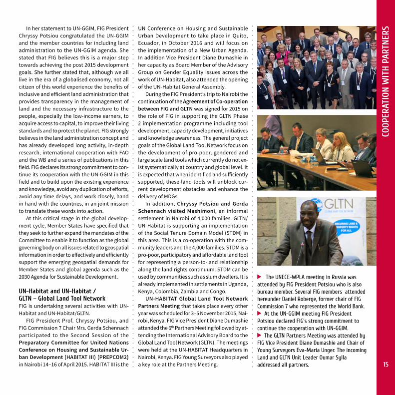
FIG President Prof. Chryssy Potsiou, and FIG Commission 7 Chair Mrs. Gerda Schennach participated to the Second Session of the Preparatory Committee for United Nations Conference on Housing and Sustainable Ur-ban Development (HABITAT III) (PREPCOM2) in Nairobi 14–16 of April 2015. HABITAT III is the
UN Conference on Housing and Sustainable Urban Development to take place in Quito, Ecuador, in October 2016 and will focus on the implementation of a New Urban Agenda. In addition Vice President Diane Dumashie in her capacity as Board Member of the Advisory Group on Gender Equality Issues across the work of UN-Habitat, also attended the opening of the UN-Habitat General Assembly.
During the FIG President’s trip to Nairobi the continuation of the Agreement of Co-operation between FIG and GLTN was signed for 2015 on the role of FIG in supporting the GLTN Phase 2 implementation programme including tool development, capacity development, initiatives and knowledge awareness. The general project goals of the Global Land Tool Network focus on the development of pro-poor, gendered and large scale land tools which currently do not ex-ist systematically at country and global level. It is expected that when identified and sufficiently supported, these land tools will unblock cur-rent development obstacles and enhance the delivery of MDGs.
In addition, Chryssy Potsiou and Gerda Schennach visited Mashimoni, an informal settlement in Nairobi of 4,000 families. GLTN/ UN-Habitat is supporting an implementation of the Social Tenure Domain Model (STDM) in this area. This is a co-operation with the com-munity leaders and the 4,000 families. STDM is a pro-poor, participatory and affordable land tool for representing a person-to-land relationship along the land rights continuum. STDM can be used by communities such as slum dwellers. It is already implemented in settlements in Uganda, Kenya, Colombia, Zambia and Congo.
UN-HABITAT Global Land Tool Network Partners Meeting that takes place every other year was scheduled for 3–5 November 2015, Nai-robi, Kenya. FIG Vice President Diane Dumashie attended the 6th Partners Meeting followed by at-tending the International Advisory Board to the Global Land Tool Network (GLTN). The meetings were held at the UN-HABITAT Headquarters in Nairobi, Kenya. FIG Young Surveyors also played a key role at the Partners Meeting.
The UNECE-WPLA meeting in Russia was attended by FIG President Potsiou who is also bureau member. Several FIG members attended hereunder Daniel Roberge, former chair of FIG Commission 7 who represented the World Bank.
At the UN-GGIM meeting FIG President Potsiou declared FIG’s strong commitment to continue the cooperation with UN-GGIM.
The GLTN Partners Meeting was attended by FIG Vice President Diane Dumashie and Chair of Young Surveyors Eva-Maria Unger. The incoming Land and GLTN Unit Leader Oumar Sylla addressed all partners. 15

COOP
ERAT
ION
WIT
H P
ARTN
ERS
During their visit to UN-Habitat in April 2015 for the preparatory meeting for HABITAT III, FIG President Potsiou and Chair of FIG Commission 7, Gerda Schennach visited Mashimoni, an informal settlement in Nairobi of 4,000 families. GLTN/ UN-Habitat is supporting an implementation of the Social Tenure Domain Model (STDM) in this area.
FIG Young Surveyors and GLTN have organised several train-the-trainer courses on STDM to disseminate the tool. In Mashimoni the STDM tool is used, and is here demonstrated to Chryssy Potsiou and Gerda Schennach.
lead of the Professional Cluster for 2016–17. The Partners meeting has grown from a small originating body of partners to 70 partners at the 6th meeting; the biggest ever held. It provides a unique opportunity to network with other NGO representatives and of course to meet with the GLTN staff and discuss about current future cooperation.
FIG is looking forward to the continued coop-eration with GLTN and Mr. Oumar Sylla the newly appointed GLTN head. Mr. Oumar Sylla has taken over the leadership from the outgoing Head, Dr. Clarissa Augustinus who was honoured by FIG earlier this year with the award of FIG honorary ambassador, Clarissa Augustinus has led GLTN since its inception in 2006.
At the FIG Working Week 2015 various joint FIG/UN-Habitat/GLTN sessions were held and also a workshop on STDM.
Other organisatons
FIG appreciates the cooperation with the various sister organisations and with regional partners.
JB-GIST h e 1 6 t h A n n u a l Meeting of the Joint
Board of Geospatial Information Societies was held 3 August 2015 in New York. The meeting was attended by GSDI, IAG, ICA, FIG, IHO, IMIA, ISPRS and ISCGM. FIG President Potsiou repre-sented FIG.
JBGIS board had a review of the UNGGIM agenda and discussed possible interventions and asked UNGGIM to include JBGIS members in the new Working Groups. The cooperation with the JBGIS members is useful and the exchange of information valuable.
The Urban and Regional Information Systems Association was accepted as an Observer or-ganization to JBGIS. The decision to elect a new Chair of the JBGIS was postponed. Prof Rizos has agreed to remain as chair for the next year until voting. Next organization on the succession list is IHO and Robert Ward has agreed.
The 6th Partners meeting focused upon strengthening partnership and collaboration within the network, and increasing the visibil-ity of land and tenure security in the ongoing global development processes. A Workshop on Understanding the Guide for Fit-for-purpose land administration and making it work was held prior to the Partners meeting.
The GLTN partners meeting was held in the context and at a strategic time in the life of the GLTN Network because the implementation of the GLTN Phase 2 project running from 2012–2017 has reached its mid-term with country level engagement, and the all-important Sus-tainable Development Goals have been agreed, which leads onto global negotiations that are underway in preparation for Habitat III forum to be held in Ecuador in October 2016. This will articulate and define the New UN Habitat Urban Agenda. The GLTN long term goal is to contribute to poverty reduction and sustainable development through promoting secure land and property rights for all.
The GLTN partners are divided into 5 cluster segment, and FIG belongs to the Professional Cluster. During the meeting FIG was elected 16

FIG
FOUN
DATI
ON
Building a Sustainable Future The FIG Foundation is an independent body under the International Federation of Surveyors and has been established for the purpose of raising funds to finance surveying education development projects and supporting young surveyors in order to build a sustainable future.
The FIG Foundation will build a sustainable future by: • grants and scholarships to projects, for
instance to develop curricula for surveying education, training and capacity building, especially in developing countries;
• encouraging research into all disciplines of surveying and to disseminate the results of that research;
• promoting high standards of education and training for surveyors and to facilitate con-tinuing professional development;
• educating people in the disciplines of survey-ing, particularly in developing countries and countries in transition;
• promoting the use of distance learning, net-working, eLearning and knowledge manage-ment if surveying education and continuing professional development;
• promoting the exchange of surveying person-nel for greater understanding of all facets of the profession of surveying;
• supporting by seed funding conferences, meetings of young surveyors and similar events in co-operation with international agencies such as the United Nations.
The FIG Foundation – How Can I Contribute?Companies, associations, institutions, events, surveyors’ groups and individuals may contribute to the Foundation by:– Donations which will be recognised
by a plaque or a certificate of different categories reflecting the sum of dona-tion as follows:
– platinum plaque 25,000 € – gold plaque 10,000 € – silver plaque 5,000 € – bronze plaque 1,000 €.– Donations to support specific projects
or by offering scholarships. Donors and Benefactors may use the FIG Founda-tion logo to promote their project donations or scholarships.
– Voluntary donation when registering to FIG events.
– Attending social functions such as the FIG Foundation Dinners held during every FIG Congress and Working Week and other events.
FOUNDATION
In 2015 the FIG Foundation awarded to 13 young surveyors to attend and participate in the FIG Working Week 2015 in Sofia, Bulgaria: – Nur Zurairah Abdul Halim (Malaysia)– Marina Davidovic (Serbia)– Casper Fibaek (Denmark)– Franka Grubišić (Croatia)– Tomislav Horvat (Croatia) – Konstantina Mangina (Greece) – Miljana Pljevaljcic (Serbia)– Erisem Qehaja (Albania)– Georgios Rigopoulos (Greece)– Melissa Robert (Uruguay) – Aliona Scutelnic (Moldova)– Kelvin Kang Wee Tang (Malaysia) – Benedicta Amarachi Ugwulebo (Nigeria).
The FIG Foundation also approved a grant to Melissa Roberts to attend several conferences to promote the FIG Young Surveyors Network and FIG in South America. CNGeGL, Italy was supported to help Young Surveyors to attend the International Summer School for Survey-ing, Milan, Italy. The Foundation is also proud to acknowledge Trimble Navigation as an FIG Foundation Charter Partner.
FIG Foundation President John Hohol with some of the Young Surveyors who got a FIG Foundation grant.
Read more: www.fig.net/foundation 17

FIG
MEM
BERS FIG Members
Member Associations (December 2015)
Algeria Ordre des Géomètres-Experts Fonciers (OGEF)Australia Surveying and Spatial Sciences Institute (SSSI)Austria Austrian Society for Surveying and GeoinformationBahamas Bahamas Association of Land Surveyors (BALS)Belarus Land Reform AssociationBelgium Union Belge des Géomètres-Experts ImmobiliersBenin Syndicat National des Géomètres- Topographes et Assimilés du BéninBosnia- Herzegovina Geodetic Association of Herceg-BosniaBrazil Brazilian Society of Cartography, Geodesy, Photogrammetry and Remote
Sensing (SBC)Brunei Darussalam Brunei Institution of Geomatics (BIG)Bulgaria Union of Surveyors and Land Managers in Bulgaria
Chamber of Graduate Surveyors Burkina Faso Association des Géomètres et Topographes du Burkina (AGT-B)Canada The Canadian Institute of GeomaticsChina China Institute of Real Estate Appraisers and Agents (CIREA)
China Land Science Society (CLSS)Chinese Society of Geodesy, Photogrammetry and Cartography
Colombia Colombian Society of SurveyorsCongo D.R. Fédération des Ingénieurs Géomètres- Topo graphesCosta Rica Colegio de Ingenieros Topógrafos de Costa RicaCroatia Croatian Geodetic SocietyCyprus Cyprus Association of Rural and Surveying Engineers
Cyprus Association of Valuers and Property ConsultantsCzech Republic Czech Association of Certified Property Appraisers
Czech Union of Surveyors and CartographersDenmark Danish Association of Chartered Surveyors (DdL)Egypt Egyptian Committee of Surveying and MappingEstonia Association of Estonian Surveyors (EGÜ)Ethiopia Ethiopian Surveying Professionals Association (ESPA)Fiji Fiji Institute of SurveyorsFinland Finnish Association of Geodetic and Land Surveyors (MIL)
Maanmittausalan ammattikorkeakoulu- ja opisto teknisten Liitto MAKLI ryFrance Ordre des Géomètres-Experts (OGE)
Association Française de Topographie (AFT)Gabon Association des Professionels de l‘Ingenierie Topographique du Gabon, APIT
GabonGeorgia Society of Professionals of Land Information Technologies (SPLIT)
Germany DVW – Society of Geodesy, Geo-information and Land ManagementGhana Ghana Institution of Surveyors
Licensed Surveyors Association of Ghana (LISAG)Greece Technical Chamber of Greece
Hellenic Association of Rural and Surveying EngineersHong Kong SAR, China
The Hong Kong Institution of Engineering Surveyors
Hungary Hungarian Society of Surveying, Mapping and Remote Sensing Indonesia Ikatan Surveyor IndonesiaIran, Islamic Republic of
Iranian Professional Society of Surveying Engineers (ISS)
Israel Association of Licensed Surveyors in IsraelItaly National Council of Italian SurveyorsJamaica The Land Surveyors Association of Jamaica (LSAJ)Japan Japan Federation of SurveyorsKenya Institution of Surveyors of Kenya (ISK)Korea, Republic of Korea Cadastre Survey CorporationKosovo Kosova Association of SurveyorsLatvia Latvian Associations of Surveyors (LMB)Lebanon Ordre des Géomètres-Topographes du LibanLiberia Cadastral Surveyors Association of Liberia, Inc. (CASUAL)Lithuania Lithuanian Association of Property Valuers
Lithuanian Association of SurveyorsLuxembourg Ordre Luxembourg des Géomètres (OLG)Malaysia Association of Authorised Land Surveyors MalaysiaMali Ordre des Géomètres Experts du Mali (OGE)Malta The Malta Institution of SurveyorsMongolia Mongolian Association of Geodesy, Photogrammetry and Cartography
(MAGPC)Morocco Ordre National des Ingénieurs Géomètres- Topographes (ONIGT)Nepal Nepal Institution of Chartered SurveyorsNetherlands Geo-informatie Nederland (GIN)New Zealand New Zealand Institute of SurveyorsNigeria Nigerian Institution of Estate Surveyors and Valuers
Nigerian Institution of SurveyorsThe Nigerian Institute of Quantity Surveyors
Norway Norges Jordskiftekandidatforening (NJKF), faglig gruppe af Tekna and GeoForum
*) New member from 2016 who have applied and were admitted into membership up until the time of printing.
18

FIG
MEM
BERSPalestinian Authority Licensed Surveyors Association in Palestine
Papua New Guinea Association of Surveyors of Papua New Guinea (ASPNG)Philippines Geodetic Engineers of the Philippines, Inc.Poland Association of Polish Surveyors Portugal Order of Engineers – College of Geographical EngineeringRomania Romanian Association of Private Surveyors
Union of Romanian GeodesyRussian Federation Federal Service of State Registration, Cadastre and Cartography (Rosreestr)
Non-commercial partnership “Self-regulated organization of activity of cadastral engineers”
Rwanda Distinctive Engineering GroupSenegal Ordre National des Géomètres Experts du Senegal (ONGES)Serbia Serbian Union of SurveyorsSlovak Republic Chamber of Surveyors and Cartographers, CSC
Slovak Union of Surveyors and CartographersSlovenia Association of Surveyors of SloveniaSouth Africa, Republic of
South African Council for Professional and Technical Surveyors The South African Geomatics Institute (SAGI) *)
Spain Spanish Association of Geodetic SurveyorsSri Lanka Surveyors’ Institute of Sri LankaSt. Lucia The Institute of Surveyors (St. Lucia) Inc. ISSLSweden Swedish professionals for the built environmentSwitzerland geosuisse – Swiss society of geomatics and
Land ManagementSyria Order of Syrian Engineers and Architects (OSEA)Togo Ordre des Géomètres du TogoTrinidad and Tobago Institute of Surveyors of Trinidad and TobagoTurkey Chamber of Surveying Engineers of TurkeyUganda Géographie, Topographie, Hydraulique, Energie et Construction (GEOTHECO) *)
Ukraine Ukrainian Society of Geodesy and CartographyUnited Kingdom Chartered Institution of Civil Engineering Surveyors (ICES)
The Royal Institution of Chartered Surveyors (RICS)Uruguay Surveyors Association of Uruguay (AAU)USA National Society of Professional Surveyors (NSPS)Vietnam Vietnam Association of Geodesy – Cartography – Remote SensingZimbabwe Survey Institute of Zimbabwe
Affiliate Members (December 2015)Albania Central Office of Immovable Property Registration – IPROArgentina Consejo Federal De Catastro De La Republica Argentina (C.F.C)Azerbaijan State Committee for Land and Cartography, State Aerogeodesy Corporation,
AzerbaijanBahrain Survey and Land Registration BureauBelgium General Administration of the Patrimonial DocumentationBrunei Darussalam Survey Department, Ministry of DevelopmentBulgaria Geodesy, Cartography and Cadastre Agency of BulgariaCambodia Ministry of Land Management, Urban Planning and ConstructionChile Servicio Hidrográfico y Oceanográfico de la Armada de ChileChina China Land Surveying and Planning InstituteColombia Instituto Geográfico Agustin CodazziCroatia State Geodetic Administration of Republic of CroatiaCyprus Cyprus Lands and Surveys DepartmentDenmark Danish Geodata AgencyFiji Ministry of Lands and Mineral Resources
iTaukei Land Trust BoardFinland National Land Survey of FinlandGuatemala Guatemalan Registry of Cadastral Information (Registro de Información
Catastral de Guatemala – RIC)Hungary Institute of Geodesy, Cartography and Remote Sensing (FÖMI)Iceland Registers IcelandIran National Cartographic Center of Iran (NCC)Iraq, Republic of General Directorate for Surveying, Ministry of Water ResourcesIsrael Survey of IsraelItaly Italian Society of Photogrammetry and Topography (SIFET)
Japan Geospatial Information Authority of Japan/Geodetic DepartmentJordan Department of Lands & Survey, Ministry of FinanceLatvia The State Land Service of LatviaLesotho Land Administration Authority (LAA) Macedonia (FYROM) Agency for Real Estate Cadastre (AREC)Mexico National Institute of Statistics, Geography and Informatics (INEGI)Moldova, Republic of
Agency for Land Administration and Cadastre of Republic of Moldova
Mongolia Administration of Land Affairs, Construction, Geodesy & CartographyNamibia Office of the Surveyor General, Ministry of Lands, Resettlement and
RehabilitationNepal Survey Department, Government of NepalNetherlands Cadastre, Land Registry and Mapping AgencyNew Zealand Land Information New ZealandNorway Statens kartverk, Norwegian Mapping and Cadastre AuthorityRomania National Agency for Cadastre and Land AdministrationRussian Federation Siberian State Academy of GeodesySaudi Arabia, Kingdom of
Ministry of Municipal and Rural AffairsGeneral Commission for Survey (GCS), General Directorate of Geodesy and Land Survey (GLS)
Sri Lanka Survey Department, Sri LankaSweden Lantmäteriet – The Swedish Mapping, Cadastral and Land Registration
AuthoritySwitzerland Swiss Federal Office of Topography, swisstopoUSA United States Department of Commerce, National Oceanic and Atmospheric
Administration NOAA 19

FIG
MEM
BERS Academic Members (December 2015)
Australia RMIT University, Department of Geospatial ScienceThe University of Melbourne, Department of GeomaticsUniversity of New South Wales, School of Surveying and Spatial Information SystemsUniversity of Southern Queensland, Department of Surveying and Land Information University of Technology Sydney, School of Construction Property & Project Manage-ment
Austria University of Natural Resources and Applied Life Sciences Vienna, Institute of Survey-ing, Remote Sensing and Land Information
Belgium Antwerp Maritime Academy, Institute for HydrographyECAM – Haute Ecole Leonard de Vinci, Département ConstructionGhent University, Department of GeographyUniversity of Applied Sciences Kaho Sint-Lieven, Department of Engineering in Construction and Land SurveyingUniversity of Liege, Unit of Geomatics
Brazil Universidade do Vale do Rio dos Sinos – UNISINOS, Centro de Ciências Exatas e Tecnológicas
Canada Université Laval, Départment des sciences géomatiqueUniversity of Calgary, Department of Geomatics EngineeringUniversity of New Brunswick, Department of Geodesy and Geomatics Engineering
China Renmin University of China, School of Public Administration, Department of Land & Real Estate ManagementThe University of Nottingham Ningbo China, Faculty of Science and Engineering
Colombia Universidad de los Andes – Civil and Environmental EngineeringUniversidad Distrital Francisco José de Caldas, Facultad de IngenieríaUniversidad Distrital Francisco José de Caldas, Facultad del Medio Ambiente y Recursos Naturales
Croatia University of Zagreb, Faculty of GeodesyCzech Republic
Brno University of Technology, Faculty of Civil Engineerin, Department of Surveying
Denmark Aalborg University, Department of Development and PlanningEthiopia Bahir Dar University, Institute of Land AdministrationFinland Aalto University, School of Engineering, Department of Real Estate, Planning and
GeoinformaticsHelsinki Metropolia University of Applied Sciences, Land SurveyingRovaniemi University of Applied Siences
France Ecole Supérieure des Géomètres et Topographes (ESGT)Gabon Ecole Nationale du Cadastre et des Sciences Geographique, ENCSGGermany Anhalt University of Applied Sciences, Faculty of Surveying Engineering
Berlin Institute of Technology, Department for Geodesy and Geoinformation ScienceTechnische Universität München, Faculty of Civil Engineering and SurveyingUniversity of Stuttgart, Institute of Engineering geodesy (IIGS)
Greece National Technical University of Athens, School of Rural and Surveying Engineering
Hong Kong SAR, China
The Hong Kong Polytechnic University, Department of Land Surveying & Geo-Informatics
Hungary The University of West Hungary, Faculty of GeoinformaticsIreland Dublin Institute of Technology, Department of Geomatics
Israel Technion – Israel Institute of Technology, Mapping and Geoinformation EngineeringJamaica University of Technology Jamaica, Division of Surveying and G eographic Information
SciencesKazakhstan East Kazakhstan State Technical University named after
D. Serikbayev, Geodesy, Land Management and CadastreKazakh National Technical University after K. I. Satpaev, Department for Strategic Planning and Development
Latvia Riga Technical University, Faculty of Civil Engineering, Department of Geomatics
Lebanon Lebanese Canadian University (LCU), Faculty of EngineeringLebanese International University, LIU, Department of Surveying Engineering
Mexico Universidad Autónoma de Nuevo León, Topography Department of the Civil Engineering
Namibia Polytechnic of Namibia, Department of Land and Property SciencesNepal Land Management Training Centre, Dhulikhel MunicipalityNetherlands ITC – Faculty of Geo-Information Science and Earth Observation of the University
of TwenteNew Zealand
University of Otago, The School of Surveying
Nigeria ABIA State Polytechnic, ABA, Nigeria, Surveying and Geoinformatics Dept. Nnamdi Azikiwe University, Faculty of Environmental SciencesUniversity of Lagos, Faculty of Environmental Sciences
Norway Norwegian University of Life Sciences, Department of Mathematical Sciences and TechnologyBergen University College, Faculty of Engineering
Oceania University of the South Pacific, Land Management & Development DepartmentPalestinian Authority
Palestine Polytechnic University, College of Engineering and Technology
Papua New Guinea
Papua New Guinea University of Technology, Surveying and Land Studies
Puerto Rico, USA
Polytechnic University of Puerto Rico, Geomatic Sciences Department
Romania “1 Decembrie 1918” University of Alba Iulia, Department of Topography and CadastreTechnical University of Civil Engineering – Faculty of Geodesy, Bucharest
Russian Federation
Moscow State University of Geodesy and Carto graphy, Economic and Land Manage-mentState University of Land Use Planning, Vise-rector for International Cooperation
Rwanda INES-Ruhengeri, Head of Department: Land Administration and Management Senegal University of Thies, UFR Science of engineeringSerbia University of Novi Sad, Faculty of Technical SciencesSlovenia University of Ljubljana, Faculty of Civil and Geodetic EngineeringSouth Africa, Republic of
University of Cape Town, Division of Geomatics in the School of Architecture, Plan-ning and Geomatics
Spain Technical University of Madrid, Higher School of Engineers in Surveying, Geodesy and CartographyUniversity of Jaen Spain, Ingenieria Cartografica, Geodesica y Fotogrametria
Sri Lanka Sabaragamuwa University of Sri Lanka, Faculty of Geomatics20

FIG
MEM
BERSSweden Lund University, Department of Real Estate Science
Royal Institute of Technology, Real Estate Planning and Land LawUniversity West, Department of Engineering
Switzerland University of Applied Sciences Northwestern Switzerland, School of Architecture, Civil Engineering and Geomatics
Trinidad and Tobago
University of the West Indies, Department of Geomatics Engineering & Land Management, Faculty of Engineering
Turkey Istanbul Technical University, Department of Geomatic EngineeringUganda Makerere University, Geomatics and Land ManagementUnited Kingdom
Oxford Brookes University, School of Built EnvironmentReading University, Henley Business School, School of Rural Estate and Planning
United Kingdom (cont.)
Sheffield Hallam University, Faculty of Development & SocietyThe University of Nottingham, Institute of Engineering Surveying and Space GeodesyUniversity of the West of England, Faculty of the Built Environment
USA New Mexico State University, Surveying EngineeringTexas A&M University – Corpus Christi, Conrad Blucher Institute for Surveying and ScienceUniversity of Houston, College of Technology
Inter-national
UNIGIS International Association
In addition, FIG has a correspondent in Tonga.
Corporate Members (April 2016)
PLATINUM LEVEL
Bentley Systems
Environmental Systems Research Institute, Inc. (ESRI)
Leica Geosystems AG
Trimble Navigation Ltd
SILVER LEVEL
Geoweb S. p. A
Meridian+
The State Enterprise “State Land Cadastre Centre”, Ukraine
Thomson Reuters
BRONZE LEVEL
COWI A/S
GIM International – Geomares Publishing
KQ Geo Technologies Co
RIPRO Corporation, Japan
BASIC LEVEL
Beijing iSpatial Co., Ltd, PRC
Derinsu Underwater Engineering & Consulting
NEH Engineering Survey and Mapping Limited Company, Vietnam
REGIONAL LEVEL
Branco Etera Ltd, Kazakhstan
Concord Surveying Works Co.
Coordinates Magazine
DataLife Environmental
GEO:connexion Ltd
Georeference Engineering Consultants, Saudi Arabia
Innovation for Trading and Contracting
JKO Surveyors & Consultants (Pvt) Ltd, Sri Lanka
Orbits Engineering Firm
OTHER SPONSORSHIP Chinese Society for Surveying, Mapping and Geoinformation, CSSMG 21

ECON
OMY
Income and Expenditure Account 2013–2015REGULAR INCOME Result 2015 *) Budget 2015 Result 2014 Result 2013 Subscriptions (all figures in Euro)
Member associations 253,998 260,000 259,444 260,145Affiliate members 30,351 28,000 28,880 25,460Corporate members 80,046 78,000 80,990 77,893Academic members 11,593 11,000 11,000 20,750Less bad debts –25,611 –14,750 –38,041 –20,775Less change in provision for doubtful debts –10,937
350,377 362,250 342,273 352,536Financial income / expenses 3,907 5,000 2,993 4,399Less banking costs –411 –250 –616 –763Currency diff –3,311Events – fees charged for services 44,549 45,000 81,910 80,000
Total regular income 395,111 412,000 426,560 436,172REGULAR EXPENDITURE
Administration 193,524 218,000 204,954 195,482Marketing and publications 11,775 10,000 28,947 19,930Council and executive management 145,998 152,000 153,161 180,876Commission support 33,015 33,000 33,000 33,000
Total regular expenditure 384,312 413,000 420,062 429,288Surplus/deficit of regular income over regular expenditure 10,799 –1,000 6,498 6,884PROJECTS AND DEVELOPMENTEvents – funds received by FIG – – 31,684 20,046Development spent –35,280 –22,000 –12,764 –21,192SURPLUS OF THE YEAR (REGULAR) –24,481 –23,000 25,418 5,738RESULTOverall surplus/deficit in the year – normal activities –4,481 –23,000 25,418 5,738Total reserve at the year end 499,647 524,128 498,711Events reserve 25,000 25,000 25,000IT reserve 30,000 50,000 25,000General reserve 444,647 449,128 448,711General reserve as a % of regular annual expenditure 116% 107% 105%
FIG Balances 2009–2015
Economy
0100,000200,000300,000400,000500,000600,000700,000800,000900,000
2009 2010 2011 2012 2013 2014 2015
SurplusAssetsEquity
**)
*) The accounts will be adopted by the General Assembly May 2016. The income and expenditure presentation follow the template approved by the General Assembly in 2009.**) 20,000 EUR of the IT reserve has been used to cover part of the deficit, due to large IT improvements in 2015.
By Prof., Dr. Rudolf Steiger, Vice President in charge of finances
22

KEY
CON
TACT
S
FIG Council
FIG Office
President Mr. Bruno Razza 2015–2016 (CNGeGL, Italy)[email protected]
Dr. Pengfei Cheng 2015–2016 (CSSMG, PR China)[email protected]
ACCO Representatives
Mr. Brian J. Coutts 2015–2016(NZIS, New Zealand)[email protected]
Vice Presidents
Dr. Diane Dumashie 2015–2018 (RICS, UK)[email protected]
Prof., Dr. Rudolf Staiger 2015–2018 (DVW, Germany)[email protected]
Prof., Dr. Chryssy A Potsiou 2015–2018 (TEE, Greece)[email protected]
Ms. Louise Friis-Hansen FIG [email protected]. + 45 9391 0810 (direct)
Ms. Claudia Stormoen Pedersen FIG Event and Support [email protected] Tel. + 45 9391 0812 (direct)
Ms. Maria Bargholz Finance and [email protected]
Ms. Tian Tian FIG Support (supported by CSSMG*)[email protected]@fig.net Tel. +45 9391 0811
International Federation of SurveyorsKalvebod Brygge 31–33DK-1780 Copenhagen VDENMARKtel. + 45 3886 1081e-mail: [email protected] site: www.fig.net
Key Contacts
FIG Communication E-NewsletterArticle of the Month
Emails
CommissionCommunication
FIG MEMBERS
www.�g.net
FIG Annual Review
FIG Publications
Social Media
Conference Proceedings
www.facebook.com/#!/international-federationofsurveyors
twitter.com/FIG_NEWS
www.linkedin.com/groups?trk=group-name&gid=2669121
FIG on Social Media
Ms. Gerda Schennach 2017–2018(OVG, Austria)[email protected]
* FIG and the Chinese Society for Surveying, Mapping and Geoinfor-mation, CSSMG have agreed on an exchange programme where a new Chinese employee each 6 month for the following 3 years come to Copenhagen and will assist in the FIG office.
23

FIG Annual Review 2015 • ISSN 1018-6522 ISBN 978-87-92853-45-5 (printed) 978-87-92853-46-2 (pdf) • Published by the International Federation of Surveyors FIG Office, Kalvebod Brygge 31–33, DK-1780 Copenhagen V, DENMARK, tel. +45 3886 1081, email [email protected], www.fig.net
FIG PLATINUM CORPORATE MEMBERS
FIG WORKING WEEK 2017
Helsinki Finland 29 May – 2 June
SURVEYING THE WORLD OF TOMORROW
From digitalisation to augmented reality
www.fig.net/fig2017
LET’S MEET WHEREContinents & Cultures, Past & Present, Old & New,Modern & Traditional MEET…
LET’S MEET IN ISTANBUL 6–11 May 2018www.fig.net/fig2018
LET`S MEET WHERE
LET`S MEET IN ISTANBUL
Continents & Cultures,Past & Present,Old & New,Modern & Traditional MEET…
LET`S MEET WHERE
LET`S MEET IN ISTANBUL
Continents & Cultures,Past & Present,Old & New,Modern & Traditional MEET…
Vietnam Association of Geodesy, Cartography
and Remote Sensing (VGCR)
International Federation of
Surveyors (FIG)
FIG Working Week 2019Hanoi, Vietnam