Embed Size (px)
Citation preview

Geodetic Network in Cambodia
MLMUPC-GDCG 1 16/10/2016
Presented by: Mr. Meas Bunthoeun
Deputy Director of General Department of Geography and Cadastral
Geospatial and GNSS CORS Infrastructure Forum
Kuala Lumpur - Malaysia , 16 October 2016

1. Introduction
2- Cambodia Geography
3- National Survey Organization
4-The Status of National Geodetic Network
5- The Challenges
6. Future Plan
Content
MLMUPC-GDCG 2 16/10/2016

The prolong civil war caused lots of difficulties not just the lack of
human resources but the awareness among decision makers was
also concerned.
The Geospatial technology and applications was recently
introduced in Cambodia increasingly, but slowly develop from
time to time.
1- Introduction
MLMUPC-GDCG 3 16/10/2016

• Location in South East Asia
• Total area : 181 035 sq.km
• Population : 14.8 millions
• Capital : Phnom Penh
• Official language : Khmer
• Religion : Buddhism
• Provinces/municipalities: 25
• Districts : 190
• Communes : 3 190 1621
2-Cambodia Geography
Thailand Laos
MLMUPC-GDCG 4 16/10/2016

3- National Survey Organization
The General Department of Cadastre and Geography (GDCG) under the Ministry of Land
Management Urban Planning and Construction (MLMUPC) is responsible for mapping,
surveying and cadastral works in Cambodia. This has six departments:
Department of Land Administration
Department of Land Dispute Affairs
Department of Technique
Department of Land Registration
Department of Geography
Department of Cadastre Information Technology
The Department of Geography is among others responsible for national geodetic
framework. It will be supervisor of the Project. The department is supported by Technical
Assistance provided by Land Administration Sub Sector Program (LASSP) .
MLMUPC-GDCG 5 16/10/2016

4-The Status of National Geodetic Network
Recommendations of Dr. Andrew Dyson Geodetic Consultant :
As a matter of urgency, an accessible 1st order Geodetic Network be established
through the whole Cambodia.
The Cambodian Horizontal Datum should be defined based on the results of the
Asia Pacific Regional Geodetic Project of 1998
A precise vertical control network is established throughout Cambodia
A common database is prepared for control points on any of the datum used in
Cambodia and that a field search be made for any of these old control points so
that they can be incorporated into the geodetic serving plan to enable the
development of new transformation parameters relating the various datum
The GPS specialist ensure quality control of the GPS operations, processing and
adjustment in addition to providing the necessary on the job training.
a)- The Role of Control Network
MLMUPC-GDCG 6 16/10/2016

4-The Status of National Geodetic Network
Recommendations of Dr. Andrew Dyson Geodetic Consultant :
As a matter of urgency, an accessible 1st order Geodetic Network be established
through the whole Cambodia.
The Cambodian Horizontal Datum should be defined based on the results of the
Asia Pacific Regional Geodetic Project of 1998
A precise vertical control network is established throughout Cambodia
A common database is prepared for control points on any of the datum used in
Cambodia and that a field search be made for any of these old control points so
that they can be incorporated into the geodetic serving plan to enable the
development of new transformation parameters relating the various datum
The GPS specialist ensure quality control of the GPS operations, processing and
adjustment in addition to providing the necessary on the job training.
a)- The Role of Control Network
MLMUPC-GDCG 7 16/10/2016
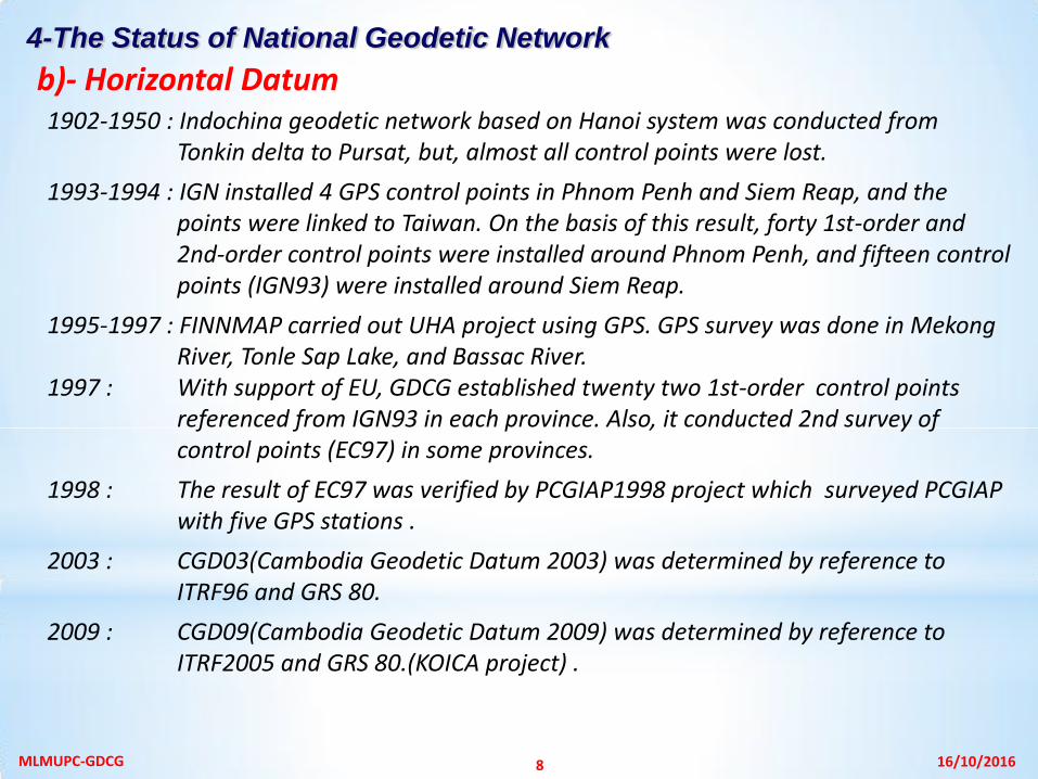
1902-1950 : Indochina geodetic network based on Hanoi system was conducted from Tonkin delta to Pursat, but, almost all control points were lost.
1993-1994 : IGN installed 4 GPS control points in Phnom Penh and Siem Reap, and the points were linked to Taiwan. On the basis of this result, forty 1st-order and 2nd-order control points were installed around Phnom Penh, and fifteen control points (IGN93) were installed around Siem Reap.
1995-1997 : FINNMAP carried out UHA project using GPS. GPS survey was done in Mekong River, Tonle Sap Lake, and Bassac River.
1997 : With support of EU, GDCG established twenty two 1st-order control points referenced from IGN93 in each province. Also, it conducted 2nd survey of control points (EC97) in some provinces.
1998 : The result of EC97 was verified by PCGIAP1998 project which surveyed PCGIAP with five GPS stations .
2003 : CGD03(Cambodia Geodetic Datum 2003) was determined by reference to ITRF96 and GRS 80.
2009 : CGD09(Cambodia Geodetic Datum 2009) was determined by reference to ITRF2005 and GRS 80.(KOICA project) .
b)- Horizontal Datum 4-The Status of National Geodetic Network
MLMUPC-GDCG 8 16/10/2016

Horizontal Geodetic Datum of Cambodia used by LMAP / LASSP is defined as follows :
Horizontal Datum Name : CGD03 (Cambodian Geodetic Datum 2003) Reference Frame : ITRF2000 (International Terrestrial Reference Frame 2000) Epoch : 1998.90 Reference Ellipsoid : GRS80 (Geodetic Reference System 1980) Semi-major Axis : 6,378,137.000 meters Inverse Flattening : 298.257222101
The Cambodian Geodetic Datum 2003 is realized by the coordinates of the following high
precision fundamental 0-order geodetic stations referred to the GRS80 ellipsoid determined
within the International Earth Rotation Service Terrestrial Reference Frame 2000. Geodetic
coordinates released in July 2003 were projected back to epoch 1998.90 .
Station ITRF2000 Latitude ITRF2000 Longitude Ellipsoidal Height Epoch Date
PENH 11º 34’ 25.7213” 104º 55’ 03.2810” 15.2397 m 24 Nov 1998
SIEM 13º 24’ 33.3967” 103º 48’ 55.5972” - 2.2294 m 24 Nov 1998
SIHA 10º 36’ 38.5483” 103º 31’ 24.6294” - 3.6596 m 24 Nov 1998
STUE 13º 31’ 49.8900” 105º 58’ 15.5307” 37.5055 m 24 Nov 1998
SVAY 11º 05’ 31.3986” 105º 47’ 24.8193” - 3.5451 m 24 Nov 1998
4-The Status of National Geodetic Network
b)- Horizontal Datum (…)
MLMUPC-GDCG 9 16/10/2016

Map Projection: UTM (Universal Transverse Mercator) Projection Zone: International UTM Zone 48, northern hemisphere Central Meridian: 105º 00’ 00” E Latitude of Origin: 0º 00’ 00” N False Easting : 500,000.000 m False Northing: 0.000 m Scale Factor at Central Meridian 0.9996 Station UTM Northing UTM Easting Ellipsoidal Height Epoch Date PENH 1279428.548 491013.771 15.240 24 Nov 1998 SIEM 1482704.306 371750.641 -2.229 24 Nov 1998 SIHA 1173319.046 338477.632 -3.660 24 Nov 1998 STUE 1496014.009 605070.840 37.506 24 Nov 1998 SVAY 1226272.551 586303.151 -3.545 24 Nov 1998
4-The Status of National Geodetic Network
b)- Horizontal Datum (…)
All further densification surveys have to be derived from the above fundamental 0-order
stations and the epoch 1998.90 coordinates have to be used as fixed coordinates in 1st
order horizontal geodetic network computations and adjustment in Cambodia
MLMUPC-GDCG 10 16/10/2016

Horizontal Datum Name: CGD09 (Cambodian Geodetic Datum 2009) Reference Frame: ITRF2000 (International Terrestrial Reference Frame 2005) Epoch: 2009.56 Reference Ellipsoid: GRS80 (Geodetic Reference System 1980) Semi-major Axis: 6,378,137.000 meters Inverse Flattening: 298.257222101
4-The Status of National Geodetic Network
b)- Horizontal Datum (…)
MLMUPC-GDCG 11 16/10/2016
Establishment of CGD09 : In 2008-2009 KOICA project completed 1-order densification
surveys of all Cambodia and incorporated previous 1-order GPS surveys by LMAP and KOICA
in one homogenous countrywide network adjustment. The final network adjustment in
2009 includes seven Zero order stations, 155 1st order stations and three CORS stations.
Fundamental Zero order stations for CGD09 were established and observed at Phnom
Penh , Siem Reap, Sihanoukville, Stueng Treng , Svay Rieng , Kandal , and Mondul Kiri.
These points were connected to IGS stations in Philippines, Singapore and Thailand at ITRF
2005 epoch 2009.56. Additionally three continuous operating reference stations (CORS)
were established to Kandal, Kratie and Siem Reap.
The final network adjustment in 2009 includes seven Zero order stations, 155 1st order Stations and three CORS stations.

Geodetic Control Points in Cambodia
Legend
0 Order 07 Pts
1st order 155 Pts.
2nd orders 496Pts.
3rd order 809 Pts.
CORS 03 Stations
MLMUPC-GDCG 12 16/10/2016

In 1938-1954, Nivellement General built precise leveling network in south Indochina
peninsula, and its purpose was to install 1st-order, 2nd-order, and 3rd-order benchmarks.
Cambodia leveling network has not been completed yet, and Ponley of north Phnom
Penh, Pursat Swai Dan Keo and Kampong Thom area was included in the network.
IGN of France executed GPS survey and leveling in Phnom Penh area in 1944, and in
Siem Reap in 1955. In 1996, leveling was conducted along the Mekong River, Tonle Sap
Lake, and Bassac River to study agricultural development in Mekong River overflowing
area. Also, leveling of 60 km and elevation point survey of 400km were carried out along
the river bank.
The latest 2nd-order benchmark survey was executed from Vietnam boundary to Prek
Dam area by FINNMAP in 2001-2002. MRC extended the leveling to Tonle Sap Lake in
Kampong Luong area.
Benchmarks which installed by France (1938-1954) and Hunting Surveys (1959-1960)
were destroyed by war and flooding. In 1996, some unstable benchmarks were
eliminated, and some benchmarks were restored.
2008-2009 Cambodia leveling network phase 1 has been completed ,
2016 Cambodia leveling network phase 2 just started ,
c)- Vertical Datum 4-The Status of National Geodetic Network
MLMUPC-GDCG 13 16/10/2016

MLMUPC-GDCG 14 16/10/2016

Human resources
Lack of qualified personnel, For example: In the local branches of Geodesy and
Cartography created positions of officer in charge of geodesy are not enough and
capacity still limited
Lack of research scientific work,
The unity quality of university education does not catch up latest technology
Absence of strategic plan for systematic development of human resources,
Technology
No regular re-measurement /updates/ of national geodetic control network,
We don't have an unified control points: one control point can not carry variety of
information, such as latitude, longitude, height, gravity.
GNSS permanent station operations do not meet international standards as
inadequate use of the station.
Gravimetric measurement is neglected last few decades,
Budget
Budget available still limited for huge Geodetic network work .
5- The Challenges
MLMUPC-GDCG 15 16/10/2016

Capacity building
Training program on Geodesy professional and Continuous Development program
Universities’ geodesy teaching staff's training \professional development\ in
developed countries,
To increase the number of bachelor, master and doctoral students in Geodesy and
Cartography studying in developed countries
Short and long-term training of governmental, non-governmental organizations and
the private sector professionals concerned.
Technologies Improvement
To establish a origin point by regular participation in International GNSS observation
campaign, which will be used for 3 type of geodetic network (for horizontal, for
vertical and for gravity),
The horizontal network transformation into the unified coordinate system, have to
continue,
Establishment and computation of First Order Height network, have to complete,
Welcome Asia Pacific and request for the best practice experts to support this
professional in Cambodia
Planned Activities
Build an experimental research center for advanced technology implementation-
To establish a ground station to receive and send satellite data.
To involve into foreign scientific research and implement projects and program
6. Future Plan
MLMUPC-GDCG 16 16/10/2016

Thank You for your attention !
MLMUPC-GDCG 17 16/10/2016