Embed Size (px)
Citation preview

Sectio
ns U
nder
Study (
ADB)
1 Estimate based on the cost of the Herat – Andkhoy section supported by the Asian Development Bank.
41
ANNEX
PROFILES OF PRIORITY PROJECTS ALONGTHE ASIAN HIGHWAY
A. Afghanistan
1. Project name: AH77, Bamiyan – Changcharan, AH71, Herat – Touraghandi.
2. Location: The Bamiyan – Changcharan section is part of AH77 and the central East-Westcorridor connecting Herat and Kabul, with a length of 344 km. The Herat – Touraghandi sectionis part of AH71 connecting Afghnistan and Turkmenistan, with a length of 120 km.
3. Brief outline of the project: The Asian Highway network in Afghanistan consists of a ring road,central East-West road and links to the neighbouring countries. The road connection to: (a) theIslamic Republic of Iran is through Zarang and Islam Qila; (b) Pakistan through Spin Boldak andTorkham: (c) Tajikistan through Shrikhan; (d) Uzbekistan through Hairatan; and (e) Turkmenistanthrough Tourghandi.
Most of the roads in Afghanistan have been damaged by war, and need upgrading and rehabi-litation. Various sections of the Asian Highway in Afghanistan are under construction or in thefeasibility study stage with support from multilateral and bilateral donors.
The Bamiyan – Changcharan (AH77) and Herat – Touraghandi (AH71) sections of the AsianHighway need to be upgraded to establish efficient East-West link and connection to Turkmenistan.
In addition to the above sections, substantial financial assistance will be necessary for undertakingother projects along the Asian Highway and national roads that are currently at the feasibilitystudy stage.
4. Rationale and objectives: The rehabilitation of the Asian Highway and roads in Afghanistan willrestore the road network in the country. This will contribute to efficient transport, a reduction invehicle operating costs and savings in travel times as well as help to stabilize economic activitiesin Afghanistan.
5. Scope of work: The project scope is the improvement of a 515-km of section of the above road.The feasibility study will define exactly the scope of work.
6. Expected impacts and benefits: The project will provide benefits to the people of Afghanistan,improve mobility, lower transportation costs and reduce travel times. The implementation of theproject will create employment and contribute towards reducing poverty by increasing householdincome.
7. Estimated cost: US$ 200 million1 (preliminary estimate).
8. Project duration: Three to four years.
9. Proposed project financing arrangements: The World Bank, the Asian Development Bank orother international and bilateral financing organizations.
10. Implementation arrangements: The Ministry of Public Works will be the implementing agency.Project implementation arrangements will be established as required.
11. Project status: A feasibility study needs to be conducted. ADB is providing TA to preparemaster plan for road improvement and development of North-South corridors.
12. Critical success factors: Availability of financing, efficient cooperation between donors and theGovernment, timely selection of consultants and contractors, and the establishment of a projectmanagement office.
13. Other project-related information: Project implementation will complete the restoration of themain road network in Afghanistan and will boost economic opportunity and stability.
14. Contact address: Directorate of Foreign Relations, Ministry of Public Works, Ministry Building,Great Massoud Road, Kabul, Afghanistan. Fax: 39-831-246-103.
42
B. Armenia
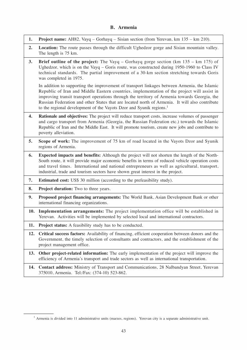
1. Project name: AH82, Vayq – Gorhayq – Sisian section (from Yerevan, km 135 – km 210).
2. Location: The route passes through the difficult Ughedzor gorge and Sisian mountain valley.The length is 75 km.
3. Brief outline of the project: The Vayq – Gorhayq gorge section (km 135 – km 175) ofUghedzor, which is on the Vayq – Goris route, was constructed during 1950-1960 to Class IVtechnical standards. The partial improvement of a 30-km section stretching towards Goriswas completed in 1975.
In addition to supporting the improvement of transport linkages between Armenia, the IslamicRepublic of Iran and Middle Eastern countries, implementation of the project will assist inimproving transit transport operations through the territory of Armenia towards Georgia, theRussian Federation and other States that are located north of Armenia. It will also contributeto the regional development of the Vayots Dzor and Syunik regions.1
4. Rationale and objectives: The project will reduce transport costs, increase volumes of passengerand cargo transport from Armenia (Georgia, the Russian Federation etc.) towards the IslamicRepublic of Iran and the Middle East. It will promote tourism, create new jobs and contribute topoverty alleviation.
5. Scope of work: The improvement of 75 km of road located in the Vayots Dzor and Syunikregions of Armenia.
6. Expected impacts and benefits: Although the project will not shorten the length of the North-South route, it will provide major economic benefits in terms of reduced vehicle operation costsand travel times. International and national entrepreneurs as well as agricultural, transport,industrial, trade and tourism sectors have shown great interest in the project.
7. Estimated cost: US$ 30 million (according to the prefeasibility study).
8. Project duration: Two to three years.
9. Proposed project financing arrangements: The World Bank, Asian Development Bank or otherinternational financing organizations.
10. Implementation arrangements: The project implementation office will be established inYerevan. Activities will be implemented by selected local and international contractors.
11. Project status: A feasibility study has to be conducted.
12. Critical success factors: Availability of financing, efficient cooperation between donors and theGovernment, the timely selection of consultants and contractors, and the establishment of theproject management office.
13. Other project-related information: The early implementation of the project will improve theefficiency of Armenia’s transport and trade sectors as well as international transportation.
14. Contact address: Ministry of Transport and Communications, 28 Nalbandyan Street, Yerevan375010, Armenia. Tel:/Fax: (374-10) 523-862.
1 Armenia is divided into 11 administrative units (marzes, regions). Yerevan city is a separate administrative unit.
43

1. Project name: AH82, Goris – Agarak section (border with the Islamic Republic of Iran).
2. Location: The continuation of the AH82 route, Vayq – Sisian segment, to the border with theIslamic Republic of Iran (from Yerevan, km 243 km – km 383).
3. Brief outline of the project: The existing road was constructed to Class IV technical standard.The Goris – Kapan road segment (60 km) was constructed during 1955-1965, while the Qajaran– Meghri (48 km) segment was completed in 1980. It includes the difficult gorge sections ofGoris – Kapan and Qajaran – Meghri.
4. Rationale and objectives: The project will reduce transport costs, increase volumes of passengerand cargo transport from Armenia (Georgia, the Russian Federation etc.) towards the IslamicRepublic of Iran and the Middle East. It will promote tourism, create new jobs and contributeto poverty alleviation.
5. Scope of work: Improvement of 140 km of road in the Syunik region of the Armenia.
6. Expected impacts and benefits: Although the project will not shorten the length of the North-South route, it will provide major economic benefits in terms of reduced vehicle operation costsand travel times.
7. Estimated cost: US$ 56 million (preliminary estimate).
8. Project duration: Five years.
9. Proposed project financing arrangements: The World Bank, the Asian Development Bank andother international financing organizations.
10. Implementation arrangements: The project implementation office will be established inYerevan. Activities will be implemented by selected local and international contractors.
11. Project status: A feasibility study needs to be conducted.
12. Critical success factors: Availability of financing, efficient cooperation between donors andthe Government, the timely selection of consultants and contractors, and the establishment of aproject management office.
13. Other project-related information: Early implementation of the project will improve theefficiency of Armenia’s transport and trade sectors as well as international transport.
14. Contact address: Ministry of Transport and Communication, 28 Nalbandyan Street, Yerevan375010, Armenia. Tel:/Fax: (374-10) 523-862.
44

1. Project name: AH81, Bavra – Gyumri road section.
2. Location: The road section is located in Armenia’s Shirak region (Yerevan, km 146 – km 156).
3. Brief outline of the project: The road was constructed during the 1950s and some improvementworks were carried out in 1989. It is the only section with Class IV technical standard on theBavra – Yerevan route.
It will improve traffic flow to Armenia from neighbouring Georgia and the Black Sea coastalareas as well as improve international transit passenger and cargo transportation via Armenia.The improvement will also contribute to the economic development of the Shirak region.
4. Rationale and objectives: The project will reduce transport costs, increase passenger and cargotransport volumes via Armenia towards the Islamic Republic of Iran and Middle East. It willalso promote tourism and create employment opportunities.
5. Scope of work: Improvement of 10 km of road in the Shirak region of Armenia, 25 km fromGyumri.
6. Expected impacts and benefits: Although the project does not envisage any shortening of theNorth-South routes, it will be of major importance in view of time savings and traffic securityimprovement. International and national entrepreneurs as well as the agricultural, industrial,trade, transport and tourism sectors have shown great interest in the project.
7. Estimated cost: US$ 5 million. (Primary cost of the project).
8. Project duration: One year.
9. Proposed project financing arrangements: The World Bank, Asian Development Bank.
10. Implementation arrangements: The project implementation office will be established inYerevan. Activities will be implemented by competition-based, elected local and internationalcontractors.
11. Project status: A feasibility study is required.
12. Critical success factors: Availability of financing, efficient cooperation between donors and theGovernment, the timely selection of consultants and contractors and the establishment of a projectmanagement office.
13. Other project-related information: Early implementation of the project will result in higherefficiency of Armenia’s transport and trade sectors as well as international transportation.
14. Contact address: Ministry of Transport and Communication, 28 Nalbandyan Street, Yerevan375010, Armenia. Tel:/Fax: (374-10) 523-862.
45
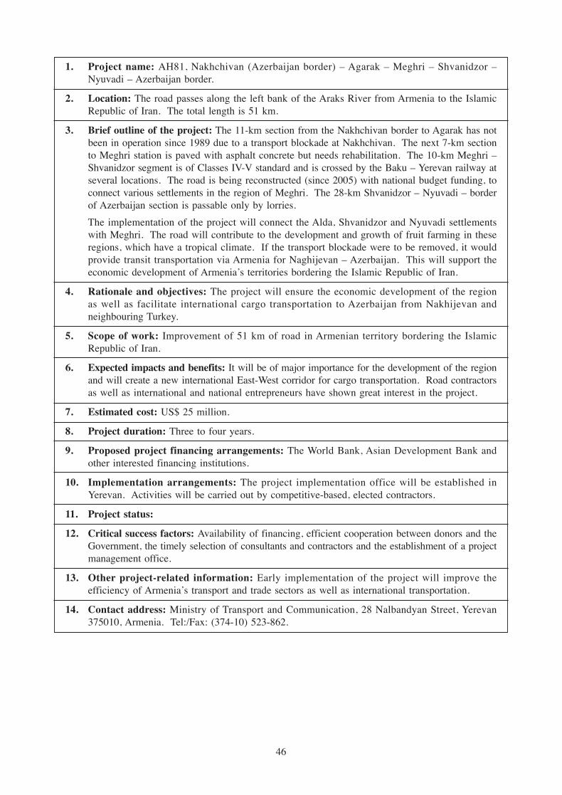
1. Project name: AH81, Nakhchivan (Azerbaijan border) – Agarak – Meghri – Shvanidzor –Nyuvadi – Azerbaijan border.
2. Location: The road passes along the left bank of the Araks River from Armenia to the IslamicRepublic of Iran. The total length is 51 km.
3. Brief outline of the project: The 11-km section from the Nakhchivan border to Agarak has notbeen in operation since 1989 due to a transport blockade at Nakhchivan. The next 7-km sectionto Meghri station is paved with asphalt concrete but needs rehabilitation. The 10-km Meghri –Shvanidzor segment is of Classes IV-V standard and is crossed by the Baku – Yerevan railway atseveral locations. The road is being reconstructed (since 2005) with national budget funding, toconnect various settlements in the region of Meghri. The 28-km Shvanidzor – Nyuvadi – borderof Azerbaijan section is passable only by lorries.
The implementation of the project will connect the Alda, Shvanidzor and Nyuvadi settlementswith Meghri. The road will contribute to the development and growth of fruit farming in theseregions, which have a tropical climate. If the transport blockade were to be removed, it wouldprovide transit transportation via Armenia for Naghijevan – Azerbaijan. This will support theeconomic development of Armenia’s territories bordering the Islamic Republic of Iran.
4. Rationale and objectives: The project will ensure the economic development of the regionas well as facilitate international cargo transportation to Azerbaijan from Nakhijevan andneighbouring Turkey.
5. Scope of work: Improvement of 51 km of road in Armenian territory bordering the IslamicRepublic of Iran.
6. Expected impacts and benefits: It will be of major importance for the development of the regionand will create a new international East-West corridor for cargo transportation. Road contractorsas well as international and national entrepreneurs have shown great interest in the project.
7. Estimated cost: US$ 25 million.
8. Project duration: Three to four years.
9. Proposed project financing arrangements: The World Bank, Asian Development Bank andother interested financing institutions.
10. Implementation arrangements: The project implementation office will be established inYerevan. Activities will be carried out by competitive-based, elected contractors.
11. Project status:
12. Critical success factors: Availability of financing, efficient cooperation between donors and theGovernment, the timely selection of consultants and contractors and the establishment of a projectmanagement office.
13. Other project-related information: Early implementation of the project will improve theefficiency of Armenia’s transport and trade sectors as well as international transportation.
14. Contact address: Ministry of Transport and Communication, 28 Nalbandyan Street, Yerevan375010, Armenia. Tel:/Fax: (374-10) 523-862.
46

C. Azerbaijan
1. Project name: AH84, Nakhchivan – Sadarak – border with Turkey Road Rehabilitation.
2. Location: The construction area covers Babak, Sharur, Kangarli and Sadarak districts of theNakhchivan Autonomy Republic, Azerbaijan.
3. Brief outline of the project: The Nakhchivan – Sadarak – border with Turkey section is 87 kmlong, Class II technical standard with 15-m subgrade width, 7.5-m asphalt-concrete carriagewayand 2 x 3.75-m shoulders. The road passes through 17 settlements. The Nakhchivan – Sadarak– border of Turkey road is included in the TACIS/TRACECA programme and is a part of theEuropean Road (E002) and Asian Highway network (AH81).
4. Rationale and objectives: As a part of AH81 and E002, the Nakhchivan – Sadarak – border withTurkey road links Nakhchivan, which is currently under blockade, with Turkey and Mediterraneanseaports. Road improvement will increase internal as well as transit transportation traffic.
5. Scope of work: Rehabilitation of the 87-km section of road from Nakhchivan city to the borderwith Turkey, passing through Givrag and Sharur towns and thereafter to Diluju and Igdir townsin Turkey (via AH81).
6. Expected impacts and benefits: The completion of rehabilitation work on the Nakhchivan –Sadarak – border with Turkey section will contribute to the improvement of international freighttransportation in the region. It is also expected to reduce vehicle operation costs, develop andimprove transport links with Turkey, and facilitate upgrading of the road section to internationalstandards as part of the Euro-Asia international transport route.
7. Estimated cost: US$ 38 million.
8. Project duration: From 2006 to 2008.
9. Proposed project financing arrangements: Due to limitations in government resources andbudget, it proposed that the project be financed with funds from international banks and financinginstitutions.
10. Project status: The feasibility study was completed in December 2004.
11. Critical success factors: Availability of funding, efficient cooperation between donors and theGovernment, the establishment of a capable project management team, and the timely procure-ment of the services of a consultant and contractors.
12. Other project-related information: The overall effectiveness coefficient of the invested capitalfor road rehabilitation is equal to 0.219 and the invested capital repayment period throughprojected incomes is five years.
13. Other project-related information:
14. Contact address: “Roadtransservice” Department, Ministry of Transport, 72/4 U. HajibayovStreet, Baku AZ1010, Azerbaijan. Tel: (994-12) 493-8083, Fax: (994-12) 493-8083, E-mail:[email protected].
47
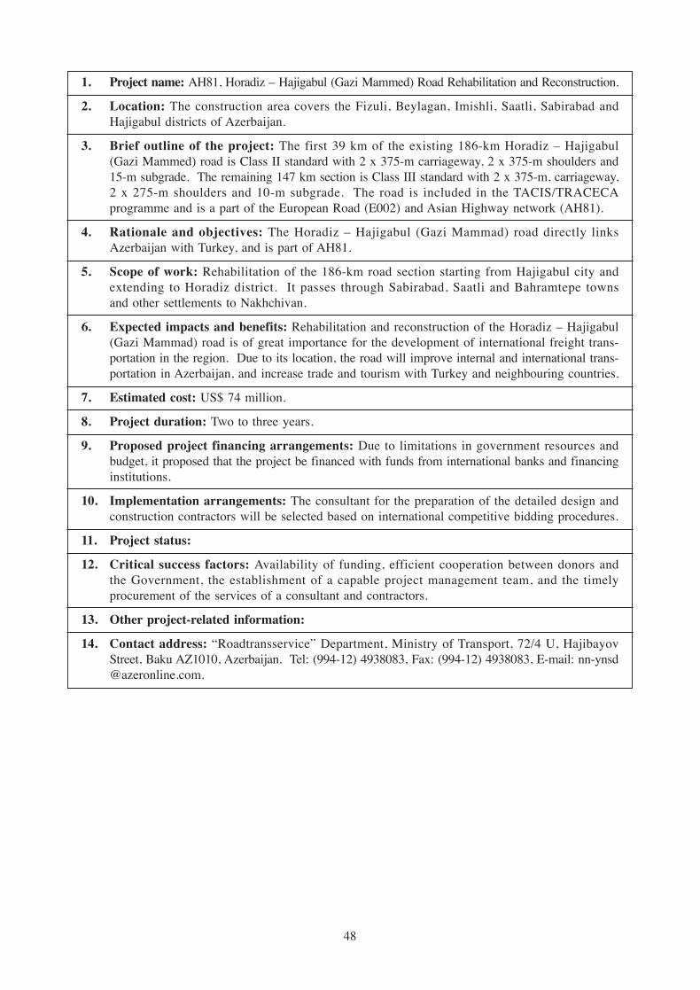
1. Project name: AH81, Horadiz – Hajigabul (Gazi Mammed) Road Rehabilitation and Reconstruction.
2. Location: The construction area covers the Fizuli, Beylagan, Imishli, Saatli, Sabirabad andHajigabul districts of Azerbaijan.
3. Brief outline of the project: The first 39 km of the existing 186-km Horadiz – Hajigabul(Gazi Mammed) road is Class II standard with 2 x 375-m carriageway, 2 x 375-m shoulders and15-m subgrade. The remaining 147 km section is Class III standard with 2 x 375-m, carriageway,2 x 275-m shoulders and 10-m subgrade. The road is included in the TACIS/TRACECAprogramme and is a part of the European Road (E002) and Asian Highway network (AH81).
4. Rationale and objectives: The Horadiz – Hajigabul (Gazi Mammad) road directly linksAzerbaijan with Turkey, and is part of AH81.
5. Scope of work: Rehabilitation of the 186-km road section starting from Hajigabul city andextending to Horadiz district. It passes through Sabirabad, Saatli and Bahramtepe townsand other settlements to Nakhchivan.
6. Expected impacts and benefits: Rehabilitation and reconstruction of the Horadiz – Hajigabul(Gazi Mammad) road is of great importance for the development of international freight trans-portation in the region. Due to its location, the road will improve internal and international trans-portation in Azerbaijan, and increase trade and tourism with Turkey and neighbouring countries.
7. Estimated cost: US$ 74 million.
8. Project duration: Two to three years.
9. Proposed project financing arrangements: Due to limitations in government resources andbudget, it proposed that the project be financed with funds from international banks and financinginstitutions.
10. Implementation arrangements: The consultant for the preparation of the detailed design andconstruction contractors will be selected based on international competitive bidding procedures.
11. Project status:
12. Critical success factors: Availability of funding, efficient cooperation between donors andthe Government, the establishment of a capable project management team, and the timelyprocurement of the services of a consultant and contractors.
13. Other project-related information:
14. Contact address: “Roadtransservice” Department, Ministry of Transport, 72/4 U, HajibayovStreet, Baku AZ1010, Azerbaijan. Tel: (994-12) 4938083, Fax: (994-12) 4938083, E-mail: [email protected].
48

D. Bangladesh
1. Project name: Four-lane upgrading of the Dhaka – Chittagong Highway. (Daudkandi – ChittagongSection).
2. Location: Daudkandi – Chittagong, 198 km of AH41.
3. Brief outline of the project: Traffic on the Dhaka – Chittagong Highway is increasing at a muchhigher rate than expected and has already exceeded 40,000 PCU/day at many locations. This isbeyond the capacity of this two-lane road and the situation has resulted in heavy congestion.
Widening the road to at least in four lanes is therefore a very urgent necessity. To make a start,the Roads and Highways Department of Bangladesh began upgrading a 28-km section of theDhaka to Daudkandi road (AH41) with Government of Bangladesh funding. The project hasalready been completed in about two and half years, and is acknowledged to have been a success.The number of accidents has been reduced, and head-on collisions, which occur mostly ontwo-lane undivided highways and are always fatal, have not occurred on this section of theroad since it was opened to traffic.
It is therefore necessary for upgrading to four lanes to proceed on subsequent sections of AH41in order to create a basic four-lane divided carriageway road facility.
4. Rationale and objectives: The main objective of this project is to reduce constraints and increaseefficiency of road transportation by upgrading the Dhaka – Chittagong Highway (Daudkandi –Chittagong section) from two to four lanes. This will enable:
(a) Optimization of Chittagong port;
(b) The development of an adequate and efficient transport system between the capital, Dhakaand commercial port city of Chittagong, thus enhancing economic development for theexpansion and integration of markets and the growth of international trade. The improve-ment of this strategic corridor is expected to provide substantial economic and socialbenefits to the south-eastern region of Bangladesh, in particular through the generation ofemployment, the creation of improved facilities for trade and commerce, the promotion ofsocial integration and the development of tourism. It will thus assist economic developmentand the reduction of poverty in the country;
(c) Assisting sustainable economic development through the enhancement of transportationbetween agricultural centres as well as industrial areas; and
(d) The enhancement of road safety measures.
5. Scope of work: Upgrading to four lanes the Dhaka – Chittagong Highway (Daudkandi –Chittagong section) comprises road construction from Daudkandi to Chittagong, including theconstruction of earthworks, pavement, culverts and bridges. It also includes constructing railwaybridges at Comilla, Feni and Fakirhat near Chittagong as well as construction work on three longriver bridges and river protection works at Kalidash, Muhuri and Feni, near Feni. Two separatelanes will be constructed along the existing two-lane highway and separated by a raised median.
6. Expected impacts and benefits: The expected impact of the project will be: (a) to cater tocurrent and projected traffic flows along this crucial commercial arterial road; and (b) to providea safe and efficient connection between Dhaka and Chittagong.
As a major road communication project, it will generate employment in the construction andtransportation sectors. It will improve distribution of farm products and accessibility to urbanmarkets for poor farmers. It will also generate more opportunities in the market centres for therural poor and improve the livelihood of day-labourers, thus making it supportive of PRSP.
Although this project is located in Bangladesh, it will greatly facilitate trade and tourism betweenMyanmar and Bangladesh as well as the use of Chittagong Port via the Asian Highway.
49
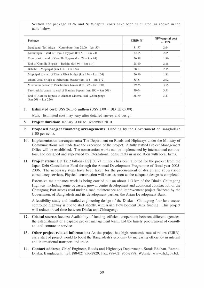
Section and package EIRR and NPV/capital costs have been calculated, as shown in thetable below.
Package EIRR(%)NPV/capital cost
at 12%
Daudkandi Toll plaza – Kutumbpur (km 28.00 – km 50) 31.77 2.64
Kutumbpur – start of Comill Bypass (km 50 – km 74) 32.65 2.85
From start to end of Comilla Bypass (km 74 – km 94) 26.88 1.86
End of Comilla Bypass – Batisha (km 94 – km 114) 28.80 2.18
Batisha – Mophipal (km 114 – km 134) 28.61 2.15
Mophipal to start of Dhum Ghat bridge (km 134 – km 154) 26.56 1.81
Dhum Ghat Bridge to Mirersarai bazaar (km 154 – km 172) 35.57 2.92
Mirersarai bazaar to Panchashila bazaar (km 172 – km 190) 39.25 3.55
Panchashila bazaar to end of Kumira Bypass (km 190 – km 208) 39.04 3.51
End of Kumira Bypass to Alanker Cinema Hall (Chittagong) 38.79 3.47(km 208 – km 226)
7. Estimated cost: US$ 261.45 million (US$ 1.00 = BD Tk 65.00).
Note: Estimated cost may vary after detailed survey and design.
8. Project duration: January 2006 to December 2010.
9. Proposed project financing arrangements: Funding by the Government of Bangladesh(100 per cent).
10. Implementation arrangements: The Department on Roads and Highways under the Ministry ofCommunications will undertake the execution of the project. A fully staffed Project ManagementOffice will be established. The construction works can be implemented by international contrac-tors, and designed and supervised by international consultants in association with local firms.
11. Project status: BD Tk 2 billion (US$ 30.77 million) has been allotted for the project from theJapan Debt Cancellation Fund through the Annual Development Programme of fiscal year 2005-2006. The necessary steps have been taken for the procurement of design and supervisionconsultancy services. Physical construction will start as soon as the adequate design is completed.
Extensive maintenance work is being carried out on about 113 km of the Dhaka ChittagongHighway, including some bypasses, growth centre development and additional construction of theChittagong Port access road under a road maintenance and improvement project financed by theGovernment of Bangladesh and its development partner, the Asian Development Bank.
A feasibility study and detailed engineering design of the Dhaka – Chittagong four-lane accesscontrolled highway is due to start shortly, with Asian Development Bank funding. This projectwill reduce travel time between Dhaka and Chittagong.
12. Critical success factors: Availability of funding, efficient cooperation between different agencies,the establishment of a capable project management team, and the timely procurement of consult-ant and contractor services.
13. Other project-related information: As the project has high economic rate of return (EIRR),early start of project would to boost the Bangladesh’s economy by increasing efficiency in internaland international transport and trade.
14. Contact address: Chief Engineer, Roads and Highways Department, Sarak Bhaban, Ramna,Dhaka, Bangladesh. Tel: (88-02) 956-2829; Fax: (88-02) 956-2798; Website: www.rhd.gov.bd.
50

1. Project name: Chittagong – Cox’s Bazar – Ramu – Gundum Road.
2. Location: Chittagong (AH41) – Ramu (km 135 of the Chittagong – Cox’s Bazar Road) –Fatekharkhul – Maricha – Balukhali – Gundum – Taungbro (Myanmar).
3. Brief outline of the project: This project covers the old Arkan Road, which was used during theperiod of the British regime, connecting Chittagong (Bangladesh), Akiub, and Yangon (Myanmar).The section from Chittagong to Ramu has recently been upgraded, but from Ramu to Gundum(36 km) it still needs to be developed. The road will provide a direct link between Bangladeshand Myanmar, which is already connected to Thailand and China.
4. Rationale and objectives: The project is expected to open a new economic horizon (businesscorridor) within Asian countries such as Myanmar, Thailand, China, Malaysia, Singapore,Cambodia, the Lao People’s Democratic Republic and Viet Nam. The project will contribute topoverty reduction in rural areas by providing access to rural people, which at present is veryrestricted. The project will also provide employment opportunities for the indigenous people andwill promote tourism within the region.
5. Scope of work: The road from Ramu to Gundum (36 km) has to be reconstructed to nationalroad standards, including many bridges and culverts. The remaining portion is already up tonational standards but needs upgrading to four lanes.
6. Expected impacts and benefits: A new corridor will be opened. Traffic will be generated.Business will be expanded among the neighbouring countries. Bangladesh will have a direct roadlink to Myanmar. Indigenous people in this hilly region will gain easy access to education andlivelihood, thereby getting rid of poverty.
7. Estimated cost: US$ 144 million.
8. Project duration: Five years.
9. Proposed project financing arrangements: Multilateral or bilateral funding (loans/grants) isrequired for the project.
10. Implementation arrangements: The Roads and Highways Department, Ministry of Communica-tions will be the executing agency. The project will be managed by a project management officeheaded by a project director of Additional Chief Engineer’s rank. The construction packageswill be awarded to contractors through national/international competitive bidding and will besupervised by appointed national/international consultants.
11. Project status: The feasibility is being examined by both the Bangladesh and Myanmar Govern-ments and a Memorandum of Understanding has been signed.
12. Critical success factors: Funding, timely disbursements, an efficient project team, and the timelyappointment of a consultant and contractors.
13. Other project-related information: An expected higher internal rate of return.
14. Contact address: Chief Engineer, Roads and Highways Department, Sarak Bhaban, Ramna,Dhaka. Tel: (88-02) 956-2829; Fax: (88-02) 956-2798.
51

1. Project name: Jhenaidah – Jessore Road, AH41.
2. Location: Jessore district headquarters to Jhenaidah district headquarters.
3. Brief outline of the project: The project area is a part of National Highway N-7. It connects thetwo district headquarters of Jessore and Jhenaidah. Passenger traffic and goods traffic use thisroad from Benapole Land Port, Mongla seaport and Khulna Divisional Headquarters, and adjacentdistricts of south-western and northern Bangladesh.
4. Rationale and objectives: With the improvement of this 45-km section of road, the transportationof goods and passengers will be made efficient. This will contribute to the socio-economic deve-lopment of the local people as well as the national economy.
5. Scope of work: The provision of base course, wearing surface on carriageway, and widening ofpavement and hard shoulder.
6. Expected impacts and benefits: The local population, including women, will gain employmentopportunities. Vehicle operating costs travel times will be reduced.
7. Estimated cost: US$ 8.00 million.
8. Project duration: Three to four years.
9. Proposed project financing arrangements: Funding by the Government of Bangladesh, theAsian Development Bank, the World Bank, the International Monetary Fund, the Government ofJapan.
10. Implementation arrangements: The Roads and Highways Department, Ministry of Communica-tions will be the executing agency. The project will be managed by a project management officeheaded by a project director of Additional Chief Engineer’s rank. The construction packageswill be awarded to contractors through national/international competitive bidding and will besupervised by appointed national/international consultants.
11. Project status: At present, 5.50 m – 6 m carriageways with 9-m average crest width. Thissection of road is being maintained through a periodic and routine maintenance programme.
12. Critical success factors: Funding, timely disbursements, an efficient project team, and timelyappointment of consultant and contractors.
13. Other project-related information: Expected higher internal rate of return.
14. Contact address: Chief Engineer, Roads and Highways Department, Sarak Bhaban, Ramna,Dhaka. Tel: (88-02) 956-2829; Fax: (88-02) 956-2798.
52

1. Project name: AH2, Beldanga – Panchagarh Road.
2. Location: The project is located in Dinajpur and Panchagarh Districts under Rajshahi Division.
3. Brief outline of the project: Dinajpur is connected with the capital by National Highway N-5through Rangpur, Gaibandha, Bogra, Seragonj, Tangail and Gazipur districts. The NationalHighway then extends through Panchagarh, Tetulia and Banglabandha border towards India andNepal from Beldanga (Panchagarh). The Beldanga – Panchagarh road (78 km) was earlier acement concrete road and was developed in 1995 with Italian grant aid. As this segment will bea part of the Asian Highway, it needs to be developed up to National Highway standard. ThePanchagarh – Tetulia – Banglabandha road (57 km) is being developed up to national highwaystandard under a road network improvement and maintenance project of the Roads and HighwaysDepartment, and is expected to be completed within the next two years.
4. Rationale and objectives: The project will open a new business corridor between Bangladesh,India, Nepal, Pakistan, Uzbekistan, Kazakhstan and Middle Eastern countries. It will play animportant role in poverty reduction and the creation of new employment opportunities in thenorthern region of Bangladesh. It will be also facilitate industrialization and promote tourism.
5. Scope of work: The existing road has been constructed to National Highway specifications up toa width of 6.10 m. Now, for international transportation purposes, the road is to be widened by2.40 m, including the hard shoulder, and strengthened. Bridges and culverts of 120 m are to bereplaced.
6. Expected impacts and benefits: Industrial and agricultural growth will take place in the areaserved by the road. The main beneficiaries will be road transportation, international and domesticbusiness entrepreneurs, workers engaged in agro-industry, manufacturing, commercial and tourismactivities, and farmers in the project area.
7. Estimated cost: US$ 12.5 million.
8. Project duration: Three to four years.
9. Proposed project financing arrangements: Multilateral or bilateral funding will be required forthe project. The Asian Development Bank, the World Bank or the Japan Bank for InternationalCooperation may be the development partner(s).
10. Implementation arrangements: The Roads and Highways Department, Ministry of Communica-tions will be the executing agency. The project will be managed by a project management officeheaded by a project Director of Additional Chief Engineer’s rank. The construction packages willbe awarded to contractors through national/international competitive bidding and will be supervisedby appointed national/international consultants.
11. Project status: This section of road is being maintained through a periodic and routine main-tenance programme.
12. Critical success factors: Funding, timely disbursements, an efficient project team, and the timelyappointment of consultant and contractors.
13. Other project-related information: Expected higher internal rate of return.
14. Contact address: Chief Engineer, Roads and Highways Department, Sarak Bhaban, Ramna,Dhaka. Tel: (88-02) 956-2829; Fax: (88-02) 956-2798.
53

1. Project name: Dasuria – Paksey – Kushita, AH41.
2. Location: From Kushita District Headquarters to Paksey Bridge.
3. Brief outline of the project: This road is part of national Highway N-705, which was built inearly 1960s. It connects south-western Bangladesh with the northern region of the country. Theroad will connect Mongla seaport and Benapole port with the capital without any interruption, asthe Lalon Shah Bridge has already been constructed over the River Padma.
4. Rationale and objectives: The project will facilitate industrialization and poverty alleviation inthe south-western region of Bangladesh. It will also promote tourism.
5. Scope of work: This section of the road, which is 38 km in length, will need to be strengthenedand widened.
6. Expected impacts and benefits: Increased employment opportunities for the local population,including women.
7. Estimated cost: US$ 2.55 million.
8. Project duration: Two to three years.
9. Proposed project financing arrangements: Funding by the Government of Bangladesh, theAsian Development Bank, the World Bank, the International Monetary Fund, the Government ofJapan.
10. Implementation arrangements: The Roads and Highways Department, Ministry of Communica-tions will be the executing agency. The project will be managed by a project management officeheaded by a Project Director of Additional Chief Engineer’s rank. The construction packageswill be awarded to contractors through national/international competitive bidding and will besupervised by appointed national/international consultants.
11. Project status: Two-lane highway, 7.50-m carriageway, crest width average 9.50 m. A 21-kmstretch of the road has been upgraded under the RRMP-II and Paksey Bridge project. Theremaining 17 km are being maintained through a periodic and routine maintenance programme.
12. Critical success factors: Funding, timely disbursements, an efficient project team, and the timelyappointment of consultant and contractors.
13. Other project-related information: Expected higher internal rate of return.
14. Contact address: Chief Engineer, Roads and Highways Department, Sarak Bhaban, Ramna,Dhaka. Tel: (88-02) 956-2829; Fax: (88-02) 956-2798.
54

Upgrad
ing Sec
tions
(Ind
ia)
E. Bhutan
1. Project name: Thimphu – Phuentsholing Highway, AH48.
2. Location: Thimphu (capital) and Phuentsholing (nodal point of the Asian Highway in Bhutan).
3. Brief outline of the project: The Thimphu – Phuentsholing Highway, the length of which isapproximately 179 km, was constructed in 1968 with a 6.9 m formation width to cater to a designtraffic volume of 145 vehicles per day. It now carries more than 1,000 vehicles per day, whichfar exceeds the initial design traffic volume.
The highway links Phuentsholing, the second largest commercial town in the country, to thecapital, Thimphu. Although it is currently classified as a National Highway, it does not conformto the national highway standard in terms of geometric characteristics such as road width, radiusof curvatures, gradients and sight distances. These inadequacies have resulted in the limitation ofspeed to a maximum of about 30 km/hr while creating traffic hazards due to two-way trafficflow being imposed on a primarily single-lane road.
It is planned to construct a dry port at Phuentsholing, which is the nodal point of the AsianHighway in Bhutan, and to upgrade the Thimphu – Phuentsholing highway (which has beendesignated as AH48) to Asian Highway standards. This project has the potential for majorenhancement of transportation and transit facilities.
4. Rationale and objectives: The objectives of this project are: (a) to widen the highway betweenThimphu and Damchu, and Chhukha and Phuentsholing, and (b) to construct a bypass betweenDamchu and Chhukha to double lane standard in order to facilitate an unrestricted flow oftwo-way traffic between Thimphu and Phuentsholing.
At present, it takes about five and half hours to travel from Thimphu to Phuentsholing. However,the journey is expected to be reduced to about four hours once the project has been completed.Substantial savings are expected to accrue from reduced road user costs, enhanced reliability andreduced accident hazards.
5. Scope of work: The project comprises of two distinct components: (a) the widening of 114 kmof the existing road between Thimphu and Damchu, and Chhukha and Phuentsholing, and(b) the construction of a 23-km bypass between Damchu and Chhukha.
6. Expected impacts and benefits: Movement of goods and services at present is constrainedlargely due to the poor geometric features of the road coupled with restrictive road width.Construction and development of this road into double-lane highway will ease traffic congestion,reduce vehicle operating costs (the pavement will be designed to carry 30-ton trucks in line withBhutan Vision 2020) and enhance safety aspects. It will also provide faster and easy access tothe dry port proposed to be established at Phuentsholing while the travel time between Thimphuand Phuntsholing will be reduced from five and half hours to about four hours as a result of thereduction in the length of the road and increased speed of travel.
7. Estimated cost: US$ 470 million (Nu 2,083 million). (US$ 1.00 = Nu 44.38). The estimatedcost of the project includes construction of the Damchu – Chhukha bypass (Nu 350 million).
8. Project duration: The project duration for the Thimphu – Damchu and Chhukha – Phuentsholinghighway section is five years, while the duration for the construction of Damchu – Chhukhabypass is three years.
55
9. Proposed project financing arrangements: The Government of India is financing the project.
10. Implementation arrangements: The survey and design works for constructing the double lanework are being carried by the Department of Roads. Construction work is being undertaken byProject Dantak of the Government of India. The latter has also been asked to fund the construc-tion of the Damchu – Chhukha bypass, the alignment of which is being finalized.
11. Project status: A topographic survey for widening the road between Thimphu and Damchu, andbeween Chhukha and Phuentsholing has been completed except for a 5-km stretch betweenKharbandi and Phuentsholing. The detail design for a 32-km stretch between Thimphu andDamchu has been completed. Widening between Thimphu and Damchu has started.
12. Critical success factors: The completion of the project depends on the timely release of funds.
13. Other project-related information:
14. Contact address: Director, Department of Roads, Ministry of Works and Human Settlements,Royal Government of Bhutan, Thimphu.
56
Upgrad
ing Sec
tions
(Ind
ia)

F. Cambodia
1. Project name: NR78 (AH11 Feeder Road) Road Improvement Project 1.
2. Location: From NR7 (AH11) Junction to Banlung (Rattanak Kiri provincial centre), north-easternCambodia.
3. Brief outline of the project: The project road links the Asian Highway (AH11) and is locatedabout 460 km from Phnom Penh, at the Balung Provincial Centre in Rattanak Kiri province,which is the ecotourism centre of the country. The existing gravel road is in very poor condition;during the rainy season, it is very difficult to pass. The project will improve 125 km of lateriteroad replacing it with 7 m of double bituminous surface treatment (DBST) standard carriagewayand 2 m laterite shoulder on both sides. The horizontal and vertical alignment of NR78 willremain unchanged. Thirty-three box/pipe culverts and 40 bridges will be replaced. The projectwill include a special subcontractor to confirm the absence of landmines and unexplodedordinance, especially in areas of borrow pits, where the standard mine-clearing depth may not besufficient.
4. Rationale and objectives:
• Poverty reduction among the population living in Rattanak Kiri
• Facilitation of the delivery of social services, education and health care
• Enhancement of the economy development of Cambodia
• Exploitation of agro-industrial areas
• Trade exchanges between Cambodia and Viet Nam
• Facilitation of tourist transportation.
5. Scope of work:
• Surface replacement with 7 m of carriageway DBST and 2-m gravel shoulders
• Replacement or repair of 33 box/pipe culverts
• Replacement or repair 40 bridges (total length 593 m)
• Clearance of landmines and unexploded ordinance.
6. Expected impacts and benefits:
Benefits
• Reduction of poverty through increased international tourism
• Promotion of investment in the agro-industrial area
• Increased trade exchanges between Cambodia and Viet Nam
• Improved accessibility to the health centre, schools etc.
• Reduced travelling time
• Reduced vehicle operation costs
• Reduced dust.
Impact
• The minority people living in the area could be affected by HIV.
7. Estimated cost: US$ 44 million.
8. Project duration: Twenty-eight months.
57

9. Proposed project financing arrangements: China is considering funding the project. Account-ing will be managed by a Project Implementation Unit (PIU) of the Ministry of Public Works andTransport. Accounting and financial statements will be prepared every month. The PIU willprepare an annual project financial statement in a format acceptable to the donor. To ensureacceptable standards of financial management, an internationally recognized auditing firm will beselected to provide onsite financial and accounting advice. An independent auditor acceptableto the donor will be hired to audit the project.
10. Implementation arrangements: The PIU will be set up to administer, manage and supervise theproject.
An international consultant should be selected, based on quality and cost, to supervise the civilworks. National competitive bidding (NCB) should be used for awarding the civil works contract.
11. Project status:
• Difficult to pass in the rainy season
• The road is in bad condition
• The road surface is covered by gravel.
12. Critical success factors:
13. Other project related information:
14. Contact address: Dr. Hong Sinara, Deputy Director-General of Public Works, Ministry of PublicWorks and Transport, Phnom Penh, Cambodia. Tel:/Fax: (855-23) 723-028; E-mail: [email protected].
58

1. Project name: NR78 (AH11 Feeder Road) Road Improvement Project 2.
2. Location: From Banlung (Rattanak Kiri provincial town) to the border with Viet Nam.
3. Brief outline of the project: The project road provides a link between the provincial centre(Banlung) of Rattanak Kiri province, a tourism destination in Cambodia, and the border withViet Nam. The existing laterite road is in very poor condition. The project will improve 78 kmof laterite road with a 7-m DBST carriageway and a 2-m gravel shoulder on each side. Thehorizontal and vertical alignment of NR78 will remain unchanged. Two culverts and one bridgewill be replaced or repaired. The project will include a special subcontractor to confirm theabsence of landmines and unexploded ordinance, especially in areas to be excavated wherethe standard mine-clearing depth may not be sufficient.
4. Rationale and objectives:
• Poverty reduction among people living in Rattanak Kiri
• Facilitation of the delivery of social and welfare services
• Enhancement of the economy development of Cambodia
• Exploitation of agro-industrial areas
• Trade exchanges between Cambodia and Viet Nam
• Facilitation of tourist transportation.
5. Scope of work:
• Surface replacement with 7 m DBST carriageway with 2 m laterite shoulder
• Replacement or repair of two box/pipe culverts
• Replacement or repair of one bridge (length, 26 m)
• Clearance of landmines and unexploded ordinance.
6. Expected impacts and benefits:
Benefits
• Reduction of poverty through increased tourism
• Promotion of investment in the agro-industrial area
• Increased trade exchanges between Cambodia and Viet Nam
• Improved accessibility to the health centre, schools etc.
• Reduced travelling time
• Reduced vehicle operation costs
• Reduced dust.
Impact
• The minority people living in the area could be affected by HIV.
7. Estimated cost: US$ 27 million.
8. Project duration: Twenty-four months.
59

9. Proposed project financing arrangements: Funding support is being sought from internationalbanks and financing institutions.
Accounting will be managed by a Project Implementation Unit (PIU) of the Ministry of PublicWorks and Transport. Accounting and financial statements will be prepared every month. ThePIU will prepare an annual project financial statement in a format acceptable to the donor.To ensure acceptable standards of financial management, an internationally recognized auditingfirm will be selected to provide onsite financial and accounting advice. An independent auditoracceptable to the donor will be hired to audit the project.
10. Implementation arrangements: The PIU will be set up to administer, manage and supervise theproject.
An international consultant should be selected, based on quality and cost, to supervise the civilworks. National competitive bidding (NCB) should be used for awarding the civil works contract.
11. Project status:
• Difficult to pass in the rainy season
• The road is in bad condition
• The road surface is covered by gravel and is very dusty.
12. Critical success factors:
13. Other project-related information:
14. Contact address: Dr. Hong Sinara, Deputy Director-General of Public Works, Ministry of PublicWorks and Transport, Phnom Penh, Cambodia. Tel:/Fax: (855-23) 723-028; E-mail: [email protected].
60

1. Project name: NR57 (AH1 Feeder Road) Road Improvement Project.
2. Location: Battambang to the border with Thailand, via Pailin.
3. Brief outline of the project: The project road provides a link to the Asian Highway (AH1)between Battambang provincial town and the border with Thailand, via Pailin. The existinglaterite road is in very poor condition and it is very difficult to pass, especially during the rainyseason. The project will improve 113 km of laterite road by replacing it with 7 m of DBSTstandard carriageway and a 2-m laterite shoulder on each side. The horizontal and verticalalignment of NR57 will remain unchanged. A total of 77 pipe/box culverts and 14 bridges willbe replaced or repaired. The project will include a special subcontractor to confirm the absenceof landmines and unexploded ordinance, especially in areas to be excavated where the standardmine-clearing depth may not be sufficient.
4. Rationale and objectives:
• Poverty reduction in Pailin and the north-western region of the country
• Facilitation of the delivery of social and welfare services
• Enhancement of the economy development of Cambodia
• Trade exchanges between Cambodia and Thailand
• Exploitation of agro-industrial areas
• Facilitation of tourism.
5. Scope of work:
• Surface replacement with 7 m DBST carriageway and 2-m laterite shoulders
• Replacement or repair of 77 box/pipe culverts
• Replacement or repair of 14 bridges (total length, 400 m)
• Clearance of landmines and unexploded ordinance.
6. Expected impacts and benefits:
Benefits
• Reduction of poverty through increased tourism
• Promotion of investment in agro-industrial areas
• Increased trade exchanges between Cambodia and Viet Nam
• Improved accessibility to the health centre, schools etc.
• Reduced travelling time
• Reduced vehicle operation costs
• Reduced dust.
Impact
• The minority people living in the area could be affected by HIV.
7. Estimated cost: US$ 40 million.
8. Project duration: Twenty-eight months.
61
9. Proposed project financing arrangements: Funding support is being sought from internationalbanks, financing institutions and bilateral donors.
Accounting will be managed by a Project Implementation Unit (PIU) of the Ministry of PublicWorks and Transport. Accounting and financial statements will be prepared every month. ThePIU will prepare an annual project financial statement in a format acceptable to the donor. Toensure acceptable standards of financial management, an internationally recognized auditingfirm will be selected to provide onsite financial and accounting advice. An independent auditoracceptable to the donor will be hired to audit the project.
10. Implementation arrangements: The PIU will be set up to administer, manage and supervise theproject.
An international consultant should be selected, based on quality and cost, to supervise the civilworks. National competitive bidding (NCB) should be used for awarding the civil works contract.
11. Project status:
• Difficult to pass in the rainy season
• The road is in bad condition
• The road surface is covered with gravel and is very dusty.
12. Critical success factors:
13. Other project-related information:
14. Contact address: Dr. Hong Sinara, Deputy Director-General of Public Works, Ministry of PublicWorks and Transport, Phnom Penh, Cambodia. Tel:/Fax: (855-23) 723-028; E-mail: [email protected].
62

1. Project name: NR61 (connecting AH1 and AH11) Road Improvement Project.
2. Location: Preak Kdam (AH1) to Thnal Keng (AH11).
3. Brief outline of the project: The project road provides links to the Asian Highway (AH1)at Preak Kdam and the Asian Highway (AH11) at Thnal Keng. The project will improve theexisting 16-km sealed road with high International Roughness Index (IRI) to the Asian Highwaystandard. The standard road design cross-section is 7-m DBST and 2-m paved shoulder oneach side. There are no structures crossing the road. The horizontal and vertical alignment ofNR61 will remain unchanged.
4. Rationale and objectives:
• The linking of two Asian Highway (AH1 and AH11) routes bypassing the Phnom Penhcapital
• Reduction of the traffic volume crossing Phnom Penh
• Reduction of travelling time
• Reduction of vehicle operation costs
• Enhancement of the economic development of Cambodia.
5. Scope of work: Surface replacement with 7-m DBST carriageway and a 2-m DBST shoulder oneach side. No work on structures will be carried out.
6. Expected impacts and benefits:
Benefits
• Reduction in poverty
• A contribution to the development of the Cambodian economy
• Reduced travelling time
• Reduced vehicle operation costs
• A significant reduction in transportation costs
• Reduced traffic jams in Phnom Penh.
7. Estimated cost: US$ 6 million.
8. Project duration: Twelve months.
9. Proposed project financing arrangements: Funding support is being sought from internationalbanks, financing institutions and bilateral donors.
10. Implementation arrangements: A Project Implementation Unit of the Ministry of Public Worksand Transport will be set up to administer, manage and supervise the project. An internationalconsultant should be selected, based on quality and cost, to supervise the civil works. Nationalcompetitive bidding (NCB) should be used for awarding the civil works contract.
11. Project status:
12. Critical success factors:
13. Other project-related information:
14. Contact address: Dr. Hong Sinara, Deputy Director-General of Public Works, Ministry of PublicWorks and Transport, Phnom Penh, Cambodia. Tel:/Fax: (855-23) 723-028; E-mail: [email protected].
63
1. Project name: NR76 (AH11 Feeder Road) Road Improvement Project.
2. Location: NR7 Junction – Sen Monorom (Mondul Kiri) – Banlung (Rattanak Kiri provincial town).
3. Brief outline of the project: The project road provides a link with the Asian Highway (AH11)at Snoul, about 257 km from Phnom Penh, the provincial centre (Sen Monorom) of MondulKiri province (a tourist destination in Cambodia) and a further connection to Banlung (RattanakKiri province). The existing laterite road is in very poor condition. The stretch of road in themountainous area is susceptible to erosion during the rainy season. The project will upgrade335 km of laterite road to a 7-m wide DBST carriageway standard with a 2-m laterite shoulder oneach side. Some of the road sections are currently impassible. The horizontal and verticalalignment will be changed accordingly to meet the safety standard. The project will contribute tothe reduction of traffic accidents. Culverts and bridges will be replaced or repaired. The projectwill include a special subcontractor to confirm the absence of landmines and unexplodedordinance, especially in areas to be excavated where the standard mine-clearing depth may notbe sufficient.
4. Rationale and objectives:
• Poverty reduction in Kratie, Mondul Kiri and Rattanak Kiri provinces
• Facilitation of the delivery of social and welfare services
• Enhancement of the economic development of Cambodia
• Exploitation of agro-industrial areas
• Enhanced trade exchanges between Cambodia and Viet Nam
• Facilitation of tourism.
5. Scope of work:
• Surface replacement with a 7-m bituminous DBST carriageway and a 2-m laterite shoulderon each side
• Replacement or repair of box and pipe culverts
• Replacement or repair of bridges
• Clearance of landmines and unexploded ordinance.
6. Expected impacts and benefits:
Benefits
• Reduction of poverty through enhanced tourism potential
• Promotion of investment in agro-industrial areas
• Increased trade exchanges between Cambodia and Viet Nam
• Improved accessibility to the health centre, schools etc.
• Reduced travelling time
• Reduced vehicle operation costs
• Reduced dust.
Impact
• The minority people living in the area could be affected by HIV.
7. Estimated cost: US$ 44 million.
8. Project duration: Twenty-eight months.
64

9. Proposed project financing arrangements: Funding support is being sought from internationalbanks, financing institutions and bilateral donors.
Accounting will be managed by a Project Implementation Unit (PIU) of the Ministry of PublicWorks and Transport. Accounting and financial statements will be prepared every month. ThePIU will prepare an annual project financial statement in a format acceptable to the donor. Toensure acceptable standards of financial management, an internationally recognized auditing firmwill be selected to provide onsite financial and accounting advice. An independent auditoracceptable to the donor will be hired to audit the project.
10. Implementation arrangements: The PIU will be set up to administer, manage and supervise theproject.
An international consultant should be selected, based on quality and cost, to supervise the civilworks. National competitive bidding (NCB) should be used for awarding the civil works contract.
11. Project status:
• Difficult to pass in the rainy season
• The road is in bad condition
• The road surface is covered by laterite and it is very dusty.
12. Critical success factors:
13. Other project-related information:
14. Contact address: Dr. Hong Sinara, Deputy Director-General of Public Works, Ministry of PublicWorks and Transport, Phnom Penh, Cambodia. Tel:/Fax: (855-23) 723-028; E-mail: [email protected].
65

1. Project name: NR73 (AH11 Feeder Road) Road Improvement Project.
2. Location: NR7 Junction of AH11 to Chhlong (Kratie province).
3. Brief outline of the project: The project road provides links to the Asian Highway (AH11) atkm 150 from Phnom Penh and to Chhlong in Kratie province. Many people live in the projectarea along the Mekong River and the area has strong agriculture production and light industrypotential. The existing laterite road is in fair condition but the health of the people living alongthe road is adversely affected by dust caused by the steadily increasing volume of traffic. Theproject will upgrade 57 km of gravel road to a 7-m wide DBST standard carriageway and a 2-mlaterite shoulder on each side. The horizontal and vertical alignment will not be changed signifi-cantly. A total of 46 box/pipe culverts and seven bridges will be replaced or repaired. Thisproject will include a special subcontractor to confirm the absence of landmines and unexplodedordinance, especially in areas to be excavated where the standard mine-clearing depth may not besufficient.
4. Rationale and objectives:
• Poverty reduction in Chhlong district communities
• Facilitation of the delivery of social and welfare services
• Enhancement of the economic development of Cambodia
• Exploitation of agriculture and industrial areas.
5. Scope of work:
• Surface replacement with a 7-m carriageway and a 2-m laterite shoulder on each side
• Replacement or repair of 46 box/pipe culverts
• Replacement or repair of seven bridges (total length, 219 m)
• Clearance of landmines and unexploded ordinance.
6. Expected impacts and benefits:
Benefits
• Reduction of poverty
• Improved commerce and trade
• Promotion of investment in agriculture and light industries
• Improved accessibility to the health centre, schools etc.
• Reduced travelling time
• Reduced vehicle operation costs
• Reduced dust.
Impacts
• The people living in the area could be affected by HIV.
7. Estimated cost: US$ 20 million.
8. Project duration: Twenty-eight months.
66

9. Proposed project financing arrangements: Funding support is being sought from internationalbanks, financing institutions and bilateral donors.
Accounting will be managed by a Project Implementation Unit (PIU) of the Ministry of PublicWorks and Transport. Accounting and financial statements will be prepared every month. ThePIU will prepare an annual project financial statement in a format acceptable to the donor. Toensure acceptable standards of financial management, an internationally recognized auditing firmwill be selected to provide onsite financial and accounting advice. An independent auditoracceptable to the donor will be hired to audit the project.
10. Implementation arrangements: The PIU will be set up to administer, manage and supervise theproject.
An international consultant should be selected, based on quality and cost, to supervise the civilworks. National competitive bidding (NCB) should be used for awarding the civil works contract.
11. Project status:
• The road is in fair condition
• The road surface is covered by laterite and is very dusty.
12. Critical success factors:
13. Other project-related information:
14. Contact address: Dr. Hong Sinara, Deputy Director-General of Public Works, Ministry of PublicWorks and Transport, Phnom Penh, Cambodia. Tel:/Fax: (855-23) 723-028; E-mail: [email protected].
67

1. Project name: East-West Corridor Road Improvement Project (Siem Reap – Stung Treng).
2. Location: Siem Reap – Stung Treng to Rattanak Kiri.
3. Brief outline of the project: The project road provides a link with the Asian Highway (AH1)and AH11 via Angkor Wat, the world-famous ancient temples of Cambodia, in Siem Reapprovince, the ecotourism centre in Rattanak Kiri province and Viet Nam. The project willfacilitate tourism development within Cambodia as well as from Thailand and Viet Nam (visits toAngkor Wat). The project will open a new Asian Highway section connecting Bangkok withQuinhon seaport in Viet Nam. The existing gravel road is in poor condition, especially in therainy season when some sections are very difficult or impossible to pass. The project willupgrade 253 km of gravel road to a 7-m wide DBST standard carriageway with a 2-m gravelshoulder on each side. In some places, the horizontal and vertical alignment will be modified.Culverts and bridges will be replaced or repaired. The project will include a special subcontrac-tor to confirm the absence of landmines and unexploded ordinance, especially in areas to beexcavated where the standard mine-clearing depth may not be sufficient.
4. Rationale and objectives:
• Poverty reduction
• Facilitation of the delivery of social and welfare services
• Enhancement of the economic development of Cambodia
• Exploitation of agriculture areas
• Increased trade exchanges between Cambodia, Thailand and Viet Nam
• Enhancement and facilitation of tourism growth and accessibility.
5. Scope of work:
• Surface replacement with a 7-m bituminous carriageway and a 2-m gravel shoulder on eachside
• Replacement or repair of box and pipe culverts
• Replacement or repair of bridges
• Clearance of landmines and unexploded ordinance.
6. Expected impacts and benefits:
Benefits
• Reduction of poverty through increased tourism
• Promotion of investment in agriculture and agro-industrial areas
• Increased trade exchanges between Cambodia, Thailand and Viet Nam
• Improved accessibility to the health centre, schools etc.
• Reduced travelling time
• Reduced vehicle operation costs
• Reduced dust.
Impact
• The people living in the area could be affected by HIV.
7. Estimated cost: US$ 260 million.
8. Project duration: Forty months.
68

9. Proposed project financing arrangements: Funding support is being sought from internationalbanks and financing institutions.
Accounting will be managed by a Project Implementation Unit (PIU) of the Ministry of PublicWorks and Transport. Accounting and financial statements will be prepared every month. ThePIU will prepare an annual project financial statement in a format acceptable to the donor. Toensure acceptable standards of financial management, an internationally recognized auditing firmwill be selected to provide onsite financial and accounting advice. An independent auditoracceptable to the donor will be hired to audit the project.
10. Implementation arrangements: The PIU will be set up to administer, manage and supervise theproject.
An international consultant should be selected, based on quality and cost, to supervise the civilworks. National competitive bidding (NCB) should be used for awarding the civil works contract.
11. Project status:
• Difficult passable in the raining season
• The road is in bad condition
• The road surface is covered by gravel and is very dusty.
12. Critical success factors:
13. Other project-related information:
14. Contact address: Dr. Hong Sinara, Deputy Director-General of Public Works, Ministry of PublicWorks and Transport, Phnom Penh, Cambodia. Tel:/Fax: (855-23) 723-028; E-mail: [email protected].
69

G. China
1. Project name: Jinghong (Xiaomengyang) – Mohan, AH3.
2. Location: Jinghong (AH3) to Mohan (AH3) in southern Yunnan province, China
3. Brief outline of the project: The road is the only Asian Highway link between China and theLao People’s Democratic Republic. It has played an important role in regional development,international exchanges and improvement of living standards among local residents. The 211-kmroad is a Class II rough route with many long slopes and sharp bends. Although an importantsection of the corridor between Kunming and Bangkok and an import link in the Greater MekongSubregion, the target of a rapid increase in the volume of trade and passenger traffic betweenthese countries has not been achieved.
4. Rationale and objectives:
• Enhancement of the economic development in the area
• Strengthening of communications between China and South-East Asian countries such as theLao People’s Democratic Republic, Cambodia, Thailand and Singapore
• Accelerating economic cooperation with the Greater Mekong Subregion
• Play an important role in poverty relief programmes in the region.
5. Scope of work: The road will be shortened from 211 km to 184 km. The new expressway willhave four lanes, thus greatly facilitating trade and tourism between China and the Lao People’sDemocratic Republic.
6. Expected impacts and benefits: The project will construct a new 184-km expressway fromXiaomengyang to the crossing point at Mohan. The safety and ease of road transportation will benoticeably improved as a result of improved road conditions. Regional development will begreatly accelerated, and international trade and tourism between China and the Lao People’sDemocratic Republic will be increased. Regional cooperation will also benefit from the project.
7. Estimated cost: US$ 800 million (as indicated by the project feasibility study).
8. Project duration: Three years. The project is scheduled to be completed by 2007.
9. Proposed project financing arrangements: The cost of road construction will be partly financedby the Central Government of China. Local government will support the remaining projectexpenses.
10. Implementation arrangements: The communications authorities of Yunnan province and theXishuangbanna local government.
11. Project status: Project implementation began in 2005 and construction will be completed in2007.
12. Critical success factors: An efficient management team is required to ensure the timely comple-tion of the project.
13. Other project-related information:
14. Contact address: Ministry of Communications, 11 Jianguomennei Avenue, Beijing, China.Fax: (86-10) 6529-2261.
70

1. Project name: Menghun – Daluo Road, AH3.
2. Location: Menghun (AH3) to Daluo (AH3) in southern Yunnan province, China.
3. Brief outline of the project: The 60-km, Class II road is one of the two Asian Highway linksbetween China and Myanmar. The road, which was constructed in 1960, has played an importantrole in developing the economy of Yunnan province as well as the promotion of internationalexchanges and the improvement of the local population’s standard of living. The target of a rapidincrease in the volume of trade and passenger traffic between China and Myanmar has not yetbeen achieved.
4. Rationale and objectives:
• Accelerating economic development in this area
• Strengthening of communications between China and South-East Asian countries such asMyanmar, Thailand and Singapore
• Enhancement of international transport cooperation between China, South-East Asia andSouth Asia.
5. Scope of work: The road is an important corridor for the Dai minority in southern Yunnanprovince. The project, which will greatly facilitate trade and tourism between China, Myanmar,Thailand and Cambodia, will upgrade the road to Class I.
6. Expected impacts and benefits: The safety and ease of road transportation will be noticeablyimproved. Regional development will be greatly accelerated, and international trade and tourismbetween China and Myanmar will benefit significantly.
The direct economic benefits of the project will be savings in vehicle operating costs, travel time,maintenance costs and road accident costs. Based on highway network planning, analysis showsthat the project is economically viable.
7. Estimated cost: US$ 60 million.
8. Project duration: Two years. The project is scheduled to be completed by 2010.
9. Proposed project financing arrangements: Local government.
10. Implementation arrangements: Local government of Xishuangbanna.
11. Project status: Construction will be completed by 2010 and will be undertaken during theeleventh Five-Year Plan.
12. Critical success factors: Funding support, efficient cooperation between the Ministry of Commu-nications and local government, and a highly efficient supervisory team.
13. Other project-related information:
14. Contact address: Ministry of Communications, 11 Jianguomennei Avenue, Beijing, China.Fax: (86-10) 6529-2261.
71

1. Project name: Kashi – Honqilaf, AH4.
2. Location: Kashi (AH4) to Honqilaf (AH4) in south-western Xinjiang Autonomous Region,China.
3. Brief outline of the project: The 417-km Kashi – Honqilaf Road was built in the 1960s. It ismostly Class II or below, and has a low level of protection against natural disasters androad transportation is interrupted annually. The current traffic volume is about 2,000 AADT.
4. Rationale and objectives:
• Acceleration of economic development in the project area
• Strengthening of communications between the western region of China and South and WestAsian countries such as Pakistan, Afghanistan and Tajikistan
• Enhancement of international transportation cooperation between China and Central andSouth Asian countries.
5. Scope of work: The 417-km long road connects AH61 and AH65 at Kashi and AH66 at Kalasu.The project will greatly facilitate trade and tourism between China, Kyrgyzstan, Tajikistan andPakistan.
6. Expected impacts and benefits: The project will shorten the road to 390 km. The ability ofdisaster protection will be considerably enhanced and regional development will be stronglypromoted. International trade and tourism will also benefit significantly from the project.
The direct economic benefits of the project will be savings in vehicle operating costs, travel time,maintenance costs and losses due to unpredictable disasters. Based on the feasibility study,analysis shows the project to be economically viable (EIRR = 14.87 per cent; ENPV = US$ 8.23million; and EBCR = 2.13).
7. Estimated cost: Approximately US$ 74.5 million (2004 prices).
8. Project duration: Four years.
9. Proposed project financing arrangements: Central Government of China.
10. Implementation arrangements: The communications authority of Xinjiang Autonomous Regionand the local government of Kashi.
11. Project status: The feasibility study of the road was completed in 2002. Construction beganin 2004.
12. Critical success factors: Funding support, efficient cooperation between the Ministry of Commu-nications and local government, and a highly efficient supervisory team.
13. Other project related information:
14. Contact address: Ministry of Communications, 11 Jianguomennei Avenue, Beijing, China.Fax: (86-10) 6529-2261.
72

1. Project name: Lasha – Zhangmu Road, AH42.
2. Location: Lasha (AH42) to Zhangmu (AH42) in southern Xizang Tibet Autonomous Region,China.
3. Brief outline of the project: The road length is 754 km, of which 120 km is Class III and theremainder below Class III. The road was built under very difficult natural conditions from 1955to 1962. It has a low level of protection from natural disasters and road transportation isinterrupted occasionally by mud-rock flows, flooding and landslides. It is the most importantconnection between China and Nepal.
4. Rationale and objectives:
• Enhancement of the economy of southern Xizang Tibet Autonomous Region
• Improvement of the efficiency of external and internal trade and communications betweenwestern China and South Asian countries, particularly Nepal
• Enhancement of international transport cooperation between China and South Asian countries.
5. Scope of work: The road connects the important cities of Lasha and Rikaze in Xizang TibetAutonomous Region. It is the south-north corridor for Xizang, linking the Chinese inlandprovince of Qinghai with Nepal. The project will shorten the road significantly.
6. Expected impacts and benefits: The project will improve transportation services, and boost theregional economy and development, particularly in Lasha, Rikaze and Ali. The interruptions intransportation by natural disasters along this road will be greatly reduced. The income of thepoor in the undeveloped area of this region will be raised and poverty levels partly reduced.Travel times will be reduced. International trade and tourism between China and Nepal willbenefit because this is the most important road through the Himalayas.
7. Estimated cost: Approximately US$ 410 million.
8. Project duration: Six years.
9. Proposed project financing arrangements: Central Government of China.
10. Implementation arrangements: The communications authorities of the Central Government andXizang Tibet Autonomous Region.
11. Project status: Feasibility studies of the road from Lasha to Qushui, from Dazuka to Rikaze andfrom Laodinri to Zhangmu are ongoing. Construction will be undertaken during the eleventhFive-Year Plan.
12. Critical success factors: The provision of financial support from the Central Government andlocal government authorities, and a highly efficient construction team that is experienced inworking in severe natural conditions.
13. Other project related information:
14. Contact address: Division of Highway Planning, Transport Planning and Research Institute,Ministry of Communications, Beijing, China. Tel: (86-10) 6491-2277 and (86-10) 6491-3463;Fax: (86-10) 6489-8376; E-mail: [email protected].
73

H. Georgia
1. Project name: AH5, Poti – Tbilis – Red Bridge (Gori – Natakhtari Section); AH5, Poti – Batumi– Sarpi; AH 81, Mtskheta – Kazbegi – Larsi.
2. Location: The Poti – Tbilisi – Red Bridge section is part of AH5 and the East-West HighwayCorridor. The Poti – Batumi – Sarpi section of AH5 connects Turkey with Poti Port. Mtskheta– Kazbegi – Larsi is part of AH81, connecting the capital, Tbilisi with the border of the RussianFederation.
3. Brief outline of the project: Due to its geographical location, Asian Highway route AH5 inGeorgia is an important East-West corridor for transit transportation from the Black Sea to CentralAsia. In addition, the Mtskheta – Kazbegi – Larsi road provides the North-South corridor fortransit transportation.
The total length of the above road sections is 623 km. The Poti – Tbilisi – Red Bridge section,including 57 km of the Gori – Natakhtari section, is 397 km. The Poti – Batumi – Sarpi sectionis 87 km. The Mtskheta – Kazbegu–Larsi section is 139 km. The Gori – Natakhtari section(57 km) is the most congested and critical section in the East-West Highway corridor andrequires upgrading.
The Government of Georgia is adopting the policy of developing efficient transit transportationthrough Georgia for its neighbouring countries and Central Asian nations. However, the mainhighways in Georgia are in poor condition and need urgent rehabilitation.
The Government recently completed construction of a 670-m tunnel on the Poti – Batumi – Sarpiroad, and has started modernization of 16-km section of the Natakhtari – Agaiani road. It is alsoproposed that the Rikoti Tunnel located along the Poti – Tbilisi road be rehabilitated with privatesector participation. The World Bank is undertaking a feasibility study of the 36-km Agaiani –Sveneti section of the Poti – Tbilisi road in addition to supporting rehabilitation of secondary andlocal roads. The Kuwait Fund and KfW have also supported rehabilitation of roads in Georgia.To enhance financing for infrastructural development, Georgia has signed a five-year agreementwith the Millennium Challenge Corporation.
Additional financial resources are required for completing the modernization of the Georgian roadnetwork. The Government of Georgia is seeking additional financing from other international andbilateral institutions and private sector investors.
4. Rationale and objectives: The rehabilitation and upgrading of the Asian Highway and roads inGeorgia will enhance the efficiency of transit transportation through Georgia and support theGovernment’s initiative to improve the transportation infrastructure. The development of roadinfrastructure will directly contribute to economic development and poverty alleviation by creatingemployment opportunities as well as foreign currency earnings from transit fees. The proposedhighways improvement will reduce vehicle-operating costs, save travel time and help to stabilizeeconomic activities.
5. Scope of work: It is proposed to upgrade the Poti – Tbilisi – Road section to four-lane express-way standards. Cement concrete pavement with a design speed of 120 km/hour is proposed forsome sections of roads.
6. Expected impacts and benefits: The projects will provide various benefits to the people ofGeorgia, improve transit transportation and mobility, and reduce transport costs and travel time.The implementation of the projects will create employment and contribute towards reducingpoverty by increasing household income.
74
Sectio
ns U
nder
Study (
WB)

Sectio
ns U
nder
Study (
WB)
7. Estimated cost: US$ 374 million1 (Gori – Natakhtari section, US$ 57 million; Poti – Batumi –Sarpi section, US$ 87 million; Mtskheta – Kazbegi – Larsi section, US$ 139 million).
8. Project duration: Four to five years.
9. Proposed project financing arrangements: The World Bank, Asian Development Bank or otherinternational and bilateral financing organizations.
10. Implementation arrangements: The Ministry of Economic Development and the Department ofRoads of Georgia will be the implementing agency. Project implementation arrangements will beestablished as required.
11. Project status: Modernization and feasibility studies of some road sections are ongoing. It isproposed to modernize the East-West Highway corridor through a step-by-step approach,beginning with the most feasible and critical high-volume traffic sections.
12. Critical success factors: Availability of financing, efficient cooperation between donors andthe Government, the timely selection of consultants and contractors, and the establishment of aproject management office.
13. Other project-related information: The implementation of the projects will enhance domesticand transit transportation from Georgia to neighbouring countries and Central Asia.
14. Contact address: Department of Roads, Ministry of Economic Development Tbilisi, Georgia.Fax: (995-32) 376-308.
1 The estimated cost of modernizing the 397-km Poti – Tbilis – Red Bridge is US$ 2,300 million.
75

Under
Study (
ADB)
I. India
1. Project name: Strengthening and improvement of the road (part of AH2) from Panitanki toFulbari (border with Nepal to the border with Bangladesh).
2. Location: Darjeeling and Jalpaiguri districts, West Bengal State, India.
3. Brief outline of the project: Kakabhitta, near the Panitanki border post in India on NH31C, tothe Fulbari border post on the border with Bangladesh on State Highway 12. Improvement workon this State Highway has been considered together with the improvement of NH34 within WestBengal to facilitate cross-border movement between West Bengal and Nepal as well as WestBengal and Bangladesh.
4. Rationale and objectives: The reduction of transportation costs from Nepal to Bangladeshthrough Jalpaiguri and Darjeeling districts in West Bengal by more than 25 per cent. Increasedefficiency in the movement of passengers and goods within Nepal, India and Bangladesh.
5. Scope of work: Strengthening and widening of the pavement along a 44-km stretch of the 54-kmroad (a diversion through the 10-km Canal West Road, which will reduce the road length) fromFulbari in India (near Bangladesh) to Panitanki in India (near the Nepal border station atKakabhitta).
6. Expected impacts and benefits: Traffic density between Bangladesh and Nepal is very low.With free trade and improved vehicle movement, there will be considerable growth in trafficbetween the two countries. The mutual development is important for both Nepal and Bangladesh,and is the main reason that the two countries wish to develop the link for maritime trade via theports of Bangladesh as well as Kolkata and Haldia ports in India.
7. Estimated cost: As per PPTA project, US$ 4.38 million (2005 prices).
8. Project duration: Two years.
9. Proposed project financing arrangements: A substantial loan is required for the project. TheAsian Development Bank would be the loan financing authority.
10. Implementation arrangements: The Government of India and the Public Works Department ofthe Government of West Bengal.
11. Project status: The final PPTA report is under consideration.
12. Critical success factors: Availability of funding, efficient cooperation between the concessionaireand the Government, the establishment of a capable project management team, the timelyprocurement of materials and the engagement of consultants and contractors.
13. Other project-related information: The necessary resources (i.e., manpower, materials andskills) are available in the project area, thus enabling the completion of the project on schedule.On completion of the project, the road will provide uninterrupted, year-round traffic flow, thusproviding significant reductions in fuel consumption and travel times.
14. Contact address: Director-General (Road Development), Ministry of Shipping, Road Transportand Highways, Department of Road Transport and Highways, Transport Bhawan, 1, ParliamentStreet, New Delhi 110 001, India. Tel: (91-11) 2371-8575; Fax: (91-11) 2371-5047; Website:www.morth.nic.in.
76

1. Project name: Improvement of the Shillong – Dawki section of NH40, which is part of AH1.
2. Location: This section is in the north-eastern region of India in the State of Meghalaya onNational Highway 40. It traverses from north to south across the eastern part of MeghalayaState through mountainous terrain in highest rainfall area (3,000-5,000 mm/year), and then joinsthe India-Bangladesh international border (AH1) at Tamabil.
3. Brief outline of the project: The total length of the Shillong – Dawki section of NH40 is 84 km.Some stretches of this section have already been upgraded to two lanes and Class III of the AsianHighway Classification and Design Standards. An additional 13 km is in the advanced phase oftwo-lane construction. One major bridge (106 km) at Dawki near the international border hasbeen approved and is likely to be completed by October 2008. Development of the entire roadsection up to Class III of the Asian Highway Classification and Design Standards has been proposed.
4. Rationale and objectives: The section covered by the project connects Shillong, the state capitalof Meghalaya, to the border with Bangladesh at Tamabil. The region is rich in mineral resources(e.g., coal and limestone) and agriculture products. Therefore, providing a proper road infra-structure will further improve trade development with other States of India as well as Bangladesh.In addition, the project will open up even greater opportunities for tourism in this picturesquevalley of the Shillong Plateau (including Cherrapunji, where some of the highest levels of rainfallin the world are recorded).
5. Scope of work: The section between Shillong and Dawki is to be developed into a two-lane roadthat complies with the National Highway two-lane standard. It will meet Class II of the AsianHighway Classification and Design Standards.
6. Expected impacts and benefits: The economic growth of Meghalaya State will be enhanced,ensuring the overall development of the Shillong Plateau population. In addition, trade betweenIndia and Bangladesh will be significantly increased. Travel times and vehicle operating costswill be reduced.
7. Estimated cost: US$ 37 million.
8. Project duration: Four to five years.
9. Proposed project financing arrangements: Budgetary support from the Government of India.
10. Implementation arrangements: Ministry of Shipping, Road Transport and Highways, Govern-ment of India, will undertake the construction work through the Public Works Department ofthe Government of Meghalaya State.
11. Project status: Upgrading of the Shillong – Dawki (Tamabil) section of NH40 to two lanes isincluded in the tenth Five-Year Plan and is expected to be completed by March 2010.
12. Critical success factors: Funding availability, and efficient project management and coordinationbetween the departments concerned and the contractors/consultants.
13. Other project-related information: Completion of the project will boost the tourism industryas well as trade with other States of India and Bangladesh, thereby contributing to the socio-economic development of India. The necessary resources (i.e., manpower, materials and skills)are available in the project area, which will help in completing the project within the designatedtimeframe. On completion of the project, the road will allow an uninterrupted, year-round flowof traffic, thus providing significant reductions in fuel consumption and travel times.
14. Contact address: Director-General (Road Development), Ministry of Shipping, Road Transportand Highways, Department of Road Transport and Highways, Transport Bhawan, 1, ParliamentStreet, New Delhi 110 001, India. Tel: (91-11) 2371-8575; Fax: (91-11) 2371-5047; Website:www.morth.nic.in.
77

1. Project name: Improvement/construction of the Banbasa – Indo-Nepal border road near Tanakpur(AH2).
2. Location: Udham Singh Nagar district, in the northern area of Uttranchal State, India.
3. Brief outline of the project: The route begins at Chainage (km 42.50) on NH-125 at Banbasaand traverses a 3-km, single-lane road up to the old Sharda Barrage and along the Sharda Riverfor 7 km to the New Barrage, which is the gateway to Brahmdev Temple situated in Nepal. Thetotal length of the proposed highway (AH2) will be 10 km. Of this length, an entirely new 4-km,two-lane highway will have to be constructed and an existing 6-km, single-lane road will have tobe reconstructed and upgraded to two lanes as per Class III of the Asian Highways Classificationand Design Standards. The road is under the control of the Uttranchal State Government.
4. Rationale and objectives: The road will boost the economy by increasing efficiency in internaltrade and exports. The project is expected to reduce transportation costs and will thereforeincrease efficiency in the movement of passengers and goods between India and Nepal.The project will support rural development and increase the earnings of low-income groups byproviding reliable and speedy access to the area. The project will also contribute to povertyalleviation and provide employment opportunities for indigenous people along the route.
5. Scope of work: Improvement of an existing 6-km, single-lane road to two-lane standard andthe construction of a new 4-km road. The improvement/construction of the road will be to aminimum Class III of the Asian Highway Classification and Design Standards.
6. Expected impacts and benefits: A significant increase in trade between Nepal and India. Withthe completion of the project (AH2), quantifiable benefits will include savings in passenger andfreight transportation costs, and reduced travel times and vehicle operating and maintenance costs.
7. Estimated cost: US$ 4.50 million.
8. Project duration: One year after project approval and land becomes available.
9. Proposed project financing arrangements: As it is a State road, funding arrangements have notyet been finalized.
10. Implementation arrangements: To be completed by the State Public Works Department of theGovernment of Uttranchal State.
11. Project status: See proposed project financing arrangements.
12. Critical success factors: The timely transfer of land from the Forest Department and theNational Hydro Power Corporation.
13. Other project-related information: The land required belongs to the Forest Department or othergovernment departments, and compensation will have to be paid to those departments. Moreover,widening of road in Banbasa town will necessitate land acquisition and payment of compensationto property owners.
14. Contact address: The Secretary, Public Works Department, Government of Uttarnchal, Dehradun,India. Tel: (91-11) 135-271-2092; Fax: (91-11) 135-271-2437.
78

1. Project name: Improvement of the Madurai – Ramanathapuram – Rameshwaram – DhanushkodiRoad, NH49 (part of AH43).
2. Location: Tamil Nadu State, southern India. It passes through Madurai City to Dhanushkodi onthe eastern coast of India.
3. Brief outline of the project: The road is a part of National Highway 49, a very importantNational Highway connecting Madurai, the temple city in Tamil Nadu, with Rameshwaram,the famous pilgrimage centre. The total length of the road is 188 km. It is planned to upgradethe road to Asian Highway standards. The road passes through various important towns(Manamadurai at km 45, Paramagudi at km 75, Ramanathapuram at 113 km and Rameshwaramat 167 km). Dhanushkodi is the last land station before the coast on the route to Sri Lanka.The road is aimed at boosting the economy by increasing efficiency in domestic and export/import trade.
4. Rationale and objectives: The reduction of transportation costs and increased efficiency in themovement of passengers and goods within India and between India and Sri Lanka. The projectwill support rural development and increase earnings of the low-income groups by providingreliable and speedy access to the area. The project will contribute to poverty alleviation andprovide employment opportunities for indigenous people along the route. Although located insouthern India, the project will greatly facilitate trade and tourism with China, Nepal, Bangladeshand Sri Lanka.
5. Scope of work: Currently, the road is of two-lane standard. It is planned to improve the road toAsian Highway standards in order to provide a high-speed corridor for rapid, safe and efficientmovement of freight and passenger traffic. Necessary traffic safety measures will be adopted atvulnerable locations.
6. Expected impacts and benefits: Reduced passenger and freight transportation costs, reducedtravel times and savings in vehicle operating and maintenance costs. The actual benefits willbe ascertained by a feasibility study. The project will accelerate industrial and agricultural growthin the project area. The main beneficiaries will be road transport operators, international anddomestic business entrepreneurs, workers engaged in the agricultural, agro-industry, manufactur-ing, commercial and tourism sectors as well as farmers in neighbouring areas.
7. Estimated cost: Approximately US$ 200 million (2005 prices).
8. Project duration: Three to four years.
9. Proposed project financing arrangements: Not yet decided.
10. Implementation arrangements: Ministry of Shipping, Road Transport and Highways through theNational Highways Authority of India (NHAI) or State Government Public Works Department.
11. Project status: A feasibility study and preparation of a detailed project report to be undertakenby NHAI.
12. Critical success factors: Availability of funding, efficient cooperation between the concessionaireand the Government, the establishment of a capable project management team, timely procure-ment of materials and the selection of consultants and contractors.
13. Other project-related information: The resources (i.e., manpower, materials and skills) areavailable in the project area, which will help in completing the project within the designatedtimeframe. On completion of the project (AH43), the road will provide a year-round, uninter-rupted flow of traffic, thus providing significant reductions in fuel consumption and travel times.
14. Contact address: Director-General (Road Development), Ministry of Shipping, Road Transportand Highways, Department of Road Transport and Highways, Transport Bhawan 1, ParliamentStreet, New Delhi 110 001, India. Tel: (91-11) 2371-8575; Fax: (91-11) 2371-5047; Website:www.morth.nic.in.
79

J. Indonesia
1. Project name: Installation of road signage for the Asian Highway network (AH2, AH25).
2. Location: Road network corridors from Banda Aceh – Bakauheuni (Sumatra Island) and Merak– Denpasar (Jawa – Bali Island).
3. Brief outline of the project: The Banda Aceh – Bakauheuni and Merak – Denpasar corridorshave been designated as part of the Asian Highway network. Therefore, to ensure ease of roaduse, standard Asian Highway network road signage needs to be installed.
4. Rationale and objectives: The project is aimed at assisting Asian Highway network users,especially travellers from other countries. This objective has become even more important sincethe start of the ferry service between Penang (Malaysia) – Belawan (Indonesia) in August 2005.
5. Scope of work: Undertaking a survey to identify the location points for road signage. Installingthe Asian Highway network road signage.
6. Expected impacts and benefits: Assisting road user to use the Asian Highway Network.
7. Estimated cost: US$ 528,300 (2005 prices).
8. Project duration: Two years.
9. Proposed project financing arrangements: Substantial multilateral or bilateral grants or loanswill be required for the project, based on their involvement in the road subsector in Indonesia,including the Governments of Japan, India, China, Germany and Switzerland as well as multi-lateral agencies such as the Asian Development Bank, the World Bank and the Islamic Deve-lopment Bank.
10. Implementation arrangements: Directorate of Road Traffic and Transport, and the Directorate-General of Land Communications, Ministry of Transportation.
11. Project status:
12. Critical success factors: Availability of funding, efficient cooperation between donor(s) and theGovernment, the establishment of a capable project management team, and the timely selection ofconsultant and contractors.
13. Other project-related information:
14. Contact address: Directorate of Road Traffic and Transport, Directorate-General of LandCommunications, Ministry of Transportation, Jakarta. Tel: (62-21) 350-6122-3.
80
K. Islamic Republic of Iran
1. Project name: Bazargan – Tabriz Freeway, AH1.
2. Location: Western Azerbaijan province, in the north-western region of the Islamic Republic ofIran. The road connects Bazargan, on the border with Turkey, with Tabriz in the centre of easternAzerbaijan province, through to Marand (AH1).
3. Brief outline of the project: Bazargan – Tabriz road is a part of the Tehran – Qazvin – Zanjan –Tabriz – Bazargan road, which connects the capital to border with Turkey. Due to high local andtransit traffic volumes, during the past 30 years it has been upgraded, section by section. FromTehran to midway between Zanjan and Tabriz, the road has been upgraded to a six-lane freewayand the remaining stretch to Tabriz will be completed by the end of 2006. The present conditionof the Bazargan – Tabriz Freeway is Class II and near Tabriz it has been upgraded to Class I.
4. Rationale and objectives: The development of the main part of AH1 in the Islamic Republic ofIran as the increasing volume of the traffic on this route has created a bottleneck on the Bazargan– Tabriz section. Implementation of this project will increase safety and decrease travel timeby about one hour.
5. Scope of work: According to the feasibility study, the length of the project is 250 km with fourlanes, a 78-m right of way and a width of 28 m. There are five tunnels, 16 long bridges and10 grade-separated interchanges along the project.
6. Expected impacts and benefits: The upgrading of the Bazargan – Tabriz freeway will completethe Tehran – Bazargan freeway and make transportation along AH1 smoother and faster. Traveltime from Tehran to the border with Turkey will be reduced by about one hour for passengertraffic and 1.5 hours for freight vehicles. The most important benefit of the project will beincreased transportation safety and a decrease in road accidents and casualties.
7. Estimated cost: US$ 250 million (based on the feasibility study).
8. Project duration: Four years.
9. Proposed project financing arrangements: Because of the project’s socio-economic aspects, itis expected to attract grants or loans from the Islamic Development Bank, the Asian DevelopmentBank or the World Bank. Reimbursement of the loan will be guaranteed by the government. Atleast 50 per cent of the project investment will be by the private sector in participation withthe Government in commissioning the freeway.
10. Implementation arrangements: The State Construction and Development of TransportationInfrastructures Company, Ministry of Road and Transportation, will be responsible for construc-tion. Design and implementation of the project may be undertaken by national consultantsand contractors, to be selected through the bidding process.
11. Project status: The feasibility study has been completed.
12. Critical success factors: The availability of funding, efficient cooperation between the investor(s)and the Government.
13. Other project-related information: The construction of the Bazargan – Tabriz freeway willcomplete the freeway connection between Tehran and Bazargan, thereby increasing the efficiencyof the Tehran – Tabriz freeway.
14. Contact address: State Construction and Development of Transportation InfrastructuresCompany, Ministry of Road and Transportation, Sh. Dadman Building, Africa Highway, Tehran,Islamic Republic of Iran.
81

1. Project name: Khorramabad – Andimeshk Freeway, AH8.
2. Location: In the south-west of the country, along AH8, connects Khorramabad (centre ofLorestan province) to Andimeshk city in Khuzestan province, Islamic Republic of Iran.
3. Brief outline of the project: The Tehran – Bandar Emam road is one of the main routes in theNorth-South corridor, and connects the capital with one of the two important maritime terminals(Bandar Emam and Bandar Abbas) located in the Persian Gulf. This road has different standardsalong its 985-km length. About 750 km of the Tehran – Bandar Emam road is either complete orunder construction up to primary or Class I standards. The remaining portion that passes throughthe Zagros mountains is Class II highway standard. The 235-km Khorramabad – Andimeshksection is located in this mountainous area. Without upgrading the road in the bottleneck areaof Khorramabad – Andimeshk, full use of the completed parts of the Tehran – Bandar Emamhighway will not be possible.
4. Rationale and objectives: Steep slopes and hairpin bends along the present route betweenKhorramabad and Andimeshk make it a hazardous area. The low speed of vehicles and the lackof safety are the main reasons for upgrading the Khorramabad – Andimeshk road.
5. Scope of work: The project involves a 159-km, four-lane freeway with a 25.8 m width. FromKhorramabad to Pol-e-zal (about 104 km), the area is mountainous and covered with forest, whilethe terrain between Pol-e-zal and Andimeshk (55 km) is rolling or level. Elevation of thehighway above sea level is 1,200 m at its beginning, reaching 1,765 m at its highest point. It has13 dual tunnels totalling 25 km, and 46 long bridges (total length, approximately 4,900 m).
6. Expected impacts and benefits: The project will shorten AH8 by at least 60 km. Thus, inaddition to providing road safety, the Khorramabad – Andimeshk freeway will double the rate oftransportation and will shorten travel time along Tehran – Bandar Emam section by two hours.It is expected that completion of the project will increase the efficiency of transshipments atBandar Emam.
7. Estimated cost: Approximately US$ 200 million (2003 prices).
8. Project duration: Approximately six years (four years for Khorramabad – Pol-e-zal, and twoyears for Pol-e-zal – Andimeshk).
9. Proposed project financing arrangements:• The Khorramabad – Pol-e-zal segment was commissioned under a 50-50 per cent public-
private partnership in early 2005. It is planned to issue government bonds as a part of thepublic sector share.
• For the Pol-e-zal – Andimeshk segment, potential partners are the private sector, internalbanks or international agencies such as the Islamic Development Bank, the Asian Develop-ment Bank or the World Bank.
10. Implementation arrangements: The State Construction and Development of TransportationInfrastructures Company, Ministry of Road and Transportation, will be responsible for construc-tion. Design and implementation of the project may be undertaken by national consultantsand contractors, to be selected through the bidding process.
11. Project status: The detailed design of the first part (Khorramabad – Pol-e-zal) is complete andconstruction has started. The feasibility study for the second part (Pol-e-zal – Andimeshk) wascompleted in 2004.
12. Critical success factors: Availability of funding and efficient cooperation between the investorsand the Government.
13. Other project-related information: The economic benefits from the implementation of theproject will include an increase in productivity from previous investments in Bandar Emam(port) as well as economic growth of Khuzestan and Lorestan provinces.
14. Contact address: State Construction and Development of Transportation InfrastructuresCompany, Ministry of Road and Transportation, Sh. Dadman Building, Africa Highway, Tehran,Islamic Republic of Iran.
82

1. Project name: Qazvin – Saveh Freeway, AH8.
2. Location: Central and northern regions of the Islamic Republic of Iran, near Tehran, lies alongAH8 and connects Qazvin on AH1 to Saveh on AH2.
3. Brief outline of the project: Qazvin – Saveh is an important National Highway that carriestraffic from the north and north-west to the central region of the country. The existing road,Qazvin – Bueenzahra – Saveh, is about 160 km long and of relatively low quality. However, itcarries a high traffic volume between the two industrial zones of Qazvin and Saveh. Completionof the Rasht – Qazvin freeway (AH8), which is under construction, will increase the demand forthe Qazvin – Saveh route. Upgrading that section is therefore necessary.
4. Rationale and objectives: Facilitation of passenger and freight transport, reduction of roadaccidents and transportation costs, reduction of travel times and ability to meet transit transporta-tion demand along the North-South corridor.
5. Scope of works: The project comprises two parts:
• Qazvin – Bueenzahra, about 50 km in length, is under rehabilitation and upgrading to afour-lane highway.
• Bueenzahra – Saveh, about 103 km in length, is under study for upgrading to a four-lanehighway.
6. Expected impacts and benefits: The project will reduce the length of the Qazvin – Saveh roadby 7 km, and will reduce travel times for passenger cars by 30 minutes and freight vehicles byone hour. The project will return its investment in five years for a four-lane highway Class I, andin eight years for a four-lane Primary Class highway. Enhancement of road safety, a reduction oftransportation costs and development of trade, industry and tourism are the other advantages ofthe project.
7. Estimated cost: US$ 135 million, (US$ 44 million for Qazvin – Bueenzahra [under rehabilitation]and US$ 91 million for Bueenzahra – Saveh) (2003 prices).
8. Project duration: Two to three years.
9. Proposed project financing arrangements:
• Grants or loans from international banks such as the Islamic Development Bank, the AsianDevelopment Bank or the World Bank.
• At least 50-50 per cent participation by the private sector and the Government in construct-ing and commissioning the project.
10. Implementation arrangements: The State Construction and Development of TransportationInfrastructures Company, Ministry of Road and Transportation, will be responsible for construc-tion. Design and implementation of the project may be undertaken by national consultantsand contractors, to be selected through the bidding process.
11. Project status: The feasibility study of the project is complete.
12. Critical success factors: Availability of funding and efficient cooperation between the investorand the Government.
13. Other project-related information: Keeping in mind that the Rasht – Qazvin freeway willbe open to traffic in two years, the necessity for the Qazvin – Saveh freeway constructionbecomes obvious in order to ensure efficient transport along the North-South corridor andeconomic development in Qazvin and Markazi provinces.
14. Contact address: State Construction and Development of Transportation InfrastructuresCompany, Ministry of Road and Transportation, Sh. Dadman Building, Africa Highway, Tehran,Islamic Republic of Iran.
83

1. Project name: Qeshm Bridge in the Persian Gulf.
2. Location: Southern region of the Islamic Republic of Iran, between Qeshm Island and the main-land in the Persian Gulf. Qeshm Bridge is located at the terminal point of AH70.
3. Brief outline of the project: Qeshm Island is a free economic zone in the Hormoz Strait of thePersian Gulf. In recent years, infrastructure such as roads, an airport and seaports have beenconstructed on the island; other infrastructure is under implementation. Currently, ferry transpor-tation is used between the free zone and the mainland. This project comprises the construction ofa long bridge that connects a coastal point on Qeshm Island, called “Laft”, to the opposite point“Sarpol” about 40 km far from Bandar Abbas.
4. Rationale and objectives: Qeshm is the largest island of the Islamic Republic of Iran in thePersian Gulf, and is a relatively short distance from the mainland. Industrial development andgrowth of trade on the island has increased the volume of transportation between Qeshm andBandar Abbas to a high level. The most convenient means for passenger and goods transportationin this region is by ferryboat. However, the ferry has limited capacity and cannot respondadequately to this increasing demand. Construction of the bridge is a reliable solution for presentand future problems facing Qeshm development.
5. Scope of work: The Qeshm Bridge will comprise a two-lane road and a single-track rail bridge,with a total length of approximately 2.5 km, including the ramps in each side.
6. Expected impacts and benefits: This project will enhance the safety of passenger and goodstransportation to Qeshm. A reduction of transportation costs to a minimum will be the otherbenefit. In addition, the improved ease and comfort in travelling to the beautiful Qeshm Islandwill lead to strong development of tourism and trade in the area.
7. Estimated cost: US$ 349 million (2002 prices).
8. Project duration: Two to three years.
9. Proposed project financing arrangements: Because of the socio-economical aspects of theproject, it is anticipated that the private sector or commercial banks will participate in the projectfinancing. In each case, the Qeshm Free Zone Organization will be the fixed party of partnership.
10. Implementation arrangements: The Qeshm Free Zone Organization will be responsible forimplementation of the project. Internal and international consultants and contractors are welcometo contribute to the design and construction of the project.
11. Project status: The feasibility study is complete. Negotiations between the Qeshm Free Zoneauthorities and European investors have reached the stage of a preliminary Memorandum ofUnderstanding.
12. Critical success factors: Efficient cooperation between investors and the Qeshm Free Zoneauthorities, and efficient coordination between the Qeshm authorities and the Ministry of Roadand Transportation on the project and the mainland road network.
13. Other project-related information: The extension of AH70 (and AH78) to Qeshm Island via theQeshm Bridge will increase the capacity for transshipments along the North-South corridor,especially once the ongoing international commercial port project at Kaveh in the north of theisland is complete. Kaveh port, which is a complementary port to Shahid Rajaee, is designedfor large-scale vessels.
14. Contact address: Tehran office of the Qeshm Free Zone, No. 15875/1548, Tehran, IslamicRepublic of Iran.
84

1. Project name: Sirjan – Bandar Abbas Freeway, AH70.
2. Location: In the south of the Islamic Republic of Iran, between Sirjan city and Shahid Rajaeeport in Bandar Abbas. The Sirjan – Bandar Abbas project is a part of AH70.
3. Brief outline of the project: Shahid Rajaee port is one of the most important seaports fortransshipping the major portion of the country’s imports and exports. The Sirjan – Bandar Abbasroad conveys goods from Shahid Rajaee port to the national road network. The traffic volume ofthis road is more than 20,000 vehicles per day, the majority of which are heavy trucks. Thepresent road is under rehabilitation and has been studied in three parts for upgrading to afour-lane Primary Class highway.
4. Rationale and objectives: Enhancing road safety and reducing travel time between Sirjan andBandar Abbas. The project will reduce transportation costs and provide employment opportuni-ties in the region.
5. Scope of work: The Sirjan – Bandar Abbas Freeway will be a 303-km, four-lane highway, witha 35.3-m width.
6. Expected impacts and benefits: In addition to the special situation of Bandar Abbas as acommercial port, it is located near the industrial zone (aluminium complex and refinery) and gasresources. Thus, construction of the project will promote industrial development in the regionthrough transport facilitation along the Sirjan – Bandar Abbas route.
7. Estimated cost: US$ 380 million (2003 prices). (Based on the project feasibility study.)
8. Project duration: About four years.
9. Proposed project financing arrangements:
• Grants or loans from international banks such as the Islamic Development Bank, the AsianDevelopment Bank, the World Bank or other international financing institutions.
• At least 50-50 per cent participation by the private sector and the Government in construct-ing and commissioning the project.
10. Implementation arrangements: The State Construction and Development of TransportationInfrastructures Company, Ministry of Road and Transportation, will be responsible for construc-tion. Design and implementation of the project may be undertaken by national consultantsand contractors, to be selected through the bidding process.
11. Project status: The feasibility study and the detailed design, excluding tunnels and bridges, havebeen completed.
12. Critical success factors: The availability of funding and efficient cooperation between theinvestor(s) and the Government.
13. Other project related information: Owing to financial benefits of the project, its constructionwill increase the productivity of previous investments in Hormozgan province.
14. Contact address: State Construction and Development of Transportation InfrastructuresCompany, Ministry of Road and Transportation, Sh. Dadman Building, Africa Highway, Tehran,Islamic Republic of Iran.
85

L. Kazakhstan
1. Project name: AH5/AH63, from the border with the Russian Federation (Samara) – Pogodaevo– Shymkent – Almaty – Khorgos.
2. Location: The highway passes from the border of the Russian Federation via Uralsk, Aktobe,Kyzylorda, Shymkent, Taraz, Almaty and Khorgos up to the border with China.
3. Brief outline of the project: The route passes along National Highways Samara – Shymkent andKhorgos – Almaty – Tashkent. The technical standards of the roads do not meet internationalrequirements. The project aims to reconstruct the whole length of the route to Class II standardsand strengthen the pavement to withstand 13 tons per axle load.
4. Rationale and objectives: The objective of the project is to upgrade the technical standardsof the road to international standards and reduce transportation costs.
5. Scope of work: Reconstruction of the road from border of the Russian Federation – Uralsk –Aktobe – Kyzylorda – Shymkent – Taraz – Almaty – Khorgos. The total length is 2,966 km.Work was carried out in 2005 on 502 km in sections: (a) from the border of the Russian Federa-tion – Uralsk, (b) Aktobe – Karabutak, and (c) Bishkek – Almaty. In accordance with the StateProgramme on the Development of Highways for 2006-2012, it is planned to reconstruct theremaining 2,259 km of the road.
6. Expected impacts and benefits: Improvement and upgrading of the technical status of the roads,increased traffic volume, improved road safety, higher cargo and passenger transportationvolumes, and a decrease in the adverse impact on the environment.
7. Estimated cost: US$ 1,320 million.
8. Project duration: Six years (2006-2012).
9. Proposed project financing arrangements: National budget.
10. Implementation arrangements: In accordance with the law of the Republic of Kazakhstan, theproject will be undertaken by contracting organizations.
11. Project status:
12. Critical success factors: Sustainable financing of the project, and effective cooperation betweenthe client and the contractors.
13. Other project-related information:
14. Contact address: Ministry of Transport and Communications, Kabanbai Batyr Avenue, 47,Astana, Kazakhstan. Tel: (7-3172) 242-097; Fax: (7-3172) 241-763; E-mail: [email protected] [email protected].
86

1. Project name: AH7/AH5, Kaerak – Koatanai – Astana – Almaty – Khorgos.
2. Location: From the border with the Russian Federation via Kostanai, Astana, Almaty andKhorgos to the border of China.
3. Brief outline of the project: The proposed project comprises three sections: (a) Astana –Kostanai – Chelyabinsk; (b) Almaty – Astana – Petropavlovsk; and (c) Khorgos – Almaty –Tashkent. All are up to National Highway standards. However, the technical standards of theroads are not in conformity with international standards. It is planned to reconstruct the wholelength of the road, upgrade it to Class II technical standards and strengthen the pavement to13 tons per axle load.
4. Rationale and objectives: Upgrading the technical standards of the roads to the internationalstandards and the reduction of transportation costs.
5. Scope of work: Reconstruction of the highway, Kaerak – Kostanai – Astana – Almaty – Khorgos.The road is divided into three sections: (a) Kaerak (Chelyabinsk) – Kostanai – Astana; (b) Astana– Almaty; and (c) Almaty – Khorgos. The total length of the road is 2,442 km. Work on 1,414km (on the sections from the border with Russian Federation – Kostanai – Astana, and Astana –Almaty) was carried out in 2005. In accordance with the State Programme on the Developmentof Highways for 2006-2012, reconstruction of the remaining 1,216 km sections of the road andthe upgrading of Astana – Karaganda (188 km) to Class I technical standards is scheduled.
6. Expected impacts and benefits: Upgrading of the technical standards of the roads, improvedroad traffic safety, increased cargo and passenger transportation volumes, and a reduction in theadverse impacts on the environment.
7. Estimated cost: US$ 870 million.
8. Project duration: Five years (2006-2010).
9. Proposed project financing arrangements: National budget.
10. Implementation arrangements: In accordance with the law of the Republic of Kazakhstan, theproject will be undertaken by contracting organizations.
11. Project status:
12. Critical success factors: Sustainable financing, and effective cooperation between the client andthe contractors.
13. Other project-related information:
14. Contact address: Ministry of Transport and Communications, Kabanbai Batyr Avenue, 47,Astana, Kazakhstan. Tel: (7-3172) 242-097; Fax: (7-3172) 241-763; E-mail: [email protected] or [email protected].
87
1. Project name: AH70, Kotyaevka – Atyrau – Aktau – border with Turkmenistan.
2. Location: From the border of the Russian Federation via Atyrau to the border with Turkmenistan.
3. Brief outline of the project: The proposed road is an existing National Highway, “Border ofRussian Federation (Astrakhan) – Atyrau – Aktau – border with Turkmenistan (Turkmenbashi).The technical standards of the road do not meet international standards and it is planned toreconstruct the whole length of the road, upgrade to Cass II technical standards and strengthenthe pavement to 13 tons per axle load.
4. Rationale and objectives: Upgrading the technical standards to international standards andthe reduction of transportation costs.
5. Scope of work: Reconstruction of the highway, Astrakhan – Atyrau – Aktau – border withTurkmenistan. The total length of the road is 1,402 km. Work on a 15-km section from theborder with the Russian Federation to Atyrau was carried out in 2005. In accordance with theState Programme on the Development of Highways for 2006-2012, reconstruction of the remain-ing 1,387 km is scheduled.
6. Expected impacts and benefits: Upgrading of technical standards, improved road traffic safety,increased cargo and passenger transport volumes, and a reduction in adverse impacts on theenvironment.
7. Estimated cost: US$ 810 million.
8. Project duration: Six years (2006-2012).
9. Proposed project financing arrangements:
• Section Atyrau – Beineu (398 km) – a loan from the European Bank of Reconstruction andDevelopment and co-financing from the national budget;
• Remaining sections – national budget.
10. Implementation arrangements: In accordance with the law of the Republic of Kazakhstan, theproject will be undertaken by contracting organizations.
11. Project status:
12. Critical success factors: Sustainable financing of the project, and effective cooperation betweenthe client and the contractors.
13. Other project-related information: Construction of a bridge is planned across the River Kigachjointly with the Russian Federation.
14. Contact address: Ministry of Transport and Communications, Kabanbai Batyr Avenue, 47,Astana, Kazakhstan. Tel: (7-3172) 242-097; Fax: (7-3172) 241-763; E-mail: [email protected] or [email protected].
88
M. Kyrgyzstan
1. Project name: AH61, Bishkek – Naryn – Torugart Road Rehabilitation Project.
2. Location: Joins AH5 and gives access to Kazakhstan in two directions, East and West, then joinsAH7 and gives access to Uzbekistan as well as AH65, giving access to Tajikistan and China(Kashgar and Urumqi). AH61 extends to China (Kashgar), AH4 and Pakistan ports.
3. Brief outline of the project: The 539-km Bishkek – Naryn – Torugart road is a significant na-tional and international highway in Kyrgyzstan that connects the southern part of the country withnorthern region. The road connects with neighbouring countries such as Kazakhstan, China andthe Karakoram Highway with Pakistan. The road was constructed in 1930 during the formerSoviet Union period. Rehabilitation work has not been carried since that time due to fundingconstraints. The route includes 48 bridges, nine underpasses and one aqueduct.
4. Rationale and objectives: This road was a part of the famous “Silk Road” that promoted initialtrade relationships between West and East. Trade, livestock and farming has been intensivelydeveloped along the road. Today, the road also has top priority. It gives access to Lake Issy-Kul,the main centre of tourism in the country. This provides the opportunity for low-incomes groupsto purchase goods along the road. The project will provide employment opportunities to local people.
5. Scope of work: Rehabilitation or reconstruction of the whole road (539 km), including48 bridges. The rehabilitated road on the Kyrgyzstan connects with upgraded AH4 and AH5as well as with AH7, which is being rehabilitated.
6. Expected impacts and benefits: The road passes through three districts (there are seven districtsin the country), Chui, Issyk-Kul and Narun. Rehabilitation of the road will increase passengerand transportation volumes as well as trade turnover, and enhance transit transportation. The roadalso gives access to the Lake Issy-Kul resort zone. Following rehabilitation, the number oftourists from China, Tajikistan and Uzbekistan will substantially increase, leading to extra invest-ments in tourism. The major part of the road goes through Naryn district, which is rich inminerals and water resources. The development and export of those resources will attract inves-tors and provide employment, thereby improving the living standards of the local population.
7. Estimated cost: US$ 1,820 million (according to 1996 prices).
8. Project duration: Implementation will be in phases. The detailed design has yet to be carried out.
9. Proposed project financing arrangements: It will be necessary to attract large investmentsthrough privilege loans from international financing institutes as well as the World Bank and theAsian Development Bank.
10. Implementation arrangements: Preparation of a detailed design and drawings. Selection ofpriority sections and the start of rehabilitation, phase by phase. An appropriate and properlystaffed Project Implementation Unit will be the project executing agency. Construction can beimplemented by local/international contractors and supervised by local/international consultantsdepending upon the funding arrangements. The Main Road Department will be the employer.
11. Project status: Funding is being sought. The feasibility study was carried out in 1995. As thedetailed design has yet to be carried out yet, it is difficult to estimate the cost of road rehabilitation.
12. Critical success factors: Availability of funding. Taking into account country restrictions withregard to external debts, the Ministry of Transport and Communications has to seek alternativetechniques of road rehabilitation and grant proceeds etc. Another critical factor is proper roadmaintenance, which is constrained due to budget restrictions. Therefore, the collection of a toll forusing the road is proposed; this revenue would be accounted separately and used for roadmaintenance.
13. Other project-related information: An early start of the project would enhance Kyrgyzstan’seconomy by increasing the efficiency of internal and international transportation and trade.
14. Contact address: Main Road Department, Ministry of Transport and Communications, 720017,Room 410, 42 Isanova Street, Bishkek, Kyrgyzstan. Tel: (996-312) 610-984/620-774;Fax: (996-312) 664-781.
89

1. Project name: Improvement of the Issyk-Kul Ring Road (Balykchi – Cholpon – Ata – Karakol –Bokonbaev – Balykchi Road).
2. Location: The road goes east from the Bishkek – Torugart – Kashgar road (AH61) and providesaccess to the Bishkek – Almaty – Horgos road (AH5) via the Tyup – Kegen road. The RingRoad is located entirely in the Issyk-Kul region (eastern Kyrgyzstan) surrounding Lake Issyk-Kul.
3. Brief outline of the project: The Ring Road was constructed during the 1950s and 1960s. It iscentred in Balykchi town, which is one of the country’s transportation hubs. From there, roadsbranch off westwards to the Chui valley where the capital, Bishkek is situated with a populationof about 1 million, southwards to the Naryn region and eastwards to China (Kashgar) andPakistan via the Torugart mountain pass.
The present road conditions are extremely bad and it cannot take trucks that are heavier than10 mt. A feasibility study has not yet been carried out. The entire length of the road is 436 kmand it passes through many settlements. After Karakol town, the road forms the southern half ofthe Ring Road to Balykchi town, thus forming a transportation ring around the lake. The lengthof the southern part is 216 km. Along its entire length the road circles the lake at a distance of5 km from the shore, at elevations of 1,600 m – 1,700 m above sea level.
Terrain along the road can be divided into five sections. The entire road is paved with asphaltpavement, but is in bad condition due to a lack of maintenance funds during the past 12-15 years.The surface has cracks, potholes, rutting and raveling on the carriageway, and the strength theasphalt pavement has been destroyed as it was designed for axel loads of 6 tons. The shoulders,which are between 2 m and 3 m wide, have been subjected extensively to water erosion fromrainfall and are deformed. The 30 bridges, 10 m to 60 m in length, along the entire length of theroute were constructed between 1960 and 1970. The majority of the bridges are of a capital-typereinforced concrete, but several bridges are on wooden piles. Two of the bridges were constructedwith local materials and are in poor shape. Many of the bridges have insufficient width (6.5 m to7 m) to meet modern standards and it will be necessary to widen and reconstruct them. Thedesign load in many cases will have to be increased in order to withstand the heavy loads carriedby large modern trucks and container vehicles. On some sections, the road does not have anysidewalk or the necessary transition curves, which makes it unsafe for pedestrians.
4. Rationale and objectives: The road is of high economic importance to Kyrgyzstan as it is themain transportation network of the Issyk-Kul region, carrying 100 per cent of cargo and passengeroperations by motorized transportation in the region. The road also provides a connection to theBalykchi-Bishkek railway line and the Bishkek – Torugart road (AH61), thus providing transportcommunications for the Issyk-Kul region. It also connects the capital, Bishkek with the Issyk-Kulregion and extends to southern Kazakhstan (AH5) and China (AH61). The road will providenecessary transportation links for the Central Asian countries. Improvement will facilitate LakeIssyk-Kul tourism and thus attract capital investments in the tourism sector. The existing tourisminfrastructure such as hotels, summer camps and services at Lake Issyk-Kul so far do not meetinternational standards. Road improvement will also facilitate the development and improvementof trade relations with the neighbouring States of Uzbekistan, Tajikistan, Kazakhstan and China.It will also help to promote the development of new agricultural areas, the movement of goodsand passengers, and enable services to be made available, especially to the remote and inacces-sible areas of the country.
5. Scope of work: Improvement of the Issyk-Kul Ring Road and its bridges, culverts and other roadfacilities. Since the road connects Kyrgyzstan with Kazakhstan and China, and circles one of themost beautiful lakes in Central Asia, its improvement will promote tourism and development ofrural areas to a major extent.
90

6. Expected impact and benefits: The traffic capacity of the road will be increased while vehicleoperating costs, travel times, maintenance costs and traffic accidents rate will decrease. Anairport is being constructed not far from the road, near to Cholpon-Ata town. Once the airport isin operation, it will attract an increasing number of flights to the region for business, tourism andother purposes. This project will induce the growth of agriculture and tourism in the area. Themain beneficiaries will be road transport operators, international and local investors, commercialcompanies, workers in the agricultural, commercial and tourism sectors, and farmers in theproject area.
7. Estimated cost: US$ 175 million – US$ 200 million. This estimate is based on the costs ofsimilar road rehabilitation projects implemented in Kyrgyzstan, which amounted to betweenUS$ 300,000 and US$ 500,000 per kilometre. This estimate therefore needs to be verified bya feasibility study.
8. Project duration: Three to four years.
9. Proposed project financing arrangements: Grant funds for the feasibility study and detaileddesign works are needed. Substantial multilateral or bilateral grants or loans will be requiredfrom international donors such as the Asian Development Bank, the World Bank, the IslamicDevelopment Bank and the Japan Bank for International Cooperation.
10. Implementation arrangements: Kyrgyzstan, represented by the Ministry of Finance, will be theborrower. The project executing agency will be the Ministry of Transport and Communicationsof Kyrgyzstan with an appropriate and properly staffed Project Implementation Unit. The civilworks and supervisory consulting services can be undertaken by local or/and international firms,depending on the terms of the funding agencies.
11. Project status: A feasibility study and detailed design works has yet to be carried out.
12. Critical success factors: Availability of funds, efficient cooperation between donor agencies andthe Government, the establishment and effective functioning of a capable project management andimplementation team as well as timely and proficient procurement actions.
13. Other project-related information:
14. Contact address: Main Road Department, Ministry of Transport and Communications, 42 IsanovStreet, 4th Floor, Bishkek, Kyrgyzstan. Tel: (996-312) 610-984; Fax: (996-312) 611-173; E-mail:[email protected].
91

1. Project name: Osh – Batken – Isfana Road Rehabilitation Project (construction of missing links[detours around enclaves] on the Osh – Batken – Isfana road).
2. Location: The road is located in Fergana valley, in the southern region of Kyrgyzstan, extendingto the borders with Uzbekistan and Tajikistan.
3. Brief outline of the project: The road runs south-west from Osh, and then westwards fromKyzyl-Kiya to Koktala village, which is located very close to the border with Uzbekistan. Soonafter that, at km 108.6, the first detour around Uzbekistan territory starts.
The next 14.7 km is a gravel road, where some construction work has already been carried out.The road then runs south-west and joins the existing road in Pulgon, which is located at km123. The road passes through the Pulgon and adjacent Frunze village, after which the seconddetour of Uzbekistan territory (enclave of Sokh) begins at km 125.3.
The first section of a new route runs north-west to the existing gravel road. Then, after approxi-mately 50 km, the new route joins the section of Sokh – Rishtan at Burgandy village, located atkm 175 of the Osh – Isfana road. The second section of the detour heads west along the existingroad up to the Sokh River at km 195.
The third section, which runs along the new route, crosses the Sokh River and the Sokh – Rishtanand Batken – Chon – Kara roads, between km 195 and km 200. The final detour stretches to thesouth-west and joins the existing road at Batken, at km 233.
From Batken, the existing road runs west towards the Tortkul reservoir and the border withTajikistan. After a transit section of 27 km through Tajikistan, the road again turns west towardsIsfana city, located at km 359.
An alternative route for reducing travel distance through Tajikistan territory runs to the south-eastfrom km 245.5, near the Tortkul reservoir, up to Ak-Tatyr village. This 26-km route passes alongthe existing narrow earth road, and then crosses the Isfana River, the western and eastern banksof which pass along the border with Tajikistan, to reach Ak-Tatyr.
The Osh – Isfana road has, so far, not been given an international identification. One of reasonsfor this road to be included in the Asian Highway network is that it can form an alternativeroute to AH7 through the Fergana valley to Tajikistan (Hudjant).
4. Rationale and objectives: Construction of the links that are missing along the Osh – Batken –Isfana road going round the existing enclaves will improve access to the south-western region ofKyrgyzstan, up to Batken Oblast without crossing the territories of neighbouring countries.
As transport movement at border crossings is a serious problem, the possible approaches toimprovement within the proposed project could include construction of several sections fordetours. In addition, the road could provide an alternative route in order to reduce the extensionof the road section that crosses Tajikistan territory.
The poverty rate of the south-western region, where the Osh – Batken – Isfana road passes, is thehighest in the whole country. These areas suffer from a lack of transportation connections withother regions of Kyrgyzstan, separated by enclaves of Uzbekistan and Tajikistan territories.
5. Scope of work:
• Construction of links (detours around enclaves) that are missing along the Osh – Batken –Isfana road and the rehabilitation of the 356-km Osh – Batken – Isfana road.
• Financing of a three-to-four year programme of periodic road maintenance and rehabilitationof the major road network.
This scope of work was suggested by the World Bank.
92

6. Expected impact and benefits: Construction of the links missing along the Osh – Batken –Isfana road will have a range of positive effects on life of the population in the project area.Various problems related to the crossing of the borders with Uzbekistan and Tajikistan will beresolved. That will improve access to the labour and service markets of such big cities as Oshand Kyzyl-Kiya. The construction of detour roads along the Osh – Batken – Isfana road willcontribute tremendous support to Kyrgyzstan Government efforts to address poverty reduction inthe country.
In addition, the construction of detours along the Osh – Batken – Isfana road will greatly reducetravel times and costs as well as vehicle operation costs. The quality of public passengertransport services and access by poor citizens to these services will be improved. Internationaltransportation and traffic volumes will increase.
The second component of the proposed project, envisaging the financing of a three-to-four yearperiodic maintenance programme as well as limited rehabilitation of the core route network,will help to minimize expenses and save the major road network from the further deterioration.
The Government of Kyrgyzstan believes that unless urgent action is taken to preserve the remain-ing maintainable road network, significant additional road length is likely to become subject torehabilitation, which, in turn, will require huge financial resources.
7. Estimated cost: US$ 80 million.
8. Project duration: Four to five years.
9. Proposed project financing arrangements: Grant funds for a feasibility study and detaileddesign works are needed. Substantial multilateral or bilateral grants or loans will be requiredfrom international donors such as the Asian Development Bank, the World Bank, the IslamicDevelopment Bank and the Japan Bank for International Cooperation.
10. Implementation arrangements: Kyrgyzstan, represented by the Ministry of Finance, will be theborrower. The project executing agency will be the Ministry of Transport and Communicationsof Kyrgyzstan with an appropriate and properly staffed Project Implementation Unit. The civilworks and supervisory consulting services can be undertaken by local or/and international firms,depending on the terms of the funding agencies.
11. Project status: The feasibility study was carried out in 2001. As financing of this project clearlyexceeds the funds likely to be available under a future bank operation, the World Bank hasproposed the possibility of lending US$ 35 million initially for a new road infrastructure projectin Kyrgyzstan from July 2006 onwards, in the context of its next Country Assistance Strategy.
Co-financing from international banks and bilateral donors would assist in ensuring the earlycommissioning of the project.
12. Critical success factors: Availability of funds, efficient cooperation between donor agencies andthe Government, the establishment and effective functioning of a capable project management andimplementation team as well as timely and proficient procurement actions.
13. Other project-related information:
14. Contact address: Urban Transport Project Implementation Unit, Ministry of Transport andCommunications, 42 Isanov Street, 5th Floor, Bishkek, Kyrgyzstan. Tel: (996-312) 611-427;Fax: (996-312) 662-152; E-mail: [email protected].
93

1. Project name: Taraz – Talas – Suusamyr road rehabilitation project.
2. Location: Kyrgyzstan. The road runs from the junction at km 197 of the Bishkek – Osh road(AH7) located in the Suusamyr valley, up to the border with Kazakhstan in the Talas valley(AH5).
3. Brief outline of the project: The Taraz – Talas – Suusamyr road was designed and constructedin different sections at different times, from the 1950s up to the end of the 1980s. As a result,various sections have different technical standards and types of pavements.
Kyrgyzstan is located in the north of the Tien Shan mountain range, between 69-80 degrees Northand 39-43 degrees East. It is surrounded by China in the east, Kazakhstan in the north,Uzbekistan in the west and Tajikistan in the south. The country is predominantly mountainouswith 90 per cent of the area having an elevation of more than 1,500 m. The highest peaks exceed7,000 m. The whole length the project road passes through the mountainous Talas valley andcrosses the Otmek pass at 3,330 m. The Talas valley is located in the north-western part of thecountry.
The length of the Taraz – Talas – Suusamyr road is 199 km. The road runs from km 197 of theBishkek – Osh road located in the Suusamyr valley, up to the border with Kazakhstan in the Talasvalley. It then passes along the right side of the Otmek River valley and crosses a number ofstreams. All streams up to the Otmek pass enter the basin of the Otmek River, which flows intothe Suusamyr River. The Otmek River originates in the ridge zone of the Talas mountain rangeand flows through its southern slopes. After the Otmek pass, the road passes through the Talasvalley to the border with Kazakhstan.
4. Rationale and objectives: The Taraz – Talas – Suusamyr road is one of the country’s main trans-port roads, and provides an exit from the Talas Oblast region in the north-western region of thecountry to other Oblasts, mainly in Chu, Jalal-Abad and Osh as well as the neighbouringKazakhstan – Taraz and Shimkent Oblasts. The road passes through the Talas Oblast. Only at itsbeginning and end, the road passes through the Chu Oblast of Kyrgyzstan and Taraz Oblast ofKazakhstan. The general direction of the road is from east to west.
The road passes through the central part of the fertile Talas valley and its populated areas ofTaldy-Bulak, Kara-Oy, Chat-Bazar, Talas (the administrative centre of the Talas Oblast),Ozgorush, Boo-Terege and Kyzyl-Adyr. It ends in Jambyl (Kazakhstan).
According to the classification and numbering of roads in Kyrgyzstan, the Taraz – Talas –Suusamyr road is of the international importance and has an index number, EM-14. It connectsthe agricultural regions of the Talas Oblast with the capital of Bishkek and the industrially devel-oped Oblasts of Chu, Jalal-Abad and Osh. The exit from these Oblasts is by the main Bishkek– Osh road, which the Taraz – Talas – Suusamyr road joins at km 197, and provides transporta-tion connections to neighbouring Kazakhstan at Taraz. Rehabilitation will promote trade betweenKazakhstan, Kyrgyzstan and Uzbekistan (the latter bordering Jalal-Abad Oblast).
The road needs to be improved in order to enhance international trade between Kyrgyzstan andits neighbouring countries. This will provide economic opportunities for the local population.Following improvement of the road, the distance from Talas to Bishkek will be 90 km shorteras it will pass completely through Kyrgyzstan territory.
5. Scope of work: Rehabilitation of the 199-km Taraz – Talas – Suusamyr road, which has 15bridges, one aqueduct, and 262 culverts. New asphalt concrete (6 cm) will be applied to 37 kmof the road. Two-ply asphalt concrete (9-12 cm) will applied to the remaining 162 km.
94

6. Expected impacts and benefits: Increased savings in terms of travel distance and times, lowercosts to road users and enhanced comfort and convenience of road travel. As a result, sometraffic will shift from other routes and transportation modes to the improved road. The volumeand composition of such traffic can be estimated by analysing origin-destination surveys of trafficon alternate routes, and the benefits determined based on the difference in costs between theexisting routes/transport modes and the improved road.
Goods transportation and services will become less expensive, and demand will increase. Theresulting increased traffic is generated traffic; the benefits of such traffic are valued at halfthe rate of normal traffic.
The magnitude of generated traffic depends upon the extent of savings in terms of transportationcosts and elasticity of demand. In the absence of detailed studies on demand elasticity, generatedtraffic has been estimated at between 5 and 20 per cent for various road sections of normaltraffic.
7. Estimated cost: US$ 50 million.
8. Project duration: Three years (per section [0-52 km]).
9. Proposed project financing arrangements: Substantial multilateral or bilateral grants or loansfrom international donors such as the Islamic Development Bank.
10. Implementation arrangements: Kyrgyzstan, represented by the Ministry of Finance, will be theborrower. The project executing agency will be the Ministry of Transport and Communicationsof Kyrgyzstan with an appropriate and properly staffed Project Implementation Unit. The civilworks and supervisory consulting services can be undertaken by local or/and internationalfirms, depending on the terms of the funding agencies.
11. Current status: The feasibility study has been completed. In 2004, a contract was signed forconstructing the first section (0-52 km) of the Taraz – Talas – Suusamyr road.
12. Critical success factors: Availability of funds, efficient cooperation between donor agencies andthe Government, the establishment and effective functioning of a capable project management andimplementation team as well as timely and proficient procurement actions.
13. Other project-related information:
14. Contact address: Main Road Department, Ministry of Transport and Communications, 42 IsanovStreet, 4th Floor, Bishkek, Kyrgyzstan. Tel: (996-312) 610984; Fax: (996-312) 611-173;E-mail: [email protected].
95

N. Lao People’s Democratic Republic
1. Project name: Khaek – Ngom Ma Lad Road Section in the Lao People’s Democratic Republic.
2. Location: Tha Khaek city, Kham Muan province – Ngommalad, Khammuan province, LaoPeople’s Democratic Republic.
3. Brief outline of the project: The 55-km road section between Tha Khaek and Ngommalad ofNational Road No. 12 is a part of an East-West corridor connecting Nakhon Phanom province,Thailand with Viet Nam via the Lao People’s Democratic Republic. This road section is animportant transit route that facilitates trade and economic activities between the Lao People’sDemocratic Republic, Thailand and Viet Nam.
4. Rationale and objectives: The road, which passes through rolling terrain, is in poor conditionand undergoes frequent flooding during the monsoon season. The objective is to reconstruct theroad to enhance transportation of people and freight.
5. Scope of work: Survey and detail design work, and construction.
6. Expected impacts and benefits: Reconstruction will enable a more efficient flow of in thetransportation of people and freight. This will greatly speed up integration among the countriesconcerned (the Lao People’s Democratic Republic, Thailand and Viet Nam). In addition, itwill provide a road link to the Nam Theun II hydropower dam.
7. Estimated cost: US$ 16 million.
8. Project duration: Three years.
9. Proposed project financing arrangements: The Ministry of Communications, Transport, Postand Construction is seeking funding by the Government or by bilateral assistance and fundingfrom international financing institutions.
10. Implementation arrangements: The Ministry of Communications, Transport, Post and Construc-tion will be responsible for the project.
11. Project status: Survey and detailed design work have not yet been done.
12. Critical success factors: Adequate funding.
13. Other project-related information: Construction of the Ngommalad – border with Viet Namsection (part of AH131) was scheduled to be completed by the end of 2005.
14. Contact address: Department of Roads, Ministry of Communications, Transport, Post andConstruction, Lane Xang Avenue, Vientiane, Lao People’s Democratic Republic, P.O. Box 2158.Tel: (85-6 21) 412-277; Fax: (85-6 21) 424-232.
96

1. Project name: Phiafai – Attapeu Road Section of National Road No. 18A in the Lao People’sDemocratic Republic.
2. Location: Phiafai, Chamsak province – Attapeu City, Attapeu province, the Lao People’sDemocratic Republic.
3. Brief outline of the project: This 114-km road section between Phiafai and Attapeu on AH132is a part of an East-West corridor connecting Ubon Rachathani in Thailand to Da Nang in VietNam. Sixty per cent of the Attapeu road section runs through rolling terrain. Upgrading thisroad section will ensure a more efficient flow of transportation for people and freight. This will,in turn, greatly speed up integration among the countries concerned (the Lao People’s DemocraticRepublic, Thailand and Viet Nam).
4. Rationale and objectives: National Road No. 18A is currently in very poor condition and canonly be used during the dry season. The objectives are to reconstruct the road and use it as atransit route.
5. Scope of work: Feasibility study, survey and detailed design work, and construction.
6. Expected impacts and benefits: Upgrading this road section will enable a more efficient flow inthe transportation of people and freight. This will greatly speed up integration among thecountries concerned (the Lao People’s Democratic Republic, Thailand and Viet Nam).
7. Estimated cost: US$ 24.5 million.
8. Project duration: Three years.
9. Proposed project financing arrangements: The Ministry of Communications, Transport, Postand Construction is seeking funding from international financial institutions.
10. Implementation arrangements: The Ministry of Communications, Transport, Post and Construc-tion will be responsible for the project.
11. Project status: The feasibility study, survey and detailed design works have not yet beencarried out.
12. Critical success factors: Adequate funding.
13. Other project-related information: The road section from Attapeu to the border with Viet Nam(part of AH132) is under construction and is expected to be completed by April 2006.
14. Contact address: Department of Roads, Ministry of Communications, Transport, Post andConstruction, Lane Xang Avenue, Vientiane, Lao People’s Democratic Republic, P.O. Box 2158.Tel: (856-21) 412-277; Fax: (856-21) 424-232.
97

1. Project name: Oudomxai – Taichang Road Section in the Lao People’s Democratic Republic.
2. Location: Oudomxai city Oudomxai Province – Taichang, Phongsaly province (border withViet Nam).
3. Brief outline of the project: The 202-km road section between Oudomxai and Taichang (part ofNational Road No. 2E) is a part of an East-West corridor (AH13) connecting Loei province inThailand and Viet Nam via the Lao People’s Democratic Republic (Muang Ngeun – Oudomxaicity). The Oudomxai – Taichang road section, which passes through rolling terrain, is in verypoor condition and can only be used during the dry season. This section used to be a part ofAH13, but it was removed when the Asian Highway network were modified. After upgrading,this section could be reinstated into the Asian Highway network.
4. Rationale and objectives: Reconstruction of the road section to enhance transportation of peopleand freight.
5. Scope of work: A feasibility study, survey and detailed design works, and construction.
6. Expected impacts and benefits: Reconstruction of the Oudomxai – Taichang road section willensure a more efficient flow in the transportation of people and freight. This will greatly speedup integration among the countries concerned (the Lao People’s Democratic Republic, Thailandand Viet Nam).
7. Estimated cost: US$ 40.4 million.
8. Project duration: Three years.
9. Proposed project financing arrangements: The Ministry of Communications, Transport, Postand Construction is seeking bilateral assistance or funding from international financial institutions.
10. Implementation arrangements: The Ministry of Communications, Transport, Post and Construc-tion will be responsible for the project.
11. Project status: The feasibility study, survey and detailed design works have yet to be carried out.
12. Critical success factors: Adequate funding.
13. Other project-related information:
14. Contact address: Department of Roads, Ministry of Communications, Transport, Post andConstruction, Lane Xang Avenue, Vientiane, Lao People’s Democratic Republic, P.O. Box 2158.Tel: (856-21) 412-277; Fax: (856-21) 424-232.
98
Under
Study (
ADB)
O. Mongolia
1. Project name: AH4, Altai Zam Project (Improvement of vertical arterial road in the westernregion).
2. Location: Ulaanbaishint (border with the Russian Federation) – Olgy – Khovd – Yarant (borderwith China) in Bayan – Olgy and Khovd provinces.
3. Brief outline of the project: Since 1991, the Government of Mongolia has been participatingin the Asian Highway network project and cooperating with ESCAP. It has been recommendedthat Mongolia be connected to the Russian Federation and China by developing the followingAsian Highway routes:
• AH3 – Altanbulag (border with Russian Federation) – Sukhbaatar – Darkhan – Ulaanbaatar– Nalaikh – Choir – Sainshand – Zamiin Uud (border with China) as a major verticalarterial road.
• AH32 – Sumber (border with China) – Choibalsan – Undurkhaan – Ulaanbaatar Uliastai –Khovd as the horizontal arterial road of the Millennium Road.
• AH4 – Ulaanbaishint – Olgy–Khovd – Yarant (border with China) as the western verticalarterial road.
The Intergovernmental Agreement on the Asian Highway Network, 2003 includes these threeroutes for linking Mongolia with the Russian Federation and China.
The vertical arterial road in western region in Mongolia includes the Ulaanbaishint (border withRussian Federation) – Olgy – Khovd – Bulgan Soum – Yarant (border with China) route and hasa total length of 725 km.
Due to economic growth and development in North-East Asia, trade between Mongolia, theRussian Federation and China is expected to increase. Western Mongolia has the potential forproviding transit transportation for international freight and passenger services between theRussian Federation and China; this will also improve transportation within the region.
The proposed AH routes would also provide further connections to the Novosibirsk – Biisk –Gornii Altai route of the Russian Federation and the motorway of Xianjiang in China. The deve-lopment of AH4 would boost economic development of western Mongolia.
4. Rational and objectives: The project will reduce vehicle operation costs and travel times, andthus increase efficiency in the movement of passengers and goods within Mongolia and betweenthe Russian Federation and China.
The project will support rural development and increase earnings among low-income groups byproviding reliable access to the area, which has not been available until now. The project willcontribute towards poverty alleviation and provide employment opportunities for the indigenouspeople, including women, along the route as well as promote tourism.
5. Scope of work: Improvement and upgrading of the 725-km vertical arterial road to a double-lane,paved road to the Asian Highway standards (AH4, Ulaanbaishint – Olgy – Khovd – Yarant [AltaiZam project], as part of regional development efforts).
99

6. Expected impacts and benefits: A research institute of the Ministry of Transportation of theRussian Federation conducted a special study on the feasibility of establishing a direct roadconnection between western regions of Siberia and the Xinjiang Uygur Autonomous Region ofChina through the western region of Mongolia. The importance of trade, infrastructure, transpor-tation and development of the western region of Mongolia, the Xinjiang Uygur region of Chinaand the western region of Siberia in the Russian Federation was outlined. The Novosibirsk –Novoaltaysk – Gorno – Altay – Barnaul – Tashanta (border with Mongolia) road in the RussianFederation can be connected with Ertai-Urumqi of China through Tsagaannuur (border withRussia) – Khovd – Bulgan – Yarant (border with China) in Mongolia.
The total length of the Novosibirsk – Novoaltaysk – Gorno – Altai – Barnaul – Tashanta –Tsagaannuur (Ulaanbaishint) – Khovd – Bulgan Soum – Yarant – Ertai – Urumqi road is 2,098km, of which 963 km is through the Russian Federation, 725 km through Mongolia and 410 kmthrough the territory of China. The preliminary cost estimation for improvement of the aboveroads is US$ 490 million for construction and rehabilitation.
If the total length of the western vertical arterial road is paved, it will provide the opportunityfor freight transportation to increase between the Russian Federation and China.
7. Estimated cost: US$ 92 million (the exact cost will be known after the completion of thefeasibility study).
8. Project duration: Five to six years.
9. Proposed project financing arrangements: The Government of Mongolia plans to implementthe project with an ADB loan, following the completion of the feasibility study. Some projectcosts will be financed through local budget resources.
10. Implementation arrangements: The Ministry of Road, Transport and Tourism (MOTTT) andRoad Supervsion and Research Center under (MORTT) are the responsible for project executionand implementation. Project management team will be established as required during feasibilitystudy, preliminary design and construction phase of the road project.
11. Project status: A prefeasibility study has been completed with ADB support. The Terms ofReference for the project have been prepared and submitted by the Road Policy and CoordinationDepartment, Ministry of Roads, Transport and Tourism to ADB. ADB has provided technicalassistance to conduct feasibility study and preliminary design of the road project. Depending onthe outcome ADB would support development of the road.
12. Critical success factors: Availability of funding, efficient cooperation between the donor andthe Government, the establishment of a capable project management team as well as the timelyselection of consultants and contractors.
13. Other project-related information:
14. Contact address: Road Policy and Coordination Department, Ministry of Roads, Transportand Tourism, Ulaanbaatar, Mongolia. Tel: (976-11) 310-612, (976-11) 326-439; Fax: (976-11)327-828.
Under
Study (
ADB)
100
1. Project name: AH32, Tsetsuukh – Yruu Soum road section (horizontal arterial road of theMillennium Road project).
2. Location: Tsetsuukh – Yruu Soum in Zavkhan Aimag.
3. Brief outline of the project: In 1994, the Master Plan for road development in Mongolia wasapproved. In 2001, Parliament and the Government made a significant resolution to develop the“Millennium Road” project. The project involves the creation of the State horizontal arterial roadfor national development, and vertical arterial roads for infrastructure development.
The present objective of the Ministry of Roads, Transport and Tourism is to implement theMillennium Road project as approved by the Parliament and the Government as a part of theplan for the road development of Mongolia.
The Millennium Road is the shortest route connecting the eastern and western regions ofMongolia. It will provide greater opportunity to increase transit transportation of neighbouringcountries through Mongolia as well as improve relations with foreign markets connected to theinternational road network and seaports.
In order to implement the Millennium Road project, the construction of a new paved road isproposed between Tsetsuukh and Yruu Soum on the western section of the Asian Highway(AH32). The length of the road section under this project is 239 km, passing though Sumber(border with China) – Undurkhaan – Ulaanbaatar – Kharkhorin – Tsetserleg – Tosontsengel –Uliastai – Khovd.
4. Rational and objectives: The project will reduce vehicle operation costs and travel times, andthus increase efficiency in the movement of passengers and goods within Mongolia and betweenthe Russian Federation and China. The project will support rural development and increaseearnings among low-income groups by providing reliable access to the area, which has not beavailable until now. The project will support poverty alleviation and provide employment oppor-tunities for the indigenous people, including women, along the route as well as promote tourism.
5. Scope of work: Construction of a new paved road, with 7-m wide asphalt concrete pavement and10-m wide embankment.
6. Expected impacts and benefits: Development of the Millennium Road will improve theefficiency of road network in the country as whole and will thus have a beneficial cascade effecton the overall economy. The project will directly help in generating employment, reducing thegrowth of rural-urban migration, improving access to mineral resources and in the development ofthe tourism sector. It will also make industries competitive in international markets due toreduced transport costs. Construction of the Millennium Road can also play a role in developingprospective international traffic routes in the region.
7. Estimated cost: US$ 36 million (preliminary feasibility study of the Millennium Road).
8. Project duration: Two to three years.
9. Proposed project financing arrangements: The Government of Mongolia considers constructionof the “Millennium Road” to be a crucial project for the entire nation. It will implementconstruction in phases by utilizing domestic financial resources as well as, assistance from donorcountries, international banks and financial institutions.
10. Implementation arrangements: The feasibility study for Tsetsuukh – Yruu Soum was carriedout in 2002 under the preliminary feasibility study of the horizontal arterial link of the Millen-nium Road. The detailed design works were completed in 2004 with local budget resources.
11. Project status: The Millennium Road preliminary feasibility study was completed in 2002.The detailed design works were completed in 2004.
12. Critical success factors: Availability of domestic financial resources and assistance from donorcountries, international banks and financial institutions.
13. Other project-related information:
14. Contact address: Road Policy and Coordination Department, Ministry of Roads, Transport andTourism, Ulaanbaatar, Mongolia. Tel: (976-11) 310-612, (976-11) 326-439; Fax: (976-11) 327-828.
101
Sectio
ns U
nder
Study (
Japa
n)
1. Project name: AH32, Undurkhaan – Sumber – Nomrog (border with China) road section of theeastern horizontal arterial road of the Millennium Road project.
2. Location: Undurkhaan – Sumber – Nomrog (border with China), in the eastern region, DornodAimag.
3. Brief outline of the project: In 1994, the Master Plan for road development in Mongolia wasapproved. In 2001, Parliament and the Government made a significant resolution to develop theMillennium Road project. The project involves the creation of the State horizontal arterial roadfor national development, and vertical arterial roads for infrastructure development.
The present objective of the Ministry of Roads, Transport and Tourism is to implement theMillennium Road project, as approved by the Parliament and the Government as a part of theplan for the road development of Mongolia.
The Millennium Road is the shortest route connecting the eastern and western regions ofMongolia. It will provide greater opportunity to increase transit transportation of neighbouringcountries through Mongolia as well as improve relations with foreign markets connected to theinternational road network and seaports.
In order to implement the Millennium Road project, the construction of a new paved road isproposed between Undurkhaan and Sumber-Nomrog (border with China) along the eastern sectionof the Asian Highway (AH32). The length of the project is 340 km, located along the easternpart of the Millennium Road and passing though Sumber (border with China) – Undurkhaan –Ulaanbaatar – Kharkhorin – Tsetserleg – Tosontsengel – Uliastai – Khovd.
4. Rational and objectives: The project will reduce vehicle operation costs and travel times, andthus increase efficiency in the movement of passengers and goods within Mongolia and betweenthe Russian Federation and China.
The project will support rural development and increase earnings among low-income groups byproviding reliable access to the area, which has not be available until now. The project willcontribute towards poverty alleviation and provide employment opportunities for the indigenouspeople, including women, along the route as well as promote tourism.
5. Scope of work: Construction of a new 7-m wide paved road with asphalt concrete pavementand 10-m wide embankment.
6. Expected impacts and benefits: Development of the Millennium Road will improve theefficiency of road network in the country as whole and will thus have a beneficial cascade effecton the overall economy. The project will directly help in generating employment, reducing thegrowth of rural-urban migration, improving access to mineral resources and in the development ofthe tourism sector. It will also make industries competitive in international markets due toreduced transport costs. Construction of the Millennium Road can also play a role in developingprospective international traffic routes in the region.
7. Estimated cost: US$ 51 million (preliminary feasibility study of the Millennium Road).
8. Project duration: Four to five years.
102

Sectio
ns U
nder
Study (
Japa
n)
9. Proposed project financing arrangements: The Government of Mongolia considers constructionof the “Millennium Road” to be a crucial project for the entire nation. It will implementconstruction in phases by utilizing domestic financial resources as well as, assistance from donorcountries, international banks and financial institutions.
10. Implementation arrangements: The preliminary feasibility study of the Undurkhaan – Sumber– Nomrog (border with China) road was carried out in 2002.
11. Project status: The preliminary feasibility study was carried out as part of the Millennium Roadpreliminary feasibility study, which was completed in 2002. It is planned to conduct the detaileddesign works using local budget resources. Following completion of the detailed design works,co-financing with donor countries will be sought.
12. Critical success factors: Availability of domestic financial resources and assistance from donorcountries, international banks and financial institutions.
13. Other project-related information:
14. Contact address: Road Policy and Coordination Department, Ministry of Roads, Transport andTourism, Ulaanbaatar, Mongolia. Tel: (976-11) 310-612, (976-11) 326-439; Fax: (976-11) 327-828.
103

1. Project name: AH32, Tsetsuukh – Tosontsengel – Uliastai – Khovd road section, horizontalarterial road, Millennium Road project.
2. Location: Tsetsuukh – Tosontsengel – Uliastai – Khovd in Zavkhan and Khovd Aimag.
3. Brief outline of the project: In 1994, the Master Plan for road development in Mongolia wasapproved. In 2001, Parliament and the Government made a significant resolution to develop theMillennium Road project. The project involves the creation of the State horizontal arterial roadfor national development, and vertical arterial roads for infrastructure development.
The present objective of the Ministry of Roads, Transport and Tourism is to implement theMillennium Road project, as approved by the Parliament and the Government as a part of theplan for the road development of Mongolia.
The Millennium Road is the shortest route connecting the eastern and western regions ofMongolia. It will provide greater opportunity to increase transit transportation of neighbouringcountries through Mongolia as well as improve relations with foreign markets connected to theinternational road network and seaports.
In order to implement the Millennium Road project, the construction of a new paved road isproposed between Tsetsuukh Soum and Khovd city along the western section of the AsianHighway (AH32). The length of the project is 533 km, located along the western part of theMillennium Road and passing though Sumber (border with China) – Undurkhaan – Ulaanbaatar– Kharkhorin – Tsetserleg – Tosontsengel – Uliastai – Khovd.
4. Rational and objectives: The project will reduce vehicle operation costs and travel times, andthus increase efficiency in the movement of passengers and goods within Mongolia and betweenthe Russian Federation and China.
The project will support rural development and increase earnings among low-income groups byproviding reliable access to the area, which has not be available until now. The project willcontribute towards poverty alleviation and provide employment opportunities for the indigenouspeople, including women, along the route as well as promote tourism.
5. Scope of work: Construction of a new paved road with 7-m wide asphalt concrete pavement and10-m wide embankment.
6. Expected impacts and benefits: Development of the Millennium Road will improve theefficiency of road network in the country as whole and will thus have a beneficial cascade effecton the overall economy. The project will directly help in generating employment, reducingthe growth of rural-urban migration, improving access to mineral resources and in the develop-ment of the tourism sector. It will also make industries competitive in international marketsdue to reduced transport costs. Construction of the Millennium Road can also play a role indeveloping prospective international traffic routes in the region.
7. Estimated cost: US$ 80 million (preliminary feasibility study of the Millennium Road).
8. Project duration: Four to five years.
104

9. Proposed project financing arrangements: The Government of Mongolia considers constructionof the “Millennium Road” to be a crucial project for the entire nation. It will implementconstruction in phases by utilizing domestic financial resources as well as, assistance from donorcountries, international banks and financial institutions.
10. Implementation arrangements: The Ministry of Roads, Transport and Tourism is planning tocarry out the detailed design works using local budget resources.
11. Project status: The feasibility study on the Tsetsuukh – Tosontsengel – Uliastai – Khovd roadsection was carried out under the preliminary feasibility study of the horizontal arterial link of theMillennium Road, which was completed in 2002.
12. Critical success factors: Availability of domestic financial resources and assistance from donorcountries, international banks and financial institutions.
13. Other project-related information:
14. Contact address: Road Policy and Coordination Department, Ministry of Road, Transport andTourism, Ulaanbaatar, Mongolia. Tel: (976-11) 310-612, (976-112) 326-439; Fax: (976-11) 327-828.
105
Under
Study (
Thaila
nd)
P. Myanmar
1. Project name: AH1, Upgrading of the Myawady – Kawkareik road section.
2. Location: Near the Thai-Myanmar border on AH1, Thingannyinaung village.
3. Brief outline of the project: The existing 40-km road is single lane in mountainous terrainbounded by cliffs. It is difficult to widen it to a double lane road, for which advanced construc-tion technology will be required. It is proposed to upgrade the existing single-lane road to astandard double-lane highway possibly through realignment.
4. Rationale and objectives: The improvement of the road will reduce transportation costs, increasethe efficiency of passenger and goods transportation by providing an uninterrupted two-waytraffic flow within Myanmar and between Thailand, Myanmar and India.
5. Scope of work: Improvement of a 40-km section of the highway up to a two-lane road that meetsAsian Highway design standards. As the terrain is mountainous with steep gradients and highcliffs, realignment of the highway should be considered. The scope of work includes rockcutting, the construction of the road and pavements, side drains, cross-drainage works and slopestabilization measures.
6. Expected impacts and benefits: The improved highway will provide a good, uninterruptedconnection between Thailand, Myanmar and India, leading to considerable reductions in traveltime and costs.
7. Estimated cost: US$ 19 million.
8. Project duration: Two to three years.
9. Proposed project financing arrangements: Project finance to be sought from internationaland bilateral donors or interested private sector investors.
10. Implementation arrangements: The Public Works Department, Ministry of Construction will beresponsible for project implementation. A project management organization could be establisheddepending on the availability of funding and requirements.
11. Project status: Thailand has offered a grant for carrying out the feasibility study.
12. Critical success factors: Availability of funds and the outcome of feasibility study.
13. Other project-related information: The road section covered by this project is a bottleneck onAsian Highway route AH1. Therefore, it is important to improve this section in order to providea good connection between South-East Asia and South Asia.
14. Contact address: Managing Director, Public Works Department, Ministry of Construction,No. 60, Shwedagon Pagoda Road, 11191 Yangon, Myanmar. Tel: (95-1) 382-713, (95-1) 379-354;Fax: (95-1) 289-531, (95-1) 380-072.
106

1. Project name: AH1, upgrading of the Kalay – Kalewa – Monywa section.
2. Location: The project starts from Kalay (about 100 km from the Myanmar-India border) and endsat Monywa.
3. Brief outline of the project: As part of India-Myanmar-Thailand Trilateral Highway Project,a 184-km intermediate lane (5.5 m) road was constructed between Monywa and Kalewa inmountainous terrain. It is proposed to upgrade the existing road to a standard double-lane road.
4. Rationale and objectives: The improvement of the road will reduce transportation costs, increasethe efficiency of passenger and goods transportation by providing an uninterrupted two-way trafficflow within Myanmar and between Thailand, Myanmar and India. This road will be about140 km shorter than the existing AH1 in Myanmar.
5. Scope of work: Upgrading of a 184-km section of the Trilateral Highway (AH1) to a two-laneroad that meets Asian Highway design standards. The scope of work includes construction of theroad and pavements, side drains, cross-drainage works and slope stabilization measures.
6. Expected impacts and benefits: The improved highway will provide a good, uninterruptedconnection between Thailand, Myanmar and India, leading to considerable reductions intravel time and costs.
7. Estimated cost: US$ 40 million.
8. Project duration: Three to four years.
9. Proposed project financing arrangements: Project finance to be sought from international andbilateral donors or interested private sector investors.
10. Implementation arrangements: The Public Works Department, Ministry of Construction will beresponsible for project implementation. A project management organization could be establisheddepending on the availability of funding and requirements.
11. Project status:
12. Critical success factors: Availability of funds.
13. Other project-related information: As the proposed section will provide shorter road linkswithin Myanmar and between Thailand, Myanmar and India, early improvement will bringconsiderable benefits by providing a good connection between South-East Asia and South Asia.This section of the road is opened to public in 2002, which is about 100 km shorter than theexisting Asian Highway passing through the city Gangaw. Myanmar has planned to shift theexisting Asian Highway to this shorter section after upgrading. This road section is also part ofIndia-Myanmar-Thailand trilateral road link.
14. Contact address: Managing Director, Public Works Department, Ministry of Construction,No. 60, Shwedagon Pagoda Road, 11191 Yangon, Myanmar. Tel: (95-1) 382-713, (95-1) 379-354;Fax: (95-1) 289-531, (95-1) 380-072.
107

1. Project name: AH2, upgrading of the Kyaington – Taunggyi section.
2. Location: Part of AH2 in the Wa State, starting from the junction of AH2/AH3 (Kyaington toTaunggyi) in Myanmar.
3. Brief outline of the project: This 450-km section of the road is being upgraded. It is proposedto continue the upgrading up to a standard double-lane road that meets Asian Highway standards.
4. Rationale and objectives: The improvement of this road will provide a good connection withthe remote region of the Wa State where other social programmes such as drug eradication areongoing. The improvement of this road will also provide good connections between Myanmarand northern Thailand, China and the Lao People’s Democratic Republic.
5. Scope of work: Improvement of this 450-km section of the highway up to a two-lane roadmeeting Asian Highway design standards. The scope of work includes rock cutting, constructionof the road and pavements, side drains, cross-drainage works and slope stabilization measures.
As the Government of Myanmar is currently upgrading part of the road, assistance is proposedfor the foreign exchange component that covers importing the diesel fuel and bitumen requiredfor the project. The estimated diesel requirement is 10 million gallons while 43,000 tons ofbitumen will be required. The Government will mobilize the other necessary project resourcesfrom domestic sources.
6. Expected impacts and benefits: The improved highway will provide a good, uninterruptedconnection between northern Thailand, Myanmar, China and the Lao People’s DemocraticRepublic. This will result in considerable reductions in travel time and costs.
7. Estimated cost: US$ 23 million.
8. Project duration: Four to five years.
9. Proposed project financing arrangements: Project finance to be sought from international andbilateral donors or interested private sector investors.
10. Implementation arrangements: The Public Works Department, Ministry of Construction will beresponsible for project implementation. A project management organization could be establisheddepending on the availability of funding and requirements.
11. Project status: Upgrading of parts of the road is ongoing.
12. Critical success factors: Availability of funds.
13. Other project-related information: The road section covered by this project is a bottleneck onAsian Highway route AH2. Therefore, it is important to improve this section in order to providea good connection between South Asia, South-East Asia and China.
14. Contact address: Managing Director, Public Works Department, Ministry of Construction,No. 60, Shwedagon Pagoda Road, 11191 Yangon, Myanmar. Tel: (95-1) 382-713, (95-1) 379-354;Fax: (95-1) 289-531, (95-1) 380-072.
108
Q. Nepal
1. Project name: Bagmati Corridor Road (Kathmandu – Terai [Birgunj] Road).
2. Location: Kathmandu (AH42) to AH2 near Pathlaiya, and Birgunj (AH42) in Nepal.
3. Brief outline of the project: The Bagmati Corridor Road (Kathmandu – Terai [Birgunj] Road)was first proposed about 50 years ago to connect Birgunj to Kathmandu. However, it was notimplemented at that time because the traffic volume was too low to justify construction. Alow-cost road, the Tribhuvan Highway, was built in 1956 instead of the Bagmati Corridor to servethe same purpose.
The distance to Pathnlaiya via the Tribhuvan Highway (TRP) is roughly 160 km. The road hassteep gradients and sharp bends, and the journey takes seven hours. The road is not used bybuses and trucks but only by smaller vehicles during normal times. The other road to Pathlaiyaand Birgunj is AH42, which is now used for the movement of passenger and freight betweenKathmandu, Pathlaiya and Birgunj. On the other hand, if the Bagmati Corridor is implemented,the distance to Birgunj will be only 110 km. The Bagmati Corridor will only have low gradients,so it will be possible to traverse the route within two hours.
The only dry port in Nepal is at Birgunj, which will be connected with this road. Therefore, thetransportation scenario of the country will experience a very positive change. Because theBagmati Corridor will carry more than 80 per cent of export-import goods, it is expected to boostthe national economy by increasing efficiency in the country’s external and internal trade. Inaddition, the construction of an international airport is planned near this route at Nijgarh, and it willplay an important role as a transit airport for international east-west flights in this region of Asia.
4. Rationale and objectives: The project is expected to reduce transportation costs betweenBirgunj and Kathmandu by up to 50 per cent as well as increase the efficiency in the movementof passengers and goods within Nepal and between China, Nepal and India. The project willsupport rural development initiatives and increase the earnings of low-income by providingreliable access to the area, which has not been available until now. The project will thereforecontribute to poverty alleviation and provide employment opportunities for the indigenous people,including women, along the route. It will also promote tourism.
5. Scope of work: The 110-km road connects AH42 at Kathmandu to AH2 at Pathlaiya in Nepal.Although this project is located in Nepal, it will greatly facilitate trade and tourism betweenChina, Nepal and India. Construction is expected to be double lane with an extra lane on eitherside to make it a fast track.
6. Expected impacts and benefits: The project The distance from Kathmandu (AH42) to thecountry’s only dry port at Birgunj (also AH42) is currently 284 km. This project will reduce thatdistance to at least 114 km. Thus, the main quantifiable benefit will be a reduction of passengerand freight transportation costs by up to 50 per cent on the AH42 section between Kathmanduand Birgunj.
The construction of a 22-km link road from Hetauda, of the same standard as the existing AH42between Narayanghat – Hetauda, will be able to divert all traffic on AH2 going north toKathmandu and Lhasa because of the shorter distance and lower travel time. The reduction indistance and travel time will be 170 km and five hours (currently, travel time is seven hours).This will greatly facilitate the development of trade and tourism between China, Nepal andIndia. The feasibility study shows that the direct economic benefits will be reduced vehicleoperating costs, shorter travel times and reduced maintenance costs.
Based on the feasibility study carried out by the Department of Roads, the project has beendetermined as economically viable with a 23.38 per cent project economic rate of return. Theproject will encourage accelerated industrial and agricultural growth in the area traversed by theroad. The main beneficiaries will be road transport operators, international and domestic businessentrepreneurs and workers engaged in agro-industry, manufacturing, commercial and tourismactivities, and farmers in the project area.
109
7. Estimated cost: Approximately US$ 80 million (2003 prices) (prefeasibility study).
8. Project duration: Three to four years.
9. Proposed project financing arrangements: Substantial multilateral or bilateral grants or loanswill be required. Candidate donors, based on their involvement in the road subsector in Nepalinclude the Governments of Japan, India, China, Germany, Switzerland, and multilateral agenciessuch as the Asian Development Bank and the World Bank.
10. Implementation arrangements: The Department of Roads, Ministry of Physical Planning andWorks, Kathmandu, will undertake construction. A fully staffed Project Management Officewill be established in Kathmandu. Construction can be implemented by national/internationalcontractors and supervised by national/international consultants, depending upon the fundingarrangements.
11. Project status: The feasibility study was completed in 2003.
12. Critical success factors: Availability of funding, efficient cooperation between the donor(s) andthe Government, the establishment of a capable project management team, and the timelyselection of a consultant and contractors.
13. Other project-related information: As the project has a high economic rate of return of 23.38per cent, early implementation of the project will boost the economy of Nepal by increasingefficiency in internal and international transportation and trade.
14. Contact address: Department of Roads, Ministry of Physical Planning and Works, Babarmahal,Kathmandu, Nepal. Tel: (977-1) 4227-657, Fax: (977-1) 4226-500; E-mail: [email protected].
110

1. Project name: Candelaria B ypass.
2. L ocation: Quezon province.
3. B r ief outline of the pr oject: T he project road, which is about 8.50 km in length, is located inCandelaria, Quezon province, along the Pan-Philippine Highway (PPH) that forms part of thenorth-south backbone of the arterial road network. I t is situated within the Calabarzon GrowthA rea.
(Note: Calabarzon is the acronym for Cavite – L aguna – B atangas – R izal – Quezon provinces.)
I t is one of the trade and commercial centres of the province and is classified as a first-classmunicipality. T he project area experienced a population growth rate of 2.74 per cent per annumfrom 1995 to 2000. The 2000 census recorded a population of 92,429 and an urban population of29,300 or 31.7 per cent.
4. R ationale and objectives: T he proposed project will ease current traffic congestion along thePPH in the town of Candelaria, which has heavy roadside development due to the presence ofcommercial, residential, recreational and social establishments. T he project will support ruraldevelopment and poverty alleviation, provide employment opportunities, increase incomes offarmers and promote eco-tourism in the area. T he Sariaya and T iaong Sections of the PPHhave also been considered as they are close to the bypass project and are experiencing a trafficcongestion problem on what could be considered for an inter-urban highway system.
5. Scope of wor k: T he present characteristics of the road network relevant to the proposed bypassproject were a vital input to the study’s economic and traffic analysis. The Candelaria B ypass, asthe main road to be intersected by the project bypass, has been subjected to verification as to itstechnical characteristics. A 45-m proposed road right-of-way requirement has been adopted inanticipation of future road expansion and, initially, the two-lane stage of construction has beenconsidered for project costing. T he proposed pavement type is PCC on the 7-m wide roadwaywith 2 x 2.5 m gravel shoulders. T he pavement and sub-base thickness will be 250 mm and300 mm, respectively. T he five identified river crossings will be provided by reinforced concretedeck girder (R CDG) structures. In addition, the four local roads that will intersect the bypassroute will be provided with R CDG structures to ensure uninterrupted traffic flow.
111
R . Philippines

6. Expected impacts and benefits: The impact of the proposed Candelaria Bypass will not be con-fined to the immediate zones or the vicinity of the project; it will also be beneficial to trafficpassing through the area or along the PPH. It is expected to enhance the improvement and ex-pansion of businesses and commercial activities in the area in terms of land-use compared to thepresent set-up in which development is concentrated only along the main road. As such, its broadzone of influence will cover the whole of the Bicol Region and reach as far as Visayas andMindanao.
7. Estimated cost: US$ 5.22 million (P 291.6 million).
Note: Exchange rate – P 55.880 = US$ 1.00 (as of 15 July 2005).
8. Project duration: Three years, Programme I.
9. Proposed project financing arrangements: Official development assistance by a donor countryor organization such as the Japan International Cooperation Agency, International Bank forReconstruction and Development, Asian Development Bank, United Nations DevelopmentProgramme or other financers. The project will be undertaken jointly by the Government of thePhilippines and the donor country/organization through their respective representatives.
10. Implementation arrangements: The Government of the Philippines, through the Department ofPublic Works and Highways, and the donor’s representative will set up their respective ProjectManagement Offices in order to coordinate and monitor the smooth and efficient implementationof the project.
11. Project status:
• The feasibility study was completed in 2003.
• The detailed engineering survey, road right-of-way acquisition and related aspects werecompleted in 2004.
12. Critical success factors: Availability of funds, close coordination and cooperation between thedonor and the Government, an effective and capable project management team, and the timelyselection of a consultant and contractors.
13. Other project-related information: The results of the feasibility assessment showed favourableeconomic indicators as well as improvement in road capacity due to a significant trafficsplit. Therefore, the study recommended the implementation of the project, which includes theconstruction of nine permanent bridge structures. The proposed bypass yielded an EIRR of94.8 per cent where the proposed South Luzon Expressway Extension up to Pagbilao, Quezonprovince, does not exist, and an EIRR of 59.3 per cent where the South Luzon ExpresswayExtension is in place.
14. Contact address: Republic of the Philippines, Department of Public Works and Highways,Project Management Office – Feasibility Studies, DPWH, Region IV Compound, EDSA, QuezonCity. Tel: (63-2) 926-5768, (63-2) 928-5658, (63-2) 9285615; Fax: (63-2) 928-5615.
112

1. Project name: Cotabato City B ypass
2. L ocation: Cotabato City.
3. B r ief outline of the project: The project comprises a bypass in Cotabato City along the CotabatoGeneral Santos C ity R oad and C otabato C ity-Zambonga C ity R oad, which form part of thenorth-south backbone of the arterial road network. Cotabato is a major city that is administered aspart of R egion X I I , which used to form part of Maguindanao and still functions as the regionalcentre of the A utonomous R egion for Muslim Mindanao. I t is classified as a first-class city andit is situated within the Metro Cotabato R egional A gri-Industrial Growth A rea. T he project areaexperienced a population growth rate of 2.22 per cent per annum between 1995 and 2000. T he2000 census recorded 163,869 inhabitants and an urban population of 19,498 or 11.9 per cent.
4. R ationale and objectives: T he proposed project will ease the traffic congestion problem beingencountered within the section along the arterial road network. I t will form a backbone transportaxis and provide highway and waterway linkages, and will interconnect with most primarycentres. In addition, it will improve access to the major regional economic, industrial and tourismcentres.
5. Scope of wor k: T he proposed project starts at km 1841 + 400 along the Marbel-A llah CotabatoR oad, then passes through eight B arangays and terminates at km 1853 + 100 along the CotabatoL anao R oad. The proposed route has an approximate length of 11.8 km, of which 1 km is graveland the rest is non-existent. T he carriageway width will be 6 m. Four creek crossings with anaverage width of 8 m and four rivers crossings are along the proposed route.
6. E xpected impacts and benefits: T he project will provide new or improved access in the areaand will function as a support infrastructure to complement development growth. I t has alsosignificance in terms of economic, agro-industrial and tourism activities. T he benefits from theroad project will be reduced transportation and road user costs. T his may be in the form of newtravellers, changes in marketing and travel patterns and increased agricultural and industrialproduction due to improved transportation services and subsequent cost reductions.
113

7. Estimated cost: US$ 7.24 million (Peso 404.7 million).
Note: Exchange rate – P 55.880 = US$ 1.00 (as of 15 July 2005).
8. Project duration: Four years, Programme I.
9. Proposed project financing arrangements: Official development assistance by a donor countryor organization such as the Japan International Cooperation Agency, International Bank forReconstruction and Development, Asian Development Bank, United Nations DevelopmentProgramme or other financers. The project will be undertaken jointly by the Government of thePhilippines and the donor country/organization through their respective representatives.
10. Implementation arrangements: The Government of the Philippines, through the Department ofPublic Works and Highways, and the donor’s representative will set up their respective ProjectManagement Offices in order to coordinate and monitor the smooth and efficient implementationof the project.
11. Project status: Prefeasibility studies completed in 2001.
12. Critical success factors: Availability of funding, close coordination and cooperation between thedonor and the Government, an effective and capable project management team, and the timelyselection of a consultant and contractors.
13. Other project-related information: The result of the prefeasibility assessments showedfavourable economic indicators. The recommendations also include, where necessary, theimprovement and construction of permanent bridges.
14. Contact address: Republic of the Philippines, Department of Public Works and Highways,Project Management Office – Feasibility Studies, DPWH, Region IV Compound, EDSA, QuezonCity. Tel: (63-2) 926-5768, (63-2) 928-5658, (63-2) 9285615; Fax: (63-2) 928-5615.
114

1. Project name: Davao City Coastal R oad.
2. L ocation: Davao City.
3. B r ief outline of the project: T he project area is located in Davao City along the Pan-PhilippineHighway (PPH), which forms part of the north-south backbone of the arterial road network. I t isthe regional centre for R egion X I and classified as a first-class city. T he project area isalso within the Davao regional agro-industrial area. T he project area experienced an annualpopulation growth rate of 2.64 per cent during 1995-2000. T he 2000 census recorded 1,147,116inhabitants and an urban population of 843,130 or 73.5 per cent.
4. R ationale and obj ectives: T he proposed road will provide highway and waterway linkages,interconnect with most primary centres as well as provide access to growth centres. T he projectis aimed at addressing traffic congestion within major urban centres in order to provide a moreefficient transportation system.
5. Scope of wor k: Construction of the Davao City E xpress System from Digos to Tagum with anestimated total length of 10 km.
6. E xpected impacts and benefits: T he road will provide a higher quality of service with faster,safer and more comfortable means of transportation. I t will also result in improved living andenvironmental conditions along the route, which will contribute to the orderly and systematicdevelopment of the roadside area. T he project is also significant in terms of expected increasedeconomic, agro-industrial and tourism activities. A ccessibility will stimulate tourism investmentby private sector.
7. E stimated cost: US$ 6.16 million (Peso 343.0 million).
Note: E xchange rate – P 55.880 = US$ 1.00 (as of 15 July 2005).
8. Project dur ation: Four years (2007-2010), Programme I .
115

9. Proposed project financing arrangements: Official development assistance by a donor countryor organization such as the Japan International Cooperation Agency, International Bank forReconstruction and Development, Asian Development Bank, United Nations DevelopmentProgramme or other financers. The project will be undertaken jointly by the Government of thePhilippines and the donor country/organization through their respective representatives.
10. Implementation arrangements:
11. Project status: The feasibility study has not yet been carried out.
12. Critical success factors: Availability of funding, efficient cooperation between the donor andthe Government, the establishment of a capable project management team, and the timelyselection of the consultant and contractors.
13. Other project-related information: The master plan study identified a 98.56 km Davao CityExpressway System from Digos to Tagum, passing through the interior of the city. In lieu of this,the Department of Public Works and Highways Regional Office has recommended the route alongthe coast, the Davao City Coastal Road, which runs parallel to the PPH from Toril district toAgdao.
14. Contact address: Republic of the Philippines, Department of Public Works and Highways,Project Management Office – Feasibility Studies, DPWH, Region IV Compound, EDSA, QuezonCity. Tel: (63-2) 926-5768, (63-2) 928-5658, (63-2) 9285615; Fax: (63-2) 928-5615.
116

1. Project name: Sariaya B ypass.
2. L ocation: Quezon province.
3. B r ief outline of the project: The project road, the total length of which is approximately 7.5 km,is located in Sariaya, Quezon province along the Pan-Philippine Highway (PPH), which formspart of the north-south backbone of the arterial road network. I t is one of the Quezon provincemunicipalities in R egion IV-A or Southern Tagalog R egion and is classified as a first-class city.I t is also situated within the Calabarzon Growth A rea
(Note: Calabarzon is the acronym for Cavite – L aguna – B atangas – R izal – Quezon provinces).
The project area experienced an annual population growth rate of 2.61 per cent during 1995-2000,and the 2000 recorded 114,568 inhabitants and an urban population of 12,717 or 11.1 per cent.
4. R ationale and objectives: T he project is expected to ease current traffic congestion along thePPH in the town proper of Sariaya. Heavy roadside development exists due to the presence ofcommercial, residential , recreational and social establishments. T he project will supportrural development, increase the incomes of farmers and promote eco-tourism of the area, thuscontributing to poverty alleviation and the generation of employment opportunities.
5. Scope of wor k: T he proposed project is a bypass road in the municipal centre of Sariaya alongthe PPH. A 45-m road right-of-way requirement has been adopted in anticipation of future roadexpansion. Initially, two-lane construction has been considered for project costing. The proposedpavement type is plain cement concrete on the 7-m wide roadway with 2 x 2.5m gravel shoulders.T he pavement type and sub-base thickness will be 250 mm and 300 mm, respectively. A t leastseven river/creek crossings have been identified; the bridges will be constructed using reinforcedconcrete deck girder structures to cater for uninterrupted traffic flow.
6. E xpected impacts and benefits: T he impact of the opening of the proposed Sariaya B ypass willnot be confined to the immediate zones along the route or the vicinity of the project. B enefitswill also accrue to traffic passing through the area or along the PPH. T he project is expected toenhance the improvement and expansion of business and commercial activities in the area interms of land use compared to the present situation in which development has concentrated onlyalong main road. A s such, the project’s zone of influence will cover the whole of the B icolR egion and reach as far as V isayas and Mindanao.
117
7. Estimated cost: US$ 4.61 million (P 257.2 million).
Note: Exchange rate – P 55.880 = US$ 1.00 (as of 15 July 2005).
8. Project duration: Three years (2008 to 2010), Programme I.
9. Proposed project financing arrangements: Official development assistance by a donor countryor organization such as the Japan International Cooperation Agency, International Bank forReconstruction and Development, Asian Development Bank, United Nations DevelopmentProgramme or other financers. The project will be undertaken jointly by the Government of thePhilippines and the donor country/organization through their respective representatives.
10. Implementation arrangements: The Government of the Philippines, through the Department ofPublic Works and Highways, and the donor’s representative will set up their respective ProjectManagement Offices in order to coordinate and monitor the smooth and efficient implementationof the project.
11. Project status: The feasibility study was completed in 2003.
12. Critical success factors: Availability of funds, close coordination and cooperation between thedonor and the Government; an effective and capable project management team; and the timelyselection of the consultant and contractors.
13. Other project-related information: The results of the feasibility assessment show favourableeconomic indicators as well as improvement in road capacity due to significant traffic diversion.As such, the study recommends the implementation of the project, including the reconstruction ofall temporary and/or dilapidated bridges as permanent bridges (RCDG Type). The proposedbypass yields an EIRR of 102.9 per cent.
14. Contact address: Republic of the Philippines, Department of Public Works and Highways,Project Management Office – Feasibility Studies, DPWH, Region IV Compound, EDSA, QuezonCity. Tel: (63-2) 926-5768, (63-2) 928-5658, (63-2) 9285615; Fax: (63-2) 928-5615.
118
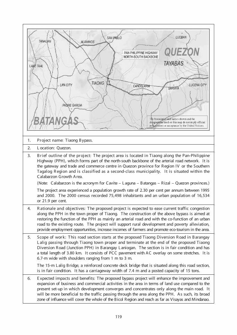
1. Project name: Tiaong B ypass.
2. L ocation: Quezon.
3. B r ief outline of the proj ect: T he project area is located in Tiaong along the Pan-PhilippineHighway (PPH), which forms part of the north-south backbone of the arterial road network. I t isthe gateway and trade and commerce centre in Quezon province for R egion IV or the SouthernTagalog R egion and is classified as a second-class municipality. I t is situated within theCalabarzon Growth A rea.
(Note: Calabarzon is the acronym for Cavite – L aguna – B atangas – R izal – Quezon provinces.)
T he project area experienced a population growth rate of 2.30 per cent per annum between 1995and 2000. T he 2000 census recorded 75,498 inhabitants and an urban population of 16,534or 21.9 per cent.
4. R ationale and objectives: T he proposed project is expected to ease current traffic congestionalong the PPH in the town proper of Tiaong. T he construction of the above bypass is aimed atrestoring the function of the PPH as mainly an arterial road and with the co-function of an urbanroad to the existing route. T he project will support rural development and poverty alleviation,provide employment opportunities, increase incomes of farmers and promote eco-tourism in the area.
5. Scope of wor k : T his road section starts at the proposed Tiaong Diversion R oad in B arangayL alig passing through Tiaong town proper and terminate at the end of the proposed TiaongDiversion R oad (Junction PPH) in B arangay L aniogan. T he section is in fair condition and hasa total length of 3.80 km. It consists of PCC pavement with AC overlay on some stretches. I t is6.7-m wide with shoulders ranging from 1 m to 3 m.
T he 15-m L alig B ridge, a reinforced concrete deck bridge that is situated along this road section,is in fair condition. I t has a carriageway width of 7.4 m and a posted capacity of 15 tons.
6. E xpected impacts and benefits: The proposed bypass project will enhance the improvement andexpansion of business and commercial activities in the area in terms of land use compared to thepresent set-up in which development converges and concentrates only along the main road. I twill be more beneficial to the traffic passing through the area along the PPH. As such, its broadzone of influence will cover the whole of the Bicol Region and reach as far as Visayas and Mindanao.
119

7. Estimated cost: US$ 1.8 million (P 102.9 million).
Note: Exchange rate – P 55.880 = US$ 1.00 (as of 15 July 2005).
8. Project duration: Two years.
9. Proposed project financing arrangements: Official development assistance by a donor countryor organization such as the Japan International Cooperation Agency, International Bank forReconstruction and Development, Asian Development Bank, United Nations DevelopmentProgramme or other financers. The project will be undertaken jointly by the Government of thePhilippines and the donor country/organization through their respective representatives.
10. Implementation arrangements: The Government of the Philippines, through the Department ofPublic Works and Highways, and the donor’s representative will set up their respective ProjectManagement Offices in order to coordinate and monitor the smooth and efficient implementationof the project.
11. Project status: The feasibility study was completed in July 2003.
12. Critical success factors: Close coordination and cooperation between the donor and the Govern-ment, an effective and capable project management team, the timely selection of a consultant andcontractors, and availability of funds.
13. Other project-related information: The proposed bypass can be considered as an inter-urbansystem considering its proximity and the traffic congestion in the area.
14. Contact address: Republic of the Philippines, Department of Public Works and Highways,Project Management Office – Feasibility Studies, DPWH, Region IV Compound, EDSA, QuezonCity. Tel: (63-2) 926-5768, (63-2) 928-5658, (63-2) 9285615; Fax: (63-2) 928-5615.
120

S. Sri Lanka
1. Project name: Upgrading the Thalaimannar – Medawachchiya Road (AH43) to Asian HighwayStandards.
2. Location: North and North Central provinces of Sri Lanka.
3. Brief outline of the project: Medawachchiya – Mannar – Thalaimannar Road (MMT Road) isa National Highway (A0014). It is 113.84 km in length and includes a 3.6-km causeway and125-m bridge that connects Thalaimannar Island to the mainland.
4. Rationale and objectives: Specifically this road will provide the access to other Asian countriesthrough a land bridge or some other means. International transportation of passengers and goodsvia land routes will improve efficiency of movement. In general, once upgraded, this road willprovide better access to Thalaimannar island together with improved mobility. The main objec-tive is to facilitate efficient, economical and safe mode of transport between the Asian countries.
5. Scope of work:
• Upgrading the entire road from Medawachchiya to Thalaimannar, including all structuresexcept the Mannar Bridge
• Reconstruction of the causeway or construction of bridges to replace the causeway
• Reconstruction of Mannar Bridge (Bridge No. 85/1 on the MMT Road).
6. Expected impacts and benefits: Improved mobility and economic activities between Sri Lankaand the rest of Asia.
7. Estimated cost: US$ 150 million.
8. Project duration: Approximately four years.
9. Proposed project financing arrangements: Funds not available.
10. Implementation arrangements: Project has not yet formulated.
11. Project status:
12. Critical success factors: Availability of funds.
13. Other project-related information: An application for funding has been forwarded to the JapanInternational Cooperation Agency for the reconstruction of Bridge No. 85/1 on MMT road.
14. Contact address: Secretary, Ministry of Highways, Ninth Floor, Sethsiripaya, Battaramulla,Sri Lanka.
121

T. Tajikistan
1. Project name: AH7, Rehabilitation and Upgrading of the Dushanbe – Khujand and Korog –border with Kyrgyzstan sections.
2. Location: The Khujand – Dushanbe section is the main road linking the capital, Dushanbe withKhujand city and the onward connection to Uzbekistan via Chavast. The Korog – border withKyrgyzstan (Sary Tash) section provides a link to Kyrgyzstan in addition to AH65 (Dushanbe –Garm – Jirgatal – Tursunzade).
3. Brief outline of the project: The Asian Highway routes AH7, AH65 and AH66 connectDushanbe with Uzbekistan, Afghanistan, Kyrgyzstan and China. They are important transportcorridors in Tajikistan.
The total length of the two sections is 708 km. The Khujand – Dushanbe section is 258 km andthe Korog – border with Kyrgyzstan section is 450 km.
The Government of Tajikistan is giving priority to the rehabilitation of all Asian Highwaycorridors in Tajikistan. When improved, these corridors will also develop transit transportationthrough Tajikistan by neighbouring Central Asian countries.
The Government recently completed the rehabilitation of the AH7 Dushanbe – Dusti section. TheAsian Development Bank is providing support for the rehabilitation of roads in various phases,Japan is funding the rehabilitation of the Kurgan Tube – Nizhiny Panj section, and the UnitedStates of America is providing support for construction of a bridge over the Amou River on theborder between Tajikistan and Afghanistan.
Additional financial resources are required to complete the modernization of the Tajikistan roadnetwork. The Government is seeking additional financing from international and bilateralinstitutions and private sector investors.
4. Rationale and objectives: The rehabilitation and upgrading of the Asian Highway and otherroads in Tajikistan will enhance the efficiency of domestic transportation provide transit transpor-tation opportunities. The development of the road infrastructure will directly contribute toeconomic development and poverty alleviation by creating employment opportunities. Theproposed improvement will provide safe and permanent transport link from Gorno-BadakhsanAutonomous Region, China and South Asian countries to the capital and central part of Tajikistan.
5. Scope of work: Rehabilitation and upgrading of AH7 Khujand – Dushanbe and Korog – borderwith Kyrgyzstan sections to international standards.
6. Expected impacts and benefits: The projects will provide benefits to the population of Tajikistan,improve transportation and mobility within Tajikistan, reduce transport costs and travel times,create employment opportunities and contribute towards poverty alleviation by increasing householdincome.
7. Estimated cost: US$ 90 million (US$ 23 million for Khujand – Dushanbe and US$ 67 millionfor Korog-Sary Tash).
8. Project duration: Three to four years.
122

9. Proposed project financing arrangements: The World Bank, Asian Development Bank or otherinternational and bilateral financing organizations.
10. Implementation arrangements: The Ministry of Transport of Tajikistan will be the implement-ing agency. Project implementation arrangements will be established as required.
11. Project status: Rehabilitation and feasibility studies of some sections of the road are ongoing. Itis planned to modernize and rehabilitate all Asian Highway corridors in Tajikistan in order tofacilitate and improve efficiency of internal as well as international transportation.
12. Critical success factors: Availability of financing, efficient cooperation between donors and theGovernment, the timely selection of consultants and contractors, and the establishment of aproject management office.
13. Other project-related information: Implementation of the projects will enhance domestictransportation as well as transit transportation from Tajikistan to neighbouring countries.
14. Contact address: Ministry of Transport, 14 Ayni Street, Dushanbe, Tajikistan. Fax: (992-372)212 003.
123

1. Project name: AH66, Dushanbe – Dangara – Kulyab – Kalaikhumb – Kulma highway.
2. Location: The Dushanbe – Kulyab – Kalaikhumb – Kulma highway is the main road linking thecapital, Dushanbe with the Pamirs and onward connection to Afghanistan and China.
3. Brief outline of the project: The Asian Highway route AH66 connects capital Dushanbe withAfghanistan and China. This is one of important transport corridor in Tajikistan.
The total length of above road is about 290 km. The Dushanbe-Dangara section is 120 km,Skev-Zigar section is 38 km, Shagon-Zigar section is 35 km and other section of the highwayis 100 km.
The Government of Tajikistan is giving priority to the rehabilitation of all Asian Highwaycorridors in Tajikistan. When improved, this AH66 corridor will also develop transit transporta-tion through Tajikistan by its neighbouring Central Asian countries.
Additional financial resources are required to complete the modernization of the Tajikistan roadnetwork. Government of Tajikistan is seeking additional financing from international and bilateralinstitutions and private sector investors.
4. Rationale and objectives: The rehabilitation and upgrading of the Asian Highways and roads inTajikistan will enhance the efficiency of domestic transportation and provide transit transportationopportunities. The development of road infrastructure will directly contribute to economic deve-lopment and poverty alleviation by creating employment opportunities. The proposed improve-ments of the highway will provide uninterrupted transportation from the Gorno-BadakhshanAutonomous Region, China and other neighbouring countries to the capital and central part ofTajikistan.
5. Scope of work: It is proposed to rehabilitate and upgrade the above road to the internationalstandards.
6. Expected impacts and benefits: The project will greatly enhance domestic transportation andtransit transportation from Tajikistan to neighbouring countries. The improvement of entirehighway will provide uninterrupted connectivity between eastern and western parts of the countryand enhance local economy through creation of tourism opportunities and other business. Theproject will provide benefit to the people of Tajikistan, improve transportation and mobility withinTajikistan, reduce transport costs and travel times. The implementation of project will createemployment opportunities and contribute towards poverty alleviation by increasing householdincome.
7. Estimated cost: US$ 131 million.
8. Project duration: Five to six years.
9. Proposed project financing arrangements: World Bank, Asian Development Bank or otherinternational and bilateral financing organizations.
10. Implementation arrangements: Ministry of Transport of Tajikistan will be the implementingagency. Project implementation arrangements will be established as required.
11. Project status: Rehabilitation of some sections of the road section is ongoing. It is proposed tomodernize and rehabilitate all Asian Highway corridors in Tajikistan to facilitate and improveefficiency of internal as well as international transport.
12. Critical success factors: Availability of financing, efficient cooperation of donors and govern-ment, timely selection of consultants and contractors, establishment of project management office.
13. Other project-related information: The implementation of projects will enhance domestictransportation and transit transportation from Tajikistan to neighbouring countries.
14. Contact address: Ministry of Transport, 14 Ayni Street, Dushanbe, Tajikistan. Fax: (992-372) 212003.
124

U. Turkey
1. Project name: AH5, Gerede – Merzifon State Road Project.
2. Location: Gerede – Merzifon State Road located in the North Anatolian region of Turkey.
3. Brief outline of the project: The international road network in Turkey serves as the mainnational network for inland transportation. In Turkey, the project is along the route designated asAH5 in the Asian Highway network, stretching from Turkey, via Georgia, Azerbaijan andTurkmenistan, up to Kazakhstan and China. It substantially crosses more than one subregion.
The Gerede – Merzifon State Road is a part of the main national and international road networkof Turkey. The road connects the Caucasus and Asia to Europe via the border with Bulgaria. Todate, no multi-lane construction work has been carried out on this 300-km road. Therefore,in order to provide a seamless road transportation infrastructure, construction of the Gerede –Merzifon State Road as a dual carriageway is crucial.
The project has also been proposed for the Transport Infrastructure Needs Assessment (TINA)Programme implemented by the European Union for candidate countries. The objective of TINAis to assist such countries to easily integrate into the Trans European Road Network as well asdetermine the routes and infrastructure needs of those routes that will become part of the TransEuropean Road Network in the future.
4. Rationale and objectives:
• With the advent of globalization, more efficient and effective international road transporta-tion corridors are urgently needed. International transport corridors, which are essential tothe existence of modern and sustainable transportation networks, also provide tremendouscontributions to socio-economic development in the regions concerned.
• The Gerede – Merzifon State Road Project is located in the area that is easily accessed bothfrom Anatolia and from the Black Sea region.
• The project is on the main international route of not only the Asian Highway route but alsothe Trans European Road Network. On completion, the project will also meet increasinglocal and international travel demands efficiently and effectively.
The project will provide better international connections with the international routes located inthe Black Sea region, the Caucasus and North, Central and South-West Asia. The main objectiveis to provide road users with infrastructure quality and safety that meets international standardsalong international routes in Turkish territory.
5. Scope of work: The Gerede – Merzifon State Road Project comprises the transformation of 300km of a two-lane road into four-lane highway paved with asphalt concrete.
6. Expected impacts and benefits:
• The improved quality of the international road infrastructure and provision of better roadtransportation for all road users will encourage an increase in the volume of passenger andgoods traffic.
• Reductions in travel times, vehicle operation costs and accidents.
• A major contribution to facilitating social and economic activities in the region.
7. Estimated cost: US$ 350 million.
8. Contact address: General Directorate of Highways, Ministry of Public Works and Settlement,Karayollari Genel Muduriugu, 06100 Yucetepe, Ankara, Turkey. Tel: (90-312) 415 7000,Fax: (90-312) 417 2851, 425 4738.
125
V. Viet Nam
1. Project name: AH14, Hanoi – Hai Phong Expressway.
2. Location: Hanoi City to Hai Phong city.
3. Brief outline of the project: Construction of a new expressway from Hanoi to Hai Phong.
4. Rationale and objectives: Development of expressway network, completion of the Kunming –Hai Phong corridor in order to facilitate transportation, trade and tourism in the Greater MekongSubregion (GMS).
5. Scope of work: Construction of 100 km with four-six lanes.
6. Expected impacts and benefits: Improved transportation, trade and tourism in Viet Nam andthe GMS.
7. Estimated cost: US$ 410 million.
8. Project duration: 2008-2011.
9. Proposed project financing arrangements: Public-private partnership.
10. Implementation arrangements: Ministry of Transport, Viet Nam.
11. Project status: Project proposal.
12. Critical success factors: Availability of funds.
13. Other project-related information:
14. Contact address: Ministry of Transport, 80 Tran Hung Dao Street, Hanoi, Viet Nam. Tel: (84-4)9424-260; Fax: (84-4) 942-3291.
1. Project name: AH16, Da Nang – Quang Ngai Expressway.
2. Location: Da Nang city and Quang Ngai province.
3. Brief outline of the project: Construction of a new expressway from Da Nang to Quang Ngai.
4. Rationale and objectives: Development of an expressway network, completion of the north-southexpressway in order to facilitate transportation, trade and tourism in Viet Nam and the GreaterMekong Subregion (GMS).
5. Scope of work: Construction of a 140-km highway with four lanes.
6. Expected impacts and benefits: Improved transportation, trade and tourism in Viet Nam and theGMS.
7. Estimated cost: US$ 700 million.
8. Project duration: 2009-2012.
9. Proposed project financing arrangements: Public-private partnership.
10. Implementation arrangements: Ministry of Transport, Viet Nam.
11. Project status: Project proposal.
12. Critical success factors: Availability of funds.
13. Other project-related information:
14. Contact address: Ministry of Transport, 80 Tran Hung Dao Street, Hanoi, Viet Nam. Tel: (84-4)942-4260; Fax: (84-4) 942-3291.
126

127
1. Project name: AH1, Bien Hoa – Vung Tau Expressway.
2. Location: Dong Nai and Vung Tau Province.
3. Brief outline of the project: Construction of a new expressway from Bien Hoa to Vung Tau.
4. Rationale and objectives: Development of an expressway network, completion of the north-southexpressway in order to facilitate transportation, trade and tourism in Viet Nam and the GreaterMekong Subregion (GMS).
5. Scope of work: Construction of a 90-km highway with four to six lanes.
6. Expected impacts and benefits: Improved transportation, trade and tourism in Viet Nam and theGMS.
7. Estimated cost: US$ 600 million.
8. Project duration: 2007-2010.
9. Proposed project financing arrangements: Public-private partnership.
10. Implementation arrangements: Ministry of Transport, Viet Nam.
11. Project status: Project proposal.
12. Critical success factors: Availability of funds.
13. Other project-related information:
14. Contact address: Ministry of Transport, 80 Tran Hung Dao Street, Hanoi, Viet Nam. Tel: (84-4)942-4260; Fax: (84-4) 942-3291.
1. Project name: AH1, Sai Gon – Long Thanh – Dau Day Expressway.
2. Location: Ho Chi Minh City and Lam Dong province.
3. Brief outline of the project: Construction of a new expressway from Bien Hoa to Vung Tau.
4. Rationale and objectives: Development of an expressway network, completion of the north-southexpressway in order to facilitate transport, trade and tourism in Viet Nam and the Greater MekongSubregion (GMS).
5. Scope of work: Construction of a 55-km highway with four to six lanes.
6. Expected impacts and benefits: Improving transportation, trade and tourism in Viet Nam andthe GMS.
7. Estimated cost: US$ 350 million.
8. Project duration: 2009-2012.
9. Proposed project financing arrangements: Public-private partnership.
10. Implementation arrangements: Ministry of Transport, Viet Nam.
11. Project status: Project proposal.
12. Critical success factors: Availability of funds.
13. Other project-related information:
14. Contact address: Ministry of Transport, 80 Tran Hung Dao Street, Hanoi, Viet Nam. Tel: (84-4)942-4260; Fax: (84-4) 942-3291.
1. Project name: AH14, Ha Noi – Lao Cai Expressway.
2. Location: Ha Noi City and Lao Cai Province.
3. Brief outline of the project: Construction of a new expressway from Ha Noi to Lao Cai.
4. Rationale and objectives: Development of an expressway network, completion of the Kunming– Hai Phong corridor in order to facilitate transportation, trade and tourism in Viet Nam and theGreater Mekong Subregion (GMS).
5. Scope of works: Construction of a 290-km highway with four to six lanes.
6. Expected impacts and benefits: Improved transportation, trade and tourism in Viet Nam andthe GMS.
7. Estimated cost: US$ 600 million.
8. Project duration: 2007-2011.
9. Proposed project financing arrangements: Loans from the Asian Development Bank and otherfinancial institutions.
10. Implementation arrangements: Ministry of Transport, Viet Nam.
11. Project status: Project preparation.
12. Critical success factors: Availability of funds.
13. Other project-related information:
14. Contact address: Ministry of Transport, 80 Tran Hung Dao Street, Hanoi, Viet Nam. Tel: (84-4)942-4260; Fax: (84-4) 942-3291.
Under
Study (
ADB)
128

1. Project name: AH1/AH14, Hanoi Ring Road.
2. Location: Hanoi City.
3. Brief outline of the project: Construction of a new ring road.
4. Rationale and objectives: Development of an expressway network, completion of the north-southexpressway in order to facilitate transportation, trade and tourism in Viet Nam and the GreaterMekong Subregion (GMS).
5. Scope of work: Construction of a 65-km road with four to six lanes and a new Thanh Tri Bridge.
6. Expected impacts and benefits: Improved transportation, trade and tourism in Viet Nam andthe GMS.
7. Estimated cost: US$ 600 million.
8. Project duration: 2004-2008.
9. Proposed project financing arrangements: Public-private partnership and official developmentassistance.
10. Implementation arrangements: Ministry of Transport, Viet Nam.
11. Project status: Part of the project is being implemented.
12. Critical success factors: Availability of funds.
13. Other project-related information:
14. Contact address: Ministry of Transport, 80 Tran Hung Dao Street, Hanoi, Viet Nam. Tel: (84-4)942-4260; Fax: (84-4) 942-3291.
129

1. Project name: Van Phong Transshipment Hub port.
2. Location: Khanh Hoa province.
3. Brief outline of the project: Construction of a new transshipment hub port.
4. Rationale and objectives: Development of international transshipments.
5. Scope of work: Construction of a new transshipment hub port (two terminals, 500,000 TEU/year).
6. Expected impacts and benefits: Improved international transshipments for Viet Nam and theGreater Mekong Subregion (GMS).
7. Estimated cost: US$ 200 million.
8. Project duration: 2008-2011.
9. Proposed project financing arrangements: Public-private partnership.
10. Implementation arrangements: Ministry of Transport, Viet Nam
11. Project status: Project proposal.
12. Critical success factors: Availability of funds.
13. Other project-related information:
14. Contact address: Ministry of Transport, 80 Tran Hung Dao Street, Hanoi, Viet Nam. Tel: (84-4)942-4260; Fax: (84-4) 942-3291.
1. Project name: Vinh – Cau Treo Road Rehabilitation.
2. Location: Nghe An province.
3. Brief outline of the project: Improving the road from Vinh to Cau Treo (border with the LaoPeople’s Democratic Republic).
4. Rationale and objectives: Facilitating transportation, trade and tourism in Viet Nam and the LaoPeople’s Democratic Republic.
5. Scope of works: Upgrading of an 85-km road to Class III.
6. Expected impacts and benefits: Improved transportation trade and tourism in Viet Nam and theLao People’s Democratic Republic.
7. Estimated cost: U$ 44 million.
8. Project duration: 2008-2011.
9. Proposed project financing arrangements: Public.
10. Implementation arrangements: Ministry of Transport, Viet Nam.
11. Project status: Project proposal.
12. Critical success factors: Availability of funds.
13. Other project-related information:
14. Contact address: Ministry of Transport, 80 Tran Hung Dao Street, Hanoi, Viet Nam. Tel: (84-4)942-4260; Fax: (84-4) 942-3291.
130

1. Project name: Rehabilitation of the Soai Rap Access Channel in Ho Chi Minh City.
2. Location: Ho Chi Minh City.
3. Brief outline of the project: Improvement of the Soai Rap access channel.
4. Rationale and objectives: Facilitating transport, trade, tourism in Viet Nam and the GreaterMekong Subregion (GMS) by inland waterway.
5. Scope of works: Dredging, training of channels (30km) for ships up to 30,000 DWT.
6. Expected impacts and benefits: Development of transportation, trade and tourism in Viet Namand the GMS via inland waterways.
7. Estimated cost: US$ 120 million.
8. Project duration: 2008-2011.
9. Proposed project financing arrangements: Public-private partnership.
10. Implementation arrangements: Ministry of Transport, Viet Nam.
11. Project status:
12. Critical success factors: Availability of funds.
13. Other project-related information:
14. Contact address: Ministry of Transport, 80 Tran Hung Dao Street, Hanoi, Viet Nam. Tel: (84-4)942-4260; Fax: (84-4) 942-3291.
131