Embed Size (px)
Citation preview
ANNEX IV
PERMAFROST BASELINE REPORT FOR THE JAY PROJECT
PERMAFROST BASELINE REPORT FOR THE JAY PROJECT
Prepared for: Dominion Diamond Ekati Corporation Prepared by: Golder Associates Ltd.
September 2014
Permafrost Baseline Report
Jay Project
Table of Contents
September 2014
i
Table of Contents
1 INTRODUCTION ................................................................................................................................. 1-1
1.1 Background and Scope ................................................................................................................. 1-1
1.2 Objectives ..................................................................................................................................... 1-4
1.3 Baseline Study Area ...................................................................................................................... 1-4
2 PROJECT SETTING ........................................................................................................................... 2-1
2.1 Physiography ................................................................................................................................ 2-1
2.2 Climate .......................................................................................................................................... 2-1
2.3 Lake Characteristics ...................................................................................................................... 2-1
2.4 Lake Water Temperature .............................................................................................................. 2-2
2.5 Regional Lake Ice Characteristics ................................................................................................ 2-2
3 REGIONAL PERMAFROST CONDITIONS ........................................................................................ 3-1
4 SITE PERMAFROST CONDITIONS ................................................................................................... 4-1
4.1 Permafrost Terminology ................................................................................................................ 4-1
4.2 Field Investigations and Thermistor Installation ............................................................................ 4-2
4.3 Geothermal Properties From Thermistor Data ............................................................................. 4-5
4.4 Material Thermal Properties .......................................................................................................... 4-8
4.5 Permafrost Conditions of Islands and Peninsulas ........................................................................ 4-8
5 LAKE TALIK FORMATION ................................................................................................................ 5-1
5.1 Critical Depth to Permafrost .......................................................................................................... 5-1
5.2 Formation of Open Taliks Under Circular Lakes ........................................................................... 5-2
5.3 Formation of Open Taliks Under Elongate Lakes ......................................................................... 5-3
5.4 Critical Lake Sizes for Open Talik Formation ............................................................................... 5-4
5.5 Groundwater Salinity and Freezing Point Depression .................................................................. 5-5
6 PROJECTED CLIMATE CHANGE ..................................................................................................... 6-1
7 SUMMARY .......................................................................................................................................... 7-1
8 REFERENCES .................................................................................................................................... 8-1
9 GLOSSARY ......................................................................................................................................... 9-1
Maps
Map 1.1-1 Location of the Jay Project ............................................................................................... 1-2 Map 1.1-2 Ekati Property Map ........................................................................................................... 1-3

Permafrost Baseline Report
Jay Project
Table of Contents
September 2014
ii
Map 1.3-1 Location of the Permafrost Baseline Study Area ............................................................. 1-5 Map 4.2-1 Locations of Thermistors .................................................................................................. 4-4
Figures
Figure 4.3-1 Typical Ground Thermal Profile in Permafrost ................................................................. 4-5 Figure 4.3-2 Typical Permafrost Thermal Regime ............................................................................... 4-6
Tables
Table 2.5-1 Summary of Regional Lake Ice Thicknesses ................................................................... 2-2 Table 4.2-1 Summary of Thermistor Installations ............................................................................... 4-3 Table 4.3-1 Summary of Geothermal Properties From Thermistor Data ............................................ 4-7 Table 4.4-1 Material Thermal Properties ............................................................................................. 4-8 Table 5.4-1 Critical Radius and Critical Half Width for Lakes Without Terraces ................................. 5-4 Table 5.4-2 Ranges of Critical Radius and Critical Half Width for Lakes With Terraces .................... 5-4
Appendices
Appendix A Thermistor Data
Permafrost Baseline Report
Jay Project
Abbreviations and Units of Measure
September 2014
iii
Abbreviations
Abbreviation Definition
AZ Azimuth
d-m-y day-month-year
Diavik Mine Diavik Diamond Mine
Dominion Diamond Dominion Diamond Ekati Corporation
EBA EBA Engineering Consultants Ltd.
e.g., for example
Ekati Mine Ekati Diamond Mine
et al. more than one additional author
i.e., that is
INCL angle of inclination
IPCC Intergovernmental Panel on Climate Change
N north
No. number
NWT Northwest Territories
Project Jay Project
TDS total dissolved solids
UTM Universal Transverse Mercator
W west
Permafrost Baseline Report
Jay Project
Abbreviations and Units of Measure
September 2014
iv
Units of Measure
Unit Definition
% percent
° degree
°C degrees Celsius
°C/m degrees Celsius per metre
cm centimetre
ha hectare
kg/m³ kilograms per cubic metre
km kilometre
km² square kilometres
m metre
m² square metres
masl metres above sea level
m/°C metres per degrees Celsius
mg/L milligrams per litre
MJ/m³-°C mega joules per cubic metre degrees Celsius
mm millimetre
ppt parts per thousand
W/m-°C Watts per metre degrees Celsius

Permafrost Baseline Report
Jay Project
Section 1, Introduction
September 2014
1-1
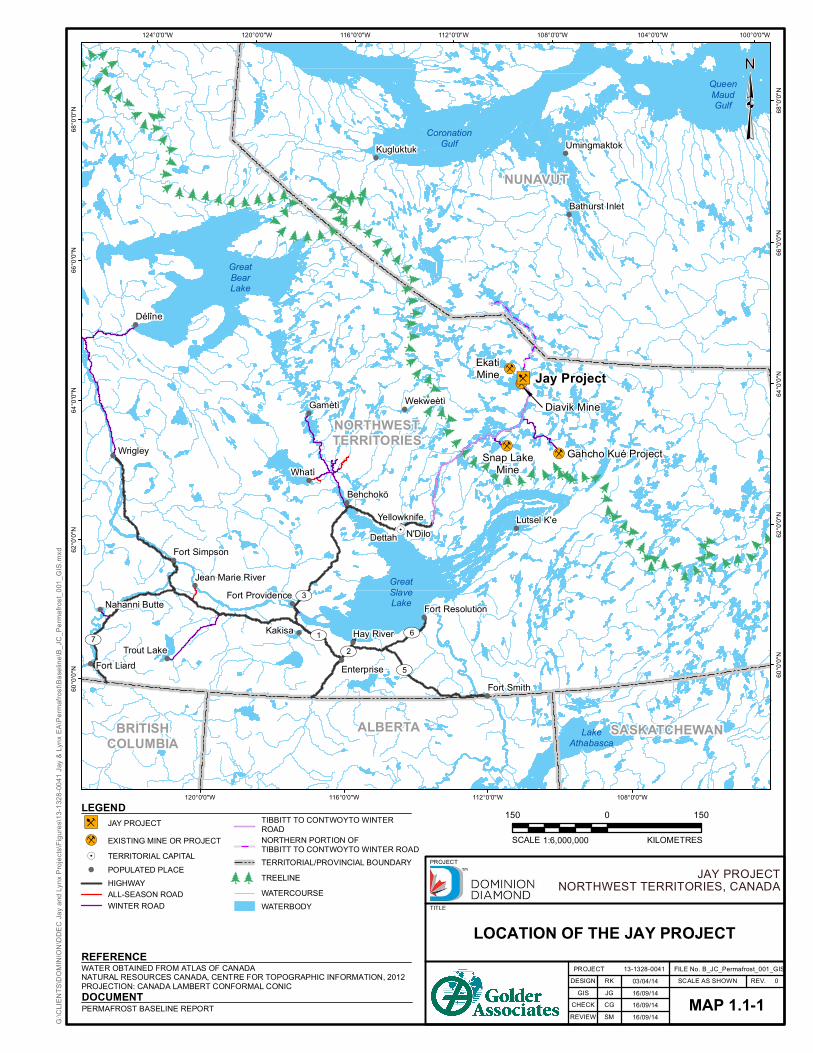
1 INTRODUCTION 1.1 Background and Scope Dominion Diamond Ekati Corporation (Dominion Diamond) is a Canadian-owned and Northwest Territories (NWT) based mining company that mines, processes, and markets Canadian diamonds from its Ekati Diamond Mine (Ekati Mine). The existing Ekati Mine is located approximately 200 kilometres (km) south of the Arctic Circle and 300 km northeast of Yellowknife, Northwest Territories (Map 1.1-1).
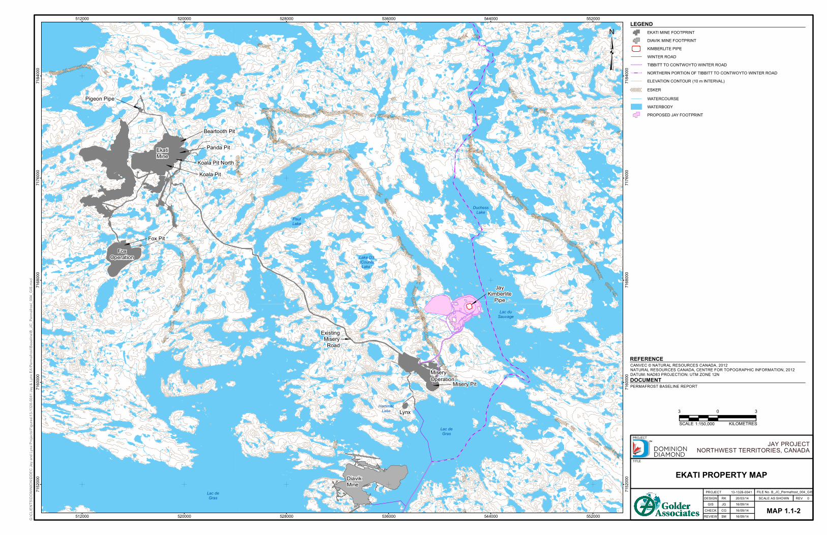
Dominion Diamond is proposing to develop the Jay kimberlite pipe (Jay pipe) located beneath Lac du Sauvage. The proposed Jay Project (Project) will be an extension of the Ekati Mine, which is a large, stable, and successful mining operation that has been operating for 16 years. Most of the facilities required to support the development of the Jay pipe and to process the kimberlite currently exist at the Ekati Mine. The Project is located in the southeastern portion of the Ekati claim block approximately 25 km from the main facilities and approximately 7 km to the northeast of the Misery Pit, in the Lac de Gras watershed (Map 1.1-2).
The permafrost baseline report is one component of a comprehensive environmental and socio-economic baseline program to collect information about the natural and socio-economic environment near the Project. This report describes the characteristics and existing condition of permafrost in the baseline study area. Additional data from Ekati Mine and adjacent Diavik Diamond Mine (Diavik Mine) were used to augment the specific permafrost information available for the Project site in this baseline study.
ooooo
oo
oo
oo
oo
o ooo
oo
o o
ooooo o
oooo
o
oooo
o oo
ooo
o
oo oo
o
o
oo
ooo
oo
ooooo oooooo
o
ooooo
oo
o
ooooo
o
ooo
oo
o
oooooo
oo
o
ooo
o
o o
oo
oo
ooo
ooo o
oo
o
oo
o
oo
o
o
oo
ooo
o
ooo
oo
oo
oo
o oo o
o
ooooooooooooooo o
ooo
ooo
oooo
o
oooo
oo
o
o
!
!
!
!
!
!
!
!
!
!
!
!
!
!
!
!
!
!
!
!
!
!
!
!
!
!
!
!
!
!
!
!
!!
!.
!i!i
!i!i
")B
Diavik Mine
EkatiMine
Snap LakeMine
Gahcho Kué Project
GreatSlaveLake
LakeAthabasca
QueenMaudGulf
CoronationGulf
GreatBearLake
UV7
UV3
UV1
UV5
UV6
UV2
SASKATCHEWANALBERTABRITISHCOLUMBIA
NUNAVUT
NORTHWESTTERRITORIES
Délîne
Dettah
EnterpriseFort Liard
Fort ProvidenceFort Resolution
Fort Simpson
Fort Smith
Hay River
Jean Marie River
Kakisa
Lutsel K'e
Nahanni Butte
Behchokö
Gamètì
Trout Lake
Wekweètì
WhatìWrigley
Bathurst Inlet
UmingmaktokKugluktuk
YellowknifeN'Dilo
Jay Project
100°0'0"W104°0'0"W
108°0'0"W
108°0'0"W
112°0'0"W
112°0'0"W
116°0'0"W
116°0'0"W
120°0'0"W
120°0'0"W124°0'0"W
68°0
'0"N 68
°0'0"
N
66°0
'0"N 66°0
'0"N
64°0
'0"N 64°0
'0"N
62°0
'0"N 62°0
'0"N
60°0
'0"N
60°0
'0"N
G:\C
LIENT
S\DOM
INIO
N\DD
EC Ja
y and
Lynx
Proj
ects\
Figure
s\13-1
328-0
041 J
ay &
Lynx
EA\
Perm
afros
t\Bas
eline
\B_JC
_Perm
afros
t_001
_GIS
.mxd
³
WATER OBTAINED FROM ATLAS OF CANADANATURAL RESOURCES CANADA, CENTRE FOR TOPOGRAPHIC INFORMATION, 2012PROJECTION: CANADA LAMBERT CONFORMAL CONIC
REFERENCE
LEGEND
JAY PROJECTNORTHWEST TERRITORIES, CANADA
PROJECTDESIGN
GISCHECKREVIEW
RKJGCGSM
03/04/1416/09/1416/09/1416/09/14
MAP 1.1-1
FILE No. B_JC_Permafrost_001_GISREV. 0
13-1328-0041 SCALE AS SHOWN
TITLE
PROJECT
LOCATION OF THE JAY PROJECT
150 1500
KILOMETRESSCALE 1:6,000,000")B JAY PROJECT
!i EXISTING MINE OR PROJECT!. TERRITORIAL CAPITAL! POPULATED PLACE
HIGHWAYALL-SEASON ROADWINTER ROAD
TIBBITT TO CONTWOYTO WINTERROADNORTHERN PORTION OFTIBBITT TO CONTWOYTO WINTER ROADTERRITORIAL/PROVINCIAL BOUNDARY
oo TREELINEWATERCOURSEWATERBODY
PERMAFROST BASELINE REPORTDOCUMENT
-------------------
---------------
---
---------------
-------
----
----
--------
-
----
----------
---
-----------
---------------------------------------------------------------------
---------------
-----
----
--------------------------
-------
----
------------------------- -----------
---
-------
-----------------
-- ------------- ------------------------------------------------------------------------------------
------
--------- ---
--------------------
--------------
-------------
-------
----- ------
-------
--------------
------
-------
--------
------------
--------- -----
------
---- -------------
-------------
--- ----------------------------------------- ---------
---------------- --------------------------------------
-------------------
------
----
----------------
---------------------------
-------- -
--------------------------- -------- --------
-------
----------
------------------ ----
-----
----
---
--------
----------------------------------
--------
------
----
----
-----
------
-------------
-----------
----------
--------
-----------
--
----------
------
-------------------------------------- ---------
------
------
--
Lac duSauvage
Lac deGras
DuchessLake
PaulLake
Lake D3(CountsLake)
HammerLake
Lac deGras
Koala PitKoala Pit North
Panda Pit
Beartooth Pit
Pigeon Pipe
Misery Pit
Fox Pit
EkatiMine
FoxOperation
MiseryOperation
DiavikMine
JayKimberlite
Pipe
Lynx
ExistingMisery
Road
512000
512000
520000
520000
528000
528000
536000
536000
544000
544000
552000
552000
7152
000
7152
000
7160
000
7160
000
7168
000
7168
000
7176
000
7176
000
7184
000
7184
000
REV 0DESIGN
EKATI PROPERTY MAP13-1328-0041
SCALE AS SHOWN
PROJECT
TITLE
GIS
REVIEWCHECK
RK
EKATI MINE FOOTPRINTDIAVIK MINE FOOTPRINTKIMBERLITE PIPEWINTER ROADTIBBITT TO CONTWOYTO WINTER ROADNORTHERN PORTION OF TIBBITT TO CONTWOYTO WINTER ROADELEVATION CONTOUR (10 m INTERVAL)
-------- ESKERWATERCOURSEWATERBODYPROPOSED JAY FOOTPRINT
20/03/14
³
JAY PROJECTNORTHWEST TERRITORIES, CANADA
PROJECT FILE No. B_JC_Permafrost_004_GIS
CANVEC © NATURAL RESOURCES CANADA, 2012NATURAL RESOURCES CANADA, CENTRE FOR TOPOGRAPHIC INFORMATION, 2012DATUM: NAD83 PROJECTION: UTM ZONE 12N
REFERENCE
LEGEND
KILOMETRESSCALE 1:150,000
MAP 1.1-2
3 30
G:\C
LIENT
S\DOM
INIO
N\DD
EC Ja
y and
Lynx
Proj
ects\
Figure
s\13-1
328-0
041 J
ay &
Lynx
EA\Pe
rmafr
ost\B
aseli
ne\B_
JC_P
ermafr
ost_0
04_G
IS.m
xd
JG 16/09/14
PERMAFROST BASELINE REPORTDOCUMENT
CG 16/09/14SM 16/09/14
Permafrost Baseline Report
Jay Project
Section 1, Introduction
September 2014
1-4
1.2 Objectives The purpose of the Permafrost Baseline Report is to describe the existing permafrost conditions at the Project site. The objectives of the baseline report are as follows:
characterize the permafrost and active layer conditions at the site, including thermal conditions and ground ice/moisture contents of underlying material;
describe the relationship between the permafrost and active layer conditions and the groundwater regimes; and,
evaluate the adequacy of the existing baseline dataset.
1.3 Baseline Study Area The proposed new mining operations would develop the Jay pipe which is located in the southeastern portion of the Ekati Mine site, approximately 25 km southeast of the Ekati main camp, and approximately 7 km northeast-east of the Misery Pit, below the waters of Lac du Sauvage.
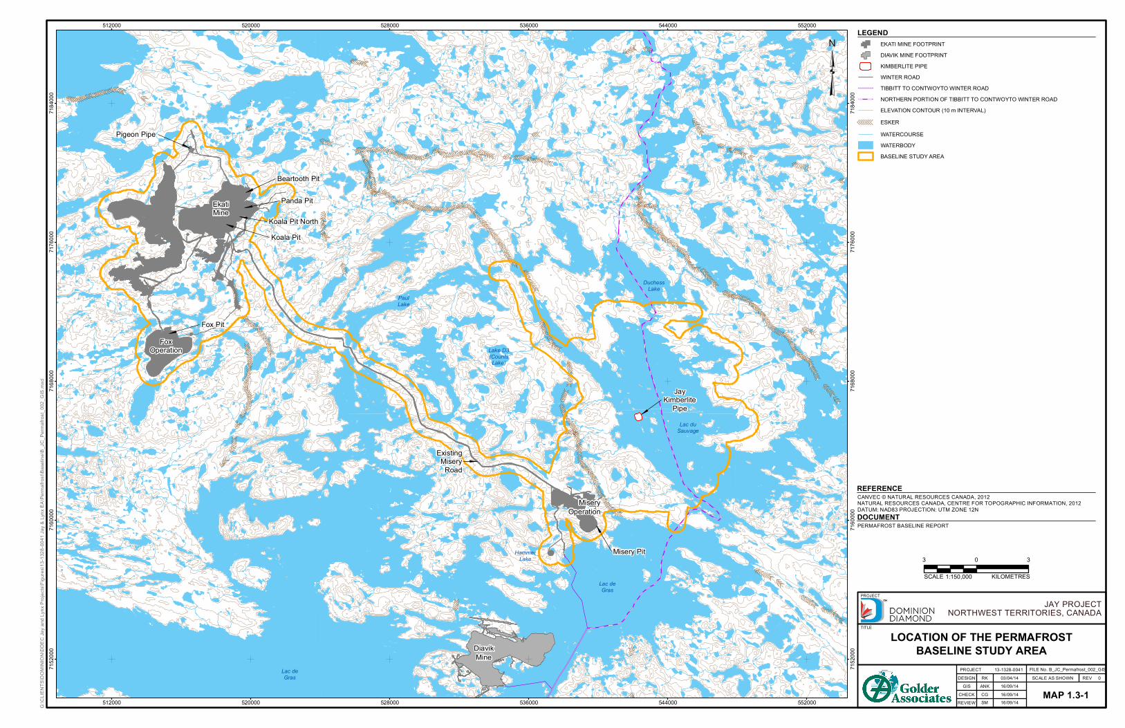
The baseline study area is approximately 236 square kilometres (km2) (23,578 hectares [ha]) and includes the existing Ekati operation plus the Project footprint and a 500 metre (m) buffer (Map 1.3-1). The locations of the Ekati Mine, Misery Haul Road, Misery Pit operations, and Jay pipe in Lac du Sauvage, are shown on the baseline study area map (Map 1.3-1).
The centre of the Jay pipe is located at approximately 7165733 m northing, 542395 m easting (Universal Transverse Mercator [UTM] Zone 12), and approximately 1.2 km from the west shoreline of Lac du Sauvage.
-------------------
---------------
---
---------------
-------
----
----
--------
-
----
----------
---
-----------
---------------------------------------------------------------------
---------------
-----
----
--------------------------
-------
----
------------------------- -----------
---
-------
-----------------
-- ------------- ------------------------------------------------------------------------------------
------
--------- ---
--------------------
--------------
-------------
-------
----- ------
-------
--------------
------
-------
--------
------------
--------- -----
------
---- -------------
-------------
--- ----------------------------------------- ---------
---------------- --------------------------------------
-------------------
------
----
----------------
---------------------------
-------- -
--------------------------- -------- --------
-------
----------
------------------ ----
-----
----
---
--------
----------------------------------
--------
------
----
----
-----
------
-------------
-----------
----------
--------
-----------
--
----------
------
-------------------------------------- ---------
------
------
--
Lac duSauvage
Lac deGras
DuchessLake
PaulLake
Lake D3(CountsLake)
HammerLake
Lac deGras
Koala PitKoala Pit North
Panda Pit
Beartooth Pit
Pigeon Pipe
Fox Pit
EkatiMine
FoxOperation
Misery Pit
MiseryOperation
DiavikMine
JayKimberlite
Pipe
ExistingMisery
Road
512000
512000
520000
520000
528000
528000
536000
536000
544000
544000
552000
552000
7152
000
7152
000
7160
000
7160
000
7168
000
7168
000
7176
000
7176
000
7184
000
7184
000
REV 0DESIGN
LOCATION OF THE PERMAFROSTBASELINE STUDY AREA
13-1328-0041SCALE AS SHOWN
PROJECT
TITLE
GIS
REVIEWCHECK
RK
EKATI MINE FOOTPRINTDIAVIK MINE FOOTPRINTKIMBERLITE PIPEWINTER ROADTIBBITT TO CONTWOYTO WINTER ROADNORTHERN PORTION OF TIBBITT TO CONTWOYTO WINTER ROADELEVATION CONTOUR (10 m INTERVAL)
-------- ESKERWATERCOURSEWATERBODYBASELINE STUDY AREA
03/04/14
³
JAY PROJECTNORTHWEST TERRITORIES, CANADA
PROJECT FILE No. B_JC_Permafrost_002_GIS
CANVEC © NATURAL RESOURCES CANADA, 2012NATURAL RESOURCES CANADA, CENTRE FOR TOPOGRAPHIC INFORMATION, 2012DATUM: NAD83 PROJECTION: UTM ZONE 12N
REFERENCE
LEGEND
KILOMETRESSCALE 1:150,000
MAP 1.3-1
3 30
G:\C
LIENT
S\DOM
INIO
N\DD
EC Ja
y and
Lynx
Proj
ects\
Figure
s\13-1
328-0
041 J
ay &
Lynx
EA\Pe
rmafr
ost\B
aseli
ne\B_
JC_P
ermafr
ost_0
02_G
IS.m
xd
ANK 16/09/14
PERMAFROST BASELINE REPORTDOCUMENT
CG 16/09/14SM 16/09/14

Permafrost Baseline Report
Jay Project
Section 2, Project Setting
September 2014
2-1
2 PROJECT SETTING 2.1 Physiography The Jay pipe is located approximately 1.2 km from the western shoreline of Lac du Sauvage in a bathymetric low that is covered by approximately 36 m of water, based on 2013 Lac du Sauvage bathymetry data (Aurora 2013). Lac du Sauvage has an elevation of approximately 416.1 metres above sea level (masl).
The topography surrounding the Project is generally flat with local surface relief rising up to 20 m and terrain elevation ranging up to 100 m in total relief over the region. The most distinctive physical features of the landscape are eskers, which are sinuous ridges of granular material deposited by glaciers.
Bedrock generally outcrops at surface in the area surrounding the Project, or is partially overlain by a thin (up to 5 m thick) veneer of Quaternary sediments consisting mainly of silty gravel, sand (glacial till) with cobbles and boulders, and organic matter (Dominion Diamond 2013). Till and moraine are typically heterogeneous, unsorted, and unstratified, given that they were laid down by glacier ice, and contain particles ranging from clay-size to boulder-size.
The overburden is thicker in certain areas due to esker occurrence. An esker is a long, winding ridge of sand and gravel left by a stream that ran in an ice tunnel under the melting glacier. Eskers run along the east and west sides of Lac du Sauvage and merge northwest of Lac du Sauvage (Map 1.3-1).
2.2 Climate The Project is located in the Canadian sub-Arctic; cold winter conditions predominate for the majority of the year. Climate baseline data are presented in the Hydrology Baseline Report (Annex X). The report includes a summary of annual and seasonal air temperatures at the Project site, calculated from the derived record of daily air temperatures extending from 1959 to 2013. Annual average air temperature at the site ranges from -12.09 degrees Celsius (°C) to -5.97°C in the 55-year record, with an average value of -9.6°C.
2.3 Lake Characteristics Waterbodies cover approximately one-third of the 266,300 ha Ekati claim block. The low terrain has resulted in a diffuse drainage pattern, and streams typically meander in braided channels through extensive boulder fields between lakes and ponds. High flows are observed during spring runoff, while low flows and dry stream channels are typical in late summer (Dominion Diamond 2013).
Lac du Sauvage drains into Lac de Gras through the Lac du Sauvage outflow channel at the southwest end of the lake. A basin study of Lac du Sauvage indicated the following (Golder 2014):
The surface area of Lac du Sauvage is 109.1 km2 at elevation 416.1 masl.
The total area of Lac du Sauvage and its watershed is 1,495.6 km2.

Permafrost Baseline Report
Jay Project
Section 2, Project Setting
September 2014
2-2
The 2013 Lac du Sauvage bathymetry survey carried out by Aurora Geosciences Ltd. (Aurora 2013) shows the following key features:
One of the deepest areas of Lac du Sauvage is located around the Jay pipe with base at elevation 381 masl, which is 36 m below the lake surface.
A trench up to approximately 20 m deep runs along the southwest shoreline of Lac du Sauvage.
Below Lac du Sauvage, the glacial till is expected to be overlain by recent lakebed sediment deposits. These lake bottom deposits are expected to be made up of soft, low-plasticity to no-plasticity silt and clayey silt.
2.4 Lake Water Temperature Lake water temperatures were previously measured at various sites in Lac du Sauvage (Rescan 2007). In the summer, lake water temperatures in deep areas are typically similar to or slightly cooler than temperatures in shallow areas. Lac du Sauvage had an average temperature range of 12°C to 12.8°C in July to September 2006 at a measured depth up to 17.1 m (approximately half the depth of the lake). In the winter under ice, Lac du Savage water temperatures are typically warmer in deeper areas than in shallow areas; at a maximum measured depth of approximately 17 m, the average temperature was approximately 2.2°C from February to May 2006 (Rescan 2007).
2.5 Regional Lake Ice Characteristics A summary of lake ice characteristics in the region of the Project, based on the Canadian Ice Database (Lenormand et al. 2002), is presented in Table 2.5-1. Mean maximum lake ice thicknesses in regional lakes range from 1.3 m at Yellowknife, to 1.9 m at Fort Reliance and 1.8 m at Contwoyto Lake. The Ekati main camp is centred at approximately 64.72°N latitude and 110.55°W longitude, and so it is expected that the lake ice thickness in Lac du Sauvage is within the upper end of this range. Estimated mean maximum ice thickness for Lac de Gras is 1.7 m (Golder 2008).
Table 2.5-1 Summary of Regional Lake Ice Thicknesses
Station Name
Station Location
Waterbody
Available Period of Record
Mean Maximum Ice Thickness (m)
Latitude North
Longitude West
1 Port Radium 66° 05' 118° 02' Great Bear Lake 1951 to 1975 1.9
2 Contwoyto Lake 65° 29' 110° 22' Contwoyto Lake 1967 to 1971 1.8
3 Fort Reliance 62° 43' 109° 06' McLeod Bay, Great Slave Lake 1956 to 1990 1.4
4 Fort Reliance 62° 43' 109° 06' Charlton Bay, Great Slave Lake 1955 to 1990 1.3
5 Yellowknife 62° 28' 114° 27' Frame Lake 1954 to 1996 1.3
6 Yellowknife 62° 28' 114° 27' Long Lake 1954 to 1996 1.3
7 Yellowknife 62° 28' 114° 27' Back Bay 1946 to 1996 1.3
Source: Lenormand et al. (2002).
m = metre; ° = degrees.

Permafrost Baseline Report
Jay Project
Section 3, Regional Permafrost Conditions
September 2014
3-1
3 REGIONAL PERMAFROST CONDITIONS The Project is located within a region of continuous permafrost. In this region, the layer of permanently frozen subsoil and rock is generally deep and overlain by an active layer that thaws during summer. The depth of the active layer in the Misery Pit area from thermistor measurements ranges from approximately 1.0 to 2.7 m. Regional permafrost is expected to extend to a depth of approximately 300 to over 400 m below the ground surface at locations that are not affected by waterbodies.
Unfrozen ground (talik zones) occurs beneath waterbodies and permafrost is expected to be absent below the majority of Lac du Sauvage (Golder 2014). Based on the regional lake ice thickness data presented in Table 2.5-1, the mean maximum ice thicknesses are expected to range from 1.3 to 1.9 m.
Mackay (1962) estimated that permafrost would not occur beneath water deeper than approximately two-thirds of the maximum winter ice thickness. Data collected by Burn (2002) indicates that the edge of permafrost beneath a lake underlain by a talik occurred beneath a water depth of approximately 60 percent (%) of the mean late-winter ice thickness. Using Burn’s method and the mean ice thickness, the taliks beneath lakes are assumed to extend vertically beneath the 1 m depth contour (60% of the mean maximum ice thickness of 1.7 m for Lac de Gras [Golder 2008]) of the lakes for which bathymetry is available. For all lakes for which bathymetry is unavailable, the 1 m depth contour is assumed to correspond to the shoreline.
Although permafrost occurs under islands and adjacent to waterbodies, the permafrost depth is expected to be less than the depth under land located away from waterbodies. It will vary below the islands and peninsulas in Lac du Sauvage depending on their sizes.
The permafrost map of Canada (Natural Resources Canada 1995) indicates that the ground ice content in the region is expected to be between 0% and 10% (dry permafrost) based on data compiled at the regional scale. Ice lenses (small bodies of ice in frozen soils) and ice wedges are likely to be present locally on land, as indicated by the electrical conductivity of the ground, and by permafrost features such as palsas (mounds of alternating layers of ice and mineral soils). These areas of local ground ice are generally associated with low-lying areas of poor drainage.
Permafrost Baseline Report
Jay Project
Section 4, Site Permafrost Conditions
September 2014
4-1
4 SITE PERMAFROST CONDITIONS 4.1 Permafrost Terminology Permafrost refers to subsurface soil or rock where temperatures remain at or below 0°C for two or more consecutive years. This condition is synonymous with perennially cryotic ground, which may be frozen, partially frozen, or non-frozen depending on the ice or water content of the ground and on the salinity of the included water. Permafrost is typically described throughout this baseline study by the following terminology, which relates to the ground temperature profile:
Active layer: The active layer is the layer of ground subject to annual freezing and thawing in areas underlain by permafrost. The depth of the active layer can vary based on material type and water content, presence or absence of vegetation, proximity to water, and general topographic aspect (the direction the slope faces, either north, south, east, or west).
Permafrost table: The permafrost table is the upper boundary of permafrost, at the base of the active layer. The ground temperature above the permafrost table is above 0°C for at least a portion of each year; the ground temperature below the permafrost table is less than 0°C year-round. The ground temperature varies with depth.
Permafrost base: The permafrost base is the lower boundary of permafrost, and is an undulating and uneven surface. The ground temperature above the permafrost base is less than 0°C, and below the permafrost base the ground temperature is above 0°C. The depth of the permafrost base varies with latitude, elevation, and proximity to large bodies of water. The depth of the permafrost base also depends on the thermal history of an area.
Depth of zero annual amplitude: The depth of zero annual amplitude is the depth below ground surface at which there is practically no variability in ground temperature due to the influence of surface air temperature. It is the depth at which the minimum monthly mean temperature and maximum monthly mean temperatures are practically equivalent.
Zero annual amplitude temperature: The temperature at the depth of zero annual amplitude.
Geothermal gradient: The geothermal gradient is the increase in ground temperature with depth, below the depth of zero annual amplitude. The geothermal gradient is typically a linear relationship. The permafrost base can be estimated if the geothermal gradient is known at a given temperature by projecting the linear relationship down until it crosses from negative ground temperature to positive ground temperature.
Mean annual ground temperature: The mean annual ground temperature is the temperature at the ground surface. It can be measured or estimated based on a projection upward of the geothermal gradient to intersect the ground surface.
Sub-permafrost aquifer: The sub-permafrost aquifer is the deep-permafrost groundwater flow regime near or below the base of permafrost. The top of the sub-permafrost aquifer may or may not coincide with the base of permafrost; if the sub-permafrost aquifer is saline, it is possible that groundwater occurs as a fluid within the permafrost due to freezing point depression.
Permafrost Baseline Report
Jay Project
Section 4, Site Permafrost Conditions
September 2014
4-2
Basal cryopeg: Basal cryopeg is layer of perennially cryotic (temperature less than 0°C) ground with liquid saline or pressurized pore water that forms the base of permafrost. The thickness of this layer is related to the salinity of the groundwater regime, which can result in depression of the freezing point several degrees below zero.
Talik: A talik is defined as a layer or body of unfrozen ground in a permafrost area, and includes several types based on the relationship to the permafrost and the mechanism related to the unfrozen conditions (Harris et al. 1988). The three most common types of talik are defined as follows:
closed talik: a talik occupying a depression in the permafrost table below a lake or river (also called lake talik and river talik); its temperature remains above 0°C because of the heat storage effect of the surface water;
open talik: a talik that penetrates the permafrost completely, connecting a waterbody above the permafrost to the sub-permafrost aquifer (e.g., below large rivers and lakes); and,
isolated talik: a talik entirely surrounded by perennially frozen ground.
4.2 Field Investigations and Thermistor Installation Multiple geotechnical field investigations have been carried out for the Ekati Mine site since the 1990s. Numerous thermistors (devices to measure temperature using electrical resistance) were installed at various sites. Thermistor data from instruments installed by EBA Engineering Consultants Ltd. (EBA) (1998, 1999, 2008) and by Dominion Diamond were used in this baseline permafrost characterization study. Data from thermistors installed by EBA (2006) in waste rock or fill materials were not used for this baseline study.
The thermistor installations used in this study are summarized in Table 4.2-1 and the locations of the thermistors are presented in Map 4.2-1.
The available ground temperature data with depth over a range of dates between installation and 2012 for these thermistors are presented graphically in Thermistor Data (Appendix A).
Permafrost Baseline Report
Jay Project
Section 4, Site Permafrost Conditions
September 2014
4-3
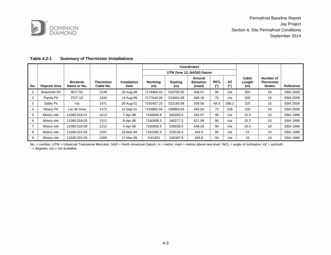
Table 4.2-1 Summary of Thermistor Installations
No. Deposit Area Borehole
Name or No. Thermistor Cable No.
Installation Date
Coordinates
Cable Length
(m)
Number of Thermistor
Nodes Reference
UTM Zone 12, NAD83 Datum
Northing (m)
Easting (m)
Ground Elevation
(masl) INCL
() AZ ()
1 Beartooth Pit BGT-52 2148 25-Aug-08 7178465.02 519705.00 468.07 90 n/a 350 16 EBA 2008
2 Panda Pit PGT-19 1344 14-Aug-99 7177640.06 519462.68 466.18 70 n/a 300 16 EBA 2008
3 Sable Pit n/a 1471 25-Aug-01 7192457.20 523190.68 509.56 69.3 288.2 325 16 EBA 2008
4 Misery Pit Lac de Gras 1472 12-Sep-01 7159665.58 539964.63 445.56 75 206 330 16 EBA 2008
5 Misery site 11580.018-01 1213 7-Apr-98 7160640.8 540283.5 432.07 90 n/a 15.4 10 EBA 1998
6 Misery site 11580.018-03 1211 8-Apr-98 7160408.3 540277.2 421.09 90 n/a 15.2 10 EBA 1998
7 Misery site 11580.018-08 1212 4-Apr-98 7160656.5 539036.5 448.28 90 n/a 15.4 10 EBA 1998
8 Misery site 11508.023-04 1291 16-Mar-99 7161592.5 539136.4 444.9 90 n/a 15 10 EBA 1999
9 Misery site 11508.023-09 1293 17-Mar-99 7161651 539397.6 445.6 90 n/a 15 10 EBA 1999
No. = number; UTM = Universal Transverse Mercator; NAD = North American Datum; m = metre; masl = metres above sea level; INCL = angle of inclination; AZ = azimuth; = degrees; n/a = not available.

-------------------
---------------
---
---------------
-------
----
----
--------
-
----
----------
---
-----------
---------------------------------------------------------------------
---------------
-----
----
--------------------------
-------
----
------------------------- -----------
---
-------
-----------------
-- ------------- ------------------------------------------------------------------------------------
------
--------- ---
--------------------
--------------
-------------
-------
----- ------
-------
--------------
------
-------
--------
------------
--------- -----
------
---- -------------
-------------
--- ----------------------------------------- ---------
---------------- --------------------------------------
-------------------
------
----
----------------
---------------------------
-------- -
--------------------------- -------- --------
-------
----------
------------------ ----
-----
----
---
--------
----------------------------------
--------
------
----
----
-----
------
-------------
-----------
----------
--------
-----------
--
----------
------
-------------------------------------- ---------
------
------
--
+UÐ+UÐ
+UÐ+UÐ+UÐ
+UÐ
+UÐ+UÐ
Lac duSauvage
Lac deGras
DuchessLake
PaulLake
Lake D3(CountsLake)
HammerLake
Lac deGras
Koala PitKoala Pit North
Panda Pit
Beartooth Pit
Pigeon Pipe
Fox Pit
EkatiMine
FoxOperation
Misery Pit
MiseryOperation
DiavikMine
JayKimberlite
Pipe
ExistingMisery
Road
1
2
46 57
8 9
512000
512000
520000
520000
528000
528000
536000
536000
544000
544000
552000
552000
7152
000
7152
000
7160
000
7160
000
7168
000
7168
000
7176
000
7176
000
7184
000
7184
000
REV 0DESIGN
LOCATIONS OF THERMISTORS13-1328-0041
SCALE AS SHOWN
PROJECT
TITLE
GIS
REVIEWCHECK
RK
EKATI MINE FOOTPRINTDIAVIK MINE FOOTPRINTKIMBERLITE PIPEWINTER ROADTIBBITT TO CONTWOYTO WINTER ROADNORTHERN PORTION OF TIBBITT TO CONTWOYTO WINTER ROADELEVATION CONTOUR (10 m INTERVAL)
-------- ESKERWATERCOURSEWATERBODY
+UÐ THERMISTOR LOCATION
03/04/14
³
JAY PROJECTNORTHWEST TERRITORIES, CANADA
PROJECT FILE No. B_JC_Permafrost_003_GIS
CANVEC © NATURAL RESOURCES CANADA, 2012NATURAL RESOURCES CANADA, CENTRE FOR TOPOGRAPHIC INFORMATION, 2012DATUM: NAD83 PROJECTION: UTM ZONE 12N
REFERENCE
LEGEND
KILOMETRESSCALE 1:150,000
MAP 4.2-1
3 30
G:\C
LIENT
S\DOM
INIO
N\DD
EC Ja
y and
Lynx
Proj
ects\
Figure
s\13-1
328-0
041 J
ay &
Lynx
EA\Pe
rmafr
ost\B
aseli
ne\B_
JC_P
ermafr
ost_0
03_G
IS.m
xd
ANK 16/09/14
PERMAFROST BASELINE REPORTDOCUMENT
CG 16/09/14SM 16/09/14
Permafrost Baseline Report
Jay Project
Section 4, Site Permafrost Conditions
September 2014
4-5
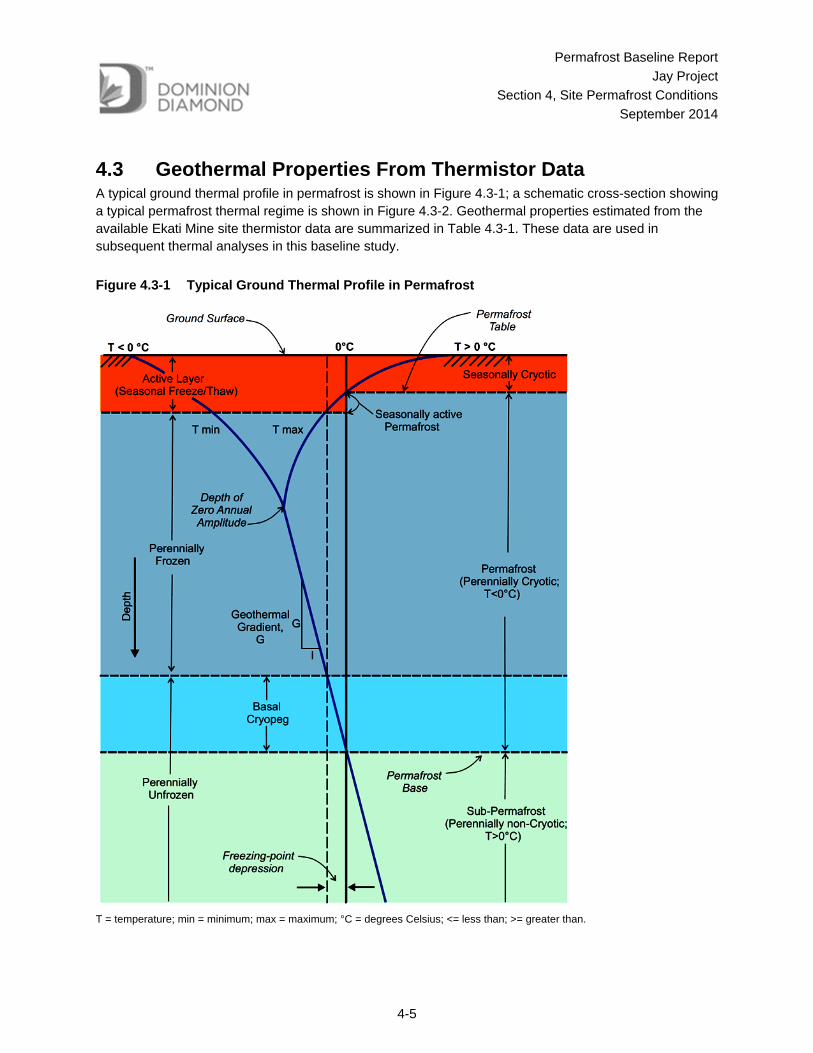
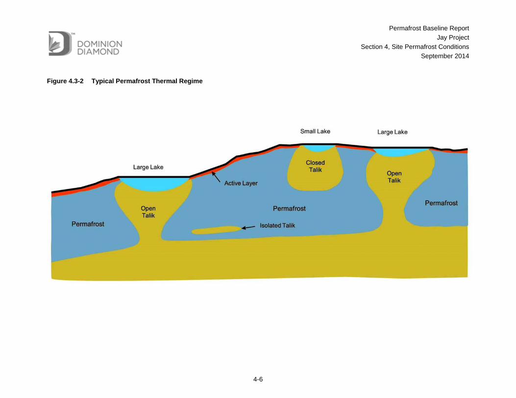
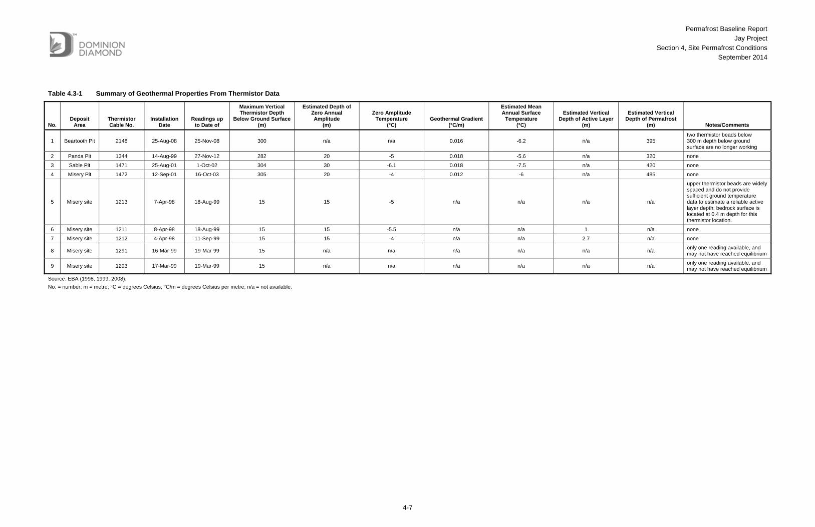
4.3 Geothermal Properties From Thermistor Data A typical ground thermal profile in permafrost is shown in Figure 4.3-1; a schematic cross-section showing a typical permafrost thermal regime is shown in Figure 4.3-2. Geothermal properties estimated from the available Ekati Mine site thermistor data are summarized in Table 4.3-1. These data are used in subsequent thermal analyses in this baseline study.
Figure 4.3-1 Typical Ground Thermal Profile in Permafrost
T = temperature; min = minimum; max = maximum; °C = degrees Celsius; <= less than; >= greater than.
Permafrost Baseline Report
Jay Project
Section 4, Site Permafrost Conditions
September 2014
4-6
Figure 4.3-2 Typical Permafrost Thermal Regime
Permafrost Baseline Report
Jay Project
Section 4, Site Permafrost Conditions
September 2014
4-7
Table 4.3-1 Summary of Geothermal Properties From Thermistor Data
No. Deposit
Area Thermistor Cable No.
Installation Date
Readings up to Date of
Maximum Vertical Thermistor Depth
Below Ground Surface (m)
Estimated Depth of Zero Annual Amplitude
(m)
Zero Amplitude Temperature
(°C) Geothermal Gradient
(°C/m)
Estimated Mean Annual Surface
Temperature (°C)
Estimated Vertical Depth of Active Layer
(m)
Estimated Vertical Depth of Permafrost
(m) Notes/Comments
1 Beartooth Pit 2148 25-Aug-08 25-Nov-08 300 n/a n/a 0.016 -6.2 n/a 395 two thermistor beads below 300 m depth below ground surface are no longer working
2 Panda Pit 1344 14-Aug-99 27-Nov-12 282 20 -5 0.018 -5.6 n/a 320 none
3 Sable Pit 1471 25-Aug-01 1-Oct-02 304 30 -6.1 0.018 -7.5 n/a 420 none
4 Misery Pit 1472 12-Sep-01 16-Oct-03 305 20 -4 0.012 -6 n/a 485 none
5 Misery site 1213 7-Apr-98 18-Aug-99 15 15 -5 n/a n/a n/a n/a
upper thermistor beads are widely spaced and do not provide sufficient ground temperature data to estimate a reliable active layer depth; bedrock surface is located at 0.4 m depth for this thermistor location.
6 Misery site 1211 8-Apr-98 18-Aug-99 15 15 -5.5 n/a n/a 1 n/a none
7 Misery site 1212 4-Apr-98 11-Sep-99 15 15 -4 n/a n/a 2.7 n/a none
8 Misery site 1291 16-Mar-99 19-Mar-99 15 n/a n/a n/a n/a n/a n/a only one reading available, and may not have reached equilibrium
9 Misery site 1293 17-Mar-99 19-Mar-99 15 n/a n/a n/a n/a n/a n/a only one reading available, and may not have reached equilibrium
Source: EBA (1998, 1999, 2008).
No. = number; m = metre; °C = degrees Celsius; °C/m = degrees Celsius per metre; n/a = not available.

Permafrost Baseline Report
Jay Project
Section 4, Site Permafrost Conditions
September 2014
4-8
4.4 Material Thermal Properties Natural ground materials at the Ekati Mine typically consist of glacial till and granite bedrock. The thermal properties for these materials were estimated by EBA (2008), and are summarized in Table 4.4-1.
Table 4.4-1 Material Thermal Properties
Material
Volumetric Water Content
(%)
Moisture Content
(%) Bulk Density
(kg/m3)
Thermal Conductivity (W/m-°C)
Volumetric Heat Capacity
(MJ/m3-°C)
Frozen Unfrozen Frozen Unfrozen
Glacial till 19.4 10 2,140 2.05 1.73 1.88 2.25
Granite bedrock 2.5 1 2,580 3.00 3.00 1.94 1.99
Source: EBA (2008).
% = percent; kg/m³ = kilograms per cubic metre; MJ/m³-°C = mega joules per cubic metre degree Celsius; W/m³ -°C = Watts per cubic metre degree Celsius.
4.5 Permafrost Conditions of Islands and Peninsulas Lac du Sauvage has many islands and peninsulas. Based on 2013 bathymetric data, seven islands are located around the Jay pipe have areas that range from approximately 12,500 square metres (m2) to 153,000 m2. The topography at these islands is expected to follow the regional pattern. The permafrost conditions beneath the islands and peninsulas are influenced by the surrounding Lac du Sauvage. Permafrost depths beneath the islands are expected to be less than the estimated maximum depths of 300 to 400 m. The actual depth of permafrost beneath the islands will depend to a degree on the size of the island. Larger islands will have deeper permafrost depths, and smaller islands will have shallower permafrost depths. Other factors that may affect the island permafrost conditions include local vegetation condition, local drainage conditions and water ponding, and unstable shore areas.
Preliminary thermal analysis modelling was carried out for the island located 300 m southeast of the Jay pipe as part of the planning for the winter 2014 drilling program. The island has the following conditions:
Lac du Sauvage surface elevation of 416.1 masl;
ground surface elevations of 416.1 to 418 masl;
a maximum width of approximately 382 m in the direction of southwest to northeast; and,
a maximum length of approximately 644 m in the direction of southeast to northwest.
Permafrost Baseline Report
Jay Project
Section 4, Site Permafrost Conditions
September 2014
4-9
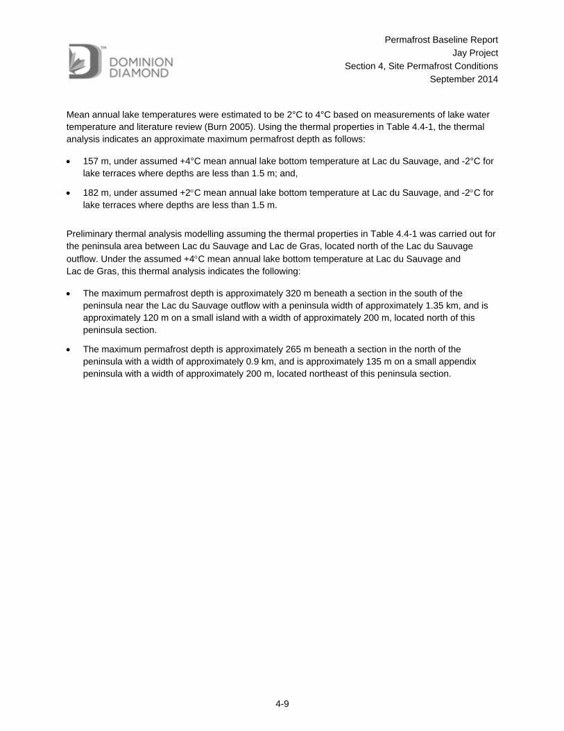
Mean annual lake temperatures were estimated to be 2°C to 4°C based on measurements of lake water temperature and literature review (Burn 2005). Using the thermal properties in Table 4.4-1, the thermal analysis indicates an approximate maximum permafrost depth as follows:
157 m, under assumed +4°C mean annual lake bottom temperature at Lac du Sauvage, and -2°C for lake terraces where depths are less than 1.5 m; and,
182 m, under assumed +2C mean annual lake bottom temperature at Lac du Sauvage, and -2C for lake terraces where depths are less than 1.5 m.
Preliminary thermal analysis modelling assuming the thermal properties in Table 4.4-1 was carried out for the peninsula area between Lac du Sauvage and Lac de Gras, located north of the Lac du Sauvage
outflow. Under the assumed +4C mean annual lake bottom temperature at Lac du Sauvage and Lac de Gras, this thermal analysis indicates the following:
The maximum permafrost depth is approximately 320 m beneath a section in the south of the peninsula near the Lac du Sauvage outflow with a peninsula width of approximately 1.35 km, and is approximately 120 m on a small island with a width of approximately 200 m, located north of this peninsula section.
The maximum permafrost depth is approximately 265 m beneath a section in the north of the peninsula with a width of approximately 0.9 km, and is approximately 135 m on a small appendix peninsula with a width of approximately 200 m, located northeast of this peninsula section.
Permafrost Baseline Report
Jay Project
Section 5, Lake Talik Formation
September 2014
5-1
5 LAKE TALIK FORMATION The land surface near the Project is underlain by continuous permafrost, with the exception of waterbodies in the area that are too deep to freeze to the bottom in the winter. Taliks (areas of unfrozen ground) are expected beneath a waterbody where the water depth is greater than the ice thickness. Formation of open taliks that penetrate through the permafrost may be expected for relatively deeper and larger lakes in the Project area. This section presents theoretical estimates of potential open talik formation below lakes in the Project area.
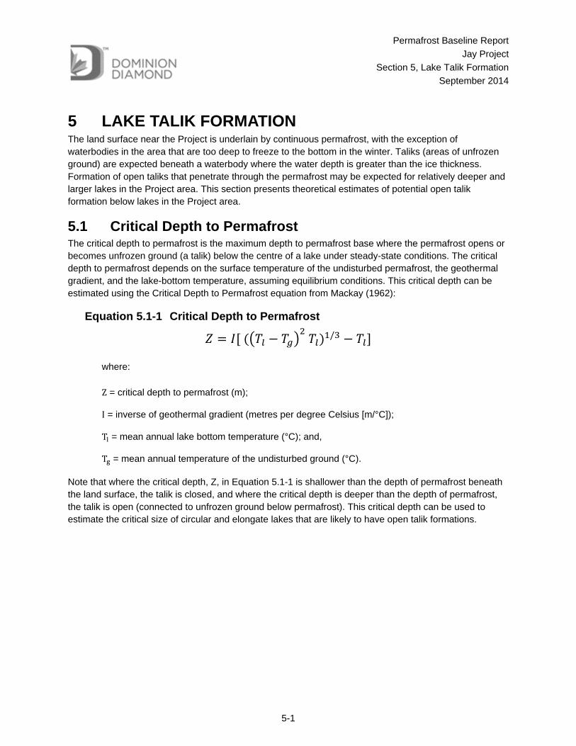
5.1 Critical Depth to Permafrost The critical depth to permafrost is the maximum depth to permafrost base where the permafrost opens or becomes unfrozen ground (a talik) below the centre of a lake under steady-state conditions. The critical depth to permafrost depends on the surface temperature of the undisturbed permafrost, the geothermal gradient, and the lake-bottom temperature, assuming equilibrium conditions. This critical depth can be estimated using the Critical Depth to Permafrost equation from Mackay (1962):
Equation 5.1-1 Critical Depth to Permafrost
/
where:
Z = critical depth to permafrost (m);
I = inverse of geothermal gradient (metres per degree Celsius [m/°C]);
T = mean annual lake bottom temperature (°C); and,
T = mean annual temperature of the undisturbed ground (°C).
Note that where the critical depth, Z, in Equation 5.1-1 is shallower than the depth of permafrost beneath the land surface, the talik is closed, and where the critical depth is deeper than the depth of permafrost, the talik is open (connected to unfrozen ground below permafrost). This critical depth can be used to estimate the critical size of circular and elongate lakes that are likely to have open talik formations.
Permafrost Baseline Report
Jay Project
Section 5, Lake Talik Formation
September 2014
5-2
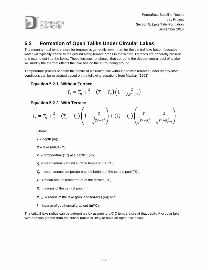
5.2 Formation of Open Taliks Under Circular Lakes The mean annual temperature for terraces is generally lower than for the central lake bottom because water will typically freeze to the ground along terrace areas in the winter. Terraces are generally present and extend out into the lakes. These terraces, or shoals, that surround the deeper central pool of a lake will modify the thermal effects the lake has on the surrounding ground.
Temperature profiles beneath the centre of a circular lake without and with terraces under steady-state conditions can be estimated based on the following equations from Mackay (1962):
Equation 5.2-1 Without Terrace
1√
Equation 5.2-2 With Terrace
1
where:
Z = depth (m);
= lake radius (m);
= temperature (°C) at a depth (m);
= mean annual ground surface temperature (°C);
= mean annual temperature at the bottom of the central pool (°C);
= mean annual temperature of the terrace (°C);
= radius of the central pool (m);
= radius of the lake (pool and terrace) (m); and,
= inverse of geothermal gradient (m/°C).
The critical lake radius can be determined by assuming a 0°C temperature at that depth. A circular lake with a radius greater than the critical radius is likely to have an open talik below.
Permafrost Baseline Report
Jay Project
Section 5, Lake Talik Formation
September 2014
5-3
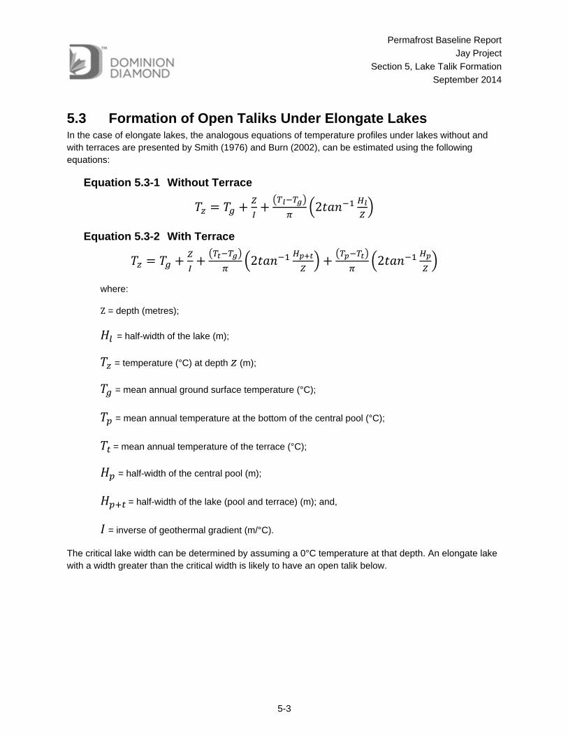
5.3 Formation of Open Taliks Under Elongate Lakes In the case of elongate lakes, the analogous equations of temperature profiles under lakes without and with terraces are presented by Smith (1976) and Burn (2002), can be estimated using the following equations:
Equation 5.3-1 Without Terrace
2
Equation 5.3-2 With Terrace
2 2
where:
Z = depth (metres);
= half-width of the lake (m);
= temperature (°C) at depth (m);
= mean annual ground surface temperature (°C);
= mean annual temperature at the bottom of the central pool (°C);
= mean annual temperature of the terrace (°C);
= half-width of the central pool (m);
= half-width of the lake (pool and terrace) (m); and,
= inverse of geothermal gradient (m/°C).
The critical lake width can be determined by assuming a 0°C temperature at that depth. An elongate lake with a width greater than the critical width is likely to have an open talik below.

Permafrost Baseline Report
Jay Project
Section 5, Lake Talik Formation
September 2014
5-4
5.4 Critical Lake Sizes for Open Talik Formation The critical radius and critical half width for lakes with and without terraces were calculated for lakes in the Project area surrounding Lac du Sauvage based on the above equations. The results from the calculations using the geothermal gradient and mean annual ground surface temperature obtained from the thermistor data are presented in Table 5.4-1. Mean annual lake temperatures were estimated to be 2°C to 4°C based on measurements of lake water temperature and literature review (Burn 2005). The mean annual ground surface temperature of -6°C was used based on the deep thermistor data of Misery Pit area (No.1472).
Table 5.4-1 Critical Radius and Critical Half Width for Lakes Without Terraces
Geothermal Gradient
Mean Annual Ground Surface
Temperature
Mean Annual Lake (or Central Pool)
Bottom Temperature
Critical Depth (Equation 5.1-1)
Circular Lake Critical Radius (Equation 5.2-1)
Elongate Lake Critical Half Width
(Equation 5.3-1)
1/I (°C/m)
Tg
(°C) Tl (or Tp)
(°C) Z
(m) Rl
(m) Hl
(m)
0.015 -6 4 225 206 99
0.015 -6 2 203 250 133
°C/m = degrees Celsius per metre; °C = degrees Celsius; m = metre.
Lakes in the Project area generally have terraces that have lower mean annual temperatures than the central pool, which would result in larger critical radius or half width. Assuming terraces with 20% of total lake widths or diameters, and a mean annual temperature of -2C, the critical lake radius and half width are calculated as shown in Table 5.4-2.
Table 5.4-2 Ranges of Critical Radius and Critical Half Width for Lakes With Terraces
Geothermal Gradient
Mean Annual Ground Surface
Temperature
Mean Annual Lake (or
Central Pool) Bottom
Temperature
Mean Annual Terrace
Temperature
Calculated Critical Depth
(Equation 5.1-1)
Calculated Circular Lake
Critical Radius (Equation 5.2-2)
Calculated Elongate Lake
Critical Half Width
(Equation 5.3-2)
With 20% Diameter Terrace
With Water Depth below
1.5 m
With 20% Total Width Terrace Water Depth below 1.5 m
1/I (°C/m)
Tg
(°C) Tl (or Tp)
(°C) Tt
(°C) Z
(m) Rl
(m) Hl
(m)
0.015 -6 4 -2 225 219 105
0.015 -6 2 -2 203 263 140
% = percent; °C/m = degrees Celsius per metre; °C = degrees Celsius; m = metre.
Permafrost Baseline Report
Jay Project
Section 5, Lake Talik Formation
September 2014
5-5
The analytical solutions provide typical guidelines for quickly determining potential open-talik formation beneath lakes in the Project area. Based on the calculation, it is expected that an open talik will exist beneath Lac du Sauvage given the lake’s large size and elongate shape (approximately 3 km width).
5.5 Groundwater Salinity and Freezing Point Depression The deep groundwater in the Project area is expected to be saline (Hydrogeology Baseline Report, Annex IX), which will result in freezing point depression so that the depth of frozen permafrost (depth to the basal cryopeg) is less than the depth of perennially cryotic ground (ground at a temperature less than 0°C).
The presence of saline groundwater will have the effect of depressing the freezing point of pore water within the rock. Because of this effect, groundwater may exist in a non-frozen state within the permafrost at temperatures less than 0C. From a practical perspective, if saline groundwater is present, groundwater inflows to an excavation may be encountered sooner than predicted based on the ground temperature profile.
Klohn Crippen (2006) and Rescan (2006) report that groundwater samples collected at the Ekati underground mines (Panda Pit and Koala Underground), where mining has been carried out beneath permafrost, are generally calcium-sodium-chloride (Ca-Na-Cl) types with total dissolved solids (TDS) typically exceeding 10,000 milligrams per litre (mg/L) and ranging up to 20,000 mg/L. This result is consistent with the relatively high chloride concentration in Panda and Koala groundwater samples (Table 5.5-2). Based on the TDS data from Panda and Koala underground mines and other available data, freezing point depression is calculated to be between -1.4˚C and -2˚C at 300 m and 400 m depth, respectively. Considering an average -2°C freezing point depression, the thickness of the basal cryopeg zone is estimated to be 135 m based on the assumed 0.015 degrees Celsius per metre (C/m) geothermal gradient.
For the Project, a Westbay multi-level monitoring well system was installed in April 2014 in a borehole drilled from an island located to the southeast of the Jay pipe. Groundwater samples were collected from three intervals in the Westbay multi-level monitoring well system between approximately 320 m and 440 m depth below ground surface. These samples had TDS concentrations ranging from approximately 1,670 mg/L to 2,390 mg/L, much lower than those observed at the Ekati Panda and Koala pits. Based on these groundwater sampling results, the TDS in the Lac du Sauvage area is generally expected to be lower than in the areas of the Panda and Koala mine areas, and freezing point depression may be less beneath the shores of Lac du Sauvage. Therefore, the estimate of freezing point depression discussed above is considered to be conservatively high for the Project area.
Permafrost Baseline Report
Jay Project
Section 6, Projected Climate Change
September 2014
6-1
6 PROJECTED CLIMATE CHANGE The projected climate change effect on air temperatures for the Ekati Mine was evaluated by EBA (2006) based on the Intergovernmental Panel on Climate Change (IPCC) special report, Emissions Scenarios (IPCC 2000). EBA Engineering Consultants Ltd. (EBA) considered a projected long-term air temperature increase for the Ekati Mine of 4.85°C over 100 years (EBA 2006).
The IPCC (2013) presents projected changes in global mean surface air temperatures for near and long terms under four different scenarios. The IPCC (2013) maximum projected increase in air temperature is 4.8°C from 2005 to 2100, which gives approximately 5°C over 100 years.
The effect of climate change on temperature for the Diavik Mine site was studied by Pham et al. (2012); an average increase in air temperature of 5.6°C over 100 years is projected based on available climate data between 1970 to 2007 from Diavik and other adjacent mine sites, and projections under an IPCC (2007) climate change scenario.
The Project should consider a projected long-term air temperature increase for the Ekati Mine of 5.6°C over 100 years in thermal analysis modelling.

Permafrost Baseline Report
Jay Project
Section 7, Summary
September 2014
7-1
7 SUMMARY The Project is located in the zone of continuous permafrost. The mean annual air temperature at the Project site is approximately -9.6°C. Based on available thermistor data and interpretation, the permafrost conditions are summarized as follows:
The depth of permafrost beneath the land mass at the Project site is estimated to be approximately 320 to 485 m based on thermistor installations.
The depth of permafrost beneath a small island to the southeast of the Jay pipe is estimated to be approximately 157 to 182 m based on preliminary thermal modelling.
The depth of the active layer from thermistors in the Misery Pit area ranges from approximately 1.0 to 2.7 m.
The extrapolated mean annual surface temperature estimated from thermistor data is between -5.6°C and -7.5°C.
The estimated depth of zero annual amplitude from the temperature profiles ranges from 15 to 30 m.
The temperatures at the depths of zero annual amplitude are in the range of -4.0°C to -6.1°C.
The geothermal gradient is in a range of 0.012°C/m to 0.018°C/m, which gives an average of 0.015°C/m.
The base of the permafrost is expected to be an irregular surface, so the actual depth to permafrost will be variable. In the local context of the Project area, the land surface is underlain by continuous permafrost, except under waterbodies too deep to freeze to the bottom during winter.
Lac du Sauvage had a surface level of elevation 416.1 masl in the summer of 2013. The bathymetric survey indicates the deepest area of Lac du Sauvage is located around the Jay pipe with the lake bottom at elevation 381 masl, which is 36 m below the lake surface.
In the summer, lake water temperatures in deep water are typically similar to or slightly cooler than temperatures in shallow water. Lac du Sauvage had an average temperature range of 12°C to 12.8°C in July to September 2006 at a measured depth up to 17.1 m (approximately half the depth of the lake). In the winter under ice, Lac du Savage water temperatures are typically warmer in deeper water than in shallower water; at a maximum measured depth of approximately 17 m, the average temperature was approximately 2.2°C from February to May 2006 (Rescan 2007).
Taliks (areas of unfrozen ground) may develop where lake depths are greater than ice thicknesses. Formation of open taliks that penetrate through the permafrost may develop beneath relatively deeper and larger lakes in the Project area.

Permafrost Baseline Report
Jay Project
Section 7, Summary
September 2014
7-2
Critical lake sizes for open-talik formation were estimated for the Ekati Mine area using the analytical solutions based on a mean annual ground temperature of -6°C, assumed 4°C and 2°C mean annual lake bottom temperatures, and -2°C mean annual terrace temperatures, which gives the following findings:
Taliks extending through the permafrost will exist beneath circular lakes having a minimum radius of 206 to 250 m, and beneath elongate lakes having a minimum half width of 99 to 133 m, without considering lake terrace geometries.
When terrace effects are included in the analyses, the critical radius for a circular lake increases to between 219 and 263 m, and the critical half width for an elongate lake increases to between 105 and 140 m, assuming that the terrace is 20% the total lake width or diameter.
Based on the open-talik formation calculation, an open talik would be expected beneath Lac du Sauvage due to its relatively large size.
Permafrost is expected to exist under the islands and peninsulas in Lac du Sauvage, with the depths being a function of the sizes of the islands and peninsulas. Preliminary thermal analyses indicate that the island southeast of the Jay pipe may have permafrost depths of 157 to 182 m, and the peninsula area north of Lac du Sauvage outflow may have permafrost depths of 265 to 320 m.
The deep groundwater in the Project area is expected to be saline, which will result in freezing point depression so that the depth of frozen permafrost (depth to the basal cryopeg) is less than the depth of perennially cryotic ground (ground at a temperature less than 0°C). The TDS of groundwater samples from the Panda and Koala underground mines are typically high, and freezing point depression is estimated to be between -1.4˚C and -2˚C at 300 m and 400 m depth, respectively.
The thicknesses of the basal cryopeg under -1°C and -2°C freezing point depression scenarios are estimated and the depths to the basal cryopeg are estimated accordingly by subtracting from the permafrost depth for the Ekati Mine, as shown below:
The thickness of the basal cryopeg is estimated to be 70 m for a -1°C freezing point depression, which would result in the estimated depth to the basal cryopeg of between 250 and 415 m below ground surface.
The thickness of the basal cryopeg is estimated to be 135 m for a -2°C freezing point depression, which would result in the estimated depth to the basal cryopeg of between 185 and 350 m below ground surface.
For the Project, groundwater samples were collected from a Westbay monitoring well system installed in April 2014, and had TDS concentrations ranging from approximately 1,670 mg/L to 2,390 mg/L, much lower than those observed at the Ekati Panda and Koala pits. Therefore, the TDS in the Lac du Sauvage area may be less beneath the shores of Lac du Sauvage. The estimate of freezing point depression discussed above is thus considered to be conservatively high for the Project area.

Permafrost Baseline Report
Jay Project
Section 8, References
September 2014
8-1
8 REFERENCES Aurora (Aurora Geosciences Ltd.). 2013. Technical Report, Lac du Sauvage - Northwest Territories,
Canada. Submitted to Dominion Diamond Corporation, October 25, 2013.
Burn CR. 2002. Tundra lakes and permafrost, Richards Island, western Arctic coast, Canada. Can J Earth Sci, 39: 1281-1298.
Burn CR. 2005. Lake-bottom thermal regimes, western Arctic coast, Canada. Permafrost Periglac 16: 355–367.
Dominion Diamond (Dominion Diamond Ekati Corporation). 2013. NI43-101 Technical Report. Prepared by Heimersson H, Carlson J, dated May 24, 2013.
EBA (EBA Engineering Consultants Ltd.). 1998. NWT Diamonds Project 1998 Geotechnical Site Investigation Misery Site Development and Panda/Koala Waste Rock Stockpile. Submitted to BHP Billiton Diamonds Inc. June 1998.
EBA. 1999. Misery Lake Site Development 1999 Geotechnical Site Investigation. Submitted to BHP Billiton Diamonds Inc. July 1999.
EBA. 2006. Thermal Evaluation of Waste Rock Piles, Ekati Diamond Mine, NWT, Canada. Submitted to BHP Billiton Diamonds Inc. September 2006.
EBA. 2008. Thermal Evaluation of Flooding Beartooth Pit, Ekati Diamond Mine, NWT, Canada. Submitted for review to BHP Billiton Diamonds Inc. November 2008.
Golder (Golder Associates Ltd.). 2008. Report on 2007 Review of Baseline Climate and Surface Water Hydrology for the Diavik Diamond Mine. Doc RPT-602, Ver. 0. November 25, 2008.
Golder. 2014. Lac du Sauvage Northwest Territories, Canada, Stage 1 Conceptual Engineering Report on Jay-Cardinal Project, Ekati Mine. Submitted to Dominion Diamond Resources Corporation. Reference No. 1313280031-014-R-Rev0-4090. January 20, 2014.
Harris SA, French HM, Heginbottom JA, Johnston GH, Ladanyi B, Sego DC, van Everdingen RO. 1988. Glossary of Permafrost and Related Ground-Ice Terms. Permafrost Subcommittee, Associate Committee on Geotechnical Research, National Research Council of Canada, Technical Memorandum No. 142.
IPCC (Intergovernmental Panel on Climate Change). 2000. Emissions Scenarios. A special report of Working Group III of the Intergovernmental Panel on Climate Change. Cambridge University Press, Cambridge, England.
IPCC. 2007. Climate Change 2007: Working Group I: The Physical Science Basis. Intergovernmental Panel on Climate Change (IPCC). Fourth Assessment Report.
IPCC. 2013. Climate Change 2013: The Physical Science Basis, Working Group I Contribution to the IPCC Fifth Assessment Report of the Intergovernmental Panel on Climate Change. Cambridge University Press.
Permafrost Baseline Report
Jay Project
Section 8, References
September 2014
8-2
Klohn Crippen. 2006. Ekati Mine 2005 Koala Feasibility Report Underground Mine Dewatering Final Report. File: A03040A02.500.
Lenormand F, Duguay CR, Gauthier R. 2002. Canadian Ice Database. Laboratoire de teledetection et de modelisation des environnements froids. Centre d’études nonordiques et Departement de géographie, Université Laval, Cite universitaire, Sainte-Foy, Québec.
Mackay JR. 1962. Pingos of the pleistocene Mackenzie Delta area. Geo Bulletin, 18: 21-63.
Natural Resources Canada. 1995. Canada Permafrost. The National Atlas of Canada 5th Edition.
Pham N, Sego DC, Blowes DW, Smith L, Amos RT. 2012. Heat Transport and the Effects of Climate Change in a Large-scale Waste Rock Pile Located in a Continuous Permafrost Region at Diavik Diamond Mine. Proceedings of the 9th International Conference on Acid Rock Drainage (ICRAD), Ottawa, ON, Canada, May 2012.
Rescan (Rescan Environmental Services Ltd.). 2006. Ekati Diamond Mine Underground Water Quality Assessment. January 2006. Project 770-1. Prepared for BHP Billiton Diamonds Inc.
Rescan. 2007. Ekati Diamond Mine 2006 Jay Pipe Aquatic Baseline. Prepared for BHP Billiton Diamonds Inc., August 2007.
Smith MW. 1976. Permafrost in the Mackenzie Delta, Northwest Territories. Geological Survey of Canada Paper, 75-28.

Permafrost Baseline Report
Jay Project
Section 9, Glossary
September 2014
9-1
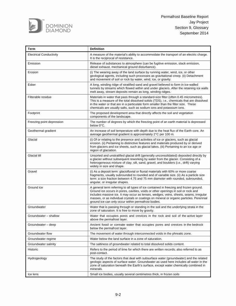
9 GLOSSARY Term Definition
Active layer The active layer is the layer of ground subject to annual freezing and thawing in areas underlain by permafrost.
Basal cryopeg The layer of perennially cryotic (temperature less than 0°C) ground with liquid saline or pressurized pore water that forms the base of permafrost. The thickness of this layer is related to the salinity of the groundwater regime, which can result in depression of the freezing point up to several degrees below zero.
Basin A large area that is lower in elevation than surrounding areas and contains water. Basins are separated by land or shallow channels.
Bathymetry Measurement of the depth of an ocean or waterbody.
Bedrock The solid rock (harder than 3 on Moh's scale of hardness) underlying soils and the regolith in depths ranging from zero (where exposed to erosion) to several hundred metres.
Biotite A mineral of the mica group K(Mg, Fe+4)3(Al, Fe+3)Si3O10(OH)2. It is black in a hand specimen, brown or green in a thin section, and has perfect basal (001) cleavage.
Boulder A large rounded mass of rock lying on the surface of the ground or embedded in the soil, typically greater than 0.3 m particle size.
Canadian Shield A large area of exposed Precambrian igneous and high-grade metamorphic rocks (geological shield) that forms the ancient geological core of the North American continent (North American or Laurentia craton), covered by a thin layer of soil.
Clay (i) As a particle size term: a size fraction less than 0.005 millimetre (mm) equivalent diameter, or some other limit (geology or engineering). (ii) As a rock term: a natural, earthy, fine grained material that develops plasticity with a small amount of water. (iii) As a soil term: a textural class. See also texture, soil. (iv) As a soil separate: a material usually consisting largely of clay minerals but commonly also of amorphous free oxides (sesquioxides) and primary minerals.
Clay mineral Finely crystalline hydrous aluminum silicates and hydrous magnesium silicates with a phyllosilicate structure.
Climate Weather averaged over a long period of time.
Closed talik A talik occupying a depression in the permafrost table below a lake or river (also called "lake talik" and "river talik"); its temperature remains above 0°C because of the heat storage effect of the surface water.
Continuous permafrost Permafrost occurring everywhere beneath the exposed land surface throughout a geographic region with the exception of widely scattered sites, such as newly deposited unconsolidated sediments, where the climate has just begun to impose its influence on the thermal regime of the ground, causing the development of continuous permafrost.
Cryotic ground Soil or rock at temperatures of 0°C or lower. Cryotic and noncryotic refer solely to the temperature of the material described, independent of its water or ice content.
Depth of Zero Annual Amplitude The depth of zero annual amplitude is the depth below ground surface at which there is no variability in ground temperature due to the influence of surface air temperature. It is the depth at which the minimum monthly mean temperature and maximum monthly mean temperatures are equivalent.
Diavik Diamond Mine (Diavik Mine) A diamond mine located on East Island in Lac de Gras, approximately 30 km southeast of the Ekati main camp and 10 km southwest of the Misery Pit.
Drainage The removal of excess surface water or groundwater from land by natural runoff and percolation, or by means of surface or subsurface drains.
Dyke A tabular body of igneous rock that cuts across the bedding or foliation of the rock it intrudes.
Ekati Mine Ekati Diamond Mine, Canada’s first diamond mine.
Permafrost Baseline Report
Jay Project
Section 9, Glossary
September 2014
9-2
Term Definition
Electrical Conductivity A measure of the material's ability to accommodate the transport of an electric charge. It is the reciprocal of resistance.
Emission Release of substances to atmosphere (can be fugitive emission, stack emission, diesel exhaust, mechanical ground disturbance).
Erosion (i) The wearing away of the land surface by running water, wind, ice, or other geological agents, including such processes as gravitational creep. (ii) Detachment and movement of soil or rock by water, wind, ice, or gravity.
Esker A long, winding ridge of stratified sand and gravel believed to form in ice-walled tunnels by streams which flowed within and under glaciers. After the retaining ice walls melt away, stream deposits remain as long, winding ridges.
Filterable residue Materials in water that pass through a standard-size filter (often 0.45 micrometres). This is a measure of the total dissolved solids (TDS), i.e., chemicals that are dissolved in the water or that are in a particulate form smaller than the filter size. These chemicals are usually salts, such as sodium ions and potassium ions.
Footprint The proposed development area that directly affects the soil and vegetation components of the landscape.
Freezing point depression The number of degrees by which the freezing point of an earth material is depressed below 0°C.
Geothermal gradient An increase of soil temperature with depth due to the heat flux of the Earth core. An average geothermal gradient is approximately 2°C per 100 m.
Glacial (i) Of or relating to the presence and activities of ice or glaciers, such as glacial erosion. (ii) Pertaining to distinctive features and materials produced by or derived from glaciers and ice sheets, such as glacial lakes. (iii) Pertaining to an ice age or region of glaciation.
Glacial till Unsorted and unstratified glacial drift (generally unconsolidated) deposited directly by a glacier without subsequent reworking by water from the glacier. Consisting of a heterogeneous mixture of clay, silt, sand, gravel, and boulders (i.e., drift) varying widely in size and shape.
Gravel (i) As a deposit term: glaciofluvial or fluvial materials with 60% or more coarse fragments, usually subrounded to rounded and of variable size. (ii) As a particle size term: a size fraction between 4.75 and 75 mm diameter with rounded, subrounded, angular, or irregular shapes.
Ground ice A general term referring to all types of ice contained in freezing and frozen ground. Ground ice occurs in pores, cavities, voids or other openings in soil or rock and includes massive ice. It may occur as lenses, wedges, veins, sheets, seams, irregular masses, or as individual crystals or coatings on mineral or organic particles. Perennial ground ice can only occur within permafrost bodies.
Groundwater Water that is passing through or standing in the soil and the underlying strata in the zone of saturation. It is free to move by gravity.
Groundwater – shallow Water that occupies pores and crevices in the rock and soil of the active layer above the permafrost layer.
Groundwater – deep Ancient fossil or connate water that occupies pores and crevices in the bedrock below the permafrost layer.
Groundwater flow The movement of water through interconnected voids in the phreatic zone.
Groundwater regime Water below the land surface in a zone of saturation.
Groundwater salinity The saltiness of groundwater related to total dissolved solids content.
Historic Refers to the period of time for which there are written records; also referred to as post-contact.
Hydrogeology The study of the factors that deal with subsurface water (groundwater) and the related geologic aspects of surface water. Groundwater as used here includes all water in the zone of saturation beneath the Earth’s surface, except water chemically combined in minerals.
Ice lens Small ice bodies, usually several centimetres thick, in frozen soils

Permafrost Baseline Report
Jay Project
Section 9, Glossary
September 2014
9-3
Term Definition
Ice wedge A large, usually wedge-shaped mass of foliated ground ice produced in permafrost, occurring as a vertical or inclined sheet, dike or vein, tapering downward, and generally measuring from a few millimetres to several meters wide and sometimes reaching 30 m depth. It originates by the freezing of water in narrow cracks or fissures produced by thermal contraction of the permafrost.
Isolated talik A talik entirely surrounded by perennially frozen ground
Kimberlite Igneous rocks that originate deep in the Earth’s mantle and intrude the Earth’s crust. These rocks typically form narrow pipe-like deposits that sometimes contain diamonds.
Kimberlite pipe A more or less vertical, cylindrical body of kimberlite that resulted from the forcing of the kimberlite material to the Earth‘s surface. Typically vertical structures of volcanic rock in the Earth’s crust that can contain diamonds.
Mafic A term to describe minerals that contain in iron and magnesium.
Mean annual ground temperature The mean annual ground temperature is the temperature at the ground surface and can be measured or estimated based on a projection upward of the geothermal gradient to intersect the ground surface.
Moisture content Geotechnical moisture content defined as a ratio of weight of pore water to weight of rock/soil solids.
Moraine A mound, ridge, or other distinct accumulation of unsorted, unstratified drift, predominantly till, deposited chiefly by direct action of glacier ice in a variety of topographic landforms that are independent of control by the surface on which the drift lies. It is now commonly used as a geomorphologic name for a landform composed mainly of till that has been deposited by a glacier.
Open-pit mine A mine where rock or mineral extraction from the Earth is done using a pit or borrow open to the surface, rather than using a tunnel into the Earth.
Open talik A talik that penetrates the permafrost completely, connecting a waterbody above permafrost to the sub-permafrost aquifer (e.g., below large rivers and lakes).
Organic matter, soil The organic fraction of the soil; included are plant and animal residues at various stages of decomposition, cells and tissues of soil organisms, and substances synthesized by the soil population. It is estimated by multiplying the soil organic carbon content by 1.724.
Outcrop That part of a geologic formation or structure that appears at the surface of the Earth.
Overburden Materials of any nature, consolidated or unconsolidated, that overlie a deposit of useful materials. In the present situation, overburden refers to the soil and rock strata that overlie kimberlite deposits.
Palsa A peaty permafrost mound possessing a core of alternating layers of segregated ice and peat or mineral soil material. Palsas are typically between 1 and 7 m in height and a few metres to 100 m in diameter.
Particle size The effective diameter (grain size) of a particle measured by sedimentation, sieving, or micrometric methods.
Particle size distribution The amounts of the various soil separates in a soil sample, usually expressed as percentage of sand, silt, and clay.
Permafrost Ground (soil or rock and included ice and organic material) that remains at or below 0°C for at least two consecutive years. Permafrost is defined on the basis of temperature. It is not necessarily frozen, because the freezing point of the included water may be depressed several degrees below 0°C; moisture in the form of water or ice may or may not be present.
Permafrost base The permafrost base is the lower boundary of permafrost, and is an undulating and uneven surface. The ground temperature above the permafrost base is less than 0°C and below the permafrost base is above 0°C. The depth of the permafrost base varies with latitude, elevation, and with proximity to large bodies of water. The depth of the permafrost base also depends on the thermal history of an area.
Permafrost conditions A general term, summarizing permafrost parameters within given area.
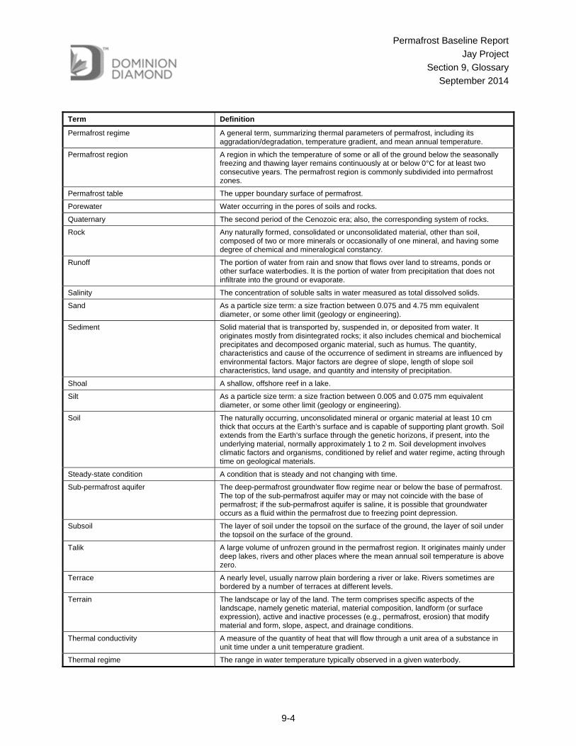
Permafrost Baseline Report
Jay Project
Section 9, Glossary
September 2014
9-4
Term Definition
Permafrost regime A general term, summarizing thermal parameters of permafrost, including its aggradation/degradation, temperature gradient, and mean annual temperature.
Permafrost region A region in which the temperature of some or all of the ground below the seasonally freezing and thawing layer remains continuously at or below 0°C for at least two consecutive years. The permafrost region is commonly subdivided into permafrost zones.
Permafrost table The upper boundary surface of permafrost.
Porewater Water occurring in the pores of soils and rocks.
Quaternary The second period of the Cenozoic era; also, the corresponding system of rocks.
Rock Any naturally formed, consolidated or unconsolidated material, other than soil, composed of two or more minerals or occasionally of one mineral, and having some degree of chemical and mineralogical constancy.
Runoff The portion of water from rain and snow that flows over land to streams, ponds or other surface waterbodies. It is the portion of water from precipitation that does not infiltrate into the ground or evaporate.
Salinity The concentration of soluble salts in water measured as total dissolved solids.
Sand As a particle size term: a size fraction between 0.075 and 4.75 mm equivalent diameter, or some other limit (geology or engineering).
Sediment Solid material that is transported by, suspended in, or deposited from water. It originates mostly from disintegrated rocks; it also includes chemical and biochemical precipitates and decomposed organic material, such as humus. The quantity, characteristics and cause of the occurrence of sediment in streams are influenced by environmental factors. Major factors are degree of slope, length of slope soil characteristics, land usage, and quantity and intensity of precipitation.
Shoal A shallow, offshore reef in a lake.
Silt As a particle size term: a size fraction between 0.005 and 0.075 mm equivalent diameter, or some other limit (geology or engineering).
Soil The naturally occurring, unconsolidated mineral or organic material at least 10 cm thick that occurs at the Earth’s surface and is capable of supporting plant growth. Soil extends from the Earth’s surface through the genetic horizons, if present, into the underlying material, normally approximately 1 to 2 m. Soil development involves climatic factors and organisms, conditioned by relief and water regime, acting through time on geological materials.
Steady-state condition A condition that is steady and not changing with time.
Sub-permafrost aquifer The deep-permafrost groundwater flow regime near or below the base of permafrost. The top of the sub-permafrost aquifer may or may not coincide with the base of permafrost; if the sub-permafrost aquifer is saline, it is possible that groundwater occurs as a fluid within the permafrost due to freezing point depression.
Subsoil The layer of soil under the topsoil on the surface of the ground, the layer of soil under the topsoil on the surface of the ground.
Talik A large volume of unfrozen ground in the permafrost region. It originates mainly under deep lakes, rivers and other places where the mean annual soil temperature is above zero.
Terrace A nearly level, usually narrow plain bordering a river or lake. Rivers sometimes are bordered by a number of terraces at different levels.
Terrain The landscape or lay of the land. The term comprises specific aspects of the landscape, namely genetic material, material composition, landform (or surface expression), active and inactive processes (e.g., permafrost, erosion) that modify material and form, slope, aspect, and drainage conditions.
Thermal conductivity A measure of the quantity of heat that will flow through a unit area of a substance in unit time under a unit temperature gradient.
Thermal regime The range in water temperature typically observed in a given waterbody.

Permafrost Baseline Report
Jay Project
Section 9, Glossary
September 2014
9-5
Term Definition
Thermistor A device whose electrical resistance, or ability to conduct electricity, is controlled by temperature. Used to measure temperature in soil, bedrock, or various media.
Till An unsorted glacial sediment. Glacial drift is a general term for the coarsely graded and extremely heterogeneous sediments of glacial origin. Glacial till is that part of glacial drift which was deposited directly by the glacier. It may vary from clays to mixtures of clay, sand, gravel, and boulders.
Topography The physical features of a district or region, such as those represented on a map, taken collectively; especially the relief and contours of the land. On most soil maps topography may also mean topography classes that describe slopes according to standard ranges of percent gradient.
Total dissolved solids The total concentration of all dissolved compounds solids found in a water sample. See filterable residue.
Treeline An area of transition between the tundra and boreal forest to the south.
UTM Universal Transverse Mercator coordinate system: a grid based method of specifying locations, employing a series of sixty zones each based on a specifically defined secant Transverse Mercator projection.
Veneer Unconsolidated materials too thin to mask the minor irregularities of the underlying unit surface. A veneer ranges from 10 cm to 1 m in thickness and possesses no form typical of the materials’ genesis.
Volumetric heat capacity The amount of heat required to raise the temperature of a unit volume of a substance by one degree. It is equal to the heat capacity multiplied by the density.
Volumetric water content Ratio of volume of water in the voids to volume of the voids in soil or rock.
Waste rock Rock moved and discarded in order to access resources.
Waterbody An area of water such as a river, stream, lake or sea.
Watercourse Riverine systems such as creeks, brooks, streams and rivers.
Watershed The area drained by a river or stream; see also drainage basin.
Winter road Roads which are built over frozen lakes and tundra. Compacted snow and/or ice is used for embankment construction.
Zero annual amplitude temperature The temperature at the depth of zero annual amplitude, where the minimum monthly temperature and the maximum monthly temperatures are practically equivalent.