Embed Size (px)
Citation preview
Climate Change, Permafrost, andImpacts on Civil Infrastructure
U.S. Arctic Research Commission
Permafrost Task Force Report
December 2003Special Report 01-03
Executive Summary
Permafrost, or perenially frozen ground, is a critical component of the cryosphere and the Arcticsystem. Permafrost regions occupy approximately 24% of the terrestrial surface of the Northern Hemi-sphere; further, the distribution of subsea permafrost in the Arctic Ocean is not well known, but newoccurrences continue to be found. The effects of climatic warming on permafrost and the seasonallythawed layer above it (the active layer) can severely disrupt ecosystems and human infrastructure suchas roads, bridges, buildings, utilities, pipelines, and airstrips. The susceptibility of engineering works tothaw-induced damage is particularly relevant to communities and structures throughout northern Alaska,Russia, and Canada. It is clear from the long-term paleographic record in these areas that climatic warm-ing can lead to increases in permafrost temperature, thickening of the active layer, and a reduction in thepercentage of the terrestrial surface underlain by near-surface permafrost. Such changes can lead toextensive settlement of the ground surface, with attendant damage to infrastructure.
To advance U.S. and international permafrost research, the U.S. Arctic Research Commission in 2002chartered a task force on climate change, permafrost, and infrastructure impacts. The task force wasasked to identify key issues and research needs to foster a greater understanding of global change impactson permafrost in the Arctic and their linkages to natural and human systems. Permafrost was found toplay three key roles in the context of climatic changes: as a record keeper (temperature archive); as atranslator of climatic change (subsidence and related impacts); and as a facilitator of climatic change(impact on the global carbon cycle). The potential for melting of ice-rich permafrost constitutes a signif-icant environmental hazard in high-latitude regions. The task force found evidence of widespread warm-ing of permafrost and observations of thawing —both conditions have serious, long-term implications forAlaska’s transportation network, for the Trans-Alaska Pipeline, and for the nearly 100,000 Alaskan cit-zens living in areas of permafrost. Climate research and scenarios for the 21st century also indicate thatmajor settlements (such as Nome, Barrow, Inuvik, and Yakutsk) are located in regions of moderate orhigh hazard potential for thawing permafrost. A renewed and robust research effort and a well-informed,coordinated response to impacts of changing permafrost are the responsibilities of a host of U.S. federaland state organizations. Well-planned, international polar research, such as the International Polar Year, isurgently needed to address the key scientific questions of changing permafrost and its impacts on thecarbon cycle and overall global environment.
Key task force recommendations include: review by funding agencies of their interdisciplinary Arcticprograms to ensure that permafrost research is integrated in program planning and execution; develop-ment of a long-term permafrost research program by the U.S. Geological Survey; enhanced funding forpermafrost research at the U.S. Army Corps of Engineers Cold Regions Research and EngineeringLaboratory; adoption of the Global Hierarchical Observing Strategy in all permafrost monitoring pro-grams; development of a high-resolution permafrost map of Alaska, including the offshore; developmentof new satellite sensors optimized for monitoring the state of the surface, temperature, moisture, and groundice; full incorporation of permafrost hydrology, hydrogeology, and geomorphology in new Arctic researchprograms of the U.S. National Science Foundation; incorporation of permafrost research in all U.S. andinternational programs devoted to the global carbon cycle; enhanced and long-term funding for the U.S.Frozen Ground Data Center; and substantially increased federal funding for contaminants research in coldregions, including studies on the impacts of regional warming, predictive modeling, and mitigation techniques.
The task force report makes specific recommendations to eight U.S. federal agencies, the State ofAlaska, and the U.S. National Research Council. Many of the recommendations will be incorporated infuture Arctic research planning documents of the Commission, including its biennial Report on Goalsand Objectives. The task force report will also be presented to the U.S. Interagency Arctic ResearchPolicy Committee and to appropriate international bodies, including the International Arctic Science Com-mittee and the Arctic Council.
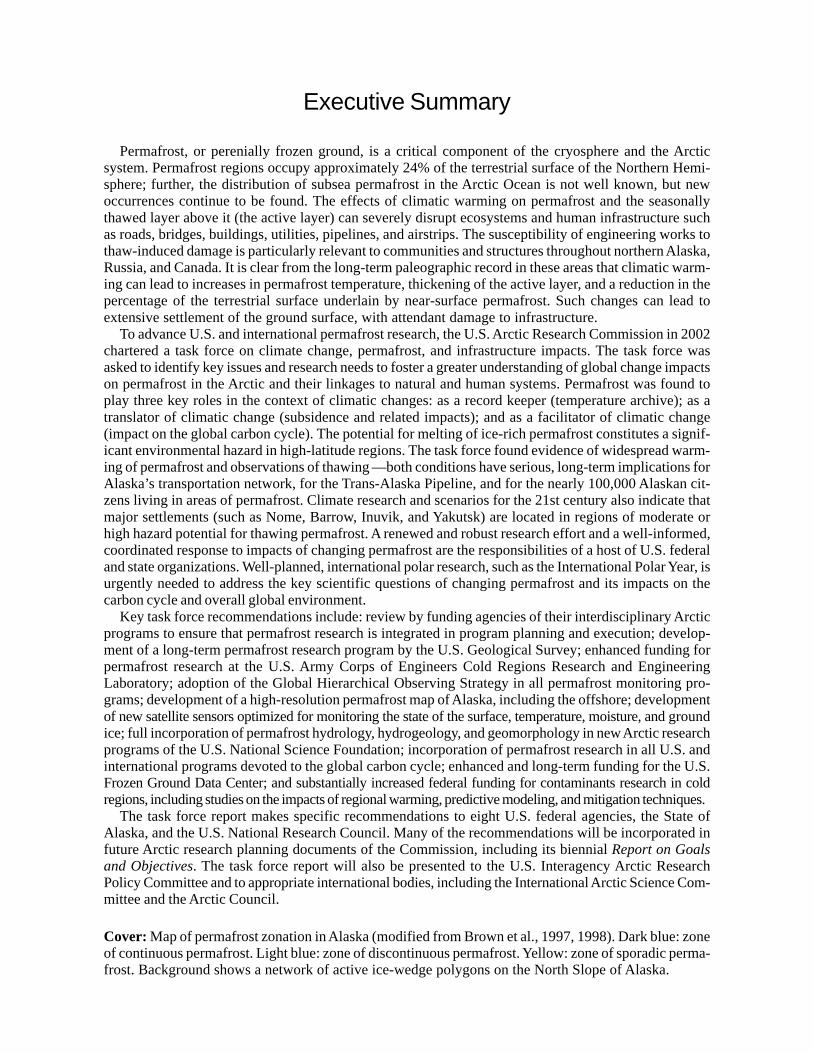
Cover: Map of permafrost zonation in Alaska (modified from Brown et al., 1997, 1998). Dark blue: zoneof continuous permafrost. Light blue: zone of discontinuous permafrost. Yellow: zone of sporadic perma-frost. Background shows a network of active ice-wedge polygons on the North Slope of Alaska.
Climate Change, Permafrost, andImpacts on Civil Infrastructure
U.S. Arctic Research Commission
Permafrost Task Force Report
December 2003
Permafrost Task Force Members
Dr. Kenneth M. HinkelProfessor of GeographyUniversity of Cincinnati
Dr. Frederick E. NelsonProfessor of GeographyUniversity of Delaware
Walter ParkerFormer Commissioner, U.S. Arctic
Research CommissionParker Associates, Anchorage
Dr. Vladimir RomanovskyAssociate ProfessorGeophysical InstituteUniversity of Alaska Fairbanks
Dr. Orson SmithProfessor of EngineeringUniversity of Alaska Anchorage
Walter TuckerGeophysicist, U.S. Army Cold Regions
Research and Engineering Laboratory
Dr. Ted VinsonProfessor of Geotechnical EngineeringOregon State University
Dr. Lawson W. BrighamDeputy Executive DirectorU.S. Arctic Research Commission

ii
REFERENCE CITATION
U.S. Arctic Research Commission Permafrost Task Force (2003) Climate Change, Permafrost, andImpacts on Civil Infrastructure. Special Report 01-03, U.S. Arctic Research Commission, Arlington, Virginia.
Acknowledgments
Lead Authors and Editors
Dr. David M. ColeU.S. Army Cold Regions Research
and Engineering Laboratory
Anna E. KleneUniversity of Montana
Dr. Frederick E. NelsonUniversity of Delaware
Dr. Lawson W. BrighamU.S. Arctic Research Commission
Contributing Authors
Dr. Kenneth M. HinkelUniversity of Cincinnati
Walter ParkerParker Associates, Anchorage
Dr. Vladimir E. RomanovskyGeophysical InstituteUniversity of Alaska Fairbanks
Dr. Nikolay I. ShiklomanovUniversity of Delaware
Dr. Orson SmithUniversity of Alaska Anchorage
Walter TuckerU.S. Army Cold Regions Research
and Engineering Laboratory
Dr. Ted VinsonOregon State University
Contributors
William LeeUniversity of Alaska Anchorage
Amanda SaxtonU.S. Arctic Research Commission
iii
iv
MESSAGE FROM THE CHAIR
This report on Climate Change, Permafrost, and Effects on Civil Infrastructure isthe result of the outstanding efforts of a team of experts serving as Special Advisors to theArctic Research Commission. The Commissioners authorized this report in order to bringthe Nation’s attention to the connections between climate change research and thechanges to civil infrastructure in northern regions that will come about as permafrostchanges.
The Commission believes strongly that basic research has important connections to theway our citizens live and work. The study of climate change is an interesting discipline,but it is important to carry the results and predictions of these changes through to theireffects on roads, bridges, buildings, ports, pipelines, and other infrastructure. This reportsuggests future research programs for the federal agencies, programs that theCommission will incorporate into our recommendations to the Interagency ArcticResearch Policy Committee in our biennial Report on Goals and Objectives for ArcticResearch.
The Commission is grateful for the effort and enthusiasm of the Task Force on ClimateChange, Permafrost, and Civil Infrastructure and commends their efforts. Without thisvoluntary effort by the community of researchers, the Commission would be unable tohelp the residents of the North to cope with the changing and occasionally extremeenvironment in which they live.
Climate Change, Permafrost, andImpacts on Civil Infrastructure
Contents
Executive Summary .......................................................................................... inside front cover
Permafrost Task Force Members ............................................................................................... i
Acknowledgments ..................................................................................................................... iii
Chapter 1: Permafrost and Its Role in the Arctic ....................................................................... 1
Chapter 2: Future Climate Change and Current Research Initiatives ...................................... 13
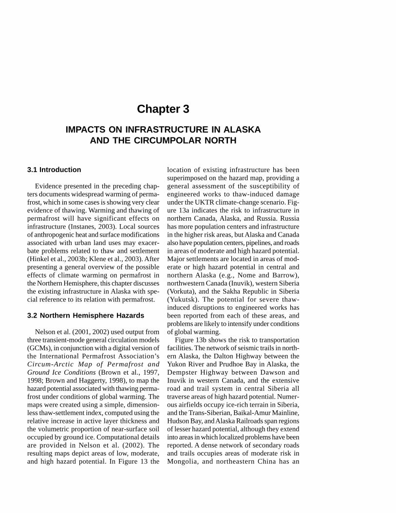
Chapter 3: Impacts on Infrastructure in Alaska and the Circumpolar North ........................... 25
Chapter 4: Findings and Agency Recommendations ................................................................ 35
References ................................................................................................................................ 44
Glossary .................................................................................................................................... 57
List of Acronyms ...................................................................................................................... 61
v

vi
1.1 Introduction
Climate-change scenarios indicate that human-caused, or anthropogenic, warming will bemost pronounced in the high latitudes. Empiri-cal evidence strongly indicates that impactsrelated to climate warming are well underwayin the polar regions (Hansen et al., 1998; Mori-son et al., 2000; Serreze et al., 2000; Smith etal., 2002). These involve air temperature (Pav-lov, 1997; Moritz et al., 2002), vegetation(Myneni et al., 1997; Sturm et al., 2001), seaice (Bjorgo et al. 1997), the cumulative massbalance of small glaciers (Dyurgerov and Meier,1997; Serreze et al., 2000; Arendt et al., 2002),ice sheets and shelves (Vaughan et al., 2001;British Antarctic Survey, 2002; Rignot andThomas, 2002), and ground temperature(Lachenbruch and Marshall, 1986; Majorowiczand Skinner, 1997).
Many of the potential environmental andsocioeconomic impacts of global warming in thehigh northern latitudes are associated withpermafrost, or perennially frozen ground. Theeffects of climatic warming on permafrost andthe seasonally thawed layer above it (the activelayer) can severely disrupt ecosystems andhuman infrastructure and intensify global warm-ing (Brown and Andrews, 1982; Nelson et al.,1993; Fitzharris et al., 1996; Jorgenson et al.,2001). Until recently, however, permafrost hasreceived far less attention in scientific reviewsand media publications than other cryosphericphenomena affected by global change (Nelsonet al., 2002).
Throughout most of its history, permafrostscience in western countries was idiosyncratic,performed by individuals or small groups of
Chapter 1PERMAFROST AND ITS ROLE IN THE ARCTIC
researchers, and not well integrated with otherbranches of cold regions research. Owing tothe importance of permafrost for developmentover much of its territory, the situation in theformer Soviet Union was distinctly different, witha large institute in Siberia and departments inthe larger and more prestigious universitiesdevoted exclusively to permafrost research.
Several factors converged in the late 1980sand early 1990s to integrate permafrost researchinto the larger spheres of international, systems,and global-change science:
• Easing of Cold-War tensions facilitatedinteractions between Soviet and westernscientists. Conferences held in Leningrad(Kotlyakov and Sokolov, 1990), Yamburg,Siberia (Tsibulsky, 1990), and Fairbanks(Weller and Wilson, 1990) during the late1980s and early 1990s were instrumentalin achieving international agreements.
• Publicity about the impacts of climatewarming in the polar regions followed sev-eral decades of unprecedented resourcedevelopment in the Arctic and raised con-cerns about the stability of the associatedinfrastructure (Vinson and Hayley, 1990).
• The global nature of climate change madeapparent the need for widespread cooper-ation, both within the permafrost researchcommunity and between permafrostresearchers and those engaged in otherbranches of science (Tegart et al., 1990).
• Permafrost scientists became increasinglyaware of the benefits accruing from thedevelopment of data archives and freeexchange of information (Barry, 1988; Barryand Brennan, 1993). Moreover, the increas-ingly integrated nature of arctic science
demands widespread cooperation and col-laboration. Some funding agencies, such asthe U.S. National Science Foundation, nowrequire, as a condition of funding, that databe made accessible to all interested par-ties.
U.S. scientists have made major contribu-tions to the study of frozen ground (geocryol-ogy), particularly since World War II. UsefulEnglish-language reviews, many with empha-sis on Alaska, have been provided by Muller(1947), Black (1950), Terzaghi (1952), Stearns(1966), Ives (1974), Washburn (1980), Anders-
land and Ladanyi (1994), Davis (2001), andHallet et al. (2004). Péwé (1983a) reviewedthe distribution of permafrost in the cordilleraof the western U.S.; Walegur and Nelson (2003)discussed its occurrence in the northern Appa-lachians. Péwé (1983c) outlined the distribu-tion of permafrost and associated landforms inthe U.S. during the last continental glaciation.
Permafrost science employs a complex andoccasionally confusing lexicon derived fromseveral languages and scientific disciplines. Abrief Glossary and a List of Acronyms at theend of this document provide assistance for nav-
2 Climate Change, Permafrost, and Impacts on Infrastructure
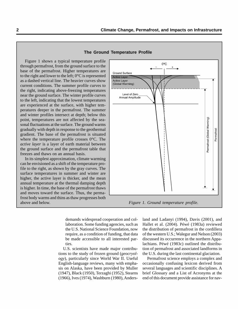
Figure 1. Ground temperature profile.
Figure 1 shows a typical temperature profilethrough permafrost, from the ground surface to thebase of the permafrost. Higher temperatures areto the right and lower to the left; 0°C is representedas a dashed vertical line. The heavier curves showcurrent conditions. The summer profile curves tothe right, indicating above-freezing temperaturesnear the ground surface. The winter profile curvesto the left, indicating that the lowest temperaturesare experienced at the surface, with higher tem-peratures deeper in the permafrost. The summerand winter profiles intersect at depth; below thispoint, temperatures are not affected by the sea-sonal fluctuations at the surface. The ground warmsgradually with depth in response to the geothermalgradient. The base of the permafrost is situatedwhere the temperature profile crosses 0°C. Theactive layer is a layer of earth material betweenthe ground surface and the permafrost table thatfreezes and thaws on an annual basis.
In its simplest approximation, climate warmingcan be envisioned as a shift of the temperature pro-file to the right, as shown by the gray curves. Thesurface temperatures in summer and winter arehigher, the active layer is thicker, and the meanannual temperature at the thermal damping depthis higher. In time, the base of the permafrost thawsand moves toward the surface. Thus, the perma-frost body warms and thins as thaw progresses bothabove and below.
The Ground Temperature Profile
Chapter 1. Permafrost and its Role in the Arctic 3
igating unfamiliar terminology. A more compre-hensive glossary, published under the auspicesof the International Permafrost Association(IPA), is readily available (van Everdingen,1998).
1.2 Background and Concepts
1.2.1 Thermal RegimeTwo classes of frozen ground are generally
distinguished: seasonally frozen ground, whichfreezes and thaws on an annual basis, andperennially frozen ground (permafrost),defined as any subsurface material that remainsat or below 0ºC continuously for at least twoconsecutive years. The term permafrost isapplied without regard to material composition,phase of water substance, or cementation.Permafrost can be extensive in areas wherethe mean annual temperature at the ground sur-face is below freezing. Because the tempera-ture at the surface and the temperature in theair often differ substantially (Klene et al., 2001),and because of differences in the thermal con-ductivity of many soils in the frozen and unfro-zen states (the thermal offset), permafrost canexist for extended periods at locations with meanannual air temperatures above 0ºC (Goodrich,1982). Climate statistics do not, therefore, pro-vide a reliable guide to the details of permafrostdistribution. Although ultimately a climaticallydetermined phenomenon, the presence orabsence of permafrost is strongly influenced bylocal factors, including microclimatic variations,circulation of ground water, the type of vegeta-tion cover, and the thermal properties of sub-surface materials.
The range of temperatures experiencedannually at the ground surface in typical perma-frost terrain decreases with depth, down to alevel at which only minute annual temperaturevariation occurs, termed the damping depth orlevel of zero annual amplitude. The activelayer above permafrost often experiences com-plex heat-transfer processes (Hinkel et al., 1997;Kane et al., 2001). Below the permafrosttable—the upper limit of material that experi-ences a maximum annual temperature of 0ºC—heat transfer occurs largely by conduction. In
situations where, unlike Figure 1, the bottom ofthe active layer is not in direct contact with thetop of the permafrost, the permafrost is a relicof a past colder interval and may be substan-tially out of equilibrium with the contemporaryclimate.
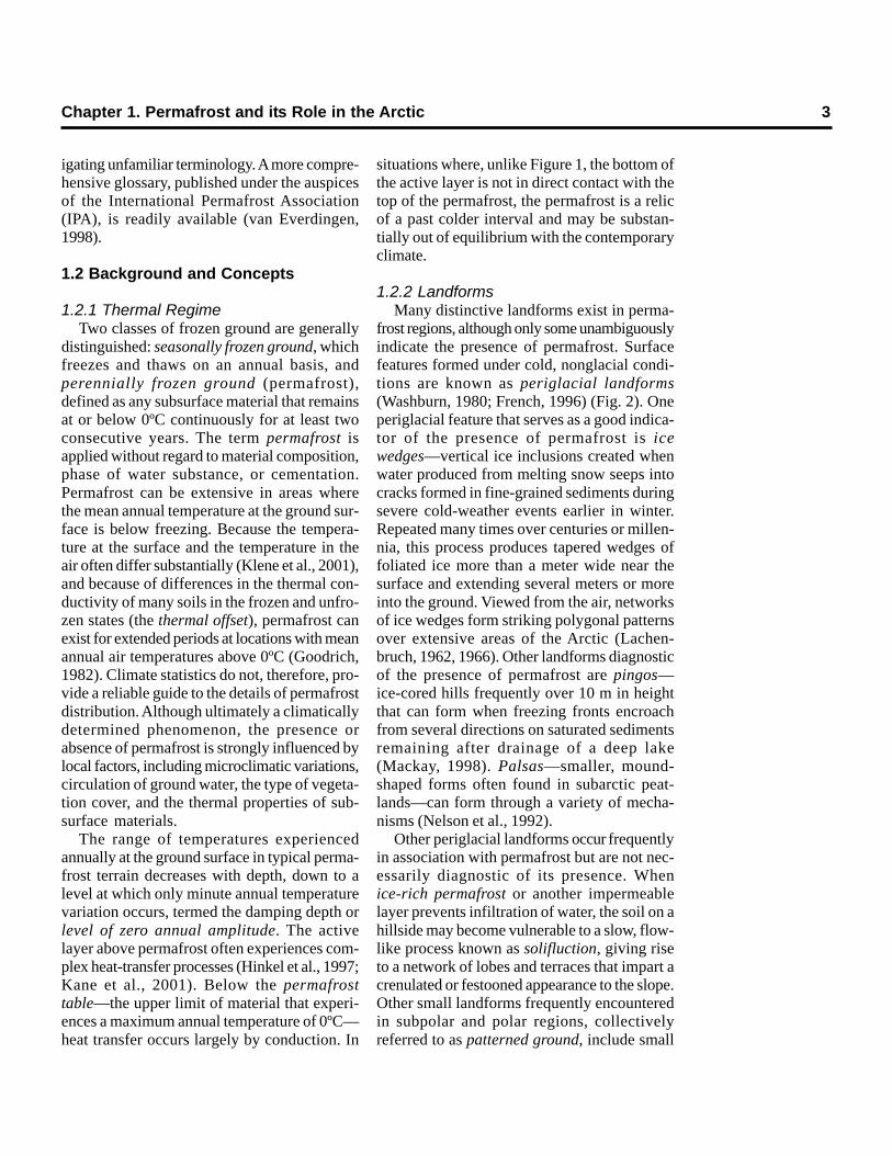
1.2.2 LandformsMany distinctive landforms exist in perma-
frost regions, although only some unambiguouslyindicate the presence of permafrost. Surfacefeatures formed under cold, nonglacial condi-tions are known as periglacial landforms(Washburn, 1980; French, 1996) (Fig. 2). Oneperiglacial feature that serves as a good indica-tor of the presence of permafrost is icewedges—vertical ice inclusions created whenwater produced from melting snow seeps intocracks formed in fine-grained sediments duringsevere cold-weather events earlier in winter.Repeated many times over centuries or millen-nia, this process produces tapered wedges offoliated ice more than a meter wide near thesurface and extending several meters or moreinto the ground. Viewed from the air, networksof ice wedges form striking polygonal patternsover extensive areas of the Arctic (Lachen-bruch, 1962, 1966). Other landforms diagnosticof the presence of permafrost are pingos—ice-cored hills frequently over 10 m in heightthat can form when freezing fronts encroachfrom several directions on saturated sedimentsremaining after drainage of a deep lake(Mackay, 1998). Palsas—smaller, mound-shaped forms often found in subarctic peat-lands—can form through a variety of mecha-nisms (Nelson et al., 1992).
Other periglacial landforms occur frequentlyin association with permafrost but are not nec-essarily diagnostic of its presence. Whenice-rich permafrost or another impermeablelayer prevents infiltration of water, the soil on ahillside may become vulnerable to a slow, flow-like process known as solifluction, giving riseto a network of lobes and terraces that impart acrenulated or festooned appearance to the slope.Other small landforms frequently encounteredin subpolar and polar regions, collectivelyreferred to as patterned ground, include small
4 Climate Change, Permafrost, and Impacts on Civil Infrastructure
a. Large pingo near Prudhoe Bay, Alaska. b. Palsa at MacMillan Pass, near the Yukon–NWT border.
c. Detachment slide in the Brooks Range foothills.
Figure 2. Periglacial landforms often associated with permafrost.
d. Large-diameter sorted patterned ground, CathedralMassif, northwestern British Columbia.
Chapter 1. Permafrost and its Role in the Arctic 5
hummocks and networks of striking geometricforms arranged into circles, polygons, or stripesof alternating coarse- and fine-grained sediment.
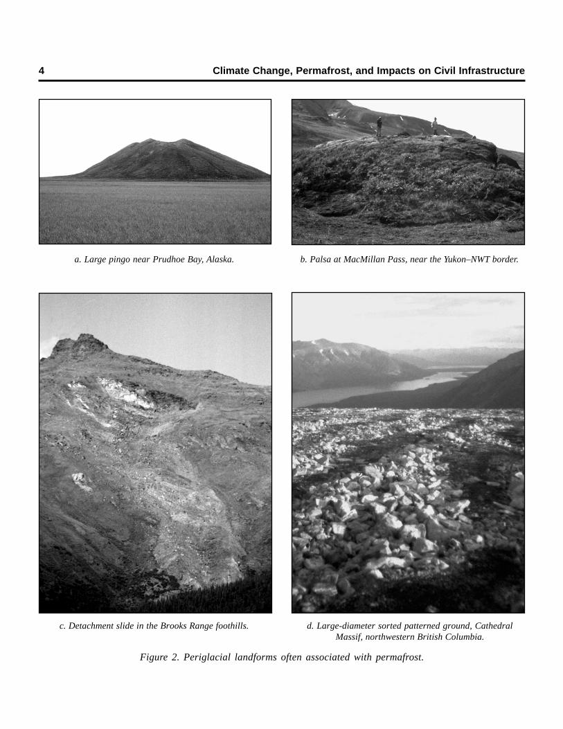
1.2.3 Permafrost DistributionThe permafrost regions occupy approxi-
mately 24% of the terrestrial surface of theNorthern Hemisphere (Brown et al., 1997;Zhang et al., 1999, 2003). Substantial areas of
subsea permafrost also occur around the landmargins of the Arctic Ocean, much of it icerich (Brown et al., 1997; Danilov et al., 1998).The distribution of offshore permafrost is notwell known, and new occurrences are foundfrequently. As shown in Figure 3, the distribu-tion of permafrost is often classified on the basisof its lateral continuity. In the Northern Hemi-sphere the various classes form a series of
Figure 3. Permafrost zonation in the Northern Hemisphere. Zones are defined on the basis of percentage of land surface underlainby permafrost: continuous zone, 90–100%; discontinuous zone, 50–90%; sporadic zone, 10–50%; isolated patches, 0–10%. The1997 map on which this figure is based is the first detailed document to show permafrost distribution in the Northern Hemispherebased on standardized mapping criteria. [After Nelson et al. (2002) adapted from Brown et al. (1997, 1998).]
6 Climate Change, Permafrost, and Impacts on Civil Infrastructure
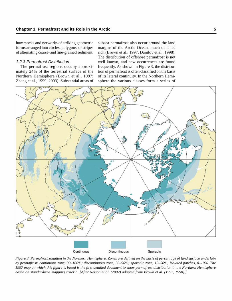
concentric zones that conform crudely to theparallels of latitude (Fig. 4). Southward devia-tions in the extent of permafrost in Siberia andcentral Canada are a response to lower meanannual temperatures in the continental interiors.
In the zone of continuous permafrost,perennially frozen ground underlies most loca-tions, the primary exception being under largebodies of water that do not freeze to the bottomannually. In the discontinuous zone, perma-frost may be widespread, but a substantial pro-portion of the land surface can be underlain byseasonally frozen ground, owing to variations insuch local factors as vegetation cover, snowdepth, and the physical properties of subsur-face materials. Some authors also refer to azone in which permafrost is sporadic, occur-ring as isolated patches that reflect combina-tions of local factors favorable to its formationand maintenance. Because the thermal proper-ties of peat are conducive to the existence offrozen ground, subarctic bogs are the primarylocations of permafrost in southerly parts of thesubarctic lowlands (Zoltai, 1971; Beilman andRobinson, 2003). In the Southern Hemisphere,permafrost occurs in ice-free areas of the Ant-arctic continent and in some of the subantarcticislands (Bockheim, 1995). Permafrost is alsoextensive in such midlatitude mountain ranges
as the Rockies, Andes, Alps, and Himalayas, aresponse to progressively lower mean annualtemperatures at higher elevations. Given suffi-cient altitude and favorable local conditions,patches of permafrost can exist even in the sub-tropics, such as in the crater of Mauna Kea(4140 m above sea level) on the island of Hawaii(Woodcock, 1974).
The thickness of permafrost is determinedby the mean annual temperature at the groundsurface, the thermal properties of the substrate,and the amount of heat flowing from the earth’sinterior. Permafrost thicknesses range from verythin layers only a few centimeters thick to about1500 m in unglaciated areas of Siberia (Wash-burn, 1980). In general, the thickness of lowlandpermafrost increases steadily with increasinglatitude.
1.2.4 Ground Ice and ThermokarstAlthough the presence of ice is not a criterion
in the definition of permafrost, ground ice isresponsible for many of the distinctive featuresand problems in permafrost regions. Ice canoccur within permafrost as small individualcrystals within soil pores, as lenses of nearlypure ice parallel to the ground surface, and asvariously shaped intrusive masses formed whenwater is injected into soil or rock and subse-
Figure 4. Latitudinalprofile through the per-mafrost zones in Alaska,extending from thevicinity of Chikaloon inthe Interior to PrudhoeBay near the ArcticOcean. Near the south-ern boundary, where theaverage annual temper-ature is around 0°C, iso-lated permafrost bodiesmay exist sporadicallyat depth. As the meanannual temperaturedecreases with increas-ing latitude, discontin-uous permafrost bodiesbecome larger andthicker, existing wherelocal conditions arefavorable, for example,on north-facing slopes.At average annual tem-peratures around –5°C,permafrost in Alaska isessentially continuous,and in northern Alaskait extends to depths ofover 400 m, althoughlocal unfrozen zones(taliks) may existbeneath large rivers andlakes. The active layercan be quite thick in thesporadic permafrostzone, and it decreases inthickness with latitude,although local factorscan make it highly vari-able (Nelson et al.,1999). Near the coast ofthe Arctic Ocean theactive layer reaches amaximum mean thick-ness of only about 60 cmin mid- to late August.
Chapter 1. Permafrost and its Role in the Arctic 7
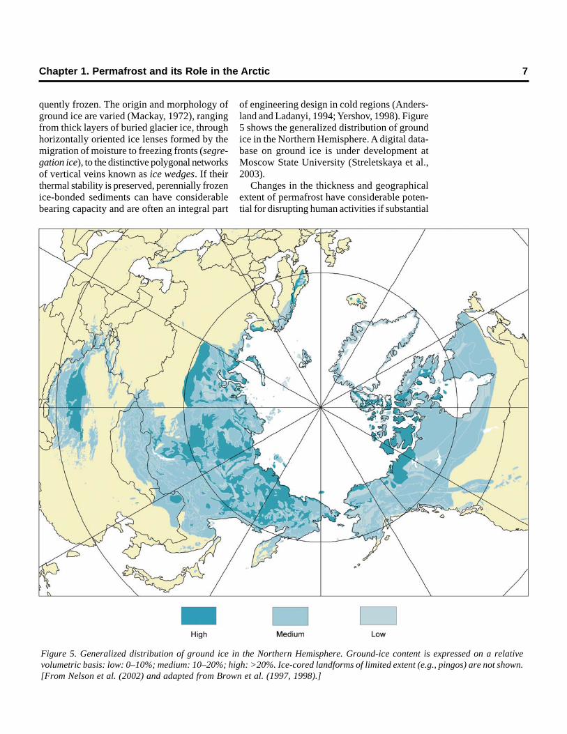
Figure 5. Generalized distribution of ground ice in the Northern Hemisphere. Ground-ice content is expressed on a relativevolumetric basis: low: 0–10%; medium: 10–20%; high: >20%. Ice-cored landforms of limited extent (e.g., pingos) are not shown.[From Nelson et al. (2002) and adapted from Brown et al. (1997, 1998).]
quently frozen. The origin and morphology ofground ice are varied (Mackay, 1972), rangingfrom thick layers of buried glacier ice, throughhorizontally oriented ice lenses formed by themigration of moisture to freezing fronts (segre-gation ice), to the distinctive polygonal networksof vertical veins known as ice wedges. If theirthermal stability is preserved, perennially frozenice-bonded sediments can have considerablebearing capacity and are often an integral part
of engineering design in cold regions (Anders-land and Ladanyi, 1994; Yershov, 1998). Figure5 shows the generalized distribution of groundice in the Northern Hemisphere. A digital data-base on ground ice is under development atMoscow State University (Streletskaya et al.,2003).
Changes in the thickness and geographicalextent of permafrost have considerable poten-tial for disrupting human activities if substantial
8 Climate Change, Permafrost, and Impacts on Civil Infrastructure
amounts of ground ice are present. Becausethe volume is reduced when ice melts andbecause pore water is squeezed out during con-solidation, thawing of ice-rich sediments leadsto subsidence of the overlying ground surface,often resulting in deformation of an initially levelsurface into irregular terrain with substantiallocal relief. By analogy with terrain developedby chemical dissolution of bedrock in areasunderlain extensively by limestone, the irregularsurface created by thawing of ice-rich perma-frost is known as thermokarst terrain.Thermokarst subsidence occurs when theenergy balance at the earth’s surface is modi-fied such that heat flux to subsurface layersincreases. The process occurs over a widespectrum of geographical scale, ranging fromhighly localized disturbances associated with theinfluence of individual structures to depressionstens of meters deep and occupying many squarekilometers (Washburn, 1980, p. 274).
On slopes, particularly in mountainous regions,thawing of ice-rich, near-surface permafrostlayers can create mechanical discontinuities inthe substrate, leading to active-layer detach-ment slides (Figure 8b) and retrogressive thawslumps (Lewkowicz, 1992; French, 1996),which have a capacity for damage to structuressimilar to other types of rapid mass movements.Thermokarst subsidence is amplified whereflowing water, often occurring in linear depres-sions, produces thermal erosion (Figure 8e;Mackay, 1970). Similarly, wave action in areascontaining ice-rich permafrost can produceextremely high rates of coastal and shorelineerosion (Walker, 1991; Wolfe et al., 1998).
Anthropogenic disturbances in permafrostterrain have been responsible for strikingchanges over relatively short time scales.Removal or disturbance of the vegetation coverfor agricultural purposes (Péwé, 1954), con-struction of roads and winter vehicle trails (Clar-idge and Mirza, 1981; Nelson and Outcalt, 1982;Slaughter et al., 1990), and airfields (French,1975) have resulted in subsidence severeenough to disrupt or prevent the uses for whichland was developed. A controlled experimentat the Permafrost National Test Site near Fair-banks, Alaska, caused the permafrost table to
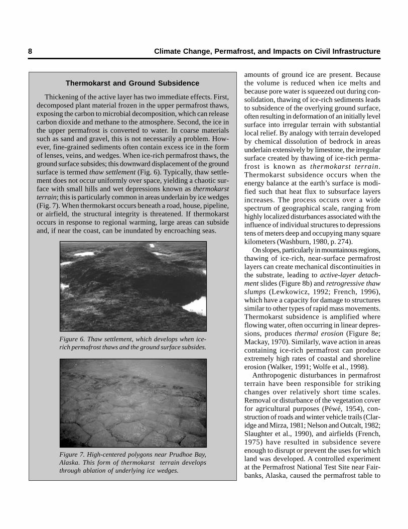
Thickening of the active layer has two immediate effects. First,decomposed plant material frozen in the upper permafrost thaws,exposing the carbon to microbial decomposition, which can releasecarbon dioxide and methane to the atmosphere. Second, the ice inthe upper permafrost is converted to water. In coarse materialssuch as sand and gravel, this is not necessarily a problem. How-ever, fine-grained sediments often contain excess ice in the formof lenses, veins, and wedges. When ice-rich permafrost thaws, theground surface subsides; this downward displacement of the groundsurface is termed thaw settlement (Fig. 6). Typically, thaw settle-ment does not occur uniformly over space, yielding a chaotic sur-face with small hills and wet depressions known as thermokarstterrain; this is particularly common in areas underlain by ice wedges(Fig. 7). When thermokarst occurs beneath a road, house, pipeline,or airfield, the structural integrity is threatened. If thermokarstoccurs in response to regional warming, large areas can subsideand, if near the coast, can be inundated by encroaching seas.
Thermokarst and Ground Subsidence
Figure 6. Thaw settlement, which develops when ice-rich permafrost thaws and the ground surface subsides.
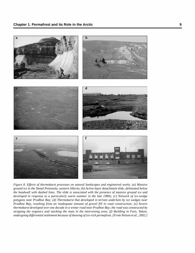
Figure 7. High-centered polygons near Prudhoe Bay,Alaska. This form of thermokarst terrain developsthrough ablation of underlying ice wedges.
Chapter 1. Permafrost and its Role in the Arctic 9
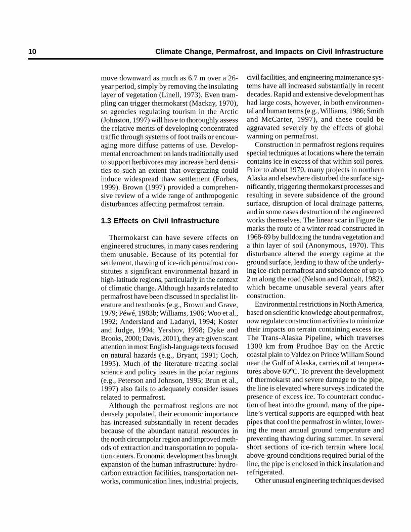
Figure 8. Effects of thermokarst processes on natural landscapes and engineered works. (a) Massiveground ice in the Yamal Peninsula, western Siberia; (b) Active-layer detachment slide, delineated belowthe headwall with dashed lines. The slide is associated with the presence of massive ground ice anddeveloped in response to a particularly warm summer in the late 1980s; (c) Network of ice-wedgepolygons near Prudhoe Bay; (d) Thermokarst that developed in terrain underlain by ice wedges nearPrudhoe Bay, resulting from an inadequate amount of gravel fill in road construction; (e) Severethermokarst developed over one decade in a winter road near Prudhoe Bay; the road was constructed bystripping the organics and stacking the mats in the intervening area; (f) Building in Faro, Yukon,undergoing differential settlement because of thawing of ice-rich permafrost. [From Nelson et al., 2002.]
10 Climate Change, Permafrost, and Impacts on Civil Infrastructure
move downward as much as 6.7 m over a 26-year period, simply by removing the insulatinglayer of vegetation (Linell, 1973). Even tram-pling can trigger thermokarst (Mackay, 1970),so agencies regulating tourism in the Arctic(Johnston, 1997) will have to thoroughly assessthe relative merits of developing concentratedtraffic through systems of foot trails or encour-aging more diffuse patterns of use. Develop-mental encroachment on lands traditionally usedto support herbivores may increase herd densi-ties to such an extent that overgrazing couldinduce widespread thaw settlement (Forbes,1999). Brown (1997) provided a comprehen-sive review of a wide range of anthropogenicdisturbances affecting permafrost terrain.
1.3 Effects on Civil Infrastructure
Thermokarst can have severe effects onengineered structures, in many cases renderingthem unusable. Because of its potential forsettlement, thawing of ice-rich permafrost con-stitutes a significant environmental hazard inhigh-latitude regions, particularly in the contextof climatic change. Although hazards related topermafrost have been discussed in specialist lit-erature and textbooks (e.g., Brown and Grave,1979; Péwé, 1983b; Williams, 1986; Woo et al.,1992; Andersland and Ladanyi, 1994; Kosterand Judge, 1994; Yershov, 1998; Dyke andBrooks, 2000; Davis, 2001), they are given scantattention in most English-language texts focusedon natural hazards (e.g., Bryant, 1991; Coch,1995). Much of the literature treating socialscience and policy issues in the polar regions(e.g., Peterson and Johnson, 1995; Brun et al.,1997) also fails to adequately consider issuesrelated to permafrost.
Although the permafrost regions are notdensely populated, their economic importancehas increased substantially in recent decadesbecause of the abundant natural resources inthe north circumpolar region and improved meth-ods of extraction and transportation to popula-tion centers. Economic development has broughtexpansion of the human infrastructure: hydro-carbon extraction facilities, transportation net-works, communication lines, industrial projects,
civil facilities, and engineering maintenance sys-tems have all increased substantially in recentdecades. Rapid and extensive development hashad large costs, however, in both environmen-tal and human terms (e.g., Williams, 1986; Smithand McCarter, 1997), and these could beaggravated severely by the effects of globalwarming on permafrost.
Construction in permafrost regions requiresspecial techniques at locations where the terraincontains ice in excess of that within soil pores.Prior to about 1970, many projects in northernAlaska and elsewhere disturbed the surface sig-nificantly, triggering thermokarst processes andresulting in severe subsidence of the groundsurface, disruption of local drainage patterns,and in some cases destruction of the engineeredworks themselves. The linear scar in Figure 8emarks the route of a winter road constructed in1968-69 by bulldozing the tundra vegetation anda thin layer of soil (Anonymous, 1970). Thisdisturbance altered the energy regime at theground surface, leading to thaw of the underly-ing ice-rich permafrost and subsidence of up to2 m along the road (Nelson and Outcalt, 1982),which became unusable several years afterconstruction.
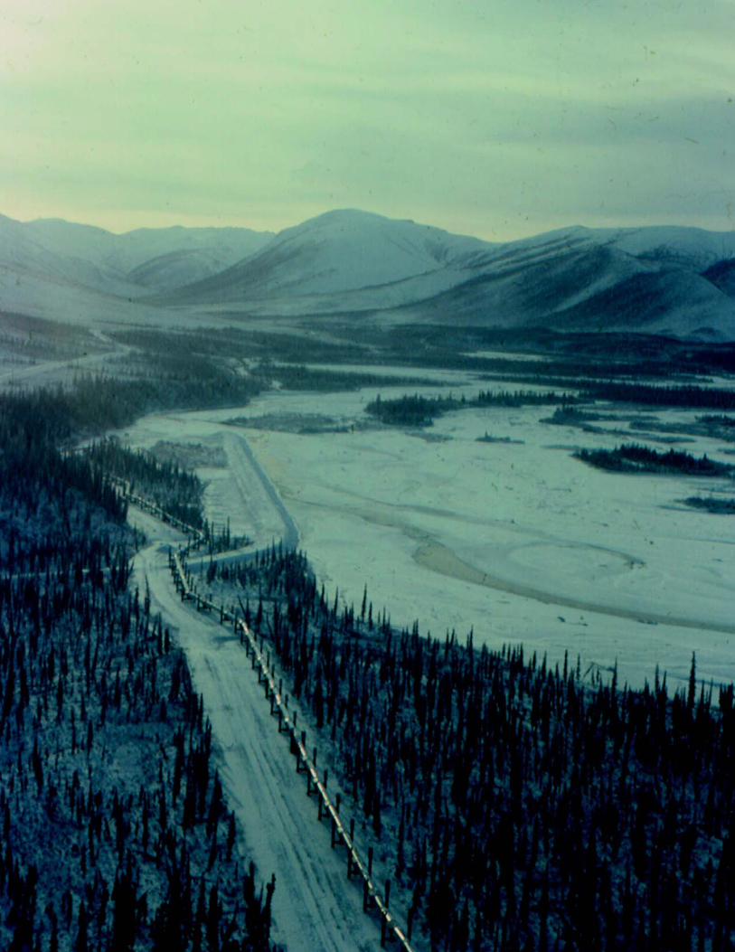
Environmental restrictions in North America,based on scientific knowledge about permafrost,now regulate construction activities to minimizetheir impacts on terrain containing excess ice.The Trans-Alaska Pipeline, which traverses1300 km from Prudhoe Bay on the Arcticcoastal plain to Valdez on Prince William Soundnear the Gulf of Alaska, carries oil at tempera-tures above 60oC. To prevent the developmentof thermokarst and severe damage to the pipe,the line is elevated where surveys indicated thepresence of excess ice. To counteract conduc-tion of heat into the ground, many of the pipe-line’s vertical supports are equipped with heatpipes that cool the permafrost in winter, lower-ing the mean annual ground temperature andpreventing thawing during summer. In severalshort sections of ice-rich terrain where localabove-ground conditions required burial of theline, the pipe is enclosed in thick insulation andrefrigerated.
Other unusual engineering techniques devised
Chapter 1. Permafrost and its Role in the Arctic 11
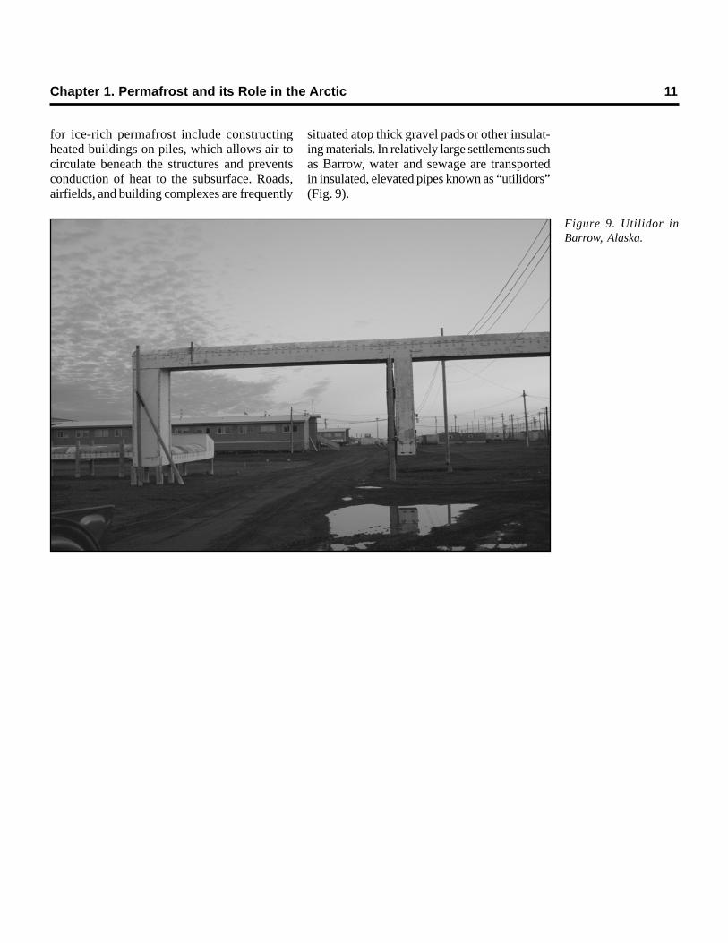
for ice-rich permafrost include constructingheated buildings on piles, which allows air tocirculate beneath the structures and preventsconduction of heat to the subsurface. Roads,airfields, and building complexes are frequently
situated atop thick gravel pads or other insulat-ing materials. In relatively large settlements suchas Barrow, water and sewage are transportedin insulated, elevated pipes known as “utilidors”(Fig. 9).
Figure 9. Utilidor inBarrow, Alaska.

12 Climate Change, Permafrost, and Impacts on Civil Infrastructure
2.1 General Considerations
Climate change is one of the most pressingissues facing science, governmental bodies, and,indeed, human occupation of the earth. Becauseof the extreme temperature sensitivity of cryo-spheric phenomena (snow, ice, frozen ground),the world’s cold regions are and will continueto be heavily impacted by climate warming.Moreover, climate models indicate that warm-ing will be particularly acute in the polar regions,exacerbating these impacts and broadening theirgeographic distribution. Changes involvingpermafrost are likely to be as profound. Owingto its multivariate role in climate change, itspotential impact on human activities, and itswidespread distribution, permafrost is among themost important of cryospheric phenomena.
Recognition of the importance of permafrostin global-change research, although slow indeveloping, has become widespread in recentyears (e.g., McCarthy et al., 2001; Goldman,2002; Hardy, 2003). Because permafrost ishighly susceptible to long-term warming, it hasbeen designated a “geoindicator,” to be used asa primary tool for monitoring and assessingenvironmental change (Berger and Iams, 1996).This chapter outlines the role of permafrost inglobal-change studies and describes severalnational and international programs designed tomonitor geocryological changes and amelioratetheir impacts on human communities.
2.2 Permafrost and Global Change
Despite implications contained in the term“permafrost,” perennially frozen ground is not
permanent. Permafrost was more widespreadduring past episodes of continental glaciation.Evidence for the former existence of perma-frost, including ice-wedge casts and pingo scars,has been found in areas of North America andEurasia now far removed from current perma-frost regions. Detailed environmental recon-structions in which permafrost is a criticalpaleogeographical indicator have been pro-duced for Eurasia (e.g., Ballantyne and Harris,1994; Velichko 1984). Although the formerextent of permafrost in North America is not aswell known, evidence that it existed during colderintervals is scattered along the glacial borderfrom New Jersey to Washington state (Péwé,1983c).
Abundant geological evidence also exists thatwidespread thermokarst terrain developed inresponse to past intervals of climatic warming.In parts of the unglaciated lowlands of the cen-tral Sakha Republic (Yakutia) in Siberia, nearlyhalf of the Pleistocene-age surface has beenaffected by development of alases, steep-sidedthermokarst depressions as much as 20–40 mdeep and occupying areas of 25 km2 or more(Soloviev, 1973; Koutaniemi, 1985; French,1996). Kachurin (1962), Czudek and Demek(1970), and Romanovskii et al. (2000) attributedthe development of these Siberian alases to warmintervals during the Holocene. In arctic parts ofNorth America, thaw unconformities (Burn,1997), sedimentary evidence (Murton, 2001),and extensive degradation of ice-cored terrain(Harry et al., 1988) attest to periods in whichwidespread, climatically induced thermokarstdeveloped. Global warming is likely to trigger anew episode of widespread thermokarst devel-
Chapter 2FUTURE CLIMATE CHANGE AND
CURRENT RESEARCH INITIATIVES
14 Climate Change, Permafrost, and Impacts on Civil Infrastructure
opment, with serious consequences for a largeproportion of the engineered works constructedin the permafrost regions during the twentiethcentury.
Permafrost plays three important roles in thecontext of climatic change (Nelson et al., 1993;Anisimov et al., 2001): as a record keeper byfunctioning as a temperature archive; as atranslator of climate change through subsid-ence and related impacts; and as a facilitatorof further change through its impact on theglobal carbon cycle. These roles are discussedbriefly in subsequent sections of this chapterand are treated in more detail in Nelson et al.(1993), Anisimov et al. (2001), and Serreze etal. (2000).
2.2.1 Record Keeper: Permafrostas a Temperature Archive
Permafrost is a product of cold climates andis common in high-latitude and high-elevationenvironments. Air temperature, the most influ-ential parameter, determines the existence ofpermafrost, as well as its stability. Although themean annual air temperature can be used as avery general indicator of the presence of perma-frost, other factors are involved in determiningits thickness, including substrate composition,thermal evolution, and groundwater distribution.
The thickness, thermal properties, and dura-tion of the snow cover exert a profound influ-ence on permafrost (Brown and Péwé, 1973;Smith, 1975; Hinzman et al., 1991; Romanovskyand Osterkamp, 1995; Zhang et al., 1997; Burn,1998; Hinkel et al., 2003a). At sites underlainby permafrost in Alaska, the mean annual groundsurface temperature is commonly 3–6ºC higherthan the mean annual air temperature. At siteswithout permafrost, this difference can be evenlarger, reaching 7–8ºC in some years.
Despite subzero mean annual air tempera-tures, boreal areas of central Alaska mayexperience mean annual ground surface tem-peratures above 0oC, owing to the insulatingeffect of low-density snow cover. Nonetheless,permafrost may exist at such locations becauseof a thermal offset attributable to differencesin the thermal properties of the substrate in thefrozen and unfrozen states (Kudryavtsev et al.,
1974; Goodrich, 1978, 1982; Burn and Smith,1988; Romanovsky and Osterkamp, 1995, 1997,2000). This situation is common in peatlands,which often form the southernmost occurrencesof subarctic permafrost (Zoltai, 1971). In a dry,unfrozen state, peat is an extremely efficientthermal insulator. When saturated and frozen,however, its thermal conductivity approachesthat of pure ice. In such a situation, frost pene-tration in winter exceeds the depth of summerthaw, and permafrost can form or persist,despite mean annual air temperatures that wouldotherwise preclude its existence.
Permafrost records temperature changes andother proxy information about environmentalchanges (Lachenbruch and Marshall, 1986;Burn, 1997; Murton 2001). Because the trans-fer of heat in thick permafrost occurs primarilyby conduction, it acts as a low-pass filter andhas a “memory” of past temperatures. Throughthe use of precision sensors, temperature trendsspanning a century or more can be recorded inthick permafrost (Lachenbruch and Marshall,1986; Clow et al., 1998; Osterkamp et al., 1998a,b; Taylor and Burgess, 1998; Romanovsky etal., 2003).
The U.S. Geological Survey (USGS) hasmeasured permafrost temperatures from deepboreholes in northern Alaska since the 1940s.Typically, this entails lowering a precision resis-tance thermistor down the access hole andobtaining a highly accurate and precise tem-perature measurement at known, closely spaceddepths down the borehole. Analysis of thesedata through the mid-1980s indicates thatpermafrost on Alaska’s North Slope has gener-ally warmed by 2–4ºC in the past century(Lachenbruch et al., 1982; Lachenbruch andMarshall, 1986), although some locales showlittle change or a slight cooling. Additional warm-ing has occurred since that time (Clow andUrban, 2002), although increased snow covermay be responsible for a significant proportionof the temperature increase near the surface(Stieglitz et al., 2003).
Permafrost at many Arctic locations hasexperienced temperature increases in recentdecades, including central and northern Alaska(Lachenbruch and Marshall, 1986; Osterkamp
and Romanovsky, 1999), northwestern Canada(Majorowicz and Skinner, 1997), and Siberia(Pavlov, 1996). Temperature increases are notuniform; cooling has occurred recently in perma-frost in northern Quebec (Allard and Baolai,1995). More recent observations indicate, how-ever, that permafrost is warming rapidly in thisregion (Allard et al., 2002). Serreze et al. (2000)summarized the extent and geographic distri-bution of recent changes in permafrost temper-ature in the Arctic.
In Alaska, temperature measurements madeover the last two decades show that perma-frost has warmed at all sites along a north–southtransect spanning the continuous and most ofthe discontinuous permafrost zones, from Prud-hoe Bay to Glennallen (Osterkamp andRomanovsky, 1999). Modeling indicates that inthe continuous permafrost zone, mean annualpermafrost surface temperatures vary inter-annually within a range of more than 5ºC. Indiscontinuous permafrost, the observed warm-ing is part of a trend that began in the late 1960s.The total magnitude of the warming at thepermafrost surface since then is about 2ºC.Observational data indicate that the last “wave”of recent warming began on the Arctic CoastalPlain, in the Foothills, and at Gulkana in the mid-1980s and in areas of discontinuous permafrostabout 1990 (typically 1989–1991). The magni-tude of the observed warming at the perma-frost surface is about 3–4ºC at West Dock andDeadhorse near the Arctic Ocean, about 2ºCover the rest of the Arctic Coastal Plain andsouth into the Brooks Range, and typically 0.5–1.5ºC in discontinuous permafrost. At some sitesin discontinuous permafrost south of the YukonRiver, permafrost is now thawing from both thetop and the bottom. Thawing of ice-rich perma-frost is presently creating thermokarst terrainin the Alaskan interior and is having significanteffects on subarctic ecosystems and infrastruc-ture (Jorgenson et al., 2001).
Permafrost also contains abundant proxyinformation about climatic change. Cryostrati-graphic techniques (Burn, 1997; French, 1998;Murton 2001), combined with isotopic analysis,can provide information about the increases inactive-layer thickness that occurred millenia ago
(Lauriol et al., 2002). Flora and fauna incorpo-rated in permafrost can be dated radiometricallyto determine cooling episodes.
2.2.2 Translator: Permafrostand Global-Change Impacts
Permafrost can translate climatic change toother environmental components (Jorgenson etal., 2001; Nelson et al., 2002). Thawing of ice-rich permafrost may induce settlement of theground surface, which often has severe conse-quences for human infrastructure and naturalecosystems. Stratigraphic and paleogeographicevidence indicates that permafrost will degradeif recent climate warming continues into thefuture (e.g., Kondratjeva et al., 1993). TheArctic’s geological record contains extensiveevidence about regional, climate-induced dete-rioration of permafrost. Melting of glaciers inAlaska and elsewhere will increase the ratesof coastal erosion in areas of ice-rich perma-frost, already among the highest in the world.Sediment input to the Arctic shelf derived fromcoastal erosion may exceed that from river dis-charge (ACD, 2003).
Degradation of ice-rich permafrost has alsobeen documented under contemporary condi-tions in central Alaska and elsewhere (e.g.,Francou et al., 1999; Osterkamp andRomanovsky, 1999; Osterkamp et al., 2000; Jor-genson et al., 2001; Tutubalina and Ree, 2001;Nelson et al., 2002; Beilman and Robinson,2003). Little is known, however, about specificprocesses associated with thawing of perma-frost, either as a function of time or as a three-dimensional process affecting the geometry ofpermafrost distribution over a wide spectrumof geographic scale. There is urgent need toconduct theoretical, numerical, and field inves-tigations to address such issues.
It is clear from the paleogeographic recordthat climatic warming in the polar regions canlead to increases in permafrost temperature,thickening of the active layer, and a reductionin the percentage of the terrestrial surfaceunderlain by near-surface permafrost. Suchchanges could lead to extensive settlement ofthe ground surface, with attendant damage toinfrastructure.
Chapter 2. Future Climate Change and Current Research Initiatives 15
16 Climate Change, Permafrost, and Impacts on Civil Infrastructure
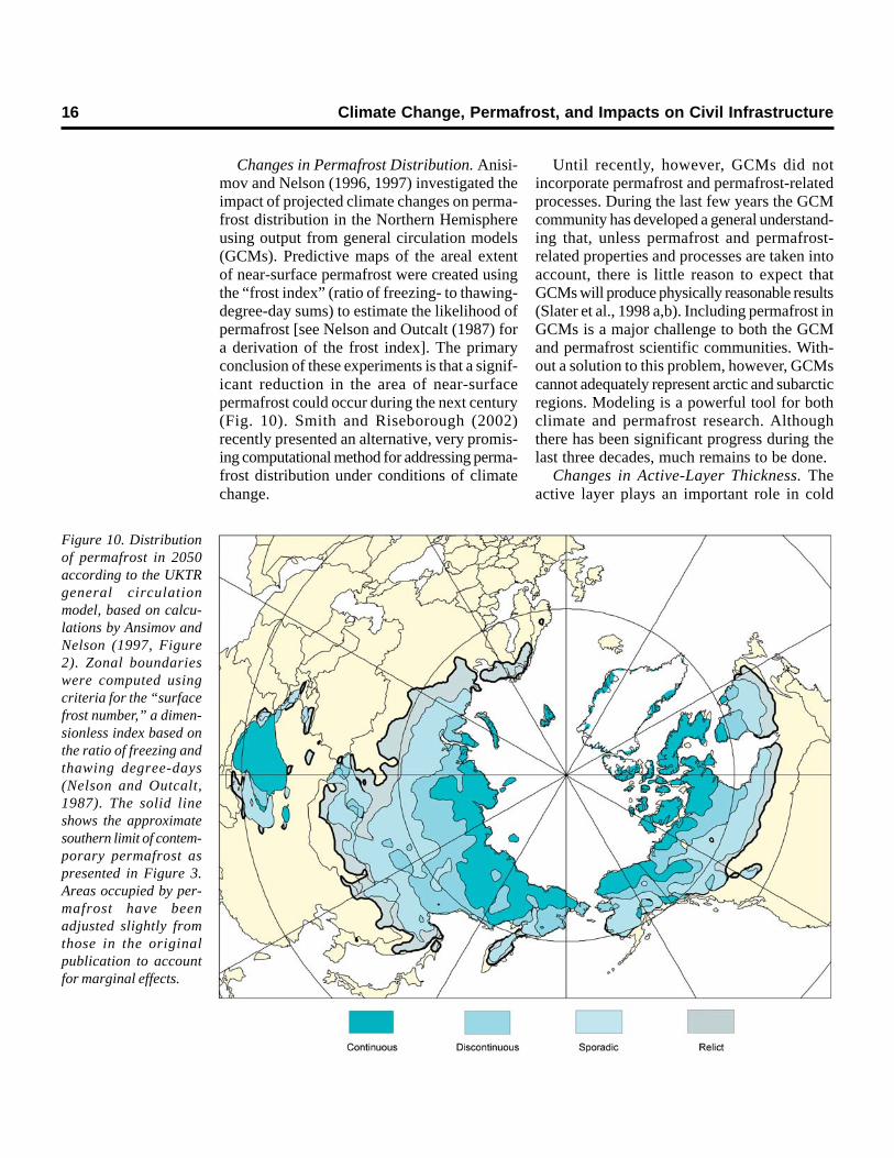
Changes in Permafrost Distribution. Anisi-mov and Nelson (1996, 1997) investigated theimpact of projected climate changes on perma-frost distribution in the Northern Hemisphereusing output from general circulation models(GCMs). Predictive maps of the areal extentof near-surface permafrost were created usingthe “frost index” (ratio of freezing- to thawing-degree-day sums) to estimate the likelihood ofpermafrost [see Nelson and Outcalt (1987) fora derivation of the frost index]. The primaryconclusion of these experiments is that a signif-icant reduction in the area of near-surfacepermafrost could occur during the next century(Fig. 10). Smith and Riseborough (2002)recently presented an alternative, very promis-ing computational method for addressing perma-frost distribution under conditions of climatechange.
Until recently, however, GCMs did notincorporate permafrost and permafrost-relatedprocesses. During the last few years the GCMcommunity has developed a general understand-ing that, unless permafrost and permafrost-related properties and processes are taken intoaccount, there is little reason to expect thatGCMs will produce physically reasonable results(Slater et al., 1998 a,b). Including permafrost inGCMs is a major challenge to both the GCMand permafrost scientific communities. With-out a solution to this problem, however, GCMscannot adequately represent arctic and subarcticregions. Modeling is a powerful tool for bothclimate and permafrost research. Althoughthere has been significant progress during thelast three decades, much remains to be done.
Changes in Active-Layer Thickness. Theactive layer plays an important role in cold
Figure 10. Distributionof permafrost in 2050according to the UKTRgeneral circulationmodel, based on calcu-lations by Ansimov andNelson (1997, Figure2). Zonal boundarieswere computed usingcriteria for the “surfacefrost number,” a dimen-sionless index based onthe ratio of freezing andthawing degree-days(Nelson and Outcalt,1987). The solid lineshows the approximatesouthern limit of contem-porary permafrost aspresented in Figure 3.Areas occupied by per-mafrost have beenadjusted slightly fromthose in the originalpublication to accountfor marginal effects.
regions because most ecological, hydrological,biogeochemical, and pedogenic activities takeplace within it (Hinzman et al., 1991; Kane etal., 1991). The thickness of the active layer isinfluenced by many factors, including surfacetemperature, thermal properties of the surfacecover and substrate, soil moisture, and theduration and thickness of the snow cover(Hinkel et al., 1997; Paetzold et al., 2000). Con-sequently, there is widespread variation in active-layer thickness across a broad spectrum ofspatial and temporal scales (e.g., Pavlov, 1998;Nelson et al., 1999; Hinkel and Nelson, 2003).The active layer can be thought of as a filterthat attenuates the temperature signal as ittravels from the ground surface into the under-lying permafrost. The properties of this filterchange with time, behaving in a radically dif-ferent manner in summer and winter becauseof the changes in the phase of the water–icesystem (Hinkel and Outcalt, 1994). Over longertime periods, the accumulation of peat at thesurface, cryoturbation, and ice enrichment atdepth can alter the filter properties. Thus, tounderstand and interpret the signal recorded inpermafrost, monitoring programs must incorpo-rate intensive active-layer observations. Thehypothesis and existing evidence that warmingwill increase the thickness of the active layer,resulting in thawing of ice-rich permafrost,ground instability, and surface subsidence,require further investigation under a variety ofcontemporary environmental settings.
Several monitoring methods are used to mea-sure seasonal and long-term changes in thethickness of the active layer: physical probingwith a graduated steel rod at the end of thethaw season (mid-August to mid-September),temperature measurements, and stratigraphicobservations of ground ice occurrences (e.g.,Burn, 1997; French, 1998; Murton, 2001). Otherrecommended measurements include soil mois-ture and vertical displacement of the active layerby thaw subsidence and frost heave. Anextended description of monitoring methods ispresented in the monograph by Brown et al.(2000).
Measurements of thaw depth are often col-lected on plots or grids that vary between 10,
100, and 1000 m on a side, with nodes evenlydistributed 1, 10, or 100 m apart, respectively.The gridded sampling design allows for analysisof intra- and inter-site spatial variability (Nelsonet al., 1998, 1999; Gomersall and Hinkel, 2001;Shiklomanov and Nelson, 2003). Summarystatistics are generated for each sample period,and thaw depth on the grid is mapped using asuitable interpolation algorithm.
Soil and near-surface permafrost tempera-tures are commonly determined with thermistorsensors inserted in the ground, and subdiurnalreadings are made manually or recorded at reg-ular time intervals by battery-operated data-loggers. Closely spaced thermistors in the uppersections of shallow to intermediate-depth bore-holes (25–125 m) provide continuous data tointerpolate active-layer thickness and to observeinterannual to decadal changes in permafrosttemperatures.
Changes in Soil Moisture and Ground IceContent. Soil moisture content has an impor-tant effect on soil thermal properties, soil heatflow, and vegetation and is, therefore, a crucialparameter. Although arctic hydrology hasreceived serious attention in science planningdocuments, little attention has been devoted tosubsurface hydrologic and hydrogeologic pro-cesses in permafrost regions. The omission ofground and soil water as a central focus isunfortunate, because subsurface flow and sub-surface storage are extremely important com-ponents in the arctic hydrological system and inthe arctic water cycle as a whole. Studies ofpermafrost hydrogeology are rare in the U.S.arctic sciences plans and programs. This is aserious gap in the research agenda and moni-toring programs, in both the high Arctic and theSubarctic.
Several methods are employed to measuresoil moisture, including gravimetric sampling,time-domain reflectometry (TDR), and porta-ble soil dielectric measurements. Soil moisturecan vary over short distances, and near-surfacesoil moisture fluctuates seasonally and inresponse to transient rainfall events (e.g., Milleret al., 1998; Hinkel and Nelson, 2003). Kane etal. (1996) had some success using satellite-basedsynthetic aperture radar to estimate soil mois-
Chapter 2. Future Climate Change and Current Research Initiatives 17
18 Climate Change, Permafrost, and Impacts on Civil Infrastructure
ture in the Kuparuk basin. Ground-based radarsystems (e.g., Doolittle et al., 1990; Hinkel etal., 2001) show considerable promise for directlydetermining the long-term position of the activelayer over limited areas.
Frozen ground supersaturated with ice (i.e.,containing excess ice) is particularly suscepti-ble to thaw subsidence. Probing may not detectthis. Careful surveying is necessary to deter-mine if thaw subsidence or frost heave hasoccurred, but surveying is often not feasible.Experiments involving high-precision (<1 cm)differential GPS (global positioning systems) tomap and determine the scale of variability ofheave and subsidence are underway in north-ern Alaska (Little et al., 2003).
Changes in active-layer thickness, accom-panied by melt of ground ice and thawsettlement, can have profound impacts on localenvironments (Burgess et al., 2000; Dyke andBrooks, 2000). Where the distribution of groundice is not uniform, thawing can lead to differen-tial subsidence, resulting in thermokarst terrain.In the Sakha Republic (Yakutia) of Siberia, thawdepressions coalesced during warm intervals ofthe Holocene to form thaw basins (alases) tensof meters deep and occupying areas of 25 km2
or more. Where human infrastructure has beenbuilt on ice-rich terrain, damage to infrastruc-ture can accompany thaw settlement (Fig. 8dand f); recent geographic overviews indicatethat the hazard potential associated with ice-rich permafrost is high in many parts of theArctic (Nelson et al., 2001, 2002).
Modeling Strategies. Changes in the activelayer may be substantial in coming decades. Topredict such changes, modeling experiments arerequired. Many formulations have been used tocalculate active-layer thicknesses and meanannual permafrost surface temperatures usingsimplified analytical solutions (Kudryavtsev etal., 1974; Pavlov, 1980; Zarling, 1987; Balobaev,1992; Aziz and Lunardini, 1992, 1993;Romanovsky and Osterkamp, 1995, 1997; Smithand Riseborough, 1996; Nelson et al., 1997).For contemporary work involving locations forwhich subsurface data are available, analyticalsolutions are less important than in previousdecades. Numerical models are widely avail-
able for permafrost problems, and they can beused with some confidence when adequateinformation about climatic, boundary layer, andsubsurface parameters is available.
Analytical equations can also be helpful inproviding insights into the physics of the cou-pling between permafrost and the atmosphere.However, these simple equations have limitedusefulness because they do not include theeffects of inhomogeneous active layers withmultiple layers, variable thermal properties,unfrozen water dynamics, and non-conductiveheat flow.
Serious problems arise when complexmodels are employed in a spatial context,particularly when little is known about the spatialvariability of parameters important to geo-cryological investigation. In such cases,stochastic modeling (Anisimov et al., 2002) orthe use of analytic procedures in a GIS envi-ronment (Nelson et al., 1997; Shiklomanov andNelson, 1999; Klene et al., 2002) may yieldresults superior to complex, physically basedmodels.
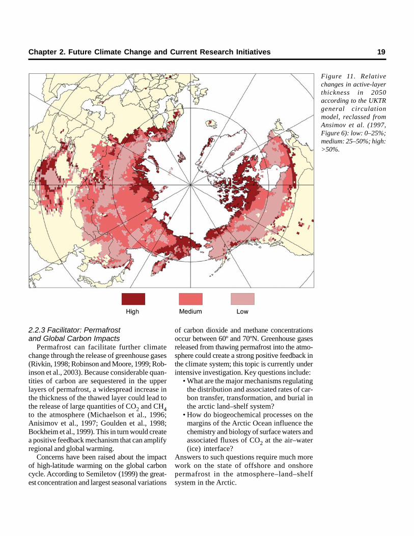
Anisimov et al. (1997) used a series of GCM-based scenarios to examine changes in active-layer thickness in the Northern Hemisphere. Theresults from these preliminary experimentsindicate that increases of 20–30% could occurin many regions, with the largest relativeincreases occurring in the northernmost areas(Fig. 11).
Both empirical evidence (Moritz et al., 2002)and climate models (e.g., Greco et al., 1994)indicate that climate warming is not geographi-cally homogeneous. With respect to degrad-ing permafrost and its influence on humansettlement, a critical concern is the spatialcorrespondence between areas of climatewarming (accompanied by active-layer thick-ening) (Fig. 11) and those of ice-rich perma-frost (Fig. 3 and 5). These relations weremodeled by Nelson et al. (2001, 2002); theresults from those experiments are given inChapter 3. Harris et al. (2001b) have imple-mented a comprehensive, observation-basedapproach to mapping geotechnical hazardsrelated to permafrost in the European moun-tains.
2.2.3 Facilitator: Permafrostand Global Carbon Impacts
Permafrost can facilitate further climatechange through the release of greenhouse gases(Rivkin, 1998; Robinson and Moore, 1999; Rob-inson et al., 2003). Because considerable quan-tities of carbon are sequestered in the upperlayers of permafrost, a widespread increase inthe thickness of the thawed layer could lead tothe release of large quantities of CO2 and CH4to the atmosphere (Michaelson et al., 1996;Anisimov et al., 1997; Goulden et al., 1998;Bockheim et al., 1999). This in turn would createa positive feedback mechanism that can amplifyregional and global warming.
Concerns have been raised about the impactof high-latitude warming on the global carboncycle. According to Semiletov (1999) the great-est concentration and largest seasonal variations
of carbon dioxide and methane concentrationsoccur between 60º and 70ºN. Greenhouse gasesreleased from thawing permafrost into the atmo-sphere could create a strong positive feedback inthe climate system; this topic is currently underintensive investigation. Key questions include:
• What are the major mechanisms regulatingthe distribution and associated rates of car-bon transfer, transformation, and burial inthe arctic land–shelf system?
• How do biogeochemical processes on themargins of the Arctic Ocean influence thechemistry and biology of surface waters andassociated fluxes of CO2 at the air–water(ice) interface?
Answers to such questions require much morework on the state of offshore and onshorepermafrost in the atmosphere–land–shelfsystem in the Arctic.
Figure 11. Relativechanges in active-layerthickness in 2050according to the UKTRgeneral circulationmodel, reclassed fromAnsimov et al. (1997,Figure 6): low: 0–25%;medium: 25–50%; high:>50%.
Chapter 2. Future Climate Change and Current Research Initiatives 19

20 Climate Change, Permafrost, and Impacts on Civil Infrastructure
Plants remove carbon dioxide from theatmosphere during photosynthesis. Carbondioxide is returned through plant respiration anddecomposition of plant detritus. Studies onAlaska’s North Slope indicate a delicate bal-ance between these two competing processes.In some years, more CO2 is released into theatmosphere, while in others more CO2 is fixedby plants (Marion and Oechel, 1993; Oechel etal., 1993). In years when biomass productionexceeds respiration, the atmosphere is a netsource of carbon, which resides in plant biomass.Regional changes in climate can alter the vege-tation communities and thus alter this balancein a direction not fully understood. Studies fromCanada and Eurasia have demonstrated thatmany arctic sites are currently losing CO2 tothe atmosphere (Zimov et al., 1993, 1996).Higher temperatures and a reduction in soil mois-ture appear to be likely causes (Oechel et al.,1995, 1998).
Plants lose biomass as part of their naturalgrowth cycle. They shed leaves and twigs, andthey disperse seeds. In wet tundra, much ofthis surface detritus decays only partially, yield-ing a surface soil layer rich in organics. Theorganics can be transported deeper into the soilvia several processes. In summer, water per-colating through the active layer can transportorganics to depth. In winter, soils are suscepti-ble to a mechanical churning process known ascryoturbation. Over long time periods, surfacematerials are transported down into the soil andcan become incorporated into the upper perma-frost. This storage (sequestration) of carbon inthe upper permafrost has been documented inseveral studies (Michaelson et al., 1996; Bock-heim et al., 1999). Terrestrial arctic ecosystemsmay have been a net carbon sink during theHolocene, and perhaps 300 gigatons are seques-tered (Miller et al., 1983).
Thickening of the seasonally thawed layereffectively means downward movement of thepermafrost table. If organic material is presentin the newly thawed layer, it again becomessubject to decomposition by soil microbes, ulti-mately releasing CO2 and CH4 to the atmo-sphere. This can act as a positive feedbackmechanism by increasing the concentration of
radiatively active gases in the high-latituderegions. By one estimate, carbon fluxes havethe potential for a positive feedback on globalchanges amounting to about 0.7 Gt per year ofcarbon to the atmosphere, about 12% of thetotal emission from fossil fuel use (Oechel andVourlitis, 1994).
High-latitude wetlands currently account forabout 5–10% of the global methane flux (Ree-burgh and Whalen, 1992), and, because meth-ane flux is related closely to the thermal regimein the active layer (Goulden et al., 1998; Nakanoet al., 2000), this component is likely to increaseif the development of widespread thermokarstterrain is triggered by permafrost degradation.Thermokarst lakes emit methane during winter;methane is generated from carbon-rich terres-trial sediments sequestered during the Pleisto-cene epoch (Zimov et al., 1997).
Embedded within sediments on the oceanmargins is a crystalline form of methane knownas gas hydrates (e.g., Yakushev and Chuvilin,2000). Although currently in quasi-equilibriumwith temperature and pressure conditions, largevolumes of gas hydrates are susceptible todisruption by warming ocean water. This couldresult in the release of these hydrocarbons,allowing them to escape to the surface and enterthe atmosphere. Since methane has a radiativeactivity index of about 27 (molecule for mole-cule, it is 27 times more effective at absorbingthermal radiation than CO2), this could providea strong positive feedback.
2.3 Monitoring: OrganizedInternational Collection,Reporting, and Archiving Efforts
Worldwide permafrost monitoring canprovide evidence of climate-induced changes.Standardized in-situ measurements are alsoessential to calibrate and verify regional andGCM models. The Global Terrestrial Networkfor Permafrost (GTN-P) is the primary inter-national program concerned with monitoringpermafrost parameters. GTN-P was developedin the 1990s with the long-term goal of obtaininga comprehensive view of the spatial structure,trends, and variability of changes in permafrost
temperature (Brown et al., 2000; Burgess etal., 2000). The program’s two components are:(a) long-term monitoring of the thermal state ofpermafrost in an extensive borehole network;and (b) monitoring of active-layer thickness andprocesses at representative locations. Theactive-layer program, titled Circumpolar ActiveLayer Monitoring (CALM), is described in amonograph by Brown et al. (2000).
The ideal distribution of sites for a global orhemispheric monitoring network should includelocations representative of major ecological,climatic, and physiographic regions. Recently,efforts have been made to re-establish a deepborehole temperature monitoring program underthe auspices of GTN-P to monitor, detect, andassess long-term changes in the active layerand the thermal state of permafrost, particularlyon a regional basis (Burgess et al., 2000;Romanovsky et al., 2002). The borehole net-work has 287 candidate sites, half of whichobtain data on a periodic basis. Borehole meta-data are available on the Geological Survey ofCanada’s permafrost web site.
The International Permafrost Association(IPA), with 24 member nations, serves as theinternational facilitator for the CALM network,which is now part of GTN-P. Prior to the 1990s,many data sets related to the thickness of theactive layer were collected as part of largergeomorphological, ecological, or engineeringinvestigations, using different sampling designsand collection methodologies. Moreover, thetypical study was short term and did not depositdata records in archives accessible for generaluse (Barry, 1988; Clark and Barry, 1998). Thecombined effect of these circumstances madeit difficult to investigate long-term changes inseasonal thaw depth or possible interregionalsynchronicity.
The CALM program was formally estab-lished in the mid-1990s as a long-term observa-tional program designed to assess changes inthe active layer and provide ground truth forregional and global models. It represents thefirst attempt to collect and analyze a large-scale,standardized geocryological data set obtainedusing methods established under an internationalprotocol. Funded by the Arctic System Science
(ARCSS) program of the U.S. National ScienceFoundation, the network currently incorporatesapproximately 125 active sites involving partic-ipants from twelve countries in the NorthernHemisphere and three countries involved inAntarctic research. The majority of the networksites are in arctic tundra regions, with theremainder in warmer forested subarctic andalpine tundra of the mid-latitudes. Metadata andancillary information are available for each site,including climate, site photographs, and descrip-tions of terrain, soil type, and vegetation. CALMdata are transferred periodically to a perma-nent archive at the National Snow and Ice DataCenter (NSIDC) in Boulder, Colorado.
GTN-P and the CALM program contributeto the Global Terrestrial Observing System(GTOS), the Global Climate Observing System(GCOS), and the associated Terrestrial Eco-system Monitoring Sites (TEMS) network. Thenetworks are co-sponsored by the WorldMeteorological Organization (WMO), theIntergovernmental Oceanographic Commission(IOC of UNESCO), the United Nations Envi-ronment Programme (UNEP), the InternationalCouncil of Scientific Unions (ICSU), and theFood and Agriculture Organization (FAO). Adetailed joint plan for GCOS and GTOS wasdeveloped by the Terrestrial ObservationalPanel for Climate (TOPC) for climate-relatedobservations (GCOS, 1997). Program goalsinclude early detection of changes related to cli-mate, documentation of natural climate variabil-ity and extreme events, modeling and predictionof these changes, and assessment of impacts.
The affiliation of GTN-P and the CALMprogram within the GCOS/GTOS networks
Chapter 2. Future Climate Change and Current Research Initiatives 21
Web Sites
GTN-P http://www.gtnp.orgCALM http://www.geography.uc.edu/~kenhinke/CALM/CEON http://ceoninfo.org/FGDC http://nsidc.org/fgdc/PACE http://www.earth.cardiff.ac.uk/research/geoenvironment/
pace/31.EU_PACE_Project.htmIPA http://www.soton.ac.uk/ipa
22 Climate Change, Permafrost, and Impacts on Civil Infrastructure
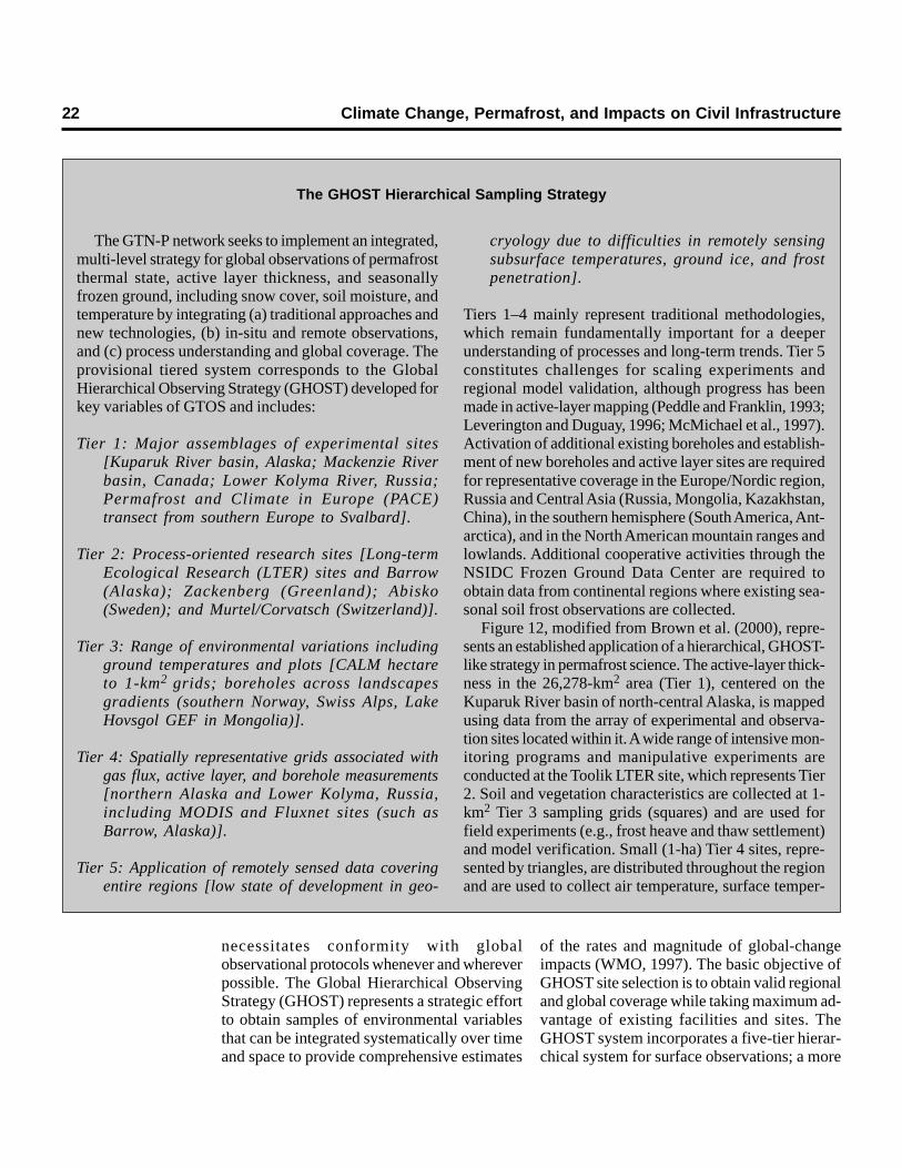
The GTN-P network seeks to implement an integrated,multi-level strategy for global observations of permafrostthermal state, active layer thickness, and seasonallyfrozen ground, including snow cover, soil moisture, andtemperature by integrating (a) traditional approaches andnew technologies, (b) in-situ and remote observations,and (c) process understanding and global coverage. Theprovisional tiered system corresponds to the GlobalHierarchical Observing Strategy (GHOST) developed forkey variables of GTOS and includes:
Tier 1: Major assemblages of experimental sites[Kuparuk River basin, Alaska; Mackenzie Riverbasin, Canada; Lower Kolyma River, Russia;Permafrost and Climate in Europe (PACE)transect from southern Europe to Svalbard].
Tier 2: Process-oriented research sites [Long-termEcological Research (LTER) sites and Barrow(Alaska); Zackenberg (Greenland); Abisko(Sweden); and Murtel/Corvatsch (Switzerland)].
Tier 3: Range of environmental variations includingground temperatures and plots [CALM hectareto 1-km2 grids; boreholes across landscapesgradients (southern Norway, Swiss Alps, LakeHovsgol GEF in Mongolia)].
Tier 4: Spatially representative grids associated withgas flux, active layer, and borehole measurements[northern Alaska and Lower Kolyma, Russia,including MODIS and Fluxnet sites (such asBarrow, Alaska)].
Tier 5: Application of remotely sensed data coveringentire regions [low state of development in geo-
cryology due to difficulties in remotely sensingsubsurface temperatures, ground ice, and frostpenetration].
Tiers 1–4 mainly represent traditional methodologies,which remain fundamentally important for a deeperunderstanding of processes and long-term trends. Tier 5constitutes challenges for scaling experiments andregional model validation, although progress has beenmade in active-layer mapping (Peddle and Franklin, 1993;Leverington and Duguay, 1996; McMichael et al., 1997).Activation of additional existing boreholes and establish-ment of new boreholes and active layer sites are requiredfor representative coverage in the Europe/Nordic region,Russia and Central Asia (Russia, Mongolia, Kazakhstan,China), in the southern hemisphere (South America, Ant-arctica), and in the North American mountain ranges andlowlands. Additional cooperative activities through theNSIDC Frozen Ground Data Center are required toobtain data from continental regions where existing sea-sonal soil frost observations are collected.
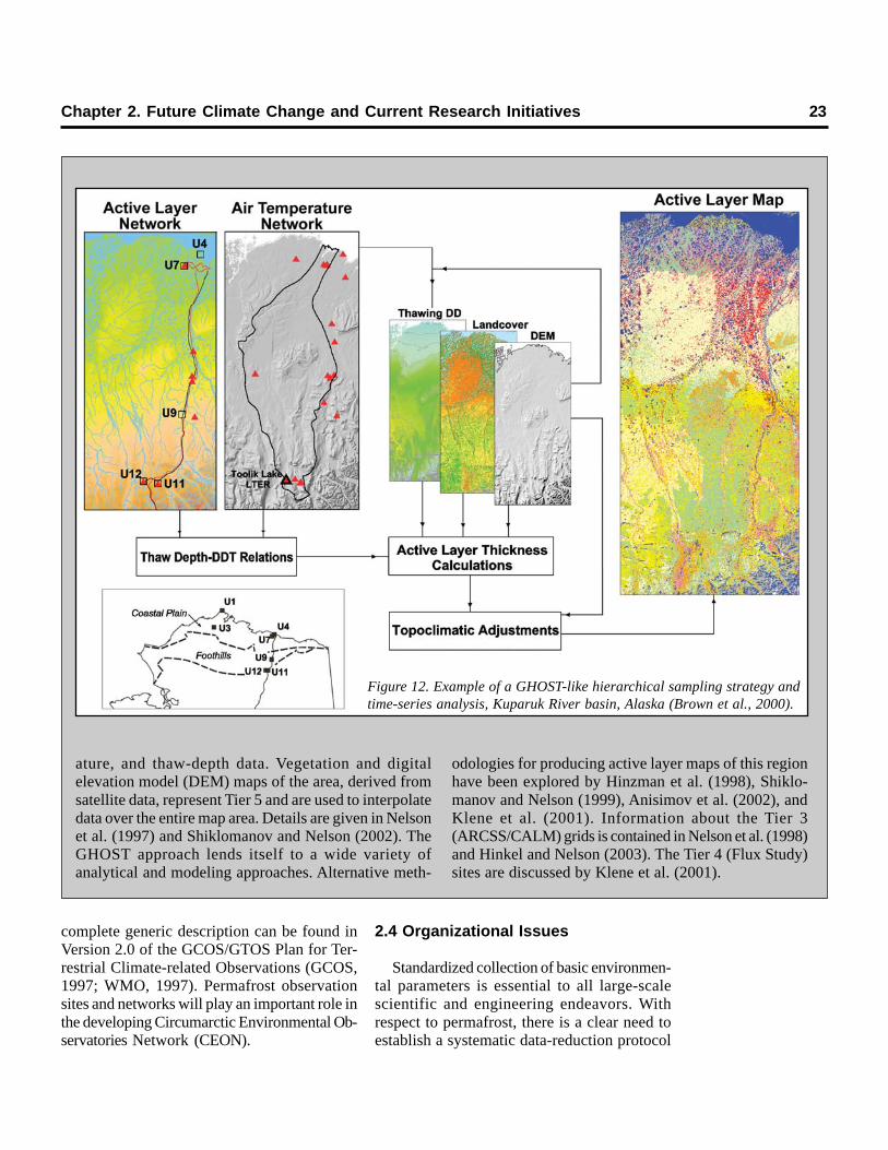
Figure 12, modified from Brown et al. (2000), repre-sents an established application of a hierarchical, GHOST-like strategy in permafrost science. The active-layer thick-ness in the 26,278-km2 area (Tier 1), centered on theKuparuk River basin of north-central Alaska, is mappedusing data from the array of experimental and observa-tion sites located within it. A wide range of intensive mon-itoring programs and manipulative experiments areconducted at the Toolik LTER site, which represents Tier2. Soil and vegetation characteristics are collected at 1-km2 Tier 3 sampling grids (squares) and are used forfield experiments (e.g., frost heave and thaw settlement)and model verification. Small (1-ha) Tier 4 sites, repre-sented by triangles, are distributed throughout the regionand are used to collect air temperature, surface temper-
The GHOST Hierarchical Sampling Strategy
necessitates conformity with globalobservational protocols whenever and whereverpossible. The Global Hierarchical ObservingStrategy (GHOST) represents a strategic effortto obtain samples of environmental variablesthat can be integrated systematically over timeand space to provide comprehensive estimates
of the rates and magnitude of global-changeimpacts (WMO, 1997). The basic objective ofGHOST site selection is to obtain valid regionaland global coverage while taking maximum ad-vantage of existing facilities and sites. TheGHOST system incorporates a five-tier hierar-chical system for surface observations; a more
Chapter 2. Future Climate Change and Current Research Initiatives 23
ature, and thaw-depth data. Vegetation and digitalelevation model (DEM) maps of the area, derived fromsatellite data, represent Tier 5 and are used to interpolatedata over the entire map area. Details are given in Nelsonet al. (1997) and Shiklomanov and Nelson (2002). TheGHOST approach lends itself to a wide variety ofanalytical and modeling approaches. Alternative meth-
odologies for producing active layer maps of this regionhave been explored by Hinzman et al. (1998), Shiklo-manov and Nelson (1999), Anisimov et al. (2002), andKlene et al. (2001). Information about the Tier 3(ARCSS/CALM) grids is contained in Nelson et al. (1998)and Hinkel and Nelson (2003). The Tier 4 (Flux Study)sites are discussed by Klene et al. (2001).
complete generic description can be found inVersion 2.0 of the GCOS/GTOS Plan for Ter-restrial Climate-related Observations (GCOS,1997; WMO, 1997). Permafrost observationsites and networks will play an important role inthe developing Circumarctic Environmental Ob-servatories Network (CEON).
2.4 Organizational Issues
Standardized collection of basic environmen-tal parameters is essential to all large-scalescientific and engineering endeavors. Withrespect to permafrost, there is a clear need toestablish a systematic data-reduction protocol
Figure 12. Example of a GHOST-like hierarchical sampling strategy andtime-series analysis, Kuparuk River basin, Alaska (Brown et al., 2000).
24 Climate Change, Permafrost, and Impacts on Civil Infrastructure
in accordance with identified and establisheduser needs. For example, hourly air tempera-ture data collected by an individual fieldresearcher may not be necessary for climatemodelers and engineers. Instead, such datacould be processed to produce average dailyair temperatures or accumulated degree-daysof frost, thaw, heating, or cooling. Implicit insuch an approach is the recognition that basicaspects of data collection would be standard-ized (e.g., all air temperature measurementswould be made at the same height above theground surface using a standard radiation shield)and that metadata files would also be available.These data, if properly collected, provide thefoundation upon which all efforts ultimatelydepend, and they are used to refine and vali-date climate modeling efforts.
A specific measurement protocol should bedeveloped for monitoring permafrost. This pro-tocol should be established by the scientific andengineering community for obtaining theappropriate measurements at the necessarytemporal frequency and spatial resolution. Theprotocol should cover the scale of instrumenta-tion ranging from site to satellite. Inherent inthe protocol is the requisite accuracy and pre-cision of thermistors, the optimal depth of soiltemperature measurements, and site descrip-tions. These efforts should be coordinated andintegrated with those of the GTN-P to ensurethe collection of data useful for global climateobservation (Burgess et al., 2000; GTN-P website). Similarly, methods of monitoring activelayer thickness and thaw subsidence should beintegrated with those of ongoing and develop-ing international projects (e.g., CALM, PACE,IPY) following discussion and modification ofthe protocols currently in place. In all cases, aneffort should be made to assess the spatial vari-ability of thaw depth and soil temperature andto collect ancillary data. A comprehensive listof recommendations regarding permafrost-related activities and their coordination wasissued recently (IPA Council, 2003).
The 24-member International PermafrostAssociation (IPA) and several of its working
groups and data committees coordinate GTN-P activities, including input to GTOS/TEMS.The Geological Survey of Canada (Ottawa)maintains the GTN-P web site and boreholemetadata files and coordinates thermal datamanagement and dissemination The NSIDCacquires, stores, and processes data. Datacollected by funded projects in the U.S. shouldbe archived in the Frozen Ground Data Center(FGDC) within an appropriate time period.FGDC is a subunit of the U.S. National Snowand Ice Data Center (NSIDC) in Boulder,Colorado, which is an affiliate of the WorldData Center for Glaciology (WDC). Detailsof site characteristics and measurementsshould be presented in standardized metadatafiles.
A strategy developed by the IPA facilitatesdata and information management to meet theneeds of cold regions science and engineering.One focus of this strategy is the Global Geo-cryological Data (GGD) system, which providesan international link for scientific investigatorsand data centers. In collaboration with theInternational Arctic Research Center (IARC),WDC and NSIDC serve as a central node forGGD. Every five years NSIDC prepares a CD-ROM containing information and data acquiredin the previous five-year interval. Known as theCircumpolar Active-Layer Permafrost System(CAPS), this product is a comprehensive com-pilation of data related to permafrost and frozenground from a global perspective. Detailedinformation can be found on the FGDC website.
Data sets representing spatially intensivemeasurements, such as satellite imagery or thawdepths interpolated over large regions, shouldbe prepared in a format conducive to genera-tion of descriptive statistics and standardizedmapping. Digital mapping at regional, continen-tal, and circumpolar scales has been facilitatedgreatly by the development of the Equal-AreaScalable Earth Grid (EASE-Grid) at NSIDC(Armstrong et al., 1997). Use of this flexiblesystem of projections is recommended at thesescales.
3.1 Introduction
Evidence presented in the preceding chap-ters documents widespread warming of perma-frost, which in some cases is showing very clearevidence of thawing. Warming and thawing ofpermafrost will have significant effects oninfrastructure (Instanes, 2003). Local sourcesof anthropogenic heat and surface modificationsassociated with urban land uses may exacer-bate problems related to thaw and settlement(Hinkel et al., 2003b; Klene et al., 2003). Afterpresenting a general overview of the possibleeffects of climate warming on permafrost inthe Northern Hemisphere, this chapter discussesthe existing infrastructure in Alaska with spe-cial reference to its relation with permafrost.
3.2 Northern Hemisphere Hazards
Nelson et al. (2001, 2002) used output fromthree transient-mode general circulation models(GCMs), in conjunction with a digital version ofthe International Permafrost Association’sCircum-Arctic Map of Permafrost andGround Ice Conditions (Brown et al., 1997,1998; Brown and Haggerty, 1998), to map thehazard potential associated with thawing perma-frost under conditions of global warming. Themaps were created using a simple, dimension-less thaw-settlement index, computed using therelative increase in active layer thickness andthe volumetric proportion of near-surface soiloccupied by ground ice. Computational detailsare provided in Nelson et al. (2002). Theresulting maps depict areas of low, moderate,and high hazard potential. In Figure 13 the
location of existing infrastructure has beensuperimposed on the hazard map, providing ageneral assessment of the susceptibility ofengineered works to thaw-induced damageunder the UKTR climate-change scenario. Fig-ure 13a indicates the risk to infrastructure innorthern Canada, Alaska, and Russia. Russiahas more population centers and infrastructurein the higher risk areas, but Alaska and Canadaalso have population centers, pipelines, and roadsin areas of moderate and high hazard potential.Major settlements are located in areas of mod-erate or high hazard potential in central andnorthern Alaska (e.g., Nome and Barrow),northwestern Canada (Inuvik), western Siberia(Vorkuta), and the Sakha Republic in Siberia(Yukutsk). The potential for severe thaw-induced disruptions to engineered works hasbeen reported from each of these areas, andproblems are likely to intensify under conditionsof global warming.
Figure 13b shows the risk to transportationfacilities. The network of seismic trails in north-ern Alaska, the Dalton Highway between theYukon River and Prudhoe Bay in Alaska, theDempster Highway between Dawson andInuvik in western Canada, and the extensiveroad and trail system in central Siberia alltraverse areas of high hazard potential. Numer-ous airfields occupy ice-rich terrain in Siberia,and the Trans-Siberian, Baikal-Amur Mainline,Hudson Bay, and Alaska Railroads span regionsof lesser hazard potential, although they extendinto areas in which localized problems have beenreported. A dense network of secondary roadsand trails occupies areas of moderate risk inMongolia, and northeastern China has an
Chapter 3IMPACTS ON INFRASTRUCTURE IN ALASKA
AND THE CIRCUMPOLAR NORTH
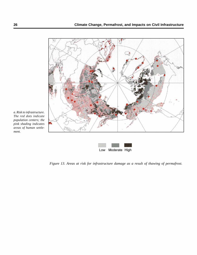
26 Climate Change, Permafrost, and Impacts on Civil Infrastructure
Figure 13. Areas at risk for infrastructure damage as a result of thawing of permafrost.
a. Risk to infrastructure.The red dots indicatepopulation centers; thepink shading indicatesareas of human settle-ment.
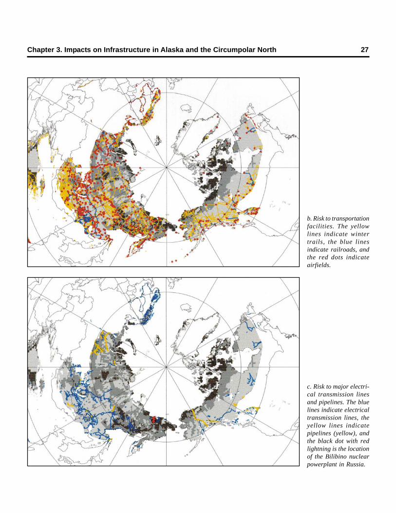
Chapter 3. Impacts on Infrastructure in Alaska and the Circumpolar North 27
b. Risk to transportationfacilities. The yellowlines indicate wintertrails, the blue linesindicate railroads, andthe red dots indicateairfields.
c. Risk to major electri-cal transmission linesand pipelines. The bluelines indicate electricaltransmission lines, theyellow lines indicatepipelines (yellow), andthe black dot with redlightning is the locationof the Bilibino nuclearpowerplant in Russia.
extensive railway system developed in areasunderlain by permafrost.
The risk to major electrical transmission linesand pipelines is shown in Figure 13c. Most elec-trical facilities, including the extensive networksin northern Scandinavia and south-centralSiberia, are located in areas of moderate risk.The Bilibino nuclear station and its grid, extend-ing from Cherskiy on the Kolyma River to Pevekon the East Siberian Sea, occupy an area inwhich increased thaw depth and abundant ice-rich permafrost combine to produce high haz-ard potential. The Trans-Alaska Pipeline Sys-tem spans two areas of moderate hazardpotential. The network of pipelines associatedwith the West Siberia oil and gas fields is ofparticular concern because it is located in theice-rich West Siberian Plain and is vulnerableto freeze–thaw processes (Seligman, 2000).
Figure 13 provides a generalized delineationof regions in the Northern Hemisphere to whichhigh priority should be assigned for monitoringpermafrost conditions. At the circum-arcticscale, maps such as these are useful for devel-oping strategies to mitigate detrimental impactsof warming and adaptation of the economy andsocial life to the changing environment of north-ern lands. Maps at such scales cannot, of course,resolve the local factors involved in the devel-opment of thermokarst. Rather, they point togeographic areas where hazard scientists, policyanalysts, and engineers should focus attentionand prepare more detailed maps at local andregional scales.
3.3 Geocryological Hazards in Alaska
Figure 14 shows the population centers andmajor roads in areas of Alaska that are pres-ently affected by permafrost. Although amajority of the population resides in permafrost-free areas of the state, sizeable towns and set-tlements are located in areas that are suscepti-ble to permafrost degradation; nearly 100,000Alaskans live in areas vulnerable to permafrostdegradation (Fig. 14). Moreover, many of thestate’s highways traverse areas underlain bypermafrost. The remainder of this chapterupdates earlier reviews by Muller (1947),
Ferrians et al. (1969), and Péwé (1954, 1983b)by considering how warming permafrost mayaffect transportation, the Trans-Alaska Pipe-line, and community infrastructure.
3.3.1 Transportation NetworkThe State of Alaska agency primarily respon-
sible for transportation infrastructure is theDepartment of Transportation and PublicFacilities (ADOT&PF). The ADOT&PF dis-cusses the history, present status, and plans forroad, rail, air, and marine transportation infra-structure in its Vision 2020 Update, StatewideTransportation Plan (ADOT&PF, 2002). Withrespect to the present status of roads, this reportnotes that “…Alaska is twice the size of Texas,but its population and road mileage comparemore closely with Vermont….” The state hasapproximately 12,700 miles of roads, about 30%(less than 4,000 miles) of which are paved.Gravel and dirt roads are by far the most com-mon design. The majority of the state’s roadsare in the south-central region, where perma-frost is discontinuous and sparse. Roads in theinterior, particularly north of Fairbanks (i.e., thegravel Dalton Highway), traverse areas under-lain by ice-rich permafrost and may requiresubstantial rehabilitation or relocation if thawoccurs.
The Alaska Railroad extends from Sewardto Fairbanks, crosses permafrost terrain, andhas been affected by differential frost heaveand thaw settlement in places (Ferrians et al.,1969). The railroad does not extend northwardinto the zone of continuous permafrost. Thawof ice-rich permafrost will increase railwaymaintenance costs but should not require majorrelocations of the existing track. Plans to extendthe track to Canada across the interior willinvolve routing through permafrost areas.Selecting a route that avoids ice-rich perma-frost foundations will increase the track mile-age and construction cost.
Alaska has 84 commercial airports and morethan 3,000 airstrips. The state has 285 publiclyowned airports, 261 of which are owned by thestate government, including 67 paved airstrips,177 gravel airstrips, and 41 seaplane ports. Manyof the state’s rural communities depend exclu-
28 Climate Change, Permafrost, and Impacts on Civil Infrastructure
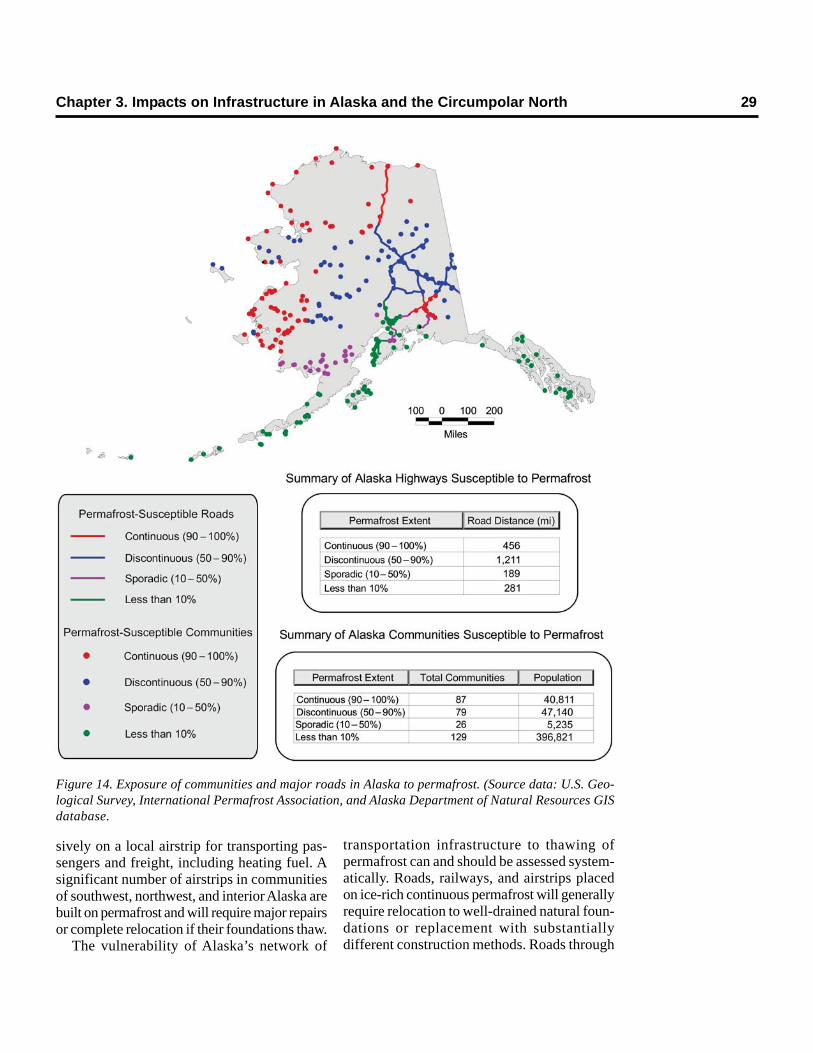
Chapter 3. Impacts on Infrastructure in Alaska and the Circumpolar North 29
Figure 14. Exposure of communities and major roads in Alaska to permafrost. (Source data: U.S. Geo-logical Survey, International Permafrost Association, and Alaska Department of Natural Resources GISdatabase.
sively on a local airstrip for transporting pas-sengers and freight, including heating fuel. Asignificant number of airstrips in communitiesof southwest, northwest, and interior Alaska arebuilt on permafrost and will require major repairsor complete relocation if their foundations thaw.
The vulnerability of Alaska’s network of
transportation infrastructure to thawing ofpermafrost can and should be assessed system-atically. Roads, railways, and airstrips placedon ice-rich continuous permafrost will generallyrequire relocation to well-drained natural foun-dations or replacement with substantiallydifferent construction methods. Roads through
30 Climate Change, Permafrost, and Impacts on Civil Infrastructure
discontinuous permafrost will require this rein-vestment for reaches built on ice-rich perma-frost. Roads and airstrips built on permafrostwith a lower volume of ice will require rehabil-itation, but perhaps not relocation, as the foun-dation thaws.
Site-specific information is most desirable forthis purpose, but the information contained onpermafrost maps can be applied to compute anexpected value of road miles over each cate-gory of permafrost. Figure 14 shows the majorroad routes of the state and the locations ofcommunities, shaded to indicate whether theyare situated in areas of continuous, discontinu-ous, or sporadic permafrost. Thawing of varioustypes of permafrost is predictable by analysesbased on knowledge of soil conditions and airtemperature warming projections. A timeline forserious permafrost-related problems could bederived from projections of general circulationmodels in a manner similar to that of Nelson etal. (2001). Expected values of relocation andrehabilitation can be developed, given estimatesof per-mile design and construction costs. Amaster plan of climate-change-induced majorrelocation and rehabilitation projects can beformed with this information. The informationcan also be applied efficiently to locate stationsto monitor permafrost warming where it mat-ters most. This effort could best be accom-plished comprehensively through the combinedresources and efforts of the state and federalgovernments.
3.3.2 Community InfrastructureCommunity infrastructure includes facilities
in urban and rural communities that are notassociated with the transportation network orthe Trans-Alaska Pipeline. Examples of com-munity infrastructure include private and publicbuildings, landfills, sewer and water facilities,solid waste facilities, electrical generatingfacilities, towers, antennas, and fuel storagetanks. Figure 14 shows the locations of settle-ments in Alaska with regard to permafrostsusceptibility. Although the major populationcenter in the Anchorage area is largely free ofpermafrost, over 160 communities lie in areasof continuous or discontinuous permafrost.
Alaska has four large military bases, two ofwhich must contend with discontinuous perma-frost. Alaska also has 600 former defense sites.Russia has an even greater problem, with asignificant number of population centers, indus-trial complexes (including one nuclear powerplant), and military bases in permafrost areas(Ershov et al., 2003). The continuous perma-frost in the far north forces essentially all facil-ities to be constructed on permafrost. Farthersouth, in areas of discontinuous permafrost, landownership and needs often force facilities to bedeveloped on permafrost.
The permafrost underlying most of the stateis the key reason why Alaskan infrastructurewill be affected by a warming climate fargreater than any other region of the U.S. Thaw-ing permafrost poses several types of risks tocommunity infrastructure. Most are associatedwith the thawing of ice-rich permafrost, which,when thawed, loses strength and volume. Themost basic risk is caused by the loss ofmechanical strength and eventually thawsettlement or subsidence. Thaw settlementcauses the failure of foundations and pilings,affecting all types of community infrastructure.Bond strengths between permafrost and pilesare greatly reduced by rising temperatures.Increases in the thickness of the active layercan cause frost heaving of pilings and struc-tures. Warming will also accelerate the erosionof shorelines and riverbanks, threatening theinfrastructure located on eroding shorelines.Thawing of permafrost or increasing the thick-ness of the active layer can also mobilizepollutants and contaminants that are presentlyconfined (Snape et al., 2003).
Thawing permafrost and changes in theactive layer across Alaska will bring potentiallyadverse impacts to building foundations andsupport structures. The past is replete withexamples of public and private facilities that havefailed due to warming and subsidence of theunderlying permafrost because of impropersiting, design, and construction methods. Thawsubsidence has resulted in numerous cases ofexpensive fixes or abandoned facilities. Duringnew construction, if ice-rich permafrost cannotbe avoided, it can be addressed with proper
Chapter 3. Impacts on Infrastructure in Alaska and the Circumpolar North 31
design and construction techniques. Methodsinclude digging out the permafrost if it is rela-tively shallow and thin, raising the structure onpiles, or otherwise assuring that the substrateremains frozen through active or passive refrig-eration. Mitigating existing problems is difficultand expensive, requiring reconstruction of thebuilding support system, as well as repairing thedamage to the structure. Warming createsfurther problems, however. If mean annual airtemperatures rise above the freezing point, itwill be impossible to maintain permafrost overthe long term without expensive artificial refrig-eration. The largest problem will be for thoseareas where the upper permafrost layers arealready near the freezing point, primarily inregions of discontinuous permafrost. Largerfacilities, such as schools and tank farms, willbe affected first. Continued warming will causeproblems even for those facilities that were prop-erly designed to maintain the underlying perma-frost in its frozen state. New approaches formaintaining existing structures and building newstructures on permafrost must be developed toaccount for increases in soil temperatures.
Thaw subsidence is also a problem for utilitydistribution networks and communicationsfacilities. These facilities are usually based onfoundations or pilings. Frost heaving of piles canresult from increased active-layer thickness.One of the major effects of thawing ice-richpermafrost is the development of thermokarstterrain. Uneven surfaces created by differen-tial thaw settlement will cause problems withabove-ground power lines, water, sewer, andfuel piped systems. Piped systems are espe-cially susceptible to settlement and subsequentleakage (Williams, 1986).
In many arctic communities, modern sewerand water facilities are non-existent. Many vil-lages still use “honeybucket” (storage and haul)systems in which human waste is emptied intoa pit or lagoon in or near the town. Many of thetowns with more modern facilities also havelagoons where waste is dumped or piped.Sewage disposal systems that are designed forsubsurface discharge may benefit from lessextensive permafrost, increased water tabledepth, and increased groundwater flow rates.
For systems that discharge into streams orrivers, increased stream flow and reduced icecover will help aerate and dilute the effluent.Landfills containing solid waste pose problemsin that contaminants confined by the frozenground may be released and transported as thepermafrost thaws. The problem is amplifiedbecause there is often far more than solid wastein landfills and at many other locations nearvillages. Past practice throughout the north hasignored proper disposal of contaminants becauseof the associated expense and the perceptionthat permafrost acts as an impermeable barrier.
Some villages or facilities located on river-banks or exposed coastlines are facing majorproblems with erosion (Walker and Arnborg,1966; USACE, 1999; Walker, 2001). Warminghas contributed to longer ice-free seasons inarctic areas. Riverbank erosion has destroyedhomes and public infrastructure in some villages(USACE, 1999). Increased storminess andhigher waves are eroding arctic coasts at greaterrates than in the past (Brown et al., 2003). Thecombination of increased wave action andwarming permafrost especially threatens low-lying coastal villages (Walker, 2001). Severalvillages in Alaska have lost buildings to the sea(Callaway et al., 1999). In some cases, entirevillages may have to be relocated. Abandoningand rebuilding communities will have thesecondary effect of generating large amountsof solid waste.
The costs associated with rehabilitating orabandoning community infrastructure damagedby thawing permafrost will be high. Even build-ings that have been designed for ice-rich perma-frost will not survive unscathed if the tempera-ture rises to the point that systems designed tomaintain permafrost in its frozen state no longerfunction adequately. Electrical distributionsystems and pipe and utilidor systems will besubject to failure from subsidence or frostheaving. Contaminants could be released fromlandfills and other contaminant storage sites oncethought to be safe. Huge costs will be associatedwith villages that must be relocated. In one casestudy by the Corps of Engineers in 1998, thecosts of moving the village of Kivalina, Alaska,to a nearby site were estimated at $54,000,000

32 Climate Change, Permafrost, and Impacts on Civil Infrastructure
(USACE, 1998). Other coastal and river villagescan be expected to have problems with warm-ing permafrost and may require additional relo-cations.
The military has extensive facilities in Alaska.Two of its largest bases and a major trainingfacility are located in areas of discontinuouspermafrost, and they must constantly cope withproblems caused by thawing permafrost (Cole,2002). There are also 600 formerly useddefense sites in Alaska. Alaska is also usedextensively for training, requiring access by mil-itary vehicles and live firing of munitions. Thedevelopment of thermokarst terrain would make
some training lands unusable. Additionalprecautions will be necessary for contaminantsgenerated by the military, some of which areassociated with the use of live munitions. Perma-frost must be considered in Department ofDefense plans for new facilities, including theNational Missile Defense sites being contem-plated for Alaska.
3.3.3 The Trans-Alaska PipelineThe Trans-Alaska Pipeline System (TAPS),
the only large-diameter hot-oil pipeline to traverseenvironmentally sensitive permafrost terrain(Fig. 15), has been called an engineering marvel.
Figure 15. Exposure of the Trans-Alaska Pipeline to permafrost. (Source data: U.S. Geological Survey,International Permafrost Association, and Alaska Department of Natural Resources GIS database.
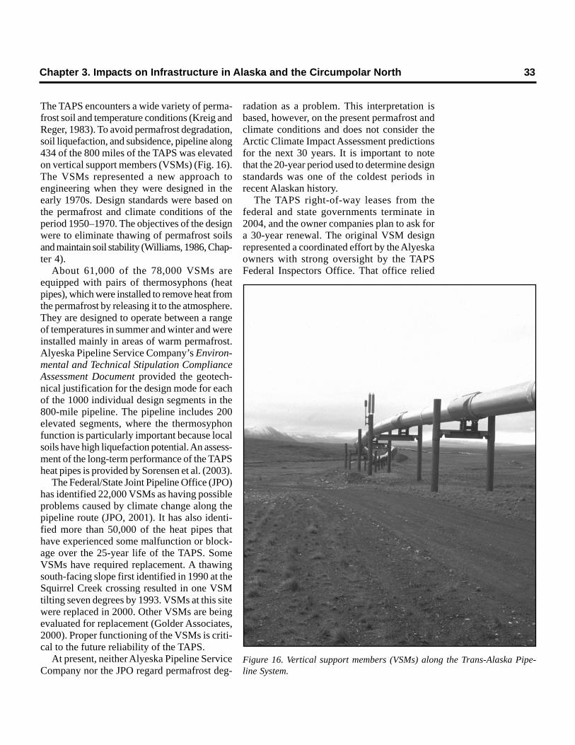
Chapter 3. Impacts on Infrastructure in Alaska and the Circumpolar North 33
The TAPS encounters a wide variety of perma-frost soil and temperature conditions (Kreig andReger, 1983). To avoid permafrost degradation,soil liquefaction, and subsidence, pipeline along434 of the 800 miles of the TAPS was elevatedon vertical support members (VSMs) (Fig. 16).The VSMs represented a new approach toengineering when they were designed in theearly 1970s. Design standards were based onthe permafrost and climate conditions of theperiod 1950–1970. The objectives of the designwere to eliminate thawing of permafrost soilsand maintain soil stability (Williams, 1986, Chap-ter 4).
About 61,000 of the 78,000 VSMs areequipped with pairs of thermosyphons (heatpipes), which were installed to remove heat fromthe permafrost by releasing it to the atmosphere.They are designed to operate between a rangeof temperatures in summer and winter and wereinstalled mainly in areas of warm permafrost.Alyeska Pipeline Service Company’s Environ-mental and Technical Stipulation ComplianceAssessment Document provided the geotech-nical justification for the design mode for eachof the 1000 individual design segments in the800-mile pipeline. The pipeline includes 200elevated segments, where the thermosyphonfunction is particularly important because localsoils have high liquefaction potential. An assess-ment of the long-term performance of the TAPSheat pipes is provided by Sorensen et al. (2003).
The Federal/State Joint Pipeline Office (JPO)has identified 22,000 VSMs as having possibleproblems caused by climate change along thepipeline route (JPO, 2001). It has also identi-fied more than 50,000 of the heat pipes thathave experienced some malfunction or block-age over the 25-year life of the TAPS. SomeVSMs have required replacement. A thawingsouth-facing slope first identified in 1990 at theSquirrel Creek crossing resulted in one VSMtilting seven degrees by 1993. VSMs at this sitewere replaced in 2000. Other VSMs are beingevaluated for replacement (Golder Associates,2000). Proper functioning of the VSMs is criti-cal to the future reliability of the TAPS.
At present, neither Alyeska Pipeline ServiceCompany nor the JPO regard permafrost deg-
radation as a problem. This interpretation isbased, however, on the present permafrost andclimate conditions and does not consider theArctic Climate Impact Assessment predictionsfor the next 30 years. It is important to notethat the 20-year period used to determine designstandards was one of the coldest periods inrecent Alaskan history.
The TAPS right-of-way leases from thefederal and state governments terminate in2004, and the owner companies plan to ask fora 30-year renewal. The original VSM designrepresented a coordinated effort by the Alyeskaowners with strong oversight by the TAPSFederal Inspectors Office. That office relied
Figure 16. Vertical support members (VSMs) along the Trans-Alaska Pipe-line System.
34 Climate Change, Permafrost, and Impacts on Civil Infrastructure
upon the expertise of the U.S. Army ColdRegions Research and Engineering Laboratory(CRREL) and the USGS for identification ofsoil and permafrost problems; continuingoperations should incorporate similar coopera-tive efforts.
In addition to the TAPS segments elevatedon VSMs, soil stability in non-permafrost areaswhere the pipeline is buried may be affected.While there was no permafrost located imme-diately adjacent to the buried pipeline, changesin freeze–thaw depth, water table location, andsoil bearing capacity may cause degradation indownslope areas, river crossings, and otherareas.
The TAPS cannot be discussed without men-tioning the large infrastructure on the NorthSlope, which provides the oil to the pipeline.Literally tens of billions of dollars of construc-tion is responsible for drilling pads, productioninstallations, injection plants, pump stations, andhundreds of miles of feeder pipelines. Althoughthese facilities are located on the colder perma-frost north of the Brooks Range, which maynot be as susceptible to thawing as is the warmerpermafrost, their impacts have been substantial(Walker et al., 1987; Committee on Cumulative
Environmental Effects, 2003, Chapter 6) andclose monitoring is critical.
3.4 Summary
A significant proportion of Alaska’s popula-tion and infrastructure is located in areas ofpermafrost, much of which may becomeunstable under conditions of global warming.Although much of this infrastructure wasdesigned for permafrost, substantial retrofittingto accommodate warming conditions may benecessary. In many instances designs are clearlyinadequate, and infrastructure could be severelydamaged by differential thaw settlement.
The problems presented by climate warm-ing in Alaska, although substantial, are notinsurmountable. To achieve maximum effective-ness in an era of declining oil revenues andlimited financial resources for both industry andgovernment at all levels, a prevenient, well-informed, and coordinated response to theeffects of global warming on permafrost isessential. The last chapter of this report providesa general prescription for the roles governmen-tal agencies can and should play in permafrostresearch.
Chapter 4FINDINGS AND AGENCY RECOMMENDATIONS
Members of the U.S. Arctic Research Com-mission Permafrost Task Force met in Salt LakeCity, Anchorage, San Francisco, and Seattlebetween November 2001 and December 2003.Discussions were also held with scientists, pri-vate industry, the U.S. Permafrost Association,senior managers of federal agencies, and Stateof Alaska departmental personnel. An integra-tion of these meetings and discussions with thebackground provided by Chapters 1 through 3of this report resulted in the following findingsand recommendations. The entire report withrecommendations has been reviewed by theCommissioners and five independent, outsidereviewers.
4.1 U.S. Federal PermafrostResearch Programs
4.1.1 Permafrost: Equal AttentionDespite publication of several reports speci-
fying needs and strategies (Committee onPermafrost, 1974, 1975, 1976, 1983; Brown andHemming, 1980), permafrost research, bothbasic and applied, has received less attentionwithin U.S. government research programs thanit warrants. This situation may in part resultfrom a perception that permafrost is very slowto respond to climate change. On the contrary,permafrost has significant roles in climatechange: as a record keeper of past tempera-tures, as a translator of climate change throughthe effects of its degradation on ecosystems andhuman infrastructure, and as a facilitator throughits potential for release of sequestered carbon.The importance of permafrost in the global sys-tem, combined with our incomplete understand-
ing of the role and behavior of frozen ground andassociated processes, dictates that permafrostresearch should have equal weight with othercomponents of the cryosphere in climate-changeresearch. The Task Force believes it is criticalthat programs such as SEARCH, ACIA, PACE,ACD, Arctic-CHAMP, Land–Shelf Interac-tions, the Fourth International Polar Year, andothers have permafrost research as one of thecritical elements of their science plans. TheTask Force recommends that all responsiblefunding agencies review their interdiscipli-nary Arctic programs to ensure that perma-frost research is appropriately integrated inprogram planning and execution.
4.1.2 Lack of a Visible U.S. FederalResearch Program
The Task Force found no focused federalresearch program dedicated to permafrost. TheNational Science Foundation funds investiga-tors in a wide range of disciplines and, underthe Office of Polar Programs (mostly throughits Arctic System Science Program), makesawards in permafrost science. The twocomponents of GTN-P are examples of highlysuccessful research programs that have receivedrecent support from NSF. Another goodexample is the development of a PermafrostObservatory at Barrow by the InternationalArctic Research Center, University of AlaskaFairbanks. In past decades, particularly duringthe Cold War and the construction of the DEWLine and the Trans-Alaska Pipeline, CRREL andUSGS had viable and robust long-term researchprograms on permafrost science and engineer-ing. These once highly visible federal programs
no longer exist. The Task Force recommendsthat the USGS, because of its key responsi-bilities in Alaska, should develop a long-termpermafrost research program with emphasison field programs. Recognizing DOD’sresponsibilities in the areas of contaminantson formerly used defense sites and futuremilitary construction in Alaska, the TaskForce recommends enhanced funding forpermafrost research and continued develop-ment of permafrost expertise at CRREL.
4.2 Data Collection, Protocols,Monitoring, and Mapping
4.2.1 Standardized Collection of BasicEnvironmental Parameters
Standardized collection of basic environ-mental parameters is essential to all scientific andengineering endeavors in cold regions.Effectively designed and implemented monitor-ing programs and sampling strategies providedata that form the foundation upon which allefforts ultimately depend. Moreover, the dataderived from such programs are invaluable formodeling efforts (e.g., general circulationmodels). The Task Force recommends thatthe WMO GHOST (Global HierarchicalObserving Strategy) hierarchical monitoringscheme discussed in Chapter 2 be imple-mented in its current or a modified format inpermafrost monitoring programs. Effort shouldbe made to support the instrumentation deemednecessary to collect basic data, in addition tothe information collected for process-based fieldstudies. At the lowest level of instrumentation,air, near-surface, and upper-permafrost temper-ature measurements should be collected at sub-diurnal frequencies. Complete meteorologicalinstrumentation at the higher end of the spec-trum should include measurements of windspeed and direction, insolation, surface albedo,soil moisture, and snow cover thickness, and itshould include a dense vertical array of thermistorsextending from the soil surface, through the activelayer, and deep into the underlying permafrost.The basic aspects of data collection at thesesites should be standardized (e.g., all air tem-perature measurements should be made at the
same height above the ground surface using astandard radiation shield). Such sites should belinked via satellite to provide real-time data tousers. Further, a concerted effort should bemade to assess the degree to which instrumentedsites are representative of the landscape. Atthis scale, timely acquisition of current and his-torical remotely sensed imagery is essential. Inthis way, a standardized set of basic environ-mental measurements, representative of a largerregion, can be collected and incorporated into aspatially extensive data set that can serve theneeds of the national and international cold-regions science and engineering communities.
4.2.2 Measurement Protocolsfor Permafrost Monitoring
A specific set of measurement protocolsshould be developed for monitoring permafrostand closely related phenomena. The protocolsshould be established by the scientific and engi-neering communities for the purpose of obtain-ing appropriate measurements at appropriatespatial and temporal frequencies and resolution.These protocols should cover the scale ofinstrumentation, ranging from site to satellite.Inherent in these protocols are the requisiteaccuracy and precision of thermistors, optimaldepth of soil measurements, and requisiteancillary data. This effort should be coordinatedand integrated with the GTN-P to ensurecollection of data useful for global climateobservation (Burgess et al., 2000; GTN-P website). Similarly, methods of monitoring active-layer thickness and thaw subsidence should beintegrated with those of ongoing internationalprojects (e.g., CALM, PACE) following discus-sion and any appropriate modification of thoseprotocols currently in place. In all cases, effortshould be made to assess the spatial variabilityof thaw depth and soil temperature and to collectancillary data.
4.2.3 Permafrost Data ManagementData collected by federally funded perma-
frost projects should be archived in the FrozenGround Data Center at NSIDC withinappropriate time periods. Details about data-collection sites and meteorological and ground
36 Climate Change, Permafrost, and Impacts on Civil Infrastructure
measurements should be available in metadatafiles with standardized formats. Some datawould be processed in accordance with identi-fied and established user needs (e.g., modelersand engineers may make better use of averagedaily temperatures or accumulated degree-daysof freezing, thawing, heating, and cooling ratherthan hourly air temperatures). Spatially inten-sive measurements, such as satellite imageryor thaw depths collected on a regular grid,should be available in a format conducive togeneration of descriptive statistics and rapidmapping. Ultimately, these data will become partof an international cold regions environmentaldata directory with links to other databases.
4.2.4 NSIDC Frozen Ground Data CenterA recent initiative at the National Snow and
Ice Data Center (NSIDC) in Boulder has beento archive permafrost and seasonally frozenground data (for example, borehole data, ArcticCoastal Dynamics program data, and maps andsoils data from Russia and China). Theseactivities are partially funded by the Interna-tional Arctic Research Center at the Universityof Alaska Fairbanks. The data activities are anoutgrowth of the International PermafrostAssociation’s data rescue program, the GlobalGeocryological Database. Long-term fundingfor the Frozen Ground Data Center is required.Recognizing that NSIDC is funded primarilyby NOAA, the Task Force strongly recom-mends that additional funding be providedby both NOAA and USGS to fully developand sustain the Frozen Ground Data Center(an estimated $300,000 annually is requiredfor adequate support).
4.2.5 Baseline Permafrost MappingThe Task Force recommends that U.S. and
international funding be sought to updatethe International Permafrost Association’sCircum-Arctic Map of Permafrost and GroundIce Conditions (Brown et al., 1997), using themost recent international databases andmaps. In addition, the Task Force recom-mends the funding and production of a high-resolution permafrost map for Alaska, a crit-ical requirement for the state’s future with
regard to climate change. Federal and stateagencies and, potentially, the private sectorshould jointly fund this effort (USGS; ArmyCorps of Engineers, Alaska District; AlaskaState agencies; and industry). The evolvingArctic Coastal Dynamics (ACD) program, ajoint effort of the IASC and IPA, could also bea vehicle for facilitating data collection andmapping of coastal erosion and flooding regimes.A continuing research theme should be theintegration of existing permafrost maps withelements of Arctic infrastructure, using GCMsand GIS. These products should include newinformation on the distribution and properties ofoffshore and alpine permafrost.
4.2.6 Measurement Technologiesand Remote Sensing
Typical measurements for the differenthierarchies of permafrost sites are provided inSection 2.3. Measurements range from probingthe active layer once annually to observing soiltemperature approximately hourly; annual tosemi-annual permafrost temperatures have alsobeen taken at 100-m depths. A fully instrumentedsingle site for examining temporal variability wouldinclude measurements of soil temperature, soilmoisture, active-layer thickness, thaw settle-ment, and near-surface permafrost tempera-tures. Air temperature, wind speed, precipitation,and snow depth are also high-priority measure-ments. With the exception of soil moisture, off-the-shelf instrumentation can make these mea-surements automatically and relativelyinexpensively. Presently, data are typicallyrecorded on a datalogger downloaded duringan annual visit to the site. Retrieval of data bysatellite uplink would mitigate the need for largedata storage capacity on-site and would allowsites to be monitored in near-real time. A criticalinstrumentation issue that needs to be addressedis the development of advanced technology formonitoring soil moisture. The Task Force rec-ommends support for the development ofinstrumentation for sensors in cold-regionsterrain by NSF’s Office of Polar Programsand Directorate of Engineering and by NASA.
Satellite remote sensing offers the greatestopportunity for large-scale monitoring of the
Chapter 4. Findings and Agency Recommendations 37
state of ground. The capability of currentsensors for permafrost monitoring needs to befully evaluated and exploited, as the study ofpermafrost by satellites has been a low-priorityissue in the remote sensing community. TheTask Force recommends that NASA continuedevelopment of new satellite sensors opti-mized for monitoring state of the surface,temperature, moisture, and ground ice incold regions. A greater capability to detectground ice would have additional planetaryapplications. All remote sensing techniques willrequire thorough field validation. Until reliablepermafrost sensors become available, methodsthat combine remotely sensed data with ground-based measurements and soil thermal modelingshould be developed and tested. Further, muchcan be inferred about permafrost from combin-ing digital elevation measurements (DEMs) withother remotely sensed parameters such as thoseconcerning snow cover and vegetation. How-ever, the DEMs currently available for much ofAlaska are extremely coarse and sometimesinaccurate, limiting their utility. The Task Forcerecommends support for advanced studiesinvolving synthesis of remotely sensed datawith other data sets, including model output.
4.2.7 Monitoring and Analysis RequirementThe Task Force recommends a new
approach (via federal legislation) for fundingthe monitoring of cold-regions environmentsin which federal projects are planned. Fed-eral agencies that fund all or portions ofmajor public works (in excess of $1M incost) in Alaska should specify that 1% ofthe project planning, design, and construc-tion costs for future Alaskan projects beinvested in monitoring in the vicinity of theconstruction site. In this way climate changecan be more adequately monitored and obser-vations analyzed and mapped into the future.
4.3 Basic Permafrost Research
4.3.1 Process Studiesin Permafrost Research
Transfer functions: air–surface–perma-frost, snow, vegetation. Quantitative estima-
tion of the air–surface–permafrost transferfunction remains a significant problem, becauseof non-linearity in the near-surface layer (air,snow, vegetation) and because of numerousfeedback effects. Continued basic research onthese processes is critical if a complete under-standing of arctic energy flows is to be achieved.
Carbon cycle considerations. Greenhousegases (carbon dioxide and methane) releasedfrom thawing permafrost into the atmospherecould create a strong positive feedback in thearctic system, and this topic is under investigationat several sites. Counterbalancing this predic-tion, there may be increased arctic ecosystemplant productivity, which could enhance thecarbon sink (Kolchugina and Vinson, 1993). Thecarbon cycle in the nearshore zone of the ArcticOcean has received less attention and requiressignificant investigation. Key questions remain:What is the major mechanism regulating thedistribution and associated rates of carbon trans-fer, transformation, and burial in the arctic land–shelf system? How do biogeochemicalprocesses on the Arctic Ocean margins influ-ence the chemistry and biology of surface watersand associated fluxes of CO2 between the air–water (or air–ice) interface? Answers to suchquestions require much more research on thestate of offshore and onshore permafrost in theatmosphere–land–shelf system in the Arctic.
Hydrology and hydrogeology. AlthoughArctic hydrology has received serious attentionin many science planning documents, littleattention has been devoted to subsurfacehydrologic and hydrogeologic processes. Thisis a critical omission because subsurface flowand subsurface storage are extremely impor-tant in the arctic hydrological system and in thearctic water cycle as a whole. Studies of perma-frost hydrogeology are practically nonexistentin the U.S., a serious gap in research for thehigh Arctic and Subarctic. The Task Forcerecommends that NSF’s new arctic programs,Arctic-CHAMP and Land–Shelf Interactions,fully incorporate permafrost hydrology andhydrogeology in their science plans.
Permafrost degradation. Stratigraphic andpaleogeographic evidence indicates that perma-frost will degrade if recent climate warming
38 Climate Change, Permafrost, and Impacts on Civil Infrastructure
continues. Degradation of ice-rich permafrosthas been documented under contemporary con-ditions in central Alaska and elsewhere(Osterkamp and Romanovsky, 1999;Osterkamp et al., 2000; Jorgenson et al., 2001).Little is known, however, about specificprocesses associated with the thawing ofpermafrost, either as a function of time or as athree-dimensional process affecting the geom-etry of permafrost distribution over a wide spec-trum of geographic scale. There is urgent needto conduct theoretical and numerical studies andadditional field investigations to address thesecritical issues; stratigraphic and paleoclimaticstudies incorporating stable isotope dating shouldbe included, as has been done in the field ofglaciology.
Geomorphic investigations. The study oflandforms and geomorphic processes is a criti-cal component of permafrost science but hasreceived little attention in Alaska in recentdecades. Process-based and modeling investi-gations focused on the evolution of slopes andother geomorphic features are urgently needed.Particular attention should be given to how pro-cesses interact over a spectrum of geographicscale. Studies focused on landscape evolutionover extended periods are also critical and cancontribute to existing programs (e.g., SEARCH,Arctic-CHAMP) concerned with hydrologicaland sediment budgets over extensive areas.Geomorphological studies should, where possi-ble, employ a systems approach that combinesexpertise from closely related disciplines.
4.3.2 Permafrost ModelingModeling is a powerful tool in permafrost
research. Although significant progress has beenachieved during the last three decades, theimportance of permafrost in a global contexthas been underestimated. Until recently, GCMsdid not incorporate permafrost and permafrost-related processes. The modeling community hasbegun to understand that unless permafrost andpermafrost-related processes are incorporated,there is little reason to expect that GCMs willproduce physically reasonable results for theArctic (Slater et. al., 1998a, b). Inclusion ofpermafrost in GCMs is a major challenge to
both modelers and permafrost researchers, andcontinued cooperative research between thetwo communities is a necessity. Funding ofmodeling efforts for arctic and subarctic regionsmust require that permafrost be incorporated inthe research plans.
Another important issue related to GCMs ishow well they can predict the extent, duration,and thickness of snow. Permafrost degradationunder a changing climate scenario is stronglyinfluenced by the regional snow cover. To date,GCMs do not provide an adequate predictivecapability for snow.
Analytical models. Many methods havebeen proposed to calculate active-layer thick-ness and mean annual permafrost surface tem-peratures using simplified analytical solutions(Pavlov, 1980; Zarling, 1987; Romanovsky andOsterkamp, 1995; Smith and Riseborough,1996). For work involving point locations wheresubsurface data are available, the importanceand utility of analytical solutions is diminished.Numerical models are widely available forpermafrost problems and can be used with someconfidence when adequate information aboutclimatic, boundary layer, and subsurface param-eters is available. Serious problems arise,however, when complex models are employedin a spatial context, particularly when little isknown about the spatial variability of parame-ters important to geocryological investigations.In such cases, stochastic modeling (Anisimovet al., 2002) or analytic procedures in a GISenvironment (Nelson et al., 1997; Shiklomamovand Nelson, 1999; Klene et al., 2002) often yieldresults superior to complex, physically basedmodels. Analytical equations can also be help-ful in providing insights into the physics of thecoupling between permafrost and theatmosphere. However, these simple equationsare presently limited in their usefulness becausethey do not include the effects of inhomogeneousactive layers with multiple layers, variablethermal properties, unfrozen water dynamics,and non-conductive heat flow. Deterministicmodels must be transformed to probabilisticmodels if the risk of permafrost degradation isto be assessed under a changing climate sce-nario (Bae and Vinson, 2001; Vinson and Bae,
Chapter 4. Findings and Agency Recommendations 39
2002). More research on refining analyticalmodels (both deterministic and probabilistic) foruse in permafrost environments is a necessity.
4.4 Applied Permafrost Research
4.4.1 Synthesis for Cold-RegionsEngineering Applications
Scientific research programs are not neces-sarily tailored to the needs of engineeringpractice and design criteria development.Predictions of frost effects and the behavior offrozen ground are highly empirical and are basedon limited numbers of field and laboratoryinvestigations. Far-reaching assumptions arenecessary to arrive at any decisions regardingchanges to the natural pattern of warming orcooling of foundations for buildings, roads, rail-ways, or airstrips in a permafrost environment.Engineers tend to rely a great deal on the provenperformance of past construction as essentialvalidations of analytical predictions.
In a period of accelerating global warming,the recent past provides only partial guidancefor predicting future permafrost conditions.Extrapolation of the recent air temperatures canbe misleading. The Task Force believesdecisions regarding new infrastructure onpermafrost will be more credible if they con-sider climate change, as predicted by globalcirculation models, weighed by associatedprobabilities.
A history of seasonal temperature is repre-sented through freezing and thawing indices, theannual sums of daily average temperaturesbelow or above freezing, respectively. Freezingand thawing indices are translated to corre-sponding ground surface freezing and thawingindices for general categories of ground surfacetypes, e.g., snow, turf, sand, and gravel. Thetransfer of atmospheric heat energy into lowerlayers of the soil is proportional to the soil thermalconductivity, which varies with soil grain size,dry density, water content, and water state(frozen or unfrozen). More precise computa-tions of heat transfer are possible but impracticalin all but carefully controlled research settings.Alaskan records of air temperature are sparse,and maps of soil characteristics are poorly
resolved. The Task Force recommends thata denser network of environmental monitor-ing stations be funded by NOAA, USGS,USDA, and responsible state agencies forAlaska. Such a network of monitoring stations,along with the application of GIS mappingmethods, will allow improved procedures to bedeveloped for predicting permafrost behaviorthat can better account for natural variabilityand probabilistic considerations.
4.4.2 Cold-Regions DesignCriteria Development
There is a significant requirement for a cold-regions engineering database to enhance thedesign, construction, and maintenance of infra-structure. Existing environmental atlases ofAlaska are nearly twenty years old. A new data-base should take advantage of GIS technologyand include geotechnical information, such aspermafrost distribution, soil type, and soil prop-erties, as well as climatic information includingair temperature and snow depth. The systemshould allow standard calculations for practicalengineering applications, such as freezing andthawing indices, active-layer thickness, and soilbearing capacity. There is also a need to estab-lish a database or information clearinghouse onexisting cold-regions transportation infra-structure (design, construction, and operations).Methods for site-specific forecasts of climatechange must be developed. A rational approachto developing design criteria using GCM resultswill perhaps be more affordable than applyingan arbitrarily large factor of safety to conven-tional design criteria. We cannot continue to treatforecasts of future climate deterministically (i.e.linearly extrapolating a rate of temperaturechange over a future time interval at a givenlocation) and must move to a more probabilisticapproach. Adaptating conventional statisticalanalyses of trends and extremes to apply GCM-predicted accelerated change is a challengingtopic for researchers.
4.4.2 Trans-Alaska PipelineSystem (TAPS)
In its 2001 Comprehensive MonitoringReport (a series of three reports dealing with
40 Climate Change, Permafrost, and Impacts on Civil Infrastructure
TAPS operations, construction, and operation),the Joint Pipeline Office (JPO) of the U.S. andthe State of Alaska indicated a range ofproblems regarding changing permafrost. Thefollowing conclusions were reached:
• The warming trends could have some effecton the foundations of the elevated portionsof the pipeline, some 423 miles with 78,000vertical support members (VSMs).
• More than 25,000 VSMs are currentlysubject to movement. Of those VSMs hav-ing heat pipes (because they are located inareas of warm permafrost), 84% have somedegree of blockage that could affect thestructure’s load-bearing capacity.
• A long-term maintenance and reconstruc-tion program is necessary for the VSMs.
The pipeline owners and their operating con-sortium, Alyeska, have contracts underway todetermine the scope of the operating and main-tenance program that will be necessary overthe next 30 years, the period requested for aright-of-way renewal. The current lease expiresin 2004 for both the federal and state rights ofway.
When the present lease was issued, scientificand engineering decisions were based on thepermafrost and climate regimes of the previousthree decades. Permafrost engineering appli-cations were limited until World War II andreached their peak during the construction ofthe DEW Line from 1948 to 1962. The exper-tise of CRREL and the USGS was made avail-able to the TAPS design team, which spent fouryears working out the present design of theVSMs. The Task Force recommends that asimilar effort be made today that closelycoordinates the efforts of the TAPS and JPOwith a significantly upgraded federalresearch effort on permafrost. Linkages withthe Arctic Climate Impact Assessment (with its
Chapter 4. Findings and Agency Recommendations 41
secretariat at the University of Alaska Fairbanks)should be established early in this effort.
4.4.3 Contaminants inPermafrost Environments
Past practice favored burial of contaminantsin permafrost because it was assumed to beimpermeable and therefore a safe and effec-tive method for isolating contaminated wastes.Contaminants are mobile in the active layer,however, and some can even be mobile withinfrozen ground. Moreover, when permafrostthaws, the ground becomes permeable, allow-ing contaminants to spread laterally and to reachdeeper unfrozen and frozen layers. The Arcticcontains a significant number of contaminatedsites; in Alaska DOD has responsibility for for-merly used defense sites, some of which arecontaminated. To determine the extent of theproblem, sites known to be contaminated mustbe assessed individually, identifying the contam-inants as well as the physical characteristics ofthe site. The potential for diffusion of contami-nants will require an estimate of the impact ofregional climate warming on the specific sites.To develop models to predict the transport ofcontaminants, the hydrological connectionsbetween the near-surface and deeper layers orground water systems must be established.Research is also required on the chemicalinteraction of contaminants with the thawedsoils, as well as on such mitigation techniquesas bioremediation. CRREL is the logical federallaboratory for this research, and the Universityof Alaska (Fairbanks and Anchorage campuses)has experienced research groups in this field.The Task Force recommends substantiallyincreased federal funding for contaminantsresearch in cold regions by DOD, EPA, andNSF, as this research is deemed critical tothe Nation’s cleanup effort in Alaska.
42 Climate Change, Permafrost, and Impacts on Civil Infrastructure
U.S. Geological Survey(Department of the Interior)
• Develop a long-term permafrost research programwith emphasis on field work and monitoring of deepboreholes; formulate the program as a contribution toSEARCH.
• Adopt the WMO GHOST hierarchical monitoringprogram for environmental data collection for newboreholes and mapping.
• Jointly fund with NOAA the Frozen Ground DataCenter at NSIDC.
• Participate in joint funding of a high-resolution perma-frost map of Alaska.
• Fund (with NOAA, USDA, and state agencies) adenser network of environmental monitoring stationsfor Alaska.
• Provide technical expertise (on permafrost and othercold-regions issues) to the TAPS JPO during the right-of-way renewal process.
• Develop jointly with the Minerals ManagementService a study of offshore undersea permafrost.
• Expand stratigraphic investigations and mapping of Qua-ternary permafrost in Alaska and the contiguous states.
• Expand investigations of periglacial landforms and pro-cesses (both contemporary and relict) in Alaska andthe contiguous states.
U.S. Army Corps of Engineers(Department of Defense)
• Provide enhanced funding for permafrost researchand support the continued development of permafrostexpertise at CRREL.
• Participate in joint funding of a high-resolution perma-frost map of Alaska.
• Increase funding for research on contaminants in coldregions at CRREL.
• Plan for climate change and permafrost degradationat existing and new military facilities to be built inAlaska.
• Rescue past agency data and contribute present andfuture data to national archives.
• Expand the role of the National Permafrost Test Site[a node in the National Geotechnical Experimenta-tion Sites (NGES) network] on Farmer’s Loop Roadoutside Fairbanks.
National Science Foundation• Review all interdisciplinary arctic programs to ensure
that permafrost research is appropriately integratedin program planning and execution.
• Within the Office of Polar Programs, restructure theGlaciology program under the heading Cryosphere,which would include snow, ice, and permafrost.
• Adopt hierarchical, spatially oriented monitoringstrategies (preferably variants of the WMO/GHOSTapproach) as appropriate for all arctic researchprograms.
• Fund proposals for the development of instrumenta-tion for sensors in cold regions (e.g., an autonomoussoil moisture sensor) (Office of Polar Programs andDirectorate of Engineering).
• Incorporate permafrost hydrology, hydrogeology, andgeomorphology in arctic programs such as Arctic-CHAMP and SEARCH; incorporate permafrostresearch in global carbon programs.
• Increase support for research on permafrost-relatedgeomorphic processes and terrain/landform analysis.
• Increase support for geocryological hazards researchat local, regional, and circumpolar scales.
• Increase funding for proposals dealing with researchon contaminants in cold regions.
• Support international permafrost activities, includingconferences and workshops.
• Integrate the use of the Permafrost National Test Siteat Fairbanks into U.S. Arctic research logisticsplanning.
• Include permafrost research at the Barrow GlobalClimate Change Research Facility.
National Aeronautics and Space Administration• Continue the development of satellite sensors
optimized for monitoring the state of the surface,temperature, moisture, and ground ice in cold regions.
• Explicitly include geocryological applications in com-petitive grants programs concerned with the use ofsatellite remote sensing data.
• Include the development of frozen ground sensors inNASA contributions to SEARCH.
• Support the Barrow Global Climate Change ResearchFacility as a satellite sensor validation site; use thefacility to ground-truth satellite frozen ground sensors.
Federal Agency, State of Alaska, and National Research Council Recommendations
Chapter 4. Findings and Agency Recommendations 43
National Oceanic and Atmospheric Administration(Department of Commerce)
• Jointly fund with USGS the Frozen Ground DataCenter at NSIDC.
• Jointly fund with USGS, USDA, and the State ofAlaska a denser network of environmental monitor-ing stations around Alaska.
• Adopt the WMO GHOST hierarchical monitoringprogram for environmental data collection.
Environmental Protection Agency• Increase funding for research on contaminants in cold
regions, and fully develop a program in Alaska.• Make funding available for permafrost-related
hazards research, particularly in urban areas.
U.S. Forest Service(Department of Agriculture)
• Increase the number of soil moisture and tempera-ture monitoring stations in Alaska.
• Formalize and extend existing programs in soil physicsand carbon sequestration.
U.S. Natural Resources Conservation Service(Department of Agriculture)
• Refine and extend activities devoted to characteriz-ing, classifying, and mapping cryosols in Alaska andthe contiguous states.
• Formalize and extend existing programs related tocarbon sequestration in tundra regions of Alaska andthe contiguous states.
• Formalize and extend existing programs investigatingsoil physics and ground temperature in Alaska, thewestern cordillera of the contiguous states, and thenorthern Appalachians.
State of Alaska• Review the arctic engineering certification process
for knowledge of permafrost under changing climateconditions.
• Seek federal support for test programs for non-standard pavements for roads and airport runways.
• Review building codes with a view to near-termchanges in the permafrost regime.
• Intensify and extend geological and geophysicalinvestigations of permafrost and its role in Quaternaryhistory by the Division of Geological and Geophysi-cal Surveys (DGGS).
• Survey community infrastructure located in perma-frost environments, with specific emphasis on ruralsewage and ground water systems.
National Research Council(National Academies of Science and Engineering)• Have the Transportation Research Board (TRB), in
cooperation with the Polar Research Board (PRB),develop a proposal for a study on the impacts of chang-ing permafrost on transportation systems in Alaska.
• Have the Polar Research Board (PRB) include glo-bal permafrost monitoring and research in the U.S.-supported programs for the International Polar Year,2007–2008.
ACD (2003) Arctic Coastal Dynamics (ACD):Summary. <http://www.awi-potsdam.de/www-pot/geo/acd.html>. Accessed Novem-ber 2003.
ADOT&PF (Alaska Department of Trans-portation and Public Facilities) (2002)Vision 2020 Update: Statewide Transpor-tation Plan.
Allard, M., and W. Baolai (1995) Recent cool-ing along the southern shore of Hudson Strait,Quebec, Canada, documented from perma-frost temperature measurements. Arctic andAlpine Research, 27(2), 157–166.
Allard, M., R. Fortier, C. Duguay, and N.Barrette (2002) A trend of fast climatewarming in northern Quebec since 1993.Impacts on permafrost and man-made infra-structure. Eos, Transactions, AmericanGeophysical Union, 83(47), F258.
Andersland, O.B., and B. Ladanyi (1994)An Introduction to Frozen GroundEngineering. Chapman and Hall, New York.
Anisimov, O.A., and F.E. Nelson (1996)Permafrost distribution in the northern hemi-sphere under scenarios of climatic change. Glo-bal and Planetary Change, 14(1), 59–72.
Anisimov, O.A., and F.E. Nelson (1997)Permafrost zonation and climate change:Results from transient general circulationmodels. Climatic Change, 35, 241–258.
Anisimov, O.A., N.I. Shiklomanov, and F.E.Nelson (1997) Effects of global warming onpermafrost and active-layer thickness:Results from transient general circulationmodels. Global and Planetary Change,15(2), 61–77.
Anisimov, O., B. Fitzharris, J.O. Hagen,R. Jeffries, H. Marchant, F.E. Nelson,T. Prowse, and D.G. Vaughan (2001) Polarregions (Arctic and Antarctic). In ClimateChange: Impacts, Adaptation, and Vul-nerability, the Contribution of WorkingGroup II of the Intergovernmental Panelon Climate Change, Third AssessmentReview. Cambridge University Press, Cam-bridge, p. 801–841.
Anisimov, O.A., N.I. Shiklomanov, and F.E.Nelson (2002) Variability of seasonal thawdepth in permafrost regions: A stochasticmodeling approach. Ecological Modelling,153(3), 217–227.
Anonymous (1970) Winter road in northernAlaska, 1969-70. Polar Record, 15(96),352–355.
Arendt, A.A., K.A. Echelmeyer, W.D.Harrison, C.S. Lingle, and V.B. Valentine(2002) Rapid wastage of Alaska glaciers andtheir contribution to rising sea level. Science,297, 382–386.
Armstrong, R., M.J. Brodzik, and A. Varani(1997) The NSIDC EASE-Grid: Addressingthe need for a common, flexible, mapping andgridding scheme. Earth System Monitor,7(4), 1–3.
Auerbach, N.A., D.A. Walker, and J.Bockheim (1996) Landcover of theKuparuk River Basin, Alaska. Joint Facilityfor Regional Ecosystem Analysis, Universityof Colorado, Boulder. Scale 1:500,000.
Aziz, A., and V.J. Lunardini (1992) Assess-ment of methods to predict the thickness ofthe active layer in permafrost regions. In Pro-ceedings, Offshore Mechanics and ArcticEngineering, Calgary, Alberta.
Aziz, A., and V.J. Lunardini (1993) Temper-ature variations in the active layer of perma-frost. In Proceedings of the Sixth Inter-national Conference on Permafrost (LanzhouInstitute of Glaciology and Cryopedology,Ed.). South China University of TechnologyPress, Wushan Guangzhou, China, p. 17–22.
Bae, Y.-S., and T.S. Vinson (2001) Probabi-listic analysis of thaw penetration with theStefan and modified Bergren equations –Case history for Fairbanks, Alaska. ReportNo. TRR 01-3, Transportation ResearchInstitute, Oregon State University.
Ballantyne, C., and C. Harris (1994) ThePeriglaciation of Britain. CambridgeUniversity Press, New York.
Balobaev, V.T. (1992) Geothermy of the
References
Frozen Zone of the Lithosphere. Nauka,Novosibirsk.
Barry, R.G. (1988) Permafrost data and infor-mation: Status and needs. In Proceedingsof the Fifth International Conference onPermafrost (K. Senneset, Ed.). Tapir Pub-lishers, Trondheim, Norway, p. 119–122.
Barry, R.G., and A.M. Brennan (1993) SixthInternational Conference on Permafrost:Towards a permafrost information system.In Proceedings of the Sixth InternationalConference on Permafrost. South ChinaUniversity of Technology Press, WushanGuangzhou, China, p. 23–26.
Beilman, D.W., and S.D. Robinson (2003)Peatland permafrost thaw and landform typealong a climatic gradient. In Proceedings ofthe Eighth International Conference onPermafrost (M. Phillips, S.M. Springman, andL.U. Arenson, Ed.). A.A. Balkema, Lisse,p. 61–65.
Berger, A.R., and W.J. Iams (1996) Geo-indicators: Assessing Rapid Environmen-tal Changes in the Earth System. Balkema,Rotterdam.
Bjorgo, E., O.M. Johannessen, and M.W.Miles (1997) Analysis of merged SMMR-SSMI time series of Arctic and Antarctic seaice parameters 1978–1995. GeophysicalResearch Letters, 24(4), 413–416.
Black, R.F. (1950) Permafrost. In AppliedSedimentation (P.D. Trask, Ed.). Wiley, NewYork, p. 247–275.
Bockheim, J.G. (1995) Permafrost distribu-tion in the southern circumpolar region andits relation to the environment: A review andrecommendations for further research. Per-mafrost and Periglacial Processes, 6(1),27–45.
Bockheim, J.G., L.R. Everett, K.M.Hinkel, F.E. Nelson, and J. Brown (1999)Soil organic carbon storage and distributionin arctic tundra, Barrow, Alaska. Soil Sci-ence Society of America Journal, 63, 934–940.
British Antarctic Survey (2002) Satellitespies on doomed Antarctic ice shelf. <http://w w w . a n t a r c t i c a . a c . u k / N e w s _and_Information/Press_Releases/2002/
20020319.html>, accessed January 2004.Brown, J. (1997) Disturbance and recovery
of permafrost terrain. In Disturbance andRecovery in Arctic Lands: An EcologicalPerspective (R.M.M. Crawford, Ed). KluwerAcademic Publishers, Dordrecht, TheNetherlands, p. 167–178.
Brown, J., and J.T. Andrews (1982) Influ-ence of short-term climate fluctuations onpermafrost terrain. Office of Basic EnergySciences, Office of Energy Research, U.S.Department of Energy, Washington, DC.
Brown, J., and N.A. Grave (1979) Physicaland thermal disturbance and protection ofpermafrost. In Proceedings of the ThirdInternational Conference on Permafrost,Volume 2. National Research Council ofCanada, Ottawa, p. 51–91.
Brown, J., and C. Haggerty (1998) Perma-frost digital databases now available. Eos,Transactions, American GeophysicalUnion, 79, 634.
Brown, J., and J.E. Hemming (1980) Work-shop on environmental protection of perma-frost terrain. Northern Engineer, 12(2), 30–36.
Brown, J., O.J. Ferrians, J.A. Hegin-bottom, and E.S. Melnikov (1997)International Permafrost AssociationCircum-Arctic Map of Permafrost andGround Ice Conditions. U.S. GeologicalSurvey Circum-Pacific Map Series, Map CP-45. Scale 1:10,000,000.
Brown, J., O.J. Ferrians, J.A. Hegin-bottom, and E.S. Melnikov (1998) Digitalcircum-arctic map of permafrost and ground-ice conditions. In Circumpolar Active-LayerPermafrost System (CAPS) CD-ROM,version 1.0. National Snow and Ice DataCenter, University of Colorado at Boulder.
Brown, J., K.M. Hinkel, and F.E. Nelson(2000) The Circumpolar Active Layer Mon-itoring (CALM) program: Research designsand initial results. Polar Geography, 24(3),165–258.
Brown, J., M.T. Jorgenson, O.P. Smith, andW. Lee (2003) Long-term rates of coastalerosion and carbon input, Elson Lagoon,Barrow, Alaska. In Proceedings of the
References 45
Eighth International Conference onPermafrost (M. Phillips, S.M. Springman, andL.U. Arenson, Ed.). A.A. Balkema, Lisse,p. 101–106.
Brown, R.J.E., and T.L. Péwé (1973) Distri-bution of permafrost in North America andits relationship to the environment: A review,1963–1973. In Permafrost—North Ameri-can Contribution to the Second Interna-tional Conference. National Academy ofSciences, Washington, D.C., p. 71–100.
Brun, S.E., D. Etkin, D.G. Law, L. Wallace,and R. White (1997) Coping with naturalhazards in Canada: Scientific, governmentand insurance industry perspectives. Envi-ronmental Adaptation Research Group,Environment Canada and Institute for Envi-ronmental Studies, University of Toronto,Toronto. <http://www.utoronto.ca/env/nh/appena.htm>.
Bryant, E.A. (1991) Natural Hazards.Cambridge University Press, Cambridge.
Burgess, M., S.L. Smith, J. Brown, V.Romanovsky, and K. Hinkel (2000) GlobalTerrestrial Network for Permafrost (GTNet-P): Permafrost monitoring contributing toglobal climate observations. GeologicalSurvey of Canada, Current Research,2000-E14.
Burn, C.R. (1997) Cryostratigraphy, paleo-geography, and climate change during theearly Holocene warm interval, westernArctic coast, Canada. Canadian Journalof Earth Sciences, 34, 912–935.
Burn, C. (1998) Field investigations of perma-frost and climatic change in northwest NorthAmerica. In Proceedings of the SeventhInternational Conference on Permafrost(A.G. Lewkowicz and M. Allard, Ed.). Cen-tre d’Etudes Nordiques, Université Laval,Québec, p. 107–120.
Burn, C.R., and C.A.S. Smith (1988) Obser-vations of the “thermal offset” in near-surface mean annual ground temperaturesat several sites near Mayo, Yukon Territory,Canada. Arctic, 41(2), 99–104.
Callaway, D., J. Earner, E. Ewardsen, C.Jack, S. Marcy, A. Olrun, M. Patkotak,D. Rexford, and A. Whiting (1999) Effects
of climate change on subsistence communi-ties in Alaska. In Assessing the Conse-quences of Climate Change in Alaska andthe Bering Sea Region: Proceedings of aWorkshop at the University of AlaskaFairbanks (G. Weller and P.A. Anderson,Ed.). Center for Global Change and ArcticSystem Research, University of Alaska Fair-banks, p. 59–73.
Claridge, F.B., and A.M. Mirza (1981)Erosion control along transportation routesin northern climates. Arctic, 34(2), 147–157.
Clark, M.J., and R.G. Barry (1998) Perma-frost data and information: Advances sincethe Fifth International Conference on Perma-frost. In Proceedings of the Seventh Inter-national Conference on Permafrost (A.G.Lewkowicz and M. Allard, Ed.). Centred’Etudes Nordiques, Université Laval,Québec, p. 181–188.
Clow, G.D., and F.E. Urban (2002) Largepermafrost warming in northern Alaskaduring the 1990’s determined from GTN-Pborehole temperature measurements. Eos,Transactions, American GeophysicalUnion, 83(47), F258.
Clow, G.D., R.W. Saltus, A.H. Lachenbruch,and M.C. Brewer (1998) Arctic Alaskaclimate change estimated from borehole tem-perature: Past, present, future. Eos, Trans-actions, American Geophysical Union,79(45), F883.
Coch, N.K. (1995) Geohazards: Natural andHuman. Prentice Hall, Englewood Cliffs,New Jersey.
Cole, D.M. (2002) Permafrost degradation:Problem statement, knowledge gaps andrelated research activities. Letter ReportERDC/CRREL LR-02-71, U.S. Army ColdRegions Research and Engineering Labora-tory, Hanover, New Hampshire.
Committee on Permafrost (1974) Prioritiesof Basic Research on Permafrost. PolarResearch Board, National Academy of Sci-ences, Washington, D.C.
Committee on Permafrost (1975) Opportu-nities for Permafrost-Related ResearchAssociated with the Trans-Alaska PipelineSystem. Polar Research Board, National
46 Climate Change, Permafrost, and Impacts on Civil Infrastructure
Academy of Sciences, Washington, D.C.Committee on Permafrost (1976) Problems
and Priorities in Offshore PermafrostResearch. Polar Research Board, NationalAcademy of Sciences, Washington, D.C.
Committee on Permafrost (1983) PermafrostResearch: An Assessment of Future Needs.Polar Research Board, National AcademyPress, Washington, D.C.
Committee on the Cumulative Environ-mental Effects of Oil and Gas Activitieson Alaska’s North Slope (2003) Cumula-tive Effects of Oil and Gas Activities onAlaska’s North Slope. National AcademyPress, Washington, D.C.
Czudek, T., and J. Demek (1970)Thermokarst in Siberia and its influence onthe development of lowland relief. Quater-nary Research, 1, 103–120.
Danilov, I.D., I.A. Komarov, and A.Y.Vlasenko (1998) Pleistocene-Holocenepermafrost of the east Siberian Eurasianarctic shelf. In Proceedings of the SeventhInternational Conference on Permafrost(A.G. Lewkowicz and M. Allard, Ed.). Cen-tre d’Etudes Nordiques, Université Laval,Québec, p. 207–212.
Davis, N. (2001) Permafrost: A Guide toFrozen Ground in Transition. University ofAlaska Press, Fairbanks.
Doolittle, J.A., M.A. Hardisky, and M.F.Gross (1990) A ground-penetrating radarstudy of active layer thicknesses in areas ofmoist sedge and wet sedge tundra nearBethel, Alaska, U.S.A. Arctic and AlpineResearch, 22(2), 175–182.
Dyke, L.D., and G.R. Brooks (2000) Thephysical environment of the MackenzieValley, Northwest Territories: A base line forthe assessment of environmental change.Bulletin 547, Geological Survey of Canada,Ottawa.
Dyurgerov, M.B., and M.F. Meier (1997)Year-to-year fluctuation of global massbalance of small glaciers and their contribu-tion to sea-level change. Arctic and AlpineResearch, 29(4), 392–402.
Ershov, E.D., S.Y. Parmuzin, N.F. Lobanov,and V.V. Lopatin (2003) Problems of radio-
active waste burial in perennially frozenground. In Proceedings of the EighthInternational Conference on Permafrost(M. Phillips, S.M. Springman, and L.U. Aren-son, Ed.). A.A. Balkema, Lisse, p. 235–238.
Ferrians, O., R. Kachadoorinan, and G.W.Green (1969) Permafrost and relatedengineering problems in Alaska. USGSProfessional Paper, 678, 1–37.
Fitzharris, B.B., I. Allison, R.J. Braith-waite, J. Brown, P.M.B. Foehn, W.Haeberli, K. Higuchi, V.M. Kotlyakov,T.D. Prowse, C.A. Rinaldi, P. Wadhams,M.-K. Woo, X. Youyu, O.A. Anisimov,A. Aristarain, R.A. Assel, R.G. Barry,R.D. Brown, F. Dramis, S. Hastenrath,A.G. Lewkowicz, E.C. Malagnino, S.Neale, F.E. Nelson, D.A. Robinson, P.Skvarca, A.E. Taylor, and A. Weidick(1996) The cryosphere: Changes and theirimpacts. In Climate Change 1995: Impacts,Adaptations, and Mitigation of ClimateChange—Scientific-Technical Analyses.Contribution of Working Group II to theSecond Assessment Report of the Inter-governmental Panel on Climate Change(R.T. Watson, M.C. Zinyowera, R.H. Moss,and D.J. Dokken, Ed.). Cambridge Univer-sity Press, New York, p. 241–265.
Forbes, B.C. (1999) Land use and climatechange on the Yamal Peninsula of north-westSiberia: Some ecological and socio-economicimplications. Polar Research, 18(2), 367–373.
Francou, B., D. Fabre, B. Pouyaud, V.Jomelli, and Y. Arnaud (1999) Symptomsof degradation in a tropical rock glacier,Bolivian Andes. Permafrost and Perigla-cial Processes, 10(1), 91–100.
French, H.M. (1975) Man-induced thermo-karst, Sachs Harbour airstrip, Banks Island,NWT. Canadian Journal of EarthSciences, 12, 132–144.
French, H.M. (1996) The PeriglacialEnvironment. Longman, Edinburgh.
French, H.M. (1998) An appraisal of cryo-stratigraphy in north-west arctic Canada.Permafrost and Periglacial Processes,9(4), 297–312.
References 47
GCOS (Global Climate Observing System)(1997) COS/GTOS plan for terrestrialclimate-related observations, Version 2.0.COS-32, WMO/TD No. 796, UNEP/DEIA/TR97-7,World Meteorological Organization,Geneva, Switzerland.
Golder Associates (2000) Potential for soilliquefaction impacting the pipline slope atSquirrel Creek. Report to the Alyeska Pipe-line Service Company.
Goldman, E. (2002) Even in the high Arctic,nothing is permanent. Science, 297(5586),1493–1494.
Gomersall, C., and K.M. Hinkel (2001)Estimating the variability of active-layer thawdepth in two physiographic regions of north-ern Alaska. Geographical Analysis, 33(2),141–155.
Goodrich, L.E. (1978) Efficient numericaltechnique for one-dimensional thermalproblems with phase change. InternationalJournal of Heat and Mass Transfer, 21(5),160–163.
Goodrich, L.E. (1982) The influence of snowcover on the ground thermal regime. Cana-dian Geotechnical Journal, 19, 421–432.
Goulden, M.L., S.C. Wofsy, J.W. Harden,S.E. Trumbore, P.M. Crill, S.T. Gower,T. Fries, B.C. Daube, S.-M. Fan, D.J.Sutton, A. Bazzaz, and J.W. Munger(1998) Sensitivity of boreal forest carbonbalance to soil thaw. Science, 279(5348),214–217.
Greco, S., R.H. Moss, D. Viner, R. Jenne,R., and Intergovernmental Panel onClimate Change, W.G.I.I. (1994) Climatescenarios and socioeconomic projections forIPCC W.G.I.I. assessment. Consortium forInternational Earth Science InformationNetwork, Washington, D.C.
Hallet, B., J. Putkonen, R.S. Sletten, andN.J. Potter (2004) Permafrost processresearch in the United States since 1960. InThe Quaternary Period in the UnitedStates (A.R. Gillespie, S.C. Porter, and B.F.Atwater, Ed.). Elsevier, Amsterdam, p. 127–145.
Hansen, J., M. Sato, J. Glascoe, and R.Ruedy (1998) A common-sense climate
index: Is climate changing noticeably?Proceedings of the National Academy ofSciences of the United States of America,95(8), 4113–4120.
Hardy, J. (2003) Global Climate Change:Causes, Effects, and Solutions. Wiley, NewYork.
Harris, C., M.C.R. Davies, and B. Etzel-mueller (2001a) The assessment of poten-tial geotechnical hazards associated withmountain permafrost in a warming globalclimate. Permafrost and Periglacial Pro-cesses, 12, 145–156.
Harris, C., W. Haeberli, D. Vonder Mühll,and L. King (2001b) Permafrost monitor-ing in the high mountains of Europe: ThePACE Project in its global context. Perma-frost and Periglacial Processes, 12, 3–11.
Harry, D.G., H.M. French, and W.H.Pollard (1988) Massive ground ice and ice-cored terrain near Sabine Point, Yukon coastalplain. Canadian Journal of Earth Sciences,25, 1846–1856.
Hinkel, K.M., and F.E. Nelson (2003) Spa-tial and temporal patterns of active layerthickness at circumpolar active layer moni-toring (CALM) sites in northern Alaska,1995–2000. Journal of GeophysicalResearch-Atmospheres, 108(D2).
Hinkel, K.M., and S.I. Outcalt (1994) Iden-tification of heat transfer processes duringsoil cooling, freezing, and thaw in centralAlaska. Permafrost and Periglacial Pro-cesses, 5(4), 217–235.
Hinkel, K.M., S.I. Outcalt, and A.E. Taylor(1997) Seasonal patterns of coupled flow inthe active layer at three sites in northwestNorth America. Canadian Journal of EarthSciences, 34, 667–678.
Hinkel, K.M., J.A. Doolittle, J.G. Bock-heim, F.E. Nelson, R. Paetzold, J.M.Kimble, and R. Travis (2001) Detectionof subsurface permafrost features withground-penetrating radar, Barrow, Alaska.Permafrost and Periglacial Processes,12(2), 179–190.
Hinkel, K.M., J.G. Bockheim, K.M. Peter-son, and D.W. Norton (2003a) Impact ofsnow fence construction on tundra soil
48 Climate Change, Permafrost, and Impacts on Civil Infrastructure
temperatures at Barrow, Alaska. In Proceed-ings of the Eighth International Confer-ence on Permafrost (M. Phillips, S.M.Springman, and L.U. Arenson, Ed.). A.A.Balkema, Lisse, p. 401–405.
Hinkel, K.M., F.E. Nelson, A.E. Klene, andJ.H. Bell (2003b) The urban heat island inwinter at Barrow, Alaska. InternationalJournal of Climatology, 23(15), 1889–1905.
Hinzman, L.D., D.L. Kane, R.E. Gieck, andK.R. Everett (1991) Hydrologic and thermalproperties of the active layer in the AlaskanArctic. Cold Regions Science andTechnology, 19(2), 95–110.
Hinzman, L.D., D.J. Goering, and D.L.Kane (1998) A distributed thermal model forcalculating soil temperature profiles and depthof thaw in permafrost. Journal of Geophys-ical Research-Atmospheres, 103(D22),28975–28991.
Hinzman, L.D., D.L. Kane, K. Yoshikawa,A. Carr, W.R. Bolton, and M. Fraver(2003) Hydrological variations among wa-tersheds with varying degrees of permafrost.In Proceedings of the Eighth InternationalConference on Permafrost (M. Phillips,S.M. Springman, and L.U. Arenson, Ed.).A.A. Balkema, Lisse, p. 407–411.
Hopkins, D.M. (1949) Thaw lakes and thawsinks in the Imuruk Lake area, Seward Pen-insula, Alaska. Journal of Geology, 57,119–131.
Instanes, A. (2003) Climate change andpossible impact on Arctic infrastructure. InProceedings of the Eighth InternationalConference on Permafrost (M. Phillips,S.M. Springman, and L.U. Arenson, Ed.).A.A. Balkema, Lisse, p. 461–466.
International Permafrost AssociationCouncil (2003). IPA Council Resolution,Zurich, Switzerland, 25 July 2003. FrozenGround, (27), 21. Also available at http://www.geodata.soton.ac.uk/ipa/.
Ives, J.D. (1974) Permafrost. In Arctic andAlpine Environments (J.D. Ives and R.G.Barry, Ed.). Methuen, London, p. 159–194.
Johnston, M.E. (1997) Polar tourism regula-tion strategies: Controlling visitors through
codes of conduct and legislation. PolarRecord, 33(184), 13–20.
JPO (Joint Pipeline Office) (2001) A look atAlyeska Pipeline Service Company’s opera-tion of the Trans-Alaska Pipeline System1999/2000. Alyeska Pipeline Service Com-pany.
JPO (Joint Pipeline Office) (2002) Evalua-tion of Alyeska Pipeline Service Company’sTrans-Alaska Pipeline Maintenance Program1999/2000. Alyeska Pipeline ServiceCompany.
Jorgenson, M.T., C.H. Racine, J.C.Walters, and T.E. Osterkamp (2001) Per-mafrost degradation and ecological changesassociated with a warming climate in centralAlaska. Climatic Change, 48(4), 551–571.
Kachurin, S.P. (1962) Thermokarst within theterritory of the USSR. Biuletyn Pery-glacjalny, 11, 49–55.
Kane, D.L., L.D. Hinzman, and J.P. Zarling(1991) Thermal response of the active layerto climatic warming in a permafrost environ-ment. Cold Regions Science and Technol-ogy, 19(2), 111–122.
Kane, D.L., L.D. Hinzman, and D.J.Goering (1996) The use of SAR satelliteimagery to measure active layer moisturecontents in arctic Alaska. Nordic Hydrology,27(1/2), 25–38.
Kane, D.L., K.M. Hinkel, D.J. Goering,L.D. Hinzman, and S.I. Outcalt (2001)Non-conductive heat transfer associated withfrozen soils. Global and Planetary Change,29(3–4), 275–292.
Klene, A.E., F.E. Nelson, N.I. Shiklo-manov, and K.M. Hinkel (2001) The n-factor in natural landscapes: Variability of airand soil-surface temperatures, Kuparuk Riverbasin, Alaska. Arctic, Antarctic, and AlpineResearch, 33(2), 140–148.
Klene, A.E., F.E. Nelson, and N.I. Shiklo-manov (2002) The n-factor as a tool in geo-cryological mapping: Seasonal thaw in theKuparuk River basin, Alaska. PhysicalGeography, 22(6), 449–466.
Klene, A.E., K.M. Hinkel, and F.E. Nelson(2003) The Barrow Heat Island Study: Soiltemperatures and active-layer thickness. In
References 49
Proceedings of the Eighth InternationalConference on Permafrost (M. Phillips,S.M. Springman, and L.U. Arenson, Ed.).A.A. Balkema, Lisse, p. 555–560.
Kolchugina, T.P., and T.S. Vinson (1993)Climate warming and the carbon cycle in thepermafrost zone of the former Soviet Union.Permafrost and Periglacial Processes,4(2), 149–163.
Kondratjeva, K.A., S.F. Khrutzky, and N.N.Romanovsky (1993) Changes in the extentof permafrost in the late Quaternary periodin the territory of the former Soviet Union.Permafrost and Periglacial Processes,4(2), 113–119.
Koster, E., and A. Judge (1994) Permafrostand climatic change: An annotated bibliogra-phy. Glaciological Data Report GD-27, WorldData Center A for Glaciology, Boulder,Colorado.
Kotlyakov, V.M., and V.E. Sokolov (Ed.)(1990) Arctic Research: Advances andProspects. Proceedings of the Conferenceof Arctic and Nordic Countries on Coor-dination of Research in the Arctic. Nauka,Moscow.
Koutaniemi, L. (1985) The central Yakutianlowlands: Land of climatic extremes, perma-frost and alas depressions. Soviet Geogra-phy, 26(6), 421–436.
Kreig, R.A., and R.D. Reger (1983) Air-photo analysis and summary of landform soilproperties along the route of the Trans-AlaskaPipeline System. Geologic Report 66, Divi-sion of Geological and Geophysical Surveys,College, Alaska.
Kudryavtsev, V.A., L.S. Garagulya, K.A.Kondrat’yeva, and V.G. Melamed (1974)Fundamentals of Frost Forecasting inGeological Engineering Investigations.Nauka, Moscow. [In Russian; English trans-lation appears as U.S. Army Cold RegionsResearch and Engineering Laboratory DraftTranslation 606 (1977).]
Lachenbruch, A.H. (1962) Mechanics ofthermal contraction cracks and ice-wedgepolygons in permafrost. Special Paper 70,Geological Society of America
Lachenbruch, A.H. (1966) Contraction theory
of ice-wedge polygons: A qualitative discus-sion. In Permafrost International Confer-ence. U.S. National Academy of Sciences–National Research Council 1287, Washington,D.C., p. 63–71.
Lachenbruch, A.H., and B.V. Marshall(1986) Changing climate: Geothermalevidence from permafrost in the Alaskanarctic. Science, 234, 689–696.
Lachenbruch, A.H., J.H. Sass, B.V.Marshall, and T.H.J. Moses (1982)Permafrost, heat flow, and the geothermalregime at Prudhoe Bay, Alaska. Journal ofGeophysical Research, 87(11B), 9301–9316.
Lauriol, B., C.R. Duguay, and A. Riel (2002)Response of the Porcupine and Old CrowRivers in northern Yukon, Canada, toHolocene climatic change. Holocene, 12(1),27–34.
Leverington, D.W., and C.R. Duguay (1996)Evaluation of three supervised classifiers inmapping “depth to late-summer frozenground,” central Yukon Territory. CanadianJournal of Remote Sensing, 22(2), 163–174.
Lewkowicz, A.G. (1992) Factors influencingthe distribution and initiation of active-layerdetachment slides on Ellesmere Island, arcticCanada. In Periglacial Geomorphology(J.C. Dixon and A.D. Abrahams, Ed.). Wiley,New York, p. 223–250.
Linell, K.A. (1973) Long-term effects ofvegetative cover on permafrost stability inan area of discontinuous permafrost. InNorth American Contribution, PermafrostSecond International Conference. NationalAcademy Press, Washington, D.C., p. 688–693.
Little, J.D., H. Sandall, M.T. Walegur, andF.E. Nelson (2003) Application of differen-tial global positioning systems to monitor frostheave and thaw subsidence in tundraenvironments. Permafrost and PeriglacialProcesses, 14(4), 349–357.
Mackay, J.R. (1970) Disturbances to thetundra and forest tundra environment of thewestern Arctic. Canadian GeotechnicalJournal, 7, 420–432.
50 Climate Change, Permafrost, and Impacts on Civil Infrastructure
Mackay, J.R. (1972) The world of under-ground ice. Annals of the Association ofAmerican Geographers, 62(1), 1–22.
Mackay, J.R. (1998) Pingo growth and col-lapse, Tuktoyaktuk Peninsula area, westernarctic coast, Canada: A long-term field study.Géographie physique et Quaternaire,52(3), 271–323.
Majorowicz, J.A., and W. Skinner (1997)Anomalous ground warming versus surfaceair warming in the southern margins of perma-frost in NW Canada. Climatic Change,35(4), 485–500.
Marion, G.M., and W.C. Oechel (1993) Mid-to late-Holocene carbon balance in ArcticAlaska and its implications for future globalwarming. Holocene, 3(3), 193–200.
McCarthy, J.J., O.F. Canziani, N.A. Leary,D.J. Dokken, and K.S. White (2001) Cli-mate Change 2001: Impacts, Adaptation,and Vulnerability. Cambridge UniversityPress, Cambridge, UK.
McMichael, C.E., A.S. Hope, D.A. Stow,and J.B. Fleming (1997) The relationbetween active layer depth and a spectralvegetation index in arctic tundra landscapesof the North Slope of Alaska. InternationalJournal of Remote Sensing, 18(11), 2371–2382.
Michaelson, G.J., C.L. Ping, and J.M.Kimble (1996) Carbon storage and distribu-tion in tundra soils of Arctic Alaska, U.S.A.Arctic and Alpine Research, 28(4), 414–424.
Miller, P.C., R. Kendall, and W.C. Oechel(1983) Simulating carbon accumulation innorthern ecosystems. Simulation, 40: 119–131.
Miller, L.L., K.M. Hinkel, F.E. Nelson,R.F. Paetzold, and S.I. Outcalt (1998)Spatial and temporal patterns of soil mois-ture and thaw depth at Barrow, AlaskaU.S.A. In Proceedings of the SeventhInternational Conference on Permafrost(A. Lewkowicz and M. Allard, Ed.). Centred’Etudes Nordiques, Université Laval,Québec, p. 731–737.
Morison, J., K. Aagaard, and M. Steele(2000) Recent environmental changes in the
Arctic: A review. Arctic, 53(4), 359–371.Moritz, R.E., C.M. Bitz, and E.J. Steig
(2002) Dynamics of recent climate changein the Arctic. Science, 297(5586), 1497–1502.
Muller, S.W. (1947) Permafrost or Perma-nently Frozen Ground and Related Engi-neering Problems. J.W. Edwards, AnnArbor, Michigan.
Murton, J.B. (2001) Thermokarst sedimentsand sedimentary structures, TuktoyaktukCoastlands, western arctic Canada. Globaland Planetary Change, 28(1–2), 175–192.
Myneni, R.B., C.D. Keeling, C.J. Tucker,G. Asrar, and R.R. Nemani (1997)Increased plant growth in the northern highlatitudes from 1981 to 1991. Nature,386(6626), 698–701.
Nakano, T., S. Kunlyoshi, and M. Fududa(2000) Temporal variation in methane emis-sion from tundra wetlands in a permafrostarea, northeastern Siberia. AtmosphericEnvironment, 34(8), 1205–1213.
Nelson, F.E., and S.I. Outcalt (1982) Anthro-pogenic geomorphology in northern Alaska.Physical Geography, 3(1), 17–48.
Nelson, F.E., and S.I. Outcalt (1987) A com-putational method for prediction and region-alization of permafrost. Arctic and AlpineResearch, 19(3), 279–288.
Nelson, F.E., S.I. Outcalt, C.W. Goodwin,and K.M. Hinkel (1985) Diurnal thermalregime in a peat-covered palsa, Toolik Lake,Alaska. Arctic, 38(4), 310–315.
Nelson, F.E., K.M. Hinkel, and S.I. Outcalt(1992) Palsa-scale frost mounds. In Peri-glacial Geomorphology (J.C. Dixon andA.D. Abrahams, Ed.). Wiley, New York, p.305–325.
Nelson, F.E., A.H. Lachenbruch, M.-K.Woo, E.A. Koster, T.E. Osterkamp,M.K. Gavrilova, and G.D. Cheng (1993)Permafrost and changing climate. InProceedings of the Sixth InternationalConference on Permafrost. South ChinaUniversity of Technology Press, Wushan,Guangzhou, China, p. 987–1005.
Nelson, F.E., N.I. Shiklomanov, G. Mueller,K.M. Hinkel, D.A. Walker, and J.G.
References 51
Bockheim (1997) Estimating active-layerthickness over a large region: Kuparuk Riverbasin, Alaska, U.S.A. Arctic and AlpineResearch, 29(4), 367–378.
Nelson, F.E., K.M. Hinkel, N.I. Shiklo-manov, G.R. Mueller, L.L. Miller, andD.A. Walker (1998) Active-layer thicknessin north-central Alaska: Systematic sampling,scale, and spatial autocorrelation. Journalof Geophysical Research, 103(D22),28963–28973.
Nelson, F.E., N.I. Shiklomanov, and G.R.Mueller (1999) Variability of active-layerthickness at multiple spatial scales, north-central Alaska, U.S.A. Arctic, Antarctic,and Alpine Research, 31(2), 158–165.
Nelson, F.E., O.A. Anisimov, and N.I. Shik-lomanov (2001) Subsidence risk from thaw-ing permafrost. Nature, 410(6831), 889–890.
Nelson, F.E., O.A. Anisimov, and N.I. Shik-lomanov (2002) Climate change and hazardzonation in the circum-Arctic permafrostregions. Natural Hazards, 26(3), 203–225.
Oechel, W.C., and G.L. Vourlitis (1994) Theeffects of climate change on land-atmospherefeedbacks in arctic tundra regions. Trendsin Ecology and Evolution, 9(9), 324–329.
Oechel, W.C., S.J. Hastings, G. Vourlitis,M. Jenkins, G. Riechers, and N. Grulke(1993) Recent change of Arctic tundra eco-systems from a net carbon sink to a source.Nature, 361(6412), 520–523.
Oechel, W.C., G.I. Vourlitis, S.J. Hastings,and S.A. Bochkarev (1995) Change inArctic CO2 flux over two decades: Effectsof climate change at Barrow, Alaska.Ecological Applications, 5(3), 846–855.
Oechel, W.C., G.L. Vourlitis, S. Brooks,T.L. Crawford, and E. Dumas (1998) Inter-comparison among chamber, tower, and air-craft net CO2 and energy fluxes measuredduring the Arctic System Science/Land–Atmosphere–Ice Interactions (ARCSS/LAII) Flux Study. Journal of GeophysicalResearch, 103(D22), 28993–29003.
Osterkamp, T.E., and V.E. Romanovsky(1999) Evidence for warming and thawingof discontinuous permafrost in Alaska.Permafrost and Periglacial Processes,
10(1), 17–37.Osterkamp, T.E., D.C. Esch, and V.E.
Romanovsky (1998a) Permafrost. InImplications of Global Change in Alaskaand the Bering Sea Region: Proceedingsof a Workshop (G. Weller and P.A. Ander-son, Ed.). Center for Global Change andArctic System Research, University ofAlaska Fairbanks, p. 115–127.
Osterkamp, T.E., V.E. Romanovsky, T.Zhang, V. Gruol, J.K. Peterson, T.Matava, and G.C. Baker (1998b) A historyof continuous permafrost conditions in north-ern Alaska. Eos, Transactions, AmericanGeophysical Union, 79(45), F833.
Osterkamp, T.E., L. Viereck, Y. Shur, M.T.Jorgenson, C. Racine, A. Doyle, andR.D. Boone (2000) Observations ofthermokarst and its impact on boreal forestsin Alaska, U.S.A. Arctic, Antarctic, andAlpine Research, 32(3), 303–315.
Outcalt, S.I., F.E. Nelson, and K.M. Hinkel(1990) The zero-curtain effect: Heat andmass transfer across an isothermal region infreezing soil. Water Resources Research,26(7), 1509–1516.
Paetzold, R.F., K.M. Hinkel, F.E. Nelson,T.E. Osterkamp, C.L. Ping, and V.E.Romanovsky (2000) Temperature andthermal properties of Alaskan soils. In GlobalClimate Change and Cold Regions Eco-systems (R. Lal, J.M. Kimble, and B.A.Stewart, Ed.). Lewis Publishers, Boca Raton,Florida, p. 223–245.
Pavlov, A.V. (1980) Calculation and Regu-lation of the Soil Freezing Regime. Nauka,Novosibirsk.
Pavlov, A.V. (1996) Permafrost-climatic mon-itoring of Russia: Analysis of field data andforecast. Polar Geography, 20(1), 44–64.
Pavlov, A.V. (1997) Patterns of frozen groundformation accompanying recent climatechanges. Polar Geography, 21(2), 137–153.
Pavlov, A.V. (1998) Active layer monitoring innorthern West Siberia. In Proceedings ofthe Seventh International Conference onPermafrost (A.G. Lewkowicz and M. Allard,Ed.). Centre d’Etudes Nordique, UniversitéLaval, Québec, p. 875–881.
52 Climate Change, Permafrost, and Impacts on Civil Infrastructure
Peddle, D.R., and S.E. Franklin (1993) Clas-sification of permafrost active layer depthfrom remotely sensed and topographicevidence. Remote Sensing of Environment,44(1), 67–80.
Peterson, D.L., and D.R. Johnson (1995)Human Ecology and Climate Change:People and Resources in the Far North.Taylor and Francis, Washington, D.C.
Péwé, T.L. (1954) Effect of permafrost uponcultivated fields. U.S. Geological SurveyBulletin, 989F, 315–351.
Péwé, T.L. (1983a) Alpine permafrost in thecontiguous United States: A review. Arcticand Alpine Research, 15(2), 145–156.
Péwé, T.L. (1983b) Geologic hazards of theFairbanks Area, Alaska. Special Report 15,Alaska Geological and Geophysical Surveys.
Péwé, T.L. (1983c) The periglacial environ-ment in North America during Wisconsin time.In The Late Pleistocene-Late QuaternaryEnvironment of the United States (S.C.Porter, Ed.). University of Minnesota Press,Minneapolis, p. 157–189.
Reeburgh, W.S., and S.C. Whalen (1992)High latitude ecosystems as CH4 sources.Ecological Bulletin, 42, 62–70.
Rignot, E., and R.H. Thomas (2002) Massbalance of polar ice sheets. Science,297(5586), 1502–1506.
Rivkin, F.M. (1998) Release of methane frompermafrost as a result of global warming andother disturbances. Polar Geography,22(2), 105–118.
Robinson, S.D., and T.R. Moore (1999)Carbon and peat accumulation over the past1200 years in a landscape with discontinu-ous permafrost, northwestern Canada.Global Biogeochemical Cycles, 13(2), 591–601.
Robinson, S.D., M.R. Turetsky, I.M.Kettles, and R.K. Wieder (2003) Perma-frost and peatland carbon sink capacity withincreasing latitude. In Proceedings of theEighth International Conference onPermafrost (M. Phillips, S.M. Springman, andL.U. Arenson, Ed.). A.A. Balkema, Lisse,p. 965–970.
Romanovskii, N.N., H.-W. Hubberten, A.V.
Gavrilov, V.E. Tumskoy, G.S. Tipenko,and M.N. Grigoriev (2000) Thermokarstand land–ocean interactions, Laptev Searegion, Russia. Permafrost and PeriglacialProcesses, 11(2), 137–152.
Romanovsky, V.E., and T.E. Osterkamp(1995) Interannual variations of the thermalregime of the active layer and near-surfacepermafrost in northern Alaska. Permafrostand Periglacial Processes, 6(4), 313–335.
Romanovsky, V.E., and T.E. Osterkamp(1997) Thawing of the active layer on thecoastal plain of the Alaskan arctic. Perma-frost and Periglacial Processes, 8(1), 1–22.
Romanovsky, V.E., and T.E. Osterkamp(2000) Effects of unfrozen water on heat andmass transport processes in the active layerand permafrost. Permafrost and PeriglacialProcesses, 11, 219–239.
Romanovsky, V., S. Smith, K. Yoshikawa,and J. Brown (2002) Permafrost tempera-ture records: Indicators of climate change.Eos, Transactions, American GeophysicalUnion, 83(50), 589 and 593–594.
Romanovsky, V.E., D.O. Sergueev, andT.E. Osterkamp (2003) Temporal variationsin the active layer and near-surface perma-frost temperatures at the long-term obser-vatories in northern Alaska. In Proceedingsof the Eighth International Conference onPermafrost (M. Phillips, S.M. Springman, andL.U. Arenson, Ed.). A.A. Balkema, Lisse,p. 989–994.
Seligman, B.J. (2000) Long-term variabilityof pipeline–permafrost interactions in north-west Siberia. Permafrost and PeriglacialProcesses, 11(1), 5–22.
Semiletov, I.P. (1999) Aquatic sources andsinks of CO2 and CH4 in the polar regions.Journal of the Atmospheric Sciences, 56,286–306.
Serreze, M.C., J.E. Walsh, F.S. Chapin III,T. Osterkamp, M. Dyurgerov, V.Romanovsky, W.C. Oechel, J. Morison,T. Zhang, and R.G. Barry (2000) Obser-vational evidence of recent change in thenorthern high-latitude environment. ClimaticChange, 46(1–2), 159–207.
References 53
Shiklomanov, N.I., and F.E. Nelson (1999)Analytic representation of the active layerthickness field, Kuparuk River basin, Alaska.Ecological Modelling, 123, 105–125.
Shiklomanov, N.I., and F.E. Nelson (2002)Active-layer mapping at regional scales: A13-year spatial time series for the Kuparukregion, north-central Alaska. Permafrost andPeriglacial Processes, 13(3), 219–230.
Shiklomanov, N.I., and F.E. Nelson (2003)Statistical representation of landscape-specific active-layer variability. In Proceed-ings of the Eighth International Confer-ence on Permafrost (M. Phillips, S.M.Springman, and L.U. Arenson, Ed.). A.A.Balkema, Lisse, p. 1039–1044.
Slater, A.G., A.J. Pitman, and C.E. Des-borough (1998a) Simulation of freeze–thawcycles in a general circulation model landsurface scheme. Journal of GeophysicalResearch, 103(D10), 11303–11312.
Slater, A.G., A.J. Pitman, and C.E. Des-borough (1998b) The validation of a snowparameterization designed for use in generalcirculation models. International Journalof Climatology, 18, 595–617.
Slaughter, C.W., C.H. Racine, D.A. Walker,L.A. Johnson, and G. Abele (1990) Useof off-road vehicles and mitigation of effectsin Alaska permafrost environments: A review.Environmental Management, 14(1), 63–72.
Smith, E.A., and J. McCarter (1997)Contested Arctic: Indigenous Peoples,Industrial States, and the CircumpolarEnvironment. University of WashingtonPress, Seattle.
Smith, J., R. Stone, and J. Fahrenkamp-Uppenbrink (2002) Trouble in polar para-dise: Polar science (Introduction). Science,297(5586), 1489.
Smith, M.W. (1975) Microclimatic influenceson ground temperatures and permafrostdistribution, Mackenzie Delta, NorthwestTerritories. Canadian Journal of EarthSciences, 12, 1421–1438.
Smith, M.W., and D.W. Riseborough (1996)Permafrost monitoring and detection ofclimate change. Permafrost and PeriglacialProcesses, 7(4), 301–309.
Smith, M.W., and D.W. Riseborough (2002)Climate and the limits of permafrost: A zonalanalysis. Permafrost and PeriglacialProcesses, 13(1), 1–15.
Snape, I., M.J. Riddle, D.M. Filler, and P.J.Williams, P.J. (2003) Contaminants in freez-ing ground and associated ecosystems: Keyissues at the beginning of the new millennium.Polar Record, 39(211), 291–300.
Soloviev, P.A. (1973) Thermokarst phenomenaand landforms due to frost heaving in centralYakutia. Biuletyn Peryglacjalny, 23, 135–155.
Sorensen, S., J. Smith, and J. Zarling (2003)Thermal performance of TAPS heat pipeswith non-condensable gas blockage. InProceedings of the Eighth InternationalConference on Permafrost (M. Phillips,S.M. Springman, and L.U. Arenson, Ed.).A.A. Balkema, Lisse, p. 1097–1102.
Stearns, S.R. (1966) Permafrost (perenniallyfrozen ground). Cold Regions Science andEngineering Part I, Section A2, U.S. ArmyCold Regions Research and EngineeringLaboratory, Hanover, New Hampshire.
Stieglitz, M., S.J. Dery, V.E. Romanovsky,and T.E. Osterkamp (2003) The role ofsnow cover in the warming of Arctic perma-frost. Geophysical Research Letters,30(13), 541–544.
Streletskaya, I.D., N.G. Ukraintseva, andI.D. Drozdov (2003) A digital database ontabular ground ice in the Arctic. In Proceed-ings of the Eighth International Confer-ence on Permafrost (M. Phillips, S.M.Springman, and L.U. Arenson, Ed.). A.A.Balkema, Lisse, p. 1107–1110.
Sturm, M., C. Racine, and K. Tape (2001)Climate change: Increasing shrub abundancein the Arctic. Nature, 411, 546–547.
Taylor, A., and M. Burgess (1998) Canada’sdeep permafrost temperatures and theresearch inspiration of Arthur H. Lachen-bruch. Eos, Transactions, AmericanGeophysical Union, 79(45), F833.
Tegart, W.J.M., G.W. Sheldon, and D.C.Griffiths (1990) The IPCC Impacts Assess-ment. Australian Government PublishingService, Canberra.
54 Climate Change, Permafrost, and Impacts on Civil Infrastructure
Terzaghi, K. (1952) Permafrost. Journal ofthe Boston Society of Civil Engineers,39(1), 1–50.
Tsibulsky, V.R. (1990) Proceedings of theInternational Symposium on Geocryolog-ical Studies in Arctic Regions. Nauka,Tyumen.
Tutubalina, O.V., and W.G. Ree (2001) Veg-etation degradation in a permafrost regionas seen from space: Noril’sk (1961–1999).Cold Regions Science and Technology, 32,191–203.
USACE (U.S. Army Corps of Engineers)(1998) Community improvement feasibilityreport, Kivalina, Alaska. U.S. Army Engi-neer District, Alaska, Anchorage.
USACE (U.S. Army Corps of Engineers)(1999) Alaska environmental infrastructure,Special Investigation. Volume 1 – MainReport. U.S. Army Engineer District, Alaska,Anchorage.
van Everdingen, R.O. (1998) Multi-Language Glossary of Permafrost andRelated Ground-Ice Terms. University ofCalgary, Alberta.
Vaughan, D.G., G.J. Marshall, W.M.Connolley, J.C. King, and R. Mulvaney(2001) Climate change: Devil in the detail.Science, 293, 1777–1779.
Velichko, A.A. (1984) Late QuaternaryEnvironments of the Soviet Union. Univer-sity of Minnesota Press, Minneapolis.
Vinson, T.S., and Y.-S. Bae (2002) Probabi-listic analysis of thaw penetration in Fairbanks,Alaska. In Proceedings of the EleventhInternational Cold Regions EngineeringSpecialty Conference. American Society ofCivil Engineers, Anchorage, Alaska, p. 712–723.
Vinson, T.S., and D.W. Hayley (Ed.) (1990)Climatic change and permafrost: Significanceto science and engineering. Journal of ColdRegions Engineering, 4(1), 1–73.
Walegur, M.T., and F.E. Nelson (2003)Permafrost distribution in the AppalachianHighlands, northeastern USA. In Proceed-ings of the Eighth International Confer-ence on Permafrost (M. Phillips, S.M.Springman, and L.U. Arenson, Ed.). A.A.
Balkema, Lisse, p. 1201–1206.Walker, D.A., P.J. Webber, E.F. Binnian,
K.R. Everett, N.D. Lederer, E.A. Nord-strand, and M.D. Walker (1987) Cumula-tive impacts of oil fields on northern Alaskanlandscapes. Science, 238, 757–761.
Walker, H.J. (1991) Bluff erosion at Barrowand Wainwright, Alaska. Zeitschrift für Geo-morphologie, Supplementband 81, 53–61.
Walker, H.J. (2001) Coastal processes andtheir influences on the people of Alaska’sNorth Slope. In Fifty More Years BelowZero (D. Norton, Ed.). Arctic Institute ofNorth America, p. 117–122.
Walker, H.J., and L. Arnborg (1966) Perma-frost and ice wedge effect on riverbankerosion. In Proceedings, Permafrost Inter-national Conference. Publication 1287,National Academy of Sciences/NationalResearch Council, Washington, D.C., p. 164–171.
Washburn, A.L. (1980) Geocryology: ASurvey of Periglacial Processes andEnvironments. Halsted Press, New York.
Washburn, A.L. (1983) What is a palsa? InMesoformen des Reliefs im heutigen Peri-glazialraum: Bericht über ein Symposium(H. Poser and E. Schunke, Ed.). Abhand-lungen der Akademie der Wissenschaften inGöttingen, Mathematisch-PhysikalischeKlasse, Göttingen, p. 34–47.
Weller, G., and C. Wilson (1990) Abstractsof the International Conference on theRole of the Polar Regions in GlobalChange. Geophysical Institute, University ofAlaska Fairbanks.
Williams, P.J. (1986) Pipelines and Perma-frost: Science in a Cold Climate. CarletonUniversity Press, Don Mills, Ontario.
Williams, P.J. (1995) Permafrost and climatechange: Geotechnical implications. Philo-sophical Transactions of the Royal Soci-ety of London A, 352(1699), 347–358.
Williams, P.J., and M.W. Smith (1989) TheFrozen Earth: Fundamentals of Geocry-ology. Cambridge University Press, NewYork.
Wolfe, S.A., S.R. Dallimore, and S.M.Solomon (1998) Coastal permafrost inves-
References 55
tigations along a rapidly eroding shoreline,Tuktoyaktuk, N.W.T. In Proceedings of theSeventh International Conference onPermafrost (A.G. Lewkowicz and M. Allard,Ed.). Centre d’Etudes Nordique, UniversitéLaval, Québec, p. 1125–1131.
Woo, M.-K., A.G. Lewkowicz, and W.R.Rouse (1992) Response of the Canadianpermafrost environment to climatic change.Physical Geography, 13(4), 287–317.
Woodcock, A.H. (1974) Permafrost andclimatology of a Hawaii volcano crater. Arcticand Alpine Research, 6(1), 49–62.
WMO (World Meteorological Organiza-tion) (1997) GHOST: Global HierarchicalObserving Strategy.
Yakushev, V.S., and E.M. Chuvilin (2000)Natural gas and gas hydrate accumulationswithin permafrost in Russia. Cold RegionsScience and Technology, 31(3), 189–197.
Yershov, E.D. (1998) General Geocryology.Cambridge University Press, Cambridge.
Zarling, J.P. (1987) Approximate solution tothe Neumann problem. In International Sym-posium on Cold Region Heat Transfer.American Society of Mechanical Engineer-ing, New York, p. 47–57.
Zhang, T., T.E. Osterkamp, and K. Stamnes(1997) Effects of climate on the active layerand permafrost on the North Slope of Alaska,U.S.A. Permafrost and PeriglacialProcesses, 8(1), 45–67.
Zhang, T., K. Barry, K. Knowles, J.A.Heginbottom, and J. Brown (1999)
Statistics and characteristics of permafrostand ground-ice distribution in the NorthernHemisphere. Polar Geography, 23(2), 132–154.
Zhang, T., R.G. Barry, K. Knowles, F. Ling,and R.L. Armstrong (2003) Distribution ofseasonally and perennially frozen ground inthe Northern Hemisphere. In Proceedingsof the Eighth International Conference onPermafrost (M. Phillips, S.M. Springman, andL.U. Arenson, Ed.). A.A. Balkema, Lisse,p. 1289–1294.
Zimov, S.A., I.P. Semiletov, S.P. Daviodov,Yu.V. Voropaev, S.F. Prosyannikov, C.S.Wong, and Y.-H. Chan (1993) WintertimeCO2 emission from soil of northeasternSiberia. Arctic, 46(3), 197–204.
Zimov, S.A., S.P. Davidov, Y.V. Voropaev,S.F. Prosyannikov, I.P. Semiletov, M.C.Chapin, and F.S. Chapin (1996) SiberianCO2 efflux in winter as a CO2 source andcause of seasonality in atmospheric CO2.Climatic Change, 33, 111–120.
Zimov, S.A., Y.V. Voropaev, I.P. Semiletov,S.P. Daviodov, S.F. Prosiannikov, F.S.Chapin III, M.C. Chapin, S. Trumbore,and S. Tyler (1997) North Siberian lakes: Amethane source fueled by Pleistocenecarbon. Science, 277, 800–802.
Zoltai, S.C. (1971) Southern limit of perma-frost features in peat landforms, Manitobaand Saskatchewan. Geological Associationof Canada Special Paper, 9, 305–310.
56 Climate Change, Permafrost, and Impacts on Civil Infrastructure
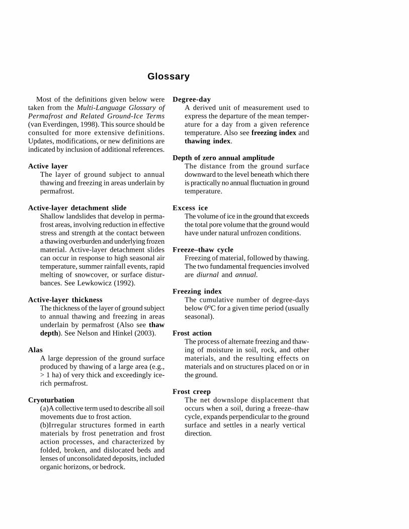
Most of the definitions given below weretaken from the Multi-Language Glossary ofPermafrost and Related Ground-Ice Terms(van Everdingen, 1998). This source should beconsulted for more extensive definitions.Updates, modifications, or new definitions areindicated by inclusion of additional references.
Active layerThe layer of ground subject to annualthawing and freezing in areas underlain bypermafrost.
Active-layer detachment slideShallow landslides that develop in perma-frost areas, involving reduction in effectivestress and strength at the contact betweena thawing overburden and underlying frozenmaterial. Active-layer detachment slidescan occur in response to high seasonal airtemperature, summer rainfall events, rapidmelting of snowcover, or surface distur-bances. See Lewkowicz (1992).
Active-layer thicknessThe thickness of the layer of ground subjectto annual thawing and freezing in areasunderlain by permafrost (Also see thawdepth). See Nelson and Hinkel (2003).
AlasA large depression of the ground surfaceproduced by thawing of a large area (e.g.,> 1 ha) of very thick and exceedingly ice-rich permafrost.
Cryoturbation(a)A collective term used to describe all soilmovements due to frost action.(b)Irregular structures formed in earthmaterials by frost penetration and frostaction processes, and characterized byfolded, broken, and dislocated beds andlenses of unconsolidated deposits, includedorganic horizons, or bedrock.
Degree-dayA derived unit of measurement used toexpress the departure of the mean temper-ature for a day from a given referencetemperature. Also see freezing index andthawing index.
Depth of zero annual amplitudeThe distance from the ground surfacedownward to the level beneath which thereis practically no annual fluctuation in groundtemperature.
Excess iceThe volume of ice in the ground that exceedsthe total pore volume that the ground wouldhave under natural unfrozen conditions.
Freeze–thaw cycleFreezing of material, followed by thawing.The two fundamental frequencies involvedare diurnal and annual.
Freezing indexThe cumulative number of degree-daysbelow 0oC for a given time period (usuallyseasonal).
Frost actionThe process of alternate freezing and thaw-ing of moisture in soil, rock, and othermaterials, and the resulting effects onmaterials and on structures placed on or inthe ground.
Frost creepThe net downslope displacement thatoccurs when a soil, during a freeze–thawcycle, expands perpendicular to the groundsurface and settles in a nearly vertical direction.
Glossary
Frost heaveThe upward or outward movement of theground surface (or objects on or in theground) caused by the formation of ice inthe soil.
Frost moundAny mound-shaped landform produced byground freezing, combined with accumula-tion of ground ice due to groundwatermovement or migration of soil moisture. Alsosee Nelson et al. (1992).
Frost penetrationThe movement of a freezing front into theground during freezing.
Frost-susceptible soilSubsurface earth materials in which segre-gated ice will form (causing frost heave)under the required conditions of moisturesupply and temperature.
Frozen groundSoil or rock in which part or all of the porewater has turned into ice.
Gas hydrateA special form of solid clathrate compoundin which crystal lattice cages or chambers,consisting of host molecules, enclose guestmolecules.
GelifluctionThe slow downslope flow of unfrozen earthmaterials over a frozen substrate. Also seesolifluction.
GeocryologyThe study of earth materials and processesinvolving temperatures of 0oC or below.
Geothermal gradientThe rate of temperature increase with depthbelow the ground surface.
Ground iceA general term referring to all types of icecontained in freezing and frozen ground.
High-center polygonAn ice-wedge polygon in which melting ofthe surrounding ice wedges has left thecentral area in a relatively elevated position.
Ice lensA dominantly horizontal, lens-shaped bodyof ice of any dimension.
Ice segregationThe formation of discrete layers or lensesof segregated ice in freezing mineral ororganic soils, as a result of the migrationand subsequent freezing of pore water.
Ice wedgeA massive, generally wedge-shaped bodywith its apex pointing downward, composedof foliated or vertically banded, commonlywhite, ice.
Ice-wedge polygonA network of ice wedges defining theboundaries of a geometric polygon in planview.
Intrusive iceIce formed from water injected into soilsor rocks.
Latent heat of fusionThe amount of heat required to melt all ice(or freeze all pore water) in a unit mass ofsoil or rock. For pure water this quantity is334 J g–1.
Low-center polygonAn ice-wedge polygon in which thawing ofice-rich permafrost has left the central areain a relatively depressed position.
58 Climate Change, Permafrost, and Impacts on Civil Infrastructure
Mass wasting (mass movement)Downslope movement of soil or rock on ornear the earth’s surface under the influenceof gravity.
Massive iceA comprehensive term used to describelarge masses of ground ice, including icewedges, pingo ice, buried ice, and large icelenses.
Mean annual air temperature (MAAT)Mean annual temperature of the air, mea-sured at standard screen height above theground surface.
Mean annual ground-surface temperature(MAGST)Mean annual temperature at the surface ofthe ground.
Mean annual ground temperature (MAGT)Mean annual temperature of the ground ata specified depth.
N-factorThe ratio of the freezing or thawing indexat the ground surface to that derived fromair temperature records.
PalsasPermafrost mounds ranging from about 0.5to about 10 m in height and exceeding about2 m in average diameter, comprising (1)aggradation forms and (2) degradationforms. The term “palsa” is a descriptiveterm to which an adjectival modifier prefixcan be attached to indicate formativeprocesses. See Washburn (1983) andNelson et al. (1992).
Patterned groundA general term for any ground surfaceexhibiting a discernibly ordered, more or lesssymmetrical, morphological pattern ofground and, where present, vegetation.
PeriglacialThe conditions, processes, and landformsassociated with cold, nonglacial environ-ments, regardless of proximity to past orpresent glaciers.
PermafrostEarth materials that remains continuouslyat or below 0oC for at least two consecu-tive years.
Permafrost, continuousRegions in which permafrost occurs nearlyeverywhere beneath the exposed landsurface. At the circumpolar scale the termcontinuous permafrost zone refers to abroad area, crudely conformable withlatitude, in which permafrost is laterally con-tinuous. See Nelson and Outcalt (1987).
Permafrost, discontinuousRegions in which permafrost is laterallydiscontinuous owing to heterogeneity ofmaterial properties, subsurface water, andsurface cover.
Permafrost, dryPermafrost containing neither free waternor ice.
Permafrost, ice-richPermafrost containing excess ice.
PingoA perennial frost mound consisting of a coreof massive ice produced primarily by injec-tion of water, and covered with soil andvegetation.
Retrogressive thaw slumpA slope failure resulting from thawing if ice-rich permafrost.
Seasonally frozen groundGround that freezes and thaws annually.
Glossary 59
SolifluctionA general term referring to the slow down-slope flow of saturated unfrozen earthmaterials over an impermeable substrate(also see gelifluction).
Thermokarst terrainIrregular topography resulting from themelting of excess ground ice and subse-quent thaw settlement.
Thaw depthThe instantaneous depth below the groundsurface to which seasonal thaw has pene-trated (also see active-layer thickness).See Nelson and Hinkel (2003).
Thaw lakeA lake whose basin was formed or enlargedby thawing of frozen ground. See Hopkins(1949) and Washburn (1980, p. 271).
Thaw settlementCompression of the ground due to loss ofexcess ground ice and attendant thaw con-solidation.
Thawing index (DDT)The cumulative number of degree-daysabove 0oC for a given time period (usuallyseasonal).
Thaw consolidationTime-dependent compression resulting fromthawing of ice-rich frozen ground and sub-sequent draining of excess water.
Thermal erosionErosion of ice-bearing permafrost by thecombined thermal and mechanical actionof moving water.
Thermal conductivityThe quantity of heat that will flow througha unit area of a substance in unit time undera unit temperature gradient. In permafrostinvestigations thermal conductivity is usuallyexpressed in W m–1 oC–1.
Thermal offsetTemperature depression in the upper layerof permafrost, resulting from the combinedeffects of seasonal differences of thermalconductivity and the operation of noncon-ductive processes in the active layer. SeeWilliams and Smith (1989) and Nelson etal. (1985).
Zero curtain effectPersistence of a nearly constant tempera-ture very close to the freezing point of waterduring annual freezing (and occasionallythawing) of the active layer. See Outcalt etal. (1990).
60 Climate Change, Permafrost, and Impacts on Civil Infrastructure
ACDArctic Coastal Dynamics (IASC)
ACIAArctic Climate Impact Assessment
ADOT&PFAlaska Department of Transportation andPublic Facilities
ALTactive-layer thickness
ARCSSArctic System Science program (NSF/OPP)
Arctic-CHAMPCommunity-wide Hydrological Analysis andMonitoring Program (U.S. National ScienceFoundation initiative)
BEOBarrow Environmental Observatory
CALMCircumpolar Active Layer Monitoringprogram
CEONCircumarctic Environmental ObservatoriesNetwork
CRRELCold Regions Research and EngineeringLaboratory (U.S. Army Corps of Engi-neers)
DGGSDivision of Geological and GeophysicalSurveys (Alaska Department of NaturalResources)
DODU.S. Department of Defense
EPAU.S. Environmental Protection Agency
FAOFood and Agriculture Organisation (of theUnited Nations)
FGDCFrozen Ground Data Center (NSIDC)
GCOSGlobal Climate Observing System
GCMgeneral circulation model (or global climatemodel)
GHOSTGlobal Hierarchical Observational Strategy(WMO)
GISgeographic information systems (or geo-graphic information science)
GSCGeological Survey of Canada
GTN-PGlobal Terrestrial Network for Permafrost
GTOSGlobal Terrestrial Observing System
IASCInternational Arctic Science Committee
ICSUInternational Council of Scientific Unions
IPAInternational Permafrost Association
IPCCIntergovernmental Panel on Climate Change
List of Acronyms
IPYInternational Polar Year
JPOJoint Pipeline Office (U.S. federal and Stateof Alaska)
LTERU.S. Long Term Ecological ResearchNetwork
MAATmean annual air temperature
MAGSTmean annual ground surface temperature
MAGTmean annual ground temperature
NASAU.S. National Aeronautics and SpaceAdministration
NOAAU.S. National Oceanic and AtmosphericAdministration
NRCSU.S. Natural Resources ConservationService (USDA)
NSFU.S. National Science Foundation
NSIDCU.S. National Snow and Ice Data Center(Boulder, Colorado)
OPPOffice of Polar Programs (U.S. NationalScience Foundation)
PACEPermafrost and Climate in Europe program
SEARCHStudy of Environmental Arctic Change(U.S. federal government multiagencyinitiative)
TAPSTrans-Alaska Pipeline System
TDRtime-domain reflectometry
TEMSTerrestrial Ecosystem Monitoring Sitesnetwork
TOPCTerrestrial Observational Panel for Climate
UAFUniversity of Alaska Fairbanks
UNEPUnited Nations Environment Programme
UNESCOUnited Nations Educational, Scientific andCultural Organization
USACEU.S. Army Corps of Engineers
USDAU.S. Department of Agriculture
USPAU.S. Permafrost Association
USARCU.S. Arctic Research Commission
USGSU.S. Geological Survey
VSMvertical support member
WMOWorld Meteorological Organization
62 Climate Change, Permafrost, and Impacts on Civil Infrastructure
UNITED STATES ARCTIC RESEARCH COMMISSION
The U.S. Arctic Research Commission (USARC) was created by the Arctic Researchand Policy Act of 1984 (as amended in November 1990). The Commission, whose sevenmembers are appointed by the President of the United States, assesses national needsfor arctic research and recommends to the President and the U.S. Congress researchpolicies and priorities that form the basis for a national arctic research plan. Other keyUSARC functions include facilitating cooperation in arctic research between federal,state, and local governments; recommending improvements in arctic research logistics;recommending areas for enhanced international scientific cooperation in the Arctic;cooperating with the Governor of Alaska in formulating arctic research policy; and con-ducting special studies such as Climate Change, Permafrost, and Impacts on CivilInfrastructure. USARC biennially submits a strategic document, Goals and Objec-tives for Arctic Research, to the Interagency Arctic Research Policy Committee for itsuse in revising a national five-year Arctic Research Plan. The Commission normallymeets four times annually (at least once each year in Alaska) to hear invited and publictestimony on all facets of Arctic research. The USARC staff has offices at 4350 NorthFairfax Drive, Suite 510, Arlington, Virginia 22203, and 420 L Street, Suite 315, Anchor-age, Alaska 99501.
USARC COMMISSIONERS (DECEMBER 2003)George B. Newton, Jr.Fairfax, Virginia (Chair)
Mary Jane FateFairbanks, Alaska
John F. Hobbie, Ph.D.Woods Hole, Massachusetts
Duane H. Laible, PESeattle, Washington
John R. RoderickAnchorage, Alaska
Susan F. Sugai, Ph.D.Fairbanks, Alaska
Mead TreadwellAnchorage, Alaska
Rita R. Colwell, Ph.D.Director, National Science Foundation(ex officio)
Back Cover: South-facing view of the Trans-Alaska pipeline near Sukakpak Mountain,southern Brooks Range foothills. This area is in the zone of discontinuous permafrost.Nearly 80% of the Trans-Alaska pipeline lies within the state’s permafrost regions (seeFigure 15). Photo by F.E. Nelson, October 1982.