Embed Size (px)
Citation preview
Index of Streets and Alleys found in Records, Plats, Atlases and Miscellaneous Drawings at the Baltimore City Archives compiled by Rebecca Gunby, 1993
Note: An Aperture Number such as {M____} refers to RG 12 S.1. An Aperture Number such as {1-11[1]} refers to MS 10.
A
A Court: (Opening) 1880 M1673 A Highway: n.d. M6255-57 Abbey Alley: Hamburg St from Abbey Alley to William St n.d. 1-41[7] Abbey Alley: 1841 M1467 Abbotston St: was Jackson St Abbottson St: Abbottson St to Carswell St & Taylor St to Kennedy Ave n.d. C-30[2] Abbottson St: Abbottson St between Taylor St to Kennedy Ave n.d. C-30[1] Abbottson St: Taylor St & Abbottson St n.d. C-30[4] Abbottson St: Polk St to Harford Rd & Abbottson St to Hugo Ave 1913 D-22[1] Abbottson St: 29th St to Abbottson St & Kennedy La to Harford Rd 1913 A-45[2] Abel St: was Claggett Alley Abel St: became part of Clagett Alley Abey Alley: now Compton St Abell, A S: Cold Spring La to 25th St & 26th St to York Tnpk Rd n.d. A-5[2] Abell Ave: Abell Av & 30th St 1913 C-26[1] Abell Ave: 31st St & Abell Av 1912 C-26[3] Abell St: n.d. M5371 Abell St: became part of Claggett Alley Abell St: 32nd St to 31st St & Guilford Ave to Abell St 1913 C-21[1] Aberdeen: Relocation of Philadelphia Rd: Balto City Line to Aberdeen 1934 [26] Aberdeen: Relocation of Philadelphia Rd: Balto City Line to Aberdeen 1934 [27] Aberdeen Proving Ground: Boothby Hill Rd from Philadelphia Rd<R>to Aberdeen Proving Ground 1942 [25] Aberdeen Md: Edmund St addition to Aberdeen Md 1922 [35] Abey Alley: now Compton St Abey Alley: Cross to Hamburg 1841 Atl 3 Abey Alley: Cross to Hamburg St 1841 M1467 Abey Alley: Hamburg St & Abey Alley n.d. I-29[3] Able St: became part of Claggett Alley Abottston St: Harford Ave between Abottston St & Tivoly Ave n.d. D-23[1] Academy Alley: from Franklin St to Howard St 1969 M6500-01 Academy Alley: was John Alley Accomodation Alley: see Aetna Alley or Lane Accomodation Alley: Accomodation Alley from Frederick St<R>to Harrison St n.d. 3-73[3] Accommodation Alley: from Breidenbaugh Alley to Mechanics Court 1930 M3215 Accomodation Alley: from Frederick St to Harrison St 1816 M.R.1&2 Accomodation Alley: High St to Accomodation Alley & Addison St<R>to Mechanical St 1858 4-18[2] Accomodation Alley: Mechanical St to Bridge St & High St<R>to Accomodation Alley n.d. 3-38[2] Accommodation Alley: from Mechanics Ct to Orleans St Viaduct 1940 M3318 Ackworth Alley: was Car Alley Ackworth Alley: Lanvale St to Franklin St & Ackworth Alley to Dorsey’s Lane n.d. 3-90[4] Ackworth Alley: Pratt St to McHenry St & Ackworth Alley to Pulaski St n.d. 2-26[5] Ada St: from Homewood Ave to Old York Rd n.d. M3816-17 Adam St: Adams St to George St & Fremont St to Brune St n.d. X-56[3] Adams Ave: Mosher St to Harlem (Adams) Ave & Fremont St to Chatsworth St n.d. X-70[2] Adams Alley: Prospect St to Adams Alley & Bloomingdale Rd to Albert St n.d. A-88[3] Adams Alley: now Trenton St Adams St: n.d. M5360 Adams St: Adams St to Franklin St & Republican St to Oregon St 1870 X-42[1] Adams St: Adams St to Thompson St & Fremont (formerly Cove) St to Schroeder St 1871 X-85[1] Adams St: Adams St to Thompson St & Schroeder St to Cove St 1828 -47[2] Adams St: Cokesbury Ave between 23rd St & Adams St 1913 C-33[5] Adams St: now Harlem Ave Adams St: from of Homewood Ave to of 25th St 1912 M1028-29 Adams St: was Kennedy Lane Adams St: Mosher St to Adams St & Calhoun St to Chatsworth St n.d. X-38[2] Adams St: Republican St to Calhoun St & Adams St to Saratoga St n.d. Z-80[1] Adams St: Republican St to Oregon St & Franklin St to Adams St 1852 O-73[5] Adams St: Republican St to Oregon St & Adams St to Thompson St n.d. 4-87[1]
file://C:\baltimore-city-streets-gunby\a.html
8/27/2006Page 1
Addison Alley: n.d. M5373 Addison Alley: 1884 M176 Addison Alley: part of A Alley Addison Alley: Addison Alley to Front St & High St n.d. Z-62[1] Addison Alley: Addison Alley to Hillen St & Front St to High St 1878 S-2[4] Addison Alley: S of Eagle St to B&O Right-of-Way 1905 M4291 Addison Alley: Edmondson Ave to Saratoga St & Smallwood St to Addison Alley n.d. O-37[6] Addison Alley: Franklin St to Mulberry St & Addison Alley to Gilmore St 1871 X-41[2] Addison Alley: Frederick Ave & Addison Alley n.d. X-16[4] Addison Alley: Frederick Ave to Lombard St & Monroe St to Addison Alley 1867 4-58[1] Addison Alley: Friendsbury Place Addison Alley: see plat of "Friendsbury" of Friendsbury Place Addison Alley: from Front St to High St 1878 M1530-31 Addison Alley: from High St to property assessed to C & G W Eggleston 1881 M1763 Addison Alley: now Hood St Addison Alley: was Kirby Lane Addison Alley: Lexington St to Baltimore St & Addison Alley to Stricker St 1849 Z-48[2] Addison Alley: North Ave to Baker St & Addison Alley to Gilmore St n.d. O-33[8] Addison Alley: North Ave to Baker St & Payson St to Addison Alley n.d. O-34[7] Addison Alley: Ramsay St from Stricker St to Addison Alley n.d. S-28[3] Addison St: High St to Accomodation Alley & Addison St to Mechanical St 1858 4-18[2] Addison St: High St & Addison St n.d. 4-100[3] Addison St: High St from Addison St to North (or Hillen) St n.d. X-41[4] Addison St: from Jones Falls toHigh St n.d. Atl 6 Aetna Lane: see Accomodation Alley Aetna St: was Accomodation Alley Aetna St: from Frederick St toHarrison St n.d. Atl 1 ½ Aetna Lane: Frederick St & Atena Lane n.d. 4-34[10] Agate Court: was Jasper Alley or Court Agate Court: was Stevenson Court Aiken St: Aiken St & Lanvale St n.d. 3-21[4] Aiken St: from Lanvale St toNorth Ave 1902 M2698 Aisquith Court: now Sapp St Aisquith St: n.d. M5361-62 Aisquith St: n.d. M5367-70 Aisquith St: Aisquith St n.d. A-24[4] Aisquith St: Aisquith St n.d. 3-35[1] Aisquith St: Aisquith St n.d. 4-38[5] Aisquith St: Aisquith St 1908 A-83[1] Aisquith St: (Little) from Baltimore St to Fayette St 1846 M0229 Aisquith St: Aisquith St from Baltimore St to Laurel St n.d. 2-9[1] Aisquith St: Aisquith St & Chew St n.d. X-91[3] Aisquith St: Aisquith St from Chew St to Madison St n.d. O-63[1] Aisquith St: Aisquith St from Douglass St to Holland St n.d. 1-43[6] Aisquith St: Aisquith St from Eager St to Chew St n.d. 1-61[4] Aisquith St: Aisquith St from Eager St to Chew St n.d. O-63[10] Aisquith St: Aisquith St to East (formerly Liberty) St & Douglass St to Comet St 1844 Z-14[1] Aisquith St: Aisquith St to East (formerly Liberty) St & Douglass St to Pine St 1844 Z-18[1] Aisquith St: Aisquith St to Fayette St n.d. X-52[4] Aisquith St: Aisquith St from Gay St to Low St n.d. Z-87[3] Aisquith St: Aisquith St to Harford Ave & Oliver St to Fells Point Lane (Old York Rd) n.d. 3-7[3] Aisquith St: Aisquith St to Harford St & Joppa Rd to Jefferson St 1820 I-35[2] Aisquith St: Aisquith St between Holbrook St & Hope St 1872 1-52[4] Aisquith St: Aisquith St & Holland St n.d. 2-30[4] Aisquith St: Aisquith St & Hulls Lane n.d. 1-56[1] Aisquith St: Aisquith St & Lamont Ave 1904 2-15[8] Aisquith St: Aisquith St & Little Sterling St n.d. I-27[5] Aisquith St: Aisquith St to Long Alley & Jefferson St to Orleans St n.d. 1-46[1] Aisquith St: Aisquith St to Long Alley & Holland St to Orleans St n.d. 1-46[5] Aisquith St: Aisquith St to Montpelier St 1924 C-68[4] Aisquith St: Aisquith St from Monument to Gay St n.d. I-25[4] Aisquith St: Aisquith St from North Ave to Towsend St n.d. S-62[5] Aisquith St: Aisquith St from Old Publick Rd to Pitt St n.d. 3-95[1] Aisquith St: Aisquith St & Orleans St n.d. 3-35[6] Aisquith St: Aisquith St & Point Lane n.d. 3-66[1] Aisquith St: (Balto.-Fayette) n.d. M5372 Aisquith St: from Baltimore St to Fayette St n.d. M2679 Aisquith St: Baltimore St toFayette St 1846 M1113 Aisquith St: from Baltimore St toFayette St 1913 M3975-76 Aisquith St: Baltimore St to Pitt(now Fayette) St n.d. Atl 3
file://C:\baltimore-city-streets-gunby\a.html
8/27/2006Page 2
Aisquith St: from Biddle St toLanvale St 1852 Atl 3 Aisquith St: Briton St & Aisquith St n.d. 3-85[2] Aisquith St: Chase St from Harford Ave to Aisquith St n.d. I-30[2] Aisquith St: from Chew St to Harford Ave 1836 M0057 Aisquith St: Chew St to the Harford Rd n.d. M0050 Aisquith St: Chew (now Ashland) Stto Harford Ave n.d. Atl 2 ½&3 Aisquith St: Chew St from Neighbor St to Aisquith St n.d. 1-90[4] Aisquith St: Darley Ave to Belmont Ave & Aisquith St to Harford Rd 1916 C-48[4] Aisquith St: Eager St & Aisquith St n.d. I-31[6] Aisquith St: Federal St from Aisquith St to Eden St 1897 S-75[1] Aisquith St: Forrest St to Aisquith St n.d. S-89[2] Aisquith St: Forrest St to Aisquith St 1836 I-81[1] Aisquith St: Forrest St to Aisquith St & Comet St to Douglass St n.d. 1-42[11] Aisquith St: Forrest St, Halfmoon Alley & Aisquith St n.d. S-94[2] Aisquith St: Friendship St to Aisquith St & Thomsen St to Orleans St 1876 S-3[1] Aisquith St: Gay St & Aisquith St 1853 Z-18[3] Aisquith St: to Half Moon Alley & Forrest St to Comet St n.d. Z-18[2] Aisquith St from Half Moon Alley to Pitt St n.d. 1-42[8] Aisquith St: from Harford Ave to Aisquith St n.d. I-27[1] Aisquith St: @ Harford Ave & ChaseSt n.d. Atl 3 Aisquith St: Harford Ave to Eager St & Upton St to Aisquith St 1836 I-61[3] Aisquith St: from Harford Ave toPoint La 1852 M0928 Aisquith St: from Harford Ave toPoint La 1852 M1171-72 Aisquith St: Hoffman St between Aisquith St & Harford Ave n.d. O-13[5] Aisquith St: Hoffman St toHarford Ave n.d. Atl 3 Aisquith St: Hoffman St Oliver St to John St & Aisquith St to Central Ave 1870 X-72[2] Aisquith St: Hoffman St to PointLane (now Lamont Ave) n.d. Atl 3 Aisquith St: Holland Alley to Aisquith St & Ensor St to Chase St n.d. X-36[1] Aisquith St: Jefferson St from Aisquith St to Canal (formerly Harford) St 1843 I-51[3] Aisquith St: John St from Aisquith St to Harford Ave n.d. X-73[3] Aisquith St: Lanvale St to Federal St & Aisquith St to Eden St n.d. O-33[1] Aisquith St: Lanvale St to Federal St & Ensor St to Aisquith St n.d. 1-53[2] Aisquith St: Lanvale St to Oliver St & Aisquith St to Point Lane 1852 1-62[5] Aisquith St: Laurel St to Fayette St & East St to Aisquith St n.d. S-94[1] Aisquith St: Levins St between Aisquith St & Canal St n.d. Z-23[3] Aisquith St: Little McElderry St between Gay St & Aisquith St 1853 X-94[2] Aisquith St: Little McElderry St to Low St & Aisquith St to Peter’s Court n.d. 3-2[2] Aisquith St: part was Lloyds Lane Aisquith & Low Sts: n.d. M5380 Aisquith St: Low & Aisquith St n.d. 3-2[4] Aisquith St: Low St from Aisquith St to Potter St n.d. X-48[1] Aisquith St: Low St from Front St to Aisquith St n.d. O-7[4] Aisquith St: Lowe Sts: 1924 M0970 Aisquith St: Madison St & Aisquith St 1841 I-24[2] Aisquith St: Madison St to Monument St & Aisquith St to Eden St 1836 I-80[3] Aisquith St: May St to Orleans St & Young St to Aisquith St n.d. O-93[3] Aisquith St: McElderry St to Pitt St & Potters St to Aisquith St n.d. 1-46[7] Aisquith St: McEldery St to Pitt & Potter St to Aisquith St 1805 3-76[3] Aisquith St: Montpelier St between Aisquith St & Harford Rd 1916 D-18[2] Aisquith St: Monument St from Aisquith St to Gay St (or Belle Air Ave) 1853 S-65[1] Aisquith St: Monument St to Pitt St & Aisquith St to Canal St n.d. 3-28[2] Aisquith St: Monument St from Upton St to Aisquith St n.d. 3-33[1] Aisquith St: North Ave to Hull’s Lane & Garden St to Aisquith St 1873 O-88[4] Aisquith St: North Ave between Kennedy Ave & Aisquith St 1912 B-65[4] Aisquith St: North Ave between Kennedy Ave & Hope St 1912 B-65[2] Aisquith St: North Ave to PointLa 1873 M2249 Aisquith St: North Ave to Town- send St & Aisquith St to Harford Ave 1875 S-42[2] Aisquith St: from North St to 25th St 1916 M0391-92 Aisquith St: Pitt St 1814 Atl 1 ½ Aisquith St: Pitt (now Fayette) St n.d. Atl 1 ½&6 Aisquith St: from Pitt (nowFayette) St to Old York Rd(now Lamont Ave) n.d. Atl 2 ½ Aisquith St: Orleans St from Young St to Aisquith St n.d. O-81[7] Aisquith St: Orleans St from Aisquith St to Lewis St n.d. S-61[4] Aisquith St: Orleans St & Aisquith St n.d. S-68[4] Aisquith St: Orleans St from Aisquith St to Central Ave 1884 S-78[2] Aisquith St: Orleans St from Forrest St to Aisquith St n.d. S-78[1] Aisquith St: Orleans St from Frederick St to Aisquith St 1815 I-12[5] Aisquith St: Point La & Aisquith St n.d. O-2[1] Aisquith St: Point La to Lanvale St & Aisquith St to Hope St 1873 1-67[1] Aisquith St: Point La to NorthAve 1872 M1517-18 Aisquith St: Robb St between Kennedy Ave & Aisquith St 1916 C-74[4]
file://C:\baltimore-city-streets-gunby\a.html
8/27/2006Page 3

Aisquith St: now Sapp St Aisquith St: Townsend St to Hoffman St & Holbrook St to Aisquith St n.d. X-26[3] Aisquith St: Towsend St to Hoffman St & Holbrook St to Aisquith St n.d. 1-56[2] Aisquith St: Upton St & Aisquith St n.d. 3-35[3] Aisquith St: was Watson Court or Street Aisquith St: from York (nowBaltimore) St to Douglass(now Lexingtion) St n.d. Atl 4 Aisquith St: 20th St from Aisquith St to Harford Rd 1916 D-66[1] Aisquith St: from 20th St to25th St 1916 M0391-92 Ajax Alley: was Jew Alley Alameda: 1908 M2786 Alameda: from Argonne Dr 1928 M2945 Alameda: Argonne Dr & The Alameda n.d. E-12[1] Alameda: from Harford Rd to 33rdSt 1913 M1610 Alameda: from 33rd St to ArgonneDr 1928 M2946-48 Alameda: from 33rd St to ArlingtonAve 1925 M4948-55 Alameda: from 33rd St to HarfordRd 1908 M2787-89 Alameda: 33rd St to Gorsuch Ave & Montebello Ave to the Alameda n.d. D-63[3] Albany Alley: was East Lane Albermarle St: Albemarle St n.d. 3-34[3] Albermarle St: Albermarle St to Harford St & King George St to Duke St n.d. X-49[3] Albermarle St: Baltimore St to King George St & Albermarle St to Traffick St n.d. I-13[2] Albemarle St: Baltimore St to Plowman St 1869 M0265 Albemarle St: Baltimore St toPlowman St 1869 M1428-29 Albemarle St: Baltimore St toPlowman St 1870 M1468 Albemarle St: Baltimore St toPlowman St 1871 M0205 Albemarle St: Baltimore St toPlowman St 1874 M0943 Albemarle St: Baltimore St toPlowman St 1874 M1433-34 Albermarle St: Canton Ave to Alice Anna St & Exeter St to Albermarle St n.d. O-45[4] Albemarle St: Canton Ave toAliceanna St 1864 Atl B Albemarle St: Canton Ave toAlice Anna St 1864 M1211 Albemarle St: from Canton Ave toAlice Anna St 1864 n.m. Albemarle St: from Canton Ave toLancaster St n.d. n.m. Albemarle St: Dock @ foot of n.d. Atl 2 ½ Albemarle St: City lot on A n.d. Atl 5 Albemarle St: Duke (now Granby) Stto beyond Alice Anna St n.d. Atl 4 Albemarle St: Fleet St(now CantonAve) to Lancaster St n.d. Atl 2 ½ Albemarle St: Plowman St to Polly(Trinity) St n.d. Atl 4 Albemarle St: Wilkes St (nowEastern Ave) to Lancaster St n.d. Atl 5 Albermarle St: Little York (now Fawn) St from Albermarle St to High St n.d. I-27[6] Albermarle St: President St to Albermarle St & Fleet St to Alice Anna St n.d. 4-52[3] Albermarle St: Wilks St to Lancaster St & Albermarle St to Bond St n.d. 4-43[1] Albermarle St: York St to Wilks St & Albermarle St to Eden St n.d. 1-51[11] Albert Alley: Coke or Vicker Alley Albert Alley: became part of Coke Alley Albert St: became part of Coke Alley Albert St: LaFayette Ave betweenJordan St & Albert St n.d. A-36[4] Albert St: LaFayette Ave to Raynor Ave & Jordan St to Albert St 1890 A-11[2] Albert St: Prospect St to Adams Alley & Bloomingdale Rd to Albert St n.d. A-88[3] Albert St: Rayner Ave between 4th (now Evergreen) St & Albert St n.d. B-97[2] Albion Alley: was part of Tyson Alley or Court Albion Ave: from Freda Ave 1926 M3553 Albion St: n.d. M5382 Albrecht, Eleanora: Property owned by Eleanora Albrecht. Henry C Logeman & Christian Logeman n.d. B-90[2] Aldershot Rd: Old Frederick Rd to Edmondson Ave & Nunnery La to Aldershot Rd 1913 B-77[1 Alexander Alley: now Hollingsworth St Alexander Alley: Smith’s Alley to Alexander Alley & Maiden La to Barnes St n.d. O-64[1] Alexander Ave: was May Ave Alexander Ave: from Wabash Ave 1955 M2915 Alicanna St: from President St toCaroline St n.d. M2129 Aliceanna St: part was Foster Ave Alice Ann St: Alice Ann St & Bond St n.d. O-44[2] Alice Ann St: Alice Ann St to Lancaster St & Canal St to Bond St n.d. I-27[3] Alice Ann St: from Castle St (orAlley) to Boston St & EssexSt to East St n.d. Atl 2 ½ Alice Ann St: City Lot on n.d. Atl 5 Alice Ann St: Columbia St (nowEast Falls Ave) to CarolineSt n.d. Atl 5 Alice Ann St: Columbia St (nowEast Falls Ave) to HarfordAve n.d. Atl 4 Alice Ann St: East Falls Ave toCentral Ave n.d. Atl 2 ½ Alice Ann St: Eden St to Spring St & Canton Ave to Alice Ann St n.d. Z-37[2] Alice Ann St: now Foster Ave Alice Ann St: from Haford St (nowCentral Ave) to Bond St n.d. Atl 2 ½ Alice Ann St: Gough St to Alice Ann St & Washington St to Gist St n.d. 4-63[2]
file://C:\baltimore-city-streets-gunby\a.html
8/27/2006Page 4
Alice Ann St: Madeira Alley to Luzerne St n.d. Atl 1,4&6 Alice Ann St: now Montford Ave Alice Ann St: from President St to Exeter St n.d. Atl B Alice Ann St: @ Washington St n.d. Atl 2&5 Alice Anna St: Alice Anna St to Lancaster St & Market St to Argyle St 1812 4-72[1] Alice Anna St: Alice Anna St from Bond St to Strawberry Alley n.d. 1-96[5] Alice Anna St: Alice Anna St to German St & Washington St to County St 1904 3-16[2] Alice Anna St: Canton Ave to Alice Anna St & Castle St to Chester St 1905 4-25[1] Alice Anna St: Canton St to Alice Anna St & Castle St to Dock St n.d. 4-26[1] Alice Anna St: Canton Ave to Alice Anna St & Exeter St to Albermarle St n.d. O-45[4] Alice Anna St: Caton Ave to Alice Anna St & Exeter St to Canal St n.d. O-45[3] Alice Anna St: Chester St & Alice Anna St 1905 3-16[5] Alice Anna St: County St to Washington St & German St to Alica Anna St n.d. 3-16[1] Alica Anna St: Fawn St to Alice Anna St & President St to Eden St n.d. O-87[6] Alice Anna St: Fleet St to Alice Anna St & Bond St to Strawberry Alley n.d. I-35[2] Alice Anna St: German St to Alice Anna St & Washington St to Choptank St n.d. 3-20[6] Alice Anna St: German St to Alice Anna St & Washington St to County St 1904 3-1[1] Alice Anna St: Harford St to Luzerne St & Old Joppa Rd to Alice Anna St n.d. 4-64[2] Alice Anna St: Market St to Argyle St 1812 4-72[2] Alice Anna St: Pitt (formerly Wappping) St to Alice Anna St & Falls (formerly Columbia St) Ave to Wolfe St n.d. 3-21[6] Alice Anna St: President St to Albermarle St & Fleet St to Alice Anna St n.d. 4-52[3] Alice Anna St: Wilkes St to Alice Anna St & Eden St to Strawberry Alley n.d. X-83[2] Alisana St: Harford St to Columbia St & Duke St to Alisana St n.d. 4-52[2] Alisanna St: see Alice Ann St Alisanna St: Alisanna St & Ann St n.d. 4-16[5] Alisanna St: Washington St fm Fountain St to Alisanna St 1808 4-26[2] Allegany County: n.d. M1012 Allegany Place: was Cumberland Place Allen Alley: Lloyd St to CentralAve 1971 M6657-58 Allen Ave: Allen Ave n.d. C-38[2] Allen Ave: now Classen Ave Allen Ave: Park Hgts Ave to Old Pimlico Rd & Vogt Ave & Park Hgts Ave n.d. A-33[3] Allen St: Allen St from Clemm St to Clagett St 1892 2-44[1] Allen St: Burrow St to Allen St & Fort Ave to Clement St 1891 2-44[2] Allen St: Clemm St to McComas St & Allen St to Lowman St n.d. X-52[3] Allen St: Cox St to Beason St & Allen St to Harper St n.d. X-2[5] Allen St: Fort Ave to Clagett St & Ludlow St to Allen St n.d. O-45[1] Allen St: Fort Ave to ClaggettSt 1892 M0335-36 Allen St: Fort Ave to Clement St 1891 M0323 Allen St: Hawk St to Jones Falls n.d. Atl 1,4&6 Allen St: Ludlow St-Allen St n.d. Z-73[1] Allen St: Wells St to Winder St & Gould St to Allen St 1902 X-52[2] Allen St: now Woodhall St Allen Rd: 1922 M3684-88 Allendale Ave: Alto Ave to Windsor Mill Rd & Montgomery Rd to Allendale Ave 1925 D-65[1] Allendale Ave: became part of Calloway Ave Allendale Rd: Chelsa Terr to Allendale Rd & Piedmont Ave to Duvall Ave 1910 A-25[3] Allendale Rd: Duvall Ave to Alto Ave & Mt Holly St to Allendale Ave n.d. D-65[1] Allendale St: n.d. M5375 Allendale St: Allendale St to Elisinore Ave n.d. C-39[5] Allendale St: Brookline: Liberty Hgts Ave to Liberty Tnpk (now Garrison) Ave & Callaway Ave (now ( Allendale St) to 13th St (now Eastwood) St n.d. B-15[1] Allendale St: Brookline: Liberty (now Garrison Ave) & Callaway Ave (now Allendale St) to 11th (now Hilton St) 1910 B-15[2] Allendale St: part was Calloway Ave Allendale St: Chelsa Ave to Allendale St & Beech Ave to Piedmont Ave 1912 D-23[3] Allendale St: Dorsey’s La from Allendale St to Hilton St 1923 2-83{1] Allendale St: from Edmondson Aveto Dorseys La 1924 M4539-43 Allendale St: Edmondson Ave to Saratoga St & Collins Ave to Allendale St 1923 C-77[2] Allendale St: part was 15th St Allisanna St: Bond St to Allisanna St. n.d. 1-36[3] Allisianna St: Caroline St to Bond St & Lancaster Alley to Allisianna St n.d. O-100[3] Allison Alley: was Smith Alley Alluvion St: 1895 M0850 Alluvion St: Paca St to Shell St & Putnam St to Alluvion St n.d. 1-37[1] Alpaca Court: was Paca Court Alto Ave: n.d. M5384 Alto Ave: Alto Ave between Garrison Ave & Hilton (formerly 11th) St 1913 B-67[4] Alto Ave: Alto Ave between Montgomery Ave & Lyndhurst Ave n.d. B-51[7] Alto Ave: Alto Ave to Windsor Mill Rd & Montgomery Rd to Allendale Ave 1925 D-65[1] Alto Ave: Alto Ave between 12th (now Waldheim) St & 11th (now Hilton) St 1911 A-17[2] Alto Ave: Carlisle Ave to Alto Ave & Garrison Ave to 11th (now Hilton St) n.d. B-42[1]
file://C:\baltimore-city-streets-gunby\a.html
8/27/2006Page 5
Alto Ave: Carlisle Ave to Alto Ave & Garrison Ave to Hilton St 1909 A-21[2] Alto Ave: Carlisle Ave to Alto Ave & Garrison Ave to 11th (now Hilton St) 1909 A-23[3] Alto Ave: Chelsa Ave to Elsinore Ave & Alto Ave to Clifton Ave 1912 1B-57[2] Alto Ave: Duvall Ave to Alto Ave & Mt Holly St to Allendale Rd n.d. D-65[1] Alto Ave: was Elk Ave Alto Ave: was Elm Ave Alto Rd: (formerly Ave) Mt Holly St 1927 M2935 Altona Ave: from Harford Rd 1926 M3164-65 American Place: became part of South St American Place: was part of South St Amity Alley: n.d. M0094 Amity Alley: 1842 M0093 Amity Alley: 1851 M1725 Amity Alley: Amity Alley from Fayette St to Par La n.d. 1-68[10] Amity Alley: Amity Alley to Parkin St & Cross St to Ramsay St 1844 3-71[1] Amity Alley: Baltimore St to Cross St 1842 M0146 Amity Alley: Boyd St to Lombard St (west) & Schroeder St to Amity Alley n.d. 1-61[6] Amity Alley: Pratt St to Cross St n.d. M1729 Amity Alley: Pratt St to Cross St 1851 M0 195 Amity Court: now Keerle St Amity St: Amity St from White Alley to Boyle St n.d. 4-96[2] Amity St: Lexington St to Baltimore St & Republican St to Amity St 1832 1-98[2] Amity St: Lombard St & Amity n.d. 3-48{4] Amity St: Raborg St & Keerl’s La or Amity St n.d. I-26[5] Amity St: Saratoga St to Lexington St & Schroeder St to Amity St 1848 1-58[3] Amity St S: Amity St (S) to Callender St (S) & Baltimore St to Pratt St (W) n.d. 1-42[4] Amity St S: Amity St (S) to Parkin St (S) & Pratt St (W) to Washington Ave n.d. 1-42[9] Amity St: @ Cross James & Ramsay Sts n.d. Atl 3 Amity St: was Hammond Alley n.d. Atl 3 Amity St: was Keerle Lane n.d. Atl 3 Amity St: Pratt to Cross Sts 1851 Atl 3 Amity St S: W Pratt St to Washington Ave & S Wandsbeck St to S Amity At n.d. 1-42[3] Anchor Alley: 1865 M0789 Anchor Alley: Clement to Water Sts n.d. Atl B Anchor Alley: Clement to Ostend Sts 1865 Atl B Anchor St: now Andre St Anchor St: River St to Anchor St & Clement St to Webster St n.d. 2-61[2] Anchor St: River St to Jackson St & West St to Anchor St n.d. 2-61[1] Anchor St: Webster St to Anchor St & River St to Clement St n.d. 2-60[4] Anderson Court: see McDonald Court Andre St: n.d. M5379 Andre St: 1923 M0085 Andre St: 1923 M0621 Andre St: Andre St from Beason St to Fort Ave n.d. O-31[1] Andre St: (Claggett to Clemm) n.d. M5356 Andre St: Andre St from Claggett St to McComas St 1916 2-36[1] Andre St: from Cuba St 1951 M3767 Andre St: Fort Ave from Andre St to Neale St n.d. Z-8[1] Andre St: Fort Ave to Claggett St 1888 M 1995 Andre St: Fort Ave to Marriott St 1888 M0797-98 Andre St: Hull St to Andre St & Marriott St to Beason St n.d. 4-7[3] Andre St: Marriott St to Beason St & Hull St to Andre St n.d. O-40[4] Andre St: Marriott St to Beason St & Hull St to Andre St 1851 4-80[1] Andre St: Marriott St from Towson St to Andre St n.d. S-87[1] Andrew Ave: was Andrew Alley Andrew Ave: now Heaver St Andrew St: from Hawk St to Jones Falls n.d. Atl 1,4&6 Angle Alley: from Belair Ave 1868 M0209 Angle Alley: from Bel Air Rd 1868 Atl B Angle Alley: Eager St to Belair Ave 1856 Atl 3 Angle Alley: Eager St to Belair Ave 1856 M1422 Angle Alley: Eager St to Belle Air Ave 1856 M1425 Angle Alley: "Ellingers" petition n.d. M0643 Angle Alley: now Lamont St Angle Alley: at Point La n.d. M0386 Angle Alley: was Point Lane Anglesea St: Fleet St to Eastern Ave 1961 M3060 Ann St: Alisanna St & Ann St n.d. 4-16[5] Ann St: Ann St from Biddle St to Chase St n.d. 4-32[3] Ann St: Ann St & Fell (formerly Pitt) St n.d. 1-49[2] Ann St: Ann St to Jackson Sq & Fayette St to Fairmont Av 1846 O-55[4]
file://C:\baltimore-city-streets-gunby\a.html
8/27/2006Page 6
Ann St: Ann St & McCubbin St n.d. X-68[3] Ann St: Ann st between Thames St & Pitt St 1852 X-21[2] Ann St: Ann St to Washington St Ann St: Ann St to Washington St & North Ave to Lanvale St n.d. 4-90[1] Ann St: Bank St & Ann St n.d. 3-82[3] Ann St: Broadway to Ann St & Pitt (now Fayette) St to Hampstead Hill n.d. O-8[5] Ann St: Broadway to Ann St & Townsend St to Lanvale n.d. 4-92[1] Ann St: Fayette St to Hampstead St & Broadway to Ann St 1859 X-18[1] Ann St: Fayette St to Hampstead Hill St & Ann St to Washington St n.d. 4-32[1] Ann St: Fell (formerly Pitt) St & Ann St 1845 S-47[1] Ann St: from Fleet (now Canton Ave) to Hampstead Hill St (now Fairmount Ave) n.d. Atl 1,4&6 Ann St: from Hampstead Hill St (now Fairmount Ave) to Fleet St (now Canton Ave) n.d. Atl 2&5 Ann St: Hampstead Hill St to Wills St & Ann St to Washington St1782I-7[2] Ann St: Hoffman St to Biddle St & Bond St to Ann St 1870 Z-90[1] Ann St: was Hopkins Ave Ann St: Monument St to Jefferson St 1872 M0038 Ann St: North Ave to Townsend St & Ann St to Wolfe St 1891 2-78[1] Ann St: Oliver St to John St & Ann St to Chester St n.d. Z-36[2] Ann St: Oliver St to John St & Ann St to Mine Bank La n.d. 1-43[1] Ann St: Oliver St to John St & Ann St to Mine Bank la n.d. 4-3[3] Ann St: Oliver St to North Ave 1890 M0140-41 Ann St: Orleans St from Argyle Alley to Ann St n.d. 4-93[3] Ann St: Pinkney (now Lombard) St from Ann St to Happy Alley n.d. 1-39[7] & John St to Oliver St n.d. Z-40[1] Ann St: became Rutland Ave Ann St: Smith (now E Lombard) St to Bank St & Fell Point Market St to Ann St n.d. 1-50[2] Ann St: Townsend St to Lanvale St & Hopkins Ave (formerly Ann St) to Register St n.d. 3-15[3] Ann St Court: now Lamley St Annabel Ave: 4th St to Horton Ave 1943 M3759 Annapolis Harbor: 1818 M1475 Annapolis Harbor: 1887 M1011 Annapolis Rd: #21 n.d. M5358 Anne Arundel County: n.d. M1006 Anne Arundel County: n.d. M1014 Anne Arundel County: n.d. M1020 Anne Rd: now Lavnina Rd Anneslie: Map of "Anneslie" situated In Balto County Maryland n.d. [68] Annex: (Balto. City) 1922 M3616-18 Anoka Ave: Reistertown Tnpk between Anoka Ave & Mohawk Ave 1906 A-29[7] Anthony St: Caroline St to Dallas St & Biddle St to Anthony St n.d. Z-57[1] Anthony St: was Orphan St Anthony’s Delight: Plat of Anthony’s Delight and other properties n.d. 3-84[1] Apple Alley: n.d. M5377 Apple Alley: n.d. M5383 Apple Alley: Apple Alley between Bond St & Market St 1826 1-44[1] Apple Alley: Apple Alley to Bond St & Mullikin St to Pitt St 1840 S-27[4] Apple Alley: Apple Alley from Hampstead Hill St to E Baltimore St n.d. 4-51[1] Apple Alley: Bayard St to Pitt St & Market St to Apple Alley n.d. O-71[10] Apple Alley: now Bethel St Apple Alley: German St & Apple Alley 1814 O-53[4] Apple Alley: German St from Bond St to Apple Alley 1814 O-32[8] Apple Alley: German St to Gough St & Apple Alley to Market St n.d. 3-15[7] Apple Alley: German St to Gough St & Apple Alley to Market St n.d. 3-59[7] Apple Alley: German St to Gough St & Apple Ally to Market St 1813 4-66[2] Apple Alley: Hampstead Hill St to Baltimore St & Bond St to Apple Alley n.d. 4-50[2] Apple Alley: Hampstead Hill St from Bond St to Apple Alley n.d. 1-92[27] Apple Alley: Hampstead Hill St to Dulany (now Baltimore) St & Market St to Apple Alley 1832 1-45[6] Apple Alley: Jefferson St to Orleans St & Apple Alley to Broadway n.d. 3-10[3] Apple Alley: was Jews Alley Apple Alley: Lancaster St & Apple Alley n.d. 4-17[5] Apple Alley: from Lancaster Alley (now St) to beyond Wilk St (now Eastern Ave) n.d. Atl 4 Apple Alley: Monument St from Apple Alley to Ensor St 1853 S-66[3] Apple Alley: from Mulliken St to Pitt St (now Fayette St) n.d. Atl 3 Apple Alley: from Mullikin St to Pitt St 1840 Atl 3 Apple Alley: Old Jopa Rd from Ensor St (Harford Ave) to Apple (Jews) Alley 1815 3-59[8] Apple Alley: Oliver St to Chase St & Harford Ave to Apple Alley 1845 I-8[4]
file://C:\baltimore-city-streets-gunby\a.html
8/27/2006Page 7
Apple Alley: Pitt St from Bond St to Apple Alley n.d. 1-92[30] Apple Alley: Pitt to Mullikin n.d. Atl 3 Apple Alley: Pitt St to Mullikin St 1840 M0152-53 Apple Alley: Smith St to German St & Bond St to Apple Alley 1804 3-46[3] Apple Court: was Bethel Place or Alley Apple Court: was Talbott’s Court or Place Apple Court: was Warren Court Appleton St: was Goldsmith Alley Appold St: became part of 20th St Apricot Court: was Walker Court April Alley: was Mullikin Alley Aqueduct for Cold Spring La: n.d. M1886-89 Aqueduct Line: 1853 M1871 Aqueduct Line-Profile: 18<T >19M 1483 Aqueduct Line-profile: 1853 M1482 Aragon Ave: n.d. M5385 Arbell Al: see Orbell Alley Arbutus Ave: n.d. M5359 Arch Alley: became Comb Alley Arch St: n.d. M3901 Arch St: n.d. M4942-43 Arch St: n.d. M6401-02 Arch St: Arch St from Lexington St to Vine St n.d. O-35[1b] Arch St: Arch St & Pearl St 1883 O-59[5] Arch St: Baltimore St to Fayette St 1860 M1666 Arch St: Baltimore St to Fayette St 1861 Atl B Arch St: Baltimore St to Fayette St 1863 M1225 Arch St: Baltimore St to German St 1882 Atl B Arch St: to Green St from Baltimore St & FayetteSt 1968 M6507-08 Arch St: was Run Alley Arch St: was Union Alley Archer St: part was Campbell St Archer St: was Little Parkin Archer St: was Walker St Archibald Alley: was Sterling Alley Argonne Dr: 1928 M2953 Argonne Dr: Argonne Dr & The Alameda n.d. E-12[1] Argonne Dr: Hillen Rd to The Alameda 1926 M4882-85 Argonne Dr: North Hill Rd from Argonne Dr to Rexmire Rd 1939 E-28[2] Arguile Alley: see Argyle Alley Argyle Alley: from Baltimore St to Hampstead St (now Fairmount Ave) 1844 Atl B Argyle Alley: Caroline St to Argyle Alley n.d. 1-95[3] Argyle Alley: from Fleet St (now Canton Ave) to Hampstead Hill St (now Fairmount Ave n.d. Atl 1,4&6 Argyle Alley: Orleans St from Argyle Alley to Ann St n.d. 4-93[3] Argyle Alley: Townsend St from Broadway to Argyle Alley n.d. O-52[6] Argyle Alley: Townsend St from Broadway to Argyle Alley n.d. 3-18[3] Pitt St to Hampstead Hill St n.d. O-39[6] Argyle St: Broadway To Argyle St & Jefferson St to Orleans St n.d. O-89[2] Argyle St: Hampstead Hill St to Baltimore St & Broadway to Argyles St n.d. 4-87[3] Argyle Ave: (Sewell St) 1955 M2901-02 Argyle Ave: (Sewell St) 1955 M2905 Argyle Ave: Sewell St from Pennsylvania Ave to Little Walsh St 1954 M3447-48 Argyle Ave: was Walsh St Argyle St: Alice Anna St to Lancaster St & Market St to Argyle St 1812 4-72[1] Argyle St: Market St to Argyle St & Arion Ave: n.d. M4216 Arion Ave: 1954 M2907 Arion Ave: 1959 M4202 Arlington Ave: n.d. M63 19-2 1 Arlington Ave: (Opening) n.d. M 1911 -13 Arlington Ave: Baltimore St to Lexington St 1876 M0154-56 Arlington Ave: Baltimore St to Lexington St 1876 M 1911 -13 Arlington Ave: Edmondson Ave to George St & Arlington Ave To Schroeder St n.d. O-34[5] Arlington Ave: Franklin St to Mosher St 1872 M1124-26 Arlington Ave: Harford Rd to Hillen Rd 1928 M3475-79 Arlington Ave: Hopkins Ave to Edmondson Ave & Arlington Ave to Schroeder St n.d. O-34[4] Arlington Ave: Lafayette Ave to Lanvale St & Arlington Ave to Fremont St n.d. S-54[2] Arlington Ave: Loch Raven Blvd to Cold Spring La 1948 M3340 Arlington Ave: Loch Raven Blvd to Cold Spring La & Cold Spring La to ? Ave 1948 M3356 Arlington Ave: Mulberry St Franklin St 1872 M0367 Arlington Ave: was Oregon St Arlington Ave: (or Oregon St) Mulberry St to Franklin St 1872 M0367
file://C:\baltimore-city-streets-gunby\a.html
8/27/2006Page 8
Arlington Ave: (or Oregon St) Franklin St to Mosher St 1872 M1124-26 Arlington Ave: Plat of Springfield: Wilow Ave to Pratts La & Arlington Ave to Springfield Ave 1892 A-43[8] Arlington Place: became W. Lanvale St Armistead Lane: became part of Hill St Armory Place: was 5th Ave Armour Fertilizer: Locust Point: Armour Fertilizer Co 1915 2-67[1] Armour St: was Reese St or Alley Armstead St: from Back St to beyond 3rd St n.d. Atl B Armstrong Alley: Fort Ave to Claggett St & Armstrong Alley to Fort McHenry n.d. I-20[1] Armstrong Alley: Fort Ave to Claggett St & Jones St to Armstrong Alley n.d. 1-53[1] Armstrong St: Armstrong St to Neale St n.d. X-55[4] Armstrong St: (Clemm-Ft. Ave.) n.d. M5363 Armstrong St: Clemm St to Fort Ave 1919 M3182 Armstrong St: Fort Ave to Marriott St & Benjamin St to Armstrong St 1853 4-7[2] Armstrong St: Richardson St to Armstrong St n.d. X-54[2] Arnold St: Arnold St to Main St & Berlin St to Baltimore & Washington Tnpk n.d. X-35[2] Arnold St: Arnold St to Willow St & Berlin St to Rail Road St n.d. X-35[3] Arnolds Report of RR Plan: n.d. M1814-18 Arnolds Report of RR Plan: 1917 M1800-08 Arnolds Report of RR Plan: 1917 M1809 Arnolds Report of RR Plan: 1917 M18 19-2 5 Arunah Ave: Arunah Ave to Edmondson Ave & proposed Ellicott Drwy to Longwood St 1915 C- 19[1 ] Arundle St: Moale St to Ferry St & Race St to Arundel St n.d. O-62[6] Arydale Ave: Yosemite Ave to Ashburton Ave & Ayrdale Ave to Calloway Pl 1924 D-26[1] Asbury: 1845 M1071 Asbury Court: was Bradley Court Asbury Court: was Chestnut Alley Court Asbury St: 1845 M1071 Asbury St: from Baltimore St to Pratt St n.d. Atl 3 Asbury St: Baltimore St to Pratt St 1845 Atl 3 Asbury St: now Carey St Asbury St: from McHenry St to Baltimore St n.d. Atl 3 Ash St: Benson St to Mill Race Rd & Ash St to Poole St 1925 D-70[2] Ash St: part was David St or Ave Ash St: was Druid Ave Ash Ave: became Oak St Ash Ave: Union Ave between Baltimore Tnpk & Ash Ave n.d. B-42[2] Ash Ave: University Pkwy to Forrest St n.d. M0413 Ashburton: Ashburton: Dolfield Ave to Liberty Hgts Ave Calloway Pl to Wabash Ave n.d. D-49[1] Ashburton: Sequoia Ave to Liberty Hgts Ave & Calloway Pl to Edgewood Rd 1920 D-43[1] Ashburton Ave: Ashburton (Sequoia) Ave from Calloway Pl to Edgewood Rd 1921 D-48[4] Ashburton Ave: Ashburton: Ashburton (Sequoia) Ave to Liberty Hgts Ave & Calloway Pl to Wabash Ave 1922 D-48[1] Ashburton Ave: Yosemite Ave to Ashburton Ave & Ayrdale Ave to Calloway Pl 1924 D-26[1] Ashburton St: n.d. M5381 Ashburton St: Ashburton St from Edmondson Ave to Franklin St n.d. E-17[2] Ashburton St: Ashburton St to Windsor Ave & Poplar Grove St to Braddish St 1947 C-79[1] Ashburton St: Ashburton (formerly 5th) St to Whitemore (formerly 3rd St) & Lafayette Ave to Patterson Ave 1910 B-20[3] Ashbury St: Fayette St to Columbia St & Cove St (S) to Ashbury St n.d. 1-42[1] Ashburton St: Harlem Ave to Lafayette Ave 1925 M3703-04 Ashburton St: was Jordan St Ashburton St: Lafayette Ave to North Ave 1911 M0930-34 Ashburton St: Lanvale St to Rayner Ave 1928 M2954 Ashburton St: Laurens St to Winchester St & Dukeland St to Ashburton St n.d. C-66[3] Ashbury St: Pratt St & Ashbury St n.d. - 19[3 ] Ashburton St: Slingluff Ave & Ashburton St n.d. B-94[2] Ashburton St: was Stafford Lane Ashburton St: (5th St.) n.d. M0537 Ashburton St: was 5th St Ashburton St: was 10th St Ashbuton Ave: Garrison Ave to Arydale Ave & Ashbuton Ave to Barrington Rd 1918 D-23[2] Ashland Ave: n.d. M5374 Ashland Ave: 1912 M2842 Ashland Ave: Ashland Ave from Collington Ave to Patterson Park Ave n.d. 3-31[1] Ashland Ave: Ashland Ave to Madison St & Collington Ave to Patterson Pk Ave n.d. 1-35[1] Ashland Ave: Ashland (Chew) Ave to Madison St & Chester St to Collington Ave n.d. 1-72[1] Ashland Ave: Ashland Ave to Madison St & Lakewood Ave to Kenwood Ave n.d. 2-69[1] Ashland Ave: Ashland Ave from Patterson Pk Ave to Bradford Alley n.d. 2-50[6] Ashland Ave: Belnord Ave to Streeper & Ashland Ave to McElderry St 1914 2-52[4] Ashland Ave: was "Chew" Ashland Ave: Gay St from Ashland Ave to Caroline St 1913 2-32[1] Ashland Ave: Harford Ave to Stirling St n.d. Atl 3
file://C:\baltimore-city-streets-gunby\a.html
8/27/2006Page 9
Ashland Ave: Jones La to 12th St & Ashland Ave to Dungan’s La n.d. D-72-73 Ashland Ave: Kenwood Ave to Streeper St & Ashland Ave to Madison St n.d. 2-54[2] Ashland Ave: Kenwood Ave to Streeper St & Madison St to Ashland Ave 1913 2-69[3] Ashland Ave: Milton Ave to Luzerne St & Madison St to Ashland Ave n.d. 2-66[1] Ashland Ave: Milton Ave to Glover Ave & Ashland Ave to Eager St n.d. 2-68[2] Ashland Ave: was "Neighbor" Ashland Ave: was Neighbor St Ashland Ave: Streeper (Grove Alley) St to Linwood Ave & Madison St to Ashland Ave 1914 2-52[4] Ashton St: was Ramsy St Askew Alley: was Eden Court Askew Alley: was Friendship Alley Askew Alley: was Friendship Court Askew St: see Aisquith St Aspen Ave: 1949 M3346 Aspen Ave: Merryman’s La between 6th Ave & Aspen Ave n.d. A-93[4] Asquith St: Harford Ave to Asquith St & Lanvale St to Oliver St 1858 0-59[9] Atkinson St: Atkinson St to Hampden St & 27th to St to 28th St n.d. C-32[4] Atkinson Ave: Hampden Ave to Atkinson Ave & 28th St to 27th St n.d. C-71[2] Atkinson St: was Atkinson Ave Atkinson St: was Atkinson Terr Atkinson St: 28th St to 27th St & Atkinson St to Hampden Ave n.d. C-71[1] Atkinson Terrace: became part of Atkinson St Atlantic Ave: n.d. M5376 Atlantic Ave: Harford Rd & Atlantic Ave n.d. B-95[1] Atlantic Ave: Remington Ave to 29th St 1923 M2990 Atlantic Ave: 37th (formerly 18th) St to 29th St & Atlantic Ave to Calvert St n.d. B-3[7] Atlantic Ave: 37th (formerly 18th) St to 29th St (formerly Homewood Ave) & Atlantic Ave to Calvert St n.d. B-5[1] Atlantic Ave: from 10ft Alley to Paca St 1971 M6674-79 Atlantic Court: became Moyer St Atlantic St: King St from Huntington Ave to Atlantic St n.d. 4-82[2] Auchentoroly Terr: n.d. M5357 Auchentoroly Terr: part was Evergreen Terrace Auchentoroly Terr: Auchentoroly Terr to Morris Ave & Whittier Ave n.d. A-49[6] Auchentoroly Terr: Auchentoroly Terr to Pennsylvania Ave n.d. A-34[5] Auchentoroly Terr: Auchentoroly Terr between Whittler Ave & Pennsylvania Ave 1897 A-34[2] Augusta Ave: n.d. M5378 Augusta Ave: now Clifton Ave Augusta Ave: Edmondale: Mountwood Rd to Rokeby Rd & Woodington Rd to Augusta Ave 1949 B-101[1] Augusta Ave: Elm Ave to Agusta Ave & 10th St to 8th St n.d. A-60[2] Augusta Ave: Highland Park: Augusta (Clifton) Ave to Pressbury St & 13th St to 8th St 1875 A-56[3] Augusta Ave: Irvington: Old Frederick Rd to Connecticut Ave & Woodland Ave to Augusta Ave 1902 A-94[1] August Ave: was Irvington Ave Augusta Ave: part was 20th St Auldgate Alley: see Algate Alley Aull St: was Mount St Avalon Ave: was Eccleston St Avenue: 1928 M2928-29 Avondale Ave: became part of Rigg Ave Avondale Ave: Winner Ave to Avondale Pk #2 1928 M2989 Ayrdale Ave: Garrison Ave to Ayrdale Ave Ashbuton Ave to Barrington Rd 1918 D-23[2] Ayrdale Ave: part was Stephen Ave
file://C:\baltimore-city-streets-gunby\a.html
8/27/2006Page 10

Index of Streets and Alleys found in Records, Plats, Atlases and Miscellaneous Drawings at the Baltimore City Archives compiled by Rebecca Gunby, 1993
Note: An Aperture Number such as {M____} refers to RG 12 S.1. An Aperture Number such as {1-11[1]} refers to MS 10.
B
B&O RR: n.d. M3872-73 B&O RR: n.d. M3908 B&O RR: 1850 M785-86 B&O RR:(blueprints Lombard) n.d. M5294-5305 B&O RR:Crossings 1906 M2658-76 B&O RR: at Locust Point n.d. 3- 19[1 ] Bach St: Cross St to Water St & Bach St to South St n.d. I-25[1] Back River: Paradise-Near Back River & Deep Creek 1909 A-65[4] Back River Branch: Philadelphia Baltimore & Washington Railroad Company 1947 [28] Back St: Back St n.d. 3-63[15] Back St: Back St n.d. 3-64[2] Back St: Back St n.d. 3-64[7] Back St: Back St n.d. 3-64[11] Back St: Back St from Cross St to Fifth La n.d. Z-12[4] Back St: Clement (or Water) St from Gates & Johnson (or 3rd) St to William St (formerly Back St) n.d. O-11[3] Back St: Cross St & Back St 1817 Z-62[1] Back St: Cross St from Back St to 3rd St 1842 4-80[2] Back St: from Cross St to about Heath St n.d. Atl 2 ½ Back St: Cross St from Light St to Back St n.d. 4-17[2] Back St: Cross St to Ostend St & Back St to Jackson St n.d. 3-99[1] Back St: Cross St to Water St & Back St to 4th St n.d. 4-70[1] Back St: Cross St to Water (now Clement) St & Back St to 4th St 1850 3-54[2] Back St: from Fish (now Saratoga) St n.d. Atl 1&4 Back St: Hamburg St to Cross St & Back St/William St to Covington St n.d. X-13[1] Back St: now Holliday St Back St: from Orange Alley to Fish (now Saratoga) St n.d. Atl 1 ½&6 Back St: from Randall St to Cross St n.d. Atl B Back St: now William St Back St: Warren St to Cross St & Back St to Covington St n.d. X-13[2] Back St: West St to Water St & William (formerly Back) St to Gates St.1784I-1[6] Back St: 4th La to Cross St & Back St to 4th St 1800 3-56[3] Back St: 5th La to Randall St & Back St to Jackson St n.d. 3-99[2] Baker: n.d. M5084-87 Baker Alley: Baker St to Cumberland St n.d. M1760 Baker Alley: Baker St to Cumberland St 1873 M1760 Baker Alley: Baker Alley from Cumberland St to Baker St 1873 S-40[1] Baker Alley: Baker Alley to Pennsylvania Ave n.d. X-7[4] Baker Alley: Baker Alley to Pennsylvania Ave n.d. X-7[4] Baker Alley: Cumberland St to Baker St 1873 M1760 Baker Alley: Cumberland St from N Carey St to Baker Alley n.d. O- 19[3 ] Baker Alley: became Fullery Alley Baker & Gilmore: n.d. M5099-5102 Baker Court: became Wagon Alley Baker St: n.d. M5410-13 Baker St: n.d. M5428 Baker St: Baker Alley from Cumberland St to Baker St 1873 S-40[1] Baker St: Baker St to Belmont Ave & 17th St n.d. A-69[3] Baker St: Baker St Block #16 n.d. [16] Baker St: Baker St from Carey St to Pennsylvania Ave n.d. O-99[6] Baker St: Baker St from Fulton Ave to Bruce Alley n.d. X-31[3] Baker St: Baker St & Gilmor St n.d. S-46[2] Baker St: Baker St to Gold St & Calhoun St to Pennsylvania Ave n.d. 4-58[2] Baker St: Baker St & Moreland Ave 1915 C-1[3] Baker St: Baker St from Mount St (north) to Vincent St (north) n.d. [22] Baker St: Baker St to Patterson Ave & 9th St to 6th St n.d. A-65[6] Baker St: Baker St & Pennsylvania Ave n.d. O-9[3] Baker St: Baker St between Poplar Grove St & Gertrude St n.d. B-94[1] Baker St: Baker St to Presstman St & Bruce Alley to Stricker St 1869 S-39[2] Baker St: Baker St to Presstman St & Monroe St to Vincent Alley n.d. 4-67[1] Baker St: Baker St to Presstman St & Vincent Alley to Bruce Alley 1884 S-54[4]
file://C:\baltimore-city-streets-gunby\b.html
8/27/2006Page 1

Baker St: Baker St to Presstman St & Vincent Alley to Calhoun St 1870 4-68[1] Baker St: Baker St to Tenant St & Brice Alley to Monroe St n.d. O-44[6] Baker St: Baker St to Townsend St & Pulaski St to Fulton Ave n.d. O-29[2] Baker St: Baker St to Windsor Mill Rd n.d. S-67[3] Baker St: Butchers Lane to Carey St 1869 M2158 Baker St: Division St to Druid Hill Ave & Baker St to Presstman St n.d. S-99[3] Baker St: Druid Hill Ave to Etting Alley & Baker St to Gold St n.d. X-1[1] Baker St: Druid Hill Ave from North Ave to Baker St n.d. O-5[3] Baker St: Gilmore Homes - Property Line Map Area I (Sheet #1): Presbury St to Baker St & Bruce St to Gilmore St 1939 [71-3] Baker St: Gilmore Homes - Property Line Map Area I (Sheet #2): Mount St to Gilmore St & Baker St to Bruce St 1939 [71-4] Baker St: Gilmore St & Baker St n.d. X-77[3] Baker St: Gilmor St from Calhoun St to Baker St n.d. O-27[3] Baker St: Gilmore St from Calhoun St to Baker St n.d. X-41[1] Baker St: Gilmore St from Cumberland St to Baker St n.d. S-26[1] Baker St: from Gilmor St to Pennsylvania Ave 1866 Atl B Baker St: Hamburg St between Cross St & William (formerly Baker) St n.d. X-9[2] Baker St: Hamburg St between Cross & William (formerly Baker) St n.d. X-9[2] Baker St: Mount St from Baker St to Northwest St & Windsor Mill Rd to Baker St 1899 2-1[1] Baker St: Mount St to Fulton Ave & North Ave to Baker St n.d. S-85[2] Baker St: North Ave to Baker St & Addison Alley to Gilmore St n.d. O-33[8] Baker St: North Ave to Baker St & Goldsmith Alley to Mount St n.d. O-15[6] Baker St: North Ave to Baker St & Payson St to Addison Alley n.d. O-34[7] Baker St: Pennsylvania Ave to Calhoun St & Baker St to Stricker St n.d. O-90[4] Baker St: Pennsylvania Ave to Gilmor St 1866 Atl B Baker St: Presbury St to Baker St & Bentalou St to Smallwood St 1915 C-6[2] Baker St: Pressbury St to Baker St & Longwood St to Poplar Grove St n.d. C-63[1] Baker St: Presbury St to Baker St & Moreland Ave to Bentalou St 1911 B-46[2] Baker St: Western Boundary to ? St n.d. M2699-2703 Baker St: Windsor Mill Rd to Baker St 1911 B-40[1] Baker St: Windsor Mill Rd to Old Western Boundary n.d. M2566 Baker St: Woodyear Alley to Stricker St & Baker St to Presstman St n.d. S-63[3] Baker St: Woodyear St to Pennsylvania Ave & Presstman St to Baker St n.d. Z-26[1] Bakers Lane: same as Rutters La Bakers La: Bakers La to McMechen St & Grundy St to John St 1860 O-46[4] Balderston Ct: Balderston Ct 1914 2-44[2] Balderson St: 1906 M2707 Balderson St: Calvert St to Charles St & Lexington St to Balderson St n.d. Z-41[3] Balderson St: was Front St Balderson St: part was Guilford St Balderson St: from Grant St to Calvert St n.d. Atl B Balderson St: Grant St to Calvert St 1846 Atl B Balderson St: from Light St to Charles St n.d. Atl 2 ½ Balderson St: from Public Alley (now Grant St) to Calvert St n.d. Atl 1 ½&6 Balderson St: was Ruxton Lane Balderston St: Light St from Baldrston St to Pratt St n.d. 4-86[1] Balderston St: was New St Balderson St: was New St from Light St to Public Lane (now Grant St) n.d. Atl 1,1 ½&6 Balderston St: Ruxton La (now Balderston St) to Pratt St & Charles St to Light St 1849 O-95[2] Ballery, The: from Covington St to Johnson St 1854 Atl B Baltimore:1773M2875 Baltimore: 1829 M2492 Baltimore Airline Tunnel: n.d. M1090 Baltimore & Frederick Town Tnpk: Cove St from Lexington St to Baltimore St & Baltimore & Frederick Town Tnpk Rd 1811 I-18[2] Baltimore & Frederick Town Tnpk: Lexington St to Baltimore & Frederick Tnpk Rd n.d. I-12[4] Baltimore & Harford Turnpike: Baltimore & Harford Tnpk Rd n.d. I-28[1] Baltimore & Harford Tnpk Rd: Baltimore & Harford Tnpk Rd n.d. 3-90[3] Baltimore & Harford Tnpk Rd: Baltimore & Harford Tnpk Rd1793O-86[5] Baltimore & Harford Tnpk Rd: Old York Rd (or Point La) & Baltimore & Harford Tnpk Rd n.d. O-42[1] Baltimore & Harford Tnpk: Townsend St to Oliver St & Baltimore & Harford Tnpk Rd to Bond St 1869 O-39[4] Baltimore & Havre de Grace Tnpk: Baltimore & Havre de Grace Tnpk Rd n.d. 1-64[10] Baltimore & Havre de Grace Tnpk: Baltimore & Havre de Grace Tnpk to Fairmount Ave & Rose Alley to East St n.d. 2-5[4] Baltimore & Havre de Grace Tnpk: Loney’s La from Philadelphia Rd to Baltimore & Havre de Grace Tnpk n.d. 1-71[3] Baltimore & Havre de Grace Tnpk: Loney’s La from the Old Philadelphia Rd to Baltimore & Havre de Grace Tnpk n.d. I-33[8] Baltimore & Havre de Grace Tnpk: Loney’s La between Old Philadelphia (or Joppa) Rd & Baltimore & Havre de Grace Tnpk n.d. 1-45[5] Baltimore & Its Environs: 1854 M 1904 Baltimore & Liberty Rd: Baltimore & Liberty Rd & Garrison Ave n.d. A-83[3] Baltimore & Liberty Tnpk: Baltimore & Liberty Tnpk n.d. B-6[6] Baltimore & Liberty Tnpk: Old Liberty Rd (now called Liberty Heights Ave) to Baltimore & Liberty Tnpk Rd n.d. A-22[2] Baltimore & Liberty Tnpk: 11th St to 4th St & Presbury St to Baltimore & Liberty Tnpk n.d. A-46[4] Baltimore & New Annex: 1919 M0738 Baltimore & Old Liberty Rd: Plat showing land located south of the Baltimore & Old Liberty Rd n.d. A-39[6]
file://C:\baltimore-city-streets-gunby\b.html
8/27/2006Page 2
Baltimore & Patapsco River:n.dM1168 Baltimore & Reisterstown Tnpk: Baltimore & Reisterstown Tnpk Rd n.d. 3-66[15] Baltimore & Reistertown Tnpk Rd: Baltimore & Reistertown Tnpk Rd n.d. 4-46[4] Baltimore & Reistertown Tnpk: Baltimore & Reisterstown Tnpk Rd n.d. 3-96[8] Baltimore & Reistertown Tnpk: Baltimore & Reisterstown Tnpk Rd to Pemblico Rd n.d. 3-96[7] Baltimore & Reisterstown Tnpk: Baltimore & Reisterstown Tnpk Rd & Windsor Mill Rd 1829 4-75[2] Baltimore & Reistertown Tnpk: Pennsylvania Ave (formerly Baltimore & Reisterstown Tnpk) between Fulton Ave & Clifton Ave n.d. B-4[2] Baltimore & Reistertown Tnpk: Pimlico Rd & Baltimore & Reisterstown Tnpk n.d. I-33[1] Baltimore & Reistertown Tnpk: Ross St to Baltimore & Reistertown Rd (now called Pennsylvania Ave & Lanvale (late Mercer) St to Hoffman (late Montgomery) St 1852 1-99[1] Baltimore & Turnpike Rd: from Clare St to Kent St 1867 4-12[3] Baltimore & Vicinity: n.d. M3922-23 Baltimore & Vicinity: n.d. M4029-30 Baltimore & Vicinity: n.d. M5351 Baltimore & Vicinity: 1890 M1010 Baltimore & Vicinity: 1904 M0742 Baltimore & Vicinity: 1912 M2648 Baltimore & Vicinity: 1917 M0379 Baltimore & Vicinity: 1918 M0382 Baltimore & Vicinity: 1918 M1041 Baltimore & Washington Tnpk: Baltimore & Washington Tnpk & Old Elk Ridge Landing Rd n.d. O-59[1] Baltimore & Washington Tnpk: Arnold St to Main St & Berlin St to Baltimore & Washington Tnpk n.d. X-35[2] Baltimore & York Tnpk: Baltimore & York Tnpk 1909 B-3[2] Baltimore & York Tnpk Rd: Baltimore & York Tnpk Rd to Old York Rd n.d. A-63[3] Baltimore & York Tnpk Rd: "Drumquhazel" Estate on Baltimore & York Tnpk Rd 1895 A-77[1] Baltimore & York Tnpk: Lanvale Rd from Falls Tnpk Rd to Baltimore & York Tnpk Rd n.d. 3-88[3] Baltimore & York Tnpk Rd: Old York Rd to Baltimore & York Tnpk Rd & Wyanoke Ave to Chestnut Hill Ave 1889 A-14[4] Baltimore & York Town Tnpk: West St & Baltimore & York Town Tnpk Rd 1825 1-53[4] Baltimore Ave: became Vermont Ave Baltimore Belt Railroad: Baltimore Belt Railroad proposed right-of-way: Sinclair La to Sumwalt La 1892 A-21[11] Baltimore City: n.d. M4478-79 Baltimore City: 1818 M5314 Baltimore City: 1871 M2647 Baltimore City: 1888 M0824 Baltimore City: 1928 M5029-30 Baltimore City: Annex Plat 1888 M2340-41 Baltimore City: Annex Plat 1888 M2390-91 Baltimore City: Annex Plat 1888 M4450-52 Baltimore City: Annex Plat 1888 M4602-04 Baltimore City: Extension 1888 M0528 Baltimore City: Index Map 1888 M4366-68 Baltimore City In 1914 : 1914 M2622 Baltimore City: Cold Spring La to 25th St & 26th St to York Tnpk Rd n.d. A-5[2] Baltimore City: Franklin St between Calverton Stockyard Co & City boundary line 1882 A-86[1] Baltimore City: 1882 M1329 Baltimore City: Southern Boundry of Baltimore City to Gwynns Falls 1902 2-48[4] Baltimore City College: 1895 M2140 Baltimore City East boundary of: Plat of property along eastern boundary of Baltimore City n.d. B-92[4] Baltimore City Line: Oakford Ave to North Ave & Garrison Ave to City Line n.d. B-60[2] Baltimore City Line: Relocation of Philadelphia Rd: Baltimore City Line to Aberdeen (plat #1449 - 12 of 20) 1934 [26] Baltimore City Line: Relocation of Philadelphia Rd: Baltimore City Line to Aberdeen (plat #1450 - 13 of 20) 1934 [27] Baltimore City North boundary of: 40th St from Northern boundary Line to 35th St & Charles St to York Rd n.d. A-5[4] Baltimore City North Boundary of: Charles St from Northern boundary Line to Cold Spring Lane n.d. B-35[3] Baltimore City North boundary of: Edgecombe Park-Balto County: Oakdale Ave to Northern City boundary & Park Hgts Ave to Green Spring Ave 1908 A-81[5] Baltimore City North boundary of: Guilford: Charles St to York Rd & Northern boundary of Baltimore city to University Pkwy 1913 A-80[2] Baltimore City North boundary of: University Pkwy & Northern boundary of Baltimore City 1915 C-22[2] Baltimore City Plat: 1888 M0824 Baltimore City South boundary of: Brunswick St at Southern boundary of Baltimore City 1912 B-58[1] Baltimore City SW corner of: Plat showing boundary stone at South West corner of Baltimore City n.d. B-52[7] Baltimore City Water Dept: Baltimore City Water Dept Survey 1912 A-62[2] Baltimore City West boundary of: Belview Ave to Oakford Ave & Western boundary of Baltimore City to Garrison Ave n.d. B-4[5] Baltimore County: n.d. M1016 Baltimore County: Edgecombe Park Baltimore Co: Oakdale Ave to Coldspring La & Park Hgts Ave to Green Spring Ave n.d. A-81[1] Baltimore County: Edgecombe Park Baltimore Co: Oakdale Ave to Northern City boundary & Park Hgts Ave to Green Spring Ave 1908 A-81[5] Baltimore County Md: Map of "Anneslie" situated in Baltimore County Md. n.d. [68] Baltimore Harbor: 1876 M 1937 -38 Baltimore Harbor: 1877 M2120-21 Baltimore Harbor: 1882 M0716 Baltimore Harbor: 1902 M0375 Baltimore Harbor: 1905 M0739
file://C:\baltimore-city-streets-gunby\b.html
8/27/2006Page 3
Baltimore Harbor: 1905 M3413 Baltimore Harbor: 1922 M3599-3601 Baltimore Harbor & Vicinity: 18<T >19M 1238 Baltimore Jail: (basement) n.d. M1870 Baltimore Jail: (3rd story) n.d. M1868-69 Baltimore Md: Stoneleigh - being a subdivision of Stoneleigh Corp Baltimore County, Md 1927 [69] Baltimore Postal Zone: 1914 M2141 Baltimore Rd: Baltimore (or Harford) Rd & Joppa Rd n.d. I-12[6] Baltimore St: n.d. M4568-70 Baltimore St: n.d. M5398 Baltimore St: n.d. M6401-02 Baltimore St:1787Atl 1 Baltimore St: Aisquith St from Baltimore St to Laurel St n.d. 2-9[1] Baltimore St: Arch St to Fayette St & Baltimore St to Greene St 1968 M6507-08 Baltimore St: Baltimore St: n.d. 4-95[1] Baltimore St: Baltimore St n.d. 4-54[8] Baltimore St: Baltimore St n.d. 4-55[2] Baltimore St: Baltimore St1792O-45[5] Baltimore St: Baltimore St n.d. O-55[1] Baltimore St: Baltimore St n.d. X-69{3-E] Baltimore St: Baltimore St n.d. X-86[1] Baltimore St: Baltimore St n.d. 1-50[7] Baltimore St: Baltimore (formerly York) St n.d. 3-87[2] Baltimore St: Baltimore (formerly York) St 1844 3-4[13] Baltimore St: Baltimore St n.d. 3-31[2] Baltimore St: Baltimore St to Bank St & Castle Alley to Chesapeake St n.d. X-74[2] Baltimore St: Baltimore St & Dallas St n.d. 3-82[2] Baltimore St: Baltimore (Dulaney) St to Bank St & Eden St to Broadway n.d. 3-60[2] Baltimore St: Baltimore St to Fayette St & Bradford Alley to Port Alley n.d. Z-6[1] Baltimore St: Baltimore St to Fish St & St Pauls La to Gay St n.d. O-29[3] Baltimore St: Baltimore St to Fleet St & Washington St to Madeira Alley n.d. X-74[3] Baltimore St: Baltimore St from Forrest St (or Ferry Rd) n.d. O-63[8] Baltimore St: Baltimore St from Forrest St (or the Ferry Rd) to Bank St n.d. O-63[9] Baltimore St: Baltimore St & Frederick St n.d. 1-66[3] Baltimore St: Baltimore St to Frederick Ave & Pulaski St to Monroe St n.d. 4-88[2] Baltimore St: Baltimore St from Fremont Ave to Pine St n.d. 2-7[2] Baltimore St: Baltimore St & Garrison La n.d. C-14[1] Baltimore St: Baltimore St & Gartz Lane n.d. S-50[1] Baltimore St: Baltimore St & German St n.d. 4-47[2] Baltimore St: Baltimore St to German St & Paca St to Eutaw St n.d. O16[3] Baltimore St: Baltimore St & Front St n.d. 4-55[13] Baltimore St: Baltimore St to German Lane n.d. 4-77[2] Baltimore St: Baltimore St from Grant St to Calvert St n.d. 3-30[1] Baltimore St: Baltimore St from Grant St to Calvert St 1891 X-14[1] Baltimore St: Baltimore St from Grant St to Light St 1827 O-60[2] Baltimore St: Baltimore St from Hanover St to Charles St17831-51[8] Baltimore St: Baltimore St & Harrison St n.d. 1-64[9] Baltimore St: Baltimore St & Harrison St n.d. 3-30[2] Baltimore St: Baltimore St & Hartways Alley n.d. 1-52[8] Baltimore St: Baltimore St & High St n.d. O-37[3] Baltimore St: Baltimore St from High St to Temple St 1885 O-47[2] Baltimore St: Baltimore St & Hoffman’s La 1891 A-69[5] Baltimore St: Baltimore St to Hollins St & Callendar Alley to Fremont St n.d. O-74[3] Baltimore St: Baltimore St to King George St & Albermarle St to Traffick St n.d. I-13[2] Baltimore St: Baltimore St to Lexington St & Fulton St to Stricker St 1852 S-7[1] Baltimore St: Baltimore St from Liberty St to Forest St 1813 4-17[1] Baltimore St: Baltimore St to Lombard St n.d. 2-32[3] Baltimore St: Baltimore St to Lombard St & Washington St to Castle Alley (or St) & Baltimore St n.d. X-85[4] Baltimore St: Baltimore St to McHenry St & Monroe St to Carey St n.d. Z-21[1] Baltimore St: Baltimore St to Mercer St & Charles St to Grant St n.d. S-74[2] Baltimore St: Baltimore St from Monroe St to Glenn St n.d. Z-70[2-A] Baltimore St: Baltimore St to Montgomery St n.d. 3-42[2] Baltimore St: Baltimore St from North La to Gay St1783I-14[4] Baltimore St: Baltimore St from North St to Harrison St 1911 2-53[3] Baltimore St: Baltimore St & Patterson Pk Ave n.d. S-17[2] Baltimore St: Baltimore St between Pine St & German St n.d. 4-93[4] Baltimore St: Baltimore St & Pratt St n.d. M1501 Baltimore St: Baltimore St to Pratt St & Calhoun St to Republican St 1845 3-78[1] Baltimore St: Baltimore St to Pratt St & Carey St to Hollins St n.d. O-59[6] Baltimore St: Baltimore St to Pratt St & Carey St to Schroeder St n.d. O-59[8] Baltimore St: Baltimore St to Pratt St & Gilmor St to Carey St n.d. 3-54[1]
file://C:\baltimore-city-streets-gunby\b.html
8/27/2006Page 4

Baltimore St: Baltimore St to Pratt St & Hanover St to Charles St 18<T >193 -97[1] Baltimore St: Baltimore St to Pratt St & Liberty St to Gay St n.d. 4-22[3] Baltimore St: Baltimore St to Pratt St & Oregon St to Schroeder St n.d. 4-62[11] Baltimore St: Baltimore St to Rutledge St & Fulton St to Mill Rd n.d. 4-93[1] Baltimore St: Baltimore St from Smallwood St to Fulton St 1853 Z-56[1] Baltimore St: Baltimore St to Warren St & Eutaw St to McElderry St 1805 4-63[1] Baltimore St: Baltimore St to 2nd St & Gay St to Frederick St 1850 3-76[1] Baltimore St: Bridge St to Baltimore St & Harrison St to Market St 1811 I-12[3] Baltimore St: Britain St to Baltimore & Harford Rd & Bridge St n.d. 3-35[5] Baltimore St: Burke St to 1st St & Baltimore St to 5th Ave n.d. 4-28[1] Baltimore St: (benefit plat) n.d. M5278-85 Baltimore St: Calvert St & Baltimore St n.d. S-44[1] Baltimore St: Calvert St from Fayette St to Baltimore St 1831 O-80[3] Baltimore St: Calverton Rd between Baltimore St & Becks La n.d. A-47[5] Baltimore St: Calverton Rd to Baltimore St n.d. A-50[7] Baltimore St: Calverton Rd to Baltimore St & Shipley St to Catherine St n.d. B-50[3] Baltimore St: Canal St (now Central Ave) to Eden St n.d. Atl B Baltimore St: Cannon St to Patterson Park & Baltimore St to Fayette St n.d. Z-3[3] Baltimore St: Cannon St to Rose St & Fayette St to Baltimore St n.d. Z-37[1] Baltimore St: Carey St from Lexington St to Baltimore St n.d. Z-79[2] Baltimore St: Castle Alley to Duncan Alley & Fayette St to Baltimore St 1855 S-8[2] Baltimore St: Castle St Washington St & Baltimore St to Lombard St n.d. X-85[3] Baltimore St: Catherine St between Lombard St & Baltimore St n.d. A-90[2] Baltimore St: Catherine St between Lombard St & Baltimore St n.d. A-90[3] Baltimore St: (at Caton Ave.) n.d. M4833-34 Baltimore St: Charles St between Barre St & Baltimore St n.d. O-63[5] Baltimore St: Charles St from German La to Baltimore St 1904 3-52[1] Baltimore St: Charles St to Light St & Baltimore St to Wine Alley 1903 3-47[1] Baltimore St: Chase St to Monument St & Barclay St to Bond St n.d. O-97[1] Baltimore St: Chesapeake St from Fayette St to Baltimore St n.d. 2-4[3] Baltimore St: Cove St from Lexington St to Baltimore St n.d. 1-41[5] Baltimore St: Cove St from Saratoga St to Baltimore St n.d. O-41[5] Baltimoe St: was Dulany St Baltimore St: Duncan Alley to Madeira Alley & Baltimore St to Fayette St n.d. Z-54[1] Baltimore St: from Eutaw St to about Fulton Ave1792Atl 4 Baltimore St: Eutaw St to Liberty St n.d. Atl 1 Baltimore St: Fayette St to Baltimore St & Bruce Alley to Vincent Alley n.d. X-69[4] Baltimore St: Fayette St to Baltimore St & Canton St to East Ave n.d. 4-14[1] Baltimore St: Fayette St to Baltimore St & Garrison Rd to Calverton Rd n.d. A-57[3] Baltimore St: Fayette St to Baltimore St & Gilmor St to Calhoun St n.d. O-78[8] Baltimore St: Fayette St to Baltimore St & Gilmor St to Calhoun St 1859 O-87[1] Baltimore St: Fayette St to Baltimore St & Paca St to Eutaw St n.d. 1-66[2] Baltimore St: Fayette St (formerly East La) to Baltimore (formerly Long) St & St Pauls St to Calvert St n.d. X-99[1] Baltimore St: Ferry St between Calvert St & Baltimore St n.d. O-63[7] Baltimore St: Fish St to Baltimore St & St Pauls Lane to Gay St 1800 O-29[4] Baltimore St: Franklin St to Baltimore St & Stricker St to Republican St n.d. 1-73[1] Baltimore St: was Frederick Pike Baltimore St: Frederick St from Baltimore St & 2nd St n.d. S-63[1] Baltimore St: Front St & Baltimore St n.d. S-74[1] Baltimore St: Front St & Baltimore St n.d. X-23[6] Baltimore St: Front St & Baltimore St n.d. 4-55[6] Baltimore St: Front St & Baltimore St n.d. 4-55[11] Baltimore St: from Fulton Ave to City Limits n.d. Atl B Baltimore St: from Front St to High St n.d. Atl 1&6 Baltimore St: Fulton Ave to Western City Limits 1853 Atl B Baltimore St: Fulton St to Western Limits 1853 M0343-44 Baltimore St: Fulton St to Western City Limits 1853 M0522 Baltimore St: Garrison La between Cemetery La & Baltimore St n.d. B-25[4] Baltimore St: Garrison La to Old Frederick Rd 1909 M4848-52 Baltimore St: Garrison La to the property of the Mayor & City Council 1915 M2066-67 Baltimore St: Garrison Rd between Fairmont Ave & Baltimore St 1917 C-49[1] Baltimore St: Gay St & Baltimore St n.d. 4-27[2] Baltimore St: Gay St from Baltimore to Fayette Sts 1901 2-53[1] Baltimore St: Gay St to Baltimore St & Frederick St to Front St 1918 2-28[4] Baltimore St: Gay St to Baltimore St & Harrison St to Holliday St 1824 I-34[1] Baltimore St: Gay St (North) from Baltimore St to Orange Alley n.d. 1-40[1] Baltimore St: from Gay St to near Harrison St n.d. Atl 1&4 Baltimore St: from Gay St to McClellans St n.d. Atl 1&4 Baltimore St: Gay St to South St & Fayette St to Baltimore St 1864 S-41[3] Baltimore St: German St to Baltimore St & South St to Calvert St n.d. O-26[3] Baltimore St: Gilmor St from Baltimore St to Fayette St 1873 S-41[1]
file://C:\baltimore-city-streets-gunby\b.html
8/27/2006Page 5
Baltimore St: Gist St to Eastern City Limits 1870 M1183-85 Baltimore St: Griffiths St to Baltimore St 1811 1-36[1] Baltimore St: Hampstead St to Baltimore St n.d. O-38[5] Baltimore St: Hampstead St to Baltimore St & Madeira Alley to Old Gist St n.d. O-43[4] Baltimore St: Hampstead St to Baltimore St & Castle St to Chester St n.d. O-43[5] Baltimore St: Hampstead St to Baltimore St & Castle St to Chester St 1855 X-71[2] Baltimore St: Hampstead St (now Fairmont) to Baltimore St & Castle St to Washington St n.d. X-32[3] Baltimore St: Hampstead St to Baltimore & Chester Sts n.d. S-27[3] Baltimore St: Hampstead St to Baltimore St & Chester St to Gist St 1845 Z-96[2] Baltimore St: Hampstead Hill St To Baltimore St & Bond St to Apple Alley n.d. 4-50[2] Baltimore St: Hampstead Hill St to Baltimore St & Broadway to Argyle St n.d. 4-87[3] Baltimore St: Hampstead Hill St to Dulany (now Baltimore) St & Market St to Apple Alley 1832 1-45[6] Baltimore St: Hanover St from Baltimore St to German St n.d. 3-38[8] Baltimore St: from Harford St (now Central Ave) to Market St (now Broadway) n.d. Atl 4 Baltimore St: Harrison St to Front St & Low St to Baltimore St n.d. 2-74[2] Baltimore St: from Harrison St to Jones Falls n.d. Atl 2 Baltimore St: High St to Exeter St n.d. Atl 1&6 Baltimore St: High St to Temple St n.d. Atl 1 Baltimore St: High St to Temple St n.d. Atl 1 ½ Baltimore St: Hilton St to Dorseys La (now Caton Ave) 1929 M4833-34 Baltimore St: Holliday St from Baltimore St to 2nd St n.d. S-45[2] Baltimore St: Holliday St from Fayette St to Baltimore St n.d. S-45[3] Baltimore St: Holliday St from Fayette to Baltimore Sts 1859 S-41[4] Baltimore St: (formerly Hollins St) & Caton (formerly Dorsey’s Lane 1929 M4833-34 Baltimore St: Hopkins Pl to Jones Falls 1906 M2161-62 Baltimore St: Howard St from Baltimore St to German St n.d. X-69[3-A] Baltimore St: Jackson Sq Ave to Baltimore St & Castle St to Old Gist St (sometimes called Choptank St) 1880 O-43[1] Baltimore St: Jackson Sq Ave to Baltimore St & Chester St to Bankard’s Alley n.d. 4-51[2] Baltimore St: Jefferson St to Baltimore St & Castle Alley to Chesapeake St n.d. X-74[1] Baltimore St: Jones Falls to Exeter St 1875 M1167 Baltimore St: Jones Falls to Exeter St 1890 M08 19 B altimore St: Jones Falls to Exeter St 1890 M4142-44 Baltimore St: Jones Falls to Harford St (now Central Ave) n.d. Atl 4 Baltimore St: Lexington St to Baltimore St & Addison Alley to Stricker St 1849 Z-48[2] Baltimore St: Lexington St to Baltimore St & Smallwood St to Monroe St n.d. S-7[2] Baltimore St: Lexington St to Baltimore St & Republican St to Amity St 1832 1-98[2] Baltimore St: Liberty St to Eutaw St n.d. Atl 1,4&6 Baltimore St: Liberty St to Sutton St & Lombard St to Baltimore St n.d. 2-32[4] Baltimore St: @ the corner of Light St n.d. Atl 3 Baltimore St: Little Aisquith St from Pitt St to Baltimore St 1846 1-61[5] Baltimore St: from Little Sharp (was Forrest) St to Liberty St n.d. Atl 1&4 Baltimore St: Lloyd St to Front St & Baltimore St/York St to Salisbury St1787I-13[6] Baltimore St: Lombard St to Baltimore St & South St to Charles St n.d. Z-48[1] Baltimore St: was Long St Baltimore St: Low St to Baltimore St & Chestnut St to High St n.d. 2-16[4] Baltimore St: was Market St Baltimore St: Market St (now Broadway) to Chester St n.d. Atl 1,4&6 Baltimore St: from Marsh Market to Jones Falls n.d. Atl 1,4&6 Baltimore St: from McClellan St to Sharp St n.d. Atl 1&4 Baltimore St: Mercer St to Baltimore St Calvert St to Light St 1867 S-13[2] Baltimore St: Mine Bank Lane, Pratt St & Baltimore St 1857 X-83[1] Baltimore St: Mt Olivet Lane to The W M Tidewater RR 1930 M4750-51 Baltimore St: Newington Rd from Baltimore St to Georgetown Rd17994-78[1] Baltimore St: North Point Rd & Baltimore St n.d. C-18[2] Baltimore St: North Point Rd from Baltimore St to Eastern Ave 1927 E-4[1] Baltimore St: North St from Baltimore St to Fayette St n.d. 2-55[7] Baltimore St: North St from Fayette St to Baltimore St n.d. 1-40[5] Baltimore St: Old City Line to New City Line 18?? M2534-38 Baltimore St: Orleans St to Baltimore St & Eden St to Broadway n.d. 2-51[5] Baltimore St: (open & close) n.d. M6507-08 Baltimore St: opening of part of Baltimore St n.d. B-25[5] Baltimore St: Parrish Alley to Vincent Alley & Fayette St to Baltimore St 1849 S-40[4] Baltimore St: Patapsco St to Chesapeake St & Baltimore St to Philadelphia Rd 1898 2- 19[1 ] Baltimore St: Patapsco St from Philadelphia Rd to Baltimore St n.d. 3-8[2] Baltimore St: Penn St to Pearl St & Baltimore St to German St n.d. X-24[1] Baltimore St: Pine St from Baltimore to Raborg Sts n.d. O-32[1] Baltimore St: Pine St to Pearl St & Saratoga St to Baltimore St n.d. S-38[1] Baltimore St: Pine St from Saratoga St to Baltimore St n.d. X-86[3] Baltimore St: Poppleton St from Lexington St to Baltimore St n.d. 1-80[2] Baltimore St: Potomac St to East Ave & Philadelphia Rd to Baltimore St n.d. X-55[2] Baltimore St: & Pratt St n.d. M1501
file://C:\baltimore-city-streets-gunby\b.html
8/27/2006Page 6

Baltimore St: Republican St to Schroeder St & Saratoga St to Baltimore St 1846 3-69[1] Baltimore St: Robinson St to Highland St & Gough St to Baltimore St n.d. D13[3] Baltimore St: Run Alley (now called Benton St) from Baltimore St to Lexington St n.d. S-29[1] Baltimore St: Sarah Ann St to Baltimore St & Fremont St to Green St n.d. O-80[2] Baltimore St: Saratoga St to Baltimore St & Cove St to Waesche St 1830 O-41[6] Baltimore St: Saratoga St to Baltimore St & Gilmore St to Republican St 1840 3-67[1] Baltimore St: Saratoga to Baltimore St & Pearl St to Pace St 1863 X-22[2] Baltimore St: Schroeder St from Baltimore St to Booth St n.d. O-39[1] Baltimore St: Smallwood St to Pulaski St & Baltimore St to Fayette St n.d. 3-22[2] Baltimore St: South St from Pleasant St to Baltimore St 1818 Z-33[3] Baltimore St: South St from York Rd to Baltimore St 1818 Z-44[3] Baltimore St: Tripoletts Alley from Baltimore St to 2nd St n.d. S-44[2] Baltimore St: became Vermont Ave Baltimore St: Wansbueck St from Baltimore St to Hollins St n.d. 3-11[4] Baltimore St: Wandsbeck St from Baltimore St to Hollins St n.d. 3-25[6] Baltimore St: part was York St Baltimore St: 1st St to 19th St & Baltimore St to 4th Ave n.d. 4-27[1] Baltimore St Bridge: n.d. M1873-76 Baltimore St, East: n.d. M4142-44 Baltimore St, East: 1875 /1890M1167 Baltimore St, East: Apple Alley from Hampstead Hill St to E. Baltimore St n.d. 4-51[1] Baltimore St, East: E Baltimore St to Caroline Alley & Spring St to Caroline St 1840 Z-9[3] Baltimore St, East: Canal (formerly Harford) St from Watson (formerly Salisbury) St to Baltimore St E 1848 O-38[2] Baltimore St, East: Concord St to Carolines St & Baltimore St E to Pratt St E 1836 Z-90[2] Baltimore St, East: High St & E Baltimore St n.d. O-89[6] Baltimore St, West: Amity St S to Callender St S & Baltimore St to Pratt St W n.d. 1-42[4] Baltimore St, West: Baltimore St W from Grant St to Calvert St S n.d. 1-43[5] Baltimore St, West: Baltimore St W to Pratt St W & Wandsbeck St S to Schroeder St S n.d. 1-43[4] Baltimore St, West: Baltimore St W from Schroeder St N to Poppleton St N n.d. O-9[4] Baltimore St, West: Callander Alley S from Parkin St S to Baltimore St W n.d. 1-42[14] Baltimore St, West: Cove St S from Baltimore St W to German St n.d. 1-42[7] Baltimore St, West: Green St N to Paca St N & Fayette St W to Baltimore St W n.d. 1-42[12] Baltimore St, West: Lexington St W to Baltimore St W & Parrish Alley N to Republican St n.d. 1-42[6] Baltimore St, West: Poppleton St N from Baltimore St W to Lexington St W n.d. 1-42[10] Baltimore St, West: Cove St from Lexington St W to Baltimore St W 1841 I-3[1] Baltimore Town: n.d. M2256 Baltimore Town:1729M5313 Baltimore Town: 1903 M0525-26 Baltimore Town: Original Baltimore Town as laid out 14 February 1729 1729 I-1[1] Baltimore Town: Plat of tracts within lines of precincts of Baltimore Town for purpose of tax17862-28[1] Baltimore Turnpike: Union Ave between Baltimore Tnpk & Ash Ave n.d. B-42[2] Baltimore Water Co: 1918 M0490-91 Balto. & Frederick RR: n.d. M5339 Balto. & German St: 1906 M2181-82 Balto: Center 1905 M2571 Balto. City: n.d. M2572 Balto. City: n.d. M3902-03 Balto. City: 1856 M3894-95 Balto. city: and vicinity n.d. M5027-28 Balto. City: Annex n.d. M4602-04 Balto. City: boundaries of wards & councilmanic districts 1888M5348 Balto. City: Extension 1874 M2246 Balto. City: Extension 1888 M2340-41 Balto. City: Extension 1888 M2390-91 Balto. City: mains-fire plugs n.d. M3965 Balto. City: map n.d. M2779-80 Balto. City: map n.d. M3614 Balto. City: map 1926 M2 197- 98 Balto. City: map 1927 M3991-92 Balto. City: map 1928 M5350 Balto. City: northern sect n.d. M4450-52 Balto. City: Passenger RR 1898 M1470-71 Balto. City: plan of 1851 M3843-46 Balto. City: Sewage Map 1922 M3621 Balto. City: Wards Legislative & Congressional Districts n.d. M5349 Balto. Harbor: 1909 M2578 Balto. Harbor: 1909 M2583 Balto. Northeastern Section: 1912 M1043 Balto. Northeastern Section: 1913 M1038 Balto. Southeastern Section: 1912 M1036
file://C:\baltimore-city-streets-gunby\b.html
8/27/2006Page 7

Balto. Southeastern Section: 1913 M1044 Balto. Water Co.’s Property: n.d. M2581-82 Balto. Western Section: n.d. M1155 Bank: n.d. M5094-98 Bank Lane: Fayette St to Bank La (or Strang’s Alley) n.d. 2-74[1] Bank Lane: McClellans Alley to Calvert St 1906 M2710 Bank Lane: was McElderry St Bank Lane: Pennsylvania Ave to Bank Lane n.d. A-84[1] Bank Lane: was Rogers Alley Bank Lane: became Wilks Alley Bank Lane; was Wilkes Lane Bank St: Another Bank St is Mercer St Bank St: Baltimore St from Forrest St (or the Ferry Rd) to Bank St n.d. O-63[9] Bank St: Baltimore St to Bank St & Castle Alley to Chesapeake St n.d. X-74[2] Bank St: Baltimore (Dulaney) St to Bank St & Eden St to Broadway n.d. 3-60[2] Bank St: Bank St n.d. 1-39[5] Bank St: Bank St & Ann St n.d. 3-82[3] Bank St: Bank St to Block St & Caroline St to Ballas St 1904 2-80[2] Bank St: Bank St from Exeter St to Canal St n.d. S-12[4] Bank St: Bank St & Exeter St 1906 2-37[2] Bank St: Bank St to Fleet St & Gist St to Luzerne St n.d. O-95[6] Bank St: Bank St to Hudson St & Castle Alley to Chesapeake St n.d. X-75[1] Bank St: Bank St & Spring St (formerly petticoat Lane) n.d. 3-93[1] Bank St: Bank St to Water St n.d. O-63[3] Bank St: Bank St to Water St & Smith’s Alley to 3rd Lane n.d. O-64[3] Bank St: Broadway to Chester St n.d. Atl 1.4&6 Bank St: Broadway to Patapsco St n.d. Atl 2 Bank St: Canal St to Exeter St 1844 Atl B Bank St: Canal St to Exeter St 1844 M0385 Bank St: Canal St to Exeter St 1844 M0617 Bank St: from Central Ave (was Harford St) to Market St (now Broadway) n.d. Atl 4 Bank St: Chester St to Choptank St n.d. Atl 3 Bank St: Chester St to Choptank St 1859 Atl 3 Bank St: from Choptank St (now Collington Ave) to Luzerne St n.d. Atl 1,4&6 Bank St: Eden St & Bank St n.d. 3-93[5] Bank St: Eden St to Canal St & Bank St to Eastern Ave n.d. O-6[7] Bank St: High St to Strawberry Alley & Fawn St to Bank St 1844 S-8[6] Bank St: Market St from Gough St to Bank St n.d. 4-46[3] Bank St: Mercer St Bank St: Plat A & B for the condemnation and closing of certain streets & alleys lying within the area bounded by Bank St to Pratt St & Bethel St to Caroline St 1940 [73] Bank St: Smith (now E Lombard) St to Bank St & & Fells Point Market St to Ann St n.d. 1-50[2] Bank St: Spring St & Bank St n.d. 4-3[4] Bank St East: Bank St - E half of block #1426 n.d. [10] Bank St East: Bank St - E half of block #1427 n.d. [13] Bank St West: Bank St - W half of block #1428 n.d. [9] Bank St West: Bank St - W half of block #1426 n.d. [11] Bank St West: Bank St W half of block #1427 n.d. [12] Bank St: 1st St between Eastern Ave & Bank St n.d. D-13[2] Bankard Alley: Brown St to Bankard Alley 1850 1-68[2] Bankard Alley: Conway St to Bankard Alley & Warner St to Cove (now Fremont) St n.d. 1-68[3] Bankard Alley: Fremont St from Bankard Alley to Haw St n.d. O-91[4] Bankard’s Alley: Jackson Sq Ave to Baltimore St & Chester St to Bankard’s Alley n.d. 4-51[2] Bankson, Joseph: property of n.d. Atl 4 Bannocks Lane: from Greenmount Ave 1941 M3747 Bannocks Lane: from Greenmount Ave 1941 M3749 Barclay Ave: became part of Reardon St Barclay Place: Barclay Place 1888 Z-80[3] Barclay Place: became Princeton Place Barclay St: n.d. M5403-06 Barclay St: Barclay St to Bretton St & Suffolk St to Greenmount Ave n.d. B-63[2] Barclay St: Barclay St to Constitution Ave & Biddle St Chase St 1876 O-25[5] Barclay St: Barclay St to Constitution St & Biddle St to Eager St n.d. 4-45[2] Barclay St: Barclay St & Shirk (4th) St 1892 B-58[4] Barclay St: Barclay St between 1st St & 2nd St n.d. B-28[1] Barclay St: Biddle St & Barclay St 1885 S-58[2] Barclay St: Biddle St to Chase St & Barclay St to Constitution St n.d. O-61[2] Barclay St: Biddle St to Chase St & Barclay St to Greenmount Ave 1883 4-69[1] Barclay St: part was Buren St Barclay St: Calvin Ave to Wilson St & Barclay St to York Tnpk Rd n.d. A-84[2] Barclay St: Charles St to Barclay St & Hoffman St to Lanvale St n.d. S-57[1]
file://C:\baltimore-city-streets-gunby\b.html
8/27/2006Page 8

Barclay St: Chase St to Biddle St 1883 M1657 Barclay St: Chase St to Truxton St & Barclay St to Constitution St n.d. O-10[7] Barclay St: Gilmor Lane between Barclay St & York Tnpk 1910 B-24[2] Barclay St: Greenmount Ave, Biddle Chase, Barclay, Constitution & Forrest Sts n.d. M1242 Barclay St: Henderson St to University Pkwy & University Pl to Barclay St 1913 C-56[3] Barclay St: Hoffman St to Eager St & Barclay St to Ensor St n.d. X-100[1] Barclay St: Huntington to Shirk St & North St to Barclay St n.d. B-53[1] Barclay St: Joppa Rd to Hampstead St & Broadway to Washington St n.d. O-97[2] Barclay St: Lanvale St from Barclay St Carter Alley n.d. O-98[6] Barclay St: Lanvale St to Oliver St & Decker St to Barclay St n.d. 4-48[2] Barclay St: North Ave to Barclay St & Preston St to Charles St 1886 X-5[2] Barclay St: North Ave to 3rd St 1889 M2113-14 Barclay St: Oliver St from Latrobe St to Barclay St n.d. 2-58[2] Barclay St: Oliver St from Latrobe (Falls Alley) St to Barclay St n.d. 2-3[4] Barclay St: became Reardon St Barclay St: St Paul St to Barclay St & Huntingdon Ave to Brady Ave (27th St) n.d. A-53[3] Barclay St: 23rd St to Gilmor Lane & Calvert St to Barclay St 1908 A-77[2] Barclay St: 25th St between Guilford Ave & Barclay St 1914 B-95[5] Barclay St: 25th St to 29th St 1916 M0450-51 Barclay St: 26th St between Barclay St & York Tpnk Rd n.d. A-39[9] Barclay St: 27th St between Guilford Ave & Barclay St n.d. B-56[2] Barclay St: 27th St to 23rd St & St Paul St to Barclay St n.d. A-15[1] Barclay St: 27th St to 25th St & St Paul St to Barclay St 1905 A-53[1] Barclay St: 27th St to 26th St & North St to Barclay St n.d. B-34[5] Barclay St: 28th St between Barclay St & York Rd n.d. C-28[1] Barclay St: 28 1/2th St to 27 1/2th St & Guilford Ave to Barclay St n.d. C-3[1] Barclay St: 28 1/2th St to Whitridge Ave & Hunter Alley to Barclay St n.d. C-36[2] Barclay St: 29th St to 28th St & Barclay St to Greenmount Ave 1915 C-1[2] Barclay St: 29th St to 28th St & Guilford Ave to Barclay St 1916 C-33[1] Barclay St: 31st St between Barclay St & Talbott St n.d. B-95[2] Barclay St: Opening of 33rd St between Barclay St & Talbott St n.d. B-84[3] Barclay St: Opening of 33rd St between York Rd Barclay St & Old York Rd n.d. B-75[1] Barclay St: 33rd St to 31st St & Calvert St to Barclay St 1905 A-96[3] Barclay St: 33rd St to 32nd St & Guilford Ave to Barclay St 1908 A-79[5] Barclay St: 34th St to 31st St (Waverly Ave) & Guilford Ave to Barclay St 1908 A-61[1] Barclay St: 35th St to 33rd St & Calvert St to Barclay St 1911 D-17[1] Barlett St: Quaker Rd between Bartlett St & Old York Rd n.d. A-76[2] Barlow Alley: Cross St & Barlow Alley n.d. O-12[6] Barlow Alley: see Cleaveland St Barn Alley: see Florence St Barnes St: Smith’s Alley to Alexander Alley & Maiden Lane to Barnes St n.d. O-64[1] Barnet St: now Clay St Barnet St: Clay (or Barnet) St from Little Sharp St to Charles St 1917 2-23[1] Barnet St: Little Sharp St to Liberty St 1853 Atl B Barnet St: Little Sharp St to Liberty St 1853 M0151 Barnet St: Little Sharp St to Liberty St 1853 M0293 Barnet St: Sharp to Liberty 1853Atl B Barnet St: Sharp St to Liberty St 1853 Atl 2 Barnet’s Tract: n.d. Atl 2 Barnets St: Charles St to Forrest Lane (now Little Sharp St) n.d. Atl 2 Barnets St: now Clay St Barnets St: Little Sharp St to Liberty St n.d. Atl B Barnetts St: Charles St from Barnetts St to Conewago St n.d. I-17[1] Barney St: Barney St to Donaldson St & Leadenhall St to Ferry Point Rd n.d. X-61[3] Barney St: Barney St & Light St n.d. 2-55[8] Barney St: Barney St to Wells St (now Ohio Ave) & Byrd St to Johnson St n.d. O-74[5] Barney St: Clement St to Barney St & Shape St to Race St n.d. X-57[1] Barney St: Light St from Randall St to Barney St n.d. Z-59[1] Barney St: Light St from Randall St to Winder St n.d. Z-59[2] Barney St: Patapsco Alley to Byrd St & Fort St to Barney St n.d. Z-78[2] Barney St: Patapsco St to Ropewalk Alley & Randall St to Barney St n.d. S-76[4] Barney St: Randall St to Barney St & Creek Alley to Light St 1871 3-26[6] Barnum Ave: part was Park Ave Barnum Ave: part was Park St Barnum Ave: became 28th St Barnum St: Barnum St to Brooks St & Decker St to Charles St n.d. A-29[4] Barnum St: part now Brady Ave Barnum St: Decker St between Barnum St & Brooks St n.d. A-29[5] Barnum St: St Paul St between Barnum St & Brooks St n.d. A-28[4] Barnum St: changed to 9th St Barnum St: now 28th St
file://C:\baltimore-city-streets-gunby\b.html
8/27/2006Page 9
Barranger Court: became part of Melrose Alley Barranger’s Court: Mitchell Court Barranger’s Court: Melrose Alley Barre St: n.d. M0380 Barre St: n.d. M5432 Barre St: 1930 M3087 Barre St: Barre St & Eutaw St 1849 O-20[4] Barre St: Barre & Fremont 1875 M1629 Barre St: Barre St to Hamburg St & Fremont (Charles) St to Eutaw (John) St n.d. O-65[4] Barre St: Barre St to Lee St & Goodman St to Forrest St n.d. 4-17[4] Barre St: Barre St to Montgomery St & Sharp St to Johnson St n.d. O-66[11] Barre St: Barre St to Ostend St & Howard St to Hanover St n.d. O-18[3] Barre St: Barre St & Sharp St n.d. 4-55[10] Barre St: Barre St to Warren St & Leonard St to Hanover St1783I-13[3] Barre St: part was Brickklin St Barre St: Calvert St to Light St n.d. M7071-77 Barre St: Calvert St to Light St n.d. M7130-36 Barre St: Charles St between Barre St & Baltimore St n.d. O-63[5] Barre St: from Charles St (now Fremont Ave) to Carrol (now Paca St) n.d. Atl 1&4 Barre St: Charles (or Cove) St from Columbia St to Barre St n.d. I-7[3] Barre St: Charles St from Columbia St to Barre St n.d. 1-48[1] Barre St: Charles St to Hanover St n.d. Atl 1&4 Barre St: Columbia St to Barre St & Warner St to Green St n.d. Z-12[3] Barre St: Conewago St to Barre St & Liberty St to Charles St1766I-3[2] Barre St: at Eutaw 1849 M2229 Barre St: from Eutaw St 1849 Atl B Barre St: Eutaw to Brickkiln n.d. Atl B Barre St: Eutaw St from Conway St to Barre St n.d. 1-68[9] Barre St: Eutaw St to Howard St 1909 M1798 Barre St: Goodman (now Charles) St to Eutaw St n.d. Atl 1,4&6 Barre St: Hanover St from Conway St to Barre St 1834 3-60[1] Barre St: Hanover St to Stump Alley n.d. Atl 3 Barre St: Little Greene St from Barre St to Welcome Alley n.d. 2-34[2] Barre St: McHenry to Ramsay n.d. Atl 3 Barre St: Pratt to Barre Sts n.d. Z-42[1] Barre St: Sharp St & Barre St n.d. 2-51[4] Barre St: was "Sterret" St Barre St: (formerly Sterrett St) & Fremont St 1875 M1629 Barre St: from Sharp St to Fremont 1849 M2220-29 Barre St: Welcome Alley & Barre St n.d. 1-47[4] Barre St: part was Woodward St Barrickmans La: See Bannocks Lane Barrington Rd: Barrington Rd & Garrison Ave 1916 C-24[1] Barrington Rd: Belle Ave to Barrington Rd & Garrison Ave to Callaway Ave 1916 B-69[7] Barrington Rd: Garrison Ave to Ayrdale Ave & Ashbuton Ave to Barrington Rd 1918 D-23[2] Barrington Rd: Lenox: Barrington Rd to Liberty Ave & Garrison Ave to Calloway Pl n.d. B-49[3] Barrington Rd: Lenox: Barrington Rd to Liberty Hgts Ave & Garrison Ave to Callaway Pl 1908 A-64[1] Barrington Rd: Yosemite Ave to Barrington Rd & Garrison Ave to Calloway Ave n.d. B-25.5[2] Barrington Rd: Yosemite Ave to Barrington Rd & Garrison Ave to Callaway Ave n.d. D-25[1] Barrington Rd: Yesomite Ave to Barrington Rd & Garrison Ave to Callaway Ave n.d. D-30[1] Bartlett Ave: See Barclay St Bartlett Ave: n.d. M5402 Bartlett Ave: 1912 M2484-85 Bartlett Ave: Gorsuch Ave to Bartlett Ave & Quaker La to Harford Rd 1914 D-4[2] Bartlett Ave: became part of Reardon St Bartlett St: became Hayward St Bartlett St: was "McHenry" Alley Bartlett St: was "Ridgley" St Baseley Mill Rd: Reistertown Rd & Baseley Mill Rd n.d. O-66[1] Basin of Baltimore: 1812 M0948 Basin Jones Falls: n.d. M0953 Bateman Ave: Lynhurst Ave to Montogmery Rd & Bateman Ave to Windsor Mill Rd n.d. B-87[1] Bateman Ave: Lyndhurst Rd to Montgomery Rd & Bateman Ave to Windsor Mill Rd n.d. A-25.5[4] Bateman Ave: Powhatan Ave to Bateman Ave & Garrison Ave to Hilton St n.d. B-50[1] Bateman Ave: West Mont Alto: Woodland Ave to Bateman Ave & Lawina Ave to Garrison Ave n.d. B-61[3] Bateman Ave: Montgomery Rd between Bateman Ave & Windsor Mill Rd 1913 B-64[5] Bateman Ave: Robb St to Harford Rd & Bateman Ave to Homestead St 1914 C-7[2] Bateman Ave: Tusculum: Lyndhurst Rd to Montgomery Rd & Bateman Ave to Windsor Mill Rd 1912 B-62[5] Bath St: See cards for New Orleans St Bath St: See New Orleans Viaduct Bath St: Bath St to Bridge St n.d. 4-20[4]
file://C:\baltimore-city-streets-gunby\b.html
8/27/2006Page 10

Bath St: Bath (now Foundary) St to Fayette St & Charles St to Gay St n.d. 1-93[3] Bath St: Bell Alley to Bath St & Davis St to Foundary Alley n.d. 4-88[4] Bath St: from Calvert St to Jones Falls n.d. Atl 2 Bath St: Chase St to Bath St & Calvert St to Constitution St n.d. O-88[7] Bath St: Eager St to Bath St & Calvert St to Constitution St n.d. 3-100[2] Bath St: now Foundary St Bath St: Front St from Bath St to Hillen St 1876 O-49[8] Bath St: Bath St to Hillen St & Fallsway to Front St 1915 2-35[4] Bath St: Holliday St from Center St to Bath St n.d. O-60[4] Bath St: from Holliday to Jones Falls n.d. Atl 2 Battery: 1855 M2343 Battery: See Battery Square Battery: Riverside Park Battery, The: n.d. Atl B Battery, The: 1855 M2343 Battery Ave: Hughes Ave from William St to Battery Ave n.d. 2-57[3] Battery Ave: was Johnson St Battery Ave: was Lincoln Battery Ave: from Montgomery St to Warren St n.d. Atl 1,4&6 Battery Ave: was Washington Battery Square: now Riverside Park Battery, The: plat of 1855 M2343 Baxter St: Baltimore St to Fayette St 1898 M2431 Baxter St: became part of Grove St Bay St: part was Bey St Bay St: Bay St to Pacific St & Worth St to Cedar Ave 1921 D-47[1] Bayard Court: became Short Alley Bayard St: 1947 M3409 Bayard St: Bayard St to Bush St & Herkimer St to James St n.d. X-40[4] Bayard St: Bayard St from Columbia Ave to Ward St n.d. 3-21[2] Bayard St: Bayard (now Mullikin) St & Eden St n.d. 1-39[11] Bayard St: Bayard St to Ostend St & Paca St to Russell St n.d. X-32[2] Bayard St: Bayard St to Pitt St & Market St to Apple Alley n.d. O-71[7] Bayard St: Bayard St to Union Alley (parallel with Pitt St) & Harford St to Eden St n.d. O-71[6] Bayard St: Bayard St to Warner St 1913 2-31[4] Bayard St: Carey St to Bayard St & Herkimer St to Glyndon St n.d. 2-69[2] Bayard St: Columbia Ave to Warner St & Kent St to Bayard St n.d. 2-42[2] Bayard St: Green St to Ward St & Bayard St to Mulberry St n.d. 3-5[2] Bayard St: Herkimer St to B&O Right-of-Way 1947 M3391-92 Bayard St: Mullikin St Bayard St: Ohio Ave to Columbia Ave to Cleveland St 1895 M1594-95 Bayard St: Ohio Ave to Columbia Ave & Cleveland St 1895 M1594-95 Bayard St: S Paca St to Washington St 1874 M0884-85 Bayard St: Ridgley St to Russell St & Wooster St to Bayard St 1883 2-5[3] Bayard St: Ridgely St to Warner St & Bayard St to Bush St n.d. Z-46[2] Bayard St: became Short Alley Bayard St: Stockholm St to Bayard St & Wicomico St to Paca St 1918 2-33[1] Bayard St: Warner St from Bayard St to Wooster St n.d. O-37[5] Bayard St: Wicomico St to Scott St & Bayard St to Stockholm St 1915 2-33[4] Bayard St: Wooster St to Bayard St & Nanticoke St to Wicomico St 1885 X-1[2] Bayer Alley: see Duncan Alley Beach Ave: Garrison Ave to Dennison St 1914 M2859 Beale Court: was Snyder’s Court Beales Court: Short Alley to 10 Ft Alley & Short Alley from Bond St to Bethel St also 10 Ft Alley from Bond St to Bethel St 1942 M3751 Beason St: n.d. M5445 Beason St: n.d. M6317-18 Beason St: 1932 M3114 Beason St: Andre St to Stewart St 1890 M0827-28 Beason St: Beason St n.d. S-88[1] Beason St: Andre St from Beason St to Fort Ave n.d. O-3[1] Beason St: Beason St to Clement St & Cookse St to Towson St n.d. 4-14[4] Beason St: Beason St to Fort Ave & Richardson St to Stewart St n.d. O-53[3] Beason St: Cox St to Beason St & Allen St to Harper St n.d. X-2[5] Beason St: Decatur St to property of H A Ramsay & Co n.d. M2464 Beason St: Hull to Andre 1888 M2169-70 Beason St: Hull St to Andre St & Marriott St to Beason St n.d. 4-7[3] Beason St: Hull to Decatur 1877 M1469 Beason St: Hull St to Towson St & Beason St to Marriott St n.d. S-86[1] Beason St: Marriott St to Beason St & Hull St to Andre St n.d. O-40[4] Beason St: Marriott St to Beason St & Hull St to Andre St 1851 4-80[1] Beason St: Marriott St to Beason St & Porter St to Jones St n.d. 2-27[4]
file://C:\baltimore-city-streets-gunby\b.html
8/27/2006Page 11
Beason St: Nicholson St to Beason St & Porter St to Jones St 1850 Z-87[1] Beason St: Porter St to Jones St & Beason St to Marriott St 1900 2-29[4] Beason St: 10 Ft Alley to Reynolds St 1923 M2891 Beaufort Lane: now Beaufort Alley Beaufort Lane: Calvert St from Dark Lane to Beaufort Lane n.d. 3-62[2] Beaufort Lane: from St Pauls Lane (now St Pauls St) to Calvert St n.d. Atl 2 Beaufort Lane: St Paul Lane to Hargrove Alley 1953 M3775 Beaufort Lane: St Paul Place to Hargrove Alley 1952 M3800 Beaurand Court: n.d. M5427 Beaurand Court: Pleasant St to Beaurand Ct & St Paul St to Hargrove Alley n.d. 2-41[5] Beaurand Lane: from St Pauls Lane (now St Pauls St) to Park Lane (now Hargrove Alley) n.d. Atl 2 Beauregard Ave: n.d. M5200-11 Beauregard Ave: Arlington Ave to Northern Boundary estab. in 1918 1926 M5200-11 Beauregard Ave: Beauregard Ave from Kinwat Rd to Belvedere Ave 1948 E-32[1] Beauty Alley: see Peace Alley Beauty Alley: now Perry St Bedford Alley: known as Liverpool Alley Bedford Alley: known as Short Alley Bedford Alley: known as Stillwater Alley Bedford Alley: known as Sugar House Alley Becks Lane: Calverton Rd between Baltimore St & Becks Lane n.d. A-47[5] Beech Ave: n.d. M5423 Beech Ave: 1914 M2859 Beech Ave: Beech Ave between Barrison Ave & 12th St n.d. C-47[2] Beech Ave: Beech Ave to Elm Ave n.d. B-32[3] Beech Ave: Beech Ave from 10th St to Garrison Ave 1912 D-12[1] Beech Ave: Chelsa Ave to Allendale St & Beech Ave to Piedmont Ave 1912 D-23[3] Beech Ave: became Dunlin St Beech Ave: became Eccleston St Beech Ave: Liberty Tnpk to 11th St & Beech Ave to Chesapeake Ave n.d. B-66[2] Beech Ave: now Morris Ave Beech Ave: Morris or Beech Ave to Clifton Ave & Smallwood St to Pulaski St 1912 B-58[5] Beech Ave: Ridgewood Park: Beech Ave to Windsor Mill Rd & Riggs Ave to 15th St 1897 B-54[1] Beech Ave: Waldheim St & Beech Ave 1912 D-12[2] Beech Ave: Waldheim St between Mondawmin Ave & Beech Ave 1912 D-12[3] Beech Ave: 9th St to 8th St & Highland Ave to Beech Ave n.d. A-14[8] Beech Ave: 33rd St between Cedar Ave & Beech Ave 1914 C-17[5] Beech Ave: 40th St between Cedar Ave & Beech Ave n.d. B-34[4] Beech St: Beech St between Cedar Ave & Remington Ave n.d. A-54[8] Beech St: Elm St to Beech St & Berty Tnpk to 11th St n.d. A-60[1] Beech St: Hampden: 2nd Ave & Beech St n.d. B-45[2] Beechfield: n.d. M4657-62 Beechfield Ave: Beechfield Ave from Loudon Ave to Wilkens Ave 1905 E-22[2] Beechfield Ave & Frederick Ave 1921 E-22[1] Beechfield Ave: Frederick Rd to the Southern Boundary 1927 M4657-62 Beechfield Ave: Loudon Park Cemetery bordering on Wilkens Ave Belair Ave: also called Belle Air Ave Belair Ave: Belair Rd Belair Ave: Belair Ave 1853 B-63[5] Belair Ave: Belair Ave from Carlyle Pl to Preston St n.d. O-42[5] Belair Ave: Belair Ave between Oliver St & Hoffman St n.d. O-4[7] Belair Ave: Belair Ave from Wolfe St to Lanvale St n.d. X-63[2] Belair Ave: Broadway from Gay St (or Belair Ave) to Preston St n.d. 2-47[3] Belair Ave: Caroline St from Monument St to Belair Ave 1878 Z-57[2] Bel Air Ave: Chase St & Bel Air Ave n.d. X-78[1] Belair Ave: Collington Ave to Patterson Park Ave n.d. 2-32[2] Belair Ave: Federal St from Belair Ave to Collington Ave 1903 2-46[1] Belair Ave: became part of Gay St Belair Ave: North Ave & Belair Ave n.d. O-65[2] Belair Ave: North Ave to Belair Ave & Collington Ave to Patterson Park Ave 1906 2-24[3] Belair Ave: North Ave from Chester St to Belair Ave 1874 1-96[1] Belair Ave: Oliver St to Belair Ave (formerly Gay St) & Broadway to Wolfe St 1888 X-51[1] Belair Ave: Oliver St to Hoffman St & Wolfe St to Belair Ave (formerly Gay St) n.d. S-64[2] Belair Ave: Oliver St from Washington St to Belair Ave n.d. X-1[2] Belair Ave: Vonderhorst La between Clifton Park & Belair Ave 1905 A-16[4] Belair Market: n.d. M0888 Belair Market: n.d. M1795 Belair Market: 1865 Atl B Belair Market Space: 1845 M1217 Belair Rd: n.d. M4695-4722 Belair Rd: n.d. M5386-95
file://C:\baltimore-city-streets-gunby\b.html
8/27/2006Page 12
Belair Rd: n.d. M5417- 19 B elair Rd: Belair Rd 1897 A-47[1] Belair Rd: Belair Rd from Glade Rd to Delight Ave 1913 D-52[1] Bel-Air Rd: Bel-Air Rd & Philadelphia Rd17853-13[3] Belair Rd: Belmont Ave to Mayfield Ave & Cardenas Ave to Belair Rd n.d. D-60[1] Belair Rd: Eastern Boundary estab. in 1888 to Eastern Boundary estab. in 1918 1922 M4695 & M4722 Belair Rd: Elmley Ave from Belair Rd to Lonely Lane 1921 D-54[1] Belair Rd: Erdman Ave & Belair Rd n.d. A-88[2] Belair Rd: Erdman Ave & Belair Rd n.d. B-52[1] Belair Rd: Erdman Ave & Belair Rd 1902 B-69[5] Belair Rd: Erdman Ave between Belair Rd & Clifton Pk n.d. B-79[4] Belair Rd: Erdman Ave between Harford Rd & Belair Rd n.d. A-24[1] Belair Rd: Erdman Ave to Clifton Park & Belair Rd to Clifton Park n.d. C-45[3] Belair Rd: Erdman Ave to Clifton Park Terr & Clifton Park to Belair Rd 1918 C-52[6] Belair Rd: became part of Gay St Belair Rd: Harford Rd to Belair Rd n.d. A-21[1] Belair Rd: Jenkins Ave & Belair Rd 1915 C-39[2] Belair Rd: Mini Bank Lane & Belair Rd n.d. A-26[5] Belair Rd: North Ave to the Eastern Boundary 1911 M3632-38 Belair Rd: Sinclair St from Washington St to Belair Rd n.d. D-46[1] Belair Rd: Valley View Park: Belair Rd between Valley View Ave & Park Ave n.d. A-75[1] Belair Turnpike Rd: Herring Run between Harford Tnpk Rd & Belair Tnpk Rd 1879 A-97[4] Belgian Ave: Belgian Ave to Cator Ave & Wislon St to Pen Lucy Ave 1912 B-59[2] Belgian Ave: Maplewood: Belgian Ave to Cator Ave & Old York Rd to Pen Lucy Ave 1906 A-85[3] Bell Air Ave: Bell Air Ave to Eager St & Bond St to Broadway n.d. X-78[3] Bell Air Ave: Bell Air Ave & Point La n.d. Z-40[2] Belle Air Ave: became part of Gay St Bell Aire Rd: Belle Air Rd n.d. 1-48[4] Bell Alley: Bell Alley to Bath St & Davis St to Foundary Alley n.d. 4-88[4] Bell Alley: Davis St to Foundry Alley 1947 M3348 Belle Air Ave: Belle Air Ave n.d. 3-32[14] Belle Air Ave: Belle Air Ave 1842 I-21[2] Belle Air Ave: Belle Air Ave from Eager St to Broadway 1856 X-78[2] Belle Air Ave: Belle Air Ave to Eager St & Broadway to Wolfe St n.d. O-22[2] Belle Air Ave: Boyd’s La & Belle Air Ave from Castle Alley to Madeira Alley n.d. O-94[3] Belle Air Ave: Chase St from Eden St to Belle Air Ave n.d. Z-22[2] Belle Air Ave: Ensor St to Gay St (or Belle Air Ave) & Madison St to Monument St n.d. 4-4[5] Belle Air Ave: part of Gay St Belle Air Ave: Market St (or Point Rd) from Belle Air Ave to Old Joppa Rd n.d. 3-33[9] Belle Air Ave: Monument St from Aisquith St to Gay St (or Belle Air Ave) 1853 S-65[1] Belle Air Ave: North Ave to Belle Air Ave & Castle Alley to Choptank St n.d. 3-62[1] Belle Air Rd: Belle Air Rd n.d. 1-38[6] Belle Air Rd: Belle Air Rd n.d. 1-50[5] Belle Air Rd: Belle Air Rd n.d. 3-7[5] Belle Air Rd: Belle Air Rd n.d. 3-32[13] Belle Air Rd: Belle Air Rd & Loney’s Lane n.d. 3-35[2] Belle Air Rd: Belle Air Rd & Mine Bank Lane or Point Rd n.d. 3-12[12] Belle Air Rd: Monument St to Mott St & Ensor St to E Gay St (or Belle Air Rd) n.d. 3-31[4] Belle Air Rd: Mott St from Ensor St to Belle Air Rd (or Bridge St) n.d. 3-34[6] Belle Air St: Belle Air Rd 1828 I- 19[6 ] Belle Ave: n.d. M5435-36 Belle Ave: n.d. M5443-44 Belle Ave: Belle Ave to Barrington Rd & Garrison Ave to Calloway Ave 1916 B-69[7] Belle Ave: Belle Ave to Old Liberty Rd & Garrison Ave to 12th St 1908 A-64[5] Belle Ave: Boarman Ave to Belle Ave Granada Ave to Garrison Ave 1923 D-51[2] Belle Ave: Dolefield Ave & Belle Ave 1923 E-15[1] Belle Ave: Garrison Ave between Kate Ave & Belle Ave 1906 A-83[5] Belle Ave: Garrison Hgts: Garrison Ave between Kate Ave & Belle Ave n.d. A-21[2] Belle Ave: Granada Ave between Belle Ave & Kate (now Boarman) Ave n.d. C-20[2] Belle Ave: North Forest Park: Belle Ave & Garrison Ave 1915 C-21[3] Belle Ave: Old Western Boundry Line to Eldorado Ave 1925 M2892 Belle Ave: Open Belle Ave 1921 E-15[2] Belle Ave: was Palatka Ave Belle Ave: Park Manor: Ridgewood Ave to Belle Ave 1901 A-43[7] Belle Ave: Park Manor: Ridgewood Ave to Belle Ave 1907 A-43[4] Bellhouse Row of Alley: Meyers Court Belle Rd: Belle Rd n.d. I-17[5] Belle St: 1921 M3188-89 Belle Terrace: n.d. M5424 Belle Terre Ave: Frisby St to Ellerslie Ave 1920 M3013-14 Bellevale Ave: Bellevalle Ave from Walther Ave 1954 M3345
file://C:\baltimore-city-streets-gunby\b.html
8/27/2006Page 13

Belle Watch: Plat showing survey of properties: "Better Secund" "Gays Neglect" "Elizabeths Diligence" "Belle Watch" & "Stuartsylvania" n.d. O-71[3] Bellona Ave: Gittings Ave to Lake Ave & Wildey Ave to Bellona Ave 1891 A-42[2] Belmar Ave: Belmar Ave to Fort Ave & Water View Ave to 9th St 1935 E-30[1] Belmont Ave: see Crystal Ave Belmont Ave: Baker St to Belmont Ave & 17th St n.d. A-69[3] Belmont Ave: Belmont Ave between Braddish Ave & Whitmore Ave 1923 C-72[4] Belmont Ave: Belmont Ave to Laurens Ave & Bloomingdale Rd to Braddish Ave 1923 C-64[1] Belmont Ave: Belmont Ave to Mayfield Ave & Cardenas Ave to Belair Rd n.d. D-60[1] Belmont Ave: now Buchanan St Belmont Ave: Darley Ave to Belmont Ave & Aisquith St to Harford Rd 1916 C-48[4] Belmont Ave: Druid Glen: Belmont Ave between Tacoma Ave & Park Hgts Ave n.d. A-61[4] Belmont Ave: part was Lorman St Belmont Ave: Poplar Grove St between Brighton St to Belmont Ave n.d. B-56[1] Belnord Ave: n.d. M5441 Belnord Ave: Belnord Ave to Streeper St & Ashland Ave to McElderry St 1914 2-52[4] Belnord Ave: was Cove St Belnord Ave: part was Dawson St Belnord Ave: Fait Ave to Hudson St & Lakewood Ave to Belnord Ave 1911 2-72[2] Belnord Ave: Foster Ave to Fait Ave & Glover St to Belnord Ave n.d. 2-65[4] Belnord Ave: was Grove St Belnord Ave: was Harris Alley Belnord Ave: Hoffman St to Oliver St 1948 M3341 Belt Alley: Clement St to Ostend St n.d. Atl B Belt Alley: Cross St & Belt Alley 1908 4-5[2] Belt Alley: Cross St to Montgomery St & Henry St to Belt Alley n.d. S-18[1] Belt Alley: Cross St to West St & Carington St to Belt Alley n.d. 1-92[3] Belt Alley: Fort St from Belt Alley to Boyle St 1850 Z-77[1] Belt Ave: Quaker La between Old York Rd & Belt Ave n.d. A-22[5] Belt Ave: now Belt St Belt Ave: now Gill St Belt St: n.d. M5429 Belt St: Belt St to Jackson St & Cross St to West St n.d. O-71[12] Belt St: Cross St & Belt St n.d. 2-65[2] Belt St: Cross St to Jackson St 1884 M0964-65 Belt St: Fort Ave to Wells St 1901 M2540-42 Belt St: Fort Ave to Wells St 1901 M2554-56 Belt St: became Skinner St Belt St: became Worsley St Belvedere Ave: n.d. M5400-01 Belvedere Ave: Belvedere Ave between Roland Ave & Charles St n.d. A-64[4] Belvedere Ave: Beauregard Ave from Kinwat Rd to Belvedere Ave 1948 E-32[1] Belvedere Ave: Greenspring Ave from Northern Pkwy to Greenspring Ave & Belvedere Ave from Greenspring Ave 1963 M3382-83 Belvedere Ave: Roland Ave between Belvedere Ave & Colorado Ave n.d. D-39[3] Belvedere Ave: Roland Ave between Belvedere Ave & Lake Ave n.d. A-45[1] Belvedere Ave: Roland Ave to Charles St 1937 M5018-20 Belvedere Ave: Roland Ave to Falls Rd & Belvedere Ave to Cold Spring Lane 1920 D-75[1] Belvedere Ave: Roland Ave between Lake Ave & Belvedere Ave 1898A-64[3] Belvedere Ave: Roland Ave to York Rd 1926 M5111- 19 B elvedere Ave: York Rd to Hillen Rd 1928 M4776-84 Belvedere Rd: Oliver St to Hoffman St & North St to Belvidere Rd n.d. 4-2[4] Belvedere St: Belvedere St from Hoffman St to John St n.d. 4-2[3] Belvedere St: Belvidere St & John St 1868 4-2[1] Belvedere St: Belvedere St between John St & Race St n.d. 4-2[2] Belvedere St: Belvedere St & York Ave n.d. 4-29[5] Belvedere St: East Lane (or East St now Fayette St) & Belvedere (now North) St1774O-50[1] Belvedere St: Federal St to Belvedere St & North St to Greenmount Ave 1886 S-58[1] Belvedere St: Hoffman St to Biddle St & Cathedral St to Belvedere St 1851 Z-9[2] Belvedere St: Mt Royal Ave to Preston St & Guilford Ave to Belvedere St 1912 B-57[3] Belvedere St: Oliver St & Belvedere St n.d. O-46[2] Belvedere St: Oliver St from Carter Alley to Belvedere St n.d. S-30[2] Belvedere St: York Ave to Belvedere St & Oliver St to Hoffman St n.d. O-43[3] Belvedere St: York Ave to Belvedere St & Oliver St to Hoffman St n.d. 3-7[4] Belvidere: 1880 M1423 Belvidere St: 1818 Atl 1 ½ Belvidere St: from Baltimore St to York Rd n.d. Atl 1 ½&6 Belvidere St: from Baltimore St to York Rd 1818 Atl 1 ½&6 Belvidere St: Biddle St & North Ave n.d. Atl 2 ½ Belvidere St: see North St Belvidere St: North St (Guilford Ave) to beyond Preston St 1892 M3440 Belvidere St: North St to N Side of Union R R 1880 M1423
file://C:\baltimore-city-streets-gunby\b.html
8/27/2006Page 14
Belvidere St: North St (Guilford Ave) to Preston St 1892 M3440 Belvidere St: see South St Belvidere Terrace: became Calvert St Belvieu Ave: Laredo Ave to Zimmerman Lane 1923 M3461-62 Belview Ave: n.d. M5437 Belview Ave: n.d. M5442 Belview Ave: Belview Ave to Oakford Ave & Western boundary of Baltimore City to Garrison Ave n.d. B-4[5] Belview Ave: Garrison Ave between Belview Ave & Penhurst Ave 1917 D-32[2] Benhill Ave: n.d. M6618 Benjamin St: Fort Ave to Marriott St & Benjamin St to Armstrong St 1853 4-7[2] Benjamin St: Wallace St to Benjamin St & Fort Ave to E to Clagett St n.d. 2-16[7] Bennets, David: Ground n.d. Atl 2 Bennett Ave: Stansbury Ave to Bennett Ave & Garrison Forest Rd to Lewen Ave 1905 A-43[5] Bennett Place: was Bradley St Bennett St: became Binney St Benson Ave: 1925 M3585 Benson Ave: now Rubin Ave Benson St: Benson St to Mill Race Rd & Ash St to Poole St 1925 D-70[2] Benson St: was Carroll St Benson St: Porter St to Jones St & Benson St to Marriott St n.d. 2-27[1] Benson Ave: now Rubin Ave Bentalou, Paul: Plat of property owned by Paul Bentalou, Thomas Kelso & Henry F Miller1789O-20[3] Bentalou St: n.d. M5407-09 Bentalou St: 1907 M2624-26 Bentalou St: Bentalou St to Browns La & Lipps La to Calverton Rd n.d. A-95[2] Bentalou St: Bentalou St from Christian St to Wilkens Ave n.d. X-23[1] Bentalou St: Bentalou St to Forest St & McHenry St to Maryanna St n.d. B-20[2] Bentalou St: Bentalou St to Monroe St & Maryanna St to Wilkens Ave n.d. 3-7[1] Bentalou St: Bentalou St to Monroe St & Riggs Ave to Lanvale St 1897 D-44[1] Bentalou St: Bentalou St & Presbury St n.d. C-32[3] Bentalou St: Bentalou St from Ramsay St to Frederick Ave 1882 D-56[3] Bentalou St: Clifton Ave between Bentalou St & Smallwood St n.d. B-58[3] Bentalou St: Fayette St from Bentalou St to Smallwood St n.d. 2-60[2] Bentalou St: Frederick Ave to Ramsay St & Bentalou St to Monroe St n.d. 3-7[2] Bentalou St: Harlem Ave to Franklin St & Warwick St to Bentalou St n.d. B-70[2] Bentalou St: Hollins St to Chatam St & Bentalou St to Republican St 1850 3-39[1] Bentalou St: Lorman St between 1st St & Bentalou St n.d. A-35[2] Bentalou St: Lorman St to Tenant St & Bentalou St to Payson St 1881 O-44[5] Bentalou St: North Ave to Lafayette Ave n.d. M2624-26 Bentalou St: North Ave to Presbury St & Bentalou St to Smallwood St n.d. C-29[3] Bentalou St: North Ave to Westwood Ave & Bentalou St to Smallwood St n.d. B-58[2] Bentalou St: Patterson Ave to Riggs Ave & Bentalou St to Smallwood St 1916 D-36[1] Bentalou St: Pawnee St to Bentalou St & Mosher St to Winchester St n.d. D-35[2] Bentalou St: Presbury St to Baker St & Bentalou St to Smallwood St 1915 C-6[2] Bentalou St: Presbury St to Baker St & Moreland Ave to Bentalou St 1911 B-46[2] Bentalou St: Presbury St to Presstman St & Bentalou St to Payson St 1912 B-45[3] Bentalou St: Ramsay St to Wilkens Ave & Catharine St to Bentalou St n.d. A-55[3] Bentalou St: Wilkens Ave between Catherine St to Bentalou St n.d. B-55 Bentalou St: Winchester St to Lanvale St & Bentalou St to Dorseys Lane n.d. B-23[3] Bentalou St: Winchester St to Lanvale St & Bentalou St to Fulton St 1897 2-2[1] Benton Heights Ave: White Ave 1940 M3586 Benton St: Arch St Benton St: Baltimore St to Saratoga St n.d. M 1978 -79 Benton St: Baltimore St to Saratoga St 1837 M1523 Benton St: Cove St from Benton St to Josephine St 1837 S-38[2] Benton St: Run Alley Benton St: Run alley (now called Benton St) from Baltimore St to Lexington St n.d. S-29[1] Benton St: Saratoga St & Benton St 1837 S-29[3] Berger Alley: Hammer Alley to Wright Alley 1855 Atl B Berger Alley: Hammer Alley to Wrights Alley 1855 M0 199 Berkeley Alley: was Fulton Alley Berkeley St: n.d. M5433 Berkley Alley: n.d. M5425 Berkley Alley: Chase St to Park Ave 1925 M0688 Berkley Alley: Park Ave to Chase St 1920 M2791 Berlin St: Arnold St to Main St & Berlin St to Baltimore & Washington Tnpk n.d. X-35[2] Berlin St: Arnold St to Willow St & Berlin St to Rail Road St n.d. X-35[3] Berlin St: Berlin St to Birckhead St & Marshall St to Light St n.d. 3-24[1] Bernard Ave: became Bernard St Bernard St: 27th St to 26th St & Bernard St to Huntingdon Ave 1927 C-73[1] Bernice Ave: Hilton St to Bernice Ave & Elbert St to Lohrs Lane 1929 E-9[2]
file://C:\baltimore-city-streets-gunby\b.html
8/27/2006Page 15
Berry St: Berry St to 3rd St & Elm Ave to Chestnut Ave n.d. C-35[4] Berry St: was Wilson Alley or Street Berty Turnpike: Elm St to Beech St & Berty Tnpk to 11th St n.d. A-60[1] Berwyn Ave: Liberty Hgts Ave between Berwyn Ave & Garrison Ave 1912 C-49[8] Bethany Alley: was Certain Alley n.d. M0003 Bethany Lane: Republican St to Norris St 1855 Atl B Bethel: n.d. M5094-98 Bethel Alley: became part of Apple Court Bethel Court: became part of Crab Court Bethle Place: part of Apple Court Bethel St: n.d. M6513-14 Bethel St: was Apple Alley Bethel St: Bethel St to Broadway n.d. 1-43[3] Bethel St: Bond St to Bethel St n.d. X-51[3] Bethel St: Dallas St to Bethel St & Lanvale St to North Ave 1877 S-24[3] Bethel St: Fairmount Ave to Fayette St 1969 M6513-14 Bethel St: Hampstead St to Fayette St 1885 M1272 Bethel St: Jefferson St to Orleans St & Bond St to Bethel St n.d. 4-39[7] Bethel St: John St to Chase St & Caroline St to Bethel St n.d. X-81[1] Bethel St: John St to Chase St & Caroline St to Bethel St 1869 1-74[1] Bethel St: from Lancaster Alley (now Lancaster St) to beyond Wilk St (Eastern Ave) n.d. Atl 4 Bethel St: McElderry St to Jefferson St & Bethel St to Broadway n.d. 4-84[2] Bethel St: Monument St from Bond St to Bethel St n.d. 4-4[2] Bethel St: Monument St to McElderry St & Bethel St to Broadway n.d. 4-4[3] Bethel St: Oliver St from Caroline St to Bethel St n.d. S-63[2] Bethel St: Oliver St to Townsend St 1892 M0801-02 Bethel St: Pitt (now Fayette) St to Mulliken St n.d. Atl 3 Bethel St: Plat A & B for the condemnation & closing of certain streets & alleys lying within the area bounded by: Bank St to Pratt St & Bethel St to Caroline St 1940 [73] Better Secund: Plat Showing survey of properties: "Better Secund" "Gay’s Neglect" "Elizabeths Diligence" " Belle Watch" & Stuartsylvania" n.d. O-71[3] Between East & Chestnut Sts: 1891 M2763-64 Between East & Chestnut Sts: 1895 M2767-68 Beuren St: see Buren St Beuren St: Eager St from Guilford Ave to Beuren St n.d. 2-38[2] Bevan St: was Butler’s Alley Beverlen St: see Beverly St Beverlen St: Beverlen St to Fort St & Charles St to Light St n.d. I-16[2] Beverlen St: William St to Charles St 1888 M1487-88 Beverlin St: became part of Beverly St Beverlin St: William to Charles Sts 1888 M1487-88 Beverllly St: see Beverlin St Beverly St: 1888 M1487-88 Beverly St: became Gittings St Beverly St: part was Roseland Ave Bey St: became part of Bay St Biays, J: Wharf 1810 Atl 2&5 Biays’ Permission: @ Alice Ann St near Washington St 1808 Atl 2&5 Bible Alley: 1906 M2730 Bible Alley: became Numsen Alley Biddle Alley: Church St Biddle Alley: Ceder Row Biddle, Chase: (profile) 1857 M1005 Biddle Court: became Barnabas Court Biddle St: n.d. M5081-83 Biddle St: n.d. M5438-39 Biddle St: 1851 M1213 Biddle St: 1853 M0022-23 Biddle St: 1858 M1326 Biddle St: 1869 M0940 Biddle St: 1959 M2965-66 Biddle St: 1961 M3655 Biddle St: Ann st from Biddle St to Chase St n.d. 4-32[3] Biddle St: Barclay St to Chase St 1876 O-25[5] Biddle St: Barclay St to Greenmount Ave 1883 M0403 Biddle St: Barclay St to Greenmount Ave 1883 M 1941 -43 Biddle St: Barclay St to North St 1883 M0994 Biddle St: Belvidere St @ North St n.d. Atl 2 ½ Biddle St: Biddle St & Barclay St 1885 S-58[2] Biddle St: Biddle St & Bolton St n.d. O-66[8] Biddle St: Biddle St & Broadway n.d. 3-8[3]
file://C:\baltimore-city-streets-gunby\b.html
8/27/2006Page 16
Biddle St: Biddle St from Canal St to Caroline St 1853 1-71[1] Biddle St: Biddle St to Center St & Falls Ave to Little Constitution St n.d. 3-36[1] Biddle St: Biddle St to Chase St & Barclay St to Constitution St n.d. O-61[2] Biddle St: Biddle St to Chase St & Cherry Alley to York Ave 1843 4-29[1] Biddle St: Biddle St to Chase St & Ensor St to Harford Ave 1891 X-7[1] Biddle St: Biddle St to Chase St & St Pauls St to North Ave 1837 Z-71[1] Biddle St: Biddle St to Chase St & St Pauls St to North St 1837 1-75[1] Biddle St: Barclay St to Constitution St & Biddle St to Eager St n.d. 4-45[2] Biddle St: Biddle St to Chase St & Barclay St to Greenmount Ave 1883 4-69[1] Biddle St: Biddle St to Chase St & Bradford St to Milton Ave n.d. 2-17[5] Biddle St: Biddle St to Chase St & Forrest St to Green Mount Ave n.d. 4-69[2] Biddle St: Biddle St to Chase St & Patterson Park Ave to Grove Alley n.d. 2-40[2] Biddle St: Biddle St to Chase St & Somerset St to Harford Ave n.d. X-61[4] Biddle St: Biddle St to Eager St & Burke St to Mine Bank Lane n.d. O-22[1] Biddle St: Biddle St to Eager St & Charles St to Calvert St 1865 O-21[5] Biddle St: Biddle St to Eager St & Washington St to Burk St n.d. O-22[5] Biddle St: Biddle St from Eutaw St to Linden Ave 1913 2-11[3] Biddle St: Biddle St to Fayette St & Mine Bank Lane to Patuxent St n.d. O-73[1] Biddle St: Biddle St to George St & Turnpike Rd to Sellmans Alley n.d. 3-26[5] Biddle St: Biddle St & George St n.d. 4-54[10] Biddle St: Biddle St from George St to Reisterstown Tnpk n.d. 4-76[3] Biddle St: Biddle St & Greenmount Ave n.d. X-33[6] Biddle St: Biddle St from Harford Ave to Caroline St 1852 1-69[1] Biddle St: Biddle St from Holland Alley to Canal St n.d. 1-71[2] Biddle St: Biddle to Howard n.d. 1-91[1] Biddle St: Biddle & Howard (formerly Bolton) St 1842 I-33[7] Biddle St: Biddle St & Madison Ave n.d. 2-78[2] Biddle St: Biddle St from Madison St to Eutaw St n.d. X-93[1] Biddle St: Biddle St from Madison St to Morris St (formerly Morris Alley) n.d. 1-41[4] Biddle St: Biddle St to Monument St & Cannon St to Patuxent St n.d. O-86[1] Biddle St: Biddle St to Monument St & Chesapeake St to Loney’s La n.d. O-78[7] Biddle St: Biddle St to Monument St & Choptank St to Cannon St n.d. O-51[1] Biddle St: Biddle St to Moore Alley & Ross St to Elder Alley n.d. O-79[4] Biddle St: Biddle St from Morris Alley to Madison Ave n.d. X-33[1] Biddle St: Biddle St from New Forrest (or Turnpike) Rd to Cove St 1807 3-46[2] Biddle St: Biddle St from New Forrest (or Turnpike) Rd to Cove St 1809 3-17[1] Biddle St: Biddle St to Orchard St & Pennsylvania Ave to Madison St n.d. 4-100[1] Biddle St: Biddle St from Pennsylvania Ave to Druid Hill Ave 1914 2-15[1] Biddle St: Biddle St from Pennsylvania Ave to Henderson St n.d. 3-23[3] Biddle St: Biddle St from Price St to Catherine St17931-100[1] Biddle St: Biddle St from St Paul’s St to North St 1852 1-69[2] Biddle St: Biddle St from York Ave to Holland Alley n.d. 1-71[4] Biddle St: Bolton St & Biddle St n.d. I-1[4] Biddle St: Bolton St & Biddle St n.d. 1-54[4] Biddle St: Bolton St to beyond Charles St 1851 M0829 Biddle St: Bond St to Broadway 1889 M2023 Biddle St: Broadway to Eden St 1889 M2171-72 Biddle St: Canal St to Sommerset St & Biddle St to Eager St n.d. Z-93[1] Biddle St: Cannon St to Chesapeake St & Federal St to Biddle St n.d. S-53[1] Biddle St: Caroline St to Dallas St & Biddle St to Anthony St n.d. Z-57[1] Biddle St: Caroline St from Federal St to Biddle St n.d. Z-56[2] Biddle St: Cathedral to Charles St n.d. Atl B Biddle St: Cathedral St to Charles St 1851 Atl B Biddle St: Cathedral St to Charles St 1851 M1206 Biddle St: Catherine St between Biddle St & Cove St 1808 3-17[2] Biddle St: Charles St to Bolton St 1854 M0863 Biddle St: Charles St to Cathedral St 1851 Atl B Biddle St: Chase St between Biddle St & Eager St n.d. Z-33[4] Biddle St: Chatsworth St to Pennsylvania Ave & Hoffman St & Biddle St n.d. S-22[4] Biddle St: Collington Ave from Monument St to Biddle St n.d. S-96[1] Biddle St: Constitution St to Greenmount Ave & Biddle St to Preston St n.d. 2-54[1] Biddle St: Duncan Alley to Madeira Alley & Biddle St to Oliver St n.d. Z-55[2] Biddle St: Duncan Alley to Madeira Alley & Biddle St to Eager St n.d. Z-55[3] Biddle St: Ensor St to Harford Ave & Biddle St to Chase St n.d. 2-32[5] Biddle St: Eutaw St from Biddle St to Madison St n.d. X-93[2] Biddle St: Federal St to Biddle St & Milton Ave to Canton St 1903 Z-17[1] Biddle St: Federal St to Biddle St & Mine Bank La to Loney’s Lane n.d. O-36[2] Biddle St: Federal St to Biddle St & Milton Ave to Canton St n.d. 2-6[3] Biddle St: Fulton Alley to Carey St & Tyson Alley to Biddle St n.d. Z-20[1] Biddle St: Garden St from Madison St to Biddle St n.d. S-34[2] Biddle St: George St & Biddle St n.d. 4-54[11]
file://C:\baltimore-city-streets-gunby\b.html
8/27/2006Page 17
Biddle St: George St from Biddle St to Pennsylvania Ave n.d. S-43[2] Biddle St: George St from Biddle St to Reisters Town Tnpk Rd 1818 4-76[2] Biddle St: George St & Chatsworth St (now Myrtle Ave) n.d. Atl 2 ½ Biddle St: Greene St to North St & Biddle St to Pratt St n.d. 3-36[3] Biddle St: Greenmount Ave, Biddle Chase Barclay Constitution & Forrest Sts n.d. M1242 Biddle St: Harford Ave & Biddle St n.d. 2-14[3] Biddle St: Harford Ave to Caroline St 1852 M1836 Biddle St: Harford Ave to Caroline St 1852 M2284 Biddle St: Harford Ave to Valley St & Hoffman St to Biddle St n.d. 4-57[1] Biddle St: Hoffman St to Biddle St & Bond St to Ann St 1870 Z-90[1] Biddle St: Hoffman St to Biddle St & Green Mount Ave to Harford Ave n.d. 4-57[2] Biddle St: W Hoffman St to Biddle St & Lovegrove Alley to North St n.d. O-16[2] Biddle St: Hoffman St to Biddle St & Cathedral St to Belvedere St 1851 Z-9[2] Biddle St: Hunter Alley to Falls Alley & John St to Biddle St 1879 Z-69[1] Biddle St: Hunter Alley to North St & Chase St to Biddle St 1817 Z-68[2] Biddle St: John St to Biddle St & Holbrook Alley to Harford Ave n.d. 1-55[1] Biddle St: John St to Biddle St & Holbrook Alley to Harford Ave 1852 1-64[1] Biddle St: John St to Biddle St & Lovegrove Alley to Calvert St n.d. 4-24[2] Biddle St: John St to Biddle St & North St to Greenmount Ave 1871 X-73[1] Biddle St: John St to Biddle St & St Paul St to Calvert St n.d. 4-29[3] Biddle St: John St between Hoffman St & Biddle St n.d. S-26[2] Biddle St: Jones Falls & Biddle St n.d. O-42[6] Biddle St: Little Monument St to Druid Hill Ave & Biddle St to Eutaw St (North) n.d. S-95[1] Biddle St: Madison (Price) St to Druid Hill (Ross St) Ave & Mosher St to Biddle St n.d. 2-23[2] Biddle St: Madison St to Monument St & Castle Alley to Chester St n.d. O-85[6] Biddle St Madison St to Pennsylvania Ave & Biddle St to Howard St 1833 I-4[1] Biddle St: Madison St from Preston St to Biddle St n.d. 2-48[2] Biddle St: from Maidson Ave to Ross St (now Druid Hill Ave) n.d. Atl 2 ½ Biddle St: Madison Ave to Ross St & Hoffman St to Biddle St 1847 3-73[1] Biddle St: Montgomery St to Biddle St & Richmond St to Price St n.d. 4-21[3] Biddle St: North Ave to Biddle St & Broadway to Gist St n.d. O-54[4] Biddle St: North Ave to Biddle St & North St to Canal St n.d. 1-51[1] Biddle St: North St from Biddle St to Chase St 1886 S-12[1] Biddle St: North to St Paul 1837 Atl 2 ½ Biddle St: Patterson Park Ave to Cannon St & Biddle St to Eager St n.d. Z-4[1] Biddle St: Pennsylvania Ave & Biddle St n.d. I-32[1-D] Biddle St: Pennsylvania Ave & Biddle St n.d. 4-23[2] Biddle St: Pennsylvania Ave to Madison Ave n.d. Atl 3 Biddle St: Pine St to Green St & Biddle St to Saratoga St n.d. X-25[2] Biddle St: Port Alley to Rose Alley & Biddle St to Eager St n.d. Z-38[1] Biddle St: Preston St to Biddle St n.d. O-42[2] Biddle St: Preston St to Biddle St & Calvert St to North St n.d. X-31[2] Biddle St: Preston St to Biddle St & Hunter Alley to Calvert St n.d. O-80[1] Bidle St: Preston St to Biddle St & Madison St to Garden St n.d. 3-98[2] Biddle St: Profiles of Hoffman, John, Biddle & Chase Sts 1857 M1005 Biddle St: Reisters Town Rd from Biddle St to George St n.d. I-33[9] Biddle St: Richmond St to Madison St & Biddle St to Larews Alley 1832 S-36[5] Biddle St: Richmond St to Price St (now Madison Ave) n.d. Atl 5 Biddle St: St Paul St to North Ave n.d. Atl 2 ½ Biddle St: St Paul St to North Ave 1837 M0051 Biddle St: St Paul St to North Ave 1837 M1403 Biddle St: St Paul St to North Sts 1837 M2131 Biddle St: Spring St from Biddle St to Chase St 1856 1-96[2] Biddle St: Spring St to Dallas St & Oliver St to Biddle St n.d. Z-56[3] Biddle St: Turnpike Rd & Biddle St n.d. I-32[1-F] Biddle St: Union St to Biddle St & Reisterstown Tnpk Rd to Ross St n.d. O-42[7] Biddle St: Washington St to Eastern City Limits 1878 M11 19-2 3 Biddle St: York Ave to Caroline St 1853 M0033-34 Biddle St: York to Harford Aves n.d. Atl B Biddle St: York to Harford 1852 Atl B Biddle St: York to Harofrd Aves 1853 Atl B Biddle St East: E Biddle St to Chase St n.d. O-76[3] Biddle St East: Charles St to Cathedral St & E John St to E Biddle St n.d. O-76[2] Biddle St East: E John St to E Biddle St & N Charles St to Cathedral St n.d. O-76[1] Biddle St West: Ross St to Madison St & Biddle St (West) to Lanvale St (West) n.d. Z-70[3] Biddle St East: 64th St from New Philadelphia Rd to Biddle St (East) 1939 E-18[3] Billingsdale St: Gay St from Bridge St to Billingsdale St n.d. 4-26[4] Billingsdale St: Gay St from Bridge St to Billingsdale St 1818 4-20[1] Billingsgate St: now Low St Billingsgate St: from Front n.d. Atl 1&4
file://C:\baltimore-city-streets-gunby\b.html
8/27/2006Page 18
Binney St: part was Bennett St Binney St: Lancaster St to Hudson St & Binney St to Patapsco St n.d. O-71[8] Birckhead St: Berlin St to Birckhead St & Marshall St to Light St n.d. 3-24[1] Birckhead St: Birckhead St from Light St to Goodman Alley (South) n.d. I-22[3] Birkhead St: Charles St to Patapsco 1889 M2380 Birkhead St: Clement St to Birkhead St & Light St to William St 1912 2-72[1] Brickhead St: part was LeLoup St Blanchard Lane: was Green Lane Bland Alley: 1850 Atl B Bland Alley: Gwynns Falls to Stockholm St n.d. Atl B Block St: 1948 M3410 Block St: Bank St to Block St & Caroline St to Dallas St 1904 2-80[2] Block St: Block St from Dock St to Point St n.d. 2-34[3] Block St: Block St & Falls Ave 1851 I-4[2] Block St: Block St to Philpot St & Point St to Thames St 1855 X-10[1] Block St: Point St to Mill St 1870 S I Block St: Caroline St & Block St n.d. X-82[2] Block St: Caroline St from Block St to Dock St 1850 I-60[2] Block St: (Caroline) St between Block St & Thames St 1836 X-82[3] Block St: Caroline St from Dock St to Block St 1850 I-32[4] Block St: Concord St to Liffey St & Pratt St to Block St n.d. 4-93[5] Block St: from Point St to Albemarle St n.d. Atl 5 Block St: from Point St to Thames St n.d. Atl 4 Block St: was Queen St Block St: from West Falls Ave (was Liffey St) to the drawbridge n.d. Atl 2 /12&5 Block St: Wills St westerly 1947 M3384 Blood Alley: became Lamley St Blood Alley: became Williams Alley Bloodgood Court: Bloodgood Ct from Harrison St to Front St n.d. S-92[2] Bloom Court: see Brunt St Bloom Court: became Mission Court Bloom St: Bloom St n.d. Z-58[4] Bloom St: Bloom St from Division St & Druid Hill Ave n.d. O-39[5] Bloom St: Bloom St from Division St to Pennsylvania Ave n.d. O-34[2] Bloom St: Bloom St from Division St to Pennsylvania Ave n.d. O-41[4] Bloom St: Bloom St from Division St to Pennsylvania Ave 1851 3-6[4] Bloom St: Bloom St from Division St to Ross St n.d. 3-6[7] Bloom St: Bloom St to Lanvale St & Ross St to Pennsylvania Ave n.d. O-5[1] Bloom St: Bloom St & Madison Ave n.d. O-20[2] Bloom St: Bloom St from Madison Ave to Druid Hill Ave n.d. Z-29[2] Bloom St: Bloom St from Pennsylvania Ave to Bouldin Alley n.d. 3-3[5] Bloom St: Bloom St from Pennsylvania Ave to Division St n.d. S-62[3] Bloom St: Bloom St to Presstman St n.d. Z-84[1] Bloom St: Bloom St to Robert St & Pennsylvania Ave to Madison Ave n.d. S-35[1] Bloom St: Bloom St from Ross St to Division St 1851 3-6[5] Bloom St: Eutaw Place from North Ave to Bloom St 1885 S-60[1] Bloom St: Gold St to Bloom St & McCulloh St to Madison Ave n.d. 3-6[7] Bloom St: Gold St to Bloom St & Ross St to Pennsylvania Ave n.d. I-30[4] Bloom St: Gold St to Bloom St & Ross St to Pennsylvania Ave 1837 3-3[4] Bloom St: Madison La from Bloom St to Reisterstown Tnpk Rd n.d. X-62[5] Bloom St: McCulloch St to Division St & North Ave to Bloom St n.d. Z-65[1] Bloom St: North Ave from Madison Ave to Bloom St n.d. X-3[1] Bloom St: Pennsylvania Ave to Eutaw St 1875 M0598 Bloom St: Pennsylvania Ave to Eutaw St 1875 M0918- 19 B loom St: Pennsylvania Ave to Eutaw St 1875 M1 195- 96 Bloom St: Reisterstown Tnpk Rd to Bloom St & Madison La to Ross St n.d. X-61[1] Bloom St: Ross St to Pennsylvania Ave & Gold St to Bloom St n.d. 1-35[4] Bloom St: Ross St to Pennsylvania Ave & Gold St to Bloom St 1837 3-3[6] Bloomfield Ave: Joh Ave & I95 1972 M6625-31 Bloomingdale: Bloomingdale Tnpk 1857 A-67[1] Bloomingdale Ave: Dukeland Park: Patterson St to Lafayette Ave & Bloomingdale Ave (7th St) to 5th St n.d. B-22[3] Bloomingdale Rd: n.d. M5396-97 Bloomingdale Rd: 1923 M2949-52 Bloomingdale Rd: 1928 M2949-52 Bloomingdale Rd: 1939 M3335 Bloomingdale Rd: SE of Baker St 1939 M3335 Bloomingdale Rd: Belmont Ave to Laurens Ave & Bloomingdale Rd to Braddish Ave 1923 C-64[1] Bloomingdale Rd: Bloomingdale Rd 1914 B-85[1] Bloomingdale Rd: Bloomingdale Rd & Brighton St n.d. B-66[5] Bloomingdale Rd: Bloomingdale Rd to Florence St & Lanvale St to Prospect St n.d. A-38[6]
file://C:\baltimore-city-streets-gunby\b.html
8/27/2006Page 19
Bloomingdale Rd: Bloomingdale Rd to Florence St & Lanvale St to Prospect St 1890 B-77[4] Bloomingdale Rd: Bloomingdale Rd to Florence St & Lanvale St to Raynor Ave n.d. B-51[1] Bloomingdale Rd: Bloomingdale Rd to Florence St & Prospect St to Lafayette Ave n.d. B-62[3] Bloomingdale Rd: Bloomingdale Rd & Lafayette Ave 1905 B-22[1] Bloomingdale Rd: Bloomingdale Rd between Mosher St & Lanvale St n.d. A-31[3] Bloomingdale Rd: Bloomingdale Rd & Poplar Grove St 1914 B-85[3] Bloomingdale Rd: Bloomingdale Rd, Poplar Grove St, & Patterson Ave 1913 C-29[1] Bloomingdale Rd: Brighton St to 10 Ft Alley 1929 M3075 Bloomingdale Rd: Charles St to Bloomingdale Rd & Mosher St to Riggs Ave n.d. B-82[4] Bloomindale Rd: Franklin Rd to Bloomingdale Rd n.d. B-12[4] Bloomingdale Rd: Lafayette Ave to Bloomingdale Rd & Florence St to Prospect St n.d. A-4[5] Bloomingdale Rd: Lafayette Ave to Lanvale St & Bloomingdale Rd to Florence St n.d. B-74[6] Bloomingdale St: Laonall St to Raynor Ave & Bloomingdale St to Florence St n.d. A-36[5] Bloomingdale Rd: Lanvale St to Franklin St & Bloomingdale Rd to 4th St 1906 D-31[1] Bloomingdale Rd: Lanvale St to Raynor Ave & Bloomingdale Rd to Florence St 1890 B-77[2] Bloomingdale Rd: Laurens St from Bloomingdale Rd to Franklin Rd 1916 E-13[2] Bloomingdale Rd: Laurens St between Bloomingdale Rd & Poplar Grove St 1916 D-38[1] Bloomingdale Rd: Laurens St between Longwood St & Bloomingdale Rd 1916 C-37[4] Bloomingdale Rd: Poplar Grove St to Clifton Ave 1923 M3537-40 Bloomingdale Rd: Prospect St to Adams Alley & Bloomingdale Rd to Albert st n.d. A-88[3] Bloomingdale Rd: Prospect St to Lanvale St & Bloomingdale Rd to Florence St 1890 A-38[3] Bloomingdale Rd: Prospect St to Lanvale St & Bloomingdale Rd to Florence St 1890 B-74[1] Bloomingdale Rd: Presstman St between Bloomingdale Rd & Braddish St n.d. D-21[1] Bloomingdale Rd: Rigg Ave & Bloomingdale Rd n.d. B-12[1] Bloomingdale Rd: Winchester St between Bloomingdale Rd & Dukeland St 1913 C-29[1] Bloomingdale Rd: Winchester St between Bloomingdale Rd & Poplar Grove St 1914 B-85[2] Bloomingdale Rd: 9th St to Bloomingdale Rd & Lafayette Ave to Lanvale St 1883 B-56[4] Blucher Ave: became Wellington St Blue Ball Hill: Old York Rd Boarman Ave: Boarman Ave to Belle Ave & Granada Ave to Garrison Ave 1923 D-51[2] Boarman Ave: Granada Ave between Belle Ave & Kate (now Borman Ave n.d. C-20[2] Boarman Ave: was Kate Ave Boden Court: was Joppa Court Boden Court: was Joppa Lane Boehm Alley: Broadway to Argyle Alley 1852 Atl B Boehm Alley: Broadway to Argyle Alley 1852 M0692 Boehm Alley: Broadway to Argyle Alley 1852 M0766 Bohemia Court: part was Castle Alley Bohemia Court: part was Castle Court Bohemia Court: part was Chaple Alley Bohemia Court: Fayette St to Bohemia Ct & Washington St to Castle St 1894 O-41[2] Bohemia Court: Jones’ Court Bohemia Court: became Lincoln Court Bohemia Court: part was Taylor Court Bokee St: became Ellsworth St Bolton Alley: Bouldin Alley Bolton Alley: became Brunt St Bolton Alley: Jenkins Alley to Bolton St & Dolphin St to Bolton Alley n.d. 1-92[21] Bolton Alley: became part of Brunt St Bolton Ave: Bolton Ave n.d. A-23[2] Bolton Ave: became part of Brookfield Ave Bolton Ave: Lennox St to North Ave & Bolton Ave to Robert st n.d. B-11[6] Bolton Ave: Whitelock St to North Ave & Mt Royal Terr to Bolton Ave 1908 A-69[7] Bolton St: Biddle St & Howard (formerly Bolton) St 1842 I-33[7] Bolton St: Bolton St & Biddle St n.d. I-1[4] Bolton St: Bolton St & Biddle St n.d. 1-54[4] Bolton St: Bolton St: Biddle St & Bolton St n.d. O-66[8] Bolton St: Bolton (now Howard) St to Tyson St & Richmond St to Cathedral St n.d. 3-14[6] Bolton St: Bolton St to Jenkins Alley n.d. O-49[2] Bolton St: Bolton St to Linden Ave & Ducatlel St to Konig St n.d. A-47[4] Bolton St: Bolton St to Madison St & Howard St to North St 1809 3-75[3] Bolton St: became Brookfield Ave Bolton St: Camel Alley to Chase St & Bolton St to Charles St 1851 1-72[2] Bolton St: Dolphin St from Bolton St Garden St n.d. 1-92[24] Bolton St: Dolphin St to Hoffman St & Bolton St to Mason Alley n.d. 1-92[20] Bolton St: Hoffman St to Dolphin St 1927 M4270-72 Bolton St: Howard St from Bolton St to Franklin St n.d. X-75[2] Bolton St: Jenkins Alley to Bolton St & Dolphin St to Bolton Alley n.d. 1-92[21] Bolton St: John St to Chase St & Bolton St to Charles St n.d. 1-73[2]
file://C:\baltimore-city-streets-gunby\b.html
8/27/2006Page 20
Bolton St: Laurens St to North Ave 1884 M1652-54 Bolton St: Linden Ave to Bolton St & Boundary Ave to Ducatel St n.d. A-47[2] Bolton St: Mosher St to Howard (Bolton) St & Cathedral St to Eutaw St n.d. O-88[3] Bolton St: North Ave to Laurens St 1884 M2 199 Bolton St: North Ave to Robert St & Bolton St to Eutaw St n.d. X-52[5] Bolton St: North Ave to Townsend St & Bolton St to Cathedral St n.d. O-91[3] Bolton St: (open & close) n.d. M6457-58 Bolton St: Park Ave between Mt Royal Ave & Bolton St n.d. O-28[4] Bolton St: Preston St to Camel Alley & Bolton St to Mason Alley n.d. 1-92[17] Bolton St: Preston St to Camel Alley & Jenkins Alley to Bolton St n.d. 1-92[29] Bolton St: Reservoir St to Watts St & Bolton St to Park Ave n.d. B-80[4] Bolton St: Robert Ave between Callow St & Bolton St n.d. B-43[4] Bolton St: Towensend St from Bolton St to Mason Alley n.d. 1-76[7] Bolton St Plaza: n.d. M4270-72 Bolton Terrace: became Preston St Bolton Yard: Bolton Yard & Calvert Station n.d. M0856-57 Bolton Yard: Calvert Station & Northern Central RR n.d. M-1706 Bond: 1877 M0283-86 Bond Property: n.d. M1847 Bond St: Alice Ann St & Bond St n.d. O-44[2] Bond St: Alice Anna St from Bond St to Strawberry St n.d. 1-96[5] Bond St: Alice Ann St to Lancaster St & Canal St to Bond St n.d. I-27[3] Bond St: Apple Alley between Bond St & Market St 1826 1-44[1] Bond St: Apple Alley to Bond St & Mulikin St to Pitt St 1840 S-27[4] Bond St: Bayard St to Pitt St & Caroline St to Bond St n.d. O-71[7] Bond St: Bell Air Ave to Eager St & Bond St to Broadway n.d. X-78[3] Bond St: Bond St to Allisanna St n.d. 1-36[3] Bond St: Bond St to Bethel St n.d. X-51[3] Bond St: Bond St to Broadway & Eager St to Barnes St n.d. O-44[1] Bond St: Bond St & Canton Ave n.d. O-5[2] Bond St: Bond St to Caroline St & North Ave to Lanvale St n.d. 2-56[2] Bond St: Bond St from Chew St to Monument St n.d. S-26[3] Bond St: Bond St from Monument St to McElderry St n.d. S-9[3] Bond St: Bond St from North Ave to Townsend St n.d. X-22[1] Bond St: Bond St from Oliver St to Hoffman St n.d. S-25[1] Bond St: Caroline St to Bond St & Lancaster Alley to Allisianna St n.d. O-100[3] Bond St: John St from Dallas St to Bond St n.d. 4-39[5] Bond St: Fells Point Market St to Bond St & Orleans St to Pitt St 1840 S-24[1] Bond St: Fleet St to Alice Anna St & Bond St to Strawberry Alley n.d. I-35]2] Bond St: Frames (Thames) St & Bond St 1866 4-5[3] Bond St: Garrison Ave to near Walcott Ave 1911 M1745-46 Bond St: German St from Bond St to Apple Alley 1814 O-32[8] Bond St: German St (or Pratt St extended) from Strawberry Alley to Bond St n.d. 1-53[5] Bond St: Hampstead Hill St to Baltimore St & Bond St to Apple Alley n.d. 4-50[2] Bond St: Hampstead Hill St from Bond St to Apple Alley n.d. 1-92[27] Bond St: Hoffman St to Biddle St & Bond St to Ann St 1870 Z-90[1] Bond St: Hoffman St from Caroline St to Bond St n.d. 4-39[6] Bond St: Jefferson St to Orleans St & Bond St to Bethel St n.d. 4-39[7] Bond St: John St to Chew St & Somerset St to Bond St n.d. O-30[7] Bond St: John St from Dallas St to Bond St n.d. 4-39[3] Bond St: John St to McElderry St & Bond St to Mine Bank Lane n.d. 1-50[1] Bond St: Joppa Rd to Hampstead St & Broadway to Washington St n.d. O-97[2] Bond St: Lancaster St & Bond St n.d. 1-64[12] Bond St: Lancaster St from Dallas St to Bond St n.d. I-31[5] Bond St: Little Hampstead Hill St to Pitt St & Strawberry Alley to Bond St 1835 4-49[2] Bond St: Madison St from Dallas St to Bond St n.d. 1-58[2] Bond St: Madison St to Fayette St & High St to Bond St n.d. O-99[1] Bond St: Monument St from Bond St to Bethel St n.d. 4-4[2] Bond St: Monument St from Dallas St to Bond St n.d. 4-4[1] Bond St: Monument St to McElderry St n.d. Atl B Bond St: Monument St to McElderry St 1852 Atl B Bond St: Monument St to McElderry St 1853 Atl B Bond St: Monument St to McElderry St 1853 M0008-09 Bond St: Monument St to McElderry St & Dallas St to Bond St n.d. O-74[4] Bond St: Mullikin St & Bond St n.d. O-51[4] Bond St: North Ave to John St & Bond St to Wolfe St n.d. X-26[1] Bond St: Pinkney (formerly Petticoat Alley) to Bond St n.d. 4-40[4] Bond St: Pitt St from Bond St to Apple Alley n.d. 1-92[30] Bond St: Pitt (now Fayette) St to Hampstead Hill St & Bond St to Strawberry Alley (now Dallas St) n.d. 4-50[5] Bond St: Pitt St to Hampstead Hill St & Strawberry Alley to Bond St n.d. 4-49[1] Bond St: Pitt St to Hampstead Hill St & Strawberry Alley to Bond St n.d. 4-50[4]
file://C:\baltimore-city-streets-gunby\b.html
8/27/2006Page 21
Bond St. Point Lane to Hoffman St 1869 M1080 Bond St: Present Terminus to North Ave 1877 M0283-86 Bond St: Present Terminus to North Ave 1877 M1201-02 Bond St: Shakespeare St & Bond St n.d. 1-67[2] Bond St: Smith St & Bond St n.d. 1-41[8] Bond St: Smith St to German St & Bond St to Apple Alley 1804 3-46[3] Bond St: Smith St to German St & Eden St to Bond St 1806 4-20[2] Bond St: Thames St to Alice Ann St n.d. Atl 2 ½ Bond St: Thames St & Bond St n.d. 3-22[1] Bond St: from Thems St to beyond Wilk St (now Eastern Ave) n.d. Atl 4 Bond St: Townsend St to Lanvale St & Eden St to Bond St n.d. 3-98[1] Bond St: Towsend St to Lanvale St & Spring St to Bond St 1859 3-98[4] Bond St: Townsend St to Oliver St & Baltimore & Harford Tnpk Rd to Bond St 1869 O-39[4] Bond St: Wilkes St from Bond St to Strawberry Alley n.d. I-1[3] Bond St: Wilkes St from Bond St to Strawberry Alley n.d. 3-66[13] Bond St: Wilkes St to Lancaster St & Albemarle St to Bond St n.d. 4-41[1] Bond St: Wilkes St to Lancaster St Albemarle St to Bond St n.d. 4-43[1] Bond St: Wilkes St to Lancaster St & Eden St to Bond St 1838 3-45[1] Bond St: Wilkes St from Strawberry Alley to Bond St n.d. 3-20[4] Bond St: Wilkes St from Strawberry Alley to Bond St n.d. 3-96[4] Bond St Court: became Costella’s Court Bond St Court: became Wiesnefields Court Bond St North: Pitt St from N Caroline St to N Bond St n.d. 4-50[3] Bond St South: Eastern Ave (formerly Wilkes St) to Canton Ave & Dallas St to S Bond St n.d. O-7[3] Bonds St: Thames St & Bond St n.d. X-84[3] Bonner Rd: n.d. M5430 Bonner Rd: 1911 M1745-46 Bonner Rd: Bonner Rd between Walcott Ave & Winfield Ave n.d. C-42[1] Bonner Rd: Bonner Rd to Woodland Ave & Chester Ave to Garrison Ave 1911 B-44[1] Bonner Rd: Garrison Ave to near Walcott Ave 1911 M1745-46 Bonner Rd: Winfield Ave to Garrison Ave 1911 M2877-78 Bonner Rd: Winfield Ave to Garrison Ave & Bonner Rd to Dalrymple Ave 1915 C-1[1] Bonnie Brae: Cathedral Cemetery Booth Alley: Tyson St Booth St: was Boyd Alley Booth St: Callander Alley to Schroeder St 1849 Atl B Booth St: Callender Alley to Schroeder St 1849 M0322 Booth St: Callender Alley to Schroeder St 1849 M1145 Booth St: Fremont Ave & Booth St n.d. 2-38[1] Booth St: Schroeder to Callendar Alley 1849 Atl B Booth St: Schroeder St from Baltimore St to Booth St n.d. O-39[1] Boothby Hill Rd: Boothby Hill Rd from Philadelphia Rd to Aberdeen Proving Ground 1942 [25] Borings Spring Branch: Plat showing: Jones Falls, Stoney Run, & Borings Spring Branch n.d. 2-38[1] Born Alley: was Calhoun Alley Born Alley: was Calhoun Court Born Alley: part was Jackson Alley or Court Born Alley: part was Jackson St Born Alley: part was Lehman Alley Born Alley: was Lehmans St Born Alley: was Lehrman Alley or Place Born Alley: part was Little Calhoun St Born Alley: part was Lohrman Alley Born Alley: part was Lorman Alley Born Alley: part was Lorman Place Born Alley: part was Parrish Place Born Alley: part was White Alley Born Alley: became Rankline St Boston St: Boston St n.d. 2-7[1] Boston St: Boston St n.d. 4-21[2] Boston St: Boston St 1881 2-63[3] Boston St: Boston St from Montford Ave to Hudson St 1916 2-15[2] Boston St: Canton Ave to Hudson St & Boston St to Luzerne St 1904 2-8[1] Boston St: Clinton St to Canton St & Boston St to 2nd Ave 1881 2-75[1] Boston St: Clinton St from Boston St to 2nd Ave 1911 2-76[1] Boston St: East Ave to Boston St & Patapsco St to Clinton St n.d. 2-9[3] Boston St: Drawbridge on Boston St n.d. Atl 2 ½ Boston St: Elliottt St to Boston St & Potomac St to Canton St n.d. X-4[3] Boston St: Fleet St (now Canton Ave) to East Ave n.d. Atl 2 ½ Boston St: Hudson St to Boston St & Cannon St to Luzerne St 1865 4- 19[2 ] Boston St: Leakin St from Burke St to Boston St 1833 1-76[5] Boston St: Patuxent St to Canton St & Elliott St to Boston St 1856 3-72[3]
file://C:\baltimore-city-streets-gunby\b.html
8/27/2006Page 22
Boston St: Windsor St to Gwynn St & Boston St to Essex St n.d. 1-76[2] Bottle Alley: 18<T >19A tl 2 Bottle Alley: was Butler Court Bottle Alley: now Dover St Bottle Alley: Dover St (formerly Bottle Alley) to Paca St & Green St to Columbia St n.d. 1-50[8] Bottle Alley: Emory St from Pratt St to Bottle Alley (now Dover St) n.d. 4-95[9] Bottle Alley: Emory St from Pratt St to Bottle Alley (now Dover St) n.d. 4-95[ 19] Bottle Alley: Eutaw to Walnut1786Atl 1,2,4,6&9 Bottle Alley: Green St from Pratt St to Bottle Alley (now Dover St) n.d. 4-94[8] Bottle Alley: Howard St (south) from Bottle Alley to Pratt St (West) n.d. 1-42[5] Bottle Alley: Penn St from Pratt St to Bottle Alley (now Dover St) n.d. 4-94[2] Bottle Alley: Penn St from Pratt St to Bottle Alley (now Dover St) n.d. 4-95[17] Bottle Alley: Pratt St to Bottle Alley (now Dover St) & Pine St to Emory St n.d. 4-95[5] Bottle Alley: Sharp St n.d. M0954 Bottle Alley: Sharp St to Small’s Sugar House 18<T >19A tl 2 Bottle Alley: South St to Hall St & Bottle Alley to Harrison St n.d. 3-37[7] Bottom St: Bottom St between Linden Ave & Park Ave n.d. X-3[3] Bouldin Alley: 1873 M1762 Bouldin Alley: Bloom St to Baker St 1893 M0847-48 Bouldin Alley: Bouldin Alley & Division St n.d. 3-51[10] Bouldin Alley: Bouldin Alley & Division St n.d. 3-63[17] Bouldin Alley: Bouldin Alley & Pennsylvania Ave n.d. 3-3[5] Bouldin Alley: Bouldin Alley between Pennsylvania Ave & Division St n.d. X-89[1] Bouldin Alley: Bouldin Alley between Pennsylvania Ave & Division St n.d. X-90[2] Bouldin Alley: Bouldin Alley & Reisterstown Rd n.d. 3-66[6] Bouldin Alley: Bouldin Alley & Reisters Town Tnpk Rd n.d. 3-63[5] Bouldin Alley: Bouldin Alley & Wilson St n.d. 3-64[ 19] Boulden Alley: now Brunt St Bouldin Alley: became part of Brunt St Bouldin Alley: Division St to Bouldin Alley n.d. 3-96[6] Bouldin Alley: Etting Alley to Bouldin Alley & Presstman St to Laurens St 1867 Z-58[1] Bouldin Alley: Laurens St to Robert St & Etting Alley to Bouldin Alley n.d. Z-58[3] Bouldin Alley: Laurens St to Wilson St 1895 M1532 Bouldin Alley: Lanvale St to Townsend St 1860 Atl B Bouldin Alley: Lanvale St to Towsend St 1860 M0062 Bouldin Alley: McMechen St & Bouldin Alley n.d. 3-51[7] Bouldin Alley: McMechen to Lanvale Sts 1859 Atl B Bouldin Alley: McMechen St to Wilson St 1873 M1765 Bouldin Alley: North Ave to Gold St & Etting Alley to Bouldin Alley n.d. Z-58[2] Bouldin Alley: Reisters Town Tnpk & Bouldin Alley n.d. 3-63[11] Bouldin Alley: Reister’s Town Rd & Bouldin Alley n.d. 3-64[14] Bouldin Alley: Reister’s Town Rd & Bouldin Alley n.d. 3-65[14] Bouldin Alley: Wilson St & Bouldin Alley n.d. 3-63[12] Bouldin Alley: Wilson St from Bouldin Alley to Division St n.d. 3-65[3] Bouldin Alley: Wilson St from Bouldin Alley to Reisterstown Rd n.d. 3-96[11] Bouldin Alley: Wilson St from Reisters Town Rd to Bouldin Alley n.d. 3-66[5] Bouldin St: n.d. M5440 Bouldin St: Philadelphia Rd North 1923 M0543-44 Boulevard: Roland Park: Boulveard between Wyman Park & Overhill Rd 1905 A-76[3] Boulevard: became part of University Pkwy Boundary Ave: Boundary Ave to Lanvale St & St Paul St to Cathedral St n.d. O-58[1] Boundary Ave: Boundary Ave & Maryland Ave 1880 3-6[2] Boundary Ave: Charles St to St Paul St 1872 M1163-64 Boundary Ave: Falls Rd from Rutters Lane to Boundary Ave n.d. X-16[6] Boundary Ave: Linden Ave to Bolton St & Boundary Ave to Ducatel St n.d. A-47[2] Boundary Ave: became North Ave Boundary Ave: see Port Ave Boundary Ave: became 42nd St Bounty Lane: was Caroline St Bounty Lane: from Caroline St to Spring St n.d. Atl 2 ½ Bowen Alley: was Bowen Court Bowen Court: became Bowen Alley Bowen St: became Sargeant St Bower Alley: Chesapeake St to Bower Alley & Philadelphia Rd to Pratt St 1871 X-87[1] Bower St: became Hare St Bower’s Alley: Turnpike Rd to Pratt St & Chesapeake St to Bowers Alley n.d. I-24[1] Bower’s Court: Bower’s Court from Wagon Alley to Saratoga St 1904 2-14[1] Bowham St: became part of Sargent St Bowie Md: Pennsylvania Railroad Eastern Region - Maryland Div: Wilmington to Washington Electrification #26129 (Severn to Bowie Maryland) 1934 [31] Bowie Md: Pennsylvania Railroad Eastern Reigon - Maryland Div: Wilmington to Washington Electrification #26130 (Bowie Md to Maryland-
file://C:\baltimore-city-streets-gunby\b.html
8/27/2006Page 23
Washington D C State Line 1934 [32] Bowly St: was Franklin Lane 1848 Atl 1 Bowley: at Ridgelys Addition 1895 Atl 1&6 Bowley St: Bowley St to Wilkes St & McElderry St to Concord St n.d. 3-99[4] Bowley St: S Frederick St to Falls Ave & 2nd St to Bowley St n.d. X-36[2] Bowley St: Mill St to Falls Ave (West) & Pratt St to Bowley St 1840 I-22[1] Bowley’s Wharf: n.d. M1108 Bowly St: was Franklin Lane Box Alley: German St to Lombard St 1886 M1757 Box Alley: became part of Sutton St Boyd Alley: now Booth St Boyd St: Boyd St 1914 2-8[3] Boyd St: Boyd St to Lombard St (west) & Schroeder St to Amity Alley n.d. 1-61[6] Boyd St: Boyd St & Poppleton St n.d. 3-51[6] Boyd St: Calendar Alley from Boyd St to Lombard St n.d. I-32[1-E] Boyd St: Fremont St from Boyd St to Lombard St n.d. 2-8[6] Boyd St: see Goodloe Alley Boyd St: was King St Boyd St: Parkin St to Wandsbeck St 1844 Atl B Boyd St: Parkin to Wandsbeck 1844 M0016 Boyd St: Parkin to Wansbeck 1844 Atl 4 Boyd St: Poppleton St from Hollins St to Boyd St n.d. 3-50[6] Boyd St: Schroeder St from Boyd St to Lombard St (west) n.d. 1-60[5] Boyd St: see Thompson Alley Boyd’s Lane: Boyd’s Lane & Belle Air Ave from Castle Alley to Madeira Alley n.d. O-94[3] Boyle St: Amity St from White Alley to Boyle St n.d. 4-96[2] Boyle St: Boyle St to Lawrence St 1911 2-62[5] Boyle St: Boyle St to Lawrence St & Clement St to Harvey St n.d. 2-13[3] Boyle St: Clement St to Harvey St & Boyle St to Webster St n.d. 2-62[2] Boyle St: Clement St to Harvey St & Lawrence St to Boyle St n.d. 2-63[2] Boyle St: Fort Alley & Boyle St n.d. S-10[3] Boyle St: from Fort Ave to Clement St n.d. Atl 5 Boyle St: Fort St from Belt Alley to Boyle St 1850 Z-77[1] Boyle St: Ostend St to Fort Ave & Covington St to Boyle St n.d. O-60[5] Boyle St: part of Wagon Alley Boyle St: Water St to Meyers St & 4th St to Boyle St n.d. O-55[3] Boyle St: part was Webster St Boyle St: 4th St to Boyle St & 6th St to Randall St n.d. Z-77[3] Boyle St: 5th Lane to Fort Ave & 4th St to Boyle St n.d. 2-66[3] Braddish St: Ashburton St to Windsor Ave & Poplar Grove St to Braddish St 1947 C-79[1] Braddish Ave: Belmont Ave between Braddish Ave & Whitmore Ave 1923 C-72[4] Braddish Ave: Belmont Ave to Laurens Ave & Bloomingdale Rd to Braddish Ave 1923 C-64[1] Braddish St: Braddish St to Whitmore Ave n.d. B-94[3] Braddish St: North Ave to Windsor Mill Rd & Slingluff Lane to Braddish St n.d. A-44[8] Braddish St: North Ave to Windsor Mill Ave & Slingluff Ave to Braddish St 1894 A-50[6] Braddish Ave: Presbury St to Windsor Mill Rd & 5th St to Braddish Ave n.d. B-44[5] Braddish St: Presstman St between Bloomingdale Rd & Braddish St n.d. D-21[1] Bradenbaugh Alley: Saratoga St to Falls 1813 Atl 1 Bradenbaough’s Alley: from Fish St to Jones Falls 1813 Atl 1 ½ Bradford: 1896 M1359-60 Bradford Alley: Ashland Ave from Patterson Park Ave to Bradford Alley n.d. 2-50[6] Bradford Alley: Baltimore St to Fayette St & Bradford Alley to Port Alley n.d. Z-6[1] Bradford Alley: Bradford Alley to Port Alley & Chase St to Hoffman St n.d. Z-7[1] Bradford Alley: Bradford Alley to Port Alley & Chew St to McElderry St n.d. Z-7[3] Bradford Alley: now Bradford St Bradford Alley: known as Claret Alley Bradford Alley: Collington Ave to Bradford Alley & Lanvale St to Federal St 1878 Z-60[2] Bradford Alley: Collington Ave to Bradford Alley & Towsend St to North Ave n.d. Z-60[1] Bradford Alley: John St from Bradford Alley to Luzerne St n.d. Z-11[2] Bradford Alley: Madeira Alley to Bradford Alley & Monument St to Chew St 1876 Z-33[1] Bradford Alley: Monument St from Bradford Alley to Burke St n.d. X-2[3] Bradford Alley: Orleans St to Fayette St & Bradford Alley to Cannon St n.d. O-47[3] Bradford St: Biddle St to Chase St & Bradford St to Milton Ave n.d. 2-17[5] Bradford St: Bradford St to Montford Ave n.d. 2-15[5] Bradford St: was Claret Alley Bradford St: part was Little Bradford St Bradford St: Oliver St to Gay St 1896 M1359-60 Bradford St: from Water St ( now Fait Ave) to Smith (now Lombard) St n.d. Atl 1,4&6 Bradford, T G: plan on Map of Maryland 1838 M2443 Bradhurst Rd: Lothian Rd from Woodbourne Ave to Bradhurst Rd 1947 D-69[1] Bradish Ave: Bradish Ave from Westwood Ave to North Ave 1916 2-11[1]
file://C:\baltimore-city-streets-gunby\b.html
8/27/2006Page 24

Bradish St: North Ave to Windsor Mill Rd & Slingluff Ave to Bradish St 1894 A-59[1] Bradley Court: became Ashbury Court Bradley St: became Bennett Place Bradley St: was Chestnut Alley Bradley St: part was Milton Place Brady Ave: was Lake Ave Brady Ave: St Paul St to Barclay St & Huntingdon Ave to Brady Ave (27th St) n.d. A-53[3] Brady Ave: from Weedon St to Vera St 1952 M3773 Brady Ave: became 27th St Brady Ave: became 28th St Brady St: Mount St to Brady St & Frisby St to Reese St n.d. A-78[4] Brady St: Mount St to Brady St & Frisby St to Reese St n.d. A-84[3] Brady Alley: from Eutaw St to Sharp St n.d. Atl 1,4&6 Branch Alley: now Garrett Alley Brandy Alley: now Perry St Brady Alley: Sharp to Hanover n.d. Atl 2&5 Brandy Alley: Sharp to Hanover Sts 18<T >19A tl 2 Brannan Court: from Hughes St 1955 M3302-03 Brannon Court: from Hughes St 1955 M3302 Brant St: was Henrietta St Brantly St: became Brantly Ave Brantly Ave: was Brantly St Brantly St: was Hopkins Ave Brehm, Henry A: Plat of property owned by Henry A Brehm n.d. B091[4] Brehms Lane: Erdman Ave & Brehms Lane n.d. B-92[1] Brehm’s Lane: n.d. M4273-78 Brehm’s Lane: from Erdman Ave to Mannasota Ave & from Parkside Dr to Brehm’s Lane 1929 M4273-78 Breidebaugh Alley: see "Bradenbaugh Alley" Breidenbaugh Alley: from High St southwesterly 1930 M3100 Brentwood Ave: was Constitution St Brentwood Ave: from 32nd St to Merryman Lane 1974 M6767-68 Bretton Place: Greenmount Ave between Bretton Place & 39th St 1914 A-32[5] Bretton St: Barclay St to Bretton St & Suffolk St to Greenmount Ave n.d. B-63[2] Bretton St: Guilford: Bretton St between Juniper Rd & York Rd 1914 B-84[1] Brevard St: from Biddle St to Preston St 1890 M1314-15 Brevard St: Brevard St to Mt Royal Ave & Preston St to Dolphin St n.d. X-17[3] Brevard St: was Foster Alley Brevard St: part was Foster St Brewer Alley: Brewer Alley to Pennsylvania Ave n.d. O-32[6] Brewer Alley: Brewer Alley & Division St n.d. 3-52[5] Brewer Alley: Brewer Alley & Division St n.d. 3-52[12] Brewer Alley: now Brighton Brewer Alley: Dolphin St from Division St to Brewer Alley n.d. X-2[1] Brewer Alley: Gelston Alley to Hoffman St & Pennsylvania Ave to Brewer Alley n.d. S-70[2] Brewer Alley: Triple Alley Brexton Alley: n.d. M5434 Brexton Alley: was Richmond Alley Brexton Alley: was part of Tyson Alley Brexton Alley: was part of Tyson Court Brian Court: from High St SW 1940 M3326 Brice Alley: Baker St to Tenant St & Brice Alley to Monroe St n.d. O-44[6] Brice (Price) Alley: became Brice St Brice Alley: Lanvale St to Lafayette Ave 1892 M0339-40 Brice Court: Saratoga St to Frederick Ave & Smallwood St to Brice Court n.d. O-86[4] Brice St: n.d. M6525-26 Brice St: became part of Harmison St Brice St: from Mulberry St to 10 Ft Alley 1928 M2936 Brice St: became part of Price St Brick Hill St: became Darby St Brick Hill St: became Oakington St Brickkiln St: now Barre Brickkiln St: Washington St to Brickkiln St & Charles St to Eutaw St 1812 X-72[3] Bridge: n.d. M0255 Bridge: n.d. M1324 Bridge: n.d. M1661 Bridge: 1840 M0256 Bridge Jones Falls: n.d. M1331 Bridge: Over Jones Falls n.d. M0862 Bridge: Over Jones Falls n.d. M1714-16 Bridge St: 1816 M0054 Bridge St: Bath St to Bridge St n.d. 4-20[4]
file://C:\baltimore-city-streets-gunby\b.html
8/27/2006Page 25

Bridge St: Bridge St to Baltimore St & Harrison St to Market St 1811 I-12[3] Bridge St: Bridge (or Ensor) St & Upton (or Stirling) St n.d. I-32[2] Bridge St: Bridge @ Harford n.d. Atl 1 Bridge St: Bridge @ Harford 1818 Atl 1 ½ Bridge St: Bridge St & High St n.d. 3-99[3] Bridge St: Bridge St from High St to Union St 1817 Atl 1 ½ Bridge St: Bridge St & Sterling St n.d. I-17[3] Bridge St: Bridge St to Water St & Frederick St to Jones Falls1784I-9[3] Bridge St: Bridge St to Water St Harrison St to Frederick St 1835 I-11[2] Bridge St: Britain St to Baltimore & Harford Rd & Bridge St n.d. 3-35[5] Bridge St: see Ensor St Bridge St: Ensor (formerly Bridge) St to Low St & Forrest (formerly Friendship) St to East (formerly Liberty) St 1812 3-78[2] Bridge St: French St to Bridge St & Union (now Potter) St to Green (now Exeter) St n.d. 1-57[2] Bridge St: French St to Gay (formerly Bridge) St & W Chestnut (late Potter formerly Union) St to Exeter (late Green) St n.d. 1-62[4] Bridge St: from Front St to beyond High St n.d. Atl 1&4 Bridge St: see Gay St Bridge St: Gay St from Bridge St to Billingsgate St n.d. 4-26[4] Bridge St: Gay St from Bridge St to Billingsdale St 1818 4-20[1] Bridge St: from Greene St (now Exeter St) to Union St (now Colvin Ave) n.d. Atl 1,4&6 Bridge St: @ Harford (now Gay) St n.d. Atl 1 ½&6 Bridge St: from Harrison St to Jones Falls n.d. Atl 1,4&6 Bridge St: High St to Front St & Bridge St to Wapping Stn.dI-1[2] Bridge St: from High St to Union St n.d. Atl 1 ½ Bridge St: from High St to Union (now Colvin Ave) n.d. Atl 1 ½&6 Bridge St: from Madison St to Briton (now Harford Ave) n.d. Atl 2 Bridge St: Mechanical St to Bridge St & High St to Accomodation Alley n.d. 3-38[2] Bridge St: Mott St from Ensor St to Belle Air Rd (or Bridge St) n.d. 3-34[6] Bridge St: Smock Alley to Petticoat Lane & Britton (formerly Ensor) St to Ensor (formerly Bridge) St 1815 I- 19[3 ] Bridge St: from Union St (Chestnut St) to near Short St (Front St) 1816 M0054 Bridge St: from Union (now Colvin) St to North (now Hillen) St n.d. Atl 1,4&6 Bridge St: from Water St (now Lombard St) to beyond Short St (now Front St) n.d. Atl 1&4 Brief Court: was Short St or Court Brighton St: Bloomingdale Rd & Brighton St n.d. B-66[5] Brighton St: was Brewer Alley Brighton St: Brighton St & Bloomingdale Rd 1913 C-8[2] Brighton St: Brighton St to Patterson St & 9th St to 8th St n.d. A-26[3] Brighton St: Brighton St between Rosedale (9th) St & Longwood (8th) St 1910 A-61[3] Brighton St: Poplar Grove St between Brighton St to Belmont Ave n.d. B-56[1] Brighton St: Brighton St to Lorman St & Rosedale St to Longwood St 1913 C-8[2] Brighton St: Brighton St & Poplar Grove Ave 1912 C-8[1] Brighton St: Poplar Grove St between Brighton St & Presstman St n.d. B-52[3] Brighton St: Poplar Grove (7th) St between Presstman St & Brighton St 1911 C-7[3] Brighton St: 8th St between Brighton St & Presstman St 1910 C-8[3] Briscoe St: part was Claret Alley Briscoe St: Ostend St to Stockholm St 1946 M3714 Briscoe St: Ostend St to Stockholm St 1946 M3716 Briscoe St: from Sterrett St (now Barre St) to Ostend St n.d. Atl 1&4 Briton St: Briton St & Aisquith St n.d. 3-85[2] Britain St: Britain St to Baltimore & Harford Rd & Bridge St n.d. 3-35[5] Britain St: Britain St (now Harford Ave) 1841 I-30[1] Britain St: Chew (formerly Neighbor) St & Britain St n.d. O-38[6] Britain St: Doctors Lane from Neighbor St to Britain St n.d. 3-5[5] Britain St: see Harford Ave Briton St: York Ave (now Mount Ave) to Briton St (Harford) Ave n.d. 1-84[2] Brittain St: Webb St to Chew St & Harford Ave (or Brittain St) to Ensor St n.d. X-45[2] Britton St: n.d. M123-24 Britton St: see Harford Ave Britton St: Smock Alley to Petticoat Lane & Britton (formerly Ensor) St to Ensor (formerly Bridge) St 1815 I- 19[3 ] Broadview Rd: Opening of Pimlico Circle near Reisterstown Rd & Broadview Rd n.d. D-5[1] Broadway: n.d. M0148 Broadway: n.d. M1417-18 Broadway: n.d. M5414-15 Broadway: n.d. M5426 Broadway: n.d. M5431 Broadway: 1949 M3113 Broadway: 1949 M3115 Broadway: Baltimore (Dulaney) St to Bank St & Eden St to Broadway n.d. 3-60[2] Broadway: Baltimore to Gay 1851 Atl B Broadway: Belair Ave to North Ave 1877 M0326-31 Broadway: Belair Ave to North Ave 1877 M0920-22 Broadway: Bell Air Ave to Eager St & Bond St to Broadway n.d. X-78[3]
file://C:\baltimore-city-streets-gunby\b.html
8/27/2006Page 26
Broadway: Belle Air Ave from Eager St to Broadway 1856 X-78[2] Broadway: Belle Air Ave to Eager St & Broadway to Wolfe St n.d. O-22[2] Broadway: Bethel St to Broadway n.d. 1-43[3] Broadway: Biddle St & Broadway n.d. 3-8[3] Broadway: Bond St to Broadway & Eager St to Barnes St n.d. O-44[1] Broadway: Broadway to Ann St & Pitt (now Fayette) St to Hampstead Hill n.d. O-8[5] Broadway: Broadway to Ann St & Townsend St to Lanvale St n.d. 4-92[1] Broadway: Broadway to Argyle Ave & Jefferson St to Orleans St n.d. O-89[2] Broadway: Broadway from Baltimore St to Belair Ave 1851 M0880-81 Broadway: Broadway from Carlyle Place to Preston St n.d. O-42[4] Broadway: Broadway from Chew St to Madison St n.d. 3-15[6] Broadway: Broadway from Gay St (or Belair Ave) to Preston St n.d. 2-47[3] Broadway: Broadway from Madison St to Monument St n.d. O-97[4] Broadway: Broadway to McDonough St 1914 2-64[2] Broadway: Broadway & Orleans St n.d. O-80[4] Broadway: Broadway from Orleans St to Fayette St n.d. O-80[5] Broadway: Broadway & Pratt St n.d. 3-82[4] Broadway: Canton Ave & Broadway n.d. O-12[7] Broadway: Caroline St to Broadway & Chase St to Chew St 1869 S-26[4] Broadway: became part of Leeds St Broadway: from Eastern Ave to Bell-Air Ave 1852 M2279-81 Broadway: Fayette St to Hampstead St & Broadway to Ann St 1859 X-18[1] Broadway: Hampstead Hill St to Baltimore St & Broadway to Argyle St n.d. 4-87[3] Broadway Alley: became part of Iron Alley Broadway: Jefferson St to Orleans St & Apple Alley to Broadway n.d. 3-10[3] Broadway: was Market St Broadway: Market St (now Broadway) from Pratt St to Gough St n.d. 1-54[2] Broadway: McElderry St to Fayette St & Caroline St to Broadway n.d. O-98[2] Broadway: McElderry St to Jefferson St & Bethel St to Broadway n.d. 4-84[2] Broadway: McElderry St to Orleans St & Broadway to Chester St 1850 Z-61[1] Broadway: Monument St from Broadway to Wolfe St n.d. 4-3[1] Broadway: Monument St to Broadway n.d. 3-29[4] Broadway: Monument St to McElderry St & Bethel St to Broadway n.d. 4-4[3] Broadway: North Ave & Broadway 1888 B-60[1] Broadway: North Ave to Broadway n.d. A5-[6] Broadway: North Ave to Biddle St & Broadway to Gist St n.d. O-54[4] Broadway: North Ave to Federal St & Broadway to Caroline St 1889 2-17[3] Broadway: North Ave to Lanvale St & Harford Ave to Broadway n.d. O-70[4] Broadway: Old Joppa Rd to Fayette St & Broadway to Chester St n.d. O-88[10] Broadway: Oliver St to Belair Ave (formerly Gay St) & Broadway to Wolfe St 1888 X-51[1] Broadway: Oliver St to Chew St & Harford St to Broadway n.d. O-91[1] Broadway: Orleans St to Baltimore St & Eden St to Broadway n.d. 2-51[5] Broadway: was Point Rd Broadway: Preston St from Broadway to Gay St n.d. O- 19[1 ] Broadway: @ Thames St 1914 M2682 Broadway: Townsend St from Broadway to Argyle Alley n.d. O-52[6] Broadway: Townsend St to Chase St & Broadway to Rose St n.d. O-55[5] Broadway: Townsend St from Broadway to Regester St n.d. S-55[1] Broadway: Townsend St from Broadway to Argyle Alley n.d. 3-18[3] Broadway: now Worth St Broadway Court: became Congress Court Broadway, Little: became Narroway Court Broadway Point Lane: Chase St to Hampstead St & Broadway Point Lane to Mine Bank Lane n.d. O-56[5] Broadway St: Lanvale St to Federal St & Washington St to Castle St n.d. O-97[3] Brodie, P: Baltimore City Water Dept Survey - Estate of P Brodie 1912 A-62[2] Broening Highway: from Colgate Creek northwesterly 1967 M6424 Broening Highway: from Holabird Ave to Boston St 1930 M5088-90 Bront St: became part of Brunt St Brook St: Brook St to Walnut St & Oak St to Decker St n.d. A-28[2] Brook St: Decker St to Charles St & Brook St to Walnut Stn.dA-29[3] Brookfield: 1961 M3658-59 Brookfield Ave: Ducatel St between Brookfield Ave & Linden Ave 1913 B-69[6] Brookfield Ave: Ducatel St between Linden Ave to Brookfield Ave 1908 B-2[6] Brookline: Brookline: Liberty Hgts Ave to Liberty Tnpk (now Garrison) Ave & Callaway Ave (now Allendale St) to 13th (now Edgewood) St n.d. B-15[1] Brookline: Brookline: Liberty Hgts Ave to Liberty Tnpk (now Garrison Ave) & Callaway Ave (now Allendale St) to 11th (now Hilton) St 1910 B-15[2] Brookline Ave: Brookline Ave between Granada Ave & Garrison Ave n.d. A-31[2] Brooklyn Center: Brooklyn Center: Chesapeake Ave to Patapsco Ave & 4th St to 7th St n.d. D-21[1] Brooklyn Park: n.d. M1609 Brooks Alley: Carroll St & Brooks Alley (or Division St) n.d. B-42[5]
file://C:\baltimore-city-streets-gunby\b.html
8/27/2006Page 27
Brooks Ave: see Brooks Court Brooks Court: became Traction Ave Brooks Lane: Brooks Lane to Chauncey Ave & Madison St to Eutaw St n.d. B-37[1] Brooks Lane: Cloverdale Rd to Brooks Lane & Madison Ave to Eutaw St n.d. C-27[4] Brooks St: Barnum St to Brooks St & Decker St to Charles St n.d. A-29[4] Brooks St: Becker St between Brooks St & Walnut St n.d. B-88[3] Brooks St: Brooks St to Sumwalt St & Oak St to St Paul St 1882 B-7[1] Brooks St: Decker St between Brooks St & Walnut St n.d. B-50[4] Brooks St: Homewood Ave to Brooks St & St Paul St to York Tnpk Rd 1882 B-7[2] Brooks St: St Paul St between Barnum St & Brooks St n.d. A-28[4] Brooks St: Wyman St to Brooks St & Maryland Ave to North St 1910 B-26[1] Brooks St: now 27th St Brooks St: 32nd St to 27th St (formerly 8th or Brooks) St & Maryland Ave to North St 1893 A-20[1] Brooks St: 32nd St to 27th (formerly 8th or Brooks) St & Maryland Ave to North St 1893 B-25.5[1] Broumel St: was Kaufman St Brown, Alexander: Plat of land to be acquired of Alexander Brown by the Western Maryland Railroad Co Baltimore City Md bordering on the properties of Alexander Brown, Slingluff Estate & C M Johnson n.d. A-38[10] Brown, Alexander: Plat of land to be acquired of Alexander Brown by the Western Maryland Railroad Co in Baltimore City 1905 B-91[5] Brown Alley: became part of Groome Alley Brown Alley: Stevens Alley Brown Lane: became McPhail St Brown Lane: see Will St Brown Rd: Dalrymple Ave to Brown Rd n.d. C-56[1] Brown St: another Brown St was 3rd & 22nd St Brown St: became Cleveland Brown St: became Wyler Brown St: Brown St to Bankard Alley 1850 1-68[2] Brown St: Brown St to Calverton Tnpk n.d. 3-42[3] Brown St: see Brown Lane Brown St: was 3rd now 22nd St Brown’s Dock: 1870 M1707 Brown’s Lane: from Broadway & North Ave to Caroline St 1889 M2 194- 95 Brown’s Lane: Brown’s Lane between North Ave & Federal St n.d. S-25[3] Brown’s Lane: Harford Ave to Brown’s Lane & North Ave to Townsend St n.d. O-90[7] Brown’s Lane: see McPhail Brown’s Lane: Will St Brown’s Lane: North Ave from Harford Ave to Brown’s Lane 1886 S-55[2] Browns Lane: Bentalou St to Browns Lane & Lipps Lane to Calverton Rd n.d. A-95[2] Browns Lane: North Ave & Browns Lane n.d. O-17[3] Bruce Alley: 1807 M1448 Bruce Alley: Baker St from Fulton Ave to Bruce Alley n.d. X-31[3] Bruce Alley: Baker St to Presstman St & Bruce Alley to Stricker St 1869 S-39[2] Bruce Alley: Baker St to Presstman St & Vincent Alley to Bruce Alley 1884 S-52[4] Bruce Alley: became Bruce St Bruce Alley: from Chatsworth St to Ogsten St 1848 M0997 Bruce Alley: from Chatsworth St to Ogsten St 1848 M1447 Bruce Alley: Fayette St to Baltimore St & Bruce Alley to Vincent Alley n.d. X-69[4] Bruce Alley: George St to Bruce Alley & Fremont St to Ogston St 1849 Z-99[1] Bruce Alley: Kirby’s Lane to Bruce Alley & Lanvale Lane to Lafayette Ave n.d. S-83[1] Bruce Alley: Lexington St to Fayette St & Fulton St to Bruce Alley n.d. S-26[2] Bruce Alley: Ogston to Chatsworth Sts 1848 Atl B Bruce Alley: from Parker St to North Ave 1894 M0799-800 Bruce Alley: Pratt St to Ramsay St & Payson St to Bruce Alley 1871 X-71[1] Bruce Alley: Saratoga St to Franklin St & Bruce Alley to Norris Alley n.d. S-50[2] Bruce St: n.d. M4214 Bruce St: from Edmondson Ave to Bruce St 1962 M4209 Bruce St: Gilmore Homes - Property line map Area I (Sheet #1): Presbury St to Baker St & Bruce St to Gilmor St 1939 [71-3] Bruce St: Gilmore Homes - Property line map Area I (Sheet #2): Mount St to Gilmore St & Baker St to Bruce St 1939 [71-4] Bruce St: from Laurens St 1964 M6338 Bruce St: from Laurens St to 10 Ft Alley 1964 M6339 Bruce St: Plat A&B for the condemnation & closing of certain streets & alleys lying within the area bounded by: Gilmor St to Bruce St & Calhoun St to Laurens St 1940 [72] Bruce St: part was Selma Place Bruce St North: Presbury St from Bruce St (north) to Mount St (north) n.d. [24] Brune St: Adams St to George St & Fremont St to Brune St n.d. X-56[3] Brune St: Brune St from George St to Chestnut Alley n.d. X-16[7] Brune St: Brune St to Ogston St & Chatsworth St to George St n.d. 4-23[5] Brune St: Chatsworth St from Brune St to Ogston St n.d. S-4[1] Brune St: Chatsworth St to George St & Brune St to Ogston St n.d. 4-23[4] Brunswick St: see "Ryan St" Brunswick St: see "Lemmon St"
file://C:\baltimore-city-streets-gunby\b.html
8/27/2006Page 28
Brunswick St: n.d. M5399 Brunswick St: n.d. M5416 Brunswick St: 1919 M1608 Brunswick St: Brunswick St 1902 2-46[2] Brunswick St: Brunswick St at southern boundary of Baltimore City 1912 B-58[1] Brunswick St: Brunswick St between Frederick Rd & Wilkens Ave 1902 A-47[6] Brunswick St: Brunswick St to Millington Lane & Frederick Ave to Wilkens Ave 1910 B-47[3] Brunswick St: Brunswick St between Wilkens Ave & Georgetown Rd n.d. A-29[1] Brunswick St: Frederick Ave to Wilkens Ave & Brunswick St to Millington Lane n.d. B-23[1] Brunswick St: Frederick Tnpk Rd to Wilkens Ave & 11th St to Brunswick St n.d. A-57[2] Brunswick St: from Lehman St to Frederick Rd 1913 M0969 Brunswick St: Millington Lane to Brunswick St & Frederick Ave to Wilkens Ave n.d. A-46[3] Brunswick St: Wilkens Ave & Brunswick St n.d. A-55[5] Brunswick St: Wilkens Ave & Brunswick St n.d. A-55[7] Brunswick St: Wilkens Ave & Brunswick St n.d. E- 19[1 ] Brunswick St: Wilkens Ave & Brunswick St 1915 C-12[1] Brunswick St: Wilkens Ave between Brunswick St & Millington Lane n.d. A-55[8] Brunswick St: Wilkens Ave between Frederick Rd & Brunswick St 1902 2-49[2] Brunt Court: became Mission Court Brunt St: part was Bolton Alley Brunt St: part was Bouldin Alley Brunt St: part was Bront St Brunt St: from Laurens St to Robert St 1895 M1379-80 Bruswick: Brunswick St between Frederick Ave & Wilkens Ave n.d. B-55[2] Bryant Ave: Liberty Hgts Ave & Bryant Ave n.d. D-6[2] Bryant Ave: Pennsylvania Ave between Bryant Ave to Lynnbrook Ave n.d. D-6[3] Buchanan St: see "Belmont Ave" Buchanan St: part was Crystal Ave Buchanan St: 25th St to Camp St & Buchanan St to York Tnpk n.d. B-48[5] Buchanan’s Alley: Water St to Pratt St & Gay St to Buchanan’s Alley 1831 O-64[5] Buchanan’s Wharf: 1825 Atl 2 Buchanan’s Wharf: Pratt St & Buchanan’s Wharf n.d. O-66[7] Bucks Lane: n.d. M5420-22 Buckler, William: Plat of land to be acquired of William Buckler by the Western Maryland Railroad Co Baltimore City Md bordering on the properties of: Alexander Brown, Slingluff Estate & C M Johnson n.d. A-38[10] Bud Court: was Rose Court Bud Court: was Rose Place Budnitz Court: was Regrave Court Buena Vista St: Buena Vista St to Edmondson Ave & 9th St to 8th St n.d. B-97[3] Buena Vista St: Buena Vista St to Harlem Ave & 8th St to Church Stn.dB-74[4] Buick Lane: from B&O RR to a 15 Ft Alley & 25th St to a 15 Ft Alley 1946 M3711 Buren St: 1956 M3109-10 Buren St: became part of Barclay St Buren St: Mentaria St to Buren St & Fountain Alley to Constitution St n.d. 1-48[5] Buren St: Monument St to Front St & Holiday St to Burne St n.d. 3-46[1] Buren St: closing of Warden St from Eager St Truxton St & Buren St 1964 M3229-30 Burgundy Alley: Burgundy Alley & Warner St n.d. 1-96[6] Burgundy Alley: part was Burgundy Place Burgundy Alley: Carroll St to Burgundy Alley & Hague St to Hammond St 1823 S-22[2] Burgundy Alley: Perry St & Burgundy Alley n.d. 3-58[6] Burgundy Alley: St Peter St to St Peter Alley & Sterrett St to Burgundy Alley 1877 Z-53[2] Burgundy Alley: Scott St to Burgundy Alley & Ostend St to Stockholm St n.d. S-51[5] Burgundy Alley: Sterrett St & Burgundy Alley n.d. I-1[5] Burgundy Alley: Sterrett St from Burgundy Alley to Ridgely St n.d. 3-57[4] Burgundy Alley: Sterrett St from Perry St to Burgundy Alley n.d. 3-57[11] Burgundy St: 1941 M3746 Burgundy St: 1941 M3748 Burgundy St: was Burgundy Alley Burgundy St: Cove St & Burgundy Alley n.d. 3-58[7] Burgunday St; @ Fremont n.d. Atl 1 Burk St: Biddle St to Eager St & Washington St to Burk St n.d. O-22[5] Burk St: Oliver st to Hoffman St & Choptank St to Burk St n.d. 4-3[2] Burka: 1896 M2394-96 Burke Ave: Burke St to 1st St & Baltimore St to 5th Ave n.d. 4-28[1] Burke St: 18.. M0864-87 Burke St: 1887 M1385-86 Burke St: 1898 M0223-27 Burke St: Biddle St to Eager St & Burke St to Mine Bank Lane n.d. O-22[1] Burke St: Burke St from Fayette St to McElderry St n.d. Z-6[2] Burke St: Burke St & Oliver St n.d. Z-7[2] Burke St: Burke St from Orleans St to Fayette St n.d. O-8[4]
file://C:\baltimore-city-streets-gunby\b.html
8/27/2006Page 29
Burke St: Canton Ave to Boston St n.d. Atl 2 ½ Burke St: Choptank St to Burke St & Eager St to Monument St n.d. 3-41[1] Burke St: Fayette St from Burke St to Milton Place (formerly Port Alley) n.d. O-75[1] Burke St: Gist St to North Ave & Townsend St to Burke St n.d. Z-41[1] Burke St: Leakin St from Burke St to Boston St 1833 1-76[5] Burke St: Lombard St to Lancaster St n.d. Atl 1 Burke St: McElderry St between Burke St & Port Alley n.d. 2-30[5] Burke St: McElderry St from Duncan Alley to Burke St n.d. O-70[1] Burke St: now Montford Ave Burke St: Monument St from Bradford Alley to Burke St n.d. X-2[3] Burke St: North Ave to Lanvale St & Castle St to Burke St n.d. 4-91[1] Burkett’s Court: was Hog Alley Burkley Alley: 1920 M2791 Burns Alley: became part of Clifford St Burns St: became part of Clifford St Burns St: see Burns Alley Burnt District: n.d. M4304-05 Burnt District: n.d. M4530-31 Burnt District: n.d. M4583-85 Burnt District: 1904 M2543 Burnt District Map: 1904 M0531 Burnt District Plat: 1904 M1799 Burrow: 1895 M0935 Burrow St: Burrow St to Allen St & Fort Ave to Clement St 1891 2-44[2] Burrow St: Ludlow St to Burrow St & Fort Ave to Clagett St 1887 S-67[1} Burrows St: Burrows Alley & Fort Ave to Clement St 1850 Z-88[1] Burrows St: Fort St to Winder St & Jackson St to Burrows St n.d. X-51[2] Bush River: The Pennsylvania Railroad Eastern Reigon - Maryland Div: Wilmington to Washington Electrification #26125 (Bush River to Gunpowder River, Harford County Maryland 1931 [29] Bush St: Bayard St to Bush St & Herkimer St to James St n.d. X-40[4] Bush St: Bush St from Severn St to Paca St 1904 2-3[5] Bush St: Columbia St to Bush St & Washington Ave to Light St 1855 4-60[1] Bush St: Gunpowder St to Bush St & Severn St to Wicomico St n.d. 2-14[4] Bush St: Paca St to Warner St & Bush St to Clare St n.d. 2-24[2] Bush St: Ridgley St to Warner St & Bayard St to Bush St n.d. Z-46[2] Bush St: Washington Ave to Carroll St & Stockholm St to Bush St n.d. S-80[1] Bush St: Washington Ave to Pinkey Alley & Bush St to Wooster St n.d. S-56[3] Busy Alley: Eutaw to Charles n.d. Atl 1 Busy Alley: Sharp St from Lee St to Busy Alley n.d. 1-68[4] Busy Alley: Welcome Alley to Busy Alley & Warner St to Eutaw St n.d. 1-49[7] Bush St: Wilkens Ave to Carroll St & Bush St to Clare St n.d. O-14[2] Busy Alley: now York St Butcher Lane: was Garrison Lane Butcher Lane: became Garrison Lane Butcher’s Alley: New Church St Butcher’s Alley: now Wyoming Butcher’s Lane: see Butcher’s Row Butcher’s Lane: 1884 M1237 Butcher’s Lane: 1887 M1748 Butcher’s Lane: Carey St to Pennsylvania Ave & Butcher’s Lane to Cumberland St n.d. Z-26[2] Butcher’s Lane: Calhoun St from Gilmor St to Butcher’s Lane 1885 X-27[1] Butcher’s Lane: N Calhoun St to Butcher’s Lane & Gilmor St to Cumberland St n.d. O-4[4] Butcher’s Lane: Cumberland St to Presstman St & Butcher’s Lane to Pennsylvania Ave n.d. O-66[10] Butcher’s Lane: North Ave & Butcher’s Lane n.d. B-97[5] Butcher’s Lane: Reisterstown Tnpk & Butcher’s (or Shrub) Lane 1873 A-73[1] Butcher’s Lane: Shrub Lane Butcher’s Lane: Wilson Lane Butcher’s Lane: became Retread St Butcher’s Market: n.d. M1497 Butcher’s Row: became Retread St Butler Court: became Bottle Alley Butler St: Butler St to Whetstone St & Fort ave to Clement St n.d. S-84[2] Butler St: Webster St to Butler St & Clement St to Fort Ave n.d. Z-88[2] Butler’s Alley: became Bevan St Byrd St: Barney St to Wells St (now Ohio Ave) & Byrd St to Johnson St n.d. O-74[5] Byrd St: Byrd St to Covington St & Ferry St to Moale St n.d. O-62[3] Byrd St: Byrd St & Fort St n.d. 4-16[4] Byrd St: Byrd St from Wells St to Ohio Ave n.d. O-21[1] Byrd St: Fort St & Byrd St 1869 4-15[3] Byrd St: Marshall St to Byrd St & Wells St n.d. 4-101[2] Byrd St: Patapsco Alley to Byrd St & Fort St to Barney St n.d. Z-78[2]
file://C:\baltimore-city-streets-gunby\b.html
8/27/2006Page 30
Byrd St: Randall St from Light St to Byrd St 1869 4-15[5] Byrd St: Winder St to Ferry St & Charles St to Byrd St n.d. X-97[2]
file://C:\baltimore-city-streets-gunby\b.html
8/27/2006Page 31

Index of Streets and Alleys found in Records, Plats, Atlases and Miscellaneous Drawings at the Baltimore City Archives compiled by Rebecca Gunby, 1993
Note: An Aperture Number such as {M____} refers to RG 12 S.1. An Aperture Number such as {1-11[1]} refers to MS 10.
C
Cable St:1797Atl 2 Cairnes Lane: was Linden Lane Cakeford Ave: Montgomery Ave to Granada Ave & Liberty Tnpk to Cakeford Ave n.d. B-11[2] Calender Alley: 1918 M1604-05 Calender Alley: Calender Alley from Boyd St to Lombard St n.d. I-32[1-E] Callender Alley: became part of Callender St Calender Alley: Calender Alley & Columbia St n.d. 1-54[3] Calhun Alley: see Calhoun Court Calhoun Alley: became Born Alley Calhoun Alley: became Born Alley Calhoun Court: became part of Born Alley Calhoun St: from Baker St to Cumberland St 1883 M0925 Calhoun St: from Baker St to Cumberland St 1884 M0346-47 Calhoun St: Baker St to Gold St & Calhoun St t Pennsylvania Ave n.d. 4-58[2] Calhoun St: Baker St to Presstman St & Vincent Alley to Calhoun St 1870 4-68[1] Calhoun St: from Baltimore St to Cathedral Cemetery 1865 M2269-70 Calhoun St: Baltimore St to Pratt St & Calhoun St to Republican St 1845 3-78[1] Calhoun St: Calhoun St n.d. 1-43[2] Calhoun St: Calhoun St to Carey St & Cumberland St to Gold St n.d. S-39[1] Calhoun St: Calhoun St to Carrollton Ave & Patterson Ave to Mosher St n.d. O-15[1] Calhoun St: Calhoun St from Cumberland St to Presstman St 1871 Z-28[1] Calhoun St: Calhoun St to Fulton St & North Ave to Presbury St n.d. S-100[1] Calhoun St: Calhoun St from Gilmor St to Butcher’s Lane 1885 X-27[1] Calhoun St: Calhoun St to Republican St & Presstman St to Winchester St n.d. Z-79[1] Calhoun St: Calhoun St & Stricker St n.d. O-18[1] Calhoun St: Calhoun St from Windsor Mill Rd to Cumberland St n.d. Z-24[1] Calhoun St: from Cemetery Lane to Winchester St 1889 M0497-99 Calhoun St: Chapel St from Calhoun St to Carey St 1871 Z-25[1] Calhoun St: Chapel St to Presstman St & Calhoun St to Carey St 1898 2-10[1] Calhoun St: Cumberland Place from Calhoun St to Carey St 1905 2-8[5] Calhoun St: Cumberland St from Calhoun St to Pennsylvania Ave n.d. X-100[4] Calhoun St: Fayette St to Baltimore St & Gilmor St to Calhoun St n.d. O-78[8] Calhoun St: Fayette St to Baltimore St & Gilmor St to Calhoun St 1859 O-87[1] Calhoun St: Franklin St to Saratoga St & Gilmor St to Calhoun St n.d. X-26[4] Calhoun St: Gilmor Homes - Plat showing area boundaries of Area I: Fulton Ave to Gilmor St & Laurens St to Calhoun St 1940 [71-2] Calhoun St: Gilmor St from Calhoun St to Baker St n.d. O-27[3] Calhoun St: Gilmor St from Calhoun St to Baker St n.d. X-41[1] Calhoun St: Gilmor St to Calhoun St & Franklin St to Saratoga St n.d. O-14[6] Calhoun St: Gilmor St Calhoun St & McHenry St to Fayette St 1872 S-31[2] Calhoun St: Gilmor St to Calhoun St & Winchester St to Windsor Mill Rd 1864 4-56[1] Calhoun St: Gilmor St from Calhoun St to Pennsylvania Ave 1864 3-76[2] Calhoun St: from Gilmor St to Presstman St 1871 M0832 Calhoun St: from Gilmor to Presstman St 1871 M1203-04 Calhoun St: Lafayette Ave Calhoun St & Woodyear Alley n.d. O-4[2] Calhoun St: Lafayette Ave to Lanvale St & Calhoun St to Carey St n.d. X-59[3] Calhoun St: Lafayette St to Lanvale St & Calhoun St to Carey St n.d. X-63[3] Calhoun St: Lanvale St to Edmondson Ave & Calhoun St to Dorsey’s Lane n.d. X-34[2] Calhoun St: Lanvale St from Gilmore St to Calhoun St n.d. 2-5[6] Calhoun St: Laurens St to Winchester St & Calhoun St to Fremont St n.d. 2-35[2] Calhoun St: Lexington St to the limits 1859 Atl 3 Calhoun St: Mosher St to Adams St & Calhoun St to Chatsworth St n.d. X-38[2] Calhoun St: Mosher St from Calhoun St to Woodyear Alley n.d. O-21[4] Calhoun St: Mosher St to Harlem Ave & Calhoun St to Chatsworth St n.d. X-38[1] Calhoun St: North Ave to Cumberland St & Pennsylvania Ave to Calhoun St n.d. X-10[4] Calhoun St: North Ave to Mount St & Calhoun St to Carey St n.d. S-70[3] Calhoun St: Northwest St to Presbury St & Fulton St to Calhoun St 1872 X-25[1] Calhoun St: Pennsylvania Ave to Calhoun St & Baker St to Stricker St n.d. O-90[4] Calhoun St: Plat A & B for the condemnation and closing of certain streets & alleys lying within the area bounded by: Gilmor St to Bruce St & Calhoun St to Laurens St 1940 [72] Calhoun St: from Presstman St to Baker St 1886 M0454-56
file://C:\baltimore-city-streets-gunby\c.html
8/27/2006Page 1
Calhoun St: from Presstman St to Baker St 1886 M2102 Calhoun St: Presstman St to Patterson St & Calhoun St to Fremont St n.d. O-11[6] Calhoun St: Presstman St to Winchester St & Kirby’s Lane to Calhoun St n.d. O-33[5] Calhoun St: Presstman St from Woodyear St to Calhoun n.d. 1-82[5] Calhoun St: Presstman St from Woodyear St to Calhoun n.d. 1-94[2] Calhoun St: Ramsey St from Norris Alley to Calhoun n.d. 2-42[3] Calhoun St: Republican St to Calhoun St & Adams St to Saratoga St n.d. Z-80[1] Calhoun St: Saratoga St from Stricker St to Calhoun St n.d. X-7[5] Calhoun St: Saratoga St to Waggon Alley & Calhoun St to Carey St n.d. 3-40[4] Calhoun St: Saratoga St to Waggon Alley & Calhoun St to Carey St n.d. 4-8[2] Calhoun St: Tenant St to Lanvale St & Fulton Ave to Calhoun St n.d. 1-96[4] Calhoun St: Winchester St from Calhoun St to Woodyear St n.d. S-62[1] Calhoun St: Winchester St to Mosher St & Gilmor St to Calhoun St n.d. X-91[2] Calhoun St: Winchester St to Presstman St 1869 M0890 Calhoun St North: N Calhoun St to Butcher’s Lane & Gilmor St to Cumberland St n.d. O-4[4] California Blvd: from Howard Park to Hillsdale Rd 1941 M3743 California Blvd: from Wayne St to Rogers Ave 1938 M5048-49 Callaway Ave: became Allendale St Callaway Ave: Belle Ave to Barrington Rd & Garrison Ave to Callaway Ave 1916 B-69[7] Callaway Ave: from Belle Ave to Calloway Ave 1928 M3524 Callaway Ave: Brookline; Liberty Hgts Ave to Liberty Tnpk (now Garrison Ave) & Callaway Ave (now Allendale St) to 13th (now Edgewood) St n.d. B-15[1] Callaway Ave: Brookline; Liberty Hgts Ave to Liberty Tnpk 1910 B-15[2] Callaway Ave: Callaway Ave between Fairview Ave & New Liberty Rd n.d. A-43[3] Callaway Ave: Callaway Ave from Garrison Ave to Liberty Hgts Ave 1918 D-50[2] Callaway Ave: Callaway Ave to Garrison Ave & Park Manor Ave to Kate Ave n.d. B-24[1] Callaway Ave: Liberty Hgts Ave to Liberty Tnpk (now Garrison Ave) & Callaway Ave (now Allendale St) to 11th (now Hilton) St 1916 D-18[1] Callaway Ave: Liberty Hgts to Powhatan Ave & Callaway Ave to 11th St 1908 B-8[3] Callaway Ave: North Walbrook; Liberty Hgts Ave to Fairview Ave & Garrison Ave to Callaway Ave n.d. A-43[6] Callaway Ave: Park Manor; Ridgewood Ave to Belle Ave & Garrison Ave to Callaway Ave 1907 A-43[4] Callaway Ave: Park Manor; Ridgewood Ave to Belle Ave & Garrison Ave to Callaway Ave 1901 A-43[7] Callaway Ave: Yosemite Ave to Barrington Rd & Garrison Ave to Callaway Ave n.d. D-25[1] Callaway Ave: Yosemite Ave to Barrington Rd & Garrison Ave to Callaway Ave n.d. D-30[1] Callaway Ave: Yosemite Ave to Barrington Rd & Garrison Ave to Callaway Ave 1919 D-26[2] Callaway Pl: Ashburton Ave from Callaway Pl to Edgewood Rd n.d. D-48[3] Callaway Place: Ashburton; Dolfield Ave to Liberty Hgts Ave & Callaway Pl to Wabash Ave n.d. D-49[1] Callaway Place: Ashburton (Sequia) Ave from Callaway Place to Edgewood Rd 1921 D-48[4] Callaway Place: Ashburton; Sequia Ave to Liberty Hgts Ave & Callaway Place to Edgewood Rd 1920 D-43[1] Callaway Place: Ashburton; Ashburton (Sequia) Ave to Liberty Hgts Ave & Callaway Pl to Wabash Ave 1922 D-48[1] Callaway Place: Callaway Place to Dennison Rd & Yosemite Ave to Liberty Hgts n.d. D-42[1] Callaway Place: Lennox; Barrington Rd to Liberty Hgts Ave & Garrison Ave to Callaway Place 1908 A-64[1] Callaway Place: Sequia Ave to Liberty Hgts Ave & Callaway Place to Edgewood Rd n.d. D-46[3] Callaway Place: Sequia Ave to Liberty Hgts Ave & Callaway Place to Hilton St n.d. D-43[2] Callaway Place: Yosemite Ave to Ashburton Ave & Ayrdale Ave to Callaway Place 1924 D-26[1] Callendar Alley: Baltimore St to Hollins St & Callendar Alley to Fremont St n.d. O-74[3] Callendar Alley: Callendar Alley & Pratt St n.d. 3-53[10] Callandar Alley: became Callendar St Callender Alley: n.d. M5505 Callender Alley: from Columbia Ave to Ramsay St 1859 M0674 Callender Alley: from Clifford St to Ramsay St 1918 M1604-05 Callender Alley: Hollins St to Pratt St & Callender Alley to McHenry St 1839 S-1[2] Callender Alley South: Callender Alley (South) from Parkin St (South) to Baltimore St (West) n.d. 1-42[14] Callendar St: was Callendar Alley Callender St: part was Shepard St Callender St South: Amity St (South to Callender St (South) & Baltimore St to Pratt St (West) n.d. 1-42[4] Callow Ave: Callow Ave between Park Terr & Whitelock St 1918 D-9[2] Callow Ave: Newington Ave between Callow Ave & Park Ave n.d. A-101[2] Callow Ave: from North Ave to Newington Ave n.d. M2567-68 Callow Ave: Park Terrace to Newington Ave & Eutaw Place to Callow Ave 1914 C-3[5] Callow St: Robert Ave between Callow St & Bolton St n.d. B-43[4] Callow Ave: Robert Ave to Callow Ave & Druid Hill Park to Whitelock St n.d. A-21[10] Callow St: n.d. M2567-68 Calloway Ave: Barrington Rd to Liberty Hgts & Garrison Ave to Calloway Ave n.d. B-49[3] Calloway Place: Lenox; Barrington Rd to Liberty Ave & Garrison Ave to Calloway Place n.d. B25.5[2] Calvert Alley: McAleer’s Court Calvert County: n.d. M10 19 C alvert Court: became part of Stone Alley n.d. 1908 Calvert Station: New Bolton Yard n.d. M0856-57 Calvert Station: Bolton Yard & Northern Central RR n.d. M1706 Calvert St: n.d. M0856-57 Calvert St: n.d. M5450
file://C:\baltimore-city-streets-gunby\c.html
8/27/2006Page 2
Calvert St: n.d. M5534 Calvert St: n.d. M7083-88 Calvert St: n.d. M7144-7150 Calvert St: 1911 M2465 Calvert St: 1915 M3435-36 Calvert St: Baltimore St to Fayette St n.d. Atl 1 Calvert St: from Baltimore St to Fayette St n.d. M2573-75 Calvert St: from Baltimore St to Fayette St n.d. M2783 Calvert St: Baltimore St from Grant St to Calvert St 1891 X-14[1] Calvert St: Baltimore St from Grant St to Calvert St n.d. 3-30[1] Calvert St: Barre St to York St n.d. M7071-77 Calvert St: Barre St to York St n.d. M7130-36 Calvert St: Biddle St to Eager St & Charles St to Calvert St 1865 O-21[5] Calvert St: from Biddle St to John St 1877 M0204 Calvert St: Calvert St n.d. O-63[6] Calvert St: Calvert St & Baltimore St n.d. S-44[1] Calvert St: Calvert St to Charles St & Lexington St to Balderson St n.d. Z-41[3] Calvert St: Calvert St & Cheapside n.d. Atl 2 Calvert St: Calvert St & Cheapside St n.d. M0680 Calvert St: Calvert St from Dark Lane to Beaufort Lane n.d. 3-62[2] Calvert St: Calvert St & East Lane n.d. 1-47[8] Calvert St: Calvert St from Fayette St to Baltimore St 1831 O-80[3] Calvert St: Calvert St from Franklin St to Centre St 1847 Z-35[3] Calvert St: Calvert St between German St (formerly Lovely Lane) & Rogers Alley n.d. 4-74[1] Calvert St: Calvert St to Guilford Ave & 29th St to 31st St 1915 D-8[1] Calvert St: Calvert St to Guilford Ave & 33rd St to Merrymans Lane 1916 D-16[1] Calvert St: Calvert St to Holliday St & Pleasant St to Saratoga St n.d. Z-97[2] Calvert St: Calvert St & Lovely Lane n.d. 4-55[]5] Calvert St: Calvert St between Mankin St & Denmead St 1880 B-53[2] Calvert St: Calvert St & Water St n.d. 3-25[1] Calvert St: Calvert St between 33rd St & 32nd St n.d. C-35[1] Calvert St: Charles St to Calvert St Hoffman St to Chase St n.d. O-75[2] Calvert St: Charles St to Calvert St & 33rd St to Greenway 1913 B-72[1] Calvert St: Chase St to Bath St & Calvert St to Constitution St n.d. O-88[7] Calvert St: Chase St to Eager St & Calvert St to Hunter Alley n.d. 4-56[3] Calvert St: Eager St to Bath St & Calvert St to Constitution St n.d. 3-100[2] Calvert St: East St from Calvert St to Gay St n.d. O-7[5] Calvert St: Fayette St (formerly East Lane) to Baltimore (formerly Long) St & St Pauls St to Calvert St n.d. X-99[1] Calvert St: Fayette St from Charles St to Calvert St n.d. S-76[2] Calvert St: from Fayette St to Pratt St 1906 M2736 Calvert St: Ferry St between Calvert St & Baltimore St n.d. O-63[7] Calvert St: @ Franklin n.d. Atl 2 Calvert St: Franklin St to Mulberry St & St Paul St to Calvert St n.d. O-9[5] Calvert St: German St to Baltimore St & South St to Calvert St n.d. O-26[3] Calvert St: Greenway to 34th St & St Paul St to Calvert St 1914 B-63[6] Calvert St: Guilford Ave between Calvert St & York Rd 1915 C-24[4] Calvert St: John St to Biddle St & Lovegrove Alley to Calvert St n.d. 4-24[2] Calvert St: John St to Biddle St & St Paul St to Calvert St n.d. 4-29[3] Calvert St: from John St to North Ave 1875 M0668-69 Calvert St: Lanvale St from Lovegrove Alley to Calvert St n.d. X-6[3] Calvert St: Lanvale St to Mt Royal Ave & Falls Rd to Calvert St n.d. 2-53[4] Calvert St: to north of Lexington St 1825 M0240 Calvert St: Lombard St from Calvert St to Hanover St 1828 S-1[3] Calvert St: Lombard St from Calvert St to South St 1836 Z-66[2] Calvert St: Long St from Forest St to Calvert St1786I-6[2] Calvert St: Lovely Lane to Mercer St & Calvert St to North St 1867 Z-67[1] Calvert St: Madison St to Gay St & Calvert St to York Ave n.d. O-37[4] Calvert St: Madison St to Monument St & Calvert St to Stirling St n.d. 1-80[1] Calvert St: Merrymans La to 33rd St & St Paul St to Calvert St 1914 B-86[1] Calvert St: Mercer St to Baltimore St & Calvert St to Light St 1867 S-13[2] Calvert St: Mercer St from Light St to Calvert St 1867 S-43[4] Calvert St: part was News Place Calvert St: North Ave to Oliver St & Calvert St to North St 1872 4-31[1] Calvert St: Oakenshawe; Homewood Terr to University Pkwy & Calvert St to Guilford Ave 1915 D-24[1] Calvert St: Oliver St to Monument St & Howard St to Calvert St n.d. O-73[3] Calvert St: P RR Co’s plan for terminal at Calvert St 1913 M2691 Calvert St: Pleasant St from Calvert St to Holliday St n.d. I-11[1] Calvert St: Preston St to Biddle St & Calvert St to North St n.d. X-31[2] Calvert St: Preston St to Biddle St & Hunter Alley to Calvert St n.d. O-80[1] Calvert St: St Paul’s La to Calvert St & Franklin St to Centre St 1847 Z-35[4] Calvert St: St Paul St to Calvert St & Franklin St to Centre St n.d. 2-4[1]
file://C:\baltimore-city-streets-gunby\c.html
8/27/2006Page 3
Calvert St: St Paul St to New Church St & Charles St to Calvert St n.d. I- 19[2 ] Calvert St: Saratoga St to Fayette St & Calvert St to Holliday St 1837 X-84[1] Calvert St: Saratoga St to Lexington St & St Paul St to Calvert St 1913 2-41[2] Calvert St: Water St to Calvert St n.d. X-59[2] Calvert St: Water St to Pratt St & Cheap Side St to Calvert St n.d. I-13[4] Calvert St: (#36) 1906 M2736 Calvert St: (23rd-Southway) n.d. M5467-68 Calvert St: 23rd St to Gilmor Lane & Calvert St to Barclay St 1908 A-77[2] Calvert St: 28th St to 27th St & Calvert St to Hunter Alley 1907 B-48[1] Calvert St: 31st St between St Paul St & Calvert St 1915 C-14[3] Calvert St: 33rd St to 31st St & Calvert St to North St 1905 A-96[3] Calvert St: 35th St to 33rd St & Calvert St Barclay St 1911 D-17[1] Calvert St: 37th St (formerly 18th St) to 29th St & Atlantic Ave to Calvert St n.d. B-3[7] Calvert St: 37th St (formerly 18th St) to 29th St (formerly Homewood Ave) & Atlantic Ave to Calvert St n.d. B-5[1] Calvert St South: Baltimore St (West from Grant St to Calvert St (South) n.d. 1-43[5] Calverton Ave: Edmondson Ave to Lauretta Ave & Calverton Ave to Evergreen St n.d. D-15[4] Calverton Rd: n.d. M4579-87 Calverton Rd: n.d. M5515 Calverton Rd: n.d. M5523 Calverton Rd: n.d. M5537 Calverton Rd: 1919 M0483 Calverton Rd: Bentalou St to Browns Lane & Lipps Lane to Calverton Rd n.d. A-95[2] Calverton Rd: Calverton Rd to Baltimore St n.d. A-50[7] Calverton Rd: Calverton Rd between Baltimore St & Becks Lane n.d. A-47[5] Calverton Rd: Calverton Rd to Baltimore St & Shipley St to Catherine St n.d. B-50[3] Calverton Rd: between Edmondson Ave & Baltimore St 1917 M2309-11 Calverton Rd: Edmondson Ave to Franklin St & Garrison Lane to Calverton Rd n.d. E-17[1] Calverton Rd: from Edmondson Ave Southeasterly 1924 M0976 Calverton Rd: Fayette St to Baltimore St & Garrison Rd to Calverton Rd n.d. A-57[3] Calverton Rd: Harlem Ave between Calverton Rd & Claymont Ave 1913 D-17[2] Calverton Rd: Harlem Ave to Edmondson Ave & Calverton Rd 1911 A-13.5[2] Calverton Rd: Harlem Ave to Edmondson Ave & Claymont Ave 1915 D-15[5] Calverton Rd: Lafayette Ave to Franklin St & Calverton Rd to 3rd St n.d. B-89[1] Calverton Rd: from Lexington St 1932 M4579-80 Calverton Stockyard Co: Franklin St between Calverton Stockyard Co & City County Boundary Line 1882 A-86[1] Calverton Tnpk: Brown St to Calverton Tnpk n.d. 3-42[3] Calverton Tnpk Rd: Calverton Tnpk Rd between Lexington St & Lime Kiln Lane 1895 A-32[1] Calvin Alley: became part of Pot House Alley Calvin Ave: Calvin Ave to Wilson St & Barclay St to York Tnpk Rd n.d. A-84[2] Calvin Place: see Colvin Place Calvin Place: became part of Mura St Calwell, James: Plat of property conveyed by J M Kim & James Calwell n.d. O-57[1] Cambridge St: n.d. M5520 Cambridge St: Canton Ave to Burke St n.d. Atl 2 ½ Cambridge St: Gwynn St from Essex St to Cambridge St n.d. 1-36[2] Cambridge St: from Wagner St to Montford Ave 1920 M0607 Camden Alley: see Rose St Camden Alley: became Camel Alley Camden Lane: now Cypress Alley Camden St: n.d. M7083-88 Camden St: n.d. M7144-50 Camden St: Camden St & Hanover St n.d. 1-64[6] Camden St: Camden St & Hanover St 1814 4-52[4] Camden St: Camden St to Pratt St & Light St to Hanover St & Charles St n.d. I-32[7] Camden St: Camden St to Little Paca St & Paca St to Eutaw St n.d. O-1[4] Camden St: Conway St to Camden St & Charles St to Light St n.d. 4-14[5] Camden St: Dover St between Pratt St & Camden St n.d. X-33[2] Camden St: Forest (or Light) St to Charles St & Camden St to Sugar Alley n.d. 3-26[4] Camden St: Howard St from Dover St to Camden St 1883 O-11[2] Camden St: Light St from Camden St to Conway St n.d. 2-55[3] Camden St: Lombard St to Camden St & Eutaw St to Hanover St 1847 Z-74[2] Camel Alley: Campbell (Cammel Al) Camel Alley: n.d. M5527 Camel Alley: Camel Alley to Chase St & Bolton St to Charles St 1851 1-72[2] Camel Alley: part was Rose St Camel Alley Court: became Camlet Court Camel Alley: became Camel St Camel Alley: from Cathedral St to Breward St 1923 M0542 Camel Alley: Preston St to Camel Alley & Bolton St to Mason Alley n.d. 1-92[17] Camel Alley: Preston St to Camel Alley & Grundy St to Foster Alley n.d. 1-92[9] Camel Alley: Preston St to Camel Alley & Jenkins Alley to Bolton St n.d. 1-92[29]
file://C:\baltimore-city-streets-gunby\c.html
8/27/2006Page 4
Camel Alley: Preston St to Camel Alley & Jenkins Alley to Grundy St n.d. 1-92[6] Camel Alley: Preston St to Camel Alley & Mason Alley to Garden St n.d. 1-92[15] Camel St: was part of Camel Alley Camlet Court: was Camel Alley Court Camp Meade: Training camp of USA at Admiral Md 1917 M0893 Camp St: now 24th St Camp St: 25th St to Camp St & Buchanan St to York Tnpk n.d. B-48[5] Campbell St: was Archer Campbell St: was Walker Canal & Falls n.d. M1458 Canal Alley: was Clifton Alley Canal Alley: Stiles St to Fawn St & Gough St to Canal St (now Central Ave) n.d. X-76[3] Canal Court: was H Alley Canal Court: part was Walker Court Canal St: 18.. M0576 Canal St: Alice Ann St to Lancaster St & Canal St to Bond St n.d. I-27[3] Canal St: Bank St from Exeter St to Canal St n.d. S-12[4] Canal St: Biddle St from Canal St to Caroline St 1853 1-71[1] Canal St: Biddle St from Holland Alley to Canal St n.d. 1-71[2] Canal St: Canal St between Harford Ave & Eden St n.d. 4-89[1] Canal St: Canal St from Lombard St to Pratt St n.d. X-80[2] Canal St: Canal St from Pratt St to Lombard St n.d. X-80[3] Canal St: Canal St from Salisbury St to Lombard (formerly King George) St (East) 1809 O-74[1] Canal St: Canal St to Sommerset St & Biddle St to Eager St n.d. Z-93[1] Canal St: Canal (formerly Harford) St from Watson (formerly Salisbury) St to Baltimore St (East) 1848 O-38[2] Canal St: Canton Ave to Alice Anna St & Exeter St to Canal St n.d. O-45[3] Canal St: Central Ave Canal St: Chew St to Hospital (or Little McElderry) St & Canal St or Wolfe St 1828 O-38[1] Canal St: Eager St from Orbit Alley to Canal St n.d. Z-34[2] Canal St: Eden St to Canal St & Bank St to Eastern Ave n.d. O-6[7] Canal St: Granby St to Stiles St & Falls Ave to Canal St n.d. X-37[4] Canal St: Harford St Canal St: Harford Ave & Canal St n.d. 1-55[4] Canal St: Harford Ave to Canal St & John St to Federal St 1848 Z-93[2] Canal St: Holland St & Canal St n.d. O-12[1] Canal St: Holland St & Canal St n.d. 3-82[5] Canal St: Holland St from Lewis St to Canal St n.d. I-27[2] Canal St: Holland St from Lewis St to Canal St n.d. O-31[6] Canal St: Holland St from Long Alley (now Lewis St) to Harford (now Canal) St n.d. 1-39[3] Canal St: Harford Run Canal St: Jefferson St from Aisquith St to Canal St (formerly Harford) St 1843 1-51[3] Canal St: Jefferson St from Canal St to Eden St n.d. I-33[5] Canal St: John St from Holland Alley to Canal St n.d. Z-98[1] Canal St: Levins St between Aisquith St & Canal St n.d. Z-23[3] Canal St: Little East St to Canal (formerly Harford) St & Salisbury St to Orleans St 1846 1-56[3] Canal St: Madison St to Harford Ave 1847 Atl 3 Canal St: from Madison St to Harford Ave 1848 M0981-82 Canal St: Madison St to Monument St & Canal St to Strawberry Alley n.d. 4-4[4] Canal St: Madison St to Oliver St 1847 Atl 3 Canal St: from Madison St to Oliver St 1848 M1371-73 Canal St: McElderry St to Hammer Alley & Canal St to Eden St 1855 Z-36[3] Canal St: Monument St to Edward St & Gay St to Canal St n.d. 3-5[4] Canal St: Monument St to Jefferson St & Canal St to Strawberry Alley 1840 3-16[7] Canal St: Monument St to Pitt St & Aisquith St to Canal St n.d. 3-28[2] Canal St: North Ave to Biddle St & North St to Canal St n.d. 1-51[1] Canal St: Oliver St from Canal St to Eden St n.d. 1-55[2] Canal St: Oliver St to Hoffman St & Canal St to Eden St n.d. 1-55[3] Canal St: Orleans St from Eden St to Canal St n.d. O-15[5] Canal St: Pinckney St to Pratt St & Canal St to Eden St n.d. I-31[7] Canal St: Pratt St from Gough St to Canal St 1838 O-60[3] Canal St: Sommerset St to Canal St & Gay St to Chew St n.d. Z-92[2] Canal St: Wilkes St & Canal (formerly Harford) St n.d. 1-92[32] Canal to Havre-de-Grace: n.d. M0876-78 Canary Court: was Madeira Court Canby Place: became part of Lexington St Cannon St: n.d. M4145-59 Cannon St: 1870 M1129-33 Cannon St: from Baltimore St to Oliver St 187? M2136-39 Cannon St: Biddle St to Monument St & Cannon St to Patuxent St n.d. O-86[1] Cannon St: Biddle St to Monument St & Choptank St to Cannon St n.d. O-51[1] Cannon St: Cannon St to Chesapeake St & Federal St to Biddle St n.d. S-53[1]
file://C:\baltimore-city-streets-gunby\c.html
8/27/2006Page 5
Cannon St: Cannon St from Hoffman St to John St n.d. Z-38[2] Cannon St: Cannon St from Monument St to McElderry St n.d. 4-5[4] Cannon St: Cannon St from Orleans St to McElderry St n.d. Z-37[4] Cannon St: Cannon St to Patterson Park & Baltimore St to Fayette St n.d. Z-3[3] Cannon St: Cannon St to Rose St & Fayette St to Baltimore St n.d. Z-37[1] Cannon St: Cannon St to Rose Alley & Chew St to Monument St n.d. Z-37[3] Cannon St: Eager St to Fayette St & Cannn St to Canton St n.d. O-53[6] Cannon St: Hudson St to Boston St & Cannon St Luzerne St 1865 4- 19[2 ] Cannon St: John St to Oliver St & Patterson Park Ave to Cannon St n.d. Z-5[1] Cannon St: from Lancaster St to Eastern Ave 1895 M0822-23 Cannon St: Lancaster St to Hudson St 1867 Atl 3 Cannon St: from Lancaster St to Hudson St 1867 M0636 Cannon St: Lancaster St to Hudson St & Cannon St to Luzerne St 1833 1-76[6] Cannon St: Lombard St to Lancaster St n.d. Atl 1 Cannon St: became Milton Ave Cannon St: McElderry St to Fayette St/Philadelphia Rd & Cannon St to Patuxent St 1891 2-8[4] Cannon St: McElderry St to Orleans St & Duncan Alley to Cannon St n.d. Z-61[2] Cannon St: Monument St to Chew St & Patterson Park Ave to Cannon St n.d. Z-4[2] Cannon St: Monument St to Great McElderry St & Cannon St to Patuxent St n.d. O-79[1] Cannon St: Monument St to Jefferson St & Castle Alley to Cannon St n.d. Z-39[1] Cannon St: Monument St to Jefferson St & Chester St to Cannon St n.d. O-30[3] Cannon St: Monument St to McElderry St & Castle Alley to Cannon St 1869 O-11[5] Cannon St: Monument St to McElderry St & Choptank St to Cannon St n.d. 4-89[4] Cannon St: Monument St to Orleans St & Choptank St to Cannon St n.d. O-85[3] Cannon St: Monument St to Orleans St & Choptank St to Cannon St n.d. O-87[5] Cannon St: North Ave to Federal St & Patterson Park Ave to Cannon St n.d. 2-20[4] Cannon St: North Ave to John St & Wolfe to Cannon St n.d. O-29[1] Cannon St: from North Ave to Oliver St 1884 M0026-27 Cannon St: Orleans St to Fayette St & Bradford Alley to Cannon St n.d. O-47[3] Cannon St: Orleans St to Fayette St & Cannon St to Luzerne St n.d. O-7[2] Cannon St: Patterson Park Ave to Cannon St & Biddle St to Eager St n.d. Z-4[1] Cannon St: was Rogers St Cannon St: Townsend St to Federal St & Patterson Park Ave to Cannon St n.d. 2-13[4] Canterbury Rd: Cloverhill Rd to Canterbury Rd & Mallory Lane to 39th St 1919 D-40[2] Canton Ave: Bond St & Canton Ave n.d. O-5[2] Canton Ave: Canton Ave to Alice Anna St & Castle St to Chester St 1905 4-25[1] Canton Ave: Canton Ave to Alice Anna St & Exeter St to Albermarle St n.d. O-45[4] Canton Ave: Canton Ave to Alice Anna St & Exeter St to Canal St n.d. O-45[3] Canton Ave: Canton Ave & Broadway n.d. O-12[7] Canton Ave: Canton Ave (formerly Fleet St) from Caroline St to Dallas St. (formerly Strawberry Alley) 1899 3-18[2] Canton Ave: Canton Ave to Hudson St & Boston St to Luzerne St 1904 2-8[1] Canton Ave: Collington Ave to Luzerne St n.d. Atl 1 Canton Ave: Eastern Ave (formerly Wilkes St) to Canton Ave & Dallas St to S Bond St n.d. O-7[3] Canton Ave: Eden St Canton Ave: Eden St to Spring St & Canton Ave to Alice Anna St n.d. Z-37[2] Canton Ave: Eden St from Wilkes St (now Eastern Ave) to Fleet St (now Canton Ave) n.d. 1-58[4] Canton Ave: Falls to Central Ave & Washington to Eastern Ave n.d. Atl 2 ½ Canton Ave: became Fleet St Canton Ave: was Fleet St Canton Ave: Spring St (formerly Petticoat Alley) from Wilke St (now Eastern Ave) to Fleet St (now Canton Ave) n.d. 1-80[4] Canton Ave: from President St to Caroline St n.d. M2117-18 Canton Co: 1833 M2215 Canton Co: of Baltimore 1901 M2539 Canton St: Billon St from Robinson St to Canton St n.d. X-99[3] Canton St: Canton St n.d. 2-26[4] Canton St: Canton St to Alice Anna St & Castle St to Dock St n.d. 4-26[1] Canton St: Canton St to Clinton St & Lancaster St to Toone St n.d. S-73[1] Canton St: Chew St to Fayette St & Grove Alley to Canton St n.d. O-67[1] Canton St: Clinton St to Canton St & Boston St to 2nd Ave 1881 2-75[1] Canton St: Dillon St to Hudson St & Canton St to Rinson St n.d. X-62[2] Canton St: Eager St to Fayette St & Cannon St to Canton St n.d. O-53[6] Canton St: Elliott St to Boston St & Potomac St to Canton St n.d. X-4[3] Canton St: became Ellwood St Canton St: Fayette St to Baltimore St & Canton St to East Ave n.d. 4-14[1] Canton St: Federal St to Biddle St & Milton Ave to Canton St n.d. 2-6[3] Canton St: Federal St to Biddle St & Milton Ave to Canton St 1903 Z-17[1] Canton St: Fleet St to Fell St & Washington St to Canton St 1833 4-28[2] Canton St: Patuxent St to Canton St & Elliott St to Boston St 1856 3-72[3] Canton St: Patuxent St to Canton St & Elliott St to Lancaster St 1890 S-72[2] Captain Dawson’s Lane: Turnpike Rd & Captain Dawson’s Lane 1800 3-61[1] Car Alley: became Ackworth Alley
file://C:\baltimore-city-streets-gunby\c.html
8/27/2006Page 6
Carbon Ave: n.d. M4896 Carbon Ave: n.d. M4898 Carbon Ave: from Weedon St to Vera St 1952 M3773 Cardenas Ave: Belmont Ave to Mayfair Ave & Cardenas Ave to Belair Rd n.d. D60[1] Cardiff Ave: 1955 M3366-67 Carey: Carey’s property bordering on Morris Ave n.d. B-14[3] Carey St: 1853 M0207 Carey St: 1853 M0266 Carey St: Baker St from Carey St to Pennsylvania Ave n.d. O-99[6] Carey St: Baltimore St to Lexington St 1836 Atl 3 Carey St: Baltimore to McHenry St 1846 Atl 3 Carey St: Baltimore St to McHenry St 1846 M1420-21 Carey St: from Baltimore St to McHenry St 1846 M1426 Carey St: Baltimore St to McHenry St & Monroe St to Carey St n.d. Z-21[1] Carey St: Baltimore St to Pratt St & Carey St to Hollins St n.d. O-59[6] Carey St: Baltimore St to Pratt St & Carey St to Schroeder St n.d. O-59[8] Carey St: Baltimore St to Pratt St & Gilmor St to Carey St n.d. 3-54[1] Carey St: Calhoun St to Carey St & Cumberland St to Gold St n.d. S-39[1] Carey St: Carey St to Bayard St & Herkeimer St to Glydon St n.d. 2-69[2] Carey St: Carey & other Sts & Cathedral Cemetery n.d. M1751 Carey St: Carey St to Pennsylvania Ave & Butchers Lane to Cumberland St n.d. Z-26[2] Carey St: Carey St & Pratt St n.d. 3-51[5] Carey St: Carey St & Pratt St n.d. 3-52[7] Carey St: Carey St from Ramsay St to Cole St n.d. S-22[3] Carey St: Carey & Saratoga St n.d. 4-34[4] Carey St: from Cemetery Lane to Winchester St 1889 M0461-63 Carey St: Chapel St from Calhoun St to Carey St 1871 Z-25[1] Carey St: Chapel St to Presstman St & Calhoun St to Carey St 1898 2-10[1] Carey St: Cumberland Place from Calhoun St to Carey St 1905 2-8[5] Carey St: Fulton Alley to Carey St & Tyson Alley to Biddle St n.d. Z-20[1] Carey St: Lafayette Ave to Lanvale St & Calhoun St to Carey St n.d. X-59[3] Carey St: Lafayette St to Lanvale St & Calhoun St to Carey St n.d. X-63[3] Carey St: Lexington St to Cath. Cemetery 1861 Atl 3 Carey St: from Lexington St to Cathedral Cemetery 1865 M1420-21 Carey St: Lexington St to Saratoga St 1852 Atl 3 Carey St: from Lexington St to Saratoga St 1854 M1424 Carey St: Mulberry St from Carey St to Carrollton Ave n.d. 3-13[2] Carey St: North Ave to Mount St & Calhoun St to Carey St n.d. S-70[3] Carey St: Pratt St & Carey St n.d. 3-52[2] Carey St: Pratt St & Carey St n.d. 3-53[5] Carey St: Pratt St & Carey St n.d. 3-53[11] Carey St: Pratt St from Carey St to Republican St n.d. Z-70[2-B] Carey St: Pratt St to Eagle St & Monroe St to Carey St n.d. 3-38[1] Carey St: Pratt St to Eagle St & Monroe St to Carey St 1851 3-40[1] Carey St: from Presstman St to North Ave 1882 M0332-34 Carey St: from Presstman St to North Ave 1882 M1177-78 Carey St: from Presstman St to Winchester St n.d. M0875 Carey St: Presstman St from Woodyear Alley to Carey St n.d. X-6[7] Carey St: Saratoga St & Carey St n.d. Z-79[3] Carey St: Saratoga St to Waggon Alley & Calhoun St to Carey St n.d. 3-40[4] Carey St: Saratoga St to Waggon Alley & Calhoun St to Carey St n.d. 4-8[2] Carey St: Stricker St to Carey St & Lanvale St to Mosher St n.d. X-45[1] Carey St: Stricker St to Carey St & Presstman St to Winchester St 1869 Z-27[2] Carey St: part was Waverly Terrace Carey St: Wooster Carey St: (see Wooster St) from North Ave 1890 M0431 Carey St: (was Wooster St) from Washington Ave to Nanticoke St or to Old Parkin St 1889 M2180 Carey St North: Cumberland St from N Carey St to Baker Alley n.d. O- 19[3 ] Carington St: Cross St to West St & Carington St to Belt Alley n.d. 1-92[3] Carlisle Ave: n.d. M5525 Carlisle Ave: n.d. M6307 Carlisle Ave: Carlisle Ave to Alto Ave & Garrison Ave to 11th (now Hilton) St n.d. B-42[1] Carlisle Ave: Carlisle Ave to Alto Ave & Garrison Ave to 11th (now Hilton) St n.d. B-51[7] Carlisle Ave: Carlisle Ave to Alto Ave & Garrison Ave to Hilton St 1909 A-21[2] Carlisle Ave: Carlisle Ave to Alto Ave 7 Garrison Ave to 11th (now Hilton) St 1909 A-23[3] Carlisle Ave: Garrison Ave between Carlisle Ave & Clifton Ave n.d. A-9[1] Carlisle Ave: Garrison Ave between Forest Ave to Carlisle Ave n.d. A-66[2] Carlisle Ave: Hilton St to Garrison Ave & Powhatan Ave to Carlisle Ave n.d. A-27[2] Carlisle St: from Longwood St to Carlisle Ave 1923 M3512 Carlisle Ave: Vickers Rd & Carlisle Ave 1913 B-78[1] Carlos Terrace: was part of Hunters Alley
file://C:\baltimore-city-streets-gunby\c.html
8/27/2006Page 7

Carlton St: was Dewberry Alley Carlton St: part was Rice Alley Carlton St: part was Wright Alley Carlyle Place: Belair Ave from Carlyle Place to Preston St n.d. O-42[5] Carlyle Place: Broadway from Carlyle Place to Preston St n.d. O-42[4] Carlyle St: Caroline St Carmen, Shipley: Annex & Plats n.d. M4591-4601 Carnegie Ave: n.d. M5245-54 Carnegie Ave: n.d. M5462-66 Carnegie Ave: from Eastern Ave to Eastern Boundary Line n.d. M4975-93 Carnegie Ave: from Eastern Boundary of Baltimore City 1928 M3323 Carney St: Carney St from Lexington St to Baltimore St n.d. Z-79[2] Caroline: 1827 M1240 Caroline Alley: E Baltimore St to Caroline Alley & Spring St to Caroline St 1840 Z-9[3] Caroline: from Caroline St to Spring St 1840 M2008 Caroline, Lombard Sts. etc: 1958 M3089-90 Caroline Alley: Caroline to Spring St 1840 Atl 3 Caroline Alley: became Carrie Alley Caroline Alley: George St & Caroline Alley n.d. O-85[2] Caroline Alley: became Lina Alley Caroline St: n.d. M0685 Caroline St: n.d. M4937 Caroline St: 1836 M1803 Caroline St: 1959 M2965-66 Caroline St: E Baltimore St to Caroline Alley & Spring St to Caroline St 1840 Z-9[3] Caroline St: Bank St to Block St & Caroline St to Dallas St 1904 2-80[2] Caroline St: Bank to Fleet n.d. Atl 2 Caroline St: Bayard St to Pitt St & Caroline St to Bond St n.d. O-71[7] Caroline St: Biddle St from Canal St to Caroline St 1853 1-71[1] Caroline St: Biddle St from Harford Ave to Caroline St 1852 1-69[1] Caroline St: Bond St to Caroline St & North Ave to Lanvale St n.d. 2-56[2] Caroline St: Canton Ave (formerly Fleet St) from Caroline St to Dallas St (formerly Strawberry Alley) 1899 3-18[2] Caroline St: from Canton Ave to Lancaster St n.d. M2117-18 Caroline St: Carlyle St Caroline St: Caroline St to Argyle Alley n.d. 1-95[3] Caroline St: Caroline St & Block St n.d. X-82[2] Caroline St: Caroline St between Block St & Thames St 1836 X-82[3] Caroline St: Caroline St to Bond St & Lancaster Alley to Allisianna St n.d. O-100[3] Caroline St: Caroline St to Broadway & Chase St to Chew St 1869 S-26[4] Caroline St: Caroline St from Chew St to Gay St n.d. O-23[2] Caroline St: Caroline St to Dallas St & Biddle St to Anthony St n.d. Z-57[1] Caroline St: Caroline St from Dock St to Block St 1850 I-32[4] Caroline St: Caroline St to Dallas St 1855 O-65[1] Caroline St: Caroline St from Block St to Dock St 1850 1-60[2] Caroline St: Caroline St from Federal St to Biddle St n.d. Z-56[2] Caroline St: Caroline St from Madison St to Chew St n.d. I-28[6] Caroline St: Caroline St from Monument St to Belair Ave 1878 Z-57[2] Caroline St: Caroline St from Pitt St to Little Hampstead St n.d. X-8[3] Caroline St: Caroline St to Strawberry Alley n.d. 3-27[2] Caroline St: Caroline St & Strawberry Alley n.d. 3-93[3] Caroline St: Caroline St & Thames St 1852 O-72[4] Caroline St: Chew St to Old Joppa Rd & Caroline St to Washington St n.d. O-100[2] Caroline St: Concord St to Caroline St & Baltimore St (East) to Pratt St (East) 1836 Z-90[2] Caroline St: Eden St to Caroline St & Pitt St to Union Alley n.d. 1-46[6] Caroline St: Fayette st (east) & Caroline St n.d. 1-65[3] Caroline St: Fayette (formerly Pitt) St & Caroline St n.d. 1-65[4] Caroline St: Federal St to Oliver St & Eden St to Caroline St 1889 2-17[4] Caroline St: Gay St from Ashland Ave to Caroline St 1913 2-32[1] Caroline St: from Gay St to Fells Point Rd 1850 M0637 Caroline St: Gay St to Fells Pt Rd 1850 M0764 Caroline St: Gay to Point Lane 1850 Atl 3 Caroline St: Hampstead to Union Sts 1837 Atl 3 Caroline St: Hoffman St from Caroline St to Bond St n.d. 4-39[6] Caroline St: John St from Caroline St to Dallas St n.d. 4-39[4] Caroline St: John St to Chase St & Caroline St to Bethel St n.d. X-81[1] Caroline St: John St to Chase St & Caroline St to Bethel St 1869 1-74[1] Caroline St: John St to Chase St & Harford Ave to Caroline St 1852 1-70[1] Caroline St: from John (Preston) St to present terminus to North Ave 1878 M0287-88 Caroline St: from John (Preston) St to North Ave 1878 M0296-99 Caroline St: from Lancaster St to Thames St 1836 M1083 Caroline St: Lanvale St from Caroline St to Bethel St n.d. S-96[2]
file://C:\baltimore-city-streets-gunby\c.html
8/27/2006Page 8
Caroline St: Little Hampstead St & Caroline St n.d. 1-40[3] Caroline St: from Little Hampstead St to Union Alley 1837 M4232-34 Caroline St: Madison St from Spring St to Caroline St n.d. 1-55[7] Caroline St: McElderry St to Fayette St & Caroline St to Broadway n.d. O-98[2] Caroline St: Mullikin St to Holland St & Spring St to Caroline St n.d. O-97[6] Caroline St: North Ave to Federal St & Broadway to Caroline St 1889 2-17[3] Caroline St: North Ave to Federal St & Ensor St to Caroline St n.d. 1-52[1] Caroline St: North Ave from Spring St to Caroline St n.d. O-78[2] Caroline St: Oliver St from Caroline St to Bethel St n.d. S-63[2] Caroline St: Pitt to Little Hampstead St n.d. Atl B Caroline St: Pitt St to Little Hampstead St & Caroline St to Strawberry Alley n.d. 1-65[1] Caroline St: Pitt St from North Caroline St to North Bond St n.d. 4-50[3] Caroline St: Plat A & B for the condemnation of certain streets & alleys lying within the area bounded by: Bank St to Pratt St & Bethel St to Caroline St 1940 [73] Caroline St: Spring St to Caroline St n.d. S-36[1] Caroline St: Spring St between Harford Ave & Caroline St n.d. O-54[1] Caroline St: West St to Water St & Hall St to 3rd (or Caroline now Gates) St n.d. 1-49[1] Caroline St: Wilkes St to Fleet St & Caroline St to Strawberry Alley 1803 4-81[2] Carpenter Alley: Carpenter alley & Howard St n.d. 1-68[13] Carpenter Alley: Carpenter Alley & Paca St n.d. 1-62[2] Carpenter’s Alley: n.d. M2004 Carpenter’s Alley: Fremont to Penn Sts 1848 Atl 3 Carpenters Alley: Carpenters Alley to Paca St n.d. 1-38[5] Carpenters Alley: German St to Whiskey (or Carpenters) Alley & Penn St to Liberty St n.d. Z-91[2] Carpenters Alley: Lombard St to Carpenters Alley n.d. 1-60[4] Carpenter Alley: Lombard St & Carpenter Alley n.d. 1-61[2] Carpenter’s Work: (#9 Druid Hill Park) 1873 M1896 Carrie Alley: was Caroline Alley Carroll Ave: became Ethelwood Alley Carroll Ave: became part of Leeds St Carroll Ave: Caton Ave between Oregon Ave & Carroll Ave n.d. A-25.5[3] Carroll Ave: became Mullen St Carroll Ave: became Old Paine St Carroll St: became Old Paine St Carroll Ave: Old York Rd & Carroll Ave n.d. A-23[9] Carroll Ave: Stafford St (or Lane) between North Alley & Carrollton (or Carroll) Ave 1910 B-9[3] Carroll Ave: Westerwald Ave to Tinges Lane & Gorsuch Ave to 35th St (Carroll Ave) n.d. C-45[1] Carroll Ave: York Tnpk Rd (now Greenmount Ave) & Carroll Ave 1909 B-6[5] Carroll County: n.d. M1016 Carroll Court: Carroll Ct to McHenry St & Sterrett St to Fremont (formerly Cove) St 1859 3-13[4] Carroll Court: now Dover St Carroll St: 1889 M2110 Carroll St: 1906 M2750-51 Carroll St: Carroll St & Brooks Alley (or Division St) n.d. B-42[5] Carroll St: Carroll St to Burgandy Alley & Hague St to Hammond St 1823 S-22[2] Carroll St: Carroll St to Leadenhall St & Ostend St to Eutaw St n.d. O-53[5] Carroll St: Cross St to New Whitehall St & Carroll St to Sycamore St 1869 A-44[4] Carroll St: from Cross St to Stockholm St 1887 M2088 Carroll St: Falls Rd between Carroll St & Cross St n.d. A-42[4] Carroll St: Greenwood Ave to Dellwood Ave & Carroll St to Conduit St n.d. A-58[5] Carroll St: became Benson St (in Hampden) Carroll St: Mt Vernon St Carroll St: the opening of New White Hall St & the closing of Old White Hall St between Carroll St & Sycamore St 1869 B-42[6] Carroll St: Ostend (formerly Stockholm) St from Carroll St to Cleveland St 1919 2-52[1] Carroll St: now Paca St Carroll St: part was Paca St Carroll St: Quincey St to Carroll St & Falls Ave to Clay St n.d. B-74[2] Carroll St: Ridgely’s Addition: Wunder Neck La to Ostend St & Carroll St to Leaden Hall St1783I-2[1] Carroll St: Sterrett St to Ostend St & Carroll (Paca or Perry) St to Great Race St 1836 O-86[2] Carroll St: became Strickland St Carroll St: Timber Neck Lane to Ostend St & Leadenhall St to Carroll St n.d. 3-55[2] Carroll St: Washington Ave to Carroll St & Stockholm St to Bush St n.d. S-80[1] Carroll St: Wilkens Ave to Carroll St & Bush St to Clare St n.d. O-14[2] Carroll St: from Wooster or Bayard St to Bush St 1895 M1409-10 Carrollton Ave: Calhoun St to Carrollton Ave & Patterson Ave to Mosher St n.d. O-15[1] Carrollton Ave: Carrollton Ave to Frederick Rd & Stafford St to Van Bibber St n.d. A-60[3] Carrollton Ave: from Lafayette Ave to Winchester St 1889 M2095-96 Carrollton Ave: from Mosher St to Winchester St 1889 M2033 Carrollton Ave: Mulberry St from Carey St to Carrollton Ave n.d. 3-13[2] Carrollton Ave: was Republican St Carrollton Ave: Riggs Ave from Fremont St to Carrollton Ave n.d. S-93[2]
file://C:\baltimore-city-streets-gunby\c.html
8/27/2006Page 9
Carrollton Ave: Stafford St (or Lane) between North Alley & Carrollton (or Carroll) Ave 1910 B-9[3] Carrollton St: became part of Stafford St Carrollton Village: Carrollton Village: Leeds St McTavish St & Old Frederick Rd n.d. A-91[2] Carrollton Village: Carrollton Village: Stafford St between Caton St & Longwood St n.d. A-49[5] Carsdale Ave: Carsdale Ave & Liberty Hgts Ave 1921 C-60[4] Carson Court: was Wilson Lane Carson Court: was Little Wilson St Carswell St: Abbottston St to Carswell St & Taylor St to Kennedy Ave n.d. C-30[2] Carswell St: Carswell St 1914 C-30[3] Carswell St: was Washington St Carter Alley: became Carter St Carter Alley: Chase St to Truxton St & Falls Ave to Carter Alley n.d. I-10[2] Carter Alley: Hoffman St to Chase St & Carter Alley to Orbit Alley n.d. O-71[11] Carter Alley: Lanvale St from Barclay St to Carter Alley n.d. O-98[6] Carter Alley: North Ave to Townsend St & Falls Alley to Carter Alley n.d. X-92[3] Carter Alley: Oliver St from Carter Alley to Belvedere St n.d. S-30[2] Carter St: was Carter Alley Carter St: was Sherman Place Carwell Ave: was Colvin Ave Cary St: Lombard St & Cary St n.d. 3-49[5] Cascara St: became part of Monastery Ave Cascara St: see "Wesley Ave" Cascars St: was Wesley St Castle Alley: Baltimore St to Bank St & Castle Alley to Chesapeake St n.d. X-74[2] Castle Alley: Baltimore St to Lombard St & Washington St to Castle Alley (or St) n.d. X-85[4] Castle Alley: Bank St to Hudson St & Castle Alley to Chesapeake St n.d. X-75[1] Castle Alley: Boyd’s Lane & Belle Aire Ave from Castle Alley to Madeira Alley n.d. O-94[3] Castle Alley: Castle Alley to Duncan Alley & Fayette St to Baltimore St 1855 S-8[2] Castle Alley: now Castle St Castle Alley: Hampstead Hill St to Baltimore St & Castle St to Castle Alley n.d. 4-31[6] Castle Alley: Jefferson St to Baltimore St & Castle Alley to Chesapeake St n.d. X-74[1] Castle Alley: Madison St to Monument St & Castle Alley to Chester St n.d. O-85[6] Castle Alley: Monument to Eager Sts 1893 Atl 2 Castle Alley: Monument St to Jefferson St & Castle Alley to Cannon St n.d. Z-39[1] Castle Alley: Monument St to Jefferson St & Wolfe St to Castle Alley 1853 Z-39[2] Castle Alley: Monument St to McElderry St & Castle Alley to Cannon St 1869 O-11[5] Castle Alley: North Ave to Belle Aire Ave & Castle Alley to Choptank St n.d. 3-62[1] Castle Court: became part of Bohemia Court Castle Court: became Rook Court Castle St: 1866 M0103 Castle St: Baltimore St to Lombard St & Washington St to Castle Alley (or St) n.d. X-85[4] Castle St: Canton Ave to Alice Anna St & Castle St to Chester St 1905 4-25[1] Castle St: Canton St to Alice Anna St & Castle St to Dock St n.d. 4-26[1] Castle St: was Castle Alley Castle St: Castle St to Duncan Alley & Gough St to Lombard St n.d. Z-95[2] Castle St: Castle St from McElderry St to Jefferson St n.d. O-31[1] Castle St: Castle St to Washington St & Baltimore St to Lombard St n.d. X-85[3] Castle St: now Chatham St Castle St: Fayette St to Bohemia Court & Washington St to Castle St 1894 O-41[2] Castle St: Fayette St from Castle St to Madeira Alley n.d. Z-96[1] Castle St: from Fayette St to Fairmount Ave 1878 M0516-18 Castle St: from Fayette St to Fairmount Ave 1878 M2159 Castle St: Hampstead St to Baltimore St & Castle St to Chester St n.d. O-43[5] Castle St: Hampstead St to Baltimore St & Castle St to Chester St 1855 X-71[2] Castle St: Hampstead St (now Fairmont Ave) to Baltimore St & Castle St to Washington St n.d. X-32[3] Castle St: Jackson Sq Ave to Baltimore St & Castle St to Old Gist St (sometimes called Choptank St) 1880 O-43[1] Castle St: Jefferson St & Castle St n.d. O-31[2] Castle St: Lanvale St to Federal St & Washington St to Castle St n.d. O-97[3] Castle St: from Lanvale St to North Ave 189? M3289 Castle St: McElderry St Castle St & Duncan Alley n.d. O-16[1] Castle St: McElderry St to Jefferson St & Castle St to Choptank St n.d. 3-75[1] Castle St: McElderry St to Monument St 1866 Atl 3 Castle St: from Monument St to Eager St 1890 M1173-74 Castle St: from Monument St to McElderry St 1866 M0091 Castle St: Monument St to McElderry St & Choptank St to Castle St n.d. S-3[2] Castle St: North Ave from Chester St to Castle St n.d. S-70[1] Castle St: from North Ave to Lanvale St 1896 M2728 Castle St: North Ave to Lanvale St & Castle St to Burke St n.d. 4-91[1] Castle St: from Orleans St to Chase St 1890 M1368-70 Castle St: Townsend St to Lanvale St & Washington St to Castle St n.d. 2-20[5] Catharine St: Catharine St n.d. O-78[4]
file://C:\baltimore-city-streets-gunby\c.html
8/27/2006Page 10

Catharine St: Catharine St between Lombard St & Baltimore St n.d. A-90[3] Catharine St: Harlem Ave to Lexington St & Republican St to Catharine St n.d. O-78[3] Catharine St: Lombard St to Frederick Ave & Catharine St to Wilkens St n.d. B-34[2] Catharine St: Laurens St to Wilson St & Linden Ave to Mason Alley n.d. 1S-5[1] Catharine St: New Forest (or Tnpk) Rd & Catharine St n.d. I-12[7] Catharine St: Saratoga St to George St & Catharine St to Pearl St 1880 3-37[6] Catharine St: Smith Alley from Price St to Catharine St 18<T >194 -21[1] Cathedral:(-Fed.-Oak, etc.) 1886 M1611 Cathedral Alley: became N Alley Cathedral Cemetery: Bonnie Brae Cathedral St: n.d. M6463-64 Cathedral St: Biddle to Tyson n.d. Atl 3 Cathedral St: Bolton (now Howard) St to Tyson St & Richmond St to Cathedral St n.d. 3-14[6] Cathedral St: Boundary Ave to Lanvale St & St Paul St to Cathedral St n.d. O-58[1] Cathedral St: Cathedral St & Eager St n.d. 1-92[5] Cathedral St: Cathedral St & Eager St n.d. 1-92[ 19] Cathedral St: Cathedral St & Federal St n.d. 4-30-3[] Cathedral St: Cathedral St to Little Sharp St & Clay St to Saratoga St n.d. 3-27[4] Cathedral St: Cathedral St & Mulberry St n.d. O-66[6] Cathedral St: Cathedral St to Read St & Tyson Alley to Richmond St n.d. 3-8[5] Cathedral St: Cathedral St to St Paul St & Madison St to Centre St 1831 S-32[1] Cathedral St: Centre St to Hamilton St & Cathedral St to Charles St n.d. 3-69[2] Cathedral St: Charles St to Cathedral St & E John St to E Biddle St n.d. O-76[2] Cathedral St: Chase St & Cathedral St n.d. 1-92[8] Cathedral St: Chase St to Eager St & Cathedral St to Charles St n.d. O-47[6] Cathedral St: Chase St to Eager St & Cathedral St to Charles St n.d. 1-50[6] Cathedral St: Dolphin St to Howard St & Garden St to Cathedral St 1842 I-29[1] Cathedral St Eager St from Cathedral St to Morton Alley n.d. 1-92[1] Cathedral St: Federal St from Cathedral St to Hudson Alley n.d. O-33[4] Cathedral St: Federal St to Oliver St & Hudson Alley to Cathedral St n.d. O-33[7] Cathedral St: Federal St to Oliver St & Cathedral St to Charles St n.d. 1-55[5] Cathedral St: from Federal St to Saratoga St 1881 M2146-50 Cathedral St: from Federal St to Saratoga St & Liberty St from Saratoga St to Howard St 1880 M2241-45 Cathedral St: Gettier St to Hudson Alley & Federal St to Cathedral St n.d. X-66[7] Cathedral St: Hofman St to Biddle St & Cathedral St to Belvedere St 1851 Z-9[2] Cathedral St: John St to Chase St & Cathedral St to Charles St n.d. O-76[4] Cathedral St: E John St to E Biddle St & N Charles St to Cathedral St n.d. O-76[1] Cathedral St: John St to Chase St & Cathedral St Charles St 1851 1-74[2] Cathedral St: E John St to Biddle St & Cathedral St to N Charles St n.d. O-87[3] Cathedral St: Morton Alley to Cathedral St & John St to Chase St 1853 Z-32[2] Cathedral St: Mosher St to Howard (Bolton) St & Cathedral St to Eutaw St n.d. O-88[3] Cathedral St: Mosher St to Preston St & Foster Alley to Cathedral St 1838 O-51[2] Cathedral St: Mt Royal Ave to Preston St & Cathedral St to Maryland Ave n.d. 2-35[1] Cathedral St: from Mulberry St to Saratoga St n.d. M1546 Cathedral St: from Mulberry St to Saratoga St 1881 M2254-55 Cathedral St: from Mulberry St to Saratoga St 1880 M2151-52 Cathedral St: became part of N Alley Cathedral St: North Ave to Lanvale St & Jenkins Alley to Cathedral St n.d. O-51[3] Cathedral St: North Ave to Townsend St & Bolton St to Cathedral St n.d. O-28[4] Cathedral St: North Ave to Townsend St & Bolton St to Cathedral St n.d. O-91[3] Cathedral St: Oak St to Cathedral St & Falls Tnpk Rd to North Ave n.d. O-9[2] Cathedral St: Oak, Federal, Getlien, Sts & Hudson Alley 1886 M1611 Cathedral St: see "Old Falls Rd" Cathedral St: Oliver St to Hoffman St & Cathedral St to Charles St 1887 2-2[1] Cathedral St: Oliver St to John St & Cathedral St to Lovegrove Alley n.d. 1S-28[1] Cathedral St: W Oliver St to W John St & Cathedral St to Charles St 1874 O-16[4] Cathedral St: Preston St to Tyson St & Tyson Alley to Cathedral St n.d. 1-87[2] Cathedral St: Townsend St & Cathedral St n.d. O-3[3] Cathedral St: Townsend St to Hoffman St & Cathedral St to John St n.d. O-50[2] Cathedral St: Tyson St to Eager St & Park Ave to Cathedral St n.d. 1-88[1] Cathedral St: Tyson St to Park Ave & Richmond St to Cathedral St n.d. 1-88[3] Cathedral St North: W Federal St to W Oliver St & N Cathedral St to N Charles St n.d. O-33[3] Catherine St: Biddle St from Price St to Catherine St17931-100[1] Catherine St: Catherine St n.d. O-78[5] Catherine St: Calverton Rd to Baltimore St & Shipley St to Catherine St n.d. B-50[3] Catherine St: Catherine St between Biddle St & Cove St 1808 3-17[2] Catherine St: Catherine St between Lombard St & Baltimore St n.d. A-90[2] Catherine St: Catherine St between McHenry St & Frederick Ave n.d. A-21[1] Catherine St: Catherine St between Pennsylvania Ave & Townsend St n.d. S-5[2] Catherine St: Catherine St & Wilkens Ave 1910 B-21[1] Catherine St: from Franklin St 1947 M3359
file://C:\baltimore-city-streets-gunby\c.html
8/27/2006Page 11
Catherine St: from Franklin St 1948 M3361 Catherine St: became part of Fox St Catherine St: from Lombard St to Frederick Ave 1907 M2752 Catherine St: Lombard St to Frederick Ave & Catherine St to Wilkens Ave n.d. A-65[1] Catherine St: part was McClelland St Catherine St: Myrtle Ave Catherine St: Ramsay St to Wilkens Ave & Catharine St to Bentalou St n.d. A-55[3] Catherine St:Ramsay St to Wilkens Ave & Catherine St to Bentalou St n.d. A-55[6] Catherine St: Ramsay St to Wilkens Ave & Millington Ave to Catherine St n.d. B-27[5] Catherine St: part was Wilkens Ave Catherine St: Wilkens Ave between Catherine St to Bentalou Stn.dB-55 Caton Ave: n.d. M5455-59 Caton Ave: n.d. M5509-14 Caton Ave: Carrollton Village; Stafford St between Caton St & Longwood St n.d. A-49[5] Caton Ave: Caton Ave between Oregon Ave & Carroll Ave n.d. A-25.5[3] Caton Ave: pat was Dorsey Lane Caton Ave: from Fred Hilton Pass 1955 M3320-21 Caton Ave: Maiden Choice Rd Caton St: Maiden Choice Rd Cator Ave: Belgain Ave to Cator Ave & Wilson St to Pen Lucy Ave 1912 B-59[2] Cator Ave: Maplewood: Belgain Ave to Cator Ave & Old York Rd to Pen Lucy Ave 1906 A-85[3] Cator Ave: Pen Lucy Ave between Cator Ave & Dumbarton Ave 1923 C-65[2] Cators Ave: Old York Rd between Cators Ave & Dumbarton Ave n.d. B-29[3] Causeway St: Pulaski St to Causeway St & Windsor Mill to Chatworth St n.d. A-7[1] Causeway St: became part of Wheeler St Causeway St: part was 1st St Caves Rd: The Caves: Caves Rd Between Garrison Rd & Dover Rd n.d. A-69[8] Caves, The: The Caves: Caves Rd Between Garrison Rd & Dover Rd n.d. A-69[8] Cecil Alley: n.d. M5524 Cecil Alley: near B&O RR property 1854 M0991-22 Cecil Alley: Cecil Alley to S Howard St n.d. 4-61[9] Cecil Alley: Cross St from Cecil Alley to Eutaw St n.d. 1-68[6] Cecil Alley; Eutaw St to Cecil Alley n.d. 4-62[6] Cecil Alley: was Huckleberry Alley Cecil Alley: Lee St to Henriett St & China Alley to Cecil Alley 1852 X-76[4] Cecil Alley: Little Montgomery St from Cecil Alley to Howard St n.d. 4-62[8] Cecil Alley: Little Montgomery St from S Eutaw St to Cecil Alley n.d. 4-61[8] Cecil Alley: now Ohio Ave Cecil Alley: (Ohio Ave) 1854 M0136-37 Cecil Alley: Ostend St from Cecil Alley to Sharp St n.d. S-13[3] Cecil Alley: Stockholm to Montgomery Sts n.d. Atl 3 Cecil Alley: from Stockholm St to Ostend St 1909 M1826 Cecil Alley: West St to Stockholm St & Howard St to Cecil Alley n.d. 4-1[1] Cecil Alley: was Whortleberry Alley Cecil Avenue: became Stanford Place Cecil Avenue: was part of Valley St Cecil County: n.d. M1017-18 Cedar Ave: Bay St to Pacific St & Worth St to Cedar Ave 1921 D-47[1] Cedar Ave: Beech St between Cedar Ave & Remington Ave n.d. A-54[8] Cedar Ave: Cedar Ave 1889 A-44[6] Cedar Ave: Cedar Ave at Jones Falls 1911 B-62[1] Cedar Ave: Cedar Ave & Primrose Ave 1913 B-73[1] Cedar Ave: Chestnut Ave to Cedar Ave n.d. A-21[6] Cedar Ave: Huntingdon (or Cedar) Ave to Mt Vernon Ave & 30th St to 27th St 1890 A-56[1] Cedar Ave: Cedar Ave between 40th St & Beech Ave n.d. D-15[3] Cedar Ave: Falls Rd between Cedar Ave & Remington Ave 1910 A-75[2] Cedar Ave: First Ave between Chestnut Ave & Cedar Ave n.d. A-54[3] Cedar Ave: Merryman’s Lane to Oak Ave & Quarry Ave to Hickory (also Remington) Ave & Cedar Ave 1912 B-64[2] Cedar Ave: Mt Vernon - Woodberry Cotton Duck Co: Union Ave to Old Mill Rd & Newington Lane to Cedar Ave n.d. D-58[2] Cedar Ave: Pacific Ave between Falls Rd & Cedar Ave 1924 C-65[1] Cedar Ave: Singer Ave between Chestnut Ave & Cedar Ave 1892 B-18[4] Cedar Ave: Tyson’s Old Mill Rd between Cedar Ave & Stoney Run 1892 A-62[3] Cedar Ave: 33rd St between Cedar Ave & Beech Ave 1914 C-17[5] Cedar Ave: 33rd St to Mill Rd & Falls Rd to Cedar Ave 1924 E-7[2] Cedar Ave: 40th St between Cedar Ave & Beech Ave n.d. B34[4] Cedar Ave: 40th St between Cedar Ave & University Pkwy 1913 B-71[1] Cedar Court: became Barnabas Court Cedar Lane: became Fir Lane Cedar Rd: Chestnut Rd & Cedar Rd 1913 C-37[3] Cedar Row: became Barnabas Court Cedar St: Ross St to Pennsylvania Ave & Preston (formerly Cedar) St to Walnut Alley 1840 3-23[5]
file://C:\baltimore-city-streets-gunby\c.html
8/27/2006Page 12
Ceddox: (closing) n.d. M6418 Ceddox St: 1972 M6618 Cemetery Ave: became Faith Lane Cemetery Ave: John St to Chase St & Cemetery Ave to Gay St (or Belair Ave) 1877 O- 19[5 ] Cemetery Company: Clifton Park near Cemetery Company n.d. B091[3] Cemetery Lane: n.d. M5535 Cemetery Lane: from Cary St to Calhoun St n.d. M1751 Cemetery Lane: Cemetery Lane bordering on the property of Walbrook Land Co 1904 B-68[3] Cemetery Lane: Cemetery Lane (Western Cemetery) n.d. A-68[1] Cemetery Lane: became Faith Lane Cemetery Lane: Garrison Lane between Cemetery Lane & Baltimore St n.d. B-25[4] Cemetery Lane: Riggs Ave Cemetery Lane: from SE side of right-of-way of P B&W RR to a point 485 ft westerly 1916 M2305 Center St: Center St from Holliday St to French St 1810 O-5[5] Center & Front Sts: n.d. M5479 Center & Holiday Sts: n.d. M5311 Central Ave: n.d. M4937 Central Ave: was Canal St Central Ave: from Canton Ave to Lancaster St n.d. M2129 Central Ave: Central Ave n.d. A-46[2] Central Ave: Central Ave n.d. 3-98[3] Central Ave: Central (or Roland) Ave between Merrymans Lane & Coldspring Lane n.d. A-49[2] Central Ave: Dock was Canal St Dock Central Ave: (to E. Limits) n.d. M4614-15 Central Ave: Girard Ave to Woodberry Ave & Maple Ave to Central Ave 1914 B-86[2] Central Ave: Granby St to Pratt St & Gough St to Central Ave 1890 S-68[3] Central Ave: was Harford St Central Ave: Hoffman St from Central Ave to Spring St n.d. O-25[1] Central Ave: opening of Hoffman St: Oliver St to John St & Aisquith St to Central Ave 1870 X-72[2] Central Ave: Lake Ave between Central Ave & Parksdale Aven.d A-95[3] Central Ave: Lombard (formerly King George) St & Central Ave 1886 3-32[2] Central Ave: Maryland Ave to Woodberry Ave & Linden Ave to Central Ave n.d. B-92[2] Central Ave: (Monument, Bdwy) n.d. M5288-89 Central & North Aves: n.d. M4104-06 Central Ave: Oliver St from Harford Ave to Central Ave n.d. 2-58[1] Central Ave: Oliver Pl between Hickory Ave to Central (now Roland) Ave n.d. A-5[1] Central Ave: Orleans St from Aisquith St to Central Ave 1884 S-78[2] Central Ave: from Orleans St to Biddle St n.d. M1577-79 Central Ave: Orleans St from Lewis St to Central Ave n.d. S-61[1] Central Ave: to Pine St. n.d. M4616-17 Central Ave: Robinson House 1856 Atl 3 Central Ave: now Roland Ave Central Ave: Stiles St to Fawn St & Gough St to Canal St (now Central Ave) n.d. X-76[3] Central Ave: Watson St to Central Ave n.d. X-38[4] Central Ave: (Woodberry) became Keyworth Central Ave: Woodberry Ave to Lake Ave & Central Ave to Parkdale Ave 1913 A-99[2] Central Ave Annex: now Roland Ave Centre Alley: became Kimmel Alley Centre Lane: now Little Greene St Centre Market: E Pratt St between S Frederick St & the Centre Market 1825 S-12[3] Centre Market Place: became Market Place Centre St: 1912 M0779 Centre St: 1913 M0047 Centre St: Biddle St to Centre St & Falls Ave to Little Constitution St n.d. 3-36[1] Centre St: Calvert St from Franklin St to Centre St 1847 Z-35[3] Centre St: Cathedral St to St Paul St & Madison St to Centre St 1831 S-32[1] Centre St: Centre St n.d. X-6[4] Centre St: Centre St to Franklin St & Park St to Plover Alley 1870 1-88[2] Centre St: Centre St & French St n.d. O-48[4] Centre St: Centre St & Front St n.d. O-85[5] Centre St: Centre St to Hamilton St & Cathedral St to Charles St n.d. 4-11[1] Centre St: Centre St & Lerews Alley n.d. O-81[6] Centre St: Centre St & St Paul (formerly Lombardy) St n.d. O-89[5] Centre St: Centre St & St Paul St 1872 3-18[4] Centre St: Centre St & St Paul St 1892 O-40[1] Centre St: Centre St & St Paul’s (formerly Lombardy) St 1843 I-33[40] Centre St: Exeter St to High St & Centre St to Front St n.d. O-93[1] Centre St: French St & Centre St 1837 1-37[3] Centre St: Front St from Centre St to High St 1912 2-13[1] Centre St: Holliday St from Centre St to Bath St n.d. O-60[4] Centre St: Howard St to Park St & Monument St to Centre St n.d. X-20[2]
file://C:\baltimore-city-streets-gunby\c.html
8/27/2006Page 13

Centre St: Madison St to Centre St & Holliday St to Constitution St 1834 4-3[6] Centre St: Madison St to Centre St & Park St to St Paul St 1848 4-30[1] Centre St: Madison St to Centre St & Tyson St to Plover St n.d. 1-88[5] Centre St: North Ave from Mt Royal Ave to Centre St 1911 2-17[2] Centre St: Pratt St from Frederick St to Centre St 1825 4-105[5] Centre St: St Paul St to Calvert St & Franklin St to Centre St n.d. 2-4[1] Centre St: St Paul’s Lane to Calvert St & Franklin St to Centre St 1847 Z-35[4] Certain Alley: see Bethany Alley Chamberlain Alley: now Eutaw Court Chancery Square: Fenchurch St to Juniper Rd & Chancery Sq to Chancery St 1914 C-6[1] Chancery St: Chancery St 1914 B-91[2] Chancery St: Comet (or Simpsons) Alley from pitt St to Chancery St n.d. O-17[5] Chancery St: Renchurch St to Juniper Rd & Chancery Sq to Chancery St 1914 C-6[1] Change Alley: was Exchange Alley Channel of Jones Falls: 1868 M 1928 Chaple Alley: became Bohemia Court Chaple Alley: College Alley from Chaple Alley to Mulberry St n.d. X-37[2] Chaple Ave: was Little Pleasant Chaple Ave: was Paterson Lane Chaple Court: became Lamley St Chaple Lane: became part of Evans Rd Chaple Neighborhood Development Program: bounded by Baltimore St, Wolfe St, Olreans St, Chaple St, a 10 ft Alley & Washington St 1971 M6667-73 Chaple St: Chaple St from Calhoun St to Carey St 1871 Z-25[1] Chaple St: Chaple St to Presstman St & Calhoun St to Carey St 1898 2-10[1] Chaple St: Chaple St to Presstman St & Fremont St to Etting Alley 1875 Z-28[2] Chaple St: Chew St from Chaple St to Washington St n.d. S-3[5] Chaple St: was Star Alley Chappell Alley: became Monastery Alley Chappell St: became School St Charlcote Rd: Charles St from Millbrook Rd & Charlcote Rd 1915 C-16[4] Charlecote Rd: St Paul St between Greenway Charlecote RD 1916 C-43[1] Charlecote Rd: Stratford Rd between Charlecote Rd & St Paul St 1916 C-31[1] Charles Ave: n.d. M5517 Charles Ave: n.d. M5528 Charles Ave: 1923 M0713 Charles Ave: from Bagle Ave to a 16 ft alley 1972 M6601 Charles Ave: from List Ave to Southern Ave 1923 M0731 Charles Ave: from List Ave to Southern Ave 1923 M2955 Charles Co: Soils n.d. M0744 Charles County: n.d. M10 19 C harles County: n.d. M1021 Charles Mead Ave: n.d. M4899 Charles St: n.d. M5476 Charles St: 1887 M1081-82 Charles St: 1964 M631? Charles St: Baltimore St from Hanover St to Charles St17831-51[8] Charles St: Baltimore St to Mercer St & Charles St to Grant St n.d. S-74[2] Charles St: Baltimore St to Pratt St & Hanover St to Charles St 18<T >193 -97[1] Charles St: Baltimore St to Lombard St n.d. Atl 1 Charles St: see Barnett plat n.d. Atl 2 Charles St: Barnum St to Brooks St & Decker St to Charles St n.d. A-29[4] Charles St; Barre St to Hamburg St & Eutaw (John) St to Fremont (Cove or Charles) St n.d. O-65[3] Charles St: Barre St to Hamburg St & Fremont (Charles) St to Eutaw (John) St n.d. O-65[4] Charles St: Barre St to Montgomery St n.d. Atl 1 Charles St: Barre to Pratt 1798Atl 1 Charles St: Bath (now Foundary) St to Fayette St & Charles St to Gay St n.d. 1-93[3] Charles St: Belvedere Ave between Roland Ave & Charles St n.d. A-64[4] Charles St: Beverlin St to Fort St & Charles St to Light St n.d. I-16[2] Charles St: Biddle St to Eager St & Charles St to Calvert St 1865 O-21[5] Charles St: Boundary Ave (north) to Oliver St & York Ave to Charles St 1859 4-66[1] Charles St: Calvert St to Charles St & Lexington St to Balderson St n.d. Z-41[3] Charles St: Camden to Barre 1797Atl 1 Charles St: Camden St to Pratt St & Light St to Hanover St & Charles St n.d. I-32[7] Charles St: Camel Alley to Chase St & Bolton St to Charles St 1851 1-72[2] Charles St: from Centre St to beyond Eager St n.d. Atl 2 ½ Charles St: Centre St to Hamilton St & Cathedral St to Charles St n.d. 3-69[2] Charles St: Charles St n.d. 4-3[7] Charles St: opening of Charles St n.d. B-17[4] Charles St: Charles St to Barclay St & Hoffman St to Lanvale St n.d. S-57[1] Charles St: Charles St from Barnetts St to Conewago St n.d. I-17[1]
file://C:\baltimore-city-streets-gunby\c.html
8/27/2006Page 14

Charles St: Charles St between Barre St & Baltimore St n.d. O-63[5] Charles St: Charles St to Bloomingdale Rd & Mosher St to Riggs Ave n.d. B-82[4] Charles St Charles St to Calvert St & Hoffman St to Chase St n.d. O-75[2] Charles St: Charles St to Calvert St & 33rd St to Greenway 1913 B-72[1] Charles St: Charles St to Cathedral St & E John St to E Biddle St n.d. O76[2] Charles St: Charles St Chase St to Eager St & Cathedral St to Charles St n.d. O-47[6] Charles St: Charles (or Cove) St from Columbia St to Barre St n.d. I-7[3] Charles St: Charles St from Columbia St to Barre St n.d. 1-48[1] Charles St: Cross St to Ostend St & Charles & William Sts 1847 Z-73[2] Charles St: Charles St from Federal St to John St n.d. S-11[3] Charles St: Charles St & Franklin St n.d. 4-1[9] Charles St: Charles St from Franklin St to Mulberry St n.d. 1-39[6] Charles St: Charles St to Gay St & Lombard St to Conway St n.d. 2-52[2] Charles St: Charles St & German Lane n.d. 3-20[8] Charles St: Charles St from German Lane to Baltimore St 1904 3-52[1] Charles St: Charles St & German St n.d. 3-12[3] Charles St: Charles St from Henrietta St to William Alley n.d. 4-39[1] Charles St: Charles St to Holliday St & Eager St to Pleasant St n.d. 4-71[1] Charles St: Charles St & Lee St n.d. 1-64[8] Charles St: Charles St to Light St & Baltimore St to Wine Alley 1903 3-47[1] Charles St: Charles St to Light St & Randall St to Fort St 1873 X-68[1] Charles St: Charles St from Little Hughes Alley to Montgomery St n.d. 3-3[1] Charles St: Charles St & Millbrook Rd 1915 C-22[1] Charles St: Charles St between Millbrook Rd & Charlcote Rd 1915 C-16[4] Charles St: Charles St & North Ave n.d. B-42[4] Charles St: Charles St from Northern Boundary Line to Cold Spring Ave n.d. B-35[3] Charles St: Charles St to Oak St & Huntington Ave to Sumwalt St n.d. B-34[1] Charles St: Charles St & Oliver St n.d. 2-3[1] Charles St: Charles St between Paradise Ave & Forrest Ave 1912 B-70[1] Charles St: Charles St from Pleasant Alley to Mulberry St n.d. 3-1[3] Charles St: Charles St & Pratt St n.d. 1-45[7] Charles St: Charles St & Pratt St 1845 1-39[9] Charles St: Charles St to St Paul St & Denmead St to Townsend St n.d. O-27[2] Charles St: Charles St to St Paul St & Lanvale St to Federal St n.d. O-27[4] Charles St: Charles St to St Paul St & 33rd St to University Pkwy 1912 B-66[1] Charles St: Charles St from 4th Ave to Lanvale St n.d. S-11[2] Charles St: Charles St between 7th St & Mosher St n.d. B-82[3] Charles St: Charles to 13 ft Alley n.d. Atl 1 Charles St: Charles St between 38th St & 39th St n.d. D-16[2] Charles St: Chase St to Eager St & Cathedral St to Charles St n.d. 1-50[6] Charles St: Chase St from Morton Alley to Charles St n.d. 1-92[28] Charles St: Charles St to St Paul St & 29th St to 30th St 1915 C-34[3] Charles St: Clay (or Barnet) St from Little Sharp St to Charles St 1917 2-23[1] Charles St: Conewago St to Barre St & Liberty St to Charles St1766I-3[2] Charles St: from Connewago (now part of Lexington) St to beyond Northwest (now part of Saratoga) St n.d. Atl 1&4 Charles St: Conway St to Camden St & Charles St to Light St n.d. 4-14[5] Charles St: Conway St from Charles St to Light St n.d. 1-47[6] Charles St: Conway St from Sharp St to Charles St n.d. 1-47[5] Charles St: Conway St from Stump Alley to Charles St 1886 O-7[1] Charles St: Covington St from Falls Tnpk Rd to Charles St n.d. 4-37[2] Charles St: from Cromwell St S to the Shore Line of the Patapsco River 1925 M1862 Charles St: from Cromwell St to the Shore Line 1925 M1828-29 Charles St: Cross St from Race St to Charles St n.d. 3-5[7] Charles St: Cross St to West St & Charles St to Light St n.d. O-61[1] Charles St: Cross St to West St & Charles St to Light St n.d. S-17[1] Charles St: Decker St to Charles St & Brook St to Walnut St n.d. A-29[3] Charles St: Donaldson St to Cromwell St & Leadenhall St to Charles St n.d. X-4[1] Charles St: Eager St to the Boundary 1847 Atl 3 Charles St: from Eager St to Boundary Ave 1848 M0029-30 Charles St: from Eager St to Boundary Ave 1848 M1265 Charles St: Eager St from Charles St to Lovegrove Alley 1868 4-30[3] Charles St: Eager St to Madison St & Charles St to Lerew Alley n.d. I-10[3] Charles St: Eager St from Morton St to Charles St n.d. 1-92[14] Charles St: Eager St to North Ave n.d. Atl 3 Charles St: Eager St to North Ave 1848 Atl 3 Charles St: Eager St to Saratoga St & Charles St to Holliday St n.d. O-98[3] Charles St: Elk Ridge Rd to Scott St & Cove St to Charles St n.d. X-58[2] Charles St: Falls Tnpk Rd from North Ave to Charles St n.d. O-6[6] Charles St: Fayette St from Charles St to Calvert St n.d. S-76[2] Charles St: from Fayette St to Lombard St 1905 M4241-43 Charles St: from Fayette St to Pratt St 1906 M2729
file://C:\baltimore-city-streets-gunby\c.html
8/27/2006Page 15
Charles St: Federal St to Chase St & Charles St to York Ave 1820 4-76[1] Charles St: Federal St to Eager St & York Ave to Charles St n.d. O-58[2] Charles St: Federal St to Hoffman St & North St to Charles St n.d. O-57[5] Charles St: Federal St to Oliver St & Cathedral St to Charles St n.d. 1-55[5] Charles St: now part of Fremont St Charles St: Frenchman’s Alley to Lombard St & Charles St to Light Lane 1839 3-77[1] Charles St: Frenchman’s (or Euler’s) Alley to Pratt St & Hanover St (or Hanover Lane) to Charles St 18<T >194 -73[1] Charles St: Forest (or Light) St to Charles St & Camden St to Sugar Alley n.d. 3-26[4] Charles St: Forrest St Charles St: Fort St to Heath St & Charles St to William St n.d. O-36[4] Charles St: was Fremont Charles St: Georgetown Rd to Hague St & Charles St to John St1792X-86[2] Charles St: German St & Charles St 1905 2-51[2] Charles St: was Goodman St Charles St: Guilford; Charles St to York Rd & Northern Boundary of Baltimore City to University Pkwy 1913 A-80[2] Charles St: Hamburg St from Charles St to William St n.d. X-12[4] Charles St: Hamburg St to Cross St & Poutney St to Charles St n.d. 3-24[3] Charles St: Homewood: 29th St to Huntingdon (25th) St & Jefferson Place to Charles St 1881 A-54[5] Charles St: Hanover St to Charles St n.d. 2-26[1] Charles St: Hanover St to Charles St & German Lane to Frenchmans Alley 18<T >194 -70[2] Charles St: Hanover St to Charles (late Goodman) St & Hamburgh St to Cross St n.d. 3-24[4] Charles St: Henshaw Lane to Charles St 1866 O-99[4] Charles St: John St to Chase St & Bolton St to Charles St n.d. 1-73[2] Charles St: John St to Chase St & Cathedral St to Charles St n.d. O-76[4] Charles St: John St to Chase St & Cathedral St to Charles St 1851 1-74[2] Charles St: Lanvale St & Charles St n.d. X-1[5] Charles St: Lanvale St from Charles St to Lovegrove Alley 1872 O-83[1] Charles St: Lanvale St to Federal St & Charles St to North Ave 1875 X-88[2] Charles St: Lanvale St from Maryland Ave to Charles St 1910 2-55[1] Charles St: Lexington St to Saratoga St n.d. Atl 2 Charles St: Light St to Charles St/Paca St & Sugar Alley to Saratoga St n.d. O-72[5] Charles St: Leadenhall St to Charles St n.d. 2-33[2] Charles St: Lexington St from Little Sharp St to Charles St n.d. X-29[1] Charles St: Lexington St to Saratoga St n.d. Atl 1 Charles St: Light St to Charles St & West St to 3rd Lane 1850 S-15[1] Charles St: Lombard St to Baltimore St & South St to Charles St n.d. Z-48[1] Charles St: Lombard St to Pratt St & Hanover St to Charles St n.d. O-38[4] Charles St: Mallory La to 39th St & Oak St to Charles St 1916 D-40[1] Charles St: Mantinko Shrik Charles St: Maryland Ave to Charles St & 26th St to 25th St 1911 B-93[3] Charles St: from McComas St to Dickman St 1930 M1265 or 4241-43 Charles St: Millbrook Rd to Highfield St & Charles St to St Paul St 1921 A-80[4] Charles St: Morton St to Charles St n.d. 1-92[18] Charles St: North Ave from Charles St to North St n.d. 1-93[1] Charles St: North Ave to Barclay St & Preston St to Charles St 1886 X-5[2] Charles St: North Ave from Decker St to Charles St n.d. 3-14[5] Charles St: North Ave to Federal St & Charles St to St Paul St 1879 O-47[4] Charles St: North Boundary Ave to Oliver St & Charles St to Greenmount Ave n.d. S-51[2] Charles St: Oak St between Charles St & Forest Ave n.d. B-83[1] Charles St: formerly Old Forrest St Charles St: Olive St to Chase St & Charles St to Hargrove Alley n.d. I-14[3] Charles St: Oliver St from Charles St to St Paul St n.d. O-47[1] Charles St: Oliver St to Hoffman St & Cathedral St to Charles St 1887 2-2[1] Charles St: Oliver st from Morton Alley to Charles St n.d. 3-42[1] Charles St: Oliver St from Morton Alley to Charles St n.d. 3-75[2] Charles St: W Oliver St to W John St & Cathedral St to Charles St 1874 O-16[4] Charles St: Pleasant St to New Church (Lexington) St & Charles St to Holliday St 1800 3-61[2] Charles St: Pratt to Camden n.d. Atl 1 Charles St: Pratt St from Charles St to Light St n.d. 3-22[3] Charles St: Pratt St to Warren St & Charles St to Howard St n.d. I-9[1] Charles St: Race St to Charles St & Fort St to Randall St 1873 X-67[1] Charles St: Race St to Charles St & Moale St to Kelso St 1856 X-27[2] Charles St: Race St to Charles St & Winder St to Jephson St n.d. X-28[1] Charles St: from Road to Georgetown (now Columbia Ave) to John St (now Eutaw St) n.d. Atl 4 Charles St: Roland Park; Oak St between Charles St & Oak St 1914 B-83[4] Charles St: Ruxton Lane now Balderston St to Pratt St & Charles St to Light St 1849 O095[2] Charles St: Ruxton Lane from Charles St to Light St 1836 4-103[1] Charles St: Ruxton Lane to Pratt St & Charles St to Light St n.d. 3-22[4] Charles St: St Martin’s Rd between Charles St & St Paul St 1914 B-85[5] Charles St: St Paul St & Charles St 1915 C-42[2] Charles St: St Paul St to Lombard St & Forrest St to Charles St n.d. 1-82[4]
file://C:\baltimore-city-streets-gunby\c.html
8/27/2006Page 16
Charles St: St Paul St to New Church St & Charles St to Calvert St n.d. I- 19[2 ] Charles St: Saratoga St to Charles St & Sharp St to Forrest Lane n.d. 2-3[6] Charles St: Saratoga (St Paul) St to Lexington (New Church) St & Charles St to St Paul’s Lane n.d. I-2[2] Charles St: Sharp St to Charles St & Perry St to Hill St n.d. X-32[4] Charles St: see Smith & Williams platAtl 2 Charles St: Sterrett St to Charles St & John (now Eutaw) St to Ridgely/Russell (now Warner) St n.d. O-64[4] Charles St: part became Sun Square Charles St: Townsend St to Oliver St & Elm St to Charles St n.d. O-56[2] Charles St: Uhlers Alley to Lexingtion St n.d. Atl 1&4 Charles St: Uhlers Alley to near Pratt St n.d. Atl 1&4 Charles St: University Pkwy between Charles St & St Paul St 1912 B-72[2] Charles St: University Pkwy to 33rd St & Charles St to St Paul St n.d. A-92[2] Charles St: Warren St to Poultney St & Charles St to Covington St n.d. X-13[4] Charles St: Washington St to Brickiln St & Charles St to Eutaw St 1812 X-72[3] Charles St: West St to Fort St & Race St to Charles St n.d. X-30[1] Charles St: between West St & Hammond St & between Pratt St & Port Warden’s Line 1873 M2089-93 Charles St: Williamson Alley to Race St & Hanover St to Charles St n.d. X-12[1] Charles St: Winder St to Ferry St & Charles St to Byrd St n.d. X-97[2] Charles St: Winder St to Jepnson St & Clarkson Alley to Charles St 1877 X-38[3] Charles St: 22nd St to 21st St & Charles St to St Paul St n.d. A-24[3] Charles St: 27th St between Charles St & Lovegorve Alley 1913 B-79[3] Charles St: 33rd St to 31st St & Charles St to St Paul St n.d. B-51[4] Charles St: 34th St to 33rd St & Charles St to St Paul St n.d. B-51[5] Charles St: 35th St to Waverly Ave (31st St) & Charles St to York Rd n.d. A-37[2] Charles St: 35th St to 34th St & Charles St to St Paul St n.d. B-51[6] Charles St: 37th St between Charles St & St Paul St 1910 A-94[3] Charles St: 39th St between Oak St & Charles St n.d. D-16[3] Charles St: 39th St to 28th St & Remington Ave to Charles St 1902 A-41[3] Charles St: 40th St from Northern Boundary Line to 35th St & Charles St to York Rd n.d. A-5[4] Charles St: N from 33rd St 1964 M6310 Charles St North: W Federal St to W Oliver St & N Cathedral St to N Charles St n.d. O-33[3] Charles St North: E John St to E Biddle St & N Charles St to Cathedral St n.d. O-76[1] Charles St North: E John St to Biddle St & Cathedral St to Charles St n.d. O-87[3] Charles St Ave: n.d. M41 19-2 5 Charles St Ave: became part of Charles St Charles St Ave: Charles St Ave n.d. A-16[3] Charlesmead Ave: 1954 M4899 Charlotte Ave: n.d. M5499 Chase Alley: W Federal St to W Oliver St & N Cathedral St to N Charles St n.d. O-87[3] Chase, Eden, Biddle, Caroline 1959 M2965-66 Chase St: n.d. M0041 Chase St: n.d. M0579 Chase St: n.d. M5440 Chase St: n.d. M5460-61 Chase St: n.d. M5480-81 Chase St: n.d. M5494-95 Chase St: 1872 M0038 Chase St: 1885 M0627-28 Chase St: 1954 M4899 Chase St: 1959 M2965-66 Chase St: 1961 M3655 Chase St: Ann St from Biddle St to Chase St n.d. 4-32[3] Chase St: Aisquith St to Harford Ave 1866 Atl 3 Chase St: Barclay St to Constitution St & Bidle St to Chase St 1876 O-25[5] Chase St: Bel-Air Ave to Point Lane 1869 M0711 Chase St: E Biddle St to Chase St n.d. O-76[3] Chase St: Biddle St to Chase St & Barclay St to Constitution St n.d. O-61[2] Chase St: Biddle Chase Barclay & Constitution & Forrest n.d. M1242 Chase St: Biddle St to Chase St & Barclay St to Greenmount Ave 1883 4-69[1] Chase St: Biddle St to Chase St & Bradford St to Milton Ave n.d. 2-17[5] Chase St: Biddle St to Chase St & Cherry Alley to York Ave 1843 4-29[1] Chase St: Biddle St to Chase St & Ensor St to Harford Ave 1891 X-7[1] Chase St: Biddle St to Chase St & Ensor St to Harford Ave 1891 X-7[1] Chase St: Biddle St to Chase St & Forrest St to Green Mount Ave n.d. 4-69[2] Chase St: Biddle St to Chase St & Patterson Park Ave to Grove Alley n.d. 2-40[2] Chase St: Biddle St to Chase St & St Paul’s St to North Ave 1837 Z-71[1] Chase St: Biddle St to Chase St & St Paul’s St to North St 1837 1-75[1] Chase St: Biddle St to Chase St & Somerset St to Harford Ave n.d. X-78[1] Chase St: Bradford Alley to Port Alley & Chase St to Hoffman St n.d. Z-7[1] Chase St: Camel Alley to Chase St & Bolton St to Chase St 1851 1-72[2] Chase St: Caroline St to Broadway & Chase St to Chew St 1869 S-26[4]
file://C:\baltimore-city-streets-gunby\c.html
8/27/2006Page 17
Chase St: Cathedral St to Charles St n.d. Atl B Chase St: Cathedral to Howard 1855 Atl 3 Chase St: Charles St to Calvert St & Hoffman St to Chase St n.d. O-75[2] Chase St: Chase St to Bath St & Calvert St to Constitution Ave n.d. O-88[7] Chase St: Chase St between Biddle St & Eager St n.d. Z-33[4] Chase St: Chase St to Cathedral St n.d. 1-92[8] Chase St: Chase St from Eden St to Belle Air Ave n.d. Z-22[2] Chase St: Chase St to Eager St n.d. O-6[9] Chase St: Chase St to Eager St & Calvert St to Hunter Alley n.d. 4-56[3] Chase St: Chase St to Eager St & Cathedral St to Charles St n.d. O-47[6] Chase St: Chase St to Eager St & Cathedral St to Charles St n.d. 1-50[6] Chase St: Chase St to Eager St & Wolfe St to Washington St 1871 4-32[2] Chase St: Chase St & Ensor St n.d. 2-21[4] Chase St: Chase St between Ensor St & Harford Ave 1856 1-44[2] Chase St: Chase St from Forrest St to York (or Greenmount) Ave n.d. 4-27[3] Chase St: Chase St to Hampstead St & Broadway Point Lane to Mine Bank Lane n.d. O-56[5] Chase St: Chase St to Harford Ave & Valley St to Ensor St n.d. 1-59[1] Chase St: Chase St from Holland Alley to Harford Ave n.d. X-85[2] Chase St: Chase St to McElderry St & Washington St to Bank Lane n.d. O-51[6] Chase St: Chase St from Mine Bank Lane to Grove Alley n.d. O-13[6] Chase St: Chase St from Morton Alley to Charles St n.d. 1-92[28] Chase St: Chase St & North St 1885 O-8[1] Chase St: Chase St to St Paul St n.d. 2-20[2] Chase St: Chase St to Truxton St & Barclay St to Constitution St n.d. O-10[7] Chase St: Chase St to Truxton St & Falls Ave to Carter Alley n.d. I-14[3] Chase St: Chase St from York Ave to Holland Alley n.d. Z-22[1] Chase St: Chase St from York Ave to Orbel Alley n.d. Z-23[2] Chase St: Collington Ave to Montford Ave & Chase St to Monument St n.d. 3-40[1] Chase St: from Constitution Ave to Harford Ave & Greenmount Ave to 10ft Alley 1872 M2285 Chase St: Eager St to Chase St n.d. Z-7[4] Chase St: from Eden St to Caroline St 1969 M6536-37 Chase St: Ensor St to Harford Ave & Biddle St to Chase St n.d. 2-32[5] Chase St: Federal St to Chase St & Charles St to York Ave 1820 4-76[1] Chase St: Greenmount Ave, Biddle, Chase, Barclay, Constitution & Forrest Sts n.d. M1242 Chase St: Greenmount Ave from Chase St to Eager St 1871 4-29[4] Chase St: from Greenmount Ave to 10ft Alley 1872 M1656 Chase St: Guilford Ave & Chase St n.d. O-6[2] Chase St: Harford Ave to Aisquith St n.d. Atl 2 ½ Chase St: Harford Ave to Aisquith St n.d. Atl 3 Chase St: Harford Ave to Aisquith St 1867 Atl 3 Chase St: Hoffman St to Chase St & Carter Alley to Orbit Alley n.d. O-71[1] Chase St: Hoffman St to Chase St & Hunter Alley to Falls Alley 1855 4-47[3] Chase St: profiles Hoffman John Biddle & Chase Sts 1857 M1005 Chase St: Holland Alley to Aisquith St & Ensor St to Chase St n.d. X-36[1] Chase St: Hunter Alley to Constitution St & Hoffman St to Chase St 1831 O-57[3] Chase St: Hunter Alley to Guilford Ave & Eager St to Chase St n.d. 2-7[4] Chase St: Hunter Alley to North St & Chase St to Biddle St 1817 Z-68[2] Chase St: John St to Chase St & Bolton St to Charles St n.d. 1-73[2] Chase St: John St to Chase St & Caroline St to Bethel St n.d. X-81[1] Chase St: John St to Chase St & Caroline St to Bethel St 1869 1-74[1] Chase St: John St to Chase St & Cathedral St to Charles St n.d. O-76[4] Chase St: John St to Chase St & Cathedral St to Charles St 1851 1-74[2] Chase St: John St to Chase St & Cemetery Ave to Gay St (or Belair Ave) 1877 O- 19[5 ] Chase St: John St to Chase St & Glover Alley to Patuxent St n.d. Z-10[1] Chase St: John St to Chase St & Harford Ave to Caroline St 1852 1-70[1] Chase St: John St to Chase St & McKim St to York Ave 1866 4-18[1] Chase St: John St to Chase St & Patuxent St to Looney’s Lane 1877 Z-10[2] Chase St: John St to Chase St & Washington St to Patterson Park Ave n.d. Z-11[1] Chase St: John St to Chase St & York Ave to McKim St 1849 O-67[4] Chase St: Joppa Rd to Hampstead St & Broadway to Washington St n.d. O-97[2] Chase St: from Loney’s Lane to Lyon St 1925 M4809-13 Chase St: from Loney’s Lane to an 80ft St 1925 M4793-97 Chase St: Mine Bank Lane to Grove Alley n.d. M2125 Chase St: Morton Alley to Cathedral St & John St to Chase St 1853 Z-32[2] Chase St: from North St to Greenmount Ave 1879 M0396-97 Chase St: North St from Biddle St to Chase St 1886 S-12[1] Chase St: North St to Greenmount Ave 1879 M0396-97 Chase St: North St to Greenmount Ave 1879 M1445 Chase St: North St from Preston St to Chase St 1893 I-10[2] Chase St: Olive St to Chase St & Charles St to Hargrove Alley n.d. I-30[2] Chase St: Oliver St to Chase St & Harford Ave to Apple Alley 1845 I-8[4]
file://C:\baltimore-city-streets-gunby\c.html
8/27/2006Page 18
Chase St: from Patterson Park Ave to Grove Alley 1897 M2460-61 Chase St: Profiles of Hoffman, John, Biddle, & Chase Sts 1857 M1005 Chase St: Rachael Colvins Property John, McKim, Biddle, Chase Sts & York ave n.d. M1722 Chase St: St. Paul St to North St n.d. Atl 2 ½ Chase St: Spring St from Biddle St to Chase St 1856 1-96[2] Chase St: Townsend St to Chase St & Broadway to Rose St n.d. O-55[5] Chase St: part became Tyson St Chase St: from Washington St to Patterson Park 1893 M0306-07 Chase St: Wilcoxx St to Ensor St & Eager St to Chase St n.d. 2-21[5] Chase St: from York to Harford Ave 1853 M0037 Chase St: from York to Harford Ave 1853 M0039-40 Chatham St: was Castle St Chatham St: now Fayette St n.d. Atl 1 ½&6 Chatam St: Hollins St to Chatam St & Bentalou St to Republican St 1850 3-39[1] Chatam St: Hollins St to Chatam St & Bentalou st to Republican St 1850 3-39[1] Chatham St: part was Peabody St Chatworth Estate: Tnpk Rd crossing Chatworth Estate 17951-48[3] Chatworth St: Pulaski St to Causeway St & Windsor Mill to Chatworth St n.d. A-7[1] Chatworth Run Sewer: n.d. M3935-36 Chatsworth St: n.d. Atl 1&4 Chatsworth St: 1856 M0530 Chatsworth St: Brune st to Ogston St & Chatsworth St to George St n.d. 4-23[5] Chatsworth St: Chatsworth St from Brune St to Ogston St n.d. S-4[1] Chatsworth St: Chatsworth St to George St & Brune St to Ogston St n.d. 4-23[4] Chatsworth St: Chatsworth St from George St to Franklin St n.d. 1-79[4] Chatsworth St: Chatsworth St to Pennsylvania Ave & Hoffman St to Biddle St n.d. S-22[4] Chatsworth St: Chatsworth St to Pennsylvania Ave & Hoffman St to George St n.d. S-3[4] Chatworth St: Chatsworth St to Pennsylvania Ave & Smiths Lane to Dolphin St 1852 S-4[2] Chatsworth St: Chatsworth St to Pennsylvania Ave & Smiths St to Mosher St 1852 S-23[3] Chatsworth St: Chatsworth St from Pierce St (formerly Cherry Alley) & Mulberry St 1845 I-30[5] Chatsworth St: Chatsworth St from Saratoga St to Lexington St n.d. O- 19[4 ] Chatsworth St: Chatsworth St to Walsh St & Townsend St to Dolphin St n.d. S-23[2] Chatsworth St: Cove St to Chatsworth St & Mulberry St to Saratoga St 1844 X-94[1] Chatsworth St: Cove St to Hook’s Town Rd & Chatsworth St to Smith’s Lane n.d. I-29[4] Chatsworth St: Dolphin St from Chatsworth St to McCulloch St 1873 S-6[1] Chatsworth St: Fremont St to Walsh St Lafayette Market Square to Chatsworth St n.d. 4-23[1] Chatsworth St: @ George St 1833 Atl 3 Chatsworth St: George St to Saratoga St & Chatsworth St n.d. I-35[1] Chatsworth St: George St to Saratoga St & Chatsworth St to Pearl St 1810 I-85[1] Chatsworth St: Green Willow St to Chestnut Alley & Chatsworth St to Pennsylvania Ave n.d. Z-99[2] Chatsworth St: Harlem Ave to George St & Chatsworth St to Freemont St n.d. 4-40[2] Chatsworth St: Hoffman St from Chatsworth St to Pennsylvania Ave n.d. Z-15[2] Chatsworth St: Hoffman St from Etting St to Chatsworth St 1846 S-37[1] Chatsworth St: Lanvale St to Dolphin St & Wilmer Alley to Chatsworth St n.d. S-28[2] Chatsworth St: Lanvale St to Hoffman St & Chatsworth St to Pennsylvania Ave n.d. S-6[2] Chatsworth St: Lanvale St to Hoffman St & Chatsworth St to Wilmer St n.d. X-8[2] Chatsworth St: Lanvale St to Hoffman St & Pennsylvania Ave to Chatsworth St n.d. O-67[2] Chatsworth St: from Lexington St to Saratoga St 1838 Atl 3 Chatsworth St: from Lexington St to Saratoga St 1838 M1352 Chatsworth St: from Lexington St to Saratoga St 1838 M1354 Chatsworth St: Mosher St to Adams St & Calhoun St to Chatsworth St n.d. X-38[2] Chatsworth St: Mosher St from Chatsworth St to Walsh St n.d. O-2[7] Chatsworth St: Mosher St Harlem (Adams) Ave & Fremont St to Chatsworth St n.d. X-70[2] Chatsworth St: Mosher St to Harlem Ave & Calhoun St to Chatsworth St n.d. X-38[1] Chatsworth St: now Myrtle Ave Chatsworth St: Saratoga St to Vine St & Chatsworth St to Pine St 1838 Z-15[1] Chatsworth St: Townsend St to Lanvale St & Chatsworth St to Pennsylvania Ave n.d. 4-84[1] Chatsworth St: Waesche St & Chatsworth St n.d. O-35[2] Chauncey Ave: Brooks Lane to Chauncey St & Madison St to Eutaw St n.d. B-37[1] Chauncey St: Park Drive to Chauncey St & Eutaw St to Lakeview Ave 1915 D-20[1] Cheapside: 1823 Atl 2 Cheapside: Lombard St from Cheapside to Franklin Lane 1904 3-32[3] Cheapside:(#38) 1906 M2738 Cheapside Dock: Cheapside Dock St (formerly Cheapside Dock) from Water St to Pratt St 1824 4-83[1] Cheapside Dock St: Cheapside Dock St (formerly Cheapside Dock) from Water St to Pratt St 1824 4-83[1] Cheapside St: 1824 M1070 Cheapside St: from Calvert St to Pratt St & Water St n.d. M0680 Cheapside St: was Cheapside Dock Cheapside St: from Pratt St to Water St n.d. M1070 Cheapside St: from Pratt St to Water St 1906 M2738 Cheapside St: from Water St to Pratt St n.d. Atl 1 ½,2&6
file://C:\baltimore-city-streets-gunby\c.html
8/27/2006Page 19
Cheapside St: Water St to Pratt St 1824 Atl 2 Cheap Side St: Water St to Pratt St & Cheap Side St to Calvert St n.d. I-13[4] Chelsea Ave: Chelsea Ave to Allendale St & Bench Ave to Piedmont Ave 1912 D-23[3] Chelsa Ave: Chelsa Ave to Elsinore Ave & Alto Ave to Clifton Ave 1912 1B-57[2] Chelsea Ave: part was Chelsea Terrace Chelsea Ave: Clifton Ave & Chelsea Ave n.d. A-39[5] Chelsea Rd: Fairmont: Chelsea Rd between Clifton Ave & Winterburne Rd n.d. B-14[2] Chelsea Ave: Mondawmin Ave to Windsor Mill Rd & Ridge (or Chelsea) Ave to 15th St n.d. A-49[1] Chelsea Ave: Mondawmin Ave to Windsor Mill Rd & Ridge (or Chelsea) Ave to 15th St n.d. A-49[4] Chelsea Rd: Chelsea Rd between Clifton Ave & Gwynns Falls Rd n.d. B-41[1] Chelsea Rd: Chelsea Rd between Clifton Ave & North Rd n.d. B-96[3] Chelsea Rd: Clifton Ave between Mt Holly St & Chelsea Rd n.d. B-49[2] Chelsea Rd: Fairmont; Clifton Ave to North Rd & Chestnut Rd to Chelsea Rd n.d. C-42[2] Chelsea Rd: Fairmont; Chelsea Rd between Clifton Ave & Gwynns Falls Park 1910 C-42[3] Chelsea Rd: North Rd between Poplar Rd & Chelsea Rd 1917 D-38[2] Chelsea St: Gwynns Falls Pkwy to Mt Holly St & Windsor Mill Rd to Chelsea St n.d. C-66[1] Chelsa Terrace: became part of Chelsa Ave Chelsea Terrace: Chelsea Terr to Allendale Rd & Piedmont Ave to Duvall Ave 1910 A-25[3] Chelsea Terrace: Chelsea Terr between Clifton Ave & Gwynns Falls Park n.d. A-39[2] Chelsea Terrace: Windsor Mill Rd to Clifton Ave & Chelsea Terr to 15th St n.d. A-5[5] Chelsea Terrace: Gwynns Falls Pkwy from Windsor Mill Rd to Chelsea Terr 1929 E-11[1] Chelsea Terrace: Gwynns Falls Pkwy to Windsor Mill Rd & Lyndhurst Ave to Chelsea Terr 1929 E-21[1] Chepultepec Alley: n.d. M5531 Chepultepec Alley: 1909 M0372 Cherry Alley: Biddle St to Chase St & & Cherry Alley to York Ave 1843 4-29[1] Cherry Alley: Chatsworth St from Pierce St (formerly Cherry Alley) & Mulberry St 1845 I-30[5] Cherry Alley: Cove St from Franklin St to Parce St (formerly Cherry Alley n.d. 1-41[3] Cherry Alley: Pearl St from Cherry Alley to Mulberry St 1814 3-17[5] Cherry Alley: part was Pierce Alley Cherry Alley: part was Pierce St Court Cherry Alley: Pine St from Franklin St to Cherry Alley n.d. X-5[8] Cherry (Glen) Ave: n.d. M5478 Cherry (Glen) Ave: from Belair Rd to Rose Ave 1924 M 1983 -84 Cherry St: n.d. Atl 2 Cherry St: Pierce St Cherry Hill Ave: n.d. M5538-39 Cherry Hill Rd: n.d. M4094-97 Cherry Hill Rd: n.d. M5158-64 Cherry Hill Rd: n.d. M5448-49 Cherry Hill Rd: Cherry Hill Rd to Fish House Rd 1924 M4018-21 Cherry Hill Rd: from Veronica Ave to Fish House Rd 1923 M4043-46 Chesapeake Alley: Chesapeake Alley to Loney’s Lane & Philadelphia Rd to Jefferson St n.d. O-77[4] Chesapeake Alley: Monument St to Philadelphia Rd & Grove Alley to Chesapeake Alley n.d. 2- 19[2 ] Chesapeake & Atlantic RR: 1906 M2488 Chesapeake Ave: Brooklyn Center; Chesapeake Ave to Patapsco Ave & 4th St to 7th St n.d. D-28[1] Chesapeake Ave: Liberty Tnpk to 11th St & Beech Ave to Chesapeake Ave n.d. B-66[2] Chesapeake Ave: now Piedmont Ave Chesapeake Ave: 4th St n.d. M3786 Chesapeake Ave: 4th St n.d. M3789 Chesapeake Bay: n.d. M1877 Chesapeake Bay: (head) n.d. M1009 Chesapeake Place: became part of Lexington St Chesapeake St: Baltimore St to Bank St & Castle Alley to Chesapeake St n.d. X-74[2] Chesapeake St: from Baltimore St to Philadelphia Rd 1897 M1307 Chesapeake St: Baltimore St to Philadelphia Rd 1898 2- 19[1 ] Chesapeake St: Bank St to Hudson St & Castle Alley to Chesapeake St n.d. X-75[1] Chesapeake St: Biddle St to Monument St & Chesapeake St to Loney’s Lane n.d. O-78[7] Chesapeake St: from Boston St to Fleet St (now Canton) n.d. Atl 2 ½ Chesapeake St: Cannon St to Chesapeake St & Federal St to Biddle St n.d. S-53[1] Chesapeake St: Chesapeake St to Bower Alley & Philadelphia Rd to Pratt St 1871 X-87[1] Chesapeake St: Chesapeake St & Elliott St n.d. 4-31[5] Chesapeake St: Chesapeake St from Fayette St to Baltimore St n.d. 2-4[3] Chesapeake St: part became Curley St Chesapeake St: from Fait Ave to Eastern Ave 1897 M1309 Chesapeake St: Hudson St to Dilon St & Patapsco St to Chesapeake St 1833 1-76[3] Chesapeake St: Jefferson St to Baltimore St & Castle Alley to Chesapeake St n.d. X-74[1] Chesapeake St: now Kenwood Ave Chesapeake St: Lancaster St & Chesapeake St n.d. S-30[4] Chesapeake St: Lancaster St from Dawson Alley to Chesapeake St n.d. O-10[1] Chesapeake St: Monument St from Chesapeake St to Patuxent St n.d. O-4[3]
file://C:\baltimore-city-streets-gunby\c.html
8/27/2006Page 20
Chesapeake St: Patapsco St (now called Lakewood Ave) to Chesapeake St (now called Kenwood Ave) & Fayette St to Fairmont Ave n.d. 2-48[5] Chesapeake St: Philadelphia Rd & Chesapeake St n.d. X-62[1] Chesmont Ave: n.d. M6394 Chesmont Ave: from a 2ft Ally to Belair Rd 1967 M6394 Chester Ave: Bonner Rd to Woodland Ave & Chester Ave to Garrison Ave 1911 B-44[1] Chester Ave: Chester Ave from Louden Ave to Lyndhurst Ave 1926 E-8[1] Chester Ave: Forest Ave to Chester Ave & Wilcox Rd to Oakfields Ave n.d. 1924 E-8[2] Chester Court: became Dietrich Court Chester St: n.d. M1724 Chester St: 1885 M1591-93 Chester St: 1888 M0479-80 Chester St: Chester St n.d. 4-14[3] Chester St: Ashland (Chew) Ave to Madison St & Chester St to Collington Ave n.d. 1-72[1] Chester St: Baltimore St to Fayette St 1855 Atl 3 Chester St: from Baltimore St to Fayette St 1855 M1723 Chester St: Belair Ave Chester St: Canton Ave to Alice Anna St & Castle St to Chester St 1905 4-25[1] Chester St: Chester St & Alice Anna St 1905 3-16[5] Chester St: Chester St to Choptank St n.d. 4-89[3] Chester St: Chester St to Gist St & Oliver St to Hoffman St 1873 Z-55[4] Chester St: Chester St & Hampstead St (or Jackson Sq Ave) n.d. O-89[1] Chester St: Chester St from Jefferson St to Orleans St n.d. Z-97[1] Chester St: Chester St between Malakoff St & North Ave n.d. B-43[7] Chester St: Chester St from McElderry St to Jefferson St n.d. O-6[1] Chester St: was County St Chester St: from Eager St to Hoffman St 1888 M0457-60 Chester St: from Fayette St to Baltimore St 1855 M0532 Chester St: from Fayette St to Eager St 1870 M0838-40 Chester St: Federal St from Chester St to Lanvale St n.d. Z-41[2] Chester St: from Fleet St (now Canton Ave) to Hampstead Hill St (Fairmount Ave) n.d. Atl 1,4&6 Chester St: from Gough St to Jefferson St 1855 M2264-65 Chester St: Hampstead St to Baltimore St & Castle St to Chester St n.d. O-43[5] Chester St: Hampstead St to Baltimore St & Castle St to Chester St 1855 X-71[2] Chester St: Hampstead St to Baltimore St & Chester St n.d. S-27[3] Chester St: Hampstead St to Baltimore St & Chester St to Gist St 1845 Z-96[2] Chester St: from Hoffman st to Oliver St 1874 M0889-91 Chester St: Jackson Square Ave to Baltimore St & Chester St to Bankard’s Alley n.d. 4-51[2] Chester St: Jefferson St from Chester St to Duncan Alley n.d. O-31[4] Chester St: Madison St to Monument St & Castle Alley to Chester St n.d. O-85[6] Chester St: McElderry St to Orleans St & Broadway to Chester St 1850 Z-61[1] Chester St: Monument St to Jefferson St & Chester St to Cannon St n.d. O-30[3] Chester St: from Monument St to the Water n.d. Atl 2 Chester St: North Ave from Chester St to Belair Ave 1874 1-96[1] Chester St: North Ave from Chester St to Castle St n.d. S-70[1] Chester St: Old Joppa Rd to Fayette St & Broadway to Chester St n.d. O-88[10] Chester St: from Oliver St to N Boundary Ave 1885 M0916-17 Chester St: Oliver St to John St & Ann St to Chester St n.d. Z-36[2] Chesterfield Ave: n.d. M5490-92 Chesterfield Ave: Chesterfield Ave 1925 E-6[1] Chesterfield Ave: Chesterfield Ave to Lake Ave & Harford Rd to Norman Ave 1928 E-6[2] Chesterfield Ave: from Harford Rd to Belair Rd 1925 M4834-38 Chestnut Alley: now Bradley St Chestnut Alley: Brune St from George St to Chestnut Alley n.d. X-16[7] Chestnut Alley: from Charles St (now Fremont Ave) to Ostend St n.d. Atl 1 Chestnut Alley: Chestnut Alley n.d. 3-9[2] Chestnut Alley: Chestnut Alley n.d. 3-9[21] Chestnut Alley: Chestnut Alley 1851 3-6[6] Chestnut Alley: Chestnut Alley to Franklin St 1851 3-6[8] Chestnut Alley: Chestnut Alley & Pearl St n.d. 3-9[15] Chestnut Alley: now Denver St Chestnut Alley: Franklin St & Chestnut Alley n.d. 3-9[24] Chestnut Alley: Franklin St & Chestnut Alley 1851 3-6[10] Chestnut Alley: George St to Chestnut Alley & pine St to Pearl St n.d. 1-37[4] Chestnut Alley: Green Willow St to Chestnut Alley & Chatsworth St to Pennsylvania Ave n.d. Z-99[2] Chestnut Alley: was Medairy Alley Chestnut Alley: Pine St from George St to Chestnut Alley 1854 I-31[3] Chestnut Alley #1: became Perkins Alley Chestnut Alley #2: became Bradley St Chestnut Alley Court: became Ashbury Court Chestnut Ave: Berry St to 3rd St & Elm Ave to Chestnut Ave n.d. C-35[4] Chestnut Ave: Chestnut Ave n.d. A-23[6]
file://C:\baltimore-city-streets-gunby\c.html
8/27/2006Page 21

Chestnut Ave: Chestnut Ave to Cedar Ave n.d. A-21[6] Chestnut Ave: Chestnut Ave to Ethelwood Lane & Star Lane to Tinges Lane 1919 D-41[1] Chestnut Ave: Chestnut Ave & 3rd Ave n.d. B-18[3] Chestnut Ave: Cold Spring Rd between Prospect Ave & Chestnut Ave n.d. B-55[1] Chestnut Ave: now Elgin Ave Chestnut Ave: Maple Ave to Chestnut Ave & from 10th St to 9th St n.d. A-4[3] Chestnut Ave: Singer Ave between Chestnut Ave & Cedar Ave 1892 B-18[4] Chestnut Ave: 1st Ave between Chestnut Ave & Cedar St n.d. A-54[3] Chestnut Ave: 1st Ave between Falls Rd & Chestnut Ave 1899 A-71[1] Chestnut Ave: 1st Ave between Mt Vernon St & Chestnut Ave n.d. A-54[11] Chestnut Ave: 2nd Ave to 1st Ave & Mt Vernon Ave to Chestnut Ave n.d. A-73[2] Chestnut Ave: 3rd Ave to Butcher St & Elm Ave to Chestnut Ave n.d. A-24[2] Chestnut Rd: Chestnut Rd & Cedar Rd 1913 C-37[3] Chestnut Rd: Clifton Ave to Chestnut Rd 1915 C-39[4] Chestnut Rd: Fairmont: Clifton Ave to North Rd & chestnut Rd to Chelsa Rd n.d. C-42[2] Chestnut Rd: Windsor Mill Rd to Chestnut Rd & Clifton Ave to Mt Holly St n.d. D-67[1] Chestnut Rd: 17th (now Lyndhurst) St between Windsor Mill Rd & Chestnut Rd 1909 D-36[2] Chestnut St: 1818 M0574 Chestnut St: Chestnut St n.d. Z-14[2] Chestnut St: Chestnut St to Locust St & Mill St to Conn St n.d. X-49[5] Chestnut St: Chestnut St to Locust St & Pitt (formerly (McElderry) St to Hugh St n.d. X-21[3] Chestnut St: Chestnut St from Mill St to Conn St n.d. X-49[4] Chestnut St: now Colvin St Chestnut St: Douglass St from Chestnut St to Forrest St n.d. S-89[1] Chestnut St: between East St & Fayette St & Chestnut St to Lexington St 1895 M2763-64 Chestnut St: between East St & Fayette St & Chestnut St to Lexington St 1895 M2767-68 Chestnut St: East (formerly Liberty) St to Chestnut (formerly Potter) St n.d. 4-48[4] Chestnut St: Exeter St to Chestnut St n.d. S-90[1] Chestnut St: Fayette to ? n.d. Atl 1 Chestnut St: Hague St to Ostend St & Madeira Alley to Chestnut St 1839 4-74[2] Chestnut St: S of Hill St 1818 M0574 Chestnut St: Lexington (Douglass) St from Chestnut St to East St n.d. O-78[4] Chestnut St: Low St to Baltimore St & Chestnut St to High St n.d. 2-16[4] Chestnut St: Mill St from Chestnut St to Wilks St n.d. X-21[4] Chestnut St: was Potter St Chestnut St: now part of Sharp St Chestnut St: Timber Neck Lane to Hague St & Chestnut St to Creek Alley n.d. 4-62[12] Chestnut St: Timber Neck Lane to Hamburg St & John (now Eutaw) St to Chestnut (now Sharp) St n.d. 4-36[4] Chestnut St: from Timber Neck Lane to Hill St 1818 Atl 1 ½ Chestnut St: from Timberneck Lane (Little Montgomery St) to Hill St n.d. Atl 1 ½&6 Chestnut St: from Timberneck Lane (Little Montgomery St) to Ostend St n.d. Atl 1&4 Chestnut St: was Union St from Bridge (now Gay) St to North (now Hillen) St n.d. Atl 1,4&6 Chestnut St: was Union Alley Chestnut St West: French St to Gay (formerly Bridge) St & W Chestnut (late Potter formerly Union) St to Exeter (late Green) St n.d. 1-62[4] Chestnut Hill Alley: 1930 M3058 Chestnut Hill Ave: opening of Ellerslie Ave between Pen Lucy Ave & Chestnut Hill Ave n.d. C-78[1] Chestnut Hill Ave: from Ellerslie Ave westerly 1930 M3101 Chestnut Hill Ave: from Ellerslie Ave westerly 1930 M3058 Chestnut Hill Ave: from Frisby St to Old York Rd 1929 M3698 Chestnut Hill Ave: Melville park: Chestnut Hill Ave 1915 C-25[1] Chestnut Hill Ave: Old York Rd to Baltimore & York Tnpk Rd & Wyanoke Ave to Chestnut Hill Ave 1889 A-14[4] Chestnut Hill Ave: Pen Lucy Ave to Chestnut Hill Ave & York Rd to Old York Rd n.d. A-89[2] Chestnut Hill Ave: 38th St to Chestnut Hill Ave & Greenmount Ave to Old York Rd (or Storr Lane) 1913 B-67[3] Cheston Ave: n.d. M6358-59 Cheston Ave: Clifton Ave to Walbrook Ave & 14th St to Cheston St n.d. A-26[4] Cheston Ave: from Walbrook Ave to Clifton Ave 1966 M6358-59 Chew Ave: Aisquith St & Chew St n.d. X-91[3] Chew Ave: Ashland (Chew) Ave to Madison St & Chester St to Collington Ave n.d. 1-72[1] Chew St: n.d. M0211 Chew St. 1862 M0691 Chew St. 1876 M0221-22 Chew St: Aisquith St from Chew St to Madison St n.d. O-63[1] Chew St: Aisquith St from Eager St to Chew St n.d. O-63[10] Chew St: Aisquith St from Eager St to Chew St n.d. 1-61[4] Chew St: now Ashland Ave Chew St: from Bond St to Broadway n.d. M0672 Chew St: Bond St from Chew St to Monument St n.d. S-26[3] Chew St: Bradford Alley to Port Alley & Chew St to McElderry St n.d. Z-7[3] Chew St: Broadway from Chew St to Madison St n.d. 3-15[6] Chew St: Cannon St to Rose Alley & Chew St to Monument St n.d. Z-37[3] Chew St: Caroline St to Broadway & Chase St to Chew St 1869 S-26[4]
file://C:\baltimore-city-streets-gunby\c.html
8/27/2006Page 22
Chew St: Caroline St from Chew St to Gay St n.d. O-23[2] Chew St: Caroline St from Madison St to Chew St n.d. I-28[6] Chew St: from Chester St to Patterson Park Ave 1897 M0409-10 Chew St: Chew St from Neighbor St to Aisquith St n.d. 1-90[4] Chew St: Chew (formerly Neighbor) St & Britain St n.d. O-38[6] Chew St: Chew St from Chaple St to Washington St n.d. S-3[5] Chew St: Chew St to Fayette St & Grove Alley to Canton St n.d. O-67[1] Chew St: Chew St to Hospital (or Little McElderry) St & Canal St to Wolfe St 1828 O-38[1] Chew St: Chew St to Madison St & Eden St to Spring St n.d. 1-52[5] Chew St: Chew St to Monument St & Eden St to Market St n.d. 3-25[4] Chew St: Chew St from Neighbor St to Stirling St 1848 1-90[3] Chew St: Chew St to Old Joppa Rd & Caroline St to Washington St n.d. O-100[2] Chew St: Chew St & Somerset St n.d. 4-38[1] Chew St: Duncan Alley to Madeira Alley & Monument St to Chew St n.d. Z-54[2] Chew St: Eager St to Chew St n.d. O-4[6] Chew St: Eager St to Chew St & McKim St to Sommerset St 1848 1-97[1] Chew St: Eden St to Market St (or Point Rd) & Chew St to Monument St n.d. 4-4[6] Chew St: Fort Ave to Chew St & Magazine St to Lawrence St 1888 S-81[1] Chew St: from Harford Ave to Stirling St 1848 M0690 Chew St: John St to Chew St & Somerset St to Bond St n.d. O-30[7] Chew St: Madeira Alley to Bradford Alley & Monument St to Chew St 1876 Z-33[1] Chew St: Monument St to Chew St & Patterson Park Ave to Cannon St n.d. Z-4[2] Chew St: now Neighbor Chew St: Oliver St to Chew St & Harford St to Broadway n.d. O-91[1] Chew St: Sommerset St to Canal St & Gay St to Chew St n.d. Z-92[2] Chew St: Somerset St & Chew St n.d. 4-37[3] Chew St: Stirling to Harford 1845 Atl 3 Chew St: from Stirling St to Harford Ave 1888 M0946 Chew St: Webb St to Chew St & Harford Ave (or Britian St) to Ensor St n.d. X-45[2] Chew St: from Wolfe St to Chester St 1891 M0808-09 China Alley: China Alley between Eutaw St & Lee St n.d. O-26[1] China Alley: China Alley between Eutaw St & Lee St n.d. O-26[5] China Alley: China St China Alley: Eutaw St from China Alley to Lee St n.d. O-26[7] China Alley: Henrietta St from Warner St to China Alley n.d. 1-53[6] China Alley: Henrietta St from Warner St to China Alley n.d. 1-54[5] China Alley: Lee St from China Alley to Eutaw St n.d. 3-18[5] China Alley: Lee St from China Alley to Eutaw St 1830 O-26[6] China Alley: Lee St to Henrietta St & China Alley to Cecil Alley 1852 X-76[4] China Alley: Montgomery St to Hamburg St & China Alley to Sharp St n.d. Z-75[2] China Alley: Plat of Little St to Henrietta St & China Alley to Eutaw St 1852 X-76[2] China Alley: Turtlesoup AlleyAtl 1&4 China Alley: West St from Warner St to China Alley n.d. O-72[6] China St: n.d. M5501 China St: was China Alley China St: from Ostend St to B&O RR Co 1960 M3341-42 China St: from Ostend St to a line N of Ostend St 1909 M21 19 C hina St: from Timberneck Lane (now Little Montgomery St) to Ostend St n.d. Atl 1&4 China St: was Turtlesoup Alley China St: from West St to Ostend St 1973 M6696-97 Choptank Court: was Griffin Court Choptank St: 184? M0956 Choptank St: Baltimore St to Canton Ave 1859 Atl 3 Choptank St: Biddle St to Monument St & Choptank St to Cannon St n.d. O-51[1] Choptank St: Chester St to Choptank St n.d. 4-89[3] Choptank St: Choptank St to Burke St & Eager St to Monument St n.d. 3-41[1] Choptank St: Choptank St & Eager St n.d. 4-25[3] Choptank St: now Collington Ave Choptank St: from Fleet St (now Canton Ave) to German St (now Pratt St) n.d. Atl 1,4&6 Choptank St: German St to Alice Anna St & Washington St to Choptank St n.d. 3-20[6] Choptank St: Hoffman St from Chase Alley to Choptank St n.d. 4-82[1] Choptank St: Hoffman St to Oliver St 1874 M0956 Choptank St: Jackson Square Ave to Baltimore St & Castle St to Old Gist St (sometimes called Choptank St) 1880 O-43[1] Choptank St: McElderry St to Jefferson St & Castle St to Choptank St n.d. 3-75[1] Choptank St: Monument St to McElderry St & Choptank St to Cannon St n.d. 4-89[4] Choptank St: Monument St to McElderry St & Choptank St to Castle St n.d. 1S-3[2] Choptank St: Monument St to Orleans St & Choptank St to Cannon St n.d. O-87[5] Choptank St: Monument St to Water St n.d. Atl 2 Choptank St: North Ave to Belle Air Ave & Castle Alley to Choptank St n.d. 3-62[1] Choptank St: Oliver St to Hoffman St & Choptank St to Burke St n.d. 4-3[2] Christian St: Bentalou St from Christian St to Wilkens Ave n.d. X-23[1]
file://C:\baltimore-city-streets-gunby\c.html
8/27/2006Page 23

Christian St: Payson St from Ramsay St to Christian St n.d. O-90[3] Church Alley: n.d. Atl 1 Church Alley: see Wine Alley Church Court: became part of Stone Alley Church Lane: became Lovegrove Alley Church Lane: became part of Rectory Lane Church St: n.d. Atl 1 Church St: Buena Vista St to Harlem Ave & 8th St to Church St n.d. B-74[4] Church St: see Chaple Lane Church St: from Charles St to Connawago (now Lexington) St n.d. Atl 1&4 Church St: Church St to Edmondson Ave & Rosedale St to Longwood St 1914 C-10[1] Church St: became part of Evans Rd Church St: from Forrest St (now Light St) to Henry St n.d. Atl 1,4&6 Church St: from Goodman (now Charles) St to Forrest (now Light) St n.d. Atl 1 ½ Church St: plat of Joppa Town: Church St between High & Low Sts n.d. A-21[4] Church St: part was Little Church St Church St: from Poplar Grove St to near Edmondson Ave n.d. M2513 Church St: was Shugar or Sugar St Church St: became Summerfield St Church St: see Wine Alley Church St: from Wine Alley to Light St 1802 Atl 1 Cider Alley: 1938 M3270 Cider Alley: 1938 M3273 Cider Alley: Cider Alley n.d. 3-2[1] Cider Alley: from Eutaw St to Howard St n.d. Atl 1,4&6 Cider Alley: German St to Cider Alley & Paca St to Eutaw St n.d. S-43[3] Cider Alley: from Greene St 1933 M3062 Cider Alley: from Greene St 1933 M3065 Cider Alley: from Greene St 1938 M3320 Cider Alley: from Greene St to Paca St 1938 M3321 Cider Alley: Penn St from German St to Cider Alley n.d. 1-49[6] Cider St: Ross St to Pear Alley & Preston (formerly called Cider) St to Walnut Alley n.d. 1-41[1] Circular St: Circular St & MeHenry St n.d. S-21[1] Circular St: @ James n.d. Atl 1 Circular St: @ Pratt St n.d. Atl 1 Circular St: from Pratt St to McHenry St n.d. Atl 3 Circular St: from Ramsay St 1851 M2157 Circular St: from Ramsay St 1851 M2278 Circular St: Ramsay, Cross & James Sts n.d. Atl 3 City Block: n.d. Atl 2 ½&5 City Block: 1880 M1406 City Dock: n.d. Atl 3 City Dock: n.d. M0495 City Dock: n.d. M1586 City Dock: 1779 M0278-80 City Dock: 1851 M1587-89 City Dock: 1852 M1590 City Hall Lot: n.d. M0240 City Hall Windows: n.d. M1694 City Industrial Map: 1921 M3620 City Jail (1st story) n.d. M 1939 City Limits: (Extension of) n.d. M3624 City Limits: (Extension of) 1872 M2408 City Limits: (Proposed exten.) n.d. M3904 City Lot: bounded by Albemarle Canton Ave, Exeter St & Alice Ann St n.d. Atl 5 City Lot: bounded by Exeter St Canton Ave, Canal (now Central Ave) & Alice Anna Sts n.d. Atl 5 City of Balto: n.d. M2238 City of Balto: n.d. M2579 City of Balto: 1845 M2576 City of Balto: 1909 M2563 City of Balto: 1919 M5347 City of Balto: (topo. survey) 1894 M5320-35 City Realty Co: Plat accompanying deed from City Realty Co to James M Costin Sr 1919 E-33[1] City Spring Plan: n.d. M0215 City Yard: n.d. M0714 Clagett Alley: was Abel Alley Clagett Alley: was Able Alley Clagett St: Fort Ave to Clagett St & Ludlow St to Allen St n.d. O-45[1] Clagett St: Wells St between Clagett St & Lawrence St n.d. O-72[4] Clagett St: Wallace St to Benjamin St & Fort Ave (East) to Clagett St n.d. 2-16[7] Clagett St: Jones St from Fort Ave to Clagett St n.d. 4-51[3]
file://C:\baltimore-city-streets-gunby\c.html
8/27/2006Page 24
Clagett St: Ludlow St to Burrow St & Fort Ave to Calgett St 1887 S-67[1] Clagett St: Allen St from Clemm St to Clagett St 1892 2-44[1] Claggett St: n.d. M5541-42 Claggett St: see "Neale St" Claggett St: Andre St from Claggett St to McComas St 1916 2-36[1] Claggett St: Claggett St to Donaldson St & Porter St to Richardson St n.d. 2-31[5] Claggett St: Fort Ave to Claggett St & Armstrong Alley to Fort McHenry n.d. I-20[1] Claggett St: Fort Ave to Claggett St & Jones St to Armstrong Alley n.d. 1-53[1] Claggett St: Neale St to Stewart St & Fort Ave to Claggett St 1853 Z-13[1] Claggett St: Stewart St & Claggett St n.d. O-25[3] Claggett St: Stewart St from Fort Ave to Claggett St n.d. O-17[1] Claggett St: Stewart St to Harper St & Donaldson St to Claggett St n.d. O-77[2] Claggett St: became part of Wells St Claggett St: Wells St to Winder St & Gould St to Claggett St 1902 2-44[1] Clara Alley: Bedford St Clare St: Baltimore & Turnpike Rd from Clare St to Kent St 1867 4-12[3] Clare St: Clare St & Paca St n.d. S-62[4] Clare St: now Monroe St Clare St: see Monroe St Clare St: Paca St to Warner St & Bush St to Clare St n.d. 2-24[2] Clare St: Putnam St to Clare St & Warner St to Paca St n.d. O-48[1] Clare St: Ridgely St to Warner St & Gunpowder St to Clare St 1880 Z-47[1] Clare St: from Washing Ave across the B&O RR tracks 1889 M1234-36 Clare St: Wilkens Ave to Carroll St & Bush St to Clare St n.d. O-14[2] Claremont: Claremont: Frederick Tnpk to Old Georgetown Rd & Union Ave to Millington Lane 1904 D-3[1] Claret Alley: now Bradford St Claret Alley: became Briscoe St Claret Alley: see Clara Alley Claret Alley: Claret Alley to Warner St & Stockholm St to West St n.d. O-26[4] Claret Alley: Cross St to Ostend St & Claret Alley to Eutaw St n.d. 4-13[2] Claret Alley: Ridgely (formerly Jonathan) St to Claret Alley & Harburgh St to Fremont (lately Cove) St n.d. I-26[1] Claret Alley: from Smith St (now Lombard St) to Water St (now Fait Ave) n.d. Atl 1,4&6 Claret Alley: from Sterrett St (now part of Barre St) to Ostend St n.d. Atl 1&4 Claret Alley: Sterrett St to Hamburg St & Jonathan (now Ridgely St to Claret Alley n.d. 1-68[1] Clarett Alley: Ostend St from Russell St to Clarett Alley 1824 O-6[8] Clark: Bernard n.d. M0081 Clark Alley: see Clark St Clark, Bernard: ground purchased from n.d. M0081 Clark Court: became Crier Court Clark’s Lane: from Northern outline of Rd Country Club to North Boundary of Baltimore City 1929 M3661-63 Clark St: now Edmondson Ave Clark St: from Grover St n.d. Atl 3&5 Clark St: was Grover St Clarkdale Rd: Green Acres; Green Spring Ave between Edgehurst Rd & Clarkdale Rd 1919 C-52[2] Clarkdale Rd: Green Acres; Melvale Ave to Derby Rd & Green Spring Ave to Clarkdale Rd 1928 C-52[1] Clarkson Alley: 1887 M0830 Clarkson Alley: from Barney St to Moale St 1896 M0841 Clarkson Alley: became part of Clarkson St Clarkson Alley: Clement St to Fort St & Peach Alley to Clarkson Alley n.d. S-14[2] Clarkson Alley: from Fort St 1877 M0830 Clarkson Alley: Fort St to Randall St & Clarkson Alley to Light St n.d. Z-86[1] Clarkson Alley: McComas St to Moale St & Clarkson Alley to Leadenhall St n.d. X-4[2] Clarkson Alley: Winder St to Jepnson & Clarkson Alley to Charles St 1877 X-38[3] Clarkson St: n.d. M5477 Clarkson St: n.d. M55 19 C larkson St: 1932 M3296 Clay St: from Arlington Ave to Schroeder St 1973 M6710-11 Clarkson St: from Baltimore & Ohio RR to McComas St 1932 M3251 Clarkson St: part was Clarkson Alley Clarkson St: Leadenhall St to Clarkson St & Wells St to Clement St 1912 2-38[4] Clarkson St: Clement St from Race St to Clarkson St n.d. O-49[1] Clarkson St: Winder St to McComas St & Leadenhall St to Clarkson St n.d. 2-43[2] Classen Ave: was Allen Ave Classen Ave: Towanda Ave to Park Hgts Ave & Kate Ave to Classen Ave 1927 D-64[1] Clay St: 1973 M6710-11 Clay St: was Barnet Clay St: Cathedral St to Little Sharp St & Clay St to Saratoga St n.d. 3-27[4] Clay St: from Charles St to Forrest Lane (now Little Sharp St) n.d. Atl 2 Clay St: Clay (or Barnet) St from Little Sharp St to Charles St 1917 2-23[1] Clay St: Clay St to Lexington St n.d. 2-56[1] Clay St: Clay St & Park Ave n.d. O-32[4]
file://C:\baltimore-city-streets-gunby\c.html
8/27/2006Page 25
Clay St: Clay St & Park Ave (formerly Park St) n.d. O-75[4] Clay St: Eutaw St to Liberty St n.d. Atl 1,4&6 Clay St: Howard St & Clay St 1887 X-9[1] Clay St: Howard St & Clay St 1887 X-9[1] Clay St: Howard & Clay St 1888 S-52[2] Clay St: Howard St from Saratoga St to Clay St n.d. 3-25[3] Clay St: Little Sharp St & Clay St n.d. 3-28[1] Clay St: Little Sharp St from Lexington St to Clay St n.d. 2-77[1] Clay St: Melvale Ave to Webster St & Clay St to Falls Rd 1892 A-100[1] Clay St: part was Paca Alley Clay St: Quincey St to Carroll St & Falls Ave to Clay St n.d. B-74[2] Clay St: was State St Clay St: was Wagon Alley Claymont Ave: Edmondson Ave & Claymont Ave 1915 C-35[3] Claymont Ave: Harlem Ave between Calverton Rd & Claymont Ave 1913 D-17[2] Claymont Ave: Harlem Ave to Edmondson Ave & Calverton Rd to Claymont Ave 1915 D1-5[5] Clayton, James E: n.d. M05 19 C layton Road: n.d. M5508 Cleansing Baltimore Harbor: n.d. M 1982 Cleaveland St: n.d. M0810 Clement Ave: Clement St from Townson St to Richardson St n.d. S-69[1] Clement St: n.d. M5533 Clement St: n.d. M6317-18 Clement St: 1885 M1681 Clement St: 1887 M1616 Clement St: 1887 S I Clement St: 1889 M0363 Clement St: 1964 M6317-18 Clement St: from Andre St to Webster or Lawrence to Hull or Allen to Hull 1897 M1414-16 Clement St: from Back St (now William St) to beyond Jackson St n.d. Atl B Clement St: Beason St to Clement St & Cookse St to Towson St n.d. 4-14[4] Clement St: Boyle St to Lawrence St & Clement St to Harvey St n.d. 2-13[3] Clement St: Burrow St to Allen St & Fort Ave to Clement St 1891 2-44[2] Clement St: Butler St to Whetstone St & fort Ave to Clement St n.d. S-84[2] Clement St: Charles St to Hanover St 1884 M0142 Clement St: Clement St to Barney St & Shape St to Race St n.d. X-57[1] Clement St: Clement St to Birkhead St & Light St to William St 1912 2-72[1] Clement St: Clement St from Cooksie St to Towson St n.d. 4-32[4] Clement St: Clement St from Cooksie St to Towson St n.d. X-45[4] Clement St: Clement St from Cooksie St to Towson St 1852 X-65[3] Clement St: Clement St to Fort Ave n.d. O-2[9] Clement St: Clement St to Fort Ave n.d. X-55[1] Clement St: Clement St to Fort Ave & Hull St to Garrett Ave n.d. S-88[2] Clement St: Clement St to Fort St & Peach Alley to Clarkson St n.d. S-14[2] Clement St: Clement St to Fort Ave & Richardson St to Stewart St n.d. O-10[4] Clement St: Clement St to Fort Ave & Weber St to Lawrence St n.d. Z-76[2] Clement St: Clement (or Gittings) St to LeLoup St & Light St St to Williams St 1875 X-14[3] Clement St: Clement St to Harvey St & Lawrence St to Boyle St n.d. 2-62[2] Clement St: Clement St to Harvey St & Lawrence St to Boyle St n.d. 2-63[2] Clement St: Clement St from Hull St Cookse St n.d. X-66[2] Clement St: Clement St from Race St to Clarkson St n.d. O-49[1] Clement St: Clement St from Race St to Hanover St n.d. O-75[6] Clement St: Clement St to Randall St & Race St to Light St n.d. S-99[2] Clement St: Clement St from Towson St to Richardson St n.d. X-66[1] Clement St: Clement (or Water) St from Gates Johnson (or 3rd) St to William St (formerly Back) St n.d. O-11[3] Clement St: Clement St & Webster St n.d. 13-8[1] Clement St: Covington (formerly 4th) St from 5th St to Gittings (formerly Clement St 1913 2-27[3] Clement St: Covington (formerly 4th St from 5th Lane to Gittings (formerly Clement) St 1913 2-29[1] Clement St: Cross St to Water (now Clement) St & Back St to 4th St 1850 3-54[2] Clement St: Decatur St to Clement St n.d. 2-7[3] Clement St: became part of Gittings St Clement St: Gittings St between Ostend St & Clement St n.d. Z-86[2] Clement St: Hamburg St to Clement St & Russell St to Peach Alley n.d. I-21[1] Clement St: from Hanover St to Race St 1893 M0363 Clement St: Hull St Clement St to Fort Ave 1852 X-65[1] Clement St: Hull St to Cooksie St & Cuba St to Clement St n.d. S-87[2] Clement St: Hull St to Cooksie St & Fort Ave to Clement St n.d. S-86[2] Clement St: from Hull St to Garrett St & Hawkens St to Garrett St 1889 M2320-21 Clement St: @ Jackson St n.d. Atl B Clement St: from Johnson St to William St n.d. Atl 3 Clement St: Johnson St to William St 1852 Atl 3
file://C:\baltimore-city-streets-gunby\c.html
8/27/2006Page 26
Clement St: Lawrence St to Burrows Alley & Fort Ave to Clement St 1850 Z-88[1] Clement St: Lawrence St from Clement St to Harvey St n.d. S-65[2] Clement St: Lawrence St from Key Hwy (formerly Clement St) to Harvey St n.d. 2-73[3] Clement St: Leadenhall St to Clarkson St & Wells St to Clement St 1912 2-38[4] Clement St: from Light St to Williams St 1887 M1616 Clement St: from Light St to William St & William St to 4th St 1852 M1651 Clement St: Lowman St to Haubert St & Fort Ave to Clement St 1887 2-12[4] Clement St: Race St to William St & Clement St to West St n.d. O-17[2] Clement St: River St to Anchor St & Clement St to Webster St n.d. 2-61[2] Clement St: Sharp St from Ostend St to Clement St n.d. 3-18[6] Clement St: Sharp St from Ostend St to Clement St n.d. 4-38[7] Clement St: Townson to Andre 1888 M1244 Clement St: part was Waghe St Clement St: part was Wehage St Clement St: was Water St Clement St: Webster St to Anchor St & River St to Clement St n.d. 2-60[4] Clement St: Webster St to Butler St & Clement St to Harvey St n.d. Z-88[2] Clement St: William to Johnson Sts n.d. Atl 3 Clement St: from William St to Johnson St 1852 M1596 Clement St (#2): became part of Gittings St Clement St: from 4th St (now Covington Ave) to Boyle St n.d. Atl 5 Clement St: 4th St to Lawrence St 1865 M1050 Clemm St: n.d. M5469 Clemm St: n.d. M5504 Clemm St: Allen St from Clemm St to Clagett St 1892 2-44[1] Clemm St: from Andre to Steuart Sts & from Armstrong to Prosser Sts 1933 M4736-38 Clemm St: from Andre St to Towson St 1919 M3564 Clemm St: Clemm St to McComas St & Allen St to Lowman St n.d. X-52[3] Clemm St: Fort Ave to Clemm St & Lowman St to Richardson St 1871 X-53[3] Clemm St: part was Heath St Clemm St: Key Hwy to Woodall St & Wells St to Clemm St 1924 2-81[2] Clemm St: from Steuart St to Armstrong St 1919 M3494 Clemm St: from Steuart St & from Armstrong St to Prosser St 1933 M4736-38 Clemm St: from Towson St to Andre St 1888 M1244 Clendenan St: Clendenan St to North Ave n.d. A-61[6] Clendenin St: Clendenin St to North Ave & McCulloh St to Madison Ave 1915 C-13[1] Clendenin St: Francis St to Druid Hill Ave & Clendenin St to Fulton Ave n.d. A-73[3] Clendinon St: McCulloch St to Druid Hill Ave & Clendenin St to Fulton Ave n.d. A-73[3] Clerk Court: was Clark Court Cleveland & Pittsburgh RR: n.d. M2207-08 Cleveland Ave: Old Liberty Rd to Springdale Ave & Oakfield Ave to Cleveland Ave n.d. B- 19[2 ] Cleveland Ave: became Stephen Ave Cleveland Place: is Henneman St Cleveland St: from Bayard St to Stockholm St 1892 M0810 Cleveland St: was Brown St Cleveland St: from Bush St to Wooster St 1895 M1390-91 Cleveland St: Cleveland St & Stockholm St n.d. O-59[4] Cleveland St: Ostend (formerly Stockholm) St from Carroll St to Cleveland St 1919 2-52[1] Cleveland St: Stockholm St & Cleveland St n.d. O-59[3] Clifford St: was Burns Alley Clifford St: part was Burns St Clifford St: was Lorman Alley Cliffton Ave St: Whitehall St to Cliffton St & Pennsylvania Ave to Ross St n.d. 3-100[1] Cliftmont Ave: 1929 M3429 Clifton Alley: became Canal Alley Clifton Ave: n.d. M4502-05 Clifton Ave: n.d. M4867-70 Clifton Ave: n.d. M5453-54 Clifton Ave: n.d. M5497 Clifton Ave: 1892 M1564-65 Clifton Ave: Augusta Ave Clifton Ave: Benison (formerly 12th) St between Clifton Ave & Walbrook Ave 1913 B-78[4] Clifton Ave: Chelsea Ave to Elsinore Ave & Alto Ave to Clifton Ave 1912 1B57[2] Clifton Ave: Chelsea Rd between Clifton Ave & Gwynn’s Falls Rd n.d. B-41[1] Clifton Ave: Chelsea Rd between Clifton Ave & North Rd n.d. B-96[3] Clifton Ave: Chelsea Terr between Clifton Ave & Gwynns Falls Park n.d. A-39[2] Clifton Ave: Clifton Ave between Bentalou St & Smallwood St n.d. B-58[3] Clifton Ave: Clifton Ave to Chestnut Rd 1915 C-39[4] Clifton Ave: Clifton Ave & Chelsea Ave n.d. A-39[5] Clifton Ave: Clifton Ave between Mt Holly St & Chelsea Rd n.d. B-49[2] Clifton Ave: Clifton Ave to North Ave & 15th St to 11th St n.d. B-14[4]
file://C:\baltimore-city-streets-gunby\c.html
8/27/2006Page 27

Clifton Ave: Clifton Ave to North Ave & 15th St to 11th St n.d. B-30[5] Clifton Ave: Clifton Ave to Walbrook Ave n.d. B-32[4] Clifton Ave: Clifton Ave to Walbrook Ave & 14th St to Cheston St n.d. A-26[4] Clifton Ave: Clifton Ave to Walbrook Ave & 14th St to 13th St n.d. B-49[1] Clifton Ave: Clifton Ave & 16th (now Mt Holly) St 1909 A-58[3] Clifton Ave: Clifton Ave between 16th St & 15th St n.d. A-23[7] Clifton Ave: Duvall Ave to Clifton Ave & Elsinor Ave to Garrison Ave n.d. B-40[4] Clifton Ave: from Edgewood St to Denison St 1925 M3483-84 Clifton Ave: Elgin Ave to Clifton Ave & Payson St to Reisterstown Rd 1879 C-55[1] Clifton Ave: Elgin Ave to Clifton Ave & Smallwood St to Pulaski St n.d. B-9[4] Clifton Ave: Elsinore Ave to Garrison Ave & Clifton Ave to Duvall Ave n.d. B-12[3] Clifton Ave: Fairmont; Chelsea Rd between Clifton Ave & Gwynns Falls Park 1910 C-42[3] Clifton Ave: Fairmont; Chelsea Rd between Clifton Ave & Winterburne Rd n.d. B-14[2] Clifton Ave: Fairmont; Clifton Ave to North Rd & Chestnut Rd to Chelsea Rd n.d. C-42[2] Clifton Ave: Garrison Ave between Carlisle Ave & Clifton Ave n.d. A-9[1] Clifton Ave: Highland Park; Augusta (Clifton) Ave to Pressbury St & 13th St to 8th St 1875 A-56[3] Clifton Ave: Morris or Beech Ave to Clifton Ave & Smallwood St to Pulaski St 1912 B-58[5] Clifton Ave: The Mount; between Clifton Ave & Gwynns Falls Park 1909 A-39[3] Clifton Ave: from Mt Holly St to Queen Anne Rd 1924 M4867-70 Clifton Ave: was part of Ogston St Clifton Ave: Pennsylvania Ave (formerly Baltimore & Reisterstown Tnpk) between Fulton Ave & Clifton Ave n.d. B-4[2] Clifton Ave: from Queen Ann Rd easterly 1925 M4502-05 Clifton Ave: Slingluff Ave between Clifton Ave & Walbrook Ave n.d. C-60[3] Clifton Ave: Windsor Mill Rd to Chestnut Rd & Clifton Ave to Mt Holly St n.d. D-67[1] Clifton Ave: Windsor Ave to Clifton Ave n.d. B-32[1] Clifton Ave: Windsor Hills; Forest Glen Rd to Tazewell Rd & Forest Ave to Clifton Ave 1907 A-78[7] Clifton Ave: Windsor Mill Rd to Clifton Ave & Chelsea Terr to 15th St n.d. A-5[5] Clifton Ave: Windsor Mill Rd to Clifton Ave & 17th St to 16th St n.d. A-65[2] Clifton Ave: Windsor Mill Rd to Clifton Ave & 17th St to 16th St n.d. C-7[2] Clifton Ave: 10th St between Clifton Ave & Gwynns Falls Park n.d. C-42[5] Clifton Ave: 15th St & Clifton Ave n.d. B-2[5] Clifton Ave: 16th St & Clifton Ave n.d. A-33[2] Clifton Ave: 16th St between Windsor Mill Rd & Clifton Ave n.d. B- 19[1 ] Clifton Ave: 17th St between Windsor Mill Rd & Clifton Ave 1906 A-65[3] Clifton Park: n.d. M3857-58 Clifton Park: plat showing property5[3] Clifton Park: Clifton Park near Cemetery Co n.d. B-91[3] Clifton Park: Erdman Ave between Belair Rd & Clifton Park n.d. B-79[4] Clifton Park: near Laurel Cemetery & Clifton Park n.d. B-91[1] Clifton Park: Erdman Ave to Clifton Park & Belair Rd to Clifton Park n.d. C-4 Clifton Park: Erdman Ave to Clifton Park Terr & Clifton Park to Belair Rd 1918 C-52[6] Clifton Park: Vonderhorst Lane between Clifton Park & Belair Ave 1905 A-16[4] Clifton Park Terrace: Erdman Ave to Clifton Park Terr & Clifton Park to Belair Rd 1918 C-52[6] Clifton Place: was Constitution St Clifton Place: from Truxton St to Grove St n.d. M2790 Clifton St: Clifton St between Frances St & Mary St n.d. B-22[2] Clifton St: Clifton St between Mary St & Pennsylvania Ave n.d. A-78[1] Clifton St: Frances St between Whitehall St & Clifton St n.d. A78[3] Clifton St: Ross St to Mary St & Whitehall St to Clifton St 1965 A-17[1] Clifton St: Whitehall St to Clifton St & Pennsylvania Ave to Frances St n.d. A-72[1] Clifton St: 2nd Ave between Clifton St & 2nd St n.d. C-44[3] Clifton St. Ave: n.d. M5484-89 Cliftview Ave: Cliftview (formerly Samuel Ready Pl) Ave & Germania Ave 1915 C-14[2] Cliftwiew Ave: Norwood Ave & Cliftview Ave n.d. C-23[2] Clinton Ave: became Ogston St Clinton St: n.d. M5493 Clinton St: Canton st to Clinton St & Lancaster St to Toone St n.d. S-73[1] Clinton St: Clinton St from Boston St to 2nd Ave 1911 2-76[1] Clinton St: Clinton St to Canton St & Boston St to 2nd Ave 1881 2-75[1] Clinton St: Clinton St to 1st St & 5th Ave to 2nd Ave n.d. 1-76[1] Clinton St: Clinton St to 3rd St Highland Ave & Toone St to Dillon St 1890 S-71[1] Clinton St: Clinton St to 16th St & 1st Ave to 5th Ave 1906 O-96[2] Clinton St: East Ave to Boston St & Patapsco St to Clinton St n.d. 2-9[3] Clinton St: 3rd St to Clinton St & 10th Ave to 11th Ave 1904 C-24[2] Clinton St: 4th Ave to 5th Ave & Clinton St to 16th St 1927 E-5[1] Clinton St: 4th Ave to 12th Ave & Clinton St to 19th St n.d. 4-27[4] Clinton St: 7th Ave to 12th Ave & Clinton St to 12th St 1927 E-1[2] Clinton St: 9th Ave between Clinton St & 2nd St n.d. C-18[3] Clinton St: 10th Ave to 12th Ave & Clinton St to 16th St 1927 E-2[4] Clipper Ave: Druid Ave Clipper Ave: became Millrace Rd
file://C:\baltimore-city-streets-gunby\c.html
8/27/2006Page 28
Clipper Place: see Clipper Ave Clipper Row: see Clipp Ave Clipper Rd: part was Jones Rd Cloney St: was Wagon Alley Clopper Springs: see Springs Cloverdale: Cloverdale; Druid Hill Park to Whitelock St & Eutaw St to Lakeview (Rieman St) Ave n.d. B-42[8] Cloverdale: Cloverdale Lake Drive to Whitelock St & Eutaw Place to Lakeview Ave n.d. C-5[1] Cloverdale Ave: Melvale Hgts; University Blvd between Cloverdale Ave & 42nd St 1915 D-1[1] Cloverdale Ave: University Blvd between Cloverdale Ave & 42nd St n.d. D-4[1] Cloverdale Rd: Cloverdale Rd to Brooks Lane & Madison Ave to Eutaw St n.d. C-27[4] Cloverdale Rd: part was Druid Hill Terrace or Druid Hill Park Terrace Cloverdale Rd: Mt Royal Terr to Madison Ave & Cloverdale Rd to Whitelock St n.d. A-31[1] Cloverdale Rd: part was Park Terrace Cloverhill Rd: Cloverhill Rd to Canterbury Rd & Mallory Lane to 39th St 1919 D-40[2] Cloverhill Rd: 39th St between Cloverhill Rd & Oak St n.d. C-50[3] Clubb, Wm: Old York Rd bordering on land belonging to Estate of Wm Clubb, deceased 1892 B-41[2] Coach Alley: now 2nd Coke Alley: Albert Alley Coke Alley: part was Vicker Alley or St Coakley Ave: was Forrest St Coakley Ave: became Forest Park Ave Cokebury Ave: Cokesbury Ave between 23trd St & Kennedy’s Lane 1913 B-73[4] Cokesbury Ave: Cokesbury Ave to Old York Rd & 23rd St to Homewood Ave n.d. B-36[4] Cokesbury Ave:n.dM3859-60 Cokesbury Ave: opening of Cokesbury Ave from York Rd to Kennedy Lane n.d. A-98[3] Cokesbury Ave: Cokesbury Ave & 23rd St n.d. B-52[6] Cokesbury Ave: Cokesbury Ave between 23rd St & Adams St 1913 C-33[5] Cokesbury Ave: Old York Rd (now Starr Lane) to Cokesbury Ave & 23rd St 1911 B-34[3] Cokesbury Ave: from York Tnpk to Kennedy Lane 1907 M3859-60 Cokesbury Ave: became part of 24th St Cold Spring Ave: Charles St from Northern Boundary Line to Cold Spring Ave n.d. B-35[3] Cold Spring Lane: n.d. M5220-23 Cold Spring Lane: 1941 M3750 Cold Spring Lane: 1974 M6762 Coldspring Lane: Central (or Roland) Ave between Merrymans Lane & Coldspring Lane n.d. A-49[2] Cold Spring Lane: from Charles St Ave to Reservoir Lane 1928 M4774-75 Cold Spring Lane: Cold Spring La to 25th St & 26th St to York Rd n.d. A-5[2] Coldspring Lane: Edgecombe Park - Baltimore County: Oakdale Ave to Coldspring La & Park Hgts Ave to Green Spring Ave n.d. A-81[1] Cold Spring Lane: (Edwards Ave) from York Rd to Kernwood 1 1928 M3505-06 Cold Spring Lane: from Falls Rd to Green Spring Ave 1928 M4321-28 Cold Spring Lane: from Falls Rd to Roland Ave 1941 M3583-84 Coldspring Lane: Guilford-Roland Park: Coldspring La to 33rd St & Linwood Rd to York Rd 1913 A-80[7] Cold Spring Lane: from Park Hghts Ave to Green Spring Ave 1928 M5 197- 99 Cold Spring Lane: from Roland Ave 1943 M3728 Cold Spring Lane: from Roland Ave to Charles St 1927 M4835-41 Cold Spring Lane: Roland Ave to Falls Rd & Belvedere Ave to Cold Spring Lane 1920 D-75[1] Cold Spring Lane: Roland Park; Cold Spring La to 5 ½ St & Roland Ave 1911 B-47[4] Cold Spring Lane: Roland Park; Cold Spring Lane to Somerset Rd & Evans Chaple Rd to University Pkwy 1915 C-23[3] Cold Spring Lane: Roland Park; Falls Rd to Roland Ave & Cold Spring Lane to Upland Rd n.d. A-63[1] Cold Spring Lane: from York Rd to Beaureguard Ave 1926 M5052-54 Cold Spring Lane: York Rd to Kernwood 1928 M3505-06 Cold Spring Lane: York Rd to Roland Ave & Cold Spring La to 33rd St 1920 D-74[2] Cold Spring Rd: Cold Spring Rd between Prospect Ave & Chestnut Ave n.d. B-55[1] Cole St: Carey St from Ramsay St to Cole St n.d. S-22[3] Cole St: Cole St & Fulton Ave n.d. S-61[2] Cole St: Cole St from Norris St to Stricker St n.d. 3-12[2] Cole St: Parrish St to Norris St & Ramsay St to Cole St n.d. S-32[2] Cole St: Pratt St to Cole St & Poppleton to Gilmor Sts n.d. 4-15[1] Cole St: Ramsay St to Cole St & Monroe St to Gilmor St n.d. 2-24[1] College Alley: College Alley from Chaple Alley to Mulberry St n.d. X-37[2] College Alley: College Alley & Pennsylvania Ave n.d. O-27[1] College Alley: was James Alley College Alley: see Ploy Alley College Alley: Saratoga St & College Alley n.d. 1-64[5] Collington: (Plat B) 1888 M0131-32 Collington Ave: Ashland Ave from Collington Ave to Patterson Park Ave n.d. 3-31[1] Collington Ave: Ashland Ave to Madison St & Collington Ave to Patterson Park Ave n.d. 1-35[1] Collington Ave: Ashland (Chew) Ave to Madison St & Chester St to Collington Ave n.d. 1-72[1] Collington Ave: from Baltimore St to Canton Ave n.d. Atl 3 Collington Ave: from Biddle St to Preston St 1896 M2364 Collington Ave: was Choptank St
file://C:\baltimore-city-streets-gunby\c.html
8/27/2006Page 29
Collington Ave: Collington to Bradford Alley & Lanvale St to Federal St 1878 Z-60[2] Collington Ave: Collington Ave to Bradford Alley & Townsend St to North Ave n.d. Z-60[1] Collington Ave: Collington Ave from Gay St to Patterson Park Ave n.d. 2-14[5] Collington Ave: Collington Ave from Monument St to Biddle St n.d. S-96[1] Collington Ave: Collington Ave to McElderry St & Duncan Alley to Madeira Alley n.d. Z-55[1] Collington Ave: Collington Ave to Montford Ave & Chase St to Monument St n.d. 3-40[1] Collington Ave: Collington Ave from Orleans St to Monument St n.d. Z-54[3] Collington Ave: Collington Ave to Patterson Park Ave n.d. 2-28[1] Collington Ave: Collington Ave to Patterson Park Ave & Belair Ave to North Ave n.d. 2-32[2] Collington Ave: Collington Ave from Preston St to Eager St 1896 2-25[1] Collington Ave: Federal St from Belair Ave to Collington Ave 1903 2-46[1] Collington Ave: from Fairmount Ave to Monument St 1888 M0131-32 Collington Ave: from Fleet St (now Canton Ave) to German (now Pratt) St n.d. Atl 1,4&6 Collington Ave: from Monument St to Biddle St 1893 M0314-16 Collington Ave: North Ave to Belair Ave & Collington Ave to Patterson Park Ave 1906 2-24[3] Collins Ave: Edmondson Ave to Saratoga St & Collins Ave to Allendale St 1923 C-77[2] Collins Ave: part was Irvington Ave or St Collins Ave: part was 19th St Collins Court: Collins Court between Harmony Lane (or Sarah Ann St) & Saratoga St 1894 2-54[3] Collins Court: became Elbow Court Collins Court: became Rock St Collins St: became Weaver St Collinson Court: became Webb St Colorado Ave: Roland Ave between Belvedere Ave to Colorado Ave n.d. D-39[2] Columbia Ave: Bayard St from Columbia Ave to Ward St n.d. 3-21[2] Columbia Ave: Columbia Ave & Fremont Ave n.d. 3-14[3] Columbia Ave: Columbia Ave to Hamburg St & Scott St to Cove St n.d. X-58[3] Columbia Ave: Columbia Ave to Nanticoke St & Parkin St to Sheppary Alley n.d. O-12[3] Columbia Ave: Columbia Ave to Warner St & Kent St to Bayard St n.d. 2-42[2] Columbia Ave: was Columbia St Columbia Ave: @ Cross St n.d. Atl 3 Columbia Ave: was Elkridge Rd Columbia Ave: Fremont St from Haw St to Columbia St n.d. O-40[6] Columbia Ave: Fremont Ave from Haw St to Columbia Ave n.d. S-73[2] Columbia Ave: was Georgetown Rd Columbia Ave: from Little Green St to about Poppleton St n.d. Atl 4 Columbia Ave: Scott St from Columbia Ave to Ostend St n.d. Z-65[2] Columbia Ave: Sterrett St from Columbia Ave to Paca St 1877 Z-51[1] Columbia Ave: was Washington Ave Columbia Ave: part was Washington St Columbia Ave: Wilkens Ave to Columbia Ave & Monroe St to Kent St 1906 2-45[1] Columbia St: Albermarle St to Columbia & Duke St to Wilkes St n.d. 4-52[2] Columbia St: Calender Alley & Columbia St n.d. 1-54[3] Columbia St: Charles St from Columbia St to Barre St n.d. 1-48[1] Columbia St: Charles (or Cove) St from Columbia St to Barre St n.d. I-73[3] Columbia St: Columbia Ave Columbia St: Columbia St n.d. 3-49[6] Columbia St: Columbia St 1850 4-105[2] Columbia St: Columbia St to Barre St & Warner St to Green St n.d. Z-12[3] Columbia St: Columbia St to Bush St & Washington Ave to Light St 1855 4-50[1] Columbia St: Columbia St to Cross St n.d. X-95[1] Columbia St: Columiba St & Eislers Alley n.d. 3-57[8] Columbia St: Columbia St & Eislers Alley n.d. 3-58[12] Columbia St: Columbia St to Nanticoke St & Parkin St to Cross St n.d. O-12[5] Columbia St: Columbia St & Parkin St n.d. 1-54[6] Columbia St: Columbia St & Parkin St n.d. 3-49[9] Columbia St: Columbia St to St Peters St n.d. 4-64[3] Columbia St: Columbia St & Scott St n.d. 4-94[5] Columbia St: Columbia St & Scott St 1846 4-105[1] Columbia St: Columiba St to Ridgley St & Sterrett St to Fremont St n.d. Z-52[2] Columbia St: Cove St from Ramsay St to Columbia St n.d. 3-71[2] Columbia St: @ Cross & Washington Sts n.d. Atl 3 Columbia St: Dover St (formerly Bottle Alley) to Paca St & Green St to Columbia St n.d. 1-50[8] Columbia St: Dover St to Columbia St & Penn St to Green St 1852 1-82[3] Columbia St: now East Falls n.d. Atl 2 Columbia St: now East Falls Ave Columbia St: Fayette St to Columbia St & Cove St (South) to Ashbury St n.d. 1-42[1] Columbia St: now Granby St Columbia St: Harford St to Columbia St & Duke St to Alisana St n.d. 4-52[5] Columbia St: Lemmon St to Columbia St & Oregon St to McHenry St 1848 4-59[1] Columbia St: Lombard St to Columbia & McHenry Alley to Fremont St n.d. X-97[1]
file://C:\baltimore-city-streets-gunby\c.html
8/27/2006Page 30

Columbia St: McHenry St to Columbia St & Poppleton St to Fremont (formerly Cove) St n.d. 4-86[2] Columbia St: McHenry St to Columbia St & Scott St to Sterrett St n.d. Z-52[1] Columbia St: Pratt St to Columbia St & Fremont St (formerly Cove St) to Paca St n.d. 3-10[2] Columbia St: Pratt St to Columbia St & Sterrett St to Emory St 1852 1-82[3] Columbia St: Pratt St to George Town Rd (or Columbia St) & Cove St to Paca St 1825 1-77[1] Columbia St: Pratt St to York (now Fawn) St & Columbia St (now the Falls Ave) to President St n.d. O-71[4] Columbia St: Pitt (formerly Wappping) St to Alice Anna St & Falls (formerly Columbia St) n.d. 3-21[6] Columbia St: Scott St from Ramsay St to Columbia St n.d. I-33[6] Columbia St: Sterrett St from Columbia St to Eislers Alley n.d. 3-57[1] Columbia St: Sterrett St from Ramsay St to Columbia St n.d. Z-51[2] Columbia St: Stockton Alley to Poppleton St & Columbia St to Pratt St n.d. O-80[6] Columbia St: Washington (now Columbia) St to Penn St 1821 3-12[13] Columbia St: York St to Wilks St & President St to Columbia St n.d. I-15[3] Columbia St: York St to Wilkes St & Columbia St to President St n.d. 1-50[11] Colvin Alley: became part of Pot House Alley Colvin Ave: became part of Carwell Ave Colvin Place: became Mura St Colvin St: from Bridge (now Gay) St to beyond North (now Hillen) St n.d. Atl 1,4&6 Colvin St: part was Chestnut St Colvin St: Colvin St to East St 1915 2-16[3] Colvin St: was Union St Comb Alley: was Arch Alley Comb Alley: was Meyer Court Comely Lane: was Halfmoon Alley Comely Lane: now Necessity Alley Comet Alley: Comet (or Simpsons) Alley from Pitt St to Chancery St n.d. O-17[5] Comet St: Aisquith St to East (formerly Liberty) St & Douglas St to Comet St 1844 Z-14[1] Comet St: Aisquith St to Half Moon Alley & Forrest St to Comet St n.d. Z-18[2] Comet St: Forrest St to Aisquith St & Comet St to Douglass St n.d. 1-42[11] Comet St: Monmonier Court Comet St: Simpson Alley Commerce Lane: Commerce Lane (changed in 1866 to Holiday St) from Exchange Pl to 2nd St n.d. S-45[1] Commerce Lane: from Exchange Place to 2nd St n.d. Atl B Commerce Lane: now Holliday St Commerce Lane: from Holliday St to 2nd St to Exchange Place 1867 M1674 Commerce Lane: 2nd St to Exchange Place 1867 M1674 Commerce St: n.d. Atl 1 Commerce St: from Baltimore St to the Basin & Holliday St Fayette St or Baltimore St to Exchange Place 1859 M2232-34 Commerce St: Commerce St n.d. 3-56[1] Commerce St: Commerce St n.d. 4-14[7] Commerce St: Commerce St 1904 2-50[2] Commerce St: Commerce St n.d. Z-66[1] Commerce St: Commerce St from Water St to Exchange Place n.d. 2-17[1] Commerce St: Foot of 1817 Atl 2&5 Commerce St: Franklin Lane to Commerce St & Water St to Pratt St n.d. 4-16[1] Commerce St: from Pratt St to the Basin n.d. Atl 1,2,5&6 Commerce St: from Pratt St to Exchange Place 1905 M2586-87 Commerce St: from Pratt St to Exchange Place 1906 M2742 Commerce St: was part of Holliday St Commerce St: Pratt St from South St to Commerce St 18<T >19I -15[4] Commerce St: Pratt to Wharf n.d. Atl 2 Commercial Highway: became Key Highway Commercial Highway: was also Waterfront St Commercial Wharf: 1885 M0388 Compton St: was Abey Alley Conawago St: see Connawago St Concord St: from Baltimore St to Water St 1906 M2727 Concord St: from Boston St to Essex St n.d. Atl 2 ½ Concord St: Bowly St to Wilks St & McElderry St to Concord St n.d. 3-99[4] Concord St: Concord St to Caroline St & Baltimore St (east) to Pratt St (east) 1836 Z-90[2] Concord St: Concord St to Falls Ave & Lombard St to Pratt St n.d. 2-55[4] Concord St: Concord St to Liffey St & Pratt St to Block St n.d. 4-93[5] Concord St: Constitution St to Concord St & Stevenson St to Eager St n.d. O-66[9] Concord St: see Dock St Concord St: Eager St from Concord St to Constitution St n.d. 1-57[5] Concord St: Eager St from Concord St to Constitution St n.d. 1-62[3] Concord St: eastern Ave & Concord St 1891 M0833-34 Concord St: from Falls Market (became 2nd St now Water St) to Water St (now Lombard St) n.d. Atl 1,4&6 Concord St: Fish Market Space to Lombard St n.d. Atl B Concord St: Hawk St to Water St & Gay St to concord St n.d. X-6[5] Concord St: Lombard St to Pratt St & Market Place to Concord St n.d. 2-13[2]
file://C:\baltimore-city-streets-gunby\c.html
8/27/2006Page 31

Concord St: Pratt St from Concord St to W Falls Ave n.d. O-17[4] Concord St: Stevenson St to Truxton & Concord St to York Tnpk Rd n.d. 1-81[4] Concord St: see Union Dock Concord St: see Union St Concord St: widening of Union Dock Eastern Ave & Concord St 1891 M0833-34 Concord St: now Wagner St Concord St: became Warden St Concrete Walkway: (unnamed) n.d. M4641 Conduit Ave: 1959 M2962 Conduit St: Greenwood Ave to Dellwood Ave & Carroll St to Conduit St n.d. A-58[5] Conduit St: Greenwood Ave to Dellwood Ave & Conduit St to Falls Rd 1871 A-58[4] Conewago St: see Conewango St Conewago St: see Lexington St Conewago St: Charles St from Barnetts St to Conewago St n.d. I-17[1] Conewago St: Conewago St to Barre St & Liberty St to Charles St1766I-3[2] Congress Court: was Broadway Court Conn St: 1802 Atl 2 ½ Conn St: east of Aisquith St n.d. Atl 2 ½ Conn St: Chestnut St to Locust St & Mill St to Conn St n.d. X-49[5] Conn St: Chestnut St from Mill St to Conn St n.d. X-49[4] Connawago St: from Charles St to Forrest Lane (Little Sharp St) n.d. Atl 2 Connawago St: east of Forrest St (now Little Sharp St) n.d. Atl 1&4 Connawago St: now Lexington St Connawago St: from Little Sharp St to Liberty St n.d. Atl 1&4 Connectucut Ave: Irvington; Old Frederick Rd to Connecticut Ave & Woodland Ave to Augusta Ave 1902 A-94[1] Connecticut Ave: another name for Nanticoke St Connellsville & Pittsburg RR: its connections east of Cumberland and west of Pittsburg n.d. M1485-86 Connor Alley: was North Alley Consolidated R R: see N C R R Constitution: 1896 M0996 Constitution St: 1912 M0779 Constitution St: Biddle St to Chase St & Barclay St to Constitution St n.d. O-61[2] Constitution St: Barclay St to Constitution St & Biddle St to Chase St 1876 O-25[5] Constitution St: Barclay St to Constitution St & Biddle St to Eager St n.d. 4-45[2] Constitution St: part became Brentwood Ave Constitution St: Chase St to Bath St & Calvert St to Constitution St n.d. O-88[7] Constitution St: Chase St to Truxton St & Barclay St n.d. O-10[7] Constitution St: part was Clifton Place Constitution St: Constitution St n.d. 3-91[2] Constitution St: Constitution St n.d. 3-92[2] Constitution St: Constitution St to Concord St & Stevenson St to Eager St n.d. O-66[9] Constitution St: Constitution St & Eager St n.d. O-74[6] Constitution St: Constitution St & French St n.d. I-15[2] Constitution St: Constitution St & Graves St n.d. X- 19[1 ] Constitution St: Constitution St to Greenmount Ave & & Biddle St to Preston St n.d. 2-54[1] Constitution St: Constitution St & Madison St n.d. 3-92[1] Constitution St: Constitution St from Madison St to Monument St n.d. I-21[3] Constitution St: Constitution St from Madison St to Monument St n.d. 3-92[3] Constitution St: Constitution St from Monument St to Front St n.d. 3-20[3] Constitution St: Eager St to Bath St & Calvert St to Constitution St n.d. 3-100[2] Constitution St: Eager St from Concord St to Constitution St n.d. 1-57[5] Constitution St: Eager St from Concord St to Constitution St n.d. 1-62[3] Constitution St: Forest St to Constitution St & Monument St to French St n.d. I-11[3] Constitution St: Greenmount Ave, Biddle St, Chase St, Barclay St, Constitution St & Forrest St n.d. M1242 Constitution St: Hunter Alley to Constitution St & Hoffman St to Chase St 1831 O-57[3] Constitution St: Madison St to Centre St & Holliday St to Constitution St 1834 4-3[6] Constitution St: Madison St & Constitution St n.d. 3-91[1] Constitution St: from Madison St to Monument St n.d. Atl 3&5 Constitution St: Mentariea St to Buren St & Fountain Alley to Constitution St n.d. 1-48[5] Constitution St: Monument St & Constitution St n.d. 3-3[7] Constitution St: from Preston St to Biddle St 1896 M0996 Constitution St: Preston St & Constitution St n.d. X-35[1] Constitution St: Truxton St from Constitution St to Grove St n.d. 4-56[2] Convent Alley: was Hopkins Alley Conway St: n.d. M5472 Conway St: n.d. M7083-88 Conway St: n.d. M7144-50 Conway St: 1930 M3103 Conway St: from Charles St to Light St 1974 M6765-66 Conway St: Charles St to Gay St & Lombard St to Conway St n.d. 2-52[2] Conway St: from Charles St to Sharp St n.d. Atl 1&4
file://C:\baltimore-city-streets-gunby\c.html
8/27/2006Page 32
Conway St: Conway St to Bankard Alley & Warner St to Cove (now Fremont) St n.d. 1-68[3] Conway St: Conway St to Camden St & Charles St to Light St n.d. 4-14[4] Conway St: Conway St from Charles St to Light St n.d. 1-47[6] Conway St: Conway St & Hanover St n.d. O-83[2] Conway St: Conway St to Lee St & Eutaw St to Sharp St 1850 S- 19[1 ] Conway St: Conway St to Lee St & Hanover St to Light St n.d. S- 19[2 ] Conway St: Conway St to Lee St & Sharp St to Johnson St n.d. X-16[3] Conway St: Conway St from Sharp St to Charles St n.d. 1-47[5] Conway St: Conway St from Stump Alley to Charles St 1886 O-7[1] Conway St: Eutaw to Charles n.d. Atl 1 Conway St: Eutaw St from Conway St to Barre St n.d. 1-68[9] Conway St: Eutaw St from Conway St to Montgomery St 1892 X-8[1] Conway St: Eutaw St to Sharp St & Lee St to Conway St n.d. Z-45[2] Conway St: Foot of 1807 Atl 5 Conway St: Hanover St from Conway St to Barre St 1834 3-60[1] Conway St: Hanover St to Gay St & Water St to Conway St n.d. X-16[1] Conway St: Hanover St to Stump St n.d. Atl 3 Conway St: from Howard St to a line 100 Ft E of Howard St 1909 M1599 Conway St: Howard St to Eutaw St n.d. Atl 3 Conway St: from Howard St to Eutaw St n.d. M1056 Conway St: Howard to Eutaw 1875 Atl 3 Conway St: was Jefferson St Conway St: Light St from Camden St to Conway St n.d. 2-55[3] Conway St: Lombard St to Conway St & Green St to Hanover St n.d. X-17[1] Conway St: from Sharp St to Eutaw St n.d. Atl 1,4&6 Cook St: Fulton St from Windsor Mill Rd to Cook St n.d. 4-34[9] Cook St: from Gilmor St to Pennsylvania Ave n.d. M-640 Cook St: from Gilmor St to Pennsylvania Ave n.d. M0673 Cook St: Gilmor to Pennsylvania Ave 1866 Atl 3 Cook St: from Gilmor St to Pennsylvania Ave 1866 M-768 Cook St: now Patterson Ave Cooke St: n.d. M0640 Cooke St: n.d. M0673 Cooke St: 1866 M0768 Cooke St: Dorsey’s La to Gilmor St & Windsor Mill Rd to Cooke St n.d. 4-11[2] Cooke St: Gilmor to Pennsylvania Ave n.d. Atl 3 Cooke St: now Patterson Ave Cooke, Theo: Hillen Rd between 32nd St & Hugo Ave to Harford Rd Plan location proposed Sts through land of Theo Cooke 1908 A-2[3] Cookesbury Ave: Montebello Ave to Homewood Ave & 22nd St to Cokesbury Ave n.d. B-78[5] Cookse St: Beason St to Clement St & Cookse St to Towson St n.d. 4-14[4] Cookse St: Clement St from Cookse St to Towson St 1852 X-65[3] Cookse St: Clement St from Hull St to Cookse St n.d. X-66[2] Cookse St: Cookse St to Towson St n.d. X-66[3] Cookse St: Fort Ave from Hull St to Cookse St 1852 X-65[2] Cookse St: Hull St to Cookse St 1852 X-65[5] Cookse St: Hull St to Cookse St 1852 X-65[6] Cooksie St: n.d. M5532 Cooksie St: Clement St from Cooksie St to Towson St n.d. X-45[4] Cooksie St: Clement St from Cooksie St to Towson St n.d. 4-32[4] Cooksie St: from Fort Ave to Marriott St or Clement St to Cuba St 1889 M2552-53 Cooksie St: Hull St to Cooksie St & Cuba St to Clement St n.d. S-87[2] Cooksie St: from Marriott St to Nicholson St 1923 M2888 Cooksie St: from Marriott St to Nicholson St 1925 M2888 Cooper Court: was Cross St Court Cooper Place: see Kuper Place Cooper Place: became part of Dover St Copes’ Addition: Plat of properties "Huntingtyon" "Copes" "Addition" & "Spicer’s Inheritance"1730O-73[4] Copley Rd: from Belle Ave & Dole Ave to Copley Rd 1928 M3430-31 Cork St: n.d. Atl 1,4&6 Cork St: now Market Space Cornell St: was Little Paca St Costella’s Court: part was Bond St Court Costin, James M Sr: Plat accompanying deed from City Realty Co to James M Costin Sr 1919 E-33[1] Cottage Ave: 1920 M0276 Cottage Ave: Cottage Ave & Montebello Ave n.d. E-9[1] Cottage Ave: Cottage Ave to Park Hgts Ave & Ulman Ave to Woodberry Ave 1917 D-63[2] Cottage Ave: Cottage Ave & Quaker Lane n.d. A-52[3] Cottage Ave: Cottage Ave between Shirley Ave & 41st St 1912 B-80[1] Cottage Ave: Cottage Ave & 41st St n.d. C-33[3] Cottage Ave: Druid Heights Cottage Ave: Druid Park Hgts: Reisterstown La to 5th Ave n.d. A-77[3]
file://C:\baltimore-city-streets-gunby\c.html
8/27/2006Page 33

Cottage Ave: became Gutman Ave Cottage Ave: became Kingsley St Cottage Ave: Montebello Ave between Walpert Ave & Cottage Ave n.d. C-41[2] Cottage Ave: Quaker La between Cottage Ave & Old York Rd 1886 A-67[3] Cottage Ave: Shirley Ave & Cottage Ave 1911 B-44[3] Cottage Ave: Violet Ave & Cottage Ave 1918 C-72[1] Cottage Ave: Violet (3rd) Ave between Cottage Ave & Park Hgts Ave 1914 B-87[4] Cottage Ave: Violet Ave to Ulman Ave & Park Hgts Ave to Cottage Ave n.d. C-72[2] Cottage Ave: 3rd (Violet) Ave to Park Hill Ave & Park Hgts Ave to Cottage Ave 1913 A-82[1] Cottage Ave: 5th Ave to Woodberry Lane & Reisterstown Tnpk to Cottage Ave n.d. A-79[1] County Rd: Parsons Ave to Maple Ave & Johnstone Park to County Rd n.d. B-29[1] County St: Alice Anna St to German St & Washington St to County St 1904 3-16[2] County St: now Chester St County St: County St to Washington St & German St to Alice Anna St n.d. 3-16[1] County St: German St to Alice Anna St & Washington St to County St 1904 3-1[1] County Wharf: (Fells Point) n.d. M2501 Court: from Post Office Ave to Holliday St 1880 M0673 Court Alley: Court Alley & Stirling St n.d. 2-79[2] Court Alley: Stirling St from Court Alley to Eager St 1881 2-79[1] Court & Record Bldg: n.d. M1770-90 Court House: 1852 M1548 Court House Drawings: n.d. M4377-4444 Court House Lane: from Calvert St to St Paul St 1894 M2442 Courtland St: n.d. M5473 Courtland St: n.d. M5498 Courtland St: n.d. M5502 Courtland St: n.d. M5529-30 Courtland St: from Church (now Lexington) St to St Paul (now Saratoga) St n.d. Atl 1 ½ Courtland St: Courtland St & Franklin St n.d. 1-51[6] Courtland St: from Franklin St to Centre St 1913 M1134-37 Courtland St: Franklin St to Hamilton St & Courtland St to St Paul St 1897 2-41[4] Courtland St: Gravel Alley & Courtland St n.d. 1-51[7] Courtland St: Lexington St to Beaurand Lane n.d. Atl 2 Courtland St: Mulberry St from St Paul St to Courtland St n.d. X-69[3-F] Courtland St: from New Church (now Lexington) St to St Paul (now Saratoga) St n.d. Atl 2&4 Courtland St: became part of St Paul Place Courtland St: St Paul St to Courtland St & Lexington St to Saratoga St n.d. S-64[4] Courtland St: St Paul St to Dark Lane & St Paul’s Lane to Courtland St 1815 I-12[2] Courtney St: n.d. M5503 Courtney St: n.d. M5518 Courtney St: was Liberty Alley Courtney St: Monument St to Madison St 1951 M3781 Courtney St: Monument St & Madison St 1952 M3783 Cove Alley: was Knox Alley Cove St: Adams St to Thompson St & Fremont (formerly Cove) St to Schroeder St 1871 X-85[1] Cove St: Adams St to Thompson St & Schroeder St to Cove St 1828 -47[2] Cove St: Barre St to Hamburg St & Cutaw (John) St to Fremont (Cove or Charles) St n.d. O-65[3] Cove St: Biddle St from New Forrest (or Turnpike) Rd to Cove St 1807 3-46[2] Cove St: Biddle St from New Forrest (or Turnpike) Rd to Cove St 1809 3-17[1] Cove St: Carroll Ct to McHenry St & Sterrett St to Fremont (formerly Cove) St 1859 3-13[4] Cove St: Catherine St between Biddle St & Cove St 1808 3-17[2] Cove St: Charles (or Cove) St from Columbia St to Barre St n.d. I-7[3] Cove St: Columbia Ave to Hamburg St & Scott St to Cove St n.d. X-58[3] Cove St: Conway St to Bankard Alley & Warner St to Cove (now Fremont) St n.d. 1-68[3] Cove St: Cove St n.d. 1-39[4] Cove St: Cove St n.d. 4-53[5] Cove St: Cove St 1846 1-63[2] Cove St: Cove St from Benton St to Josephine St 1837 S-38[2] Cove St: Cove St & Burgundy Alley n.d. 3-58[7] Cove St: Cove St to Chatsworth St & Mulberry St to Saratoga St 1844 X-94[1] Cove St: Cove St from Columbia St to Eisler’s Alley n.d. 3-58[12] Cove St: Cove St from Franklin St to Parce St (formerly Cherry Alley) n.d. 1-41[3] Cove St: Cove St from Franklin St to Pierce St n.d. 3-1[4] Cove St: now Fremont St or Ave Cove St: Cove (now Fremont) St from Lombard St n.d. 4-95[10] Cove St: Cove (now Fremont) St & Portland St n.d. 4-94[4] Cove St: Cove (now Fremont) St from Ridgely Alley to Pratt St n.d. 4-94[7] Cove St: Cove (now Fremont) St from Ridgely Alley to Pratt St n.d. 4-95[6] Cove St: Cove St to Hooks Town Rd & Chatsworth St to Smith’s Lane n.d. I-29[4] Cove St: Cove St from Lexington St to Baltimore St n.d. 1-41[5] Cove St: Cove St from Lexington St to Baltimore & Frederick Town Tnpk Rd 1811 I-18[2]
file://C:\baltimore-city-streets-gunby\c.html
8/27/2006Page 34

Cove St: Cove St from Lexington St (West) to Baltimore St (West) 1841 I-3[1] Cove St: Cove St from Mulberry St to Sarah Ann St 1817 1-38[4] Cove St: Cove St from Mulberry St to Saratoga St 1818 3-28[3] Cove St: Cove St to Pearl St & Vine St to German St n.d. Z-100[2] Cove St: Cove St to Penn St & German St to Pratt St n.d. Z-101[1] Cove St: Cove St & Perry St n.d. 3-57[2] Cove St: Cove St from Pierce St to Mulberry St n.d. 1-54[8] Cove St: Cove St to Pine St & Vine St to Pratt St n.d. X-80[4] Cove St: Pratt St to George Town Rd (or Columbia St) & Cove St to Paca St 1825 1-77[1] Cove St: Cove St from Ramsay St to Columbia St n.d. 3-71[2] Cove St: Cove St from Saratoga St to Baltimore St n.d. O-41[5] Cove St: Cove St from Saratoga St to Mulberry St n.d. I-17[4] Cove St: Cove St to Schroeder St & Hammond St to Lexington St n.d. O-95[3] Cove St: Elbow La to Homespun Alley & Warner St to Cove St 1850 1-68[7] Cove St: Elk Ridge Rd to Scott St & Cove St to Charles St n.d. X-58[2] Cove St: Franklin St from Cove St to Schroeder St n.d. X-93[3] Cove St: Franklin St to Harmony Lane & Schroeder St to Cove St 1834 1-51[9] Cove St: Franklin St from Norris Alley to Cove St n.d. 1-45[3] Cove St: now Fremont St Cove St: Fremont (formerly Cove) St & Pennsylvania Ave 1852 I-26[3] Cove St: George St to Franklin St & Cove St to Ogston St 1834 I-51[1] Cove St: German St to Whiskey Alley & Cove St to Liberty St n.d. 4-22[1] Cove St: near Laurens St n.d. Atl 3 Cove St: Laurens St between Fremont (formerly Cove) St & Pennsylvania Ave n.d. I-26[2] Cove St: Laurens St from Fremont (formerly Cove) St to Pennsylvania Ave n.d. I-31[4] Cove St: Laurens St from Fremont (formerly Cove) St to Pennsylvania Ave n.d. 3-79[4] Cove St: Lexington St & Cove St n.d. 4-46[2] Cove St: Lombard St to Pratt St & Fremont (formerly Cove) St to Paca St 1863 3-10[1] Cove St: McHenry St to Columbia St & Poppleton St to Fremont (formerly Cove) St n.d. 4-86[2] Cove St: Parkin St to Cove St & Hollins St to Ramsay St 1843 3-41[2] Cove St: Portland St & Cove (now Fremont) St n.d. 4-94[3] Cove St: Pratt St to Columbia St & Fremont (formerly Cove) St to Paca St n.d. 3-10[2] Cove St: Pratt St & Cove St n.d. 1-69[4] Cove St: Pratt St to Haw St & German St to Cove (now Fremont) St 1856 4-94[1] Cove St: Ridgley (formerly Jonathan St to Claret Alley & Harburgh St to Fremont (lately Cove) St n.d. I-26[1] Cove St: Saratoga St to Baltimore St & Cove St to Waesche St 1830 O-41[6] Cove St: Saratoga St & Fremont (formerly Cove) St n.d. 3-40[3] Cove St: Thompson Alley to Ramsay St & McHenry St to Cove St n.d. X-62[4] Cove St: Thompson St to Franklin St (West) & Schroeder St to Fremont (formerly Cove) St n.d. O-60[1] Cove St: Thompson St to Franklin St (West) & Schroeder St & Fremont (formerly Cove) St n.d. 4-53[1] Cove St: Vine St to Park Lane & Schroeder St to Cove St 1800 S-30[5] Cove St: Vine St to Park Lane & Schroeder St to Cove St n.d. Z-16[1] Cove St South: Cove St (south from Baltimore St (West) to German St n.d. 1-42[7] Cove St South: Fayette St to Columbia St & Cove St (South) to Ashbury St n.d. 1-42[1] Covington St: n.d. M0312-13 Covington St: n.d. M5475 Covington St: n.d. M5496 Covington St: 1857 M0577 Covington St: Byrd St to Covington St & Ferry St to Moale St n.d. O-62[3] Covington St: Clement St to Ostend St n.d. Atl B Covington St: Covington St & Cross St n.d. 2-62[1] Covington St: Covington St from Falls Tnpk Rd to Charles St n.d. 4-37[2] Covington St: Covington St from Fort St to Heath St n.d. S-85[1] Covington St: Covington St from Great Hughes St to Hamburg St n.d. S-16[3] Covington St: Covington St from Hamburg St to Cross St n.d. X-68[2] Covington St: Covington St from Hughes St to Montgomery St n.d. 2-52[2] Covington St: Covington St from Warren St to Hamburgh St n.d. O-95[7] Covington St: Cross St from Covington St to Suffolk Alley 1850 S-20[1] Covington St: from Cross St to Great Hughes St 1857 M2271 Covington St: Cross St to West St & Covington (formerly Leonard) St to Jackson St n.d. 3-37[4] Covington St: from Cross St to 5th Lane 1893 M1106 Covington St: plat of Federal Hill Hughes St to Hamburgh St & Johnson St to Covington St 1850 S-2[2] Covington St: Foot of 1807 Atl 5 Covington St: Fort Ave to Donaldson St & Covington St to Wallace St n.d. O-44[4] Covington St: from Fort Ave to Gould St 1882 M1438-40 Covington St: Fort Ave to Randall St & Henry St to Covington St n.d. 3- 19[2 ] Covington St: Hamburg St to Cross St & Back St/William St to Covington St n.d. X-13[1] Covington St: Hamburg St to Cross St & Johnson (Gates or 3rd) St to Covington St 1861 X-9[3] Covington St: Heath St from Covington St to Jackson St 1875 3-45[2] Covington St: Hughes St to Hamburg St & Johnson St to Covington St n.d. Z-89[1] Covington St: Hughes St to Warren St & Johnson St to Covington St n.d. Z-89[2]
file://C:\baltimore-city-streets-gunby\c.html
8/27/2006Page 35
Covington St: Hughes St to Warren St & Johnson St to Covington St n.d. 4-50[1] Covington St: Lee St to Great Montgomery St & Light St to Covington St n.d. 4-36[1] Covington St: was Leonard St Covington St: Montgomery St & Covington St n.d. 2-62[3] Covington St: Montgomery St from Covington St to Reppert St n.d. X-13[3] Covington St: Montgomery St to Cross St n.d. Atl 3 Covington St: Montgomery St to Cross St 1856 Atl 3 Covington St: Montgomery St to Cross St 1857 M0377 Covington St: Montgomery St to Hamburg St & Henry St to Covington St n.d. X-88[4] Covington St: from Montgomery to Hughes St n.d. Atl 1&6 Covington St: Montgomery St from Key St to Covington St n.d. 2-61[3] Covington St: Montgomery St to Port Wardens Line n.d. Atl 1 Covington St: from Myers to beyond Clement n.d. Atl 5 Covington St: Ostend St to Fort Ave & Covington St to Boyle St n.d. O-60[5] Covington St: Randall St to Heath St & Johnson St to Covington St 1854 4-37[1] Covington St: Randall St to Heath St & Light St to Covington St n.d. 1-62[1] Covington St: Reppert St to Covington St & Hughes St to Cross St n.d. 2-61[4] Covington St: Warren St to Cross St & Back St to Covington St n.d. X-13[2] Covington St: Warren St to Hamburg St & Henry St to Covington St 1857 O-99[5] Covington St: Warren St to Poultney St & Charles St to Covington St n.d. X-13[4] Covington St: Winder St to Donaldson St & Covington St to Jackson St 1875 3-21[7] Covington St: Covington (formerly 4th) St from 5th St to Gittings (formerly Clement) St 1913 2-27[3] Covington St: Covington (formerly 4th) St from 5th La to Gittings (formerly Clement) St 1913 2-29[1] Covington St: was 4th St Cowpen Alley: Cowpen Alley & Howard St n.d. 4-25[4] Cowpen Alley: Eutaw to Liberty Sts n.d. Atl 1,4&6 Cowpen Alley: now Garrett St Cowpen Alley: was Park Lane Cox Ave: became Cox Lane Cox Lane: was Cox Ave Cox St: Cox St to Beason St & Allen St to Harper St n.d. X-2[5] Cox St: was Oak St Cox St: became Ober St Cox St: Towson St from Cox St to Nicholson St n.d. X-2[4] Crab Court: was Bethel Court Crandall Court: was Grindall Court Crawford St: n.d. M5508 Crawford St: from Greenmount Ave to Star Lane 1918 M3513 Crawford St: was Thompson Ave Creamer Alley: n.d. M5471 Creamer Alley: 1930 M3104 Creamer Alley: from Barre St to Lee St n.d. M2511-12 Creamer Alley: from Barre St to Lee St 1911 M2511-12 Creamer Alley: was Patapsco Ave Creamer Alley: part was Reese Alley Creek Alley: n.d. M5516 Creek Alley: n.d. M5522 Creek Alley: 1921 M3148 Creek Alley: Cross St & Creek Alley n.d. 1-55[8] Creek Alley: Cross to Winter n.d. Atl 1 Creek Alley: from Hambrug St to Hague St (now Cross St) n.d. Atl 1&4 Creek Alley: Ostend St from Creek Alley to Race St n.d. 2-6[1] Creek Alley: Randall St to Barney St & Creek Alley to Light St 1871 3-26[6] Creek Alley: Stockholm St to Fort Ave & Sharp St to Creek Alley n.d. 4-14[2] Creek Alley: Timber Neck La to Hague St & Chestnut St to Creek Alley n.d. 4-62[12] Creeks: from Road to Newington (now Fremont St) @ Road to Georgetown (now Columbia Ave) n.d. Atl 4 Creeks: In SW Baltimore n.d. Atl 4 Crier Court: was Clark Court Crisp St: was George St Cromnells Bridge Rd: Cromnells Bridge Rd & Fells Point Rd n.d. 3-85[3] Cromwell Ave: see Cromwell St Cromwell St: Baltimore St & Holliday St n.d. O-96[5] Cromwell St: Charles St to Light St 1928 M3010 Cromwell St: Cromwell (Kennedy Lane) St to Taylor St & Griffin St to 22nd St n.d. B-31[2] Cromwell St: Donaldson St to Cromwell St & Leadenhall St to Charles St n.d. X-4[1] Cromwell St: Heath St to Cromwell St & Patapsco St to Lawrence St n.d. O-11[1] Cromwell St: became part of Homewood Ave Cromwell St: 20th St between Cromwell St & Garrett Ave 1912 B-79[5] Cromwells Bridge Rd: Cromwells Bridge Rd & Fell Point Rd 1817 4-75[1] Crooke Lane: Fayette St from Liberty St to Crooke Lane n.d. S-76[1] Crooked Lane: Crooked Lane between New Church St & Lexington St n.d. O-13[4]
file://C:\baltimore-city-streets-gunby\c.html
8/27/2006Page 36

Crooked Lane: from Vulcan Alley (now Wyoming St) to Connewago (Lexington_) St. n.d. Atl 1 ½&6 Crooked Lane: was part of 10’ Lane Cross Alley: became Pierce St Cross Section Bridge: n.d. M1061 Cross St: n.d. M5506 Cross St: n.d. M5536 Cross St: 1881 M0657 Cross St: 1914 M0424 Cross St: Amity Alley to Parkin St & Cross St to Ramsay St 1844 3-71[1] Cross St: Back St from Cross St to 5th Lane n.d. Z-12[4] Cross St: east of Back St (now William St) n.d. Atl B Cross St: Belt St to Jackson St & Cross St to West St n.d. O-71[12] Cross St: from Carrol St (now Paca St) to Race St n.d. Atl 1&4 Cross St: @ Columbia Ave (part was Columbia St & part was Washington St n.d. Atl 3 Cross St: Columbia St to Cross St n.d. X-95[1] Cross St: Columbia St to Nanticoke St & Parkin St to Cross St n.d. O-12[5] Cross St: Covington St & Cross St n.d. 2-62[1] Cross St: Covington St from Hamburg St to Cross St n.d. X-68[2] Cross St: Cross St n.d. 1-49[5] Cross St: Cross St n.d. 2-62[3] Cross St: Cross St & Back St 1817 Z-62[2] Cross St: Cross St from Back St to 3rd St 1842 4-80[2] Cross St: Cross St & Barlow Alley n.d. O-12[6] Cross St: Cross St & Belt Alley 1908 4-5[2] Cross St: Cross St & Belt St n.d. 2-65[2] Cross St: Cross St from Cecil Alley to Eutaw St n.d. 1-68[6] Cross St: Cross St from Covington St to Suffolk Alley 1850 S-20[1] Cross St: Cross St & Creek Alley n.d. 1-55[8] Cross St: Cross St to Fort St & Sharp St to Light St n.d. X-76[1] Cross St: Cross St from Goodman St to Ferry Point Rd 1801 3-27[3] Cross St: Cross St (formerly Hague) St to Stockholm St & Howard St to Cross St n.d. I-29[2] Cross St: Cross (formerly Hague) St to Stockholm St & Howard St to Leadenhall St n.d. 1-52[6] Cross St: Cross St & Light St 1868 4-38[3] Cross St: Cross St from Light St to Back St n.d. 4-17[2] Cross St: Cross St & Little Race St n.d. 3-49[7] Cross St: Cross St to Montgomery St & Henry St to Belt Alley n.d. S-18[1] Cross St: Cross St to New Whitehall St & Carroll St to Sycamore St 1869 A-44[4] Cross St: Cross St to Ostend St & Back St to Jackson St n.d. 3-99[1] Cross St: Cross St to Ostend St & Claret Alley to Eutaw St n.d. 45-13[2] Cross St: Cross St to Ostend St & Charles St & William St 1847 Z-73[2] Cross St: Cross St from Paca St (South) to Maldies St 1887 O-73[2] Cross St: Cross St & Race St n.d. 3-51[4] Cross St: Cross St from Race St to Charles St n.d. 3-5[7] Cross St: Cross St between Ridgely St & Russell St 18?? O-66[4] Cross St: Cross St & Washington St n.d. 3-66[7] Cross St: Cross St to Water St & Bach St to South St n.d. I-25[1] Cross St: Cross St to Water St & Back St to 4th St n.d. 4-70[1] Cross St: Cross St to Water (now Clement) St & Back St to 4th St 1850 3-54[2] Cross St: Cross St to West St & Carrington St to Belt Alley n.d. 1-92[3] Cross St: Cross St to West St & Charles St to Light St n.d. S-17[1] Cross St: Cross St to West St & Covington (formerly Leonard) St to Jackson St n.d. 3-37[4] Cross St: Cross St to West St & Ridgely St to Russell St n.d. O-66[5] Cross St: Cross St to West St & Scott St to Paca St n.d. X-49[2] Cross St: Cross St & 3rd St n.d. 3-64[6] Cross St: Cross St to 3rd Lane & Howard St to Goodman St n.d. O-53[2] Cross St: Cross St to 3rd Lane & 10th St to 4th St n.d. 4-85[1] Cross St: Cross St to 4th Lane & Ferry Rd (or Light St) to 3rd (now Johnson) St 1850 O-56[1] Cross St: Cross St to 4th Lane & Howard St to Johnson (or 3rd) St n.d. O-20[1] Cross St: Ellicott St to Cross St & Sycamore St to Falls Rd n.d. A-42[1] Cross St: from Eutaw St to James St 1854 M2072-73 Cross St: Falls Rd between Carroll St & Cross St n.d. A-42[4] Cross St: was Hague St Cross St: Hamburg St to Cross St n.d. 1-39[10] Cross St: Hamburg St to Cross St n.d. 1-46[4] Cross St: Hamburg St to Cross St & Back St/William St to Covington St n.d. X-13[1] Cross St: Hamburg St to Cross St & Johnson (Gates or 3rd) St to Covington St 1861 X-9[3] Cross St: Hamburg St to Cross St & Poutney St to Charles St n.d. 3-24[3] Cross St: Hamburg St between Cross St & William (formerly Baker) St n.d. X-9[2] Cross St: Hamburg St to Cross St & William St to Light St 1841 S-24[2] Cross St: Hanover St to Charles (late Goodman) St & Hamburgh St to Cross St n.d. 3-24[4] Cross St: Hanover St to Light St & Cross St to Montgomery St n.d. S-17[4]
file://C:\baltimore-city-streets-gunby\c.html
8/27/2006Page 37
Cross St: Hanover St from Race St to Cross St n.d. O-34[8] Cross St: Howard St & Cross St 1913 2-53[2] Cross St: from Howard St & Plum Alley 1952 M3810 Cross St: from James St to Ramsay St 1855 Atl 3 Cross St: Johnson St from Grindall St to Cross St n.d. O-90[1] Cross St: Johnson (or 3rd) St from 5th Lane to Cross St n.d. O-85[4] Cross St: Key Hwy to Patapsco River 1930 M3425 Cross St: from Key Highway to the Patapsco River 1930 M3445 Cross St: Leadenhall St from Little Montgomery St to Cross St 1847 Z-44[1] Cross St: Light St from Henrietta St to Cross St n.d. X-14[2] Cross St: Little Hughs St to Cross St & Peach Alley to Hanover St n.d. X-31[4] Cross St: McHenry St to Warner St & Cross St to Kent St 1899 2-18[2] Cross St: Montgomery St to Cross St & Henry St to Jackson St n.d. 4-5[1] Cross St: Montgomery St to Cross St & Leadenhall St to William St n.d. O-95[8] Cross St: from Paca St 1968 M6469-80 Cross St: Paca St to Front St & Cross St to Wells St n.d. Z-3[2] Cross St: from Paca St to Ramsay & James Sts n.d. Atl 3 Cross St: Paca (formerly Perry) St to Ridgely St & Cross St to Hamburgh St n.d. O-23[3] Cross St: Race St & Cross St n.d. 3-51[12] Cross St: from Ramsay St 1855 M2082-83 Cross St: Ramsay St to Amity Alley n.d. Atl 3 Cross St: Ramsay St. James St, Scott St @ Schroeder St extended n.d. Atl 3 Cross St: Ramsay St to Ridgely’s Addition n.d. Atl 3 Cross St: Reppert St to Covington St & Hughes St to Cross St n.d. 2-61[4] Cross St: from Russell St to right-of-way I95 1965 M6326 Cross St: from Russell St to right-of-way I95 1965 M6426-27 Cross St: St Peters St to Wicomico St & Cross St to South Paca St n.d. X-96[1] Cross St: Sycamore St between Dellwood Ave & Cross (now 36th) St n.d. C-60[2] Cross St: Union Ave to 3rd Ave (Cross St) & Sycamore St to Hickory Ave n.d. C-60[1] Cross St: Warren St to Cross St & Back St to Covington St n.d. X-13[2] Cross St: part was Weyler St Cross St: William St from Hamburg St to Cross St n.d. I-30[6] Cross St: 3rd Ave Cross St: 4th Lane to Cross St & Back St to 4th St 1800 3-56[3] Cross St: 4th Lane to Cross St & William St to Light St 1844 O-83[5] Cross St: became 36th St in Hampden Cross St Court: became Cooper Court Cross St Market: n.d. M2153 Crossland Ave: Glenwood Ave to Erdman Ave & Harford Rd to Crossland Ave 1925 E-27[1] Crowl St: Crowl St between Windsor Mill Rd & Presstman St n.d. C-55[2] Crowther Alley: was Kelly Place Crowther Alley: was Oak Ave in Hampden Crystal Ave: now Belmont Ave Crystal Ave: became part of Buchanan St Cuba St: from Hull St to Andoc St 1885M1048 Cuba St: Hull St to Cooksie St & Cuba St to Clement St n.d. S-87[2] Cullison Court: was Orchard Court Cullison Court: was Orchard St Court Culver St. from Caton Ave (Dorsey’s Lane) to Hilton St 1928 M2940-41 Cumberland Court: became Refuge Court Cumberland & Ohio:(B & O RR) 1855 M1115 Cumberland Place: Cumberland Place from Calhoun St to Carey St 1905 2-8[5] Cumberland Place: Pennsylvania Ave to Boundary 1866 Atl 3 Cumberland Row: Water St & Cumberland Row n.d. X-1[6] Cumberland St: 1864 M0381 Cumberland St: Baker Alley from Cumberland St to Baker St 1873 S-40[1] Cumberland St: Calhoun St to Carey St & Cumberland St to Gold St n.d. S-39[1] Cumberland St: Calhoun St from Cumberland St to Presstman St 1871 Z-28[1] Cumberland St: Calhoun St from Windsor Mill Rd to Cumberland St n.d. Z-24[1] Cumberland St: N Calhoun St to Butcher’s Lane & Gilmor St to Cumberland St n.d. O-4[4] Cumberland St: Carey St to Pennsylvania Ave & Butcher’s Lane to Cumberland St n.d. Z-26[2] Cumberland St: Cumberland St from Calhoun St to Pennsylvania Ave n.d. X-100[4] Cumberland St: Cumberland St from Gilmor St to Pennsylvania Ave 1875 S-81[3] Cumberland St: Cumberland St to McMechen St & Grundy (or Park) Ave to Fremont n.d. 2-22[3] Cumberland St: Cumberland St to Mosher St & Pennsylvania Ave to John St n.d. 2-22[2] Cumberland St: Cumberland St from North Carey St to Baker Alley n.d. O- 19[3 ] Cumberland St: Cumberland St to Presstman St & Butcher’s Lane to Pennsylvania Ave n.d. O-66[10] Cumberland St: Gilmor St from Cumberland St to Baker St n.d. S-26[1] Cumberland St: North Ave to Cumberland St & Pennsylvania Ave to Calhoun St n.d. X-10[4] Cumberland St: from Pennsylvania Ave to Calhoun St 1860 Atl 3 Cumberland St: from Pennsylvania Ave to Calhoun St 1864 M1400-02
file://C:\baltimore-city-streets-gunby\c.html
8/27/2006Page 38

Cumberland St: from Pennsylvania to Calhoun St 1865 M0381 Curley St: from Fayette St to Philadelphia Ave n.d. M1753 Curley St: n.d. M5474 Curley St: n.d. M5500 Curley St: n.d. M5521 Curley St: n.d. M5526 Curley St: 1912 M1759 Curley St: from Baltimore St to Fairmount Ave 1898 M1347 Curley St: was part of Chesapeake St Curley St: Curley St from Philadelphia Ave to Fayette St n.d. 2-50[4] Curley St: Eastern Ave to Fleet St & Patuxent (Linwood) St to Curley St n.d. 2-70[5] Curley St: Fayette St to Philadelphia Ave n.d. M1753 Curley St: Harrison St to Curley St & Hampstead St to Eastern Ave n.d. 2- 19[3 ] Curley St: from McElderry St to Jefferson St 1914 M1603 Curley St: Philadelphia Ave to Fayette St & Curley St 1914 2-82[1] Curtain Ave: n.d. M5451-52 Curtain Ave: from Harford Rd to Taylor St 1916 M0601-02 Curtis Bay: 1918 M0570 Curtis Bay & Vicinity: n.d. M1032 Curtis Creek: 1892 M0717 Custom House Ave: from Baltimore St to Second (now Water) St n.d. Atl 1,3&1/2&6 Custom House Ave: was Forman St Custom House Ave: was Post Office Ave Custom House Ave: was Tripoletts Alley Cyder Alley: see cider Alley Cypress Alley: plat of 1832 M0682 Cypress Alley: part was Camden Lane Cyrpus Alley: Lanvale St to Hoffman St & Ross St to Madison Ave n.d. O-69[2] Cypress Alley: from Lombard St to Pratt St n.d. Atl 2 ½ Cypress Alley: from Lombard St to Pratt St 1817 M0118 Cyprus Alley: 1835 M0118
file://C:\baltimore-city-streets-gunby\c.html
8/27/2006Page 39

Index of Streets and Alleys found in Records, Plats, Atlases and Miscellaneous Drawings at the Baltimore City Archives compiled by Rebecca Gunby, 1993
Note: An Aperture Number such as {M____} refers to RG 12 S.1. An Aperture Number such as {1-11[1]} refers to MS 10.
D
Dallas Court: became Nolan Alley Dallas St: south of Alice Ann St n.d. Atl 2 ½ Dallas St: Alisanna St to beyond Wilk St (now Eastern Ave) Philpot, Hill & Fells Addition n.d. BCA218 Dallas St: Baltimore & Dallas St n.d. 3-82[2] Dallas St: Bank to Block St & Caroline St to Dallas St 1904 2-80[2] Dallas St: Canton Ave (formerly Fleet St) from Caroline St to Dallas St (formerly Strawberry Alley) 1899 3-18[2] Dallas St: Caroline St to Dallas St 1855 O-65[1] Dallas St: Caroline St to Dallas & Biddle St to Anthouny St n.d. Z-57[1] Dallas St: Dallas St n.d. O-36[5] Dallas St: Dallas St to Bethel St & Lanvale St to North Ave 1877 S-24[3] Dallas St: was Douglas Place Dallas St: Eastern Ave (formerly Wilkes St) to Canton Ave & Dallas St to S Bond St n.d. O-7[3] Dallas St: John St from Caroline St to Dallas St n.d. 4-39[4] Dallas St: John St from Dallas St to Bond St n.d. 4-39[3] Dallas St: John St from Dallas St to Bond St n.d. 4-39[5] Dallas St: Lancaster St from Dallas St to Bond St n.d. I-31[5] Dallas St: Lanvale St to Federal St & Harford Ave to Dallas St 1876 O-26[2]] Dallas St: Madison from Dallas St to Bond St n.d. 1-58[2] Dallas St: Monument St to McEldery St & Dallas St to Bond St n.d. O-74[4] Dallas St: Monument St from Dallas St to Bond St n.d. 4-41[1] Dallas St: North Ave to Dallas St n.d. S-56[2] Dallas St: Pitt (now Fayette) St to Hampstead Hill St & Bond St to Strawberry Alley (now Dallas St) n.d. 4-50[5] Dallas St: part was Ridge Place Dallas St: Townsend to North Ave 1887 M1271 Dallas St: Spring St to Dallas St & Oliver St to Biddle St n.d. Z-56[3] Dallas St: was State St Dallas St: was Strawberry Alley Dallas St Court: became Young Alley Dalrymple Ave: Dalrymple Ave to Brown Rd n.d. C-56[1] Dalrymple Ave: Dalrymple Ave & Winfield Ave n.d. B-39[2] Dalrymple Ave: Dalrymple Ave to Woodland Ave & Forest Glen Rd to Winfiled Ave n.d. D-29[2] Dalrymple Ave: Hilldale: Dalrymple Ave to Woodland Ave & Forest Glen Rd to Oakfield Ave 1911 A-87[2] Dalrymple Ave: Oakfields: Liberty Tnpk & Dalrymple Ave n.d. A-68[3] Dalrymple Ave: Winfield Ave to Garrison Ave & Bonner Rd to Dalrymple Ave 1915 C-1[1] Dammann Court: was Webster Court Dam Race: property of Chas. Shipley near Dam Race & Gwynns Falls n.d. A-70[3] Daniel Court: was Webster Court or Alley Danville Ave: 1956 M2932 Darby St: was Brick Hill St Darby St: Mill Rd & Darby St 1926 E-7[1] Dark Lane: n.d. Atl 1 Dark Lane: n.d. Atl 1 Dark Lane: Calvert St from Dark Lane to Beaufort Lane n.d. 3-62[2] Dark Lane: Calvert St from Dark Lane & St Paul’s Lane to Courtland St 1815 I-12[2] Dark Lane: @ Lexington n.d. Atl 1 Dark Lane: St Pauls Lane to Calvert St 1800 Atl 1 Dark Lane: from St Pauls Lane (now St Paul St) to Calvert St n.d. Atl 1&6 Dark Lane: St Pauls Lane (now St Paul St) to Calvert St n.d. Atl 2 Dark Lane: St Pauls Lane (now St Paul St) to Courtland St n.d. Atl 1 ½ Dark Lane: now Stewart Court Darley Ave: Darley Ave to Belmont Ave & Aisquith St to Harford Rd 1916 C-48[4] Darley Ave: Darley Ave between Harford Ave & Germania Ave 1913 C37[1] Darley Ave: Darley Ave between Harford Rd & Wolf St n.d. B-11[3] Darley Ave: Harford Rd between Wolfe St & Darley Ave 1913 D-5[2] Darley Ave: Harford Rd between Wolfe (25th) St & Darley Ave 1913 D-5[3] Darley Ave: Robb St & Harford Rd & Darley Ave to Goldsmith (or Hargest) St n.d. C-25[2] Darley Ave: Wolfe St between Harford Rd & Darley Ave 1915 C-16[1] Darley Hall: n.d. Atl 1&4 Darlington Rd: Wildwood Pkwy from Darlington Rd to Edmondson Ave 1925 D-56[1] David Alley: David’s Fancy
file://C:\baltimore-city-streets-gunby\d.html
8/27/2006Page 1
David St: n.d. M5546 David St: became Ash St Davis St: Bell Alley to Bath St & Davis St to Foundary Alley n.d. 4-88[4] Davis St: was Hunter Alley Davis St: became Hunter St Davis St: Lexington Davis & North Sts n.d. M0094 Davis St: from New Church St (now Lexington St) to Pleasant St n.d. Atl 2 Davis St: was Pearl St n.d. Atl 2 Davis St: was Pearl St n.d. Atl 4 Davis St: Pleasant St from Davis St to Guilford (formerly North St) Ave n.d. 2-55[6] Davis St: from Pleasant to Spring St (about where Centre St now lies) n.d. Atl 2 Davis St: Saratoga St from Davis St to North St n.d. 1-64[7] Dawson Alley: see Harris Alley Dawson Alley: Lancaster St from Dawson Alley to Chesapeake St n.d. O-10[1] Dawson Alley: McHenry to Ramsay Sts n.d. Atl 3 Dawson Alley: became part of Otterbein Dawson Alley: Pratt St to McHenry St & Poppleton St to Dawson Alley n.d. 1-82[1] Dawson Alley: Washington Ave to Dawson Alley & Pratt St (west) to Ramsay St n.d. 1-82[1] Dawson St: became part of Belnord Dawson St: became part of Harris Alley Dawson St: became part of Otterbein St Dawson St: Ramsay St from Scott St to Dawson St n.d. 4-105[3] Dayton Ave: Kate Ave & Dayton Ave 1907 B-11[4] Daytona Ave: Daytona Ave between Grace Ave & Kate Ave 1907 B-43[2] Deal’s Lane: Hoffman St & Deal’s (or Mine Bank) Lane n.d. O-48[3] Deals Lane: Hoffman St & Deals Lane n.d. O-79[2] Deals Lane: Hoffman St & Mine Bank (or Deals) Lane n.d. O-79[2] Deals Lane: Hoffman St & Mine Bank (or Deals) Lane n.d. O-79[5] Deals Lane: McElderry St to Madison St n.d. Atl 2 ½ Dean St: 1952 M3762 Decatur St: n.d. M5549 Decatur St: n.d. M5554 Decatur St: Beason to Cox Sts 1850 Atl B Decatur St: Claggett St 1919 M3183 Decatur St: Claggett to Beason Sts 1877 M0712 Decatur St: Cox to Beason Sts 1850 M0220 Decatur St: Cox to Beason Sts 1850 M1052 Decatur St: Decatur St to Clement St n.d. 2-7[3] Decatur St: Decatur St & Nicholson St 1877 O-14[1] Decatur St: Fort Ave from Decatur St to Richardson St n.d. Z-8[2] Decatur St: Marriott St to Nicholson St 1925 M2887 Decatur St: bounded by Nicholson St & Haubert St Benson St & the B&O RR 1962 M3660 Decatur St: bounded by Nicholson St & Haubert St Benson St & the B&O RR 1962 M3829 Decatur St: Perry St to Point St n.d. Atl 5 Deck’s Court: was Dexter Alley Decker Ave: was Hare St Decker Ave: Linwood Ave to Decker Ave & Jefferson St to Monument St n.d. 2-67[3] Decker Ave: Robinson St to Decker Ave & McElderry St to Philadelphia Ave n.d. 2-71[4] Decker St: 1849 M0763 Decker St: Barnum St to Brooks St & Decker St to Charles St n.d. A-29[4] Decker St: Brook St to Walnut St & Oak St to Decker St n.d. A-28[2] Decker St: Chase to Oliver n.d. Atl B Decker St: Chase to Oliver 1849 M0689 Decker St: Chase to Oliver 1849 M0763 Decker St: Decker St n.d. O-75[3] Decker St: Decker St between Barnum St & Brooks St n.d. A-29[5] Decker St: Decker St between Brooks St & Walnut St n.d. B-50[4] Decker St: Decker St between Brooks St & Walnut St n.d. B-88[3] Decker St: Decker St to Charles St & Brook St to Walnut St n.d. A-29[3] Decker St: Denmead St to Lanvale St & Decer St to Falls Alley n.d. 4-48[1] Decker St: Denmead St to Oliver St & Decker St (or Maryland Ave) to North St 1882 S-46[4] Decker St: Lanvale St to Oliver St & Decker St to Barclay St n.d. 4-48[2] Decker St: Mankin St to Townsend St & Oak St to Decker St 1853 3-2[6] Decker St: now Maryland Ave Decker St: now Maryland Ave 1849 Atl B Decker St: McElderry St from Decker St to Loney’s Lane n.d. 2-21[2] Decker St: North Ave & Decker St n.d. 4-98[2] Decker St: North Ave from Decker St to Charles St n.d. 3-14[5] Decker St: North to Oliver 1853 M2076-77 Decker St: Oliver to Chase 1849 Atl B Decker St: Oliver to North 1853 M2050-51
file://C:\baltimore-city-streets-gunby\d.html
8/27/2006Page 2

Decker St: Shirk St to Mankin St & Fells Tnpk Rd to Decker St n.d. A-57[1] Deep Creek: Paradise-Near Back River & Deep Creek 1909 A-65[4] Delaware & Chesapeake Bays: 1855 M2112 Delaware Ave: n.d. M5553 Delight Ave: Belair Rd from Glade Rd to Delight Ave 1913 D-52[1] Dellwood Ave: n.d. M5550 Dellwood Ave: Falls Rd between Dellwood Ave & Union Ave n.d. B-10[4] Dellwood Ave: Greenwood Ave to Dellwood Ave & Carroll St to Conduit St n.d. A-58[5] Dellwood Ave: Greenwood Ave to Dellwood Ave & Conduit St to Falls Rd 1871 A-58[4] Dellwood Ave: Sycamore St between Dellwood Ave & Cross (now 36th) St n.d. C-60[2] Deluol Alley: Deluol Alley to Ross St & Orchard St to St Mary’s St 1848 3-73[2] Deluol Alley: now Little Monument St n.d. Atl 3 Deluol Alley: now Little Monument St Deluol Alley: was Moore Alley Duleol Court: was Moore Court Denison St: Denison St between North Ave & Westwood Ave 1914 B-82[1] Denison St: Denison St (formerly 12th) St between Clifton Ave & Walbrook Ave 1913 B-78[4] Denison St: Denison (formerly 12th) St between North Ave & Westwood Ave n.d. B-81[3] Denison St: was Waldheim Denmead: 1st St Denmead: 20th St Denmead St: Calvert St between Mankin St & Denmead St 1880 B-53[2] Denmead St: Charles to St Paul St to Denmead St to Townsend St n.d. O-27[2] Denmead St: Denmead St 1860 O-84[1] Denmead St: Denmead St to Lanvale St & Decker St to Falls Alley n.d. 4-48[1] Denmead St: Denmead St to Oliver St & Decker St (or Maryland Ave) to North St 1882 S-46[4] Denmead St: Denmead St & York Rd 1878 A-24[7] Dennison Rd: Calloway Place to Dennison Rd & Yosemite Ave to Liberty Hgts n.d. D-42[1] Dennison St: Dennison St & Forest Park Ave 1924 C-65[5] Dennison St: Dennison St to Hilton St & Harlem Ave to Lanvale St n.d. C-70[1] Dennison St: Lyndhurst St to Dennison St & Edmondson Ave to Hilton St 1923 D-62[1] Dennison St: Mondawmin Ave to Elgin Ave & Garrison Ave to Dennison (formerly 12th) St n.d. B-98[1] Dennlyn Rd: Dorchester Rd to Liberty Hgts Ave & Ellamont Rd to Dennlyn Rd 1925 D-47[3] Deved Court: was Thomas Ct n.d. n.m. Denver St: 1958 M3292 Denver St: from Charles St (now Fremont Ave) to Ostend St n.d. Atl 1 Denver St: was Chestnut Alley Denver St: was Madeira Alley n.d. Atl 1 Denver St: from Worcester St to Stockholm St 1958 M3294 Derby Manor: Derby Manor: Oswego Ave to Shirley Ave & Derby Manor Dr to Green Spring Ave 1922 D-39[1] Derby Rd: Green Acres: Green Spring Ave between Gordon Rd & Derby Rd 1918 C-52[3] Derby Rd: Green Acres: Melvale Ave to Derby Rd 1928 C-52[1] Devon St: now Shutter St Dewberry Alley: now Carlton St Dewberry Alley: Lombard St & Dewberry Alley n.d. O-79[6] Dewberry Alley: @ Mt Clare 1843 Atl B Dewberry Alley: from Pratt St 1851 M1697 Dewberry Alley: Pratt St to Circular St 1851 Atl B Dewberry Alley: was Rice Alley Dewberry Alley: was Wright Alley Dexter Alley: became Decks Court Diagonal St: became Greenway Ave Diamond Alley: Saratoga St from Diamond Alley (or St) to Paca St n.d. O-2[10] Diamond St: Garrett St from Diamond St to Paca St 1914 2-8[2] Diamond St: was Market Alley Diamond St: Saratoga St from Diamond Alley (or St) to Paca St n.d. O-2[10] Dickey Place: 1951 M3780 Dickman St: 1928 M2934 Dickman St: was Jephson Dietrich Court: was Chester Court Dilany St: Lehman St & Dilany St n.d. B-61[1] Dillon St: Clinton to 3rd St Highland Ave & Toone St to Dillon St 1890 S-71[1] Dillon St: Dillon St to Hudson St & Canton St to Rinson St n.d. X-62[2] Dillon St: Dillon St from Robinson St to Canton St n.d. X-99[3] Dillon St: Dillon St from Streeper St to Patuxent St n.d. S-30[3] Dillon St: Hudson St to Dillon St & Patapsco St to Chesapeake St 1833 1-76[3] Dillon St: Lancaster St to Dillon St & Luzerne St to Patuxent St 1890 S-71[2] Dillon St: Patapsco St (now Lakewood Ave) to East St n.d. Atl 2 ½ Dillon St: Patapsco St to Patuxent St & Dillon St to Elliott St 1890 S-72[1] Division St: Bloom St from Division St & Druid Hill Ave n.d. O-39[5] Division St: Bloom St from Division St to Pennsylvania Ave n.d. O-34[2]
file://C:\baltimore-city-streets-gunby\d.html
8/27/2006Page 3

Division St: Bloom St from Division St to Pennsylvania Ave n.d. O-41[4] Division St: Bloom St from Division St to Pennsylvania Ave 1851 3-6[4] Division St: Bloom St from Division St to Ross St n.d. 3-6[7] Division St: Bloom St from Pennsylvania Ave to Division St n.d. S-62[3] Division St: Bloom St from Ross St to Division St 1851 3-6[5] Division St: Bouldin Alley & Division St n.d. 3-51[10] Division St: Bouldin Alley & Division St n.d. 3-63[17] Division St: Bouldin Alley between Pennsylvania Ave & Division St n.d. X-89[1] Division St: Bouldin Alley between Pennsylvania Ave & Division St n.d. X-90[2] Division St: Brewer Alley & Division St n.d. 3-52[5] Division St: Brewer Alley & Division St n.d. 3-52[12] Division St: Brooks Alley Division St: Carroll St & Brooks Alley (or Division St) n.d. B-42[5] Division St: Division St to Bouldin Alley n.d. 3-96[6] Division St: Division St to Druid Hill Ave & Baker St to North Ave n.d. S-99[3] Division St: Division St & Etting Alley n.d. 3-64[10] Division St: Division St & Etting Alley n.d. 3-65[8] Division St: Division St & Wilson St n.d. 3-66[8] Division St: Division St & Wilson St n.d. 3-66[10] Division St: Etting Alley between Division St & Ross St n.d. 4-9[2] Division St: Etting Alley between Division St & Ross St (now called Druid Hill Ave) n.d. X-90[1] Division St: Dolphin St from Division St to Brewer Alley n.d. X-2[1] Division St: Gold St from Division St to Pennsylvania Ave n.d. 2-2[2] Division St: Gold St from Pennsylvania Ave to Division St n.d. Z-63 Division St: Hoffman St from Etting St to Division St n.d. X-34[1] Division St: Lanvale St to Robert St 1847 Atl B Division St: McCulloch St to Division St & North Ave to Bloom St n.d. Z-65[1] Division St: McCulloch St to Division St & Presstman St to Wilson St n.d. Z-64[2] Division St: McMechen St & Division St n.d. 3-50[10] Division St: McMechen to Townsend St & Druid Hill Ave to Division St n.d. Z-64[1] Division St: North Ave between Division St to McCulloh Ave 1910 B- 19[5 ] Divison St: Presstman St to Robert St & Division St to Pennsylvania Ave 1887 S-64[3] Division St: Robert St to Lanvale St 1848 Missing Division St: Robert St to Lanvale St 1848 M1387-88 Division St: Robert St to North Ave 1867 Atl B Division St: Robert St to North Ave 1887 M0201-0203 Division St: became Sweetair Alley Division St: became Sweet Air St in Hampden Division St: Townsend St to Dolphin St & Division St to Pennsylvania Ave n.d. X-59[1] Division St: Whitelock Division St: Wilson St & Division St n.d. 3-64[5] Division St: Wilson St from Bouldin Alley to Division St n.d. 3-65[3] Division St: Wilson St from Division St to Etting Alley n.d. 3-66[14] Division St: Wilson St from Etting Alley to Division St n.d. 3-92[2] Division St: part of Woodbrook Ave Dobles Ave: was Montebello Ave Dobson Court: was Lorhman Alley Dock Alley: now Ellicots Dock n.d. Atl 1 Dock Alley: now Ellicott St n.d. Atl 1 Dock Alley: from New (now Balderson) St to Water St n.d. Atl 1 Dock St: n.d. M5543 Dock St: Block St from Dock St to Point St n.d. 2-34[3] Dock St: Canton St to Alice Anna St & Castle St to Dock St n.d. 4-26[1] Dock St: Caroline St to Albemarle St n.d. Atl 5 Dock St: Caroline St from Dock St to Block St 1850 I-32[4] Dock St: Caroline St from Block to Dock St 1850 1-60[2] Dock St: from Caroline to Dallas Sts n.d. M0149 Dock St: Caroline St to Will (or Wells) St n.d. Atl 2 ½ Dock St: now Dallas St Dock St: became Oler St Dock St: Strawberry Alley Dock St: Wills to Block Sts 1940 M3311 Dock St: Wills to Block Sts 1940 M3312 Dock St: 20 Ft Alley n.d. M0149 Dock St: 20 Ft Alley n.d. M0150 Doctors Lane: Doctors Lane from Neighbor St to Britain St (Harford Ave) n.d. 3-5[5] Doctor’s Lane: now Neighbor Dolfield Ave: n.d. M5555-58 Dolfield Ave: Ashburton: Dolfiled Ave to Liberty Hgts Ave & Callaway Place to Wabash Ave n.d. D-49[1] Dolfield Ave: Dolfield Ave & Belle Ave 1923 E-15[1] Dolfield Ave: Dolfield Ave from Garrison Ave to Grace Ave 1923 E-34[1]
file://C:\baltimore-city-streets-gunby\d.html
8/27/2006Page 4

Dolfield Ave: Dolfield Ave from Garrison Ave to Lewin Ave n.d. E-24[1] Dolfield Ave: Dolfield Ave to Oakford Ave & Garrison Ave to Lewin Ave 1926 C-76[2] Dolfield Ave: Garrison Ave between Dolfield Ave & Penhurst Ave 1906 C-27[5] Dolfield Ave: Groveland Ave to Sequoia Ave & Hilton St 1923 M4488-94 Dolly Court: was Madison Court Dolphin, Biddle, Madison etc. n.d. M5120-22 Dolphin St: n.d. M5081-83 Dolphin St: n.d. M0242 Dolphin St: n.d. M1466 Dolphin St: 1853 M2228 Dolphin St: 1961 M3295 Dolphin St: 1961 M3399 Dolphin St: Brevard St to Mt Royal Ave & Preston St to Dolphin St n.d. X-17[3] Dolphin St: Chatsworth St to Pennsylvania Ave & Smiths Lane to Dolphin St 1852 S-4[2] Dolphin St: Chatsworth St to Walsh St & Towsend St to Dolphin St n.d. S-23[2] Dolphin St: Dolphin St from Chatsworth St to McCulloch St 1873 S-6[1] Dolphin St: Dolphin St from Bolton St to Garden St n.d. 1-92[24] Dolphin St:Dolphin St from Division St to Brewer Alley n.d. X-2[1] Dolphin St: Dolphin St from Druid Hill Ave to Stoddard Alley 1914 2-36[3] Dolphin St: Dolphin St between Garden St & Eutaw St n.d. B-27[1] Dolphin St: Dolphin St from Garden St to Eutaw St n.d. X-6[1] Dolphin St: Dolphin St from Harlem Ave Myrtle Ave to Fremont St n.d. S-64[1] Dolphin St: Dolphin St from Hoffman St & Bolton St to Mason Alley n.d. 1-92[20] Dolphin St: Dolphin St to Hoffman St & Bolton St to Mason Alley n.d. 1-92[20] Dolphin St: Dolphin to Hoffman St & Foster Alley to Grundy St n.d. I-28[4] Dolphin St: Dolphin St to Hoffman St & Foster Alley to Grundy St n.d. 1-92[10] Dolphin St: Dolphin St to Hoffman St & Grundy St to Jenkins Alley n.d. 1-92[4] Dolphin St: Dolphin St to Hoffman St & Morton Alley to Garden St n.d. 1-92[11] Dolphin St: Dolphin St to Howard St & Garden St to Cathedral St 1842 I-29[1] Dolphin St: Dolphin St from Pennsylvania Ave to Etting St 1853 S-27[2] Dolphin St: Dolphin St to Preston St & Jenkins Alley to Foster Alley n.d. 1-87[1] Dolphin St: Dolphin St to Preston St & Jordan St to Foster Alley n.d. S-10[1] Dolphin St: Dolphin St from Walsh St to Wilmor Alley n.d. 4-11[3] Dolphin St: Etting St from Lanvale St to Dolphin St n.d. S-40[3] Dolphin St: Fremont St to Myrtle Ave & Dolphin St to Harlem Ave 1881 O-72[7] Dolphin St: Garden St from Dolphin St to Hoffman St n.d. I-28[5] Dolphin St: Garden St from Dolphin St to Hoffman St n.d. 1-92[16] Dolphin St: Jenkins Alley to Bolton St & Dolphin St to Bolton Alley n.d. 1-92[21] Dolphin St: John St to Park Ave 1961 M3399 Dolphin St: Lanvale St to Dolphin St & Druid Hill Ave to McCulloh St n.d. 2-59[2] Dolphin St: Lanvale St to Dolphin St & Wilmer Alley to Chatsworth St n.d. S-28[2] Dolphin St: Madison St to McCulloh St & Lanvale St to Dolphin St 1913 2-31[2] Dolphin St: Madison to Pennsylvania Aves 1853 Atl 2 ½ Dolphin St: Morris Alley to Jordan Alley & Townsend St to Dolphin St 1854 Z-84[2] Dolphin St: Mosher St to Dolphin St & John St to Garden St 1853 4-33[2] Dolphin St: Pennsylvania Ave to Chatsworth St 1873 M1465 Dolphin St: Pennsylvania Ave to Chatsworth 1873 M1601-02 Dolphin St: Pennsylvania Ave to Madison Ave 1853 M02 19 D olphin St: Pennsylvania Ave to Madison Ave 1853 M0241 Dolphin St: Towsend St to Dolphin St & Division St to Pennsylvania Ave n.d. X-59[1] Dolphin St: Townsend St to Dolphin St & Jenkins Alley to Foster Alley n.d. 1-87[1] Donaldson St: Barney St to Donaldson St & Leadenhall St to Ferry Point Rd n.d. X-61[3] Donaldson St: Charles to Light Sts 1928 M2933 Donaldson St: Claggett St to Donaldson St & Porter St to Richardson St n.d. 2-31[5] Donaldson St: Donaldson St n.d. 2-43[1] Donaldson St: Donaldson St to Cromwell St & Leadenhall St to Charles St n.d. X-4[1] Donaldson St: Donaldson St to Gould St & Marshall St to Johnson St 1902 2-47[4] Donaldson St: Donaldson St to Moale St & Ferry Point to Marshall St n.d. Z-59[4] Donaldson St: Fort Ave to Donaldson St & Covington St to Wallace St n.d. O-44[4] Donaldson St: Fort Ave to Donaldson St & Stewart St to Neal St n.d. 1-53[3] Donaldson St: Harper St to Near St & Fort Ave to Donaldson St n.d. O-98[7] Donaldson St: Light St from Winder St to Donaldson St n.d. Z-59[3] Donaldson St: Marshall to Sharp Sts 1887 M0 199- 2000 Donaldson St: McComas St to Donaldson St & Hanover St to Ferry Rd n.d. 3-70[3] Donaldson St: McComas St to Donaldson St & Stuart St to Harper St n.d. 4-35[4] Donaldson St: Race St to Hanover St & Donaldson St to Moale Stn.d2-12[1] Donaldson St: Stewart St to Harper St & Donaldson St to Claggett St n.d. O-77[2] Donaldson St: Winder St to Donaldson St & Covington St to Jackson St 1875 3-21[7] Donnell’s Court: see Donnelly Court Donnell’s Wharf: 1847 M1557 Dorchester: Windsor Hills—Southern Portion: Lawina Rd to Gywnns Falls & Dorchester to Windsor Mill Rd 1910 A-78[8]
file://C:\baltimore-city-streets-gunby\d.html
8/27/2006Page 5

Dorchester Ave: Windsor Hills: Dorchester Ave to Gwynn’s Falls & Forest Ave to Windsor Mill Rd 1895 A-78[11] Dorchester Rd: Dorchester Rd from Ellamont Rd to Wabash Ave 1924 D-47[2] Dorchester Rd: Dorchester Rd to Liberty Hgts Ave & Ellamont Rd to Dennlyn Rd 1925 D-47[3] Dorchester Rd: Dorchester Rd to Liberty Hgts Ave & Ellamont Rd to Wabash Ave 1924 D-47[1] Dorchester Rd: east of Hicks Ave 1929 M4831-32 Dorchester Rd: Winsor Hills: Montgomery Ave to Gwynn’s Falls & Dorchester Rd to Windsor Mill Rd 1902 A-78[10] Dorsey Ave: Whitehall: Old Frederick Rd to Dorsey Ave & Wesley St to Morley St n.d. A-11[6] Dorsey Lane: n.d. M5551-52 Dorsey Lane: Dorsey’s Lane to Gilmor St & Winsor Mill Rd to Cooke St 1876 4-11[2] Dorsey’s Lane: now Caton Ave Dorsey Lane: Dorsey La to 11th St n.d. B-25[3] Dorsey Lane: Edmondson Ave to Dorsey Lane & Grtantly (4th) St to Hilton (11th) St n.d. B-1[1] Dorsey Lane: Old Frederick Rd between Fairview Ave & Dorsey Lane n.d. A-50[3] Dorsey Lane: Old Frederick Rd between Fairview Ave & Dorsey Lane n.d. A-52[7] Dorsey’s Lane: Allendale to Hilton Sts 1926 M4770-73 Dorsey’s Lane: Dorsey’s Lane n.d. B-48[6] Dorsey’s Lane: Dorsey’s Lane from Allendale St to Hilton 1923 2-83[1] Dorsey’s Lane: Dorsey’s Lane & Hoffman’s Lane n.d. B-40[2] Dorsey’s Lane: Edmondson Ave & Dorsey’s Lane 1883 B-1[5] Dorsey’s Lane: Edmondson Ave from Dorsey’s Lane to Fulton Ave n.d. O-95[4] Dorsey’s Lane: Fairview Ave between Old Frederick Rd & Dorsey’s Lane n.d. A-49[3] Dorsey’s Lane: Harwood Ave between Glenwood Ave & Dorsey’s Lane n.d. A-28[1] Dorsey’s Lane: see "Kirby’s Lane" Dorsey’s Lane: Lanvale St to Edmondson Ave & Calhoun St to Dorsey’s Lane n.d. X-34[2] Dorsey’s Lane: Lanval St to Franklin St & Ackworth Alley to Dorsey’s Lane n.d. 3-90[4] Dorsey’s Lane: Mosher St between Dorsey’s Lane & Tennant St n.d. S-46[3] Dorsey’s Lane: Saratoga St to Allendale St 1939 M3329-30 Dorsey’s Lane: Tennant St to Lanvale St & Pulaski St to Dorsey’s lane n.d. O-45[2] Dorsey’s Lane: Winchester St to Tennant St & Dorsey’s Lane to Fulton Ave 1876 X-77[2] Dorsey’s Lane: 11th St between Dorsey’s Lane & Saratoga St n.d. B-2[2] Dorsey’s Lane (or Kirby’s Lane): Lanvlae St to Harlem Ave 1897 M 1997 -98 Dorsey’s Lane (or Kirby’s Lane): Winchester St to Windsor Mill Rd 1876 M0175 Dorseys Lane: Edmondson Ave to Dorseys Lane 1883 B-1[3] Dorseys Lane: Winchester St to Lanvale St & Bentalou St to Dorseys Lane n.d. B-23[3] Douglas St: Aisquith St to East (formerly Liberty) St & Douglas St to Comet St 1844 Z-14[1] Douglass St: 1880 M2222-25 Douglass St: Aisquith St from Douglass St to Holland St n.d. 1-43[6] Douglass St: Aisquith St to East (formerly Liberty) St & Douglass St to Pine St 1844 Z-18[1] Douglass St: Aisquith St to Holliday St 1884 M2756-58 Douglass St: Aisquith St to beyond North St 1866 M3925-26 Douglass St: Chestnut to Gay Sts 1880 M2288-91 Douglass St: Douglass St from Chestnut St to Forrest n.d. S-89[1] Douglass St: Douglass & Lexington Sts 1866 M3925-26 Douglass St: Forrest St to Aisquith St & Comet St to Douglass St n.d. 1-42[11] Douglass St: now Lexington St Douglass St: Lexington (Douglass) St from Chestnut St to East St n.d. O-78[4] Duglass St: was McElderry St Dover: 1852 M0630 Dover Rd: The Caves: Caves Rd between Garrison Rd & Dover Rd n.d. A-69[8] Dover St: n.d. M6545-46 Dover St: was Bottle Alley n.d. Atl 1 Dover St: was Bottle Alley east from Sharp St n.d. Atl 2 Dover St: Furen St to Constitution St 1854 Atl 3 Dover St: "Carroll Ct" Dover St: "Columbia St" Dover St: was part of Cooper Place Dover St: Dover St (formerly Bottle Alley) to Paca St & Green St to Columbia St n.d. 1-50[8] Dover St: Dover St to Columiba St & Penn St to Green St 1852 1-81[3] Dover St: Dover St from Penn St to Emory St n.d. 4-95[14] Dover St: Dover St between Pratt St & Camden St n.d. X-33[2] Dover St: Emory St from Pratt St to Bottle Alley (now Dover St) n.d. 4-95[ 19] Dover St: Eutaw St from Dover St to Pratt Stn.dX-7[2] Dover St: Eutaw to Hanover & Hanover to Sharp Sts n.d. M2006 Dover St: Fremont to Emory 1852 Atl B Dover St: Fremont to Emory 1852 M0630 Dover St: Fremont to Emory 1852 M1069 Dover St: Green St from Pratt St to Bottle Alley (now Dover) St n.d. 4-94[8] Dover St: was Hanover La from Hanover St to Camden Lane n.d. Atl 5 Dover St: Hanover St to Eutaw St 1847 M2267 Dover St: Hanover St to Sharp Sts 1847 Atl B Dover St: Howard St from Dover St to Camden St 1883 O-11[2]
file://C:\baltimore-city-streets-gunby\d.html
8/27/2006Page 6
Dover St: was Irving St Dover St: was Kuper Place Dover St: Penn St from Dover St to Portland St n.d. 4-95[8] Dover St: Penn St from Pratt St to Bottle Alley (now Dover St) n.d. 4-94[2] Dover St: Penn St from Pratt St to Bottle Alley (now Dover St) n.d. 4-95[17] Dover St: Pratt St to Bottle Alley (now Dover St) & Pine St to Emory St n.d. 4-95[5] Drainage Basins: 1906 M2463 Druid Ave: became part of Ash St Druid Ave: see Clipper Ave Druid Glen: Druid Glen: Belmont Ave between Tacoma Ave & Park Hgts Ave n.d. A-61[4] Druid Heights Ave: Park Heights Ave Druid Heights Ave: became Pimlico Blvd Druid Hill: Druid Hill: Druid Hill Terr between Madison Ave & Druid Hill Ave 1910 B-18[6] Druid Hill: Nicholson St to Fort Ave & Lawrence St to Jones St 1855 X-50[2] Druid Hill Ave: n.d. M1127-28 Druid Hill Ave: n.d. M3953-54 Druid Hill Ave: Biddle St to Lanvale St n.d. Atl 2 ½ Druid Hill Ave: Biddle St from Pennsylvania Ave to Druid Hill Ave 1914 2-15[1] Druid Hill Ave: Bloom St from Division St & Druid Hill Ave n.d. O-39[5] Druid Hill Ave: Bloom St from Madison Ave to Druid Hill Ave n.d. Z-29[2] Druid Hill Ave: Division St to Druid Hill Ave & Baker St to North Aven.dS-99[3] Druid Hill Ave: Dolphin St from Druid Hill Ave to Stoddard Alley 1914 2-36[3] Druid Hill Ave: Druid Hill: Druid Hill Terr between Madison Ave & Druid Hill Ave 1910 B-18[6] Druid Hill Ave: Druid Hill Ave to Etting Alley & Baker St to Gold St n.d. X-1[1] Druid Hill Ave: Druid Hill Ave to Foot Alley n.d. A-23[5] Druid Hill Ave: Druid Hill Ave to Madison Ave n.d. O-3[2] Druid Hill Ave: Druid Hill Ave to Madison St n.d. O-31[5] Druid Hill Ave: Druid Hill Ave from North Ave to Baker St n.d. O-5[3] Druid Hill Ave: Druid Hill Ave from North Ave to Gold St. n.d. O-74[8] Druid Hill Ave: Druid Hill Ave to Pennsylvania Ave & Robert St to Wilson St n.d. O-98[1] Druid Hill Ave: Druid Hill Ave between Whitelock Lane & North Ave n.d. B-9[1] Druid Hill Ave: Druid Hill Ave between Whitelock St & North Ave n.d. B-20[1] Druid Hill Ave: Etting Alley between Division St & Ross St (now called Druid Hill Ave) n.d. X-90[1] Druid Hill Ave: Eutaw St to beyond St Mary St n.d. Atl 4 Druid Hill Ave: Francis St to Druid Hill Ave & Clendenin St to Fulton Ave n.d. A-73[3] Druid Hill Ave: Fulton Ave between Pennsylvania Ave & Druid Hill Ave 1911 A-10[2] Druid Hill Ave: Gold St & Druid Hill Ave 1893 3-5[1] Druid Hill Ave: Gold St from Druid Hill Ave to Pennsylvania Ave n.d. Z-63[2] Druid Hill Ave: Howard, Biddle, Park Ave & Chase Sts 1962 M4210 Druid Hill Ave: Lanvale St to Dolphin St & Druid Hill Ave to McCulloh St n.d. 2-59[2] Druid Hill Ave: Laurens St to Wilson St & Druid Hill Ave to McCulloh St 1873 X-41[3] Druid Hill Ave: Little Monument St to Druid Hill Ave n.d. S-95[1] Druid Hill Ave: was Little Ross Druid Hill Ave: Madison Ave to Druid Hill Ave & Park Terr to North Ave n.d. A-80[8] Druid Hill Ave: Madison St to Druid Hill Ave & Robert St to McMechen St n.d. S-33[3] Druid Hill Ave: Madison (Price) St to Druid Hill (Ross St) Ave & Mosher St to Biddle St n.d. 2-23[2] Druid Hill Ave: McCulloch St to Druid Hill Ave & Clendinon St to Fulton Ave n.d. A-38[5] Druid Hill Ave: McMechen St to Mosher St & Druid Hill Ave to Madison Ave n.d. 4-46[1] Druid Hill Ave: McMechen St to Townsend St & Druid Hill Ave to Division St n.d. Z-64[1] Druid Hill Ave: North Ave to Gold St & Eutaw St to Druid Hill Ave n.d. Z-63[1] Druid Hill Ave: Orems Lane to Fulton Ave & Pennsylvania Ave to Druid Hill Ave 1907 A-68[2] Druid Hill Ave: Oxford St to Druid Hill Ave 1882 O-91[2] Druid Hill Ave: Pennsylvania Ave to Druid Hill Ave n.d. O-31[8] Druid Hill Ave: Preston, Madison & Biddle Sts 1962 M4210 Druid Hill Ave: Public Lane to Presstman St & Druid Hill Ave to Pennsylvania Ave 1875 Z-30[2] Druid Hill Ave: Robert St to North Ave 1869 M1045-46 Druid Hill Ave: was Ross St n.d. Atl 2 ½ Druid Hill Ave: School House Lane to Laurens St & Druid Hill Ave to Madison Ave n.d. 4-84[4] Druid Hill Ave: Wilson St from Stoddard Alley to Druid Hill Ave n.d. X-63[1] Druid Hill Park: 1873 M0861 Druid Hill Park: 1873 M0879 Druid Hill Park: 1898 M2569 Druid Hill Park: Cloverdale: Druid Hill Park to Whitelock St & Eutaw St to Lakeview (Rieman St) Ave n.d. B-42[8] Druid Hill Park: Druid Hill Park between Eutaw St & Park Ave 1870 A-93[3] Druid Hill Park: Druid Hill Park & Reservoir St & Walter Ave to Mt Royal Ave n.d. B-31[4] Druid Hill Park: Eutaw St between Druid Hill Park & Whitelock Lane n.d. B-24[5] Druid Hill Park: Eutaw St from Druid Hill Park to Whitelock Lane n.d. Z-84[4] Druid Hill Park: Oxford St to Green Willow St & Pennsylvania Ave to Druid Hill Park n.d. 2-51[1] Druid Hill Park: Property of John Orem bordering on Druid Hill Park n.d. A-62[6] Druid Hill Park: Robert Ave to Callow Ave & Druid Hill Park to Whitelock St n.d. A-21[10] Druid Hill Park: Woodberry Ave between Druid Hill Park & Railroad Ave 1903 A-99[1]
file://C:\baltimore-city-streets-gunby\d.html
8/27/2006Page 7

Druid Hill Terrace: became part of Cloverdale Rd Druid Hill Terrace: Druid Hill: Druid Hill Terr between Madison Ave & Druid Hill Ave 1910 B-18[6] Druid Park Drive: Park Heights Ave to Druid Park Drive & Hilldale Place 1926 D-63[1] Druid Park Drive: Towanda Ave from Druid Park Drive to Ocala Ave 1932 2-84[1] Druid Park Heights: Druid Park Hgts between Reisterstown Tnpk & Woodberry Lane n.d. A-52[2] Druid Park Heights: Druid Park Hgts: Reisterstown Tnpk to Cottage Ave & Woodberry Lane to 5th Ave n.d. A-77[3] Druid Park Heights Improvement: Plat of land between Keyworth Estate & John S Gittings property to be acquired for the Druid Park Heights Improvement Co by the Western Maryland Railroad Co 1905 B-66[4] Drumquhazel Estate: "Drumquhazel" Estate on Baltimore & York Tnpk Rd 1895 A-77[1] Dubarton Ave: Old York Rd between Cators Ave & Dubarton Ave n.d. B-29[3] Ducatel St: 1961 M3658-59 Ducatel St: Bolton St to Linden Ave & Ducatel St to Koning St n.d. A-47[4] Ducatel St: Ducatel St between Brookfield Ave & Linden Ave 1913 B-69[6] Ducatel St: Ducatel St between Linden Ave to Brookfield Ave 1908 B-2[6] Ducatel St: Ducatel St to North Ave & Eutaw St to Linden Ave n.d. B-30[4] Ducatel St: Eutaw St between Whitelock St & Ducatel St n.d. B-39[5] Ducatel St: Linden Ave to Bolton St & Boundary Ave to Ducatel St n.d. A-47[2] Ducatel St: Linden Ave to Eutaw St 1898 M2438 Ducatel St: Linden Ave to Eutaw St & Whitelock St to Ducatel St n.d. B-75[2] Dugan Ave: 1960 M3397 Dugan’s Wharf: Pratt St to Wood St & O’Donnells St to Dugans Wharf n.d. 2-14[1] Dugans & McElderry Wharf: 1881 M1109 Duke St: Albermarle St to Columbia St & Duke St to Wilkes St n.d. 4-52[2] Duke St: Columbia St (now East Falls Ave) to Wolfe St (now Gough St) n.d. Atl 4 Duke St: Exeter St from King George St to Duke St 1818 4-83[2] Duke St: Exeter St from King George (Lombard) St to Duke (Granby) St 18<T >193 -55[1] Duke St: now Granby St n.d. Atl 4 Duke St: Granby St & Duke St n.d. I-27[4] Duke St: Harford St to Columbia St & Duke St to Alisana St n.d. 4-52[5] Duke St: Jones Falls to Harford St (now Central Ave) n.d. Atl 4 Dukeland Ave: Laurens (or Patterson) Ave to Winchester St & Popular Grove (or 7th) St to Dukeland Ave (or 6ht) St n.d. C-43[3] Dukeland Ave: became part of Mosher St Dukeland Park: Dukeland Park: Patterson St to Lafayette Ave & Bloomingdale Ave (7th St) to 5th St n.d. B-22[3] Dukeland St: n.d. M5544-45 Dukeland St: n.d. M5547-48 Dukeland St: 1886 M2560 Dukeland St: Dukeland St between Windsor St & Gwynns Falls Pkwy n.d. C-79[2] Dukeland St: was Florence St Dukeland St: Laurens St to Winchester & Dukeland St to Ashburton St n.d. C-66[3] Dukeland St: Laurens St to Winchester St & Poplar Grove (7th) St to Dukeland (6th) St 1915 B-95[3] Dukeland St: Liberty Heights Ave between Dukeland St & Overlook Rd 1916 C-46[1] Dukeland St: North Ave to Beech Ave n.d. M2557-59 Dukeland St: Presbury to Lafayette Ave 1915 M3169-71 Dukeland St: Slingluff Ave between Windsor Mill Ave & Dukeland St n.d. B-100[3] Dukeland St: Winchester St between Bloomingdale Rd & Dukeland St 1913 B-70[3] Dukeland St: Winchester St to Riggs Ave & Poplar Grove St to Dukeland St 1914 C-4[2] Dukland St: part was 6th St Duker Alley: part was Hammond Alley Duker Alley: part was President Alley Duker Alley: part was Wells Alley Dulany St: now Baltimore St n.d. Atl 1 Dulaney St: Baltimore (Dulaney) St to Bank St & Eden St to Broadway n.d. 3-60[2] Dulany St: Broadway to Patapsco St n.d. Atl 2 Dulaney St: Hampstead Hill St to Dulaney St & Washington St to Gist St n.d. 4-53[4] Dulany St: Hampstead Hill St to Dulaney (now Baltimore) St & Market St to Apple Alley 1832 1-45[6] Dualny St: Harford St (now Central Ave) to Market St (now Broadway) n.d. Atl 4 Dulany St: part was Ludan St Dulany St: part was Marriott St Dulin St: was Beech Ave Dumbarton Ave: Pen Lucy Ave between Cator Ave & Dumbarton Ave 1923 C-65[2] Duncan Alley: Baltimore St to Canton Ave n.d. Atl 3 Duncan Alley: Castle Alley to Duncan Alley & Fayette St to Baltimore St 1855 S-8[2] Duncan Alley: Castle St to Duncan Alley & Gough St to Lombard St n.d. Z-95[2] Duncan Alley: Collington Ave to McElderry St & Duncan Alley to Madiera Alley n.d. Z-55[1] Duncan Alley: Duncan Alley n.d. O-34[3] Duncan Alley: Duncan Alley to Madeira Alley & Baltimore St to Fayette St n.d. Z-54[1] Duncan Alley: Duncan Alley to Madiera Alley & Biddle St to Eager St n.d. Z-55[3] Duncan Alley: Duncan Alley to Madiera Alley & Biddle St to Oliver St n.d. Z-55[2] Duncan Alley: Duncan Alley to Madiera Alley & Monument St to Chew St n.d. Z-54[2] Duncan Alley: Duncan Alley from McElderry St to Jefferson St n.d. O-55[2]
file://C:\baltimore-city-streets-gunby\d.html
8/27/2006Page 8
Duncan Alley: Jefferson St from Chester St to Duncan Alley n.d. O-31[4] Duncan Alley: McElderry St Castle St & Duncan Alley n.d. O-16[1] Duncan Alley: McElderry St from Duncan Alley to Burke St n.d. O-70[1] Duncan Alley: McElderry St to Orleans St & Duncan Alley to Cannon St n.d. Z-61[2] Duncan Alley: Monument St to the water n.d. Atl 2 Duncan Alley: Oliver St to John St & Duncan Alley to Luzerne St n.d. Z-36[1] Duncan Place: see Duncan Alley Duncan St: part was Duncan Place Dundalk & Vicinity: 1918 M1037 Dundalk & Vicinity: 1918 M1307 Dundalk Ave: from Kane St (formerly 35th St) easterly 1931 M3112 Dungan’s Lane: Jone Lane to 12th St & Ashland Ave to Dungan’s Lane n.d. D-72-73 Durham Ct: became Durham St Durham St: was Durham Court Durham St: was Happy Alley Durham St: from Hampstead Hill St (now Fairmount Ave) to Fleet St (now Canton Ave) n.d. Atl 4 Durham St: Monument to Jefferson Sts 1872 M0036 Durham St: North Ave to Townsend St & Durham St to Register St 1889 S-69[2] Durham St: Oliver St to North Ave 1891 M0359-60 Durst Alley: 1824 M0679 Durst Alley: was Hope Alley Durst Alley: West to Cross 1869 M0678 Dutch Alley: Eutaw to Liberty n.d. Atl 1 Dutch Alley: Eutaw to Liberty n.d. Atl 6 Dutch Alley: Lexington St to Dutch Alley & Welsh’s Alley to Eutaw St n.d. 1-50[10] Dutch Alley: Liberty St & Dutch Alley 1856 3-15[4] Dutch Alley: Liberty St from Fayette St to Marion St (formerly Dutch Alley) 1887 S-51[4] Dutch Alley: now Marion St Dutch Alley: now Marion St n.d. Atl 1 Dutch Alley: now Marion St n.d. Atl 6 Dutch Alley: Park St & Marion St (formerly Dutch Alley) n.d. 1-96[3] Dutch Broadway: became part of Leeds St Duvall Ave: Chelsea Terr to Allendale Rd & Piedmont Ave to Duvall Ave 1910 A-25[3] Duvall Ave: Duvall Ave to Alto Ave & Mt Holly St to Allendale Rd n.d. D-65[1] Duvall Ave: Duvall Ave to Clifton Ave & Elsinor Ave to Garrison Ave n.d. B-40[4] Duvall Ave: Duvall Ave to Mondawmin Ave & Elsinore Ave to Garrison Ave n.d. B-67[5] Duvall Ave: Elsinore Ave to Garrison Ave & Clifton Ave to Duvall Ave n.d. B-12[3] Duvall Ave: Garrison Ave & Duvall Ave n.d. B-10[5] Duvall Ave: Garrison Ave between Duvall Ave & Mondawmin Ave 1909 A-25[1] Duvall Ave: Winfield Ave between Norfolk & Duvall Ave n.d. A-66[3]
file://C:\baltimore-city-streets-gunby\d.html
8/27/2006Page 9
Index of Streets and Alleys found in Records, Plats, Atlases and Miscellaneous Drawings at the Baltimore City Archives compiled by Rebecca Gunby, 1993
Note: An Aperture Number such as {M____} refers to RG 12 S.1. An Aperture Number such as {1-11[1]} refers to MS 10.
E
Eagar Alley: Saratoga St to New St (Franklin St) n.d. Atl 1 Eagar Alley: now State St n.d. Atl 1 Eager Alley: became State St Eager Place: 1913 M2814-15 Eager Place: Luzerne Ave to Lakewood Ave & Madison St to Eager Place 1914 2-15[4] Eager St: n.d. M2287 Eager St: n.d. M5611 Eager St: 1879 M2165 Eager St: Aisquith St from Eager St to Chew St n.d. O-63[10] Eager St: Aisquith St from Eager St to Chew St n.d. 1-61[4] Eager St: Barclay St to Constitution St & Biddle St to Eager St n.d. 4-45[2] Eager St: Bel-Air Ave to Bond St 1872 M1049 Eager St: Belair Ave to Bond St 1872 M0814-15 Eager St: Bell Air Ave to Eager St & Bond St to Broadway n.d. X-78[3] Eager St: Belle Air Ave from Eager St to Broadway 1856 X-78[2] Eager St: Belle Air Ave to Eager St & Broadway to Wolfe n.d. O-22[2] Eager St: Biddle St to Eager St & Burke St to Mine Bank Lane n.d. O-22[1] Eager St: Biddle St to Eager St & Washington St to Burk St n.d. O-22[5] Eager St: Bond St to Broadway & Eager St to Barnes St n.d. O-44[1] Eager St: Broadway to Mine Bank Lane n.d. Atl B Eager St: Broadway to Mine Bank Lane 1855 Atl B Eager St: Broadway to Mine Bank Lane 1855 M0509-10 Eager St: Broadway to Mine Bank Lane 1855 M0811-12 Eager St: Canal St (now Central Ave) to North St n.d. Atl B Eager St: Canal St to Sommerset St & Biddle St to Eager St n.d. Z93[1] Eager St: Cathedral to Park 1876 M2286 Eager St: Charles St to Holliday St & Eager St to Pleasant St n.d. 4-71[1] Eager St: Chase St between Biddle St & Eager St n.d. Z-33[4] Eager St: Chase to Eager n.d. O-6[9] Eager St: Chase St to Eager St & Calvert St to Hunter Alley n.d. 4-56[3] Eager St: Chase St to Eager & Cathedral St to Charles St n.d. O-47[6] Eager St: Chase St to Eager St & Cathedral St to Charles St n.d. 1-50[6] Eager St: Chase St to Eager St & Wolfe St to Washington St 1871 4-32[2] Eager St: Choptank St to Burke St & Eager St to Monument St n.d. 3-41[1] Eager St: Choptank & Eager St n.d. 4-25[3] Eager St: Cathedral St & Eager St n.d. 1-92[5] Eager St: Cathedral St & Eager St n.d. 1-92[ 19] Eager St: Collington Ave from Preston St to Eager St 1896 2-25[1] Eager St: Constitution St to Concord St & Stevenson St to Eager St n.d. O-66[9] Eager St: Constitution St to Eager St n.d. O-74[6] Eager St: Duncan Alley to Madeira Alley & Biddle St to Eager St n.d. Z-55[3] Eager St: Eager St & Aisquith St n.d. I-31[6] Eager St: Eager St to Bath St & Calvert St to Constitution St n.d. 3-100[2] Eager St: Eager St from Cathedral St to Morton Alley n.d. 1-92[1] Eager St: Eager St from Charles St to Lovegrove Alley 1868 4-30[4] Eager St: Eager to Chase Sts n.d. Z-7[4] Eager St: Eager St & Chew St n.d. O-4[6] Eager St: Eager St from Chew St & McKim St to Sommerset St 1848 1-97[1] Eager St: Eager St from Concord St to Constitution St n.d. 1-57[5] Eager St: Eager St from Concord St to Constitution St n.d. 1-62[3] Eager St: Eager & Ensor Sts & Harford Ave n.d. M0955 Eager St: Eager St to Fayette St & Cannon St to Canton St n.d. O-53[6] Eager St: Eager St to Franklin St & Lovegrove Alley to Holliday St n.d. O-89[3] Eager St: Eager St from Guilford Ave to Beuren St n.d. 2-38[2] Eager St: Eager St from Harford Ave to Aisquith St n.d. I-27[1] Eager St: Eager St to Madison St & Charles St to Lerew Al n.d. I-10[3] Eager St: Eager from Madison St & Hunter Alley to North St 1849 O-99[3] Eager St: Eager to Madison St & Harford St (or Harford Ave) to Somerset St 1852 1-60[1] Eager St: Eager St to Madison St & Milton Ave to Kenwood Ave n.d. 2-68[3]
file://C:\baltimore-city-streets-gunby\e.html
8/27/2006Page 1

Eager St: Eager St to McElderry St & Wolfe St to Gist St n.d. X-55[3] Eager St: Eager St to McElderry St & Wolfe St to Gist St n.d. 1-50[4] Eager St: Eager St & Mine Bank Lane n.d. 4-31[2] Eager St: Eager St & Morton Alley n.d. 1-92[12] Eager St: Eager St & Morton Alley n.d. 1-92[22] Eager St: Eager St from Morton St to Charles St n.d. 1-92[14] Eager St: Eager St from North Ave to McKim St n.d. Z-34[1] Eager St: Eager St from Orbel (or Orbit) Alley to McKim St n.d. 4-37[4] Eager St: Eager St from Orbit Alley to Canal St n.d. Z-34[2] Eager St: Eager St to Saratoga St & Charles St to Holliday St n.d. O-98[3] Eager St: Eager St from Wolfe St to Washington St 1878 S-81[2] Eager St: Eager St from York Ave to Valley St n.d. I-25[3] Eager St: Eager St from York Lane to Valley St 1839 I-8[1] Eager St: Federal St to Eager St & York Ave to Charles St n.d. O-58[2] Eager St: Greenmount Ave from Chase St to Eager St 1871 4-29[4] Eager St: Harford Ave to Eager St & Upton St to Aisquith St 1836 1-61[3] Eager St: Hoffman St to Eager St & Barclay St to Ensor St n.d. X-100[1] Eager St: Hunter Alley to Guilford Ave & Eager St to Chase St n.d. 2-7[4] Eager St: John St to Eager St & Ensor St to Somerset St 1852 1-59[2] Eager St: Lanvale St to Eager St & St Paul St to McKim St n.d. O-95[1] Eager St: Milton Ave to Glover Ave & Ashland Ave to Eager St n.d. 2-68[2] Eager St: Morton Al to Jones Falls n.d. Atl 2 ½ Eager St: Morton St to Lovegrove Alley & Biddle St to Eager St 1848 S-11[1] Eager St: North St to Canal St 1846 Atl B Eager St: Park to Cathedral Sts 1876 M1496 Eager St: Park Ave from Eager St to Tyson Alley n.d. O-13[3] Eager St: Parnassus Hill Eager St: Patterson Park Ave to Cannon St & Biddle St to Eager St n.d. Z-4[1] Eager St: Port Alley to Rose Alley & Biddle St to Eager St n.d. Z-38[1] Eager St: Stirling St from Court Alley to Eager St 1881 2-79[1] Eager St: Tyson St to Eager St & Park Ave to Cathedral St n.d. 1-88[1] Eager St: Wilcox St to Ensor St & Eager St to Chase St n.d. 2-21[5] Eager St: York Ave to Harford Ave & Eager St to Madison St 1855 Z- 19[1 ] Eager St East: Eager St (East) to Truxton St & Great Constitution St to York Rd (or Ave) n.d. 1-64[11] Eagle St: Pratt St to Eagle St & Monroe St to Carey St n.d. 3-38[1] Eagle St: Pratt St to Eagle St & Monroe St to Carey St 1851 3-40[1] Earl Ave: Earl Ave to Walnuthill Ave & Reisterstown Tnpk to Liberty Rd 1905 A-62[5] Earl Ave: Old Liberty Rd to Reisterstown Rd & Earl Ave n.d. A-8[1] Earl Ave: Tioga Pl (formerly Earl Ave) 1915 C-13[2] Earl Ave: Walnut Ave to Earl Ave & Liberty Rd to Reisterstown Tnpk 1907 A-48[4] East & Southeast Addition: also called Philpot, Hill and Fells Addition1773Atl 4 East Ave: n.d. M5594 East Ave: n.d. M5603-04 East Ave: East Ave to Boston St & Patapsco St to Clinton St n.d. 2-9[3] East Ave: East Ave & Fairmount Ave n.d. 2-15[7] East Ave: East Ave between 1st St & 3rd St n.d. C-18[4] East Ave: Fayette St to Baltimore St & Canton St to East Ave n.d. 4-14[1] East Ave: Fayette St to Philadelphia Ave 1915 M1138-39 East Ave: became Northeast St East Ave: fm Philadelphia Rd 1925 M1033-34 East Ave: Potomac St to East Ave & Philadelphia Rd to Baltimore St n.d. X-55[2] East Baltimore n.d. M0913 East Baltimore n.d. M3994 East Baltimore 1801 M3905 East Eager St: Great Constitution St from Eager St (east) to Truxton St n.d. 3-15[8] East Falls Ave: was Columbia St East Falls Ave: from Duke St (now Granby St) to beyond Alice Ann St n.d. Atl 4 East Falls Ave: (was Columbia St) at mouth of Jones Falls 1803 Atl 5 East Falls Ave: East Falls Ave & Eastern Ave n.d. 3-18[1] East Falls Ave: Fleet St (now Canton Ave) to Lancaster St n.d. Atl 2 ½ East Lane: became Alvaney Alley East Lane: Calvert St & East Lane n.d. 1-47[8] East Lane: Calvert St to Gay St n.d. Atl 1 East Lane: Centre St to Spring Alley (now Peabody Alley) n.d. Atl 2 ½ East Lane: East Lane (or East St now Fayette St) & Belvedere (now North) St1774O-50[1] East Lane: now Fayette St East Lane: Fayette St (formerly East Lane) to Baltimore (formerly Long) St & St Pauls St to Calvert St n.d. X-99[1] East Lane: Frederick St to Jones Falls n.d. Atl 1 East Quay: now part of Central Ave East Quay: from Wilks St (now Eastern Ave) to Lancaster St n.d. Atl 5 East St: 1887 M3630-31
file://C:\baltimore-city-streets-gunby\e.html
8/27/2006Page 2

East St: Aisquith St to East (formerly Liberty) St & Douglas St to Comet St 1844 Z-14[1] East St: Aisquith St to East (formerly Liberty) St & Douglass St to Pine St 1844 Z-18[1] East St: Baltimore & Havre de Grace Tnpk to Fairmount Ave & Rose Alley to East St n.d. 2-5[4] East St: Bridge (now Ensor) St to beyond North (now Hillen) St n.d. Atl 1 East St: Colvin St to East St 1915 2-16[3] East St: from Dr Alexanders Alley to Belvidere St (now North St) n.d. Atl 2 East St: from Dr Alexanders Alley to Monument Square n.d. Atl 2 East St: East Lane (or East St now Fayette St) & Belvedere (now North) St1774O-50[1] East St: East St n.d. 3-88[6] East St: East St 1844 3-4[14] East St: East St from Calvert St to Gay St n.d. O-7[5] East St: East St from Chestnut St & Fayette St to Lexington St 1895 M2763-68 East St: East to Forrest Sts n.d. 4-35[2] East St: East St & Hillen St n.d. O-30[6] East St: East (formerly Liberty) St to Chestnut (formerly Potter) St n.d. 4-48[4] East St: Ensor (formerly Bridge) St to Low St & Forrest (formerly Friendship) St to East (formerly Liberty) St 1812 3-78[2] East St: now Fayette St East St: Great Constitution St & East St n.d. O-10[6] East St: from Harbour to Fleet St (Canton Ave) n.d. Atl 2 ½ East St: Holliday St to Dr Alexanders Alley 1820 Atl 2 East St: Laurel St to Fayette St & East St to Aisquith St n.d. S-94[1] East St: north of Lexington 1825 M0240 East St: Lexington (Douglass) St from Chestnut St to East St n.d. O-78[4] East St: Liberty St from Douglass (now Lexington) St to Half Moon Alley n.d. Atl B East St: Low to Gay Sts 1887 M 1908 -10 East St: Low St from Potter St to East St 1876 Z-89[3] East St: was Milk La (part now Rogers Ave) from York St (now Baltimore St) to Douglass (now Lexington) St n.d. Atl 4 East St: Monument Sq easterly 1822 M0676 East St: North La (now North St) to Gay St n.d. Atl 1 East St: was Rogers Ave East Wabash Ave: 1955 M2915 East Wabash Ave: 1955 M2918 Eastern Ave: 1934 M3531 Eastern Ave: Broadway to Chester St n.d. Atl 1 Eastern Ave: Choptank St (now Collington Ave) to beyond Luzerne St n.d. Atl 1&4 Eastern Ave: Columbia St (now East Falls Ave) to Caroline St n.d. Atl 5 Eastern Ave: from Columbia St (now East Falls Ave) to Harford St (now Central Ave) n.d. Atl 4 Eastern Ave: East Falls Ave & Eastern Ave n.d. 3-18[1] Eastern Ave: Eastern Ave to Fleet St & Patuxent (Linwood) St to Curley St n.d. 2-70[5] Eastern Ave: Eastern Ave & North Point Rd n.d. E-16[1] Eastern Ave: Eastern Ave (formerly Wilkes St) to Canton Ave & Dallas St to S Bond St n.d. O-7[3] Eastern Ave: Eastern Ave & 31st St n.d. D-13[1] Eastern Ave: Eastern Ave from 31st St to 35th St 1927 E-3[2] Eastern Ave: Eastern Ave 35th St to 41st St n.d. E-3[1] Eastern Ave: Eden St to Canal St & Bank St to Eastern Ave n.d. O-6[7] Eastern Ave: Eden St to Market St (now Broadway) n.d. Atl 4 Eastern Ave: Eden St to Spring St & Eastern Ave to Hammonds Alley n.d. X-60[2] Eastern Ave: Eden St from Wilke St (now Eastern Ave) to Fleet St (now Canton Ave) n.d. 1-58[4] Eastern Ave: Ellwood Ave to Linwood Ave & Eastern Ave to Fait Ave n.d. 2-65[3] Eastern Ave: Fairmont Ave to Eastern Ave & North Point Rd to 54th St n.d. D-11[2] Eastern Ave: Harrison St to Curley St & Hampstead St to Eastern Ave n.d. 2- 19[3 ] Eastern Ave: Lehigh St to The Philadelphia, Baltimore & Washington RR 1934 M3531 Eastern Ave: Luzerne St to East City Limit 1892 M0792-96 Eastern Ave: was Milk St Eastern Ave: North Point Rd from Baltimore St to Eastern Ave 1927 E-4[1] Eastern Ave: Spring (formerly Petticoat Alley) from Wilke St (now Eastern Ave) to Fleet St (now Canton Ave) n.d. 1-80[4] Eastern Ave: see Union Dock Eastern Ave: at Union Dock Eastern Ave: Union Dock, Eastern Ave & Concord St 1891 M0833-34 Eastern Ave: was Wilkes St Eastern Ave: Wilke St (now Eastern Ave) & Spring St (formerly Petticoat Alley) n.d. 1-58[5] Eastern Ave: 1st St between Eastern Ave & Bank St n.d. D-13[2] Eastern Ave Underpass: Haven St to Macon St 1929 M3985-55 Eastern Potters Field: n.d. M20 19 E astern Potters Field: 1876 M1002 Eastern Section-Balto City: 1888 M0528 Eastern Shore of MD: 1886 M1008 Easter’s Lane: Presbury to Smallwood Sts n.d. M0652 Easterwood Park: 1916 M2786 Eaton St: Dillon to O’Donnell St 1952 M3776 Eccleston St: became Avalon Ave
file://C:\baltimore-city-streets-gunby\e.html
8/27/2006Page 3
Eccleston St: was Beech Ave Echodale Ave: n.d. M5559-64 Echodale Ave: from Belair Rd northwest 1943 M3761 Echodale Ave: Harford Ave to Belair Rd 1930 M3370-73 Echodale Ave: Harford Ave to Hamilton Ave 1926 M5034-39 Eden: n.d. M5094-98 Eden: Orleans, Broadway etc: n.d. M5031-33 Eden:Orleans,Broadway, Fayette & Lexington n.d. M5123-25 Eden Court: became Askew Alley Eden Court: was Friendship Alley Eden Court: became H Alley Eden Court: became Heple Alley Eden Alley: became Ten Pin Alley Eden Lane: Canal to Eden Sts 1845 M2133 Eden Lane: Canal to Eden Sts 1845 M2360 Eden lane: Canal (or Harford St) to Eden St 1845 Atl B Eden St: 1959 M2965-66 Eden St: Alice Ann St to Lancaster St n.d. Atl 2 ½ Eden St: Baltimore (Dulaney) St to Bank St & Eden St to Broadway n.d. 3-60[2] Eden St: Bayard (now Mullikin) St & Eden St n.d. 1-39[1] Eden St: Bayard St to Union Alley (parallel with Pitt St) & Harford St to Eden St n.d. O-71[6] Eden St: Canal St between Harford Ave & Eden St n.d. 4-89[1] Eden St: Canton Ave, Hammond Alley, Eden & Spring Sts 1885 M0952 Eden St: Canton Ave to Lancaster St n.d. M2129 Eden St: Chase St from Eden St to Belle Air Ave n.d. Z-22[2] Eden St: Chew St to Madison St & Eden St to Spring St n.d. 1-52[5] Eden St: Chew St to Monument St & Eden St to Market St n.d. 3-25[4] Eden St: Eden St n.d. 3-86[6] Eden St: Eden St n.d. 3-87[6] Eden St: Eden St n.d. 3-88[2] Eden St: Eden St n.d. 3-93[2] Eden St: Eden St n.d. 3-93[4] Eden St: Eden St 1844 3-4[2] Eden St: Eden St 1844 3-4[5] Eden St: Eden St & Bank St n.d. 3-93[5] Eden St: Eden St to Canal St & Bank St to Eastern Ave n.d. O-6[7] Eden St: Eden St to Caroline St & Pitt St to Union Alley n.d. 1-46[6] Eden St: Eden St & Lombard St n.d. 1-52[7] Eden St: Eden St to Market St (or Point Rd) & Chew St to Monument St n.d. 4-4[6] Eden St: Eden St to Short St & Monument St to Orleans n.d. Z-92[1] Eden St: Eden St to Spring St & Canton Ave to Alice Anna St n.d. Z-37[2] Eden St: Eden St to Spring St & Eastern Ave to Hammonds Alley n.d. X-60[2] Eden St: Eden St from Wilke St (now Eastern Ave) to Fleet St (now Canton Ave) n.d. 1-58[4] Eden St: Fawn St to Alice Anna St & President to Eden n.d. O-87[6] Eden St: Federal St from Aisquith St to Eden St 1897 S-75[1] Eden St: Federal St to Oliver St & Eden St to Caroline St 1889 2-17[4] Eden St: Harford St to Eden St & Holland St to Pitt St n.d. 1-46[2] Eden St: Harford St to Eden St & King George’s St to Wilks St17843-7[6] Eden St: Harford St to Eden St & Oliver St to Presstman n.d. 3-29[2] Eden St: Hoffman to Harford n.d. 1883 S I Eden St: Hoffman St to Lanvale St 1877 M0172-74 Eden St: Hoffman to Lanvale 1877 M1079 Eden St: Jefferson St from Canal St to Eden St n.d. I-32[5] Eden St: Lanvale St from Eden St to Spring St n.d. S-23[1] Eden St: Lanvale St to Federal St & Aisquith St to Eden St n.d. O-33[1] Eden St: Lombard St & Eden St n.d. O-51[5] Eden St: Madison St to Monument St & Aisquith St to Eden St 1836 1-80[3] Eden St: McElderry St to Hammer Alley & Canal St to Eden St 1855 Z-36[3] Eden St: Oliver St from Canal St to Eden St n.d. 1-55[2] Eden St: Oliver from Harford Ave to Eden St n.d. X-72[1] Eden St: Oliver St to Hoffman St & Canal St to Eden St n.d. 1-55[3] Eden St: Oliver St to John St & Harford Ave to Eden St 1860 3-29[3] Eden St: Orleans St to Baltimore St & Eden St to Broadway n.d. 2-51[5] Eden St: Orleans St from Eden St to Canal St n.d. O-15[5] Eden St: Orleans St from Hollan St & Hartford St to Eden St n.d. O-71[9] Eden St: Pinckney St to Pratt St & Canal St to Eden St n.d. I-31[7] Eden St: Slighs La & Eden St n.d. 3-32[10] Eden St: Smith St to German St & Eden St to Bond St 1806 4-20[2] Eden St: Townsend St to John St & Eden St to Wolfe St n.d. O-88[5] Eden St: Townsend St to Lanvale St & Eden St to Bond St n.d. 3-98[1] Eden St: Wilkes St to Alice Anna St & Eden St to Strawberry Alley n.d. X-83[2]
file://C:\baltimore-city-streets-gunby\e.html
8/27/2006Page 4
Eden St: Wilkes St (now Eastern Ave) to Lancaster St) n.d. Atl 5 Eden St: Wilkes St to Lancaster St & Eden St to Bond St 1838 3-45[1] Eden St: York St to Wilks St & Albermarle St to Eden St n.d. 1-51[11] Eden St Court: became part of Nolan Ave Edgar Place: was Port Alley Edgar Place: became part of Port St Edgecombe Park: Edgecombe Park: Baltimore Co Oakdale Ave to Coldspring Lane & Park Hgts Ave to Green Spring Ave n.d. A-81[1] Edgecombe Park: Edgecombe Park: Baltimore Co Oakdale Ave to Northern City Boundary & Park Hgts Ave to Green Spring Ave 1908 A-81[5] Edgehurst Rd: Green Acres: Green Spring Ave between Edgehurst Rd & Clarkdale Rd 1919 C-52[2] Edgemere Ave: Green Spring Ave to Park Hill Ave & Edgemere Ave to Woodberry Ave n.d. B-38[4] Edgemere Ave: Manchester Ave to Woodland Ave 1928 M3480-81 Edgemere Ave: Park Hill Ave from Green Spring Ave to Edgemere Ave 1928 E-10[3] Edgewood Rd: Ashburton (Sequoia) Ave from Callaway Place to Edgewood Rd 1921 D-48[4] Edgewood Rd: Ashburton: Sequoia Ave to Liberty Hgts Ave & Callaway Place to Edgewood Rd 1920 D-43[1] Edgewood Rd: Sequoia Ave to Liberty Hgts Ave & Callaway Place to Edgewood Rd n.d. D-46[3] Edgewood St: Brookline: Liberty Hgts Ave to Liberty Tnpk (now Garrison) Ave & Callaway Ave (now Allendale St) to 13th (now Edgewood) St n.d. B-15[1] Edgewood St: Franklin St to Mulberry St & Edgewood St to Gwynn Ave 1927 E-16[1] Edgewood St: Liberty Hgts Ave to Powhatan Ave & 13th (now Edgewood) St to 11th (now Hilton) St n.d. B-15[3] Edgewood St: Powhatan Ave to Garrison Ave & 14th (now Grantley) St to 13th (now Edgewood) St n.d. B-24[3] Edgewood St: part was 13th St Edgmere Ave: 1928 M3480-81 Edmondale: Edmondale: Glenhunt Rd to Rokeby Rd & Woodington Ave to Wildwood Pkwy 1949 B-101[2] Edmondale: Edmondale: Mountwood Rd to Rokeby Rd & Woodington Rd to Augusta Ave 1949 B-101[1] Edmondale: Edmondale: Mountwood Rd to Wildwood Pkwy & Rokeby Rd to Stokes Dr 1948 B-101[3] Edmondson Ave: n.d. M5565-70 Edmondson Ave: n.d. M63 19-2 1 Edmondson Ave: Ashburton St from Edmondson Ave to Franklin St n.d. E-17[2] Edmondson Ave: Buena Vista St to Edmondson Ave & 9th St to 8th St n.d. B-97[3] Edmondson Ave: Church St to Edmondson Ave & Rosedale St to Longwood St 1914 C-10[1] Edmondson Ave: was Clark St Edmondson Ave: Edmondson Ave & Claymont Ave 1915 C-35[3] Edmondson Ave: Edmondson Ave to Dorsey Lane 1883 B-1[3] Edmondson Ave: Edmondson Ave & Dorsey Lane 1883 B-1[5] Edmondson Ave: Edmondson Ave from Dorsey’s Lane to Fulton Ave n.d. O-95[4] Edmondson Ave: Edmondson Ave to Dorsey Lane & Grantley (4th) St to Hilton (11th) St n.d. B-1[1] Edmondson Ave: Edmondson Ave between Evergreen Ave & Warwick Ave n.d. D-15[2] Edmondson Ave: Edmondson Ave to Franklin St & Garrison Lane to Calverton Rd n.d. E-17[1] Edmondson Ave: Edmondson Ave to Franklin St & & Whitmore Ave to Wheeler Ave n.d. D-15[6] Edmondson Ave: Edmondson Ave to Franklin St & 7th St to Garrison Rd 1909 C-57[3] Edmondson Ave: Edmondson Ave to Franklin St & 12th St to 11th St 1901 B-96[1] Edmondson Ave: Edmondson Ave to George St & Arlington Ave to Schroeder St n.d. O-34[5] Edmondson Ave: Edmondson Ave at Gwynns Falls n.d. A-71[4] Edmondson Ave: Edmondson Ave at Gwynns Falls 1913 C-15[1] Edmondson Ave: Edmondson Ave between Gwynns Falls Rosedale (formerly 9th) St 1915 C- 19[2 ] Edmondson Ave: Edmondson Ave to Lauretta Ave & Calverton Ave to Evergreen St n.d. D-15[4] Edmondson Ave: Edmondson Ave to Saratoga St & Collins Ave to Allendale St 1923 C-77[2] Edmondson Ave: Edmondson Ave to Saratoga St & Smallwood St to Addison Alley n.d. O-37[6] Edmondson Ave: Edmondson Ave & Stricker St 1914 2-29[3] Edmondson Ave: Edmondson Ave to Wesley St & 13th St to 11th St 1915 D-11[1] Edmondson Ave: Edmondson Ave between 9th (or Rosedale) St & 8th (or Longwood) St n.d. C-39[3] Edmondson Ave: Edmondson Ave & 12th St n.d. C-36[4] Edmondson Ave: Edmondson Ave between 19th & 17th Sts n.d. A-79[6] Edmondson Ave: Franklin Tnpk to Edmondson Ave n.d. A-23[8] Edmondson Ave: Franklin Tnpk to Edmondson Ave n.d. A-93[2] Edmondson Ave: Fulton Ave to Mount St & Harlem Ave to Edmondson Ave n.d. O-89[4] Edmondson Ave: Fulton Ave to Western City Limits 1883 missing Edmondson Ave: Garrison Ave between Edmondson Ave & Franklin St 1909 B-11[1] Edmondson Ave: Gwynns Falls between Edmondson Ave & Frederick Tnpk Rd n.d. A-92[3] Edmondson Ave: Harlem Ave to Edmondson Ave & Calverton Rd to Claymont Ave 1915 D-15[5] Edmondson Ave: Harlem Ave to Edmondson Ave & Calverton Rd to Glenolden Ave 1911 A-13.5[2] Edmondson Ave: Harlem Ave to Edmondson Ave & (9th) Rosedale St to (8th) Longwood St 1910 B-71[2] Edmondson Ave: Hopkins Ave to Edmondson Ave & Arlington Ave to Schroeder St n.d. O-34[4] Edmondson Ave: Lanvale St to Edmondson Ave & Calhoun St to Dorsey’s Lane n.d. O-95[4] Edmondson Ave: Lyndhurst St to Dennison St & Edmondson Ave to Hilton St 1923 D-62[1] Edmondson Ave: from Mount St 1965 M6442 Edmondson Ave: Old Frederick Rd to Edmondson Ave & Nunnery Lane to Aldershot Rd 1913 B-77[1] Edmondson Ave: Pulaski St 1941 M3742 Edmondson Ave: Pulaski St to Payson St & Edmondson Ave to Harlem Ave n.d. 2-70[1] Edmondson Ave: was Thompson St Edmondson Ave: was Thompson St 1867 Atl B
file://C:\baltimore-city-streets-gunby\e.html
8/27/2006Page 5
Edmondson Ave: present Western Limits to Western City Limits 1883 M1667-70 Edmondson Ave: Wildwood Pkwy from Darlingtron Rd to Edmondson Ave 1924 D-56[1] Edmondson Ave: opening of 11th St from south side Edmondson Ave to north side Frederick Rd 1905 E-20[1] Edmondson Ave: 19th St from Franklin Rd to Edmondson Ave 1924 D-56[2] Edmondson Property #48 19th Ward: n.d. M5290 Edmondson, Thomas (estate of, 18th Ward): n.d. M5309 Edmonson Ave: Arunah Ave to Edmondson Ave & proposed Ellicott Drwy to Longwood St 1915 C- 19[1 ] Edmonson Ave: Edmonson Ave & Garrison Rd n.d. A-21[8] Edmund St: Edmund St addition to Aberneen Md 1922 [35] Edward St: Monument St to Edward St & Gay St to Canal St n.d. 3-5[4] Edwards Ave: see Cold Spring Lane Edward’s Lot: Plat showing properties: Edward’s Lot Wilkson’s Folly, Hap Hazard, Mount Royal, & Salisbury Plaine n.d. X-39[2] Ehlew, Wm B: Liberty Tnpk bordering on property of Wm B Ehlew 1898 B-6[4] Eislen St: part was Camden St Eislen St: part was Elbow Lane Eislen St: now Iceland St Eislen St: Sterrett St from Ramsay St to Eislen St n.d. Z-53[1] Eisler’s Alley: Columbia St & Eisler’s Alley n.d. 3-58[3] Eisler’s Alley: Cove St from Columbia St to Eisler’s Alley n.d. 3-58[12] Eisler’s Alley: Perry St from Eisler’s Alley to St Peter’s St n.d. 3-59[1] Eislers Alley: Eislers Alley & St Peter’s St n.d. 3-57[9] Eislers Alley: Columbia St & Eisler’s Alley n.d. 3-57[9] Eislers Alley: Sterrett St from Columbia St to Eislers Alley n.d. 3-57[1] Eislers Alley: Sterrett St from Eisler’s Alley to Saint Peters St n.d. 3-57[2] Elbert St: Hilton St to Bernice Ave & Elbert St to Lohrs Lane 1929 E-9[2] Elbow Lane: became Camden St Elbow Court: was Collins Court Elbow Court: was Stewart Court Elbow Lane: became part of Eislean St Elbow Lane: Elbow Lane to Homespun Alley & Warner St to Cove St 1850 1-68[7] Elbow Lane: Pratt St to Elbow Lane & Emory St to Green St n.d. 1-83[1] Elder Alley: Biddle St to Moore Alley & Ross St to Elder Alley n.d. O-79[4] Eldorado Ave: n.d. M5577-78 Eldorado Ave: 1922 M2883-84 Eldorado Ave: Oakford Ave from Eldoradao Ave to Garrison Ave n.d. D-52[2] Eldorado Ave: Park Hgts Ave from Groveland Ave to Liberty Hgts & Eldarado Ave to Reisterstown Rd n.d. A-3 Eldorado Ave: Penhurst Ave to Fernhill Ave & Eldorado Ave to Granada Ave n.d. A-16[7] Eldorado Ave: Reisterstown Tnpk to Oakford Ave & Eldorado Ave to Garrison Ave n.d. A-16[6] Eldorado Ave: Ridgewood Ave to Liberty Hgts Ave 1922 M2883-84 Elevation of Front #3 Druid Hill Park: 1873 M1898 Elgin Ave: n.d. M5593 Elgin Ave: 1892 M1566 Elgin Ave: 1914 M0390 Elgin Ave: was Chestnut Ave Elgin Ave: Elgin Ave to Clifton Ave & Payson St to Reisterstown Rd 1879 C-55[1] Elgin Ave: Elgin Ave to Clifton Ave & Smallwood St to Pulaski St n.d. B-9[4] Elgin Ave: Elgin Ave between Pulaski St Pennsylvania Ave n.d. D-32[1] Elgin Ave: Elgin Ave to Windsor Ave n.d. B-32[2] Elgin Ave: Elgin Ave to Windsor Ave & Payson St to Monroe St n.d. C-58[2] Elgin Ave: Gwynns Falls Pkwy to Elgin Ave & Pulaski St to Reisterstown Rd 1925 E-22[3] Elgin Ave: Longwood St 1938 M3281 Elgin Ave: Mondawmin Ave to Elgin Ave & Garrison Ave to Dennison (formerly 12th) St n.d. B-98[1] Elgin Ave: Pennsylvania Ave to Pulaski St & Gwynn’s Falls Pkwy to Elgin Ave 1924 E-15[3] Elgin Ave: Pulaski St between Elgin Ave & Grace St n.d. C-3[2] Elizabeth Lane: Elizabeth Lane to Light St & Rope Walk Alley to West St n.d. 3-24[5] Elizabeths Diligence: Plat showing survey of properties "Better Secund" "Gay’s Neglect" "Elizabeths Diligence" "Belle Watch" & " Stuartsylvania" n.d. O-71[3] Elizabeth St: became part of Marshall St Elk St: n.d. M5585 Elk St: became part of Kimmel Alley Elk St: Russell St to Gwynns Falls 1909 M3008-09 Elk Ridge Landing Rd: Baltimore & Washington Tnpk & Old Elk Ridge Landing Rd n.d. O-59[1] Elk Ridge Rd: now Columbia Ave Elk Ridge Rd: Elk Ridge Rd to Penn St & Parkin St to Scott St 1849 1-83[2] Elk Ridge Rd: Elk Ridge Rd to Scott St & Cove St to Charles St n.d. X-58[2] Elk Ridge Plan of Farm: Plan of the Farm at Elk Ridge n.d. 3-36[2] Ellamont Ave: Westwood Ave to Grayson St & Longwood Ave to Ellamont Ave n.d. D-67[2] Ellamont Ave: part was 10th St Ellamont Rd: Dorchester Rd from Ellamont Rd to Wabash Ave 1924 D-47[2]
file://C:\baltimore-city-streets-gunby\e.html
8/27/2006Page 6

Ellamont Rd: Dorchester Rd to Liberty Hgts Ave & & Ellamont Rd to Dennlyn Rd 1925 D-47[3] Ellamont Rd: Dorchester Rd to Liberty Hgts Ave & Ellamont Rd to Wabash Ave 1924 D-47[1] Ellamont Rd: Sequoia (Ashburton) Ave from Ellamont Rd to Rosedale Rd 1927 D-48[2] Ellamont St: Frederick Ave to Lhors Lane 1930 M3647-48 Ellamont St: North St (or Westwood Ave) to Presbury St & 10th (or Ellamont) St to 11th (or Hilton) St n.d. B-37[2] Ellamont St: Presbury St between Hilton (formerly 11th) St & Ellamont (formerly 10th) St 1913 B-18[2] Ellerslie Ave: n.d. M5573-75 Ellerslie Ave: n.d. M5579 Ellerslie Ave: opening of Ellerslie Ave between Pen Lucy Ave & Chestnut Hill Ave n.d. C-78[1] Ellerslie Ave: Ellerslie Ave & Tinges Lane n.d. A- 19[1 ] Ellerslie Ave: Ellerslie Ave & 39th St 1924 M4858-62 Ellerslie Ave: Gorsuch Ave to Ellerslie Ave 1916 D-14[1] Ellerslie Ave: Gorsuch Ave to 35th St 1916 M2486-87 Ellerslie Ave: part was Liberty St Ellerslie Ave: 33rd St to Greenmount Ave 1924 M4858-62 Ellerslie Ave: 35th St to 34th St & Westerwald Ave to Ellerslie Ave n.d. C-68[3] Ellerslie Ave: 39th St & Ellerslie Ave between York Rd & Old York Rd n.d. C-78[2] Ellicott Drive: 1914 M3695 Ellicott Driveway: n.d. M5571-72 Ellicott Driveway: n.d. M5576 Ellicott Driveway: 1914 M2826-27 Ellicott Driveway: Arunah Ave to Edmondson Ave & proposed Ellicott Dvwy to Longwood St 1915 C- 19[1 ] Ellicott Driveway: Edmondson Ave to Franklin Rd 1914 M22826-27 Ellicott Driveway: Edmondson Ave to Franklin Rd 1914 M3695 Ellicott Driveway: Ellicott Dwy above Gwynn Falls 1915 D-6[1] Ellicott Driveway: Ellicott Dwy from Lyttleton Rd to Mosher St 1926 D-59[1] Ellicott Driveway: Franklin Rd & proposed Ellicott Dwy 1915 C-15[2] Ellicott, John’s Ground n.d. M1556 Ellicott St: n.d. M5613 Ellicott St: was Dock Alley Ellicott St: Ellicott St to Cross St & Sycamore St to Falls Rd n.d. A-42[1] Ellicott St: Lombard St to Pratt St & Ellicott St to Frederick St 1886 S-56[4] Elliott St: 1920 M3179-80 Elliott St: 1920 M3221-23 Elliott St: Boston to East St n.d. Atl 2 ½ Elliott St: Chesapeake St & Elliott St n.d. 4-31[5] Elliott St: Clinton to 1st St 1920 M3176 Elliott St: Clinton to 1st St 1920 M3221-23 Elliott St: Elliott St to Boston St & Potomac St to Canton St n.d. X-4[3] Elliott St: Elliott St & Streeper St n.d. 3-20[1] Elliott St: Patapsco St to Patuxent St & Dillon St to Elliott St 1890 S-72[1] Elliott St: Patuxent St to Canton St & Elliott St to Boston St 1856 3-72[3] Elliott St: Patuxent St to Canton St & Elliott St to Lancaster St 1890 S-72[2] Ellicott St: Pratt to Water 1906 M2733 Ellicotts St: was Dock Alley Ellicotts St: New St (now Balderston St) to Pratt St n.d. Atl 1 Ellicotts St: New St (now Balderston St) to Water St n.d. Atl 1 Ells St: see Claggett St Ellsworth St: 1935 M3 199 Ellsworth St: part was Bokee St Ellsworth St: from Gay St 1931 M3201 Ellsworth St: part was St Joseph St Ellwood Ave: n.d. M5595 Ellwood Ave: was Canton St Ellwood Ave: Ellwood Ave to Linwood Ave & Eastern Ave to Fait Ave n.d. 2-65[3] Ellwood Ave: Fleet St to Fait St & Streeper St to Ellwood Ave 1911 2-70[2] Ellwood Ave: McElderry St to Philadelphia Ave 1914 M 1958 Ellwood Ave: Monument St from Ellwood Ave to Loneys Lane n.d. 2-70[3] Ellwood Ave: Monument St from Linwood Ave to Ellwood Ave n.d. 2-70[4] Elm Ave: Beech Ave to Elm Ave n.d. B-32[3] Elm Ave: Berry St to 3rd St & Elm Ave to Chestnut Ave n.d. C-35[4] Elm Ave: Elm Ave to Augusta Ave & 10th St to 8th St n.d. A-60[2] Elm Ave: Elm Ave & 33rd St n.d. B-97[1] Elm Ave: Highland Park: Elm Ave to Pressbury St & 13th St to 8th St 1875 A-90[1] Elm Ave: 3rd Ave to Butcher St & Elm Ave to Chestnut Ave n.d. A-24[2] Elm Place: became part of Shields Alley Elm St: Cathedral St to North Ave 1877 M0667 Elm St: Elm St to Beech St & Berty Tnpk to 11th St n.d. A-60[1] Elm St: Elm St from Lanvale St to Townsend St n.d. S-33[1] Elm St: Lanvale St to Townsend St & Elm St to Mt Royal Ave n.d. S-77[1] Elm St: became Lord St
file://C:\baltimore-city-streets-gunby\e.html
8/27/2006Page 7
Elm St: Mt Royal Ave to Elm St & Lanvale St to Townsend St n.d. S-77[3] Elm St: Townsend St to Oliver St & Elm St to Charles St n.d. O-56[2] Elmey Ave: Elmley Ave from Belair Rd to Lonley Lane 1921 D-54[1] Elmley Ave: n.d. M5599 Elmley Ave: 1921 M3081-82 Elsinor Ave: Duvall Ave to Clifton Ave & Elsimor Ave to Garrison Ave n.d. B-40[4] Elsinore Ave. n.d. M6326-27 Elsinore Ave: Allendale St to Elsinore Ave n.d. C-39[5] Elsinore Ave: Chelsea Ave to Elsinore Ave & Alto Ave to Clifton Ave 1912 1B-57[2] Elsinore Ave: Duvall Ave to Mondawmin Ave & Elsimore Ave to Garrison Ave n.d. B-67[5] Elsinore Ave: from Edmondson Ave to right-of-way United Railways & Electric Co 1926 M4283-84 Elsinore Ave: Elsinore Ave to Garrison Ave & Clifton Ave to Duvall Ave n.d. B-12[3] Elsinore Ave: part was Grantley St Elsinore Ave: Highland Ave to Windsor Mill Rd & Elsinore Ave to Garrison Ave n.d. A-94[2] Elsinore Ave: Mondawmin Ave between Elsinore Ave & Roslyn Ave n.d. C-47[3] Elsinore Ave: Piedmont Ave to Windsor Mill Rd & 16th St to Elsinore Ave n.d. B-63[1] Elsinore Ave: part was 14th St Elsrode Ave: Berwick Ave to Elsrode Ave 1928 M2956 Elsrode Ave: Inglewood Ave to Elsrode Ave 1928 M3236 Emerald Rd: Emerald Rd to Garnet Rd & Old Harford Rd to Harford Rd 1919 C-54[2] Emory St: Dover St from Penn St to Emory St n.d. 4-95[14] Emory St: Emory St from Pratt St to Bottle Alley (now Dover St) n.d. 4-95[9] Emory St: Emory St from Pratt St to Bottle Alley (now Dover St) n.d. 4-95[ 19] Emory St: Haw St from Penn St to Emory St n.d. 4-95[13] Emory St: Portland St & Emory St n.d. 4-95[4] Emory St: Portland St & Emory St n.d. 4-95[18] Emory St: Pratt St to Bottle Alley (now Dover St) & Pine St to Emory St n.d. 4-95[5] Emory St: Pratt St to Columbia St & Sterrett St to Emory 1852 1-82[3] Emory St: Pratt St to Elbow Lane & Emory St to Green St n.d. 1-83[1] Emory St: Portland St to Haw St n.d. Atl B Emory St: Pratt St to Portland St n.d. Atl B Endsor St: n.d. M5 197- 99 Engine (Steam): n.d. M1495 Enon Alley: was John Alley Enon Alley: was John Lane Ensor Court: was Petticoat Lane Ensor St: n.d. M5 197- 99 Ensor St: 1879 M0248-50 Ensor St: 1879 M0705-06 Ensor St: 1900 M2774-75 Ensor St: Biddle St to Chase St & Ensor St to Harford Ave 1891 X-7[1] Ensor St: was Bridge Ensor St: Bridge (or Ensor) St & Upton (or Stirling) St n.d. I-32[2] Ensor St: Chase St & Ensor St n.d. 2-21[4] Ensor St: Chase St between Ensor St & Harford Ave 1856 1-44[2] Ensor St: Chase St to Harford Ave & Valley St to Ensor St n.d. 1-59[1] Ensor St: Eager & Ensor Sts & Harford Ave n.d. M0955 Ensor St: Ensor St 1848 O-88[2] Ensor St: Ensor (formerly Bridge) St to Low St & Forrest (formerly Friendship) St to East (formerly Liberty) St 1812 3-78[2] Ensor St: Ensor St from Forrest St to Green St1782I-7[1] Ensor St: Ensor St to Gay St (or Belle Air Ave) & Madison St to Monument St n.d. 4-4[5] Ensor St: Ensor St to Harford Ave & Biddle St to Chase St n.d. 2-32[5] Ensor St: Ensor St to Harford Rd n.d. 1-95[2] Ensor St: Ensor St from Madison St to Monument St n.d. O-52[5] Ensor St: Federal St to John St & Ensor St to Harford Ave n.d. 1-58[1] Ensor St: Harford Ave to Chase St 1895 M2769-75 Ensor St: Harford Ave to Hoffman St 1877 M2433 Ensor St: part now Harford Rd Ensor St: at Harford (now Gay) St n.d. Atl 1 ½&6 Ensor St: Hillen St to Ensor St 1848 1-44[3] Ensor St: Hillen St to Ensor St n.d. 1-63[4] Ensor St: Hoffman St to Eager St & Barclay St to Ensor St n.d. X-100[1] Ensor St: Hoffman St from Ensor St to Harford Ave 1853 S-32[3] Ensor St: Hoffman St to North Ave 1879 M0705-06 Ensor St: Holbrook St to Ensor St & Lanvale St to Federal St n.d. O-14[3] Ensor St: Holland Alley to Aisquith St & Ensor St to Chase St n.d. X-36[1] Enosr St: John St to Eager St & Ensor St to Somerset St 1852 1-59[2] Ensor St: was Kennedy Ave Ensor St: Lanvale St to Federal St & Ensor St to Aisquith St n.d. 1-53[2] Ensor St: Lanvale St to Federal St & Ensor St to Point Lane 1850 1-57[1] Ensor St: Lanvale St to Hoffman St & Ensor St to Harford Tnpk Rd n.d. 3-44[2]
file://C:\baltimore-city-streets-gunby\e.html
8/27/2006Page 8
Ensor St: Madison St to Briton St (now Harford Ave) n.d. Atl 2 Ensor St: Madison St to Monument St & Ensor to Upton Sts n.d. I-24[3] Ensor St: Monument St from Apple Alley to Ensor St 1853 S-66[3] Ensor St: Monument St from Jews Alley to Ensor St 1850 Z-95[1] Ensor St: Monument St to Mott St Ensor St to E Gay St (or Belle Air Rd) n.d. 3-31[4] Ensor St: Mott St & Ensor St n.d. X-59[4] Ensor St: Mott St from Ensor St to Belle Air Rd (or Bridge St) n.d. 3-34[6] Ensor St: Mott St from Ensor St to Belle Air Rd or Gay St n.d. 3-33[6] Ensor St: Neilson St to Ensor St & Forest St to York Tnpk Rd 1808 1-38[1] Ensor St: North Ave to Federal St & Ensor St to Caroline n.d. 1-52[1] Ensor St: Old Joppa Rd from Ensor St (Harford Ave) to Apple (Jews) Alley 1815 3-59[8] Ensor St: Oliver St to John St & Ensor St to Harford Ave n.d. 1-54[1] Ensor St: Portland St to Ensor St n.d. 4-95[3] Ensor St: Prospect Square Ensor St: Smock Alley to Petticoat Lane & Britton (formerly Ensor) St to Ensor (formerly Bridge) St 1815 I- 19[3 ] Ensor St: Truxton St to Forrest St & Neilson St to Ensor St (or Harford Ave) 1808 X- 19[2 ] Ensor St: Union (now Colvin) St to North (now Hillen) St n.d. Atl 1,4&6 Ensor St: Webb St to Chew St & Harford Ave (or Brittian St) to Ensor St n.d. X-45[2] Ensor St: Wilcox St to Ensor St & Eager St to Chase St n.d. 2-21[5] Ensore St: 1961 M3655 Erdman Ave: n.d. M3861-66 Erdman Ave: Belair Rd to Philadelphia Rd 1926 M4752-62 Erdman Ave: Erdman Ave n.d. B-68[4] Erdman Ave: Erdman Ave 1906 A-28[6] Erdman Ave: Erdman Ave & Belair Rd n.d. A-88[2] Erdman Ave: Erdman Ave & Belair Rd n.d. B-52[1] Erdman Ave: Erdman Ave & Belair Rd 1902 B-69[5] Erdman Ave: Erdman Ave between Belair Rd & Clifton Park n.d. B-79[4] Erdman Ave: Erdman Ave & Brehms Lane n.d. B-92[1] Erdman Ave: Erdman Ave to Clifton Park & Belair Rd to Clifton Park n.d. C-45[3] Erdman Ave: Erdman Ave to Clifton Park Terr & Clifton Park to Belair Rd 1918 C-52[6] Erdman Ave: Erdman Ave & Harford Rd 1898 A-96[2] Erdman Ave: Erdman Ave between Harford Ave & Belari Rd n.d. A-24[1] Erdman Ave: Glenwood Ave to Erdman Ave & Harford Rd to Crossland Ave 1925 E-27[1] Erdman Ave: Harford Rd between Erdman Ave & Montebello Ave 1887 A-44[5] Erwin St: became part of Irvington St Escalon Ave: Green Haven: Shore Rd to 31st St & Escalon Ave to Francis Ave n.d. [33] Escalon Ave: Outing Park - plat #2 Shore Rd to 31st St & Escalon Ave to Francis Ave 1914 [34] Essex St: Gwynn St from Essex St to Cambridge St n.d. 1-36[2] Essex St: Windsor St to Gwynn St & Boston St to Essex St n.d. 1-76[2] Estate of Edw. Patterson: n.d. M1704 Estates & Additions: Darley Hall n.d. Atl 1&4 Esther Place: n.d. M5600 Esther Place: Highland Ave to Clinton St 1921 M2299 Ethelbert Ave: n.d. M5591-92 Ethelbert Ave: Hayward Ave to Ingleside Ave 1925 M5120-22 Ethelwood Lane: was Carroll Ave Ethelwood Lane: Chestnut Ave to Ethelwood Lane & Star Lane to Tinges Lane 1919 D-41[1] Etna Alley: see Aetna Alley Etna Lane: n.d. M5596 Etting Alley: Chapel St to Presstman St & Fremont St to Etting Alley 1875 Z-28[2] Etting alley: Division St & Etting Alley n.d. 3-64[10] Etting Alley: Division St & Etting Alley n.d. 3-65[8] Etting Alley: Druid Hill Ave to Etting Alley & Baker St to Gold St n.d. X-1[1] Etting Alley: Etting Alley to Bouldin Alley & Presstman St to Laurens St 1867 Z-58[1] Etting Alley: Etting Alley between Division St & Ross St n.d. 4-9[2] Etting Alley: Etting Alley between Division St & Ross St (now called Druid Hill Ave) n.d. X-90[1] Etting Alley: Etting Alley & McMechen St n.d. 3-53[2] Etting Alley: Etting Alley & Ross St n.d. 3-66[12] Etting Alley: Etting Alley & Wilson St n.d. 3-63[13] Etting Alley: Laurens St to Robert St & Etting Alley to Bouldin Alley n.d. Z-58[3] Etting Alley: McMechen St & Etting Alley n.d. 3-51[1] Etting Alley: McMechen St from Etting Alley to Ross St n.d. 3-49[3] Etting Alley: North Ave to Gold St & Etting Alley to Bouldin Alley n.d. Z-58[2] Etting Alley: Ross St & Etting Alley n.d. 3-64[1] Etting Alley: Ross St & Etting Alley n.d. 3-66[4] Etting Alley: Ross St & Etting Alley n.d. 3-96[9] Etting Alley: Wislon St from Division St to Etting Alley n.d. 3-66[14] Etting Alley: Wilson St from Etting Alley to Division St n.d. 3-96[2] Etting Alley: Wilson St from Ross St to Etting Alley n.d. 3-63[2] Etting Ave: Laurens St from Pennsylvania Ave to Etting Ave n.d. O-3[4]
file://C:\baltimore-city-streets-gunby\e.html
8/27/2006Page 9
Etting St: 1885 M781-82 Etting St: 1893 M2683 Etting St: Dolphin St from Pennsylvania Ave to Etting St 1853 S-27[2] Etting St: Etting St from Lanvale St to Dolphin St n.d. S-40[3] Etting St: Gold to Baker 1886 MISSING Etting St: Hoffman St from Etting St to Chatsworth St 1846 S-37[1] Etting St: Hoffman St from Etting St to Division St n.d. X-34[1] Etting St: Pennsylvania Ave to Etting St n.d. S-3[3] Etting St: Robert to Laurens 1888 M2037 Etting St: was Rose Alley Etting St: Washington Euler’s Alley: Frenchman’s (or Euler’s) Alley to Pratt St & Hanover St (or Hanover Lane) to Charles St 18<T >194 -73[1] Eutaw: 185? M0035 Eutaw Ave: Biddle St from Madison St to Eutaw St n.d. X-93[1] Eutaw Court: was Chamberlin Alley Eutaw Court: Eutaw St to Howard St & Franklin St to Eutaw Court n.d. 2-35[3] Eutaw Court: became part of Pierce St Eutaw Farm: Herring Run near "Eutaw Farm" n.d. A-97[3] Eutaw Ave: Eutaw Ave to Linden Ave n.d. A-28[5] Eutaw Ave: Park Terr to North Ave & McCulloh Ave to Eutaw Ave n.d. A-82[4] Eutaw Pl: n.d. M2401-04 Eutaw Pl: n.d. M3832-33 Eutaw Pl: 1877 M1075-78 Eutaw Pl: Cloverdale: Lake Dr to Whitelock St & Eutaw Place to Lakeview Ave n.d. C-5[1] Eutaw Pl Dolphin to Mosher 1854 M0726 Eutaw Pl: Dolphin to Townsend Sts 1853 Atl B Eutaw Pl: Eutaw Pl to Madison Ave & North Ave to Presstman St 1886 S-42[1] Eutaw Pl: Eutaw Pl to Madison Ave & North Ave to Presstman St 1886 S-60[2] Eutaw Pl: Eutaw Pl from North Ave to Bloom St 1885 S-60[1] Eutaw Pl: Eutaw Pl from North Ave to Presstman St n.d. S-68[2] Eutaw Pl: Madison Ave to Garden St & Eutaw Pl to Luarens St n.d. Z-17[2] Eutaw Pl: Mosher to Laurens 1854 Atl B Eutaw Pl: North Ave from Eutaw Pl to Presstman St 1885 O-32[2] Eutaw Pl: Park Terr to Newington Ave Eutaw Pl to Callow Ave 1914 C-3[5] Eutaw Pl: Presstman St to Robert St & Eutaw Pl to Madison Ave n.d. S-64[5] Eutaw Pl: Townsend to Dolphin n.d. M1635 Eutaw Pl: Townsend to Laurens 1853 M1617 Eutaw Sq: Eutaw Sq from McMechen St to Mosher St n.d. O-3[6] Eutaw Sq: Laurens St to Jordan Alley & Eutaw Sq to Garden St n.d. S-49[3] Eutaw Sq: Luarens St to Morris Alley & Madison St to Eutaw Square n.d. S-49[2] Eutaw Sq: Townsend St to Dolphin St 1853 M1635 Eutaw St: n.d. M0687 Eutaw St: n.d. M4286 Eutaw St: n.d. M5612 Eutaw St: 1854 M0087 Eutaw St: 1854 M0325 Eutaw St: 1854 M0726 Eutaw St: 1854 M0995 Eutaw St: 1854 M3626 Eutaw St: 1892 M0183 Eutaw St: Baltimore St to German St & Paca St to Eutaw St n.d. O-16[3] Eutaw St: Baltimore St to Timberneck La (now Little Montgomery St) n.d. Atl 4 Eutaw St: Baltimore St to Warren St & Eutaw St to McElderry St 1805 4-63[1] Eutaw St: Barre St to Hamburg St & Eutaw (John) St to Fremont (Cove or Charles) St n.d. O-65[3] Eutaw St: Barre St to Hamburg St & Fremont (Charles) St to Eutaw (John) St n.d. O-65[4] Eutaw St: Barre St & Eutaw St 1849 O-20[4] Eutaw St: northward to Biddle 1854 M0950 Eutaw St: at Biddle 1854 Atl B Eutaw St: at Biddle 1892 M0183 Eutaw St: Biddle St from Eutaw St to Linden Ave 1913 2-11[3] Eutaw St: Brooks La to Chauncey Ave & Madison St to Eutaw St n.d. B-37[1] Eutaw St: Camden St to Little Paca St & paca St to Eutaw St n.d. O-1[4] Eutaw St: Caroline St from Block St to Dock St 1850 1-60[2] Eutaw St: Carroll St to Leadenhall St & Ostend St to Eutaw St n.d. O-53[5] Eutaw St: China Alley between Eutaw St & Lee St n.d. O-26[1] Eutaw St: China Alley between Eutaw St & Lee St n.d. O-26[5] Eutaw St: Cloverdale: Druid Hill Park to Whitelock St & Eutaw St to Lakeview (Rieman St) Ave n.d. B-42[8] Eutaw St: Cloverdale Rd to Brooks La & Madison Ave to Eutaw St n.d. C-27[4] Eutaw St: Conway St to Lee St & Eutaw St to Sharp St 1850 S- 19[1 ] Eutaw St: Cross St from Cecil Alley to Eutaw St n.d. 1-68[6] Eutaw St: Cross St to Ostend St
file://C:\baltimore-city-streets-gunby\e.html
8/27/2006Page 10

& Claret Alley to Eutaw St n.d. 4-13[2] Eutaw St: Dolphin to Biddle 1854 M2049 Eutaw St: Dolphin St between Garden St & Eutaw St n.d. B-27[1] Eutaw St: Dolphin St from Garden St to Eutaw St n.d. X-6[1] Eutaw St: Dolphin to Mosher 1854 M2217 Eutaw St: Dolphin to Mosher 1854 M2296 Eutaw St: Dolphin to Townsend 1853 Atl B Eutaw St: Druid Hill Park between Eutaw St & Park Ave 1870 A-93[3] Eutaw St: Ducatel St to North Ave & Eutaw St to Linden Av n.d. B-30[4] Eutaw St: Eutaw Pl 1877 M1863 Eutaw St: Eutaw St 1912 2-55[5] Eutaw St: Eutaw St n.d. 1-64[4] Eutaw St: Eutaw St & Biddle St to Madison St n.d. X-93[2] Eutaw St: Eutaw St & Cecil Alley n.d. 4-62[6] Eutaw St: Eutaw St from China Alley to Lee St n.d. O-26[7] Eutaw St: Eutaw St form Conway St to Barre St n.d. 1-68[9] Eutaw St: Eutaw St from Conway St to Montgomery St 1892 X-8[1] Eutaw St: Eutaw St from Dover St to Pratt St n.d. X-7[2] Eutaw St: Eutaw St between Druid Hill Park & Whitelock Lane n.d. B-24[5] Eutaw St: Eutaw St to Eutaw Place 1877 M1075-78 Eutaw St: Eutaw St from Druid Hill Park to Whitelock Lane n.d. Z-84[4] Eutaw St: Eutaw St to Garden St n.d. X-16[8] Eutaw St: Eutaw St to Howard St & Franklin St to Eutaw Court n.d. 2-35[3] Eutaw St: Eutaw St & Little Monument St n.d. X-40[1] Eutaw St: Eutaw St to Madison Ave & Robert St to McMechen St n.d. O-30[4] Eutaw St: Eutaw St to Madison Ave & Whitelock Lane to North Ave n.d. X-4[8] Eutaw St: Eutaw St to Madison St & North Ave to Presstman St 1877 Z-83[1] Eutaw St: Eutaw St from Marion St to Fayette St 1914 2-49[1] Eutaw St: Eutaw St between Morris Alley & North Ave n.d. Z-29[1] Eutaw St: Eutaw St to North Ave 1889 A-14[7] Eutaw St: Eutaw St to Sharp St & Lee St to Conway St n.d. Z-45[2] Eutaw St: Eutaw St between Whitelock St & Ducatel St n.d. B-39[5] Eutaw St: Eutaw St from Whitelock Lane to North Ave n.d. Z-84[3] Eutaw St: Fayette St to Baltimore St & Paca St to Eutaw St n.d. 1-66[2] Eutaw St: Foster St to Madison St & Eutaw St to Plover Alley n.d. S-82[1] Eutaw St: Franklin St from Jasper St to Eutaw St n.d. X-37[3] Eutaw St: Franklin St to Ross St (now Drudihill Ave) n.d. Atl 4 Eutaw St: German St to Cider Alley & Paca St to Eutaw St n.d. S-43[3] Eutaw St: was "Gibson" 1850 S I Eutaw St: was Gibson St n.d. M2217 Eutaw St: was Gibson St 1854 M1449 Eutaw St: part was Hamilton Terr Eutaw St: Henrietta St to Hammond St & John (now Eutaw) St to Leadenhall St n.d. O-68[3] Eutaw St: Homespun Alley to Lee St & Fremont St to Eutaw St 1849 Z-45[1] Eutaw St: part was John St from Timberneck Lane (now Little Montgomery St) to Ostend St n.d. Atl1&4 Eutaw St: Lake Dr to Whitelock St & Eutaw St to Linden Ave 1913 A-18[1] Eutaw St: Laurens to North Ave 1873 M0693-95 Eutaw St: Laurens to Townsend 1854 M0035 Eutaw St: Laurens to Townsend 1854 M0087 Eutaw St: Lee St from China Alley to Eutaw St 1830 O-26[6] Eutaw St: Lee St from China Alley to Eutaw St n.d. 3-18[5] Eutaw St: Lexington St to Dutch Alley & Welsh’s Alley to Eutaw St n.d. 1-50[10] Eutaw St: Lexington St to Fayette St & Paca St to Eutaw St n.d. 4-24[1] Eutaw St: Linden Ave to Eutaw St & Whitelock St to Ducatel St n.d. B-75[2] Eutaw St: plat of Little St to Hennrietta St & China Alley to Eutaw St 1852 X-76[2] Eutaw St: Little Montgomery St to Hamburg St & Eutaw (formerly John) St to Sharp St 1845 3-20[7] Eutaw St: Lombard St to Camden St & Eutaw St to Hanover St 1847 Z-74[2] Eutaw St: Louisiana St from Green St to Eutaw St n.d. 4-17[3] Eutaw St: at Madison n.d. Atl 3 Eutaw St: Madison Ave to Eutaw St & Presstman St to Robert St n.d. 4-40[1] Eutaw St: Madison Ave to Preston St 1892 M2187 Eutaw St: Mary’s St between Madison St & Eutaw St 1835 3-17[6] Eutaw St: Monument St to Eutaw St n.d. 2-21[3] Eutaw St: Moore Alley to Franklin St & Pennsylvania Ave to Eutaw St n.d. 3-74[1] Eutaw St: Morris Alley between Madison Ave & Eutaw Stn.dX-18[3] Eutaw St: Mosher St to Howard (Bolton) St & Cathedral St to Eutaw St n.d. O-88[3] Eutaw St: Mosher to Laurens 1854 Atl B Eutaw St: (New Franklin St) 1830 M1567-68 Eutaw St: New Lane to Franklin St & Long Alley (now Jasper St) to Eutaw St n.d. I-27[2] Eutaw St:New St to Saratoga St & Eutaw St to North St n.d. I-34[2] Eutaw St: North Ave to Gold St & Eutaw St to Druid Hill Ave n.d. Z-63[1]
file://C:\baltimore-city-streets-gunby\e.html
8/27/2006Page 11
Eutaw St: North Ave to Robert St & Bolton St to Eutaw St n.d. X-52[5] Eutaw St: Park Ave to Chauncey St & Eutaw St to Lakeview Ave 1915 D-20[1] Eutaw St: Presstman St to McMechen St & Eutaw St to Ross St n.d. 3-69[3] Eutaw St: Ross St (now Druid Hill Ave) to Madison St n.d. Atl 2 ½ Eutaw St: Ross to Madison 1830 M1567-68 Eutaw St: Ross St to Stockholm St & McMechen St to Eutaw n.d. O-74[7] Eutaw St: Saratoga to Hill n.d. Atl 1,4&6 Eutaw St: Saratoga St to Lombard St & Eutaw St to Libery St n.d. I-8[2] Eutaw St: Saratoga St to Mulberry St & & Eutaw St to North Ave n.d. 4-1[4] Eutaw St: Sterrett St to Charles St & John (now Eutaw) St to Ridgley St/Russell (now Warner) St n.d. O-64[4] Eutaw St: Stockholm St to Middle Branch of The Patapsco River 1909 M1630-31 Eutaw St: Stockholm St to Wooster St & Ridgely St to Eutaw St n.d. O-54[5] Eutaw St: Timber Neck Lane to Hamburg St & John (now Eutaw) St to Chestnut (now Sharp) St n.d. 4-36[4] Eutaw St: Townsend to Laurens 1854 M0686 Eutaw St: Townsend to Laurens 1854 M0986 Eutaw St: Washington St to Brickkiln St & Charles St to Eutaw St 1812 X-72[3] Eutaw St: Welcome Alley to Busy Alley & Warner St to Eutaw St n.d. 1-49[7] Eutaw St: West St to Stockholm St & Eutaw St to Howard St n.d. 4-1[6] Eutaw St: Whitelock La between Eutaw St & Linden Ave 1870 A-50[1] Eutaw St: Whitelock La from Eutaw St to Madison Ave n.d. X-4[7] Eutaw St: Whitelock La from Eutaw St to Madison Ave n.d. X-5[3] Eutaw St: Whitelock La from Eutaw St to Morris Alley n.d. X-5[5] Eutaw St North: Little Monument St to Druid Hill Ave & Biddle St to Eutaw St (north) n.d. S-95[1] Eutaw St South: Little Montgomery St to Hamburg St & Leadenhall St to South Eutaw St n.d. 4-36[2] Eutaw St South: Little Montgomery St from South Eutaw St to Cecil Alley n.d. 4-61[8] Eutaw Heights Ave: n.d. M5582-84 Eutaw Heights Ave: n.d. M5586-88 Eutaw Heights Ave: n.d. M5605 Eutaw Heights Ave: Harford to Belair Rd 1921 M3 191- 93 Eutaw Heights Ave: Wolfe to Diller Ave 1924 M2942 Eter’s Alley: Hanover St & Frenchman’s (or Euter’s) Alley 18<T >193 -83[1] Evans Chapel Rd: n.d. M5601-02 Evans Chaple Rd: became Evans Rd Evans Chapel Rd: Merryman Ave to Cold Spring La 1922 M3568-70 Evans Chapel Rd: Providence (formerly Prospect) St to 43rd St & Evans Chapel Rd to Roland Ave 1932 3-25[1] Evans Chapel Rd: Roland Park: Cold Spring Lane to Somerset Rd & Evans Chapel Rd to University Pkwy 1915 C-23[3] Evans Rd: part was Chapel Lane Evans Rd: part was Church St Evans Rd: part was Evans Chapel Rd Eve Alley: was Hamilton Alley Evergreen Ave: Belle Vista Ave to Carter Ave 1929 M3701-02 Evergreen Ave: Edmondson Ave between Evergreen Ave & Warwick Ave n.d. D-15[2] Evergreen Ave: Gwynn Falls Pkwy to Windsor Ave & Slingluff Ave to Evergreen Ave 1946 C-79[3] Evergreen St: Edmondson Ave to Lauretta Ave & Calverton Ave to Evergreen St n.d. D-15[4] Evergreen St: Rayner Ave between 4th (now Evergreen) St & Albert St n.d. B-97[2] Evergreen St: was 4th St Evergreen Terrace: became part of Auchentoroly Terrace Everhart St: was Park Ave Evesham Ave: York Rd easterly 1926 M0743 Ewer Ct: was Wilson Court Exchange Alley: 1906 M2645 Exchange Alley: became Change Alley Exchange Alley: 2nd St (now Water St) to Water St (now Lombard St) n.d. Atl 1&6 Exchange Pl: Commerce Lane (changed in 1866 to Holliday St) from Exchange Place to 2nd St n.d. S-45[1] Exchange Pl: Commerce St from Water St to Exchange Place n.d. 2-17[1] Exchange Pl: became Lombard n.d. Atl 1 Exchange Pl: at Lombard St n.d. Book 3 Exchange Pl: South to Commerce Sts n.d. Atl 2 ½ Exeter St: Bank & Exeter Sts 1906 2-37[2] Exeter Hall Ave: 1948 M3360 Exeter Hall Ave: 1948 M3362 Exeter St: n.d. M5597 Exeter St: 1961 M3 198 Exeter St: 1961 M3205 Exeter St: Aliceanna to Lancaster Sts 1927 M0578 Exeter St: Aliceanna to Lancaster Sts 1927 M2881 Exeter S: Bank St from Exeter St to Canal St n.d. S-12[4] Exeter St: Bridge St (now Gay St) to North St (now Hillen St) n.d. Atl 1,4&6 Exeter St: Canton Ave to Alice Anna St & Exeter St to Albermalre St n.d. O-45[4] Exeter St: Canton Ave to Alice Anna St & Exeter St to Canal St n.d. O-45[3] Exeter St: Canton Ave to Lancaster St n.d. M2117-18
file://C:\baltimore-city-streets-gunby\e.html
8/27/2006Page 12

Exeter St: city lots on n.d. Atl 5 Exeter St: Constitution St to Front St 1888 M4238 Exeter St: Duke St (now Lombard St) to Alice Ann St n.d. Atl 4 Exeter St: Exeter St n.d. 3-87[4] Exeter St: Exeter St 1844 3-4[4] Exeter St: Exeter St to Chestnut St n.d. S-90[1] Exeter St; Exeter St from Fayette St to Necessity Alley 1892 1-47[1] Exeter St: Exeter St to Harford St n.d. 4-52[1] Exeter St: Exeter to High Sts n.d. S-99[1] Exeter St: Exeter St to High St & Centre St to Front St n.d. O-93[1] Exeter St: Exeter St from King George St to Duke St 1818 4-83[2] Exeter St: Exeter St from King George (Lombard) St to Duke (Granby) St 18<T >193 -55[1] Exeter St: Exeter St & Necessity Alley 1892 2-50[1] Exeter St: Exeter St from Necessity Alley to Fayette St n.d. 2-30[3] Exeter St: Exeter St & Prince St n.d. X-44[2] Exeter St: Fleet St (now Canton Ave) to Lancaster St n.d. Atl 2 ½ Exeter St: French St to Gay St (formerly Bridge) St & West Chestnut (late Potter formerly Union) St to Exeter (late Green) St n.d. 1-62[4] Exeter St: was Green St Exeter St: Green from Pitt (now Fayette St) to York St (now Baltimore St) n.d. Atl 1 ½ Exeter St: High & Exeter Sts n.d. S-90[2] Exeter St: High & Exeter Sts n.d. 2-39[4] Exeter St: King George St & Exeter St n.d. 3-33[12] Exeter St: Low St from Exeter St to Front St n.d. X-47[1] Exeter St: Polly St to Wilk St & Granby St to Exeter St n.d. 1-40[4] Exeter St: Polly St to Wilkes St & Granby St to Exeter St n.d. 1-49[4] Exeter St: Polly (now Trinity) St to Wilkes St (now Eastern Ave) n.d. Atl 1 ½&6 Exeter St: Prince St to York St & Granby St to Exeter St n.d. 4-32[6] Exeter St: Salisbury St to Exeter St n.d. 3-32[4] Exeter St: Salisbury St to Granby St & High St to Exeter St n.d. O-52[4] Exeter St: Stiles St to Fawn St & Gough St to Exeter St 1848 X-92[1] Exeter St: Trinity St to Exeter St n.d. 2-37[3] Exeter St: was Union St Exeter St: Water St (East) to Granby St & High St to Exeter St n.d. I-27[8] Exeter St: Water St (East) to Granby St & High St to Exeter St n.d. O-33[6] Exeter St: Watson St & Exeter St n.d. O-38[3] Exeter St: Wilks St (now Eastern Ave) to Lancaster St n.d. Atl 5 Exeter St: York St from Exeter St to Lloyd St n.d. 4-16[2] Exeter St: York St (now Baltimore St) to Polly St (now Trinity St) n.d. Atl 4 Extension of Balto City: 1888 M2340-41 Exter St: Gough St to Exeter St & Stiles St to Fawn St 1852 X-92[2]
file://C:\baltimore-city-streets-gunby\e.html
8/27/2006Page 13
Index of Streets and Alleys found in Records, Plats, Atlases and Miscellaneous Drawings at the Baltimore City Archives compiled by Rebecca Gunby, 1993
Note: An Aperture Number such as {M____} refers to RG 12 S.1. An Aperture Number such as {1-11[1]} refers to MS 10.
F
F Alley: Park St to Cathedral St n.d. Atl 5 F Alley: Park St (now Park Ave) to Larews Alley n.d. Atl 2 ½ Factory Alley: part was Rogers Alley Fair Oak Ave: Waverly Ave to Fair Oak Ave & Greenmount Ave to Old York Rd n.d. B-13[4] Fairmont: Fairmont: Chelsea Rd between Clifton Ave & Gwynn’s Falls Park 1910 C-42[3] Fairmont: Fairmont: Chelsea Rd between Clifton Ave & Winterbourne Rd n.d. B-14[2] Fairmont: Fairmont: Clifton Ave to North Rd & Chestnut Rd to Chelsea Rd n.d. C-42[2] Fairmont Ave: Ann St to Jackson Square & Fayette St to Fairmont Ave 1846 O-55[4] Fairmont Ave: Fairmont Ave to Eastern Ave & North Point Rd to 54th St n.d. D-11[2] Fairmont Ave: Garrison Rd between Fairmont Ave & Baltimore St 1917 C-49[1] Fairmont Ave: Hampstead St (now Fairmont Ave) to Baltimore St & Castle St to Washington St n.d. X-32[3] Fairmont Ave: Patapsco St (now called Lakewood Ave) to Chesapeake St (now called Kenwood Ave) & Fayette St to Fairmont Ave n.d. 2-48[5] Fairmount: was Jackson Square Fairmount: now Lamley St Fairmount Ave: n.d. M5643 Fairmount Ave: 1956 M3130 Fairmount Ave: 1962 M3402-03 Fairmount Ave: Baltimore & Havre de Grace Tnpk to Fairmount Ave & Rose Alley to East St n.d. 2-5[4] Fairmount Ave: Bond St to Broadway n.d. Atl 4 Fairmount Ave: Broadway to Chester St n.d. Atl 4,6&7 Fairmount Ave: Canal or Harford St (now Central Ave) to Eden St n.d. Atl B Fairmount Ave: East Ave & Fairmount Ave n.d. 2-15[7] Fairmount Ave: was Hampstead Hill Fairmount St: part was Hampstead Hill St from Bonds St to Market St (now Broadway) n.d. Atl 4 Fairmount Ave: Highland Ave to Clinton St 1923 M2794-95 Fairmount Ave: was Jackson Square Fairmount Ave: Luzerne St to Eastern City Limits 1896 M2434-35 Fairmount Ave: became McCurley St Fairmount Ave: became Montrose St Fairmount Ave: Patterson Park Ave to Luzerne St 1889 M0439-41 Fairmount Ave: Patterson Park Ave to Luzerne or Patapsco St 1889 M2103-04 Fairmount Ave: was Sligh’s Lane Fairmount Ave: part was Slighs Lane from Harford St (Central Ave) to Bond St n.d. Atl 4 Fairmount St: 1893 M2434-35 Fairmount St: became part of Lamley St Fairview Ave: Callaway Ave between Fairview Ave & New Liberty Rd n.d. A-43[3] Fairview Ave: Fairview to Grindon Aves 1926 M3159-60 Fairview Ave: Fairview Ave between Old Frederick Rd & Dorsey’s Lane n.d. A-49[3] Fairview Ave: Fariview Ave to Powhatan Ave & Grantley St to Hilton St 1912 B-63[7] Fairview Ave: Grantley St & Fairview Ave n.d. B-52[2] Fairview Ave: Grantley St between Springdale Ave & Fairview Ave 1915 C-5[3] Fairview Ave: North Walbrook: Liberty Hgts Ave to Fairview Ave & Garrison Ave to Callaway Ave n.d. A-43[6] Fairview Ave: Old Frederick Rd between Fairview Ave & Dorsey Lane n.d. A-50[3] Fairview Ave: Old Frederick Rd between Fairview Ave & Dorsey Lane n.d. A-52[7] Fait Ave: Ellwood Ave to Linwood Ave & Eastern Ave to Fait Ave n.d. 2-65[3] Fait Ave: Fait Ave to Hudson St & Lakewood Ave to Belnord Ave 1911 2-72[2] Fait Ave: Fait Ave from Lakewood Ave to Grove St 1910 2-72[3] Fait Ave: Foster Ave to Fait Ave & Glover St to Belnord Ave n.d. 2-65[4] Fait Ave: was Lancaster Ave Fait Ave: Montford Ave to East St n.d. Atl 2 ½ Fait St: Fleet St to Fait St & Streeper St to Ellwood Ave 1911 2-70[2] Faith Lane: was Cemetery Ave Faith Lane: was Cemetery Lane Fall Pike Rd: Federal St & Fall Pike Rd 1880 4-67[2] Falls Cliff Rd: 1928 M3291 Falls (Fish) Market: Marsh Market Space from Swan St to Falls (or Fish) Market Space n.d. 3-20[10] Falls Alley: Denmead St to Lanvale St & Decker St to Falls Alley n.d. 4-48[1] Falls Alley: Hoffman St to Chase St & Hunter Alley to Falls Alley 1855 4-47[3] Falls Alley: Hunter Alley to Falls Alley & Federal St to Hoffman St n.d. Z-69[2]
file://C:\baltimore-city-streets-gunby\f.html
8/27/2006Page 1

Falls Alley: Hunter Alley to Falls Alley & John St to Biddle St 1879 Z-69[1] Falls Alley: John St to Lanvale Rd & Hunter Alley to Falls Alley n.d. Z-67[2] Falls Alley: now Latrobe St Falls Alley: North Ave to Townsend St & Falls Alley to Carter Alley n.d. X-92[3] Falls Alley: Northern Ave to Hoffman St & Falls Alley to York Ave n.d. 4-29[2] Falls Alley: Oliver St from Latrobe (Falls Alley) St to Barclay St n.d. 2-3[4] Falls Ave: see East Falls Ave Falls Ave: see West Falls Ave Falls Ave: Biddle St to Centre St & Falls Ave to Little Constitution St n.d. 3-36[1] Falls Ave: Block St & Falls Ave 1851 I-4[2] Falls Ave: Chase St to Truxton St & Falls Ave to Carter Alley n.d. I-10[2] Falls Ave: Concord St to Falls Ave & Lombard St to Pratt St n.d. 2-55[4] Falls Ave: S Frederick St to Falls Ave & 2nd St to Bowley St n.d. X-36[2] Falls Ave: Granby St to Stiles St & Falls Ave to Canal St n.d. X-37[4] Falls Ave: was Columbia St Falls Ave: was Liffy St Falls Ave: Pitt (formerly Wapping) St to Alice Anna St & Falls (formerly Columbia St) Ave to Wolfe St n.d. 3-21[6] Falls Ave: Pratt St to York (now Fawn) St & Columbia St (now the Falls Ave) to President St n.d. O-71[4] Falls Ave: Quincey St to Carroll St & Falls Ave to Clay St n.d. B-74[2] Falls Ave East: Fawn St from E Falls Ave to President St n.d. O-1[2] Falls Ave West: Falls Ave (West) n.d. 4-88[2] Falls Ave West: Mill St to Falls Ave (West) & Pratt St to Bowley St 1840 I-22[1] Falls Ave West: Pratt St from Concord St to West Falls Ave n.d. O-17[4] Falls Ave West: Pratt St to Wilk St & McElderry St to West Falls Ave n.d. 4-42[3] Falls Market: Falls Market n.d. 3-33[5] Falls Market: Market Space to Jones Falls n.d. Atl 1,4&6 Falls Rd: 1960 M4 194 Falls Rd: Ellicott St to Cross St & Sycamore St to Falls Rd n.d. A-42[1] Falls Rd: Falls Rd n.d. A-41[1] Falls Rd: Falls Rd n.d. O-62[5] Falls Rd: Falls Rd 1907 D-71[1] Falls Rd: Falls Rd between Carroll St & Cross St n.d. A-42[4] Falls Rd: Falls Rd between Cedar Ave & Remington Ave 1910 A-75[2] Falls Rd: Falls Rd between Delwood Ave & Union Ave n.d. B-10[4] Falls Rd: Falls Rd to Hickory Ave & 3rd Ave to 4th Av 1915 C-34[1] Falls Rd: Falls Rd from Rutters Lane to Boundary Ave n.d. X-16[6] Falls Rd: Falls Rd & Turnpike Rd n.d. B-3[8] Falls Rd: Falls Rd between Webster St & 8th Ave 1912 B-52[4] Falls Rd: Falls Rd (now 38th St) to 5th Ave n.d. B-74[5] Falls Rd: Falls Rd between 42nd St & Hohenhoff Pkwy n.d. B-74[3] Falls Rd: Falls Rd between 42nd St & 41st St 1916 C-41[1] Falls Rd: Greenwood Ave to Dellwood Ave & Conduit St to Falls Rd 1871 A-58[4] Falls Rd: Hunter Alley to Falls Rd & Federal St to John St 1875 Z-2[2] Falls Rd: Lanvale St to Mt Royal Ave & Falls Rd to Calvert St n.d. 2-53[4] Falls Rd: Melville Ave to Webster St & Clay St to Falls Rd 1892 A-100[1] Falls Rd: Pacific Ave between Falls Rd & Cedar Ave 1924 C-65[1] Falls Rd: Roland Ave to Falls Rd & Belvedere Ave to Cold Spring Lane 1920 D-75[1] Falls Rd: Roland Park: Falls Rd to Roland Ave & Cold Spring Lane to Upland Rd n.d. A-63[1] Falls Rd: part was Spring Row Falls Rd: Viaduct Ave & Falls Rd n.d. A-40[1] Falls Rd: 1st Ave between Falls Rd & Chestnut Ave 1899 A-71[1] Falls Rd: 7th Ave between Falls Rd & Hickory Ave n.d. B-69[4] Falls Rd: 33rd St to Mill Rd & Falls Rd to Cedar Ave 1924 E-7[2] Falls Rd Terr: n.d. M6477 Falls St: 1854 M0021 Falls St: Buren St to Constitution St 1854 Atl 3 Falls St: Buren St to Jones Falls 1852 Atl 3 Falls St: Buren St to Jones Falls 1852 M0028 Falls St: Constitution to Buren Sts 1854 M0020 Falls St: Constitution to Buren Sts 1854 M0090 Falls St: became Terminal St Falls Tnpk: Falls Tnpk n.d. B-52[5] Falls Tnpk: Falls Tnpk 1810 O-24[1] Falls Tnpk: Medfield Ave to Merryman’s Lane & Java St to Falls Turnpike 1897 B-92[6] Falls Tnpk Rd: Covington St from Falls Tnpk Rd to Charles St n.d. 4-37[2] Falls Tnpk Rd: Falls Tnpk Rd n.d. O-71[2] Falls Tnpk Rd: Falls Tnpk Rd 1851 A-57[4] Falls Tnpk Rd: Falls Tnpk Rd from North Ave to Charles St n.d. O-6[6] Falls Tnpk Rd: Falls Tnpk Rd & Rutters Lane n.d. O-52[2] Falls Tnpk Rd: Hampden: Falls Tnpk Rd between Newington Ave & Western St n.d. A-40[ ] Falls Tnpk Rd: Lanvale Rd from Falls Tnpk Rd to Baltimore & York Tnpk Rd n.d. 3-88[3]
file://C:\baltimore-city-streets-gunby\f.html
8/27/2006Page 2
Falls Tnpk Rd: North Ave between Falls Tnpk Rd & Madison Ave n.d. A-50[4] Falls Tnpk Rd: Oak St to Cathedral St & Falls Tnpk Rd to North Ave n.d. O-9[2] Falls Tnpk Rd: Rutters Lane & Falls Tnpk Rd n.d. I-33[2] Falls Tnpk Rd: 8th Ave to 7th Ave & Merrymans Lane to Falls Tnpk Rd n.d. C-10[3] Falls Tnpk Rd: 8th Ave to 7th Rd & Falls Tnpk Rd to Hickory Ave n.d. A-54[10] Falls Cliff Rd: 33rd St to Roland ave 1928 M3291 Fallsway: from Baltimore St n.d. M4511-16 Fallsway: Bath St to Hillen St & Fallsway to Front St 1915 2-35[4] Fallsway: Fallsway 1915 2-57[1] Fallsway: Fallsway & Front St n.d. 2-39[2] Fallsway: Hillen St between Holliday St & Fallsway n.d. 2-39[1] Fallsway: popularly called Jones Falls Blvd Fallsway: Monument to Lanvale Sts n.d. M4307-12 Fawcett, Emmon: Property boundary of Henry Shirk, Emmon Fawcett & Estate of John Harris n.d. A-48[3] Fawcett St: was Turner Place Fawn St: Columbia St (now East Falls Ave) to Exeter St n.d. Atl 4 Fawn St: Fawn St to Alice Anna St & President St to Eden St n.d. O-87[6] Fawn St: Gough St to Exeter St & Stiles St to Fawn St 1852 X-92[2] Fawn St: High (formerly Granby) St from Stiles (formerly Prince) St to Fawn (formerly York) St n.d. I-22[2] Fawn St: High St to Strawberry Alley & Fawn St to Bank St 1844 S-8[6] Fawn St: was Little St Fawn St: was Little York St Fawn St: Little York (now Fawn) St & Columbia St (now the Falls Ave) to President St n.d. O-71[4] Fawn St: President to Exeter n.d. Atl 1 ½ Fawn St: President St to Harford St (Central Ave) n.d. Atl 4 Fawn St: Stiles St to Fawn St & Gough St to Canal St (now Central Ave) n.d. X-76[3] Fawn St: Stiles St to Fawn St & Gough St to Exeter St 1848 X-92[1] Fawn St: was York St Fayette Ct: became Wapping Alley Fayette St: n.d. M5631 Fayette St: n.d. M5637 Fayette St: n.d. M5644-45 Fayette St: n.d. M5651 Fayette St: n.d. M6385 Fayette St: n.d. M6401-02 Fayette St: 1822 Atl 2 Fayette St: 1847 M1066 Fayette St: 1962 M3260-61 Fayette St: Aisquith St & Fayette St n.d. X-52[4] Fayette St: Amity Alley from Fayette St to Park Lane n.d. 1-68[10] Fayette St: Ann St to Jackson Square & Fayette St to Fairmont Ave 1846 O-55[4] Fayette St: Baltimore St to Fayette St & Bradford Alley to Port Alley n.d. Z-6[1] Fayette St: Bath (now Foundary) St to Fayette St & Charles St to Gay St n.d. 1-93[3] Fayette St: Biddle St to Fayette St & Mine Bank Lane to Patuxent St n.d. O-73[1] Fayette St: Broadway to Ann St & Pitt (now Fayette) St to Hampstead Hill n.d. O-8[5] Fayette St: Broadway from Orleans St to Fayette St n.d. O-80[5] Fayette St: Burke St from Fayette St to McElderry St n.d. Z-6[2] Fayette St: Burke St from Orleans St to Fayette St n.d. O-8[4] Fayette St: Calvert St from Fayette St to Baltimore St 1831 O-80[3] Fayette St: Calvert to Holliday Sts n.d. Atl B Fayette St: Calvert to Holliday Sts 1860 Atl B Fayette St: Calvert to Holliday Sts 1860 M1105 Fayette St: Calvert to Liberty Sts n.d. M0701-02 Fayette St: Calvert to Liberty Sts 1891 M4223-28 Fayette St: Cannon St to Patterson Park & Baltimore St to Fayette St n.d. Z-3[3] Fayette St: Cannon St to Rose St & Fayette St to Baltimore St n.d. Z-37[1] Fayette St: Castle Alley to Duncan Alley & Fayette St to Baltimore St 1855 S-8[2] Fayette St: Charles to Liberty Sts 1872 M0698 Fayette St: Chatham St Fayette St: Chesapeake St from Fayette St to Baltimore St n.d. 2-4[3] Fayette St: Chew St to Fayette St & Grove Alley to Canton St n.d. O-67[1] Fayette St: Cove St (now Fremont Ave) to Gilmor St n.d. Atl 3 Fayette St: Cove to Gilmor 1840 Atl 3 Fayette St: Cove to Gilmor 1840 M0232-33 Fayette St: Curley St from Philadelphia Ave to Fayette n.d. 2-50[4] Fayette St: Duncan Alley to Madeira Alley & Baltimore St to Fayette St n.d. Z-54[1] Fayette St: Eager St to Fayette St & Cannon St to Canton St n.d. O-53[6] Fayette St: was East Lane or St Fayette St: East Ave to 3rd 1923 M0971 Fayette St: was East Lane from Calvert St near Gay St n.d. Atl 1&4 Fayette St: East Lane (or East St now Fayette) & Belvedere (now North) St1774O-50[1]
file://C:\baltimore-city-streets-gunby\f.html
8/27/2006Page 3
Fayette St: (was East La) from near Frederick St to Jones Falls n.d. Atl 1,4&6 Fayette St: was East St 1822 M0676 Fayette St: (was East St) from Dr Alexanders Alley to Belvidere St (now North St) n.d. Atl 2 Fayette St: was East St from North Lane (now North St) to Gay St n.d. Atl 1,5&6 Fayette St: Eutaw to Liberty n.d. Atl 1,4&6 Fayette St: Eutaw St from Marion St to Fayette St 1914 2-49[1] Fayette St: Exeter St from Fayette St to Necessity Alley 1892 1-47[1] Fayette St: Exeter St from Necessity Alley to Fayette St n.d. 2-30[3] Fayette St: Fallsway to Broadway 1935 M5224-29 Fayette St: Fallsway to Front 1930 M3604-05 Fayette St: Fayette St n.d. O- 19[2 ] Fayette St: Fayette St n.d. O-56[3] Fayette St: Fayette St n.d. X-69[6] Fayette St: Fayette St n.d. 2-5[2] Fayette St: Fayette St 1905 2-10[2] Fayette St: Fayette St to Baltimore St & Bruce Alley to Vincent Alley n.d. X-69[4] Fayette St: Fayette St to Baltimore St & Canton St to East Ave n.d. 4-14[1] Fayette St: Fayette St to Baltimore St & Garrison Rd to Calverton Rd n.d. A-57[3] Fayette St: Fayette St to Baltimore St & Gilmor St to Calhoun St n.d. O-78[8] Fayette St: Fayette St to Baltimore St & Gilmor St to Calhoun St 1859 O-87[1] Fayette St: Fayette St to Baltimore St & Paca St to Eutaw St n.d. 1-66[2] Fayette St: Fayette St to Bank La (or Strang’s Alley) n.d. 2-74[1] Fayette St: Fayette St from Bentalou St to Smallwood St n.d. 2-60[2] Fayette St: Fayette St to Bohemia Ct & Washington St to Castle St 1894 O-41[2] Fayette St: Fayette St from Burke St to Milton Pl (formerly Port Alley) n.d. O-75[1] Fayette St: Fayette St from Castle St to Madeira Alley n.d. Z-96[1] Fayette St: Fayette St from Charles St to Calvert St n.d. S-76[2] Fayette St: Fayette St to Columbia St & Cove St (south) to Ashbury St n.d. 1-42[1] Fayette St: Fayette (formerly East Lane) to Baltimore (formerly Long) St & St Pauls St to Calvert St n.d. X-99-[1] Fayette St: Fayette St & Gay St n.d. X-100[3] Fayette St: Fayette St from Gay St to Harrison St 1846 S-47[3] Fayette St: Fayette St from Gilmor St to Republican St n.d. Z-16[2] Fayette St: Fayette St from Gilmor St to Stricker St n.d. 4-40[3] Fayette St: Fayette St to Hampstead St & Broadway to Ann St 1859 X-18[1] Fayette St: Fayette St to Hampstead Hill St & Ann St to Washington St n.d. 4-32[1] Fayette St: Fayette St & Harrison St 1866 3-77[3] Fayette St: Fayette St from Holliday St to Gay St n.d. S-34[3] Fayette St: Fayette St from Holliday St to Gay St n.d. X-100[2] Fayette St: Fayette St to Hollins St & Pulaski St to Fulton St n.d. X-43[1] Fayette St: Fayette St from Liberty St to Crooke Lane n.d. S-76[1] Fayette St: Fayette St from Little Sharp St n.d. O-52[3] Fayette St: Fayette St & Park Lane n.d. 1-68[8] Fayette St: Fayette St to Park Lane & Gilmor St to Republican St n.d. S-30[6] Fayette St: Fayette St from Park St to Liberty St 1891 S-43[1] Fayette St: Fayette (formerly Pitt) St & Caroline St n.d. 1-65[4] Fayette St: Fayette St from Smallwood St to Fulton St 1852 Z-47[2] Fayette St: Fayette St from Stricker St n.d. O-35[1a} Fayette St: Fish (now Saratoga) St to Fayette St & North Lane to Gay St n.d. 1-87[3] Fayette St: Franklin St to Fayette St n.d. S-31[1] Fayette St: Frederick St to Jones Falls 1906 M2714-15 Fayette St: Front St n.d. Atl 1 Fayette St: Fulton Ave to Western City Limits n.d. Atl 3 Fayette St: Fulton Ave to Western City Limits 1852 Atl 3 Fayette St: Fulton Ave to Western City Limits 1852 M1058 Fayette St: Gay St from Baltimore St to Fayette St 1901 2-53[1] Fayette St: Gay to Fallsway 1923 M1791-93 Fayette St: Gay to Fallsway 1923 M2330-31 Fayette St: Gay to Front Sts 1846 Atl 3 Fayette St: Gay & Holliday St n.d. M0317-18 Fayette St: Gay St to Jones Falls n.d. Atl 3 Fayette St: Gay St to Jones Falls 1846 M1066 Fayette St: Gay St to Jones Falls 1846 M1558-61 Fayette St: Gay St to South St & Fayette St to Baltimore St 1864 S-41[3] Fayette St: Gilmore St from Baltimore St to Fayette St 1873 S-41[1] Fayette St: Gilmor to City Limits 1852 M0718-20 Fayette St: Gilmor to Fulton n.d. Atl 3 Fayette St: Gilmor to Fulton 1849 Atl 3 Fayette St: Gilmor to Fulton 1849 M0399 Fayette St: Gilmor to Fulton 1849 M0675 Fayette St: Gilmor St to Calhoun St & McHenry St to Fayette St 1872 S-31[2] Fayette St: Harlem Ave to Fayette St & 14th St to 11th St 1902 B-1[2]
file://C:\baltimore-city-streets-gunby\f.html
8/27/2006Page 4
Fayette St: Hawk St to Jones Falls n.d. Atl 1,4&6 Fayette St: High St to Broadway n.d. Atl 4 Fayette St: Holliday St from Fayette St to Baltimore St n.d. S-45[3] Fayette St: Holliday St from Fayette St & to Baltimore St 1859 S-41[4] Fayette St: Holliday to Gay 1876 M0671 Fayette St: Holliday to Gay 1876 M1355 Fayette St: Holliday St to Jones Falls n.d. M0217-18 Fayette St: Howard St & Fayette St n.d. 4-5[6] Fayette St: Howard St from Fayette St to Marion St n.d. O-82[2] Fayette St: was King Tammany St Fayette St: Kintamini Fayette St: Laurel St to Fayette St & East St to Aisquith St n.d. S-94[1] Fayette St: Lexington, East & Chestnut Sts 1895 M2763-68 Fayette St: Lexington St to Fayette St & Fulton St to Bruce Alley n.d. 2-26[2] Fayette St: Lexington St to Fayette St & Holliday St to Gay St 1915 2-64[1] Fayette St: Lexington St to Fayette St & Liberty St to McClellons St n.d. S-41[2] Fayette St: Lexington St to Fayette St & Paca St to Eutaw St n.d. 4-24[1] Fayette St: Lexington St to Fayette St & Republican St to Schroeder St n.d. S-52[3] Fayette St: Lexington St to Fayette St & Stricker St to Norris Alley n.d. 3-17[4] Fayette St: Liberty St from Fayette St to Marion St (formerly Dutch Alley) 1887 S-51[4] Fayette St: Liberty St from Lexington St to Fayette St n.d. S-40[5] Fayette St: Luzerne to Eastern City Limits 1895 M2457-59 Fayette St: Madison St to Fayette St & High St to Bond St n.d. O-99[1] Fayette St: McElderry St to Fayette St & Caroline St to Broadway n.d. O-98[2] Fayette St: McElderry St to Fayette St/ Philadelphia Rd & Cannon St to Patuxent 1891 2-8[4] Fayette St: Milk Lane Fayette St: Monument St to Fayette St & Wolfe St to Patuxent St n.d. O-30[2] Fayette St: Monument St to Fayette St & 8th St to 11th St n.d. D-10[2] Fayette St: North St from Baltimore St to Fayette St n.d. 2-55[7] Fayette St: North St from Fayette St to Baltimore St n.d. 1-40[5] Fayette St: Old Joppa Rd to Fayette St & Broadway to Chester St n.d. O-88[10] Fayette St: Orleans St to Fayette St & Bradford Alley to Cannon St n.d. O-47[3] Fayette St: Orleans St to Fayette St & Cannon St to Luzerne St n.d. O-7[2] Fayette St: Park St from Lexington St to Fayette St 1868 S-40[2] Fayette St: Parrish Alley to Vincent Alley & Fayette St to Baltimore St 1849 S-40[4] Fayette St: Parrish St to Vincent St & Franklin St to Fayette St n.d. S-50[3] Fayette St: Patapsco St (now called Lakewood Ave) to Chesapeake St (now called Kenwood Ave & Fayette St to Fairmont Ave n.d. 2-48[5] Fayette St: Philadelphia Ave to Fayette St & Curley St 1914 2-82[1] Fayette St: Philadelphia Rd & Fayette St n.d. 2-4[2] Fayette St: Philadelphia Rd from Luzerne St to Lakewood Ave 1902 M2453 Fayette St: Pine St from Lexington St to Fayette St n.d. 3-25[5] Fayette St: was Pitt St Fayette St: Pitt (now Fayette) St to Hampstead Hill St & Bond St to Strawberry Alley (now Dallas St) n.d. 4-50[5] Fayette St: Poppleton St & Fayette St n.d. I-32[1-G] Fayette St: Saratoga St to Fayette St & Calvert St to Holliday St 1837 X-84[1] Fayette St: Saratoga St to Fayette St & Fulton St to Mount St n.d. Z-49[2] Fayette St: Saratoga St to Fayette St & Smallwood St to Pulaski St 1847 Z-50[2] Fayette St: Sharp St & Fayette St n.d. S-16[2] Fayette St: Smallwood St to Pulaski St & Baltimore St to Fayette St n.d. 3-22[2] Fayette St: Spring St between Fayette St & little Hampstead St 1849 S-1[1] Fayette St: Vine St & Fayette St n.d. O-1[3] Fayette St: Vine St to Fayette St 1912 2-10[3] Fayette St: was Wapping St Fayette St East: Fayette St (East) & Caroline St n.d. 1-65[3] Fayette St West: Green St (North) to Paca St (North) & Fayette St (West) to Baltimore St (West) n.d. 1-42[2] Federal: 1883 MO11-12 Federal Ct: became part of Morton St Federal Hill: n.d. M267 Federal Hill: n.d. M4007-12 Federal Hill: 1850 M750 Federal Hill: Plat of Federal Hill: Hughes St to Hamburgh St & Johnson St to Covington St 1850 S-2[2] Federal Hill Square: n.d. M1549-50 Federal Hill Square: n.d. M1551 Federal Hill Square: n.d. M1553-54 Federal Hill Square: n.d. M2126 Federal Hill Square: n.d. M3981-84 Federal Hill Square: 1850 MO780 Federal Hill Square: 1850 MO846 Federal Hill Square: 1850 M1088-89 Federal Hill Square: 1872 M1087 Federal Hill Square: 1876 M1552
file://C:\baltimore-city-streets-gunby\f.html
8/27/2006Page 5

Federal Place: became part of Madeira St Federal St: 1879 MO978-80 Federal St: Aisquith to Ensor 1882 M2080 Federal St: Aisquith to Wolfe 1879 M0988-90 Federal St: Brown’s Lane between North Ave & Federal St n.d. S-25[3] Federal St: Cannon St from Chesapeake St & Federal St to Biddle St n.d. S-53[1] Federal St: Cannon St to Eastern City Limits 1883 M0011-12 Federal St: Caroline St from Federal St to Biddle St n.d. Z-56[2] Federal St: Cathedral St & Federal St n.d. 4-30[3] Federal St: Cathedral, Oak & Gettier Sts & Hudson Ave 1886 M1611 Federal St: Charles St from Federal St Brown’s Lane between North Ave & Federal St n.d. S-25[3] Federal St to John St n.d. S-11[3] Federal St: Charles St to St Paul St & Lanvale St to Federal St n.d. O-27[4] Federal St: Collington Ave to Bradford Alley & Lanvale St to Federal St 1878 Z-60[2] Federal St: Eden to Aisquith 1891 M0831 Federal St: Eden to Aisquith 1891 M0835-37 Federal St: Eden to Washington 1888 M0843-45 Federal St: Eden to Washington 1888 M1072-74 Federal St: Federal St from Aisquith St to Eden St 1897 S-75[1] Federal St: Federal St from Belair Ave to Collington Ave 1903 2-46[1] Federal St: Federal St to Belvedere St & North St to Greenmount Ave 1886 S-58[1] Federal St: Federal St to Biddle St & Milton Ave to Canton St n.d. 2-6[3] Federal St: Federal St to Biddle St & Milton Ave to Canton St 1903 Z-17[1] Federal St: Federal St to Biddle St & Mine Bank Lane to Loney’s Lane n.d. O-36[2] Federal St: Federal St from Cathedral St to Hudson Alley n.d. O-33[4] Federal St: Federal St to Chase St & Charles St to York Ave 1820 4-76[1] Federal St: Federal St from Chester St to Lanvale St n.d. Z-41[2] Federal St: Federal St to Eager St & York Ave to Charles St n.d. O-58[2] Federal St: Federal St & Fall Pike Rd 1880 4-67[2] Federal St Federal St to Hoffman St & North St to Charles St n.d. O-57[5] Federal St: Federal St from Hudson Alley to Maryland Ave 1804 O-6[4] Federal St: Federal St from Hunter Alley to Guilford Ave n.d. O-10[2] Federal St: Federal St to John St & Ensor St to Harford Ave n.d. 1-58[1] Federal St: Federal St from Oak St to Hudson Alley 1803 O-6[5] Federal St: Federal St to Oliver St & Cathedral St to Charles St n.d. -55[5] Federal St: Federal St to Oliver St & Hudson Alley to Cathedral St n.d. O-33[7] Federal St: Federal St to Oliver St & Eden St to Caroline St 1889 2-17[4] Federal St: Federal St to Oliver St & Mount Royal Ave to Maryland Ave n.d. O-90[2] Federal St: Federal St to Preston St & Patuxent St to Loney’s Lane n.d. S-53[2] Federal St: Gettier St to Hudson Alley & Federal St to Cathedral St n.d. X-66[7] Federal St: part was Girard Ave Federal St: Harford Ave to Canal St & John St to Federal St 1848 Z-93[2] Federal St: Harford Ave & Federal St 1888 S-75[3] Federal St: Holbrook St to Ensor St & Lanvale St to Federal St n.d. O-14[3] Federal St: Hunter Alley to Falls Alley & Federal St to Hoffman St n.d. Z-69[2] Federal St: Hunter Alley to Falls Rd & Federal St to John St 1875 Z-2[2] Federal St: Hunter Alley to North St & North Ave to Federal St n.d. Z-68[1] Federal St: Lanvale St to Federal St & Aisquith St to Eden St n.d. O-33[1] Federal St: Lanvale St to Federal St & Charles St to North Ave 1875 X-88[2] Federal St: Lanvale St to Federal St & Ensor St to Aisquith St n.d. 1-53[2] Federal St: Lanvale St to Federal St & Ensor St to Point Lane 1850 1-57[1] Federal St: Lanvale St to Federal St & Harford Ave to Dallas St 1876 O-26[2] Federal St: Lanvale St to Federal St & Washington St to Castle St n.d. O-97[3] Federal St: North Ave to Federal St & Broadway to Caroline St 1889 2-17[3] Federal St: North Ave to Federal St & Charles St to St Paul St 1879 O-47[4] Federal St: North Ave to Federal St & Ensor St to Caroline St n.d. 1-52[1] Federal St: North Ave to Federal St & Patterson Park Ave to Cannon St n.d. 2-20[4] Federal St: Patterson Park Ave to Cannon St 1893 M0341-42 Federal St: Patterson Park Ave to Cannon St 1893 M0361-62 Federal St: Townsend St to Federal St & Patterson Park Ave to Cannon St n.d. 2-13[4] Federal St: was Old York Rd Federal St: Washington St to Belair Ave 1874 M0911 Federal St: Washington to Chester 1874 M2107 Federal St West: West Federal St to West Oliver St & North Cathedral St to North Charles St n.d. O-33[3] Federick Ave: Lexington St (west) to Frederick Ave & Fulton St to Gilmor St n.d. Z-71[2] Federick St: Federick St from Baltimore St & 2nd St n.d. S-63[1] Fell St: Ann St & Fell (formerly Pitt) St n.d. 1-49[2] Fell St: Bond St to Market St (now Broadway) n.d. Atl 4 Fell St: Fell St n.d. 3-20[9] Fell St: Fell St 1804 S-30[1] Fell St: George St (now Thames St) to Wolf St n.d. Atl 4 Fell St: was Pitt St
file://C:\baltimore-city-streets-gunby\f.html
8/27/2006Page 6
Fell St: Fell (formerly Pitt) St & Ann St 1845 S-47[1] Fell St: Fell St from Wolfe St to Thames St n.d. X-9[4] Fell St: Fleet St to Fell St & Washington St to Canton St 1833 4-28[2] Fell St: O’Donnell’s Wharf: Pitt (now Fell) St 1847 4-99[1] Fell St: now part of Thames St Fell’s Prospect: Plat of Fell’s Prospect n.d. 2-11[5] Fells Addition: n.d. Atl 4 Fells Addition:1773M3927-28 Fell’s Market House: Market St Fells Point:1773M3994 Fells Point: Fleet, Lancaster & other streets n.d. M1141-42 Fells Point: see Market St Fells Point: Market St & Baltimore to Pratt Sts 1844 M0234-35 Fells Point: Market St & Baltimore to Pratt Sts 1844 M1057 Fells Point Lane: Aisquith St to Harford Ave & Oliver St to Fells Point La (Old York Rd) n.d. 3-7[3] Fells Point Market Square: Fells Point Market Square from Shakespeare St to Thames St 1863 O-86[7] Fells Point Market St: Fells Point Market St to Bond St & Orleans St to Pitt St 1840 S-24[1] Fells Point Market St: Smith (now East Lombard) St to Bank St & Fells Point Market St to Ann St n.d. 1-50[2] Fells Point Rd: Cromwell Bride Rd & Fells Point Rd n.d. 3-85[3] Fells Point Rd: Cromwells Bridge Rd & to Fells Point Rd 1817 4-75[1] Fells Point Rd: Harford Ave & Fells Point Rd n.d. 1-35[3] Fells Point Rd: see Point Rd Fells Prospect: Plat showing property lines of: Fells Prospect, Kemps Addition & Parkers Haven17831-47[3] Fells St: Market St from Shakespeare St to Fells St n.d. O-86[6] Fells St: Market St from Shakespeare St to Fells St n.d. 3-20[5] Fells St: was Pitt St Fells St: now Thames St Fells Turnpike Rd: Fells Tnpk Rd & Rutters Lane n.d. 4-11[4] Fells Turnpike Rd: Shirk St to Mankin St & Fells Tnpk Rd to Decker St n.d. A-57[1] Fenchurch St: Fenchurch St to Juniper Rd & Chancery Square to Chancery St 1914 C-6[1] Fendall Rd: n.d. M5050-51 Fendall Rd: 1938 M5050-51 Fenny Rd: Fenny Rd & Goodman St n.d. O-44[7] Fernbarn Ave: n.d. M5647 Fernhill Ave: n.d. M5628-29 Fernhill Ave: Garrison to Lewin Aves 1925 M4022-24 Fernhill Ave: Penhurst Ave to Fernhill Ave Eldorado Ave to Granada Ave n.d. A-16[7] Fernhill Ave: Wahaton Park: Mohawk or Walnuthill Ave to Wahaton or Fernhill Ave & Reisterstown Rd to Saranac Ave 1907 B-57[4] Ferry Point: Donaldson St to Moale St & Ferry Point to Marshall St n.d. Z-59[4] Ferry Point Rd: 1851 M2078-79 Ferry Point Rd: see Light St 1928 M3077 Ferry Point Rd: Barney St to Donaldson St & Leadenhall St to Ferry Point Rd n.d. X-61[3] Ferry Point Rd: Bellvue to Middle Branch n.d. Atl 3 Ferry Point Rd: Cross St to Bellvue (about where Cromwell St now is) n.d. Atl 2 ½ Ferry Point Rd: Cross St from Goodman St to Ferry Point Rd 1801 3-27[3] Ferry Point Rd: from Dorsey St 1878 M0452-53 Ferry Point Rd: Old Ferry Rd from Cross St to Hamburg St n.d. Atl 2 ½ Ferry Point Rd: 4th La to Cross St & & 4th St to Ferry Point Rd 1844 O083[5] Ferry Point Rd: 4th La & Ferry Point Rd n.d. Z-78[1] Ferry Rd: Baltimore St & Forrest St (or Ferry Rd) n.d. O-63[8] Ferry Rd: Baltimore St from Forrest St (or the Ferry Rd) to Bank St n.d. O-63[9] Ferry Rd: Cross St to 4th Lane & Ferry Rd (or Light St) to 3rd (now Johnson) St 1850 O-56[1] Ferry Rd: Ferry Rd n.d. O-63[4] Ferry Rd: Ferry Rd n.d. 4-61[12] Ferry Rd: Ferry Rd n.d. 4-62[7] Ferry Rd: McComas St to Donaldson St & Hanover St to Ferry Rd n.d. 3-70[3] Ferry Rd: 4th St to Light St (extended of Ferry Rd) 1842 1-62[6] Ferry St: Byrd St to Covington St & Ferry St to Moale St n.d. O-62[3] Ferry St: Ferry St between Calvert St & Baltimore St n.d. O-63[7] Ferry St: Moale St to Ferry St & Race St to Arundle St n.d. O-62[6] Ferry St: Moale St to Ferry St & Race St to Henry St n.d. X-37[1] Ferry St: Wells St (or Ohio Ave) to Ferry St & Byrd St to Jackson St 1880 O-61[3] Ferry St: West St & Light St (formerly Ferry Rd) 1851 O-24[2] Ferry St: Winder St to Ferry St & Charles St to Byrd St n.d. X-97[2] Fillmore St: Ellerslie Ave to Reese St 1930 M3166 Filmore St: 1930 M3166 Filmore St: Washington St to Fillmore St & York Rd to Quaker Rd n.d. A-12-13 Finck Ct: part was Lamond (Lamont) Place Finck Ct: was Limond (Limont) Place Finck Ct: part was Mason Place Fir Lane: was Cedar Lane
file://C:\baltimore-city-streets-gunby\f.html
8/27/2006Page 7
Fir Lane: from Greenmount Ave 1929 M2937 Fire Plugs & Water Pipes: n.d. M3963-64 Fish House: 1821 MO784 Fish House: 1866 MO859 Fish House: 1875 MO813 Fish House: 1923 M3847-56 Fish House Property: n.d. M2145 Fish Market Space: was Fish St Fish St: Back St (now Holliday St) to Bridge (now Gay) St n.d. Atl 1&4 Fish St: Baltimore St to Fish St & St Pauls La to Gay St n.d. O-29[3] Fish St: Fish St to Baltimore St & St Pauls La to Gay St 1800 O-29[4] Fish St: Fish (now Saratoga) St to Fayette St & North Lane to Gay St n.d. 1-87[3] Fish St: Fish St to Water St & Gay St to Traifick St n.d. I-9[5] Fish St: Holliday St to Gay St n.d. Atl 1,4&6 Fish St: now Saratoga St Flamm’s Map Greater Balto: n.d. MO740 Flatiron Alley: part was Mott St Court Fleet Alley: was "Pleasure Alley" Fleet St: Baltimore St to Fleet St & Washington St to Madeira Alley n.d. X-74[3] Fleet St: Bank St to Fleet St & Gist St to Luzerne St n.d. O-95[6] Fleet St: Broadway to Chester St n.d. Atl 1,4&6 Fleet St: now Canton Ave Fleet St: Canton Ave (formerly Fleet St) from Caroline St to Dallas St (formerly Strawberry Alley) 1899 3-18[2] Fleet St: Caroline St to Wolfe St n.d. Atl 4 Fleet St: Choptank St (now Collington Ave) to Luzerne St n.d. Atl 1,4&6 Fleet St: Columbia St (now East Falls Ave) to near Eden St n.d. Atl 5 Fleet St: Columbia St (now East Falls Ave) to beyond Harford St (now Central Ave) n.d. Atl 5 Fleet St: Eastern Ave to Fleet St & Patuxent (Linwood) St to Curley St n.d. 2-70[5] Fleet St: East Falls Ave to Central Ave n.d. Atl 2 ½ Fleet St: Eden St from Wilke St (now Eastern Ave) to Fleet St (now Canton Ave) n.d. 1-58[4] Fleet St: Fleet St n.d. O-92[3] Fleet St: Fleet St n.d. 4-48[3] Fleet St: Fleet St to Alice Anna St & Bond St to Strawberry Alley n.d. I-35[2] Fleet St: Fleet St to Fait St & Streeper St to Ellwood Ave 1911 2-70[2] Fleet St: Fleet St to Fell St & Washington St to Canton St 1833 4-28[2] Fleet St: Fleet St to George St & Wolfe St to Rogers St 1816 I-17[6] Fleet St: Fleet St to George St & Wolfe St to Rogers St 1905 I- 19[1 ] Fleet St: Lancaster and other Sts n.d. M1141-42 Fleet St: President St to Albermarle St & Fleet St to Alice Anna St n.d. 4-52[3] Fleet St: Spring St (formerly Petticoat Alley) from Wilke St (now Eastern Ave) to Fleet St (now Canton Ave) n.d. 1-80[4] Fleet St: Washington St to Eastern City Limits n.d. Atl 2 ½ Fleet St: Washington St & Fleet St 1841 I-23[3] Fleet St: Wilks St to Fleet St & Caroline St to Strawberry Alley 1803 4-81[2] Fleet St: 1st St to Fleet St & 8th St to 12th St 1927 E-4[3] Flooded District: 1886 ?M2188-89 Florence St: Bloomingdale Rd to Florence St & Lanvale St to Prospect St n.d. A-38[6] Florence St: Bloomingdale Rd to Florence St & Lanvale St to Prospect St 1890 B-77[4] Florence St: Bloomingdale Rd to Florence St & Prospect St to Lanvale St n.d. B-62[3] Florence St: Bloomingdale Rd to Florence St & Lanvale St to Rayner Ave n.d. B-51[1] Florence St: became Dukeland St Florence St: Florence St to Jordan St & Lanvale St to Prospect St 1890 B-77[3] Florence St: Florence St to Jordan St & Rayner Ave to Lanvale St 1890 A-11[5] Florence St: Lafayette Ave to Bloomingdale Rd & Florence St to Prospect St n.d. A-4[5] Florence St: Lafayette Ave between Florence Jordan & Prospect Sts n.d. A-5[7] Florence St: Lafayette St to Lanvale St & Bloomingdale Rd to Florence St n.d. B-74[6] Florence St: Lanvale St to Rayner Ave & Bloomingdale Rd to Florence St 1890 B-77[2] Florence St: Lanvale St to Rayner Ave & Florence St to Jordan St n.d. A-36[6] Florence St: Laonall St to Rayner Ave & Florence St to Jordan St n.d. A-36[5] Florence St: Prospect St to Lanvale St & Bloomingdale Rd to Florence St 1890 A-38[3] Florence St: Prospect St to Lanvale St & Bloomingdale Rd to Florence St 1890 B-74[1] Font Hill Ave: Old Lane to Font Hill Ave n.d. A-44[3] Foot Alley: Druid Hill Ave to Foot Alley n.d. A-23[5] Foreman St: was Tripolett’s Alley Forest Ave: became Coakley Ave Forest Ave: Forest Ave to Chester Ave & Wilcox Rd to Oakfields Ave 1924 E-8[2] Forest Ave: Forest Ave to Woodlawn Ave & Forest Glen Rd to Garrison Ave n.d. D-29[1] Forest Ave: Forest Ave to 40th St n.d. B-17[5] Forest Ave: Forest Park: Forest Ave to Woodland Ave & Forest Glen Rd to Garrison Ave n.d. A-66[5] Forest Ave: Forest Park: Liberty Lawn Ave to Forest Ave & Hamilton Ave to Garrison Ave 1906 A-6[3] Forest Ave: Garrison Ave between Forest Ave to Carlisle Ave n.d. A-66[2] Forest Ave: Oak St between Charles St & Forest Ave n.d. B-83[1]
file://C:\baltimore-city-streets-gunby\f.html
8/27/2006Page 8

Forest Ave: Oakfield Ave to Granada Ave & Liberty Pike to Forest Ave 1908 A-69[2] Forest Ave: Old Liberty Rd to Forest Ave & Oakfield Ave to Garrison Ave 1907 A-76[1] Forest Ave: Springdale Ave to Kathland Ave & Oakfields Ave to Forest Ave 1908 C-50[2] Forest Ave: Windsor Hills: Dorchester Ave to Gwynn’s Falls & Forest Ave to Windsor Mill Rd 1895 A-78[11] Forest Ave: Windsor Hills: Forest Glen Rd to Tazewell Rd & Forest Ave to Clifton Ave 1907 A-78[7] Forest Ave: Windsor Hills: Lawina Rd to Gwynns Falls & Forest Ave to Montgomery Ave 1922 A-78[6] Forest Ave: Winfield Ave between Forest Ave & Woodland Ave 1913 A-66[4] Forest Ave: Forest Park: Forest Ave to Woodland Ave & Forest Glen Rd to Garrison Ave n.d. D-29[1] Forest Glen Rd: Dalrymple Ave to Woodland Ave & Forest Glen Rd to Winfield Ave n.d. D-29[2] Forest Glen Rd: Hilldale: Dalrymple Ave to Woodland Ave & Forest Glen Rd to Garrison Ave n.d. A-66[5] Forest Glen Rd: Windsor Hills: Forest Glen Rd to Tazewell Rd & Forest Ave to Clifton Ave 1907 A-78[7] Forest Park Forest Park: Forest Ave to Woodland Ave & Forest Glen Rd to Garrison Ave n.d. A-66[5] Forest Park: Forest Park: Liberty Lawn Ave to Forest Ave & Hamilton Ave to Garrison Ave 1906 A-6[3] Forest Park: Forest Park: Liberty Lawn Ave to Liberty Tnpk & Granada Ave to Garrison Ave n.d. B-83[3] Forest Park Ave: n.d. M4934-35 Forest Park Ave: n.d. M5625-27 Forest Park Ave: was Coakley Ave Forest Park Ave: Dennison St & Forest Pk Ave 1924 C-65[5] Forest Park Ave: Kathland Ave to Forest Park Ave & Oakfield Ave n.d. C-61[1] Forest Park Company: Forest Park Company: Hawthorne Ave to Liberty Tnpk & Granada Ave to Garrison Ave 1906 B-83[2] Forest Path: Liberty Tnpk between Forest Path & Oakfield Ave 1909 B- 19[3 ] Forest Rd: Forest Rd & Furnace Rd n.d. X-39[1] Forest St: Baltimore St from Liberty St to Forest St 1813 4-17[1] Forest St: Bentalou St to Forest St & McHenry St to Maryanna St n.d. B-20[2] Forest St: Forest St 1818 I-13[5] Forest St: Forest St to Constitution St & Monument St to French St n.d. I-11[3] Forest St: Forest (or Light) St to Charles St & Camden St to Sugar Alley n.d. 3-26[4] Forerst St: Forest St from Monument St to French St n.d. I-14[1] Forest St: Hughes St to Montgomery St & Forest St to Leonard St 1810 3-70[2] Forest Rd: Lanvale St to New St & Forest Rd to Pulaski St 1908 A-54[4] Forest St: Long St from Forest St to Calvert St1786I-6[2] Forest St: Madison St from Forest St to York ave 1841 I- 19[5 ] Forest St: Neilson St to Ensor St & Forest St to York Tnpk Rd 1808 1-38[1] Forest St: St Paul St to Lombard St & Forest St to Front St1747I-6[3] Forest St: Truxton St to Forest St & Neilson St to Ensor St (or Harford Ave) 1808 X- 19[2 ] Forest St: Truston St to Forest St & Neilson St to York Tnpk Rd n.d. 1-38[3] Forman St: 1866 MO404 Forman St: Baltimore St to 2nd St 1866 Atl 3 Forman St: Baltimore St to 2nd St (now Water St) n.d. Atl 1 ½,3&6 Forman St: now Custom House Ave Forman St: became Post Office Ave Forman St: was Tripoletts Alley Foreman St: Baltimore St to 2nd St 1866 M0402 Foreman St: was Tripoletts Alley Forney Alley: part was Stricker Alley Forney Alley: part was Stricker Court Forrest Alley: see Forrest St Forrest Alley: became part of Furrow St Forrest Ave: Charles St between Paradise Ave & Forrest Ave 1912 B-70[1] Forrest Ave: Garrison Forrest Rd between Forrest Ave & Liberty Tnpk 1896 A-54[1] Forrest Ave: Granada Ave between Kathland Ave & Forrest Ave 1907 A-59[2] Forrest Ave: Granada Ave between Liberty Tnpk Rd & Forrest Ave n.d. A-63[2] Forrest Ave: became Mallory Lane Forrest Lane: now Little Sharp St Forrest Lane: Saratoga St to Charles St & Sharp St to Forrest Lane n.d. 2-3[6] Forrest Place: became part of Forrest St Forrest Place: was Harmony St Forrest Rd: now Light St Forrest St: n.d. M6505-06 Forrest St: 187? M2117-18 Forrest St: Aisquith St to Half Moon Alley & Forrest St to Comet St n.d. Z-18[2] Forrest St: Aisquith St to Harford now "Jackson" 1839 S I Forrest St: Baltimore St & Forrest St (or Ferry Rd) n.d. O-63[8] Forrest St: Baltimore St from Forrest St (or the Ferry Rd) to Bank St n.d. O-63[9] Forrest St: Barre St to Lee St & Goodman St to Forrest St n.d. 4-17[4] Forrest St: Biddle St to Chase St & Forrest St to Green Mount Ave n.d. 4-69[2] Forrest St: Bridge (now Ensor) St to North (now Hillen St) n.d. Atl 1,4&6 Forrest St: Brown’s Boundaries of Baltimore" Forrest St: now Charles St Forrest St: Chase St from Forrest St to York (or Greenmount Ave) n.d. 4-27[3] Forrest St: Douglass to Baltimore Sts n.d. M2282-83
file://C:\baltimore-city-streets-gunby\f.html
8/27/2006Page 9
Forrest St: Douglass St from Chestnut to Forrest Sts n.d. S-89[1] Forrest St: Douglass to Fayette Sts 1874 M2122 Fayette St: Douglass to Fayette Sts 1894 M2226-27 Forrest St: Douglass St (now Lexington St) to Half Moon Alley n.d. Atl B Forrest St: East St to Forrest St n.d. 4-35[2] Forrest St: Ensor (formerly Bridge) St to Low St & Forrest (formerly Friendship) St to East (formerly Liberty) St 1812 3-78[2] Forrest St: Ensor St & Forrest St n.d. O-81[1] Forrest St: Ensor St from Forrest St to Green st1782I-7[1] Forrest St: part was Forrest Place Forrest St: Forrest St to Aisquith St n.d. S-89[2] Forrest St: Forrest St to Aisquith St 1836 1-81[1] Forrest St: Forrest St to Aisquith St & Comet St to Douglass St n.d. 1-42[1] Forrest St: Forrest St Halfmoon Alley & Aisquith St n.d. S-94[2] Forrest St: Forrest St & Hillen Rd n.d. 1-92[7] Forrest St: Forrest St from Madison St to Monument St n.d. I-14[2] Forrest St: Forrest St from Monument St to Front St n.d. 2-36[6] Forrest St: Forrest St from Nelson St to French St n.d. 3-95[4] Forrest St: Forrest St & 3rd Lane n.d. O-64[2] Forrest St: French St & Forrest St n.d. 3-68[2] Forrest St: French St & Forrest St 1854 3-43[2] Forrest St: was Friendship St Forrest St: Front to Ensor Sts 1930 M5172-73 Forrest St: became Furrow St Forrest St: Gay to Hillen n.d. Atl B Forrest St: German St to Northwest (now Saratoga) St n.d. Atl 1&4 Forrest St: Gerrard St to Hill St & Goodmans St to Forrest Stnd.I-15[1] Forrest St: Greenmount Ave, Biddle Chase, Barclay, Constitution & Forrest Sts n.d. M1242 Forrest St: Hill St to Warren St n.d. Atl1,4&6 Forrest St: Hill St to the Water1786Atl 1&6 Forrest St: Hillen St from High St to Forrest St n.d. Z-97[3] Forrest St: N Hillen St from Jones St to Forrest St n.d. O-35[5] Forrest St: Jackson St Forrest St: Lee St to Hill St & Goodman St to Forrest St n.d. 4-78[2] Forrest St: now Light St Forrest St: now Little Sharp St Forrest St: Madison St from Howard St to Forrest St 1836 1-78[2] Forrest St: Madison St to Pitt St & Forrest (formerly Friendship) St to Market St n.d. 3-27[1] Forrest St: McHenry to Pratt 1877 M1705 Forrest St: McHenry to Pratt 1877 M2062 Forrest St: part was Nelson St Forrest St: Orleans St from Forrest St to Aisquith St n.d. S-78[1] Forrest St: St Paul St to Lombard St & Forrest St to Charles St n.d. 1-82[4] Forrest St: Sharp St Forrest St: Uhlers Alley to Lexington St n.d. Atl 1&4 Forrest St: York Rd (now Greenmount Ave) & Harford Ave n.d. Atl 1 ½ Forster Alley: see Foster Alley Fort Alley: Fort Alley & Boyle St n.d. S-10[3] Fort Alley: North Ave & Fort Alley n.d. O-70[2] Fort Ave: n.d. MO914-15 Fort Ave: n.d. M 1935 -36 Fort Ave: n.d. M2508 Fort Ave: n.d. M3661-63 Fort Ave: n.d. M5632 Fort Ave:4 n.d. M5638 Fort Ave: 1853 M1562 Fort Ave: 1855 MO186 Fort Ave: 1917 MO449 Fort Ave: 1962 M3661-63 Fort Ave: Andre St from Beason St to Fort Ave n.d. O-3[1] Fort Ave: Beason St to Fort Ave & Richardson St to Stewart St n.d. O-53[3] Fort Ave: Belmar Ave to Fort Ave & Water View Ave to 9th St 1935 E-30[1] Fort Ave: Burrow St to Allen St & Fort Ave to Clement St 1891 2-44[2] Fort Ave: Butler St to Whetstone St & Fort Ave to Clement St n.d. S-84[2] Fort Ave: Clement St to Fort Ave n.d. O-2[9] Fort Ave: Clement St to Fort Ave & Hull St to Garrett Ave n.d. S-88[2] Fort Ave: Clement St to Fort Ave & Richardson St to Stewart St n.d. O-10[4] Fort Ave: Clement St to Fort Ave & Webster St to Lawrence St n.d. Z-76[2] Fort Ave: Cox St to Fort Ave & Porter St to Neal St 1840 4-7[4] Fort Ave: Fort Ave n.d. X-100[5] Fort Ave: Fort Ave n.d. 3-35[4] Fort Ave: Fort Ave n.d. 4-22[4]
file://C:\baltimore-city-streets-gunby\f.html
8/27/2006Page 10
Fort Ave: Fort Ave 1916 2-65[1] Fort Ave: Fort Ave from Andre St to Neal St n.d. Z-8[1] Fort Ave: Fort Ave from Belt Alley to Boyle St 1850 Z-77[1] Fort Ave: Fort Ave to Chew St & & Magazine St to Lawrence St 1888 S-81[1] Fort Ave: Fort Ave to Claggett St & Armstrong Alley to Fort McHenry n.d. I-20[1] Fort Ave: Fort Ave to Claggett St & Jones St to Armstrong Alley n.d. 1-53[1] Fort Ave: Fort Ave to Claggett St & Ludlow St to Allen St n.d. O-45[1] Fort Ave: Fort Ave to Clemm St & Lowman St to Richardson St 1871 X-53[3] Fort Ave: Fort Ave from Decatur St to Richardson St n.d. Z-8[2] Fort Ave: Fort Ave to Donaldson St & Covington St to Wallace St n.d. O-44[4] Fort Ave: Fort Ave from Hall St to Cooksie St 1852 X-65[2] Fort Ave: Fort Ave from Haubert St to Hull St n.d. 3-47[5] Fort Ave: Fort Ave to Heath St & Lawrence St to Webster St 1888 2-80[1] Fort Ave: Fort Ave to Heath St & William St to 4th St n.d. Z-77[2] Fort Ave: Fort Ave & Hull St n.d. 3-47[2] Fort Ave: Fort Ave from Leadenhall St to Race St 1889 S-66[2] Fort Ave: Fort Ave from Light St to Johnson St n.d. Z-71[3] Fort Ave: Fort Ave to Marriott St & Benjamin St to Armstrong St 1853 4-7[2] Fort Ave: Fort Ave to McComas St & Towson St to Haubert St 1882 X-53[1] Fort Ave: Fort Ave to McElderry St & Port Alley to William St n.d. O-97[5] Fort Ave: Fort Ave from Porter St to Lowman St n.d. Z-9[1] Fort Ave: Fort Ave from Randall St & Henry St to Covington St n.d. 3- 19[2 ] Fort Ave: Fort Ave from Ways St to Martin St n.d. Z-8[3] Fort Ave: Fort Ave from Webster St to Whetstone St n.d. Z-72[2] Fort Ave: Fort Ave to Wells St & Ludlow St to Lawrence St 1916 2-73[2] Fort Ave: Fort Ave from William St to Johnson St n.d. Z-78[4] Fort Ave: Harper St to Near St & Fort Ave to Donaldson St n.d. O-98[7] Fort Ave: Haubert St & Fort Ave n.d. 3-50[7] Fort Ave: Hull St Clement St to Fort Ave 1852 X-65[1] Fort Ave: Hull St & Fort Ave n.d. 3-47[6] Fort Ave: Hull St from Marriott St to Fort Ave n.d. 3-82[1] Fort Ave: Hull St from Marriott St to Fort Ave (or St) n.d. 4-77[1] Fort Ave: Hull St to Towson St & Fort Ave to Clement St n.d. S-86[2] Fort Ave: Jackson St to Suffolk St & Fort Ave to Randall St 1904 2-29[2] Fort Ave: Jones St from Fort Ave to Claggett St n.d. 4-51[3] Fort Ave: Lanvale St to Federal St & Ensor St to Aisquith St n.d. 1-53[2] Fort Ave: Lawrence St to Burrows Alley & Fort Ave to Clement St 1850 Z-88[1] Fort Ave: Lawrence St from Fort Ave to Ludlow St 1867 O-72[1] Fort Ave: Lawrence St to Ludlow St & Fort Ave to Wells St 1916 2-30[1] Fort Ave: Lowman St to Haubert St & Fort Ave to Clement St 1887 2-12[4] Fort Ave: Ludlow St to Burrow St & Fort Ave to Claggett St 1887 S-67[1] Fort Ave: Ludlow St from Lawrence St to Fort Ave 1901 2-45[4] Fort Ave: McComas St to Fort McHenry 1916 M0603 Fort Ave: Neale St to Stewart St & Fort Ave to Claggett St 1853 Z-13[1] Fort Ave: Nicholson St to Fort Ave & Lawrence St to Jones St 1855 X-50[2] Fort Ave: Orleans St to 12th St & 2nd St to Fort Ave n.d. O-92[2] Fort Ave: Stewart St from Fort Ave to Claggett St n.d. O-17[1] Fort Ave: Stewart St from Fort Ave to McComas St n.d. 4-35[3] Fort Ave: Stockholm St to Fort Ave & Sharp St to Creek Alley n.d. 4-14[2] Fort Ave: Webster St to Butler St & Clement St to Fort Ave n.d. Z-88[2] Fort Ave: William to Fort McHenry n.d. Atl 3 Fort Ave: William to Fort McHenry n.d. M0548-50 Fort Ave: Williams St to Fort McHenry 1852 ATl 3 Fort Ave: Williams St to Fort McHenry 1853 M0176-80 Fort Ave: 4th St (now Covington St) to Boyle St n.d. Atl 5&2 ½ Fort Ave: 5th Lane to Fort Ave & 4th St to Boyle St n.d. 2-66[3] Fort Ave: 5th La to Fort Ave & 4th St to Ludlow St 1840 4-13[1] Fort Ave East: Wallace St to Benjamin St & Fort Ave (east) to Claggett St n.d. 2-16[7] Fort Covington Rd: n.d. M5618 Fort McHenry: Fort Ave to Claggett St & Armstrong Alley to Fort McHenry n.d. I-20[1] Fort St: n.d. MO715 Fort St: n.d. M1299 Fort St: 1855 M1297 Fort St: 1864 M1298 Fort St: Beverlin St to Fort St & Charles St to William St n.d. I-16[2] Fort St: Byrd St & Fort St n.d. 4-16[4] Fort St: Charles St to Light St & Randall St to Fort St 1873 X-68[1] Fort St: Clement St to Fort St & Peach Alley to Clarkson Alley n.d. S-14[2] Fort St: Covington St from Port St to Heath St n.d. S-85[1] Fort St: Cross St to fort St & Sharp St to Light St n.d. X-76[1] Fort St: Fort St & Byrd St 1869 4-16[3]
file://C:\baltimore-city-streets-gunby\f.html
8/27/2006Page 11
Fort St: Fort St to Heath St & Charles St to William St n.d. O-36[4] Fort St: Fort St to Heath St & Light St to 3rd St n.d. X-23[2] Fort St: Fort Ave from Light St to William St n.d. O-71[1] Fort St: Fort St to Marshall St n.d. 3-15[1] Fort St: Fort St to Randall St & Clarkson Alley to Light St n.d. Z-86[1] Fort St: Fort St from William St 4th St 1855 Z-85[2] Fort St: Fort St to Winder St & Jackson St to Burrows St n.d. X-51[2] Fort St: Hull St from Mariott St to Fort Ave (or Fort St) n.d. 4-16[4] Fort St: Light St from Fort St to Winder St n.d. X-98[2] Fort St: Myers St from Fort St to Fort Ave n.d. X-54[1] Fort St: Patapsco Alley to Byrd St & Fort St to Barney St n.d. Z-78[2] Fort St: Race St to Charles St & Fort St to Randall St 1873 X-67[1] Fort Ave: Race St from Fort St to Ostend St n.d. 3-3[2] Fort St: Water St to Fort St & 3rd St to 4th St n.d. O-41[1] Fort St: Water St to Fort St & 3rd St to 4th St n.d. O-77[3] Fort St: Webster St to Middle Branch 1855 M0983-84 Fort St: West St to Fort St & Race St to Charles St n.d. X-30[1] Fort St: West St to Fort St & Race St to William St n.d. O-1[6] Fort St: westerly to William St n.d. M0100-01 Fort St: William St to Port Warden Line (Middle Branch) 1853 M2064-65 Fort St: Williams to Water 1855 M0186 Fort St: 4th St from Fort St to Randall St 1878 S-84[1] Foster Alley: Dolphin St to Hoffman St & Foster Alley to Grundy St n.d. I-28[4] Foster Alley: Dolphin St to Hoffman St & Foster Alley to Grundy St n.d. 1-92[26] Foster Alley: Dolphin St to Preston St & Jordan St to Foster Alley n.d. S-10[1] Foster Alley: Hoffman St from Garden St to Foster Alley 1849 S-5[4] Foster Alley: McMechen St to Mosher St & North Ave to Foster Alley n.d. O-28[3] Foster Alley: McMechen St to Townsend St & Foster Alley to Jenkins Alley n.d. 4-33[1] Foster Alley: McMechen St to Townsend St & Jenkins Alley to Foster Alley n.d. 1-86[2] Foster Alley: McMechen to Wilson Sts 1861 Atl B Foster Alley: McMechen to Wilson Sts 1861 M1001 Foster Alley: Mosher St to Preston St & foster Alley to Cathedral St 1838 O-51[2] Foster Alley: North Ave to McMechen St & Jenkins Alley to Foster Alley n.d. 1-86[1] Foster Alley: Preston St to Camel Alley & Grundy St to Foster Alley n.d. 1-92[9] Foster Alley: Townsend St to Dolphin St & Jenkins Alley to Foster Alley n.d. 1-86[3] Foster Ave: was Aliceanna St Foster Ave: Essex St to Eastern City Limits n.d. Atl 2 ½ Foster Ave: Foster Ave to Fait Ave & Glover St to Belnord Ave n.d. 2-65[4] Foster Ave: Foster Ave to O’Donnell St & 16th St to 31st St 1927 E-3[3] Foster Ave: Foster Ave & 20th St 1927 C-68[2] Foster Ave: Montford Ave (was Burke St) to Luzerne St n.d. Atl 1,4&6 Foster St: became part of Brevard St Foster St: Dolphin St to Preston St & Jenkins Alley to Foster St n.d. 1-87[1] Foster St: was Foster Alley Foster St: Foster St to Madison St & Eutaw St to Plover Alley n.d. S-82[1] Foundary Alley: Bell Alley to Bath St & Davis St to Foundary Alley n.d. 4-88[4] Foundary St: Bath (now Foundary) St to Fayette St & Charles St to Gay St n.d. 1-93[3] Foundry Alley: 1947 M3350 Foundry Alley: Franklin to Orleans Sts n.d. M3348 Foundry Court: was West Court Foundry St: became part of Bath St Foundry St: Foundry St & Front St n.d. 3-9[3] Foundry St: North St to Holliday St & Foundry (formerly Bath) St to Pleasant St n.d. 3-26[1] Fount Hill Ave: was Gwynn St Fountain Alley: 1846 MO724 Fountain Alley: Lombard to Pratt Sts 1846 M0724 Fountain Alley: Mentaria St to Buren St & Fountain Alley to Constitution St n.d. 1-48[5] Fountain St: Fountain St to O’Donnell St & Winsor St to Patapsco St n.d. 4-26[3] Fountain St: Washington St from Fountain St to Alisanna St 1808 4-26[2] Fox Ave: is Fox St Fox St: part was Catherine St Fox St: part was Remington Place Frames St: Frames (Thames) St & Bond St 1866 4-5[3] Frances St: Clifton St between Frances St & Mary St n.d. B-22[2] Frances St: Frances St between Whithall St & Clifton St n.d. A-78[3] Frances St: Whitehall St to Clifton St & Pennsylvania Ave to Frances St n.d. A-72[1] Frances St: Whitehall St between Frances St & Ross St n.d. A-78[2] Francis Ave: Greenhaven: Shore Rd to 31st St & Escalon Ave to Francis Ave n.d. [33] Francis Ave: Outing Park: Plat 2: Shore Rd to 31st St & Escalon Ave to Francis Ave 1914 [34] Francis St: Francis St to Druid Hill Ave & Clendenin St to Fulton Ave n.d. A-73[3] Frank Ave: n.d. M6601
file://C:\baltimore-city-streets-gunby\f.html
8/27/2006Page 12
Frankford Ave: n.d. M6332 Frankford Ave: 1946 M3354-55 Frankford Ave: 1963 M3282-83 Frankfurst Ave: 1943 M3745 Franklin Court: 1865 M1067 Franklin Court: Holliday to South Sts 1865 M0210 Franklin Court: Holliday to South Sts 1865 M1054 Franklin Court: South to Commerce Sts 1929 M2938 Franklin Court: South to Holliday Sts 1860 Atl 3 Franklin Lane: 1807 Atl 5 Franklin Lane: 1906 M2739 Franklin Lane: from the Basin to Pratt St n.d. Atl 1 ½ Franklin Lane: Franklin Lane to Commerce St & Water St to Pratt St n.d. 4-16[1] Franklin Lane: Guilford St from Franklin Lane to South St 1904 3-32[1] Franklin Lane: Lombard St from Cheapside to Franklin Lane 1904 3-32[3] Franklin Lane: New St Franklin Lane: Pratt St to the Basin n.d. Atl B Franklin Lane: Pratt St to Water St 1906 M2736 Franklin Lane: Water St to Cable St n.d. Atl1&6 Franklin Lane: Water St to Pratt St & Franklin Lane to Light St n.d. I-18[1] Franklin Rd: Franklin Rd 1908 B-61[2] Franklin Rd: Franklin Rd to Bloomingdale Rd n.d. B-12[4] Franklin Rd: Franklin Rd & proposed Elicott Drwy 1915 C-15[2] Franklin Rd: Franklin Rd & Gwynns Falls 1915 C-28[4] Franklin Rd: Laurens St from Bloomingdale Rd to Franklin Rd 1916 E-13[2] Franklin Rd: Laurens St to Franklin Rd & Poplar Grove St to Laurens St 1916 D-37[2] Franklin Rd: Mosher St to Western Md RR & Mosher from Payson St to Franklin Rd 1915 M2835-41 Franklin Rd: Rokeby Rd to Walnut Ave & Franklin Rd to Gelston Dr n.d. D-57[2] Franklin St: n.d. M5630 Franklin St: n.d. M5641 Franklin St: n.d. M63 19-2 1 Franklin St: n.d. M6562-63 Franklin St: 1947 M4929-33 Franklin St: 1949 M3400 Franklin St: Adams St to Franklin St & Republican St to Oregon St 1870 X-42[1] Franklin St: Ashburton St from Edmondson Ave to Franklin St n.d. E-17[2] Franklin St: Calvert St from Franklin St to Centre St 1847 Z-35[3] Franklin St: Calvert to Holliday Sts n.d. Atl 2 Franklin St: Calverton Rd to Garrison Lane 1914 M2318 Franklin St: Centre St to Franklin St & Larews Alley to North St n.d. I-8[3] Franklin St: Centre St to Franklin St & Park St to Plover Alley 1870 1-88[2] Franklin St: Charles St & Franklin St n.d. 4-1[9] Franklin St: Charles St from Franklin St to Mulberry St n.d. 1-39[6] Franklin St: Chatsworth St from George St to Franklin St n.d. 1-79[4] Franklin St: Chestnut Alley to Franklin St 1851 3-6[8] Franklin St: Courtland St & Franklin St n.d. 1-51[6] Franklin St: Courtland St to St Paul St 1916 M2253 Franklin St: Cove St from Franklin St to Parce St (formerly Cherry Alley) n.d. 1-41[3] Franklin St: Cove St from Franklin St to Pierce St n.d. 3-1[4] Franklin St: Cove St (now Fremont Ave) to Western City Limits n.d. Atl 2 ½&3 Franklin St: Eager St to Franklin St & Lovegrove Alley to Holliday St n.d. O-89[3] Franklin St: Edmondson Ave to Franklin St & Garrison Lane to Calverton Rd n.d. E-17[1] Franklin St: Edmondson Ave to Franklin St & Whitemore Ave to Wheeler Ave n.d. D-15[6] Franklin St: Edmondson Ave to Franklin St & 7th St to Garrison Rd 1909 C-57[3] Franklin St: Edmondson Ave to Franklin St & 12th St to 11th St 1901 B-96[1] Franklin St: Eutaw St & Franklin St n.d. 1-57[6] Franklin St: Eutaw St to Howard St & Franklin St to Eutaw Ct n.d. 2-35[3] Franklin St: Eutaw St to Laurens Alley (now State St) n.d. Atl 1 Franklin St: Franklin St n.d. A-84[4] Franklin St: Franklin St n.d. 3-9[13] Franklin St: Franklin St n.d. 3-9[22] Franklin St: Franklin St n.d. 4-1[10] Franklin St: Franklin St to Baltimore St & Stricker St to Republican St n.d. 1-73[1] Franklin St: Franklin St between Calverton Stockyard Co & City Boundary Line 1882 A-86[1] Franklin St: Franklin St & Chestnut Alley n.d. 3-9[24] Franklin St: Franklin St & Chestnut Alley 1851 3-6[10] Franklin St: Franklin St from Cove St to Schroeder St n.d. X-93[3] Franklin St: Franklin St to Fayette St n.d. S-31[1] Franklin St: Franklin St from Fremont St to Ogston St 1866 1-85[1] Franklin St: Franklin St to Fremont St & Ogston St to Gooseberry Alley n.d. 4-34[6] Franklin St: Franklin St to German St & Pine St to Union (or Green) St1772X-15[1]
file://C:\baltimore-city-streets-gunby\f.html
8/27/2006Page 13
Franklin St: Franklin St to Hamilton St & Courtland St to St Paul St 1897 2-41[4] Franklin St: Franklin St to Harmony Lane & Schroeder St to Cove St 1834 1-51[9] Franklin St: Franklin St from Jasper St to Eutaw St n.d. X-37[3] Franklin St: Franklin St to Lexington St & Smallwood St to Fulton Ave 1858 O-82[1] Franklin St: Franklin St between McClellan St & 1st St 1911 C-53[3] Franklin St: Franklin St to McHenry St & Pulaski St to Oregon St n.d. X-54[2] Franklin St: Franklin St to Mulberry St n.d. O-2[5] Franklin St: Franklin St to Mulberry St n.d. X-21[1] Franklin St: Franklin St to Mulberry St & Addison Alley to Gilmor St 1871 X-41[2] Franklin St: Franklin St to Mulberry St & Edgewood St to Gwynn Ave 1927 E-16[1] Franklin St: Franklin St to Mulberry St & St Paul St to Calvert St n.d. O-9[5] Franklin St: Franklin St from Norris Alley to Cove St n.d. 1-45[3] Franklin St: Franklin St to Paca St n.d. X-5[6] Franklin St: Franklin St & Pearl St n.d. 3-9[14] Franklin St: Franklin St & Pearl St 1851 3-6[9] Franklin St: Franklin St from Pearl St to Paca St 1911 2-47[1] Franklin St: Franklin St between Pennsylvania Ave & Paca St 1846 3-5[6] Franklin St: Franklin St to Pierce St & Fremont St to Ogston St n.d. O-2[6] Franklin St: Franklin St to Saratoga St & Gilmor St to Calhoun St n.d. X-26[4] Franklin St: Franklin St to Saratoga St & Norris Alley to Republican St n.d. 1-73[3] Franklin St: Franklin St to Vine St & 5th St to Warwick Ave 1896 D-55[1] Franklin St: Fremont St from Franklin St to Pierce St n.d. 4-87[2] Franklin St: Fulton St from Lexington St to Franklin St n.d. Z-35[1] Franklin St: Garrison Ave between Edmondson Ave & Franklin St 1909 B-11[1] Franklin St: George St to Franklin St & Cove to Ogston Sts 1834 I-5[1] Franklin St: Gilmor St to Calhoun St & Franklin St to Saratoga St n.d. O-14[6] Franklin St: Gooseberry Alley to Franklin St n.d. 4-34[7] Franklin St: Green to Pearl 1872 M2417 Franklin St: Green to Pearl 1872 M3869-71 Franklin St: Greenmount Ave between 40th St & Franklin St n.d. C-35[2] Franklin St: Hamilton St & Franklin St n.d. X-11[1] Franklin St: Harlem Ave to Franklin St & Warwick St to Bentalou St n.d. B-70[2] Franklin St: Howard St from Bolton St to Franklin St n.d. X-75[2] Franklin St: Jasper Alley from Franklin St to Mulberry St n.d. X-23[3] Franklin St: Lafayette Ave to Franklin St & Calverton Rd to 3rd St n.d. B-89[1] Franklin St: Lafayette St to Franklin St & Jordan St to Pulaski St n.d. D-31[3] Franklin St: Lanvale St to Franklin St & Ackworth Alley to Dorsey’s Lane n.d. 3-90[4] Franklin St: Lanvale St to Franklin St & Bloomingdale Rd to 4th St 1906 D-31[1] Franklin St: Lanvale St to Franklin St & Fulton St to Republican St n.d. 4-12[1] Franklin St: plat showing Lexington Franklin Monroe & Smallwood Sts n.d. M1527 Franklin St: Madison St to Franklin St & St Paul St to Holliday St 1856 O-5[4] Franklin St: Moore Alley to Franklin St & Pennsylvania Ave to Eutaw St n.d. 3-74[1] Franklin St: New La to Franklin St & Long Alley (now Jasper St) to Eutaw St n.d. I-27[7] Franklin St: part was New St Franklin St: Parrish St to Vincent St & Franklin St to Fayette St n.d. S-50[3] Franklin St: Payson St to Kirby St & Lanvale St to Franklin St n.d. S-66[1] Franklin St: Pearl St & Franklin St n.d. 3-9[6] Franklin St: Pennsylvania Ave to Franklin St n.d. 3-14[2] Franklin St: Pine St from Franklin St to Cherry Alley n.d. X-5[8] Franklin St: Poppleton St to Western City Limits 1830 Atl 3 Franklin St: Pulaski St to Payson St & Franklin St to Mulberry St n.d. 2-71[3] Franklin St: Republican St to Oregon St & Franklin St to Adams St 1852 O-73[5] Franklin St: Saratoga St to Franklin St & Bruce Alley to Norris Alley n.d. S-50[2] Franklin St: St Paul St to Calvert St & Franklin St to Centre St n.d. 2-4[1] Franklin St: St Pauls Lane to Calvert St & Franklin St to Centre St 1847 Z-35[4] Franklin St: Smallwood St to Pulaski St & Lanvale St to Franklin St n.d. 3-90[1] Franklin St: Thompson St to Franklin St & Schroeder St to Fremont Ave n.d. 1-87[4] Franklin St: Towsend St to Franklin St & Monroe St to Republican St n.d. 4-12[2] Franklin St: Water St to Pratt St & Light St to Franklin St 1818 4-65[1] Franklin St: 14th St to 9th St & Lanvale St to Franklin St 1910 A-7[2] Franklin St: 19th St from Franklin Rd to Edmondson Ave 1924 D-56[2] Franklin St Little: north to Holliday St 1874 M1330 Franklin St Little: Holliday St to St Paul St 1874 M2034 Franklin St North: Mulberry St between Franklin St (north) & Saratoga St 1818 I-28[7] Franklin St West: Franklin St (west) from Smallwood St to Stricker St n.d. 1-45[1] Franklin St West: Thompson St to Franklin St (west) & Schroeder St to Fremont (formerly Cove) St n.d. O-60[1] Franklin St West: Thompson St to Franklin St (west) & Schroeder St & Fremont (formerly Cove) St n.d. 4-53[1] Franklin Terrace: is Sindall St Franklin Tnpk: Franklin Tnpk to Edmondson Ave n.d. A-23[8] Franklin Tnpk: Franklin Tnpk to Edmondson Ave n.d. A-93[2] Franklin Tnpk: Gelston Heights: Franklin Tnpk at Gwynns Falls 1879 D-7[1]
file://C:\baltimore-city-streets-gunby\f.html
8/27/2006Page 14
Franklin Tnpk Rd: Smith’s Rd & Franklin Tnpk bordering on land belonging to the heirs of H Gelston 1882 A-89[3] Frederick Ave: Baltimore St to Frederick Ave & Pulaski St to Monroe St n.d. 4-88[2] Frederick Ave: Baltimore & Gilmor Sts n.d. Atl B Frederick Ave: Bentalou St from Ramsay St to Frederick Ave 1882 D-56[3] Frederick Ave: Brunswick St between Frederick Ave & Wilkens Ave n.d. B-55[2] Frederick Ave: Brunswick St to Millington Lane & Frederick Ave to Wilkens Ave 1910 B-47[3] Frederick Ave: Catherine St between McHenry St & Frederick Ave n.d. A-36[2] Frederick Ave: Catherine St between McHenry St & Frederick Ave n.d. A52-4[] Frederick Ave: Frederick Ave & Addison Alley n.d. X-16[4] Frederick Ave: Frederick Ave to Jayne Ave & Yale Ave to Luden Ave n.d. A-38[7] Frederick Ave: Frederick Ave to Lombard St & Munroe St to Addison Alley 1867 4-58[1] Frederick Ave: Frederick Ave to Ramsay St & Bentalou St to Monroe St n.d. 3-7[2] Frederick Ave: Frederick Ave & Wilkens Ave n.d. B-29[2] Frederick Ave: Frederick Ave to Wilkens Ave & Brunswick St to Millington Lane n.d. B-23[1] Frederick Ave: Fulton St from Frederick Ave to Lexington St n.d. Z-35[2] Frederick Ave: Garrison Rd between Hafer St & Frederick Ave n.d. A-21[7] Frederick Ave: Lexington St to Frederick Ave & Fulton St to Gilmor St n.d. 4-9[1] Frederick Ave: Lombard St to Frederick Ave & Catherine St to Wilkens Ave n.d. A-65[1] Frederick Ave: Lombard St to Frederick Ave & Catherine St to Wilkens Ave n.d. B-34[2] Frederick Ave: Louden Park Cemetery bordering on Wilkens Ave Beechfield Ave & Frederick Ave 1921 E-22[1] Frederick Ave: Millington Lane to Brunswick St & Frederick Ave to Wilkens Ave n.d. A-46[3] Frederick Ave: Monroe St from Hollins St to Frederick Ave n.d. O-54[2] Frederick Ave: Saratoga St to Frederick Ave & Smallwood St to Brice Ct n.d. O-86[4] Frederick Ave: Wilkens St & Frederick Ave n.d. A-44[9] Frederick County: Topographical map of the Pen-Mar Region being parts of Frederick & Washington Counties n.d. M1022-23 Frederick Rd: n.d. M5616 Frederick Rd: 1911 M2876 Frederick Rd: Athol Ave to Western Boundary of Baltimore City 1918 M5189-96 Frederick Rd: Brownswide St to Western Md RR 1919 M0929 Frederick Rd: Brunswick St between Frederick Rd & Wilkens Ave 1902 A-47[6] Frederick Rd: Carrollton Ave to Frederick Rd & Stafford St to Van Bibber St n.d. A-60[3] Frederick Rd: became Frederick Ave Frederick Rd: Frederick Rd & Garrison Lane 1901 B-3[1] Frederick Rd: Frederick Rd at Gwynns Falls n.d. A-71[5] Frederick Rd: Frederick Rd between Kossuth St Morley St n.d. B-25[1] Frederick Rd: Frederick Rd & Louden Ave 1913 B-73[2] Frederick Rd: Frederick Rd to Mt Olivet Cemetery n.d. B-48[4] Frederick Rd: Frederick Rd to Wilkens Ave & 8th St to Hurley Lane n.d. A-2[2] Frederick Rd: plat showing land on the east side of Hilton St north of Frederick Rd to be deeded by the Mayor & City Council to Mary Peregoy 1916 C-40[1] Frederick Rd: Hilton (formerly 11th) St & Frederick Rd 1912 E-20[2] Frederick Rd: Millington on the Frederick Rd 1952 B-1[4] Frederick Rd: Millington Lane from Frederick Rd to Lehmon St 1896 A-8[2] Frederick Rd: Wilkens Ave between Frederick Rd & Brunswick St 1902 2-49[2] Frederick Rd: opening of 11th St south side Edmondson Ave to north side Frederick Rd 1912 E-20[1] Frederick St: n.d. M5617 Frederick St: n.d. M5646 Frederick St: n.d. M5652 Frederick St: n.d. M6515-16 Frederick St: 1807 Atl 5 Frederick St: 1923 MO513 Frederick St: Accommodation Alley from Frederick St to Harrison St n.d. 3-73[3] Frederick St: Baltimore St & Frederick St n.d. 1-66[3] Frederick St: Baltimore St to 2nd St & Gay St to Frederick St 1850 3-76[1] Frederick St: Bridge St to Water St & Harrison St to Frederick St 1835 I-11[2] Frederick St: Frederick St n.d. X-69[3C] Frederick St: Frederick St n.d. 1-51[10] Frederick St: Frederick St n.d. 1-63[3] Frederick St: Frederick St & Aetna Lane n.d. 4-34[10] Frederick St: Frederick St between Gay St & Harrison St n.d. S-92[1] Frederick St: Frederick St & Water (now Lombard) St n.d. 1-39[2] Frederick St: Fulton St from Pratt St to Frederick St 1854 Z-35[5] Frederick St: Gay St to Baltimore St & Frederick St to Front St 1918 2-28[4] Frederick St: Gay St & Frederick St n.d. 1-64[3] Frederick St: became Leonard St Frederick St: Lombard St between Gay St & Frederick St n.d. 2-48[3] Frederick St: Lombard St to Pratt St & Ellicott St to Frederick St 1886 S-56[4] Frederick St: Lombard St to Pratt St (west) & Sharp St to Frederick St n.d. Z-91[1] Frederick St: Orleans St from Frederick St to Aisquith St 1815 I-12[5] Frederick St: Pratt to Fayette Sts 1906 M2678
file://C:\baltimore-city-streets-gunby\f.html
8/27/2006Page 15

Frederick St: Pratt St & Frederick St 1840 I-33[3] Frederick St: Pratt St from Frederick St to Centre St 1825 4-105[5] Frederick St: Pratt St from Gay St to Frederick St n.d. 4-105[4] Frederick St: Water St to Gay St n.d. Atl1&4 Frederick St Sewer: under Holliday Saratoga & Frederick Sts n.d. M1166 Frederick St South: S Frederick St to Falls Ave & 2nd St to Bowley St n.d. X-36[2] Frederick St South: E Pratt St between S Frederick St & the Centre Market 1825 S-12[3] Frederick St South: 2nd St & Frederick St (south) n.d. 1-40[2] Frederick St South: 2nd St to Pratt St & Gay St (south) to Frederick St (south) n.d. X-15[2] Frederick Town Tnpk Rd: Frederick Town Tnpk Rd from Old Cook Rd to Holland Ferry Rd 1811 O-68[2] Frederick Tnpk: Claremont: Frederick Tnpk to Old Georgetown Rd & Union Ave to Millington Lane 1904 D-3[1] Frederick Tnpk: Frederick Tnpk & Hurley St n.d. B-89[2] Frederick Tnpk: Frederick Tnpk to Washington Tnpk 1909 B-5[2] Frederick Tnpk: Garrison Rd to Frederick Tnpk 1908 A-79[4] Frederick Tnpk Rd: n.d. M56 19 F rederick Tnpk Rd: Frederick Tnpk Rd n.d. 3-16[6] Frederick Tnpk Rd: Frederick Tnpk Rd from Lombard St to Pratt St & Pulaski St to Payson St 1863 3-14[4] Frederick Tnpk Rd: Frederick Tnpk Rd to Wilkens Ave & 11th St to Brunswick St n.d. A-57[2] Frederick Tnpk Rd: Gwynns Falls between Edmondson Ave & Frederick Tnpk Rd n.d. A-92[3] Frederick Tnpk Rd: Saratoga St to Frederick Tnpk Rd & Fulton St to Gilmor’s St 1829 4-8[1] Freemont & Sterrent Sts: 1875 M1629 Freemont St: Harlem Ave to George St & Chatsworth St to Freemont St n.d. 4-40[2] Fremont-Lexington-Amity Sts: n.d. M4723-25 Fremont Ave: Baltimore St from Fremont Ave to Pine St n.d. 2-7[2] Fremont Ave: Columbia Ave & Fremont Ave n.d. 3-14[3] Fremont Ave: was Cove St Fremont Ave: Fremont Ave & Booth St n.d. 2-38[1] Fremont Ave: near Laurens St n.d. Atl 3 Fremont Ave: Lurens St to Winchester St & Calhoun St to Fremont Ave n.d. 2-35[2] Fremont Ave: was "Road to Newington" from Road to Georgetown (Columbia Ave) to Baltimore St1792Atl 4 Fremont St: Adams St to George St & Fremont St to Brune St n.d. S-56[3] Fremont St: Adams St to Thompson St & Fremont (formerly Cove) St to Schroeder St 1871 X-85[1] Fremont St: Baltimore St to Hollins St & Callendar Alley to Fremont St n.d. O-74[3] Fremont St: Barre St to Hamburg St & Eutaw (John) St to Fremont (Cove or Charles) St n.d. O-65[3] Fremont St: Barre St to Hamburg St & Fremont (Charles) St to Eutaw (John) St n.d. O-65[4] Fremont St: Carroll Ct to McHenry St & Sterrett St to Fremont (formerly Cove) St 1859 3-13[4] Fremont St: Chaple St to Lormon St & Vincent Alley to Fremont St 1868 S-35[2] Fremont St: Chaple St to Presstman St & Fremont St to Etting Alley 1875 Z-28[2] Fremont St: was Charles St Fremont St: Columbia St to Ridgely St & Sterrett St to Fremont St n.d. Z-52[2] Fremont St: Conway St to Bankard Alley & Warner St to Cove (now Fremont) St n.d. 1-68[3] Fremont St: was Cove St Fremont st: Cove (now Fremont) St from Lombard St n.d. 4-95[10] Fremont St: Cove (now Fremont) St & Portland St n.d. 4-94[4] Fremont St: Cove (now Fremont) St from Ridgely Alley to Pratt St n.d. 4-94[7] Fremont St: Cove (now Fremont) St from Ridgely Alley to Pratt St n.d. 4-95[6] Fremont St: Cumberland St to McMechen St Grundy (or Park) Ave to Fremont St n.d. 2-22[3] Fremont St: Dolphin St to Harlem Ave & Myrtle Ave to Fremont St n.d. S-64[1] Fremont St: Franklin St from Fremont St to Ogston St 1866 1-85[1] Fremont St: Franklin St to Fremont St & Ogston St to Gooseberry Alley n.d. 4-34[6] Fremont St: Franklin St to Pierce St & Fremont St to Ogston St n.d. O-2[6] Fremont St: Fremont St n.d. 3-79[3] Fremont St: Fremont St n.d. 3-80[5] Fremont St: Fremont St n.d. 3-80[8] Fremont St: Fremont St n.d. 3-80[11] Fremont St: Fremont St n.d. 3-81[4] Fremont St: Fremont St from Bankard Alley to Haw St n.d. O-91[4] Fremont St: Fremont St from Boyd St to Lombard St n.d. 2-8[6] Fremont St: Fremont (formerly Cove) St & Pennsylvania Ave 1852 I-26[3] Fremont St: Fremont St from Franklin St to Pierce St n.d. 4-87[2] Fremont St: Fremont St from Haw St to Columbia Ave n.d. S-73[2] Fremont St: Fremont St from Haw St to Columbia St n.d. O-40[6] Fremont St: Fremont St & Laurens St n.d. 3-79[8] Fremont St: Fremont St & Laurens St n.d. 3-80[3] Fremont St: Fremont St & Laurens St n.d. 3-80[7] Fremont St: Fremont St & Laurens St n.d. 3-80[9] Fremont St: Fremont St & Laurens St n.d. 3-80[13] Fremont St: Fremont St & Laurens Stn.e.3-81[2] Fremont St: Fremont St & Laurens St n.d. 3-81[5] Fremont St: Fremont St to Laurens St n.d. 3-81[7] Fremont St: Fremont St to Myrtle Ave & Dolphin St to Harlem Ave 1881 O-72[7]
file://C:\baltimore-city-streets-gunby\f.html
8/27/2006Page 16
Fremont St: Fremont St to Pennsylvania Ave & Presstman St to Robert St n.d. S-29[3] Fremont St: Fremont St to Republican St & Mosher St to Harlem Ave n.d. X-44[1] Fremont St: Fremont St from Waesche St to Lexington St n.d. S-68[1] Fremont St: Fremont St to Walsh St & LaFayette Mkt Square to Chatsworth St n.d. 4-23[1] Fremont St: George St to Bruce Alley & Fremont St to Ogston St 1849 Z-99[1] Fremont St: Harlem Ave from Fremont St to Myrtle Ave n.d. S-20[2] Fremont St: Homespun Alley to Lee St & Fremont St to Eutaw St 1849 Z-45[1] Fremont St: Lafayette Ave to Lanvale St & Arlington Ave to Fremont St n.d. S-54[2] Fremont St: @ Lanvale St 1875 M2016 Fremont St: Lanvale St from Oregon St to Fremont St n.d. S-54[3] Fremont St: Laurens St & Fremont St n.d. 3-79[6] Fremont St: Laurens St from Fremont (formerly Cove) St to Pennsylvania Ave n.d. I-26[2] Fremont St: Laurens St from Fremont (formerly Cove) St to Pennsylvania Ave n.d. I-31[4] Fremont St: Laurens St from Fremont (formerly Cove) St to Pennsylvania Ave n.d. 3-79[4] Fremont St: Lawrence St & Fremont St n.d. 3-79[2] Fremont St: Lombard St to Columbia St McHenry Alley to Fremont St n.d. X-97[1] Fremont St: Lombard Penn King & Fremont Sts n.d. M0 198 Fremont St: Lombard St to Pratt St & Fremont (formerly Cove) St to Paca St 1863 3-10[1] Fremont St: McHenry St to Columbia St & Poppleton St to Fremont (formerly Cove) St n.d. 4-86[2] Fremont St: Mosher St to Harlem (Adams) Ave & Fremont St to Chatsworth St n.d. X-70[2] Fremont St: was Newington Rd Fremont St: Oregon St from Townsend St to Lanvale St n.d. S-8[3] Fremont St: Portland St & Cove (now Fremont) St n.d. 4-94[3] Fremont St: Pratt St to Columbia St & Fremont St (formerly Cove) St to Paca St n.d. 3-10[2] Fremont St: Pratt St to Haw St & German St to Cove (now Fremont) St 1856 4-94[1] Fremont St: Presstman St to Patterson St & Calhoun St to Fremont St n.d. O-11[6] Fremont St: Presstman St to Tenant St & Fulton St to Fremont St n.d. )-13[2] Fremont St: Ridgely (formerly Jonathan) St to Claret Alley & Hamburgh St to Fremont (lately Cove) St n.d. I-26[1] Fremont St: Riggs Ave from Fremont St to Brune St n.d. X-56[3] Fremont St: Robert St to Laurens St & Pennsylvania Ave to Fremont St n.d. S-29[2] Fremont St: Sarah Ann St to Baltimore St & Fremont St to Green St n.d. O-80[2] Fremont St: Saratoga St & Fremont (formerly Cove) St n.d. 3-40[3] Fremont St: Saratoga St to Josephine St & Fremont St to Waesche St 1859 4-44[2] Fremont St @ Sterrett St 1875 M1629 Fremont St: Thompson St to Franklin St & Schroeder St to Fremont St n.d. 1-87[4] Fremont St: Thompson St to Franklin St (west) & Schroeder St to Fremont (formerly Cove) St n.d. O-60[1] Fremont St: Thompson St to Franklin St (west) & Schroeder St & Fremont (formerly Cove) St n.d. 4-53[1] Fremont St: Townsend St from Fremont St to Upton St 1867 4-34[3] Fremont St: Townsend St to Lanvale St & Oregon St to Fremont St n.d. S-54[1] Fremont St: Townsend St to Lanvale St & Upton St to Fremont St n.d. O-93[2] French Alley: Charles St to Short Alley 1850 Atl 3 French Alley: Charles St to Short Alley 1850 M0048 French Alley: Charles St to Short Alley 1850 M0121 French Alley: now French Lane French Alley: was French St French Alley: was Short Alley French Alley: from Short Alley to Charles St n.d. Atl 3 French Alley: from Short Alley to Light St n.d. Atl 5 French Alley: became Water St French Ave: 1850 MO48 French Ave: 1850 MO121 French Lane: became Water St French St: n.d. M5642 French St: Centre St & French St n.d. O-48[4] French St: Centre St from Holliday St to French St 1810 O-5[5] French St: Constitution St & French St n.d. I-15[2] French St: Forest St to Constitution St & Monument St to French St n.d. I-11[3] French St: Forest St from Monument St to French St n.d. I-14[1] French St: Forrest St from Nelson St to French St n.d. 3-95[4] French St: French St to Bridge St & Union (now Potter) St to Green (now Exeter) St n.d. 1-57[2] French St: French St & Centre St 1837 1-37[3] French St: French St & Forrest St n.d. 3-68[2] French St: French St from Front St to High St n.d. O-99[2] French St: French St to Gay (formerly Bridge) St & W Chestnut (late Potter formerly Union) St to Exeter (late Green) St n.d. 1-62[4] French St: French St to Shakespeare St President St to Luzerne St n.d. I-23[2] French St: from Harford Ave & Forrest St to Ensor & Hillen Sts 1959 M4 192- 93 French St: Monument (formerly John) St & French St (formerly the Joppa Rd) n.d. 3-2[7] French St: was Old Joppa Rd Frenchman’s Alley: Frenchman’s (or Euler’s) Alley to Pratt St & Hanover St or (Hanover Lane) to Charles St 18<T >194 -73[1] Frenchman’s Alley: Frenchman’s Alley to Lombard St & Charles St to Light Lane 1839 3-77[1]
file://C:\baltimore-city-streets-gunby\f.html
8/27/2006Page 17
Frenchman’s Alley: Hanover St to Charles St & German Lane to Frenchman’s Alley 18<T >194 -70[2] Frenchman’s Alley: Hanover St & Frenchman’s (or Euter’s) Alley 18<T >193 -83[1] Freys Alley: n.d. M3790 Frey’s Alley: 1951 M3765 Frey’s Alley: 1963 M3071 Frey’s Alley: 1963 M3470 Friendsbury: plat of the Estate 0f Wm Baker & Dr Graves 1869 M2416 Friendsbury Place: n.d. M5634 Friendsbury Place: 1909 M2504 Friendsbury Place: was Addison Alley Friendsbury Place: became Friendsbury St Friendsbury St: part was McKean Ave or St Friendsbury Place: from Presstman St to Windsor Mill Rd n.d. M2504 Friendsbury Square: 1869 M2416 Friendship Alley: became part of Askew Alley Friendship Alley: became Ten Pin Alley Friendship Ave: was 11th St Friendship Ave: became part of 13th St Friendship Ave: now 30th St Friendship Ct: became part of Askew Alley Friendship La: became part of 30th St Friendship St: n.d. MO214 Friendship St: n.d. M5287 Friendship St: Friendship St 1844 3-4[17] Friendship St: Friendship St n.d. 3-88[7] Friendship St: Friendship St to Aisquith St & Thomsen St to Orleans St 1876 S-3[1] Friendship St: part is Forrest St Friendship St: Madison St to Pitt St & Forrest (formerly Friendship) St to Market St n.d. 3-27[1] Friendship St: part became 30th St Friensburg Place: Presstman St to Fulton Terr (now Kavanaugh St) & Friensburg Pl to Fulton Ave 1911 2-47[7] Frisby Ave: became Frisby St Frisby St: n.d. M5635 Frisby St: n.d. 5648-49 Frisby St: was Frisby Ave Frisby St: Frisby St between Gorsuch Ave & 33rd St 1916 D-31[2] Frisby St: Frisby St to Quaker Lane 1890 A-21[5] Frisby St: Lake La to Oxford St & York Rd to Frisby St n.d. A-30[3] Frisby St: part was Matthews Ave or St Frisby St: Mount St to Brady St & Frisby St to Reese St n.d. A-78[14] Frisby St: Mount St to Brady St & Frisby St to Reese St n.d. A-84[3] Frisby St: was Republican St Frisby St: York Rd & Frisby St 1910 C-52[5] Frisby St: 27th St between Greenmount Ave & Frisby St n.d. C-52[4] Frisby St: 28th St from Frisby St to Simpson St n.d. E-23[1] Frisby St: 33rd St between Tinges Lane & Frisby St n.d. D-15[1] Frisby St: opening of 33rd St between York Rd & Frisby St n.d. B-68[5] Frisby St: 33rd St to 34th St 1926 M3211 Fritz Alley: was Hooper Alley Front St: n.d. M5650 Front St: 1913 MO477 Front St: see Mattews Front St: Addison Alley to Front St & High St n.d. Z-62[1] Front St: Addison Alley to Hillen St & Front St to High St 1878 S-2[4] Front St: now Balderson St Front St: Baltimore St & Front St n.d. 4-55[13] Front St: Bath St to Hillen St & Fallsway to Front St 1915 2-35[4] Front St: Bloodgood Ct from Harrison St to Front St n.d. S-92[2] Front St: at Centre St 1913 MISSING Front St: Centre & Front Sts n.d. O-85[5] Front St: Constitution St from Monument St to Front St n.d. 3-20[3] Front St: Exeter St to High St & Centre St to Front St n.d. O-93[1] Front St: Fallsway & Front St n.d. 2-39[2] Front St: French St from Front St to High St n.d. O-99[2] Front St: Foundary St & Front St n.d. 3-9[3] Front St: was French St Front St: Front St n.d. I- 19[7 ] Front St: Front St n.d. O-86[3] Front St: Front St n.d. X-12[3] Front St: Front St n.d. X-69[3-B] Front St: Front St n.d. X-69[G] Front St: Front St n.d. 1-57[4]
file://C:\baltimore-city-streets-gunby\f.html
8/27/2006Page 18

Front St: Front St n.d. 3-4[10] Front St: Front St n.d. 3-12[6] Front St: Front St n.d. 3-12[9] Front St: Front St n.d. 3-86[4] Front St: Front St n.d. 3-86[7] Front St: Front St n.d. 4-38[2] Front St: Front St 1844 3-4[6] Front St: Front St 1844 3-4[8] Front St: Front St & Baltimore St n.d. S-74[1] Front St: Front St & Baltimore St n.d. X-23[6] Front St: Front St & Baltimore St n.d. 4-55[6] Front St: Front St & Baltimore St n.d. 4-55[11] Front St: Front St from Bath St to Hillen St 1876 O-49[8] Front St: Front St from Centre St to High St 1912 2-13[1] Front St: Front St to High St n.d. S-91[1] Front St: Front (formerly Jones’) St 1843 I-23[4] Front St: Front (formerly Jones) St & Gay St (north) n.d. 1-64[2] Front St: Front St & Low St n.d. 3-12[10] Front St: Forrest St from Monument St to Front St n.d. 2-36[6] Front St: Gay St to Baltimore St & Frederick St to Front St 1918 2-28[4] Front St: Gay St from High St to Front St n.d. S-98[1] Front St: Harrison St to Front St & Low St to Baltimore St n.d. 2-74[2] Front St: between High & Exeter Sts 1912 M0779 Front St: High St to Front St & Bridge St to Wapping St n.d. I-1[2] Front St: Hillen St from Front St to High St n.d. 4-86[3] Front St: Hughes St to Montogomery St & Henry St to Front St n.d. 1-60[3] Front St: was Jone St Front St: Lloyd St to Front St & Baltimore St/York St to Salisbury St1787I-13[6] Front St: Low St from Front St to Aisquith St n.d. O-7[4] Front St: Low St from Exeter St to Front St n.d. X-47[1] Front St: Monument St to Front St & Holliday St to Buren St n.d. 3-46[1] Front St: North Gay (formerly Gay) St & Front St n.d. 3-12[11] Front St: Paca St to Front St & Cross St to Wells St n.d. Z-3[2] Front St: became Pacific St Front St: Pitt St & Front St n.d. 4-20[3] Front St: Plowman St to beyond Baltimore St n.d. Atl 1 Front St: Plowman St to King George (Lombard) St n.d. Atl 1 Front St: Public La (now Grant St) to Calvert St n.d. Atl 1 ½&6 Front St: St Paul St to Lombard St & & Forest St to Front St1747I-6[3] Front St: became Senaca St Front St: was Short St Front St: part was Still House St Front St: Wapping St from Front St to High St n.d. 3-67[2] Fruit Court: part was St Mary Ct Fruit Court: was Smith Court Fugle Alley: was Jones St Fuller Alley: was Baker Alley Fulton Alley: became Berkely Alley Fulton Alley: Fulton Alley to Carey St & Tyson Alley to Biddle St n.d. Z-20[1] Fulton Alley: Howard St & Fulton Alley n.d. 1-90[2] Fulton Ave: 1887 MO308-10 Fulton Ave: Baker St from Fulton Ave to Bruce Alley n.d. X-31[3] Fulton Ave: Baker St to Townsend St & Pulaski St to Fulton Ave n.d. O-29[2] Fulton Ave: Edmondson Ave from Dorsey’s Lane to Fulton Ave n.d. O-95[4] Fulton Ave: Franklin St to North Ave n.d. Atl B Fulton Ave: Franklin St to North Ave 1867 Atl B Fulton Ave: Frederick Ave to Lexington St n.d. Atl B Fulton Ave: Fulton Ave to Gilmor & Lanvale St to Thompson St n.d. Z-81[1] Fulton Ave: Fulton Ave to Gilmor St & Lorman St to Patterson Ave n.d. X-77[1] Fulton Ave: Fulton Ave to Gilmor & Tenant St to Townsend St n.d. Z-81[2] Fulton Ave: Fulton Ave to Mount St & Harlem Ave to Edmondson Ave n.d. O-89[4] Fulton Ave: Fulton Ave to Mount St & Mulberry St to Saratoga St n.d. O-81[2] Fulton Ave: Fulton Ave between Pennsylvania Ave & Druid Hill Ave 1911 A-10[2] Fulton Ave: Fulton Ave between Pennsylvania Ave & Woodbrook Ave n.d. A-42[3] Fulton Ave: Fulton Ave from Windsor MIll Rd to Presstman St 1899 2-11[2] Fulton Ave: Fulton Ave from Windsor Mill Rd to Winchester St 1876 X-11[4] Fulton Ave: Gilmor Homes: plat showing area boundaries of Area I: Fulton Ave to Gilmor St & Laurens St to Calhoun St 1940 [71-2] Fulton Ave: Gilmor Homes: Fulton Ave to Gilmor St & Laurens St to Presbury St 1942 [70] Fulton Ave: Lexington St to Lombard St & Pulaski St to Fulton Ave n.d. 4-88[1] Fulton Ave: Monroe St & Fulton Ave n.d. 2-81[1] Fulton Ave: Monroe St to Fulton Ave & Windsor Mill Rd to Lorman St n.d. 2-9[2]
file://C:\baltimore-city-streets-gunby\f.html
8/27/2006Page 19
Fulton Ave: Mount St to Fulton Ave & North Ave to Baker St n.d. S-85[2] Fulton Ave: Mulberry St to Saratoga St & Fulton Ave to Mount St n.d. O-35[3] Fulton Ave: Northwest St to Presstbury St & Monroe St to Fulton Ave n.d. 2-20[1] Fulton Ave: Orems Lane to Fulton Ave & Pennsylvania Ave to Druid Hill Ave 1907 A-68[2] Fulton Ave: Orem’s La to Fulton Ave & Pennsylvania Ave to Parkwood Ave n.d. A-22[3] Fulton Ave: Orem’s La to Fulton Ave & Pennsylvania Ave to Parkwood Ave n.d. A-22[6] Fulton Ave: Pennsylvania Ave (formerly Baltimore & Reisterstown Tnpk) between Fulton Ave & Clifton Ave n.d. B-4[2] Fulton Ave: Pennsylvania Ave & Fulton Ave n.d. C-62[5] Fulton Ave: Pennsylvania Ave & Fulton Ave 1921 E-26[1] Fulton Ave: Pennsylvania Ave between Ruskin Ave & Fulton Ave n.d. A-37[4] Fulton Ave; Pennsylvania Ave between Ruskin Ave & Fulton Ave n.d. A-38[2] Fulton Ave: Pennsylvania Ave between Ruskin Ave & Fulton Ave n.d. A-39[7] Fulton Ave: Pratt to Franklin Sts n.d. Atl3 Fulton Ave: Presstman St to Fulton Terr & Windsor Ave to Walbrook Ave 1914 B-78[2] Fulton Ave: Presstman St to Patterson Ave & Fulton Ave to Gilmor St n.d. S-46[1] Fulton Ave: Saratoga St from Mount St to Fulton Ave n.d. O-43[2] Fulton Ave: Tenant St to Lanvale St & Fulton Ave to Calhoun St n.d. 1-96[4] Fulton Ave: Walbrook Ave to North Ave & Monroe St to Fulton Ave n.d. B-51[2] Fulton Ave: was known as Whitelock St Fulton Ave: Winchester St to Tennant St & Dorsey’s La to Fulton Ave 1876 X-77[2] Fulton Ave: Windsor Mill Rd to Patterson Ave & Fulton Ave to Monroe St n.d. X-40[6] Fulton Ave: Windsor Mill Rd to Patterson Ave & Monroe St to Fulton Ave 1885 S-79[1] Fulton Ave South: Eagle St to Carroll Park 1894 M2450 Fulton Ave S: 1894 M2450 Fulton St: Baltimore St to Lexington St & Fulton St to Stricker St 1852 S-7[1] Fulton St: Baltimore St from Rutledge St & Fulton St to Mill Rd n.d. 4-93[1] Fulton St: Baltimore St from Smallwood St to Fulton St 1853 Z-56[1] Fulton St: Calhoun St to Fulton St & North Ave to Presbury St n.d. S-100[1] Fulton St: Fayette St to Hollins St & Pulaski St to Fulton St n.d. X-43[1] Fulton St: Fayette St from Smallwood St to Fulton St 1852 Z-47[2] Fulton St: Franklin St to Lexington St & Smallwood St to Fulton St 1858 O-82[1] Fulton St: Franklin St to North Boundary Ave 1867 M0545-47 Fulton St: Franklin St to North Ave n.d. Atl B Fulton St: Frederick Ave to Lexington St n.d. Atl B Fulton St: Fulton St from Frederick Ave to Lexington St n.d. Z-35[2] Fulton St: Fulton St to Gilmor St 1849 Z-47[3] Fulton St: Fulton St from Lexington St to Franklin St n.d. Z-35[1] Fulton St: Fulton St from Pratt St to Frederick St 1854 Z-35[3] Fulton St: Fulton St from Windsor Mill Rd to Cook St n.d. 4-34[9] Fulton St: Lanvale St to Franklin St & Fulton St to Republican St n.d. 4-12[1] Fulton St: Lexington St to Fayette St & Fulton St to Bruce Alley n.d. 2-26[2] Fulton St: Lexington St to Frederick Ave & Fulton St to Gilmor St n.d. 4-9[1] Fulton Ave: Lexington St (west) to Frederick Ave & Fulton St to Gilmor St n.d. Z-71[2] Fulton St: Mulberry St to Saratoga St & Fulton St to Gilmor St n.d. 3-95[3] Fulton St: North Ave to Lorman St & Fulton St to Madison Ave 1804 X-64[1] Fulton St: Northwest St to Presbury St & Fulton St to Calhoun St 1872 X-25[1] Fulton St: Pratt to Franklin Sts n.d. Atl 3 Fulton St: Pratt to Franklin Sts 1843 Atl 3 Fulton St: Pratt to Franklin Sts 1854 M1282-83 Fulton St: Pratt to Franklin Sts 1854 M1506-07 Fulton St: Presbury St to Lorman St & Payson St to Fulton St n.d. X-20[4] Fulton St: Presstman St to Lanvale St & Fulton St to Norris St n.d. O-12[2] Fulton St: Presstman St to Tenant St & Fulton St to Fremont St n.d. O-13[2] Fulton St: Saratoga St to Fayette St & Fulton St to Mount St n.d. Z-49[2] Fulton St: Saratoga St to Frederick Tnpk Rd & Fulton St to Gilmor St 1829 4-8[1] Fulton St: Winchester St to Lanvale St & Bentalou St to Fulton Ave 1897 2-2[1] Fulton St: Winchester St to Townsend St & Fulton St to Gilmor St n.d. 4-95[1] Fulton Terrace: became Kavanaugh St Fulton Terrace: Presstman St to Fulton Terr (now Kavanaugh St) & Friensburg Pl to Fulton Ave 1911 2-47[7] Furnace Rd: Forest Rd & Furnace Rd n.d. X-39[1] Furrow St: part was Forrest Alley Furrow St: part was Forrest St
file://C:\baltimore-city-streets-gunby\f.html
8/27/2006Page 20
Index of Streets and Alleys found in Records, Plats, Atlases and Miscellaneous Drawings at the Baltimore City Archives compiled by Rebecca Gunby, 1993
Note: An Aperture Number such as {M____} refers to RG 12 S.1. An Aperture Number such as {1-11[1]} refers to MS 10.
G
G. Alley: Cathedral to Plover Alley 1883 M0556 G. Alley: Park St (or Ave) to Cathedral St n.d. Atl 2 ½ G. Alley: Park to Plover 1854 Atl B G. Alley: Park St (or Ave) to Plover Alley n.d. Atl B G. Alley: Park St to Plover Alley 1883 M0556 G. Alley: Park St to Plover Alley 1854 M1658 G. Alley: Plover Alley to Cathedral St n.d. Atl B G. Alley: Plover Alley to Cathedral St 1853 Atl B Gable Ave: 1964 M3667 Gail Alley: part was Horse Shoe Alley Gallowbarrow: C Rogers property n.d. Atl 2 Garden St: n.d. MO70 Garden St: 1833 Atl 3 Garden St: 1853 MO61 Garden St: see A W B n.d. Atl 3 Garden St: Dolphin St from Bolton St to Garden St n.d. 1-92[24] Garden St: Dolphin St between Garden St & Eutaw St n.d. B-27[1] Garden St: Dolphin St from Garden St to Eutaw St n.d. X-6[1] Garden St: Dolphin St to Howard St & Garden St to Cathedral St 1842 I-29[1] Garden St: Dolphin St to Hoffman St & Morton Alley to Garden St n.d. 1-92[11] Garden St: Eutaw St to Garden St n.d. X-16[8] Garden St: Garden St from Dolphin St to Hoffman St n.d. I-28[5] Garden St: Garden St from Dolphin St to Hoffman St n.d. 1-92[16] Garden St: Garden St to Howard St n.d. 2-59[4] Garden St: Garden St to John St & Wilson St to Lanvale St n.d. 4-10[3] Garden St: Garden St from Laurens St to Mosher St n.d. O-3[7] Garden St: Garden & Madison Sts n.d. I-34[3] Garden St: Garden St from Madison St to Biddle St n.d. S-34[2] Garden St: Garden St & Mason Alley n.d. X-6[2] Garden St: Garden St to Mason St n.d. B-27[4] Garden St: Hoffman St from Garden St to Foster Alley 1849 S-5[4] Garden St: Laurens St to Jordan Alley & Eutaw Square to Garden St n.d. S-49[3] Garden St: Laurens St to McMechen St & John St to Garden St n.d. 4-34[2] Garden St: part was Linden Alley Garden St: part was Linden Ave Garden St: Madison Ave to Garden St & Eutaw Pl to Laurens St n.d. Z-17[2] Garden St: McMechen St to Mosher St & Garden St to Madison St n.d. 4-10[1] Garden St: Monument to Madison Sts n.d. Atl 3 Garden St: Mosher St to Dolphin St & John St to Garden St 1853 4-33[2] Garden St: Mosher St to Lanvale St & Garden St to Madison St n.d. 4-100[2] Garden St: Mosher St to North Ave 1853 Atl 3 Garden St: Mosher St to North Ave 1853 M0068-69 Garden St: Mosher St to North Ave 1853 M7374 Garden St: Mosher St to Townsend St & Garden St to Mason Alley n.d. 4-8[3] Garden St: North Ave to Hull’s Lane & Garden St to Aisquith St 1873 O-88[4] Garden St: Preston St to Biddle St& Madison St to Garden St n.d. 3-98[2] Garden St: Preston St to Camel Alley & Mason Alley to Garden St n.d. 1-92[15] Garden St: Preston St from Garden St to Jordan Alley n.d. 1-61[7] Garden St: Ross to Monument also called Rose Alley n.d. Atl 3 Garnet Rd: Emerald Rd to Garnet Rd & Old Harford Rd to Harford Rd n.d. C-54[2] Garnet Rd: Topaz Rd to Garnet Rd & Old Harford Rd to Harford Rd n.d. C-54[3] Garrett: City Plats: Mount Royal, Garret & Huntington 1803 3-47[4] Garrett Alley: see Branch Alley Garrett Alley: was Branch Alley n.d. Atl 2 ½ Garrett Ave: 1908 M2134 Garrett Ave: became part of Reynolds St Garrett Ave: Clement St to Fort Ave & Hull St to Garrett Ave n.d. S-88[2] Garrett Ave: was Reynolds Ave Garrett Ave: became part of Valley St
file://C:\baltimore-city-streets-gunby\g.html
8/27/2006Page 1
Garrett Ave: 20th St between Cromwell St & Garrett Ave 1912 B-79[5] Garrett Ave: 22nd St to Curtain Ave n.d. M2134 Garrett Park Place: became part of Lexington St Garrett St: was Cowpen Alley Garrett St: Eutaw St to Liberty St n.d. Atl 1,4&6 Garrett St: Garrett St from Diamond St to Paca St 1914 2-8[2] Garrett St: was Park Lane Garrett St: became Voyce St Garrison Ave: n.d. M5664-68 Garrison Ave: n.d. M5706 Garrison Ave: 1905 M3415- 19 G arrison Ave: Alto Ave between Garrison Ave & Hilton (formerly 11th) St 1913 B-67[4] Garrison Ave: Baltimore & Liberty Rd & Garrison Ave n.d. A-83[3] Garrison Ave: Barrington Rd & Garrison Ave 1916 C-24[1] Garrison Ave: Barrington Rd to Liberty Hgts & Garrison Ave to Calloway Ave n.d. B-49[3] Garrison Ave: Beech Ave between Garrison Ave & 12th St n.d. C-47[2] Garrison Ave: Beech Ave from 10th St to Garrison Ave 1912 D-12[1] Garrison Ave: Belle Ave to Barrington Rd & Garrison Ave to Callaway Ave 1916 B-69[7] Garrison Ave: Belle Ave to Old Liberty Rd & Garrison Ave to 12th St 1909 A-64[5] Garrison Ave: Belview Ave to Oakford Ave & Western Boundary of Baltimore City to Garrison Ave n.d. B-4[5] Garrison Ave: Bonner Rd to Woodland Ave & Chester Ave to Garrison Ave 1911 B-44[1] Garrison Ave: Boarman Ave to Belle Ave & Granada Ave to Garrison Ave 1923 D-51[2] Garrison Ave: Brookline: Liberty Hgts Ave to Liberty Tnpk (now Garrison Ave) & Calloway Ave (now Allendale St) to 11th (now Hilton) St 1910 B-15[2] Garrison Ave: Brookline: Liberty Hgts Ave to Liberty Tnpk (now Garrison) Ave & Callaway Ave (now Allendale St) to 13th St (now Edgewood St) n.d. B-15[1] Garrison Ave: Brookline Ave between Granada Ave & Garrison Ave n.d. A-31[2] Garrison Ave: Callaway Ave from Garrison Ave to Liberty Hgts Ave 1918 D-50[2] Garrison Ave: Callaway Ave to Garrison Ave & Park Manor Ave to Kate Ave n.d. B-24[1] Garrison Ave: Carlisle Ave to Alto Ave & Garrison Ave to 11th (now Hilton) St n.d. B-42[1] Garrison Ave: Carlisle Ave to Alto Ave & Garrison Ave to 11th (now Hilton) St n.d. B-51[7] Garrison Ave; Carlisle Ave to Alto Ave & Garrison Ave to 11th (now Hilton) St 1909 A-23[3] Garrison Ave: Dolfield Ave from Garrison Ave to Grace Ave 1923 E-34[1] Garrison Ave: Dolfield Ave from Garrison Ave to Lewin Ave n.d. E-24[1] Garrison Ave: Dolfield Ave to Oakford Ave & Garrison Ave to Lewin Ave 1926 C-76[2] Garrison Ave: Duvall Ave to Clifton Ave & Elsinor Ave to Garrison Ave n.d. B-40[4] Garrison Ave: Duvall Ave to Mondawmin Ave & Elsinore Ave to Garrison Ave n.d. B-67[5] Garrison Ave: Elsinore Ave to Garrison Ave & Clifton Ave to Duvall Ave n.d. B-12[3] Garrison Ave: Forest Ave to Woodland Ave & Forest Glen Rd to Garrison Ave n.d. D-29[1] Garrison Ave: Forest Park: Forest Ave to Woodland Ave & Forest Glen Rd to Garrison Ave n.d. A-66[5] Garrison Ave: Forest Park: Liberty Lawn Ave to Forest Ave & Hamilton Ave 1906 A-6[3] Garrison Ave: Forest Park: Liberty Lawn Ave to Liberty Tnpk & Garanada Ave to Garrison Ave n.d. B-83[3] Garrison Ave: Forest Park Co: Hawthorne Ave to Liberty Tnpk & Granada Ave to Garrison Ave 1906 B-83[2] Garrison Ave: Garrison Ave 1895 A-23[1] Garrison Ave: Garrison Ave to Arydale Ave & Ashburton Ave to Barrington Rd 1918 D-23[2] Garrison Ave: Garrison Ave between Belview Ave & Penhurst Ave 1917 D-32[2] Garrison Ave: Garrison Ave between Carlisle Ave & Clifton Ave n.d. A-9[1] Garrison Ave: Garrison Ave between Dolfield Ave & Pebnhurst Ave 1906 C-27[5] Garrison Ave: Garrison Ave & Duvall Ave n.d. B-10[5] Garrison Ave: Garrison Ave between Duvall Ave & Mondawmin Ave 1909 A-25[1] Garrison Ave: Garrison Ave between Edmondson Ave & Franklin St 1909 B-11[1] Garrison Ave: Garrison Ave between Forest Ave to Carlisle Ave n.d. A-66[2] Garrison Ave: Garrison Ave between Kate Ave & Belle Ave 1906 A-83[5] Garrison Ave: Garrison Ave & Liberty Lawn Ave n.d. C-63[2] Garrison Ave: became Garrison Blvd Garrison Ave: Garrison Hgts: Garrison Ave between Kate Ave & Belle Ave n.d. A-21[2] Garrison Ave: Hawthorne Ave to Liberty Tnpk & Granada Ave to Garrison Ave 1906 A-29[2] Garrison Ave: Hawthorne Ave to Liberty Rd & Granada Ave to Garrison Ave n.d. 55[6] Garrison Ave: Hawthorne Ave to Liberty Tnpk & Granada Ave to Garrison Ave 1906 A-29[6] Garrison Ave: Highland to Windsor Mill Rd & Elsinore Ave to Garrison Ave n.d. A-94[2] Garrison Ave: Hilton St to Garrison Ave & Powhatan Ave to Carlisle Ave n.d. A-27[2] Garrison Ave: Kate Ave between Park Hgts Ave & Garrison Ave 1897 B-2[4] Garrison Ave: Lennox: Barrington Rd to Liberty Ave & Garrison Ave to Calloway Place n.d. B-25.5[2] Garrison Ave: Lennox: Barrington Rd to Liberty Hgts Ave & Garrison Ave to Calloway Place 1908 A-64[1] Garrison Ave: Liberty Hgts Ave between Berwyn Ave & Garrison Ave 1912 C-49[8] Garrison Ave: Liberty Hgts Ave to Liberty Tnpk (now Garrison Ave) & Calloway Ave (now Allendale St) to 11th (now Hilton) St 1916 D-18[1] Garrison Ave: Liberty Hgts Ave between New Liberty Tnpk & Garrison Ave n.d. A-71[2] Garrison Ave: Liberty Tnpk & Garrison Ave 1897 A-36[1] Garrison Ave: Mondawmin Ave to Elgin Ave & Garrison Ave to Dennison (formerly 12th) St n.d. B-98[1] Garrison Ave: part was New Liberty Rd Garrison Ave: North Forest Park: Belle Ave & Garrison Ave 1915 C-21[3]
file://C:\baltimore-city-streets-gunby\g.html
8/27/2006Page 2
Garrison Ave: North Walbrook: Liberty Hgts Ave to Fairview Ave & Garrison Ave to Callaway Ave n.d. A-43[6] Garrison Ave: Oakford Ave from Eldorado Ave to Garrison Ave n.d. D-52[2] Garrison Ave: Oakford Ave to North Ave & & Garrison Ave to City Line n.d. B-60[2] Garrison Ave: Old Liberty Rd to Forest Ave & Oakfield Ave to Garrison Ave 1907 A-76[1] Garrison Ave: Park Manor: Ridgewood Ave to Belle Ave & Garrison Ave to Calloway Ave 1901 A-43[7] Garrison Ave: Park Manor: Ridgewood Ave to Belle Ave & Garrison Ave to CAlloway Ave 1907 A-43[4] Garrison Ave: Powhatan Ave to Bateman Ave & Garrison Ave to Hilton St n.d. B-50[1] Garrison Ave: Powhatan Ave to Garrison Ave & 14th St (now Grantly St) to 13th (now Edgewood) St n.d. B-24[3] Garrison Ave: Reisterstown Tnpk to Oakford Ave & Eldorado Ave to Garrison Ave n.d. A-16[6] Garrison Ave: Reisterstown Tnpk to Oakford & Navarro Rd to Garrison Ave 1893 A-81[4] Garrison Ave: Ridgewood Ave to Oakford Ave & Granada Ave to Garrison Ave n.d. C-62[1] Garrison Ave: West Mont Alto: Woodland Ave to Bateman Ave & Lawina Ave to Garrison Ave n.d. B-61[3] Garrison Ave: part now Windsor MIll Rd Garrison Ave: Winfield Ave to Garrison Ave & Bonner Rd to Dalrymple Ave 1915 C-1[1] Garrison Ave: Woodland Ave & Garrison Ave 1920 C-54[1] Garrison Ave: Woodland Ave between Mt Holly Rd & Garrison Ave n.d. D-33[2] Garrison Ave: Yosemite Ave to Barrington Rd & Garrison Ave to Callaway Ave n.d. D-25[1] Garrison Ave: Yosemite Ave to Barrington Rd & Garrison Ave to Callaway Ave n.d. D-30[1] Garrison Ave: Yosemite Ave to Barrington Rd & Garrison Ave to Callaway Ave 1919 D-26[2] Garrison Blvd: n.d. M5653-61 Garrison Blvd: was Garrison Ave Garrison Blvd: Garrison Blvd n.d. B-13[5] Garrison Forest Farm: Plan of the Garrison Forest Farm n.d. 3-37[1] Garrison Forrest Rd: see Garrison Lane Garrison Forrest Rd: Garrison Forrest Rd between Forrest Ave & Liberty Tnpk 1896 A-54[1] Garrison Forrest Rd: Garrison Forrest Rd to Lewis Ave n.d. A-43[1] Garrison Forrest Rd: Reisterstown Tnpk & Garrison Forrest Rd n.d. A-91[3] Garrison Forest Rd: Stansbury Ave Bennett Ave & Garrison Forest Rd to Lewen Ave 1905 A-43[5] Garrison Heights: Garrison Ave between Kate Ave & Belle Ave n.d. A-21[2] Garrison Lane: n.d. M5662-63 Garrison Lane: n.d. M5673-74 Garrison Lane: n.d. M5689-90 Garrison Lane: 1917 M3533-36 Garrison Lane: 1926 M2879-80 Garrison Lane: Baltimore St & Garrison Lane n.d. C-14[1] Garrison Lane: became Butcher Lane Garrison Lane: Edmondson Ave to Franklin St & Garrison Lane to Calverton Rd n.d. E-17[1] Garrison Lane: Frederick Rd & Garrison Lane 1901 B-3[1] Garrison Lane: Garrison La between Cemetery La & Baltimore St n.d. B-25[4] Garrison Rd: Edmondson Ave to Franklin St & 7th St to Garrison Rd 1909 C-57[3] Garrison Rd: Edmondson Ave & Garrison Rd n.d. A-21[8] Garrison Rd: Fayette St to Baltimore St & Garrison Rd to Calverton Rd n.d. A-57[3] Garrison Rd: Garrison Rd between Fairmount Ave & Baltimore St 1917 C-49[1] Garrison Rd: Garrison Rd to Frederick Tnpk 1908 Z-79[4] Garrison Rd: Garrison Rd between Hafer St & Frederick Ave n.d. A-21[7] Garrison Rd: Garrison Rd & Reisterstown Rd n.d. A-80[3] Garrison Rd: Old Frederick Rd & Garrison Rd 1882 X-5[1] Garrison Rd: The Cave: Caves Rd between Garrison Rd & Dover Rd n.d. A-69[8] Garts Lane: now "Gilmor St" 1850 Atl B Gart’s Lane: Baltimore St to Franklin St n.d. Atl B Gartz Lane: Baltimore St & Gartz Lane n.d. S-50[1] Gates Alley: Wells to Winder 1875 M0721-22 Gates Johnson St: Clement (or Water) St from Gates Johnson (or 3rd) St to William (formerly Back) St n.d. O-11[3] Gates St: Hamburg St to Cross St & Johnson (Gates or 3rd) St to Covington St 1861 X-9[3] Gates St: now Johnson St n.d. Atl 2 ½ Gates St: Warren to Hamburg n.d. Atl 2 ½ Gates St: West St to Water St & Hall St to 3rd (or Caroline now Gates) St n.d. 1-49[1] Gates St: West St to Water St & William (formerly Back) St to Gates St1784I-1[6] Gates St: was 3rd St Gay St: n.d. M6890-95 Gay St: n.d. M6908-14 Gay St: Aisquith St from Gay to Low Sts n.d. Z-87[3] Gay St: Baltimore to Aisquith Sts 1894 M3874-78 Gay St: Baltimore to Fish Sts & St Pauls Lane to Gay St n.d. O-29[3] Gay St: Baltimore St from North Lane to Gay St1783I-14[4] Gay St: Baltimore to Pratt Sts & Liberty to Gay Sts n.d. 4-22[3] Gay St: Baltimore St to 2nd St & Gay St to Frederick St 1850 3-76[1] Gay St: Bath (now Foundary) St to Fayette St & Charles to Gay Sts n.d. 1-93[3] Gay St: was Belair Ave Gay St: was Bridge St n.d. Atl 1&4 Gay St: Broadway from Gay St (or Belair Ave) to Preston n.d. 2-47[3]
file://C:\baltimore-city-streets-gunby\g.html
8/27/2006Page 3
Gay St: Caroline St from Chew to Gay Sts n.d. O-23[2] Gay St: Charles to Gay Sts & Lombard to Conway Sts n.d. 2-52[2] Gay St: Collington Ave from Gay St to Patterson Park Ave n.d. 2-14[5] Gay St: East St from Calvert to Gay Sts n.d. O-7[5] Gay St: Ensor to Gay (Belle Air Ave) n.d. 4-4[5] Gay St: Fayette & Gay Sts n.d. X-100[3] Gay St: Fayette St from Gay St to Harrison St 1846 S-47[3] Gay St: Fayette to Holliday n.d. M0317-18 Gay St: Fayette St from Holliday to Gay Sts n.d. S-34[3] Gay St: Fayette from Holliday to Gay Sts n.d. X-100[2] Gay St: Fish St to Baltimore St & St Pauls La to Gay St 1800 O-29[4] Gay St: Fish (now Saratoga) St to Fayette St & North Lane to Gay St n.d. 1-87[3] Gay St: Fish to Water Sts & Gay to Traffick St n.d. I-9[5] Gay St: Frederick St between Gay & Harrison Sts n.d. S-92[1] Gay St: French St to Gay (formerly Bridge) St & W Chestnut (late Potter formerly Union) St to Exeter (late Green) St n.d. 1-62[4] Gay St: Front & Gay Sts n.d. S-97[2] Gay St: Gay St 1913 2-16[1] Gay St: Gay St & Aisquith St 1853 Z-18[3] Gay St: Gay St from Ashland Ave to Caroline St 1913 2-32[1] Gay St: Gay & Baltimore Sts n.d. 4-27[2] Gay St: Gay St from Baltimore to Fayette Sts 1901 2-53[1] Gay St: Gay St from Baltimore to Frederick Sts 1918 2-28[4] Gay St: Gay St to Baltimore St & Harrison St to Holliday St 1824 I-34[1] Gay St: Gay St from Bridge St to Billingdale St 1818 4-20[1] Gay St: Gay St from Birdge to Billingsgate St n.d. 4-26[4] Gay St: Gay & Frederick Sts n.d. 1-64[3] Gay St: Gay St (was Harford St) at intersection with Ensor (was Bridge) St n.d. Atl 1 ½&6 Gay St: Gay & High Sts 1830 O-100[1] Gay St: Gay St from High to Front Sts n.d. S-98[1] Gay St: Gay to Market Sts n.d. O-69[4] Gay St: Gay & Monument Sts n.d. 3-21[3] Gay St: Gay St & Patterson Park Ave n.d. S-67[2] Gay St: Gay & Pratt n.d. Atl 1 Gay St: Gay & Pratt St land at head of Smith’s Dock n.d. Atl 1 Gay St: Gay to South Sts & Fayette to Baltimore Sts 1864 S-41[3] Gay St: Gay & 2nd Sts n.d. X-10[2] Gay St: Gay & 2nd Sts n.d. X-33[5] Gay St: Gay & 2nd Sts n.d. 3-72[1] Gay St: from Green (now Exeter) St to Union (now Colvin) St n.d. Atl 1,4&6 Gay St: Hanover to Gay Sts & Water to Conway Sts n.d. X-16[1] Gay St: connect with Harford 1818 Atl 1 Gay St: from Harrison St to the Bridge n.d. Atl 2 Gay St: Harrison St to Jones Falls n.d. Atl 1,4&6 Gay St: Hawk to Water Sts & Gay to Concord Sts n.d. X-6[5] Gay St: High & Gay Sts n.d. X-45[3] Gay St: High to Potter 1817 Atl 1 Gay St: High St to Union (now Colvin) St n.d. Atl 1 ½&6 Gay St: John to Chase Sts & Cemetery Ave to Gay St (or Belair Ave) 1877 O- 19[5 ] Gay St: from Jones Falls to Exeter St 1904 M3681-83 Gay St: north of Lexington St 1825 M0240 Gay St: Lexington St to Fayette St & Holliday Gay Sts 1915 2-64[1] Gay St: Little McElderry St between Gay St & Aisquith St 1853 X-94[2] Gay St: Lombard St between Gay & Frederick Sts n.d. 2-48[3] Gay St: Madison to Gay Sts & Calvert St to York Ave n.d. O-37[4] Gay St: Monument St from Aisquith St to Gay St (or Belle Air Ave) 1853 S-65[1] Gay St: Monument to Edward Sts & Gay to Canal Sts n.d. 3-5[4] Gay St: Mott from Ensor Sts to Belle Air Rd or Gay St n.d. 3-33[6] GAy St: North Gay (formerly Gay) St & Front St n.d. 3-12[11] Gay St: Oliver St to Belair Ave (formerly Gay St) & Broadway to Wolfe St 1888 X-51[1] Gay St: Oliver St to Hoffman & Wolfe Sts n.d. S-64[2] Gay St: Orange Alley from Holliday to Gay Sts n.d. S-92[2] Gay St: Pratt to Baltimore 1906 M2745 Gay St: Pratt St from Gay to Frederick Sts n.d. 4-105[4] Gay St: Preston St from Broadway to Gay St n.d. O- 19[1 ] Gay St: Preston & Gay Sts n.d. O-8[3] Gay St: Sommerset to Canal Sts & Gay to Chew Sts n.d. Z-92[2] Gay St: Water St to Pratt St & Gay St to Buchanan’s Alley 1831 O-64[5] Gay St: 2nd (now Water) St to Water (now Lombard) St n.d. Atl 1 Gay St Bridge: n.d. M01 19 G ay St Bridge: n.d. M1324 Gay St Bridge: also called Griffith’s Bridge n.d. Atl 1 ½&6
file://C:\baltimore-city-streets-gunby\g.html
8/27/2006Page 4

Gay St Dock: n.d. Atl 1 Gay St Dock: 1807 Atl 5 Gay St Dock: also called Smith’s Dock n.d. Atl 2 Gay St East: Monument St to Mott St & Ensor St to East Gay St (or Belle Air Rd) n.d. 3-31[4] Gay St North: Aisquith St from Monument St to Gay St (north) n.d. I-25[4] Gay St North: Front (formerly Jones) St & Gay St (north) n.d. 1-64[2] Gay St North: Gay St (north) n.d. O-56[4] Gay St North: Gay St (north) from Baltimore St to Orange Alley n.d. 1-40[1] Gay St North: High & Gay St(north) n.d. O-34[1] Gay St South: Spear Alley to Gay St (south) & Lombard to Pratt Sts n.d. X-11[3] Gay St South: 2nd to Pratt Sts & Gay St (south) to Frederick St (south) n.d. X-15[2] Gay St Wharf: also called Smith’s Wharf n.d. Atl 2 Gay’s Neglect: n.d. Atl 1&4 Gay’s Neglect: plat showing survey of properties: "Better Secund" "Gay’s Neglect" "Elizabeths Diligence" "Belle Watch" & Stuartsylvania" n.d. O-71[3] Geigan Alley: was Hagan Court Gelston Alley: Gelston Alley to Hoffman St & Pennsylvania Ave to Brewer Alley n.d. S-70[2] Gelston Alley: was Kirk Alley Gelston Alley: became Manse Alley Gelston Alley: part was Wood Alley (or Court) Gelston Drive: Rokeby Rd to Walnut Ave & Franklin Rd to Gelston Dr n.d. D-57[2] Gelston Heights: Gelston hgts: Franklin Tnpk at Gwynns Falls 1879 D-7[1] Gelston, H: Smith’s Rd & Franklin Tnpk Rd bordering on land belonging to the heirs of H Gelston 1882 A-89[3] Geological: n.d. MO554 George Alley: became part of Wilmer Alley George Rd: Pratt St to George Rd (now Washington St) & Greene St to Paca St n.d. 4-8[1] George St: n.d. M6953-58 George St: n.d. M6975-81 George St: n.d. M6990-95 George St: n.d. M7022-28 George St: 1849 M2365 George St: 1854 M2296 George St: Adams to George Sts & Fremont to Brune Sts n.d. X-56[3] George St: Biddle to Chatsworth Sts 1834 Atl 2 ½ George St: Biddle to Chatsworth Sts n.d. M0447 George St: Biddle to Chatsworth Sts 1836 M2003 George St: Biddle @ Chatsowrth (now Myrtle Ave) Sts n.d. Atl 2 ½ George St: Biddle & George Sts n.d. 4-54[10] George St: Biddle St from George St to Reisterstown Tnpk n.d. 4-76[3] George St: Biddle St to George St & Turnpike Rd to Sellmans Alley n.d. 3-26[5] George St: Brune to Chatsworth Sts 1849 Atl B George St: Brune St to Chatsworth St 1849 M-415-16 George St: Brune to Chatsworth Sts 1849 M2365 George St: Brune St from George St to Chestnut Alley n.d. X-16[7] George St: Brune St to Ogston St & Chatsworth to George Sts n.d. 4-23[5] George St: Chatsworth to Brune to Fremont 1838 Atl B George St: Chatsworth St to George St & Brune St to Ogston St n.d. 4-23[4] George St: Chatsworth St from George to Franklin Sts n.d. 1-79[4] George St: Chatsworth St to Pennsylvania Ave & Hoffman to George Sts n.d. S-3[4] George St: became Crisp St George St: Edmondson Ave to George St & Arlington Ave to Schroeder St n.d. O-34[5] George St: Fleet to George Sts & Wolfe to Rogers Sts 1816 I-17[6] George St: Fleet to George Sts & Wolfe to Rogers Sts 1905 I- 19[1 ] George St: part was George Alley George St: George St n.d. 1-81[2] George St: George & Biddle Sts n.d. 4-54[11] George St: George St from Biddle St to Pennsylvania Ave n.d. S-43[2] George St: George St from Biddle St to Reisterstown Rd 1818 4-76[2] George St: George St to Bruce Alley & Fremont St to Ogston St 1849 Z-99[1] George St: George St & Caroline Alley n.d. O-85[2] George St: George St to Chestnut Alley & Pine to Pearl Sts n.d. 1-37[4] George St: George St to Franklin St & Cove St to Ogston St 1834 I-5[1] George St: George St from Saratoga to Chatsworth Sts n.d. I-35[1] George St: George to Saratoga Sts & Chatsworth to Pearl Sts 1810 I-85[1] George St: George St & Sellmans Alley n.d. 3-9[9] George St: George St & Sellmans Alley n.d. 3-9[23] George St: was part of Gough St George St: Harlem Ave to George St & Chatsworth to Fremont Sts n.d. 4-40[2] George St: from Market St (now Broadway) to beyond Wolfe St n.d. Atl 4 George St: Milton Place
file://C:\baltimore-city-streets-gunby\g.html
8/27/2006Page 5
George St: part is Paca St George St: Pine St from George St to Chestnut Alley 1854 I-31[3] George St: Pratt St to Granby St n.d. Atl 2 ½ George St: Reisters Town Rd from Biddle St to George St n.d. I-33[9] George St: Saratoga St to George St & Catherine St to Pearl St 1880 3-37[6] George St: Sellman’s Alley & George St n.d. 3-9[7] George St: Sellmans Alley & George St n.d. 3-9[16] George St: now Thames St George St Court: became part of Wilmer Alley George St Little: became part of Wilmer Alley George Town Rd: George Town Rd to Hague St & Charles St to John St1792X-86[2] George Town Rd: George Town Rd (now called Washington St) to Pratt St & Greene St to Paca St n.d. I-12[1] George Town Rd: Pratt St to George Town Rd (or Columbia St) & Cove St to Paca St 1825 1-77[1] George’s Creek: plat of properties along George’s Creek n.d. 4- 19[1 ] Georges Creek Coal Co: Locust Point - Georges Creek Coal Co 1915 2-64[3] Georgetown Rd: Brunswick St between Wilkens Ave & Georgetown Rd n.d. A-29[1] Georgetown Rd: now Columbia Ave Georgetown Rd: Newington Rd from Baltimore St to Georgetown Rd17994-78[1] Georgetown Rd: Ridgely’s Delight & Howard’s Timber Neck n.d. Atl 4 Georgia: plat of property called "Georgia" n.d. O-59[10] Georgia: Tract of land called "Georgia" and other tracts n.d. 3-84[3] Gerard St: @ foot of Lee St n.d. Atl 1&6 German, - -: plat filed in Circuit Court in the case of Shea vs German 1914 B-89[3] German Lane: n.d. M1844-45 German Lane: Baltimore St & German Lane n.d. 4-77[2] German Lane: Charles St & German Lane n.d. 3-20[8] German Lane: Charles St from German Lane to Baltimore St 1904 3-52[1] German Lane: Charles St to Sharp St n.d. Atl 1&4 German Lane: Charles St to Sharp St 1833 Atl 2 ½ German Lane: Charles St to Sharp St 1833 M2349 German Lane: Charles St to Sharp St 1834 M4236 German Lane: German La from Howard St to Wine Alley n.d. O-15[4] German Lane: now German St German Lane: Hanover St to Charles St & German Lane to Frenchmans Alley 18<T >194 -70[2] German Lane: Sharp to Charles1729Atl 1&2 ½ German St: n.d. M2588-91 German St: 1870 Atl B German St: 1870 MO311 German St: 1873 M2266 German St: another German St now Pratt St. east of Falls German St: Alice Anna St to German St & Washington St to County St 1904 3-16[2] German St: Baltimore St & German St n.d. 4-47[2] German St: Baltimore to German Sts & Paca St to Eutaw Sts n.d. O-16[3] German St: Baltimore St between Pine St & German St n.d. 4-93[4] German St: Broadway to Washington St n.d. Atl 1,4&6 German St: Calvert St between German St (formerly Lovely Lane) & Rogers Alley n.d. 4-74[1] German St: Calvert St to South Lane (now South St) n.d. Atl1&4 German St: Charles St to German St n.d. 3-12[3] German St: Charles to Sharp Sts n.d. Atl 1&4 German St: Charles St to South St n.d. M1632-34 German St: Charles St to South St n.d. Atl B German St: Charles St to South St 1867 M0393-95 German St: County St to Washington St & German St to Alice Anna St n.d. 3-16[1] German St: Cove St (south) from Baltimore St (west) to German St n.d. 1-42[7] German St: Cove to Pearl Sts & Vine St to German St n.d. Z-100[2] German St: Cove to Penn Sts & German St to Pratt St n.d. Z-101[1] German St: Eutaw to Liberty n.d. Atl 1 German St: Eutaw to Liberty Sts n.d. Atl1,4&6 German St: Franklin St to German St & Pine St to Union (or Green) St1772X-15[1] German St: German Lane German St: was German Lane from Sharp St to Charles St n.d. Atl 2 ½ German St: German St to Alice Anna St & Washington St to Choptank St n.d. 3-20[6] German St: German St to Alice Anna St & Washington St to County St 1904 3-1[1] German St: German St & Apple Alley 1814 O-53[4] German St: German St to Baltimore St & South St to Calvert St n.d. O-26[3] German St: German St from Bond St to Apple Alley 1814 O-34[8] German St: German & Charles Sts 1905 2-51[2] German St: German to Gough Sts & Apple Alley to Market St n.d. 3-59[7] German St: German to Gough Sts & Apple Alley to Market St n.d. 3-15[7] German St: German to Gough Sts & Apple Alley to Market St 1813 4-66[2]
file://C:\baltimore-city-streets-gunby\g.html
8/27/2006Page 6
German St: German & Green Sts n.d. 1-54[7] German St: German St from Liberty to Sharp Sts n.d. O-78[1] German St: German St to Lombard St & Liberty St to Sharp St n.d. O-33[2] German St: German St to Lombard St & Penn St to Green St 1845 3-68[1] German St: German (or Pratt) St to Gough St & Happy Alley to Wolfe St n.d. I-9[4] German St: German (or Pratt extended) St from Strawberry Alley to Bond St n.d. 1-53[5] German St: German to Water Sts & Smith’s Alley to 3rd Lane n.d. O-63[2] German St: German St to Whiskey (or Carpenters) Alley & Penn St to Liberty St n.d. Z-91[2] German St: German St to Whiskey Alley & Cove St to Liberty St n.d. 4-22[1] German St: Green St from Portland St to German St n.d. Z-12[2] German St: Hanover St from Baltimore St to German St n.d. 3-38[8] German St: Harford St (now Central Ave) to Market St (now Broadway) n.d. Atl 4 German St: Hopkins Place to Light St 1905 M4250-51 German St: Howard St from Baltimore St to German St n.d. X-69[3A] German St: Lexington St to German St & Oregon St to Pearl St n.d. 1-84[3] German St: Liberty St & German St n.d. O-57[4] German St: Liberty to South Sts 1906 M4253-54 German St: Lovely Lane German St: from Madeira Alley to beyond Luzerne St n.d. Atl 1,4&6 German St: Penn St from German St to Cider Alley n.d. 1-49[6] German St: Pine to German Sts 1847 S-2[3] German St: now part of Pratt St German St: Pratt St to Haw St & German St to Cove (now Fremont) St 1856 4-94[1] German St: Queen (now Pratt) St & German (now Pratt) St n.d. Atl 1 ½ German St: became Redwood St German St: Sharp St to Liberty St n.d. Atl 1 German St: Smith St to German St & Bond St to Apple Alley 1804 3-46[3] German St: Smith St to German St & Eden St to Bond St 1806 4-20[2] Germania Ave: n.d. M5701 Germania Ave: Cliftview (formerly Samuel Ready Pl) Ave & Germainia Ave 1915 C-14[2] Germania Ave: Darley Ave between Harford Ave & Germania Ave 1913 C-37[1] Gerrard St: n.d. Atl 1 Gerrard St: Gerrard St to Hill St & Goodmans St to Forrest St n.d. I-15[1] Gertrude Ave: Gertrude Ave to Slingluff Ave & North Ave to Presbury St n.d. A-64[2] Gertrude Ave: North Ave between Gertrude Ave & Slingluff Ave 1909 C-9[1] Gertrude St: Baker St between Poplar Grove St & Gertrude St n.d. B-94[1] Gertrude St: Presbury to Baker Sts 1927 M3424 Getner St: 1873 M1437 Gettier St: Cathedral Oak Federal & Hudson 1886 M1611 Gettier St: Hudson Alley westerly 1873 M1437 Gettier St: Gettier St to Hudson Alley & Federal St to Cathedral St n.d. X-66[7] Getz Ave: was Holland Alley Getz Ave: see Wilcox St Gibbons Ave: was Hamilton Ave Gibbons Ave: Hamilton Court to Highland Ave 1926 M3642 Gibson St: Dolphin to Mosher 1854 M0325 Gibson St: now Eutaw St 1854 M0325 Gibson St: Lanvale to Townsend Sts 1854 M0087 Gibson St: Laurens to Townsend Sts 1854 M0035 Gibson St: Rose St from Gibson St to Morris Alley n.d. 1-42[2] Gill St: was Belt Ave Gillingham Alley: Eutaw to Howard St n.d. Atl 1,4&6 Gilmore: n.d. M5084-87 Gilmor Homes: Gilmor Homes: prperty line map Area I (sheet No1): Presbury St to Baker St & Bruce to Gilmor Sts 1939 [71-3] Gilmor Homes: Gilmor Homes: property line map Area I (sheet No2): Mount St to Gilmor St & Baker St to Bruce St 1939 [71-4] Gilmor Homes: Gilmor Homes: property line map Area I (sheet No3): Mount St to Gilmor St & Presstman St to Laurens St 1939 [71-5] Gilmor Homes: Gilmor Homes: Sheet 1-4 Names of leaseholders, address, assestments, etc 1940 [71-1] Gilmor Homes: Gilmor Homes: plat showing area boundaries of Area I: Fulton Ave to Gilmor St & Laurens St to Calhoun St 1940 [71-2] Gilmor Homes: Gilmor Homes: Fulton Ave to Gilmor St & Laurens St to Presbury St 1942 [70] Gilmor Lane: Gilmor La between Barclay St & York Tnpk 1910 B-24[2] Gilmor Lane: St Paul to 27th 1901 M2744 Gilmor Lane: became Vinyard La Gilmor Lane: 23rd St to Gilmor Lane to Calvert St to Barclay St 1908 A-77[2] Gilmor Lane: 27th to 29th Sts 1897 M2550-51 Gilmor Lane: 30th St & Gilmor (now Vineyard) Lane 1914 B-100[1] Gilmor St: Baker & Gilmor Sts n.d. S-46[2] Gilmor St: Baker St to Windsor Mill Rd & Newington Pl to Gilmor St n.d. S-67[3] Gilmor St: Baltimore to Franklin Sts 1844 M0610-11 Gilmor St: Baltimore to Franklin Sts 1849 M2359 Gilmor St: Baltimore to Lexington Sts n.d. Atl B Gilmor St: Baltimore to Lexington Sts 1849 Atl B
file://C:\baltimore-city-streets-gunby\g.html
8/27/2006Page 7
Gilmor St: Baltimore St to Pratt St & Gilmor St to Carey St n.d. 3-54[1] Gilmor St: Calhoun to Baltimore Sts n.d. M1400-02 Gilmor St: Calhoun & Cumberland Sts n.d. Atl 3 Gilmor St: Calhoun St from Gilmor St to Butcher’s Lane 1885 X-27[1] Gilmor St: N Calhoun St to Butcher’s La & Gilmor St to Cumberland St n.d. O-4[4] Gilmor St: Cumberland St from Gilmor St to Pennsylvania Ave 1875 S-81[3] Gilmor St: Dorsey’s Lane to Gilmor St & Windsor Mill Rd to Cooke St n.d. 4-11[2] Gilmor St: Fayette St to Baltimore St & Gilmor to Calhoun Sts n.d. O-78[8] Gilmor St: Fayette St to Baltimore St & Gilmor St to Calhoun St 1859 O-87[1] Gilmor St: Fayette St from Gilmor St to Republican St n.d. Z-16[2] Gilmor St: Fayette St from Gilmor St to Stricker St n.d. 4-40[3] Gilmor St: Fayette St to Park Lane & Gilmor St to Republican St n.d. S-30[6] Gilmor St: Franklin to Adams 1869 Gilmor St: Franklin & Calhoun Sts 1857 M2409-11 Gilmor St: Franklin St to Mulberry St & Addison Alley to Gilmor St 1871 X-41[2] Girmor St: Franklin to Saratoga Sts & & Gilmor St to Calhoun St n.d. X-26[4] Gilmor St: Fulton St to Gilmor St 1849 Z-47[3] Gilmor St: Fulton Ave to Gilmor St & Lanvale to Thompson Sts n.d. Z-81[1] Gilmor St: Fulton Ave to Gilmor St & Lorman St to Patterson Ave n.d. X-77[1] Gilmor St: Fulton Ave to Gilmor St & Tenant St to Townsend St n.d. Z-81[2] Gilmor St: par was Gart’s Lane Gilmor St: plat A & B for the condemnation & closing of certain streets & alleys lying within the area surrounded by: Gilmor to Bruce Sts & Calhoun to Laurens Sts 1940 [72] Gilmor St: Gilmor Homes-plat showing boundaries of Area I: Fulton Ave to Gilmor St & Laurens St to Calhoun St 1940 [71-2] Gilmor St: Gilmor Homes: Fulton Ave to Gilmor St & Laurens St to Presbury St 1942 [70] Gilmor St: Gilmor Homes-property line map Area I (sheet No2) Mount St to Gilmor St & Baker St to Bruce St 1939 [71-4] Gilmor St: Gilmor Homes-property line map Area I (sheet No3) Mount St to Gilmor St & Presstman St to Laurens St 1939 [71-5] Gilmor St: Gilmor Homes-property line map Area I (sheet No1): Presbury St to Baker St & Bruce St to Gilmor St 1939 [71-3] Gilmor St: Gilmor & Baker Sts n.d. X-77[3] Gilmor St: Gilmor St from Baltimore St to Fayette St 1873 S-41[1] Gilmor St: Gilmor St from Calhoun St to Baker St n.d. X-41[1] Gilmor St: Gilmor to Calhoun Sts & McHenry St to Fayette St 1872 S-31[2] Gilmor St: Gilmor St from Cumberland St to Baker St n.d. S-26[1] Gilmor St: Gilmor St from Calhoun to Baker Sts n.d. O-27[3] Gilmor St: Gilmor St to Calhoun St & Franklin St to Saratoga St n.d. O-14[6] Gilmor St: Gilmor St from Calhoun St to Pennsylvania Ave 1864 3-76[2] Gilmor St: Gilmor St to Whatcoat St & Winchester St to Presstman St n.d. Z-25[2] Gilmor St: Gilmor St to Calhoun St & Winchester St to Windsor Mill Rd 1864 4-56[1] Gilmor St: Gilmor St from Winchester St to Tenant St n.d. 4-10[2] Gilmor St: Hoffman plat n.d. M0614 Gilmor St: Lanvale St from Gilmor to Calhoun Sts n.d. 2-5[6] Gilmor St: Lexington to Franklin Sts n.d. Atl B Gilmor St: Lexington to Franklin Sts 1849 Atl B Gilmor St: Lexington St (west) to Frederick Ave & Fulton St to Gilmor St n.d. Z-71[2] Gilmor St: Lexington St to Frederick Ave & Fulton St to Gilmor St n.d. 4-9[1] Gilmor St: Lexington & Fulton Sts n.d. Atl B Gilmor St: Mulberry St from Gilmore St to Stricker St 1856 4-35[1] Gilmor St: Mulberry St to Saratoga St & Fulton St to Gilmor St n.d. 3-95[3] Gilmor St: North Ave to Baker St & Addison Alley to Gilmor St n.d. O-33[8] Gilmor St: North Ave to Windsor Mill Rd & Payson St to Gilmor St 1869 X-7[3] Gilmor St: Pratt to B&O RR 1852 Gilmor St: Pratt St to Cole St & Poppleton St to Gilmor St n.d. 4-15[1] Gilmor St: Presstman St to Patterson Ave & Fulton Ave to Gilmor St n.d. S-46[1] Gilmor St: Ramsay St to Cole St & Monroe St to Gilmor St n.d. 2-24[1] Gilmor St: Riggs Ave from Gilmor St to Vincent Alley n.d. 3-25[2] Gilmor St: Saratoga St to Baltimore St & Gilmor St to Republican St 1840 3-67[1] Gilmor St: Tenant St from Vincent Alley & Gilmor St n.d. X-77[4] Gilmor St: Vincent Alley & Gilmor St n.d. Z-49[1] Gilmor St: Winchester St to Mosher St & Gilmor St to Calhoun St n.d. X-91[2] Gilmor St: Winchester St from Stricker St to Gilmor St n.d. 2-73[1] Gilmor St: Winchester St to Townsend St & Fulton St to Gilmor St n.d. 4-95[1] Gilmore Lane: n.d. M5696 Gilmore Lane: 1896 M2550-51 Gilmore Lane: York Tnpk between Waverly Ave & Gilmor Lane 1887 A-58[2] Gilmore St: n.d. MO614 Gilmore St: 1849 MO610-11 Gilmore St: 1849 M2359 Gilmore St: 1857 M2409-11 Gilmore St: 1960 M3422-23 Gilmore St: 1961 M3653-54 Gilmore St: 30th St to 29th St & Gilmore St to York Rd 1909 A-80[1]
file://C:\baltimore-city-streets-gunby\g.html
8/27/2006Page 8

Gilmore’s Lane 1901 M2744 Gilmor’s St: Saratoga St to Frederick Tnpk Rd & Fulton St to Gilmor St n.d. 4-95[3] Girard Ave: became part of Federal St Girard Ave: Girard Ave & Maple Ave n.d. B-43[3] Girard Ave: Girard Ave to Woodberry Ave & Maple Ave to Central Ave 1914 B-86[2] Girard Ave or St: became part of 28th St Girard Terr: became part of Hunter St Gist St: Baltimore to Monument Sts 1873 M1266-69 Gist St: Bank St to Fleet St & Gist St to Luzerne St n.d. O-95[6] Gist St: Chester St to Gist St & Oliver St to Hoffman St 1873 Z-55[4] Gist St: Eager St to McElderry St & Wolfe St to Gist St n.d. X-55[3] Gist St: Eager St to McElderry St & Wolfe St to Gist St n.d. 1-50[4] Gist St: Gist St to North Ave & Townsend St to Burke St n.d. Z-41[1] Gist St: Gough St to Alice Ann St & Washington St to Gist St n.d. 4-63[2] Gist St: Hampstead St to Baltimore St & Chester St to Gist St 1845 Z-96[2] Gist St: Hampstead Hill St to Dulany St & Washington St to Gist St n.d. 4-53[4] Gist St: North Ave to Biddle St & Broadway to Gist St n.d. O-54[4] Gist St: Oliver to North Ave 1880 M1147 Gist St: Oliver to North Ave 1880 M1156 Gist St: Philadelphia Main Rd to Water St & Gist St to Patapsco Neck Main Rd n.d. O-92[1] Gist St: Ramsay’s Rope Walk 1873 M1662 Gist’s Inspection:1782Atl 1 Gist’s Inspection:1783M5292 Gists Inspection: survey plat of Gists Inspection n.d. 1-71[5] Gittings Court or Lane: became Poultney St Gittings Plat: Hamburgh St from Charles St to Williams St n.d. Atl B Gittings St: part was Beverly St Gittings St: part was Clement St Gittings St: Covington (formerly 4th) St from 5th Lane to Gittings (formerly Clement) St 1913 2-29[1] Gittings St: Covington (formerly 4th) St from 5th St to Gittings (formerly Clement) St 1913 2-27[3] Gittings St: Clement (or Gittings) St to LeLoup St & Light St to Williams St 1875 X-14[3] Gittings Ave: Gittings Ave to Lake Ave & Wildey Ave to Bellona Ave 1891 A-42[2] Gittings St: Gittings St between Ostend & Clement Sts n.d. Z-86[2] Gittings St: part was Roseland St Gittings St: was Water St Gittings, John S: plat of land between Keyworth Estate & John S Gittings Property to be acquired for the Druid Park Hgts Improvement Co by the Western Md Railroad Co 1905 B-66[4] Glade Rd: Belair Rd from Glade Rd to Delight Ave 1913 D-52[1] Glen Ave: n.d. M5684-85 Glen Ave: see Cherry Ave Glen Ave: (Cherry) 1924 M 1983 -84 Glen Ave: Reisterstown Rd to Park Ave 1925 M4887-90 Glen Edwards Ave: 1957 M2967 Glenhunt Rd: Edmondale: Glenhunt Rd to Rokeby Rd & Woodington Ave to Wildwood Pkwy 1949 B-101[2] Glenmore Ave: n.d. M4743-49 Glenmore Ave: Belair Rd to Harford Rd 1926 M4743-49 Glenmore Ave: Harford Rd to Sefton Ave 1928 M3026-27 Glenn St: Baltimore St from Monroe St to Glenn St n.d. Z-70[2-A] Glenn St: now "Carrollton Ave" Glenolden Ave: Harlem Ave to Edmonson Ave & Calverton Rd to Glenolden Ave 1911 A-13.5[2] Glenwood Ave: Glenwood Ave to Erdman Ave & Harford Rd to Crossland Ave 1925 E-27[1] Glenwood Ave: Harwood Ave between Glenwood Ave & Dorsey’s Lane n.d. A-28[1] Glenwood Ave: Hazlewood Hgts: Hazlewood Ave between Glenwood Ave & Woodland Ave n.d. A-74[1] Glenwood Ave: part was Hill St Glover Alley: John St to Chase St & Glover Alley to Patuxent St n.d. Z-10[1] Glover Alley: Monument St to near Canton Ave n.d. Atl 2 Glover Ave: Milton Ave to Glover Ave & Ashland Ave to Eager St n.d. 2-68[2] Glover St: n.d. M5700 Glover St: n.d. M5704-05 Glover St: Foster Ave to Fait Ave & Glover St to Belnord Ave n.d. 2-65[4] Glover St: Madison St to Monument St & Glover St to Grove St n.d. 2-20[6] Glover St: Monument to Maidson Sts n.d. M1752 Glover St: Philadelphia Rd to Monument St 1897 M2132 Glyndon St: Carey St to Bayard St & Herkimer St to Glyndon St n.d. 2-69[2] Gold St: 1882 M1320-21 Gold St: Baker to Gold Sts & Calhoun St to Pennsylvania Ave n.d. 4-58[2] Gold St: Calhoun to Carey Sts & Cumberland St to Gold St n.d. S-39[1] Gold St: Druid Hill Ave to Etting Alley & Baker St to Gold St n.d. X-1[1] Gold St: Druid Hill Ave from North Ave to Gold St n.d. O-74[8] Gold St: Gold to Bloom Sts & McCulloh St to Madison Ave n.d. 3-20[2] Gold St: Gold St to Bloom St & Ross St to Pennsylvania Ave n.d. I-30[4]
file://C:\baltimore-city-streets-gunby\g.html
8/27/2006Page 9
Gold St: Gold St to Bloom St & Ross St to Pennsylvania Ave 1837 3-3[4] Gold St: Gold St from Division St to Pennsylvania Ave n.d. 2-2[2] Gold St: Gold St & Druid Hill Ave 1893 3-5[1] Gold St: Gold St from Druid Hill Ave to Pennsylvania Ave n.d. Z-63[2] Gold St: Gold St from Pennsylvania Ave to Division St n.d. Z-63 Gold St: Gold St from Woodyear Alley to Pennsylvania Ave 1885 S-59[1] Gold St: North Ave to Gold St & Etting Al to Bouldin Alley n.d. Z-a58[2] Gold St: North Ave to Gold St & Eutaw St to Druid Hill Ave n.d. Z-63[1] Gold St: North Ave from Gold St to Presstman St n.d. S-34[1] Gold St: Pennsylvania Ave to Calhoun St 1886 M0411-12 Gold St: Pennsylvania Ave to Madison Ave 1882 M1320-21 Gold St: Pennsylvania Ave to Madison Ave 1882 M2030-31 Gold St: Ross St to Pennsylvania Ave & Gold to Bloom Sts n.d. 1-35[4] Gold St: Ross St to Pennsylvania Ave & Gold St to Bloom St 1837 3-3[6] Gold St: Stoddard Alley to Madison Ave & & Gold St to North Ave n.d. X-62[3] Goldsborough Farm: n.d. M0042 Goldsborough Farm: n.d. M1701 Goldsmith Alley: part now "Appleton St" Goldsmith Alley: Goldsmith Alley to Monroe St 1881 O-81[3] Goldsmith Alley: North Ave to Baker St & Goldsmith Alley to Mount St n.d. O-15[6] Goldsmith Alley: Pressbury to Baker Sts 1870 M1682 Goldsmith Alley: Wilhelm St to Ramsay St & Goldsmith Alley to Monroe St 1928 2-66[2] Goldsmith Lane: became Hargest Lane Goldsmith St: n.d. M5698 Goldsmith St: Goldsmith St to Trimbles St & Hargest Ave to Harford Rd n.d. A-63[4] Goldsmith St: Robb St & Harford Rd & Dalrey Ave to Goldsmith (or Hargest) St n.d. C-25[2] Goodloe Alley: now "Boyd St" Goodloe St: Callender Alley to McHemry Alley n.d. Atl 3 Goodloe St: Cove (now Fremont) St from Lombard (formerly Goodloe) St to Ridgely Alley n.d. 4-95[10] Goodloe St: Lombard St (formerly Goodloe) St & Ridgely Ave n.d. 4-95[15] Goodman Alley: Ostend St from Hanover St to Goodman Alley n.d. O-88[9] Goodman Alley: south of West now Olive Goodman Alley: West St to 3rd Lane & Hanover St & Goodman Alley n.d. S-15[2] Goodman Alley South: Birckhead St from Light St to Goodman Alley (south) n.d. I-22[3] Goodman St: Barry St to Lee St & Goodman St to Forrest St n.d. 4-17[4] Goodman St: Barre St to beyond Montgomery St n.d. Atl 1,4&6 Goodman St: now "Charles" n.d. Atl 1 Goodman St: Cross St from Goodman St to Ferry Point Rd 1801 3-27[3] Goodman St: Cross St to 3rd Lane & Howard St to Goodman St n.d. O-53[2] Goodman St: Fenny & Goodman Sts n.d. O-44[7] Goodman St: Hanover St to Charles (late Goodman) St & Hamburgh St to Cross St n.d. 3-24[4] Goodman St: Hill St to beyond Camden St n.d. Atl 6 Goodman St: Lee St to Hill St & Goodman St to Forrest St n.d. 4-78[2] Goodmans St: Gerrard St to Hill St & Goodmans St to Forrest St n.d. I-15[1] Goodwin Alley: became Wise Alley Goodwin’s Lane: Goodwin’s Lane n.d. 1-55[6] Goodwood Ave: 1924 M3643-44 Goodwood Rd: n.d. M5699 Goodwood Rd: Harford Rd to Hampnett Rd 1924 M3643-44 Gooseberry Alley: Franklin St to Fremont St & Ogston St to Gooseberry Alley n.d. 4-34[6] Gooseberry Alley: Gooseberry Alley to Franklin St n.d. 4-34[7] Gordon Ave: became part of 41st St Gorden Lane: Gorden La between Park Hgts Ave & Old Pimlico Rd n.d. B-68[2] Gordon Lane: n.d. M5681 Gordon Rd: Green Acres: Green Spring Ave between Gordon Rd & Derby Rd 1918 C-52[3] Gordon St: North Ave to McMechen St & Park Ave to Gordon St n.d. O-30[5] Gorsuch Ave: 1922 M3322 Gorsuch Ave: Frisby St between Gorsuch Ave & 33rd St 1916 D-31[2] Gorsuch Ave: Gorsuch Ave to Bartlett Ave & Quaker Lane to Harford Rd 1914 D-4[2] Gorsuch Ave: Gorsuch Ave & Ellerslie Ave 1916 D-14[2] Gorsuch Ave: Gorsuch Ave to Homestead St & Starr Lane to Tinges Lane n.d. B-44[4] Gorsuch Ave: Gorsuch Ave from Quaker Rd to Harford Tnpk n.d. A-13[1] Gorsuch Ave: Gorsuch Ave between York Tnpk Rd & Old York Rd n.d. B-66[3] Gorsuch Ave: Montpelier St to Gorsuch Ave & Harford Rd to Polk St n.d. C-47[1] Gorsuch Ave: Westerwald Ave to Tinges Lane & Gorsuch Ave to 35th St (Carroll Ave) n.d. C-45[1] Gorsuch Ave: York Rd to Tinges Lane 1927 M3375 Gorsuch Ave: 33rd St to Gorsuch Ave & Montebello Ave to the Alameda n.d. D-63[3] Gorsuch Ave: 33rd St to Gorsuch Ave & York Tnpk Rd to Old York Rd n.d. B-67[1] Gorsuch’s Venture: plat of properties "Orange" & "Gorsuch’s Venture"1751O-88[1] Gough St: n.d. M5687 Gough St: Broadway to Chester n.d. Atl 1
file://C:\baltimore-city-streets-gunby\g.html
8/27/2006Page 10
Gough St: Broadway to Patapsco St n.d. Atl 2 Gough St: Canal to Stiles 1836 M0576 Gough St: from Canal St (now Central Ave) to Stiles St n.d. Atl 2 ½ Gough St: Caroline to Pratt 1836 M2355 Gough St: Castle St to Duncan Alley & Gough St to Lombard St n.d. Z-95[2] Gough St: Chester to Choptank Sts 1859 Atl 3 Gough St: Choptank St (now Collington Ave) to Luzerne St n.d. Atl 1,4&6 Gough St: (part was George St) from Granby St to Pratt St n.d. Atl 2 ½ Gough St: German St to Gough St & Apple Alley to Market St n.d. 3-15[7] Gough St: German St to Gough St & Apple Alley to Market St n.d. 3-59[7] Gough St: German St to Gough St & Apple Alley to Market St 1813 4-66[2] Gough St: German (or Pratt) St to Gough St & Happy Alley to Wolfe St n.d. I-9[4] Gough St: Gouch St blk #1417 n.d. [2] Gough St: Gough St blk #14 19< T>n.d. [5] Gough St: Gough St to Alice Ann St & Washington St to Gist St n.d. 4-63[2] Gough St: Gough St to Exeter St & Stiles St to Fawn St 1852 X-92[2] Gough St: Gough & Wolfe 1812 Atl 1 Gough St: Granby St to Pratt St & Gough St to Central Ave 1890 S-68[3] Gough St: Harford St (now Central Ave) to Market St (now Broadway) n.d. Atl 4 Gough St: Market St (now Broadway) from Pratt St to Gough St n.d. 1-54[2] Gough St: Market St from Gough St to Bank St n.d. 4-46[3] Gough St: Plowman St to Wilks St & Philpot St to Wolfe (now Gough) St 1844 1-75[2] Gough St: Pratt St from Gough St to Canal St 1838 O-60[3] Gough St: Robinson St to Highland St & Gough St to Baltimore St n.d. D-13[3] Gough St: Sitles St to Fawn St & Gough St to Canal St (now Central Ave) n.d. X-76[3] Gough St: Stiles St to Fawn St & Gough St to Exeter St 1848 X-92[1] Gough St: to Wolf St 1812 Atl 1 ½ Gough St: part was Wolfe St from Harford St (now Central Ave) to Queen St (now Pratt St) n.d. Atl 1 ½ Gough St: (part was Wolfe St then called Little Gough St) from Duke St (now Granby St) to Prince St (now Stiles St) n.d. Atl 4 Gough St East: Gough St east n.d. [1] Gough St: 8th St to Penn. RR (9th St) 1927 M0892 Gough St Little: became part of Rogers Ave Gough St West: Gough St - West ½ of blk #1417 n.d. [3] Gough St West: Gough St - West ½ of blk 1418 n.d. [4] Gould, Alexander: plat showing property of the heirs of Van Bibber between property of Alexander Gould & John B Morris n.d. 1-67[4] Gould Alley: Gould Alley n.d. O-39[3] Gould Lane: became part of Weber St Gould St: (N.W. half) n.d. M5697 Gould St: Wells St to Winder St & Gould St to Allen St 1902 X-52[2] Gould St: Wells St to Winder St & Gould St to Claggett St 1902 2-47[4] Goulds Court: became Pepper Ct Gouls St: Gouls St n.d. 2-12[2] Grace Ave: Daytona Ave between Grace Ave & Kate Ave 1907 B-43[2] Grace Ave: Dolfield Ave from Garrison Ave to Grace Ave 1923 E-34[1] Grace Ave: Grace Ave 1905 B-94[5] Grace Ave: Grace Ave & Reisterstown Tnpk 1889 A-78[13] Grace Ave: Reisterstown Tnpk from Grace Ave to Katie Ave n.d. A-11[4] Grace Ave: Reisterstown Rd to Grace Ave & Virginia Ave to Umatilla Ave n.d. C-59[1] Grace Ave: see Ridgewood Ave Grace St: Pulaski St between Elgin Ave & Grace St n.d. C-3[2] Grace St: was Ridgewood Ave Graham, John A: John A Graham property along Hillen Rd 1914 C-3[4] Granada Ave: n.d. M5691-92 Granada Ave: 1922 M2885-86 Granada Ave: Boarman Ave to Belle Ave & Granada Ave to Garrison Ave 1923 D-51[2] Granada Ave: Brookline Ave between Granada Ave & Garrison Ave n.d. A-31[2] Granada Ave: Forest Park: Liberty Lawn Ave to Liberty Tnpk & Granada Ave to Garrison Ave n.d. B-83[3] Granada Ave: Forest Park Co: Hawthorne Ave to Liberty Tnpk & Granada Ave to Garrison Ave 1906 B-83[2] Granada Ave: Granada Ave to between Belle Ave & Kate (now Borman) Ave n.d. C-20[2] Granada Ave: Granada Ave between Kathland Ave & Forrest Ave 1907 A-59[2] Granada Ave: Granada Ave between Liberty Tnpk Rd & Forrest Ave n.d. A-63[2] Granada Ave: Granada Ave between Liberty Tnpk & Maine Ave 1906 C-58[1] Granada Ave: Hawthorne Ave to Liberty Tnpk & Granada Ave to Garrison Ave 1906 A-29[2] Granada Ave: Hawthorne Ave to Liberty Rd & Granada Ave to Garrison Ave n.d. 55[6] Granada Ave: Hawthorne Ave to Liberty Tnpk & Granada Ave to Garrison Ave 1906 A-29[6] Granada Ave: Liberty Tnpk to Maine Ave & Granada Ave to Oakfields Ave 1907 A-44[2] Granada Ave: Montgomery Ave to Granada Ave & Liberty Tnpk to Oakford Ave n.d. B-11[2] Granada Ave: Oakfield Ave to Granada Ave & Liberty Pike to Forest Ave 1908 A-69[2] Granada Ave: Penhurst Ave to Fernhill Ave & Eldorado Ave to Granada Ave n.d. A-16[7] Granada Ave: Ridgewood Ave to Oakford Ave & Granada Ave to Garrison Ave n.d. C-62[1] Granada Ave: Springdale Ave to Kathland Ave & Granada Ave to Oakfields Ave n.d. B-12[2]
file://C:\baltimore-city-streets-gunby\g.html
8/27/2006Page 11

Granby St: from Columbia St (now E Falls Ave) to Wolfe St (now Gough St) n.d. Atl 4 Granby St: was "Duke St" Granby St: from Duke (now Granby) St to Wilkes St (now Eastern Ave) n.d. Atl 4 Granby St: Exeter St from King George (Lombard) St to Duke (Granby) St 18<T >193 -55[1] Granby St: Granby & Duke Sts n.d. I-27[4] Granby St: Granby & Exeter 1807 Atl 1 ½ Granby St: Granby & King George Sts n.d. 3-34[8] Granby St: Granby St to Pratt St & Gough St to Central Ave 1890 S-68[3] Granby St: Granby St to Stiles St & Falls Ave to Canal St n.d. X-37[4] Granby St: now High St Granby St: High (formerly Granby) St from Stiles (formerly Prince) St to Fawn (formerly York) St n.d. I-22[2] Granby St: from Jones Falls to Harford St (now Central Ave) n.d. Atl 4 Granby St: from Polly St to Wilkes St 1807 Atl 1 ½ Granby St: from Polly (now Trinity) St to Wilkes St (Eastern Ave) n.d. Atl 1 ½&6 Granby St: Polly St to Wilk St & Granby St to Exeter St n.d. 1-40[4] Granby St: Polly St to Wilk St & Granby St to Exeter St n.d. 1-49[4] Granby St: Prince St to York St & Granby to Exeter Sts n.d. 4-32[6] Granby St: Salisbury to Granby Sts & High to Exeter Sts n.d. O-52[4] Granby St: Water St (east) to Granby St & High St to Exeter St n.d. O-33[6] Granby St: from York (now Baltimore) St to beyond Polly St (now Trinity) St n.d. Atl 4 Grant St: n.d. M5677 Grant St: Baltimore St (west) from Grant St to Calvert St (south) n.d. 1-43[5] Grant St: Baltimore St from Grant to Calvert Sts n.d. 3-30[1] Grant St: Baltimore St from Grant to Calvert Sts 1891 X-14[1] Grant St: Baltimore St from Grant to Light Sts 1827 O-60[2] Grant St: Baltimore to Mercer Sts & Charles to Grant Sts n.d. S-74[2] Grant St: Lombard St to Ruxton Lane & Charles St to Grant St 1836 4-103[2] Grant St: Mercer to Matthews Sts & Grant St (formerly Public Alley) to Hollingsworth St (formerly Smith Alley) n.d. 3- 19[5 ] Grant St: from New (now Balderson) St to Pratt St n.d. Atl 1 1/26 Grant St: from Pratt St to Baltimore St 1906 M2735 Grant St: was Public Alley n.d. Atl 1 Grant St: from Water St to about Pratt St n.d. Atl 1 Grantley Ave: from Reisterstown Rd to WM RR 1922 M3573 Grantley Rd: from Sequia Ave to Dolfield Ave 1939 M3324 Grantley St: 1939 M3324 Grantley St: 1950 M3108 Grantley St: Edmondson Ave to Dorsey Lane & Grantley (4th) St to Hilton (11th) St n.d. B-1[1] Grantley St: part became Elsinore Ave Grantley St: from Franklin to Mulberry Sts 1960 M4 195- 96 Grantley St: Grantley St & Fairview Ave n.d. B-52[2] Grantley St: Grantley St & Harlem Ave n.d. C-65[3] Grantley St: Grantley St between Springdale Ave & Fairview Ave 1915 C-5[3] Grantley St: from Mulberry St south 1950 M3129 Grantley St: Powhatan Ave to Garrison Ave to Garrison Ave & 14th (now Grantley) St to 13th (now Edgewood) St n.d. B-24[3] Grantley St: Springdale Ave & Grantley St 1913 C-12[2] Grantley St: Springdale Ave to Powhatan Ave & Grantley to Hilton Sts n.d. B-60[4] Grantley St: part was 14th St Grantly Ave: n.d. M5702 Grantly St: Fairview Ave to Powhatan Ave & Grantley St to Hilton St 1912 B-63[7] Grason St: Windsor Mill or Liberty Rd to Longwood (8th) St & Grason St to Westwood Ave n.d. C-51[1] Graudtly Ave: Graudtley Ave (Thornes Lane) & Towanda Ave 1909 B-10[1] Gravel Alley: 1847 M1573 Gravel Alley: 1847 M2358 Gravel Alley: Franklin to Center 1847 Atl B Gravel Alley: Franklin to Centre Sts 1847 M2358 Gravel Alley: Gravel Alley & Courtland St n.d. 1-51[7] Gravel Alley: now "Hargrove Alley" Gravel Alley: was "Park Lane" Gravel Alley: was "Scrabble Alley" Graves St: Constitution St & Graves St n.d. X- 19[1 ] Graveyard: Graveyard & Road Reservation at Hillen Rd 1913 B-72[4] Grayson St: Westwood Ave to Grayson St & Longwood Ave to Ellamont Ave n.d. D-67[2] Great Constitution St: 1896 M0996 Great Constitution St: Eagle St (east) to Truxton St & Great Constitution St to York Rd(or Ave) n.d. 1-64[11] Great Constitution St: Great Constitution St from Eager St (east) to Truxton St n.d. 3-15[8] Great Constitution St: Great Constitution St & East St n.d. O-10[6] Great German St: Josephine St to Great German St & Pine St to Green St 1863 X-24[2] Great Hughes St: Covington St from Great Hughes St to Hamburg St n.d. S-16[3] Great Hughes St: Great Hughes St & Great Montgomery St n.d. 4-61[5] Great Hughes St: Great Hughes St to Great Montgomery St n.d. 4-62[5] Great Hughes St: Great Hughes St to Hamburg St & Light St to Johnson St n.d. S-16[1]
file://C:\baltimore-city-streets-gunby\g.html
8/27/2006Page 12
Great Hughes St: Great Hughes St from Light St to William St n.d. I-21[4] Great Hughes St: Great Hughes St from Light St to William St n.d. X-6[8] Great Hughes St: Great Hughes St from Light St to William St n.d. 4-62[1] Great Hughes St: Great Montgomery & Great Hughes Sts n.d. 4-61[6] Great Hughes St: Johnson & Great Hughes Sts n.d. 4-61[4] Great Hughes St: Johnson & Great Hughes Sts n.d. 4-62[4] Great Hughes St: Lee St to Great Hughes St & Light St to Johnson St n.d. S-18[3] Great McElderry St: Monument St to Great McElderry St & Cannon St to Patuxent St n.d. O-79[1] Great Montgomery St: Great Hughes St & Great Montgomery St n.d. 4-61[5] Great Montgomery St: Great Hughes St to Great Montgomery St n.d. 4-62[5] Great Montgomery St: Great Montgomery St n.d. 4-61[7] Great Montgomery St: Great Montgomery St & Great Hughes St n.d. 4-61[6] Great Montgomery St: Lee St to Great Montgomery St & Light St to Covington St n.d. 4-36[1] Great Montgomery St: Light St from Welcome Alley to Great Montgomery St n.d. Z-42[3] Great Race St: Sterrett St to Ostend St & Carroll (Paca or Perry) St to Great Race St 1876 1-94[3] Greater Baltimore: n.d. M4079-80 Greek Alley: West St from Greek Alley to Race St 1876 1-94[3] Greek Alley: Williamson Alley to Race St & Greek Alley to Light St n.d. X-12[2] Greeley Rd: n.d. M5703 Greeley Rd: 1909 M1796-97 Greely Rd: North Ave to Smith Ave 1924 M1796-97 Green Acres: Green Acres: Green Spring Ave between Edgehurst Rd & Clarkdale Rd 1919 C-52[2] Green Acres: Green Acres: Green Spring Ave between Gordon Rd & Derby Rd 1918 C-52[3] Green Acres: Green Acres: Melvale Ave to Derby Rd & Green Spring Ave to Clarkdale Rd 1928 C-52[1] Green Haven: Green Haven: Shore Rd to 31st St & Escalon Ave to Francis Ave n.d. [33] Green Lane: became Blanchard Lane Green Mount Ave: Biddle St to Chase St & Forrest St to Green Mount Ave n.d. 4-69[2] Green Spring Ave: Derby Manor: Oswago Ave to Shirley Ave & Derby Manor Dr to Green Spring Ave 1922 D-39[1] Green Spring Ave: Edgecomb Park - Balto Co: Oakdale Ave to northern City Boundary & Park Hgts Ave to Green Spring Ave 1908 A-81[5] Green Spring Ave: Edgecomb Par - Balto Co: Oakdale Ave to Coldspring La & Park Hgts Ave to Green Spring Ave n.d. A-81[1] Green Spring Ave: Green Acres: Melvale Ave to Derby Rd & Green Spring Ave to Clarkdale Rd 1928 C-52[1] Green Spring Ave: Green Spring Ave to park Hill Ave & Edgemere Ave to Woodberry Ave n.d. B-38[4] Green Spring Ave: Green Spring Ave between Shirley’s Lane & Woodberry Ave 1901 B-36[1] Green Spring Ave: Park Hill Ave from Green Spring Ave to Edgemere Ave 1928 E-10[3] Green Spring Ave: Park Hill: Green Spring Ave from Park Hill Ave to Woodberry Ave 1927 E-10[1] Green Spring Ave: Woodberry Ave between Pimlico Circle & Green Spring Ave n.d. C-75[1] Green St: Bridge (now Gay) St to North (now Hillen) St n.d. Atl 1,4&6 Green St: Columbia St to Barre St & Warner St to Green St n.d. Z-12[3] Green St: Dover (formerly Bottle Alley) to Paca St & Green St to Columbia St n.d. 1-50[8] Green St: Dover St to Columbia St & Penn to Green Sts 1852 1-81[3] Green St: Ensor St from Forrest St to Green St1782I-7[1] Green St: now "Exeter" n.d. Atl 1 Green St: ‘Franklin Rd" Green St: Franklin St to German St & Pine St to Union (or Green) St1772X-15[1] Green St: French St to Bridge St & Union (now Potter) St to Green (now Exeter) St n.d. 1-57[2] Green St: French St to Gay (formerly Bridge) St & West Chestnut (late Potter formerly Union) St to Exeter (late Green) St n.d. 1-62[4] Green St: German & Green Sts n.d. 1-54[7] Green St: German St to Lombard St & Penn to Green Sts 1845 3-68[1] Green St: Green St n.d. 4-42[2] Green St: Green from Portland St to German St n.d. Z-12[2] Green St: Green St from Pratt St to Bottle Alley (now Dover St) n.d. 4-94[8] Green St: Green St to Ward St & Bayard St to Mulberry St n.d. 3-5[2] Green St: Josephine to Great German Sts & Pine to Green Sts 1863 X-24[2] Green St: Lombard to Conway Sts & Green St to Hanover St n.d. X-17[1] Green St: Lombard to Washington Sts & Washington Rd to Green St n.d. X-18[2] Green St: Louisiana St from Green St to Eutaw St n.d. 4-17[3] Green St: Pitt & Green Sts1783X-49[1] Green St: Pratt St to Elbow Lane & Emory St to Green St n.d. 1-83[1] Green St: Pitt to York Sts 1813 Atl 1 ½ Green St: Sarah Ann St to Baltimore St & Fremont St to Green St n.d. O-80[2] Green St: was "Union" n.d. Atl 1 Green St North: Green St (north) to Paca St (north) & Fayette St (west) to Baltimore St (west)n.d1-42[12] Green St: Pine St to Green St & Biddle St to Saratoga St n.d. X-25[2] Green Willow St: Green Willow St to Chestnut Alley & Chatsworth St to Pennsylvania Ave n.d. Z-99[2] Green Willow St: Oxford St to Green Willow St & Pennsylvania Ave to Druid Hill Park n.d. 2-51[1] Greenberry Rd: 1929 M3174 Greene St: George Town Rd (now Called Washington St) to Pratt St & Greene St to Paca St n.d. I-12[1] Greene St: Greene St from Lombard St to Carpenter Alley n.d. 1-48[6] Greene St: Greene St from Lombard St to King St n.d. S-62[2] Greene St: Greene St to North St & Biddle St to Pratt St n.d. 3-36[3] Greene St: part was Little Greene St
file://C:\baltimore-city-streets-gunby\g.html
8/27/2006Page 13
Greene St: Pratt St to George Rd (now Washington St) & Greene St to Paca St n.d. 4-1[8] Green St Little: Columbia St to Elbow Lane 1851 M6296-97 Greenberry Rd: from Cross Country Blvd 1929 M3174 Greenhill Ave: LaSalle Ave to Willshire Ave 1928 M3157 Greenmont Ave: 29th St to 28th St & Barclay St to Greenmount Ave 1915 C-1[2] Greenmount Ave: Barclay St to Bretton St & Suffolk St to Greenmount Ave n.d. B-63[2] Greenmount Ave: Biddle St to Chase St & Barclay St to Greenmount Ave 1883 4-69[1] Greenmount Ave: Biddle Chase Barclay Constitution & Forrest Sts n.d. M1242 Greenmount Ave: Biddle St & Greenmount Ave n.d. X-33[6] Greenmount Ave: Chase St from Forrest St to York (or Greenmount) Ave n.d. 4-27[3] Greenmount Ave: Constitution St to Greenmount Ave & Biddle St to Preston St n.d. 2-54[1] Greenmount Ave: Federal St to Belvedere St & North St to Greenmount Ave 1886 S-58[1] Greenmount Ave: Greenmount Ave 1912 2-20[3] Greenmount Ave: Greenmount Ave between Bretton Pl & 39th St 1914 A-32[5] Greenmount Ave: Greenmount Ave from Chase St to Eager St 1871 4-29[4] Greenmount Ave: Greenmount Ave & 29th St 1913 C-37[2] Greenmount Ave: Greenmount Ave between 40th St & Franklin St n.d. C-35[2] Greenmount Ave: Harford Ave to Forrest St n.d. Atl 2 ½ Greenmount Ave: Hoffman St to Biddle St & Green Mount Ave to Harford Ave n.d. 4-57[2] Greenmount Ave: Jenkins Lane between York (or Greenmount) Ave & Point La to (or Old York Rd) n.d. 1-95[1] Greenmount Ave: John St to Biddle St & North St to Greenmount Ave 1871 X-73[1] Greenmount Ave: Monument St from Greenmount Ave to Harford Ave 1866 4-3[5] Greenmount Ave: North Ave between Greenmount Ave & Kennedy Ave n.d. A-34[1] Greenmount Ave: North Ave from North St to Greenmount Ave 1874 1-93[2] Greenmount Ave: North Ave to Oliver St & Maryland Ave to Greenmount Ave 1862 O-84[2] Greenmount Ave: North Boundary Ave to Oliver St & Charles St to Greenmount Ave n.d. S-51[2] Greenmount Ave: Preston to Cemetery Gate n.d. Atl B Greenmount Ave: Preston St & Greenmount Ave 1902 2-36[2] Greenmount Ave: Truxton St from Greenmount Ave to McKim St n.d. O-83[3] Greenmount Ave: Waverly Ave to Fair Oak Ave & Greenmount Ave to Old York Rd n.d. B-13[4] Greenmount Ave: Wyanoke Ave to 39th St & Greenmount Ave to Old York Rd n.d. E-13[1] Greenmount Ave: part was York Rd Greenmount Ave: see York Rd Tnpk Greenmount Ave: York Tnpk Rd (now Greenmount Ave) & Carroll Ave 1909 B-6[5] Greenmount Ave: 27th St between Greenmount Ave & Frisby St n.d. C-52[4] Greenmount Ave: 38th St to Chestnut Hill Ave & Greenmount Ave to Old York Rd (or Storr Lane) 1913 B-67[2] Greenmount Cemetery: John to Oliver Sts 1844 M0268 Greenmount Cemetery: plat showing cemetery & streets surrounding it n.d. M1695 Green’s Court: became Sassafras Ct Greenspring Ave: n.d. M4150 Greenspring Ave: n.d. M4642-43 Greenspring Ave: 1961 M4150 Greenspring Ave: 1963 M3382-83 Greenspring Ave: Cylburn Ave to Belvedere Ave 1949 M4639-40 Greenspring Ave: Green Acres: Greenspring Ave between Edgehurst Rd & Clarkdale Rd 1919 C-52[2] Greenspring Ave: Green Acres: Green Spring Ave between Gordon Rd & Derby Rd 1918 C-52[3] Greenspring Pkwy: n.d. M5669-72 Greenspring Pkwy: Reisterstown Rd to Park Hgts Ave & Green Spring Ave to northern City Boundary 1912 M2478-82 Greenway: Charles St to Calvert St & 33rd St to Greenway 1913 B-72[1] Greenway: Greenway between Lambeth St & Wendover Rd n.d. C-5[4] Greenway: Greenway to 34th St & St Paul St to Calvert St 1914 B-63[6] Greenway: Highfield St to Wendover Rd & Greenway to Underwood Rd n.d. C-9[4] Greenway: St Paul & Greenway 1921 A-80[5] Greenway: St Paul St between Greenway & Charlecote Rd 1916 C-43[1] Greenway: Wendover Rd to Kemble St & Greenway to Juniper Rd n.d. B-85[6] Greenwich St: now "Greenwillow St" Greenwillow Ct: became Wilmer Alley Greenwillow St: was "Greenwich St" Greenwillow St: part was Union St Greenwillow St: was "Walter Alley" Greenwood Ave: from Buena Vista Ave 1974 M6763-64 Greenwood Ave: Greenwood Ave to Dellwood Ave & Carroll St to Conduit St n.d. A-58[5] Greenwood Ave: Greenwood Ave to Dellwood Ave & Conduit St to Falls Rd 1871 A-58[4] Griffin Court: was Robinson Court Griffin St: Cromwell (Kennedy Lane) St to Taylor St & Griffin St to 22nd St n.d. B-31[2] Griffith Court: became Griffith Alley Griffith Ave: part became 26th St Griffith St: became 26th St Griffiths St: Griffiths St to Baltimore St 1811 1-36[1] Griffis Alley: became Griffith Alley Griffis Court: became Griffith Alley
file://C:\baltimore-city-streets-gunby\g.html
8/27/2006Page 14
Griffiss Court: became Griffiss Alley Grindall Court: Brannon Court to Grindall Court 1955 M3302-03 Grindall Court: became Crandall Court Grindall St: 1834 Atl 3 Grindall St: 1963 M3665-66 Grindall St: William to Johnson Sts 1857 M0721-22 Grindall St: Johnson St from Grindall St to Croos St n.d. O-90[1] Grindall St: 3rd or Gates Sts to Covington St 1861 Atl 3 Grindon Lane: Montebello Park: Upland Ave to Harford Rd & Parkview Terr to Grindon Lane Maontbello Park Co n.d. A-1 Groff Mill Line: n.d. M1848-52 Groome Alley: part was Brown Alley Groome Alley: became Groome Alley Groome Alley: part was Stevens Alley or Court Grounds of Poor House: 1830 M0912 Grove Alley: Biddle St to Chase St & Patterson Park Ave to Grove Alley n.d. 2-40[2] Grove Alley: Chase St from Mine Bank Lane to Grove Alley n.d. O-13[6] Grove Alley: Chew St to Fayette St & Grove Alley to Canton St n.d. O-67[1] Grove Alley: Madison St to Monument St & Grove Alley to Loneys Lane n.d. 2-51[3] Grove Alley: Monument St from Cannon St to Grove Alley n.d. O-85[3] Grove Alley: Monument to Eager Sts 1876 M0590-91 Grove Alley: Monument St to Philadelphia Rd & Grove Alley to Chesapeake Alley n.d. 2- 19[2 ] Grove Alley: part became Streeper St Grove Alley: Streeper (Grove Alley) St to Linwood Ave & Madison St to Ashland Ave 1914 2-12[3] Grove St: Baltimore St to Philadelphia Rd 1897 M2760-61 Grove St: part was Baxter St Grove St: became part of Belnord Ave Grove St: Eager to Truxton 1858 Atl 3 Grove St: Eager to Truxton Sts 1859 M1251 Grove St: Fait Ave from Lakewood Ave to Grove St 1910 2-72[3] Grove St: Madison St to Monument St & Glover st to Grove St n.d. 2-20[6] Grove St: became part of Streeper St Grove St: Truxton St to Clifton Place n.d. M2790 Grove St: Truxton St from Constitution St to Grove St n.d. 4-56[2] Groveland Ave: Park Hgts Ave from Groveland Ave to Liberty Hgts & Eldorado Ave to Reisterstown Rd n.d. A-3 Grover Place: became part of Lansing St Grover St: now Clark St Grover St: west from Forrest St n.d. Atl 3 Grundy Ave: Cumberland St to McMechen St & Grundy (or Park) Ave to Fremont St n.d. 2-22[3] Grundy Place: n.d. M0555 Grundy Place: now "Park Place" Grundy St: 1861 M1226 Grundy St: Bakers Lane to McMechen St & Grundy St to John St 1860 O-46[4] Grundy St: Dolphin St to Hoffman St & Foster Alley to Grundy St n.d. I-28[4] Grundy St: Dolphin St to Hoffman St & Foster Alley to Grudny St n.d. 1-92[10] Grundy St: Dolphin St to Hoffman St & Grundy St to Jenkins Alley n.d. 1-92[4] Grundy St: Jenkins Alley & Grundy St n.d. O-66[2] Grundy St: Grundy St & Jenkins Alley n.d. 1-92[23] Grundy St: Hoffman St to Preston St & Foster Alley to Grundy St n.d. 1-92[26] Grundy St: McMechen to Laurens Sts 1861 Atl B Grundy St: McMechen to Laurens Sts 1861 M2298 Grundy St: now Park Ave or Park Place n.d. Atl B Grundy St: Preston St to Camel Alley & Grundy St to Foster Alley n.d. 1-92[9] Grundy St: Preston St to Camel Alley & Jenkins Alley to Grundy Stn.d1-92[6] Grundy St: Wilson St from John St to Grundy St n.d. 4-31[7] Grundy St: Wilson St to Mosher St & Oliver St to Grundy St n.d. O-87[2] Guilford: plat of Guilford (sheet #2) 1913 [36] Guilford: plat of Guilford (sheet #3) 1913 [37] Guilford: plat of Guilford portion of blks 44,46&48 1914 [38] Guilford: plat of Guilford blks 29A & 30 being a sub-division of blk 29 1915 [39] Guilford: plat of Guilford showing resubdivision of blks 9,10,23 & 39 and parts of blk 3,8 & 38 1921 [40] Guilford: plat of Guilford showing resubdivision of blk 13 & 15 1928 [41] Guilford: Guilford: Bretton St between Juniper Rd & York Rd 1914 B-84[1] Guilford: Guilford-Roland Park: Coldspring La to 33rd St & Linwood Rd to York Rd 1913 A-80[7] Guilford: York Rd @ York Court 1915 C-4[1] Guilford Alley: Goodman (now Charles)St to Lewis (now part of Light) St n.d. Atl 1&6 Guilford Alley: Hunter Alley to Guilford Ave & Eager St to Chase St n.d. 2-7[4] Guilford Alley: Light to Charles Sts n.d. Atl 1 Guilford Ave: became part of Quay Alley Guilford Ave: n.d. M5686 Guilford Ave: Calvert St to Guilford Ave & 29th St to 31st St 1915 D-8[1] Guilford Ave: Calvert St to Guilford Ave & 33rd St to Merrymans Lane 1916 D-16[1]
file://C:\baltimore-city-streets-gunby\g.html
8/27/2006Page 15
Guilford Ave: Eager St from Guilford Ave to Beuren St n.d. 2-38[2] Guilford Ave: Federal St from Hunter Alley to Guilford Ave n.d. O-10[2] Guilford Ave: Guilford Ave between Calvert St & York Rd 1915 C-24[4] Guilford Ave: Guilford Ave & Chase St n.d. O-6[2] Guilford Ave: Guilford Ave & St Martins Rd n.d. B-69[2] Guilford Ave: Guilford Ave & 24th St n.d. A-4[2] Guilford Ave: Guilford Ave between 25th St & 23rd St n.d. B-35[1] Guilford Ave: Guilford Ave between 27th St & 28th St 1915 C-11[3] Guilford Ave: Guilford Ave between 28th St & 25th St n.d. B-35[2] Guilford Ave: Guilford Ave between 28 1/2th St & 30th St 1915 C-11[4] Guilford Ave: Guilford Ave between 29th St & 27th St n.d. B-36[3] Guilford Ave: Guilford Ave 31st St n.d. C-38[3] Guilford Ave: Guilford Ave between 31st St & 30th St n.d. B-36[2] Guilford Ave: Guilford Ave between 32nd St & 31st St 1913 C-20[1] Guilford Ave: Guilford Ave & 24th St n.d. A-4[2] Guilford Ave:Hunter Alley to Guilford Ave & 29th St to 31st St n.d. B-64[1] Guilford Ave: Mt Royal Ave to Preston St & Guilford Ave to Belvidere St 1912 B-57[3] Guilford Ave: was North St Guilford Ave: Oakenshawe: Homewood Terr to University Pkwy & Calvert St to Guilford Ave 1915 D-24[1] Guilford Ave: Oakenshawe Place to Guilford Ave & University Pkwy to Southway 1916 C-48[3] Guilford Ave: Peabody Hgts from 31st St to 27th St & Maryland Ave to Guilford Ave 1896 A-4[2] Guilford Ave: Pleasant St from Davis St to Guilford (formerly North St) Ave n.d. 2-55[6] Guilford Ave: Preston St & Guilford Ave 1914 2-16[5] Guilford Ave: part is South St Guilford Ave: 25th St between Guilford Ave & Barclay St 1914 B-95[5] Guilford Ave: 27th St between Guilford Ave & Barclay n.d. B-56[2] Guilford Ave: 27th St to 26th St & Guilford Ave to Barclay St n.d. B-34[5] Guilford Ave: 28 1/2th St to 27 1/2th St & Guilford Ave to Barclay St n.d. C-3[1] Guilford Ave: 29th St to 28th St & Guilford Ave to Barclay St 1916 C-33[1] Guilford Ave: 32nd St to 31st St & Guilford Ave to Abell St 1913 C-21[1] Guilford Ave: 33rd St to 32nd St & Guilford Ave to Barclay St 1908 A-79[5] Guilford Ave: 34th St to 31st St (Waverly Ave) & Guilford Ave to Barclay Ave 1908 A-61[1] Guilford Place: became McAllister St Guilford St: became part of Balderston St Guilford St: Franklin Lane to South St n.d. Atl 1&6 Guilford St: Franklin Lane to South St 1906 M2706 Guilford St: Guilford St from Franklin Lane to South St 1904 3-32[1] Guilford Terrace: was part of Guilford Ave Gunpowder River: The Pennsylvania Railroad Eastern Region Maryland Div Wilmington to Washington Electrification No 26125 Bush River to Gunpowder River, Harford Co Md 1931 [29] Gunpowder St: Gunpowder St to Bush St & Severn St to Wicomico St n.d. 2-14[4] Gunpowder St: Ridgely St to Warner St & Gunpowder St to Clare St 1880 Z-47[1] Gunpowder Tunnel: n.d. M0539 Gunpowder Water Line: n.d. M1277-78 Gunpowder Water Supply: n.d. M5002-05 Gutman Ave: part was Cottage Ave Gutman Ave: Gutman Ave 1914 B-87[2] Gutman Ave: Gutman Ave & Montebello Ave n.d. C-17[3] Gwynn Ave: Franklin St to Mulberry St & Edgewood St to Gwynn Ave 1927 E-16[1] Gwynn St: from Boston St to Essex St n.d. Atl 2 ½ Gwynn St: became part of Fount Hill Ave Gwynn Falls Pkwy: Gwynn Falls Pkwy to Windsor Ave & Slingluff Ave to Evergreen Ave 1946 C-79[3] Gwynn St: Gwynn St from Essex St to Cambridge St n.d. 1-36[2] Gwynn St: Windsor St to Gwynn St & Boston St to Essex St n.d. 1-76[2] Gwynn’s Falls: property & names of owners along Gwynn’s Falls 1814 B-41[3] Gwynn’s Falls: Edmondson Ave at Gwynn’s Falls n.d. A-71[4] Gwynn’s Falls Park: Fairmont: Chelsea Rd between Clifton Ave & Gwynn’s Falls Park 1910 C-42[3] Gwynn’s Run Ave: n.d. M5683 Gwynn’s Falls Pkwy: Pennsylvania Ave to Pulaski St & Gwynn’s Falls Pkwy to Elgin Ave 1924 E-15[3] Gwynn’s Falls Rd: Chelsea Rd between Clifton Ave & Gwynn’s Falls Rd n.d. B-41[1] Gwynns Falls: Edmondson Ave at Gwynns Falls 1913 C-15[1] Gwynns Falls: Edmondson Ave between Gwynnes Falls & Rosedale (formerly 9th) St 1915 C- 19[2 ] Gwynns Falls: Ellicott Driveway above Gwynns Falls 1915 D-6[15] Gwynns Falls: Franklin Rd and Gwynns Falls 1915 C-28[4] Gwynns Falls: Frederick Rd at Gwynns Falls 1915 A-71[5] Gwynns Falls: Gelston Hgts: Franklin Tnpk @ Gwynns Falls 1879 D-7[1] Gwynns Falls: Gwynns Falls 1910 A-78[8] Gwynns Falls: Gwynns Falls between Edmondson Ave & Frederick Tnpk Rd n.d. A-92[3] Gwynns Falls: Plat of Real Estate on Gwynns Falls n.d. A-61[2] Gwynns Falls: Property of Mrs Annie M Seymor n.d. C-9[3] Gwynns Falls: Property of Chas Shipley near Dam Race & Gwynns Falls n.d. A-70[3]
file://C:\baltimore-city-streets-gunby\g.html
8/27/2006Page 16
Gwynns Falls: Properties along the Gwynns Falls n.d. A-71[3] Gwynns Falls: Windsor Hills: Dorchester Ave to Gwynn’s Falls & Forest Ave to Windsor Mill Rd 1895 A-78[11] Gwynns Falls: Windsor Hill: Lawina Ave to Gwynns Falls & Forest Ave to Montgomery Ave 1922 A-78[6] Gwynns Falls: Windsor Hills: Lawina Rd to Gwynns Falls & Forest Ave to Windsor Mill Rd 1917 A-78[5] Gwynns Falls: Windsor Hills: Montgomery Ave to Gwynn’s Falls & Dorchester Rd to Windsor Mill Rd 1902 A-70[2] Gwynns Falls: Southern Boundary of Baltimore City to Gwynns Falls 1902 2-48[4] Gwynns Falls: Windsor Hills: Southern portion: Lawina Rd to Gwynns Falls & Dorchester to Windsor Mill Rd 1910 A-78[8] Gwynns Falls Park: 1907 M2509-10 Gwynns Falls Park: Chelsea Park Terr between Clifton Ave & Gwynns Falls Park n.d. A-39[2] Gwynns Falls Park: The Mount: between Clifton Ave & Gwynns Falls Park 1909 A-39[3] Gwynns Falls Park: Property of Mrs Annie M Seymor bordered by Gwynns Falls & Gwynns Falls Park n.d. C-9[3] Gwynns Falls Park: 10th St between Clifton Ave & Gwynns Falls Park n.d. C-42[5] Gwynns Falls Pkwy: n.d. M4571-75 Gwynns Falls Pkwy: n.d. M5675-76 Gwynns Falls Pkwy: n.d. M5678-80 Gwynns Falls Pkwy: n.d. M5682 Gwynns Falls Pkwy: n.d. M5688 Gwynns Falls Pkwy: n.d. M5693-95 Gwynns Falls Pkwy: 1916 M2473-75 Gwynns Falls Pkwy: Chelsea Terr to Windsor Mill Rd 1929 M2992 Gwynns Falls Pkwy: from Clifton Ave 1946 M3713 Gwynns Falls Pkwy: east of Dukeland St to ne of W M R R 1926 M3707-08 Gwynns Falls Pkwy: Dukeland St between Winsor St & Gwynns Falls Pkwy n.d. C-79[2] Gywnns Falls Pkwy: Gwynns Falls Pkwy to Elgin Ave & Pulaski St to Reisterstown Rd 1925 E-22[3] Gwynns Falls Pkwy: Gwynns Falls Pkwy Lyndhurst Rd & Windsor Mill Rd n.d. E-10[2] Gwynns Falls Pkwy: Gwynns Falls Pkwy to Mt Holly St & Windsor Mill Rd to Chelsea St n.d. C-66[1] Gwynns Falls Pkwy: Gwynns Falls Pkwy from Windsor Mill Rd to Chelsea Terr 1929 E-11[1] Gwynns Falls Pkwy: Gwynns Falls Pkwy to Windsor Mill Rd & Lyndhurst Ave to Chelsea Terr 1929 E-21[1] Gwynns Falls Pkwy: Liberty Hgts Ave to W M R R & Allendale St to Clifton Ave 1916 M2306-08 Gwynns Falls Pkwy: Pennsylvania Ave to Gwynns Falls 1923 M4480-84 Gwynns Falls Reservation: 1911 M3507-09
file://C:\baltimore-city-streets-gunby\g.html
8/27/2006Page 17
Index of Streets and Alleys found in Records, Plats, Atlases and Miscellaneous Drawings at the Baltimore City Archives compiled by Rebecca Gunby, 1993
Note: An Aperture Number such as {M____} refers to RG 12 S.1. An Aperture Number such as {1-11[1]} refers to MS 10.
H
H Alley: became Canal St H Alley: from Cathedral to Larews Alley n.d. At 2 ½ H Alley: was Eden Court H Alley: from Park St (now Park Ave) to Cathedral St n.d. Atl 5 H Place: became part of Hubbard Alley Haddon Ave: n.d. M5770 Haddon Ave: from Lloyd Ave to Packard Ave 1920 M4076-78 Hafer St: Garrison Rd between Hafer St & Frederick Ave n.d. A-21[7] Hagan Court: now Geigan Alley Hague St: Carroll St to Burgundy Alley & Hague St to Hammond St 1823 S-22[2] Hague St: from Carroll St (now Paca St) to near Race St n.d. Atl 1&4 Hague St: now Cross St Hague St: Cross (formerly Hague) St to Stockholm St & Howard St to Leadenhall St n.d. 1-52[6] Hague St: Georgetown Rd to Hague St & Charles St to John St1792X-86[2] Hague St: Hague St to Ostend St & Madeira Alley to Chestnut St 1839 4-74[2] Hague St: Hague St & Peach Alley17931-52[3] Hague St: from John St (now Eutaw St) to beyond Jonathan St (now Ridgely St) n.d. Atl 4 Hague St: Timber Neck La to Hague St & Chestnut St to Creek Alley n.d. 4-62[12] Haines Court: became part of Haines St Haines St: n.d. M5765 Hal Court: was Henry Court Hales Folley: plat of Hales Folley n.d. 1-51[5] Hales Folley: plat of Hales Folley17951-51[2] Half Moon Alley: n.d. M4581-82 Half Moon Alley: 1844 M3336 Half Moon Alley: Aisquith St to Half Moon Alley & Forrest St to Comet St n.d. Z-18[2] Half Moon Alley: Aisquith St to Half Moon Alley & Pitt St n.d. 1-42[8] Half Moon Alley: Forrest to East Sts 1849 Atl B Half Moon Alley: Forrest St Half Moon Alley & Aisquith St n.d. S-94[2] Half Moon Alley: Milk Lane from Necessity (or Half Moon) Alley to Pitt St n.d. 1-39[1] Hall Alley: Cross to Fort Sts 1858 M00 19 H all Alley: became Mince Alley Hall Design of Md. Institute: n.d. M1615 Hall over Lexington Market: n.d. M2615-21 Hall St: South St to Hall St & Bottle Alley to Harrison St n.d. 3-37[7] Hall St: Warren to Hamburg n.d. Atl 2 ½ Hall St: West St to Water St & Hall St to 3rd (or Caroline now Gates) St n.d. 1-49[1] Halls Addition:1754Atl 1 Halls Addition: to Poppleton Plat 1843 M1208 Halls Run Lane: Caleb Halls Run Lane Line n.d. Atl B Hall’s Addition: see also Sligh’s & Halls Addition 1839 Atl1&3 Hamburg St: n.d. M0684 Hamburg St: n.d. M0865 Hamburg St: 1914 M0696-97 Hamburg St: Barre to Hamburg Sts & Eutaw (John) St to Fremont (Cove or Charles) St n.d. O-65[3] Hamburg St: Barre to Hamburg Sts & Fremont (Charles) St to Eutaw (John) St n.d. O-65[4] Hamburg St: Bush St to Ostend St (formerly Stockholm St) 1914 M0696-97 Hamburg St: Charles to Hanover Sts 1852 M0324 Hamburg St: Charles to Hanover Sts 1852 M0389 Hamburg St: Charles to William Sts 1846 Atl B Hamburg St: Columbia Ave to Hamburg St & Scott St to Cove St n.d. X-58[3] Hamburg St: Covington St from Great Hughes St to Hamburg St n.d. S-16[3] Hamburg St: Covington St from Hamburg St to Cross St n.d. X-68[2] Hamburg St: Cross to Sterret Alley 1853 Atl B Hamburg St: Cross St to Sterrett Alley 1854 M0683 Hamburg St: Cross St to Sterrett Alley 1854 M1338 Hamburg St: Great Hughes St to Hamburg St & Light St to Johnson St n.d. S-16[1] Hamburg St: Hamburg St & Abey Alley n.d. I-29[3]
file://C:\baltimore-city-streets-gunby\h.html
8/27/2006Page 1
Hamburg St: Hamburg St from Abbey Alley to William St n.d. 1-41[7] Hamburg St: Hamburg St from Charles to William Sts n.d. X-12[4] Hamburg St: Hamburg to Clement Sts & Russell St to Peach Alley n.d. I-21[1] Hamburg St: Hamburg to Cross Sts n.d. 1-39[10] Hamburg St: Hamburg to Cross Sts n.d. 1-46[4] Hamburg St: Hamburg to Cross Sts & Back/William to Covington Sts n.d. X-13[1] Hamburg St: Hamburg to Cross Sts & Johnson (Gates or 3rd) St to Covington St 1861 X-9[3] Hamburg St: Hamburg to Cross Sts & Poutney St to Charles St n.d. 3-24[3] Hamburg St: Hamburg St between Cross & William (formerly Baker) Sts n.d. X-9[2] Hamburg St: Hamburg St to Cross St & William St to Light St 1841 S-24[2] Hamburg St: Hamburg St & St Peter’s Alley n.d. 3-59[3] Hamburg St: Hamburg & Sterrett Sts n.d. 3-57[6] Hamburg St: Hamburg to West Sts & & Light St to Sadtler Alley n.d. S-20[3] Hamburg St: Hamburg & William Sts n.d. I-24[4] Hamburg St: Hanover to Charles Sts 1852 Atl B Hamburg St: Hanover to Charles (late Goodman) St & Hamburgh St to Cross St n.d. 3-24[4] Hamburg St: Hughes St to Hamburg St & Johnson St to Covington St n.d. Z-89[1] Hamburg St: Jno S Gittings: property of 1846 M0256 Hamburg St: Leadenhall St to Light St & Montgomery to Hamburg Sts n.d. X-82[4] Hamburg St: Light St to Johnson St & Warren St to Hamburg St n.d. 3-37[5] Hamburg St: Little Market from Hamburg St 1959 M4203-04 Hamburg St: Little Montgomery St Hamburg St & Eutaw (formerly John) St to Sharp St 1845 3-20[7] Hamburg St: Little Montgomery St to Hamburg St & Leadenhall St to S Eutaw St n.d. 4-36[2] Hamburg St: Montgomery to Hamburg Sts & China Alley to Sharp St n.d. Z-75[2] Hamburg St: Montgomery to Hamburg Sts & Henry St to Covington St n.d. X-88[4] Hamburg St: Montgomery St to Hamburg St & Leadenhall St to Hanover St n.d. 4-45[1] Hamburg St: Paca (formerly Perry) St to Ridgely St & Cross to Hamburg Sts n.d. O-23[3] Hamburg St: from Russell St 1969 M6495 Hamburg St: St Peter’s Alley & Hamburg St n.d. 3-57[7] Hamburg St: St Peter’s Alley & Hamburg St n.d. 3-58[2] Hamburg St: St Peter’s Alley & Hamburg St n.d. 3-58[10] Hamburg St: St Peters St to Hamburg St & Scott St to S Paca St n.d. 4-39[2] Hamburg St: Sharp & Hamburg Sts n.d. 4-38[4] Hamburg St: Sterrett St to Hamburg St & Johnathan (now Ridgely) St to Claret Alley n.d. 1-68[1] Hamburg St: Timberneck Lane to Hamburg St & John (now Eutaw) St to Chestnut (now Sharp) St n.d. 4-36[4] Hamburg St: Warren St to Hamburg St & Henry to Covington Sts 1857 O-99[5] Hamburg St: William to Charles Sts 1846 Atl B Hamburg St: William to Covington Sts n.d. M0687 Hamburg St: William to Covington Sts 1838 Atl 3 Hamburg St: William St from Hamburg St to Cross St n.d. I-30[6] Hamburgh St: 1852 M0324 Hamburgh St: from Carroll St (now Paca St) to Leadenhall St n.d. Atl 1&4 Hamburgh St: Covington St from Warren St to Hamburgh St n.d. O-95[7] Hamburgh St: plat of Federal Hill: Hughes St to Hamburgh St & Johnson St to Covington St 1850 S-2[2] Hamburgh St: John (now Eutaw) St to about Paca St n.d. Atl 4 Hamburgh St: Scott & Cross n.d. Atl 3 Hamilton Alley: became Eve Alley Hamilton Ave: from Belair Rd 1927 M2776-77 Hamilton Ave: Forest Park: Liberty Lawn Ave to Forest Ave &4 Hamilton Ave to Garrison Ave 1906 A-6[3] Hamilton Ave: is now Gibbons Ave Hamilton Rd: to Cross Country Blvd 1926 M3298-99 Hamilton St: n.d. M5767 Hamilton St: 1916 M2297 Hamilton St: Centre to Hamilton Sts & Cathedral to Charles Sts n.d. 3-69[2] Hamilton St: Franklin to Hamilton Sts & Courtland St to St Paul St 1897 2-41[4] Hamilton St: Hamilton St n.d. 3-9[10] Hamilton St: Hamilton St 1851 3-6[11] Hamilton St: Hamilton & Franklin Sts n.d. X-11[1] Hamilton St: Hamilton & Lombardy Sts n.d. 3-9[18] Hamilton St: Hamilton & Lombardy Sts 1851 3-6[12] Hamilton St: Little Courtland to Gravel Alley & Charles St to Gravel Alley 1857 M2005-07 Hamilton Terrace: became part of Eutaw St n.d. n.m. Hamlin Ave: n.d. M6436-37 Hammer Alley: Eden to Canal 1855 M0558 Hammer Alley: Eden to Central Ave 1855 Atl B Hammond Alley: 1877 Atl B Hammond Alley: became part of Duker Alley Hammond Alley: Eden to Caroline Sts 1851 M2366 Hammond Alley: Eden to Spring Sts 1851 Atl B Hammond Alley: Eden to Spring 1851 M0259 Hammond Alley: Hammond Alley Eden & Spring Sts 1885 M0952
file://C:\baltimore-city-streets-gunby\h.html
8/27/2006Page 2
Hammond Alley: also Miller Alley Hammond Alley: also Wells Alley Hammond St: Carroll St to Burgundy Alley & Hague St to Hammond St 1823 S-22[2] Hammond St: from Carroll (now Paca) St to Leadenhall St n.d. Atl 1&4 Hammond St: Charles to Light 1928 M2987 Hammond St: Cove to Schroeder St & Hammond to Lexington Sts n.d. O-95[3] Hammond St: Hammond to Stockholm Sts & Huckleberry Alley to Paca St n.d. 4-1[3] Hammond St: Henrietta St to Hammond St & John (now Eutaw) St to Leadenhall St n.d. O-68[3] Hammond St: now West St Hammonds Alley: Eden St to Spring St & Eastern Ave to Hammonds Alley n.d. X-60[2] Hammond’s Property: William Hammond’s property n.d. Atl 4 Hamner Alley: McElderry St to Hamner Alley & Canal St to Eden St 1855 Z-36[3] Hampden: Hampden: Falls Tnpk Rd between Newington Ave & Western St n.d. A-40[] Hampden: Hampden: 2nd Ave & Beech St n.d. B-45[2] Hampden: Hampden: 11th Ave to 1st Ave & Pine Ave to Merryman’s Lane 1857 A-42[6] Hampden: Hampden: 11th Ave to 1st Ave & Pine Ave to Merryman’s Lane 1907 A-42[7] Hampden Ave: Atkinson St to Hampden St & 27th St to 28th St n.d. C-32[4] Hampden Ave: Hampden Ave n.d. A-39[1] Hampden Ave: Hampden Ave to Atkinson Ave & 28th St to 27th St n.d. C-71[2] Hampden Ave: Hampden Ave between 27th & 28th Sts n.d. A-40[5] Hampden Ave: Huntington Ave to 28th St & Prospect Ave to Hampden Ave n.d. A-6[1] Hampden Ave: became Pym Ave Hampden Ave: 27th St between Lake Roland Electric Railway & Hampden Ave n.d. A-39[8] Hampden Ave: 27th to 26th Sts & Mt Vernon Ave to Hampden Ave n.d. B-23[4] Hampden Ave: 28th to 27th Sts & Atkinson St to Hampden Ave n.d. C-71[1] Hampson St: Linden Ave from North Ave to Hampson St n.d. O-4[1] Hampson St: Linden Ave from North Ave to Hampson St n.d. S-61[3] Hampstead Court: was Smith Court Hampstead Hill: Broadway to Ann St & Pitt (now Fayette) St to Hampstead Hill n.d. O-8[5] Hampstead Hill St: Appley Alley from Hampstead Hill St to E. Baltimore St n.d. 4-51[1] Hampstead Hill St: from Bond St to Market (now Broadway) n.d. Atl 4 Hampstead Hill St: from Broadway to Chester St n.d. Atl1,4&6 Hampstead Hill St: from Canal or Harford St (now Central Ave) to Eden St n.d. Atl B Hampstead Hill St: now Fairmount Ave Hampstead Hill St: Fayette St to Hampstead Hill St & Ann St to Washington St n.d. 4-32[1] Hampstead Hill St: Hampstead Hill St to Baltimore St & Bond St to Apple Alley n.d. 4-50[2] Hampstead Hill St: Hampstead Hill St to Baltimore St & Broadway to Argyle St n.d. 4-87[3] Hampstead Hill St: Hampstead Hill St from Bond St to Apple Alley n.d. 1-92[27] Hampstead Hill St: Hampstead Hill St to Dulany St & Washington St to Gist St n.d. 4-53[4] Hampstead Hill St: Hampstead Hill St to Dulany (now Baltimore) St & market St to Apple Alley 1832 1-45[6] Hampstead Hill St: Hampstead Hill St to Philpot St & Point St to Washington St 1842 3-1[2] Hampstead Hill St: Hampstead Hill St from Washington St to Castle Alley n.d. 4-31[6] Hampstead Hill St: Hampstead Hill St to Wilks St & Ann St to Washington St1782I-7[2] Hampstead Hill St: Market St to Argyle St & Pitt St to Hampstead Hill St n.d. O-39[6] Hampstead Hill St: Pitt St to Hampstead Hill St & Strawberry Alley to Bond St n.d. 4-49[1] Hampstead Hill St: Pitt St to Hampstead Hill Ave & Strawberry Alley to Bond St n.d. 4-50[4] Hampstead Hill St: Pitt (now Fayette) St to Hampstead Hill St & Bond St to Strawberry Alley (now Dallas) St n.d. 4-50[5] Hampstead St: Chase St to Hampstead St & Broadway Point Lane to Mine Bank Lane n.d. O-56[5] Hampstead St: Chester St & Hampstead St (or Jackson Square Ave) n.d. O-89[1] Hampstead St: was Eden now Fairmount Ave Hampstead St: Fayette St to Hampstead St & Broadway to Ann St 1859 X-18[1] Hampstead St: Hampstead St to Baltimore St n.d. O-38[5] Hampstead St: Hampstead St to Baltimore St & Castle St to Chester St n.d. O-43[5] Hampstead St: Hampstead St to Baltimore St & Castle St to Chester St 1855 X-71[2] Hampstead St: Hampstead St to Baltimore & Chester Sts n.d. S-27[3] Hampstead St: Hampstead St to Baltimore St & Chester to Gist Sts 1845 Z-96[2] Hampstead St: Hampstead to Baltimore Sts & Madeira Alley & Old Gist St n.d. O-43[4] Hampstead St: Hampstead St (now Fairmount Ave) to Baltimore St & Castle St to Washington St n.d. X-32[3] Hampstead St: Harrison St to Curley St & Hampstead St to Eastern Ave n.d. 2- 19[3 ] Hampstead St: Joppa Rd to Hampstead St & Broadway to Washington St n.d. O-97[2] Hampstead St: Orleans St to Hampstead St & Happy Alley to Starr Alley n.d. X-60[1] Hanover: Chesapeake,Frankfort n.d. M4893-95 Hanover Lane: Baltimore St to Lombard St n.d. Atl 1&4 Hanover Lane: Baltimore to Lombard Sts1729Atl 1 Hanover Lane: now part of Dover St Hanover Lane: Frenchman’s (or Euler’s) Alley to Pratt St & Hanover St (or Lane) to Charles St 18 194 -73[1] Hanover Lane: now Hanover St Hanover Lane: from Hanover St to Camden Lane n.d. Atl 5 Hanover Lane: Long St from Hanover Lane to North Lane1729I-6[1] Hanover St: n.d. M1501 Hanover St: n.d. M2592-93
file://C:\baltimore-city-streets-gunby\h.html
8/27/2006Page 3
Hanover St: 1856 M1830-34 Hanover St: 1875 M3030-33 Hanover St: Baltimore to Fayette Sts 1905 M4248 Hanover St: Baltimore St from Hanover St to Charles St17831-51[8] Hanover St: Baltimore to Lombard Sts n.d. Atl 1&4 Hanover St: Baltimore St to Pratt St & Hanover St to Charles St 18<T >193 -97[1] Hanover St: from Barre to Conway Sts n.d. Atl 3 Hanover St: from Barre to Montgomery St n.d. Atl 1&4 Hanover St: Barre to Ostend Sts & Howard St to Hanover St n.d. O-18[3] Hanover St: Barre St to Warren St & Leonard St to Hanover St1783I-13[3] Hanover St: Camden & Hanover Sts n.d. 1-64[6] Hanover St: Camden & Hanover Sts 1814 4-52[4] Hanover St: Camden to Pratt Sts & Light st to Hanover & Charles Sts n.d. I-32[7] Hanover St: Clement St from Race to Hanover Sts n.d. O-75[6] Hanover St: Conway & Hanover Sts n.d. O-83[2] Hanover St: Conway to Lee Sts & Hanover St to Light St n.d. S- 19[2 ] Hanover St: Frenchman’s (or Euler’s) Alley to Pratt St & Hanover St (or Lane) to Charles St 18<T >194 -73[1] Hanover St: from German to Fayette Sts 1906 M2717 Hanover St: part was Hanover Lane Hanover St: Hanover St n.d. 3-11[2] Hanover St: Hanover St from Baltimore St to German St n.d. 3-38[8] Hanover St: Hanover to Charles Sts n.d. 2-26[1] Hanover St: Hanover to Charles Sts & Berman Lane to Frenchman’s Alley 18<T >194 -70[2] Hanover St: Hanover St to Charles (late Goodman) St & Hamburgh St to Cross St n.d. 3-24[4] Hanover St: Hanover St from Conway St to Barre St 1834 3-60[1] Hanover St: Hanover St & Frenchman’s (or Euler’s) Alley 18<T >193 -83[1] Hanover St: Hanover to Gay Sts & Water St to Conway St n.d. X-16[1] Hanover St: Hanover & Hill Sts 1839 I-32[6] Hanover St: Hanover to Light Sts & Cross to Montgomery Sts n.d. S-17[4] Hanover St: Hanover from Ostend St to Ropewalk Alley n.d. O-62[2] Hanover St: Hanover St from Race St to Cross St n.d. O-34[8] Hanover St: Hanover St & Williamson Alley n.d. O-22[4] Hanover St: Henrietta & Hanover Sts n.d. 3-53[7] Hanover St: Henrietta St from Peach Alley to Hanover St 1850 Z-75[1] Hanover St: Lee & Hanover Sts n.d. 4-53[2] Hanover St: Little Hughes St to Cross St & Peach Alley to Hanover St n.d. X-31[4] Hanover St: at Lombard St n.d. Atl 1 Hanover St: south from Lombard St n.d. Atl 1&4 Hanover St: from Lombard to near Barre St n.d. Atl 1&4 Hanover St: Lombard St from Calvert St to Hanover St 1828 S-1[3] Hanover St: Lombard to Camden Sts & Eutaw St to Hanover St 1847 Z-74[2] Hanover St: Lombard to Pratt Sts & Hanover to Charles Sts n.d. O-38[4] Hanover St: McComas to Donaldson & Hanover St to Ferry Rd n.d. 3-70[3] Hanover St: McComas to Moale St & Hanover St to Marshall St n.d. 4-36[3] Hanover St: McComas St to Moale St & Peach Alley to Hanover St n.d. O-62[4] Hanover St: Montgomery St to Hamburg St & Leadenhall St to Hanover St n.d. 4-45[1] Hanover St: Mt Royal Ave & Oliver St n.d. X-17[2] Hanover St: Ostend St from Hanover St to Goodman Alley n.d. O-88[9] Hanover St: Peach Alley from Hanover St to Short Alley n.d. 4-6[3] Hanover St: Pratt to Montgomery Sts n.d. Atl 1 Hanover St: from Pratt to Montgomery St n.d. Atl 6 Hanover St: Race St to Hanover St & Donaldson St to Moale St n.d. 2-12[]1 Hanover St: Sharp St to Hanover St & Winder St to Moale St n.d. O-65[5] Hanover St: Upton Court, 16th & Hanover Sts 1857 O-65[7] Hanover St: West to Middle Branch 1855 Atl B Hanover St: West St to Middle Branch 1856 M1498-1500 Hanover St: West St to Middle Branch 1856 M1830-34 Hanover St: from West St to Port Wardens Line 1855 Atl B Hanover St: West St to 3rd Lane & Hanover St & Goodman Alley n.d. S-15[2] Hanover St: Williamson Alley to Race St & Hanover St to Charles St n.d. X-12[1] Hanson Alley: Stockholm St from Nanticoke St to Hanson Alley 1886 X-31[1] Hanshaw Lane: from Race St to Williamson Alley n.d. Atl B Hanson’s Improvement: n.d. Atl 2 Hanson’s Mill Rd: 1870 M0629 Hanson’s Mill Rd: North Ave south of Federal St 1879 M0629 Hap Hazard: plat showing properties: Edward’s Lot, Wilkson’s Folly, Hap Hazard, Mt Royal & Salisbury Plaine n.d. X-39[2] Hap Hazard: plat showing dividing line between Hap Hazard & Mt Royal properties 1801 1-62[7] Happy Alley: now Durham St Happy Alley: Fleet St (now Canton Ave) to Hampstead Hill St (now Fairmount Ave) n.d. Atl 1,4&6 Happy Alley: German (or Pratt) St to Gough St & Happy Alley to Wolfe St n.d. I-9[4] Happy Alley: Orleans St to Hampstead St & Happy Alley to Starr Alley n.d. X-60[1]
file://C:\baltimore-city-streets-gunby\h.html
8/27/2006Page 4
Happy Alley: Pinkney (now Lombard) St from Ann St to Happy Alley n.d. 1-39[7] Happy Alley: Pratt St from Happy Alley to Wolfe St n.d. 1-39[8] Happy Alley: Wilks St & Happy Alley n.d. X-65[7] Harbor: n.d. M4644-45 Harbor: 1853 M2692-93 Harbor: depth of 1876 M 1931 -32 Harburgh St: Ridgely (formerly Jonathan) St to Claret Alley & Harburgh St to Fremont (lately Cove) St n.d. I-26[1] Harden Court: part was Patapsco Alley Hare: Elliott to Boston Hare St: part was Bower St Hare St: part became Decker St Hare St: part became Rochester Place Harford & Wilkes Tunnel: 1818 M1476-81 Harford Ave: Aisquith St from Harford Ave & Oliver St to Fells Point Lane (Old York Rd) n.d. 3-7[3] Harford Ave: was known as Baltimore St Harford Ave: Biddle St to Chase St & Ensor St to Harford Ave 1891 X-7[1] Harford Ave: Biddle St to Chase St & Somerset to Harford Ave n.d. X-61[4] Harford Ave: Biddle St from Harford Ave to Caroline St 1852 1-69[1] Harford Ave: part was Briton St from Madison St to Ensor (was Bridge) St n.d. Atl 2 Harford Ave: Brittian St (now Harford Ave) 1841 I-30[1] Harford Ave: Canal St between Harford Ave & Eden St n.d. 4-89[1] Harford AveL Chase @ Aisquith St n.d. Atl 2 ½ Harford Ave: Chase St between Ensor St & Harford Ave 1856 1-44[2] Harford Ave: Chase St from Harford Ave to Aisquith St n.d. I-30[2] Harford Ave: Chase St to Harford Ave & Valley St to Ensor St n.d. 1-59[1] Harford Ave: Chase St from Holland Alley to Harford Ave n.d. X-85[2] Harford Ave: Darley Ave between Harford Ave & Germania Ave 1913 C-37[1] Harford Ave: Doctors Lane from Neighbor St to Britain St (now Harford Ave) n.d. 3-5[5] Harford Ave: Eager & Ensor Sts & Harford Ave n.d. M-0955 Harford Ave: Eager St from Harford Ave to Aisquith St n.d. I-27[1] Harford Ave: Eager to Madison Sts & Harford St (or Ave) to Somerset St 1852 1-60[1] Harford Ave: was known as Ensor St Harford Ave: Ensor St to Harford Ave & Biddle St to Chase St n.d. 2-32[5] Harford Ave: Federal St to John St & Ensor St to Harford Ave n.d. 1-58[1] Harford Ave: Harford Ave n.d. O-81[5] Harford Ave: Harford Ave 1836 1-61[1] Harford Ave: Harford Ave 1844 O-42[8] Harford Ave: Harford Ave between Abottston St & Tivoly Ave n.d. D-23[1] Harford Ave: Harford Ave to Aisquith St & Lanvale St to Oliver St 1858 O-59[9] Harford Ave: Harford Ave & Biddle St n.d. 2-14[3] Harford Ave: Harford Ave to Brown’s Lane & North Ave to Townsend St n.d. O-90[7] Harford Ave: Harford Ave & Canal St n.d. 1-55[4] Harford Ave: Harford Ave to Canal St & John St to Federal St 1848 Z-93[2] Harford Ave: Harford Ave to Eager St & Upton St to Aisquith St 1836 1-61[3] Harford Ave: Harford Ave to Eden St & Oliver St to Presstman St n.d. 3-29[2] Harford Ave: Harford Ave & Federal St 1888 S-75[3] Harford Ave: Harford Ave & Fells Point Rd n.d. 1-35[3] Harford Ave: Harford Ave & Hoffman St 1870 X-73[2] Harford Ave: Harford Ave & Madison St 1853 1-59[3] Harford Ave: Harford Ave from Monument St to Old Joppa Rd n.d. O-49[3] Harford Ave: Harford Ave from Oliver to Lanvale Sts 1915 O-25[4] Harford Ave: Harford Ave & Point Lane 1888 S-75[2] Harford Ave: Harford Ave to Valley St & Hoffman St to Biddle St n.d. 4-57[1] Harford Ave: Harford & Weaver Aves n.d. C-74[2] Harford Ave: Hoffman St between Aisquith St & Harford Ave n.d. O-12[5] Harford Ave: Hoffman St to Biddle St & Green Mount Ave to Harford Ave n.d. 4-57[2] Harford Ave: Hoffman St from Ensor St to Harford Ave 1853 S-32[3] Harford Ave: John to Biddle Sts & Holbrook Alley to Harford Ave n.d. 1-55[1] Harford Ave: John to Biddle Sts & Holbrook Alley to Harford Ave 1852 1-64[1] Harford Ave: John St to Chase St & Harford Ave to Caroline St 1852 1-70[1] Harford Ave: John St form Aisquith St to Harford Ave n.d. X-73[3] Harford Ave: Lanvale from Caroline St to Harford Ave n.d. S-96[2] Harford Ave: Lanvale to Federal Sts & Harford Ave to Dallas St 1876 O-26[2] Harford Ave: Lanvale St & Harford Ave n.d. X-26[5] Harford Ave: Monument St from Greenmount Ave to Harford Ave 1866 4-3[5] Harford Ave: Neighbor St from McKim St to Harford Ave n.d. 4-67[3] Harford Ave: North Ave & Harford Ave n.d. A-94[4] Harford Ave: North Ave & Harford Ave 1910 A-27[3] Harford Ave: North Ave from Harford Ave to Brown’s Lane 1886 S-55[2] Harford Ave: North Ave between Kennedy Ave & Harford Ave n.d. B-10[3] Harford Ave: North Ave to Lanvale St & Harford Ave to Broadway n.d. O-70[4]
file://C:\baltimore-city-streets-gunby\h.html
8/27/2006Page 5
Harford Ave: North Ave to Townsend St & Aisquith St to Harford Ave 1875 S-42[2] Harford Ave: Old Joppa Rd from Ensor St (Harford Ave) to Apple (Jews) Alley 1815 3-59[8] Harford Ave: Oliver to Chase Sts & Harford Ave to Apple Alley 1845 I-8[4] Harford Ave: Oliver St from Harford Ave to Central Ave n.d. 2-58[1] Harford Ave: Oliver St from Harford Ave to Eden St n.d. X-72[1] Harford Ave: Oliver St to John St & Ensor St to Harford Ave n.d. 1-54[1] Harford Ave: Oliver St to John St & Harford Ave to Eden St 1860 3-29[3] Harford Ave: Oliver to John St & Holbrook Alley to Harford Ave n.d. 1-63[1] Harford Ave: Orbel Alley to Harford Ave n.d. O-32[7] Harford Ave: Orbel alley to Harford Ave n.d. Z-23[1] Harford Ave: Point Lane (now Lamont Ave) & Chase St n.d. Atl 3 Harford Ave: Spring St between Harford Ave & Caroline St n.d. O-54[1] Harford Ave: Townsend & Harford Ave n.d. X-6[6] Harford Ave: Townsend St from Harford Ave to Spring St n.d. O-25[2] Harford Ave: Townsend St from Hope St to Harford Ave n.d. X-69[1] Harford Ave: Truxton St to Forest St & Neilson St to Ensor St (or Harford Ave) 1808 X- 19[2 ] Harford Ave: Webb St to Chew St & Harford Ave (or Brittain St) to Ensor St n.d. X-45[2] Harford Ave: York Ave to Harford Ave & Eager St to Madison St 1855 Z- 19[1 ] Harford Ave: York (now Mount) Ave to Briton St (Harford Ave) n.d. 1-84[2] Harford Ave: York Rd & Forrest St n.d. Atl 2 ½ Harford County: n.d. M1016 Harford County: The Pennsylvania Railroad Eastern Section - Maryland Division: Wilmington to Washington Electrification No 26125 (Bush River to Gunpowder River, Harford Co. Maryland) 1931 [29] Harford Rd: n.d. M4618-25 Harford Rd: n.d. M5708-15 Harford Rd: n.d. M5717-27 Harford Rd: n.d. M5737-39 Harford Rd: Baltimore (or Harford) Rd & Joppa Rd n.d. I-12[6] Harford Rd: Britain St to Baltimore & Harford Rd & Bridge St n.d. 3-35[5] Harford Rd: Chesterfield Ave to Lake Ave & Harford Rd to Norman Ave 1928 E-6[2] Harford Rd: Darley Ave to Belmont Ave & Aisquith St to Harford Rd 1916 C-48[4] Harford Rd: Darley Ave between Harford Rd & Wolf St n.d. B-11[3] Harford Rd: Eastern Boundary to Norther Boundary 1924 M5139-53 Harford Rd: Ensor St to Harford Rd n.d. 1-95[2] Harford Rd: Erdman Ave between Harford & Belair Rds n.d. A-24[1] Harford Rd: Emerald Rd to Garnet Rd & Old Harford Rd to Harford Rd 1919 C-54[2] Harford Rd: Erdman Ave & Harford Rd 1898 A-96[2] Harford Rd: Glenwood Ave to Erdman Ave & Harford Rd to Crossland Ave 1925 E-27[1] Harford Rd: Goldsmith St to Trimbles St & hargest Ave to Harford Rd n.d. A-63[4] Harford Rd: Gorsuch Ave to Bartlett Ave & Quaker Lane to Harford Rd 1914 D-4[2] Harford Rd: Harford Rd & Atlantic Ave n.d. B-95[1] Harford Rd: Harford Rd & Belair Rd n.d. A-21[1] Harford Rd: Harford Rd between Erdman Ave & Montebello Ave 1887 A-44[5] Harford Rd: Harford Rd & Herring Run n.d. A-97[1] Harford Rd: Harford Rd between Jackson St to Hillen Rd 1913 A-85[2] Harford Rd: Harford Rd between Jackson St & Hugo Ave n.d. A-85[1] Harford Rd: Harford Rd & Lake Ave n.d. A-23[4] Harford Rd: Harford Rd & Overland Ave 1914 A-98[2] Harford Rd: Harford Rd & Patterson Lane n.d. A-4[4] Harford Rd: Harford Rd & Point Rd 1839 3-2[5] Harford Rd: Harford Rd & Samuel Ready Place 1914 B-80[2] Harford Rd: Harford Rd to Washington St & Samuel Ready Place to North Ave n.d. B-88[2] Harford Rd: Harford Rd between Wolfe St & Darley Ave 1913 D-5[2] Harford Rd: Harford Rd between Wolfe (25th) St & Darley Ave 1913 D-5[3] Harford Rd: @ Herring Run 1914 M3338-39 Harford Rd: Hillen Rd between 32nd St & Hugh Ave to Harford Rd 1908 A-2[3] Harford Rd: Homestead St to Montpeliar St & Polk St to Harford Rd n.d. C-2[3] Harford Rd: Lake Montebello Terr & Harford Rd 1914 B-100[2] Harford Rd: Lanvale St from Hope St to Harford Rd n.d. O-34[6] Harford Rd: Montebello Park: Upland Ave to Harford Rd & Parkview Terr to Grindon Lane n.d. A-1 Harford Rd: Montpelier St between Aisquith St & Harford Rd 1916 D-18[2] Harford Rd: Montpelier St to Gorsuch Ave & Harford Rd to Polk St n.d. C-47[1] Harford Rd: Nichols St to Harford Rd n.d. A-79[3] Harford Rd: North Ave to Eastern City Limits 1905 M4556-63 Harford Rd: North Ave between Kennedy Ave & Harford Rd 1915 D-21[2] Harford Rd: Overland Ave & Harford Rd 1914 B-99[4] Harford Rd: Polk St to Harford Rd & Abbottson St to Hugo Ave 1913 D-22[1] Harford Rd: Quaker Lane to Harford Rd n.d. X-91[1] Harford Rd: Robb St to Harford Rd & Bateman Ave to Homestead St 1914 C-7[2] Harford Rd: Robb St & Harford Rd & Darley Ave to Goldsmith (or Hargest) St n.d. C-25[2] Harford Rd: Topaz Rd to Garnet Rd & Old Harford Rd to Harford Rd n.d. C-54[3]
file://C:\baltimore-city-streets-gunby\h.html
8/27/2006Page 6

Harford Rd: Wolfe St between Harford Rd & Darley Ave 1915 C-16[1] Harford Rd: Wolfe St from North Ave to Harford Rd n.d. C-29[4] Harford Rd: 20th St from Aisquith St to Harford Rd 1916 D-66[1] Harford Rd: 20th St between Sherwood St to Harford Rd n.d. C-66[4] Harford Rd: 29th St to Abbottson St & Kenndey Lane to Harford Rd 1913 A-45[2] Harford Rd: 31st St & Harford Rd n.d. A-2[1] Harford Rd: 32nd St to 28th St & Taylor Ave to Harford Rd 1908 D-34[1] Harford Run: n.d. M0208 Harford Run: from Hampstead Hill St (now Fairmount Ave) to Baltimore St n.d. Atl B Harford St: n.d. M0231 Harford St: Aisquith St to Harford St & Joppa Rd to Jefferson St 1820 1-35[2] Harford St: Albermarle St to Harford St & King George St to Duke St n.d. X-49[3] Harford St: Bayard St to Union Alley (parallel with Pitt St) & Harford St to Eden St n.d. O-71[6] Harford St: @ Bridge (now Ensor) St n.d. Atl 1 ½&6 Harford St: was Canal St Harford St: now Central Ave Harford St: now Gay St Harford St: Canal (formerly Harford) St from Watson (formerly Salisbury) St to Baltimore St (East) 1848 O-38[2] Harford St: Dock at foot of n.d. Atl 2 ½ Harford St: Dock (now Central Ave Sewer) from Wilkes St (now stern Ave) to Lancaster St n.d. Atl 5 Harford St: Eager St to Madison St & Harford St (or Ave) to Somerset St 1852 1-60[1] Harford St: Exeter St to Harford St n.d. 4-52[1] Harford St: Harford St to Columbia St & Duke St to Alisana St n.d. 4-52[5] Harford St: Harford St to Eden St & Holland to Pitt Sts n.d. 1-46[2] Harford St: Harford St to Eden St King George’s St to Wilks St17843-7[6] Harford St: Harford St to Luzerne St & Old Joppa Rd to Ailce Anna Stn.d4-62[2] Harford St: Holland St from Long Alley (now Lewis St) to Harford (now Canal) St n.d. 1-39[3] Harford St: Jefferson St from Aisquith St to Canal (formerly Harford) St 1843 1-51[3] Harford St: Little East St to Canal (formerly Harford) St & Salisbury St to Orleans St 1846 1-56[3] Harford St: Oliver St to Chew St & Harford St to Broadway n.d. O-91[1] Harford St: Pitt (now Fayette) St to Wilkes St (now Eastern Ave) n.d. Atl 4 Harford St: Wilks St & Canal (formerly Harford) St n.d. 1-92[32] Harford St: Wilkes St (now Eastern Ave) to beyond Alice Ann St n.d. Atl 4 Harford St: Wilkes St (now Eastern Ave) to Lancaster St n.d. Atl 5 Harford St: Wilks St to Lancaster St & Harford St to Bond St n.d. 4-41[1] Harford Turnpike: Gorsuch Ave from Quaker Rd to Harford Tnpk n.d. A-13[1] Harford Turnpike: Old Harford Rd & Harford Tnpk 1843 I-31[2] Harford Turnpike Rd: n.d. M5744-50 Harford Turnpike Rd: Harford Tnpk Rd n.d. 3-86[3] Harford Turnpike Rd: Herring Run between Harford Tnpk Rd & Belair Tnpk Rd 1879 A-97[4] Harford Turnpike Rd: Lanvale St to Hoffman St & Ensor St to Harford Tnpk Rd n.d. 3-44[2] Hargest Ave: Goldsmith St to Trimbles St & Hargest Ave to Harford Rd n.d. A-63[4] Hargest Ave: 20th St to North Ave & York Rd to Hargest Ave n.d. B-6[7] Hargest Lane: was Goldsmith Lane Hargest Lane: Harford Rd to Sherwood Ave n.d. M6529-30 Hargest St: Robb St & Harford Rd & Darley Ave to Goldsmith (or Hargest) St n.d. C-25[2] Hargrove Alley: 1880 M0271 Hargrove Alley: 1952 M3775 Hargrove Alley: was Gravel Alley Hargrove Alley: Lanvale St from Hargrove Alley to Calvert St n.d. X-6[3] Hargrove Alley: Mankin to Lanvale Sts & Oak St to Hargrove Alley n.d. O-10[5] Hargrove Alley: Olive to Chase Sts & Charles St to Hargrove Alley n.d. I-14[3] Hargrove Alley: was Park Lane Hargrove Alley: Park Lane from Dark Lane to Beaufort Lane & from St Paul’s St (now Saratoga St) to near Pleasant St n.d. Atl 2 Hargrove Alley: Pleasant St to Beaurand Court & St Paul St to Hargrove Alley n.d. 2-41[5] Hargrove Alley: Pleasant St to Saratoga St 1952 M3800 Hargrove Alley: from Read St to beyond Chase St n.d. Atl 2 ½ Hargrove Alley: part was 20’ Alley from Dark lane to Beaufort Lane n.d. Atl 4 Hargrove St: St Paul St to Hargrove St & Scrable Alley to Harlem Ave n.d. 2-41[1] Harlem Ave: n.d. M 1954 -56 Harlem Ave: n.d. M5773 Harlem Ave: 1887 M 1954 -56 Harlem Ave: was Adams St Harlem Ave: Buena Vista St to Harlem Ave & 8th St to Church St n.d. B-74[4] Harlem Ave: Dennison St to Hilton St & Harlem Ave to Lanvale St n.d. C-70[1] Harlem Ave: Dolphin St to Harlem Ave & Myrtle Ave to Fremont St n.d. S-64[1] Harlem Ave: Fremont St to Myrtle Ave & Dolphin St to Harlem Ave 1881 O-72[7] Harlem Ave: Fulton Ave to Mount St & Harlem Ave to Edmondson Ave n.d. O-89[4] Harlem Ave: Grantley St to Harlem Ave n.d. C-65[3] Harlem Ave: Harlem Ave between Calverton Rd & Claymont Ave 1913 D-17[2] Harlem Ave: Harlem Ave to Edmonson Ave & Calverton Rd to Claymont Ave 1915 D-15[5]
file://C:\baltimore-city-streets-gunby\h.html
8/27/2006Page 7

Harlem Ave: Harlem Ave to Edmondson Ave & Calverton Rd to Glenolden Ave 1911 A-13.5[2] Harlem Ave: Harlem Ave to Edmondson Ave & (9th) Rosedale St to (8th) Longwood St 1910 B-71[2] Harlem Ave: Harlem Ave to Fayette St & 14th to 11th Sts 1902 B-1[2] Harlem Ave: Harlem Ave to Franklin St & Warwick St to Bentalou St n.d. B-70[2] Harlem Ave: Harlem Ave from Fremont St to Myrtle Ave n.d. S-20[2] Harlem Ave: Harlem Ave to George St & Chatsworth St to Fremont St n.d. 4-40[2] Harlem Ave: Harlem Ave to Lexington St & Parrish St to Republican Carrollton Ave n.d. O-88[8] Harlem Ave: Harlem Ave to Lexington St & Republican St to Catherine St n.d. O-78[3] Harlem Ave: Harlem Ave to Linnard Ave 1922 C-64[3] Harlem Ave: Harlem Ave from Mount St to Vincent Alley n.d. O-4[5] Harlem Ave: Harlem Ave & Rosedale St 1923 D-61[1] Harlem Ave: Hilton to Edgewood St 1926 M3024-25 Harlem Ave: Kirbys Lane to City Limits 1887 M0851-52 Harlem Ave: Lanval St to Harlem Ave & Rosedale St to Longwood St n.d. D-61[2] Harlem Ave: Linnard Ave to Harlem Ave 1922 C-64[4] Harlem Ave: Mosher St to Harlem (Adams) Ave & Fremont St to Chatsworth St n.d. X-70[2] Harlem Ave: Pulaski St to Payson St & Edomonson Ave to Harlem Ave n.d. 2-60[1] Harlem Ave: Pulaski St to Western Boundary 193? M3334 Harlem Park: n.d. M3286-88 Harlem Park: was Harlem Square Harlem Park: & Streets surrounding also estates n.d. M3286-88 Harlem St: Smallwood St to Pulaski St & Harlem St to Lafayette St 1915 2-69[4] Harmison St: was Brice St or Alley Harmison St: part was Price Alley Harmony Lane: Collins Ct between Harmony Lane (or Sarah Ann St) & Saratoga St 1894 2-54[3] Harmony Lane: Franklin St to Harmony Lane & Schroeder St to Cove St 1834 1-51[9] Harmony Lane: was Peach Alley Harmony Lane: now Sarah Ann Harmony Lane: Saratoga St from Mulberry St to Harmony Lane (or Sarah Ann St) n.d. 3-38[3] Harmony Lane: Schroeder St from Mulberry St to Harmony Lane (or Sarah Ann St) n.d. 4-89[2] Harmony Lane: Schroeder St from Pierce St to Harmony Lane (or Sarah Ann) n.d. 4-1[5] Harmony St: now Forrest Place Harper St: Cox St to Beason St & Allen St to Harper St n.d. X-2[5] Harper St: Harper St n.d. O-98[4] Harper St: Harper St to Near St & Fort Ave to Donaldson St n.d. O-98[7] Harper St: McComas St to Donaldson St & Stuart St to Harper St n.d. 4-35[4] Harper St: McComas to Fort n.d. M5734 Harper St: Stewart St to Harper St & Donaldson St to Claggett St n.d. O-77[2] Harris Alley: became part of Belnord Ave Harris Alley: was Dawson St or Alley Harris Alley: O’Donnell St 1928 M2988 Harris, John: Property boundary of Henry Shirk, Emmon Fawcett & Estate of John Harris n.d. A-48[3] Harrison St: n.d. M 1905 -06 Harrison St: n.d. M5753 Harrison St: 1869 M 1904 Harrison St: Accomodation Alley from Frederick St to Harrison St n.d. 3-73[3] Harrison St: Baltimore St & Harrison St n.d. 1-64[9] Harrison St: Baltimore St & Harrison St n.d. 3-30[2] Harrison St: Baltimore to Lexington Sts 1906 M2724 Harrison St: Baltimore St from North St to Harrison St 1911 2-53[3] Harrison St: Bend at Old Landing n.d. Atl 3 Harrison St: at Bend at Watering Place n.d. Atl 5 Harrison St: Bloodgood Court from Harrison St to Front St n.d. S-92[2] Harrison St: Bridge St to Baltimore St & Harrison St to Market St 1811 I-12[3] Harrison St: Bridge (now Gay) St to Baltimore St n.d. Atl1,4&6 Harrison St: Bridge St to Water St & Harrison St to Frederick St 1835 I-11[2] Harrison St: Fayette St from Gay St to Harrison St 1846 S-47[3] Harrison St: Fayette to Gay Sts 1893 Atl 1 Harrison St: Fayette & Harrison Sts 1866 3-77[3] Harrison St: Frederick St between Gay & Harrison Sts n.d. S-92[1] Harrison St: Gay to Baltimore Sts n.d. Atl 2 Harrison St: Gay St to Baltimore St & Harrison St to Holliday St 1824 I-34[1] Harrison St: Harrison St n.d. I-26[4] Harrison St: Harrison St n.d. X-69[3-D] Harrison St: Harrison St n.d. 1-76[4] Harrison St: Harrison St n.d. 3-29[5] Harrison St: Harrison St n.d. 3-32[7] Harrison St: Harrison St n.d. 3-34[4] Harrison St: Harrison St n.d. 3-34[7] Harrison St: Harrison St to Curley St & Hampstead St to Eastern Ave n.d. 2- 19[3 ] Harrison St: Harrison St to Front St & Low St to Baltimore St n.d. 2-74[2]
file://C:\baltimore-city-streets-gunby\h.html
8/27/2006Page 8
Harrison St: Harrison St & Jones Falls n.d. 3-32[5] Harrison St: Harrison St to Jones Falls n.d. 3-33[4] Harrison St: Harrison St to Jones Falls n.d. 3-34[1] Harrison St: Howards plat of Jones Falls n.d. Atl 1 ½&6 Harrison St: part became Market Place Harrison St: Old Landing at Bend of Harrison St between Lexington & Fayette Sts 1853 M1301 Harrison St: Old Landing at Bend of Harrison St between Fayette St & Lexington St 1853 M1404 Harrison St: South St to Hall St & Bottle Alley to Harrison St n.d. 3-73[3] Harrison St: became part of Valley St Harrison St: Wamplers plat of Jones Falls n.d. Atl ½&6 Harrison’s Marsh:1784M5293 Harrison’s Marsh: 1800 M5293 Harrison’s Marsh: n.d. Atl 1 Harry Court: was Henry Court Hart Lane: n.d. M5266-69 Hart Lane: n.d. M5752 Hart Lane: Belle Terre Ave to 30th St 1922 M5266-69 Hartway Alley: Lawson Alley n.d. Atl 2 ½ Hartway Alley: north from German St n.d. Atl 2 ½ Hatford St: Jefferson St to Orleans St & Short St to Harford St n.d. X-33[3] Hartford St: Orlean St to Hollan St & Hartford St to Eden St n.d. O-71[9] Hartways Alley: Baltimore St & Hartways Alley n.d. 1-52[8] Harvey St: n.d. M5769 Harvey St: Boyle St to Lawrence St & Clement St to Harvey St n.d. 2-13[3] Harvey St: Buller St to 7th St 1855 Atl B Harvey St: Clement St to Harvey St & Boyle St to Webster St n.d. 2-62[2] Harvey St: Clement St to Harvey St & Lawrence St to Boyle St n.d. 2-63[2] Harvey St: Fort to Clement or Lawrence to Clement 1855 M2397-98 Harvey St: Jackson St 1855 M0374 Harvey St: Jackson to Boyle Sts "Powder House Grounds" n.d. Atl 5 Harvey St: Jackson to Webster n.d. Atl B Harvey St: Jackson to Webster Sts 1865 Atl B Harvey St: Jackson & Webster Sts 1865 M0496 Harvey St: Jackson to Webster Sts 1865 M1710 Harvey St: Lawrence St from Clement St to Harvey St n.d. S-65[2] Harvey St: Lawrence St to Key Hwy 1919 M0484-85 Harvey St: Lawrence St from Key Highway (formerly Clement St) to Harvey St n.d. 2-73[3] Harvey St: @ Webster n.d. Atl B Harwood Ave: Harwood Ave between Glenwood Ave & Dorsey’s Lane n.d. A-28[1] Harwood Ave: became part of Kate Ave Harwood Ave: became Lorraine Ave Harwood Ave: Pimlico Rd between Pimlico Ave & Harwood Ave n.d. A-67[2] Haubert St: Fort Ave from Haubert St to Hull St n.d. 3-47[5] Haubert St: Fort Ave to McComas St & Towson St to Haubert St 1882 X-53[1] Haubert St: Haubert to Decatur St 1951 M3782 Haubert St: Haubert St & Fort Ave n.d. 3-50[7] Haubert St: Haubert & Hull St n.d. 3-52[4] Haubert St: Haubert & Hull St n.d. 3-48[1] Haubert St: Lowman St to Haubert St & Fort Ave to Clement St 1887 2-12[4] Haubert St: Nicholson & Haubert Sts 1950 M33 19 H auser St: Sharp to Howard 1930 M3105 Haw St: Emory to Fremont 1852 Atl B Haw St: Fremont St from Bankard Alley to Haw St n.d. O-91[4] Haw St: Fremont to Emory Sts 1852 Atl B Haw St: Fremont to Emory Sts 1852 M0613 Haw St: Fremont to Emory Sts 1852 M1259 Haw St: Fremont St from Haw St to Columbia Ave n.d. S-73[2] Haw St: Fremont st from Haw St to Columbia St n.d. O-40[6] Haw St: Haw St from Penn St to Emory St n.d. 4-95[13] Haw St: Market Space to Concord St 1906 M2448 Haw St: Pratt St to Haw St 1852 S-2[1] Haw St: Pratt St to Haw St & German St to Cove (now Fremont) St 1856 4-94[1] Hawk St: 1824 M1474 Hawk St: 1830 Atl B Hawk St: 1906 M2448 Hawk St: Concord St to Jones Falls n.d. Atl B Hawk St: Concord St to Jones Falls 1853 Atl B Hawk St: Falls to Concord 1853 M0723 Hawk St: Falls to Concord St 1853 M1473 Hawk St: as laid out on "Harrison’s Marsh"1766Atl 1,4&6 Hawk St: Hawk St to Water St & Gay St to Concord St n.d. X-6[5[
file://C:\baltimore-city-streets-gunby\h.html
8/27/2006Page 9

Hawk St: from Market Space to Jones Falls n.d. Atl 1,4&6 Hawkins Point Rd: n.d. M3803 Hawkins Point Rd: n.d. M3809 Hawkins Point Rd: from Arundel Cove Ave westerly 1933 M3651-52 Hawkins Point Rd: was Pennington Ave Hawthorne Ave: n.d. M4465-66 Hawthorne Ave: n.d. M5771 Hawthorne Ave: Granada to Eldorado Aves 1924 M4465-66 Hawthorne Ave: Hawthorne Ave to Liberty Rd & Granada Ave to Garrison Ave n.d. 55[6] Hawthorne Ave: Hawthorne Ave to Liberty Tnpk & Granada Ave to Garrison Ave 1906 A-29[2] Hawthorne Ave: Hawthorne Ave to Liberty Tnpk & Granada Ave to Garrison Ave 1906 B-83[2] Hayward Ave: n.d. M6346 Hayward Ave: 1960 M3398 Hayward Ave: Park Hgts Ave to Hamlin Ave 1968 M6436-37 Hayward Ave: Rogers Ave to Pimlico Rd 1960 M3343 Hayward St: was Bartlett St Hazelhurst, Mrs Eliz V McK: Hazlehurt & Mrs Eliz V McK Hazlehurst, Howard Co 1900 A-51[1] Hazelwood Ave: Hazelwood Hgts: Hazelwood Ave between Glenwood Ave & Woodland Ave n.d. A-74[1] Hazelwood Hgts: Hazelwood Hgts: Hazelwood Ave between Glenwood Ave & Woodland Ave n.d. A-74[1] Hazlehurst, Henry R: Title map of Estates of: Henry R Hazlehurst & Mrs Eliz V McK Hazlehurst, Howard Co Md 1900 A-51[1] Headquarters:(Ft. Meade)n.dM5310 Healey Court: part was O’Donnell Ct Healey Court: part was Taylor Ct Heath St: part was Clemm St Heath St: Covington St from Fort St to Heath St n.d. S-85[1] Heath St: Fort Ave to Heath St & Charles St to William St n.d. O-36[4] Heath St: Fort Ave to Heath St & Lawrence St to Webster St 1888 2-80[1] Heath St: Fort Ave to Heath St & William St to 4th St n.d. Z-77[2] Heath St: Fort St to Heath St & Light St & 3rd (or Johnson) St n.d. X-23[2] Heath St: Heath St from Covington St to Jackson St 1875 3-45[2] Heath St: Heath St to Cromwell St & patapsco St to Lawrence St n.d. O-11[1] Heath St: Heath St to Winder St & Light St to Johnson St 1875 4-15[2] Heath St: Race St from Heath St to Wells St n.d. 1-67[5] Heath St: Randall St to Heath St n.d. 2-5[1] Heath St: Randall St to Heath St & Johnson St to Covington St 1854 4-37[1] Heath St: Randall St to Heath St & Light St to Covington St n.d. 1-62[1] Heath St: Randall St to Heath St & Light St to 4th St n.d. X-23[4] Heaver St: was Andrew Ave Hebrew Cemetery: plat showing property near Hebrew Cemetery n.d. B-90[4] Hemple Alley: part was Eden Ct Hemple Alley: part was Philpot Alley Hemple Alley: part was Slemmer’s Alley Hemple"s Court: part was Central-Avenue Ct Henderson St: Biddle from Pennsylvania Ave to Henderson St n.d. 3-23[3] Henderson St: Henderson St to University Pkwy & University Place to Barclay St 1913 C-56[3] Henderson St: was Wilson St Henneman St: part was Cleveland Place Henneman St: part was Horn St Henriett St: Lee St to Henriett St & China Alley to Cecil Alley 1852 X-76[4] Henrietta St: n.d. M5768 Henrietta St: became Brant St Henrietta St: Charles St from Henrietta St to William Alley n.d. 4-39[1] Henrietta St: from Claret Alley or Briscoe St to Leadenhall St n.d. Atl 1&4 Henrietta St: Eutaw to Howard n.d. Atl 3 Henrietta St: from Eutaw to Howard Sts 1909 M3503-04 Henrietta St: Henrietta St to Hammond St & John (now Eutaw) St to Leadenhall St n.d. O-68[3] Henrietta St: Henrietta & Hanover Sts n.d. 3-53[7] Henrietta St: Henrietta St from Howard St to Plum Alley 1903 2-50[5] Henrietta St: Henrietta St from Peach Alley to Hanover St 1850 Z-75[1] Henrietta St: Henrietta St from Warner St to China Alley n.d. 1-53[6] Henrietta St: Henrietta St from Warner St to China Alley n.d. 1-54[5] Henrietta St: Henrietta St to Williamson Alley & Warren St to Light St n.d. I-8[2] Henrietta St: Lee St between Henrietta St & Warner St 1855 I-24[5] Henrietta St: Light St from Henrietta St to Cross St n.d. X-14[2] Henrietta St: plat of Little St to Henrietta St & China Alley to Eutaw St 1852 X76[2] Henrietta St: was Sterrett St Henrietta St: part was Warren Ave Henry Court: became Hal Court Henry St: n.d. M6848-52 Henry St: n.d. M6872-77 Henry St: 1875 M0745
file://C:\baltimore-city-streets-gunby\h.html
8/27/2006Page 10
Henry St: 1932 M3156 Henry St: Clement to Ostend Sts n.d. Atl B Henry St: Cross St to Montgomery St & Henry St to Belt Alley n.d. S-18[1] Henry St: Foot of 1807 Atl 5 Henry St: Fort Ave to Randall St & Henry St to Covington St n.d. 3- 19[2 ] Henry St: Hughes & Henry Sts 1850 S-18[2] Henry St: Hughes St to Montgomery St & Henry to Front Sts n.d. 1-60[3] Henry St: Moale St to Ferry St & Race St to Henry St n.d. X-37[1] Henry St: Montgomery St to Cross St & Henry St to Jackson St n.d. 4-5[1] Henry St: Montgomery to Hamburg Sts n.d. Atl 2 ½ Henry St: Montgomery St to Hamburg St & Henry St to Covington St n.d. X-88[4] Henry St: Montgomery to Warren Sts n.d. Atl 1,4&6 Henry St: Montgomery St to West St & Henry St to Jackson St n.d. I-10[1] Henry St: Randall St to Fort Ave 1892 M0321 Henry St: Randall St from Riverside Ave to Henry St n.d. 3-12[1] Henry St: Warren St to Hamburg St & Henry St to Covington St 1857 O-99[5] Henry St: Water to Montgomery Sts n.d. Atl 1&6 Henshaw Lane: Henshaw Lane to Charles St 1866 O-99[4] Herkimer St: Bayard St to Bush St & Herkimer St to James St n.d. X-40[4] Herkimer St: Carey St to Bayard St & Herkimer St to Glyndon St n.d. 2-69[2] Herkimer St: Carey to Ostend 1946 M3717 Herkimer St: Carey to Ostend Sts 1946 M3724 Herkimer St: Morrell Park: Herkimer St to Washington Rd & 6th St to Spence St n.d. A-38[8] Herring Court: part was Swan Alley Herring Run: n.d. M1864-6 Herring Run: Harford Rd & Herring Run n.d. A-97[1] Herring Run: Herring Run n.d. A-61[5] Herring Run: Herring Run n.d. A-97[2] Herring Run: Herring Run near "Eutaw Farm" n.d. A-97[3] Herring Run: Herring Run between Harford Tnpk Rd & Belair Tnpk Rd 1879 A-97[4] Herring Run: plat showing property of Mrs Kirk along Herring Run 1914 B-88[5] Heywood Court: part was Webster Court Hickory Ave: Falls Rd to Hickory Ave & 3rd Ave to 4th Ave 1915 C-34[1] Hickory Ave: Hickory Ave 1875 B-6[1] Hickory Ave: Hickory Ave n.d. A-51[2] Hickory Ave: Hickory Ave to Merryman’s Lane n.d. A-32[3] Hickory Ave: Hickory Ave & Merryman’s Lane n.d. B-11[7] Hickory Ave: Merrymans Lane to Oak Ave & Quarry Ave to Hickory (also Remington) Ave & Cedar Ave 1912 B-64[2] Hickory Ave: Oliver Place between Hickory Ave to Central (now Roland) Ave n.d. A-5[1] Hickory Ave: Union Ave to 3rd Ave (Cross St) & Sycamore St to Hickory Ave n.d. C-60[1] Hickory Ave: 7th Ave between Falls Rd & Hickory Ave n.d. B-69[4] Hickory Ave: 8th Ave to 7th Rd & Falls Tnpk Rd to Hickory Ave n.d. A-54[10] Hickory Ave: from 34th St to Roland Ave 1928 M3178 Higate Dr: 1926 M3656-57 High Alley: Jackson St to High Alley n.d. X-16[2] High Court: became Hyde Ct High Service Reservoir n.d. M0861 High St: n.d. M6432-33 High St: Addison Alley to Front & High Sts n.d. Z-62[1] High St: Addison Alley to Hillen St & Front St to High St 1878 S-2[4] High St: Baltimore & High Sts n.d. O-37[3] High St: Baltimore St from High St to Temple St 1885 O-47[2] High St: Bridge & High Sts n.d. 3-99[3] High St: Exeter to High Sts n.d. S-99[1] High St: Exeter St to High St & Centre St to Front St n.d. O-93[1] High St: French St from Front St to High St n.d. O-99[2] High St: from Front to Bridge (now Gay) St n.d. Atl 1 High St: Front St from Centre St to High St 1912 2-13[1] High St: Front to High Sts n.d. S-91[1] High St: Gay & High Sts 1830 O-100[1] High St: Gay St from High to Front Sts n.d. S-98[1] High St: was Granby St High St: High St n.d. O-71[5] High St: High St n.d. O-90[6] High St: High St n.d. 3-86[2] High St: High St n.d. 3-87[1] High St: High St n.d. 3-87[5] High St: High St n.d. 3-87[7] High St: High St n.d. 3-88[5] High St: High St 1844 3-4[7] High St: High St 1844 3-4[12]
file://C:\baltimore-city-streets-gunby\h.html
8/27/2006Page 11

High St: High St 1844 3-4[15] High St: High St to Accomodation Alley & Addison St to Mechanical St 1858 4-18[2] High St: High & Addison Sts n.d. 4-100[3] High St: High St from Addison St to North (or Hillen) St n.d. X-41[4] High St: High & East Baltimore Sts n.d. O-89[6] High St: High & Exeter Sts n.d. 2-39[4] High St: High St to Exeter St n.d. S-90[2] High St: High to Front St & Bridge St to Wapping St n.d. I-1[2] High St: High (formerly Granby) St from Stiles (formerly Prince) St to Fawn (formerly York) St n.d. I-22[2] High St: High & Gay Sts n.d. X-45[3] High St: High St & Gay St (north) n.d. O-34[1] High St: High St from Humes to Hillen Sts n.d. 1-45[2] High St: High St & Necessity Alley n.d. O-11[4] High St: High & North Sts n.d. 1-45[4] High St: High St & Pitt (formerly Wapping) St n.d. 3-12[5] High St: High St & Salisbury (now Watson) St n.d. X-23[5] High St: High St to Strawberry Alley & Fawn St to Bank St 1844 S-8[6] High St: High St & Water (now East Lombard) St n.d. 4-15[3] High St: High St & Wilkes St 1864 3-77[2] High St: Hillen St from High to Forrest Sts n.d. Z-97[3] High St: Hillen from Front to High Sts n.d. 4-86[3] High St: Hillen St (north) from High St to Jones’s St 1824 O-35[4] High St: plat of Joppa Town: Church St between High & Low Sts n.d. A-21[4] High St: Little Front St to High St & Plowman St to Lombard St 1874 S-22[1] High St: Little York (now Fawn) St from Albermarle St to High St n.d. I-27[6] High St: Low to Baltimore Sts & Chestnut St to High St n.d. 2-16[4] High St: Madison St to Fayette St & High St to Bond St n.d. O-99[1] High St: Mechanical St to Bridge St & High St to Accomadation Alley n.d. 3-38[2] High St: Mechanics Ct & High St n.d. 2-39[3] High St: Pitt (formerly Wapping) St & High St 1843 3-12[7] High St: Polly to Wilkes St or Stiles to Eastern Ave 1807 Atl 1 ½ High St: Salisbury St to Granby St & High St to Exeter St n.d. O-52[4] High St: Stiles to Eastern n.d. Atl 1 High St: Wapping (now Fayette) St to Bridge (now Gay) St n.d. Atl 1&4 High St: Wapping St from Front to High Sts n.d. 3-67[2] High St: Water St (east) to Granby St & High St to Exeter St n.d. I-27[8] High St: Water St (east) to Granby St & High St to Exeter St n.d. O-33[6] High St: York (now Baltimore) St to Polly (Trinity) St n.d. Atl 4 High St: York St from High St to Temple St 1810 4-15[4] Highfield St: Highfield St to Wendover Rd & Greenway to Underwood Rd n.d. C-9[4] Highfield St: Millbrook Rd to Highfield St & Charles St to St Paul St 1921 A-80[4] Highgate Drive: Taney Rd southeasterly 1926 M3656-57 Highland Ave: n.d. M5772 Highland Ave: Clinton St to 3rd St/Highland Ave & Toone St to Dillon st 1890 S-71[1] Highland Ave: Highland Ave to Windsor Mill Rd & Elsinore Ave to Garrison Ave n.d. A-94[2] Highland Ave: part became Mondawmin Ave Highland Ave: 9th St to 8th St & Highland Ave to Beech Ave n.d. A-14[8] Highland Park: Highland Park: Augusta (Clifton) Ave to Pressbury St & 13th St to 8th St 1875 A-56[3] Highland Park: Highland Park: Elm Ave to Pressbury St & 13th St to 8th St 1875 A-90[1] Highland St: Robinson St to Highland St & Gough St to Baltimore St n.d. D-13[3] Hill St: part was Armistead Lane Hill St: became part of Glenwood Ave Hill St: Forrest (now Light) St to Howard St n.d. Atl1,4&6 Hill St: Forrest (now Light) St to Goodman (now Charles) St n.d. Atl 1&6 Hill St: Gerrard St to Hill St & Goodmans to Forrest Sts n.d. I-15[1] Hill St: Hill & light Sts n.d. 4-54[4] Hill St: Hill & Light Sts n.d. 4-54[12] Hill St: Hill & Light Sts n.d. 4-55[7] Hill St: Hanover & Hill Sts 1839 I-32[6] Hill St: Lee to Hill St & Goodman St to Forrest Stn.d4-78[2] Hill St: Light & Hill Sts n.d. 4-54[13] Hill St: Light St from York St to Hill St n.d. 2-58[3] Hill St: Sharp St to Charles St & Perry St to Hill St n.d. X-32[4] Hill St: Sharp St from Hill St to Little Montgomery St 1902 2-37[1] Hill St: York St to Hill St & Howard St to Patapsco Ave n.d. 1-49[3] Hilldale: Hilldale: Dalrymple Ave to Woodland Ave & Forest Glen Rd to Oakfield Ave 1911 A-87[2] Hilldale Ave: Hilldale (1st) Ave & Park Hgts Ave 1912 B-57[1] Hilldale Ave: Park Hgts Ave between Violet Ave & Hilldale Ave n.d. D-27[2] Hilldale Ave: Pimlico Circle between Hilldale Ave & Reisterstown Rd 1915 D-27[1] Hilldale Ave: Springhill Ave to Hilldale Ave & Sequoia Ave to Reistertown Rd n.d. C-27[3] Hilldale Ave: was 1st Ave
file://C:\baltimore-city-streets-gunby\h.html
8/27/2006Page 12
Hilldale Place: Park Hgts Ave to Druid Park Dr & Hilldale Place 1926 D-63[1] Hillen Rd: n.d. M4036-40 Hillen Rd: n.d. M5730-33 Hillen Rd: n.d. M5740-41 Hillen Rd: n.d. M5751 Hillen Rd: n.d. M5776 Hillen Rd: 1959 M2906 Hillen Rd: 1959 M2909 Hillen Rd: Forrest St & Hillen Rd n.d. 1-92[7] Hillen Rd: Graveyard & Road Reservation @ Hillen Rd 1913 B-72[4] Hillen Rd: Harford Rd to Northern City Boundary n.d. M2796-2808 Hillen Rd: Harford Rd to the northwest 1925 M0970 Hillen Rd: Harford Rd between Jackson St to Hillen Rd 1913 A-85[2] Hillen Rd: Hillen Rd 1896 A-59[3] Hillen Rd: Hillen Rd 1909 B-47[2] Hillen Rd: Hillen Rd near Lake Montebello 1900 B-4[1] Hillen Rd: Hillen Rd between 32nd St & Hugo Ave 1908 A-2[3] Hillen Rd: John A Graham property along Hillen Rd 1914 C-3[4] Hillen Rd: Joppa Rd to Terrace Dale & Weir Ave to Hillen Rd 1920 E-35[1] Hillen Rd: 33rd St between Tivoly Ave & proposed Hillen Rd 1921 C-62[3] Hillen Realty Co: property bordering Hillen Realty Co n.d. E-12[2] Hillen St: n.d. M5716 Hillen St: n.d. M5735-36 Hillen St: 1912 M3167-68 Hillen St: Addison Alley to Hillen St & Front St to High St 1878 S-2[4] Hillen St: Bath St to Hillen St & Fallsway to Front St 1915 2-35[4] Hillen St: from Bridge (now Ensor) St to Green (now Exeter) St n.d. Atl 1,4&6 Hillen St: East St & Hillen St n.d. O-30[6] Hillen St: Forrest to Ensor n.d. M1262 Hillen St: Front form Bath to Hillen Sts 1876 O-49[8] Hillen St: from Green (now Exeter) St to High St n.d. Atl 1&6 Hillen St: High St from Addison St to North (or Hillen St) n.d. X-41[4] Hillen St: High from Humes to Hillen Sts n.d. 1-45[2] Hillen St: High St to Jones Falls n.d. Atl 1 ½,2&6 Hillen St: High St to Jones Falls n.d. M0238 Hillen St: High St to Jones Falls n.d. M0679 Hillen St: High St to Jones Falls 1824 Atl 2 Hillen St: High St to Jones Falls 1824 M0242 Hillen St: High St to Jones Falls 1824 M1474 Hillen St: Hillen St n.d. O-25[6] Hillen St: Hillen St n.d. 3-86[5] Hillen St: Hillen St 1844 3-4[11] Hillen St: Hillen to Ensor St1-63[4] Hillen St: Hillen to Ensor St 1848 1-44[3] Hillen St: Hillen St from Front to High Sts n.d. 4-86[3] Hillen St: Hillen St from High to Forrest Sts n.d. Z-97[3] Hillen St: Hillen St between Holliday St & Fallsway n.d. 2-39[1] Hillen St: Jones Falls to Forrest St n.d. M2041 Hillen St: Jones Falls to Holliday St n.d. Atl 2 ½ Hillen St: was North Hillen St North: Hillen St (north) from High st to Jones St 1824 O-35[7] Hillen St: North Hillen St from Jones St to Forrest St n.d. O-35[5] Hillock Alley: was Russell Terr Hillsdale Ave: Hillsdale (1st St) Ave & Park Hgts Ave n.d. B-72[3] Hillside Ave: was Keyser St Hillside Rd: n.d. M5728 Hillside Rd: Liberty Hgts Ave to Reisterstown Rd 1916 M3499 Hilton Rd: Sequoia Ave to Liberty Hgts Ave & Calloway Place to Hilton Rd n.d. D-43[2] Hilton St: n.d. M5758 Hilton St: n.d. M5762 Hilton St: n.d. M5764 Hilton St: Alto Ave between Garrison Ave & Hilton (formerly 11th) St 1913 B-67[4] Hilton St: Alto Ave between 12th (now Waldheim) St & 11th (now Hilton) St 1911 A-17[2] Hilton St: Brookline: Liberty Hgts Ave to Liberty Tnpk (now Garrison Ave) & Callaway Ave (now Allendale St) to 11th (now Hilton) St 1910 B-15[2] Hilton St: Carlisle Ave to Alto Ave & Garrison Ave to Hilton St 1909 A-21[12] Hilton St: Carlisle Ave to Alto Ave & Garrison Ave to Hilton St 1909 A-23[3] Hilton St: Carlisle Ave to Alto Ave & Garrison Ave to 11th (now Hilton) St n.d. B-42[1] Hilton St: Carlisle Ave to Alto Ave & Garrison Ave to 11th (now Hilton) St n.d. B-51[7] Hilton St: Dennison St to Hilton St & Harlem Ave to Lanvale St n.d. C-70[1] Hilton St: Dorsey’s Lane from Allendale St to Hilton St 1923 2-83[1]
file://C:\baltimore-city-streets-gunby\h.html
8/27/2006Page 13
Hilton St: Edmonson Ave to Dorsey Lane & Grantley (4th) St to Hilton (11th) St n.d. B-1[1] Hilton St: Fairview Ave to Powhatan Ave & Grantley St to Hilton St 1912 B-63[7] Hilton St: Hilton St to Bernice Ave & Elbert St to Lohrs Lane 1929 E-9[2] Hilton St: plat showing land on the east side of Hilton St north of Frederick Rd to be deeded by the Mayor & City Council to Mary Peregoy 1916 C-40[1] Hilton St: Hilton (formerly 11th) St & & Frederick Rd 1912 E-20[2] Hilton St: Hilton St to Garrison Ave & Powhatan Ave to Carlisle Ave n.d. A-27[2] Hilton St: Hilton St to Longwood St & Powhatan Ave to Vickers Rd n.d. B-18[5] Hilton St: Hollins from Hilton St to Mt Olivet Lane 1928 D-68[1] Hilton St: Liberty Hgts Ave to Liberty Tnpk (now Garrison Ave) & Callaway Ave (now Allendale St) to 11th (now Hilton) St 1916 D-18[1] Hilton St: Liberty Hgts Ave to Powhatan Ave & 13th (now Edgewood) St to 11th (now Hilton) St n.d. B-15[3] Hilton St: Lyndhurst St to Dennison St & Edmondson Ave to Hilton St 1923 D-62[1] Hilton St: Morris Ave & Hilton St n.d. C-28[5] Hilton St: Powhatan Ave to Bateman Ave & Garrison Ave to Hilton St n.d. B-50[1] Hilton St: Powhatan Ave between 11th (now Hilton) St & Longwood St n.d. B-18[1] Hilton St: Presbury St between Hilton (formerly 11th) St & Ellamont (formerly 10th) St 1913 B-18[2] Hilton St: Sequoia Ave between Hilton St & Reisterstown Rd n.d. A-26[1] Hilton St: Springdale Ave to Powhatan Ave & Grantley St to Hilton St n.d. B-60[4] Hilton St: Westwood Ave to Presbury St & morris Ave to Windsor Mill Rd 1910 B-39[4] Hilton St: Windsor Ave to Gwynn’s Falls Pkwy 1929 M3705-06 Hilton St: formerly 11th St 1912 M0096 Hilton St: (formerly 11th St) from Edmondson Ave to Frederick Rd n.d. M2509-10 Hilton St: (formerly 11th St) from Frederick Rd north 1912 M0486 Hilton St: (formerly 11th St) from Piedmont Ave to Powhatten Ave 1909 M0095 Hilton St: 11th (now Hilton St) between Powhatan Ave & Piedmont Ave 1909 B-8[1] Hind St: was Johnson Hind St: now Riverside Hoen & Co. Business Map: 1867 M4313-16 Hoff St: part became Edgemont Ave Hoff St: was Maple Ave Hoffman, Johns: 1857 M1005 Hoffman Lane: Hilton St east n.d. M5055-57 Hoffman Place: became part of Keyser St Hoffman St: n.d. M5754 Hoffman St: n.d. M6805-09 Hoffman St: n.d. M6818-23 Hoffman St: 1887 M3896-3900 Hoffman St: 1958 M3252 Hoffman St: Aisquith to Central Ave 1870 M2038 Hoffman St: Bel Air Ave to Luzerne St n.d. M2039-40 Hoffman St: Belair Ave between Oliver St & Hoffman St n.d. O-4[7] Hoffman St: Belvidere St from Hoffman St to John St n.d. 4-2[3] Hoffman St: Bond to Broadway 1895 M2432 Hoffman St: Bond to Broadway 1932 M3242 Hoffman St: Bond St from Oliver St to Hoffman St n.d. S-25[1] Hoffman St: Bradford Alley to Port Alley & Chase St to Hoffman St n.d. Z-7[1] Hoffman St: Cannon St from Hoffman St to John St n.d. Z-38[2] Hoffman St: Cathedral St to Lovegrove Alley n.d. Atl B Hoffman St: Cathedral to Lovegrove Alley 1850 Atl B Hoffman St: Cathedral to Lovegrove Alley 1866 M1692 Hoffman St: Central to Harford Ave 1870 M0512 Hoffman St: Charles St to Barclay St & Hoffman St to Lanvale St n.d. S-57[1] Hoffman St: Charles St to Calvert St & Hoffman St to Chase St n.d. O-75[2] Hoffman St: Chatsworth to Pennsylvania Ave 1846 M0616 Hoffman St: Chatsworth St to Pennsylvania Ave & Hoffman St to Biddle St n.d. S-22[4] Hoffman St: Chatsworth St to Pennsylvania Ave & Hoffman St to George St n.d. S-3[4] Hoffman St: Chatsworth to Ross Sts 1846 M2354 Hoffman St: Chester to Gist Sts & Oliver St to Hoffman St 1873 Z-55[4] Hoffman St: Dolphin to Hoffman & Bolton St to Mason Alley n.d. 1-92[20] Hoffman St: Dolphin St to Hoffman St & Forster Alley to Grundy St n.d. I-28[4] Hoffman St: Dolphin St to Hoffman St & Foster Alley to Grundy St n.d. 1-92[10] Hoffman St: Dolphin to Hoffman & Grundy to Jenkins Alley n.d. 1-92[4] Hoffman St: Dolphin St to Hoffman St & Morton Alley to Garden St n.d. 1-92[11] Hoffman St: Eden to Bond 1884 M0187-88 Hoffman St: Eden to Bond Sts 1884 M1576 Hoffman St: Federal St to Hoffman St & North St to Charles St n.d. O-57[5] Hoffman St: Foster Alley to Cathedral St n.d. Atl B Hoffman St: Foster Alley to Cathedral St 1850 Atl B Hoffman St: Garden St from Dolphin St to Hoffman St n.d. I-28[5] Hoffman St: Garden St from Dolphin to Hoffman St n.d. 1-92[16] Hoffman St: Gelston Alley to Hoffman St & Pennsylvania Ave to Brewer alley n.d. S-70[2]
file://C:\baltimore-city-streets-gunby\h.html
8/27/2006Page 14
Hoffman St: Harford Ave & Hoffman St 1870 X-73[2] Hoffman St: Harford Ave to Valley St & Hoffman to Biddle n.d. 4-57[1] Hoffman St: Hoffman St n.d. O-79[3] Hoffman St: Hoffman St n.d. S-47[2] Hoffman St: Hoffman St between Aisquith St & Harford Ave n.d. O-13[5] Hoffman St: Hoffman St to Biddle St & Bond to Ann Sts 1870 Z-90[1] Hoffman St: Hoffman St to Biddle St & Cathedral St to Belvedere St 1851 Z-9[2] Hoffman St: Hoffman to Biddle & Green Mount Ave to Harford Ave n.d. 4-57[2] Hoffman St: Hoffman St from Caroline to Bond St n.d. 4-39[6] Hoffman St: Hoffman St from Central Ave to Spring St n.d. O-25[1] Hoffman St: Hoffman St to Chase St & Carter Alley to Orbit Alley n.d. O-71[11] Hoffman St: Hoffman St from Chase Alley to Choptank St n.d. 4-82[1] Hoffman St: Hoffman St from Chase St & Hunter Alley to Falls Alley 1855 4-47[3] Hoffman St: Hoffman St from Chatsworth St to Pennsylvania Ave n.d. Z-15[2] Hoffman St: Hoffman St & Deals Lane n.d. O-79[2] Hoffman St: Hoffman St & Deal’s (or Mine Bank) Lane n.d. O-48[3] Hoffman St: Hoffman St to Eager St & Barclay St to Ensor St n.d. X-100[1] Hoffman St: Hoffman St from Ensor St to Harford Ave 1853 S-32[3] Hoffman St: Hoffman St from Etting to Division Sts n.d. X-34[1] Hoffman St: Hoffman St from Etting St to Chatsworth St 1846 S-37[1] Hoffman St: Hoffman St from Garden St to Foster Alley 1849 S-5[4] Hoffman St: Profiles: Hoffman, John, Biddle & Chase 1857 M1005 Hoffman St: Hoffman St from John to Cathedral St 1849 S-9[2] Hoffman St: Hoffman St & Mine Bank (or Deals) Lane n.d. O-79[2] Hoffman St: Hoffman St & Mine Bank (or Deals) Lane n.d. O-79[5] Hoffman St: Hoffman St between Oliver & John Sts n.d. Z-33[2] Hoffman St: Hoffman St from Pennsylvania Ave to Walsh St n.d. 3-43[3] Hoffman St: Hoffman to Preston & Foster Alley to Grundy St n.d. A-92[26] Hoffman St: Hoffman to Preston & Grundy St to Jenkins Alley n.d. 1-92[25] Hoffman St: Hoffman St to Preston St & Jenkins Alley to Garden St n.d. 1-92[13] Hoffman St: Hoffman St to Preston St & Pennsylvania Ave to Ross St 1860 X-26[2] Hoffman St: Hunter Alley to Constitution St & Hoffman St to Chase St 1831 O-57[3] Hoffman St: Hunter Alley to Falls Alley & Federal St to Hoffman St n.d. Z=69[2] Hoffman St: John St between Hoffman St & Biddle St n.d. S-26[2] Hoffman St: Lanvale St from Hoffman & Chatsworth St to Pennsylvania Ave n.d. S-6[2] Hoffman St: Lanvale to Hoffman St & Chatsworth to Wilmer St n.d. X-8[2] Hoffman St: Lanvale to Hoffman & Ensor St to Harford Tnpk Rd n.d. 3-44[2] Hoffman St: Lanvale St to Hoffman St & Madison St to Ross St n.d. O-63[11] Hoffman St: Lanvale St to Hoffman St & Pennsylvania Ave to Chatsworth St n.d. O-67[2] Hoffman St: Lanvale St to Hoffman St & Ross St to Madison Ave n.d. O-69[2] Hoffman St: Lovegrove to Garden St 1849 M0401-02 Hoffman St: Lovegrove to Garden St 1865 Atl B Hoffman St: Lovegrove Alley to Ross St 1849 M2035-36 Hoffman St: Madison Ave to Ross St (now Druid Hill Ave) n.d. Atl 2 ½ Hoffman St: Madison Ave to Ross St & Hoffman St to Biddle St 1847 3-73[1] Hoffman St: part became Mount Royal Ave Hoffman St: Mount Royal Ave & Hoffman St n.d. 2-15[6] Hoffman St: North Ave to Hoffman St & Mason Alley to Jenkins Alley 1876 S-82[2] Hoffman St: Northern Ave to Hoffman & Falls Alley to York Ave n.d. 4-29[2] Hoffman St: Oliver to Hoffman Sts n.d. Z-38[3] Hoffman St: Oliver to Hoffman & Canal to Eden St n.d. 1-55[3] Hoffman St: Oliver St to Hoffman St & Cathedral St to Charles St 1887 2-2[1] Hoffman St: Oliver to Hoffman & Choptank to Burke St n.d. 4-3[2] Hoffman St: Oliver to Hoffman & North St to Belvidere Rd n.d. 4-2[4] Hoffman St: Oliver St to Hoffman St & Wolfe St to Belair Ave (formerly Gay St) n.d. S-64[2] Hoffman St: Oliver St to John St Aisquith St to Central Ave 1870 X-72[2] Hoffman St: Patterson Park Ave to Collington Ave 1962 M3305-06 Hoffman St: Patterson Park Ave from Hoffman St to Preston St n.d. 3-6[3] Hoffman St: Pennsylvania Ave to Chatsworth St (now Myrtle Ave) n.d. Atl B Hoffman St: Pennsylvania Ave to Chatsworth 1846 Atl B Hoffman St: Ross St to Baltimore & Reistertown Tnpk Rd (now called Pennsylvania Ave) & Lanvale (late Mercer) St to Hoffman (late Montgomery) St 1852 1-991[] Hoffman St: Townsend St to Hoffman St & Holbrook St to Aisquith St n.d. X-26[3] Hoffman St: Townsend St to Hoffman St & Holbrook St to Aisquith St n.d. 1-56[2] Hoffman St: Townsend St to Hoffman St & North St to Charles St n.d. O-57[5] Hoffman St: York Ave to Belvedere St & Oliver St to Hoffman St n.d. O-43[3] Hoffman St: York Ave to Belvedere St & Oliver St to Hoffman St n.d. 3-7[4] Hoffman St: York Ave (now Greenmount Ave) to Harford Ave n.d. Atl B Hoffman St: York to Harford 1847 Atl B Hoffman St: York to Harford Ave 1853 Atl B Hoffman St: York to Harford Ave 1853 M0128-29
file://C:\baltimore-city-streets-gunby\h.html
8/27/2006Page 15
Hoffman St: York to Harford Ave 1853 M0189-90 Hoffman St Court: part became Wilmer Alley Hoffman St West: W Hoffman St to Biddle St & Lovegrove Alley to North St n.d. O-16[2] Hoffman’s Lane: Dorsey’s Lane & Hoffman’s Lane n.d. B-40[2] Hoffman’s Lane: Baltimore St & Hoffman’s Lane 1891 A-69[5] Hoffman’s Lane: became Phelps Lane Hog Alley: became part of Burkett’s Court Hog Alley: Hog Alley & Spring St n.d. 1-68[5] Hog Alley: part was Kent Alley Hogg Alley: part was Mullikin Ct Hohenhoff Pkwy: Falls Rd between 42nd St & Hohenhoff Pkwy n.d. B-74[3] Hohenhoff Pkwy: became Weldon Ave Holabird Ave: 1954 M3265 Holbrook Alley: John St to Biddle St & Holbrook Alley to Harford Ave n.d. 1-55[1] Holbrook Alley: John St to Biddle St & Holbrook Alley to Harford Ave 1852 1-64[1] Holbrook Alley: Oliver to John St & Holbrook Alley to Harford Ave n.d. 1-63[1] Holbrook St: Aisquith St between Holbrook St & Hope St 1872 1-52[4] Holbrook St: Hoffman St to Point Lane 1883 M0143-44 Holbrook St: Holbrook to Ensor & Lanvale to Federal St n.d. O-14[3] Holbrook St: Townsend St to Hoffman St & Holbrook St to Aisquith St n.d. X-26[3] Holbrook St: Townsend to Hoffman & Holbrook to Aisquith St n.d. 1-56[2] Holiday St: Pleasant St to New Church St & St Paul’s Lane to Holliday St 1800 1-98[1] Holland Alley: Biddle St from Holland Alley to Canal St n.d. 1-71[2] Holland Alley: Biddle St from York Ave to Holland Alley n.d. 1-71[4] Holland Alley: Chase St from Holland Alley to Harford Ave n.d. X-85[2] Holland Alley:Chase St from York Ave to Holland Alley n.d. Z-22[1] Holland Alley: Holland Alley to Aisquith St & Ensor St to Chase St n.d. X-36[1] Holland Alley: John St from Holland Alley to Canal St n.d. Z-98[1] Holland Alley: became part of Wilcox St Holland Alley: York Ave to Holland Alley n.d. S-32[4] Holland Court: became part of Hubbard Alley Holland Ferry Rd: Frederick Town Tnpk Rd from Old Cook Rd to Holland Ferry Rd 1811 O-68[2] Holland St: n.d. M4285 Holland St: Aisquith from Douglass St to Holland St n.d. 12-30[4] Holland St: Aisquith St to Long Alley & Holland St to Orleans St n.d. 1-46[5] Holland St: Caroline to Aisquith Sts 1855 M2502 Holland St: Caroline to Eden 1855 Atl B Holland St: Eden to Union 1832 Atl B Holland St: Eden St to Union Alley 1834 M4240 Holland St: Harford to Eden & Holland to Pitt St n.d. 1-46[2] Holland St: Holland & Canal St n.d. O-12[1] Holland St: Holland & Canal St n.d. 3-82[5] Holland St: Holland from Lewis St to Canal St n.d. I-27[2] Holland St: Holland from Lewis to Canal St n.d. O-31[6] Holland St: Holland from Long Alley (now Lewis St) to Harford (now Canal) St n.d. 1-39[3] Holland St: now Lexington Holland St: Mullikin St to Holland St & Spring St to Caroline St n.d. O-97[6] Holland St: Orlean St to Holland St & Spring St to Caroline St n.d. O-71[9] Holland St: Upton St to Stigar St & Holland St to Pitt St17871-40[6] Holliday St: n.d. M2012-13 Holliday St: n.d. M2041 Holliday St: 1811 M1264 Holliday St: 1864 M0239 Holliday St: 1876 M0671 Holliday St: "Back St" Holliday St: Baltimore to Fayette Sts 1864 Atl B Holliday St: Baltimore to Lexington Sts n.d. Atl B Holliday St: Baltimore to 2nd St 1864 Atl B Holliday St: Baltimore to 2nd Sts 1864 M0377-78 Holliday St: Baltimore to 2nd Sts 1864 M2048 Holliday St: Bath to Monument Sts n.d. Atl 2 Holliday St: Bath to Read St n.d. Atl 2 Holliday St: Calvert St to Holliday St & Pleasant St to Saratoga St n.d. Z-97[2] Holliday St: Center St from Holliday to French St 1810 O-5[5] Holliday St: Charles St to Holliday St & Eager St to Pleasant St n.d. 4-71[1] Holliday St: Chase St to Monument & Barclay to Bond St n.d. O-97[1] Holliday St: part was Commerce Lane Holliday St: Commerce Lane (changed in 1866 to Holliday St) from Exchange Pl to 2nd St n.d. S-45[1] Holliday St: part became Commerce St Holliday St: Eager St to Franklin & Lovegrove Alley to Holliday St n.d. O-89[3] Holliday St: Eager to Saratoga & Charles to Holliday St n.d. O-98[3]
file://C:\baltimore-city-streets-gunby\h.html
8/27/2006Page 16
Holliday St: Eager to Saratoga & Charles to Holliday St n.d. O-98[3] Holliday St: East St (now Fayette St) to beyond Orange Alley (now Lexington St) n.d. Atl 1,6&6 Holliday St: Exchange Place to Baltimore St 1859 M2232-34 Holliday St: Exchange Place to Baltimore St 1906 M2741 Holliday St: Fayette to Baltimore Sts 1864 M1649-50 Holliday St: Fayette St to Exchange Place n.d. M1503 Holliday St: Fayette to Exchange Place 1859 M2205-06 Holliday St: Fayette from Holliday to Gay Sts n.d. S-34[3] Holliday St: Fayette from Holliday to Gay Sts n.d. X-100[2] Holliday St: Gay to Baltimore St & Harrison to Holliday Sts 1824 I-34[1] Holliday St: Gay & Fayette n.d. M0317 Holliday St: Hillen St between Holliday St & Fallsway n.d. 2-39[1] Holliday St: Holliday St 1886 S-17[3] Holliday St: Holliday from Baltimore to 2nd St n.d. S-45[2] Holliday St: Holliday from Centre to Bath Sts n.d. O-60[4] Holliday St: Holliday from Fayette to Baltimore St 1859 S-41[4] Holliday St: Holliday from Fayette to Baltimore St n.d. S-45[3] Holliday St: Holliday & Pleasant Sts 1882 O-98[5] Holliday St: Holliday & Saratoga Sts 1898 3-26[2] Holliday St: "Lemmon St" Holliday St: Lexington to Fayette & Holliday to Gay St 1915 2-64[1] Holliday St: Lexington to Pleasant St1783Atl 1 Holliday St: Lexington to Pleasant Sts 1893 Atl 1 Holliday St: Lexington to Saratoga Sts n.d. Atl 1,4&6 Holliday St: Madison St to Centre St & Holliday St to Constitution St 1834 4-3[6] Holliday St: Madison St to Franklin St & St Paul St to Holliday St 1856 O-5[4] Holliday St: North St to Holliday St & Foundary (formerly Bath) St to Pleasant St n.d. 3-26[1] Holliday St: Orange Alley from Holliday St to Gay St n.d. S-92[2] Holliday St: Orange Alley (now Lexington St) to St Paul St (now Saratoga St) & Fish St (now Saratoga St) n.d. Atl 1&6 Holliday St: Orange to Saratoga St 1811 Atl 1 Holliday St: Pleasant St from Calvert to Holliday St n.d. I-11[1] Holliday St: Pleasant St to New Church (Lexington) St & Charles to Holliday St 1800 3-61[2] Holliday St: St Paul St to Orange Alley 1811 Atl 1 ½ Holliday St: St Paul St (now Saratoga St) to beyond Pleasant St n.d. Atl 2 Holliday St: near Saratoga St was Back St n.d. Atl 1 Holliday St: Saratoga St to Fayette St & Calvert St to Holliday St 1837 X-84[1] Holliday St: Saratoga & Holliday Sts n.d. I-21[5] Holliday St: Saratoga St to the water 1867 M2012-13 Holliday St: South to Holliday St 1900 2-36[5] Holliday St: 2nd St to Exchange Place 1867 Atl B Holliday St: 2nd St to Exchange Place 1867 M1674 Hollingsworth Alley: Front St (now Balderson St) to Pratt St n.d. Atl 1 ½&6 Hollingsworth St: @ Balderson n.d. Atl B Hollingsworth St: Front St (now Balderson St) to Pratt St n.d. Atl 1 ½&6 Hollingsworth St: Lombard to Balderson St 1846 Atl B Hollingsworth St: Lombard to Pratt Sts 1846 M1304 Hollingsworth St: Mercer St to Matthews St & Grant St (formerly Public Alley) to Hollingsworth St (formerly Smith Alley) n.d. 3- 19[5 ] Hollingsworth St: Pratt to Water Sts 1906 M2737 Hollingsworth St: Smith Alley n.d. Atl B Hollins Alley: became Mt Clare Alley Hollins Alley: @ Mt Clare 1850 Atl B Hollins Alley: Pratt to Circular St n.d. Atl B Hollins Alley: Pratt to Circular St 1851 M1305 Hollins Alley: Republican St to Calhoun St 1840 Atl B Hollins Alley: Saratoga to Franklin Sts n.d. Atl B Hollins Alley: Saratoga to Franklin Sts 1851 Atl B Hollins Alley: Saratoga to Franklin Sts 1851 M0583 Hollins Alley: Saratoga to Franklin Sts 1851 M0620 Hollins Ferry Rd: Lakeland: Hollins Ferry Rd 1907 A-72[3] Hollins Rd: Wandsbeck St from Baltimore St to Hollins St n.d. 3-25[6] Hollins St: 1891 M1794 Hollins St: Baltimore St to Hollins St & Callendar Alley to Fremont St n.d. O-74[3] Hollins St: Baltimore to Pratt & Carey to Hollins St n.d. O-59[6] Hollins St: Calverton Rd to City Limits to Old Western Line of City Limits 1891 M1430-31 Hollins St: Catherine St to Calverton Rd 1891 M2466 Hollins St: Fayette to Hollins & Pulaski St to Fulton St n.d. X-43[1] Hollins St: Hilton St to Mt Olivet Lane 1928 M3675-76 Hollins St: Hollins St n.d. 3-50[1] Hollins St: Hollins St n.d. 3-50[3] Hollins St: Hollins St to Chatam St & Bentalou to Republican St 1850 3-39[1] Hollins St: Hollins St from Hilton St to Mt Olivet Lane 1928 D-68[1]
file://C:\baltimore-city-streets-gunby\h.html
8/27/2006Page 17

Hollins St: Hollins St from McHenry Alley to Parkin St n.d. O-2[8] Hollins St: Hollins St to Pratt St & Callender Alley to McHenry Alley 1839 S-1[2] Hollins St: Hollins & Poppleton Sts n.d. 3-50[5] Hollins St: Hollins & Poppleton Sts n.d. 3-53[12] Hollins St: Hollins & Wansbeck Sts n.d. 3-48[5] Hollins St: Lexington St to Hollins St & W 12th St to W 9th St n.d. B-59[1] Hollins St: Lombard to Pratt & Hollins to Schroeder St n.d. 3-39[2] Hollins St: Monroe St from Hollins St to Frederick Ave n.d. O-54[2] Hollins St: Parkin St to Cove St & Hollins St to Ramsay St 1843 3-41[2] Hollins St: Poppleton & Hollins Sts n.d. 3-50[4] Hollins St: Poppleton from Hollins to Boyd St n.d. 3-50[6] Hollins St: Republican to Calhoun Sts 1834 Atl B Hollins St: Republican to Calhoun Sts 1846 M0677 Hollins St: Republican to Calhoun Sts 1846 M0949 Hollins St: Wansbeck St from Baltimore St to Hollins St n.d. 3-11[4] Hollins St: 12th St to North St & Lexington St to Hollins St 1910 B-26[2] Hollins St Market: n.d. M1261 Hollins St Market: n.d. M1262 Holly Ave: n.d. M5775 Holly Ave: from Clifton Ave east 1924 M0734-35 Holly Ave: from Clifton Ave east 1924 M0936-37 Holmegrove Ave: Pen Lucy Ave & Holmegrove Ave n.d. C-75[2] Holmes St: was 10th St Holmes St: now 29th St Holmgrove Ave: Pen Lucy Ave & Holmgrove Ave 1916 C-31[2] Holton Alley: was Arlington Alley Holy Cross Cemetery: Wolfe St bordered by Holy Cross Cemetery n.d. B-88[1] Homburg St: n.d. M5742-43 Home Court: 1955 M3368 Home Court: 1955 M3375 Home Court: was Hughes Court Homeland: plat of Homeland (Sheet #1) 1925 [42] Homeland: plat of Homeland (Sheet #2) 1925 [43] Homeland: plat of Homeland (Sheet #3) 1925 [44] Homeland: Homeland - plat showing resubdivision of parts of Block Nos 3,4,5,6,7,31,38 & 39 1925 [47] Homeland: Homeland: plat showing resubdivision of Block No 2 and parts of Block Nos 1,3,4,5,6&7 1926 [45] Homeland: Homeland: plat showing resubdivision of Block No 2A and parts of Block Nos 22, 23,24&25 1926 [46] Homeland: Homeland - plat showing resubdivision of parts of Block Nos 29,30,37&41 1926 [53] Homeland: Homeland - plat showing resubdivision of parts of Block Nos 7,8,17,27&29 1927 [48] Homeland: Homeland - plat showing resubdivision of Block No 27 & parts of Block Nos 8,17,18 24,32,37,40&41 1927 [51] Homeland: Homeland - plat showing resubdivision of part of Block No 25 1928 [50] Homeland: Homeland: plat showing resubdivision of part of Block No 29 1928 [52] Homeland: Homeland- plat showing resubdivision of Lots 42,43, & 44, Block No 37 1928 [54] Homeland: Homeland - plat of Block Nos 46,47,48,49, and part of Block No 41 being a resubdivision of Block Nos 8,9,16,17,27 & a part of Block No 42 1929 [49] Homeland: Homeland - plat showing resubdivision of part of Block No 45 1929 [56] Homeland: Homeland - plat of resubdivision of Block Nos 48 & 49 1937 [57] Homeland: Homeland - plat of resubdivision of Block No 48,49 & 29 1942 [58] Homeland: Homeland - plat of Block Nos 42,43,44&45 being a resubdivision of Block Nos 10, 11,12,13,14&15 and a subdivision of other land 1948 [55] Homespun Alley: Elbow Lane to Homespun Alley & Warner St to Cove St 1850 1-68[7] Homespun Alley: Eutaw to Sharp Sts n.d. Atl 1,4&6 Homespun Alley: Homespun Alley to Howard St n.d. 4-55[14] Homespun Alley: Homespun Alley to Lee St & Fremont St to Eutaw St 1849 Z-45[1] Homespun Alley: was Moale (Mould) Lane Homespun Alley: was Wayne St Homestead St: n.d. M5755-57 Homestead St: n.d. M5759 Homestead St: n.d. M5766 Homestead St: n.d. M5777 Homestead St: 1909 M 1975 Homestead St: 1916 M3047 Homestead St: 1923 M1024-27 Homestead St: Gorsuch Ave to Homestead St & Starr Lane to Tinges Lane n.d. B-38[1] Homestead St: Greenmount Ave to Tinges Lane 1909 M2467 Homestead St: Harford Ave to Polk St 1916 M3020-23 Homestead St: Homestead St to Montpeliar St & Polk St to Harford Rd n.d. C-2[3] Homestead St: was Jefferson St Homestead St: Robb St to Harford Rd & Bateman Ave to Homestead St 1914 C-7[2] Homestead St: Tyler St to Harford Rd 1909 M2467 Homewood Ave: Cokesbury Ave to Old York Rd & 23rd St to Homewood Ave n.d. B-36[4]
file://C:\baltimore-city-streets-gunby\h.html
8/27/2006Page 18
Homewood Ave: part was Cromwell St or Ave Homewood Ave: Homewood Ave to Brooks St & St Paul St to York Tnpk Rd 1882 B-7[2] Homewood Ave: Homewood Ave to Oak Hill Ave 1912 B-65[3] Homewood Ave: was "McKim" Homewood Ave: Montebello Ave to Homewood Ave & 22nd St to Cokesbury Ave n.d. B-78[5] Homewood Ave: Old York Rd (now Starr La) to Cokesbury Ave & 23rd St to Homewood Ave 1911 B-34[3] Homewood Ave: became part of 29th St Homewood Ave: 37th St (formerly 18th St) to 29th St (formerly Homewood Ave) & Atlantic Ave to Calvert St n.d. B-5[1] Homewood St: Homewood (29th) St to Huntingdon (25th) St & Jefferson Pl to Charles St 1881 A-54[5] Homewood Terrace: University Pkwy & Calvert St to Guilford Ave 1915 D-24[1] Honey Alley: now "Hughes St" Hood St: 1912 M2507 Hood St: was Addison Alley or St Hooks Town Rd: Cove St to Hooks Town Rd & Chatsworth St to Smith’s Lane n.d. I-29[4] Hookstown Rd: Washington Ave to Hookstown Rdn.dB-8[2] Hooper Alley: 1906 M2164 Hooper Alley: became Fritz Alley Hooper Ave: Sanford Ave to Woodberry La & Park Dale Ave to Hooper Ave 1814 B-34[5] Hooper Ave: 21st St to Woodberry Ave & Maple Ave to Hooper Ave n.d. A-95[1] Hooper Court: became O’Brien Court Hope Alley: became part of Durst Alley Hope St: Aisquith St between Holbrook St & Hope St 1872 1-52[4] Hope St: Lanvale St from Hope St to Harford Rd n.d. O-34[6] Hope St: North Ave between Aisquith St & Hope St 1912 B-65[2] Hope St: North Ave between Townsend & Aisquith Sts 1887 M0903 Hope St: North Ave to Townsend St & east of Aisquith St n.d. M2560 Hope St: Point La to Lanvale St & Aisquith St to Hope St 1873 1-67[1] Hope St: Townsend St from Hope St to Harford Ave n.d. X-69[1] Hope St: Townsend to Lanvale St & Point La to Hope St n.d. 11-66[1] Hope St: part was Union Ave Hopewell Court: was Warner Place Hopkins Alley: became Convene Alley Hopkins Ave: was "Ann St" Hopkins Ave: became part of Ann St Hopkins Ave: became Brantly St Hopkins Ave: Hopkins Ave to Edmondson Ave & Arlington Ave to Schroeder St n.d. O-34[4] Hopkins Ave: Townsend St to Lanvale St & Hopkins Ave (formerly Ann St) to Register St n.d. 3-15[3] Hopkins Park Commission: 1898 M2696 Hopkins Place: n.d. M2596-98 Hopkins Place: n.d. M4247 Hopkins Place: n.d. M6350-51 Hopkins Place: 1966 M6368-69 Hopkins Place: part was Forrest St Hopkins Place: Forrest St from German St to Baltimore St n.d. Atl 1&4 Hopkins Place: Lombard to Liberty St 1905 M2594-95 Hopkins Place: Sharp St from Pratt to German St n.d. Atl 1&4 Hopkins Place: "Sharp St" Hopkins St: n.d. M0662 Horn Ave: became part of Morris St Horn St: became part of Henneman St Horse Market Space: from Market Space to Jones Falls n.d. Atl 1,4&6 Horse Market Space: now "Swan St" Horse-Shoe Alley: became part of Gail Alley Hospital St: Chew St to Hospital (or Little McElderry) St & Canal St or Wolfe St 1828 O-38[1] Hospital St: now "McElderry" House @ Main Hospital: 1854 M1526 House @ Marine Hospital: n.d. M1544-45 House of Refuge: plat of land to bed acquired of the House of Refuge by the Western Maryland Railroad Co 1903 C-10[2] Houser St: 1930 M3105 Houser St: see Hauser St Howard Addition: 1783 M0670 Howard C Addition: 1765Atl 1 Howard County: n.d. M1014 Howard County: Title map of Estates of: Henry R Hazlehurt & Mrs Elzi V McK Hazlehurst Howard Co Md 1900 A-51[1] Howard County: parts of "Valley of Owen" & "Littleworth" Howard Co Md 1900 A-51[3] Howard J E Addition: Lun’s Lot n.d. Atl 1 Howard & Lexington Sewer: n.d. M1484 Howard Place: n.d. M5774 Howard Place: from Park Hgts Ave to Reisterstown Rd 1922 M0369 Howard Place: from Reisterstown Rd northeasterly 1927 M3510 Howard St: n.d. M3955-62
file://C:\baltimore-city-streets-gunby\h.html
8/27/2006Page 19
Howard St: n.d. M5729 Howard St: n.d. M6407 Howard St: 1962 M4210 Howard St: 1967 M6407 Howard St: Barre St to Ostend St & Howard St to Hanover St n.d. O-18[3] Howard St: Biddle St to Howard St n.d. 1-91[1] Howard St: Biddle St & Howard (formerly Bolton) St 1842 I-33[7] Howard St: was known as "Bolton St" Howard St: Bolton (now Howard) St to Tyson St & Richmond St to Cathedral St n.d. 3-14[6] Howard St: Bolton St to Madison St & Howard St to North St 1809 3-75[3] Howard St: Camden to Hill Sts 1909 M1 198- 1200 Howard St: Carpenter Alley to Howard St n.d. 1-68[13] Howard St: Chase St to North Ave 1935 M5212- 19 H oward St: Cowpen Alley & Howard St n.d. 4-25[4] Howard St: Cross (formerly Hague) St to Stockholm St & Howard St to Leadenhall St n.d. I-29[2] Howard St: Cross (formerly Hague) St to Stockholm St & Howard St to Leadenhall St n.d. 1-52[6] Howard St: Cross St to 3rd Lane & Howard St to Goodman St n.d. O-53[2] Howard St: Cross St to 4th Lane & Howard St to Johnson (or 3rd) St n.d. O-20[1] Howard St: Dolphin St to Howard St & Garden St to Cathedral St 1842 I-29[1] Howard St: Eutaw St to Howard St & Franklin St to Eutaw Court n.d. 2-35[3] Howard St: Garden St to Howard St n.d. 2-59[4] Howard St: German La from Howard St to Wine Alley n.d. O-15[4] Howard St: Henrietta St from Howard St to Plum Alley 1903 2-50[5] Howard St: Homespun Alley to Howard St n.d. 4-55[14] Howard St: Howard from Baltimore St to German St n.d. X-69[3-A] Howard St: Howard from Bolton to Franklin Sts n.d. X-75[2] Howard St: Howard & Clay Sts 1887 X-9[1] Howard St: Howard & Clay Sts 1888 S-52[2] Howard St: Howard & Cross Sts 1913 2-53[2] Howard St: Howard St from Dover to Camden St 1883 O-11[2] Howard St: Howard & Fayette Sts n.d. 4-5[6] Howard St: Howard from Fayette to Marion St n.d. O-82[2] Howard St: Howard St & Fulton Alley n.d. 1-90[2] Howard St: Howard St to Larews Alley 1886 O-37[1] Howard St: Howard to Leadenhall Sts & Stockholm St to Ostend St n.d. O-49[7] Howard St: Howard & Lee Sts n.d. O-49[4] Howard St: Howard & Lexington Sts n.d. I-32[1-B] Howard St: Howard to Park St & Monument to Centre Sts n.d. X-20[2] Howard St: Howard St & Plum Alley n.d. 4-62[9] Howard St: Howard from Saratoga to Clay St n.d. 3-25[3] Howard St: Howard St from Saratoga to Lexington Sts n.d. 1-47[7] Howard St: Howard to Sharp Sts & German to Lombard St n.d. S-8[5] Howard St: Howard & State Sts 1913 2-43[3] Howard St: Lexington & Howard Sts n.d. 3-9[11] Howard St: Little Montgomery St from Cecil Alley to Howard St n.d. 4-62[8] Howard St: Little Montgomery St from Howard St to Plum Alley n.d. 4-61[10] Howard St: from Little Montgomery to Stockholm St n.d. Atl 3 Howard St: Madison St from Howard to Forrest St 1836 1-78[2] Howard St: Madison St to Pennsylvania Ave & Biddle St to Howard St 1833 I-4[1] Howard St: Madison St to Pennsylvania Ave & Biddle St to Howard St n.d. 2-48[2] Howard St: Madison St to Richmond St n.d. Atl 5 Howard St: Mosher St to Howard (Bolton) St & Cathedral to Eutaw St n.d. O-88[3] Howard St: Oliver to Monument & Howard to Calvert St n.d. O-73[3] Howard St: was known as Paca St Howard St: Pratt St to Warren St & Charles St to Howard St n.d. I-9[1] Howard St: from Richmond St 1917 M3333 Howard St: Richmond St from Lerews Alley to Howard St n.d. I-29[5] Howard St: Saratoga to Hill n.d. Atl 1,4&6 Howard St: Saratoga from Howard St to Larews Alley n.d. X-4[6] Howard St: Saratoga from Howard St to Larews Alley n.d. 3-9[5] Howard St: Saratoga to Lexington & Howard St to Sharp St (north) n.d. S-65[3] Howard St: from Saratoga to New (now Franklin) St n.d. Atl 1&6 Howard St: Stockholm St from Ohio Ave to Howard St n.d. 4-1[2] Howard St: from Timberneck Lane (now Little Montgomery St) to Ostend St n.d. Atl 1&4 Howard St: West St to Stockholm St & Howard St to Cecil Alley n.d. 4-1[1] Howard St: West St to Stockholm St & Eutaw St to Howard St n.d. 4-1[6] Howard St: York St to Hill St & Howard St to Patapsco Ave n.d. 1-49[3] Howard St: 16th & Howard Sts 1880 4-85[2] Howard St North: addition n.d. Atl 1&6 Howard St North: Lexington St & N Howard St n.d. O-97[8] Howard St South: Cecil Alley to S Howard St n.d. 4-61[9]
file://C:\baltimore-city-streets-gunby\h.html
8/27/2006Page 20

Howard St South: Howard St (South) from Bottle Alley to Pratt St West n.d. 1-42[5] Howard St South: Ostend St from Howard St (South) to Plum Alley n.d. O-49[5] Howard’s Point: plan of the Neck Farm comprising Triple Union & Howard’s Point n.d. 3-37[2] Hubbard Alley: was Eden Court Hubbard Alley: part was H Alley Hubbard Alley: part was H Place Hubbard Alley: part was Holland Court Hubbard Alley: part was Little McElderry Court Hubbard Alley: part was McElderry Court Hubbard Alley: part was Smith Court Hubner St: was Shipley St Huckleberry Alley: Cecil Alley Huckleberry Alley: Hammond St to Stockholm St & Huckleberry Alley to Paca St n.d. 4-1[3] Huckleberry Alley: now "Ohio Ave" Huckleberry Alley: also called Whortleberry Alley HUckleberry Alley: from Timberneck Lane (now Little Montgomery St) to Ostend St n.d. Atl 1&4 Hudson Alley: n.d. M5763 Hudson Alley: 1886 M1611 Hudson Alley: 1909 M2470 Hudson Alley: Federal St from Cathedral St to Hudson Alley n.d. O-33[4] Hudson Alley: Federal St from Hudson Alley to Maryland Ave 1804 O-6[4] Hudson Alley: Federal St from Oak St to Hudson Alley 1803 O-6[5] Hudson Alley: Federal St to Oliver St & Hudson Alley to Cathedral St n.d. O-33[7] Hudson Alley: Gettier St to Hudson Alley & Federal St to Cathedral St n.d. X-66[7] Hudson Alley: Mankin St to Lanvale St & Hudson Alley to St Paul’s St n.d. O-23[4] Hudson Alley: Oliver to John St & Hudson Alley to Lovegrove Alley n.d. S-9[1] Hudson Alley: became Shirk Alley Hudson Alley: Sumwalt St between Huntingdon Ave to Shirk Ave & Jefferson Place to Hudson Alley n.d. A-6[2] Hudson Alley: from 25th St to 28th St n.d. M2468-69 Hudson Place: n.d. M6362-63 Hudson St: Bank St to Hudson St & Castle Alley to Chesapeake St n.d. X-75[1] Hudson St: Boston St to East St n.d. Atl 2 ½ Hudson St: Boston St from Montford Ave to Hudson St 1916 2-15[2] Hudson St: Canton Ave to Hudson St & Boston St to Luzerne St 1904 2-8[1] Hudson St: Dillon St to Hudson St & Canton St to Rinson St n.d. X-62[2] Hudson St: Fait Ave to Hudson St & Lakewood Ave to Belnord Ave 1911 2-72[2] Hudson St: Hudson St to Boston St & Cannon St to Luzerne St 1865 4- 19[2 ] Hudson St: Hudson St to Dillon St & Patapsco St to Chesapeake St 1833 1-76[3] Hudson St: Lancaster to Hudson St & Binney to Patapsco St n.d. O-71[8] Hudson St: Lancaster St to Hudson St & Cannon St to Luzerne St 1833 1-76[6] Hudson St: Morton Alley Hudson St & North Ave to Lanvale St n.d. Z-32[1] Hugh St: Chestnut St to Locust St & Pitt (formerly McElderry) St to Hugh St n.d. X-21[3] Hugh St: Locust St from Hugh St & to Union Dock n.d. X-49[6] Hugh St: Wilk St to Locust St & Mill St to Hugh St n.d. 4-42[1] Hughes Ave: Hughes Ave from William St to Battery Ave n.d. 2-57[3] Hughes Ave: Light St to William St & Hughes Ave to York St n.d. 2-33[3] Hughes Court: became Home Ct Hughes St: Covington from Hughes St to Montgomery St n.d. 2-52[2] Hughes St: plat of Federal Hill: Hughes St to Hamburgh St & Johnson St to Covington St 1850 S-2[2] Hughes St: was "Henry Alley" Hughes St: was Honey Alley Hughes St: Hughes Hamburg & Johnson to Covington St n.d. Z-89[1] Hughes St: Hughes & Henry Sts 1850 S-18[2] Hughes St: Hughes St to Montgomery St & Forrest St to Leonard St 1810 3-70[2] Hughes St: Hughes to Montgomery St & Henry to Front St n.d. 1-60[3] Hughes St: Hughes St to Warren St & Johnson St to Covington St n.d. Z-89[2] Hughes St: Hughes St to Warren St & Johnson St to Covington St n.d. 4-50[1] Hughes St: Hughes St to West St & Johnson St to Jackson St n.d. 3-37[3] Hughes St: Key Hwy & Covington St easterly 1941 M3727&3740 Hughes St: part was Little Hughes St Hughes St: Reppert St to Covington St & Hughes St to Cross St n.d. 2-61[4] Hughes St: Sharp St to William St n.d. Atl 1,4&6 Hughes St: from William St to Beyond Leonard St (now Covington St) n.d. Atl 1&6 Hugo Ave: Harford Rd between Jackson St & Hugo Ave n.d. A-85[1] Hugo Ave: Hillen Rd between 32nd St & Hugo Ave to Harford Rd plan location proposed Sts through land of Theo Cooke 1908 A-2[3] Hugo Ave: Hugo Ave (proposed)to the Alameda & 33rd St to 29th St 1920 D-45[1] Hugo Ave: 28th St between Hugo Ave & Tivoly Ave n.d. D-22[2] Hugo Ave: 33rd St to 32nd St & Snowden Ave to Hugo Ave n.d. D-46[2] Hull St: 1885 M1048 Hull St: 1972 M6652-54 Hull St: Clement St to Fort Ave & Hull St to Garrett Ave n.d. S-88[2]
file://C:\baltimore-city-streets-gunby\h.html
8/27/2006Page 21
Hull St: Clement St from Hull to Cookse St n.d. X-66[2] Hull St: Fort Ave from Haubert St to Hull St n.d. 3-47[5] Hull St: Fort Ave & Hull St n.d. 3-47[2] Hull St: Fort Ave from Hull St to Cookse St 1852 X-65[2] Hull St: Haubert St & Hull St n.d. 3-48[1] Hull St: Haubert & Hull Sts n.d. 3-52[4] Hull St: Hull St to Andre & Marriott St to Beason St n.d. 4-7[3] Hull St: Hull St Clement St to Fort Ave 1852 X-65[1] Hull St: Hull to Cookse Sts 1852 X-65[5] Hull St: Hull to Cookse St & Cuba St to Clement St n.d. S-87[2] Hull St: Hull St & Fort Ave n.d. 3-47[6] Hull St: Hull St from Marriott St to Fort Ave n.d. 3-82[1] Hull St: Hull St from Marriott St to Fort Ave (or Fort St) n.d. 4-77[1] Hull St: Hull to Towson St & Beason to Marriott St n.d. S-86[1] Hull St: Hull to Towson St & Fort Ave to Clement St n.d. S-86[2] Hull St: Marriott St to Beason St & Hull St to Andre St n.d. O-40[4] Hull St: Marriott St to Beason St & Hull St to Andre St 1851 4-80[1] Hull St: Nicholson St to North West Branch 1877 M0551-52 Hull St: Nicholson St to North West Branch 1877 M1218 Hull’s Alley or Lane: became part of May St Hull’s Lane: North Ave to Hull’s Lane & Garden St to Aisquith St 1873 O-88[4] Hulls Lane: Aisquith St & Hulls Lane n.d. 1-56[1] Humes St: Exeter St to east of High St 1877 M1254 Humes St: High St from Humes St to Hillen St n.d. 1-45[2] Hunter Alley 1968 M6655-56 Hunter Alley: from Biddle to Chase St n.d. Atl 2 ½ Hunter Alley: Chase St to Eager St & Calvert St to Hunter Alley n.d. 4-56[3] Hunter Alley: was Davis St Hunter Alley: Eager St to Madison St & Hunter Alley to North St 1849 O-99[3] Hunter Alley: from Easter St southerly 1967 M6481-83 Hunter Alley: Federal St from Hunter Alley to Guilford Ave n.d. O-10[2] Hunter Alley: Hoffman to Chase & Hunter Alley to Falls Alley 1855 4-47[3] Hunter Alley: Hunter Alley to Constitution St & Hoffman St to Chase St 1831 O-57[3] Hunter Alley: Hunter Alley to Falls Alley & Federal St to Hoffman St n.d. Z-69[2] Hunter Alley: Hunter Alley to Falls Alley & John St to Biddle St 1879 Z-69[1] Hunter Alley: Hunter Alley to Falls Rd & Federal St to John St 1875 Z-2[2] Hunter Alley: Hunter Alley to Guilford Ave & Eager St to Chase St n.d. 2-7[4] Hunter Alley: Hunter Alley to Guilford Ave & 29th St to 31st St n.d. B-64[1] Hunter Alley: Hunter Alley to North St & Chase St to Biddle St 1817 Z-68[2] Hunter Alley: Hunter Alley to North St & North Ave to Federal St n.d. Z-68[1] Hunter Alley: John St to Lanvale St & Hunter Alley to Falls Alley n.d. Z-67[2] Hunter Alley: Preston St to Biddle St & Hunter Alley to Calvert St n.d. O-80[1] Hunter Alley: Read St to Chase St n.d. Atl 2 ½ Hunter Alley: 22nd St between Hunter Alley & North St n.d. B-42[7] Hunter Alley: 28th St to 27th St & Calvert St to Hunter Alley 1907 B-48[1] Hunter Alley: 28 ½ St to Whitridge Ave & Hunter Alley to Barclay St n.d. C-36[2] Hunter St: n.d. M6481-83 Hunter St: part was Davis St Hunter St: part was Girard Terr Hunters Alley: part became Carlos Terr Huntingdon: plat of properties: "Huntingdon" "Copes’ Addition" & "Spicers Inheritance"1730O-73[4] Huntingdon: plat of Huntingdon: along York Rd n.d. X-40[5] Huntingdon Ave: n.d. M5760-61 Huntingdon Ave: Huntingdon (or Cedar) Ave to Mt Vernon Ave & 30th St to 27th St 1890 A-56[1] Huntingdon Ave: Huntingdon Ave & King St n.d. A-26[6] Huntingdon Ave: Huntingdon Ave & King (31st) St n.d. A-26[7] Huntingdon Ave: Huntingdon Ave & Wyman St 1883 A- 19[2 ] Huntindon Ave: Huntingdon Ave to 28th St & Prospect Ave to Hampden Ave n.d. A-6[1] Huntingdon Ave: part was Jefferson Place Huntingdon Ave: King (now 31st) St to Lake (now 27th) St & Huntingdon Ave to Mankins Rd 1908 B-76[1] Huntingdon Ave: part was McJilton St Huntingdon Ave: Oak St to Huntingdon Ave & 28th St to 26th St n.d. A-34[4] Huntingdon Ave: Paradis Ave to Huntingdon Ave & Remington Ave to Wyman Ave (31st) St n.d. A-54[9] Huntingdon Ave: St Paul St to Barclay St & Huntingdon Ave to Brady Ave (27th St) n.d. A-53[3] Huntingdon Ave: Sumwalt St between Huntingdon Ave to Shirk Ave & Jefferson Pl to Hudson Alley n.d. A-6[2] Huntingdon Ave: Wymann Ave to 26th St & Huntingdon Ave to Remington Ave n.d. C-32[2a] Huntingdon Ave: now "25th St" Huntingdon Ave: part was 25th St Huntingdon Ave: 25th St between Oak St to Huntingdon Ave 1923 C-64[2] Huntingdon Ave: 25th St to 30th St n.d. M2499-2500 Huntingdon Ave: 27th St to Wymann Ave & Huntingdon Ave to Remington Ave 1915 C-32[2]
file://C:\baltimore-city-streets-gunby\h.html
8/27/2006Page 22
Huntingdon Ave: 27th St to 26th St & Bernard St to Huntingdon Ave 1927 C-73[1] Huntingdon Ave: 28th St to 25th St (Huntingdon) Ave & Prospect St to Oak St 1923 C-79[4] Huntingdon Ave: 30th St between Huntingdon Ave & Remington Ave 1912 A-18[2] Huntingdon St: Homewood (29th) St to Huntingdon (25th) St & Jefferson Pl to Charles St 1881 A-54[5] Huntingdon St: Prospect St between Huntingdon & Sumwalt (or 5th) St 1892 B-39[3] Huntington: City plats: Mt Royal Garret & Huntington 1803 3-47[4] Huntington Ave: Charles St to Oak St & Huntington Ave to Sumwalt St n.d. B-34[1] Huntington Ave: Huntington Ave to Sumwalt St & Maryland Ave to St Paul St n.d. B-53[4] Huntington Ave: King St from Huntington Ave to Atlantic St n.d. 4-82[2] Huntington Ave: 24th St between Huntington Ave & Oak St 1913 B-73[3] Huntington St: Huntington St to Shrik & North St to Barclay St n.d. B-53[1] Huntington Rd: 1909 M2499-2500 Huntington Rd: 1955 M2908 Hurley Lane: Frederick Tnpk to Wilkens Ave & 8th St to Hurley Lane n.d. A-2[2] Hurley St: Frederick Tnpk & Hurley St n.d. B-89[2] Hurleys Lane: Wilkens Ave between Hurleys Lane & 6th St n.d. D-51[1] Hutton Rd: was Talbot or Talbott Ave Hyacinth Lane: from Jackson St to Boyle St n.d. Atl 5 Hyde Court: was High Court
file://C:\baltimore-city-streets-gunby\h.html
8/27/2006Page 23

Index of Streets and Alleys found in Records, Plats, Atlases and Miscellaneous Drawings at the Baltimore City Archives compiled by Rebecca Gunby, 1993
Note: An Aperture Number such as {M____} refers to RG 12 S.1. An Aperture Number such as {1-11[1]} refers to MS 10.
I
Iceland St: see "Eiselin St" Ilchester Ave: was 28 ½ St Improvements of Cove east of Jones Falls: n.d. Atl 5 Improving Eastern City Spring: n.d. M1721 Index to maps (Balto): 1893 M5318- 19 I ngleside Ave: 1939 M3327 Inner Harbor Project 1: 1972 M6831-52 Inner Harbor Project 1: 1972 M6853-77 Inner Harbor West Project: n.d. M6659-60 Innt St: see Rose Alley Intersections of various Sts: Biddle & Belvidere & North Sts n.d. Atl 2 ½ Biddle George Sts & Chatsworth St (now Myrtle Ave) n.d. Atl 2 ½ Calhoun Cumberland & Gilmor Sts n.d. Atl 3 Canal St (now Central Ave) Harford Ave & Point Lane (now Lamont Ave) n.d. Atl 3 Chase St Harford Ave & Aisquith St n.d. Atl 2 ½&3 Cross Circular James & Ramsay Sts n.d. Atl 3 Cross St & (Columbia Ave part was Columbia St) part was Washington Ave n.d. Atl 3 Cross Hamburg & Scott Sts n.d. At. 3 Cross Ramsay & Amity Sts n.d. Atl 3 Forest St York Rd (or Greenmount Ave) & Harford Ave n.d. Atl 2 ½ Lombard & Liberty Sts n.d. Atl 1&6 Interstate 70N: n.d. M6551-58 Interstate 83: n.d. M6516 Interstate 95: n.d. M6410-17 Interstate 95: n.d. 6700 Interstate 95: n.d. M67 19 I nterstate 396: n.d. M6550-58 Iron Alley: part was Broadway Alley Irvine Pl: was Register St Irving Ave: became part of Collins Ave Irving Ave: 19th St Irving Pl: see Arguile Alley Irving St: became part of Dover St Irving St: became Kuper St Irvington: Irvington: Old Frederick Rd to Connecticut Ave & Woodland Ave to Augusta Ave 1902 A-94[1] Irvington Ave: now "Augusta Ave" Irvington St: part was Erwin St
file://C:\baltimore-city-streets-gunby\i.html
8/27/2006Page 1
Index of Streets and Alleys found in Records, Plats, Atlases and Miscellaneous Drawings at the Baltimore City Archives compiled by Rebecca Gunby, 1993
Note: An Aperture Number such as {M____} refers to RG 12 S.1. An Aperture Number such as {1-11[1]} refers to MS 10.
J
J S G Plat: Gittings plat of Hamburg St from Charles to William St Sts n.d. Atl B Jackson Alley: became Parsonage Alley Jackson Ave: now Fairmount Ave Jackson Court: became part of Born Alley Jackson Square: 1844 Atl B Jackson Square: Ann St to Jackson Sq & Fayette St to Fairmont Ave 1846 O-55[4] Jackson Square: Pitt to Hamstead Sts n.d. Atl B Jackson Square: was part of Register St Jackson Square Ave: Jackson Square Ave to Baltimore St & Castle St to Old Gist (sometimes called Choptank) St 1880 O-43[1] Jackson Square Ave: Jackson Square Ave to Baltimore St & Chester St to Bankard’s Alley n.d. 4-51[2] Jackson Square Ave: Chester St & Hampstead St (or Jackson Square Ave) n.d. O-89[1] Jackson Place: from Fairmount Ave to Fayette St 1958 M3304-07 Jackson Place: became part of Register St Jackson St: n.d. Atl B Jackson St: n.d. M5778 Jackson St: became Abbotston St Jackson St: Belt St to Jackson St & Cross St to West St n.d. O-71[12] Jackson St: from Clement to Ostend Sts n.d. Atl B Jackson St: Cross to Ostend St & Back to Jackson St n.d. 3-99[1] Jackson St: Cross St to West St & Covington (formerly Loenard) St to Jackson St n.d. 3-37[4] Jackson St: was "Forrest St" Jackson St: Fort Ave to Clement St 1866 M0615 Jackson St: from Fort Ave to Ostend St n.d. Atl 5 Jackson St: Fort St to Winder St & Jackson St to Burrows St n.d. X-51[2] Jackson St: Harford Rd between Jackson St to Hillen Rd 1913 A-85[2] Jackson St: Harford Rd between Jackson St & Hugo Ave n.d. A-85[1] Jackson St: Heath St from Covington St to Jackson St 1875 3-45[2] Jackson St: Hughes St to West St & Johnson St to Jackson St n.d. 3-37[3] Jackson St: Jackson St to High Alley n.d. X-16[2] Jackson St: Jackson St to Suffolk St & Fort Ave to Randall St 1904 2-29[2] Jackson St: Jackson St from West St to 5th St n.d. 2-63[1] Jackson St: Jackson & 5th Sts n.d. 2-60[3] Jackson St: Montgomery to Cross St & Henry to Jackson St n.d. 4-5[1] Jackson St: Montgomery St to West St & Henry St to Jackson St n.d. I-10[1] Jackson St: now Preston Jackson St: Randall St to McComas St & Marshall St to Jackson St n.d. O-54[3] Jackson St: River St to Jackson St & West St to Anchor St n.d. 2-61[1] Jackson St: became St Matthew St Jackson St: Webster St to Jackson St & West St to 6th St n.d. 1Z-76[1] Jackson St: Wells St to Jephson & Light to Jackson St n.d. O-61[5] Jackson St: Wells St to Fort Ave 1901 M2544-46 Jackson St: Wells St (or Ohio Ave) to Ferry St & Race St to Jackson St 1880 O-61[3] Jackson St: West to Clement 1854 M1336 Jackson St: West to Clement Sts 1854 M1341 Jackson St: West to Jackson Sts 1964 M3331-32 Jackson St: from West St to 6th St 1854 Atl B Jackson St: Winder St to Donaldson St & Covington St to Jackson St 1875 3-21[7] Jackson St: 5th Lane to Randall St & Back to Jackson St n.d. 3-99[2] Jackson St: was 7th St n.d. Atl B Jacob Lane: from Covington (or 4th) St to Webster St n.d. M0303-04 Jacobs Lane: 6th St to Jacobs Lane & 4th St to 7th St n.d. Z-72[1] Jacob’s Lane: 4th St from Mayer St to Jacob’s Lane 1839 4-43[2] Jail: n.d. M281-82 James Alley: 1861 M1308 James Alley: Brown to Cross 1870 M0145 James Alley: Hamburg to Cross 1861 Atl B James Alley: became Patapsco St James Lane: became Patapsco St James Clayton Property: n.d. M05 19 J ames St: 1851 M0622
file://C:\baltimore-city-streets-gunby\j.html
8/27/2006Page 1
James St: 1851 M0647 James St: Bayard St to Bush St & Herkimer St to James St n.d. X-40[4] James St: Cross Amity & Ramsay Sts n.d. Atl 3 James St: Cross Circular Ramsay & Schroeder Sts n.d. Atl 3 James St: Ramsay to Circular Sts n.d. Atl B James St: Ramsay to Circular 1857 Atl B James St: Stockholm to Cross n.d. Atl B James St: Stockholm to Cross 1857 Atl B Jasper Alley: Jasper Alley from Franklin St to Mulberry St n.d. X-23[3] Jasper Court: became Agate Ct Jasper St: 1973 M6724-25 Jasper St: Franklin St from Jasper St to Eutaw St n.d. X-37[3] Jasper St: Franklin St to Ross St (now Druid Hill Ave) n.d. Atl 4 Jasper St: part was Long Alley Jasper St: Mulberry St to Meeting House Lane n.d. Atl 3 Jasper St: New Lane to Franklin St & Long Alley (now Jasper St) to Eutaw St n.d. I-27[7] Jasper St: Paca to Jasper St 1854 I-29[6] Jasper St: Short Alley & Jasper St n.d. 4-6[1] Jasper St: Short Alley & Jasper St n.d. 4-6[5] Java St: Medfield Ave to Merryman’s Lane & Java St to Falls Tnpk 1897 B-92[6] Jayne Ave: Frederick Ave to Jayne Ave & Yale Ave to Loudon Ave n.d. A-38[7] Jefferson Court: became part of Lewis St Jefferson Place: Homewood (29th) St to Huntingdon (25th) St & Jefferson Pl to Charles St 1881 A-54[5] Jefferson Place: became part of Huntingdon Ave Jefferson Place: became McJilton St Jefferson Place: Sumwalt St between Huntingdon Ave to Shirk Ave & Jefferson Place to Hudson Alley n.d. A-6[2] Jefferson Place: 2nd St & Jefferson Place n.d. A-22[4] Jefferson Place: 2nd St & Jefferson Place 1910 B-6[2] Jefferson Rd: Quantico Ave to Oswego Ave & Old Pimlico Rd to Jefferson Rd 1919 C-55[3] Jefferson St: n.d. M5781 Jefferson St: n.d. M5783 Jefferson St: 1913 M2816 Jefferson St: Aisquith St to Harford St & Joppa Rd to Jefferson St 1820 1-35[2] Jefferson St: Aisquith to Long Alley & Jefferson St to Orleans St n.d. 1-46[1] Jefferson St: Broadway to Argyle St & Jefferson st to Orleans St n.d. O-89[2] Jefferson St: Broadway to Cannon St 1850 Atl 2 Jefferson St: Broadway to Cannon St 1850 M0251-52 Jefferson St: Castle St from McElderry St to Jefferson St n.d. O-31[1] Jefferson St: Chesapeake Alley to Loney’s Lane & Philadelphia Rd to Jefferson St n.d. O-77[4] Jefferson St: Chester St from Jefferson to Orleans St n.d. Z-97[1] Jefferson St: Chester St from McElderry St to Jefferson St n.d. O-6[1] Jefferson St: Duncan Alley from McElderry St to Jefferson St n.d. O-55[2] Jefferson St: now Homestead St n.d. M2467 Jefferson St: Jefferson St from Aisquith St to Canal (formerly Harford) St 1843 1-51[3] Jefferson St: Jefferson St to Baltimore St & Castle Alley to Chesapeake St n.d. X-74[1] Jefferson St: Jefferson from Canal St to Eden St n.d. I-33-[5] Jefferson St: Jefferson & Castle St n.d. O-31[2] Jefferson St: Jefferson St from Chester St to Duncan Alley n.d. O-31[4] Jefferson St: Jefferson St to Orleans St & Short St to Harford St n.d. X-33[3] Jefferson St: Jefferson St between McElderry St & Orleans St n.d. Z-3[1] Jefferson St: Jefferson to Orleans & Bond to Bethel St n.d. 4-39[7] Jefferson St: Jefferson to Orleans St & Apple Alley to Broadway n.d. 3-10[3] Jefferson St: Jefferson to Orleans St & Milton Ave n.d. 3-14[1] Jefferson St: Jefferson to Orleans St & Port St to Milton Ave n.d. 3-15[2] Jefferson St: Linwood Ave to Decker Ave & Jefferson St to Monument St n.d. 2-67[3] Jefferson St: from Loney’s Lane 1914 M1628 Jefferson St: McElderry to Jefferson & Bethel to Broadway n.d. 4-84[2] Jefferson St: McElderry to Jefferson St & Castle to Choptank n.d. 3-75[1] Jefferson St: Milton Ave to Patapsco St 1896 M1432 Jefferson St: Monument St to Jefferson St & Canal St to Strawberry Alley 1840 3-16[7] Jefferson St: Monument St to Jefferson St & Castle Alley to Cannon St n.d. Z-39[1] Jefferson St: Monument to Jefferson St & Wolfe St to Castle Alley 1853 Z-39[2] Jefferson St: Patapsco St to Cemetery of M E Church & Baltimore St 1898 - 1900 M2462 Jefferson St: Rose St to Luzerne St & Jefferson St to McElderry St 1914 2-52[3] Jefferson St: Wolfe St from Monument to Jefferson St n.d. O-30[1] Jenifer St: Jenifer & 30th St n.d. B-55[7] Jefferson St Court: became part of Sapp St Jenkins Alley: Bolton St to Jenkins Alley n.d. O-49[2] Jenkins Alley: Dolphin to Hoffman & Grundy St to Jenkins Alley n.d. 1-92[4] Jenkins Alley: Dolphin St to Preston St & Jenkins Alley to Foster St n.d. 1-87[1] Jenkins Alley: Grundy St & Jenkins Alley n.d. 1-92[23]
file://C:\baltimore-city-streets-gunby\j.html
8/27/2006Page 2

Jenkins Alley: Hoffman to Preston & Grundy St to Jenkins Alley n.d. 1-92[25] Jenkins Alley: Hoffman to Preston St & Jenkins Al to Garden St n.d. 1-92[13] Jenkins Alley: Jenkins Alley to Bolton St & Dolphin St to Bolton Alley n.d. 1-92[21] Jenkins Alley: Jenkins Alley & Grundy St n.d. O-66[2] Jenkins Alley: McMechin to Laurens Sts n.d. Atl B Jenkins Alley: McMechen to Laurens St 1861 Atl B Jenkins Alley: McMechen to Laurens St 1861 M1291 Jenkins Alley: McMechan to Townsend & Foster Alley to Jenkins Alley n.d. 4-33[1] Jenkins Alley: McMechen St to Townsend St & Jenkins Alley to Foster Alley n.d. 1-86[2] Jenkins Alley: North Ave to Hoffman St & Mason Alley to Jenkins Alley 1876 S-82[2] Jenkins Alley: North Ave to Lanvale & Jenkins Alley to Cathedral St n.d. O-51[3] Jenkins Alley: North Ave to McMechen & Jenkins Alley to Foster Alley n.d. 1-86[1] Jenkins Alley: North Ave to McMechen St & Laurens Park Ave to Jenkins Alley n.d. O-28[1] Jenkins Alley: Preston to Camel Alley & Jenkins Alley to Bolton St n.d. 1-92[29] Jenkins Alley: Preston St to Camel Alley & Jenkins Alley to Grundy St n.d. 1-92[6] Jenkins Alley: Townsend St to Dolphin St & Jenkins Alley to Foster Alley n.d. 1-86[3] Jenkins Alley: Wilson St to McMechin St n.d. Atl 2 Jenkins Ave: Jenkins Ave & Belair Rd 1915 C-39[2] Jenkins Lane: Cromwell to 20th St 1901 M1880 Jenkins Lane: Jenkins Lane between York (or Greenmount) Ave & Point Lane ( or Old York Rd) n.d. 1-95[1] Jenkins Lane: North Ave to Cromwell St 1901 M1880 Jenkins Lane: became part of Taylor St Jenkins Lane: 22nd St between Taylor St (Jenkins Lane) & Kennedy Ave 1914 A-43[2] Jennings St: now part of Fayette St Jenning St: from Hawk St to Jones Falls n.d. Atl 1,4&6 Jephson St: became Dickman St Jephson St: marshall to Leadenhall St 1887 M0746-48 Jephson St: Race St to Charles St & Winder St to Jephson St n.d. X-28[1] Jephson St: Wells St to Jephson St & Light St to Jackson St n.d. O-61[5] Jepnson St: Winder St to Jephson St & Clarkson Alley to Charles St 1877 X-38[3] Jew Alley: n.d. M5377 Jew Alley: n.d. M5383 Jew Alley: became part of Ajax Alley Jew Alley: north of Marion St 1893 M0272 Jews Alley: Monument St from Jews Alley to Ensor St 1850 Z-95[1] Jew Alley: became part of Nero Alley Jews Alley: Old Joppa Rd from Ensor St (Harford Ave) to Apple (Jews) Alley 1815 3-59[8] Joh Ave: 1969 M6636 Joh Ave: 1971 M6570 Joh Ave: Wilkins Ave to P B RR & Coolidge Ave 1929 M4814-16 John Alley: became Academy Alley John Alley: became Enon Alley John Ave: n.d. M4814-16 John Court: became Enon Alley John Ellicott’s Ground: n.d. M1556 John St: n.d. M4013-15 John St: 1853 M0253-54 John St: 1871 M2032 John St: 1871 M2142 John St: 1875 M1 195- 96 John St: Ann to Washington St & John St to Oliver St n.d. Z-40[1] John St: Bakers Lane to McMechen St & Grundy St to John St 1860 O-46[4] John St: Barre St to Hamburg St & Eutaw (John) St to Fremont (Cove or Charles) St n.d. O-65[3] John St: Barre St to Hamburg St & Fremont (Charles) St to Eutaw (John) St n.d. O-65[4] John St: Belair Ave to Eastern City Limits 1880 M1 190- 94 John St: Belvidere from Hoffman & John Sts n.d. 4-2[3] John St: Belvidere & John St 1868 4-2[1] John St: Belvidere between John & Race Sts n.d. 4-2[2] John St: Broadway to Cathedral Sts 1871 M1096-99 John St: Cannon from Hoffman St to John St n.d. Z-38[2] John St: Caroline St to Belair Ave 1870 M0623-24 John St: Cathedral to Belvedere Sts 1851 M0642 John St: Cathedral to Belvedere Sts 1851 M2344 John St: Cathedral St to Charles St n.d. Atl B John St: Charles from Federal St to John St n.d. S-11[3] John St: Cumberland St to Mosher St & Pennsylvania Ave to John St n.d. 2-22[2] John St: Dolphin to Mosher 1871 M2142 John St: Eden to Harford Ave 1865 M1222 John St: Eden to Harford Ave 1865 M1229 John St: now Eutaw St John St: Federal to John St & Ensor St to Harford Ave n.d. 1-58[1]
file://C:\baltimore-city-streets-gunby\j.html
8/27/2006Page 3
John St: Garden to John St & Wilson St to Lanvale St n.d. 4-10[3] John St: George Town Rd to Hague St & Charles St to John St1792X-86[2] John St: Greenmount Ave to Harford Ave 1853 M1214-15 John St: Harford Ave to Canal St & John St to Federal St 1848 Z-93[2] John St: John to Chase St & Cathedral St to Charles St n.d. O-76[4] John St: Henriteea St to Hammond St & John (now Eutaw) St to Leadenhall St n.d. O-68[3] John St: Hoffman John Biddle & Chase Sts 1857 M1005 John St: Hoffman from John St to Cathedral St 1849 S-9[2] John St: Hoffman St between Oliver to John St n.d. Z-33[2] John St: opening of Hoffman St: Oliver St to John St & Aisquith St to Central Ave 1870 X-72[2] John St: Hunter Alley to Falls Alley & John St to Biddle St 1879 Z-69[1] John St: Hunter Alley to Falls Rd & Federal St to John St 1875 Z-2[2] John St: John St from Aisquith St to Harford Ave n.d. X-73[3] John St: John to Biddle St & Holbrook Alley to Harford Ave 1852 1-64[1] John St: John to Biddle St & Lovergrove Alley to Calvert St n.d. 4-24[2] John St: John to Biddle St & North St to Greenmount Ave 1871 X-73[1] John St: John to Biddle St & St Paul to Calvert St n.d. 4-29[3] John St: John to Chase St & Caroline to Bethel St n.d. X-81[1] John St: John to Biddle St & Holbrook Alley to Harford Ave n.d. 1-55[1] John St: John to Chase St & Caroline to Bethel St 1869 1-74[1] John St: John St from Bradford Alley to Lzuerne St n.d. Z-11[2] John St: John St from Caroline to Dallas St n.d. 4-39[4] John St: John to Chase St & Bolton St to Charles St n.d. 1-73[2] John St: John St to Chase St & Cathedral St to Charles St 1851 1-74[2] John St: John to Chase & Cemetery Ave to Gay St (or Belair Ave) 1877 O- 19[5 ] John St: John to Chase St & Glover Alley to Patuxent St n.d. Z-10[1] John St: John to Chase St & Harford Ave to Caroline St 1852 1-70[1] John St: John to Chase St & McKIm St to York Ave 1866 4-18[1] John St: John to Chase & Patuxent St to Loney’s Lane 1877 Z-10[2] John St: John to Chase St & Washington St to Patterson Park Ave n.d. Z-11[1] John St: John to Chase St & York Ave to McKim St 1849 O-67[4] John St: John to Chew & Somerset to Bond St n.d. O-30[7] John St: John St from Dallas to Bond St n.d. 4-39[3] John St: John St from Dallas to Bond St n.d. 4-39[5] John St: John to Eager St & Ensor to Somerset St 1852 1-59[2] John St: John St between Hoffman & Biddle St n.d. S-26[2] John St: John St from Holland Alley to Canal St n.d. Z-98[1] John St: John St to Lanvale Rd & Hunter Alley to Falls Alley n.d. Z-67[2] John St: John St to Lovegrove Alley n.d. S-5[3] John St: John St to McElderry St & Bond St to Mine Bank Lane n.d. 1-50[1] John St: John St to Madison St & McMechen St to Preston St 1834 O-78[6] John St: John St to Oliver & Patterson Park Ave to Cannon St n.d. Z-5[1] John St: John St from York Ave to Valley St 1853 Z-98[2] John St: Laurens to McMechen St & John St to Garden St n.d. 4-34[2] John St: Laurens to Mosher & John St to Mason Alley n.d. O-47[5] John St: Little Montgomery St to Hamburg St & Eutaw (formerly John) St to Sharp St 1845 3-20[7] John St: Mine Bank Lane to Ann St 1854 M2160 John St: Monument (formerly John) St & French St (formerly the Joppa Rd) n.d. 3-2[7] John St: Morton Alley to Cathedral St & John St to Chase St 1853 Z-32[2] John St: Mosher St to Dolphin St & John St to Garden St 1853 4-33[2] John St: North Ave to John St & Bond St to Wolfe St n.d. X-26[1] John St: North Ave to John St & Wolfe St to Cannon St n.d. O-29[1] John St: North Ave to Laurens St & Park Ave to John St n.d. 2-6[2] John St: North Ave McMechen & Mosher Sts & Rutter Ave n.d. M-758 John St: Oliver to John St & Ann to Chester St n.d. Z-36[2] John St: Oliver to John St & Ann St to Mine Bank Lane n.d. 1-43[1] John St: Oliver to John St & Ann St to Mine Bank Lane n.d. 4-3[3] John St: Oliver to John St & Cathedral St to Lovegrove Alley n.d. 1S-28[1] John St: Oliver to John St & Duncan Alley to Luzerne St n.d. Z-36[1] John St: Oliver to John St & Ensor St to Harford Ave n.d. 1-54[1] John St: Oliver St to John St & Harford Ave to Eden St 1860 3-29[3] John St: Oliver to John St & Holbrook Alley to Harford Ave n.d. 1-63[1] John St: Oliver to John St & Hudson Alley to Lovegrove Alley n.d. S-9[1] John St: now Preston St John St: Rachael Colvins property John McKim Biddle Chase & York Ave 1849 M1722 John St: Sterrett St to Charles St & John (now Eutaw) St to Ridgely St/Russell (now Warner) St n.d. O-64[4] John St: Timber Neck Lane to Hamburg St & John (now Eutaw) St to Chestnut (now Sharp) St n.d. 4-36[4] John St: Timberneck Lane (now Little Montgomery St) to Charles St (now Fremont Ave) n.d. Atl 4 John St: Timberneck Lane (now Little Montgomery St) to Ostend St n.d. Atl 1&4 John St: Townsend St to Hoffman St & Cathedral St John St n.d. O-50[2] John St: Townsend St to John St & Eden St to Wolfe St n.d. O-88[5]
file://C:\baltimore-city-streets-gunby\j.html
8/27/2006Page 4
John St: Wilson from John St to Grundy St n.d. 4-31[7] John St East: Charles St to Cathedral St & E John St to E Biddle St n.d. O-76[2] John St East: E John to Biddle St & Cathedral to N Charles St n.d. O-87[3] John St East: E John St to E Biddle St & N Charles St to Cathedral St n.d. O-76[1] John St West: John St (west) to Oliver St (west) & McMechen St to North Ave n.d. O-46[3] John St West: Madison St to John St (west) & Preston St to McMechen St n.d. 1-38[2] John St West: Oliver St (west) to John St (west) & North Ave to Mosher St n.d. 1-94[1] John St West: W Oliver St to W John St & Cathedral St to Charles St 1874 O-16[4] John St Square: n.d. M3993 John St Square: 1873 M2058 John St Square: 1873 M2250-51 John St Square: 1873 M2143-44 Johns Alley: now Shakespeare Alley Johns Hopkins Hospital: n.d. M1293 Johns Hopkins University: 1884 M1013 Johnson Alley: became part of Moyer St Johnson C M: plat of land to be acquired of Willim Buckler by the Western Md Railroad Co Baltimore City Md bordering on the properties of: Alexander Brown, Slingluff Easte & C M Johnson n.d. A-38[10] Johnson St: n.d. M5782 Johnson St: 1962 M3308-09 Johnson St: Barney St to Wells St (now Ohio Ave) & Byrd St to Johnson St n.d. O-74[5] Johnson St: Barre St to Montgomery St & Sharp St to Johnson St n.d. O-66[11] Johnson St: Conway to Lee St & Sharp St to Johnson St n.d. X-16[3] Johnson St: Cross St to 4th Lane & Ferry Rd (or Light St) to 3rd (now Johnson) St 1850 O-56[1] Johnson St: Cross St to 4th Lane & Howard St to Johnson or 3rd St n.d. O-20[1] Johnson St: Donaldson St to Gould St & Marshall St to Johnson St 1902 2-47[4] Johnson St: plat of Federal Hill: Hughes St to Hamburgh St & Johnson St to Covington St 1850 S-2[2] Johnson St: Fort Ave from Light St to Johnson St n.d. Z-71[3] Johnson St: Fort Ave from William St to Johnson St n.d. Z-89[1] Johnson St: Fort St to Heath St & Light St to 3rd (or Johnson) St n.d. X-23[2] Johnson St: was Gates St Johnson St: Great Hughes St to Hamburg St & Light St to Johnson St n.d. S-16[1] Johnson St: Hamburg to Cross St & Johnson (Gates or 3rd) St to Covington St 1861 X-9[3] Johnson St: Hamburg to Montgomery Sts n.d. Atl 1 Johnson St: Heath St to Winder St & Light St to Johnson St 1875 4-15[2] Johnson St: Hughes to Hamburg St & Johnson to Covington St n.d. Z-89[1] Johnson St: Hughes to Warren St & Johnson to Covington St n.d. Z-89[2] Johnson St: Hughes to Warren St & Johnson to Covington St n.d. 4-50[1] Johnson St: Hughes to West St & Johnson to Jackson St n.d. 3-37[3] Johnson St: Johnson & Great Hughes St n.d. 4-61[4] Johnson St: Johnson & Great Hughes St n.d. 4-62[4] Johnson St: Johnson to Grindall St to Cross St n.d. O-90[1] Johnson St: Johnson St from Quay Alley to York St n.d. 4-61[3] Johnson St: Johnson (or 3rd) St to from 5th La to Cross St n.d. O-85[4] Johnson St: Lee St to Great Hughes St & Light St to Johnson St n.d. S-18[3] Johnson St: Light to Johnson St & Warren to Hamburg St n.d. 3-37[5] Johnson St: Montgomery St to Hamburg St n.d. Atl 2 ½ Johnson St: Montgomery to Warren Sts n.d. Atl 1,4&6 Johnson St: to Portwarden’s Line n.d. Atl 2 Johnson St: Randall St to Cross St n.d. Atl B Johnson St: Randall St to Heath St & Johnson St to Covington St 1854 4-37[1] Johnson St: Randall St to Wells St 1889 M0427-28 Johnson St: now Riverside Ave Johnson St: Warren to Montgomery Sts n.d. Atl 1 Johnson St: William St to Johnson St 1913 2-57[2] Johston Park: Parsons Ave to Maple Ave & Johnstome Park to County Rd n.d. B-29[1] Jonathan St: from Charles St (now Fremont St) to beyond Hammond St (now West St) n.d. Atl 1&4 Jonathan St: now Ridgely St Jonathan St: Ridgely (formerly Jonathan) St to Claret Alley & Harburgh St to Fremont (lately Cove) St n.d. I-26[1] Jonathan St: Sterrett St to Hamburg St & Jonathan (now Ridgely) St to Claret Alley n.d. 1-68[1] Jones Ave: became Fugle St Jones Court: now Bohemia Ct Jones Court: became Prague Ct Jones Falls: n.d. M0534 Jones Falls: n.d. M1703 Jones Falls: n.d. M2211 Jones Falls: n.d. M2418 Jones Falls: n.d. M3878-80 Jones Falls: n.d. M3912-14 Jones Falls: n.d. M3937-38 Jones Falls: n.d. M6642
file://C:\baltimore-city-streets-gunby\j.html
8/27/2006Page 5
Jones Falls:1702M1492 Jones Falls: 1876 M2230-31 Jones Falls: 1883 M2236-37 Jones Falls: 1886 M2376 Jones Falls: 1801 M2212 Jones Falls: 1858 M 1928 Jones Falls: 1971 M6642 Jones Falls: Alterations at mouth of Jones Falls [near Water St (now Lombard St)] 1811 Atl 1&5 Jones Falls: Baltimore & Gay Sts n.d. Atl 1&2 Jones Falls: Baltimore to Monument Sts 1824 Atl 2 Jones Falls: Bridge (Gay) St to Baltimore St 1811 Atl 1 ½ Jones Falls: from Bridge (now Gay St) to Water (now Lombard) St n.d. Atl 1,4&6 Jones Falls: Bridge St (or Griffiths Bridge) to Baltimore St 1811 Atl 1 ½ Jones Falls: Bridge St to Water St & Frederick St to Jones Falls1784I-9[3] Jones Falls: Canton to City Dock (Lancaster St) n.d. M4586-87 Jones Falls: Cedar Ave at Jones Falls 1911 B-62[1] Jones Falls: @ Centre St 1879 M2415 Jones Falls: Channel changed from about Hillen st to Gay St (at Griffiths Bridge) n.d. Atl1,5&6 Jones Falls: Encroachments on Jones Falls between Baltimore St & the Watering Place (bend in) at Harrison St n.d. Atl 5 Jones Falls: Fayette St (north & south of) 1882 M3937-38 Jones Falls: Fayette to Hillen Sts 1872 M3966-68 Jones Falls: Fleet St to the Harbor 1834 Atl 2 ½ Jones Falls: from Gay St to Baltimore St n.d. Atl 1 ½&2 Jones Falls: Gay to Bridge St 1813 Atl 1 ½ Jones Falls: Griffiths Bridge to the Canal n.d. Atl 1 Jones Falls: Griffiths Bridge to the Canal 1805 Atl 1 Jones Falls: at Griffiths Bridge (now Gay St Bridge) 1804 Atl 1 Jones Falls: Harrison St & Jones Falls n.d. 3-32[5] Jones Falls: Harrison St to Jones’s Falls n.d. 3-33[4] Jones Falls: Harrison St to Jones Falls n.d. 3-34[1] Jones Falls: from Hillen to Fayette Sts n.d. M4588-90 Jones Falls: Hillen to Low 1880 M3978-80 Jones Falls: Hillen & Low St 1880 M4004-06 Jones Falls: from Hillen to Monument Sts n.d. M2406-07 Jones Falls: Improvements at mouth of 1807 Atl 5 Jones Falls: Improvements at mouth of 1814 Atl 5 Jones Falls: In 3 Sections 18<T >19A tl 2 Jones Falls: Jones Falls n.d. X-10[3] Jones Falls: Jones Falls & Biddle St n.d. O-42[6] Jones Falls: Lines of channel near Griffiths Bridge (now Gay St Bridge) 1805 Atl 1 ½&6 Jones Falls: Lines fixed and established from Bridge St (now Gay St) to Baltimore St 1811 Atl 1 ½,5&6 Jones Falls: Lombard to Fayette Sts n.d. M4532-33 Jones Falls: Loop in Jones Falls from near Holliday & Pleasant Sts to near Holliday & Saratoga Sts n.d. Atl 4 Jones Falls: Monument & Chase n.d. M2400 Jones Falls: Monument to Chase Sts n.d. M4495-98 Jones Falls: Monument to Gay 1874 M2209-10 Jones Falls: Monument to Hillen Sts 1876 M2230-31 Jones Falls: North Ave between Mt Royal & Jones Falls n.d. 2-11[4] Jones Falls: Old Landing 1853 M1301 Jones Falls: Old Landing 1853 M1404 Jones Falls: Old Landing at bend in Harrison St n.d. Atl 3 Jones Falls: Old Plans n.d. Atl 1 Jones Falls: Part of Loop & Channel n.d. Atl !,5&6 Jones Falls: Plat showing: Jones Falls Stoney Run & Borings Spring Branch n.d. 3-94[1] Jones Falls: Plat of Property near (Jones) Falls n.d. O-96[3] Jones Falls: Property along part of Jones Falls 1911 B-45[4] Jones Falls: Proposed alteration of the lower part n.d. Atl 1 Jones Falls: Section 2 1872 M3912-14 Jones Falls: Section 5 1873 M4609-13 Jones Falls: Section 6 at City Dock n.d. M2453 Jones Falls: Swan St & Jones Falls n.d. 3-34[2] Jones Falls: Union Ave below Jones Falls 1925 C-69[1] Jones Falls: from the Water Co’s dam (at about Centre St) to Lancaster St or City Dock 18<T >19A tl 2 Jones Falls: Watering Place at bend in Harrison St n.d. Atl 5 Jones Falls Blvd: became Falls Way Jones Falls Expressway: 1965 M6331 Jones Falls Race: Jones Falls Race n.d. O-57[2] Jones Lane: Jones Lane to 12th St & Ashland Ave to Dungan’s Lane n.d. D-72-73 Jones Rd: became part of Clipper Rd Jones St: n.d. M5780 Jones St: n.d. M0262
file://C:\baltimore-city-streets-gunby\j.html
8/27/2006Page 6

Jones St:1794M0263 Jones St: Beason to Nicholson 1850 Atl B Jones St: Beason to Nicholson 1850 M0261 Jones St: Beason to Nicholson 1850 M2368 Jones St: Fort Ave to Beason St 1877 M1221 Jones St: Fort Ave to Claggett St 1877 M0228 Jones St: Fort Ave to Claggett St & Jones St to Armstrong Alley n.d. 1-53[1] Jones St: now Front St Jones St: was part of Front St Jones St: Front (formerly Jones) St & Gay St North n.d. 1-64[2] Jones St: N Hillen St from Jones St to Forrest St n.d. O-35[5] Jones St: Jones St from Fort Ave to Clagett St n.d. 4-51[3] Jones St: Jones & Nicholson Sts n.d. 3-17[3] Jones St: Marriott St to Beason St & Porter to Jones St n.d. 2-27[4] Jones St: Monument to Jones St n.d. 3-46[4] Jones St: Nicholson to Beason St & Porter St to Jones St 1850 Z-87[1] Jones St: Nicholson from Jones St to Lowman St n.d. O-59[2] Jones St: Nicholson’s St from Jones St to Lowman St n.d. Z-47[4] Jones St: Nicholson St to Fort Ave & Lawrence St to Jones St 1855 X-50[2] Jones St: Porter St to Jones St & Beason to Marriott St 1900 2-29[4] Jones St: Porter St to Jones St & Benson to Marriott St n.d. 2-27[1] Jones’ St: Front (formerly Jones’) St 1843 I-23[4] Jones’ St: Hillen st (north) from High St to Jones’s St 1824 O-35[7] Jones Town: 1903 M0525-26 Joppa Court or Lane: became Boden Ct Joppa Rd: n.d. M5779 Joppa Rd: 1872 M0681 Joppa Rd: Aisquith St to Harford St & Joppa Rd to Jefferson St 1820 1-35[2] Joppa Rd: Baltimore (or Harford) Rd & Joppa Rd n.d. I-12[6] Joppa Rd: Bond to Bethel Sts 1854 Atl B Joppa Rd: Broadway to Wolfe 1848 M2131 Joppa Rd: part now Front St Joppa Rd: from Harford Ave to Fells Point Market St (now Broadway) n.d. Atl 2 ½ Joppa Rd: between Hillen & Forrest Sts 1850 M0521 Joppa Rd: from Jews or Apple Alley to Hillen St 1850 Atl B Joppa Rd: Jews Alley to Hillen St 1850 Atl B Joppa Rd: Joppa Rd to Hampstead St & Broadway to Washington St n.d. O-97[2] Joppa Rd: Joppa Rd to Terrace Dale & Weir Ave to Hillen Rd 1920 E-35[1] Joppa Rd: to Loney’s Lane 1850 M2001-02 Joppa Rd: Loney’s Lane between Old Philadelphia (or Joppa) Rd & Baltimore & Havre de Grace Tnpk Rd n.d. 1-45[5] Joppa Rd: Mine Bank Lane to East Ave 1850 Atl 3 Joppa Rd: Monument to Bond St 1872 M0681 Joppa Rd: Monument (formerly John) St & French st (formerly the Joppa Rd) n.d. 3-2[7] Joppa Rd: Wolfe to Cannon 1852 Atl 3 Joppa Rd: Wolfe to Cannon 1852 M0088 Joppa Rd: Wolfe to Cannon 1852 M0502 Joppa Rd Old: from Bond to Bethel Sts 1854 Atl B Joppa Rd Old: Broadway to Betheel Sts 1878 M1383 Joppa Rd Old: from Broadway to Wolfe St 1848 M0418 Joppa Rd Old: became French St Joppa Rd Old: to Loney’s Lane 1850 M2362 Joppa Rd Old: from Loney’s Lane to Catholic Burial Grounds (on Mine Bank Lane) 1860 Atl 3 Joppa Town: plat of Joppa Town: Church St between High & Low Sts n.d. A-21[4] Jordan Alley: n.d. M0079 Jordan Alley: n.d. M0114 Jordan Alley: n.d. M2342 Jordan Alley: 18.. M0113 Jordan Alley: 1851 M0662 Jordan Alley: 1853 M0115 Jordan Alley: 1871 M0025 Jordan Alley: Dolphin to near Mosher St n.d. Atl B Jordan Alley: Dolphin to Mosher Sts 1854 Atl B Jordan Alley: Dolphin to Preston St & Ross St to Jordan Alley n.d. S-10[2] Jordan Alley: Dolphin to Townsend St 1853 Atl B Jordan Alley: Dolphin to Townsend Sts 1854 M0572 Jordan Alley: Dolphin to Townsend Sts 1854 M0606 Jordan Alley: Dolphin to Townsend Sts 1854 M2342 Jordan Alley: Dolphin to Townsend St 1884 M06 19 J ordan Alley: Jordan Alley to Mason Alley & Laurens St to McMechen St n.d. S-36[3] Jordan Alley: now Jordan St
file://C:\baltimore-city-streets-gunby\j.html
8/27/2006Page 7
Jordan Alley: Laurens St to Jordan Alley & Eutaw Square to McMechen St n.d. S-49[3] Jordan Alley: Laurens St to Mosher St n.d. M0032 Jordan Alley: Laurens to Mosher Sts 1854 M0024 Jordan Alley: Laurens to Mosher Sts 1854 M0078 Jordan Alley: Morris Alley to Jordan Alley & Townsend St to Dolphin St 1854 Z-84[2] Jordan Alley: Mosher to Laurens Sts n.d. Atl B Jordan Alley: Mosher to Laurens Sts 1854 Atl B Jordan Alley: Mosher to Laurens Sts 1855 Atl B Jordan Alley: Preston from Garden St to Jordan Alley n.d. 1-61[7] Jordan Alley Court: became part of Rehin Court Jordan St: became part of Ashburton Ave Jordan St: Dolphin to Preston St & Jordan St to Foster Alley n.d. S-10[1] Jordan St: Florence St to Jordan St & Lanvale to Prospect St 1890 B-77[3] Jordan St: Florence St to Jordan St & Rayner Ave to Lanvale St 1890 A-11[5] Jordan St: was Jordan Alley Jordan St: Lafayette Ave between Florence Jordan & Prospect Sts n.d. A-5[7] Jordan St: Lafayette to Franklin St & Jordan to Pulaski St n.d. D-31[3] Jordan St: Lafayette St between Jordan & Albert Sts n.d. A-36[4] Jordan St: Lafayette Ave to Rayner Ave & Jordan St to Albert St 1890 A-11[2] Jordan St: Lanvale to Rayner Ave & Florence to Jordan St n.d. A-36[6] Joseph St: Joseph St to Lexington St & Pine St to Run Alley n.d. I-28[3] Joseph St: see St Joseph St Josephine Court: became Jordan St Josephine St: n.d. M6634-35 Josephine St: Chatsworth St to Fremont St 1865 M0788 Josephine St: Cove St from Benton St to Josephine St 1837 S-38[2] Josephine St: Josephine St to Great German St & Pine St to Green St 1863 X-24[2] Josephine St: Josephine St to Lexington St & Pine St to Run alley n.d. 1-50[3] Josephine St: Pine St to Run Alley n.d. M-1337 Josephine St: Pine St to Run Alley 1844 Atl B Josephine St: Pine St to Run Alley 1844 M1344 Josephine St: Pine from Saratoga St to Josephine St n.d. X-79[2] Josephine St: Saratoga St to Josephine St & Fremont St to Waesche St 1859 4-44[2] Josephine St: part now Waesche Josephine St: Waesche St from Josephine St to Lexington St n.d. 4-54[14] Juniper Rd: Fenchurch St to Juniper Rd & Chancery Sq to Chancery St 1914 C-6[1] Juniper Rd: Guilford: Bretton St between Juniper Rd & York Rd 1914 B-84[1] Juniper Rd: Juniper Rd n.d. B-80[3] Juniper Rd: Wendover Rd to Kemble St & Greenway to Juniper Rd n.d. B-85[6] Jurgen Court: was Washington Court
file://C:\baltimore-city-streets-gunby\j.html
8/27/2006Page 8
Index of Streets and Alleys found in Records, Plats, Atlases and Miscellaneous Drawings at the Baltimore City Archives compiled by Rebecca Gunby, 1993
Note: An Aperture Number such as {M____} refers to RG 12 S.1. An Aperture Number such as {1-11[1]} refers to MS 10.
K
K Alley: from Cathedral St to Larews Alley n.d. Atl 2 ½ Kane St: 1945 M3717- 19 K ane St: was 35th St Kate Ave: n.d. M5793-95 Kate Ave: n.d. M5798 Kate Ave: was Boarman Ave Kate Ave: Callaway Ave to Garrison Ave & Park Manor Ave to Kate Ave n.d. B-24[1] Kate Ave: Daytona Ave between Grace Ave & Kate Ave 1907 B-43[2] Kate Ave: at Garrison Ave 1923 M0541 Kate Ave: Garrison Ave between Kate Ave & Belle Ave 1906 A-83[5] Kate Ave: Garrison Hgts: Garrison Ave between Kate Ave & Belle Ave n.d. A-21[2] Kate Ave: Granada Ave between Belle Ave & Kate (now Borman) Ave n.d. C-20[2] Kate Ave: was Harwood Ave Kate Ave: Kate Ave 1905 B-93[5] Kate Ave: Kate Ave 1905 B-94[4] Kate Ave: Kate & Dayton Ave 1907 B-11[4] Kate Ave: Kate & Park Hgts Ave 1919 C-53[2] Kate Ave: Kate Ave between Park Hgts Ave & Garrison Ave 1897 B-2[4] Kate Ave: part was Park Manor Ave Kate Ave: Towanda Ave to Park Hgts Ave & Kate Ave to Classen Ave 1927 D-64[1] Kathland Ave: Granada Ave between Kathland Ave & Forrest Ave 1907 A-59[2] Kathland Ave: Kathland to Forrest Park Ave & Oakfield Ave n.d. C-61[1] Kathland Ave: Springdale Ave to Kathland Ave & Granada Ave to Oakfields Ave n.d. B-12[2] Kathland Ave: Springdale Ave to Kathland Ave & Oakfields Ave to Forest Ave 1908 C-50[2] Katie Ave: Reisterstown Tnpk - bordering on land of Hiram Kauffaman deceased 1882 A-86[3] Kaufman St: became Broumel St Kavanaugh St: was Fulton Terr Kavanaugh St: Presstman St to Fulton Terr (now Kavanaugh St) & Friensburg Place to Fulton Ave 1911 2-47[7] Kavon Ave: 1929 M3575-76 Keeners Property: Melcher Keeners property n.d. Atl 4 Keelre Court: was Amity Court Keerl’s Lane: now Amity St Keerl’s Lane: Raborg St & Keerl’s Lane or Amity St n.d. I-26[5] Kelly Ave: n.d. M5791-92 Kelly Ave: Lochlea Rd to Cross Country Rd 1950 M3804-06 Kelly Ave: Western Run Rd to Falls Rd 1924 M5136-38 Kelly Ave: Western Run Rd to Falls Rd 1924 M5154-57 Kelly Place: became Crowther Alley Kelso St: from Charles to Light St 1928 M2985 Kelso St: Race St to Charles St & Moale St to Kelso St 1856 X-27[2] Kelso, Thomas: plat of property owned by Paul Bentalou, Thomas Kelso & Henry F Miller1789O-20[3] Kemble St: Wendover Rd to Kemble St & Greenway to Juniper Rd n.d. B-85[6] Kemps Addition:1782Atl 1 Kemps Addition: plat showing property lines of Fells Prospect, Kemps Addition & Parkers Haven17831-47[3] Kennedy Ave: n.d. M5801 Kennedy Ave: Abbotson to Carswell St & Taylor St to Kennedy Ave n.d. C-30[2] Kennedy Ave: Abbotson St between Taylor St to Kennedy Ave n.d. C-30[1] Kennedy Ave: became part of Adams St Kennedy Ave: became part of Ensor St Kennedy Ave: part was Ensor St Kennedy Ave: North Ave between Greenmount & Kennedy Ave n.d. A-34[1] Kennedy Ave: North Ave between Kennedy Ave & Aisquith St 1912 B-65[4] Kennedy Ave: North between Kennedy & Harford Aves n.d. B-10[3] Kennedy Ave: North Ave between Kennedy Ave & Harford Rd 1915 D-21[2] Kennedy Ave: North Ave between Valley St & Kennedy Ave 1912 B-65[5] Kennedy Ave: Robb St between Kennedy Ave & Aisquith St 1916 C-74[4] Kennedy Ave: part was Valley St (Homestead) Kennedy Ave: 22nd St between Taylor St (Jenkins La) & Kennedy Ave 1914 A-43[2] Kennedy Ave: 22nd St to Curtain Ave n.d. M2135 Kennedy Ave: 22nd St to 20th St & Oak Hill Ave to Kennedy Ave n.d. B-60[3]
file://C:\baltimore-city-streets-gunby\k.html
8/27/2006Page 1
Kennedy Lane: opening of Cokesbury Ave from York Rd to Kennedy Lane n.d. A-98[3] Kennedy Lane: Cromwell (Kennedy Lane) St to Taylor St & Griffin St to 22nd St n.d. B-31[2] Kennedy Lane: Quaker Lane to Kennedy Lane & St Ann’s Ave to Walpert Ave n.d. A-50[5] Kennedy Lane: 29th St to Abboston St & Kennedy La to Harford Rd 1913 A-45[2] Kennedy’s Lane: Cokesbury Ave between 23rd St & Kennedy’s Lane 1913 B-73[4] Kensett St: Kensett St between Woodbrook Ave to Salem St n.d. C-13[3] Kent Alley: became part of Hog Alley Kent County: n.d. M1017-18 Kent St: Baltimore & Turnpike Rd from Clare St to Kent St 1867 4-12[3] Kent St: Baltimore & Washington Tnpk & Kent St 1853 2-48[1] Kent St: Columbia Ave to Warner & Kent to Bayard Sts n.d. 2-42[2] Kent St: McHenry St to Warner St & Cross St to Kent St 1906 2-45[1] Kenwood Ave: n.d. M5800 Kenwood Ave: 1912 M2754-55 Kenwood Ave: Ashland Ave to Madison St & Lakewood Ave to Kenwood Ave n.d. 2-69[1] Kenwood Ave: was Chesapeake St Kenwood Ave: Eager St to Madison St & Milton Ave to Kenwood Ave n.d. 2-68[3] Kenwood Ave: Kenwood Ave to Streeper St & Ashland Ave to Madison St n.d. 2-54[2] Kenwood Ave: Kenwood Ave to Streeper St & Maidson St to Ashland Ave 1913 2-69[3] Kenwood Ave: Lakewood Ave to Kenwood Ave & Madison St to Monument St 1914 2-31[3] Kenwood Ave: Linwood Ave to Kenwood Ave & Madison St to Monument St 1914 [2] Kenwood Ave: Patapsco St (now called Lakewood Ave) to Chesapeake St (now called Kenwood Ave) & Fayette St to Fairmont Ave n.d. 2-48[5] Key Highway: n.d. M4474-77 Key Highway: n.d. M4506 Key Highway: n.d. M5006-10 Key Highway: n.d. M5785-90 Key Highway: n.d. M5797 Key Highway: from Clemm to Wells Sts 1924 M4235 Key Highway: was Commercial Hywy Key Highway: Hughes St from Henry to Montgomery Sts 1911 M4091 Key Highway: between Key Highway (formerly Clement St) & Wells St 1938 M4564-67 Key Highway: Key Highway to Woodall St & Wells to Clemm St 1924 2-81[2] Key Highway: Lawrence St from Key Highway (formerly Clement St) to Harvey St n.d. 2-73[3] Key Highway: Lawrence to McComas Sts 1915 M3972-74 Key Highway: Lawrence to McComas Sts 1915 M5002-08 Key Highway: Light to Lee Sts 1911 M4092-93 Key Highway: Light & Lee Sts to William & Hughes Sts 1911 M4031-35 Key St: Montgomery St from Key St to Covington St n.d. 2-61[3] Key Highway: Montgomery St to Lawrence St 1911 M0654-55 Key Highway: Montgomery St to Lawrence St 1911 M4522-23 Key Highway: was Riverfront St Key Highway: Wells to McComas Sts 1929 M3124 Key Highway: William & Hughes Sts 1911 M4092-93 Keyser St: n.d. M5796 Keyser St: was Hillside Ave Keyser St: was Hoffman Place Keyser St: was Oliver Place Keyworth Ave: n.d. M5784 Keyworth Ave: Keyworth Ave from Reistertown Rd to park Hgts Ave n.d. C-44[4] Keyworth Ave: Park Hgts Ave between Keyworth & Violet Aves n.d. D-27[3] Keyworth Ave: Reisterstown Rd to Park Heights Ave 1909 M2470 Keyworth Ave: Reisterstown Rd to Park Hgts Ave & Keyworth Ave to Shirley Ave n.d. E-27[2] Keyworth Ave: Shirley Ave to Keyworth Ave & Willowdale Rd to Reisterstown Rd 1914 B-98[2] Keyworth Estate: plat of land between Keyworth Estate & John S Gittings property to be acquired for the Druid Park Hgts Improvement Co by the Western Maryland Railroad Co 1905 B-66[4] Keyworth Estate: plat of land to be acquired of the Keyworth Estate by the Western Maryland Railroad co 1905 B-79[2] Keyworth St: was Central Ave (Woodberry) Kim J M: plat of property conveyed by J M Kim & James Calwell n.d. O-57[1] Kimmel Alley: n.d. Atl 1 Kimmel Alley: part was Centre Alley Kimmel Alley: part was Elk St Kimmel Alley: Lexington to Marion Sts 1946 M3352-53 Kimmells Alley: Lexington St to Wagon Alley 1812 Atl 1 ½&6 King Court: was King St Court King George St: Albermarle St to Harford St & King Geroge St to Duke St n.d. X-49[3] King George St: Baltimore to King George St & Albermarle St to Traffick St n.d. I-13[2] King George St: Canal St from Salisbury St to Lombard (formerly King George) St (East) 1809 O-74[1] King George St: Exeter St from King George to Duke St 1818 4-83[2] King George St: Exeter from King George (Lombard) St to Duke (Granby) St 18<T >193 -55[1] King George St: Granby St & King George St n.d. 3-34[8] King George St: from Jones Falls to Harford St (now Central Ave) n.d. Atl 4
file://C:\baltimore-city-streets-gunby\k.html
8/27/2006Page 2
King George St: King George St n.d. 3-32[9] King George St: King George St n.d. 3-33[3] King George St: King George St n.d. 3-95[2] King George St: King George St & Exeter St n.d. 3-33[12] King George St: now Lombard St King George St: Lombard (formerly King George) St & Central Ave 1886 3-32[2] King George St: now Water St n.d. M2363 King George St: @ Water St (now Lombard St) n.d. Atl 1 ½&6 King George’s St: Harford St to Eden St & King George’s St to Wilks St17843-7[6] King St: became part of Boyd St King St: was Carpenter Alley King St: Eutaw to Howard Sts n.d. Atl 1,4&6 King St: Greene St from Lombard St to King St n.d. S-62[2] King St: Huntingdon Ave & King St n.d. A-26[6] King St: Huntingdon Ave & King St (31st St) n.d. A-26[7] King St: King St from Huntingdon Ave to Atlantic St n.d. 4-82[2] King St: King between Remington Ave & Mankin Rd n.d. B-4[3] King St: King (now 31st) St to Lake (now 2th) St & Huntingdon Ave to Mankins Rd 1908 B-76[1] King St: was Lemmon Alley King St: Lombard to Penn King & Fremont Sts n.d. M0 198 King St: Paca St from King St to Pratt St 1905 2-5[5] King St: Paca St from King St to Pratt St 1905 2-30[2] King St: Scott St from King St to Pratt St 1855 O-9[6] King St: known as Whiskey Alley King St: was Whiskey Alley King St: known as Wyman St King St: became part of 31st St Kings Point Rd: 1952 M3803 Kinsey Ave: was Cemetery Lane Kinsley St: was Cottage Ave King Tammany St: now Fayette St Kingtamany (Kintamini): now Fayette St Kintamini St: now part of Fayette St Kinwat Rd: Beauregard Ave from Kinwat Rd to Belvedere Ave 1948 E-32[1] Kirby Lane: n.d. M1493 Kirby Lane: n.d. M1494 Kirby St: Payson St to Kirby St & Lanvale St to Franklin St n.d. S-66[1] Kirby’s Lane: became Addison Alley Kirby’s Lane: (or Dorsey’s Lane) Kirby’s Lane: (or Dorsey’s Lane) from Lanvale to Larlem at Winchester St 1897 M 1997 -98 Kirby’s Lane: (or Dorsey’s Lane) Franklin St to Edmondson Ave 1893 M2490 Kirby’s Lane: (or Dorsey’s Lane) Winchester St to Windsor Mill Rd 1876 M0175 Kirby’s Lane: Kirby’s Lane to Bruce Alley & Lanvale Lane to Lafayette Ave n.d. S-83[1] Kirby’s Lane: Presstman St to Winchester St & Kirby’s Lane to Calhoun St n.d. O-33[5] Kirby’s Lane: Windsor Mill Rd & Kirby’s Lane 1872 O-69[1] Kirch Court: was Price Court Kirk Alley: became Gelston Alley Kirk Alley: became Manse Alley Kirk Mrs: plat showing property of Mrs Kirk along Herring Run 1914 B-88[5] Kittery Lane: n.d. M5799 Kittery Lane: Midland Rd to Overhill Rd & University Pkwy to Kitterery Lane 1910 B-37[4] Kittery Lane: University Pkwy between Midland Rd & Kittery Lane n.d. A-41[2] Kittery Lane: 40th St to Merrymans Lane 1920 M0598 Knox Alley: became Cove Alley Knox Alley: was Cove Alley Knox Court: was 1st Lane Knox Court: was 2nd Lane Konig St: Bolton St to Linden Ave & Ducatel St to Konig St n.d. A-47[4] Kossuth St: Frederick Rd between Kossuth St & Morley St n.d. B-25[1] Kuper Place: became part of Dover St Kuper Place: became Kuper St Kuper St: became part of Dover St Kuper St: was Irving St Kuper St: was Kuper Place
file://C:\baltimore-city-streets-gunby\k.html
8/27/2006Page 3
Index of Streets and Alleys found in Records, Plats, Atlases and Miscellaneous Drawings at the Baltimore City Archives compiled by Rebecca Gunby, 1993
Note: An Aperture Number such as {M____} refers to RG 12 S.1. An Aperture Number such as {1-11[1]} refers to MS 10.
L
L Alley: 1845 M0787 L Alley: from Centre to Hamilton Sts n.d. Atl 2 ½ L Alley: Hamilton to Centre 1844 Atl 3 L Alley: was part of Smith Alley La Porte St: Towanda Ave between La Porte St & Kate Ave 1921 C-62[2] Lafayette Ave: n.d. M5841 Lafayette Ave: n.d. M5855 Lafayette Ave: n.d. M6322-23 Lafayette Ave: 1930 M3602-03 Lafayette Ave: Ashburton (formerly 5th) St to Whitmore (formerly 3rd) St & Lafayette Ave to Patterson Ave 1910 B-20[3] Lafayette Ave: Bloomingdale Rd to Florence St & Prospect St to Lafayette Ave n.d. B-62[3] Lafayette Ave: Bloomingdale Rd & Lafayette Ave 1905 B-22[1] Lafayette Ave: Dukeland Park: Patterson St to Lafayette Ave & Bloomingdale Ave (7th St) to 5th St n.d. B-22[3] Lafayette Ave: Kirby’s Lane to Bruce Alley & Lanvale Lane to Lafayette Ave n.d. S-83[1] Lafayette Ave: Lafayette Ave 1871 4-34[5] Lafayette Ave: Lafayette Ave to Bloomingdale Rd & Florence St to Prospect St n.d. A-4[5] Lafayette Ave: Lafayette Ave, Calhoun St & Woodyear Alley n.d. O-4[2] Lafayette Ave: Lafayette Ave between Florence Jordan & Prospect Sts n.d. A-5[7] Lafayette Ave: Lafayette Ave to Franklin St & Calverton Rd to 3rd St n.d. B-89[1] Lafayette Ave: Lafayette Ave to Franklin St & Jordan St to Pulaski St n.d. D-31[3] Lafayette Ave: Lafayette Ave to Lanvale St n.d. B-44[2] Lafayette Ave: Lafayette Ave to Lanvale St n.d. B-74[6] Lafayette Ave: Lafayette Ave to Lanvale St & Arlington Ave to Fremont St n.d. S-54[2] Lafayette Ave: Lafayette Ave to Lanvale St & Calhoun to Carey Sts n.d. X-59[3] Lafayette Ave: Lafayette Ave & Popular Grove St n.d. B-26[3] Lafayette Ave: Lafayette Ave to Rayner Ave & Jordan St to Albert St 1890 A-11[2] Lafayette Ave: Lafayette Ave (or Townsend St) from Stricker St to Parrish Alley n.d. O-21[3] Lafayette Ave: Mosher St to Lafayette Ave & Stricker St to Whatcoat St n.d. 2-59[3] Lafayette Ave: Pawnee St to Smallwood St & Lafayette Ave to Mosher St n.d. D-35[1] Lafayette Ave: was Townsend Lafayette Ave: 9th St to Bloomingdale Rd & Lafayette Ave to Lanvale St 1883 B-56[4] Lafayette Market: Fremont St to Walsh St & La Fayette Market Square to Chatsworth St n.d. 4-23[1] Lafayette St: Lafayette St to Lanvale St & Calhoun St to Carey St n.d. X-63[3] Lafayette Ave: from Poplar Grove St to Franklin Rd n.d. M2882 Lafayette St: Smallwood St to Pulaski St & Harlem St to Lafayette St 1915 2-69[4] Lafayette Ave: part was Townsend St Lake Ave: n.d. M5820 Lake Ave: n.d. M5844 Lake Ave: n.d. M5856-57 Lake Ave: 1924 M0772 Lake Ave: 1924 M2991 Lake Ave: 1957 M2972-73 Lake Ave: 1958 M3300-01 Lake Ave: Chesterfield Ave to Lake Ave & Harford Rd to Norman Ave 1928 E-6[2] Lake Ave: Gittings Ave to Lake Ave & Wildey Ave to Bellona Ave 1891 A-42[2] Lake Ave: Harford Rd & Lake Ave n.d. A-23[4] Lake Ave: Harford Rd to a 10’ Alley 1930 M4821-22 Lake Ave: Lake Ave between Central Ave & Parkdale Ave n.d. A-95[3] Lake Ave: Lake Ave & Washington St n.d. A-38[1] Lake Ave: Roland Ave between Belvedere Ave & Lake Ave n.d. A-45[1] Lake Ave: Roland Ave from Lake Ave to Belvedere Ave n.d. D-39[3] Lake Ave: Roland Ave between Lake Ave Belvedere Ave 1898 A-64[3] Lake Ave: Woodberry Ave to Lake Ave & Central Ave to Parkdale Ave 1913 A-99[2] Lake Ave: York Rd to Beauregard Ave 1924 M5130-35 Lake Ave: York Rd to Beauregard Ave 1929 M3017- 19 L ake Ave: became part of 27th St Lake Drive: Cloverdale: Lake Dr to Whitelock St & Eutaw Place to Lakeview Ave n.d. C-5[1] Lake Drive: Lake Dr to Whitelock St & Eutaw St to Linden Ave 1913 A-18[1] Lake Drive: Maryland Manor: Philadelphia Rd to Lake Dr & 64th st to 62nd St 1918 E-18[2] Lake Drive: Philadelphia Rd to Lake Dr & 62nd St to 64th St n.d. E-18[1]
file://C:\baltimore-city-streets-gunby\l.html
8/27/2006Page 1

Lake Lane: Lake La to Oxford St & York Rd to Frisby St n.d. A-30[3] Lake Montebello: Hillen Rd near Lake Montebello 1900 B-4[1] Lake Montebello Terr: Lake Montebello Terr & Harford Rd 1914 B-100[2] Lake Roland Electric Railway: 27th St between Lake Roland Electric Railway & Hampden Ave n.d. A-39[8] Lake St: was Brook St Lake St: King (now 31st) St to Lake (now 27th) St & Huntingdon Ave to Mankins Rd 1908 B-76[1] Lake St: became part of 27th St Lakeland: Lakeland: Hollins Ferry Rd 1907 A-72[3] Lakeview Ave: Cloverdale: Druid Hill Park to Whitelock St & Eutaw St to Lakeview Ave (Reiman St) n.d. B-42[8] Lakeview Ave: Cloverdale: Lake Dr to Whitelock St & Eutaw Place to Lakeview Ave n.d. C-5[1] Lakeview Ave: Park Dr to Chauncey St & Eutaw St to Lakeview Ave 1915 D-20[1] Lakeview Ave: was Reiman St Lakewood: n.d. M5858 Lakewood Ave: n.d. M5804 Lakewood Ave: Ashland Ave to Madison St & Lakewood Ave to Kenwood Ave n.d. 2-69[1] Lakewood Ave: from Boston to Fleet St n.d. Atl 2 ½ Lakewood Ave: Fait Ave to Hudson St & Lakewood Ave to Belnord Ave 1911 2-72[2] Lakewood Ave: Fait Ave from Lakewood Ave to Grove St 1910 2-72[3] Lakewood Ave: Lakewood Ave to Kenwood Ave & Madison St to Monument St 1914 2-31[3] Lakewood Ave: Luzerne Ave to Lakewood Ave & Madison St to Eager Place 1914 2-15[4] Lakewood Ave: Madison St to Ashland Ave 1912 M1600 Lakewood Ave: was Patapsco St Lakewood Ave: Patapsco St (now called Lakewood Ave) to Chesapeake St (now called Kenwood Ave) & Fayette St to Fairmont Ave n.d. 2-48[5] Lamb Court: see Little Court Lamb Court: see Lord St Lambeth St: Greenway between Lambeth St & Wendover Rd n.d. C-5[4] Lamley St: was Ann St Court Lamley St: part was Fairmount St Lamley St: part was Chaple Ct Lamond Place: became part of Finck Ct Lamont Ave: Aisquith St & Lamont Ave 1904 2-15[8] Lamont Ave: part was Angle Alley Lamont Ave: Harford Ave near Chase St n.d. Atl 3 Lamont Ave: is part of Point Lane Lamont Place: became part of Finck Ct Lamont St: part was Lamont Ave Lamont St: was Point Lane Lancaster Alley: from Bond St to beyond Wolfe St n.d. Atl 4 Lancaster Alley: Caroline St to Bond St & Lancaster Alley to Allisianna St n.d. O-100[3] Lancaster Alley: now Lancaster St Lancaster St: n.d. M5843 Lancaster St: Alice Ann St to Lancaster St & Canal St to Bond St n.d. I-27[3] Lancaster St: Alice Anna St to Lancaster St & Market St to Argyle St 1812 4-72[1] Lancaster St: Canton St to Clinton St & Lancaster St to Toone St n.d. S-73[1] Lancaster St: from Columbia St (now E Falls Ave) to Strawberry Alley (now Dallas St) n.d. Atl 5 Lancaster St: from East Falls Ave to Central Ave n.d. Atl 2 ½ Lancaster St: part now Fait Ave Lancaster St: (now Fait Ave) from Burke St (now Montford Ave) to East St n.d. Atl 2 ½ Lancaster St: Fleet & other St (Fells Point) n.d. M1141-42 Lancaster St: from Harford St (now Central Ave) to Bond St n.d. Atl 2 ½ Lancaster St: (was Lancaster Alley) from near Bond St to beyond Wolfe St n.d. Atl 4 Lancaster St: Lancaster St n.d. X-88[3] Lancaster St: Lancaster St n.d. 1-67[3] Lancaster St: Lancaster St & Apple Alley n.d. 4-17[5] Lancaster St: Lancaster & Bond Sts n.d. 1-64[12] Lancaster St: Lancaster St & Chesapeake St n.d. S-30[4] Lancaster St: Lancaster St from Dallas St to Bond St n.d. I-31[5] Lancaster St: Lancaster St from Dawson Alley to Chesapeake St n.d. O-10[1] Lancaster St: Lancaster St to Dillon St & Luzerne St to Patuxent St 1890 S-71[2] Lancaster St: Lancaster St to Hudson St & Binney St to Patapsco St n.d. O-71[8] Lancaster St: Lancaster St to Hudson St & Cannon St to Luzerne St 1833 1-76[1] Lancaster St: Lancaster & Luzerne Sts n.d. O-97[7] Lancaster St: Lancaster & Potomac St n.d. 4-3[8] Lancaster St: Lancaster St to Philpot St & Willis St to Thames St 1836 X-82[3] Lancaster St: Lancaster from Washington St 1955 M3347 Lancaster St: Lancaster from Washington St 1955 M3349 Lancaster St: Lancaster from Wolfe St 1954 M3247 Lancaster St: Lancaster from Wolfe St 1954 M3250 Lancaster St: Patterson Park Ave to Luzerne n.d. Atl 1 Lancaster St: Patuxent St to Canton St & Elliott St to Lancaster St 1890 S-72[2] Lancaster St: President to Caroline Sts n.d. M2129
file://C:\baltimore-city-streets-gunby\l.html
8/27/2006Page 2

Lancaster St: President to Jones Falls 1917 M2483 Lancaster St: (was Water St) from Gist St (now Patterson Park Ave) to Rogers St (now Milton Ave) n.d. Atl 2 &5 Lancaster St: (was Water St part of east of Montford Ave is now Fait Ave) from Gist St (Patterson Park Ave) to beyond Luzerne St n.d. Atl 1,4&6 Lancaster St: Wilkes St to Lancaster St & Albemarle St to Bond St n.d. 4-43[1] Lancaster St: Wilkes St to Lancaster St & Eden St to Bond St 1838 3-45[1] Lancaster St: Wilkes St to Lancaster St & Harford St to Bond St n.d. 4-41[1] Landing: Old & Jones Falls 1853 M1301 Landing: Old Landing at Bend in Harrison St n.d. Atl 3 Landwehr Lane: 1st St Lipp Lane & Landwehr Lane n.d. B-21[2] Lane: in Fulton Ave from Frederick Ave to Saratoga St n.d. Atl B Lane: in Gilmor St from Frederick Ave to Saratoga St n.d. Atl B Lane: in Madison Ave from Presstman St to North Ave n.d. Atl B Lane: Public Lane in bed of Fulton Ave n.d. Atl 3 Lane: in Scott St from Columbia St (now Ave) to Cross St n.d. Atl 3 Lane: 19’ wide (was called Philpots Lane) now Philpots Alley from George St (now Gough St) to Canal St (now Central Ave) n.d. Atl 2 ½ Lansdowne St: part was Penrose Ave Lansing St: part was Grover Place Lanvale Lane: Kirby’s Lane to Bruce Alley & Lanvale Lane to Lafayette Ave n.d. S-83[1] Lanvale Rd. 1880 M2029 Lanvale Rd: John St to Lanvale Rd & Hunter Alley to Falls Alley n.d. Z-67[2] Lanvale Rd: Lanvale Rd from Falls Tnpk Rd to Baltimore & York Tnpk Rd n.d. 3-88[3] Lanvale Rd: from York Tnpk (now Greenmount Ave) n.d. Atl 3 Lanvale St: n.d. M4287-88 Lanvale St: n.d. M5817 Lanvale St: 1855 M0627-28 Lanvale St: 1875 M2016 Lanvale St: 1931 M3390 Lanvale St: 1960 M3422-23 Lanvale St: 1963 M3364 Lanvale St: 1963 M3401 Lanvale St: 1964 M3832-33 Lanvale St: Aiken & Lanvale St n.d. 3-21[4] Lanvale St: Aisquith to Ensor Sts 1882 M1091 Lanvale St: Ann to Washington St & North Ave to Lanvale St n.d. 4-90][1] Lanvale St: was Arlington Place Lanvale St: Belair Ave from Wolfe St to Lanvale St n.d. X-63[2] Lanvale St: Bentalou St to Monroe St & Riggs Ave to Lanvale St 1897 D-44[1] Lanvale St: Bloom St to Lanvale St & Ross St to Pennsylvania Ave n.d. O-5[1] Lanvale St: Bloomingdale Rd to Florence St & Lanvale St to Prospect St n.d. A-38[6] Lanvale St: Bloomingdale Rd to Florence St & Lanvale St to Prospect St 1890 B-77[4] Lanvale St: Bloomingdale Rd to Florence St & Lanvale St to Rayner Ave n.d. B-51[1] Lanvale St: Bloomingdale Rd between Mosher & Lanvale Sts n.d. A-31[3] Lanvael St: Bond to Aisquith Sts 1874 M2021 Lanvale St: Bond St to Caroline St & North Ave to Lanvale St n.d. 2-56[2] Lanvale St: Bond to Wolfe St 1888 M2014-15 Lanvale St: Boundary Ave to Lanvale St & St Paul St to Cathedral St n.d. O-58[1] Lanvale St: Broadway to Ann St & Townsend to Lanvale St n.d. 4-92[1] Lanvale St: Carey St to Pennsylvania Ave 1860 M2173 Lanvale St: Charles to Barclay & Hoffman to Lanvale St n.d. S-57[1] Lanvale St: Charles St to Greenmount Ave 1874 M0625-26 Lanvale St: Charles St to Maryland Ave 1919 M3145 Lanvale St: Charles St from 4th Ave to Lanvale St n.d. S-11[2] Lanvale St: Collington Ave to Bradford Alley & Lanvale St to Federal St 1878 Z-60[2] Lanvale St: Dallas to Bethel St & Lanvale St to North Ave 1877 S-24[3] Lanvale St: Denmead St to Lanvale St & Decker St to Falls Alley n.d. 4-48[1] Lanvale St: Dennison St to Hilton St & Harlem Ave to Lanvale St n.d. C-70[1] Lanvale St: Division St from Townsend to Lanvale St 1867 Z-57[3] Lanvale St: Elm St from Lanvale St to Townsend St n.d. S-33[1] Lanvale St: Etting St from Lanvale St to Dolphin St n.d. S-40[3] Lanvale St: Federal from Chester St to Lanvale St n.d. Z-41[2] Lanvale St: Florence to Jordan St & Lanvale to Prospect St 1890 B-77[3] Lanvale St: Florence St to Jordan St & Rayner Ave to Lanvale St 1890 A-11[5] Lanvale St: @ Fremont St 1869 M2357 Lanvale St: Fremont to Walsh 1858 Atl 3 Lanvale St: Fremont to Walsh 1869 Atl 3 Lanvale St: Fulton Ave to Gilmor St & Lanvale St to Thompson St n.d. Z-81[1] Lanvale St: Garden to John St & Wilson to Lanvale St n.d. 4-10[3] Lanvale St: Greenmount Ave to Charles St 1873 M1502 Lanvale St: Harford to Aisquith Sts 1874 M2028 Lanvale St: Harford Ave to Aisquith St & Lanvale St to Oliver St 1858 O-59[9] Lanvale St: Harford Ave to Bond St 1872 M1318
file://C:\baltimore-city-streets-gunby\l.html
8/27/2006Page 3
Lanvale St: Harford Ave to Bond St 1872 M2214 Lanvale St: Harford Ave to Bond St 1874 M0631 Lanvale St: Harford Ave from Oliver St to Lanvale St 1915 O-25[4] Lanvale St: Holbrook St to Ensor St & Lanvale St to Federal St n.d. O-14[3] Lanvale St: Lafayette Ave to Lanvale St n.d. B-44[2] Lanvale St: Lafayette Ave to Lanvale St & Arlington Ave to Fremont St n.d. S-54[2] Lanvale St: Lafayette Ave to Lanvale St & Bloomingdale Rd to Florence St n.d. B-74[6] Lanvale St: Lafayette Ave to Lanvale St & Calhoun to Carey St n.d. X-59[3] Lanvale St: Lafayette Ave to Lanvale St & Calhoun to Carey St n.d. X-63[3] Lanvale St: Lanvale St n.d. O-18[2] Lanvale St: Lanvale St n.d. X-69[2] Lanvale St: Lanvale St from Barclay St to Carter Alley n.d. O-98[6] Lanvale St: Lanvale St from Caroline St to Harford Ave n.d. S-96[2] Lanvale St: Lanvale & Charles Sts n.d. X-1[5] Lanvale St: Lanvale St from Charles St to Lovegrove Alley 1872 O-83[1] Lanvale St: Lanvale to Dolphin St & Druid Hill Ave to McCulloh Stn.d2-59[2] Lanvale St: Lanvale to Dolphin St & Wilmer Alley to Chatsworth St n.d. S-28[2] Lanvale St: Lanvale to Eager St & St Paul St to McKim St n.d. O-95[1] Lanvale St: Lanvale St from Eden to Spring St n.d. S-23[1] Lanvale St: Lanvale to Edmondson Ave & Calhoun St to Dorsey’s Lane n.d. X-34[2] Lanvale St: Lanvale to Federal & Charles St to North Ave 1875 X-88[2] Lanvale St: Lanvale to Franklin St & Bloomingdale Rd to 4th St 1906 D-31[1] Lanvale St: Lanvale to Federal St & Aisquith to Eden St n.d. O-33[1] Lanvale St: Lanvale to Federal St & Ensor to Aisquith St n.d. 1-53[2] Lanvale St: Lanvale St to Federal St & Ensor St to Point Lane 1850 1-57[1] Lanvale St: Lanvale to Federal St & Harford Ave to Dallas St 1876 O-26[2] Lanvale St: Lanvale to Federal St & Washington St to Castle St n.d. O-97[3] Lanvale St: Lanvale St to Franklin St & Ackworth Alley to Dorsey’s Lane n.d. 3-90[4] Lanvale St: Lanvale to Franklin & Fulton to Republican St n.d. 4-12[1] Lanvale St: Lanvale & Fremont 1875 M2014-16 Lanvale St: Lanvale & Fremont 1875 M2021-23 Lanvale St: Lanvale St from Gilmor to Calhoun St n.d. 2-5[6] Lanvale St: Lanvale St & Harford Ave n.d. X-26[5] Lanvale St: Lanvale St from Hargrove Alley to Calvert St n.d. X-6[3] Lanvale St: Lanvale St to Harlem Ave & Rosedale St to Longwood St n.d. D-61[2] Lanvale St: Lanvale St to Hoffman St & Chatsworth St to Pennsylvania Ave n.d. S-6[2] Lanvale St: Lanvale St to Hoffman St & Chatsworth St to Wilmer St n.d. X-8[2] Lanvale St: Lanvale to Hoffman & Ensor St to Harford Tnpk n.d. 3-44[2] Lanvale St: Lanvale St to Hoffman St & Ross St to Madison Ave n.d. O-69[2] Lanvale St: Lanvale St from Hope St to Harford Rd n.d. O-34[6] Lanvale St: Lanvale to Lexington St & 16th to 9th Sts n.d. A-33[1] Lanvale St: Lanvale St from Luzerne St to Patapsco St n.d. O-31[7] Lanvale St: Lanvale St from Maryland Ave to Charles St 1910 2-55[1] Lanvale St: Lanvale St from Montford Ave to Port St n.d. 3-21[5] Lanvale St: plat of Lanvale St & Mt Royal Ave n.d. O-24[3] Lanvale St: Lanvale to Mt Royal Ave & Falls Rd to Calvert St n.d. 2-53[4] Lanvale St: Lanvale to New St & Forrest & Forrest Rd to Pulaski St 1908 A-54[4] Lanvale St: Lanvale St to Oliver St & Aisquith St to Point Lane 1852 1-62[5] Lanvale St: Lanvale to Oliver & Decker St to Barclay St n.d. 4-48[2] Lanvale St: Lanvale St from Oregon to Fremont Sts n.d. S-54[3] Lanvale St: Lanvale St to Rayner Ave & Bloomingdale Rd to Florence St 1890 B-77[2] Lanvale St: Lanvale St to Rayner Ave & Florence St to Jordan St n.d. A-36[6] Lanvale St: Lanvale St from Ross to Pennsylvania Ave n.d. O-2[3] Lanvale St: Lanvale St & Starr Alley n.d. X-1[4] Lanvale St: Lanvale St to Townsend St & Elm St to Mt Royal Ave n.d. S-77[1] Lanvale St: Lanvale St from Vincent to Mount St n.d. X-22[3] Lanvale St: Madison Ave to McCulloh St & Lanvale St to Dolphin St 1913 2-31[2] Lanvale St: Madison Ave to Ross St (now Druid Hill Ave) n.d. Atl 2 ½ Lanvale St: Mankin to Lanvale St & Hudson Alley to St Paul’s St n.d. O-23[4] Lanvale St: Mankin St to Lanvale St & Oak St to Hargrove Alley n.d. O-10[5] Lanvale St: Maryland Ave & Lanvale St n.d. 2-45[3] Lanvale St: McMechen to Lanvale St & Pennsylvania Ave to Ross St n.d. I-31[1] Lanvale St: Morton Alley to Hudson St & North Ave to Lanvale St n.d. Z-32[1] Lanvale St: Mosher to Lanvale St & Garden to Madison St n.d. 4-100[2] Lanvale St: Mt Royal Ave to Elm St & Lanvale St to Townsend St n.d. S-77[3] Lanvale St: North Ave to Lanvale St & Castle St to Burke St n.d. 4-91[1] Lanvale St: North Ave to Lanvale St & Harford Ave to Broadway n.d. O-70[4] Lanvale St: North Ave to Lanvale St & Jenkins Alley to Cathedral St n.d. O-51[3] Lanvale St: North St from Lanvale St to North Ave n.d. Z-2[1] Lanvale St: North St from North Ave to Lanvale St n.d. Z-70[1] Lanvale St: Oregon St to Fremont St & Lanvale St to Townsend St n.d. S-8[4]
file://C:\baltimore-city-streets-gunby\l.html
8/27/2006Page 4
Lanvale St: Oregon St from Townsend St to Lanvale St n.d. S-8[1] Lanvale St: Oregon St from Townsend St to Lanvale St n.d. S-8[3] Lanvale St: Patterson Park Ave to Cannon 1895 M1618 Lanvale St: Payson St to Kirby St & Lanvale St to Townsend St n.d. S-66[1] Lanvale St: Point Lane to Lanvale St & Aisquith St to Hope St 1873 1-67[1] Lanvale St: Presstman St to Lanvale St & Fulton St to Norris St n.d. O-12[2] Lanvale St: Prospect St to Lanvale St & Bloomingdale Rd to Florence St 1890 B-74[1] Lanvale St: Pulaski to Payson & Lanvale to Oakley St n.d. 2-4[5] Lanvale St: Register St from Townsend to Lanvale St n.d. O-15[2] Lanvale St: Rose St to Baltimore & Reisterstown Tnpk Rd (now called Pennsylvania Ave) & Lanvale (late Mercer) St to Hoffman (late Montgomery) St 1852 1-99[1] Lanvale St: Ross to Madison St & Biddle St (West) to Lanvale St (West) n.d. Z-70[3] Lanvale St: Ross St to Pennsylvania Ave & McMechen St to Lanvale St n.d. 3- 19[4 ] Lanvale St: Smallwood St to Pulaski St & Lanvale St to Franklin St n.d. 3-90[1] Lanvale St: Stricker to Carey St & Lanvale St to Mosher St n.d. X-45[1] Lanvale St: Tenant to Lanvale Sts & Fulton to Calhoun Sts n.d. 1-96[4] Lanvale St: Tenant St to Lanvale St & Pulaski St to Dorsey’s Lane n.d. O-45[2] Lanvale St: Townsend & Lanvale Sts n.d. Z-80[2] Lanvale St: Townsend to Lanvale & Chatsworth to Pennsylvania Ave n.d. 4-84[1] Lanvale St: Townsend to Lanvale & Eden to Bond Sts n.d. 3-98[1] Lanvale St: Townsend to Lanvale St & Hopkins Ave (formerly Ann St) to Regester Stn.e.3-15[3] Lanvale St: Townsend to Lanvale St & Oregon St to Fremont St n.d. S-54[2] Lanvale St: Townsend to Lanvale St & Point Lane to Hope St n.d. 11-66[1] Lanvale St: Townsend St to Lanvale St & Spring St to Bond St 1859 3-98[4] Lanvale St: Townsend St to Lanvale St & Upton to Fremont St n.d. O-93[2] Lanvale St: Townsend St to Lanvale St & Washington St to Castle St n.d. 2-20[5] Lanvale St: Townsend between Mosher & Lanvale St n.d. S-33[2] Lanvale St: Western City Limits to Pennsylvania Ave 1858 M2174-75 Lanvale St: Winchester St to Lanvale St & Bentalou St to Dorseys Lane n.d. B-23[3] Lanvale St: Winchester St to Lanvale St & Bentalou St to Fulton St 1897 2-2[1] Lanvale St: Wolfe to Washington Sts 1897 M1395 Lanvale St: 9th St to Bloomingdale Rd & Lafayette Ave to Lanvale St 1883 B-56[4] Lanvale St: 14th St to 9th St & Lanvale St to Franklin St 1910 A-7[2] Lanvale St West: Ross to McCulloh St & Mosher St to Lanvale St n.d. O-52[1] Laonall St: Laonall St to Rayner Ave & Bloomingdale St to Florence St n.d. A-36[5] Larado Ave: n.d. M5840 Laredo Ave: Fernhill Ave to Zimmerman Ave 1924 M 1969 Laredo Ave: Fernhill Ave to Zimmerman Ave 1924 M3680 Larew Alley: Center to Monument Sts n.d. Atl 3 Larew Alley: Passage between Monument & Centre 1844 Atl 3 Larew Alley: now Tyson Larews Alley: Centre to Franklin St & Lares Alley to North St n.d. I-8[3] Larews Alley: Howard St to Larews Alley 1886 O-37[1] Larews Alley: Madison to Richmond Sts n.d. Atl 5 Larews Alley: Monument to Centre Sts n.d. Atl 3 Larews Alley: Richmond to Centre Sts n.d. Atl 2 ½ Larews Alley: Richmond St to Maidson & Biddle St to Larews Alley 1832 S-36[5] Larews Alley: Saratoga from Howard St to Larews Alley n.d. X-4[6] Larews Alley: from Saratoga to New (now Franklin) St n.d. Atl 1&6 Larews Alley: now Tyson Alley Larews St: Madison to Richmond Sts n.d. Atl 5 Larews St: Monument to Centre St n.d. Atl 3 Larews St: Richmond to Centre Sts n.d. Atl 2 ½ Larews St: Saratoga to New (now Franklin) St n.d. Atl 1 & 6 Larews St: now Tyson St Latham: n.d. M5845 Latrobe Park Terrace: n.d. M5818 Latrobe Park Terrace: from Fort Ave to Wells (formerly Clagett) St 1914 M2843-44 Latrobe St: from McAllister Ct to Bowen Alley & Princeton Place to Latrobe 1957 M2920 Latrobe St: 1957 M2922 Latrobe St: was Falls Alley Latrobe St: Oliver from Latrobe (Falls Alley) St to Barclay St n.d. 2-3[4] Latrobe St: Oliver from Latrobe to Barclay Sts n.d. 2-58[2] Latrobe St: Stockholm St to Ostend St & Latrobe to Paca St 1854 4-104[2] Latrobe St: West St to Ostend St & Latrobe to Paca Sts 1854 4-104[1] Laurel Ave: n.d. M4767-69 Laurel Ave: from Laurel Ave to Echodale Ave 1927 M4767-69 Laurel Cemetery: plat showing property near Laurel Cemetery & Clifton Park n.d. B-91[1] Laurel St: Aisquith St from Baltimore St to Laurel St n.d. 2-9[1] Laurel St: Laurel St to Fayette St & East St to Aisquith St n.d. S-94[1] Laurel St: from Lloyds Lane (now Aisquith St) to Milk Lane (now East St) n.d. Atl 1 ½&6
file://C:\baltimore-city-streets-gunby\l.html
8/27/2006Page 5
Laurel St: was Maiden Lane Laurel St: was Straight Lane Laurelton Ave: see Laurel Ave Laurelton Ave: from Laurel Ave to Echodale Ave 1927 M4767-69 Laurence: n.d. M5084-87 Laurence St: n.d. M5859 Laurens Ave: Belmont Ave to Laurens Ave & Bloomingdale Rd to Braddish Ave 1923 C-64[1] Laurens Ave: Laurens (or Patterson) Ave to Winchester St & Popular Grove (or 7th) St to Dukeland Ave (or 6th St) n.d. C-43[3] Laurens Park Ave: North Ave to McMechen St & Laurens Park Ave to Jenkins Alley n.d. O-28[1] Laurens St: 187 M0749 Laurens St: 1873 M1179-80 Laurens St: 1961 M3653-54 Laurens St: from Cove (now Fremont Ave) to Pennsylvania Ave n.d. Atl 3 Laurens St: Etting Alley to Bouldin Alley & Presstman St to Laurens St 1867 Z-58[1] Laurens St: Fremont St & Laurens St n.d. 3-79[8] Laurens St: Fremont St & Laurens St n.d. 3-80[3] Laurens St: Fremont St & Laurens St n.d. 3-80[7] Laurens St: Fremont St & Laurens St n.d. 3-80[9] Laurens St: Fremont St & Laurens St n.d. 3-80[13] Laurens St: Fremont St & Laurens St n.d. 3-81[2] Laurens St: Fremont St & Laurens St n.d. 3-81[5] Laurens St: Fremont St & Laurens St n.d. 3-81[7] Laurens St: Garden St from Laurens St to Mosher St n.d. O-3[7] Laurens St: Gilmor Homes: Fulton Ave to Gilmor St & Laurens St to Presbury St 1942 [70] Laurens St: Gilmor Homes - Plat showing area boundaries of Area I: Fulton Ave to Gilmor St & Laurens St to Calhoun St 1940 [71-2] Laurens St: Gilmor Homes - Property line map Area I (sheet #3): Mount St to Gilmor St & Presstman St to Laurens St 1939 [71-5] Laurens St: @ Grundy St (now Park Ave) n.d. Atl B Laurens St: Jordan Alley to Mason Alley & Laurens St to McMechen St n.d. S-36[3] Laurens St: Laurens St from Bloomingdale Rd Franklin Rd 1916 E-13[2] Laurens St: Laurens between Bloomingdale Rd & Poplar Grove Rd 1916 D-38[1] Laurens St: Laurens St to Franklin St & Poplar Grove St to Laurens St 1916 D-37[2] Laurens St: Laurens & Fremont Sts n.d. 3-79[6] Laurens St: Laurens between Fremont (formerly Cove) St & to Pennsylvania Avend.I-26[2] Laurens St: Laurens from Fremont (formerly Cove) St to Pennsylvania Ave n.d. I-31[4] Laurens St: Laurens St from Fremont (formerly Cove) St to Pennsylvania Ave n.d. 3-79[4] Laurens St: Laurens St to Jordan Alley & Eutaw Square to Garden St n.d. S-49[3] Laurens St: Laurens St between Longwood St & Bloomingdale Rd 1916 C-37[4] Laurens St: Laurens St to Morris Alley & Madison St to Eutaw Square n.d. S-49[2] Laurens St: Laurens St from McColloh to Druid Hill n.d. X-50[1] Laurens St: Laurens to McMechen St & John to Garden St n.d. 4-34[2] Laurens St: Laurens to Mosher St & John St to Mason Alley n.d. 1S-5[1] Laurens St: Laurens St & Pennsylvania Ave n.d. X-89[2] Laurens St: Laurens St & Pennsylvania Ave n.d. 3-80[2] Laurens St: Laurens St & Pennsylvania Ave‘ n.d. 3-80[10] Laurens St: Laurens St & Pennsylvania Ave n.d. 3-80[12] Laurens St: Laurens St & Pennsylvania Ave n.d. 3-80[14] Laurens St: Laurens St from Pennsylvania Ave to Etting Ave n.d. O-3[4] Laurens St: Laurens & Pennsylvania Sts n.d. 3-80[4] Laurens St: Laurens St to Robert St & Etting Alley to Bouldin Alley n.d. Z-58[3] Laurens St: Laurens to Wilson St & Druid Hill Ave to McCulloh St 1873 X-41[3] Laurens St: Laurens to Winchester & Calhoun St to Fremont Ave n.d. 2-35[2] Laurens St: Laurens to Winchester St & Dukeland St to Ashburton St n.d. C-66[3] Laurens St: Laurens to Winchester & Poplar Grove (7th) St to Dukeland (6th) St 1915 B-95[3] Laurens St: or Lawrence St Laurens St: Maidson Ave to Garden St & Eutaw Place to Laurens St n.d. Z-17[2] Laurens St: from Morris Alley to beyond Jordan Alley n.d. Atl B Laurens St: North Ave to Laurens St & Park Ave to John St n.d. 2-6[2] Laurens St: now Patterson Ave Laurens St: part was Patterson Ave Laurens St: Payson St from Laurens St to Riggs St n.d. 2-72[4] Laurens St: Pennsylvania Ave & Laurens St n.d. 3-79[7] Laurens St: Pennsylvania St to Laurens St n.d. 3-79[5] Laurens St: Pennsylvania Ave & Laurens St n.d. 3-81[1] Laurens St: Pennsylvania Ave & Laurens St n.d. 3-81[3] Laurens St: Pennsylvania Ave & Laurens St n.d. 3-81[6] Laurens St: from Pennsylvania Ave to Madison Ave 1873 M1312-13 Laurens St: Plat A&B for the condemnation & closing of certain streets & alleys lying within the area bounded by: Gilmor St to Bruce St & Calhoun St to Laurens St 1940 [72] Laurens St: Presstman to Laurens St & Linden Ave to Madison Ave n.d. X-60[3] Laurens St: Presstman to Laurens St & Madison St to Linden Ave n.d. 4-31[3] Laurens St: Presstman to Laurens St & Madison St to Linden Ave n.d. 4-34[1]
file://C:\baltimore-city-streets-gunby\l.html
8/27/2006Page 6

Laurens St: Presstman to Laurens St & McCulloh St to Morris Alley n.d. 1-79[2] Laurens St: Presstman to Laurens St & Pennsylvania Ave to Stoodard Alley n.d. Z-43[2] Laurens St: Robert to Laurens St & Pennsylvania Ave to Fremont St n.d. S-29[2] Laurens St: Schoolhouse Lane to Laurens St & Druid Hill Ave to Madison Ave n.d. 4-84[4] Laurens St: 6 ½ St between Winchester & Laurens Sts 1914 C-38[1] Lauretta Ave: n.d. M5813 Lauretta Ave: n.d. M5826 Lauretta Ave: 1929 M0732-33 Lauretta Ave: Edmondson Ave to Lauretta Ave & Calverton Ave to Evergreen St n.d. D-15[4] Lawina Ave: West Mont Alto: Woodland Ave to Bateman Ave & Lawina Ave to Garrison Ave n.d. B-6[3] Lawina Rd: was Anne Rd Lawina Rd: Mont Alto: Woodland Ave to Piedmont Ave & Lawina Rd to Powhatan Ave 1909 A-78[8] Lawina Rd: Windsor Hills: Lawin Rd to Gwynns Falls & Forrest Ave to Windsor Mill Rd 1917 A-78[5] Lawina Rd: Windsor Hills: Lawina Rd to Gwynns Falls & Forest Ave to Montgomery Ave 1922 A-78[6] Lawina Rd: Windsor Hills—Southern Portion: Lawina Rd to Gwynns Falls & Dorchester to Windsor Mill Rd 1910 A-78[8] Lawnview Ave: from Loney’s Lane to Erdman Ave 1929 M3489 Lawrence: 1854 M0014 Lawrence: 1854 M0092 Lawrence St: 1916 M3175 Lawrence St: Boyle St to Lawrence St 1911 2-62[5] Lawrence St:Boyle to Lawrence St & Clement to Harvey St n.d. 2-13[3] Lawrence St: Clement to Fort Ave & Webster to Lawrence St n.d. Z-76[2] Lawrence St: Clement to Harvey & Lawrence to Boyle St n.d. 2-63[2] Lawrence St: Fort Ave to Chew St & Magazine St to Lawrence St 1888 S-81[1] Lawrence St: Fort Ave to Clement St 1878 M1246 Lawrence St: Fort Ave to Clement St 1889 M-0466 Lawrence St: Fort Ave to Heath St & Lawrence to Webster St 1888 2-80[1] Lawrence St: from Fort Ave to Port Wardens Lane 1854 M0014 Lawrence St: Fort Ave to Port Wardens Lane 1854 M0092 Lawrence St: Fort Ave to Port Wardens Line 1854 Atl 3 Lawrence St: Fort Ave to Wells St & Ludlow St to Lawrence St 1916 2-73[2] Lawrence St: Heath St to Cromwell St & Patapsco St to Lawrence St n.d. O-11[1] Lawrence St: Lawrence St to Burrows Alley & Fort Ave to Clement St 1850 Z-88[1] Lawrence St: Lawrence St from Clement to Harvey St n.d. S-65[2] Lawrence St: Lawrence St from Fort Ave to Ludlow St 1867 O-72[1] Lawrence St: Lawrence St & Fremont Ave n.d. 3-79[2] Lawrence St: Lawrence St from Key Highway (formerly Clement St) to Harvey St n.d. 2-73[3] Lawrence St: Lawrence St to Ludlow St & Fort Ave to Wells St 1916 2-30[1] Lawrence St: became part of Ludlow St Lawrence St: Ludlow St from Lawrence St to Fort Ave 1901 2-45[4] Lawrence St: Nicholson St to Fort Ave & Lawrence St to Jones St 1855 X-50[2] Lawrence St: became part of Norfolk St Lawrence St: became part of Well St Lawrence St: Wells St between Clagett & Lawrence St n.d. O-72[4] Lawson Alley: from German St n.d. Atl 2 ½ Lawson Alley: Hartway Alley Lawson’s Lane: 1829 M1665 Lawson’s Lane: North Ave to Druid Hill Ave 1885 M1664 Lawson’s Lane: Lawson’s Lane & Old Lane n.d. B-31[1] Lawson’s Marsh: n.d. Atl1,4&6 Leaden Hall St: see Leadenhall St Leaden Hall St: Ridgely’s Addition: Wunder Neck Lane to Ostend St & Carroll St to Leaden Hall St1783I-2[1] Leadenhall St: 1962 M3661-63 Leadenhall St: Barney to Donaldson St & Leadenhall St to Ferry Point Rd n.d. X-61[3] Leadenhall St: Carroll to Leadenhall St & Ostend to Eutaw St n.d. O-53[5] Leadenhall St: Cross (formerly Hague) St to Stockholm St & Howard St to Leadenhall St n.d. I-29[2] Leadenhall St: Cross (formerly Hague) St to Stockholm St & Howard to Leadenhall St n.d. 1-52[6] Leadenhall St: Donaldson to Cromwell St & Leadenhall to Charles St n.d. X-4[1] Leadenhall St: Fort Ave from Leadenhall St to Race St 1889 S-66[2] Leadenhall St: Howard to Leadenhall Sts & Stockholm to Ostend St n.d. O-49[7] Leadenhall St: Henrietta St to Hammond St & John (now Eutaw) St to Leadenhall St n.d. O-68[3] Leadenhall St: Leadenhall St n.d. 3-48[6] Leadenhall St: Leadenhall St n.d. 3-50[2] Leadenhall St: Leadenhall St n.d. 3-50[8] Leadenhall St: Leadenhall St n.d. 3-51[8] Leadenhall St: Leadenhall St n.d. 3-52[6] Leadenhall St: Leadenhall to Charles St n.d. 2-33[2] Leadenhall St: Leadenhall St to Clarkson St & Wells St to Clement St 1912 2-38[4] Leadenhall St: Leadenhall to Light St & Montgomery to Hamburg St n.d. X-82[4] Leadenhall St: Leadenhall St to Light St & Randall St to 4th Lane n.d. O-88[6] Leadenhall St: Leadenhall St from Little Montgomery St to Cross St 1847 Z-44[1]
file://C:\baltimore-city-streets-gunby\l.html
8/27/2006Page 7
Leadenhall St: Leadenhall & West St n.d. 3-51[2] Leadenhall St: Leadenhall & West St n.d. 3-53[3] Leadenhall St: Little Montgomery St to Hamburg St & Leadenhall St to South Eutaw St n.d. 4-36[2] Leadenhall St: McComas to Moale St & Clarkson Alley to Leadenhall St n.d. X-4[2] Leadenhall St: Montgomery to Cross & Leadenhall to William Sts n.d. O-95[8] Leadenhall St: Montgomery to Hamburg St & Leadenhall St to Hanover St n.d. 4-45[1] Leadenhall St: Stockholm St to Ostend St & Leadenhall St to Race St 1898 2-26[3] Leadenhall St: Stockholm St from Peach Alley to Leadenhall St n.d. 3-49[4] Leadenhall St: from Timberneck Lane (now Little Montgomery St) to Hammond (now West) St n.d. Atl 1&4 Leadenhall St: Timberneck Lane to Ostend St & Leadenhall St to Carroll St n.d. 3-55[2] Leadenhall St: Winder to McComas St & Leadenhall to Clarkson St n.d. 2-43[2] Leakin St: from Boston to Essex St n.d. Atl 2 ½ Leakin St: Leakin St from Burke St to Boston St 1833 1-76[5] Lee St: n.d. M7065-70 Lee St: n.d. M7123-29 Lee St: Barre to Lee St & Goodman to Forrest St n.d. 4-17[4] Lee St: Charles & Lee St n.d. 1-64[8] Lee St: Charles nearly to Light St n.d. Atl 1 Lee St: China Alley between Eutaw St & Lee St n.d. O-26[1] Lee St: China Alley between Eutaw St & Lee St n.d. O-26[5] Lee St: Conway St to Lee St & Eutaw St to Sharp St 1850 S- 19[1 ] Lee St: Conway to Lee & Hanover to Light St n.d. S- 19[2 ] Lee St: Conway to Lee St & Sharp to Johnson St n.d. X-16[3] Lee St: Eutaw St from China Alley to Lee St n.d. O-26[7] Lee St: Eutaw to Sharp & Lee to Conway St n.d. Z-45[2] Lee St: foot of 1807 Atl 5 Lee St: from Goodman (now Charles) St to Eutaw St n.d. Atl 1&6 Lee St: Hanover & Lee Sts n.d. 4-55[9] Lee St: Homespun Alley to Lee St & Fremont St to Eutaw St 1849 Z-45[1] Lee St: Howard & Lee St n.d. O-49[4] Lee St: Lee St n.d. 1-68[11] Lee St: Lee St from China Alley to Eutaw St 1830 O-26[6] Lee St: Lee from China Alley to Eutaw St n.d. 3-18[5] Lee St: Lee to Great Hughes St & Light St to Johnson St n.d. S-18[3] Lee St: Lee to Great Montgomery St & Light St to Covington St n.d. 4-36[1] Lee St: Lee & Hanover Sts n.d. 4-53[2] Lee St: Lee to Henriett St & China Alley to Cecil Alley 1852 X-76[4] Lee St: Lee St between Henrietta & Warner St 1855 I-24[5] Lee St: Lee to Hill St & Goodman St to Forrest St n.d. 4-78[2] Lee St: Lee & Quay Alley n.d. 4-61[1] Lee St: Lee to Quay Alley n.d. 4-62[2] Lee St: Lee & York St 1913 2-48[6] Lee St: from the Port Wardens Line to Goodman (now Charles) St1786Atl 1&6 Lee St: Sharp from Lee St to Busy Alley n.d. 1-68[4] Lee St: Warner & Lee Sts n.d. 1-68[12] Leeds Ave: Leeds Ave between Linden Ave & Wilkens Ave 1896 A-79[2] Leeds St: part was Carroll Ave Leeds St: Carrollton Village: Leeds St MacTavish St & Old Frederick Rd n.d. A-91[2] Leeds St: part was Dutch Broadway Leeds St: from Ellamont St to r.o.w. of P B & W RR 1932 M3050-51 Leeds St: from McCurley St 1969 M6523-24 Lefferman Alley: part was Donnell’s Ct Lefferman Alley: part was Donnelly Ct Lehigh St: 1952 M3763 Lehigh St: 1952 M3770 Lehman Alley: became part of Born Alley Lehman Alley: Lorman Alley Lehman St: East Lynne St between Lehman St & Loudon Ave 1911 B-47[1] Lehman St: Lehaman St & Dilany St n.d. B-61[1] Lehmann’s Alley: became part of Born Alley Lehmon St: Millington Lane from Frederick Rd to Lehmon St 1896 A-8[2] Lehrman Alley: became part of Born Alley Lehrman Place: became part of Born Alley Le Loup St: n.d. M2356 Le Loup St: William to Light 1875 M2356 Le Loup St: became part of Birckhead St LeLoup St: Clement (or Gittings) St to LeLoup St & Light St to Williams St 1875 X-14[3] Lemmon Alley: became part of Lemmon St Lemmon Alley: see Ridgely Alley Lemmon Court: became part of Lemmon St Lemmon St: 1964 M6324-25
file://C:\baltimore-city-streets-gunby\l.html
8/27/2006Page 8

Lemmon St: from Eutaw St 1919 M1842 Lemmon St: part was King St Lemmon St: part was Lemmon Alley Lemmon St: part was Lemmon Court Lemmon St: Lemmon St to Columbia St & Oregon St to McHenry St 1848 4-59[1] Lemon St: n.d. M1843 Lemon St: n.d. M5805 Lemon St: n.d. M6324-25 Lemon St: 1919 M1842 Lemmon St: now King Lemon St: McHenry Alley from Pratt St to Lemon St n.d. 3-88[8] Lemmon St: was Thompson, part of Holliday Lennonx: Lennox: Barrington Rd to Liberty Hgts Ave & Garrison Ave to Calloway Place 1908 A-64[1] Lennox St: Lennox St to North Ave & Bolton Ave to Robert St n.d. B-11[6] Lennox St: Mount Royal Ave between Lennox St & North Ave n.d. A-48[1] Lennox St: Mount Royal Ave between Lennox St & North Ave n.d. A-94[5] Lennox St: Robert Ave between Reservoir St & Lennox St n.d. A-52[6] Lenox: Lenox: Barrington Rd to Liberty Ave & Garrison Ave to Calloway Place n.d. B25.5[2] Leonard St: Barre St to Warren St & Leonard to Hanover St1783I-13[3] Leonard St: now Covington Leonard St: Cross St to West St & Covington (formerly Leonard) St to Jackson St n.d. 3-37[4] Leonard St: foot of 1807 Atl 5 Leonard St: became Frederick St Leonard St: was Frederick St Leonard St: Hughes to Montgomery St & Forest St to Leonard St 1810 3-70[2] Leonard St: from Montgomery St to Hughes St n.d. At;1&6 Leondard, David Estate of: plat of land to be acquired of the Estate of David Leonard by the Western Maryland Tidewater Railroad Co 1902 C-11[2] Lerew Alley: Eager St to Madison St & Charles St to Lerew Alley n.d. I-10[3] Lerews Alley: Centre St & Lerews Alley n.d. O-81[6] Lerews Alley: Richmond St from Larews Alley to Howard St n.d. I-29[5] Lerews Alley: Saratoga St from Howard St to Lerews Alley n.d. 3-9[5] Leslie St: was part of Parrish St Lester Court #2: became Luster’s Court Levington St: Levington St to Hollins St & 12th St west to 9th St west n.d. B-59[1] Levins St: Levins St between Aisquith St & Canal St n.d. Z-23[3] Lewen Ave: Stansbury Ave to Bennett Ave & Garrison Forest Rd to Lewen Ave 1905 A-43[5] Lewin Ave: widening of Dolfield Ave from Garrison Ave to Lewin Ave n.d. E-24[1] Lewin Ave: Dolfield Ave to Oakford Ave & Garrison Ave to Lewin Ave 1926 C-76[2] Lewin Ave: Lewin Ave 1905 C-21[2] Lewis Ave: Garrison Forrest Rd to Lewis Ave n.d. A-43[1] Lewis St: Holland St from Lewis St to Canal St n.d. I-27[2] Lewis St: Holland St from Lewis St to Canal St n.d. O-31[6] Lewis St: Holland St from Long Alley (now Lewis St) to Harford (now Canal) St n.d. 1-39[3] Lewis St: part was Jefferson Court Lewis St: was Long Lane or Alley Lewis St: now Light 1841 Atl 1 Lewis St: Orleans St from Aisquith St to Lewis St n.d. S-61[4] Lewis St: Orleans St from Lewis St to Central Ave n.d. S-61[1] Lewis St: part was St James Court Lewis St: from York St to Gerard St n.d. Atl 1&6 Lexington Davis & North Sts: n.d. M0094 Lexington Fayette East & Chestnut Sts 1895 M2763-64 Lexington Fayette East & Chestnut Sts 1895 M2767-68 Lexington Greene Saratoga Eutaw Sts n.d. M4917-18 Lexington & Douglass (exten.): n.d. M3925-26 Lexington Market: n.d. M2075 Lexington Market: n.d. M2176 Lexington St: n.d. M3738-39 Lexington St: n.d. M4249 Lexington St: n.d. M4289-90 Lexington St: n.d. M5803 Lexington St: n.d. M6347 Lexington St: n.d. M6432-33 Lexington St: 1928 M3671-72 Lexington St: 1930 M3073-74 Lexington St: 1951 M3766 Lexington St: 1965 M6432-33 Lexington St: from Aisquith 1930 M3073-74 Lexington St: from Aisquith to beyond North St 1866 M3925-26 Lexington St: Arch St from Lexington to Vine Sts n.d. O-35[1b]
file://C:\baltimore-city-streets-gunby\l.html
8/27/2006Page 9
Lexington St: Baltimore St to Lexington St & Fulton St to Stricker St 1852 S-7[1] Lexington St: from Calhoun St to Republican St n.d. Atl 3 Lexington St: Calvert to Charles St & Lexington to Balderson St n.d. Z-41[3] Lexington St: Calverton Tnpk Rd between Lexington St & Lime Kiln Lane 1895 A-32[1] Lexington St: part was Canby Place Lexington St: Carney from Lexington St to Baltimore St n.d. Z-79[2] Lexington St: from Charles St to Forrest La (now Little Sharp St) n.d. Atl 2 Lexington St: from Charles St to Holliday St n.d. Atl 2&4 Lexington St: Chatsworth St from Saratoga to Lexington St n.d. O- 19[4 ] Lexington St: part was Chesapeake Place Lexington St: Clay to Lexington St n.d. 2-56[1] Lexington St: part was Conawago St Lexington St: Cove from Lexington to Baltimore Sts n.d. 1-41[5] Lexington St: Cove St from Lexington St to Baltimore & Fredericktown Tnpk Rd 1811 I-18[2] Lexington St: Cove St to Schroeder St & Hammond St to Lexington St n.d. O-95[3] Lexington St: Crooked Lane between New Church St & Lexington St n.d. O-13[4] Lexington St: was Douglass Lexington St: Franklin St to Lexington St & Smallwood St to Fulton St 1858 O-82[1] Lexington St: Fremont from Waesche St to Lexington St n.d. S-68[1] Lexington St: Front St to Douglass St n.d. M2022 Lexington St: Fulton from Frederick St to Lexington St n.d. Z-35[2] Lexington St: Fulton from Lexington St to Franklin St n.d. Z-35[1] Lexington St: part was Garrett Park Place Lexington St: from Garrison Lane to Calverton Rd 1928 M3671-72 Lexington St: from Gay to Frederick Sts 1923 M3132 Lexington St: from Gay to Frederick Sts 1928 M2897-98 Lexington St: Gay to Front St 1874 M2026-27 Lexington St: Gilmor to the Limits 1847 Atl 3 Lexington St: Gilmor to Stricker Sts n.d. Atl 3 Lexington St: Gilmor St to Western City Limits 1847 M2024-25 Lexington St: Harlem Ave to Lexington St & Parrish St to Republican Carrollton Ave n.d. O-88[8] Lexington St: Harlem Ave to Lexington St & Republican St to Catherine St n.d. O-78[3] Lexington St: was Holland Lexington St: Holliday to Douglass Sts 1872 M2272-73 Lexington St: Howard & Lexington Sts n.d. I-32-B] Lexington St: Howard from Saratoga to Lexington Sts n.d. 1-47[7] Lexington St: Joseph St to Lexington St & Pine St to Run Alley n.d. I-28[3] Lexington St: Josephine St to Lexington St & Pine St to Run Alley n.d. 1-50[3] Lexington St: Lanvale to Lexington St & 16th St to 9th St n.d. A-33[1] Lexington St: Lexington St n.d. O-24[1] Lexington St: Lexington St n.d. X-69[5] Lexington St: Lexington to Baltimore & Addison Alley to Stricker St 1849 Z-48[2] Lexington St: Lexington St to Baltimore & Frederick Tnpk Rd n.d. I-12[4] Lexington St: Lexington to Baltimore St & Republican St to Amity St 1832 1-98[2] Lexington St: Lexington to Baltimore & Smallwood to Monroe St n.d. S-7[2] Lexington St: Lexington & Cove Sts n.d. 4-46[2] Lexington St: Lexington (Douglass) St from Chestnut to East St n.d. O-78[4] Lexington St: Lexington St to Dutch Alley & Welsh’s Alley to Eutaw St n.d. 1-50[10] Lexington St: Lexington to Fayette St & Fulton St to Bruce Alley n.d. 2-26[2] Lexington St: Lexington to Fayette & Holliday to Gay St 1915 2-64[1] Lexington St: Lexington to Fayette St & Liberty to McClellons St n.d. S-41[2] Lexington St: Lexington to Fayette & Paca to Eutaw Sts n.d. 4-24[1] Lexington St: Lexington to Fayette & Republican to Schroeder Sts n.d. S-52[3] Lexington St: Lexington to Fayette & Stricker to Norris Alley n.d. 3-17[4] Lexington St: Lexington Franklin Monroe & Smallwood Sts n.d. M1527 Lexington St: Lexington St to Frederick St & Fulton St to Gilmor St n.d. 4-9[1] Lexington St: Lexington to German & Oregon to Pearl St n.d. 1-84[3] Lexington St: Lexington St & Howard St n.d. O-97[8] Lexington St: Lexington & Howard Sts n.d. 3-9[11] Lexington St: Lexington from Little Sharp to Charles Sts n.d. X-29[1] Lexington St: Lexington to Lombard & Pulaski St to Fulton Ave n.d. 4-88[1] Lexington St: Lexington & Marion Sts n.d. X-79[4] Lexington St: Lexington to Marion & Park Ave to Liberty St n.d. 3-12[4] Lexington St: plat showing streets between Lexington, Paca, Pratt, & Poppleton Sts n.d. M1724 Lexington St: Lexington St & Park St 1880 S-51[2] Lexington St: Lexington from Stricker St to Republic St 1839 1-48[2] Lexington St: Lexington to Vine Sts n.d. 1-57[3] Lexington St: Lexington & Vine Sts n.d. 3-16[4] Lexington St: Lexington & Vine Sts n.d. 4-54[9] Lexington St: Lexington & Wyoming Sts n.d. O-2[11] Lexington St: from Liberty to Eutaw Sts n.d. Atl 1,4&6
file://C:\baltimore-city-streets-gunby\l.html
8/27/2006Page 10
Lexington St: Liberty & Lexington Sts n.d. I-32[1-C] Lexington St: Liberty St from Lexington to Fayette Sts n.d. S-40[5] Lexington St: from Little Sharp St to Liberty St n.d. Atl 1 Lexington St: Little Sharp from Lexington to Clay St n.d. 2-77[1] Lexington St: part was Louisiana Ave Lexington St: was New Church St Lexington St: North St to Holliday St n.d. M0432 Lexington St: North St & Lexington St n.d. 3-9[17] Lexington St: Paca St from Louisiana to Lexington Sts n.d. O-49[6] Lexington St: Paca St from Turnpike Rd to Lexington St n.d. O-72[2] Lexington St: Park St from Lexington to Fayette St 1868 S-40[2] Lexington St: Pine & Lexington St n.d. I-32[1-A] Lexington St: Pine St from Lexington to Fayette Sts n.d. 3-25[5] Lexington St: Pine from Lexington to Spring (now Vine) St n.d. 3-5[3] Lexington St: Pine from Saratoga St to Lexington St n.d. X-80[1] Lexington St: Pleasant St to New Church (Lexington) St & Charles to Holliday St 1800 3-61[2] Lexington St: Poppleton St from Lexington to Baltimore n.d. 1-80[2] Lexington St: St Paul’s Lane to Calvert St 1801 Atl 1 Lexington St: Saratoga to Lexington St & St Paul St to Calvert St 1913 2-41[2] Lexington St: Run Alley (now called Benton St) from Baltimore St to Lexington St n.d. S-29[1] Lexington St: St Paul to Calvert Sts n.d. Atl 1 Lexington St: from St Pauls Lane (now St Pauls St) to Calvert St n.d. Atl 1&6 Lexington St: St Paul to Courtland Sts & Lexington to Saratoga Sts n.d. S-64[4] Lexington St: St Paul to Holliday Sts 1869 M2097 Lexington St: Saratoga to Lexington & Howard to Sharp St (N) n.d. S-65[3] Lexington St: Saratoga to Lexington St & Schroeder St to Amity St 1848 1-58[3] Lexington St: Saratoga to Lexington St & Republican to Wandsbeck St n.d. O-67[3] Lexington St: Saratoga (St Paul) St to Lexington (New Church) St & Charles St to St Pauls Lane n.d. I-2[2] Lexington St: Smallwood to Pulaski & Lexington to Saratoga n.d. 2-71[2] Lexington St: Stag Alley & Lexington St n.d. X-20[3] Lexington St: was Vulcan Alley n.d. Atl 1 ½ Lexington St: Waesche St from Josephine St to Lexington Sts n.d. 4-54[14] Lexington St: from 10’ Lane (now McClellans St) to Forrest (now Little Sharp) St n.d. Atl 1&4 Lexington St: 12th St to North St & Lexington St to Hollins St 1910 B-26[2] Lexington St Sewer: Sewer @ Howard & Lexington St n.d. M1484 Lexington St West: Cove St from Lexington St West to Baltimore St West 1841 I-3[1] Lexington St West: Lexington St West to Baltimore St (West) & Parrish Alley (North) to Republican St n.d. 1-42[6] Lexington St West: Lexington St West to Frederick Ave & Fulton St to Gilmor St n.d. Z-71[2] Lexington St West: Poppleton St (North) from Baltimore St (West) to Lexington St (West) n.d. 1-42[10] Liberty Alley: now Courtney Liberty Ave: Lenox: Barrington Rd to Liberty Ave & Garrison Ave to Calloway Place n.d. B25.5[2] Liberty Heights: 1912 M2998-3005 Liberty Heights: Barrington Rd to Liberty Heights & Garrison Ave to Calloway Ave n.d. B-49[3] Liberty Heights: Callaway Place to Dennison Rd & Yosemite Ave to Liberty Heights n.d. D-42[1] Liberty Heights: Liberty Heights to Powhatan Ave & Calloway Ave to 11th St 1908 B-8[3] Liberty Heights Ave: n.d. M5810-11 Liberty Heights Ave: n.d. M5814-15 Liberty Heights Ave: n.d. M5829-34 Liberty Heights Ave: n.d. M5836-39 Liberty Heights Ave: n.d. M5850-54 Liberty Heights Ave: Ayrdale Ave to Garrison Ave 1926 M3172-73 Liberty Heights Ave: Ashburton: Dolfield Ave to Liberty Heights Ave & Callaway Place to Wabash Ave n.d. D-49[1] Liberty Heights Ave: Ashburton: Sequoia Ave & Liberty Hgts Ave & Callaway Place to Edgewood Rd 1920 D-43[1] Liberty Heights Ave: Ashburton: Ashburton (Sequoia) Ave to Liberty Hgts Ave & Callaway Place to Wabash Ave 1920 D-48[1] Liberty Heights Ave: Brookline: Liberty Heights Ave to Liberty Tnpk (now Garrison Ave) & Callaway Ave (now Allendale St) to 11th (now Hilton) St 1910 B-15[2] Liberty Heights Ave: Brookline: Liberty Heights Ave to Liberty Tnpk (Garrison) Ave & Callaway Ave (Allendale St) to 13th (Edgewood) St n.d. B-15[1] Liberty Heights Ave: Callaway Ave from Garrison Ave to Liberty Heights Ave 1918 D-50[2] Liberty Heights Ave: Calsdale Ave & Liberty Heights Ave 1921 C-60[4] Liberty Heights Ave: Dorchester Rd to Liberty Heights Ave & Ellamont to Dennlyn Rds 1925 D-47[3] Liberty Heights Ave: Dorchester Rd to Liberty Heights Ave & Ellamont Rd to Wabash Ave 1924 D-47[1] Liberty Heights Ave: Lennox: Barrington Rd to Liberty Hgts Ave & Garrison Ave to Calloway Place 1908 A-64[1] Liberty Heights Ave: Liberty Heights Ave between Berwyn Ave & Garrison Ave 1912 C-49[8] Liberty Heights Ave: Liberty Heights Ave & Bryant Ave n.d. D-6[2] Liberty Heights Ave: Liberty Heights Ave between Dukeland St & Overlook Rd 1916 C-46[1] Liberty Heights Ave: Liberty Heights Ave to Liberty Tnpk (now Garrison Ave) & Callaway Ave (now Allendale St) to 11th (now Hilton) St 1916 D-18[1] Liberty Heights Ave: Liberty Heights Ave to New Liberty Tnpk & Garrison Ave n.d. A-71[2] Liberty Heights Ave: Liberty Hgts Ave to Powhatan Ave & 13th (now Edgewood) St to 11th (now Hilton) St n.d. B-15[3] Liberty Heights Ave: North Walbrook: Liberty Heights Ave to Fairview Ave & Garrison Ave to Callaway Ave n.d. A-43[6]
file://C:\baltimore-city-streets-gunby\l.html
8/27/2006Page 11
Liberty Heights Ave: see Old Liberty Rd Liberty Heights Ave: Old Liberty Rd (now called Liberty Hgts Ave) to Baltimore & Liberty Tnpk Rd n.d. A-22[2] Liberty Heights Ave: Overland Ave (now Druid Park Drive) 1924 M3138 Liberty Heights Ave: Overland Ave from Liberty Hgts Ave & Reisterstown Rd 1925 E- 19[2 ] Liberty Heights Ave: Park Heights Ave from Groveland Ave to Liberty Heights & Eldorado Ave to Reisterstown Rd n.d. A-3 Liberty Heights Ave: Reistertown Rd to Callaway Ave 1912 M2998-3005 Liberty Heights Ave: Sequoia Ave to Liberty Hgts Ave & Callaway Place to Edgewood Rd n.d. D-46[3] Liberty Heights Ave: Sequoia Ave & Liberty Heights Ave 1919 C-48[1] Liberty Lawn Ave: Forest Park: Liberty Lawn Ave to Forest Ave & Hamilton Ave to Garrison Ave 1906 A-6[3] Liberty Lane Ave: Forest Park: Liberty Lawn Ave to Liberty Tnpk & Granada Ave to Garrison Ave n.d. B-83[3] Liberty Lawn Ave: Garrison Ave & Liberty Lawn Ave n.d. C-63[2] Liberty Pike: Oakfield Ave to Granada Ave & Liberty Pike to Forest Ave 1908 A-69[2] Liberty Rd: Earl Ave to Walnutthill Ave & Reisterstown Tnpk to Liberty Rd 1905 A-62[5] Liberty Rd: Fremont to Gilmor 1872 M1342 Liberty Rd: became part of Garrison Ave Liberty Rd: Gilmor St to Monroe St 1870 M1065 Liberty Rd: Hawthoren Ave to Liberty Rd & Granada Ave to Garrison Ave n.d. 55[6] Liberty Rd: became Liberty Hgts Ave Liberty Rd: North Ave to Liberty Rd & 10th St n.d. A-16[8] Liberty Rd: Presbury St to Liberty Rd & 8th St to Slingluff Ave 1895 A-92[1] Liberty Rd: Presbury St to Liberty Rd & 8th St to Slingluff Ave n.d. D-50[1] Liberty Rd: Reisterstown Tnpk & Liberty Rd n.d. A-24[5] Liberty Rd: Reisterstown Tnpk between Park Heights & Liberty Rd n.d. A-38[4] Liberty Rd: Reisterstown Rd to Sarnac Ave & Sequoia Ave to Liberty Rd n.d. A-87[1] Liberty Rd: Smallwood St between North Ave & Liberty (or Windsor Mill) Rd n.d. A-69[4] Liberty Rd: Walnut Ave to Earl Ave & Liberty Rd to Reisterstown Tnpk 1907 A-48[4] Liberty Rd: part became Windsor Mill Rd Liberty Rd: Windsor Mill or Liberty Rd to Longwood (8th) St & Grason St to Westwood Ave n.d. C-51[1] Liberty St: 1870 M2044-45 Liberty St: 1930 M4654-56 Liberty St: 1973 M6728-29 Liberty St: Aisquith St to East (formerly Liberty St) & Douglas St to Comet St 1844 Z-14[1] Liberty St: Aisquith St to East (formerly Liberty) St & Douglass St to Pine St 1844 Z-18[1] Liberty St: Baltimore St from Liberty St to Forest St 1813 4-17[1] Liberty St: Baltimore to Pratt & Liberty to Gay Sts n.d. 4-22[3] Liberty St: Baltimore to Saratoga Sts n.d. Atl 1 Liberty St: Conewago St to Barre St & Liberty St to Charles St1766I-3[2] Liberty St: was East St Liberty St: East (formerly Liberty) St to Chestnut (formerly Potter) St n.d. 4-48[4] Liberty St: became part of Ellerslie Ave Liberty St: Ensor (formerly Bridge) St to Low St & Forres (formerly Friendship) St to East (formerly Liberty) St 1812 3-78[2] Liberty St: Fayette from Liberty to Crook Lane n.d. S-76[1] Liberty St: Fayette St from Park St to Liberty St 1891 S-43[1] Liberty St: German from Liberty to Sharp Sts n.d. O-78[1] Liberty St: German St to Lombard St & Liberty St to Sharp St n.d. O-33[2] Liberty St: German St to Whiskey (or Carpenters) Alley & Penn to Liberty Sts n.d. Z-91[2] Liberty St: German St to Whiskey Alley & Cove St to Liberty St n.d. 4-22[1] Liberty St: from Howard St to Northwest (now Saratoga) St n.d. Atl 1&4 Liberty St: Lexington to Marion & Park Ave to Liberty St n.d. 3-12[4] Liberty St: Liberty St n.d. 1-51[4] Liberty St: Liberty St & Dutch Alley 1856 3-15[4] Liberty St: Liberty from Fayette St to Marion St (formerly Dutch Alley) 1887 S-51[4] Liberty St: Liberty & German Sts n.d. O-57[4] Liberty St: Liberty & Lexington Sts n.d. I-32[1-C] Liberty St: Liberty from Lexington to Fayette Sts n.d. S-40[5] Liberty St: Liberty to Little Sharp St n.d. 3-62[3] Liberty St: Liberty St to Milk Lane & Necessity Alley to Pitt St n.d. 3-59[5] Liberty St: Liberty to Sutton Sts & Lombard to Baltimore n.d. 2-32[4] Liberty St: part became McLane Pl Liberty St: Saratoga to Howard Sts & Cathedral from Federal to Saratoga Sts 1881 M2146-50 Liberty St: Saratoga to Lombard St & Eutaw St to Liberty St n.d. I-8[2] Liberty St: Saratoga & Liberty Sts n.d. 3-15[9] Liberty St: Stone Hill: became Puritan St Liberty St Old: from McElderry St n.d. M1852 Liberty Town Rd: Limbergers Rd to Reisters Town Tnpk & Windsor Mill Rd to Liberty Town Rd n.d. O-68[1] Liberty Tnpk: Brookline: Liberty Hgts Ave to Liberty Tnpk (now Garrison Ave) & Callaway Ave (now Allendale St) to 11th (now Hilton) St 1910 B-15[2] Liberty Tnpk: Brookline: Liberty Hgts Ave to Liberty Tnpk (now Garrison) Ave & Callaway Ave (now Allendale St) to 13th (now Edgewood) St n.d. B-15[1] Liberty Tnpk: Forest Park: Liberty Lawn Ave to Liberty Tnpk & Granada Ave to Garrison Ave n.d. B-83[3] Liberty Tnpk: Forest Park Co: Hawthorne Ave to Liberty Tnpk & Granada Ave to Garrison Ave 1906 B-83[2]
file://C:\baltimore-city-streets-gunby\l.html
8/27/2006Page 12
Liberty Tnpk: Garrison Forrest Rd between Forrest Ave & Liberty Tnpk 1896 A-54[1] Liberty Tnpk: Granada Ave between Liberty Tnpk & Main Ave 1906 C-58[1] Liberty Tnpk: Hawthorne Ave to Liberty Tnpk & Granada Ave to Garrison Ave 1906 A-29[6] Liberty Tnpk: Liberty Hgts Ave to Liberty Tnpk (now Garrison Ave) & Callaway Ave (now Allendale St) to 11th (now Hilton) St 1916 D-18[1] Liberty Tnpk: Liberty Tnpk bordering on the property of Wm B Ehlew 1898 B-6[4] Liberty Tnpk: Liberty Tnpk between Forest Path & Oakfield Ave 1909 B- 19[3 ] Liberty Tnpk: Liberty Tnpk & Garrison Ave 1897 A-36[1] Liberty Tnpk: Liberty Tnpk to Maine Ave & Granada Ave to Oakfields Ave 1907 A-44[2] Liberty Tnpk: Liberty Tnpk to 11th St & Beech Ave to Chesapeake Ave n.d. B-66[2] Liberty Tnpk: Montgomery Ave to Granada Ave & Liberty Tnpk to Cakeford Tnpk n.d. B-11[2] Liberty Tnpk: Oakfields: Liberty Tnpk & Dalrymple Ave n.d. A-68[3] Liberty Tnpk: Oakfields Ave between Liberty Tnpk & Maine St n.d. A-72[4] Liberty Tnpk Rd: Granada Ave between Liberty Tnpk Rd & Forrest Ave n.d. A-63[2] Liberty Tnpk Rd: Liberty Tnpk Rd n.d. A-24[6] Liffey St: Concord St to Liffey St & Pratt St to Block St n.d. 4-93[5] Liffey St: deed to n.d. Atl 5 Liffey St: also West Falls Ave Liffey St: from Fleet St (now Canton Ave) to beyond Block St n.d. Atl 2 ½ Light Alley: became Telephone Alley Light lane: Baltimore to Water Sts n.d. Atl 1&4 Light Lane: Ellicotts Plat Light St Water St Grant St & Pratt St n.d. Atl 1 Light Lane: Frenchman’s Alley to Lombard St & Charles St to Light Lane 1839 3-77[1] Light Lane: now Light St Light St: n.d. M1256 Light St: n.d. M4997-5001 Light St: n.d. M6835-46 Light St: n.d. M6857-70 Light St: n.d. M7095-7102 Light St: n.d. M7116-21 Light St: n.d. M7158-64 Light St: n.d. M7179-85 Light St: 1817 M2063 Light St: 1905 M4997-5001 Light St: @ Baltimore St n.d. Atl 3 Light St: @ Baltimore St 1832 Atl 3 Light St: Baltimore from Grant St to Light St 1827 O-60[2] Light St: Baltimore to Pratt 1905 M2599-2602 Light St: Baltimore to Pratt 1906 M2732 Light St: Baltimore to West Sts 1870 M2177-79 Light St: Barney & Light Sts n.d. 2-55[8] Light St: from Barre to Pratt Sts 1807 Atl 5 Light St: Berlin St to Birckhead St & Marshall St to Light St n.d. 3-24[1] Light St: Beverlin St to Fort St & Charles St to Light St n.d. I-16[2] Light St: Birckhead St from Light St to Goodman Alley S n.d. I-22[3] Light St: Camden to Pratt St & Light St to Hanover St & Charles St n.d. I-32[7] Light St: Charles St to Light St & Baltimore St to Wine Alley 1903 3-47[1] Light St: Charles St to Light St & Randall St to Fort St 1873 X-68[1] Light St: Chase St to Monument St & Barclay to Bond St n.d. O-97[1] Light St: Clement St to Birkhead St & Light St to William St 1912 2-72[1] Light St: Clement (or Gittings) St to LeLoup St & Light St to Williams St 1875 X-14[3] Light St: Clement to Randall St & Race to Light St n.d. S-99[2] Light St: Columbia to Bush Sts & Washington Ave to Light St 1855 4-60[1] Light St: Conway to Camden Sts & Charles to Light St n.d. 4-14[5] Light St: Conway from Charles to Light St n.d. 1-47[6] Light St: Conway to Lee St & Hanover to Light St n.d. S- 19[2 ] Light St: Cromwell to McComas Sts 1928 M3495-96 Light St: Cross St to Fort St & Sharp to Light St n.d. X-76[1] Light St: Cross & Light Sts 1868 4-38[3] Light St: Cross St to West St & Charles St to Light St n.d. O-61[1] Light St: Cross St to West St & Charles St to Light St n.d. S-17[1] Light St: Cross St to 4th Lane & Ferry Rd (or Light St) to 3rd (now Johnson) St 1850 O-56[1] Light St: Elizabeth Lane to Light St & Rope Walk Alley to West St n.d. 3-24[5] Light St: formerly Ferry Point RdM3077 Light St: was Forrest St Light St: Forest (or Light) St to Charles St & Camden St to Sugar Alley n.d. 3-26[4] Light St: Fort Ave from Light to Johnson St n.d. Z-71[3] Light St: Fort St to Heath St & Light St to 3rd (or Johnson) St n.d. X-23[2] Light St: Fort St from Light St to William St n.d. O-71[1] Light St: Fort St to Randall St & Clarkson Alley to Light St n.d. Z-86[1] Light St: Great Hughes St to Hamburg St & Light St to Johnson St n.d. S-16[1] Light St: Great Hughes St from Light St to William St n.d. I-21[4]
file://C:\baltimore-city-streets-gunby\l.html
8/27/2006Page 13
Light St: Great Hughes from Light to William Sts n.d. X-6[8] Light St: Great Hughes from Light to William Sts n.d. 4-62[1] Light St: Hamburg St to Cross St & William St to Light St 1841 S-24[2] Light St: Hamburg St to Old Ferry Rd 1832 Atl 2 ½ Light St: Hamburg to West St & Light St to Sadtler Alley n.d. S-20[3] Light St: from about Hamburgh St to the Old Ferry Rd n.d. Atl 2 ½ Light St: Hanover to Light St & Cross to Montgomery St n.d. S-17[4] Light St: Heath St to Winder St & Light St to Johnson St 1875 4-15[2] Light St: Henrietta St to Williamson Alley & Warren St to Light St n.d. I-8[2] Light St: Hill St to the Basin n.d. Atl 1&6 Light St: Hill & Light Sts n.d. 4-55[7] Light St: Hill to Montgomery n.d. Atl 1 Light St: Hill to Warren St n.d. Atl 1,4&6 Light St: Leadenhall to Light St & Montgomery St to Hamburg St n.d. X-82[4] Light St: Leadenhall St to Light St & Randall St to 4th Lane n.d. O-88[6] Light St: Lee to Great Montgomery & Light to Covington St n.d. 4-36[1] Light St: from Lee to Hill St n.d. M4092-93 Light St: Lee St to Great Hughes St & Light St to Johnson St n.d. S-18[3] Light St: was Light Lane from Baltimore to Water Sts n.d. Atl 1&4 Light St: Light St n.d. Z-42[2] Light St: Light St from Balderston to Pratt St n.d. 4-86[1] Light St: Light St from Barney to Winder St n.d. Z-59[2] Light St: Light St from Camden to Conway St n.d. 2-55[3] Light St: Light St to Charles/Paca St & Sugar Alley to Saratoga St n.d. O-72[5] Light St: Light to Charles St & West to 3rd Lane 1850 S-15[1] Light St: Light St from Fort St to Winder St n.d. X-98[2] Light St: Light St from Henrietta to Cross St n.d. X-14[2] Light St: Light St to Johnson St & Warren to Hamburg St n.d. 3-37[5] Light St: Light & Montgomery n.d. 4-54[2] Light St: Light & Montgomery n.d. 4-55[8] Light St: Light St from Randall to Barney St n.d. Z-59[1] Light St: Light St from Welcome Alley to Great Montgomery St n.d. Z-42[3] Light St: Light & Wells St n.d. 3-9[1] Light St: Light to William St & Hughes Ave to York St n.d. 2-33[3] Light St: Light St from Winder to Donaldson St n.d. Z-59[3] Light St: Light St from York St to Hill St n.d. 2-58[3] Light St: Little Hughes St & Light St n.d. 4-54[5] Light St: part was Marshall Ave Light St: part was Marshall St Light St: formerly Marshall St n.d. M3077 Light St: Mercer St to Baltimore St & Calvert St to Light St 1867 S-13[2] Light St: Mercer St from Light St to Calvert St 1867 S-43[4] Light St: Montgomery to Lexington Sts 1860 M2056-57 Light St: Montgomery St & Light St n.d. 4-53[3] Light St: Ostend St from Light to William St n.d. 3-24[2] Light St: Pratt St from Charles to Light St n.d. 3-22[3] Light St: Pratt St from Charles to Light St n.d. 3-42[1] Light St: Pratt to Lee St 1870 M 1929 -30 Light St: Pratt to Lee Sts 1905 M2603-05 Light St: Pratt St from Light St to South St 1829 Z-74[1] Light St: Quay Alley from Light St to William St n.d. 4-61[2] Light St: Randall to Heath St & Light to Covington St n.d. 1-62[1] Light St: Randall St from Light St to Barney St & Creek Alley to Light St 1871 3-26[6] Light St: Randall St to McComas St & Light St to Webster St n.d. O-96[1] Light St: Randall St to 4th Lane & Race St to Light St n.d. X-70[1] Light St: plat for opening Key Highway of Riverfront St n.d. M4031-35 Light St: Ruxton Lane (now Balderson St) to Pratt St & Charles to Light Sts 1849 O-95[2] Light St: Ruxton Lane from Charles St to Light St 1836 4-103[1] Light St: Ruxton Lane to Pratt St & Charles St to Light St n.d. 3-22[4] Light St: part is St Paul St Light St: Warren to Hamburg Sts n.d. Atl 2 ½ Light St: Water St from Light St to Publik Lane1783I-13[1] Light St: from Water to Pratt Sts n.d. Atl 1 Light St: Water to Pratt St & Franklin La to Light St n.d. I-18[1] Light St: Water St to Pratt St & Light St to Franklin St 1818 4-65[1] Light St: Wells St to Jephson St & Light St to Jackson St n.d. O-61[5] Light St: West St & Light St (formerly Ferry Rd) 1851 O-24[2] Light St: West St from Race St to Light St n.d. O-8[6] Light St: Williamson Alley to Race St & Greek Alley to Light St n.d. X-12[2] Light St: Winder to McComas St & Light St to Marshall St n.d. X-84[2] Light St: Winder to McComas St & Light St to Marshall St n.d. 2-12[5]
file://C:\baltimore-city-streets-gunby\l.html
8/27/2006Page 14
Light St: Winder St from Patapsco Alley to Light St n.d. 3-29[1] Light St: south of Wine Alley n.d. M0508 Light St: from York St n.d. M7071-77 Light St: from York St n.d. M7130-36 Light St: 4th St to Light St extended (or Ferry Rd) 1842 1-62[6] Light St: #32 1906 M2732 Limbergers Rd: Limbergers Rd to Reisters Town Tnpk & Windsor Mill Rd to Liberty Town Rd n.d. O-68[1] Lime Kiln Lane: Calverton Tnpk Rd between Lexington St & Lime Kiln Lane 1895 A-32[1] Limond Place: became part of Finck Ct Limont Place: became part of Finck Ct Lina Alley: was Caroline Alley Lincoln Ave: Pennsylvania Ave to Lincoln Ave & Lynbrook Ave to Ruskin Ave n.d. A-37[5] Lincoln Ave: Ruskin Ave to Lynbrook Ave & Pennsylvania Ave to Lincoln Ave n.d. A-40[3] Lincoln Ave: now Woodbrooke Ave Lincoln Court: was Bohemia Ct Lincoln Highway Route: 1915 M2623 Lincoln St: changed to Battery Ave Lincoln St: was Washington St Linden Alley: became part of Garden St Linden Ave: 1961 M3658-59 Linden Ave: 1963 M3401 Linden Ave: Biddle St from Eutaw to Linden Ave 1913 2-11[3] Linden Ave: Bolton St to Linden Ave & Ducatel St to Koning St n.d. A-47[4] Linden Ave: Bottom St between Linden Ave & Park Ave n.d. X-3[3] Linden Ave: Ducatel St between Brookfield & Linden Ave 1913 B-69[6] Linden Ave: Ducatel St between Linden Ave to Brookfield Ave 1908 B-2[6] Linden Ave: Ducatel to North Ave & Eutaw St to Linden Ave n.d. B-30[4] Linden Ave: Eutaw St to Linden Ave n.d. A-28[5] Linden Ave: was Garden Linden Ave: another Linden Ave now Homewood Ave Linden Ave: Lake Dr to Whitelock St & Eutaw St to Linden Ave 1913 A-18[1] Linden Ave: Leeds Ave between Linden Ave & Wilkens Ave 1896 A-79[2] Linden Ave: Linden Ave n.d. B-43[5] Linden Ave: Linden to Bolton & Boundary Ave to Ducatel St n.d. A-47[2] Linden Ave: Linden Ave to Eutaw St & Whitelock St to Ducatel St n.d. B-75[2] Linden Ave: Linden Ave to North Ave n.d. B-30[1] Linden Ave: Linden Ave from North Ave to Hampson St n.d. O-4[1] Linden Ave: Linden Ave from North Ave to Hampson St n.d. S-61[3] Linden Ave: Linden Ave & Whitelock St n.d. A-21[3] Linden Ave: Linden Ave & Whitelock St n.d. A-21[9] Linden Ave: Laurens St to Wilson St & Linden Ave to Mason Alley n.d. 1S-5[1] Linden Ave: from Madison to Biddle Sts n.d. Atl 5 Linden Ave: Maryland Ave to Woodberry Ave & Linden Ave to Central Ave n.d. B-92[2] Linden Ave: McMechen St from Mason Ave to Linden Ave n.d. O-2[4] Linden Ave: from Mosher St to North Ave n.d. Atl 3 Linden Ave: Monument to Madison St n.d. Atl 3 Linden Ave: Mount Royal: Park Terr to North Ave & Linden Ave to Mount Royal Ave 1877 A-88[4] Linden Ave: Mount Royal: Whitelock St to Reservoir St & Linden Ave to Mount Royal Ave n.d. A-44[7] Linden Ave: Mount Royal: Whitelock St to Reservoir St & Linden Ave to Mount Royal Ave n.d. B-31[3] Linden Ave: North Ave to Presstman St & Yewell Ave to Linden Ave n.d. 3-6[1] Linden Ave: Presstman to Laurens St & Linden Ave to Madison Ave n.d. X-60[3] Linden Ave: Presstman to Laurens St & Madison St to Linden Ave n.d. 4-34[1] Linden Ave: Presstman to Laurens St & Madison St to Linden Ave n.d. 4-34[1] Linden Ave: Presstman St & North Ave 1873 M0181-82 Linden Ave: Whitelock Lane between Eutaw St & Linden Ave 1870 A-50[1] Linden Ave: Whitelock Lane from Linden Ave to Eutaw St n.d. X-3[4] Linden Heights Ave. n.d. M6300-01 Linden Lane: became Cairnes Lane Linden Place: became part of Wolfe St Linden St: Linden Ave to Madison St & Robert St to Wilson St n.d. Z-83[2] Linder Ave: Whitelock St between Mason Alley & Linder Ave n.d. B-42[3] Linkwood Rd: Tuscany: Tuscany Rd from Linkwood Rd to Ridgemeade Rd 1930 E-29[1] Linnard Ave: Harlem Ave to Linnard Ave 1922 C-64[3] Linnard Ave: Linnard Ave to Harlem Ave 1922 C-64[4] Linwood Ave: n.d. M5809 Linwood Ave: Boston St to the Patapsco River 1913 M0370 Linwood Ave: Ellwood Ave to Linwood Ave & Eastern Ave to Fait Ave n.d. 2-65[3] Linwood Ave: Linwood Ave to Decker Ave & Jefferson St to Monument St n.d. 2-67[3] Linwood Ave: Linwood Ave to Kenwood Ave & Madison St to Monument St 1914 [2] Linwood Ave: Madison St & Linwood Ave n.d. 2-68[1] Linwood Ave: Monument St from Linwood Ave to Ellwood Ave n.d. 2-70[4]
file://C:\baltimore-city-streets-gunby\l.html
8/27/2006Page 15
Linwood Ave: was Patuxent St Linwood Ave: Streeper (Grove Alley) St to Linwood Ave & Madison St to Ashland Ave 1914 2-12[3] Linwood Ave: Streeper St to Linwood Ave & Monument to Madison St n.d. 2-69[5] Linwood Ave: was William Linwood Ave: now 30th St Linwood Rd: Guilford-Roland Park: Coldspring Lane to 33rd St & Linwood Rd to York Rd 1913 A-80[7] Linwood St: Eastern Ave to Fleet St & Patuxent (Linwood) St to Curley St n.d. 2-70[5] Lipp Lane: 1st St Lipp Lane & Landwehr Land n.d. B-21[2] Lipps Lane: Bentalou St to Browns Lane & Lipps Lane to Calverton Rd n.d. A-95[2] Little Aisquith: 1846 M0229 Little Aisquith St: Little Aisquith St from Pitt St to Baltimore St 1846 1-61[5] Little Aisquith St: Baltimore to Fayette Sts 1846 M0229 Little Aisquith St: Baltimore to Fayette Sts 1846 M1113 Little Aisquith St: Baltimore to Pitt St 1846 Atl 3 Little Aisquith St: was Lloyd’s Lane n.d. Atl 1 Little Aisquith St: Pitt to Baltimore St 1846 Atl 3 Little Aisquith St: was Smock Alley Little Alley: part was Little St Little Alley: part was Pig Alley Little Bradford St: became part of Bradford St Little Broadway: became Narroway Ct Little Calhoun St: became part of Born Alley Little Calhoun St: see Calhoun Ct Little Camden St: became part of Eislen St Little Camden St: was Elbow Lane Little Church St: see Church St Little Church St: was Sugar Alley Little Constitution St: Biddle St to Centre St & Falls Ave to Little Constitution St n.d. 3-36[1] Little Court: became Lamb Court Little Court: Lord St from Little Court to Lamb Ct 1964 M3228-29 Little Courtland St: Centre to Hamilton Sts 1852 Atl 3 Little Courtland St: Centre to Hamilton 1883 Atl 3 Little Courtland St: from Hamilton St to Centre St 1852 M0560 Little Courtland St: became Refuge Ct Little East St: Little East St to Canal (formerly Harford) St & Salisbury St to Orleans St 1846 1-56[3] Little Ensor St: n.d. M5806 Little Forrest St: see Nursery Alley Little Franklin St: Holliday St to St Paul St 1874 M2034 Little Franklin St: North St to Holliday St 1874 M1330 Little Front St: Little Front St High St & Plowman St to Lombard St 1874 S-22[1] Little Garden St: see Garden St Little Garden St: see Ross St Little George St: became part of Wilmer Alley Little Gough St: Duke St (now Granby St) to Prince (now Stiles) St n.d. Atl 4 Little Gough St: see Gough St Little Gough St: became part of Rogers Ave Little Gough St: was Wolfe St Little Great St: Little Montgomery St to Hamburg St & Leadenhall St to South Eutaw St n.d. 4-36[2] Little Green St: n.d. M5847 Little Green St:----M6296-97 Little Green St: was Centre Lane Little Green St: became part of Greene St Little Greene St: Little Greene St from Barre St to Welcome Alley n.d. 2-34[2] Little Hampstead Hill St: Little Hampstead Hill St to Pitt St & Strawberry Alley to Bond St 1835 4-49[2] Little Hampstead St: Caroline St from Pitt St to Little Hampstead St n.d. X-8[3] Little Hampstead St: see Hampstead St Little Hampstead St: Little Hampstead & Caroline St n.d. 1-40[3] Little Hampstead St: Pitt St to Little Hampstead & Caroline St to Strawberry Alley n.d. 1-65[1] Little Hampstead St: Spring St between Fayette St & Little Hampstead St 1849 S-1[1] Little Hughes St: Charles St from Little Hughes St to Montgomery St n.d. 3-3[1] Little Hughes St: Little Hughes St to Cross St & Peach Alley to Hanover St n.d. X-32[4] Little Hughes St: Little Hughes & Light St n.d. 4-54[5] Little Hughes St: Little Hughes & Light St n.d. 4-55[1] Littlejohn Lane: from about Fleet St (now Canton Ave) to Boston St n.d. Atl 2 ½ Little Josephine St: now Little Waesche Little Mary Court: became Silver Court Little May Court: became Silver Ct Little McElderry St: 1853 M0596 Little McElderry St: Aisquith St to Forrest St 1853 Atl B Little McElderry St: was Bank Lane Little McElderry St: Belair Mkt to Aisquith St n.d. M1250
file://C:\baltimore-city-streets-gunby\l.html
8/27/2006Page 16

Little McElderry St: Belair Mkt to Aisquith St 1853 M0596 Little McElderry St: Belair Mkt to Aisquith St 1853 M1689 Little McElderry St: Chew St to Hospital (or Little McElderry) St & Canal (or Wolfe) St 1828 O-38[1] Little McElderry St: Little McElderry St to Low St & Aisquith St to Peter’s Court n.d. 3-2[2] Little McElderry St: Little McElderry St between Gay & Aisquith Sts 1853 X-94[2] Little McElderry St: @ Loney Lane n.d. Atl B Little McElderry St: Belair Mkt to Aisquith St 1853 M0495 Little McElderry St: Belair Mkt to Aisquith St 1853 M1689 Little McElderry St: see McElderry St Little McHenry St: McHenry to Pratt Sts 1885 M1116 Little Montgomery: 1852 M1231-32 Little Montgomery St: Eutaw St to China Alley n.d. Atl B Little Montgomery St: Eutaw to China Alley 1852 Atl B Little Montgomery St: Eutaw St to China Alley 1852 M1231-32 Little Montgomery St: Leadenhall St from Little Montgomery St to Cross St 1847 Z-44[1] Little Montgomery St: Little Montgomery St from Cecil Alley to Howard St n.d. 4-62[8] Little Montgomery St: Little Montgomery St from S Eutaw St to Cecil Alley n.d. 4-61[8] Little Montgomery St: Little Montgomery St to Hamburg St & Eutaw (formerly John) St to Sharp St 1845 3-20[7] Little Montgomery St: Little Montgomery St from Howard St to Plum Alley n.d. 4-61[10] Little Montgomery St: Little Montgomery St from Plum Alley to Sharp St n.d. 4-61[10] Little Montgomery St: became part of Montgomery St Little Montgomery St: Paca St to Eutaw St n.d. Atl 1 Little Montgomery St: Sharp from Hill St to Little Montgomery St 1902 2-37[1] Little Montgomery St: was Timberneck Lane Little Monument St: was Deluol Alley Little Monument St: Eutaw & Little Monument St n.d. X-40[10] Little Monument St: Little Monument St to Druid Hill Ave & Biddle St to Eutaw St (north) n.d. S-95[1] Little Monument St: became part of Monument St Little Monument St: was Moore Alley Little Monument St: from St Mary’s St to Eutaw St n.d. Atl 4 Little Nicholson St: was High Alley Little Paca St: Camden St to Little Paca St & Paca St to Eutaw St n.d. O-1[4] Little Paca St: became part of Cornell St Little Paca St: was Lun Lane Little Parkin St: Archer St Little Pine St: became part of Pine St Little Pleasant St: became part of Pleasant St Little Pleasant St (La): was Chaple Alley Little Race St: Cross St & Little Race St n.d. 3-49[7] Little Ross St: now Druid Hill Ave Little Ross St: from Howard to Eutaw Sts n.d. Atl 3 Little Ross St: was Moore’s Lane Little Ross St: see Ross St Little Second St: from Jones Falls to Still House (now Front) St n.d. Atl 1 Little Second St: was Spear Alley Little Second St: was Stable Alley Little Second St: became part of Water St Little Sharp St: Cathedral St to Little Sharp St & Clay St to Saratoga St n.d. 3-27[4] Little Sharp St: Clay (or Barnet) St from Little Sharp St to Charles St 1917 2-23[1] Little Sharp St: Fayette & Little Sharp Sts n.d. O-52[3] Little Sharp St: was Forrest St (La) Little Sharp St: from German Lane (now German St) to beyond Northwest St (now Saratoga St) n.d. Atl 1&4 Little Sharp St: Lexington from Little Sharp to Charles Sts n.d. X-29[1] Little Sharp St: Liberty St to Little Sharp St n.d. 3-62[3] Little Sharp St: Little Sharp & Clay Sts n.d. 3-28[1] Little Sharp St: Little Sharp St from Lexington St to Clay St n.d. 2-77[1] Little Sharp St: became North Sharp St Little Sharp St: became part of Sharp St Little Sterett St: became part of Sterett St Little St: now Fawn Little Street: part was Little Alley Little St: Plat of Little St to Henrietta st & China Alley to Eutaw St 1852 X-76[2] Little Stirling St: Aisquith St & Little Stirling St n.d. I-27[5] Little Vine St: became part of Vine St Little Waesche St: was Little Josephine Little Walsche St: 1859 Atl 3 Little Walsh St: 1954 M3447-48 Little Walsh St: near John Carrerres Property n.d. Atl 3 Little Walsh St: @ or near Laurens St (now Patterson Ave) n.d. Atl 3 Little Water St: became part of Wilmer Alley Little William St: became part of William St
file://C:\baltimore-city-streets-gunby\l.html
8/27/2006Page 17
Little Wilson St: became part of Carson Ct Little York St: now Fawn St Little York St: Little York (now Fawn) St from Albermarle St to High St n.d. I-27[6] Little 2nd St: see E 2nd St Little 2nd St: became Water St Littleworth: parts of "Valley of Owen" & "Littleworth" Howard Co Md 1900 A-51[3] Liverpool Alley: now Bedford Alley Livery Alley: now E 2nd St Lloyd Ave: n.d. M5842 Lloyd Ave: 1923 M3 195 Lloyd Ave: to Penhurst Ave 1923 M3 195 Lloyd St: Lloyd St to Front St & Baltimore St/York St to Salisbury St1787I-13[6] Lloyd St: part was Rogers Ave Lloyd St: York St (now Baltimore St) to King George St (now Lombard St) n.d. Atl 4 Lloyd St: York St from Exeter St to Lloyd St n.d. 4-16[2] Lloyd St: York St to Salisbury St & Lloyd St to Smock Alley17984-44[1] Lloyd’s Lane: now Little Aisquith Lloyd’s Lane: was Smock Alley Lloyds Lane: now Aisquith St Lloyds Lane: north from Baltimore St n.d. Atl 1 ½&6 Lloyds Lane: Lloyds Lane & York St n.d. 3-33[11] Lloyds Lane: from Pitt St (now Fayette St) to Straight Lane (now Laurel St) n.d. Atl 1 ½ Lloyds Lane: was Smock Alley Lloyds Lane: from York St (now Baltimore St) about Douglass St (now Lexington St) n.d. Atl 4 Locust Point: n.d. M2405 Locust Point: n.d. M2414 Locust Point: B&O Railroad at Locust Point n.d. 3- 19[1 ] Locust Point: Locust Point - Armour Fertilizer Co 1915 2-67[1] Locust Point: Locust Point - Georges Creek Coal Co 1915 2-64[3] Locust Point: Locust Point - Piedmont Mount Airy Guano Co 1915 2-67[2] Locust Point: Mian Rd leading to Fort McHenry & Locust Point n.d. 3- 19[7 ] Locust St: Chestnut to Locust St & Mill to Conn St n.d. X-49[5] Locust St: Chestnut St to Locust St & Pitt (formerly McElderry) St to Hugh St n.d. X-21[3] Locust St: Locust St from Hugh St to Union dock n.d. X-49[6] Locust St: Wilk St to Locust St & Mill St to Hugh St n.d. 4-42[1] Logan St: n.d. M5816 Logeman, Christian: Property owned by Eleanora Albrecht, Henry C Logeman & Christian Logeman n.d. B-90[2] Logeman, Henry C: Property owned by Eleanora Albrecht, Henry C Logeman & Christian Logeman n.d. B-90[2] Lohrman Alley: became part of Born Alley Lohrman Place: became part of Born Alley Lohrman St: see Lehman Lohrs Lane: Hilton St to Bernice Ave & Elbert St to Lohrs Lane 1929 E-9[2] Lombard St: n.d. M2753 Lombard St: n.d. M5808 Lombard St: 1827 M1230 Lombard St: 1832 M0682 Lombard St: 1836 M2052-53 Lombard St: 1906 M2753 Lombard St: 1972 M6659-60 Lombard St: Baltimore to Lombard Sts n.d. 2-32[3] Lombard St: Baltimore to Lombard St & Washington St to Castle Alley (or St) n.d. X-85[4] Lombard St: Callendar Alley from Boyd St to Lombard St n.d. I-32[1-E] Lombard St: from Calvert St easterly 1835 M0481 Lombard St: Calvert to South Sts n.d. Atl 2 ½ Lombard St: Canal St from Lombard to Pratt St n.d. X-80[2] Lombard St: Canal St from Pratt to Lombard St n.d. X-80[3] Lombard St: Castle St to Duncan Alley & Gough St to Lombard St n.d. Z-95[2] Lombard St: Castle to Washington St & Baltimore to Lombard St n.d. X-85[3] Lombard St: Catherine St between Lombard & Baltimore St n.d. A-90[2] Lombard St: Catherine St between Lombard & Baltimore St n.d. A-90[3] Lombard St: Charles to Gay St & Lombard to Conway St n.d. 2-52[2] Lombard St: Charles to Howard n.d. Atl 1 Lombard St: Charles St to Jones Falls 1906 M2704-05 Lombard St: Chester St to Madeira Alley n.d. Atl 3 Lombard St: Chester St to Madeira 1859 Atl 3 Lombard St: Concord St to Falls Ave & Lombard to Pratt n.d. 2-55[4] Lombard St: Cove (now Fremont) St from Lombard St (formerly Goodloe) St to Ridgely Alley n.d. 4-95[10] Lombard St: Cyprus Alley from Lombard St to Pratt St n.d. O-69[3] Lombard St: Eden & Lombard St n.d. 1-52[7] Lombard St: Ellicott St to Calvert St n.d. Atl B Lombard St: from Exchange Alley to Gay St n.d. Atl 3
file://C:\baltimore-city-streets-gunby\l.html
8/27/2006Page 18
Lombard St: @ Exchange Place n.d. M0584 Lombard St: now Exchange Place Lombard St: Exeter St from King George (Lombard) St to Duke (Granby) St 18<T >193 -55[1] Lombard St: Frederick Ave to Lombard St & Munroe St to Addison Alley 1867 4-58[1] Lombard St: Frederick St & Water (Lombard) St n.d. 1-39[2] Lombard St: Frederick Tnpk Rd from Lombard St to Pratt St & Pulaski St to Payson St 1863 3-14[4] Lombard St: Fremont St from Boyd to Lombard Sts n.d. 2-8[6] Lombard St: Frenchman’s Alley to Lombard St & Charles St to Light Lane 1839 3-77[1] Lombard St: Gay St to Centre Market & Charles St to South St 1905 M2603-14 Lombard St: Gay St to Exchange Alley 1839 Atl 3 Lombard St: German to Lombard St & Penn St to Green St 1845 3-68[1] Lombard St: Greene St from Lombard St to Carpenter Alley n.d. 1-48[6] Lombard St: Greene St from Lombard St to King St n.d. S-62[2] Lombard St: German St to Lombard St & Liberty St to Sharp St n.d. O-33[2] Lombard St: Hanover St to Calvert St n.d. Atl 2 ½ Lombard St: Hanover to Calvert Sts n.d. M4222 Lombard St: Hanover St to Calvert St 1828 M1343 or 5 Lombard St: Hanover St to Charles St n.d. M0595 Lombard St: from Hanover to Sharp St n.d. Atl 1&4 Lombard St: Howard St to Sharp St & German to Lombard St n.d. S-8[5] Lombard St: Lexington to Lombard St & Pulaski St to Fulton Ave n.d. 4-88[1] Lombard St: @ Liberty St n.d. Atl1&6 Lombard St: @ Liberty St 1806 Atl 1 Lombard St: Liberty St to Eutaw St n.d. Atl1,4&6 Lombard St: Liberty St to Sutton St & Lombard St to Baltimore St n.d. 2-32[4] Lombard St: Little Front to Hight St & Plowman St to Lombard St 1874 S-22[1] Lombard St: Lombard & Amity St n.d. 3-48[4] Lombard St: Lombard to Baltimore & South St to Charles St n.d. Z-48[1] Lombard St: Lombard St from Calvert St to South St 1836 Z-66[2] Lombard St: Lombard to Camden St & Eutaw to Hanover St 1847 Z-74[2] Lombard St: Lombard & Carey n.d. 3-49[5] Lombard St: Lombard St to Carpenters Alley n.d. 1-60[4] Lombard St: Lombard St & Carpenters Alley n.d. 1-61[2] Lombard St: Lombard from Cheapside to Franklin Lane 1904 3-32[3] Lombard St: Lombard to Columbia St & McHenry Alley to Fremont St n.d. X-97[1] Lombard St: Lombard to Conway St & Green to Hanover St n.d. X-17[1] Lombard St: Lombard St & Dewberry Alley n.d. O-79[6] Lombard St: Lombard & Eden St n.d. O-51[5] Lombard St: Lombard St to Frederick Ave & Catherine St to Wilkens Ave n.d. A-65[1] Lombard St: Lombard to Frederick Ave & Catherine St to Wilkens St n.d. B-34[2] Lombard St: Lombard between Gay & Frederick Sts n.d. 2-48[3] Lombard St: Lombard St (formerly Goodloe) St to Ridgely Alley n.d. 4-95[21] Lombard St: Lombard (formerly Goodloe) St & Ridgely Ave n.d. 4-95[15] Lombard St: Lombard (formerly King George) St & Central Ave 1886 3-32[2] Lombard St: Lombard St from Parkin St to Poppleton St n.d. 3-53[8] Lombard St: Lombard Penn King & Fremont Sts n.d. M0 198 Lombard St: Lombard to Pratt St & Ellicott St to Frederick St 1886 S-56[4] Lombard St: Lombard to Pratt St & Fremont (formerly Cove) St to Paca St 1863 3-10[1] Lombard St: Lombard to Pratt St & Hanover to Charles St n.d. O-38[4] Lombard St: Lombard to Pratt St & Market Pl to Concord St n.d. 2-13[2] Lombard St: Lombard to Pratt (west) & Sharp to Frederick Sts n.d. Z-91[1] Lombard St: Lombard to Pratt St & Hollins to Schroeder St n.d. 3-39[2] Lombard St: Lombard to Pratt St & Stockton Alley to Oregon (formerly Wandsbeck) St n.d. I-25[2] Lombard St: Lombard St to Ruxton Lane & Charles St to Grant St 1836 4-103[2] Lombard St: Lombard & Sharp n.d. 4-38[6] Lombard St: Lombard & Sharp n.d. 4-96[4] Lombard St: Lombard to Washington St & Washington Rd to Green St n.d. X-18[2] Lombard St: Lombard (formerly Water) St & Centre (or Marsh Market Space) St n.d. 4-11[1] Lombard St: from Marsh Market Space to Jones Falls to King George St (now Lombard St) n.d. Atl 4 Lombard St: Pen to Gay Sts 1836 M2052-53 Lombard St: Pinkney (now Lombard) St from Ann St to Happy Alley n.d. 1-39[7] Lombard St: Republican St to Calhoun St n.d. Atl 3 Lombard St: Republican to Calhoun 1846 Atl 3 Lombard St: Republican St to Calhoun St 1846 M0584 Lombard St: Republican to Calhoun St 1846 M1053 Lombard St: St Paul to Lombard & Forrest to Charles St n.d. 1-82[4] Lombard St: St Paul St to Lombard St & Forest St to Front St1747I-6[3] Lombard St: Saratoga St to Lombard St & Eutaw St to Liberty St n.d. I-8[2] Lombard St: Scott St from Lombard to Pratt St 1846 X-98[1] Lombard St: Sharp St to Liberty St n.d. Atl 1
file://C:\baltimore-city-streets-gunby\l.html
8/27/2006Page 19

Lombard St: part was Smith St Lombard St: (part was Smith St) from Broadway to Chester n.d. Atl1,4&6 Lombard St: (part was Smith St) from Harford St (now Central Ave) to Market St (now Broadway) n.d. Atl 4 Lombard St: (was Smith St) from Madeira Alley to beyond Luzerne St n.d. Atl 1&4 Lombard St: from South St to Commerce St n.d. Atl 1 Lombard St: South St to Commerce St n.d. Atl 2 ½ Lombard St: Speare Alley to Gay St (south) & Lombard St to Pratt St n.d. X-11[3] Lombard St: part was Union Terr Lombard St: was Water St Lombard St: Water & Pinkney Sts 1838 Atl 3 Lombard St East: Canal St from Salisbury St to Lombard (formerly King George) St (east) 1809 O-74[1] Lombard St East: Hight St & Water St (now East Lombard) St n.d. 4-15[3] Lombard St East: Smith (now East Lombard) St to Bank St & Fells Point Market St to Ann St n.d. 1-50[2] Lombard St West: Boyd St to Lombard St (west) & Schroeder St to Amity Alley n.d. 1-61[6] Lombard St West: Schroeder St from Boyd St to Lombard St (West) n.d. 1-60[5] Lombardy St: Centre & St Paul (formerly Lombardy) St n.d. O-89[5] Lombardy St: Centre St & St Paul’s (formerly Lombardy) St 1843 I-33[40] Lombardy St: Hamilton St & Lombardy St 1851 3-6[12] Lombardy St: Hamilton St & Lombardy St n.d. 3-9[18] Lombardy St: now St Paul London Court: was Thames Court Lonely Lane: Elmley Ave from Belair Rd to Lonely Lane 1921 D-54[1] Loney’s Lane: n.d. M5821-25 Loney’s Lane: 1926 M3072 Loney’s Lane: Biddle to Monument St & Chesapeake St to Loney’s Lane n.d. O-78[7] Loney’s Lane: Chesapeake Alley to Loney’s Lane & Philadelphia Rd to Jefferson St n.d. O-77[4] Loney’s Lane: Federal to Biddle St & Mine Bank Lane to Loney’s Lane n.d. O-36[2] Loney’s Lane: Federal St to Preston St & Patuxent St to Loney’s Lane n.d. S-53[2] Loney’s Lane: John St to Chase St & Patuxent St to Loney’s Lane 1877 Z-10[2] Loney’s Lane: Loney’s Lane between Old Philadelphia (or Joppa) Rd & Baltimore & Havre de Grace Tnpk Rd n.d. 1-45[5] Loney’s Lane: Loney’s Lane from Philadelphia Rd to McElderry St n.d. 2-71[5] Loney’s Lane: McElderry St from Decker St to Loney’s Lane n.d. 2-21[2] Loney’s Lane: Monument to McElderry & Patuxent St to Loney’s Lane n.d. O-77[1] Loney’s Lane: Monument St to Sinclair Lane 1921 M4686-94 Loney’s Lane: Sinclair Lane to Erdmann Ave 1928 M4806-08 Loneys Lane: Belle Air Rd & Loneys Lane n.d. 3-35[2] Loneys Lane: Loneys Lane n.d. Z-94[1] Loneys Lane: Loney’s Lane from the Old Phildelphia Rd to Baltimore & Havre de Grace Tnpk n.d. I-33[8] Loney’s Lane: Loney’s Lane from Philadelphia Rd to Baltimore & Havre de Grace Tnpk n.d. 1-71[3] Loneys Lane: Madison to Monument St & Grove Alley to Loneys Lane n.d. 2-51[3] Loneys Lane: Monument from Elwood Ave to Loneys Lane n.d. 2-70[3] Loneys Lane: Monument to McElderry Sts & Patuxent St to Loney’s Lane n.d. O-75[5] Long Alley: 1839 M0762 Long Alley: Aisquith St to Long Alley & Holland St to Orleans St n.d. 1-46[5] Long Alley: Aisquith St to Long Alley & Jefferson St to Orleans St n.d. 1-46[1] Long Alley: from Franklin St to Meeting House Lane n.d. Atl 2 ½ Long Alley: Holland St from Long Alley (now Lewis St) to Harford (now Canal) St n.d. 1-39[3] Long Alley: now Jasper St Long Alley: Mulberry St & Long Alley n.d. 3-9[ 19] Long Alley: from Mulberry St to Meeting House Alley 1839 Atl 3 Long Alley: from Mulberry St to Meeting House Alley 1839 M2112 Long Alley: from Mulberry St to Meeting House Lane n.d. Atl 3 Long Alley: New Lane to Franklin St & Long Alley (now Jasper) St to Eutaw St n.d. I-27[7] Long Alley: from Saratoga St to Mulberry St n.d. Atl 2 ½ Long Alley: Saratoga St from Paca St to Long Alley n.d. 4-55[3] Long Alley: Saratoga St from Paca St to Long Alley n.d. 4-55[12] Long Bridge: 1876 S I Long St: now Baltimore St Long St: Fayette (formerly East Lane) St to Baltimore (formerly Long) St & St Pauls St to Calvert St n.d. X-99[1] Long St: Gay St to McLellans Alley n.d. Atl 1&4 Long St: Long St from Forest St to Calvert St1786I-6[2] Long St: Long St from Hanover Lane to North Lane1729I-6[1] Long’s Alley: Franklin to Meetinghouse Alley n.d. Atl 3 Long’s Alley: Saratoga to Mulberry n.d. Atl 3 Longwood Ave: Westwood Ave to Grayson St & Longwood Ave to Ellamont Ave n.d. D-67[2] Longwood St: n.d. M5827-28 Longwood St: n.d. M5846 Longwood St: n.d. M5848-49 Longwood St: n.d. M6344-45 Longwood St: Brighton St to Lorman St & Rosedale St & Longwood St 1913 B-76[2] Longwood St: Brighton St between Rosedale (9th) St & Longwood (8th) St 1910 A-61[3]
file://C:\baltimore-city-streets-gunby\l.html
8/27/2006Page 20

Longwood St: Carrollton Village: Stafford St between Caton St & Longwood St n.d. A-49[5] Longwood St: Church St to Edmondson Ave & Rosedale St to Longwood St 1914 C-10[1] Longwood St: Edmonson Ave to Franklin Rd 1922 M3 190 Longwood St: Edmondson Ave between (th (or Rosedale) St & 8th (or Longwood) St n.d. C-39[3] Longwood St: Franklin Rd to Lanvale St 1926 M 1974 Longwood St: Harlem Ave to Edmondson Ave & (9th) Rosedale St to (8th) Longwood St 1910 B-71[2] Longwood St: Hilton St to Longwood St & Powhatan Ave to Vickers Rd n.d. B-18[5] Longwood St: Lanvale St to Harlem Ave & Rosedale St to Longwood St n.d. D-61[2] Longwood St: Laurens St between Longwood St & Bloomingdale Rd 1916 C-37[4] Longwood St: Longwood (8th) St & North Ave 1914 C-11[1] Longwood St: Madison Ave to Powhatan Ave 1924 M2314-16 Longwood St: Powhatan Ave between 11th (now Hilton) St & Longwood St n.d. B-18[1] Longwood St: Pressbury St to Baker St & Longwood St to Poplar Grove St n.d. C-63[1] Longwood St: part was Waters Lane Longwood St: Westwood Ave to Baker St n.d. M2494-95 Longwood St: Westwood Ave & Longwood St 1915 B-92[3] Longwood St: Westwood Ave to Presbury St & 8th (Longwood St) to Poplar Grove St 1913 C-51[2] Longwood St: Winchester St between Longwood (8th) St & Poplar Grove (7th) St 1915 C-28[3] Longwood St: Windsor Mill or Liberty Rd to Longwood (8th) St & Grason St to Westwood Ave n.d. C-51[1] Longwood St: part was 8th St Lord St: 1964 M3228-29 Lord St: was Elm St Lorman Alley: became part of Born Alley Lorman Alley: became Dobson Ct Lorman Place: became part of Born Alley Lorman St: became Belmont Ave Lorman St: Brighton St to Lorman St & Rosedale St to Longwood St 1913 B-76[2] Lorman St: @ Fulton Ave 1867 Atl B Lorman St: Fulton Ave to Gilmor St & Lorman St to Patterson Ave n.d. X-77[1] Lorman St: Lorman St to Tenant St & Bentalou to Payson St 1881 O-44[5] Lorman St: Lorman St between 1st St & Bentalou St n.d. A-35[2] Lorman St: Monroe St to Fulton Ave & Windsor Mill Rd to Lorman St n.d. 2-9[2] Lorman St: North Ave to Lorman St & Fulton St to Madison Ave 1804 X-64[1] Lorman St: Pulaski St to Payson St & Presstman St to Lorman St n.d. O-81[8] Lorman St: Presbury St to Lorman St & Payson St to Fulton St n.d. X-20[4] Lormon St: Chaple St to Lormon St & Vincent Alley to Fremont St 1868 S-35[2] Lorraine Ave: was Harwood Ave Lothian Rd: Lothian Rd from Woodbourne Ave to Bradhurst Rd 1947 D-69[1] Lots on City Block: n.d. M 1996 Lot of Ground: @ Bridge St (now Ensor St) & Harford St (now Gay St) n.d. Atl 1 ½ Lot of Ground: on City Block n.d. Atl 5 Lot of Ground: @ head of Smith’s Dock n.d. Atl 1&6 Lot of Ground: on Sharping Lane (now Water St) near South St n.d. Atl 1&6 Lott’s Lane: Little Green St Loudon Ave: Beechfield Ave from Loudnon Ave to Wilkens Ave 1905 E-22[2] Loudon Ave: Chester Ave from Loudon Ave to Lyndhurst Ave 1926 E-8[1] Loudon Ave: became Dulany St Loudon Ave: East Lynne St between Lehman St & Loudon Ave 1911 B-47[1] Loudon Ave: Frederick Ave to Jayne Ave & Yale Ave to Loudon Ave n.d. A-38[7] Loudon Ave: Frederick Rd & Loudon Ave 1913 B-73[2] Loudon Ave: was 18th St Loudon St: became Dulany St Loudon Park: Pennsylvania Railroad Eastern Region - Maryland Division: Wilmington to Washington Electrification No 26128 (Loudon Park, Baltimore to Severn Md 1934 [30] Loudon Park Cemetery: Loudon Park Cemetery bordering on Wilkens Ave Beechfield Ave & Frederick Ave 1921 E-22[1] Louisiana Ave: became part of Lexington St Louisiana St: Louisiana St from Green St to Eutaw St n.d. 4-17[3] Louisiana St: Paca St from Louisiana St to Lexington St n.d. O-49[6] Lovegrove Alley: n.d. M0727-28 Lovegrove Alley: n.d. M5821 Lovegrove Alley: 1968 M6441 Lovegrove Alley: from Adams Alley to North Ave n.d. Atl 3 Lovegrove Alley: Adams Alley to Townsend 1853 Atl 3 Lovegrove Alley: Adams Alley to 1st St 1890 M0435-36 Lovegrove Alley: from Biddle St to 10’ Alley 1922 M0433 Lovegrove Alley: from Branch Alley (now Garrett Alley) to Madison St n.d. Atl 2 ½ Lovegrove Alley: from Centre to Chase Sts n.d. Atl 2 ½ Lovegrove Alley: part was Church Lane Lovegrove Alley: Eager St from Charles St to Lovegrove Alley 1868 4-30[4] Lovegrove Alley: Eager St to Franklin St & Lovegrove Alley to Holliday St n.d. O-89[3] Lovegrove Alley: John St to Biddle St & Lovegrove Alley to Calvert Stnd.4-24[2]
file://C:\baltimore-city-streets-gunby\l.html
8/27/2006Page 21

Lovegrove Alley: John St to Lovegrove Alley n.d. S-5[3] Lovegrove Alley: Lanvale St from Charles St to Lovegrove Alley 1872 O-83[1] Lovegrove Alley: Lovegrove Alley between 29th St & 30th St 1915 C-34[4] Lovegrove Alley: Morton St to Lovegrove Alley & Biddle St to Eager St 1848 S-11[1] Lovegrove Alley: North Boundary Ave to Townsend St & Love Grove Alley to St Paul St n.d. O-2[2] Lovegrove Alley: Oliver to John St & Cathedral St to Lovegrove Alley n.d. 1S-28[1] Lovegrove Alley: Read St from Lovegrove Alley to St Paul St n.d. 3-9[8] Lovegrove Alley: from Townsend St to North Ave 1854 Atl 3 Lovegrove Alley: West Hoffman St to Biddle St & Lovegrove Alley to North St n.d. O-16[2] Lovegrove Alley: from 20’ Alley to North Ave 1854 M1708 Lovegrove Alley: 21st St between Lovegrove Alley & St Paul St n.d. B-40[3] Lovegrove Alley: 27th St between Charles St & Lovegrove Alley 1913 B-79[3] Lovegrove Alley: from 34th St to University Pkwy n.d. M0727-28 Lovegrove St. n.d. M6475-76 Lovegrove St: 1972 M6648 Lovely Lane: Calvert St between German St (formerly Lovely Lane) & Rogers Alley n.d. 4-74[1] Lovely Lane: Calvert St & Lovely Lane n.d. 4-55[5] Lovely Lane: from Calvert St to South La (now South St) n.d. Atl 1&4 Lovely Lane: Calvert St to South St n.d. Atl B Lovely Lane: now German Lovely Lane: Lovely Lane to Mercer St & Calvert St to South St 1867 Z-67[1] Loves Point: Loves Point 1803 O-90[5] Low St: n.d. M2042-43 Low St: n.d. M5812 Low St: 1914 M1632 Low St: 1914 M1636 Low St: 1924 M0970 Low St: 1967 M6434-35 Low St: Aisquith St from Gay St to Low St n.d. Z-87[3] Low St: Aisquith to Union Sts 1813 Atl 2 Low St: from Felair Market Space to Potter St (now Chestnut St) n.d. Atl 2 ½ Low St: was Billingsgate St Low St: (part was Billinsgate St) westerly from Front St n.d. Atl1&4 Low St: Ensor (formerly Bridge) St to Low St & Forrest (formerly Friendship) St to East (formerly Liberty) St 1812 3-78[2] Low St: from Front St n.d. Atl 1&4 Low St: Front & Low Stn.d3-12[10] Low St: Gay to Forrest Sts n.d. M1884-85 Low St: Harrison St to Front St & Low St to Baltimore St n.d. 2-74[2] Low St: @ High St n.d. Atl 1&4 Low St: High to Front 1830 Atl 2 Low St: plat of Joppa Town: Church St between High & Low St n.d. A-21[4] Low St: Little McElderry St to Low St & Aisquith St to Peter’s Court n.d. 3-2[2] Low St: Low St 1844 3-4[9] Low St: Low St n.d. 3-88[1] Low St: Low & Aisquith Sts n.d. 3-2[4] Low St: Low St from Aisquith to Potter St n.d. X-48[1] Low St: Low to Baltimore St & Chestnut to High St n.d. 2-16[4] Low St: Low St from Exeter to Front St n.d. X-47[1] Low St: Low St from Front St to Aisquith St n.d. O-7[4] Low St: Low St from Potter St to East St 1876 Z-89[3] Low St: Low St to Rogers Ave n.d. 3-16[3] Low St: Potter St to Belair Market n.d. M0434 Low St: from Union St (Exeter St) to Aisquith St n.d. Atl 2 Lowman St: 1938 M3243-44 Lowman St: 1958 M2970-71 Lowman St: 1963 M3213-14 Lowman St: from Beason St to Cox St 1850 Atl 3 Lowman St: Beason St to Marriott St 1938 M3243-44 Lowman St: Beason to Port Warden’s Line 1850 Atl 3 Lowman St: Cox to Beason Sts 1850 M0 196 Lowman St: Cox to Beason Sts 1850 M1281 Lowman St: Fort Ave to Clemm St & Lowman St to Richardson St 1871 X-53[3] Lowman St: Reese St to Lowman St 1887 2-12[4] Lowman St: Nicholson St from Jones St to Lowman St n.d. O-59[2] Loyd’s Lane: see Lloyd’s Lane Loyd’s Lane: see Lloyd’s St Loyd’s St: see Lloyd’s Lane Loyd’s St: see Lloyds St Loyola Place: became part of Calvert St Lucille Ave: n.d. M3785 Ludlow St: Fort Ave to Claggett St 1895 M1348
file://C:\baltimore-city-streets-gunby\l.html
8/27/2006Page 22
Ludlow St: Fort Ave to Claggett St & Ludlow St to Allen St n.d. O-45[1] Ludlow St: was Lawrence St Ludlow St: Lawrence St from Fort Ave to Ludlow St 1867 O-72[1] Ludlow St: Lawrence St to Ludlow St & Fort Ave to Wells St 1916 2-73[2] Ludlow St: Ludlow to Allen Sts n.d. Z-73[1] Ludlow St: Ludlow St to Burrow St & Fort Ave to Clagett St 1887 S-67[1] Ludlow St: Ludlow St from Lawrence St to Fort Ave 1901 2-45[4] Ludlow St: 5th Lane to Fort Ave & 4th St to Ludlow St 1840 4-13[1] Lun’s Lot: Eutaw, Saratoga, North & New Sts n.d. Atl 1 Lunn’s Lot: 1702 M1035 Luster’s Court: was Lester Ct Luzerne: n.d. M5807 Luzerne Ave: 1934 M3669-70 Luzerne Ave: Luzerne Ave to Lakewood Ave & Madison St to Eager Place 1914 2-15[4] Luzerne St:MISSINGM2496 Luzerne St: n.d. M5835 Luzerne St: 1895 M0269-70 Luzerne St: 1913 M3076 Luzerne St: Baltimore St to Madison St 1880 M1675-76 Luzerne St: Baltimore St to Madison St 1880 M 1980 -81 Luzerne St: Baltimore St to Madison St 1881 M1686-87 Luzerne St: Baltimore St to Madison St 1881 M2069-71 Luzerne St: Bank St to Fleet St & Gist St to Luzerne St n.d. O-95[6] Luzerne St: from Boston St to Fleet St (now Canton Ave) n.d. Atl 2 ½ Luzerne St: Canton Ave to Eastern Ave 1895 M0294-95 Luzerne St: Canton Ave to Hudson St & Boston St to Luzerne St 1904 2-8[1] Luzerne St: French St to Shakespeare St & President St to Luzerne St n.d. I-23[2] Luzerne St: Harford St to Luzerne St & Old Joppa Rd to Alice Anna St n.d. 4-64[2] Luzerne St: Hudson St to Boston St 1895 M0269-70 Luzerne St: Hudson St to Boston St & Cannon St to Luzerne St 1865 4- 19[2 ] Luzerne St: Hudson St to Oliver St 1877 M4172-77 Luzerne St: John St from Bradford Alley to Luzerne St n.d. Z-11[2] Luzerne St: Lancaster to Dillon St & Luzerne St to Patuxent St 1890 S-71[2] Luzerne St: Lancaster St to Hudson St & Cannon St to Luzerne St 1833 1-76[6] Luzerne St: Lancaster St & Luzerne St n.d. O-97[7] Luzerne St: Lanvale St from Luzerne to Patapsco St n.d. O-31[7] Luzerne St: Lombard St to Oliver St 1877 M0707-10 Luzerne St: Lombard St to Oliver St 1877 M4172-77 Luzerne St: became Luzerne Ave Luzerne St: Madison St to P RR Trackes n.d. M2102 Luzerne St: Milton Ave to Luzerne St & Madison St to Ashland Ave n.d. 2-66[1] Luzerne St: Oliver St to John St & Duncan Alley to Luzerne St n.d. Z-36[1] Luzerne St: Orleans St to Fayette St & Cannon St to Luzerne St n.d. O-7[2] Luzerne St: Rose St to Luzerne St & Jefferson St to McElderry St 1914 2-52[3] Luzerne St: Smith St to Water St & Washington St to Luzerne St1783I-6[4] Luzerne St: Smith St to Water St & Washington St to Luzerne St1783I-16[1] Luzerne St: from below Water St (now Fait Ave) to Smith St (now Lombard St) n.d. Atl 1,4&6 Lynbrook Ave: Pennsylvania Ave to Lincoln Ave & Lynbrook Ave to Ruskin Ave n.d. A-37[5] Lynbrook Ave: Pennsylvania Ave between Ruskin Ave & Lynbrook Ave n.d. B-9[2] Lynbrook Ave: Ruskin Ave to Lunbrook Ave & Pennsylvania Ave to Lincoln Ave n.d. A-40[3] Lyndhurst Ave: Alto Ave between Montgomery Ave & Lyndhurst Ave n.d. A-98[1] Lyndhurst Ave: Chester Ave from Loudon Ave to Lyndhurst Ave 1926 E-8[1] Lyndhurst Ave: Gwynns Falls Pkwy to Windsor Mill Rd 1929 E-21[1] Lyndhusrt St: part was 17th St Lyndhurst Rd: n.d. M5802 Lyndhurst Rd: Duvall Ave to Woodland Ave 1925 M 1972 Lyndhurst Rd: Duvall Ave to Woodland Ave 1925 M2259 Lyndhurst Rd: Gwynns Falls Pkwy Lyndhurst Rd & Windsor Mill Rdn.dE-10[2] Lyndhurst Rd: Lyndhurst Rd to Montgomery Rd & Bateman Ave to Windsor Mill Rd n.d. A-25.5[4] Lyndhurst Rd: Tusculum: Lyndhurst Rd to Montgomery Rd & Bateman Ave to Windsor Mill Rd 1912 B-62[5] Lyndhurst St: Lyndhurst St to Dennison St & Edmondson Ave to Hilton St 1923 D-62[1] Lynhurst Ave: Lynhurst Ave to Montgomery Rd & Bateman Ave to Windsor Mill Rd n.d. B-87[1] Lynnbrook Ave: Pennsylvania Ave between Bryant Ave to Lynbrook Ave n.d. D-6[3] Lynne St East: E Lynne St between Lehman St & Loudon Ave 1911 B-47[1] Lynview Ave: 1959 M2923 Lyon St: n.d. M4940-41 Lyttleton Rd: Ellicott Drwy from Lyttleton Rd to Mosher St 1926 D-59[1]
file://C:\baltimore-city-streets-gunby\l.html
8/27/2006Page 23
Index of Streets and Alleys found in Records, Plats, Atlases and Miscellaneous Drawings at the Baltimore City Archives compiled by Rebecca Gunby, 1993
Note: An Aperture Number such as {M____} refers to RG 12 S.1. An Aperture Number such as {1-11[1]} refers to MS 10.
M
M Alley: 1848 Atl B M Alley: from L Alley n.d. Atl 2 1/2 & 3 M Alley: L Alley east 1848 M0055 M Alley: became Public Alley 1847 Atl B Mace St: n.d. M5924 Mace St: 1971 M6680-81 Mace St: was Hudson Alley Mace St: 29th St between Mace St & Maryland Ave 1913 C-16[2] Macon St: from Eager St to Baltimore Belt RR Co 1952 M3763 Macon St: from Eager St to Baltimore RR Co 1952 M3771 MacTavish St: Carrollton Village: Leeds St, MacTavish St & Old Frederick Rd n.d. A-91[2] Madeira Alley: Alisanna St (now Foster Ave) to German St (now Pratt St) n.d. Atl 1,4&6 Madeira Alley: Baltimore St to Fleet St & Washington St to Madeira Alley n.d. X-74[3] Madeira Alley: Boyd's Lane & Belle Air Ave from Castle Alley to Madeira Alley n.d. O-94[3] Madeira Alley: from Charles St (now Fremont Ave) to Ostend St n.d. Atl 1&4 Madeira Alley: see Chestnut Alley Madeira Alley: Collington Ave to McElderry St & Duncan Alley to Madeira Alley n.d. Z-55[1] Madeira Alley: see Denver St Madeira Alley: Duncan Alley to Madiera Alley & Baltimore St to Fayette St n.d. Z-54[0] Madeira Alley: Duncan Alley to Madiera Alley & Biddle St to Eager St n.d. Z-55[3] Madeira Alley: Duncan Alley to Madiera Alley & Biddle St to Oliver St n.d. Z-55[2] Madeira Alley: Duncan Alley to Madiera Alley & Monument St to Chew St n.d. Z-54[2] Madeira Alley: Fayette St from Castle St to Madiera Alley n.d. Z-96[1] Madeira Alley: Hague St to Ostend St & Madeira Alley to Chestnut St 1839 4-74[2] Madeira Alley: Hampstead St to Baltimore St & Madeira Alley to Old Gist St n.d. O-43[4] Madeira Alley: Monument St to Water St n.d. Atl 2 Madeira Court: became Canary Court Madeira St: Madeira Alley to Bedford Alley & Monument St to Chew St 1876 Z-33[1] Madison & Linwood Ave: n.d. M4919 Madison & Linwood Ave: n.d. M4921 Madison Alley: Madison Ave n.d. 4-25[5] Madison Alley: became part of Sapp St
file://C:\baltimore-city-streets-gunby\m.html
8/27/2006Page 1
Madison Ave: n.d. M5906 Madison Ave: n.d. M6322-23 Madison Ave: 1957 M3734 Madison Ave: Biddle St to Lanvale St n.d. Atl 2 1/2 Madison Ave: Biddle St & Madison Ave n.d. 2-78[2] Madison Ave: Biddle St from Morris Alley to Madison Ave n.d. X-33[1] Madison Ave: Bloom St & Madison Ave n.d. O-20[2] Madison Ave: Bloom St from Madison Ave to Druid Hill Ave n.d. Z-29[2] Madison Ave: Bloom St to Robert St & Pennsylvania Ave to Madison Ave n.d. S-35[1] Madison Ave: Clendenin St to North Ave & McCulloh St to Madison Ave 1915 C-13[1] Madison Ave: Cloverdale Rd to Brooks Lane & Madison Ave to Eutaw St n.d. C-27[4] Madison Ave: County Rd from Presstman St to North Ave n.d. Atl B Madison Ave: Druid Hill: Druid Hill Terr between Madison Ave & Druid Hill Ave 1910 B-18[6] Madison Ave: Druid Hill Ave to Madison Ave n.d. O-3[2] Madison Ave: Eutaw Place to Madison Ave & Morth Ave to Presstman St 1886 S-42[1] Madison Ave: Eutaw Place to Madison Ave & North Ave to Presstman St 1886 S-60[2] Madison Ave: @ Eutaw St n.d. Atl 2 Madison Ave: Eutaw St to Madison Ave 1967 M6404-05 Madison Ave: Eutaw St to Madison Ave & Robert St to McMechen St n.d. O-30[4] Madison Ave: Eutaw St to Madison Ave & Whitelock Lane to North Ave n.d. X-4[8] Madison Ave: Gold St to Bloom St & McCulloh St to Madison Ave n.d. 3-20[2] Madison Ave: Lanvale to Hoffman Sts & Ross to McMechen Sts n.d. O-69[2] Madison Ave: Madison Ave n.d. X-4[10] Madison Ave: Madison Ave to Druid Hill Ave & Park Terr to North Ave n.d. A-80[8] Madison Ave: Madison Ave to Eutaw St & Presstman St to Robert St n.d. 4-40[1] Madison Ave: Madison Ave to Garden St & Eutaw Place to Laurens St n.d. Z-17[2] Madison Ave: Madison Ave to McCulloh St & Lanvale St to Dolphin St 1913 2-31[2] Madison Ave: Madison Ave to McCulloch St & Wilson St to McMechen St n.d. O-72[3] Madison Ave: Madison Ave to Morris Alley n.d. A-14[6] Madison Ave: Madison Ave to Ross St & Hoffman St to Biddle St 1847 3-73[1] Madison Ave: Madison Ave between Whitelock Lane & North Ave n.d. A-44[1] Madison Ave: Madison Ave from Whitelock Lane to North Ave n.d. X-5[7] Madison Ave: Madison Ave from Wilson St to McMechen St n.d. X-22[4] Madison Ave: part was Madison St Madison Ave: Mason Alley to Madison Ave & Robert St to McMechen St n.d. 3-70[1] Madison Ave: McMechen St to Mosher St & Druid Hill Ave to Madison Ave n.d. 4-46[1] Madison Ave: Morris Alley to Madison Ave & North Ave to Robert St 1853 1-78[1] Madison Ave: Morris Alley to Madison Ave & Whitelock Lane to North Ave n.d. X-5[4] Madison Ave: Mt Royal Terr to Madison Ave & Cloverdale Rd to Whitelock St n.d. A-31[1] Madison Ave: south from North Ave 1853 M0115
file://C:\baltimore-city-streets-gunby\m.html
8/27/2006Page 2
Madison Ave: North Ave between Falls Tnpk Rd & Madison Ave n.d. A-50[4] Madison Ave: North Ave to Lorman St & Fulton St to Maidson Ave 1804 X-64[1] Madison Ave: North Ave & Madison Ave n.d. O-10[3] Madison Ave: North Ave & Madison Ave n.d. X-61[2] Madison Ave: North Ave & Madison Ave 1859 I-30[3] Madison Ave: North Ave from Madison Ave to Bloom St n.d. X-3[1] Madison Ave: North Ave between Madison Ave & Morris Alley n.d. A-5[3] Madison Ave: North Ave between Norris Ave & Madison Ave n.d. B-19[4] Madison Ave: North Ave to Presstman St 1853 M1339-40 Madison Ave: North Ave to N Robert St 1852 Atl B Madison Ave: Pennsylvania Ave, North Ave & McMechen St n.d. M3953-54 Madison Ave: Presstman St to Laurens St & Linden Ave to Madison Ave n.d. X-60[3] Madison Ave: Presstman St from Madison Ave to McCulloch St n.d. X-34[4] Madison Ave: Presstman St from Madison Ave to Morris Alley n.d. 3-19[6] Madison Ave: Presstman St to North Ave n.d. Atl B Madison Ave: Presstman St to North Ave 1853 Atl B Madison Ave: Presstman St to Robert St & Eutaw Place to Madison Ave n.d. S-64[5] Madison Ave: (was Price St) from Biddle St to Preston St n.d. Atl 5 Madison Ave: Robert St from McCulloch St to Madison Ave 1879 Z-43[1] Madison Ave: Ross St to Madison Ave n.d. S-27[1] Madison Ave: School House Lane to Laurens St & Druid Hill Ave to Madison Ave n.d. 4-84[4] Madison Ave: Stoddard Alley to Madison Ave & Gold St to North Ave n.d. X-62[3] Madison Ave: Whitelock Lane from Eutaw St to Madison Ave n.d. X-4[7] Madison Ave: Whitelock Lane from Eutaw St to Madison Ave n.d. X-5[3] Madison Ave: Whitelock Ave to Madison Ave n.d. A-27[1] Madison Ave: Whitelock Lane from Morris Alley to Madison Ave n.d. X-4[4] Madison Ave: Whitelock Lane from Morris Alley to Madison Ave n.d. X-4[9] Madison Court: became Dolly Court Madison Lane: Madison Lane from Bloom St to Reisterstown Tnpk Rd n.d. X-62[5] Madison Lane: Reisterstown Tnpk Rd to Bloom St & Madison Madison Lane to Ross St n.d. X-61[1] Madison Park North Renewal Project: McCulloh St, Ducatel St, Lennox St, Malster St, Dolphin St, Bolton St & Laurens St 1965 M6445-6472 Madison Rd: Morris Alley between Madison Ave & Eutaw St n.d. X-18[3] Madison St: n.d. M5081-83 Madison St: n.d. M5883 Madison St: 1853 M1339-40 Madison St: Aisquith St from Chew St to Madison St n.d. O-63[1] Madison St: Ashland (Chew) Ave to Madison St & Chester St to Collington Ave n.d. 1-72[1] Madison St: Ashland Ave to Madison St & Collington Ave to Patterson Park Ave n.d. 1-35[1] Madison St: Ashland Ave to Madison
file://C:\baltimore-city-streets-gunby\m.html
8/27/2006Page 3
St & Lakewood Ave to Kenwood Ave n.d. 2-69[1] Madison St: Biddle St to Lanvale St n.d. Atl 2 1/2 Madison St: Biddle St from Madison St to Eutaw St n.d. X-93[1] Madison St: Biddle St from Madison St to Morris St (formerly Morris Alley) n.d. 1-41[4] Madison St: Biddle St to North St (now Park Ave) 1809 Atl B Madison St: Biddle St to Orchard St & Pennsylvania Ave to Madison St n.d. 4-100[1] Madison St: Bolton St to Madison St & Howard St to North St 1809 3-75[3] Madison St: Broadway from Chew to Madison St n.d. 3-15[6] Madison St: Broadway from Madison St to Monument St n.d. O-97[4] Madison St: Brooks Lane to Chauncey Ave & Madison St to Eutaw St n.d. B-37[1] Madison St: Caroline St from Madison St to Chew St n.d. I-28[6] Madison St: Cathedral St to St Paul St n.d. Atl 2 1/2 Madison St: Cathedral St to St Paul St & Madison St to Centre St 1831 S-32][1] Madison St: Chew St to Madison St & Eden St to Spring St n.d. 1-52[5] Madison St: Constitution & Madison Sts n.d. 3-92[1] Madison St: Constitution St from Madison St to Monument St n.d. I-21[3] Madison St: Constitution St from Madison St to Monument St n.d. 3-92[3] Madison St: Druid Hill Ave to Madison St n.d. O-31[5] Madison St: Eager St to Madison St & Charles St to Lerew Alley n.d. I-10[3] Madison St: Eager St to Madison St & Harford St (or Ave) to Somerset St 1852 1-60[1] Madison St: Eager St to Madison St & Hunter Alley to North St 1849 O-99[3] Madison St: Eager St to Madison St & Milton Ave to Kenwood Ave n.d. 2-68[3] Madison St: Ensor St to Gay St (or Belle Air Ave) & Madison St to Monument St n.d. 4-4[5] Madison St: Ensor St from Madison to Monument Sts n.d. O-52[5] Madison St: @ Eutaw St n.d. Atl 2 Madison St: Eutaw St from Biddle St to Madison St n.d. X-93[2] Madison St: Eutaw St to Madison St & North Ave to Presstman St 1877 Z-83[1] Madison St: Forrest St to Aisquith St n.d. Atl 2 /2 Madison St: Forrest St to Aisquith St 1836 M0184-85 Madison St: Forrest St to Aisquith St 1836 M0193 Madison St: Forrest St to Constitution St n.d. Atl B & 5 Madison St: Forrest St from Madison St to Monument St n.d. I-14[2] Madison St: Garden & Madison Sts n.d. I-34[3] Madison St: Garden St from Madison St to Biddle St n.d. S-34[2] Madison St: Harford Ave & Madison St 1853 1-59[3] Madison St: Highland Ave & Monument St to Loneys Lane 1925 M5011-13 Madison St: from Howard St to Forrest St n.d. Atl 2 1/2 Madison St: Howard St to Forrest St 1836 M1243 Madison St: from Howard St to Jones Falls n.d. Atl 2 1/2 Madison St: John St to Madison St & McMechen St to Preston St 1834 O-78[6]
file://C:\baltimore-city-streets-gunby\m.html
8/27/2006Page 4
Madison St: Kenwood Ave to Streeper St & Ashland Ave to Madison St n.d. 2-54[2] Madison St: Kenwood Ave to Streeper St & Madison St to Ashland Ave 1913 2-69[3] Madison St: Lakewood Ave to Kenwood Ave & Madison St to Monument St 1914 2-31[3] Madison St: Lanvale to Hoffman Sts & Madison to Ross Sts n.d. O-63[11] Madison St: Laurens St to Morris Alley & Madison St to Eutaw Square n.d. S-49[2] Madison St: Linden St to Madison St & Robert St to Wilson St n.d. Z-83[2] Madison St: Linwood Ave to Kenwood Ave & Madison St to Monument St 1914 [2] Madison St: Luzerne Ave to Lakewood Ave & Madison St to Eager Place 1914 2-15[4] Madison St: Madison Ave n.d. 3-9[4] Madison St: Madison & Aisquith Sts 1841 I-24[2] Madison St: Madison St to Centre St & Holliday St to Constitution St 1834 4-3[6] Madison St: Madison St to Centre St & Park St to St Paul St 1848 4-30[1] Madison St: Madison St to Centre St & Tyson St to Plover St n.d. 1-88[5] Madison St: Madison St & Constitutuion St n.d. 3-91[1] Madison St: Madison St from Dallas St to Bond St n.d. 1-58[2] Madison St: Madison St to Druid Hill Ave & Robert St to McMechen St n.d. S-33[3] Madison St: Madison St to Fayette St & High St to Bond St n.d. O-99[1] Madison St: Madison St from Forrest St to York Ave 1841 I-19[5] Madison St: Madison St to Franklin St & St Paul St to Holliday St 1856 O-5[4] Madison St: Madison St to Gay St & Calvert St to York Ave n.d. O-37[4] Madison St: Madison St from Howard St to Forrest St 1836 1-78[2] Madison St: Madison St to John St (west) & Preston St to McMechen St n.d. 1-38[2] Madison St: Madison St & Linwood Ave n.d. 2-68[1] Madison St: Madison St & Milton St 1914 2-21[1] Madison St: Madison St to Monument St & Aisquith St to Eden St 1836 1-80[3] Madison St: Madison St to Monument St & Calvert St to Stirling St n.d. 1-80[1] Madison St: Madison St to Monument St & Canal St to Strawberry Alley n.d. 4-4[4] Madison St: Madison St to Monument St & Castle Alley to Chester St n.d. O-85[6] Madison St: Madison St to Monument St & Ensor St to Upton St n.d. I-24[3] Madison St: Madison St to Monument St & Glover St to Grove St n.d. 2-20[6] Madison St: Madison St to Monument St & Grove Alley to Loney's Lane n.d. 2-51[3] Madison St: Madison St from Park Ave to Plover Alley 1893 2-16[6] Madison St: Madison St to Pennsylvania Ave & Biddle St to Howard St n.d. 2-48[2] Madison St: Madison St to Pennsylvania Ave & Biddle St to Howard St 1833 I-4[1] Madison St: Madison St to Pitt St & Forrest (formerly Frienship) St to Market St n.d. 3-27[1] Madison St: Madison St from Preston St to Biddle St n.d. 2-47[2] Madison St: Madison (Price) St to Druid Hill (Ross St) Ave &
file://C:\baltimore-city-streets-gunby\m.html
8/27/2006Page 5

Mosher St to Biddle St n.d. 2-23[2] Madison St: Madison, St Paul, Centre Sts & Park Ave n.d. Atl 5 Madison St: Madison from Spring St to Caroline St n.d. 1-55[7] Madison St: McMechen St to Mosher St & Garden St to Madison St n.d. 4-10[1] Madison St: Milton Ave to Luzerne St & Madison St to Ashland Ave n.d. 2-66[1] Madison St: became Montpelier St Madison St: Mosher St to Lanvale St & Garden St to Madison St n.d. 4-100[2] Madison St: Patterson Park Ave to Grove Alley 1894 M1638-39 Madison St: Pearl St from Cherry Alley to Mulberry St 1814 3-17[5] Madison St: Presstman St to Laurens St & Madison St to Linden Ave n.d. 4-31[3] Madison St: Presstman St to Laurens St & Madison St to Linden Ave n.d. 4-34[1] Madison St: Presstman St to North Ave n.d. Atl B Madison St: Presstman St to North Ave 1853 Atl B Madison St: Presstman St to Robert St & Ross St to Madison St n.d. 1-79[3] Madison St: Preston St to Biddle St & Madison St to Garden St n.d. 3-98[2] Madison St: Preston St to Madison St & Price St to Richmond St 1809 1-84[1] Madison St: was Price St Madison St: (was Price St) from Biddle St to Preston St n.d. Atl 5 Madison St: Properties along presently St Paul St & Madison St n.d. 3-23[1] Madison st: Richmond St to Madison St n.d. X-20[1] Madison St: Richmond St to Madison St & Biddle St to Larews Alley 1832 S-36[5] Madison St: Richmond St to Madison St & Tyson St to Plover Alley n.d. 1-88[4] Madison St: Ross St to Madison St & Biddle St (west) to Lanvale St (west) n.d. Z-70[3] Madison St: Ross St & Price (now Madison) St n.d. 3-15[5] Madison St: St Paul St from Madison St to Mulberry St 1897 2-41[3] Madison St: Spring St & Madison St n.d. X-7[6] Madison St: Streeper St ( Grove Alley) to Linwood Ave & Madison St to Ashland Ave 1914 2-12[3] Madison St: Streepter St to Linwood Ave & Monument St to Madison St n.d. 2-69[5] Madison St: Washington St to Patterson Park Ave 1894 M0273-74 Madison St: Wilson St to McMechen St & Pennsylvania Ave to Madison St n.d. Z-87[2] Madison St: Wolfe St to Washington St 1889 M0430 Madison St: Wolfe St to Washington St 1889 M1047 Madison St: York Ave to Harford Ave & Eager St to Madison St 1855 Z-19[1] Magazine St: Fort Ave to Chew St & Magazine St to Lawrence St 1888 S-81[1] Magazine St: Fort Ave to Clement St n.d. Atl 5 Maiden Choice Rd: now Caton Ave or St Maiden Lane: 1846 Atl 1 Maiden Lane: now Laurel St Maiden Lane: Smith's Alley to Alexander Alley & Maiden Lane to Barnes St n.d. O-64[1] Maiden Lane: was Straight Lane Maier Ave: n.d. M5911 Maier Ave: from Midwood to Ivenhoe Aves 1923 M2828 Main Cornice #1 Druid Hill Pk: 1873 M1903
file://C:\baltimore-city-streets-gunby\m.html
8/27/2006Page 6
Main Road to Fort McHenry: Main Rd leading to Fort McHenry & Locust Point n.d. 3-19[7] Main St: Arnold St to Main St & Berlin St to Baltimore & Washington Tnpk n.d. X-35[2] Maine Ave: Granada Ave between Liberty Tnpk & Maine Ave 1906 C-58[1] Maine Ave: Liberty Tnpk to Maine Ave & Granada Ave to Oakfields Ave 1907 A-44[2] Maine St: Oakfields Ave between Liberty Tnpk & Maine St n.d. A-72[4] Malakoff St: Chester St between Malakoff St & North Ave n.d. B-43[7] Malcolm Lane: was Oak Ave Maldies St: Cross St from Paca St (south) to Maldies St 1887 O-73[2] Mallory Lane: Cloverhill Rd to Canterbury Rd & Mallory Lane to 39th St 1919 D-40[2] Mallory Lane: Mallory Lane to 39th St & Oak St to Charles St 1916 D-40[1] Malvern Ave: Ruxton Hgts: Maywood Ave to Malvern Ave 1892 A-33[5] Manasota Ave: n.d. M4763-66 Manhattan Ave: 1928 M3693-94 Mankin Ave: Oak St between Mankin & North Ave n.d. A-14[5] Mankin Rd: King St between Remington Ave & Mankin Rd n.d. B-4[3] Mankin St: Calvert St between Mankin St & Denmead St 1880 B-53[2] Mankin St: Mankin St to Lanvale St & Hudson Alley to St Paul's St n.d. O-23[4] Mankin St: Mankin St to Lanvale St & Oak St to Hargrove Alley n.d. O-10[5] Mankin St: Mankin St to Townsend St & Pak St to Decker St 1853 3-2[6] Mankin St: Shirk St to Mankin St & Fells Tnpk Rd to Decker St n.d. A-57[1] Mankin St: was 2nd St Mankin St: now 21st St Mankins Rd: Kinfg (now 31st) St to Lake (now 27th) St & Huntingdon Ave to Mankins Rd 1908 B-76[1] Map: n.d. M4054-55 Map of Balto: n.d M1210 Map of Balto: n.d. M2656 Map of Balto: n.d. M3921 Map of Balto: n.d. M4362-65 Map of Balto: n.d. M6597-6600 Map of Balto: 1832 M2694 Map of Balto: 1888 M4366-69 Map of Balto: 1894 M4344-47 Map of Balto: 1900 M4507-10 Map of Balto: 1903 M4317-19-20 Map of Balto: 1906 M4329-32 Map of Balto: 1910 M2325 Map of Balto: 1913 M1769 Map of Balto: 1914 M2697 Map of Balto: 1914 M4358-61 Map of Balto: 1923 M2584 Map of Balto: 1939 M5286 Map of Balto: (District) 1928 M3411-12 Map of Balto: (new Flamm's) n.d. M4635-38 Map of Balto: (new Flamm's) 1906 M4626-29 Map of Balto: (new Flamm's) 1907 M4630-34 Map of Balto: (sewage comm.) 1906 M4333 Map of Balto: (& Vicinity) n.d. M1764 Map of Balto: (& vicinity) n.d. M4334-37 Map of Balto: (& vicinity) 1882 M4338-43
file://C:\baltimore-city-streets-gunby\m.html
8/27/2006Page 7
Map of Balto: (Ward&Precinct) 1882 M3439 Map of Balto: (w/wards, precincts & dists.) 1951 M6531-6531B Map of Balto: (w/ wards, precincts & districts) 1954 M6532-6532C Map of Balto: (w/ wards, precincts & districts) 1958 M6533-6533C Map of Balto: (w/ wards, precincts & districts) 1965 M6534-6534C Map of Balto: (w/ wards, precincts & districts) 1966 M6535-6535B Map of Maryland: n.d. M2657 Map of Maryland: 1838 M2443 Map of Maryland: 1885 M4354-57 Map of Maryland: 1907 M5336-38 Map of Maryland: 1914 M2570 Map of Maryland(St. Rd syst): n.d. M5352-53 Map of U. S: 1888 M2527 Map of U. S: (and colonies) 1903 M4348-53 Map of 22nd Ward: 1888 M1702 Map (System of Block #5): 1909 M2743 Maple Ave: 1927 M3207 Maple Ave: 1928 M3577-78 Maple Ave: Girard Ave & Maple Ave n.d. B-43[3] Maple Ave: Girard Ave to Woodberry Ave & Maple Ave to Central Ave 1914 B-86[2] Maple Ave: Maple Ave to Chestnut Ave & from 10th St to 9th St n.d. A-4[3] Maple Ave: Parsons Ave to Maple Ave & Johnstone Park to County Rd n.d. B-29[1] Maple Ave: now Windsor Ave Maple Ave: 21st St to Woodberry Ave & Maple Ave to Hooper Ave n.d. A-95[1] Maple St: now Federal St Maplewood: Maplewood: Belgin Ave to Cator Ave & Old York Rd to Pen Lucy Ave 1906 A-85[3] Marble Hall: Plat showing areas & release values in Montebello, Woodbourne & Marble Hall 1931 [65] Mardell Ave: 1971 M6601 Marion St: was Dutch Alley Marion St: from Eutaw St to Liberty St n.d. Atl 1&4 Marion St: Eutaw St from Marion St to Fayette St 1914 2-49[1] Marion St: Howard St from Fayette St to Marion St n.d. O-82[2] Marion St: Lexington St & Marion St n.d. X-79[4] Marion St: Lexington St to Marion St & Park Ave to Liberty St n.d. 3-12[4] Marion St: Liberty St from Fayette St to Marion St (formerly Dutch Alley) 1887 S-51[4] Marion St: Park St & Marion St (formerly Dutch Alley) n.d. 1-96[3] Mariott St: Hull St from Mariott St to Fort Ave (or Fort St) n.d. 4-77[1] Market Alley: now Diamond St Market, Belair: n.d. M0769 Market Lane: from Louisiana Ave to Mulberry St n.d. Atl 2 1/2 Market Place: was Centre Market Place Market Place: was part of Harrison St Market Place: Lombard St to Pratt St & Market Place to Concord St n.d. 2-13[2] Market Place: was Marsh Market Space Market Space: from Baltimore St to Lombard St n.d. Atl 1,4&6 Market Space: was Cook St Market Space: was Cork St, Centre Space, Centre Market Space, Marsh Market Space, St Patrick's Row, part now
file://C:\baltimore-city-streets-gunby\m.html
8/27/2006Page 8
Baltimore St & McElderry's Wharf Market Space: foot of 1807 Atl 5 Market Space: Pratt St to Baltimore St 1906 M2726 Market Space: 2nd St & Market Space n.d. 3-31[3] Market Spaces: n.d. M2644 Market Square: now Broadway Market St: n.d. M0236 Market St: n.d. M0769 Market St: n.d. M0770 Market St: Alice Anna St to Lancaster St & Market St to Argyle St 1812 4-72[1] Market St: Baltimore St to Pratt St 1844 M0234-35 Market St: Baltimore St to Pratt St 1844 M1057 Market St: Bayard St to Pitt St & Market St to Apple Alley n.d. O-70[10] Market St: Bridge St to Baltimore St & Harrison St to Market St 1811 I-12[3] Market St: now Broadway Market St: Chew St to Monument St & Eden St to Market St n.d. 3-25[4] Market St: Eden St to Market St (or Point Rd) & Chew St to Monument St n.d. 4-4[6] Market St: Gay to Market Sts n.d. O-69[4] Market St: German St to Gough St & Apple Alley to Market St n.d. 3-15[7] Market St: German St to Gough St & Apple Alley to Market St n.d. 3-59[7] Market St: German St to Gough St & Apple Alley to Market St 1813 4-66[2] Market St: Hampstead Hill St to Dulany (now Baltimore) St & Market St to Apple Alley 1832 1-45[6] Market St: from the Harbour to beyond Wilk St (now Eastern Ave) n.d. Atl 4 Market St: Madison St to Pitt St & Forrest (was Friendship) to Market St n.d. 3-27[1] Market St: Market St & Alice Anna St 1812 4-72[2] Market St: Market St to Argyle St & Pitt St to Hampstead Hill St n.d. O-39[6] Market St: Market St (now Broadway) from Pratt St to Gough St n.d. 1-54[2] Market St: Market St from Gough to Bank Sts n.d. 4-46[3] Market St: Market St (or Point Rd) from Belle Air Ave to Old Joppa Rd n.d. 3-33[9] Market St: Market St from Shakespeare St to Fells St n.d. O-86[6] Market St: Market St from Shakespeare St to Fells St n.d. 3-20[5] Market St: Patapsco St to Market St & Monument St to Water St 1826 1-44[1] Market St: Pitt & Market Sts n.d. 1-46[3] Marlow St: Northway to Marlow St & Underwood Rd to Wendover Rd 1921 A-80[6] Marriott St: 1962 M3660 Marriott St: became part of Dulany St Marriott St: Fort Ave to Marriott St & Benjamin St to Armstrong St 1853 4-7[2] Marriott St: Hull St to Andre St & Marriott St to Beason St n.d. 4-7[3] Marriott St: Hull St from Marriott St to Fort Ave n.d. 3-82[1] Marriott St: Hull St to Towson St & Beason St to Marriott St n.d. S-86[1] Marriott St: from Lowman St to American Sugar Refinery 1932 M3158 Marriott St: Marriott St to Beason St & Hull St to Andre St n.d. O-40[4]
file://C:\baltimore-city-streets-gunby\m.html
8/27/2006Page 9

Marriott St: Marriott St to Beason St & Hull St to Andre St 1851 4-80[1] Marriott St: Marriott St to Beason St & Porter St to Jones St n.d. 2-27[4] Marriott St: Marriott St to Beason St & Porter St to Reese St n.d. 4-14[6] Marriott St: Marriott St from Towson St to Andre St n.d. S-87[1] Marriott St: Millington Lane between Marriott St & Ramsay St n.d. A-55[4] Marriott St: Millington Lane between Marriott St to Ramsay St n.d. B-33[1] Marriott St: Porter St to Jones St & Beason St to Marriott St n.d. 2-27[1] Marriott St: Porter St to Jones St & Beason St to Marriott St 1900 2-29[4] Marsh Market Space: Marsh Market Space from Swan St to Falls (or Fish) Market Space n.d. 3-20[10] Marsh St: Lombard (formerly Water) St & Centre (or Marsh Market Space) St n.d. 4-11[1] Marshall Ave: became part of Light St Marshall St: 1875 M0666 Marshall St: 1879 M2059-60 Marshall St: 1887 M0746-48 Marshall St: Berlin st to Brickhead St & Marshall St to Light St n.d. 3-24[1] Marshall St: Beverline St to West St 1878 M1187 Marshall St: Beverline St to West St 1897 M1319 Marshall St: Cromwell St to Port Wardens Line 1877 M2123-24 Marshall St: Donaldson St to Gould St & Marshall St to Johnson St 1902 2-47[4] Marshall St: Donaldson St to Moale St & Ferry Point to Marshall St n.d. 2-12[5] Marshall St: Dorsey St to Port Wardens Line 1877 M2059-60 Marshall St: part was Elizabeth St or Lane Marshall St: Fort St to Marshall St n.d. 3-15[1] Marshall St: became part of Light St Marshall St: Marshall St to Byrd St & Wells St n.d. 4-10[1] Marshall St: McComas St to Moale St & Hanover St to Marshall St n.d. 4-36[3] Marshall St: Randall St to Cross St 1878 M0803-04 Marshall St: Randall St to McComas St & Marshall St to Jackson St n.d. O-54[3] Marshall St: Wells St to McComas St 1876 M1642-44 Marshall St: Wells St to McComas St 1876 M2419-20 Marshall St: Wells St to Randall St 1876 M2046-47 Marshall St: Winder St to McComas St & Light St to Marshall St n.d. X-84[2] Marshes: Harrisons Marsh n.d. Atl 1,4&6 Marshes: Harrison, Lawson & Philpots Marshes n.d. Atl 1 Marshes: Lawsons Marsh n.d. Atl 1,4&6 Marshes: Philpots Marsh n.d. Atl 1,4&6 Marshes: @ Plowman St & Jones Falls n.d. Atl 4 Marsh Market Place: became Market Place Marsh Market Space: became Market Place Marten's Court: became Vernal Court Martin St: Fort Ave from Ways St to Martin St n.d. Z-8[3] Mary Ave: 1926 M3611-12 Mary Ann St: became part of Ramsay St Mary Court: was Woodbrook Terrace Mary St: Clifton St between Frances St & Mary St n.d. B-22[2] Mary St: Clifton St between Mary St & Pennsylvania Ave n.d. A-78[1]
file://C:\baltimore-city-streets-gunby\m.html
8/27/2006Page 10

Mary St: Pennsylvania Ave to Mary St 1900 A-52[5] Mary St: Ross St to Mary St & Whitehall St to Clifton St 1965 A-17[1] Mary St: became part of Woodbrook Ave Mary Terrace: became part of Traction St Mary's St: Mary's St between Madison St & Eutaw St 1835 3-17[6] Maryanna St: Bentalou St to Forest St & McHenry St to Maryanna St n.d. B-20[2] Maryanna St: Bentalou St to Monroe St & Maryanna St to Wilkens Ave n.d. 3-7[1] Maryland & Deleware: 1799 M2491 Maryland-Washington State Line: Pennsylvania Railroad Eastern Reigon - Maryland Divison: Wilmington to Washington Electrification No26130 (Bowie, Maryland to Maryland Washington D C Line 1934 [32] Maryland Ave: n.d. M5882 Maryland Ave: Boundary Ave & Maryland Ave 1880 3-6[2] Maryland Ave: was Decker St Maryland Ave: Denmead St to Oliver St & Decker St (or Maryland Ave) to North St 1882 S-46[4] Maryland Ave: Federal St from Hudson Alley to Maryland Ave 1804 O-6[4] Maryland Ave: Federal St to Oliver St & Mt Royal Ave to Maryland Ave n.d. O-90[2] Maryland Ave: Huntington Ave to Sumwalt St & Maryland Ave to St Paul St n.d. B-53[4] Maryland Ave: Lanvale St from Maryland Ave to Charles St 1910 2-55[1] Maryland Ave: Maryland Ave 1913 2-34[1] Maryland Ave: Maryland Ave to Charles St & 26th St to 25th St 1911 B-93[3] Maryland Ave: Maryland Ave & Lanvale St n.d. 2-45[3] Maryland Ave: Maryland Ave to Woodberry Ave & Linden Ave to Central Ave n.d. B-92[2] Maryland Ave: Maryland Ave between 29th St & 28th St n.d. A-54[2] Maryland Ave: Mt Royal Ave to Preston St & Cathedral St to Maryland Ave n.d. 2-35[1] Maryland Ave: North Ave to Oliver St & Maryland Ave to Greenmount Ave 1862 O-84[2] Maryland Ave: North Ave to 20th St 1928 M3514 Maryland Ave: from Oliver St to Chase St n.d. Atl B Maryland Ave: Peabody Hgts from 31st St to 27th St & Maryland Ave to Guilford Ave 1896 A-4[2] Maryland Ave: Wyman St to Brooks St & Maryland Ave to North St 1910 B-26[1] Maryland Ave: from 20th St to North Ave 1925 M6305-06 Maryland Ave: 29th St between Mace St & Maryland Ave 1913 C-16[2] Maryland Ave: 32nd St to 27th St (formerly 8th or Brooks) St & Maryland Ave to North St 1893 B-25.5[1] Marlyand Ave: 32nd St to 27th St & Maryland Ave to North Ave n.d. A-20[2] Maryland Ave: became part of 39th St Maryland Ave: 41st St to 35th St & Maryland Ave to York Rd n.d. A-37[1] Maryland Canal: n.d. M1985 Maryland Construction Co: Plat showing property of Maryland Construction Co n.d. B-90[3] Maryland Manor: Maryland Manor: Philadelphia Rd to Lake Dr
file://C:\baltimore-city-streets-gunby\m.html
8/27/2006Page 11
& 64th St to 62nd St 1928 E-18[2] Maryland (Map): n.d. M0894 Maryland (Map): n.d. M2493 Maryland State Roads: 1917 M1827 Mason Alley: Dolphin St to Hoffman St & Bolton St to Mason Alley n.d. 1-92[20] Mason Alley: Garden St & Mason Alley n.d. X-6[2] Mason Alley: Jordan Alley to Mason Alley & Laurens St to McMechen St n.d. S-36[3] Mason Alley: Laurens St to Mosher St & John St to Mason Alley n.d. O-47[5] Mason Alley: Laurens St Wilson St & Linden Ave to Mason Alley n.d. 1S-5[1] Mason Alley: Mason Alley to Madison Ave & Robert St to McMechen St n.d. 3-70[1] Mason Alley: became part of Mason St Mason Alley: Mosher St to Townsend St & Garden St to Mason Alley n.d. 4-8[3] Mason Alley: North Ave to Hoffman St & Mason Alley to Jenkins Alley 1876 S-82[2] Mason Alley: Preston St to Camel Alley & Bolton St to Mason Alley n.d. 1092[17] Mason Alley: Townsend St from Bolton St to Mason Alley n.d. 1-76[7] Mason Alley: Whitelock St between Mason Alley & Linder Ave n.d. B-42[3] Mason Ave: McMechen St from Mason Ave to Linden Ave n.d. O-2[4] Mason Place: became part of Finck Court Mason St. n.d. M6322-23 Mason St: Garden St to Mason St n.d. B-27[4] Massachusetts Ave: formerly Baltimore St Massachusetts Ave: or McHenry St Massachusetts Ave: Hilton St to Ellamont St 1929 M3161 Massachusetts Ave: Hilton St to Ellamont St 1929 M3067 Mathews Ave: Townsend Ave between Mathews Ave & Quaker Lane 1887 A-83[4] Mathews St: 1870 M0206 Mathews St: from Grant St to Hollingsworth St n.d. M2471 Matthai Lane: was 3rd Lane Matthai, William: Plat of land to be acquired of William Matthai by Western Maryland Railroad Co 1905 B-99[2] Matthews Ave: became part of Frisby St Matthews Ave: became Matthews St Matthews St: n.d. M4936 Matthews St: n.d. M5908 Matthews St: 1915 M2471 Matthews St: from Calvert St to Holliday St 1870 M0206 Matthews St: became part of Frisby St Matthews St: was Matthews Ave Matthews St: Mercer St to Matthews St & Grant St (formerly Public Alley) to Hollingsworth St (formerly Smith Alley) n.d. 3-19[5] May Ave: n.d. M5870 May Ave: became Alexander Ave May Ave: from Cole Ave to Baltimore Ave 1926 M2785 May Ave: Reisterstown Tnpk & May Ave n.d. A-14[1] May St: Eden St from Orleans St to May St n.d. Z-53[3] May St: part was Hull('s) Alley or Lane May St: May St to Orleans St & Young St to Aisquith St n.d. O-93[3] May St: was Silver St May St Court: became part of Silver Court Mayer St: 4th St from Mayer St to
file://C:\baltimore-city-streets-gunby\m.html
8/27/2006Page 12

Jacob's Lane 1839 4-43[2] Mayfield Ave: Belmont Ave to Mayfield Ave & Cardenas Ave to Belair Rd n.d. D-60[1] Maywood Ave: Ruxton Hgts: Maywood Ave to Malvern Ave 1892 A-33[5] McAleer Alley: was Russell Court McAleer Court: was Calvert Court McAleer St: was McAleer's Court McAleer St: part was McLean Court McAleer St: part was McLeary's Court McAllister Court: became McAllister St McAllister Court: became part of Webb St McAllister St: was Guilford Place McAllister St: part was Union Ave McCabe St: Ostend to West Sts 1859 Atl B McCabe St: Ostend to West Sts 1859 M1239 McCabe St: Ostend St to West 1877 Atl B McClellan Alley: from Baltimore St to Fayette St 1906 M2720 McClellan Alley: became McClellan St McClellan Place: n.d. M6376 McClellan Place: from Fayette St to Hanover St 1962 M3262-63 McClellan Place: Redwood St, McClellan Pl & Sharp St 1965 M6376 McClellan St: n.d. Atl 1 McClellan St: from Baltimore St to Fayette St n.d. Atl 1&4 McClellan St: from Baltimore St to St Tammany (now Fayette) St n.d. Atl 1&6 McClellan St: from Fayette St to Hanover St 1982 M3262 McClellan St: see Ten Ft Lane McClellan St: was McClellan Alley McClelland St: became part of Catherine St McClellan's Alley: 1906 M2720 McClellans St: from St Tammony St to Baltimore St 1802 Atl 1 McClellons St: Lexington St to Fayette St & Liberty St to McClellons St n.d. S-41[2] McClure's Dock: n.d. Atl 2 McComas St: n.d. M4293-96 McComas St: n.d. M4370-76 McComas St: n.d. M5860-64 McComas St: n.d. M5914-15 McComas St: Andre St from Claggett St to McComas St 1916 2-36[1] McComas St: Baltimore St & Holliday St n.d. O-96[5] McComas St: from C.G.E.L.&P. Co Property to McComas St 1927 M2911 McComas St: from Charles St to Light St 1927 M2910 McComas St: Clemm St to McComas St & Allen St to Lowman St n.d. X-52[3] McComas St: Fort Ave to McComas St & Townson St to Haubert St 1882 X-53[1] McComas St: Light St to Fort Ave 1914 M4470-73 McComas St: from Light St to Gould St 1927 M2912-13 McComas St: McComas St to Donaldson St & Hanover St to Ferry Rd n.d. 3-70[3] McComas St: McComas St to Donaldson St & Stuart St to Harper St n.d. 4-35[4] McComas St: McComas St to Moale St & Clarkson Alley to Leadenhall St n.d. X-4[2] McComas St: McComas St to Moale St & Hanover St to Marshall St n.d. 4-36[3] McComas St: McComas St to Moale St & Peach Alley to Hanover St n.d. O-62[4] McComas St: from Page Engine Co to Fort Ave 1917 M3500-02 McComas St: Randall St to McComas
file://C:\baltimore-city-streets-gunby\m.html
8/27/2006Page 13
St & Light St to Webster St n.d. O-96[1] McComas St: Randall St to McComas St & Marshall St to Jackson St n.d. O-54[3] McComas St: Stuart St from Fort Ave to McComas St n.d. 4-35[3] McComas St: Winder St to McComas St & Leadenhall St to Clarkson St n.d. 2-43[2] McComas St: Winder St to McComas St & Light St to Marshall St n.d. X-84[2] McComas St: Winder St to McComas St & Light St to Marshall St n.d. 2-12[5] McCubbin St: Ann St & McvCubbin St n.d. X-68[3] McCulloch St: 1889 M1345-46 McCulloch St: Dolphin St from Chatsworth St to McCulloch St 1873 S-6[1] McCulloch St: Madison Ave to McCulloch St & Wilson St to McMechen St n.d. O-72[3] McCulloch St: McCulloch St to Division St & North Ave to Bloom St n.d. Z-65[1] McCulloch St: McCulloch St to Division St & Presstman St to Wilson St n.d. Z-64[2] McCulloch St: McCulloch St to Druid Hill Ave & Clendinon St to North Ave n.d. A-38[5] McCulloch St: Morris Alley to McCulloch St & North Ave to Presstman St 1853 1-79[1] McCulloch St: Nicholson St to Fort Ave & Lawrence St to Jones St 1855 X-50[2] McCulloch St: Presstman St to Laurens St & McCulloch St to Morris Alley n.d. 1-79[2] McCulloch St: Presstman St from Madison Ave to McCulloch St n.d. X-34[4] McCulloch St: Robert St from McCulloch St to Madison Ave 1879 Z-43[1] McCullogh St: McCulloch St from School House Lane to Robert St n.d. 4-84[3] McCulloh St: n.d. M7057-63 McCulloh Alley: from Presstman St to Wilson St 1877 M0138-39 McCulloh Ave: North Ave between Division St to McCulloh Ave 1910 B-19[5] McCulloh Ave: Park Terr to North Ave & McCulloh Ave to Eutaw Ave n.d. A-82[4] McCulloh St: Biddle St to N Eutaw St 1892 M1412-13 McCulloh St: from Biddle St to Eutaw St (or Hopkins Place) 1898 M2696 McCulloh St: from Biddle St to Lanvale St n.d. Atl 2 1/2 McCulloh St: Clendenin St to North Ave & McCulloh St to Madison Ave 1915 C-13[1] McCulloh St: Eutaw St to Biddle St 1892 M1533-38 McCulloh St: Eutaw St to Biddle St 1905 M2219 McCulloh St: Gold St to Bloom St & McCulloh St to Madison Ave n.d. 3-20[2] McCulloh St: Lanvale St to Dolphin St & Druid Hill Ave to McCulloh St n.d. 2-59[2] McCulloh St: Laurens St to Wilson St & Druid Hill Ave Ave to McCulloh St 1873 X-41[3] McCulloh St: McMechen St to North Ave 1869 M1345-46 McCulloh St: Madison Ave to McCulloh St & Lanvale St to Dolphin St 1913 2-31[2] McCulloh St: Ross St to McCulloh St & Mosher St to Lanvale St n.d. O-52[1] McCullough: n.d. M3574 McCullough St: 1890 M3278-80 McCullough St: Biddle St to North Ave 1890 M3278-80 McCullough St: Park Ave to Biddle St n.d. M3574 McCullough St: Wilson St & McCullough St n.d. O-6[3] McCurley St: n.d. M5928
file://C:\baltimore-city-streets-gunby\m.html
8/27/2006Page 14

McCurley St: was Fairview Ave McCurley St: from Frederick Rd to Old Frederick Rd 1928 M3530 McCurley St: from Frederick Rd to Old Frederick Rd 1924 M2784 McDonogh Estate: 1868 M1358 McDonough St: Broadway to McDonough St 1914 2-64[2] McDonogh St: part was Register St McElderry: 1852 M1250 McElderry Court: became part of Hubbard Alley McElderry's Dock: n.d. M1690-91 McElderry St: 1851 M0633-34 McElderry St: 1853 M1689 McElderry St: Baltimore St to Warren St & Eutaw St to McElderry St 1805 4-63[1] McElderry St: Belnmord Ave to Streeper St & Ashland Ave to McElderry St 1914 2-52[4] McElderry St: Bond St from Monument St to McElderry St n.d. S-9[3] McElderry St: Bowley St to Wilks St & McElderry St to Concord St n.d. 3-99[4] McElderry St: Bradford Alley to Port Alley & Chew St to McElderry St n.d. Z-7[3] McElderry St: Broadway to Register St 1871 M0632 McElderry St: Broadway to Register St 1871 M1353 McElderry St: Burke St from Fayette St to McElderry St n.d. Z-6[2] McElderry St: Cannon St Loneys Lane 1880 M0350-53 McElderry St: Cannon to Loneys Lane 1880 M1569-70 McElderry St: Cannon St from Monument St to McElderry St n.d. 4-5[4] McElderry St: Cannon St from Orleans St to McElderry St n.d. Z-37[4] McElderry St: Castle St from McElderry St to Jefferson St n.d. O-31[1] McElderry St: Chase St to McEldery St & Washington St to Mine Bank Lane n.d. O-51[6] McElderry St: Chester St from McElderry St to Jefferson St n.d. O-6[1] McElderry St: Chestnut St to Locust St & Pitt (formerly McElderry) St to Hugh St n.d. X-21[3] McElderry St: Collington Ave to McElderry St & Duncan Alley to Madeira Alley n.d. Z-55[1] McElderry St: Duncan Alley from McElderry St to Jefferson St n.d. O-55[2] McElderry St: Eager St to McElderry St & Wolfe St to Gist St n.d. X-55[3] McElderry St: Eager St to McElderry St & Wolfe St to Gist St n.d. 1-50[4] McElderry St: Fort Ave to McElderry St & Port Alley to William St n.d. O-97[5] McElderry St: Jefferson St between McElderry St & Orleans St n.d. Z-3[1] McElderry St: John St to McElderry St & Bond St to Mine Bank Lane n.d. 1-50[1] McElderry St: part was Little McElderry St McElderry St: Loney's Lane from Philadelphia Rd to McElderry St n.d. 2-71[5] McElderry St: McElderry St between Burke St & Port Alley n.d. 2-30[5] McElderry St: McElderry St Castle St & Duncan St n.d. O-16[1] McElderry St: McElderry St from Decker St to Loney's Lane n.d. 2-21[2] McElderry St: McElderry St from Duncan Alley to Burke St n.d. O-70[1] McElderry St: McElderry St to Fayette St & Caroline St to Broadway n.d. O-98[2] McElderry St: McElderry St to
file://C:\baltimore-city-streets-gunby\m.html
8/27/2006Page 15
Fayette St/Philadelphia Rd & Cannon St to Patuxent St 1891 2-8[4] McElderry St: McElderry St to Hammer Alley & Canal St to Eden St 1855 Z-36[3] McElderry St: McElderry St to Jefferson St & Bethel St to Broadway n.d. 4-84[2] McElderry St: McElderry St to Jefferson St & Castle St to Choptank St n.d. 3-75[1] McElderry St: McElderry St to Orleans St & Broadway to Chester St 1850 Z-61[1] McElderry St: McElderry St to Orleans St & Duncan Alley to Cannon St n.d. Z-61[2] McElderry St: McElderry St to Pitt St & Potter St to Aisquith St 1805 3-67[3] McElderry St: McElderry St to Pitt St & Potters St to Aisquith St n.d. 1-46[7] McElderry St: now Mill St McElderry St: Mill (formerly McElderry) St 1844 3-4[1] McElderry St: Mill (formerly McElderry) St n.d. 3-86[1] McElderry St: now Milton Ave McElderry St: Monument St to McElderry St n.d. S-12[2] McElderry St: Monument St to McElderry St & Bethel St to Broadway n.d. 4-4[3] McElderry St: Monument St to McElderry St & Castle Alley to Cannon St 1869 O-11[5] McElderry St: Monument St to McElderry St & Choptank St to Cannon St n.d. 4-89[4] McElderry St: Monument St to McElderry St & Choptank St to Castle St n.d. 1S-3[2] McElderry St: Monument St to McElderry St & Dallas St to Bond St n.d. O-74[4] McElderry St: Monument St to McElderry St & Mine Bank Lane to Patuxent St n.d. X-16[5] McElderry St: Monument St to McElderry St & Patuxent St to Loneys Lane n.d. O-77[1] McElderry St: Monument St to McElderry St & Patuxent St to Potomac St n.d. O-1[5] McElderry St: Pratt St from Port Wardens Line n.d. Atl 1&6 McElderry St: Pratt St to Wilke St & McElderry St to West Falls Ave n.d. 4-42[3] McElderry St: Reigster St to Wolfe St 1870 M0638 McElderry St: Robinson St to Decker Ave & McElderry St to Philadelphia Ave n.d. 2-71[4] McElderry St: Rose St to Luzerne St & Jefferson St to McElderry St 1914 2-52[3] McElderry St: Wolfe to Cannon Sts 1852 Atl B McElderry St: Wolfe St to Cannon St 1853 M0065 McElderry St: Wolfe St to Cannon St 1853 M1377-78 McHenry Alley: Hollins Alley from McHenry Alley to Parkin's St n.d. O-2[8] McHenry Alley: Hollins St to Pratt St & Callender Alley to McHenry Alley 1839 S-1[2] McHenry Alley: Lombard St to Columbia St & McHenry Alley to Fremont St n.d. X-97[1] McHenry Alley: McHenry Alley from Pratt St to Lemon St n.d. 3-88[8] McHenry St: 1818 M0084 McHenry St: Baltimore St to McHenry St & Monroe St to Carey St n.d. Z-21[1] McHenry St: Bentalou St to Forest St & McHenry St to Maryanna St n.d. B-20[2] McHenry St: Bentalou St to Monroe St 1877 M0405-08
file://C:\baltimore-city-streets-gunby\m.html
8/27/2006Page 16
McHenry St: Carey St to Circular St n.d. Atl B McHenry St; Carey St to Circular St 1851 Atl B McHenry St: Carey St eastrly 1851 M0064 McHenry St: Carey St eastrly 1851 M0083 McHenry St: Carroll Court to McHenry St & Sterrett St to Fremont (formerly Cove) St 1859 3-13[4] McHenry St: Catherine St between McHenry St & Frederick Ave n.d. A-36[2] McHenry St: Catherine between McHenry & Frederick Ave n.d. A-52[4] McHenry St: Circular St & McHenry St n.d. S-21[1] McHenry St: Franklin St to McHenry St & Pulaski St to Oregon St n.d. X-54[2] McHenry St: Gilmor St to Calhoun St & McHenry St to Fayette St 1872 S-31[2] McHenry St: Lemmon St to Columbia St & Oregon St to McHenry St 1848 4-59[1] McHenry St: or Massachusetts Ave McHenry St: McHenry St to Columbia St & Poppleton St to Fremont (formerly Cove) St n.d. 4-86[2] McHenry St: McHenry to Columbia St & Scott St to Sterrett St n.d. Z-52[1] McHenry St: McHenry St from Smallwood St to Payson St 1914 2-15[3] McHenry St: McHenry St to Warner St & Cross St to Kent St 1899 2-18[2] McHenry St: Monroe St to Bentalou St 1877 M2094 McHenry St: Pratt St to McHenry St & Ackworth Alley to Pulaski St n.d. 2-26[5] McHenry St: Pratt St to McHenry St & Poppleton St to Dawson Alley n.d. 1-82[1] McHenry St: Thompson Alley to Ramsay St & McHenry St to Cove St n.d. X-62[4] McJilton St: became part of Huntingdon Ave McJilton St: was Jefferson Place McKean Ave: became part of Friendsbury St McKean Ave: Walbrook Ave between Monroe St & McKean Ave n.d. A-47[3] McKewin Ave: n.d. M5871 McKim Court: became part of St John's Alley McKim St: Eager St to Chew St & McKIm St to Somerset St 1848 1-97[1] McKim St: Eager to Hoffman 1877 M1575 McKim St: Eager St from North St to McKim St n.d. Z-34[1] McKim St: Eager St from Orbel (or Orbit) Al to McKim St n.d. 4-37[4] McKim St: Hoffman St to Madison St 1877 M1407-08 McKim St: part was Homewood Ave McKim St: John St to Chase St & York Ave to McKim St n.d. O-32[3] McKim St: Lanvale St to Eager St & St Paul St to McKim St n.d. O-95[1] McKim St: McKim & Willow Sts n.d. 2-22[1] McKim St: Madison St to Eager St 1855 M2068 McKim St: Madison St to Eager St 1855 M2192 McKim St: Neighbor St from McKim St to Harford Ave n.d. 4-67[3] McKim St: Truxton St from Greenmount Ave to McKim St n.d. O-83[3] McKim St: York Ave to McKim St 1824 3-88[4] McLane Place: was part of Liberty St McLane Place: was part of Park Ave McLean Court: became part of McAleer St McLellan St: see McClellan St McLeary's Court: became part of McAleer St McLures Dock: 1819 M1357 McLures Dock: see McClures Dock McMechen St: n.d. M6322-23
file://C:\baltimore-city-streets-gunby\m.html
8/27/2006Page 17
McMechen St: Bakers Lane to McMechen St Grundy St John St 1860 O-46[4] McMechen St: Cumberland St to McMechen St & Grundy (or Park) Ave to Fremont St n.d. 2-22[3] McMechen St: Druid Hill Ave to North Ave 1853 N0126-27 McMechen St: Durid Hill Ave to North Ave 8153 M1310-11 McMechen St: Etting Alley & McMechen St n.d. 3-53[2] McMechen St: Eutaw Square from McMechen St to Mosher St n.d. O-3[6] McMechen St: Eutaw St to Maidoson Ave & Robert St to McMechen St n.d. O-30[4] McMechen St: from Foster Alley to Jenkins Alley 1853 Atl B McMechen St: John St to Madison St & McMechen St to Preston St 1834 O-78[6] McMechen St: John St (west) to Oliver St (west) & McMechen St to Morth Ave n.d. O-46[3] McMechen St: Jordan Alley to Mason Alley & Laurens St to McMechen St n.d. S-36[3] McMechen St: Laurens to McMechen St & John St to Garden St n.d. 4-34[2] McMechen St: Madison Ave to Druid Hill Ave & Robert St to McMechen St n.d. S-33[3] McMechen St: Madison Ave to McCulloch St & Wilson St to McMechen St n.d. O-72[3] McMechen St: Madison Ave from Wilson St to McMechen St n.d. X-22[4] McMechen St: Madison St to John St (west) & Preston St to McMechen St n.d. 1-38[2] McMechen St: Mason Alley to Madison Ave & Robert St to McMechen St n.d. 3-70[1] McMechen St: McMechen St n.d. 3-53[1] McMechen St: McMechen St & Bouldin Alley n.d. 3-51[7] McMechen St: McMechen St & Division St n.d. 3-50[10] McMechen St: McMechen St & Etting Alley n.d. 3-51[1] McMechen St: McMechen St & Etting Alley n.d. 3-51[11] McMechen St: McMechen St from Etting Alley to Ross St n.d. 3-49[3] McMechen St: McMechen St to Lanvale St & Pennsylvania Ave to Ross St n.d. I-31[1] McMechen St: McMechen St from Mason Ave to Linden Ave n.d. O-2[4] McMechen St: McMechen St to Mosher St n.d. O-3[5] McMechen St: McMechen St to Mosher St & Druid Hill Ave to Madison Ave n.d. 4-46[1] McMechen St: McMechen St to Mosher St & Garden St & Garden St to Madison St n.d. 4-10[1] McMechen St: McMechen St to Mosher St & North Ave to Foster Alley n.d. O-28[3] McMechen St: McMechen St from North Ave to Rutter Alley n.d. O-62[1] McMechen St: McMechen St to Townsend St & Druid Hill Ave to Divison St n.d. Z-64[1] McMechen St: McMechen St to Townsend St & Foster Alley to Jenkins Alley n.d. 4-33[1] McMechen St: McMechen St to Townsend St & Jenkins Alley to Foster Alley n.d. 1-86[2] McMechen St: McMechen St between Wilson St & Mosher St n.d. Z-57[4] McMechen St: from Morris Alley to Jordan Alley 1853 Atl B
file://C:\baltimore-city-streets-gunby\m.html
8/27/2006Page 18

McMechen St: Mount Royal Ave to North Ave 1883 Atl B McMechen St: North Ave to McMechen St & Jenkins Alley to Foster Alley n.d. 1-86[1] McMechen St: North Ave to McMechen St & Laurens Park Ave to Jenkins Alley n.d. O-28[1] McMechen St: North Ave, McMechen & Mosher Sts & Rutters Alley n.d. M0758 McMechen St: North Ave to Ross St 1853 M2216 McMechen St: Oliver & McMechen Sts 1886 O-23[1] McMechen St: Oliver St to North Ave 1878 M1169 McMechen St: Oliver St to North Ave 1878 M1197 McMechen St: Oliver St to Rutter Alley & McMechen St to Mosher St n.d. O-32[5] McMechen St: Pennsylvania, Madison & North Sts n.d. M3953-54 McMechen St: Presstman St to McMechen St & Eutaw St to Ross St n.d. 3-69[3] McMechen St: Ross St to North Ave 1853 M0126-27 McMechen St: Ross St to North Ave 1853 M1310-11 McMechen St: Ross St to Pennsylvania Ave & Mcmechen St to Lanvale St n.d. 3-19[4] McMechen St: Ross St to Stockholm St & McMechen St to Eutaw St n.d. O-74[7] McMechen St: Wilson St to McMechen St & Pennsylvania Ave toMadison St n.d. Z-87[2] McLane St: n.d. M0662 McPhail St: n.d. M5875 McPhail St: now Brown's Lane McPhail St: was Brown Lane McPhail St: Frederick Rd to Hollins St n.d. M2497-98 McPhail St: was Will St McTeague St: 1932 M3042-53 Md. Del. Va. W. Va. & D.C: 1910 M3977 Md. Institute Hall Design: n.d. M1615 MD-PA: 1885 M1023 MD-VA Boundary Line: 1877 M0895 Mechanical St: High St to Accomodation Alley & Addison St to Mechanical St 1858 4-18[2] Mechanical St: Mechanical St to Bridge St & High St to Accomodation Alley n.d. 3-38[2] Mechanics Court: Mechanics Court & High St n.d. 2-39[3] Mechen St: 1853 M2216 Medfield Ave: Medifeld Ave to Union Ave 1914 D-37[1] Meeting House Alley: n.d. Atl 2 1/2 Meeting House Lane: n.d. Atl 2 1/2 Melrose Alley: became part of Melrose Ave Melrose Alley: part was Melrose Court Melrose Alley: part was Mitchell Court Melrose Alley: part was Saratoga Court Melrose Alley: part was Watts Court Melrose Ave: Melrose Ave & Merryman's Lane n.d. A-37[3] Melrose Ave: became part of Melrose Alley Melrose Court: became part of Melrose Alley Melvale Ave: see Cold Spring Lane Melvale Ave: Green Acres: Melvale Ave to Derby Rd & Green Spring Ave to Clarksdale Rd 1928 C-52[1] Melvale Ave: became part of Parkdale Ave Melvale Heights: Melvale Heights: University Blvd between Cloverdale Ave & 42nd St 1915 D-1[1] Melville Ave: n.d. M5902 Melville Ave: n.d. M5926 Melville Park: Melville Park: Chestnut Hill Ave between Starr Lane & Tinges Lane 1915 C-25[1]
file://C:\baltimore-city-streets-gunby\m.html
8/27/2006Page 19
MeMechen St: North Ave to McMechen St & Park Ave to Gordon St n.d. O-30[5] Mengle, John G: Plat of land to be acquired of John G Mengle by the Western Maryland Railroad 1905 C-27[2] Mentaria St: Metaria St to Buren St & Fountain Alley to Constitution St n.d. 1-48[5] Mentor Court: was Monument Alley or Court Mercer St: Baltimore St to Mercer St & Charles St to Grant St n.d. S-74[2] Mercer St: see Bank St Mercer St: see Lanvale St Mercer St: From Light St to Calvert St 1906 M2445 Mercer St: Lovely Lane to Mercer St & Calvert St to South St 1867 Z-67[1] Mercer St: Mercer St to Baltimore St & Calvert St to Light St 1867 S-13[2] Mercer St: Mercer St from Light St to Calvert St 1867 S-43[4] Mercer St: Mercer St to Matthews St & Grant St (formerly Public Alley) to Hollingsworth St (formerly Smith Alley) n.d. 3-19[5] Mercer St: Ross St to Baltimore & Reisterstown Tnpk Rd (now Pennsylvania Ave) & Lanvale (late Mercer) St to Hoffman (late Montgomery) St 1852 1-99[1] Merryman Ave: was Merryman Lane Merryman Ave: part became University Pkwy Merryman's Lane: n.d. M5867-68 Merryman's Lane: n.d. M5885 Merryman's Lane: n.d. M5909 Merryman's Lane: from Cedar Ave to 40th St n.d. M2472 Merrymans Lane: from Falls Rd to Roland Ave 1928 M4733-35 Merryman's Lane: Hampden: 11th Ave to 1st Ave & Pine Ave to Merryman's Lane 1857 A-42[6] Merryman's Lane: Hampden: 11th Ave to 1st Ave & Pine Ave to Merryman's Lane 1907 A-42[7] Merryman's Lane: Hickory Ave to Merryman's Lane n.d. A-32[3] Merryman's Lane: Medfield Ave to Merryman's Lane & Java St to Falls Tnpk 1897 B-92[6] Merrymans Lane: Calvert St to Guilford Ave & 33rd St to Merrymans Lane 1916 D-16[1] Merrymans Lane: Central (or Roland) Ave between Merrymans Lane & Coldspring Lane n.d. A-49[2] Merrymans Lane: from Elm ave to Cedar Ave 1920 M0605 Merrymans Lane: Hickory Ave & Merrymans Lane n.d. B-11[7] Merrymans Lane: Melrose Ave & Merrymans Lane n.d. A-37[3] Merrymans Lane: Merrymans Lane to Oak Ave & Quarry Ave to Hickory (also Remington) Ave & Cedar Ave 1912 B-64[2] Merrymans Lane: Merrymans Lane & York Rd 1910 C-56[2] Merrymans Lane: Merrymans Lane between 6th & Aspen Aves n.d. A-93[4] Merrymans Lane: Merrymans Lane to 33rd St & St Paul St to Calvert St 1914 B-86[1]
file://C:\baltimore-city-streets-gunby\m.html
8/27/2006Page 20
Merrymans Lane: Roland Ave to Merrymans Lane n.d. A-14[2] Merryman's Lane: from St Paul St to 33rd St 1915 M2239-40 Merryman's Lane: became part of University Pkwy Merrymans Lane: University Pkwy between Overhill Rd & Merrymans Lane n.d. B-54[2] Merrymans Lane: 8th Ave to 7th Ave & Merrymans Lane to Falls Tnpk Rd n.d. C-10[3] Merrymans Lane: between 40th St & Elm Ave 1928 M2996 Metropolitan Railroad: Map showing the located route of the Metropolitan RR from Georgetown to Hagerstown 1855 M0604 Meyd Court: became part of Stump Alley Meyer Court: became part of Comb Alley Meyer Court: became part of Stump Alley Meyer St: from Covington St to Jackson St 1904 M2686 Meyer St: from Jackson St to Fort Ave & Webster St 1904 M2687 Meyers St: n.d. M2688-89 Meyers St: 1904 M2686 Meyers St: 1904 M2687 Meyers St: see Myers St Mickle Alley: see Z Alley Mickle's Plat: n.d. Atl 1 Middle Branch: Property bordering on Patapsco River & Middle Branch n.d. B-30[6] Middle District: 1870 M2196 Midland Rd: Midland Rd to Overhill Rd & University Pkwy to Kittery Lane 1910 B-37[4] Midland Rd: University Pkwy between Midland Rd & Kittery Lane n.d. A-41[2] Milk Lane: East St Milk Lane: Liberty St to Milk Lane & Necessity Alley to Pitt St n.d. 3-59[5] Milk Lane: Milk Lane from Necessity (or Half Moon) Alley to Pitt St n.d. 1-39[1] Milk Lane: from Pitt St (now Fayette St) to Straight Lane (now Laurel St) n.d. Atl 1 1/2 Milk Lane: now Rogers Ave Milk Lane: from York St (now Baltimore St) to Douglass St (now Lexington St) n.d. Atl 4 Mill: proposed Mill @ Eutaw St & Barre St n.d. M0380 Mill Race: Property owners at Mill Race n.d. D-37[3] Mill Race Rd: Benson St to Mill Race Rd & Ash St to Poole St 1925 D-70[]2] Mill Rd: Baltimore St to Rutledge St & Fulton St to Mill Rd n.d. 4-93[1] Mill Rd: MIll Rd & Darby St 1926 E-7[1] Mill Rd: 33rd St to Mill Rd & Falls Rd to Cedar Ave 1924 E-7[2] Mill St: was McElderry Mill St: from Pratt St to the Basin n.d. Atl 1&6 Mill St: Chestnut St to Locust St & Mill St to Conn St n.d. X-49[5] Mill St: Chestnut St from Mill St to Conn St n.d. X-49[4] Mill St: Mill St from Chestnut St to Wilks St n.d. X-21[4] Mill St: Mill (formerly McElderry) St 1844 3-4[1] Mill St: Mill (formerly McElderry) St n.d. 3-86[1] Mill St: Mill St to Falls Ave (west) & Pratt St to Bowley St 1840 I-22[1] Mill St: Wilk St to Locust St & Mill St to Hugh St n.d. 4-42[1]
file://C:\baltimore-city-streets-gunby\m.html
8/27/2006Page 21
Millbrook Rd: Charles St & Millbrook Rd 1915 C-22[1] Millbrook Rd: Charles St between Millbrook Rd & Charlcote Rd 1915 C-16[4] Millbrook Rd: Millbrook Rd to Highfield St & Charles St to St Paul St 1921 A-80[4] Miller Alley: became part of Duker Alley Miller Ave: became part of Steever St Miller, Henry F: Plat of property owned by Paul Bentalou Thomas Kelso & Henry F Miller 1789 O-20[3] Miller St: n.d. M0238 Milliken St: 1863 M1384 Milliman St: 1882 M1396 Milliman St: Ann St to Grounds of Hebrew Hospital 1882 M1397 Millington Ave: from Frederick Ave to Wilkens Ave 1906 M2688-89 Millington Ave: Ramsay St to Wilkens Ave & Millington Ave to Catherine St n.d. B-27[5] Millington Lane: Brunswick St to Millington Lane & Frederick Ave to Wilkens Ave 1910 B-47[3] Millington Lane: Claremont: Frederick Tnpk to Old Georgetown Rd & Union Ave to Millington Lane 1904 D-3[1] Millington Lane: Frederick Ave to Wilkens Ave & Brunswick St to Millington Lane n.d. B-23[1] Millington Lane: Millington Lane to Brunswick St & Frderick Ave to Wilkens Ave n.d. A-46[3] Millington Lane: Millington Lane from Frederick Rd to Lehmon St 1896 A-8[2] Millington Lane: Millington Lane between Marriott St & Ramsay St n.d. A-55[4] Millington Lane: Millington Lane between Marriott St & Ramsay St n.d. B-33[1] Millington Lane: Ramsay St to Wilkens Ave & Millington Lane to Catherine St n.d. A-55[6] Millington Lane: Wilkens Ave between Brunswick St & Millington Lane n.d. A-55[8] Millrace: from Read St to Bath St westerly of Jones Falls n.d. Atl 2 Mill-race Rd: was Clipper Ave (Row or Place) Mills Rd: n.d. M5270-77 Milton Ave: n.d. M5901 Milton Ave: Biddle St to Chase St & Bradford St to Milton Ave n.d. 2-17[5] Milton Ave: Boston St to Fleet St (now Canton Ave) n.d. Atl 2 1/2 Milton Ave: was Cannon St Milton Ave: Eager St to Madison St & Milton Ave to Kenwood Ave n.d. 2-68[3] Milton Ave: Federal St to Biddle St & Milton Ave to Canton St n.d. 2-6[3] Milton Ave: Federal St to Biddle St & Milton Ave to Canton St 1903 Z-17[1] Milton Ave: Jefferson St to Orleans St & Port St to Milton Ave n.d. 3-14[1] Milton Ave: Milton Ave to Glover Ave & Ashland Ave to Eager St n.d. 2-68[2] Milton Ave: Milton Ave to Luzerne St & Madison St to Ashland Ave n.d. 2-66[1] Milton Ave: was Rogers St then Cannon St Milton Ave: from Water St (now Fait Ave) to Smith (now Lombard St) n.d. Atl 1 4&6 Milton Place: became part of Bradley St Milton Place: Fayette St from
file://C:\baltimore-city-streets-gunby\m.html
8/27/2006Page 22

Burke St to Milton Place (formerly Port Alley) n.d. O-75[1] Milton St: Jefferson St to Orleans St & Port St to Milton Ave n.d. 3-15[2] Milton St: Madison St to Milton St 1914 2-21[1] Mine Bank Lane: 1900 M2451 Mine Bank Lane: Belle Air Rd & Mine Bank Lane or Point Rd n.d. 3-12[12] Mine Bank Lane: Biddle St to Eager St & Burke St to Mine Bank Lane n.d. O-22[1] Mine Bank Lane: Biddle St to Fayette St & Mine Bank Lane to Patuxent St n.d. O-73[1] Mine Bank Lane: Chase St to Hampstead St & Broadway Point Lane to Mine Bank Lane n.d. O-56[5] MIne Bank Lane: Chase St to McElderry St & Washington St to Mine Bank Lane n.d. O-51[6] Mine Bank Lane: Chase St from Mine Bank Lane to Grove Alley n.d. O-13[6] Mine Bank Lane: Eager St & Mine Bank Lane n.d. 4-31[2] Mine Bank Lane: Federal St to Biddle St & Mine Bank Lane to Loney's Lane n.d. O-36[2] Mine Bank Lane: Hoffman St & Deal's (or Mine Bank) Lane n.d. O-48[3] MIne Bank Lane: Hoffman St & Mine Bank (or Deals) Lane n.d. O-79[2] Mine Bank Lane: Hoffman St & Mine Bank (or Deals) Lane n.d. O-79[5] Mine Bank Lane: John St to McElderry St & Bond St to Mine Bank Lane n.d. 1-50[1] Mine Bank Lane: Mine Bank Lane n.d. B-90[1] Mine Bank Lane: Mine Bank Lane & Belair Rd n.d. A-26[5] Mine Bank Lane: Mine Bank Lane, Pratt St & Baltimore St 1857 X-83[1] Mine Bank Lane: Monument St to McElderry St & Mine Bank Lane to Patuxent St n.d. X-16[5] Mine Bank Lane: North Ave to Oliver St & Patterson Park Ave to Mine Bank Lane n.d. O-40[2] Mine Bank Lane: Oliver St to John St & Ann St to Mine Bank Lane n.d. 1-43[1] Mine Bank Lane: Oliver St to John St & Ann St to Mine Bank Lane n.d. 4-3[3] Miss Rachel Collins Plat: 1849 M1722 Mitchell Court: Melrose Ave Moald Alley: from Little Green St to near Eutaw St n.d. Atl B Moald Alley: also called Mould Alley Moald Alley: now Wayne St Moald Alley: was Welcome Alley Moale Lane: Homespun Alley Moale Lane: from Little Green St to Eutaw St n.d. Atl B Moale Lane: now Wayne St Moale St: Byrd St to Covington St & Ferry St to Moale St n.d. O-62[3] Moale St: from Charles St to Light St 1928 M2986 Moale St: Donaldson St to Moale St & Ferry Point to Marshall St n.d. 4-36[3] Moale St: McComas St to Moale St & Clarkson Alley to Leadenhall St n.d. X-4[2] Moale St: McComas St to Moale St & Peach Alley to Hanover St n.d. O-62[4] Moale St: Moale St to Ferry St & Race St to Arundle St n.d. O-62[6] Moale St: Moale St to Ferry St &
file://C:\baltimore-city-streets-gunby\m.html
8/27/2006Page 23
Race St Henry St n.d. X-37[1] Moale St: Race St to Charles St & Moale St to Kelso St 1856 X-27[2] Moale St: Sharp St to Hanover St & Winder St to Moale St n.d. O-65[5] Mohawk Ave: Reistertown Tnpk between Anoka Ave & Mohawk Ave 1906 A-29[7] Mohawk Ave: Wahaton Park: Mohawk or Walnuthill Ave to Wahaton or Fernhill Ave & Reisterstown Rd to Saranac Ave 1907 B-57[4] Monastery Alley: was Chappell Alley Monastery Ave: n.d. M5865-66 Monastery Ave: n.d. M5879 Monastery Ave: 1930 M3140 Monestery Ave: part was Cascara St Monestery Ave: part was Wesley St Monastery Ave: from Frederick Ave to Old Frederick Rd 1913 M0713 Mondawin Ave: Mondawmin Ave to Elgin Ave & Garrison Ave to Dennison (formerly 12th) St n.d. B-98[1] Mondawmin Ave: n.d. M5887 Mondawmin Ave: n.d. M5912-13 Mondawmin Ave: from Chelsea Ave to Lyndhurst Ave 1925 M3641 Mondawmin Ave: Duvall Ave to Mondawmin Ave & Elsinore Ave to Garrison Ave n.d. B-76[5] Mondawmin Ave: Garrison Ave between Duvall Ave & Mondawmin Ave 1909 A-25[1] Mondawmin Ave: was Highland Ave Mondawmin Ave: Mondawmin Ave between Elsinore Ave & Roslyn Ave n.d. C-47[3] Mondawmin Ave: Mondawmin Ave to North Ave & 9th St to 4th St n.d. A-62[1] Mondawmin Ave: Mondawmin Ave to Windsor Mill Rd & Ridge (or Chelsea Ave) to 15th St n.d. A-49[1] Mondawmin Ave: Mondawmin Ave to Windsor Mill Rd & Ridge (or Chelsea Ave) to 15th St n.d. A-49[4] Mondawmin Ave: Montgomery Rd between Talbot Rd to Mondawmin Ave 1928 A-78[9] Mondawmin Ave: part was Orem Park Place Mondawmin Ave: Waldheim St between Mondawmin Ave & Beech Ave 1912 D-12[3] Monmonier's Court: now Comet St Monroe St: n.d. M5884 Monroe St: n.d. M5929 Monroe St: 1854 M2258 Monroe St: Baker St to Presstman St & Monroe St to Vincent Alley n.d. 4-67[1] Monroe St: Baker St to Prestburry St 1870 M0783 Monroe St: Baker St to Prestbury St 1870 M1399 Monroe St: Baker St to Tenant St & Brice Alley to Monroe St n.d. O-44[6] Monroe St: Baltimore St to Frederick Ave & Pulaski St to Monroe St n.d. 4-88[2] Monroe St: Baltimore St to Liberty Rd 1886 M4178-83 Monroe St: Baltimore St to McHenry St & Monroe St to Carey St n.d. Z-21[1] Monroe St: Baltimore St from Monroe St to Glenn St n.d. Z-70[2-A] Monroe St: Bentalou St to Monroe St & Marryanna St to Wilkens Ave n.d. 3-7[1] Monroe St: Bentalou St to Monroe St & Riggs Ave to Lanvale St 1897 D-44[1] Monroe St: was Clare St Monroe St: Elgin St to Gwynns Falls Pkwy 1924 M2257
file://C:\baltimore-city-streets-gunby\m.html
8/27/2006Page 24
Monroe St: Elgin Ave to Gwynns Falls Pkwy 1924 M2328-29 Monroe St: Elgin Ave to Windsor Ave & Payson St to Monroe St n.d. C-58[2] Monroe St: Frederick Ave to Lombard St & Munroe St to Addison alley 1867 4-58[1] Monroe St: Frederick Ave to Ramsay St & Bentalou St to Monroe St n.d. 3-7[2] Monroe St: Goldsmith Alley to Monroe St 1881 O-81[3] Monroe St: Lexington St to Baltimore St & SMallwood St to Monroe St n.d. S-7[2] Monroe St: Monroe St to Fulton Ave & Windsor Mill Rd to Lorman St n.d. 2-9[2] Monroe St: Lexington, Franklin, Monroe & Smallwood Sts n.d. M1527 Monroe St: Monroe St from Hollins St to Frederick Ave n.d. O-54[2] Monroe St: Northwest St to Pressbury St & Monroe St to Fulton Ave n.d. 2-20[1] Monroe St: Paca St to Gwynns Falls 1933 M3591-92 Monroe St Payson to Monroe St n.d. Z-50[1] Monroe St: Payson St to Monroe St & Saratoga St to Mulberry St 1915 2-27[2] Monroe St: Pratt St to Eagle St & Monre St to Carey St: n.d. 3-38[1] Monroe St: Pratt St to Eagle St & Monroe St to Carey St 1851 3-40[1] Monroe St: Pressbury St to Presstman St & Smallwood St to Monroe St 1915 D-28[2] Monroe St: Ramsay St to Cole St & Monroe St to Gilmor St n.d. 2-24[1] Monroe St: Riggs Ave & Monroe St 1915 2-71[1] Monroe St: Riggs Ave from Payson St to Monroe St 1915 2-59[1] Monroe St: Townsend St to Franklin St & Monroe St to Republican St n.d. 4-12[2] Monroe St: Townsend St to Mulberry St & Pulaski St to Monroe St n.d. 3-90[2] Monroe St: Walbrook Ave to North Ave & Monroe St to Fulton Ave n.d. B-51[2] Monroe St: Wilhelm St to Ramsay St & Goldsmith Alley to Monroe St 1928 2-66[2] Monroe St: Wilkens Ave to Columbia Ave & Monroe St to Kent St 1906 2-45[1] Monroe St: Windsor Mill Rd to Eagle St 1886 M4184-89 Monroe St: Windsor Mill Rd to Patterson Ave & Fulton Ave to Monroe St n.d. X-40[6] Monroe St: Windsor Mill Rd to Patterson Ave & Monroe St to Fulton Ave 1885 S-79[1] Mont Alto: Mont Alto: Woodland Ave to Piedmont Ave & Lawina Rd to Powhatan Ave 1909 A-25[2] Mont Alto West: West Mont Alto: Woodland Ave to Bateman Ave & Lawina Ave to Garrison Ave n.d. B-6i[3] Montebello: Baltimore City Water Dept Survey - Estate of P. Brodie, Montebello 1912 A-62[2] Montebello: Plat showing areas and release values in Montebelo, Woodbourne & Marble Hall 1931 [65] Montebello Ave: n.d. M5873-74 Montebello Ave: n.d. M5877-78 Montebello Ave: n.d. M5895-96 Montebello Ave: n.d. M5910 Montebello Ave: from Cokesbury Ave to B&O RR n.d. M1754-55 Montebello Ave: Cottage Ave & Montebello Ave n.d. 3-9[1] Montebello Ave: became Dobler Ave
file://C:\baltimore-city-streets-gunby\m.html
8/27/2006Page 25
Montebello Ave: Gutman Ave & Montebello Ave n.d. C-17[3] Montebello Ave: Harford Rd between Erdman Ave & Montebello Ave 1887 A-44[5] Montebello Ave: Montebello Ave to Homewood Ave & 22nd St to Cokesbury Ave n.d. B-78[5] Montebello Ave: Montebello Ave between Walpert Ave & Cottage Ave n.d. C-41[2] Montebello Ave: part was Old York Rd Montebello Ave: Quaker Lane Montebello Ave: part was Starr Lane Montebello Ave: 25th St between Montebello Ave & St Ann's Ave n.d. C-48[2] Montebello Ave: 27th St to 25th St & Greenmount Ave to Montebello (Quaker Lane) Ave 1910 A-70[1] Montebello Ave: 28th St from Reese St to Montebello Ave 1923 E-24[2] Montebello Ave: 33rd St to Gorsuch Ave & Montebello Ave to the Alameda n.d. D-63[3] Montebello Park: Montebello Park: Upland Ave to Harford Rd & Parkview Terr to Grindon Lane n.d. A-1 Montebello Terrace: n.d. M5886 Montebello Terrace: from Harford Rd to Arabia Ave 1924 M1960 Montebello Terrace: from Harford Rd to Arabia Ave 1924 M3432 Montford Ave: 1969 M6602-03 Montford Ave: Baltimore St to Oliver St 1878 M0223-27 Montford Ave: from Boston St to Fleet St (now Canton Ave) n.d. Atl 2 1/2 Montford Ave: Boston St from Montford Ave to Hudson St 1916 2-15[2] Montford Ave: Bradford St to Montford Ave n.d. 2-15[5] Montford Ave: was Burke St Montford Ave: Collington Ave to Montford Ave & Chase St to Monument St n.d. 3-40[1] Montford Ave: Lanvale St from Montford Ave to Port S n.d. 3-21[5] Montford Ave: Montford Ave & Port St 1915 2-45[2] Montford Ave: Oliver St to Belair Ave 1896 M2394-96 Montford Ave: Water St (Fait Ave) to Smith (now Lombard) n.d. Atl 1,4&6 Montgomery: n.d. M2129 Montgomery: 1902 M2127-28 Montgomery Alley: now Penn (Pin) Alley Montgomery Ave: Alto Ave between Montgomery Ave & Lyndhurst Ave n.d. A-98[1] Montgomery Ave: Montgomery Ave to Granada Ave & Liberty Tnpk to Cakeford Ave n.d. B-11[2] Montgomery Ave: Montgomery Ave between Queen Anne Rd & Windsor Mill Rd n.d. B-11[5] Montgomery Ave: Windsor Hills: Lawina Rd to Gwynns Falls & Forest Ave to Montgomery Ave 1922 A-78[6] Montgomery Ave: Windsor Hills: Montgomery Ave to Gwynn's Falls & Dorchester Rd to Windsor Mill Rd 1902 A-78[10] Montgomery County: n.d. M1014 Montgomery Rd: Alto Ave to Windsor Mill Rd & Montgomery Rd to Allendale Ave 1925 D-65[1] Montgomery Rd: Lyndhurst Ave to Montgomery Rd & Bateman Ave to Windsor Mill Rd n.d. A-25.5[4]
file://C:\baltimore-city-streets-gunby\m.html
8/27/2006Page 26
Montgomery Rd: Lyndhurst Ave to Montgomery Rd & Bateman Ave to Windsor Mill Rd n.d. B-87[1] Montgomery Rd: Montgomery Rd between Bateman Ave & Windsor Mill Rd 1913 B-64[5] Montgomery Rd: Montgomery Rd between Talbot Rd to Mondawmin Ave 1928 A-78[9] Montgomery Rd: Tusculum: Lyndhurst Rd to Montgomery Rd & Bateman Ave to Windsor Mill Rd 1912 B-62[5] Montgomery St: n.d. M5907 Montgomery St: Baltimore St & Montgomery St n.d. 3-42[2] Montgomery St: Barre St to Montgomery St & Sharp St to Johnson St n.d. O-66[11] Montgomery St: Charles St from Little Hughes St to Montgomery St n.d. 3-3[1] Montgomery St: Covington St from Hughes St to Montgomery St n.d. 2-52[2] Montgomery St: Cross St to Montgomery St & Henry St to Belt Alley n.d. S-18[1] Montgomery St: Eutaw St from Conway St to Montgomery St 1892 X-8[1] Montgomery St: from Eutaw St to Howard St 1909 M2127-28 Montgomery St: Goodman St to Forrest St n.d. Atl 6 Montgomery St: from Hanover St to Johnson St n.d. Atl 1,4&6 Montgomery St: Foot of 1815 Atl 5 Montgomery St: Hanover St to Light St & Cross St to Montgomery St n.d. S-17[4] Montgomery St: Hughes St to Montgomery St & Forest St to Leonard St 1810 3-70[2] Montgomery St: Hughes St to Montgomery St & Henry St to Front St n.d. 1-60[3] Montgomery St: from Johnson St to Leonard St (now Covington St) n.d. Atl 1,4&6 Montgomery St: Lanvale St to Oliver St & Decker St to Barclay St n.d. 4-48[2] Montgomery St: Leadenhall St to Light St & Montgomery St to Hambrug St n.d. X-82[4] Montgomery St: Light & Montgomery Sts n.d. 4-54[2] Montgomery St: Light & Montgomery Sts n.d. 4-55[8] Montgomery St: part was Little Montgomery St Montgomery St: Montgomery St n.d. 3-85[1] Montgomery St: Montgomery St 1818 O-66[3] Montgomery St: Montgomery St to Biddle St & Richmond St to Price St n.d. 4-21[3] Montgomery St: Montgomery St & Covington St n.d. 2-62[3] Montgomery St: Montgomery St from Covington St to Reppert St n.d. X-13[3] Montgomery St: Montgomery St to Cross St & Henry St to Jackson St n.d. 4-5[1] Montgomery St: Montgomery St to Cross St & Leadenahll St to William St n.d. O-95[8] Montgomery St: Montgomery St to Hamburg St & China Alley to Sharp St n.d. Z-75[2] Montgomery St: Montgomery St to Hamburg St & Henry St to Covington St n.d. X-88[4] Montgomery St: Montgomery St from Key St to Covington St n.d. 2-61[3] Montgomery St: Montgomery St & Light St n.d. 4-53[3] Montgomery St: Montgomery St & Light St n.d. 4-55[4] Montgomery St: Montgomery St to Sugar Alley n.d. O-89[7] Montgomery St: Montgomery St to West St & Henry St to Jackson St n.d. I-10[1]
file://C:\baltimore-city-streets-gunby\m.html
8/27/2006Page 27
Montgomery St: Ross St to Baltimore & Reisterstown Tnpk Rd now called Pennsylvania Ave & Lanvale (late Mercer) St to Hoffman (late Montgomery) St 1852 1-99[1] Montpeliar St: Homestead St to Montpeliar St & Polk St to Harford Rd n.d. C-2[3] Montpelier St: Aisquith St to Montpelier St 1924 C-68[4] Montpelier St: was Madison St Montpelier St: Montpelier St between Aisquith St & Harford Rd 1916 D-18[2] Montpelier St: Montpelier St to Gorsuch Ave & Harford Rd to Polk St n.d. C-47[1] Montreal St: North Ave & Oliver or Montreal St n.d. B-33[2] Montreal St: was Oliver St Montrose St: was Fairmount Ave Montrose St: was Raborg Montrose St: Stricker St & Montrose St n.d. O-94[2] Monument: Broadway,Orleans n.d. M4891-92 Monument: at North Point n.d. M1302 Monuments: n.d. M1916-23 Monument Alley: became Mentor Court Monument Court: became Mentor Court Monument St: n.d. M1457 Monument St: n.d. M4875-81 Monument St: n.d. M4937 Monument St: n.d. M5916-19 Monument St: n.d. M6473-74 Monument St: 1926 M2914 Monument St: Aisquith St from Monument St to Gay St (north) n.d. I-25[4] Monument St: Biddle St to Monument St & Cannon St to Patuxent St n.d. O-86[1] Monument St: Biddle St to Monument St & Chesapeake St to Loney's Lane n.d. O-78[7] Monument St: Biddle St to Monument St & Choptank St to Cannon St n.d. O-51[1] Monument St: Bond St from Chew St to Monument St n.d. S-26[3] Monument St: Bond St from Monument St to McElderry St n.d. S-9[3] Monument St: Broadway from Madison St to Monument St n.d. O-97[4] Monument St: Calvert St to Jones Falls n.d. Atl 2 Monument St: Calvert to North 1853 Atl B Monument St: Calvert to North 1853 M1062-63 Monument St: Calvert to North 1853 M1356 Monument St: Cannon St from Monument St to McElderry St n.d. 4-5[4] Monument St: Cannon St to Rose Alley & Chew St to Monument St n.d. Z-37[3] Monument St: Caroline St from Monument St to Belair Ave 1878 Z-57[2] Monument St: Chase St to Monument St & Barclay St to Bond St n.d. O-97[1] Monument St: Chew St to Monument St & Eden St to Market St n.d. 3-25[4] Monument St: Choptank St to Burke St & Eager St to Monument St n.d. 3-41[1] Monument St: Collington Ave to Montford Ave & Chase St to Monument St n.d. 3-40[1] Monument St: Collington Ave from Monument St to Biddle St n.d. S-96[1] Monument St: Collington Ave from Orleans to Monument Sts n.d. Z-54[3] Monument St: Constitution St to Forest St n.d. Atl 3 Monument St: Constitution St from
file://C:\baltimore-city-streets-gunby\m.html
8/27/2006Page 28
Madison St to Monument St n.d. I-21[3] Monument St: Constitution St from Madison St to Monument St n.d. 3-92[3] Monument St: Constitution St from Monument St to Front St n.d. 3-20[3] Monument St: Duncan Alley to Madeira Alley & Monument St to Chew St n.d. Z-54[2] Monument St: Eden St to Market St (or Point Rd) and Chew St to Monument St n.d. 4-4[6] Monument St: Eden St to Short St & Monument St to Orleans St n.d. Z-92[1] Monument St: Ensor St to Gay St (or Belle Air Ave) & Madison St to Monument St n.d. 4-4[5] Monument St: Ensor St from Madison St to Monument St n.d. O-52[5] Monument St: Forest St to Constitution St & Monument St to French St n.d. I-11[3] Monument St: Forrest St from Madison St to Monument St n.d. I-14[2] Monument St: Forrest St from Monument St to Front St n.d. 2-36[6] Monument St: Gay St & Monument St n.d. 3-21[3] Monument St: Harford Ave from Monument St to Old Joppa Rd n.d. O-49[3] Monument St: Holliday St to Jones Falls n.d. Atl 2 Monument St: Howard St to Park St & Monument St to Centre St n.d. X-20[2] Monument St: Howard St to St Paul St n.d. Atl 2 1/2 Monument St: part was John St Monument St: Lakewood Ave to Kenwood Ave & Madison St to Monument St 1914 2-31[3] Monument St: Linwood St to Decker Ave & Jefferson St to Monument St n.d. 2-67[3] Monument St: Linwood Ave to Kenwood Ave & Madison St to Monument St 1914 [2] Monument St: part was Little Monument St Monument St: Loney's Lane to Philadelphia Rd 1923 M4875-81 Monument St: Madeira Alley to Bradford Alley & Monument St to Chew St 1876 Z-33[1] Monument St: Madison St to Monument St & Calvert St to Stirling St n.d. 1-80[1] Monument St: Madison St to Monument St & Canal St to Strawberry Alley n.d. 4-4[4] Monument St: Madison St to Monument St & Ensor St to Upton St n.d. I-24[3] Monument St: Madison St to Monument St & Glover St to Grove St n.d. 2-20[6] Monument St: Madison St to Monument St & Grove Alley to Loney's Lane n.d. 2-51[3] Monument St: Monument St from Aisquith St to Gay St (or Belle Air Ave) 1853 S-65[1] Monument St: Monument St from Apple Alley to Ensor St 1853 S-66[3] Monument St: Monument St from Bond St to Bethel St n.d. 4-4[2] Monument St: Monument St from Bradford Alley to Burke St n.d. X-2[3] Monument St: Monument St to Broadway n.d. 3-29[4] Monument St: Monument St from Broadway to Wolfe St n.d. 4-3[1] Monument St: Monument St from Cannon St to Grove Alley n.d. O-85[3] Monument St: Monument St from Chesapeake St to Patuxent St n.d. O-4[3] Monument St: Monument St from Chew St & Patterson Park Ave to Cannon St n.d. Z-4[2] Monument St: Monument St &
file://C:\baltimore-city-streets-gunby\m.html
8/27/2006Page 29
Constitution St n.d. 3-3[7] Monument St: Monument St from Dallas St to Bond St n.d. 4-4[1] Monument St: Monument St to Edward St & Gay St to Canal St n.d. 3-5[4] Monument St: Monument St from Elwood Ave to Loneys Lane n.d. 2-70[3] Monument St: Mounment St to Eutaw St n.d. 2-21[3] Monument St: Monument St to Fayette St & Wolfe St to Patuxent St n.d. O-30[2] Monument St: Monument St to Fayette St & 8th St to 11th St n.d. D-10[2] Monument St: Monument St to Front St & Holiday St to Buren St n.d. 3-46[1] Monument St: Monument St from Great McElderry St & Cannon St to Patuxent St n.d. O-79[1] Monument St: Monument St from Greenmount Ave to Harford Ave 1866 4-3[5] Monument St: Monument St to Jefferson St & Canal St to Strawberry Alley 1840 3-16[7] Monument St: Monument St to Jefferson St & Castle Alley to Cannon St n.d. Z-39[1] Monument St: Monument St to Jefferson St & Chester St to Cannon St n.d. O-30[3] Monument St: Monument St to Jefferson St & Wolfe St to Castle Alley 1853 Z-39[2] Monument St: Monument St to Jones St n.d. 3-46[4] Monument St: Monument St from Jews Alley to Ensor St 1850 Z-95[1] Monument St: Monument (formerly John) St & French St (formerly the Joppa Rd) n.d. 3-2[7] Monument St: Monument St from Linwood Ave to Ellwood Ave n.d. 2-70[4] Monument St: Monument St to McElderry St n.d. S-12[2] Monument St: Monument St from McElderry St & Bethel St to Broadway n.d. 4-4[3] Monument St: Monument St to McElderry St & Castle Alley to Cannon St 1869 O-11[5] Monument St: Monument St to McElderry St & Choptank St to Cannon St n.d. 4-89[4] Monument St: Monument St to McElderry St & Choptank St to Castle St n.d. 1S-3[2] Monument St: Monument St to McElderry St & Dallas St to Bond St n.d. O-74[4] Monument St: Monument St to McElderry St & Mine Bank Lane to Patuxent St n.d. X-16[5] Monument St: Monument St to McElderry St & Patuxent St to Loneys Lane n.d. O-75[5] Monument St: Monument St to McElderry St & Patuxent St to Loney's Lane n.d. O-77[1] Monument St: Monument St to McElderry St & Patuxent St to Potomac St n.d. O-1[5] Monument St: Monument St to Mott St & Ensor St to E Gay St (or Belle Air Rd) n.d. 3-31[4] Monument St: Monument St to Orleans St & Choptank St to Cannon St n.d. O-87[5] Monument St: Monument St to Philadelphia Rd & Grove Alley to Chesapeake Alley n.d. 2-19[2] Monument St: Monument St to Philadelphia Tnpk 1882 A-86[2] Monument St: Monument St to Pitt St & Aisquith St to Canal St n.d. 3-28[2] Monument St: Monument St from Upton St to Aisquith St n.d. 3-33[1] Monument St: part is Mt Vernon Place Monument St: Mt Vernon Place from
file://C:\baltimore-city-streets-gunby\m.html
8/27/2006Page 30
Cathedral St to St Pauls St n.d. Atl 2 1/2 Monument St: North St to Eastern Line 1828 Atl 2 1/2 Monument St: Old Joppa Rd between Monument St & Phildelphia Tnpk n.d. Z-94[2] Monument St: Oliver St to Monument St & Howard St to Calvert St n.d. O-73[3] Monument St: from Park St (now Park Ave) to St Paul St n.d. Atl 5 Monument St: Patapsco St to Market St & Monument St to Water St 1822 1-82[2] Monument St: Streeper St to Linwood Ave & Monument St to Madison St n.d. 2-69[5] Monument St: Wolfe St to Calvert St 1831 M1455-56 Monument St: Wolfe St from Monument St to Jefferson St n.d. O-30[1] Moore Alley: Biddle St to Moore Alley & Ross St to Elder Alley n.d. O-79[4] Moore Alley: now Deluol Alley Moore Alley: Moore Alley to Franklin St Pennsylvania Ave to Eutaw St n.d. 3-74[1] Moore Alley: now Moore St Moore Court: became Deluol Court Moore St: was Moore Alley Moores Alley: now Little Monument St Moores Alley: from St Mary St to Eutaw St (St Mary's Seminary) n.d. Atl 4 Moores Alley: from Tessier St to near Madison Ave n.d. Atl 3 Moores Bridge: n.d. Atl 6 Moravia Rd: n.d. M5920-22 Moravia Rd: 1965 M6328 Moravia Rd: 1968 M6462 Moravia Rd: Belair Rd to Harford Rd 1925 M4726-32 Moreland Ave: Baker St & Moreland Ave 1915 C-1[3] Moreland Ave: Presbury St to Baker St & Moreland Ave to Bentalou St 1911 B-46[2] Morgan St: 1952 M3772 Morgan St: Harman Ave NE 1951 M3778 Morley Ave: n.d. M5872 Morley St: Frederick Rd between Kossuth St & Morley St n.d. B-25[1] Morley St: Whitehall: Old Frederick Rd to Dorsey Ave & Wesley St to Morley St n.d. A-11[6] Morley St: Whitehall: Old Frederick Rd to Dorsey Ave & Wesley St to Morley St 1917 A-11[1] Morling Ave: n.d. M5889 Morling Ave: n.d. M5894 Morling Ave: from Falls Rd 1919 M2332-34 Morling St: 1919 M2332-34 Morrell Park: Morrell Park: Herkimer St to Washington Rd & 6th St to Spence St n.d. A-38[8] Morris Alley: n.d. M1582 Morris Alley: 1797 M0106-07 Morris Alley: 1854 M0741 Morris Alley: 1854 M1977 Morris Alley: Biddle St from Madison St to Morris St (formerly Morris Alley) n.d. 1-41[4] Morris Alley: Dolphin St to the northwest 1854 M1249 Morris Alley: Dolphin St to the northwest 1854 M1411 Morris Alley: Dolphin St to the northwest 1854 M2081 Morris Alley: Dolphin St to the northwest 1854 M2218 Morris Alley: Dolphin St to Mosher St 1854 Atl B Morris Alley: Dolphin St to beyond
file://C:\baltimore-city-streets-gunby\m.html
8/27/2006Page 31
Townsend St n.d. Atl B Morris Alley: Eutaw St between Morris Alley & North Ave n.d. Z-29[2] Morris Alley: Eutaw St to Morris Alley & Whitelock Lane to North Ave n.d. X-4[5] Morris Alley: Laurens St to Morris Alley & Madison St to Eutaw Square n.d. S-49[2] Morris Alley: Luarens St to Mosher St 1854 M0104 Morris Alley: Laurens St to Mosher St 1854 M0105 Morris Alley: Laurens St to Mosher St 1854 M0110 Morris Alley: Laurens St to Mosher St 1854 M0122 Morris Alley: Madison Ave to Morris Alley n.d. A-14[6] Morris Alley: Morris Alley to Jordan Alley & Townsend St to Dolphin St 1854 Z-84[2] Morris Alley: Morris Alley between Madison Ave & Eutaw St n.d. X-18[3] Morris Alley: Morris Alley to Madison Ave & North Ave to Robert St 1853 1-78[1] Morris Alley: Morris Alley to Madison Ave & Whtielock Lane to North Ave n.d. X-5[4] Morris Alley: Morris Alley to McCulloch St & North Ave to Presstman St 1853 1-79[1] Morris Alley: Morris Alley to Stoddard Alley n.d. Z-30[1] Morris Alley: became part of Morris St Morris Alley: Mosher St to Laurens St 1854 Atl B Morris Alley: North Ave between Madison Ave & Morris Alley n.d. A-5[3] Morris Alley: Presstman St to Bloom St 1890 M1581 Morris Alley: Presstman St to Laurens St & McCulloch St to Morris Alley n.d. 1-79[2] Morris Alley: Presstman St from Madison Ave to Morris Alley n.d. 3-19[6] Morris Alley: Rose St from Gibson St to Morris Alley n.d. 1-42[2] Morris Alley: Whitelock Lane from Eutaw St to Morris Alley n.d. X-5[5] Morris Alley: Whitelock Lane from Morris Alley to Madison Ave n.d. X-4[4] Morris Alley: Whitelock Lane from Morris Alley to Madison Ave n.d. X-4[9] Morris Ave: n.d. M5925 Morris Ave: 1910 M1749 Morris Ave: Auchentoroly Terr to Morris & Whittier Aves n.d. A-49[6] Morris Ave: was Beech Ave Morris Ave: Carey's property bordering on Morris Ave n.d. B-14[3] Morris Ave: Morris Ave n.d. A-101[1] Morris Ave: Morris or Beech Ave to Clifton Ave & Smallwood St to Pulaski St 1912 B-58[5] Morris Ave: Morris Ave & Hilton St n.d. C-28[5] Morris Ave: became Waldheim St Morris Ave: Westwood Ave to Hilton St n.d. M1749 Morris Ave: Westwood Ave to Presbury St & Morris Ave to Windsor Mill Rd (plat for closing Morris Ave from Westwood Ave to Hilton (11th) St 1910 B-39[4] Morris St: n.d. M6428-29 Morris St: Biddle St from Madison St to Morris St (formerly Morris Alley) n.d. 1-41[4] Morris St: Dolphin St to Lafayette Ave 1853 Atl B Morris St: part was Horn Ave Morris St: was Morris Alley Morris, John B: Plat showing
file://C:\baltimore-city-streets-gunby\m.html
8/27/2006Page 32

property of the heirs of Van Bibber between property of Alexander Gould & John B Morris n.d. 1-67[4] Morton Alley: 18-- M0751 Morton Alley: 1854 M0761 Morton Alley: 1968 M6655-56 Morton Alley: Adam to North Ave 1853 Atl B Morton Alley: Adam to Townsend St 1853 Atl B Morton Alley: from Branch Alley (now Garret St) to Madison St n.d. Atl 2 1/2 Morton Alley: from Centre St to Eager St n.d. Atl 2 1/2 Morton Alley: Chase St to Caroline St n.d. Atl B Morton Alley: Chase St to Caroline St 1868 Atl B Morton Alley: Chase to Eager 1850 Atl B Morton Alley: Chase St from Morton Alley to Charles St n.d. 1-92[28] Morton Alley: Dolphin St to Hoffman St & Morton Alley to Garden St n.d. 1-92[11] Morton Alley: Eager St from Cathedral St to Morton Alley n.d. 1-92[1] Morton Alley: Eager St & Morton Alley n.d. 1-92[12] Morton Alley: Eager St & Morton Alley n.d. 1-92[22] Morton Alley: Morton Alley to Cathedral St & John St to Chase St 1853 Z-32[2] Morton Alley: Morton Alley to Hudson St & North Ave to Lanvale St n.d. Z-32[1] Morton Alley: Morton Alley to St Paul St n.d. 4-99[2] Morton Alley: from North Ave to Townsend St 1854 Atl B Morton Alley: from Oliver St to Hoffman St 1868 Atl B Morton Alley: Oliver St from Morton Alley to Charles St n.d. 3-34[5] Morton Alley: Oliver St from Morton Alley to Charles St n.d. 3-75[2] Morton Alley: Read St & Morton Alley n.d. 3-11[1] Morton Ave: n.d. M5876 Morton St: 1921 M3639-40 Morton St: Adams to North Ave 1853 Atl B Morton St: Adams to Townsend 1853 Atl B Morton St: Chase to Caroline n.d. Atl B Morton St: Chase to Eager 1850 Atl B Morton St: Eager to Chase Sts 1850 M1004 Morton St: Eager to Chase Sts 1850 M1146 Morton St: Eager St from Morton St to Charles St n.d. 1-92[14] Morton St: part was Federal Court Morton St: part was Morton Alley Morton St: Morton St n.d. 1-92[2] Morton St: Morton St to Charles St n.d. 1-92[18] Morton St: Morton St to Lovegrove Alley & Biddle St to Eager St 1848 S-11[1] Morton St: part was West Lane Moses Shepard Estate: 1858 M0639 Mosher: 1885 M0398 Mosher St: n.d. M5255-65 Mosher St: n.d. M5890-93 Mosher St: n.d. M5897-5900 Mosher St: n.d. M5903-05 Mosher St: n.d. M5923 Mosher St: n.d. M6430-31 Mosher St: 1823 M1677-78 Mosher St: 1951 M3774 Mosher St: 1964 M6430-31 Mosher St: Bloomingdale Rd between Mosher St & Lanvale St n.d. A-31[3] Mosher St: Brice St to Smallwood St 1931 M3543 Mosher St: Calhoun St to Carrollton
file://C:\baltimore-city-streets-gunby\m.html
8/27/2006Page 33
Ave & Patterson Ave to Mosher St n.d. O-15[1] Mosher St: Charles St to Bloomingdale Rd & Mosher St to Riggs Ave n.d. B-82[4] Mosher St: Charles St between 7th St & Mosher St n.d. B-82[3] Mosher St: Chatsworth St to Pennsylvania Ave & Smiths St to Mosher St 1852 S-23[3] Mosher St: Cumberland St to Mosher St & Pennsylvania Ave to John St n.d. 2-22[2] Mosher St: Ellicott Drwy from Lyttleton Rd to Mosher St 1926 D-59[1] Mosher St: Etting St to Eutaw Square n.d. M2183 Mosher St: Eutaw Sq from McMechen St to Mosher St n.d. O-3[6] Mosher St: Fremont St to Republican St & Mosher St to Harlem Ave n.d. X-44[1] Mosher St: Fulton Ave to Kirbys or Dorseys Lane 1885 M0398 Mosher St: Garden St from Laurens St to Mosher St n.d. O-3[7] Mosher St: Gilmor St to Fulton Ave 1883 M2084 Mosher St: Kirbys Lane to Western City Limits 1889 M0472 Mosher St: Kirbys or Dorseys Lane to Western City Limits 1889 M2061 Mosher St: Laurens St to Mosher St & John St to Mason Alley n.d. O-47[5] Mosher St: Madison (Price) St to Druid Hill (Ross St) Ave & Mosher St to Biddle St n.d. 2-23[2] Mosher St: McMechen St to Mosher St n.d. O-3[5] Mosher St: McMechen St to Mosher St & Druid Hill Ave to Madison Ave n.d. 4-46[1] Mosher St: McMechen St to Mosher St & Garden St to Madison St n.d. 4-10[1] Mosher St: McMechen St to Mosher St & North Ave to Foster Alley n.d. O-28[3] Mosher St: McMechen St between Wilson St & Mosher St n.d. Z-57[4] Mosher St: Morris Alley to Jordan Alley n.d. Atl B Mosher St: Mosher St to Adams St & Calhoun St to Chatsworth St n.d. X-38[2] Mosher St: Mosher St from Calhoun St to Woodyear Alley n.d. O-21[4] Mosher St: Mosher St from Chatsworth St to Walsh St n.d. O-2[7] Mosher St: Mosher St to Dolphin St & John St to Garden St 1853 4-33[2] Mosher St: Mosher St between Dorsey's Lane & Tennant St n.d. S-46[3] Mosher St: Mosher St to Harlem (Adams) Ave & Fremont St to Chatsworth St n.d. X-70[2] Mosher St: Mosher St to Harlem Ave & Calhoun St to Chatsworth St n.d. X-38[1] Mosher St: Mosher St to Howard (Bolton) St & Cathedral St to Eutaw St n.d. O-88[3] Mosher St: Mosher St to Lafayette Ave & Stricker St to Whatcoat St n.d. 2-59[3] Mosher St: Mosher St to Lanvale St & Garden St to Madison St n.d. 4-100[2] Mosher St: Mosher St to Preston St & Foster Alley to Cathedral St 1838 O-51[2] Mosher St: Mosher St between Smallwood St & Payson St n.d. C-17[1] Mosher St: Mosher St to Townsend St n.d. S-36[2] Mosher St: Mosher St to Townsend St & Garden St to Mason Alley n.d. 4-8[3] Mosher St: Mosher St & 8th St n.d. D-10[3] Mosher St: Oliver St (west) to
file://C:\baltimore-city-streets-gunby\m.html
8/27/2006Page 34
John St (west) & North Ave to Mosher St 1850 1-94[1] Mosher St: Mount St to Stricker St & Winchester St to Mosher St n.d. S-49[1] Mosher St: Oliver St to Rutter Alley & McMechen St to Mosher St n.d. O-32[5] Mosher St: Pawnee St to Bentalou St & Mosher St to Winchester St n.d. D-35[2] Mosher St: Pawnee St to Smallwood St & Lafayette Ave to Mosher St n.d. D-35[1] Mosher St: Payson St to Brice St 1935 M3546-50 Mosher St: Payson St to Franklin Rd n.d. M2835-41 Mosher St: Payson St to Smallwood St 1920 M2820 Mosher St: Ross St to McCulloch St & Mosher to Lanvale St n.d. O-52[1] Mosher St: Smallwood St to Poplar Grove 1918 M2817-19 Mosher St: Stricker St to Carey St & Lanvale St to Mosher St n.d. X-45[1] Mosher St: Townsed St between Mosher St & Lanvale St n.d. S-33[2] Mosher St: Walsh St from Smith's Lane to Mosher St 1852 S-48[1] Mosher St: Wilson St to Mosher St & Oliver St to Grundy St n.d. O-87[2] Mosher St: Winchester St to Mosher St & Gilmor St to Calhoun St n.d. X-91[2] Mott St: Monument St from Ensor St to Belle Air Rd or Gay St n.d. 3-31[4] Mott St: Mott & Ensor Sts n.d. X-59[4] Mott St: Mott St from Ensor St to Belle Air Rd (or Bridge St) n.d. 3-34[6] Mott St Court: became part of Flat-Iron Alley Mott St Court: became Flatiron Court Mould Lane: 1851 Atl B Mould Lane: see Moale Lane Mould Lane: was Welcome Alley Moument St: Madison St to Monument St & Castle Alley to Chester St n.d. O-85[6] Mount: n.d. M5084-87 Mount Ave: York Ave (now Mount Ave) to Briton St (Harford Ave) n.d. 1-84[2] Mount Clare: plat of part of Mount Clare n.d. 4-93[2] Mount Clare Alley: was Hollins Alley Mount Court: became part of Vine St Mount Holly: Mt Holly: Windsor Ave to Walbrook Ave & 17th St to 16th St n.d. A-65[5] Mount Holly Rd: Woodland Ave between Mt Holly Rd & Garrison Ave n.d. D-33[2] Mount Holly St: n.d. M5888 Mount Holly St: n.d. M5927 Mount Holly St: 1925 M3518-19 Mount Holly St: Bateman Ave to Alto Ave 1925 M3515-17 Mount Holly St: Clifton Ave between Mount Holly St & Chelsea Rd n.d. B-49[2] Mount Holly St: Clifton Ave & 16th (now Mt Holly) St & 1909 A-58[3] Mount Holly St: Duvall Ave to Alto Ave & Mount Holly St to Allendale Rd n.d. D-65[1] Mount Holly St: Gwynns Falls Pkwy to Mount Holly St & Windsor Mill Rd to Chelsea St n.d. C-66[1] Mount Holly St: Windsor Mill Rd to Chestnut Rd & Clifton Ave to Mount Holly St n.d. D-67[1] Mount Holly St: part was 16th St Mount Hope Lane: @ Garden St (now Linden Ave) n.d. Atl 3 Mount Hope Lane: Madison Ave to Linden Ave 1876 M1441 Mount Olivet Cemetery: Frederick Rd
file://C:\baltimore-city-streets-gunby\m.html
8/27/2006Page 35

to Mount Olivet Cemetery n.d. B-48[4] Mount Olivet Lane: Hollins St from Hilton St to Mt Olivet Lane 1928 D-68[1] Mount Royal: n.d. M1457 Mount Royal: n.d. M1547 Mount Royal: City plats: Mount Royal, Garrett, & Huntington areas 1803 3-47[4] Mount Royal: Mount Royal: Park Terr to North Ave & Linden Ave to Mount Royal Ave 1877 A-88[4] Mount Royal: Mount Royal: Whitelock St to Reservoir St & Linden Ave to Mt Royal Ave n.d. A-44[7] Mount Royal: Mount Royal: Whitelock St to Reservoir St & Linden Ave to Mt Royal Ave n.d. B-31[3] Mount Royal: North Ave between Mount Royal & Jones Falls n.d. 2-11[4] Mount Royal: Plat showing properties: Edward's Lot, Wilkson's Folly, Hap hazard, Mount Royal & Salisbury Plaine n.d. X-39[2] Mount Royal: Plat showing dividing line between Hap Hazard & Mount Royal properties 1801 1-62[7] Mount Royal: Plat of Lanvale St & Mount Royal n.d. O-24[3] Mount Royal: Precincts of Baltimore Plat n.d. Atl 1&4 Mt. Royal Cathedral, Preston: n.d. M5312 Mount Royal Ave: n.d. M3989-90 Mount Royal Ave: Bolton Depot Property n.d. M3989-90 Mount Royal Ave: Brevard St to Mount Royal Ave & Preston St to Dolphin St n.d. X-17[3] Mount Royal Ave: Druid Hill Park to Reservoir St & Walter Ave to Mount Royal Ave n.d. B-31[4] Mount Royal Ave: Federal St to Oliver St & Mount Royal Ave to Maryland Ave n.d. O-90[2] Mount Royal Ave: part was Hoffman St Mount Royal Ave: Hoffman-Maryland to Guilford Aves 1887 M3896-3900 Mount Royal Ave: was John St Mount Royal Ave: now John St Mount Royal Ave: Lanvale St to Mount Royal Ave & Falls Rd to Calvert St n.d. 2-53[4] Mount Royal Ave: Lanvale St to Townsend St & Elm St to Mount Royal Ave n.d. S-77[1] Mount Royal Ave: Mount Royal: Park Terr to North Ave & Linden Ave to Mount Royal Ave 1877 A-88[4] Mount Royal Ave: Mount Royal: Whitelock St to Reservoir St & Linden Ave to Mount Royal Ave n.d. A-44[7] Mount Royal Ave: Mt Royal: Whitelock St to Reservoir St & Linden Ave to Mount Royal Ave n.d. B-31[3] Mount Royal Ave: Mount Royal Ave n.d. B-33[3] Mount Royal Ave: Mount Royal Ave to Elm St & Lanvale St to Townsend St n.d. S-77[3] Mount Royal Ave: Mount Royal Ave & Hoffman St n.d. 2-15[6] Mount Royal Ave: Mount Royal Ave between Lennox St & North Ave n.d. A-48[1] Mount Royal Ave: Mount Royal Ave between Lennox St & North Ave n.d. A-94[5] Mount Royal Ave: Mount Royal Ave & Oliver St n.d. X-17[2]
file://C:\baltimore-city-streets-gunby\m.html
8/27/2006Page 36
Mount Royal Ave: Mount Royal Ave to Preston St & Cathedral St to Maryland Ave n.d. 2-35[1] Mount Royal Ave: Mount Royal Ave to Preston St & Guilford Ave to Belvidere St 1912 B-57[3] Mount Royal Ave: Mount Royal Ave between Reservoir St & Whitelock St n.d. B-1[6] Mount Royal Ave: North Ave from Mt Royal Ave to Centre St 1911 2-17[2] Mount Royal Ave: was Oliver St Mount Royal Ave: Park Ave between Mount Royal Ave & Bolton St n.d. O-28[2] Mount Royal Ave: Park Ave to Mount Royal Ave & Watts St to Reservoir St 1912 B-78[3] Mount Royal Terrace: Mount Royal Terrace to Madison Ave & Cloverdale Rd to Whitelock St n.d. A-31[1] Mount Royal Terrace: Whitelock St to North Ave & Mount Royal Terrace to Bolton Ave 1908 A-69[7] Mount St: 1957 M2978 Mount St: became Aull St Mount St: Baker St to Northwest Sts 1900 M2746-48 Mount St: Baltimore St to Fayette St 1873 M1389 Mount St: Baltimore St to Fayette St 1873 M1442-43 Mount St: from Fayette St to about Sagatoga St n.d. Atl B Mount St: Fulton Ave to Mount St & Harlem Ave to Edmondson Ave n.d. O-89[4] Mount St: Fulton Ave to Mount St & Mulberry St to Saratoga St n.d. O-81[2] Mount St: Gilmor Homes - Property line map Area I (Sheet No 2): Mount St to Gilmor St & Baker St to Bruce St 1939 [71-4] Mount St: Gilmor Homes - Property line map Area I (Sheet No 3): Mount St to Gilmor St & Presstman St to Laurens St 1939 [71-5] Mount St: Harlem Ave from Mount St to Vincent Alley n.d. O-4[5] Mount St: Lanvale St from Vincent St to Mount St n.d. X-22[3] Mount St: Lexington St to Edmondson Ave 1891 M0161-62 Mount St: Lexington St to Edmondson Ave 1891 M4220-21 Mount St: Mount St from Baker St to Northwest St 1899 2-1[1] Mount St: Mount St to Brady St & Frisby St to Reese St n.d. A-84[3] Mount St: Mount St to Fulton Ave & North Ave to Baker St n.d. S-85[2] Mount St: Mount St from Presstman St to Winchester St 1873 Z-82[1] Mount St; Mount St to Stricker St & Winchester St to Mosher St n.d. S-49[1] Mount St: Mulberry St to Saratoga St & Fulton Ave to Mount St n.d. O-35[3] Mount St: North Ave from Baker St to Goldsmith Alley to Mount St n.d. O-15[6] Mount St: Northwest St to North Ave 1888 M1103 Mount St: Patterson Ave to Baker St 1884 M2108-09 Mount St: Saratoga St to Fayette St & Fulton St to Mount St n.d. Z-49[2] Mount St: Saratoga St from Mount St to Fulton Ave n.d. O-43[2] Mount St: Townsend St to Presstman Sts n.d. M1992-94
file://C:\baltimore-city-streets-gunby\m.html
8/27/2006Page 37
Mount St Court: became part of Vine St Mount St (North): Baker St from Mount St (north) to Vincent St (north) n.d. [22] Mount St (North): Presbury St from Bruce St (north) to Mount St (north) n.d. [23] Mount St (North): Presbury St from Bruce St (north) to Mount St (north) n.d. [24] Mount Vernon Ave: 2nd Ave to 1st Ave & Mount Vernon Ave to Chestnut Ave n.d. A-73[2] Mount Vernon Place: see Washington Monument Mount Vernon Place: see Washington St Mount, The: The Mount: between Clifton Ave & Gwynns Falls Park 1909 A-39[3] Mounteneiss Neck: plat of Mounteneiss Neck 1809 4-81[2] Mount Vernon: Mt Vernon - Woodberry Cotton Duck Company: Union Ave to Old Mill Rd & Newington Lane to Cedar Ave n.d. D-58[2] Mount Vernon Ave: Huntingdon (or Cedar) Ave to Mount Vernon Ave & 30th St to 27th St 1890 A-56[1] Mount Vernon Ave: was Prospect Ave Mount Vernon Ave: became Sisson St Mount Vernon Ave: Viaduct Ave Mount Vernon Ave: 27th St to 26th St & Mount Vernon Ave to Hampden Ave n.d. B-23[4] Mount Vernon Ave: 28th St to Cedar Ave 1902 M3969-71 Mount Vernon Place: was part of Monument St Atl 2 1/2&5 Mount Vernon Place: Mount Vernon Place & Washington Place n.d. 4-30[2] Mount Vernon St: was Carroll St Mount Vernon St: became part of Paine St Mount Vernon St: 1st Ave between Mount Vernon St & Chestnut Ave n.d. A-54[11] Mount Vernon Urban Renewal: n.d. M5291 Mount Winans Project: 1971 M6674-79 Mountville: plat of part of Mountville n.d. C-2[1] Mountville: prt of Mountville n.d. D-2[1] Mount Washington Ave: 1924 M0737 Mountwood Rd: Edmondale: Mountwood Rd to Rokeby Rd & Woodington Rd to Augusta Ave 1949 B-101[1] Mountwood Rd: Edmondale: Mountwood Rd to Wildwood Pkwy & Rokeby Rd to Stokes Dr 1948 B-101[3] Mowinckel St: see Woodyear St Moyer St: 1974 M6780-81 Moyer St: part was Johnson Alley Mulberry & Franklin Sts: n.d. M4929-33 Mulberry Alley: became Pebble Alley Mulberry Court: became Pebble Court Mulberry St: n.d. M5869 Mulberry St: n.d. M5880-81 Mulberry St: 1916 M2319 Mulberry St: 1947 M4929-33 Mulberry St: 1973 M6698-99 Mulberry St: Cathedral St & Mulberry St n.d. O-66[6] Mulberry St: Charles St from Franklin St to Mulberry St n.d. 1-39[6] Mulberry St: Charles St from Pleasant Alley to Mulberry St n.d. 3-1[3] Mulberry St: Chatsworth St from Pierce St (formerly Cherry Alley) & Mulberry St 1845 I-30[5] Mulberry St: College Alley from Chapel Alley to Mulberry St n.d. X-37[2] Mulberry St: Cove St to Chatsworth
file://C:\baltimore-city-streets-gunby\m.html
8/27/2006Page 38
St & Mulberry St to Saratoga St 1844 X-94[1] Mulberry St: Cove St from Mulberry St to Sarah Ann St 1817 1-38[4] Mulberry St: Cove St from Mulberry St to Saratoga St 1818 3-28[3] Mulberry St: Cove St from Pierce St to Mulberry St n.d. 1-54[8] Mulberry St: Cove St from Saratoga St to Mulberry St n.d. I-17[4] Mulberry St: from Eager Alley to Larews Alley n.d. Atl 1&6 Mulberry St: Eutaw St to Park Ave n.d. Atl 1 Mulberry St: Franklin St to Mulberry St n.d. O-2[5] Mulberry St: Franklin St to Mulberry St n.d. X-21[1] Mulberry St: Franklin St to Mulberry St & Addison Alley to Gilmor St 1871 X-41[2] Mulberry St: Franklin St to Mulberry St & Edgewood St to Gwynn Ave 1927 E-16[1] Mulberry St: Franklin St to Mulberry St & St Paul St to Calvert St n.d. O-9[5] Mulberry St: Fulton St to Mount St & Mulberry St to Saratoga St n.d. O-81[2] Mulberry St: Between Gilmor St & Fulton Ave 1887 M0168-71 Mulberry St: Gilmor St to Western City Limits 1887 M0753-57 Mulberry St: Green St to Ward St & Bayard St to Mulberry St n.d. 3-5[2] Mulberry St: from Hilton St to Loudon Ave 1924 M3515-17 Mulberry St: Jasper Alley from Franklin St to Mulberry St n.d. X-23[3] Mulberry St: Mulberry St from Carey St to Carrollton Ave n.d. 3-13[2] Mulberry St: Mulberry St between Franklin St (north) & Saratoga St 1818 I-28[7] Mulberry St: Mulberry St from Gilmor St to Stricker St 1856 4-35[1] Mulberry St: Mulberry St & Long Alley n.d. 3-9[19] Mulberry St: Mulberry St to Saratoga St & Fulton St to Gilmor St n.d. 3-95[3] Mulberry St: Mulberry St from St Paul St to Courtland St n.d. X-69[3-F] Mulberry St: Mulberry St to Sartoga St & Fulton Ave to Mount St n.d. O-35[3] Mulberry St: Ogston St from Pierce St to Mulberry St 1846 4-25[2] Mulberry St: Payson St to Monroe St & Saratoga St to Mulberry St 1915 2-27[2] Mulberry St: Pearl St from Cherry Alley to Mulberry St 1814 3-17[5] Mulberry St: Pulaski St to Payson St & Franklin St to Mulberry St n.d. 2-71[3] Mulberry St: St Paul St to Hargrove St & Scrable Alley to Mulberry St n.d. 2-41[1] Mulberry St: St Paul St from Madison to Mulberry Sts 1897 2-41[3] Mulberry St: Saratoga St to Mulberry St & Eutaw St to North St n.d. 4-1[4] Mulberry St: Saratoga St from Mulberry St to Harmony Lane (or Sarah Ann St) n.d. 3-38[3] Mulberry St: Schroeder St to Mount St 1869 M2087 Mulberry St: Schroeder St from Mulberry St to Harmony Lane (or Sarah Ann St) n.d. 4-89[2] Mulberry St: Smallwood St to Pulaski St & Tenant St to Mulberry St n.d. O-31[3] Mulberry St: Stricker St & Mulberry St n.d. O-81[4] Mulberry St: Stricker St & Mulberry St n.d. X-1[2] Mulberry St: Townsend St to Mulberry St
file://C:\baltimore-city-streets-gunby\m.html
8/27/2006Page 39
& Pulaski St to Monroe St n.d. 3-90[2] Mullet Court: was part of Taylor Court (No.2) Mullikin Alley: became April Alley Mullikin Court: became part of Hogg Alley Mullikin St: Apple Alley to Bond St & Mullikin St to Pitt St 1840 S-27[4] Mullikin St: Aisquith St to Canal St 1851 Atl B Mullikin St: Aisquith to Canal Sts 1851 M1446 Mullikin St: Aisquith to Canal Sts 1853 M1384 Mullikin St: Ann St to Broadway 1857 Atl 3 Mullikin St: Bayard (now Mullikin) St & Eden St n.d. 1-39[11] Mullikin St: Broadway to Ann 1857 Atl 3 Mullikin St: Mullikin St & Bond St n.d. O-51[4] Mullikin St: Mullikin St to Holland St & Spring St to Caroline St n.d. O-97[6] Mullin St: was Carroll Ave Mumma's Alley: Frey's Alley Mura St: part was Calvin (Colvin) Place Myers Court: became Comb Alley Myers St: also see Meyers St Myers St: Myers St from Fort St to Fort Ave n.d. X-54[1] Myers St: Water St to Myers St & 4th St to Boyle St n.d. O-55[3] Myers St: from 4th St (now Covington St) to Fort Ave n.d. Atl 5 Myrtle Ave: Biddle St @ George St n.d. Atl 2 1/2/ Myrtle Ave: was Chatsworth Myrtle Ave: Dolphin St to Harlem Ave & Myrtle Ave to Fremont St n.d. S-64[1] Myrtle Ave: Fremont St to Myrtle Ave & Dolphin St to Harlem Ave 1881 O-72[7] Myrtle Ave: Fulton to Pulaski Sts 1895 M1362 Myrtle Ave: Harlem Ave from Fremont St to Myrtle Ave n.d. S-20[2] Myrtle Ave: Lexington St to Saratoga St n.d. Atl 3 Myrtle Ave: Sarah Anne St & Myrtle Ave n.d. 2-50[3] Myrtle Ave: Smith St from Myrtle Ave to Pennsylvania Ave 1876 S-48[2] Myrtle Ave: now Walbrook Myrtle Ave: was Walbrook Ave
file://C:\baltimore-city-streets-gunby\m.html
8/27/2006Page 40
Index of Streets and Alleys found in Records, Plats, Atlases and Miscellaneous Drawings at the Baltimore City Archives compiled by Rebecca Gunby, 1993
Note: An Aperture Number such as {M____} refers to RG 12 S.1. An Aperture Number such as {1-11[1]} refers to MS 10.
N
N Alley: 1929 M3102 N Alley: part was Cathedral Alley N Alley: part was Cathedral St N Alley: from Cathedral St n.d. M3152-55 N Alley: part was North Alley N Alley: from Park St (now Park Ave) to Cathedral St n.d. Atl 2 1/2 N Alley: part was Wilson Alley Nanticoke: 1888 M0437 Nanticoke: 1889 M0470-71 Nanticoke St: 1895 M1393 Nanticoke St: Bayard to Stockholm St 1889 M0470-71 Nanticoke St: from Bush St to Bayard St 1963 M3226-27 Nanticoke St: Columbia Ave to Nanticoke St & Parkin St to Cross St n.d. O-12[5] Nanticoke St: Columbia Ave to Nanticoke St & Parkin St to Sheppard Alley n.d. O-12[3] Nanticoke St: part was Connecticut St or Ave Nanticoke St: Cross St to Stockholm St 188 M0437 Nanticoke St: Nanticoke St to Wicomico St & Stockholm St to Wooster St 1885 S-56[2] Nanticoke St: was Old Parkin Nanticoke St: part was St Peter Alley Nanticoke St: Stockholm St from Nanticoke St to Hanson Alley 1886 X-31[1] Nanticoke St: Wooster St to Bayard St & Nanticoke St to Hanson Alley 1885 X-1[2] Narroway Court: was Little Broadway Navarro Rd: Reisterstown Tnpk to Oakford & Navarro Rd to Garrison Ave 1893 A-81[4] Neal St: Cox St to Fort Ave & Porter St to Neal St 1840 4-7[4] Neal St: Fort Ave to Donaldson St & Stewart St to Neal St n.d. 1-53[3] Neale St: Armstrong St to Neale St n.d. X-55[4] Neale St: Fort Ave from Andre St to Neale St n.d. Z-8[1] Neale St: Neale St to Stewart St & Frot Ave to Claggett 1853 Z-13[1] Near St: Harper St to Near St & Fort Ave to Donaldson St n.d. O-98[2] Necessity Alley: see Comely Lane Necessity Alley: Exeter St from Fayette St to Necessity Alley 1892 1-47[1] Necessity Alley: Exeter St & Necessity Alley 1892 2-50[1] Necessity Alley: Exeter St from Necessity Alley to Fayette St n.d. 2-30[3] Necessity Alley: see Halfmoon Alley Necessity Alley: High St & Necessity Alley n.d. O-11[4] Necessity Alley: Liberty St to Milk Lane & Necessity Alley to Pitt St n.d. 3-59[5] Necessity Alley: Milk Lane from Necessity (or Half Moon) Alley to Pitt St n.d. 1-39[1] Neck Farm: Plan of the Neck Farm comprising Triple Union and
file://C:\baltimore-city-streets-gunby\n.html
8/27/2006Page 1
Howard's Point n.d. 3-37[2] Neighbor St: became part of Ashland Ave Neighobr St: Chew St from Neighbor St to Aisquith St n.d. 1-90[4] Neighbor St: Chew St from Neighbor St to Stirling St 1848 1-90[3] Neighbor St: also Doctor's Lane Neighbor St: Doctors Lane from Neighbor St to Britain St (Harford Ave) n.d. 4-67[3] Neighbor St: from Harford Ave to McKim St n.d. Atl 3 Neighbor St: from Madison St n.d. Atl 2 Neighbor St: Neighbor St to from McKim St to Harford Ave n.d. 4-67[3] Neighbor St: Neighbor & Valley Sts n.d. S-52[1] Neighbor St: Neighbor & Valley Sts 1889 S-54[4] Neighbour Rd: Neighbour St to Upton St 1792 I-17[2] Neighbour St: Chew (formerly Neighbour) St & Britain St n.d. O-38[6] Nielson St: Neilson St to Ensor St & Forest St to York Tnpk Rd 1808 1-38[1] Neilson St: Truxton St to Forest St & Neilson St to Ensor St (or Harford Ave) 1808 X-19[2] Neilson St: Truxton St to Forest St & Neilson St to York Tnpk Rd n.d. 1-38[3] Neilson St: Truxton St from Neilson St to York Tnpk Rd n.d. 3-33[7] Nelson Ave. n.d. M5940 Nelson Ave: from Reisterstown Rd to Garrison Ave 1921 M0588-89 Nelson St: now Forrest St Nelson St: Forrest St from Nelson St to French St n.d. 3-95[4] Nelson St: Nelson St & Truxton St 1807 1-50[9] Nero Alley: was Jew Alley New Bolton Yard: n.d. M0856-57 New Church: Pleasant St to New Church (Lexington) St & Charles St to Holliday 1800 3-61[2] New Church St: n.d. Atl 1 New Church St: was Butcher Alley New Church St: Crooked Lane between New Church St & Lexington St n.d. O-13[4] New Church St: from Forrest Alley to McClellan St n.d. Atl 1 1/2 New Church St: now Lexington New Church St; Pleasant St to New Church St & St Paul's Lane to Holliday St 1800 1-98[1] New Church St: from St Pauls Lane to Calvert St 1801 Atl 1 New Church St: from St Paul's Lane (now St Pauls St) to Calvert St n.d. Atl 1&6 New Church St: from St Paul's Lane (now St Pauls St) to North St n.d. Atl 2&4 New Church St: St Paul St to New Church St & Charles St to Calvert St n.d. I-19[2] New Church St: Saratoga ( St Paul) St to Lexington (New Church) St & Charles St to St Paul's Lane n.d. I-2[2] New Church St: was Vulcan Alley New Church St: Vulcan Alley & Lexington St from Forest Alley to McClellan St 1810 Atl 1 1/2 New Church St: now Wyoming New Center Market: 1859 M1188 New City Hall: n.d. M1539-40 New City Hall: (Plans) n.d. M1953
file://C:\baltimore-city-streets-gunby\n.html
8/27/2006Page 2
New Cut Rd: part of Windsor Mill Rd New Forest Rd: New Forest (or Turnpike) Rd & Catherine St n.d. I-12[7] New Forest Rd: Pennsylvania Ave New Forest St: Smith Alley from Ross St to New Forest Rd 1811 3-11[3] New Forrest Rd: Biddle St from New Forrest (or Turnpike) Rd to Cove St 1807 3-46[2] New Forrest Rd: Biddle St from New Forrest (or Turnpike) Rd to Cove St 1809 3-17[1] New Jail: n.d. M1837 New Jail: n.d. M1940 New Jail: 1856 M1620-21 New Jail: 1856 M1859 New Jail: 1856 M1860 New Jail: 1856 M1861 New Jail: 1856 M2213 New Lane: New Lane to Franklin St & Long Alley (now Jasper St) to Eutaw St n.d. I-27[7] New Liberty Rd: Callaway Ave between New Liberty Tnpk & Garrison Ave n.d. A-71[2] New Liberty Rd: became part of Garrison Ave New Liberty Rd: became part of Windsor Mill Rd New Map of Balto: n.d. M2580 New Philadelphia Rd: 64th St from New Philadelphia Rd to Biddle St (east) 1939 #-18[3] New Post Office n.d. M1696 New St: now Balderson St New St: from Eager Alley to Larews Alley (now State St) n.d. Atl 1&6 New St: now Franklin St New St: Lanvale St to New St & Forest Rd to Pulaski St 1908 A-54[4] New St: from Light St to Public Lane (Grant St) n.d. Atl 1&6 New St: New St to Saratoga St & Eutaw St to North St n.d. I-34[2] New St: from paca St to Eutaw St n.d. Atl 4 New White Hall St: Cross St to New White Hall St & Carroll St to Sycamore St 1869 A-44[4] New White Hall St: New White Hall St between Carroll St & Sycamore St 1869 B-42[6] Newington: on the Turnpike Rd 1795 X-64[2] Newington Ave: Hampden-Falls Tnpk Rd between Newington Ave & Western St n.d. A-40[ Newington Ave: Newington Ave between Callow Ave & Park Ave A-101[2] Newington Ave: North & Newington Ave n.d. 4-96[3] Newington Ave: Park Terrace to Newington Ave & Eutaw Place to Callow Park Ave 1914 C-3[5] Newington Lane: Mt Vernon - Wood- berry Cotton Duck Co: Union Ave to Old Mill Rd & Newington Lane to Cedar Ave n.d. D-58[2] Newington Lane: Newington Lane & Proposed Ave n.d. B-14[5] Newington Lane: Pennsylvania Ave & Newington Lane 1854 C-50[4] Newington Place: Baker St to Windsor Mill Rd & Newington Place to Gilmor St n.d. S-67[3] Newington Place: became part of Parrish St
file://C:\baltimore-city-streets-gunby\n.html
8/27/2006Page 3
Newington Rd: now Fremont Newington Rd: Newington Rd from Baltimore St to Georgetown Rd 1799 4-78[1] Newington Rd: Reistertown Tnpk Rd & Newington Rd 1833 I-32[3] News Place: became part of Calvert St Nicholls St: Nicholls St to Harford Rd n.d. A-79[3] Nicholson St: n.d. M3782 Nicholson St: n.d. M5930 NIcholson St: n.d. M5939 Nicholson St: n.d. M5942 Nicholson St: 1951 M3782 Nicholson St: Decatur St to Lowman St 1929 M3433-34 Nicholson St: Decatur St & Nicholson St 1877 O-14[1] Nicholson St: Haubert St to Decatur St 1950 M3319 Nicholson St: Jones St & Nicholson St n.d. 3-17[3] Nicholson St: Nicholson St to Beason St & Porter St to Jones St 1850 Z-87[1] Nicholson St: Nicholson St to Fort Ave & Lawrence St to Jones St 1855 X-50[2] Nicholson St: Nicholson St from Jones St to Lowman St n.d. O-59[2] Nicholson St: Nicholson St & Towson St 1901 X-3[2] Nicholson St: became part of Sherwood St Nicholson St: Towson St to Cooksie St 1923 M2889 Nicholson St: Towson St from Cox St to Nicholson St n.d. X-2[4] Nicholson's St: Nicholson's St from Jones St to Lowman St n.d. Z-47[4] Nolan Alley: part was Eden St Court Nolan Alley: was part of Dallas Court Norfolk Ave: n.d. M5932 Norfolk Ave: Winfield Ave between Norfolk Ave & Duvall Ave n.d. A-66[3] Norfolk Ave: Winfield Ave between Norfolk Ave & Woodland Ave n.d. A-66[1] Norfolk St: part was Lawrence St Norman Ave: Chesterfield Ave to Lake Ave & Harford Rd to Norman Ave 1928 E-6[2] Norris Alley: 1845 M1093 Norris Alley: 1856 M0760 Norris Alley: 1969 M6503-04 Norris Alley: from Baltimore St to Fayette St n.d. Atl B Norris Alley: Baltimore St to Fayette St 1856 M0777 Norris Alley: Fayette St to Baltimore St 1856 Atl B Norris Alley: Franklin St from Norris Alley to Cove St n.d. 1-45[3] Norris Alley: Franklin St to Saratoga St & Norris Alley to Republican St n.d. 1-73[3] Norris Alley: Lexington St to Fayette St & Stricker St to Norris Alley n.d. 3-17[4] Norris Alley: from Lexington St to Saratoga St n.d. Atl B Norris Alley: Lexington St to Saratoga St 1855 Atl B Norris Alley: Lexington St to Saratoga St 1855 M10?3 Norris Alley: Lexington St to Saratoga St 1855 M1306 Norris Alley: Ramsay St from Norris Alley to Calhoun St n.d. 2-42[3] Norris Alley: Saratoga St to Franklin St & Bruce Alley to Norris Alley n.d. S-50[2] Norris Alley: part was Whatcoat St Norris Ave: North Ave between Norris Ave & Madison Ave n.d. B-19[4]
file://C:\baltimore-city-streets-gunby\n.html
8/27/2006Page 4
Norris St: n.d. M6503-04 Norris St: Cole St from Norris St to Stricker St n.d. 3-12[2] Norris St: Parrish St to Norris St & Ramsay St to Cole St n.d. S-32[2] Norris St: Presstman St to Lanvale St & Fulton St to Norris St n.d. O-12[2] North Alley: became part of Connor Alley North Alley: known as Minden Place North Alley: became part of N Alley North Alley: known as Opel Lane North Alley: known as 12 Ft Alley North Alley: Stafford St (or Lane) between North Alley & Carrollton (or Carroll) Ave 1910 B-9[3] North Ave: n.d. M0758 North Ave: n.d. M3915-20 North Ave: n.d. M5943 North Ave: 1854 M1986-91 North Ave: 1866 M0368 North Ave: 1875 M1688 North Ave: 1875 M4151-54 North Ave: 1924 M0737 North Ave: 1926 M2860 North Ave: 1990 M1986-91 North Ave: Aisquith St from North Ave to Townsend St n.d. S-62[5] North Ave: Ann St to Washington St & North Ave to Lanvale St n.d. 4-90[1] North Ave: Belair Ave to Mine Bank Lane 1892 M0345 North Ave: Biddle St to Chase St & St Pauls St to North Ave 1837 Z-71[1] North Ave: Bond St to Caroline St & North Ave to Lanvale St n.d. 2-56[2] North Ave: Bond St from North Ave to Townsend St n.d. X-22[1] North Ave: was Boundary Ave North Ave: Braddish Ave from Westwood Ave to North Ave 1916 2-11[1] North Ave: Brown's Lane between North Ave & Federal St n.d. S-25[3] North Ave: Calhoun St to Fulton St & North Ave to Baker St n.d. S-100[1] North Ave: Charles St to Greenmount Ave 1874 M1181-82 North Ave: Charles St & North Ave n.d. B-42[4] North Ave: N Charles St to St Paul St 1872 M1163-64 North Ave: Chester St between Malakoff St & North Ave n.d. B-43[7] North Ave: Clendenan St to North Ave n.d. A-61[6] North Ave: Clendenin St to North Ave & McCulloh St to Madison Ave 1915 C-13[1] North Ave: Clifton Ave to North Ave & 15th St to 11th St n.d. B-14[4] North Ave: Clifton Ave to North Ave & 15th St to 11th St n.d. B-30[5] North Ave: Collington Ave to Bradford Alley & Townsend St to North Ave n.d. Z-60[1] North Ave: Collington Ave to Patterson Park Ave & Belair Ave to North Ave n.d. 2-32[2] North Ave: Dallas St to Bethel St & Lanvale St to North Ave 1877 S-24[3] North Ave: Dennison St between North Ave & Westwood Ave 1914 B-82[1] North Ave: Dennison (formerly 12th) St between North Ave & Westwood Ave n.d. B-81[3] North Ave: Divison St to Druid Hill Ave & Baker St to North Ave n.d. S-99[3] North Ave: Druid Hill Ave from
file://C:\baltimore-city-streets-gunby\n.html
8/27/2006Page 5

North Ave to Baker St n.d. O-5[3] North Ave: Druid Hill Ave from North Ave to Gold St n.d. O-74[8] North Ave: Druid Hill Ave between Whitelock La & North Ave n.d. B-9[1] North Ave: Druid Hill Ave between Whitelock St & North Ave n.d. B-20[1] North Ave: Ducatel St to North Ave & Eutaw St to Linden Ave n.d. B-30[4] North Ave: Eutaw Place from Madison Ave & North Ave to Presstman St 1886 S-42[1] North Ave: Eutaw Place from Madison Ave & North Ave to Presstman St 1886 S-60[2] North Ave: Eutaw Place from North Ave to Bloom St 1885 O-342[2] North Ave: Eutaw Place from North Ave to Presstman St n.d. S-68[2] North Ave: Eutaw St between Morris Alley & North Ave n.d. Z-29[1] North Ave: Eutaw St to Madison St & Whitelock Lane to North Ave n.d. X-4[8] North Ave Eutaw St to Madison St & North Ave to Presstman St 1877 Z-83[1] North Ave: Eutaw St to Morris Alley & Whitelock Lane to North Ave n.d. X-4[5] North Ave: Eutaw St to North Ave 1889 A-14[7] North Ave: Eutaw St from Whitelock Lane to North Ave n.d. Z-84[3] North Ave: Fairmont; Clifton Ave to North Rd & Chestnut Rd to Chelsa Rd n.d. C-42[2] North Ave: Falls Tnpk Rd from North Ave to Charles St n.d. O-6[6] North Ave: Gertrude Ave to Slingluff Ave & North Ave to Presbury St n.d. A-64[2] North Ave: Gist St to North Ave & Townsend St to Burke St n.d. Z-41[1] North Ave: Greenmount Ave to Pennsylvania Ave 1850 M4453-61 North Ave: from Greenspring Ave 1924 M2997 North Ave: Harford Ave to Brown's Lane & North Ave to Townsend St n.d. O-90[7] North Ave: Harford Rd to Washington St & Samuel Ready Place to North Ave n.d. B-88[2] North Ave: Hunter Alley to North St & North Ave to Bloom St n.d. Z-68[1] North Ave: John St (west) to Oliver St (west) & McMechen St to North Ave n.d. O-46[3] North Ave: Lanvale St to Federal St & Charlers St to North Ave 1875 X-88[2] North Ave: Lennox St to North Ave & Bolton Ave to Robert St n.d. B-11[6] North Ave: Linden Ave to North Ave n.d. B-30[1] North Ave: Linden Ave from North Ave to Hampson St n.d. O-4[1] North Ave: Linden Ave from North Ave to Hampson St n.d. S-61[3] North Ave: Longwood (8th) St & North Ave 1914 C-11[1] North Ave: McCulloh St to Division St & North Ave to Bloom St n.d. Z-65[1] North Ave: McCulloh St to Druid Hill Ave & Clendinon St to North Ave n.d. A-38[5] North Ave: McCulloh St to Mine Bank Lane or Greenmount Ave to Bel Air Ave 1875 M4112-18 North Ave: McMechen, Madison & Pennsylvania Ave n.d. M3953-54 North Ave: McMechen St to Mosher St & North Ave to Foster Alley n.d. O-28[3]
file://C:\baltimore-city-streets-gunby\n.html
8/27/2006Page 6
North Ave: McMechen St from North Ave to Rutter Alley n.d. O-62[1] North Ave: Madison Ave to Druid Hill Ave & Park Terr to North Ave n.d. A-80[8] North Ave: Madison Ave between Whitelock Lane & North Ave n.d. A-44[1] North Ave: Maidson Ave from Whitelock Lane to North Ave n.d. X-5[7] North Ave: from Maryland Ave (Decker St) to Pennsylvania Ave & from York Rd to St Paul St n.d. M1986-91 North Ave: Mondawmin Ave to North Ave & 9th St to 4th St n.d. A-62[1] North Ave: Morris Alley to McCulloch St & North Ave to Presstman St 1853 1-79[1] North Ave: Morris Alley to Madison Ave & North Ave to Robert St 1853 1-78[1] North Ave: Morris Alley to Madison Ave & Whitelock Lane to North Ave n.d. X-5[4] North Ave: Morton Alley to Hudson St & North Ave to Lanvale St n.d. Z-32[1] North Ave: Mount Royal: Park Terr to North Ave & Linden Ave to Mount Royal Ave 1877 A-88[4] North Ave: Mount Royal Ave between Lennox St & North Ave n.d. A-48[1] North Ave: Mount Royal Ave between Lenox St & North Ave n.d. A-94[5] North Ave: Mount St to Fulton Ave & North Ave to Baker St n.d. S-85[2] North Ave: North Ave n.d. O-94[1] North Ave: North Ave n.d. 1-65[2] North Ave: North Ave n.d. 4-96[1] North Ave: North Ave n.d. 4-97[1] North Ave: North Ave 1911 B-81[2] North Ave: North Ave between Aisquith St & Hope St 1912 B-65[2] North Ave: North Ave to Baker St & Addison Alley to Gilmor St n.d. O-33[8] North Ave: North Ave to Baker St & Payson St to Addison Alley n.d. O-34[7] North Ave: North Ave to Barclay St & Preston St to Charles St 1886 X-5[2] North Ave: North Ave & Belair Ave n.d. O-65[2] North Ave: North Ave to Belair Ave & Collington Ave to Patterson Park Ave 1906 2-24[3] North Ave: North Ave to Belle Air Ave & Castle Alley to Choptank St n.d. 3-62[1] North Ave: North Ave to Biddle St & Broadway to Gist St n.d. O-54[4] North Ave: North Ave to Biddle St & North St to Canal St n.d. 1-51[1] North Ave: North Ave to Broadway n.d. A-5[6] North Ave: North Ave & Broadway 1888 B-60[1] North Ave: North Ave & Brown's Lane n.d. O-17[3] North Ave: North Ave & Butchers Lane n.d. B-97[5] North Ave: North Ave from Charles St to North St n.d. 1-93[1] North Ave: North Ave from Chester St to Belair Ave 1874 1-96[1] North Ave: North Ave from Chester St to Castle St n.d. S-70[1] North Ave: North Ave to Cumberland St & Pennsylvania Ave to Calhoun St n.d. X-10[4] North Ave: North Ave to Dallas St n.d. S-56[2] North Ave: North Ave & Decker St n.d. 4-98[2] North Ave: North Ave from Decker St to Charles St n.d. 3-14[5] North Ave: North Ave between Division St & McCulloch St 1910 B-19[5]
file://C:\baltimore-city-streets-gunby\n.html
8/27/2006Page 7

North Ave: North Ave from Eutaw Place to Presstman St 1885 O-32[2] North Ave: North Ave between Falls Tnpk Rd & Madison Ave n.d. A-50[4] North Ave: North Ave to Federal St & Broadway to Caroline St 1889 2-17[3] North Ave: North Ave to Federal St & Charles St to St Paul St 1879 O-47[4] North Ave: North Ave to Federal St & Ensor St to Caroline St n.d. 1-52[1] North Ave: North Ave to Federal St & Patterson Park Ave to Cannon St n.d. 2-20[4] North Ave: North Ave & Fort Alley n.d. O-70[2] North Ave: North Ave between Gertrude Ave & Slingluff Ave 1909 C-9[1] North Ave: North Ave to Gold St & Etting Alley to Bouldin Alley n.d. Z-58[2] North Ave: North Ave to Gold St & Eutaw St to Druid Hill Ave n.d. Z-63[1] North Ave: North Ave from Gold St to Presstman St n.d. S-34[1] North Ave: North Ave between Greenmount Ave & Kennedy Ave n.d. A-34[1] North Ave: North Ave & Harford Ave n.d. A-94[4] North Ave: North Ave & Harford Ave 1910 A-27[3] North Ave: North Ave from Harford Ave to Brown's Lane 1886 S-55[2] North Ave: North Ave from Hoffman St & Mason Alley to Jenkins Alley 1876 S-82[2] North Ave: North Ave to Hull's Lane & Garden St to Aisquith St 1873 O-88[4] North Ave: North Ave to John St & Bond St to Wolfe St n.d. X-26[1] North Ave: North Ave between Kennedy Ave & Aisquith St 1912 B-65[4] North Ave: North Ave between Kennedy Ave & Harford Ave n.d. B-10[3] North Ave: North Ave between Kennedy Ave & Harford Rd 1915 D-21[2] North Ave: North Ave to John St & Wolfe St to Cannon St n.d. O-29[1] North Ave: North Ave to Lanvale St & Castle St to Burke St n.d. 4-91[1] North Ave: North Ave to Lanvale St & Harford Ave to Broadway n.d. O-70[4] North Ave: North Ave to Lanvale St & Jenkins Alley to Cathedral St n.d. O-51[3] North Ave: North Ave to Laurens St & Park Ave to John St n.d. 2-6[2] North Ave: North Ave to Liberty Rd & 10th St n.d. A-16[8] North Ave: North Ave to Lorman St & Fulton St to Madison Ave 1804 X-64[1] North Ave: North Ave to McMechen St & Jenkins Alley to Foster Alley n.d. 1-86[1] North Ave: North Ave & McMechen St & Laurens Park Ave to Jenkins Alley n.d. O-28[1] North Ave: North Ave to McMechen St & park Ave to Gordon St n.d. O-30[5] North Ave: North Ave & Madison Ave n.d. O-10[3] North Ave: North Ave & Madison Ave n.d. X-61[2] North Ave: North Ave & Madison Ave 1859 I-30[3] North Ave: North Ave between Madison Ave & Morris Alley n.d. A-5[3] North Ave: North Ave between Mount Royal & Jones Falls n.d. 2-11[4] North Ave: North Ave to Mount St & Calhoun St to Carey St n.d. S-70[3] North Ave: North Ave from Mount Royal Ave to Centre St 1911 2-17[2]
file://C:\baltimore-city-streets-gunby\n.html
8/27/2006Page 8
North Ave: North Ave & Newington Ave n.d. 4-96[3] North Ave: North Ave between Norris Ave & Madison Ave n.d. B-19[4] North Ave: North Ave from North St to Greenmount Ave 1874 1-93[2] North Ave: North Ave to Oliver St & Calvert St to North St 1872 4-31[1] North Ave: North Ave to Oliver St & Maryland Ave to Greenmount Ave 1862 O-84[2] North Ave: North Ave & Oliver or Montreal St n.d. B-33[2] North Ave: North Ave to Oliver St & Patterson Park Ave to Mine Bank Lane n.d. O-40[2] North Ave: North Ave & Pennsylvania Ave 1854 C-50[1] North Ave: North Ave between Pennsylvania Ave & Stockholm St n.d. 2-36[4] North Ave: North Ave to Poplar St & 11th St to Windsor Mill Rd n.d. A-81[2] North Ave: North Ave to Presbury St & Bentalou St to Smallwood St n.d. C-29[3] North Ave: North Ave to Presstman Ave & Yewell Ave to Linden Ave n.d. 3-6[1] North Ave: North Ave to Robert St & Bolton St to Eutaw St n.d. X-52[5] North Ave: North Ave & Slingluff Ave n.d. B-61[4] North Ave: North Ave from Spring St to Caroline St n.d. O-78[2] North Ave: North Ave to Townsend St n.d. X-88[1] North Ave: North Ave to Townsend St & Aisquith St to Harford Ave 1875 S-42[2] North Ave: North Ave to Townsend St & Ann St to Wolfe St 1891 2-78[1] North Ave: North Ave to Townsend & Bolton St to Cathedral St n.d. O-28[4] North Ave: North Ave to Townsend St & Durham St to Register St 1889 S-69[2] North Ave: North Ave to Townsend St & Falls Alley to Carter Alley n.d. X-92[3] North Ave: North Ave to Townsend & North St to York Ave n.d. O-9[2] North Ave: North Ave to Townsend St & Bolton St to Cathedral St n.d. O-91[3] North Ave: North Ave between Valley St & Kennedy Ave 1912 B-65[5] North Ave: North Ave to Westwood Ave & Bentalou St to Smallwood St n.d. B-58[2] North Ave: North Ave to Windsor Mill Ave & Slingluff Ave to Braddish St 1894 A-50[6] North Ave: North Ave to Windsor Mill Rd & Payson St to Gilmor St 1869 X-7[3] North Ave: North Ave to Windsor Mill Rd & Slingluff Lane to Braddish St n.d. A-44[8] North Ave: North Ave to Windsor Mill Ave & Slingluff Rd to Braddish St 1894 A-59[1] North Ave: North Ave to Windsor Mill Rd & Smallwood St to Payson St 1895 B-13[3] North Ave: North Ave to Windsor Mill Rd & 4th St to 2nd St n.d. A-22[1] North Ave: North Ave & Wolfe St 1917 D-12[4] North Ave: North Ave & York Rd n.d. 4-99[3] North Ave: North St from Lanvale St to North Ave n.d. Z-2[1] North Ave: North St from North Ave to Lanvale St n.d. Z-70[1] North Ave: Oak St between Mankin & North Ave n.d. A-14[5] North Ave: Oakford Ave to North Ave & Garrison Ave to City Line n.d. B-60[2]
file://C:\baltimore-city-streets-gunby\n.html
8/27/2006Page 9
North Ave: Oliver St (west) to John St (west) & North Ave to Mosher St 1850 1-94[1] North Ave: Oliver St to Western City Limits or Pennsylvania Ave to Western Limits 1885 M4155-60 North Ave: Orleans St from Eden St to Canal St n.d. O-15[5] North Ave: Park Terr to North Ave & McCulloh Ave to Eutaw Ave n.d. A-82[4] North Ave: Patterson Park Ave & North Ave 1915 C-3[3] North Ave: Payson St between North Ave & Windsor Mill Rd n.d. B-13[2] North Ave: Presstman St between North Ave & Robert St 1873 S-36[4] North Ave: Pulaski St between North Ave & Presstman St n.d. A-35[3] North Ave: St Paul St between 20th St to North Ave 1911 C-67[2] North Ave:St Paul St between 20th St (formerly 1st St) & North Ave n.d. A-40[2] North Ave: Sherwood Ave to North Ave n.d. A-16[5] North Ave: Slingluff Ave & North Ave n.d. A-48[2] North Ave: Smallwood St between North Ave & Liberty (or Windsor Mill) Rd n.d. A-69[4] North Ave: Stoddard Alley to Madison Ave & Gold St to North Ave n.d. X-62[3] North Ave: Walbrook Ave to North Ave & Monroe St to Fulton Ave n.d. B-51[2] North Ave: Whitelock St to North Ave n.d. B-24[4] North Ave: Whitelock St to North Ave & Mount Royal Terr to Bolton Ave 1908 A-69[7] North Ave: Windsor Ave to North Ave & 14th St to Windsor Mill Rd n.d. B-10[2] North Ave: Windsor Mill Rd to North Ave & 14th St to 10th St n.d. A-32[4] North Ave: Windsor Mill Rd to North Ave & 14th St to 10th St n.d. B-2[1] North Ave: Wolfe St from North Ave to Harford Rd n.d. C-29[4] North Ave: Wolfe St between 20th St & North Ave 1914 B-97[4] North Ave: York Rd to Pennsylvania Ave 1854 M4126-30 North Ave: 1st St to North Ave n.d. B-28[2] North Ave: 20th St to North Ave & York Rd to Hargest Ave n.d. B-6[7] North Ave: 21st St to North Ave n.d. B-16[3] North Ave: 32nd St to 27th St & Maryland Ave to North Ave n.d. A-20[2] North Boundary Ave: Boundary Ave (North) to Oliver St & York Ave to Cbarles St 1859 4-66[1] North Boundary Ave: North Boundary Ave to Townsend St & Love Grove Alley to St Paul St n.d. O-2[2] North Boundary, Ave: North Boundary Ave to Oliver St & Charles St to Greenmount Ave n.d. S-51[2] North Field Court Rd: North Field Court Rd to University Pkwy & Overhill/Somerset Rd to Wickford Rd n.d. B-43[1] North Forest Park: North Forest Park: Belle Ave & Garrison Ave 1915 C-21[3] North Hill Rd: North Hill Rd from Rexmere Rd 1940 E-28[1] North Hill Rd: North Hill Rd from Argonne Drive to Rexmire Rd 1939 E-28[2] North Hill Rd: North Hill Rd & Rexmire Rd 1939 E-28[3]
file://C:\baltimore-city-streets-gunby\n.html
8/27/2006Page 10
North Lane: from Baltimore St to near Lexington St n.d. Atl 1&4 North Lane: Baltimore St from North Lane to Gay St 1783 I-14[4] North Lane: from East (Fayette) St to New Church (now Lexington) St n.d. Atl 1 1/2&6 North Lane: from East (Fayette) St to New Church (Lexington) St 1812 Atl 1 1/2 North Lane: Fish (now Saratoga) St to Fayette St & North Lane to to Gay St n.d. 1-87[3] North Lane: from Green 1804 Atl 1 North Lane: now Guilford Ave North Lane: High to Falls 1816 Atl 1 1/2 North Lane: now Hillen North Lane: Long St from Hanover Lane to North Lane 1729 I-6[1] North Lane: now North St North Point Rd: Eastern Ave & North Point Rd n.d. E-16[1] North Point Rd: Fairmont Ave to Eastern Ave & North Point Rd to 54th St n.d. D-11[2] North Point Rd: North Point Rd & Baltimore St n.d. C-18[2] North Point Rd: North Point Rd from Baltimore St to Eastern Ave 1927 E-4[1] North Rd: Chelsea Rd between Clifton Ave & North Rd n.d. B-96[3] North Rd: North Rd between Poplar Rd & Chelsea Rd 1917 D-38[2] North Rd: Poplar Rd between North Rd & Park Drive n.d B-43[6] North St: n.d. M4544-52 North St: Baltimore St to Lexington St n.d. Atl B North St: Baltimore St to Lexington St n.d. Atl 1&4 North St: Baltimore St from North St to Harrison St 1911 2-53[3] North St: from Baltimore St to York Rd (now Greenmount Ave) n.d. Atl 1 1/2&6 North St: from Bath St to Read St n.d. Atl 2 North St: Belvidere St at Biddle St n.d. Atl 2 1/2 North St: Biddle St to Chase St & St Paul St to North St 1837 1-75[1] North St: Biddle St to John St 1879 M1563 North St: Biddle St from St Paul St to North St 1852 1-69[2] North St: Bolton St to Madison St & Howard St to North St 1809 3-75[3] North St: Centre St to Franklin St & Larews Alley to North St n.d. I-8[3] North St: Chase St to Biddle St 1881 M1273-76 North St: Chase St to Biddle St 1881 M1524 North St: Chase St & North St 1885 O-8[1] North St: Denmead St to Oliver St & Decker St (or Maryland Ave) to North St 1882 S-46[4] North St: Eager St to Madison St & Hunter Alley to North St 1849 O-99[3] North St: Eager St from North St to McKim St n.d. Z-34[1] North St: East Lane (or East St Now Fayette St) & Belvedere (now North) St 1774 O-50[1] North St: from East (now Fayette) St to New Church St (now Lexington St) n.d. Atl 1 1/2&6 North St: Fayette St to Saratoga St 1802 Atl 1 North St: Federal St from Belvedere St & North St to Greenmount Ave 1886 S-58[1] North St: Federal St to Hoffman St
file://C:\baltimore-city-streets-gunby\n.html
8/27/2006Page 11

& North St to Charles St n.d O-57[5] North St: N Gay (formerly Gay) St & Front St n.d. 3-12[11] North St: from Greene (now Exeter) St to Bridge (now Ensor) St n.d. Atl 1,4&6 North St: from Greene (now Exeter) St to High St n.d. Atl 1 1/2&6 North St: Green St to High St 1805 Atl 1 North St: Greene St to North St & Biddle St to Pratt St n.d. 3-36[3] North St; became Guilford Ave North St: High St from Addison St to North (or Hillen) St n.d. X-41[4] North St: High St to Jones Falls n.d. Atl 1 1/2,2&6 North St: High St to Jones Falls 1818 Atl 1 1/2 North St: High St & North St n.d. 1-45[4] North St: now Hillen St North St: W Hoffman St to Biddle St & Love Grove Alley to North St n.d. O-16[2] North St: Hunter Alley to North St & Chase St to Biddle St 1817 Z-68[2] North St: Hunter Alley to North St & North Ave to Federal n.d. Z-68[1] North St: Huntington to Shirk St & North St to Barclay St n.d. B-53[1] North St: John St to Biddle St & North St to Greenmount Ave 1871 X-73[1] North St: John St to North Ave 1875 M1175-76 North St: John St to North Ave 1875 M1571-72 North St: Lexington, Davis & North Sts n.d. M0094 North St: Liberty St to Saratoga St n.d. Atl 1&6 North St: Lovegrove Alley to St Paul St & North Ave to Townsend St n.d. S-25[2] North St: Madison St to Richmond St n.d. Atl 5 North St: New St to Saratoga St & Eutaw St to North St n.d. I-34[2] North St: from New Church St (Lexington) St to beyond Pleasant St n.d. Atl 2&4 North St: North Ave from Biddle St & North St to Canal St n.d. 1-51[1] North St: North Ave from Charles St to North St n.d.` 1-93[1] North St: North Ave from Madison Ave to Bloom St n.d. X-3[1] North St: North Ave from North St to Greenmount Ave 1874 1-93[2] North St: North Ave to Oliver St & Calvert St to North St 1872 4-31[1] North St: North Ave to Townsend St & North St to York Ave n.d. O-7[6] North St: part was North Lane North St: North St from Baltimore St to Fayette St n.d. 2-55[7] North St: North St from Biddle St to Chase St 1886 S-12[1] North St: North St from Fayette St to Baltimore St n.d. 1-40[5] North St: North St to Holliday St & Foundary (formerly Bath) St to Peasant St n.d. 3-26[1] North St: North St from Lanvale St to North Ave n.d. Z-2[1] North St: North St from North Ave to Lanvale St n.d. Z-70[1] North St: North St & Lexington St n.d. 3-9[17] North St: North St from Preston St to Chase St 1893 O-36[3] North St: North St (or Westwood Ave) to Presbury St & 10th (or Ellamont) St to 11th (or Hilton) St n.d. B-37[2]
file://C:\baltimore-city-streets-gunby\n.html
8/27/2006Page 12

North St: Oliver St to Hoffman St & North St to Belveidere Rd n.d. 4-2[4] North St: now Park Ave North St: Park (formerly North) St n.d. I-8[5] North St: Pleasant St from Davis St & to Guilford (formerly North St) Ave n.d. 2-55[6] North St: Preston St to Biddle St & Calvert St to North St n.d. X-31[2] North St: Saratoga St from Davis St to North St n.d. 1-64[7] North St: Saratoga St to Mulberry St n.d. Atl 1&6 North St: Saratoga St to Mulberry St & Eutaw St to North St n.d. 4-1[4] North St: see Talbott North St: Wyman St to Brooks St & Maryland Ave to North St 1910 B-26[1] North St: 22nd St between Hunter Alley & North St n.d. B-42[7] North St: 32nd St to 27th (formerly 8th or Brooks) St & Maryland Ave to North St 1893 A-20[1] North St: 32nd St to 27th (formerly 8th or Brooks) St & Maryland Ave to North St 1893 B-25.5[1] North Walbrook: North Walbrook: Liberty Hgts Ave to Fairview Ave & Garrison Ave to Callaway Ave n.d. A-43[6] Northeast St: was East Ave Northern Ave: Northern Ave to Hoffman St & Falls Alley to York Ave n.d. 4-29[2] Northern Parkway: n.d. M5014-17 Northern Parkway: n.d. M5052-54 Northern Parkway: n.d. M5058-67 Northern Parkway: n.d. M5933-38 Northern Parkway: 1958 M2902-04 Northern Parkway: 1964 M3664 Northern Parkway: 1964 M3668 Northern Parkway: 1972 M6701 Northway: Northway to Marlow St & Underwood Rd to Wendover Rd 1921 A-80[6] North West St: 1892 M1253 Northwest Branch: n.d. Atl 1&4 Northwest Branch: Covington St to Locust Point 1815 Atl 5 Northwest Branch: Cross St to Locust Point 1811 Atl 5 Northwest Branch: also called Harbor and Basin Northwest Branch: from Montgomery St to Locust Point 1815 Atl 2&5 Northwest St: n.d. Atl 1 Northwest St: Calhoun St to Franklin St 1894 M0855 Northwest St: at Charles St n.d. Atl 1&4 Northwest St: Fulton Ave to Payson St 1898 M2430 Northwest St: Mount St from Baker St to Northwest St 1899 2-1[1] Northwest St: Northwest St to Presbury St & Fulton St to Calhoun St 1872 X-25[1] Northwest St: Northwest St to Pressbury St & Monroe St to Fulton Ave n.d. 2-20[1] Northwest St: Saratoga St Northwest St: became Westwood Ave Northwest St: 7th St to 9th St 1892 M1253 Northwood: Northwood 1931 [66] Norton Ave: St Paul St from Norton Ave to 1st St n.d. A-11[3] Norwood Ave: Norwood Ave & Cliftview Ave n.d. C-23[2] Norwood Court: part was Willow Court Numsen Alley: was Biddle Alley Numsen Ave: on Locust Point n.d. M1712
file://C:\baltimore-city-streets-gunby\n.html
8/27/2006Page 13
Numsen St: n.d. M1712 Nunnery Lane: Old Frederick Rd to Edmondson Ave & Nunnery Lane to Aldershot Rd 1913 B-77[1] Nursery Alley: n.d. M5931 Nursery Alley: Little Forrest St between Biddle St & Preston St n.d. M1756 Nursery Alley: was Prince Alley Nursery Ave: 1913 M1756
file://C:\baltimore-city-streets-gunby\n.html
8/27/2006Page 14

Index of Streets and Alleys found in Records, Plats, Atlases and Miscellaneous Drawings at the Baltimore City Archives compiled by Rebecca Gunby, 1993
Note: An Aperture Number such as {M____} refers to RG 12 S.1. An Aperture Number such as {1-11[1]} refers to MS 10.
NUMBERED STREETS, ALLEYS, AVENUES & LANES
1st
1st Ave: Clinton St to 16th St & 1st Ave to 5th 1906 O-96[2] 1st Ave: from Frankfurst Ave 1943 M3744 1st Ave: Hampden; 11th Ave to 1st Ave & Pine Ave to Merryman's Lane 1857 A-42[6] 1st Ave: Hampden; 11th Ave to to 1st Ave & Pine Ave to Merryman's Lane 1907 A-42[7] 1st Ave: became Hilldale Ave 1st Ave: Hilldale (St) Ave & Park Heights Ave 1912 B-57[1] 1st Ave: 1st Ave between Chestnut Ave & Cedar Ave n.d. A-54[3] 1st Ave: 1st Ave between Falls Rd and Chestnut Ave 1899 A-71[1] 1st Ave: 1st Ave to Fleet St & 8th St to 12th St 1927 E-4[3] 1st Ave: 1st Ave between Mt Vernon St & Chestnut Ave n.d. A-54[11] 1st Ave: 1st Ave between Reisterstown Rd and Park Heights Ave 1911 A-100[2] 1st Ave: 1st Ave to 5th Ave and 8th St to 15th St 1927 E-4[2] 1st Ave: 2nd Ave to 1st Ave and Mt Vernon Ave to Chestnut Ave n.d. A-73[2] 1st Ave: 8th St to 9th St and 5th Ave to 1st Ave 1927 E-4[4] 1st Ave: 15th St from 5th Ave to 1st Ave 1927 E-2[2] 1st Ave: 15th St to 16th St and 1st Ave to O'Donnell St 1927 E-2[3] 1st Ave: became part of 33rd St 1st Lane: became part of Know Court 1st St: n.d. M5633 1st St: Barclay St between 1st St & 2nd St n.d. B-28[1] 1st St: Burke St to 1st & Baltimore St to 5th Ave n.d. 4-28[1] 1st St: became part of Causeway St 1st St: Clinton St to 1st St & 5th Ave to 2nd Ave n.d. 1-76[1] 1st St: East Ave between 1st St & 3rd St n.d. C-18[4] 1st St: Franklin St between McClellan St & 1st St 1911 C-53[3] 1st St: Hillsdale (1st St) Ave & Park Heights Ave n.d. B-72[3] 1st St: Lorman St between 1st St & Bentalou St n.d. A-35[2] 1st St: North Ave between Kennedy Ave & Harfod Rd 1915 D-21[2] 1st St: St Paul St from Norton Ave To 1st St n.d. A-11[3] 1st St: St Paul St between 20th St (formerly 1st) and North Ave n.d. A-40[2] 1st St: 1st St Lipp Lane & Landwehr Lane n.d. B-21[2] 1st St: 1st St to North Ave n.d. B-28[2] 1st St: 1st St to 19th St &
file://C:\baltimore-city-streets-gunby\numbered.html
8/27/2006Page 1
Baltimore St to 4th Ave n.d. 4-27[1] 1st St: now 20th St
2nd
2nd & Waterbury Sts: n.d. M3930-32 2nd Ave: n.d. M6072 2nd Ave: Clinton St from Boston St to 2nd Ave 1911 2-76[1] 2nd Ave: Clinton St to Canton St & Boston St to 2nd Ave 1881 2-75[1] 2nd Ave: Hampden: 2nd Ave & Beech St n.d. B-45[2] 2nd Ave: became Ulman Ave 2nd Ave: 2nd Ave between Clifton St & 2nd St n.d. C-44[3] 2nd Ave: 2nd Ave to 1st Ave & Mount Vernon Ave to Chestnut Ave n.d. A-73[2] 2nd Ave: became 34th St 2nd Lane: became Knox Court 2nd Lane: between Water St & 6th St 1865 M2353 2nd St: n.d. M6068 2nd St: 1958 M2930-32 2nd St: Baltimore St to 2nd & Gay St to Frederick 1850 3-76[1] 2nd St: Barclay St between 1st St & 2nd St n.d. B-28[1] 2nd St: Calvert St to South St n.d. Atl 1 2nd St: Clinton St to 1st St & 5th Ave to 2nd Ave n.d. 1-76[1] 2nd St: Commerce Lane (changed in 1866 to Holliday St) from Exchange Place to 2nd St n.d. S-45[1] 2nd St: from Custom House Ave to Frederick St n.d. Atl 1&4 2nd St: Fort Ave to Hudson St 1925 M2317 2nd St: Frederick St from Baltimore St & 2nd St n.d. S-63[1] 2nd St: Frederick to Falls n.d. Atl 1 2nd St: south of Frederick St to Falls Ave & 2nd St to Bowley St n.d. X-36[2] 2nd St: from Frederick St to Jones Falls n.d. Atl 1,4&6 2nd St: Frederick to South n.d. Atl 1 2nd St: Gay St to Exchange Alley n.d. Atl 1 2nd St: Gay St & 2nd St n.d. X-10[2] 2nd St: Gay St & 2nd St n.d. 3-72[1] 2nd St: Holliday St from Baltimore St to 2nd St n.d. S-45[2] 2nd St: Jones Falls to Albemarle St n.d. Atl 1&6 2nd St: North Ave to Windsor Mill Rd & 4th St to 2nd St n.d. A-22[1] 2nd St: Orleans St to 12th St & 2nd St Fort Ave n.d. O-92[2] 2nd St: was Sharping Lane 2nd St: Sharping Lane from South St to Custom House Ave n.d. Atl 1&4 2nd St: South St & 2nd St n.d. X-44[3] 2nd St: South St & 2nd St n.d. 4-54[3] 2nd St: South St & 2nd St n.d. 4-54[6] 2nd St: Tripoletts Alley from Baltimore St to 2nd St n.d. S-44[2] 2nd St: Tripolets Alley & 2nd St n.d. 4-54[7] 2nd St: became Warwick Ave 2nd St: now Water St 2nd St: 2nd Ave between Clifton St & 2nd St n.d. C-44[3] 2nd St: 2nd St n.d. X-56[2] 2nd St: 2nd St n.d. 3-32[12] 2nd St: 2nd St n.d. 3-56[2] 2nd St: 2nd St 1875 O-41[3]
file://C:\baltimore-city-streets-gunby\numbered.html
8/27/2006Page 2
2nd St: 2nd St 1916 C-44[2] 2nd St: 2nd St & Frederick St. (south) n.d. 1-40[2] 2nd St: 2nd St & Jefferon Place n.d. A-22[4] 2nd St: 2nd St & Jefferson Place 1910 B-6[2] 2nd St: 2nd St Market Place n.d. 3-31[3] 2nd St: 2nd St to Pratt St & Gay St (south) to Frederick St (south) n.d. X-15[2] 2nd St: 2nd St & Tripolets Alley n.d. 4-54[1] 2nd St: 2nd St & 10th St 1905 C-17[2] 2nd St: 9th Ave between Clinton St & 2nd St n.d. C-18[3] 2nd St East: was Livery or Stable Alley 2nd St East: was 2nd St 2nd St North:now 21st St 2nd Ward: n.d. M3290
3rd
3rd Ave: Chestnut Ave to 3rd Ave n.d. B-18[3] 3rd Ave: Falls Rd to Hickory Ave. & 3rd Ave 4th Ave 1915 C-34[1] 3rd Ave: Park Heights Ave between 3rd Ave & Park Hill Ave 1915 A-82[3] 3rd Ave: Park Heights Ave between 3rd Ave & Woodberry Ave 1913 A-82[2] 3rd Ave: Sweet Air Ave 3rd Ave: Union Ave to 3rd Ave (Cross St) & Sycamore St to Hickory Ave n.d. C-60[1] 3rd Ave: Violet Ave 3rd Ave: Violet (3rd) Ave between Cottage Ave & Park Heights Ave 1914 B-87[4] 3rd Ave: 3rd Ave to Butcher St & Elm Ave to Chestnut Ave n.d. A-24[2] 3rd Ave: 3rd (Violet) Ave to Park Hill Ave & Park Heights to Cottage Ave 1913 A-82[1] 3rd Ave: 3rd Ave between 3rd St & 4th St n.d. C-23[1] 3rd Ave: 3rd Ave to 5th St & Reisterstown Rd to Park Hgts Ave n.d. B-48[2] 3rd Ave: became 36th St 3rd Lane: Caroline St to Dallas St 1855 O-65[1] 3rd Lane: Cross St 3rd Lane & Howard St to Goodman St n.d. O-53[2] 3rd Lane: Cross St to 3rd Lane & 10th St to 4th St n.d. 4-85[1] 3rd Lane: Forrest St & 3rd Lane n.d. O-64[2] 3rd Lane: German St to Water St & Smith's Alley to 3rd Lane n.d. O-63[2] 3rd Lane: Light St to Charles St. & West St to 3rd Lane 1850 S-15[1] 3rd Lane: Light to Race Sts 1874 M0886 3rd Lane: became Matthai Lane 3rd Lane: 3rd Lane to Wells St n.d. X-29[2] 3rd St: n.d. M6127-29 3rd St: n.d. M6150 3rd St: 1874 M0886 3rd St: Ashburton (formerly 5th) St to Whitmore (formerly 3rd St) and Lafayette Ave to Patterson Ave 1910 B-20[3] 3rd St: Baltimore St to Philadelphia Rd 1924 M4855-57 3rd St: Berry St to 3rd St. & Elm Ave to Chestnut Ave n.d. C-35[4] 3rd St: Clement (or Water) St from Gates Johnson (or 3rd) St to William St (formerly Back) St n.d. O-11[3]
file://C:\baltimore-city-streets-gunby\numbered.html
8/27/2006Page 3
3rd St: Clinton St to 3rd St/Highland Ave & Toone St to Dillon St 1890 S-71[1] 3rd St: Cross St. from Back St to 3rd St 1842 4-80[2] 3rd St: Cross St & 3rd St n.d. 3-64[6] 3rd St: Cross St to 4th Lane & Ferry Rd (or Light St) to 3rd (now Johnson) St 1850 O-56[1] 3rd St: Cross St to 4th Lane & Howard St to Johnson (or 3rd) St n.d. O-20[1] 3rd St: East Ave between 1st St and 3rd St n.d. C-18[4] 3rd St: Fort St to Heath St & Light St & 3rd (or Johnson) St n.d. X-23[2] 3rd St: Hamburg St to Cross St & Johnson (Gates or 3rd) St to Covington St 1861 X-9[3] 3rd St: Johnson (or 3rd) St from 5th Lane to Cross St n.d. O-85[4] 3rd St: Lafayette Ave to Franklin St & Calverton Rd to 3rd St n.d. B-89[1] 3rd St: from Randall St to Cross St n.d. Atl B 3rd St: now Riverside Ave 3rd St: Water St to Fort St & 3rd St to 4th St n.d. O-41[1] 3rd St: Water St to Fort St & 3rd St to 4th St n.d. O-77[3] 3rd St: Water St & 3rd St n.d. 3-96[10] 3rd St: West St to Water St & Hall St. to 3rd (or Caroline now Gates) St n.d. 1-49[1] 3rd St: West St to 3rd Lane & Hanover St & Goodman Alley n.d. S-15[2] 3rd St: became part of Whitmore Ave 3rd St: 3rd Ave between 3rd St & 4th St n.d. C-23[1] 3rd St: 3rd St n.d. 3-63[6] 3rd St: 3rd St n.d. 3-63[10] 3rd St: 3rd St n.d. 3-64[13] 3rd St: 3rd St n.d. 3-64[15] 3rd St: 3rd St n.d. 3-65[6] 3rd St: 3rd St n.d. 3-65[9] 3rd St: 3rd St n.d. 3-65[11] 3rd St: 3rd St n.d. 3-65[13] 3rd St: 3rd St n.d. 3-65[16] 3rd St: 3rd St n.d. 3-66[2] 3rd St: 3rd St n.d. 3-66[16] 3rd St: 3rd St n.d. 3-96[3] 3rd St: 3rd St to Clinton St & 10th Ave to 11th Ave 1904 C-24[2] 3rd St: 3rd St & 5th Lane n.d. 3-64[18] 3rd St: 5th Lane & 3rd St n.d. 3-63[16] 3rd St: now 22nd St
4th
4th Ave: Charles St from 4th Ave to Lanvale St n.d. S-11[2] 4th Ave: Falls Rd to Hickory Ave & 3rd Ave to 4th Ave 1915 C-34[1] 4th Ave: became Springhill Ave 4th Ave: Spring Hill (4th) Ave between Willowdale Rd & Reisterstown Rd 1914 B-86[3] 4th Ave: 1st St to 19th St & Balto St to 4th Ave n.d. 4-27[1] 4th Ave: 4th Ave to 5th Ave & Clinton St to 9th St 1927 E-5[1] 4th Ave: 4th Ave to 12th Ave & Clinton St to 19th St n.d. 4-27[4] 4th Ave: became part of 37th St
file://C:\baltimore-city-streets-gunby\numbered.html
8/27/2006Page 4
4th Lane: now Covington St n.d. Atl B 4th Lane: Cross St to 4th Lane & Howard St to Johnson (or 3rd) St n.d. O-20[1] 4th Lane: Cross St to 4th Lane (or Light St) to 3rd (now Johnson) St 1850 O-56[1] 4th Lane: Leadenhall St to Light St & Randall St to 4th Lane n.d. O-88[6] 4th Lane: Randall St to 4th Lane & Race St to Light St n.d. X-70[1] 4th Lane: 4th Lane to Cross St & Back St to 4th St 1800 3-56[3] 4th Lane: 4th Lane to Cross St & 4th St to Ferry Point Rd 1844 O083[5] 4th Lane: 4th Lane & Ferry Point Rd n.d. Z-78[1] 4th St: n.d. M5636 4th St: 1853 M2064-65 4th St: Barclay St & Shirk St (4th) 1892 B-58[4] 4th St: Brooklyn Ctr. Chesapeake Ave to Patapsco Ave & 4th St to 7th St n.d. D-28[1] 4th St: Covington (formerly 4th) St. from 5th St. to Gittings (formerly Clement) St. 1913 2-27[3] 4th St: Covington (formerly 4th) St. from 5th Lane to Gittings (formerly Clement) St. 1913 2-29[1] 4th St: Cross to Water St & Back St to 4th St n.d. 4-70[1] 4th St: Cross St to Water (now Clement) St & Back St to 4th St 1850 3-54[2] 4th St: Cross St to 3rd Lane & 10th St to 4th St n.d. 4-85[1] 4th St: Edmondson Ave to Dorsey Lane & Grantley (4th) St to Hilton (11th) St n.d. B-1[1] 4th St: became part of Evergreen St 4th St: from Fort Ave 1894 M3234 4th St: south of Fort Ave 1896 M2429 4th St: Fort St to Grounds of A Gould Jr 1890 M0505 4th St: Fort Ave to Heath St & William St to 4th St n.d. Z-77[2] 4th St: Fort Ave to Ostend St n.d. Atl 5 4th St: Fort St from William St to 4th St 1855 Z-85[2] 4th St: Lanvale St. to Franklin St & Bloomingdale Rd to 4th St 1906 D-31[1] 4th St: Mondawmin Ave to North Ave & 9th St to 4th St n.d. A-62[1] 4th St: North Ave to Windsor Mill Rd. & 4th to 4th St n.d. A-22[1] 4th St: Randall St to Heath St & Light St to 4th St n.d. X-23[4] 4th St: Randall St from William St to 4th St 1884 O-59[7] 4th St: Rayner Ave between 4th (now Evergreen) St & Albert St n.d. B-97[2] 4th St: Water St to Fort St & 3rd St to 4th St n.d. O-41[1] 4th St: Water St to Fort St & 3rd St to 4th St n.d. O-77[3] 4th St: Water St to Myers St & 4th St to Boyle St n.d. O-55[3] 4th St: Water St & 4th St n.d. 3-96[13] 4th St: 3rd Ave between 3rd St & 4th St n.d. C-23[1] 4th St: see "4th Lane" 4th St: 4th Lane to Cross St
file://C:\baltimore-city-streets-gunby\numbered.html
8/27/2006Page 5
& Back St to 4th St 1800 3-56[3] 4th St: 4th Lane to Cross St & 4t St to Ferry Point Rd 1844 O-83[5] 4th St: 4th St n.d. 3-65[2] 4th St: 4th St n.d. 3-66[9] 4th St: 4th St n.d. 3-96[1] 4th St: 4th St to Boyle St & 6th St to Randall St n.d. Z-77[3] 4th St: 4th St from Fort St to Randall St 1878 S-84[1] 4th St: 4th St to Light St (extended of Ferry Rd) 1842 1-62[6] 4th St: 4th St from Mayer St to Jacob's Lane 1839 4-43[2] 4th St: 4th St to Webster St 1853 Z-78[3] 4th St: 4th St from 5th Lane to Water St n.d. 3-96[5] 4th St: 5th Lane to Fort Ave & 4th St to Ludlow St 1840 4-13[1] 4th St: 5th Lane to Fort Ave & 4th St to Boyle St n.d. 2-66[3] 4th St: 5th Lane & 4th St n.d. 3-66[11] 4th St: 5th St & 4th St n.d. 3-64[4] 4th St: 6th St to Jacobs Lane & 4th St to 7th St n.d. Z-72[1] 4th St: 11th St to 4th St & Presbury St to Baltimore & Liberty Tnpk n.d. A-46[4] 4th St: see "23rd St"
5th
5th Ave: see Armory Place 5th Ave: Burke St to 1st St & Baltimore St to 5th Ave n.d. 4-28[1] 5th Ave: Clinton St to 16th St & 1st Ave to 5th Ave 1906 O-96[2] 5th Ave: Druid Park Hgts: Reisterstown Tnpk to Cottage Ave & Woodberry Lane to 5th Ave n.d. A-77[3] 5th Ave: Falls Rd (now 38th St) to 5th Ave n.d. B-74[5] 5th Ave: Park Heights Ave between Shirley Ave & 5th Ave 1906 A-33[4] 5th Ave: Park Heights Ave & 5th Ave n.d. B-39[1] 5th Ave: Park Heights Ave & 5th Ave n.d. B-64[3] 5th Ave: 1st Ave to 5th Ave & 8th St to 15th St 1927 E-4[2] 5th Ave: 4th Ave to 5th Ave & Clinton St to 9th St 1927 E-5[1] 5th Ave: 5th Ave between Towanda Ave & Reisterstown Rd 1913 B-87[3] 5th Ave: 5th Ave to Woodberry Lane & Reisterstown Tnpk to Cottage Ave n.d. A-79[1] 5th Ave: 8th St to 9th St & 5th Ave to 1st Ave 1927 E-4[4] 5th Ave: 15th St from 5th Ave to 1st Ave 1927 E-2[2] 5th Ave: 15th St to 18th St & 12th Ave to 5th Ave 1927 E-2[1] 5th Ave: became 38th St 5th Ave: became part of 42st St 5th Lane: Back St from Cross St to 5th Lane n.d. Z-12[4]
file://C:\baltimore-city-streets-gunby\numbered.html
8/27/2006Page 6
5th Lane: Covington (formerly 4th) St from 5th Lane to Gittings (formerly Clement) St 1913 2-29[1] 5th Lane: Division St & Wilson St n.d. 3-66[10] 5th Lane: Jackson St to the Water Line 1890 M0438 5th Lane: Johnson (or 3rd) St from 5th Lane to Cross St n.d. O-85[4] 5th Lane: from Key Hwy 1940 M3316-17 5th Lane: became part of Stockholm St 5th Lane: east of 3rd St n.d. Atl B 5th Lane: 3rd St & 5th Lane n.d. 3-64[18] 5th Lane: 4th St from 5th Lane to Water St n.d. 3-96[5] 5th Lane: 5th Lane n.d. 3-64[4] 5th Lane: 5th Lane to Fort Ave & 4th St to Boyle St n.d. 2-66[3] 5th Lane: 5th Lane to Fort Ave & 4th St to Ludlow St 1840 4-13[1] 5th Lane: 5th Lane to Randall St & Back St to Jackson St n.d. 3-99[2] 5th Lane: 5th Lane & 3rd St n.d. 3-63[16] 5th St: n.d. M5639-40 5th St: became Ashburton St 5th St: Ashburton (formerly 5th) St to Whitmore (formerly 3rd St) & Lafayette Ave to Patterson Ave 1910 B-20[3] 5th St: Clinton St to 1st St & 5th Ave to 2nd Ave n.d. 1-76[1] 5th St: Covington (formerly 4th) St from 5th St to Gittings (formerly Clement) St 1913 2-27[3] 5th St: Dukeland Park: Patterson St to Lafayette Ave & Bloomingdale Ave (7th St to 5th St) n.d. B-22[3] 5th St: Franklin St to Vine St & 5th St to Warwick Ave 1896 D-55[1] 5th St: Jackson St from West St to 5th St n.d. 2-63[1] 5th St: Jackson St & 5th St n.d. 2-60[3] 5th St: Patterson Ave to Popular Grove St & 5th St n.d. B-67[3] 5th St: Patterson Ave between 6th St & 5th St 1914 B-93[1] 5th St: Pressbury St to Windsor Mill Rd & 5th St to Braddish Ave n.d. B-44[5] 5th St: Prospect St between Huntingdon & Sumwalt (or 5th) St 1892 B-39[3] 5th St: Sumwalt or 5th St 1892 A-32[2] 5th St: was Sumwalt now 24th St 5th St: 3rd Ave to 5th St & Reisterstown Rd to Park Heights Ave n.d. B-48[2] 5th St: 5th St & 4th St n.d. 3-64[4] 5 1/2 St: Cedar Ave between 40th St & 51/2 St n.d. D-15[3] 5 1/2 St: Roland Pk: Cold Spring Lane to 5 1/2 St & Roland Ave 1911 B-47[4]
6th
6th Ave: Merrymans La between 6th Ave & Aspen Ave n.d. A-93[4] 6th Ave: Park Heights Ave between Old Pimlico Rd & 6th Ave 1910 B-63[4] 6th Ave: 6th Ave to 7th St & 18th St to 26th St 1917 C-49[3]
file://C:\baltimore-city-streets-gunby\numbered.html
8/27/2006Page 7
6th St: n.d. M6097 6th St: Baker St to Patterson Ave & 9th St to 6th St n.d. A-65[6] 6th St: became Dukeland St from North Ave to Beech Ave 1909 M2557-59 6th St: Fish House Prop n.d. Atl 5 6th St: Laurens (or Patterson) Ave to Winchester St & Poplar Grove (7th) St to Dukeland Ave (or 6th) St n.d. C-43[3] 6th St: Laurens St to Winches- ter St & Poplar Grove (7th) St to Dukeland (6th) St 1915 B-95[3] 6th St: Morrell Park: Herkimer St to Washington Rd & 6th St to Spence St n.d. A-38[8] 6th St: Patterson Ave between 6th St & 5th St 1914 B-93[1] 6th St: Webster St to Jackson St & West St to 6th St n.d. 1Z-76[1] 6th St: Wilkens Ave between Hurleys Lane & 6th St n.d. D51[1] 6th St: Wilkens Ave & 6th St 1899 A-55[1] 6th St: Wilkens Ave & 6th St 1918 C-57[1] 6th St: east from 4th St to Covington St n.d. Atl B 6th St: 4th St to Boyle St & 6th St to Randall St n.d. Z-77[3] 6th St: 4th to Webster Sts 1865 M1095 6th St: 6th St to Jacobs Lane & 4th St to 7th St n.d. Z-72[1] 6th St: now 25th St
6 1/2
6 1/2 Ft Lane: n.d. M6290 6 1/2 St: 6 1/2 St between Winchester St & Laurens St 1914 C-38[1]
7th
7th Ave: 7th Ave between Falls Rd & Hickory Ave n.d. B-69[4] 7th Ave: 8th Ave to 7th Ave & Merrymans La to Fall Tnpk Rd n.d. C-10[3] 7th Rd: 8th Ave to 7th Rd & Falls Tnpk Rd to Hickory Ave n.d. A-54[10] 7th St: n.d. M6089-92 7th St: n.d. M6111-12 7th St: Brooklyn Ctr: Chesapeake Ave to Patapsco Ave & 4th St to 7th St n.d. D-28[1] 7th St: Charles St between 7th St & Mosher St n.d. B-82[3] 7th St; Dukeland Park: Patterson St to Lafayette Ave & Bloomingdale Ave (7th St) to 5th St n.d. B-22[3] 7th St: Edmondson Ave to Franklin St & 7th St to Garrison Rd 1909 C-57[3] 7th St: Edmondson Ave to Westwood Ave 1909 M0419-23 7th St: now Jackson 7th St: Laurens (or Patterson) Ave to Winchester St & Poplar Grove (or 7th) St to Dukeland Ave (or 6th) St n.d. C-43[3] 7th St: Laurens St to Winchester St & Poplar Grove (7th) St to
file://C:\baltimore-city-streets-gunby\numbered.html
8/27/2006Page 8

Dukeland (6th) St 1915 B-95[3] 7th St: North West St to Marris Ave 1892 M0191-92 7th St: Old Georgetown Rd to Washington Rd & 11th St to 7th St 1897 A-26[2] 7th St: became part of Poplar Grove St 7th St: Poplar Grove (7th) St between Presstman St & Brighton St 1911 C-7[3] 7th St: Poplar Grove (formerly 7th) Ave to Slingluff Ave & Presbury St to Westwood Ave n.d. C-9[2] 7th St: Water St to 6th St 1865 M1263 7th St: Winchester St & 7th n.d. A-36[3] 7th St: Winchester St between Longwood (8th) St & Poplar Grove (7th) St 1915 C-28[3] 7th St: 6th St to Jackobs Lane & 4th St to 7th St n.d. Z-72[1] 7th St: 6th Ave to 7th St & 18th St to 26th St 1917 C-49[3] 7th St: 7th Ave to 12th Ave & Clinton St to 12th St 1927 E-1[2] 7th St: now 26th St 7th Ward: n.d. M2413
8th
8th Ave: Falls Rd between Webster St & 8th Ave 1912 B-52[4] 8th Ave: 8th Ave to 7th Rd & Falls Tnpk to Hickory Rd n.d. A-54[10] 8th Ave: 8th Ave to 7th Rd & Merrymans La to Fall Tnpk Rd n.d. C-10[3] 8th St: n.d. M3649-50 8th St: n.d. M5580-81 8th St: n.d. M5589-90 8th St: n.d. M5598 8th St: Ashland Ave n.d. M4965-68 8th St: Brighton St to Patterson St & 9th St to 8th St n.d. A-26[3] 8th St: Brighton St between Rosedale (9th) St & Longwood (8th) St 1910 A-61[3] 8th St: Buena Vista St to Edmondson Ave & 9th St to 8th St n.d. B-97[3] 8th St: Buena Vista St to Harlem Ave & 8th St to Church St n.d. B-74[4] 8th St: Edmondson Ave between 9th (or Rosedale) St & 8th (or Longwood) St n.d. C-39[3] 8th St: Elm Ave to Augusta Ave & 10th St to 8th St n.d. A-60[2] 8th St: Frederick Rd to Wilkens Ave & 8th St to Hurley Lane n.d. A-2[2] 8th St: Harlem Ave to Edmondson Ave & (9th) Rosedale St & (8th) Longwood St 1910 B-71[2] 8th St: Highland Park: Augusta (Clifton) Ave to Pressbury St & 13th St to 8th St 1875 A-56[3] 8th St: Highland Pk: Elm Ave to Pressbury St & 13th St to 8th St 1875 A-90[1] 8th St: became part of Longwood St 8th St: Longwood (8th) St & North Ave 1914 C-11[1] 8th St: Monument St to Fayette St & 8th St to 11th St n.d. D-10[2] 8th St: Mosher St & 8th St n.d. D-10[3] 8th St: Northwest St to Elgin Ave 1892 M0291-92 8th St: Presbury St to Liberty Rd & 8th St to Slingluff Ave n.d. D-50[1] 8th St: Presbury St to Liberty Rd & 8th St to Slingluff Ave 1895 A-92[1] 8th St: Westwood Ave to Prest- bury St & 8th (Longwood) St to Poplar Grove St 1913 C-51[2]
file://C:\baltimore-city-streets-gunby\numbered.html
8/27/2006Page 9

8th St: Winchester St between Longwood (8th) St & Poplar Grove (7th) St 1915 C-28[3] 8th St: Windsor Mill or Liberty Rd to Longwood (8th) St & Grason St to Westwood Av n.d. C-51[1] 8th St: 1st Ave to Fleet St & 8th St to 12th St 1927 E-4[3] 8th St: 1st Ave to 5th Ave & 8th St to 15th St 1927 E-4[2] 8th St: 8th St between Brighton St & Presstman St 1910 C-8[3] 8th St: 8th St to 9th St & 5th Ave to 1st Ave 1927 E-4[4] 8th St: 9th St to 8th St & Highland Ave to Beech Ave n.d. A-14[8] 8th St: 32nd St to 27th St (formerly 8th or Brooks) St & Maryland Ave to North St 1893 A-20[1] 8th St: 32nd St to 27th St (formerly 8th or Brooks) St & Maryland Ave to North St 1893 B-25.5[1]
9th
9 Ft: Strip of Land n.d. M6337 9th Ave: 9th Ave between Clinton St & 2nd St n.d. C-18[3] 9th St: n.d. M5941 9th St: Baker St to Patterson Ave & 9th St to 6th St n.d. A-65[6] 9th St: was Barnum 9th St: Belmar Ave to Fort Ave & Water View Ave to 9th St 1935 E-30[1] 9th St: Brighton St to Patterson St & 9th St to 8th St n.d. A-26[3] 9th St: Brighton St between Rosedale (9th) St & Longwood (8th) St 1910 A-61[3] 9th St: Buena Vista St to Edmondson Ave & 9th St to 8th St n.d. B-97[3] 9th St: Charles St to Maryland Ave 1892 M1444 9th St: Edmondson Ave between Gwynns Falls & Rosedale (formerly 9th) St 1915 C-19[2] 9th St: Edmondson Ave between 9th (or Rosedale) St & 8th (or Longwood) St n.d. C-39[3] 9th St: Harlem Ave to Edmondson Ave & (9th) Rosedale St to (8th) Longwood St 1910 B-71[2] 9th St: plat showing land on the east side of Hilton St north of Frederick Rd to be deeded by the Mayor & City Council to Mary Peregoy 1916 C-40[1] 9th St: Lanvale St to Lexington St & 16th St to 9th St n.d. A-33[1] 9th St: Levington St to Hollins St & 12th St west to 9th St west n.d. B-59[1] 9th St: Maple Ave to Chestnut Ave & from 10th St to 9th St n.d. A-4[3] 9th St: Mondawmin Ave to North Ave & 9th St to 4th St n.d. A-62[1] 9th St: became part of Rosedale St 9th St: 4th Ave to 5th Ave & Clinton St to 9th St 1927 E-5[1] 9th St: 6th St Rd to Patapsco Ave 1921 M4605-08 9th St: 8th St to 9th St & 5th Ave to 1st Ave 1927 E-4[4]
file://C:\baltimore-city-streets-gunby\numbered.html
8/27/2006Page 10
9th St: 9th St to Bloomingdale Rd & Lafayette Ave to Lanvale St 1883 B-56[4] 9th St: 9th St to 8th St & Highland Ave to Beech Av n.d. A-14[8] 9th St: 14th St to 9th St & Lanvale St to Franklin St 1910 A-7[2] 9th St: now 28th St
10th
10 Ft Lane: from Baltimore St to Fayette St n.d. Atl 1&4 10 Ft Lane: from Baltimore St to King Tamany St (now Fayette) St n.d. Atl 1&6 10 Ft Lane: from Baltimore St to Tammany (now Fayette) St n.d. Atl 1&6 10 Ft Lane: from Chatham St 1817 Atl 1 1/2 10 Ft Lane: Chatham (now Fayette) St n.d. Atl 1 1/2&6 10 Ft Lane: from Chatham (now Fayette) St to Connagwago (now Lexington) St n.d. Atl 1 1/2&6 10 Ft Lane: now Crooked Lane 10 Ft Lane: now McClellan St 10 Ft Lane: from Vulcan Alley to Canawago St 1808 Atl 1 1/2 10 Ft Lane: from Vulcan Alley (now Wyoming St) To Connawago (now Lexington) St n.d. Atl 1&6 10th Ave: 3rd St to Clinton St & 10th Ave to 11th Ave 1904 C-24[2] 10th Ave: 10th Ave to 12th Ave & Clinton St to 16th St 1927 E-2[4] 10th St: n.d. M6122 10th St: n.d. M6124-25 10th St: became part of Ashburton St 10th St: Beech Ave from 10th St to Garrison Ave 1912 D-12[1] 10th St: Brooklyn n.d. M4605-08 10th St: Cross St to 3rd Lane & 10th St to 4th St n.d. 4-85[1] 10th St: became part of Ellamont Ave 10th St: Elm Ave to Augusta Ave & 10th St to 8th St n.d. A-60[2] 10th St: was Holmes 10th St: Maple Ave to Chestnut Ave & from 10th St to 9th St n.d. A-4[3] 10th St: Maryland Ave to St Paul St 1892 M0216 10th St: North Ave to Liberty Rd & 10th to 9th Sts n.d. A-16[8] 10th St: North St (or Westwood Ave) Prestbury St & 10th (or Ellamont) St to 11th (or Hilton) St n.d. B-37[2] 10th St: Presbury St between Hilton (formerly 11th) St & Ellamont (formerly 10th) St 1913 B-18[2] 10th St: Windsor Mill Rd to North Ave & 14th St to 10th St n.d. A-32[4] 10th St: Windsor Mill Rd to North Ave & 14th St to 10th St n.d. B-2[1] 10th St: 2nd St & 10th St 1905 C-17[2] 10th St: 6th St 10 10th St 1927 E-1[1] 10th St: 10th St between Clifton Ave & Gwynns Falls Park n.d. C-42[5] 10th St: now 29th St 10th St: to 18 Ft. Alley 1929 M3206 10th St: to 20 Ft. Alley 1963 M3224-25
file://C:\baltimore-city-streets-gunby\numbered.html
8/27/2006Page 11

11th
11th Ave: Hampden: 11th Ave to 1st Ave & Pine Ave to Merrymans Lane 1857 A-42[6] 11th Ave: Hampden: 11th Ave to 1st Ave & Pine Ave to Merrymans Lane 1907 A-42[7] 11th Ave: 3rd St to Clinton St & 10th Ave to 11th Ave 1904 c-24[2] 11th St: n.d. M5607-10 11th St: Alto Ave between Garrison Ave & Hilton (formerly 11th) St 1913 B-67[4] 11th St: Alto Ave between 12th (now Waldheim) St & 11th (now Hilton) St 1911 A-17[2] 11th St: Brookline: Liberty Hgts Ave to Liberty Tnpk (now Garrison Ave) & Callaway Ave (now Allendale St) to 11th (now Hilton) St 1910 B-15[2] 11th St: Carlisle Ave to Alto Ave & Garrison Ave to 11th (now Hilton) St n.d. B-42[1] 11th St: Carlisle Ave to Alto Ave & Garrison Ave to 11th (now Hilton) St n.d. B-51[7] 11th St: Carlisle Ave to Alto Ave & Garrison Ave to 11th (now Hilton) St 1909 A-23[3] 11th St: Clifton Ave to North Ave & 15th St to 11th St n.d. B-14[4] 11th St: Clifton Ave to North Ave & 15h St to 11th St n.d. B-30[5] 11th St: Dorsey La to 11th St n.d. B-25[3] 11th St: Edmondson Ave to Dorsey La & Grantley (4th) St to to Hilton (11th) St n.d. B-1[1] 11th St: Edmondson Ave to Franklin St & 12th St to 11th St 1901 B-96[1] 11th St: Edmondson Ave to Frederick Rd 1907 M2509-10 11th St: Edmondson Ave to Wesley St & 13th St to 11th St 1915 D-11[1] 11th St: Elm St to Beech St & Berty Tnpk to 11th St n.d. A-60[1] 11th St: from Frederick Rd 1912 M0096 11th St: Frederick Tnpk Rd to Wilkens Ave & 11th St to Brunswick St n.d. A-57[2] 11th St: Friendship Lane 11th St: Harlem Ave to Fayette St & 14th St to 11th St 1902 B-1[2] 11th St: now Hilton St 11th St: Hilton (formerly 11th) St & Frederick Rd 1912 E-20[2] 11th St: Liberty Heights Ave to Liberty Tnpk (now Garrison Ave) & Callawy Ave (now Allendale St) to 11th (now Hilton) St 1916 D-18[1] 11th St: Liberty Heights to Powhatan Ave & Callaway Ave to 11th St 1908 B-8[3] 11th St: Liberty Heights Ave to Powhatan Ave & 13th (now Edgewood) St to 11th (now Hilton) St n.d. B-15[3] 11th St: Liberty Tnpk to 11th St & Beech Ave to Chesapeake Ave n.d. B-66[2] 11th Ave: Monument St to Fayette St & 8th St to 11th St n.d. D-10[2]
file://C:\baltimore-city-streets-gunby\numbered.html
8/27/2006Page 12

11th St: North Ave to Poplar St & 11th St to Windsor Mill Rd n.d. A-81[2] 11th St: North St (or Westwood Ave) to Presbury St & 10th (or Ellamont) St to 11th (or Hilton) St n.d. B-37[2] 11th St: Old Georgetown Rd to Washington Rd & 11th St to 7th St 1897 A-26[2] 11th St: Powhatan Ave between 11th (now Hilton) St & Longwood St n.d. B-18[1] 11th St: Presbury St between Hilton (formerly 11th) St & Ellamont (formerly 10th) St 1913 B-18[2] 11th St: Westwood Ave to Presbury St & Morris Ave to Windsor Mill Rd (plat for closing Morris Ave from Westwood Ave to Hilton (11th) St 1910 B-39[4] 11th St: opening of 11th St from south side Edmondson Ave to north side Frderick Rd 1905 E-20[1] 11th St: 11th St between Dorsey Lane & Saratoga St n.d. B-2[2] 11th St: 11th (now Hilton) St between Powhatan Ave & Piedmont Ave 1909 B-8[1] 11th St: 11th & Lanvale Sts 1907 A-20[3] 11th St: 11th St between Powhatan Ave & Piedmont Ave n.d. B-13[1] 11th St: 11th St to 4th St & Presbury St to Baltimore and Liberty Tnpk n.d. A-46[4] 11th St: became part of 30th St
12th
12th Ave: 7th Ave to 12th Ave & Clinton St to 12th St 1927 E-1[2] 12th Ave: 10th Ave to 12th Ave & Clinton St to 16th St 1927 E-2[4] 12th Ave: 14th St & 12th Ave n.d. O-1[1] 12th Ave: 4th Ave to 12th Ave & Clinton St to 19th St n.d. 4-27[4] 12th Ave: 15th St to 18th St & 12th Ave to 5th Ave 1927 E-2[1] 12th St: Alto Ave between 12th (now Waldheim) St & 11th (now Hilton) St 1911 A-17[2] 12th St: Beech Ave between Garrison Ave & 12th St n.d. C-47[2] 12th St: Belle Ave to Old Liberty Rd & Garrison Ave to 12th St 1908 A-64[5] 12th St: Denison (formerly 12th St) between Clifton Ave & Walbrook Ave 1913 B-78[4] 12th St: Denison (formerly 12th) St between North Ave & Westwood Ave n.d. B-81[3] 12th St: Edmondson Ave to Frank- lin St & 12th St to 11th St 1901 B-96[1] 12th St: Edmondson Ave & 12th St n.d. C-36[4] 12th St: Jones Lane to 12th St & Ashland Ave to Dungan's Lane n.d. D-72-73 12th St: Levington St to Hollins St &12th St west to 9th St west n.d. B-59[1] 12th St: Mondawmin Ave to Elgin Ave & Garrison Ave to Denison (formerly 12th) St n.d. B-98[1] 12th St: Orleans St to 12th St & 2nd St to Fort Ave n.d. O-92[2]
file://C:\baltimore-city-streets-gunby\numbered.html
8/27/2006Page 13

12th St: became part of Waldheim St 12th St: 7th Ave to 12th Ave & 8th St to 12th St 1927 E-4[3] 12th St: 12th St to North St & Lexington St to Hollins St 1910 B-26[2] 12th St: 13th St to 12th St n.d. B-25[2] 12th St: now 31st St
13th
13th St: Clifton Ave to Walbrook Ave & 14th St to 13th St n.d. B-49[1] 13th St: Brookline: Liberty Heights Ave to Liberty Tnpk (now Garrison) Ave & Callaway Ave (now Allen- dale St) to 13th St (now Edgewood) St n.d. B-15[1] 13th St: became part of Edgewood St 13th St: Edmondson Ave to Wesley St & 13th St to 11th St 1915 D-11[1] 13th St: Highland Park: Augusta (Clifton) Ave to Pressbury St & 13th St to 8th St 1875 A-56[3] 13th St: Liberty Heights Ave to Powhatan Ave & 13th (now Edgewood) St to 11th (now Hilton) St n.d. B-15[3] 13th St: Powhatan Ave to Garrison Ave & 14th St (now Grantley St) to 13th (now Hilton St) n.d. B-24[3] 13th St: 13th St to 12th St n.d. B-25[2] 13th St: now 32nd St
14th
14th St: Clifton Ave to Walbrook Ave & 14th St to Cheston St n.d. A-26[4] 14th St: Clifton Ave to Walbrook Ave & 14th St to 13th St n.d. B-49[1] 14th St: became part of Elsinore Ave 14th St: became part of Grantley St 14th St: Harlem Ave to Fayette St & 14th St to 11th St 1902 B-1[2] 14th St: Powhatan Ave to Garrison Ave & 14th St (now Grantley St) to 13th (now Edgewood) St n.d. B-24[3] 14th St: Windsor Ave to North Ave & 14th St to Windsor Mill Rd n.d. B-10[2] 14th St: Windsor Mill Rd to North Ave & 14th St to 10th St n.d. A-32[4] 14th St: Windsor Mill Rd to North Ave 14th St to 10th St n.d. B-2[1] 14th St: 14th St to 9th St & Lanvale St to Franklin St 1910 A-7[2] 14th St: 14th St to 12th Ave n.d. O-1[1] 14th St: now 23rd St
15th
15 Ft Lane: from Pennsylvania Ave to 10' Alley 1928 M2943-44
file://C:\baltimore-city-streets-gunby\numbered.html
8/27/2006Page 14
15 Ft Lane: from Pennsylvania Ave to 10' Alley 1928 M3177 15th St: became part of Allendale St 15th St: Clifton Ave to North Ave & 15th St to 11th St n.d. B-14[4] 15th St: Clifton Ave to North Ave & 15th St to 11th St n.d. B-30[5] 15th St: Clifton Ave between 16th St & 15th St n.d. A-23[7] 15th St: Mondawmin Ave to Windsor Mill Rd & Ridge (or Chelsea) Ave to 15th St & Clifton Ave n.d. A-49[4] 15th St: Ridgewood Park: Beech Ave to Windsor Mill Rd & Ridge Ave to 15th St 1897 B-54[1] 15th St: Windsor Mill Rd to Clifton Ave & Chelsea Terr to 15th St n.d. A-5[5] 15th St: 1st Ave to 5th Ave & 8th St to 15th St 1927 E-4[2] 15th St: 15th St & Clifton Ave n.d. B-2[5] 15th St: 15th St from 5th Ave to 1st Ave 1927 E-2[2] 15th St: 15th St to 16th St & 1st Ave to O'Donnell St 1927 E-2[3] 15th St: 15th St to 18th St & 12th Ave to 5th Ave 1927 E-2[1] 15th St: now 34th St
16th
16th St: Clifton Ave & 16th (now Mt Holly) St 1909 A-58[3] 16th St: Clinton St to 16th St & 1st Ave to 5th Ave 1906 O-96[2] 16th St: Clifton Ave between 16th St & 15th St n.d. A-23[7] 16th St: Foster Ave to O'Donnell St & 16th St to 31st St 1927 E-3[3] 16th St: Lanvale St to Lexington St & 16th St to 9th St n.d. A-33[1] 16th St: became part of Mt Holly St 16th St: Mt Holly: Windsor Ave to Walbrook Ave & 17th St to 16th St n.d. A-65[5] 16th St: O'Donnell St & 16th St n.d. C-18[1] 16th St: Piedmont Ave to Windsor Mill Rd & 16th St to Elsinore Ave n.d. B-63[1] 16th St: Upton Court 16th St & Hanover St 1857 O-65[7] 16th St: Windsor Mill Rd to Clifton Ave & 17th St to 16th St n.d. A-65[2] 16th St: Windsor Mill Rd to Clifton Ave & 17th St to 16th St n.d. C-7[2] 16th St: 10th Ave to 12th Ave & Clinton St to 16th St 1927 E-2[4] 16th St: 15th St to 16th St & 1st Ave to O'Donnell St 1927 E-2[3] 16th St: 16th St n.d. O-65[6] 16th St: 16th St & Clifton Av n.d. A-33[2] 16th St: 16th St & Howard St 1880 4-85[2] 16th St: 16th St between Windsor Mill Rd & Clifton Ave n.d. B-19[1] 16th St: now 36th St 16 1/2 Ft. Lane 1914 M0652
17th
file://C:\baltimore-city-streets-gunby\numbered.html
8/27/2006Page 15

17th St: n.d. M6115 17th St: 1921 M0520 17th St: Baker St to Belmont Ave & 17th St n.d. A-69[3] 17th St: Edmondson Ave between 19th St & 17th St n.d. A-79[6] 17th St: Holly Ave & 17th (now Lyndhurst) St 1910 D-36[3] 17th St: became Lyndhurst St 17th St: Mt Holly: Windsor Ave to Walbrook Ave &17th St to 16th St n.d. A-65[5] 17th St: Windsor Mill Rd to Clifton Ave & 17th St to 16th St n.d. A-65[2] 17th St: Windsor Mill Rd to Clifton Ave & 17th St to 16th St n.d. C-7[2] 17th St: 17th (now Lyndhurst) St between Windsor MIll Rd & Chestnut Rd 1909 D-36[2] 17th St: 17th St between Windsor Mill Rd & Clifton Ave 1906 A-65[6] 17th St: now 36th St
18th
18th St: became part of Loudon Ave 18th St: 6th Ave to 7th St & 18th St to 26th St 1917 C-49[3] 18th St: 15th St to 18th St & 12th Ave to 5th Ave 1927 E-2[1] 18th St: 37th (formerly 18th) St to 29th St & Atlantic Ave to Calvert St n.d. B-3[7] 18th St: 37th (formerly 18th) St to 29th (formerly Homewood Ave) & Atlantic Ave to Calvert St n.d. B-5[1] 18th St West: was called Linden or Loudon Ave
19th
19 Ft. Lane: George St (now Gough St) to Canal St (now Central Ave) n.d. Atl 2 1/2 19th St: became part of Collins Ave 19th St: Edmondson Ave between 19th St & 17th St n.d. A-79[6] 19th St: 1st St to 19th St & Baltimore St to 4th Ave n.d. 4-27[1] 19th St: 4th Ave to 12th Ave & Clinton St to 19th St n.d. 4-27[4] 19th St: was 5th Ave 19th St: 19th St from Franklin Rd to Edmondson Ave 1924 D-56[2] 19th St: was 38th St 19th & 20th Wards n.d. M1854
20th
20th St: n.d. M6136 20th St: n.d. M6138 20th St: n.d. M6156 20th St: n.d. M6441 20th St: part was Appold St
file://C:\baltimore-city-streets-gunby\numbered.html
8/27/2006Page 16
20th St: became part of Augusta Ave 20th St: Cecil Ave & Alley north of 20th St n.d. C-29[2] 20th St: Cecil Ave between 20th St & 22nd St 1914 B-84[2] 20th St: was Denmead 20th St: Foster Ave & 20th St 1927 C-68[2] 20th St: from Harford Rd to Aisquith St 1916 M4445 20th St: St Paul St & 20th St 1914 C-2[2] 20th St: St Paul St between 20th St (formerly 1st) & North Ave n.d. A-40[2] 20th St: St Paul St between 20th St to North Ave 1911 C-67[2] 20th St: Wolfe St between 20th St & North Ave 1914 B-97[4] 20th St: was 1st St 20th St: opening of 20th St from Aisquith St- Harford Rd 1916 D-66[1] 20th St: 20th St between Cromwell St & Garrett Ave 1912 B-79[5] 20th St: 20th St to North Ave & York Rd to Hargest Ave n.d. B-6[7] 20th St: 20th St between Sherwood St to Harford Rd n.d. C-66[4]
21st St
21st St: was Cemetary Rd 21st St: was Mankin St 21st St: was 2nd St 21st St: 21st St between Lovegrove Alley & St Paul St n.d. B-40[3] 21st St: 21st St to North Ave n.d. B-16[3] 21st St: 21st St to Woodberry Ave & Maple Ave to Hooper Av n.d. A-95[1] 21st St: 22nd St to 21st St & Charles St to St Paul St n.d. A-24[3] 21st St: became part of 31st St
22nd
22nd St: n.d. M6140 22nd St: was Brown 22nd St: Cecil Ave between 20th St & 22nd St 1914 B-84[2] 22nd St: Cromwell (Kennedy Lane) St to Taylor St & Griffin St tp 22nd St n.d. B-31[2] 22nd St: Jakins Lane to Gareth Ave 1908 M1768 22nd St: Montebello Ave to Homewood Ave & 22nd St to Cokesbury Ave n.d. B-78[5] 22nd St: was 3rd 22nd St: 22nd St between Hunter Alley & North St n.d. B-42[7] 22nd St: 22nd St between Taylor St (Jenkins Lane) & Kennedy Ave 1914 A-43[2] 22nd St: 22nd St to 21st St & Charles St to St Paul St n.d. A-24[3] 22nd St: 22nd St to 20th St & Oak Hill Ave to Kennedy Ave n.d. B-60[3] 22nd St: 23rd St to 22nd St n.d. B-16[2]
file://C:\baltimore-city-streets-gunby\numbered.html
8/27/2006Page 17
23rd
23rd St: n.d. M6144 22nd St: 1960 M4199-4200 23rd St: Cokesbury Ave to Old York Rd & 23rd St to Homewood Ave n.d. B-36[4] 23rd St: Cokesbury Ave & 23rd St n.d. B-52[6] 23rd St: Cokesbury Ave between 23rd St & Kennedy's Lane 1913 B-73[4] 23rd St: Cokesbury Ave between 23rd St & Adams St 1913 C-33[5] 23rd St: Guilford Ave between 25th St & 23rd St n.d. B-35[1] 23rd St: Old York Rd (now Starr Lane) to Cokesbury Ave & 23rd St to Homewood Ave 1911 B-34[3] 23rd St: was 4th St 23rd St: 23rd St to Gilmore Lane & Calvert St to Barclay St 1908 A-77[2] 23rd St: 23rd St to 22nd St n.d. B-16[2] 23rd St: 27th St to 23rd St & St Paul St to Barclay St n.d. A-15[1]
24th
24th St: n.d. M6131 24th St: part was Cokesbury Ave 24th St: formerly Camp St 24th St: Guilford Ave & 24th St n.d. A-4[2] 24th St: from Oak St to Hampden Ave 1912 M3420-21 24th St: part was Prospect Ave 24th St: was 5th St 24th St: 24th St between Huntington Ave & Oak St 1913 B-73[3] 24th St: 25th St to 24th St n.d. B-16[1]
25th
25th St: n.d. M4681-85 25th St: n.d. M6166-68 25th St: 1909 M3554-58 25th St: Cold Spring La to 25th St & 26th St to York Tnpk Rd n.d. A-5[2] 25th St: Guilford Ave between 28th St & 23rd St n.d. B-35[1] 25th St: Guilford Ave between 28th St & 25th St n.d. B-35[2] 25th St: Harford Rd between Wolfe (25th) St & Darley Ave 1913 D-5[3] 25th St: Homewood (29th) St to Huntington (25th) St & Jefferson Place to Charles St 1881 A-54[5] 25th St: was Huntingdon Ave 25th St: Maryland Ave to Charles St & 26th St to 25th St 1911 B-93[3] 25th St: from Sisson St to Buick Lane 1946 M3711-12 25th St: part was Wolfe St 25th St: was 6th St 25th St: 25th St to Camp St & Buchanan St to York Tnpk n.d. B-48[5] 25th St: 25th St between Guilford Ave & Barclay St 1914 B-95[5] 25th St: 25th St between Montebello Ave & St Ann's Ave n.d. C-48[2]
file://C:\baltimore-city-streets-gunby\numbered.html
8/27/2006Page 18

25th St: 25th St between Oak St to Huntington Ave 1923 C-64[2] 25th St: 25th St to 24th St n.d. B-16[1] 25th St: 27th St to 25th St & St Paul St to Barclay St 1905 A-53[1] 25th St: 27th St to 25th St & Greenmount Ave to Montebello (Quaker Lane) Ave 1910 A-70[1] 25th St: 28th St to 25th St (Huntington Ave) & Prospect to Oak St 1923 C-79[4]
26th
26th St: n.d. M6135 26th St: n.d. M6139 26th St: Cold Spring La to 25th St & 26th St to York Tnpk Rd n.d. A-5[2] 26th St: part was Griffith St or Ave 26th St: from Huntingdon Ave to Hampden Ave 1909 M2852 26th St: from Huntingdon Ave to Oak St or Remington Ave 1910 M0648 26th St: from Huntingdon Ave to Sisson St 1923 M4873-74 26th St: Oak St to Huntington Ave & 28th St to 26th St n.d. A-34[4] 26th St: Oak St between 27th St & 26th St n.d. C-32[5] 26th St: Oak St between 28th St & 26th St n.d. A-54[7] 26th St: was Walnut 26th St: Wyman Ave to 26th St & Huntington Ave to Remington Ave n.d. C-32[2a] 26th St: 26th St n.d. B-16[6] 26th St: 26th St between Barclay St & York Tnpk Rd n.d. A-39[9] 26th St: 27th St to 26th St & Guilford Ave to Barclay St n.d. B-34[5] 26th St: 27th St to 26th St & Mt Vernon Ave to Hampden Av n.d. B-23[4] 26th St: Maryland Ave to Charles St & 26th St to 25th St 1911 B-93[3] 26th St: 6th Ave to 7th St & 18th St to 26th St 1917 C-49[3] 26th St: 27th St to 26th St & Bernard St. to Huntington Ave 1927 C-73[1] 26th St: was 7th 26th Ward: n.d. M2823
27th
27th St: n.d. M4936 27th St: n.d. M6178 27th St: Atkinson St to Hampden St & 27th St to 28th St n.d. C-32[4] 27th St: was Brady Ave 27th St: was Brooks St 27th St: Guilford Ave between 27th St & 28th St 1915 C-11[3] 27th St: Guilford Ave between 29th St & 27th St n.d. B-36[3] 27th St: Hampden Ave to Atkinson Ave & 28th St to 27th St n.d. C-71[2]
file://C:\baltimore-city-streets-gunby\numbered.html
8/27/2006Page 19
27th St: Hampden Ave between 27th St & 28th St n.d. A-40[5] 27th St: Huntington (or Cedar) Ave to Mt Vernon Ave & 30th St to 27th St 1890 A-56[1] 27th St: Huntingdon Ave to Remington Ave 1910 M0650 27th St: King (now 31st) St to Lake (now 27th) St & Huntington Ave to Mankins Rd 1908 B-76[1] 27th St: part was Lake St or Ave 27th St: Oak St between 27th St & 26th St n.d. C-32[5] 27th St: part was Oxford Ave 27th St: Peabody Heights from 31st St to 27th St & Maryland Ave to Guilford Ave 1896 A-4[2] 27th St: St Paul St to Barclay St n.d. A-53[3] 27th St: St Paul St between 27th St & Walnut St n.d. B-38[3] 27th St: was 8th St 27th St: 27th St between Charles St & Lovegrove Alley 1913 B-79[3] 27th St: 27th St between Greenmount Ave & Frisby St n.d. C-52[4] 27th St: 27th St between Guilford Ave & Barclay n.d. B-56[2] 27th St: 27th St between Lake Roland Electric Railway & Hampden Ave n.d. A-39[8] 27th St: 27th St to Wyman Ave & Huntington Ave to Remington Ave 1915 C-32[2] 27th St: 27th St to 23rd St & St Paul St to Barclay St n.d. A-15[1] 27th St: 27th St to 25th St & Greenmount Ave to Montebello (Quaker Lane) Ave 1910 A-70[1] 27th St: 27th St to 25th St & St Paul St to Barclay St 1905 A-53[1] 27th St: 27th St to 26th St & Bernard St to Huntington Ave 1927 C-73[1] 27th St: 27th St to 26th St & Guilford Ave to Barclay St n.d. B-34[5] 27th St: 27th St to 26th St & Mount Vernon Ave to Hampden Ave n.d. B-23[4] 27th St: 28th St to 27th St & Atkinson St to Hampden Ave n.d. C-71[1] 27th St: 28th St to 27th St & Calvert St to Hunter Alley 1907 B-48[1] 27th St: 32nd St to 27th St & Maryland Ave to North Ave n.d. A-20[2] 27th St: 32nd St to 27th St (formerly 8th or Brooks) St & Maryland Ave to North St 1893 B-25.5[1]
27 1/2 St: became Whitridge Ave 27 1/2 St: 28 1/2 St to 27 1/2 St & Guilford Ave to Barclay St n.d. C-3[1]
28th
28th St: n.d. M6130 28th St: n.d. M6159 28th St: n.d. M6177 28th St: n.d. M6180 28th St: Atkinson St to Hampden St & 27th St to 28 St n.d. C-32[4] 28th St: part was Barnum Ave 28th St: was Barnum St then 9th St 28th St: part was Brady Ave 28th St: from Frisby St to
file://C:\baltimore-city-streets-gunby\numbered.html
8/27/2006Page 20
Montebello Ave 1923 M2649-51 28th St: part was Girard Ave or St 28th St: Guilford Ave between 28th St & 25th St n.d. B-35[2] 28th St: Gwynns Falls Pkwy to Windsor Ave & Slingluff Ave to Evergreen Ave 1946 C-79[3] 28th St: Hampden Ave to Atkinson Ave & 28th St to 27th St n.d. C-71[2] 28th St: Hampden Ave between 27th St & 28th St n.d. A-40[5] 28th St: from Huntingdon Ave to Maryland Ave 1912 M1101-02 28th St: Huntingdton Ave to 28th St & Prospect Ave to Hampden Ave n.d. A-6[1] 28th St: Maryland Ave between 29th St & 28th St n.d. A-53[2] 28th St: Maryland Ave between 29th St & 28th St n.d. A-54[2] 28th St: Oak St to Huntingdon Ave & 28th St to 26th St n.d. A-34[4] 28th St: Oak St between 28th St & 26th St n.d. A-54[7] 28th St: 28th St between Barclay St & York Rd n.d. C-28[1] 28th St: 28th St from Frisby St to Simpson St n.d. E-23[1] 28th St: 28th St between Hugo Ave & Tivoly Ave n.d. D-22[2] 28th St: 28th St from Reese St to Montebello Ave 1923 E-24[2] 28th St: 28th St to 27th St & Atkinson St to Hampden Ave n.d. C-71[1] 28th St: 28th St to 27th St & Calvert St to Hunter Alley 1907 B-48[1] 28th St: 29th St to 28th St n.d. B-16[5] 28th St: 29th St to 28th St & Barclay St to Greenmount Ave 1915 C-11[3] 28th St: 29th St to 28th St & Guilford Ave to Barclay St 1916 C-33[1] 28th St: 32nd St to 28th St & Taylor Ave to Harford Rd 1908 D-34[1] 28th St: 39th St to 28th St & Remington Ave to Charles St 1902 A-41[3]
28 1/2
28 1/2 St: Guilford Ave between 28 1/2 St & 30th St 1915 C-11[4] 28 1/2 St: became Ilchester Ave 28 1/2 St: 28 1/2 St to Whitridge Ave & Hunter Alley to Barclay St n.d. C-36[2] 28 1/2 St: 28 1/2 St to 27 1/2 St & Guilford Ave to Barclay St n.d. C-3[1]
29th
29th St: Calvert St to Guilford Ave & 29th St to 31st St 1915 D-8[1] 29th St: Charles St to St Paul St & 29th St to 30th St 1915 C-34[3] 29th St: Greenmount Ave & 29th St 1913 C-37[2] 29th St: Guilford Ave between 29th St & 27th St n.d. B-36[3] 29th St: was Holmes St
file://C:\baltimore-city-streets-gunby\numbered.html
8/27/2006Page 21
29th St: was Homewood Ave 29th St: Homewood (29th) St to Huntington (25th) St & Jefferson Place to Charles St 1881 A-54[5] 29th St: Hugo Ave (proposed) to The Alameda & 33rd St to 29th St 1920 D-45[1] 29th St: Hunter Alley to Guilford Ave & 29th St to 31st St n.d. B-64[1] 29th St: Lovegrove Alley between 29th St & 30th St 1915 C-34[4] 29th St: Maryland Ave between 29th St & 28th St n.d. A-53[2] 29th St: Maryland Ave between 29th St & 28th St n.d. A-54[2] 29th St: Sisson St to the lower drive around Druid Lake via 29th St Bridge 1936 M3581-82 29th St: from York Rd to Calvert St n.d. M0658-59 29th St: was 10th St 29th St: 29th St to Abbottson St & Kennedy Lane to Harford Rd 1913 A-45[2] 29th St: 29th St between Mace St & Maryland Ave 1913 C-16[2] 29th St: 29th St between Remington Ave & Oak St 1920 C-58[3] 29th St: 29th St to 28th St n.d. B-16[5] 29th St: 29th St to 28th St & Barclay St to Greenmount Ave 1915 C-1[2] 29th St: 29th St to 28th St & Guilford Ave to Barclay St 1916 C-33[1] 29th St: 30th St to 29th St & Gilmore St to York Rd 1909 A-80[1] 29th St: 37th (formerly 18th) St to 29th St & Atlantic Ave to Calvert St n.d. B-3[7] 29th St: 37th St (formerly 18th St) to 29th St (formerly Homewood Ave) & Atlantic Ave to Calvert St n.d. B-5[1]
30th
30th: n.d. M0658-59 30th St: n.d. M4936 30th St: n.d. M6141 30th St: n.d. M6175 30th St: Abell Ave & 30th St 1913 C-26[1] 30th St: Charles St to St Paul St & 29th St to 30th St 1915 C-34[3] 30th St: part was Friendship Ave or St or Lane 30th St: Guilford Ave between 28 1/2 St & 30th St 1915 C-11[4] 30th St: Guilford Ave between 31st St & 30th St n.d. B-36[2] 30th St: Huntingdon (or Cedar) Ave to Mt Vernon Ave & 30th St to 27th St 1890 A-56[1] 30th St: Jenifer St & 30th St n.d. B-55[7] 30th St: Lovegrove Alley between 29th St & 30th St 1915 C-34[4] 30th St: part was Townsend Ave 30th St: part was William St 30th St: was Wright Ave 30th St: was 11th St 30th St: 30th St n.d. B-16[4] 30th St: 30th St & Gilmore (now Vineyard) Lane 1914 B-100[1] 30th St: 30th St between Huntingdon Ave & Remington Ave 1912 A-18[2]
file://C:\baltimore-city-streets-gunby\numbered.html
8/27/2006Page 22
30th St: 30th St to 29th St & Gilmore St to York Rd 1909 A-80[1]
31st
31st St: n.d. M6126 31st St: from Charles St to York Rd 1905 M4052-53 31st St: Eastern Ave & 31st St n.d. D-13[1] 31st St: Green Haven: Shore Rd to 31st St & Escalon Ave to Francis Ave n.d. [33] 31st St: Guilford Ave & 31st St n.d. C-38[3] 31st St: Guilford Ave between 31st St & 30th St n.d. B-36[2] 31st St: Hunter Alley to Guilford Ave & 29th St to 31st St n.d. B-64[1] 31st St: Huntingdon Ave & King (31st) St n.d. A-26[7] 31st St: from Huntingdon Ave to Remington Ave n.d. M4017 31st St: part was King St 31st St: King (now 31st) St to Lake (now 27th) St & Huntingdon Ave to Mankins Rd 1908 B-76[1] 31st St: Paradise Ave to Huntingdon Ave & Remington Ave to Wyman Ave (31st) n.d. A-54[9] 31st St: Peabody Heights from 31st St to 27th St & Maryland Ave to Guilford Ave 1896 A-4[2] 31st St: Remington Ave & 31st St n.d. C-36[3] 31st St: was Waverly Ave 31st St: was 12th St 31st St: part was 21st St 31st St: 31st St between Barclay St & Talbott St n.d. B-95[2] 31st St: 31st St & Harford Rd n.d. A-2[1] 31st St: 31st St & York Rd n.d. B-3[5] 31st St: 32nd St to 31st St n.d. B-17[3] 31st St: 33rd St to 31st St & Calvert St to Barclay St 1905 A-96[3] 31st St: 33rd St to 31st St & Charles St to St Paul St n.d. B-51[4] 31st St: 34th St to 31st St (Waverly Ave) & Guilford Ave to Barclay St 1908 A-61[1] 31st St: 35th St to Waverly Ave (31st St) & Charles St to Charles St to York rd n.d. A-37[2]
32nd
32nd St: n.d. M6133 32nd St: n.d. M6438 32nd St: from Barclay St to Tinges Lane 1921 M3677-79 32nd St: Calvert St between 33rd St & 32nd St n.d. C-35[1] 32nd St: Guilford Ave between 32nd St & 31st St 1913 C-20[1] 32nd St: Hillen Rd between 32nd St & Hugo Ave to Harford Rd 1908 A-2[3] 32nd St: from St Paul St to Abell Ave 1914 M2778 32nd St: 32nd St to 27th St & Maryland Ave to North Ave n.d. A-20[3] 32nd St: 32nd St to 27th (formerly
file://C:\baltimore-city-streets-gunby\numbered.html
8/27/2006Page 23
8th or Brooks) St & Maryland Ave to North St 1893 A-20[1] 32nd St: 32nd St to 27th St (formerly 8th or Brooks) St & Maryland Ave to North St 1893 B-25.5[1] 32nd St: 32nd St to 28th St & Taylor Ave to Harford Rd 1908 D-34[1] 32nd St: 32nd St to 31st St n.d. B-17[3] 32nd St: 32nd St to 31st St & Guilford Ave to Abell St 1913 C-21[1] 32nd St: 33rd St to 32nd St & Guilford Ave to Barclay St 1908 A-79[5] 32nd St: 33rd St to 32nd St & Snowden Ave to Hugo Ave n.d. D-46[2]
33rd
33rd St: n.d. M6152-55 33rd St: from Abell St to York Rd n.d. M1766-67 33rd St: Calvert St to Guilford Ave & 33rd St to Merrymans Lane 1916 D-16[1] 33rd St: Calvert St between 33rd St & 32nd St n.d. C-35[1] 33rd St: Charles St to Calvert St & 33rd St to Greenway 1913 B-72[1] 33rd St: from Charles St to Hillen Rd n.d. M1810-13 33rd St: Charles St to St Paul St & 33rd St to University Pkwy 1912 B-66[1] 33rd St: Elm Ave & 33rd St n.d. B-97[1] 33rd St: Frisby St between Gorsuch Ave & 33rd St 1916 D-31[2] 33rd St: Guilford-Roland Park: Coldspring La to 33rd St & Linwood Rd to York Rd 1913 A-80[7] 33rd St: Hugo Ave (proposed) to The Alameda & 33rd St to 29th St 1920 D-45[1] 33rd St: Merrymans La to 33rd St & St Paul St to Calvert St 1914 B-86[1] 33rd St: from St Paul St to Hillen Rd 1915 M2853-57 33rd St: Tinges Ave to Venable Park & 33rd St to 35th St n.d. D-14[2] 33rd St: University Pkwy to 33rd St & Charles St to St Paul St n.d. A-92[2] 33rd St: York Rd to Roland Ave & Cold Spring La to 33rd St 1920 D-74[2] 33rd St: was 1st Ave 33rd St: 33rd St n.d. B-96[2] 33rd St: opening of 33rd St between Barclay St & Talbott St n.d. B-84[3] 33rd St: 33rd St between Cedar Ave & Beech Ave 1914 C-17[5] 33rd St: 33rd St to Gorsuch Ave & Montebello AVe to The Alameda n.d. D-63[3] 33rd St: 33rd St to Gorsuch Ave & York Tnpk Rd to Old York Rd n.d. B-67[1] 33rd St: 33rd St to Mill Rd & Falls Rd to Cedar Ave 1924 E-7[2] 33rd St: 33rd St between Tinges Lane & Frisby St n.d. D-15[1] 33rd St: 33rd St between Tivoly Ave & proposed Hillen Rd 1921 C-62[3] 33rd St: opening of 33rd St York Rd Barclay St & Old York Rd n.d. B-75[1] 33rd St: opening of 33rd St between York Rd & Frisby St n.d. B-68[5] 33rd St: 33rd St to 31st St & Charles St to St Paul St n.d. B-51[4]
file://C:\baltimore-city-streets-gunby\numbered.html
8/27/2006Page 24
33rd St: 33rd St to 32nd St & Calvert St to Barclay St 1905 A-96[3] 33rd St: 33rd St to 32nd St & Guilford Ave to Barclay 1908 A-79[5] 33rd St: 33rd St to 32nd St & Snowden Ave to Hugo Ave n.d. D46[2] 33rd St 34th St to 33rd St n.d. B-17[2] 33rd St: 34th St to 33rd St & Charles St to St Paul St n.d. B-51[5] 33rd St: 35th St to 33rd St & Calvert St to Barclay St 1911 D-17[1]
34th
34th St: n.d. M2896 34th St: n.d. M6147 34th St: n.d. M6157-58 34th St: n.d. M6160 34th St: n.d. M6541 34th St: 1928 M2898 34th St: 1959 M2897 34th St: between Charles St & St Paul St n.d. M0727-28 34th St: from Ellerslie Ave to Tinges Lane 1916 M2895 34th St: from Greenmount Ave to beyond Ellerslie St n.d. M4047-48 34th St: Greenway to 34th St & St Paul St to Calvert St 1914 B-63[6] 34th St: part was Windermere Ave 34th St: was 2nd Ave 34th St: 34th St 1910 A-19[3] 34th St: 34th St to 31st St (Waverly Ave) & Guilford Ave to Barclay St 1908 A-61[1] 34th St: 34th St to 33rd St n.d. B-17[2] 34th St: 34th St to 33rd St & Charles St to St Paul St n.d. B-51[5] 34th St: 35th St to 34th St & & Charles St to St Paul St n.d. C-68[3]
35th
35th St: n.d. M6150 35th St: between Charles St & St Paul St n.d. M0727-28 35th St: from Eastern Ave to Bay View Ave n.d. M3995-4000 35th St: Eastern Ave to Carnegie Ave n.d. M4266-69 35th St: Easterm Ave from 31st St to 35th St 1927 E-3[2] 35th St: Eastern Ave from 35th St to 41st St n.d. E-3[1] 35th St: from Ellerslie Ave to Tinges Lane 1916 M2486-87 35th St: now Kane St 35th St: Tinges Ave to Venable Pk & 33rd St to 35th St n.d. D-14[2] 35th St: Westerwald Ave to Tinges La & Gorsuch Ave to 35th St (Carroll Ave) n.d. C-45[1] 35th St: 35th St to Waverly Ave (31st St) & Charles St to York Rd n.d. A-37[2] 35th St: 35th St to 33rd St & Calvert St to Barclay St 1911 D-17[1] 35th St: 35th St to 34th St & Charles St to St Paul St n.d. B-51[6]
file://C:\baltimore-city-streets-gunby\numbered.html
8/27/2006Page 25
35th St: 35th St to 34th St & Westerwald Ave to Ellerslie Ave n.d. C-68[3] 35th St: 36th St to 35th St n.d. B-17[1] 35th St: 40th St from Northern Boundry Line to 35th St & Charles St to York Rd n.d. A-5[4] 35th St: 41st St to 35th St & Maryland Ave to York Rd n.d. A-37[1]
36th
36th St: n.d. M6142 36th St: n.d. M6151 36th St: was Cross St 36th St: part was Sweet Air Ave 36th St: Sycamore St between Dellwood Ave & Cross (now 36th) St n.d. B-17[1] 36th St: was 3rd Ave 36th St: 36th St to 35th St n.d. B-17[1]
37th
37th St: n.d. M6145 37th St: n.d. M7148 37th St: from Charles St to University Pkwy 1912 M0653 37th St: was 4th Ave 37th St: 37th St n.d. B-17[7] 37th St: 37th St between Charles St & St Paul St 1910 A-94[3] 37th St: 37th St (formerly 18th) St to 29th St & Atlantic Ave to Calvert St n.d. B-3[7] 37th St: 37th St (formerly 18th) St to 29th St (formerly Homewood Ave) & Atlantic Ave to Calvert St n.d. B-5[1]
38th
38th St: Charles St between 38th St & 39th St n.d. D-16[2] 38th St: Falls Rd (now 38th St) to 5th Ave n.d. B-74[5] 38th St: York Rd & 38th St 1914 C-17[4] 38th St: part was 5th Ave 38th St: 38th St to Chestnut Hill Ave & Greenmount Ave to Old York Rd 1913 B-67[2]
39th
39th St: n.d. M6117-19 39th St: n.d. M6132 39th St: n.d. M6173 39th St: Charles St between 38th St & 39th St n.d. D-16[2] 39th St: Cloverhill Rd to Canterbury Rd & Mallory Lane to 39th St 1919 D-40[2] 39th St: Greenmount Ave between Bretton Pl & 39th St 1914 A-32[5] 39th St: Mallory Lane to 39th St & Oak St to Charles St 1916 D-40[1] 39th St: part was Maryland Ave 39th St: part was Plymouth Ave 39th St: St Paul St between 39th
file://C:\baltimore-city-streets-gunby\numbered.html
8/27/2006Page 26
St & St Martin's Rd 1921 A-80[3] 39th St: University Pkwy between 39th St & Oak St 1915 C-46[2] 39th St: Wyanoke Ave to 39th St & Greenmount Ave to Old York Rd n.d. E-13[1] 39th St: 33rd St to Greenmount Ave (see Ellerslie Ave & 39th St) 1924 M4858-62 39th St: 39th St n.d. B-17[6] 39th St: 39th St between Cloverhill Rd & Oak St n.d. C-50[3] 39th St: 39th St & Ellerslie Ave between York Rd & Old York Rd n.d. C-78[2] 39th St: 39th St between Oak (formerly Ash) St & University Pkwy n.d. B-50[2] 39th St: 39th St between Oak St & Charles St n.d. D-16[3] 39th St: 39th St between Oak St & University Pkwy n.d. B-51[3] 39th St: 39th St to 28th St & Remington Ave to Charles St 1902 A-41[3]
40th
40th St: n.d. M5614-15 40th St: from University Pkwy to Roland Ave 1908 M2561-62 40th St: Cedar Ave between 40th St & 5 1/2 St n.d. D-15[3] 40th St: Forrest Ave to 40th St n.d. B-17[5] 40th St: Greenmount Ave between 40th St & Franklin St n.d. C-35[2] 40 Ft St: Hope St from North Ave to Townsend St & east of Aisquith St 1886 M2560 40th St: Pressbury St to Presstman St & Smallwood St to Monroe St 1915 D-28[2] 40th St: 40th St between Cedar Ave & Beech Ave n.d. B-34[4] 40th St: 40th St between Cedar Ave & University Pkwy 1913 B-71[1] 40th St: 40th St from Northern Broundry Line to 35th St & Charles St to York Rd n.d. A-5[4] 40th St: plat for the opening of 40th St from the southwest side of University Pkwy to the east side of Roland Ave 1898 A-10[1]
41st
41st St: 1931 M3137 41st St: Cottage Ave between Shirley Ave & 41st St 1912 B-80[1] 41st St: Eastern Ave from 35th St to 41st St n.d. E-3[1] 41st St: from Edgehill Ave to N.C. RR & Woodberry Ave 1928 M4739-42 41st St: Falls Rd between 42nd St & 41st St 1916 C-41[1] 41st St: part was Gordon Ave 41st St: @ Merryman Lane n.d. M4733-35 41st St: part was 5th Ave 41st St: 41st St & Merryman's Lane n.d. M4733-35 41st St: 41st St to 35th St &
file://C:\baltimore-city-streets-gunby\numbered.html
8/27/2006Page 27

Maryland Ave to York Rd n.d. C-33[3]
42nd
42nd St: was Boundary Ave 42nd St: Falls Rd between 42nd St & Hohenhoff Pkwy n.d. B-74[3] 42nd St: Falls Rd between 42nd St & 41st St 1916 C-41[1] 42nd St: Melvale Heights: University Blvd between Cloverdale Ave & 42nd St 1915 D-1[1] 42nd St: University Blvd between Cloverdale Ave & 42nd St n.d. D-4[1]
43rd
43rd St: Providence (formerly Prospect) St to 43rd St & Evans Chapel Rd to Roland Ave 1932 E-25[1] 54th
54th St: Fairmont Ave to Eastern Ave & North Point Rd to 54th St n.d. D-11[2]
62nd
62nd St: n.d M6410-17 62nd St: Maryland Manor: Philadelphia Rd to Lake Dr & 64th St to 62nd St 1928 E-18[2] 62nd St: Philadelphia Rd to Lake Dr & 62nd St to 64th St n.d. E-18[1]
64th
64th St: Maryland manor: Philadelphia Rd to Lake Dr & 64th St to 62nd St 1928 E-18[2] 64th St: Philadelphia Rd to Lake Dr & 62nd St to 64th St n.d. E-18[1] 64th St: 64th St from New Philadelphia Rd to Biddle St (east) 1939 E-18[3]
79 Lots: 1873 M2274
file://C:\baltimore-city-streets-gunby\numbered.html
8/27/2006Page 28
Index of Streets and Alleys found in Records, Plats, Atlases and Miscellaneous Drawings at the Baltimore City Archives compiled by Rebecca Gunby, 1993
Note: An Aperture Number such as {M____} refers to RG 12 S.1. An Aperture Number such as {1-11[1]} refers to MS 10.
O
O Alley: from Greene St to Market Lane n.d. Atl 2 1/2 O Alley: Shad Alley O'Brien Ct: was Hooper Ct O'Donell: 1924 M0013 O'Donnell: 1924 M0049 O'Donnell Ct: became Healy Ct O'Donnell Ct: see Nealy Ct O'Donnell St: n.d. M5948 O'Donnell St: n.d. M5952 O'Donnell St: from Boston St to East St n.d. Atl 2 1/2 O'Donnell St: Foster Ave to O'Donnell St & 16th St to 31st St 1927 E-3[3] O'Donnell St: Fountain St to O'Donnell St & Windsor St to Patapsco St n.d. 4-26[3] O'Donnell St: from Kenwood Ave 1924 M0013 O'Donnell St: from Kenwood Ave 1924 M0049 O'Donnell St: O'Donnell St & 16th St n.d. C-18[1] O'Donnell St: 15th St to 16th St & 1st Ave to O'Donnell St 1927 E-2[3] O'Donnell's Wharf: Pitt (now Fell) St 1847 4-99[1] O'Donnells St: Pratt St to Wood St & O'Donnells St to Durgan's Wharf n.d. 2-14[1] Oak Ave: became Malcolm La Oak Ave: became Crowther Alley Oak Ave: Merrymans Lane to Oak Ave & Quarry Ave to Hickory (also Remington) Ave & Cedar Ave 1912 B-64[2] Oak Lane: Lake Ave to Melrose Ave 1927 M3924 Oak Lane: Lake Ave to Melrose Ave 1927 M4914-15 Oak Hill Ave: 1920 M3497-98 Oak Hill Ave: Homewood Ave to Oak Hill Ave 1912 B-65[3] Oak Hill Ave: 22nd St to 20th St & Oak Hill Ave to Kennedy Ave n.d. B-60[3] Oak St: n.d. M5951 Oak St: n.d. M5958 Oak St: 1930 M3098 Oak St: was Ash Ave Oak St: from Boundary Ave to Lanvale St 1880 M4231 Oak St: Brooks St to Sumwalt St & Oak St to St Paul St 1882 B-7[1] Oak St: Brook St to Walnut St & Oak St to Decker St n.d. A-28[2] Oak St: became part of Canterbury Rd Oak St: Cathedral St to Gettier St & Hudson Alley to Federal St 1886 M1611 Oak St: Charles St to Oak St & Huntingdon Ave to Sumwalt St n.d. B-34[1] Oak St: became Cox St Oak St: Federal St from Oak St to Hudson Alley 1803 O-6[5] Oak St: Mallory Lane to 39th St & Oak St to Charles St 1916 D-40[1] Oak St: Mankin St to Lanvale St & Oak St to Hargrove Alley n.d. O-10[5] Oak St: Mankin St to Townsend St & Oak St to Decker St 1853 3-2[6] Oak St: Oak St to Cathedral St & Falls Tnpk Rd to North Ave n.d. O-9[2] Oak St: Oak St between Charles St
file://C:\baltimore-city-streets-gunby\o.html
8/27/2006Page 1
& Forest Ave n.d. B-83[1] Oak St: Oak St between Mankin & North Ave n.d. A-14[5] Oak St: Oak St to Huntingdon Ave & 28th St to 26th St n.d. A-34[4] Oak St: Oak St & University Parkway n.d. B-49[4]] Oak St: Oak St between 27th St & 26th St n.d. C-32[5] Oak St: Oak St between 28th St & 26th St n.d. A-54[7] Oak St: Remington Ave & Oak St n.d. C-74[1] Oak St: Roland Park-Oak St between Charles St & Oak St 1914 B-83[4] Oak St: was Ash Ave between University Pkwy & Forrest St 1909 M0413 Oak St: University Pkwy from Wyman Park Rd to Oak St 1910 A-8[3] Oak St: University Pkwy between 39th St & Oak St 1915 C-46[2] Oak St: 24th St between Huntington Ave & Oak St 1913 B-73[3] Oak St: 25th St between Oak St to Huntingdon Ave 1923 C-64[2] Oak St: from 26th St to 29th St 1910 M0514-15 Oak St: 28th St to 25th St (Huntingdon Ave) & Prospect St to Oak St 1923 C-79[4] Oak St: 29th St between Remington Ave & Oak St 1920 C-58[3] Oak St: 39th St between Colverhill Rd & Oak St n.d. C-50[3] Oak St: 39th St between Oak (formerly Ash) St & University Pkwy n.d. B-50[2] Oak St: 39th St between Oak St & Charles St n.d. D-16[3] Oak St: 39th St between Oak St & University Pkwy n.d. B-51[3] Oakdale Ave: n.d. M5955 Oakdale Ave: Edgecombe Park--Balto County: Oakdale Ave to Coldspring Lane & Park Hgts Ave to Green Spring Ave n.d. A-81[1] Oakdale Ave: Edgecombe Park--Balto County: Oakdale Ave to Northern City Boundary & Park Hgts Ave to Green Spring Ave 1908 A-81[5] Oakenshawe: Oakenshawe; Homewood Terrace to University Pkwy & Calvert St to Guilford Ave 1915 D-24[1] Oakenshawe Place: Oakenshawe Place to Guilford Ave & University Pkwy to Southway 1916 C-48[3] Oakfield Ave: Hilldale: Dalrymple Ave to Woodland Ave & Forest Glen Rd to Oakfield Ave 1911 A-87[2] Oakfiled Ave: Kathland Ave to Forest Park Ave & Oakfield Ave n.d. C-61[1] Oakfield Ave: Liberty Tnpk between Forest Path & Oakfield Ave 1909 B-19[3] Oakfield Ave: Oakfield Ave to Granada Ave & Liberty Pike to Forest Ave 1908 A-69[2] Oakfield Ave: Old Liberty Rd to Forest Ave & Oakfield Ave to Garrison Ave 1907 A-76[1] Oakfield Ave: Old Liberty Rd to Springdale Ave & Oakfield Ave to Cleveland Ave n.d. B-19[2] Oakfields: Oakfields: Liberty Tnpk & Dalrymple Ave n.d. A-68[3] Oakfields Ave: Forest Ave to
file://C:\baltimore-city-streets-gunby\o.html
8/27/2006Page 2

Chester Ave & Wilcox Rd to Oakfields Ave 1924 E-8[2] Oakfields Ave: Liberty Tnpk to Maine Ave & Granada Ave to Oakfields Ave 1907 A-44[2] Oakfields Ave: Oakfields Ave between Liberty Tnpk & Maine St n.d. A-72[4] Oakfields Ave: Springdale Ave to Kathland Ave & Granada Ave to Oakfields Ave n.d. B-12[2] Oakfields Ave: Springdale Ave to Kathland Ave & Oakfields Ave to Forest Ave 1908 C-50[2] Oakford Ave: n.d. M5944 Oakford Ave: n.d. M5949-50 Oakford Ave: n.d. M5953-54 Oakford Ave: n.d. M6489-90 Oakford Ave: 1969 M6489-90 Oakford Ave: Belview Ave to Oakford Ave & Western Boundary of Baltimore City to Garrison Ave n.d. B-4[5] Oakford Ave: Dolfield Ave to Oakford Ave & Garrison Ave to Lewing Ave 1926 C-76[3] Oakford Ave: from Garrison Ave to Eldorado Ave 1922 M0974-75 Oakford Ave: from Garrison Ave to Lewin Ave 1925 M3559-60 Oakford Ave: Oakford Ave from Eldorado Ave to Garrison Ave n.d. D-52[2] Oakford Ave: Oakford Ave to North Ave & Garrison Ave to City Line n.d. B-60[2] Oakford Ave: Reisterstown Tnpk to Oakford Ave & Eldorado Ave to Garrison Ave n.d. A-16[6] Oakford Ave: Ridgewood Ave to Oakford Ave & Granada Ave to Garrison Ave n.d. C-62[1] Oakford Ave: was Stansbury Ave (or Lane) Oakford Rd: Reisterstown Tnpk to Oakford & Navarro Rd to Garrison Ave 1893 A-81[4] Oakhill Ave: n.d. M5960 Oakhill Ave: from 20th St to Tylor St 1920 M3497-98 Oakhurst Place: Winchester St between Longwood St & Oakhurst Place 1915 B-95[4] Oakington St: Seneca St from Oakington St & Parkside St 1925 D-71[2] Oakington St: was Brick Hill St Oakland Ave: now Roland Ave Oakland Farm: n.d. M1945-46 Oakley St: Pulaski St to Payson St & Lanvale St to Oakley St n.d. 2-4[5] Ober St: was Cox St Ocala Ave: Towanda Ave from Druid Park Dr to Ocala Ave 1932 2-84[1] Ocala Place: Reisterstown Tnpk between Sequoia Ave & Ocala Place n.d. A-72[2] Oehrl Ct: became part of Earle Ct Ogston St: Brune St to Ogston St & Chatsworth St to George St n.d. 4-23[5] Ogston St: Chatsworth St to George St 1872 M0244 Ogston St: Chatsworth St to George St & Brune St to Ogston St n.d. 4-23[4] Ogston St: was Clinton Ave Ogston St: Franklin St from Fremont St to Ogston St 1866 1-85[1] Ogston St: Franklin St to Fremont St & Ogston St to Gooseberry Alley n.d. 4-34[6] Ogston St: from Franklin St to George St n.d. Atl B
file://C:\baltimore-city-streets-gunby\o.html
8/27/2006Page 3
Ogston St: Franklin St to George St 1848 Atl B Ogston St: Franklin St to George St 1849 Atl B Ogston St: Franklin St to George St 1849 M1068 Ogston St: Franklin St to George St 1849 M1472 Ogston St: from Franklin St to Mulberry St n.d. Atl B Ogston St: Franklin St to Mulberry St 1851 Atl B Ogston St: Franklin St to Mulberry St 1852 Atl B Ogston St: Franklin St to Mulberry St 1852 M1212 Ogston St: Franklin St from Pierce St & Fremont St to Ogston St n.d. O-2[6] Ogston St: George St to Bruce Alley & Fremont St to Ogston St 1849 Z-99[1] Ogston St: George St to Franklin St & Cove St to Ogston St 1834 I-5[1] Ogston St: Mulberry St to Franklin St 1857 M1505 Ogston St: Ogston St from Pierce St to Mulberry St 1846 4-25[2] Ohio Ave: n.d. M5957 Ohio Ave: 1854 M0991-92 Ohio Ave: 1909 M0289-90 Ohio Ave: 1909 M2864-66 Ohio Ave: Barney St to Wells St (now Ohio Ave) & Byrd St to Johnson St n.d. O-74[5] Ohio Ave: Byrd St from Wells St to Ohio Ave n.d. O-21[1] Ohio Ave: became Cecil Alley Ohio Ave: Cross St to Stockholm St 1909 M0289-90 Ohio Ave: Hamburg St to Cross St 1909 M1606 Ohio Ave: was Huckleberry Alley Ohio Ave: from Stockholm St to Little Montgomery St n.d. Atl 3 Ohio Ave: Stockholm St from Ohio Ave to Howard St n.d. 4-1[2] Ohio Ave: from Timber Neck Lane (now Little Montgomery St) to Ostend St n.d. Atl 1 Ohio Ave: was Wells St Ohio Ave: Wells St (or Ohio Ave) to Ferry St & Race St to Jackson St 1880 O-61[3] Ohio Ave: West St to Stockholm St & Ohio Ave to Sharp St n.d. S-13[1] Ohio Ave: was Whortleberry Ave Ohio Ave; from York St to Hamburg St 1909 M2303-04 Old Rd: Old Rd n.d. A-46[1] Old Alms House: 1832 M0536-37 Old Annapolis Rd: n.d. M5963-65 Old Bolton Depot Property: 1888 M1216 Old Cold Spring Lane: from Brand Ave 1974 M6762 Old Cook Rd: Frederick Town Tnpk RD from Old Cook Rd to Holland Ferry Rd 1811 O-68[2] Old Covington St: on Rutlers Plat n.d. Atl B Old Dukeland St: 1958 M3259 Old Dukeland St: 1958 M3310 Old Dukeland St: from Baker St to Presbury St 1958 M3259-60 Old Ferry Rd: from Hamburg St to Cross St n.d. Atl 2 1/2 Old Forrest St: now Charles St Old Frederick Rd: n.d. M5620-24 Old Frederick Rd: Carrollton Village: Leeds St, McTavish St & Old Frederick Rd n.d. A-91[2] Old Frederick Rd: Fairview Ave between Old Frederick Rd & Dorsey's Lane n.d. A-49[3] Old Frederick Rd: Irvington; Old Frederick Rd to Connecticut
file://C:\baltimore-city-streets-gunby\o.html
8/27/2006Page 4
Ave & Woodland Ave to Augusta Ave 1902 A-94[1] Old Frederick Rd: Old Frederick Rd to Edmondson Ave & Nunnery Lane to Aldershot Rd 1913 B-77[1] Old Frederick Rd: Old Frederick Rd between Fairview Ave & Dorsey Lane n.d. A-50[3] Old Frederick Rd: Old Frederick Rd between Fairview Ave & Dorsey Lane n.d. A-52[7] Old Frederick Rd: Old Frederick Rd & Garrison Rd 1882 X-5[1] Olf Frederick Rd: Whitehall; Old Frederick Rd to Dorsey Ave & Wesley St to Morley St n.d. A-11[6] Old Frederick Rd: Whitehall; Old Frederick Rd to Dorsey Ave & Wesley St to Morley St 1917 A-11[1] Old Gay St: Jackson Square Ave to Baltimore St & Castle St to Old Gist St (also called Choptank St) 1880 O-43[1] Old Georgetown Ave: Claremont: Frederick Tnpk to Old Georgetown Rd & Union Ave to Millington Lane 1904 D-3[1] Old Georgetown Rd: Old Georgetown Rd to Washington Rd & 11th St to 7th St 1897 A-26[2] Old Gist St: Hampstead St to Baltimore St & Madeira Alley to Old Gist St n.d. O-43[4] Old Hanover Market: n.d. M2275 Old Harford Rd: Emerald Rd to Garnet Rd & Old Harford Rd to Harford Rd 1919 C-54[2] Old Harford Rd: Old Harford Rd & Harrison Tnpk 1843 I-31[2] Old Harford Rd: Topaz Rd to Garnet Rd & Old Harford Rd to Harford Rd n.d. C-54[3] Old Joppa Rd: 1830 M2001-02 Old Joppa Rd: 1854 M0043 Old Joppa Rd: Bond St to Bethel St 1854 M0071 Old Joppa Rd: @ Broadway 1844 M0264 Old Joppa Rd: Broadway to Bethel St 1878 M1383 Old Joppa Rd: Broadway to Wolfe St 1848 M0418 Old Joppa Rd: Broadway to Wolfe St 1848 M2116 Old Joppa Rd: Chew St to Old Joppa Rd & Caroline St to Washington St n.d. O-100[2] Old Joppa Rd: between Forest St & Hillen St 1850 M1846 Old Joppa Rd: became French St Old Joppa Rd: Harford Ave from Monument St to Old Joppa Rd n.d. O-49[3] Old Joppa Rd: Harford St to Luzerne St & Old Joppa Rd to Alice Anna St n.d. 4-64[2] Old Joppa Rd: between Hillen & Forrest Sts 1850 M0521 Old Joppa Rd: to Loney's Lane 1850 M2362 Old Joppa Rd: Market St (or Point Rd) from Belle Air Ave to Old Joppa Rd n.d. 3-33[9] Old Joppa Rd: Monument St to Bond St 1872 M0431 Old Joppa Rd: Old Joppa Rd n.d. 1-77[2] Old Joppa Rd: Old Joppa Rd from Ensor St (Harford Ave) to Apple (Jew) Alley 1815 3-59[8] Old Joppa Rd: Old Joppa Rd to Fayette St & Broadway to Chester St n.d. O-88[10] Old Joppa Rd: Old Joppa Rd between Monument St & Philadelphia Tnpk n.d. Z-94[2] Old Joppa Rd: Turnpike Rd & Old Joppa Rd 1802 3-43[1] Old Joppa Rd: Wolfe St to Cannon St 1852 Atl 3 Old Joppa Rd: Wolfe St to Cannon St 1852 M0502 Old Landing: 1853 Atl 3
file://C:\baltimore-city-streets-gunby\o.html
8/27/2006Page 5
Old Landing: @ Jones Falls 1853 M1301 Old Landing: & Jones Falls @ Harrison St 1853 M1404 Old Lane: Lawson's Lane & Old Lane n.d. B-31[1] Old Lane: Old Lane to Font Hill Ave n.d. A-44[3] Old Liberty Rd: Belle Ave to Old Liberty Rd & Garrison Ave to 12th St 1908 A-64[5] Old Liberty Rd: became Liberty Hgts Ave Old Liberty Rd: Old Liberty Rd to Forest Ave & Oakfield Ave to Garrison Ave 1907 A-76[1] Old Liberty Rd: Old Liberty Rd (now called Liberty Hgts Ave) to Baltimore & Liberty Tnpk Rd n.d. A-22[2] Old Liberty Rd: Old Liberty Rd to Reisterstown Rd & Earl Ave n.d. A-8[1] Old Liberty Rd: Old Liberty Rd to Springdale Ave & Oakfield Ave to Cleveland Ave n.d. B-19[2] Old Liberty St: from McElderry St n.d. M1852 Old Mill Rd: Mt Vernon - Woodberry Cotton Duck Company; Union Ave to Old Mill Rd & Newington Lane to Cedar Ave n.d. D-58[2] Old Parkin St: now Nanticoke Old Philadelphia Rd: Loney's Lane from the Old Phildelphia Rd to Baltimore & Havre de Grace Tnpk n.d. I-33[8] Old Philadelphia Rd: Loney's Lane between Old Philadelphia (or Joppa) Rd & Baltimore & Havre de Grace Tnpk Rd n.d. 1-45[5] Old Pimlico: Old Pimlico Rd between Reisterstown Rd & Park Hgts Ave n.d. C-67[1] Old Pimlico: Old Pimlico Rd between Reisterstown Rd & Park Hgts Ave 1923 C-68[1] Old Pimlico Rd: 1927 M3235 Old Pimlico Rd: Alley west of Old Pimlico Rd & south from Quantico Ave 1913 B-85[4] Old Pimlico Rd: Gorden Lane between Park Hgts Ave & Old Pimlico Rd n.d. B-68[2] Old Pimlico Rd: Old Pimlico Rd & Quantico Ave 1915 C-15[3] Old Pimlico Rd: Park Hgts Ave to Old Pimlico Rd & Vogt Ave to Allan Ave 1925 D-64[2] Old Pimlico Rd: Park Hgts Ave between Old Pimlico Rd & 6th Ave 1910 B-64[4] Old Pimlico Rd: Quantico Ave to Oswego Ave & Old Pimlico Rd to Jefferson Rd 1919 C-55[3] Old Pimlico Rd: Quantico Ave between Reisterstown Rd & Old Pimlico Rd n.d. E-14[1] Old Pimlico Rd: from Reisterstown Rd to Park Hgts Ave 1927 M3235 Old Poor House Grounds: n.d. M0912 Old Publick Rd: Aisquith St from Old Publick Rd to Pitt St n.d. 3-95[1] Old Road: Old Road & Walnut St n.d. A-16[1] Old Robinson House: 1856 M1577-79 Old Tobacco Warehouse: n.d. M2235 Old Town Project: n.d. M6878-6914 Old Trap Td: from Chesapeake St to Eastern City Limits n.d. Atl 2 1/2 Old Western Boundary : 1924 M0563 Old White Hall St: between Carroll St & Sycamore St 1869 B-42[6] Old Yoirk Rd: 33rd St to Gorsuch Ave & York Tnpk Rd to Old York Rd n.d. B-67[1] Old York Ave: Old York Rd (now
file://C:\baltimore-city-streets-gunby\o.html
8/27/2006Page 6
Starr lane) to Cokesbury Ave & 23rd St to Homewood Ave 1911 B-34[3] Old York Ave: 39th St & Ellerslie Ave between York Rd & Old York Rd n.d. C-78[2] Old York Rd: Aisquith St to Harford Ave & Oliver St to Fells Point Lane (Old York Rd) n.d. 3-7[3] Old York Rd: Baltimore & York Tnpk Rd to Old York Rd n.d. A-63[3] Old York Rd: Cokesbury Ave to Old York Rd & 23rd St to Homewood Ave n.d. B-36[4] Old York Rd: Gorsuch Ave between York Tnpk Rd & Old York Rd n.d. B-66[3] Old York Rd:Jenkins Lane between York (or Greenmount) Ave & Point Lane (or Old York Rd) n.d. 1-95[1] Old York Rd: Maplewood: Belgain Ave to Cator Ave & Old York Rd to Pen Lucy Ave 1906 A-85[3] Old York Rd: became part of Montebello Ave Old York Rd: Old York Rd n.d. X-40[7] Old York Rd: Old York Rd 1878 A-60[4] Old York Rd: Old York Rd to Baltimore & York Tnpk Rd & Wyanoake Ave to Chestnut Hill Ave 1889 A-14[4] Old York Rd: Old York Rd Bordering on Land belonging to the Estate of Wm Clubb, deceased 1892 B-41[2] Old York Rd: Old York Rd & Carroll Ave n.d. A-23[9] Old York Rd: Old York Rd between Cators Ave & Dubarton Ave n.d. B-29[3] Old York Rd: Old York Rd (or Point Lane) & Baltimore & Harford Tnpk Rd n.d. O-42[1] Old York Rd: Old York Rd & Thompson Ave n.d. A-32[6] Old York Rd: Old York Rd between Wyanoke Ave & Pen Lucy Ave n.d. B-6[3] Old York Rd: Old York Rd & York Tnpk Rd n.d. A-42[5] Old York Rd: Old York Rd & York Tnpk Rd n.d. B-30[3] Old York Rd: Old York Rd & York Tnpk Rd n.d. B-62[4] Old York Rd: Old York Rd to York Tnpk Rd 1909 B-4[4] Old York Rd: Old York Rd to York Tnpk Rd 1910 B-14[1] Old York Rd: Oxford Ave between York Ave & Old York Rd n.d. A-30[2] Old York Rd: Pen Lucy Ave to Chestnut Hill Ave & York Rd to Old York Rd n.d. A-89[2] Old York Rd: Quaker Rd between Bartlett St & Old York Rd n.d. A-76[2] Old York Rd: Quaker lane between Cottage Ave & Old York Rd 1886 A-67[3] Old York Rd: Quaker Lane between Old York Rd & Belt Ave n.d. A-22[5] Old York Rd: became Star Lane Old York Rd: Waverly Ave to Fair Oak Ave & Greenmount Ave to Old York Rd n.d. B-13[4] Old York Rd: Wyanoke Ave to 39th St & Greenmount Ave to Old York Rd n.d. E-13[1] Old York Rd: York Tnpk Rd to Old York Rd n.d. B-27[6] Old York Rd: York Tnpk Rd to Old York Rd 1874 A-68[4] Old York Rd: York Tnpk Rd & Old York Rd 1908 X-40[3] Old York Rd: 33rd St between York Rd Barclay St & Old York Rd n.d. B-75[1] Old York Rd: 38th St to Chestnut Hill Ave & Greenmount Ave to Old York Rd (or Starr Lane) 1913 B-67[2] Oler St: was Dock St Olive Ct: became Seim Ct
file://C:\baltimore-city-streets-gunby\o.html
8/27/2006Page 7

Olive St: was Goldman Alley Olive St: was Goodman Alley Olive St: Olive St to Chase St & Charles St to Hargrove Alley n.d. I-14[3] Oliver's Dock: 1821 Atl 2 Oliver Neighborhood Development Program: n.d. M6803-30 Oliver Place: became part of Keyser St Oliver Place: Oliver Place between HIckory Ave to Central (now Roland) Ave n.d. A-5[1] Oliver Place: became part of Union Ave Oliver St: n.d. M1242 Oliver St: n.d. M5945 Oliver St: 1868 M0765 Oliver St: 1876 M0752 Oliver St: 1884 M0916-17 Oliver St: Aisquith St to Ensor St 1882 M0213 Oliver St: Aisquith St to Harford Ave 1888 M0475-76 Oliver St: Aisquith St to Harford Ave 1888 M2054 Oliver St: Aisquith St to Harford Ave & Oliver St to Fells Point Lane (Old York Rd) n.d. 3-7[3] Oliver St: Ann St to Washington St & John St to Oliver St n.d. Z-40[1] Oliver St: Belair Rd to Mine Bank Lane 1873 M1285-86 Oliver St: Belair Rd to Mine Bank Lane 1873 M1322-23 Oliver St: Belair Ave between Oliver St & Hoffman St n.d. O-4[7] Oliver St: Bond St from Oliver St to Hoffman St n.d. S-25[1] Oliver St: Boundary Ave (north) to Oliver St & York Ave to Charles St 1859 4-66[1] Oliver St: Burke St & Oliver St n.d. Z-7[2] Oliver St: from Cathedral St to Charles St n.d. Atl B Oliver St: from Charles St to Decker St (now Maryland Ave) n.d. Atl B Oliver St: Charles St & Oliver St n.d. 2-3[1] Oliver St: Chester St to Gist St & Oliver St to Hoffman St 1873 Z-55[4] Oliver St: Denmead St to Oliver St & Decker St (or Maryland Ave) to North St 1882 S-46[4] Oliver St: Dolphin St to North Ave 1875 M1914-15 Oliver St: Duncan Alley to Madeira Alley & Biddle St to Oliver St n.d. Z-55[2] Oliver St: Federal St to Oliver St & Cathedral St to Charles St n.d. 1-55[5] Oliver St: Federal St to Oliver St & Eden St to Caroline St 1889 2-17[4] Oliver St: Federal St to Oliver St & Hudson Alley to Cathedral St n.d. O-33[7] Oliver St: Federal St to Oliver St & Mt Royal Ave to Maryland Ave n.d. O-90[2] Oliver St: Greenmount Ave to North St 1884 M1233 Oliver St: Greenmount Ave to North St 1884 M1241 Oliver St: Harford Ave to Aisquith St & Lanvale St to Oliver St 1858 O-59[9] Oliver St: Harford Ave to Burke St 1878 M1374-76 Oliver St: Harford Ave to Eden St & Oliver St to Presstman St n.d. 3-29-[2] Oliver St: Harford Ave from Oliver St to Lanvale St 1915 O-25[4] Oliver St: Hoffman St between Oliver St & John St n.d. Z-33[2] Oliver St: Hoffman St: Oliver St to John St & Aisquith St to Central Ave 1870 X-72[2] Oliver St to John St & Duncan Alley to Luzerne St n.d. Z-36[1]
file://C:\baltimore-city-streets-gunby\o.html
8/27/2006Page 8

Oliver St: John St to Oliver St & PattersonPark Ave to Cannon St n.d. Z-5[1] Oliver St: Lanvale St to Oliver St & Aisquith St to Point Lane 1852 1-62[5] Oliver St: Lanvale St to Oliver St & Decker St to Barclay St n.d. 4-48[2] Oliver St: became Montreal St Oliver St: Mt Royal Ave & Oliver St n.d. X-17[2] Oliver St: North Ave to Dolphin St 1875 M1117-18 Oliver St: North Ave to Oliver St & Calvert St to North Ave 1872 4-31[1] Oliver St: North Ave to Oliver St & Maryland Ave to Greenmount Ave 1862 O-84[2] Oliver St: North Ave & Oliver (or Montreal) St n.d. B-33[2] Oliver St: North Ave to Oliver St & Patterson Park Ave to Mine Bank Lane n.d. O-40[2] Oliver St: North Boundary Ave to Oliver St & Charles St to Greenmount Ave n.d. S-51[2] Oliver St: Oliver St n.d. O-21[2] Oliver St: Oliver St to Belair Ave (formerly Gay St) & Broadway to Wolfe St 1888 X-51[1] Oliver St: Oliver St & Belvedere St n.d. O-46[2] Oliver St: Oliver St from Canal St to Eden St n.d. 1-55[2] Oliver St: Oliver St from Caroline St to Bethel St n.d. S-63[2] Oliver St: Oliver St from Carter Alley to Belvedere St n.d. S-30[2] Oliver St: Oliver St from Charles St to St Paul St n.d. O-47[1] Oliver St: Oliver St to Chase St & Harford Ave to Apple Alley 1845 I-8[4] Oliver St: Oliver St to Chew St & Harford St to Broadway n.d. O-91[1] Oliver St: Oliver St from Harford Ave to Central Ave n.d. 2-58[1] Oliver St: Oliver St to Hoffman St & Canal St to Eden St n.d. 1-55[3] Oliver St: Oliver St to Hoffman St & Cathedral St to Charles St 1887 2-2[1] Oliver St: Oliver St to Hoffman St & Wolfe St to Belair Ave (formerly Gay St) n.d. S-64[2] Oliver St: Oliver St from Harford Ave to Eden St n.d. X-72[1] Oliver St: Oliver St to Hoffman St n.d. Z-38[3] Oliver St: Oliver St to Hoffman St & Choptank St to Burk St n.d. 4-3[2] Oliver St: Oliver St to John St & Ann St to Chester St n.d. Z-36[2] Oliver St: Oliver St to John St & Ann St to Mine Bank Lane n.d. 4-3[3] Oliver St: Oliver St to John St & Ensor St to Harford Ave n.d. 1-54[1] Oliver St: Oliver St to John St & Ann St to Mine Bank Lane n.d. 1-43[1] Oliver St: Oliver St to John St & Cathedral St to Lovegrove Alley n.d. 1S-28[1] Oliver St: Oliver St to John St & Harford Ave to Eden St 1860 3-29[3] Oliver St: Oliver St to John St & Holbrook Alley to Harford Ave n.d. 1-63[1] Oliver St: Oliver St to John St & Hudson Alley to Lovegrove Alley n.d. S-9[1] Oliver St: Oliver St from Latrobe St to Barclay St n.d. 2-58[2] Oliver St: Oliver St from Latrobe
file://C:\baltimore-city-streets-gunby\o.html
8/27/2006Page 9
(Falls Alley) St to Barclay St n.d. 2-3[4] Oliver St: Oliver St & McMechen St 1886 O-23[1] Oliver St: Oliver St to Monument St & Howard St to Calvert St n.d. O-73[3] Oliver St: Oliver St from Morton Alley to Charles St n.d. 3-75[2] Oliver St: Oliver St from Morton Alley to Charles St n.d. 4-2[4] Oliver St: Oliver St to Rutter Alley & McMechen St to Mosher St n.d. O-32[5] Oliver St: Oliver St from Washington St to Belair Ave n.d. X-1[2] Oliver St: Spring St to Dallas St & Oliver St to Biddle St n.d. Z-56[3] Oliver St: Townsend St to Oliver St & Baltimore & Harford Tnpk Rd to Bond St 1869 O-39[4] Oliver St: Townsend St to Oliver St & Elm St to Charles St n.d. O-56[2] Oliver St: Wilson St to Mosher St & Oliver St to Grundy St n.d. O-87[2] Oliver St: York Ave to Belvedere St & Oliver St to Hoffman St n.d. O-43[3] Oliver St: York Ave to Belvedere St & Oliver St to Hoffman St n.d. 3-7[4] Oliver St West: John St (west) to Oliver St (west) & McMechen St to North Ave n.d. O-46[3] Oliver St West: Oliver St (west) to John St (west) & McMechen St to North Ave 1850 1-94[1] Oliver St West: West Federal St to West Oliver St & North Cathedral St to North Charles St n.d. O-33[3] Oliver St West: West Oliver St to West John St & Cathedral St to Charles St 1874 O-16[4] Opel Lane: known as Minden Place Opel Lane: known as North Alley Orange: Plat of Propeties: "Orange" & Goresuch's Venture 1751 O-88[1] Orange Alley: 1837 Atl B Orange Alley: Gay St (north) from Baltimore St to Orange Alley n.d. 1-40[1] Orange Alley: from Holliday St to Gay St n.d. Atl 1,1.5&6 Orange Alley: Holliday St to North St 1837 M1427 Orange Alley: Holliday to North 1860 Atl B Orange Alley: from North St to Holliday St n.d. Atl B Orange Alley: North St to Holliday St 1837 Atl B Orange Alley: North St to Holliday St 1837 M0770 Orange Alley: North St to Holliday St 1868 Atl B Orange Alley: North St to Holliday St 1868 M0585 Orange Alley: Orange Alley from Holliday St to Gay St n.d. S-92[2] Orange Alley: part was Watchhouse Alley Orange Alley: (Watchhouse Alley) from North St to Holliday St n.d. Atl 1 1/2&6 Orange Court: was Schott's Court Orbel Alley: Chase St from York Ave to Orbel Alley n.d. Z-23[2] Orbel Alley: Eager St from Orbel (or Orbit) Alley to McKim St n.d. 4-37[4] Orbel Alley: Orbel Alley to Harford Ave n.d. O-32[7] Orbel Alley: Orbel Alley to Harford Ave n.d. Z-23[1] Orbit Alley: Eager from Orbel (or Orbit) Alley to McKim St n.d. 4-37[4] Orbit Alley: Eager St from Orbit Alley to Canal St n.d. Z-34[2] Orbit Alley: Hoffman St to Chase
file://C:\baltimore-city-streets-gunby\o.html
8/27/2006Page 10
St & Carter Alley to Orbit Alley n.d. O-71[1] Orchard Ave: n.d. M5961-62 Orchard Ave: from Franklin Ave to Hamilton Ave 1925 M4526-29 Orchard St: Biddle St to Orchard St & Pennsylvania Ave to Madison St n.d. 4-100[1] Orchard St: Cullison Ct Orchard St: Deluol Alley to Ross St & Orchard St to St Mary's St 1848 3-73[2] Orchard St: Orchard St to St Mary's St n.d. O-39[2] Orchard St: Pennsylvania Ave to Madison St 1847 M3867-68 Orchard St: Pennsylvania Ave from Orchard St to St Mary St n.d. S-42[3] Orchard St: from Tessier St to Madison St n.d. Atl 3 Orchard St Court: became Cullison Ct Orchid-Biddle Neighborhood Development Program: n.d. M6945-7063 Oread Ave: 1928 M3217 Oread Ave: from Laurel Ave to Old Pimlico Rd 1928 M3215 Oregon Ave: Caton Ave between Oregon Ave & Carroll Ave n.d. A-25.5[3] Oregon St: Adams St to Frankon St & Republican St to Oregon St 1870 X-42[1] Oregon St: Arlington Ave Oregon St: Baltimore St to Pratt St & Oregon St to Schroeder St n.d. 4-62[11] Oregon St: Franklin St to McHenry St & Pulaski St to Oregon St n.d. X-54[2] Oregon St: Franklin St to Mosher St 1858 M2290-91 Oregon St: Franklin St to Mosher St 1872 M1124-26 Oregon St: Fremont St to Smith St 1870 M0816 Oregon St: Fremont St to Smith St 1870 M1209 Oregon St: Lanvale St from Oregon St to Fremont St n.d. S-54[3] Oregon St: Lemmon St to Columbia St & Oregon St to McHenry St 1848 4-59[1] Oregon St: Lexington St to German St & Oregon St to Pearl St n.d. 1-84[3] Oregon St: Lexington St to Saratoga St 1854 M0817-18 Oregon St: Lombard St to Pratt St & Stockton Alley to Oregon (formerly Wandsbeck) St n.d. I-25[2] Oregon St: Mulberry St to Franklin St 1872 M0367 Oregon St: Oregon St to Fremont St & Lanvale St to Townsend St n.d. S-8[4] Oregon St: Oregon St from Townsend St to Lanvale St n.d. S-8[1] Oregon St: Oregon St from Townsend St to Lanvale St n.d. S-8[3] Oregon St: Pratt St to Circular St n.d. Atl B Oregon St: Republican St to Oregon St & Adams St to Thompson St n.d. 4-87[1] Oregon St: Republican St to Oregon St & Franklin St to Adams St 1852 O-73[5] Oregon St: Townsend St to Lanvale St & Oregon St to Fremont St n.d. S-54[1] Oregon St: was Wansbeck Orem Ave: Parkwood Ave between Orem Ave & Ruskin Ave 1900 A-69[6] Orem Park Place: became part of Mondawmin Ave Orem's Lane: Orem's Lane to Fulton Ave & Pennsylvania Ave to Parkwood Ave n.d. A-22[3] Orem's Lane: Orem's Lane to Fulton Ave & Pennsylvania Ave to Parkwood Ave n.d. A-22[6] Orem, John: Property of John Orem bordering on Druid Hill Park n.d. A-62[6]
file://C:\baltimore-city-streets-gunby\o.html
8/27/2006Page 11

Orems Lane: Orems Lane to Fulton Ave & Pennsylvania Ave to Druid Hill Ave 1907 A-68[2] Original Baltimore Town: n.d. M5340-42 Oriole St: see Latrobe Park Terrace Orlean St: Orlean St to Hollan St & Hartford St to Eden St n.d. O-71[9] Orleans St: n.d. M4937 Orleans St: n.d. M5966-67 Orleans St: 1876 M1514-16 Orleans St: 1885 M3441-43 Orleans St: 1963 M3752-53 Orleans St: Aisquith St to Long Alley & Holland St to Orleans St n.d. 1-46[5] Orleans St: Aisquith St to Long Alley & Jefferson St to Orleans St n.d. 1-46[1] Orleans St: Aisquith St & Orleans St n.d. 3-35[6] Orleans St: Broadway to Argyle St Jefferson St to Orleans St n.d. O-89[2] Olreans St: Broadway & Orleans St n.d. O-80[4] Orleans St: Broadway from Orleans St to Fayette St n.d. O-80[5] Orleans St: from Broadway to Patapsco St n.d. Atl 2 Orleans St: Burke St from Orleans St to Fayette St n.d. O-8[4] Orleans St: Cannon St from Orleans St to McElderry St n.d. Z-37[4] Orleans St: Chester St from Jefferson St to Orleans St n.d. Z-97[1] Orleans St: Chester St to Patuxent St 1873 M0773-75 Orleans St: [Collington] Ave from Orleans St to Monument St n.d. Z-54[3] Orleans St: Eden St from Orleans St May St n.d. Z-53[3] Orleans St: Eden St to Short St & Monument St to Orleans St n.d. Z-92[1] Orleans St: Fells Point Market St to Bond St & Orleans St to Pitt St 1840 S-24[1] Orleans St: Forrest St to Central Ave 1885 M4217-19 Orleans St: Friendship St to Aisquith St & Thompsen St to Orleans St 1876 S-3[1] Orleans St: Jefferson St between McElderry St & Orleans St n.d. Z-3[1] Orleans St: Jefferson St to Orleans St & Apple Alley to Broadway n.d. 3-10[3] Orleans St: Jefferson St to Orleans St & Bond St to Bethel St n.d. 4-39[7] Orleans St: Jefferson St to Orleans St & Milton Ave n.d. 3-14[1] Orleans St: Jefferson St to Orleans St & Port St to Milton Ave n.d. 3-15[2] Orleans St: Jefferson St to Orleans St & Short St to Hartford St n.d. X-33[3] Orleans St: Little East St to Canal (formerly Harford) St & Salisbury St to Orleans St 1846 1-56[3] Orleans St: McElderry St to Orleans St & Broadway to Chester St 1850 Z-61[1] Orleans St: McElderry St to Orleans St & Duncan Alley to Cannon St n.d. Z-61[2] Orleans St: May St to Orleans St & Young St to Aisquith St n.d. O-93[3] Orleans St: Monument St to Orleans St & Choptank St to Cannon St n.d. O-87[5] Orleans St: Orlean St from Frederick St to Aisquith St 1815 I-12[5] Orleans St: Orleans St & Aisquith St n.d. S-68[4] Orleans St: Orleans St from Aisquith St to Central Ave 1884 S-78[2] Orleans St: Orleans St from Aisquith St to Lewis St n.d. S-61[4]
file://C:\baltimore-city-streets-gunby\o.html
8/27/2006Page 12
Orleans St: Orleans St from Argyle Alley to Ann St n.d. 4-93[3] Orleans St: Orleans St to Baltimore St & Eden St to Broadway n.d. 2-51[5] Orleans St: Orleans St from Eden St to Canal St n.d. O-15[5] Orleans St: Olreans St to Fayette St & Bradford Alley to Cannon St n.d. O-47[3] Orleans St: Orleans St to Fayette St & Cannon St to Luzerne St n.d. O-7[2] Orleans St: Orleans St from Forrest St to Aisquith St n.d. S-78[1] Orleans St: Orleans St to Hampstead St & Happy Alley to Starr Alley n.d. X-60[1] Olreans St: Orleans St from Lewis St to Central Ave n.d. S-61[1] Orleans St: Orleans St from Young St to Aisquith St n.d. O-81[7] Orleans St: Orleans St to 12th St & 2nd St to Fort Ave n.d. O-92[2] Orleans St: from Washington St to Forrest St 1876 M2292-94 Orleans St & Philadelphia Ave: from Curley St to Highland Ave 1935 M3551-52 Orleans St Viaduct: from St Paul Place to Forrest St 1929 M3466-69 Orleans St Viaduct: from St Paul St to Forrest St 1929 M5072-76 Orleans St Viaduct: St Paul Place to Calvert St 1936 M3258 Orphan St: now Anthony St Ostend & Stockholm Sts: n.d. M4049-51 Ostend St: n.d. M5946 Ostend St: n.d. M5959 Ostend St: Barre St to Ostend St & Howard St to Hanover St n.d. O-18[3] Ostend St: Bayard St to Ostend St & Paca St to Russell St n.d. X-32[2] Ostend St: Carroll to Leadenhall St & Ostend St to Eutaw St n.d. O-53[5] Ostend St: Cross St to Ostend St & Back St Jackson St n.d. 3-99[1] Ostend St: Cross St to Ostend St & Claret Alley to Eutaw St n.d. 4-13[2] Ostend St: Cross St to Ostend St & Charles St to William St 1847 Z-73[2] Ostend St: Cross St to Ostend St & Claret Alley to Eutaw St n.d. 4-13[2] Ostend St: Gittings St between Ostend St & Clement St n.d. Z-86[2] Ostend St: Hague St to Ostend St & Madeira Alley to Chestnut Alley 1839 4-74[2] Ostend St: Hanover St from Ostend St to Ropewalk Alley n.d. O-62[2] Ostend St: from Howard St to Eutaw St 1909 M4499-4501 Ostend St: Howard St to Leadenhall St & Stockholm St to Ostend St n.d. O-49[7] Ostend St: from Howard St to Plum Alley 1913 M0167 Ostned St: from Jackson St to Back St (now William St) n.d. Atl B Ostend St: Jackson St to near Webster St n.d. Atl 5 Ostend St: from Jonathan St (now Ridgely St) to beyond Chestnut (now Sharp) St n.d. Atl 1&4 Ostend St: Light St to Race St 1886 M1084-85 Ostend St: Light St to Race St 1886 M4229-30 Ostend St: Light St to William St 1875 M1207 Ostend St: Ostend St from Cecil Alley to Sharp St n.d. S-13[3] Ostend St: Ostend St from Chestnut
file://C:\baltimore-city-streets-gunby\o.html
8/27/2006Page 13
St to Russell St 1800 O-82[3] Ostend St: Ostend St from Creek Alley to Race St n.d. 2-6[1] Ostend St: Ostend St to Fort Ave & Covington St to Boyle St n.d. O-60[5] Ostend St: Ostend St from Hanover St to Goodman Alley n.d. O-88[9] Ostend St: Ostend St from Howard St to Hanover St n.d. O-18[3] Ostend St: Ostend St from Howard St (south) to Plum Alley n.d. O-49[5] Ostend St: Ostend St from Light St to William St n.d. 3-24[2] Ostend St: Ostend & Race Sts n.d. 3-9[2] Ostend St: Ostend St from Russell St to Clarett Alley 1824 O-6[8] Ostend St: Ostend (formerly Stockholm) St from Carroll St to Cleveland St 1919 2-52[1] Ostend St: Ostend St & Warner St n.d. X-54[3] Ostend St: Race & Ostend Sts n.d. 2-10[4] Ostend St: Race St from Fort St to Ostend St n.d. 3-3[2] Ostend St: from Race to Stockholm Sts 1904 M4049-51 Ostend St: Ridgely St to Warner St & Ostend St to Wooster St n.d. Z-46[1] Ostend St: Scott St to Burgundy Alley & Ostend St to Stockholm St n.d. S-51[1] Ostend St: Scott St from Columbia Ave to Ostend St n.d. Z-65[2] Ostend St: Sharp St from Ostend St to Clement St n.d. 3-18[6] Ostend St: Sharp St from Ostend St to Clement St n.d. 4-38[7] Ostend St: Sterrett St to Ostend St & Carroll (Paca or Perry) St to Great Race St 1836 O-86[2] Ostend St: became part of Stockholm St Ostend St: Stockholm St to Ostend St & Latrobe St to Paca St 1854 4-104[2] Ostend St: Stockholm St to Ostend St & Leadenhall St to Race St 1898 2-26[3] Ostend St: Timber Neck Lane to Ostend St & Leadenhall St to Carroll St n.d. 3-55[2] Ostend St: West St to Ostend St & Latrobe St to Paca St 1854 4-104[1] Ostend St: West St to Ostend St & Scott St to Ridgely St n.d. I-1[7] Ostend St: West St to Ostend St & Scott St to Ridgely St n.d. S-14[1] Ostend St: West St to Ostend St & Scott St to Ridgely St n.d. S-51[3] Ostend St: West St to Ostend St & Scott St to Ridgely St n.d. 2-40[1] Oswego Ave: n.d. M5947 Oswego Ave: n.d. M5956 Oswego Ave: Derby Manor: Oswego Ave to Shirley Ave & Derby Manor Dr to Green Spring Ave 1922 D-39[1] Oswego Ave: Quantico Ave to Oswego Ave & Old Pimlico Rd to Jefferson Rd 1919 C-55[3] Oswego Ave: from Reisterstown Rd to Old Pimlico Rd 1919 M0582 Oswego Ave: from Reisterstown Rd to Park Hgts Ave 1920 M0699-700 Otis Ave: 1929 M3139 Otis Ave: from Letitia Ave to De Soto Rd 1929 M3139 Otterbein St: was Dawson Alley Outing Park: Outing Park-plat #2: Shore Rd to 31st St & Escalon
file://C:\baltimore-city-streets-gunby\o.html
8/27/2006Page 14
Ave to Francis Ave 1914 [34] Overhill Rd: Midland Rd to Overhill Rd & University Pkwy to Kitery Lane 1910 B-37[4] Overhill Rd: Roland Park: Boulevard between Wymann Park & Overhill Rd 1905 A-76[3] Overhill Rd: University Pkwy between Overhill Rd & Merrymans Lane n.d. B-54[2] Overhill/Somerset Rd: North Field Court Rd to University Pkwy & Ovehill/Somerset Rd to Wickford Rd n.d. B-43[1] Overland Ave: Harford Rd & Overland Ave 1914 A-98[2] Overland Ave: Overland Ave & Harford Rd 1914 B-99[4] Overland Ave: Overland Ave from Liberty Hgts Ave & Reisterstown Rd 1925 E-19[2] Overlook Rd: Liberty Hgts Ave between Dukeland St & Overlook Rd 1916 C-46[1] Oxford Ave: Oxford Ave between York Ave & Old York Rd n.d. A-30[2] Oxford Ave: became 27th St Oxford Ct: Wilmer Ct Oxford Ct: became part of Wilmer Alley Oxford St: Oxford: York Rd between Oxford St & Robinson's Old Mill Rd 1864 A-30[1] Oxford St: Lake Lane to to Oxford St & York Rd Frisby St n.d. A-30[3] Oxford St: Oxford St 1910 A-39[4] Oxford St: Oxford St & Druid Hill Ave 1882 O-91[2] Oxford St: Oxford St to Green Willow St & Pennsylvania Ave to Druid Hill Park n.d. 2-51[1] Oxford St: from Pennsylvania Ave to Ross St (now Druid Hill Ave) n.d. Atl 3 Oxford St: was Telegraph St
file://C:\baltimore-city-streets-gunby\o.html
8/27/2006Page 15
Index of Streets and Alleys found in Records, Plats, Atlases and Miscellaneous Drawings at the Baltimore City Archives compiled by Rebecca Gunby, 1993
Note: An Aperture Number such as {M____} refers to RG 12 S.1. An Aperture Number such as {1-11[1]} refers to MS 10.
P
P Alley: n.d. Atl 2 1/2 PA RR Eastern Region Md Div: Pennsylvania Railroad Eastern Region - Maryland Division: Wilmington to Washington Electrification No 26125 (Bush River to Gunpowder River, Harford Co Md) 1931 [29] PA RR Eastern Reigon Md Div: Pennsylvania Railroad Eastern Region - Maryland Dvision: Wilmington to Washington Electrification No 26128 (Loudon Pakr, Baltimore to Servern, Maryland) 1934 [30] PA RR Eastern Region-Md Div: Pennsylvania Railroad Eastern Region - Maryland Division: Wilmington to Washington Electrification No 26129 Severn to Bowie, Md) 1934 [31] PA RR Eastern Region-Md Div: Pennsylvania Railroad Eastern Region - Maryland Division: Wilmington to Washington Electrification No 26130 (Bowie Md to Maryland Washington DC Line 1934 [32] P.W.A. Map: n.d. M6308 Paca Alley: became part of Clay St Paca Court: became Alpaca Alley Paca Court: became Rieger Court Paca Place: became Rieger Court Paca St: n.d. M6013 Paca St: 1971 6674-79 Paca St: 1898 M2456 Paca St: Baltimore St to German St & Paca St to Eutaw St n.d. O-16[3] Paca St: Bayard St to Ostend St & Paca St to Russell St n.d. X-32[2] Paca St: Bush St from Severn St to Paca St 1904 2-3[5] Paca St: Camden St to Little Paca St & Paca St to Eutaw St n.d. O-1[4] Paca St: Carpenter Alley & Paca St n.d. 1-62[2] Paca St: Carpenters Alley to Paca St n.d. 1-38[5] Paca St: part was Carroll St Paca St: part was Carroll St from Charles St (now Fremont Ave) to Hammond St (now West St) n.d. Atl 1&4 Paca St: Clare St & Paca St n.d. S-62[4] Paca St: Cross St to West St & Scott St to Paca St n.d. X-49[2] Paca St: Dover St (formerly Bottle Alley) to Paca St & Green St to Columbia St n.d. 1-50[8] Paca St: Fayette St to Baltimore St & Paca St to Eutaw St n.d. 1-66[2] Paca St: Franklin & Paca Sts n.d. X-5[6]
file://C:\baltimore-city-streets-gunby\p.html
8/27/2006Page 1
Paca St: Franklin St from Pearl St to Paca St 1911 2-47[1] Paca St: Franklin St between Pennsylvania Ave & Paca St 1846 3-5[6] Paca St: from Fremont Ave 1930 M3673-74 Paca St: Fremont to West n.d. Atl 1 Paca St: Garrett St from Diamond St to Paca St 1914 2-8[2] Paca St: part was George St Paca St: Georgetown Rd (now called Washington St) to Pratt St & Greene St to Paca St n.d. I-12[1] Paca St: German St to Cider Alley & Paca St to Eutaw St n.d. S-43[3] Paca St: Hammond St to Stockholm St & Huckleberry Alley to Paca St n.d. 4-1[3] Paca St: part now Howard St Paca St: Lexington St to Fayette St & Paca St to Eutaw St n.d. 4-24[1] Paca St: between Lexington Paca Pratt & Poppleton Sts n.d. M1724 Paca St: Light St to Charles St Paca St & Sugar Alley to Saratoga St n.d. O-72[5] Paca St: Lombard St to Pratt St & Fremont (formerly Cove) St to Paca St 1863 3-10[1] Paca St: Paca St to Front St & Cross St to Wells St n.d. Z-3[2] Paca St: Paca St to Jasper St 1854 I-29[6] Paca St: Paca St from King St to Pratt St 1905 2-5[5] Paca St: Paca St from King St to Pratt St 1905 2-30-2[] Paca St: Paca St from Louisiana St to Lexington St n.d. O-49[6] Paca St: Paca (formerly Perry) St to Ridgely St & Cross St to hamburg St n.d. O-23[3] Paca St: Paca St to Shell St & Putnam St to Alluvion St n.d. 1-37[1] Paca St: Paca St to Short Alley n.d. 4-6[4] Paca St: Paca St from Turnpike Rd to Lexington St n.d. O-72[2] Paca St: Paca St to Warner St & Bush St to Clare St n.d. 2-24[2] Paca St: Paca St to Warner St & Putnam St to Stockholm St n.d. 1-37[2] Paca St: Paca & West Sts n.d. X-32[1] Paca St: was Perry St Paca St: (part was Perry St) from Putman St to Stockholm n.d. Atl B Paca St: Pratt St to Columbia St & Fremont (formerly Cove) St to Paca St n.d. 3-10[2] Paca St: Pratt St to George Rd (now Washington St) & Greene St to Paca St n.d. 4-1[8] Paca St: Pratt St to George Town Rd (or Columbia St) & Cove St to Paca St 1825 1-77[1] Paca St: Putnam St to Clare St & Warner St to Paca St n.d. O-48[1] Paca St: Saratoga St to Baltimore St & Pearl St to Paca St 1863 X-22[2] Paca St: Saratoga St from Diamond Alley (or St) to Paca n.d. O-2[10] Paca St: Saratoga St from Paca St to Long Alley n.d. 4-55[3] Paca St: Saratoga St from Paca St to Long Alley n.d. 4-55[12]
file://C:\baltimore-city-streets-gunby\p.html
8/27/2006Page 2

Paca St: Sterrett St to Ostend St & Carroll (Paca or Perry) St to Great Race St 1836 O-86[2] Paca St: west to Stockholm St 1898 M2456 Paca St: Stockholm St to Bayard St & Wicomico St to Paca St 1918 2-33[1] Paca St: Stockholm St to Ostend St & Latrobe to Paca Sts 1854 4-104[2] Paca St: Timberneck Lane (now Little Montgomery St) to Ostend St n.d. Atl 1&4 Paca St: West St to Ostend St & Latrobe St to Paca St 1854 4-104[1] Paca St North: Green St (north) to Paca St (north) & Fayette St (west) to Baltimore St (west) n.d. 1-42[12] Paca St South: Cross St from Paca St (south) to Maldies St 1887 O-73[2] Paca St Sout: Paca St (south) n.d. X-57[4] Paca St South: St Peters St to Hamburg St & Scott St to South Paca St n.d. 4-39[2] Paca St South: St Peters St to Wicomico St & Cross St to South Paca St n.d. X-96[1] Paca St South: Sterrett St from Cloumbia Ave to Paca St (south) 1877 Z-51[1] Pace St S: 1930 M3673-74 Pacific Ave: Pacific Ave between Falls Rd & Cedar Ave 1924 C-65[1] Pacific St: was Front St Pacific St: Bay St to Pacific St & Worth St to Cedar Ave 1921 D-47[1] Page Alley: became part of Winchester St Paine St: was Carroll Ave or St Paine St: was Mt Vernon St Palatka Ave: n.d. M6018 Palatka Ave: 1866 M0003 Palatka Ave: 1911 M0001-2 Palatka Ave: 1923 M0004 Palatka Ave: part was Belle Ave Palatka Ave: Palatka Ave (proposed) between Towanda Ave to Reisterstown Rd 1914 C-34[2] Pall Mall Rd: n.d. M5982 Pall Mall Rd: Keyworth Ave to Shirley Ave 1925 M4871-72 Paradise: Paradis-Near Back River & Deep Creek 1909 A-65[4] Paradise Ave: Charles St between Paradise Ave & Forrest Ave 1912 B-70[1] Paradise Ave: Paradise Ave to Untingdon Ave & Remington Ave to Wyman Ave (31st) St n.d. A-54[9] Parce St: Cove St from Franklin St to Parce St (formerly Cherry Alley) n.d. 1-41[3] Parish Alley North: Lexington St (west) to Baltimore St (west) & Parish Alley (north) to Republican St n.d. 1-42[6] Park Ave: n.d. M6019 Park Ave: n.d. M6463-64 Park Ave: 1870 M1519-22 Park Ave: 1959 M2925 Park Ave: 1968 M6463-64 Park Ave: became Barnum Ave Park Ave: Bottom St between Linden Ave & Park Ave n.d. X-3[3 Park Ave: from Centre St to Richmonds n.d. Atl 2 1/2 Park Ave: Clay St & Park Ave n.d. O-32[4]
file://C:\baltimore-city-streets-gunby\p.html
8/27/2006Page 3

Park Ave: Clay St & Park Ave (formerly Park St) n.d. O-75[4] Park Ave: Cumberland St to McMechen St & Grundy (or Park) Ave to Fremont St n.d. 2-22[3] Park Ave: Druid Hill Park between Eutaw St & Park Ave 1870 A-93[3] Park Ave: became Everhart St Park Ave: was Grundy St Park Ave: Lexington St to Marion St & Park Ave to Liberty St n.d. 3-12[4] Park Ave: became McLane Place Park Ave: Madison St from Park Ave to Plover Alley 1893 2-16[6] Park Ave: Madison St to Richmond St n.d. Atl 5 Park Ave: Newington Ave between Callow Ave & Park Ave n.d. A-101[2] Park Ave: North Ave to Laurens St & Park Ave to John St n.d. 2-6[2] Park Ave: North Ave to McMechen St & Park Ave to Gordon St n.d. O-30[5] Park Ave: was North St on Howards Plat Park Ave: was North St from Liberty St to Saratoga St n.d. Alt 1 Park Ave: was North St from Saratoga St to Mulberry St n.d. Atl 1 Park Ave: Park Ave from Eager St to Tyson Alley n.d. O-13[3] Park Ave: Park Ave between Mt Royal Ave & Bolton St n.d. O-28[2] Park Ave: Park Ave to Mt Royal Ave & Watts St to Reservoir St 1912 B-78[3] Park Ave: was Park St Park Ave: became Parkside St Park Ave: Reservior St & Park Ave n.d. B-38[2] Park Ave: Reservior St to Watts St & Bolton St to Park Ave n.d. B-80[4] Park Ave: from Saratoga St to Clay St 1949 M3392-3 Park Ave: Saratoga St to Mulberry St n.d. Atl 1 Park Ave: Tyson St to Eager St & Park Ave to Carthedral St n.d. 1-88[1] Park Ave: Vally View Park: Belair Rd between Valley View Ave & Park Ave n.d. A-75[1] Park Ave: York Rd to Woodville Rd 1924 M0972-73 Park Dale Ave: Sanford Ave to Woodberry Lane & Park Dale Ave to Hooper Ave 1814 B-34[5] Parkdale Ave: part was Melvale Ave Park Drive: Park Drive to Chauncey St & Eutaw St to Lakeview Ave 1915 D-20[1] Park Drive: Poplar Rd between North Rd & Park Drive n.d. B-43[6] Park Grove Ave: 1929 M3078-79 Park Grove Ave: & Tivoly Ave 1929 M3078-79 Park Heights: n.d. M3881-93 Park Heights: n.d. M4956-64 Park Heights: Reisterstown Tnpk between Park Heights & Liberty Rd n.d. A-38[4] Park Heights: 3rd (Violet) Ave to Park Hill Ave & Park Heights to Cottage Ave 1913 A-82[1] Park Heights Ave: n.d. M5977-81 Park Heights Ave: n.d. M6000-04 Park Heights Ave: n.d. M6020-23 Park Heights Ave: Allen Ave & Park Heights Ave n.d. A-33[3] Park Heights Ave: Cottage Ave to Park Heights Ave & Ulman Ave to Woodberry Ave 1917 D-63[2] Park Heights Ave: Druid Glen: Belmont Ave between Tacoma Ave & Park Heights Ave n.d. A-61[4]
file://C:\baltimore-city-streets-gunby\p.html
8/27/2006Page 4

Park Heights Ave: part was Druid Hgts Ave Park Heights Ave: Edgecomb Park-- Balto Co: Oakdale Ave to Coldspring Lane & Park Heights Ave to Green Spring Ave n.d. A-81[1] Park Heights Ave: Edgecomb Park-- Balto Co: Oakdale Ave to Northern City Boundary & Park Heights Ave between Old Pimlico Rd & 6th Ave 1908 A-81[5] Park Heights Ave: Gordon Lane between Park Heights Ave & Old Pimlico Rd n.d. B-68[2] Park Heights Ave: Hilldale (1st) Ave & Park Heights Ave 1912 B-57[1] Park Heights Ave: Hillsdale (1st St) Ave & Park Heights Ave n.d. B-72[3] Park heights Ave: Kate Ave & Park Heights Ave 1919 C-53[2] Park Heights Ave: Kate Ave between Park Hgts Ave & Garrison Ave 1897 B-2[4] Park Heights Ave: from Keyworth Ave to Avondale Ave 1924 M4956-64 Park Heights Ave: Keyworth Ave from Reisterstown Rd to Park Heights Ave n.d. C-44[4] Park Heights Ave: Old Pimlico Rd between Reisterstown Rd & Park Heights Ave n.d. C-67[1] Park Heights Ave: Old Pimlico Rd between Reisterstown Rd & Park Heights Ave 1923 C-68[1] Park Heights Ave: Park Heights Ave n.d. B-56[3] Park Heights Ave: Park Heights Ave 1907 A-13.5[1] Park Heights Ave: Park Heights Ave to Druid Park Drive & Hilldale Place 1926 D-63[1] Park Heights Ave: Park Heights Ave from Groveland Ave to Liberty Heights & Eldorado Ave to Reisterstown Rd n.d. A-3 Park Heights Ave: Park Heights Ave between Keyworth Ave & Violet Ave n.d. D-27[3] Park Heights Ave: Park Heights Ave to Old PImlico Rd & Vogt Ave to Allan Ave 1925 D-64[2] Park Heights Ave: Park Heights Ave between Old Pimlico Rd & 6th Ave 1910 B-64[4] Park Heights Ave: Park Heights Ave between Shirley Ave & 5th Ave 1906 A-33[4] Park Heights Ave: Park Heights Ave between Violet Ave & Hilldale Ave n.d. D-27[2] Park Heights Ave: Park Heights Ave & Woodberry Lane 1915 C-73[2] Park Heights Ave: Park Heights Ave between Woodberry Lane & Reisterstown Tnpk Rd n.d. A-35[4] Park Heights Ave: Park Heights Ave between Woodland Ave & Virginia Ave 1906 A-52[1] Park Heights Ave: Park Heights Ave between 3rd Ave & Park Hill Ave 1915 A-82[3] Park Heights Ave: Park Heights Ave between 3rd Ave & Woodberry Ave 1913 A-82[2] Park Heights Ave: Park Heights Ave & 5th Ave n.d. B-39[1] Park Heights Ave: Park Heights Ave & 5th Ave n.d. B-64[3] Park Heights Ave: part was Pimlico Blvd Park Heights Ave: Quantico Ave & Park Heights Ave n.d. B-63[3]
file://C:\baltimore-city-streets-gunby\p.html
8/27/2006Page 5
Park Heights Ave: Quantico Ave between Park Heights Ave & Pimlico Rd 1914 B-69[1] Park Heights Ave: Reisterstown Rd & Park Heights Ave 1912 B-62[2] Park Heights Ave: Reisterstown Rd to Park Heights Ave & Keyworth Ave to Shirley Ave n.d. E-27[2] Park Heights Ave: Reisterstown Rd between Park Heights Ave & Woodberry Ave n.d. C-36[1] Park Heights Ave: Towanda Ave to Park Heights Ave & Kate Ave to Classen Ave 1927 D-64[1] Park Heights Ave: Violet Ave to Ulman Ave & Park Heights Ave to Cottage Ave n.d. C-72[2] Park Heights Ave: Violet (3rd) Ave between Cottage Ave & Park Heights Ave 1914 B-87[4] Park Heights Ave: 1st Ave between Reisterstown Rd & Park Heights Ave 1911 A-100[2] Park Heights Ave: 3rd Ave to 5th St & Reisterstown Rd to Park Heights Ave n.d. B-48[2] Park Hill: Park Hill: Green Spring Ave from Park Hill Ave to Woodberry Ave 1927 E-10[1] Park Hill Ave: n.d. M6030 Park Hill Ave: 1911 M0729-30 Park Hill Ave: Green Spring Ave to Park Hill Ave & Edgemere Ave to Woodberry Ave n.d. B-38[4] Park Hill Ave: Park Heights Ave between 3rd Ave & Park Hill Ave 1915 A-82[3] Park Hill Ave: Park Hill: Green Spring Ave from Park Hill Ave to Woodberry Ave 1927 E-10[1] Park Hill Ave: Park HIll Ave from Green Spring Ave to Edgemere Ave 1928 E-10[3] Park Hill Ave: 3rd (Violet) Ave to Park Hill Ave & Park Heights to Cottage Ave 1913 A-82[1] Park Lane: Amity Alley from Fayette St to Park Lane n.d. 1-68[10] Park Lane: see Cowpen Alley Park Lane: from Dark Lane to Beaufort Lane (now Saratoga St) to near Pleasant St n.d. Atl 2 Park Lane: Fayette St & Park Lane n.d. 1-68[8] Park Lane: Fayette St to Park Lane & Gilmor St to Republican St n.d. S-30[6] Park Lane: now Garrett St Park Lane: see Gravel Alley Park Lane: see Hargrove Alley Park Lane: from Liberty St to Eutaw St n.d. Atl 1,4&6 Park Lane: changed to Raborg St Park Lane: from St Paul's St (now Saratoga St) to near Pleasant St n.d. Atl 4 Park Lane: Vine St to Park Lane & Schroeder St to Cove St n.d. Z-16[1] Park Lane: Vine St to Park Lane & Schroeder St to Cove St 1800 S-30[5] Park Manor: Park Manor; Ridgewood Ave to Belle Ave & Garrison Ave to Callaway Ave 1901 A-43[7] Park Manor: Park Manor: Ridgewood Ave to Belle Ave & Garrison Ave to Callaway Ave 1907 A-43[4] Park Manor Ave: Callaway Ave to Garrison Ave & Park Manor Ave to Kate Ave n.d. B-24[1]
file://C:\baltimore-city-streets-gunby\p.html
8/27/2006Page 6
Park Manor Ave: was Kate Ave Park Place: 1859 M0771 Park Place: was Grundy Place Park Place: was Grundy St Park Place: McMechen to Laurence St n.d. Atl B Park Place: McMechen to Laurence Sts n.d. M2156 Park Place: McMechen & Laurence Sts 1861 Atl B Park Riverside: 1875 M0871 Park or Square: n.d. M2058 Park or Square: 1873 M3998 Park St: 1854 M1835 Park St: 1868 M1349-51 Park St: became part of Barnum Ave Park St: Centre St to Franklin St & Park St to Plover St 1870 1-88[2] Park St: from Centre St to Richmond St n.d. Atl 2 1/2 Park St: Clay St & Park Ave (formerly Park St) n.d. O-75[4] Park St: Cowpen Alley to Saratoga St n.d. Atl 1 Park St: Fayette St to Saratoga St 1802 Atl 1 Park St: Fayette St from Park St to Liberty St 1891 S-43[1] Park St: Howard St to Park St & Monument St to Centre St n.d. X-20[2] Park St: Lexington St & Park St 1880 S-51[2] Park St: Lots between park St or Ave & Madison St St Paul St & Centre St n.d. Atl 5 Park St: Madison St to Centre St & Park St to St Paul St 1848 4-30[1] Park St: from Monument St to Madison St n.d. Atl B Park St: from Madison St to Richmond St n.d. Atl 5 Park St: was North St Park St: (was North St) from Liberty St to Saratoga St n.d. Atl 1 Park St: (was North St) from Saratoga St to Mulberry St n.d. Atl 1 Park St: now Park Ave Park St: Park St from Lexington St to Fayette St 1868 S-40[2] Park St: Park St & Marion St (formerly Dutch Alley) n.d. 1-96[3] Park St: Park (formerly North) St n.d. I-8[5] Park St: Richmond St to Biddle St 1870 M1519-22 Park St: Saratoga St to Cowpen Alley 1868 M0663-65 Park St: from Saratoga St to Cowpen Alley 1868 M1349-51 Park St: Park St from Tyson Alley to Richmond St 1870 1-89[1] Park St: Tyson St to Park St & Richmond St to Cathedral St n.d. 1-88[3] Park Terrace: Callow Ave between Park Terrace & Whitelock St 1918 D-9[2] Park Terrace: became part of Cloverdale Rd Park Terrace: Druid Hill Terrace Park Terrace: Madison Ave to Druid Hill Ave & Park Terrace to North Ave n.d. A-80[8] Park Terrace: Mount Royal: Park Terrace to North Ave & Linden Ave to Mount Royal Ave 1877 A-88[4] Park Terrace: Ppark Terrace to Newington Ave & Eutaw Place to Callow Ave 1914 C-3[5] Park Terrace: Park Terrace to North Ave & McCulloh Ave to Eutaw Ave n.d. A-82[4] Parkdale Ave: Lake Ave between Central Ave & Parkdale Ave n.d. A-95[3] Parkdale Ave: Woodberry Ave to Lake Ave
file://C:\baltimore-city-streets-gunby\p.html
8/27/2006Page 7
& Central Ave to Parkdale Ave 1913 A-99[2] Parken St: 1840 Atl 3 Parkers Haven: 1783 M2874 Parkers Haven: Plat showing property lines of: Fells Prospect, Kemps Addition and Parkers Haven 1783 1-47[3] Parkin St: 1839 M0243 Parkin St: Amity Alley to Parkin St & Cross St to Ramsay St 1844 3-71[1] Parkin St: Columiba Ave to Nanticoke St & Parkin St to Cross St O-12[5] Parkin St: Columbia Ave to Nanticoke St & Parkin St to Sheppard Alley n.d. O-12[3] Parkin St: Columbia St & Parkin St n.d. 1-54[6] Parkin St: Columbia St & Parkin St n.d. 3-49[9] Parkin St: Elk Ridge Rd to Penn St & Parkin St to Scott St 1849 1-83[2] Parkin St: Hollins to Pratt 1839 M1405 Parkin St: Lombard St from Parkin St to Poppleton St n.d. 3-53[8] Parkin St: Parkin St to Cove St & Hollins St to Ramsay St 1843 3-41[2] Parkin St: Pratt St to Hollins St 1839 Atl 3 Parkin St: Pratt St & Parkin St n.d. 3-48[3] Parkin St South: Amity St (south) to Parkin St (south) & Pratt St (west) to Washington Ave n.d. 1-42[9] Parkin St South: Callander Alley (south) to Baltimore St (west) n.d. 1-42[14] Parkin's St: Hollins St from McHenry Alley to Parkin's St n.d. O-2[8] Parkins St: Washington (now Columbia) St to Penn St & Parkins St to Scott St 1821 3-12[13] Parks: 1906 M2506 Parks Square: n.d. M4025-28 Parkside St: was Park Ave Parkside St: Seneca St from Oakington St & Parkside St 1925 D-7[2] Parkview Terrace: Montebello Park: Upland Ave to Harford Rd & Parkview Terrace to Grindon Lane n.d. A-1 Parkwood Ave: Orem's Lane to Fulton Ave & Pennsylvania Ave to Parkwood Ave n.d. A-22[3] Parkwood Ave: Orem's Lane to Fulton Ave & Pennsylvania Ave to Parkwood Ave n.d. A-22[6] Parkwood Ave: from Orem Lane to Whittier St 1909 M2749 Parkwood Ave: Parkwood Ave between Orem Ave & Ruskin Ave 1900 A-69[6] Parnassus St: see Sup. Ct Parrish Alley: Lafayette Ave (or Townsend St) from Stricker St to parrish Alley n.d. O-21[3] Parrish Alley: Mulberry to Franklin Sts 1884 M1100 Parrish Alley: Parrish Alley & Tennant St n.d. X-40[2] Parrish Alley: Parrish Alley to Vincent Alley & Fayette St to Baltimore St 1849 S-40[4] Parrish Alley: became Parrish St Parrish Alley: from Winchester St to Cooke (now Patterson Ave) St n.d. Atl B Parrish Place: became Born Alley Parrish St: Harlem Ave to Lexington St & Parrish St to Republican Carrollton Ave n.d. O-88[8] Parrish St: became Leslie St Parrish St: was Newington Place Parrish St: became Parrish Alley Parrish St: Parrish St to Norris St & Ramsay St to Cole St n.d. S-32[2]
file://C:\baltimore-city-streets-gunby\p.html
8/27/2006Page 8

Parrish St: Parrish St to Vincent St & Franklin St to Fayette St n.d. S-50[3] Parrishes Fear: Plat of Parrishes Range & Parrishes Fear 1814 4-79[1] Parsonage Alley: was Jackson Alley Parsons Ave: Parsons Ave to Maple Ave & Johnstone Park to County Rd n.d. B-29[1] Parts of map of Baltimore: n.d. M1878-79 Patapasco St: Heath St to Cromwell St & Patapsco St to Lawrence St n.d. O-11[1] Patapsco Alley: became Harden Court Patapsco Alley: Ostend St to West St n.d. M0849 Patapsco Alley: became Patapsco St Patapsco Alley: Patapsco Alley to Byrd St & Fort St to Barney St n.d. Z-78[2] Patapsco Alley: Winder St from Patapsco Alley to Light St n.d. 3-29[1] Patapsco Ave: n.d. M5986 Patapsco Ave: n.d. M6024-29 Patapsco Ave: n.d. M6309 Patapsco Ave: 1964 M6309 Patapsco Ave: Brooklyn Center: Chesapeake Ave to Patapsco Ave & 4th St to 7th St n.d. D-28[1] Patapsco Ave: became part of Creamer Alley Patapsco Ave: York St to Hill St & Howard St to Patapsco Ave n.d. 1-49[3] Patapsco Ave: from York to Hill Sts 1909 M0566 Patapsco Neck Main Rd: Philadelphia Main Rd to Water St & Gist St to Patapsco Neck Main Rd n.d. O-92[1] Patapsco River: n.d. M2268 Patapsco River: 1819 M2526 Patapsco River: 1882 M0716 Patapsco River: 1892 M0717 Patapsco River: Property bordering on Patapsco River & Middle Branch n.d. B-30[6] Patapsco River Bridge: n.d. M0527 Patapsco St: n.d. M4161-66 Patapsco St: Baltimore St to Monument St 1887 M1459-61 Patapsco St: Baltimore St & Patapsco St n.d. O-44[3] Patapsco St: Boston St to Patterson Park & Patterson Park @ Baltimore St to Monument St 1885 M4136-41 Patapsco St: Boston St to Patterson Park & Patterson Park to Monument St 1885 M4161-66 Patapsco St: Eager to Monument Sts 1878 M1148 Patapsco St: East Ave to Boston St & Patapsco St to Clinton St n.d. 2-9[3] Patapsco St: Fort Ave to Ostend St 1883 M1663 Patapsco St: Fountain St to O'Donnell St & Windsor St to Patapsco St n.d. 4-26[3] Patapsco St: Hudson St to Boston St n.d. Atl 2 1/2 Patapsco St: Hudson St to Dillon St & Patapsco St to Chesapeake St 1833 1-76[3] Patpasco St: part was James Alley or Lane Patapsco St: now Lakewood Ave Patapsco St: Lancaster St to Hudson St & Binney St to Patapsco St n.d. O-71[8] Patapsco St: Lanvale St from Luzerne St to Patapsco St n.d. O-31[7] Patapsco St: Monument St to Wilkes St (now Eastern Ave) n.d. Atl 2 Patapsco St: part was Patapsco Alley Patapsco St: Patapsco St to Chesapeake St & Baltimore St to Philadelphia Rd 1898 2-19[1] Patapsco St: Patapsco St (now called Lakewood Ave) to Chesapeake St (now called
file://C:\baltimore-city-streets-gunby\p.html
8/27/2006Page 9
Kenwood Ave) & Fayette St to Fairmont Ave n.d. 2-48[5] Patapsco St: Patapsco St to Market St & Monument St to Water St 1822 1-82[2] Patapsco St: Patapsco St to Patuxent St & Dillon St to Elliott St 1890 S-72[1 Patapsco St: Patapsco St from Philadelphia Rd to Baltimore St n.d. 3-8[2] Patapsco St: Patapsco St to Ropewalk Alley & Randall St to Barney St n.d. S-67[4] Patapsco Tunnel: n.d. M4911-13 Patapsco Tunnel Project: n.d. M4646-49 Patapsco Tunnel Project: n.d. M4663-66 Patterson Ave: 1879 M1671-72 Patterson Ave: 1895 M2759 Patterson Ave: Asburton (formerly 5th) St to Whitemore (formerly 3rd) St & Lafayette Ave to Patterson Ave 1910 B-20[3] Patterson Ave: Baker St to Patterson Ave & 9th St to 6th St n.d. A-65[6] Patterson Ave: Bloomingdale Rd, Poplar Grove St & Patterson Ave 1913 C-29[1] Patterson Ave: Calhoun St to Carrolton Ave & Patterson Ave to Mosher St n.d. O-15[1] Patterson Ave: Carey St to Stricker St n.d. M1751 Patterson Ave: was Cooke Patterson Ave: Fulton Ave to Gilmor St & Lorman St to Patterson Ave n.d. X-77[1] Patterson Ave: became part of Laurens St Patterson Ave: Laurens (or Patterson) Ave to Winchester St & Poplar Grove (or 7th) St to Dukeland Ave (or 6th St) n.d. C-43[3] Patterson Ave: Monroe St to Fulton Ave 1895 M2759 Patterson Ave: Patterson Ave to Poplar Grove St & 5th St n.d. B-67[3] Patterson Ave: Patterson Ave to Riggs Ave & Bentalou St to Smallwood St 1916 D-36[1] Patterson Ave: Patterson Ave to Riggs Ave & Pulaski St to Payson St n.d. C-40[3] Patterson Ave: Patterson Ave between 6th St & 5th St 1914 B-93[1] Patterson Ave: Pennsylvania Ave to Gilmor St n.d. Atl 3 Patterson Ave: Presstman St to Patterson Ave & Fulton Ave to Gilmor St n.d. S-46[1] Patterson Ave: Windsor Mill Rd to Patterson Ave & Fulton Ave to Monroe St n.d. X-40[6] Patterson Ave: Windsor Mill Rd to Patterson Ave & Monroe St to Fulton Ave 1885 S-79[1] Patterson Ave: Woodyear Alley to Stockton Alley & Winchester St to Patterson Ave n.d. Z-27[1] Patterson, Edw: (Estate of) n.d. M1704 Patterson Lane: Harford Rd to Patterson Lane n.d. A-4[4] Patterson Lane: became part of Taylor St Patterson Park: 1898 M2577 Patterson Park: Cannon St to Patterson Park & Baltimore St to Fayette St n.d. Z-3[3] Patterson Park Alley: 1879 M2370-73 Patterson Park Ave: Ashland Ave from Collington Ave to Patterson Park Ave n.d. 3-31[1] Patterson Park Ave: Ashland Ave to Madison St & Collington Ave to Patterson Park Ave n.d. 1-35[1] Patterson Park Ave: Ashland Ave
file://C:\baltimore-city-streets-gunby\p.html
8/27/2006Page 10
from Patterson Park Ave to Bradford Alley n.d. 2-50[6] Patterson Park Ave: Baltimore St to Oliver St 1879 M2370-73 Patterson Park Ave: Baltimore St & Patterson Park Ave n.d. S-17[2] Patterson Park Ave: Biddle St to Chase St & Patterson Park Ave to Grove Alley n.d. 2-40[2] Patterson Park Ave: Collington Ave from Gay St to Patterson Park Ave n.d. 2-14[5] Patterson Park Ave: Collington Ave to Patterson Park Ave n.d. 2-28[1] Patterson Park Ave: Collington Ave to Patterson Park Ave & Belair Ave to North Ave n.d. 2-32[2] Patterson Park Ave: Gay St & Patterson Park Ave n.d. S-67[2] Patterson Park Ave: was Gist St Patterson Park Ave: John St to Chase St & Washington St to Patterson Park Ave n.d. Z-11[1] Patterson Park Ave: John St to Oliver St & Patterson Park Ave to Cannon St n.d. Z-5[1] Patterson Park Ave: Monument St to Chew St & Patterson Park Ave to Cannon St n.d. Z-4[2] Patterson Park Ave: Monument St to Oliver St 1882 M1157-60 Patterson Park Ave: Monument St to Oliver St 1882 M1840-41 Patterson Park Ave: North Ave to Belair Ave & Collington Ave to Patterson Park Ave 1906 2-24[3] Patterson Park Ave: North Ave to Federal St & Patterson Park Ave to Cannon St n.d. 2-20[4] Patterson Park Ave: North Ave to Oliver St & Patterson Park Ave to Mine Bank Lane n.d. O-40[2] Patterson Park Ave: Oliver St to North Ave 1880 M1147 Patterson Park Ave: Oliver St to North Ave 1880 M1156 Patterson Park Ave: Oliver St to North Ave 1881 M1150-51 Patterson Park Ave: Oliver St to North Ave 1881 M1153 Patterson Park Ave: Patterson Park Ave to Cannon St & Biddle St to Eager St n.d. Z-4[1] Patterson Park Ave: Patterson Park Ave from Hoffman St to Preston St n.d. 3-6[3] Patterson Park Ave: Patterson Park Ave & North Ave 1915 C-3[3] Patterson Park Ave: Patterson Park Ave & Washington St n.d. S-95[2] Patterson Park Ave: was Patterson Place Patterson Park Ave: Townsend St to Federal St & Patterson Park Ave to Cannon St n.d. 2-13[4] Patterson Park Ave: from Water St (now Fait Ave) to Smith St (now Lombard St) n.d. Atl 1,4&6 Patterson Place: became part of Patterson Park Ave Patterson Place: was Rose Alley Patterson St: 1817 Atl 2 Patterson St: Brighton St to Patterson St & 9th St to 8th St n.d. A-26[3] Patterson St: Dukeland Park: Patterson
file://C:\baltimore-city-streets-gunby\p.html
8/27/2006Page 11
St to Lafayette Ave & Bloomingdale Ave (7th St) to 5th St n.d. B-22[3] Patterson St: Patterson St & Pratt St n.d. X-11[2] Patterson St: now Pattersons Wharf Patterson St: Presstman St to Patterson St & Calhoun St to Fremont St n.d. O-11[6] Patterson, Wm: n.d. Atl 2 Patterson's Purchases: 1872 M1163-64 Patterson's Purchases: 1887 M1162 Patuent St: John St to Chase St & Glover Alley to Patuxent St n.d. Z-10[1] Patuxent St: Biddle St to Fayette St & Mine Bank Lane to Patuxent St n.d. O-73[1] Patuxent St: Biddle St to Monument St & Cannon St to Patuxent St n.d. O-86[1] Patuxent St: from Boston St to Fleet St (now Canton Ave) n.d. Atl 2 1/2 Patuxent St: Dillon St from Streeper St to Patuxent St n.d. S-30[3] Patuxent St: Eastern Ave to Fleet St & Patuxent (Linwood) St to Curley St n.d. 2-70[5] Patuxent St: Federal St to Preston St & Patuxent St to Loney's Lane n.d. S-53[2] Patuxent St: Lancaster St to Dillon St & Luzerne St to Patuxent St 1890 S-71[2] Patuxent St: now Linwood Ave Patuxent St: McElderry St to Fayette St/Philadelphia Rd & Cannon St to Patuxent St 1891 2-8[4] Patuxent St: Monument St from Chesapeake St to Patuxent St n.d. O-4[3] Patuxent St: Monument St to Eastern Ave 1896 M2424-28 Patuxent St: Monument St to Fayette St & Wolfe St to Patuxent St n.d. O-30[2] Patuxent St: Monument St to Great McElderry St & & Cannon St to Patuxent St n.d. O-79[1] Patuxent St: Monument St to McElderry St & Mine Bank Lane to Patuxent St n.d. X-16[5] Patuxent St: Monument St to McElderry St & Patuxent St to Loneys Lane n.d. O-75[5] Patuxent St: Monument St to McElderry St & Patuxent St to Loneys Lane n.d. )-77[1] Patuxent St: Monument St to McElderry St & Patuxent St to Potomac St n.d. O-1[5] Patuxent St: Patapsco St to Patuxent St & Dillon St to Elliott St 1890 S-72[1] Patuxent St: Patuxent St to Canton St & Elliott St to Boston St 1856 3-72[3] Pawnee St: Pawnee St to Bentalou St & Mosher St to Winchester St n.d. D-35[2] Pawnee St: Pawnee St to Smallwood St & Lafayette Ave to Mosher St n.d. D-35[1] Payson: n.d. M6465-66 Payson: 1887 M1933 Payson St: 1968 M6465-66 Payson St: Baltimore St to Lafayette Ave 1887 M1933 Payson St: Elgin Ave to Clifton Ave & Payson St to Reisterstown Rd 1879 C-55[1] Payson St: Elgin Ave to Windsor Ave & Payson St to Monroe St n.d. C-58[2] Payson St: Frederick Rd to Fayette St & Baltimore St to Hollins St 1899 M2423 Payson St: Frederick Tnpk Rd from Lombard St to Pratt St & Pulaski St to Payson St 1863 3-14[4] Payson St: Lorman St to Tenant St & Bentalou St to Payson St 1881 O-44[5] Payson St: McHenry St from Smallwood St
file://C:\baltimore-city-streets-gunby\p.html
8/27/2006Page 12
to Payson St 1914 2-15[3] Payson St: Mosher St between Smallwood St & Payson St n.d. C-17[1] Payson St: North Ave to Clifton Ave 1896 M2422 Payson St: North Ave to Baker St & Payson St to Addison Alley n.d. O-34[7] Payson St: North Ave to Windsor Mill Rd & Payson St to Gilmor St 1869 X-7[3] Payson St: North Ave to Windsor Mill Rd & Smallwood St to Payson St 1895 B-13[3] Payson St: Patterson Ave to Riggs Ave & Pulaski St to Payson St n.d. C-40[3] Payson St: Payson St to Kirby St & Lanvale St to Franklin St n.d. S-66[1] Payson St: Payson St from Laurens St to Riggs St n.d. 2-72[4] Payson St: Payson St to Monroe St n.d. Z-50[1] Payson St: Payson St to Monroe St & Saratoga St to Mulberry St 1915 2-27[2] Payson St: Payson St between North Ave & Windsor Mill Rd n.d. B-13[2] Payson St: Payson St from Ramsay St to Christian St n.d O-90[3] Payson St: Pratt St to Ramsay St & Payson St to Bruce Alley 1871 X-71[1] Payson St: Presbury St to Lorman St & Payson St to Fulton St n.d. X-20[4] Payson St: Presbury St to Presstman St & Bentalou St to Payson St 1912 B-45[3] Payson St: Pulaski St to Payson St & Edmondson Ave to Harlem Ave n.d. 2-60[1] Payson St: Pulaski St to Payson St & Franklin St to Mulberry St n.d. 2-71[3] Payson St: Pulaski St to Payson St & Lanvale St to Oakley St n.d. 2-4[5] Payson St: Pulaski St to Payson St & Presstman St to Lorman St n.d. O-81[8] Payson St: Riggs Ave from Payson St to Monroe St 1915 2-59[1] Payson St: Windsor MIll Rd to Presstman St & Smallwood St to Payson St n.d. B-3[3] Peabody Alley: from Cathedral St to St Pauls St n.d. Atl 2 1/2 Peabody Alley: was Spring Alley Peabody Heights 1883 M2564 Peabody Heights: Peabody Heights from 31st to 27th St & Maryland Ave to Guilford Ave 1896 A-4[2] Peabody Heights Co: 1883 M2564 Peabody St: became part of Chatham St Peace Alley: was Beauty Alley Peace Alley: was Brandy Alley Peace Alley: Peace Alley n.d. 4-6[2] Peace Alley: Peace Alley from Hanover St to Short Alley n.d. 4-6[3] Peace Alley: became Perry Peace Alley: Sharp St to Hanover St n.d. Atl 2 1/2 Peace Alley: Sharp St to Hanover St 1836 M1092 Peace Alley: Sharp St to Hanover St 1885 M0237 Peace Alley: was Sugar Alley Peach Alley: Clement St to Fort St & Peach Alley to Clarkson Alley n.d. S-14[2] Peach Alley: Hague St & Peach Alley 1793 1-52[3] Peach Alley: Hamburg St to Clement St & Russell St to Peach Alley n.d. I-21[1] Peach Alley: Henrietta St from Peach Alley to Hanover St 1850 Z-75[1] Peach Alley: Little Hughes St to Cross St & Peach Alley to Hanover St n.d. X-31[4]
file://C:\baltimore-city-streets-gunby\p.html
8/27/2006Page 13
Peach Alley: McComas St to Moale St & Peach Alley to Hanover St n.d. O-62[4] Peach Alley: Peach Alley & Stockholm St n.d. 3-51[3] Peach Alley: now Sarah Ann Peach Alley: Stockholm St from Peach Alley to Leadenhall St n.d. 3-49[4] Peach Alley: Timberneck Lane (now Little Montgomery St) to Ostend St n.d. Atl 1&4 Pear Alley: Ross St to Pear Alley & Preston (formerly called Cider) St to Walnut Alley n.d. 1-41[1] Pear St: was Pear Alley Pearl St: n.d. M6953-58 Pearl St: n.d. M6975-81 Pearl St: n.d. M7002-07 Pearl St: n.d. M7036-42 Pearl St: Arch & Pearl Sts 1883 O-59[5] Pearl St: Chestnut Alley & Pearl St n.d. 3-9[15] Pearl St: Cove St to Pearl St & Vine St to German St n.d. Z-100[2] Pearl St: now Davis St Pearl St: Franklin St & Pearl St n.d. 3-9[14] Pearl St: Franklin St & Pearl St 1851 3-6[9] Pearl St: Franklin St from Pearl St to Paca St 1911 2-47[1] Pearl St: George St to Chestnut Alley & Pine St to Pearl St n.d. 1-37[4] Pearl St: George St to Saratoga St & Chatsworth St to Pearl St 1810 I-85[1] Pearl St: Lexington St to German St & Oregon St to Pearl St n.d. 1-84[3] Pearl St: from New Church (now Lexington) St to Pleasant St n.d. Atl 2 Pearl St: from New Church (now Lexington) St to Pleasant St n.d. Atl 4 Pearl St: Pearl St from Cherry Alley to Mulberry St 1814 3-17[5] Pearl St: Pearl St & Franklin St n.d. 3-9[6] Pearl St: Penn St to Pearl St & Baltimore St to German St n.d. X-24[1] Pearl St: Pine St to Pearl St & Raborg St to Saratoga St n.d. X-79[3] Pearl St: Pine St to Pearl St & Saratoga St to Baltimore St n.d. S-38[1] Pearl St: from Pleasant St to Spring St (where Centre St now lies) n.d. Atl 1 Pearl St: Saratoga St to Baltimore St & Pearl St to Paca St 1863 X-22[2] Pearl St: Saratoga St to George St & Catherine St to Pearl St 1880 3-37[6] Pebble Court: part was Mulberry Alley or Court Peirce St: became part of Pierce St Pemblico Rd: Pemblico Rd & Reister's Town Tnpk Rd n.d. 3-64[9] Pemblico Rd: Reisters Town Tnpk Rd & Pemblico Rd n.d. 3-63[7] Pemblico Rd: Reisters Town Tnpk Rd & Pemblico Rd n.d. 3-96[7] Pen Lucy Ave: n.d. M6016-17 Pen Lucy Ave: Belgin Ave to Cator Ave & Wilson St to Pen Lucy Ave 1912 B-59[2] Pen Lucy Ave: from Ellerslie Ave to Alameda 1925 M5126-29 Pen Lucy Ave: Ellerslie Ave between Pen Lucy Ave & Chestnut Hill Ave n.d. C-78[1] Pen Lucy Ave: Maplewood: Belgain Ave to Cator Ave & Old York Rd to Pen Lucy Ave 1906 A-85[3] Pen Lucy Ave: Old York Rd between
file://C:\baltimore-city-streets-gunby\p.html
8/27/2006Page 14
Wyanoke Ave & Pen Lucy Ave n.d. B-6[3] Pen Lucy Ave: Pen Lucy Ave 1927 C-76[1] Pen Lucy Ave: Pen Lucy Ave between Cator Ave & Dumbarton Ave 1923 C-65[2] Pen Lucy Ave: Pen Lucy Ave to Chestnut Hill Ave & York Rd to Old York Rd n.d. A-89[2] Pen Lucy Ave: Pen Lucy Ave & Holmgrove Ave n.d. C-75[2] Pen Lucy Ave: Pen Lucy Ave & Holmgrove Ave 1916 C-31[2] Pen Mar Region: 1885 M1022 Pendle Court: part was Waters Row or Court Penhurst Ave: 1930 M3606 Penhurst Ave: Garrison Ave between Belview Ave & Penhurst Ave 1917 D-32[2] Penhurst Ave: Garrison Ave between Dolfield Ave & Penhurst Ave 1906 C-27[5] Penhurst Ave: Penhurst Ave to Fernhill Ave & Eldorado Ave to Granada Ave n.d. A-16[7] Penhurst Ave: from White Oak Ave 1930 M3606 Penmont Court: was Walte(r)Meyer Court Penn. RR Plans: 1913 M2691 Penn Alley: became Pin Alley Penn St: 1917 M2792 Penn St: Cove St to Penn St & German St to Pratt St n.d. Z-101[1] Penn St: Elk Ridge Rd to Penn St & Parkin St to Scott St 1849 1-83[2] Penn St: Dover St to Columbia St & Penn St to Green St 1852 1-81[3] Penn St: Dover St from Penn St to Emory St n.d. 4-95[14] Penn St: German St to Columbia Ave 1891 M2374-75 Penn St: German St to Lombard St & Penn St to Green St 1845 3-68[1] Penn St: German St to Whiskey (or Carpenters) Alley & Penn St to Liberty St n.d. Z-91[2] Penn St: Haw St to Columbia Ave to Fremont St 1891 M0858 Penn St: Haw St from Penn St to Emory St n.d. 4-95[13] Penn St: Haw to Pratt 1852 Atl B Penn St: King to Pratt 1854 Atl B Penn St: Lombard-Penn-King-Fremont Sts n.d. M0198 Penn St: Penn St from Dover St to Portland St n.d. 4-95[8] Penn St: Penn St from German St to Cider Alley n.d. 1-49[6] Penn St: Penn St to Pearl St & Baltimore St to German St n.d. X-24[1] Penn St: Penn St & Portland St n.d. 4-95[12] Penn St: Penn St from Pratt St to Bottle Alley (now Dover) St n.d. 4-94[2] Penn St: Penn St from Pratt St to Bottle Alley (now Dover) St n.d. 4-95[17] Penn St: Portland St to Haw St n.d. Atl B Penn St: Portland St & Penn St n.d. 4-95[16] Penn St: Pratt St to Haw St n.d. Atl B Penn St: Pratt St to Haw St n.d. M1189 Penn St: Pratt St to Haw St 1850 M0951 Penn St: Pratt St to Haw St 1852 Atl B Penn St: Pratt St to King St n.d. Atl B Penn St: Pratt St to King St 1854 Atl B Penn St: Pratt St to King St 1854 M1381 Penn St: Pratt St to King St 1854 M1398 Penn St: Pratt St to Portland St n.d. Atl B Penn St: Washington (now Columbia) St to to Penn St & Parkins St to Scott St 1821 3-12[13] Pennington Ave: n.d. M3939-52
file://C:\baltimore-city-streets-gunby\p.html
8/27/2006Page 15

Pennington Ave: 1930 M4462-64 Pennington Ave: 1933 M3651-53 Pennington Ave: Alder St to Marley Neck Rd 1929 M3939-52 Pennington Ave: now Hawkins Point Rd Pennsylvania Ave: n.d. M5983 Pennsylvania Ave: n.d. M5990 Pennsylvania Ave: n.d. M6005 Pennsylvania Ave: 1877 M1111 Pennsylvania Ave: 1916 M2792 Pennsylvania Ave: 1921 M4297-4303 Pennsylvania Ave: 1972 M6702-03 Pennsylvania Ave: Auchentoroly Terrace to Pennsylvania Ave n.d. A-34[5] Pennsylvania Ave: Auchentoroly Terrace between Whittler Ave & Pennsylvania Ave 1897 A-34[2] Pennsylvania Ave: Baker Alley to Pennsylvania Ave n.d. X-7[4] Pennsylvania Ave: Baker St from Carey St to Pennsylvania Ave n.d. O-99[6] Pennsylvania Ave: Baker St to Gold St & Calhoun St to Pennsylvania Ave n.d. 4-58[2] Pennsylvania Ave: Baker St & Pennsylvania Ave n.d. O-9[3] Pennsylvania Ave: Biddle St to Orchard St & Pennsylvania Ave to Madison St n.d. 4-100[1] Pennsylvania Ave: Biddle St from Pennsylvania Ave to Druid Hill Ave 1914 2-15[1] Pennsylvania Ave: Biddle St from Pennsylvania Ave to Henderson St n.d. 3-23[3] Pennsylvania Ave: Bloom St from Division St to Pennsylvania Ave n.d. O-34[2] Pennsylvania Ave: Bloom St from Division St to Pennsylvania Ave n.d. O-41[4] Pennsylvania Ave: Bloom St from Division St to Pennsylvania Ave 1851 3-6[4] Pennsylvania Ave: Bloom St to Lanvale St & Ross St to Pennsylvania Ave n.d. O-5[1] Pennsylvania Ave: Bloom St from Pennsylvania Ave to Bouldin Alley n.d. 3-3[5] Pennsylvania Ave: Bloom St from Pennsylvania Ave to Division St n.d. S-62[3] Pennsylvania Ave: Bloom St to Robert St & Pennsylvania Ave to Madison Ave n.d. S-35[1] Pennsylvania Ave: Bouldin Alley & Pennsylvania Ave n.d. 3-9[20] Pennsylvania Ave: Bouldin Alley between Pennsylvania Ave & Division St n.d. X-89[1] Pennsylvania Ave: Bouldin Alley between Pennsylvania Ave & Division St n.d. X-90[2] Pennsylvania Ave: Breser Alley to Pennsylvania Ave n.d. O-32[6] Pennsylvania Ave: Carey St to Pennsylvania Ave & Butchers Lane to Cumberland St n.d. Z-26[2] Pennsylvania Ave: Catherine St between Pennsylvania Ave & Townsend St n.d. S-5[2] Pennsylvania Ave: Chatsworth St to Pennsylvania Ave & Hoffman St to Biddle St n.d. S-22[4] Pennsylvania Ave: Chatsworth St to Pennsylvania Ave & Hoffman St to George St n.d. S-3[4] Pennsylvania Ave: Chatsworth St to Pennsylvania Ave & Smiths Lane to Dolphin St 1852 S-4[2] Pennsylvania Ave: Clifton St between
file://C:\baltimore-city-streets-gunby\p.html
8/27/2006Page 16
Mary St & Pennsylvania Ave n.d. A-78[1] Pennsylvania Ave: College Alley & Pennsylvania Ave n.d. O-27[1] Pennsylvania Ave: Cumberland St from Calhoun St to Pennsylvania Ave n.d. X-100[4] Pennsylvania Ave: Cumberland St from Gilmor St to Pennsylvania Ave 1875 S-81[3] Pennsylvania Ave: Cumberland St to Mosher St & Pennsylvania Ave to John St n.d. 2-22[2] Pennsylvania Ave: Cumberland St to Presstman St & Butcher's Lane to Pennsylvania Ave n.d. O-66[10] Pennsylvania Ave: Dolphin St from Pennsylvania Ave to Etting St 1853 S-27[2] Pennsylvania Ave: Druid Hill Ave to Pennsylvania Ave & Robert St to Wilson St n.d. O-98[1] Pennsylvania Ave: Elgin Ave between Pulaski St & Pennsylvania Ave n.d. D-32[1] Pennsylvania Ave: Franklin St between Pennsylvania Ave & Paca St 1846 3-5[6] Pennsylvania Ave: Franklin St to beyond St Mary's St n.d. Atl 4 Pennsylvania Ave: Fremont (formerly Cove) St & Pennsylvania Ave 1852 I-26[3] Pennsylvania Ave: Fremont St to Pennsylvania Ave & Presstman St to Robert St n.d. S-29[3] Pennsylvania Ave: from Fulton to Liberty Heights Ave 1913 M3039-46 Pennsylvania Ave: Fulton Ave between Pennsylvania Ave & Druid Hill Ave 1911 A-10[2] Pennsylvania Ave: Fulton Ave between Pennsylvania Ave & Woodbrook Ave n.d. A-42[3] Pennsylvania Ave: Gelston Alley to Hoffman St & Pennsylvania Ave to Brewer Alley n.d. S-70[2] Pennsylvania Ave: George St from Biddle St to Pennsylvania Ave n.d. S-43[2] Pennsylvania Ave: Gilmor St from Calhoun St to Pennsylvania Ave 1864 3-76[2] Pennsylvania Ave: Gold St to Bloom St & Ross St to Pennsylvania Ave n.d. I-30[4] Pennsylvania Ave: Gold St to Bloom St & Ross St to Pennsylvania Ave 1837 3-3[4] Pennsylvania Ave: Gold St from Division St to Pennsylvania Ave n.d. 2-2[2] Pennsylvania Ave: Gold St from Druid Hill Ave to Pennsylvania Ave n.d. Z-63[2] Pennsylvania Ave: Gold St from Pennsylvania Ave to Division St n.d. Z-63 Pennsylvania Ave: Gold St from Woodyear Alley to Pennsylvania Ave 1885 S-59[1] Pennsylvania Ave: Greenwillow St to Chestnut Alley & Chatsworth St to Pennsylvania Ave n.d. Z-99[2] Pennsylvania Ave: Hoffman St to Chatsworth St to Pennsylvania Ave n.d. Z-15[2] Pennsylvania Ave: Hoffman St from Pennsylvania Ave to Walsh St n.d. 3-43[3] Pennsylvania Ave: Hoffman St to Preston St & Pennsylvanina Ave to Ross St 1860 X-26[2] Pennsylvania Ave: Lanvale St to Hoffman St & Chatsworth St to Pennsylvania Ave n.d. S-6[2] Pennsylvania Ave: Lanvale St to Hoffman St & Pennsylvania Ave to Chatsworth St n.d. O-67[2] Pennsylvania Ave: Lanvale St from Ross St to Pennsylvania Ave n.d. O-2[3]
file://C:\baltimore-city-streets-gunby\p.html
8/27/2006Page 17

Pennsylvania Ave: @ Laurens St n.d. Atl 3 Pennsylvania Ave: Laurens St between Fremont (formerly Cove) St & Pennsylvania Ave n.d. I-26[2] Pennsylvania Ave: Laurens St from Fremont (formerly Cove) St to Pennsylvania Ave n.d. 3-79[4] Pennsylvania Ave: Laurens St between Fremont (formerly Cove) St & Pennsylvania Ave n.d. I-31[4] Pennsylvania Ave: Laurens St & Pennsylvania Ave n.d. X-89[2] Pennsylvania Ave: Laurens St & Pennsylvania Ave n.d. 3-80[10] Pennsylvania Ave: Laurens St & Pennsylvania Ave n.d. 3-80[12] Pennsylvania Ave: Laurens St & Pennsylvania Ave n.d. 3-80[14] Pennsylvania Ave: Laurens St & Pennsylvania Ave n.d. 3-81[6] Pennsylvania Ave: Laurens St between Pennsylvania Ave to Ettings St n.d. O-3[4] Pennsylvania Ave: Laurens St to Wilson St & Linden Ave to Mason Alley n.d. 1S-5[1] Pennsylvania Ave: McMechen St to Lanvale St & Pennsylvania Ave to Ross St n.d. I-31[1] Pennsylvania Ave: McMechen North & Madison Sts n.d. M3953-54 Pennsylvania Ave: Madison St to Pennsylvania Ave & Biddle St to Howard St n.d. 2-48[2] Pennsylvania Ave: Madison St to Pennsylvania Ave & Biddle St to Howard St 1833 I-4[1] Pennsylvania Ave: Moore Alley to Franklin St & Pennsylvania Ave to Eutaw St n.d. 3-74[1] Pennsylvania Ave: North Ave to Cumberland St & Pennsylvania Ave to Calhoun St n.d. X-10[4] Pennsylvania Ave: North Ave & Pennsylvania Ave 1854 C-50[1] Pennsylvania Ave: North Ave between Pennsylvania Ave & Stockholm St n.d. 2-36[4] Pennsylvania Ave: Orems Lane to Fulton Ave & Pennsylvania Ave to Druid Hill Ave 1907 A-68[2] Pennsylvania Ave: Orem's Lane to Fulton Ave & Pennsylvania Ave to Parkwood Ave n.d. A-22[3] Pennsylvania Ave: Oxford St to Green Willow St & Pennsylvania Ave to Druid Hill Park n.d. 2-51[1] Pennsylvania Ave: Pennsylvania Ave n.d. 1-41[6] Pennsylvania Ave: Pennsylvania Ave n.d. 3-79[1] Pennsylvania Ave: Pennsylvania Ave n.d. 3-81[8] Pennsylvania Ave: Pennsylvania Ave (formerly Baltimore & Reistertown Tnpk) between Fulton Ave & Clifton Ave n.d. B-4[2] Pennsylvania Ave: Pennsylvania Ave & Biddle St n.d. I-32[1-D] Pennsylvania Ave: Pennsylvania Ave & Biddle St n.d. 4-23[2] Pennsylvania Ave: Pennsylvania Ave to Bank Lane n.d. A-84[1] Pennsylvania Ave: Pennsylvania Ave between Bryant Ave to Lynbrook Ave n.d. D-6[3] Pennsylvania Ave: Pennsylvania Ave
file://C:\baltimore-city-streets-gunby\p.html
8/27/2006Page 18
to Calhoun St & Baker St to Stricker St n.d. O-90[4] Pennsylvania Ave: Pennsylvania Ave to Druid Hill Ave n.d. O-31[8] Pennsylvania Ave: Pennsylvania Ave & Ettings St n.d. S-3[3] Pennsylvania Ave: Pennsylvania Ave to Franklin St n.d. 3-14[2] Pennsylvania Ave: Pennsylvania Ave & Fulton Ave n.d. C-62[5] Pennsylvania Ave: Pennsylvania Ave & Fulton Ave 1921 E-26[1] Pennsylvania Ave: Pennsylvania Ave & Laurens St n.d. 3-79[7] Pennsylvania Ave: Pennsylvania Ave & Laurens St n.d. 3-81[1] Pennsylvania Ave: Pennsylvania Ave & Laurens St n.d. 3-81[3] Pennsylvania Ave: Pennsylvania Ave to Lincoln Ave & Lynbrook Ave to Ruskin Ave n.d. A-37[5] Pennsylvania Ave: Pennsylvania Ave to Mary St 1900 A-52[5] Pennsylvania Ave: Pennsylvania Ave & Newington Lane 1854 C-50[4] Pennsylvania Ave: Pennsylvania Ave from Orchard St to St Mary St n.d. S-42[3] Pennsylvania Ave: Pennsylvania Ave to Pulaski St & Gwynn's Falls Parkway to Elgin Ave 1924 E-15[3] Pennsylvania Ave: Pennsylvania Ave (or Reisterstown Rd) n.d. 1-41[2] Pennsylvania Ave: Pennsylvania Ave (or Reisterstown Rd) n.d. 3-5[8] Pennsylvania Ave: Pennsylvania Ave & Retreat St n.d. A-78[4] Pennsylvania Ave: Pennsylvania Ave between Ruskin Ave & Fulton Ave n.d. A-37[4] Pennsylvania Ave: Pennsylvania Ave between Ruskin Ave & Fulton Ave n.d. A-38[2] Pennsylvania Ave: Pennsylvania Ave between Ruskin Ave & Fulton Ave n.d. A-39[7] Pennsyvania Ave: Pennsylvania Ave between Ruskin Ave & Lynbrook Ave n.d. B-9[2] Pennsylvania Ave: Pennsylvania Ave & St Mary's St n.d. O-15[3] Pennsylvania Ave: Pennsylvania Ave to Wilmer Alley n.d. 3-2[3] Pennsylvania Ave: Plat of property owner's along Pennsylvania Ave n.d. C-53[1] Pennsylvania Ave: Presstman St to Laurens St & Pennsylvania Ave to Stoddard Alley n.d. Z-43[2] Pennsylvania Ave: Presstman St to Robert St & Division St to Pennsylvania Ave 1887 S-64[3] Pennsylvania Ave: Public Lane to Presstman St & Durid Hill Ave to Pennsylvania Ave 1875 Z-30[2] Pennsylvania Ave: part is Reisterstown Rd Pennsylvania Ave: Retreat St between Pennsylvania Ave & Woodbrook Ave n.d. B-99[1] Pennsylvania Ave: Robert St to Laurens St & Pennsylvania Ave to Fremont St n.d. S-29[2] Pennsylvania Ave: Ross St to Baltimore & Reisterstown Tnpk Rd (now called Pennsylvania Ave) & Lanvale (late Mercer) St to Hoffman (late Montgomery) St 1852 1-99[1]
file://C:\baltimore-city-streets-gunby\p.html
8/27/2006Page 19
Pennsylvania Ave: Ross St to Pennsylvania Ave & Gold St to Bloom St n.d. 1-35[4] Pennsylvania Ave: Ross St to Pennsylvania Ave & Gold St to Bloom St 1837 3-3[6] Pennsylvania Ave: Ross St to Pennsylvania Ave & McMechen St to Lanvale St n.d. 3-19[4] Pennsylvania Ave: Ross St to Pennsylvania Ave & Preston (formerly Cedar) St to Walnut Alley 1840 3-23-2[] Pennsylvania Ave: Ruskin Ave to Lynbrook Ave & Pennsylvania Ave to Lincoln Ave n.d. A-40[3] Pennsylvania Ave: Smith St from Myrtle Ave to Pennsylvanina Ave 1876 S-48[2] Pennsylvania Ave: Townsend St to Dolphin St & Division St to Pennsylvania Ave n.d. X-59[1] Pennsylvania Ave: Townsend St to Lanvale St & Chatsworth St to Pennsylvania Ave n.d. 4-84[1] Pennsylvania Ave: Whiterhall St to Clifton St & Pennsylvania Ave to Frances St n.d. A-72[1] Pennsylvania Ave: Whitehall St to Cliffton St & Pennsylvania Ave to Ross St n.d. 3-100[1] Pennsylvania Ave: Wilson St to McMechaen St & Pennsylvania Ave to Madison St n.d. Z-87[2] Pennsylvania Ave: Woodyear St to Pennsylvania Ave & Presstman St to Baker St n.d. Z-26[1] Pennsylvania St: Chatsworth St to Pennsylvania Ave & Smiths St Mosher St 1852 S-23[3] Pennsylvania St: Laurens St & Pennsylvania Ave n.d. 3-80[2] Pennsylvania St: Laurens St & Pennsylvania St n.d. 3-80[4] Pennsylvania St: Pennsylvania St & Laurens St n.d. 3-79[5] Penrose Ave: became part of Lansdowne St Pentz Alley: became part of Pentz Court Pepper Court: was Gould's Court Pepper Court: (Pfeffer Court) Peregoy, Mary: Plat showing land on the east side of Hilton St north of Frederick Rd to be deeded by the Mayor & City Council to Mary Peregoy 1916 C-40[1] Perkins Alley: was Chestnut Alley Perry St: 1850 Atl B Perry St: n.d. M0237 Perry St: n.d. M3337 Perry St: n.d. M5995 Perry St: 1909 M1598 Perry St: 1930 M3054 Perry St: was Brandy Alley Perry St: Cove St & Perry St n.d. 3-57[12] Perry St: Eutaw St to Howard St 1853 M0194 Perry St: Eutaw St to Howard St 1858 M0200 Perry St: Eutaw St to Sharp St n.d. Atl 1,4&6 Perry St: Howard St to Eutaw St n.d. Atl B Perry St: Lancaster St to Decatur St n.d. Atl 5 Perry St: Little Mcelderry St to Low St & Aisquith St to Peter's Court n.d. 3-2[2] Perry St: now Paca St
file://C:\baltimore-city-streets-gunby\p.html
8/27/2006Page 20

Perry St: Paca (formerly Perry) St & to Ridgely St & Cross St to Hamburg St n.d. O-23[3] Perry St: was Peace Alley Perry St: Perry St & Brugandy Alley nd. 3-58[6] Perry St: Perry St from Eisler's Alley to St Peter's St n.d. 3-59[1] Perry St: Putnam St to Stockholm St 1853 Atl B Perry St: St Peter's St from Spring Alley to Perry St n.d. 3-59[2] Perry St: Sharp St to Charles St & Perry St to Hill St n.d. X-32[4] Perry St: Sharp St to Hanover St n.d. Atl 2 Perry St: Sharp St to Hanover St n.d. Atl 2 1/2 Perry St: Sharp St to Hanover St 1835 M0237 Perry St: Sharp St to Hanover St 1836 M1092 Perry St: Sharp to Little Paca St 1853 M1292 Perry St: Sterrett St to Ostend St & Carroll (Paca or Perry) St to Great Race St 1836 O-86[2] Perry St: Sterrett St from Perry St to Burgundy Alley n.d. 3-57[11] Perry St: Sterrett St from Spring Alley to Perry St n.d. 3-57[10] Perry St: Sterrett St from Spring Alley to Perry St n.d. 3-58[5] Petticoat Alley: Fleet St (now Canton Ave) to Lancaster St n.d. Atl 5 Petticoat Alley: Pinkney (formerly Smith) St to Pratt St & Spring St (formelry Petticoat Alley) to Bond St n.d. 4-40[4] Petticoat Alley: now Spring St Petticoat Alley: Spring St (formerly Petticoat Alley) from Wilk St (now Eastern Ave) to Fleet St (now Canton Ave) n.d. 1-80[4] Petticoat Alley: Wilke St (now Eastern Ave) & Spring St (formerly Petticoat Alley) n.d. 1-58[5] Petticoat Lane: now Ensor Ct Petticoat Lane: Smock Alley to Petticoat Lane & Britton (formerly Ensor) St to Ensor (formerly Bridge) St 1815 I-19[3] Pfeffer Court: Goulds Court Pfeffer Court: became Pepper Court Phelp's Lane: 1929 M3080 Phelps Lane: was Hoffman's Lane Philadelphia, Baltimore and Washington Railroad Co: Back River Branch: Philadelphia-Balto & Washington Railroad Co 1947 [28] Philadelphia Ave: Curley St from Philadelphia Ave to Fayette St n.d. 2-50[4] Philadelphia Ave: Philadelphia Ave to Fayette St & Curley St 1914 2-82[1] Philadelphia Ave: was Philadelphia Rd Philadelphia Ave: Robinson St to Decker Ave & McElderry St to Philadelphia Ave n.d. 2-71[4] Philadelphia Main Rd: Philadelphia Main Rd to Water St & Gist St to Patapsco Neck Main Rd n.d. )-92[1] Philadelphia Rd: n.d. M5968-75 Philadelphia Rd: 1923 M5174-82 Philadelphia Rd: 1926 M3012 Philadelphia Rd: Boothby Hill Rd from Philadelphia Rd to Aberdeen proving Ground 1942 [25] Philadelphia Rd: Chesapeake Alley
file://C:\baltimore-city-streets-gunby\p.html
8/27/2006Page 21
to Loney's Lane & Philadelphia Rd to Jefferson St n.d. O-77[4] Philadelphia Rd: Chesapeake St to Bower Alley & Philadelphia Rd to Pratt St 1871 X-87[1] Philadelphia Rd: Fayette St to Baltimore St 1889 M2276-77 Philadelphia Rd: Fayette St from Luzerne to Lakewood Ave 1902 M2452 Philadelphia Rd: Highland Ave 1923 M5021-26 Philadelphia Rd: Loney's Lane from Philadelphia Rd to Baltimore & Haver de Grace Tnpk n.d. 1-71[3] Philadelphia Rd: Loney's Lane from Philadelphia Rd to McElderry St n.d. 2-71[5] Philadelphia Rd: Maryland Manor: Phildelphia Rd to Lake Drive & 64th St to 62nd St 1928 E-18[2] Philadelphia Rd: McElderry St to Fayette St/Philadelphia Rd & Cannon St to Patuxent St 1891 2-8[4] Philadelphia Rd: Monument St to Philadelphia Rd & Grove Alley to Chesapeake Alley n.d. 2-19[2] Philadelphia Rd: Patapsco St to Chesapeake St & Baltimore St to Philadelphia Rd 1898 2-19[1] Philadelphia Rd: Philadelphia Rd & Chesapeake St n.d. X-62[1] Philadelphia Rd: Philadelphia Rd to Lake Drive & 62nd St to 64th St n.d. E-18[1] Philadelphia Rd: Philadelphia Rd & Fayette St n.d. 2-4[2] Philadelphia Rd: Potomac St to East Ave & Philadelphia Rd to Baltimore St n.d. X-55[2] Philadelphia Rd: Relocation of Philadelphia Rd: Baltimore City Line to Aberdeen (plat no 1449 - 12 of 20) 1934 [26] Philadelphia Rd: Relocation of Philadelphia Rd: Baltimore City Line to Abeerdeen (plat no 1450 13 of 20) 1942 [25] Philadelphia Turnpike: Monument St to Philadelphia Tnpk 1882 A-86[2] Philadelphia Turnpike: Old Joppa Rd between Monument St & Philadelphia Tnpk n.d. Z-94[2] Philadelphia Tnpk Rd: Philadelphia Tnpk Rd n.d. I-23[1] Philadelphia Tnpk Rd: Philadelphia Tnpk Rd n.d. O-12[4] Phildelphia Rd: Bel-Air Rd & Philadelphia Rd 1785 3-13[3] Phildelphia Rd: Patapsco St from Philadelphia Rd to Baltimore St n.d. 3-8[2] Phildelphia Rd: Philadelphia Rd n.d 3-32[5] Phillips, John E: Plat of land to be acquired of John E Phillips by Western Maryland Railroad Co 1905 C-26[2] Philpot Alley: was Duke Alley Philpot Alley: from George St (now Gough St) to Canal St (now Central Ave) n.d. Atl 2 1/2 Philpot Alley: became part of Hempel Alley Philpot Alley: became part of Slemmer's Alley Philpots Alley: was Philpots Lane Philpot Lane: now Philpots Alley Philpot St: 1958 M3266
file://C:\baltimore-city-streets-gunby\p.html
8/27/2006Page 22
Philpot St: 1958 M3269 Philpot St: Block St to Philpot St & Point St to Thames St 1855 X-10[1] Philpot St: Lancaster St to Philpot St & Wills St to Thames St 1836 X-82[3] Philpot St: Hampstead Hill St to Philpot St & Point St to Washington St 1842 3-1[2] Philpot St: Plowman St to Wilks St & Philpot St to Wolfe (now Gough) St 1844 1-75[2] Philpot St: from Prince St (now Stiles St) to York St (now Fawn St) n.d. Atl 1 1/2,4&6 Philpot St: from Point St to Thames St n.d. Atl 4 Philpot St: @ Thames St n.d. Atl 1 1/2&2 Philpot St: from Thames St 1808 Atl 1 1/2 Philpot St: from Will or Wells St to Thames St n.d. Atl 1 1/2&6 Philpot St: Will St to Wolfe St & Philpot St to Pitt St n.d. 4-102[2] Philpot's Addition: n.d. Atl 1 1/2&4 Philpot's Bridge: over Jones Falls @ Baltimore St n.d. Atl 1 !/2 Philpots Hill: 1773 Atl 4 Philpots Lane: now Philpots Alley Philpots Marsh: n.d. Atl 1&6 Philpots Second Addition: n.d. Atl 1 1/2.4&6 Pickney St: 1891 M0868 Pictures: (U.S. Officers) n.d. M5307-08 Piedmont Ave: Chelsea Ave to Allendale Rd & Beech Ave to to Piedmont Ave 1912 D-23[3] Piedmont Ave: Chelsea Terrace to Allendale Rd & Piedmont Ave to Duvall Ave 1910 A-25[3] Piedmont Ave: was Chesapeake Ave Piedmont Ave: Mont Alto: Woodland Ave to Piedmont Ave & Lawina Rd to to Powhatan Ave 1909 A-25[2] Piedmont Ave: Piedmont Ave to Windsor Mill Rd & 16th St to Elsinore Ave n.d. B-63[1] Piedmont Ave: part was West Ave Piedmont Ave: 11th (now Hilton) St between Powhatan Ave & Piedmont Ave 1909 B-8[1] Piedmont Ave: 11th St between Powhatan Ave & Piedmont Ave n.d. B-13[1] Piedmont Mount Airey Guano Co: Locust Point - Piedmont Mount Airy Guano Company 1915 2-67[2] Pier Recreation: n.d. M1838-39 Pier Recreation: n.d. M4041-42 Pier Recreation: n.d. M4074-75 Pier 1: 1905 M2634 Pier 2: 1905 M2635-36 Pier 3: 1905 M2637-38 Pier 4: 1905 M2639-40 Pier 6: n.d. M4001-02 Pier 6: 1905 M2641-43 Pierce Alley: became part of Cherry Alley Pierce St: Cove St from Franklin St to Pierce St n.d. 3-1[4] Pierce St: from Cove St (now Fremont Ave) to Schroeder St n.d. Atl 2 1/2 Pierce St: Cove St from Pierce St to Mulberry St n.d. 1-54[8] Pierce St: part was Cross Alley Pierce St: was Eutaw Court Pierce St: Franklin St to Pierce
file://C:\baltimore-city-streets-gunby\p.html
8/27/2006Page 23
St & Fremont St to Ogston St n.d. O-2[6] Pierce St: Fremont St from Franklin St to Pierce St n.d. 4-87[2] Pierce St: Chatsworth St from Pierce St (formerly Cherry Alley) & Mulberry St 1845 I-30[5] Pierce St: Ogston St from Pierce St to to Mulberry St 1846 4-25[2] Pierce St: Schroeder St from Pierce St to Harmony Lane (or Sarah Ann) St n.d. 4-1[5] Pierce St Court: became part of Cherry Alley Piers & Wharves: 1881 M3034-38 Pig Alley: became part of Little Alley Pimlico Alley: 1848 M0111 Pimlico Alley: Montgomery to Henrietta 1858 M0111 Pimlico Ave: Pimlico Rd between Pimlico Ave & Harwood Ave n.d. A-67[2] Pimlico Blvd: became part of Park Heights Ave Pimlico Boulevarde: was Druid Heights Ave Pimlico Circle: 1915 M4853-54 Pimlico Circle: 1926 M0488 Pimlico Circle: Pimlico Circle between Hilldale Ave & Reisterstown Rd 1915 D-27[1] Pimlico Circle: Pimlico Circle at Reisterstown Rd 1917 D-9[1] Pimlico Circle: opening of Pimlico Circle near Reisterstown Rd & Broadview Rd n.d. D-5[1] Pimlico Circle: was part of Reisterstown Rd Pimlico Circle: Woodberry Ave between Pimlico Circle & Green Spring Ave n.d. C-75[1] Pimlico Rd: Pimlico Rd & Baltimore & Reisterstown Tnpk Rd n.d. I-33[1] Pimlico Rd: Pimlico Rd between Pimlico Ave & Harwood Ave n.d. A-67[2] Pimlico Rd: Quantico Ave between Park Heights Ave & Pimlico Rd 1914 B-69[1] Pimlico Rd: Reisterstown Rd to Pimlico Rd n.d. A-34[3] Pin Alley: 1946 M3735 Pin Alley: 1970 M6517 Pin Alley: Arch to Pine Sts 1938 M3284 Pin Alley: was Penn Alley Pinckney St: Cross St to Stockholm St 1891 M0868 Pinckney St: Pinckney St to Pratt St & Canal St to Eden St n.d. I-31[7] Pinckney St: became part of Ward St Pine Ave: Hampden: 11th Ave to 1st Ave & Pine Ave to Merryman's Lane 1857 A-42[6] Pine Ave: Hampden: 11th Ave to 1st Ave & Pine Ave to Merryman's Lane 1907 A-42[7] Pine Heights Ave: 1929 M3426-27 Pine Heights Ave: 1934 M3645-46 Pine St: n.d. M6401 Pine St: n.d. M6990-95 Pine St: n.d. M7008-14 Pine St: n.d. M7022-28 Pine St: n.d. M7043-49 Pine St: Aisqith St to East (formerly Liberty) St & Douglass St to Pine St 1844 Z-18[1] Pine St: Baltimore St from Fremont Ave to Pine St n.d. 2-7[2] Pine St: Baltimore St to German St n.d. Atl B Pine St: Baltimore St to German St 1847 Atl B Pine St: Baltimore St to German St 1847 M0524 Pine St: Baltimore St between Pine St & German St n.d. 4-93[4] Pine St: Cove St to Pine St & Vine St to Pratt St n.d. X-80[4]
file://C:\baltimore-city-streets-gunby\p.html
8/27/2006Page 24
Pine St: Franklin St to German St & Pine St to Union (or Green) St 1772 X-15[1] Pine St: George St to Chestnut Alley & Pine St to Pearl St n.d. 1-37[4] Pine St: Joseph St to Lexington St & & Pine St tp Run Alley n.d. I-28[3] Pine St: Josephine St to Great German St & Pine St to Green St 1863 X-24[2] Pine St: Josephine St to Lexington St & Pine St to Run Alley n.d. 1-50[3] Pine St: Lexington St to Fayette St n.d. Atl 2 Pine St: part was Little Pine St Pine St: Pine St from Baltimore St to Raborg St n.d. O-32[1] Pine St: Pine St from Franklin St to Cherry Alley n.d. X-5[8] Pine St: Pine St from George St to Chestnut Alley 1854 I-31[3] Pine St: Pine St to German St 1847 S-2[3] Pine St: Pine St & Lexington St n.d. I-32[1-A] Pine St: Pine St from Lexington St to Fayette St n.d. 3-25[5] Pine St: Pine St from Lexington St to Spring (now Vine) St n.d. 3-5[3] Pine St: Pine St to Pearl St & Raborg St to Saratoga St n.d. X-79[3] Pine St: Pine St to Pearl St & Saratoga St to Baltimore St n.d. S-38[1] Pine St: Pine St from Saratoga St to Baltimore St n.d. X-86[3] Pine St: Pine St from Saratoga St to Josephine St n.d. X-79[2] Pine St: Pine St from Saratoga St to Lexington St n.d. X-80[1] Pine St: Pine St from Saratoga St to Vine St 1847 Z-100[1] Pine St: Pratt St to Bottle Alley (now Dover St) & Pine St to Emory St n.d. 4-95[5] Pine St: Sarahann & Pine Sts 1854 I-19[4] Pine St: Saratoga St to German St n.d. M3909-10 Pine St: Saratoga St to Vine St & Chatsworth St to Pine St 1838 Z-15[1] Pine Heights Ave: 1934 M3645-46 Pine Heights Ave: MacTavish Ave to Benson Ave 1929 M3426-27 Pinkey Alley: Washington Ave to Pinkey Alley & Bush St to Wooster St n.d. S-56[3] Pinkney St: now Lombard St Pinkey St: Pinkey (now Lombard) St from Ann St to Happy Alley n.d. 1-39[7] Pinkey St: Pinkey (formerly Smith) St to Pratt St & Spring St (formerly Petticoat Alley) to Bond St n.d. 4-40[4] Pipe Alley: 1947 M3301 Pipe Alley: 1947 M3357 Pitcher St: Arlington Ave to Bouldin Alley 1877 M1064 Pitcher St: Pennsylvania Ave to Myrtle Ave 1877 M1111 Pitt St: Aisquith St from Half Moon Alley to Pitt St n.d. 1-42[8] Pitt St: Aisquith St from Old Publick Rd to Pitt St n.d. 3-95[1] Pitt St: Ann St & Fell (formerly Pitt) St n.d. 1-49[2] Pitt St: Ann St between Thames St & Pitt St 1852 X-21[2] Pitt St: Apple Alley to Bond St & Mullikin St to Pitt St 1840 S-27[4]
file://C:\baltimore-city-streets-gunby\p.html
8/27/2006Page 25
Pitt St: Bayard St to Pitt St & Caroline St to Bond St n.d. O-71[7] Pitt St: Bayard St to Pitt St & Market St to Apple Alley n.d. O-71[10] Pitt St: Bayard St to Union Alley (parallel with Pitt St) & Harford St to Eden St n.d. O-71[6] Pitt St: Broadway to Ann St & Pitt (now Fayette) St to Hampstead Hill n.d. O-8[5] Pitt St: Caroline St from Pitt St to Little Hampstead St n.d. X-8[3] Pitt St: Chestnut St to Locust St & Pitt (formerly McElderry) St to Hugh St n.d. X-21[3] Pitt St: Comet (or Simpsons) Alley from Pitt St to Chancery St n.d. O-17[5] Pitt St: now part of Fayette St Pitt St: Fell (formerly Pitt) St & Ann St 1845 S-47[1] Pitt St: Fells Point Market St to Bond St & Orleans St to Pitt St 1840 S-24[1] Pitt St: now Fells St Pitt St: from George St (now Thames St) to Wolfe St n.d. Atl 4 Pitt St: Harford St to Eden St & Holland St to Pitt St n.d. 1-46[2] Pitt St: High St to Market St (now Broadway) n.d. Atl 4 Pitt St: High St & Pitt (formerly Wapping) St n.d. 3-12[5] Pitt St: Little Aisquith St from Pitt St to Baltimore St 1846 1-61[5] Pitt St: Eden St to Caroline St & Pitt St to Union Alley n.d. 1-46[6] Pitt St: Fayette (formerly Pitt) St & Caroline St n.d. 1-65[4] Pitt St: Liberty St to Milk Lane & Necessity Alley to Pitt St n.d. 3-59[5] Pitt St: Little Hampstead Hill St to Pitt St & Strawberry Alley to Bond St 1835 4-49[2] Pitt St: McElderry St to Pitt St & Potters St to Aisquith St n.d. 1-46[7] Pitt St: McElderry St to Pitt St & Potter St to Aisquith St 1805 3-67[3] Pitt St: Madison St to Pitt St & Forrest (formerly Wapping) St to Market St n.d. 3-27[1] Pitt St: Market St to Argyle St & Pitt St to Hampstead Hill St n.d. O-39[6] Pitt St: Milk Lane from Necessity (or Half Moon) Alley to Pitt St n.d. 1-39[1] Pitt St: Monument St to Pitt St & Aisquith St to Canal St n.d. 3-28[2] Pitt St: O'Donnell's Wharf: Pitt (now Fell) St 1847 4-99[1] Pitt St: Pitt St n.d. I-10[4] Pitt St: Pitt St from Bond St to Apple Alley n.d. 1-92[30] Pitt St: Pitt St from N Caroline St to N Bond St n.d. 4-50[3] Pitt St: Pitt (now Fayette) St to Hampstead Hill St & Bond St to Strawberry Alley (now Dallas St) n.d. 4-50[5] Pitt St: Pitt St & Front St n.d. 4-20[3] Pitt St: Pitt St & Green St 1783 X-49[1] Pitt St: Pitt St to Hampstead Hill St & Strawberry Alley to Bond St n.d. 4-50[4] Pitt St: Pitt St to Hampstead Hill St & Strawberry Alley to Bond St n.d. 4-49[1]
file://C:\baltimore-city-streets-gunby\p.html
8/27/2006Page 26
Pitt St: Pitt St to Little Hampstead St & Caroline St to Strawberry Alley n.d. 1-65[1] Pitt St: Pitt St & Market St n.d. 1-46[3] Pitt St: Pitt St to Sligh's Lane 1812 1-38[7] Pitt St: Pitt (formerly Wapping) St to Alice Anna St & Falls (formerly Columbia St) n.d. 3-21[6] Pitt St: Pitt (formerly Wapping) St & High St 1843 3-12[7] Pitt St: Upton St to Stiger St & Holland St to Pitt St 1787 1-40[6] Pitt St: Will St to Wolfe St & Philpot St to Pitt St n.d. 4-102[2] Pittsburgh & Connellsville RR: 1868 M1485-86 Plan of Baltimore: n.d. M2565 Plan of a Bridge: n.d. M1693 Plan of Bridge & Stores: n.d. M1614 Plan of Entrance Steps: n.d. M1853 Plan of Viaduct: n.d. M1926 Plans (New City Hall): n.d. M1953 Plat "B" of Old Landing: 1853 M1301 Plat of Balto. City: n.d. M1623 Plat of Balto. City: 1852 M1622 Plat of "Orange": Plat of "Orange" & surrounding properties n.d. 3-19[3] Plat of Properties: Plat of properties: "Orange" & "Goresuch's Venture" 1751 O-881[1] Plat of "Thalia": Plat of Thalia" n.d. 3-31[1] Plat Susquehannah River: 1824 M1626-27 Plat #270 (Pier #5): n.d. M3932-34 Plaza: @ St Paul St from Fayette St to Lexington St n.d. M2630-32 Pleasant Alley: Charles St from Pleasant Alley to Mulberry St n.d. 3-1[3] Pleasant Alley: became part of Portugal Alley Pleasant Lane: became part of Pleasant St Pleasant St: from Calvert St to Holliday St n.d. Atl 2&4 Pleasant St: n.d. M5993 Pleasant St: Calvert St to Holliday St & Pleasant St to Saratoga St n.d. Z-97[2] Pleasant St: Calvert St to Jones Falls & Holliday St to the Falls n.d. M2041 Pleasnat St: Charles St to Holliday St & Eagert St to Pleasant St n.d. 4-71[1] Pleasant St: Courtland St to St Paul St 1915 M1973 Pleasant St: from Holiday St to Jones Falls n.d. Atl 2 1/2 Pleasant St: Holliday St & Pleansant St 1882 O-98[5] Pleasant St: a.k.a Little Pleasant St Pleasnat St: North St to Holliday St & Foundary (formerly Bath) St to Pleasant St n.d. 3-26[1] Pleasant St: was Pleasant St Pleasant St: Pleasant St to Beaurand Court & St Paul St to Hargrove Alley n.d. 2-41[5] Pleasant St: Pleasant St from Calvert St to Holliday St n.d. I-11[1] Pleasnat St: Pleasant St from Daivs St to Guilford (formerly North St) Ave n.d. 2-556[] Pleasant St: Pleasant St to New Church St & St Paul's Lane to Holliday St 1800 1-98[1] Pleasant St: Pleasant St to New Church (Lexington) St & Charles St to Holliday St 1800 3-61[2] Pleasant St: South St from Pleasant St to Baltimore St 1818 Z-33[3]
file://C:\baltimore-city-streets-gunby\p.html
8/27/2006Page 27
Plot of City: n.d. M4553-55 Plover Alley: Centre St to Franklin St & Park St to Plover Alley 1870 1-88[2] Plover Alley: Centre St to Richmond St n.d. Atl 2 1/2 Plover Alley: Foster St to Maidson St & Eutaw St to Plover Alley n.d. S-82[1] Plover Alley: Maidson St from Park Ave to Plover Alley 1893 2-16[6] Plover Alley: Richmond St to Madison St & Tyson St to Plover Alley n.d. 1-88[4] Plowman St: Estates & Additions @ Plowman St & Jones Falls n.d. Atl 4 Plowman St: from Front St to High St n.d. Atl 1&6 Plowman St: from Jones Falls to High St n.d. Atl 4 Plowman St: Little Front St to High St & Plowman St to Lombard St 1874 S-22[1] Plover St: Madison St to Centre St & Tyson St to Plover Alley n.d. 1-88[4] Plowman St: Monument St to Madison St n.d. Atl B Plowman St: Plowman St to Wilks St & Philpot St to Wolfe (now Gough) St 1844 1-75[2] Ploy Alley: n.d. M6479-80 Ploy Alley: 1933 M3093 Ploy Alley: 1969 M6479-80 Ploy Alley: Mulberry St to Pleasant St 1933 M3121 Plum Alley: Henrietta St from Howard (south) to Plum Alley 1903 2-50[5] Plum Alley: Howard St to Plum Alley n.d. 4-62[9] Plum Alley: Little Montgomery St from Plum Alley to Sharp St n.d. 4-62[10] Plum Alley: Ostend St from Howard St (south) to Plum Alley n.d. O-49[5] Plum Alley: was Plum St or Row Plum Alley: Stockholm St & Plum Alley n.d. 3-47[3] Plum AlleY: from Timberneck Lane (now Little Montgomery St) to Ostend St n.d. Atl 1&4 Plum Row: became Plum Alley Plumb Alley: Plumb Alley & Stockholm St n.d. 3-48[2] Plumb Alley: Plumb Alley & Stockholm St n.d. 3-52[11] Plymouth Ave: became part of 39th St Plymouth Property: Plymouth Property n.d. B-40[7] Plymouth Property: Plymouth Property 1911 B-40[7a] P O Ave: 1906 M2677 Poes Alley: Poes Alley & Turnpike Rd n.d. I-12[8] Point & Jenkins Lane: n.d. M1881 Point & Jenkins Lane: n.d. M1883 Point & Jenkins Lane: 1901 M1880 Point Lane: n.d. M1055 Point Lane: n.d. M1171-72 Point Lane: 1868 M0371 Point Lane: Aisquith St & Point Lane n.d. 3-66[1] Point Lane: became Angle Alley Point Lane: @ Angle Alley n.d. M0386 Point Lane: Belair Ave to Chase St 1870 M0383 Point Lane: Belair Ave (now Gay) St to beyond Caroline St n.d. Atl 3 Point Lane: Belle Air Ave & Point Lane n.d. Z-40[2] Point Lane: Chase St to John (now Preston) St n.d. Atl B Point Lane: Eager St to Bel Air Ave 1856 Atl 3 Point Lane: Eager St to Bel Air Ave 1856 M2350 Point Lane: Eager St to Belle Air Ave (now Gay St) n.d. Atl 3 Point Lane: Harford Ave & Point Lane 1888 S-75[2] Point Lane: @ Jenkins Lane from North Ave to Cromwell St 1901 M1880 Point Lane: Jenkins Lane between York (or Greenmount) Ave & Point Lane (or Old York Rd) n.d. 1-95[1]
file://C:\baltimore-city-streets-gunby\p.html
8/27/2006Page 28

Point Lane: part was Lamont Ave Point Lane: part was Old York Rd Point Lane: Oliver to Caroline Sts 1884 M1504 Point Lane: leads into Point Rd Point Lane: Lanvale St to Oliver St & Aisquith St to Point Lane 1852 1-62[5] Point Lane: became Lamont St Point Lane: Old York Rd (or Point Lane) & Baltimore & Harford Tnpk Rd n.d. O-41[1] Point Lane: Point Lane n.d. X-57[3] Point Lane: Point Lane & Aisquith St n.d. O-2[1] Point Lane: Point Lane to Lanvale St & Aisquith St to Hope St 1873 1-67[1] Point Lane: Townsend St to Lanvle St & Point Lane to Hope St n.d. 11-66[1] Point Rd: Bel Aire Rd to Baltimore St 1851 Atl B Point Rd: Belle Air Rd & Mine Bank Lane or Point Rd n.d. 3-12[12] Point Rd: now Broadway n.d. Atl 3 Point Rd: Eden St to Market St (or Point Rd) & Chew St to Monument St n.d. 4-4[6] Point Rd: Harford Rd & Point Rd 1839 3-2[5] Point Rd: Market St (or Point Rd) from Belle Air Ave to Old Joppa Rd n.d. 3-33[9] Point Rd: 4th Lane & Ferry Point Rd n.d. Z-78[1] Point St: n.d. M3777 Point St: n.d. M5985 Point St: 1920 M1612 Point St: 1947 M3769 Point St: 1951 M3769 Point St: 1951 M3777 Point St: Block St from Dock St to Point St n.d. 2-34[3] Point St: Block St to Philpot St & Point St to Thames St 1855 X-10[1] Point St: Hampstead Hill St to Philpot St & Point St to Washington St 1842 3-1[2] Point St: John (or Caroline) St to Chase St 1868 M0371 Point St: John (or Caroline) St to Chase St 1868 M1055 Point St: Philpot St to beyond Queen St (now Block St) n.d. Atl 4 Point St: Point St 1828 4-102[1] Point St: Queen St (now Block St) to Dock St n.d. Atl 5 Polar St: North Ave to Poplar St & 11th St to Windsor Mill Rd n.d. A-81[2] Polk St: Homestead St to Montpeliar St & Polk St to Harford Rd n.d. C-2[3] Polk St: Montpeliar St to Gorsuch Ave & Harford Rd to Polk St n.d. C-47[1] Polk St: Polk St to Harford Rd & Abbottson St to Hugo Ave 1913 D-22[1] Polly St: Albemarle St to Exeter St n.d. Atl 1 1/2 Polly St: Albemarle St to Exeter St n.d. Atl 4 Polly St: Polly St to Wilk St & Granby St to Exeter St n.d. 1-40[4] Polly St: Polly St to Wilks St & Granby St to Exeter St n.d. 1-49[4] Polly St: now Trinity Poole St: Benson St to Mill Race Rd & Ash St to Poole St 1925 D-60[2] Poole St: Poole St n.d. D-70[1] Poole St: Poole St 1925 D-58[1] Poole St: part was Sycamore St Poole St: was Syracuse St Poor House Property: n.d. M3906-07 Poplar Grove Ave: Brighton St & Poplar Grove Ave 1912 C-8[1]
file://C:\baltimore-city-streets-gunby\p.html
8/27/2006Page 29
Poplar Grove Ave: Poplar Grove Ave between Pressbury St & Westwood Ave n.d. C-33[2] Poplar Grove Ave: Poplar Grove (formerly 7th) Ave to Slingluff Ave & Presbury St to Westwood Ave n.d. C-9[2] Poplar Grove Rd : Laurens St between Bloomingdale Rd & Poplar Grove Rd 1916 D-38[1] Poplar Grove St: Ashburton St to Windsor Ave & Poplar Grove St to Braddish St 1947 C-79[1] Poplar Grove St: Baker St between Poplar Grove St & Gertrude St n.d. B-94[1] Poplar Grove St: Bloomingdale Rd & Poplar Grove St 1914 B-85[3] Poplar Grove St: Bloomingdale Rd Poplar Grove St & Patterson Ave 1913 C-29[1] Poplar Grove St: Edmondson Ave to Westwood Ave n.d. M0419-23 Poplar Grove St: Laurens St to Franklin Rd & Poplar Grove St to Laurens St 1916 D-37[2] Poplar Grove St: Laurens (or Patterson) Ave to Winchester St & & Poplar Grove (or 7th) St to Dukeland Ave (or 6th St) n.d. C-43[3] Poplar Grove St: Laurens St to Winchester St & Poplar Grove (7th) St to Dukeland (6th) St 1915 B-95[3] Poplar Grove St: Lafayette Ave & Poplar Grove St n.d. B-26[3] Poplar Grove St: Patterson Ave to Poplar Grove St & 5th St n.d. B-67[3] Poplar Grove St: Poplar Grove St 1913 B-69[3] Poplar Grvoe St: Poplar Grove St between Brighton St & Belmont Ave n.d. B-56[1] Poplar Grove St: Poplar Grove St between Brighton St & Presstman St n.d. B-52[3] Poplar Grove St: Poplar Grove (7th) St between Presstman St & Brighton St 1911 C-7[3] Poplar Grove St: Poplar Grove St between Winchester St & Riggs Ave n.d. D-10[1] Poplar Grove St: Pressbury St to Baker St & Longwood St to Poplar Grove St n.d. C-63[1] Poplar Grove St: Presstman St & Poplar Grove St n.d. B-92[5] Poplar Grove St: Riggs Ave & Poplar Grove St n.d. B-48[3] Poplar Grove St: Water St to 6th St 1865 M1263 Poplar Grove St: Westwood Ave between Longwood St & Poplar Grove St 1914 C-33[4] Poplar Grove St: Westwood Ave to Presbury St & 8th (Longwood) St to Poplar Grove St 1913 C-51[2] Poplar Grove St: Winchester St between Longwood (8th) St & Poplar Grove (7th) St 1915 C-28[3] Poplar Grove St: Winchester St & Poplar Grove St 1915 C-28[2] Poplar Grove St: Winchester St to Riggs Ave & Poplar Grove St to Dukeland St 1914 C-4[2] Poplar Grove St: part was 7th St Poplar Rd: North Rd between Poplar Rd & Chelsea Rd 1917 D-38[2] Poplar Rd: Poplar Rd between North Rd & Park Dr n.d. B-43[6]
file://C:\baltimore-city-streets-gunby\p.html
8/27/2006Page 30
Poplar St: 1964 M3135-36 Poplar St: 1973 M6684-85 Poplar St: now Wolfe St Poppletons plat of Hall's Edition: 1784 M1208 Poppleton St: n.d. M0054 Poppleton St: 1848 M0055 Poppleton St: 1881 M0053 Poppleton St: 1974 M6774-75 Poppleton St: Boyd St & Poppleton St n.d. 3-51[6] Poppleton St: Hollins St & Poppleton St n.d. 3-50[5] Poppleton St: Hollins St & Poppleton St n.d. 3-53[12] Poppleton St: between Lexington, Paca, Pratt & Poppleton Sts n.d. M1724 Poppleton St: Lombard St from Parkin St to Poppleton St n.d. 3-53[8] Poppleton St: McHenry St to Columbia St & Poppleton St to Fremont (formerly Cove) St n.d. 4-86[2] Poppleton St: Pratt St to Cole St & Popleton St to Gilmor St n.d. 4-15[1] Poppleton St: Poppleton St n.d. 3-51[9] Poppleton St: Poppleton St n.d. 3-52[3] Poppleton St: Poppleton St n.d. 3-53[6] Poppleton St: Poppleton St n.d. 3-53[6] Poppleton St: Poppleton St n.d. 3-53[9] Poppleton St: Poppleton St & Fayette St n.d. I-32[1-G] Poppleton St: Poppleton St & Hollins St n.d. 3-50[4] Poppleton St: Poppleton St from Hollins St to Boyd St n.d. 3-50[6] Poppleton St: Poppleton St from Lexington St to Baltimore St n.d. 1-80[2] Poppleton St: Poppleton St & Ramsay St n.d. 3-49[8] Poppleton St: Pratt St to McHenry St & Poppleton St to Dawson Alley n.d. 1-82[1] Poppleton St: Ramsay St to Franklin St n.d. Atl 2 1/2 Poppleton St: Ramsay St to Franklin St 1836 M0052 Poppleton St: Ramsay St to Franklin St 1836 M0059-60 Popleton St: Ramsay St to Washington St & Republican St to Poppleton St 1851 S-21[2] Poppleton St: Stockton Alley to Poppleton St & Columbia St to Pratt St n.d. O-80[6] Poppleton St North: Baltimore St (west) from Schroeder St (north) to Poppleton St (north) n.d. O-9[4] Poppleton St North: Poppleton St (north) from Baltimore St (west) to Lexington St (west) n.d. 1-42[10] Poppletons Lines: for Gilmor St near Baltimore St n.d. Atl B Poppletons Lines: for Winchester St n.d. Atl B Popular Grove St: Winchester St between Bloomingdale Rd & Popular Grove St 1914 B-85[2] Population Map City of Balto: n.d. M1225 Port Alley: Alice Anna St to Lancaster St 1887 M1392 Port Alley: Baltimore St to Fairmount Ave 1893 M0842 Port Alley: Baltimore St to Fayette St & Bradford Alley to Port Alley n.d. Z-6[1] Port Alley: Bradford Alley to Port Alley & Chase St to Hoffman St n.d. Z-7[1] Port Alley: Bradford Alley to Port Alley & Chew St to McElderry St n.d. Z-7[3] Port Alley: Fayette St from Burke St to Milton Place (formerly Port Alley) n.d. O-75[1] Port Alley: Fort Ave to McElderry St & Port Alley to William St n.d. O-97[5] Port Alley: McElderry St between Burke St & Port Alley n.d. 2-30[5]
file://C:\baltimore-city-streets-gunby\p.html
8/27/2006Page 31
Port Alley: Port Alley to Rose Alley & Biddle St to Eager St n.d. Z-38[1] Port Alley: now Port St Port Alley: Water St (now Fait Ave) to Smith St (now Lombard St) n.d. Atl 1,4&6 Port St: 1868 M0663-65 Port St: 1887 M1392 Port St: was Egdar Place or Terrace Port St: Federal St to Townsend St 1895 M1059-60 Port St: Jefferson St to Orleans St & Port St to Milton Ave n.d. 3-15[2] Port St: Lanvale St from Montford Ave to Port St n.d. 3-21[5] Port St: Montford Ave & Port St 1915 2-45[2] Port St: Monument St to Water St n.d. Atl 2 Port St: was Port Alley Port St: Townsend St to North Ave 1897 M1394 Port St: from Water St (now Fait Ave) to Smith (now Lombard St) n.d. Atl 1,4&6 Port Warden's Line: n.d. Atl B Port Warden's Line: 1828 Atl B Port Warden's Line: 1828 M2130 Port Warden's Line: 1852 M0387 Port Warden's Line: 1853 M1332-35 Port Warden's Line: 1855 Atl B Port Warden's Line: 1855 M0384 Port Warden's Line: 1855 M2345 Port Warden's Line: 1871 M1698-1700 Port Warden's Line: 1876 M1698-1700 Port Warden's Line: 1878 M1698-1700 Port Warden's Line: City Dock & surroundings 1814 M1586 Port Warden's Line: Locust Point Property n.d. M2405 Port Warden's Line: extension of west side of Pattersons Wharf 1807 M0384 Port Warden's Lines: from Aliceann St & Choptank St (now Collington Ave) to Wilks St (now Eastern Ave) @ Patapsco St (now Lakewood Ave) n.d. Atl 2 Port Warden's Lines: from Aliceanna St & Choptank St (now Collington Ave) to Sugar House Wharf (at foot of Montford Ave) 1816 Atl 2&5 Port Warden's Lines: near foot of Ann St n.d. Atl B Port Warden's Lines: @ Bowly's Wharf & vicinity n.d. Atl 1 Port Warden;s Lines: from Covington St to Jones Falls 1807 Atl 5 Port Warden's Lines: from Covington St to Locust Point n.d. Atl 5 Port Warden's Lines: from Eden St & Wilk St (now Eastern Ave) to States Wharf (at about foot of Luzerne St) 1799 Atl 2&6 Port Warden's Lines: @ or near Fells Point n.d. Atl 1 Port Warden's Lines: from near Fell St to near O'Donnell St & Boston St n.d. Atl 2 1/2 Port Warden's Lines: near Harbaughs Wharf (near foot of Montgomery St) n.d. Atl 5 Port Warden's Lines: from Henry St to Johnson St ? Atl 2 Port Warden's Lines: from Johnson St to Montgomery St 1816 Atl 2&5 Port Warden's Lines: from Jones Falls to Central Ave n.d. Atl 4
file://C:\baltimore-city-streets-gunby\p.html
8/27/2006Page 32

Port Warden's Lines: from Ludlow St to Water St (now Clement) St 1840 Atl 2 1/2 Port Warden's Lines: from Montgomery St to Hull St 1815 Atl 2&5 Port Warden's Lines: from O'Donnell St & Boston St to Eastern City Limits n.d. Atl 2 1/2 Port Warden's Lines: from Pattersons Wharf (at entrance to City Dock) to Prices Wharf (near foot of George St [now Thames St]) n.d. Atl 2 1/2 Port Warden's Lines: @ foot of Porter St n.d. Atl B Port Warden's Lines: South Side of Northwest Branch n.d. Atl 2&5 Port Warden's Line: @ foot of Thames St n.d. Atl 2 Port Warden's Lines: from foot of Thames St to Jones Falls n.d. Atl B Port Wardens Lines: from Wilsons Wharf to Powderhouse Wharf 1817 Atl 5 Port Warden's Lines: from near Wooster St (now Carey St) @ Warner St to near Eutaw & Ostend Sts n.d. Atl 4 Port Warden's Plat: Philpot, Thames, Fells, George & Pitt St 1799 Atl 1 Port Warden's Plat: from Price's Wharf to Sugar House Wharf 1826 Atl 2 Port Warden's Plat: South Side of Basin 1815 Atl 2 Port Warden's Plat: South side of Basin 1816 Atl 2 Port Warden's Plat: from Point St to Old States Wharf 1799 Atl 2 Porter Alley: now Rose alley Porter Alley: from Monument St to Water St n.d. Atl 2 Porter Alley: from Water St (now Fait Ave) to Smith St (now Lombard St) n.d. Atl 1,4&6 Porter St: from Beason St to Merriott St 1850 Atl B Porter St: Claggett St to Beason St 1877 M0926-27 Porter St: Claggett St & Beason St 1897 M2436-37 Porter St: Claggett St Donaldson Sts & Porter St to Richardson St n.d. 2-31[5] Porter St: Cox St to Fort Ave & Porter St to Neal St 1840 4-7[4] Porter St: Fort Ave from Porter St to Lowman St n.d. Z-9[1] Porter St: Marriott St to Beason St 1850 M0571 Porter St: Marriott St & Beason St 1850 M1257 Porter St: Marriott St to Beason St & Porter St to Reese St n.d. 4-14[6] Porter St: Nicholson St to Beason St & Porter St to Jones St 1850 Z-87[1] Porter St: Porter St to Jones St & Beason St to Marriott St 1900 2-29[4] Porter St: Porter St to Jones St & Benson St to Marriott St n.d. 2-27[1] Porter St: Wells St to Winder St & Whettone St to Porter St n.d. X-53[2] Portland St: n.d. Atl 1&4 Portland St: Fremont St to Columbia St 1852 Atl B Portland St: Fremont St to Green St 1852 M0987 Portland St: Fremont to Green & McHenry & Amity to Fremont Sts 1852 M2010-11 Portland St: Green St from Portland St to German St n.d. Z-12[2] Portland St: Penn St from Dover St to Portland St n.d. 4-95[8] Portland St: Penn St & Portland St n.d. 4-95[12] Portland St: Portland St n.d. Z-12[1] Portland St: Portland St & Cove
file://C:\baltimore-city-streets-gunby\p.html
8/27/2006Page 33
(now Fremont) St n.d. 4-94[3] Portland St: Portland St & Emory St n.d. 4-95[3] Portland St: Portland St & Emory St n.d. 4-95[18] Portland St: Portland St & Ensor St n.d. 4-94[4] Portland St: Portland St & Penn St n.d. 4-95[16] Portugal Alley: part was Pleasant Alley Portugal St: was part of Portugal Alley Post Rd: n.d. M5991-92 Post Office Ave: Baltimore St to Water St 1906 M2677 Post Office Ave: from Baltimore St to 2nd St (now Water St) n.d. Atl 1 1/2,3&6 Post Office Ave: now Custom House Ave Post Office Ave: was Forman Post Office Ave: Tripolets Alley Post Office Ave: was Tripoletts Alley, then Forman St Pot House Alley: was Calvin Alley Pot House Alley: was Colvin Alley Pot House Alley: was Porter Alley Pot House Alley: was Stevens Alley Pothouse Alley: was Porter Alley Pothouse Alley: was Stevens Alley Potomac St: n.d. M5987-89 Potomac St: n.d. M5994 Potomac St: n.d. M5996 Potomac St: n.d. M5999 Potomac St: n.d. M6014 Potomac St: Boston St to Fleet St (now Canton Ave) n.d. Atl 2 1/2 Potomac St: Elliott St to Boston St & Potomac St to Canton St n.d. X-4[3] Potomac St: Fayette St to Philadelphia Rd 1914 M0736 Potomac St: Lancaster St & Potomac St n.d. 4-3[8] Potomac St: Monument St to McElderry St & Patuxent St to Potomac St n.d. O-1[5] Potomac St: Philadelphia Rd to a 10 Ft Alley 1925 M0944-45 Potomac St: Philadelphia Rd to a 10 Ft Alley 1925 M1030-31 Potomac St: Potomac St to East Ave & Philadelphia Rd to Baltimore St n.d. X-55[2] Potomac St: a.k.a Potomack St Potter Alley: became Pothouse Alley Potter Ave: Potter Ave bordering on Property of Wm. H, Walter, & Geo. E. Pressler 1912 B-65[1] Potter Ave: became Powers St Potter St: now Chestnut Potter St: East (formerly Liberty) St to Chestnut (formerly Potter) St n.d. 4-48[4] Potter St: French St to Bridge St & Union (now Potter) St to Green (now Exeter) St n.d. 1-57[2] Potter St: French St to Gay (formerly Bridge) St & W Chestnut (late Potter formerly Union) St to Exeter (late Green) St n.d. 1-62[4] Potter St: Low St from Aisquith St to Potter St n.d. X-48[1] Potter St: Low St from Potter St to East St 1876 Z-89[3] Potter St: McElderry St to Pitt St & Potter St to Aisquith St 1805 3-67[3] Potters St: McElderry St to Pitt St & Potters St to Aisquith St n.d. 1-46[7] Potter's Field: n.d. Atl 2 Poultney St: was Gittings Court of Lane Poultney St: Warren St to Poultney
file://C:\baltimore-city-streets-gunby\p.html
8/27/2006Page 34
St & Charles St to Covington St n.d. X-13[4] Poutney St: Hamburg St to Cross St & Poutney St to Charles St n.d. 3-24[3] Powder House: n.d. Atl 2 Powder House Plan: n.d. M0086 Powder House Plan: 1878 M0117 Powers St: was Potter Ave Powhatan Ave: Fairview Ave to Powhatan Ave Grantley St to Hilton St 1912 B-63[7] Powhatn Ave: Hilton St to Garrison Ave & Powhatan Ave to Carlisle Ave n.d. A-27[2] Powhatan Ave: Hilton St to Longwood St & Powhatan Ave to Vickers Rd n.d. B-18[5] Powhatan Ave: Liberty Hgts to Powhatan Ave & Callaway Ave to 11th St 1908 B-8[3] Powhatan Ave: Liberty Hgts Ave to Powhatan Ave & 13th (now Edgewood) St to 11th (now Hilton) St n.d. B-15[3] Powhatan Ave: Mont Alto: Woodland Ave to Piedmont Ave & Lawina Rd to Powhatan Ave 1909 A-25[2] Powhatan Ave: Powhatan Ave to Bateman Ave & Garrison Ave to Hilton St n.d. B-50[1] Powhatan Ave: Powhatan Ave to Garrison Ave & 14th (now Grantley) St to 13th (now Edgewood) St n.d. B-24[3] Powhatan Ave: Powhatan Ave between 11th (now Hilton) St & Longwood St n.d. B-18[1] Powhatan Ave: Springdale Ave to Powhatan Ave & Grantley St to Hilton St n.d. B-60[4] Powtatan Ave: 11th (now Hilton) St between Powhatan Ave & Piedmont Ave 1909 B-81[] Powhatan Ave: 11th St between Powhatan Ave & Piedmont Ave n.d. B-13[1] Prague Court: was Jones Court Pratt: n.d. M5103-07 Pratt:(Bethel, Bank, Eden) n.d. M5103-07 Pratt St: n.d. M6015 Pratt St: n.d. M7083-7102 Pratt St: n.d. 7110-15 Pratt St: n.d. M7144-64 Pratt St: n.d. 7172-78 Pratt St: 1857 M0646 Pratt St: 1906 M2873 Pratt St: 1910 M0165 Pratt St: 1972 M6659-60 Pratt St: & Baltimore St n.d. M1501 Pratt St: Baltimore St to Pratt St & Calhoun St to Republican St 1845 3-78[1] Pratt St: Baltimore St to Pratt St & Carey St to Hollins St n.d. O-59[6] Pratt St: Baltimore St to Pratt St & Carey St to Schroeder St n.d. O-59[8] Pratt St: Baltimore St to Pratt St & Gilmor St to Carey St n.d. 3-54[1] Pratt St: Baltimore St to Pratt St & Hanover St to Charles St 1819 3-97[1] Pratt St: Baltimore St to Pratt St & Liberty St to Gay St n.d. 4-22[3] Pratt St: Baltimore St to Pratt St & Oregon St to Schroeder St n.d. 4-62[1] Pratt St: Broadway & Pratt St n.d. 3-82[4] Pratt St: Callendar Alley & Pratt St n.d. 3-53[10] Pratt St: Camden St to Pratt St & Light St to Hanover St & Charles St n.d. I-32[7]
file://C:\baltimore-city-streets-gunby\p.html
8/27/2006Page 35

Pratt St: Canal St to Frederick St n.d. M2287 Pratt St: Canal St from Lombard St to Pratt St n.d. X-80[2] Pratt St: Canal St from Pratt St to Lombard St n.d. X-80[3] Pratt St: Carey St & Pratt St n.d. 3-51[5] Pratt St: Carey St & Pratt St n.d. 3-52[7] Pratt St: Charles St to Jones Falls 1906 M2708-09 Pratt St: Charles St to Light St n.d. Atl 1 Pratt St: Charles St & Pratt St n.d. 1-45[7] Pratt St: Charles St & Pratt St 1845 1-39[3] Pratt St: Charles St to Sharp St n.d. Atl 1&4 Pratt St: Cheapside Dock St (formerly Cheapside Dock) from Water St to Pratt St 1824 4-83[1] Pratt St: Cheap Side St from Water St to Pratt St n.d. I-14[5] Pratt St: Chesapeake St to Bower Alley & Philadelphia Rd to Pratt St 1871 X-87[1] Pratt St: Concord St to Falls Ave & Lombard St to Pratt St n.d. 2-55[4] Pratt St: Concord St to Liffey St & Pratt St to Block St n.d. 4-93[5] Pratt St: Cove (now Fremont) St from Ridgely Alley to Pratt St n.d. 4-95[6] Pratt St: Cove St to Penn St & German St to Pratt St n.d. Z-101[1] Pratt St: Cove St to Pine St & Vine St to Pratt St n.d. X-80[4] Pratt St: Cyrpus Alley from Lombard St to Pratt St n.d. O-69[3] Pratt St: Dover St between Pratt St & Camden St n.d. X-332[] Pratt St: Emory St from Pratt St to Bottle Alley (now Dover St) n.d. 4-95[9] Pratt St: Emory St from Pratt St to Bottle Alley (now Dover St) n.d. 4-95[19] Pratt St: Eutaw St from Dover St to Pratt St n.d. X-7[2] Pratt St: Franklin Lane to Jones Falls n.d. Atl 1&6 Pratt St: Franklin Lane to Jones Falls 1799 Atl 1 Pratt St: Franklin St to Commerce St n.d. Atl 1&6 Pratt St: Franklin to Commerce St to Falls n.d. Atl 1 Pratt St: Franklin Lane to Commerce St & Water St to Pratt St n.d. 4-16[1] Pratt St: Frederick to Gay n.d. Atl 2 Pratt St: Frederick St to Centre Market Space 1825 Atl 2 Pratt St: Frederick to Market Space n.d. Atl 2 Pratt St: Frederick St to Market Space 1825 M0963 Pratt St: Frederick Tnpk Rd from Lombard St to Pratt St & Pulaski St to Payson St 1863 3-14[4] Pratt St: Frenchman's (or Euler's) Alley to Pratt St & Hanover St (or Lane) to Charles St 1819 4-73[1] Pratt St: Fulton St from Pratt St to Frederick St 1854 Z-35[5] Pratt St: Gay to Frederick St n.d. Atl 2 Pratt St: Gay to Frederick n.d. M1927 Pratt St: Gay to Frederick 1822 Atl 2 Pratt St: Gay to Frederick 1822 M0759 Pratt St: Gay St (land at head of Smiths Dock) n.d. Atl 1&6 Pratt St: George Town Rd (now Washington St) to Pratt St & Greene St to Paca St n.d. I-12[1] Pratt St: part was German St Pratt St: (was German St) from Broadway to Washington St n.d. Atl 1,4&6
file://C:\baltimore-city-streets-gunby\p.html
8/27/2006Page 36
Pratt St: (part was German St) from Harford St (now Central Ave) to Market St (now Broadway) n.d. Atl 4 Pratt St: (was German St) from Madeira Alley to Luzerne St n.d. Atl 1,4&6 Pratt St: German (or Pratt) St to Gough St Happy Alley to Wolfe St n.d. I-9[4] Pratt St: German St (or Pratt St extended) from Strawberry Alley to Bond St n.d. 1-53[5] Pratt St: Granby St to Pratt St & Gough St to Central Ave 1890 S-68[3] Pratt St: Green St to North St & Biddle St to Pratt St n.d. 3-36[3] Pratt St: Hollins St to Pratt St & Callender Alley to McHenry Alley 1839 S-1[2] Pratt St: Lexington, Paca, Pratt & Poppleton Sts n.d. M1724 Pratt St: Light St from Balderston St to Pratt St n.d. 4-86[1] Pratt St: Light St to Franklin Lane n.d. Atl 1 1/2,6&B Pratt St: Light St to Franklin Lane 1817 Atl 1 1/2 Pratt St: Light St to Jones Falls n.d. Atl 1 1/2&6 Pratt St: Light St to Jones Falls n.d. M0958 Pratt St: Light St to Jones Falls n.d. M2018 Pratt St: Light St to Jones Falls 1905 M2652-55 Pratt St: Light St to Jones Falls 1813 Atl 1 1/2 Pratt St: from Light St to South St 1829 M0645 Pratt St: Light St Wharf to South St n.d. Atl B Pratt St: Lombard St to Pratt St & Ellicott St to Frederick St 1886 S-56[4] Pratt St: Lombard St to Pratt St & Fremont (formerly Cove) St to Paca St 1863 3-10[1] Pratt St: Lombard St to Pratt St & Hanover St to Charles St n.d. O-38[4] Pratt St: Lombard St to Pratt St & Hollins St to Schroeder St n.d. 3-39[2] Pratt St: Lombard St to Pratt St & Market Place to Concord St n.d. 2-13[2] Pratt St: Lombard St to Pratt St & Stockton Alley to Oregon (formerly Wandsbeck) St n.d. I-25[2] Pratt St: McHenry Alley from Pratt St to Lemon St n.d. 3-88[8] Pratt St: Market St (now Broadway) from Pratt St to Gough St n.d. 1-54[2] Pratt St: Mill St to Falls Ave (west) & Pratt St to Bowley St 1840 I-22[1] Pratt St: Mine Bank Lane Pratt St & Baltimore St 1857 X-83[1] Pratt St: Paca St from King St to Pratt St 1905 2-5[5] Pratt St: Paca St from King St to Pratt St 1905 2-30[2] Pratt St: Patterson St & Pratt St n.d. X-11[2] Pratt St: Penn St from Pratt St to Bottle Alley (now Dover St) n.d. 4-94[2] Pratt St: Penn St from Pratt St to Bottle Alley (now Dove St) n.d. 4-95[17] Pratt St: Pinckney St to Pratt St & Canal St to Eden St n.d. I-31[7] Pratt St: Pinkney (formerly Smith) St to Pratt St & Spring St (formerly Petticoat Alley) to Bond St n.d. 4-42[3] Pratt St: Plat A&B for the condemnation and closing of certain streets and alleys lying within the area bounded by: Bank Stto Pratt St & Bethel St to Caroline St 1940 [73] Pratt St: Pratt St & Ashbury St n.d. -19[3] Pratt St: Pratt St to Barre St n.d. Z-42[1]
file://C:\baltimore-city-streets-gunby\p.html
8/27/2006Page 37
Pratt St: Pratt St Blk 9-19 n.d. [15] Pratt St: Pratt St Blk 56-61 n.d. [8] Pratt St: Pratt St Blk 71-79 n.d. [7] Pratt St: Pratt St Blk 80-89 n.d. [6] Pratt St: Pratt St & Buchanan's Wharf n.d. O-66[7] Pratt St: Pratt St & Carey St n.d. 3-52[2] Pratt St: Pratt St & Carey St n.d. 3-53[5] Pratt St: Pratt St & Carey St n.d. 3-53[11] Pratt St: Pratt St from Carey St to Republican St n.d. Z-70[2-B] Pratt St: Pratt St from Charles St to Light St n.d. 3-22[3] Pratt St: Pratt St from Charles St to Light St n.d. 3-42[1] Pratt St: Pratt St to Cole St & Poppleton St to Gilmor St n.d. 4-15[1] Pratt St: Pratt St to Columbia St & Fremont (formerly Cove) St to Paca St n.d. 3-10[2] Pratt St: Pratt St to Columbia St & Sterrett St to Emory St 1852 1-82[3] Pratt St: Pratt St from Concord St to West Falls Ave n.d. O-17[4] Pratt St: Pratt St & Cove St n.d. 1-69[4] Pratt St: Pratt St to Eale St & Monroe St to Carey St n.d. 3-38[1] Pratt St: Pratt St to Eagle St & Monroe St to Carey St 1851 3-40[1] Pratt St: Pratt St to Elbow Lane & Emory St to Green St n.d. 1-83[1] Pratt St: Pratt St from Frederick St to Centre St 1825 4-105[5] Pratt St: Pratt St from Gay St to Frederick St n.d. 4-105[4] Pratt St: Pratt St from George Rd (now Washington St) & Greene St to Paca St n.d. 4-1[8] Pratt St: Pratt St to George Town Rd (or Columbia St) & Cove St to Paca St 1825 1-77[1] Pratt St: Pratt St from Gough St to Canal St 1838 O-60[3] Pratt St: Pratt St from Happy Alley to Wolfe St n.d. 1-39[8] Pratt St: Pratt St to Haw St 1852 S-2[1] Pratt St: Pratt St to Haw St & German St Cove (now Fremont) St 1856 4-94[1] Pratt St: Pratt St from Light St to South St 1829 Z-74[1] Pratt St: Pratt, Lombard, Catherine & Frederick Rd n.d. Atl 2 Pratt St: Pratt St to McHenry St & Ackworth Alley to Pulaski St n.d. 2-26[5] Pratt St: Pratt St to McHenry St & Poppleton St to Dawson Alley n.d. 1-82[1] Pratt St: Pratt St & Parkin St n.d. 3-48[3] Pratt St: Pratt St to Ramsay St & Payson St to Bruce Alley 1871 X-71[1] Pratt St: Pratt St from South St to Commerce St 1819 I-15[4] Pratt St: Pratt St to Warren St & Charles St to Howard St n.d. I-9[1] Pratt St: Pratt St Wharf n.d. Atl B Pratt St: Pratt St to Wood St & O'Donnells St to Dugan's Wharf n.d. 2-14[1] Pratt St: Pratt St to York (now Fawn) St St & Columbia St (now Falls Ave) to President St n.d. O-71[4] Pratt St: part was Queen St Pratt St: (part was Queen St) from Columbia St ( now East Falls
file://C:\baltimore-city-streets-gunby\p.html
8/27/2006Page 38
Ave) to Wolfe St (now Gough St) n.d. Atl 4 Pratt St: (part was Queen St) extended from, Harford St (now Central Ave) to intersection of Eden St & German (now Pratt) St n.d. Atl 1&6 Pratt St: (part was Queen St) from Jones Falls to Harford St (now Central Ave) n.d. Atl 4 Pratt St: Ruxton Lane now Balderston St to Pratt St & Charles St to Light St 1849 O-95[2] Pratt St: Ruxton Lane to Pratt St & Charles St to Light St n.d. 3-22[4] Pratt St: Scott-Jones Falls n.d. M4673-80 Pratt St: Scott St from King St to Pratt St 1855 O-9[6] Pratt St: Scott St from Lombard St to Pratt St 1846 X-98[1] Pratt St: from Sharp St to Eutaw St n.d. Atl 1,4&6 Pratt St: Speare Alley to Gay St (south) & Lombard St to Pratt St n.d. X-11[3] Pratt St: Stockton Alley to Poppleton St & Columiba St to Pratt St n.d. O-80[6] Pratt St: Track 1905 M5315-17 Pratt St: Turnpike Rd to Pratt St & Chesapeake St to Bowers Alley n.d. I-24[1] Pratt St: Water St to Pratt St n.d. 4-32[5] Pratt St: Water St to Pratt St & Cheapside St to Calvert St n.d. I-13[4] Pratt St: Water St to Pratt St & Gay St to Buchanan's Alley 1831 O-64[5] Pratt St: Water St to Pratt St & Franklin St to Light St n.d. I-18[1] Pratt St: Water St to Pratt St & Light St to Franklin St 1818 4-65[1] Pratt St: 2nd St to Pratt St & Gay St (south) to Frederick St (south) n.d. X-15[2] Pratt St East: Concord St to Caroline St & Baltimore St (east) to Pratt St (east) n.d. Z-90[2] Pratt St East: E Pratt St between S Frederick St & the Centre Market 1825 S-12[3] Pratt St East: Pratt St East Half of Blks 1-8 n.d. [14] Pratt St West: Amity St (south) to Callender St (south) & Baltimore St to Pratt St (west) n.d. 1-42[4] Pratt St West: Amity St (south) to Parkin St (south) & Pratt St (west) to Washington Ave n.d. 1-42[9] Pratt St West: Baltimore St (west) to Pratt St (west) & Wandsbeck St (south) to Schroeder St (south) n.d. 1-43[4] Pratt St West: Howard St (south) from Bottle Alley to Pratt St (west) n.d. 1-42[5] Pratt St West: Lombard St to Pratt St (west) & Sharp St to Frederick St n.d. Z-91[1] Pratt St West: Pratt St (west) from Stockton Alley to Republican St n.d. O-42[9] Pratt St West: W Pratt St to Washington Ave & S Wandsbeck St to S Amity St n.d. 1-42[3] Pratt St West: Washington Ave to Dawson Alley & Pratt St (west) to Ramsay St n.d. 1-42[13] Pratts Lane: Plat of Springfield: Willow Ave to Pratts Lane & Arlington Ave to Springfield Ave 1892 A-43[8] Precinct Plats: n.d. Atl 1 & 1 1/2 Precinct Plat of Tracts of Land: 1786 M2505
file://C:\baltimore-city-streets-gunby\p.html
8/27/2006Page 39
Prentice, John: Parcel of land owned by John Prentice n.d. B-63[4] Presbury St: 1967 M6425 Presbury St: Bentalou St & Presbury St n.d. C-32[3] Presbury St: Calhoun St to Fulton St & North Ave to Presbury St n.d. S-100[1] Presbury St: Gertrude Ave to Slingluff Ave & North Ave to Presbury St n.d. A-64[2] Presbury St: Gilmor Homes: Fulton Ave to Gilmor St & Laurens St to Presbury St 1942 [70] Presbury St: Gilmor Homes - Property Line Map Area I(sheet #1): Presbury St to Baker St & Bruce St to Gilmor St 1939 [71-3] Presbury St: North Ave to Presbury St & Bentalou St to Smallwood St n.d. C-29[3] Presbury St: North St (or Westwood) Ave to Presbury St & 10th (or Ellamont) St to 11th (or Hilton) St n.d. B-37[2] Presbury St: Northwest St to Presbury St & Fulton St to Calhoun St 1872 X-25[1] Presbury St: Poplar Grove St (formerly 7th Ave) to Slingluff Ave & Presbury St to Westwood Ave n.d. C-9[2] Presbury St: Presbury St to Baker St & Bentalou St to Smallwood St 1915 C-6[2] Presbury St: Presbury St to Baker St & Moreland Ave to Bentalou St 1911 B-46[2] Presbury St: Presbury St from Bruce St (north) to Mount St (north) n.d. [24] Presbury St: Presbury St between Hilton (formerly 11th) St & Ellamont (formerly 10th) St 1913 B-18[2] Presbury St: Presbury St to Liberty Rd & 8th St to Slingluff Ave n.d. D-50[1] Presbury St: Presbury St to Liberty Rd & 8th St to Slingluff Ave 1895 A-92[1] Presbury St: Presbury St to Lorman St & Payson St to Fulton St n.d. X-20[4] Presbury St: Presbury St to Presstman St & Bentalou St to Smallwood St 1912 B-45[3] Presbury St: Presbury St from Vincent St (north) to Mount St (north) nd. .[23] Presbury St: Presbury St to Windsor Mill Rd & 5th St to Braddish Ave n.d. B-44[5] Presbury St: Westwood Ave to Presbury St & Morris Ave to Windsor Mill Rd 1910 B-39[4] Presbury St: Westwood Ave to Presbury St & Smallwood St to Pulaski St n.d. C-39[1] Presbury St: Westwood St to Presbury St & 8th (Longwood) St to Poplar Grove St 1913 C-51[2] Presbury St: 11th St to 4th St & Presbury St to Baltimore & Liberty Tnpk n.d. A-46[4] President Alley: became part of Duker Alley President St: Canton Ave to Lancaster St n.d. M2129 President St: Fawn St to Alice Anna St & President St to Eden St n.d. O-87[6] President St: Fawn St from East Falls Ave to President St n.d. O-1[2] President St: Fleet St (now Canton Ave) to Lancaster St n.d. Atl 2 1/2 President St: French St to Shakespeare St & President St to Luzerne St n.d. I-23[2] President St: Pratt St to York (now Fawn) St & Columbia St (now the Falls Ave) to
file://C:\baltimore-city-streets-gunby\p.html
8/27/2006Page 40
President St n.d. O-71[4] President St: President St to Albermarle St & Fleet St to Alice Anna St n.d. 4-52[3] President St: Queen (now Pratt) St to beyond Aliceann St n.d. Atl 4 President St: York St to Wilks St & Columbia St to President St n.d. 1-50[11] President St: Wilks St (now Eastern Ave) to Lancaster St n.d. Atl 5 President St: York St to Wilks St & President St to Columbia St n.d. I-15[3] Pressbury St: Highland Park: Augusta (Clifton) Ave to Pressbury St & 13th St to 8th St 1875 A-56[3] Pressbury St: Highland Park: Elm Ave to Pressbury St & 13th St to 8th St 1875 A-90[1] Pressbury St: Northwest St to Pressbury St & Monroe St to Fulton Ave n.d. 2-20[1] Pressbury St: Poplar Grove Ave between Pressbury St & Westwood Ave n.d. C-33[2] Pressbury St: Pressbury St to Baker St & Longwood St to Poplar Grove St n.d. C-63[1] Pressbury St: Pressbury St to Presstman & Smallwood St to Monore St 1915 D-28[2] Pressbury St: Pressbury St between Slingluff Ave & Whitmore Ave 1914 D-9[3] Pressbury St: Pressbury St between Smallwood St & Pulaski St 1907 A-91[1] Pressler, Ger. E: Potter Ave bordering on Property of Wm. H., R. Walter, & Geo. E. Pressler 1912 B-65[1] Presstman Alley: now Montgomery Presstman Ave: North Ave to Presstman Ave & Yewell Ave to Linden Ave n.d. 3-6[1] Presstman St: n.d. M2017 Presstman St: 1877 M0138-39 Presstman St: 1877 M0523 Presstman St: Baker St to Presstman St & Bruce Alley to Stricker St 1869 S-39[2] Presstman St: Baker St to Presstman St & Monroe St to Vincent Alley n.d. 4-67[1] Presstman St: Baker St to Presstman St & Vincent Alley to Bruce Alley 1884 S-52[4] Presstman St: Baker St to Presstman St & Vincent Alley to Calhoun St 1870 4-68[1] Presstman St: Bloom St to Presstman St n.d. Z-84[1] Presstman St: Calhoun St from Cumberland St to Presstman St 1871 Z-28[1] Presstman St: Calhoun St to Republican St & Presstman St to Winchester St n.d. Z-79[1] Presstman St: Chapel St to Presstman St & Calhoun St to Carey St 1898 2-10[1] Presstman St: Chapel St to Presstman St & Fremont St to Etting Alley 1875 Z-28[2] Presstman St: Crowel St between Windsor Mill Rd & Presstman St n.d. C-55[2] Presstman St: Cumberland St to Presstman St Butcher's Lane to Pennsylvania Ave n.d. O-66[10] Presstman St: Etting Alley to Bouldin Alley & Presstman St to Laurens St 1867 Z-58[1] Presstman St: Eutaw Place to Madison Ave & North Ave to Presstman St 1886 S-42[1] Presstman St: Eutaw Place to Madison Ave & North Ave to Presstman St 1886 S-60[2] Presstman St: Eutaw Place from North Ave to Presstman St n.d. S-68[2] Presstman St: Eutaw St to Madison St & North Ave to Presstman St 1877 Z-83[1]
file://C:\baltimore-city-streets-gunby\p.html
8/27/2006Page 41
Presstman St: Fremont St to Pennsylvania Ave 1866 Atl B Presstman St: Fremont St to Pennsylvania Ave & Presstman St to Robert St n.d. S-29[3] Presstman St: Fulton Ave from Windsor Mill Rd to Presstman St 1899 2-11[2] Presstman St: Gilmor Homes: Property Line map Area I (Sheet #3): Mount St to Gilmor St & Presstman St to Laurens St 1939 [71-5] Presstman St: Gilmor St to Fulton Ave 1871 M0993 Presstman St: Gilmor St to Fremont St & Pennsylvania Ave to Madison Ave 1868 M6511-12 Presstman St: Gilmor st to Monroe St & Calhoun st to Payson St 1870 M2107 Presstman St: Gilmor St to Whatcoat St & Winchester St to Presstman St n.d. Z-25[2] Presstman St: Gilmor St to Western City Limits 1879 M0909-10 Presstman St: Gilmor St to Western City Limits 1879 M1205 Presstman St: Harford Ave to Eden St & Oliver St to Presstman St n.d. 3-29[2] Presstman St: McCulloch St to Division St & Presstman St to Wilson St n.d. Z-64[2] Presstman St: Madison Ave to Eutaw St & Presstman St to Robert St n.d. 4-40[1] Presstman St: Morris Alley to McCulloch St & North Ave to Presstman St 1853 1-79[1] Presstman St: Mount St from Presstman St to Winchester St 1873 Z-82[1] Presstman St: North Ave from Eutaw Place to Presstman St 1885 O-32[2] Presstman St: North Ave from Gold St to Presstman St n.d. S-34[1] Presstman St: Pennsylvania Ave to Fremont Ave n.d. Atl B Presstman St: Pennsylvania Ave to Fremont Ave 1866 M0376 Presstman St: Pennsylvania Ave to Fremont St 1866 Atl B Presstman St: Pennsylvania Ave to Fremont St 1866 M0999 Presstman St: Poplar Grove St between Brighton St & Presstman St n.d. B-52[3] Presstman St: Poplar Grove (7th) St between Presstman St & Brighton St 1911 C-7[3] Presstman St: Presbury St to Presstman St & Bentalou St to Payson St 1912 B-45[3] Presstman St: Presbury St to Presstman St & Samllwood St to Monroe St 1915 D-28[2] Presstman St: Presstman St n.d. O-46[1] Presstman St: Presstman St between Bloomingdale Rd & Braddish St n.d. D-21[1] Presstman St: Presstman St between Fulton Terrace (now Kavanaugh St) & Friensburg Place to Fulton Ave 1911 2-47[7] Presstman St: Presstman St to Lanvale St & Fulton St to Norris St n.d. O-12[2] Presstman St: Presstman St to Laurens St & Linden Ave to Madison Ave n.d. X-60[3] Presstman St: Presstman St to Laurens St & McCulloch St to Morris Alley n.d. 1-79[2] Presstman St: Presstman St to Laurens St & Madison St to Linden Ave n.d. 4-31[3] Presstman St: Presstman St to Laurens St & Madison St to Linden Ave n.d. 4-34[1] Presstman St: Presstman St to Laurens St Pennsylvania Ave to Stoddard Alley n.d. Z-43[2] Presstman St: Presstman St to McMechen
file://C:\baltimore-city-streets-gunby\p.html
8/27/2006Page 42
St & Eutaw St to Ross St n.d. 3-69[3] Presstman St: Presstman St from Madison Ave to McCulloch St n.d. X-34[4] Presstman St: Presstman St from Madison Ave to Morris Alley n.d. 3-19[6] Presstman St: Presstman St between North Ave & Robert St 1873 S-36[4] Presstman St: Presstman St to Patterson St & Calhoun St to Fremont St n.d. O-11[6] Presstman St: Presstman St to Patterson Ave & Fulton Ave to Gilmor St n.d. S-46[1] Presstman St: Presstman & Poplar Grove Sts n.d. B-92[5] Presstman St: Presstman St to Robert St & Division St to Pennsylvania Ave 1887 S-64[3] Presstman St: Presstman St to Robert St & Eutaw Place to Madison Ave n.d. S-64[5] Presstman St: Presstman St to Robert St & Ross St to Madison St n.d. 1-79[3] Presstman St: Presstman St to Tenant St & Fulton St to Fremont St n.d. O-13[2] Presstman St: Presstman St to Winchester St & Kirby's Lane to Calhoun St n.d. O-33[5] Presstman St: Presstman St from Woodyear Alley to Carey St n.d. X-6[7] Presstman St: Presstman St from Woodyear St to Calhoun St n.d. 1-82[5] Presstman St: Presstman St from Woodyear St to Calhoun St n.d. 1-94[2] Presstman St: Public Lane to Presstman St & Druid Hill Ave to Pennsylvania Ave 1875 Z-30[2] Presstman St: Pulaski St to Payson St & Presstman St to Lorman St n.d. O-81[1] Presstman St: Pulaski St between North Ave & Presstman St n.d. A-35[3] Presstman St: Stricker St to Carey St & Presstman St to Winchester St 1869 Z-27[2] Presstman St: Windsor Mill Rd to Presstman St & Smallwood St to Payson St n.d. B-3[3] Presstman St: Woodyear St to Pennsylvania Ave & Presstman St to Baker St n.d. Z-26[1] Presstman St: Woodyear Alley to Stricker St & Baker St to Presstman St n.d. S-63[3] Presstman St: 8th St between Brighton St & Presstman St 1910 C-8[3] Presstman St East: Presstman St East Half of Block #22 n.d. [21] Preston St: n.d. M4817-20 Preston St: n.d. M5081-83 Preston St: n.d. M5997-98 Preston St: Belair Ave from Carlyle Place to Preston St n.d. 0-42[5] Preston St: part was Bolton Terrace Preston St: Brevard St to Mt Royal Ave & Preston St to Dolphin St n.d. X-17[3] Preston St: Broadway from Carlyle Place to Preston St n.d. O-42[4] Preston St: Broadway from Gay St (or Belair Ave) to Preston St n.d. 2-47[3] Preston St: Cedar St Preston St: Collington Ave from Preston St to Eager St 1896 2-25[1] Preston St: Constitution St to Greenmount Ave & Biddle St to Preston St n.d. 2-54[1] Preston St: Dolphin St to Preston St & Jenkins Alley to Foster St n.d 1-87[1]
file://C:\baltimore-city-streets-gunby\p.html
8/27/2006Page 43
Preston St: Dolphin St to Preston St & Jordan St to Foster Alley n.d. S-10[1] Preston St: Druid Hill Ave n.d. M4785-88 Preston St: Druid Hill Ave to Argyle Ave 1926 M4785-92 Preston St: East Ave or Loney's Lane to Belair Ave 1885 M4131-35 Preston St: Federal St to Preston St & Patuxent St to Loney's Lane n.d. S-53[2] Preston St: Harford Ave or Gay St to Loney's Lane or Eastern City Limits 1885 M4167-71 Preston St: Hoffman St to Preston St & Foster Alley to Grundy St n.d. 1-92[26] Preston St: Hoffamn St to Preston St & Grundy St to Jenkins Alley n.d. 1-92[25] Preston St: Hoffman St to Preston St & Jenkins Alley to Garden St n.d. 1-92[13] Preston St: Hoffman St to Preston St & Pennsylvania Ave to Ross St 1860 X-26[2] Preston St: was John St east of Cathedral St Preston St: John St to Madison St & McMechen St to Preston St 1834 O-78[6] Preston St: Madison Ave to Ross St (now Druid Hill Ave) n.d. Atl 2 1/2 Preston St: Madison St to John St (west) & Preston St to McMechen St n.d. 1-38[2] Preston St: Madison St from Preston St to Biddle St n.d. 2-47[2] Preston St: Mine Bank Lane to Ann St 1854 M2160 Preston St: Mosher St to Preston St & Foster Alley to Cathedral St 1838 O-51[2] Preston St: Mount Royal Ave to Preston St & Cathedral St to Maryland Ave n.d. 2-35[1] Preston St: Mount Royal Ave to Preston St & Guilford Ave to Belvidere St 1912 B-57[3] Preston St: North Ave to Barclay St & Preston St to Charles St 1886 X-5[2] Preston St: North Ave from Preston St to Chase St 1893 O-36[3] Preston St: Patterson Park Ave from Hoffman St to Preston St n.d. 3-6[3] Preston St: Preston St n.d. O-14[4] Preston St: Preston St n.d. O-36[1] Preston St: Preston St to Biddle St n.d. O-42[2] Preston St: Preston St to Biddle St & Calvert St to North Ave n.d. X-31[2] Preston St: Preston St to Biddle St & Hunter Alley to Calvert St n.d. O-80[1] Preston St: Preston St to Biddle St & Madison St to Garden St n.d. 3-98[2] Preston St: Preston St from Broadway to Gay St n.d. O-19[1] Preston St: Preston St to Camel Alley & Bolton St to Mason Alley n.d. 1-92[17] Preston St: Preston St to Camel Alley & Grundy St to Foster Alley n.d. 1-92[9] Preston St: Preston St to Camel Alley & Jenkins Alley to Bolton St n.d. 1-92[29] Preston St: Preston St to Camel Alley & Jenkins Alley to Grundy St n.d. 1-92[6] Preston St: Preston St to Camel Alley & Mason Alley to Garden St n.d. 1-92[15] Preston St: Preston St & Central Ave 1894 2-4[4] Preston St: Preston St & Constitution St n.d. X-35[1] Preston St: Preston St from Garden St to Jordan Alley n.d. 1-61[7] Preston St: Preston & Gay Sts n.d. O-8[3] Preston St: Preston St & Greenmount Ave 1902 2-36[2]
file://C:\baltimore-city-streets-gunby\p.html
8/27/2006Page 44

Preston St: Preston St & Guilford Ave 1914 2-16[5] Preston St: Preston St to Madison St. & Price St to Richmond St 1809 1-84[1] Preston St: Preston St to Tyson St & Tyson Alley to Cathedral St n.d. 1-87[2] Preston St: Preston St & Wolfe St 1914 2-16[2] Preston St: Ross St to Pear Alley & Preston (formerly called Cider) St to Walnut Alley n.d. 1-41[1] Preston St: Ross St to Pennsylvania Ave & Preston (formerly Cedar) St to Walnut Alley 1840 3-23[2] Price Alley: 1892 M0339-40 Price Alley: was Brice Alley Price Alley: became part of Harmison St Price Alley: became Nursery Alley Price Ave: Rogers Ave to Mortimer Ave 1926 M5183-86 Price Court: became Kirsch Court Price St: from Biddle St to about Preston St n.d. Atl 5 Price St: Biddle St from Price St to Catherine St 1793 1-100[1] Price St: see Brice St Price St: now part of Maidson Ave Price St: now Madison St Price St: Madison (Price) St to Druid Hill (Ross St) Ave & Mosher St to Biddle St n.d. 2-23[2] Price St: Montgomery St to Biddle St & Richmond St to Price St n.d. 4-21[3] Price St: Preston St to Madison St & Price St to Richmond St 1809 1-84[1] Price St: Ross St & Price (now Madison) St n.d. 3-15[5] Price St: Ross St to Price St & Stoddard Alley to School House Alley n.d. 3-12[8] Price St: Smith Alley from Price St to Catherine St 1819 4-21[1] Primrose Alley: now Lombard Primrose Ave: Cedar Ave & Primrose Ave 1913 B-73[1] Prince St: from Columbia St (now East Falls Ave) to Wolfe St (now Gough St) n.d. Atl 4 Prince St: from Exeter St to President St n.d. Atl 1 1/2 Prince St: Exeter St & Prince St n.d. X-44[2] Prince St: High (formerly Granby) St from Stiles (formerly Prince) St to Fawn (formerly York) St n.d. I-22[2] Prince St: from near President St to Harford St (now Central Ave) n.d. Atl 4 Prince St: Prince St to York St & Granby St to Exeter St n.d. 4-32[6] Prince St: now Stiles Prince Georges County: n.d. M1006 Prince Georges County: n.d. M1014-15 Princeton Place: was Barclay Place Proctor Alley: became Proctor St Proctor St: was Proctor Alley Produce & Fish Exchange: n.d. M1619 Profile - Aqueduct Line: 1819 M1483 Profile - Aqueduct Line: 1853 M1482 Profile of Jones Falls: n.d. M1750 Property Adjoining City yard: 1881 M1294 Property-Heirs of J. Wilinson: 1873 M1555 Property of McDonough Place Company: 1871 M1186 Property-Winans Co: 1876 M1947 Proposed Ave: Newington Lane & Proposed Ave n.d. B-12[5] Proposed Music Hall: n.d. M1709
file://C:\baltimore-city-streets-gunby\p.html
8/27/2006Page 45

Prospect Ave: Cold Spring Rd between Prospect Ave & Chestnut Ave n.d. B-55[1] Prospect Ave: Huntingdon Ave to 28th St & Prospect Ave to Hampden Ave n.d. A-6[1] Prospect Ave: (Mt Vernon Ave) Prospect Ave: became part of Sisson St Prospect Ave: became part of 24th St Prospect Lane: became part of Webb St Prospect St: n.d. M064? Prospect St: Bloomingdale Rd to Florence St & Lanvale St to Prospect St n.d. A-38[6] Prospect St: Bloomingdale Rd to Florence St & Lanvale St to Prospect St 1890 B-77[4] Prospect St: Bloomingdale Rd to Florence St & Prospect St to Lafayette Ave n.d. B-62[3] Prospect St: Florence St to Jordan St & Lanvale St to Prospect St 1890 B-77[3] Prospect St: Lafayette Ave to Bloomingdale Rd & Florence St to Prospect St n.d. A-4[5] Prospect St: Lafayette Ave between Florence, Jordan & Prospect Sts n.d. A-5[7] Prospect St: Prospect St n.d. C-57[2] Prospect St: Prospcect St to Adams Alley & Bloomingdale Rd to Albert St n.d. A-88[3] Prospect St: Prospect St between Huntingdon & Sumwalt (or 5th) St 1892 B-39[3] Prospect St: Prospect St to Lanvale St & Bloomingdale Rd to Florence St 1890 A-38[3] Prospect St: Prospect St to Lanvale St & Bloomingdale Rd to Florence St 1890 B-74[1] Prospcet St: Providence (formelry Prospect) St to 43rd St & Evans Chapel Rd to Roland Ave 1932 E-25[1] Prospect St: 28th St to 25th St (Huntingdon Ave) & Prospect St to Oak St 1923 C-79[4] Prosperry Ave: 1956 M3268-69 Providence St: Providence (formerly Prospect) St to 43rd St & Evans Chapel Rd to Roland Ave 1932 E-25[1] Prudence: n.d. M6418 Prudence St: 1972 M6618 Public Alley: now Grant Public Alley: Mercer St to Matthews St & Grant St (formerly Public Alley) to Hollingsworth St (formerly Smith Alley) n.d. 3-19[5] Public Alley: from New St (now Balderson St) to Pratt St n.d. Atl 1 1/2&6 Public Lane: now Grant St Public Lane: Public Lane to Presstman St & Druid Hill Ave to Pennsylvania Ave 1875 Z-30[2] Publick Lane: Water St from Light St to Publick Lane 1783 I-13[1] Public Lane: from Water St to about Pratt St n.d. Atl 1 Public Lot: on S Gay St n.d. M0109 Public Rd or Lane in various Streets: Scott St from Columbia Ave to Cross St n.d. Atl 3 Public Rd or Lane in various Streets: In bed of Fulton Ave n.d. Atl 3 Public Walk: now Patterson Park Puget St: n.d. M1378 Puget St: 1951 M3778 Puget St: 1952 M3772
file://C:\baltimore-city-streets-gunby\p.html
8/27/2006Page 46

Pulaski St: n.d. M1961-62 Pulaski St: n.d. M5984 Pulaski Ave: Baker St to Townsend St & Pulaski St to Fulton Ave n.d. O-29[2] Pulaski St: Baltimore St to Frederick Ave & Pulaski St to Monroe St n.d. 4-88[2] Pulaski St: Baltimore St to Lafayette Ave 1888 M2381-84 Pulaski St: Clifton St to Mondawmin Ave 1915 M1961-62 Pulaski St: Elgin Ave to Clifton Ave & Smallwood St to Pulaski St n.d. B-9[4] Pulaski St: Elgin Ave between Pulaski St & Pennsylvania Ave n.d. D-32[1] Pulaski St: Fayette St to Hollins St & Pulaski St to Fulton St n.d. X-43[1] Pulaski St: Franklin St to McHenry St & Pulaski St to Oregon St n.d. X-54[2] Pulaski St: Frederick Rd to Baltimore St 1889 M0448 Pulaski St: Frederick Tnpk Rd from Lombard St to Pratt St & Pulaski St to Payson St 1863 3-14[4] Pulaski St: Gwynn's Falls Pkwy to Elgin Ave & Pulaski St to Reisterstown Rd 1925 E-22[3] Pulaski St: Lafayette Ave to Franklin St & Jordan St to Pulaski St n.d. D-31[3] Pulaski St: Lanvale St to New St & Forest Rd to Pulaski St 1908 A-54[4] Pulaski St: Lexington St to Lombard St & Pulaski St to Fulton Ave n.d. 4-88[1] Pulaski St: Morris or Beech Ave to Clifton Ave & Smallwood St to Pulaski St 1912 B-58[5] Pulaski St: North Ave to Clifton Ave 1896 M1086 Pulaski St: Patterson Ave to Riggs Ave & Pulaski St to Payson St n.d. C-40[3] Pulaski St: Pennsylvania Ave to Pulaski St & Gwynn's Falls Pkwy to Elgin Ave 1924 E-15[3] Pulaski St: Pratt St to McHenry St & Ackworth Alley to Pulaski St n.d. 2-26[5] Pulaski St: Pressbury St between Smallwood St & Pulaski St 1907 A-91[1] Pulaski St: Pulaski St to Causeway St & Windsor MIll to Chatsworth St n.d. A-7[1] Pulaski St: Pulaski St between Elgin St & Grace St n.d. C-3[2] Pulaski St: Pulaski St from Franklin St to Edmondson St n.d. 2-70[1] Pulaski St: Pulaski St between North Ave & Presstman St n.d. A-35[3] Pulaski St: Pulaski St to Payson St & Edmondson Ave to Harlem Ave n.d. 2-60[1] Pulaski St: Pulaski St to Payson St & Franklin St to Mulberry St n.d. 2-71[3] Pulaski St: Pulaski St to Payson St & Lanvale St to Oakley St n.d. 2-4[5] Pulaski St: Pulaski St to Payson St & Presstman St to Lorman St n.d. O-81[8] Pulaski St: Saratoga St to Fayette St & Smallwood St to Pulaski St 1847 Z-50[2] Pulaski St: Smallwood St to Pulaski St & Baltimore St to Fayette St n.d. 3-22[2] Pulaski St: Smallwood St to Pulaski St & Harlem St to Lafayette St 1915 2-69[4] Pulaski St: Smallwood St to Pulaski St & Lanvale St to Franklin St n.d. 3-90[1] Pulaski St: Smallwood St to Pulaski St & Lexington St to Saratoga St n.d. 2-71[2] Pulaski St: Smallwood St Pulaski
file://C:\baltimore-city-streets-gunby\p.html
8/27/2006Page 47

St & Tenant St to Mulberry St n.d. O-31[3] Pulaski St: Tenant St to Lanvale St & Pulaski st to Dorsey's Lane n.d. O-45[2] Pulaski St: Townsend St to Mulberry St & Pulaski St to Monroe St n.d. 3-90[2] Pulaski St: Westwood Ave to Presbury St & Wmallwood St to Pulaski St n.d. C-39[1] Pump Alley: is Chappell St Pump House & Reservoir: n.d. M1711 Pump House Druid Hill Park: 1873 M1894-95 Pumphrey St: 1956 M3246 Pumphrey St: 1956 M3249 Pumphrey St: 1956 M3249 Purification of Basin: 1877 M1717-20 Puritan St: was Liberty St (Stone Hill) Purnell, Mrs L B: Plat of land acquired of Mrs L B Purnell by the Western Maryland Tidewater Railroad Co 1903 C-24[3] Purnell, Mrs L B: Plat showing property of Mrs L B Purnell n.d. C-18[5] Putnam St: n.d. M5976 Putnam St: from Gwynns Falls to Severn St n.d. Atl B Putnam St: from Paca St to Gwynns Falls 1933 M3544-45 Putnam St: Paca St to Shell St & Putnam St to Alluvion St n.d. 1-37[1] Putnam St: Paca St to Warner St & Putnam St to Stockholm St n.d. 1-37[2] Putnam St: Putnam St to Clare St & Warner St to Paca St n.d. O-48[1] Putnam St: Ridgley St to Warner St & Putnam St to Stockholm St 1914 2-18[1] Pym Ave: was Hampden Ave
file://C:\baltimore-city-streets-gunby\p.html
8/27/2006Page 48
Index of Streets and Alleys found in Records, Plats, Atlases and Miscellaneous Drawings at the Baltimore City Archives compiled by Rebecca Gunby, 1993
Note: An Aperture Number such as {M____} refers to RG 12 S.1. An Aperture Number such as {1-11[1]} refers to MS 10.
Q
Q Alley: from Paca St to Eutaw St n.d. Atl 2 1/2 Quail St: 1964 M6302 Quail St: 1968 M6478 Quail St: Fait Ave to Hudson St 1941 M3745 Quaker Lane: Cottage Ave & Quaker Lane n.d. A-52[[3] Quaker Lane: Frisby St to Quaker Lane 1890 A-21[5] Quaker Lane: Gorsuch Ave to Bartlett Ave & Quaker Lane to Harford Rd 1914 D-4[2] Quaker Lane: see Montebello Ave Quaker Lane: Quaker Land between Cottage Ave & Old York Rd 1886 A-67[3] Quaker Lane: Quaker Lane & Harford Rd n.d. X-91[1] Quaker Lane: Quaker Lane to Kennedy Lane & St Ann's Ave to Walpert Ave n.d. A-50[5] Quaker Lane: Quaker Lane between Old York Rd & Belt Ave n.d. A-22[5] Quaker Lane: Townsend Ave between Mathews Ave & Quaker Lane 1887 A-83[3] Quaker Lane: 27th St to 25th St & Greenmount Ave to Montebello (Quaker Lane) Ave 1910 A-70[1] Quaker Rd: Gorsuch Ave from Quaker Rd to Harford Rd n.d. A-13[1] Quaker Rd: Quaker Rd between Bartlett St & Old York Rd n.d. A-76[2] Quantico Ave: n.d. M5108-10 Quantico Ave: n.d. M6031-32 Quantico Ave: Alley west of Old Pimlico Rd & south from Quantico Ave 1913 B-85[4] Quantico Ave: Old Pimlico Rd & Quantico Ave 1915 C-15[3] Quantico Ave: from Old Pimlico Rd to Reisterstown Rd 1926 M1970-71 Quantico Rd: from Old Pimlico Rd to Reistertown Rd 1926 M5103-07 Quantico Ave: Quantico Ave to Oswego Ave & Old Pimlico Rd to Jefferson Rd 1919 C-55[3] Quantico Ave: Quantico Ave & Park Hgts Ave n.d. B-63[3] Quantico Ave: Quantico Ave between Park Hgts Ave & Pimlico Rd 1914 B-69[1] Quantico Ave: Quantico Ave between Reisterstown Rd & Old Pimlico Rd n.d. E-14[1] Quarry Ave: Merrymans Lane to Oak Ave & Quarry Ave to Hickory (also Remington) Ave & Cedar Ave 1912 B-64[2] Quarry Ave: Quarry Ave n.d. C-40[2] Quay: East Quay (now part of Central Ave) from Wilks St (now Eastern Ave) to Lancaster St n.d. Atl 5 Quay: West Quay (now part of Central Ave) from Wilks St (now Eastern Ave) to Lancaster St n.d. Atl 5 Quay Alley: part was Guilford Alley Quay Alley: Johnson St from Quay Alley to York St n.d. 4-61[3] Quay Alley: Lee St & Quay Alley n.d. 4-61[1] Quay Alley: Lee St to Quay Alley n.d. 4-62[2] Quay Alley: from Light St to
file://C:\baltimore-city-streets-gunby\q.html
8/27/2006Page 1
William St Dock 1952 M3802 Quay Alley: from Light St to William St Dock 1952 M3788 Quay Alley: Quay Alley from Light St to William St n.d. 4-61[2] Quay Alley: William St from Quay Alley to York St n.d. 14-62[3] Quay Alley: see York St Queen Ann Rd: Queen Ann Rd 1924 C-66[2] Queen Anne Rd: Montgomery Ave between Queen Anne Rd n.d. B-11[5] Queen Anne Rd: Queen Anne Rd 1905 A-96[4] Queen Anne's County: n.d. M1018 Queen St: see Block St Queen St: from Columbia St (now East Falls Ave) to Wolfe St (now Gough St) n.d. Atl 4 Quenn St: now Block St Queen St: from Harford St (now Central Ave) to German St (now Pratt St) @ Eden St n.d. Atl 1 1/2&6 Queen St: from Harford Ave to Eden St 1814 Atl 1 1/2 Queen St: from Jones Falls to Albemarle St n.d. Atl 1 Queen St: Jones Falls St to Eden St & Pratt St n.d. M0125 Queen St: from Jones Falls to Harford St (now Central Ave) n.d. Atl 4 Queen St: Point St to Albemarle St n.d. Atl 5 Queen St: Point St to Thames St n.d. Atl 4 Queen St: now Pratt St Queen St: east of Thames St n.d. Atl 2 1/2 Queen St: from Thames St to Dock St n.d. Atl 5 Quinn St: Gwynn St Qunicey St: Quincey St to Carroll St & Falls Ave to Clay St n.d. B-74[2]
file://C:\baltimore-city-streets-gunby\q.html
8/27/2006Page 2
Index of Streets and Alleys found in Records, Plats, Atlases and Miscellaneous Drawings at the Baltimore City Archives compiled by Rebecca Gunby, 1993
Note: An Aperture Number such as {M____} refers to RG 12 S.1. An Aperture Number such as {1-11[1]} refers to MS 10.
R
R Alley: from Q Alley to P Alley n.d. Atl 2 1/2 R.R. Stations: n.d. M2489 Raborg St: from Cove (now Fremont) St to Gilmor St n.d. Atl 1 Raborg St: was Cowpen Alley Raborg St: was Garrett St Raborg St: Gilmor St to Stricker St 1865 M0767 Raborg St: Gilmor St to Stricker St 1873 M0494 Raborg St: Gilmor to Stricker Sts 1873 M1152 Raborg St: now Montrose Raborg St: was Park Lane Raborg St: Pine St from Baltimore St to Raborg St n.d. O-32[1] Raborg St: Pine St to Pearl St & Raborg St to Saratoga St n.d. X-79[3] Raborg St: Raborg St & Keerl's Lane or Amity St n.d. I-26[5] Raborg St: Republican St & Raborg St n.d. I-26[6] Race St: n.d. M6044 Race St: n.d. M6055 Race St: 1877 M0649 Race St: 1938 M5077-80 Race St: Barney St to Moale St 1887 M2547-49 Race St: Belvidere St between John St & Race St n.d. 4-2[2] Race St: Clement St to Barney St & Shape St to Race St n.d. X-57[1] Race St: Clement St from Race St to Clarkson St n.d. O-49[1] Race St: Clement St from Race St to Hanover St n.d. O-75[6] Race St: Clement St to Randall St & Race St to Light St n.d. S-99[2] Race St: Clement St to Randall St & Sharp St to Race St n.d. Z-86[3] Race St: Cross St to Fort Ave n.d. M0657 Race St: Cross St to Hanover & West St to Hanover St 1889 M2115 Race St: Cross St & Race St n.d. 3-51[4] Race St: Cross St from Race St to Charles St n.d. 3-5[7] Race St: from Donaldson St 1921 M0414 Race St: Fort Ave from Leadenhall St to Race St 1889 S-66[2] Race St: Hanover St from Race St to Cross St n.d. O-34[8] Race St: Moale St to Ferry St & Race St to Arundel St n.d. O-62[6] Race St: Moale St to Ferry St & Race St to Henry St n.d. X-37[1] Race St: Ostend St from Creek Alley to Race St n.d. 2-6[1] Race St: Ostend St & Race St n.d. 3-9[2] Race St: Race St to Charles St & Fort St to Randall St 1873 X-67[1] Race St: Race St to Charles St & Moale St to Kelso St 1856 X-27[2] Race St: Race St to Charles St & Winder St to Jephson St n.d. X-28[1]
file://C:\baltimore-city-streets-gunby\r.html
8/27/2006Page 1
Race St: Race St & Cross St n.d. 3-51[12] Race St: Race St from Fort St to Ostend St n.d. 3-3[2] Race St: Race St to Hanover St & Donaldson St to Moale St n.d. 2-12[1] Race St: Race St from Heath St to Wells St n.d. 1-67[5] Race St: Race St & Ostend St n.d. 2-10[4] Race St: Race St to William St & Clement St to West St n.d. O-17[2] Race St: Randall St to 4th Lane & Race St to Light St n.d. X-70[1] Race St: Stockholm St to Ostend St & Leadenhall St to Race St 1898 2-26[3] Race St: Wells St (or Ohio Ave) to Ferry St & Race St to Jackson St 1880 O-61[3] Race St: West St to Fort St & Race St to Charles St n.d. X-30[1] Race St: West St to Fort St & Race St to William St n.d. O-1[6] Race St: West St from Greek Alley to Race St 1876 1-94[3] Race St: West St to Ostend St & Sharp St to Race St n.d. S-14[1] Race St: West St & Race St n.d. X-57[2] Race St: West St from Race St to Light St n.d. O-8[6] Race St: Williamson Alley to Race St & Greek Alley to Light St n.d. X-12[2] Race St: Williamson Alley to Race St & Hanover St to Charles St n.d. X-12[1] Radno Ave: n.d. M6042 Railroad Ave: known as Hooper Ave Rail Road St: Arnold St to Willow St & Berlin St to Rail Road St n.d. X-35[3] Railroad: n.d. M0230 Railroad: n.d. M0231 Railroad: n.d. M2503 Railroad: 1892 M0854 Railroad Ave: Woodberry Ave between Druid Hill Park & Railroad Road Ave 1903 A-99[1] Railroad turnout: n.d. M0998 Ramcat Alley: part was Stansbury Alley Ramsey St: 1851 M1924 Ramsey St: 1877 M0081 Ramsay St: Amity Alley to Parkin St & Cross St to Ramsay St 1844 3-71[1] Ramsay St: part became Ashton St Ramsay St: Bentalou St from Ramsay St to Frederick Ave 1882 D-56[3] Ramsay St: Carey St from Ramsay St to Cole St n.d. S-223[] Ramsay St: Carey to Republican Sts 1850 Atl 3 Ramsay St: Carey St to Republican St 1851 M0400 Randall St: Charles St to William St 1870 M1149 Ramsay St: Circular St to James St n.d. Atl 3 Ramsay St: Cove St from Ramsay St to Columbia St n.d. 3-71[2] Ramsay St: Frederick Ave to Ramsay St & Bentalou St to Monroe St n.d. 3-7[2] Ramsay St: Fremont (Cove) St to Popleton St 1850 Atl 3 Ramsay St: Fremont to Poppleton Sts 1850 Atl 3 Ramsay St: Fremont St to Poppleton St 1850 M2055 Ramsay St: James St to Circular St 1850 Atl 3 Ramsay St: James St to Circular St 1851 M0800 Ramsay St: James St Cross St & Amity St n.d. Atl 3 Ramsay St: part was Mary Ann St Ramsay St: Millington Lane between Marriott St & Ramsay St n.d. A-55[4]
file://C:\baltimore-city-streets-gunby\r.html
8/27/2006Page 2

Ramsay St: Millington Lane between Marriott St & Ramsay St n.d. B-33[1] Ramsay St: Parrish St to Norris St & Ramsay St to Cole St n.d. S-32[2] Ramsay St: Parkin St to Cove St & Hollins St to Ramsay St 1843 3-41[2] Ramsay St: Payson St from Ramsay St to Christian St n.d. O-90[3] Ramsay St: Poppleton St to Cove St n.d. M2055 Ramsay St: Poppleton St to Cove St 1851 M1003 Ramsay St: Poppleton St to Fremont Ave n.d. Atl 3 Ramsay St: Poppleton St to Fremont Ave 1850 M0644 Ramsay St: Poppleton St & Ramsay St n.d. 3-49[8] Ramsay St: Pratt St to Ramsay St & Payson St to Bruce Alley 1871 X-71[1] Ramsay St: Ramsay St to Cole St & Monroe St to Gilmor St n.d. 2-24[1] Ramsay St: Ramsy St from Norris Alley to Calhoun St n.d. 2-42[3] Ramsay St: Ramsay St from Scott St to Dawson St n.d. 4-105[3] Ramsay St: Ramsay St from Stricker St to Addison Alley n.d. S-28[3] Ramsay St: Ramsay St to Washington St & Republican St to Poppleton St 1851 S-21[2] Ramsay St: Ramsay St to Wilkens Ave & Catherine St to Bentalou St n.d. A-55[3] Ramsay St: Ramsay St to Wilkens Ave & Millington Lane to Catherine St n.d. A-55[6] Ramsay St: Ramsay St to Wilkens Ave & Millington Lane to Catherine St n.d. B-27[5] Ramsay St: Schroeder St (if extended) to James St Cross St & Circular St n.d. Atl 3 Ramsay St: Scott St from Ramsay St to Columbia St n.d. I-33[6] Ramsay St: Sterrett St from Ramsay St to Columbia St n.d. Z-51[2] Ramsay St: Sterrett St from Ramsay St to Eislen St n.d. Z-53[1] Ramsay St: Thompson Alley to Ramsay St & McHenry St to Cove St n.d. X-62[4] Ramsay St: Washington Ave to Dawson Alley & Pratt St (west) to Ramsay St n.d. 1-42[13] Ramsay St: Wilhelm St to Ramsay St & Goldsmith Alley to Monroe St 1928 2-66[2] Randall St: 1870 M1149 Randall St: 1892 M0321 Randall St: Charles St to Light St & Randall St to Fort St 1873 X-68[1] Randall St: Clement St to Randall St & Race St to Light St n.d. S-99[2] Randall St: Covington St to Webster St 1893 M0303-04 Randall St: Fort St to Randall St & Clarkson Alley to Light St n.d. Z-86[1] Randall St: Fort Ave to Randall & Henry St to Covington St n.d. 3-19[2] Randall St: Jackson St to Suffolk St & Fort Ave to Randall St 1904 2-29[2] Randall St: Leadenhall St to Light St & Randall St to 4th Lane n.d. O-88[6] Randall St: Light St from Randall St to Barney St n.d. Z-59[1] Randall St: Patapsco St to Ropewalk Alley & Randall St to Barney St n.d. S-67[4] Randall St: Race St to Charles St & Fort Ave to Randall St 1873 X-67[1] Randall St: Randall St to Barney St & Creek Alley to Light St 1871 3-26[6] Randall St: Randall St to Heath St n.d. 2-5[1] Randall St: Randall St to Heath
file://C:\baltimore-city-streets-gunby\r.html
8/27/2006Page 3

St & Johnson St to Covington St 1854 4-37[1] Randall St: Randall St to Heath St & Light St to Covington St n.d. 1-62[1] Randall St: Randall St to Heath St & Light St to 4th St n.d. X-23[4] Randall St: Randall St from Light St to Byrd St 1869 4-15[5] Randall St: Randall St to McComas St & Light St to Webster St n.d. O-96[1] Randall St: Randall St to McComas St Marshall St to Jackson St n.d. O-54[3] Randall St: Randall St from Riverside Ave to Henry St n.d. 3-12[1] Randall St: Randall St from William St to 4th St 1884 O-59[7] Randall St: Randall St to 4th Lane & Race St to Light St n.d. X-70[1] Randall St: William to Covington Sts 1874 M0703-04 Randall St: William to Covington Sts 1874 M2009 Randall St: 4th St to Boyle St & 6th St to Randall St n.d. Z-77[3] Randall St: 4th St from Fort St to Randall St 1878 S-84[1] Randall St: 5th Lane to Randall St & Back St to Jackson St n.d. 3-99[2] Rankin Place: was Born Alley Rasboro St: 1865 M0767 Raspe St: 1970 M6561 Rayner Ave: Bloomingdale Rd to Florence St & Lanvale St to Rayner Ave n.d. B-51[1] Rayner Ave: Florence St to Jordan St & Rayner Ave to Lanvale St 1890 A-11[5] Rayner Ave: Lafayette Ave to Rayner Ave & Jordan St to Albert St 1890 A-11[2] Rayner Ave: Lanvale St to Rayner Ave & Bloomingdale Rd to Florence St 1890 B-77[2] Rayner Ave: Lanvale St to Rayner Ave & Florence St to Jordan St n.d. A-36[6] Rayner Ave: Laonall St to Rayner Ave & Bloomingdale St to Florence St n.d. A-36[5] Read St: Cathedral St to Read St & Tyson Alley to Richmond St n.d. 3-8[5] Rayner Ave: Rayner Ave between 4th (now Evergreen) St & Albert St n.d. B-97[2] Read St: Calvert St to Jones Falls n.d. Atl 2 Read St: Read St from Lovegrove Alley to St Paul St n.d 3-9[8] Read St: Read St & Morton Alley n.d. 3-11[1] Read St: Richmond St to Jones Falls n.d. Atl 2 1/2 Reardon St: was Barclay Ave of St Reardon St: part was Bartlett Ave Reassesment on Milliken St: 1863 M1384 Recreation Pier: n.d. M1838-39 Recreation Pier: n.d. M4041-42 Recreation Pier: from Thames St to water n.d. M1838-39 Recreation Pier: from Thames St to the water n.d. M4041-42 Recreation Pier: from Thames St to the water n.d. M4074-75 Rectory Lane: was Church Lane Rectory Lane: was St Mary Ave Red Lane: Sumwalt Lane Redgrave Court: was Budnitz Court Redwood: n.d. M6376 Redwood St: n.d. M6351 Redwood St: 1966 M6369 Redwood St: was German St Reese Alley: became Armour Alley Reese Alley: part was Creamer St Reese Alley: S Alley
file://C:\baltimore-city-streets-gunby\r.html
8/27/2006Page 4
Reese St: became Armour Alley Reese St: Beason St to Portwarden's Line 1850 Atl 3 Reese St: Beason St to Port Wardens Line 1850 M0725 Reese St: Beason St to Port Wardens Lane 1850 M0985 Reese St: Beason St to 100' Ave 1850 Atl 3 Reese St: Marriott St to Beason St & Porter St to Reese St n.d. 4-14[6] Reese St: Mount St to Brady St & Frisby St to Reese St n.d. A-78[14] Reese St: Mount St to Brady St & Frisby St to Reese St n.d. A-84[3] Reese St: Reese St to Lowman St 1876 O-14[2] Reese St: 28th St from Reese St to Montebello Ave 1923 E-24[2] Refuge Court: was Cumberland Court Register St: was Argyle Alley Register St: (was Arguile Alley) from Fleet St (now Canton Ave) to Hampstead Hill St (now Fairmount Ave) n.d. Atl 1 Register St: part was Irvine Place Register St: became Jackson Square Register St:part was McDonogh St Register St: North Ave to Townsend St & Durham St to Register St 1889 S-69[2] Register St: Oliver St to North Ave 1890 M0500-01 Register St: (was Original Alley) from Fleet St (now Canton Ave) to Hampstead Hill St (now Fairmount Ave) n.d. Atl 6 Register St: Orleans to Jefferson Sts 1869 M1258 Register St: Register St from Townsend St to Lanvale St n.d. O-15[2] Register St: became part of Short Alley Register St: Thames St to Lancaster St 1872 M0212 Register St: Thames to Lancaster Sts 1872 M0592-93 Register St: Townsend St from Broadway to Register St n.d. S-55[1] Register St: Townsend St to Lanvale St & & Hopkins Ave (formerly Ann St) to Register St n.d. 3-15[3] Reiman St: became part of Lakeview Ave Reister's Town Rd: Reister's Town Rd & Basseley Mill Rd n.d. O-66[1] Reisters Town Rd: Reisters Town Rd from Biddle St to Geroge St n.d. I-33[9] Reisters Town Tnpk: Limbergers Rd to Reisters Town Tnpk & Windsor Mill Rd to Liberty Town Rd n.d. O-68[1] Reisters Town Tnpk: Reisters Town Tnpk & Bouldin Alley n.d. 3-63[11] Reisters Town Tnpk: Towanda Ave to Reisters Town Tnpk & Spring Ave to Shirley Ave n.d. B-40[5] Reisters Town Tnpk Rd: George from Biddle St to Reisters Town Tnpk Rd 1818 4-76[2] Reisters Town's Tnpk Rd: Pemblico Rd & Reister's Town Tnpk Rd n.d. 3-64[9] Reisters Turnpike Rd: Reisters Turnpike Rd 1857 A-55[2] Reisterstown Rd: n.d. M6006-12 Reisterstown Rd: n.d. M6056 Reisterstown Rd: Bouldin Alley & Reisters' Town Rd n.d. 3-66[6] Reisterstown Rd: Elgin Ave to Clifton Ave & Payson St to Reisterstown Rd 1879 C-55[1]
file://C:\baltimore-city-streets-gunby\r.html
8/27/2006Page 5

Reisterstown Rd: Garrison Rd & Reistertown Rd n.d. A-80[3] Reisterstown Rd: Gwynns Falls Pkwy to Elgin Ave & Pulaski St to Reisterstown Rd 1925 E-22[3] Reisterstown Rd: opening of Keyworth Ave from Reisterstown Rd to Park Hgts Ave n.d. C-44[4] Reisterstown Rd: from Liberty Hgts Ave to Northern Boundary of the City 1913 M3039-46 Reisterstown Rd:Old Liberty Rd to Reisterstown Rd & Earl Ave n.d. A-8[1] Reistertown Rd: Old Pimlico Rd between Reisterstown Rd & Park Hgts Ave n.d. C-67[1] Reisterstown Rd: Old Pimlico Rd between Reisterstown Rd & Park Hgts Ave 1923 C-68[1] Reisterstown Rd: Overland Ave from Liberty Hgts Ave & Reisterstown Rd 1925 E-19[2] Reisterstown Rd: Park Hgts Ave from Groveland Ave to Liberty Hgts Ave & Eldorado Ave to Reisterstown Rd n.d. A-3 Reisterstown Rd: part is Pennsylvania Ave Reisterstown Rd: Pennsylvania Ave (or Reisterstown Rd) n.d. 3-5[8] Reisterstown Rd: Pimlico Circle between Hilldale Ave & Reisterstown Rd 1915 D-27[1] Reisterstown Rd:(Pimlico Circle) 1915 M4853-54 Reisterstown Rd: Pimlico Circle at Reisterstown Rd 1917 D-9[1] Reisterstown Rd: opening of Pimlico Circle near Reisterstown Rd & Broadview Rd n.d. D-5[1] Reisterstown Rd: Quantico Ave between Reisterstwon Rd & Old Pimlico Rd n.d. E-14[1] Reisterstown Rd: Reisterstown Rd n.d. #-12[3] Reisterstown Rd: Reisterstown Rd 1917 C-62[4] Reisterstown Rd: Reisterstown Rd & Bouldin Alley n.d. 3-64[14] Reisterstown Rd: Reisterstown Rd & Bouldin Alley n.d. 3-65[14] Reisterstown Rd: Reisterstown Rd & Park Hgts Ave 1912 B-62[2] Reisterstown Rd: Reisterstown Rd to Park hgts Ave & Keyworth Ave to Shirley Ave n.d. E-27[2] Reisterstown Rd: Reisterstown Rd between Park Hgts Ave & Woodberry Ave n.d. C-36[1] Reisterstown Rd: Reisterstown Rd to Pimlico Rd n.d. A-34[3] Reisterstown Rd: Sequoia Ave between Hilton St & Reisterstown Rd n.d. A-26[1] Reisterstown Rd: Shirley Ave to Keyworth Ave & Willowdale Rd to Reisterstown Rd 1914 B-98[2] Reisterstown Rd: Shirley Ave to Spring Hill Ave & Reistertwon Rd to Towanda Ave 1911 B-45[1] Reisterstown Rd: Springhill Ave to Hilldale Ave & Sequoia Ave to Reisterstown Rd n.d. C-27[3] Reisterstown Rd: Spring Hill (4th) Ave between Willowdale Rd & Reisterstown Rd 1914 B-86[3] Reisterstown Rd: Wahaton Park:
file://C:\baltimore-city-streets-gunby\r.html
8/27/2006Page 6

Mohawk or Walnuthill Ave to Wahaton or Fernhill Ave & Reisterstown Rd 1907 B-57[4] Reisterstown Rd: Wilson St from Bouldin Alley to Reisterstown Rd n.d. 3-96[11] Reisterstown Rd: Wilson St from Reisterstown Rd to Bouldin Alley n.d. 3-66[5] Reisterstown Rd: 1st Ave between Reisterstown Rd & Park Hgts Ave 1911 A-100[2] Reisterstown Rd: 3rd Ave to 5th St & Reisterstown Rd to Park Hgts Ave n.d. B-48[2] Reisterstown Rd: 5th Ave between Towanda Ave & Reisterstown Rd 1913 B-87[3] Reisterstown Tnpk: Biddle St from George St to Reisterstown Tnpk n.d. 4-76[3] Reisterstown Tnpk: Druid Park Hgts to Cottage Ave & Woodberry Lane to 5th Ave n.d. A-77[3] Reisterstown Tnpk: Druid Park Hgts between Reisterstown Tnpk & Woodberry Lane n.d. A-52[2] Reisterstown Tnpk: Earl Ave to Walnuthill Ave & Reisterstown Tnpk to Libery Rd 1905 A-62[5] Reisterstown Tnnpk: Grace Ave & Reisterstown Tnpk 1889 A-78[13] Reisterstown Tnpk: Reisterstown Tnpk 1870 B-3[4] Reisterstown Tnpk: Reisterstown Tnpk between Anoka Ave & Mohawk Ave 1906 A-29[7] Reisterstown Tnpk: Reisterstown Tnpk & Butchers (or Shrub) Lane 1873 A-73[1] Reisterstown Tnpk: Reisterstown Tnpk from Grace Ave to Katie Ave n.d. A-11[4] Reisterstown Tnpk: Reisterstown Tnpk - bordering on land of Hiram Kauffman 1882 A-86[3] Reisterstown Tnpk: Reisterstown Tnpk & Liberty Rd n.d. A-24[5] Reisterstown Tnpk: Reisterstown Tnpk & May Ave n.d. A-14[1] Reisterstown Tnpk: Reisterstown Tnpk to Oakford Ave & Eldorado Ave to Garrison Ave n.d. A-16[6] Reisterstown Tnpk: Reisterstown Tnpk to Oakford & Navarro Rd to Garrison Ave 1893 A-81[4] Reisterstown Tnpk: Reisterstown Tnpk between Park Hgts & Liberty Rd n.d. A-38[4] Reisterstown Tnpk: Reisterstown Tnpk to Saranac Ave & Sequoia Ave to Liberty Rd n.d. A-87[1] Reisterstown Tnpk: Reisterstown Tnpk between Sequoia Ave & Ocala Place n.d. A-72[2] Reisterstown Tnpk: Reisterstown Tnpk & Wichita Ave 1907 A-69[1] Reisterstown Tnpk: Walnut Ave to Earl Ave & Liberty Rd to Reisterstown Tnpk 1907 A-48[4] Reisterstown Tnpk: 5th Ave to Woodberry Lane & Reistertown Tnpk to Cottage Ave n.d. A-79[1] Reisterstown Tnpk Rd: Bouldin Alley & Reisters Town Tnpk Rd n.d. 3-63[5] Reisterstown Tnpk Rd: Park Hgts between Woodberry Lane & Reisterstown Tnpk Rd n.d. A-35[4] Reisterstown Tnpk Rd: Reisters Town Tnpk Rd n.d. 3-66[3]
file://C:\baltimore-city-streets-gunby\r.html
8/27/2006Page 7
Reisterstown Tnpk Rd: Reisters Town Tnpk Rd & Pemblico Rd n.d. 3-65[10] Reisterstown Tnpk Rd: Reisterstown Tnpk Rd n.d. A-14[3] Reisterstown Tnpk Rd: Reisterstown Tnpk Rd n.d. B-2[3] Reisterstown Tnpk Rd: Reisterstown Tnpk Rd to Bloom St & Madison Lane to Ross St n.d. X-61[1] Reisterstown Tnpk Rd: Reisterstown Tnpk Rd & Garrison Forrest Rd n.d. A-91[3] Reisterstown Tnpk Rd: Reisterstown Tnpk Rd & Newington Rd 1833 I-32[3] Reisterstown Tnpk Rd: Shirley Ave to Spring Hill Ave & Towanda Ave to Reisterstown Tnpk Rd n.d. B-40[6] Reisterstown Tnpk Rd: Union St to Biddle St & Reisterstown Tnpk Rd to Ross St n.d. O-42[7] Reisterstown Tnpk Rd: Wilson St from Reisterstown Tnpk Rd to Ross St n.d. I-32[5] Reistertown Tnpk Rd: Palatka Ave (proposed) between Towanda Ave to Reisterstown Rd 1914 C-34[2] Reistertown Rd: Pennsylvania Ave (or Reistertown Rd) n.d. 1-41[2] Reistertown Rd: Reistertown Rd 1919 C-25[3] Reistertown Rd: Reisterstown Rd to Grace Ave & Virginia Ave to Umatilla Ave n.d. C-59[1] Reistertown Rd: Spring Hill Ave to Violet Ave & Willowdale Rd to Reisterstown Rd 1914 C-61[2] Reistertown Rd: Virginaia Ave between Reisterstown Rd & Waldorf Ave 1921 C-59[2] Reistertown Tnpk Rd: Madison Lane from Bloom St to Reistertown Tnpk Rd n.d. X-62[5] Reistertown Tnpk Rd: Reistertown Tnpk Rd n.d. 3-74[2] Reistertown Tnpk Rd: 3rd St n.d. 3-63[6] Remington Ave: n.d. M6034 Remington Ave: n.d. M6037 Remington Ave: Beech St between Cedar Ave & Remington Ave n.d. A-54[8] Remington Ave: Falls Rd between Cedar Ave & Remington Ave 1910 A-75[2] Remington Ave: King St between Remington Ave & Mankin Rd n.d. B-43[3] Remington Ave: Merrymans Lane to Oak Ave & Quarry Ave to Hickory (also Remington) Ave & Cedar Ave 1912 B-64[2] Remington Ave: Paradise Ave to Huntingdon Ave & Remington Ave to Wyman Ave (31st) St n.d. A-54[9] Remington Ave: Remington Ave & Oak St n.d. C-74[1] Remington Ave: Remington Ave & 31st St n.d. C-36[3] Remington Ave: Remington Ave & 31st St 1913 C-45[2] Remington Ave: Wyman Ave to 26th St & Huntingdon Ave to Remington Ave n.d. C-32[2a] Remington Ave: 27th St to Wyman Ave & Huntingdon Ave to Remington Ave 1915 C-32[2] Remington Ave: 27th St to 29th St 1923 M3579-80 Remington Ave: from 28th St to Oak St 1910 M1957 Remington Ave: 29th St between Remington Ave & Oak St 1920 C-58[3] Remington Ave: 30th St between Huntingdon Ave & Remington Ave 1912 A-18[2]
file://C:\baltimore-city-streets-gunby\r.html
8/27/2006Page 8
Remington Ave: 39th St to 28th St & Remington Ave to Charles St 1902 A-41[3] Remington Place: became part of Fox St Remley St: 1952 M3795 Remley St: 1952 M3798 Renwick Ave: 1964 M6315-16 Repealed Ordinance: 1920 M2476-77 Reppert St: Montgomery St from Covington St to Reppert St n.d. X-13[3] Reppert St: Reppert St to Covington St & Hughes St to Cross St n.d. 2-61[4] Republic St: Lexington St from Stricker St to Republic St 1839 1-48[2] Republican Carrollton Ave: Harlem Ave to Lexington St & Parrish St to Republican Carrollton Ave n.d. O-88[8] Republican: 1851 M1726 Republican: 1851 M1726-42 Republican St: 18.. M0941-42 Republican St: Adams St to Franklin St & Republican St to Oregon St 1870 X-42[1] Republican St: Baltimore St to Pratt St & Calhoun St to Republican St 1845 3-78[1] Republican St: Calhoun St to Republican St & Presstman St to Winchester St n.d. Z-79[1] Republican St: now Carrollton Ave Republican St: @ Circular St n.d. Atl B Republican St: Fayette St from Gilmor St to Republican St n.d. Z-16[2] Republican St: Fayette St to Park Lane & Gilmor St to Republican St n.d. S-30[6] Republican St: Franklin St to Baltimore St & Stricker St to Republican St n.d. 1-73[1] Republican St: Franklin St to Mosher St n.d. Atl 3 Republican St: Franklin St to Mosher St 1858 Atl 3 Republican St: Franklin St to Mosher St 1858 M0905 Republican St: Franklin St to Saratoga St & Norris Alley to Republican St n.d. 1-73[3] Republican St: Fremont St to Republican St & Mosher St to Harlem Ave n.d. X-44[1] Republican St: became part of Frisby St Republican St: Harlem Ave to Lexington St & Republican St to Schroeder St n.d. O-78[3] Republican St: Hollins St to Chatam & Bentalou St to Republican St 1850 3-39[1] Republican St: Lanvale St to Franklin St & Fulton St to Republican St n.d. 4-12[1] Republican St: Lexington St (west) Baltimore St (west) & Parish Alley (north) to Republican St n.d. 1-42[6] Republican St: Lexington St to Baltimore St & Republican St to Amity St 1832 1-98[2] Republican St: Lexington St to Fayette St & Republican St to Schroeder St n.d. S-52[3] Republican St: Franklin St to Lexington St 1857 M1511 Republican St: Mosher St to Franklin St 1857 Atl 3 Republican St: Pratt St from Carey St to Republican St n.d. Z-70[2-B]
file://C:\baltimore-city-streets-gunby\r.html
8/27/2006Page 9
Republican St: Pratt St to Ramsay St n.d. Atl 3 Republican St: Pratt st to Ramsay St 1851 Atl 3 Republican St: Pratt St to Ramsay St 1851 M1512 Republican St: Pratt St to Ramsay St 1851 M1726 Republican St: Pratt St (west) from Stockton Alley to Republican St n.d. O-42[9] Republican St: Ramsay St to Pratt St 1850 Atl 3 Republican St: Ramsay St to Washington St & Republican St to Poppleton St 1851 S-21[2] Republican St: Republican St to Calhoun St & Adams St to Saratoga St n.d. Z-80[1] Republican St: Republican St to Oregon St & Adams St to Thompson St n.d. 4-87[1] Republican St: Republican St to Oregon St & Ranklin St to Adams St 1852 O-73[5] Republican St: Republican St & Raborg St n.d. I-26[6] Republican St: Republican St to Schroeder St & Saratoga St to Baltimore St 1846 3-69[1] Republican St: Saratoga St to Baltimore St & Gilmore St to Republican St 1840 3-67[1] Republican St: Saratoga St to Lexington St & Republican St to Wandsbeck St n.d. O-67[3] Republican St: Townsend St to Franklin St & Monroe St to Republican St n.d. 4-12[2] Reservoir Hill Project: n.d. M915-29 Reservoir Hill Project: n.d. M6931-44 Reservoir Lane: from Cold Spring Lane to Northway 1927 M4576-78 Reservoir St: Druid Hill Park to Reservoir St & Walter Ave to Mt Royal Ave n.d. B-31[4] Reservoir St: Mt Royal: Whitelock St to Reservoir St & Linden Ave to Mt Royal Ave n.d. A-44[7] Reservoir St: Mt Royal: Whitelock St to Reservoir St & Linden Ave to Mt Royal Ave n.d. B-31[3] Reservoir St: Mt Royal Ave between Reservoir St & Whitelock St n.d. B-1[6] Reservior St: Park Ave to Mt Royal Ave & Watts St to Reservoir St 1912 B-78[3] Reservior St: Reservior St & Park Ave n.d. B-38[2] Reservoir St: Reservoir St to Watts St & Bolton St to Park Ave n.d. B-80[4] Reservoir St: Robert Ave between Reservoir St & Lennox St n.d. A-52[6] Retreat St: part was Butcher's Row or Lane Retreat St: Pennsylvania Ave & Retreat St n.d. A-78[4] Retreat St: Retreat St between Pennsylvania Ave & Woodbrook Ave n.d. B-99[1] Rex Alley: now Garden St n.d. Atl 3 Rexmire Rd: North Hill Rd from Argonne Dr to Rexmire Rd 1939 E-28[2] Rexmire Rd: North Hill Ave & Rexemire Rd 1940 E-28[1] Rexmire Rd: North Hill Rd & Rexmire Rd 1939 E-28[3] Reynolds: 1844 M0016 Reynolds: 1858 M0019 Reynolds: 1867 M0017-18 Reynolds: 1923 M0005 Reynolds: 1923 M0015 Reynolds St: n.d. M6054 Reynolds St: Clement to Beason St 1923 M0015 Reynolds St: Clement to Beason St 1923 M0149 Reynolds St: now Garrett Ave Rhein Court: was Jordan Alley Court
file://C:\baltimore-city-streets-gunby\r.html
8/27/2006Page 10
Rice Alley: became part of Carlton St Rice Alley: became part of Dewberry Alley Rice Alley: became Wright Alley Richardson: 1923 M0010 Richardson: 1923 M0031 Richardson St: n.d. M6058 Richardson St: n.d. M6061 Richardson St: Beason St to Fort Ave & Richardson St to Stewart St n.d. O-53[3] Richardson St: Claggett to Clemm Sts 1919 M3184 Richardson St: Clement St to Fort Ave & Richardson St to Stewart St n.d. O-10[4] Richardson St: Clement St from Townson St to Richardson St n.d. S-69[1] Richardson St: Clement St from Townson St to Richardson St n.d. X-66[1] Richardson St: Cuba St to 20' Alley 1923 M0010 Richardson St: Fort Ave to Beason St or Fort Ave to Cuba St 1889 M2085-86 Richardson St: Fort Ave to Claggett St 1889 M2099 Richardson St: Fort Ave to Clemm St & Lowman St to Richardson St 1871 X-53[3] Richardson St: Fort Ave from Decatur St to Richardson St n.d. Z-8[2] Richardson St: Fort Ave from Townson St to Richardson St n.d. X-66[4] Richardson St: Richardson St to Armstrong St n.d. X-54[2] Richardson St: Towson St to Richardson St 1852 X-65[4] Richmond Alley: became Brexton Alley Richmond Market: n.d. M0938-39 Richmond Market: n.d. M1363 Richmond Market: n.d. M3629 Richmond Market: n.d. M4016 Richmond Market: n.d. M6057 Richmond Market: 1871 M2514-23 Richmond Market: 1885 M2524-25 Richmond St: Bolton (now Howard) St to Tyson St & Richmond St to Cathedral St n.d. 3-14[6] Richmond St: from Cathedral St to Howard St n.d. Atl 2 1/2 Richmond St: from Cathedral St to about Preston St n.d. Atl 5 Richmond St: Cathedral St to Reed St & Tyson Alley to Richmond St n.d. 3-8[5] Richmond St: Montgomery St to Biddle St & Richmond St to Price St n.d. 4-21[3] Richmond St: Park St from Tyson Alley to Richmond St 1870 1-89[1] Richmond St: Preston St to Madison St & Price St to Richmond St 1809 1-84[1] Richmond St: Richmond St from Larews Alley to Howard St n.d. I-29[5] Richmond St: Richmond St to Madison St n.d. X-20[1] Richmond St: Richmond St to Maidson St & Biddle St to Larews Alley 1832 S-36[5] Richmond St: Richmond St to Madison St & Tyson St to Plover Alley n.d. 1-88[4] Richmond St: Tyson St to Park St & Richmond St to Cathedral St n.d. 1-88[3] Richmond St: Tyson St from Tyson Alley to Richmond St n.d. 3-59[9] Richmond, Samuel: Plat used in the will of Samuel Richmond, Baltimore County showing property with names and owners n.d. A-28[3] Ridge Ave: Mondawmin Ave to Windsor Mill Rd & Ridge (or Chelsea) Ave to 15th St n.d. A-49[1]
file://C:\baltimore-city-streets-gunby\r.html
8/27/2006Page 11
Ridge Ave: Mondawmin Ave to Windsor Mill Rd & Ridge (or Chelsea) Ave to 15th St n.d. A-49[4] Ridge Ave: Ridgewood Park: Beech Ave to Windsor Mill Rd & Ridge Ave to 15th St 1897 B-54[1] Ridge Place: became part of Dallas St Ridgely Cove @ Spring Gardens: 1848 M1489-91 Ridgeley St: West St to Ostend St & Scott St to Ridgeley St n.d. S-51[3] Ridgely, Gunpowder, Elk: n.d. M4650-51 Ridgely Alley: Cove (now Fremont) St from Lombard (formerly Goodloe) St to Ridgely Alley n.d. 4-95[10] Ridgely Alley: Cove (now Fremont) St from Ridgely Alley to Pratt St n.d. 4-94[7] Ridgely Alley: Cove (now Fremont) St from Ridgely Alley to Pratt St n.d. 4-95[6] Ridgely Alley: Lombard (formerly Goodloe) St & Ridgely Alley n.d. 4-95[21] Ridgely Alley: Ridgely Alley & Stockholm St n.d. 4-1[7] Ridgely Ave: Lombard (formerly Goodloe) St & Ridgely Ave n.d. 4-95[15] Ridgely St: n.d. M6048 Ridgely St: from Bush St to Monroe St 1947 M4650-51 Ridgely St: from Carey St to Ostend St n.d. Atl 4 Ridgely St: from Charles (now Fremont Ave) to beyond Hammond St (now West St) n.d. Atl 1&4 Ridgely St: Columbia St to Ridgely St & Sterrett St to Fremont St n.d. Z-52[2] Ridgely St: Cross St between Ridgely St & Russell St 18?? O-66[4] Ridgely St: Cross St to West St & Ridgely St to Russell St n.d. O-66[5] Ridgely St: was Jonathan St Ridgely St: from Ostend St to Putnam St n.d. Atl B Ridgely St: Paca (formerly Perry) St to Ridgely St & Cross St to Hamburg St n.d. O-23[3] Ridgely St: Ridgely (formerly Jonathan) St to Claret Alley & Harburgh St to Fremont (lately Cove) St n.d. I-26[1] Ridgely St: Ridgely St to Russell St & Wooster St to Bayard St 1883 2-5[3] Ridgely St: Ridgely St to Warner St & Bayard St to Bush St n.d. Z-46[2] Ridgely St: Ridgely St to Warner St & Gunpowder St to Clare St 1880 Z-47[1] Ridgely St: Ridgely St to Warner St & Ostend St to Wooster St n.d. Z-46[1] Ridgely St: Sterrett St to Charles St & John (now Eutaw) St to Ridgely St/Russell (now Warner St) n.d. O-64[4] Ridgely St: Stockholm St from Scott St to Ridgely St 1856 3-8[4] Ridgely St: Sterrett St from Burgundy Alley to Ridgely St n.d. 3-57[4] Ridgely St: Sterrett St to Hamburg St & Jonathan (now Ridgely) St to Claret Alley n.d. 1-68[1] Ridgely St: from Sterrett St (now Henrietta St) to beyond Ostend St n.d. Atl 1&4 Ridgely St: Stockholm St to Wooster St & Ridgely St to Eutaw St n.d. O-54[5] Ridgely St: now Warner St Ridgely St: West St to Ostend St
file://C:\baltimore-city-streets-gunby\r.html
8/27/2006Page 12

& Scott St to Ridgely St n.d. I-1[7] Ridgely St: West St to Ostend St & Scott St to Ridgely St n.d. 2-40[1] Ridgely's Addition: 1782 M0072 Ridgely's Addition: part was Howards Timberneck n.d. Atl 1,1 1/2&4 Ridgely's Addition: Ridgely's Addition: Wunder Neck Lane to Ostend St & Carroll St to Leadenhall St 1783 I-2[1] Ridgely's Addition: see Ridgely's Delight Ridgely's Delight: 1792 M2454 Ridgely;s Delight: Plat of Ridgely's Delight n.d. 3-84[2] Ridgemead Rd: Tuscany: Tuscany Rd from Linkwood Rd to Ridgemeade Rd 1930 E-29[1] Ridgewood Ave: 1974 M6797-98 Ridgewood Ave: from Dolfield Ave to Callaway Ave 1929 M3028 Ridgewood Ave: (Grace Ave) Ridgewood Ave: became part of Grace St Ridgewood Ave: Park Manor: Ridgewood Ave to Belle Ave & Garrison Ave to Callaway Ave 1901 A-43[7] Ridgewood Ave: Park Manor: Ridgewood Ave to Belle Ave & Garrison Ave to Callaway Ave 1907 A-43[4] Ridgewood Ave: Ridgewood Ave to Oakford Ave & Granada Ave to Garrison Ave n.d. C-62[1] Ridgewood Park: Ridgewood Park: Beech Ave to Windsor Mill Rd & Ridge Ave to 15th St 1897 B-54[1] Ridgewood Ave: Smallwood St between Windsor Ave & Ridgewood Ave n.d. A-16[9] Ridgley St: Ridgley St to Warner St & Putnam St to Stockholm St 1914 2-18[1] Rieger Court: was Paca Place or Court Rieman St: was Robert Ave Riemon St: Colverdale: Druid Hill Park to Whitelock St & Eutaw St to Lakeview (Rieman St) Ave n.d. B-42[8] Rigg Ave: Rigg Ave & Bloomingdale Rd n.d. B-12[1] Riggs Ave: n.d. M6045 Riggs Ave: 1890 M2000-07 Riggs Ave: 1959 M4206 Riggs Ave: 1967 M6403 Riggs Ave: part was Avondale Ave Riggs Ave: Bentalou St to Monroe St & Riggs Ave to Lanvale St 1897 D-44[1] Riggs Ave: was Cemetery Lane Riggs Ave: Charles St to Bloomingdale Rd & Mosher St to Riggs Ave n.d. B-82[4] Riggs Ave: Patterson Ave to Riggs Ave & Pulaski St to Payson St 1916 D-36[1] Riggs Ave: Patterson Ave to Riggs Ave & Pulaski St to Payson St n.d. C-40[3] Riggs Ave: Poplar Grove St between Winchester St & Riggs Ave n.d. D-10[1] Riggs Ave: Riggs Ave n.d. B-82[2] Riggs Ave: Riggs Ave from Fremont St to Carrollton Ave n.d. S-93[2] Riggs Ave: Riggs Ave from Gilmor St to Vincent Alley n.d. 3-25[2] Riggs Ave: Riggs Ave & Monroe St 1915 2-71[1] Riggs Ave: Riggs Ave from Payson St to Monroe St 1915 2-59[1] Riggs Ave: Riggs Ave & Poplar Grove St n.d. B-48[3] Riggs Ave: Riggs Ave & Warwick Ave n.d. A-62[4] Riggs Ave: was Tenant
file://C:\baltimore-city-streets-gunby\r.html
8/27/2006Page 13
Riggs Ave: or Tennant St Riggs Ave: Winchester St to Riggs Ave & Poplar Grove St to Dukeland St 1914 C-4[2] Riggs St: Payson St from Laurens St to Riggs St n.d. 2-72[4] Ringgold St: from McHenry St to Ramsay St n.d. Atl 3 Ringgold St: was Young Alley Rinson St: Dillon St to Hudson St & Canton St to Rinson St n.d. X-62[2] River St: n.d. M0565 River St: from Clement St to the Harbor n.d. Atl 5 River St: Clement St to Ostend St 1865 M0564 River St: from Key Highway 1940 M3615 River St: from Key Highway 1953 M3787 River St: now Key Highway River St: Montgomery St to Lawrence Sts n.d. M0654-55 River St: River St to Anchor St & Clement St to Webster St n.d. 2-61[2] River St: Fish House Grounds n.d. Atl 5 River St: Powder House and Grounds n.d. Atl 5 River St: River St to Jackson St & West St to Anchor St n.d. 2-61[1] River St: Webster St to Anchor St & River St to Clement St n.d. 2-60[4] River Front St: from Hughes St near Henry St to Montgomery St 1911 M4090-91 River Front St: now Key Highway River Front St: from Light St to Lee St to Williams St & Hughes St 1911 M4031-35 Riverside Ave: n.d. M6059 Riverside Ave: 1875 M0871 Riverside Ave: 1912 M0656 Riverside Ave: 1963 M3665-66 Riverside Ave: Riverside Ave & Sander's St n.d. 3-21[1] Riverside Ave: from Warner Ave to Hamburg St n.d. M0656 Riverside Park: 1875 M0871 Riverside Park: was The Battery Road: Philadelphia Ave to Erdman Ave 1938 M3594 Road to Georgetown: part now Columbia Ave n.d. Atl 4 Road in Madison ave: from Presstman St to North Ave n.d. Atl B Road to Newington: part now Fremont Ave n.d. Atl 4 Road Proposed: Mt Royal Reservoir to Lake Chapman n.d. M0114 Road Reservation: Graveyard & Road Reservation @ Hillen Rd 1913 B-72[4] Road in Scott St: from Columbia St (now Ave) to Cross St n.d. Atl 3 Road to York Rd: intersecting Lanvale Rd n.d. Atl 3 Robb St: Robb St n.d. B-27[2] Robb St: Robb St to Harford Rd & Bateman Ave to Homestead St 1914 C-7[2] Robb St: Robb St & Harford Rd & Darley Ave to Goldsmith (or Hargest) St n.d. C-25[2] Robb St: Robb St between Kennedy Ave & Aisquith St 1916 C-74[4] Robert Ave: Robert Ave between Callow Ave & Bolton St n.d. B-43[4] Robert Ave: Robert Ave to Callow Ave & Druid Hill Park to Whitelock St n.d. A-21[10] Robert Ave: Robert Ave between Reservoir St & Lennox St n.d. A-52[6] Robert St: n.d. M6060
file://C:\baltimore-city-streets-gunby\r.html
8/27/2006Page 14
Robert St: Bloom St to Robert St & Pennsylvania Ave to Madison Ave n.d. S-35[1] Robert St: Druid Hill Ave to Pennsylbvania Ave & Robert St to Wilson St n.d. O-98[1] Robert St: Eutaw St to Maidson St & Robert St to McMechen St n.d. O-30[4] Robert St: Fremont St to Pennsylvania Ave & Presstman St to Robert St n.d. S-29[3] Robert St: Laurens St to Robert St & Etting Alley to Bouldin Alley n.d. Z-58[3] Robert St: Lennox St to North Ave & Bolton Ave to Robert St n.d. B-11[6] Robert St: Linden Ave to Bolton St 1884 M0364 Robert St: Linden Ave to Bolton St 1884 M2191 Robert St: Linden Ave to Bolton St 1884 M3428 Robert St: Linden St to Madison St & Robert St to Wilson St n.d. Z-83[2] Robert St: McCullough St from School House Lane to Robert St n.d. 4-84[3] Robert St: Madison St to Druid Hill Ave & Robert St to McMechen St n.d. S-33[3] Robert St: Madison Ave to Eutaw Place 1882 M0417 Robert St: Madison St to Eutaw St & Presstman St to Robert St n.d. 4-40[1] Robert St: Mason Alley to Madison Ave & Robert St to McMechen St n.d. 3-70[1] Robert St: Morris Alley to Madison Ave & North Ave to Robert St 1853 1-78[1] Robert St: North Ave to Robert St & Bolton St to Eutaw St n.d. X-52[5] Robert St: Pennsylvania Ave to Linden Ave 1882 M2105-06 Robert St: Pennsylvania Ave to Madison Ave 1879 M1104 Robert St: Presstman St between North Ave & Robert St 1873 S-36[4] Robert St: Presstman St to Robert St & Division St to Pennsylvania Ave 1887 S-64[3] Robert St: Presstman St to Robert St & Eutaw St to Madison Ave n.d. S-64[5] Robert St: Presstman St to Robert St & Ross St to Madison St n.d. 1-79[3] Robert St: became Rieman St Robert St: Robert St to Laurens St n.d. Z-82[2] Robert St: Robert St to Laurens St & Pennsylvania Ave to Fremont St n.d. S-29[2] Robert St: Robert St from McCulloch St to Madison Ave 1879 Z-43[1] Robinson Court: became Griffin Court Robinson St: Dillon St from Robinson St to Canton St n.d. X-99[3] Robinson St: Robinson St to Decker Ave & McElderry St to Philadelphia Ave n.d. 2-71[4] Robinson St: Robinson St to Highland St & Gough St to Baltimore St n.d. D-13[3] Robinson's Old Mill Rd: Oxford: York Rd between Oxford St & Robinson's Old Mill Rd 1864 A-30[1] Rochester Place: was part of Hare St Rock Creek: 1917 M1042 Rock Glen Rd: from Frederick Rd to Edmondson Ave 1926 M4842-47 Rock Glen Rd: from Frederick Rd to Edmondson Ave 1926 M4969-74 Rock Hill Ave: 1926 M3522-23 Rock Hill Ave: from Wilkens to Coolidge Aves 1928 M3522-23 Rock St: part was Collins Court Rogers Addition: 1783 Atl 1 Rogers Addition: 1805 Atl 1
file://C:\baltimore-city-streets-gunby\r.html
8/27/2006Page 15
Rogers Alley: Calvert St between German St (formerly Lovely Lane) & Rogers Alley n.d. 4-74[1] Rogers Alley: became Factory Alley Rogers Ave: n.d. M4944-47 Rogers Ave: n.d. M6035-36 Rogers Ave: n.d. M6046-47 Rogers Ave: 1960 M3343 Rogers Ave: became part of East St Rogers Ave: was East St Rogers Ave: Front to Ensor n.d. Atl 1 Rogers Ave: was Little Gough St Rogers Ave: became part of Lloyd St Rogers Ave: Low St to Rogers Ave n.d. 3-16[3] Rogers Ave: was Milk Lane Rogers Ave: from Norwood Ave to Hillsdale Park 1938 M5046-47 Rogers Cround: Charles Rogers Ground n.d. Atl 2 Rogers Inspection: n.d. Atl 2 Rogers St: became Cannon St Rogers St: Fleet St to George St & Wolfe St to Rogers St 1816 I-17[6] Rogers St: Fleet St to George St & Wolfe St to Rogers St 1905 I-19[1] Rogers St: now Milton Ave Rogers St: from Monument St to the water n.d. Atl 2 Rogers St: from Water St (now Fait Ave) to Smith (now Lombard) St n.d. Atl 1,4&6 Rokeby Rd: n.d. M4863-66 Rokeby Rd: n.d. M6049-50 Rokeby Rd: Edmondale: Mountwood Rd to Rokeby Rd & Woodington Rd to Augusta Ave 1949 B-101[1] Rokeby Rd: Edmondale: Mountwood Rd to Wildwood Pkwy & Rokeby Rd to Stokes Drive 1948 B-101[3] Rokeby Rd: Edmondale: Glenhunt Rd to Rokeby Rd & Woodington Ave to Wildwood Pkwy 1949 B-101[2] Rokeby Rd: Rokeby Rd to Walnut Ave & Franklin Rd to Gelston Drive n.d. D-57[2] Rokeby Rd: from Walnut Ave to Rokeby Rd 1924 M4858-62 Roland Ave: Belvedere Ave between Roland Ave & Charles St n.d. A-64[4] Roland Ave: Central (or Roland) Ave between Merrymans Lane & Cold Spring Lane n.d. A-49[2] Roland Ave: was Oakland Ave Roland Ave: Oliver Place between Hickory Ave to Central (now Roland) Ave n.d. A-5[1] Roland Ave: Providence (formerly Propect) St to 43rd St & Evans Chapel Rd to Roland Ave 1932 E-25[1] Roland Ave: Roland Ave 1890 A-88[1] Roland Ave: Roland Ave between Belvedere Ave to Colorado Ave n.d. D-39[2] Roland Ave: Roland Ave between Belvedere Ave & Lake Ave n.d. A-45[1] Roland Ave: Roland Ave to Falls Rd & Belvedere Ave to Cold Spring Lane 1920 D-75[1] Roland Ave: Roland Ave from Lake Ave to Belvedere Ave n.d. D-39[3] Roland Ave: Roland Ave between Lake Ave & Belvedere Ave 1898 A-64[3] Roland Ave: Roland Ave to Merrymans Lane n.d. A-14[2] Roland Ave: Roland Park: Cold Spring Lane to 5 1/2 St &
file://C:\baltimore-city-streets-gunby\r.html
8/27/2006Page 16
Roland Ave 1911 B-47[4] Roland Ave: Roland Park: Falls Rd to Roland Ave & Cold Spring Lane to Upland Rd n.d. A-63[1] Roland Ave: York Rd to Roland Ave & Cold Spring Lane to 33rd St 1920 D-74[2] Roland Ave: from 34th St to Falls Rd n.d. M4827-28 Roland Ave: plat 40th St from University Pkwy to Roland Ave 1898 A-10[1] Roland Park: Guilford-Roland Park: Coldspring Lane to 33rd St & Linwood Rd to York Rd 1913 A-80[7] Roland Park: Roland Park:Boulevard between Wyman Park & Overhill Rd 1905 A-76[3] Roland Park: Roland Park: Cold Spring Lane to Somerset Rd & Evans Chapel Rd to University Pkwy 1915 C-23[3] Roland Park: Roland Park: Cold Spring Lane to 5 1/2 St & Roland Ave 1911 B-47[4] Roland Park: Roland Park: Falls Rd to Roland Ave & Cold Spring Lane to Upland Rd n.d. A-63[1] Roland Park: Roland Park: Oak St between Charles St & Oak St 1914 B-83[4] Roland Park: Roland Park Plat #2 1901 [59] Roland Park: Roland Park Plat #3 1909 [60] Roland Park: Roland Park Plat #4 1905 [61] Roland Park: Roland Park Plat #4A&5 1916 [62] Roland Park: Roland Park Plat #5 showing resubdivision of Lots 27-33 inclusive 1921 [63] Roland Park: Roland park Plat #6 1909 [64] Roof Castings #18 Druid Hill Park: 1873 M1901 Roof Castings #19 Druid Hill Park: 1873 M1902 Rook Court: was Castle Court Rope Walk Alley: Elizabeth Lane to Light St & Rope Walk Alley to West St n.d. 3-24[5] Ropewalk Alley: Hanover St from Ostend St to Ropewalk Alley n.d. O-62[2] Ropewalk Alley: Patapsco St to Ropewalk Alley & Randall St to Barney St n.d. S-67[4] Rose Alley: Baltimore & Havre de Grace Tnpk to Fairmount Ave & Rose Alley to East St n.d. 2-5[4] Rose Alley: Cannon St to Rose Alley & Chew St to Monument St n.d. Z-37[3] Rose Alley: became part of Etting St Rose Alley: now Garden St Rose Alley: from Monument St to Little Ross St n.d. Atl 3 Rose Alley: was Porter Alley Rose Alley: Port Alley to Rose Alley & Biddle St to Eager St n.d. Z-38[1] Rose Alley: from Preston St to Walnut Alley n.d. Atl B Rose Alley: from Water St (now Fait Ave) to Smith (now Lombard) St n.d. Atl 1,4&6 Rose Court: became Bud Court Rose Place: became Bud Court Rose St: n.d. M2782 Rose St: n.d. M6043 Rose St: Baltimore St to Monument St 1896 M1364-67 Rose St: became part of Camel Alley Rose St: Cannon St to Rose St & Fayette St to Baltimore St n.d. Z-37[1] Rose St: from madison St to Eager Place 1912 M2781 Rose St: Monument St to Madison St 1909 M0166 Rose St: Rose St from Gibson St to Morris Alley n.d. 1-42[2]
file://C:\baltimore-city-streets-gunby\r.html
8/27/2006Page 17

Rose St: Rose St to Luzerne St & Jefferson St to McElderry St 1914 2-52[3] Rose St: Townsend St to Chase St & Broadway to Rose St n.d. O-55[5] Rosebud Alley: see Tyson Alley Rosedale St: Brighton St to Lorman St & Rosedale St to Longwood St 1913 B-76[2] Rosedale St: Brighton St between Rosedale (9th) St & Longwood (8th) St 1910 A-61[3] Rosedale St: Church St to Edmondson Ave & Rosedale St to Longwood St 1914 C-10[1] Rosedale St: Edmondson Ave between Gwynns Falls & Rosedale (formerly 9th) St 1915 C-19[2] Rosedale St: Edmondson Ave between 9th (or Rosedale) St & 8th (or Longwood) St n.d. C-39[3] Rosedale St: Harlem Ave to Edmondson Ave & (9th) Rosedale St to (8th) Longwood St 1910 B-71[2] Rosedale St: Harlem Ave & Rosedale St 1923 D-61[1] Rosedale St: Lanvale St to Harlem Ave & Rosedale St to Longwood St n.d. D-61[2] Rosedale St: Rosedale (or 9th) St between Walbrook Ave & Roseland Place n.d. C-49[2] Rosedale St: part was 9th St Rosedale Rd: Sequia (Ashburton) Ave from Ellamont Rd to Rosedale Rd 1927 D-48[2] Roseland St: became part of Gittings St Roseland Place: Rosedale or 9th St between Walbrook Ave & Roseland Place n.d. C-49[2] Roselind Ave: became part of Beverly St Roselind St: became part of Beverly St Roselind St: became part of Gittings St Rosewood Ave: n.d. M6033 Rosewood Ave: from Park Hgts Ave to Old Pimlico Rd 1925 M3625 Roslyn Ave: Mondawmin Ave between Elsinore Ave & Roslyn Ave n.d. C-47[3] Ross St: Biddle St to Lanvale St n.d. Atl 2 1/2 Ross St: Biddle St to Moore Alley & Ross St to Elder Alley n.d. O-79[4] Ross St: Bloom St from Divison St to Ross St n.d. 3-6[7] Ross St: Bloom St to Lanvale St & Ross St to Pennsylvania Ave n.d. O-5[1] Ross St: Bloom St from Ross St to Division St 1851 3-6[5] Ross St: Deluol Alley to Ross St & Orchard St to St Mary's St 1848 3-73[2] Ross St: Dolphin St to Preston St & Ross St to Jordan Alley n.d. S-10[2] Ross St: now Druid Hill Ave Ross St: Etting Alley between Division St & Ross St (now called Druid Hill Ave) n.d. X-90[1] Ross St: Etting Alley & Ross St n.d. 3-66[12] Ross St: from Eutaw St to beyond St Mary's St "St Mary's Seminary" n.d. Atl 4 Ross St: Gold St to Bloom St & Ross St to Pennsylvania Ave n.d. I-30[4] Ross St: Gold St to Bloom St & Ross St to Pennsylvania Ave 1837 3-3[4] Ross St: Hoffman St to Preston St & Pennsylvania Ave to Ross St 1860 X-26[2] Ross St: Lanvale St to Hoffman St & Ross St to Madison Ave n.d. O-69[2]
file://C:\baltimore-city-streets-gunby\r.html
8/27/2006Page 18

Ross St: Lanvale St from Ross St to Pennsylvania Ave n.d. O-2[3] Ross St: McMechen St from Etting Alley to Ross St n.d. 3-49[3] Ross St: McMechen St to Lanvale St & Pennsylvania Ave to Ross St n.d. I-31[1] Ross St: Madison (Price) St to Druid Hill (Ross St) Ave & Mosher St to Biddle St n.d. 2-23[2] Ross St: Madison Ave to Ross St & Hoffman St to Biddle St 1847 3-73[1] Ross St: Presstman St to McMechen St & Eutaw St to Ross St n.d. 3-69[3] Ross St: Presstman St to Robert St & Ross St to Madison St n.d. 1-79[3] Ross St: Reisterstown Tnpk Rd to Bloom St & Madison Lane to Ross St n.d. X-61[1] Ross St: Ross St to Baltimore & Reisterstown Tnpk Rd (now called Pennsylvania Ave) & Lanvale (late Mercer) St to Hoffman St (late Montgomery St) 1852 1-99[1] Ross St: Ross St & Etting Alley n.d. 3-64[1] Ross St: Ross St & Etting Alley n.d. 3-66[4] Ross St: Ross St & Etting Alley n.d. 3-96[9] Ross St: Ross St & Hoffman St n.d. 3-49[2] Ross St: Ross St to McCulloch St & Mosher St to Lanvale St n.d. O-52[1] Ross St: Ross St to Madison Ave n.d. S-27[1] Ross St: Ross St to Madison St & Biddle St (west) to Lanvale St (west) n.d. Z-70[3] Ross St: Ross St to Mary St & Whitehall St to Clifton St 1965 A-17[1] Ross St: Ross St to Pear Alley & Preston (formerly called Cider) St to Walnut Alley n.d. 1-41[1] Ross St: Ross St to Pennsylvania Ave & Gold St to Bloom St n.d. 1-35[4] Ross St: Ross St to Pennsylvania Ave & Gold St to Bloom St 1837 3-3[6] Ross St: Ross St to Pennsylvania Ave & McMechen St to Lanvale St n.d. 3-19[4] Ross St: Ross St to Pennsylvania Ave & Preston (formerly Cedar) St to Walnut Alley 1840 3-23[2] Ross St: Ross St & Price (now Madison) St n.d. 3-15[5] Ross St: Ross St to Price St & Stoddard Alley to School House Alley n.d. 3-12[8] Ross St: Ross St to Stockholm St & McMechen St to Eutaw St n.d. O-74[7] Ross St: Smith Alley to German St & Eden St to Bond St 1806 4-20[2] Ross St: Smith Alley from Ross St to New Forest Rd 1811 3-11[3] Ross St: Union St to Biddle St & Reisterstown Tnpk Rd to Ross St n.d. O-42[7] Ross St: Whitehall St to Clifton St & Pennsylvania Ave to Ross St n.d. 3-100[1] Ross St: Whitehall St between Frances St & Ross St n.d. A-78[2] Ross St: Wilson St from Reisterstown Tnpk Rd to Ross St n.d. I-32[5] Ross St: Wilson St from Ross St to Etting Alley n.d. 3-63[2] Route of Metropolitan RR: 1855 M0604 Rubin Ave: see Benson Ave Run Alley: changed to Benton St
file://C:\baltimore-city-streets-gunby\r.html
8/27/2006Page 19
Run Alley: Baltimore St to Saratoga St n.d. M1978-79 Run Alley: Baltimore St to Saratoga St 1837 M1523 Run Alley: Josephine St to Lexington St & Pine St to Run Alley n.d. 1-50[3] Run Alley: Run Alley (now called Benton St) from Baltimore St to Lexington St n.d. S-29[1] Run Alley: now Union Lane Ruskin Ave: Parkwood Ave between Orem Ave & Ruskin Ave 1900 A-69[6] Ruskin Ave: Pennsylvania Ave to Lincoln Ave & Lynbrook Ave to Ruskin Ave n.d. A-37[5] Ruskin Ave: Pennsylvania Ave between Ruskin Ave & Fulton Ave n.d. A-37[4] Ruskin Ave: Pennsylvania Ave between Ruskin Ave & Fulton Ave n.d. A-38[2] Ruskin Ave: Pennsylvania Ave between Ruskin Ave & Fulton Ave n.d. A-39[7] Ruskin Ave: Pennsylvania Ave between Ruskin Ave & Lynbrook Ave n.d. B-9[2] Rusikin Ave: Ruskin Ave to Lybrook Ave & Pennsylvania Ave to Lincoln Ave n.d. A-40[3] Russell Court: became McAleer Alley Russell Court: became part of McAleer's Court Russell St: n.d. M5343-46 Russell St: n.d. M6038-41 Russell St: n.d. M6051-53 Russell St: 1929 M3059 Russell St: 1969 M6542 Russell St: Bayard St to Ostend St Paca St to Russell St n.d. X-32[2] Russell St: from Carey St or Wooster St to Ostend St n.d. Atl 4 Russell St: from Charles St (now Fremont Ave) to Ostend St n.d. Atl 1&4 Russell St: Cross St between Ridgely St & Russell St 18?? O-66[4] Russell St: Cross St to West St & Ridgely St to Russell St n.d. O-66[5] Russell St: Hamburg St to Clement St & Russell St to Peach Alley n.d. I-21[1] Russell St: from Old Annapolis Rd 1929 M4652-53 Russell St: Ostend St from Chestnut St to Russell St 1800 O-82[3] Russell St: Ostend St to Clare St 1880 M0872-74 Russell St: Ostend St from Russell St to Clarett Alley 1824 O-6[8] Russell St: Ostend St to Wooster St 1889 M2167-68 Russell St: Ridgely St to Russell St & Wooster St to Bayard St 1883 2-5[3] Russell St: Sterrett St to Charles St & John (now Eutaw) St to Ridgely St/Russell (now Warner) St n.d. O-64[4] Russell St: Stockholm St to Maryland Ave 1927 M4098-4103 Russell St Bridge: 1890 M1963-68 Russell Terrace: became Hillock Alley Rutland Ave: was part of Ann St Rutledge St: Baltimore St to Rutledge St & Fulton St to Mill Rd n.d. 4-93[1] Rutter Alley: McMechen St from North Ave to Rutter Alley n.d. O-62[1] Rutter Alley: Oliver St to Rutter Alley & McMechen St to Mosher St n.d. O-32[5] Rutter Rd: Rutter Rd n.d. 3-3[8] Rutters Lane: Falls Rd from Rutters Lane to Boundary Ave n.d. X-16[6] Rutters Lane: Falls Tnpk Rd & Rutters Lane n.d. O-52[2]
file://C:\baltimore-city-streets-gunby\r.html
8/27/2006Page 20
Rutters Lane: Fells Tnpk Rd & Rutters Lane n.d. 4-11[4] Rutters Lane: Rutters lane & Falls Tnpk Rd n.d. I-33[2] Ruxton Heights: Ruxton Heights: Maywood Ave to Malvern Ave 1892 A-33[5] Ruxton Lane: now Balderston St Ruston Lane: from Charles St to Light St n.d. Atl 2 1/2 Ruxton Lane: Charles St to Light St 1836 M0102 Ruxton Lane: from Charles St to Light St 1836 M1112 Ruxton Lane: Lombard St to Ruxton Lane & Charles St to Grant St 1836 4-103[2] Ruston Lane: Ruxton Lane from Charles St to Light St 1836 4-103[1] Ruxton Lane: Ruxton Lane to Pratt St & Charles St to Light St n.d. 3-22[4] Ruxton Lane St: Ruxton Lane now Balderston St to Pratt St & Charles St to Light St 1849 O-95[2] Ryan St: was Brunswick St
file://C:\baltimore-city-streets-gunby\r.html
8/27/2006Page 21

Index of Streets and Alleys found in Records, Plats, Atlases and Miscellaneous Drawings at the Baltimore City Archives compiled by Rebecca Gunby, 1993
Note: An Aperture Number such as {M____} refers to RG 12 S.1. An Aperture Number such as {1-11[1]} refers to MS 10.
S
S Alley: from Welcome Alley to Lee St n.d. Atl 2 1/2 Sadtler Alley: 1875 M1290 Sadtler Alley: Hamburg St to West St & Light St to Sadtler Alley n.d. S-20[3] Sadtler Alley: Wells to Winder Sts 1875 M1290 Sadtler St: from Clement St to Ostend St n.d. Atl B Sadtler St: from Warren St to near Hamburg St n.d. Atl 2 1/2 St Ambrose Ave: from Park Hgts Ave to Waldorf Ave 1927 M2821-22 St Andrew's Alley: was Watson Alley St Ann's Ave: Quaker Lane to Kennedy Lane & St Ann's Ave to Walpert Ave n.d. A-50[5] St Ann's Ave: 25th St between Montebello Ave & St Ann's Ave n.d. C-48[2] St Barnabas Court: was Biddle Court St Barnabas Court: was Cedar Court or Row St Benedict St: part was Young St St Catherine's Alley: part was Wood Alley or Court St Clair Lane: became part of Sinclair Lane St Elizabeth Court: was St Paul Court St George's Ave: 1963 M3407-08 St Helen's Ave: n.d. M0100-01 St Helen's Ave: n.d. M6063 St Helen's Ave: n.d. M6087 St Helen's Ave: from Morella Rd to Harford Rd 1924 M0098-99 St Helen's Ave: from Morella Rd to St Helen's Ave: from Morella Rd to Harford Rd 1924 M2960-61 St James Court: became part of Lewis St St John's Alley: part was McKim Court St Joseph St: became part of Ellsworth St St Martin's Rd: St Martin's Rd between Charles St & St Paul St 1914 B-85[5] St Martin's Rd: St Paul St between 39th St & St Martin's Rd 1921 A-80[3] St Martins Rd: Guilford Ave & St Martins Rd n.d. B-69[2] St Mary Ave: became Rectory Lane St Mary Court: became Fruit Court St Mary Court: became Seminary Court St Mary St: n.d. M6107 St mary St: from near Deluol Alley (now Little Monument St) to near Madison Ave n.d. Atl 3 St Mary St; was Morris St St Mary St: from Pennsylvania Ave to Madison Ave n.d. Atl 3 St Mary St: Pennsylvania Ave from Orchard St to St Mary St n.d. S-42[3] St Mary's County: n.d. M1019 St Mary's Seminary: 1847 M1463-64 St Mary's Seminary: 1880 M1462 St Mary's St: Deluol Alley to Ross St & Orchard St to St Mary's St 1848 3-73[2] St Mary's St: Orchard St to St Mary's St n.d. O-39[2]
file://C:\baltimore-city-streets-gunby\s.html
8/27/2006Page 1
St Mary's St: Pennsylvania Ave & St Mary's St n.d. O-15[3] St Matthew St: was Jackson St St Matthew St: was Union Alley or St St Paul: 1877 M1279-80 St Paul Court: became St Elizabeth Court St Paul Place: is part of St Paul St from Lexington to Centre St St Paul Ave: 1844 M0264 St Paul Lane: Pleasant St to New Church St & St Paul Lane to Holliday St 1800 1-98[1] St Paul Lane: St Paul Lane to Calvert St & Franklin St to Centre St 1847 Z-35[4] St Paul Lane: in St Paul's Parish 1813 Atl 1 1/2&2 St Paul Lane: St Paul St n.d. Atl 1 St Paul Lane: St Paul St to Dark Lane & St Paul Lane to Courtland St 1815 I-12[2] St Paul Lane: St Paul St & St Paul Lane n.d. 4-5[5] St Paul St: from Baltimore St to Dark Lane n.d. Atl 1&4 St Paul St: from Baltimore St to Lexington St n.d. Atl B St Paul St: Biddle St to Chase St & St Paul St to North St 1837 1-75[1] St Paul St: Biddle St from St Paul St to North St 1852 1-69[2] St Paul St: Centre St & St Paul (formerly Lombardy) St 1843 I-33[4] St Paul St: Mankin St to Lanvale St & Hudson Alley to St Paul St n.d. O-23[4] St Paul St: from New Church St (now Lexington St) to near Pleasant St n.d. Atl 4 St Paul St: was St Paul Lane St Paul St: St Paul St & St Paul Lane n.d. 4-5[5] St Paul St: from 20 Ft Alley (now Dark Lane) to St Paul St (now Saratoga St) n.d. Atl 1 1/2&6 St Paul Lane: from Baltimore St to Dark Lane n.d. Atl 1&4 St Paul Lane: Baltimore St to Fish St & St Paul Lane to Gay St n.d. O-29[3] St Paul Lane: from Dark Lane to St Paul St 1815 Atl 1 1/2 St Paul Lane: Fish St to Baltimore St & St Paul Lane to Gay St 1800 O-29[4] St Paul Lane: from new Church (now Lexington) St to near Pleasant St n.d. Atl 4 St Paul Lane: now St Paul St St Paul Lane: from 20 Ft Alley (now Dark lane) to St Paul St (now Saratoga St) n.d. Atl 1 1/2&6 St Paul St: Biddle St to Chase St & St Pauls St to North Ave 1837 Z-71[1] St Paul St: east from Charles St n.d. Atl 1&4 St Paul St: from Charles St to Holliday St n.d. Atl 2&4 St Paul St: from North St to Fish (now Saratoga) St n.d. Atl 1 1/2&6 St Paul St: from North St to Holliday St n.d. Atl 1 1/2&6 St Paul St: from North St to Holliday St 1812 Atl 1 1/2 St Paul St: now Saratoga St St Paul St: n.d. M6066-67 St Paul St: n.d. M6095
file://C:\baltimore-city-streets-gunby\s.html
8/27/2006Page 2
St Paul St: n.d. M6105-06 St Paul St: 1906 M2729 St Paul St: 1915 M1039-40 St Paul St: 1915 M2861-63 St Paul St: 1915 M3152-55 St Paul St: 1916 M1761 St Paul St: 1916 M3083-86 St Paul St: 1965 M6337 St Paul St: Baltimore St to Fayette St 1905 M2628-29 St Paul St: from Baltimore St to Lexington St 1906 M2731 St Paul St: Boundary Ave to Lanvale St & St Paul St to Cathedral St n.d. O-58[1] St Paul St: Brooks St to Sumwalt St & Oak St to St Paul St 1882 B-7[1] St Paul St: Cathedral St to St Paul St & Madison St to Centre St 1831 S-32[1] St Paul St: from Centre St to Chase St n.d. Atl 2 1/2 St Paul St: from Centre St to Madison St n.d. Atl 2 1/2&5 St Paul St: Centre St & St Paul St 1872 3-18[4] St Paul St: Centre St & St Paul St 1892 O-40[1] St Paul St: Centre St & St Paul (formerly Lombardy) St n.d. O-89[5] St Paul St: Charles St to St Paul St & Denmead St to Townsend St n.d. O-27[2] St Paul St: Charles St to St Paul St & Lanvale St to Federal St n.d. O-27[4] St Paul St: Charles St to St Paul & 29th St to 30th St 1915 C-34[3] St Paul St: Charles St to St Paul St & 33rd St to University Pkwy 1912 B-66[1] St Paul St: Chase St to St Paul St n.d. 2-20[2] St Paul St: Fayette St (formerly East Lane) to Baltimore (was Long) St & St Pauls St to Calvert St n.d. X-99[1] St Paul St: Fish (Saratoga) St to North (Hillen) St 1811 Atl 1 St Paul St: Franklin St to Hamilton St & Courtland St to St Paul St 1897 2-41[4] St Paul St: Franklin St to Mulberry St & St Paul St to Calvert St n.d. O-9[5] St Paul St: Greenway to 34th St & St Paul St to Calvert St 1914 B-63[6] St Paul St: @ Hamilton St 1899 M2439-40 St Paul St: Homewood Ave to Brooks St & St Paul St to York Tnpk Rd 1882 B-7[2] St Paul St: Huntingdon Ave to Sumwalt St & Maryland Ave to St Paul St n.d. B-53[4] St Paul St: John St to Biddle St & St Paul St to Calvert St n.d. 4-29[3] St Paul St: from John St to North Ave 1877 M1279-80 St Paul St: Lanvale St to Eager St & St Paul St to McKim St n.d. O-95[1] St Paul St: from Lexington St to Beaurand Court 1916 M3699-3700 St Paul St: Lexington St to Dark Lane 1893 M0348-49 St Paul St: from Lexington St to Hamilton St 1915 M3141-42 St Paul St: part is Light St St Paul St: Lots bounded by St Paul St, Centre St, Park St or Ave & Madison St n.d. Atl 5 St Paul St: Lovegrove Alley to St Paul St & North Ave to Townsend St n.d. S-25[2] St Paul St: Madison St to Centre St & Park St to St Paul St 1848 4-30][1] St Paul St: Madison St to Franklin St & St Paul St to Holliday St 1856 O-5[4] St Paul St: Merryman's Lane to 33rd St
file://C:\baltimore-city-streets-gunby\s.html
8/27/2006Page 3

& St Paul St to Calvert St 1914 B-86[1] St Paul St: Millbrook Rd to Highfield St & Charles St to St Paul St 1921 A-80[4] St Paul St: Morton Alley to St Paul St n.d. 4-99[2] St Paul St: Mulberry St from St Paul St to Courtland St n.d. X-69[3-F] St Paul St: North Ave to Federal St & Charles St to St Paul St 1879 O-47[4] St Paul St: North Boundary Ave to Townsend St & Love Grove Alley to St Paul St n.d. O-2[2] St Paul St: Oliver St from Charles St to St Paul St n.d. O-47[1] St Paul St: Pleasant St to Beaurand Court & St Paul St to Hargrove Alley n.d. 2-41[5] St Paul St: Properties along presently St Paul St & Madison St n.d. 3-23[1] St Paul St: Read St from Lovegrove Alley to St Paul St n.d. 3-9[8] St Paul St: St Martin's Rd between Charles St & St Paul St 1914 B-85[5] St Paul St: became St Paul Place St Paul St: St Paul St n.d. A-58[1] St Paul St: St Paul St to Barclay St & Huntingdon Ave to Brady Ave (27th St) to St Paul St n.d. A-53[3] St Paul St: St Paul St between Barnum St & Brooks St n.d. A-28[4] St Paul St: St Paul St to Calvert St & Franklin St to Centre St n.d. 2-4[1] St Paul St: St Paul St & Charles St 1915 C-42[2] St Paul St: St Paul St to Courtland St & Lexington St to Saratoga St n.d. S-64[4] St Paul St: St Paul St to Dark Lane & St Paul Lane to Courtland St 1815 I-12[2] St Paul St: St Paul St & Greenway 1921 A-80[5] St Paul St: St Paul St between Greenway & Charlecote Rd 1916 C-43[1] St Paul St: St Paul St to Hargrove St & Scrable Alley to Mulberry St n.d. 2-41[1] St Paul St: St Paul St to Lombard St & Forest St to Front St 1747 I-6[3] St Paul St: St Paul St to Lombard St & Forrest St to Charles St n.d. 1-82[4] St Paul St: St Paul St from Madison to Mulberry Sts 1897 2-41[3] St Paul St: St Paul St from Norton Ave to 1st St n.d. A-11[3] St Paul St: St Paul St & 20th St 1914 C-2[2] St Paul St: St Paul between 20th St to North Ave 1911 C-67[2] St Paul St: St Paul St between 20th (formerly 1st) St & North Ave n.d. A-40[2] St Paul St: St Paul St between 39th St & St Martin's Rd 1921 A-80[3] St Paul St: St Paul St between 27th St & Walnut St n.d. B-38[3] St Paul St: Saratoga St to Lexington St & St Paul St to Calvert St 1913 2-41[2] St Paul St: Saratoga (St Paul) St to Lexington (New Church) St & Charles St to St Paul Lane n.d. I-2[2] St Paul St: Stratford Rd between Charlecote Rd & St Paul St 1916 C-31[1] St Paul St: University Pkwy between Charles St & St Paul St 1912 B-72[2] St Paul St: University Pkwy to 33rd St & Charles St to St Paul St n.d. A-92[2] St Paul St: part was Wallis Place St Paul St: 21st St between
file://C:\baltimore-city-streets-gunby\s.html
8/27/2006Page 4
Lovegrove Alley & St Paul St n.d. B-40[3] St Paul St: 22nd St to 21st St & Charles St to St Paul St n.d. A-24[3] St Paul St: 27th St to 23rd St & St Paul St to Barclay St n.d. A-15[1] St Paul St: 27th St to 25th St & St Paul St to Barclay St 1905 A-53[1] St Paul St: 31st St between St Paul St & Calvert St 1915 C-14[3] St Paul St: 33rd St to 31st St & Charles St to St Paul St n.d. B-51[4] St Paul St: 34th St to 33rd St & Charles St to St Paul St n.d. B-51[5] St Paul St: 35th St to 34th St & Charles St to St Paul St n.d. B-51-6[] St Paul St: 37th St between Charles St & St Paul St 1910 A-94[3] St Peter Alley: became Nanticoke St St Peter Alley: St Peter St to St Peter Alley & Sterrett St to Burgunday Alley 1877 Z-53[2] St Peter St: was Penn St Peter St: St Peter St to St Peter Alley & Sterrett St to Burgunday Alley 1877 Z-53[2] St Peter St: St Peter St & Scott St n.d. 4-94[6] St Peter St: St Peter St & Scott St n.d. 4-95[2] St Peter St: St Peter St to Wicomico St & Cross St to S Paca St n.d. X-96[1] St Peter Alley: Hamburg St & St Peter Alley n.d. 3-59[3] St Peter Alley: St Peter Alley & Hambrug St n.d. 3-58[2] St Peter Alley: St Peter Alley & Hambrug St n.d. 3-58[10] St Peter Alley: St Peter Alley & Hamburg St n.d. 3-57[7] St Peter Episcopal Cemetery: Sterret St to Scott (showing location of plots and owners n.d. X-56[1] St Peter St: Eislers Alley & St Peter St n.d. 3-57[9] St Peter St: Eisler Alley & St Peter St n.d. 3-58[4] St Peter St: Perry St from Eislers Alley to St Peter St n.d. 3-59[1] St Peter St: St Peter St from Spring Alley to Perry St n.d. 3-59[2] St Peter St: St Peter St & Sterrettt St n.d. 3-57[3] St Peter St: St Peter St to Woodward St & Scott St to Sterrett St 1873 X-56[2] St Peter St: Spring Alley from St Peter St to Sterrett St n.d. 3-59[6] St Peter St: Sterrett St from Eislers Alley to St Peter St n.d. 3-57[2] St Peter St: Columbia St to St Peter St n.d. 4-64[3] St Peter St: St Peter St to Hamburg St & Scott St to S Paca St n.d. 4-39[2] St Peter St: Scott St & St Peter St n.d. 4-94[9] St Tammany St: now Fayette St Thomas Court: see Yellott Court Salem St: Kensett St between Woodbrook Ave to Salem St n.d. C-13[3] Salisbury Alley: became part of Temple St Salisbury Court: became part of Temple St Salisbury Plaine: plat showing properties: Edward's Lot, Wilkson's Folly, Hap Hazard,
file://C:\baltimore-city-streets-gunby\s.html
8/27/2006Page 5
Mount Royal and Salisbury Plaine n.d. X-39[2] Salisbury St: Canal (formerly Harford) St from Watson (formerly Salisbury) St to Baltimore St (east) 1848 O-38[2] Salisbury St: Canal St from Salisbury St to Lombard St (formerly King George) St (east) 1809 O-74[1] Salisbury St: from Exeter St to Lloyd St n.d. Atl 1&6 Salisbury St: from High St to Harford St (now Central Ave) n.d. Atl 4 Salisbury St: High St & Salisbury (now Watson) St n.d. X-23[5] Salisbury St: Little East St to Canal (formerly Harford) St & Salisbury St to Orleans St 1846 1-56[3] Salisbury St: Lloyd St to Front St & Baltimore St/York St to Salisbury St 1787 I-13[6] Salisbury St: Salisbury St n.d. 1-69[3] Salisbury St: Salisbury St & Exeter St n.d. 3-32[4] Salisbury St: Salisbury St to Grandy St & High St to Exeter St n.d. O-52[4] Salisbury St: now Watson St Salisbury St: York St to Salisbury St & Lloyd St to Smock Alley 1798 4-44[1] Samuel Ready Place: Harford Rd to Samuel Ready Place 1914 B-79[1] Samuel Ready Place: Harford Rd & Samuel Ready Place 1914 B-80[2] Samuel Ready Place: Harford Rd to Washington St & Samuel Ready Place to North Ave n.d. B-88[2] Samuel Ready Place: Wolfe St between Sinclair St & Samuel Ready Place 1916 C-44[1] Sander's St: Riverside Ave & Sander's St n.d. 3-21[1] Sandy Point: plat of Sandy Point & Whetstone Point n.d. 4-7[1] Sanford Ave: Sanford Ave to Woodberry Lane & Park Dale Ave to Hooper Ave 1814 B-34[5] Sapp St: was Aisquith Court Sapp St: was Madison Alley Sapp St: part was Jefferson St Court Sarah Ann St: n.d. Atl 3 Sarah Ann St: Chatsworth St to Cove St 1844 M0557 Sarah Ann St: Chatsworth St to Cove St 1844 M0608 Sarah Ann St: Collines Court between Harmony Lane (or Sarah Ann St) & Saratoga St 1894 2-54[3] Sarah Ann St: from Cove St to Chatsworth St 1844 Atl 3 Sarah Ann St: Cove St from Mulberry St to Sarah Ann St 1817 1-38[4] Sarah Ann St: was Harmony Lane Sarah Ann St: was Peach Alley Sarah Ann St: Sarah Ann St to Baltimore St & Fremont St to Green St n.d. O-80[2] Sarah Ann St: Sarah Ann St & Myrtle Ave n.d. 2-50[3] Sarah Ann St: Saratoga St from Mulberry St to Harmony Lane (or Sarah Ann St) n.d. 3-38[3] Sarah Ann St: Schroeder St from Mulberry St to Harmony Lane (or Sarah Ann St) n.d. 4-89[2] Sarah Ann St: Schroeder St from Pierce St to Harmony Lane (or Sarah Ann St) n.d. 4-1[5] Sarah Ann St: Schroeder St from
file://C:\baltimore-city-streets-gunby\s.html
8/27/2006Page 6

Sarah Ann St to Saratoga St n.d. X-34[3] Sarahann St: Sarahann St & Pine St 1854 I-19[4] Saranac Ave: Reisterstown Tnpk to Saranac Ave & Sequoia Ave to Liberty Rd n.d. A-87[1] Saranac Ave: Whaton Park: Mohawk or Walnuthill Ave to Wahaton or Fernhill Ave & Reisterstown Rd to Saranac Ave 1907 B-57[4] Saratoga Court: became part of Melrose Alley Saratoga St: n.d. Atl 1 Saratoga St: n.d. M6088 Saratoga St: n.d. M6093-94 Saratoga St: was Bowen St Saratoga St: Bower's Court from Wagon Alley to Saratoga St 1904 2-14[2] Saratoga St: Calvert St to Holliday St & Pleasant St to Saratoga St n.d. Z-97[2] Saratoga St: Carey St & Saratoga St n.d. 4-34[4] SAratoga St: Cathedral St to Little Sharp St & Clay St to Saratoga St n.d. 3-27[4] Saratoga St: part east of Charles St was St Paul St n.d. Atl 1&4 Saratoga St: Chatsworth St from Saratoga St to Lexington St n.d. O-19[4] Saratoga St: Collins Court between Harmony Lane (or Sarah Ann St) & Saratoga St 1894 2-54[3] Saratoga St: Cove St to Chatsworth St & Mulberry St to Saratoga St 1844 X-94[1] Saratoga St: Cove St from Mulberry St to Saratoga St 1818 3-28[3] Saratoga St: Cove St from Saratoga St to Baltimore St n.d. O-41[5] Saratoga St: Cove St from Saratoga St to Mulberry St n.d. I-17[4] Saratoga St: from Eager Alley (now State St) to Larews Alley n.d. Atl 1&6 Saratoga St: Eager St to Saratoga St & Charles St to Holliday St n.d. O-98[3] Saratoga St: Edmondson Ave to Saratoga St & Collins Ave to Allendale St 1923 C-77[2] Saratoga St: Edmondson Ave to Saratoga St & Smallwood St to Addison Alley n.d. O-37[6] Saratoga St: part was Fish St from Back St (now Holliday St) to Bridge (now Gay) St n.d. Atl 1&4 Saratoga St: part was Fish St from Holliday St to Gay St n.d. Atl 1,4&6 Saratoga St: Fish (now Saratoga) St to Fayette St & North Lane to Gay St n.d. 1-87[3] Saratoga St: from Forrest (now Little Sharp) St to Liberty St n.d. Atl 1&4 Saratoga St: Franklin Rd to Saratoga St 1900 A-93[1] Saratoga St: Franklin St to Saratoga St & Gilmor St to Calhoun St n.d. X-26[4] Saratoga St: Franklin St to Saratoga St & Norris St to Republican St n.d. 1-73[3] Saratoga St: Fulton Ave to Mount St & Mulberry St to Saratoga St n.d. O-81[2] Saratoga St: Geroge St to Saratoga St & Chatsworth St n.d. I-35[1] Saratoga St: George St to Saratoga St & Chatsworth St to Pearl St 1810 I-85[1] Saratoga St: Gilmor St to Calhoun St & Franklin St to Saratoga St n.d. O-14[6] Saratoga St: from Holliday St to Gay Sts 1909 M0164 Saratoga St: Holliday St & Saratoga St 1898 3-26[2] Saratoga St: Howard St from Saratoga St
file://C:\baltimore-city-streets-gunby\s.html
8/27/2006Page 7
to Clay St n.d. 3-25[3] Saratoga St: Howard St from Saratoga St to Lexington St n.d. 1-47[7] Saratoga St: from Liberty St to Eutaw St n.d. Atl 1,4&6 Saratoga St: Light St to Charles St & Sugar Alley to Saratoga St n.d. O-72[5] Saratoga St: Monroe St to City Limits 1887 M0442-46 Saratoga St: Monroe St to City Limits 1887 M0468-69 Saratoga St: Mulberry St between Franklin St (north) & Saratoga St 1818 I-28[7] Saratoga St: Mulberry St to Saratoga St & Fulton Ave to Mount St n.d. O-35[3] Saratoga St: Mulberry St to Saratoga St & Fulton St to Gilmor St n.d. 3-95[3] Saratoga St: New St to Saratoga St & Eutaw St to North St n.d. I-34[2] Saratoga St: was Northwest St from Charles St to Forrest (now Little Sharp) St n.d. Atl 1&4 Saratoga St: Payson St to Monroe St & Saratoga St to Mulberry St 1915 2-27[2] Saratoga St: Pine St to Green St & Biddle St to Saratoga St n.d. X-25[2] Saratoga St: Pine St to Pearl St & Raborg St to Saratoga St n.d. X-79[3] Saratoga St: Pine St to Pearl St & Saratoga St to Baltimore St n.d. S-38[1] Saratoga St: Pine St from Saratoga St to Baltimore St n.d. X-86[3] Saratoga St: Pine St from Saratoga St to Josephine St n.d. X-79[2] Saratoga St: Pine St from Saratoga St to Lexington St n.d. X-80[1] Saratoga St: Pine St from Saratoga St to Vine St 1847 Z-100[1] Saratoga St: Republican St to Calhoun St & Adams St to Saratoga St n.d. Z-80[1] Saratoga St: Republican St to Schroeder St & Saratoga St to Baltimore St 1846 3-69[1] Saratoga St: St Paul St to Courtland St & Lexington St to Saratoga St n.d. S-64[4] Saratoga St: part was St Paul St extendign from North St to Fish (now Saratoga) St n.d. Atl 1 1/2&6 Saratoga St: part was St Paul St from Charles St to Holliday St n.d. Atl 2&4 Saratoga St: Saratoga St & Benton St 1837 S-29[3] Saratoga St: Saratoga St to Baltimore St & Cove St to Waesche St 1830 O-41[6] Saratoga St: Saratoga St to Baltimore St & Gilmore St to Republican St 1840 3-67[1] Saratoga St: Saratoga St to Baltimore St & Pearl St to Paca St 1863 X-22[2] Saratoga St: Saratoga St & Carey St n.d. Z-79[3] Saratoga St: Saratoga St to Charles St & Sharp St to Forrest Lane n.d. 2-3[6] Saratoga St: Saratoga St & College Alley n.d. 1-64[5] Saratoga St: Saratoga St from Davis St to North St n.d. 1-64[7] Saratoga St: Saratoga St from Diamond Alley (or St) to Paca St n.d. O-2[10] Saratoga St: Saratoga St to Fayette St & Calvert St to Holliday St 1837 X-84[1] Saratoga St: Saratoga St to Fayette St & Fulton St to Mount St n.d. Z-49[2] Saratoga St: Saratoga St to Fayette St & Smallwood St to Pulaski St 1847 Z-50[2] Saratoga St: Saratoga St to Franklin St
file://C:\baltimore-city-streets-gunby\s.html
8/27/2006Page 8
& Bruce Alley to Norris Alley n.d. S-50[2] Saratoga St: Saratoga St to Frederick Ave & Smallwood St to Brice Court n.d. O-86[4] Saratoga St: Saratoga St to Frederick Tnpk Rd & Fulton St to Gilmor's St 1829 4-8[1] Saratoga St: Saratoga St & Fremont (formerly Cove) St n.d. 3-40[3] Saratoga St: Saratoga St to George St & Catherine St to Pearl St 1880 3-37[6] Saratoga St: Saratoga St & Holliday St n.d. I-21[5] Saratoga St: Saratoga St from Howard St to Larews Alley n.d. X-4[6] Saratoga St: Saratoga St from Howard St to Larews Alley n.d. 3-9[5] Saratoga St: Saratoga St to Josephine St & Fremont St to Waesche St 1859 4-44[2] Saratoga St: Saratoga St to Lexington St & Howard St to Sharp St (north) n.d. S-65[3] Saratoga St: Saratoga St to Lexington St & St Paul St to Calvert St 1913 2-41[2] Saratoga St: Saratoga St to Lexington St & Republican St to Wandsbeck St n.d. O-67[3] Saratoga St: Saratoga St to Lexington St & Schroeder St to Amity St 1848 1-58[3] Saratoga St: Saratoga St & Liberty St n.d. 3-15[9] Saratoga St: Saratoga St to Lombard St & Eutaw St to Liberty St n.d. I-8[2] Saratoga St: Saratoga St from Mount St to Fulton Ave n.d. O-43[2] Saratoga St: Saratoga St to Mulberry St & Eutaw St to North St n.d. 4-1[4] Saratoga St: Saratoga St from Mulberry St to Harmony Lane (or Sarah Ann St) n.d. 3-38[3] Saratoga St: Saratoga St from Paca St to Long Alley n.d. 4-55[3] Saratoga St: Saratoga St from Paca St to Long Alley n.d. 4-55[12] Saratoga St: Saratoga (St Paul) St to Lexington (new Church) St & Charles St to St Paul's Lane n.d. I-2[2] Saratoga St: Saratoga St from Stricker St to Calhoun St n.d. X-7[5] Saratoga St: Saratoga St to Vine St & Chatsworth St to Pine St 1838 Z-15[1] Saratoga St: Saratoga St to Waggon Alley & Calhoun St to Carey St n.d. 3-40[4] Saratoga St: Saratoga St to Waggon Alley & Calhoun St to Carey St n.d. 4-8[2] Saratoga St: Schroeder St from Sarah Ann St to Saratoga St n.d. X-34[3] Saratoga St: Smallwood St to Pulaski St & Lexington St to Saratoga St n.d. 2-71[2] Saratoga St: W Tenant St to Saratoga St & Silverton Rd to Monroe St n.d. A-54[6] Saratoga St: 11th St between Dorsey's Lane & Saratoga St n.d. B-2[2] Sargent St: was Bowen St Sargent St: was Bowham Sassafras Court: was Green Court Sassafras Court: was Green St Sassafrass St: now Hamburg Saters Ridge: n.d. M1872 Schaefer Court: was Spring Court Scheick Alley: now Stoddard Alley School House Alley: Ross St to Price St & Stoddard Alley to School House Alley n.d. 3-12[8] School House Lane: McCulloh St tp Druid Hill Ave 1884 M0130 School House Lane: McCullough St
file://C:\baltimore-city-streets-gunby\s.html
8/27/2006Page 9

from School House Lane to Robert St n.d. 4-84[3] School House Lane: School House Lane to Laurens St & Druid Hill Ave to Madison Ave n.d. 4-84[4] Schoolhouse Lane: 1884 M0130 Schoolhouse Lane: Madison Ave to McCulloh St 1878 M0574 School st: was Chappell St School St: was Windsor Ave Schott's Court: became Orange Court Schroeder: 1836 M1224 Schroeder St: Adams St to Thompson St & Fremont (formerly Cove) St to Schroeder St 1871 X-85[1] Schroeder St: Adams St to Thompson St & Schroeder St to Cove St 1828 -47[2] Schroeder St: Baltimore St to Lexington St n.d. Atl 2 1/2 Schroeder St: Baltimore St to Lexington St 1836 M1224 Schroeder St: Baltimore St to Lexington St 1836 M1228 Schroeder St: Baltimore St to Pratt St & Carey St to Schroeder St n.d. O-59[8] Schroeder St: Boyd St to Lombard St (west) & Schroeder St to Amity Alley n.d. 1-61[6] Schroeder St: @ Carroll n.d. M2528-32 Schroeder St: Cove St to Schroeder St & Hammond St to Lexington St n.d. O-95[3] Schroeder St: Franklin St to Adams St 1871 M0506 Schroeder St: Franklin St to Adams St 1871 M0891 Schroeder St: Franklin St from Cove St to Schroeder St n.d. X-93[3] Schroeder St: Franklin St to Fayette St n.d. M1450 Schroeder St: Franklin St to Harmony Lane & Schroeder St to Cove St 1834 1-51[9] Schroeder St: Hopkins Ave to Edmondson Ave & Arlington Ave to Schroeder St n.d. O-34[4] Schroeder St: Lexington St to Fayette St & Republican St to Schroeder St n.d. S-52[3] Schroeder St: Lexington St to Mulberry St 1849 Atl 3 Schroeder St: Lexington St to Mulberry St 1849 M1143 Schroeder St: Lexington St to Mulberry St 1859 Atl 3 Schroeder St: Lombard St to Pratt St & Hollins St to Schroeder St n.d. 3-39[2] Schroeder St: Pratt St to Circular St 1851 M0044 Schroeder St: intersecting Ramsay & James Sts n.d. Atl B Schroeder St: Republican St to Schroeder St & Saratoga St to Baltimore St 1846 3-69[1] Schroeder St: Saratoga St to Lexington St & Schroeder St to Amity St 1848 1-58[3] Schroeder St: Schroeder St from Baltimore St to Booth St n.d. O-39[1] Schroeder St: Schroeder St from Pierce St to Harmony Lane (or Sarah Ann St) n.d. 4-89[2] Schroeder St: Schroeder St from Sarah Ann St to Saratoga St n.d. X-34[3] Schroeder St: Thompson St to Frankilin St (west) & Schroeder St to Fremont (formerly Cove) St n.d. O-60[1] Schroeder St: Thompson St to Franklin St & Schroeder St
file://C:\baltimore-city-streets-gunby\s.html
8/27/2006Page 10
to Fremont St n.d. 1-87[4] Schroeder St: Vien St to Park Lane & Schroeder St to Cove St n.d. Z-16[1] Schroeder St: Vine St to Park Lane & Schroeder St to Cove St 1800 S-30[5] Schroeder St (North): Baltimore St (west) from Schroeder St (north) to Poppleton St (north) n.d. O-9[4] Schroeder St (South): Baltimore St (west) to Pratt St (west) & Wandsbeck St (south) to Schroeder St (south) n.d. 1-43[4] Schroeder's & Carroll's Run: n.d. M2528-33 Scott St: n.d. M6113 Scott St: n.d. M6522 Scott St: 1889 M2260-61 Scott St: Columbia to Ramsay 1855 Atl 3 Scott St: Columbia Ave to Ramsay St n.d. M0482 Scott St: Columbia Ave to Hamburg St & Scott st to Cove St n.d. X-58[3] Scott St: Columbia Ave to Ostend St n.d. M0599-600 Scott St: Columiba Ave to Ostend St 1854 M1270 Scott St: Columbia Ave & Scott St 1846 4-105[1] Scott St: from Columbia St (now Columbia Ave) to Ramsay St n.d. Atl 3 Scott St: Columbia St to Ridgely St 1880 M2154-55 Scott St: Columbia St to Scott St n.d. 4-94[5] Scott St: to Cross St 1853 Atl 3 Scott St: Cross St @ Hamburg St n.d. Atl 3 Scott St: Cross St to Ridgely St 1889 M2262-63 Scott St: Cross St to West St & Scott St to Paca St n.d. X-49[2] Scott St: Elk Ridge Rd to Penn St & Parkin St to Scott St 1849 1-83[2] Scott St: Elk Ridge Rd to Scott St & Cove St to Charles St n.d. X-58[2] Scott St: Lombard St to Pratt St 1846 M0575 Scott St: Lombard to Pratt Sts 1846 M0635 Scott St: McHenry St to Columbia St & Scott St to Sterrett St n.d. Z-52[1] Scott St: from Ostend St 1962 M3456-57 Scott St: from Ostned St to Columbia St (now Columbia Ave) n.d. Atl 3 Scott St: Ostned St to Columbia St 1854 Atl 3 Scott St: Ostend St to Ridgely St 1880 M2252 Scott St: Ostend St to Ridgely St 1885 M1613 Scott St: Ostend St to Ridgely St also across the Right-of- Way of the B&O RR at Ostend St 1900 M2421 Scott St: Ramsay St to Columbia St 1850 Atl 3 Scott St: Ramsay St to Columbia Ave 1850 M1260 Scott St: Ramsay St from Scott St to Dawson St n.d. 4-105[3] Scott St: St Peter's (Episcopal} Burial Ground: Sterret St to Scott St (showing location of plots & owners) n.d. X-56[1] Scott St: St Peter's St to Hamburg St & Scott St to South Paca St n.d. 4-39[2] Scott St: St Peter St & Scott St n.d. 4-94[6] Scott St: St Peter St & Scott St n.d. 4-95[2] Scott St: St Peter's St to Woodward St & Scott St to Sterrett St 1873 X-56[2] Scott St: Scott St n.d. 1-63[5] Scott St: Scott St n.d. 3-59[4] Scott St: Scott St 1851 X-58[1] Scott St: Scott St from Columbia Ave to Ostend St n.d. Z-65[2] Scott St: Scott St from King St to Pratt St 1855 O-9[6]
file://C:\baltimore-city-streets-gunby\s.html
8/27/2006Page 11
Scott St: Scott St from Lombard St to Pratt St 1846 X-98[1] Scott St: Scott St & St Peter St n.d. 4-94[9] Scott St: Stockholm St from Scott St to Ridgely St 1856 3-8[4] Scott St: Washington (now Columbia) St to Penn St & Parkins St to Scott St 1821 3-12[13] Scott St: West St to Ostend St & Scott St to Ridgely St n.d. S-51[3] Scott St: West St to Ostend St & Scott St to Ridgely St n.d. 2-40[1] Scott St: Wicomico St to Scott St & Bayard St to Stockholm St 1915 2-47[5] Scott St: Wicomucio St to Severn St & Scott St to Wooster St 1865 4-79[2] Scrabble Alley: now Gravel Alley Scrable Alley: St Paul St to Hargrove St & Scrable Alley to Mulberry St n.d. 2-41[1] Second Section of Key Hwy: 1911 M654-55 Second St: Second St n.d. 3-30[4] Section of Rail on Newell: n.d. M1890-91 Sections(7,10,17,11,8&15): n.d. M4591-4601 Seidel Ave: from Belair Rd to Eduardo Ave 1927 M2926 Seim Court: was Olive Court Selma Place: became part of Bruce St Sellman Alley: became part of Wilmer Alley Sellman's Alley: George St & Sellman's Alley n.d. 3-9[23] Sellman's Alley: Sellman's Alley & George St n.d. 3-9[7] Sellmans Alley: Biddle St to George St & Turnpike Rd to Sellmans Alley n.d. 3-26[5] Sellmans Alley: George St & Sellmans Alley n.d. 3-9[9] Sellmans Alley: Sellmans Alley & George St n.d. 3-9[16] Seminary Court: was St Mary Court Seneca St: was Front St Seneca St: Seneca St from Oakington St & Parkside St 1925 D-71[2] Sequoia Ave: n.d. M6074-78 Sequoia Ave: n.d. M6080-83 Sequoia Ave: n.d. M6098-6102 Sequoia Ave: Ashubrton: Ashburton (Sequoia) Ave to Liberty Hgts Ave & Callaway Place to Wabash Ave 1922 D-48[1] Sequoia Ave: Ashburton: Sequoia Ave to Liberty Hgts Ave & Callaway Place to Edgewood Rd 1920 D-43[1] Sequoia Ave: from Pimlico Circle to Callaway Ave 1924 M3524-29 Sequoia Ave: from Pimlico Circle to Garrison Ave 1921 M2808-13 Sequoia Ave: from Pimlico Circle to Garrison Ave 1924 M2845-50 Sequoia Ave: Reisterstown Tnpk to Sarnac Ave & Sequoia Ave to Liberty Rd n.d. A-87[1] Sequoia Ave: Reisterstown Tnpk between Sequoia Ave & Ocala Place n.d. A-72[2] Sequoia Ave: Sequoia (Ashburton) Ave from Ellamont Rd to Rosedale Rd 1927 D-48[2] Sequoia Ave: Sequoia Ave between Hilton St & Reisterstown Rd n.d. A-26[1] Sequoia Ave: Sequoia Ave &
file://C:\baltimore-city-streets-gunby\s.html
8/27/2006Page 12
Liberty Hgts Ave 1919 C-48[1] Sequoia Ave: Sequoia Ave to Liberty Hgts Ave & Callaway Place to Edgewood Rd n.d. D-46[3] Sequoia Ave: Sequoia Ave to Liberty Hgts Ave & Callaway Place to Hilton Rd n.d. D-43[2] Sequoia Ave: Springhill Ave to Hilldale Ave & Sequoia Ave to Reisterstown Rd n.d. C-27[3] Severn St: Bush St from Severn St to Paca St 1904 2-3[5] Severn St: Gunpowder St to Bush St & Severn St to Wicomico St n.d. 2-14[4] Severn St: Wicomico St to Severn St & Scott St to Wooster St 1865 4-79[2] Severn, Md: Pennsylvania Railroad Eastern Region - Maryland Divison: Wilmington to Washington Electrification No 26128 (Loudon Park, Baltimore to Severn, Md 1931 [30] Severn, Md: Pennsylvania Railroad Eastern Region - Maryland Division: Wilmington to Washington Electrification No 26129 (Severn to Bowie Maryland) 1934 [31] Sewell St: 1954 M3447-48 Sewell St: 1955 M2901 Sewell St: 1955 M2905 Sewer: Charles St to Light St n.d. Atl 1 Sewer: Holiday Sar & Fred n.d. M1166 Sewer: Howard & Lexington n.d. M1484 Sewer: Howard & Lexington n.d. M3929-31 Seymour, Annie M Mrs: Property of Mrs Annie M Seymour bordered by Gwynns Falls & Gwynns Falls Park n.d. C-9[3] Shad Alley: same as O Alley Shapkespeare Alley: Johns Alley Shakespeare St: Bond St to Market n.d. Atl 2 Shakespeare St: Fells Point Market Square from Shakespeare St to Thames St 1863 O-86[7] Shakespeare St: French St to Shakespeare St & President St to Luzerne St n.d. I-23[2] Shakespeare St: Market St from Shakespeare St to Fells St n.d. O-86[6] Shakespeare St: Market St from Shakespeare St to Fells St n.d. 3-20[5] Shakespeare St: Shakespeare St & Bond St n.d. 1-67[2] Shape St: Clement St to Barney St & Shape St to Race St n.d. X-57[1] Sharp St: n.d. Atl 1 Sharp St: n.d. M0157-60 Sharp St: 1965 M6376 Sharp St: 1967 M6385 Sharp St: Barre St to Montgomery St & Sharp St to Johnson St n.d. O-66[11] Sharp St: Barre St to Sharp St n.d. 4-55[10] Sharp St: from Brandy Alley (now Perry St) to Honey Alley (now Hughes St) n.d. Atl 1,4&6 Sharp St: part was Chestnut Sharp St: part was Chestnut St extended from Timberneck Lane (now Little Montgomery St to Hill St n.d. Atl 1 1/2 Sharp St: part was Chestnut St frpm Timberneck Lane (now
file://C:\baltimore-city-streets-gunby\s.html
8/27/2006Page 13
Little Montgomery St) to Ostend St n.d. Atl 1&4 Sharp St: Clement St to Randall St & Sharp St to Race St n.d. Z-86[3] Sharp St: Conway St to Lee St & Eutaw St to Sharp St 1850 S-19[1] Sharp St: Conway St to Lee St & Sharp St to Johnson St n.d. X-16[3] Sharp St: Conway St from Sharp St to Charles St n.d. 1-47[5] Sharp St: Cross St to Fort St & Sharp St to Light St n.d. X-76[1] Sharp St: Eutaw St to Sharp St & Lee St to Conway St n.d. Z-45[2] Sharp St: part was Forrest Sharp St: was Forrest St from German Lane (now German St) to Baltimore St n.d. Atl 1&4 Sharp St: from German Lane (now German St) to beyond Lombard St n.d. Atl 1&4 Sharp St: German St from Liberty St to Sharp St n.d. O-78[1] Sharp St: from German St to Lombard St n.d. Atl 1 1/2&6 Sharp St: from German St to Lombard St 1813 Atl 1 1/2 Sharp St: German St to Lombard St & Liberty St to Sharp St n.d. O-33[2] Sharp St: part is now Hopkins Place Sharp St: Howard St to Sharp St & German St to Lombard St n.d. S-8[5] Sharp St: Little Montgomery St to Hamburg St & Eutaw (formerly John) St to Sharp St 1845 3-20[7] Sharp St: Little Montgomery St from Plum Alley to Sharp St n.d. 4-62[10] Sharp St: part was Little Sharp St Sharp St: from Lombard St to near Conway St n.d. Atl 1&6 Sharp St: Lombard St to Pratt St (west) & Sharp St to Frederick St n.d. Z-91[1] Sharp St: Lombard St & Sharp St n.d. 4-38[6] Sharp St: Lombard St & Sharp St n.d. 4-96[4] Sharp St: Montgomery St to Hamburg St & China Alley to Sharp St n.d. Z-75[2] Sharp St: Montgomery to Ostend Sts n.d. Atl 1 Sharp St: Ostend St from Cecil Alley to Sharp St n.d. S-13[3] Sharp St: Saratoga St to Charles St & Sharp St to Forrest Lane n.d. 2-3[6] Sharp St: Sharp St n.d. 3-87[3] Sharp St: Sharp St 1844 3-4[3] Sharp St: Sharp St & Barre St n.d. 2-51[4] Sharp St: Sharp St to Charles St & Perry St to Hill St n.d. X-32[4] Sharp St: Sharp St & Fayette St n.d. S-16[2] Sharp St: Sharp St & Hamburg St n.d. 4-38[4] Sharp St: Sharp St to Hanover St & Winder St to Moale St n.d. O-65[5] Sharp St: Sharp St from Hill St to Little Montgomery St 1902 2-37[1] Sharp St: Sharp St from Lee St to Busy Alley n.d. 1-68[4] Sharp St: Sharp St from Ostend St to Clement St n.d. 3-18[6] Sharp St: Sharp St from Ostend St to Clement St n.d. 4-38[7] Sharp St: Sharp St & Stockholm St n.d. 3-52[9] Sharp St: Sharp St & Stockholm St n.d. 3-53[4] Sharp St: Stockholm St to Fort Ave & Sharp St to Creek Alley n.d. 4-14[2] Sharp St: Timber Neck Lane to Hamburg St & John (now Eutaw) St to Chestnut (now Sharp) St n.d. 4-36[4]
file://C:\baltimore-city-streets-gunby\s.html
8/27/2006Page 14
Sharp St: from Walnut St to Honey Alley (now Hughes St) n.d. Atl 1,4&6 Sharp St: West St to Ostend St & Sharp St to Race St n.d. S-14[1] Sharp St: West St to Stockholm St & Ohio Ave to Sharp St n.d. S-13[1] Sharp St: Whiskey Alley to Honey Alley n.d. Atl 1 Sharp St (North): was Little Sharp St Sharp St (North): Saratoga St to Lexington St & Howard St to Sharp St (North) n.d. S-65[3] Sharp St (South): Plum Alley to Sharp St (South) n.d. 4-61[11] Sharping Lane: Bowly's Lots on Sharping Lane n.d. Atl 1&6 Sharping Lane: became Second St Sharping Lane: now "Second St" Sharping Lane: now Water St Sharping Lane: @ South St n.d. Atl 1&6 Sharping Lane: from South St to Custom House Ave n.d. Atl 1&4 Shea, --: Plat filed in Circuit Court in the case of Shea vs German 1914 B-89[3] Sheffield Rd: 1953 M3797 Shell Rd: 1949 M4667-72 Shell St: n.d. M6065 Shell St: Paca St to Shell St & Putnam St to Alluvion St n.d. 1-37[1] Shepherd St: became part of Callender St Sheppard Alley: Columbia Ave to Nanticoke St & Parkin St to Sheppard Alley n.d. O-12[3] Sheppard-Moses-Estate: n.d. M0639 Sheppard St: see Callendar Alley Shepperd St: see Callendar Alley Sherman Place: became part of Carter St Sherwood Ave: from Northern Pkwy to Sherwood Ave 1957 M3314 Sherwood Ave: Sherwood Ave to North Ave n.d. A-16[5] Sherwood St: part was Nicholson St Sherwood St: 20th St between Sherwood St to Harford Rd n.d. C-66[4] Shield's Alley: Shield's Alley & Walsh St n.d. 3-72[2] Shield's Alley: became Shield's Place Shield's Place: was Shield's Alley Shields Alley: part was Elm Place Shields Alley: Greenwillow St to Hoffman St 1850 M0507 Shields Alley: Greenwillow St to Mosher St 1856 M2190 Shipley & Carmen Annex: 1876 M4591-4601 Shipley St: Calverton Rd to Baltimore St & Shipley St to Catherine St n.d. B-50[3] Shipley, Charles: Property of Charles Shipley near Dam Race & Gwynns Falls n.d. A-70[3] Shirk Alley: was Hudson Alley Shirk Alley: became Mace St Shirk Ave: Sumwalt St between Huntingdon Ave to Shirk Ave & Jefferson Place to Hudson Alley n.d. A-6[2] Shrik St: Barclay St & Shirk (4th) St 1892 B-58[4] Shirk St: Huntingdon to Shirk St & North St to Barclay St n.d. B-53[1] Shirk, Henry: Property Boundary of Hebry Shirk Emmon Fawcett & Estate of John Harris n.d. A-48[3] Shrik St: Shirk St to Mankin St & Fells Tnpk Rd to Decker St n.d. A-57[1]
file://C:\baltimore-city-streets-gunby\s.html
8/27/2006Page 15
Shirk St: now 23rd St Shirley Ave: n.d. M6062 Shirley Ave: n.d. M6064 Shirley Ave: n.d. M6109 Shirley Ave: 1970 M6663-64 Shirley Ave: Cottage Ave between Shirley Ave & 41st St 1912 B-80[1] Shirely Ave: Derby Manor: Oswego Ave to Shirley Ave & Derby Manor Dr to Green Spring Ave 1922 D-39[1] Shirley Ave: from Harford Rd 1927 M3562-63 Shirley Ave: from Park Hgts Ave to Green Spring Ave 1920 M3571-72 Shirley Ave: from Park Hgts Ave to Reisterstown Rd 1923 M3150-51 Shirley Ave: Park Hgts Ave between Shirley Ave & 5th Ave 1906 A-33[4] Shirley Ave: Reisterstown Rd to Park Hgts Ave & Keyworth Ave to Shirley Ave n.d. E-27[2] Shirley Ave: Shirley Ave & Cottage Ave 1911 B-44[3] Shirley Ave: Shirley Ave to Keyworth Ave & Willowdale Rd to Reisterstown Rd 1914 B-98[2] Shirley Ave: Shirley Ave to Spring Hill Ave & Reisterstown Rd to Towanda Ave 1911 B-45[1] Shirley Ave: Shirley Ave to Violet Ave n.d. A-50[2] Shirley Ave: Towanda Ave to Reisters Town Tnpk & Spring Ave to Shirley Ave n.d. B-40[5] Shirley's Lane: Green Spring Ave between Shirley's Lane & Woodberry Ave 1901 B-36[1] Shore Rd: Green haven: Shore Rd to 31st St & Escalon Ave to Francis Ave n.d. [33] Shore Rd: Outing Park - Plat No 2 Shore Rd to 31st St & Escalon Ave to Francis Ave 1914 [34] Short Alley: n.d. M6071 Short Alley: 1942 M3751 Short Alley: was Bayard Court Short Alley: became part of French Alley Short Alley: French Alley to Wine n.d. Atl 1 Short Alley: from French Alley to Wine Alley 1819 Atl 1 1/2 Short Alley: Paca Alley to Short Alley n.d. 4-6[4] Short Alley: Peace Alley from Hanover St to Short Alley n.d. 4-6[3] Short Alley: part was Register St Court Short Alley: Short Alley & Jasper St n.d. 4-6[1] Short Alley: Short Alley to Jasper St n.d. 4-6[5] Short Alley: became Welsch Alley Short St: from Billingsgate St (now Low St) to Bridge St (now Gay St) n.d. Atl1&4 Short St: Eden St to Short St & Monument St to Orleans St n.d. Z-92[1] Short St: now part of Front St Short St: Jefferson St to Orleans St & Short St to Hartford St n.d. X-33[3] Short St: became part of Somerset St Short St Court: became Brief Court Shrub Lane: Butcher's Lane Shrub Lane: Reistertown Tnpk & Butchers (or Shrub) Lane 1873 A-73[1] Shryocks Wharf: n.d. Atl 1 1/2 Shugar Alley: see Sugar Alley Shuter St: Devon St Side Wall Jones Falls: 1874 M0562 Sidel Ave: 1927 M2926 Silver Court: was Little May Court
file://C:\baltimore-city-streets-gunby\s.html
8/27/2006Page 16
Silver Court: part was May St Court Silver St: now May St Silverton Rd: W Tenant St to Saratoga St & Silverton Rd to Monroe St n.d. A-54[6] Simpson St: Comet St Simpson St: was Valley St Simpson St: 28th St from Frisby St to Simpson St n.d. E-23[1] Simpsons Alley: Comet (or Simpsons) Alley from Pitt St to Chancery St n.d. O-17[5] Sinclair Lane: n.d. M5068-71 Sinclair Lane: Baltimore Belt Railroad proposed right-of way: Sinclair Lane to Sumwalt Lane 1892 A-21[11] Sinclair Lane: part was St Clair Lane Sincalir St: Sincalir St from Washington St to Belair Rd n.d. D-46[1] Sinclair St: Wolfe St between Sinclair St & Samuel Ready Place 1916 C-44[1] Sindall St: was Franklin Terrace Singer Ave: Singer Ave between Chestnut Ave & Cedar Ave 1892 B-18[4] Sisson St: n.d. M6096 Sisson St: 1926 M3541-42 Sisson St: was Mt Vernon Ave Sisson St: part was Prospect (Mt Vernon) Ave Sisson St: 24th St to 28th St 1920 M2476-77 Sisson St: from 25th St to 26th St 1946 M3711 Skinner St: was Belt St Sleigh's Additon: n.d. Atl 1 Sleigh's Lane: became Fairmount Ave Sleigh's Lane: became Hampstead St Sleighs Lane: see Slighs Lane Slemmer's Alley: became part of Hempel Alley Slemmers Alley: part was Philpot Alley Sligh's Lane: Pitt St to Sligh's Lane 1812 1-38[7] Sligh's Lane: Slighs Lane & Eden St n.d. 3-32[10] Slighs Addition: 1750 Atl 1&4 Slighs Lane: now Fairmount Ave Slighs Lane: from Harford St (now Central Ave) to Bond St n.d. Atl 4 Slingluff Ave: n.d. M6069-70 Slingluff Ave: 1909 M3015-16 Slingluff Ave: Gertrude Ave to Slingluff Ave & North Ave to Presbury St n.d. A-64[2] Slingluff Ave: Gwynn Falls Pkwy to Windsor Ave & Slingluff Ave to Evergreen Ave 1946 C-79[3] Slingluff Ave: North Ave between Gertrude Ave & Slingluff Ave 1909 C-9[1] Slingluff Ave: North Ave & Slingluff Ave n.d. B-61[4] Slingluff Ave: North Ave to Windsor Mill Ave & Slingluff Ave to Braddish St 1894 A-50[6] Slingluff Ave: North Ave to Windsor Mill Rd & Slingluff Ave to Braddish St 1894 A-59[1] Slingluff Ave: Poplar Grove (formerly 7th) Ave to Slingluff Ave & Presbury St to Westwood Ave n.d. C-9[2] Slingluff Ave: Presbury St to Liberty Rd & 8th St to Slingluff Ave n.d. D-50[1] Slingluff Ave: Presbury St to Liberty Rd & 8th St to Slingluff Ave 1895 A-92[1] Slingluff Ave: Pressbury St between Slingluff Ave & Whitmore Ave 1914 D-9[3] Slingluff Ave: Slingluff Ave & Ashburton St n.d. B-94[2] Slingluff Ave: Slingluff Ave between
file://C:\baltimore-city-streets-gunby\s.html
8/27/2006Page 17

Clifton Ave & Walbrook Ave n.d. C-60[3] Slingluff Ave: Slingluff Ave & North Ave n.d. A-48[2] Slingluff Ave: Slingluff Ave between Windsor Mill Ave & Dukeland St n.d. B-100[3] Slingluff Estate: Plat of Land to be acquired of William Buckler by the Western Maryland Railroad Co Balto City Md bordering on the properties of: Alexander Brown, Slingluff Estate & C M Johnson n.d. A-38[10] Slingluff Lane: North Ave to Windsor Mill Rd & Slingluff Lane to Braddish St n.d. A-44[8] Sloan Court: was South Lane Slum Area: n.d. M4886 Slum Clearance: n.d. M5187-88 Slum Clearance: n.d. M5230-32 Slum Clearance: 1955 M3696 Small St: part was Webb Place or Alley Small St: part was Webster Alley or Place Smallwood, Franklin & others: n.d. M1527 Smallwood Ave: Smallwood Ave to Fulton Ave & Windsor Ave to Walbrook Ave 1914 B-78[2] Smallwood St: n.d. M2202-04 Smallwood St: n.d. M6086 Smallwood St: n.d. M6114 Smallwood St: Baltimore St from Smallwood St to Fulton St 1853 Z-56[1] Smallwood St: Clifton Ave between Bentalou St & Smallwood St n.d. B-58[3] Smallwood St: Edmondson Ave to Saratoga St & Smallwood St to Addison Alley n.d. O-37[6] Smallwood St: Elgin Ave to Clifton Ave & Smallwood St to Pulaski St n.d. B-9[4] Smallwood St: Fayette St from Bentalou St to Smallwood St n.d. 2-60[2] Smallwood St: Fayette St from Smallwood St to Fulton St 1852 Z-47[2] Smallwood St: Franklin St to Lexington St & Smallwood St to Fulton St 1858 O-82[1] Smallwood St: Franklin St (west) from Smallwood St to Stricker St n.d. 1-45[1] Smallwood St: Lexington St to Baltimore St & Smallwood St to Monroe St n.d. S-7[2] Smallwood St: McHenry St from Smallwood St to Payson St 1914 2-15[3] Smallwodd St: Morris or Beech Ave to Clifton Ave & Smallwood St to Pulaski St 1912 B-68[5] Smallwood St: Mosher St between Smallwood St & Payson St n.d. C-17[1] Smallwood St: North Ave to Presbury St & Bentalou St to Smallwood St n.d. C-29[3] Smallwood St: North Ave to Westwood Ave & Bentalou St to Smallwood St n.d. B-58[2] Smallwood St: North Ave to Windsor Mill Rd & Smallwood St to Payson St 1895 B-13[3] Smallwood St: Patterson Ave to Riggs Ave & Bentalou St to Smallwood St 1916 D-36[1] Smallwood St: Pawnee St to Smallwood St & Lafayette Ave to Mosher St n.d. D-35[1] Smallwood St: Plat showing Lexington Franklin Monroe & Smallwood Sts n.d. M1527 Smallwood St: Pratt St to Fayette St 1897 M2200-01 Smallwood St: Presbury St to BakerSt & Bentalou St to Smallwood St 1915 C-6[2] Smallwood St: Pressbury St between
file://C:\baltimore-city-streets-gunby\s.html
8/27/2006Page 18
Smallwood St & Pulaski St 1907 A-91[1] Smallwood St: Pressbury St to Presstman St & Smallwood St to Monroe St 1915 D-28[2] Smallwood St: Saratoga St to Fayette St & Smallwood St to Pulaski St 1847 Z-50[2] Smallwood St: Saratoga St to Franklin St 1909 M0163 Smallwood St: Saratgoa St to Frederick Ave & Smallwood St to Brice St n.d. O-86[4] Smallwood St: Smallwood St n.d. A-35[1] Smallwood St: Smallwood St between North Ave & Liberty (or Windsor Mill) Rd n.d. A-69[4] Smallwood St: Smallwood St to Pulaski St & Baltimore St to Fayette St n.d. 3-22[2] Smallwood St: Smallwood St to Pulaski St & Harlem St to Lafayette St 1915 2-69[4] Smallwood St: Smallwood St to Pulaski St & Lanvale St to Franklin St n.d. 3-90[1] Smallwood St: Smallwood St to Pulaski St & Lexington St to Saratoga St n.d. 2-71[2] Smallwood St: Smallwood St to Pulaski St & Tenent St to Mulberry St n.d. O-31[3] Smallwood St: Smallwood St between Windsor Ave & Ridgewood Ave n.d. A-16[9] Smallwood St: Westwood Ave to Presbury St & Smallwood St to Pulaski St n.d. C-39[1] Smallwood St: Windsor Mill Rd to Presstman St & Smallwood St to Payson St n.d. B-3[ Smith Alley: east from Gay St 1906 M2711 Smith Alley: part became L Alley Smith Alley: Mercer St to Matthews St & Grant St (formerly Pulbic Alley) to Hollingworth St (formerly Smith Alley) n.d. 3-19[5] Smith Alley: Smith Alley from Price St to Catherine St 1819 4-21[1] Smith Alley: Smith Alley from Ross St to New Forest Rd 1811 3-11[3] Smith Alley: part became Warehouse Alley Smith Alley: became part of Webb St Smith Ave: 1926 M0489 Smith Court: became part of Huggard Alley Smith Court: became Hampstead Court Smith (St Mary's) Court: became part of Fruit Court Smith St: became part of Darley Ave Smith St: now part Lombard St from Broadway to Chester St n.d. Atl 4&6 Smith St: from Harford St (now Central Ave) to Market St (now Broadway) n.d. Atl 4 Smith St: from Madeira Alley to beyond Luzerne St n.d. Atl 1,4&6 Smith St: Pinkney (formerly Smith) St to pratt St & Spring St (formerly Petticoat Alley) & Bond St n.d. 4-40[4] Smith St: Smith St & Bond St n.d. 1-41[8] Smith St: Smith St to German St & Bond St to Apple Alley 1804 3-46[3] Smith St: Smith St to German St & Eden St to Bond St 1806 4-20[2] Smith St: Smith St (now E Lombard) St to Bank St & Fells Point Market St to Ann St n.d. 1-50[2] Smith St: Smith St from Myrtle Ave to Pennsylvania Ave 1876 S-48[2] Smith St: Smith St to Water St &
file://C:\baltimore-city-streets-gunby\s.html
8/27/2006Page 19
Washington St to Luzerne St 1783 I-6[4] Smith St: Smith St to Water St & Washington St to Luzerne St 1873 I-16[1] Smith's Alley: n.d. Atl 1 Smith's or Buchanan's Alley: from Gay St to Frederick St 1801 Atl 1 Smith's Alley: Bank St to Water St & Smith's Alley to 3rd Lane n.d. O-64[3] Smith's Alley: German St to Water St & Smith's Alley to 3rd Lane n.d. O-63[2] Smith's Alley: now Hollingsworth St Smith's Alley: Smith's Alley to Alexander Alley & Maiden Lane to Barnes St n.d. O-64[1] Smith's and Pattersons Additon to Pratt St: at the head of Smith's Dock 1801 Atl 1 Smith's Lane: Cove St to Hooks Town Rd & Chatsworth St to Smith's Lane n.d. I-29[4] Smith's Lane: Walsh St from Smith's Lane to Mosher St 1852 S-48[1] Smith's Rd: Smith's Rd & Franklin Tnpk Rd bordering on land belonging to the heirs of H Gelston 1882 A-89[3] Smiths Alley: was 20 Ft Alley or Lane from Gay St to Frederick St n.d. Atl 1&^ Smiths Lane: Chatsworth St to Pennsylvania Ave & Smiths Lane to Dolphin St 1852 S-4[2] Smiths St: Chatsworth St to Pennsylvania Ave & Smiths St to Mosher St 1852 S-23[3] Smiths Wharf: foot of Gay St 1831 M0821 Smock Alley: now Little Aisquith Smock Alley: see Lloyd's Lane Smock Alley: Smock Alley to Petticoat Lane & Britton (formerly Ensor) St to Ensor (formerly Bridge) St 1815 I-19[3] Smock Alley: York St to Salisbury St & Lloyd St to Smock Alley 1798 4-44[1] Snow St: Herring Court Snowden Ave: n.d. M6110 Snowden Ave: 33rd St to 32nd St & Snowden Ave to Hugo Ave n.d. D-46[2] Snyder, Isabella: plat of land to be acquired of Isabella Snyder by Western Maryland Railroad Co in Baltimore City n.d. B-93[4] Snyder's Court: became Beale Court Somerset Rd: Roland Park: Cold Spring Lane to Somerset Rd & Evans Chapel Rd to University Pkwy 1915 C-23[3] Somerset St: Biddle St to Chase St & Somerset St to Harford Ave n.d. X-61[4] Somerset St: Chew St & Somerset St n.d. 4-38[1] Somerset St: Eager St to Madison St & Harford St (or Ave) to Somerset St 1852 1-70[1] Somerset St: John St to Chew St & Somerset St to Bond St n.d. O-30[7] Somerset St: John St to Eager St & Ensor St to Somerset St 1852 1-59[2] Somerset St: part was Short St Somerset St: Somerset St & Chew St n.d. 4-37[3] Sommerset St: Canal St to Sommerset St & Biddle St to Eager St n.d. Z-93[1] Sommerset St: Eager St to Chew St & McKim St to Sommerset St 1848 1-97[1] Sommerset St: Sommerset St to Canal St & Gay St to Chew St n.d. Z-92[2] South Baltimore: n.d. M1325
file://C:\baltimore-city-streets-gunby\s.html
8/27/2006Page 20
South Baltimore: 1750 M1328 South Baltimore: 1754 M1326 South Baltimore: 1785 M1327 South Baltimore Highway: became Key Hwy South Balto. Co: 1932 M3619 South Lane: 1729 Atl 1 South Lane: from Long (now Baltimore) St to the Water n.d. Atl 1&4 South Lane: see Ropewalk Lane South Lane: became Sloan Court South Lane: now South St South St: n.d. Atl 1 South St: part became American Place South St: from Baltimore St to York Rd 1818 Atl 1 1/2 South St: Cross St to Water St & Back St to South St n.d. I-25[1] South St: Foot of 1807 Atl 5 South St: Gay St to South St & Fayette St to Baltimore St 1864 S-41[3] South St: German St to Baltimore St & South St to Calvert St n.d. O-26[3] South St: Guilford St from Franklin Lane to South St 1904 3-32[1] South St: Lombard St to Baltimore St & South St to Charles St n.d. Z-48[1] South St: Lombard St from Calvert St to South St 1836 Z-66[2] South St: Lovely Lane to Mercer St & Calvert St to South St 1867 Z-67[1] South St: North Lane to East St & Madison to York Rd n.d. Atl 1 South St: (part now North St part now Belvidere St) from Baltimore St to York Rd n.d. Atl 1 1/2&6 South St: Pratt St to Baltimore St 1906 M2740 South St: Pratt St from Light St to South St 1829 Z-74[1] South St: Pratt St from South St to Commerce St 1819 I-15[4] South St: from Sharping Lane (became 2nd St now Water St) to the water n.d. Atl 1&6 South St: was South Lane South St: part was South Lane from Long (now Baltimore) St to the water n.d. Atl 1&4 South St: South St to Hall St & Bottle Alley to Harrison St n.d. 3-37[3] South St: South St to Holliday St 1900 2-36[5] South St: South St from Pleasant St to Baltimore St 1818 Z-33[3] South St: South St from York Rd to Baltimore St 1818 Z-44[3] South St: South St & 2nd St n.d. X-44[3] South St: South St & 2nd St n.d. 4-54[3] South St: South St & 2nd St n.d. 4-54[6] South St: Water St & South St n.d. X-33[4] South St: from Water St to the water n.d. Atl 1&6 Southport Ave: n.d. M3794 Southport Ave: n.d. M3796 Southway: Oakenshawe Place to Guilford Ave & Universtiy Pkwy to Southway 1916 C-48[3] Southwestern District: 1925 M4524-25 Sparrows Point: 1917 M1042 Speare Alley: Speare Alley to Gay St (south) & Lombard St to Pratt St n.d. X-11[3] Spear's Alley: Stable Alley Spears Alley: was called Stable Alley Spears Alley: now Little Second St Spears Alley: from Jones Falls to Still House St (now Front St) n.d. atl 1&6
file://C:\baltimore-city-streets-gunby\s.html
8/27/2006Page 21
Spence St: Morrell Park: Herkimer St to Washington Rd & 6th St to Spence St n.d. A-38[8] Spicers Inheritance: plat of the properties "Huntington" "Copes' Addition" & "Spicers Inheritance" 1730 O-73[4] Spring: 1885 M0952 Spring Alley: n.d. Atl 2 1/2 Spring Alley: see Peabody Alley Spring Alley: from Cathedral St to St Paul St n.d. Atl 2 1/2 Spring Alley: St Peter's St from Spring Alley to Perry St n.d. 3-59[2] Spring Alley: Spring Alley from St Peter's St to Sterrett St n.d. 3-59[6] Spring Alley: Sterrett St from Spring Alley to Perry St n.d. 3-57[10] Spring Alley: Sterrett St from Spring Alley to Perry St n.d. 3-58[5] Spring Ave: Towanda Ave to Reisters Town Tnpk & Spring Ave to Shirley Ave n.d. B-40[1] Spring Branch: @ Franklin St between Carey St & Calhoun St n.d. Atl 3 Spring Branch: @ Franklin St & Western City Limits n.d. Atl 3 Spring Court: became part of Schaefer Court Springdale Ave: Grantley St between Springdale Ave & Fairview Ave 1915 C-5[3] Springdale Ave: Old Liberty Rd to Springdale Ave & Oakfield Ave to Cleveland Ave n.d. B-19[2] Springdale Ave: Springdale Ave & Grantley St 1913 C-12[2] Springdale Ave: Springdale Ave to Kathland Ave & Granada Ave to Oakfields Ave n.d. B-12[2] Springdale Ave: Springdale Ave to Kathland Ave & Oakfields Ave to Forest Ave 1908 C-50[2] Springdale Ave: Springdale Ave to Powhatan Ave & Grantley to Hilton St n.d. B-60[4] Springfield Ave: 1941 M3754-56 Springfield Ave: plat of Springfield: Willow Ave to Pratts Lane & Arlington Ave to Springfield Ave 1892 A-43[8] Spring Garden: n.d. M0860 Spring Garden Ave: n.d. M6073 Spring Garden Ave: n.d. M6085 Spring Garden Ave: 1913 M2326 Spring Garden Ave: from York St to Hill St 1909 M1637 Springhill Ave: was Fourth Ave Springhill Ave: Springhill Ave to Hilldale Ave & Sequoia Ave to Reisterstown Rd n.d. C-27[3] Spring Hill Ave: Shirley Ave to Spring Hill Ave & Reisterstown Rd to Towanda Ave 1911 B-45[1] Spring Hill Ave: Shirley Ave to Spring Hill Ave Towanda Ave to Reistertown Tnpk Rd n.d. B-40[6] Spring Hill Ave: Spring Hill Ave to Violet Ave & Willowdale Rd to Reisterstown Rd 1914 C-61[2] Spring Hill Ave: Spring Hill (4th) Ave between Willowdale Rd & Reisterstown Rd 1914 B-86[3]
file://C:\baltimore-city-streets-gunby\s.html
8/27/2006Page 22

Spring Row: became part of Falls Rd Spring Row: became part of Spring St Spring St: n.d. Atl 2 Spring St: from Aliceanna St to Lancaster St n.d. Atl 2 1/2 Spring St: E Baltimore St to Caroline Alley & Spring St to Caroline St 1840 Z-9[3] Spring St: Bank St & Spring St (formerly Petticoat Lane) n.d. 3-93[1] Spring St: from Biddle St to Chase St n.d. Atl 3 Spring St: from Calvert St to Jones Falls n.d. Atl 2 Spring St: from Canton Ave to Lancaster St n.d. M2129 Spring St: Chase to Biddle 1856 Atl 3 Spring St: Chase St to Biddle St 1856 M0612 Spring St: Chew St to Madison St & Eden St to Spring St n.d. 1-52[5] Spring St: Eden St to Spring St & Canton Ave to Alice Anna St n.d. Z-37[2] Spring St: Eden St to Spring St & Eastern Ave to Hammonds Alley n.d. X-60[2] Spring St: from Fayette St to Hampstead Hill St (now Fairmount Ave) n.d. Atl 3 Spring St: Fayette St to Little Hampsteaed St 1849 Atl 3 Spring St: Fayette St to Little Hampstead St 1849 M0260 Spring St: Hampstead to Fayette Sts 1849 Atl B Spring St: Hoffman St from Central Ave to Spring St n.d. O-25[1] Spring St: Hog Alley & Spring St n.d. 1-68[5] Spring St: Lanvale St from Eden St to Spring St n.d. S-23[1] Spring St: Little Hampstead St to Fayette St 1849 M0957 Spring St: Madison St from Spring St to Caroline St n.d. 1-55[7] Spring St: Mullikin St to Holland St & Spring St to Caroline St n.d. O-97[6] Spring St: North Ave from Spring St to Caroline St n.d. O-78[2] Spring St: from Oliver St to Townsend St 1892 M0790-91 Spring St: part was Petticoat Alley from Fleet St (now Canton Ave) to Lancaster St n.d. Atl 5 Spring St: Petticoat Lane Spring St: east of Pine St n.d. Atl 2 Spring St: Pine St from Lexington St to Spring (now Vine) St n.d. 3-5[3] Spring St: Pinkney (formerly Smith) St to Pratt St & Spring St (formerly Petticoat Alley) to Bond St n.d. 4-40[4] Spring St: Plat of Canton Ave, Hammond Alley, Eden & Spring Sts 1885 M0952 Spring St: Preston St to Hoffman St 1889 M2098 Spring St: was Spring Alley Spring St: was Spring Row Spring St: part was Spring St Court Spring St: Spring St & Bank St n.d. 4-3[4] Spring St: Spring St from Biddle St to Chase St 1856 1-96[2] Spring St: Spring St to Caroline St n.d. S-36[1] Spring St: Spring St to Dallas St & Oliver St to Biddle St n.d. Z-56[3] Spring St: Spring St between Fayette St & Little Hampstead St 1849 S-1[1] Spring St: Spring St between
file://C:\baltimore-city-streets-gunby\s.html
8/27/2006Page 23
Harford Ave & Caroline St n.d. O-54[1] Spring St: Spring St to Madison St n.d. X-7[6] Spring St: Spring St (formerly Petticaot Alley) from Wilke St (now Eastern Ave) to Fleet St (now Canton Ave) n.d. 1-80[4] Spring St: Townsend St from Harford Ave to Spring St n.d. O-25[2] Spring St: Townsend St to Lanvale St & Spring St to Bond St 1859 3-98[4] Spring St: Townsend St & Spring St n.d. S-13[4] Spring St: Wilke St (now Eastern Ave) & Spring St (formerly Petticoat Alley) n.d. 1-58[5] Spring St: became Vine Alley Spring St: now Vine St Spring St Court: became part of Spring St Spruce Alley: became Spruce St Spruce St: was Spruce Alley Stable Alley: from Jones Falls to Still House (now Front St) n.d. Atl 1&6 Stable Alley: Lombard to Pratt Sts 1875 Atl 1 Stable Alley: from Pratt St to Lombard St 1906 M2646 Stable Alley: was Spear's Alley Stable Alley: now "E 2nd St" Stable Alley: now Little 2nd St Stafford Lane: became Ashburton St Stafford Lane: Stafford St (or Lane) between North Alley & Carrollton (or Carroll) Ave 1910 B-9[3] Stafford St: 1932 M3056 Stafford St: 1932 M3106 Stafford St: was Carrollton St Stafford St: Carrollton Ave to Frederick Rd & Stafford St to Van Bibber St n.d. A-60[3] Stafford St: Carrollton Village: Stafford St between Caton St & Longwood St n.d. A-49[5] Stafford St: Stafford St (or Lane) between North Alley & Carrollton (or Carroll) Ave 1910 B-9[3] Stag Alley: Stag Alley & Lexington St n.d. X-20[3] Stansbury Alley: Belair Market Space to Mott St 1872 M0567 Stansbury Alley: Mott St to Monument St 1858 M0594 Stansbury Alley: see Ramcat Alley Stansbury Alley: 10 Ft Alley Stansbury Ave: became part of Oakford Ave Stansbury Ave: Stansbury Ave to Bennett Ave & Garrison Forest Rd to Lewen Ave 1905 A-43[5] Stansbury Lane: became part of Oakford Ave Star Alley: now Chapel St Star Alley: from Fleet St (now Canton Ave) to Hampstead Hill St (now Fairmount Ave) n.d. Atl 1,4&6 Star Lane: Chestnut Ave to Ethelwood Lane & Star Lane to Tinges Lane 1919 D-41[1] Starr Alley: Lanvale St & Starr Alley n.d. X-1[4] Starr Alley: Orleans St to Hampstead St & Happy Alley to Starr Alley n.d. X-60[1] Starr Lane: Gorsuch Ave to Homestead St & Starr Lane to Tinges Lane n.d. B-38[1] Starr Lane: became part of Montebello Ave Starr Lane: Melville Park:
file://C:\baltimore-city-streets-gunby\s.html
8/27/2006Page 24
Chestnut Hill Ave between Starr Lane & Tinges Lane 1915 C-25[1] Starr Lane: Old York Rd (now Starr Lane) to Cokesbury Ave & 23rd St to Homewood Ave 1911 B-34[3] State St: from near Alisanna St to beyond Wilkes St (now Eastern Ave) n.d. Atl 4 State St: now Clay St State St: now Dallas St State St: was Eager Alley State St: was Strawberry Alley State St: was Wagon Alley State St: Howard St & State St 1913 2-43[3] State St: from Saratoga St to New St (now Franklin St) n.d. Atl 1 Station 59 of Ridge Line: n.d. M1288-89 Steam Dredge: Wells & Miller n.d. M1161 Steever St: part was Miller Ave Steiger, A: Canal in Steiger's Meadows 1803 Atl 1 Sterling St: Bridge St & Sterling St n.d. I-17[3] Stephen Ave: part became Ayrdale Ave Stephen Ave: was Cleveland Ave Stephenson Court: Jasper Court Stephenson Court: Beason St to Marriott St 1850 M0089 Stephenson St: Beason St to Port Wardens Line 1850 Atl 3 Stephonson St: n.d. Atl 3 Stephenson St: 1850 M0089 Sterret St: St Peter's [Episcopal] Burial Ground: Sterret St to Scott St (showing location of plots & owners) n.d. X-56[1] Sterrett Alley: 1907 M2793 Sterrett Alley Sterrett Alley n.d. 3-58[9] Sterrett Alley: Sterrett Alley & Sterrett St n.d. 3-58[1] Sterrett Alley: became Sterrett St Sterrett St: n.d. M6104 Sterrett St: became Barre St Sterrett St: Carroll Court to McHenry St & Sterrett St to Fremont (formerly Cove) St 1859 3-13[4] Sterrett St: from Charles St (now Fremont Ave) to Carroll St (now Paca St) n.d. Atl 1&4 Sterrett St: from Claret Alley or Briscoe St to Leadenhall St n.d. Atl 1&4 Sterrett St: Columbia Ave to Ramsay St 1873 M1660 Sterrett St: Columiba St to Ridgely St & Sterrett St to Fremont St n.d. Z-52[2] Sterrett St: Cross St to Hamburg St 1925 M3181 Sterrett St: Hamburg St & Sterrett St n.d. 3-57[6] Sterrett St: now Henrietta St Sterrett St: McHenry St to Columbia St & Scott St to Sterrett St n.d. Z-52[1] Sterrett St: McHenry to Ramsay Sts n.d. Atl 3 Sterrett St: McHenry St to Ramsay St 1861 Atl 3 Sterrett St: Paca St to Columbia Ave 1877 M0906 Sterrett St: S Paca St to Columbia Ave 1877 M0902 Sterrett St: Pratt St to Columbia St & Sterrett St to Emory St 1852 1-82[3] Sterrett St: St Peter St to St Peter Alley & Sterrett St to Burgundy Alley 1877 Z-53[2] Sterrett St: St Peters St & Sterrett St n.d. 3-57[3] Sterrett St: St Peter's St to Woodward St & Scott St to Sterrett St 1859 X-56[2] Sterrett St: Spring Alley from
file://C:\baltimore-city-streets-gunby\s.html
8/27/2006Page 25
St Peter's St to Sterrett St n.d. 3-59[6] Sterrett St: Sterrett Alley & Sterrett St n.d. 3-58[1] Sterrett St: Sterrett St n.d. 3-58[8] Sterrett St: Sterrett St & Burgundy Alley n.d. I-1[5] Sterrett St: Sterrett St from Burgunday Alley to Ridgely St n.d. 3-57[4] Sterrett St: Sterrett St from Charles St & John (now Eutaw) St to Ridgely St Russell (now Warner) St n.d. O-64[4] Sterrett St: Sterrett St from Columbia Ave to Paca St 1877 Z-51[1] Sterrett St: Sterrett St from Columbia St to Eislers Alley n.d. 3-57[1] Sterrett St: Sterrett St from Eislers Alley to St Peters St n.d. 3-57[2] Sterrett St: Sterrettt & Fremont Sts 1875 M1629 Sterrett St: Sterrett St to Hamburg St & Jonathan (now Ridgely) St to Claret Alley n.d. 1-68[1] Sterrett St: Sterrett St to Ostend St & Carroll (Paca or Perry) St to Great Race St 1836 O-86[2] Sterrett St: Sterrett St from Perry St to Burgunday Alley n.d. 3-57[11] Sterrett St: Sterrett St from Ramsay St to Columbia St n.d. Z-51[2] Sterrett St: Sterrett St from Ramsay St Eislen St n.d. Z-53[1] Sterrett St: Sterrett St from Spring Alley to Perry St n.d. 3-57[10] Sterrett St: Sterrett St from Spring Alley to Perry St n.d. 3-58[5] Steuart St: 1919 M3494 Stevens Alley: Brown Alley Stevens Alley: became part of Groome Alley Stevens Alley: became part of Pot House Alley Stevens Alley: Stern Alley Stevens Court: became part of Groome Alley Stevenson Court: became Agate Court Stevenson St: n.d. Atl 3 Stevenson St: Clement St to Fort Ave 1897 M1382 Stevenson St: Spring Alley from St Peter's St to Sterrett St n.d. O-66[9] Stevenson St: Stevenson St to Truxton St & Concord St to York Tnpk Rd n.d. 1-81[4] Steward Court: became part of Dark lane Steward Court: became Elbow Court Steward St: Fort Ave to Donaldson St & Stewart St to Neal St n.d. 1-53[3] Stewart St: Clement St to Fort Ave & Richardson St to Stewart St n.d. O-10[4] Stewart St: Neale St to Stewart St & Fort Ave to Claggett St 1853 Z-13[1] Stewart St: Stewart St & Claggett St n.d. O-25[3] Stewart St: Stewart St from Fort Ave to Claggett St n.d. O-17[1] Stewart St: Stewart St to Harper St & Donaldson St to Claggett St n.d. O-77[2] Stewart St: ????? St to Fort Ave & Richardson St to Stewart St n.d. O-53[3] Stig?r St: Upton St to Stigar St & Holland St to Pitt St 1787 1-40[6] Stiles, Geo: Wharf 1808 Atl 2 Stiles St: n.d. M3808 Stiles St: from Columbia St (now Falls Ave) to beyond Wolfe St ( now Gough St) n.d. Atl 4 Stiles St: from Exeter St to
file://C:\baltimore-city-streets-gunby\s.html
8/27/2006Page 26
President St n.d. Atl 1 1/2 Stiles St: Gough St to Exeter St & Stiles St to Fawn St 1852 X-92[2] Stiles St: Granby St to Stiles St & Falls Ave to Canal St n.d. X-37[4] Stiles St: High (formerly Granby) St from Stiles St to Fawn St n.d. I-22[2] Stiles St: President to Exeter Sts n.d. Atl 1 Stiles St: from President St to Harford St (now Central Ave) n.d. Atl 4 Stiles St: now Prince St Stiles St: was Prince St Stiles St: Stiles St to Fawn St & Gough St to Canal St (now Central Ave) n.d. X-76[3] Stiles St: Stiles St to Fawn St & Gough St to Exeter St 1848 X-92[1] Stiles Wharf: between Pitt St & Ann St 1808 Atl 2 Stillhouse Alley: 1808 Atl 1 Stillhouse Alley: now Front St Stillhouse Alley: from Stillhouse St (now Front St) to Jones Falls n.d. Atl 1&6 Stillhouse St: now part of Front St Stillhouse St: from Plowman St to King George St 1804 Atl 1 Stillhouse St: from Plowman St to King George (now Lombard) St n.d. Atl 1&6 Stillwater Alley: now Bedford Lane Stirling Alley: became Archibald Alley Stirling Ave: 1927 M3161 Stirling Ave: from Harwood Ave to Park Ave 1927 M3161 Stirling St: Bridge (or Ensor) St & Upton (or Stirling) St n.d. I-32[2] Stirling St: Chew St from Neighbor St to Stirling St 1848 1-90[3] Stirling St: Court Alley & Stirling St n.d. 2-79[2] Stirling St: @ Madison n.d. Atl 2 Stirling St: Madison St to Monument St & Calverrt St to Stirling St n.d. 1-80[4] Stirling St: from Monument St to about Eagar St n.d. Atl 2 Stirling St: Stirling St 1855 2-79[3] Stirling St: Stirling St from Court Alley to Eager St 1881 2-79[1] Stirling St: was Upton St Stockholm: 1893 M0357-58 Stockholm: 1885 M1747 Stockholm: 1888 M2020 Stockholm St: Claret Alley to Warner St & Stockholm St to West St n.d. O-26[4] Stockholm St: Cleveland St & Stockholm St n.d. O-59[4] Stockholm St: Cross (formelry Hague) St to Stockholm St & Howard St to Leadenahll St n.d. I-29[2] Stockholm St: Cross (formerly Hague) St to Stockholm St & Haoward St to Leadenhall St n.d. 1-52[6] Stockholm St: from Eutaw St to Howard St n.d. Atl 3 Stockholm St: Hammond St to Stockholm St & Huckleberry Alley to Paca St n.d. 4-1[3] Stockholm St: Howard St to Leadenhall St & Stockholm St to Ostend St n.d. O-49[7] Stockholm St: from about Jonathan (now Ridgeley) St to about Leadenhall St n.d. Atl 4 Stockholm St: from Leadenhall St
file://C:\baltimore-city-streets-gunby\s.html
8/27/2006Page 27
to Ostend St 1904 M4049-51 Stockholm St: Nanticoke St to Wicomico St & Stockholm St to Wooster St 1885 S-56[2] Stockholm St: North Ave between Pennsylvania Ave & Stockholm St n.d. 2-36[4] Stockholm St: part of became Ostend St Stockholm St: part of was Ostend St Stockholm St: Ostend (formerly Stockholm) St from Carroll St to Cleveland St 1919 2-52[1] Stockholm St: Paca St to Warner St & Putnam St to Stockholm St n.d. 1-37[2] Stockholm St: Peach Alley & Stockholm St n.d. 3-51[3] Stockholm St: Plum Alley & Stockholm St n.d. 3-48[2] Stockholm St: Plum Alley & Stockholm St n.d. 3-52[11] Stockholm St: Ridgely near Leadenhall n.d. Atl 1 Stockholm St: Ridgely Alley & Stockholm St n.d. 4-1[7] Stockholm St: Ridgely St to Warner St & Putnam St to Stockholm St 1914 2-18[1] Stockholm St: Ross St to Stockholm St & McMechen St to Eutaw St n.d. O-74[7] Stockholm St: Scott St to Burgundy Alley & Ostend St to Stockholm St n.d. S-51[1] Stockholm St: Scott St to Paca St 1888 M2020 Stockholm St: Scott St to Ridgeley St 1885 M1747 Stockholm St: Sharp St & Stockholm St n.d. 3-52[9] Stockholm St: Sharp St & Stockholm St n.d. 3-53[4] Stockholm St: Stockholm St to Bayard St & Wicomico St to Paca St 1918 2-33[1] Stockholm St: Stockholm St & Clveveland St n.d. O-59[3] Stockholm St: Stockholm St to Fort Ave & Sharp St to Creek Alley n.d. 4-14[2] Stockholm St: Stockholm St from Nanticoke St to Hanson Alley 1886 X-31[1] Stockholm St: Stockholm St from Ohio Ave to Howard St n.d. 4-1[2] Stockhom St: Stockholm St to Ostend St & Latrobe St to Paca St 1854 4-104[2] Stockholm St: Stockholm St to Ostend St & Leadenhall St to Race St 1898 2-26[3] Stockholm St: Stockholm St from Peach Alley to Leadenhall St n.d. 3-49[4] Stockholm St: Stockholm St & Plum Alley n.d. 3-47[3] Stockholm St: Stockholm St & Scott St 1915 2-47[5] Stockholm St: Stockholm St from Scott St to Ridgely St 1856 3-8[4] Stockholm St: Stockholm St from Wicomico St to Washington Ave n.d. S-97[1] Stockholm St: Stockholm St to Wooster St & Ridgely St to Eutaw St n.d. O-54[5] Stockholm St: Washington Ave to Carroll St & Stockholm St to Bush St n.d. S-80[1] Stockholm St: Washington Ave to Wicomico St 1893 M0357-58 Stockholm St: West St to Stockholm St n.d. Z-44[2] stockholm St: West St to Stockholm St & Eutaw St to Howard St n.d. 4-1[6] Stockholm St: West St to Stockholm St & Howard St to Cecil Alley n.d. 4-1[1] Stockholm St: West St to Stockholm St & Ohio Ave to Sharp St n.d. S-13[1] Stockholm St: Wicomico St to Scott St & Bayard St to Stockholm St 1915 2-33[4] Stockholm St: part was 5th Lane Stockholm St Court: became Sweden Court
file://C:\baltimore-city-streets-gunby\s.html
8/27/2006Page 28
Stockton Alley: 1851 M1510 Stockton Alley: from Baltimore St to Lombard St n.d. Atl B Stockton Alley: Lombard St to Pratt St & Stockton Alley to Oregon (formerly Wandsbeck) St n.d. I-25[2] Stockton St: from Pratt St to Ramsay St n.d. Atl 3 Stockton Alley: Pratt St (west) from Stockton Alley to Republican St n.d. O-42[9] Stockton Alley: Presstman St to Cooke St 1870 M1165 Stockton Alley: Stockton Alley n.d. 3-52[10] Stockton Alley: Stockton Alley to Poppleton St & Columbia St to Pratt St n.d. O-80[6] Stockton Alley: now Stockton St Stockton alley: Woodyear Alley to Stockton Alley & Winchester St to Patterson Ave n.d. Z-27[1] Stockton St: 1955 M3363 Stockton St: 1955 M3376 Stockton St: from Pratt St to Ramsay St 1851 Atl 3 Stockton St: Ramsay St to Pratt St 1851 M1508 Stockton St: Ramsay St to Pratt St 1851 M1510 Stockton St: was Stockton Alley Stockton St: Stockton St to Stricker St n.d. S-93[1] Stoddard Alley: 1750-77 M0077 Stoddard Alley: see Carrere Stoddard Alley: Dolphin St from Druid Hill Ave to Stoddard Alley 1914 2-36[3] Stoddard Alley: from McMechen St to Gold St 1869 M0075-76 Stoddard Alley: Morris Alley to Stoddard Alley n.d. Z-30[1] Stoddard Alley: Presstman St to Laurens St & Pennsylvania Ave to Stoddard Alley n.d. Z-43[2] Stoddard Alley: Ross St to Price St & Stoddard Alley to School House Alley n.d. 3-12[8] Stoddard Alley: was Sheick Alley Stoddard Alley: Stoddard Alley to Madison Ave & Gold St to North Ave n.d. X-62[3] Stoddard Alley: Wilson St from Stoddard Alley to Druid Hill Ave n.d. X-63[1] Stoddard St: n.d. M6370-71 Stokes Drive: Edmondale: Mountwood Rd to Wildwood Pkwy & Rokeby Rd to Stokes Drive 1948 B-101[3] Stone Alley: was Calvert Court Stone Alley: was Church Court Stone Wall #11 Druid Hill Pk: 1873 M1899 Stone Wall #12 Druid Hill Pk: 1873 M1900 Stonecroft Rd: 1964 M3328 Stoneleigh: Stoneleigh - a subdivision of Stoneleigh Corp Balto County Md 1927 [69] Stonleigh Corporation: Stoneleigh a subdivision of Balto County Maryland 1927 [69] Stoney: 1917 M1042 Stoney Run: Plat showing Jones Falls Stoney Run & Borings Spring Branch n.d. 3-94[1] Stoney Run: Tyson's Old Mill Rd between Cedar Ave & Stoney Run 1892 A-62[3] Stoney Run Lane: Stoney Run Lane 1913 B-68[1] Stoney Run Lane: Stoney Run Lane & 40th St 1920 D-33[1] Storr Lane: 38th St to Chestnut
file://C:\baltimore-city-streets-gunby\s.html
8/27/2006Page 29

Hill Ave & Greenmount Ave to Old York Rd (or Storr Lane) 1913 B-67[2] Straight Lane: n.d. Atl 1 Straight Lane: from Milk Lane to Lloyd's Lane 1812 Atl 1 1/2 Strang's Alley: Fayette St to Bank Lane (or Strang's Alley) n.d. 2-74[1] Stratford Rd: Stratford Rd between Charlecote Rd & St Paul St 1916 C-31[1] Strawberry Alley: Alice Anna St from Bond St to Strawberry Alley n.d. 1-95[6] Strawberry Alley: from near Aliceanna St to beyond Wilkes St (now Eastern Ave) n.d. Atl 4 Strawberry Alley: Canton Ave (formerly Fleet St) from Caroline St to Dallas St (formerly Strawberry Alley) 1899 3-18[2] Strawberry Alley: Caroline St & Strawberry Alley n.d. 3-93[3] Strawberry Alley: now Dallas Strawberry Alley: Fleet St to Alice Anna St & Bond St to Strawberry Alley n.d. I-35[2] Strawberry Alley: German St (or Pratt St extended) from Strawberry Alley to Bond St n.d. 1-53[5] Strawberry Alley: High St to Strawberry Alley & Fawn St to Bank St 1844 S-8[6] Strawberry Alley: Little Hampstead Hill St to Pitt St & Strawberry Alley to Bond St 1835 4-49[2] Strawberry Alley: Madison St to Monument St & Canal St to Strawberry Alley n.d. 4-4[4] Strawberry Alley: Monument St to Jefferson St & Canal St to Strawberry Alley 1840 3-16[7] Strawberry Alley: Pitt (now Fayette) St to Hampstead Hill St & Bond St to Strawberry Alley (now Dallas St) n.d. 4-50[5] Strawberry Alley: Pitt St to Hampstead Hill St & Strawberry Alley to Bond St n.d. 4-49[1] Strawberry Alley: Pitt St to Hampstead Hill St & Strawberry Alley to Bond St n.d. 4-50[4] Strawberry Alley: Pitt St to Little Hampstead St & Caroline St to Strawberry Alley n.d. 1-65[1] Strawberry Alley: see State St Strawberry Alley: Wilkes St to Alice Anna & Eden St to Strawberry Alley n.d. X-83[2] Strawberry Alley: Wilkes St from Bond St to Strawberry Alley n.d. I-1[3] Strawberry Alley: Wilks St to Fleet St & Caroline St to Strawberry Alley 1803 4-81[2] Strawberry Alley: Wilkes St from Strawberry Alley to Bond St n.d. 3-20[4] Strawberry Alley: Wilkes St from Strawberry Alley to Bond St n.d. 3-96[4] Streams: see Water Courses Streeper: was Harrison Streeper St: n.d. M6079 Streeper St: n.d. M6084 Streeper St: n.d. M6103 Streeper St: part south of
file://C:\baltimore-city-streets-gunby\s.html
8/27/2006Page 30

Baltimore St was Grove St Streeper St: Belnord Ave to Streeper St & Ashland Ave to McElderry St 1914 2-52[4] Streeper St: Dillon St from Streeper St to Patuxent St n.d. S-30[3] Streeper St: Elliott St & Streeper St n.d. 3-20[1] Streeper St: Fleet St to Fait St & Streeper St to Ellwood Ave 1911 2-70[2] Streeper St: part was Grove Alley Streeper St: Kenwood Ave to Streeper St & Ashland Ave to Madison St n.d. 2-54[2] Streeper St: Kenwood Ave to Streeper St & Madison St to Ashland Ave 1913 2-69[3] Streeper St: from Monument St to McElderry St 1914 M0425-26 Streeper St: Streeper (Grove Alley) St to Linwood Ave & Madison St to Ashland Ave 1914 2-12[3] Streeper St: Streeper St to Linwood Ave & Monument St to Madison St n.d. 2-69[5] Street: along to Old Western Boundary 1924 M0540 Street: 50 ft n.d. M6266 Street: 66 ft wide 1878 M1169 Street: 80 ft wide n.d. M6277-78 Street: 120'-160' wide n.d. M6291-95 Street A: Fayette St Luzerne St to Eastern City Limits 1895 M2457-59 Street A: Hope St North Ave & Townsend St east of Aisquith St 1887 M0903 Street A: Sutton St 1873 M3879-80 Street A: Sutton St from German St to Lombard St between Hanover St & Sharp St 1873 M2266 Streets: Baltimore St 1962 M3094-95 Streets: Biddle 1956 M3122 Streets: Calhoun St 1961 M3485-86 Streets: Chesapeake Ave 4th St Maude Ave & 2nd St 1953 M3785 Streets: Chesapeake Ave 4th St Maude Ave & 2nd St 1953 M3788 Streets: Howard St 1960 M3069-70 Streets: McHenry/Scott 1963 M3474 Streets: McHenry/Scott 1963 M3482 Streets: McHenry St Scott St Ramsay St & Poppleton St 1963 M3474 Streets: McHenry St Scott St Ramsay St & Poppleton St 1963 M3482 Streets: bounded by North Ave Linden Ave Robert St & Eutaw Place n.d. M6449-50 Streets: bounded by Linden Ave. North to Robert St n.d. M6449-50 Streets: Warren Ave Riverside Ave Grindall St & William St 1963 M3666 Streets: Woodheights Ave Buchanan Ave Roland Hgts Ave & Clydesdale Ave 1953 M3766 Streets: Woodheights Ave Buchanan Ave Roland Hgts Ave & Clydesdale Ave 1953 M3769 Streets & Alleys: Albemarle St Plowman St High St Watson St Exeter St Lombard St Central Ave & Pratt St 1953 M4926-33 Streets & Alleys: Ashburton St Lafayette Ave Braddish Ave & Raynor Ave 1957 M2899 Streets & Alleys: Ashburton St Lafayette Ave Braddish Ave & Raynor Ave 1957 M2902-05 Streets & Alleys: Baltimore 1959 M3465 Streets & Alleys: Baltimore 1959 M3511 Streets & Alleys: Baltimore St
file://C:\baltimore-city-streets-gunby\s.html
8/27/2006Page 31
Ann St Fayette St & Wolfe St 1972 M6782-86 Streets & Alleys: Baltimore St Charles St Lombard St & Hopkins Place 1962 M3094-95 Streets & Alleys: Baltimore St Hopkins Place Lombard St & Howard St 1959 M3463-65 Streets & Alleys: Baltimore St McLane Pl Liberty St Saratoga St & Charles St 1962 M3096-97 Streets & Alleys: Baltimore St Pine St Fayette St & Arch St 1967 M6401-02 Streets & Alleys: Barre 1949 M3123 Streets & Alleys: Barre St Greene St Lee St & Warner St 1949 M3126-27 Streets & Alleys: Berwick Ave Birchwood Ave Fair Oaks Ave Marietta Ave & Oakland Ave 1967 M6623-24 Streets & Alleys: Biddle n.d. M4938 Streets & Alleys: Biddle St Eutaw St Hoffman St & Linden Ave 1956 M3122 Streets & Alleys: Biddle St Eutaw St Hoffman St & Linden Ave 1956 M3131 Streets & Alleys: Biddle St Washington St Chase St & Wolfe St 1951 M4926 Streets & Alleys: Biddle St Washington St Chase St & Wolfe St 1951 M4938 Streets & Alleys: Blode Ave Bloomfield Ave Joh Ave & Interstate 95 1972 M6625-31 Streets & Alleys: Bolton St Laurens St Jordan St and Robert St n.d. M6455-56 Streets & Alleys: Bond St Fairmount Ave & Dallas St 1973 M6756-57 Streets & Alleys: Broadway, Fairmount Ave, Ann St & Baltimore St 1972 M6783-87 Streets & Alleys: Broadway to Monument St & Caroline St to Eager St 1970 M6543-44 Streets & Alleys: Broadway-Orleans Redvelopment Area 1968 M6484-85 Streets & Alleys: Brookfield Lennox St Park Ave & North Ave & Linden Ave n.d. M6460-61 Streets & Alleys: Calhoun 1959 M3064 Streets & Alleys: Calhoun 1959 M3066 Streets & Alleys: Calhoun n.d. M3814-15 Streets & Alleys: Calhoun St Cumberland St Carey St & 700 Baker St 1973 M6665-66 Streets & Alleys: Calhoun St Harlem Ave Carey St & Edmondson Ave 1959 M3814-15 Streets & Alleys: Calhoun St Lanvale St Fremont Ave & Harlem Ave 1961 M3485-86 Streets & Alleys: Calhoun St Lexington St Stricker St & Saratoga St 1959 M3064-66 Streets & Alleys: Carbon Ave 1954 M4896-98 Streets & Alleys: Cardiff 1943 M3720-21 Streets & Alleys: Cardiff 1943 M3725-26 Streets & Alleys: Cardiff Ave 1955 M3366-67 Streets & Alleys: Caroline Lombard Bethel & Pratt Sts 1958 M3089-90 Streets & Alleys: Caroline St Pratt St Eden St & Lombard St 1964 M6354-55 Streets & Alleys: Central 1959 M2983 Streets & Alleys: Central Ave 1959 M2981 Streets & Alleys: bound by Charles Lombard Light & Pratt Sts n.d. M6496-97 Streets & Alleys: Chapel NDP 1971 M6667-73
file://C:\baltimore-city-streets-gunby\s.html
8/27/2006Page 32
Streets & Alleys: Charles St Lombard St Light St & Pratt St 1969 M6496-97 Streets & Alleys: Chase St to Union Railroad Co right-of-way 1969 M6602-03 Streets & Alleys: Cold Spring Lane Wilmslow Rd Alpine Rd & th former Maryland & Penna Railroad right-of-way 1960 M6341 Streets & Alleys: Collington n.d. M3824-25 Streets & Alleys: Collington Ave Oliver St Patterson Park Ave & Hoffman St 1961 M3824-25 Streets & Alleys: Colvin n.d. M4264-65 Streets & Alleys: Colvin St Fayette St Fallsway Low St 1961 M4259-65 Streets & Alleys: Dolphin St Wilmer Court Lanvale St & Pennsylvania Ave Lafayette Ave Division St & Brewer St 1969 M6604-09 Streets & Alleys: Dukeland St Baker St Braddish Ave & Western Maryland RR right of way 1971 M6686-87 Streets & Alleys: from Druham St 1972 M6784-88 Streets & Alleys: Eager 1939 M3595-98 Streets & Alleys: Eager 1940 M3587-90 Streets & Alleys: Edmondson Ave Carey St Harlem Ave & Fremont Ave 1961 M3607-10 Streets & Alleys: Edmondson Ave Fulton Ave Lanvale St & Gilmor St 1961 M3450-51 Streets & Alleys: Fairmount Ave Washington St Fayette St & Chester St 1965 M6418-19 Streets & Alleys: from Fayette St 1972 M6785-89 Streets & Alleys: Fayette St High St Baltimore St & the Fallsway 1971 M6641-42 Streets & Alleys: Fayette St Paca St Cider Alley Pine St Baltimore St & Arch St 1962 M3133-34 Streets & Alleys: Franklin St Fulton Ave Mulberry St & Pulaski St 1972 M6621-22 Streets & Alleys: Fremont n.d. M4261-63 Streets & Alleys: Fremont Ave George St Myrtle Ave & Franklin St and Myrtle Ave Hoffman St Argyle Ave Biddle St & George St 1961 M4257-60 Streets & Alleys: Fulton Ave Francis St Clifton Ave & Woodbrook Ave 1969 M6518-19 Streets & Alleys: Gay St. Renewal Project 1 n.d. M6543-44 Streets & Alleys: Georgetown Rd DeSoto Rd Herkimer St & Letitia Ave 1966 M6352-53 Streets & Alleys: Gilmor St Lanvale St Stricker St Lafayette Ave Calhoun St & Harlem Ave 1960 M3422-24 Streets & Alleys: Greenmount Ave 24th St Cokesbury Ave & 23rd St 1974 M6778-79 Streets & Alleys: Guilford Ave Federal St Calvert St & Lanvale St 1964 M3385 -86 Streets & Alleys: Hanover St Chesapeake Ave Frankfort Ave Shell Rd 1953 M4893-95 Streets & Alleys: Hanover St Chesapeake Ave Frankfort Ave & Shell Rd 1953 M4923-25 Streets & Alleys: Harbor Campus CCB 1973 M6714-17 Streets & Alleys: Hoffman Madison
file://C:\baltimore-city-streets-gunby\s.html
8/27/2006Page 33
Dolphin & Eutaw Sts 1958 M3252-53 Streets & Alleys: Hollins Ferry Rd Huron St Harman Ave & The B&O RR mainline 1971 M6674-79 Streets & Alleys: Howard Pk 1925 M1597 Streets & Alleys: Howard Hamburg Sharp Sts etc 1957 M3270-75 Streets & Alleys: Howard St Park Ave Dolphin St Brevard St Preston St Cathedral St & Chase St 1960 M3068-70 Streets & Alleys: Howard St Ware St Hudson Place 1966 M6361-62 Streets & Alleys: Hunter St n.d. M6493-94 Streets & Alleys: Huntingdon Ave 23rd St Sisson St & the right-of way of Baltimore Belt RR Co 1955 M2907-09 Streets & Alleys: Jefferson St & Broadway 1959 M3812-13 Streets & Alleys: Jordan St North Ave & Eutaw Pl n.d. M6471-72 Streets & Alleys: Lafayette n.d. M3818-19 Streets & Alleys: Lafayette Ave Whitmore Ave Harlem Ave & Braddish Ave 1960 M3818-19 Streets & Alleys: Lanvale 1961 M3492-93 Streets & Alleys: Lanvale St Calhoun St Lafayette Ave & Fremont St 1961 M4279-80 Streets & Alleys: Laurens St Fremont Ave Winchester St & Carey St 1969 M6730-31 Streets & Alleys: Lexington St Bentalou St The Philadelphia Baltimore & Washington RR & Warwick Ave 1959 M2896-98 Streets & Alleys: Lexington St Charles St Fayette St & Sharp St 1961 M4201-02 Streets & Alleys: Lexington St Greene St Saratoga St & Eutaw St 1950 M3738-39 Streets & Alleys: Lexington St Greene St Saratoga St & Eutaw St 1950 M4917-18 Streets & Alleys: Light St Cross St William St & Hamburg St 1972 M6706-09 Streets & Alleys: Linden Ave Ducatel St Brookfield Ave & Watts St 1961 M3658-59 Streets & Alleys: Lombard Green Pratt & Penn Sts 1962 M3370-74 Streets & Alleys: Lombard St Hanover St & Hopkins Place 1972 M6659-60 Streets & Alleys: Low St Orleans St Lexington St May St & Caroline St Fayette St & Colvin St 1953 M4909-10 Streets & Alleys: McCulloh Homes Extension Housing Proj. 1967 M6566-69 Streets & Alleys: McCulloh St Wilson St Mason St & McMechen St 1962 M6298-99 Streets & Alleys: McElderry St Eden St Jefferson St 1959 M2981-83 Streets & Alleys: McMechen St Rutter St Mosher St & Brevard St 1956 M3252-55 Streets & Alleys: Madison 1962 M3464 Streets & Alleys: Madison Ave Hoffman St Park Ave & Biddle St 1957 M3733-34 Streets & Alleys: Madison Ave Lanvale St Eutaw Place Lafayette Ave Mason St & Dolphin St 1962 M3464-65 Streets & Alleys: Madison Ave McMechen St Mason St & Lafayette Ave 1962 M6322-23
file://C:\baltimore-city-streets-gunby\s.html
8/27/2006Page 34
Strees & Alleys: Madison St Linwood Ave Union RR Co right-of-way & Edison Hwy 1953 M4919-21 Streets & Alleys: Md Comm Mental Health Site n.d. M6632-33 Streets & Alleys: Monroe 1961 M3490-91 Streets & Alleys: Monroe 1961 M3561 Streets & Alleys: Monroe 1961 M3613 Streets & Alleys: Monroe St Harlem Ave Fulton Ave Edmondson Ave Stricker St & Franklin St 1961 M3561 Streets & Alleys: Monroe St Lafayette Ave Stricker St Lanvale St Fulton Ave & Harlem Ave 1961 M3489-91 Streets & Alleys: Monument St Eden St Biddle St & Broadway 1969 M6732-41 Streets & Alleys: Monument St & Broadway Orleans St & Caroline St 1954 M4891-92 Streets & Alleys: Monument St Caroline St Orleans St & Central Ave 1952 M4886 Streets & Alleys: Monument St Caroline St Orleans St & Central Ave 1952 M4937 Streets & Alleys: Monument St Washington St McElderry St & Wolfe St 1965 M6380-81 Streets & Alleys: Mount St Riggs Ave Bruce St Smithson St 1957 M2978-79 Streets & Alleys: Mt Royal Ave Charles St to Jones Falls Expressway 1969 M6486-87 Streets & Alleys: Mulberry St Myrtle Ave Fayette St & Fremont Ave 1955 M3696 Streets & Alleys: North Ave & Dukeland St Presbury St & Poplar Grove St 1971 M6682-83 Streets & Alleys: North Ave Eutaw Pl Bloon St and Madison Ave n.d. M6471-72 Streets & Alleys: Northpark Jr High School Site n.d. M6423-24 Streets & Alleys: Oldtown Project 1974 M6758-61 Streets & Alleys: Oliver NDP 1971 M6704-05 Streets & Alleys: Oliver NDP 1973 M6742-51 Streets & Alleys: Orchard-Biddle N D P 1972 M6634-35 Streets & Alleys: Paca Hamburg Russell & Ostend Sts 1962 M6348-49 Streets & Alleys: Paine St 1952 M3472 Streets & Alleys: Paine St 33rd St Falls Cliff Rd Roland Ave & 34th St 1954 M3471 Streets & Alleys: Park Hgts n.d. M4900 Streets & Alleys: Park Hgts Ave & Garrison Ave 1973 M6712-13 Streets & Alleys: Park Hgts Ave Trainor Ave Highgate Dr & Northern Pkwy 1953 M4896-97 Streets & Alleys: Park Hgts Ave Trainor Ave Highgate Dr & Northern Pkwy 1953 M4899-4900 Streets & Alleys: Pennington Ave Curtis Ave 1953 M4922 Streets & Alleys: Pine St Vine St Arch St etc 1968 M6632-33 Streets & Alleys: Presstman Calhoun Gold & Carey n.d. M6498-99 Streets & Alleys: Preston St Eutaw
file://C:\baltimore-city-streets-gunby\s.html
8/27/2006Page 35
St Dolphin St Bolton St Lanvale St & Park Ave 1962 M6378 Streets & Alleys: Preston Eutaw Dolphin Bolton Lanvale Sts & Park Ave 1962 M6422-23 Streets & Alleys: Preston Eutaw Dolphin Bolton Lanvale Sts & Park Ave 1962 M6379 Streets & Alleys: Preston St Druid Hill Ave Biddle St & Pear Alley 1967 M6547-50 Streets & Alleys: Pulaski n.d. M3820-21 Streets & Alleys: Pulaski St Presbury St Payson St & Baker St 1961 M3821 Streets & Alleys: Pulaski St Presbury St Payson St & Baker St 1962 M3820 Streets & Alleys: Pulaski St 62nd St & Interstate 95 1971 M6610-16 Streets & Alleys: Register St Lanvale St Rutland Ave & Federal St 1956 M3245-48 Streets & Alleys: Reisterstown Rd from Nelson Ave to Garrison Ave 1973 M6752-53 Streets & Alleys: Remley St Carton Ave Weedon St & Brady Ave 1960 M4197-98 Streets & Alleys: in Reservoir Hill Project 1974 M6769-70 Streets & Alleys: Rogers Ave Hayward Ave Hillsdale Rd & Rennison Ave 1953 M3764 Streets & Alleys: Round Rd Joseph Ave Cherry Hill Rd Cherryland Rd Bridgeview Rd Carver Rd & Cherryhill Rd 1954 M4901 Streets & Alleys: Russell St Hamburg St Eutaw St & Ostend St 1962 M6390-93 Streets & Alleys: Russell St Barre St Eutaw St & Hamburg St 1962 M6397-98 Streets & Alleys: Russell Hamburg Eutaw & Cross Sts 1965 M6426-27 Streets & Alleys: St Georges Ave & 43rd St 1972 M6692-93 Streets & Alleys: Saratoga St 1949 M3107 Streets & Alleys: Saratoga St 1949 M0311 Streets & Alleys: Southport Ave Joffre St Asiatic Ave 1953 M3795-97 Streets & Alleys: Stricker St Edmondson Ave Arlington Ave & Franklin St 1961 M6319-21 Streets & Alleys: Stricker St Laurens St Gilmor St 1961 M3653-54 Streets & Alleys: Stricker St Lexington Calhoun & Fayette Sts n.d. M6491-92 Streets & Alleys: Stricker St & Presstman St Calhoun St & Laurens St 1971 M6661-62 Streets & Alleys: Valley St Biddle St Ensor St & Chase St 1961 M3828 Streets & Alleys: Warren Ave Riverside Ave Grindall St & William St 1963 M3665 Streets & Alleys: Washington Blvd Paca St Camden St Eutaw St Barre St & Russell St 1962 M3493 Streets & Alleys: Washington Blvd Paca St Camden St Eutaw St Barre St & Russell St 1962 M4281-82 Streets & Alleys: Washington Hill Chapel NDP 1974 M6780-81
file://C:\baltimore-city-streets-gunby\s.html
8/27/2006Page 36
Streets & Alleys: Winchester St Whitmore Ave Lafayette Ave & Braddish Ave 1957 M2977 Streets & Alleys: Winchester St Whitmore Ave Lafayette Ave & Braddish Ave 1957 M3697 Streets & Alleys: Woodhome Elementry School Site n.d. M6467-68 Streets & Alleys: Woodhome Elementry School Site 1967 M6467-68 Streets & Alleys: 21st St Guilford Ave 20th St & Calvert St 1972 M6694-95 Streets & Alleys: 24th St Mace St Howard St & 115-25 25th St 1967 M6412-13 Streets & Alleys: 27th St n.d. M4939 Streets & Alleys: 27th St Mathews St 30th St Reese St 1952 M4936 Streets & Alleys: 27th St Mathews St 30th St Reese St 1952 M4939 Streets & Roads: for the condemnation of certain streets & roads or portions thereof lying within the northeastern approach of the proposed Patapsco Tunnel project from the vicinity of Lakedale Ave & Pulaski Hwy northeasterly to the vicinity of Woodruff Ave northwest of Plainview Ave 1956 M4902-07 Streets & Roads: for the condemnation of certain streets and roads or portions thereof lying within the northeastern approach of the proposed Patapsco Tunnel project from the vicinity of Lakedale Ave & Pulaski Hwy northwesterly to the vicinity of Woodrull Ave northwest of Plainview Ave 1956 M4911-13 Stricker Alley: became part of Forney Alley Stricker Court: became part of Forney Alley Stricker St: n.d. M6319-21 Stricker St: 1960 M3422-23 Stricker St: 1961 M3653-54 Stricker St: Baker St to Presstman St & Bruce Alley to Stricker St 1869 S-39[2] Stricker St: Baltimore St to Lexington St & Fulton St to Stricker St 1852 S-7[1] Stricker St: Baltimore to Saratoga Sts 1849 Atl 3 Stricker St: Baltimore St to Saratoga St 1849 M1223 Stricker St: Baltimore St to Saratoga St 1849 M1227 Stricker St: Calhoun St & Stricker St n.d. O-18[1] Stricker St: & Cathedral Cemetery and all surrounding Sts n.d. M1751 Stricker St: Cole St from Norris St to Stricker St n.d. 3-12[2] Stricker St: Edmondson Ave & Stricker St 1914 2-29[3] Stricker St: Fayette St from Gilmor St to Stricker St n.d. 4-40[3] Stricker St: Fayette St & Stricker St n.d. O-35[1a] Stricker St: Franklin St to Baltimore St & Stricker St to Republican St n.d. 1-73[1] Stricker St: Franklin St (west) from Smallwood St to Stricker St n.d. 1-45[1]
file://C:\baltimore-city-streets-gunby\s.html
8/27/2006Page 37

Stricker St: Lafayette Ave (or Townsend St) from Strikcer St to Parrish Alley n.d. O-21[3] Stricker St: Lexington St to Baltimore St & Addison Alley to Stricker St 1849 Z-48[2] Stricker St: Lexington St to Fayette St & Stricker St to Norris Alley n.d. 3-17[4] Stricker St: Lexington St from Stricker St to Republic St 1839 1-48[2] Stricker St: Mosher St to Lafayette Ave & Stricker St to Whatcoat St n.d. 2-59[3] Stricker St: Mount St to Stricker St & Winchester St to Mosher St n.d. S-49[1] Stricker St: Mulberry St to Baker St 1867 M0133-35 Stricker St: Mulberry St from Gilmor St to Stricker St 1856 4-35[1] Stricker St: Mulberry St to Thompson St 1872 M0245 Stricker St: Mulberry St to Thompson St 1872 M0300-02 Stricker St: Pennsylvania Ave to Calhoun St & Baker St to Stricker St n.d. o-90[4] Stricker St: Ramsay St from Stricker St to Addison Alley n.d. S-28[3] Stricker St: Saratoga St from Stricker St to Calhoun St n.d. X-7[5] Stricker St: Stockton St to Stricker St n.d. S-93[1] Stricker St: Stricker St to Carey St & Lanvale St to Mosher St n.d. X-45[1] Stricker St: Stricker St to Carey St & Presstman St to Winchester St 1869 Z-27[2] Stricker St: Stricker St & Montrose St n.d. O-94[2] Stricker St: Stricker St & Mulberry St n.d. O-81[4] Stricker St: Stricker St & Mulberry St n.d. X-1[2] Stricker St: Winchester St from Stricker St to Gilmor St n.d. 2-73[1] Stricker St: Woodyear Alley to Stricker St & Baker St to Presstman St n.d. S-63[3] Strickland St: was Carroll St Strickland St: Caton Ave to the right-of-way of the P.B. & W. R.R. 1932 M3091-92 Stiles St: 1950 M3391 Stuart St: McComas St to Donaldson St & Stuart St to Harper St n.d. 4-35[4] Stuart St: became Stewart St Stuart St: Stuart St from Fort Ave to McComas St n.d. 4-35[3] Stuartsylvania: plat showing survey of properties "Better Secund" "Gay's Neglect" "Elizabeths Dilignece" "Belle Watch" & "Stuartslvania" n.d. O-71[3] Stump Alley: Barre to Conway 1838 Atl 3 Stunp Alley: Conway to Barre 1838 M0561 Stump Alley: Conway to Barre 1838 M2369 Stump Alley: Conway St from Stump Alley to Charles St 1886 O-7[1] Stump Alley: was Meyd Court Stump Alley: was Meyer Court Stump Alley: was X Alley Suburban Ave: n.d. M6108 Suburban Ave: Greenmount Ave to Old York Rd 1922 M3520-21 Suffolk Alley: Cross St from Covington St to Suffolk Alley 1850 S-30[1] Suffolk St: Barclay St to Bretton St & Suffolk St to Greenmount Ave n.d. B-63[2] Suffolk St: Jackson St to Suffolk St & Fort Ave to Randall St 1904 2-29[2] Suffolk St: became part of Webster St
file://C:\baltimore-city-streets-gunby\s.html
8/27/2006Page 38
Sugar Alley: now Church St Sugar Alley: Forest (or Light) St to Charles St & Camden St to Sugar Alley n.d. 3-26[4] Sugar Alley: from Forrest St (now Light) St to Goodman (now Charles) St n.d. Atl 1 1/2&6 Sugar St: from Forrest (now Light) St to Henry St n.d. Atl 1,4&6 Sugar Alley: from Goodman St to Forest St 1815 Atl 1 1/2 Sugar Alley: Light St to Charles St 1815 Atl 1 Sugar Alley: Light St to Charles St/Paca St & Sugar Alley to Saratoga St n.d. O-72[5] Sugar Alley: Light to Henry n.d. Atl 1 Sugar Alley: changed to Little Church Sugar Alley: Montgomery St to Sugar Alley n.d. O-89[7] Sugar Alley: Peace Alley Sugar Alley: Sugarhouse Alley Sugar Alley: from William St to Henry St n.d. Atl 2 1/2 Sugarhouse Alley: see Bedford Alley Sugar House Wharf: n.d. Atl 2&5 Sugar House Wharf: 1799 Atl 6 Summer Court: was Winter Court Summerfield St: was Church St Sumwalt Court: 1949 M3119 Sumwalt Lane: Charles St to Maryland Ave 1893 M0853 Sumwalt Lane: Baltimore Belt Railroad proposed right-of -way: Sinclair Lane to Sumwalt Lane 1892 A-21[11] Sumwalt St: Brooks St to Sumwalt St & Oak St to St Paul St 1882 B-7[1] Sumwalt St: Charles St to Oak St & Huntingdon Ave to Sumwalt St n.d. B-34[1] Sumwalt St: Huntingdon Ave to Sumwalt St n.d. A-78[12] Sumwalt St: Huntingdon Ave to Sumwalt St & Maryland Ave to St Paul St n.d. B-53[4] Sumwalt St:Prospect St between Huntingdon & Sumwalt (or 5th) St 1892 B-39[3] Sumwalt St: Sumwalt St between Huntingdon Ave to Shirk Ave & Jefferson Place to Hudson Alley n.d. A-6[2] Sumwalt St: Sumwalt or 5th St 1892 A-32[2] Sumwalt St: now 24th St Sumwalt's Lane: became Red Lane Sundry Lots:(Joining Poor House) 1832 M0538 Sun Square: was part of Charles St Surrounding Properties: Plat of "Orange" and surrounding properties n.d. 3-19[3] Survey of Patapsco River & Chesapeake Bay & Annapolis Harbor: 1819 M1316-17 Sutton St: was Box Alley Sutton St: German St to Lombard St 1873 M2266 Sutton St: from German St to Lombard St 1873 M3879-80 Sutton St: Liberty St to Sutton St & Lombard St to Baltimore St n.d. 2-32[4] Swan Alley: became Herring Court Swan St: 1904 M2163 Swan St: Centre Market Space to West Falls Ave 1906 M2126 Swan St: was Horsemarket Space
file://C:\baltimore-city-streets-gunby\s.html
8/27/2006Page 39
Swan St: from Market Space to Jones Falls n.d. Atl 1,4&6 Swan St: Marsh Market Space from Swan St to Falls (or Fish) Market Space n.d. 3-20[10] Swan St: Swan St n.d. 3-30[3] Swan St: Swan St n.d. 3-32[8] Swan St: Swan St n.d. 3-33[8] Swan St: Swan St & Jones Falls n.d. 3-34[2] Swann Lake Aqueduct: 1862 M2444 Swansea: Plat showing areas and release values in Swansea 1931 [67] Sweden Court: was Stockholm St Court Sweet Air Ave: now 3rd St Sweet Air Ave: became part of 36th St Sweet Air St: was Brooks Alley Sweet Air St: was Division St Swift Alley: was West Alley Sycamore Ave: now Buena Vista Ave Sycamore Ave: see Poole St Sycamore St: n.d. M6419-20 Sycamore St: 1972 M6619-20 Sycamore St: Cross St to New Whitehall St & Carroll St to Sycamore St 1869 A-44[4] Sycamore St: Ellicott St to Cross St & Sycamore St to Falls Rd n.d. A-42[1] Sycamore St: the opening of New Whithall St & the closing of Old Whitehall St between Carroll St & Sycamore St 1869 B-42[6] Sycamore St: Sycamore St between Dellwood Ave & Cross (now 36th) St n.d. C-60[2] Sycamore St: Union Ave to 3rd Ave (Cross St) & Sycamore St to Hickory Ave n.d. C-60[1] Syracuse St: became part of Poole St
file://C:\baltimore-city-streets-gunby\s.html
8/27/2006Page 40
Index of Streets and Alleys found in Records, Plats, Atlases and Miscellaneous Drawings at the Baltimore City Archives compiled by Rebecca Gunby, 1993
Note: An Aperture Number such as {M____} refers to RG 12 S.1. An Aperture Number such as {1-11[1]} refers to MS 10.
T
T Alley: from Welcome Alley to Lee St n.d. Atl 2 1/2 Tacoma Ave: Druid Glen: Belmont Ave between Tacoma Ave & Park Heights Ave n.d. A-61[4] Talbot Ave: Talbot Ave 1905 A-96[1] Talbot Place: became Apple Court Talbot Rd: Montgomery Rd between Talbot Rd to Mondawmin Ave 1928 A-78[9] Talbot St: n.d. M6179 Talbot St: became Talbott St Talbott Ave: became Hutton Rd Talbott St: 31st St between Barclay St & Talbott St n.d. B-95[2] Talbott St: 33rd St between Barclay St & Talbott St n.d. B-84[3] Talbott's Court: became Apple Court Tauber, John F: Plat showing property of Henry Thurias & John F Tauber n.d. 4-47[1] Taylor Ave: 32nd St to 28th St & Taylor Ave to Harford Rd 1908 D-32[1] Taylor Court: became Bohemia Court Taylor Court: became part of Healy Court Taylor Court: became Mullet Court Taylor St: n.d. M6161-64 Taylor St: n.d. M6169-72 Taylor St: n.d. M6181-82 Taylor St: 1925 M3689-92 Taylor St: 1926 M0535 Taylor St: Abbotston St between Taylor St to Kennedy Ave n.d. C-30[1] Taylor St: along the right-of-way of the Balto Belt RR Co 1926 M0513 Taylor St: Cromwell (Kennedy Lane) St to Taylor St & Griffin St to 22nd St n.d. B-31[2] Taylor St: from Homewood Ave to the Alameda 1911 M2867-72 Taylor St: was Jenkins Lane Taylor St: from Oakhill Ave to The Alameda 1920 M4081-89 Taylor St: part was Patterson Lane Taylor St: Taylor St & Abbottston St n.d. C-30[4] Taylor St: 22nd St between Taylor St (Jenkins Lane) & Kennedy Ave 1914 A-43[2] Tazewll Rd: Windsor Hills: Forest Glen Rd to Tazewell Rd & Forest Ave to Clifton Ave 1907 A-78[7] Telegraph St: n.d. Atl 3 Telegraph St: 1860 M0776 Telegraph St: now Oxford Telegraph St: from Pennsylvania Ave to Ross St (now Druid Hill Ave) 1859 Atl 3 Telephone Alley: was Light Alley Temple Court: n.d. M6134 Temple St: Baltimore St from High St to Temple St 1885 O-47[2] Temple St: part was Salisbury Court or Alley Temple St: part was White('s) Court
file://C:\baltimore-city-streets-gunby\t.html
8/27/2006Page 1

Temple St: from York (now Baltimore) St to Douglass (now Lexington) St n.d. Atl 4 Temple St: York St from High St to Temple St 1810 4-15[14] Tenant St: 1881 M0898-99 Tenant St: 1882 M0805-06 Tenant St: 1882 M0907-08 Tenant St: Baker St to Tenant St & Brice Alley to Monroe St n.d. O-44[6] Tenant St: was Cemetary Lane Tenant St: was private near Fulton Ave 1867 Atl B Tenant St: Fulton Ave to Gilmor St & Tenant St to Townsend St n.d. Z-81[2] Tenant St: Gilmor St from Winchester St to Tenant St n.d. 4-10[2] Tenant St: Lorman St to Tenant St & Bentalou St to Payson St 1881 O-44[5] Tenant St: Presstman St to Tenant St & Fulton St to Fremont St n.d. O-13[2] Tenant St: see Riggs Ave Tenant St: Smallwood St to Pulaski St & Tenant St to Mulberry St n.d. O-31[3] Tenant St: Tenant St to Lanvale St & Fulton Ave to Calhoun St n.d. 1-96[4] Tenant St: Tenant St to Lanvale St & Pulaski St to Dorsey's Lane n.d. O-45[2] Tenant St: Tenant St from Vincent Alley to Gilmor St n.d. X-77[4] Tennant St: 1890 M2100-01 Tennant St: Mosher St between Dorsey's Lane & Tennant St n.d. S-46[3] Tennant St: Parrish Alley & Tennant St n.d. X-40[2] Tennant St: Stricker St to Western City Limits 1881 M0898-99 Tennant St: Stricker St to City Limits 1882 M0805-06 Tennant St: Stricker St to Western City Limits 1882 M0907-08 Tennant St: Winchester St to Tennant St & Dorsey's Lane to Fulton Ave 1876 X-77[2] Ten Pin Alley: was Eden Alley Ten Pin Alley: was Friendship Alley Terminal St: was Falls St Terrace Dale: Joppa Rd to Terrace Dale & Weir Ave to Hillen Rd 1920 E-35[1] Tessier St: n.d. Atl 3 Tessier St: from Biddle St to Orchard St n.d. Atl 3 Tessier St: Orchard St to St Mary St n.d. Atl 3 Tessier St: from St May St to Orchard St 1850 Atl 3 Tessier St: St Marys to Orchard St 1850 M0573 Thames Court: became London Court Thames St: n.d. M6116 Thames St: Ann St between Thames St & Pitt St 1852 X-21[2] Thames St: Block St to Philpot St & Point St to Thames St 1855 X-10[1] Thames St: (Caroline) St between Block St & Thames St 1836 X-82[3] Thames St: Caroline St & Thames St 1852 O-74[2] Thames St: Fells Point Market Square from Shakespeare St to Thames St 1863 O-86[7] Thames St: part was Fell St from Bond St to Market St (now Broadway) n.d. Atl 4 Thames St: Fell St from Wolfe St to Thames St n.d. X-9[4] Thames St: Frames (Thames) St & Bond St 1866 4-5[3] Thames St: part was George St from
file://C:\baltimore-city-streets-gunby\t.html
8/27/2006Page 2

Market St (now Broadway) to beyond Wolfe St n.d. Atl 4 Thames St: Lancaster St to Philpot St & Wills St to Thames St 1836 X-82[3] Thames St: from Philpot St to Bond St n.d. Atl 4 Thames St: from Queen (now Block) St to Bond St "The Cove" n.d. Atl 2 1/2 Thames St: (Recreation Pier) from Broadway to Ann St n.d. M4074-75 Thames St: (Recreation Pier) from Broadway to Anne St 1839 M1838-39 Thames St: Thames St & Bond St n.d. X-84[3] Thames St: Thames St & Bond St n.d. 3-22[1] Thames St: Wells St Philpot St & Thames St n.d. Atl 1 1/2&6 The Alameda: n.d. M4948-55 The Alameda: n.d. M5354-55 The Alameda: n.d. M5364-66 The Alameda: 1913 M1610 The Alameda: 1913 M3622-23 The Alameda: Hugo Ave (proposed) to the Alameda & 33rd St to 29th St 1920 D-45[1] The Battery: 1834 Atl 3 The Battery: now Riverside Park The Four Corners: 1926 M3344 The Gunpowder Line: n.d. M1892-93 Thomas Ave: became part of Thomas St Thomas Court: became DeVed Court Thompson Alley: now Boyd St Thompson Alley: Thompson Alley to Ramsay St & McHenry St to Cove St 1828 X-62[4] Thompson Ave: became Crawford St Thompson Ave: Old York Rd & Thompson Ave n.d. A-32[6] Thompson, Gardiner & Ramsay Wharves: part was Smiths Wharf part was Biays Wharf at the foot of Thames St & Philpot St l817 Atl 2 Thompson St: Adams St to Fremont (formerly Cove) St to Schroeder St 1871 X-85[1] Thompson St: Adams St to Thompson St & Schroeder St to Cove St 1828 -47[2] Thompson St: now Edmondson Ave Thompson St: Fremont St to Republican 1871 M0882-83 Thompson St: was private near Fulton Ave 1867 Atl B Thompson St: Fulton Ave to Gilmor St & Lanvale St to Thompson St n.d. Z-81[1] Thompson St: Republican St (Carrollton Ave) to Fremont Ave 1871 M0503-04 Thompson St: Republican St to Oregon St & Adams St to Thompson St n.d. 4-87[1] Thompson St: Thompson St to Franklin St & Schroeder St to Fremont St n.d. 1-87[4] Thompson St: Thompson St to Franklin St (west) & Schroeder St to Fremont (formerly Cove) St n.d. O-60[1] Thompson St: Thompson St to Franklin St (west) & Schroeder St & Fremont (formerly Cove) St n.d. 4-53[1] Thomsen St: Friendship St to Aisquith & Thomsen St to Orleans St 1876 S-3[1] Thomson St: is Thompson St Thorne, John: Plat of land to be acquired of John Thorne by to Western Maryland Railroad Company 1905 B-99[3]
file://C:\baltimore-city-streets-gunby\t.html
8/27/2006Page 3
Thornes Lane: Graudtly Ave (Thornes Lane) & Towanda Ave 1909 B-10[1] Thornton Ave: n.d. M6176 Thornton Ave: from Lloyd Ave to Packard Ave 1925 M3532 Thos. Sligh: Thos Sligh Quaker property - East Balto n.d. 1-91[2] Three Pond Branch: n.d. Atl 1 1/2 Three Pond Branch: from Hauge (now Cross) St to Burgundy Alley n.d. Atl 2 Three Prong Branch: n.d. Atl 4 Thurias, Henry: Plat showing property of Henry Thurias & John F Tauber n.d. 4-47[1] Tiffany Alley: n.d. M3792-93 Tiffany Alley: from Lanvale St to Lafayette Ave 1952 M3792-94 Tiffany Alley: was McCulloh Alley Tiffany St: from Dolphin St 1973 M6726-27 Timber Neck: also called Howard's Timberneck Timber Neck: Plat of Timber Neck 1778 4-62[13] Timber Neck: Timber Neck n.d. O-53[1] Timber Neck Lane: now Henritetta Timber Neck Lane: now Little Montgomery Timber Neck Lane: Timber Neck Lane to Hamburg St & John (now Eutaw) St to Chestnut (now Sharp) St n.d. 4-36[4] Timber Neck Lane: Timber Neck Lane to Hague St & Chestnut St to Creek Alley n.d. 4-62[12] Timber Neck Lane: Timber Neck Lane to Ostend St & Leaden Hall St to Carroll St n.d. 3-55[2] Timberneck: see Ridgely's Addition Timberneck: part of Ridgeley's Delight Timberneck: Plat showing property line of Timberneck 1779 4-61[13] Timberneck Lane: from Eutaw St to Paca St n.d. Atl 1&4 Timberneck Lane: Ridgeley's Delight 1792 Atl 4 Tingers Lane: Gorsuch Ave to Homestead St & Starr Lane to Tinges Lane n.d. B-38[1] Tinges Ave: Tinges Ave to Venable Park & 33rd St to 35th St n.d. D-14[2] Tinges Lane: n.d. M6121 Tinges Lane: n.d. M6123 Tinges Lane: n.d. M6149 Tinges Lane: n.d. M6165 Tinges Lane: Chestnut Ave to Ethelwood Lane & Starr Lane to Tinges Lane 1919 D-41[1] Tinges Lane: Ellerslie Ave & Tinges Lane n.d. A-19[1] Tinges Lane: from Frisby St 1916 M3007 Tinges Lane: Gorsuch Ave between York Tnpk Rd & Tinges Lane n.d. B-44[4] Tinges Lane: Melville Park: Chestnut Hill Ave between Starr Lane & Tinges Lane 1915 C-25[1] Tinges Lane: Westwald Ave to Tinges Lane & Gorsuch Ave to 35th St (Carroll Ave) n.d. C-45[1] Tinges Lane: 33rd St between Tinges Lane & Frisby St n.d. D-15[1] Tinges Lane: from 35th St to 33rd St & 34th St from Ellerslie Ave to Tinges Lane 1916 M2895 Tioga Place: Tioga Place (formerly Earl Ave) 1915 C-13[2] Tippett Ave: 1926 M3449 Tirner Lane: was Turner Lane Tivoly Ave: from Alameda to 33rd St 1929 M3078-79
file://C:\baltimore-city-streets-gunby\t.html
8/27/2006Page 4
Tivoly Ave: Harford Ave between Abottston St & Tivoly Ave n.d. D-23[1] Tivoly Ave: @ Park Grove Ave 1929 M3078-79 Tivoly Ave: from Roundhill Rd 1939 M3315 Tivoly Ave: 28th St between Hugo Ave & Tivoly Ave n.d. D-22[2] Tivoly Ave: 33rd St between Tivoly Ave & proposed Hillen Rd 1921 C-62[3] Todd's Range: n.d. Atl 1&2 Todds Range: n.d. Atl 1&4 Todds Range: or Coles Harbor Todds Range: showing Holliday Pleasant Charles & New Church Sts 1800 Atl 2 Todds Range: Smith & Williams plat & part of Todd's Range n.d. Atl 2&4 Tome St: became part of Toone St Toone St: n.d. M4920 Toone St: n.d. M6509-10 Toone St: from Boston St to the Eastern City Limits n.d. Atl 2 1/2 Toone St:Canton St to Clinton St & Lancaster St to Toone St n.d. S-73[1] Toone St: Clinton St to 3rd St Highland Ave & Toone St to Dillon St 1890 S-71[1] Toone St: from Conkling St to the Philadelphia Baltimore & Washington Railroad right-of-way 1969 M6509-20 Toone St: from Ellwood Ave to Robinson St 1950 M4919 Toone St: was part of Tome St Topaz Rd: Topaz Rd to Garnet Rd & Old Harford Rd to Harford Rd n.d. C-54[3] Towanda Ave: n.d. M6143 Towanda Ave: 1923 M3185 Towanda Ave: 1953 M4916 Towanda Ave: 1970 M6663-64 Towanda Ave: Graudily Ave (Thornes Lane) & Towanda Ave 1909 B-10[1] Towanda Ave: Palatka Ave (proposed) between Towanda Ave to Reisterstown Rd 1914 C-34[2] Towanda Ave: Shirley Ave to Spring Hill Ave & Reisterstown Rd to Towanda Ave 1911 B-45[1] Towanda Ave: Shirley Ave to Spring Hill Ave & Towanda Ave to Reisterstown Tnpk Rd n.d. B-40[6] Towanda Ave: Towanda Ave from Druid Park Drive to Ocala Ave 1932 2-84[1] Towanda Ave: Towanda Ave between La Porte St & Kate Ave 1921 C-62[2] Towanda Ave: Towanda Ave to Park Heights Ave & Kate Ave to Classen Ave 1927 D-64[1] Towanda Ave: Townada Ave to Reisters Town Tnpk & Spring Ave to Shirley Ave n.d. B-40[5] Towanda Ave: Towanda Ave & Violet Ave 1922 C-64[5] Towanda Ave: 5th Ave between Towanda Ave & Reisterstown Rd 1913 B-87[3] Tower Cornice #2 Druid Hill Park: 1873 M1897 Townsend Ave: Townsend Ave between Mathews Ave & Quaker Lane 1887 A-83[4] Townsend Ave: York Rd & Friendship (or Townsend) Ave n.d. A-83[2] Townsend Ave: became part of 30th St Townsend Court: was Guilford Place Townsend St: 1836 M0821 Townsend St: 1873 M2274 Townsend St: 1875 M0586-87
file://C:\baltimore-city-streets-gunby\t.html
8/27/2006Page 5

Townsend St: Aisquith St to Harford Ave 1873 M0529 Townsend St: Aisquith St from North Ave to Townsend St n.d. S-62[5] Townsend St: Baker St to Townsend St & Pulaski st to Fulton Ave n.d. O-29[2] Townsend St: Belair Ave to Cannon St 1893 M0807 Townsend St: Bond St from North Ave to Townsend St n.d. X-22[1] Townsend St: Broadway to Washington St 1896 M1435-36 Townsend St: Broadway to Ann St & Townsend St to Lanvale St n.d. 4-92[1] Townsend St: Caroline St to Broadway 1887 M2248 Townsend St: Catherine St between Pennsylvania Ave & Townsend St n.d. S-5[2] Townsend St: Charles St to Maryland Ave 1884 M0337-38 Townsend St: Charles St to Maryland Ave 1884 M0366 Townsend St: Charles St to St Paul St Denmead St to Townsend St n.d. O-27[2] Townsend St: Chatsworth St to Walsh St & Townsend St to Dolphin St n.d. S-23[2] Townsend St: Chatsworth St to Western City Limits 1858 M0923-24 Townsend St: Collington Ave to Bradford Alley & Townsend St to North Ave n.d. Z-60[1] Townsend St: Division St from Townsend St to Lanvale St 1867 Z-57[3] Townsend St: Elm St from Lanvale St to Townsend St n.d. S-33[1] Townsend St: Fulton Ave to Gilmor St & Tenant St to Townsend St n.d. Z-81[2] Townsend St: Gist St to North Ave & Townsend St to Burke St n.d. Z-41[1] Townsend St: Harford Ave to Aisquith St 1870 M2193 Townsend St: Harford Ave to Brown's Lane & North Ave to Townsend St n.d. O-90[7] Townsend St: Harford Ave to Caroline St 1892 M0354-56 Townsend St: Harford Ave to Caroline St 1892 M0820 Townsend St: now Lafayette Ave Townsend St: Lafayette Ave (or Townsend St) from Stricker St to parrish Alley n.d. O-21[3] Townsend St: Lanvale St to Townsend St & Elm St to Mt Royal Ave n.d. S-77[1] Townsend St: Laurens St to Wilson St & Linden Ave to Mason Alley n.d. 1S-5[1] Townsend St: Lovegrove Alley to St Paul St & North Ave to Townsend St n.d. S-25[2] Townsend St: McMechen St to Townsend St & Jenkins Alley to Foster Alley n.d. 1-86[2] Townsend St: McMechen St to Townsend St & Druid Hill Ave to Division St n.d. Z-64[1] Townsend St: McMechen St to Townsend St & Foster Alley to Jenkins Alley n.d. 4-33[1] Townsend St: Mankin St to Townsend St & Oak St to Decker St 1853 3-2[6] Townsend St: Morris Alley to Jordan Alley & Townsend St to Dolphin St 1854 Z-84[2] Townsend St: Mosher St & Townsend St n.d. S-36[2] Townsend St: Mosher St to Townsend St & Garden St to Mason Alley n.d. 4-8[3] Townsend St: Mt Royal Ave to Elm
file://C:\baltimore-city-streets-gunby\t.html
8/27/2006Page 6
St & Lanvale St to Townsend St n.d. S-77[3] Townsend St: North Ave to Townsend St n.d. X-88[1] Townsend St: North Ave to Townsend St & Aisquith St to Harford Ave 1875 S-42[2] Townsend St: North Ave to Townsend St & Ann St to Wolfe St 1891 2-78[1] Townsend St: North Ave to Townsend St & Bolton St to Cathedral St n.d. O-28[4] Townsend St: North Ave to Townsend St & Bolton St to Cathedral St n.d. O-91[3] Townsend St: North Ave to Townsend St & Durham St to Register St 1889 S-69[2] Townsend St: North Ave to Townsend St & Falls Alley to Carter Alley n.d. X-92[3] Townsend St: North Ave to Townsend St & North St to York Ave n.d. O-7[6] Townsend St: North Boundary Ave to Townsend St & Love Grove Alley to St Paul St n.d. O-2[2] Townsend St: Oregon St from Fremont St & Lanvale St to Townsend St n.d. S-8[4] Townsend St: Oregon St from Townsend St to Lanvale St n.d. S-8[1] Townsend St: Oregon St from Townsend St to Lanvale St n.d. S-8[3]3 Townsend St: Reigster St from Townsend St to Lanvale St n.d. O-15[2] Townsend St: Townsend St from Bolton St to Mason Alley n.d. 1-76[7] Townsend St: Townsend St from Broadway to Argyle Alley n.d. 3-18[3] Townsend St: Townsend St from Broadway to Argyle Ave n.d. O-52[6] Townsend St: Townsend St from Broadway to Register St n.d. S-55[1] Townsend St: Townsend St & Cathedral St n.d. O-3[3] Townsend St: Townsend St to Chase St & Broadway to Rose St n.d. O-55[5] Townsend St: Townsend St to Dolphin St & Division St to Pennsylvania Ave n.d. X-59[1] Townsend St: Townsend St to Dolphin St & Jenkins Alley to Foster Alley n.d. 1-86[3] Townsend St: Townsend St to Federal St & Patterson Park Ave to Cannon St n.d. 2-13[4] Townsend St: Townsend St to Franklin St & Monroe St to Republican St n.d. 4-12[2] Townsend St: Townsend St from Fremont St to Upton St 1867 4-34[3] Townsend St: Townsend St & Harford Ave n.d. X-6[6] Townsend St: Townsend St from Harford Ave to Spring St n.d. O-25[2] Townsend St: Townsend St to Hoffman St & Cathedral St to John St n.d. O-50[2] Townsend St: Townsend St to Hoffman St & Holbrook St to Aisquith St n.d. X-26[3] Townsend St: Townsend St to Hoffman St & Holbrook St to Aisquith St n.d. 1-56[2] Townsend St: Townsend St from Hope St to Harford Ave n.d. X-69[1] Townsend St: Townsend St to John St & Eden St to Wolfe St n.d. O-88[5] Townsend St: Townsend St to Lanvale St n.d. Z-80[2] Townsend St: Townsend St to Lanvale St & Chatsaworth St to Pennsylvania Ave n.d. 4-84[1] Townsend St: Townsend St to Lanvale St & Eden St to Bond St n.d. 3-98[1]
file://C:\baltimore-city-streets-gunby\t.html
8/27/2006Page 7
Townsend St: Townsend St to Lanvale St & Hopkins Ave (formerly Ann St) to Register St n.d. 3-15[3] Townsend St: Townsend St to Lanvale St & Oregon St to Fremont St n.d. S-54[1] Townsend St: Townsend St to Lanvale St & Point Lane to Hope St n.d. 11-66[1] Townsend St: Townsend St to Lanvale St & Spring St to Bond St 1859 3-98[4] Townsend St: Townsend St to Lanvale St & Upton St to Fremont St n.d. O-93[2] Townsend St: Townsend St to Lanvale St & Washington St to Castle St n.d. 2-20[5] Townsend St: Townsend St between Mosher St & Lanvale St n.d. S-33[2] Townsend St: Townsend St to Mulberry St & Pulaski St to Monroe St n.d. 3-90[2] Townsend St: Townsend St to Oliver St & Baltimore & Harford Tnpk Rd to Bond St 1869 O-39[4] Townsend St: Towsned St to Oliver St & Elm St to Charles St n.d. O-56[2] Townsend St: Townsend St & Spring St n.d. S-13[4] Townsend St: Townsend St from Wilmor Alley to Walsh St n.d. 4-34[8] Townsend St: Winchester St to Townsend St & Fulton St to Gilmor St n.d. 4-95[1] Towson St: n.d. M6120 Towson St: n.d. M6146 Towson St: 1880 M1264 Towson St: Beason St to Clement St & Cookse St to Towson St n.d. 4-14[4] Towson St: from Claggett St to Clemm St 1919 M3232 Towson St: Clement St from Cookse St to Towson St 1852 X-65[3] Towson St: Clement St from Cooksie St to Towson St n.d. X-45[4] Towson St: Clement St from Cooksie St to Towson St n.d. 4-32[4] Towson St: Clement St from Towson St to Richardson St n.d. S-69[1] Towson St: Clement St from Towson St to Richardson St n.d. X-66[1] Towson St: Cookse St to Towson St n.d. X-66[3] Towsn St: Cookse St to Towson St 1852 X-65[6] Towson St: Fort Ave to Claggett St 1888 M0464-65 Towson St: Fort Ave to McComas St & Towson to Haubert Sts 1852 X-53[1] Towson St: Fort Ave from Towson St to Richardson St n.d. X-66[4] Towson St: Hull St to Towson St & Beason St to Marriott St n.d. S-86[1] Towson St: Hull St to Towson St & Fort Ave to Clement St n.d. S-86[2] Towson St: from Marriott St to Nicholson St 1923 M2890 Towson St: Marriott St from Towson St to Andre St n.d. S-87[1] Towson St: Nicholson St & Towson St 1901 X-3[2] Towson St: Towson St from Cox St to Nicholson St n.d. X-2[4] Towson St: Towson St to Richardson St 1852 X-65[4] Traction St: n.d. M6137 Traction St: was Brook Court Traction St: part was Mary Terr Traction St: from Pennsylvania Ave to Woodbrook Ave 1914 M2858 Traction St: was Woodbrook Terr Traffick St: n.d. Atl 1,4&6 Traffick St: Baltimore st to King George St & Albermarle St to
file://C:\baltimore-city-streets-gunby\t.html
8/27/2006Page 8
Traffick St n.d. I-13[2] Traffick St: Fish St to Water St & Gay St to Traffick St n.d. I-9[5] Traffick St: from Plowman St to King George (now Lombard) St n.d. Atl 1&6 Trainor Ave: n.d. M3444 Trainor Ave: n.d. M4071-73 Trainor Ave: n.d. M6174 Trainor Ave: from Park Heights Ave 1928 M3444 Trap Rd: also called Old Trap Rd Trap Rd: from Chesapeake St to Eastern City Limits n.d. Atl 2 1/2 Trappe Rd: see Old Trappe Rd Trenton St: was Adams Alley Trenton St: see Lemmon St Trimbles St: Goldsmith St to Trimbles St & Hargest Ave to Harford Rd n.d. A-63[4] Trine Alley: was Trinity Alley Trinity Alley: became Trine Alley Trinity St: from Albemarle St to Exeter St n.d. Atl 1 1/2&4 Trinity St: was Polly St Trinity St: Trinity St & Exeter St n.d. 2-37[3] Tripe Alley: now Breweer Alley Triple Union: Plan of the Neck Farm comprising Triple Union & Howard's Point n.d. 3-37[2] Tripolets Alley: n.d. Atl 1 Tripolets Alley: from Baltimore St to Second St 1816 Atl 1 1/2 Tripolets Alley: now Custom House Ave Tripolets Alley: became Forman St Tripolets Alley: now P O Ave Tripolets Alley: Tripolets Alley & 2nd St n.d. 4-54[7] Tripolets Alley: 2nd St & Tripolets Alley n.d. 4-54[1] Tripoletts Alley: from Baltimore St to Second (now Water) St n.d. Atl 1 1/2&6 Tripoletts Alley: now Custom House Ave Tripoletts Alley: became Forman St Tripoletts Alley: became Post Office Alley Tripoletts Alley: Tripoletts Alley from Baltimore St to 2nd St n.d. S-44[2] Truxton St: Chase St to Truxton St & Barclay St to Constitution St n.d. O-10[7] Truxton St: Charse St to Truxton St & Falls Ave to Carter Alley n.d. I-10[2] Truxton St: Clifton Place & Grove St 189? M2790 Truston St: Eager St (east) to Truxton St & Great Constitution St to York Rd (or Ave) n.d. 1-64[11] Truxton St: Forrest to Buren 1879 M1154 Truxton St: Forrest St to Greenmount Ave 1873 M0778 Truxton St: Great Constitution St from Eager St (east) to Truxton St n.d. 3-15[8] Truxton St: from Madison St to Eager St & Greenmount Ave to Forrest St 1968 M6505-06 Truxton St: Nelson St & Truxton St 1807 1-50[9] Truxton St: Stevenson St to Truxton St & Concord St to York Tnpk Rd n.d. 1=81[4] Truxton St: Truxton St from Constitution St to Grove St n.d. 4-56[2] Truxton St: Truxton St to Forest St & Neilson st to Ensor St (or Harford Ave) 1808 X-19[2] Truxton St: Truxton St to Forest St & Neilson St to York Tnpk Rd n.d. 1-38[3] Truxton St: Truxton St from
file://C:\baltimore-city-streets-gunby\t.html
8/27/2006Page 9

Greenmount Ave to McKim St n.d. O-83[3] Truxton St: Truxton St from Neilson St to York Tnpk Rd n.d. 3-33[7] Truxton St: Warden St Truxton St & Buren St 1964 M3202-03 Tunnel: Decker & Oliver Sts n.d. M0559 Tunnel: Harford & Wilkes 1818 M1476-77-81 Tunnel, Air Line: from Gunpowder Falls n.d. M1090 Turner Lane: see Tirner Lane Turner Place: became Fawcett St Turner's Lane: from Montibello Ave to Reese St 1927 M0533 Turnpike Rd: n.d. M5306 Turnpike Rd: Biddle St to George St & Turnpike Rd to Sellmans Alley n.d. 3-26[5] Turnpike Rd: Biddle St from New Forrest (or Turnpike) Rd to Cove St 1809 3-17[1] Turnpike Rd: Falls Rd & Turnpike Rd n.d. B-3[8] Turnpike Rd: plat of property called "Georgia" bordered by Turnpike Rd n.d. O-59[10] Turnpike Rd: New Forrest (or Turnpike) Rd & Catherine St n.d. I-12[7] Turnpike Rd: "Newington" on the Turnpike Rd 1795 X-64[2] Turnpike Rd: Paca St from Turnpike Rd to Lexington St n.d. O-72[2] Turnpike Rd: Turnpike Rd n.d. B-3[6] Turnpike Rd: Turnpike Rd n.d. O-59[11] Turnpike Rd: Turnpike Rd 1794 O-70[3] Turnpike Rd: Turnpike Rd 1794 1-99[2] Turnpike Rd: Turnpike Rd & Biddle St n.d. I-32[1-F] Turnpike Rd: Turnpike Rd & Captain Dawson's Lane 1800 3-61[1] Turnpike Rd: Turnpike Rd crossing Chatworth Estate 1795 1-48[3] Turnpike Rd: Turnpike Rd & Old Joppa Rd 1802 3-43[1] Turnpike Rd: Turnpike Rd to Pratt St & Chesapeake St to Bowers Alley n.d. I-24[1] Turnpike Rd: Union St & Turnpike Rd 1797 4-31[4] Turnpike St: Biddle St from New Forrest (or Turnpike) Rd to Cove St 1807 3-46[2] Turnpike St: Poe's Alley & Turnpike Rd n.d. I-12[8] Turtlesoup Alley: now China Alley Turtle Soup Alley: now China Alley or St Turtle Soup Alley: from Timber Neck Lane (now Little Montgomery St) to Ostend St n.d. Atl 1&4 Tuscany: Tuscany: Tuscany Rd from Linkwood Rd to Ridgemeade Rd 1930 E-29[1] Tuscany Rd: Tuscany: Tuscany Rd from Linkwood Rd to Ridgemeade Rd 1930 E-29[1] Tusculum: Tusculum: Lyndhurst Rd to Montgomery Rd & Bateman Ave to Windsor Mill Rd 1912 B-62[5] Two Alleys: n.d. M6282 Two Alleys: 1914 M3099 Two Alleys:(10 ft.) n.d. M6330 Two Alleys:(14 ft. portions) n.d. M6303-04 Tylers Alley: n.d. M3801 Tylers Alley: 1958 M2919 Tylers Alley: from Slemmers Alley 1941 M3756 Tylor Alley: 1958 M2917 Tyson Alley: part became Albion Alley Tyson Alley: part became Brexton Alley Tyson Alley: Cathedral St to Read St & Tyson Alley to Richmond St n.d. 3-59[9] Tyson Alley: Eager St to Park Ave 1882 M0197
file://C:\baltimore-city-streets-gunby\t.html
8/27/2006Page 10
Tyson Alley: Eager St to Park Ave 1882 M1683 Tyson Alley: Fulton Alley to Carey St & Tyson Alley to Biddle St n.d. Z-20[1] Tyson Alley: Park Ave from Eager St to Tyson Alley n.d. O-13[3] Tyson Alley: Park St from Tyson Alley to Richmond St 1870 1-89[1] Tyson Alley: Preston St to Tyson St & Tyson Alley to Cathedral St n.d. 1-87[2] Tyson Court: part became Albion Alley Tyson Court: part became Brexton Alley Tyson St: Bolton (now Howard) St to Tyson St & Richmond St to Cathedral St n.d. 3-14[6] Tyson St: from Centre to Monument Sts n.d. Atl 3 Tyson St: from Centre to Monument Sts 1846 M1266-67 Tyson St: part now Chase St Tyson St: Franklin to Center Sts 1941 M3741 Tyson St: was Larew Alley Tyson St: Madison St to Centre St & Tyson St to Plover St n.d. 1-88[5] Tyson St: Monument St to Centre St 1845 Atl 3 Tyson St: Preston St to Tyson St & Tyson Alley to Cathedral St n.d. 1-87[2] Tyson St: Richmond St to Madison St & Tyson St to Plover Alley n.d. 1-88[4] Tyson St: from Saratoga St to New (now Franklin) St n.d. Atl 1&6 Tyson St: Tyson St to Eager St & Park Ave to Cathedral St n.d. 1-88[1] Tyson St: Tyson St to Park St & Richmond St to Cathedral St n.d. 1-88[3] Tyson St: Tyson St & Tyson Alley n.d. 1-90[1] Tyson St: Tyson St from Tyson Alley to Richmond St n.d. 3-59[9] Tyson's Old Mill Rd:Tyson's Old Mill Rd n.d. B-23[2] Tyson's Old Mill Rd: Tyson's Old Mill Rd between Ceder Ave & Stoney Run 1892 A-62[3]
file://C:\baltimore-city-streets-gunby\t.html
8/27/2006Page 11
Index of Streets and Alleys found in Records, Plats, Atlases and Miscellaneous Drawings at the Baltimore City Archives compiled by Rebecca Gunby, 1993
Note: An Aperture Number such as {M____} refers to RG 12 S.1. An Aperture Number such as {1-11[1]} refers to MS 10.
U
U Alley: from Barre St to Welcome Alley n.d. Atl 2 1/2 U. S. Map: 1897 M3885-42 Uhler Alley: became Uhler St Uhler St: was Uhler Alley Uhler's Alley: Frenchman's Alley Uhler's Alley: see Old Lombard St Ulman Ave: was Second Ave Umatilla Ave: from Ridgewood Ave to Reisterstown Rd 1927 M3210 Underwood Rd: Highfield St to Wendover Rd & Greenway to Underwood Rd n.d. C-9[4] Union Alley: n.d. M4240 Union Alley: now Arch St Union Alley: Bayard St to Union Alley (parallel with Pitt St) & Harford St to Eden St n.d. O-71[6] Union Alley: Eden St to Caroline St & Pitt St to Union Alley n.d. 1-46[6] Union Alley: Fayette St to Dutch Alley n.d. Atl 1 Union Alley: from Fayette St to Dutch Alley 1805 Atl 1 Union Alley: now Marion St Union Alley: became St Matthew St Union Ave: Claremont: Frederick Tnpk to Old Gerogetown Rd & Union Ave to Millington Lane 1904 D-3[1] Union Ave: Falls Rd between Dellwood Ave & Union Ave n.d. B-10[4] Union Ave: became part of Hope St Union Ave: became part of McAllister St Union Ave: Medfield Ave to Union Ave 1914 D-37[1] Unoin Ave: Mt Vernon - Woodberry Cotton Duck Company: Union Ave to Old Mill Rd & Newington Lane to Cedar Ave n.d. D-58[2] Union Ave: part was Oliver Place Union Ave: Union Ave between Baltimore Tnpk & Ash Ave n.d. B-42[2] Union Ave: Union Ave below Jones Falls 1925 C-69[1] Union Ave: Union Ave to 3rd Ave (Cross St) & Sycamore St to Hickory Ave n.d. C-60[10] Union Court: became Unity Court Union Dock: n.d. Atl 2 Union Dock: Locust St from Hugh St to Union Dock n.d. X-49[6] Union Dock: see Concord St Union Dock: Eastern Ave 1891 M0833-34 Union Lane: Run Alley Union RR: n.d. M1141-42 Union RR: n.d. M0257-58 Union RR: 1866 M1140 Union RR: 187? M1934 Union Square: n.d. M2385 Union Square: 1847 M2386-87 Union St: from Bridge (now Gay) St to beyond North (now Hillen) St n.d. Atl 1,4&6
file://C:\baltimore-city-streets-gunby\u.html
8/27/2006Page 1
Union St: see Chestnut St Union St: now Colvin Ave Union St: now Exeter St Union St: Franklin St to German St & Pine St to Union (or Green) St 1772 X-15[1] Union St: French St to Bridge St & Union (now Potter) St to Green (Exeter) St n.d. 1-57[2] Union St: French St to Gay (formerly Bridge) St & West Chestnut (late Potter formerly Union) St to Exeter (late Green) St n.d. 1-62[4] Union St: became Green St Union St: see Green St Union St: became part of Greenwillow St Union St: between Harford & Lar. n.d. M1513 Union St: became St Matthew St Union St: Union St to Biddle St & Reisterstown Tnpk Rd to Ross St n.d. O-42[7] Union St: Union St & Turnpike Rd 1797 4-31[4] Union Terrace: became part of Lombard St Unity Court: was Union Court University Blvd: Melvale Hgts: University Blvd between Cloverdale Ave & 42nd St 1915 D-1[1] University Blvd: University Blvd between Cloverdale Ave & 42nd St n.d. D-4[1] University Pkwy: part was the Boulevard Universit Pkwy: Charles St to St Paul St & 33rd St to University Pkwy 1912 B-66[1] University Pkwy: Guilford: Charles St to York Rd & Northern Boundary of Balto City to University Pkwy 1913 A-80[2] Univeristy Pkwy: Henderson St to University Pkwy & University Place to Barclay St 1913 C-56[3] University Pkwy: was Merryman's Lane or Ave University Pkwy: Midland Rd to Overhill Rd & University Pkwy to Kittery Lane 1910 B-37[4] University Pkwy: North Field Court Rd to University Pkwy & Overhill/Somerset Rd to Wickford Rd n.d. B-43[1] Univeristy Pksy: Oak St & University Pkwy n.d. B-49[4] University Pkwy: Oakenshawe: Homewood Terr to University Pkwy & Calverrt St to Guilford Ave 1915 D-24[1] University Pkwy: Oakenshawe Place to Guilford Ave & University Pkwy to Southway 1916 C-48[3] University Pkwy: Roland Park: Cold Spring Lane to Somerset Rd & Evans Chapel Rd to University Pkwy 1915 C-23[3] University Pkwy: St Paul to 33rd St 1915 M2239-40 University Pkwy: University Pkwy between Charles St to St Paul St 1912 B-72[2] University Pkwy: University Pkwy between Midland Rd & Kittery Lane n.d. A-41[2] University Pkwy: University Pkwy & Northern Boundary of Balto City 1915 C-22[2] University Pkwy: University Pkwy between Overhill Rd & Merrymans Lane n.d. B-54[2] University Pkwy: University Pkwy from Wyman Park Rd to Oak St 1910 A-8[3]
file://C:\baltimore-city-streets-gunby\u.html
8/27/2006Page 2
University Pkwy: University Pkwy to 33rd St & Charles St to St Paul St n.d. A-92[2] University Pkwy: University Pkwy between 39th St & Oak St 1915 C-46[2] University Pkwy: 39th St between Oak St & University Pkwy n.d. B-51[3] University Pkwy: 39th St between Oak (formerly Ash) St & University Pkwy n.d. B-50[2] Univeristy Pkwy: 40th St between Cedar Ave & University Pkwy 1913 B-71[1] Universirty Pkwy: plat for opening of 40th St from the southwest side of University Pkwy to the east side of Roland Ave 1898 A-10[1] University Place: Henderson St to University Pkwy & University Place to Barclay St 1913 C-56[3] Unknown Alley: 1925 M2894 Unknown Alley: 1887 M0067 Unknown Bldg: n.d. M1284-87 Upland Ave: Montebello Park: Upland Ave to Harford Rd & Parkview Terr to Grindon Lane n.d. A-1 Upland Rd: Roland Park: Falls Rd to Roland Ave & Cold Spring Lane to Upland Rd n.d. A-63[1] Upton Court: plat of Upton Ct n.d. 4-6[6] Upton Court: Upton Court 16th St & Hanover St 1857 O-65[7] Upton St: Bridge (or Ensor) St & Upton (or Stirling) St n.d. I-32[2] Upton St: Harford Ave to Eager St & Upton St to Aisquith St 1836 1-61[3] Upton St: Madison St to Monument St & Ensor St to Upton St n.d. I-24[3] Upton St: from Monument St to Eager St n.d. Atl 2 Upton St: Monument St from Upton St to Aisquith St n.d. 3-33[1] Upton St: Neighbor St to Upton St 1792 I-17[2] Upton St: see Stirling St Upton St: Townsend St from Fremont St to Upton St 1867 4-34[3] Upton St: Townsend St to Lanvale St & Upton St to Fremont St n.d. O-93[2] Upton St: Upton St & Aisquith St n.d. 3-33[10] Upton St: Upton St & Aisquith St n.d. 3-35[3] Upton St: Upton St to Stigar St & Holland St to Pitt St 1787 1-40[6] Upton St: part was Wood Alley or Court
file://C:\baltimore-city-streets-gunby\u.html
8/27/2006Page 3
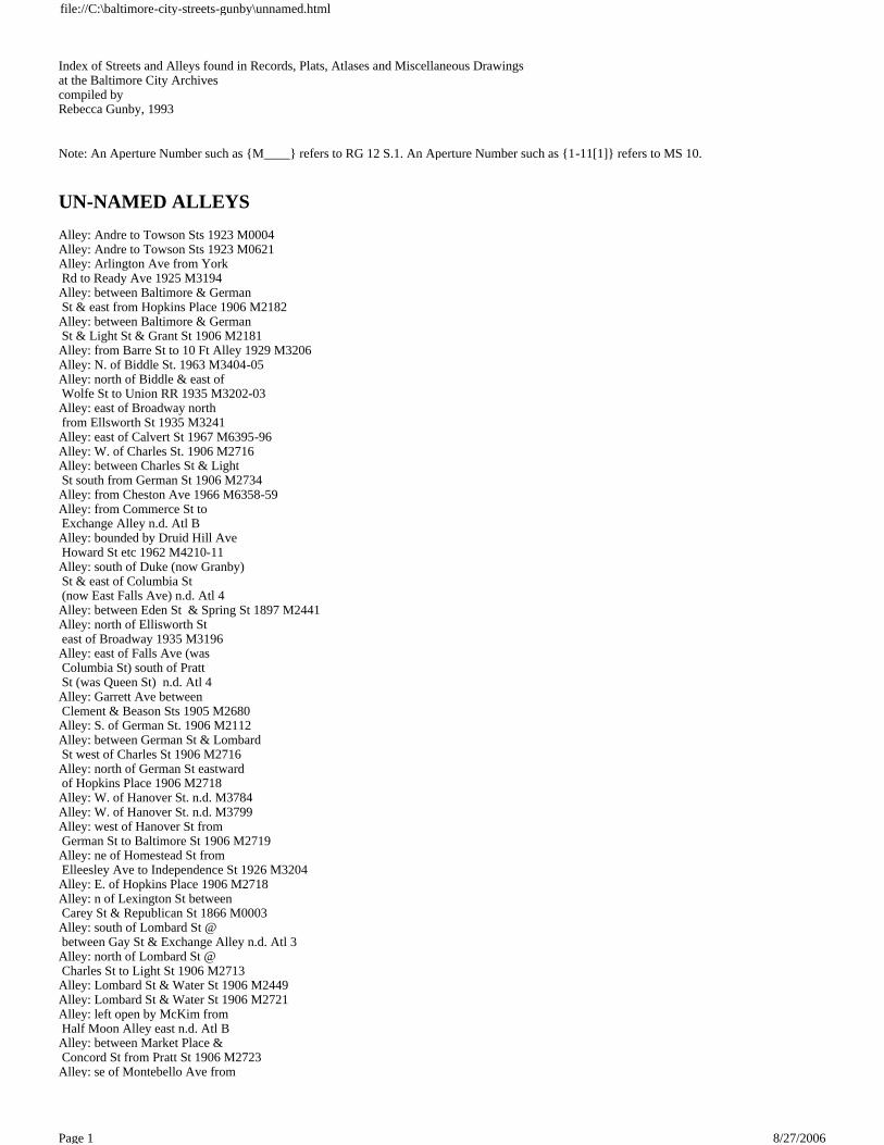
Index of Streets and Alleys found in Records, Plats, Atlases and Miscellaneous Drawings at the Baltimore City Archives compiled by Rebecca Gunby, 1993
Note: An Aperture Number such as {M____} refers to RG 12 S.1. An Aperture Number such as {1-11[1]} refers to MS 10.
UN-NAMED ALLEYS
Alley: Andre to Towson Sts 1923 M0004 Alley: Andre to Towson Sts 1923 M0621 Alley: Arlington Ave from York Rd to Ready Ave 1925 M3194 Alley: between Baltimore & German St & east from Hopkins Place 1906 M2182 Alley: between Baltimore & German St & Light St & Grant St 1906 M2181 Alley: from Barre St to 10 Ft Alley 1929 M3206 Alley: N. of Biddle St. 1963 M3404-05 Alley: north of Biddle & east of Wolfe St to Union RR 1935 M3202-03 Alley: east of Broadway north from Ellsworth St 1935 M3241 Alley: east of Calvert St 1967 M6395-96 Alley: W. of Charles St. 1906 M2716 Alley: between Charles St & Light St south from German St 1906 M2734 Alley: from Cheston Ave 1966 M6358-59 Alley: from Commerce St to Exchange Alley n.d. Atl B Alley: bounded by Druid Hill Ave Howard St etc 1962 M4210-11 Alley: south of Duke (now Granby) St & east of Columbia St (now East Falls Ave) n.d. Atl 4 Alley: between Eden St & Spring St 1897 M2441 Alley: north of Ellisworth St east of Broadway 1935 M3196 Alley: east of Falls Ave (was Columbia St) south of Pratt St (was Queen St) n.d. Atl 4 Alley: Garrett Ave between Clement & Beason Sts 1905 M2680 Alley: S. of German St. 1906 M2112 Alley: between German St & Lombard St west of Charles St 1906 M2716 Alley: north of German St eastward of Hopkins Place 1906 M2718 Alley: W. of Hanover St. n.d. M3784 Alley: W. of Hanover St. n.d. M3799 Alley: west of Hanover St from German St to Baltimore St 1906 M2719 Alley: ne of Homestead St from Elleesley Ave to Independence St 1926 M3204 Alley: E. of Hopkins Place 1906 M2718 Alley: n of Lexington St between Carey St & Republican St 1866 M0003 Alley: south of Lombard St @ between Gay St & Exchange Alley n.d. Atl 3 Alley: north of Lombard St @ Charles St to Light St 1906 M2713 Alley: Lombard St & Water St 1906 M2449 Alley: Lombard St & Water St 1906 M2721 Alley: left open by McKim from Half Moon Alley east n.d. Atl B Alley: between Market Place & Concord St from Pratt St 1906 M2723 Alley: se of Montebello Ave from
file://C:\baltimore-city-streets-gunby\unnamed.html
8/27/2006Page 1

Homewood Ave 1930 M3209 Alley: s side of proposed Northern Pkwy 1964 M3664 Alley: s side of proposed Northern Pkwy 1964 M3668 Alley: from Oliver St extending westerly to Lakewood Ave 1964 M6313-14 Alley: from Post Office Ave (Calvert St) to Holliday St 1881 M0053 Alley: Post Office Ave to Holliday St 1881 M0067 Alley: se of Presstman St 1967 M6428-29 Alley: South St & Commerce St n.d. M1925 Alley: from Walbrook Ave 1966 M6358-59 Alley: S. of Ware St. 1960 M3394-95 Alley: between Water St & Lombard St easterly from Frederick St 1906 M2449 Alley: between Water & Lombard Sts westerly from Frederick St 1906 M2721 Alley: from 5th St from Jeffrey St to Talbott St 1968 M6459 Alley: rear of 420 E 27th St 1974 M6754-55 Alley: ns from n/s Wyndhurst Ave to Wilmslow Rd 1964 M6303-04 ALL ALLEYS: bounded by Carey St, Cumberland St, Stockton St & Carey St 1971 M6690-91 ALL ALLEYS: bounded by Charles St Mt Vernon Place St Paul St & Centre St 1965 M6372-73 ALL ALLEYS: bounded by Collington Ave Monument St Madeira St & McElderry St 1967 M6420-21 ALL ALLEYS: bounded by Clifton Ave Cheston Ave Walbrook Ave & Elsinore Ave 1964 M6326-27 ALL ALLEYS: [Eutaw Place Robert St. Madison Ave. & Presstman St. n of Laurens St n.d. M6453-54 ALL ALLEYS: bounded by Fayette St Broadway Fairmount Ave & Bond St 1960 M3830-31 ALL ALLEYS: bounded by Franklin St Edgewood St Mulberry St & former Grantley St 1961 M3822-23 ALL ALLEYS: bounded by George St Brune St Harlem Ave & Myrtle Ave 1962 M3388-89 ALL ALLEYS: bounded by Greenmount Ave 29th St Mathews St & 28th St 1956 M3271 ALL ALLEYS: bounded by Greenmount Ave 29th St Mathews St & 28th St 1956 M3274 ALL ALLEYS: bounded by Greenspring Ave Druid Park Dr 1969 M6559-60 ALL ALLEYS: bounded by High St from Fayette St to Low St 1965 M6432-33 ALL ALLEYS: bounded by Lanvale St St Paul St Charles St & the Northern Central Rwy Co Right-of-Way 1967 M6387 ALL ALLEYS: bounded by Lexington St from Front St to High St 1965 M6432-33 ALL ALLEYS: bounded by Linden Ave Ducatel St Brookfield Ave & west outline of school #61 n.d. M6451-52 ALL ALLEYS: bounded by Lombard St Gay St Pratt St & Commerce St n.d. M7089-94 ALL ALLEYS: bounded by Lombard St Gay St Pratt St & Commerce St n.d. M7151-57 ALL ALLEYS: bounded by McMechen St Malaster, & Mt. Royal Ave n.d. M6447-48 ALL ALLEYS: bounded by North Ave Mt Royal Ave McMechen St & Park Ave n.d. M6445-46 ALL ALLEYS: bounded by Orleans St Colvin St & Low St n.d. M6432-33
file://C:\baltimore-city-streets-gunby\unnamed.html
8/27/2006Page 2
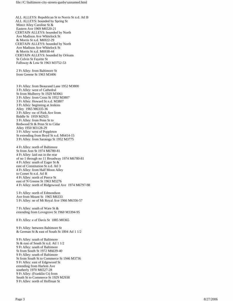
ALL ALLEYS: Republican St to Norris St n.d. Atl B ALL ALLEYS: bounded by Spring St Mince Alley Caroline St & Eastern Ave 1969 M6520-21 CERTAIN ALLEYS: bounded by North Ave Madison Ave Whitelock St & Morris St n.d. M6922-29 CERTAIN ALLEYS: bounded by North Ave Madison Ave Whitelock St & Morris St n.d. M6938-44 CERTAIN ALLEYS: bounded by Orleans St Colvin St Fayette St Fallsway & Low St 1963 M3752-53
2 Ft Alley: from Baltimore St from Greene St 1963 M3406
3 Ft Alley: from Beaurand Lane 1952 M3800 3 Ft Alley: west of Cathedral St from Mulberry St 1929 M3061 3 Ft Alley: from Cross St 1952 M3807 3 Ft Alley: Howard St n.d. M3807 3 Ft Alley: beginning at Jenkins Alley 1965 M6335-36 3 Ft Alley: sw of Park Ave from Biddle St 1959 M2925 3 Ft Alley: from Penn St to Redwood St & Penn St to Cidar Alley 1950 M3128-29 3 Ft Alley: west of Poppleton St extending from Boyd St n.d. M6414-15 3 Ft Alley: from Saratoga St 1952 M3775
4 Ft Alley: north of Baltimore St from Ann St 1974 M6780-81 4 Ft Alley: laid out in the rear of no 1 through no 11 Broadway 1974 M6780-81 4 Ft Alley: south of Eager St & east of Constitution St n.d. Atl 3 4 Ft Alley: from Half Moon Alley to Comet St n.d. Atl B 4 Ft Alley: north of Pierce St east of N Greene St 1963 M3276 4 Ft Alley: north of Ridgewood Ave 1974 M6797-98
5 Ft Alley: north of Edmondson Ave from Mount St 1965 M6333 5 Ft Alley: ne of Mt Royal Ave 1966 M6356-57
7 Ft Alley: south of Ware St & extending from Lovegrove St 1960 M3394-95
8 Ft Alley: e of Davis St 1885 M0365
9 Ft Alley: between Baltimore St & German St & east of South St 1804 Atl 1 1/2
9 Ft Alley: south of Baltimore St & east of South St n.d. Atl 1 1/2 9 Ft Alley: south of Baltimore St from South St 1972 M6639-40 9 Ft Alley: south of Baltimore St from South St to Commerce St 1946 M3736 9 Ft Alley: east of Edgewood St extending from Harlem Ave southerly 1970 M6527-28 9 Ft Alley: (Franklin Ct) from South St to Commerce St 1929 M2938 9 Ft Alley: north of Hoffman St
file://C:\baltimore-city-streets-gunby\unnamed.html
8/27/2006Page 3
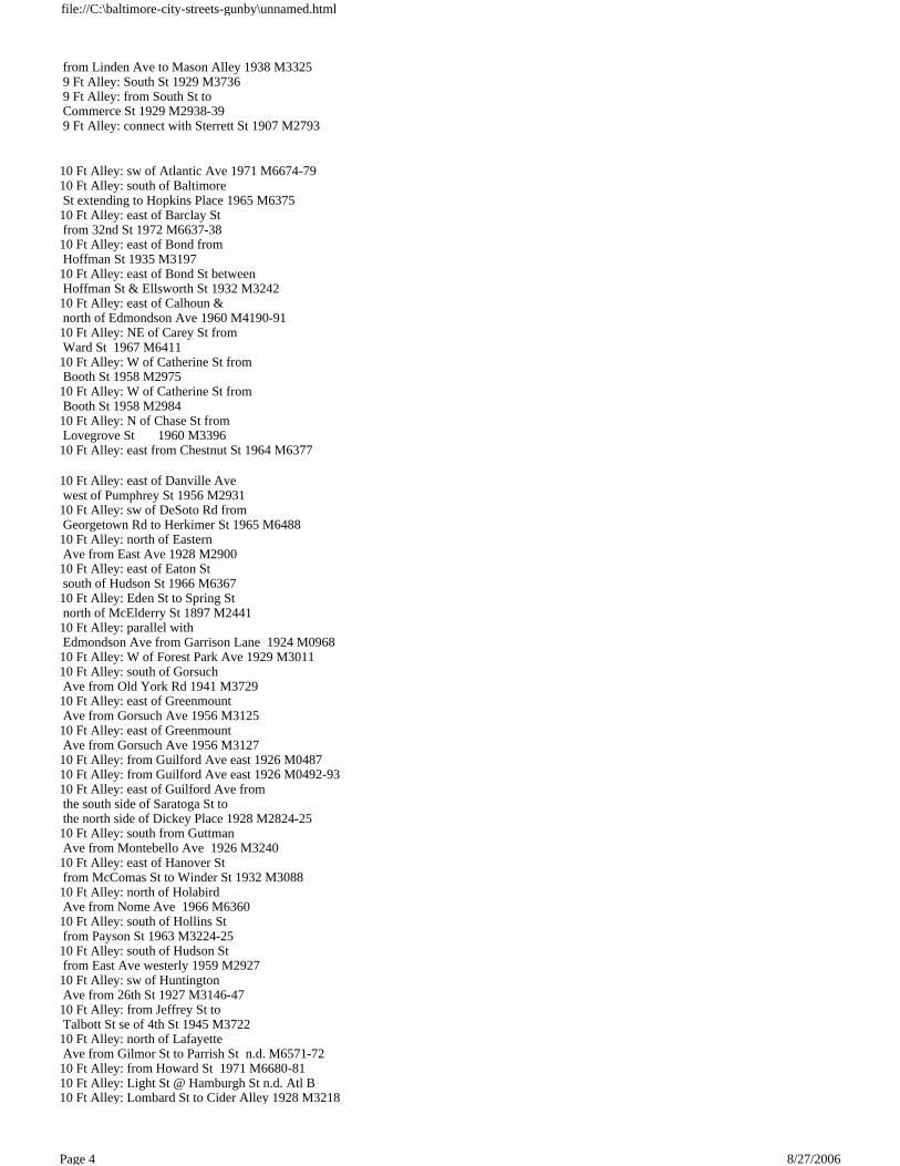
from Linden Ave to Mason Alley 1938 M3325 9 Ft Alley: South St 1929 M3736 9 Ft Alley: from South St to Commerce St 1929 M2938-39 9 Ft Alley: connect with Sterrett St 1907 M2793
10 Ft Alley: sw of Atlantic Ave 1971 M6674-79 10 Ft Alley: south of Baltimore St extending to Hopkins Place 1965 M6375 10 Ft Alley: east of Barclay St from 32nd St 1972 M6637-38 10 Ft Alley: east of Bond from Hoffman St 1935 M3197 10 Ft Alley: east of Bond St between Hoffman St & Ellsworth St 1932 M3242 10 Ft Alley: east of Calhoun & north of Edmondson Ave 1960 M4190-91 10 Ft Alley: NE of Carey St from Ward St 1967 M6411 10 Ft Alley: W of Catherine St from Booth St 1958 M2975 10 Ft Alley: W of Catherine St from Booth St 1958 M2984 10 Ft Alley: N of Chase St from Lovegrove St 1960 M3396 10 Ft Alley: east from Chestnut St 1964 M6377
10 Ft Alley: east of Danville Ave west of Pumphrey St 1956 M2931 10 Ft Alley: sw of DeSoto Rd from Georgetown Rd to Herkimer St 1965 M6488 10 Ft Alley: north of Eastern Ave from East Ave 1928 M2900 10 Ft Alley: east of Eaton St south of Hudson St 1966 M6367 10 Ft Alley: Eden St to Spring St north of McElderry St 1897 M2441 10 Ft Alley: parallel with Edmondson Ave from Garrison Lane 1924 M0968 10 Ft Alley: W of Forest Park Ave 1929 M3011 10 Ft Alley: south of Gorsuch Ave from Old York Rd 1941 M3729 10 Ft Alley: east of Greenmount Ave from Gorsuch Ave 1956 M3125 10 Ft Alley: east of Greenmount Ave from Gorsuch Ave 1956 M3127 10 Ft Alley: from Guilford Ave east 1926 M0487 10 Ft Alley: from Guilford Ave east 1926 M0492-93 10 Ft Alley: east of Guilford Ave from the south side of Saratoga St to the north side of Dickey Place 1928 M2824-25 10 Ft Alley: south from Guttman Ave from Montebello Ave 1926 M3240 10 Ft Alley: east of Hanover St from McComas St to Winder St 1932 M3088 10 Ft Alley: north of Holabird Ave from Nome Ave 1966 M6360 10 Ft Alley: south of Hollins St from Payson St 1963 M3224-25 10 Ft Alley: south of Hudson St from East Ave westerly 1959 M2927 10 Ft Alley: sw of Huntington Ave from 26th St 1927 M3146-47 10 Ft Alley: from Jeffrey St to Talbott St se of 4th St 1945 M3722 10 Ft Alley: north of Lafayette Ave from Gilmor St to Parrish St n.d. M6571-72 10 Ft Alley: from Howard St 1971 M6680-81 10 Ft Alley: Light St @ Hamburgh St n.d. Atl B 10 Ft Alley: Lombard St to Cider Alley 1928 M3218
file://C:\baltimore-city-streets-gunby\unnamed.html
8/27/2006Page 4

10 Ft Alley: see McClellan St 10 Ft Alley: east of Madeira St extending from Patterson Park Ave 1967 M6420-21 10 Ft Alley: E of Maryland Ave south of Mt Royal Ave 1959 M2969 10 Ft Alley: sw of Melville 1928 M3237 10 Ft Alley: west of Monroe St from Clifton Ave south of Windsor Ave 1955 M2924 10 Ft Alley: from Montebello Ave 1922 M3216 10 Ft Alley: from Montebello Ave to Adams St between Cokesbury & Bartlett Aves 1925 M3029 10 Ft Alley: south of Montgomery St from Covington St to Key Hwy 1944 M3715 10 Ft Alley: south of Montgomery St from Covington St to Key Hwy 1944 M3723 10 Ft Alley: Monument St of n.d. M6270 10 Ft Alley: n of Orleans St from Bond St to Bethel St 1942 M3751 10 Ft Alley: from Penn to Redwood St & Penn St to Cidar Alley 1950 M3128-29 10 Ft Alley: south of Presstman St extending east of Ellamont St 1975 M6776-77 10 Ft Alley: from Redwood St to Cider Alley 1933 M3063 10 Ft Alley: s of Redwood St from Penn St west of Penn St to Cider Alley 1950 M3129 10 Ft Alley: east of Roland Ave west of Elm Ave north of 36th St 1957 M2963-64 10 Ft Alley: se of School St from Stockton St 1955 M3363 10 Ft Alley: n of Pratt St 1959 M4205 10 Ft. Alley: Ten Pin Alley 10 Ft Alley: Washington Blvd from Spence St 1967 M6399-6400 10 Ft Alley: from West Alley to s of Prospect St 1941 M3313 10 Ft Alley: west of Wicomico St from Little Market St 1955 M3293 10 Ft Alley: north of 20th St extending to Lovegrove St to Charles St n.d. M6564-65 10 Ft Alley: n of 20th St from Lovegrove St west of St Paul St 1956 M3251 10 Ft Alley: n of 20th St from Lovegrove St west of St Paul St 1956 M3256 10 Ft Alley: between 28th & 29th Sts from Mace St 1965 M6329-30 10 Ft Alley: N of 36th St 1957 M3962-64
11 Ft Alley: sw Woodbrook Ave & se Traction St 1934 M3163
12 Ft Alley: west of Charles St from Conway St 1941 M3732-33 12 Ft Alley: from Chester St south of Federal St 1967 M6386 12 Ft Alley: Light St to Wine Alley 187- M1170 12 Ft Alley: known as Minden Place & Opel Lane from Ellamont St 1932 M3048-49 12 Ft Alley: from Orleans St 1871 M0025
12 1/2 Ft Alley: 1930 M3209
13 Ft Alley: between Baltimore St & Charles (Wine Alley) 1898 Atl 1
14 Ft Alley: sw of English Consul Ave 1972 M6649 14 Ft Alley: from Guilford Ave east 1926 M0487 14 Ft Alley: from Hollins Ferry
file://C:\baltimore-city-streets-gunby\unnamed.html
8/27/2006Page 5

Rd in Mt Winans Project Area 1971 M6674-79 14 Ft Alley: from Magnolia Ave from Patapsco Ave 1967 M6416-17 14 Ft Alley: from Patapsco Ave from Viona Ave 1967 M6416-17
15 Ft Alley: north of Biddle St from Rutland Ave 1963 M3404-05 15 Ft Alley: Broadway to Register St 1871 M0148 15 Ft Alley: Buick Lane to Sisson St 1946 M3711-12 15 Ft Alley: from Collington Ave to Patterson Park Ave & between Fayette St & Orleans St 1889 M1976 15 Ft Alley: west of S Conkling St 1954 M3473 15 Ft Alley: west of S Conkling St 1954 M3452 15 Ft Alley: from Druid Lake Dr from Callow Ave 1972 M6650-51 15 Ft Alley: Edgepark Rd 1963 M3459-60 15 Ft Alley: south of Elliott St 1955 M3255 15 Ft Alley: Exeter Hall Ave to nw of Garrett Ave 1964 M6311-12 15 Ft Alley: se. of Harford Rd from Pelham Ave n.d. M3779 15 Ft Alley: n of Holabird from Newkirk St westerly 1958 M2968 15 Ft Alley: sw of Kathland Ave from Granada Ave to Forest Path 1926 M3149 15 Ft Alley: sw of Melville Ave from Frisby St 1928 M3237 15 Ft Alley: nw of Montebello Ave from Gorsuch Ave 1927 M3212 15 Ft Alley: ne of Narcissus Ave from Trainor Ave 1938 M3593 15 Ft Alley: south of O'Donnell St extending from Ponca St westerly 1965 M6340 15 Ft Alley: n of Oliver n.d. M6313-14 15 Ft Alley: rear of 1803-05 Pennsylvania Ave & 1802-04 Brunt St 1949 M3358 15 Ft Alley: Presstman St to Wilson St 1877 M0138-39 15 Ft Alley: ne of Springdale Ave 1967 M6408-09 15 Ft Alley: ne of Springdale Ave from Forest Park Ave 1929 M3068 15 Ft Alley: Talbott St 1943 M3722 15 Ft Alley: n of Toone St 1954 M3455 15 Ft Alley: Trainor Ave 1938 M3593 15 Ft Alley: ne of Warshaw Ave from Old Cold Spring Lane 1932 M3208 15 Ft Alley: from Whitelock St to south of Park Terrace 1908 M2684-85 15 Ft Alley: 1st Alley east of Edgepark Rd from Perring Pkwy northerly & northeast of Belvedere Ave 1963 M3459-60 15 Ft Alley: 1st Alley ne of Park Hgts Ave 1970 M6573-74
16 Ft Alley: from Hollins Ferry Rd in Mt Winans Project Area 1971 M6674-79 16 Ft Alley: sw of Wicklow Rd from Sidehill Rd to Seminole Ave 1967 M6382-83
19 Ft Alley: west of Baylis St 1953 M3446
20 Ft Alley: Andre St to Towson St 1923 M0004 20 Ft Alley: Andre St to Towson St 1923 M0621 20 Ft Alley: north of Baltimore St 1963 M3406 20 Ft Alley: north of Bateman Ave 1964 M6305-06
file://C:\baltimore-city-streets-gunby\unnamed.html
8/27/2006Page 6
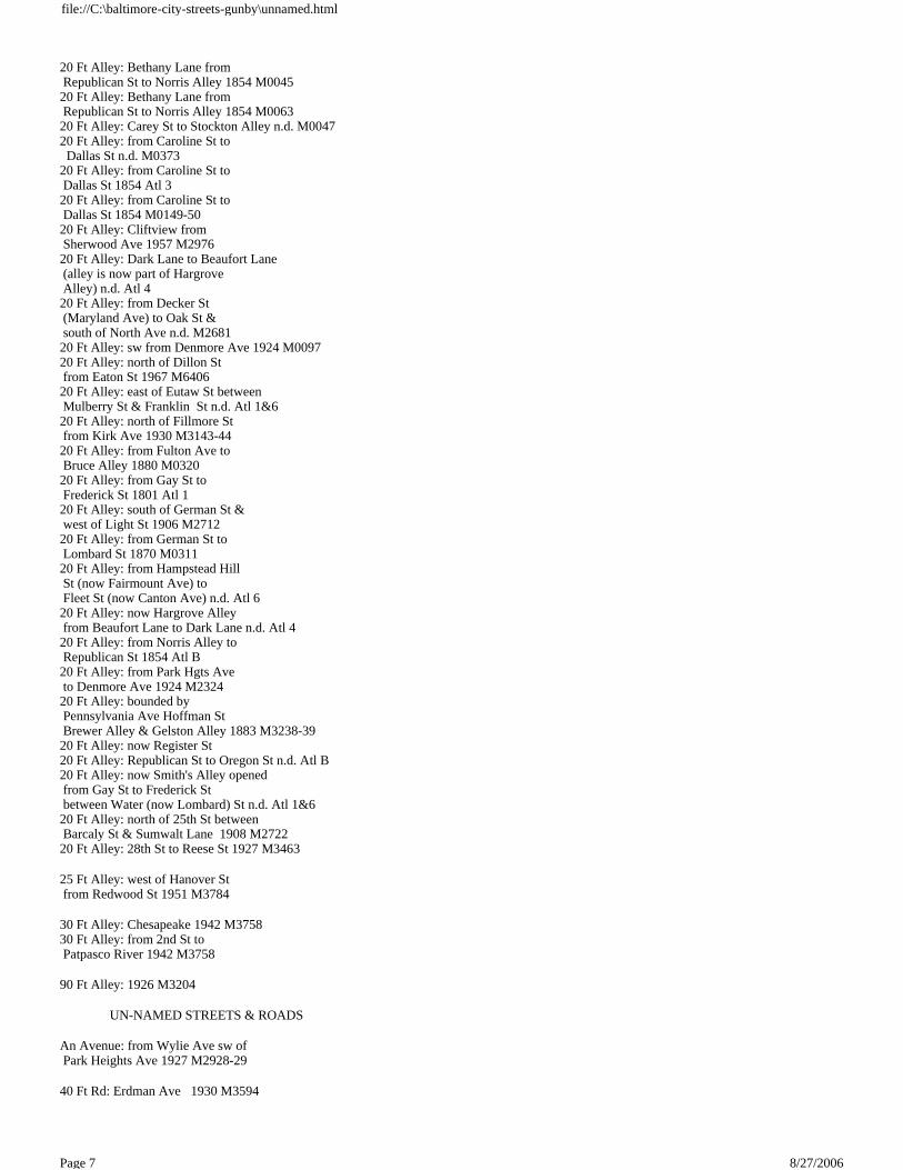
20 Ft Alley: Bethany Lane from Republican St to Norris Alley 1854 M0045 20 Ft Alley: Bethany Lane from Republican St to Norris Alley 1854 M0063 20 Ft Alley: Carey St to Stockton Alley n.d. M0047 20 Ft Alley: from Caroline St to Dallas St n.d. M0373 20 Ft Alley: from Caroline St to Dallas St 1854 Atl 3 20 Ft Alley: from Caroline St to Dallas St 1854 M0149-50 20 Ft Alley: Cliftview from Sherwood Ave 1957 M2976 20 Ft Alley: Dark Lane to Beaufort Lane (alley is now part of Hargrove Alley) n.d. Atl 4 20 Ft Alley: from Decker St (Maryland Ave) to Oak St & south of North Ave n.d. M2681 20 Ft Alley: sw from Denmore Ave 1924 M0097 20 Ft Alley: north of Dillon St from Eaton St 1967 M6406 20 Ft Alley: east of Eutaw St between Mulberry St & Franklin St n.d. Atl 1&6 20 Ft Alley: north of Fillmore St from Kirk Ave 1930 M3143-44 20 Ft Alley: from Fulton Ave to Bruce Alley 1880 M0320 20 Ft Alley: from Gay St to Frederick St 1801 Atl 1 20 Ft Alley: south of German St & west of Light St 1906 M2712 20 Ft Alley: from German St to Lombard St 1870 M0311 20 Ft Alley: from Hampstead Hill St (now Fairmount Ave) to Fleet St (now Canton Ave) n.d. Atl 6 20 Ft Alley: now Hargrove Alley from Beaufort Lane to Dark Lane n.d. Atl 4 20 Ft Alley: from Norris Alley to Republican St 1854 Atl B 20 Ft Alley: from Park Hgts Ave to Denmore Ave 1924 M2324 20 Ft Alley: bounded by Pennsylvania Ave Hoffman St Brewer Alley & Gelston Alley 1883 M3238-39 20 Ft Alley: now Register St 20 Ft Alley: Republican St to Oregon St n.d. Atl B 20 Ft Alley: now Smith's Alley opened from Gay St to Frederick St between Water (now Lombard) St n.d. Atl 1&6 20 Ft Alley: north of 25th St between Barcaly St & Sumwalt Lane 1908 M2722 20 Ft Alley: 28th St to Reese St 1927 M3463
25 Ft Alley: west of Hanover St from Redwood St 1951 M3784
30 Ft Alley: Chesapeake 1942 M3758 30 Ft Alley: from 2nd St to Patpasco River 1942 M3758
90 Ft Alley: 1926 M3204
UN-NAMED STREETS & ROADS
An Avenue: from Wylie Ave sw of Park Heights Ave 1927 M2928-29
40 Ft Rd: Erdman Ave 1930 M3594
file://C:\baltimore-city-streets-gunby\unnamed.html
8/27/2006Page 7
50 Ft St: along the Old Western Boundary from Liberty Hgts Ave to Hawthorne Ave 1924 M0540
66 Ft St: Oliver to North 1878 M1169
file://C:\baltimore-city-streets-gunby\unnamed.html
8/27/2006Page 8

Index of Streets and Alleys found in Records, Plats, Atlases and Miscellaneous Drawings at the Baltimore City Archives compiled by Rebecca Gunby, 1993
Note: An Aperture Number such as {M____} refers to RG 12 S.1. An Aperture Number such as {1-11[1]} refers to MS 10.
V
V Alley: from Barre St to Welcome Alley n.d. Atl 2 1/2 Vacant Property: 1875 M2125 Valley St: 1877 M1684-85 Valley St: 1961 M3655 Valley St: became Cecil Ave Valley St: Chase St to Harford Ave & Valley St to Ensor St n.d. 1-59[1] Valley St: Eager St to Hoffman St 1877 M1580 Valley St: Eager St from York Ave to Valley St n.d. I-25[3] Valley St: Eager St from York Lane to Valley St 1839 I-8[1] Valley St: part was Garrett Ave Valley St: Harford Ave to Valley St & Hoffman St to Biddle St n.d. 4-57[1] Valley St: part was Harrison St Valley St: John St from York Ave to Valley St 1853 Z-98[2] Valley St: became Kennedy Ave Valley St: Neighbor St & Valley St n.d. S-52[1] Valley St: Neighbor St & Valley St 1889 S-54[4] Valley St: North Ave between Valley St Kennedy Ave 1912 B-65[5] Valley St: became Simpson St Valley View Ave: Valley View Park: Belair Rd between Valley View Ave & Park Ave n.d. A-75[1] Valley of Owen: Parts of "Valley of Owen" & "Littleworth" Howard Co Md 1900 A-51[3] Van Bibber: Plat showing property of the Heirs of Van Bibber between property of Alexander Gould & John B Morris n.d. 1-67[4] Van Bibber St: Carrollton Ave to Frederick Rd & Stafford St to Van Bibber St n.d. A-60[3] Vance Ave: n.d. M6601 Van Lill St: was Windsor St Venable Ave: n.d. M6183 Venable Ave: 1961 M3826-27 Venable Park: Tinges Ave to Venable Park & 33rd St to 35th St n.d. D-14[2] Venable Place: n.d. M6184 Vermont Ave: was Baltimore Ave Vernal Court: was Martin's Court Viaduct Ave: Mt Vernon Ave Viaduct Ave: Viaduct Ave & Falls Rd n.d. A-40[1] Viaduct Ave: from 28th St to Cedar Ave 1902 M3969-71 Viaduct Orleans St: St Paul Place to Forrest St 1929 M3466-69 Vicent Alley: Tenant St from Vincent Alley to Gilmor St n.d. X-77[4] Vicker St: Albert or Coke Alley Vickers Rd: Hilton St to Longwood St & Powhatan Ave to Vickers Rd n.d. B-18[5] Vickers Rd: Vickers Rd & Carlsile Ave 1913 B-78[1] Vincnet Alley: Baker St to Presstman St
file://C:\baltimore-city-streets-gunby\v.html
8/27/2006Page 1

& Monroe St to Vincent Alley n.d. 4-67[1] Vincnet Alley: Baker St to Presstman St & Vincent Alley to Bruce Alley 1884 S-52[4] Vincent Alley: Baker St to Presstman St & Vincent Alley to Calhoun St 1870 4-68[1] Vincent Alley: Baltimore to Fayette 1873 M0947 Vincent Alley: from Baltimore to beyond Lexington n.d. Atl B Vincent Alley: N Calhoun St to Butcher's Lane & Gilmor St to Cumberland St n.d. O-4[4] Vincent Alley: Chapel St to Lorman St & Vincent Alley to Fremont St 1868 S-35[2] Vincent Alley: Fayette St to Baltimore St & Bruce Alley to Vincent Alley n.d. X-69[4] Vincent Alley: became part of Forney Alley Vincent Alley: Parrish Alley to Vincent Alley & Fayette St to Baltimore St 1849 S-40[4] Vincnet Alley: Riggs Ave from Gilmor St to Vincent Alley n.d. 3-25[2] Vincent Alley: Townsend St to Patterson Ave 1878 M1640-41 Vincent Alley: Vincent Alley & Gilmor St n.d. Z-49[1] Vincent Alley Court: became Forney Alley Vincent Court: became part of Forney Alley Vincent Place: became part of Vincent St Vincent St: n.d. M6539-40 Vincent St: became part of Forney Alley Vincent St: Lanvale St from Vincent St to Mount St n.d. X-22[3] Vincent St: Parrish St to Vincent St & Franklin St to Fayette St n.d. S-50[3] Vincent St: was Vincent Alley Vincent St: part was Vincent Place Vincent St East: Vincent St - East Half of Block No 33 n.d. [17] Vincent St North: Baker St from Mount St (north) to Vincent St (north) n.d. [22] Vincnet St North: Presbury St from Vincent St (north) to Mounht St (north) n.d. [23] Vincent St North: Vincent St (north) East Half of Block No 28 n.d. [19] Vincent St North: Vincent St (north) West Half of Block No 28 n.d. [20] Vincent St North: Vincent St (north) West Half of Block No 33 n.d. [18] Vine Alley: see Vine St Vine Court: became part of Vine St Vine St: 1968 M6539-40 Vine St: Arch St from Lexington St to Vine St n.d. O-35[1b] Vine St: Carlton St to Schroeder St 1855 Atl B Vine St: Cove St to Pearl St & Vine St to German St n.d. Z-100[2] Vine St: Cove St to Pine St & Vine St to Pratt St n.d. X-80[4] Vine St: Fayette St to Lexington St 1860 Atl 3 Vine St: Franklin St to Vine St & 5th St to Warwick Ave 1896 D-55[1] Vine St: from Gilmor St to Stricker St n.d. Atl 3 Vine St: Lexington St to Vine St n.d. 1-57[3] Vine St: Lexington St to Vine St n.d. 3-16[4] Vine St: Lexington & Vine Sts n.d. 4-54[9] Vine St: was Little Vine St Vine St: east of Pine St n.d. Atl 2 Vine St: Pine St from Lexington St to Spring (now Vine) St n.d. 3-5[3] Vine St: Pine St from Saratoga St
file://C:\baltimore-city-streets-gunby\v.html
8/27/2006Page 2
to Vine St 1847 Z-100[1] Vine St: Saratoga St to Vine St & Chatsworth St to Pine St 1838 Z-15[1] Vine St: Schroeder St to Carlton 1854 Atl B Vine St: Schroeder St to Carlton St 1855 M1655 Vine St: Schroeder St to Carlton St 1855 M1659 Vine St: Spring n.d. Atl 3 Vine St: was Spring St Vine St: Vine & Fayette Sts n.d. O-1[3] Vine St: Vine to Fayette Sts 1912 2-10[3] Vine St: part was Mount St Court Vine St: was Vine Alley Vine St: part was Vine Court Vine St: Vine St Court Vine St: Vine St to Park Lane & Schroeder st to Cove St n.d. Z-16[1] Vine St: Vine St to Park Lane & Schroeder St to Cove St 1800 S-30[5] Vine St Court: became part of Vine St Vineyard Lane: n.d. M4215 Vineyard Lane: 1956 M3264 Vineyard Lane: was Gilmor Lane Vineyard Lane: 30th St & Gilmor (now Vineyard) Lane 1914 B-100[1] Violet Ave: Cottage Ave & Violet Ave n.d. C-72[3] Violet Ave: Park Hgts Ave between Keyworth Ave & Violet Ave n.d. D-27[3] Violet Ave: Park Hgts Ave between Violet Ave & Hilldale Ave n.d. D-27[2] Violet Ave: Shirley Ave to Violet Ave n.d. A-50[2] Violet Ave: Spring Hill Ave to Violet Ave & Willowdale Rd to Reisterstown Rd 1914 C-61[2] Violet Ave: Towanda Ave & Violet Ave 1922 C-64[5] Violet Ave: Violet Ave & Cottage Ave 1918 C-72[1] Violet Ave: Violet Ave to Ulman Ave & Park Hgts Ave to Cottage Ave n.d. C-72[2] Violet Ave: Violet (3rd) Ave between Cottage Ave & Park Hgts Ave 1914 B-87[4] Violet Ave: now 3rd Ave Violet Ave: was 3rd Ave Violet Ave: 3rd (Violet) Ave to Park Hill Ave & Park Hgts Ave to Cottage Ave 1913 A-82[1] Virginia Ave: Park Hgts Ave between Woodland Ave & Virginia Ave 1906 A-52[1] Virginia Ave: Reisterstown Rd to Grace Ave & Virginia Ave to Umatilia Ave n.d. C-59[1] Virginia Ave: Virgina Ave between Reisterstown Rd & Waldorf Ave 1921 C-59[2] Vogt Ave: Park Hgts Ave to Old Pimlico Rd & Vogt Ave to Allan Ave 1925 D-64[2] Vonderhorst Lane: Vonderhorst Lane n.d. B-81[1] Vonderhorst Lane: Vonderhorst Lane between Clifton Park & Belair Ave 1905 A-16[4] Voyce St: was Garrett St Vulcan Alley: n.d. Atl 1 Vulcan Alley: from Forest Alley to McClellan St 1810 Atl 1 1/2 Vulcan Alley: became New Church St n.d. Atl 1 Vulcan Alley: now Wyoming St Vulcan Ave: n.d. Atl 1 Vulcan Ave: became New Church St n.d. Atl 1
file://C:\baltimore-city-streets-gunby\v.html
8/27/2006Page 3
Index of Streets and Alleys found in Records, Plats, Atlases and Miscellaneous Drawings at the Baltimore City Archives compiled by Rebecca Gunby, 1993
Note: An Aperture Number such as {M____} refers to RG 12 S.1. An Aperture Number such as {1-11[1]} refers to MS 10.
W
W Alley: from Barre St to Welcome Alley n.d. Atl 2 1/2 Wabash Ave: n.d. M6192-94 Wabash Ave: n.d. M6196-99 Wabash Ave: Ashburton: Ashburton (Sequoia) Aveto Liberty Hgts Ave & Callaway Place to Wabash Ave 1922 D-48[1] Wabash Ave: Ashburton: Dolfield Ave to Liberty Hgts Ave & Callaway Place to Wabash Ave n.d. D-49[1] Wabash Ave: from Cold Spring Lane 1969 M6502 Wabash Ave: Dorchester Rd from Ellamont Rd to Wabash Ave 1924 D-47[2] Wabash Ave: Dorchester Rd to Liberty Hgts Ave & Ellamont Rd to Wabash Ave 1924 D-47[1] Wabash Ave: from Liberty Hgts Ave to Belle Ave 1921 M2335-39 Wabash Ave: Liberty Hgts Ave to Kate Ave 1917 M2829-34 Wabash Ave East: see Alexander Ave Wabash Ave East: from Woodland Ave to Alexander Ave & E Wabash Ave to Doll Ave 1955 M2915&18 Waesche St: Fremont St form Waesche St to Lexington St n.d. S-68[1] Waesche St: was Josephine St Waesche St: Saratoga St to Baltimore St & Cove St to Waesche St 1830 O-41[6] Waesche St: Saratoga St to Josephine St & Fremont St to Waesche St 1859 4-44[2] Waesche St: Waesche St & Chatsworth St n.d. O-35[2] Waesche St: Wesche St from Josephine St to Lexington St n.d. 4-54[14] Waggon Alley: Saratoga St to Waggon Alley & Calhoun St to Carey St n.d. 3-40[4] Waggon Alley: Saratoga St to Waggon Alley & Calhoun St to Carey St n.d. 4-8[2] Waggon Alley: see Wagon alley Wagner Ave: became part of Wagner St Wagner St: from Boston St to Essex St n.d. Atl 2 1/2 Wagner St: was Concord east of Leakin Wagon Alley: was Baker Court Wagon Alley: Bower's Court from Wagon Alley to Saratoga St 1904 2-14[2] Wagon Alley: now Clay St Wagon Alley: became Cloney St Wagon Alley: Eutaw St to Liberty St n.d. Atl 1,4&6 Wagon Alley: Howard St to Liberty St n.d. Atl 3 Wagon Alley: Howard to Liberty Sts 1837 M4239 Wagon Alley: Howard to Little Sts 1827 M1248 Wagon Alley: Liberty to Howard Sts 1837 Atl 3 Wagon Alley: Republican St to
file://C:\baltimore-city-streets-gunby\w.html
8/27/2006Page 1
Schroeder St 1853 Atl B Wagon Alley: Schroeder St to Dewberry Alley 1856 M0120 Wagon Alley: Schroeder to Repbulican 1853 Atl B Wagon Alley: Schroeder St to Republican St 1853 M2393 Wagon Alley: changed to State St Wahaton Ave: from Reisterstown Rd to Towanda Ave 1953 M4916 Wahaton Ave: Wahaton Park: Mohawk or Walnuthill Ave to Wahaton or Fernhill Ave & Reisterstown Rd to Sarnac Ave 1907 B-57[4] Wahaton Park: Wahaton Park: Mohawk or Walnuthill Ave to Wahaton or Frenhill Ave & Reisterstown Rd to Saranac Ave 1907 B-57[4] Walbrook Ave: n.d. M6201 Walbrook Ave: n.d. M6216 Walbrook Ave: n.d. M6358-59 Walbrook Ave: 1892 M0305 Walbrook Ave: 1964 M6326-27 Walbrook Ave: Clifton Ave to Walbrook Ave n.d. B-32[4] Walbrook Ave: Clifton Ave to Walbrook Ave & 14th St to Cheston St n.d. A-26[4] Walbrook Ave: Clifton Ave to Walbrook Ave & 14th St to 13th St n.d. B-49[1] Walbrook Ave: Denison (formerly 12th) St between Clifton Ave & Walbrook Ave 1913 B-78[4] Walbrook Ave: Mt Holly: Windsor Ave to Walbrook Ave & 17th St to 16th St n.d. A-65[5] Walbrook Ave: was Myrtle Ave Walbrook Ave: (formerly Myrtle Ave) from Fulton Ave to Pulaski St 1895 M1362 Walbrook Ave: Rosedale (or 9th) St between Walbrook Ave & Rosedale Place n.d. C-49[2] Walbrook Ave: Slingluff Ave between Clifton Ave & Walbrook Ave n.d. C-60[3] Walbrook Ave: Smallwood Ave to Fulton Ave & Windsor Ave to Walbrook Ave 1914 B-78[2] Walbrook Ave: Walbrook Ave between Monroe St & McKean Ave n.d. A-47[3] Walbrook Ave: Walbrook Ave to North Ave & Monroe St to Fulton Ave n.d. B-51[2] Walbrook Ave: part was Woodbrook Ave Walbrook Land Co: Cemetary Lane bordering on the property of Walbrook Land Co 1904 B-68[3] Walcott Ave: Bonner Rd between Walcott Ave & Winfield Ave n.d. C-42[1] Waldheim St: Alto Ave between 12th (now Waldheim) St & 11th (now Hilton) St 1911 A-17[2] Waldheim St: part is Denison St Waldheim St: was Morris Ave Waldheim St: Waldheim St & Beech Ave 1912 D-12[2] Waldheim St: Waldheim St between Mondawmin Ave & Beech Ave 1912 D-12[3] Waldheim St: part was 12th St Waldorf Ave: Virginia Ave between Reisterstown Rd & Waldorf Ave 1921 C-59[2] Walker Alley: became Walker St Walker Court: became Apricot Court Walker St: see Archer St Walker St: changed to Campbell St
file://C:\baltimore-city-streets-gunby\w.html
8/27/2006Page 2
Walkway: (unnamed) 1948 M4641 Wall St: now McCabe St Wallace St: Fort Ave to Donaldson St & Covington St to Wallace St n.d. O-44[4] Wallace St: Wallace St to Benjamin St & Fort Ave (east) to Claggett St n.d. 2-16[7] Wallis Place: became part of St Paul St Walnut Alley: n.d. M0109 Walnut Alley: Pear Alley to Rose Alley 1862 M0108 Walnut Alley: from Pearl Alley to Rose Alley 1862 Atl B Walnut Alley: Ross St to Pear Alley & Preston (formerly called Cider) St to Walnut Alley n.d. 1-41[1] Walnut Alley: Ross St to Pennsylvania Ave & Preston (formerly Cdear) St to Walnut Alley 1840 3-23[2] Walnut Alley: became part of Walnut St Walnut Ave: Rokeby Rd to Walnut Ave & Franklin Rd to Gelston Dr n.d. D-57[2] Walnut Ave: Walnut Ave to Earl Ave & Liberty Rd to Reisterstown Tnpk 1907 A-48[4] Walnut St: Brook St to Walnut St & Oak St to Decker St n.d. A-28[2] Walnut St: Decker St between Brooks St & Walnut St n.d. B-50[4] Walnut St: Decker St between Brooks St & Walnut St n.d. B-88[3] Walnut St: Old Road & Walnut St n.d. A-16[1] Walnut St: from Pratt St to Barre St n.d. Atl 1,4&6 Walnut St: Rose to Pear Alley 1862 Atl B Walnut St: part was Walnut Alley Walnut St: now 26th St Walnuthill Ave: Earl Ave to Walnuthill Ave & Reisterstown Tnpk to Liberty Rd 1905 A-62-5 Walnuthill Ave: Wahaton Park: Mohawk or Walnuthill Ave to Wahaton or Fernhill Ave & Reisterstown Rd to Saranac Ave 1907 B-57[4] Walpert Ave: Montebello Ave between Walpert Ave & Cottage Ave n.d. C-41[2] Walpert Ave: Quaker Lane to Kennedy Lane & St Ann's Ave to Walpert Ave n.d. A-50[5] Walsh St: n.d. M4994-96 Walsh St: Biddle St to Greenwillow Sts 1835 Atl B Walsh St: Biddle St to Market Square 1852 Atl B Walsh St: Biddle St to McMechen St 1852 M1679-80 Walsh St: Chatsworth St to Walsh St & Townsend St to Dolphin St n.d. S-23[2] Walsh St: Dolphin St from Walsh St to Wilmor Alley n.d. 4-11[3] Walsh St: Fremont St to Walsh St & La Fayette Market Square to Chatsworth St n.d. 4-23[1] Walsh St: Hoffman St from Pennsylvania Ave to Walsh St n.d. 3-43[3] Walsh St: to Lafayette Market 1872 M0904 Walsh St: Lafayette Market to McMechen St 1872 M0900-01 Walsh St: Mosher St from Chatsworth St to Walsh St n.d. O-2[7] Walsh St: Moyland to Chatsworth Sts 1859 Atl 3 Walsh St: Shield's Alley & Walsh St n.d. 3-72[2] Walsh St: Townsend St from Wilmor Alley to Walsh St n.d. 4-34[8] Walsh St: Walsh St from Smith's Lane to Mosher St 1852 S-48[1] Walter Ave: n.d. M6234 Walter Ave: Druid Hill Park
file://C:\baltimore-city-streets-gunby\w.html
8/27/2006Page 3
Reservoir St & Walter Ave to Mt Royal Ave n.d. B-31[4] Walter Ave: Oakfor Ave to Penhurst Ave 1926 M3487-88 Walter, Wm H R: Potter Ave bordering on Property of Wm H R Walter, & Geo E Pressler 1912 B-65[1] Walte(R)Meyer Alley: became Waltermeyer Alley Walte(R)Meyer Court: became Penmont Court Waltermeyer Court: was Walte(R)Meyer Alley Walter's Alley: now Greenwillow St Walther Ave: n.d. M6235-38 Walther Ave: from Harofrd Rd to Franklin Ave 1924 M4798-4805 Wandsbeck: 1851 M0082 Wandsbeck St: Lombard St to Pratt St & Stockton Alley to Oregon (formerly Wandsbeck) St n.d. I-25[2] Wandsbeck St: from Pratt St to Circular St 1851 Atl B Wandsbeck St: Saratoga St to Lexington St & Republican St to Wandsbeck St n.d. O-67[3] Wandsbeck St: Wandsbeck St from Baltimore St to Hollins St n.d. 3-25[6] Wandsbeck St South: Baltimore St (west) to Pratt St (west) & Wandsbeck St (south) to Schroeder St (south) n.d. 1-43[4] Wandsbeck St South: W Pratt St to Washington Ave & S Wandsbeck St to S Amity St n.d. 1-42[3] Wansbeck St: Hollins St & Wansbeck St n.d. 3-48[5] Wansbeck St: changed to Oregon St Wansbeck St: Pratt St to Circular St 1851 Atl B Wansbeck St: Wansbeck St from Baltimore St to Hollins St n.d. 3-11[4] Wapping Alley: was Fayette Court Wapping St: now Fayette St Wapping St: from Front St to High St n.d. Atl 1&4 Wapping St: High St to Front St & Bridge St to Wapping St n.d. I-1[2] Wapping St: High St & Pitt (formerly Wapping) St n.d. 3-12[5] Wapping St: Pitt (formerly Wapping) St to Alice Anna St & Falls (formerly Columbia St) Ave to Wolfe St n.d. 3-21[6] Wapping St: Pitt (formerly Wapping) St & High St 1843 3-12[7] Wapping St: Wapping St from Front St to High St n.d. 3-67[2] Ward Map of Baltimore: n.d. M2585 Ward Maps of Baltimore: 1877-1907 M6575-96 Ward St: Bayard St from Columbia Ave to Ward St n.d. 3-21[2] Ward St: Bayard St to Stockholm St 1892 M0825-26 Ward St: Green St to Ward St & Bayard St to Mulberry St n.d. 3-5[2] Ward St: part was Pinckney St Warden St: 1964 M3230-31 Warden St: see Concord St Warden St: from Falls Market Space (also called Fish Market Space) or 2nd St) to Water (now Lombard) St n.d. Atl 1,4&6 Ware Alley: part was Wehr St Warehouse Alley: was Smith Alley Warminster St: n.d. M6203 Warminster St: from Frederick Ave to Baltimore St 1925 M3453-54 Warner Place: became Hopewell Court
file://C:\baltimore-city-streets-gunby\w.html
8/27/2006Page 4
Warner St: n.d. M6202 Warner St: Bayard St & Warner St 1913 2-31[4] Warner St: Burgunday Alley & Warner St n.d. 1-96[6] Warner St: Camden St to Columbia 1861 Atl B Warner St: Claret Alley to Warner St & Stockholm St to West St n.d. O-26[4] Warner St: Columbia to Little Camden St 1865 M0112 Warner St: Columbia to Little Camden St 1865 M0114 Warner St: Columbia Ave to Warner St & Kent St to Bayard St n.d. 2-42[2] Warner St: Columbia St to Barre St & Warner St to Green St n.d. Z-12[3] Warner St: Conway St to Bankard Alley & Warner St to Cove (now Fremont) St n.d. 1-68[3] Warner St: Elbow Lane to Homespun Alley & Warner St to Cove St 1850 1-68[7] Warner St: Henrietta St from Warner St to China Alley n.d. 1-53[6] Warner St: Henrietta St from Warner St to China Alley n.d. 1-54[5] Warner St: Lee St between Henrietta St & Warner St 1855 I-24[5] Warner St: from Little Camden St or Elbow Lane to Columbia St 1865 Atl B Warner St: McHenry St to Warner St & Cross St to Kent St 1899 2-18[2] Warner St: Montgomery St to Ostend St n.d. Atl 1 Warner St: Ostend St & Warner St n.d. X-54[3] Warner St: Paca St to Warner St & Bush St to Clare St n.d. 2-24[2] Warner St: Paca St to Warner St & Putnam St to Stockholm St n.d. 1-372[] Warner St: Putnam St to Clare St & Warner St to Paca St n.d. O-48[1] WArner St: was Ridgely St Warner St: Ridgeley St to Warner St & Bayard St to Bush St n.d. Z-46[2] Warner St: Ridgeley St to Warner St & Gunpowder St to Clare St 1880 Z-47[1] Warner St: Ridgeley St to Warner St & Ostend St to Wooster St n.d. Z-46[1] Warner St: Ridgeley St to Warner St & Putnam St to Stockholm St 1914 2-18[1] Warner St: Sterrett St to Charles St & John (now Eutaw) St to Ridgeley St/Russell (now Warner) St n.d. O-64[4] Warner St: from Sterrett (now Henrietta) St to Ostend St n.d. Atl 1&4 Warner St: Warner St from Bayard St to Wooster St n.d. O-37[5] Warner St: Warner St & Lee St n.d. 1-68[12] Warner St: Welcome Alley to Busy Alley & Warner St to Eutaw St n.d. 1-49[7] Warner St: West St from Warner St to China Alley n.d. O-72[6] Warner St: Wooster (or Carey) St to Ostend St n.d. Atl 4 Warren Ave: was Warren St WArren Court: became part of Apple Court Warren St: 1963 M3665-66 Warren St: Baltimore St to Warren St & Eutaw St to McElderry St 1805 4-63[1] Warren St: Barre St to Warren St & Leondard St to Hanover St 1783 I-13[3] Warren St: Covington St from Warren St to Hambrugh St n.d. O-95[7]
file://C:\baltimore-city-streets-gunby\w.html
8/27/2006Page 5
Warren St: from Forrest (now Light) St to Henry St n.d. Atl 1,4&6 Warren St: part was Henrietta St Warren St: Henrietta St to Williamson Alley & Warren St to Light St n.d. I-8[2] Warren St: Hughes St to Warren St & Johnson St to Covington St n.d. Z-89[2] Warren St: Hughes St to Warren St & Johnson St to Covington St n.d. 4-50[1] Warren St: Light St to Covington St n.d. Atl 1&2 1/2 Warren St: Light St to Johnson St & Warren St to Hamburg St n.d. 3-37[5] Warren St: Pratt St to Warren St & Charles St to Howard St n.d. I-9[1] Warren St: was Warren Ave Warren St: Warren St to Cross St & Back St to Covington St n.d. X-13[2] Warren St: Warren St to Hamburg St & Henry St to Covington St 1857 O-99[5] Warren St: Warren St Poultney St & Charles St to Covington St n.d. X-13[4] Warren St: from William St to Covington St n.d. Atl 3 Warsaw Ave: from Old Cold Spring Lane to a 20' Alley 1932 M3200 Warwick Ave: n.d. M6187-88 Warwick Ave: Baltimore St to Edmondson Ave 1912 M2993-95 Warwick Ave: Edmondson Ave between Evergreen Ave & Warwick Ave n.d. D-15[2] Warwick Ave: Franklin St to Vine St & 5th St to Warwick Ave 1896 D-55[1] Warwick Ave: Riggs Ave & Warwick Ave n.d. A-62[4] Warwick St: Harlem Ave to Franklin St & Warwick St to Bentalou St n.d. B-70[2] Warwick Ave: was 2nd St Washington Ave: Amity St (south) to Parkin St (south) & Pratt St (west) to Washington Ave n.d. 1-42[9] Washington Ave: now Columbia Ave Washington Ave: Columbia St (now Columbia Ave) @ Cross St n.d. Atl 3 Washington Ave: Gwynns Falls to Bush St 1887 M1451-54 Washington Ave: W Pratt St to Washington Ave & S Wandsbeck St to S Amity St n.d. 1-42[3] Washington Ave: Stockholm St from Wicomico St to Washington Ave n.d. S-97[1] Washington Ave: Washington Ave to Carroll St & Stockholm St to Bush St n.d. S-80[1] Washington Ave: Washington Ave to Dawson Alley & Pratt St (wewst) to Ramsay St n.d. 1-42[13] Washington Ave: Washington Ave to Hookstown Rd n.d. B-8[2] Washington Ave: Washington Ave to Pinkey Alley & Bush St to Wooster St n.d. S-56[3] Washington County: n.d. M1012 Washington Court: became part of Jurgen Court Washington Hill-Chapel NDP 1972 M6782-89 Washington Hill-Chapel NDP 1974 M6780-81 Washington Monument RR: n.d. M2348 Washington Place: n.d. M4237 Washington Place: n.d. Atl 2 1/2&5 Washington Rd: see Balto & Wash Tnpk Washington Rd: Gwynns Falls to Bush St 1887 M1451-54
file://C:\baltimore-city-streets-gunby\w.html
8/27/2006Page 6
Washington Rd: Lombard St to Washington St & Washington Rd to Green St n.d. X-18[2] Washington Rd: Morrell Park: Herkimer St to Washington Rd & 6th St to Spence St n.d. A-38[8] Washington Rd: Old Gerogetown Rd to Washington Rd & 11th St to 7th St 1897 A-26[2] Washington Rd: Washington Rd n.d. O-59[12] Washington St: 1875 M1713 Washington St: from Aliceanna Ave 1954 M3257 Washington St: Alice Anna St to German St & Washington St to County St 1904 3-16[2] Washington St: Ann St to Washington St & John St to Oliver St n.d. Z-40[1] Washington St: Ann St to Washington St & North Ave to Lanvale St n.d. 4-90[1] Washington St: Avenue 1887 M1451-54 Washington St: Baltimore St to Fleet St & Washington St to Madeira Alley n.d. X-74[3] Washington St: Baltimore St to Lombard St & Washington St to Castle Alley (or St) n.d. X-85[4] Washington St: now Battery Ave WashingtonSt: Belair Ave (or Gay St) to Hoffman St 1875 M1713 Washington St: Biddle St to Eager St & Washington St to Burk St n.d. O-22[5] Washington St: Biddle St to Hoffman St 1874 M1247 Washington St: Biddle St to Hoffman St 1874 M1944 Washington St: became Carswell St Washington St: Castle St to Washington St & Baltimore St to Lombard St n.d. X-85[3] Washington St: Chase St to Danvale St 1875 M2247 Washington St: Chase St to Eager St & Wolfe St to Washington St 1871 4-32[2] Washington St: Chase St to McElderry St & Washington St to Mine Bank Lane n.d. O-51[6] Washington St: Chew St from Chapel St to Washington St n.d. S-3[5] Washington St: Chew St to Old Joppa Rd & Caroline St to Washington St n.d. O-100[2] Washington St: Columbia St to Bush St & Wshington Ave to Light St 1855 4-60[1] Washington St: County St to Washington St & German St to Alice Anna St n.d. 3-16[1] Washington St: Cross St & Washington St n.d. 3-66[7] Washington St: Eager St from Wolfe St to Washington St 1878 S-81[2] Washington St: Fayette St to Bohemia Court & Washington St to Castle St 1894 O-41[2] Washington St: Fayette St to Hampstead Hill St & Ann St to Washington St n.d. 4-32[1] Washington St: Fleet St (now Canton Ave) to Hampstead Hill St (now Fairmount Ave) n.d. Atl 1,4&6 Washington St: Fleet St to Fell St & Washington St to Canton St 1833 4-28[2] Washington St: George Town Rd (now called Washington St) to Pratt St & Greene St to Paca St n.d. I-12[1] Washington St: German St to Alice Anna St & Washington St to Choptank St n.d. 3-20[6] Washington St: German St to Alice Anna St & Washington St to County St 1904 3-1[1]
file://C:\baltimore-city-streets-gunby\w.html
8/27/2006Page 7
Washington St: Gough St to Alice Ann St & Washington St to Gist St n.d. 4-63[2] Washington St: Hampstead Hill St to Dulany St & Washington St to Gist St n.d. 4-53[4] Washington St: Hampstead Hill St to Philpot St & Point St to Washington St 1842 3-1[2] Washington St: Hampstead Hill St from Washington St to Castle Alley n.d. 4-31[6] Washington St: Hampstead Hill St to Wilks St & Ann St to Washington St 1782 I-7[2] Washington St: Hampstead St (now Fremont Ave) to Baltimore St & Castle St to Washington St n.d. X-32[3] Washington St: Harford Rd to Washington St & Samuel Ready Place to North Ave n.d. B-88[2] Washington St: John St to Chase St & Washington St to Patterson Park Ave n.d. Z-11[1] Washington St: Lake Ave & Washington St n.d. A-38[1] Washington St: Lanvale St to Federal St & Washington St to Castle St n.d. O-97[3] Washington St: changed to Lincoln St Washington St: Lombard St to Washington St & Washington Rd to Green St n.d. X-18[2] Washington St: Monument St to Eager St 1875 M2399 Washington St: Mt Veronon Place & Washington Place n.d. 4-30[2] Washington St: Oliver St from Washington St to Belair Ave n.d. X-1[2] Washington St: Patterson Park Ave to Washington St n.d. S-95[2] Washington St: Pratt St to George Rd (now Washington St) & Greene St to Paca St n.d. 4-1[8] Washington St: Ramsay St to Washington St & Republican St to Poppleton St 1851 S-21[2] Washington St: from Randall St to Cross St n.d. Atl B Washington St: Sinclair St from Washington St to Belair Rd n.d. D-46[1] Washington St: Smith St to Water St & Washington St to Luzerne St 1783 I-6[4] Washington St: Smith St to Water St & Washington St to Luzerne St 1783 I-16[1] Washington St: Townsend St to Lanvale St & Washington St to Castle St n.d. 2-20[5] Washington St: Washington St n.d. 3-63[3] Washington St: Washington St n.d. 3-63[9] Washington St: Washington St n.d. 3-63[14] WAshington St: Washington St n.d. 3-64[3] Washington St: Washington St n.d. 3-64[8] Washington St: Washington St n.d. 3-64[12] Washington St: Washington St n.d. 3-64[16] Washington St: Washington St n.d. 3-64[20] Washington St: Washington St n.d. 3-65[4] Washington St: Washington St n.d. 3-65[12] Washington St: Washington St n.d. 3-65[15] Washington St: Washington St n.d. 3-96[2] Washington St: Washington St from Brickkiln St & Charles St to Eutaw St 1812 X-72[3] Washington St: Washington St (now Columbia) St to Penn St & Perkins St to Scott St 1821 3-12[13] Washington St: Washington St to
file://C:\baltimore-city-streets-gunby\w.html
8/27/2006Page 8
Fillmore St & York Rd to Quaker Rd n.d. A-12[13] Washington St: Washington St & Fleet St 1841 I-23[3] Washington St: Washington St from Fountain St to Alisanna St 1808 4-26[2] Washington Tnpk: Frederick Tnpk to Washington Tnpk 1909 B-5[2] Wastewater: Wastewater & Alley Drain n.d. B-55[5] Watch House Alley: from North St to Holliday St 1816 Atl 1 1/2 Water Co: see Balto Water Co n.d. Atl 2 Water Co: Plat 1804 Atl 2 Water Co: Property 1859 M2581-82 Water Courses: Hoffman St from near Greenmount Ave to Jones Falls n.d. Atl B Water Courses: Light St to Charles St & north of Pratt St n.d. Atl 6 Water Courses: Pleasant St & Saratoga St & from Holiday St to Jones Falls n.d. Atl 2 1/2 Water Courses: Tyson St from Centre St to Monument St n.d. Atl 3 Water Court: became Pindle Court Water Court: became part of Wilmer Alley Water Dept: (Service Areas) 1896 M2765 Water Dept: (Service Areas) 1897 M2766 Water Row: became Pindle Court Water St: Bank St to Water St n.d. O-63[3] Water St: Bank St to water St & Smith's Alley to 3rd Lane n.d. O-64[3] Water St: east from Bank (now William) St n.d. Atl B Water St: Bridge St to Water St & Frederick St to Jones Falls 1784 I-9[3] Water St: Bridge St to Water St & Harrison St to Frederick St 1835 I-11[2] Water St: as laid out in "Original Baltimore Town" from Calvert St to Frederick St n.d. Atl 1&4 Water St: Calvert St to South St n.d. Atl 2 Water St: Calvert St to South St 1826 Atl 2 Water St: Calvert St & Water St n.d. 3-25[1] Water St: Cheap Side St from Water St to Pratt St n.d. I-14[5] Water St: Cheapside Dock St (formerly Cheapside Dock) from Water St to Pratt St 1824 4-83[1] Water St: now Clement St Water St: Clement ( or Water) St from Gates (Johnson or 3rd) St to William St (fromerly Back) St n.d. O-11[3] Water St: Commerce St from Water St to Exchange Place n.d. 2-17[1] Water St: Cross St to Water St & Bach St to South St n.d. I-25[1] Water St: Cross St to Water St & Back St to 4th St n.d. 4-70[1] Water St: Cross St to Water (now Clement) St & Back St to 4th St 1850 3-54[2] Water St: from Custom House Ave to Frederick St n.d. Atl 1&4 Water St: from Exchange Alley to Gay St n.d. Atl 1&3 Water St: now called Exchange Place from South St to beyond Commerce St n.d. Atl 1&2 1/2 Water St: now Fait Ave Water St: on Fish House Property n.d. Atl 5 Water St: Fish St to Water St & Gay St to Traffick St n.d. I-9[5] Water St: Franklin Lane to Commerce St
file://C:\baltimore-city-streets-gunby\w.html
8/27/2006Page 9
& Water St to Pratt St n.d. 4-16[1] Water St: from Franklin Lane to South St n.d. Atl 1&6 Water St: from Frederick St to Jones Falls n.d. Atl 1,4&6 Water St: Frederick St & Water (now Lombard) St n.d. 1-39[2] Water St: part was French Lane or Alley Water St: German St to Water St & Smith's Alley to 3rd Lane n.d. O-63[2] Water St: from Gist St (now Patterson Park Ave) to beyond Luzerne St n.d. Atl 1,4&6 Water St: Hanover St to Gay St & Water St to Conway St n.d. X-16[1] Water St: Hawk St to Water St & Gay St to Concord St n.d. X-6[5] Water St: from High St to Harford St (now Central Ave) n.d. Atl 4 Water St: High St & Water (now E Lombard) St n.d. 4-15[3] Water St: from Jackson St to River St n.d. Atl B Water St: from Johnson St to William St n.d. Atl 3 Water St: Jones Falls to Harford St n.d. M2363 Water St: formerly King George St Water St: became Lancaster St Water St: (now Lancaster St part now Fait Ave) from Gist St (now Patterson Park Ave) to Rogers St (now Milton Ave) n.d. Atl 2&5 Water St: from Light St to Publick Lane (now Grant St) n.d. Atl 1 Water St: from Light St from West Falls Ave 1906 M2446-47 Water St: part was Little 2nd St Water St: part changed to Lombard Water St: now part of Lombard St @ Exchange Place n.d. Atl 1 Water St: Lombard (formerly Water) St & Centre (or Marsh Market Space) St n.d. 4-11[1] Water St: from Marsh Market Space to Jones Falls n.d. Atl 1, 1 1/2,4&6 Water St: Patapsco St to Market St & Monument St to Water St 1822 1-82[2] Water St: Philadelphia Main Rd to Water St & Gist St to Patapsco Neck Main Rd n.d. O-92[1] Water St: was Sharping Lane from South St to Custom House Ave n.d. Atl 1&4 Water St: Smith St to Water St & Washington St to Luzerne St 1783 I-6[4] Water St: Smith St to Water St & Washington St to Luzerne St 1783 I-16[1] Water St: @ South St n.d. Atl 1 Water St: from Warden St to Jones Falls 1817 Atl 1 1/2 Water St: Water St & Calvert St n.d. X-59[2] Water St: another Water St is Clement St Water St: Water St & Cumberland Row n.d. X-1[6] Water St: Water St to Fort St & 3rd St to 4th St n.d. O-41[1] Water St: Water St to Fort St & 3rd St to 4th St n.d. O-77[3] Water St: another Water St is Gittings Water St: Water & King George Sts 1817 Atl 1 Water St: another Water St is Lancaster Water St: Water St from Light St to Publick Lane 1783 I-13[1] Water St: Water St to Myers St & 4th St to Boyle St n.d. O-55[3]
file://C:\baltimore-city-streets-gunby\w.html
8/27/2006Page 10
Water St: Water St to Pratt St n.d. 4-32[5] Water St: Water St to Pratt St & Cheap Side St to Calvert St n.d. I-13[4] Water St: Water St Pratt St & Franklin Lane to Light St n.d. I-18[1] Water St: Water St to Pratt St & Gay St to Buchanan's Alley 1831 O-64[5] Water St: Water St to Pratt St & Light St to Franklin St 1818 4-65-[1] Water St: Water St & South St n.d. X-33[4] Water St: Water St & 3rd St n.d. 3-96[10] Water St: Water St & 4th St n.d. 3-96[13] Water St: was 2nd St Water St: from 4th St to Port Wardens Line n.d. Atl B Water St: 4th St to Portwarden's Line 1865 Atl B Water St: 4th St to Port Wardens Line 1865 M1303 Water St: West St to Water St & Hall St to 3rd (or Caroline now Gates) St n.d. 1-49[1] Water St: West St to Water St & William (formerly Back) St to Gates St 1784 I-1[6] Water St: 4th St from 5th Lane to Water St n.d. 3-96[5] Water St (East): Water St (east) to Granby St & High St to Exeter St n.d. I-27[8] Water St (East): Water St (East) to Granby St & High St to Exeter St n.d. O-33[6] Water Supply Chart: n.d. M0977 Water View Ave: Belmar Ave to Fort Ave & Water View Ave to 9th St 1935 E-30[1] Waterbury St: 1958 M2930-32 Waterfront St: became Key Hwy Watering Place: @ Bend in Harrison St n.d. Atl 5 Watering Place: see Old Landing Atl 3 Waterline: from Alisanna & Washington Sts to about Luzerne St n.d. Atl 2&5 Waterline: from Calhouns Wharf to to the mouth of Jones Falls 1803 Atl 5 Wateline: @ east end of City Dock n.d. atl 2 1/2 Waterline: from Cross St to Locust Point n.d. Atl 5 Waterline: @ Ferry Point 1851 Atl 3 Waterline: from Frederick St Dock to mouth of Jones Falls 1803 Atl 5 Waterline: @ mouth of Jones Falls 1786 Atl 1, 1 1/2,4,5&6 Waterline: from Nicholson St to Beason St 1850 Atl 3 Waterline: from Patapsco St to East St n.d. Atl 2 1/2 Waterline: in Southwest Baltimore in 1792 Atl 4 Waterline: from Wapping (now Fayette) St & Jones Falls to Wolfe St & Aliceanna St n.d. Atl 4 Waters Court: became Pindle Court Waters Lane: became part of Longwood St Waters Row: became part of Pendle Court Waters Row: became Pindle Court Watson Alley: became St Andrew's Alley Watson Court: became part of Aisquith St Watson St: Canal (formerly Harford) St from Watson St (Formerly Salisbury) St to Baltimore St (East) 1848 O-38[2] Watson St: from near Exeter St to Lloyd St n.d. Atl 1&6 Watson St: High St & Salisbury (now Watson) St n.d. X-23[5] Watson St: Lloyd to beyond Exeter n.d. Atl 1
file://C:\baltimore-city-streets-gunby\w.html
8/27/2006Page 11
Watson St: was Salisbury St Watson St: Watson St to Central Ave n.d. X-38[4] Watson St: Watson St & Exeter St n.d. O-38[3] WAtson St Court: became part of Aisquith St Watts: 1961 M3658-59 Watts Court: became part of Melrose Alley Watts St: n.d. M6443-44 Watts St: Park Ave to Mt Royal Ave & Watss St to Reservoir St 1912 B-78[3] Watts St: Reservoir St to Watts St & Bolton St to Park Ave n.d. B-80[4] Waverly Ave: Waverly Ave to Fair Oak Ave & Greenmount Ave to Old York Rd n.d. B-13[4] Waverly Ave: York Tnpk between Waverly Ave & Gilmor La 1887 A-58[2] Waverly Ave: 31st St Waverly Ave: 34th St to 31st St (Waverly Ave) & Guilford Ave to Barclay St n.d. 1908 A-61[1] Waverly Ave: 35th St to Waverly Ave (31st St) & Charles St to York Rd n.d. A-37[2] Waverly Terrace: became part of Carey St Wayne St: n.d. Atl B Wayne St: n.d. M6229 Wayne St: 1909 M0277 Wayne St: from Eutaw St 1852 M0553 Wayne St: from Eutaw St 1852 M2346 Wayne St: from Eutaw St to Moald Lane 1852 Atl B Wayne St: from Eutaw St to Mould Alley (now Wayne St was Welcome Alley) n.d. Atl B Wayne St: from Eutaw to Mould Lane 1852 Atl B Wayne St: was Homespun Alley Wayne St: was Homespun Alley from Eutaw St to Sharp St n.d. Atl 1,4&6 Wayne St: Howard to Eutaw Sts n.d. Atl B Wayne St: Howard to Eutaw 1852 Atl B Wayne St: Howard to Eutaw Sts 1850 M1245 Wayne St: Howard to Euatw Sts 1853 Atl B Wayne St: Howard to Eutaw Sts 1853 M2347 Wayne St: was Mould Alley Ways St: Fort Ave from Ways St to Marlin St n.d. Z-8[3] Wayson St: part was Young St Weaver St: was Collins St Weaver Ave: Harford Ave & Weaver Ave n.d. C-74[2] Webb Alley: became part of Small Alley Webb Alley: became part of Small St Webb Place: became part of Small Alley Webb Place: became part of Small St Webb St: part was Collison Court Webb St: part was Gould Lane Webb St: part was McAllister's Court Webb St: part was Prospect Lane Webb St: part was Smith Alley Webb St: Webb St to Chew St & Harford Ave (or Brittain St) to Ensor St n.d. X-45[2] Webster Alley: became Daniel Court Webster Alley: became Small St Webster Court: became Dammann Court Webster Court: became Daniel Court Webster Court: became Heywood Court Webster Place: became Small St Webster St: n.d. M04256 Webster St: became Boyle St Webster St: Chase St to Momument St & Barclay St to Bond St n.d. O-97[1] Webster St: Clement St to Fort Ave & Webster St to Lawrence St n.d. Z-76[2] Webster St: Clement St to Harvey
file://C:\baltimore-city-streets-gunby\w.html
8/27/2006Page 12
St & Boyle St to Webster St n.d. 2-62[1] Webster St: Clement St & Webster St n.d. 13-8[2] Webster St: Falls Rd between Webster St & 8th Ave 1912 B-52[4] Webster St: @ Fish House n.d. Atl 5 Webster St: Fort Ave to Heath St & Lawrence St to Webster St 1888 2-80[1] Webster St: from Fort Ave to Ostend St n.d. Atl 5 Webster St: Fort Ave from Webster St to Whetstone St n.d. Z-72[2] Webster St: from Key Hwy 1940 M3551-52 Webster St: Melvale Ave to Webster St & Clay St to Falls Rd 1892 A-100[1] Webster St: Randall St to Fort Ave 1893 M2295 Webster St: Randall St to McComas St & Light St to Webster St n.d. O-96[1] Webster St: River St to Anchor St & Clement St to Webster St n.d. 2-61[2] Webster St: part was Suffolk St Webster St: Webster St n.d. Z-85[1] Webster St: Webster St to Anchor St & River St to Clement St n.d. 2-60[4] Webster St: Webster St to Butler St & Clement St to Fort Ave n.d. Z-88[2] Webster St: Webster St to Jackson St & West St to 6th St n.d. 1Z-76[1] Webster St: 4th St to Webster St 1853 Z-78[3] Wehage St: became part of Clement St Wehr St: became part of Ware Alley Weir Ave: Joppa Rd to Terrace Dale & Weir Ave to Hillen Rd 1920 E-35[1] Welcome Alley: n.d. M6220 Welcome Alley: 1849 M1143 Welcome Alley: 1965 M6374-75 Welcome Alley: Eutaw to Howard Sts 1852 Atl B Welcome Alley: from Eutaw St to Howard St 1909 M2322-23 Welcome Alley: from Eutaw St to Goodman (now Charles) St n.d. Atl 1,4&6 Welcome Alley: from Eutaw St to Warner St 1849 M1107 Welcome Alley: from Eutaw St to Warner St 1849 M1144 Welcome Alley: from Eutaw St to Welcome Alley n.d. Atl B Welcome Alley: from Eutaw St to Welcome Alley 1849 Atl B Welcome Alley: from Howard St to Eutaw St n.d. Atl B Welcome Alley: from Howard St to Eutaw St 1850 M0056 Welcome Alley from Howard St to Eutaw St 1850 M0066 Welcome Alley: from Howard St to Eutaw St 1852 Atl B Welcome Alley: Light St from Welcome Alley to Great Montgomery St n.d. Z-42[3] Welcome Alley: Little Greene St from Barre St to Welcome Alley n.d. 2-34[2] Welcome Alley: (Mould Lane) Welcome Alley: from Sharp St to Howard St 1930 M3055 Welcome Alley: Welcome Alley n.d. 2-3[3] Welcome Alley: Welcome Alley & Barre St n.d. 1-47[2] Welcome Alley: Welcome Alley to Busy Alley & Warner St to Eutaw St n.d. 1-49[7] Weldon Ave: was Hohenhoff Pkwy Weldon Circle: was part of Hohenhoff Pkwy Wellesley St: n.d. M6241
file://C:\baltimore-city-streets-gunby\w.html
8/27/2006Page 13

Wellesley St: from Frederick Rd to Stafford St 1919 M3233 Wellington St: was Blucher Ave Wells-Claggette: 1871 M0961-62 Wells Alley: became Duker Alley Wells & McComas Monument: see Ashland Sq Wells & Miller Alley: see Hammond Alley Wells & Millers: Steam Dredge n.d. M1161 Wells St: n.d. M6213 Wells St: Andre St to Stevenson St 1930 M4467-69 Wells St: Barney St to Wells St (now Ohio Ave) & Byrd St to Johnson St n.d. O-74[5] Wells St: Byrd St from Wells St to Ohio Ave n.d. O-21[1] Wells St: part was Claggett St Wells St: from Dock St to Queen (now Block) St n.d. Atl 2 1/2 Wells St: Fort Ave to Wells St & Ludlow St to Lawrence St 1916 2-73[2] Wells St: from Key Hgwy 1957 M2974 Wells St: Key Highway to Woodall St & Wells St to Clemm St 1924 2-81[2] Wells St: part was Lawrence St Wells St: Lawrence St to Ludlow St & Fort Ave to Wells St 1916 2-30[1] Wells St: Leadenhall St to Clarkson St & Wells St to Clement St 1912 2-38[4] Wells st: Light St to Marshall St 1941 M3757 Wells St: Light St to Marshall St 1941 M3760 Wells St: Light St & Wells St n.d. 3-9[1] Wells St: Marshall St to Byrd St & Wellst St n.d. 4-101[1] Wells St: Paca St to Front St & Cross St to Wells St n.d. Z-3[2] Wells St: from Philpot St to beyond Queen (now Block) St n.d. Atl 4 Wells St: from Queen (now Block) St to Dock St n.d. Atl 5 Wells St: Race St from Heath St to Wells St n.d. 1-67[5] Wells St: Wells St between Clagett St & Lawrence St n.d. O-72[4] Wells St: Wells St to Jephson St & Light St to Jackson St n.d. O-61[5] Wells St: Wells St (or Ohio Ave) to Ferry St & Race St to Jackson St 1880 O-61[3] Wells St: Wells St to Winder St & Gould St to Allen St 1902 X-52[2] Wells St: Wells St to Winder St & Gould St to Claggett St 1902 2-44[1] Wells St: Wells St to Winder St & Whetstone St to Porter St n.d. X-53[2] Wells St: also called Wills St Wells St: 3rd Lane to Wells St n.d. X-29[2] Welsh Alley: n.d. M6215 Welsh Alley: part was Short Alley Welsch's Adventure: n.d. Atl 1&4 Welsh's Alley: Lexington St to Dutch Alley & Welsh's Alley to Eutaw St n.d. 1-50[10] Welch's & Chatsworth's: 1809 M2524-25 Wenburn St: now Russell St n.d. M4642-53 Wendover Rd: Greenway between Lambeth St & Wendover Rd n.d. C-5[4] Wendover Rd: Highfield St to Wendover Rd & Greenway to Underwood Rd n.d. C-9[4] Wendover Rd: Northway to Marlow St & Underwood Rd to Wendover Rd 1921 A-80[6]
file://C:\baltimore-city-streets-gunby\w.html
8/27/2006Page 14
Wendover Rd: Wendover Rd 1914 B-88[4] Wendover Rd: Wendover Rd to Kemble St & Greenway to Juniper Rd n.d. B-85[6] Wesenthal's Propterty: n.d. Atl 4 Wesley Ave: became part of Cascara St Wesley St: became Cascara St Wesley St: Edmondson Ave to Wesley St & 13th St to 11th St 1915 D-11[1] Wesley St: became part of Monastary Ave Wesley St: Whitehall: Old Frederick Rd to Dorsey Ave & Wesley St to Morley St n.d. A-11[6] Wesley St: Whitehall: Old Frederick Rd to Dorsey Ave & Wesley St to Morley St 1917 A-11[1] West Alley: became Swift Alley West Alley: became Westerline Court West Ave: became part of Piedmont Ave West Court: became Foundry Court West Falls Ave: @ Block St n.d. Atl 5 West Falls Ave: from Fleet St (now Canton Ave) to beyond Block St n.d. Atl 2 1/2 West Falls Ave: was Liffey St West Falls Ave: or Liffey St n.d. M1665 West Falls Ave: Lombard St to Baltimore St n.d. M2633 West Falls Ave: Lombard Stt o Baltimore St n.d. M4003 West Falls Ave: from Pratt St to Baltimore St 1906 M2725 West Lane: from Centre St to Spring Alley (now Peabody Alley) n.d. Atl 2 1/2,4&5 West Lane: became part of Morton St West Quay: now part of Central Ave West Quay: from Wilkes St (now Eastern Ave) to Lancaster St n.d. Atl 5 West St: n.d. M6207 West St: 1853 M0008-9 West St: 1870 M0006-7 West St: 1964 M3331-32 West St: from Back (now William) St to beyond 3rd St n.d. Atl B West St: Belt St to Jackson St & Cross St to West St n.d. O-71[12] West St: Claret Alley to Warner St & Stockholm to West Sts n.d. O-26[4] West St: Cross St to West St & Carington St to Belt Alley n.d. 1-92[3] West St: Cross St to West St & Charles St to Light St n.d. S-17[1] West St: Cross St to West St & Covington (formerly Leonard) St to Jackson St n.d. 3-37[4] West St: Cross St to West St & Ridgely St to Russell St n.d. O-66[5] West St: Cross St to West St & Scott St to Paca St n.d. X-49[2] West St: Elizabeth Lane to Light St & Rope Walk Alley to West St n.d. 3-24[5] West St: Eutaw St to Howard St 1909 M4485-87 West St: Hamburg St to West St & Light St to Sadtler Al n.d. S-20[3] West St: Hammond St West St: was Hammond St from Carroll (now Paca) St to Leadenhall St n.d. Atl 1&4 West St: Hughes St to West St & Johnson St to Jackson St n.d. 3-37[3]
file://C:\baltimore-city-streets-gunby\w.html
8/27/2006Page 15
West St: Jackson St from West St to 5th St n.d. 2-63[1] West St: Leadenhall St & West St n.d. 3-51[2] West St: Leadenhall St & West St n.d. 3-53[3] West St: Light St to Charles St & West St to 3rd Lane 1850 S-15[1] West St: Light to William Sts n.d. Atl B West St: Light St to William St 1844 Atl B West St: Light to William Sts 1847 Atl B West St: Light to William Sts 1847 M1110 West St: Light to William Sts 1847 M1296 West St: Montgomery St to West St & Henry St to Jackson St n.d. I-10[1] West St: Paca St to Burgundy Alley 1898 M2074 West St: Paca St & West St n.d. X-32[1] West St: Race St to William St & Clement St to West St n.d. O-17[2] West St: Ridgely St to Burgundy Alley 1885 M0429 West St: River St to Jackson St & West St to Anchor St n.d. 2-61[1] West St: Scott to Ridgely Sts 1873 M2377-79 West St: Webster St to Jackson St & West St to 6th St n.d. 1Z-76[1] West St: West St & Baltimore & York Town Tnpk Rd 1825 1-53[4] West St: West St to Fort St & Race St to Charles St n.d. X-30[1] West St: West St to Fort St & & Race St to William St n.d. O-1[6] West St: West St from Greek Alley to Race St 1876 1-94[3] West St: West St & Light St (formerly Ferry Rd) 1851 O-24[2] West St: West St to Ostend St & Latrobe to Paca St 1854 4-104[1] West St: West St to Ostend St & Scott St to Ridgely St n.d. I-1[7] West St: West St to Ostend St & Scott St to Ridgeley St n.d. S-51[3] West St: West St to Ostend St & Scott St to Ridgeley St n.d. 2-40[1] West St: West St to Ostend St & Sharp St to Race St n.d. S-14[1] West St: West St & Race St n.d. X-57[2] West St: West St from Race St to Light St n.d. O-8[6] West St: West & Stockhom Sts n.d. Z-44[2] West St: West St to Stockholm St & Eutaw St to Howard St n.d. 4-1[6] West St: West St to Stockholm St & Howard St to Cecil Alley n.d. 4-1[1] West St: West St to Stockholm St & Ohio Ave to Sharp St n.d. S-13[1] West St: West St from Warner St to China Alley n.d. O-72[6] West St: West St to Water St & Hall St to 3rd (or Caroline now Gates) St n.d. 1-49[1] West St: West St to Water St & William (formerly Back) St to Gates St 1784 I-1[6] West St: West St to 3rd Lane & Hanover St to Goodman Alley n.d. S-15[2] West St: William to Hall Sts 1859 M0887 West St: York Tnpk Rd & West St n.d. 1-76[3] West Tenant St: W Tenant St to Saratoga St & Silverton Rd to Monroe St n.d. A-54[6] Westerling Court: was West Alley Western Boundary Balto: 1924 M0540 Western Cemetery: 1823 Atl 2
file://C:\baltimore-city-streets-gunby\w.html
8/27/2006Page 16

Western Cemetery: Cemetery Lane (Western Cemetery) n.d. A-68[1] Western Maryland Railroad Co: Plat of land to be acquired of Alexander Brown by the Western Maryland RR Co 1905 B-91[5] Western Maryland Railroad Co: Plat of land to be acquired of the House of Refuge by the Western Maryland RR Co 1903 C-10[2] Western Maryland Railroad Co: Plat of land to be acquired of Isabella Snyder by the Western Maryland RR Co n.d. B-93[4] Western Maryland Railroad Co: Plat of land to be acquired of John G Mengle by the Western Maryland RR Co 1905 C-27[2] Western Maryland Railroad Co: Plat of land to be acquired of John E Phillips by the Western Maryland RR Co 1905 C-26[2] Western Maryland Railroad Co Plat of land to be acquired or John Thorne by the Western Maryland RR Co 1905 B-99[3] Western Maryland Railroad Co: Plat of land to be acquired of the Keyworth Estate by the Western Maryland RR Co 1905 B-79[2] Western Maryland Railroad Co: Plat of land between Keyworth Estate & John S Gittings Property to be acquired for the Druid Park Hgts Improvement Co by the Western Maryland RR Co 1905 B-66[4] Western Maryland Railroad Co: Plat of land to be acquired of W S G Williams by the Western Maryland RR Co 1905 C-27[1] Western Maryland Railroad Co: Plat of land to be acquired of William Buckler by the Western Maryland RR Co Balto Md bordering on the properties of Alexander Brown, Slingluff Estate & C M Johnson n.d. A-38[10] Western Maryland Railroad Co: Plat of land to be acquired of William Matthai by the Western Maryland RR Co 1905 B-99[2] Western Maryland Railroad: Routes Survey n.d. M0609 Western Maryland Tidewater RR: Plat of land to be acquired of the Estate of David Leonard by the Western Maryland RR Co 1902 C-11[2] Western Maryland Tidewater RR: Plat of land to be acquired of Mrs L B Purnell by the Western Maryland RR Co 1903 C-24[3] Western Potters Field: 1823 Atl 2 Western Potters Field: 1823 M1000 Western Run Rd: n.d. M4517-21 Western Run Rd: n.d. M6228 Western Run Rd: Mt Washington: Western Run to Kelly Ave n.d. M4446-49 Western Section of City: n.d. M1155 Western Shore of MD: 1886 M1007
file://C:\baltimore-city-streets-gunby\w.html
8/27/2006Page 17
Western St: Hampden: Falls Tnpk Rd between Newington Ave & Western St n.d. A-40[ Westerwald Ave: n.d. M6208 Westerwald Ave: Westerwald Ave to Tinges Lane & Gorsuch Ave to 35th St ( Carroll Ave) n.d. C-45[1] Westerwald Ave: 33rd St to 35th St 1916 M2893 Westerwald Ave: 34th St to 35th St 1959 M2916 Westerwald Ave: 34th St to 35th St 1959 M2921 Westerwald Ave: 35th St to 34th St & Westerwald Ave to Ellerslie Ave n.d. C-68[3] Westwood Ave: n.d. M6240 Westwood Ave: 1967 M6425 Westwood Ave: Braddish Ave from Westwood Ave to North Ave 1916 2-11[1] Westwood Ave: Denison St between North Ave & Westwood Ave 1914 B-82[1] Westwood Ave: Dennison (formerly 12th) St between North Ave & Westwood Ave n.d. B-81[3] Westwood Ave: North Ave to Westwood Ave & Bentalou St to Smallwood St n.d. B-58[2] Westwood Ave: North St (or Westwood Ave) to Presbury St & 10th (or Ellamont) St to 11th (or Hilton) St n.d. B-37[2] Westwood Ave: was Northwest St Westwood Ave: (formerly Northwest St) Calhoun St to Fulton Ave 1894 M0855 Westwood Ave: (formerly Northwest St) Fulton Ave to Payson St 1898 M2430 Westwood Ave: (formerly Northwest St) 7th St to 9th St 1892 M1253 Westwood Ave: Poplar Grove St to Gertrude St 1915 M0467 Westwood Ave: Poplar Grove (formerly 7th) Ave to Slingluff Ave & Pressbury St to Westwood Ave n.d. C-33[2] Westwood Ave: Westwood Ave to Grayson St & Longwood Ave to Ellamont) Ave n.d. D-67[2] Westwood Ave: Westwood Ave & Longwood St 1915 B-92[3] Westwood Ave: Westwood Ave between Longwood St & Poplar Grove St 1914 C-33[4] Westwood Ave: Westwood Ave to Presbury St & Morris Ave to Windsor Mill Rd (plat for Closing Morris Ave from Westwood Ave to Hilton (11th) St 1910 B-39[4] Westwood Ave: Westwood Ave to Presbury St & Smallwood St to Pulaski St n.d. C-39[1] Westwood Ave: Westwood Ave to Presbury St & & 8th (Longwood) St to Poplar Grove St 1913 C-51[2] Westwood Ave: Windsor Mill or Liberty Rd to Longwood (8th) St & Grason St to Westwood Ave n.d. C-51[1] Weyler St: was Brown Weyler St: became part of Cross St Wharf Property: n.d. M1528-29 Wharves: see also Harbor, Docks, Basin and under each street touching on water front Whatcoat Alley: was K Alley Whatcoat St: Gilmor St to Whatcoat St & Winchester St to Presstman St n.d. Z-25[2] Whatcoat St: Mosher St to
file://C:\baltimore-city-streets-gunby\w.html
8/27/2006Page 18
Lafayette Ave & Stricker St to Whatcoat St n.d. 2-59[3] Whatcoat St: Norris Alley Wheeler Ave: part was Causeway St Wheeler Ave: Edmondson Ave to Franklin St & Whitmore Ave to Wheeler Ave m.d. D-15[6] Whetstone Alley: Fort Ave to Portwardens Line 1853 Atl B Whetstone Alley: Fort Ave to Port Wardens Line 1853 M2367 Whetstone Alley: Fort Ave to Port Wardens Line 1853 M3834 Whetstone Point: Plat of Sandy Point & Whetstone Point n.d. 4-7[1] Whetstone St: Butler St to Whetstone St & Fort Ave to Clement St n.d. S-84[2] Whetstone St: Fort Ave to Port Wardens Line 1859 Atl B Whetstone St: Fort Ave from Webster St to Whetstone St n.d. Z-72[2] Whetstone St: Wells St to Winder St & Whetstone St to Porter St n.d. X-53[2] Whiskey Alley: Carpenter's Alley Whiskey Alley: Eutaw St to Howard St n.d. Atl 1,4&6 Whiskey Alley: German St to Whiskey (or Carpenters) Alley & Penn St to Liberty St n.d. Z-91[2] Whiskey Alley: German St to Whiskey Alley & Cove St to Liberty St n.d. 4-22[1] Whiskey Alley: now King St White Alley: Amity St from White Alley to Boyle St n.d. 4-96[2] White Alley: became Born Alley White Alley: Poppleton to Amity Sts 1853 Atl B White Alley: Poppleton to Amity Sts 1853 M0597 White Alley: Poppleton to Amity 1853 M1300 White Court: became part of Temple St Whitehall St: Frances St between Whithall St & Clifton St n.d. A-78[3] Whitehall: Whitehall: Old Frederick Rd to Dorsey Ave & Wesley St to Morley St n.d. A-11[6] Whitehall: Whitehall: Old Frederick Rd to Dorsey Ave & Wesley St to Morley St 1917 A-11[1] Whitehall St: Ross St to Mary St & Whitehall St to Clifton St 1965 A-17[1] Whitehall St: Whithall St to Clifton St & Pennsylvania Ave to Frances St n.d. A-72[1] Whitehall St: Whitehall St to Clifton St & Pennsylvania Ave to Ross St n.d. 3-100[1] Whitehall St: Whitehall St between Francs St & Ross St n.d. A-78[2] Whitelock Lane: Druid Hill Ave between Whitelock Lane & North Ave n.d. B-9[1] Whitelock Lane: Eutaw St between Druid Hill Park & Whitelock Lane n.d. B-24[5] Whitelock Lane: Eutaw St between Druid Hill Park & Whitelock Lane n.d. Z-84[4] Whitelock Lane: Eutaw St to Madison Ave & Whitelock Lane to North Ave n.d. X-4[8] Whitelock Lane: Eutaw St to Morris Alley & Whitelock Lane to North Ave n.d. X-4[5] Whitelock Lane: Eutaw St from Whitlock Lane to North Ave n.d. Z-84[3] Whitelock Lane: Frances St to North Ave 1897 M1361 Whitelock Lane: Madison Ave between
file://C:\baltimore-city-streets-gunby\w.html
8/27/2006Page 19
Whitelock Lane & North Ave n.d. A-44[1] Whitelock Lane: Madison Ave from Whitelock Lane to North Ave n.d. X-5[7] Whitelock Lane: Morris Alley to Madison Ave & Whitelock Lane to North Ave n.d. X-5[4] Whitelock Lane: Whitelock Lane between Eutaw St & Linden Ave 1870 A-50[1] Whitelock Lane: Whitelock Lane from Eutaw St to Madison Ave n.d. X-4[7] Whitelock Lane: Whitelock Lane from Eutaw St to Madison Ave n.d. X-5[3] Whitelock Lane: Whitelock Lane from Eutaw St to Morris Alley n.d. X-5[5] Whitelock Lane: Whitelock Lane from Linden Ave to Eutaw St n.d. X-3[4] Whitelock Lane: Whitelock Lane from Morris Alley to Madison Ave n.d. X-4[9] Whitelock Lane: Whitelock Lane from Morris Alley & Whitelock Lane to North Ave n.d. X-4[5] Whitelock St: 1901 M2455 Whitelock St: Callow Ave between Park Terr & Whitelock St 1918 D-9[2] Whitelock St: Cloverdale: Lake Dr to Whitelock St & Eutaw Place to Lakeview Ave n.d. C-5[1] Whitelock St: Druid Hill Ave between Whitelock St & North Ave n.d. B-20[1] Whitelock St: Eutaw St between Whitelock St & Ducatel St n.d. B-39[5] Whitelock St: Lake Drive to Whitelock St & Eutaw St to Linden Ave 1913 A-18[1] Whitelock St: Linden Ave to North Ave 1892 M1219-20 Whitelock St: Linden Ave & Whitelock St n.d. A-21[3] Whitelock St: Linden Ave & Whitelock St n.d. A-21[9] Whitelock St: Mt Royal Ave between Reservoir St & Whitelock St n.d. B-1[6] Whitelock Ave: Mt Royal Terr to Madison Ave & Cloverdale Rd to Whitelock St n.d. A-31[1] Whitelock St: Mt Royal: Whitelock St to Reservoir St & Linden Ave to Mt Royal Ave n.d. A-44[7] Whitelock St: Mt Royal: Whitelock St to Reservoir St & Linden Ave to Mt Royal Ave n.d. B-31[3] Whitelock Ave: Robert Ave to Callow Ave & Druid Hill Park to Whitelock St n.d. A-21[10] Whitelock St: Whitelock St & Madison Ave n.d. A-27[1] Whitelock St: Whitelock St between Mason Alley & Linder Ave n.d. B-42[3] Whitelock St: Whitelock St to North Ave n.d. B-24[4] Whitelock St: Whitelock St to North Ave & Mt Royal Terrace to Bolton Ave 1908 A-69[7] Whitemore St: Asburton (formerly 5th) St to Whitemore (formerly 3rd) St & Lafayette Ave to Patterson Ave 1910 B-20[3] Whites Court: became part of Temple St Whitman Ave: n.d. M6426 Whitmore Ave: 1967 M6425 Whitmore Ave: Belmont Ave between Braddish Ave & Whitmore Ave 1923 C-72[4] Whitmore Ave: Braddish St to Whitmore Ave n.d. B-94[3] Whitmore Ave: Edmondson Ave to Franklin St & Whitmore Ave to Wheeler Ave n.d. D-15[6]
file://C:\baltimore-city-streets-gunby\w.html
8/27/2006Page 20

Whitmore Ave: Pressbury St between Slingluff Ave & Whitmore Ave 1914 D-9[3] Whitmore Ave: part was 3rd St Whitridge Ave: part was 27th 1/2 St Whitridge Ave: 28 1/2th St to Whitridge Ave & Hunter Alley to Barclay St n.d. C-36[2] Whittier Ave: Auchentoroly Terr to Morris Ave & Whittier Ave n.d. A-49[6] Whittler Ave: Auchentoroly Terr between Whittler Ave & Pennsylvania Ave 1897 A-34[2] Whortleberry Alley: now Cecil Alley Whortleberry Alley: also Huckleberry Alley Whortleberry Alley: Ohio Alley Whortleberry Alley: Ohio Ave Whortleberry Alley: from Timberneck Lane (now Montgomery St) to Ostend St n.d. Atl 1&4 Wichita Ave: Reisterstown Tnpk & Wichita Ave 1907 A-69[1] Wichita Ave: see Towanda Ave Wicke's Lane: now 5th Ave Wickford Rd: North Field Court Rd to University Pkwy & Overhill/Somerset Rd to Wickford Rd n.d. B-43[1] Wicomico St: n.d. M6204-05 Wicomico St: from Bush to Ostend Sts 1914 M0580-81 Wicomico St: from Cross St to Stockholm St 1887 M0478 Wicomico St: Gunpowder St to Bush St & Severn St to Wicomico St n.d. 2-14[4] Wicomico St: Nanticoke St to Wicomico St & Stockholm St to Wooster St 1885 S-56[2] Wicomico St: St Peters St to Wicomico St & Cross St to S Paca St n.d. X-96[1] Wicomico St: Stockholm St to Bayard St & Wicomico St to Paca St 1918 2-33[1] Wicomico St: Stockholm St from Wicomico St to Washington Ave n.d. S-97[1] Wicomico St: Wicomico St to Scott St & Bayard St to Stockholm St 1915 2-33[4] Wicomico St: Wicomico St to Severn St & Scott St to Wooster St 1865 4-79[2] Wicomico St: Wooster St to Bayard St & Nanticoke St to Wicmoico St 1885 X-1[2] Wiesenfield's Court: part was Bond St Court Wilcox Rd: Forest Ave to Chester Ave & Wilcox Rd to Oakfields Ave 1924 E-8[2] Wilcox St: from Chase St to Eager St 1877 M0058 Wilcox St: from Chase St to Eager St 1950 M3116 Wilcox St: from Chase St to Eager St 1950 M3118 Wilcox St: part was Getz Ave Wilcox St: was Holland Alley Wilcox st: part was Holland Ave Wilcox St: Wilcox St to Ensor St & Eager St to Chase St n.d. 2-21[5] Wildey Ave: Gittings Ave to Lake Ave & Wildey Ave to Bellona Ave 1891 A-42[2] Wildwood Pkwy: Edomdale: Glenhunt Rd to Rokeby Rd & Woodington Ave to Wildwood Pkwy 1949 B-101[2] Wildwood Pkwy: Edmondale: Mountwood Rd to Wildwood Pkwy & Rokeby Rd to Stokes Dr 1948 B-101[3] Wiley Ave: became Wylie Ave Wilhelm St: Wilhelm St to Ramsay St & Goldsmith Alley to Monroe St 1928 2-66[2] Wilk St: Polly St to Wilk St &
file://C:\baltimore-city-streets-gunby\w.html
8/27/2006Page 21
Granby St to Exeter St n.d. 1-40[4] Wilk St: Pratt St to Wilk St & McElderry St to West Falls Ave n.d. 4-42[3] Wilk St: Wilk St to Locust St & Mill St to Hugh St n.d. 4-42[1] Wilke St: Eden St from Wilke St (now Eastern Ave) to Fleet St (now Canton Ave) n.d. 1-58[4] Wilke St: Wilke St (now Eastern Ave) & Spring St (formerly Petticoat Alley) n.d. 1-80[4] Wilkens Ave: Beechfield Ave from Loudon Ave to Wilkens Ave 1905 E-22[2] Wilkens Ave: Bentalou St from Christian St to Wilkens Ave n.d. X-23[1] Wilkens Ave: Bentalou St to Monroe St & Maryanna St to Wilkens Ave n.d. 3-7[1] Wilkens Ave: Brunswick St between Frederick Ave & Wilkens Ave n.d. B-55[2] Wilkens Ave: Brunswick St between Frederick Rd & Wilkens Ave 1902 A-47[6] Wilkens Ave: Brunswick St to Millington Lane & Frederick Ave to Wilkens Ave 1910 B-47[3] Wilkens Ave: Brunswick St between Wilkens Ave & Georgetown Rd n.d. A-29[1] Wilkens Ave: from Caton Ave to City Boundary of 1918 n.d. M5165-71 Wilkens Ave: Dukeland St to Caton Ave 1935 M4823-26 Wilkens Ave: Frederick Ave & Wilkens Ave n.d. B-29[2] Wilkens Ave: Frederick Ave to Wilkens Ave & Brunswick St to Millington Lane n.d. B-23[1] Wilkens Ave: Frederick Rd to Wilkens Ave & 8th St to Hurley Lane n.d. A-2[2] Wilkens Ave: Frederick Tnpk Rd to Wilkens Ave & 11th St to Brunswick St n.d. A-57[2] Wilkens Ave: Leeds Ave between Linden Ave & Wilkens Ave 1896 A-79[2] Wilkens Ave: Lombard St to Frederick Ave & Catherine St to Wilkens Ave n.d. A-65[1] Wilkens Ave: Louden Park Cemetery bordering on Wilkens Ave Beechfield Ave & Frederick Ave 1921 E-22[1] Wilkens Ave: Millington Lane to Brunswick St & Frederick Ave to Wilkens Ave n.d. A-46[3] Wilkens Ave: Monroe St to Gilmor St 1876 M0869-70 Wilkens Ave: Monroe St to Gilmor St 1876 M0896-97 Wilkens Ave: Ramsay St to Wilkens Ave & Millington Lane to Catherine St n.d. A-55[3] Wilkens Ave: Ramsay St to Wilkens Ave & Millington Ave to Catherine St n.d. B-27[5] Wilkens Ave: Ramsay St to Wilkens Ave & Millington Lane to Catherine St n.d. A-55[6] Wilkens Ave: Wilkens Ave n.d. B-27[3] Wilkens Ave: Wilkens Ave n.d. C-16[3] Wilkens Ave: Wilkens Ave & Brunswick St n.d. A-55[5] Wilkens Ave: Wilkens Ave & Brunswick St n.d. A-55[7] Wilkens Ave: Wilkens Ave & Brunswick St n.d. E-19[1] Wilkens Ave: Wilkens Ave &
file://C:\baltimore-city-streets-gunby\w.html
8/27/2006Page 22
Brunswick St 1915 C-12[1] Wilkens Ave: Wilkens Ave between Brunswick St & Millington Lane n.d. A-55[8] Wilkens Ave: Wilkens Ave to Carroll St & Bush St to Clare St n.d. O-14[2] Wilkens Ave: Wilkens Ave between Catherine St to Bentalou St n.d. B-55 Wilkens Ave: Wilkens Ave to Columbia Ave & Monroe St to Kent St 1906 2-45[1] Wilkens Ave: Wilkens Ave between Frederick Rd & Brunswick St 1902 2-49[2] Wilkens Ave: Wilkens Ave between Hurleys Lane & 6th St n.d. D-51[1] Wilkens Ave: Wilkins Ave & Wilmington Ave n.d. A-55[2] Wilkens Ave: Wilkens Ave & 6th St 1899 A-55[1] Wilkens Ave: Wilkens Ave & 6th St 1918 C-57[1] Wilkens St: became part of Cartherine St Wilkens St: Catherine St & Wilkens St 1910 B-21[1] Wilkens Ave: Lombard St to Frederick Ave & Catherine St to Wilkens St n.d. B-34[2] Wilkens St: Wilkens St & Frederick Ave n.d. A-44[9] Wilk's Lane: now Bank Lane Wilkes Alley: became Bank Lane Wilkes St: Albermarle St to Columbia St & Duke St to Wilkes St n.d. 4-52[2] Wilkes St: from Broadway to Chester St n.d. Atl 4&6 Wilkes St: from Broadway to Patapsco St n.d. Atl 2 Wilkes St: from Choptank St (now Collington Ave) to beyomd Luzerne St n.d. AStl 1,4&6 Wilkes St: from Columbia St (now East Falls Ave) to Caroline St n.d. Atl 5 Wilkes St; from Columbia St (now East Falls Ave) to Harford (now Central Ave) n.d. Atl 4 Wilkes St: now Eastern Ave Wilkes St: Eastern Ave (formerly Wilkes St) to Canton Ave & Dallas St to S Bond St n.d. O-7[3] Wilkes St: from Eden St to Market St (now Broadway) n.d. Atl 4 Wilkes St: High St & Wilkes St 1864 3-77[2] Wilkes St: Polly St to Wilkes St & Granby St to Exeter St n.d. 1-49[4] Wilkes St: Wilkes St to Alice Anna St & Eden St to Strawberry Alley n.d. X-83[2] Wilkes St: Wilkes St from Bond St to Strawberry Alley n.d. I-1[3] Wilkes St: Wilkes St from Bond St to Strawberry Alley n.d. 3-66[13] Wilkes St: Wilkes St & Canal (formerly Harford) St n.d. 1-92[32] Wilkes St: Wilkes St & Happy Alley n.d. X-65[7] Wilkes St: Wilkes St to Lancaster St & Albemarle St to Bond St n.d. 4-43[1] Wilkes St: Wilkes St to Lancaster St & Eden St to Bond St 1838 3-45[1] Wilkes St: Wilkes St to Lancaster St & Harford St to Bond St n.d. 4-41[1] Wilkes St: Wilkes St from Strawberry Alley to Bond St n.d. 3-20[4] Wilkes St: Wilkes St from Strawberry Alley to Bond St n.d. 3-96[4] Wilkes St: York St to Wilkes St & Columbia St to President St n.d. 1-50[11] Wilks St: Bowley St to Wilks St & NcElderry St to Concord St n.d. 3-99[4] Wilks St: Hampstead Hill St to Wilks St & Ann St to Washington St 1782 I-7[2] Wilks St: Harford St to Eden St &
file://C:\baltimore-city-streets-gunby\w.html
8/27/2006Page 23
King George's St to Wilks St 1784 3-7[6] Wilks St: Mill St from Chestnut St to Wilks St n.d. X-21[4] Wilks St: Plowman St to Wilks St & Philpot St to Wolfe (now Gough) St 1844 1-75[2] Wilks St: Wilks St to Fleet St & Caroline St to Strawberry Alley 1803 4-81[2] Wilks St: York St to Wilks St & Albermarle St to Eden St n.d. 1-51[11] Wilks St: York St to Wilks St & President St to Columbia St n.d. I-15[3] Wilkson's Folly: Plat showing properties: Edward's Lot Wilkson's Folly Hap Hazard Mt Royal & Salisbury Plaine n.d. X-39[2] Will St: see Brown's Lane Will St: from Dock St to Queen (now Block) St n.d. Atl 2 1/2 Will St: changed to McPhail St Will St: from Philpots St to beyond Queen (now Block) St n.d. Atl 4 Will St: from Queen (now Block) St to Dock St n.d. Atl 5 Will St: now Wells St Will St: Will St to Wolfe St & Philpot St to Pitt St n.d. 4-102[2] William Alley: Saint Peters St to Hamburg St & Scott St to S Paca St n.d. 4-39[2] William St: n.d. M6307-08 William St: was Back St William St: foot of Buck (now William) St 1897 Atl 5 William St: Calvert St to York St n.d. M7071-77 William St: Calvert St to York St n.d. M7130-36 William St: Clement St to Birkhead St & Light St to William St 1912 2-72[1] William St: Clement (or Water) St from Gates Johson (or 3rd) St to William (formerly Back) St n.d. O-11[3] William St: Cross St to Ostend St & Charles St to William St 1847 Z-73[2] William St: Fort St to Heath St & Charles St to William St n.d. O-36[4] William St: Fort Ave to Heath St & William St to 4th St n.d. Z-77[2] William St: Fort St from Light St to William St n.d. O-71[1] William St: Fort Ave to McElderry St & Port Alley to William St n.d. O-97[5] William St: Fort Ave from William St to Johnson St n.d. Z-78[4] William St: Fort St from William St to 4th St 1855 Z-85[2] William St: Great Hughes St from Light St to William St n.d. I-21[4] William St: Great Hughes St from Light St to William St n.d. 4-62[1] William St: Hamburg St from Abbey Alley to William St n.d. 1-41[7] William St: Hamburg St from Charles St to William St n.d. X-12[4] William St: Hamburg St to Cross St & Back/William St to Covington St n.d. X-13[1] William St: Hamburg St between Cross St & William (formerly Baker) St n.d. X-9[2] William St: Hamburg St to Cross St & William St to Light St 1841 S-24[2] William St: from Hamburg St to
file://C:\baltimore-city-streets-gunby\w.html
8/27/2006Page 24
about Heath St n.d. Atl 2 1/2 William St: Hamburg St & William St n.d. I-24[4] William St: from near Honey Alley (now Hughes St) to Warren St n.d. Atl 1,4&6 William St: Hughes Ave from William St to Battery Ave n.d. 2-57[3] William St: Light St to William St & Hughes Ave to York St n.d. 2-33[3] William St: was Linwood Ave William St: part was Little William St William St: Montgomery St to Cross St & Leadenhall St to William St n.d. O-95[8] William St: Ostend St from Light St to William St n.d. 3-24[2] William St: Quay Alley from Light St to William St n.d. 4-61[2] William St: Race St to William St & Clement St to West St n.d. O-17[2] William St: Randall St from William St to 4th St 1884 O-59[7] William St: from Warren St to Hamburg St n.d. Atl 2 1/2 William St: from Warren St to the Water n.d. Atl 1,4&6 William St: West St to Fort St & Race St to William St n.d. O-1[6] William St: West St to Water St & William (formerly Back) St to Gates St 1784 I-1[6] William St: William St from Hamburg St to Cross St n.d. I-30[6] William St: William St to Johnson St 1913 2-57[2] William St: William St from Quay Alley to York St n.d. 14-62[3] William St: now 30th St Williams Alley: was Blood Alley Williams St: 1963 M3665-66 Williams St: Clement (or Gittings) St to LeLoup St & Light St to Williams St 1875 X-14[3] Williams St: Great Hughes St from Light St to Williams St n.d. X-6[8] Williams, W S G: Plat of land to be acquired of W S G Williams by Western Maryland Railroad Co 1905 C-27[1] Williamson Alley: see Hamburg St Williamson Alley: Hanover St to Williamson Alley n.d. O-22[4] Williamson Alley: Henrietta St to Williamson Alley & Warren St to Light St n.d. I-8[2] Williamson Alley: Williamson Alley to Race St & Greek Alley to Light St n.d. X-12[2] Williamson Alley: Williamson Alley to Race St & Hanover St to Charles St n.d. X-12[1] Williamson Alley: became part of Williamson St Williamson St: part was Williamson Alley Willow Court: became Norwood Court Willow St: Arnold St to Willow St & Berlin St to Rail Road St n.d. X-35[3] Willow St: McKim St & Willow St n.d. 2-22[1] Willowdale Rd: Shirley Ave to Keyworth Ave & Willowdale Rd to Reisterstown Rd 1914 B-98[2] Willowdale Rd: Spring Hill Ave to Violet Ave & Willowdale Rd to Reisterstown Rd 1914 C-61[2] Willowdale Rd: Spring Hill (4th) Ave between Willowdale Rd & Reisterstown Rd 1914 B-86[3]
file://C:\baltimore-city-streets-gunby\w.html
8/27/2006Page 25
Wills Alley: n.d. M3792 Wills Alley: n.d. M3811 Wills St: Lancaster St to Philpot St & Wills St to Thames St 1836 X-82[3] Wills St: from Philpot St 1951 M3791 Wilm. to Wash. Elec: Pennsylvania Railroad Eastern Rdigon Maryland Division: Wilmington to Washington Electrification No 26130 (Bowie Maryland to Maryland- Washington D C State Line) 1934 [32] Wilmer Alley: 1878 M2388-89 Wilmer Alley: part was George Alley Wilmer Alley: was George St Court Wilmer Alley: part was Greenwillow Court Wilmer Alley: Hoffman St to Dolphin St 1849 M1295 Wilmer Alley: part was Hoffman St Court Wilmer Alley: part was Little George St Wilmer Alley: was Little Water St Wilmer Alley: was Oxford Court Wilmer Alley: was Oxford St Wilmer Alley: Pennsylvania Ave to Wilmer Alley n.d. 3-2[3] Wilmer Alley: was Selman Alley Wilmer Alley: was Water Court Wilmer Alley: see also Wilmor Alley Wilmer St: Lanvale St to Hoffman St & Chatsworth St to Wilmer St n.d. X-8[2] Wilmere Alley: 1849 M1094 Wilmere Alley: 1849 M1295 Wilmere Alley: Hoffman to Dolphin Sts 1849 Atl B Wilmere Alley: Hoffman to Dolphin Sts 1849 M1094 Wilmere Alley: was Sellman or Oxford Alley Wilmere St: from Hoffman St to Dolphin St 1849 ATl B Wilmington Ave: Wilkens Ave & Wilmington Ave n.d. A-55[2] Wilmington to Wash. Elec: Pennsylvania Railroad Eastern Reigon - Maryland Division: Wilmington to Washington Electrification No 26128 (Loudon Park, Baltimore to Severn Maryland 1934 [30] Wilmington to Wash. Elec: Pennsylvania Railroad Eastern Reigon - Maryland Division Wilmington to Washington Electrification No 26129 (Severn to Bowie Md) 1934 [31] Wilington to Wash. Elec: The Pennsylvania Railraod Eastern Reigon - Maryland Division Wilmington to Washington Electrification No 26125 (Bush River to Gunpowder River Harford County Maryland 1931 [29] Wilmor Alley: Dolphin St from Walsh St to Wilmor Alley n.d. 4-11[3] Wilmor Alley: Lanvale St to Dolphin St & Wilmer Alley to Chatsworth St n.d. S-28[2] Wilmor Alley: Mosher to Smith Sts 1878 M2388-90 Wilmor Alley: Townsend St from Wilmor Alley to Walsh St n.d. 4-34[8] Wilmor Alley: see Wilmer Alley Wilson Alley: became Berry Alley Wilson Alley: became part of N Alley Wilow Ave: Plat of Springfield: Wilow Ave to Pratts Lane & Arlington Ave to Springfield Ave 1892 A-43[8]
file://C:\baltimore-city-streets-gunby\w.html
8/27/2006Page 26

Wilson Ave: Wilson Ave from Stoddard Alley to Druid Hill Ave n.d. X-63[1] Wilson Ave: n.d. M6222-23 Wilson Ave: n.d. M6233 Wilson Ave: 1921 M3186-87 Wilson Court: became Brewer Court Wilson Lane: became Carson Court Wilson St: 1857 M1255 Wilson St: Belgain Ave to Cator Ave & Wilson St o Pen Lucy Ave 1912 B-59[2] Wilson St: became Berry St Wilson St: Bouldin Alley & Wilson St n.d. 3-64[19] Wilson St: Calvin Ave to Wilson St & Barclay St to York Tnpk Rd n.d. A-84[2] Wilson St: Division St to Wilson St n.d. 3-66[8] Wilson St: Division St to Wilson St n.d. 3-66[10] Wilson St: Druid Hill Ave to Pennsylvania Ave & Robert St to Wilson St n.d. O-98[1] Wilson St: Etting Alley & Wilson St n.d. 3-63[13] Wilson St: Garden St to John St & Wilson St to Lanvale St n.d. 4-10[3] Wilson St: became Henderson St Wilson St: Laurens St to Wilson St & Druid Hill Ave to McCulloh St 1873 X-41[3] Wilson St: Laurens St to Wilson St & Linden Ave to Mason Alley n.d. 1S-5[1] Wilson St: Linden St to Madison St & Robert St to Wilson St n.d. Z-83[2] Wilson St: McCulloch St to Division St & Presstman St to Wilson St n.d. Z-64[2] Wilson St: McMechen St between Wilson St & Mosher St n.d. Z-57[4] Wilson St: Madison Ave to Eutaw Place n.d. 6388-89 Wilson St: Madison Ave to McCulloch St & Wilson St to McMechen St n.d. O-72[3] Wilson St: Madison Ave to Ross St 1856 Atl B Wilson St: Madison Ave to Ross St 1857 M0618 Wilson St: Madison Ave to Ross St 1857 M1252 Wilson St: Madison Ave from Wilson St to McMechen St n.d. X-22[4] Wilson St: from Madison St to Ross St (now Druidhill Ave) n.d. Atl B Wilson St: from Morris Alley to Jordan Alley n.d. Atl B Wilson St: Ross St to Madison Ave 1856 Atl B Wilson St: Wilson St & Bouldin Alley n.d. 3-63[12] Wilson St: Wilson St from Bouldin Alley to Division St n.d. 3-65[3] Wilson St: Wilson St from Bouldin Alley to Reisterstown Rd n.d. 3-96[11] Wilson St: Wilson St & Division St n.d. 3-64[5] Wilson St: Wilson St from Division St to Etting Alley n.d. 3-66[14] Wilson St: Wilson St from Etting Alley to Division St n.d. 3-96[2] Wilson St: Wilson St from John St to Grundy St n.d. 4-31[7] Wilson St: Wilson St & McCullough St n.d. O-6[3] Wilson St: Wilson St to McMechen St & Pennsylvania Ave to Madison St n.d. Z-87[2] Wilson St: Wilson St to Mosher St & Oliver St to Grundy St n.d. O-87[2] Wilson St: Wilson St from Reisterstown Tnpk Rd to Ross St n.d. I-32[5] Wilson St: Wilson St from Reisters Town Rd to Bouldin Alley n.d. 3-66[5] Wilson St: Wilson St from Ross St to Etting Alley n.d. 3-63[2] Wilson St: Wilson St Sewer n.d. M3953-54 Wilwood Parkway: Wilwood Parkway from
file://C:\baltimore-city-streets-gunby\w.html
8/27/2006Page 27
Darlington Rd to Edmondson Ave 1925 D-56[1] Winchester & Braddish Ave: 1957 M2980 Winchester & Braddish Ave: 1957 M2982 Winchester St: 1957 M2977 Winchester St: Calhoun St to Republican St & Presstman St to Winchester St n.d. Z-79[1] Winchester St: @ Fulton Ave (was private) 1867 Atl B Winchester St: Fulton Ave from Windsor Mill Rd to Winchester St 1876 X-11[4] Winchester St: Gilmor St to Calhoun St & Winchester St to Windsor Mill Rd 1864 4-56[1] Winchester St: Gilmor St to Fremont 1867 Atl B Winchester St: Gilmor St to Whatcoat St & Winchester St to Mosher St n.d. Z-25[2] Winchester St: Gilmor St from Winchester St to Tenant St n.d. 4-10[2] Winchester St: Laurens St to Winchester St & Calhoun St to Fremont Ave n.d. 2-35[2] Winchester St: Laurens St to Winchester St & Poplar Grove (7th) St to Dukeland (6th) St 1915 B-95[3] Winchester St: Laurens (or Patterson) Ave to Winchester St & Poplar Grove (or 7th) St to Dukeland Ave (0r 6th St) n.d. C-43[3] Winchester St: Laurens St to Winchester St & Dukeland St to Ashburton St n.d. C-66[3] Winchester St: Monroe St to Fulton Ave 1905 M2762 Winchester St: Mount St from Presstman St to Winchester St 1873 Z-82[1] Winchester St: Mount St to Stricker St & Winchester St to Mosher St n.d. S-49[1] Winchester St: part was Page Alley Winchester St: Pawnee St to Bentalou St & Mosher St to Winchester St n.d. D-35[2] Winchester St: Poplar Grove Ave & Winchester St 1915 C-5[2] Winchester St: Poplar Grove St between Winchester St & Riggs Ave n.d. D-10[1] Winchester St: Presstman St to Winchester St & Kirby's Lane to Calhoun St n.d. O-33[5] Winchester St: Stricker St to Carey St & Cathedral Cemetery & surrounding streets` n.d. M1751 Winchester St: Stricker St to Carey St & Presstman St to Winchester St 1869 Z-27[2] Winchester St: Winchester St n.d. 2-38[3] Winchester St: Winchester St between Bloomingdale Rd & Dukeland St 1913 B-70[3] Winchester St: Winchester St between Bloomingdale Rd & Popular Grove St 1914 B-85[2] Winchester St: Winchester St from Calhoun St to Woodyear St n.d. S-62[1] Winchester St: Winchester St to Lanvale St & Bentalou St to Dorseys Lane n.d. B-23[3] Winchester St: Winchester St to Lanvale St & Bentalou St to Fulton St 1897 2-2[1] Winchester St: Winchester St between Longwood St & Oakhurst Place 1915 B-95[4] Winchester St: Winchester St between Longwood (8th) St & Poplar Grove (7th) St 1915 C-28[3] Winchester St: Winchester St to Mosher
file://C:\baltimore-city-streets-gunby\w.html
8/27/2006Page 28
St & Gilmor St to Calhoun St n.d. X-91[2] Winchester St: Winchester St & Poplar Grove St 1915 C-28[2] Winchester St: Winchester St to Riggs Ave & Poplar Grove St to Dukeland St 1914 C-4[2] Winchester St: Winchester St from Stricker St to Gilmor St n.d. 2-73[1] Winchester St: Winchester St to Tennant St & Dorsey's Lane to Fulton Ave 1876 X-77[2] Winchester St: Winchester St to Townsend St & Fulton St to Gilmor St n.d. 4-95[10] Winchester St: Winchester St & 7th St n.d. A-36[3] Winchester St: Woodyear Alley to Stockton Alley & Winchester St to Patterson Ave n.d. Z-27[1] Winchester St: 6 1/2th St between Winchester St & Laurens St 1914 C-38[1] Winder St: n.d. M6206 Winder St: n.d. M6239 Winder St: Fort St to Winder St & Jackson St to Burrows St n.d. X-51[2] Winder St: Heath St to Winder St & Light St to Johnson St 1875 4-15[2] Winder St: Light St from Barney St to Winder St n.d. Z-59[2] Winder St: Light St from Fort St to Winder St n.d. X-98[2] Winder St: Light St from Winder St to Donaldson St n.d. Z-59[3] Winder St: Race St to Charles St & Winder St to Jephson St n.d. X-28[1] Winder St: Sharp St to Hanover St & Winder St to Moale St n.d. O-65[5] Winder St: Wells St to Winder St & Gould St to Claggett St 1902 X-52[2] Winder St: Wells St to Winder St & Gould St to Claggett St 1902 2-44[1] Winder St: Wells St to Winder St & Whetstone St to Porter St n.d. X-53[2] Winder St: Winder St to Donaldson St & Covington St to Jackson St 1875 3-21[7] Winder St: Winder St to Ferry St & Charles St to Byrd St n.d. X-97[2] Winder St: Winder St to Jepnson St & Clarkson Alley to Charles St 1877 X-38[3] Winder St: Winder St to McComas St & Leadenhall St to Clarkson St n.d. 2-43[2] Winder St: Winder St to McComas St & Light St to Marshall St n.d. X-84[2] Winder St: Winder St to McComas St & Light St to Marshll St n.d. 2-12[5] Winder St: Winder St from Patapsco Alley to Light St n.d. 3-29[1] Windermere Ave: see 34th St Windows in City Hall: n.d. M1694 Windsor Ave: n.d. M6212 Windsor Ave: n.d. M6227 Windsor Ave: 1892 M0246-47 Windsor Ave: Ashburton St to Windsor Ave & Poplar Grove St to Braddish St 1947 C-79[1] Windsor Ave: Elgin Ave to Windsor Ave n.d. B-32[2] Windsor Ave: Elgin Ave to Windsor Ave & Payson St to Monroe St n.d. C-58[2] Windsor Ave: from Elsinore Ave to Old Carey Lane 1914 M1959 Windsor Ave: Gwynn Falls Pkwy to Windsor Ave & Slingluff Ave to Evergreen Ave 1946 C-79[3]
file://C:\baltimore-city-streets-gunby\w.html
8/27/2006Page 29
Windsor Ave: was Maple Ave Windsor Ave: from Monroe St to Pennsylvania Ave 1927 M3730-31 Windsor Ave: Mt Holly: Windsor Ave to Walbrook Ave & 17th St to 16th St n.d. A-65[5] Windsor Ave: became School St Windsor Ave: Smallwood Ave to Fulton Ave & Windsor Ave to Walbrook Ave 1914 B-78[2] Windsor Ave: Smallwood St between Windsor Ave & Ridgewood Ave n.d. A-16[9] Windsor Ave: from Warwick Ave 1962 M3458 Windsor Ave: Windsor Ave to Clifton Ave n.d. B-32[1] Windsor Ave: Windsor Ave to North Ave & 14th St to Windsor Mill Rd n.d. B-10[2] Windsor Hills: Windsor Hills: Dorchester Ave to Gwynn's Falls & Forest Ave to Windsor Mill Rd 1895 A-78[11] Windsor Hills: Windsor Hills: Forest Glen Rd to Tazewell Rd & Forest Ave to Clifton Ave 1907 A-78[7] Windsor Hills: Windsor Hills: Lawina Rd to Gwynns Falls & Forest Ave to Montgomery Ave 1922 A-78[6] Windsor Hills: Windsor Hills: Lawina Rd to Gwynns Falls & Forest Ave to Windsor Mill Rd 1917 A-78[5] Windsor Hills: Windsor Hills: Montgomery Ave to Gwynns Falls & Dorchester Rd to Windsor Mill Rd 1902 A-78[10] Windsor Hills: Windsor Hills-- Southern Portion: Lawina Rd to Gwynns Falls & Dorchester to Windsor Mill Rd 1910 A-78[8] Windsor Mill: Pulaski St to Causeway St & Windsor Mill to Chatworth St n.d. A-7[1] Windsor Mill: Windsor Mill (or Liberty) Rd to Longwood (8th) St & Grason St to Westwood Ave n.d. C-51[1] Windsor Mill Ave: North Ave to Winsor Mill Ave & Slingluff Ave to Braddish St 1894 A-50[6] Windsor Mill Ave: Slingluff Ave between Windsor Mill Ave & Dukeland St n.d. B-100[3] Windsor Mill Rd: n.d. M4292 Windsor Mill Rd: n.d. M6189-91 Windsor Mill Rd: n.d. M6210 Windsor Mill Rd: Alto Ave to Windsor Mill Rd & Montgomery Rd to Allendale Ave 1925 D-65[1] Windsor Mill Rd: Baker St to Windsor Mill Rd & Newington Place to Gilmor St n.d. S-67[3] Windsor Mill Rd: Baltimore & Reisterstown Tnpk Rd & Windsor Mill Rd 1829 4-75[2] Windsor Mill Rd: Calhoun St from Windsor Mill Rd to Cumberland St n.d. Z-24[1] Windsor Mill Rd: Crowl St between Windsor Mill Rd & Presstman St n.d. C-55[2] Windsor Mill Rd: Dorsey's Lane to Gilmor St & Windsor Mill Rd to Cooke St n.d. 4-11[2] Windsor Mill Rd: from Fulton Ave to Payson St n.d. M0651 Windsor Mill Rd: Fulton Ave from
file://C:\baltimore-city-streets-gunby\w.html
8/27/2006Page 30
Windsor Mill Rd to Cook St n.d. 4-34[9] Windsor Mill Rd: Fulton Ave from Windsor Mill Rd to Presstman St 1899 2-11[2] Windsor Mill Rd: Fulton Ave from Windsor Mill Rd to Winchester St 1876 X-11[4] Windsor Mill Rd: part was Garrison Ave Windsor Mill Rd: Gilmor St to Calhoun St & Winchester St to Windsor Mill Rd 1864 4-56[1] Windsor Mill Rd: Gwynns Falls Pkwy Lyndhurst Rd & Windsor Mill Rd n.d. E-10[2] Windsor Mill Rd: Gwynns Falls Pkwy to Mt Holly St & Windsor Mill Rd to Chelsea St n.d. C-66[1] Windsor Mill Rd: Gwynns Falls Pkwy from Windsor Mill Rd to Chelsea Terr 1929 E-11[1] Windsor Mill Rd: Gwynns Falls Pkwy to Windsor Mill Rd & Lyndhurst Ave to Chelsea Terr 1929 E-21[1] Windsor Mill Rd: Highland Ave to Windsor Mill Rd & Elisnore Ave to Garrison Ave n.d. A-94[2] Windsor Mill Rd: see Liberty Pike Windsor Mill Rd: see Liberty Rd Windsor Mill Rd: Limbergers Rd to Reisters Town Tnpk & Windsor Mill Rd to Liberty Town Rd n.d. O-68[1] Windsor Mill Rd: from Lyndhurst to Clifton 1927 M4306 Windsor Mill Rd: Lyndhurst Rd to Montgomery Rd & Bateman Ave to Windsor Mill Rd n.d. A-25.5[4] Windsor Mill Rd: Lyndhurst Ave to Montgomery Rd & Bateman Ave to Windsor Mill Rd n.d. B-87[1] Windsor Mill Rd: Mondawmin Ave to Windsor Mill Rd & Ridge (or Chelsea) Ave to 15th St n.d. A-49[4] Windsor Mill Rd: Monroe St to Fulton Ave & Windsor Mill Rd to Lorman St n.d. 2-9[2] Windsor Mill Rd: Montgomery Ave between Queen Anne Rd & Windsor Mill Rd n.d. B-11[5] Windsor Mill Rd: Montgomery Rd between Bateman Ave & Windsor Mill Rd 1913 B-64[5] Windsor Mill Rd: from Moreland Ave to west of Ruxton Ave 1917 M1607 Windsor Mill Rd: was part of New Liberty Rd Windsor Mill Rd: North Ave to Poplar St & 11th St to Windsor Mill Rd n.d. A-81[2] Windsor Mill Rd: North Ave to Windsor Mill Rd & Payson St to Gilmor St 1869 X-7[3] Windsor Mill Rd: North Ave to Windsor Mill Rd & Slingluff Lane to Braddish St n.d. A-44[8] Windsor Mill Rd: North Ave to Windsor Mill Rd & Slingluff Ave to Bradish St 1894 A-59[1] Windsor Mill Rd: North Ave to Winsor Mill Rd & Smallwood St to Payson St 1895 B-13[3] Windsor Mill Rd: North Ave to Windsor Mill Rd & 4th St to 2nd St n.d. A-22[1] Windsor Mill Rd: Payson St between North Ave & Windsor Mill Rd n.d. B-13[2] Windsor Mill Rd: Piedmont Ave to Windsor Mill Rd & 16th St to
file://C:\baltimore-city-streets-gunby\w.html
8/27/2006Page 31
Elsinore Ave n.d. B-63[1] Windsor Mill Rd: Presbury St to Windsor Mill Rd & 5th St to Braddish Ave n.d. B-44[5] Windsor Mill Rd: Ridgewood Park: Beech Ave to Windsor Mill Rd & Ridge Ave to 15th St 1897 B-54[1] Windsor Mill Rd: Smallwood St between North Ave & Liberty (or Windsor Mill) Rd n.d. A-69[4] Windsor Mill Rd: Tusculum: Lyndhurst Rd to Montgomery Rd & Bateman Ave to Windsor Mill Rd 1912 B-62[5] Windsor Mill Rd: Westwood Ave to Presbury St & Morris Ave to Windsor Mill Rd (plat for closing Morris Ave from Westwood Ave to Hilton (11th St) 1910 B-39[4] Windsor Mill Rd: Windsor Ave to North Ave & 14th St to Windsor Mill Rd n.d. B-10[2] Windsor Mill Rd: Windsor Hills: Dorchester Ave to Gwynn's Falls & Forest Ave to Windsor Mill Rd 1895 A-78[11] Windsor Mill Rd: Windsor Hills: Lawina Rd to Gwynns Falls & Forest Ave to Windsor Mill Rd 1917 A-78[5] Windsor Mill Rd: Windsor Hills: Montgomery Ave to Gwynns Falls & Dorchester Rd to Windsor Mill Rd 1902 A-78[10] Windsor Mill Rd: Windsor Hills-- Southern Portion: Lawina Rdto Gwynns Falls & Dorchester to Windsor Mill Rd 1910 A-78[8] Windsor Mill Rd: Windsor Mill Rd 1866 4-25[2] Windsor Mill Rd: Windsor Mill Rd 1911 B-37[3] Windsor Mill Rd: Windsor Mill Rd & Baker St 1911 B-40[1] Windsor Mill Rd: Windsor Mill Rd to Chestnut Rd & Clifton Ave to Mt Holly St n.d. D-67[1] Windsor Mill Rd: Windsor Mill Rd to Clifton Ave & Chelsea Terr to 15th St n.d. A-5[5] Windsor Mill Rd: Windsor Mill Rd to Clifton Ave & 17th St to 16th St n.d. A-65[2] Windsor Mill Rd: Windsor Mill Rd to Clifton Ave & 17th St to 16th St n.d. C-7[2] Windsor Mill Rd: Windsor Mill Rd & Kirby's Lane 1872 O-69[1] Windsor Mill Rd: Windsor Mill Rd to North Ave & 14th St to 10th St n.d. A-32[4] Windsor Mill Rd: Windsor Mill Rd to North Ave & 14th St to 10th St n.d. B-2[1] Windsor Mill Rd: Windsor Mill Rd to Patterson Ave & Fulton Ave to Monroe St n.d. X-40[6] Windsor Mill Rd: Windsor Mill Rd to Patterson Ave & Monroe St to Fulton Ave 1885 S-79[1] Windsor Mill Rd: Windsor Mill Rd to Presstman St & Carey St to Fremont St 1883 O-13[1] Windsor Mill Rd: Windsor Mill Rd to Presstman St & Smallwood St to Payson St n.d. B-3[3] Windsor Mill Rd: Windsor Mill Rd & Yellots Lane n.d. O-35[4] Windsor Mill Rd: Windsor Mill Rd & Yellotts Lane 1841 O-35[6] Windsor Mill Rd: see Windsor St
file://C:\baltimore-city-streets-gunby\w.html
8/27/2006Page 32
Windsor Mill Rd: 16th St between Windsor Mill Rd & Clifton Ave n.d. B-19[1] Windsor Mill Rd: 17th St between Windsor Mill Rd & Clifton Ave 1909 D-36[2] Windsor St: Dukeland St between Windsor St & Gwynns Falls Pkwy n.d. C-79[2] Windsor St: part of Old Windsor Mill Rd Windsor St: became Van Lill St Windsor St: Windsor St to Gwynn St & Boston St to Essex St n.d. 1-76[2] Wine Alley: from Baltimore St to Charles St n.d. Atl 1 Wine Alley: from Baltimore St to Charles St 1798 Atl 1 Wine Alley: Charles St to Light St & Baltimore St to Wine Alley 1903 3-47[1] Wine Alley: see Church Alley Wine Alley: German Lane from Howard St to Wine Alley n.d. O-15[4] Wine Alley: from Light St to Charles St n.d. Atl 1 Wine Alley: from Light St to Charles St 1801 Atl 1 Wine St: from Charles St 1906 M2166 Winfield Ave: Bonner Rd between Walcott Ave & Winfield Ave n.d. C-42[1] Winfield Ave: Dalrymple Ave to Winfield Ave n.d. B-39[2] Winfield Ave: Dalrymple Ave to Woodland Ave & Forest Glen Rd to Winfield Ave n.d. D-29[2] Winfield Ave: Winefield Ave between Forest Ave & Woodland Ave 1913 A-66[4] Winfield Ave: Winfield Ave to Garrison Ave & Bonner Rd to Dalrymple Ave 1915 C-1[1] Winfield Ave: Winfield Ave between Norfolk Ave & Duvall Ave n.d. A-66[3] Winfield Ave: Winfield Ave between Norfolk Ave & Woodland Ave n.d. A-66[1] Winslow Court: was Bruce Terrace Winsor Mill Rd: Winsor Mill Rd n.d. A-16[2] Winsor St: Fountain St to O'Donnell St & Winsor St to Patapsco St n.d. 4-26[3] Winston Ave: n.d. M6225-26 Winston Ave: from Ready Ave 1929 M3006 Winston Ave: from York Rd to St George's Ave 1924 M3565-67 Winter Alley: became Winter St Winter Court: became Summer Court Winter St: was Winter Alley Winterburne Rd: Fairmount: Chelsea Rd between Clifton Ave & Winterburne Rd n.d. B-14[2] Wise Alley: was Goodwin Alley Wolf St: Darley Ave between Harford Rd & Wolf St n.d. B-11[3] Wolfe St: n.d. M6209 Wolfe St: Baltimore St to North Ave or Monument St to North Ave n.d. M4107-11 Wolfe St: Belair Ave from Wolfe St to Lanvale St n.d. X-63[2] Wolfe St: Belle Air Ave to Eager St & Broadway to Wolfe St n.d. O-22[2] Wolfe St: Chase St to Eager St & Wolfe St to Washington St 1871 4-32[2] Wolfe St: Chew St to Hospital (or Little McElderry) St & Canal St or Wolfe St 1828 O-38[1] Wolfe St: from Duke (now Granby) St to Prince (now Stiles) St n.d. Atl4
file://C:\baltimore-city-streets-gunby\w.html
8/27/2006Page 33
Wolfe St: Eager St to McElderry St & Wolfe St to Gist St n.d. X-55[3] Wolfe St: Eager St to McElderry St & Wolfe St to Gist St n.d. 1-50[4] Wolfe St: Eager St from Wolfe St to Washington St 1878 S-81[2] Wolfe St: Fell St from Wolfe St to Thames St n.d. X-9[4] Wolfe St: Fleet St to George St & Wolfe St to Rogers St 1816 I-17[6] Wolfe St: Fleet St to George St & Wolfe St to Rogers St 1905 I-19[1] Wolfe St: German (or Pratt) St to Gough St & Happy Alley to Wolfe St n.d. I-9[4] Wolfe St: now Gough St Wolfe St: to Gough St n.d. Atl 1 1/2 Wolfe St: Hampstead St to Orleans St 1849 M2351-52 Wolfe St: from Harford St (now Central Ave) to Queen (now Pratt St) n.d. Atl 1 1/2 Wolfe St: Harford Rd between Wolfe St & Darley Ave 1913 D-5[2] Wolfe St: Harford Rd between Wolfe (25th) St & Darley Ave 1913 D-5[3] Wolfe St: from Harford St (now Central Ave) to Queen St (now Pratt St) n.d. Atl 1&6 Wolfe St: part was Linden Place Wolfe St: was Little Gough St Wolfe St: Monument St to Aliceanna St n.d. Atl 2 Wolfe St: Monument St from Broadway to Wolfe St n.d. 4-3[1] Wolfe St: Monument St to Fayette St & Wolfe St to Patuxent St n.d. O-30[2] Wolfe St: Monument St to Jefferson St & Wolfe St to Castle Alley 1853 Z-39[2] Wolfe St: Monument St to North Ave 1873 M1855-58 Wolfe St: Monument St to North Ave 1879 M1645-48 Wolfe St: Monument St to North Ave 1879 M1948-52 Wolfe St: North Ave to Bond St & Bond St to Wolfe St n.d. X-26[1] Wolfe St: North Ave to Harford Rd 1913 M2301-02 Wolfe St: North Ave to John St & Wolfe St to Cannon St n.d. O-29[1] Wolfe St: North Ave to Townsend St & Ann St to Wolfe St 1891 2-78[1] Wolfe St: North Ave & Wolfe St 1917 D-12[4] Wolfe St: Oliver St to Belair Ave (formerly Gay St) & Broadway to Wolfe St 1888 X-51[1] Wolfe St: Oliver St to Hoffman St & Wolfe St to Belair Ave (formerly Bay St) n.d. S-64[2] Wolfe St: Orleans to Hampstead Hill 1849 Atl B Wolfe St: Orleans St to Hampstead St n.d. Atl B Wolfe St: Orleans St to Hampstead St 1849 Atl B Wolfe St: Pitt (formerly Wapping) St to Alice Anna St & Falls (formerly Columbia St) Ave to Wolfe St n.d. 3-21[6] Wolfe St: Plowman St to Wilks St & Philpot St to Wolfe (now Gough) St 1844 1-75[2] Wolfe St: Pratt St from Happy Alley to Wolfe St n.d. 1-39[8] Wolfe St: Preston St & Wolfe St 1914 2-16[2] Wolfe St: Townsend St to John St & Eden st to Wolfe St n.d. O-88[5] Wolfe St: Will St to Wolfe St & Philpot St to Pitt St n.d. 4-102[2]
file://C:\baltimore-city-streets-gunby\w.html
8/27/2006Page 34
Wolfe St: Wolfe St between Harford Rd & Darley Ave 1915 C-16[1] Wolfe St: Wolfe St bordered by Holy Cross Cemetery n.d. B-88[1] Wolfe St: Wolfe St from Monument St to Jefferson St n.d. O-30[1] Wolfe St: opening of Wolfe St from North Ave to Harford Rd n.d. C-29[4] Wolfe St: Wolfe St between Sinclair St & Samuel Ready Place 1916 C-44[1] Wolfe St: Wolfe St between 20th St & North Ave 1914 B-97[4] Wolfe St: part became 25th St Wood Alley: 1872 M1525 Wood Alley: became part of St Catherine St Wood Alley: became part of Gelston Alley Wood Alley: became part of Upton St Wood Court: became part of St Catherine St Wood Court: became part of Gelston Alley Wood Court: became part of Upton St Wood Heights Ave: 1953 M3768 Wood Heights Ave: 1953 M3771 Wood St: n.d. Atl 1 Wood St: from Franklin Lane to South St n.d. Atl B&1 Wood St: Pratt St to Wood St & O'Donnells St to Dugan's Wharf n.d. 2-14[1] Woodall St: n.d. M6211 Woodall St: Key Hwy to Woodall St & Wells St to Clemm St 1924 2-81[2] Woodall St: from Wells to Clement Sts 1918 M2300 Woodberry Ave: n.d. M6185-86 Woodberry Ave: n.d. M6195 Woodberry Ave: Cottage Ave to Park Hgts Ave & Ulman Ave to Woodberry Ave 1917 D-63[2] Woodberry Ave: Girard Ave to Woodberry Ave & Maple Ave to Central Ave 1914 B-86[2] Woodberry Ave: Green Spring Ave to Park Hill Ave & Edegemere Ave to Woodberry Ave n.d. B-38[4] Woodberry Ave: Green Spring Ave between Shirley's Lane & Woodberry Ave 1901 B-36[1] Woodberry Ave: Maryland Ave to Woodberry Ave & Linden Ave to Central Ave n.d. B-92[2] Woodberry Ave: Park Hgts Ave between 3rd Ave & Woodberry Ave 1913 A-82[2] Woodberry Ave: Park Hill: Green Spring Ave from park Hill Ave to Woodberry Ave 1927 #-10[1] Woodberry Ave: Reistertown Rd between Park Hgts Ave & Woodberry Ave n.d. C-36[1] Woodberry Ave: Woodberry Ave n.d. B-30[2] Woodberry Ave: Woodberry Ave between Druid Hill park & Railroad Ave 1903 A-99[1] Woodberry Ave: Woodberry Ave to Lake Ave & & Central Ave to Parkdale Ave 1913 A-99[2] Woodberry Ave: Woodberry Ave between Pimlico Circle & Green Spring Ave n.d. C-75[1] Woodberry Ave: 21st St to Woodberry Ave & Maple Ave to Hooper Ave n.d. A-95[1] Woodberry Cotton Duck Co: Mt Vernon - Woodberry Cotton Duck Company: Union Ave to Old Mill Rd & Newington Lane
file://C:\baltimore-city-streets-gunby\w.html
8/27/2006Page 35

to Cedar Ave n.d. D-58[2] Woodberry Lane: Druid Park Hgts between Reisterstown Tnpk & Woodberry Lane n.d. A-52[2] Woodberry Lane: Druid Park Hgts: Reisterstown Tnpk to Cottage Ave & Woodberry Lane to 5th Ave n.d. A-77[3] Woodberry Lane: Park Hgts Ave & Woodberry Lane 1915 C-73[2] Woodberry Lane: Park Hgts Ave between Woodberry Lane & Reistertown Tnpk Rd n.d. A-35[4] Woodberry Lane: Sanford Ave to Woodberry Lane & Park Dale Ave to Hooper Ave 1814 B-34[5] Woodberry Lane: 5th Ave to Woodberry Lane & Reisterstown Tnpk to Cottage Ave n.d. A-79[1] Woodberry Mill: Three lots near Woodberry Mill n.d. D-57[1] Woodbourne: Plat showing areas & releast values in Montebello Woodbourne & Marble Hall 1931 [65] Woodbourne Ave: Lothian Rd from Woodbourne Ave to Bradhurst Rd 1947 D-69[1] Woodbourne Ave: York Rd to Homeland Ave 1930 M4829-30 Woodbourne Ave: York Rd to Homeland Ave 1931 M5091-93 Woodbrook Ave: part was Division Ave Woodbrook Ave: Fulton Ave between Pennsylvania Ave & Woodbrook Ave n.d. A-42[3] Woodbrook Ave: Kensett St beteen Woodbrook Ave to Salem St n.d. C-13[3] Woodbrook Ave: was Lincoln Ave Woodbrook Ave: part was Mary St Woodbrook Ave: Retreat St between Pennsylvania Ave & Woodbrook Ave n.d. B-99[1] Woodbrook Ave: part was Walbrook Ave Woodbrook Ave:Whitelock to Fulton was Mary St Woodbrook Terrace: became Mary Court Woodbrook Terrace: became part of Traction St Woodburry Ave: 1912 M3414 Woodcrest Ave: from Glen Ave to Rockwood Ave n.d. M4207-08 Woodhall St: was Allen St Woodington Ave: Edmondale: Glenhunt Rd to Rokeby Rd & Woodington Ave to Wildwood Pkwy 1949 B-101[2] Woodington Rd: Edomdale: Mountwood Rd to Rokeby Rd & Woodington Rd to Augusta Ave 1949 B101-[1] Woodland Ave: n.d. M6200 Woodland Ave: n.d. M6214 Woodland Ave: n.d. M6221 Woodland Ave: Bonner Rd to Woodland Ave & Chester Ave to Garrison Ave 1911 B-44[1] Woodland Ave: Dalrymple Ave to Woodland Ave & Forest Glen Rd to Winfield Ave n.d. D-29[2] Woodland Ave: Forest Ave to Woodland Ave & Forest Glen Rd to Garrison Ave n.d. D-29[1] Woodland Ave: Forest Park: Forest Ave to Woodland Ave & Forest Glen Rd to Garrison Ave n.d. A-66[5] Woodland Ave: from Garrison Ave to Wolcott Ave 1914 M2312-13 Woodland Ave: Hazlewood Hgts: Hazlewood Ave between
file://C:\baltimore-city-streets-gunby\w.html
8/27/2006Page 36
Glenwood Ave & Woodland Ave n.d. A-74[1] Woodland Ave: Hilldale: Dalrymple Ave to Woodland Ave & Forest Glen Rd to Oakfield Ave 1911 A-87[2] Woodland Ave: Irvington: Old Frederick Rd to Connecticut Ave & Woodland Ave to Augusta Ave 1902 A-94[1] Woodland Ave: Mont Alto; Woodland Ave to Piedmont Ave & Lawina Rd to Powhatan Ave 1909 A-25[2] Woodland Ave: Park Hgts Ave between Woodland Ave & Virginia Ave 1906 A-52[1] Woodland Ave: West Mont Alto: Woodland Ave to Bateman Ave & Lawina Ave to Garrison Ave n.d. B-61[3] Woodland Ave: Winfield Ave between Forest Ave & Woodland Ave 1913 A-66[4] Woodland Ave: Winfield Ave between Norfolk Ave & Woodland Ave n.d. A-66[1] Woodland Ave: Wolcott Ave 1924 M1624 Woodland Ave: Woodland Ave & Garrison Ave 1920 C-54[1] Woodland Ave: Woodland Ave between Mt Holly Rd & Garrison Ave n.d. D-33[2] Woodring Ave: from Harford Rd 1928 M3437-38 Woodrow Ave: 1973 M6718-19 Woodward St: was part of Barre St Woodward St: St Peter's St to Woodward St & Scott St to Sterrett St 1873 X-56[2] Woodyear Alley: from Baltimore St to McHenry St n.d. Atl 3 Woodyear Alley: from Baltimore St to Park Lane n.d. Atl 3 Woodyear Alley: Gold St from Woodyear Alley to Pennsylvania Ave 1885 S-59[1] Woodyear Alley: Lafayette Ave Calhoun St & Woodyear Alley n.d. O-4[2] Woodyear Alley: Mosher St from Calhoun St to Woodyear Alley n.d. O-21[4] Woodyear Alley: Presstman St from Woodyear Alley to Carey St n.d. X-6[7] Woodyear Alley: Woodyear Alley to Stockton Alley & Winchester St to Patterson Ave n.d. Z-27[1] Woodyear Alley: Woodyear Alley to Stricker St & Baker St to Presstman St n.d. S-63[3] Woodyear St: n.d. M6230 Woodyear St: Presstman St from Woodyear St to Calhoun St n.d. 1-82[5] Woodyear St: Presstman St from Woodyear St to Calhoun St n.d. 1-94[2] Woodyear St: Winchester St from Calhoun St to Woodyear St n.d. S-62[1] Woodyear St: Woodyear St to Pennsylvania Ave & Presstman St to Baker St n.d. Z-26[1] Wooster St: now Carey St Wooster St: Nanticoke St to Wicomico St & Stockholm St to Wooster St 1885 S-56[2]2] Wooster st: from North Ave 1890 M0431 Wooster St: Ridgeley St to Russell St & Wooster St Bayard St 1883 2-5[3] Wooster St: Ridgely St to beyond Warner St n.d. Atl 4 Wooster St: Ridgeley St to Warner St & & Ostend St to Wooster St n.d. Z-46[1] Wooster St: Stokholm St to Wooster St & Ridgeley St to Eutaw St n.d. O-54[5]
file://C:\baltimore-city-streets-gunby\w.html
8/27/2006Page 37
Wooster St: Warner St from Bayard St to Wooster St n.d. O-37[5] Wooster St: Washington Ave to Nanticoke St or to Old Parkin St 1889 M2180 Wooster St: Washington Ave to Pinkey Alley & Bush St to Wooster St n.d. S-56[3] Wooster St: Wicomico St to Severn St & Scott St to Wooster St 1865 4-79[2] Wooster St: Wooster St to Bayard St & Nanticoke St to Wicomico St 1855 X-1[2] Worchester St: was part of Carey St Worchester St: see Wooster Worsley St: was Belt St Worth St: Bay St to Pacific St & Worth St to Cedar Ave 1921 D-47[1] Worth St: was Broadway (Brick Hill, Hampstead) Wright Alley: 1855 M0116 Wright Alley: Canal to Eden 1855 Atl B Wright Alley: became part of Carlton St Wright Alley: became Dewberry Alley Wright Alley: Eden St to Canal St 1855 Atl B Wright Alley: Eden St to Canal St 1855 M0116 Wright Alley: was Rice Alley Wright St: see 30th St Wunder Neck Alley: Ridgley's Addition: Wunder Neck Lane to Ostend St & Carroll st to Leadenhall St 1783 I-2[1] Wyanoke Ave: n.d. M6217-19 Wyanoke Ave: n.d. M6231-32 Wyanoke Ave: Greenmount Ave to Pen Lucy Ave 1913 M0966-67 Wyanoke Ave: Old York Rd to Baltimore & York Tnpk Rd & Wyanoke Ave to Chestnut Hill Ave 1889 A-14[4] Wyanoke Ave: Old York Rd between Wyanoke Ave & Pen Lucy Ave n.d. B-6[3] Wyanoke Ave: Wyanoke Ave to 39th St & Greenmount Ave to Old York Rd n.d. E-13[1] Wyman Ave: n.d. M6224 Wyman Ave: from Huntingdon Ave to Remington Ave 1911 M0660 Wyman Ave: was King St Wyman Ave: Paradise Ave to Huntingdon Ave & Remington Ave to Wyman Ave (31st St) n.d. A-54[9] Wyman Ave: Wyman Ave to 26th St & Huntingdon Ave to Remington Ave n.d. C-32[2a] Wyman Ave: 27th St to Wyman Ave & Huntingdon Ave to Remington Ave 1915 C-32[2] Wyman Park: Roland Park: Boulevard between Wyman Park & Overhill Rd 1905 A-76[3] Wyman Park Rd: University Pkwy from Wyman Park Rd to Oak St 1910 A-8[3] Wyman St: Huntingdon Ave & Wyman St 1883 A-19[2] Wyman St: Wyman St to Brooks St & Maryland Ave to North St 1910 B-26[1] Wyoming St: from Forrest Alley (now Little Sharp St) to McClellans St n.d. Atl 1 1/2&6 Wyoming St: Lexington St to Wyoming St n.d. O-2[11] Wyoming St: was New Church St Wyoming St: was New Church St from North St to Calvert St n.d. Atl 1 1/2 Wyoming St: was Vulcan Alley
file://C:\baltimore-city-streets-gunby\w.html
8/27/2006Page 38
Index of Streets and Alleys found in Records, Plats, Atlases and Miscellaneous Drawings at the Baltimore City Archives compiled by Rebecca Gunby, 1993
Note: An Aperture Number such as {M____} refers to RG 12 S.1. An Aperture Number such as {1-11[1]} refers to MS 10.
X
X Alley: from Lee St to Busy Alley n.d. Atl 2 1/2 X Alley: from Montgomery St to Sugar Alley n.d. Atl 2 1/2 X Alley: became part of Stump Alley
file://C:\baltimore-city-streets-gunby\x.html
8/27/2006Page 1
Index of Streets and Alleys found in Records, Plats, Atlases and Miscellaneous Drawings at the Baltimore City Archives compiled by Rebecca Gunby, 1993
Note: An Aperture Number such as {M____} refers to RG 12 S.1. An Aperture Number such as {1-11[1]} refers to MS 10.
Y
Y Alley: from Hill St to Little Hughes St n.d. Atl 2 1/2 Yale Ave: Frederick Ave to Jayne Ave & Yale Ave to Loudon Ave n.d. A-38[7] Yeats Addition: see Philpot, Bowly & Yeats Addition Yellots Lane: Windsor Mill Rd & Yellots Lane n.d. O-35[4] Yellots Lane: Windsor Mill Rd & Yellotts Lane 1841 O-35[6] Yellott Court: St Thomas Court Yewell Ave: North Ave to Presstman Ave & Yewell Ave to Linden Ave n.d. 3-6[1] Yewell, Francis: Peabody Hgts from 31st St to 27th St & Maryland Ave to Guilford Ave 1896 A-4[2] York Ave: (Greenmount Cemetery) John St to Oliver St 1844 M0268 York Ave: (Greenmount Cemetery) John St to Oliver St 1848 M0268 York Ave: Belvidere St & York Ave n.d. 4-29[5] York Ave: Biddle St to Chase St & Cherry Alley to York Ave 1843 4-29[1] York Ave: Biddle St from York Ave to Holland Alley n.d. 1-71[4] York Ave: Boundary Ave (north) to Oliver St & York Ave to Charles St 1859 4-66[1] York Ave: Chase St from Forest St to York (or Greenmount) Ave n.d. 4-27[3] York Ave: Chase St from York Ave to Holland Alley n.d. Z-22[1] York Ave: Chase St from York Ave to Orbel Alley n.d. Z-23[2] York Ave: Eager St (east) to Truxton St & Great Constitution St to York Rd (or Ave) n.d. 1-64[11] York Ave: Federal St to Eager St & York Ave to Charles St n.d. O-52[2] York Ave: Greenmount Ave 1852 Atl B York Ave: Jenkins Lane between York (or Greenmount) Ave & Point Lane (or Old York Rd) n.d. 1-95[1] York Ave: John St to Chase St & McKim St to York Ave 1866 4-18[1] York Ave: John St to Chase St & York Ave to McKim St 1849 O-67[4] York Ave: John St from York Ave to Valley St 1853 Z-98[2] York Ave: Madison St from Forest St to York Ave 1841 I-19[5] York Ave: Madison St to Gay St & Calvert St to York Ave n.d. O-37[4] York Ave: North Ave to Townsend St & North St to York Ave n.d. O-7[6] York Ave: Northern Ave to Hoffman St & Falls Alley to York Ave n.d. 4-29[2] York Ave: Oxford Ave between York Ave & Old York Rd n.d. A-30[2] York Ave: Preston St to Cemetery Gate n.d. Atl B
file://C:\baltimore-city-streets-gunby\y.html
8/27/2006Page 1
York Ave: Rachael Colvins plat- Johns, McKim, Biddle, Chase Sts & York Ave 1849 M1172 York Ave: York Ave to Belvedere St & Oliver St to Hoffman St n.d. O-43[3] York Ave: York Ave to Belvedere St & Oliver St to Hoffman St n.d. 3-7[4] York Ave: York Ave to Harford Ave & Eager St to Madison St 1855 Z-19[1] York Ave: York Ave to Holland Alley n.d. S-32[4] York Ave: York Ave to McKim St 1824 3-88[4] York Ave: York (now Mount) Ave to Briton St (Harford Ave) n.d. 1-84[2] York Ave: York Ave & McKim St n.d. O-32[3] York Ave: York Rd 1852 Atl B York Court: York Rd @ York Court Guilford 1915 C-4[1] York Lane: Eager St from York Lane to Valley St 1839 I-8[1] York Rd: n.d. M0275 York Rd: n.d. M6244-50 York Rd: 1905 M3377-81 York Rd: 1922 M5233-44 York Rd: opening of Cokesbury Ave from York Rd to Kennedy Lane n.d. A-98[3] York Rd: Denmead St & York Rd 1878 A-24[7] York Rd: Eager St from York Ave to Valley St n.d. I-25[3] York Rd: Eager St (east) to Truxton St & Great Constitution St to York Rd (or Ave) n.d. 1-64[11] York Rd: Federal St to Chase St & Charles St to York Ave 1820 4-76[1] York Rd: Forrest St @ Harford Ave n.d. Atl 2 1/2 York Rd: Guilford: Bretton St between Juniper Rd & York Rd 1914 B-84[1] York Rd: Guilford Ave between Calvert St & York Rd 1915 C-24[4] York Rd: Guilford: Charles St to York Rd & Northern Boundary of Bakltimore City to University Pkwy 1913 A-80[2] York Rd: Guilford-Roland Park: Coldspring Lane to 33rd St & Linwood Rd to York Rd 1913 A-80[7] York Rd: now Greenmount Ave York Rd: plat of Huntingdon: along York Rd n.d. X-40[5] York Rd: Lake Lane to Oxford St & York Rd to Frisby St n.d. A-30[3] York Rd: Merrymans Lane & York Rd 1910 C-56[2] York Rd: North Ave & York Rd n.d. 4-99[3] York Rd: see Old York Rd York Rd: Oxford: York Rd between Oxford St & Robinson's Old Mill Rd 1864 A-30[1] York Rd: Pen Lucy Ave to Chestnut Hill Ave & York Rd to Old York Rd n.d. A-89[2] York Rd: South St from York Rd to Baltimore St 1818 Z-44[3] York Rd: Washington St to Fillmore St & York Rd to Quaker Rd n.d. A-12[13] York Rd: York Rd n.d. C-33[6] York Rd: York Rd & Friendship (or Townsend) Ave n.d. A-83[2] York Rd: York Rd & Frisby St 1910 C-52[5] York Rd: York Rd to Roland Ave & Cold Spring Lane to 33rd St 1920 D-74[2] York Rd: York Rd @ York Ct Guilford 1915 C-4[1] York Rd: York Rd & 38th St 1914 C-17[4] York Rd: 20th St to North Ave & York Rd to Hargest Ave n.d. B-6[7]
file://C:\baltimore-city-streets-gunby\y.html
8/27/2006Page 2
York Rd: 28th St between Barclay St & York Rd n.d. C-28[1] York Rd: 30th St to 29th St & Gilmor St to York Rd 1909 A-80[1] York Rd: 31st St & York Rd n.d. B-3[5] York Rd: opening of 33rd St between York Rd & Frisby St n.d. B-68[5] York Rd: opening of 33rd St between York Rd Barclay St & Old York Rd n.d. B-75[1] York Rd: 35th St to Waverly Ave (31st St) & Charles St to York Rd n.d. A-37[2] York Rd: 39th St & Ellerslie Ave between York Rd & Old York Rd n.d. C-78[2] York Rd: 40th St from Northern Boundary Line to 35th St & Charles St to York Rd n.d. A-5[4] York Rd: 41st St to 35th St & Maryland Ave to York Rd n.d. A-37[1] York Rd Old: became Montebello Ave York Rd Old: became Star Lane York St: n.d. M6242-43 York St: 1909 M0568-69 York St: Baltimore (formerly York) St n.d. 3-87[2] York St: Baltimore (formerly York) St 1844 3-4[13] York St: was Busy Alley York St: from Charles St to Eutaw St n.d. Atl 2 1/2 York St: from Columbia St (now East Falls Ave) to beyond Exeter St n.d. Atl 4 York St: now Fawn St York St: from Goodman (now Charles) St to Forrest (now Light) St n.d. Atl 1&6 York St: from Goodman (now Charles) St to Forrest (now Light) St n.d. Atl 1 1/2 York St: from Goodman St to Forest St 1812 Atl 1 1/2 York St: from High St to Exeter St n.d. Atl 1 York St: High (formerly Granby) St from Stiles (formerly Prince) St to Fawn (formerly York) St n.d. I-22[2] York St: from High St to Harford St (now Central Ave) n.d. Atl 4 York St: from High St to Temple St n.d. Atl 1 1/2&6 York St: from High St to Temple St 1806 Atl 1 1/2 York St: Johnson St from Quay Alley to York St n.d. 4-61[3] York St: Lee St & York St 1913 2-48[6] York St: Light St to William St & Hughes Ave to York St n.d. 2-33[3] York St: Light St from York St to Hill St n.d. 2-58[3] York St: Little York St York St: Lloyd St to Front St & Baltimore St/York St to Salisbury St 1787 I-13[6] York St: Lloyds Lane & York St n.d. 3-33[11] York St: Pratt St to York (now Fawn) St & Columbia St (now Falls Ave) to President St n.d. O-71[4] York St: from near President St to Harford St (now Central Ave) n.d. Atl 4 York St: Prince St to York St & Granby St to Exeter St n.d. 4-32[6] York St: Quay St York St: William St from Quay Alley to York St n.d. 14-62[3] York St: York St n.d. 3-33[2] York St: York St n.d. 3-35[7] York St: York St from Exeter St to Lloyd St n.d. 4-16[2] York St: York St from High St to Temple St 1810 4-15[4] York St: York St to Hill St &
file://C:\baltimore-city-streets-gunby\y.html
8/27/2006Page 3

Howard St to Patapsco Ave n.d. 1-49[3] York St: York St to Salisbury St & Lloyd St to Smock Alley 1798 4-44[1] York St: York St to Wilks St & Albermarle St to Eden St n.d. 1-51[11] York St: York St to Wilks St & Columbia St to President St n.d. 1-50[11] York St: York St to Wilks St & President St to Columbia St n.d. I-15[3] York Tnpk: Gilmor Lane between Barclay St & York Tnpk 1910 B-24[2] York Tnpk: York Tnpk between Waverly Ave & Gilmor Lane 1887 A-58[2] York Tnpk: 25th St to Camp St & Buchanan St to York Tnpk n.d. B-48[5] York Tnpk Ave: York Tnpk Rd to Old York Rd n.d. B-27[6] York Tnpk Rd: Baltimore City to Pennsylvania Line 1797 M0275 York Tnpk Rd: Calvin Ave to Wilson St & Barclay St to York Tnpk Rd n.d. A-84[2] York Tnpk Rd: Cold Spring Lane to 25th St & 26th St to York Tnpk Rd n.d. A-5[2] York Tnpk Rd: Gorsuch Ave between York Tnpk Rd & Old York Rd n.d. B-66[3] York Tnpk Rd: Gorsuch Ave between York Tnpk Rd & Tinges Lane n.d. B-44[4] York Tnpk Rd: Homewood Ave to Brooks St & St Paul St to York Tnpk Rd 1882 B-7[2] York Tnpk Rd: Neilson St to Ensor St & Forest St to York Tnpk Rd 1808 1-83[1] York Tnpk Rd: from North Ave to North Boundary Line 1898 M3377-81 York Tnpk Rd: Old York Rd to York Tnpk Rd n.d. A-42[5] York Tnpk Rd: Old York Rd to York Tnpk Rd n.d. B-30[3] York Tnpk Rd: Old York Rd & York Tnpk Rd n.d. B-62[4] York Tnpk Rd: Old York Rd to York Tnpk Rd 1909 B-4[4] York Tnpk Rd: Old York Rd to York Tnpk Rd 1910 B-14[1] York Tnpk Rd: Stevenson St to Truxton St & Concord St to York Tnpk Rd n.d. 1-81[4] York Tnpk Rd: Truxton St to Forest St & Neilson St to York Tnpk Rd n.d. 1-38[3] York Tnpk Rd: Truxton St from Neilson St to York Tnpk Rd n.d. 3-33[7] York Tnpk Rd: York Tnpk Rd n.d. A-31[4] York Tnpk Rd: York Tnpk Rd n.d. B-46[1] York Tnpk Rd: York Tnpk Rd n.d. O-83[4] York Tnpk Rd: York Tnpk Rd (now Greenmount Ave) & Carroll Ave 1909 B-6[5] York Tnpk Rd: York Tnpk Rd to Old York Rd 1874 A-68[4] York Tnpk Rd: York Tnpk Rd & Old York Rd 1908 X-40[3] York Tnpk Rd: York Tnpk Rd & West St n.d. 1-76[3] York Tnpk Rd: 26th St between Barclay St & York Tnpk Rd n.d. A-39[9] York Tnpk Rd: 33rd St to Gorsuch Ave & York Tnpk Rd to Old York Rd n.d. B-67[1] Yosemite Ave: Callaway Place to Dennison Rd & Yosemite Ave to Liberty Hgts n.d. D-42[1] Yosemite Ave: Yosemite Ave to Ashburton Ave & Ayrdale Ave to Callaway Place 1924 D-26[1] Yosemite Ave: Yosemite Ave to
file://C:\baltimore-city-streets-gunby\y.html
8/27/2006Page 4
Barrington Rd & Garrison Ave to Callaway Ave n.d. D-25[1] Yosemite Ave: Yosemite Ave to Barrington Rd & Garrison Ave to Callaway Ave n.d. D-30[1] Yosemite Ave: Yosemite Ave to Barrington Rd & Garrison Ave to Callaway Ave 1919 D-26[2] Young Alley: was Dallas St Court Young Alley: from McHenry St to Ramsay St n.d. Atl 3 Young Alley: Ramsay St to McHenry St 1868 M0147 Young Alley: now Ringgold St Young Alley: was Young Court Young Alley: became Young St Young Ave: became part of St Benidect St Young Court: was Young Alley Young Court: became Young St Young St: became part of St Benidect St Young St: May St to Orleans St & Young St to Aisquith St n.d. O-93[3] Young St: Orleans St from Young St to Aisquith St n.d. O-81[7] Young St: became part of Wayson St Young St: part was Young Alley Young St: was Young Alley Young St: part was Young Court
file://C:\baltimore-city-streets-gunby\y.html
8/27/2006Page 5
Index of Streets and Alleys found in Records, Plats, Atlases and Miscellaneous Drawings at the Baltimore City Archives compiled by Rebecca Gunby, 1993
Note: An Aperture Number such as {M____} refers to RG 12 S.1. An Aperture Number such as {1-11[1]} refers to MS 10.
Z
Z Alley: was Mickle Alley Zimmerman Lane: n.d. M6251-52
file://C:\baltimore-city-streets-gunby\z.html
8/27/2006Page 1


![[EN] [Bowling] Tracktl, the new sound system for your bowling alleys](https://img.pdfslide.us/doc/110x75/55c45289bb61eba17c8b46b4/en-bowling-tracktl-the-new-sound-system-for-your-bowling-alleys.jpg)