Embed Size (px)
Citation preview
PLANNING APPLICATIONS COMMITTEE22 JUNE 2017
APPLICATION NO. DATE VALID16/P2672 08/07/2016
Address/Site Haslemere Industrial Estate, Ravensbury Terrace,
Wimbledon Park
Ward Wimbledon Park
Proposal: Demolition of existing buildings and a phased redevelopment of site to provide; a part 4 and part 6 storey mixed use building, comprising 826 sqm GIA of commercial use and 79 residential units and a part single, part 2, part 3 and part 4 storey terrace of 50 residential units and 341.4 sqm GIA of commercial use (totaling 129 dwellings and 1,176.6 sqm commercial space within use Class B1) with the formation of a riverside park, car parking, servicing, access and landscaping
Drawing Nos 0790-LOC-01 Rev P1, 0790-S-00 Rev P7, S-01 Rev P7, S-02 Rev P7, S-03 Rev P5, S-04 Rev P6, S-05 Rev P6, S-RF Rev P5, S-10 Rev P4, S-011 Rev P5, S-012 Rev P5, S13 Rev P3, S14 Rev P2, S-15 Rev P1, 0790-GA- AB-G Rev P1, AB-01 Rev P3, AB-04 Rev P3, AB-05 Rev P3, AB-RF Rev P1, 0790-GA-CD-G Rev P1, CD-01 Rev P3, CD-04 Rev P4, CD-05 Rev P4, DC-G Rev P1, E-01 Rev P3, E-04 Rev P3, E-05 Rev P3, E-RF Rev P1, 0790-GE-AB-01 Rev P1, AB-02 Rev P1, AB-03 Rev P1, CD-01 Rev P1, CD-02 Rev P1, E-01 Rev P1, E-02 Rev P1, E-03 Rev P1, 0790-GS-01 Rev P1, GS-02 Rev P1, GS-03 Rev P1, 0790-GA-HS-01 Rev P5, HS-02 Rev P5, 0790-GA-K-01 Rev P5, K-02 Rev P6, HJ-01 Rev P6, FG-01 Rev P6, FG-02 Rev P6, FG-03 Rev P1, CU-01 Rev P1, 0790-GE-JK-01 Rev P4, H Rev 01, FG-01 Rev P4FG-02 Rev P5H-02 Rev P4, JK-02 Rev P4, CU-01 Rev P2 & 0790-GS-FK-01 Rev P1.
Contact Officer: Stuart Adams (0208 545 3147) ________________________________________________________________
Page 55
Agenda Item 9
RECOMMENDATION
GRANT Planning Permission subject S106 agreements and conditions.
CHECKLIST INFORMATION.
Heads of agreement: - Affordable housing, Flexible Working Commitments, Car Club, Permit Free, River Bank Enhancements, Permissive Way & Wandle Trail ContributionIs a screening opinion required: YesIs an Environmental Statement required: No Has an Environmental Impact Assessment been submitted – No Press notice – YesSite notice – YesDesign Review Panel consulted – Yes (pre-application stage) Number of neighbours consulted – 182External consultations – London Borough of Wandsworth, Transport For London, Environment Agency, Crossrail & Greater London Archeological Advice Service PTAL score – 4CPZ – 4F
________________________________________________________________
1. INTRODUCTION
1.1 The application has been brought before the Planning Applications Committee for consideration in light of the number of objections against the proposal 49 & 36 letters of objection were received to the original and amended plans respectively.
2. SITE AND SURROUNDINGS
2.1 The application site comprises an existing industrial estate, known as Halslemere Industrial Estate, Ravensbury Terrace, Wimbledon Park. The application site sits within the far northern section of the Borough, adjacent to the Borough boundary with Wandsworth. Vehicle and pedestrian access is provided from Ravensbury Terrace to the west between 12 Ravensbury Terrace and 61 Haslemere Avenue. The access road also serves Rufus Business Centre to the south. The site sits parallel to the River Wandle and Railway Embankment to the west.
2.2 The existing buildings on the site comprises four, two storey industrial units used for storage and distribution (one of which is combined) and one unit is currently operating as a gym. A number of single storey containers and hardstanding areas make up the remainder of the site.
Page 56
12 Ravensbury Terrace
2.3 Located to the directly to the north of the application site, this neighbour is a three storey commercial building at the entrance to the site, fronting onto the existing access road and at a right angle to Ravensbury Terrace. The building benefits from extant prior approval permission for change of use of existing office space (Class B1) on first and second floors into residential. However to date the permission has not been implemented
The Warehouse - 12 Ravensbury Terrace
2.4 Located to the directly to the north of the application site, attached to 12 Ravensbury Terrace, the building fronts onto the application site and at a right angle to the River Wandle. The Warehouse, 12 Ravensbury Terrace is a two storey building accommodating commercial units and a 3 bedroom upper floor flat (first floor and within roof space) accessed via an external staircase to front.
12A Ravenbury Terrace
2.5 Attached to the rear 12 Ravensbury Terrace, this neighbouring building is a single storey office building fronting onto Ravensbury Terrace.
Rufus Business Centre
2.5 To the south of the application site is Rufus Bunsiness Centre. The Centre comprises 3 separate industrial buildings with a total of 17 units and ancillary car parking areas. The industrial buildings are 2/3 storeys in height. The Rufus Business Centre is accessed from Halsemere Industrial Estate via Ravensbury Terrace.
Dawlish Avenue
2.6 Located to the west of the application site, neighbouring properties in Dawlish Avenue are orientated directly towards the application site. They are separated from the application site by a rear alleyway (vehicle access) serving properties in Dawlish Avenue and Haslemere Avenue. Each property has a deep rear garden of at least 24m. All properties backing onto the application site, apart from 28 Dawlish Avenue have existing rear outbuildings fronting the rear alleyway. The properties in Dawlish Avenue sit approximately half a storey above the western boundary of the application site due to the increasing ground levels to the west.
Haslemere Avenue
Page 57
2.7 Directly to the west of the application site, 49 to 61 Haslemere Avenue, are two storey terraced houses. The properties in this section of Haslemere Avenue sit at an oblique angle to the application site, following the curve in the Haslemere Avenue highway.
Banhams
2.8 Located to the north of the application site, the Banhams site is situated on the other side of the River Wandle in Wandsworth. The site includes three detached buildings, one two storey building, one three storey building and one four story building with accommodation within the roof space.
Site Allocation
2.9 The application site is identified within the Sites and Policies Plan (2014) as site proposal 70 (Halsemere Industrial Estate) with an allocation of business/light industrial (B1) or a suitable employment led redevelopment.
Transport
2.10 The site provides car parking in the form of marked bays, informal parking and areas for loading and unloading. There are approximately 50 marked bays within the site.
2.11 A range of local shops and amenities are within a short walking distance of the site. This includes shops around Earlsfield Rail Station (400m from site access) via Ravensbury Terrace and Penwith Road to the east and also along Merton Road (465m) to the west.
2.12 The application site is situated close to the centre of Earlsfield and has good access to public transport. The site benefits from a Public Transport Accessibility (PTAL) rating of 4.
Buses
2.13 The nearest bus stops to the site are on Garratt Lane to the east, approximately 350m from the site access. Additional bus stops are available from Merton Road to the west, located approximately 500m from the site.
Underground
2.14 The nearest Underground station is Wimbledon Park, located approximately 1.2km (a 12 to 15 minute walk) from the site.
Page 58
Rail
2.15 Earlsfield Rail Station is approximately 400m from the site access. South West Trains run to London Waterloo, Clapham Junction, Wimbledon, Dorking, Guildford, Hampton Court, Effingham Junction and Shepperton.
Cycling
2.16 National Cycle Route 20 runs from Wandsworth to Brighton and within close proximity to the site. The route includes the Wandle Trail, which is a mostly traffic-free route that follows the route of the River Wandle from Wandsworth to Carshalton.
3. PROPOSAL
3.1 Demolition of existing buildings and a phased redevelopment of site to provide; a part 4 and part 6 storey mixed use building, comprising 826 sqm GIA of commercial use and 79 residential units and a part 2, part 3 and part 4 storey terrace of 50 residential units and 341.4 sqm GIA of commercial use (totaling 129 dwellings and 1,176.6 sqm commercial space within use Class B1) with the formation of a riverside park, car parking, servicing, access and landscaping.
Layout
3.2 The proposed development is split into three distinctive elements which are served by a new access road through the site. The three elements include a part 4, part 6 storey mixed use building on the eastern section of the site, a part single, part 2, part 3, part 4 storey terrace on the western section and a new pocket park on the northern section of the site adjacent to the River Wandle.
Mixed Use building
3.3 The part 4, part 6 storey mixed use building would accommodate 826 sqm co-working office space (spilt into two units 375.6 sqm and 427.7sqm), plant, cycle and bin storage areas at ground floor level. At the upper levels the building would provide 79 residential units. Access points to the building are located on both the curved northern frontage via a raised entrance and entrances along the western elevation.
3.4 The building would have a modern design approach with brickwork facades, comprising buff and dark brickwork to the 6 and 4 storey elements respectively. The building would have a grid form with uniform brick pier widths and balcony and window sizes. The precast concreate string course at each floor offsets the strong vertical emphases of the
Page 59
external balconies, fenestration, brickwork detailing and recessed balconies between vertical piers.
3.5 The 6 storey elements are clearly defined by into three distinctive blocks by nature of the 4 storey elements and contrasting brickwork. The four storey elements include a curved frontage on the northern end, two four storey links and a flat roof southern end. The flat roof areas of the four storey elements would provide four separate shared amenity space areas (56.2sqm, 124.6sqm, 160.6sqm and 125.3smq)
Terrace
3.6 The part single, part 2, part 3, part 4 storey terrace is located on the western section of the site. The terrace would accommodate a 341.4 sqm (GIA) office unit, 6 houses and 44 flats. The design approach follows on from the mixed used building on the other side of the new access road, but without the precast concreate string course between each floor.
3.7 The residential elements within the terrace comprise 6 houses with integral garages (stained timber doors) and 44 flats. The three storey houses, with the top floor set back, and dark brickwork elevations have a raised ground floor with rubbish store below its entrance. Amenity space is provided by private rear gardens and front terraces at second floor level. The flats within the terrace are four storeys blocks with the use of buff brickwork with the zinc top floor being set back from the frontage. Each flat would have a private recessed balconies or external terraces. The flat entrances would be at grade level, but internally floor levels would be raised due to flooding considerations on the site.
3.8 The commercial unit would be a flat roof, two storey building at the northern end of the terrace close to the entrance from Ravensbury Terrace. The commercial block would have the same dark brick used for the proposed houses and four storey elements of the main mixed use building. The commercial building would have similar fenestration to the residential blocks, but employed in a regular grid signifying the office use. The entrance is marked by a cantilevered section of the 1st floor.
Pocket Park
3.9 A new pocket park would be provided in the northern section of the site close to the frontage of the mixed use building and bank of the River Wandle. The pocket park would be 178 sqm in size with a 60 sqm play space area, provides links to the River Wandle, a potential link to the Wandle Trail and provides amenity space for new and existing residents/visitors.
Page 60
Parking
3.10 A total of 27 car parking spaces are provided for the new development, this includes a car club bay, blue badge visitor bay and grade level residential and visitor parking. On street car parking is provided with 12 car parking space on the western section of the new access road through the site, 7 grade level parking spaces are provided to the rear of the western terrace and one integral garage for each of the 6 houses in the terrace. 13 car parking spaces will be allocated with the wheelchair units, 1 visitor parking space, 1 space for a car club, 2 spaces associated with the commercial units and 4 'first come first served' spaces.
4. PLANNING HISTORY
4.1 10/P0458 - Notification to utilise permitted development rights for the removal of 6 existing Vodafone antennas and installation of 6 replacement antennas [3 x Vodafone and 3 x O2 antennas] and the alterations to equipment within existing cabin - No Further Action - 22-03-2010
4.2 08/P1629 - Advertisement consent for display of a nonilluminatedhanging sign – Granted - 03-07-2008
4.3 07/P1683 - Certificate of lawfulness for an existing use of the building as B8 warehouse, storage and distribution – Granted - 13-06-2007
4.4 07/P1682 - Upgrade and subdivision of existing building into three B8 (warehouse/storage) units – Granted - 20-07-2007
4.5 07/P1652 - Change of use of building from B8 to B1 – Granted - 19-07-2007
12 Ravensbury Terrace
4.6 14/P2973 - Prior approval in relation to the change of use of existing office space (Class B1) on first and second floors into residential (Class C3) – Grant - 23/09/2014
4.7 09/P0360 - Erection of roof extension to create additional offices (Class B1) – Grant - 09/04/2009
4.8 05/P0991 - Certificate of lawfulness for an existing self contained residential flat on part of first floor – Issue - 20/06/2005
12A Ravensbury Terrace
Page 61
4.9 16/P3551 - Demolition and redevelopment of the site to provide office accommodation (318m2) on the ground floor with 24 residential units on the first, second, third, fourth and fifth floors, together with 8 car parking spaces including two disabled spaces and associated landscaping, cycle and refuse storage – Pending decision
13/P2904 - Demolition of existing buildings and erection of nine residential units (Class C3) and 6 offices (Class B1) with associated access arrangements, parking and landscaping – Grant - 31/03/2014
.The Warehouse – 12 Ravensbury Terrace
4.10 15/P4016 - Demolition of existing building and erection of a five storey mixed use building comprising of an office unit (Class B1) use and 4 x residential units (Class C3) use – Pending decision
The Rufus Business Centre
4.11 The Rufus Business Centre is located at the end of Ravensbury Terrace and comprises 16 individual units. Constructed in the early 1990’s, the estate collectively contains approximately 2,595 sqm of business floor space. Refus Business Centre is accessed from Ravensbury Terrace, which runs through the Haslemere Industrial Estate.
5. CONSULTATION
5.1 The application has been advertised by major site notice procedure and letters of notification to the occupiers of neighbouring properties.
5.1.1 In response to the consultation, 1 letters of support, 1 letter of comment and 49 letters of objection were received (original plans).
5.1.2 The letter of support from Merton Chamber of Commerce raises the following points
The regeneration of the site presents a unique opportunity for local businesses, residents and for Merton’s economy as a whole. In particular, the flexible co-working space afforded to the employment mix in the area – particularly given that small – and medium-sized enterprises are the largest growing business sector nationwide.
As a body that represents hundreds of businesses within Merton, we see the development of the Haslemere Industrial Estate as a boost to the Boroughs economic future, in line with the Council Leaders aspiration for Merton to become the most business friendly borough in the UK.
Page 62
5.1.3 The letter of comment from The Ramblers Greater London Forum raises the following points:
The 78-mile Capital Ring is one of the seven strategic walks promoted by Transport for London. On its circuit around London, the Capital Ring currently passes the land covered by this application, along Garratt Lane, Penwith Road and Ravensbury Terrace.
The new Mayor of London included in his manifesto to open up more walking routes around London and work with local authorities and TfL to improve the London Loop and Capital Ring walks.
There seems to be a once-in-a-lifetime opportunity here, perhaps by section 106 agreement, to considerably improve the route not only of the Capital Ring, but also the Wandle Trail by:
a) Eliminating the so-called Earlsfield Gap on the Wandle Trail north of the Trewint Street bridge
b) Providing a link from the Wandle into Durnsford Road Recreation Ground.
Together, these provisions would enable the Capital Ring to go along Summerley Street, beside the Wandle and directly into the Recreation Ground.
(The proposed development makes provision for both the Wandle Trail and link to Durnsford Road Recreational Ground)
5.1.4 The letters of objection, including one from the Chair of the Haslemere Industrial Estate Committee, Wandle Valley Regional Park Trust & Wandle Valley Forum raise the following points:
Local Infrastructure
128 new dwellings will put too much strain on local infrastructure.
Highways
No consideration for the increase in car traffic that will no doubt occur once the building is complete.
Objection to building works traffic heading along Ravensbury Terrace which will cause damage to cars parked on the road and will likely lead to infrastructure damage on the properties on this street.
Parking of only 28 parking spaces for 128 dwellings will inevitably increase pressure on parking out of restrictive hours.
Development must be permit free.
Page 63
No spare parking capacity in surrounding streets. Lack of parking would lead to unauthorised parking. Additional traffic will pose a risk to nearby Wimbledon Park primary
school. Although the development would be permit free this would not
prevent pressure on car parking outside CPZ hours. Ravensbury Terrace is not a suitable road for all development
traffic going back and forth and this has again not been considered with consultation with Wandsworth residents and WBC.
Development impacts upon right of access to 12 Ravensbury Terrace. Proposal would cause concerns with congestion, creating an environment with traffic congestion and accidents are inevitable. Businesses located within the Rufus Business Centre receive deliveries at all times of the day from various vehicles types. Request that these existing delivery arrangements are maintained allowing tenants to continue to use the proposed re-aligned road and footpath to access their premises. The CMP should clearly state and have a strategy in place to ensure the access road is clear at all times to ensure that vehicle movements to the Rufus Business Centre is unrestricted at all times.
The applicant has suggested that the proposed development would be permit free. However Rufus Business Centre has 55 car parking spaces (no parking restrictions) and visitors to the redevelopment may seek to park within the Rufus Business Centre. This would be unacceptable as these car parking spaces are in constant use by existing occupiers. It is suggested that visitor spaces should be provided within the development to meet the anticipated demand (could be provided in undercroft below the block closest to the River Wandle).
Residents would like to understand what plans are in place for the travel network to support the increased demand from this proposal alongside the other developments in Ravensbury Terrace and the Wimbledon Stadium?
Design
Height is not in keeping with the surrounding area as no domestic building is higher than 3 storeys. The 6 storey block and another 4 storey block will dominate the local skyline, dwarf existing housing and set a very worrying precedent. The development does not respect, reinforce or enhance the local areas. These developments should be no higher than existing local housing. Banhams building across the river in Wandsworth completely dominates the area – please don’t let the Haslemere development do the same. Very poor streetscape. Ideally this road should have a roadway and pavements on the same level with the paving materials used to
Page 64
distinguish different areas. There should be extensive planting. The design looks ugly, the surrounding area has so much charm and they need to make a bigger effort not to repeat the eyesores at Banham. The height and appearance does not respect, reinforce or enhance the local area as per the tall buildings background paper.
The proposal is far too intensive Proposed terrace should be one storey less
Neighbour Amenity
Antisocial behavior in the new park area Overshadow and buildings would loom over the houses on Dawlish
Avenue Impact upon surrounding properties from structural works and
disruption during construction Gardens would be overlooked by the proposed four storey
properties. Noise from proposed car parking areas at back of residential gardens. Request for large trees to be planted to prevent overlooking of Dawlish and Haselemere Avenue. Result in a significant deterioration in views from the rear of existing properties with the buildings dominating the area.
Overlooking from terraces Impact of right to light, no right of light report submitted with
application.
Consultation
The developers have chosen to reverse on many points raised by residents at the consultation stage with neighbours prior to the planning submission.
River Wandle
It is vital that this development and the adjoining sites offer a seamless pedestrian route along the river. It is important that the route is in character with the area – in other words it should be an open path and not (for example) a walkway under the flats.
Concerns with the proposed access to the River Wandle and Wandle Trail with unwanted increase in river pollution and littering attracting vermin. Has any thought been given to the bridge across the river, which would improve access to the centre of Earlsfield for both residents of the development and others locally?
The new open space must be managed to be successful. There appears to be no plan or proposals on how this will be taken forward
The development should have enlarged area of Riverside Park that
Page 65
extends the full length of the sites frontage with the River Wandle and provides dedicated public access and appropriate interpretation.
Flooding
Not enough thought has been put into flooding. In 2016 local sewers over flowed with raw sewage onto Halsemere and Acuba Roads. The additional dwellings will only increase the risk of this being repeated. The additional dwellings will increase the already problem of flooding. The existing drainage is not fit for purpose and whilst Thames Water are still investigating they have no plans to increase capacity.
Changes in levels could impact on the existing levels to the Refus Business Centre or exacerbate its potential risk to flooding.
Housing
It is important there is a minimum of 25% affordable housing in all units in this area and ideally the proportion should be closer to 35%. If necessary the Council should be willing to accept a lower CIL payment than the £2.25m proposed to allow this.
More houses required. Merton should allow more houses even if gardens are below the Councils amenity space standard of 50 sqm,
Density of development and balance of flats and houses is unbalanced.
Employment
Loss of existing industrial units/business.
Future development
Development should be considered with other developments in the area
The proposed south-west windows would directly overlook Rufus Business Centre car park which is not within the ownership of the applicant. These could constrain any future development on Rufus (request that these are removed)
The proposed walkup apartments to the south-west of the site could prejudice any further development on the existing Rufus Business Park car park as any proposal would need to be substantially set back from the north-west boundary to provide an appropriate distance between residential accommodation (depending on the proposed use).
Page 66
Positive comments (within objection letters)
Welcome the new Public Park and opening of inaccessible part of the Rive Wandle. Pleased to see that the riverside is being opened up and there is a small grass and play area (pocket park). I’m sure this space, though small, will be very popular given the number of families with young children in the area.
Support the principle of the proposed employment-led redevelopment which is considered to make more efficient use of the site. Retaining the number of jobs on the site and delivering such needed residential accommodation which the Borough desperately requires.
Consider the size, scale and proportions of the development to sit comfortably within its surroundings. The proposed detailing and high quality materials to the façade of the buildings is commended.
Hope that Wandle Valley have the opportunity to install branding and interpretation panels at the development site to promote the rivers heritage and the Regional park.
Complete the Wandle Trail and close the gap at Earlsfield and the Wandle Delta.
General support for opening up of a pedestrian route linking the new development to Durnsford Recreational Ground.
Haslemere Industrial Estate Committee
During the consultation process we were encouraged by the changes made by First Base. The interim design appeared to be moving in the right direction and reflected feedback from local residents; however, we were very disappointed by the final submission which regressed on a number of those aspects and does not meet the standards set out by Merton Council and as such is not one that we can support.
The development backing onto Dawlish Avenue is now predominantly four stories compared to two storey local houses, some with dormer windows. It is completely out of keeping with the local area and will dwarf the houses it overlooks on Dawlish Avenue. It certainly does not respect, reinforce or enhance the local area as per the tall buildings background paper. These developments should be no higher than existing local housing. We would ask the planning committee to ensure that the development is in keeping with the local area and does not exceed 3 stories.
The main apartment block backing onto the River Wandle and the railway is a reasonable place to locate apartments, however, the proposed height is again out of keeping with the local area (9m higher than local houses). The use of Banham’s building as precedent is no reflective of the area. This building is widely
Page 67
considered to be domineering, out of place and unattractive. The final design altered the staggered frontage of the top floors,
which has been included in the interim design. This had the benefit of reducing the visual impact of the building for existing residents. The committees view remains that the height is unnecessary, detrimental to local residents and is a dangerous precedent fundamentally changing the local area. We would ask the development is in keeping with the local area and does not exceed 4 stories, particularly in light of the additional planning applications on Ravensbury Terrace.
The final design reverted to a single material, which is much less desirable.
The committee is concerned about the scale of the development and the ability of the local infrastructure to support the development
The very limited number of parking spaces places for such a large number of dwellings will inevitably increase pressure on surrounding areas irrespective of parking restrictions.
Residents would like to understand what plans are in place for the travel network to support the increased demand from this proposal alongside the other developments in Ravensbury Terrace and the Wimbledon Stadium.
5.1.5 Following amendments to the scheme, neighbours were re-consulted on the changes. In response to consultation 36 letters of objection (including one from Haslemere Industrial Estate Residents Committee), 2 letters of comment (including one from the Wandle Valley Forum) and 1 letter of support has been received. See section 7.2 of committee report for the details of amendments.
The letters of objection reiterate the original objections and raise the additional points:
Amendments do not overcome original objections To reduce parking and to provide additional dwellings will increase
the existing parking problems in CPZ P3. Further provision must be made for residential parking on the site
Further information on the Riverside Park required, but this is still a squashed in shoebox of a development not in keeping with suburbia.
The new street will be a bottleneck with just a single entrance and exit, which will be shared with existing business. This may result in traffic problems, double- parking and cars stopping on the road or on corners on surrounding streets.
The letter from the developer states that the redevelopment will reduce the number of HGV movements, but makes no mention of access routes for demolition, site clearance or building material
Page 68
deliveries. Inadequate affordable housing provision. Height based on Banhams building. Set worrying precedent. Would expect 1 car parking space per dwelling. If not, then CPZ
should be increased to 24 hours. Overlooking of Dawlish Avenue The loss of houses with more flats is not in keeping with the area
and local needs. The original plans had a staggered frontage on the top floors which
had the benefit of reducing the visual impact of the building for existing residents. The original design has used a variety of materials resulting in a less imposing, and domineering structure, the changes have reverted to a single materials, which is much less desirable.
Need for co-ordination with the four other developments proposed in the area. In particular concerns regarding the construction phasing which will cause a major disruption to the local area. This project could transform the area, provide access to the Wandle and be a major attraction. The current plans are driven by commercial gain and will result in a disjointed, unattractive and unsustainable combination of developments.
Impact upon the transport network from the development. Stability of neighbouring properties Noise generated between the new building and passing trains
being transfers across to neighbouring properties. Overdevelopment Contradicts tall building policy Request that flank window are obscured glazed and amenity space
at the fourth floor is fitted with a 1.7m high obscured glazed side screen.
Eyesore from wider area, including Durnsford Recreation Ground
The two letters of comments raise the following points:
Opportunity to extend the Wandle Trail. The Wandle Trail should be extended from its current terminus at Steerforth Street, under or over the railway bridge and up to the point where First Base are claiming they will create a riverside park
New access routes linking Durnsford Road Recreational to the Wandle Trail through 1 – 3 Wellington Works and Haslemere Industrial Estate
The developments currently proposed should improve connections between the Wandle Trail and Capital Ring where they meet.
Ask that the developments proposed make advanced opportunity to close the gap in the Wandle Trail down to Trewint Street Bridge
Page 69
(Earlsfield Missing Link). Changes can be funded through contributions from these
developments.
The letter of support raises the following point:
Need to be proactive in encouraging the redevelopment of brownfield sites in order to build more homes. The current use is out of keeping with the surrounding area. The proposal would enhance the local vicinity and would add to the character of the area.
5.1.6 Climate Officer – No objection subject to conditions
5.1.7 Policy Officer – No objection to subject to conditions.
5.1.8 Flood Officer – No objection subject to conditions. Note comments below;
The existing river wall adjacent to the site, provides the proposed scheme with a standard of protection from fluvial flooding from The River Wandle. We would seek that the structural integrity of the river wall, matches that of the lifetime of the proposed development. Therefore a full structural survey and feasibility study should be undertaken to demonstrate the condition of the river wall and options for remedial works or full replacement. The study should identify options for either improvements to or full replacement of the river wall, if required, that benefit both flood risk and deliver ecological enhancements in accordance with the London Plan and its Blue Ribbon Network policies. The identified preferred option should be submitted to the Local Authority for approval and be implemented in full.
Background:
The National Planning Policy Framework (NPPF), paragraph 109 recognises that the planning system should aim to conserve and enhance the natural and local environment by minimising impacts on biodiversity and providing net gains in biodiversity where possible, contributing to the Government’s commitment to halt the overall decline in biodiversity, including by establishing coherent ecological networks that are more resilient to current and future pressures. Article 10 of the Habitats Directive stresses the importance of natural networks of linked habitat corridors to allow the movement of species between suitable habitats, and promote the expansion of biodiversity. River corridors are particularly effective in this way. Such networks and corridors may also help wildlife adapt to climate change.
Page 70
5.1.9 Design Officer – Comments on amended plans - In general there are improvements to the proposed buildings, notably their external appearance
Urban design principlesHigher level urban design principles such as permeability and legibility are relevant to this site mainly in respect to access to the River Wandle and facilitating future access through the site to the south, access across the River Wandle and the creation of public access along the river. The proposals are in accordance with these aims.
Massing, scale, height, densityThe residential density remains largely the same as the previous plans and appears to be in accordance with the London Plan. The massing, scale and height are acceptable given the sites context and nature of the adjacent new builds across the river. There is clear definition of the three elements of the main block, and both ends of the block have been tidied up, so there is more coherence to the whole building. The smaller block has more clarity with its massing, although the gaps between the houses are smaller, this increases the quality of the units and still retains acceptable gaps that allow light, air and views through, maintaining the rhythm of the blocks of flats. The simplification of the elevations also helps in this respect.
Siting, layoutThe siting of the buildings is as before, though the southern end of the main block has received alterations, which are an improvement. The siting of the rest of the buildings is generally fine and logical. The houses block relates to the houses to the rear.
The general layout of the buildings is also reasonable, and a sensible response to the constraints of the site. The increased number of cores in the flats block improves the number of dual aspect units, which is welcomed. The arrangement of these however, is not in a regular pattern and makes for a wide range of sizes and shapes of flats.
The five cores are only accessed from two entrances onto the street and, the active frontage of the offices will add surveillance and visual interest and the raised floor level and ramp will add a degree of defensible space
Rhythm, proportions, materialsThe improvements to the rhythm, proportions and materials have been further refined to add clarity and crispness. This has been achieved by reducing the number of elevation planes and simplifying the materials palette. Care needs to be taken that the ground floors of the houses block feel and work as an active frontage. Maximising the amount of glazing to
Page 71
the house entrances and breaking up the size of the garage doors will help with this.
Architecture & building designThe improvements to the generally good architectural approach have refined the external appearance further. Conditioning on materials will remain an important tool to ensure a quality finish.
LandscapeThe open space now has a simpler layout with a clearly defined space and reasonably clear route through to the river. However, the space at the rear, with neighbour access rights, appears ‘left-over. More work needs to be done to arrive at a solution that keeps neighbour access and has a design that is a useable part of the open space when access is not needed. The layout of the green space and paving in front of the office building needs to be developed further as part of the detailed condition stage stating how it is expected to be used and how the design facilitates and manages this.
The public realmThe public realm remains generally positive.
There is now only one parking court, which is an improvement. However, previous advice to put parking on both sides of the street could provide additional parking spaces but conversely could dominate the street scene. The current proposals are reasonably sound given the narrowness of the site.
5.1.10 Transport Planning
The proposed scheme will provide a mixed used development comprising 1,177 sqm of commercial floorspace and 129 residential units.
The site is accessed from a private road off Ravensbury Terrace. The site is bounded to the west and northwest by Haslemere Avenue and Dawlish Avenue (predominately residential streets) To the east the site is bounded by the River Wandle and a railway embankment to the south is the Rufus Business Centre with Durnsford Road Recreation Ground, Wimbledon Park Primary School and Welllington Road industrial estate beyond.
The site is located within a reasonably close proximity to Dunsford Road (A218) which forms part of the Strategic Road Network (SRN) and Garrett Lane (A217) which is also SRN.
The PTAL rating on TFL’s Webcat PTAL generator is 4 with bus, tube and tram in the calculation area. It should be noted that within 100m of the site
Page 72
the PTAL ramps up further to a 5, and Wimbledon park tube station is just outside of the calculation area, yet still a reasonable walking distance (approx. 10 min’s) from the site. Therefore the development is well connected for public transport, it is thought that due to these factors a vast number of the future users of the commercial aspect of the development will travel to the site via public transport.
The development is currently located within the Wimbledon Park (P3) CPZ which is operational 09:30-16:30 Monday- Friday.
Pedestrians and cycles will access the proposed development via Ravensbury Terrace and Dawlish Road/Hazelmere Avenue.
The Main access to the site from Ravensbury Terrace. There is a realignment of the current access to provide improved pedestrian and cycle access to the site and a wider designated access for 12A Ravensubry terrace. This has been reviewed via a road safety audit and the proposals are deemed suitable. It is understood that all party’s have come to an agreement regarding the rights of way for 12A Ravensbury terrace over the site. The access strip to 12A is of a suitable width to accommodate parked vehicles, service vehicles and provide a level of pedestrian/cycle safety.
Further afield pedestrians and cycles will use Dunsford Road, Haselmere Avenue, Ravensbury Terrace and Penwith Road (Wandsworth) to access the site. There is a reasonable provision of cycle infrastructure on these further afield strategic sections of the highway network. The Wandle path is within a close proximity to the site. A section of the site has been left clear so that a higher level of permeability can be achieved between this site and the adjoining Rufus and Wellington Works sites. There is a “missing link” in the Wandle path within the immediate area. The provision of the missing link would enable pedestrians/cycles to travel in a north south direction without the need to use Garret Lane, providing reduced journey times and improved safety benefits for pedestrian and cycle users. The applicants have provided £30,000 towards a study to provide options and costings for the provision of the missing link.
Secure cycle parking has been proposed in association with the development. The TA states that it will be in line with London Plan minimum standards. It is thought that cycle usage will be high in association with both aspects of this development. As a result monitoring should be undertaken via the travel plan and cycle parking should be increase in line with demand for both the residential and commercial aspects of the development. Increased levels of high quality cycle parking facilities are a suitable mitigatory measure against car ownership and usage. The location of the proposed cycle parking facilities is welcomed
Page 73
as it is deemed both accessible and secure.
Parking surveys have been undertaken. At peak times of residential parking demand there are 118 and 125 spaces available (which equates to 74-76%)
Using census car ownership data it has been estimated that there could be 83 vehicles associated with the residential aspect of the development. Twenty off street parking spaces have been provided in association with the residential aspect. Two of these spaces are visitor spaces, for the purpose of this assessment off street parking facilities have been calculated as 18.
A worst case level of over spill parking has been calculated as 65 vehicles. The parking survey shows that this level of over spill parking could be accommodated by the surrounding highway network at peak times of residential demand.
The applicants propose a package of mitigation against car usage and ownership which includes permit exemption, an on site car club (plus 4 other cars on the surrounding highway network), free car club membership and driving credit, higher than minimum cycle parking levels (have been requested) and a travel plan. All of these methods will significantly reduce the level of car ownership, over spill parking and trip generation associated with both the residential and commercial aspects of the development.
There have been objections raised by the adjoining Rufus Business Park (who are also looking to develop their site) regarding future residents using the business park to park their vehicles. This would not be a matter for the council to enforce. An agreement should be reached by both parties outside of the planning process or a well signed private parking enforcement scheme should be associated with each development.
Disabled parking has been provided for each accessible unit. The disable parking spaces are closely located to entrances and cores on flat step free ground.
The impact of trip generation by the proposed development is comparably less than if the existing industrial space was operating at full capacity. There will be a net increase in person trips but there will be a noticeable reduction in vehicle trips. There for the perceivable impact of the development will be reduced.
The proposed development will have no impact on public transport capacity in the surrounding area.
Page 74
There have been many objections raised regarding the construction phase of not only this development but a number of other developments proposed in the surrounding area. As a result officers from both Merton and Wandsworth have discussed the management of the construction phases. The outcome of these discussions is that construction management plans will be proposed for all of the surrounding developments. The construction management plans for the developments in this area will be coordinated to reduce the overall impact of construction vehicles in this area. As with any construction management plan, the Council will seek to identify the most appropriate routes and construction vehicles would be required to access the strategic road network in the most direct way, therefore reducing the impact of construction vehicles on vulnerable road users and residents in the surrounding area. The construction phase of this development is a temporary one which can be careful managed to mitigate both this developments impact and the cumulative impact of development on the surrounding highway network.
Present the existing commercial uses on site do not have any service management plans associated, therefore there is no control of the level or timing of vehicle movement. The proposed commercial aspect will have service management plans associated. Service management plans reduce the impact of service and refuse vehicles and ensure that a level of co-ordination is applied to stop multiple vehicles accessing the development at once, which can impact on the operation of the development, surrounding highway network and safety of vulnerable road users.
The proposals will not generate a significant negative impact on the performance and safety of the surrounding highway network or its users, as such a recommendation for approval is supported;
A reduction in vehicular trip generation will be associated with the proposed development.
A package of measures have been proposed to reduce car usage and ownership .
A Robust construction management plan will be provided to mitigate the construction phase.
Service management plans will be provided to further reduce the impact of the commercial aspect of the development.
5.1.11 TFL
(Comments on Original Plans – No response to re-consult and amended plans)
Page 75
The site of the proposed scheme is located less than 300m from A217 Garratt Lane, which forms part of the Strategic Road Network (SRN). TfL has a duty under the Traffic Management Act 2004 to ensure that any development does not have an adverse impact on the SRN.
It is stated in the Transport Assessment (TA) that a total of 33 car parking spaces will be provided. It is understood that these have been allocated as follows;
A. 11 spaces for 11 housesB. 12 accessible spaces for wheelchair adaptable residential units C. 1 accessible space for commercialD. 1 accessible space for residential visitorsE. 1 Car club bayF. 2 spaces within the site for No. 12 Ravensbury TerraceG. 5 spaces for the apartments
Allocations B, C and E are in line with London Plan standards and are thus welcomed. However, considering the ‘good’ PTAL of 4 of the site, TfL requests the remaining allocations A, D, F and G are reduced.
TfL welcomes the provision of Electric Vehicle Charging Points in line with London Plan. It is requested that these are secured through appropriate condition or section 106 agreement.
TfL welcomes the applicant’s commitment to provide one car club space and requests two years free car club membership for all residents of which need to be secured through a section 106 agreement.
Exclusion from applying for parking permits for all residents of the new development is welcomed. This needs to be included as a clause in a section 106 agreement.
TfL has reviewed the information provided on trip generation and has made the following observations:
- As the site of proposed development is still in use, TfL would recommend that survey data of the existing uses are used rather than the TRAVL assessment which includes a number of survey sites over 10 years old.
- The trip generation for the proposed commercial use is based on the maximum number of staff expected on site and Census data for the mode share, which is reasonable and therefore welcomed.
Page 76
- The TRAVL database has been used to ascertain the residential trip generation on site. The assessment includes the BedZed site and 4 of the survey sites are over 10 years. A sense check using the TRICS database indicates that whilst the AM peak hour trips seem reasonable the PM trips have been underestimated by approximately 20 trips.
- TfL would question why the TRAVL database is being used given that it was discontinued in 2014 with many of the surveys undertaken prior to 2013. Our best practice guidance states sites more than five years old must be excluded unless otherwise agreed with TfL. Regardless of this, even with an uplift of 20 residential trips in the PM peak hour the proposed development is unlikely to have an unacceptable impact on the public transport network of the strategic road network.
TfL welcomes the proposed provision of 6 long stay and 2 short stay cycle parking spaces for commercial use and 207 long-stay and 3 short-stay for residential use. It is requested however, that all long-stay spaces are located in secure areas and not in a public area as proposed. TfL also requests that the number of short-stay spaces for commercial use are increased to reflect standards of the London Plan.
TfL has reviewed the submitted Residential Travel Plan (RTP) with reference to standards of the ATTrBuTE assessment and has the following comments:
- It is required by ATTrBuTE that the RTP refers to relevant policy and guidance. The submitted RTP does not comply with this and needs to be amended.
- Notwithstanding the comment above, paragraph 1.3 in section 1 outlines the structure of the RTP which states that section 3 sets out policy context. However, section 3 of the RTP does include any policy at all but instead sets out data for anticipated travel patterns making the document unclear and incoherent. The RTP needs to be updated to correct this.
- ATTrBuTE requires the numbers of expected users on site to be outlined. TfL appreciates that the number of dwellings may indicate the number of residents expected on site. However, it would be helpful if additional information about the expected number of users in association with other uses was provided.
- TfL accepts the use of the TRAVL database to establish the anticipated travel patterns and it is understood that surveys will take
Page 77
place 1, 3 and 5 years after the initial baseline survey. However it is unclear if future surveys will be TRAVL compliant as well. It is therefore requested that future surveys are TRICS compliant and that the RTP is amended to clarify this.
- TfL requests the applicant provides a direct link between targets and objectives set out in section 4 and that these reflect current policy and guidance. In addition it is requested that targets are set for 3 and 5 years post occupation.
- It is understood that a TPC will be appointed to implement, manage and promote the RTP. TfL requests the RTP is updated to identify the TPC and state the time allocated for the RTP once this is known.
- TfL welcomes the proposed measures set out in section 5. It is requested however that more measures are proposed to support the objective of encouraging residents to move up within the sustainable transport hierarchy, particularly in the case of promoting walking and reducing car parking spaces.
- TfL understands that a budget for monitoring and managing the RTP might not be known at this stage of the application. It is requested that once this information suffices, the RTP is updated.
- Please note that a full ATTrBuTE assessment of the RTP was not completed due to technical difficulties. It is requested however that the above comments are taken into consideration and comments will follow shortly once the ATTrBuTE service is fixed.
TfL notes the submitted Construction Management Plan (CMP) and requests the following comments are taken into account:
- TfL welcomes the use of a full wheel wash facility and the use of banksmen in line with TfL’s guidance for construction management.
- As it is stated in the CMP that vehicles will access the site via the A217 Garratt Lane, TfL requests that the applicant commits to using a booking system and ensuring delivery, construction and service related vehicles are undertaken outside peak hours to minimise any traffic impacts on the SRN.
- TfL requests that all vehicles access and egress from the site safely in forward gear.
Page 78
- Contractor vehicles should include side-bars, blind spot mirrors and detection equipment to reduce the risk and impact of collisions with cyclists and other road users and pedestrians on the capital’s roads.
- The footway and carriageway on the A217 Garratt Lane should not be blocked during the construction of the development. Temporary obstructions during the conversion should be kept to a minimum and should not encroach on the clear space needed to provide safe passage for pedestrians or obstruct the flow of traffic on the A217 Garratt Lane. All vehicles should only park/ stop at permitted locations and within the time periods permitted by existing on-street restrictions.
TfL welcomes information on deliveries and servicing set out in section 4.7. These details should be set out in a Delivery and Servicing Plan (DSP) as referred to in the London Freight Plan, which identifies efficiency and sustainability measures to be undertaken once developments are operational, is submitted to and approved by Merton Council in consultation with TfL prior to occupation. TfL further requests that the submission of the plans should be secured via appropriate planning conditions/ obligations.
Whilst TfL understands the applicant may not be able to control the delivery and servicing requirements of the individual commercial units/operators, the DSP should include a framework plan for these units.
It should be noted that if any changes were required to the local highway network, the applicant would be required to enter into a section 278 agreement with Merton council.
The site of the proposed development is in close proximity to the Crossrail 2 safe guarding. Although not included, work on Crossrail 2 is ongoing and plans may be reviewed.
The above comments should be considered while additional comments await.
5.1.12 Greater London Archeological Advise – No response
5.1.13 Crossrail2 – The site sits outside the safeguarding zone so no comment.
5.1.14 Planning Policy (Employment)
Further to previous comments on this planning application, the applicant has revised their proposals which have been subject to additional
Page 79
consultation.
Considering employment policies only, the new proposals increase the commercial floorspace from 826sqm to 1,177sqm GIA. (an additional 350sqm) The original plans for a mixed use building remain and the additional floorspace is provided by the entrance to the site, replacing a residential unit which previously had a compromised layout and limited garden space. Other modifications to the scheme have resulted in an overall increase in the number of residential units from 128 to 129.
In seeking to address the previousl comments on addressing employment policies and the site’s designation for “employment led regeneration” in the Sites and Policies Plan 2014, the applicants considered a number of different options, all of which were accompanied by marked up site drawings and an associated viability appraisal in order to allow for robust consideration. In deciding to increase the amount of employment floorspace, the applicant considered at least four different options for these increases, including creating more mixed use buiildings within the site, locating more commercial floorspace at the southern part of the site (adjacent to Rufus business centre but furthest away from the site entrance). Some of these options resulted in additional commercial floorspace but created other compromises on urban design, site layout and viability.
Council officers and the applicant support the option that is now presented: the provision of commercial floorspace:- The mixed use building (part of the original proposals) being marked
and run for flexible workspace. This approach will support a greater jobs density on site than standard offices. Paragraphs 21-27 of the council’s September 2016 employment comments set this out in more detail.
- Some of the additional employment floorspace will be located beside the entrance to the site, replacing residential units that were previously compromised on garden space. The smaller size and separation of this commercial floorspace from the main commercial floorspace means that it will be marketed as standard office accommodation (as opposed to dedicated flexible working).
The revisions to the proposal (2017) to provide additional commercial floorspace plus the securing of flexible working for most of the commercial floorspace will lead to a higher jobs density across the site. To ensure that the jobs density set out in the planning application will be achieved, the council will require this part of the site to be marketed by an experienced flexible workspace operator and fitted out to the appropriate standards. This is secured via S106.
Page 80
5.1.15 Design and Review Panel
(Note comments relates to pre-application scheme - 15/P2334/NEW - pre application advice for the demolition of existing industrial units and erection of 150 x residential units and office floor space (7 storey building))
The Panel welcomed the urban design analysis taken to inform the site layout, that will facilitate the future access to the open space to the south. They also commended the provision of an open green space linking the river to the street.
The Panel felt that further work was needed in order to ensure the appropriateness and quality of the street’s character, look and feel, particularly as industrial traffic would also be using it. Issues to address included the street width and surface materials; the relationship between the different ground floor uses on either side of the street and materials used to define these; and the potential for a lop-sided feel to the street due to different building heights.
There was a general feeling that the blocks of flats were too tall and dominant. The Panel struggled to see a precedent for buildings of this scale in the locality, which was predominantly two-storey for some distance. Given this, the applicant needed to consider the visual impact of the flats not only from local streets, but from the railway and a wider distance where there would be longer views from other more distant vantage points.
The Panel had some general concerns about the block of flats. This related to its general large scale, mass and bulk. It was suggested that this could be addressed by designing the block as a number of separate pavilions. The block’s rectilinear shape was askew to the street and did not fully address it. It could be in line with the street or step back from it in sections, rather than the proposed angle. There was also concern about the high numbers of effectively single-aspect flats, particularly those facing the noisy railway.
An important criticism of the block was in regard to its relationship with the open space. The Panel felt that this relationship was very weak. The building simply did not address or acknowledge this important space. The windows facing the space looked like an afterthought in what was essentially a side wall to the space. This whole end wall needed to have a clear focus and the building should be designed specifically to be an integral part of the open space.
It was suggested something special could happen here, both with the building and the space and that they should be seen as one landscape –
Page 81
sculptural and baroque were used to describe how the two could feel, and it was suggested the building might be curved in elevation. The water, railway bridge, walkway, building and open space all needed to combine to create a really special waterfront development. It was suggested that this should be the springboard for the design for the whole building and the space, where the greenery could extend from the river and open space, through into the street.
The open space should also be designed as an invitation to enter the street, which should not feel like a dead-end street. It was felt that the main space needed to be protected from potential encroachment – either by future development or for pressure for parking. The Panel also raised some concern about the low level of parking, particularly for the business use. An important part of the success of the development, the street and the open space would be to ensure the commercial element was successful. The Panel noted the importance of adhering to relevant requirements relating to flooding.
Overall the panel felt that there were some merits in the scheme but that it felt like it was over development and should be designed from the new open space outwards.
VERDICT: AMBER
5.1.16 Wandsworth Council
The main considerations material to the assessment of this application is the likely impact of the development on the amenities of residents and employees within the LB of Wandsworth, and on the strategic aims of the borough.
PrincipleIn comparison to the previously approved scheme, again, it is considered that the scheme raises no specific policy concerns and is unlikely to have any major cross-boundary implications which would preclude the strategic aims of the Wandsworth Local Plan being achieved. The increase in the number of units, amount of commercial floorspace and affordable housing provision would not have any strategic impact upon the aims of the LB of Wandsworth and there is no objection to these elements.
DesignIt is considered that the proposed changes to the design of the development would not have a significant impact upon the residents and employees within the LB of Wandsworth including the changes to the height of the proposal and there is also no objection to this element.
Page 82
Transport While the proposed built development may not have a material impact on the Borough in transport terms, neither the applicants nor Merton Council are considered to have engaged adequately with the Council in discussing issues arising from this and neighbouring development. This development is dependent upon access via Wandsworth. The Council is unaware of any consideration being made towards service or infrastructure improvements in Wandsworth and assumes any CIL/s106 payment would be retained by Merton. More importantly, the Construction Management Plan arrangements assume that construction vehicles are routed through local Wandsworth roads. This Council has tried to engage with developers and Merton Council on an equitable solution to traffic management in the area but without resolution at the current time. In transport terms, the Council has no objection in principle to the site being redeveloped but any development must be subject to satisfactory resolution of access and construction management with Wandsworth Council. In the event that Merton Council determines to grant permission, it is recommended that a condition/obligation be added requiring a revised Construction Management Plan to be approved prior to commencement of development, subject to consultation with and agreement of Wandsworth Council.
Recommendation Inform LB Merton the Council has no objections to the proposed development subject to LB of Merton requiring agreement with Wandsworth Council on equitable construction management arrangements and a robust construction management plan.
5.1.17 MP Justine Greening
The traffic situation in this area is already difficult with a development adjacent which is also accessed via Penwith and Duntshill Roads, combined deliveries to The Wandle Pub which block the straight through traffic lane at the junction of Penwith and Garratt Lane. It does seem unreasonable that Merton residents are protected from traffic to the site and Wandsworth highways, and local residents, have had to bare this traffic. I have spoken with Four Communications who are acting for the developers of application 16/P3551 and am assured that they are very aware and conscious of residents’ concerns and will reflect these in their traffic management plan for the site (if approved), but it is very difficult to see how this traffic will be managed fairly and effectively whilst width restrictions remain in situ.
It would be really helpful if you could clarify Merton Councils position on this issue. Whilst I appreciate Merton has a duty to effectively manage its roads, it does seem unfair that this is causing traffic to be pushed on to an already busy route (Merton Road – Penwith Road – Garratt Lane), which
Page 83
is impacting on local residents in Wandsworth. It would be helpful to know what Merton’s position is with regards to the Haslemere Industrial site development, as well as going forward once this site is built – if approved. I am also following up Wandsworth Council, as well as Four communications who are managing the development application.
5.1.18 MET Police – No objection. Detailed comments provided regarding safety and request for planning condition relating to Secured By Design Award Scheme
5.1.19 Environment Agency
Original PlanThank you for consulting on the additional information for this application. We have reviewed the Modelling Technical Note 3 by Aecom (Contract No: 60429660, Date: 2 November 2016, Version: Draft V 1.0) and drawing number SKE-20-PH01-CU-0004 and we have no objection to the granting of planning permission subject to inclusion of the conditions
Amended plansThank you for reconsulting us on this application. The amended proposed layout does not have any material difference on the impact of flood risk from the previous consultation, we therefore request that the conditions requested in our previous response ref: SL/2016/116132/03 be included on the planning permission.
We would encourage the developer to include ecological enhancements as part of any river wall works undertaken as part of the planning application. Engineered river channels result in the destruction of ecologically valuable habitat and we recommend that applicants seek to restore the river channels to as much of a natural state as possible. Development and works to river walls present an opportunity to do this. The restoration of rivers like the Wandle is fully supported by the London Plan and its Blue Ribbon Network policies.
The National Planning Policy Framework (NPPF), paragraph 109 recognises that the planning system should aim to conserve and enhance the natural and local environment by minimising impacts on biodiversity and providing net gains in biodiversity where possible, contributing to the Government’s commitment to halt the overall decline in biodiversity, including by establishing coherent ecological networks that are more resilient to current and future pressures. Article 10 of the Habitats Directive stresses the importance of natural networks of linked habitat corridors to allow the movement of species between suitable habitats, and promote the expansion of biodiversity. River corridors are particularly effective in this way. Such networks and corridors may also help wildlife adapt to climate change.
Page 84
6. POLICY CONTEXT
6.1 Merton Core Planning Strategy (July 2011)CS8 – Housing ChoiceCS9 – Housing ProvisionCS12 – Economic DevelopmentCS14 - Design CS15 – Climate ChangeCS18 – Active TransportCS19 – Public TransportCS20 - Parking, Servicing and Delivery
6.2 Adopted Merton Sites and Policies Plan (July 2014) DM H2 Housing MixDM H3 Support for affordable housingDM E1 Employment areas in MertonDM E3 Protection of scattered employment sitesDM E4 Local employment opportunitiesDM O1 Open spaceDM O2 Nature conservation, trees, hedges and landscape features DM D1 Urban design and the public realmDM.D2 Design Considerations in All DevelopmentsDM EP4 PollutantsDM.EP2 Reducing and Mitigating NoiseDM F1 Support for flood risk managementDM F2 Sustainable urban drainage systems (SUDS) and; wastewater and water infrastructureDM T1 Support for sustainable transport and active travelDM T2 Transport impacts of developmentDM T3 Car parking and servicing standards
6.3 London Plan (2015) 3.3 (Increasing Housing Supply), 3.4 (Optimising Housing Potential), 3.5 (Quality and Design of Housing Developments), 3.6 children and young peoples play and informal recreation facilities 3.8 (Housing Choice), 5.1 (Climate Change Mitigation), 5.3 (Sustainable Design and Construction).7.3 (Designing Out Crime)7.4 (Local Character)7.6 (Architecture)
7. PLANNING CONSIDERATIONS
7.1 The principal planning considerations relate to the principle of
Page 85
development, is the scheme employment led, design of buildings and street scene, flooding, standard of residential accommodation, neighbour amenity and highway considerations.
7.2 Amendments
7.2.1 Following discussions between the applicant and Council Officers the scheme has been amended in the following ways:
Increased commercial floor space - 826 sqm to 1,176.6 sqm (GIA). Additional commercial space provided in the terrace be replacing 2 x 2 bed houses and 1 x studio apartment.
Increased residential units (128 to 129 - houses reduced from 11 to 6, replaced by flats & additional 349.9sqm commercial floor space).
Increased affordable housing (19 to 24 units - 15% to 19%) Internal/external alterations to layout of residential units so that all
units meet minimum space standards. Altered design & reduction in height, massing & form of mixed use
building (northern and southern ends reduced to 4 storeys). Altered design and reduction in height, massing & form of
residential terrace. Altered car parking arrangement (32 to 27 spaces)
7.2.2 Following the above amendments and discussion with Planning Officers, additional amendments have been provided by the applicant.
Residential Terrace
Mansard roof included to the rear elevation of all 3rd floor elements; Landscaping proposed in rear gardens
Block K
Cycle store reduced in width from 6.4m to 5.8m; Garden sizes adjusted in light of above alterations. 1st and 2nd floors rear elevations set back by 1.5m from ground
floor. Internal alterations revising unit mix from 1 x 3 bed, 1 x 2 bed and 1
x 1 bed, to 2 x 2 bed and 1 x 1 bed; 3rd floor rear elevation set back a further 0.8m. Now 3.6m (4.2m to
top of mansard) set back from ground floor. Core reduced in width from 6.4m to 4.4m, and set back 1.5m from
ground floor rear elevation (in line with 1st and 2nd floor rear elevations);
Block F
Page 86
Upper floor windows removed, new flank windows and obscured glazing to only rear staircase window.
Pocket Park
A 60 sqm play space area with equipment (leapfrog posts, stepping stones and Birds Nest) has been incorporated into Pocket Park.
The access road serving 12 Ravensbury Terrace has been increased in width from 6m to 8m. This results in a smaller Pocket Park area (now 178 sqm)
7.3 Principle of development
7.3.1 The application site has been identified as site proposal 70 (Haslemere Industrial Estate) within the Councils adopted Sites and Polices Plan 2014. Site Proposal 70 has an adopted allocated use of ‘Business/light industrial (B1) or a suitable employment led redevelopment’. Delivery timescale is between 2014 – 2019 with the aim of continuing space for employment in this area.
7.3.2 The proposed redevelopment of the site seeks to demolish the existing Storage and Distributions and Assembly and Leisure buildings (4,296 sqm and 441.3 sqm respectively). The redevelopment of the site seeks to introduce 1176.6 sqm of new Class B1 (c) office space (co-working and traditional office space) and 129 residential units.
7.3.3 In principle, the proposed development would provide a source of employment. However as discussed below, a key planning consideration is whether the redevelopment of the site is considered to be ‘employment led’? As discussed in the committee report below, a balanced judgment is required in relation to all other planning consideration and whether the proposed redevelopment complies with its policy allocation?
7.4 Employment
Existing
7.4.1 The existing buildings comprise a mix of industrial and warehousing sheds and the gym which are of poor quality and are coming towards the end of their economic life. This type of development creates relatively few low paid jobs. The applicant has confirmed that the site offers up to 75 full time staff.
Proposed
Page 87
7.4.2 The redevelopment of the site would introduce three commercial units, units 1 and 2 being co-working spaces (or otherwise known as flexible working) 429.5smq and 380.7 sqm respectively and unit 3 a traditional office space over ground and first floors being 203.7 and 137.7 sqm respectively. The total amount of gross internal area of commercial floor space would be 1176.6 sqm.
7.4.3 The proposed office space would be built out to shell and core, as the applicant cannot predict exactly what the operator will want (as each operator will seek something slightly different). The applicant (First Base) is however committing to a number of objectives to ensure that the scheme has every chance of success, see section of 7.4.9 within committee report for details.
Co-working
7.4.4 At the heart of the redevelopment of the site is the applicant’s commitment to provide 810.2 sqw (GIA) of co-working office space. It is estimated that the proposed co-working could provide between 150 – 200 jobs. Co-working can generate a higher ratio of job per floor space when compared to traditional office space. The higher occupancy ratios can be achieved by co-working facilities being shared by a number of different individuals and businesses, seeking to achieve as high a level of occupancy as possible. The individuals and small companies working at such facilities want to work closely with others to exchange ideas and potentially feed off one another, with workstations being all open plan and in close proximity to one another to deliberately achieve this. All the ancillary spaces such as meeting rooms, breakout areas, printing etc are all shared, with there being just one facility for everybody. The membership scheme that forms the basis of most co-working operations, provides the space and backup as and when someone wants it, which particularly suites (and therefore attracts) people who often work elsewhere, enabling co-working facilities to support a large number of individuals and businesses, by virtue of the fact that they are not people who always need to be at a desk.
7.4.5 The applicant has been working with Central Working, which is a brand and operator within the co-working market that has clubs across London and Manchester. The company provides environments, which create a feeling of belonging and community so that small businesses and independent workers can thrive in.
7.4.6 The proposed co-working space seeks to provide a unique office experience compared to traditional office space. The co-working space is designed as one space, providing flexible hot desks, personal desks, private meeting rooms and break out areas, for the identified target group (micro, small and medium-sized enterprises (SME’s)). The co-working
Page 88
facility seeks to provide an opportunity to collaborate and connect with a number of large and small businesses from its networks and personalised management (knowing and understanding members businesses) to create a collaboration and community through its members.
7.4.6 Working with Central Working, the applicant seeks to ensure that the space is designed to provide a vibrant hub and maximises the number of jobs that could be created. To date, Central Working clubs (2000 members) are occupied by a diverse mix of members from app developers to financial based businesses to investors – this mix across sectors helps to create opportunity, from collaboration through to investment.
7.4.7 The proposed scheme has been designed with three key aspects to allow for successful co-working facility:
Varied spaces to work Creating spaces to meet and for collaboration Spaces to break-out and relax
7.4.8 Whilst the existing Central Working spaces tend to be located in more central urban locations within London, the the application site has many positive characteristics that could support a new hub within Merton. The application site has good public transport links (PTAL rating of 4) with Earlsfeild Rail Station being just 400m from the site, thus appealing to local and extended communities, has a riverside setting and would provide new office accommodation to meet the needs of the end user.
S106 agreement
7.4.9 In order for the Council to have control and some comfort over the implementation of a co-working scheme on this site, the applicant has confirmed that they are willing to enter into a S106 agreement. The draft S106 agreement seeks to ensure that the space being offered will actually be delivered. The draft S106 includes:
Flexible workspace to be provided prior to the occupation of the first residential unit in the mixed use building.
Operator (who the applicant has to secure) has to be one that specialises in managing shared business space for collaborative/co-working, including (but not limited to) shared/hot desks, dedicated desks in a shared space and dedicated private spaces.
Tenants will be able to occupy on a monthly basis on flexible terms, without having to enter into long term leases.
The flexible monthly fee/rent will be inclusive of business rates, lighting, heating, water, cleaning, building insurance and
Page 89
management. The applicant is prepared to commit to work with the selected
workspace operator to fit the employment premises out within 6 months of entering into the agreement to lease.
Traditional office Space
7.4.10 Following discussion with the Council, the plans were amended to provide additional office floor space. The proposed office (unit 3) would provide office space over two floors generating up to 40 jobs.
Employment Led
7.4.11 As set out above, the site has an adopted allocation for the site is employment led redevelopment. It is acknowledged that the amount of residential floor space clearly dominates the scheme, when compared to the proposed employment floor space; however in this instance the proposed employment space has the potential to create a significant uplift in the number of jobs on the site. The existing situation provides approximately 75 jobs whilst the proposal could increase the number of jobs up to 240. Whilst the redevelopment of the site would offer a significant reduction in the amount of employment floor space compared to existing, the space would be more intensively occupied by co-working (810.2 sqm) and traditional office space (349.9 sqm). It should be noted that the co-working element would be the first private funded scheme in the Borough. This offers a unique opportunity outside more urban settings where co-working could be a success within Merton by offering facilities that are responding to changes in working patterns and lifestyles. Given the significant increase in the number of jobs onsite, it is considered that the proposal would be in line with the objectives of the site allocation.
7.5 Design
Demolition
7.5.1 The existing buildings on the site by nature of their use as predominately storage and distribution units have little architectural merit. Therefore their demolition and replacement with new buildings with an altered site layout are considered to be acceptable.
Layout
7.5.2 The existing site, again due to its use, has a somewhat disjointed layout with informal parking; ancillary containers and no clearly defined pedestrian access, thus creating some conflict between the pedestrians and vehicles. The proposal seeks to rectify the poor layout with a more
Page 90
coherent form of development with clearly defined routes with buildings either side of a designated street and clear paths for both pedestrians and vehicles. A new riverside pocket park is proposed to open up views of the River Wandle and makes provision to link into the existing Wandle Trail to the South.
Height and Massing
7.5.3 A high percentage of objections received from neighbouring properties relate to the proposed height and massing being out of keeping. The existing context is set out below for reference:
Application site
7.5.4 Access to the site is via a vehicle/pedestrian access road from Ravensbury Terrace between the existing industrial units and the adjacent three story building at 12A Ravensbury Terrace. The site sits adjacent to the River Wandle, Railway Embankment. The existing two storey industrial units are sited along the western site boundary, backing onto the residential properties in Hazelmere Avenue and Dawlish Avenue.
Wandsworth Sites
7.5.5 Located to the north of the application site, the Banhams site is situated on the other side of the River Wandle in Wandsworth. The site includes three detached buildings, one two storey building, one three storey building and one four story building with accommodation within the roof space.
7.5.6 Located to the north of the application site in Wandsworth, 8 Ravensbury Terrace currently accommodates single storey buildings and open yard areas. The site has been subject of redevelopment proposals for more intensive use. Planning Permission (2015/6103) for a part three, part four, part five-storey building was refused planning permission for matters relating to bulk, massing and height, resulting in a dominating building which would have an adverse impact on the character and appearance of the surrounding area, and be poorly integrated within in the streetscene, and fail to demonstrate compliance with the Tall buildings criteria and fails to provide or safeguard a riverside walk along the entire Wandle riverside frontage.
7.5.7 The decision was dismissed at appeal on 30th March 2017 (Ref APP/H5960/W/16/3164733). Relevant to the current proposal at the application site, the inspector made the following comments.
Page 91
“The siting, scale and massing of the riverside element would dominate the setting of the Wandle and would be at odds withthe low-rise character of neighbouring development to the north. As such, it would appear as an incongruous and discordant feature which would not relate well to the existing townscape and landform and would be highly prominent in views from the eastern side of the river and from Ravensbury Terrace”.
“There is an extant planning permission for a 4 and 5 storey development to the south of the appeal site at 12A Ravensbury Terrace. I do not have full details of this scheme, which has not yet commenced. However, based on the evidence before me and my observations on site, No 12A is situated adjacent to a significant area of industrial development and in fairly close proximity tothe railway. As such, the site context of this other scheme differs to the appeal site and so is not directly comparable. Therefore, it too has limited weight”.
The latter point made by the planning inspector must be noted as it is particularly relevant to the 6 storey building proposed at the application site. As set out in the design section of the Committee Report, the buildings have been designed to lower to four storeys adjacent to the River front (respecting the river front setting) and the six storey elements sit adjacent to the railway embankment where an increased height can be reasonably achieved.
7.5.8 Following the refusal and dismissed appeal decision, there is a pending planning application (2016/5183) for a three to four storey building on the site.
Rufus Business Park
7.5.9 Located directly to the south of the application site and access from Haslemere Industrial Estate, the commercial buildings in Rufus Business Park range between two and three storeys in height.
12 Ravensbury Terrace
7.5.10 Located to the directly to the north of the application site, the corner building fronts onto the existing access road and sits at a right angle to Ravensbury Terrace. 12 Ravensbury Terrace is a three storey commercial building.
The Warehouse - 12 Ravensbury Terrace
7.5.11 Located directly to the north of the application site, fronting onto the
Page 92
existing access road and siting at a right angle to the River Wandle, The Warehouse, 12 Ravensbury Terrace is a two storey building . It should be noted that The Warehouse - 12 Ravensbury Terrace has a pending planning application (15/P4016) for a five storey extension to the section of the building at the rear fronting the River Wandle.
12A Ravensbury Terrace
7.5.12 Attached to the rear 12 Ravensbury Terrace, this neighbouring building is a single storey office building fronting onto Ravensbury Terrace. 12 A Ravensury Terrace has an extant planning approval (13/P2904) for a building ranging between three and five storeys in height and a pending planning application (16/P3551) also for a building ranging between three and six storeys in height.
1 – 3 Wellington Works
7.5.13 Located to the south of the application site, beyond Rufus Business Park, and adjacent to Dundonald Recreational Park, the existing commercial buildings on the site are single storey only. The site is however subject of redevelopment with a pending planning application (17/P1400) for a four storey building.
Housing
7.5.14 Traditional two storey housing, some properties have been extended with rear roof extensions (making them three storeys) sit in surrounding areas to the south, west and north of the application site.
Proposal
7.5.15 The proposed development is spilt into two distinctive elements, the main mixed use building and western terrace. The main building would be a 6 storey building with four storey linkages and a four storey curved frontage onto the proposed riverside pocket park. The western terrace would be a part single, part two, part three and part four storey terrace designed with a staggered building form.
7.5.16 It is acknowledged that the proposed buildings would create an increased mass and height when compared to traditional housing in the area, however, the site is considered to form a strong relationship with the other riverside developments to the north. Another material consideration in this instance is the context of the application site and its relationship with the River Wandle and Railway Embankment.
7.5.17 As set out above, the application site forms a strong relationship with the
Page 93
other riverside developments. These range in height between three and six storey buildings. It is considered that the part 6, part 4 storey building, would be seen as a gradual increase in height along the River Wandle. Importantly the six storey elements would sit adjacent to the Railway Embankment, where an increase in height can be achieved. In addition, the massing of the six storey elements is broken down into three separate blocks, rather than a continuous form. An important element in the design rationale for the building is the lowering of the building to four storeys. The curved four storey frontage, adjacent to the River Wandle would respect the riverside setting and help form the transition in height with other developments along the River Wandle.
7.5.18 The height of the development lowers to the west with the part single, part two, part three, part four storey terrace. The decrease in the height of the building towards residential properties responds to the more domestic scale to residential streets to the south, west and north which sit on higher ground. The proximity of the terrace towards the western boundary would also assist in breaking down the massing and height of the main building when viewed from neighbouring streets and the entrance to the site from Ravensbury Terrace.
7.5.19 On balance, the Council has worked with the applicant to reduce the massing, height and bulk of the buildings, whilst still making affective use of the site, not harming the visual amenities of the area or appearing out of keeping given the reasons stated above.
Architecture
7.5.20 The proposed modern buildings are considered to be well designed and subject to detailing would be a positive addition to the visual amenities of the area. The Council can control the end quality of the buildings by imposing planning conditions requiring the submission and approval of materials and the finer details of the building such as window reveals and balcony fixings.
Co-ordination With Other Developments
7.5.21 As set out above, the application site forms part of a group of plots along the River Wandle and Railway Lines. The height of the proposed building would be seen as a gradual increase between buildings along the River Wandle to the north and south. The new pocket park and location of the proposed building would allow for a potential link (missing link) to the Wandle Trail to the south of the site. The applicant has agreed a financial contribution that could be used for either general improvements to walking and cycling of the Wandle Trail or a feasibility study and survey to help deliver the missing link. The new scheme with the new access road to
Page 94
Rufus Business Centre would also make provision for a new walking/cycling route to Durnsford Recreational Park beyond should Rufus Business Park be redeveloped.
7.6 Neighbour Amenity
Sun and Daylight
7.6.1 The applicant has submitted an independent sun, daylight and overshadowing report produced by GIA. The report confirms that daylight, sunlight and overshadowing are compliant with BRE Guidelines.
12 Ravensbury Terrace
7.6.2 Located to the directly to the north of the application site, the corner building fronts onto the existing access road and sits at a right angle to Ravensbury Terrace. 12 Ravensbury Terrace is a three storey commercial building with its entrance and windows facing towards the proposed buildings.
7.6.3 The proposed mixed use building and western terrace would be separated from this neighbouring property by the proposed new access road and new pocket park. Given the commercial use of the neighbouring building and level of separation from the proposed buildings there would be no undue loss of amenity.
The Warehouse - 12 Ravensbury Terrace
7.6.4 Located directly to the north of the application site, fronting onto the existing access road and siting at a right angle to the River Wandle, The Warehouse, 12 Ravensbury Terrace is a two storey building accommodating commercial units and a 3 bedroom upper floor flat (first floor and within roof space).
7.6.5 The proposed mixed use building and western terrace would be separated from this neighbouring property by the proposed new access road and new pocket park. Given the part commercial use of the neighbouring building, the existing flat being at first floor level and being well separated from the proposed buildings there would be no undue loss of amenity.
12A Ravensbury Terrace
7.6.6 Attached to the rear 12 Ravensbury Terrace, this neighbouring building is a single storey office building fronting onto Ravensbury Terrace. The building is commercial and windows front into Ravensbury Terrace, therefore there would be no undue loss of amenity.
Page 95
Rufus Business Centre
7.6.7 Located directly to the south of the application site, Rufus Business Centre has 17 industrial units. Given the commercial nature of this neighbouring site, there would be no loss of amenity. Whilst objections have been received from Rufus Business Centre regarding potential conflict with the redevelopment of the centre in the future, currently the site remains in a commercial use and there are no pending planning applications seeking redevelopment (only a pre-application scheme). In any event, the proposed development is not considered to prevent the adjacent Rufus Business Park from being redeveloped.
7.6.8 A key consideration is however to ensure that the proposed development does not affect the existing centres ability to successfully continue as a light industrial estate. As part of the redevelopment of the site, the proposal would provide a new access road through the site which would also serve Rufus Business Centre. Planning conditions and a S106 agreement relating to a permission way, can ensure that Rufus Business Centre does have 24 hour access. The Councils Transport Officer has confirmed that the proposed access road is of suitable size and layout to ensure that the proposals would not adversely affect the running of Rufus Business Estate.
7.6.9 There have been objections raised by the adjoining Rufus Business Park regarding future residents using the business park to park their vehicles. This would not be a matter for the Council to enforce. An agreement should be reached by both parties outside of the planning process or a well signed private parking enforcement scheme should be associated with each development.
61 Haslemere Avenue
7.6.10 This neighbouring residential property is located directly to the west of the application site, adjacent to the Ravensbury Terrace. The neighbour property is an extension to the existing terrace. It sits at an oblique angle and within close proximity to the application site resulting in a limited sized rear garden area. Whilst the existing rear alley offers some visual break between the application site, the large industrial units sit on the western boundary of the application site, creating a sensitive relationship with this neighbour. This relationship impacts upon sense of space, outlook and light levels. The existing situation is therefore a material planning consideration.
7.6.11 The proposed ground floor level cycle store abuts the western boundary; however the store is modest in size and lower than the existing industrial
Page 96
units. Therefore there would be no change to neighbouring amenity.
7.6.12At the upper levels, the new proposed building would move further away from the western boundary than the existing and therefore further away from this neighbouring property. The upper levels of the commercial building sit predominately to the flank of the neighbour. In addition, the neighbours rear windows/doors are orientated away from the commercial building due to the oblique orientation of the neighbour. No rear or side windows are proposed at the upper level of the commercial building. A planning condition preventing new windows being added can ensure that there is no undue loss of privacy. Given the existing situation, this element of the terrace is considered to be a material improvement for this neighbours amenity.
7.6.13 The residential element within the proposed terrace beyond the commercial building increases in height up to four storeys. However the proposed terrace has been designed to step up and away from this neighbour. Due to the oblique angle of the neighbouring property there would be no windows directly facing each other. It should also be noted that the rear upper windows in Block F (closest this neighbour) have been omitted, replaced by flank windows and the only remaining staircase window would be obscured glazed. There would be a 14.6m separation from the first floor level directly to the rear of this neighbours rear garden, complying with the Councils SPG guidance. The higher four storey elements are well distanced away from the neighbour and have been designed as having a lightweight/softer appearance with a standing seam zinc mansard form recessed from the floors below and with no rear facing windows. The proposed rear car parking area would only accommodate 7 car parking spaces, would be enclosed by boundary treatment and separated from this neighbour by the rear alleyway. On balance, given the existing situation, oblique angle of the neighbour and design of the proposed terrace, it is considered that there would be no undue loss of amenity.
7.6.14 In terms of the part 4, part 6 storey building, the building would be distanced at least 37.5m from the rear elevation of this neighbouring property. It should be noted that the mixed use building ranges between four and six storeys, with the four storey curved frontage being located at the end of the site closest to this neighbour. It should also be noted that the proposed mixed use building would be seen within context of the western terrace which sits close to the neighbouring property. This would help break down the massing of the mixed use building. On balance it is considered that there would be no undue loss of this neighbours amenity.
49 – 59 Haslemere Avenue
Page 97
7.6.15 The remaining terraced houses in Haslemere Avenue again are at an oblique angle to the application site, following the angle of the street. The existing industrial buildings project to the rear of these neighbours gardens. Due to the form of the terrace, 49 Halsemere Avenue sits the furthest away and 59 Haslemere Avenue sits the closest from the application site.
7.6.16 The proposed ground floor level cycle store abuts the western boundary; however the store is modest in size and lower than the existing industrial units. Therefore there would be no change to neighbouring amenity.
7.6.17 At the upper levels the proposed terrace would be distanced at least 10.7m at first and second floor levels and 12.8m to the mansard roof at third floor level from the neighbours rear gardens. The second and third floor levels do not strictly comply with Councils SPG guidance in terms of daylight, sunlight and outlook. There would be a SPG shortfall of 1.8m at second floor and 2.2m at third floor level. However it should be noted that the SPG is guidance only. Consideration must be given to each site context and the design of the building.
7.6.18 In terms of context, it must be noted that the existing two storey industrial buildings sit on the western boundary of the site. The existing buildings have a blank elevation that sits 7.3m closer to the neighbouring gardens than the proposed buildings first and second floor levels. In addition, new planting is proposed along the western boundary to help create a soft edge to the boundary. In terms of outlook from these neighbouring properties, whilst the building would be higher, its massing is broken down by its staggered design approach, would sit further away from the boundary compared to the existing building and as such it is considered that outlook would be preserved. In terms of daylight and sunlight, the applicant has provided a sun, daylight and overshadowing report with the application that confirms that the development complies with BRE guidance and hence no loss of amenity.
7.6.19 The proposed terrace would project up to four storeys, however the terrace would have a staggered form, being part single, part two, part three and part four storeys. This design approach, including a lightweight mansard third floor helps reduced the overall massing when viewed from properties in Haslemere Avenue.
7.6.20 Again, in terms of the mixed use, part 4, part 6 storey building, this would be well distanced away from Haslemere Avenue. When viewed from properties in Haslemere Avenue, the proposed western terrace would also assist in breaking down the massing and height of the mixed use building. On balance it is therefore considered that there would be no undue loss of this neighbours amenity.
Page 98
7.6.21 On balance, given the existing situation and design of the proposed development it is considered that there would be no undue loss of amenity.
2 – 32 Dawlish Avenue
7.6.22 Located to the west of the application site, these neighbouring properties in Dawlish Avenue are orientated directly towards the application site. They are separated from the application site by a vehicular access and are situated on elevated land due to the typography of the land which increases in height to the west. The internal floor levels of the properties in Dawlish Avenue sit at least half a storey above the ground level of the western boundary of the application site. The properties have deep rear gardens of at least 24m. All properties apart from 28 Dawlish Avenue have existing rear outbuildings fronting the rear alleyway.
7.6.23 The proposed ground floor level cycle stores abut the western boundary; however these stores are modest in size and are lower than the existing industrial units. Therefore there would be no change to neighbouring amenity.
7.6.24 At the upper levels the proposed terrace would be distanced at least 9.5m at first and second floor levels and 11.7m to the mansard roof at third floor level from the Dawlish Avenue rear gardens. The first, second and third floor levels do not strictly comply with Councils SPG guidance relating to daylight, sunlight and outlook. There would be a SPG shortfall of 0.5m, 3m and 3.3m respectively in the separation from neighbouring garden boundaries. However it should be noted that the SPG is guidance only and consideration must be given to each site context, especially the change in levels and design of the building.
7.6.25 In terms of context, the two storey industrial buildings sit on the western boundary from 2 – 28 Dawlish Avenue, 7.3m closer to the neighbouring gardens than the proposed first and second floors. In addition, new planting is proposed along the western boundary to help create a soft edge to the boundary. In terms of outlook from these neighbouring properties, these neighbours have deep rear gardens of at least 24m. All properties apart from 28 Dawlish Avenue have an existing rear outbuilding at the end of gardens. The internal floor levels of the houses in Dawlish Avenue sit approximately half a storey higher than the western boundary of the application site. The proposed buildings would be higher, but they would be moved away from the boundary, are well distanced away from the neighbouring properties due to the deep rear gardens and the massing of the terrace is broken down by its staggered design approach. It is therefore considered that outlook would be preserved. In terms of daylight
Page 99
and sunlight, the applicant has provided a sun, daylight and overshadowing report with the application that confirms that the development complies with BRE guidance and hence no loss of amenity.
7.6.26 Again, in terms of the mixed use, part 4, part 6 storey building, this would be well distanced away from Dawlish Avenue (at least 59m). When viewed from properties in Dawlish Avenue, the proposed western terrace would also assist in breaking down the massing and height of the mixed use building. It is therefore considered that there would be no undue loss of this neighbours amenity.
Weir Road
7.6.28 Located to the west of the application site on the other side of the Railway Embankment are commercial plots which are well distanced away from the application site to ensure that there would be no undue loss of amenity.
Summerley Street
7.6.29 The neighbouring properties on the other side of the railway lines and River Wandle are generally commercial units and in any event they are well distanced away from the proposed development to ensure that there is no undue loss of amenity.
7.7 Residential Accommodation
7.7.1 The requirement for additional homes is a key priority of the London Plan and the recently published Further Alterations to the London Plan (FALP) seeks to significantly increase the ten year minimum housing target across London from 322,100 to 423,887 (in the period from 2015 to 2025), and this equates to an associated increase in the annual monitoring target across London to 42,389. The minimum ten year target for Merton has also increased by more than 30% to 4,107, with a minimum annual monitoring target of 411 homes per year. The delivery of 129 new residential units at this site will contribute to meeting housing targets and the mix of unit sizes will assist in the delivery of a mixed and balanced community in a sustainable location. New housing is considered to be in accordance with the objectives of the NPPF, London Plan targets, and LBM policy.
7.7.2 Following amendments to the scheme and concerns with the standard of residential accommodation, five houses were removed from the scheme (lack of appropriate amenity space being one of the main reasons) and these have been replaced with flats in order to help ensure that a suitable standard of residential accommodation is provided.
Page 100
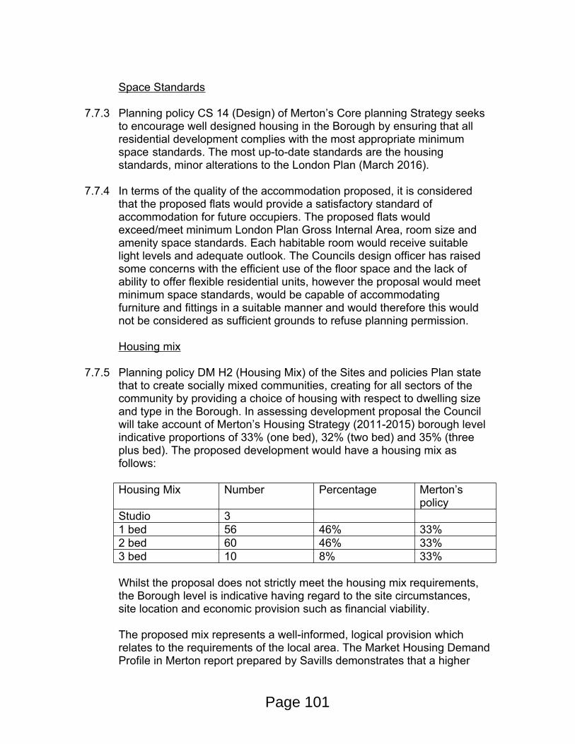
Space Standards
7.7.3 Planning policy CS 14 (Design) of Merton’s Core planning Strategy seeks to encourage well designed housing in the Borough by ensuring that all residential development complies with the most appropriate minimum space standards. The most up-to-date standards are the housing standards, minor alterations to the London Plan (March 2016).
7.7.4 In terms of the quality of the accommodation proposed, it is considered that the proposed flats would provide a satisfactory standard of accommodation for future occupiers. The proposed flats would exceed/meet minimum London Plan Gross Internal Area, room size and amenity space standards. Each habitable room would receive suitable light levels and adequate outlook. The Councils design officer has raised some concerns with the efficient use of the floor space and the lack of ability to offer flexible residential units, however the proposal would meet minimum space standards, would be capable of accommodating furniture and fittings in a suitable manner and would therefore this would not be considered as sufficient grounds to refuse planning permission.
Housing mix
7.7.5 Planning policy DM H2 (Housing Mix) of the Sites and policies Plan state that to create socially mixed communities, creating for all sectors of the community by providing a choice of housing with respect to dwelling size and type in the Borough. In assessing development proposal the Council will take account of Merton’s Housing Strategy (2011-2015) borough level indicative proportions of 33% (one bed), 32% (two bed) and 35% (three plus bed). The proposed development would have a housing mix as follows:
Housing Mix Number Percentage Merton’s policy
Studio 31 bed 56 46% 33%2 bed 60 46% 33%3 bed 10 8% 33%
Whilst the proposal does not strictly meet the housing mix requirements, the Borough level is indicative having regard to the site circumstances, site location and economic provision such as financial viability.
The proposed mix represents a well-informed, logical provision which relates to the requirements of the local area. The Market Housing Demand Profile in Merton report prepared by Savills demonstrates that a higher
Page 101
proportion of 1 and 2 bed units in this area is a more suitable mix for the area, based on demographics, affordability and supply and demandassessments. It is concluded that the proposed mix is well matched tothe profile of active demand in the area around the proposed scheme and in Merton.
A larger quantum of family sized dwellings was considered at pre-application stage, however due to the individual constraints of this site in terms of width and the requirement to maintain access to Rufus Business Park etc. it was becoming increasingly difficult to provide the necessary private amenity space required for houses (50sqm). In order forthe scheme to remain viable, a certain quantum of development is required and it was therefore considered that a reduction in the number of family units would go some way to addressing a number of other issues.
Play Space
7.7.6 Merton’s Core Planning Strategy (CS 13) and The London Plan (3.6), require housing proposals to provide play spaces for the expected child population, and to the Mayor of London’s ‘Play and Informal Recreation’ SPG (2012), which provides detailed guidance on this matter.
7.7.7 The nearest public park is Durnsford Road Recreation Ground and the actual walking distance to the nearest gate to the park is approximately 510m, from the boundary of the site at the Haslemere Avenue / Ravensbury Terrace road entrance. Children residing in Block C would have to walk an additional 100m.
7.7.8 The nearest play space is the Durnsford Road Play Area and the actual walking distance to the play space is approximately 640m.
7.7.9 Following the amendments to the scheme and increased amount of affordable housing, the proposed scheme would need to provide 358m2 of children’s place space. The revised application documentation states that the proposal will now provide 456m2 of play space within roof gardens on the mixed-use building and a 60 sqm play space area in the proposed pocket park. The proposed development would therefore meet play space requirements.
Affordable housing
7.7.12 Planning policy CS 8 (Housing Choice) of Merton’s Core Planning Strategy states that development proposals of 10 units or more require an on-site affordable housing target of 40% (60% social rented and 40% intermediate). In seeking affordable housing provision, the Council will have regard to site characteristics such as site size, its suitability and
Page 102
economics of provision such as financial viability issues and other planning contributions.
7.7.13 The amount of affordable housing this site can accommodate has been subject of a viability assessment. Following extensive discussions, the Councils independent viability assessor has confirmed that a policy compliant 40% affordable scheme is not viable in this instance. However following amendments to the scheme the level of affordable housing on the site has been increased from 19 to 24 units (15 x affordable rent and 9 x shared ownership) which is an increase of 15% to 19%. The level of affordable housing is therefore considered to be policy compliant via the viability of the scheme.
7.7.14 In light of the scale of the development and the possible lengthy timescales involved in implementing and constructing the development, the affordable housing contribution would be subject of a review mechanism.
7.8 Flooding
7.8.1 The Environment Agency’s flood maps show that the site falls within flood zones 2 and 3a. In terms of surface water flooding, parts of the site are shown to be at high, medium and low surface water risk as per the Environment Agency’s maps. The NPPF and supporting NPPG defines residential use as being a ‘more vulnerable’ use and the commercial elements of the proposal are classed as ‘less vulnerable’. As required by the NPPF and by Merton’s policy DM F1, the site has appropriately undertaken a sequential and exception test in recognition of the site’s location within Flood Zone 3, to assess if there are any other reasonably available sites that would be at a lower risk of flooding.
7.8.2 The Flood Risk Assessment includes site specific hydraulic modelling of the fluvial floodplain, in order to assess flood risk impacts as existing and post development. The Environment Agency have reviewed the refined modelling in detail and have confirmed that the outputs show minimal impact to flood risk on and offsite. Mitigation has been proposed including raised finished floor levels above the 1 in 100 year climate change level. Flood voids are proposed at ground level to allow floodwaters to flow beneath the building in order to ensure there is no increase in flood risk offsite, through a loss of flood storage. In addition, some areas of the site such as the pocket park will contain floodwaters from the River Wandle during peak flood events. Merton consulted with Wandsworth Council officers regarding the application of the sequential test and it was accepted that the approach undertaken was reasonably and in accordance with policy and guidance.
Page 103
7.8.3 The Flood Risk Assessment includes site specific hydraulic modelling of the fluvial floodplain, in order to assess flood risk impacts as existing and post development. The Environment Agency have reviewed the refined modelling in detail and have confirmed that the outputs show minimal impact to flood risk on and offsite. Mitigation has been proposed including raised finished floor levels above the 1 in 100 year climate change level. Flood voids are proposed at ground level to allow floodwaters to flow beneath the building in order to ensure there is no increase in flood risk offsite, through a loss of flood storage. In addition, some areas of the site such as the pocket park will contain floodwaters from the River Wandle during peak flood events.
7.8.4 The baseline model results show that it will not be possible to provide dry access to the site during a flood with an annual chance of 1 in 100 (1%), including a Higher Central allowance for climate change. However, the proposals show that the site can provide safe refuge for occupants during inundation of the site and for access/egress for emergency vehicles. Some modification is proposed to ground levels are proposed in order to ensure safe access.
7.8.5 A flood warning and evacuation plan (FWEP) has been provided as an appendix to the FRA. The FWEP confirms that all future occupants should sign up to the EA’s free automated flood warning service.
7.8.6 The surface water drainage strategy for the site is included within the FRA and shown on AECOM drawing SKE-20-PH01-CU-0003. The design includes a +35% allowance for climate change (rainfall intensity). A variety of SuDS measures are proposed in accordance with the National Standards for Surface Water, the London Plan policy 5.13 and Merton’s policy DM F2 including bio-retention measures in addition to geo-cellular storage. The development will reduce runoff rates to greenfield rates and will discharge surface water to the river at a rate no more than 5l/s. A required attenuation storage volume of 658m3 has been calculated. Storage volumes for the 1 in 100 year +35% climate change allowance will require some nominal flood depths to be stored on public open space (pocket park area), the access road and parking areas. A pumping station is proposed for surface water drainage, prior to restricted discharge to the river. Maintenance of the drainage onsite will be undertaken by a private management company.
7.8.7 The existing river wall adjacent to the site, provides the proposed scheme with a standard of protection from fluvial flooding from The River Wandle. We would seek that the structural integrity of the river wall, matches that of the lifetime of the proposed development. Therefore a full structural survey and feasibility study should be undertaken to demonstrate the condition of the river wall and options for remedial works or full replacement. The study
Page 104
should identify options for either improvements to or full replacement of the river wall, if required, that benefit both flood risk and deliver ecological enhancements in accordance with the London Plan and its Blue Ribbon Network policies. Dependent on the outcome of the structural survey and feasibility study, the remediation works to the river wall that maybe required, may impact upon the viability of the scheme and the level of affordable housing offered on-site. As the schemes viability will be reassessed at a later date, this aspect can be determined at this time.
7.8.8 The Councils Flood and the Environment Agency have confirmed that they have no objection to the proposed development subject to conditions.
7.9 Transport
Context
7.9.1 The site is accessed from a private road off Ravensbury Terrace and is bounded by the River Wandle, railway lines, Rufus Business Centre and residential dwellings. It is easily accessible by public transport, being located within 400m of Earlsfield Rail Station, and has a ‘good’ Public Transport Accessibility Level (PTAL) of 4.
7.9.2 A range of local shops and amenities are within a short walking distance of the site. This includes shops around Earlsfield Rail Station (400m from site access) via Ravensbury Terrace and Penwith Road to the east and also along Merton Road (465m) to the west.
7.9.3 The site is directly connected to established cycle networks that form part of London and National Cycle Routes. National Cycle Route 20 (NCN20) runs from Wandsworth to Brighton and is within close proximity to the site. The route goes through King George’s Park to the north and includes the Wandle Trail, which is a mostly traffic-free route that runs from Wandsworth to Carshalton.
Construction Routes
7.9.4 Ravensbury Terrace runs in a north-south direction and becomes Haslesmere Avenue to the west of the site. It is a single carriageway road subject to a 30mph speed limit and there is on-street parking located on both sides of the road.
7.9.5 Ravensbury Terrace to the north is connected to Penwith Road. This leads to A217 Garratt Lane to the east and A218 Merton Road to the west. Both Garratt Lane and Merton Road provide routes into Wandsworth and Central London to the north. To the south, Garratt Lane provides access
Page 105
to Mitcham, Sutton and Reigate and Merton Road provides access to Merton.
7.9.6 The local residential roads between Garratt Lane and Merton Road are subject to a 7.5 tonne vehicle restriction, except for loading. There is signage at the entrance to this zone at Penwith Road, Strathville Road, Bodmin Street and Dunshill Road. Ravensbury Road is signed to be “unsuitable for HGVs” and Mount Road has a width restriction of 7 feet.
7.9.7 Access to Haslemere industrial Estate is located close to the junction of Haslemere Avenue and Ravensbury Terrace. Both streets are traffic calmed using road humps with residential parking on both sides of the road. A seven foot width restriction is provided to the west on Mount Road to prevent access by goods vehicles. Highway responsibility rests with LB Merton for Haslemere Avenue and L.B.Wandsworth for Ravensbury Terrace and Ravensbury Road.
7.9.8 Concerns have been received from Merton and Wandsworth residents and officers at the London Borough of Wandsworth in terms of potential disturbance that would be caused from construction vehicle movement to and from the site. The applicant has submitted a draft Construction Management Plan (CMP) with the planning application, setting out the broad principles associated with the proposed construction phases of the development and routing of vehicles. At this stage, the applicant is unable to provide a full and detailed CMP as a contractor would only be appointed once planning permission is secured for the site. In order for the Council to control and satisfactorily manage construction related activities, a pre-commencement planning condition requiring a full and detailed CMP would need to be submitted to and approved in writing by Merton Council in consultation with London Borough of Wandsworth. As with any construction management plan, the Council will seek to identify the most appropriate routes and construction vehicles would be required to access the strategic road network in the most direct way.
Car Parking
7.9.9 The local roads in the area provide on-street parking which is within Controlled Parking Zones (CPZ). The site falls within the Merton’s CPZ (Zone P3) which restricts on-street parking to residential permit holders only from Monday to Friday, 9.30am to 4.30pm.
7.9.10 Ravensbury Terrace to the north of the site falls within the London Borough of Wandsworth. From Monday to Friday, 9.30am to 4.30pm, on-street parking is for permit holders only (Zone L1) or pay at machine.
Page 106
7.9.11 The realignment of the access road within the site which will improve the angle of approach and visibility at the junction with Ravensbury Terrace. There will be 2.0m footways provided along both sides of the carriageway. The carriageway has been designed to a width of 5.5m which is in keeping to the nature of the residential development while still providing access for the Rufus Business Centre. Swept path analysis shows that an 8.0m rigid lorry and large car can pass each other.
7.9.12 A total of 27 car parking spaces will be provided both on-street, within private garages and a parking court behind residential blocks within the development. The car parking spaces will be allocated as follows:
6 garages - 1 per house 13 parking spaces associated with the wheelchair units 1 visitor parking space 1 space for a car club 2 spaces associated with the commercial space 4 'first come first served' spaces.
9.9.13 The level of parking is well below the maximum level parking standards set in the London Plan. Whilst objections have been received from neighbours relating to the low level of car parking, the proposal complies with the London Plan and whilst offering low levels of car parking, given the PTAL 4, the proposal would encourage sustainable travel patterns. On-street parking on neighbouring streets is at a premium and the Council would therefore require the development to be permit free to protect the amenity of existing residents. The applicant will be required to enter into a S106 agreement with the Council to ensure the development is permit free and no resident or business within the development can apply for an on street parking permit in the surrounding parking zones.
9.9.14 Concerns from neighbours relating to parking pressures on existing CPZ areas outside controlled hours is noted. As part of the applicants Transport Statement, Parking surveys have been undertaken within 200m of the site access, including Ravensbury Terrace, Haslemere Avenue and Penwith Road. The survey showed that the greatest overnight demand was observed on Dunshill Road (83% on the Thursday) and Ravensbury Road (80% on the Saturday). The survey shows that there is generally demand for on-street parking in the local area but the parking stress does not exceed 85% on any of the roads within 200m of the site.
9.9.15 Using census car ownership data it has been estimated that there could be 83 vehicles associated with the residential aspect of the development. Twenty off street parking spaces have been provided in association with the residential aspect. Two of these spaces are visitor spaces, for the purpose of this assessment off street parking facilities have been
Page 107
calculated as 18.
9.9.16 A worst case level of over spill parking has been calculated as 65 vehicles. The parking survey shows that this level of over spill parking could be accommodated by the surrounding highway network at peak times of residential demand.
9.9.17 The applicants propose a package of mitigation against car usage and ownership which includes car parking permit exemption, an on site car club (plus 4 other cars on the surrounding highway network) with free car club membership and driving credit, cycle parking levels in accordance with the London Plan (a bicycle voucher worth £100 would be provided to each of the households, free cycle training and bicycle surgery events to encourage cycling) and a travel plan. All of these methods will significantly reduce the level of car ownership, over spill parking and trip generation associated with both the residential and commercial aspects of the development.
9.9.18 There have been objections raised by the adjoining Rufus Business Park (who are also looking to develop their site) regarding future residents using the business park to park their vehicles. This would not be a matter for the council to enforce. An agreement should be reached by both parties outside of the planning process or a well signed private parking enforcement scheme should be associated with each development.
9.9.19 Electric charging points will be provided as per the London Plan requirements which are 20% of spaces to provide electrical charging points (7 spaces) and an additional 20% passive provision for electric charging in the future. Details relating to Electic Charging points can be secured by a planning condition.
Servicing
7.9.20 All deliveries and servicing activity will be undertaken within the site. Given the scale of the development, these are expected to be undertaken by cars, vans and motorbikes, with the occasional large vehicle for the delivery of bulky items. These vehicles can be accommodated within the site. A service and delivery plan can provide future details of servicing and deliveries, this can be controlled via a planning condition.
7.9.21 It should also be noted that the proposed redevelopment of the site would see a significant change on the type of vehicles serving and visiting the site. Neighbours have expressed long term problems with large HGV using small residential streets. Once the construction phase has finished, the proposed development would see smaller vehicles serving the site on
Page 108
a much less frequent. Therefore in the long term, the proposal would be a considerable improvement on the existing situation.
Walking & Cycling
7.9.22 As set out above, the proposed development offers low level car parking, has close connections to a number of alterative public transport (PTAL 4) and would therefore promote sustainable modes for future residents and employees. The Wandle Trail is a walking and cycling trail that follows the River Wandle from Croydon to Wandsworth. The application site is situated in an area where a new section of the Wandle Trail could potentially link Trewint Street to the south and Penwith Road to the North. The proposed development has made suitable provision with a 3.8m wide path on its eastern boundary and the application has agreed to make a financial contribution towards investigating the potential of the missing link or general improvements to walking and cycling for the Wandle Trail. In order to ensure that the new path remains available for public use, a permissive path can be secured via a S106 agreement.
12 Ravensbury Terrace
7.9.22 Following objections and correspondence from owners of 12 and 12A Ravensbury Terrace, there is a legal right to provide vehicle access to the 12 Ravensbury Terrace. Whilst this is the private matter between land owners and interested parties, the proposals provide a 8m wide access path in front of 12 Ravenbury Terrace. The applicant has provided a safety audit with the application that demonstrates that the access is suitable. The Councils Transport Planner has confirmed that there is no objection to the new access path.
8. Sustainability
8.1.1 London Plan Policy 5.2 requires new development proposals to make the fullest contribution to minimising carbon dioxide emissions in accordance with the following energy hierarchy:
Be lean: use less energy Be clean: supply energy efficiently Be green; use renewable energy
8.1.2 The submitted energy statement indicates that the proposed development will achieve a minimum 35% improvement (currently projected to achieve 37% improvement) in CO2 emissions against Part L 2013 across the site. This meets the minimum sustainability requirements for major developments of Merton’s Core Planning Strategy Policy CS15 (2011) and Policy 5.2 of the London Plan (2015).
Page 109
9. Biodiversity
9.9.1 The applicant site is adjacent to SINC and Green Corridors along its south-eastern and eastern border – the railway embankment and the River Wandle. The applicant has submitted a Preliminary Ecological Appraisal with the application. The Councils Ecology officer has confirmed that the methodology, findings and recommendations of the submitted Preliminary Ecological Appraisal, are acceptable. In order to ensure that the development enhances conservation values, planning conditions relating to planting details, construction methods statement, external lighting bat boxes and bird nesting features are required. In addition, in this instance it is considered reasonable to also seek enhancements to the riverbank. Details can be secured via a suitable planning condition.
10.1 Local Financial Considerations
The proposed development is liable to pay the Mayoral CommunityInfrastructure Levy, the funds for which will be applied by the Mayor towards the Crossrail project. This, and the Councils CIL payment is non-negotiable.
11. SUSTAINABILITY AND ENVIRONMENTAL IMPACT ASSESSMENT REQUIREMENTS
11.1.1 The proposal is for minor householder development and an EnvironmentalImpact Assessment is not required in this instance.
11.1.2 The application does not constitute Schedule 1 or Schedule 2 development. Accordingly, there are no requirements in terms on EIA submission.
12. CONCLUSION
12.1 It is considered that the proposed development would fulfill its policy allocation of an employment led scheme due to the potential number of jobs being created by the employment offer. The acceptance of the policy allocation is also in association with the other benefits of the scheme including the delivery of new high quality designed buildings and 129 good quality residential units. Other public benefits include the removal of poor quality industrials units, a new public pocket park on the river front, potential to connect into the missing link of the Wandle Trail and removing the long term problems raised by neighbours from the use of large vehicles used by the existing industrial estate.
12.2 The proposed buildings and use would have no undue impact upon neighbouring amenity, trees or highway conditions. The proposal is in
Page 110
accordance with Adopted Site and Polices Plan, Core Planning Strategy and London Plan policies. The proposal is therefore recommended for approval subject to conditions and S106 agreements.
RECOMMENDATION
GRANT PLANNING PERMISSION
Subject to the completion of a Section 106 Agreement covering the following heads of terms:-
1. Affordable housing (15 x affordable rent and 9 x shared ownership) with review mechanism.
2. Flexible Working Commitment
3. Permit Free Development (residential and business)
4. Wandle Trail contribution (35k)
5. River bank Improvement, including if necessary improvements to the river wall & ecology of the river
6. Car Club
7. Permissive Way (Rufus, Wandle Trail, Pocket Park and 12 Ravensbury Terrace)
8. The developer agreeing to meet the Councils costs of preparing, drafting and monitoring the Section 106 Obligations.
And the following conditions:
1. A1 Commencement of Development (full application)
2. A7 Approved Plans
3. B.1 Materials to be approved
4. B.4 Details of Surface Treatment
5. Typical building details (window revels, balconies etc)
6. B.5 Details of Walls/Fences
Page 111
7. B5 Details of boundary treatment
8. C06 Refuse & Recycling (Details to be submitted)
9. C07 Refuse & Recycling (implementation)
10. CO4 Obsured Glazed windows to non-habitable room (upper levels of rear elevation within terrace)
11. Details of balcony balustrades (including 1.7m high obscured side screen to fourth floor terrace in block E)
12. CO1 Removal of PD rights (Extensions)
13. CO2 Removal of PD Right (Windows)
14. C08 Use of Flat Roofs (other than those approved)
15. F09 Hardstandings
16. D11 Construction Times
17. B6 Levels
18. F05 Tree protection
19. F8 Site Supervision (Trees)
20. H01 New Vehicle Access (Details to be submitted)
21. H02 Vehicle Access to be provided
22. H06 Cycle Parking details to be submitted
23. H07 Cycle Parking to be implemented
24. H08 Travel Plan
25. H09 Construction Vehicles Traffic Management Plan
26. F01 Landscaping/planting scheme
27. F02 Landscaping (implementation)
28. H10 Construction vehicles, wash down facilities (mayor developments)
Page 112
29. H12 Delivery and Servicing Plan to be Submitted
30. H13 Construction Logistic Plan to be Submitted (mayor development)
31. Construction Management Plan
32. H.11 Parking Management Plan
33. Electric Vehicle Charging Points
34. H19 Garage doors not opening into highway
35. Class B1 Use restriction
36. Prior to the commencement of the development, excluding demolition and site preparation works, hereby approved a full and detailed application for the Secured by Design award scheme shall be submitted to the Local Planning Authority, setting out how the principles and practices of the Secured by Design Scheme are to be incorporated. Once approved in writing by the Local Planning Authority in consultation with the Metropolitan Police Designing Out Crime Officers, the development shall be carried out in accordance with the agreed details.
Reason: In the interest of creating safer, sustainable communities.
37. Unless otherwise agreed in writing by the Local Planning Authority, no part of the development hereby approved shall be used or occupied until evidence has been submitted to the council that the developer has uploaded the appropriate information pertaining to the sites Combined Heat and Power (CHP) system has been uploaded onto the London Heat Map (http://www.londonheatmap.org.uk/)
Reason - To ensure that the development contributes to the London Plan targets for decentralised energy production and district heating planning. Development Plan policies for Merton: policy 5.2,5.5 of the London Plan 2011 and policy CS15 of Merton's Core Planning Strategy 2011.
38. No part of the development hereby approved shall be occupied until evidence has been submitted to the council confirming that the development has achieved not less than the CO2 reductions (ENE1 and internal water usage (WAT1) standards equivalent to Code for Sustainable Homes Level 4.
Page 113
39. Unless otherwise agreed in writing by the Local Planning Authority, no part of the development hereby approved shall be used or occupied until a Post-Construction Review Certificate issued by the Building Research Establishment or other equivalent assessors confirming that the non-residential development has achieved a BREEAM rating of not less than the standards equivalent to ‘Very Good’ has been submitted to and acknowledged in writing by the Local Planning Authority. The submission shall also include confirmation that the development will meet the London Plan C02 reduction targets.’
40. No development, excluding demolition and site preparation works, shall commence, excluding demolition and site preparation works, until the applicant submits to, and has secured written approval from, the Local Planning Authority on evidence demonstrating that the development has been designed to enable connection of the site to an existing or future district heating network, in accordance with the Technical Standards of the London Heat Network Manual (2014).’Reason: To demonstrate that the site heat network has been designed to link all building uses on site (domestic and non-domestic) and to demonstrate that sufficient space has been allocated in the plant room for future connection to wider district heating in accordance with London Plan (2015) policies 5.5 and 5.6.
41. The development permitted by this planning permission shall be carried out in accordance with the approved Flood Risk Assessment (FRA) by AECOM dated June 2016 ref 0429660 and the Addendum to Wandle Terrace FRA dated 13 October 2016.
The mitigation measures shall be fully implemented prior to occupation and subsequently in accordance with the timing / phasing arrangements embodied within the scheme, or within any other period as may subsequently be agreed, in writing, by the local planning authority.
Reason: To ensure the development is does not lead to an increase in flood risk
42. No development, excluding demolition and site preparation works, shall take place until a detailed method statement for removing or the long-term management of Japanese knotweed on the site shall be submitted to and approved in writing by the local planning authority. The method statement shall include measures that will be used to prevent the spread of Japanese knotweed during any
Page 114
operations e.g. mowing, strimming or soil movement. It shall also contain measures to ensure that any soils brought to the site are free of the seeds / root / stem of any invasive planted listed under the Wildlife and Countryside Act 1981, as amended. Development shall proceed in accordance with the approved method statement.
Reason: This condition is necessary to prevent the spread of Japanese knotweed which is an invasive species. Without it, avoidable damage could be caused to the nature conservation value of the site contrary to national planning policy as set out in the National Planning Policy Framework paragraph 109, which requires the planning system to aim to conserve and enhance the natural and local environment by minimising impacts on biodiversity and providing net gains in biodiversity where possible.
43. Prior to the commencement of development, excluding demolition and site preparation works, approved by this planning permission (or such other date or stage in development as may be agreed in writing with the Local Planning Authority), the following components of a scheme to deal with the risks associated with contamination of the site shall each be submitted to and approved, in writing, by the local planning authority: 1) An additional site investigation scheme, based on the preliminary findings form the above report and including robust groundwater monitoring, to provide information for a detailed assessment of the risk to all receptors that may be affected, including those off site. 2) The results of the site investigation and detailed risk assessment referred to in (1) and, based on these, an options appraisal and remediation strategy giving full details of the remediation measures required and how they are to be undertaken. 3) A verification plan providing details of the data that will be collected in order to demonstrate that the works set out in the remediation strategy in (2) are complete and identifying any requirements for longer-term monitoring of pollutant linkages, maintenance and arrangements for contingency action. Any changes to these components require the express consent of the local planning authority. The scheme shall be implemented as approved.
Reason: For the protection of Controlled Waters. The site is located over a Secondary Aquifer and adjacent to the River Wandle and there are indications that the site is affected by historic contamination.
44. If, during development, contamination not previously identified is found to be present at the site then no further development (unless otherwise agreed in writing with the Local Planning Authority) shall
Page 115
be carried out until the developer has submitted, and obtained written approval from the Local Planning Authority for, a remediation strategy detailing how this unsuspected contamination shall be dealt with. The remediation strategy shall be implemented as approved, verified and reported to the satisfaction of the Local Planning Authority.
Reason: There is always the potential for unexpected contamination to be identified during development groundworks. We should be consulted should any contamination be identified that could present an unacceptable risk to Controlled Waters.
45. Prior to occupation of the development, a verification report demonstrating completion of the works set out in the approved remediation strategy and the effectiveness of the remediation shall be submitted to and approved, in writing, by the local planning authority. The report shall include results of sampling and monitoring carried out in accordance with the approved verification plan to demonstrate that the site remediation criteria have been met. It shall also include any plan (a "long-term monitoring and maintenance plan") for longer-term monitoring of pollutant linkages, maintenance and arrangements for contingency action, as identified in the verification plan, if appropriate, and for the reporting of this to the local planning authority. Any long-term monitoring and maintenance plan shall be implemented as approved.
Reason: Should remediation be deemed necessary, the applicant should demonstrate that any remedial measures have been undertaken as agreed and the environmental risks have been satisfactorily managed so that the site is deemed suitable for use.
46. Whilst the principles and installation of sustainable drainage schemes are to be encouraged, no drainage systems for the infiltration of surface water drainage into the ground are permitted other than with the express written consent of the Local Planning Authority, which may be given for those parts of the site where it has been demonstrated that there is no resultant unacceptable risk to Controlled Waters. The development shall be carried out in accordance with the approval details.
Reason: Infiltrating water has the potential to cause remobilisation of contaminants present in shallow soil/made ground which could ultimately cause pollution of groundwater.
47. Piling or any other foundation designs using penetrative methods shall not be permitted other than with the express written consent of
Page 116
the Local Planning Authority, which may be given for those parts of the site where it has been demonstrated that there is no resultant unacceptable risk to groundwater. The development shall be carried out in accordance with the approved details.
Reason: The developer should be aware of the potential risks associated with the use of piling where contamination is an issue. Piling or other penetrative methods of foundation design on contaminated sites can potentially result in unacceptable risks to underlying groundwaters. We recommend that where soil contamination is present, a risk assessment is carried out in accordance with our guidance 'Piling into Contaminated Sites'. We will not permit piling activities on parts of a site where an unacceptable risk is posed to Controlled Waters.
48. No development approved by this permission shall be commenced, excluding demolition and site preparation works, until a detailed scheme for the provision of surface and foul water drainage has been implemented in accordance with details that have been submitted to and approved in writing by the local planning authority and in consultation with Thames Water. The drainage scheme will dispose of surface water by means of a sustainable drainage system (SuDS) in accordance with drainage hierarchy contained within the London Plan Policy (5.12, 5.13 and SPG) and the advice contained within the National SuDS Standards. Where a sustainable drainage scheme is to be provided, the submitted details shall:
i. Provide information about the design storm period and intensity, the method employed to delay and control the rate of surface water discharged from the site to the River Wandle to no more than 5l/s. Appropriate measures must be taken to prevent pollution of the receiving groundwater and/or surface waters;
ii. Include a timetable for its implementation; iii. Provide a management and maintenance plan for the lifetime of the development which shall include the arrangements for adoption and any other arrangements to secure the operation of the scheme throughout its lifetime;vi. All sewer diversions and any new connections are undertaken to the satisfaction of Thames Water.
Reason: To reduce the risk of surface and foul water flooding to the proposed development and future users, and ensure surface water and foul flood risk does not increase offsite in accordance with Merton’s policies CS16, DMF2 and the London Plan policy 5.13
Page 117

49. Planting details - including information demonstrating how the proposed species would address the recommendations in paragraph 5.15 of the submitted Preliminary Ecological Appraisal.
50. The development hereby permitted shall not be occupied until such time as a Flood Warning and Evacuation plan and procedure is implemented and agreed in writing to the satisfaction of the Local Planning Authority. The Flood Warning and Evacuation Plan shall be implemented in accordance with the Flood Risk Assessment and the procedures contained within the plan shall be reviewed annually for the lifetime of the development. Consultation of the plan shall take place with the Local Planning Authority and Emergency Services.
Reason: To reduce the risk of flooding to the proposed development and future users in accordance with Merton’s CS16 and policy DM F1 and the London Plan policy 5.12.
51. Construction methods statement, including information demonstrating how the concerns and recommendations in paragraphs 5.8-5.13 of the submitted Preliminary Ecological Appraisal have been addressed.
52. External lighting in accordance with External Lighting Assessment Report (WBS-11971-REP-E01 Rev A03).
53. D09 No external Lighting (other than the approved details)
54. Bat boxes
55. Bird nesting features
56. Noise levels, (expressed as the equivalent continuous sound level) LAeq (10 minutes), from any new plant/machinery from the commercial/domestic use shall not exceed LA90-10dB at the boundary with the closest residential property.
Reason: To protect the amenities of future occupiers and those in the local vicinity.
57. Any external lighting shall be positioned and angled to prevent any light spillage or glare beyond the site boundary.
Reason: To protect the amenities of future occupiers and those in
Page 118
the local vicinity.58. The internal noise criteria in section 6 of the Waterman –
Assessment of Residential Amenity – Noise and Vibration Document WIB15644-100-R-1-3-3 dated June 2016 shall be implemented that that standard or higher.
Reason: To protect the amenities of future occupiers and those in the local vicinity.
59. A supplementary intrusive investigation should be undertaken for contaminated land, as recommended in the Soiltechnics report STM3167B-G0, dated June 16, if necessary, a detailed remediation scheme to bring the site to a condition suitable for the intended use by removing unacceptable risks to human health, buildings and other property and the natural and historical environment must be prepared, and is subject to the approval in writing of the Local Planning Authority. The scheme must include all works to be undertaken, proposed remediation objectives and remediation criteria, timetable of works and site management procedures. The scheme must ensure that the site will not qualify as contaminated land under Part 2A of the Environmental Protection Act 1990 in relation to the intended use of the land after remediation.
Reason: To protect the amenities of future occupiers and those in the local vicinity.
60. Any approved remediation scheme must be carried out in accordance with its terms prior to the commencement of development (excluding demolition), unless otherwise agreed in writing by the Local Planning Authority. Following the completion of any measures identified in the approved remediation scheme, a verification report that demonstrates the effectiveness of the remediation carried out must be produced, and is subject to the approval in writing of the Local Planning Authority.
Reason: To protect the amenities of future occupiers and those in the local vicinity.
61. In the event that contamination is found at any time when carrying out the approved development that was not previously identified it must be reported in writing immediately to the Local Planning Authority. An investigation and risk assessment must be undertaken in accordance in accordance with DEFRA and the Environment Agency’s ‘Model Procedures for the Management of Land Contamination, CLR 11’ and where remediation is necessary
Page 119
a remediation scheme must be prepared, which is subject to the approval in writing of the Local Planning Authority.Reason: To protect the amenities of future occupiers and those in the local vicinity.
62. No development shall take place until a Demolition and Construction Method Statement has been submitted to, and approved in writing by, the local planning authority. The approved Statement shall be adhered to throughout the demolition and construction period.
The Statement shall provide for:
-hours of operation-the parking of vehicles of site operatives and visitors -loading and unloading of plant and materials -storage of plant and materials used in constructing the development -the erection and maintenance of security hoarding including decorative -displays and facilities for public viewing, where appropriate -wheel washing facilities -measures to control the emission of noise and vibration during construction.-measures to control the emission of dust and dirt during construction/demolition -a scheme for recycling/disposing of waste resulting from demolition and construction works
Reason: To protect the amenities of future occupiers and those in the local vicinity.
Informative
1. Japanese Knotweed, which was has been positively identified within 7m of the boundary of the site, is an invasive non-native species. It is an offence to plant or cause this species to grow in the wild and when removed, it is regarded as a ‘controlled waste’. The developer should follow the recommendations in paragraphs 5.5-5.7 of the submitted Preliminary Ecological Appraisal by The Ecology Consultancy, dated 2 June 2016.
2. Whilst the development site boundary is outside of safeguarded limits it is adjacent to an existing operational railway and an ‘Area of Surface Interest’ (AOSI) for Crossrail 2. The AOSI would be used a a construction worksite and would be used for a number of years if
Page 120
adopted.
3. The development proposes as a preferred option to discharge surface run off via the existing outfall into the River Wandle. To minimise potential impacts to water quality, the applicant should include oil interceptors if not already present on site.
4. No surface water runoff should discharge onto the public highway including the public footway or highway. When it is proposed to connect to a public sewer, the site drainage should be separate and combined at the final manhole nearest the boundary. Where the developer proposes to discharge to a public sewer, prior approval from Thames Water Developer Services will be required (contact no. 0845 850 2777)
5. It is Council policy for the Council's contractor to construct new vehicular accesses. The applicant should contact the Council's Highways Team on 020 8545 3829 prior to any work starting to arrange for this work to be done. If the applicant wishes to undertake this work the Council will require a deposit and the applicant will need to cover all the Council's costs (including supervision of the works). If the works are of a significant nature, a Section 278 Agreement (Highways Act 1980) will be required and the works must be carried out to the Council's specification.
6. You are advised to contact the Council's Highways team on 020 8545 3700 before undertaking any works within the Public Highway to obtain the necessary approvals and/or licences. Please be advised that there is a further charge for this work. If your application falls within a Controlled Parking Zone this has further costs involved and can delay the application by 6 to 12 months.
7. Any works/events carried out either by, or at the behest of, the developer, whether they are located on, or affecting a prospectively maintainable highway, as defined under Section 87 of the New Roads and Street Works Act 1991, or on or affecting the public highway, shall be co-ordinated under the requirements of the New Roads and Street Works Act 1991 and the Traffic management Act 2004 and licensed accordingly in order to secure the expeditious movement of traffic by minimising disruption to users of the highway network in Merton. Any such works or events commissioned by the developer and particularly those involving the connection of any utility to the site, shall be co-ordinated by them in liaison with the London Borough of Merton, Network Coordinator, (telephone 020 8545 3976). This must take place at least one month in advance of the works and particularly to ensure that
Page 121
statutory undertaker connections/supplies to the site are co-ordinated to take place wherever possible at the same time.
Click here for full plans and documents related to this application.
Please note these web pages may be slow to load
Page 122