Embed Size (px)
Citation preview

UAV Survey AETOS HOLDING PTE LTD

Aerial Platform
• How it Begin
• Aircraft
• Helicopter
• Blimp
• Balloon
• Kites
• Parachute
• Pigeon

Aerial Platform
• Limitation
• Cost
• Runway
• Certified Pilots
• Ability to control
• Area that it can cover
• Stability
• Controlled Area

Aerial Platform • Current Platform
• UAV
• Quad
• Octo
• Hexa
• Fixed Wing
• VTOL
• Advantages
• Ease of use
• Precision
• Live transmission
• Needs small area
• Assortment of payload
• Flexibility

Aerial Platform • Fixed Wing UAV
• Advantages
• Longer flight time
• Cover larger areas in shorter time
• Higher flight safety
• Better image quality over a large area
• Disadvantages
• More difficult to learn
• Needs higher attitude
• Large area needed to safely takeoff and land

Aerial Platform • Multirotor UAV
• Advantages
• Agile and can hover
• Small area needed for take off
• Better image quality (slower)
• Greater flexibility with payload
• Easier to learn to operate
• Disadvantages
• Covers smaller area
• More maintenance
• Slower compared to fixed wing
• Shorter flight time (28 mins)

Aerial Platform • Hybrid UAV
• Advantages
• Can hover
• Small area needed for take off
• Cover a large area
• Longer flight time
• Disadvantages
• Limited payload weight
• More maintenance
• Needs a more experienced pilot
• In hover mode very short battery life.

Aerial Platform • Advantages
• More effective and efficient
• Safer especially in hazardous areas
• Easy to operator and learn
• Can generate a lot of different types of output for various needs
• Disadvantage
• Pilot skills
• There are limitations
• Cost
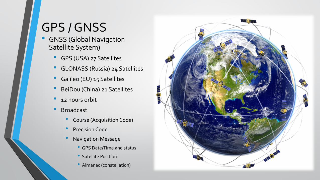
GPS / GNSS • GNSS (Global Navigation
Satellite System)
• GPS (USA) 27 Satellites
• GLONASS (Russia) 24 Satellites
• Galileo (EU) 15 Satellites
• BeiDou (China) 21 Satellites
• 12 hours orbit
• Broadcast
• Course (Acquisition Code)
• Precision Code
• Navigation Message
• GPS Date/Time and status
• Satellite Position
• Almanac (constellation)

GPS / GNSS 2 • Carrier Freq
• L1 = 1575.42 Mhz
• L2 = 1227.60 Mhz
• Mobile devices only L1 (Single Band)
• Most surveying grade equipment (Duo Band)
• 3 sat or more horizontal
• 4 or more vertical position (drift 3 – 5m)

RTK (Real Time Kinematic) • Accuracy
• Can achieve up to 3 cm or more
• 2 ppm
• Used with
• Known points
• Unknown Points
• Usually coupled with DUO band
• Detects an additional data Carrier phase
• Broadcast correction to rover or drone

Surveying Payloads
• Payloads
• LIDAR
• Light detection and ranging (Laser)
• Multispectral Sensor
• High resolution cameras
• FLIR
• Stabilizing Gimbal

Surveying Payloads
• LIDAR
• is based on high precision laser scanners coupled with the Global Positioning System (GPS) and Inertial Navigation Systems (INS) to produce a high level of accuracy.

Surveying Payloads
• Multispectral Sensors

Surveying Payloads
• High Res Cameras
• Light weight
• Full frame
• Min. 24 megapixels
• Stabilizing Gimbal
• Provides 3D stability for the camera system to have to ability to take good shots.

Applications
• Land Survey
• Photogrammetric Mapping
• Digital Terrain Model
• Contours
• GIS (Geographic Information System)
• Orthomosaic Maps

Applications
• Encoachment
• Given defined GPS borders
• 3D model / orthomosaic proof
• GPS markers

Applications
• Site Progress and safety checks
• High Res Videos
• Photo log
• GPS markers to develop time lapse

Thank you