Embed Size (px)
Citation preview
AECOM Phase 1 Geotechnical and Geo-environmental Desk Study Report 29
Capabilities on project:
Environment
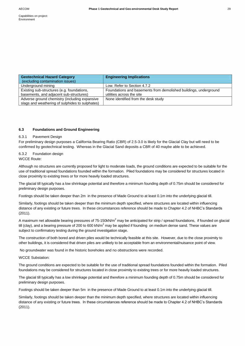
Geotechnical Hazard Category
(excluding contamination issues)
Engineering Implications
Underground mining Low. Refer to Section 4.7.2
Existing sub-structures (e.g. foundations, basements, and adjacent sub-structures)
Foundations and basements from demolished buildings, underground utilities across the site
Adverse ground chemistry (including expansive slags and weathering of sulphides to sulphates)
None identified from the desk study
6.3 Foundations and Ground Engineering
6.3.1 Pavement Design
For preliminary design purposes a California Bearing Ratio (CBR) of 2.5-3.0 is likely for the Glacial Clay but will need to be
confirmed by geotechnical testing. Whereas in the Glacial Sand deposits a CBR of 40 maybe able to be achieved.
6.3.2 Foundation design
WCCE Route:
Although no structures are currently proposed for light to moderate loads, the ground conditions are expected to be suitable for the
use of traditional spread foundations founded within the formation. Piled foundations may be considered for structures located in
close proximity to existing trees or for more heavily loaded structures.
The glacial till typically has a low shrinkage potential and therefore a minimum founding depth of 0.75m should be considered for
preliminary design purposes.
Footings should be taken deeper than 2m in the presence of Made Ground to at least 0.1m into the underlying glacial till.
Similarly, footings should be taken deeper than the minimum depth specified, where structures are located within influencing
distance of any existing or future trees. In these circumstances reference should be made to Chapter 4.2 of NHBC’s Standards
(2011).
A maximum net allowable bearing pressures of 75-150kN/m2 may be anticipated for strip / spread foundations, if founded on glacial
till (clay), and a bearing pressure of 200 to 600 kN/m2 may be applied if founding on medium dense sand. These values are
subject to confirmatory testing during the ground investigation stage.
The construction of both bored and driven piles would be technically feasible at this site. However, due to the close proximity to
other buildings, it is considered that driven piles are unlikely to be acceptable from an environmental/nuisance point of view.
No groundwater was found in the historic boreholes and no obstructions were recorded.
WCCE Substation:
The ground conditions are expected to be suitable for the use of traditional spread foundations founded within the formation. Piled
foundations may be considered for structures located in close proximity to existing trees or for more heavily loaded structures.
The glacial till typically has a low shrinkage potential and therefore a minimum founding depth of 0.75m should be considered for
preliminary design purposes.
Footings should be taken deeper than 5m in the presence of Made Ground to at least 0.1m into the underlying glacial till.
Similarly, footings should be taken deeper than the minimum depth specified, where structures are located within influencing
distance of any existing or future trees. In these circumstances reference should be made to Chapter 4.2 of NHBC’s Standards
(2011).

AECOM Phase 1 Geotechnical and Geo-environmental Desk Study Report 30
Capabilities on project:
Environment
A maximum net allowable bearing pressures of 75kN/m2 may be anticipated for strip / spread foundations, if founded on glacial till
(clay), and a bearing pressure of 200 to 600 kN/m2 may be applied if founding on medium dense sand. These values are subject to
confirmatory testing during the ground investigation stage.
The construction of both bored and driven piles would be technically feasible at this site. However, due to the close proximity to the
Birmingham canal, it is considered that driven piles are unlikely to be acceptable from an environmental point of view.
No groundwater was found in the historic boreholes and no obstructions were recorded.
6.3.3 Ground Floor Slabs
Ground bearing floor slabs are thought to be suitable but are dependent on the thickness and consistency of the Made Ground
and the floor loading. The potential use of ground bearing floor slabs will be determined following the ground investigation.
6.3.4 Excavations
Shallow excavations for foundations and drainage are anticipated to be stable in the short term. Close or continuous support will
be required for any manned entry to excavations.
Shallow groundwater maybe encountered as a perched water table within the Made Ground. Detailed information regarding the
groundwater regime will be available following the ground investigation and subsequent monitoring.
Excavations should be relatively easy in the Glacial Till and Glacial Sand.
6.3.5 Soakaways
The ground conditions are unlikely to be suitable for the use of pit soakaways unless glacial sand is encountered. Therefore,
surface water run-off should be directed to main drainage subject to appropriate consent to discharge. The decision will depend
on the ground conditions identified from the ground investigation.

7 Recommendations for Further
Work
AECOM Phase 1 Geotechnical and Geo-environmental Desk Study Report 32
7.1 Summary
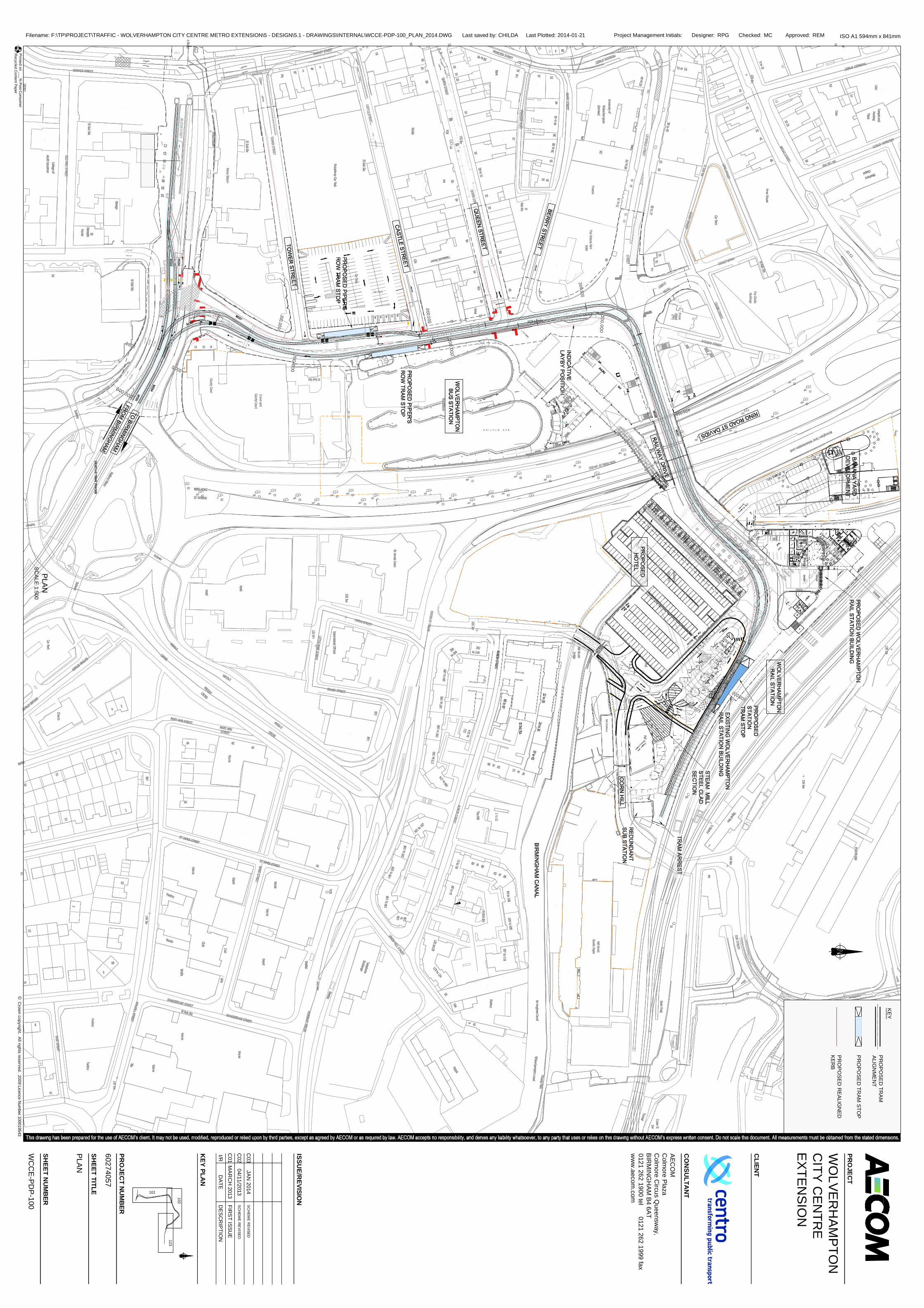
The WCCE will be street running and will extend 700 m from Bilston Street opposite the Crown and County Court along the
length of Piper’s Row to Railway Drive where it will head towards the existing railway station and terminate.
The WCCE may require additional traction power. If additional traction power is required an existing substation (known as
substation 2) situated on the Corner of Bilston Street and Chillington Street will be extended.
Based on a review of historical and current mapping the area within the vicinity of the WCCE experienced varied historical and
recent potentially contaminating industrial and commercial land uses and activities, including but not limited to railway land, sites
of activity foundries, engineering works, vehicle depots and garages, timber yards and dry cleaners. As such, there is a risk of
encountering ground contamination.
Ground gas including methane and carbon dioxide may be present associated with the Warwickshire Group, along with the
possible presence of Made Ground. The presence of ground gas should be investigated as part of a ground investigation during
detailed design. However, the risk posed by ground gas is routinely mitigated on development sites with the inclusion of ground
gas protection measures incorporated into the development. Therefore, ground gas is not considered to pose a significant risk to
the WCCE.
The Envirocheck Report states that basic radon protection measures are not required as the WCCE is not within an area that
experiences high levels of Radon. As such, radon is not considered to pose a significant risk.
The main geotechnical risk for the WCCE route is the possibility of encountering buried basements and buried foundations along
the alignment from current or historical foundations. For both sites the thicknesses of Made Ground encountered could lead to
poor founding conditions and excessive settlement. Any loose or deleterious material should be removed and replaced with
engineered fill. A CBR value for preliminary design purposes of 2.5-3.0 is likely for the Glacial Clay but will need to be confirmed
by geotechnical testing. Whereas in the Glacial Sand deposits a CBR of 40 maybe able to be achieved
The potential risks that have been identified have been assessed by the preliminary risk assessment as being very low to
medium with the majority being moderate/low risk. The risks identified are not uncommon for urban area, and the soils and
geology expected at the site. The risks may be mitigated by further assessment through intrusive ground investigation and risk
assessment at the detailed design stage, and if necessary the inclusion of routine construction measures for example, usage of
correct PPE for construction workers and ground gas protection measures. Therefore, the potential risks identified are not
considered to pose a significant risk to the WCCE.
7.2 Recommendations
Once the layout and nature of the WCCE are finalised a ground investigation will be required in order to inform the detailed
design of the site.
7 Summary and
Recommendations

8 References
AECOM Phase 1 Geotechnical and Geo-environmental Desk Study Report 34
British Geological Survey (2014) BGS GeoIndex [Internet], London, British Geological Survey. Available from: <
http://www.bgs.ac.uk/geoindex/> [Accessed 12th December 2013].
British Standards Institution (1999) BS 5930:1999 Code of practice for site investigations (+A2:2010). London, BSI.
British Standards Institution (2004) BS EN 1997-1:2004 Eurocode 7: Geotechnical design. General rules (incorporating
corrigendum February 2009). London, BSI.
British Standards Institution (2007) BS EN 1997-2:2007 Eurocode 7: Geotechnical design. Ground investigation and testing
(incorporating corrigendum June 2010). London, BSI.
British Standards Institution (2011) BS 10175:2011 Investigation of potentially contaminated sites – Code of practice. London,
BSI.
Building Research Establishment (2007) Soakaway design. Bracknell, BRE. (Digest 365).
Department for Communities and Local Government (2012) National Planning Policy Framework. London, HMSO.
Department for Environment, Food and Rural Affairs (2012) Environmental Protection Act 1990: Part 2A Contaminated Land
Statutory Guidance. London, HMSO.
Department for Environment, Food and Rural Affairs and Environment Agency (2004) Model Procedures for the Management of
Land Contamination. Bristol, Environment Agency. (Contaminated Land Report 11).
Environment Agency (2008) Groundwater protection: Policy and practice (GP3), Part 4 – Legislation and Policies. Bristol,
Environment Agency.
Environment Agency (2009) River Basin Management Plan Humber River Basin District, Annex B: water body status objectives.
[Internet], Bristol, Environment Agency. Available from: < http://publications.environment-agency.gov.uk/pdf/GENE0910BSQT-E-
E.pdf> [Accessed 20th
December 2013]
Environment Agency (2014) What’s in your backyard? [Internet], Bristol, Environment Agency. Available from:
<http://www.environment-agency.gov.uk/homeandleisure/37793.aspx> [Accessed 12th December 2013].
Environmental Protection Act 1990 (c. 43) London, HMSO
Miles, J. and others (2007) Indicative Atlas of Radon in England and Wales. Nottingham, British Geological Survey and Didcot,
Health Protection Agency. (HPA-RPD-033).
National House Building Council (2011) NHBC Standards 2011. Part 4 – Foundations. Milton Keynes, NHBC.
National House Building Council and Environment Agency (2008) Guidance for the Safe Development of Housing on Land
Affected by Contamination. NHBC, Environment Agency and Chartered Institute of Environmental Health. (R&D Publication 66).
Scivyer, C. (2007) Radon: Guidance on protective measures for new buildings. Bracknell, IHS BRE Press. (BR 211).
Simpson, B. and others (1989) The engineering implications of rising groundwater levels in the deep aquifer beneath London.
London, CIRIA. (Special Publication SP 69).
Stone, K. and others (2009) Unexploded ordnance (UXO): a guide for the construction industry. London, CIRIA. (Publication
C681).
8 References

Figures
"This document has been prepared by AECOM Ltd ("AL") for the sole use of our Client (the "Client") and in accordance with generally accepted consultancy principles, the budget for fees and the terms of reference agreed between AL and the Client. Any information provided by third parties and referred to herein has not been checked or verified by AL, unless otherwise expressly stated in the document. No third party may rely upon this document without the prior and express written agreement of AL"
AECOM
AECOM House
179 Moss Lane
Altrincham
WA15 8FH
Tel: +44 (0)161 927 8200
Fax: +44 (0)161 927 8299
www.aecom.com
Copywright: OpenStreet Map (And Contributers)
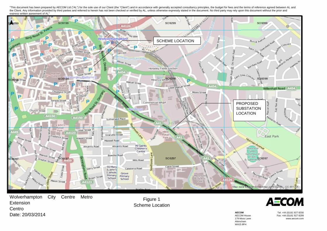
Wolverhampton City Centre Metro
Extension
Centro
Date: 20/03/2014
Figure 1
Scheme Location
SCHEME LOCATION
PROPOSED
SUBSTATION
LOCATION

Appendices

Appendix A: Scheme Route Plan (WCCE-PDP-100)
PLA
NS
CA
LE1:500
©C
rown
copyright.A
llrightsreserved.
2009Licence
Num
ber100019543
101
102
123
PRO
JECT
NU
MB
ER
60274057
SHEET
TITLE
PLA
N
SHEET
NU
MB
ER
WC
CE
-PD
P-100
Project Management Initials: Designer: Checked: Approved:RPG MC REM ISO A1 594mm x 841mm
KEY
PLAN
CLIEN
T
Filename: F:\TP\PROJECT\TRAFFIC - WOLVERHAMPTON CITY CENTRE METRO EXTENSION\5 - DESIGN\5.1 - DRAWINGS\INTERNAL\WCCE-PDP-100_PLAN_2014.DWG Last saved by: CHILDA Last Plotted: 2014-01-21
CO
NSU
LTAN
T
AEC
OM
Colm
oreP
lazaC
olmore
Circus
Queensw
ay,B
IRM
ING
HA
MB4
6AT0121
2621900
tel0121
2621999
faxw
ww
.aecom.com
Printed
on___%
Post-Consum
erR
ecycledC
ontentPaper
PRO
JECT
WO
LVER
HAM
PTON
CITY
CEN
TRE
EXTEN
SION
I/RD
ATED
ESC
RIP
TION
ISSUE/R
EVISION
C01
MA
RC
H2013
FIRS
TISSU
E
C02
04/11/2013S
CH
EME
RE
VISED
C03
JAN
2014S
CH
EM
ER
EVISED
KEY
PR
OPO
SED
TRAM
ALIG
NM
EN
T
PR
OPO
SED
TRAM
STOP
PR
OP
OS
ED
REALIG
NED
KER
B

Appendix B: Site Walkover Photographs