Embed Size (px)
Citation preview

Addendum – Route 29 Corridor Study - Blueprint
1
ADDENDUM to the Route 29 Corridor Study BACKGROUND The Route 29 Corridor Study (Study) was reviewed and accepted by Resolution of the Commonwealth Transportation Board (CTB) on December 17, 2009. However, the CTB expressed concern that the Study did not include specific recommendations on certain issues. The CTB Resolution stated that: “this Board does not believe that the Study, and process by which it was developed, produced the template which the Board desires as a Blueprint for future planning for other Corridors of Statewide Significance ...” Based on their concerns, the CTB directed VDOT and DRPT to work with a CTB subcommittee to address certain issues. The CTB Resolution may be viewed at: http://www.ctb.virginia.gov/resources/2009/dec/resol/Agenda_Item_NB_1_Rt_29_Board_Resolution.pdf This Addendum to the Route 29 Corridor Study presents the work of the CTB Subcommittee in response to the CTB Directives in the Resolution of December 17, 2009. CTB DIRECTIVES The CTB Resolution of December 17, 2009, directed VDOT & DRPT to work with a Board Subcommittee on the following:
1. A process for studying Corridors of Statewide Significance (CoSS).
2. A prioritized list of intersections to be replaced by grade separated intersections or interchanges.
3. A plan to improve mobility/accessibility north of Charlottesville.
4. A plan to improve mobility/accessibility in the Gainesville, Haymarket, and Buckland area.
5. A plan to minimize the number of traffic control signals in the corridor.
CTB SUBCOMMITTEE A CTB Subcommittee (Committee) was appointed by Secretary of Transportation on February 10, 2010, to oversee the additional work on the Route 29 Corridor.

Addendum – Route 29 Corridor Study - Blueprint
2
The Committee developed the following documents to address the CTB’s Directives.
1. A process for future studies on Route 29 and other Corridors of Statewide Significance (CoSS) was developed by the Committee and is included in this Addendum as Appendix 1. This Study process was recommended by the Committee and accepted by the CTB on May 19, 2010. The Corridor Study Process is shown in Section 1 of this Addendum and the CTB Resolution of acceptance may be viewed at: http://www.ctb.virginia.gov/resources/2010/may/resol/Item_8_Route_29_CTB_Resolution5-19-2010.pdf
2. A prioritized list of intersections based on safety and congestions concerns was compiled and is included in Section 2 of this Addendum.
3. A plan to improve mobility and accessibility north of Charlottesville must begin with dialog with the local leaders. The Committee recommended the initiation of cross-jurisdictional discussions with area leaders. These discussions will be led by a professional facilitator with experience in public dispute resolution. The Committee’s recommendation is presented in Section 3 of this Addendum.
4. A plan for improving the mobility/accessibility in the Gainesville, Haymarket and Buckland region must result in a consensus on transportation improvement alternatives. Since there is disagreement on how to address the traffic congestion and safety in this area, any resolution must begin with discussions between local leaders. The Committee recommended cross jurisdictional discussions to begin informally to outline points of contention as well as points of agreement. These discussions should be led by a professional facilitator with experience in resolving public disputes. The Committee’s recommendations are shown in Section 4 of this Addendum.
5. A plan/policy for minimizing the number on new traffic control signals on Route 29 and other Corridors of Statewide Significance (CoSS) must acknowledge that most traffic signals are installed to provide safe access for traffic generated by new developments. Safe access to future land development must be planned far in advance of the development proposals. Establishing the locations for access on the CoSS will ensure that the locality, developer and VDOT staff clearly understand how new developments can be served. In most cases, access can be provided without the addition of a traffic signal. The Committee’s recommendation for planning and establishing the future access points is shown in Section 5 of this Addendum.

Addendum – Route 29 Corridor Study - Blueprint
3
CTB SUBCOMMITTEE RECOMMENDATIONS SECTION 1 - A process for future studies on Route 29 and other Corridors of Statewide Significance (CoSS)
INTRODUCTION
Virginia’s Statewide Multi-modal Transportation Plan (VTrans2035) identifies certain transportation corridors of statewide significance (CoSS) that form the backbone of the Commonwealth’s transportation system. VTrans establishes the purpose of and goals for maintaining the functions of the CoSS. The economic vitality of the Commonwealth depends upon these corridors to provide for the safe, efficient, and effective movement of people and goods. Studies of these corridors must focus primarily on their importance to the State as routes for long distance travel and transport between discrete, functional nodes of economic activity. Because some corridor segments also serve as “Main Street” for the localities through which they pass, collaborative partnerships between the State, regional planning agencies and local governments are critical to the success of the CoSS studies and to the development and implementation of effective corridor management plans. (See the VTrans2035 Report January 2010) The technical processes, procedures and steps for corridor studies are well-established based on hundreds of studies performed across the United States over many years. Well-defined steps and procedures for the technical process are critical if these studies are to guide future investments. Equally essential to implementation of CoSS study recommendations are how the study will be developed within the general framework of steps and who will be involved in the planning and execution processes. This memorandum focuses on answering “how” and “who.” The Process for Studies of Corridors of Statewide Significance The CoSS study process starts with the assumption that major transportation corridors serve as important statewide utilities. Establishing a corridor vision and goals which support the safe, efficient, and effective movement of people and goods is the first step of the process. Segments of these corridors, however, also function as local Main Streets, and most land use decisions remain a function of local governments. Engaging local governments throughout the process, therefore, is critical in two important respects – first, to ensure that statewide goals are reflected in local plans

Addendum – Route 29 Corridor Study - Blueprint
4
and actual land use decision-making, and second, to ensure that local objectives regarding access, mobility and aesthetic standards are also respected in a cooperative way that nonetheless furthers statewide goals.
The following Corridor Study Flow Diagram on page three highlights the five steps proposed for a corridor study process. The study process should include a professional facilitator as part of the study team to ensure that input is captured from localities and stakeholders, and that all participants are working constructively toward “win-win” solutions that respect the legitimate goals of all involved. (Detail of these five steps is included in the flowchart at the end of this memorandum).
• Pre-study activities in Step 1 (a) bring in information from prior statewide planning efforts,
such as VTrans 2035 and the Virginia Surface Transportation Plan process, this information should be presented through strong and informative visual displays, (b) focus specific analysis at the broad corridor level and at some key geographic areas within the corridor, and (c) establish the participatory groundwork for the study, including local and stakeholder participation.
• Step 2 involves the collaborative efforts of State, local and other stakeholders to apply the broader statewide CoSS goals of VTrans to the specific corridor, while simultaneously developing potential strategies that respect local and stakeholder objectives.
• Alternatives are further developed, analyzed and evaluated in Step 3, with emphasis on creative “out-of- the-box” design and problem-solving.
• Step 4 utilizes workshops and meetings with local governments and stakeholders to refine study recommendations for both the statewide and corridor-wide vision and strategies. As stated above, these may be professionally-facilitated discussions to ensure that input is captured from all participants, and that the objectives of all participants are considered and a consensus incorporated into the final recommendations.
• Many of the implementation activities included in Step 5 will occur after the end of the formal corridor study. These activities include developing and adopting corridor master plans, revising local comprehensive plans, identifying funding, performing detailed location studies, and ultimately, project construction and/or improvements to highway, transit and rail services, and land use decision-making. State implementation may also include non-construction recommendations, such as new legislation or policy, rule or procedural changes.

Addendum – Route 29 Corridor Study - Blueprint
5
Corridor Study Process Flow Diagram A key issue illustrated by the flowchart is how to involve local governments and other stakeholders in a process that has substantial effects on localities, but also larger issues reaching beyond individual jurisdictions. Local governments can be engaged and brought into the planning process in a number of ways.
• The CTB can make clear that there are linkages between successful CoSS studies, the State’s transportation planning process and local planning, and future transportation investments. The CTB can issue a policy statement or statements that projects, developed by and through the CoSS study process, will be given a priority for funding and advancement by the CTB.

Addendum – Route 29 Corridor Study - Blueprint
6
Such a linkage will create an incentive for local governments to participate in the process and give them a measurable stake in the outcome of the process.
• VDOT and DRPT can encourage local governments to include CoSS study recommendations
in local comprehensive plans. Day-to-day state agency and department decisions with local governments on access control, safety, connectivity for new developments, etc., can be predicated on local government acknowledgement of the importance of CoSS study recommendations and real action by those governments to include those recommendations which are applicable to the locality in local comprehensive plans and land use decision-making.
• Local officials can collaborate with other stakeholders and one another in facilitated
workshops and/or charettes to compare interests, explore alternatives and extend corridor visions. As local governments understand the benefits of collaboration and the risks of not participating, fostering an excellent engagement and participation process becomes critical. The CoSS study team should meet early and informally with elected county, city and town officials both to round out the understanding of corridor interests and to capture local ones within their jurisdictional boundaries and elsewhere. These might be special meetings or regular meetings of board or council committees or subgroups. The process, beginning at the initiation of the study, should encourage cross-jurisdictional communication between elected leaders and collaboration where special issues, such as congestion relief, unique safety needs, historical and cultural resources or specific growth pressures, exist. The study team should use area maps with overlays as well as other displays that may be needed for the participants to clearly understand the issues and impacts.
The CTB’s goal is to engage local officials throughout the CoSS process, but particularly at the initiation of the study, after certain analyses are completed and before the study team finalizes plans or presents to public hearings. Specific recommendations are likely to be adjusted throughout the study to reflect technical and planning considerations, changing needs and conditions, continuing input from corridor jurisdictions and shifts in state agency resources. In the final analysis, it is important that state agencies and local governments, as stakeholders, find common ground to achieve goals. The process must be designed to maximize the constructive cooperation of all involved in a structured and efficient manner. The enabling authority for this Policy is found in the Code of Virginia, Sections 2.2-229, 15.2-2232, 33.1-12 and 33.1-23.03. CTB Approval: This process for studying the Corridors of Statewide Significance was accepted by the CTB on May 19, 2010. The CTB Resolution may be viewed at: http://www.ctb.virginia.gov/resources/2010/may/resol/Item_8_Route_29_CTB_Resolution5-19-2010.pdf

Addendum – Route 29 Corridor Study - Blueprint
7
SECTION 2 - A prioritized list of intersections based on safety and congestions concerns

Addendum – Route 29 Corridor Study - Blueprint
8

Addendum – Route 29 Corridor Study - Blueprint
9

Addendum – Route 29 Corridor Study - Blueprint
10
SECTION 3 - A plan for improving the mobility and accessibility north of Charlottesville A Proposal for Cross-jurisdictional Discussions on Improving Mobility and Accessibility in the Charlottesville, North Albemarle, and Greene County Areas Accepted by the Commonwealth Transportation Board - June15, 2011 Background and Purpose At its December 17, 2009 meeting, the Commonwealth Transportation Board (CTB), by resolution, accepted the Route 29 Corridor Study, but also directed VDOT and DRPT to work with a Board Subcommittee to develop:
A plan to improve mobility and accessibility north of Charlottesville, evaluating various alternatives, and not limited to prior proposals.
How to resolve the Route 29 traffic congestion in the Charlottesville area has been an ongoing issue for more than 30 years. For many years, the Charlottesville-Albemarle Metropolitan Transportation Organization’s Transportation Plan included a Western Bypass for rerouting Route 29 from the current connection of the Leonard Sandridge Parkway (southern terminus) extending north to a reconnection with Route 29 north of the Rivanna River. Although VDOT pursued a project to build the Western Bypass and purchased a portion of the right of way, due to lack of support of local elected leaders, the MPO removed the Western Bypass from their Transportation Plan. The Route 29 Corridor Study explored the possibility of two options for relieving the congestion by (1) constructing a local road along the proposed alignment of the Western Bypass, from Route 29 (at Leonard Sandridge Parkway) to Earlysville Road, another alternative that connected to Hydraulic Road and (2) an eastern location for a bypass that would extend north from the I-64 - Keswick Interchange to the Route 29 bypass at Culpeper. This proposed alignment would generally follow the CSX to the Town of Gordonsville, overlap Route 15 to the Town of Orange and follow the N/S Railway to Route 29 at Culpeper. These options received significant opposition from citizens and elected leaders at the public meetings that were held on the Route 29 Corridor Study. Due to this opposition, including formal opposition from Albemarle and Orange Counties, the Administration eliminated those options from the final recommendations of the Study. Getting agreement on transportation solutions to relieve the congestion will be a difficult task. However, reaching consensus on any solution must begin with discussions between the local leaders. This is an outline for an approach to initiating the discussions between local leaders. Steps to Develop a Plan for the Route 29 Corridor in the Charlottesville Area The next steps in the process of developing a mobility and accessibility plan for the Charlottesville area include cross-jurisdictional discussions of local concerns in the Corridor, and identifying opportunities or common ground for consensus. The suggested next steps are as follows:
Addendum – Route 29 Corridor Study - Blueprint
11
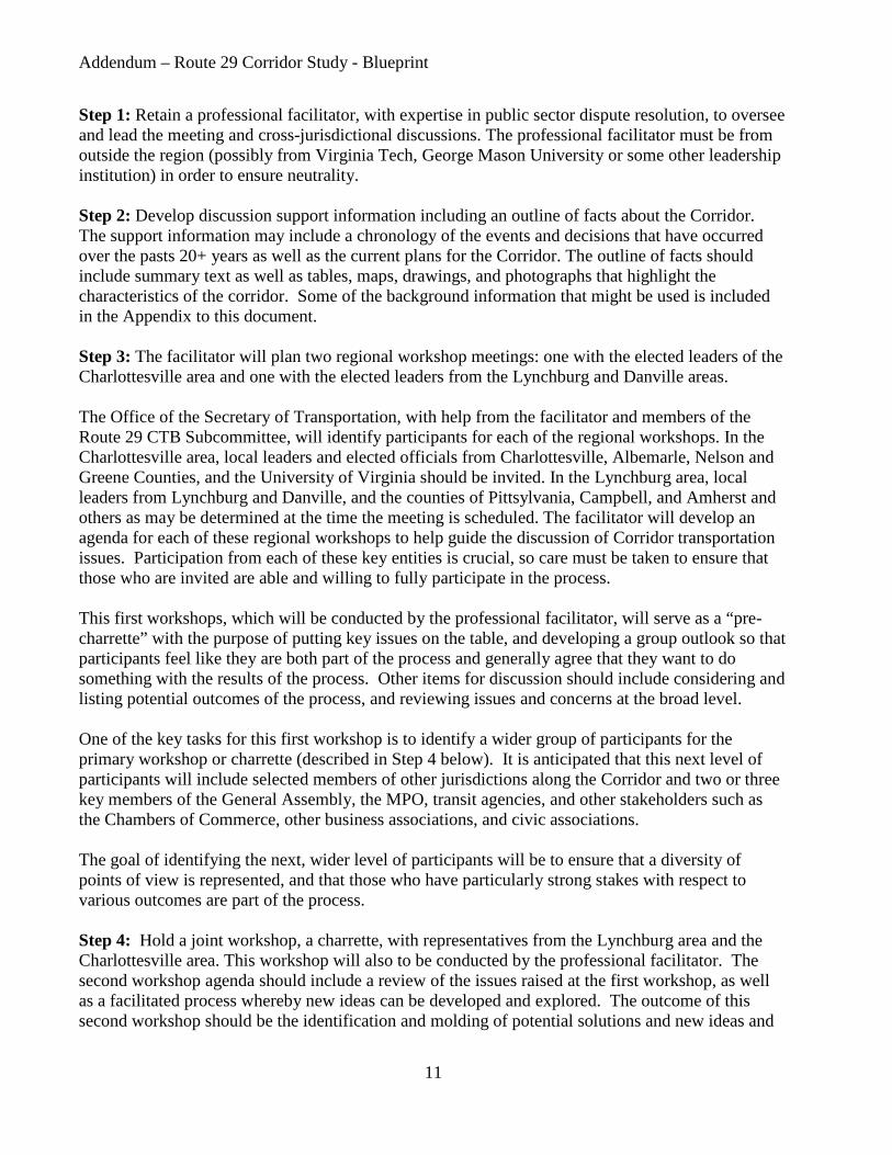
Step 1: Retain a professional facilitator, with expertise in public sector dispute resolution, to oversee and lead the meeting and cross-jurisdictional discussions. The professional facilitator must be from outside the region (possibly from Virginia Tech, George Mason University or some other leadership institution) in order to ensure neutrality. Step 2: Develop discussion support information including an outline of facts about the Corridor. The support information may include a chronology of the events and decisions that have occurred over the pasts 20+ years as well as the current plans for the Corridor. The outline of facts should include summary text as well as tables, maps, drawings, and photographs that highlight the characteristics of the corridor. Some of the background information that might be used is included in the Appendix to this document. Step 3: The facilitator will plan two regional workshop meetings: one with the elected leaders of the Charlottesville area and one with the elected leaders from the Lynchburg and Danville areas. The Office of the Secretary of Transportation, with help from the facilitator and members of the Route 29 CTB Subcommittee, will identify participants for each of the regional workshops. In the Charlottesville area, local leaders and elected officials from Charlottesville, Albemarle, Nelson and Greene Counties, and the University of Virginia should be invited. In the Lynchburg area, local leaders from Lynchburg and Danville, and the counties of Pittsylvania, Campbell, and Amherst and others as may be determined at the time the meeting is scheduled. The facilitator will develop an agenda for each of these regional workshops to help guide the discussion of Corridor transportation issues. Participation from each of these key entities is crucial, so care must be taken to ensure that those who are invited are able and willing to fully participate in the process. This first workshops, which will be conducted by the professional facilitator, will serve as a “pre-charrette” with the purpose of putting key issues on the table, and developing a group outlook so that participants feel like they are both part of the process and generally agree that they want to do something with the results of the process. Other items for discussion should include considering and listing potential outcomes of the process, and reviewing issues and concerns at the broad level. One of the key tasks for this first workshop is to identify a wider group of participants for the primary workshop or charrette (described in Step 4 below). It is anticipated that this next level of participants will include selected members of other jurisdictions along the Corridor and two or three key members of the General Assembly, the MPO, transit agencies, and other stakeholders such as the Chambers of Commerce, other business associations, and civic associations. The goal of identifying the next, wider level of participants will be to ensure that a diversity of points of view is represented, and that those who have particularly strong stakes with respect to various outcomes are part of the process. Step 4: Hold a joint workshop, a charrette, with representatives from the Lynchburg area and the Charlottesville area. This workshop will also to be conducted by the professional facilitator. The second workshop agenda should include a review of the issues raised at the first workshop, as well as a facilitated process whereby new ideas can be developed and explored. The outcome of this second workshop should be the identification and molding of potential solutions and new ideas and

Addendum – Route 29 Corridor Study - Blueprint
12
approaches into outcomes that have cross-jurisdictional support. It is important to allow for the possibility that a follow-on sessions may be needed to further develop and engender consensus. Step 5: Summarize the areas of consensus and potential solutions and document these outcomes in the final Route 29 Corridor Study report. These potential solutions should then be incorporated in a Corridor Master Plan, the local Comprehensive Plans and the MPO Transportation Plans. SECTION 3 - Appendix Regional Issues and Chronology for Route 29 in the Charlottesville, Albemarle, and Greene Areas The absolute importance of Route 29 to the communities through which it passes is clearly evident from the discussions that have taken place over many decades, as well as the passions that these discussions have engendered. The intertwined issues of high growth, congestion and safety have centered most pointedly in the areas on the north side of the City of Charlottesville and extending into Greene County. The discussion below summarizes some of the background with respect to key issues, planning efforts, and a general chronology of events. One of the key items that must be considered in this portion of the corridor is that the Charlottesville area lies within the planning area designated as the Charlottesville-Albemarle Metropolitan Planning Organization (MPO). In designated MPO areas, the CTB must work cooperatively with the localities and the MPO to formulate transportation plans. Since the MPO has worked continuously over the years to evaluate alternatives and develop transportation recommendations along the Route 29 Corridor, many of which are still valid, it is important to recognize those recommendations in any new plan that is developed. The first step in this effort would be to document the facts about key transportation issues in the region to provide the foundation for informed discussions. This document is intended to serve as an outline for compiling the transportation information for cross-jurisdictional discussions. The information is provided in four key areas: 1. A summary of the planning work that has been accomplished jointly by VDOT, DRPT, Albemarle and Greene Counties, the city of Charlottesville, and the Charlottesville-Albemarle Metropolitan Planning Organization (MPO). 2. A listing of transportation improvements in and near the Route 29 Corridor that have already been agreed upon by the local governments. 3. A summary of the evaluations of the Route 29 Corridor Study. 4. Identification of areas along the Route 29 Corridor where additional capacity is needed to accommodate existing and future travel demands.

Addendum – Route 29 Corridor Study - Blueprint
13
Section 1. Summary of Previous Studies on Route 29 Over the years, various studies have concluded with recommendations on the US Route 29 corridor or portions of it. In 1990, the Commonwealth Transportation Board (CTB) adopted a resolution calling for a three-phase sequence of improvements to the Route 29 corridor. Phase one improvements were made which included the widening of Route 29 from Hydraulic Road to the South Fork of the Rivanna River. The second phase improvements called for the construction of grade separated intersections along Route 29 at the Hydraulic Road, Greenbrier Drive, and Rio Road Intersections. Slated for the third-phase of improvements was the Western Bypass, contingent on traffic and economic conditions. Note: Section 1 will provide the sequence of events and plan approvals over the past twenty years to show how the transportation plan evolved to its’ current status. Section 2. Transportation Improvements That Have Been Agreed Upon by Local Governments While there have been numerous studies performed for the section of Route 29 through Charlottesville and Albemarle and Greene Counties, official agreement across the region for any project is reflected in those projects that are incorporated in to the MPO’s Financially Constrained Long-Range Transportation Plan (called UnJAM 2035). UnJAM 2035 was officially approved by the MPO Policy Board in May 2009. Note: Section 2 will include Table 2: Summary of Transportation Projects from UnJAM 2035. Section 3. Summary of Route 29 Corridor Study Evaluations The primary emphasis of the Route 29 Corridor Study was to identify transportation needs and those aspects of the corridor that should be preserved through transportation and land use planning initiatives, develop an overall planning framework, and identify projects (based on previous studies and/or stakeholder input), and to gain public input for each of these activities. Within the Charlottesville/Albemarle/Greene County area, the study incorporated projects from previous planning efforts including the most recent of the studies, Places29 and the Greene County Route 33 Multimodal Corridor Study. Note: Section 3 will outline the proposals that were evaluated as part of the Route 29 Corridor Study. Section 4. Areas on Route 29 Where Additional Capacity is Needed to Accommodate Existing and Future Travel Demands

Addendum – Route 29 Corridor Study - Blueprint
14
Analysis of existing and projected traffic volumes, levels of congestion, as well as crash data, will provide an initial reading of areas in the corridor where additional capacity should be considered. Tables and maps should be used to highlight these locations for the entire 219-mile corridor. SECTION 4 - A plan for improving the mobility and accessibility in the Gainesville, Haymarket and Buckland region A Proposal for Cross-Jurisdictional Discussions on Improving Mobility and Accessibility in the Gainesville, Haymarket and Buckland Region Accepted by the Commonwealth Transportation Board - June 15, 2011 Purpose On December 17, 2009, the Commonwealth Transportation Board (CTB), by resolution, accepted the Route 29 Corridor Study, but also directed, VDOT and DRPT to work with a Board Subcommittee to develop:
A plan to improve mobility and accessibility in the Gainesville, Haymarket and Buckland region, evaluating various alternatives, and not limited to prior proposals.
Over the past twenty years, traffic has rapidly increased along the Route 29 Corridor on the segment between the New Baltimore area of Fauquier County and I-66 at Gainesville, in Prince William County. Due to the heavy traffic congestion on Route 29 in Gainesville, a significant portion of the commuter traffic exits Route 29 and uses Route 15 through Haymarket community to connect to I-66. Also the intersection at Route 215 (Vent Hill Road) was for many years, under consideration for the construction of an interchange, but the interchange would have a significant impact on the historic Buckland battlefield area. Any improvements to the existing facility must mitigate any possible encroachment on the historic and environmentally sensitive areas in Prince William and Fauquier Counties. The most notable is the Buckland Historic area. Located just north of the Fauquier County line, in Prince William County, the historic village of Buckland est. 1798, stands adjacent to west side of Route 29, and the Historic Buckland Overlay District is on both sides of the facility. The Historic District is delineated and identified in Prince William County’s Comprehensive Plan. In Fauquier County there are several privately owned parcels that are being considered for designation for historic preservation or conservation easements. These properties are immediately adjacent to Route 29 or they are within the Buckland Historic District and the Buckland Mills Battlefield area. More information on the historic area is provided in Appendix A Reaching consensus on any solution must begin with discussions between the local leaders. This is an outline for initiating the discussions between local leaders.
Addendum – Route 29 Corridor Study - Blueprint
15
Steps to Develop a Plan for the Route 29 Corridor in the Buckland Area The first steps in the process of developing a mobility and accessibility plan for the Buckland/Gainesville area is to initiate cross-jurisdictional discussions of local concerns in the Corridor and identifying opportunities or common ground for consensus. The Route 29 corridor subcommittee has proposed that with the concurrence of the Secretary of Transportation, the CTB members for the Culpeper and NOVA Districts will contact the board of supervisor’s members that represent the Buckland/Gainesville/Haymarket areas for Fauquier and Prince William Counties (2 from each County) to seek their participation in these discussions. It is suggested that the members of Fauquier Board of Supervisors that represent the Marshall District and Scott District be invited. From Prince William County it is suggested that an invitation be extended to the Board of Supervisors members that represent the Gainesville and Brentsville Districts. If there is progress in these informal discussions, then the parties may choose to move the discussions to a more formal facilitated process to ensure that any agreements or points of consensus are documented. The suggested formal steps are as follows: Step 1: Retain a professional facilitator, with expertise in public sector dispute resolution, to oversee and lead the meeting and cross-jurisdictional discussions. The professional facilitator must be from outside the region to ensure neutrality. Step 2: Develop discussion support information including facts about the Corridor. The support information may include a chronology of the studies and decisions that have led to the current status of plans for the Corridor. The outline of facts should include a summary document as well as tables, maps, drawings, and photographs that highlight the characteristics of the corridor. Some of the background information that might be used is included in Appendix A of this document. Step 3: The facilitator will plan additional cross-jurisdictional meetings with the elected leaders of Fauquier and Prince William Counties. The participating members of the initial informal meeting(s) will work with the facilitator to determine if others should be invited to the meeting. Participation from these jurisdictional representatives is crucial, so care must be taken to ensure that those who are invited are able and willing to fully participate in the process. This first meeting will be for the purpose of putting key issues on the table, and developing any points of consensus that the participants may agree upon. The facilitator will document and summarize the areas of common ground and any potential solutions that may be identified. This documentation will be used as the basis for any follow-up meetings or discussions that may be needed. Should additional discussions be planned, the participants will identify others that should be involved and the activities in step 4 should be followed. Step 4: The facilitator and the participants will develop an agenda and plan the next meeting, including others who should be invited. At this meeting, the facilitator will review the discussions of the initial meeting and allow this wider group of representatives to discuss any potential solutions that were identified. The facilitator will document the discussions of this meeting, summarize the results and distribute this information to the participants. Based on the outcome of this meeting, the

Addendum – Route 29 Corridor Study - Blueprint
16
facilitator will determine whether there is a need for further discussions or if the participant jurisdictions are at a point of mutual agreement on the proposed solutions. SECTION 4 - Appendix
HISTORIC PROPERTIES AND TRANSPORTATION PROJECTS AT BUCKLAND, PRINCE WILLIAM COUNTY
The Buckland Historic Site Any future transportation improvements to Route 29 will require detailed studies and evaluations of the impact on historical and archaeological sites. The Buckland Historic District covers approximately 408 acres and straddles Route 29. The Buckland community in Prince William County has a wide range of archaeological and historic architectural resources. Two properties have been identified that have the most prominent relationship to future improvements to Route 29 and which include many of the remaining smaller properties as internal components. These properties, with Department of Historic Resources’ (DHR) inventory numbers in parentheses, are: Buckland Historic District (076-0313): This property listed in the Virginia Landmarks Register and National Register of Historic Places includes the surviving building and archaeological components of the town of Buckland Mills, a community dating to the early 19th-century. Buckland Mills Battlefield (030-5152): This property is considered eligible for listing in the Virginia Landmarks Register and National Register of Historic Places. It defines the site of the battle of Buckland Mills, an 1863 engagement during which Confederate forces repulsed Federal troops attempting to advance along the Warrenton Turnpike (now Rt. 29). The Buckland Mills Battlefield covers approximately 4,413 acres and straddles Rt. 29. Preservation Easements Historic preservation easements can be held by the Commonwealth’s Board of Historic Resources and constitutes the legal interest of the Commonwealth in the preservation of the historic aspects of such properties. Historic preservation easements are voluntary donations by private property owners with terms negotiated on a property-specific basis. According to DHR staff, a total of four properties are presently under consideration for easements, three immediately adjacent to the existing Rt. 29 right-of-way and another some distance to the south. All are within the recognized boundaries of the Buckland Historic District and Buckland Mills Battlefield. Legal and Regulatory Considerations Section 106: The National Historic Preservation Act of 1966, Section 106, requires that Federal agencies take into account the effects that their funded or permitted actions may have on historic properties. This process is administered by the Federal Advisory Council on Historic Preservation
Addendum – Route 29 Corridor Study - Blueprint
17
(ACHP) using procedures described in 36 CFR Part 800. Note that Section 106 is a procedural requirement and does not prescribe a preservation outcome. Section 106 coordination can be time consuming, especially with public controversy; though in most cases historic preservation concerns can be reasonably resolved in Federal projects. Section 4(f): Unlike the procedural, non-prescriptive character of Section 106, Section 4(f) of the Department of Transportation Act of 1966 requires avoidance of use (e.g., acquisition of property) from historic properties, public parks and recreation areas, and wildlife refuges unless it can be demonstrated that there are no feasible or prudent alternatives to such use. Section 4(f) is administered by the Federal Highway Administration (FHWA). While Section 4(f) differs from Section 106 (avoidance vs. consideration of effect), historic properties are the common denominator between the two requirements. It is important to recognize that 4(f) is not merely procedural and could result in the substantive avoidance of historic properties such as the Buckland Historic District and the Buckland Mills Battlefield. Section 6(f): The Land and Water Conservation Fund (LWCF) Act of 1965, Section 6(f), protects properties acquired with those funds from conversion to other purposes (e.g. transportation use) without the approval of the Secretary of the Interior. LWCF monies traditionally have been used for the acquisition or development of park lands for public outdoor recreation. However, the American Battlefield Protection Program (ABPP) of the National Park Service administers LWCF monies to acquire battlefield lands throughout the United States. In 2007 the ABPP awarded a LWCF grant to the Buckland Preservation Society for the acquisition of multiple parcels within the Buckland Mills Battlefield. It is important to recognize that 6(f) may require the substantive avoidance of parcels acquired with LWCF monies, unless approval to use those parcels can be obtained from the Secretary of the Interior. Commitments from Recent Transportation Projects The recent replacement of the bridge deck on the southbound bridge across Broad Run involved significant Section 106 consultation between VDOT, FHWA, DHR, the federal Advisory Council on Historic Preservation, and the Buckland Historical Society. That effort was completed by execution of a Section 106 Memorandum of Agreement (MOA) that stipulated actions to be implemented by the MOA participants to mitigate the effects of that project on the adjacent historic properties. The terms of that MOA constitute legally binding commitments and a copy of that agreement is attached as a specific reference document. There are three substantive (i.e., non-administrative) stipulations in the MOA. Stipulations I, II, and III, respectively, govern bridge design and construction, archaeology, and planning. Stipulations I and II have been satisfactorily completed by VDOT as part of the bridge deck construction project. The planning requirements of Stipulation III, however, are principally the responsibility of the Buckland Preservation Society (BPS). The BPS is required to invite VDOT to participate in its master planning efforts and VDOT is required to participate “to the extent practicable”. It is important to note that VDOT did not make any commitment regarding the nature of future improvements to Rt. 29, either during development of the Broad Run bridge deck replacement project or through the associated Section 106 MOA.

Addendum – Route 29 Corridor Study - Blueprint
18
Consequences for Transportation Planning and Future Capacity Improvements The presence of the Buckland Historic District and the Buckland Mills Battlefield will influence the development of any transportation improvements in this area. The influence may be significant, especially with regard to 4(f) issues and the existence of historic preservation easements held by the Commonwealth. Section 4(f) will require analysis – and possibly implementation - of alternatives to avoid the use of historic properties relative to their “macro” definition and their constituent, contributing elements. Some of those contributing elements are the discrete parcels subject to historic preservation easements. Consideration of alternatives will also be required for Section 106 consultation. In any case, identifying a full range of alternatives during planning, prior to the initiation of formal project development, is warranted given the known historic property conditions in the Buckland area and the anticipated complexity of the issues. Buckland Bypass In recognition of the historic significance of the Buckland Historic area, VDOT funded a study of the possible alternatives to widening existing Route 29. This study completed in 2007 recommended a bypass of the historic area. All of the recommended alignments for this proposal extended from Route 29 south of the Buckland Historic area (in Fauquier County), to I-66 near Thoroughfare Gap in Prince William County. These alternatives were not acceptable to Fauquier County due to the encroachment on several conservations districts and the impacts on farmland. (See the Buckland Bypass Map below)

Addendum – Route 29 Corridor Study - Blueprint
19

Addendum – Route 29 Corridor Study - Blueprint
20
Route 29 Corridor Study During the development of the Route 29 Corridor Study, the study team met with the Boards of Supervisors (BOS) of Prince William County and Fauquier County to receive input on vital transportation issues. In April 2009, the Prince William County BOS changed their Comprehensive Plan to show a recommendation for four lanes on Route 29 from the Fauquier County line to the Route 15 Intersection. (Previously, the Comp. Plan had recommended six lanes.) Following a meeting with the full Prince William BOS in May 2009, the study team met with the two supervisors (Stirrup and Covington) that represent the Gainesville- Buckland areas of the County. From this meeting a new alignment for a Buckland Bypass was proposed. This connector would extend from Route 29 south of the Buckland area in Fauquier County to Route 15 near the intersection of Thoroughfare Road. While the Fauquier BOS supported many of the proposals in the Route 29 Study, they were opposed to the proposal for a Buckland Bypass due to its impact on their county. SECTION 5 - A plan/policy for minimizing the number on new traffic control signals on Route 29 and other Corridors of Statewide Significance (CoSS) The CTB Committee discussed at length how best to address the proliferation of new entrances on Route 29 and the other CoSS facilities. Their discussions concluded that any plan or policy for minimizing the number on new traffic control signals on Route 29 and other Corridors of Statewide Significance (CoSS) must acknowledge that most traffic signals are installed to provide safe access for traffic generated by new developments. Safe access to future land development sites must be planned far in advance of the development proposals. Establishing the locations for access in a Master Plan on all of the CoSS will ensure that the locality, developer and VDOT staff clearly understand how new developments can be served. In most cases, access can be provided without the addition of a traffic signal. An outline for developing Master Plans for the CoSS follows.

Addendum – Route 29 Corridor Study - Blueprint
21
Master Plans for the Corridors of Statewide Significance
Corridors of Statewide Significance The Corridors of Statewide Significance (CoSS) are identified in the Code of Virginia and described in detail in VTrans2035. In general the CoSS applies to a network of facilities that are vital to transportation and commerce within the Commonwealth. These multimodal transportation corridors include all of the Interstate System as well as the following Primary Highway Corridors: Routes 13, 17, 29, 58, 220, and 460. The official definition of the CoSS is: “An integrated, multimodal network of transportation facilities that connect major centers of activity within and through the Commonwealth and promote the movement of people and goods essential to the economic prosperity of the state.” Purpose and Need for Corridor Master Plans The purpose of a Corridor Master Plan is to identify ways to preserve the capacity and ensure the safety of the Commonwealth’s major transportation corridors or CoSS. Transportation facilities represent a major investment in public funds and, given the unclear outlook for financing new transportation improvements on the CoSS, it is critical to develop plans and procedures to better preserve the Commonwealth’s existing transportation investments.
There will continue to be a need to accommodate new land development along the CoSS, but the access to new sites must be planned in order to minimize the congestion and safety impacts that frequently accompany “strip development”. The location, spacing, and design of entrances, street intersections, median openings, traffic signals, and transit amenities must be addressed in the Corridor Master Plan to preserve the facility for through travel and to serve future developments.
The Corridor Master Plan is needed to help guide localities and the development community in locating and designing the appropriate access for the future development. It is recognized that there are many tools that need to be employed in the preservation and protection of the CoSS including; the Access Management Regulations, Traffic Impact Analysis Regulations, congestion management practices, as well as carpooling, vanpooling and transit alternatives. Authority for the Plan The Code of Virginia requires the Commonwealth Transportation Board (CTB) to conduct a comprehensive review of statewide transportation needs in the Statewide Transportation Plan; setting forth assessment of capacity needs for all CoSS, regional networks, and improvements to promote urban development areas. The Code further states that the assessment shall consider all modes of transportation. Such corridors shall be planned to include multimodal transportation improvements, and the Plan shall consider corridor location in planning for any major transportation infrastructure, including environmental impacts and the comprehensive land use plan of the locality

Addendum – Route 29 Corridor Study - Blueprint
22
in which the corridor is (or would be) located. Per the Code of Virginia, the CTB shall not be constrained by local, district, regional, or modal plans in the designation of such corridors. The Statewide Transportation Plan, VTrans2035, was developed in 2009 and presented to the CTB on December 17, 2009. The VTrans2035 Plan identifies the CoSS as including all of the Interstate System as well as the following Primary Highways: Routes 13, 17, 29, 58, 220, and 460. Other Principle Arterials, that meet the appropriate criteria, may also be identified by the CTB and included in the CoSS network. The CTB, in accepting VTrans2035 Plan on December 17, 2009, directed that CoSS master plans be developed to include the following features:
o Updates should coincide with Commonwealth Administration and Legislative cycles; o Include plans to address Environmental Quality issues as required by law; o Include the development of regional transportation and land use performance measures and
goals for urban regions; and o Include a plan to educate local governments about the greater role the CTB envisions for
VDOT and DRPT. In a separate resolution accepting the Route 29 Corridor Study on December 17, 2009, the CTB directed a Subcommittee to oversee additional work by VDOT and DRPT to develop an approach to minimizing the number of traffic signals on Route 29, and to incorporate lessons learned from the Route 29 Corridor Study into the ongoing development of tools and procedures to better manage all of the CoSS. A key concern for the Route 29 Corridor was the proliferation of traffic access points and traffic signals. The following policy statement highlights the concerns that such proliferation has on degrading the major transportation investment that the Commonwealth has in the entire CoSS network. CoSS Access Point and Access Control Policy Statement: “In managing the Corridors of Statewide Significance, and to minimize the number of traffic signals, it is the policy of the Commonwealth Transportation Board (CTB) that intersections or new access points to those corridors shall be planned, designed, operated and maintained to ensure minimum delay to through traffic. Access locations under consideration shall be evaluated for the impact to corridor travel time and mitigation strategies, including: land use planning, access management, mode shift, transit enhancements, or aggressive traffic operational strategies. These measures shall be incorporated in a Corridor Master Plan that will guide VDOT, DRPT and Localities in providing access for future growth areas. Exceptions to this policy may only be granted by the Commonwealth Transportation Commissioner after an independent review and documentation justifying the exception.” Corridor Master Plans for the Corridors of Statewide Significance Introduction: A primary function of the Corridors of Statewide Significance (CoSS) is to carry long distance traffic. In order for these corridors to serve this function, the ability of travelers and goods
Addendum – Route 29 Corridor Study - Blueprint
23
to move safely and efficiently must be preserved and given priority over other functions that these corridors serve, such as access. The goal of the Corridor Master Plan is to preserve the capacity and operating efficiency of the CoSS. Such preservation is critical due to the Commonwealth’s limited ability to provide funds to add new capacity along these corridors. Increasing the number of access points and the number of traffic signals can degrade mobility and operations along a CoSS. The policy delineated in the CoSS Access Point and Access Control Policy Statement included above will be implemented through effective transportation and land use planning, as embodied in locality Corridor Master Plans (CMP) and by the effective allocation of planning, primary highway construction, and transit funds by the CTB. The CMPs will be developed through the cooperative efforts of VDOT, DRPT, local governments, and regional agencies; these documents will inform and guide decisions by each of these entities as well as the CTB. A CTB Subcommittee will provide oversight of the CMP development and will report to the full Board at least quarterly on the progress of developing the CMPs. The CTB Subcommittee may decide to first develop a “pilot study” before proceeding with the CMPs on the entire CoSS network. Key features of the CMPs:
1. VDOT and DRPT will develop a memorandum of understanding (MOU) with localities along the CoSS. The MOUs will establish a common goal to preserve the corridors, and indicate a dedication by all parties to work together to achieve this goal through the coordinated development of CMPs, as well as an ongoing commitment to support corridor preservation prior to the development and implementation of the CMPs. Such commitments will be important because the process for developing and implementing the CMPs may take time.
2. VDOT and DRPT will then work with the localities along the CoSS to develop local CMPs. With input from both regional agencies and local governments, VDOT and DRPT will jointly develop a format and template for these documents.
3. The local CMP should consider: • Overall corridor studies related to each particular CoSS, VDOT’s Access
Management Regulations for Principal Arterials and DRPT’s Transit Service Design Guidelines.
• Evaluations of the existing Surface Transportation Plan, Statewide Rail Plan, Transit and TDM Development Plans, and the existing and future Comprehensive Plans to determine the potential for increased and/or expanded rail, transit, and TDM solutions.
• The adopted locality Comprehensive Plan to identify future growth patterns, land use zoning and policies, as well as the designation of Urban Development Areas in localities which have designated them in their Comprehensive Plans.
• The Comprehensive Plans and the local CMP of the adjoining localities along the corridor.

Addendum – Route 29 Corridor Study - Blueprint
24
• Identifying access locations and illustrate design configurations to serve future nodal development. Coordination with land use planning will be of key importance for this aspect of the CMP.
• Identifying and locating planned access points for future land uses along the corridor along with proposed design concept(s) for the access, as well as the potential to implement multi-modal transportation solutions. An emphasis of this planning effort is the identification of access types that do not require the installation of traffic signals and are sensitive to the surrounding context.
• Properties fronting on the Corridor that also have access to connecting roadways using the connecting roadway as their primary means of access.
• Lots subdivided from an existing parcel using the entrance of the parent parcel for access to the Corridor.
• Providing an opportunity for public input on the draft CMP and addressing concerns before final approval or adoption.
4. Review of the CMP by the locality at least every five years, with updates as necessary, in cooperation with VDOT and DRPT.
5. Implementation of the CMP will take place, at a minimum, through the following actions: a. The execution of MOUs between localities within the CoSS and VDOT and DRPT that
include a commitment to work together to preserve the corridors. Following the execution of the MOUs, state transportation planning funding shall be made available for the preparation of a local CMP.
b. Locally adopted CMPs that incorporate the considerations contained in item 2 above shall be considered by VDOT in the evaluation of entrance permits.
c. Projects that are identified as priorities within the CMPs, and that incorporate all the considerations contained in item 2 above, will be considered as first priorities for funding by the CTB, provided that the CMP has also been adopted in the Comprehensive Plan of the locality in which the project is located. It is the intent of this policy that the CMP be incorporated in locality Comprehensive Plans either directly or by reference.
The flow diagram on the following page is included to illustrate the development and application of the CMP process.

Addendum – Route 29 Corridor Study - Blueprint
25
Illustrative Diagram Showing Relationships and Workflows for Development, Adoption, and Implementation of Corridor Management Plans for Corridors of
Statewide Significance

Addendum – Route 29 Corridor Study - Blueprint
26
Statute References: Statutes for Authority as Well as Application of the Policy
§ 33.1-12. (3) Traffic regulations, (7) Policies and operations, (8) Cooperation with other agencies and local governments, (9)(b) To monitor….coordination of such rail and public transportation plans with highway programs. § 33.1-23.03. Board to develop and update Statewide Transportation Plan § 33.1-198. Connections over shoulders of highways for intersecting commercial establishment entrances. § 33.1-198.1. Comprehensive highway access management standards. § 33.1-199. Replacing entrances destroyed by Commissioner. § 15.2-2223. Comprehensive plan to be prepared and adopted; scope and purpose. § 15.2-2230 Comprehensive Plan to be reviewed every five years. § 15.2-2232 Legal Status of the Plan COMMONWEALTH TRANSPORTATION BOARD ACTIONS The recommendations of the CTB Subcommittee were accepted by the CTB as follows: Section 1 above: The Process for Future Studies on the Corridors of Statewide Significance was accepted by the CTB on May 19, 2010. The CTB Resolution may be viewed at: http://www.ctb.virginia.gov/resources/2010/may/resol/Item_8_Route_29_CTB_Resolution5-19-2010.pdf Sections 2-5 above: These recommendations were accepted by the CTB on June 15, 2011. The CTB Resolution of acceptance may be viewed at: http://www.ctb.virginia.gov/resources/2011/june/reso/Agenda_Item_15_CTB_Resolution.pdf