Embed Size (px)
Citation preview
Northern Virginia Transportation Authority
Briefing
May 11, 2017
Route 28 Corridor
Feasibility Study.
V
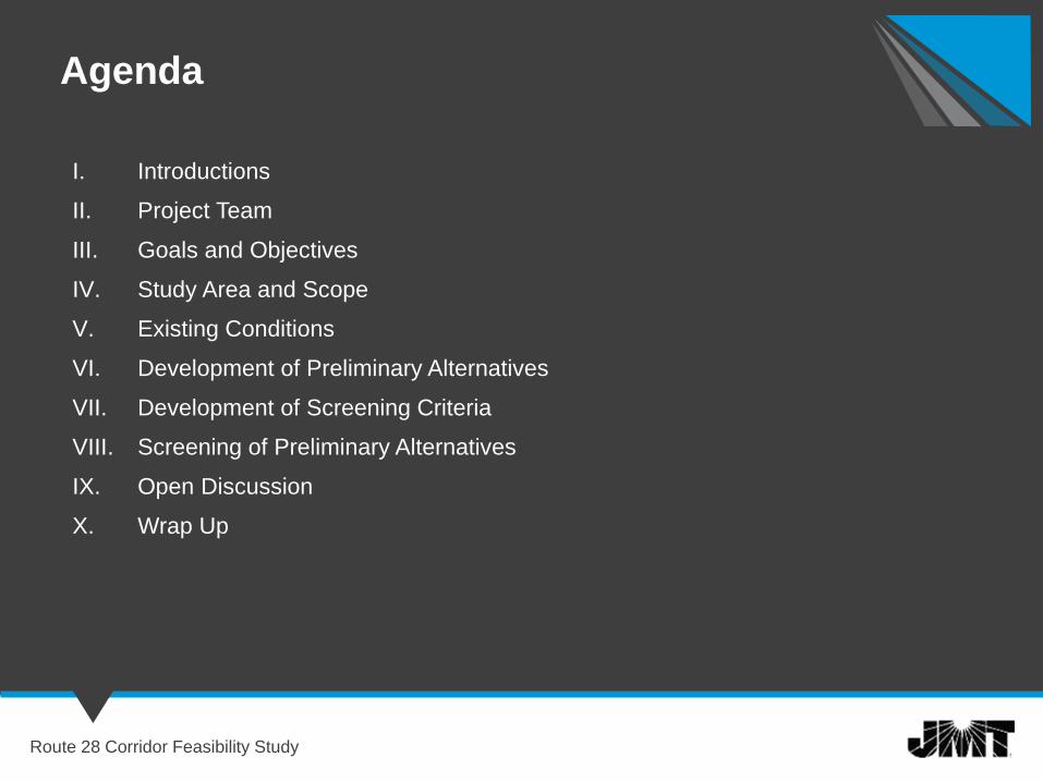
I. Introductions
II. Project Team
III. Goals and Objectives
IV. Study Area and Scope
V. Existing Conditions
VI. Development of Preliminary Alternatives
VII. Development of Screening Criteria
VIII. Screening of Preliminary Alternatives
IX. Open Discussion
X. Wrap Up
Agenda
Route 28 Corridor Feasibility Study
Project Team
Route 28 Corridor Feasibility Study
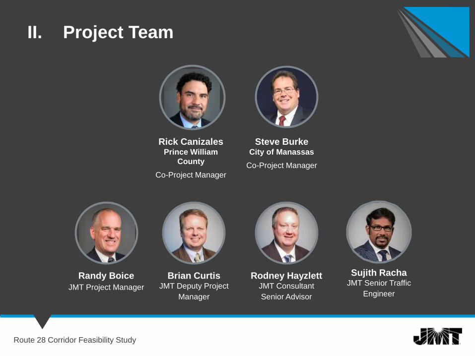
II. Project Team
Steve BurkeCity of Manassas
Co-Project Manager
Randy Boice
JMT Project Manager
Brian CurtisJMT Deputy Project
Manager
Rodney HayzlettJMT Consultant
Senior Advisor
Rick CanizalesPrince William
County
Co-Project Manager
Route 28 Corridor Feasibility Study
Sujith RachaJMT Senior Traffic
Engineer

Project Goals and
Objectives
Route 28 Corridor Feasibility Study
GOAL
III. Project Goals and Objective
Route 28 Corridor Feasibility Study
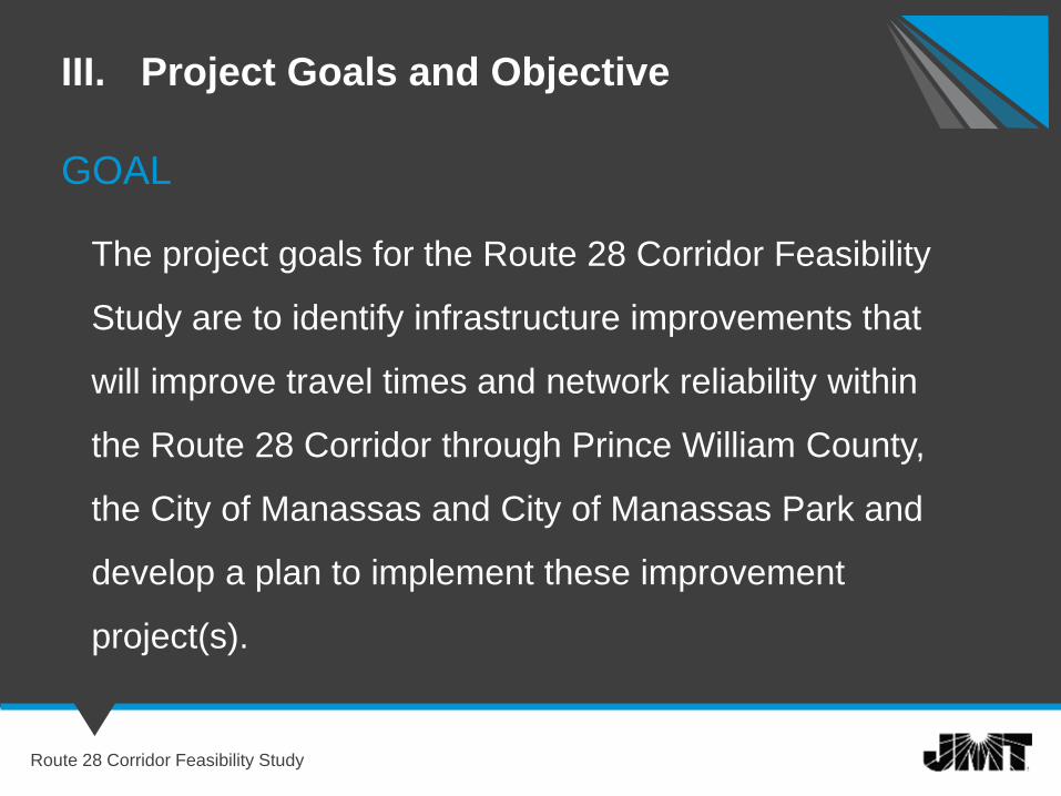
The project goals for the Route 28 Corridor Feasibility
Study are to identify infrastructure improvements that
will improve travel times and network reliability within
the Route 28 Corridor through Prince William County,
the City of Manassas and City of Manassas Park and
develop a plan to implement these improvement
project(s).

Objectives
III. Project Goals and Objective
Route 28 Corridor Feasibility Study
1. Reduce congestion and improve network reliability on Route 28 from Godwin
Drive through Historic Downtown Manassas to Liberia Avenue.
2. Reduce congestion and improve network reliability on Route 28, Centreville
Road – between Liberia Avenue and Compton Road.
3. Facilitate the weekday peak period commuter flows between I-66 and the
residential communities in Manassas Park, Manassas, and Prince William
County.
4. Provide increased opportunities for alternative modes of travel such as travel
by bicycles, walking and carpooling/vanpooling.
5. Provide improved access to transit facilities.
6. Identify improvement project(s) that have public consensus.
7. Identify improvement project(s) that avoid or minimize environmental
impacts.
Objectives – cont.
III. Project Goals and Objective
Route 28 Corridor Feasibility Study
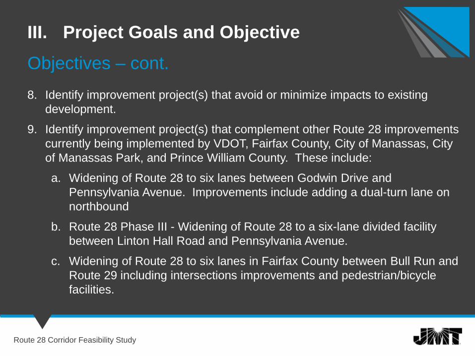
8. Identify improvement project(s) that avoid or minimize impacts to existing
development.
9. Identify improvement project(s) that complement other Route 28 improvements
currently being implemented by VDOT, Fairfax County, City of Manassas, City
of Manassas Park, and Prince William County. These include:
a. Widening of Route 28 to six lanes between Godwin Drive and
Pennsylvania Avenue. Improvements include adding a dual-turn lane on
northbound
b. Route 28 Phase III - Widening of Route 28 to a six-lane divided facility
between Linton Hall Road and Pennsylvania Avenue.
c. Widening of Route 28 to six lanes in Fairfax County between Bull Run and
Route 29 including intersections improvements and pedestrian/bicycle
facilities.
Study Area and
Scope
Route 28 Corridor Feasibility Study
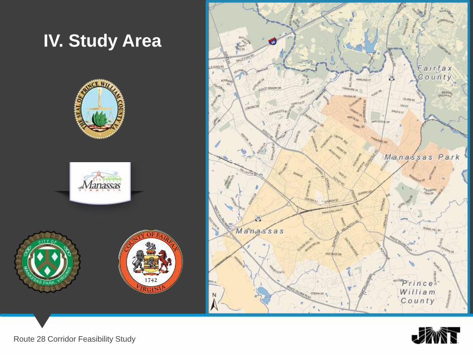
IV. Study Area
Route 28 Corridor Feasibility Study
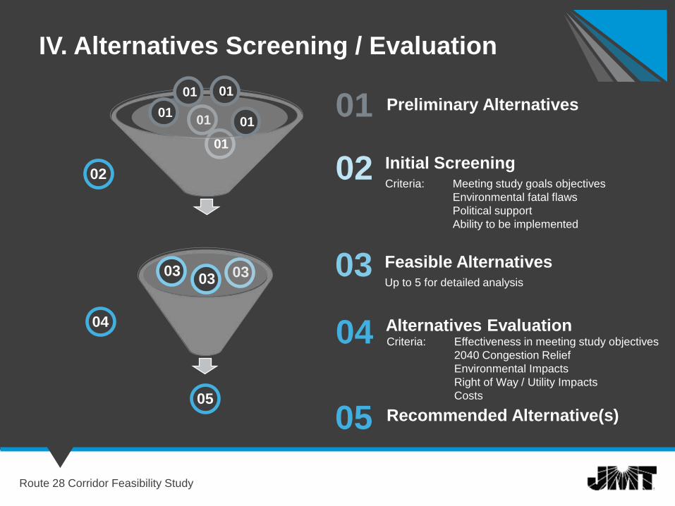
01
02
03
04
Preliminary Alternatives
03
02Criteria: Meeting study goals objectives
Environmental fatal flaws
Political support
Ability to be implemented
Initial Screening
Up to 5 for detailed analysis
Feasible Alternatives
Alternatives Evaluation
IV. Alternatives Screening / Evaluation
0101
01
0303
04
05
05 Recommended Alternative(s)
Criteria: Effectiveness in meeting study objectives
2040 Congestion Relief
Environmental Impacts
Right of Way / Utility Impacts
Costs
c0101
01
Route 28 Corridor Feasibility Study

Existing Conditions
Route 28 Corridor Feasibility Study
Results
Route 28 Corridor Feasibility Study
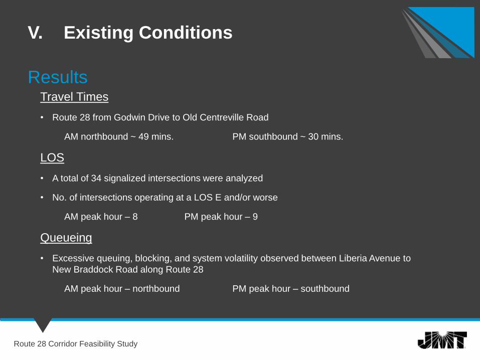
V. Existing Conditions
Travel Times
• Route 28 from Godwin Drive to Old Centreville Road
AM northbound ~ 49 mins. PM southbound ~ 30 mins.
LOS
• A total of 34 signalized intersections were analyzed
• No. of intersections operating at a LOS E and/or worse
AM peak hour – 8 PM peak hour – 9
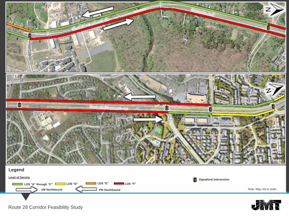
Queueing
• Excessive queuing, blocking, and system volatility observed between Liberia Avenue to
New Braddock Road along Route 28
AM peak hour – northbound PM peak hour – southbound
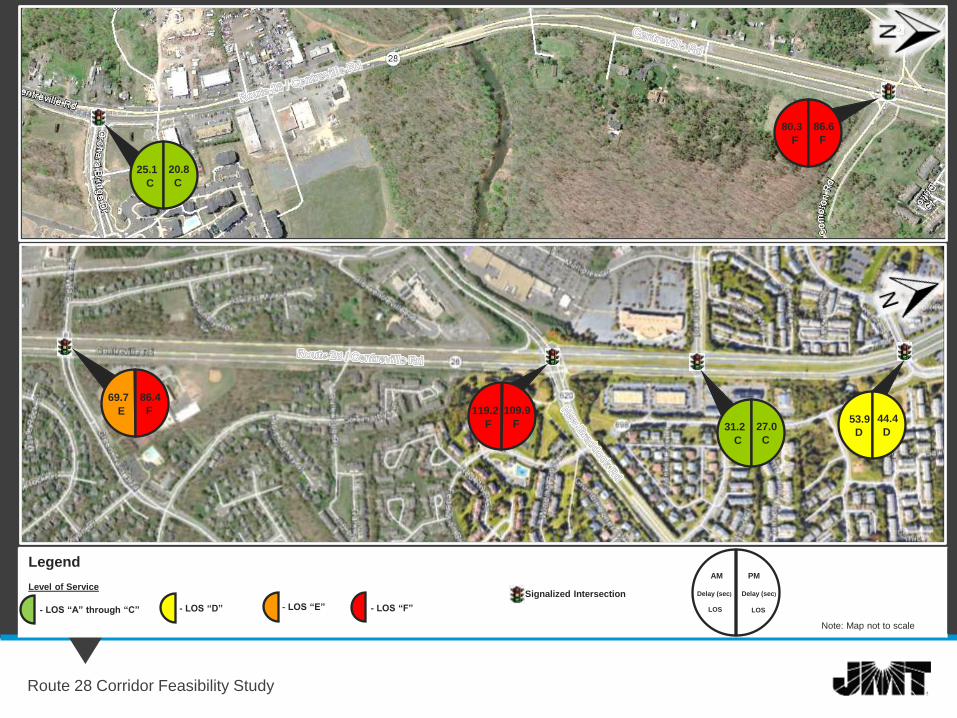
Legend
- LOS “A” through “C” - LOS “D” - LOS “E” - LOS “F”
Level of ServiceSignalized Intersection
Note: Map not to scale
Route 28 Corridor Feasibility Study
Delay (sec)
LOS
AM
Delay (sec)
LOS
PM
25.1
C
20.8
C
69.7
E
86.4
F 119.2
F
109.9
F 31.2
C
27.0
CD
44.4
D
53.9
80.3
F
86.6
F
Legend
Level of Service
Note: Map not to scale
Route 28 Corridor Feasibility Study
LOS “A” through “C” LOS “D” LOS “E” LOS “F”
Signalized Intersection
AM Northbound PM Southbound

Development of
Preliminary Alternatives
Route 28 Corridor Feasibility Study
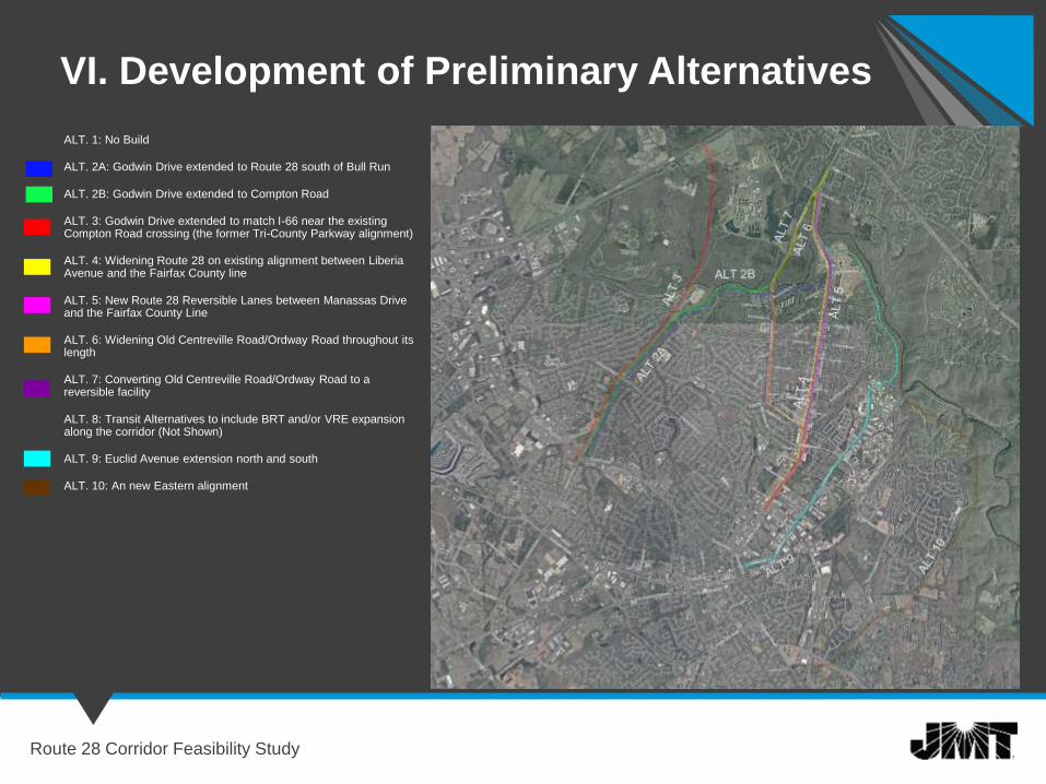
VI. Development of Preliminary Alternatives
Route 28 Corridor Feasibility Study
ALT. 1: No Build
ALT. 2A: Godwin Drive extended to Route 28 south of Bull Run
ALT. 2B: Godwin Drive extended to Compton Road
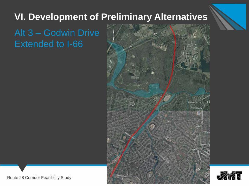
ALT. 3: Godwin Drive extended to match I-66 near the existing Compton Road crossing (the former Tri-County Parkway alignment)
ALT. 4: Widening Route 28 on existing alignment between Liberia Avenue and the Fairfax County line
ALT. 5: New Route 28 Reversible Lanes between Manassas Drive and the Fairfax County Line
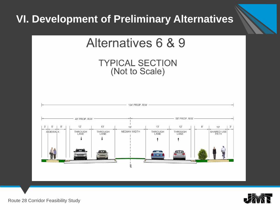
ALT. 6: Widening Old Centreville Road/Ordway Road throughout its length
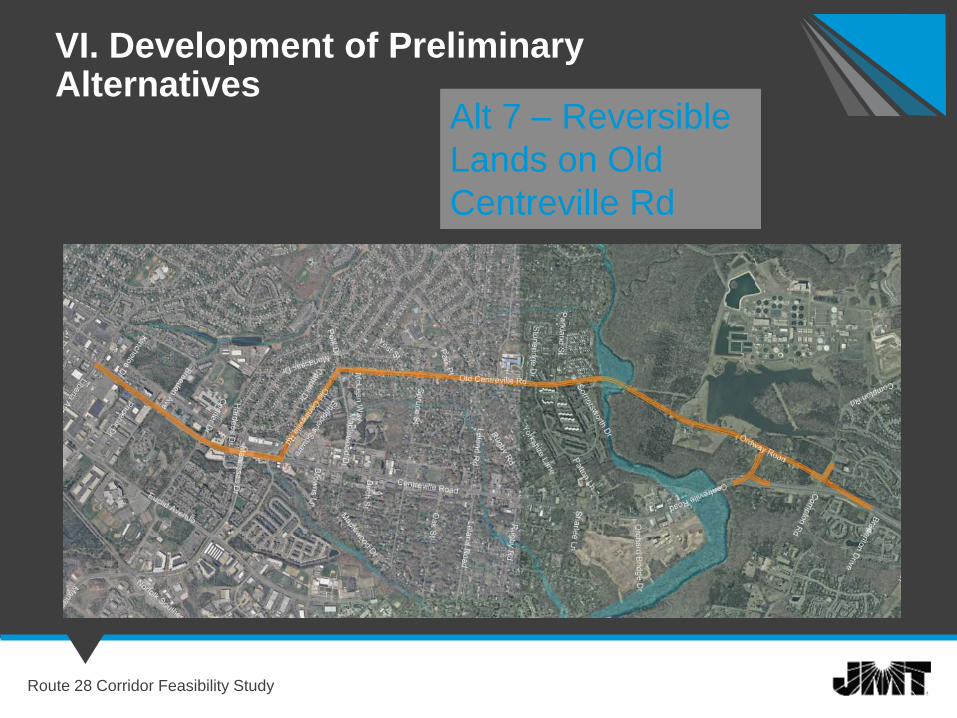
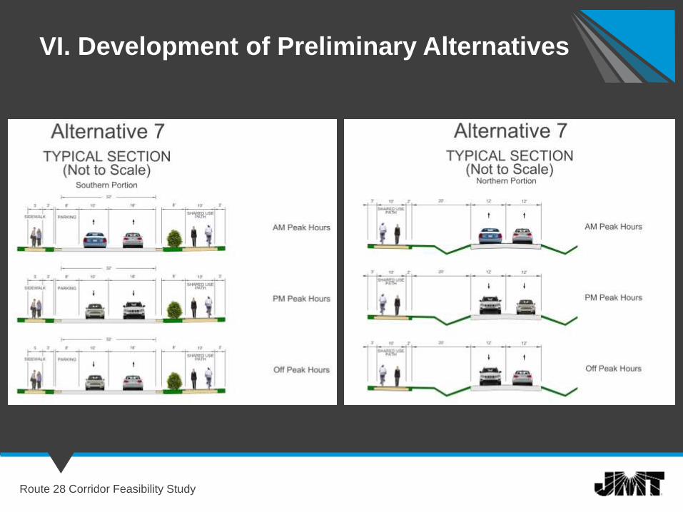
ALT. 7: Converting Old Centreville Road/Ordway Road to a reversible facility
ALT. 8: Transit Alternatives to include BRT and/or VRE expansion along the corridor (Not Shown)
ALT. 9: Euclid Avenue extension north and south
ALT. 10: An new Eastern alignment
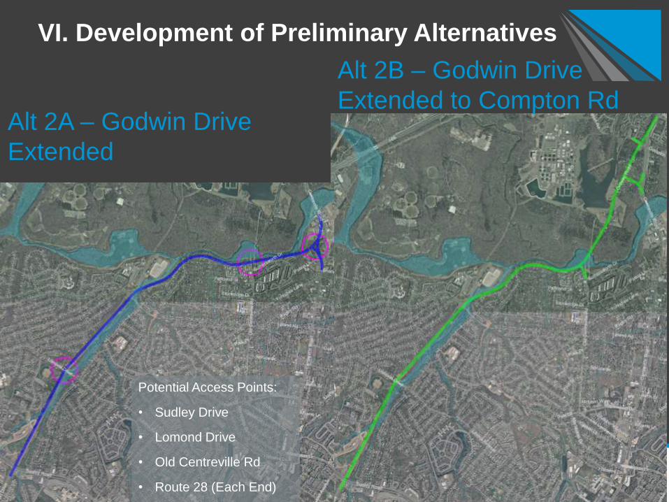
VI. Development of Preliminary Alternatives
Route 28 Corridor Feasibility Study
Alt 2B – Godwin Drive
Extended to Compton Rd Alt 2A – Godwin Drive
Extended
Potential Access Points:
• Sudley Drive
• Lomond Drive
• Old Centreville Rd
• Route 28 (Each End)
VI. Development of Preliminary Alternatives
Route 28 Corridor Feasibility Study
Alt 3 – Godwin Drive
Extended to I-66
Route 28 Corridor Feasibility Study
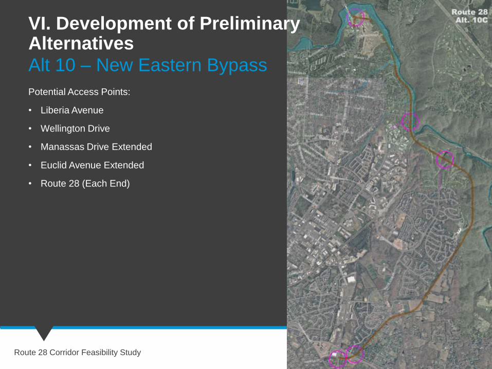
Alt 10 – New Eastern Bypass
Potential Access Points:
• Liberia Avenue
• Wellington Drive
• Manassas Drive Extended
• Euclid Avenue Extended
• Route 28 (Each End)
VI. Development of Preliminary Alternatives
VI. Development of Preliminary Alternatives
Route 28 Corridor Feasibility Study
VI. Development of Preliminary Alternatives
Route 28 Corridor Feasibility Study
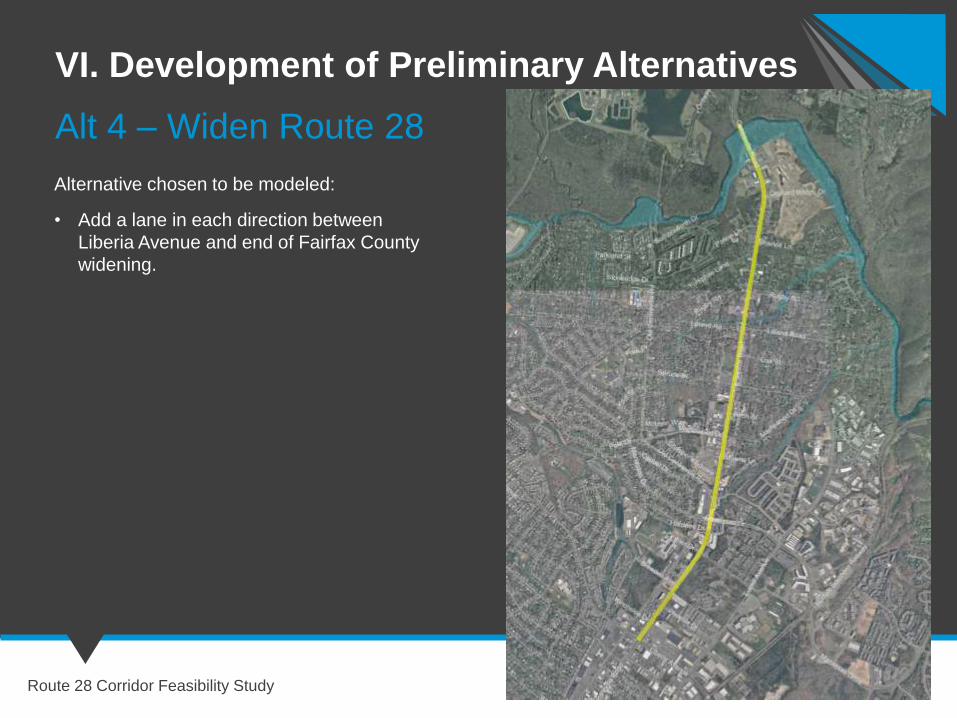
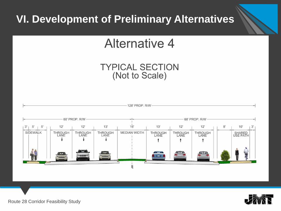
Alt 4 – Widen Route 28
Alternative chosen to be modeled:
• Add a lane in each direction between
Liberia Avenue and end of Fairfax County
widening.
VI. Development of Preliminary Alternatives
Route 28 Corridor Feasibility Study
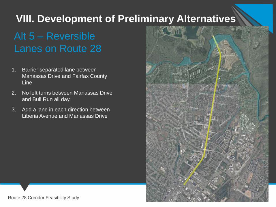
VIII. Development of Preliminary Alternatives
Route 28 Corridor Feasibility Study
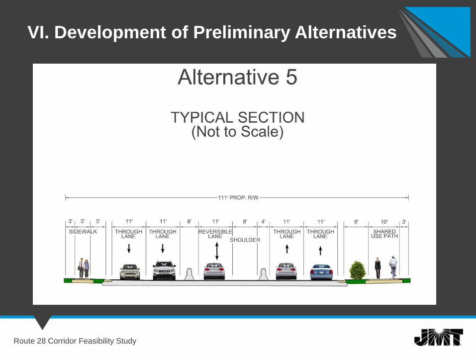
Alt 5 – Reversible
Lanes on Route 28
1. Barrier separated lane between
Manassas Drive and Fairfax County
Line
2. No left turns between Manassas Drive
and Bull Run all day.
3. Add a lane in each direction between
Liberia Avenue and Manassas Drive
VI. Development of Preliminary Alternatives
Route 28 Corridor Feasibility Study
VI. Development of Preliminary Alternatives
Route 28 Corridor Feasibility Study
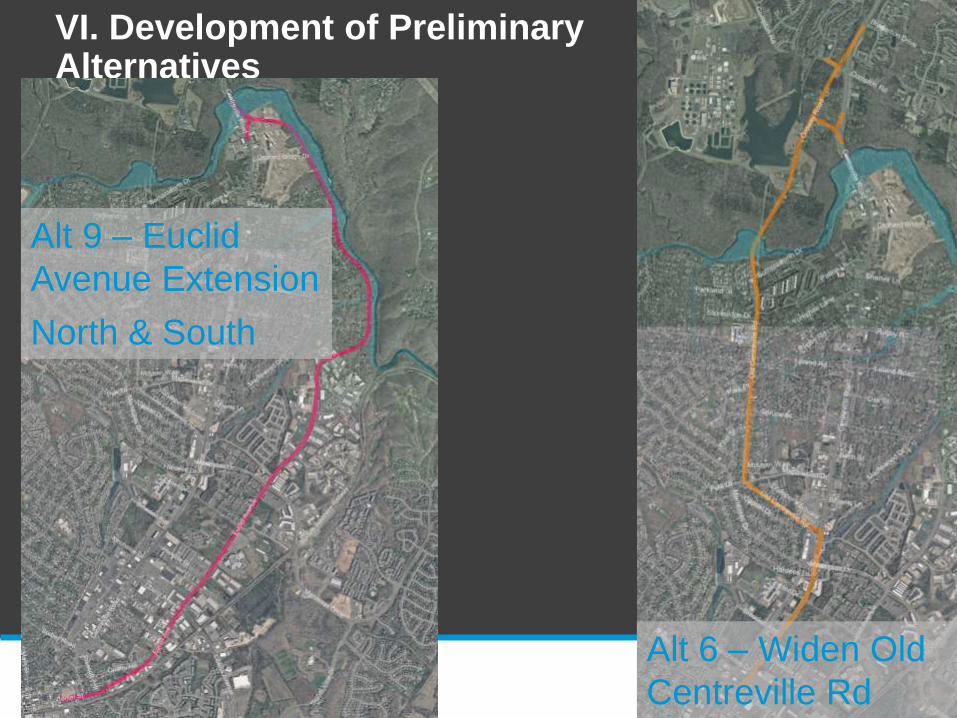
Alt 6 – Widen Old
Centreville Rd
Alt 9 – Euclid
Avenue Extension
North & South
VI. Development of Preliminary Alternatives
Route 28 Corridor Feasibility Study
VI. Development of Preliminary Alternatives
Route 28 Corridor Feasibility Study
Alt 7 – Reversible
Lands on Old
Centreville Rd
VI. Development of Preliminary Alternatives
Route 28 Corridor Feasibility Study

Development of
Screening Criteria
Route 28 Corridor Feasibility Study
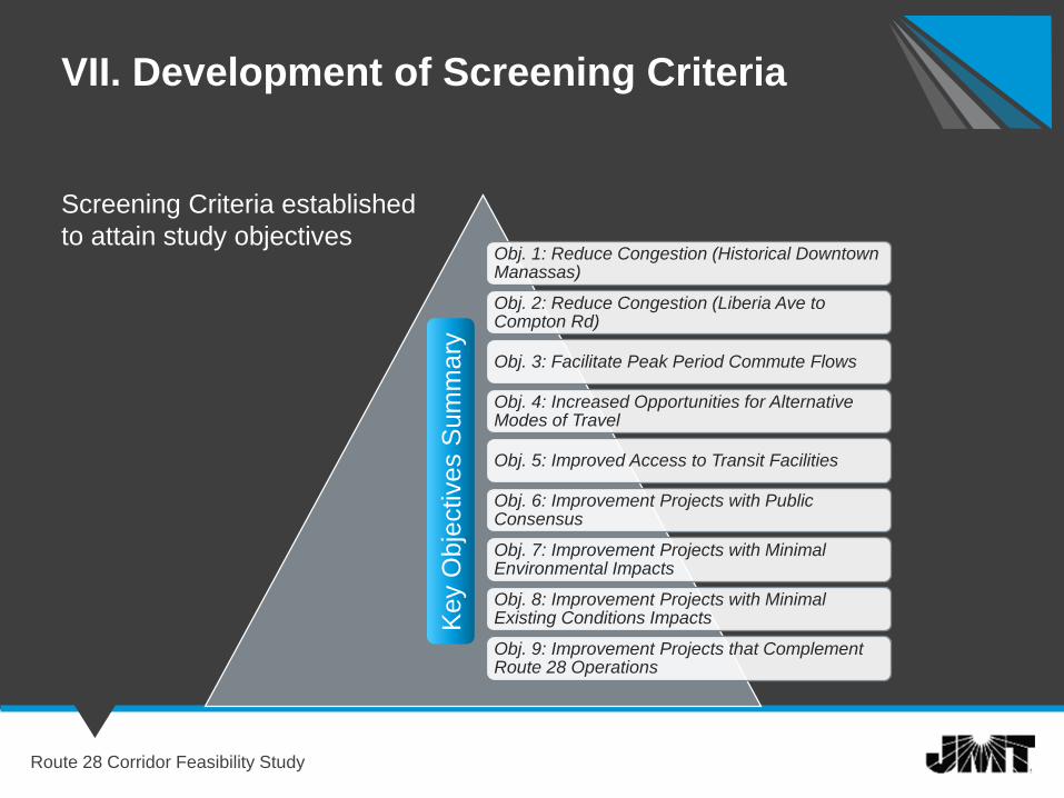
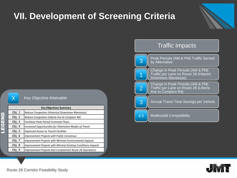
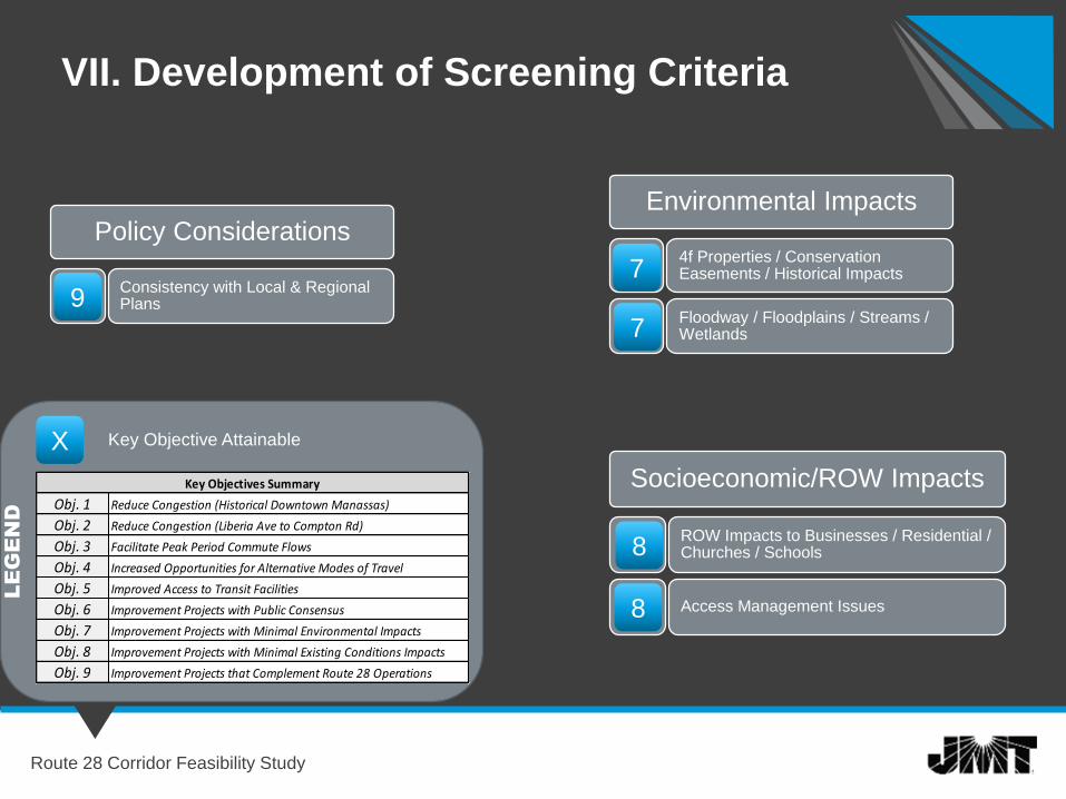
VII. Development of Screening Criteria
Route 28 Corridor Feasibility Study
Screening Criteria established
to attain study objectivesObj. 1: Reduce Congestion (Historical Downtown Manassas)
Obj. 2: Reduce Congestion (Liberia Ave to Compton Rd)
Obj. 3: Facilitate Peak Period Commute Flows
Obj. 4: Increased Opportunities for Alternative Modes of Travel
Obj. 5: Improved Access to Transit Facilities
Obj. 6: Improvement Projects with Public Consensus
Obj. 7: Improvement Projects with Minimal Environmental Impacts
Obj. 8: Improvement Projects with Minimal Existing Conditions Impacts
Obj. 9: Improvement Projects that Complement Route 28 Operations
Key O
bje
ctives S
um
mary
VII. Development of Screening Criteria
Route 28 Corridor Feasibility Study
Traffic Impacts
Peak Periods (AM & PM) Traffic Served by Alternative
Change in Peak Periods (AM & PM) Traffic per Lane on Route 28 (Historic Downtown Manassas)
Change in Peak Periods (AM & PM) Traffic per Lane on Route 28 (Liberia Ave to Compton Rd)
Annual Travel Time Savings per Vehicle
Multimodal Compatibility
3
1
2
3X Key Objective Attainable
Obj. 1
Obj. 2
Obj. 3
Obj. 4
Obj. 5
Obj. 6
Obj. 7
Obj. 8
Obj. 9
Improved Access to Transit Facilities
Improvement Projects with Public Consensus
Improvement Projects with Minimal Environmental Impacts
Improvement Projects with Minimal Existing Conditions Impacts
Improvement Projects that Complement Route 28 Operations
Reduce Congestion (Liberia Ave to Compton Rd)
Reduce Congestion (Historical Downtown Manassas)
Increased Opportunities for Alternative Modes of Travel
Facilitate Peak Period Commute Flows
Key Objectives Summary
LEGEND 4,5
VII. Development of Screening Criteria
Route 28 Corridor Feasibility Study
Policy Considerations
Consistency with Local & Regional Plans9
X Key Objective Attainable
Obj. 1
Obj. 2
Obj. 3
Obj. 4
Obj. 5
Obj. 6
Obj. 7
Obj. 8
Obj. 9
Improved Access to Transit Facilities
Improvement Projects with Public Consensus
Improvement Projects with Minimal Environmental Impacts
Improvement Projects with Minimal Existing Conditions Impacts
Improvement Projects that Complement Route 28 Operations
Reduce Congestion (Liberia Ave to Compton Rd)
Reduce Congestion (Historical Downtown Manassas)
Increased Opportunities for Alternative Modes of Travel
Facilitate Peak Period Commute Flows
Key Objectives Summary
LEGEND
Environmental Impacts
4f Properties / Conservation Easements / Historical Impacts
Floodway / Floodplains / Streams / Wetlands
7
7
Socioeconomic/ROW Impacts
ROW Impacts to Businesses / Residential / Churches / Schools
Access Management Issues
8
8
Screening of
Preliminary Alternatives
Route 28 Corridor Feasibility Study
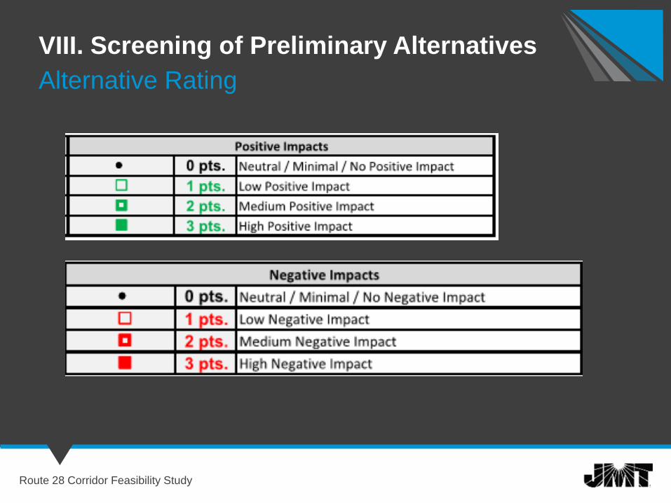
VIII. Screening of Preliminary Alternatives
Route 28 Corridor Feasibility Study
Alternative Rating
VIII. Screening of Preliminary Alternatives
Route 28 Corridor Feasibility Study
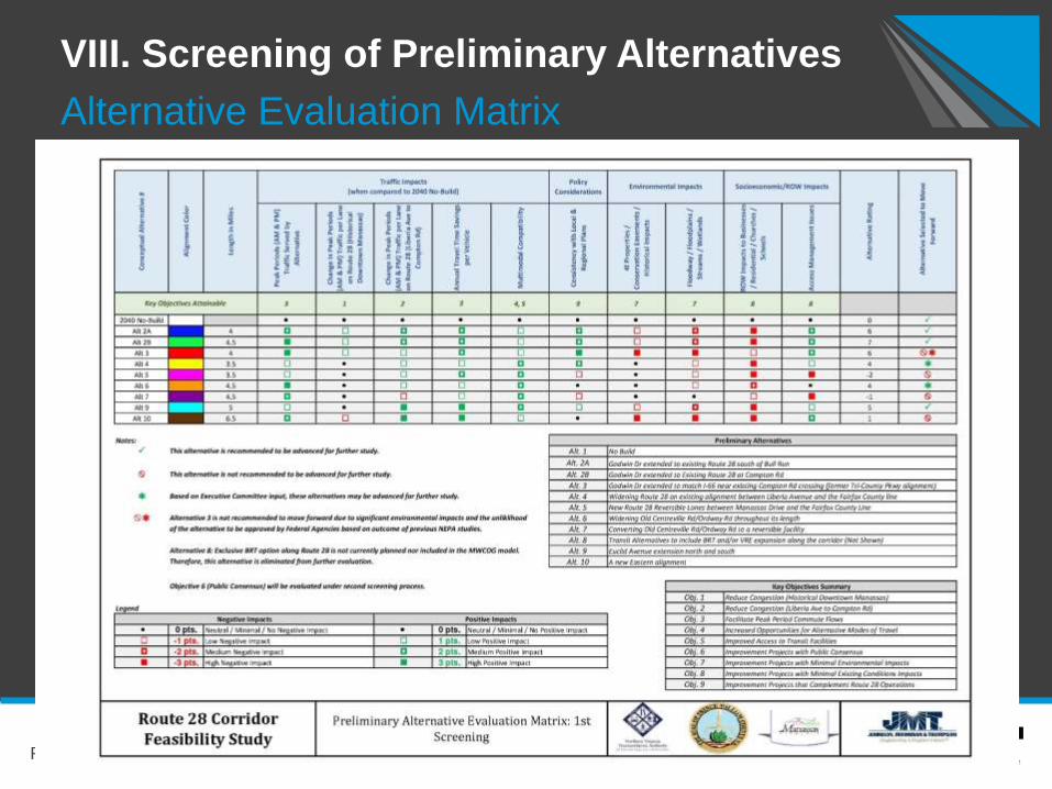
Alternative Evaluation Matrix
VIII. Screening of Preliminary Alternatives
Route 28 Corridor Feasibility Study
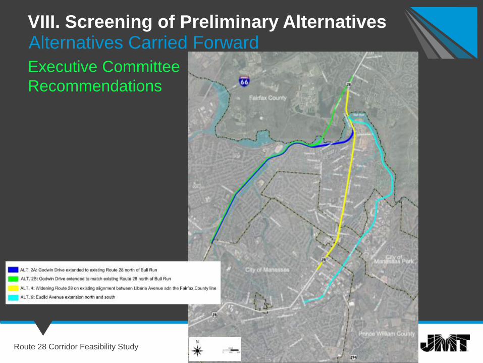
Alternatives Carried Forward
Executive Committee
Recommendations
VIII. Screening of Preliminary Alternatives
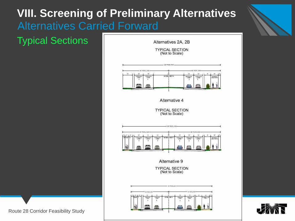
Route 28 Corridor Feasibility Study
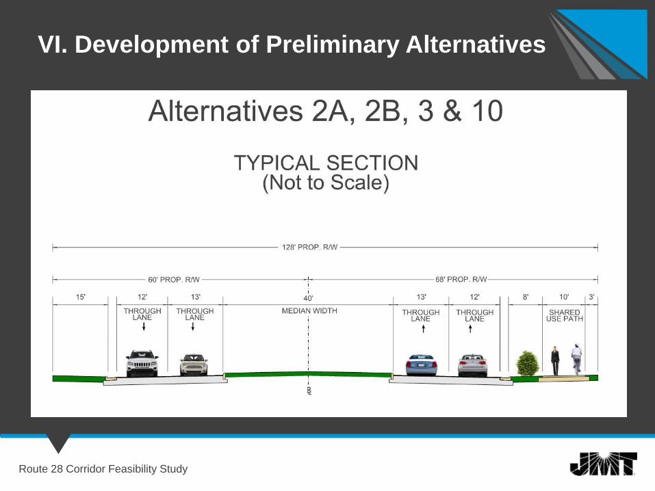
Alternatives Carried Forward
Typical Sections
Open Discussion
Route 28 Corridor Feasibility Study
Wrap-Up
Route 28 Corridor Feasibility Study
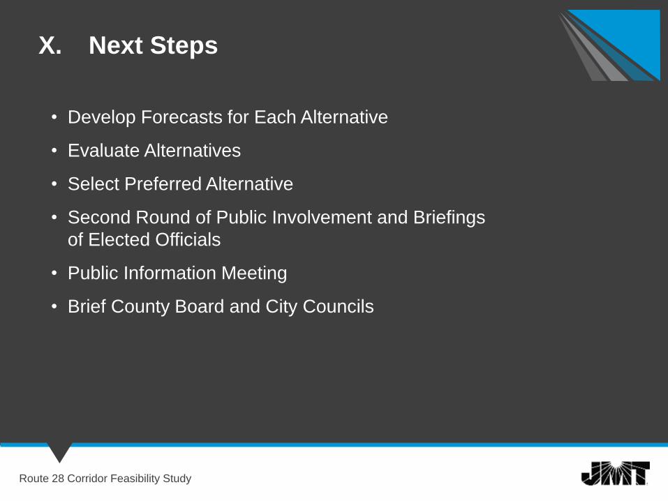
X. Next Steps
Route 28 Corridor Feasibility Study
• Develop Forecasts for Each Alternative
• Evaluate Alternatives
• Select Preferred Alternative
• Second Round of Public Involvement and Briefings
of Elected Officials
• Public Information Meeting
• Brief County Board and City Councils
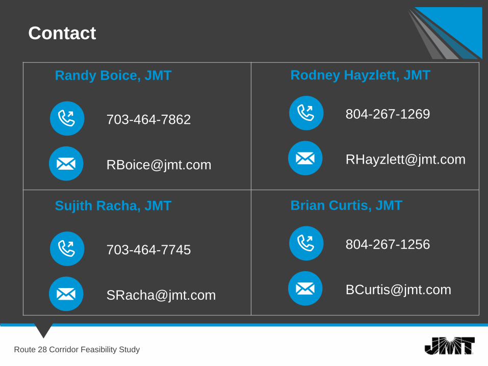
Contact
Randy Boice, JMT
703-464-7862
Route 28 Corridor Feasibility Study
Rodney Hayzlett, JMT
804-267-1269
Sujith Racha, JMT
703-464-7745
Brian Curtis, JMT
804-267-1256