Embed Size (px)
Citation preview

ANSI/ASHRAE Addendum n toANSI/ASHRAE Standard 62.2-2010
Ventilation andAcceptable
Indoor Air Qualityin Low-Rise
Residential BuildingsApproved by the ASHRAE Standards Committee on January 21, 2012; by the ASHRAE Board of Directors on January 25, 2012;and by the American National Standards Institute on January 26, 2012.
This addendum was approved by a Standing Standard Project Committee (SSPC) for which the Standards Committee has estab-lished a documented program for regular publication of addenda or revisions, including procedures for timely, documented, con-sensus action on requests for change to any part of the standard. The change submittal form, instructions, and deadlines may beobtained in electronic form from the ASHRAE Web site (www.ashrae.org) or in paper form from the Manager of Standards.
The latest edition of an ASHRAE Standard may be purchased on the ASHRAE Web site (www.ashrae.org) or from ASHRAECustomer Service, 1791 Tullie Circle, NE, Atlanta, GA 30329-2305. E-mail: [email protected]. Fax: 404-321-5478. Telephone:404-636-8400 (worldwide), or toll free 1-800-527-4723 (for orders in US and Canada). For reprint permission, go towww.ashrae.org/permissions.
© 2012 ASHRAE ISSN 1041-2336

SPECIAL NOTEThis American National Standard (ANS) is a national voluntary consensus standard developed under the auspices of ASHRAE.
Consensus is defined by the American National Standards Institute (ANSI), of which ASHRAE is a member and which has approved thisstandard as an ANS, as “substantial agreement reached by directly and materially affected interest categories. This signifies the concurrenceof more than a simple majority, but not necessarily unanimity. Consensus requires that all views and objections be considered, and that aneffort be made toward their resolution.” Compliance with this standard is voluntary until and unless a legal jurisdiction makes compliancemandatory through legislation.
ASHRAE obtains consensus through participation of its national and international members, associated societies, and public review.ASHRAE Standards are prepared by a Project Committee appointed specifically for the purpose of writing the Standard. The Project
Committee Chair and Vice-Chair must be members of ASHRAE; while other committee members may or may not be ASHRAE members, allmust be technically qualified in the subject area of the Standard. Every effort is made to balance the concerned interests on all ProjectCommittees.
The Manager of Standards of ASHRAE should be contacted for:a. interpretation of the contents of this Standard,b. participation in the next review of the Standard,c. offering constructive criticism for improving the Standard, ord. permission to reprint portions of the Standard.
DISCLAIMERASHRAE uses its best efforts to promulgate Standards and Guidelines for the benefit of the public in light of available information and
accepted industry practices. However, ASHRAE does not guarantee, certify, or assure the safety or performance of any products, components,or systems tested, installed, or operated in accordance with ASHRAE’s Standards or Guidelines or that any tests conducted under itsStandards or Guidelines will be nonhazardous or free from risk.
ASHRAE INDUSTRIAL ADVERTISING POLICY ON STANDARDSASHRAE Standards and Guidelines are established to assist industry and the public by offering a uniform method of testing for rating
purposes, by suggesting safe practices in designing and installing equipment, by providing proper definitions of this equipment, and by providingother information that may serve to guide the industry. The creation of ASHRAE Standards and Guidelines is determined by the need for them,and conformance to them is completely voluntary.
In referring to this Standard or Guideline and in marking of equipment and in advertising, no claim shall be made, either stated or implied,that the product has been approved by ASHRAE.
ASHRAE STANDARDS COMMITTEE 2011–2012
Carol E. Marriott, Chair Krishnan Gowri Janice C. Peterson
Kenneth W. Cooper, Vice-Chair Maureen Grasso Douglas T. Reindl
Douglass S. Abramson Cecily M. Grzywacz Boggarm S. SettyKarim Amrane Richard L. Hall James R. TaubyCharles S. Barnaby Rita M. Harrold James K. VallortHoy R. Bohanon, Jr. Adam W. Hinge William F. WalterSteven F. Bruning Debra H. Kennoy Michael W. WoodfordDavid R. Conover Jay A. Kohler Craig P. WraySteven J. Emmerich Frank Myers Eckhard A. Groll, BOD ExOAllan B. Fraser Ross D. Montgomery, CO
Stephanie C. Reiniche, Manager of Standards
ASHRAE Standing Standard Project Committee 62.2Cognizant TC: TC 4.3, Ventilation Requirements and Infiltration
SPLS Liaison: Robert G. Baker
*Denotes members of voting status when the document was approved for publication.
Steven J. Emmerich, Chair* Thomas P. Heidel Armin RuddDon T. Stevens, Vice-Chair* Mark C. Jackson* Max H. ShermanDavid A. Baylon* Richard John Karg* Thomas R. Stroud*Terry M. Brennan* Glenn P. Langan Don Surrena*Roy R. Crawford* Joseph W. Lstiburek* John M. Talbott*David C. Delaquila* Michael R. Lubliner Iain S. Walker*Lance L. DeLaura Jane Malone* Eric D. Werling*S. Craig Drumheller James C. Moore* Bruce A. Wilcox*Philip W. Fairey, III* Amy B. Musser* Ted A. WilliamsPaul Francisco* Paul H. Raymer*
© ASHRAE (www.ashrae.org). For personal use only. Additional reproduction, distribution, or transmission in either print or digital form is not permitted without ASHRAE's prior written permission.

© ASHRAE (www.ashrae.org). For personal use only. Additional reproduction, distribution, or transmission in either print or digital form is not permitted without ASHRAE's prior written permission.
(This foreword is not part of this standard. It is merelyinformative and does not contain requirements necessaryfor conformance to the standard. It has not beenprocessed according to the ANSI requirements for astandard and may contain material that has not beensubject to public review or a consensus process.Unresolved objectors on informative material are notoffered the right to appeal at ASHRAE or ANSI.)
FOREWORD
SSPC 62.2 has responsibility for maintenance ofASHRAE Standard 136. As such, a 136 subcommittee wasformed to update the standard. The 136 subcommittee rec-ommended and SSPC 62.2 concurred that the provisions ofStandard 136 be incorporated directly into the body of Stan-dard 62.2 and that Standard 136 be withdrawn when that isaccomplished. During the 136 subcommittee deliberations,the SPC 119 committee recommended the withdrawal ofStandard 119. As a result of this decision, the 136 Subcom-mittee decided to include the pertinent provisions of Stan-dard 119 into Standard 62.2 as well so that all of theseprovisions are in one place. This will save the user of Stan-dard 62.2 from purchasing all three standards. The weatherfactors (W) that were contained in Standard 136 have beenupdated to be consistent with the new TMY3 climate data for1020 climates using the expanded ASHRAE infiltrationmodel using shielding Class 4. The resulting values, whichhave been renamed as weather and shielding factor (wsf)values to differentiate them from the old W factors, are sig-nificantly lower than the original values but are believed tobe much closer to reality than the previous values, whichhave been criticized by a number of technical experts as esti-mating infiltration rates that are significantly greater thanthose measured in the field.
This addendum incorporates a revised method of calcu-lating infiltration airflow using normalized leakage, with arevised height adjustment exponent, and the revised wsf val-ues. This infiltration airflow rate would then be used todetermine the required mechanical ventilation fan flow raterequirement for meeting the standard.
Note: In this addendum, changes to the current standardare indicated in the text by underlining (for additions) andstrikethrough (for deletions) unless the instructions specifi-cally mention some other means of indicating the changes.
Addendum n to Standard 62.2-2010
[Add a new definition to Section 3 as follows.]
3. DEFINITIONS
effective annual average infiltration rate: the constant airinfiltration rate that would result in the same average indoorpollutant concentration over the annual period as actuallyoccurs under varying conditions.
[Revise Section 4 as shown below.]
4. WHOLE-BUILDING VENTILATION
4.1 Ventilation Rate. A mechanical exhaust system, supplysystem, or combination thereof shall be installed for eachdwelling unit to provide whole-building ventilation with out-door air each hour at a rate not no less than specified in Sec-tion 4.1.1, Fan Ventilation Rate Method, or Section 4.1.2,Total Ventilation Rate Method.
4.1.1 Fan Ventilation Rate Method. tThe mechanicalventilation rate shall be as specified in Tables 4.1a and orTable 4.1b or, equivalently, Equations 4.1a and or Equation4.1b, based on the floor area of the conditioned space andnumber of bedrooms.
Qfan = 0.01Afloor + 7.5(Nbr + 1) (4.1a)
where
Qfan = fan flow rate, cfm
Afloor = floor area, ft2
Nbr = number of bedrooms; not to be less than one
Qfan = 0.05Afloor + 3.5(Nbr + 1) (4.1b)
where
Qfan = fan flow rate, L/s
Afloor = floor area, m2
Nbr = number of bedrooms; not to be less than one
Exceptions: Whole-building mechanical systems are notrequired provided that at least one of the following con-ditions is met:a. the building has no mechanical cooling and is in zone
1 or 2 of the IECC 2004 Climate Zone Map (see Fig-ure 8.2), or
b. the building is thermally conditioned for humanoccupancy for less than 876 h per year,
and if the authority having jurisdiction determines thatwindow operation is a locally permissible method ofproviding ventilation.
TABLE 4.1a (I-P)Ventilation Air Requirements, cfm
Floor Area, ft2Bedrooms
0–1 2–3 4–5 6–7 >7
<1500 30 45 60 75 90
1501–3000 45 60 75 90 105
3001–4500 60 75 90 105 120
4501–6000 75 90 105 120 135
6001–7500 90 105 120 135 150
>7500 105 120 135 150 165
ANSI/ASHRAE Addendum n to ANSI/ASHRAE Standard 62.2-2010 1

© ASHRAE (www.ashrae.org). For personal use only. Additional reproduction, distribution, or transmission in either print or digital form is not permitted without ASHRAE's prior written permission.
4.1.2 Total Ventilation Rate Method. The total requiredventilation rate (Qtot) shall be calculated using Equation 4.2a(I-P) or Equation 4.2b (SI).
Qtot = 0.03Afloor + 7.5(Nbr + 1) (4.2a)
where
Qtot = total required ventilation rate, cfm
Afloor = floor area of residence, ft2
Nbr = number of bedrooms (to be not less than one)
Qtot = 0.15Afloor + 3.5(Nbr +1) (4.2b)
where
Qtot = total required ventilation rate, L/s
Afloor = floor area of residence, m2
Effective Annual Average Infiltration Rate (Qinf):Effective Annual Average Infiltration Rate (Qinf) shall becalculated using the normalized leakage calculated frommeasurements of envelope leakage using either ASTME779XI or CGSB 149.10X2. The authority having jurisdictionmay approve other means of calculating effective leakage area(ELA).
ASTM Procedure: To calculate the effective leakagearea from the ASTM E779XI standard, the leakage area forpressurization and depressurization (using a 4 Pa referencepressure) shall be averaged using Equation 4.3.
ELA = (Lpress + Ldepress)/2 (4.3)
where
ELA = effective leakage area, ft2 (m2)
Lpress = leakage area from pressurization, ft2 (m2)
Ldepress = leakage area from depressurization, ft2 (m2)
CGSB Procedure: To calculate the effective leakage areafrom CGSB-149.10X2, the following modifications to the testprocedure must be made: (1) all vents and intentional openingsmust be in the same configuration as specified in the ASTM stan-dard (i.e., HVAC dampers and registers should be in the normaloperating position; fireplace and other dampers should beclosed unless they are required for test operation), (2) heightand floor area must be reported consistently with the definitions
of this standard, and (3) the leakage area as calculated from theCGSB procedure must be converted using Equation 4.4.
ELA = 0.61 · (0.4)n-0.5 · Lcgsb (4.4a)
where
n = exponent measured from the CGSB standard
Lcgsb = CGSB leakage area, as modified above, ft2 (m2)
Normalized Leakage: Normalized leakage shall becalculated using Equation 4.5.
(4.5)
where
NL = normalized leakage
Hr = reference height, 8.2 ft (2.5 m)
H = vertical distance from lowest above grade floor tohighest ceiling, ft (m)
z = 0.4 for the purpose of calculating the EffectiveAnnual Infiltration Rate below
Effective Annual Average Infiltration Rate (Qinf):Effective Annual Average Infiltration Rate (Qinf) shall becalculated using Equation 4.6a (I-P) or Equation 4.6b (SI).
(4.6a)
where
NL = normalized leakage
wsf = weather and shielding factor from NormativeAppendix X
Afloor = floor area of residence, ft2
(4.6b)
where
Afloor = floor area of residence, m2
Required Mechanical Ventilation Rate (Qfan):Required Mechanical Ventilation Rate (Qfan) shall be calcu-lated using Equation 4.7.
Qfan = Qtot – Qinf (4.7)
where
Qfan = required mechanical ventilation rate, cfm (L/s)
If Qfan is less than or equal to zero, then no whole-buildingventilation fan is required.
4.1.13 Different Occupant Density. Tables 4.1a and 4.1band Equations 4.1a and 4.1b and Equations 4.2a and 4.2bassume two persons in a studio or one-bedroom dwelling unitand an additional person for each additional bedroom. Wherehigher occupant densities are known, the rate shall beincreased by 7.5 cfm (3.5 L/s) for each additional person.When approved by the authority having jurisdiction, loweroccupant densities may be used.
TABLE 4.1b (SI)Ventilation Air Requirements, L/s
Floor Area, m2Bedrooms
0–1 2–3 4–5 6–7 >7
<139 14 21 28 35 42
139.1–279 21 28 35 42 50
279.1–418 28 35 42 50 57
418.1–557 35 42 50 57 64
557.1–697 42 50 57 64 71
>697 50 57 64 71 78
NL 1000 ELAA floor--------------- H
H r-------
z⋅⋅=
Qinf cfm( )NL wsf A floor⋅⋅
7.3-----------------------------------------=
Qinf L/s( )NL wsf A floor⋅⋅
1.44-----------------------------------------=
2 ANSI/ASHRAE Addendum n to ANSI/ASHRAE Standard 62.2-2010

© ASHRAE (www.ashrae.org). For personal use only. Additional reproduction, distribution, or transmission in either print or digital form is not permitted without ASHRAE's prior written permission.
4.1.24 Alternative Ventilation. Other methods may beused to provide the required ventilation rates (of Tables 4.1aand 4.1b) when approved by a licensed design professional.
4.1.3 Infiltration Credit. Section 4.1 includes a defaultcredit for ventilation provided by infiltration of 2 cfm per 100ft2 (10 L/s per 100 m2) of occupiable floor space. For build-ings built prior to the application of this standard, when excessinfiltration has been measured in accordance with ANSI/ASHRAE Standard 136, A Method of Determining AirChange Rates in Detached Dwellings,1 the rates in Section4.1 may be decreased by half of the excess of the rate calcu-lated from Standard 136 that is above the default rate. Noincrease to the rate in Section 4.1 is required if measured infil-tration in accordance with Standard 136 is lower than thedefault rate.
4.2 System Type. The whole-house mechanical ventilationsystem shall consist of one or more supply or exhaust fans andassociated ducts and controls. Local exhaust fans shall be per-mitted to be part of a mechanical exhaust system. Outdoor airducts connected to the return side of an air handler shall bepermitted as supply ventilation if manufacturers’ require-ments for return air temperature are met. See Chapter 10 ofGuideline 242 for guidance on selection of methods.
4.3 Airflow Measurement. The airflow required by thissection is the quantity of outdoor ventilation air supplied and/or indoor air exhausted by the mechanical ventilation systemas installed and shall be measured using a flow hood, flowgrid, or other airflow measuring device. Ventilation airflow ofsystems with multiple operating modes shall be tested in allmodes designed to meet this section.
4.4 Control and Operation. The “fan on” switch on a heat-ing or air-conditioning system shall be permitted as an oper-ational control for systems introducing ventilation air througha duct to the return side of an HVAC system. Readily acces-sible override control must be provided to the occupant. Localexhaust fan switches and “fan on” switches shall be permittedas override controls. Controls, including the “fan-on” switchof a conditioning system, must be appropriately labeled.
Exception: An intermittently operating, whole-housemechanical ventilation system may be used if the venti-lation rate is adjusted, according to the exception to Sec-tion 4.5. The system must be designed so that it canoperate automatically based on a timer. The intermittentmechanical ventilation system must operate at least onceper day and must operate at least 10% of the time.
4.5 Delivered Ventilation. The delivered mechanical ven-tilation rate shall be calculated as the larger of the total supplyor total exhaust and shall be no less than specified in Section4.1 during each hour of operation.
Exception: The effective mechanical ventilation rate of anintermittent system is the combination of its deliveredcapacity, fractional on-time, cycle time, and the ventila-tion effectiveness from Table 4.2. The fan flow raterequired to achieve an
TABLE 4.2 Mechanical Ventilation Effectiveness forIntermittent Fans
FractionalOn-Time, f
Cycle Time, Tcyc (h)
0 to 4 8 12 24
0.1 1.00 0.79 * *
0.2 1.00 0.84 0.56 *
0.3 1.00 0.89 0.71 *
0.4 1.00 0.92 0.81 0.20
0.5 1.00 0.94 0.87 0.52
0.6 1.00 0.97 0.92 0.73
0.7 1.00 0.98 0.96 0.86
0.8 1.00 0.99 0.98 0.94
0.9 1.00 1.00 1.00 0.99
1.0 1.00 1.00 1.00 1.00
*Condition not allowed since no amount of intermittent ventilation will provideequivalent ventilation.
effective mechanical ventilationrate that is equivalent to the continuous mechanical ven-
tilation requirement shall be calculated from the follow-ing equation:
Qf Qon = Qr Qfan/(εf) (4.28)
where
QfQon = intermittent fan flow rate during the on-cycle
QrQfan = mechanical ventilation air requirement (fromTable 4.1a or 4.1b Section 4.1)
Tcyc = fan cycle time, defined as the total time for oneon-cycle and one off-cycle (used in Table 4.2)
ε = mechanical ventilation effectiveness (fromTable 4.2)
f = fractional on time, defined as the on-time forone cycle divided by the cycle time
See Chapter 10 of Guideline 242 for an example of thiscalculation.
For values not listed, use the next higher value for CycleTime or the next lower value for Fractional On-Time. Linearinterpolation is allowed for intermediate Fractional On-Times.
The maximum allowed Cycle Time is 24 h and the mini-mum allowed Fractional On-Time is 0.1.
[Delete Reference 1 in Section 9, add new references X1 andX2, and renumber the remaining references as applicable.]
9. REFERENCES
1. ANSI/ASHRAE Standard 136-1993 (RA 2006), A Methodof Determining Air Change Rates in Detached Dwell-ings. American Society of Heating, Refrigerating andAir-Conditioning Engineers, Inc., Atlanta, GA.
ANSI/ASHRAE Addendum n to ANSI/ASHRAE Standard 62.2-2010 3
© ASHRAE (www.ashrae.org). For personal use only. Additional reproduction, distribution, or transmission in either print or digital form is not permitted without ASHRAE's prior written permission.
X1. ANSI/ASTM E779-10. Standard Test Method for Deter-mining Air Leakage Rate by Fan Pressurization. ASTMInternational, West Conshohocken, PA.
X2. CAN/CGSB 149.10-M86. Determination for the Air-tightness of Building Envelopes by the Fan Depressur-ization Method. Canadian General Standard Board,Gatineau, Quebec, Canada.
[Revise Section A2 in Normative Appendix A as shown below.]
A2. WHOLE-BUILDING MECHANICALVENTILATION RATE
If Section 4.1.1 is used to determine the fan flow require-ment, then Tthe required mechanical ventilation rate, Qfan,shall be the rate in Section 4.1.1 plus the required additionalairflow calculated in accordance with Section A3.
If Section 4.1.2 is used to determine the fan flow require-ment, then the required additional airflow calculated in accor-dance with Section A3 shall be added to Qtot prior toapplication of Qinf. If the airtightness of the building envelopehas been measured, the required mechanical ventilation ratemay be reduced as described in Section 4.1.3. In these cases,Section A3 shall be applied before Section 4.1.3 when deter-mining the final mechanical ventilation rate.
[Add a new Normative Appendix X as shown below.]
(This is a normative appendix and is part of thestandard.)
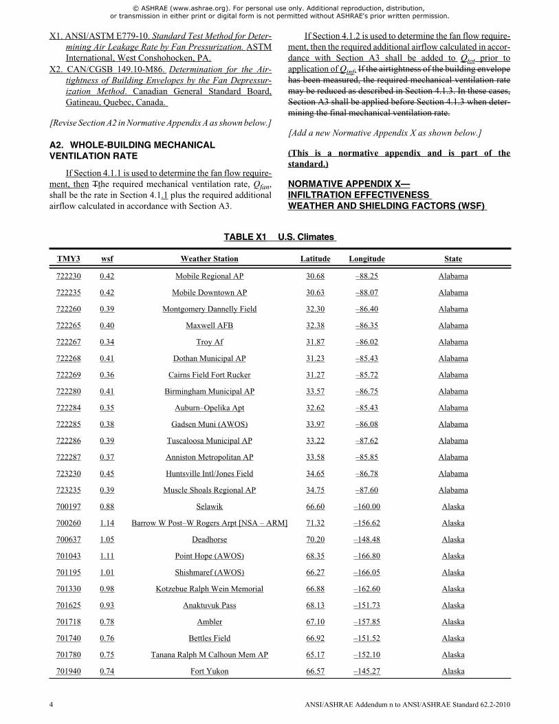
NORMATIVE APPENDIX X—INFILTRATION EFFECTIVENESSWEATHER AND SHIELDING FACTORS (WSF)
TABLE X1 U.S. Climates
TMY3 wsf Weather Station Latitude Longitude State
722230 0.42 Mobile Regional AP 30.68 –88.25 Alabama
722235 0.42 Mobile Downtown AP 30.63 –88.07 Alabama
722260 0.39 Montgomery Dannelly Field 32.30 –86.40 Alabama
722265 0.40 Maxwell AFB 32.38 –86.35 Alabama
722267 0.34 Troy Af 31.87 –86.02 Alabama
722268 0.41 Dothan Municipal AP 31.23 –85.43 Alabama
722269 0.36 Cairns Field Fort Rucker 31.27 –85.72 Alabama
722280 0.41 Birmingham Municipal AP 33.57 –86.75 Alabama
722284 0.35 Auburn–Opelika Apt 32.62 –85.43 Alabama
722285 0.38 Gadsen Muni (AWOS) 33.97 –86.08 Alabama
722286 0.39 Tuscaloosa Municipal AP 33.22 –87.62 Alabama
722287 0.37 Anniston Metropolitan AP 33.58 –85.85 Alabama
723230 0.45 Huntsville Intl/Jones Field 34.65 –86.78 Alabama
723235 0.39 Muscle Shoals Regional AP 34.75 –87.60 Alabama
700197 0.88 Selawik 66.60 –160.00 Alaska
700260 1.14 Barrow W Post–W Rogers Arpt [NSA – ARM] 71.32 –156.62 Alaska
700637 1.05 Deadhorse 70.20 –148.48 Alaska
701043 1.11 Point Hope (AWOS) 68.35 –166.80 Alaska
701195 1.01 Shishmaref (AWOS) 66.27 –166.05 Alaska
701330 0.98 Kotzebue Ralph Wein Memorial 66.88 –162.60 Alaska
701625 0.93 Anaktuvuk Pass 68.13 –151.73 Alaska
701718 0.78 Ambler 67.10 –157.85 Alaska
701740 0.76 Bettles Field 66.92 –151.52 Alaska
701780 0.75 Tanana Ralph M Calhoun Mem AP 65.17 –152.10 Alaska
701940 0.74 Fort Yukon 66.57 –145.27 Alaska
4 ANSI/ASHRAE Addendum n to ANSI/ASHRAE Standard 62.2-2010

© ASHRAE (www.ashrae.org). For personal use only. Additional reproduction, distribution, or transmission in either print or digital form is not permitted without ASHRAE's prior written permission.
702000 0.88 Nome Municipal Arpt 64.52 –165.45 Alaska
702005 0.89 Saint Mary’s (AWOS) 62.07 –163.30 Alaska
702035 0.98 Savoonga 63.68 –170.50 Alaska
702040 1.14 Gambell 63.78 –171.75 Alaska
702070 0.91 Unalakleet Field 63.88 –160.80 Alaska
702075 0.71 Anvik 62.65 –160.18 Alaska
702084 0.83 Emmonak 62.78 –164.50 Alaska
702185 0.99 Mekoryuk 60.37 –166.27 Alaska
702186 1.00 Hooper Bay 61.52 –166.15 Alaska
702190 0.89 Bethel Airport 60.78 –161.83 Alaska
702225 0.76 Huslia 65.70 –156.38 Alaska
702310 0.73 McGrath Arpt 62.95 –155.60 Alaska
702320 0.73 Aniak Airport 61.58 –159.53 Alaska
702460 0.65 Minchumina 63.88 –152.28 Alaska
702495 0.66 Hayes River 61.98 –152.08 Alaska
702510 0.68 Talkeetna State Arpt 62.32 –150.10 Alaska
702590 0.75 Kenai Municipal AP 60.58 –151.23 Alaska
702595 0.67 Soldotna 60.47 –151.03 Alaska
702600 0.70 Nenana Municipal AP 64.55 –149.10 Alaska
702606 0.73 Chulitna 62.88 –149.83 Alaska
702607 0.65 Hoonah 58.08 –135.45 Alaska
702610 0.70 Fairbanks Intl Arpt 64.82 –147.85 Alaska
702647 0.72 Healy River Airport 63.88 –149.02 Alaska
702650 0.68 Fairbanks/Eielson A 64.65 –147.10 Alaska
702670 0.73 Big Delta Allen AAF 64.00 –145.72 Alaska
702710 0.78 Gulkana Intermediate Field 62.15 –145.45 Alaska
702720 0.66 Anchorage/Elmendorf 61.25 –149.80 Alaska
702725 0.66 Lake Hood Seaplane 61.18 –149.97 Alaska
702730 0.71 Anchorage Intl AP 61.18 –150.00 Alaska
702735 0.61 Anchorage Merrill Field 61.22 –149.85 Alaska
702740 0.67 Palmer Municipal 61.60 –149.08 Alaska
702746 0.63 Birchwood 61.42 –149.52 Alaska
702750 0.70 Valdez Wso 61.13 –146.35 Alaska
702756 0.67 Valdez Pioneer Fiel 61.13 –146.27 Alaska
702757 0.75 Whittier 60.77 –148.68 Alaska
702770 0.75 Seward 60.12 –149.45 Alaska
702910 0.73 Northway Airport 62.97 –141.93 Alaska
TABLE X1 U.S. Climates (Continued)
TMY3 wsf Weather Station Latitude Longitude State
ANSI/ASHRAE Addendum n to ANSI/ASHRAE Standard 62.2-2010 5

© ASHRAE (www.ashrae.org). For personal use only. Additional reproduction, distribution, or transmission in either print or digital form is not permitted without ASHRAE's prior written permission.
702960 0.68 Cordova 60.50 –145.50 Alaska
702986 0.70 Big River Lake 60.82 –152.30 Alaska
703080 0.98 St Paul Island Arpt 57.17 –170.22 Alaska
703160 0.99 Cold Bay Arpt 55.20 –162.72 Alaska
703165 0.80 Sand Point 55.32 –160.52 Alaska
703210 0.76 Dillingham (AMOS) 59.05 –158.52 Alaska
703260 0.82 King Salmon Arpt 58.68 –156.65 Alaska
703330 0.90 Port Heiden 56.95 –158.62 Alaska
703400 0.78 Iliamna Arpt 59.75 –154.92 Alaska
703407 0.66 Sleetmute 61.72 –157.15 Alaska
703410 0.73 Homer Arpt 59.65 –151.48 Alaska
703430 0.80 Middleton Island Aut 59.47 –146.32 Alaska
703500 0.75 Kodiak Airport 57.75 –152.50 Alaska
703606 0.82 Togiac Village AWOS 59.05 –160.40 Alaska
703610 0.69 Yakutat State Arpt 59.52 –139.63 Alaska
703620 0.76 Skagway Airport 59.47 –135.30 Alaska
703670 0.67 Gustavus 58.42 –135.70 Alaska
703710 0.68 Sitka Japonski AP 57.05 –135.37 Alaska
703810 0.69 Juneau Intl Arpt 58.35 –134.58 Alaska
703855 0.66 Kake Seaplane Base 56.97 –133.95 Alaska
703860 0.64 Petersburg 56.80 –132.95 Alaska
703870 0.63 Wrangell 56.48 –132.37 Alaska
703884 0.71 Hydaburg Seaplane 55.20 –132.83 Alaska
703950 0.68 Ketchikan Intl AP 55.37 –131.72 Alaska
703980 0.66 Annette Island AP 55.05 –131.57 Alaska
704140 1.02 Shemya AFB 52.72 174.12 Alaska
704540 0.89 Adak NAS 51.88 –176.65 Alaska
704890 0.81 Dutch Harbor 53.90 –166.55 Alaska
699604 0.44 Yuma MCAS 32.65 –114.62 Arizona
722735 0.48 Douglas Bisbee–Douglas Intl A 31.47 –109.60 Arizona
722740 0.48 Tucson International AP 32.13 –110.95 Arizona
722745 0.45 Davis Monthan AFB 32.17 –110.88 Arizona
722747 0.48 Safford (AMOS) 32.82 –109.68 Arizona
722748 0.45 Casa Granda (AWOS) 32.95 –111.77 Arizona
722780 0.43 Phoenix Sky Harbor Intl AP 33.45 –111.98 Arizona
722784 0.45 Deer Valley/Phoenix 33.68 –112.08 Arizona
722785 0.47 Luke AFB 33.55 –112.37 Arizona
TABLE X1 U.S. Climates (Continued)
TMY3 wsf Weather Station Latitude Longitude State
6 ANSI/ASHRAE Addendum n to ANSI/ASHRAE Standard 62.2-2010

© ASHRAE (www.ashrae.org). For personal use only. Additional reproduction, distribution, or transmission in either print or digital form is not permitted without ASHRAE's prior written permission.
722789 0.41 Scottsdale Muni 33.62 –111.92 Arizona
722800 0.43 Yuma Intl Arpt 32.67 –114.60 Arizona
723700 0.57 Kingman (AMOS) 35.27 –113.95 Arizona
723710 0.45 Page Muni (AMOS) 36.93 –111.45 Arizona
723723 0.51 Prescott Love Field 34.65 –112.42 Arizona
723740 0.55 Winslow Municipal AP 35.03 –110.72 Arizona
723747 0.59 Show Low Municipal 34.27 –110.00 Arizona
723755 0.59 Flagstaff Pulliam Arpt 35.13 –111.67 Arizona
723783 0.61 Grand Canyon Natl P 35.95 –112.15 Arizona
723403 0.44 Little Rock Adams Field 34.75 –92.23 Arkansas
723405 0.40 Little Rock AFB 34.92 –92.15 Arkansas
723406 0.45 Walnut Ridge (AWOS) 36.13 –90.92 Arkansas
723407 0.47 Jonesboro Muni 35.83 –90.65 Arkansas
723415 0.42 Memorial Fld 34.47 –93.10 Arkansas
723416 0.45 Stuttgart (AWOS) 34.60 –91.57 Arkansas
723417 0.44 Pine Bluff Faa AP 34.17 –91.93 Arkansas
723418 0.42 Texarkana Webb Field 33.45 –94.00 Arkansas
723419 0.41 El Dorado Goodwin Field 33.22 –92.82 Arkansas
723434 0.49 Springdale Muni 36.18 –94.12 Arkansas
723440 0.45 Fort Smith Regional AP 35.33 –94.37 Arkansas
723443 0.48 Siloam Spring (AWOS) 36.18 –94.48 Arkansas
723444 0.46 Bentonville (AWOS) 36.35 –94.22 Arkansas
723445 0.44 Fayetteville Drake Field 36.00 –94.17 Arkansas
723446 0.46 Harrison Faa AP 36.27 –93.15 Arkansas
723447 0.39 Flippin (AWOS) 36.30 –92.47 Arkansas
723448 0.41 Batesville (AWOS) 35.73 –91.65 Arkansas
723449 0.48 Rogers (AWOS) 36.37 –94.10 Arkansas
690150 0.50 Twentynine Palms 34.30 –116.17 California
722860 0.43 March AFB 33.90 –117.25 California
722868 0.45 Palm Springs Intl 33.83 –116.50 California
722869 0.42 Riverside Muni 33.95 –117.45 California
722880 0.39 Burbank–Glendale–Pasadena AP 34.20 –118.35 California
722885 0.39 Santa Monica Muni 34.02 –118.45 California
722886 0.39 Van Nuys Airport 34.22 –118.48 California
722895 0.55 Lompoc (AWOS) 34.67 –120.47 California
722897 0.51 San Luis Co Rgnl 35.23 –120.63 California
722899 0.45 Chino Airport 33.97 –117.63 California
TABLE X1 U.S. Climates (Continued)
TMY3 wsf Weather Station Latitude Longitude State
ANSI/ASHRAE Addendum n to ANSI/ASHRAE Standard 62.2-2010 7

© ASHRAE (www.ashrae.org). For personal use only. Additional reproduction, distribution, or transmission in either print or digital form is not permitted without ASHRAE's prior written permission.
722900 0.38 San Diego Lindbergh Field 32.73 –117.17 California
722903 0.39 San Diego/Montgomery 32.82 –117.13 California
722904 0.40 Chula Vista Brown Field NAAS 32.58 –116.98 California
722906 0.39 San Diego North Island NAS 32.70 –117.20 California
722926 0.40 Camp Pendleton MCAS 33.30 –117.35 California
722927 0.38 Carlsbad/Palomar 33.13 –117.28 California
722930 0.39 San Diego Miramar NAS 32.87 –117.13 California
722950 0.42 Los Angeles Intl Arpt 33.93 –118.40 California
722956 0.38 Jack Northrop Fld H 33.92 –118.33 California
722970 0.38 Long Beach Daugherty Fld 33.83 –118.17 California
722976 0.34 Fullerton Municipal 33.87 –117.98 California
722977 0.36 Santa Ana John Wayne AP 33.68 –117.87 California
723805 0.51 Needles Airport 34.77 –114.62 California
723810 0.59 Edwards AFB 34.90 –117.87 California
723815 0.58 Daggett Barstow–Daggett AP 34.85 –116.80 California
723816 0.62 Lancaster Gen Wm Fox Field 34.73 –118.22 California
723820 0.57 Palmdale Airport 34.63 –118.08 California
723830 0.68 Sandberg 34.75 –118.72 California
723840 0.43 Bakersfield Meadows Field 35.43 –119.05 California
723890 0.45 Fresno Yosemite Intl AP 36.78 –119.72 California
723895 0.42 Porterville (AWOS) 36.03 –119.07 California
723896 0.43 Visalia Muni (AWOS) 36.32 –119.40 California
723910 0.45 Point Mugu Nf 34.12 –119.12 California
723925 0.44 Santa Barbara Municipal AP 34.43 –119.85 California
723926 0.43 Camarillo (AWOS) 34.22 –119.08 California
723927 0.45 Oxnard Airport 34.20 –119.20 California
723940 0.52 Santa Maria Public Arpt 34.92 –120.47 California
723965 0.53 Paso Robles Municipal Arpt 35.67 –120.63 California
724800 0.55 Bishop Airport 37.37 –118.35 California
724815 0.46 Merced/Macready Fld 37.28 –120.52 California
724830 0.51 Sacramento Executive Arpt 38.50 –121.50 California
724837 0.45 Beale AFB 39.13 –121.43 California
724838 0.50 Yuba Co 39.10 –121.57 California
724839 0.51 Sacramento Metropolitan AP 38.70 –121.58 California
724915 0.49 Monterey Naf 36.60 –121.87 California
724917 0.54 Salinas Municipal AP 36.67 –121.60 California
724920 0.50 Stockton Metropolitan Arpt 37.90 –121.23 California
TABLE X1 U.S. Climates (Continued)
TMY3 wsf Weather Station Latitude Longitude State
8 ANSI/ASHRAE Addendum n to ANSI/ASHRAE Standard 62.2-2010

© ASHRAE (www.ashrae.org). For personal use only. Additional reproduction, distribution, or transmission in either print or digital form is not permitted without ASHRAE's prior written permission.
724926 0.47 Modesto City–County AP 37.63 –120.95 California
724927 0.53 Livermore Municipal 37.70 –121.82 California
724930 0.54 Oakland Metropolitan Arpt 37.72 –122.22 California
724935 0.47 Hayward Air Term 37.67 –122.12 California
724936 0.53 Concord–Buchanan Field 38.00 –122.05 California
724940 0.60 San Francisco Intl AP 37.62 –122.40 California
724945 0.48 San Jose Intl AP 37.37 –121.93 California
724955 0.55 Napa Co. Airport 38.22 –122.28 California
724957 0.49 Santa Rosa (AWOS) 38.52 –122.82 California
725845 0.44 Blue Canyon AP 39.30 –120.72 California
725846 0.66 Truckee–Tahoe 39.32 –120.13 California
725847 0.64 South Lake Tahoe 38.90 –120.00 California
725905 0.47 Ukiah Municipal AP 39.13 –123.20 California
725910 0.50 Red Bluff Municipal Arpt 40.15 –122.25 California
725920 0.47 Redding Municipal Arpt 40.52 –122.32 California
725945 0.56 Arcata Airport 40.98 –124.10 California
725946 0.60 Crescent City Faa Ai 41.78 –124.23 California
725955 0.55 Montague Siskiyou County AP 41.78 –122.47 California
725958 0.59 Alturas 41.50 –120.53 California
745090 0.45 Mountain View Moffett Fld NAS 37.40 –122.05 California
745160 0.67 Travis Field AFB 38.27 –121.93 California
746120 0.52 China Lake Naf 35.68 –117.68 California
747020 0.50 Lemoore Reeves NAS 36.33 –119.95 California
747185 0.46 Imperial 32.83 –115.58 California
747187 0.46 Palm Springs Thermal AP 33.63 –116.17 California
747188 0.48 Blythe Riverside Co Arpt 33.62 –114.72 California
724620 0.67 Alamosa San Luis Valley Rgnl 37.43 –105.87 Colorado
724625 0.58 Durango/La Plata Co 37.15 –107.75 Colorado
724635 0.63 La Junta Municipal AP 38.05 –103.53 Colorado
724636 0.62 Lamar Municipal 38.07 –102.68 Colorado
724640 0.61 Pueblo Memorial AP 38.28 –104.50 Colorado
724645 0.61 Trinidad Las Animas County AP 37.27 –104.33 Colorado
724660 0.63 Colorado Springs Muni AP 38.82 –104.72 Colorado
724665 0.66 Limon 39.18 –103.72 Colorado
724666 0.61 Denver/Centennial [Golden – NREL] 39.74 –105.18 Colorado
724673 0.74 Leadville/Lake Co. 39.22 –106.32 Colorado
724675 0.63 Eagle County AP 39.65 –106.92 Colorado
TABLE X1 U.S. Climates (Continued)
TMY3 wsf Weather Station Latitude Longitude State
ANSI/ASHRAE Addendum n to ANSI/ASHRAE Standard 62.2-2010 9

© ASHRAE (www.ashrae.org). For personal use only. Additional reproduction, distribution, or transmission in either print or digital form is not permitted without ASHRAE's prior written permission.
724676 0.64 Aspen Pitkin Co Sar 39.22 –106.87 Colorado
724677 0.66 Gunnison Co. (AWOS) 38.53 –106.93 Colorado
724695 0.60 Aurora Buckley Field ANGB 39.72 –104.75 Colorado
724698 0.67 Akron Washington Co AP 40.17 –103.23 Colorado
724699 0.58 Broomfield/Jeffco [Boulder – Surfrad] 40.13 –105.24 Colorado
724760 0.57 Grand Junction Walker Field 39.13 –108.53 Colorado
724765 0.56 Montrose Co. Arpt 38.50 –107.90 Colorado
724767 0.58 Cortez/Montezuma Co 37.30 –108.63 Colorado
724768 0.60 Greeley/Weld (AWOS) 40.43 –104.63 Colorado
724769 0.59 Fort Collins (AWOS) 40.45 –105.02 Colorado
725650 0.59 Denver Intl AP 39.83 –104.65 Colorado
725700 0.64 Craig–Moffat 40.50 –107.53 Colorado
725715 0.66 Hayden/Yampa (AWOS) 40.48 –107.22 Colorado
725717 0.56 Rifle/Garfield Rgnl 39.53 –107.72 Colorado
725029 0.50 Oxford (AWOS) 41.48 –73.13 Connecticut
725040 0.59 Bridgeport Sikorsky Memorial 41.18 –73.15 Connecticut
725045 0.52 New Haven Tweed Airport 41.27 –72.88 Connecticut
725046 0.53 Groton New London AP 41.33 –72.05 Connecticut
725080 0.53 Hartford Bradley Intl AP 41.93 –72.68 Connecticut
725086 0.51 Danbury Municipal 41.37 –73.48 Connecticut
725087 0.48 Hartford Brainard Fd 41.73 –72.65 Connecticut
724088 0.47 Dover AFB 39.13 –75.47 Delaware
724089 0.52 Wilmington New Castle Cnty AP 39.67 –75.60 Delaware
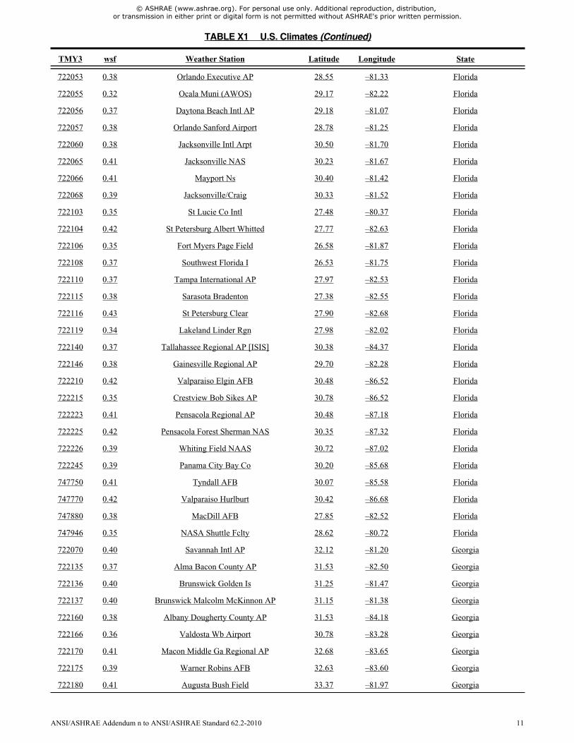
722010 0.49 Key West Intl Arpt 24.55 –81.75 Florida
722015 0.41 Key West NAS 24.58 –81.68 Florida
722016 0.39 Marathon Airport 24.73 –81.05 Florida
722020 0.41 Miami Intl AP 25.82 –80.30 Florida
722024 0.38 Miami/Opa Locka 25.90 –80.28 Florida
722025 0.41 Fort Lauderdale Hollywood Int 26.07 –80.15 Florida
722026 0.33 Homestead AFB 25.48 –80.38 Florida
722029 0.37 Miami/Kendall–Tamia 25.65 –80.43 Florida
722030 0.41 West Palm Beach Intl Arpt 26.68 –80.10 Florida
722038 0.35 Naples Municipal 26.15 –81.77 Florida
722039 0.40 Fort Lauderdale 26.20 –80.17 Florida
722040 0.38 Melbourne Regional AP 28.12 –80.65 Florida
722045 0.38 Vero Beach Municipal Arpt 27.65 –80.42 Florida
722050 0.39 Orlando Intl Arpt 28.43 –81.33 Florida
TABLE X1 U.S. Climates (Continued)
TMY3 wsf Weather Station Latitude Longitude State
10 ANSI/ASHRAE Addendum n to ANSI/ASHRAE Standard 62.2-2010
© ASHRAE (www.ashrae.org). For personal use only. Additional reproduction, distribution, or transmission in either print or digital form is not permitted without ASHRAE's prior written permission.
722053 0.38 Orlando Executive AP 28.55 –81.33 Florida
722055 0.32 Ocala Muni (AWOS) 29.17 –82.22 Florida
722056 0.37 Daytona Beach Intl AP 29.18 –81.07 Florida
722057 0.38 Orlando Sanford Airport 28.78 –81.25 Florida
722060 0.38 Jacksonville Intl Arpt 30.50 –81.70 Florida
722065 0.41 Jacksonville NAS 30.23 –81.67 Florida
722066 0.41 Mayport Ns 30.40 –81.42 Florida
722068 0.39 Jacksonville/Craig 30.33 –81.52 Florida
722103 0.35 St Lucie Co Intl 27.48 –80.37 Florida
722104 0.42 St Petersburg Albert Whitted 27.77 –82.63 Florida
722106 0.35 Fort Myers Page Field 26.58 –81.87 Florida
722108 0.37 Southwest Florida I 26.53 –81.75 Florida
722110 0.37 Tampa International AP 27.97 –82.53 Florida
722115 0.38 Sarasota Bradenton 27.38 –82.55 Florida
722116 0.43 St Petersburg Clear 27.90 –82.68 Florida
722119 0.34 Lakeland Linder Rgn 27.98 –82.02 Florida
722140 0.37 Tallahassee Regional AP [ISIS] 30.38 –84.37 Florida
722146 0.38 Gainesville Regional AP 29.70 –82.28 Florida
722210 0.42 Valparaiso Elgin AFB 30.48 –86.52 Florida
722215 0.35 Crestview Bob Sikes AP 30.78 –86.52 Florida
722223 0.41 Pensacola Regional AP 30.48 –87.18 Florida
722225 0.42 Pensacola Forest Sherman NAS 30.35 –87.32 Florida
722226 0.39 Whiting Field NAAS 30.72 –87.02 Florida
722245 0.39 Panama City Bay Co 30.20 –85.68 Florida
747750 0.41 Tyndall AFB 30.07 –85.58 Florida
747770 0.42 Valparaiso Hurlburt 30.42 –86.68 Florida
747880 0.38 MacDill AFB 27.85 –82.52 Florida
747946 0.35 NASA Shuttle Fclty 28.62 –80.72 Florida
722070 0.40 Savannah Intl AP 32.12 –81.20 Georgia
722135 0.37 Alma Bacon County AP 31.53 –82.50 Georgia
722136 0.40 Brunswick Golden Is 31.25 –81.47 Georgia
722137 0.40 Brunswick Malcolm McKinnon AP 31.15 –81.38 Georgia
722160 0.38 Albany Dougherty County AP 31.53 –84.18 Georgia
722166 0.36 Valdosta Wb Airport 30.78 –83.28 Georgia
722170 0.41 Macon Middle Ga Regional AP 32.68 –83.65 Georgia
722175 0.39 Warner Robins AFB 32.63 –83.60 Georgia
722180 0.41 Augusta Bush Field 33.37 –81.97 Georgia
TABLE X1 U.S. Climates (Continued)
TMY3 wsf Weather Station Latitude Longitude State
ANSI/ASHRAE Addendum n to ANSI/ASHRAE Standard 62.2-2010 11

© ASHRAE (www.ashrae.org). For personal use only. Additional reproduction, distribution, or transmission in either print or digital form is not permitted without ASHRAE's prior written permission.
722190 0.46 Atlanta Hartsfield Intl AP 33.63 –84.43 Georgia
722195 0.37 Fulton Co Arpt Brow 33.77 –84.52 Georgia
722196 0.39 Dekalb Peachtree 33.87 –84.30 Georgia
722250 0.35 Fort Benning Lawson 32.35 –85.00 Georgia
722255 0.39 Columbus Metropolitan Arpt 32.52 –84.95 Georgia
722270 0.40 Marietta Dobbins AFB 33.92 –84.52 Georgia
723110 0.40 Athens Ben Epps AP 33.95 –83.33 Georgia
723200 0.38 Rome R B Russell AP 34.35 –85.17 Georgia
747804 0.40 Hunter AAF 32.00 –81.15 Georgia
747810 0.36 Moody AFB/Valdosta 30.97 –83.20 Georgia
912120 0.49 Guam Wfo 13.48 144.80 Guam
912180 0.46 Andersen AFB 13.57 144.92 Guam
911650 0.51 Lihue Airport 21.98 –159.33 Hawaii
911760 0.35 Kaneohe Bay MCAS 21.45 –157.78 Hawaii
911780 0.35 Barbers Point NAS 21.32 –158.07 Hawaii
911820 0.42 Honolulu Intl Arpt 21.32 –157.93 Hawaii
911860 0.45 Molokai (AMOS) 21.15 –157.10 Hawaii
911900 0.48 Kahului Airport 20.90 –156.43 Hawaii
911904 0.55 Kapalua 20.95 –156.63 Hawaii
911905 0.47 Lanai 20.78 –156.95 Hawaii
911975 0.36 Kona Intl At Keahol 19.73 –156.05 Hawaii
912850 0.29 Hilo International AP 19.72 –155.05 Hawaii
725780 0.68 Pocatello Regional AP 42.92 –112.57 Idaho
725785 0.68 Idaho Falls Fanning Field 43.52 –112.07 Idaho
725786 0.60 Malad City 42.15 –112.28 Idaho
725865 0.61 Hailey/Friedman Mem 43.50 –114.30 Idaho
725866 0.65 Joslin Fld Magic Va [Twin Falls – UO] 42.55 –114.35 Idaho
725867 0.60 Burley Municipal Arpt 42.53 –113.77 Idaho
725868 0.70 Soda Springs/Tigert 42.65 –111.58 Idaho
726810 0.56 Boise Air Terminal [UO] 43.62 –116.21 Idaho
726813 0.55 Caldwell (AWOS) 43.63 –116.63 Idaho
726815 0.63 Mountain Home AFB 43.05 –115.87 Idaho
726865 0.58 Salmon/Lemhi (AWOS) 45.12 –113.88 Idaho
727830 0.51 Lewiston Nez Perce Cnty AP 46.37 –117.02 Idaho
727834 0.60 Coeur D’Alene (AWOS) 47.77 –116.82 Idaho
724335 0.44 Mount Vernon (AWOS) 38.32 –88.87 Illinois
724336 0.44 Southern Illinois 37.77 –89.25 Illinois
TABLE X1 U.S. Climates (Continued)
TMY3 wsf Weather Station Latitude Longitude State
12 ANSI/ASHRAE Addendum n to ANSI/ASHRAE Standard 62.2-2010

© ASHRAE (www.ashrae.org). For personal use only. Additional reproduction, distribution, or transmission in either print or digital form is not permitted without ASHRAE's prior written permission.
724338 0.48 Belleville Scott AFB 38.55 –89.85 Illinois
724339 0.47 Marion Regional 37.75 –89.02 Illinois
724390 0.57 Springfield Capital AP 39.85 –89.68 Illinois
724396 0.51 Quincy Muni Baldwin Fld 39.93 –91.20 Illinois
724397 0.60 Central Illinois Rg 40.47 –88.92 Illinois
725300 0.60 Chicago Ohare Intl AP 41.98 –87.92 Illinois
725305 0.58 W. Chicago/Du Page 41.92 –88.25 Illinois
725314 0.45 Cahokia/St. Louis 38.57 –90.15 Illinois
725315 0.57 Univ Of Illinois Wi [Bondville – Surfrad] 40.06 –88.37 Illinois
725316 0.56 Decatur 39.83 –88.87 Illinois
725320 0.55 Peoria Greater Peoria AP 40.67 –89.68 Illinois
725326 0.51 Sterling Rockfalls 41.75 –89.67 Illinois
725340 0.56 Chicago Midway AP 41.78 –87.75 Illinois
725347 0.59 Chicago/Waukegan 42.42 –87.87 Illinois
725430 0.58 Rockford Greater Rockford AP 42.20 –89.10 Illinois
725440 0.58 Moline Quad City Intl AP 41.47 –90.52 Illinois
744655 0.57 Aurora Municipal 41.77 –88.47 Illinois
724320 0.48 Evansville Regional AP 38.05 –87.53 Indiana
724365 0.45 Huntingburg 38.25 –86.95 Indiana
724373 0.50 Terre Haute Hulman Regional A 39.45 –87.30 Indiana
724375 0.47 Monroe Co 39.13 –86.62 Indiana
724380 0.54 Indianapolis Intl AP 39.72 –86.27 Indiana
724386 0.53 Lafayette Purdue Univ AP 40.42 –86.93 Indiana
725330 0.57 Fort Wayne Intl AP 41.00 –85.20 Indiana
725335 0.54 Grissom Arb 40.65 –86.15 Indiana
725336 0.53 Delaware Co Johnson 40.23 –85.40 Indiana
725350 0.57 South Bend Michiana Rgnl AP 41.70 –86.33 Indiana
725450 0.56 Cedar Rapids Municipal AP 41.88 –91.72 Iowa
725453 0.54 Atlantic 41.40 –95.05 Iowa
725454 0.54 Washington 41.28 –91.67 Iowa
725455 0.54 Burlington Municipal AP 40.78 –91.12 Iowa
725456 0.48 Keokuk Muni 40.47 –91.43 Iowa
725457 0.59 Algona 43.08 –94.27 Iowa
725460 0.58 Des Moines Intl AP 41.53 –93.67 Iowa
725463 0.56 Charles City 43.07 –92.62 Iowa
725464 0.55 Newton Muni 41.68 –93.02 Iowa
725465 0.60 Ottumwa Industrial AP 41.10 –92.45 Iowa
TABLE X1 U.S. Climates (Continued)
TMY3 wsf Weather Station Latitude Longitude State
ANSI/ASHRAE Addendum n to ANSI/ASHRAE Standard 62.2-2010 13

© ASHRAE (www.ashrae.org). For personal use only. Additional reproduction, distribution, or transmission in either print or digital form is not permitted without ASHRAE's prior written permission.
725467 0.52 Shenandoah Muni 40.75 –95.42 Iowa
725468 0.57 Carroll 42.05 –94.78 Iowa
725469 0.53 Chariton 41.03 –93.37 Iowa
725470 0.59 Dubuque Regional AP 42.40 –90.70 Iowa
725473 0.57 Clinton Muni (AWOS) 41.83 –90.33 Iowa
725474 0.57 Creston 41.02 –94.37 Iowa
725475 0.52 Monticello Muni 42.23 –91.17 Iowa
725476 0.46 Decorah 43.28 –91.73 Iowa
725477 0.56 Denison 41.98 –95.38 Iowa
725478 0.58 Webster City 42.43 –93.87 Iowa
725479 0.49 Clarinda 40.72 –95.03 Iowa
725480 0.62 Waterloo Municipal AP 42.55 –92.40 Iowa
725483 0.47 Fort Madison 40.67 –91.33 Iowa
725484 0.53 Le Mars 42.78 –96.20 Iowa
725485 0.65 Mason City Municipal Arpt 43.15 –93.33 Iowa
725486 0.57 Boone Muni 42.05 –93.85 Iowa
725487 0.49 Muscatine 41.37 –91.15 Iowa
725488 0.57 Oelwen 42.68 –91.97 Iowa
725489 0.58 Orange City 42.98 –96.07 Iowa
725490 0.55 Fort Dodge (AWOS) 42.55 –94.18 Iowa
725493 0.50 Knoxville 41.30 –93.12 Iowa
725494 0.55 Red Oak 41.02 –95.27 Iowa
725495 0.59 Sheldon 43.22 –95.83 Iowa
725496 0.60 Storm Lake 42.60 –95.23 Iowa
725497 0.51 Council Bluffs 41.27 –95.77 Iowa
725570 0.65 Sioux City Sioux Gateway AP 42.38 –96.38 Iowa
726498 0.56 Fair Field 41.05 –91.98 Iowa
726499 0.66 Estherville Muni 43.40 –94.75 Iowa
726500 0.67 Spencer 43.17 –95.15 Iowa
724468 0.52 Olathe/Johnson Co. 38.85 –94.73 Kansas
724475 0.57 Olathe Johnson Co Industrial 38.83 –94.88 Kansas
724500 0.62 Wichita Mid–Continent AP 37.65 –97.43 Kansas
724504 0.58 Wichita/Col. Jabara 37.75 –97.22 Kansas
724505 0.61 McConnell AFB 37.62 –97.27 Kansas
724506 0.56 Hutchinson Municipal AP 38.07 –97.87 Kansas
724507 0.54 Chanute Martin Johnson AP 37.67 –95.48 Kansas
724509 0.60 Newton (AWOS) 38.05 –97.28 Kansas
TABLE X1 U.S. Climates (Continued)
TMY3 wsf Weather Station Latitude Longitude State
14 ANSI/ASHRAE Addendum n to ANSI/ASHRAE Standard 62.2-2010

© ASHRAE (www.ashrae.org). For personal use only. Additional reproduction, distribution, or transmission in either print or digital form is not permitted without ASHRAE's prior written permission.
724510 0.75 Dodge City Regional AP 37.77 –99.97 Kansas
724515 0.69 Garden City Municipal AP 37.93 –100.72 Kansas
724516 0.67 Liberal Muni 37.03 –100.97 Kansas
724517 0.65 Great Bend (AWOS) 38.35 –98.87 Kansas
724518 0.65 Hays Muni (AWOS) 38.85 –99.27 Kansas
724550 0.50 Fort Riley Marshall AAF 39.05 –96.77 Kansas
724555 0.53 Manhattan Rgnl 39.13 –96.67 Kansas
724556 0.61 Emporia Municipal AP 38.33 –96.18 Kansas
724560 0.55 Topeka Municipal AP 39.07 –95.63 Kansas
724565 0.54 Topeka Forbes Field 38.95 –95.67 Kansas
724580 0.63 Concordia Blosser Muni AP 39.55 –97.65 Kansas
724585 0.68 Russell Municipal AP 38.88 –98.82 Kansas
724586 0.61 Salina Municipal AP 38.82 –97.67 Kansas
724650 0.73 Goodland Renner Field 39.37 –101.70 Kansas
724655 0.61 Hill City Municipal AP 39.38 –99.83 Kansas
724210 0.50 Cincinnati Northern Ky AP 39.05 –84.67 Kentucky
724220 0.48 Lexington Bluegrass AP 38.03 –84.60 Kentucky
724230 0.47 Louisville Standiford Field 38.18 –85.73 Kentucky
724235 0.41 Louisville Bowman Field 38.23 –85.67 Kentucky
724236 0.38 Jackson Julian Carroll AP 37.58 –83.32 Kentucky
724238 0.47 Henderson City 37.82 –87.68 Kentucky
724240 0.45 Fort Knox Godman AAF 37.90 –85.97 Kentucky
724243 0.42 London–Corbin AP 37.08 –84.08 Kentucky
724350 0.46 Paducah Barkley Regional AP 37.05 –88.77 Kentucky
724354 0.38 Somerset (AWOS) 38.00 –84.60 Kentucky
746710 0.44 Fort Campbell AAF 36.67 –87.48 Kentucky
746716 0.43 Bowling Green Warren Co AP 36.98 –86.43 Kentucky
722310 0.41 New Orleans Intl Arpt 30.00 –90.25 Louisiana
722314 0.41 New Iberia NAAS 30.03 –91.88 Louisiana
722315 0.47 New Orleans Lakefront AP 30.05 –90.03 Louisiana
722316 0.35 New Orleans Alvin Callender F 29.82 –90.02 Louisiana
722317 0.39 Baton Rouge Ryan Arpt 30.53 –91.15 Louisiana
722329 0.37 Patterson Memorial 29.72 –91.33 Louisiana
722390 0.36 Fort Polk AAF 31.05 –93.18 Louisiana
722400 0.42 Lake Charles Regional Arpt 30.12 –93.23 Louisiana
722404 0.42 Lake Charles Wb Airp 30.22 –93.17 Louisiana
722405 0.42 Lafayette Regional AP 30.20 –91.98 Louisiana
TABLE X1 U.S. Climates (Continued)
TMY3 wsf Weather Station Latitude Longitude State
ANSI/ASHRAE Addendum n to ANSI/ASHRAE Standard 62.2-2010 15

© ASHRAE (www.ashrae.org). For personal use only. Additional reproduction, distribution, or transmission in either print or digital form is not permitted without ASHRAE's prior written permission.
722406 0.37 Houma–Terrebonne 29.57 –90.67 Louisiana
722480 0.44 Shreveport Regional Arpt 32.45 –93.82 Louisiana
722484 0.41 Shreveport Downtown 32.53 –93.75 Louisiana
722485 0.39 Barksdale AFB 32.50 –93.67 Louisiana
722486 0.40 Monroe Regional AP 32.52 –92.03 Louisiana
722487 0.36 Alexandria Esler Regional AP 31.40 –92.30 Louisiana
747540 0.38 England AFB 31.32 –92.55 Louisiana
726060 0.60 Portland Intl Jetport 43.65 –70.30 Maine
726064 0.57 Sanford Muni (AWOS) 43.40 –70.72 Maine
726073 0.55 Waterville (AWOS) 44.53 –69.68 Maine
726077 0.62 Bar Harbor (AWOS) 44.45 –68.37 Maine
726079 0.57 Rockland/Knox (AWOS) 44.07 –69.10 Maine
726083 0.65 Northern Aroostook 47.28 –68.32 Maine
726088 0.58 Bangor International AP 44.80 –68.82 Maine
726184 0.56 Auburn–Lewiston 44.05 –70.28 Maine
726185 0.58 Augusta Airport 44.32 –69.80 Maine
726196 0.52 Millinocket Municipal AP 45.65 –68.68 Maine
727033 0.61 Houlton Intl Arpt 46.12 –67.80 Maine
727120 0.66 Caribou Municipal Arpt 46.87 –68.03 Maine
727130 0.66 Presque Isle Municip 46.68 –68.05 Maine
727135 0.50 Wiscasset 43.97 –69.72 Maine
743920 0.59 Brunswick NAS 43.90 –69.93 Maine
724040 0.45 Patuxent River NAS 38.30 –76.42 Maryland
724045 0.47 Salisbury Wicomico Co AP 38.33 –75.52 Maryland
724060 0.50 Baltimore Blt–Washngtn Int'l 39.17 –76.68 Maryland
724066 0.46 Hagerstown Rgnl Ric 39.70 –77.73 Maryland
745940 0.49 Andrews AFB 38.82 –76.87 Maryland
725060 0.60 Otis ANGBb 41.65 –70.52 Massachusetts
725063 0.61 Nantucket Memorial AP 41.25 –70.07 Massachusetts
725064 0.53 Plymouth Municipal 41.92 –70.73 Massachusetts
725065 0.54 New Bedford Rgnl 41.67 –70.95 Massachusetts
725066 0.59 Marthas Vineyard 41.40 –70.62 Massachusetts
725067 0.60 Barnstable Muni Boa 41.67 –70.28 Massachusetts
725073 0.59 Provincetown (AWOS) 42.07 –70.22 Massachusetts
725075 0.52 North Adams 42.70 –73.17 Massachusetts
725088 0.58 Beverly Muni 42.58 –70.92 Massachusetts
725090 0.66 Boston Logan Intl Arpt 42.37 –71.02 Massachusetts
TABLE X1 U.S. Climates (Continued)
TMY3 wsf Weather Station Latitude Longitude State
16 ANSI/ASHRAE Addendum n to ANSI/ASHRAE Standard 62.2-2010

© ASHRAE (www.ashrae.org). For personal use only. Additional reproduction, distribution, or transmission in either print or digital form is not permitted without ASHRAE's prior written permission.
725095 0.59 Worchester Regional Arpt 42.27 –71.88 Massachusetts
725098 0.52 Norwood Memorial 42.18 –71.18 Massachusetts
744904 0.55 Lawrence Muni 42.72 –71.12 Massachusetts
744910 0.49 Chicopee Falls Westo 42.20 –72.53 Massachusetts
744915 0.50 Westfield Barnes Muni AP 42.15 –72.72 Massachusetts
725370 0.60 Detroit Metropolitan Arpt 42.22 –83.35 Michigan
725374 0.56 Ann Arbor Municipal 42.22 –83.75 Michigan
725375 0.56 Detroit City Airport 42.40 –83.00 Michigan
725376 0.57 Detroit Willow Run AP 42.23 –83.53 Michigan
725377 0.55 Mount Clemens Selfridge Fld 42.62 –82.83 Michigan
725378 0.50 Howell 42.63 –83.98 Michigan
725384 0.51 St.Clair County Int 42.92 –82.53 Michigan
725390 0.63 Lansing Capital City Arpt 42.78 –84.58 Michigan
725395 0.54 Jackson Reynolds Field 42.27 –84.47 Michigan
725396 0.55 Battle Creek Kellogg AP 42.30 –85.25 Michigan
726350 0.60 Grand Rapids Kent County Int' 42.88 –85.52 Michigan
726355 0.53 Benton Harbor/Ross 42.13 –86.43 Michigan
726357 0.53 Kalamazoo Battle Cr 42.23 –85.55 Michigan
726360 0.61 Muskegon County Arpt 43.17 –86.23 Michigan
726370 0.60 Flint Bishop Intl Arpt 42.97 –83.75 Michigan
726375 0.57 Oakland Co Intl 42.67 –83.42 Michigan
726379 0.59 Saginaw Tri City Intl AP 43.53 –84.08 Michigan
726380 0.59 Houghton Lake Roscommon Co Ar 44.37 –84.68 Michigan
726384 0.58 Cadillac Wexford Co AP 44.28 –85.42 Michigan
726385 0.53 Manistee (AWOS) 44.27 –86.25 Michigan
726387 0.61 Traverse City Cherry Capital 44.73 –85.58 Michigan
726390 0.61 Alpena County Regional AP 45.07 –83.58 Michigan
726395 0.60 Oscoda Wurtsmith AFB 44.45 –83.40 Michigan
726480 0.64 Escanaba (AWOS) 45.75 –87.03 Michigan
726487 0.57 Menominee (AWOS) 45.13 –87.63 Michigan
727340 0.65 Sault Ste Marie Sanderson Fie 46.47 –84.35 Michigan
727344 0.66 Chippewa Co Intl 46.25 –84.47 Michigan
727347 0.59 Pellston Emmet County AP 45.57 –84.78 Michigan
727437 0.56 Iron Mountain/Ford 45.82 –88.12 Michigan
727440 0.67 Hancock Houghton Co AP 47.17 –88.50 Michigan
727445 0.62 Ironwood (AWOS) 46.53 –90.13 Michigan
726440 0.70 Rochester International Arpt 43.90 –92.50 Minnesota
TABLE X1 U.S. Climates (Continued)
TMY3 wsf Weather Station Latitude Longitude State
ANSI/ASHRAE Addendum n to ANSI/ASHRAE Standard 62.2-2010 17

© ASHRAE (www.ashrae.org). For personal use only. Additional reproduction, distribution, or transmission in either print or digital form is not permitted without ASHRAE's prior written permission.
726544 0.61 Orr, MN 48.02 –92.87 Minnesota
726547 0.62 Glenwood (ASOS) 45.65 –95.32 Minnesota
726550 0.59 St Cloud Regional Arpt 45.55 –94.05 Minnesota
726555 0.57 Brainerd/Wieland 46.40 –94.13 Minnesota
726556 0.64 Redwood Falls Muni 44.55 –95.08 Minnesota
726557 0.67 Alexandria Municipal AP 45.88 –95.40 Minnesota
726558 0.61 Cloquet (AWOS) 46.70 –92.50 Minnesota
726559 0.66 Marshall/Ryan (AWOS) 44.45 –95.82 Minnesota
726560 0.64 Fergus Falls (AWOS) 46.28 –96.15 Minnesota
726563 0.57 Faribault Muni AWOS 44.33 –93.32 Minnesota
726564 0.55 Red Wing 44.58 –92.48 Minnesota
726565 0.66 Morris Muni (AWOS) 45.57 –95.97 Minnesota
726566 0.63 Pipestone (AWOS) 43.98 –96.32 Minnesota
726567 0.61 New Ulm Muni (AWOS) 44.32 –94.50 Minnesota
726568 0.59 Owatonna (AWOS) 44.12 –93.25 Minnesota
726569 0.60 Hutchinson (AWOS) 44.87 –94.38 Minnesota
726575 0.58 Minneapolis/Crystal 45.07 –93.35 Minnesota
726576 0.59 Willmar 45.12 –95.08 Minnesota
726578 0.58 Little Falls (AWOS) 45.95 –94.35 Minnesota
726579 0.58 Flying Cloud 44.82 –93.45 Minnesota
726580 0.63 Minneapolis–St Paul Intl Arp 44.88 –93.23 Minnesota
726583 0.53 Litchfield Muni 45.10 –94.50 Minnesota
726584 0.57 St Paul Downtown AP 44.93 –93.05 Minnesota
726585 0.61 Mankato (AWOS) 44.22 –93.92 Minnesota
726586 0.66 Fairmont Muni (AWOS) 43.65 –94.42 Minnesota
726587 0.67 Worthington (AWOS) 43.65 –95.58 Minnesota
726588 0.51 Winona Muni (AWOS) 44.08 –91.70 Minnesota
726589 0.55 Albert Lea (AWOS) 43.68 –93.37 Minnesota
726603 0.51 South St Paul Muni 44.85 –93.15 Minnesota
727444 0.60 Two Harbors 47.05 –91.75 Minnesota
727450 0.70 Duluth International Arpt 46.83 –92.22 Minnesota
727452 0.67 Crookston Muni Fld 47.85 –96.62 Minnesota
727453 0.65 Park Rapids Municipal AP 46.90 –95.07 Minnesota
727455 0.64 Hibbing Chisholm–Hibbing AP 47.38 –92.85 Minnesota
727457 0.63 Detroit Lakes (AWOS) 46.83 –95.88 Minnesota
727458 0.60 Grand Rapids (AWOS) 47.22 –93.52 Minnesota
727459 0.58 Ely Muni 47.82 –91.83 Minnesota
TABLE X1 U.S. Climates (Continued)
TMY3 wsf Weather Station Latitude Longitude State
18 ANSI/ASHRAE Addendum n to ANSI/ASHRAE Standard 62.2-2010

© ASHRAE (www.ashrae.org). For personal use only. Additional reproduction, distribution, or transmission in either print or digital form is not permitted without ASHRAE's prior written permission.
727470 0.65 International Falls Intl AP 48.57 –93.40 Minnesota
727473 0.57 Crane Lake (AWOS) 46.27 –92.57 Minnesota
727474 0.63 Eveleth Muni (AWOS) 47.40 –92.50 Minnesota
727475 0.54 Mora Muni (AWOS) 45.88 –93.27 Minnesota
727476 0.62 Baudette International AP 48.72 –94.60 Minnesota
727477 0.65 Roseau Muni (AWOS) 48.85 –95.70 Minnesota
727478 0.68 Hallock 48.78 –96.95 Minnesota
727503 0.54 Cambridge Muni 45.57 –93.27 Minnesota
727504 0.58 Aitkin Ndb (AWOS) 46.55 –93.68 Minnesota
727505 0.61 Fosston (AWOS) 47.58 –95.77 Minnesota
727507 0.62 Benson Muni 45.32 –95.65 Minnesota
727533 0.66 Wheaton Ndb (AWOS) 45.70 –96.50 Minnesota
727550 0.62 Bemidji Municipal 47.50 –94.93 Minnesota
727555 0.66 Thief River (AWOS) 48.07 –96.18 Minnesota
727556 0.62 Silver Bay 47.20 –91.40 Minnesota
727566 0.55 Austin Muni 43.67 –92.93 Minnesota
722340 0.41 Meridian Key Field 32.33 –88.75 Mississippi
722345 0.34 Meridian NAAS 32.55 –88.57 Mississippi
722348 0.35 Hattiesburg Laurel 31.47 –89.33 Mississippi
722350 0.42 Jackson International AP 32.32 –90.08 Mississippi
722356 0.44 Greenville Municipal 33.48 –90.98 Mississippi
722357 0.36 Natchez/Hardy (AWOS) 31.62 –91.30 Mississippi
722358 0.36 McComb Pike County AP 31.23 –90.47 Mississippi
722359 0.41 Greenwood Leflore Arpt 33.50 –90.08 Mississippi
723306 0.42 Columbus AFB 33.65 –88.45 Mississippi
723307 0.40 Golden Tri (AWOS) 33.45 –88.58 Mississippi
723320 0.43 Tupelo C D Lemons Arpt 34.27 –88.77 Mississippi
747685 0.38 Gulfport Biloxi Int 30.40 –89.07 Mississippi
747686 0.38 Keesler AFB 30.42 –88.92 Mississippi
723300 0.43 Poplar Bluff (AMOS) 36.77 –90.47 Missouri
723489 0.47 Cape Girardeau Municipal AP 37.23 –89.57 Missouri
723495 0.53 Joplin Municipal AP 37.15 –94.50 Missouri
724340 0.54 St Louis Lambert Intl Arpt 38.75 –90.37 Missouri
724345 0.48 St Louis Spirit Of St Louis A 38.65 –90.65 Missouri
724400 0.53 Springfield Regional Arpt 37.23 –93.38 Missouri
724450 0.54 Columbia Regional Airport 38.82 –92.22 Missouri
724454 0.45 Farmington 37.77 –90.40 Missouri
TABLE X1 U.S. Climates (Continued)
TMY3 wsf Weather Station Latitude Longitude State
ANSI/ASHRAE Addendum n to ANSI/ASHRAE Standard 62.2-2010 19

© ASHRAE (www.ashrae.org). For personal use only. Additional reproduction, distribution, or transmission in either print or digital form is not permitted without ASHRAE's prior written permission.
724455 0.53 Kirksville Regional AP 40.10 –92.55 Missouri
724456 0.52 Vichy Rolla Natl Arpt 38.13 –91.77 Missouri
724457 0.44 Ft Lnrd Wd AAF 37.75 –92.15 Missouri
724458 0.46 Jefferson City Mem 38.58 –92.15 Missouri
724459 0.45 Kaiser Mem (AWOS) 38.10 –92.55 Missouri
724460 0.60 Kansas City Intl Arpt 39.30 –94.72 Missouri
724463 0.51 Kansas City Downtown AP 39.12 –94.60 Missouri
724467 0.53 Whiteman AFB 38.72 –93.55 Missouri
724490 0.56 St Joseph Rosecrans Memorial 39.77 –94.90 Missouri
726676 0.69 Glendive (AWOS) 47.13 –104.80 Montana
726770 0.66 Billings Logan Intl Arpt 45.80 –108.55 Montana
726776 0.67 Lewistown Municipal Arpt 47.05 –109.45 Montana
726785 0.68 Butte Bert Mooney Arpt 45.95 –112.50 Montana
726797 0.62 Bozeman Gallatin Field 45.80 –111.15 Montana
726798 0.78 Livingston Mission Field 45.70 –110.45 Montana
727680 0.70 Glasgow Intl Arpt 48.22 –106.62 Montana
727686 0.66 Wolf Point Intl [Fort Peck – Surfrad] 48.31 –105.10 Montana
727687 0.66 Sidney–Richland 47.70 –104.20 Montana
727720 0.63 Helena Regional Airport 46.60 –111.97 Montana
727730 0.61 Missoula International AP 46.92 –114.10 Montana
727750 0.71 Great Falls Intl Arpt 47.47 –111.38 Montana
727770 0.70 Havre City–County AP 48.55 –109.77 Montana
727790 0.62 Kalispell Glacier Pk Intl Ar 48.32 –114.25 Montana
727796 0.76 Cut Bank Muni AP 48.60 –112.37 Montana
742300 0.67 Miles City Municipal Arpt 46.43 –105.88 Montana
725500 0.58 Omaha Eppley Airfield 41.32 –95.90 Nebraska
725510 0.60 Lincoln Municipal Arpt 40.83 –96.77 Nebraska
725515 0.58 Beatrice Municipal 40.30 –96.75 Nebraska
725520 0.66 Grand Island Central Ne Region 40.97 –98.32 Nebraska
725524 0.61 Ord/Sharp Field 41.62 –98.95 Nebraska
725525 0.61 Hastings Municipal 40.60 –98.43 Nebraska
725526 0.65 Kearney Muni (AWOS) 40.73 –99.00 Nebraska
725527 0.59 Tekamah (ASOS) 41.77 –96.17 Nebraska
725530 0.55 Omaha Wsfo 41.37 –96.02 Nebraska
725533 0.55 Falls City/Brenner 40.08 –95.60 Nebraska
725540 0.51 Bellevue Offutt AFB 41.12 –95.92 Nebraska
725555 0.66 Broken Bow Muni 41.43 –99.65 Nebraska
TABLE X1 U.S. Climates (Continued)
TMY3 wsf Weather Station Latitude Longitude State
20 ANSI/ASHRAE Addendum n to ANSI/ASHRAE Standard 62.2-2010
© ASHRAE (www.ashrae.org). For personal use only. Additional reproduction, distribution, or transmission in either print or digital form is not permitted without ASHRAE's prior written permission.
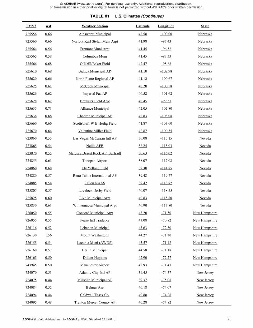
725556 0.66 Ainsworth Municipal 42.58 –100.00 Nebraska
725560 0.66 Norfolk Karl Stefan Mem Arpt 41.98 –97.43 Nebraska
725564 0.56 Fremont Muni Arpt 41.45 –96.52 Nebraska
725565 0.58 Columbus Muni 41.45 –97.33 Nebraska
725566 0.68 O’Neill/Baker Field 42.47 –98.68 Nebraska
725610 0.69 Sidney Municipal AP 41.10 –102.98 Nebraska
725620 0.66 North Platte Regional AP 41.12 –100.67 Nebraska
725625 0.61 McCook Municipal 40.20 –100.58 Nebraska
725626 0.62 Imperial Faa AP 40.52 –101.62 Nebraska
725628 0.62 Brewster Field Arpt 40.45 –99.33 Nebraska
725635 0.71 Alliance Municipal 42.05 –102.80 Nebraska
725636 0.68 Chadron Municipal AP 42.83 –103.08 Nebraska
725660 0.66 Scottsbluff W B Heilig Field 41.87 –103.60 Nebraska
725670 0.64 Valentine Miller Field 42.87 –100.55 Nebraska
723860 0.55 Las Vegas McCarran Intl AP 36.08 –115.15 Nevada
723865 0.54 Nellis AFB 36.25 –115.03 Nevada
723870 0.55 Mercury Desert Rock AP [Surfrad] 36.63 –116.02 Nevada
724855 0.61 Tonopah Airport 38.07 –117.08 Nevada
724860 0.68 Ely Yelland Field 39.30 –114.85 Nevada
724880 0.57 Reno Tahoe International AP 39.48 –119.77 Nevada
724885 0.54 Fallon NAAS 39.42 –118.72 Nevada
725805 0.57 Lovelock Derby Field 40.07 –118.55 Nevada
725825 0.60 Elko Municipal Arpt 40.83 –115.80 Nevada
725830 0.61 Winnemucca Municipal Arpt 40.90 –117.80 Nevada
726050 0.55 Concord Municipal Arpt 43.20 –71.50 New Hampshire
726055 0.55 Pease Intl Tradepor 43.08 –70.82 New Hampshire
726116 0.52 Lebanon Municipal 43.63 –72.30 New Hampshire
726130 1.56 Mount Washington 44.27 –71.30 New Hampshire
726155 0.54 Laconia Muni (AWOS) 43.57 –71.42 New Hampshire
726160 0.57 Berlin Municipal 44.58 –71.18 New Hampshire
726165 0.50 Dillant Hopkins 42.90 –72.27 New Hampshire
743945 0.50 Manchester Airport 42.93 –71.43 New Hampshire
724070 0.53 Atlantic City Intl AP 39.45 –74.57 New Jersey
724075 0.44 Millville Municipal AP 39.37 –75.08 New Jersey
724084 0.52 Belmar Asc 40.18 –74.07 New Jersey
724094 0.44 Caldwell/Essex Co. 40.88 –74.28 New Jersey
724095 0.48 Trenton Mercer County AP 40.28 –74.82 New Jersey
TABLE X1 U.S. Climates (Continued)
TMY3 wsf Weather Station Latitude Longitude State
ANSI/ASHRAE Addendum n to ANSI/ASHRAE Standard 62.2-2010 21

© ASHRAE (www.ashrae.org). For personal use only. Additional reproduction, distribution, or transmission in either print or digital form is not permitted without ASHRAE's prior written permission.
724096 0.48 McGuire AFB 40.02 –74.60 New Jersey
725020 0.54 Newark International Arpt 40.72 –74.18 New Jersey
725025 0.50 Teterboro Airport 40.85 –74.07 New Jersey
745966 0.49 Cape May Co 39.00 –74.92 New Jersey
722680 0.53 Roswell Industrial Air Park 33.30 –104.53 New Mexico
722683 0.52 Sierra Blanca Rgnl 33.47 –105.53 New Mexico
722686 0.63 Clovis Cannon AFB 34.38 –103.32 New Mexico
722687 0.52 Carlsbad Cavern City Air Term 32.33 –104.27 New Mexico
722689 0.64 Clovis Muni (AWOS) 34.43 –103.08 New Mexico
722695 0.49 Las Cruces Intl 32.28 –106.92 New Mexico
722710 0.51 Truth Or Consequences Muni AP 33.23 –107.27 New Mexico
722725 0.52 Deming Muni 32.25 –107.72 New Mexico
723600 0.66 Clayton Municipal Airpark 36.45 –103.15 New Mexico
723627 0.58 Gallup Sen Clarke Fld 35.52 –108.78 New Mexico
723650 0.54 Albuquerque Intl Arpt [ISIS] 35.04 –106.62 New Mexico
723656 0.60 Santa Fe County Municipal AP 35.62 –106.08 New Mexico
723658 0.58 Farmington Four Corners Regl 36.75 –108.23 New Mexico
723663 0.63 Taos Muni Apt (AWOS) 36.45 –105.67 New Mexico
723676 0.58 Tucumcari Faa AP 35.18 –103.60 New Mexico
723677 0.66 Las Vegas Municipal Arpt 35.65 –105.15 New Mexico
747320 0.53 Holloman AFB 32.85 –106.10 New Mexico
725030 0.58 New York Laguardia Arpt 40.78 –73.88 New York
725033 0.61 New York Central Prk Obs Belv 40.78 –73.97 New York
725035 0.53 Islip Long Isl MacArthur AP 40.78 –73.10 New York
725036 0.49 Poughkeepsie Dutchess Co AP 41.63 –73.88 New York
725037 0.51 White Plains Westchester Co A 41.07 –73.72 New York
725038 0.56 Stewart Field 41.50 –74.10 New York
725145 0.51 Monticello (AWOS) 41.70 –74.80 New York
725150 0.61 Binghamton Edwin A Link Field 42.20 –75.98 New York
725156 0.52 Elmira Corning Regional AP 42.17 –76.90 New York
725180 0.61 Albany County AP 42.75 –73.80 New York
725185 0.51 Glens Falls AP 43.35 –73.62 New York
725190 0.55 Syracuse Hancock Int'l Arpt 43.12 –76.10 New York
725197 0.53 Utica Oneida County AP 43.15 –75.38 New York
725235 0.57 Jamestown (AWOS) 42.15 –79.27 New York
725280 0.65 Buffalo Niagara Intl AP 42.93 –78.73 New York
725287 0.60 Niagara Falls Af 43.10 –78.95 New York
TABLE X1 U.S. Climates (Continued)
TMY3 wsf Weather Station Latitude Longitude State
22 ANSI/ASHRAE Addendum n to ANSI/ASHRAE Standard 62.2-2010

© ASHRAE (www.ashrae.org). For personal use only. Additional reproduction, distribution, or transmission in either print or digital form is not permitted without ASHRAE's prior written permission.
725290 0.57 Rochester Greater Rochester I 43.12 –77.68 New York
726223 0.59 Massena AP 44.93 –74.85 New York
726227 0.57 Watertown AP 44.00 –76.02 New York
726228 0.59 Adirondack Rgnl 44.38 –74.20 New York
743700 0.61 Fort Drum/Wheeler–S 44.05 –75.72 New York
744860 0.57 New York J F Kennedy Intl Ar 40.65 –73.80 New York
744864 0.53 Republic 40.72 –73.42 New York
744865 0.54 Westhampton Gabreski AP 40.85 –72.63 New York
723013 0.43 Wilmington International Arpt 34.27 –77.90 North Carolina
723030 0.43 Fayetteville Pope AFB 35.17 –79.02 North Carolina
723035 0.44 Fayetteville Rgnl G 34.98 –78.88 North Carolina
723040 0.49 Cape Hatteras Nws Bldg 35.27 –75.55 North Carolina
723046 0.50 Dare Co Rgnl 35.92 –75.70 North Carolina
723060 0.43 Raleigh Durham International 35.87 –78.78 North Carolina
723065 0.40 Pitt Greenville Arp 35.63 –77.40 North Carolina
723066 0.44 Goldsboro Seymour Johnson AFB 35.35 –77.97 North Carolina
723067 0.44 Kinston Stallings AFB 35.32 –77.63 North Carolina
723068 0.42 Rocky Mount Wilson 35.85 –77.90 North Carolina
723069 0.43 Jacksonville (AWOS) 34.83 –77.62 North Carolina
723090 0.46 Cherry Point MCAS 34.90 –76.88 North Carolina
723095 0.41 New Bern Craven Co Regl AP 35.07 –77.05 North Carolina
723096 0.43 New River MCAF 34.70 –77.38 North Carolina
723140 0.43 Charlotte Douglas Intl Arpt 35.22 –80.95 North Carolina
723143 0.41 Southern Pines AWOS 35.23 –79.40 North Carolina
723145 0.40 Hickory Regional AP 35.73 –81.38 North Carolina
723150 0.47 Asheville Regional Arpt 35.43 –82.53 North Carolina
723170 0.43 Greensboro Piedmont Triad Int 36.10 –79.95 North Carolina
723193 0.39 Winston–Salem Reynolds AP 36.13 –80.22 North Carolina
746930 0.38 Fort Bragg Simmons AAF 35.13 –78.93 North Carolina
746943 0.50 Elizabeth City Coast Guard Ai [Nrel] 36.30 –76.25 North Carolina
727530 0.69 Fargo Hector International AP 46.93 –96.82 North Dakota
727535 0.69 Jamestown Municipal Arpt 46.92 –98.68 North Dakota
727573 0.69 Devils Lake (AWOS) 48.12 –98.92 North Dakota
727575 0.70 Grand Forks Af 47.97 –97.40 North Dakota
727576 0.66 Grand Forks International AP 47.95 –97.18 North Dakota
727640 0.67 Bismarck Municipal Arpt [ISIS] 46.77 –100.77 North Dakota
727645 0.76 Dickinson Municipal AP 46.80 –102.80 North Dakota
TABLE X1 U.S. Climates (Continued)
TMY3 wsf Weather Station Latitude Longitude State
ANSI/ASHRAE Addendum n to ANSI/ASHRAE Standard 62.2-2010 23

© ASHRAE (www.ashrae.org). For personal use only. Additional reproduction, distribution, or transmission in either print or digital form is not permitted without ASHRAE's prior written permission.
727670 0.68 Williston Sloulin Intl AP 48.20 –103.65 North Dakota
727675 0.72 Minot AFB 48.42 –101.35 North Dakota
727676 0.73 Minot Faa AP 48.27 –101.28 North Dakota
724280 0.49 Columbus Port Columbus Intl A 39.98 –82.88 Ohio
724286 0.48 Zanesville Municipal AP 39.95 –81.90 Ohio
724288 0.50 Ohio State University 40.07 –83.07 Ohio
724290 0.54 Dayton International Airport 39.90 –84.22 Ohio
724297 0.47 Cincinnati Municipal AP Lunki 39.10 –84.42 Ohio
725210 0.56 Akron–Canton Reg AP 40.92 –81.43 Ohio
725240 0.58 Cleveland Hopkins Intl AP 41.40 –81.85 Ohio
725245 0.61 Burke Lakefront 41.52 –81.68 Ohio
725246 0.61 Mansfield Lahm Municipal Arpt 40.82 –82.52 Ohio
725250 0.56 Youngstown Regional Airport 41.25 –80.67 Ohio
725360 0.55 Toledo Express Airport 41.58 –83.80 Ohio
725366 0.53 Findlay Airport 41.02 –83.67 Ohio
745700 0.51 Dayton Wright Patterson AFB 39.83 –84.05 Ohio
723520 0.55 Altus AFB 34.65 –99.27 Oklahoma
723525 0.67 Hobart Municipal AP 35.00 –99.05 Oklahoma
723526 0.63 Clinton–Sherman 35.33 –99.20 Oklahoma
723527 0.65 Gage Airport 36.30 –99.77 Oklahoma
723530 0.58 Oklahoma City Will Rogers Wor 35.38 –97.60 Oklahoma
723535 0.61 Vance AFB 36.33 –97.92 Oklahoma
723540 0.56 Oklahoma City Tinker AFB 35.42 –97.38 Oklahoma
723544 0.61 Oklahoma City/Wiley 35.53 –97.65 Oklahoma
723545 0.55 Stillwater Rgnl 36.15 –97.08 Oklahoma
723546 0.56 Ponca City Municipal AP [SGP – ARM] 36.61 –97.49 Oklahoma
723550 0.56 Fort Sill Post Field Af 34.65 –98.40 Oklahoma
723560 0.54 Tulsa International Airport 36.20 –95.88 Oklahoma
723565 0.48 Bartlesville/Philli 36.77 –96.02 Oklahoma
723566 0.45 McAlester Municipal AP 34.90 –95.78 Oklahoma
723575 0.53 Lawton Municipal 34.57 –98.42 Oklahoma
725895 0.61 Klamath Falls Intl AP [UO] 42.22 –121.74 Oregon
725970 0.50 Medford Rogue Valley Intl AP [Ashland – UO] 42.19 –122.70 Oregon
725975 0.59 Sexton Summit 42.60 –123.37 Oregon
725976 0.64 Lakeview (AWOS) 42.17 –120.40 Oregon
726830 0.61 Burns Municipal Arpt [UO] 43.52 –119.02 Oregon
726835 0.62 Redmond Roberts Field 44.25 –121.17 Oregon
TABLE X1 U.S. Climates (Continued)
TMY3 wsf Weather Station Latitude Longitude State
24 ANSI/ASHRAE Addendum n to ANSI/ASHRAE Standard 62.2-2010

© ASHRAE (www.ashrae.org). For personal use only. Additional reproduction, distribution, or transmission in either print or digital form is not permitted without ASHRAE's prior written permission.
726880 0.56 Pendleton E Or Regional AP 45.70 –118.83 Oregon
726884 0.61 La Grande Muni AP 45.28 –118.00 Oregon
726886 0.63 Baker Municipal AP 44.83 –117.82 Oregon
726904 0.47 Roseburg Regional AP 43.23 –123.35 Oregon
726917 0.61 North Bend Muni Airport 43.42 –124.25 Oregon
726930 0.56 Eugene Mahlon Sweet Arpt [UO] 44.05 –123.07 Oregon
726940 0.55 Salem McNary Field 44.90 –123.00 Oregon
726945 0.53 Corvallis Muni 44.48 –123.28 Oregon
726959 0.48 Aurora State 45.25 –122.77 Oregon
726980 0.52 Portland International AP 45.60 –122.62 Oregon
726985 0.51 Portland/Troutdale 45.55 –122.40 Oregon
726986 0.50 Portland/Hillsboro 45.53 –122.95 Oregon
727910 0.61 Astoria Regional Airport 46.15 –123.88 Oregon
724080 0.53 Philadelphia International AP 39.87 –75.23 Pennsylvania
724085 0.49 Philadelphia Ne Philadelphia 40.08 –75.02 Pennsylvania
724086 0.44 Willow Grove NAS 40.20 –75.15 Pennsylvania
725103 0.46 Reading Spaatz Field 40.37 –75.97 Pennsylvania
725115 0.55 Middletown Harrisburg Intl AP 40.20 –76.77 Pennsylvania
725116 0.50 Lancaster 40.12 –76.30 Pennsylvania
725117 0.47 Washington (AWOS) 40.13 –80.28 Pennsylvania
725118 0.48 Harrisburg Capital City Arpt 40.22 –76.85 Pennsylvania
725124 0.47 Butler Co. (AWOS) 40.78 –79.95 Pennsylvania
725125 0.56 Dubois Faa AP 41.18 –78.90 Pennsylvania
725126 0.51 Altoona Blair Co Arpt 40.30 –78.32 Pennsylvania
725127 0.54 Johnstown Cambria County AP 40.32 –78.83 Pennsylvania
725128 0.49 State College [Penn State–Surfrad] 40.72 –77.93 Pennsylvania
725130 0.53 Wilkes–Barre Scranton Intl AP 41.33 –75.73 Pennsylvania
725140 0.49 Williamsport Regional AP 41.25 –76.92 Pennsylvania
725170 0.55 Allentown Lehigh Valley Intl 40.65 –75.45 Pennsylvania
725200 0.53 Pittsburgh International AP 40.50 –80.23 Pennsylvania
725205 0.51 Pittsburgh Allegheny Co AP 40.35 –79.92 Pennsylvania
725260 0.62 Erie International AP 42.08 –80.18 Pennsylvania
725266 0.60 Bradford Regional AP 41.80 –78.63 Pennsylvania
725267 0.54 Franklin 41.38 –79.87 Pennsylvania
785140 0.41 Aquadilla/Borinquen 18.50 –67.13 Puerto Rico
785145 0.32 Eugenio Maria De Ho 18.25 –67.15 Puerto Rico
785203 0.35 Mercedita 18.00 –66.55 Puerto Rico
TABLE X1 U.S. Climates (Continued)
TMY3 wsf Weather Station Latitude Longitude State
ANSI/ASHRAE Addendum n to ANSI/ASHRAE Standard 62.2-2010 25

© ASHRAE (www.ashrae.org). For personal use only. Additional reproduction, distribution, or transmission in either print or digital form is not permitted without ASHRAE's prior written permission.
785260 0.38 San Juan Intl Arpt 18.42 –66.00 Puerto Rico
785263 0.36 San Juan L M Marin Intl AP 18.43 –66.00 Puerto Rico
785350 0.42 Roosevelt Roads 18.25 –65.63 Puerto Rico
725054 0.49 Pawtucket (AWOS) 41.92 –71.50 Rhode Island
725058 0.60 Block Island State Arpt 41.17 –71.58 Rhode Island
725070 0.58 Providence T F Green State Ar 41.72 –71.43 Rhode Island
722080 0.43 Charleston Intl Arpt 32.90 –80.03 South Carolina
722085 0.39 Beaufort MCAS 32.48 –80.72 South Carolina
723100 0.41 Columbia Metro Arpt 33.95 –81.12 South Carolina
723106 0.41 Florence Regional AP 34.18 –79.73 South Carolina
723119 0.42 Greenville Downtown AP 34.85 –82.35 South Carolina
723120 0.43 Greer Greenv’l–Spartanbrg AP 34.90 –82.22 South Carolina
723125 0.44 Anderson County AP 34.50 –82.72 South Carolina
747900 0.43 Sumter Shaw AFB 33.97 –80.47 South Carolina
747910 0.47 Myrtle Beach AFB 33.68 –78.93 South Carolina
747915 0.43 North Myrtle Beach Grand Stra 33.82 –78.72 South Carolina
726510 0.67 Sioux Falls Foss Field 43.58 –96.75 South Dakota
726515 0.63 Brookings (AWOS) 44.30 –96.82 South Dakota
726525 0.61 Chan Gurney Muni 42.92 –97.38 South Dakota
726540 0.68 Huron Regional Arpt 44.40 –98.22 South Dakota
726545 0.65 Mitchell (AWOS) 43.77 –98.03 South Dakota
726546 0.69 Watertown Municipal AP 44.93 –97.15 South Dakota
726590 0.66 Aberdeen Regional Arpt 45.45 –98.42 South Dakota
726620 0.72 Rapid City Regional Arpt 44.05 –103.05 South Dakota
726625 0.68 Ellsworth AFB 44.15 –103.10 South Dakota
726685 0.71 Mobridge 45.53 –100.43 South Dakota
726686 0.68 Pierre Municipal AP 44.38 –100.28 South Dakota
723183 0.40 Bristol Tri City Airport 36.47 –82.40 Tennessee
723240 0.41 Chattanooga Lovell Field AP 35.03 –85.20 Tennessee
723260 0.43 Knoxville McGhee Tyson AP 35.82 –83.98 Tennessee
723265 0.40 Crossville Memorial AP 35.95 –85.08 Tennessee
723270 0.44 Nashville International AP 36.12 –86.68 Tennessee
723340 0.46 Memphis International AP 35.07 –89.98 Tennessee
723346 0.44 Jackson McKellar–Sipes Regl A 35.60 –88.92 Tennessee
723347 0.44 Dyersburg Municipal AP 36.02 –89.40 Tennessee
690190 0.56 Abilene Dyess AFB 32.43 –99.85 Texas
722410 0.44 Port Arthur Jefferson County 29.95 –94.02 Texas
TABLE X1 U.S. Climates (Continued)
TMY3 wsf Weather Station Latitude Longitude State
26 ANSI/ASHRAE Addendum n to ANSI/ASHRAE Standard 62.2-2010

© ASHRAE (www.ashrae.org). For personal use only. Additional reproduction, distribution, or transmission in either print or digital form is not permitted without ASHRAE's prior written permission.
722420 0.53 Galveston/Scholes 29.30 –94.80 Texas
722429 0.38 Houston/D.W. Hooks 30.07 –95.55 Texas
722430 0.42 Houston Bush Intercontinental 30.00 –95.37 Texas
722435 0.41 Houston William P Hobby AP 29.65 –95.28 Texas
722436 0.40 Houston Ellington AFB [Clear Lake – UT] 29.57 –95.09 Texas
722445 0.40 College Station Easterwood Fl 30.58 –96.37 Texas
722446 0.41 Lufkin Angelina Co 31.23 –94.75 Texas
722448 0.45 Tyler/Pounds Fld 32.35 –95.40 Texas
722470 0.43 Longview Gregg County AP [Overton – UT] 32.29 –94.98 Texas
722499 0.37 Nacogdoches (AWOS) 31.58 –94.72 Texas
722500 0.48 Brownsville S Padre Isl Intl 25.90 –97.43 Texas
722505 0.49 Harlingen Rio Grande Valley I 26.23 –97.65 Texas
722506 0.49 McAllen Miller Intl AP [Edinburg – UT] 26.31 –98.17 Texas
722510 0.53 Corpus Christi Intl Arpt [UT] 27.88 –97.63 Texas
722515 0.52 Corpus Christi NAS 27.68 –97.28 Texas
722516 0.44 Kingsville 27.50 –97.82 Texas
722517 0.48 Alice Intl AP 27.73 –98.03 Texas
722520 0.55 Laredo Intl AP [UT] 27.57 –99.49 Texas
722523 0.40 San Antonio/Stinson 29.33 –98.47 Texas
722524 0.45 Rockport/Aransas Co 28.08 –97.05 Texas
722526 0.44 Cotulla Faa AP 28.45 –99.22 Texas
722530 0.45 San Antonio Intl AP 29.53 –98.47 Texas
722533 0.43 Hondo Municipal AP 29.37 –99.17 Texas
722535 0.45 San Antonio Kelly Field AFB 29.38 –98.58 Texas
722536 0.43 Randolph AFB 29.53 –98.28 Texas
722540 0.41 Austin Mueller Municipal AP [UT] 30.29 –97.74 Texas
722544 0.44 Camp Mabry 30.32 –97.77 Texas
722547 0.45 Georgetown (AWOS) 30.68 –97.68 Texas
722550 0.47 Victoria Regional AP 28.87 –96.93 Texas
722555 0.48 Palacios Municipal AP 28.72 –96.25 Texas
722560 0.53 Waco Regional AP 31.62 –97.23 Texas
722563 0.48 McGregor (AWOS) 31.48 –97.32 Texas
722570 0.46 Fort Hood 31.13 –97.72 Texas
722575 0.47 Killeen Muni (AWOS) 31.08 –97.68 Texas
722576 0.49 Robert Gray AAF 31.07 –97.83 Texas
722577 0.50 Draughon Miller Cen 31.15 –97.40 Texas
722583 0.53 Dallas Love Field 32.85 –96.85 Texas
TABLE X1 U.S. Climates (Continued)
TMY3 wsf Weather Station Latitude Longitude State
ANSI/ASHRAE Addendum n to ANSI/ASHRAE Standard 62.2-2010 27

© ASHRAE (www.ashrae.org). For personal use only. Additional reproduction, distribution, or transmission in either print or digital form is not permitted without ASHRAE's prior written permission.
722587 0.48 Cox Fld 33.63 –95.45 Texas
722588 0.44 Greenville/Majors 33.07 –96.07 Texas
722590 0.53 Dallas–Fort Worth Intl AP 32.90 –97.02 Texas
722594 0.49 Fort Worth Alliance 32.98 –97.32 Texas
722595 0.49 Fort Worth NAS 32.77 –97.45 Texas
722596 0.52 Fort Worth Meacham 32.82 –97.37 Texas
722597 0.48 Mineral Wells Municipal AP 32.78 –98.07 Texas
722598 0.53 Dallas/Addison Arpt 32.97 –96.83 Texas
722599 0.50 Dallas/Redbird Arpt 32.68 –96.87 Texas
722610 0.46 Del Rio [UT] 29.38 –100.91 Texas
722615 0.46 Del Rio Laughlin AFB 29.37 –100.78 Texas
722630 0.52 San Angelo Mathis Field 31.35 –100.50 Texas
722636 0.67 Dalhart Municipal AP 36.02 –102.55 Texas
722640 0.55 Marfa AP 30.37 –104.02 Texas
722650 0.60 Midland International AP 31.95 –102.18 Texas
722656 0.54 Wink Winkler County AP 31.78 –103.20 Texas
722660 0.58 Abilene Regional AP [UT] 32.47 –99.71 Texas
722670 0.58 Lubbock International AP 33.67 –101.82 Texas
722700 0.48 El Paso International AP [UT] 31.77 –106.50 Texas
723510 0.59 Wichita Falls Municipal Arpt 33.98 –98.50 Texas
723604 0.57 Childress Municipal AP 34.43 –100.28 Texas
723630 0.68 Amarillo International AP [Canyon – UT] 34.99 –101.90 Texas
724723 0.55 Blanding 37.62 –109.48 Utah
724735 0.50 Hanksville 38.37 –110.72 Utah
724754 0.49 Saint George (AWOS) 37.08 –113.60 Utah
724755 0.60 Cedar City Municipal AP 37.70 –113.10 Utah
724756 0.70 Bryce Cnyn Faa AP 37.70 –112.15 Utah
724776 0.54 Moab/Canyonlands [UO] 38.58 –109.54 Utah
724795 0.60 Delta 39.33 –112.58 Utah
725705 0.55 Vernal 40.43 –109.52 Utah
725720 0.61 Salt Lake City Intl Arpt [ISIS] 40.77 –111.97 Utah
725724 0.56 Provo Muni (AWOS) 40.22 –111.72 Utah
725750 0.55 Ogden Hinkley Airport 41.20 –112.02 Utah
725755 0.62 Ogden Hill AFB 41.12 –111.97 Utah
725810 0.56 Wendover Usaf Auxiliary Field 40.72 –114.03 Utah
725165 0.54 Rutland State 43.52 –72.95 Vermont
726115 0.51 Springfield/Hartnes 43.35 –72.52 Vermont
TABLE X1 U.S. Climates (Continued)
TMY3 wsf Weather Station Latitude Longitude State
28 ANSI/ASHRAE Addendum n to ANSI/ASHRAE Standard 62.2-2010

© ASHRAE (www.ashrae.org). For personal use only. Additional reproduction, distribution, or transmission in either print or digital form is not permitted without ASHRAE's prior written permission.
726145 0.56 Montpelier AP 44.20 –72.57 Vermont
726170 0.61 Burlington International AP 44.47 –73.15 Vermont
785430 0.49 Charlotte Amalie Harry S Trum 18.35 –64.97 Virgin Islands, American
723075 0.49 Oceana NAS 36.82 –76.03 Virginia
723080 0.55 Norfolk International AP 36.90 –76.20 Virginia
723083 0.41 Franklin NAAS 36.70 –76.90 Virginia
723085 0.49 Norfolk NAS 36.95 –76.28 Virginia
723086 0.51 Newport News 37.13 –76.50 Virginia
724010 0.48 Richmond International AP 37.52 –77.32 Virginia
724014 0.40 Dinwiddie Co 37.18 –77.52 Virginia
724016 0.41 Charlottesville Faa 38.13 –78.45 Virginia
724017 0.40 Farmville 37.35 –78.43 Virginia
724026 0.45 Melfa/Accomack Arpt 37.65 –75.77 Virginia
724030 0.47 Washington DC Dulles Intl Ar [Sterling–ISIS] 38.98 –77.47 Virginia
724033 0.43 Shannon Arpt 38.27 –77.45 Virginia
724035 0.45 Quantico MCAS 38.50 –77.30 Virginia
724036 0.46 Manassas Muni (AWOS) 38.72 –77.52 Virginia
724037 0.40 Davison AAF 38.72 –77.18 Virginia
724050 0.51 Washington Dc Reagan AP 38.87 –77.03 Virginia
724053 0.45 Winchester Rgnl 39.15 –78.15 Virginia
724055 0.44 Leesburg/Godfrey 39.08 –77.57 Virginia
724056 0.45 Marion / Wytheville 36.90 –81.35 Virginia
724058 0.43 Abingdon 36.68 –82.03 Virginia
724100 0.44 Lynchburg Regional Arpt 37.33 –79.20 Virginia
724105 0.43 Staunton/Shenandoah 38.27 –78.90 Virginia
724106 0.43 Danville Faa AP 36.57 –79.33 Virginia
724107 0.48 Hillsville 36.77 –80.82 Virginia
724110 0.46 Roanoke Regional AP 37.32 –79.97 Virginia
724113 0.43 Virginia Tech Arpt 37.22 –80.42 Virginia
724115 0.62 Hot Springs/Ingalls 37.95 –79.83 Virginia
724116 0.43 Pulaski 37.13 –80.68 Virginia
724117 0.43 Wise/Lonesome Pine 36.98 –82.53 Virginia
745980 0.49 Langley AFB 37.08 –76.35 Virginia
745985 0.40 Martinsville 36.63 –80.02 Virginia
690230 0.61 Whidbey Island NAS 48.35 –122.67 Washington
726988 0.61 The Dalles Municipal Arpt 45.62 –121.15 Washington
727810 0.57 Yakima Air Terminal 46.57 –120.55 Washington
TABLE X1 U.S. Climates (Continued)
TMY3 wsf Weather Station Latitude Longitude State
ANSI/ASHRAE Addendum n to ANSI/ASHRAE Standard 62.2-2010 29

© ASHRAE (www.ashrae.org). For personal use only. Additional reproduction, distribution, or transmission in either print or digital form is not permitted without ASHRAE's prior written permission.
727815 0.66 Stampede Pass 47.28 –121.33 Washington
727825 0.57 Wenatchee/Pangborn 47.40 –120.20 Washington
727826 0.60 Ephrata AP FCWOS 47.30 –119.52 Washington
727827 0.55 Moses Lake Grant County AP 47.20 –119.32 Washington
727840 0.61 Hanford 46.57 –119.60 Washington
727845 0.54 Pasco 46.27 –119.12 Washington
727846 0.56 Walla Walla City County AP 46.10 –118.28 Washington
727850 0.64 Spokane International AP [Cheney – UO] 47.49 –117.59 Washington
727855 0.63 Fairchild AFB 47.63 –117.65 Washington
727856 0.56 Felts Fld 47.68 –117.32 Washington
727857 0.59 Pullman/Moscow Rgnl 46.75 –117.12 Washington
727885 0.57 William R Fairchild 48.12 –123.50 Washington
727920 0.54 Olympia Airport 46.97 –122.90 Washington
727923 0.61 Hoquiam AP 46.98 –123.93 Washington
727924 0.52 Kelso Wb AP 46.13 –122.90 Washington
727926 0.52 Toledo–Winlock Mem 46.48 –122.80 Washington
727928 0.55 Bremerton National 47.48 –122.75 Washington
727930 0.56 Seattle–Tacoma Intl A 47.47 –122.32 Washington
727934 0.51 Renton Muni 47.48 –122.22 Washington
727935 0.49 Seattle Boeing Field [ISIS] 47.68 –122.25 Washington
727937 0.54 Snohomish Co 47.90 –122.28 Washington
727938 0.53 Tacoma Narrows 47.27 –122.58 Washington
727970 0.56 Quillayute State Airport 47.93 –124.57 Washington
727976 0.58 Bellingham Intl AP 48.80 –122.53 Washington
742060 0.54 Tacoma McChord AFB 47.15 –122.48 Washington
742070 0.52 Gray AAF 47.08 –122.58 Washington
724120 0.46 Beckley Raleigh Co Mem AP 37.80 –81.12 West Virginia
724125 0.40 Bluefield/Mercer Co [Nrel] 37.27 –81.24 West Virginia
724127 0.52 Lewisburg/Greenbrie 37.87 –80.40 West Virginia
724140 0.42 Charleston Yeager Arpt 38.38 –81.58 West Virginia
724170 0.49 Elkins–Randolph Co Arp 38.88 –79.85 West Virginia
724175 0.45 Harrison Marion Rgn 39.28 –80.23 West Virginia
724176 0.43 Morgantown Hart Field 39.65 –79.92 West Virginia
724177 0.44 Martinsburg Eastern Wv Reg AP 39.40 –77.98 West Virginia
724250 0.44 Huntington Tri–State Arpt 38.38 –82.55 West Virginia
724273 0.44 Parkersburg Wood County AP 39.35 –81.43 West Virginia
724275 0.48 Wheeling Ohio County AP 40.18 –80.65 West Virginia
TABLE X1 U.S. Climates (Continued)
TMY3 wsf Weather Station Latitude Longitude State
30 ANSI/ASHRAE Addendum n to ANSI/ASHRAE Standard 62.2-2010

© ASHRAE (www.ashrae.org). For personal use only. Additional reproduction, distribution, or transmission in either print or digital form is not permitted without ASHRAE's prior written permission.
726400 0.65 Milwaukee Mitchell Intl AP 42.95 –87.90 Wisconsin
726404 0.59 Minocqua/Woodruff 45.93 –89.73 Wisconsin
726410 0.61 Madison Dane Co Regional Arpt [ISIS] 43.13 –89.33 Wisconsin
726415 0.59 Janesville/Rock Co. 42.62 –89.03 Wisconsin
726416 0.53 Lone Rock Faa AP 43.20 –90.18 Wisconsin
726430 0.57 La Crosse Municipal Arpt 43.87 –91.25 Wisconsin
726435 0.58 Eau Claire County AP 44.87 –91.48 Wisconsin
726450 0.60 Green Bay Austin Straubel Int 44.48 –88.13 Wisconsin
726455 0.60 Manitowac Muni AWOS 44.13 –87.68 Wisconsin
726456 0.59 Wittman Rgnl 43.98 –88.55 Wisconsin
726457 0.62 Appleton/Outagamie 44.25 –88.52 Wisconsin
726458 0.61 Sturgeon Bay 44.85 –87.42 Wisconsin
726463 0.58 Wausau Municipal Arpt 44.92 –89.63 Wisconsin
726464 0.52 Watertown 43.17 –88.72 Wisconsin
726465 0.58 Mosinee/Central Wi 44.78 –89.67 Wisconsin
726467 0.55 Rice Lake Municipal 45.48 –91.72 Wisconsin
726468 0.55 Phillips/Price Co. 45.70 –90.40 Wisconsin
726574 0.58 Marshfield Muni 44.63 –90.18 Wisconsin
726626 0.60 Antigo/Lang (AWOS) 45.15 –87.15 Wisconsin
727415 0.58 Rhinelander Oneida 45.63 –89.47 Wisconsin
725640 0.72 Cheyenne Municipal Arpt 41.15 –104.80 Wyoming
725645 0.76 Laramie General Brees Field 41.32 –105.68 Wyoming
725690 0.72 Casper Natrona Co Intl AP 42.90 –106.47 Wyoming
725744 0.70 Rock Springs Arpt [Green River–UO] 41.46 –109.44 Wyoming
725745 0.76 Rawlins Municipal AP 41.80 –107.20 Wyoming
725760 0.60 Lander Hunt Field 42.82 –108.73 Wyoming
725765 0.64 Riverton Municipl AP 43.05 –108.45 Wyoming
725775 0.70 Evanston/Burns Fld 41.28 –111.03 Wyoming
725776 0.71 Jackson Hole 43.60 –110.73 Wyoming
726650 0.69 Gillette/Gillette–C 44.35 –105.53 Wyoming
726660 0.61 Sheridan County Arpt 44.77 –106.97 Wyoming
726665 0.57 Worland Municipal 43.97 –107.95 Wyoming
726700 0.60 Cody Muni (AWOS) 44.52 –109.02 Wyoming
TABLE X1 U.S. Climates (Continued)
TMY3 wsf Weather Station Latitude Longitude State
ANSI/ASHRAE Addendum n to ANSI/ASHRAE Standard 62.2-2010 31

© ASHRAE (www.ashrae.org). For personal use only. Additional reproduction, distribution, or transmission in either print or digital form is not permitted without ASHRAE's prior written permission.
TABLE X2 Canadian Climates
CWEC wsf Weather Station Latitude Longitude Province
711230 0.70 Edmonton 53.53 –114.1 Alberta
712430 0.78 Lethbridge 49.63 –112.8 Alberta
718720 0.70 Medecine Hat 50.02 –110.72 Alberta
718770 0.73 Calgary 51.12 –114.02 Alberta
719320 0.66 Fort McMurray 56.65 –111.22 Alberta
719400 0.72 Grande Prairie 55.18 –118.88 Alberta
711010 0.75 Sandspit 53.25 –131.82 British Columbia
711080 0.55 Abbotsford 49.03 –122.37 British Columbia
711090 0.65 Port Hardy 50.68 –127.37 British Columbia
717680 0.57 Summerland 49.57 –119.65 British Columbia
717990 0.57 Victoria 48.65 –123.43 British Columbia
718800 0.63 Cranbrook 49.6 –115.78 British Columbia
718870 0.57 Kamloops 50.7 –120.45 British Columbia
718920 0.57 Vancouver 49.18 –123.17 British Columbia
718930 0.62 Comox 49.72 –124.9 British Columbia
718960 0.64 Prince George 53.88 –122.68 British Columbia
718980 0.70 Prince Rupert 54.3 –130.43 British Columbia
719430 0.76 Fort St John 56.23 –120.73 British Columbia
719500 0.64 Smithers 54.82 –127.18 British Columbia
711400 0.73 Brandon 49.92 –99.95 Manitoba
718520 0.72 Winniped 49.9 –97.23 Manitoba
718670 0.73 The Pas 53.97 –101.1 Manitoba
719130 0.98 Churchill 58.75 –94.07 Manitoba
716090 0.76 Saint John 45.32 –65.88 New Brunswick
717000 0.64 Fredericton 45.87 –66.53 New Brunswick
717440 0.66 Miramichi 47.02 –65.45 New Brunswick
718010 0.89 St Johns 47.62 –52.73 Newfoundland
718030 0.83 Gander 48.95 –54.57 Newfoundland
718150 0.74 Stephenville 48.53 –58.55 Newfoundland
718160 0.80 Goose 53.32 –60.37 Newfoundland
718170 1.05 Battle Harbour 52.3 –55.83 Newfoundland
719360 0.84 Yellowknife 62.47 –114.45 Northwest Territories
719570 0.86 Inuvik 68.3 –133.48 Northwest Territories
713970 0.66 Greenwood 44.98 –64.92 Nova Scotia
713980 0.67 Truro 45.37 –63.27 Nova Scotia
716000 0.84 Sable Island 43.93 –60.02 Nova Scotia
716010 0.63 Shearwater 44.63 –63.5 Nova Scotia
32 ANSI/ASHRAE Addendum n to ANSI/ASHRAE Standard 62.2-2010

© ASHRAE (www.ashrae.org). For personal use only. Additional reproduction, distribution, or transmission in either print or digital form is not permitted without ASHRAE's prior written permission.
717070 0.82 Sydney 46.17 –60.05 Nova Scotia
719240 1.28 Resolute 74.72 –94.98 Nunavut
712600 0.67 Sault Ste Marie 46.48 –84.52 Ontario
715270 0.61 Simcoe 42.85 –80.27 Ontario
715380 0.57 Windsor 42.27 –82.97 Ontario
716200 0.67 Kingston 44.22 –76.6 Ontario
716210 0.61 Trenton 44.12 –77.53 Ontario
716230 0.59 London 43.03 –81.15 Ontario
716240 0.58 Toronto 43.67 –79.63 Ontario
716280 0.59 Ottawa 45.32 –75.67 Ontario
716300 0.61 Muskoka 44.97 –79.3 Ontario
716310 0.63 Mount Forest 43.98 –80.75 Ontario
717310 0.62 North Bay 46.35 –79.43 Ontario
717390 0.69 Timmins 48.57 –81.37 Ontario
717490 0.69 Thunder Bay 48.37 –89.32 Ontario
717060 0.70 Charlottetown 46.28 –63.13 Prince Edward Island
711870 0.77 Baie Comeau 49.13 –68.2 Quebec
713710 0.66 St Hubert 45.52 –73.42 Quebec
714210 0.82 Lake Eon 51.87 –63.28 Quebec
716100 0.61 Sherbrooke 45.43 –71.68 Quebec
716270 0.60 Montreal Intl AP 45.47 –73.75 Quebec
716278 0.56 Montreal Jean Brebeuf 45.5 –73.62 Quebec
716278 0.57 Montreal Mirabel 45.68 –74.03 Quebec
717140 0.62 Quebec 46.8 –71.38 Quebec
717150 0.69 Riviere du Loup 47.8 –69.55 Quebec
717180 0.77 Mont Joli 48.6 –68.22 Quebec
717200 0.61 Ste Agathe des Monts 46.05 –74.28 Quebec
717250 0.71 Val-d’Or 48.07 –77.78 Quebec
717270 0.70 Bagotville 48.33 –71 Quebec
717280 0.73 Roberval 48.52 –72.27 Quebec
718110 0.76 Sept–Iles 50.22 –66.27 Quebec
718270 0.83 La Grande Riviere 53.63 –77.7 Quebec
718280 0.90 Schefferville 54.8 –66.82 Quebec
719050 0.94 Kuujjuarapik 55.28 –77.77 Quebec
719060 0.93 Kuujuaq 58.1 –68.42 Quebec
719650 0.87 Nitchequon 53.2 –70.9 Quebec
719660 1.00 Grindstone Island 47.38 –61.87 Quebec
TABLE X2 Canadian Climates (Continued)
CWEC wsf Weather Station Latitude Longitude Province
ANSI/ASHRAE Addendum n to ANSI/ASHRAE Standard 62.2-2010 33

© ASHRAE (www.ashrae.org). For personal use only. Additional reproduction, distribution, or transmission in either print or digital form is not permitted without ASHRAE's prior written permission.
718620 0.78 Estevan 49.22 –102.97 Saskatchewan
718630 0.80 Regina 50.43 –104.67 Saskatchewan
718660 0.75 Saskatoon 52.17 –106.68 Saskatchewan
718700 0.81 Swift Current 50.28 –107.68 Saskatchewan
718760 0.72 North Battleford 52.77 –108.25 Saskatchewan
719640 0.77 Whitehorse 60.72 –135.07 Yukon Territory
TABLE X2 Canadian Climates (Continued)
CWEC wsf Weather Station Latitude Longitude Province
34 ANSI/ASHRAE Addendum n to ANSI/ASHRAE Standard 62.2-2010

POLICY STATEMENT DEFINING ASHRAE’S CONCERNFOR THE ENVIRONMENTAL IMPACT OF ITS ACTIVITIES
ASHRAE is concerned with the impact of its members’ activities on both the indoor and outdoor environment. ASHRAE’smembers will strive to minimize any possible deleterious effect on the indoor and outdoor environment of the systems andcomponents in their responsibility while maximizing the beneficial effects these systems provide, consistent with acceptedstandards and the practical state of the art.
ASHRAE’s short-range goal is to ensure that the systems and components within its scope do not impact the indoor andoutdoor environment to a greater extent than specified by the standards and guidelines as established by itself and otherresponsible bodies.
As an ongoing goal, ASHRAE will, through its Standards Committee and extensive technical committee structure,continue to generate up-to-date standards and guidelines where appropriate and adopt, recommend, and promote those newand revised standards developed by other responsible organizations.
Through its Handbook, appropriate chapters will contain up-to-date standards and design considerations as the material issystematically revised.
ASHRAE will take the lead with respect to dissemination of environmental information of its primary interest and will seekout and disseminate information from other responsible organizations that is pertinent, as guides to updating standards andguidelines.
The effects of the design and selection of equipment and systems will be considered within the scope of the system’sintended use and expected misuse. The disposal of hazardous materials, if any, will also be considered.
ASHRAE’s primary concern for environmental impact will be at the site where equipment within ASHRAE’s scopeoperates. However, energy source selection and the possible environmental impact due to the energy source and energytransportation will be considered where possible. Recommendations concerning energy source selection should be made byits members.
© ASHRAE (www.ashrae.org). For personal use only. Additional reproduction, distribution, or transmission in either print or digital form is not permitted without ASHRAE's prior written permission.

ASHRAE · 1791 Tullie Circle NE · Atlanta, GA 30329 · www.ashrae.org
2/12