Embed Size (px)
Citation preview

ADDENDUM F
MAINTENANCE MANAGEMENT PLAN FOR THE
WATERCOURSES (INCLUDING WETLANDS)
LOCATED WITHIN THE DEVELOPMENT FOOTPRINT FOR THE
PROPOSED SWARTLAND JUNCTION MIXED-USE
DEVELOPMENT, MALMESBURY
REF: 16/3/3/2/F5/16/2044/20
May 2021
Applicant: Agri Industria (Pty) Ltd
P.O. Box 3380
Cape Town
8000
Email:
Consultant: Enviro-EAP (Pty) Ltd
2 School Street
Agulhas
South Africa
7287
Fax: 086 435 4691
Email: [email protected] /
MAINTENANCE MANAGEMENT PLAN FOR WATERCOURSES
SWARTLAND JUNCTION INTEGRATED MIXED-USE DEVELOPMENT, MALMESBURY
DEA&DP REFERENCE: 16/3/3/2/F5/16/2044/20
2
ADDENDUM F
MAINTENANCE MANAGEMENT PLAN FOR THE WATERCOURSES
(INCLUDING WETLANDS)
LOCATED WITHIN THE DEVELOPMENT FOOTPRINT FOR THE
PROPOSED SWARTLAND JUNCTION MIXED-USE DEVELOPMENT,
MALMESBURY
DEA&DP REFERENCE NUMBER: 16/3/3/2/F5/16/2044/20
Report No: 2044/20/RDEIR Date: 24/05/2021 Report Status: 1st Draft
Consultant:
Enviro-EAP (Pty) Ltd
P.O. Box 205
Agulhas
7278
Email: [email protected]
Applicant:
Agri Industria (Pty) Ltd
P.O. Box 3380
Cape Town
8000
Email: [email protected]
© COPYRIGHT: Enviro-EAP (Pty) Ltd
Verification Capacity Name Signature Date
Author EAPASA Registered EAP –
2019/656 Lauren Abrahams
24 May 2021
TABLE OF CONTENTS PAGE
1.1 INTRODUCTION 2
1.2 MAINTENANCE MANAGEMENT PRINCIPLES 3
1.3 DESCRIPTION OF THE DEVELOPMENT PROPOSAL AND RECEIVING
ENVIRONMENT
3
1.4LEGISLATIVE CONTEXT 33
2.1 METHOD STATEMENT 39
2.2 MONITORING AND REPORTING 53
2.3 DEFINITIONS 55 55
2.4 ACRONYMS 56 56
2.5 REFERENCE GUIDE FOR DRAFTING MMPs FOR A WATERCOURSE 57 57
ALIEN VEGETATION MANAGEMENT PLAN 57
1.1 INTRODUCTION
This MMP has been prepared principally in compliance with the requirements of “Annexure A –
Guideline for Compiling a Maintenance Management Plan”.
This document, together with the conditions in the EMPr, Environmental Authorisation, Water Use
Authorisation, must be adhered to.
Responsible Party:
The responsible party that will be implementing the MMP is Agri Industria (Pty) Ltd.
Agri Industria (Pty) Ltd. has committed itself to a set of values that include the maintenance of
good relations and transparent communications with all stakeholders, and the dynamic
engagement of the larger community.
Agri Industria (Pty) Ltd. undertakes to implement suitable management systems for all the areas
and aspects of this operation. This will ensure that development itself and management of the
project will comply with legal, technical, environmental and transformation policies and
standards.
Agri Industria (Pty) Ltd. intends to enable continuous improvement in legal compliance and the
sustainable operation of the site. This MMP intends to further guide the achievement of the
strategic objectives of the organization at the project site.
The satisfactory implementation of the MMP on site will require both the full support and
commitment of all personnel.

MAINTENANCE MANAGEMENT PLAN FOR WATERCOURSES
SWARTLAND JUNCTION INTEGRATED MIXED-USE DEVELOPMENT, MALMESBURY
DEA&DP REFERENCE: 16/3/3/2/F5/16/2044/20
3
1.2 MAINTENANCE MANAGEMENT PRINCIPLES
The following overarching principles are to be used by landowners and managers when
considering the development and implementation of a MMP:
a. The anticipation and prevention of negative impacts and risks, then minimisation,
rehabilitation or ‘repair’, where a sequence of possible mitigation measures to avoid,
minimize, rehabilitate and/or remedy negative impacts is explicitly considered;
b. Avoid and reduce unnecessary maintenance;
c. Maintenance and management of a watercourse must be informed by the condition of
the physical and ecological processes that drive and maintain aquatic ecosystems within
a catchment, relative to the desired state of the affected system;
d. Management actions must aim to prevent further deterioration to the condition of
affected watercourses and, overall, be guided by a general commitment to improving
and maintaining ecological infrastructure for the delivery of ecosystem services;
e. Managers and organs of state must identify, address and, where feasible, eliminate the
factors that necessitate intrusive, environmentally damaging maintenance; and
f. A process of continuous management improvement be applied, namely Planning;
Implementing; Checking (monitoring, auditing, determine corrective action) and Acting
(management review).
1.3 DESCRIPTION OF THE DEVELOPMENT PROPOSAL AND RECEIVING ENVIRONMENT
Location of the proposed development
On a Regional level Malmesbury and Abbotsdale are located within the Swartland Local Municipal area
in the West Coast District and bounded by Bergrivier Local Municipality to the north and Drakenstein Local
Municipality to the east. The proposed development will be located between Malmesbury and
Abbotsdale and will in effect join the two towns.
The proposed development site is located south-west of the existing built-up area of Malmesbury and
north-east of the built-up area of Abbotsdale (see locality map in section 2.1 below). One of the main
future development strategies of the Swartland SDF is to connect Abbotsdale and Malmesbury as a single
entity and this development will contribute to achieving this initiative.
Several properties are involved in this application, with all the said properties either being vacant or
farmed. The entire development footprint is included within the demarcated urban edge of
Malmesbury/Abbotsdale.

MAINTENANCE MANAGEMENT PLAN FOR WATERCOURSES
SWARTLAND JUNCTION INTEGRATED MIXED-USE DEVELOPMENT, MALMESBURY
DEA&DP REFERENCE: 16/3/3/2/F5/16/2044/20
4
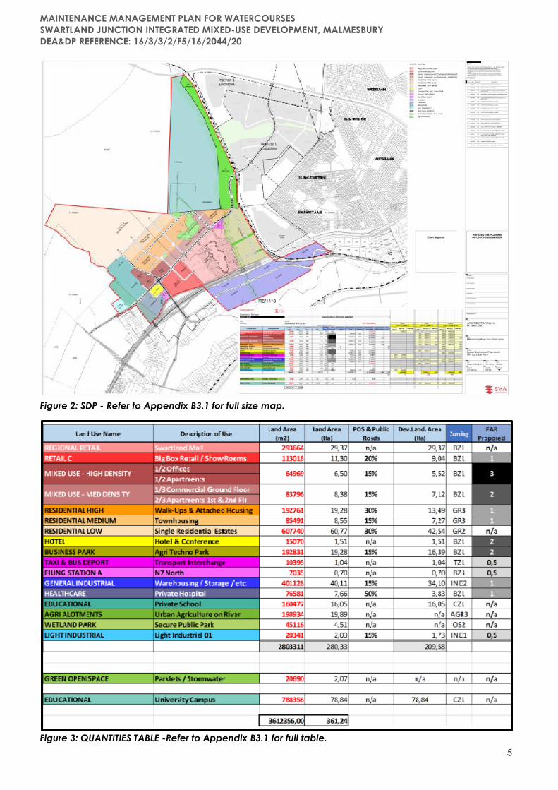
Figure 1: Locality of Properties involved in the Swartland Junction Development.
Project Overview:
Agri Industria (Pty) Ltd proposes the development of the Swartland Junction Mixed-Use Development on
erven 12526, 12496, 353, Portion 1 of Farm 1113, Remainder of Farm 1113, and Portion 1 of Farm 697,
Malmesbury.
The Swartland Junction development will consist of an approximately 361ha integrated development
focused on a mixed-use, diverse, and vibrant community. The development will include uses like low to
high density residential opportunities and commercial-, industrial-, healthcare-, community-, recreational-
, educational facilities as well as all associated infrastructure in accordance with the SDP and Quantities
Table provided below.
MAINTENANCE MANAGEMENT PLAN FOR WATERCOURSES
SWARTLAND JUNCTION INTEGRATED MIXED-USE DEVELOPMENT, MALMESBURY
DEA&DP REFERENCE: 16/3/3/2/F5/16/2044/20
5
Figure 2: SDP - Refer to Appendix B3.1 for full size map.
Figure 3: QUANTITIES TABLE -Refer to Appendix B3.1 for full table.
MAINTENANCE MANAGEMENT PLAN FOR WATERCOURSES
SWARTLAND JUNCTION INTEGRATED MIXED-USE DEVELOPMENT, MALMESBURY
DEA&DP REFERENCE: 16/3/3/2/F5/16/2044/20
6
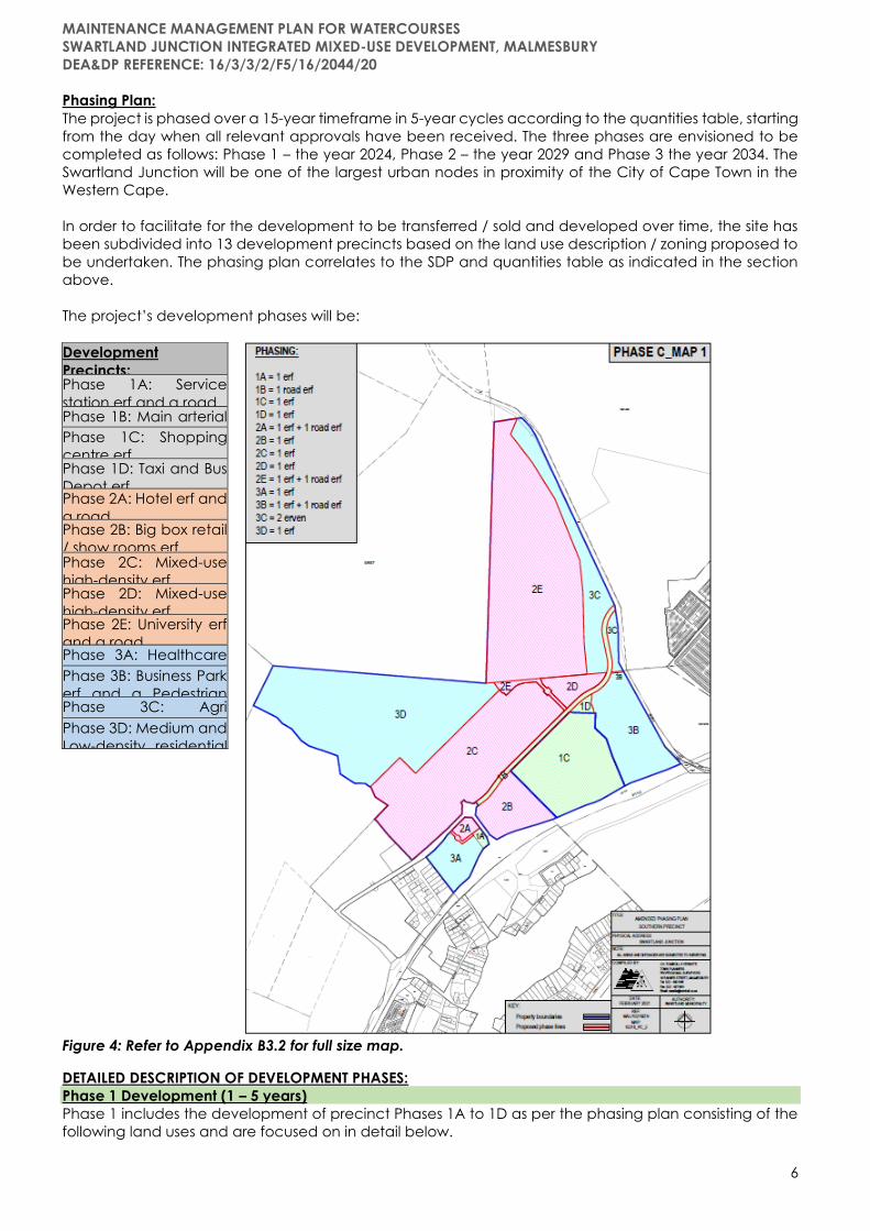
Phasing Plan:
The project is phased over a 15-year timeframe in 5-year cycles according to the quantities table, starting
from the day when all relevant approvals have been received. The three phases are envisioned to be
completed as follows: Phase 1 – the year 2024, Phase 2 – the year 2029 and Phase 3 the year 2034. The
Swartland Junction will be one of the largest urban nodes in proximity of the City of Cape Town in the
Western Cape.
In order to facilitate for the development to be transferred / sold and developed over time, the site has
been subdivided into 13 development precincts based on the land use description / zoning proposed to
be undertaken. The phasing plan correlates to the SDP and quantities table as indicated in the section
above.
The project’s development phases will be:
Figure 4: Refer to Appendix B3.2 for full size map.
DETAILED DESCRIPTION OF DEVELOPMENT PHASES:
Phase 1 Development (1 – 5 years)
Phase 1 includes the development of precinct Phases 1A to 1D as per the phasing plan consisting of the
following land uses and are focused on in detail below.
Development
Precincts: Phase 1A: Service
station erf and a road Phase 1B: Main arterial
road Phase 1C: Shopping
centre erf Phase 1D: Taxi and Bus
Depot erf Phase 2A: Hotel erf and
a road Phase 2B: Big box retail
/ show rooms erf Phase 2C: Mixed-use
high-density erf Phase 2D: Mixed-use
high-density erf Phase 2E: University erf
and a road Phase 3A: Healthcare
erf Phase 3B: Business Park
erf and a Pedestrian
Road Phase 3C: Agri
allotment erf Phase 3D: Medium and
Low-density residential
erf

MAINTENANCE MANAGEMENT PLAN FOR WATERCOURSES
SWARTLAND JUNCTION INTEGRATED MIXED-USE DEVELOPMENT, MALMESBURY
DEA&DP REFERENCE: 16/3/3/2/F5/16/2044/20
7
Table 1: PHASE 1 DEVELOPMENT
Land Use Description Total Developed Land Area % Developed P1
1. 8 light industrial erven ±1.73 ha 100%
2. Filling Station - A ±0.7 ha 100%
3. Shopping centre ±29.37 ha 50%
4. Taxi and bus depot ±1.04 ha 100%
5. Phase 1 Infrastructure
1. 8 light industrial erven (±1.73 ha)
Locality: This area is located on the western boundary of the greater development next to the existing
road leading from Highland WDF to the rest of the development area. The area is within walking distance
(just north) of Abbotsdale West and is located within the 500m buffer area of the Highlands WDF. The
500m buffer does not permit the development consisting of certain land uses in accordance with the
facilities waste Management Licence conditions.
Figure 5: Locality – 8 light industrial erven
Figure 6: Proposed subdivision of 8 Industrial Zone 1 erven.
MAINTENANCE MANAGEMENT PLAN FOR WATERCOURSES
SWARTLAND JUNCTION INTEGRATED MIXED-USE DEVELOPMENT, MALMESBURY
DEA&DP REFERENCE: 16/3/3/2/F5/16/2044/20
8
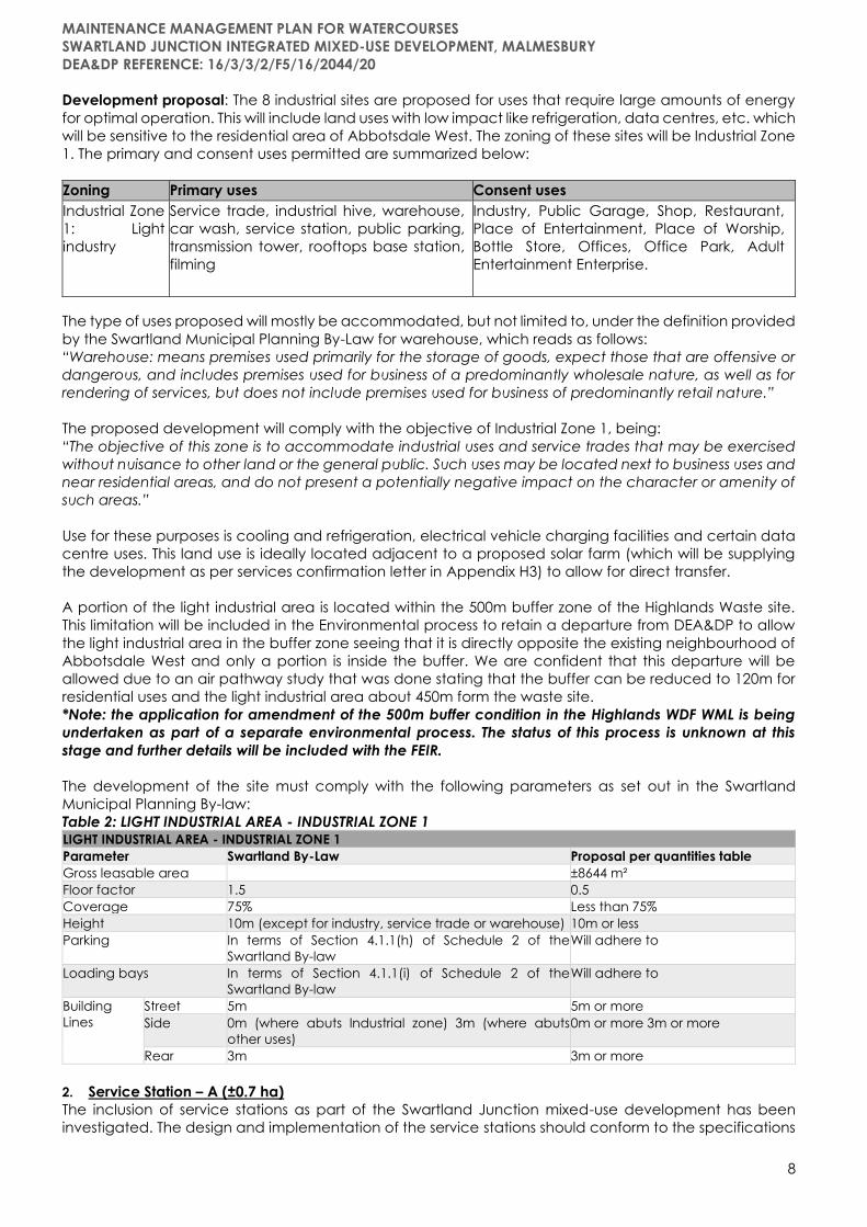
Development proposal: The 8 industrial sites are proposed for uses that require large amounts of energy
for optimal operation. This will include land uses with low impact like refrigeration, data centres, etc. which
will be sensitive to the residential area of Abbotsdale West. The zoning of these sites will be Industrial Zone
1. The primary and consent uses permitted are summarized below:
Zoning Primary uses Consent uses
Industrial Zone
1: Light
industry
Service trade, industrial hive, warehouse,
car wash, service station, public parking,
transmission tower, rooftops base station,
filming
Industry, Public Garage, Shop, Restaurant,
Place of Entertainment, Place of Worship,
Bottle Store, Offices, Office Park, Adult
Entertainment Enterprise.
The type of uses proposed will mostly be accommodated, but not limited to, under the definition provided
by the Swartland Municipal Planning By-Law for warehouse, which reads as follows:
“Warehouse: means premises used primarily for the storage of goods, expect those that are offensive or
dangerous, and includes premises used for business of a predominantly wholesale nature, as well as for
rendering of services, but does not include premises used for business of predominantly retail nature.”
The proposed development will comply with the objective of Industrial Zone 1, being:
“The objective of this zone is to accommodate industrial uses and service trades that may be exercised
without nuisance to other land or the general public. Such uses may be located next to business uses and
near residential areas, and do not present a potentially negative impact on the character or amenity of
such areas.”
Use for these purposes is cooling and refrigeration, electrical vehicle charging facilities and certain data
centre uses. This land use is ideally located adjacent to a proposed solar farm (which will be supplying
the development as per services confirmation letter in Appendix H3) to allow for direct transfer.
A portion of the light industrial area is located within the 500m buffer zone of the Highlands Waste site.
This limitation will be included in the Environmental process to retain a departure from DEA&DP to allow
the light industrial area in the buffer zone seeing that it is directly opposite the existing neighbourhood of
Abbotsdale West and only a portion is inside the buffer. We are confident that this departure will be
allowed due to an air pathway study that was done stating that the buffer can be reduced to 120m for
residential uses and the light industrial area about 450m form the waste site.
*Note: the application for amendment of the 500m buffer condition in the Highlands WDF WML is being
undertaken as part of a separate environmental process. The status of this process is unknown at this
stage and further details will be included with the FEIR.
The development of the site must comply with the following parameters as set out in the Swartland
Municipal Planning By-law:
Table 2: LIGHT INDUSTRIAL AREA - INDUSTRIAL ZONE 1 LIGHT INDUSTRIAL AREA - INDUSTRIAL ZONE 1
Parameter Swartland By-Law Proposal per quantities table
Gross leasable area ±8644 m²
Floor factor 1.5 0.5
Coverage 75% Less than 75%
Height 10m (except for industry, service trade or warehouse) 10m or less
Parking In terms of Section 4.1.1(h) of Schedule 2 of the
Swartland By-law
Will adhere to
Loading bays In terms of Section 4.1.1(i) of Schedule 2 of the
Swartland By-law
Will adhere to
Building
Lines
Street 5m 5m or more
Side 0m (where abuts Industrial zone) 3m (where abuts
other uses)
0m or more 3m or more
Rear 3m 3m or more
2. Service Station – A (±0.7 ha)
The inclusion of service stations as part of the Swartland Junction mixed-use development has been
investigated. The design and implementation of the service stations should conform to the specifications

MAINTENANCE MANAGEMENT PLAN FOR WATERCOURSES
SWARTLAND JUNCTION INTEGRATED MIXED-USE DEVELOPMENT, MALMESBURY
DEA&DP REFERENCE: 16/3/3/2/F5/16/2044/20
9
as detailed below which has been informed by specialist investigations and inputs. An SDP has been
developed to show the general layout of the installation.
Activity description:
The main activity of the service stations will be the resale of petrol and diesel to the public. The service
stations will consist of the following:
• 2x underground petrol tanks.
• 3x underground diesel tanks.
• Forecourt.
• Office.
• Fast food outlets.
• Small shop.
The site will be equipped with fire hydrants, hose reels and all the required fire-fighting apparatus.
Site installation specifications:
Each service station’s fuel installation will consist of the following:
• 2x underground petrol tanks.
• 3x underground diesel tanks.
• Forecourt with 8x multi product dispensers.
Development proposal:
Two service stations are being proposed for the development. The one service station will
be located at a shopping centre, and the other service station will be in a commercial area. The final
location for the second service station is still to be confirmed.
Each service station will consist of five 23m3 underground tanks. Two of the tanks will be used for petrol
and three will be used for diesel. The underground tank farm will be located between the forecourt and
the access road as far from the fast-food outlets and shops as is possible.
The forecourt will have eight back-to-back dispensers that will be dispense petrol and diesel. The forecourt
will have a spill catchment area connected to an oil/ water separator.
The road tanker filling point will be located close to the tank farm and will be placed in such a way as not
to obstruct traffic movement at the site. It is expected that a road tanker will visit the service stations three
times per week. There will be hydrants, hose reels and fire extinguishers located at the site.
Locality Service Station - A: The property is located north of the N7 on the north-western corner of the
newly built interchange. The service station will gain access from the road running north from the
Abbotsdale - N7 interchange. This site is ideally located for a service station where a national road
becomes a regional road with high vehicle movement. Refer to SDP and Locality Map below.
Figure 7: Service Station – A SDP and Locality – See Appendix B3.6 for detailed map.

MAINTENANCE MANAGEMENT PLAN FOR WATERCOURSES
SWARTLAND JUNCTION INTEGRATED MIXED-USE DEVELOPMENT, MALMESBURY
DEA&DP REFERENCE: 16/3/3/2/F5/16/2044/20
10
The development implementation of the service stations must ensure strict adherence to ALL
recommendations and mitigation measures as set out by the specialists in the groundwater investigation
as well as the MHI Risk Assessment.
Strict monitoring and legal compliance obligations must be adhered to in all phases of the activity’s
lifecycle. Additionally, the competent authority should be notified once the location of the other service
station has been decided.
The development of the site must comply with the following parameters as set out in the Swartland
Municipal Planning By-law:
Table 3: SERVICE STATION - BUSINESS ZONE 3 (Consent uses: shop and restaurant) SERVICE STATION - BUSINESS ZONE 3 (Consent uses: shop and restaurant)
Parameter Swartland By-Law Proposal per quantities table
Gross leasable area ±2806 m²
Floor factor 2.5 0.5
Coverage 75% <75%
Height 3 storeys 2 storeys or less
Street Building Line 5m 5m
Side and Rear Building Line 0m
3m (If abutting a residential zone)
0m
Parking Public Garages 4 parking bays per repair bay No repair bays suggested
All other One parking bay per 50m² GLA with a minimum of 8
parking bays
Will adhere to
Restaurant and
shop
4 per 100m² GLA Will adhere to
Billboards 10m maximum height 10m maximum height
Table 4: Site Access Requirements Site Access Requirements
Parameter By-Law Proposal
Carriageway crossings
Shall not exceed 10m In/Out access –
7.5m in only – 4m
Limited to two per site unless street boundary exceeds 30m in which
case one additional carriageway crossing may be permitted
Two access points
provided
May not be located closer than 30m to the intersection of a declared
road with any other road of a like status
Not near a
declared road
May not be located closer than 30m to the nearest point of an
intersection where traffic is controlled by a traffic signal or island
The intersection
will not be
controlled by a
traffic signal.
May not be located closer than 10m from the corner of an intersection
not referred to above, if such intersection is not splayed or 5m from the
point where the splay meets the road boundary
Access located 7m
from splay
Street boundary At least 100mm thick wall 200mm high be erected on the street
boundary between different vehicle carriageway crossings. Will adhere to
Access and parking: The development will gain access from a connector road to the existing Abbotsdale
- N7 interchange link road. The N7 is a National Road and therefore the application will be circulated to
the SANRAL for comment. Sufficient parking will be provided as demonstrated in the parameters table.
Motivation: The service station will primarily service the N7 but will also serve as a refueling station for visitors
to the newly proposed development. Providing motor vehicle related services (excluding services relating
to spray-painting, panel beating, blacksmith or body work) will be the focus of the service station. The
envisioned development is thus aligned with the purpose and definition of the proposed zoning.
Additionally, the service station will include take away franchises (restaurants) and a shop/convenience
store. The proposed service station is well located as it provides for future development in the surrounding
area and is the only service station on the N7 at the entry portals of Malmesbury, making it highly visible
and accessible. This means that motorists that would like to make use of the N7 do not have to drive into
the CBD of Malmesbury to fill up and can conveniently use this service station on the outskirts of
Malmesbury.

MAINTENANCE MANAGEMENT PLAN FOR WATERCOURSES
SWARTLAND JUNCTION INTEGRATED MIXED-USE DEVELOPMENT, MALMESBURY
DEA&DP REFERENCE: 16/3/3/2/F5/16/2044/20
11
Furthermore, the service station will be easily accessible for motorists travelling between Cape Town and
the northern part of the Western Cape or even the Northern Cape and Namibia as well as the motorist
travelling inland from the Swartland and Boland region.
Service stations are totally dependent on traffic volumes which pass the site on a daily basis. Location –
which can determine up to 70% of a site’s volume – is the key to success for most service stations. It cannot
be over-emphasized how important this factor is. The adjacent N7 highway thus makes this use and
locality ideal. Service station facilities have improved and become very sophisticated in past years. The
reality is that a service station has a forecourt and some supportive buildings with retail stores and shops
– and, in most cases, this is what motorists expect.
3. Shopping Centre
The proposed Shopping centre will be divided into two or more construction phases. The first construction
phase will consist of ±52 500m2 of gross leasable area. The second construction phase will be developed
at a later stage if there is need to expand the Mall and sufficient services are available. The vision of
Shopping centre is to serve as a regional shopping centre in the Swartland area and beyond. The
proposed shopping centre will reduce the distance and time that many individuals travel to gain access
to shopping centres with a similar scale. The shopping centre will provide additional job opportunities to
many individuals from the local community and will stimulate the economy of the Swartland. The
proposed Shopping centre zoned Business Zone 1 which allows consent uses for a car wash, service
station, and place of entertainment.
The proposed first construction phase of the Shopping centre, being ±52 500m2 in size, is strategically
located along the N7 which connects Cape Town and Namibia. The Shopping centre does not only aim
to service Malmesbury and surrounding towns but also a greater regional area. The Swartland SDF
identifies Malmesbury/Abbotsdale as the Regional Service Centre of the Swartland. The development
firstly acts as a central point between Abbotsdale and Malmesbury. Secondly, the Shopping centre acts
as a regional magnet which further anchors Malmesbury and Abbotsdale as a regional service centre.
The Shopping centre development may be an anchor point that will act as a catalyst for the future
developments in the Swartland Junction. The site proposes three entrances and additional future entry
points that link to the surrounding developments. The proposed shopping centre is surrounded by a ring
road which offers access to all entrances for pickups and drop offs. Furthermore, the shopping centre
seeks to provide parking spaces all around the Shopping centre to create efficient parking space and
shorter walking distances.
The proposed Shopping centre zoned Business Zone 1 which allows consent uses for a car wash, service
station and place of entertainment will comply with the following parameters set out in the Swartland
Municipal Planning By-law:
Table 5: SHOPPING CENTRE – BUSINESS ZONE 1 SHOPPING CENTRE – BUSINESS ZONE 1
Parameter Swartland By-Law Proposal per quantities table
Gross leasable area Shopping centre:
- 52 500m² (phase 1 – year 1-5)
- 47 500m² (phase 3 – year 11-15)
- Service station: ±2000m² (phase 3 –year 11-
15)
Land uses Business premises/ shopping centre Shopping centre, car wash, places of
entertainment and a service station.
Floor factor 3 Less than 3
Coverage 100% Less than 100%
Height 6 storeys 2 storeys
Parking 6 per 100m² GLA 5 per 100m² GLA
Setback 8m (from centre of street) Will adhere to
Building
Lines
Street 0m or 5m (where abuts declared road) Will adhere to
Side 0m (no doors & windows) 3m (where abuts
residential)
Will adhere to
Rear Will adhere to
Motivation: The car wash and place of entertainment may be uses that are usually accommodated
within a shopping centre. The place of entertainment includes gaming arcades, cinemas, and gambling
facilities, to be accommodated in the Swartland Mall. The service station indicated on the draft SDP in

MAINTENANCE MANAGEMENT PLAN FOR WATERCOURSES
SWARTLAND JUNCTION INTEGRATED MIXED-USE DEVELOPMENT, MALMESBURY
DEA&DP REFERENCE: 16/3/3/2/F5/16/2044/20
12
Figure 17 below forms part of the expansion of the Swartland Mall and more detail will be provided to
Council during the building plan and development stages. The rights for the service station still need to
be obtained at this stage. The draft SDP was drawn up to show the development possibilities of the site.
This SDP will not be submitted for approval at this stage and will only be submitted at building plan stage.
The proposed first construction phase of the Shopping centre, being ±52 500m2 in size, is strategically
located along the N7 which connects Cape Town and Namibia as indicated in Figure 317 below. The
Shopping centre does not only aim to service Malmesbury and surrounding towns but also a greater
regional area. The Swartland SDF identifies Malmesbury/Abbotsdale as the Regional Service Centre of
the Swartland. The development firstly acts as a central point between Abbotsdale and Malmesbury.
Secondly, the Shopping centre acts as a regional magnet which further anchors Malmesbury and
Abbotsdale as a regional service centre.
The Shopping centre development may be seen as an anchor point that will act as a catalyst for the
future developments in the Swartland Junction. The site proposes three entrances and additional future
entry points that link to the surrounding developments. The proposed shopping centre is surrounded by a
ring road which offers access to all entrances for pickups and drop offs. Furthermore, the shopping centre
seeks to provide parking spaces all around the Shopping centre to create efficient parking space and
shorter walking distances.
The arterial road needs to be constructed as a two-lane road from the existing Abbotsdale roundabout
to the roundabout next to the Taxi and Bus Depot site. The developer of the Shopping centre wants to
develop 60 000m2 GLA in the first construction phase, although application is only being made for 52
500m2. The trip generation of a 60 000m2 shopping centre will trigger the construction of a four-lane road
or the future link to Darling Road will need to be built. These two options cannot be afforded by the
developer at this stage. If the bypass link road to the Darling Road / R45 is built by the Municipality, in
respect of the negotiations with the developer for contributions, the GLA of the first construction phase
of the Shopping centre will be increased to 60 000m2. For now, application is only made for 52 500m2.
Figure 8: Shopping centre – proposed SDP.

MAINTENANCE MANAGEMENT PLAN FOR WATERCOURSES
SWARTLAND JUNCTION INTEGRATED MIXED-USE DEVELOPMENT, MALMESBURY
DEA&DP REFERENCE: 16/3/3/2/F5/16/2044/20
13
The Shopping centre is located in close proximity to Saamstaan, Ilinge Lethu, the future De Hoop housing
project and Abbotsdale. This provides hundreds of employment opportunities within walking distance to
numerous disadvantaged households, the pedestrian bridge of the railway is also supporting this initiative.
Furthermore, this provides lower income families with direct access to a large retail facility without having
to travel to other towns for all their retail needs. This development can therefore be seen as an initiative
to redress past spatial development imbalances and to provide incremental upgrading of informal areas
by enforcing the people to build a better life. On a neighbouring plot there is a proposed taxi rank that
will provide further access to the Mall for the users of public transportation. Due to the topography of the
site the Shopping centre will be built on two levels and construction will include a two-storey building. Due
to the topography of the site the Swartland Mall will be built on two levels and construction will include a
two-storey building. The draft floor plans can be seen in Figure 9.
Figure 9: Draft floor plans for Swartland Mall.
The design of the Mall will be of such a nature that it fits into the rural character of the Swartland area.
The developers plan to imitate the look of a wine cellar which is a prominent feature throughout the
Swartland area. This development will improve the aesthetics of the entry gate into Malmesbury as it is
located next to the N7. Further details regarding the design and architecture will be introduced at
building plan submission stage although the graphics below will give an overall idea of the theme. New
age technology will also be added to the Mall like an urban vegetable and herb garden on the roof of
the Mall which will be used in the restaurants and shops of the Mall.
The shopping centre culture has become a big business, as they have become multi-story structures that
house a large number of shops selling various products and services. Visiting a mall is advantageous,
because the shops are housed in a complex. Groceries, clothes, shoes, reading material, food courts,
cinemas, and entertainment are available in one place making it more convenient for shoppers. The Mall
is located in a prime location which is easily accessible and visible to potential users.

MAINTENANCE MANAGEMENT PLAN FOR WATERCOURSES
SWARTLAND JUNCTION INTEGRATED MIXED-USE DEVELOPMENT, MALMESBURY
DEA&DP REFERENCE: 16/3/3/2/F5/16/2044/20
14
Figure 10: Graphic representation of the Swartland Mall theme.
To prevent any of the other Business zoned sites (within the development footprint) to develop a shopping
mall the following title condition will be added to the title deeds of the other properties in the
development:
“No shopping mall is allowed on this property: Mall being defined as a large retail complex containing a
variety of stores and often restaurants, and other business establishments housed in a series of connected
or adjacent buildings, or in a single large building with interconnected walkways of which traffic is
excluded, but does not include value centres, warehousing and strip retail.”
The shopping centre is further motivated by the market study discussed in Sections 5.3 and 6 of this report.
4. Taxi and bus depot
A taxi and bus depot with a GLA of ±2078m2 is proposed on the north-eastern corner of the Shopping
centre next to the main arterial road through the development. This road will connect to the Darling Road
/R45 in the future and give direct access to Saamstaan and Ilinge Lethu and also the N7. Meetings with
the relevant authorities and the taxi associations will assist in the final sizing and location of the bus and
taxi rank.

MAINTENANCE MANAGEMENT PLAN FOR WATERCOURSES
SWARTLAND JUNCTION INTEGRATED MIXED-USE DEVELOPMENT, MALMESBURY
DEA&DP REFERENCE: 16/3/3/2/F5/16/2044/20
15
A notional design has been included in the site plan below, which shows the preferred access
arrangement. However, the final public transport facility should be designed with input from the public
transport operators, Swartland Municipality, the Provincial Regulating Entity (PRE) and the Department of
Transport and Public Works (DTPW).
Figure 11: Taxi and Bus Depot - notional design.
The proposed Taxi and Bus Depot will have to comply with the following parameters set out in the
Swartland Municipal Planning By-law:
Table 6: TAXI AND BUS DEPOT - TRANSPORT ZONE 1 TAXI AND BUS DEPOT - TRANSPORT ZONE 1
Parameter Swartland By-Law Proposal per quantities table
Gross leasable area ±2078 m²
Land uses Transport usage Taxi rank
Floor factor 2 < 2
Coverage 80% <80%
Height Determined by Municipality Will adhere to
Building Lines Street 0m
5m (where abuts declared road)
Will adhere to
Side 3m Will adhere to
Rear
Motivation: to accommodate this large-scale development all modes of transport were as considered
and the need for an additional Taxi and Bus Depot will be a major asset to the development. The site will
be ideally located next to the main arterial route through the development. Users of public transport will
be dropped off and picked up in a central location, which is within walking distance to the University,
central business area and the Shopping centre. The site is large enough to accommodate ancillary
consent uses like offices, shops and public bathrooms if needed.
A notional design (figure 13) has been included in the site plan, which shows the preferred access
arrangement. However, the final public transport facility should be designed with input from the public
transport operators, Swartland Municipality, the Provincial Regulating Entity (PRE) and the Department of
Transport and Public Works (DTPW).
5. Phase 1 Infrastructure:
*Refer to the Services Reports in Appendix H, proposed services layout in Appendix B3.4, and services
confirmation letters in Appendix E. Note: All road infrastructure upgraded and proposed, as well as
infrastructure proposed over railway line, within on-site watercourses or the regulated area of
watercourses would be subject to relevant approvals / permits / authorisations by the respective
competent authorities.

MAINTENANCE MANAGEMENT PLAN FOR WATERCOURSES
SWARTLAND JUNCTION INTEGRATED MIXED-USE DEVELOPMENT, MALMESBURY
DEA&DP REFERENCE: 16/3/3/2/F5/16/2044/20
16
TRANSPORT INFRASTRCUTURE:
Road Network:
➢ All intersections in the study area will continue to operate well following the implementation of Phase
1. Road link capacity will not be reached on any of the roads within the study area. No upgrades
would be required in this scenario.
➢ For access to the proposed development, a portion of the Darling Way link will need to be
constructed between the single-lane roundabout (located on northern side of the Abbotsdale
Interchange) up to the proposed public transport interchange. A 2-lane road is proposed.
Public Transport:
➢ A public transport interchange accommodating minibus taxi and bus services is therefore proposed
for the development. The public transport interchange to be constructed as part of phase 1 of the
development. A notional design has been included in the site plan (see site plan I point 4 above),
which shows the preferred access arrangement. However, the final public transport facility should be
designed with input from the public transport operators, Swartland Municipality, the Provincial
Regulating Entity (PRE) and the Department of Transport and Public Works (DTPW).
Non-motorised Transport:
➢ A pedestrian footbridge (2m wide trafficable surface) and connecting shared bicycle and pedestrian
routes (minimum 3m wide) be provided across the railway line and river on the northern side of the
site as part of the implementation of Phase 1, thus providing a direct linkage between the proposed
development and the western suburbs of Malmesbury.
Water Supply:
➢ The proposed development will connect into the Wesbank Water Reticulation Network (shown on
drawing W1759-500).
➢ The existing network is divided into three pressure zones, namely the high-pressure zone feeding
directly from the reservoirs, the zone feeding from the water tower and the zone feeding from a
pressure pump. This proposed development will tap into the network feeding directly from the
reservoirs.
➢ The existing reservoir capacity is adequate to provide 48 hours of storage for the medium-term
development horizon. The possible upgrade of the West Coast District Council supply line* will be
covered in the GLS report.
*Kindly note that all bulk water infrastructure previously owned by the West Coast District Municipality
were transferred to the local municipalities during 2018. The bulk water supply lines that will supply the
proposed development are therefore the responsibility of Swartland Municipality – WCDM, Ms. D. Kotze
➢ For Phases 1 and 2: Two connections will be made on the existing network requiring the following
upgrades to the existing network to create sufficient capacity:
❖ An additional 250mm Ø water main will be designed to increase the capacity of high-pressure
network to cater for the additional load of the commercial as well as the low-cost housing
projects.
❖ The water main in Alpha Street will be upgraded form a 150mm Ø to a 200mm Ø pipe.
❖ A 200mm Ø connection will be constructed from Kiewiet Street to create a ring main in the
commercial development.
Sewer Network:
The sewer network will gravitate to two pumpstations, positioned on the lowest part of the development
area. The position of the pumpstations is shown on the services layout map. The proposed sewerage
network will consist of uPVC Class 34 sewerage pipes with diameters varying from 160mm Ø to 250mm Ø.
All sewerage will flow to the main pumpstation from where it will be pumped across the stream and
railway line to the Malmesbury External Sewer Line, which gravitates to the Malmesbury Treatment works.
The Malmesbury External Sewer line has sufficient capacity for Phase 1 and 2 of the development.
PHASE 2 DEVELOPMENT (6 – 10 YEARS)
Phase 2 includes the development of precinct Phases 2A - 2E as per the phasing plan consisting of the
following land uses and are focused on in detail below.
Table 7: PHASE 2 DEVELOPMENT
Land Use Description Total Developed Land Area % Developed P2
1. Big box retail / motor show rooms ±9.04 ha 50%
2. High density mixed use – offices and
apartments
±5.52 ha 50%

MAINTENANCE MANAGEMENT PLAN FOR WATERCOURSES
SWARTLAND JUNCTION INTEGRATED MIXED-USE DEVELOPMENT, MALMESBURY
DEA&DP REFERENCE: 16/3/3/2/F5/16/2044/20
17
3. Medium density mixed use –
commercial and apartments
±7.12 ha 50%
4. High residential ±13.49 ha 25%
5. Hotel ±1.51 ha 100%
6. General industrial ±34.10 ha 75%
7. Educational – Private school ±16.05 ha 100%
8. Educational – University campus ±78.84 ha 50%
Phase 2 Infrastructure
1. Big box retail / motor show rooms
The development proposal identifies this site for the development of retail facilities with a development
footprint of ±9.04 ha. The site will be zoned as Business Zone 1: General Business which allows an array of
primary, and consent uses as defined by the Local Planning By-Law. This site is located on the eastern
corner of the newly built interchange of Abbotsdale next to the N7. This site is highly visible from the N7
which will attract clients to the site and act as supporting use in a high vehicle movement area which
supports the intended / proposed land use for this site as big box retail and motor show rooms.
Motor sales and big box retail sites are located next to main access routes to allow sufficient access and
visual marketing needed for this type of business. These uses also generate a high amount of traffic with
the new off-ramp from the N7 and the proposed arterial route through the development being ideal for
this proposed use. The motor sales and big box retail uses is also ancillary uses to the Swartland Mall, by
providing two of the commercial uses not normally located within a shopping centre. The development
of the site must comply with the following parameters as set out in the Swartland Municipal Planning By-
law:
Table 8: BIG BOX RETAIL / MOTOR SHOW ROOMS - BUSINESS ZONE 1 BIG BOX RETAIL / MOTOR SHOW ROOMS - BUSINESS ZONE 1
Parameter Swartland By-Law Proposal per quantities table
Gross leasable area ±36165 m² (phase 2 – year 6-10)
±36165 m² (phase 3 – year 11-15)
Land uses Business premises Retail and motor sales
Floor factor 3 1
Coverage 100% < 100%
Height 6 storeys < 6 storeys
Parking 4 per GLA Will adhere to
Setback 8m (from centre of street) Will adhere to
Building
Lines
Street 0m
5m (where abuts declared road)
Will adhere to
Side 0m (no doors & windows)
3m (where abuts residential)
Will adhere to
Rear Will adhere to
Motivation: Motor sales and big box retail sites are located next to main access routes to allow sufficient
access and visual marketing needed for this type of business. These uses also generate a high amount of
traffic with the new off-ramp from the N7 and the proposed arterial route through the development being
ideal for this proposed use. The motor sales and big box retail uses is also ancillary uses to the Swartland
Mall, by providing two of the commercial uses not normally located within a shopping centre.
2. High density mixed use – offices and apartments
This area is earmarked to accommodate high density mixed uses like offices and apartments with a total
development footprint of ±5.52 ha. The site will be zoned as Business Zone 1: General Business which allows
an array of primary, and consent uses as defined by the Local Planning By-Law. The development of the
site must comply with the following parameters as set out in the Swartland Municipal Planning By-law:
Table 9: HIGH DENSITY MIXED USE - BUSINESS ZONE 1 HIGH DENSITY MIXED USE - BUSINESS ZONE 1
Parameter Swartland By-Law Proposal per quantities table
Gross leasable area ±66267 m² (phase 2 – year 6-10)
±66267 m² (phase 3 – year 11-15)
Land uses Offices and flats Primary use
Floor factor 3 3
Coverage 100% <100%
Height 6 storeys 3-6 storeys
Parking Flats – 1.5 per unit Will adhere to
MAINTENANCE MANAGEMENT PLAN FOR WATERCOURSES
SWARTLAND JUNCTION INTEGRATED MIXED-USE DEVELOPMENT, MALMESBURY
DEA&DP REFERENCE: 16/3/3/2/F5/16/2044/20
18
Offices – 4 per 100m² GLA
Setback 8m (from centre of street) Will adhere to
Building Lines Street 0m
5m (where abuts declared road)
Will adhere to
Side 0m (no doors & windows)
3m (where abuts residential)
Will adhere to
Rear Will adhere to
Motivation: Locating the high-density mixed uses around a central point ensures that the growth pattern
starts centrally, and the densities decrease the further away you move from the node. This node is focused
on the classic mix of business, offices, shops, and high-density residential accommodation above the
ground floor. This supports walkable cities and spaces for central place making.
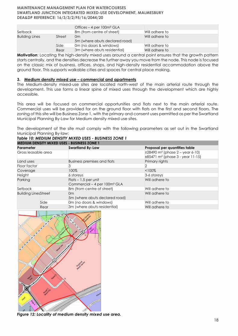
3. Medium density mixed use – commercial and apartments
The Medium-density mixed-use sites are located north-west of the main arterial route through the
development. This use forms a linear spine of mixed uses through the development which are highly
accessible.
This area will be focused on commercial opportunities and flats next to the main arterial route.
Commercial uses will be provided for on the ground floor with flats on the first and second floors. The
zoning of this site will be Business Zone 1, with the primary and consent uses permitted as per the Swartland
Municipal Planning By-Law for Medium density mixed use sites.
The development of the site must comply with the following parameters as set out in the Swartland
Municipal Planning By-law:
Table 10: MEDIUM DENSITY MIXED USES - BUSINESS ZONE 1 MEDIUM DENSITY MIXED USES - BUSINESS ZONE 1
Parameter Swartland By-Law Proposal per quantities table
Gross leasable area ±28490 m² (phase 2 – year 6-10)
±85471 m² (phase 3 - year 11-15)
Land uses Business premises and flats Primary rights
Floor factor 3 2
Coverage 100% <100%
Height 6 storeys 3-6 storeys
Parking Flats – 1.5 per unit
Commercial – 4 per 100m² GLA
Will adhere to
Setback 8m (from centre of street) Will adhere to
Building Lines Street 0m
5m (where abuts declared road)
Will adhere to
Side 0m (no doors & windows)
3m (where abuts residential)
Will adhere to
Rear Will adhere to
Figure 12: Locality of medium density mixed use area.

MAINTENANCE MANAGEMENT PLAN FOR WATERCOURSES
SWARTLAND JUNCTION INTEGRATED MIXED-USE DEVELOPMENT, MALMESBURY
DEA&DP REFERENCE: 16/3/3/2/F5/16/2044/20
19
Motivation: the medium density mixed-use areas located along the new arterial route decreases in
density from the high mixed-use node towards the University. This area will focus on a high street design
where the streets become useable and liveable areas with coffee shops, workstations, offices, and
residential areas.
4. High residential
The high-density residential sites are located behind the mixed-use areas, away from the arterial route
but still in close proximity to the uses. These sites are also within walking distance of the University located
to the north-east and can be used in support with the University.
Figure 13: Locality of High density residential area.
The high-density residential area will consist of flats and town housing on a high-density scale. These
residential units can also be used to house the students at the University. The zoning of this site will be
General Residential Zone 3, the primary and consent uses permitted which apply to High density
residential areas must comply with the requirements of the Swartland Municipal Planning By-Law.
The development of the site must comply with the following parameters as set out in the Swartland
Municipal Planning By-law:
Table 11: HIGH DENSITY RESIDENTIAL AREA – GENERAL RESIDENTIAL ZONE 3 HIGH DENSITY RESIDENTIAL AREA – GENERAL RESIDENTIAL ZONE 3
Parameter Swartland By-Law Proposal per quantities table
Gross leasable area ±26986 m² (phase 2 – year 6-10)
±80959 m² (phase 3 – year 11-15)
Land uses Flats and/or town housing Primary use
Floor factor 2 1
Coverage 40% 40%
Height 21m ≤ 21m
Parking Flats – 1.5 per unit
Town housing – 2 per unit
Will adhere to
Building
Lines
Street 5m Will adhere to
Side 5m Will adhere to
Rear Will adhere to
Motivation: higher density residential uses are always in high demand once the social services are
increased in an area, like the development of the University Campus. The need for residential housing in
Malmesbury has already increased due to the dualling of the N7 and the demand for higher density
housing for young professionals has increased drastically. This area is safe guarded from the business area,
although still in walking distance.

MAINTENANCE MANAGEMENT PLAN FOR WATERCOURSES
SWARTLAND JUNCTION INTEGRATED MIXED-USE DEVELOPMENT, MALMESBURY
DEA&DP REFERENCE: 16/3/3/2/F5/16/2044/20
20
5. Hotel
This portion forms part of the larger northern precinct adjacent to the proposed service station, hospital
and the motor city that is located north of the N7. The Hotel will gain access from the Abbotsdale - N7
interchange.
Figure 14: Locality of Hotel site
The hotel is centrally located in the development to be within walking distance of the business node and
the Shopping centre. The zoning of this site is Business Zone 1 with a consent use for a hotel, the primary
and consent uses permitted for Hotel – Business Zone 1 must comply with the requirements of the
Swartland Municipal Planning By-Law.
The development of the site must comply with the following parameters as set out in the Swartland
Municipal Planning By-law:
Table 12: HOTEL - BUSINESS ZONE 1 (consent use for hotel) HOTEL - BUSINESS ZONE 1 (consent use for hotel)
Parameter Swartland By-Law Proposal per quantities table
Gross leasable area ±18174 m²
Land uses Hotel Consent use
Floor factor 3 2
Coverage 100% <100%
Height 6 storeys ≤6 storeys
Parking 1 bay per bedroom + 20 bays Will adhere to
Setback 8m (from centre of street) Will adhere to
Building
Lines
Street 0m
5m (where it abuts declared road)
Will adhere to
Side 0m (no doors & windows)
3m (where abuts residential)
Will adhere to
Rear Will adhere to
Motivation: The proposed hotel seeks to accommodate guests planning to visit Malmesbury. Furthermore,
due to its accessible location near the N7 it provides accommodation options for people travelling on
the N7 between Namibia and Cape Town. As part of the bigger proposed precinct the hotel supports
and is supported by the surrounding uses namely mixed-use development, hospital, shopping centre,
office park, and other business opportunities.
Hotel and lodging businesses are mainstays of their communities, and an important source of quality jobs.
Hotels support their communities through increased tax revenue, capital investment, tourism-related

MAINTENANCE MANAGEMENT PLAN FOR WATERCOURSES
SWARTLAND JUNCTION INTEGRATED MIXED-USE DEVELOPMENT, MALMESBURY
DEA&DP REFERENCE: 16/3/3/2/F5/16/2044/20
21
development, and promotion. Hospitality generates revenue for local economies directly when tourists
spend money in hotels, restaurants, and entertainment venues.
6. General industrial
The General industrial area is located below, to the south, of the N7 between Malmesbury and
Abbotsdale. This area will be the extension of the existing industrial area called Schoonspruit located to
the north-east.
The industrial area is proposed as an extension of the existing industrial area in Malmesbury, namely
Schoonspruit. This development will strengthen the connection between Abbotsdale and Malmesbury
located below the N7. The zoning of these sites will be Industrial Zone 2: General Industry, the primary and
consent uses permitted must comply with the requirements of the Swartland Municipal Planning By-Law.
Figure 15: Locality of General Industrial sites.
The industrial area is proposed as an extension of the existing industrial area in Malmesbury, namely
Schoonspruit. This development will strengthen the connection between Abbotsdale and Malmesbury
located below the N7. The zoning of these sites will be Industrial Zone 2: General Industry, the primary and
consent uses permitted must comply with the requirements of the Swartland Municipal Planning By-Law.
The development of the site must comply with the following parameters as set out in the Swartland
Municipal Planning By-law:
Table 13: GENERAL INDUSTRY – INDUSTRIAL ZONE 2 GENERAL INDUSTRY – INDUSTRIAL ZONE 2
Parameter Swartland By-Law Proposal per quantities table
Gross leasable area ±204575 m² (phase 2 – year 6-10)
±68191 m² (phase 3 – year 11-15)
Land uses Warehousing, industry, etc. Primary uses
Floor factor 2 <2
Coverage 75% Less than 75%
Height 21m (except for industry, service trade or
warehouse)
21m or less
Parking In terms of Section 4.2.1(h) of Schedule 2 of the
Swartland By-law
Will adhere to
Loading bays In terms of Section 4.2.1(i) of Schedule 2 of the
Swartland By-law
Will adhere to
Building Lines Street 5m 5m or more
Side 0m (where abuts Industrial zone) 3m (where
abuts other uses)
0m or more 3m or more
Rear 3m 3m or more

MAINTENANCE MANAGEMENT PLAN FOR WATERCOURSES
SWARTLAND JUNCTION INTEGRATED MIXED-USE DEVELOPMENT, MALMESBURY
DEA&DP REFERENCE: 16/3/3/2/F5/16/2044/20
22
Motivation: Malmesbury’s economy has a strong industrial component and most of the industrial land in
Malmesbury has either been developed or sold out. It is thus important to provide sufficient industrial land
to ensure this foundation can be expanded for the future prosperity of the town’s economy. Utilizing a
portion of land below the N7 next to the existing industrial area for the provision of industrial land will
ensure that sufficient industrial land is available for future growth while also forming an industrial corridor,
linking with the existing residential area and the Schoonspruit industrial area. This corridor will act as a
spine that supports the surrounding communities of Ilinge Lethu, Abbotsdale, Wesbank and Malmesbury.
The establishment of this corridor will also function as a mechanism that spatially integrates the stated
communities. The establishment of this corridor will also function as a mechanism that spatially integrates
the stated communities.
7. Educational – Private school
The education site is located north-west of the newly built roundabout to the N7. This is close to
Abbotsdale West and there is an existing water course on the south-western boundary of the site.
Figure 16: Locality of Education site.
The education site is suggested for a school, although it can be state owned as well. This is not a proposal
of what type of school it will be, but a need for a school is necessary when you provide the number of
residential opportunities as suggested in this application. The zoning of this site will be Community Zone 1,
the primary and consent uses permitted must comply with the requirements of the Swartland Municipal
Planning By-Law.
The development of the site must comply with the following parameters as set out in the Swartland
Municipal Planning By-law:
Table 14: EDUCATION SITE - COMMUNITY ZONE 1 EDUCATION SITE - COMMUNITY ZONE 1
Parameter Swartland By-Law Proposal per quantities table
Gross leasable area ±10000 m²
Land uses Place of Instruction School
Floor factor 1 1
Coverage 60% <60%
Height 3 storeys 2-3 storeys
Parking 1 bay per classroom
1 bus parking per 20 pupils
Will adhere to

MAINTENANCE MANAGEMENT PLAN FOR WATERCOURSES
SWARTLAND JUNCTION INTEGRATED MIXED-USE DEVELOPMENT, MALMESBURY
DEA&DP REFERENCE: 16/3/3/2/F5/16/2044/20
23
1 bay per 4 seats for other uses
Building
Lines
Street 10m Will adhere to
Side 5m Will adhere to
Rear Will adhere to
Motivation: Schools are one of the most important social assets to create a sustainable human settlement.
It is predicted that Malmesbury will have a high influx of people from the City as a result of the dualling of
the N7 and this is already visible in the increased property demand in Malmesbury. The prediction is that
people will live in Malmesbury and commute to the City or other surrounding towns. By moving their
families to Malmesbury, the necessary social services need to be provided for, for example education.
The education site is located near a high-volume access route and bordered by the existing
neighbourhood of Abbotsdale West and the proposed residential areas of the development. The
educational site can be developed by a private institute or by the government, depending on the first
need in the community.
The reality is that the majority of Western Cape schools are full, and a lot of schools have long waiting lists.
The learner population in the Western Cape continues to grow dramatically, due to continued inward
migration and high retention rates in our schools. It is thus clear that there are huge shortages and can
this development contribute to assisting the Department of Education by providing a much-needed
facility.
In 2019, the Western Cape required an additional 480 teachers as well as a minimum of 15 new schools
to accommodate the ever-increasing number of students, according to the Western Cape’s MEC for
Education, Debbie Schafer. The right to education is a fundamental human right. Every individual,
irrespective of race, gender, nationality, ethnic or social origin, religion or political preference, age, or
disability, is entitled to education. The proposed development supports the objective to provide quality
education in the Western Cape to ensure sustainability for future generations.
8. Educational – University campus
The University is located on the most northern portion of the development site, south of the R45. The
University will have easy access to the main arterial road of the development and is north-east of all the
proposed residential uses.
Figure 17: Locality of the University.
MAINTENANCE MANAGEMENT PLAN FOR WATERCOURSES
SWARTLAND JUNCTION INTEGRATED MIXED-USE DEVELOPMENT, MALMESBURY
DEA&DP REFERENCE: 16/3/3/2/F5/16/2044/20
24
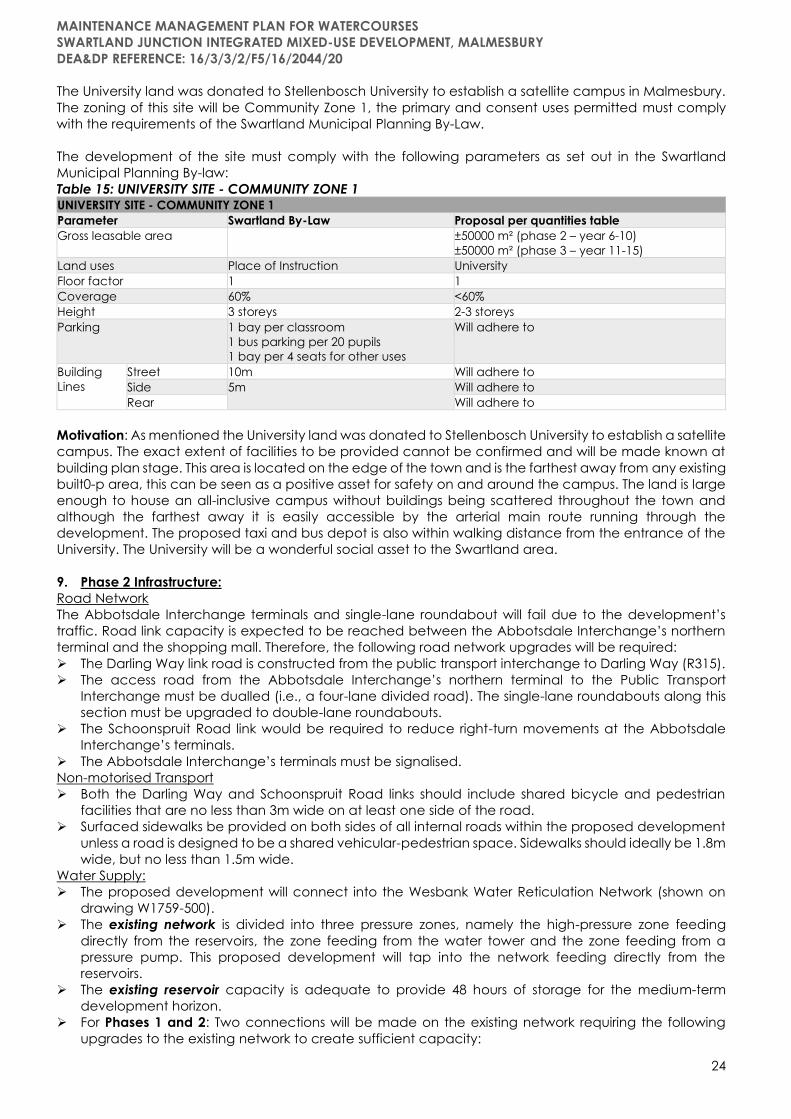
The University land was donated to Stellenbosch University to establish a satellite campus in Malmesbury.
The zoning of this site will be Community Zone 1, the primary and consent uses permitted must comply
with the requirements of the Swartland Municipal Planning By-Law.
The development of the site must comply with the following parameters as set out in the Swartland
Municipal Planning By-law:
Table 15: UNIVERSITY SITE - COMMUNITY ZONE 1 UNIVERSITY SITE - COMMUNITY ZONE 1
Parameter Swartland By-Law Proposal per quantities table
Gross leasable area ±50000 m² (phase 2 – year 6-10)
±50000 m² (phase 3 – year 11-15)
Land uses Place of Instruction University
Floor factor 1 1
Coverage 60% <60%
Height 3 storeys 2-3 storeys
Parking 1 bay per classroom
1 bus parking per 20 pupils
1 bay per 4 seats for other uses
Will adhere to
Building
Lines
Street 10m Will adhere to
Side 5m Will adhere to
Rear Will adhere to
Motivation: As mentioned the University land was donated to Stellenbosch University to establish a satellite
campus. The exact extent of facilities to be provided cannot be confirmed and will be made known at
building plan stage. This area is located on the edge of the town and is the farthest away from any existing
built0-p area, this can be seen as a positive asset for safety on and around the campus. The land is large
enough to house an all-inclusive campus without buildings being scattered throughout the town and
although the farthest away it is easily accessible by the arterial main route running through the
development. The proposed taxi and bus depot is also within walking distance from the entrance of the
University. The University will be a wonderful social asset to the Swartland area.
9. Phase 2 Infrastructure:
Road Network
The Abbotsdale Interchange terminals and single-lane roundabout will fail due to the development’s
traffic. Road link capacity is expected to be reached between the Abbotsdale Interchange’s northern
terminal and the shopping mall. Therefore, the following road network upgrades will be required:
➢ The Darling Way link road is constructed from the public transport interchange to Darling Way (R315).
➢ The access road from the Abbotsdale Interchange’s northern terminal to the Public Transport
Interchange must be dualled (i.e., a four-lane divided road). The single-lane roundabouts along this
section must be upgraded to double-lane roundabouts.
➢ The Schoonspruit Road link would be required to reduce right-turn movements at the Abbotsdale
Interchange’s terminals.
➢ The Abbotsdale Interchange’s terminals must be signalised.
Non-motorised Transport
➢ Both the Darling Way and Schoonspruit Road links should include shared bicycle and pedestrian
facilities that are no less than 3m wide on at least one side of the road.
➢ Surfaced sidewalks be provided on both sides of all internal roads within the proposed development
unless a road is designed to be a shared vehicular-pedestrian space. Sidewalks should ideally be 1.8m
wide, but no less than 1.5m wide.
Water Supply:
➢ The proposed development will connect into the Wesbank Water Reticulation Network (shown on
drawing W1759-500).
➢ The existing network is divided into three pressure zones, namely the high-pressure zone feeding
directly from the reservoirs, the zone feeding from the water tower and the zone feeding from a
pressure pump. This proposed development will tap into the network feeding directly from the
reservoirs.
➢ The existing reservoir capacity is adequate to provide 48 hours of storage for the medium-term
development horizon.
➢ For Phases 1 and 2: Two connections will be made on the existing network requiring the following
upgrades to the existing network to create sufficient capacity:

MAINTENANCE MANAGEMENT PLAN FOR WATERCOURSES
SWARTLAND JUNCTION INTEGRATED MIXED-USE DEVELOPMENT, MALMESBURY
DEA&DP REFERENCE: 16/3/3/2/F5/16/2044/20
25
❖ An additional 250mm Ø water main will be designed to increase the capacity of high-pressure
network to cater for the additional load of the commercial as well as the low-cost housing
projects.
❖ The water main in Alpha Street will be upgraded form a 150mm Ø to a 200mm Ø pipe.
❖ A 200mm Ø connection will be constructed from Kiewiet Street to create a ring main in the
commercial development.
Sewer Network:
The sewer network will gravitate to two pumpstations, positioned on the lowest part of the development
area. The position of the pumpstations are shown on the services layout map. The proposed sewerage
network will consist of uPVC Class 34 sewerage pipes with diameters varying from 160mm Ø to 250mm Ø.
All sewerage will flow to the main pumpstation from where it will be pumped across the stream and
railway line to the Malmesbury External Sewer Line, which gravitates to the Malmesbury Treatment works.
The Malmesbury External Sewer line has sufficient capacity for Phase 1 and 2 of the development.
PHASE 3 DEVELOPMENT (11 – 15 YEARS)
Phase 3 includes the development of precinct Phases 3A to 3D as per the phasing plan consisting of the
following land uses and are focused on in detail below.
Table 16: PHASE 3 DEVELOPMENT
Land Use Description Total Developed Land Area % Developed P3
1. Medium residential ±7.27 ha 100%
2. Low residential ±42.54 ha 100%
3. Business Park ±16.39nha 100%
4. Healthcare ±3.83 ha 100%
5. Agricultural allotments ±19.89 ha 100%
6. Other zonings:
6.1. Transport Zone 2
6.2. Open Space Zone 2: Private Open
Space
± 4.54 ha and ±2.07ha
100%
7. Phase 3 Infrastructure
PHASE 3 EXPANSIONS (REMAINING DEVELOPMENT COMPONENTS FROM PHASES 1 AND 2)
Big box retail / motor show rooms ±9.04 ha 50%
High density mixed use – offices and
apartments
±5.52 ha 50%
Medium density mixed use – commercial
and apartments
±7.12 ha 50%
High residential ±13.49 ha 25%
General industrial ±34.10 ha 75%
Educational – University campus ±78.84 ha 50%
1. Medium residential (±7.27ha)
The medium density residential area is located parallel to the high-density residential area to the north-
west. This shows a pattern of higher linear development next to a main route and decreasing in density
the further you move away from the arterial spine.
Figure 18: Locality of Medium Density residential sites.

MAINTENANCE MANAGEMENT PLAN FOR WATERCOURSES
SWARTLAND JUNCTION INTEGRATED MIXED-USE DEVELOPMENT, MALMESBURY
DEA&DP REFERENCE: 16/3/3/2/F5/16/2044/20
26
the medium density area will be developed with lower density flats and town housing. The zoning of this
site will be General Residential Zone 3, the primary and consent uses permitted must comply with the
requirements of the Swartland Municipal Planning By-Law. The development of the site must comply with
the following parameters as set out in the Swartland Municipal Planning By-law:
Table 17: MEDIUM DENSITY RESIDENTIAL AREA – GENERAL RESIDENTIAL ZONE 3 MEDIUM DENSITY RESIDENTIAL AREA – GENERAL RESIDENTIAL ZONE 3
Parameter Swartland By-Law Proposal per quantities table
Density 60 units per ha
Land uses Flats and/or town housing Primary use
Floor factor 2 1
Coverage 40% 40%
Height 21m ≤ 21m
Parking Flats – 1.5 per unit
Town housing – 2 per unit
Will adhere to
Building
Lines
Street 5m Will adhere to
Side 5m Will adhere to
Rear Will adhere to
Motivation: The land allocated for medium density residential is higher up against the slope of the
development area and further away from the arterial spine of the development. This area is perfectly
suited for medium density, lower in height, flats, and town houses. The combination of housing
opportunities contributes to the integration of residential uses and, also creates opportunities for investors
to enter the market according to the affordability of the various housing types.
2. Low residential (±42.54ha)
The low-density residential area is located high up the slope of the site and will overlook the proposed
development and the rest of Malmesbury. This area will possibly be developed last due to the distance
from the main arterial route.
Figure 19: Location of the low density residential area.
The proposal for this area is lower density gated estates. The zoning of this site will be General Residential
Zone 2, the primary and consent uses permitted must comply with the requirements of the Swartland
Municipal Planning By-Law. The development of the site must comply with the following parameters as
set out in the Swartland Municipal Planning By-law:
Table 18: LOW DENSITY RESIDENTIAL - GENERAL RESIDENTIAL ZONE 2 LOW DENSITY RESIDENTIAL - GENERAL RESIDENTIAL ZONE 2
Parameter Swartland By-Law Proposal per quantities table
Density 50 units per ha 40 units per ha
Land uses Town housing Primary use
Coverage 50% <50%
MAINTENANCE MANAGEMENT PLAN FOR WATERCOURSES
SWARTLAND JUNCTION INTEGRATED MIXED-USE DEVELOPMENT, MALMESBURY
DEA&DP REFERENCE: 16/3/3/2/F5/16/2044/20
27
Height 8m <8m
Parking 2 bays per unit Will adhere to
Building
Lines
Street 2m Will adhere to
Side 0m
2m (where abuts other zones)
Will adhere to
Rear Will adhere to
Motivation: The locality of this site is ideal up the slope to allow for astonishing views over Malmesbury and
the agricultural land further on. The visual impact of the site is also high and no more than 2 storey buildings
can be accommodated here. If developed correctly this area can be a residential neighbourhood with
estates allowing children to play in the streets and grow up.
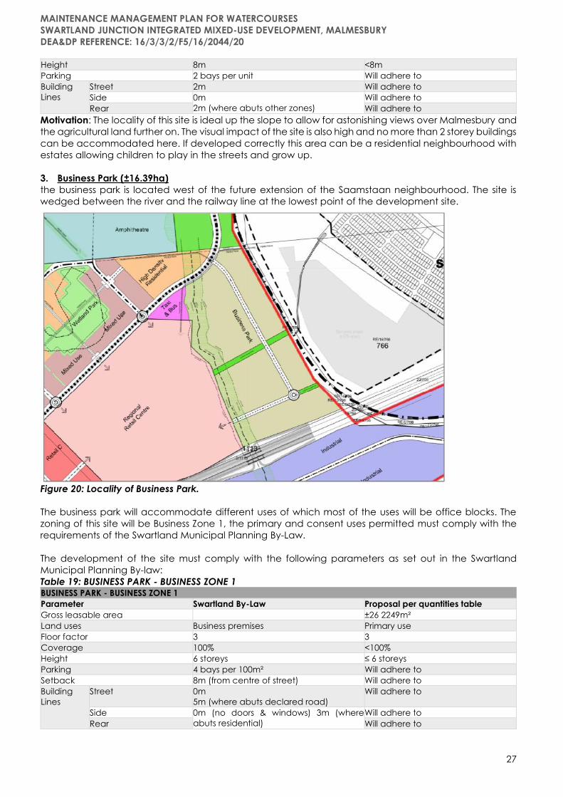
3. Business Park (±16.39ha)
the business park is located west of the future extension of the Saamstaan neighbourhood. The site is
wedged between the river and the railway line at the lowest point of the development site.
Figure 20: Locality of Business Park.
The business park will accommodate different uses of which most of the uses will be office blocks. The
zoning of this site will be Business Zone 1, the primary and consent uses permitted must comply with the
requirements of the Swartland Municipal Planning By-Law.
The development of the site must comply with the following parameters as set out in the Swartland
Municipal Planning By-law:
Table 19: BUSINESS PARK - BUSINESS ZONE 1 BUSINESS PARK - BUSINESS ZONE 1
Parameter Swartland By-Law Proposal per quantities table
Gross leasable area ±26 2249m²
Land uses Business premises Primary use
Floor factor 3 3
Coverage 100% <100%
Height 6 storeys ≤ 6 storeys
Parking 4 bays per 100m² Will adhere to
Setback 8m (from centre of street) Will adhere to
Building
Lines
Street 0m
5m (where abuts declared road)
Will adhere to
Side 0m (no doors & windows) 3m (where
abuts residential)
Will adhere to
Rear Will adhere to

MAINTENANCE MANAGEMENT PLAN FOR WATERCOURSES
SWARTLAND JUNCTION INTEGRATED MIXED-USE DEVELOPMENT, MALMESBURY
DEA&DP REFERENCE: 16/3/3/2/F5/16/2044/20
28
Motivation: The Business Park will attract large companies to establish their office headquarters in
Malmesbury. This will be a boundless economic injection in Malmesbury’s economy and will create job
opportunities for the local community. The site is located in the lowest part of the development area
creating the possibility for higher office buildings without having an impact on the visual sensitivity of the
site. The VIA suggested that the Business Park needs to be reconsidered next to the future housing project
east of the railway line. It is the intention that this will not be necessary due to the ±50m buffer area
between the two developments. This buffer area includes the railway line, an electrical servitude, and a
service servitude. This buffer area does not even include building line restrictions on both sides. The back
of the buildings will face the neighbourhood and most of the houses will be able to look over the buildings
due to the height difference of the two sites. This proposal shows integration of different uses in an area
that promotes sustainable developments.
4. Healthcare (±3.83ha)
The healthcare site is located west of the new interchange from the N7 and abuts the proposed service
station and hotel. The site is highly accessible from the N7 which allows fast transport of emergency
vehicles to and from the healthcare site.
Figure 21: Location of the Healthcare site.
The zoning of this site will be Business Zone 1, and the reason for the zoning is due to the fact that medical
investors don’t invest in healthcare sites if zoned anything but Business. The primary and consent uses
permitted must comply with the requirements of the Swartland Municipal Planning By-Law.
The development of the site must comply with the following parameters as set out in the Swartland
Municipal Planning By-law:
Table 20: HEALTHCARE - USINESS ZONE 1 HEALTHCARE - USINESS ZONE 1
Parameter Swartland By-Law Proposal per quantities table
Gross leasable area ±2 7411m²
Land uses Institution Consent use
Floor factor 3 3
Coverage 100% <100%
Height 6 storeys ≤ 6 storeys
Parking 1 bay per bed Will adhere to
Setback 8m (from centre of street) Will adhere to

MAINTENANCE MANAGEMENT PLAN FOR WATERCOURSES
SWARTLAND JUNCTION INTEGRATED MIXED-USE DEVELOPMENT, MALMESBURY
DEA&DP REFERENCE: 16/3/3/2/F5/16/2044/20
29
Building
Lines
Street 0m
5m (where abuts declared road)
Will adhere to
Side 0m (no doors & windows)
3m (where abuts residential)
Will adhere to
Rear Will adhere to
Motivation: Hospitals need to be located next to main transport routes to ensure easy and quick access
to the premises during emergencies. This site is located next to the main arterial spine of the development
and can be seen from the N7. There is a need in Malmesbury for healthcare facilities, seeing that the
town only has 1 Government hospital and Clinics in Wesbank. A private hospital will be an asset to
Swartland and will service the other rural towns in Malmesbury as well.
The medical facilities to form part of the development will provide a much-needed service in healthcare.
Access to comprehensive, quality health care services is important for promoting and maintaining health,
preventing, and managing disease, reducing unnecessary disability and premature death, and
achieving health equity for all. Health facilities play a very significant role in the mitigation of disasters
because of their particular function in treating the injured and handling outbreaks of disease. An efficient
health care system can contribute to a significant part of a town’s economy, development, and
industrialization. Health care is conventionally regarded as an important determinant in promoting the
general physical and mental health and well-being of people.
5. Agricultural allotments (±19.89ha)
the agricultural allotments area is located between the railway line and the river, just east of the University
site.
Figure 22: Locality of the Agricultural allotments.
This area is earmarked for small agricultural uses like vegetable gardens, small crop farming, and rural
living. The zoning of this site will be Agricultural Zone 3, and primary and consent uses permitted must
comply with the requirements of the Swartland Municipal Planning By-Law.
The development of the site must comply with the following parameters as set out in the Swartland
Municipal Planning By-law:

MAINTENANCE MANAGEMENT PLAN FOR WATERCOURSES
SWARTLAND JUNCTION INTEGRATED MIXED-USE DEVELOPMENT, MALMESBURY
DEA&DP REFERENCE: 16/3/3/2/F5/16/2044/20
30
Table 21: AGRICULTURAL ALLOTMENTS - AGRICULTURAL ZONE 3 AGRICULTURAL ALLOTMENTS - AGRICULTURAL ZONE 3
Parameter Swartland By-Law Proposal per quantities table
Land uses Agriculture Primary use
Height 8m Will adhere to
Building
Lines
Street 30m Will adhere to
Side 30m
10m if site is smaller than 2ha
Will adhere to
Rear Will adhere to
Motivation: This area is not feasible to develop and is proposed as an urban agriculture area. The area
can be cultivated and can include vegetable gardens and small crop farming. If the area is proposed
for subdivision, smallholdings of 2ha and larger can be created. This area will be allocated to the
community.
6. Other zonings:
6.1. TRANSPORT ZONE 2: ROADS
All roads will be zoned Transport Zone 2: Roads, the primary and consent uses allowed in this zone are as
follows: Zoning Primary uses Consent uses
Transport
Zone 2: Roads
Public Street, Private Road, Public Parking, Private Parking,
Filming.
Any use determined by the
municipality.
The further subdivision of the superblocks will allocate the roads where needed in the development. This
rezoning will allow the developer to not only develop the specific use but ensure that all roads in the area
are zoned as per the Swartland Municipal Land Use Planning By-law. Most of the roads will be public roads
and transferred to Swartland Municipality after construction. Private roads will be located in gated areas
where services and roads will be managed by the Homeowners Association or Body Corporate.
6.2. OPEN SPACE ZONE 2: PRIVATE OPEN SPACE
Green Open Space Zones (±2.07ha) and Wetland Park (±4.54ha)
In the Freshwater study there was a few water sources that were highlighted, being the wetland and two
non-perennial rivers. The wetland area will be protected and rehabilitated as a feature in the
development and will also be a central natural space for people to enjoy, being referred to as the
wetland park. A flood line determination was done on portions of the eastern non-perennial rivers to
ensure safe development and protection of the vegetation around the river. No development will be
allowed within the flood line or 32m off-set line from the rivers or within the buffer area, as set out in the
framework plan.
Figure 23: Green areas around wetland and rivers.

MAINTENANCE MANAGEMENT PLAN FOR WATERCOURSES
SWARTLAND JUNCTION INTEGRATED MIXED-USE DEVELOPMENT, MALMESBURY
DEA&DP REFERENCE: 16/3/3/2/F5/16/2044/20
31
To protect these natural areas, it is proposed that it is zoned Open Space Zone 2: Private open space,
the following table shows the primary and consent uses allowed.
Zoning Primary uses Consent uses
Open space zone 2:
Private open space
Private open space, Conservation usage,
Transmission tower, Rooftop base station, Filming.
Cemetery, Wall of remembrance,
camping site, 4x4 route, Boat launching
facility, Racing track.
These areas will be owned privately to ensure that the natural area is rehabilitated and to prevent loss of
any natural vegetation through over-use by the public. These natural corridors will become natural
features in the development with sustainable facilities to sit down and also walkways to ensure minimum
disturbance.
7. Phase 3 Infrastructure:
Roads and Transport:
➢ An updated TIA should be completed and approved for Phase 3 before its implementation and any
successive phases.
Water Supply:
The Wesbank reservoirs have sufficient capacity to supply Phase 1 and 2 of the Swartland Junction
Development. The construction of the De Hoop reservoirs will be necessitated by the implementation of
the bulk supply network from the Wesbank Reservoirs to Riverlands and Chatsworth. The development of
Phase 3 of the development will require:
➢ An additional 8.0 Megaliter reservoir capacity.
➢ The water network will have to be upgraded in accordance with the GLS masterplan.
Sewer Network:
The outfall sewer will reach its capacity 50% through phase 3 of the development. When the outfall sewer
reaches its capacity, the additional sewerage can be pumped directly to the sewerage treatment.
NON-PHASED INFRASTRUCTURE
This section lists all the infrastructure applicable during all phases of development implementation as well
as infrastructure recommendations by specialist / technical investigations.
Parking Requirements:
➢ Parking be provided in accordance with Swartland’s Municipal Land Use Planning Bylaw, with the
exception of the following uses where the lower off-street parking ratios given below are considered
to be more appropriate for the development, given its mixed-use nature, access to public transport
and walkability:
o Shopping mall: 4 bays per 100m2 GLA
o Office / Agri Techno Park: 2.5 bays per 100m2 GLA
o Flats: 1 bay per unit (residents) + 0.25 bays per unit (visitors)
➢ Parking sharing / communal parking areas should be considered to allow for the more efficient use
of parking areas.
➢ Disabled and loading bays be provided in accordance with Swartland’s Municipal Land Use Planning
Bylaw.
Internal Roads:
➢ The internal roads defining the development blocks will have lane widths varying from 3.4m to 3.7m.
The road widths will be designed in accordance with the Traffic Impact Study. The roads will have
premix surface with barrier kerbs on both sides. The 2.0m wide sidewalks will be
tarred/paved/gravelled, depending on the location within the development.
Non-motorised Transport
➢ Surfaced sidewalks be provided on both sides of all internal roads within the proposed development
unless a road is designed to be a shared vehicular-pedestrian space. Sidewalks should ideally be 1.8m
wide, but no less than 1.5m wide.
Stormwater:
A stormwater network will be installed in the road reserves. The roads will be cambered with stormwater
catchpits on either side of the road. The maximum distance between the catchpits is 90m. The minimum
diameter concrete pipes to be used is 375mm Ø. Stormwater will be discharged in the non-perennial
streams on the northern, as well as the southern side of the property. Both these streams are tributaries of
the Diep River running north to south approximately 300m from the eastern boundary.

MAINTENANCE MANAGEMENT PLAN FOR WATERCOURSES
SWARTLAND JUNCTION INTEGRATED MIXED-USE DEVELOPMENT, MALMESBURY
DEA&DP REFERENCE: 16/3/3/2/F5/16/2044/20
32
The property will be subdivided into superblocks/precincts as shown on the SDP and Zoning Maps. Each
precinct will be subdivided at a later stage by their respective owners / developers. The developers of
these precincts will have to provide onsite retention facilities to ensure that the post-development
stormwater runoff from the site is limited to the pre-development volumes. Each individual precinct
development is responsible to provide onsite retention facilities before discharging it in the stormwater
system.
Solid Waste:
The solid waste disposal service will fall under the Swartland Municipality as normal services to the area.
Waste will be disposed of at the Highlands Solid waste disposal site bordering on the development.
Electricity Supply:
Swartland Power Solutions (SWAP) is a company dedicated to the development, construction,
commissioning and operation of renewable electrical generation and supply infrastructure within the
Swartland, Western Cape municipal area.
In this context, SWAP is currently developing a renewable generation facility adjacent to the Swartland
Junction development, primarily to ensure sufficient and uninterrupted electrical services to the
development and surrounds. Subject to the relevant regulatory, permitting, contractual, commercial
finance and all other applicable approvals, SWAP can confirm the following:
➢ Sufficient electrical supply services will be available to service all aspects of the Swartland Junction
Development from the date that these services are required by the various off-takers within the
development.
➢ Due to the relatively short construction period (<12 months), and close proximity between the
generation facility and the off-takers within the development, no delays are anticipated in planning
and executing the Electrical Supply Infrastructure programme.
➢ Due to the modular nature of the planned renewable energy infrastructure, SWAP can commit to
ensuring sufficient supply of electricity throughout the various planned development phases of the
Swartland Junction Development.
UrbanEQ - TIA Recommendations:
• A traffic impact study was undertaken by UrbanEQ (Pty) Ltd. The phased road construction will be
implemented in accordance with the recommendations. Pedestrian linkages between Wesbank and
the development will be required. A safe railway crossing will form part of the pedestrian route.
• The single carriageway section of the road will have traffic lanes of 4.0m wide and a 0.9m shoulder
on either side. Where a dual carriageway road is required, the traffic lanes will be narrowed down to
3,4m and 3, 7m. The road widths will be designed in accordance with the Traffic Impact Study.
• The portion of the Darling Way link road between the single-lane roundabouts (located on northern
side of the Abbotsdale Interchange) up to the proposed public transport interchange be constructed
as a 2-lane road.
• The public transport interchange is constructed for Phase 1 of the framework development. The public
transport operators, Swartland Municipality, the Provincial Regulating Entity (PRE) and the Department
of Transport and Public Works (DTPW) should be consulted in the detailed design of the facility and a
layout agreed before building plan approval is given.
• A pedestrian footbridge (2m wide trafficable surface) and connecting shared bicycle and pedestrian
routes (minimum 3m wide) be provided across the railway line and river on the northern side of the
site as part of the implementation of Phase 1.
• The following road network upgrades needs to be constructed:
o The Darling Way link road is constructed from the public transport interchange to Darling Way
(R315).
o The portion of the road between the Abbotsdale Interchange’s northern terminal and the
public transport interchange be upgraded to a four-lane divided roadway (i.e. dual
carriageway). All roundabouts along this section should be upgraded to double-lane
roundabouts.
o The Schoonspruit Road link is constructed.
o Both of Abbotsdale Interchange’s terminals are signalised.
• Both the Darling Way and Schoonspruit Road links, when implemented for Phase 2, should include
shared bicycle and pedestrian facilities that are no less than 3m wide on at least one side of the road.
• Surfaced sidewalks be provided on both sides of all internal roads within the proposed development
unless a road is designed to be a shared vehicular-pedestrian space. Sidewalks should ideally be 1.8m
wide, but no less than 1.5m wide.

MAINTENANCE MANAGEMENT PLAN FOR WATERCOURSES
SWARTLAND JUNCTION INTEGRATED MIXED-USE DEVELOPMENT, MALMESBURY
DEA&DP REFERENCE: 16/3/3/2/F5/16/2044/20
33
• Parking be provided in accordance with Swartland’s Municipal Land Use Planning Bylaw, with the
exception of the following uses where the lower off-street parking ratios given below are considered
to be more appropriate for the development, given its mixed-use nature, access to public transport
and walkability:
o Shopping Mall: 4 bays per 100m2 GLA
o Office / Agri Techno Park: 2.5 bays per 100m2 GLA
o Flats: 1 bay per unit (residents) + 0.25 bays per unit (visitors)
• Parking sharing / communal parking areas should be considered to allow for the more efficient use
of parking areas.
• Disabled and loading bays be provided in accordance with Swartland’s Municipal Land Use Planning
Bylaw.
ITS - TIA Recommendations:
➢ Intersection 11 - Darling/Western Ring Road intersection: Install a traffic signal when warranted and
construct a separate northbound right-turn lane.
➢ Intersection 12 - Western Ring Road/Internal road: Construct a 30m single lane roundabout.
➢ Intersection 15 - Western Ring Road/Internal road: roundabout construct a 30m single lane.
Figure 24: ITS TIA Recommendations Map.
UrbanEQ - TIA Addendum Conclusions
➢ Revision T does not change the recommendations of the original TIA (dated 05 March 2020), other
than ensuring compliance with the new AMG 2020 minimum access spacing requirements. The
development planning is still at a high level and therefore detail on shoulder sight distance cannot
be provided. However, future compliance with minimum shoulder sight distances can be ensured by
the provision of corner splays at full unsignalised intersections and high-volume driveway accesses
and setting back structures where significant road curvature is present.
➢ Lastly, the road-over-rail bridge for the new link road should be constructed through contributions by
the various planned developments in the area.
1.4 LEGISLATIVE CONTEXT
NATIONAL ENVIRONMENTAL MANAGEMENT ACT, AS AMENDED (ACT NO. 107 OF 1998)
The National Environmental Management Act, 1998 (Act No. 107 of 1998) (NEMA) makes provision for the
identification and assessment of activities that are potentially detrimental to the environment and which
require authorisation from the relevant authorities based on the findings of an environmental assessment.
NEMA is a national act, which is enforced by the Department of Environmental Affairs (DEA). These powers

MAINTENANCE MANAGEMENT PLAN FOR WATERCOURSES
SWARTLAND JUNCTION INTEGRATED MIXED-USE DEVELOPMENT, MALMESBURY
DEA&DP REFERENCE: 16/3/3/2/F5/16/2044/20
34
are often delegated to the Department of Environmental Affairs and Development Planning (DEA&DP)
in the Western Cape.
The National Environmental Management Act (107 of 1998) as amended, and the Environmental Impact
Assessment Regulations (2014) as amended, govern the process of applying for environmental
authorisation for certain developments. Lists of activities which require environmental authorisation are
published in three listing notices (GNR 324, 325, and 327 of April 2017). Provision in the EIA Regulations is
made for two forms of assessment: Basic Assessment and Scoping and EIA. The EIA regulations specify
that:
• Activities identified in Listing Notice 1 (GNR 327 of 2017I requires Basic Assessment,
• Activities identified in Listing Notice 2 (GNR 325 of 2017) are subject to a Scoping and EIA,
• Activities identified in Listing Notice 3 (GNR 324 of 2017) requires Basic Assessment.
Where activities have been identified in Listing Notice 2, Scoping and EIA must be undertaken. This
application will follow a Scoping/EIA Process. The listed activities associated with the proposed
development are listed in the table below:
NEMA - IDENTIFIED LISTED ACTIVTIES Activity
No(s):
Provide the relevant Basic Assessment
Activity(ies) as set out in Listing Notice 1
Describe the portion of the proposed development to which the
applicable listed activity relates.
9 The development of infrastructure
exceeding 1 000 metres in length for the
bulk transportation of water or storm water-
(i) with an internal diameter of 0,36 metres
or more; or (ii) with a peak throughput of
120 litres per second or more;
Development of water and stormwater infrastructure as detailed
in the project description. Technical specifications must adhere to
requirements as per civil services reports. See proposed services
layout map Appendix B3.
10 The development and related operation of
infrastructure exceeding 1 000 metres in
length for the bulk transportation of
sewage, effluent, process water,
wastewater, return water, industrial
discharge or slimes- (i) with an internal
diameter of 0,36 metres or more; or (ii) with
a peak throughput of 120 litres per second
or more;
Development of sewer infrastructure as detailed in the project
description. Technical specifications must adhere to requirements
as per civil services reports. See proposed services layout map
Appendix B3.
12 The development of- (i) dams or weirs,
where the dam or weir, including
infrastructure and water surface area,
exceeds 100 square metres; or (ii)
infrastructure or structures with a physical
footprint of 100 square metres or more;
where such development occurs- (a) within
a watercourse; (b) in front of a
development setback; or (c) if no
development setback exists, within 32
metres of a watercourse, measured from
the edge of a watercourse;
The development of service infrastructure associated with the
proposed development will result in infrastructure crossing the
watercourses or located within the regulated area of the defined
watercourses traversing the development footprint. Refer to the
Layout of infrastructure indicating the river crossings or relation to
the watercourses in Appendix B3.4.
Please refer to Appendix E2 for a summary of the water uses
triggered and applied for in terms of section 21 of the NWA.
14 The development and related operation of
facilities or infrastructure, for the storage, or
for the storage and handling, of a
dangerous good, where such storage
occurs in containers with a combined
capacity of 80 cubic metres or more but
not exceeding 500 cubic metres.
Site installation specifications:
Each service station’s fuel installation will consist of the following:
➢ 2x underground petrol tanks.
➢ 3x underground diesel tanks.
➢ Forecourt with 8x multi product dispensers.
Development proposal:
Two service stations are being proposed for the development. The
one service station will be located at a shopping centre, and the
other service station will be in a commercial area. The final
location for the second service station is still to be confirmed.
Each service station will consist of five 23m3 underground tanks.
Two of the tanks will be used for petrol and three will be used for
diesel. The underground tank farm will be located between the
forecourt and the access road as far from the fast-food outlets and
shops as is possible.

MAINTENANCE MANAGEMENT PLAN FOR WATERCOURSES
SWARTLAND JUNCTION INTEGRATED MIXED-USE DEVELOPMENT, MALMESBURY
DEA&DP REFERENCE: 16/3/3/2/F5/16/2044/20
35
The forecourt will have eight back-to-back dispensers that will be
dispense petrol and diesel. The forecourt will have a spill
catchment area connected to an oil/ water separator.
The road tanker filling point will be located close to the tank farm
and will be placed in such a way as not to obstruct traffic
movement at the site. It is expected that a road tanker will visit the
service stations three times per week. There will be hydrants, hose
reels and fire extinguishers located at the site.
19 The infilling or depositing of any material of
more than 10 cubic metres into, or the
dredging, excavation, removal or moving
of soil, sand, shells, shell grit, pebbles or rock
of more than 10 cubic metres from- (i) a
watercourse;
The development of service infrastructure associated with the
proposed development will result in infrastructure crossing the
watercourses or located within the regulated area of the defined
watercourses traversing the development footprint. Refer to the
Layout of infrastructure indicating the river crossings or relation to
the watercourses in Appendix B3.4.
Please note that no watercourses will be infilled - however the
cumulative volume of material that may need to be added or
removed for the construction or maintenance of infrastructure
within the watercourse or regulated area of the water course may
exceed the 10 cubic meter threshold as per the listed activity.
All construction, operational and maintenance work to be
undertaken in accordance with the approved EMPr which has
been informed by specialist input to mitigate negative impacts
that cannot be avoided.
Please refer to Appendix E2 for a summary of the water uses
triggered and applied for in terms of section 21 of the NWA.
24 The development of a road - (i) for which
an environmental authorisation was
obtained for the route determination in
terms of activity 5 in Government Notice
387 of 2006 or activity 18 in Government
Notice 545 of 2010; or (ii) with a reserve
wider than 13,5 meters, or where no reserve
exists where the road is wider than 8 metres;
The development of roads as detailed in the project description.
The technical specifications as set out in the services reports and
TIA’s must be adhered to when implementing the development
components. The proposed road layout is attached in Appendix
B3.5. All construction, operational and maintenance work to be
undertaken in accordance with the approved EMPr which has
been informed by specialist input to mitigate negative impacts
that cannot be avoided.
28 Residential, mixed, retail, commercial,
industrial or institutional developments
where such land was used for agriculture,
game farming, equestrian purposes or
afforestation on or after 01 April 1998 and
where such development: (i) will occur
inside an urban area, where the total land
to be developed is bigger than 5 hectares;
or (ii) will occur outside an urban area,
where the total land to be developed is
bigger than 1 hectare;
Development of a 361ha integrated mixed use development, as
detailed in the project description, on areas zoned and used for
agricultural purposes.
Activity
No(s):
Provide the relevant Basic Assessment
Activity(ies) as set out in Listing Notice 3
Describe the portion of the proposed development to which the
applicable listed activity relates.
4 The development of a road wider than 4
metres with a reserve less than 13,5 metres
i. Western Cape i. Areas zoned for use as
public open space or equivalent zoning; ii.
Areas outside urban areas; (aa) Areas
containing indigenous vegetation; (bb)
Areas on the estuary side of the
development setback line or in an
estuarine functional zone where no such
setback line has been determined; or iii.
Inside urban areas: (aa) Areas zoned for
conservation use; or (bb) Areas designated
for conservation use in Spatial
Development Frameworks adopted by the
competent authority.
The development of roads as detailed in the project description.
The technical specifications as set out in the services reports and
TIA’s must be adhered to when implementing the development
components. The proposed road layout is attached in Appendix
B3.5.
All construction, operational and maintenance work to be
undertaken in accordance with the approved EMPr which has
been informed by specialist input to mitigate negative impacts
that cannot be avoided.
12 The clearance of an area of 300 square
metres or more of indigenous vegetation
Clearing activities for the 361ha development will result in the loss
of indigenous vegetation.

MAINTENANCE MANAGEMENT PLAN FOR WATERCOURSES
SWARTLAND JUNCTION INTEGRATED MIXED-USE DEVELOPMENT, MALMESBURY
DEA&DP REFERENCE: 16/3/3/2/F5/16/2044/20
36
except where such clearance of
indigenous vegetation is required for
maintenance purposes undertaken in
accordance with a maintenance
management plan. i. Western Cape i.
Within any critically endangered or
endangered ecosystem listed in terms of
section 52 of the NEMBA or prior to the
publication of such a list, within an area
that has been identified as critically
endangered in the National Spatial
Biodiversity Assessment 2004;
The terrestrial area was ploughed, and signs of agricultural
engineered contours is still evident. The area has not been
ploughed the last ten years. The vegetation is commonly
dominated by alien grasses (Cynodon dactylon), Leysera
gnaphalodes, Hermannia sp., Ornithogalum fimbrimarginatum,
small patches of Galenia Africana and two Elytropappus
rhinocerotis plants because of the current and past agricultural
activities in the area. The area that will be impacted by the
proposed developed was classified having a poor ecological
status because of the past and current agricultural practices.
Activity
No(s):
Provide the relevant Scoping and EIR
Activity(ies) as set out in Listing Notice 2
Describe the portion of the proposed development to which the
applicable listed activity relates.
4
The development and related operation of
facilities or infrastructure, for the storage, or
storage and handling of a dangerous
good, where such storage occurs in
containers with a combined capacity of
more than 500 cubic metres.
The development of a 25MWh lithium battery storage capacity.
The battery storage facility will consist of 12 – 15 12m shipping
containers which would have a maximum capacity of 1129.5
cubic meters. The actual storage capacity intended for this
application is 200 – 300 cubic metres, depending on final design.
15 The clearance of an area of 20 hectares or
more of indigenous vegetation.
Clearing activities for the 361ha development will result in the loss
of indigenous vegetation.
The terrestrial area was ploughed, and signs of agricultural
engineered contours is still evident. The area has not been
ploughed the last ten years. The vegetation is commonly
dominated by alien grasses (Cynodon dactylon), Leysera
gnaphalodes, Hermannia sp., Ornithogalum fimbrimarginatum,
small patches of Galenia Africana and two Elytropappus
rhinocerotis plants because of the current and past agricultural
activities in the area. The area that will be impacted by the
proposed developed was classified having a poor ecological
status because of the past and current agricultural practices.
27
The development of a road - (i) … (ii) … (iii)
with a reserve wider than 30 metres; or (iv)
catering for more than one lane of traffic in
both directions;
The development of roads as detailed in the project description.
The technical specifications as set out in the services reports and
TIA’s must be adhered to when implementing the development
components. The proposed road layout is attached in Appendix
B3.5.
All construction, operational and maintenance work to be
undertaken in accordance with the approved EMPr which has
been informed by specialist input to mitigate negative impacts
that cannot be avoided.
NATIONAL WATER ACT (ACT 36 OF 1998)
The fundamental objective of the National Water Act (Act 36 of 1998) is to ensure the protection of the
aquatic ecosystems of South Africa’s water resources. The development proposal would require a water
use license in terms of section 21 c and i, for development components proposed within the regulated
area(s) as defined the NWA Regulations.
The WULA for the water uses triggered by the proposed development has been submitted (phase 3 –
technical reports submitted 15 May 2021) on the eWULAAs platform. A summary of the Application
(including a list of all the water uses) are provided below:

MAINTENANCE MANAGEMENT PLAN FOR WATERCOURSES
SWARTLAND JUNCTION INTEGRATED MIXED-USE DEVELOPMENT, MALMESBURY
DEA&DP REFERENCE: 16/3/3/2/F5/16/2044/20
37
PHASE 3 Summary Report - Swartland Junction Mixed Use Development, Malmesbury (WU17415)
Description of Activities in Relation to the Water Use Application: The Swartland Junction is an integrated mixed-use
development to connect Malmesbury and Abbotsdale and has a developable area of approximately 338ha. The
development will include uses like low to high density residential, commercial, healthcare and educational facilities.
The project is to be spread out over a 15-year timeframe in 5-year cycles resulting in three development phases.
The development area is located south-west of the existing built up area of Malmesbury and north-east of the built-
up area of Abbotsdale. The main water features within the study area comprise of the Diep River, two non-perennial
rivers which is tributaries of the Diep River and a unchanneled valley-bottom wetland. From the assessment of
freshwater features within the study area, it can be concluded that there are no significant freshwater features that
would potentially be impacted by the proposed development, provided that the mitigation and management
measures included in this report are implemented and adhered to and the appropriate buffer areas established be
maintained. The unchanneled valley bottom wetland will not be impacted and the established buffer area is
assessed to be appropriate and significant. A small area of the Eastern non- perennial river will be impacted upon
during the construction of the road and pedestrian crossings and installation of services.
Pre Application Enquiry Submission Date: 8/4/2020 9:35:44 AM
Application Date: 3/3/2021 12:00:00 AM
Phase 3 Submission Date:
Primary Contact: Mrs Lauren Abrahams
Cell: +27662109892
Tel: 0662109892
Email: [email protected]
Signatory Contact: Mrs Lauren Abrahams
Cell: +27662109892
Tel: 0662109892
Email: [email protected]
TECHNICAL DOCUMENTATION
Status / Document Description / Loaded By On
Compulsory: Water Use Licence Application Water
Resource Report
Water Use Licence Application Water Resource Report
Lauren Abrahams 5/15/2021 3:50:04 PM
Compulsory: Section 27 Motivation SECTION 27 MOTIVATION Lauren Abrahams 3/19/2021
1:15:24 PM
Compulsory: Public Participation Advert Notice
Summary of PPP undertaken during the EIR process in
accordance with the "One Environmental System"
guideline. Lauren Abrahams 5/15/2021 3:51:29 PM
Optional: Additional Technical Document BBBEE CERTIFICATE - AGRI INDUSTRIA (PTY) LTD
(APPLICANT) Lauren Abrahams 5/15/2021 8:21:20 PM
Optional: Additional Technical Document Risk Assessment Matrix Lauren Abrahams 5/15/2021
3:51:55 PM
Optional: Additional Technical Document WATER USE OVERLAY MAP Lauren Abrahams 5/15/2021
8:20:17 PM
Compulsory: Wetland Assessment Report
Freshwater Ecology Impact Assessment - all freshwater
aquatic features have been identified, described and
assessed by a SACNASP registered Specialist. Lauren
Abrahams 3/19/2021 1:08:43 PM
APPLICATION FORMS
Client Registration DW758 - Registration/Licensing Part 1 - Company, Business, Partnership Or Community, National
Or Provincial Government
Portion 1 of Land Parcel 1113 of the Major Region MALMESBURY DW901 - Property where water use occurs
Portion 1 of Land Parcel 1113 of the Major Region MALMESBURY DW902 - Details of Property Owner
Land Parcel 1113 of the Major Region MALMESBURY DW901 - Property where water use occurs
Land Parcel 1113 of the Major Region MALMESBURY DW902 - Details of Property Owner
Land Parcel 353 of the Minor Region ABBOTSDALE DW901 - Property where water use occurs
Land Parcel 353 of the Minor Region ABBOTSDALE DW902 - Details of Property Owner
16. NEW 600mm Ø STORMWATER PIPE: OUTLET POSITION INTO RIVER (EASTERN BOUNDARY TRIBUTARY) DW768 -
Altering The Bed, Banks, Course Or Characteristics Of A Watercourse (i)
3. NEW 600mm Ø STORMWATER PIPE: OUTLET POSITION INTO RIVER (EASTERN BOUNDARY TRIBUTARY) DW763 -
Impeding or diverting the flow of water in a watercourse (c)
15. New 250mm WATER PIPELINE: RIVER CROSSING POSITION (EASTERN BOUNDARY TRIBUTARY) DW768 - Altering The
Bed, Banks, Course Or Characteristics Of A Watercourse (i)
2. New 250mm WATER PIPELINE: RIVER CROSSING POSITION (EASTERN BOUNDARY TRIBUTARY) DW763 - Impeding or
diverting the flow of water in a watercourse (c)
18. NEW 200mm Ø WATER PIPE: RIVER CROSSING POSITION (EASTERN BOUNDARY TRIBUTARY) DW768 - Altering The
Bed, Banks, Course Or Characteristics Of A Watercourse (i)
5. NEW 200mm Ø WATER PIPE: RIVER CROSSING POSITION (EASTERN BOUNDARY TRIBUTARY) DW763 - Impeding or
diverting the flow of water in a watercourse (c)
25. NEW 160mm diam. SEWER PIPE: RIVER CROSSING POSITION WITHIN EXISTING ROADWAY (EASTERN BOUNDARY
TRIBUTARY) DW768 - Altering The Bed, Banks, Course Or Characteristics Of A Watercourse (i)

MAINTENANCE MANAGEMENT PLAN FOR WATERCOURSES
SWARTLAND JUNCTION INTEGRATED MIXED-USE DEVELOPMENT, MALMESBURY
DEA&DP REFERENCE: 16/3/3/2/F5/16/2044/20
38
23. NEW 160mm diam. SEWER PIPE: RIVER CROSSING POSITION (WESTERN BOUNDARY TRIBUTARY) DW768 - Altering
The Bed, Banks, Course Or Characteristics Of A Watercourse (i)
17. 160mm DIAM. SEWER RISING MAIN: RIVER CROSSING POSITION (EASTERN BOUNDARY TRIBUTARY) DW768 -
Altering The Bed, Banks, Course Or Characteristics Of A Watercourse (i)
12. NEW 160mm diam. SEWER PIPE: RIVER CROSSING POSITION WITHIN EXISTING ROADWAY (EASTERN BOUNDARY
TRIBUTARY) DW763 - Impeding or diverting the flow of water in a watercourse (c)
10. NEW 160mm diam. SEWER PIPE: RIVER CROSSING POSITION (WESTERN BOUNDARY TRIBUTARY) DW763 - Impeding
or diverting the flow of water in a watercourse (c)
4. 160mm DIAM. SEWER RISING MAIN: RIVER CROSSING POSITION (EASTERN BOUNDARY TRIBUTARY) DW763 -
Impeding or diverting the flow of water in a watercourse (c)
19. MAIN SEWER PUMP STATION ABOVE THE 1:100 YEAR FLOODLINE (EASTERN BOUNDARY TRIBUTARY) DW768 -
Altering The Bed, Banks, Course Or Characteristics Of A Watercourse (i)
6. MAIN SEWER PUMP STATION ABOVE THE 1:100 YEAR FLOODLINE (EASTERN BOUNDARY TRIBUTARY) DW763 -
Impeding or diverting the flow of water in a watercourse (c)
26. DEVELOPMENT WITHIN THE REGULATED AREA OF A WETLAND DW768 - Altering The Bed, Banks, Course Or
Characteristics Of A Watercourse (i)
24. NEW WATER PIPE: RIVER CROSSING POSITION WITHIN EXISTING ROADWAY (EASTERN BOUNDARY TRIBUTARY)
DW768 - Altering The Bed, Banks, Course Or Characteristics Of A Watercourse (i)
22. NEW WATER PIPE: RIVER CROSSING POSITION WITHIN EXISTING ROADWAY (WESTERN BOUNDARY TRIBUTARY) W768
- Altering The Bed, Banks, Course Or Characteristics Of A Watercourse (i)
14. ROAD: CROSSING RIVER BY MEANS OF CULVERT (EASTERN BOUNDARY TRIBUTARY) DW768 - Altering The Bed,
Banks, Course Or Characteristics Of A Watercourse (i)
13. DEVELOPMENT WITHIN THE REGULATED AREA OF A WETLAND DW763 - Impeding or diverting the flow of water in a
watercourse (c)
11. NEW WATER PIPE: RIVER CROSSING POSITION WITHIN EXISTING ROADWAY (EASTERN BOUNDARY TRIBUTARY)
DW763 - Impeding or diverting the flow of water in a watercourse (c)
9. NEW WATER PIPE: RIVER CROSSING POSITION WITHIN EXISTING ROADWAY (WESTERN BOUNDARY TRIBUTARY)
DW763 - Impeding or diverting the flow of water in a watercourse (c)
1. ROAD: CROSSING RIVER BY MEANS OF CULVERT (EASTERN BOUNDARY TRIBUTARY) DW763 - Impeding or diverting
the flow of water in a watercourse (c)
8. NEW 160mm diam. SEWER PIPE WITHIN REGULATED AREA (100M WATERCOURSE) DW763 - Impeding or diverting
the flow of water in a watercourse (c)
7. SEWER PUMP STATION WITHIN REGULATED AREA (100M WATERCOURSE) (WESTERN BOUNDARY
TRIBUTARY) DW763 - Impeding or diverting the flow of water in a watercourse (c)
21. NEW 160mm diam. SEWER PIPE WITHIN REGULATED AREA (100M WATERCOURSE) DW768 - Altering The Bed, Banks,
Course Or Characteristics Of A Watercourse (i)
20. SEWER PUMP STATION WITHIN REGULATED AREA (100M WATERCOURSE) (WESTERN BOUNDARY TRIBUTARY) DW768 -
Altering The Bed, Banks, Course Or Characteristics Of A Watercourse (i)
PROPOSED MAINTENANCE ACTIVTIES CLASSIFIED BY MAINTENANCE CATEGORY TYPE
The maintenance activities required by the development proposal has been broadly classified by the
categories as provided in the table below:
MAINTENANCE CATEGORY MAINTENANCE ACTIVITIES REQUIRED TO BE UNDERTAKEN
Category A:
Sediment removal because of
deposition or sediment deposition as
a result of erosion
• Clearing sediment or placing sediment at:
o Pump hole/trench (pipelines – bulk civils, road
infrastructure, etc.)
o Stormwater outfall (maintenance of anti-erosion
mechanisms – such as reno mattress)
o Bridges, culverts, and drifts
Category B:
Emergency repairs – urgent action
required to manage risk and damage
to assets
• Repair to erosion of riverbanks / beds / floodplain resulting
from servicing infrastructure (e.g., pipelines/road
culverts/stormwater outlet culverts)
• Removal of material built up because of
flooding/sedimentation and increasing risk to
infrastructure.
• Address damage or replacement of infrastructure (e.g.,
pipelines -bulk civils/road culverts/stormwater pipelines
and outlet culverts).

MAINTENANCE MANAGEMENT PLAN FOR WATERCOURSES
SWARTLAND JUNCTION INTEGRATED MIXED-USE DEVELOPMENT, MALMESBURY
DEA&DP REFERENCE: 16/3/3/2/F5/16/2044/20
39
• Manage the condition of flood protection berms, and
existing structures such as gabions, canalized and
stormwater systems.
• Installing temporary gravel approaches at flood-
damaged river crossings / anti-erosion mechanisms (reno
mattress) included with infrastructure installation as per
engineer design specifications
Category C:
Managing alien invasive and bush
encroachment plant species
• Clearing of alien invasive vegetation out of a watercourse
to reduce maintenance requirements as they relate to
erosion and sedimentation.
• Management of indigenous species categorized as bush
encroachment, to improve hydrological flow and reduce
associated flooding impacts.
Category D:
Rehabilitation and restoration
activities for maintaining ecological
infrastructure
• Development and maintenance of ecological buffering
systems to improve and/or restore functioning (e.g.,
wetlands, watercourses, and stormwater detention
ponds).
• Actively rehabilitating riparian zones through planting of
locally indigenous species.
• Bank grading and movement/removal of berms and
barriers to flow.
Please refer to the Freshwater Ecology Impact Assessment Report, Included as Appendix G4 of the
Revised Draft EIR for details pertaining to a description and identification of the the on-site watercourses
as well as details pertaining to the geographical, physical, biodiversity sensitivity, current ecological
state, current and required condition of the on-site watercourses. The report sets out the identified impacts
resulting from the development proposal which includes the compilation of a DWS risk assessment matrix
categorising the assessed risk and associated significance of the impacts resulting from the activities.
Please also refer to the Revised Draft EIR which sets out the PPP undertaken as well as consultation with
the various stakeholders and authorities administering legislation applicable to this plan. Please refer to
the impact assessment which assesses the impacts resulting from ALL proposed development
components and activities. This MMP must be read and implemented in conjunction with the approved
EA, WULA, EMPr and Addendums appended thereto.
All site maps (Locality, Biodiversity Overlay, Site sensitivities overlay, Watercourse and wetlnd delineation
overlay, 1:100 year floodline, and SDP) are provided in the EMPr as well as in the Appendices of the
Revised Draft EIR.
2.1 METHOD STATEMENTS
The development of appropriate method statements to mitigate the impact of the maintenance
needs, should be aligned within the framework of these considerations:
• Watercourses experience a natural process of sedimentation and erosion, with varying rates
depending on the geomorphology and the integrity of the land-uses within the catchment;
• Manipulation of the watercourse results in increased erosion and/or deposition being experienced
further downstream, perpetuating greater need for manipulation and more drastic and costly
maintenance interventions;
• Locally indigenous riparian and wetland vegetation assists in the stabilization of river banks
through effective root structures, while contributing to improve in-stream habitat and water
quality conditions;
• Invasive alien and bush encroachment vegetation significantly impacts on the functioning of a
watercourse, often leading to increased flood associated damage, with further implications and
a reduction in water quality and availability;
• Persons undertaking maintenance activities have a responsibility to ensure a sense of duty of care
is applied as prescribed within NEMA Section 28(1).
General requirements
• The method statement must provide a step-by-step plan (which may include a schematic
diagram etc.) to inform the responsible person(s) on the process and actions to take in a

MAINTENANCE MANAGEMENT PLAN FOR WATERCOURSES
SWARTLAND JUNCTION INTEGRATED MIXED-USE DEVELOPMENT, MALMESBURY
DEA&DP REFERENCE: 16/3/3/2/F5/16/2044/20
40
sequential and logical manner, which aims to reduce the impact of undertaking the activity within
a reasonable timeframe and cost.
• A method statement should be compiled for each individual activity given the likely specific
circumstances and conditions of a site requiring maintenance. However, in situations whereby
uniform conditions and circumstances are evident for multiple sites requiring the same type of
activity, a method statement can be given for a specific type of activity to be undertaken at
multiple sites given the aforementioned requirements.
• The detail of the method statement will be assessed by the Department and other relevant
regulatory authorities to ensure actions that are taken are such that they do not perpetuate
increased incidences of erosion/deposition of material.
• Time periods must be given within which the maintenance actions contemplated need to be
implemented. An indication must be made whether maintenance actions will be repeated, e.g.
clearing of silt/debris from under a bridge annually or after flood events.
• The following serves as a general guide required to minimise the spatial impact of the
maintenance activity:
o Repairs and maintenance should be undertaken within the dry season, except for emergency
maintenance works.
o Where at all possible, existing access routes should be used. In cases where none exist, a route
should be created through the most degraded area avoiding sensitive/indigenous
vegetation areas.
o Responsible management of pollutants through ensuring handling and storage of any
pollutants is away from the watercourse. When machinery is involved, ensure effective
operation with no leaking parts and refuel outside of the riparian area, at a safe distance
from the watercourse to manage any accidental spillages and pose no threat of pollution.
o At no time should the flow of the watercourse be blocked (temporary diversions may be
allowed) nor should the movement of aquatic and riparian biota (noting breeding periods)
be prevented during maintenance actions.
o No new berms can be created.
o In circumstances which require the removal of any top soil, this must be sufficiently restored
through sustainable measures and practices.
o Concerted effort must be made to actively rehabilitate repaired or reshaped banks with
indigenous local vegetation.
o No deepening of the watercourse beyond the original, pre-damage determined thalweg,
unless such deepening is directly related to the natural improved functioning and condition
of such a watercourse.
o Where at all possible, limit the disturbance to the zone of the thalweg. This is due to the
ecological importance of the low flow channel and respective habitat being allowed to re-
establish improving the ecological condition.
o The build-up of debris/sediment removed from a maintenance site may:
✓ be utilised for the purpose of in-filling or other related maintenance actions related to
managing erosion, which form part of an adopted MMP;
✓ not be used to enlarge the height, width or any extent of existing berms;
✓ not be deposited anywhere within the watercourse or anywhere along the banks of a
river where such action is not part of the proposed maintenance activity (ies). Material
that cannot be used for maintenance purposes must be removed out of the riparian
area to a suitable stockpile location or disposal site. Further action and consideration
may be required where the possibility of contaminated material may occur, such as in
urban watercourses.
• The use of foreign material, such as concrete, rubble, woody debris and/or dry land-based
soil, is strictly prohibited from being used in maintenance actions, unless for the specific
purpose of repairs to existing infrastructure, coupled with appropriate mitigation measures.
• On completion of the maintenance action, the condition of the site in terms of relative
topography should be similar to the pre-damaged state (i.e. the shape of the river bank should
be similar or in a state which is improved to manage future damage). This ultimately dictates
that the channel, banks and bed cannot be made narrower, higher or deepened
respectively. Exceptions are considered for systems involved with the management of
stormwater and improvements for water quality within the urban context.
MAINTENANCE MANAGEMENT PLAN FOR WATERCOURSES
SWARTLAND JUNCTION INTEGRATED MIXED-USE DEVELOPMENT, MALMESBURY
DEA&DP REFERENCE: 16/3/3/2/F5/16/2044/20
41
RISKS ASSOCIATED WITH THE NO-GO OPTION FOR THE MMP I.E. THE RISK OF NOT UNDERTAKING THE
MAINTENANCE ACTIVITIES AS STATED IN THE MMP.
Should the maintenance activities not be undertaken as prescribed in this MMP could have the
following results:
• Extreme erosion - continual erosion without monitoring, prevention and mitigation could result
in the altering of flow of the drainage line. It could also result in the washing away of the
instream infrastructure should erosion not be mitigated or controlled to minimise the effects on
the environment and downstream users.
• Siltation / build-up occurs over time within the river system. It is a maintenance requirement to
remove siltation by cleaning the infrastructure placed within the drainage line to ensure that
flow is not impacted / reduced. Blocked infrastructure could result in the washing away of the
drainage line crossing or altering the flow of the drainage line which could result in the loss of
crops located on the property.
• Pollution - Pollution may occur as a result of installing the infrastructure. This is easy mitigated
through educating of staff in environmentally positive habits and procedures.
• Encroachment and infestation of alien vegetation - All alien vegetation must be cleared from
the property. Alien vegetation clearing to be followed up regularly to ensure that the
infestation of alien vegetation is controlled. The encroachment of alien vegetation would
result in the loss of indigenous vegetation through their resilience to out-compete naturally
occurring vegetation.
• Stabilisation of infrastructure - See point above in terms of erosion.
COMPLIANCE OBJECTIVES IN TERMS OF CONSERVATION OF AGRICULTURAL RESOURCES ACT, 1983 (ACT
NO. 43 OF 1983) (“CARA”)
In terms of the Conservation of Agricultural Resources Act, 1983 (Act No. 43 of 1983) (“CARA”) landowners
must prevent the spread of alien invasive plants on the property. Removal of the alien and weed species
encountered throughout the construction, operational, and maintenance phases must take place to
comply with the requirements of CARA.
Conservation of Agricultural Resources Act, (CARA) 43 of 1983) is regarded as one of the principal Acts
governing the protection of agricultural and other natural resources. The main aim of the Act is to control
the utilization of natural agricultural resources to ensure the conservation of soil, water, and vegetation,
as well as the combating of alien and invasive plants. According to Section 1 of the Act, conservation of
natural agricultural resources includes the protection, restoration as well as the reclamation thereof.
The objectives of CARA are to provide for the conservation of the natural agricultural resources through
maintaining the production potential of the land, combating and prevention of erosion, preventing the
weakening or destruction of the water resources, protecting the vegetation, and combating weeds and
invader plant.
To achieve the objectives, certain control measures may be prescribed which shall be complied with by
the land users and which may relate to:
Erosion Control
• According to Regulation 4, sub-regulation (1) "Every land user shall by means of as many of the
following measures as are necessary in his situation, protect the cultivated land on his farm unit
effectively against excessive soil loss as a result of erosion through the action of water:" A suitable soil
conservation work shall be constructed and thereafter be maintained in order to divert run-off water
from other land or to restrict the run-off speed of run-off water.
• According to Regulation 5, sub-regulation (1) "Every land user shall by means of as many of the
following measures as are necessary in his situation, protect the cultivated land on his farm unit
effectively against excessive soil loss as a result of erosion through the action of wind:"
o To prevent/minimize soil erosion through the action of water and wind, control measures should
be put in place such as protection berms where needed. Procedures should be developed to
minimize surface water run-off and soil erosion. As a mitigating measure soil property could be
improved by encouraging re-vegetation in bare areas by planting indigenous cuttings from the
surrounding area.
o Monitoring and evaluation procedures should be put in place to determine if there is any
improvement and to ascertain if more rehabilitation initiatives are needed or if the area should
be left to spontaneously rehabilitate.

MAINTENANCE MANAGEMENT PLAN FOR WATERCOURSES
SWARTLAND JUNCTION INTEGRATED MIXED-USE DEVELOPMENT, MALMESBURY
DEA&DP REFERENCE: 16/3/3/2/F5/16/2044/20
42
o Applicant or landowner must protect all areas susceptible to erosion by preventing storm water
form concentrating in securing slopes, banks. Where impacts could not be avoided, specialist will
provide mitigation measure to reduce the impacts to an acceptable level and to leave the area
in a manner that is environmentally safe and does not pose any unstainable to the neighbouring
communities and/or farms. All the above-mentioned mitigation measures must be included in the
EMP document(s).
Protection of Watercourses
• If Applicable; According to Regulation 7, sub-regulation (1) "Subject to the provisions of the Water
Act, 1956 (Act 54 of 1956)”, and Sub-Regulation (2) “of this regulation, no land user shall utilise the
vegetation in a vlei, marsh or water sponge or within the flood area of a water course or within 10
metres horizontally outside flood area in a manner that causes or may cause the deterioration of or
damage to the natural agricultural resources.”
• Sub-regulation 7(2) Every land user shall remove the vegetation in a watercourse on his farm unit to
such an extent that it will not constitute an obstruction during a flood that could cause excessive soil
loss because of erosion through the action of water. Sub-regulation 7(3) Except on authority of a
written permission by the executive officer, no land user shall-
a) Drain or cultivate any vlei, marsh or water sponge or a portion thereof on his farm unit; or
b) Cultivate any land on his farm unit within the flood area of a water course or within 10 metres
horizontally outside the flood area of a water course.
• Sub-regulation 7(4)(b) Land within the flood area of a water course or within 10 metres horizontally
outside the flood area of a water course that is under cultivation on the date of commencement of
these regulations, provided it is already protected effectively in terms of Regulation 4 against
excessive soil loss due to erosion through the action of water.
Stormwater / Runoff Management
• According to Regulation 8; Sub-regulation (1) "Subject to the provisions of the Water Act, 1956 (Act 54
of 1956), no land user shall in any manner whatsoever divert any run-off water from a water course
on his farm unit to any other water course, except on authority of a written permission by the executive
officer;”
• sub-regulation (4) No land user shall effect an obstruction that will disturb the natural flow pattern of
run-off water on his farm unit or permit the creation of such obstruction unless the provision for the
collection, passing through and flowing away of run-off water through, around or along that
obstruction is sufficient to ensure that it will not be a cause for excessive soil loss due to erosion through
the action of water or the deterioration of the natural agricultural resources.
• Sub-regulation (5) No land user shall remove or alter an obstruction in the natural flow pattern of run-
off water on his farm unit if such removal or alternation will result in excessive soil loss due to erosion
through the action of water or the deterioration of the natural agricultural resources.
Alien Vegetation Management
• According to Regulation 15 of the CARA if the weed / vegetation present falls under category 1 which
is not tolerated on land neither in rural nor urban areas. Ongoing monitoring and clearing of regrowth
of alien plants within these areas will be required. These plants need to be controlled and removed
annually (on going clearing programs) as they can cause damage to the surrounding natural
vegetation.
• According to Conservation of Agricultural Resources Act, (Act 43of1983), Regulation 15E methods of
controlling alien plants are as follow:
o Uprooting; felling; cutting or burning.
o Treatment with a weed killer that is registered for use in connection with such plants in accordance
with the directions for the use of such.
o Biological control carried out in accordance with the stipulations of the Agricultural Pests Act, (Act
no 36 of 1983).
• Combination of one or more methods mentioned above, and any action taken to control alien plants
shall be executed with caution and in a manner that will cause least possible damage to the
environment.

METHODS STATEMENTS
Category A Activity
Description of
maintenance activity
Alien vegetation removal within the affected watercourses.
Actions • Access to affected watercourses
• Removal of alien vegetation
Impacts of actions • Minor disturbance to the local indigenous vegetation within the aquatic habitats because of removal of alien
and invasive plants.
• Proliferation of alien and invasive spp.
• Potential risks to water quality
Severity of impacts If all mitigation measures are implemented, the severity of the impact will be Negligible (Low Risk).
Measures to mitigate the
severity of the impact
• Removal of the invasive and alien plants should be according to the appropriate invasive alien plant clearing
guidelines/methods provided by the Working for Water Programme.
• maintenance within watercourses must be done during the dry season or when water levels are low.
• The use of hand labour for the removal of alien vegetation used as far as possible.
• Limit vehicle/machinery footprint within the watercourse should machinery be required to the bare minimum.
Where possible existing access routes must be used.
Remedial measures if
mitigation measures are
not implemented
adequately on site.
There are no additional remedial mitigation measures other than those listed above. As such, all mitigation measures
as outlined above should be implemented in full.
Method of Access to the
site
Access to the site could be gained using existing footpaths and access roads located adjacent to the affected areas.
Time period of
maintenance
management activity
The maintenance management activity should be undertaken on a regular basis (at least 12 monthly) after the work
is completed. The maintenance management activity will last for approximately 1-2 days.
Category B Activity
Description of
maintenance activity
Site Inspections of stormwater gabion and rehabilitated areas.
Actions • Access to infrastructure and affected areas
• Removal of nuisance vegetation, silt, and debris
• Rehabilitation of areas disturbed by maintenance
Impacts of actions • Proliferation of alien and invasive spp.
• Changes to hydrological function and sediment balance.
Severity of impacts If all mitigation measures are implemented, the severity of the impact will be Negligible (Low Risk).
Measures to mitigate the
severity of the impact
• The stormwater gabion and associated areas must be cleared to ensure that it does not become blocked with
sediment, debris or nuisance vegetation growth.
• The impacted areas remain clear of invasive alien plants and nuisance plant growth should it serve to block the

MAINTENANCE MANAGEMENT PLAN FOR WATERCOURSES
SWARTLAND JUNCTION INTEGRATED MIXED-USE DEVELOPMENT, MALMESBURY
DEA&DP REFERENCE: 16/3/3/2/F5/16/2044/20
44
affected watercourse.
• These inspections can be undertaken from the banks and existing pedestrian walkway where there is existing
access and disturbance of any aquatic habitat is minimal.
• All waste within the stormwater systems must be removed on a regular basis. The minimum area for the
maintenance activity to be adequately undertaken should be properly demarcated. Outside of the
maintenance activity area should be treated as a no-go area.
• Construction/maintenance within watercourses must be done during the dry season or when water levels are
low.
• The use of hand labour for the removal of silt as far as possible.
• Limit vehicle/machinery footprint within the watercourse should machinery be required to the bare minimum.
Where possible existing access routes must be used.
• Ensure that the disturbed area (where silt was removed) is rehabilitated to match the surrounding topography.
• An alien and invasive Control plan must be implemented for the construction and operational phases of the
development to prevent proliferation of alien and invasive plant species into the watercourses.
Remedial measures if
mitigation measures are
not implemented
adequately on site.
There are no additional remedial mitigation measures other than those listed above. As such, all mitigation measures
as outlined above should be implemented in full.
Method of Access to the
site
Access to the site could be gained using existing footpaths and access roads located adjacent to the affected areas.
Time period of
maintenance
management activity
The maintenance management activity should be undertaken on a regular basis after the river works are completed
and in particular following significant rainfall events as well as prior to the onset of the winter rainfall period. This
maintenance management activity will last for not more than 2 hours.
Category C Activity
Description of
maintenance activity
Erosion Protection along the impacted watercourses; and any rehabilitated areas.
Actions • Indigenous vegetation management
• Removal of alien invasive vegetation
Impacts of actions • Minor disturbance to the local indigenous vegetation as a result of continued human activity in relation to the
affected areas.
• Disturbance to the watercourse due to removal of sediment, debris and nuisance plant growth.
Severity of impacts If all mitigation measures are implemented, the severity of the impact will be Negligible (Low Risk).
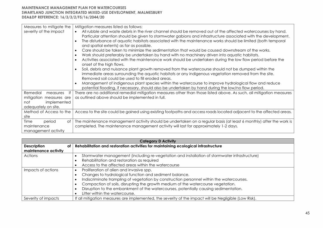
MAINTENANCE MANAGEMENT PLAN FOR WATERCOURSES
SWARTLAND JUNCTION INTEGRATED MIXED-USE DEVELOPMENT, MALMESBURY
DEA&DP REFERENCE: 16/3/3/2/F5/16/2044/20
45
Measures to mitigate the
severity of the impact
Mitigation measures listed as follows:
• All rubble and waste debris in the river channel should be removed out of the affected watercourses by hand.
Particular attention should be given to stormwater gabions and infrastructure associated with the development.
• The disturbance of aquatic habitats associated with the maintenance works should be limited (both temporal
and spatial extents) as far as possible.
• Care should be taken to minimize the sedimentation that would be caused downstream of the works.
• Work should preferably be undertaken by hand with no machinery driven into aquatic habitats.
• Activities associated with the maintenance work should be undertaken during the low flow period before the
onset of the high flows.
• Soil, debris and nuisance plant growth removed from the watercourse should not be dumped within the
immediate areas surrounding the aquatic habitats or any indigenous vegetation removed from the site.
Removed soil could be used to fill eroded areas.
• Management of indigenous plant species within the watercourse to improve hydrological flow and reduce
potential flooding, if necessary, should also be undertaken by hand during the low/no flow period.
Remedial measures if
mitigation measures are
not implemented
adequately on site.
There are no additional remedial mitigation measures other than those listed above. As such, all mitigation measures
as outlined above should be implemented in full.
Method of Access to the
site
Access to the site could be gained using existing footpaths and access roads located adjacent to the affected areas.
Time period of
maintenance
management activity
The maintenance management activity should be undertaken on a regular basis (at least 6 monthly) after the work is
completed. The maintenance management activity will last for approximately 1-2 days.
Category D Activity
Description of
maintenance activity
Rehabilitation and restoration activities for maintaining ecological infrastructure
Actions • Stormwater management (including re-vegetation and installation of stormwater infrastructure)
• Rehabilitation and restoration as required
• Access to the affected areas within the watercourse
Impacts of actions • Proliferation of alien and invasive spp.
• Changes to hydrological function and sediment balance.
• Indiscriminate trampling of vegetation by construction personnel within the watercourses.
• Compaction of soils, disrupting the growth medium of the watercourse vegetation.
• Disruption to the embankment of the watercourses, potentially causing sedimentation.
• Litter within the watercourse.
Severity of impacts If all mitigation measures are implemented, the severity of the impact will be Negligible (Low Risk).
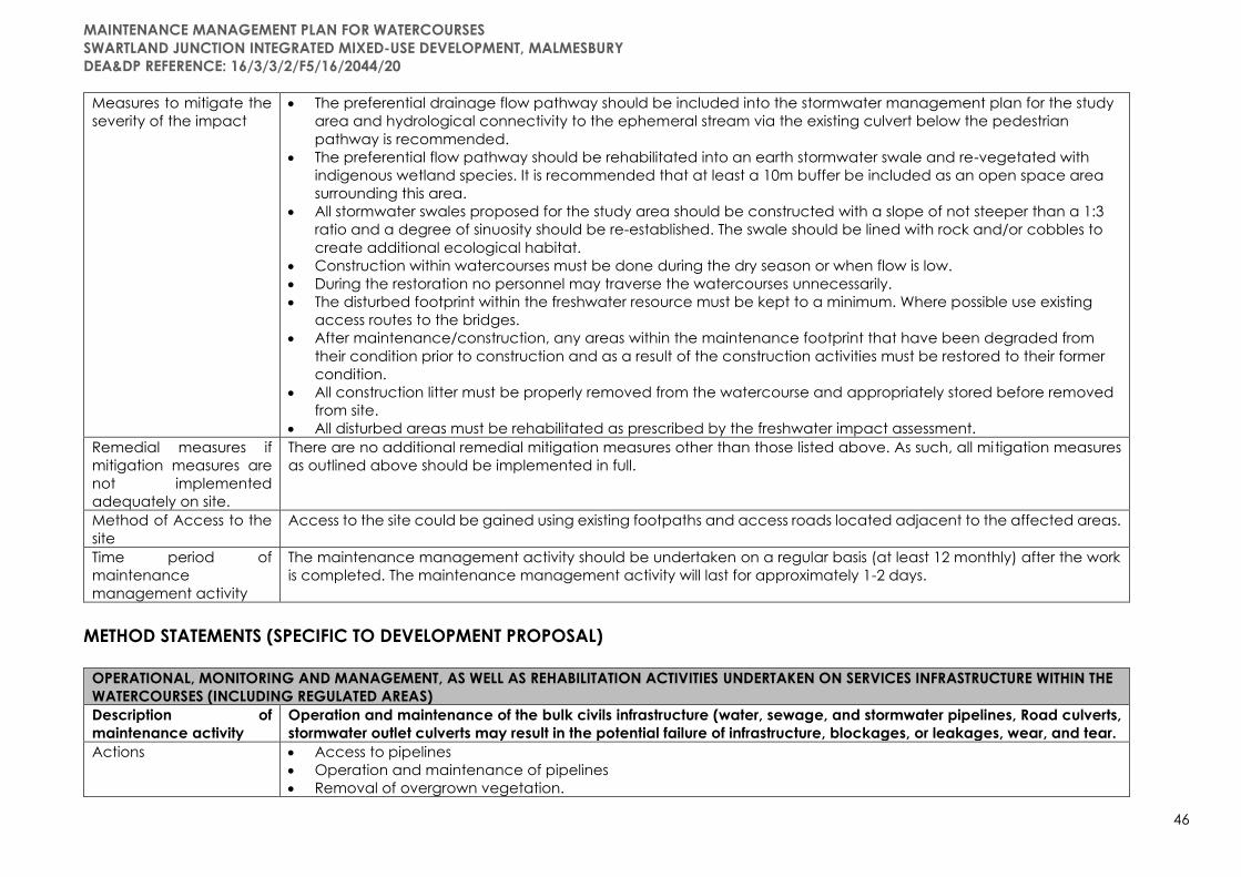
MAINTENANCE MANAGEMENT PLAN FOR WATERCOURSES
SWARTLAND JUNCTION INTEGRATED MIXED-USE DEVELOPMENT, MALMESBURY
DEA&DP REFERENCE: 16/3/3/2/F5/16/2044/20
46
Measures to mitigate the
severity of the impact
• The preferential drainage flow pathway should be included into the stormwater management plan for the study
area and hydrological connectivity to the ephemeral stream via the existing culvert below the pedestrian
pathway is recommended.
• The preferential flow pathway should be rehabilitated into an earth stormwater swale and re-vegetated with
indigenous wetland species. It is recommended that at least a 10m buffer be included as an open space area
surrounding this area.
• All stormwater swales proposed for the study area should be constructed with a slope of not steeper than a 1:3
ratio and a degree of sinuosity should be re-established. The swale should be lined with rock and/or cobbles to
create additional ecological habitat.
• Construction within watercourses must be done during the dry season or when flow is low.
• During the restoration no personnel may traverse the watercourses unnecessarily.
• The disturbed footprint within the freshwater resource must be kept to a minimum. Where possible use existing
access routes to the bridges.
• After maintenance/construction, any areas within the maintenance footprint that have been degraded from
their condition prior to construction and as a result of the construction activities must be restored to their former
condition.
• All construction litter must be properly removed from the watercourse and appropriately stored before removed
from site.
• All disturbed areas must be rehabilitated as prescribed by the freshwater impact assessment.
Remedial measures if
mitigation measures are
not implemented
adequately on site.
There are no additional remedial mitigation measures other than those listed above. As such, all mitigation measures
as outlined above should be implemented in full.
Method of Access to the
site
Access to the site could be gained using existing footpaths and access roads located adjacent to the affected areas.
Time period of
maintenance
management activity
The maintenance management activity should be undertaken on a regular basis (at least 12 monthly) after the work
is completed. The maintenance management activity will last for approximately 1-2 days.
METHOD STATEMENTS (SPECIFIC TO DEVELOPMENT PROPOSAL)
OPERATIONAL, MONITORING AND MANAGEMENT, AS WELL AS REHABILITATION ACTIVITIES UNDERTAKEN ON SERVICES INFRASTRUCTURE WITHIN THE
WATERCOURSES (INCLUDING REGULATED AREAS)
Description of
maintenance activity
Operation and maintenance of the bulk civils infrastructure (water, sewage, and stormwater pipelines, Road culverts,
stormwater outlet culverts may result in the potential failure of infrastructure, blockages, or leakages, wear, and tear.
Actions • Access to pipelines
• Operation and maintenance of pipelines
• Removal of overgrown vegetation.

MAINTENANCE MANAGEMENT PLAN FOR WATERCOURSES
SWARTLAND JUNCTION INTEGRATED MIXED-USE DEVELOPMENT, MALMESBURY
DEA&DP REFERENCE: 16/3/3/2/F5/16/2044/20
47
• Removal of alien vegetation.
• Physical removal of the silt and built up debris.
• Trimming of disturbed area after the removal.
• Rehabilitation of impacted areas
Impacts of actions Contamination / degradation /loss of habitat of onsite water resources (eastern and western non-perennial tributaries
of the Diep River, unchanneled valley bottom wetland) resulting from:
• Potential failure / burst / rupture of pipelines
• Blockages / leaks of sewerage pipeline
• Alien vegetation management – use of chemicals / hazardous substances in alien vegetation management.
• Rehabilitation of sensitive areas (CA and ESA) as well as other natural areas retained in the development proposal.
• Vehicle Access – for undertaking operational activities.
• Trampling of potentially sensitive plant species
Vehicular access to infrastructure resulting in:
• Soil compaction
• Vegetation degradation
• Soil and stormwater contamination from oils and hydrocarbons.
Contamination of the watercourse with additional sewage effluent resulting in:
• Increased concentration of salts, nitrate and toxic ammonia concentrations, as well as counts of Escheria coli;
• Potential eutrophication of the system, including anoxic conditions, leading to biodiversity simplification and the
excess production of hydrogen sulphide gas;
• Increased alien and invasive species encroachment; and
• Potential health risk to downstream users.
Prevention of consequence, including but not limited to:
• Disturbances of soils leading to increased alien vegetation proliferation, and in turn to further altered freshwater
habitat; and
• Altered runoff patterns and alteration to flow patterns, leading to increased erosion and sedimentation of
freshwater habitat.
• Erosion of the exposed trenches,
• Potential sedimentation of the watercourse,
• Potential impacts on water quality and contamination of soils within the watercourse,
• Potential of backfill material to enter the watercourse, increasing the sediment load within the watercourse,
• Potential for over-compaction of soils within the watercourse, disrupting the growth medium of the freshwater
vegetation.
Severity of impacts The result of the DWS Risk Assessment was a Moderate Risk.
Measures to mitigate the
severity of the impact
• All services infrastructure (pipelines) connecting to the existing infrastructure network must be pressure tested for
integrity upon the completion of construction, and prior to connection,

MAINTENANCE MANAGEMENT PLAN FOR WATERCOURSES
SWARTLAND JUNCTION INTEGRATED MIXED-USE DEVELOPMENT, MALMESBURY
DEA&DP REFERENCE: 16/3/3/2/F5/16/2044/20
48
• It is recommended that the managing authority test the integrity of the pipelines at least once every five years or
more often should there be any sign or reports of a leak,
• Should a blockage occur all possible steps are to be taken to prevent the pollution (specific to the sewer
pipelines and crossings) of the watercourse during repair, including the placement of sheeting around the
manhole used for access as well as containment barrels for any effluent withdrawn,
• No vehicles are permitted to drive through any watercourses or regulated area of the watercourses. Any
maintenance works must be undertaken by foot or the relevant authorisations obtained beforehand; and
• On repair of any leaks, all excavated areas must be backfilled, and alien vegetation proliferation must be
monitored until basal cover has been established.
• Trenches should be backfilled with the stockpiled excavated materials in layers, up to 150mm below the natural
ground level, after which the topsoil is replaced (to the stream bed level) and re-worked and the removed
vegetation is reinstated as part of the rehabilitation of the site; and
• Soil must be re-compacted to a depth of 450 mm, and all construction material must be removed from site upon
the completion of construction and installation of rock and/or cobbling should take place at least 2m up and
downstream of the trench site.
Remedial measures if
mitigation measures are
not implemented
adequately on site.
There are no additional remedial mitigation measures other than those listed above. As such, all mitigation measures
as outlined above should be implemented in full.
Method of Access to the
site
Access to the site could be gained using existing footpaths and access roads located adjacent to the affected areas.
Or as demarcated in accordance with the SDP under supervision of the site ECO.
Time period of
maintenance
management activity
• Both the potable water and sewer pipelines and all manholes must be pressure tested for integrity upon the
completion of construction;
• It is recommended that the managing authority test the integrity of the pipelines at least once every five years or
more often should there be any sign or reports of a leak.
OPERATION AND MAINTENANCE OF SERVICE INFRASTRUCTURE – INFRASTRUCTURE FAILURE
Description of
maintenance activity
Operation and maintenance of service infrastructure resulting in infrastructure failure.
Potential failure of infrastructure (burst / leaking pipelines, hoses, hose attachments.
Actions • Access to pipelines
• Operation and maintenance of pipelines
• Removal of overgrown vegetation.
• Removal of alien vegetation.
• Physical removal of the silt and built up debris.
• Trimming of disturbed area after the removal.
• Rehabilitation of impacted areas
Impacts of actions Potential failure of infrastructure (burst / leaking pipelines, hoses, hose attachments.
Blockages and leaks may result from inappropriate connections of the existing infrastructure as proposed and

MAINTENANCE MANAGEMENT PLAN FOR WATERCOURSES
SWARTLAND JUNCTION INTEGRATED MIXED-USE DEVELOPMENT, MALMESBURY
DEA&DP REFERENCE: 16/3/3/2/F5/16/2044/20
49
influenced by service Vehicular access to infrastructure resulting in:
• Soil compaction
• Vegetation degradation
• Soil and stormwater contamination from oils and hydrocarbons.
Contamination of the watercourse resulting from increased demand capacity in:
• Increased concentration of salts, nitrate, and toxic ammonia concentrations, as well as counts of Escheria coli.
• Potential eutrophication of the system, including anoxic conditions, leading to biodiversity simplification, and the
excess production of hydrogen sulphide gas.
• Increased alien and invasive species encroachment; and
• Potential health risk to downstream users.
Rehabilitation, alien invasive species management
• Proliferation of alien and invasive spp.
• Temporary - Potential risks to water quality
• Changes to hydrological function and sediment balance.
• Temporary loss of habitat, indigenous species and ecosystem functioning
• Long-term impacts – positive as a result of rehabilitation and implementation of regular Alien vegetation
management
Severity of impacts The result of the DWS Risk Assessment was a Moderate (negative) Risk – due to the sewerage infrastructure.
Long-term positive impacts – improvement of watercourse due to rehabilitation, and implementation of mitigation
measures to reduce, avoid or mitigate negative impacts.
Measures to mitigate the
severity of the impact
• All pipeline and all manholes must be pressure tested for integrity upon the completion of construction.
• It is recommended that the managing authority test the integrity of the pipelines at least once every five years or
more often should there be any sign or reports of a leak.
• Should a blockage occur all possible steps are to be taken to prevent the pollution (specific to the sewer
pipeline) of the watercourse during repair, including the placement of sheeting around the manhole used for
access as well as containment barrels for any effluent withdrawn.
• No vehicles are permitted to drive through any watercourses. Any maintenance works must be undertaken by
foot or the relevant authorisations obtained beforehand; and
• On repair of any leaks, all excavated areas must be backfilled, and alien vegetation proliferation must be
monitored until basal cover has been established.
Remedial measures if
mitigation measures are
not implemented
adequately on site.
There are no additional remedial mitigation measures other than those listed above. As such, all mitigation measures
as outlined above should be implemented in full.
Method of Access to the
site
Access to the site could be gained using existing footpaths and access roads located adjacent to the affected areas.
Or as demarcated in accordance with the SDP under supervision of the site ECO.

MAINTENANCE MANAGEMENT PLAN FOR WATERCOURSES
SWARTLAND JUNCTION INTEGRATED MIXED-USE DEVELOPMENT, MALMESBURY
DEA&DP REFERENCE: 16/3/3/2/F5/16/2044/20
50
Time period of
maintenance
management activity
• Both the potable water and sewer pipelines and all manholes must be pressure tested for integrity upon the
completion of construction;
• It is recommended that the managing authority test the integrity of the pipelines at least once every five years or
more often should there be any sign or reports of a leak.
• Rehabilitation and Alien vegetation management in accordance with the scheduling included in the
management plan (Addendum D) – activity should be undertaken on a regular basis (at least 6 monthly) after
the work is completed. The maintenance management activity will last for approximately 1-2 days.
REHABILITATION AND ALIEN VEGETATION MANAGEMENT, MAINTENANCE OF ROAD CULVERTS, STROMWATER OUTLET CULVERTS, MANHOLES,
WATERCOURSES AND WETLAND AREAS (INCLUDING BUFFER AREAS)
Description of
maintenance activity
Vegetation management, removal of silt and debris and the prevention of possible contamination of freshwater soils
and increased toxicants into the downstream dam
Actions • Access to impacted areas
• Removal of overgrown vegetation.
• Removal of alien vegetation.
• Physical removal of the silt and built up debris.
• Trimming of disturbed area after the removal.
• Rehabilitation of impacted areas
Impacts of actions • Proliferation of alien and invasive spp.
• Potential risks to water quality
• Changes to hydrological function and sediment balance.
Severity of impacts The result of the DWS Risk Assessment was a Low Risk.
Long-term positive impacts – improvement of watercourse due to rehabilitation, and implementation of mitigation
measures to reduce, avoid or mitigate negative impacts.
Measures to mitigate the
severity of the impact
• An alien vegetation management plan should be developed and implemented and managed for all open
space areas as well as the stormwater swales and downstream ephemeral stream;
• As much indigenous terrestrial vegetation should be included into the landscape plan for the open space areas.
Indigenous vegetation will reduce the irrigation requirements as well as fertilizers.
• Care must be taken when using herbicides and pesticides in gardens and open space areas, especially during
the rainy season when stormwater runoff is high. These chemicals must be used in accordance with the
prescribed quantities to prevent contamination of surface water in the nearby watercourse, especially since
stormwater is released therein.
• As far as possible, all construction/maintenance activities should occur in the low flow season, during the drier
winter months;
• No vehicles should be allowed to drive through designated sensitive wetland areas during the eradication of
alien and weed species.
Remedial measures if
mitigation measures are
There are no additional remedial mitigation measures other than those listed above. As such, all mitigation measures
as outlined above should be implemented in full.

MAINTENANCE MANAGEMENT PLAN FOR WATERCOURSES
SWARTLAND JUNCTION INTEGRATED MIXED-USE DEVELOPMENT, MALMESBURY
DEA&DP REFERENCE: 16/3/3/2/F5/16/2044/20
51
not implemented
adequately on site.
Method of Access to the
site
Access to the site could be gained using existing footpaths and access roads located adjacent to the affected areas.
Time period of
maintenance
management activity
The maintenance management activity should be undertaken on a regular basis (at least 6 monthly) after the work is
completed. The maintenance management activity will last for approximately 1-2 days.
OPERATION, MAINTENANCE, REHABILITATION AND MONITORING OF DEVELOPMENT WITHIN THE DWS ZONES OF REGULATION: 500M OF A WETLAND
AND 100M FROM THE EDGE OF THE NON-PERENNIAL WATERCOURSES (EASTERN AND WESTERN BOUNDARY TRIBUTARIES)
Description of
maintenance activity
Vegetation management, removal of silt and debris and the prevention of possible contamination of freshwater soils
and increased toxicants into the downstream dam
Actions • Access to impacted areas
• Removal of overgrown vegetation.
• Removal of alien vegetation.
• Physical removal of the silt and built up debris.
• Trimming of disturbed area after the removal.
• Rehabilitation of impacted areas
Impacts of actions • Contaminated groundwater, surface water and surrounding environment.
• Contamination / degradation /loss of habitat of onsite water resources (eastern and western non-perennial
tributaries of the Diep River, unchanneled valley bottom wetland) resulting from:
• Alien vegetation management – use of chemicals / hazardous substances in alien vegetation management.
• Rehabilitation of sensitive areas (CA and ESA) as well as other natural areas retained in the development
proposal.
• Vehicle Access – for undertaking operational activities.
• Trampling of potentially sensitive plant species
• Vehicular access to impacted area resulting in:
o Soil compaction
o Vegetation degradation
o Soil and stormwater contamination from oils and hydrocarbons.
Severity of impacts The result of the DWS Risk Assessment was a Low Risk.
Long-term positive impacts – improvement of watercourse due to rehabilitation, and implementation of mitigation
measures to reduce, avoid or mitigate negative impacts.
Measures to mitigate the
severity of the impact
• An alien vegetation management plan should be developed and implemented and managed for all open
space areas as, buffer areas, green corridors, landscaped areas, and stormwater outlets, uncultivated agri-
alotments, gardens, wetland park.
• As much indigenous terrestrial vegetation should be included into the landscape plan for the open space areas.
Indigenous vegetation will reduce the irrigation requirements as well as fertilizers.
• Care must be taken when using herbicides and pesticides in gardens and open space areas, especially during
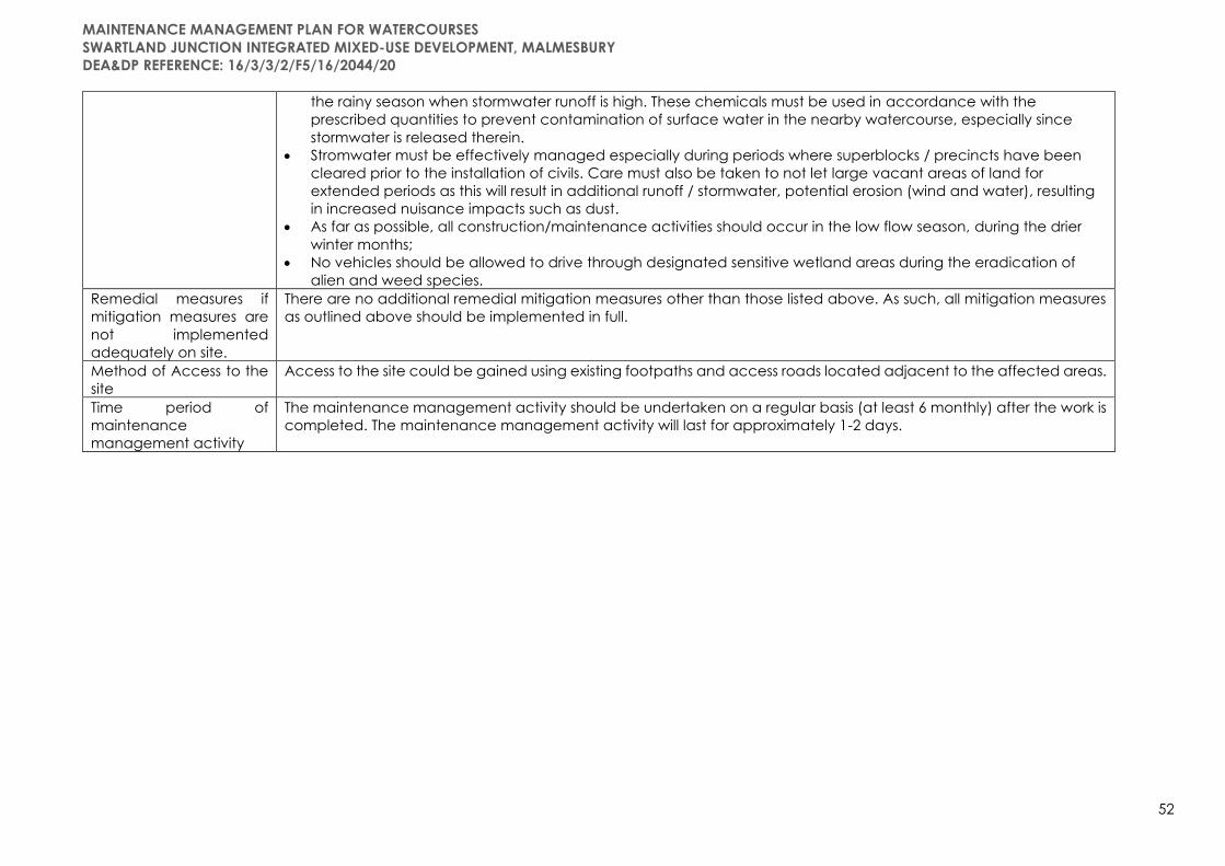
MAINTENANCE MANAGEMENT PLAN FOR WATERCOURSES
SWARTLAND JUNCTION INTEGRATED MIXED-USE DEVELOPMENT, MALMESBURY
DEA&DP REFERENCE: 16/3/3/2/F5/16/2044/20
52
the rainy season when stormwater runoff is high. These chemicals must be used in accordance with the
prescribed quantities to prevent contamination of surface water in the nearby watercourse, especially since
stormwater is released therein.
• Stromwater must be effectively managed especially during periods where superblocks / precincts have been
cleared prior to the installation of civils. Care must also be taken to not let large vacant areas of land for
extended periods as this will result in additional runoff / stormwater, potential erosion (wind and water), resulting
in increased nuisance impacts such as dust.
• As far as possible, all construction/maintenance activities should occur in the low flow season, during the drier
winter months;
• No vehicles should be allowed to drive through designated sensitive wetland areas during the eradication of
alien and weed species.
Remedial measures if
mitigation measures are
not implemented
adequately on site.
There are no additional remedial mitigation measures other than those listed above. As such, all mitigation measures
as outlined above should be implemented in full.
Method of Access to the
site
Access to the site could be gained using existing footpaths and access roads located adjacent to the affected areas.
Time period of
maintenance
management activity
The maintenance management activity should be undertaken on a regular basis (at least 6 monthly) after the work is
completed. The maintenance management activity will last for approximately 1-2 days.

2.2 MONITORING AND REPORTING
It is important to note that any and all activities undertaken outside the scope of the adopted MMP, in
terms of the action outlined within the given method statement, the responsible person(s) will be subject
to Section 24(F) of NEMA and that appropriate enforcement and compliance requirements will follow.
The specific reporting information required by the competent authority should be discussed during the
consultation phase between the proponent and the Department. The relevant information required
should be considered on a case-by-case basis.
NOTIFICATION OF MAINTENANCE ACTIVITIES
The following Forms A and B are to be considered as a guideline in terms of the type of information
required. It is proposed that Form A below must be completed by the relevant person(s) before
maintenance activities are undertaken and Form B after a maintenance activity has been completed.
A copy of each completed Form A & B must be sent to the relevant WUA/IB/local authority management
if they have undertaken the development of the MMP. For any individual landowner applications, the
landowner is responsible to ensure a record of all maintenance activities is recorded as per Form A & B
below. Form A and B must also be sent to the Provincial Department of Agriculture, Directorate:
Sustainable Resource Management.
The Department may, within a reasonable notice period, request to evaluate the maintenance activities
and assess the maintenance sites as per the adopted MMP.
Form A should be completed at least 7 working days before the commencement of any maintenance
activity and Form B at least 3 working days following the completion of the maintenance activity(ies). At
least two photographs are required from two different points of perspective (A and B) looking at the site
(coordinates of these points are required). When listing the type and reference code, this must be done
by specifically listing the relevant detail within the adopted MMP.
REPORTING FOR INTENT TO UNDERTAKE MAINTENANCE ACTIVITIES – FORM A
Section A: Landowner Details
Name Surname Farm No. Erf No. Today’s Date
Section B: Details of proposed maintenance activity
WUA/GA reference number
and DEA&DP reference
number for MMP.
Activity Type: Reference
code (make
reference to
MMP)
Footprint
area (m2)
Volume of
material (m3)
Equipment to be used: Description of method for planned activity: Date when work
will commence:
Date of last flood event for
site:
Note any further damage and comments regarding the state of the
site
Section C: Photographs of activity location before maintenance
Before (perspective A)
Coordinates:
S
E
Before (perspective B)
Coordinates:
S
E
Date of photos taken:
REPORTING FOR COMPLETION OF MAINTENANCE ACTIVITIES – FORM B
Section A: Landowner Details
Name Surname Farm No. Erf No. Today’s Date
Section B: Details of proposed maintenance activity

MAINTENANCE MANAGEMENT PLAN FOR WATERCOURSES
SWARTLAND JUNCTION INTEGRATED MIXED-USE DEVELOPMENT, MALMESBURY
DEA&DP REFERENCE: 16/3/3/2/F5/16/2044/20
54
WUA/GA reference
number and DEA&DP
reference number
for MMP.
Activity Type: Reference
code (make
reference to
MMP)
Footprint
area (m2)
Volume of
material (m3)
Equipment that was
used:
Description of method for completed activity and if
commence date changed
Date activity
completed
Date of last flood
event for site:
Note any challenges or difficulties experienced in following the MMP method
statement
Section C: Photographs of activity location after maintenance
After (perspective A)
Coordinates:
S
E
After (perspective B)
Coordinates:
S
E
Date of photos
taken:
ENVIRONMENTAL MONITORING AND REPORTING/AUDFITING
Environmental monitoring is the continuous evaluation of the status and condition of environmental
elements. Its purpose is to detect change that takes place in the environment over time and involves the
measuring and recording of physical, social, and economic variables associated with development
impacts.
Many techniques for environmental monitoring have been proposed, each detailing a specific protocol.
Regardless of which technique is used, the ultimate aim is that each environmental management
specification be checked by means of a system in which a score may be allocated for:
• Full compliance
• Satisfactory performance
• Unsatisfactory performance and
• No action taken
Completed monitoring reports will be submitted to the project engineer, developer/landowner and the
contractor, who will attend to issues. These reports must be kept on file and be made available upon
request by any environmental authority requesting such.
An individual undertaking an activity authorised by this MMP are deemed not to have complied with the
performance specifications if:
• There is evidence of wilful or accidental contravention of any specification included in the MMP;
• There is evidence of the individual carrying out activities not permitted in terms of the MMP;
• There is evidence of environmental negligence and / or mismanagement resulting in negative
impacts on the environment;
• Has failed to meet with the requirements of the approved schedule.
Disregard for an instruction, and failure to respond adequately to complaints from the public will be
construed as non-compliance. Non-compliance may lead to parties being penalised.
In cases of persistent non-compliance, the contractor, staff, or individual undertaking the activity may be
evicted from site after a disciplinary process is followed. Only the developer/landowner may issue such
instruction, retaining any costs required to remedy situations perpetuated by environmental negligence,
mismanagement and / or non-compliance.
Audits must be undertaken as prescribed by the Environmental Authorisation. The audit objective is to
assess operations against the requirements of the EA, WULA, EMPr and this MMP. The purpose of which

MAINTENANCE MANAGEMENT PLAN FOR WATERCOURSES
SWARTLAND JUNCTION INTEGRATED MIXED-USE DEVELOPMENT, MALMESBURY
DEA&DP REFERENCE: 16/3/3/2/F5/16/2044/20
55
will be to identify those requirements that are not being met. An environmental performance audit
examines and assesses practices and procedures which, in the event of failure, would cause an
environmental impact or result in an environmental risk. The performance audit will ensure that the
monitoring was correctly undertaken, and that compliance was best achieved.
All instances of environmental pollution which has occurred must be duly reported to the Department of
Water and Sanitation and/or DEADP and a suitably qualified environmental specialist must be contacted
to provide recommendations on how the affected site must be rehabilitated.
PENALTY SYSTEM
A system of penalties will be introduced to reinforce environmentally sensitive and prudent behaviour.
The maximum penalties that will be fined per incident that may be enforced are listed below. The penalty
amount will be determined (inter alia) by the severity of the offence.
Non-compliance R 5 000.00 (ex VAT) per non-
compliant act, per day until
compliance is achieved
Casual Litter on site resulting from operation R250 / offence / day
Disposal of any litter, construction material, topsoil, excavated
sediment and silt, vegetation (inclusive of alien invasive vegetation) in
non-specified area or by non-compliant means
R5000 / m3/per day
Dumping of cement, concrete, fuel or oil in an area or other than that
authorised, by the EA and EMPr, and suitable
R10 000 per offence/day
Failure to use portable / toilets R100 / observed incident or
evidence of human
excrement on site
Unauthorised entry into demarcated “no go areas”,
Trampling of vegetation in sensitive areas (watercourses)
R100 / observed incident
In addition to the above, all costs incurred by the client/developer to remedy any damage will be the
responsibility of the offender.
Should the monitoring process reveal acts of persistent and / or wilful non-compliance with the
environmental performance specifications, then the contractor or staff member will be fined according
to the specified value of that item.
All penalties will be paid to an Environmental NGO or group within the Swartland Area for the purpose of
undertaking rehabilitation of damaged areas and alien clearing purposes within the Swartland Municipal
Area of Jurisdiction.
2.3 DEFINITIONS
"Activity" means an activity identified in any notice published by the Minister or MEC in terms of section
24D(1)(a) of the Act as a listed activity or specified activity. Activity in this document refers to the activities
as listed in Listing Notice 1, 2 and 3 of the Environmental Impact Assessment Regulations, 2014 (as
amended).
“Bush Encroachment” means stands of plants of the kinds specified in column 1 of Table 4 of the
Conservation of Agricultural Resources Act (Act No. 43 of 1983) where individual plants are closer to each
other than three times the mean crown diameter.
“Diverting” as defined in the General Authorisation, in terms of section 39 of the National Water Act, 1998
(Act no 36 of 1998) for Water Uses as defined in Section 21(c) and 21(i) (GN. 509 of 26 August 2016), means
to, in any manner, cause the instream flow of water to be rerouted temporarily or permanently.
“Ecological Infrastructure” refers to naturally functioning ecosystems that deliver valuable services to
people, such as water and climate regulation, soil formation and disaster risk reduction.
“Estuary” has the meaning assigned to it in the National Environmental Management: Integrated Coastal
Management Act, 2008 (Act No. 24 of 2008)
“Flood event” is the event where land is inundated by the overflowing of water from a river channel and
where this event causes significant damage to infrastructure or results in watercourse erosion and/or
sediment deposition.
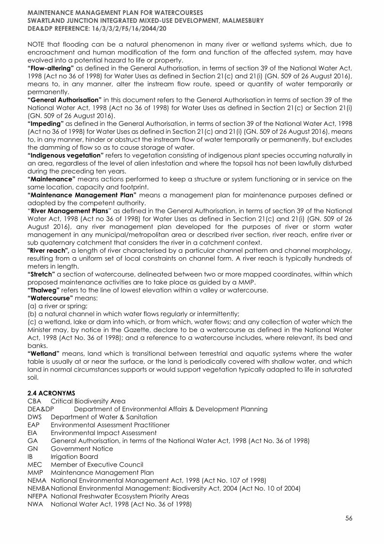
MAINTENANCE MANAGEMENT PLAN FOR WATERCOURSES
SWARTLAND JUNCTION INTEGRATED MIXED-USE DEVELOPMENT, MALMESBURY
DEA&DP REFERENCE: 16/3/3/2/F5/16/2044/20
56
NOTE that flooding can be a natural phenomenon in many river or wetland systems which, due to
encroachment and human modification of the form and function of the affected system, may have
evolved into a potential hazard to life or property.
“Flow-altering” as defined in the General Authorisation, in terms of section 39 of the National Water Act,
1998 (Act no 36 of 1998) for Water Uses as defined in Section 21(c) and 21(i) (GN. 509 of 26 August 2016),
means to, in any manner, alter the instream flow route, speed or quantity of water temporarily or
permanently.
“General Authorisation” in this document refers to the General Authorisation in terms of section 39 of the
National Water Act, 1998 (Act no 36 of 1998) for Water Uses as defined in Section 21(c) or Section 21(i)
(GN. 509 of 26 August 2016).
“Impeding” as defined in the General Authorisation, in terms of section 39 of the National Water Act, 1998
(Act no 36 of 1998) for Water Uses as defined in Section 21(c) and 21(i) (GN. 509 of 26 August 2016), means
to, in any manner, hinder or obstruct the instream flow of water temporarily or permanently, but excludes
the damming of flow so as to cause storage of water.
“Indigenous vegetation” refers to vegetation consisting of indigenous plant species occurring naturally in
an area, regardless of the level of alien infestation and where the topsoil has not been lawfully disturbed
during the preceding ten years.
“Maintenance” means actions performed to keep a structure or system functioning or in service on the
same location, capacity and footprint.
“Maintenance Management Plan” means a management plan for maintenance purposes defined or
adopted by the competent authority.
“River Management Plans” as defined in the General Authorisation, in terms of section 39 of the National
Water Act, 1998 (Act no 36 of 1998) for Water Uses as defined in Section 21(c) and 21(i) (GN. 509 of 26
August 2016), any river management plan developed for the purposes of river or storm water
management in any municipal/metropolitan area or described river section, river reach, entire river or
sub quaternary catchment that considers the river in a catchment context.
"River reach", a length of river characterised by a particular channel pattern and channel morphology,
resulting from a uniform set of local constraints on channel form. A river reach is typically hundreds of
meters in length.
“Stretch” a section of watercourse, delineated between two or more mapped coordinates, within which
proposed maintenance activities are to take place as guided by a MMP.
“Thalweg” refers to the line of lowest elevation within a valley or watercourse.
“Watercourse” means:
(a) a river or spring;
(b) a natural channel in which water flows regularly or intermittently;
(c) a wetland, lake or dam into which, or from which, water flows; and any collection of water which the
Minister may, by notice in the Gazette, declare to be a watercourse as defined in the National Water
Act, 1998 (Act No. 36 of 1998); and a reference to a watercourse includes, where relevant, its bed and
banks.
“Wetland” means, land which is transitional between terrestrial and aquatic systems where the water
table is usually at or near the surface, or the land is periodically covered with shallow water, and which
land in normal circumstances supports or would support vegetation typically adapted to life in saturated
soil.
2.4 ACRONYMS
CBA Critical Biodiversity Area
DEA&DP Department of Environmental Affairs & Development Planning
DWS Department of Water & Sanitation
EAP Environmental Assessment Practitioner
EIA Environmental Impact Assessment
GA General Authorisation, in terms of the National Water Act, 1998 (Act No. 36 of 1998)
GN Government Notice
IB Irrigation Board
MEC Member of Executive Council
MMP Maintenance Management Plan
NEMA National Environmental Management Act, 1998 (Act No. 107 of 1998)
NEMBA National Environmental Management: Biodiversity Act, 2004 (Act No. 10 of 2004)
NFEPA National Freshwater Ecosystem Priority Areas
NWA National Water Act, 1998 (Act No. 36 of 1998)
MAINTENANCE MANAGEMENT PLAN FOR WATERCOURSES
SWARTLAND JUNCTION INTEGRATED MIXED-USE DEVELOPMENT, MALMESBURY
DEA&DP REFERENCE: 16/3/3/2/F5/16/2044/20
57
PES Present Ecological State
SANParks South African National Parks Authority
WUA Water Users Association
WULA Water Use Licence Application
2.5 REFERENCE GUIDE FOR DRAFTING MMPs FOR A WATERCOURSE
Ecosystem Guidelines for Environmental Assessment in the Western Cape, Edition 2, 2016. Available at:
www.bgis.org.za
Wetland offsets: A best practice guideline for South Africa, 2016. Available at: http://www.wrc.org.za
Preliminary guideline for the determination of buffer zones for rivers, wetlands and estuaries, 2014.
Available at: http://www.wrc.org.za
National Water Act, 1998 (Act No. 36 of 1998). Available at: http://www.gov.za/documents/national-
water-act
General Authorisation, in terms of Section 39 of the National Water Act, 1998 (Act No. 36 of 1998) for water
uses as defined in Section 21(c) or Section 21(i).
ALIEN VEGETATION MANAGEMENT PLAN CLEARING AREAS AND PROPOSED SCHEDULE
The following Alien Vegetation Control Programs as detailed below must be undertaken for EACH
PROJECT IMPLEMENTATION PHASE as per the development implementation phasing of the development.
Alien vegetation control programs must include the following two phases (Campbell, 2000):
1. Initial Control Phase: The existing population must be drastically reduced.
2. Follow-up and Maintenance Control Phase: Control of coppice regrowth, root suckers and
seedlings. It is important to monitor the situation of infestation during the growing season of the
plants as to avoid re-infestation and to keep the control cost at a minimum. Follow-up control
must be done once a year during spring (September – November) for a minimum period of seven
(7) years to ensure that new infestation does not occur within the rehabilitated areas, after which
the follow-up period should be re-assessed based on the need.
Initial Control Phase – Development Pre-construction Phase:
• Before the initial alien and invasive vegetation clearing is undertaken, a baseline assessment should
be taken to indicate species and respective densities within the application area.
• The baseline assessment should indicate priority clearing areas, as well as the type of control measure
and respective methodology that should be applied depending on the level of infestation.
• Application Area(s): this phase will include the entire extent of the development footprint.
Follow-up and Maintenance Control Phase – Development Construction, Operational, and Rehabilitation
Phases:
• After the initial alien and invasive vegetation clearing has been completed, residual densities should
be re-recorded, including all methods and chemicals used.
• Quarterly assessment during the first-year post rehabilitation. Densities and locations of newly
coppiced alien and invasive plants to be recorded.
• Annually during the growing season for the second and third year, post rehabilitation to ensure long-
term maintenance measures are effective.
• Application Area(s): this phase will include previously cleared construction blocks, firebreak(s), all
open spaces, unchanneled valley bottom wetland (disturbed because of development), channelled
valley bottom wetland (disturbed because of development) (Refer to SDP map in EMPr).
• An annual assessment before mobilisation of the clearing crew should be undertaken to determine
equipment and personnel requirements to secure the necessary funding.
• After initial control operations dense regrowth may arise as new regrowth will sprout in the form of
stump coppice, seedlings, and root suckers. The following should therefore be applied:
o Plants that are less than 1 m in height must be controlled by foliar application.
o Areas with dense seedlings should not be uprooted or hoed out, as these areas will result in
soil disturbance and will in return promote flushes and germination of alien seedling growth.
NOTE: Each “superblock” / “development precinct” would be responsible for undertaking alien
vegetation management within their “superblock” / “development precinct” footprint.

MAINTENANCE MANAGEMENT PLAN FOR WATERCOURSES
SWARTLAND JUNCTION INTEGRATED MIXED-USE DEVELOPMENT, MALMESBURY
DEA&DP REFERENCE: 16/3/3/2/F5/16/2044/20
58
METHODS FOR ALIEN VEGETATION CLEARING
DEFINITIONS ASSOCIATED WITH ALIEN VEGETATION CONTROL METHODS
Hand Pull Saplings and seedlings must be pulled out by hand. All root material should be
removed to avoid re-sprouting of the plant.
Frill The technique whereby an axe or cane knife is used to chip/cut around the base
of a tree (±2mm deep) in order to place herbicide into the cuts (cutting not to be
as deep as to ringbark). Herbicide to be applied within 30 minutes from frilling.
Ringbark Removal of a ring of bark at least 25cm wide and pull down to just below ground
level. Ring barking interferes with the circulation of the tree and results in it slowly
dying.
Tree Felling Complete removal down to a stump by means of a chainsaw, hand axe or cane
knife.
Brush Cutting Cutting (usually large dense stands of alien trees or shrubs) with a mechanical brush
cutter.
Stumping The treatment of the remaining stump after felling with an appropriate herbicide
(see recommended below).
Soil Application The application of herbicide (see recommended below) to the soil which is taken
up by the plant’s roots.
Foliar Spray The application of herbicides directly to the leaves. Foliar spraying can be done by
using the following:
a) A hose and handgun spraying the solution from a herbicide tank;
b) A backpack spray unit; or
c) Splatter guns which allow for larger droplets at higher concentrations – suitable
for regrowth.
Stump Coppice New shoots that regenerate from the stumps of felled trees
Root Suckers New vertical regrowth that arises from the base of the trunk, a new stem arising
away from the main, stumped stem.
GENERAL METHODOLOGY
Integrated Control Strategies
A combination of the most suitable and effective methods should be used to control a specific species
in a particular situation. The following selection of appropriate control methods should take into account
the following (Campbell, 2000):
• Species of alien and invasive weeds.
• The type of growth form (i.e., seedling, sapling, shrub, or tree).
• The density of infestation.
• The terrain where the infestation is present.
• Rehabilitation requirements.
• What resources are available.
• Speed or urgency that the control of the infestation requires – physical removal and biological control
will take longer than chemical control.
Initial Control Phase
• Hand pull: saplings and seedlings must be pulled out by hand and regrowth must be controlled with
herbicide (Campbell, 2000). All guidelines for the application of herbicide listed in this Rehabilitation
Plan must be adhered to.
• Frill: a cane knife is used to cut frills into the stem. Herbicide must be applied (1-2 mm per frill) and must
be done in 30min after frilling.
• Soil application: herbicide is applied to the soil and taken up by the plant’s roots.
Methods for controlling coppice, saplings, and seedlings:
Infestation can comprise different growth forms, and some of the growth forms cannot be utilised. These
plants need to be cut with a brush cutter and the stumps treated with herbicide that was mixed with a
dye to show where treatment was done (however stumps must not be removed as they significantly
contribute to soil stability especially along riverbanks).
MAINTENANCE MANAGEMENT PLAN FOR WATERCOURSES
SWARTLAND JUNCTION INTEGRATED MIXED-USE DEVELOPMENT, MALMESBURY
DEA&DP REFERENCE: 16/3/3/2/F5/16/2044/20
59
INTEGRATED STRATEGIES TO CONTROL ALIEN SHRUBS AND TREES (I.E. PORT JACKSON, EUCALYPTUS, PINE
TREES)
Alien shrubs and trees that are less than 1m in height:
• Hand pull as far as possible and remove all pulled materials off site to a suitable landfill or burning
site (note no burning of materials may occur without the proper authorisation form the local
municipality and fire department)
• A foliar application must be used in the general control of alien shrubs and trees that are less than
1 m in height, that cannot be hand pulled.
• Registered herbicide must be used and where grass is present, selective broadleaf herbicide that
will not impact on the grass. When grass is not present, a selective or non-selective registered
herbicide must be used.
• For dense seedling growth that is of uniform height (i.e. grass) a flat fan nozzle with knapsack must
be used.
• For seedling growth that is of uneven height, root suckers, short saplings, and coppice growth a
cone nozzle must be used.
Alien shrubs and trees that are taller than 1m (Campbell, 2000):
• Shrubs and trees that are taller than 1 m must be reduced cutting using brush cutter, cane knives
or chainsaws depending on the thickness of the stems.
• When large areas with dense growth are present a tractor mounted gyro-motor can be used.
• For low – medium density infestation a cut stump treatment must be used. Stumps that are cut
must be treated immediately (within 30min of being cut). The best time to treat is during the active
growing season.
• Medium – High-density infestations must be slashed to knee height so that the plants can coppice.
The best time to do this is during the winter months as the plants are dormant and the coppice will
come out during the active growing period after good rain. The coppice must be sprayed when
enough leaves are present to absorb the herbicide, and a dye must also be used to indicate
treated areas.
• Pathways must be cut to increase exposed areas so that a foliar spray treatment is more effective
without compromising the indigenous vegetation.
• Mechanical uprooting of shrubs or trees are not always a preferred method because the soil is
disturbed, and this increases the risk of alien vegetation infestation. This activity also promotes
erosion, and soil loss will occur. Mechanical uprooting can be done in areas that have a dense
grass cover, as the roots of the grass will keep the soil intact. After uprooting the soil must be
levelled and if grass seeds are present, some indigenous grass seeds must be placed on these
areas to promote grass regrowth.
INTEGRATED STRATEGIES TO CONTROL ALIEN HERBS AND GRASS (CAMPBELL, 2000)
Chemical control:
• Alien herbs and grasses are soft non-woody species.
• Some of the alien herbs and grasses have registered herbicides to control them and are either
pre- or post-emergent herbicides.
• When alien herbs are associated with woody alien plant, herbicides that are registered to control
woody alien species are often used to control alien herbs. Alternatively, glyphosate can be used
as it is often registered for both alien herb and alien woody species.
Follow-up Control and Maintenance (Campbell, 2000)
Follow-up control is essential to control alien saplings, seedlings and coppice regrowth to achieve and
sustain the progress that was made with the initial control work in the initial phase. If the follow-up control
phase is neglected, the alien infestation will become worse and denser than before the eradication
process started. It is essential to sustain the follow-up phase because it will prevent the regrowth alien
seedlings.
Follow-up treatment control consists of the following methods:
• Chemical control methods: Only use registered herbicides to control any alien species. Instruction on
the herbicide labels must be followed carefully.
• Biological control methods (if available).
• Manual removal that should not be carried out by any machinery larger than a chainsaw.
• Mechanical i.e. brush cutters, but which should only be used for dense stands of alien shrubs such and
Port Jackson forests and not in areas where indigenous vegetation shrubs are still abundant.

MAINTENANCE MANAGEMENT PLAN FOR WATERCOURSES
SWARTLAND JUNCTION INTEGRATED MIXED-USE DEVELOPMENT, MALMESBURY
DEA&DP REFERENCE: 16/3/3/2/F5/16/2044/20
60
CONTROL METHODS FOR DENSE REGROWTH: After initial control operations dense regrowth may
arise as new regrowth will sprout in the form of stump coppice, seedlings, and root suckers.
Chemical control /
foliar application:
• Plants that are less than 1 m in height must be controlled by foliar
application.
• Dense seedling growth must be controlled with knapsack sprayers with
a flat fan nozzle.
• A registered selective herbicide must be used so as not to harm the
indigenous vegetation or water resources.
• Suitable dye must be used at all times to limit over- or under spray of
areas.
Manual and
mechanical control:
• Areas with dense seedlings should not be uprooted or hoed out, as these
areas will result in soil disturbance and will in return promote flushes and
germination of alien seedling growth.
• When stump density is high, plants should not be cut. This is impractical,
and there will be many untreated stumps. Instead cut the stumps in
dense areas with brush cutters and remove the top growth. Stumps will
start to coppice, and foliar spay must be used to control the coppice
regrowth.
CONTROL METHODS FOR LOW-MEDIUM DENSITY REGROWTH: Neglecting to control low-medium
density regrowth will result in densification and spreading as well as additional control costs.
Chemical control /
foliar application:
• Cut stump method must be used and stumps must be cut up to a height
of 15 cm and must be sprayed within 30min of cutting the plant with a
registered herbicide. Herbicide must be applied with knapsack sprayers
set to low pressure, using cone nozzles, e.g. TG1 or CE1. Hand sprayers
can also be used to apply herbicide. A suitable dye must be used to
ensure all stumps are treated. Only the cut surface must be treated with
herbicide, and the side of the stumps must not be treated.
• Foliar spray can be applied to regrowth that is up to the height of 1m.
Herbicide must be applied using knapsacks with solid cone nozzle and
must be mixed with a suitable dye to prevent over- or under spraying of
treated areas.
Manual and
mechanical control:
• Seedlings can be removed from wet soil by hand pulling. Gloves can be
used for hand protection during the operation.
Follow-up schedules and timelines:
• Follow-up should be quarterly after the initial clearing, thereafter, annually, within the growing
season (September – November) for at least seven (7) years.
• An annual assessment before mobilisation of the clearing crew should be undertaken to
determine equipment and personnel requirements in order to secure the necessary funding.
Biomass Clearance
The removal of alien vegetation biomass after clearing is equally as important as the clearing itself and it
is often overlooked. Alternative approaches for the use of the biomass of alien vegetation material should
be explored for the site in order to prevent the accumulation of debris and dense seed stores in this debris.
The accumulation of the leaf litter and upper foliage also creates a fire risk on site.
Large alien trees will create a large supply of firewood which can be collected by local communities and
sold for additional income.
Considerations should also be given to the use of a woodchipper. Chipping the material and using the
chips as a mulch layer and brush wood packing of de-seeded branches are two methods for using the
material in the rehabilitation programme. The chipped material can also be used for the market
gardening. Care must be taken that the chipped material does not contribute to further spread of aliens
through the movement of seeds around the site.
In instances where chipping and firewood collection will not suffice, controlled burns may be required.
This should only be considered under a strictly controlled area with suitably trained personnel and
firefighting equipment on standby.
MAINTENANCE MANAGEMENT PLAN FOR WATERCOURSES
SWARTLAND JUNCTION INTEGRATED MIXED-USE DEVELOPMENT, MALMESBURY
DEA&DP REFERENCE: 16/3/3/2/F5/16/2044/20
61
Cut material can be stockpiled for removal or used as erosion barriers. Smaller stemmed material can be
stacked for burning or chipping. Seed bearing slash that has been chipped must be left to compost (or
to allow seeds to germinate) before being used. It must be noted that stockpiling poses a fire hazard and
burns easily.
SPECIES SPECIFIC CONTROL
The methodology below indicates the recommended control measures to be implemented for specific
species. All recommended herbicides and active ingredients are listed under species specific control. It
is important to note that control (specifically dense woody alien tree thickets) must be done from the
outer sections inwards in order to contain the existing alien tree population and prevent further spread.
Acacia saligna (Port Jackson):
• Seedlings must be hand pulled and no herbicide is needed.
• Young plants that cannot be removed via “tree popper”/hand pulling should be lopped/pruned and
treated by means of a foliar spray of 50ml Triclopyr Ester mixed with 10l of water and applied at a rate
of 3Vha. A foliar spray such as Touchdown (Glyphosate Trimedium) can also be applied in areas which
are not sensitive or close to water bodies at a rate of 2 – 4 ℓ per ha.
• Adult plants must first be cut down to a stump and felled and frilled before being treated with 300ml
of Triclopyr Amine salt mixed in 10l of water applied at a rate of 1.5l/ha. Additionally, a Triclopyr Ester
solution or Timbrel can also be applied to approximately 0.6m length of stump.
• All branches that have been mechanically removed must be transported off site to designated
dumping facility. Cut branches should not be left in stockpiles as the seed will likely germinate and it
is a fire fuel hazard.
• It has been found that the application of herbicides in conjunction with mechanical methods is best
suited to eradicate/control this species.
• Follow up in the form of weeding/pulling of seedlings when they are 15-40 cm high is required.
Eucalyptus spp. (Gum trees):
• Seedlings and yearlings must be hand pulled and no herbicide is needed.
• Young plants should be lopped/pruned and treated by means of foliar spray or cut-stump herbicide
application. Mix up a batch of glyphosate or triclopyr herbicide at a 50 percent concentration by
following the instructions included with the herbicide. Note if cut-stump application is implemented
herbicide (with dye) must be applied within 30min or less of the stem being cut.
• For larger trees one of the best ways to control this invasive species is to kill the tree by drilling into the
trunk or frilling the bark before applying an herbicide.
o Mix up a batch of glyphosate or triclopyr herbicide at a 50 percent concentration by following the
instructions included with the herbicide.
o Pour some of the herbicide solution into a handheld spray bottle and set it aside so it is ready to use
as soon as you finish preparing the tree trunk.
o Drill holes into the trunk of the eucalyptus tree at a downward 45-degree angle using a 5/16-inch
flat spade drill bit and a power drill. Space the holes about 3 inches apart around the circumference
of the trunk. Each hole should be at least 2 inches deep so it cuts into the cambium, the inner tissue
of the tree.
o Set the handheld spray bottle to the squirt setting and use it to fill the holes you just drilled with the
herbicide solution.
o Allow several weeks for the herbicide solution to soak into the cambium of the eucalyptus tree.
During the warm spring and summer months, it should take between two and four weeks for the
tree to die.
Or
o Cut two parallel grooves around the circumference of the eucalyptus tree to a depth of at least 1
inch using a chainsaw. This tree-killing method is called girdling.
o Spray the herbicide solution into the grooves, or girdles, in the trunk, wetting the exposed cambium
completely. If you prefer not to use herbicide to kill the tree, use a chainsaw or hatchet to remove
the bark between the two girdles.
Or

MAINTENANCE MANAGEMENT PLAN FOR WATERCOURSES
SWARTLAND JUNCTION INTEGRATED MIXED-USE DEVELOPMENT, MALMESBURY
DEA&DP REFERENCE: 16/3/3/2/F5/16/2044/20
62
o Make a series of downward-angled cuts all the way around the circumference of the eucalyptus
tree trunk with a hatchet, leaving the cut pieces of bark attached. This method is called frilling, and
it is best applied to trees more than 4 inches in diameter.
o Spray the herbicide mixture into the cuts, or frills, until the cambium is thoroughly wet. Depending
on the diameter of the tree, this method can take several weeks to kill the tree.
o Cut down the dead tree using a chainsaw and recycle the trunk as firewood.
o Grind the remaining stump down to ground level using a stump grinder.
o Apply a commercial stump remover to the eucalyptus stump by following the manufacturer's
instructions. Killing the stump is an essential step in killing a eucalyptus tree because, like many trees,
eucalyptus can sprout from the trunk and create new plants.
Or
o Cut the eucalyptus tree as short as possible and apply herbicide to the cut stump.
• Monthly follow-up may be needed until no further resprouting occurs. All resprouting branches need
to be sprayed with herbicide solution until the trees are dead.
Equipment:
▪ Glyphosate or triclopyr herbicide
▪ Handheld spray bottle
▪ 5/16-inch flat spade drill bit
▪ Power drill
▪ Chainsaw
▪ Hatchet
▪ Stump grinder
▪ Stump remover
▪ Tree-popper
Tips:
• If you are using the drilling method to kill eucalyptus trees during the winter, space the holes in the
trunk only 1 inch apart. Depending on the temperature, the tree may be dormant in the winter and a
greater quantity of herbicide will be necessary to kill it.
• Use glyphosate or triclopyr herbicide e.g. Garlon or Timbrel, with colour dye to prevent re-sprouting. If
herbicide application is not done within 5 minutes of being cut the tree will re-sprout, wasting the
original effort.
• All cut branches should be stacked into a pyramid with cut ends up and left to dry to allow rodents to
eat the available seed under the pile, thereby reducing seed germination.
• Always wear protective gear and exercise caution when operating power tools like the power drill
and chainsaw.
Pinus pinaster (Pine trees):
• Seedlings and yearlings must be hand pulled and no herbicide is needed.
• Intermediate sized plants should be cut at ground level, with the root being left behind.
• Mature pine trees can be cut/sawed. Ring barking or filling can also be used. (Refer to proposed
Eucalyptus trees - large trees control methods).
• A contractor can also be appointed to harvest suitable mature trees, but under the contractual
agreement that when the trees are harvested suitable herbicide application control methods as
recommended above must be implemented to effectively kill the trees.
• Disposal: Cut material can either be stockpiled for removal or used as erosion barriers (as and if
required under guidance of an Environmental Control Officer). Smaller stemmed material can be
stacked for burning or chipping. Seed bearing materials that has been chipped must be left to
compost (or to allow seeds to germinate) before being used. Stockpiling should be avoided within a
flood plain as this could pose a flood risk. Stockpiling should also be avoided within firebreaks or fire
exclusion zones as it will pose as a fire fuel risk.
Leptospermum laevigatum (Australian myrtle):
• No chemicals have been registered for the control of Australian myrtle. Mechanical control is,
however successful, since the plant reproduces only by means of seeds.
• Seedlings and yearlings must be hand pulled and no herbicide is needed.
MAINTENANCE MANAGEMENT PLAN FOR WATERCOURSES
SWARTLAND JUNCTION INTEGRATED MIXED-USE DEVELOPMENT, MALMESBURY
DEA&DP REFERENCE: 16/3/3/2/F5/16/2044/20
63
• The plants must be cut at ground level and cut-material removed.
• Within two years the seedlings should be hand-pulled.
• Burning can also be an effective management tool for this species however due to the significant
infestation and dense growth of Port Jackson and Pine tree also currently present on the property
burning as an alien plant management tool is not currently recommended.
Phragmites australis:
Although not considered an alien invasive plant, Phragmites australis is known to dominate wetlands and
rivers associated with deep sandy soils and outcompete other indigenous vegetation and lead to
blocking of river flow and eventual flooding of surrounding areas. The following table provides a
description of the various mechanisms that should be used to control P. australis.
NOTE: P. australis must only be controlled and cleared where it is causing a block in river or stormwater
flow along narrow channels and must not be disturbed along the riverbanks.
• Mowing and cutting: For a perennial rhizomatous grass, mowing does little to reduce P. australis
dominance. It was identified that mowing actually stimulates shoot production and resulted in
increased density of Phragmites shoots (but decreased shoot height and biomass) in wetlands
(Gu¨sewell 2003; Hazelton et al. 2014). On a large scale, hand cutting is noted to be ineffective due
to the time and labour requirements, however, is considered an important strategy of rapid response
efforts. Overall, simply cutting will be ineffective in eliminating P. australis, but with proper timing,
cutting may help reduce dominance (through depletion of underground reserves) and control further
expansion (Hazelton et al. 2014). It is, however, imperative that all cut material be removed and
disposed of off-site in order to prevent recolonization of rhizomes.
• Burning: Burning has not been effective unless coupled with either hydrological restoration or
herbicide application (Marks et al. 1994). Burning alone has produced variable results and in some
instances was noted to stimulated Phragmites growth and stand development (Hazelton et al. 2014).
• Herbicides: Because of the physiology of P. australis, well-established stands are difficult to control
with only one herbicide treatment. Creating multiple stresses on the plants is the most effective way
to control phragmites. There are two broad-spectrum herbicides, Glyphosate and Imazapyr that are
commercially available and known to control P. australis effectively when used properly. These
chemicals are nonselective and will enter any plant species (targeted and non-target plant species)
through contact with the leaves or stems and be translocated to the rhizomes. As such, application
of glysophate should be done to targeted P. australis after senescence of other indigenous species
(during the Cape Town dry season) to minimise effects (Hazelton et al. 2014). Both herbicides are
available in separate formulas for application either on aquatic or terrestrial sites. Improper use of the
terrestrial formulations in an aquatic habitat may harm fish and macro invertebrates and therefore
label instructions may not be exceeded due to negative impacts on surrounding flora and fauna.
Two types of applications are noted to be the most effective for the treatment of P. australis:
• Foliar Treatment:
Spray should be applied to wet the leaves and, when present, the flower plumes of the target
plants. Excessive application, such that the chemicals are dripping off the plants, should be
avoided due to injuries to desirable indigenous plants. This application can be undertaken in areas
where P. australis is dense, with limited other species (NRCS, 2013).
• Cut stem treatment:
This method should be used in isolated or scattered stands of P. australis, where impacts to
desirable, native plant species must be avoided. Cut plants to waist height and add one drop of
herbicide to hollow stems with a squirt bottle or syringe. Be careful to remove seed heads from
the site after cutting to prevent seed spread. Due to the pervasiveness of this species and its ability
to aggressively recolonize through seed or rhizomes, long-term management and monitoring are
necessary. Once areas of phragmites have been controlled (e.g., greater than 85-percent
reduction), it is recommended that an annual maintenance control program be implemented
(NRCS, 2013).
• Biological control: Once Phragmites australis proliferation is within controllable levels, plant
competition by other indigenous species will likely assist with the long-term restoration trajectory.
Areas where P. australis have been killed should be replanted/ re seeded with indigenous
species as soon as possible (In line with precautionary timeframe after chemical control) in order
MAINTENANCE MANAGEMENT PLAN FOR WATERCOURSES
SWARTLAND JUNCTION INTEGRATED MIXED-USE DEVELOPMENT, MALMESBURY
DEA&DP REFERENCE: 16/3/3/2/F5/16/2044/20
64
to allow for establishment so as to competitively exclude P. australis samplings. Unmanaged
areas where P. australis has been controlled effectively, but not replanted with indigenous
species, are often reinvaded by P. australis immediately either by seeds or regrowth from
rhizomes that were not killed (Hazelton et al. 2014).
HERBICIDE USE POLICY
Storage:
All storage facilities are to comply with the requirements of AVCASA (Association of Veterinary and Crop
Association of South Africa) including the following:
Isolation –
• All stores should be in a separate building and not sited near dwellings, livestock, buildings, fodder
or flammable materials. If located in a complex a completely sealed store is required.
• All stores to be located away from rivers, dams or boreholes.
• The store should be located in a area which can be supervised.
Accessibility –
• Ease of delivery is important.
• Accessibility from all sides in fire situations.
Store construction:
• Floors to be non-permeable, screeded concrete is preferred, however steel sealed containers are
acceptable, walls to be brick or concrete with airbricks.
• Vents 200 mm from the floor or at the roof level are required. Containers are acceptable if there is
adequate ventilation.
• The roof should be leak free and comprise some ventilation to manage temperatures.
• Steel doors with an effective locking system is required. Wooden doors should have a security gate.
• Windows to provide sufficient light to read product labels or alternative sufficient lighting to be
provided.
• Staff should have immediate access to sanitation facilities with running water, soap and towels. An
eye wash bottle or similar should also be available at all times. A shower facility is also
recommended.
Equipment:
• A table should be provided for decanting and measuring purposes.
• Measuring jugs, funnels, pumps and buckets should be available and used for herbicides only.
• A broom, spade and a dry fine absorbent material to contain spills should also be available.
Handling:
• Suitable protective clothing must be available and made compulsory.
• Chemical resistant aprons, gloves and eye protection must be worn when handling concentrates.
Adequate hygiene aids such as running water, soap, towels and eyewash must also be available.
• Spill control methods should be in place.
• Concentrates should be decanted in a prescribed area and not in the field.
• All containers into which herbicides are decanted should be clearly marked with a copy of the
original label secured to this container.
In field handling:
• Spray mixtures to be leak and spill proof, and kept away from personal belongings, food stuff etc.
Containers should stand on suitable absorbent materials (Hessian sack) and out of direct sunlight,
containers to be kept at least 20 m away from water bodies, storage areas in the field should be
marked with hazard tape.
• Filling sites to be pre-determined to prevent damage to sensitive vegetation.
• Cleaning of containers to take place at store and not in the field.
• Suitable protective clothing is required for all handlers.
Transportation:
• Herbicide to be carried on separate vehicle to labour or part of the vehicle which is isolated from
people, food and clothing.
• Vehicles should carry absorbent material for any spillage.
• Materials should not be left unattended.
MAINTENANCE MANAGEMENT PLAN FOR WATERCOURSES
SWARTLAND JUNCTION INTEGRATED MIXED-USE DEVELOPMENT, MALMESBURY
DEA&DP REFERENCE: 16/3/3/2/F5/16/2044/20
65
Disposal of containers:
• Designated officer to be responsible for correct disposal in accordance with AVCASA guidelines.
• All containers to be suitably destroyed and not reused in domestic scenarios.
Public safety:
• Warning signs should be erected.
• Herbicides to only be used in line with label recommendations.
• Treatment of areas within 50 m of habitations or public areas should be avoided and done in
consultation with the effected parties.
Environmental Safety:
• Area contamination must be minimised by careful and accurate application with a minimum
amount of herbicide to achieve good control.
• All care must be taken to prevent contamination of any water bodies.
• This includes care in storage, application, cleaning equipment and disposal of containers,
product and spray mixtures.
• Equipment should be washed where there is no danger of contaminating water sources and
washings carefully disposed of in a suitable site.
• To avoid damage to indigenous or other desirable vegetation, product should be selected that
will have the least effect on non-target vegetation (Coarse droplet nozzles should be fitted to
avoid drift onto neighbouring vegetation)
Application:
• Equipment to be regularly inspected for leaks and irregular application devices.
• Rates of application and precautions and the use of adjuvants and water sources for mixing must
be known and monitored.
Weather:
• Applications should not be undertaken in unfavourable conditions.
• Label recommendations for suitable application weather to be followed.
Mixing:
• To be conducted as per label.
Calibration:
• All equipment to be correctly calibrated and maintained to achieve correct mix ratios.
CONCLUSION
A clearing team should be immediately established. This team should have some experience in alien
clearing or receive the necessary training. The team should be comprised of a supervisor, chainsaw
operators, herbicide applicator (as and when required) and general workers. The team should be made
aware of sensitive areas on site (including Milkwood tree identification). The team should also be informed
of the targets and schedule of events and where immediate follow up clearing is required.
The Environmental Control officer (ECO) for construction or operation should do regular site checks and
conduct site meetings with the alien team to ensure compliance as outlined in both EMP’s.
Target species identification should be conducted to ensure that the team does not disturb indigenous
species.
Clearing should proceed in line with the steps outlined in this report.
Follow up clearing is critical to the success of any alien clearing program and should take place after
year one of the initial clearing and continue on a dedicated annual basis thereafter. Missing follow up /
maintenance will result in an increase in costs and time required to obtain the clearing goal. Follow up
clearing typically involves control of seedlings and coppice re-growth. If follow up treatments have too
large an interval between them, especially after initial clearing, the follow up clearing will increase

MAINTENANCE MANAGEMENT PLAN FOR WATERCOURSES
SWARTLAND JUNCTION INTEGRATED MIXED-USE DEVELOPMENT, MALMESBURY
DEA&DP REFERENCE: 16/3/3/2/F5/16/2044/20
66
substantially in time and cost. It is always preferable to follow up on an area and treat seedlings and tree
re-spouting rather than treat a new area.
Alien management and control programs are essential to protect valuable resources as proposed here.
Any alien management plan requires a high level of commitment and planning, with the aim to conserve
what is remaining and minimise loss of indigenous seed banks and soil, whilst reducing restoration costs
after clearing.
REFERENCES
Campbell P.J. (2000) Rehabilitation Recommendations after Alien Plant Control. Plant Protection
Research Institute, Agricultural Research Council, Hilton.
CapeNature Best Practice Guideline: Alien Vegetation Management.
Conservation of Agricultural Resources Act regulations.
For additional information on alien vegetation clearing management visit the Working for Water website
(http://www.dwaf.gov.za/wfw/Control/)