Embed Size (px)
Citation preview
Nelson Resource Management Plan (12/11/12) 3-1
3 administration
AD1 Introduction AD1.1 This chapter sets out the manner in which the provisions are presented. It also describes how this Plan will be administered and the procedures which should be followed to obtain a resource consent.
AD1.2 The implementation of these provisions is at all times subject to the requirements of the Resource Management Act 1991, and its subsequent amendments, and to any other relevant legislation.
AD2 Plan changes and review AD2.1 This Plan may be changed from time to time. Plan changes may be proposed by the Council, either on its own initiative, or at the request of any person or organisation. A request for a plan change must explain the purpose, reasons, and environmental effects of the change. The Council can refuse to consider a request for a change if the matter has been considered in the last two years, if the Plan has been operative for less than two years, and for other reasons set out in the Act (First Schedule).
AD2.2 Any proposed change, whether initiated by the Council or an individual, will be open for submission by the public in a similar way as the original plan. The Act should be consulted for full details of the plan change procedures.
AD2.3 The Council is required to commence a review of any provision in this Plan, if a provision has not been subject to a review or change during the previous 10 years. After review, Council must publicly notify either any proposed changes or a proposal to retain the current provision, which will once again become the subject of public scrutiny and submission.
AD2.4 The Council has embarked on a process of ‘rolling review’ of the Plan. The introduction of the urban design issue, and District Wide objectives and policies is an example of such a process. While these have been implemented through changes in the Residential Zone policies and rules, pragmatically the District Wide urban design objectives and policies cannot be implemented through all Zones at once. They will therefore be implemented through subsequent plan changes for all other Zones.
AD3 Issues, objectives, and policies AD3.1 Issues, objectives, policies and methods of implementation are required by the Resource Management Act to be stated in plans. This section and the next describe how they are presented in this Plan.
AD3.2 Issues are set out in Chapter 4 (resource management issues). Objectives, policies, and methods of implementation are set out in Chapter 5 (district wide objectives and policies) and in the individual zone chapters. Chapter 5 applies throughout the District, while the objectives and policies in the zone chapters relate mainly to the zone dealt with in each chapter. The Plan should always be considered as a whole and there are occasions where the objectives and policies stated for one zone
3-2 (12/11/12) Nelson Resource Management Plan
are relevant to activities in another zone. This might arise where the effects of a proposed activity will extend to more than one zone, or where space has been set aside in one zone for a particular activity and the question arises as to whether the activity should locate there or elsewhere.
AD3.3 Issues, objectives, policies and methods of implementation are presented in common formats and numbering styles, to assist readers to identify the status of any particular part of the document. The following material illustrates the format in which they appear in the document and incorporates a definition in place of an actual objective, policy or method.
AD3.4 Example shown below:
Objective
EG1 An “objective” is the desired result the community is seeking.
Reasons
EG1.i Reasons for objectives follow the statement of the objective. Further explanation is contained in the discussion of the relevant issues in Chapter 4.
policy EG1.1 A “policy” is what needs to be done to attain an objective. Several policies may be related to one objective. Policies generally:
a) focus on the effect to be managed in order to attain the objective
b) state how the effect is to be managed
c) provide guidance for deciding resource consent applications
Explanation and Reasons
EG1.1.i Explanation and reasons for policies follow the statement of each policy. Further explanation may be found in the reasons for the relevant objectives.
AD4 Methods
AD4.1 Statements of methods
For each policy this Plan indicates the particular methods of implementation that will be used to implement the policy. There are many methods available to implement the policies. Methods are stated after the policies they refer to.
Methods
AD4.1.i A “method” is the action to be taken to implement the policy.
AD4.1.ii Methods are of various types as described below.
AD4.2 Regulatory methods
AD4.2.i Rules may prohibit, regulate or allow activities. The format and content of rules are discussed in sections AD6 (activities dealt with in rules) and AD7 (presentation of rules).
AD4.2.ii Designations are inserted in the Plan to provide for future or existing public works (See AD11.5 – designations).

Nelson Resource Management Plan (12/11/12) 3-3
AD4.2.iii Heritage Orders can be used to protect places of heritage significance and surrounding areas of land.
AD4.3 Tax and subsidy methods
AD4.3.i The Council has very limited powers to impose taxes (rates) and slightly greater powers to make grants and subsidies to encourage resource management outcomes. Rates relief may be available for land on which historic or cultural features are voluntarily enhanced or preserved (such as by protective covenants), in accordance with the Council’s policy under the Rating Powers Act 1998 from time to time.
AD4.3.ii Heritage Protection Fund money may also be available to protect heritage items.
AD4.3.iii Having regard to the net environmental benefit and the size of the property involved, Council may also offer assistance in the preparation of property plans (to be negotiated and agreed upon between the Council and the landowner), the implementation of which may provide a means of compliance with the Plan provisions for activities in the Archaeological Overlay and the Conservation Overlay.
AD4.4 Economic instruments
AD4.4.i The Council might promote a market in transferable rights and permits.
AD4.4.ii Financial contributions have a role in internalising the costs of activities to improve resource decision making.
AD4.5 Service delivery methods
AD4.5.i The Council directly achieving a required outcome by commissioning works or services.
AD4.5.ii Purchasing a resource or site in order to have management control.
AD4.5.iii Transferring the responsibility for certain actions and decisions to another organisation by way of a transfer of powers or delegation of functions.
AD4.5.iv The Major Projects Team is a group of inter departmental staff within Nelson City Council who provide pre-application advice to applicants on proposed major development projects.
AD4.5.v The Urban Design Panel is an independent group of urban design experts who provide advice on proposals (at pre- and post-application stage) which potentially have significant urban design issues.
AD4.6 Information and education methods
AD4.6.i Advocating changes to central government policy and services.
AD4.6.ii Promoting and recognising industry codes of practice.
AD4.6.iia Promoting, recognising and supporting initiatives, such as “self regulation” through certified environmental management systems, which are designed to contribute to achieving sustainable management.
AD4.6.iii Supporting negotiated agreements between parties to environmental issues.
AD4.6.iv Providing information and helping to raise awareness in the community about environmental issues and the effects of activities.
AD4.6.v Undertaking research and monitoring to gain an understanding of natural and physical resources and the effects of activities on the environment, including the assessment of risks.
AD4.6.vi Establishing and maintaining inventories of natural and physical resources.
3-4 (30/04/12) Nelson Resource Management Plan
AD5 Anticipated environmental results AD5.1 Anticipated Environmental Results are stated in a table in each chapter after the statements of methods. They state the practical results that the community could expect to see or experience as the plan is implemented.
AD5.2 Performance Indicators are key factors to be monitored in order to assess whether or how well policies and methods are achieving the desired objectives. These are stated in the table of anticipated environmental results.
AD6 Activities dealt with in rules
AD6.1 Rules and activities
AD6.1.i Rules are used extensively in this Plan as a method to implement policies. Rules prohibit, regulate, or allow activities. Rules determine whether a resource consent is required for a particular activity. Activities that are prohibited, regulated, or allowed by the rules fall into five classes that reflect the actual or potential effect of the activity on the environment. The five classes of activity are: permitted activities, controlled activities, discretionary activities, non-complying activities, and prohibited activities.
AD6.1.ii These classes of activity are described below, together with their component parts, which include conditions, standards and terms, matters of control and assessment criteria.
AD6.2 Permitted activity
AD6.2.i Generally, in every zone except the Coastal Marine Area and the Open Space and Recreation Zone, if a land use is not regulated by a rule, then it is allowed without a resource consent. In the majority of zones, an activity is permitted if:
a) the activity or its aspects or effects are not mentioned in the rules, or b) the activity or its aspects or effects is mentioned and it complies with the conditions stated for permitted activities in the relevant rule.
However, for activities in the beds of lakes and rivers, taking, damming or diversion of water and discharges may not be undertaken unless expressly permitted by this plan.
AD6.2.ii In the Coastal Marine Area and in the Open Space and Recreation Zone, permitted activities are those activities specifically described in the rules as permitted, which comply with the stated conditions. In these areas or zones, if the rules do not mention an activity or effect, then a resource consent is required.
AD6.2.iii A permitted activity may be carried out without a resource consent. Different rules may apply to different aspects of an activity (eg. noise, signs and vehicle access are dealt with in separate rules) and all relevant rules need to be read to see whether an activity is permitted or not.
AD6.2.iv The fact that a resource consent is not required does not always mean the activity may be undertaken as of right. A permit or consent may be required under other laws, apart from this Plan and the Resource Management Act (see Section 23 of the Act). For example, where a building in a particular zone is a permitted activity under this Plan, it may still require a building consent under the Building Act before work can commence.
AD6.2.v Certain activities, that would ordinarily require a resource consent, may continue without a consent if they were in existence before the Plan came into force,
Nelson Resource Management Plan (30/04/12) 3-5
subject to limitations set out in Sections 10 and 20 of this Act. These are referred to as “existing uses” rather than permitted activities.
AD6.3 Controlled activity
AD6.3.i A controlled activity is allowed only if a resource consent has been obtained. The activity must comply with any standards and terms specified in the rules. If the activity does not comply with the standards and terms, it will not be dealt with as a controlled activity, but as a discretionary or non-complying activity.
AD6.3.ii The Council must grant a resource consent for a controlled activity on almost all applications. A consent cannot be granted in a few cases where the consent would transgress a requirement of the Resource Management Act. Under sec 106 of the Act, Council can decline consent in circumstances, e.g. where subdivision involves hazard-prone land.
AD6.4 Discretionary activity and restricted discretionary activity
AD6.4.i A discretionary activity is allowed only if a resource consent has been obtained. The activity must comply with any standards and terms which have been specified in the rules. If the activity does not comply with the standards and terms, it will not be dealt with as a discretionary activity, but as a non-complying activity. In any cases, no standards and terms are specified. In these cases, the activity is deemed to be a discretionary activity.
AD6.4.ii The Council may decide to refuse an application for a resource consent, or grant it with or without conditions. Those conditions may relate to any relevant matters in the circumstances. In some cases, the Plan restricts the Council’s discretion to the consideration of particular matters. In these cases, resource consents may be refused, or conditions imposed, only in respect of the matters to which discretion has been restricted.
AD6.5 Non-complying activity
AD6.5.i A non-complying activity is allowed only if a resource consent has been obtained. The Council may decide to refuse an application for a resource consent, or grant it with or without conditions. A resource consent will not be granted for a non-complying activity unless either: the adverse effects will be minor, or it will not be contrary to the objectives and policies of the Plan (see section 104 of the Act).
AD6.5.ii Non-complying activities are those that contravene a rule but are not prohibited. Many non-complying activities are not the subject of special rules but arise automatically when the standards and terms stated in a rule are not complied with.
AD6.6 Prohibited activities
No resource consent will be granted and no application will be accepted for an activity that the Plan describes as a prohibited activity. The only avenue open to a person wanting to carry out a prohibited activity is to request a plan change. Information on the plan change request procedure may be obtained from the Council.
3-6 (30/04/12) Nelson Resource Management Plan
AD6.7 Assessment criteria
Assessment criteria are to be used in the consideration of whether or not to grant resource consents and the imposition of conditions. The list of assessment criteria is not exhaustive. The Council must take into account all of the matters mentioned in section 104 of the Act. Assessment criteria are “other provisions” within section 104(1)(d) and have no priority over the other matters mentioned in the section, which include the effects on the environment, objectives and policies. Assessment criteria are provided as a guide to applicants and decision makers as to what practical matters will generally be considered. They do not restrict the Council’s discretion.
AD7 Presentation of rules
AD7.1 Rule text and rule tables
AD7.1.i Rules appear in each of the Zone Chapters after the objectives, policies and methods statements. They appear in two parts: in full page text, followed by double page Rule Tables. The full page text includes important introductory material, general conditions applicable to various activities and states the prohibited activities in each zone. Rules including District-wide rules also appear in both formats in the Appendices, although most commonly as specific as full-page text. These rules are linked to the Rule Tables either by direct reference within the Rule Table, or through overlays or other notations (e.g. designations) on the maps.
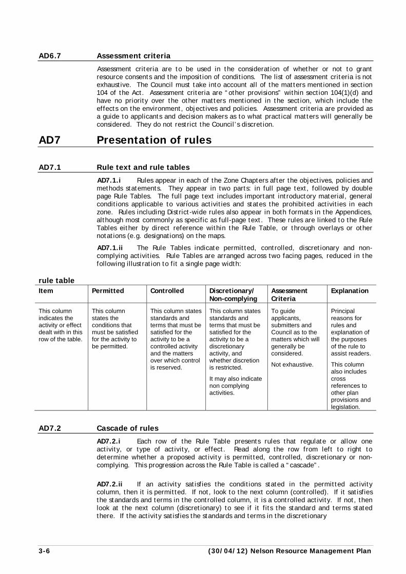
AD7.1.ii The Rule Tables indicate permitted, controlled, discretionary and non-complying activities. Rule Tables are arranged across two facing pages, reduced in the following illustration to fit a single page width:
rule table Item Permitted Controlled Discretionary/
Non-complying Assessment Criteria
Explanation
This column indicates the activity or effect dealt with in this row of the table.
This column states the conditions that must be satisfied for the activity to be permitted.
This column states standards and terms that must be satisfied for the activity to be a controlled activity and the matters over which control is reserved.
This column states standards and terms that must be satisfied for the activity to be a discretionary activity, and whether discretion is restricted.
It may also indicate non complying activities.
To guide applicants, submitters and Council as to the matters which will generally be considered.
Not exhaustive.
Principal reasons for rules and explanation of the purposes of the rule to assist readers.
This column also includes cross references to other plan provisions and legislation.
AD7.2 Cascade of rules
AD7.2.i Each row of the Rule Table presents rules that regulate or allow one activity, or type of activity, or effect. Read along the row from left to right to determine whether a proposed activity is permitted, controlled, discretionary or non-complying. This progression across the Rule Table is called a “cascade”.
AD7.2.ii If an activity satisfies the conditions stated in the permitted activity column, then it is permitted. If not, look to the next column (controlled). If it satisfies the standards and terms in the controlled column, it is a controlled activity. If not, then look at the next column (discretionary) to see if it fits the standard and terms stated there. If the activity satisfies the standards and terms in the discretionary
Nelson Resource Management Plan (01/09/04) 3-7
column it is discretionary. An activity can be non-complying if it is identified specifically as such or it may be non-complying if it does not meet the standards and terms required of a discretionary activity.
AD7.2.iii The discretionary column may state no standards and terms, in which case the cascade ends there: all activities that are not permitted or controlled are discretionary, and no non-complying activities arise in that row.
AD7.2.iv The fact that an activity meets the standards for a controlled or discretionary activity does not necessarily mean that a resource consent will be granted: it simply means that an application for a resource consent must be lodged and that the application will be considered as a controlled or discretionary activity as the case may be. Controlled activities have to be granted, except in limited circumstances set out in the Act.
AD7.2.v The assessment criteria column indicates some of the effects that are likely to be considered relevant to the decision to grant or refuse consent and, if granted, what conditions to impose, if any. Assessment criteria do not limit the Council’s discretion, and any additional matters that might arise in a particular case may be considered.
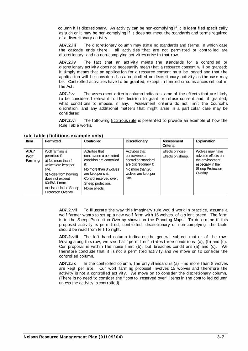
AD7.2.vi The following fictitious rule is presented to provide an example of how the Rule Table works.
rule table (fictitious example only) Item Permitted Controlled Discretionary Assessment
Criteria Explanation
ADr.7 Wolf Farming
Wolf farming is permitted if: a) No more than 4 wolves are kept per site. b) Noise from howling does not exceed 60dBA, Lmax. c) It is not in the Sheep Protection Overlay
Activities that contravene a permitted condition are controlled if: No more than 8 wolves are kept per site. Control reserved over: Sheep protection. Noise effects.
Activities that contravene a controlled standard are discretionary if: No more than 20 wolves are kept per site.
Effects of noise. Effects on sheep.
Wolves may have adverse effects on the environment, especially in the Sheep Protection Overlay.
AD7.2.vii To illustrate the way this imaginary rule would work in practice, assume a wolf farmer wants to set up a new wolf farm with 15 wolves, of a silent breed. The farm is in the Sheep Protection Overlay shown on the Planning Maps. To determine if this proposed activity is permitted, controlled, discretionary or non-complying, the table should be read from left to right.
AD7.2.viii The left hand column indicates the general subject matter of the row. Moving along this row, we see that “permitted” states three conditions, (a), (b) and (c). Our proposal is within the noise limit (b), but breaches conditions (a) and (c). We therefore conclude that it is not a permitted activity and we move on to consider the controlled column.
AD7.2.ix In the controlled column, the only standard is (a) – no more than 8 wolves are kept per site. Our wolf farming proposal involves 15 wolves and therefore the activity is not a controlled activity. We move on to consider the discretionary column. (There is no need to consider the “control reserved over” items in the controlled column unless the activity is controlled).
3-8 (01/09/04) Nelson Resource Management Plan
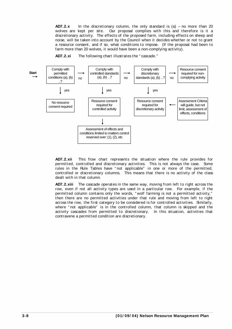
AD7.2.x In the discretionary column, the only standard is (a) – no more than 20 wolves are kept per site. Our proposal complies with this and therefore is it a discretionary activity. The effects of the proposed farm, including effects on sheep and noise, will be taken into account by the Council when it decides whether or not to grant a resource consent, and if so, what conditions to impose. (If the proposal had been to farm more than 20 wolves, it would have been a non-complying activity).
AD7.2.xi The following chart illustrates the “cascade.”
AD7.2.xii This flow chart represents the situation where the rule provides for permitted, controlled and discretionary activities. This is not always the case. Some rules in the Rule Tables have “not applicable” in one or more of the permitted, controlled or discretionary columns. This means that there is no activity of the class dealt with in that column.
AD7.2.xiii The cascade operates in the same way, moving from left to right across the row, even if not all activity types are used in a particular row. For example, if the permitted column contains only the words, “wolf farming is not a permitted activity,” then there are no permitted activities under that rule and moving from left to right across the row, the first category to be considered is for controlled activities. Similarly, where “not applicable” is in the controlled column, that column is skipped and the activity cascades from permitted to discretionary. In this situation, activities that contravene a permitted condition are discretionary.
Start Comply with
permitted conditions (a), (b)
..?
Comply with controlled standards
(a), (b) …?
Comply with discretionary
standards (a), (b) ..?
Resource consent required for non-complying activity
No resource consent required
Resource consent required for
controlled activity
Resource consent required for
discretionary activity
Assessment Criteria will guide, but not
limit, assessment of effects, conditions
Assessment of effects and conditions limited to matters control
reserved over: (1), (2), etc
yes yes yes
no no no
Nelson Resource Management Plan (26/01/08) 3-9
AD8 Resource consents
AD8.1 General
AD8.1.i Applications for resource consent must be made in writing to the Council and be accompanied by the application fee. Various procedural steps are required before a decision on the application can be made. These include checking the adequacy of the information supplied and the assessment of effects, deciding whether the application should be notified or not, and if required, arranging notification, receiving submissions, and arranging prehearing meetings and hearings if necessary. The Act sets time limits for the various steps and a clear structure for undertaking each step. For example, the consideration of whether to publicly notify any application for resource consent, or give limited notification is expressly controlled.
AD8.1.ii Resource consents are given different names depending on the type of activity they relate to. The types of resource consents are:
Consent Type Example
Land use consent Building, excavation and filling of land, day to day activities such as running a business, making more noise than allowed in a particular zone.
Subdivision consent Subdivision of land, including cross leases and unit titles.
Coastal permit Occupying space, e.g. for a wharf, dredging or reclamation.
Water permit Taking water from a river or well.
Discharge permit Discharging waste water into a river.
AD8.1.iii Land use consents lapse after five years if it has not been given effect to. An applicant may request a longer period if required. A land use, once established, may continue at the same character, scale and intensity without time restriction, unless the consent states otherwise. Other consents (apart from subdivisions) may be limited in time, with a maximum of 35 years.
AD8.2 Information to be included with applications
AD8.2.i Every application for a resource consent must provide a full description of the proposal and sufficient information to enable the Council and the general public to understand the nature of the proposal and its effects. Applications must be made in the prescribed form and manner and include an assessment of effects as prescribed by the Fourth Schedule of the Resource Management Act. Further information may be requested where the assessment of environmental effects is considered by Council to be inadequate, or the required information is not provided. Any application which replaces one already rejected by Council as being inadequate will be treated as a new application.
AD8.2.ii The Council has the power under Section 92 of the Act to require further information from the applicant for a resource consent in particular cases, so this list is not necessarily exhaustive. All applications must include: a) names and addresses of all applicants and owners and occupiers of the land, b) address or location and full legal description, including a current copy of certificate
of title for the land, c) reference to any other resource consent required with respect to the proposal, d) plans drawn to a metric scale (either 1:250, 1:200, 1:100 or an approved alternative)
with a north point and showing at least:
3-10 (31/10/13) Nelson Resource Management Plan
i) Topographical Features Existing landscape and natural features and showing how the site is to be
modified. Information to be provided must include: the location and manner in which areas are to be planted, grassed, sealed or paved; details of screening of buildings or activities from the public view or from neighbouring properties.
ii) Appearance Details indicating the design and appearance of all buildings on the
property. The development should generally achieve a design that is consistent with the character of the area in which it is located. Design features that reflect the character of the area should be appropriately indicated.
iii) Site Layout A plan showing the total site development indicating all relevant
boundaries, areas and dimensions. In particular, it should show location of parking areas and landscaping and screening in relation to other site development and boundaries, and location of all existing and proposed buildings.
iv) Access A plan showing the location and design of vehicular and pedestrian access to
the site. The plan must show proposed and existing (if relevant) on-site developments (including signs and landscaping) and the location of neighbouring footpaths, accesses and intersections. In an urban situation, “neighbouring” means within 55m of the site; in a rural situation “neighbouring” means within 250m of the activity location or its vehicular pedestrian access to the site, whichever is the greater. Where the proposed activity is a non-residential, commercial, industrial, retail, recreation, education or health activity, then the plan, or a separate plan, shall also show how the proposal complies with the requirements of Appendix 11.
Regards must be had to the location, design and safety of access in relation to vehicular and pedestrian movement and in respect of vehicular movement on adjacent roads and intersections set out in Appendix 11 of this Plan.
v) Car Parking A plan showing the location, number and dimension of parking, loading,
manoeuvring, queuing, and set down spaces and areas, and access. (See Appendices 10 – standards and terms for parking and loading, Appendix 11 – access standards, and Appendix 12 – tracking curves).
vi) Hazards All hazards should be identified and the means of avoiding, remedying or
mitigating adverse effects of the activity specified.
vii) Heritage and Cultural Any heritage and cultural items, places, buildings and trees referred to in
this Plan either in the site or on adjoining sites. (Photographs of such items, where relevant, may also be useful).
AD8.2.iii Chapter 13 (Coastal Marine Area) contains detailed requirements for information to be included with applications for coastal permits.
AD8.3 Information to be included with subdivision applications
Applications for subdivision consents must include the information required for other resource consents, set out above (where relevant), and the following additional material: a) The legal description and current copies of certificates of title for the land proposed
to be subdivided. b) A location diagram showing the proposed subdivision in relation to the district. c) A plan at an appropriate scale (either 1:250 or 1:200 or an approved alternative)
defining all allotments and balance areas and the position of all new boundaries.
Nelson Resource Management Plan (12/11/12) 3-11
d) Areas and dimensions of all allotments must be shown on the plan, except where the subdivision is to be effected by cross lease, company lease, or unit plan.
e) Provision for safe vehicular access. f) Legal descriptions of contiguous land and names of landowners. g) Identification of any adjoining land of the subdividing owner. h) Location and areas of existing and new reserves, including esplanade reserves and
strips. i) Location and areas of land below mean high water springs or any river or lake bed to
be vested in the Crown or the Council. j) Details of any land or structure on the land that is, or is likely to be, subject to
material damage by erosion, falling debris, subsidence, slippage or inundation from any source.
k) All existing buildings, structures and significant topographical features such as land forms, watercourses, flood channels, trees, fences, pipes or drains.
l) A statement of yards, bulk and location of existing buildings on net allotments and a plan if requested.
m) The location and proximity of areas, buildings, objects, sites or natural features of special value listed in the Plan and any other archaeological or heritage sites or features.
n) Any traditional, cultural or spiritual site or feature or any other aspect having special significance to the tangata whenua.
o) Existing and proposed services such as storm water, sewerage, water supply, electricity and telephone, to be indicated on the subdivision plan.
p) Proposed tenure and use of access lots, rights of way and easements. q) Location and areas of land to be set aside as roads and access and width and grade
of any road and access. r) Sufficient accompanying information to enable the Council to determine whether
the proposed subdivision meets the requirements of the Plan. s) Any proposed amalgamation conditions, covenants and consent notices. t) The standard of the legal roads providing legal fronting and access. u) Provision for on site drainage. v) Proposed areas of cut and fill. w) In the case of land to be subdivided in stages, the above information presented
separately in regard to each stage for which subdivision consent is not immediately sought, with an indication of the proposed timing for each stage.
x) In the case of land in the Rural Zone, or in any Hazard Overlay or Landscape Overlay, identification of any proposed building sites.
y) A statement on fire safety requirements in regard to proposed party walls and buildings on boundaries.
z) Where a subdivision abuts a State Highway, a written statement from the NZ Transport Agency on the proposal.
aa) A copy of all conditions from the Council’s condition book relating to the land (if any).
bb) Whether the land to be subdivided contains hazardous or contaminated material. cc) Where directed by rules and assessment criteria the residential subdivision design
and information requirements under Appendix 14. dd) Any information required by any Structure Plan or contained in any Schedule.
3-12 (12/11/12) Nelson Resource Management Plan
AD8.4 Assessment of Effects
AD8.4.i Applications must include an assessment of any actual or potential effects that the activity may have on the environment and the ways in which adverse effects may be mitigated. The Assessment of Effects must be of such detail that is consistent with the scale and significance of the likely actual and potential effects of the proposal. In the case of a controlled activity, the assessment needs to cover only the matters over which control is reserved, as stated in the relevant rules.
These are stated in the controlled column of the Rule Table, and in the rules that precede the Rule Table, in each zone chapter.
AD8.4.ii The Fourth Schedule of the Act sets out the matters which should be addressed in an Assessment of Effects. In preparing such an assessment, consideration should be given to any positive effect as well as any adverse effect. In addition to those matters specified in the Fourth Schedule, assessments should include, where appropriate, an assessment of effects on:
a) adjacent activities in terms of such effects as noise, traffic generation, shade, dust,
smell, vibration, glare. b) existing and proposed infrastructure including road networks, storm water services,
sewerage, water supply. c) disposal and storage of effluent, solid waste and hazardous substances. d) the social, economic and cultural well-being of the community e) any special localities, areas, buildings, objects, sites or natural features of special
value identified in the Plan f) amenity values of a locality g) natural hazards
Nelson Resource Management Plan (26/01/08) 3-13
AD8.5 Notification
AD8.5.i All resource consent applications have to be publicly notified, except as provided in sections 93 and 94 of the Act. Under this Plan, applications will generally not be publicly notified in these cases:
a) activities for a controlled activity, or b) where Council is satisfied that the adverse effects of the activity on the
environment will be minor.
AD8.5.ii For those activities qualifying under clause 8.5.i above, Sec 94(1) of the Act still requires Council to serve limited notification of the application on all persons who may be adversely affected by the activity, even if some of these persons may have already given their written approval. However, this limited notification is not required if all persons who may be adversely affected have given their written approval.
AD8.5.iii Notwithstanding clauses 8.5.i and 8.5.ii above, Council:
a) will notify a controlled activity where the Plan expressly provides it must be notified;
b) is not required to notify a restricted discretionary activity if a rule in the Plan expressly provides it does not need to be notified; and
c) does not need to serve notice for a controlled or restricted discretionary activity if a rule expressly provides that notice is not required.
AD8.5.iv Where Council considers that a proposal (which is not a controlled activity) may have more than a minor adverse effect on the environment, the application is required to be publicly notified.
AD8.5.v Applications that include sufficient information will be notified within 10 working days of being lodged with the Council. Notice will be served on every person required by the regulations to the Act. Notice will also be advertised in an appropriate newspaper and displayed on the site. Submissions on an application may be made by any person, who must lodge them with the Council within 20 working days and serve them on the applicant.
AD8.5.vi Council is required to publicly notify an application in accordance with the Act if requested to by an applicant. Council may also notify an application if it considers special circumstances exist.
AD8.6 Hearings
AD8.6.i A hearing is a meeting where the Council (or a committee, or a commissioner, or someone to whom decision making has been lawfully delegated) hears an explanation of a proposal and the reasons for submissions. Hearings are generally held when submissions have been received in respect of a resource consent application, a plan change or a review of the Plan.
AD8.6.ii A prehearing meeting may be held to clarify, mediate, or facilitate resolution of matters and issues before a hearing. The Council may, on its own initiative, or upon request, invite applicants and submitters to meet each other and other people as the Council thinks fit.
AD8.6.iii Advance notice of the date, time and place of hearing is always given. The applicant and any person who had lodged a submission or persons representing them, will be given the opportunity to express their point of view. The Resource Management Act sets out various requirements for hearings. It requires that unnecessary formality be avoided, tikanga Maori be recognised where appropriate, questioning of parties and witnesses is restricted to questions from the chairperson and members of the hearing body, and cross examination is not permitted. (See Sections 39 – 42A, 100-103). A degree of formality will often be necessary to ensure that everyone gets a fair hearing and the principles of natural justice are observed.
3-14 (30/04/12) Nelson Resource Management Plan
AD8.6.iv Following the hearing the Council will make a decision and indicate its reasons in writing.
AD8.7 Decisions
In making its decision the Council is required to have regard to various matters stated in section 104 of the Act. The full section should be read. The following matters from section 104 will be relevant: Part II of the Act; the effects on the environment of allowing the activity; national policy statements; New Zealand Coastal Policy Statement, Regional Policy Statement, objectives, policies and rules of any relevant Plan, Proposed Plan, and other matters that are relevant such as regulations and designations or heritage orders. Council may disregard an adverse effect on the environment if the Plan permits an activity with that effect.
(This paragraph does not attempt to give a full description of the Council’s decision making process.) Section 105 includes additional matters which require consideration with respect to certain applications.
AD8.8 Conditions of consent
The Council, in granting a resource consent, may include one or more conditions which are considered appropriate (see Section 108 of the Resource Management Act 1991).
The conditions may include: Any matter to avoid, remedy or mitigate adverse effects likely to arise from the activity and to assist in achieving the desired outcomes identified in the Plan. Requirements to ensure positive effects to offset any adverse effect. Bonds or covenants or both to ensure performance or compliance of any conditions imposed. Financial conditions in the form of money, land, works (including planting, restoration or enhancement of the locality) or services, or a combination of these, as required. (See Chapter 6 – financial contributions). An administrative charge in respect of processing applications, monitoring and supervision of resource consents. Notice that some or all conditions may be reviewed at some time in the future. Conditions requiring the consent holder to carry out certain monitoring regarding the effects of their activities. Any other condition that the Council considers appropriate.
AD8.9 Appeals
An appeal may be made to the Environment Court (Planning Tribunal) against the whole or any part of a decision of the Council of a resource consent application (see sections 120 and 121 of the Resource Management Act 1991). There is a limited time to appeal. If you are not sure about your rights or the procedures in relation to appeals, you are advised to seek qualified advice. A limited time period is available for those who are not a party to appeal proceedings to become a party with proper notice to the Environment Court.
AD8.10 Objections
Applicants who are dissatisfied with a decision of the Council may in certain circumstances lodge an objection and obtain a further hearing by the Council. The full circumstances for objections are set out in section 357 of the Act. One common situation where an objection may be lodged is in respect of a condition imposed where a subdivision consent is granted.
Nelson Resource Management Plan (12/11/12) 3-15
AD9 Property plans AD9.1 The concept of a property plan
Property plans apply in rural areas, as appropriate. There is no direct provision for Property Plans contained within the Resource Management Act, although they could be considered as an alternative method under Section 32. In their simplest form property plans are a “bundle of resource consents” applied for and considered by Council all at the same time along with their associated explanations, assessments of effects, and conditions of consent. Property plans are prepared jointly by the landowner and the Council in a co-operative manner with each party contributing as appropriate to the information contained within the plan. Property plans usually address matters related to Part II of the Act on that particular property.
In the Nelson Resource Management Plan matters related to Part II of the Act are generally addressed through the use of overlays. These include but are not limited to landscape, conservation features, riparian margins or archaeological sites. It is not essential that an individual property plan deals with all Part II matters and the plan may be restricted to one or two key issues.
AD9.2 Content of a property plan
A property plan needs to:- a) Contain adequate resource information. b) Contain adequate description of the activities proposed. c) Contain an assessment of the likely effects of the proposed activities on the natural
and cultural values contained within the property. d) Specify what activities the Property Plan covers. e) Specify any necessary conditions to be observed when undertaking works. f) Specify the period of the Property Plan. g) Specify under what circumstances or where additional conditions or resource
consents will be required.
AD9.3 Optional content of a property plan
Other matters which a Property Plan might contain include:- a) A commitment to active management and/or protection of significant features.
This could include fencing of sites, pest control, covenants to be created, public access provisions.
b) A cost sharing commitment for any active management, for example Council contribution to fencing or commitment to rates relief.
c) A statement of any additional development rights which are conferred on the property in return for active protection of significant features. In the example of the fencing and protection of a bush remnant, this may include consent to an additional subdivision lot or to the construction of an additional dwelling house.
AD9.4 Involvement of affected parties
Affected parties or those representing some aspect of public interest will be consulted and their input sought. Likely groups include Iwi and Department of Conservation. Where appropriate, parts of the property plan requiring resource consents will be publicly notified.
AD9.5 Advantages of a property plan
The concept of Property Plans may have many advantages for both the Council and for the landowner. In the Council’s case the Property Plan achieves:
3-16 (12/11/12) Nelson Resource Management Plan
a) integrated land management on a property by property basis. b) information transfer and consultation with landowners. c) refinement of resource management information on a property by property basis d) a vehicle by which Council can apply any works or grants to achieve resource
management outcomes. e) a reduction in the number of consents it needs to deal with for individual
properties.
In the landowners case the Property Plan has the following advantages. It:-
a) removes the need to apply for a large number of ad hoc resource consents. b) reduces the time and monetary cost of compliance with the District Plan. c) may include agreement from Council to contribute to works, grants rates relief and
permit additional development in return for active protection of significant features.
d) may provide additional information and research into resource management issues related to the property (e.g. an archaeological survey).
AD10 Relevant documents AD10.1 Land information memorandum
A Land Information Memorandum (LIM) may be obtained from the Council in respect of any property. It is a means of ascertaining information held by the Council in respect of land and development and can assist in planning the use of a site and preparing resource consent applications. A fee is payable on application for a LIM.
AD10.2 Documents related to this Plan
AD10.2.i Design Guides
Several design guides or documents setting out desired design outcomes are referred to or accompany this Plan. Three are included in the Appendices and are part of this Plan: a) Guide for subdivision and structures in the Landscape Overlays (Appendix 7). b) Comprehensive Housing Development (Appendix 22). c) Design guide and rules for Wakefield Quay (Appendix 23).
Additional guides not contained in the Plan: a) Design Guide for South Street Heritage Precinct. b) Design Guide for Elliott Street Heritage Precinct. c) Design Guide for Fountain Place Heritage Precinct. d) Design Guide for Russell Street Heritage Precinct. e) Design Guide for Alton Street Heritage Precinct. f) Design Guide for Seymour Avenue Heritage Precinct. g) Design Guide for Dear Cottages (Rutherford Street) Heritage Precinct. h) Design Guide for Nelson City Centre.
The guides, including those not contained in the Plan, will be used in the consideration of relevant applications and the imposition of conditions.
AD10.2.ii Nelson City Council conditions register
This contains information about conditions or constraints that apply to specific sites. It records such matters as previous slips, uncontrolled filling, inputs from geological reports, and engineering constraints such as those related to drainage and sewerage, as well as conditions that have been placed on the property as part of any building consent or resource consent. Some of this information has been included on the Planning Maps. However the Conditions Register is more site specific, and can be more up to date as information may be added or deleted as it is no longer relevant. The Conditions Register can also include matters which are outside the scope of the Plan.
The register is linked to Council’s Geographic Information System database on computer, and is used to generate information for Land Information Memoranda. It should be referred to by potential purchasers or developers.
Nelson Resource Management Plan (12/11/12) 3-17
AD10.2.iii Nelson City Council Land Development Manual 2010
The Council has a Land Development Manual (LDM) which includes both design guidance and minimum standards for subdivision and development. The Manual represents quality urban design and engineering practice and includes design features and standards that are acceptable to the Council. The Manual will be regarded as an acceptable means of compliance with requirements of the Plan and any conditions of consent. It contains minimum design and construction standards as well as design guidance. Minimum standards are differentiated from design guidance for the purpose of assessing compliance with the NRMP rules, as defined in Section 1.1.1 General of the LDM. The Council recognises there may be other acceptable means of compliance, in which case proposals should be accompanied by appropriate supporting detail at the time of resource consent application. The Land Development Manual 2010 is an externally referenced document, and as such has effect as if it is part of the NRMP.
AD10.2.iv Financial contributions guide
Not part of this Plan, but intended to explain financial contributions required under the plan with worked examples of calculations.
AD10.2.v New Zealand standards
The New Zealand Standards Association publishes a variety of documents on a wide range of subjects. These documents may be referred to when assessing any application, imposing conditions of consent, or establishing compliance with the Plan provisions.
AD10.2.vi Codes of practice
Various industry associations publish Codes of Practice relating to their spheres of interest. Where these documents have wide publication and a measure of support the Council may refer to them when assessing applications and in imposing conditions of consent.
AD10.2.vii Externally referenced documents
Part 3, Clauses 30-35 of the First Schedule of the Resource Management Act 1991 outlines what documents can be incorporated by reference and the process for doing this. The documents that can be incorporated by reference include standards, requirements or recommended practices of international or national organisations or countries and any other written material that deals with technical matters that is too large or impractical to be printed as part of the Plan. Documents that are incorporated by reference have legal effect as part of the Plan, have to be consulted on and to be publicly available.
AD10.2.viii New Zealand Urban Design Protocol
The Council is a signatory to the NZ Urban Design Protocol. The protocol aims to foster improvements in the way our towns and cities are designed and developed. By signing the protocol the Council has committed to an action plan to raise awareness of the value of quality urban design both to the Council and the community.
AD10.3 Additional relevant documents
AD10.3.i Documents referred to in the Resource Management Act
The Act requires the Council, when preparing or changing a plan, to have regard to various documents (sections 66 and 74). These are as follows:
AD10.3.ii Regional policy statement
This document has been produced under the Resource Management Act. It provides an overview of the resource management issues of the region and the policies and methods to achieve integrated management of the natural and physical resources of the region. This Plan may not be inconsistent with the Regional Policy Statement.
The Nelson Regional Policy Statement was originally notified in August 1994 and after hearing of submissions, became operative in March 1997.
3-18 (12/11/12) Nelson Resource Management Plan
AD10.3.iii National Environmental Standards
The Minister for the Environment can recommend to the Governor-General that a regulation be issued known as a National Environmental Standard. A standard can deal with a range of factors, e.g. qualitative or quantitative standards, for example for noise or contaminants, or can determine methods for implementing standards, or classifying a resource. They can also prohibit an activity. Where a regulation prohibits an activity, this prevails over the provisions of a Plan.
AD10.3.iv Regulations
The Governor General may issue regulations at any time concerning a range of issues, e.g. the manner of content of applications, who is required to be served notice of an application, and so on. Regulations can apply to specific parts of the region, be applied generally or from time to time. Where appropriate, these regulations must be taken into account.
AD10.3.v National policy statements
These may be issued by the Minister for the Environment on matters of national significance that are relevant to achieving the purposes of the Resource Management Act. The exception is the NZ Coastal Policy Statement, which was mandatory, and was issued by the Minister of Conservation 5 May 1994. Any plans produced by a Council under the Act must not be inconsistent with any National Policy Statement.
AD10.3.vi Local Government Act 2002
The Long Term Plan (LTP) is prepared under the Local Government Act 2002, with the purpose of describing Council’s activities to promote the social, economic, environmental and cultural well-being of our community, in the present and for the future. This includes describing the ‘community outcomes’ of the city, providing integrated decision making and co-ordinating the resources of the Council. It provides a long term focus for the decisions and activities of the Council and is an important basis for the accountability of the Council to the Nelson community. It provides an opportunity for the public to participate in decisions on activities to be carried out by the Council and covers ten years of financial expenditure in detail. The LTP also includes the Council’s Development Contributions Policy. This policy ensures that those who benefit from (or create the need for) new infrastructure are responsible for funding it. The Local Government Act requires the Council to take a sustainable development approach through the LTP, which is a wider planning mandate than that of the Resource Management Act which promotes sustainable management of the environment.
A LTP must be adopted every three years and cover a period of not less than 10 consecutive financial years. The Annual Plan is published in the years that the LTP is not. The Annual Plan updates Council’s financial situation, intended activities and work programme for the following financial year.
Asset and Parks and Reserves Management Plans are developed for the management of infrastructure and community facilities assets. These Plans combine multi disciplinary management techniques (including technical and financial) over the life cycle of the asset to provide a specified level of service in a cost effective manner.
AD10.3.vii Documents recognised by iwi
Council will take into account any relevant planning document which is recognised by an iwi authority, and which has been lodged with Council, to the extent that its content has a bearing on the resource management issues of the region.
AD10.3.viii Reserve management plans
The day to day management of reserves under the Reserves Act 1977 is controlled by management plans under the Reserves Act. This Plan only sets out to manage reserves at the broadest resource management level, leaving the operational and planning details of reserves to the reserves management plans. Most reserves have been included in the Open Space and Recreation Zone or Residential Zone.
Nelson Resource Management Plan (12/11/12) 3-19
AD10.3.ix Historic Places Trust register
Entries were taken into account in compiling the heritage provisions of this Plan.
AD10.3.x Fisheries regulations
There are freshwater fisheries regulations administered by the Fish and Game Councils which may have relevance to resource management.
These include the Wildlife Regulations 1955, Annual Game Notices, Fresh Water Fisheries Regulations 1983, and Anglers’ Notices.
AD11 Plan construction
AD11.1 Planning maps
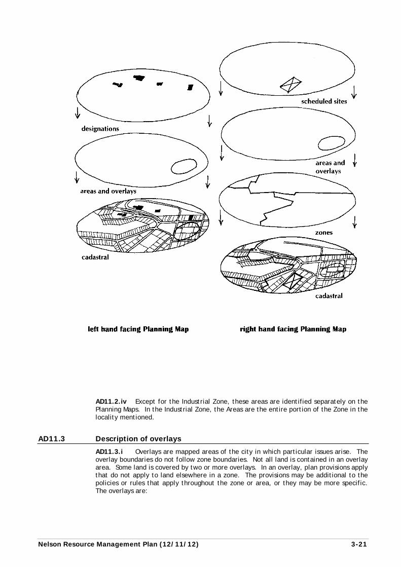
AD11.1 The Planning Maps in Volume 4 are an integral part of this Plan. They contain the following information: a) cadastral base (a map showing property boundaries). b) zones and areas. c) overlays. d) scheduled land (eg. hospital, quarries). e) designations. f) information to aid location and interpretation of maps.
Two maps cover each part of the District. They are presented on facing pages of the Planning Maps. The left hand page presents designations, areas and some overlays. The right hand page presents more areas and overlays, the zones, and scheduled sites. Both maps need to be read together.
The relationship of the various layers is shown as follows:
AD11.1.ii The area subject to this Plan is the whole District including the Coastal Marine Area. The Coastal Marine Area extends seaward from mean high water springs to the outer limits of the territorial sea (“12 mile limit”). The Planning Maps show where the boundary of the Coastal Marine Area crosses rivers, usually inland of the general line of mean high water springs.
AD11.2 Description of zones and areas
AD11.2.i All land and sea subject to this Plan is contained within one of eight zones or areas. The reasons for the zoning approach are stated in Chapter 5 (district wide objectives and policies). The zones are: Residential, Inner City, Suburban Commercial, Industrial, Open Space and Recreation, Rural and Conservation Zones, as well as the Coastal Marine Area.
The Coastal Marine Area is not a zone. This allows the provisions of both Chapter 13 (Coastal Marine Area) and Chapter 10 (Industrial Zone) to apply to that part of the Coastal Marine area in the port which is occupied by wharves or ships at berth, and which is zoned industrial. Where there is any conflict between the two sets of provisions, the provisions of Chapter 13 (Coastal Marine Area) shall take precedence.
AD11.2.ii All rules that affect activities in any one zone or area are largely contained within the relevant zone or area chapter of this Plan, supplemented by the information in Chapters 1 to 6, and the Appendices. Where rules seek to protect values in another zone or area, the appropriate objectives and policies will be found in that other zone or area. An example of this is in the Inner City Zone, where the effects of activities on the surrounding Residential Zone are taken into account by applying more stringent performance standards to activities near the zone boundary.
AD11.2.iii Unless otherwise stated, all rules for the zone are applicable to all land in any one zone.
3-20 (12/11/12) Nelson Resource Management Plan
Within some zones, particular areas are identified. Areas may be subject to additional policies or rules, or policies and rules which are more specific than those applying in the remainder of the zone. Additional policies or rules apply in addition to the policies or rules for the rest of the zone. Policies and rules which are more specific than a general policy or rule apply instead of that more general provision e.g. if an Area provides for a maximum building height of 12m, while the general rule provides for 7.5m, then 12m shall prevail within the land covered by the Area.
The Areas are described below:
Residential Zone Lower Density Area Higher Density Area
Rural Zone Lower Density Small Holdings Area Higher Density Small Holdings Area
Inner City Zone Intense Development Area City Centre City Fringe
Suburban Commercial Zone Leisure Area
Industrial Zone Tahunanui Area Vanguard Street/St Vincent Street Area Port Area Nayland Road South Area Saxtons Area Airport Area
Nelson Resource Management Plan (12/11/12) 3-21
AD11.2.iv Except for the Industrial Zone, these areas are identified separately on the Planning Maps. In the Industrial Zone, the Areas are the entire portion of the Zone in the locality mentioned.
AD11.3 Description of overlays
AD11.3.i Overlays are mapped areas of the city in which particular issues arise. The overlay boundaries do not follow zone boundaries. Not all land is contained in an overlay area. Some land is covered by two or more overlays. In an overlay, plan provisions apply that do not apply to land elsewhere in a zone. The provisions may be additional to the policies or rules that apply throughout the zone or area, or they may be more specific. The overlays are:
3-22 (12/11/12) Nelson Resource Management Plan
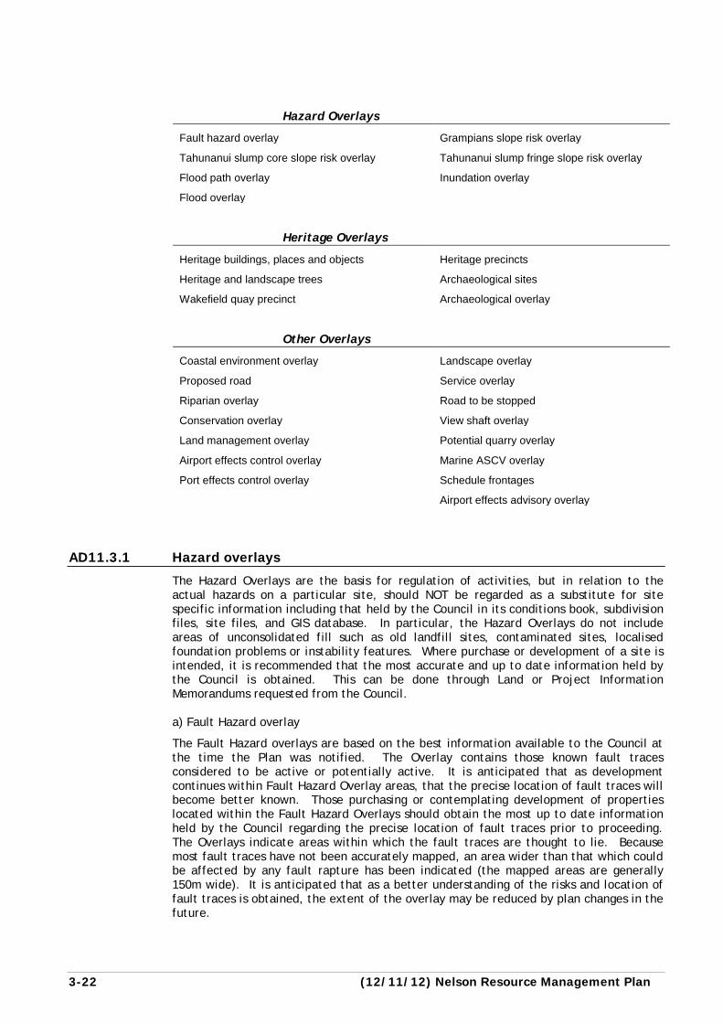
Hazard Overlays
Fault hazard overlay Grampians slope risk overlay
Tahunanui slump core slope risk overlay Tahunanui slump fringe slope risk overlay
Flood path overlay Inundation overlay
Flood overlay
Heritage Overlays
Heritage buildings, places and objects Heritage precincts
Heritage and landscape trees Archaeological sites
Wakefield quay precinct Archaeological overlay
Other Overlays
Coastal environment overlay Landscape overlay
Proposed road Service overlay
Riparian overlay Road to be stopped
Conservation overlay View shaft overlay
Land management overlay Potential quarry overlay
Airport effects control overlay Marine ASCV overlay
Port effects control overlay Schedule frontages
Airport effects advisory overlay
AD11.3.1 Hazard overlays
The Hazard Overlays are the basis for regulation of activities, but in relation to the actual hazards on a particular site, should NOT be regarded as a substitute for site specific information including that held by the Council in its conditions book, subdivision files, site files, and GIS database. In particular, the Hazard Overlays do not include areas of unconsolidated fill such as old landfill sites, contaminated sites, localised foundation problems or instability features. Where purchase or development of a site is intended, it is recommended that the most accurate and up to date information held by the Council is obtained. This can be done through Land or Project Information Memorandums requested from the Council. a) Fault Hazard overlay
The Fault Hazard overlays are based on the best information available to the Council at the time the Plan was notified. The Overlay contains those known fault traces considered to be active or potentially active. It is anticipated that as development continues within Fault Hazard Overlay areas, that the precise location of fault traces will become better known. Those purchasing or contemplating development of properties located within the Fault Hazard Overlays should obtain the most up to date information held by the Council regarding the precise location of fault traces prior to proceeding. The Overlays indicate areas within which the fault traces are thought to lie. Because most fault traces have not been accurately mapped, an area wider than that which could be affected by any fault rapture has been indicated (the mapped areas are generally 150m wide). It is anticipated that as a better understanding of the risks and location of fault traces is obtained, the extent of the overlay may be reduced by plan changes in the future.
Nelson Resource Management Plan (12/11/12) 3-23
b) Grampians slope risk overlay, Tahunanui core slope risk overlay and Tahunanui fringe slope risk overlay
Indicate where controls are to be imposed in order to address the effects of slope risks in two broad areas, the Tahunanui Slump and the lower Grampians slip. Both areas define potential or actual land slip areas where stringent building or development controls are necessary. c) Inundation overlay
The Inundation Overlay indicates areas which may be susceptible to localised stormwater flows, stormwater ponding, ponding of other floodwaters or tidal inundation. The causes of localised ponding are highly site specific but generally relate to the presence of a low lying area where stormwater accumulates or tidal backwater effects prevent drainage. Currently where new development occurs in these areas, the Council requires that adequate site levels are achieved to maximise drainage and that floor levels are established above the maximum water level expected in a 50 year return period event (an event predicted to happen on average only once in any 50 year period).
Tidal inundation may occur at some sites during periods of extra high tides and particularly in combination with low pressure weather systems. In exposed coastal areas wave action is also a factor. Calculations of the likely flooding events include sea level rise of 0.3 m over the next 50 years (after Ministry for the Environment 1993). As knowledge of possible global warming and associated sea level rise is gained this figure is likely to be reviewed. The Council is also reviewing the way in which development adapts to the potential effects of climate change on inundation levels. d) Flood path overlay
Indicates areas where the land may be subject to occasional flooding within flood paths and overflow channels of rivers and streams. These areas have been differentiated from the inundation overlays because of the higher risks to safety and property associated with this type of hazard, particular from the erosive or destructive force of moving floodwater. The Council is undertaking a long term programme of upgrading storm water drainage. As this work progresses the susceptibility of areas to flooding will change. Those purchasing or developing within the Flood Path Overlays should obtain the most up to date information available from the Council. e) Flood overlay
Indicates areas in the Rural Zone and Conservation Zone where land may be subject to flooding or hazards caused by running water such as debris flows on steam fans and the change in the position of creeks, but insufficient information is available to allocate it to the Inundation Overlay or Flood Paths Overlay.
The Flood Overlay is an advisory overlay which is given effect to through other rules in the Plan, the Resource Management Act itself or through other legislation. Examples of situations where the Flood Overlay will be taken into account include the earthworks rules of the Plan which make earthworks within the Flood Overlay a restricted discretionary activity, section 14 of the Resource Management Act which controls the damming or diversion of water, and the Building Act which takes flood hazards into account when assessing a building consent.
AD11.3.2 Landscape overlay
All areas adjacent to the city, coast and main traffic routes which are highly sensitive to development. They comprise mainly the ridge tops together with the most sensitive shoulder slopes.
3-24 (12/11/12) Nelson Resource Management Plan
AD11.3.3 Services overlay
AD11.3.3.i The Services Overlay relates to the availability and capacity of services such as wastewater, water supply, stormwater drainage, and roads. The overlay areas contain one or more of the following servicing constraints: a) Development of the area is beyond the immediate scope of the Long Term Plan or
Council’s Nelson Development Strategy. b) The area is low lying and requires filling before servicing can occur c) The area is one where extension of services is required to serve other land or
contribute to a network. This includes the provision of legal road and utilities up to the boundary of the development site to serve the development potential of adjoining land in the Services Overlay.
d) Services in the area are inadequate and require comprehensive upgrading before development can proceed
e) The area is above the contour for which water can be supplied to meet the requirements of the Council’s Land Development Manual. (The standards are based on the NZS4404: Land Development and Subdivision, and the New Zealand Fire Service Water Supplies Code of Practice).
These constraints must be addressed before development of these areas can proceed. Resource consent will not be declined for servicing constraint reasons when they have been resolved.
AD11.3.3.ii The Services Overlay also deals with situations where services need to be developed in the area in a comprehensive manner in conjunction with the Council and other property owners.
AD11.3.4 Heritage overlays
a) Heritage Buildings, Places, and Objects
Are individual items, described in Appendix 1, and indicated on the Planning Maps. The Plan protects these items.
b) Heritage Precincts
Are areas that contain a number of heritage items, where the group together has particular value. Heritage Precincts may contain buildings that are not listed heritage buildings, but are subject to controls to ensure that alterations to these buildings do not detract from the values of the precinct.
c) Heritage and Landscape Trees
Are individual trees, groups of trees, or woodlands, described in Appendix 2, and indicated on the Planning Maps. The Plan protects these items.
d) Archaeological sites
All sites of human habitation prior to 1900, indicated on the Planning Maps and supplemented by Appendix 3. The Plan protects these items.
e) Archaeological Overlay
Are areas which are known to contain a high number of identified archaeological sites, and which are also likely to contain many sites that are not documented. One such area occurs at Delaware Bay, another at the mouth of the Whangamoa River. Within these overlays the Plan regulates activities which have the potential to damage archaeological sites. Individual sites within these overlays are not shown on the Planning Maps, but records of some archaeological sites within them are available at the Council offices. Applicants will be expected to establish the presence or absence of archaeological sites near their proposed activity through consultation with the relevant iwi, and where necessary in some cases through an archaeological investigation.
Nelson Resource Management Plan (12/11/12) 3-25
f) Wakefield Quay Precinct
Is an area where special bulk and location, and design controls apply in order to protect the special character of the area. While it contains a number of heritage buildings, it is not a heritage precinct.
AD11.3.5 Conservation overlay
Covers areas of significant conservation value (“ASCVs”), outside the Conservation Zone. This is to recognise and provide for the protection of outstanding natural features and landscapes from inappropriate subdivision, use, and development, and the protection of significant indigenous vegetation and habitats of indigenous fauna.
AD11.3.6 Marine ASCV (Areas of Significant Conservation Value) overlay
Covers area of significant conservation value (“ASCVs”) within the Coastal Marine Area. This is to recognise and provide for the protection of outstanding natural features and landscapes from inappropriate subdivision, use, and development, and the protection of significant indigenous vegetation and habitats of indigenous fauna.
AD11.3.7 Coastal environment overlay
AD11.3.7.i The Coastal Environment Overlay identifies land in the coastal environment where the natural character is such that the elevation of any activity proposed within the overlay justifies not only the consideration of the nature of the activity, but also its effect on the natural character of the coastal environment. It should be noted that the term ‘Coastal Environment Overlay’ is quite distinct from the term ‘Coastal Environment’, while including extensive areas above the mean high water mark, is located largely within the Coastal Marine Area (definition found in Chapter 2, Meanings of Words).
AD11.3.7.ii The overlay is intended primarily for activities outside the Coastal Marine Area. For this reason, the seaward boundary is generally mean High Water Springs. The notable exception to this is adjacent to the Port Industrial Zone where the overlay extends over the sea to coincide with the Port industrial zone.
AD11.3.7.iii The inland boundary of the coastal environment overlay was adopted on the basis of a variety of criteria, which were given different weightings in different localities. In the northern rural areas of the District, the inner boundary of the coastal environment overlay has been positioned generally to follow the line of the nearest dominant ridge inland from the sea, largely on the basis of landscape and geographical considerations and the relatively high degree of remaining natural character.
AD11.3.7.iv In urban and industrial areas abutting the coast, the boundary has been drawn generally to exclude “built” areas from the coastal environment overlay, because while these areas still possess a level of natural character, they have been extensively modified. However, the port area was included within the overlay, because the remaining natural character was offset by the potential for land-based activities to affect the adjacent Coastal Marine Area.
AD11.3.7.v In the Stoke Bypass, Rocks Road, Nelson urban, and Atawhai areas, the inner boundary of the coastal environment has been located a few tens of metres inland from Mean High Water Springs because of the extent to which activities on land affect the adjacent Coastal Marine Area, access, and the extent to which an area is subject to coastal processes (or may be in the future, as a result of sea level rise). In these areas, the outer edge of the coastal highway is a convenient and readily identifiable place to position the boundary. In the Airport/Nelson Golf Course/Tahunanui Beach area the boundary has been drawn further inland in recognition of the significance of public ownership of land (conservation values are more readily preserved on publicly owned land) and coastal erosion in these areas.
3-26 (12/11/12) Nelson Resource Management Plan
AD11.3.7.vi Overall, the boundary is considered to have both landscape and ecological significance, to be readily identifiable on the ground, and to be appropriate for the purposes of giving effect to the Act and to the New Zealand Coastal Policy Statement. The location of the boundary of the Coastal Environment Overlay is shown on the Planning Maps.
AD11.3.8 Land management overlay
Indicates land that is especially sensitive to activities that cause erosion and sedimentation, particularly vegetation clearance, soil disturbance and earthworks. The Overlay comprises mostly the land in Land Management Zone C in the NCC Land Disturbance Regional Plan, which is to be replaced by this Plan.
AD11.3.9 Riparian overlay
AD11.3.9.i Indicates rivers and the coast whose margins have been identified as having values for esplanade purposes. These values may be conservation (water quality, aquatic habitat, natural values), public access, hazard mitigation, or a combination of these.
AD11.3.9.ii Appendix 6 Table 6.1 contains a listing of values for all rivers and the coast shown as Riparian Overlay on the Planning Maps. The values listed are matters to be taken into account when deciding resource consents (other than controlled activity subdivision consents) or plan change applications. Specific Provisions for controlled activity subdivisions consents are listed in Appendix 6 Table 6.2.
AD11.3.9.iii Appendix 6 Table 6.2 contains a listing of all parts of rivers within the Riparian Overlay on the Planning Maps for which, esplanade reserves or esplanade strips will be acquired when a subdivision takes place, or they may be required as a condition of a resource consent when there is a change of land use activity on the site. Appendix 6, Table 6.2 sets out whether an esplanade reserve or an esplanade strip is required, the side of the river it is required, the values that it is intended to protect, and its width (including from MHWS). Rules are included in each zone to protect the esplanade values in the interim, before esplanade reserves or strips are implemented.
AD11.3.10 Road overlays
Proposed Road Overlay, and Road to be Stopped Overlay cover areas where the road network is to be extended or modified in some way. No rules apply to the Road to be Stopped Overlay. The Road to be Stopped Overlay is for information only, and will be taken into account in considering resource consent applications (e.g. when considering the roading pattern for a subdivision consent). Road alignments shown in the Proposed Road Overlay are indicative only and are considered as a standard and term under the Services Overlay – Building Rules, and matters of discretion and assessment criteria under the Subdivision Rules. Roads may also be designated in the Plan from time to time as required. See AD11.5 (designations) below.
In relation to Indicative Roads shown on a Structure Plan refer to AD11.4A for explanation.
Showing roads to be stopped in the Plan is only the beginning of a process. To be formally stopped, either the gazettal procedure under the Public Works Act, or the procedures under the Local Government Act must be used. The latter Act provides for public submissions and the resolution of disputes by the Environment Court. The gazettal process will only be used to stop roads or parts of roads where public access and usage are not materially affected. Otherwise, the Local Government Act, Tenth Schedule, process will be followed.
AD11.3.11 Potential quarry overlay
Indicates places where a rock resource is identified in order that it is protected from inconsistent land uses that would prevent the resource being quarried in the future.
Nelson Resource Management Plan (12/11/12) 3-27
AD11.3.12 Scheduled frontages
Property frontages within the City Centre with high pedestrian use, where special account is taken of pedestrian needs, eg. verandahs are required.
AD11.3.13 Airport effects overlays
Indicate areas likely to be subject to the effects of certain predicted noise levels from the operation of Nelson Regional Airport. The lines which form the boundaries of the Airport Effects Advisory Overlay represent noise levels predicted for the year 2020 from aircraft movements to and from the airport. From a 1994 base the predictions assume 10% growth in aircraft movements per year until 1999 and then 3% per annum for 21 years. a) Airport Effects Control Overlay
The outer limit of the Airport Effects Control Overlay represents a predicted noise level of Ldn 60 dBA (34.6 Pasques). The outer line has been slightly adjusted to take into account property boundaries. Land within this overlay is expected to be exposed to potentially high noise levels from the airport. Rules in the Plan restrict the density of housing in the Effects Control Overlay to avoid increasing the number of residential units exposed to the noise. Acoustic insulation is required for new residential units or significant alterations to existing units. Where resource consents are required (eg for activities that are not residential, as defined in the Plan), the effects of noise will be taken into account. The approximately Ldn 65 dBA (109 Pasque) contour (the Airnoise Boundary), which is within the inner edge of the Airport Effects Control Overlay, also regulates the maximum noise levels that the aircraft operations can generate at the airport. This line is based on aircraft movement growth to 2020, at the rates stated above. b) Airport Effects Advisory Overlay
This is the area between the Ldn 60 dBA (34.6 Pasque) and the Ldn 55 dBA (10.9 Pasque) predicted noise level boundaries. The lines bounding the overlay have been adjusted to take account of property boundaries. There are no rules that apply to the Airport Effects Advisory Overlay. It is for information – to advise people of the levels of noise that the area is likely to be subject to in the future. The presence of the Effects Advisory Overlay may be taken into account when resource consent applications are being considered.
AD11.3.14 Port effects control overlays
Indicates an area likely to be subject to the effects of noise levels from the Port Industrial Area.
The outer limit of the Port Effects Control Overlay represents a predicted noise level of 55 dBA Ldn. The line has been slightly adjusted to take in property boundaries. Land within this overlay is expected to be exposed to varying degrees of noise levels from port operations depending on the location of the land with respect to the Port. Rules in this Plan place some restrictions on housing in this area to avoid increasing the number of residential units exposed to the noise.
Acoustic insulation is required for new residential units or alterations to existing units. Where resource consents are required (eg for activities that are not residential, as defined in the Plan), effects of noise will be taken into account.
AD11.4 Scheduled sites
AD11.4.i Some activities are located in zones where they do not comply with the ordinary zone standards. An example is a service station in the Residential Zone. Confinement to commercial areas would not allow the necessary distribution of such services across all areas of the city. These activities are provided for by scheduling and
3-28 (31/10/13) Nelson Resource Management Plan
regulating them especially on their identified site. The intention of this is to ensure the continuation of a service to the community and protect the investment committed to buildings and site development. Opportunity to expand on site may be provided for such activities, which is a more liberal regime than existing use rights provided for under section 10 of the Act.
AD11.4.ii Schedules are also used in the Open Space and Recreation Zone to indicate permitted activities in different classes of land within that zone.
AD11.4.iii The rules that apply to the activity and site are stated in the relevant schedule. The schedules are located after the rule table in the relevant zone. The relationship between the schedule and the rule table is set out within each schedule.
AD11.4A Structure Plans
AD11.4A.i Structure Plans are used to achieve the integrated management of the effects of developing larger areas of land, often held in multiple ownership, particularly in an urban or urban fringe context. A Structure Plan provides an overall plan to guide integration of those elements that will achieve a quality urban environment (ie streets, walkway/cycleway connections, open space and natural values, character and activities). These elements may also exist in areas of Rural zoning where they link more urban neighbourhoods or are adjacent to urban areas. Requiring that development proceed in general accordance with the Structure Plan will ensure that individual landowners incrementally work in a co-ordinated and orderly way towards a planned and sustainable urban environment.
AD11.4A.ii The Structure Plans are located either within Scheduled Sites for various locations and zones throughout the district, for example in the Residential and Rural Zone rules (Chapters 7 and 12), and/or in the planning maps contained in Volume 4 of the Plan. Structure Plans incorporated in the Nelson Resource Management Plan have the effect of a rule and must be complied with to the extent specified in the relevant rule.
AD11.4A.iii A number of the specific resource management issues that may affect any future development area are covered by overlays on the planning maps, and to avoid duplication of spatial information these are not shown on the Structure Plans. Rules relevant to those overlays are located in the rule table in the relevant zone. The zone and area maps, overlays, zone rules and Structure Plans, and schedules if relevant, need to be read together in determining the status of activities and issues that may impact on the pattern and intensity of development.
AD11.4A.iv The Structure Plans may include zones where the pattern and intensity of development that exists or is anticipated for an area and/or adjoining areas may assist in explaining the location, linkage and scale of transportation, service and other linkages across parcels of land within the Structure Plan area.
AD11.4A.v Other information that may be shown on the Structure Plans includes the items below. Sections AD11.4A.v – AD11.4A.ix provide the definition and intent of these items:
a) Indicative Roads: The purpose of indicative roads on Structure Plans is to achieve good integration between land use and transport outcomes, having regard to the intensity of development and providing a choice in transport routes where appropriate. They are also used to ensure road linkage between different physical areas or catchments (e.g. valleys) which will enhance transportation outcomes, contact between communities, access to key commercial services, amenities and community facilities, and improve the quality of the urban environment. They do not show the full roading network required to service any future development of the area. The indicative roads may potentially arise in a wider context than merely the Structure Plan area.
Nelson Resource Management Plan (31/10/13) 3-29
b) Walkways: The purpose of the walkways on Structure Plans (these can also be cycleways where the terrain is suitable) is to promote recreational opportunity through off-road linkages within and surrounding the urban area, to provide for choice in transport modes, and to promote the safe and efficient movement of people and vehicles by resolving potential tensions between pedestrians, cyclists and motor vehicles.
c) Biodiversity Corridors: The purpose of Biodiversity Corridors is to contribute to natural values within, through, and beyond the urban environment, and assist where appropriate in meeting the open space, recreational, riparian, low impact storm water management, landscape setting and amenity objectives of quality urban design. In addition Biodiversity Corridors recognise and help preserve the cultural significance of water, native vegetation and native aquatic flora and fauna to Maori. Where these objectives can be met in proximity to a water way identified in the Plan, the Biodiversity Corridor will wherever practicable include any existing Riparian Overlay. “Biodiversity Corridor” is defined in Chapter 2 of the Plan.
d) Greenspace: The purpose of ‘greenspace’ is to offset the surrounding residential development and ensure an open space, or vegetated network is created which is integral to the community in the area. ‘Greenspace’ and Biodiversity Corridors can exist together as they will often achieve compatible goals. In private ownership the ongoing maintenance is the responsibility of the developer and/or final owner, and the methodology for future management of these areas will need to form part of any subdivision proposal under which they are created. Council may purchase some, or all, of this land for reserves purposes. “Greenspace” is defined in Chapter 2 of the Plan.
AD11.4A.vi Subdivision applications are to show how they provide for items on a Structure Plan including those listed in AD11.4A.v a)-d). In relation to location these items are generally shown “indicatively” on the Structure Plan as they show an intent rather than precise location for those features. This may be shown by way of an indicative line or through the use of text. These then form a matter of control which the Council will exercise as part of any subdivision consent process. It is intended that this provides an element of design flexibility to meet both the objectives of the Council and the developer, but while still achieving the overall objective of integrated and sustainable urban resource management and development.
AD11.4A.vii The Council acknowledges that the indicative connections may not directly serve or enhance a particular subdivision, for example where shown, or described, within a balance area. This, along with the formation and management of public use of certain connections, may also be at odds with farming, rural industry (including quarrying) or other legitimate rural land use practice activities on adjoining land. The Council will in those cases work with the land owners and any other landowners that may be affected in determining the appropriate time and method to provide the items described in AD11.4A.v or to set aside land upon subdivision for those purposes. In the interim, the objective will be to avoid activities and structures on the land which would compromise the future attainment of those connections or corridors. Any walkways/cycleways through the Rural Zone shown, or described, on a Structure Plan will only be opened by the Council for public use when network connection has been secured to other walkways, cycleways or roads, or when otherwise agreed by the adjacent landowners. The Council must at that time, where requested and in consultation with adjacent land owners, set in place a management regime to minimise any adverse effects on adjoining land.
3-30 (31/10/13) Nelson Resource Management Plan
AD11.4A.viii For the purpose of interpretation of any rules relating to Structure Plans, the term “generally accord” shall mean that items on these plans must be provided for in the general locations shown, or described, within the development area and linking to adjoining areas as shown in the Structure Plan except for the indicative education facility in Marsden Valley Schedule I (Clause I.6). It is not intended that the positions are exact or can be identified by scaling from the Structure Plan. It is intended that connections between points are achieved or provided for with no restrictions. The final location will depend upon detailed analysis of the physical suitability of an alignment (including the presence of existing natural features and ecologically sensitive habitats such as streams where providing for Biodiversity Corridors), other servicing implications, appropriate location in respect of final residential development layout and amenity, costing considerations, and impact on other land uses. The key proviso is that the items on the Structure Plan must be provided for, and that any connections must occur or be able to occur in the future.
AD11.4A.ix The primary objective of indicative roads, walkways/cycleways or Biodiversity Corridors is connectivity. Compliance with the rules requires that connection is planned for, or provided, within each stage of development, and to adjoining property boundaries at the appropriate stage, and is not restricted or prevented through the use of “isolation strips” or other methods which could lead to adjoining land becoming landlocked or connectivity being compromised.
AD11.5 Designations
A Minister of the Crown or a local authority with financial responsibility for a public work, or a network utility operator which has been approved as a requiring authority under section 167 of the Act may require land to be designated within the Plan. The designations are contained in Appendix 24 and indicated on the Planning Maps.
AD11.6 Roads – zoning
AD11.6.i Roads have the same zoning as the land that surrounds them. Where a road runs along the boundary between two zones, the zone boundary is the centre line of the road. Where a road runs beside the coast (for example Rocks Road), the boundary of the Coastal Marine Area is mean high water springs, not the centre of the road, and therefore the entire road is in a land zone. A bridge has the zoning of the river bed or other land beneath it.
AD11.6.ii Note that a road in the context of this Plan means the entire road reserve between the boundaries of adjoining parcels of land, not just the formed carriageway. Roads are generally represented without zone colouring on the Planning Maps. They are left white to provide orientation to map users and to provide a ready reference point to find properties.
AD11.7 Water bodies – zoning
AD11.7.i Land forming part of a water body, where not otherwise zoned, takes the zoning of the land that surrounds it. Where a water body occurs on the boundary between two zones, the zone boundary is the centre of the water body. Note: a river bed is normally wider than the channel where the water usually flows.
AD11.7.ii Water bodies owned by the Crown or the Council are often represented without zone colouring on the Planning Maps. They are left white to provide orientation for map users.
Nelson Resource Management Plan (31/10/13) 3-31
AD12 Boundaries that cross sites Boundaries of zones, areas and overlays are shown on the Planning Maps and generally following cadastral (property) boundaries. Where a boundary crosses a site, and the Planning Maps have insufficient detail to indicate the exact location of the boundary, it will be taken as following any land contours or other physical features relevant to the policies and objectives of the zone, area, or overlay as the case may be. Unless shown otherwise, the boundary between any zone or overlay and the Coastal Marine Area will be mean high water springs.
AD13 Numbering system of the plan A paragraph numbering system has been included, combining letters and numbers. The intention is to assist with the submission process, so that each objective, policy, paragraph or rule (or part of a rule) have a unique identifier associated with it. The letters are used to help identify the chapter and type of provisions, eg. “ICr” is Inner City Rule.