Embed Size (px)
Citation preview
AD-A131 460 GEOTHERMAL POTENTIAL OF MARINE CORPS MOUNTAIN WARFARETRAININO CENTER AT PICKEL MEADOW CALIFORNIANU NAVALWEAPONS CENTER CHINA LAKE CA K DANT ET AL MAY 83UNIDNC-TM488 F /4NL
mhhhh~EEEENDEEEEEEEEL
14-11 12. 2 .5_
11111 1.$ 2 .1I~.8
•1 1-25 II.I4il'IIII ,- l~
MICROCOPY RESOLUTION TEST CHART
%ATOAL' 8u*Au OF STANOAO - 1963
-A
ONWC Technical Memorandum 4898
GEOTHERMAL POTENTIALOF
MARINE CORPSMOUNTAIN WARFARE TRAINING CENTER
AT PICKEL MEADOW, CALIFORNIA
by
.Kathy DantiJ. A. Whelan
Allan M. Katzenstein
Geothermal Utilization DivisionPublic Works Department
May 1983
Approved for public release; distribution unlimited. Thisis an informal report of the Naval Weapons Center and is notpart of the permanent records of the Department of Defense.
Ct2. ~ color
.. '.I. be in black and
LI.. ~J1 7533
NAVAL WEAPONS CENTER "China Lake, CA Ar583 f? 1. 001
f • -*
NWC TM 4898
FOREWORD
The work described in this report was performed by the Naval WeaponsCenter during August 1981, and was authorized and funded by the NavalCivil Engineering Laboratory, Port Hueneme, California, under ProjectNo. Z0829-01-520A.
This report presents interim findings on the geothermal explorationof the Marine Corps Mountain Warfare Training Center, Pickel Meadow,California, and the surrounding area.
The report has been reviewed for technical accuracy by C.F. Austinand J. A. Whelan.
C. F. Austin, HeadGeothermal Utilization Division
Public Works Department13 Hay 1983
NWC TM 4898, published by Code 341, 150 copies.
NWC TM 4898
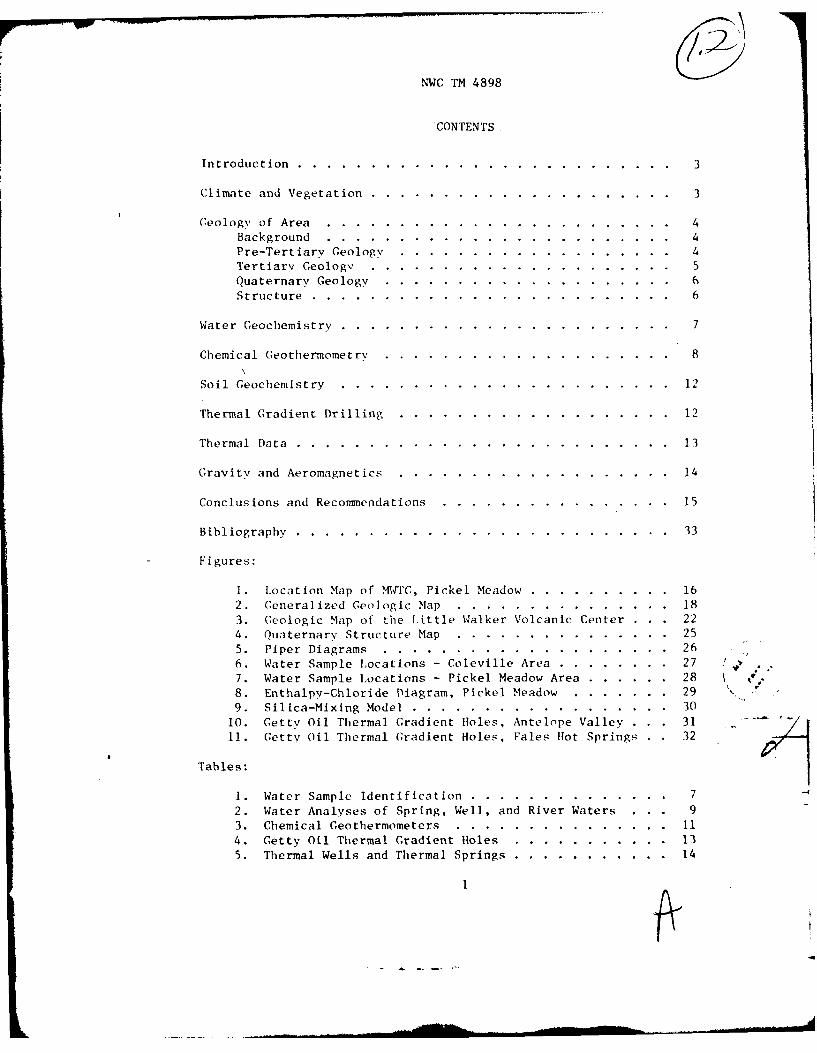
CONTENTS.
Introduction..............................3
Climate and Vegetation.......................3
Geology of Area..........................4Background..........................4Pre-Tertiary Geolog ...................... 4Tertiary Ge ologv.......................5Quaternarv Geology......................6Structure...........................6
Water Geochemistry.........................7
Chemical Geothermometrv........................8
Soil Geochemistry.........................12
Thermal Gradient Drilling....................12
Thermal Data...........................13
G;ravity and Aeromagnetics....................14
Conclusions and Recommendations.................. .. .. 15
Bibliography.......................... .. .33
Figures:
1. Location Map of MWTC, Pickel Meadow ............ 162. Generalized Geologic Map.................183. Geologic Map of the Little Walker Volcanic Center ... 224. Quaternarv Structure Map.................255. Piper Diagrams.....................266. Water Sample Locations - Coleville Area. ........ 277. Water Sample Locations - Pickel Meadow Area. ...... 288. Enthalpy-Chloride Diagram, Pickel Meadow ........ 29 ~9. Silica-Mixing Model...................30
10. Gettv Oil Thermal Gradient Holes, Antelope Valley 3111. Getty Oil Thermal Gradient Holes, Fales Hot Springs 32
Tables-
2. Water Analyses of Spring, Well, and River Waters 93. Chemical Geothermometers.................114. Getty Oil Thermal Gradient Holes.............135. Thermal Wells and Thermal Springs ................. 14
1
NWC TM 4898
INTRODUCTION
The Geothermal Utilization Division at tile Naval Weapons Center (NWC)
was tasked to perform a geothermal exploration program at the Marine CorpsMountain Warfare Training Center (MWTC) at Pickel Meadow (near Bridgeport),California. The program was implemented to determine which of MWTC's lands,
if any, contained adequate geothermal resources to develop energy self-sufficiency for the central facilities located at MWTC.
The Marine Corps Mountain Warfare Training Center, Pickel Meadow,
Bridgeport, California, was investigated in two sections: (1) the mainencampment area at Pickel Meadow (see Figure 1; all figures are locatedat the end of the report), and (2) the proposed family housing areas inAntelope Valley. Both areas appear to have a high potential for space heat-
ing and possibly even electrical power generation, since throughout theseareas warm wells, hot springs, and warm springs occur.
The Pickel Meadow area is U.S. Forest Service land. The Marine Corpshas a long-term use permit for these lands. At the time of this writing,
no military fee-acquired lands existed in this area. Antelope Valley con-sists mainly of privately owned land, some Forest Service land, and Bureauof Land Management (BLM)-administered lands. The Naval Facilities Engineer-
ing Command (NAVFAC) is conducting a study to determine which lands areeconomically feasible for the proposed family housing units. The area
that will be used for the housing will probably be fee-acquired.
MWTC lies on the lower eastern slopes of the Sierra Nevada in north-western Mono County. The Sweetwater Mountains are to the east. The main
encampment of MWTC is on the northern side of Pickel Meadow. Major drain-age through the entire area is by the West Walker River. Bridgeport liesabout 17 miles (27.4 kin) to the southeast and Antelope Valley is about15 miles (24 kin) to the north. U.S. Highway 395 is the major highwaythrough the region running in a north-south direction. State Highway 108(Sonora Pass) passes east-west. The main encampment is located 4 miles
(6.4 km) west along Highway 108 from the intersection of these two highways.
CLIMATE AND VEGETATION
The elevation varies considerably from 5,000 feet (1,525 m) in Antelope
Valley to peaks that are over 10,000 feet (1,048 m) above sea level. Theclimate is largely a function of elevation. At the higher elevations,precipitation is about 40 inches (101.6 cm) per %,ear. Temperatures arecharacterized by one monthly average between 50"F (100 C) to 64.6 0 F (18"C)and at least 4 months with average temperatures of less than 33.8 0F (10C)(Slemmons, 1953). The lower altitudes are semi-arid. The Bridgeport
3
NWC TM 4898
area (6,470 feet, 1,972 m) receives 8 inches (20.3 cm) of precipitationannually (Martin et a] ., 198()). Pret ipitation at all elevations is mostlyby snowfall; however, frequent thundershowers do occur during the summermonths .
Vegetation ranges from sagebrush types in the lower elevations toJuniper, Pinon, Jeffrey, and Lodgepole pine and Douglas Fir in the higherL'Ievations.
GEOLOGY OF AREA
BACKGROUND
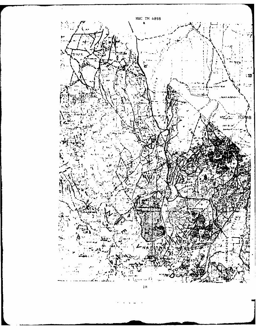
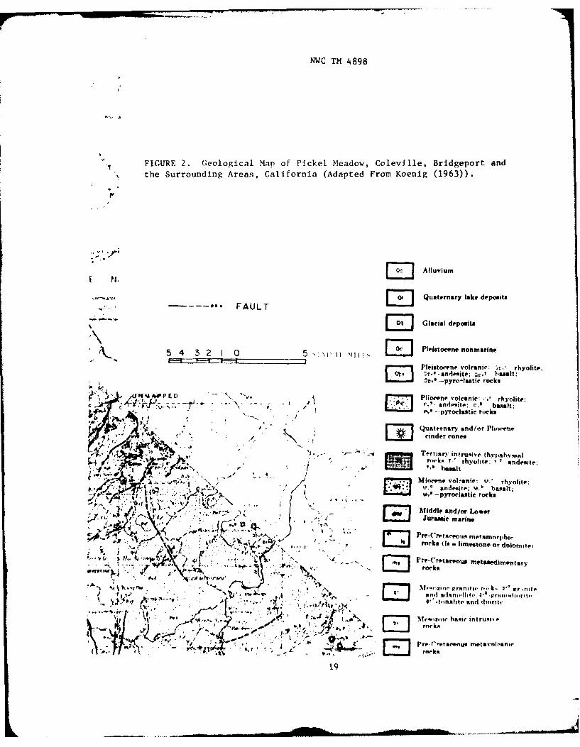
A generalized geological map of the area is shown as Figure 2.
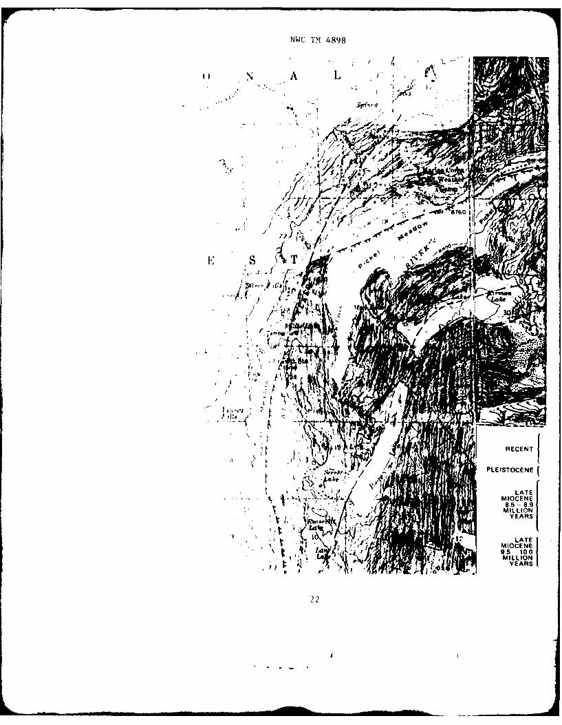
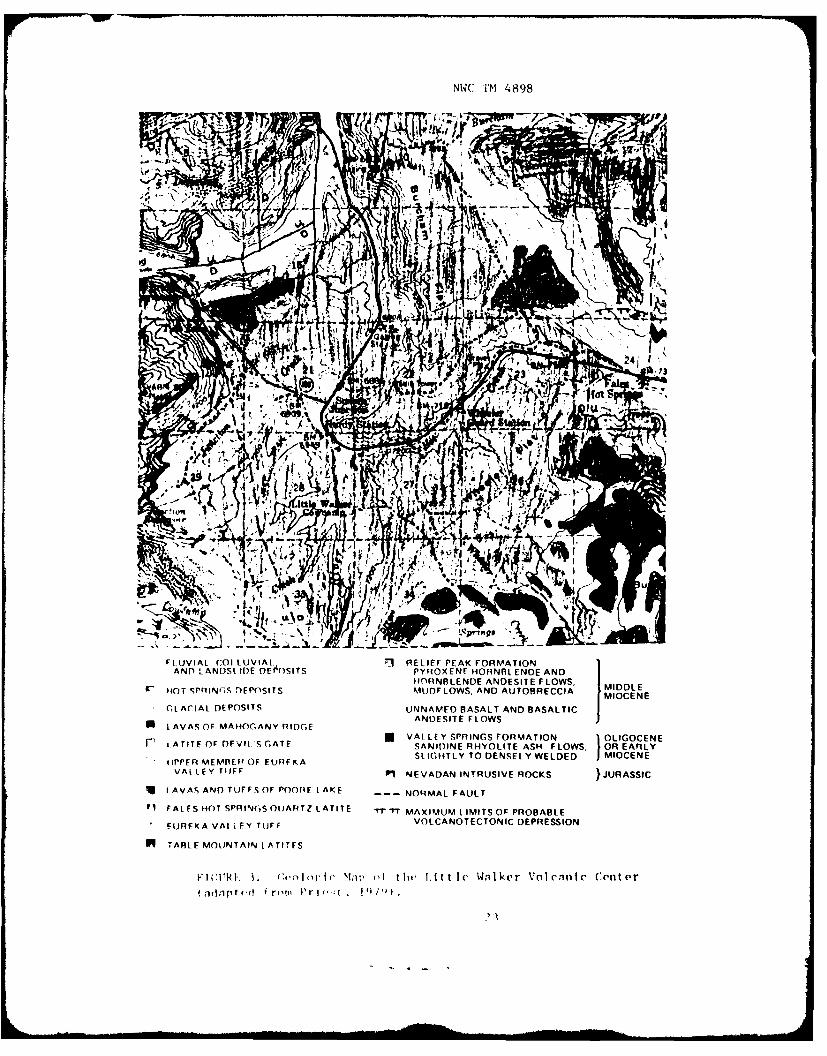
Halsey (1953) has mapped parts of the Fales Hot Springs and theDesert Creek Peak quadrangles. The Dardanelles Cone and Sonora Pass quad-rangles were mapped by Slemmons (1953). Curtis (1951) mapped the TopazLake and the eastern half of the Ebbetts Pass quadrangles. Priest (1979)has studied the volcanic rocks of the Sonora Pass and the Fales Hot Springsquadrangles in detail. Priest's (1979) geologic map is shown as Figure 3.He notes that the lavas are highly potassic, latitic lavas and tuffs from8.6 to 10.0 million years old. He states that "a great deal of evidence
supports the formation of volcano-tectonic depression..." Fales Hot Springs,the main encampment of MWTC, and the Leavitt Lake Road Spring are all onthe northern edge of the collapse caldera. As will be detailed in a latersoction on hydrology and geochemical geothermometrv, it is highly probablethat the water of Leavitt Lake Road Spring contains a geothermal component.A.ust in et al (1971) note that most of the major geothermal areas of thew,,ld are associated with this type of structural pattern.
The proposed housing areas are located in Antelope Valley in Recentalluvium off Higlway 395 to the north of MWTC. The Antelope Valley is agraben bounded by north-south faults. The mountains to the west containMesozoic granitic rocks and pre-Cretaceous metamorphosed sedimentary rocks,while across the valley are Mesozoic granitic and Cretaceous rocks. Warmwells occur at the town of Walker (Antelope Valley), which probably indi-cates that hot water is rising along tile graben boundary faults. Thefollowing discussion of the geology has been abstracted from Hlalse\ (1953).
PRI.-TERTIARY GEOLOGY
The lower Jurassic sediments of Leavitt Meadow contain quartz-diorite
pebbles and boulders. These particles are considered to be the oldest
rocks in the country north of Mono lake. In the Sweetwater Range and
4
NWC TM 4898
vicinity, remnants of metamorphosed pre-Nevadan (Jura-Trias) rocks occuras discontinuous outcrops separated by Nevadan intrusive rocks or byTertiary volcanic cover. These metamorphosed rocks, which were part ofthe early Mesozoic geosyncline, have been extensively folded and/or altered.During the upper Mesozoic, the folded pre-Nevadan rocks were intruded bya series of plutons. The early plutons were small bodies of quartz-gabbroand quartz-diorite. They were followed by the predominant early Nevadanintrusives that were granodiorite or a basic quartz monzonite. More basicand acidic bodies are present but they are uncommon. After these earlyplutons cooled, they were intruded by large plutons of granodiorite toquartz-monzonite. These rocks are exposed extensively west of the WestWalker River.
TERTIARY GEOLOGY
The oldest Tertiary volcanic rocks are exposed as several small flowremnants of welded rhyolite tuff between the West Walker River and MillCreek and also between Mill Creek and Lost Cannon Creek. These volcanicrocks are of upper Eocene age. Propylitized andesites are exposed alongthe Mt. Emma ridge. The Mt. Emma andesites cover an area of about 30 squaremiles and are bounded by Leavitt Meadow, Pickel Meadow, Sonora JunctionValley, and Burt Canyon. In this area, the andesitic series are from1,000 to 2,500 feet thick. Miocene sediments crop out along the north-eastern side of Antelope Valley. These sediments were deposited duringtile erosional interval between Oligocene volcanism and late Miocenevolcanism. Tile Mio-Pliocene andesitic rocks of the Walker River drain-age basin are the most extensive of all tile Tertiary volcanic rocks. TheMio-Pliocene andesitic rocks are derived mainly from the Lost Cannon Peakintrusive center. This center covers an area of about 8 square milesnorth of Pickel Meadow and east of Lost Cannon Peak. The andesites areat least 2,500 feet thick. They consist of autobrecciated flows, sills,intrusions, several dozen lahars, and several horizons of andesitic sedi-ments. These sediments are well exposed on the scarp sides of two largetilted fault blocks north of Pickel Meadow. A latitic series of flows andtuffs overlies the Mio-Pliocene andesites (Mehrten Formation). This seriesis further divided into the Table Mountain Member, the Welded Tuff Member,the Pumice Tuff-Breccia Member, and the Alkaline Basalt Member. The middlePliocene latite series extends across the entire width of the Sierra Nevadainto the western Great Basin. East of Sonora Pass, the Table Mountainlatites reach a maximum thickness of 100 feet, and are exposed to a thick-ness of approximately 400 feet just east of Lost Cannon Peak. About 250feet of latites= representing at least four flows are exposed along theWest Walker Ri\er east of Lost Cannon Peak. Welded tuffs are exposed inthe Fales Hot Springs area and in the Lost Cannon Peak area. The PumiceTuff-Breccia Member is represented by only a few scattered outcrops.Present exposures are approximately 50 feet thick. They outcrop along theeast wall of the West Walker River Canyon. The Alkaline Basalt Member isexposed as a small remnant between Lost Cannon Creek and Little Antelope
5
NWC TM 4898
Valley. It also outcrops on the west bank of Mill Creek. Mid-Plioceneintermediate and acid rocks occur as intrusions and short flows. Theircomposition ranges from hornblende acid andesites to rhyolites. Severalof these intrusions are exposed south of Antelope Valley between theLeavitt Meadow-Slinkards Valley fault. Most of the intrusions are ex-posed in the Mio-Pliocene volcanic terrane north of Leavitt Meadow. Ex-posures of late Pliocene olivine basalts occur as small domes, intrusions,and flow remnants. The largest number of exposures are in the subsiimmitarea of the Sweetwater Range. The flow remnants range in thickness fromabout 50 to 150 feet.
QUATERNARY GEOLOGY
Basaltic andesite is exposed within 2 miles of Volcanic Butte. Vol-canic Butte is a conical plug or dome lying 3 miles south of Fales HotSprings. The andesite is about 400 feet thick at Volcanic Butte. A fewshort flows have thicknesses up to 200 feet. The andesite is betweenearly and mid-Pleistocene in age. It is probably younger than the Sherwinglacial stage.
Pickel Meadow and Sonora Junction Valley lie in Recent alluviumsurrounded by Pleistocene glacial deposits. Leavitt Meadow lies inRecent alluvium.
STRUCTURE
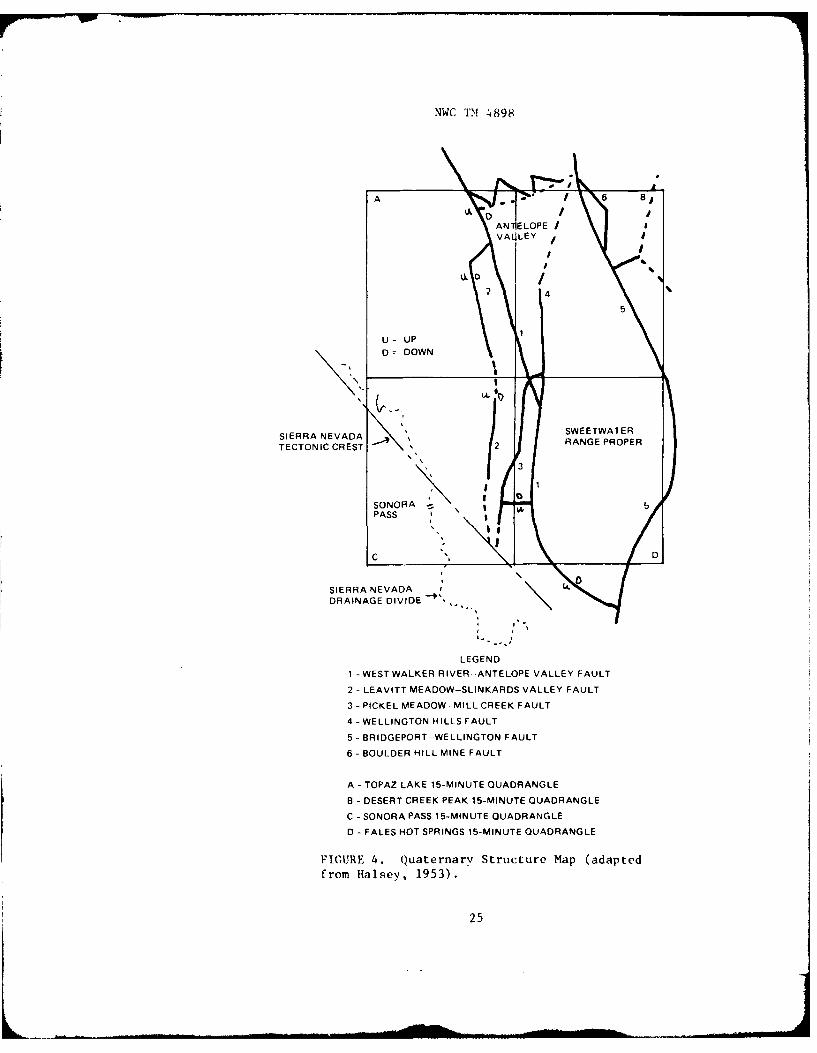
A generalized quaternary structural map of the area between AntelopeValley and south of Mt. Emma is shown as Figure 4.
The present western border of the Great Basin proper is the Leavitt'eadow-Slinkards Vallev fault. The complex fault-block structure of theBasin and Range is present east of this fault. The structural and phvsio-graphic trends of the Sierra Nevada are predominant west of the fault.
Pleistocene faulting, east of the Sierra Nevada crest, is the majorprocess responsible for the present physiographic character. These struc-tural units have been only slightly modified by canyon cutting, Pleistoceneglaciation, and valley sedimentation.
A narrow zone of untilted blocks is located between the LeavittMleadow-Slinkards Vallev fault block zone (I to 3 miles wide) and theSweetwater Range. The zone extends from the south end of Antelope Valleyto just south of Mt. Emma. From Antelope Vallev, the blocks rise steplikein elevation from 6,500 feet to 11,000 feet on Hanging Valley Ridge southof 'It. Emma.
Sonora Junction Valley is a graben of many blocks partly concealedbv glacial moraines and outwash sediments. The West Walker River scarp(2,500 to 3,000 feet) bounds it on the west. The eastern edge is definedby blocks that rise only a few hundred feet.
NWC I'M 4898
A ntelope Valley is a graben bounded on the west by the West WalkerRiver-Antelope Valley fault (500 to 2,000 feet high) and on the east bythe Wellington Hills fault.
Leavitt Meadow and Pickel Meadow are typical "U-shaped" valleys.These valleys were filled by the glaciers of the Tioga, Tahoe, and Sherwinstages. The Sherwin stage glacier was the largest system east of theSierra Nevada crest. This glacier covered an area of about 200 squaremiles and reached thicknesses up to 2,500 feet.
Fales Hot Springs and Huntoon Valley are areas that have largeaccumulations of outwash gravels. Old till remnants of probable McGeeage are found north of Fales Hot Springs, above Volcanic Butte, andbetween Mill Creek and the West Walker River.
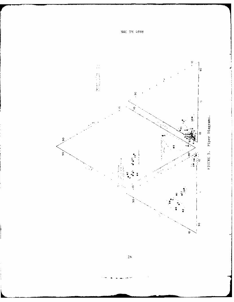
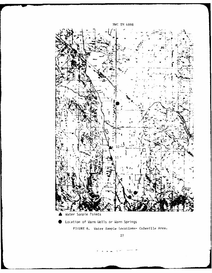
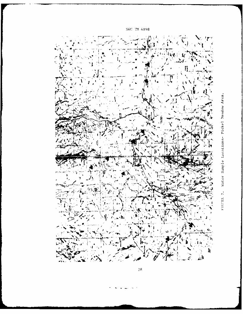
WATER GEOCHEMISTRY
Eleven water samples were collected and analyzed (Table 1). Nineof these were in the Fales Hot Springs-Pickel Meadow area; two were inthe Coleville (Antelope Valley) area. In the Fales Hot Springs-PickelMeadow area one of the waters collected was a surface water; the remain-ing samples were taken from springs.
TABLE I. Water Sample Identification.
Sample Name/general Water Locationno. location source (section, township, range)
I Summit Meadows Spring Sec 36, T7N, R22E, MDM-
2 Sonora Bridge River See 17, T6N, R23E
3 Fales Hot Springs Spring Sec 24, T6N, R23E
4 Unnamed Spring NE 1/4, Sec 20, T6N, R23E
5 Unnamed Spring Sec 1, T6N, R23E
6 Northwest of Sardine Spring Sec 36, T6N, R21EMeadow
7 Nea r Devil' (;,te Spring SW 1/4, Sec 19, T6N, R24E
8 Vnnamed Spring See II, T6N, R22E
S .ivi t t I ak, Road Spring See 7, T5N, R22E
10 \,,t Walker Kiv.r River Sec 36, T9N, R22E,|t ( i|n i n c'tin| e iod
fit i dg'
11 'ltvi I I it wraiI Well See 1. T8N, R22ESt urt.
.ount D)iablo mer'idian.
NWC TM 4898
Analyses are given in Table 2. Piper diagrams of these waters areshown as Figure 5. Sampling points are shown as Figures 6 and 7. SampleNos. 2, 4, 5, 6, and 8 group tightly on the Piper diagrams as calcium-magnesium-bicarbonate waters. The similarity of the spring waters to theWest Walker River water indicates these waters represent the shallowestsurface aquifers, where short transit times have caused little change dueto water-rock-soil interaction. This is also indicated by the generalgood quality of the water and low total dissolved solids (110 ppm forthe West Walker River, 116 to 201 ppm for the springs).
Fales Hot Springs (No. 3), the cold spring (No. 7) adjacent to FalesHot Springs, and Leavitt Lake Road Spring (No. 9) form an interesting trio.these are high sodium-potassium-bicarbonate waters. The authors groupthese together. To look at the relationship between these waters moreclosely, we considered the chloride-to-sulfate ionic ratios. The ratiosare Fales: cold spring: Leavitt = 1.42:NA*:1.47. The relatively high sul-fate content could indicate steam transport. A real possibility is thatvapors are heating and modifying the cold waters creating Fales Hot Springs.The Leavitt Lake Road Spring is higher in calcium and bicarbonate than theFales Hot Springs water. This represents shallow Pickel Meadow watersalso modified by vapors somewhere in the hydrologic system. it should benoted that while sample No. 7 has low dissolved solids (230 ppm), FalesHot Springs and Leavitt Lake Road Spring have very similar dissolvedsolids (2,288 and 2,399 ppm, respectively).
'he third group of waters includes the West Walker River nearColeville (No. 10), the store at Coleville (No. 11), and the Summit MeadowSpring (No. I). The Summit Meadow Spring has only about one-third (69 ppm)the disolved solids of the West Walker River (216 ppm) or the Colevillestore (231 )pm).
CHtEMICAL ( EOTH ERMOMETRY
the various geothermometers are given in Table 3. The results groupaccording to the geochemical interpretations of the previous section.
Since Fales Hot Springs, sample No. 7, and Leavitt Lake Road Springseem to be related to a geothermal reservoir, mixing models were mademainly using these samples.
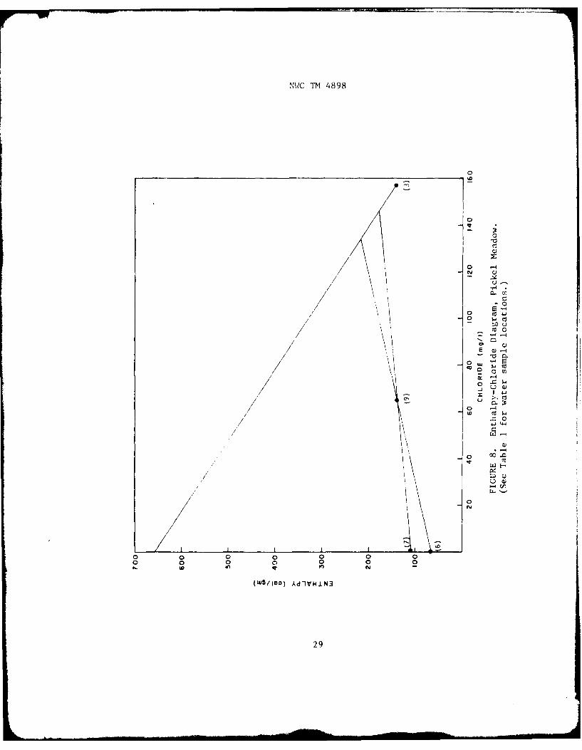
The chloride mixing model of Fournier (197)) was made using quartzsteam-flashing temperatures to obtain enthalpies (Figure 8). This is con-cordant with the geochemical model of the previous section. 's ing theDevil's ;ate sample (No. 7), t eavitt Lake Road Spring (No. 9), and Falestot Springs (No. 3), a reservoir temperature of 1800C is obtained. If thespring northwest of Sardine Meadow (No. 6) is used, a reservoir temperatureof 220 0 C is obtained.
Not analyzed.
NWC TM 4898
C C C . . . . - 7 7
C C C
C C CC C C - C C: C -
C C C C C C C C c;
CC
C C C C C; C C C- - C C i C ;-
-'C C - - N C C C; C N C N C C C Cz. - - .
c, c C - N c -
Z . .. 7
C c: C C o c C 0'C C C C C - C
'CC
C C; C N - C C C C C CC .3 C C C C C; C
C
C Cf C C C N C ' ~ C C
c' c, - C C ,I ~C C 0C C: 'C C ccC C C
4.4 w3 C C oc S SC N- C- C
c N wI Can ~ ~ ~ ~ ~ ~ c C: 7 3 C N~ C0 0 0 C0 O 33N~~a CCC CC c - C 0 0- C C C
- Sv N S
A. - .tr C r- W <
9N
NWC TM 4898
V t Cl l
OD4 - C
'D'
0~ ~ to'0 0' 0
a, .4 C
0 0'
01
%'WC TM 4898
~ - -~' r- ~ I,a -4 00 '.i CC -4 r.
'-D 00 c - or 4
CC
00 oc 0' cZ (n -
- aU' 0 00 -
cc 'C c Cc
CD am 00 N CN - -0 r-. N F' 0 1-1 0) 'c
44 -4-4-4 -4 -
0 cc i F'- en~ ON '~
a)
o ~~~ -4-4 a
-4 CD F- -ZQ -.1 00 - - F". 0 e
N n C~N N "I ~ - 14 00
-4- cC '
Fn 0
14 '- N *)V~~~~~- 4-1__ _ _ _ _ _ _ _ _a
00
0 0>-
41 H * ~-41 r.
0 u 0 u0 -
0 ) k- -4-w 0 >1 4..) cc go U. w
0 0 -0rz .' 0 (n ~ 0 UN 0 N L) 4- U U U *
0'J 1 0'~ Z
t14
X :3 m- z v
NIXC TM 4898
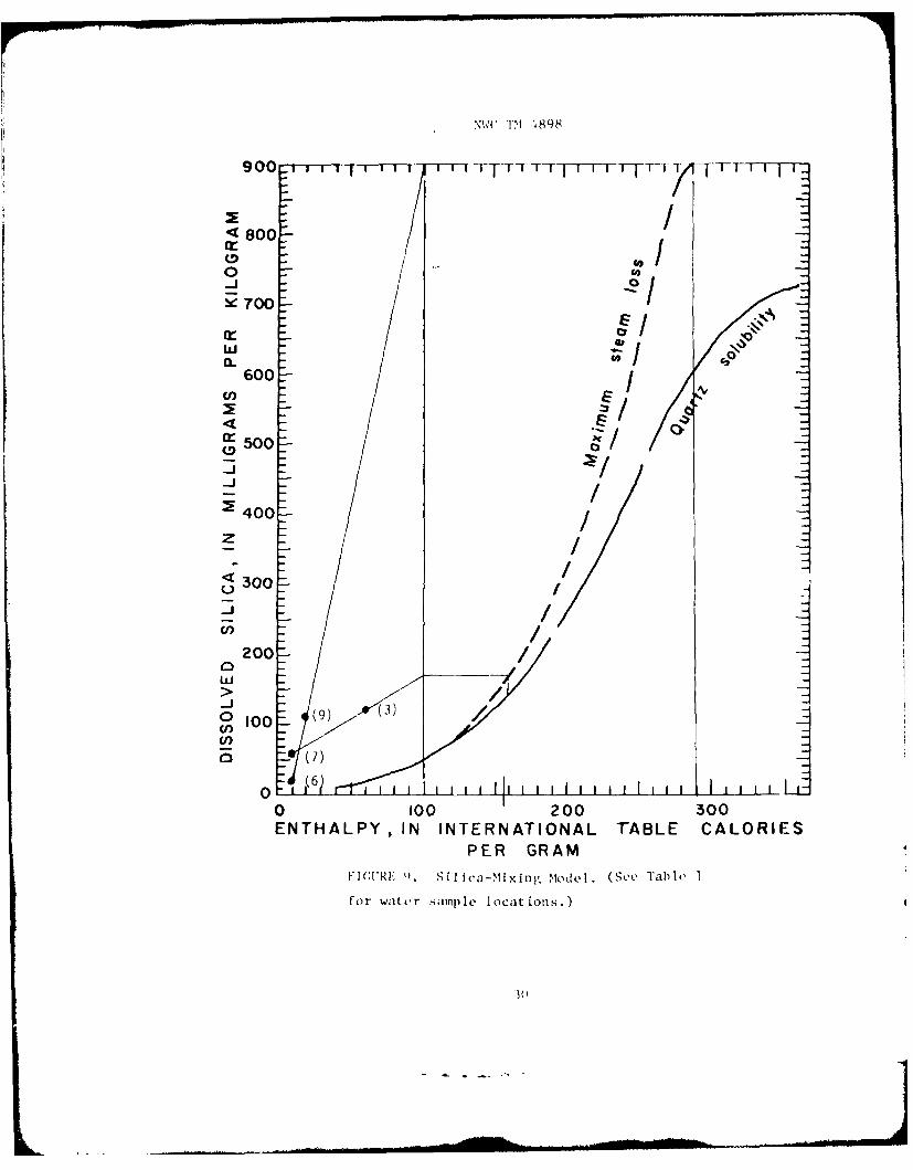
Using the s i I ica-ixixing model of 'Iruesdel I and Fournier ( 1977)(Fi gure 9) , wi t Ii steam f LashI ini- at 10(0'C, one o btai ns a reservoit, temper-
at ure o1 162C I)\b- us i ng the Dcvi I's Gate samplIe (No. 7) and F;M ies, HotSp riniigs ( No . 3) . A t emperature Of 290loC is obta ined when the sprinugnorthwest of Sard ine Meadow (No. 0) aind Leavi tt Lake Road Spring (No. 9)are used.
I'hus, chemical geOthermometrv indicates a good p)OSSibil1itv' Of aresource more than adequate for space heating, and possiblv adequiate forPower generation.
S'OIL dI:OCIIE1MTSTRY
A regional soil survey was conducted during the initial fieldreconnaissance. '[le soil samples were collected and analyzed b\' NWC' sGeothermal Utilization D~ivision. Samples were taken everv 0.9 mile alongexisting accessible roads. The samples were later analyzed for mercurycontent in parts per bill ion. '[ie results were inconclusive due to manyvproblems, which included a verv wide range of soil types and inadequategrid coverage of the area. The area was not covered'as originallv planneddue to the fact that much of the forest rv lands are classi fled as "wildernessareas,"' in which case vehlicle access is not permi tted. Available field timediid not all1ow for the walking of all the traverses.
THERMAL GRAD IENT DRI111L1NG
To understand the livd rolIogx, aind to ge t ai gene xxi view onl thet. geothermalpotential, thermal grad ient drill ing, is considered highJlv des irable . Aminiimum program shAoulld incl1utde one io010 'Iat the main encampment and onehole at e'ach Of the p roposed hions ing si tes . Sinlce s;hallow anomalies maybe offset f ron thle resou rce at d epthis, such drill ing would not neces sar ii Ip rove the exis-tec~le of or define a resource, buxt the data coul1d be usedfor compar ison with the gradients OF tile S;i rra Nevada (o.33i to I._18'r/100 feet; (0.6 to 2.S9(G/lfl0 m) (Sass et al ., 1471) . This comparison Couldgive a good indicat ion if anv potentialeis.
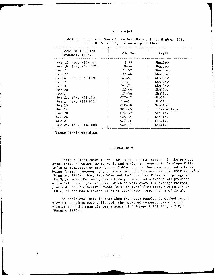
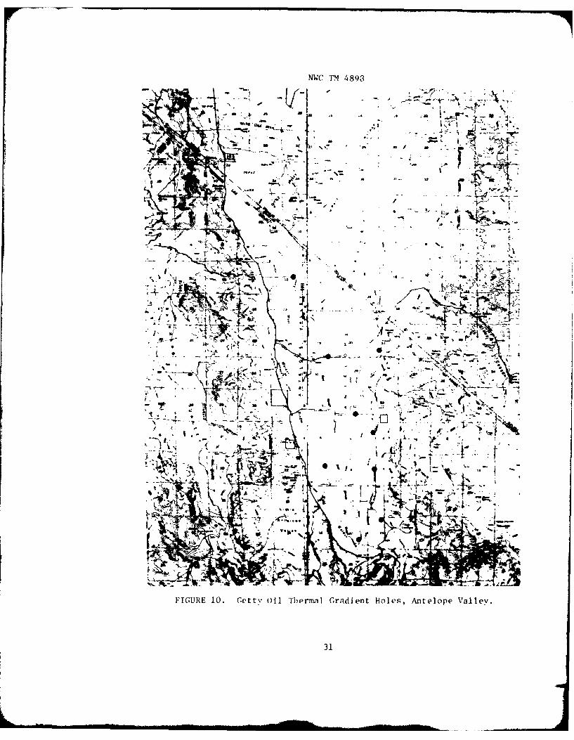
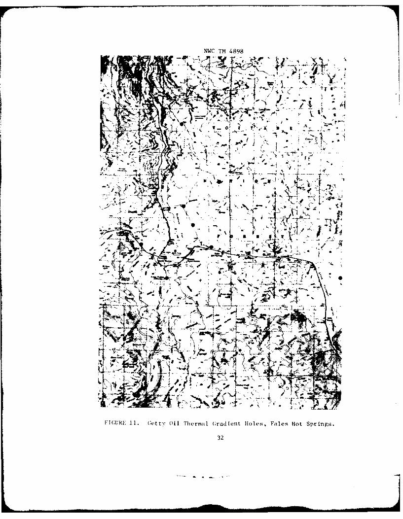
(if spec Li note is tilt' fact thatL (Gtt \ Oil,* in a joint venture w thMono Power,* has d rii 14ed 10 thermal gradi i ot anid one observation (orst rat igraphiic) hlel in tilt area (tIable 4, Fl gIil-s 10 and 11). oIf part ic-nlar interest are,: hole C20-39, a grad ient hole, less than .3 mi les fromtie eastern botinda r% Of MWV; htole SC(1 4-5, ain ohs e rva tion hole (a deephol e Couild i urnkisi s ign if icanit datai on trtirpivlitilg and hyvdrologv);and gradIient holes CIO'-54, (' 12-46, (,-4% * and C'7-47 which surround thep roposed iousing aireas.
12
',W(" TM 4898
'ABL" 4. ',,tt. 0i I hermal Gradient Holes, State Highway 108,..S. Fii.wav P , and Antelope Valley.
1A C t i n 0 11 it I n Hole no. Depth
township, range)
Sec 12, 1'9N, R22F MI)M, ('13-53 Shallow
Se, k 1N,[9N *I' W MM C.19-54 ShallowSec 21 C21-52 Shallow
Sec 32 ('32-46 ShallowSee 4, T8N, R23E MDM C4-45 Shallow
Sec 7 C7-47 Shallow
Sec 9 C9-47 Shallow
Sec 20 C20-44 Shallow
Sec 21 C21-50 Shallow
See 22, T7N, R23 MDM C22-42 Shallow
See 1, T6N, R23E MDM Cl-41 Shallow
Sec 10 C10-40 Shallow
Sec 14 SC14-5 IntermediateSec 20 C20-39 Shallow
Sec 24 C24-35 ShallowSec 27 C27-36 ShallowSec 25, T6N, R24E MDM C25-37 Shallow
Mount Diablo meridian.
THERMAL DATA
Table 5 lists known thermal wells and thermal springs in the project
area, three of which, MO-i, MO-2, and MO-3, are located in Antelope Valley.
Definite temperatures are not available because they are reported only as
being "warm." However, these waters are probably greater than 80'F (26.7'C)
(Higgins, 1980). Data from MO-4 and MO-5 are from Fales Hot Springs and
the Magma Power Co. well, respectively. MO-5 has a geothermal gradient
of 14'F/tO0 feet (26°C/100 m), which is well above the average thermal
gradients for the Sierra Nevada (0.33 to 1.38 0F/100 feet, 0.6 to 2.5°C/
100 m) or the Basin Ranges (1.65 to 2.75OF/I06 feet, 3 to 5*C/l00 m).
An additional note is that when the water samples described in the
previous sections were collected, the measured temperatures were all
greater than the mean air temperature of Bridgeport (41.4 0 F, 5.20C)
(Hannah, 1975).
13

NWC TM 4898
I'A 1, K 5. I'htrmal Wells and Thermal Spring,,Pict- ci L'adoW and Antelope Valley.
La t i t tide Long i t tide, Tempe ra ture,No. TY pe 1)1) .MSS:* 1) 1). >U1S S C Ot her
MO- I Spring 38. 3736 119.3015 Wa rm 3 70 '1. 1. S.>10-2 Wel 11 38. 1130 119. 2830 Wa irmnMo- I Well 38. Q200 119.2800 Warm>10-4 Spring 38.21092 119.2401 82 2400 T. 1). S.>10-5 Well 38.2100 119.2400 38 126 m deep
- ~From Higgins (1980).
F Degrees, minutes, seconds.Total dissolved solids.
CRAVITY AND AEROMAGNETICS
Previous gravity surveys- were conducted on a regional scale (Oliveret al ., 1973) . Compilation of these data and unpublished data was com-pleted b)*y Oliver et al.,* 1980. Aeromagnetic surveys were flown atvarious, scales-b th 0) .5S. CGeological 'iurvev (1USGS) (1971) , and Zeitze t al . 1969. Even thbough the gray itv and aeromagnet ics data were ofa regional nature, a few trends can be noted as follows.
Thie a rea containing, Vales lHot Springs , P i ckel M eadow, and AntelopeVa] 1ev lies wi thiin or onl thle ides of a large northward elongated reg'iona1cravi tv low (Oliver et al., 1080) , which corresponds somewhat to a largeregional magnet ic low (Zeitz vt al ., 19)69). The gravity low extends southtowaird Rishop and inLudeRs theC COI lapse Calderas of Mlono Lake, Long Vallev,and Round Valley, in addition to the Mono Craters. Does this represent arift ing structure as seen in the Imperial Vallex', witli a s n of thenmant le toward thle surface? Thie magnet ic signature is similar to thle graJi tvand shows the largest regional lows over the Mono Craters and the Mono Lakecaldera. The map (Ze itz et al. , 1969) does not extend far enough south todel ineate the magnetic signatutre over the Long Valle\: caldera.
Ini the project area, the aeromaignetics, possibi v del ineate the l~i tt leWakrVolcanic Center- (collapse0 caidera) oif Pries t (19)7() near MWTC..
ihi is not seeni clear.% 1)%?b g ra i t% dia ta becaus.,e oif post-collapse fali It-ing thait might obs-cuire this feature. However, to the north of the calderathec gray i tv- becomecs lower, 11whi i IC there' is a si i ght rise and then a drop iiithe I magne kt i cs . This wouild s;e(m to i Ild icato posible deep-sealted heat inl
he a rea of An eope ValI ox. MoreC do't ai led graiitv and magnietic survevsalre needC~ed to del inea to the st ructuirc.
14
NWC TM 4898
CONCLUSIONS AND RECOMENDATIONS
The geology, water geochemistry, and chemical geothermometrv indicatea high probability of a geothermal resource at MWTC, with high enoughtemperatures for space heating and a good probability of a resource withadequate temperatures for power production.
On the central-eastern frontal area of the Sierra Nevada, many volcaniccenters and collapse calderas are known to exist. Thermal wells and springsoccur throughout the project area. Tle previous geophysical surveys showthat there might be an association between these features.
Recommended future work is as follows:
1. Obtain thermal data, if possible, from private industry.
2. Conduct gravity, land magnetic, and aeromagnetic surveys of theproject areas to delineate subsurface structural features of interest asdrilling targets for the production of water suitable for space heating.
3. Perform a deep electrical-resistivity survey to define conductivezones in the Fales Hot Springs area to determine if these zones persistbeneath MWTC to the side and extend north to the proposed Antelope Vallevhousing annex.
4. Drill thermal gradient holes at the main encampment of MWTC.
5. Drill exploratory wells at both fMWTC and at the selected familyhousing site in the Antelope Valley.
NOTF: Pages 17, 20, 21, and 24 were intent ionalIv left blank.
15
NWC TM 489 8
w
or z V,
S ff .4 x&
S$.-
4 4N
o woE p
"-4
co3
co c
41-4
U
-- 0
16o
NWC TM 4898
~ /qT-
aT,,
~-*'sk-' I'Nob~
AA
To*
r 1f3T44~ )~ -~ '(\\ IZ,
At A'. A I~ I .A .
L -
r~xrJ~~
Kq
.,1.-~ i\c'f5
* . ' %%1 0; I -ss, -
-S O-. %
41(~
iit
'r~4 Z,
ppz
44 it
.A
* 'itlit
NWC TM 4898
FIGURE 2. Geological Map of Pickel Meadow, Coleville, Bridgeport andthe Surrounding Areas, California (Adapted From Koenig (1963)).
SAlluvium
Quaternary lake depouitsa----... FAULT
Glacial deposits
5 4 3 2 1 0 i llPleistocene nonmarine
jJPleistorenp volcanic ,c., thyolite.r,'sndemqite; ;~ bsalt:
Ov.0 -pyro'lsatic rocks
UN*A40PI:D ' .. "IPliocene volcanic: .,rhyolite:- -. - ~' andetite; c. -basalt;
EHI N -pyroelastic rocks
Quaternary and/or Ptiocenecinder cones
Tertian rume(%ptpa
- I.I~Miocene volcanic: v.' rhyolite:I ' ru~i .O andesite; 'ae , ialt;
vvO -pyrolastic rocks
- [~J Middle and/or Lower
A
'~ ~*1zPre-Cretsceoup metasneianer
rock
NWC I'M 4898
IrLe'
-41 N76 1
ef
LAT
2\. ,5 - 8
YEAR
IC S LATEMICN
I' . . 0MILLIO
YEARSmu.3
r2
NN(; INM 4898
FIUVIL CC) LUVII ~RLIEF EAK OMATO
A N D L N S D EI O I SP R X N E H R A E D N
ri HO P IC.EOIT I R R E D N EST L W . MD L
I OCEN
VA LE luF . E A I NT USV RO K 1. '1ASIC
FLU VAL. A OI TUVFS OFIE PPE LK N A FL TIO
HO FT HOTIN(,' EP SIS LAT AIE i iM MU M L IMS N OF PRB CAEDL
EUREA OFVAHOGY ID E V ANTECLON C DEISSO
tTIRE MFOFNTIN S GATlESSNDN HOIE S LW, EF
tt :iqll I.SE OF l EU EK S lp f L. ltIGL TO e DENS L WELDED MCENEVAIE TId IM NEVADA INTRSIV ROKURSI
I AVS AD TUFS F POFIFL AK -- NOR AL AUL
NWC T%1 4898
U=
UP
0 DOWN
SIERRA NEVADA J SWEETWATER
2 RANGE PROPER
SONORA " ' b
C 0,
SIERRA NEVADA...
-AN
DRAINAGE DIVIDE ,,,.
V Al
LEGEND
1 -WEST WALKER RIVER•-ANTELOPE VALLEY FAULT
2 - LEAVITT MEADOW-SLINKARDS VALLEY FAULT
3 -PICKEL MEADOW- MILL CREEK FAULT
4-WELLINGTON HILLS FAULT
5-BRIDGEPORT-WELLINGTON FAULT
6-BOULDER HILL MINE FAULT
A - TOPAZ LAKE 15-MINUTE QUADRANGLE
B - DESERT CREEK PEAK 15-MINUTE QUADRANGLE
C -SONORA PASS 15-MINUTE QUADRANGLE
D - FALES HOT SPRINGS 15-MINUTE QUADRANGLE
FIGURE 4. Quaternary Structure Map (adapted
from Halsey, 1953).
25
NWC TM 4898
It0
26K
NWC TM 4898
- -4-
7' -Oe
rr -
f IF
72
NWC IN 4898
-1 75 Ad
-7
1.- 28
N14C TM 4898
0
o o u
'o 0
0
co
0
o ~~ 00 00
000 0 0 0 0
(w5/100) kd*IVHIN3
29
Nl,('r~ -48T98
900 -r1r-mTT-T T-Thm71-TF- F (ThIFITIT
< 800F
0600 -
600
00
_- //
400 -
3 3007'
0J /I I I l l l J J IzI
200O /w
O ioo (9) (3) /-'(7)
0( 100 1 200 300ENTHALPY, IN INTERNATIONAL TABLE CALORIES
PER GRAM
FIC(URIE ). Si]ica-mixing model. (See Table I
for water sample locations.)
NWC TM 4893
ON, 7-44C-.7
Li r
N >J -1
FIUE1. G i hralGain oeAtlp Vle .4
4'+ --c~v 5,31
NWC TM 4898
4~
isif
ItI '01'
144L
~~F a,4.
1 ~ G tcU~ t1 ((ty Oil Thermal Graditent Holes, Fales Hot Springs.
32
NWC TM 4898
BIBLIOGRAPHY
Austin, C. F., W. H. Austin, and G. W. Leonard. "Geothermal Scienceand Technology, A National Program," Naval Weapons CenterTechnical Series 45-029-72. (September 1971)
Baker, C. L,. "The Nature of the Later Deformations in Certain Rangesof the Great Basin." j' J .. ,:-. Vol. 21 (1913), pp. 273-278.
Ball, S. H. "A Geologic Reconnaissance in Southwestern Nevada and
Eastern California." IT.S. (eological Survey Bulletin 308. (1907)
Blackwelder, Elliot. "Pleistocene Glaciation in the Sierra Nevada andBasin Ranges., Vol. 42(1913), pp. 865-922.
Blake, M. C., Isidore Zietz, and David L. Daniels. "Aeromagnetic andGeneralized Geologic Map of Parts of Central California." U.S.
Geological Survey, Geophysical Investigations Map GP-918. (1978)
California Blue Book (1950), Mono County, pp. 911-912.
California Geological Survey. (Description of Country Between Mono Lakeand Sonora Pass.) Vol. 1 (1860-1864), pp. 437-439.
California State Mining Bureau (California Department of Natural Resources,Division of Mines), References to Mineral Resources of Mono Countyin Annual Reports of the State Mineralogist 8, 12, 13, 15, 17, 18, and
23, and Bulletins 13, 18, 24, 26, 36, 38, 125, and 152.
Chesterman, C. W. "Geology of the Matterhorn Peak Quadrangle, Monoand Tuolumne Counties, California." California Division of Mines
and Geology Map, Sheet 22. (1975)
Clark, M. M. "Pleistocene Glaciation of the Drainage of the West WalkerRiver, Sierra Nevada, California." Ph.D. Thesis, Stanford Univer-sity (1967)
Curtis, G. H. "Geology of the Topaz Lake and the Eastern Half ofEbbetts Pass Quadrangles." Unpublished Ph.D. Thesis, Universityof California, Berkeley. (1951)
Davis, W. M. "Mountain Ranges of the Great Basin." Puzrd ov .Mur. Crm 27ooai i FiiTl l-n, Vol. 42 (1903), pp. 129-177.
Davis. W. M. "Faults, Underdrag and Landslides of the Great Basin
Ranges." 7eolo,7iw,-Z oc-ct y of Amcrioa 1u, !, tin, Vol. 33 (1922).pp. 92-96.
33
NWC TIM 48()8
lou i Ilfac , C. and G. Mi chard. 'Sod ium Li t h i umn Rat i o i n Wat er App] lidto Geotherrnometrv ofI Geothermal Reservoi rs."' *' '.o~ -* Vo . 10
(1981), No. 1, pp. 55-70.
FoUrnier, R. 0. "Chemical Gcotliermometers and Mi~ing Models forGeothermal Sx'stens. " .~>~ Vol. 5 (1977), pp. 41-50.
Fourn ier, R. 0. ''A Rev ised Fquat ion for the Na/K Geotherniometer."Vol .3 (97),Sept.
1979, pp. 221-224.
Fournier, R. 0. "Geochemical and Hyvdrologic Considerat ions and theUse of Fnthalpv Chloride D~iagrams in the Predict ions of UndergroundConditions in Hlot-Sp ring Systems." f'c~
.' ,;, ' ..1 , Vol. 5 (1979), pp. 1-16.
Fournier, R. 0. and R. W. Potter. "Magnesium Correct ion to thle Na-K-CaChemical Geothermometer." .. "~Vol. 43(1979), pp. 1543-1550.
Halsex', J1. H. ''Geology of Parts; of the Bridgeport, California andWel11ington, Nevada Quadrangl cs.'' 1'nptbl i shed Ph.DI. Thesis, UniversitY,of California, Berkeley. (1953)
Han nahi, J1. L. "Thie pot ent ial1 of Low Fempe rat ure Geo thermal ReSOUre esin Northern Cal ifornia.'' California Pivision oif MI and Gas, ReportNo. TRI 3. (1975)
Hler,J. 1). ''St udv and Interpretation of the Cheumi cal Chiaracteri st ics ofNatural Water.'' U.S. logical Survev 1Wat er-Sutpplv Paper 1473.I 1970)
Hii 11) iin , C. T. ' ;eot herma I Resources of Cal i fornia . '' Cal i forn iaDivis4ion of Mines, and Geology, Geolog ic Data Map No. 4. (1980)
JIohn , 1). .. , .1. Ghi usso , W2. J . Moore * and R . A. Armn . "Rc'conna i ssance(;eo logic Map of' the Topaz Lake 19-Mi nute, Quadrangl e, Cal iforn ia andN'evada.'' U.S. evo logical Su rvy Open-File Report 81-273. (1981)
Koenig,, .1. Bl. "ceo logic Map of Californ ia , Walker Lake Sheet."calI i f, ,rn in a Mivi sion of Mines, and Geol ogv . (10 63)
l~acleutb ruch * A. It. "PrelIiminarv Geothermal Model of the Sierra Nevada.''.>.~. ;'4:, Vol . 73 ( 1968) , No. 22, pp. 6Q77-698().
Mriner, R. 11. F . S). Presser, and W2. C. Fvans. ''Hot Springs, of theCe nt ralI Si er ra Neuva da, CalIl f o r i a . '' U S. GeolIogricvalI Sourve y 0Open-F ilIeRe port 77- 95). (1977)
34
NWC TM 4898
Martin, R. C., C. T. Higgins, and D. Olmstead. "Resource Assessmentof Low and Moderate-Temperature Geothermal Waters in California."Report of the First Year, 1978-1979 of the U.S. Department of Energy-California State-Coupled Program for Reservoir Assessment andConfirmation. (1980)
Muffler, L. J. P. "Assessment of Geothermal Resources of the United
States." U.S. Geological Survey Circular 790. (1979)
Noble, D. C., W. R. Dickinson, and M. M. Clark. "Collapse Caldera ix.the Little Walker Area, Mono County, California." GCo~oqalo SUt. ,of Aierioa, Special Paper 121, pp. 536-537. (1979)
Noble, D. C., D. B. Slemmons, M. K. Korringa, W. R. Dickinson, Y. Al-Rawi,and E. H. McKee. "Eureka Valley Tuff, East-Central Californiaand Adjacent Nevada." :o~o,, Vol. 2 (1974), pp. 139-142.
Oliver, H. W. "Interpretation of the Gravity Map of California andits Continental Margin." California Division of Mines and GeologyBulletin 205. (1980)
Oliver, H. W., R. H. Chapman, S. Biehler, S. L. Robbins, W. F. Hana,A. Groscom, L. A. Beyer, and E. A. Silver. "Gravity Map ofCalifornia and its Continental Margin." California Division of Minesand Geology, Geologic Data Map No. 3. (1980)
Oliver, H. W., S. L. Robbins, and W. L. Rambo. "Complete BouguerGravity Map of Part of the Walker Lake - 11 x 21 Quadrangle, Californiaand Nevada." U. S. Geological Survey Open-File Report. (1973)
Paces, T. "Chemical Characteristics and Equilibrium in Natural Water-Felsic Rock-CO 2 System." Geuocwj'rn ea ct oohi~ncu A,-ta, Vol. 36(1972), pp. 217-240.
Priest, G. R., H. R. Bowman, A. J. Herbert, M. L. Silberman, K. Street,and D. C. Noble (1974). "Eruptive History and Geochemistry of theLittle Walker Volcanic Center, East Central California." A ProgressReport: Jo ,,)jioaZ Socety of Amcr7'?a, Abstracts with 'rougrans,Vol. 6 (1974), p. 237.
Priest, G. R., D. C. Noble, H. R. Bowman, A. J. Herbert, and H. A. Wollen-berg. "Eruptive and Geochemical Evolution of the Little WalkerVolcanic Center." ('a71fornio (;hor., Vol. 28 (1975), No. 5, p. 106.
Priest, G. R. "Geology and Geochemistry of the Little Walker VolcanicCenter, Mono County, California." Ph.D. Thesis, Oregon StateUniversity. (1979)
Priest, G. R., H. R. Bowman, A. J. Herbert, M. L. Silberman, K. Street,and D. C. Noble. "Eruptive History and Geochemistry of the Little
35
NWC TM 4898
Walker Volcanic Center, East Central California." A Progress Report:* I :c, ~rX7K.8, I t:'.>~ .'Lriz m~v ,Vol. 6
(1974), p. 237.
Robbins, S. L. and Ht. W. Oliver. "Principal Facts, Accuracies, Sources,Base Station Descriptions and Plots for 832 Gravity Stations of theLittle Walker Volcanic Center." 'u"a:' : ,. Vol. 28 (1976),No. 5, p). 106).
Roberts, C. W., R. C. Jachens, and H. W. Oliver. "Preliminary IsoistaticResidual G;ravityl Map of California." U.S. Geological Survey open-FileReport 81-573. (1981)
Sass, J. Hf., A. H. Lachembruci, R. J. Munroe, G. W. Greene, and T'. Hf. Moses, Jr."Heat Flow in the Western United States." krn( '
Thr~ ~+,Vol. 76 (1971), No. 26, pp. 6376-6413.
Schweichert, R. A. "Shallow-Level Intrusions in the Eastern SierraNevada, California." Ph.D. Thesis, Stanford University. (1972)
Sharp, R. P. "Pleistocene Glaciation, Bridgeport Basin, California."I , I '' ' rlCe 7, Vol. 83 (1972). pp. 2233-2260.
Sheridan, M. F. "Guidebook to the Quaternary Geology of the East-CentralSierra Nevada." Phoenix, Ariz., Le Beau Printing Company, 1971.
Si omeons, 1). B. "Geology of the Sonora Pass Region." UnpublishedPh.D. Thesis, University of California, Berkeley. (1953)
St anford Geological Survey. "Geol ogic Map of the Antelope ValleyArea, Mono Countv, Cal iforn ia."' St anford Universitv, unpublishedmnapping , s;cale 1:62, 500. (1,964)
hompson , G. A. and M. fl1wan i. ''Crus tal St ructure From PacificBas in to Central Nevada." .', : . : ,,.*;7....-*.,%, e. Vol . 69(1964), No. 22, pp. 481 3-4837.
'ruesdellI, A. If. and R. 0. Fourn ier. ''Cal1culat io .of Deep Temperaturesin Geothermal Systems fromT the Chemistrv oli Toi ling Spring Water.,of Mixed Origin,'' in .' uc .. '
Vol. 1. (1976), PP. 837-844.
T'ruesdell , A. fl. and R. 0. Fourn ier. "Procedure for Estimating theTemperature (if Hot-Water Component in a Mixed Water Using a P'lot of1)1 ssolved Sil1ica Versus FEntha lphy . u ~ ''
* w".* VolI . 5, No. I (.Ianuarv-Fe bruarv 1)7 7) , pp. 49-52 .
36
NWC TM 4898
U.S. Geological Survey (1956) - 15-Minute Topographical Quadrangle MapSeries:Desert Creek Peak, Nevada - CaliforniaFales Hot Springs, California - NevadaMatterhorn Peak, CaliforniaSonora Pass, CaliforniaTopaz Lake, California - NevadaTower Peak, California
U.S. Geological Survey. "Aeromagnetic Map of Parts of the Walker Lake,
Reno, Chico and Sacramento 1V4 x 2'4 Quadrangles, Nevada - California."U.S. Geological Survey Geophysical Investigations Map CP-751. (1971)
Waring, G. A. "Springs of California." U.S. Geological Survey
Water-Supply Paper 338. (1951)
Waring, G. A. "Thermal Springs of the United States and OtherCountries of the World - A Summary." U.S. Geological SurveyProfessional Paper 492. (1965)
White, D. E. "Assessment of Geothermal Resources of the United States-1975." U.S. Geological Survey Circular 726. (1975)
Zietz, Isidore, P. C. Bateman, J. E. Case, M. D. Crittenden, Jr.,A. Griscom, E. R. King, R. J. Roberts, and G. R. Lorentzen.
"Aeromagnetic Investigation of Crustal Structure for Strip Across
the Western United States." co,',2L SoCoct?, of Amcrli(, a Pu7ZiCtin,Vol. 80 (1969), pp. 1703-1714.
37
NWC TM 4898
INITIAL DISTRIBUTION
4 Naval kir 3ystems ComiazxAER-O)D4 (2)AIR-01lA (I )AIR-4106B (I)
2 Chief of Naval Operitions)P-413F 0iOP-45 (1)
2 Chief of Naval )tsteri'ilMAT-()*J, Cdr. Clark()MAT-(I5 (1 )
7 i'Iaval Facilities Fbjineering offawanl, AlexandriaFAC-03 (0FAC-052E (I)FAC-G$ ()FAO-ogr (0FAC--CY)B (I)i'kc-i1I iMFAC-1113 (1)
1 Naval Facilities Wnineering .onawid, Atlantic Division,Norfolk (itilities Division)
1 'iaval F-Icilities i"r~iseering ' omnand, Chesapeake Division
(Maintenancc and Utilities Division)INaval Facilities F ineering Coryand, Northern Division,?hiladeloiia (Utilities Division)
1 N4ava*l Faiilities Enjimoering CclTnr, Pacific Division,Pearl Hfarbor (Itilities Division)
1 Nlaval Facilities Engineering Co"anji, Southern Division,
Clharleston (Utilities Division)5 Naval Facilities Engineerimg Clonina, Western Division,
3an BrunoCode 39B (I)Code JiYJC5 (I)Codie 1 (0)
Cod 112 (0)Code 24 0I
38
NWC 7M 4898
4 Naval 3M SutM CmmndMr43 (1)
Wk.99612 (2)1 01 1r in Odie, U.S. Pbcdic Fleet (Code 325)I 1Hd~parteru, U.S. manea Corpsi Cnmaer, Third Fleet, Nlari Hiarbori Ooodr Sevurh Fleet, San FranciscoI Naval Aw&M, Armnapolis (ibry)3 Naval Civil Enineng Lsboratory, Fort %=M@
Cmin Oficer(ILOAF, Dore Hoims 0Technical Libr. (1)
2 Naval RmW & Swironsetal SpotActivity, Nurt bManoCode 11011 (1)Code IIIA (1)
1 Naval Pet@=&nt. School. Motrey (Likry)3 Naval Ship Vapo Syse Rg~aseriva Ststion, Part Swom
code 0711 Repository (2)Code 5712 (1)
I Nfaval war Callw, Newport1 Hemiqurber, U.S. ArvW (iUiO-=i)I Chief of Engineers (DAI-g )I Cowatuction ftgineering Research Laboratory, Cwipg
((NlL-M)I Facilities &gbmer Support Ag~,ft. Bilvoir (iin&-'m)I Ilesiquarbers, U.S. Air F R IM(A/l)1 Air Forme System Cma, Azdres Air Force Be (AIFc/ri)2 Air Force AcadWb
Code L (1)Library (1)
I Air Force Wight Aronwtical Laboratories, Vnitg-Ptterson,Air Force Boe (AIAWF=O)
1 Civil Hqonaering Center. Tyndall Air F ame~ (M)I Yxleula Air Force Bae, (sax/lu)
12 Defenne Technical Idbotiam CenterI hrssn of Nines, Ren* ffI Dqrbmt of Naarg, So Fzan1so pration, Wdnd CA
(J. Crawford)I Genera Sarrices Aildarta. ~bli W1ildt Smervc
(1MrzW Comrvation Diviim)5 'JniteI States Geological &wMv, Nmio Putk, CA
Dr. N- (1)Dr. Owistimen (I)Dr. baffieldi (I)Peid Stone (I)Library (1)