Embed Size (px)
Citation preview
ACTION MEMORANDUM – Joint EPA and USDA Forest Service SUBJECT: Action Memorandum Requesting Approval for Non-Time-Critical Removal
Action to Address Libby Amphibole Asbestos Contamination in Operable Unit 3 of the Libby Asbestos National Priorities List Site in Libby, Montana and a Request for Ceiling Increase and Exemption from the 12-Month Statutory Limit on Removal Actions
FROM: Christina Progess, Remedial Project Manager Ecosystems Protection and Remediation
U.S. Environmental Protection Agency, Region 8
Jeff K. Johnson, On Scene Coordinator Northern Region, U.S. Department of Agriculture, Forest Service
THROUGH: Chris Savage, Forest Supervisor, Kootenai National Forest Northern Region, U.S. Department of Agriculture, Forest Service
TO: Betsy Smidinger, Assistant Regional Administrator
Ecosystems Protection and Remediation U.S. Environmental Protection Agency, Region 8 Leanne M. Marten, Regional Forester Northern Region, U.S. Department of Agriculture, Forest Service Re: Site ID#: BC Category of Removal: Non-Time Critical
I. INTRODUCTION The purpose of this Action Memorandum is to request and document for approval the proposed Non-Time-Critical Removal Action (NTCRA) for Operable Unit (OU) 3 of the Libby Asbestos Superfund Site (Site) in Lincoln County, Montana. OU3 includes a former vermiculite mine and adjacent areas contaminated with Libby Amphibole asbestos (LA). The OU is located within the external boundaries of the Kootenai National Forest in northwest Montana and portions of the OU are heavily forested. Northwestern Montana experiences multiple wildfires during the summer months. The U.S. Environmental Protection Agency (EPA) and the U.S. Department of Agriculture, Forest Service (Forest Service) are jointly issuing this Action Memorandum because of the mixed ownership of land within OU3.
UNITED STATES ENVIRONMENTAL PROTECTION AGENCY REGION 8
1595 Wynkoop Street Denver, Colorado 80202-1129
Phone 800-227-8917 www.epa.gov/region8

2
This NTCRA addresses the release or threat of release of LA on federal, state, and private lands that could result from a large wildfire in OU3, starting with the 2017 fire season and continuing until a remedial action is selected for OU3. The presence of LA within OU3 that could be mobilized by a wildfire presents a threat to human health and the environment. The basis for this determination is as follows:
• A large wildfire could expose firefighters to unacceptable risks from LA. A wildfire generates ash from the burning or incineration of available forest-related source media, which in OU3 is contaminated with LA. Because asbestos is resistant to fire, the LA would concentrate in the ash during a wildfire, which may result in the exposure of firefighters to LA-contaminated wildfire ash during firefighting and firefighting mop-up activities.
• Following wildland fires, the ash containing LA in burned areas is susceptible to transport by erosion and runoff during precipitation events, increasing the potential for migration of LA to nearby surface water bodies. Migration of LA to nearby surface water bodies, such as Upper Rainy Creek and the Kootenai River, could threaten potential drinking water supplies, regulated as such by the State of Montana.
• Additionally, irrespective of any potential migration of LA-contaminated ash, because wildfires de-vegetate and alter the landscape, post-fire flood events could result in a substantial amount of water and sediment loading behind the Kootenai Development Impoundment Dam (KDID), a structurally deficient impoundment dam storing approximately 3.2 million cubic yards of LA-contaminated tailings, that could release large amounts of LA-contaminated tailings into Rainy Creek and downstream water supplies on the Kootenai River, if it is unable to accommodate the additional loading.
Conditions at the Site present a threat to human health and the environment and meet the criteria for initiating a NTCRA under 40 C.F.R. § 300.415(b)(2) of the National Oil and Hazardous Substances Pollution Contingency Plan (NCP). Given the potential threat to human health and the environment, immediate steps are necessary to address the threat of a release of LA that could result from a wildfire in OU3. On April 5, 2017, EPA and the Forest Service published an engineering evaluation/cost analysis (EE/CA), in which three removal action objectives and three removal action alternatives were discussed and evaluated. Consistent with that EE/CA, this NTCRA authorizes heightened fire preparedness actions to enhance fire suppression effectiveness to reduce the size and severity of wildfire events within OU3. Preventing a fire-start from growing into a larger wildland fire would reduce firefighter exposure to LA by reducing the time firefighters spend fighting the fire and the size of the area impacted by the fire, thus reducing the potential for transport and runoff of contaminated ash. It would also minimize the need for firefighting mop‐up activities, which involves unacceptable levels of risk of exposure of firefighters to LA-contaminated wildfire ash. In addition, a reduction in the size and severity of a potential wildfire in OU3 above the KDID – i.e., within the Rainy Creek basin – would reduce the possibility of a post-fire flood event that could lead to a failure of the KDID and release of LA-contaminated tailings.
3
The authorized actions include the staging of a helicopter in Libby that would rapidly respond to wildfires in OU3. They would also include the staging of heavy equipment (e.g., dozer and lowboy) and a team of specially trained and equipped firefighters stationed in Libby who would fight fire with specialized personal protective equipment (PPE), to prevent firefighter exposure to LA. Staging dedicated aerial and ground resources close to OU3 would enable expedited response by firefighters to reduce the size and spread of fire starts and reduce the likelihood of a large wildfire developing within the OU3 removal action area. An immediate response to a lightning strike or other sign of fire could prevent a small fire from growing into a large fire in OU3, reducing the likelihood that firefighters will be exposed to LA and that LA will be released into nearby drinking water resources. Without the firefighting resources authorized by this NTCRA, the Forest Service’s ability to provide a reliable, effective response to a wildfire in OU3 would be compromised. Upon discovery of a fire in or near OU3, local Forest Service personnel would call in resources from Forest Service Region 1 or other Forest Service regions. The availability of firefighting resources would depend on competing fire suppression demands and the location of personnel and equipment. By the time firefighting resources arrive at OU3, the fire might have grown exponentially. Moreover, the Forest Service would have to obtain PPE for any firefighting crew from outside the area that gets assigned to an OU3 fire (wildland firefighters are not typically equipped with PPE appropriate for asbestos-contaminated environments) and the crew would need to be fitted and trained on the use of the PPE before entering an OU3 fire zone, causing further delay. Thus, specially trained and equipped firefighting personnel need to be stationed near OU3 to reduce the likelihood of a large wildfire developing. In 2016, EPA and Forest Service utilized a time-critical removal action (TCRA) to authorize heightened fire preparedness actions, including aggressive initial attack, to enhance fire suppression effectiveness during the 2016 fire season. Historically, the Forest Service has allocated similar firefighting personnel and equipment to OU3 using discretionary funding subject to national prioritization based on burning conditions and fire activity across the country. However, that personnel and equipment is subject to redeployment based on firefighting needs elsewhere in the state of Montana and throughout the country. As such, prior to 2016, OU3-dedicated firefighting resources were not guaranteed during the fire season. This NTCRA authorizes the stationing or deployment of firefighting personnel and equipment near OU3 during the 2017 and subsequent fire seasons until a remedial action is selected for OU3, to provide the resources to reduce the potential size and spread of fire starts in OU3 fire without regard to competing regional or national firefighting needs. The actions described in this Action Memorandum are anticipated to require more than 12 months and an increase of the total project ceiling to $343,377,600 to complete. EPA and the Forest Service expect that the actions taken under this Non-Time Critical Removal Action will be consistent with a future remedial action. EPA and the Forest Service will continue to evaluate the threat posed by wildfire in and near OU3 and consider appropriate responses to that threat.

4
II. SITE CONDITIONS AND BACKGROUND A. Site Description: Libby Asbestos OU3, Former Zonolite Mine
Site Name: Libby Asbestos Superfund Site ID: 08BC NRC Case Number: N/A CERCLIS Number: MT0009083840 Site Location: Lincoln County, Montana Lat/Long Coordinates: Latitude: +48.391520; Longitude: -115.551110 Potentially Responsible Parties: W.R. Grace & Co.–Conn.; Kootenai Development
Company (KDC) NPL Status Listed (2002) Removal Start Date: FY 2000 Incident Category: Non-Time-Critical Response Authority: CERCLA
Operable Unit 3 (OU3) of the Libby Asbestos Superfund Site (Site) is a mixed ownership site consisting of private, federal, and state lands in Lincoln County, Montana. A 2007 Administrative Settlement Agreement and Order on Consent (AOC) between EPA and W.R. Grace & Co.–Conn. and Grace’s subsidiary KDC (collectively, “Grace”) defines “OU3” to mean:
[P]roperty in and around the Zonolite Mine owned by Grace or Grace-owned subsidiaries (excluding the former Screening Plant) and any area (including any structure, soil, air, water, sediment, or receptor) impacted by the release and subsequent migration of hazardous substances and/or pollutants or contaminants from such property, including, but not limited to, the mine property, the Kootenai River and sediments therein, Rainy Creek, Rainy Creek Road and areas in which tree bark is contaminated with such hazardous substances and/or pollutants and contaminants.
(AOC, paragraph 11k ((Docket No. CERCLA-08-2007-0012)). Major features of this OU include a former vermiculite mine, known as the Zonolite Mine, a dry mill located at the mine, the Kootenai Development Impoundment Dam, which impounds approximately 3.2 million cubic yards of LA-contaminated tailings, and surrounding forested areas impacted by mining operations. The contaminant of concern at OU3 for this removal action is LA. For purposes of this removal action, the OU3 Feasibility Study (FS) study area boundary has been used to delineate the area where OU3-dedicated fire preparedness actions will be implemented. This boundary contains areas where unacceptable risks of exposure to LA-contaminated duff/soil may occur and considers information on measured LA concentrations in duff and soil, air modeling, and site topography. This boundary is subject to further evaluation and may be revised as new data becomes available as part of the FS process. The OU3 FS removal action area is shown on Figure 1.
5
Exposure to LA from the former Zonolite Mine can be hazardous to humans, as evidenced by the occurrence of asbestos-related disease in area workers and residents in and around the communities of Libby and Troy. Studies have demonstrated inhalation exposures of LA can cause a variety of lethal and sublethal health effects in exposed members of the Libby community, including cancer (lung cancer, mesothelioma) and non-cancer effects (asbestosis, pleural thickening) (EPA, 2014). There are multiple complete human exposure pathways (by inhalation and ingestion) within OU3, as well as the communities of Libby and Troy. EPA’s cleanup efforts at the Site have focused on reducing cumulative exposure to LA from the multiple pathways known to exist. Vermiculite was mined at the former Zonolite Mine on OU3 from the early 20th century to the early 1990s. Grace owned and operated the mine beginning in the 1960s. The Zonolite Mine contains the single largest known deposit of vermiculite in the world. The vermiculite deposit at the mine also contains an assemblage of amphibole asbestos minerals, including (in order of decreasing abundance) winchite, richerite, and tremolite, with lower levels of magnesio-riebeckite, edenite, and magnesio-arfvedsonite (Meeker et al., 2003), which are referred to collectively as LA. Asbestos was introduced to the vermiculite deposit by hydrothermal waters millions of years after the emplacement of the vermiculite.
1. Remedial Site Evaluation Pre-RI Remedial Site Evaluation: Prior to beginning the remedial investigation (RI) sampling effort in 2007, only limited data existed on the nature and extent of LA contamination at the former Zonolite mine area. In addition, only limited data were available on the identity and levels of mining, processing, and mined material disposal related to potential releases from the mine to surrounding areas in the OU3 study area (EPA Region 8, 2007). A summary of data that were collected prior to the 2007 RI sampling efforts was presented in the Phase I Sampling and Analysis Plan for Operable Unit 3, Libby Asbestos Superfund Site (EPA Region 8, 2007). For purposes of this Action Memorandum, sampling activities and available data are summarized below with respect to key environmental media relevant to this Action Memorandum: Tree Bark. Ward et al. (2006) collected tree bark samples from six locations in and around Libby in November 2004. Three of these locations were in forested locations within the OU3 study area. Tree bark results ranged from 14 million to 260 million fibers per square centimeter. Surface Waters and Sediments. Grace provided surface water sampling data from 1981 through 1994. Additionally, the EPA collected surface water and sediment samples from Rainy Creek and the tailings impoundment from 2001 through 2003. Fifteen surface water samples were analyzed for LA structures longer than (>) 10 micrometers (µm); samples with concentrations of 7.5 million fibers per liter (MFL), 0.7 MFL, and 1.3 MFL were found in “Rainy Creek catch basin (Lower reach),” the “stream above the lower tailings pond,” and the “main discharge from lower tailings pond,” respectively. Three sediment samples were analyzed for asbestos area fraction for tremolite-actinolite, chrysotile, and other amphibole, with one sample result of 2% tremolite-actinolite. There were no pre-2007 non-asbestos constituent data for sediment.

6
A maximum contaminant level (MCL) is the legal threshold limit on the amount of a substance that is allowed in public water systems, which is set by EPA pursuant to the Safe Drinking Water Act, 42 U.S.C. § 300f et seq. The MCL for asbestos is 7 MFL specific to structures >10 µm (7 MFL >10 µm) (40 C.F.R. §141.51(b)). Under existing hydrological conditions, MCL exceedances have been found in Lower Rainy Creek. Surface water sample analyses indicate exceedances of the MCL at various OU3 sampling locations occurring typically between the months of April and May, with maximum concentrations up to 66 MFL >10 µm (EPA Region 8, 2017). Additionally, MCL exceedances have been detected in Carney Creek near the confluence with Lower Rainy Creek (MWH Americas, Inc. [MWH], 2016). RI Site Evaluation: Sampling in support of the OU3 RI was performed in several phases. Sampling and analysis activities performed as part of each phase were conducted in accordance with EPA-developed program-specific sampling and analysis plans and/or quality assurance project plans. An overview of the various sampling programs is discussed below. RI data collected are too voluminous to report here. References have been provided below to key portions of the comprehensive OU3 Data Summary Report (OU3 DSR) (CDM Smith, 2016). In summary, the RI data have shown OU3 to be widely contaminated with LA with the greater concentrations detected in areas closest to the mine, and human exposure to LA, particularly to firefighters and commercial loggers, to have the potential to result in unacceptable risk. Phase I of the RI was performed in the fall of 2007 in accordance with the Phase I Sampling and Analysis Plan for Operable Unit 3 (EPA Region 8, 2007). The primary goal of the Phase I investigation was to obtain preliminary data on the levels and spatial distribution of LA and non-asbestos chemicals that might have been released to the environment in the past because of the mining and milling activities at the Site. As part of Phase I, data were collected for forest duff, tree bark, soil, mine waste, surface water, sediment, groundwater and ambient air. Extensive data were collected for forest duff and tree bark (see OU3 DSR, Section 6.1). Phases II through V of the RI were performed between 2008 and 2012 to support the RI and human health risk assessment. These phases of the RI included, but were not limited to, the collection of: • activity-based air samples during simulated recreational visitor, wood harvesting, forest
management, and firefighting activities in the forest (2009-2010) (see OU3 DSR, Sections 8.1 and 8.2); and
• data on the levels of LA in ambient air (see OU3 DSR, Section 7). Sampling was conducted for the period 2012-2014 to support the RI and human health risk assessment. These sampling activities included, but were not limited to, the collection of: • forest duff and tree bark samples to characterize the nature and extent of LA contamination
in the forested areas along the NPL boundary (2012) (see OU3 DSR, Section 6.3); • activity-based air samples during commercial logging activities; tree bark and forest duff
samples (2012) (see OU3 DSR, Section 8.4);

7
• opportunistic air sampling data during a small wildfire that occurred near the Souse Gulch recreation area (2013) (see OU3 DSR, Section 8.6);
• additional activity-based air samples during commercial logging activities in areas further from the mine than the areas previously evaluated in 2012; tree bark and forest duff samples (2014) (see OU3 DSR, Section 8.7); and
• activity-based air samples to measure LA concentrations in air along the NPL boundary (2014) (see OU3 DSR, Section 8.8).
Additional sampling was conducted during 2015. These sampling activities included, but were not limited to, the collection of: • activity-based air samples during activities that represent the types of human receptor
activities that may occur in and around the mined area (e.g., trespasser all-terrain vehicle riding and rock hounding) (see OU3 DSR, Section 8.11);
• activity-based air samples for forest workers conducting slash pile burning activities in the forest near the mine; soil, tree bark, forest duff, and ash samples (see OU3 DSR, Section 8.9);
• activity-based air samples for firefighters during a low-intensity, small-scale understory burn in the forest near the mine; soil, tree bark, forest duff, and ash samples (see OU3 DSR, Section 8.10); and
• opportunistic soil and forest duff data after two small wildfires in OU3 (see OU3 DSR, Section 6.8.2).
In 2015, EPA published the Site-wide Human Health Risk Assessment (HHRA) (EPA Region 8, 2015). The HHRA quantified potential human health risks from exposures to LA due to past mining, milling, and processing activities at the Site. The HHRA used LA air concentrations, as measured during the ambient air and activity-based sampling investigations for all OUs at the Site, including OU3, to quantify potential inhalation exposures for a variety of human receptor types and activity scenarios. These exposure estimates were used to calculate potential cancer risks and non-cancer hazards from LA at the Site. Results of the HHRA help Site managers determine if remedial actions are necessary to address risks, and if so, which exposure scenarios would need to be addressed to reduce LA exposures. The HHRA showed there were several exposure scenarios, including several scenarios specific to OU3 (e.g., commercial logging, firefighting), where human exposures to LA have the potential to result in unacceptable risks. Further sampling was conducted during 2016. These sampling activities included, but were not limited to, the collection of: • activity-based air samples for forest workers conducting certain logging activities (hooking
and skidding) in the forest near the mine; tree bark and forest duff samples.
KDID Investigations: Periodic inspections of the KDID have occurred over approximately the last 10 years, with monthly inspections conducted since 2011. However, the spillway deficiencies were not identified until the mid- to late-2016 inspections. The Montana Department

8
of Natural Resources and Conservation (DNRC) is the state agency responsible for dam safety. In 2016, the state-licensed dam safety engineer determined that the box culvert of the principal spillway showed signs of cracking and shifting (deflection) (Hafferman Engineering Inc. (HEI), 2016, Kootenai Development Impoundment Dam, Box Culvert). The Draft Final Appraisal Study (MWH, 2017a) evaluated design concepts to address the identified problems related to the KDID and former mine-related areas. The design concepts retained in the Appraisal Study will be developed further and evaluated in more detail in the CERCLA Feasibility Study. The Draft KDID Spillway Risk Assessment (MWH, 2017b) evaluated nine short‐term dam safety actions and the potential dam safety risks of each. This risk assessment indicates that the largest risks for the spillways in the next two years are associated with failure or piping and erosion around the principal spillway box culvert from high frequency recurrence interval storm events. Following a large wildfire (whether weather-induced or human-caused), the burnt landscape is susceptible to high surface water runoff after precipitation events, such as rain or snowmelt, and, in OU3, this could result in substantial water and sediment loading behind the KDID, which could cause the principal spillway to fail and thereby potentially releasing large amounts of LA-contaminated tailings into Rainy Creek and into downstream water supplies on the Kootenai River.
2. Physical Location
The former Zonolite Mine in OU3 is located approximately 6.5 miles east of the City of Libby. KDC, a subsidiary of Grace, currently owns the 3,500-acre property on which the former Zonolite Mine is located. The elevation of the former Zonolite Mine is 4,200 feet. The disturbed area of the mine property is approximately 1,100 acres, including the KDID. Grace operated the mine, mills, and associated facilities from 1963 to 1990, when Grace closed the mine due to a drop-off in demand for vermiculite. The KDID is located approximately 2.5 miles to the north-northeast of the confluence of Rainy Creek and the Kootenai River. The Forest Service, State of Montana, and private owners own the thousands of acres of forested area surrounding the mine.
3. Site Characteristics The former Zonolite Mine contains a vermiculite deposit in the form of a dome in the center of a roughly circular basin. The rim is from 400 to 900 feet above the top of the former mine. The basin is drained by Fleetwood Creek around the north flank of the vermiculite dome and by Carney Creek around the south flank. These creeks are tributaries to Rainy Creek, a much larger stream whose headwaters are at an elevation of 5,500 feet above sea level on the slope of Blue Mountain, about 5 miles north-northwest of the mine. Rainy Creek and Fleetwood Creek flow into the KDID mine tailings impoundment, which covers an area of approximately 70 acres (MWH, 2016). The 1,100-acre Zonolite Mine property is largely devoid of trees. However, the OU3 FS study area (see Figure 1) is approximately 10,000 acres and contains forested area under the jurisdiction of the Forest Service (approximately 5,400 acres) and the State of Montana

9
(approximately 640 acres), and/or is in private ownership (approximately 420 acres). OU3 is dominated by dry-site interior Douglas fir and ponderosa pine forests. South aspects generally consist of more open stands of large-diameter ponderosa pine and Douglas-fir with grass and shrubs in the understory. These drier south aspects would have historically exhibited low fire severity with shorter fire return intervals. The north aspects are heavily timbered with denser, closed stands of Douglas fir and other mixed conifers (e.g., western larch, grand fir, lodgepole) with heavier fuel loads on the forest floor. The heavier fuel loads and denser forests typically found on north aspects would have historically exhibited mixed-severity to high-severity (stand-replacing) fires with longer fire return intervals. These heavily forested areas are at risk of burning during the annual summer fire season. For example, during the period 1992 to 2016, an average of approximately one wildfire occurred per year in OU3, as depicted in Figure 2. Additionally, Figure 2 also shows the numerous wildfires that have started just outside the OU3 boundary. Appendix A contains fire history records for OU3 for the 1992-2016 period. The last wildfire in OU3 greater than 1,000 acres occurred in 1910, burning approximately 11,000 acres. The absence of recent 1,000 acre-plus acre wildfires in OU3 does not indicate a lack of fire potential, as the area experiences wildfires annually. Under certain fire danger conditions, any new fire start within OU3 has the potential for growth with favorable fuels, weather, and typographical conditions. In fact, the lack of natural disturbances, such as fire that allows for renewal and growth, has resulted in denser forest canopies that create favorable wildfire conditions – namely, susceptibility to uncontrolled wildfire including crown fires. Additionally, while the risk of a large fire in any given year in any specific area may be relatively low, the consequences of a large fire would be significant. The potential sources for fire starts include human-caused fires from forest users and adjacent landowners, and weather-induced, naturally ignited lightning fires. The KDID is a tailings impoundment dam with a 135-foot-tall embankment located in the Rainy Creek drainage. Construction of the KDID began in 1971 in the Rainy Creek valley adjacent to the former mine to store tailings slurry generated from the wet mill processing of vermiculite. The KDID is located approximately 2.5 miles to the north-northeast of the confluence of Rainy Creek and the Kootenai River. The KDID embankment was constructed by placing and compacting coarse tailings in lifts starting from the valley bottom. Multiple lifts were used to form a series of downstream embankment raises. A series of underdrains underlay the embankment material in the valley bottom to collect seepage flow and reduce foundation pressures. The KDID currently contains approximately 3.2 million cubic yards of fine tailings, which are composed of silt with varying amounts of fine sand. These tailings contain LA ranging in weight from less than 0.2 percent to greater than 1 percent (MWH, 2016).
4. Release or Threatened Release into the Environment of a Hazardous Substance, Pollutant, or Contaminant
The contaminant of concern at OU3 for the purpose of this removal action is LA. Studies have documented the presence of LA in multiple environmental media in OU3 (CDM Smith, 2016). Extensive data have been collected in the forested area near the former Zonolite Mine in OU3 (CDM Smith, 2016) and in the forested area near the current NPL Site boundary (CDM Smith, 2013). These data show that LA is present in the forest-related source media in OU3.

10
Additionally, the KDID contains approximately 3.2 million cubic yards of LA-impacted fine tailings (MWH, 2016). The KDID was initially constructed in 1971 to store and manage tailing slurry generated from the wet processing of vermiculite, which began that same year. The addition of fine tailings to the KDID stopped in 1990. The data show a large wildfire in OU3 is of concern for several reasons, including: (a) a large wildfire could expose firefighters to unacceptable risks from LA; (b) ash in burned areas contaminated with LA would be susceptible to transport by erosion and runoff during precipitation events, including transport and migration to nearby surface water bodies that could threaten potential drinking water supplies; and (c) because wildfires de-vegetate and alter the landscape, substantial post-fire precipitation events could result in significant water and sediment loading behind the structurally deficient KDID, the failure of which could release large amounts of LA-contaminated tailings into Rainy Creek and downstream water supplies on the Kootenai River. The responsible party, Grace, is performing an RI/FS for OU3. Investigations conducted as part of the OU3 RI have demonstrated that LA is present in environmental media (e.g., forest duff, tree bark) at forested locations more than 10 miles from the former Zonolite Mine (CDM Smith, 2013). The detection of low levels of LA in tree bark and duff does not necessarily indicate that human exposures to these levels would result in unacceptable risks. The amount of LA that could be released to air and inhaled will vary depending upon several factors, including the level of LA in the source material (e.g., forest duff, soil, tree bark); the nature, intensity, and duration of the disturbance activity; meteorological conditions (e.g., relative humidity, wind direction and speed, and inversions); and conditions of the source material (e.g., moisture content). Because of these factors, predicting exposure levels and the resulting risk to exposed populations based on measured quantities of LA in environmental media is complex. As part of the RI for OU3, Grace evaluated the nature and extent of environmental contamination and collected activity-based sampling data to help EPA better understand predictive exposure levels based on known quantities of LA in environmental media. These efforts included evaluation of risks to forest users engaged in various forest-related activities (e.g., commercial logging, residential firewood harvesting, hiking). Of those exposure scenarios that relate to the OU3 study area, the exposure scenarios that had the potential to result in unacceptable risks, included: firefighter exposures while performing firefighting activities during an understory burn (HQ = 5 during dry mop-up, HQ = 1 during wet mop-up, HQ= 0.7 while fighting fire); forest worker exposures while building slash piles near the mine (HQ=2); certain commercial logging activities (HQ=5 during hooking/skidding and HQ=2 during site restoration) when conducted near the mine; recreational exposures while hiking along Rainy Creek near the mine (HQ = 0.6); and residential exposures while emptying woodstove ash when firewood was gathered near the mine (HQ=2) (MWH, 2016). Any wildfire would be expected to generate ash from the burning or incineration of available forest fuels, including LA-contaminated forest duff and tree bark. As discussed above, there are unacceptable risks to firefighters from exposure to LA during an understory burn and while performing post-fire mop-up (both wet and dry).

11
Additionally, following wildland fires, ash containing LA in burned areas is susceptible to transport by erosion and runoff during and after precipitation events, increasing the potential for migration of LA to nearby surface water bodies. Migration of LA to nearby surface water bodies could threaten potential drinking water supplies, which include Upper Rainy Creek and the Kootenai River. Also, a large wildfire in OU3 (whether weather-induced or human-caused) would result in a substantial change in the landscape that could promote considerable water and sediment loading behind the structurally deficient KDID. Increased loadings of water and sediment could cause the principal spillway to fail, thereby potentially releasing large amounts of LA-contaminated tailings into Rainy Creek and downstream water supplies on the Kootenai River. Recent inspections have shown the structural stability of KDID is a risk (HEI, 2016; MWH, 2017b). The KDID was initially constructed in 1971 to store and manage tailings slurry generated from the wet processing of vermiculite. It covers an area of approximately 70 acres and impounds (stores) approximately 3.2 million cubic yards of fine tailings. These tailings contain LA ranging in weight from less than 0.2 percent to greater than 1 percent (MWH, 2016). Both the principal spillway box culvert and auxiliary (emergency) spillway are at risk of failure. During a routine inspection in July 2016, it was noted that cracks had developed in the ceiling of the principal spillway box culvert and there was water dripping from the cracks and transverse joints (EPA Region 8, 2017). Failure and dam breach would result in release of tailings and flood water to Rainy Creek and possibly also the Kootenai River. Landscape changes associated with a large wildfire in OU3 (such as reduced vegetation and increased hydrophobic soil conditions) could promote considerable water and sediment loading behind the structurally unstable KDID. Even with the Grace’s proposed construction of a cofferdam, meant to stabilize the KDID, increased water and sediment loading could cause the principal spillway to fail and thereby potentially release large amounts of LA-contaminated tailings into Rainy Creek and downstream water supplies on the Kootenai River. In addition, DNRC has expressed support for aggressive suppression of wildland fires in OU3, as wildfires could change runoff conditions, elevating the risk of future dam failure due to clogging of the principal spillway and subsequent overtopping of the dam (Tubbs, 2016).
5. NPL Status Since 1999, EPA has been conducting response actions at the Site to address the unprecedented human health impacts associated with widespread contamination in and near the cities of Libby and Troy. In 2002, EPA listed the Site on the NPL. The Site consists of 8 OUs, including OU3, which is the subject of this Action Memorandum.
6. Maps, Pictures and Other Geographic Representations The attached map illustrates the OU3 FS study area (see Figure 1, blue line).
12
B. Other Actions to Date
1. Previous Activities
The investigation and cleanup of the Site is ongoing. In 2009, the EPA Administrator issued a Declaration of Public Health Emergency at the Site, which marked the first time the agency had exercised that authority under CERCLA, the federal Superfund law. This declaration facilitated the provision of federal health care assistance for victims of asbestos-related disease. Following issuance of the 2009 Declaration of Public Health Emergency, on December 8, 2014, EPA released its final Integrated Risk Information System (IRIS) Toxicological Review of Libby Amphibole Asbestos (EPA, 2014). On February 8, 2016, EPA signed a Site-wide Record of Decision (ROD) for OUs 4-8 (EPA Region 8, 2016a). The Site-wide ROD selected a final remedial plan for OUs 4-8, which include the communities of Libby and Troy. The final remedy includes the cleanup work that EPA has conducted in recent years under CERCLA removal authority, with the addition of a long-term remedial plan to manage LA that might be encountered following the cleanup. The cleanup of substantial portions of the Site – apart from OU3 – is now complete or nearing completion as a result of the previously conducted removal actions. The Site-wide ROD did not address OU3. Prior to the Site-wide ROD, EPA conducted a series of removal actions at the Site pursuant to an Action Memorandum (EPA Region 8, 2000) and amendments (EPA Region 8, 2001, 2002, 2006a, 2006b, 2008, 2009a, 2009b, 2012a, 2012b, 2016b). These documents provide basic descriptions of the former Zonolite Mine, vermiculite processing facilities, several contaminated properties, and the conditions found in the Libby valley. As part of these removal actions, cleanups have now been completed at more than 2,000 homes, businesses, and other properties at the Site. The 2000 Action Memorandum and subsequent amendments chiefly authorize removal actions at OUs other than OU3. One of the 2012 amendments (EPA Region 8, 2012b) authorized removal action adjacent to Rainy Creek in OU3. In total, $335 million worth of removal actions have been performed at the Site to address risks related to LA. However, the 2012 amendment did not address the threat of a release of LA as a result of a wildfire in OU3. In 2016, EPA and the Forest Service utilized a TCRA to authorize heightened fire preparedness actions, including aggressive initial attack, to enhance fire suppression effectiveness during the 2016 fire season. This removal action authorized the following OU3-dedicated resources: a helicopter on high fire risk days; a dozer with transport and other heavy equipment; a 10-person, specially trained and equipped firefighting crew, PPE, medical monitoring, tools, staging and transportation; and decontamination material and supplies for personnel and equipment. During the 2016 fire season, a Type 2 helicopter was stationed in Libby a total of 14 days. Also, an OU-dedicated ground crew of four firefighters were stationed in Libby from late June to late September. This TCRA was for a predefined timeframe; specifically, it was limited to the 2016 fire season, in order to allow EPA and the Forest Service to conduct an EE/CA prior to the 2017 fire season. As of the date of this Action Memorandum, remedial activities have not yet been selected for
13
OU3. This ceiling increase allows for continued fire preparedness to reduce the risk of a large wildfire developing in OU3. If a ceiling increase was not allowed, the risk of a wildfire in OU3, and the related risks to firefighters, potential drinking water supplies, and infrastructure, as discussed in this Action Memorandum and in the EE/CA, would increase. Additionally, an exemption to the 12-month limit for fund-financed removal actions is requested to continue fire preparedness actions until a remedial action is selected for OU3. The actions presented in this memorandum are expected to be consistent with the future remedial action.
2. Current Actions at OU3
Grace is currently performing an RI/FS for OU3 under EPA oversight pursuant to the 2007 AOC. Grace has completed a draft RI, and is now embarking on Phase I of the FS. The purpose of the RI/FS is to assess site conditions and evaluate alternatives, to the extent necessary, to select a remedy. This process will culminate in EPA’s selection of a final remedial plan for OU3 in a ROD, which is currently estimated to occur in 2020, and the implementation of the selected remedy. Grace has also recently proposed to clear certain access roads on the Grace-owned portions of OU3 by removing the vegetation that has been allowed to grow and that has made the roads unpassable today, to facilitate firefighter access to fire starts and to create shaded fuel breaks on their property. These actions will help reduce the risk of large wildfires developing on some portions of OU3. In addition to the fire preparedness activities covered by this NTCRA, during the FS process, EPA and the Forest Service will consider the need for other appropriate response actions to address the threat of release of LA as a result of a wildfire in OU3. C. State, Local, and Other Authorities’ Roles
1. State, Local, and Other Authorities’ Actions to Date EPA, in cooperation with the Forest Service, is working closely with the Montana Department of Environmental Quality (DEQ), DNRC, Lincoln County, and the City of Libby on OU3 response actions. EPA has conferred with the DEQ regarding the scope, timing, and funding of the NTCRA, which is the subject of this Action Memorandum. The DEQ and the DNRC support the federal agencies’ efforts to enhance fire preparedness in OU3 through this NTCRA. EPA and the Forest Service are also working with the state, county, and local governments to develop a coordinated response plan in the event of a potential wildland fire in OU3 called the “Libby Asbestos Response Plan” (LARP). Grace has attended various meetings and drills associated with the LARP. The purpose of the LARP is to identify clearly the values at risk and to provide a framework in which to respond to the release or threat of release of LA as a result of a wildfire in an efficient, effective, coordinated, and safe manner. The local, state, and federal agencies share a common interest in clarifying roles, responsibilities, and decision-making authorities in order to have a unified plan and messaging strategy to the public, stakeholders, and decision makers.

14
2. Potential for Continued State, Local, and Other Authorities’ Response
EPA is working closely with the Forest Service to carry out response actions at OU3 in recognition of the Forest Service’s responsibility for managing public lands within OU3. As a general matter, the Forest Service is responsible for wildland fire protection on National Forest System (NFS) lands, and the DNRC is responsible for wildland fire protection on state and private forested lands. However, pursuant to a state-wide wildland fire protection exchange agreement between the Forest Service and the State of Montana, the Forest Service currently provides wildland fire protection on NFS, state, and private lands within OU3. On January 26, 2016, EPA Region 8 and the U.S. Department of Agriculture, Forest Service Region 1, entered into a Memorandum of Understanding (MOU) concerning OU3. The purpose of the MOU is to provide a recommended framework in which EPA Region 8 and the Forest Service intend to coordinate response actions at OU3 pursuant to the agencies’ respective authorities under CERCLA, 42 U.S.C. § 9601 et seq. The agencies’ intent to coordinate CERCLA response authorities is a two-fold function of each agency having certain delegated authorities under CERCLA and the agencies’ desire to expeditiously implement the response actions at the Site. EPA and the Forest Service will continue to work closely with the DEQ and DNRC as well as Lincoln County and the City of Libby in carrying out response actions at OU3. III. THREATS TO PUBLIC HEALTH OR WELFARE OR THE ENVIRONMENT, AND
STATUTORY AND REGULATORY AUTHORITIES
Conditions at OU3 of the Site present a threat to public health and the environment, and meet the criteria for initiating a removal action under 40 C.F.R. § 300.415(b)(2) of the NCP. While the RI/FS for OU3 is ongoing, EPA and the Forest Service have considered all of the factors described in Section 300.415(b)(2) of the NCP, and have determined the following factors are present at OU3: (i) Actual or potential exposure to nearby human populations, animals, or the food chain
from hazardous substances, or pollutants, or contaminants (Section 300.415(b)(2)(i)) EPA and the Forest Service have determined the presence of actual or potential exposure to firefighters from LA. Threat of Release from the Burning of LA-Contaminated Source Media in OU3: LA is present in forest-related source media within OU3 and activity-based sampling studies have shown that a wildfire would result in the release of LA, primarily by burning or incinerating LA-contaminated media and concentrating that LA in wildfire ash following a fire. Asbestos is highly resistant to thermal decomposition from fire, and thus when forest duff or tree bark is burned, most LA remains entrained in ash (Ward et al., 2009; EPA, 2012).
15
Potential for Exposure to LA: Firefighters could be exposed to LA during fire suppression and firefighting mop-up activities. Activity-based sampling studies performed by EPA at OU3 provide measured data on LA concentrations in air during fire-related activities. These studies have been conducted to provide information on potential exposures to fire fighters during an understory burn and to forest workers during a slash pile burn (CDM Smith, 2016). Although specific risk estimates are not necessary to meet the NCP criteria for a removal action, EPA studies have shown risks to firefighters are above levels of concern during fire suppression and firefighting mop-up activities (EPA Region 8, 2015).1 Firefighter exposure to LA increases as wildland fire size increases. Larger fires generate more ash and must typically be fought over a broader area, for a longer duration, and with more personnel. They also require more extensive mop-up activities. As a result, larger fires on OU3 would typically result in greater LA exposure to firefighters. This NTCRA is intended to prevent a fire-start from growing into a wildland fire, which would reduce the risk of exposure to firefighters due to reduced size of the area impacted by the fire and minimized required mop‐up. The stationing of OU3-dedicated equipment and personnel at Libby, combined with asbestos-related exposure training for OU3-dedicated personnel, and the procurement and fitting of PPE and decontamination units required for such equipment and personnel at Libby, is necessary to abate, prevent, minimize, stabilize, mitigate, or eliminate actual or potential exposure to firefighters from LA.
(ii) Actual or potential contamination of drinking water supplies or sensitive ecosystems
(Section 300.415(b)(2)(ii)) EPA and the Forest Service have determined the presence of actual or potential exposure from LA to Rainy Creek and the Kootenai River, which are potential drinking water supplies. Threat of Release from Post-Fire Ash in OU3: As noted above, LA is present in forest-related source media within OU3 and studies have confirmed that, following a fire, the LA would concentrate in the wildfire ash. Threat of Release from Post-Fire Erosion to Nearby Water Bodies and from Sediment Loading Behind the Structurally-Deficient KDID: Wildfire ash is the burnt or powdery residue generated from the combustion of vegetation. Studies indicate that, following a wildfire, a portion of the ash generated by a wildfire would remain localized on the ground while the remaining portion would be subsumed in a plume of smoke and ash generated by the wildfire. In both scenarios, the LA-contaminated ash could be available for transport to nearby potential drinking water supplies. Large wildland fires result in burned areas having modified ground features. Specifically, after a wildfire burns the vegetation in an area, wildfire ash on the ground, as well as sediment, become
1 The understory burn and slash pile burn likely underestimated the risk to firefighters because they are small fires in controlled settings. EPA and the Forest Service have conducted limited study and quantification of the exposures resulting from fires to small fires in controlled settings. A larger wildfire could mobilize greater amounts of LA and could expose firefighters to potentially higher levels of LA.

16
more readily available for transport by surface water runoff after precipitation events (as well as by wind) for several reasons. First, the absence of live vegetation eliminates or reduces the amount of vegetation and root systems that typically would anchor soil, forest duff, and wildfire ash. In addition, the fire-killed vegetation no longer absorbs water in the soil nor does it serve as a source of rain or snow intercept. Finally, wildfires can leave behind hydrophobic soil conditions, which would further reduce the absorption properties of the soil and thereby increase the potential for surface water runoff. The portion of LA-contaminated ash that remains localized on the ground following a wildfire would be susceptible to transport by erosion and surface water runoff during and after precipitation events. As a result, this LA-contaminated ash could potentially migrate to nearby surface water bodies that are potential drinking water supplies. Potential drinking water supplies include Upper Rainy Creek and the Kootenai River. The State of Montana surface water use classifications for Upper Rainy Creek and the Kootenai River are A-1 and B-1, respectively. Surface waters classified by the State of Montana as “A__” or “B__” are considered potential drinking water sources, and are to be maintained as suitable for drinking (Administrative Rules of Montana, Chapter 30 (Water Quality), Subchapter 6 (Surface Water Quality Standards and Procedures).2 Although MCL exceedances have not been found in the Kootenai River, MCL exceedances have been found in Lower Rainy Creek. Surface water sample analyses indicate exceedances of the MCL at various sampling locations occurring typically between the months of April and May, with maximum concentrations up to 66 MFL >10 µm (EPA Region 8, 2017). A large wildfire could increase the amount of sediment that is available for transport by surface water runoff after precipitation events. This could lead to an increase in the extent to which the MCLs are being exceeded and/or an expansion in the number of locations at which the MCL is exceeded. Additionally, this could cause MCL exceedances to occur beyond just the months of April and May, which are months associated with spring snowmelt. In addition to the potential migration of LA-contaminated ash, a large wildfire could lead to increased post-fire sediment and water loading behind the KDID that could compound the risk of failure from the currently damaged spillway, which could cause or contribute to the release of LA-contaminated tailings. As noted above, the KDID is at risk of failure during extreme weather events. Such a failure could lead to a release of LA into Rainy Creek and the Kootenai River, which is approximately 2.5 miles south of the KDID. Decreasing the size and spread of wildland fires would reduce the size of the burned area, which in turn would reduce the amount of LA-contaminated ash directly susceptible to runoff into nearby surface water bodies and reduce the amount of sediment and water runoff into the KDID. 2 Additionally, state law, Montana Code Annotated § 75-5-303, establishes a nondegradation policy, which prohibits the degradation of high-quality waters.

17
(iii) Weather conditions that may cause hazardous substances or pollutants or contaminants to migrate or be released (Section 300.415(b)(2)(v))
Weather conditions at OU3 may cause LA to migrate or be released through one or more means. First, a weather-induced, lightning-ignited wildfire could mobilize the LA in forest-related source media, which could expose firefighters to LA. Second, following a large wildfire in OU3 (whether weather-induced or human-caused), wind or rain could mobilize LA-contaminated ash on the ground. Third, also following a large wildfire (whether weather-induced or human-caused), the burnt landscape is susceptible to high surface water runoff after precipitation events, such as rain or snowmelt, and, in OU3, this could result in substantial water and sediment loading behind the KDID, which could cause the principal spillway to fail and thereby potentially releasing large amounts of LA-contaminated tailings into Rainy Creek and into downstream water supplies on the Kootenai River. With regard to this first item, weather-induced, naturally ignited lightning fires can cause multiple fire starts within a short duration of time. Statistically, sixty-four percent of the fire starts have been caused by lightning (1987-2016) (EPA Region 8, 2017). As discussed above, a wildfire in OU3 could expose firefighters to LA-contaminated ash during fire suppression and firefighting mop-up activities. Additionally, and as outlined above, following a wildland fire in OU3, whether weather-induced or human-caused, the post-fire ash containing concentrated levels of LA in burned areas would be susceptible to transport by wind erosion and runoff after precipitation events. Finally, regarding the third item, a large wildfire in OU3 (whether weather-induced or human-caused, and irrespective of the volume of LA-contaminated ash) would result in an increased change in the landscape that could promote substantial water and sediment loading behind the structurally deficient KDID, which could lead to the release of the LA-contaminated tailings that are currently impounded behind the KDID. All wildfires, regardless of how they are extinguished, are, at some point in time, followed by rain and/or snow. However, a wildfire-burned landscape is subject to increased post-fire stormwater runoff or flow for two reasons: reduced vegetation and increased hydrophobic soil conditions. The absence of live vegetation eliminates or reduces the amount of vegetation to anchor soil, forest duff, and wildfire ash with root systems or other plant matter. In addition, the fire-killed vegetation no longer absorbs water in the soil nor does it serve as a source of rain or snow intercept. Also, wildfires can leave behind hydrophobic soil conditions, which would further reduce the absorption properties of the soil and thereby further increasing potential surface water runoff. All of these factors contribute to weather conditions potentially leading to post-fire precipitation events (including heavy snow melting in the spring) causing an increased amount of water and sediment draining into the KDID, and a possible failure of the KDID. The KDID contains approximately 3.2 million cubic yards of fine tailings that are contaminated with LA ranging in weight from less than 0.2 percent to greater than 1 percent. As a structurally deficient dam, increased loading behind the KDID could lead to a potential failure of the spillways and the

18
release of these mine tailings into Rainy Creek and the Kootenai River. Additionally, the very same changes to the landscape that could promote increased water and sediment drainage, could also lead to LA-contaminated wildfire ash migrating through erosion and/or runoff. (iv) Threat of fire or explosion (Section 300.415(b)(2)(vi)) The threat of fire in OU3 is of concern for two reasons: 1) LA is present in the forest-related source media; and 2) OU3 contains heavily forested areas that are subject to wildfire. LA in Forest-Related Source Media: The presence of LA in forest-related source media is discussed above, and in the EE/CA, published April 5, 2017, and will not be repeated here. OU3 Is a Heavily Forested Area Subject to Wildfire: As discussed above under Site Characteristics, the forested areas of OU3 are subject to wildfire. In the absence of recent 1,000-plus acre wildfires in OU3, forest stand succession, without natural disturbances such as fire that allow for renewal and growth, has resulted in denser forest canopies. Multi-storied structures with ladder fuels and lower tree crown base heights typify the existing forest canopies. These conditions have created favorable wildfire conditions, namely, susceptibility to uncontrolled wildfire including crown fires. The following fire behavior conditions could limit fire suppression effectiveness in OU3: 1) a crown fire; 2) high intensity fire as measured by elongated flame length; and 3) spotting over significant distances. A crown fire is a fire that has ascended from the ground into the forest canopy, and advances from top to top of trees and shrubs burning the tops. Flame length is one of two common measures of conditional fire intensity, and is a proxy for severe wildfire conditions. Spotting is the behavior of fire-producing sparks or embers that are carried by the wind, starting new fires (spot fires) beyond the zone of direct ignition by the main fire. Fire behavior in the form of a crown fire, high intensity fire, and/or spotting, would significantly impair the ability of first responders to attack a wildfire. The effectiveness of the initial attack is critical for preventing further extension of the wildfire. Enhanced fire preparedness, such as those authorized by this NTCRA that are beyond typical Forest Service firefighting actions, would strengthen the ability of first responders to mount an effective initial attack, thereby reducing the potential for a crown fire, high intensity fire, and/or spotting. Staging aerial and ground resources close to OU3 would enable firefighters to reduce the size and spread of fire starts and the likelihood of a large wildfire developing within the OU3 removal action area. An immediate response to a lightning strike or other sign of fire could prevent a small fire from growing into a large fire in OU3 that could potentially release LA and/or result in heavy loading behind the dam. The occurrence of wildfire caused by lightning or humans in OU3 is not a question of if, but when. Given the potential for wildfire in OU3, it is critical that immediate steps be taken to enhance fire preparedness. The heightened fire preparedness activities authorized in this Action Memorandum are intended to reduce the severity of fires that do occur in OU3 to address the threat of release of LA as a result of a wildfire.
19
(v) The availability of other appropriate federal or state response mechanisms to respond to the release of a CERCLA hazardous substance, pollutant, or contaminant (Section 300.415(b)(2)(vii))
The Forest Service has fire protection responsibilities for all federal, state, and private lands within the current boundaries of OU3 pursuant to a statewide wildland fire protection exchange agreement between the Forest Service and State of Montana. In the absence of such an agreement, the Forest Service is responsible for wildland fire protection on NFS lands and the DNRC is responsible for wildland fire protection for state and private forests. The Forest Service’s ability to carry out its fire protection responsibilities in OU3 is constrained by the presence of LA. The presence of LA in OU3 prevents the Forest Service from responding to a wildfire as it would in an uncontaminated forest. In particular, the presence of LA in forest-related source media in OU3 limits the available response options and necessitates additional fire preparedness measures. For example, within OU3, the Forest Service cannot utilize wildfire aerial firefighting crews (e.g., smokejumpers or rappel crews) for a variety of reasons. A helicopter cannot land or hover close enough to the ground to allow for rappelling because the helicopter rotor wash could disturb the LA contaminated forest duff. In addition, parachuting into OU3 is not an option, as smokejumpers would land in the forest duff, potentially contaminating themselves, their parachutes, and other specialized equipment, as well as potentially transporting LA to previously decontaminated areas. Further, neither rappelling nor smokejumping can be done while wearing a respirator or hazardous material suits due to safety concerns. Moreover, the presence of LA in OU3 eliminates the Forest Service’s ability to deploy a standard wildfire ground crew (i.e., hotshots). Outside of OU3, a ground crew might respond to an active fire by digging into the ground or through the forest duff to remove deadwood and undergrowth ahead of a fire, so as to create a firebreak, or they might go in behind a wildfire to extinguish smoldering vegetation along a fire’s edge, stop sparks from travelling by ensuring any burning fuel is burnt or spread out or buried, or clear snags or low hanging tree limbs. Any of these activities might result in unacceptable human exposure for firefighters. Given the presence of LA in forest-related source media, which could be mobilized in a wildfire, and the potential for unacceptable exposure to LA during fire suppression and firefighting mop-up activities, EPA and the Forest Service have determined that this NTCRA is necessary to address the threat of release of LA on federal, state, and private lands and more specifically, to minimize fire size, since the generation of an exposure pathway to firefighters through mop-up activity increases as wildland fire size increases. Also, the larger the fire, the greater amount of ash generated, and the larger the perimeter for mop-up, which increases the number of personnel and the time spent by firefighters fighting the fire. For all of these reasons, the resources authorized by this NTCRA (as opposed to a traditional response to wildfire in an uncontaminated area) are necessary.3 3 The NCP requires EPA and the Forest Service to consider the presence of “[h]igh levels of hazardous substances or pollutants or contaminants in soils largely at or near the surface that may migrate.” (Section 300.415(b)(2)(iv)). Because the forest floor consists of forest duff over large portions of OU3, rather than exposed soils, and because

20
IV. ENDANGERMENT DETERMINATION
The actual or threatened releases from this Site, if not addressed by continuing to implement removal actions set forth in the original Action Memorandum, subsequent Amendments, and this Action Memorandum may present an imminent and substantial endangerment to public health or welfare or the environment. The original Action Memorandum for the Site, dated May 23, 2000 (EPA Region 8, 2000), as well as subsequent Amendments and the administrative record, describe in detail evidence of the toxicity associated with exposure to LA, the large number of human exposure pathways, the significantly elevated disease rate in Libby residents, and the variety of conditions present in and around Libby that could lead to continuing exposures. The rationale for determination of an imminent and substantial endangerment from LA exposures at OU3 is six-fold: 1) LA is present in forest-related source media in OU3;
2) a wildfire would burn forest-related source media and concentrate the LA in wildfire ash;
3) a majority of LA is known to remain in ash following a fire;
4) firefighters could be exposed to LA-contaminated wildfire ash during fire suppression and
firefighting mop-up activities;
5) LA-contaminated wildfire ash could migrate through erosion by wind and surface water run-off and aerial dispersion and deposition, presenting the threat of a release of a CERCLA hazardous substance; and
6) A wildfire in the Rainy Creek watershed could increase loadings of water and sediment
behind the KDID, which could lead to a failure of the spillways and the release of LA-contaminated mine tailings (approximately 3.2 million cubic yards of LA-contaminated fine tailings – containing LA ranging in weight from less than 0.2 percent to greater than 1 percent – are impounded behind the KDID) into Rainy Creek and the Kootenai River.
This Action Memorandum specifically provides for action necessary to address the threat of an LA release as a result of a wildfire, and address the potential for unacceptable human exposure for firefighters and the potential for migration to other areas.
forest duff and tree bark are more likely than soil to burn in a wildfire, those risks are analogous to the NCP factor set forth in Section 300.415(b)(2)(iv) and therefore constitutes “[o]ther situations or factors that may pose threats to public health or welfare of the United States or the environment” pursuant to Section 300.415(b)(2)(viii) of the NCP. Additionally, the risks associated with the release or threat of release of the approximately 3.2 million cubic yards of fine tailings contaminated with LA behind the structurally deficient KDID are also analogous to the NCP factor set forth in Section 300.415(b)(2)(iv).

21
V. EXEMPTION FROM STATUTORY LIMITS The original Action Memorandum dated May 23, 2000 (EPA Region 8, 2000), provided the documentation required to meet the NCP section 300.415(b) criteria for a removal action. Conditions at the Site meet the CERCLA section 104(c)(1) (NCP section 300.415(b)(5)(ii)) criteria for a consistency exemption. Fire preparedness activities are consistent with the remedial action to be taken, as they will not interfere with likely remedial alternatives, which will also address the risk of wildfire in OU3, and this removal action is appropriate because fire preparedness activities are necessary to avoid the forseeable threat of wildfire in OU3 and prevent further migration of LA. Because this Action Memorandum authorizes a joint EPA-Forest Service removal action that is being prepared separately from the other removal actions at the Site, it shows the costs for the removal action for fire preparedness alongside the costs for the remaining portions of the Site. VI. PROPOSED ACTION AND ESTIMATED COSTS A. Proposed Action Description
This NTCRA provides for heightened fire preparedness actions to reduce the threat of release of LA as a result of a wildfire, which will reduce the potential for: 1) exposing firefighters to LA-contaminated ash; 2) migration of LA-contaminated ash to potential drinking water supplies; and 3) failure of the KDID caused by a post-fire increase in water and sediment loadings behind the dam. “Fire preparedness” involves the necessary actions required to be prepared for and provide an initial response to a new fire. In contrast, “fire suppression” is the actions taken once a fire occurs and after the initial response to a new fire. While the effectiveness of fire suppression is related to fire preparedness, these actions are two completely separate actions. Fire suppression is beyond the scope of this NTCRA. This NTCRA addresses the release or threat of release of LA that could result from a wildfire in OU3 starting with 2017 fire season and continuing until a remedial action is initiated for OU3. EPA and the Forest Service will continue to evaluate on an ongoing basis the level of fire preparedness needed in OU3. As discussed in further detail below, this action is intended to be consistent with the final remedy to be selected in the ROD. By reducing the threat of a large wildfire within OU3, this action is also intended reduce the potential for harm to human health and the environment. Fire preparedness includes the provision of a complex arrangement of qualified personnel, aviation resources, heavy equipment, engines, supplies, and the logistical support for these resources. In particular, this NTCRA covers the following dedicated OU3 actions to reduce the threat of release of LA:
22
• a helicopter; • a dozer with transport and other heavy equipment; • a 10-person specially trained and equipped firefighting crew and associated training,
PPE, medical monitoring, tools, staging and transportation; and • decontamination material and supplies for personnel and equipment.
Future fire preparedness actions may differ from the proposed actions set forth in this NTCRA due to actions taken to reduce the risk of wildfire in OU3, the Forest Service’s assessment of seasonal fire severity, additional information developed regarding fire behavior in OU3 and its potential to mobilize LA, and potential OU3 study area boundary modifications. The fire preparedness actions authorized by this Action Memorandum represents the maximum extent of potential fire preparedness activities being authorized under CERCLA. Given the inherent complexities associated with wildfires and degree to which the wildfire threat fluctuates during the fire season, Forest Service fire managers retain the flexibility to implement actions that are less than authorized within this Action Memorandum. However, if additional fire preparedness resources are needed, beyond what is authorized by this action, then EPA and the Forest Service may issue a future action memorandum, or action memorandum amendment, and/or address the need for such resources in the ROD. Aerial Resources The Forest Service would rely upon dedicated aerial support resources to quickly respond and slow fire growth in OU3 while ground-based resources are mobilized. The Forest Service has determined that a helicopter staged in Libby is necessary to accomplish this objective due to: 1) the presence of LA in forest-related source media; 2) the potential for LA in forest-related source media to become airborne as a result of wildfire, as evidenced by available activity-based sampling data; and 3) the time-intensive deployment of PPE-equipped firefighting crew. During the spring and fall shoulder seasons when fire risk is relatively low, the Forest Service believes that it can quickly contain wildfires in OU3 if it maintains readiness at Preparedness Levels (PLs) 1-3. The actual level within that range depends upon the Energy Release Component (ERC) present at any particular time, as well as other factors, such as short-term weather forecast, available resources, and current fire activity. The primary summer fire season usually starts around July 5 when the ERC typically rises and the Forest Service increases its readiness to a higher PL. The precise date and appropriate PL depend upon when the weather turns warm and precipitation diminishes creating dryer fuels and greater fire risk. Historically, by August 1, the Kootenai Forest including the forest portions of OU3, attains PL 4 or 5. When the PL is raised to PL 4 based on burning conditions and fire activity, the Forest Service would contract for a Type 2 helicopter, which has a carrying capacity of up to 360 gallons. If the severity of the fire season warrants a higher capacity helicopter, then the Forest Service would contract for a Type 1 helicopter, which would replace the Type 2 helicopter. A Type 1 helicopter has a carrying capacity in the range of 700 to 2,500 gallons.
23
Ground Resources This action provides authorization for heavy equipment (e.g., dozer and lowboy), and heavy equipment operators, and a 10-person firefighting crew starting with the 2017 fire season and continuing until a remedial action is initiated for OU3. After dispatching aerial resources, the Forest Service would mobilize dedicated ground-based resources based in Libby to suppress the fire. A dedicated and specially trained and equipped firefighting crew based in Libby is needed to quickly respond on the ground to one to two new fire starts at any given time. This NTCRA provides for a 10-person, specially trained and equipped firefighting crew, along with heavy equipment and equipment operators, such as a dozer and operator, which are needed to expeditiously build fire lines. Although the use of specially-trained and equipped firefighting personnel will limit exposure to LA during firefighting and firefighting mop-up activities, the need for a respirator as part of the PPE will make it more difficult to perform this action in OU3. Studies have shown a significant reduction in work capacity due to breathing resistance caused by respirators (Sharkey and Gaskill, 2001). Safety requirements allow only an 8-hour work shift in a respirator, which further reduces the ability of specially trained and equipped firefighting personnel to perform fire suppression mop-up operations as compared to a standard 16-hour shift. The enhanced aerial attack capability that this NTCRA authorizes will help support the on-the-ground firefighting personnel by limiting the area impacted by fire and number of hours needed to perform mop-up. The exact size of the firefighting ground crew will depend on the ability of the Forest Service to successfully recruit or contract for firefighters for OU3. For the 2017 fire season, this will need to occur in a short timeframe. If any issues arise regarding recruitment or contracting for the 2017 fire season, EPA and the Forest Service would place a greater reliance on heavy equipment and the helicopter discussed above to maintain the size of any fire starts in OU3. Decontamination The Forest Service would decontaminate all ground-based firefighting personnel and equipment as part of firefighting demobilization. Decontamination of personnel and equipment is necessary due to the presence of LA-contaminated wildfire ash in the firefighting zone. Equipment requiring decontamination includes but is not limited to: 1) firefighting personnel; 2) respirators and other PPE; 3) dozer and other heavy equipment (e.g., vehicles); 4) tools (e.g., chainsaws, shovels); and 5) water handling equipment (e.g., hoses and nozzles). B. Contribution to Remedial Performance CERCLA section 104(b) of provides that any removal action should, to the extent practicable, “contribute to the efficient performance of any long term remedial action with respect to the release or threatened release concerned.” EPA guidance provides that a removal action should be consistent with long-term actions at those sites where further cleanup will be taken (EPA, 1987). Removal actions may be found consistent with the long-term remedial action because they contribute in a positive way to the long-term cleanup plan.

24
It is expected that the selected NTCRA and the heightened fire preparedness activities will contribute in a positive way to the long-term cleanup plan for the Site and OU3 based on site-specific factors. First, by minimizing the potential for firefighter exposure to LA, the removal action is consistent with EPA’s ongoing cleanup to abate the risk to human health from the release or threat of release of LA. Second, this removal action is consistent with the short-term and long-term measures to stabilize the KDID, because reducing the size and severity of wildfires within OU3 will reduce the amount of post-fire erosion and sediment loading behind the dam until a new spillway can be constructed. Third, the removal action is intended to protect the CERCLA remedy selected by EPA for the Site in the Site-wide ROD by minimizing the potential contamination of new areas or the re-contamination of cleaned up areas as the result of a large wildfire, which would be likely to aggravate or contribute to the existing contamination and interfere with EPA’s cleanup remedy. Fourth, the removal action is intended to be consistent with the anticipated final remedy as informed by the ongoing evaluations of remedial alternatives in the FS. C. EE/CA The NCP, 40 CFR section 300.415(b)(4), provides that whenever a planning period of at least 6 months exists before on-site activities must be initiated, the lead agency shall conduct an EE/CA, or its equivalent. An EE/CA is an analysis of removal alternatives for a site. On March 9 and 13, 2017, EPA and the Forest Service signed an EE/CA Approval Memorandum, the purpose of which was to provide justification for management approval for the agencies to conduct an EE/CA for OU3. An EE/CA for this NTCRA was first published on April 5, 2017. During the 30-day public comment period, comments were received from Grace, and, in a joint letter, from Montana DEQ and DNRC. The agencies have prepared a written response to significant comments, which is attached to this Action Memorandum. D. Applicable or Relevant and Appropriate Requirements (ARARs) No federal or state ARARs are pertinent to this removal.
E. Project Schedule The fire preparedness work undertaken at OU3 is expected to begin in the spring of 2017 and continue until a remedial action is selected for OU3. F. Estimated Costs The estimated $7,781,100 in extramural costs to conduct the NTCRA are contained in the table below.

25
REMOVAL ACTION PROJECT CEILING ESTIMATE
Proposed Action Cost Extramural Costs:
1. Helicopter Type 2 Type 1
2. Dozer and other heavy equipment
3. 10-person Firefighting Crew & Leadership
4. Decontamination Materials and Supplies ESTIMATED REMOVAL ACTION PROJECT CEILING Previously Approved Total Project Ceiling (last adjusted 7/8/2016) TOTAL PROJECT CEILING
$ 999,000 3,631,500
513,000
2,382,500
255,000
$ 7,781,100
$ 335,596,500 $ 343,377,600
This NTCRA covers heightened fire preparedness actions for a typical fire season (e.g., duration, severity). If a wildfire occurs in OU3, fire suppression costs would be incurred, which are beyond the scope of this NTCRA. In addition, if a wildfire of significance were to occur in OU3, additional costs would be incurred to develop and implement a Burned Area Emergency Response Plan to address the potential for LA-contaminated wildfire ash to migrate through erosion by wind and surface water run-off. EPA will fund OU3-dedicated fire preparedness resources up to $300,000 annually through an inter-agency agreement with the Forest Service. The Forest Service will fund the remaining portion. EPA monies may only be used to defray the cost of OU3-dedicated response equipment (e.g., bulldozer and other equipment). EPA funds will not be used to defray the cost of a helicopter. VII. EXPECTED CHANGE IN THE SITUATION SHOULD ACTION BE DELAYED OR
NOT TAKEN A delay in action or no action at OU3 would increase the actual or potential threats to the public health and/or the environment. Delayed action would increase the likelihood of: unacceptable firefighter exposure to LA during fire suppression and firefighting mop up activities; migration of LA-contaminated ash after a fire to nearby surface water bodies, which could threaten potential drinking water supplies; and failure of the KDID caused by increased water and sediment loading behind the dam. Failure to take action has the potential to increase the risk to public health and continue to burden an already impacted community.

26
VIII. ENFORCEMENT A confidential enforcement addendum has been prepared.

IX. RECOMMENDATION
This decision document represents the selected removal action to address the threat of release of LA, a CERCLA hazardous substance, due to a wildfire in OU3 of the Libby Asbestos Superfund Site in Lincoln County, Montana, and the potential for unacceptable human exposure for firefighters and the potential for migration to o ther areas. The proposed removal action has been developed in accordance with CERCLA as amended and is not inconsistent with the NCP. The decision is based on the Administrative Record for this NTCRA. Conditions at the Site continue to meet the NCP § 300.41 S(b) criteria for a removal action and meet the CERCLA section l 04(c) consistency exemption from the 12-month limitation and a proposed project ceiling increase, and I recommend your approval of the proposed removal action, the 12-month exemption, and the proposed project ceiling increase to allow a continued removal response. The OU3 project ceiling increase, if approved, will be $7, 78 I , l 00; of which $300,000 annually will be funded from EPA's OU3 special account and the remaining $2,293,700 annually from the Forest Service. Once this Action Memorandum is approved, the total cost ceiling for the Site will be $343,377,600.
Approve: < -"'=-,-,c=L..::....:::!f--==--.,_-'--"-'~'---.:...;;,,.""'"'-'---- Date: ~L.?-+/~3 ..... /~,-+1=--tsy Sm inger, Assista gional Administrator
Ecosyste s Protection and Remediation U.S. Environmental Protection Agency, Region 8
Disapprove: Date: - - - -------------- ------ -Betsy Smidinger, Assistant Regional Administrator Ecosystems Protection and Remediation U.S. Environmental Protection Agency, Region 8
Approve: -c:a---..~~~___,~;Y2"'--"-YYk.~-~--Date: & ./ q / /7 Leanne M. Marten, Regional Forester, Northern Region U.S. Depa1tment of Agriculture, Forest Service
Disapprove: Date: ---- - ------------ -------Leanne M. Marten, Regional Forester, Northern Region U.S. Department of Agriculture, Forest Service
27
28
REFERENCES CDM Smith. 2013. Data Summary Report: Nature and Extent of LA Contamination in the Forest, Libby Asbestos Superfund Site. Denver, Colorado: CDM Federal Programs Corporation. Report prepared for U.S. Environmental Protection Agency. August. CDM Smith. 2016. Data Summary Report: 2007 to 2015, Libby Asbestos Superfund Site, Operable Unit 3. Denver, Colorado: CDM Federal Programs Corporation. Report prepared for U.S. Environmental Protection Agency. Revision 4 - April. EPA (U.S. Environmental Protection Agency). 1987. Guidance on Implementation of the “Contribute to Remedial Performance” Provision. U.S. Environmental Protection Agency, Office of Solid Waste and Emergency Response. OSWER Directive No. 9360.0-13. April 6. EPA. 2012. Emissions of Libby Amphibole Asbestos from the Simulated Open Burning of Duff from Libby, MT. Prepared for EPA Region 8 by EPA Office of Research and Development. 2012 December. Report No.: EPA/600/R-12/063. December. EPA. 2014. Toxicological Review of Libby Amphibole Asbestos. Washington D.C.: U.S. Environmental Protection Agency, Office of Research and Development, National Center for Environmental Assessment, Integrated Risk Information System. EPA/635/R-11/002F. December. EPA Region 8 (U.S. Environmental Protection Agency, Region 8). 2000. Action Memorandum: Request for a Time Critical Removal Action Approval and Exemption from the 12-month, $2-million Statutory Limit at the Libby Asbestos Site-Export Plant & Screening Plant former Processing Areas, Libby, Lincoln County, Montana. May 23, 2000. EPA Region 8. 2001. Action Memorandum Amendment: Request for headquarters approval of a ceiling increase beyond $6 million and a modification to the proposed scope of response for the Time-Critical Removal Action at the Libby Asbestos Site – Libby, Lincoln County, Montana. July 20, 2001. EPA Region 8. 2002. Action Memorandum Amendment: Time Critical Removal Action at the Libby Asbestos Site – Libby, Lincoln County, Montana. May 2, 2002. EPA Region 8. 2006a. Action Memorandum Amendment: Requesting Formal Approval of a Ceiling Increase for the Time-Critical Removal Action at the Libby Asbestos Site – Libby, Lincoln County, Montana. May 15, 2006.
29
EPA Region 8. 2006b. Action Memorandum Amendment: Requesting Formal Approval of a Ceiling Increase for the Time-Critical Removal Action at the Libby Asbestos Site, OU7, Troy, Montana. June 27, 2006. EPA Region 8. 2007. Phase I Sampling and Analysis Plan for Operable Unit 3, Libby Asbestos Superfund Site. Prepared by U.S. Environmental Protection Agency, Region 8 with technical assistance from Syracuse Research Corporation and NewFields Boulder LLC. September 26. EPA Region 8. 2008. Action Memorandum Amendment: Request Approval to Address Amphibole Asbestos Contamination in Certain Creeks for the Time-Critical Removal Action at the Libby Asbestos Site – Libby, Lincoln County, Montana. September 24, 2008. EPA Region 8. 2009a. Action Memorandum Amendment: Request Approval of a Ceiling Increase for the Time-Critical Removal Action at the Libby Asbestos Site – Libby, Lincoln County, Montana. June 17, 2009. EPA Region 8. 2009b. Action Memorandum Amendment: Requesting Approval to Address Amphibole Asbestos Contamination at the Cabinet View Country Club Golf Course for the Time-Critical Removal Action at the Libby Asbestos Site – Libby, Lincoln County, Montana. August 13, 2009. EPA Region 8. 2012a. Action Memorandum Amendment: Requesting Approval to Address Amphibole Asbestos Contamination for the Time-Critical Removal Action at the Libby Asbestos Site – Libby, Lincoln County, Montana. March 14, 2012. EPA Region 8. 2012b. Action Memorandum Amendment: Requesting Approval to Address Amphibole Asbestos Contamination in the Rainy Creek Floodplain for Time-Critical Removal Action in Operable Unit 3 of the Libby Asbestos Site – Libby, Lincoln County, Montana. August 28, 2012. EPA Region 8. 2015. Site-wide Human Health Risk Assessment, Libby Asbestos Superfund Site. Prepared for EPA Region 8 by CDM Smith with technical input from SRC, Inc. and Tetra Tech EM Inc. November. EPA Region 8. 2016a. Record of Decision for Libby Asbestos Superfund Site, Libby and Troy Residential and Commercial Properties, Parks and Schools, Transportation Corridors, Industrial Park. Operable Units 4-8, Lincoln County, Montana. February 8.
30
EPA Region 8. 2016b. Action Memorandum Amendment: Requesting Approval to Address Amphibole Asbestos Contamination for the Time-Critical Removal Action – Libby, Lincoln County, Montana. July 20, 2016. EPA Region 8. 2017. Libby Amphibole Asbestos (LA)-Related Fire Preparedness Engineering Evaluation/Cost Analysis (EE/CA), Libby Asbestos Superfund Site, Operable Unit 3, Lincoln County, Montana. April. HEI (Hafferman Engineering Inc.) 2016. Kootenai Development Impoundment Dam, Box Culvert. Meeker GP, Bern AM, Brownfield IK, Lowers HA, Sutley SJ, Hoeffen TM, and Vance JS. 2003. The composition and morphology of amphiboles from the Rainy Creek Complex, near Libby, Montana. American Mineralogist 88:1955-1969. MWH Americas, Inc. (MWH). 2016. Final Remedial Investigation Report, Operable Unit 3 Study Area, Libby Asbestos Superfund Site, Libby, Montana. November. MWH. 2017a. Appraisal Study, Operable Unit 3 Study Area, Libby Asbestos Superfund Site, Libby, Montana. Draft Final Report. April. MWH. 2017b. Draft KDID Spillway Risk Assessment. February. Sharkey, B. and S. Gaskill. 2001. Respiration, Respirators and Work Capacity. 3M JobHealth Highlights Volume 19, Number 2. http://multimedia.3m.com/mws/media/143160O/respiration-respirators-and-work-capacity-2001.pdf. Tubbs, John E. Letter provided by the State of Montana’s Department of Natural Resources and Conservation supporting the United States Forest Service’s continued wildland suppression efforts within OU3. Received by Chris Savage, November 30, 2016. Ward TJ, T Spear, J Hart, C Noonan, A Holian, M Getman, and JS Webber. 2006. Trees as reservoirs for amphibole fibers in Libby, Montana. Science of the Total Environment 367: 460–465. Ward TJ, Hart JF, Spear TM, Meyer BJ, and Webber JS. 2009. Fate of Libby amphibole fibers when burning contaminated firewood. Environmental Science and Technology 43(8): 2878–2883.

31
Figure 1 OU3 FS Study Area
..._ .. 10.Q77
--·'~·',;'°===>8.~el 0 0$ I M••
OU3 BOUNDARY
llbby Asbeatoa Supertund Sl'le, OU38ound.iry
W.R. c,ace & co. -coon.

32
Figure 2 Fire History Locations 1987 – 2016
, 12
1, 13
, ,
I 12
,4 ,., .,... 24
,
,
7
•
•
6 , 7
18
19
,6 , •
1:100,000
32
5
8
20
28 ,
4
21
27
1987-2016 28 Total Fires
18 Lightning Caused 10 Human Caused
0.93 Fires/Yr.
26 25
• 34 35 36
7
30 , , 31
3 2 1 , 6
, , 36, 31
, ,,
22 23
8
N
i 32 , ,
,
20
OU3 Boundary Past Fires Ownership
28
33
, C] OU3 Boundary CAUSE Forest Service .. i-l-+--- ---1__._ __ H
1 Lightning State of Montana
• Human Weyerhaeuser
15 14
22 23
1111 Stimson Lumber
Private
1111 Corp of Eng
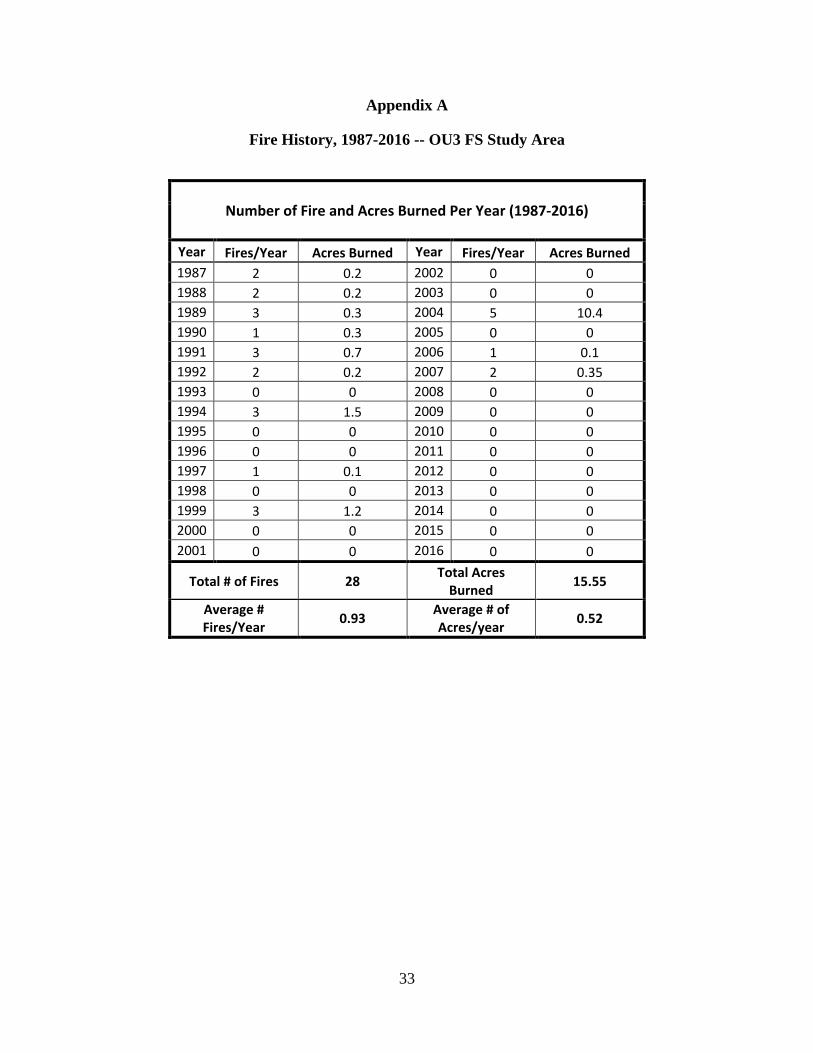
33
Appendix A
Fire History, 1987-2016 -- OU3 FS Study Area
Number of Fire and Acres Burned Per Year (1987-2016)
Year Fires/Year Acres Burned Year Fires/Year Acres Burned 1987 2 0.2 2002 0 0 1988 2 0.2 2003 0 0 1989 3 0.3 2004 5 10.4 1990 1 0.3 2005 0 0 1991 3 0.7 2006 1 0.1 1992 2 0.2 2007 2 0.35 1993 0 0 2008 0 0 1994 3 1.5 2009 0 0 1995 0 0 2010 0 0 1996 0 0 2011 0 0 1997 1 0.1 2012 0 0 1998 0 0 2013 0 0 1999 3 1.2 2014 0 0 2000 0 0 2015 0 0 2001 0 0 2016 0 0
Total # of Fires 28 Total Acres Burned 15.55
Average # Fires/Year 0.93 Average # of
Acres/year 0.52