Embed Size (px)
Citation preview

ABANaomEHT OF OFFSHORE ARTIFICIU, ISLANDS IW THE BEAUFORT SEA
Suhi tted to: ENVIRONMENTAL PROTECTION SERVICE
ENVIROmENT CANADA
Prepared by: EBA ENGINEERING CONSULTANTS LTD.
ARCTIC LABORATORIES LIMITED ESL ENVIRONMENTAL SCIENCES LIMITED STANLEY ASSOCIATES ENGINEERING LTD.

EXECUTIVE SUMMARY
Numerous a r t i f i c i a1 i s 1 ands have been constructed i n the southern port ion of the Canadian Beaufort Sea. These structures are required to support year- round o i l and gas explorat ion i n a reg ion wi th severe environmental design loads. They are temporary i n nature, typical ly occupied for less than one year. Construction water depths have ranged from 1.3 t o 45 metres Fol1 owing compl e t i on o f e x p l o r a t i o n a c t i v i t i e s ,I d r i 1 1 i ng equi pment and slope protect ion are removed, permi t t ing the granular fill t o be dispersed by waves, The purpose o f th is s tudy was t o summarize current knowledge on the impacts associated with the abandonment o f these is1 ands.
Pert inent informat ion concerning the potent ia l impact o f abandoned is lands on the physical, chemical, and biological environment has been reviewed and summarized. The p o s s i b i l i ty of i n te r fe rence w i th t rad i t i ona l summer navigat ion and over- ice hunt ing pract ice has also been considered. 'The physical environment includes ice, currents, sediment transport and dynamics, i s l and morphology, chemical oceanography, and sediment chemistry. B io log ica l components consis t o f benthos, f i sh , b i rds , and marine mammals.
Current is land abandonment practices are considered t o have had no d i r e c t s ign i f i can t e f fec t on .the physical, chemical, or biological environment i n the Beaufort Sea. Poss ib le i nd i rec t e f fec ts on the b io log ica l component are r e l a t e d t o the t iming o f the breakup o f t he l and fas t i ce shee t and a l t e r a t i o n o f the year l y seaward extent of the landfast i c e sheet. It has
been suggested i n some 1 i terature rev iewed that the presence o f i s l ands coul d cause a delay i n i c e breakup, or. t h a t an increase i n the seaward ex ten t o f the i ce cou ld e f fec t bo th the popu la t ion and d i s t r i b u t i o n o f marl ne mammals and birds. However, these effects have no t ye t been observed i n the Beaufort Sea.
Effects on hunting and t rapping are a lso re la ted t o the extent of the landfas t i ce sheet. It i s thought by some ind iv idua ls tha t the presence o f
is lands wi 11 increase the seaward extent o f t he l and fas t i ce , resu l t i ng i n

;I I E
a simi lar increase in the d istances t ravel 1 ed by hunters. There appears t o be no evidence i n support of t h i s .
Government regulat ions and respons ib i l i t i es regard ing i s land abandonment are not clear. This i s due to the involvement o f .many agencies , wi th no one agency being responsible for a l l aspects o f i s l a n d abandonment. COGLA,
INAC, NOT, and Environment Canada are the primary agencies involved. Regulation through various Acts ( T e r r i t o r i a l Lands Act , Public Lands Grants - A c t , Navigable Waters Protection Act, Ocean Dumping Control Act, Arct ic Waters Pol lu t ion Prevent ion Act , Fisheries Act, Canada Oil and Gas Act) f u r t h e r serves t o confuse the issue since these Acts are used i n an ad hoc manner.
"
The impact of abandoned is lands on navigat ion has been i d e n t i f i e d as the primary concern. It i s bel ieved that th is impact could be mitigated through the char t ing of the locat ions o f the abandoned i s 1 ands as we1 1 as through t h e i n s t a l l a t i o n o f permanent a ids to nav iga t ion a t the s i t e s of abandoned islands. Recent po l i cy gut del ines proposed under the Navi gab1 e Waters Protection Act place major r e s t r i c t i o n s upon exp lo ra t i on ac t i v i t i es i n certain port ions of the Beaufort Sea. These guidel ines propose tha t i s lands constructed i n a c e r t a i n tone be "scalped" e i ther t o an e levat ion o f -12
metres, or to the seabed as p a r t o f the approved abandonment program. This zone i s designated a "navigat ional corr idor" , s e t aside fo r future tanker t ra f f ic . Th is proposal is cons idered to be premature, because a production and t ranspor tat ion scenario for Beaufort Sea o i l has not been developed. Industry has suggested t h a t i t discriminates ,against explorat ion companies t h a t a1 ready hold 1 eases w i th in the proposed co r r i do r ,
-
The a v a i l a b l e i n f o r m a t i o n i s c o n s i d e r e d t o be s a t i s f a c t o r y , w i t h de f i c ienc ies i den t i f i ed only i n the area o f sediment dynamics fo l l ow ing i sl and abandonment. Data per ta in ing t o the ra te and extent o f i s 1 and de ter io ra t ion fo l low ing abandonment i s sparse a t present. A formal monitoring program t o quant i f y i s land de ter io ra t ion and resu l tan t sediment
dispersal patterns and r e l a t e these t o construction material types and environmental conditions would benefit future planning.
iii
E M Eaginrerinq Connrlknlr lld. &
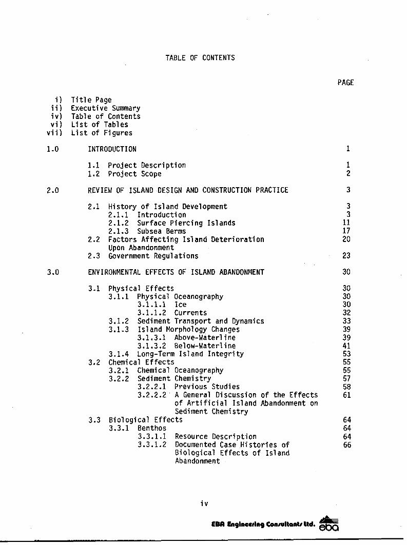
TABLE OF CONTENTS
PAGE
i ) T i t l e Page i i ) Executive Summary i v ) Table of Contents v i ) L i s t o f Tables
v i i ) L i s t of Figures
1 .o INTRODUCTION
2 .o
3.0
1.1 Pro ject Descr ip t ion 1.2 Pro jec t Scope
REVIEGl OF ISLAND DESIGN AND CONSTRUCT1 ON PR, ACTICE
2.1 His tory o f Is land Development 2.1.1 In t roduc t ion 2.1.2 Surface Piercing Is lands 2.1.3 Subsea Berms
2.2 Factors Af fect ing Island Deter iorat ion Upon Abandonment
2.3 Government Regulations
ENVIRONMENTAL EFFECTS OF ISLAND ABANDONMENT
3.1 Physical E f f e c t s 3.1.1 Physical Oceanography
3.1.1.1 Ice 3.1.1.2 Currents
3.1.2 Sediment Transport and Dynamics 3.1.3 I s 1 and Morpho1 ogy Changes
3.1.3.1 Above-Waterline 3.1.3.2 Below-Waterline
3.1.4 Long-Term Is1 and I n t e g r i t y
3.2.1 Chemical Oceanography 3.2.2 Sediment Chemistry
3.2 Chemical Effects
3.2.2.1 Previous Studies 3.2.2.2' A General Discussion o f the Ef fec ts
of A r t i f i c i a l I s l a n d Abandonment on Sediment Chemistry
3.3 Bio log ica l Ef fects 3.3.1 Benthos
3.3.1.1 Resource Descr ipt ion 3.3.1.2 Documented Case His tor ies of
B io log ica l E f fec ts o f I s land Abandonment
i v
1
1 2
3
3 3
11 17 20
23
30
30 30 30 32 33 39 39 41 53 55 55 57 58 61
64 64 64 66

TABLE OF CONTENTS (cont 'd)
3.3.2 F i s h 3.3.2.1 Introductidn and Background 3.3.2.2 Potential Effects
3.3.3.1 Introduction and Background 3.3.3.2 Potential Direct Effects 3.3.3.3 Potential Indirect Effects
3.3.4.1 Introduction and Background 3.3.4.2 Potential Direct Effects 3.3.4.3 Potential Indirect Effects
3 . 3 . 3 Birds
3.3.4 Marine Mammals
4 .O POTENTIAL LAND USE CONFLICTS
4.1 Hazards t o Vessel Navigation 4.1.1 Review o f Published and Solicited Information 4.1.2 Identification o f Key Concerns
4.2 Effects on Hunt ing and Trapping 4.2.1 Review of Published Information 4.2.2 Beaufort Sea EARP Hearings (Transcripts) 4.2.3 Questionnaire Results 4.2.4 Identification o f Key Concerns
5.0 CONCLUSIONS
APPENDICES
Appendix A-1 References - Reports Appendix A-2 References - Information Sources Appendix A-3 References - Questionnai re
V
PAGE
79 79 82 86 86 86 89 90 90 91 97
101
101 101 108
109 109 115 117 118
119
E M Englnuudng Conrlknb ltd. t

Table 1
Table 2
Table 3
Table 4
Table 5
Table 6
Table 7
Table 8
Table 9
Table 10
Table 11
Table 12
Table 13
Table 14
LIST OF TABLES
Islands Constructed i n t he Beau fo r t Sea
Approximate Sediment Volume Re1 ocated t o I s l a n d S i t e s
Time. Required fo r I s l ands t o Become Eroded to the Water1 i ne ( t o 1980)
I s l and Top Surface Erosion
Summary of L i t e r a t u r e on E f fec ts on Benthos Re1 a ted t o I s1 and Construction
Benthos Densit ies Measured a t Netserk F-40, 1977
Benthos Densit ies Measured a t Issungnak 0-61, 1981/82
Benthos Densi t ies Measured a t Issungnak 0-61, 1980
Macroinvertebrate Taxa Densi t ies Measured a t Issungnak 0-61, 1981/82
Macroinvertebrate Taxa Densi t ies Measured a t Issungnak 0-61, 1980
Local ly Abundant o r Cotmnon Fishes of the Southeastern Beaufort Sea ( a f t e r LGL and ESL, 1981)
Estimates of Annual Harvest (N.M.T. Beaufort Sea) Aklavi k/Tuktoyaktuk/Inuvik
Estimates o f Annual Economic Value of Annual Harvest (N.W.T. Beaufort Sea) Akl av i k/Tuktoyaktuk/Inuvik ( 1982 Dol 1 ars)
Questionnaire Concerns
v i
PAGE
5
37
40
54
67
69
73
73
74
74
80
111
111
118
Figure 1
Figure 2
Figure 3
Figure 4
Figure 5
Figure 6
Fi gure 7
Fi gure 8
Figure 9
Fi gure 10
Fi gure 11
Fi gure 12
Figure 13
LIST OF FIGURES
Location of Artificial Islands i n the Beaufort Sea
Typical Sections - Types of Islands Used for Exploration Structures
Construction Methods Used for Expl oration Is1 ands
Transport Directions as Indicated by Redistribution of Artificial Island Sediments by Wave Action
Wave Power Roses
North-South Cross Sections - Kannerk G-42
East-West Cross Sections - Kannerk 6-42
East-West Cross Sections - Isserk E-27
North-South Cross Sections - I t i o y k 1-27
East-West Cross Sections - I t iyok 1-27
North-South Cross Sections - West Atkinson L-17
East-West Cross Sections - West Atkinson L-17
Location o f Artificial Islands and Proposed Navigational Corr
v i i
i dor
PAGE
4
9
10
42
44
45
46
47
48
49
50
51
107

101A-4007 July 1984
1 .o INTRODUCTION
1.1 Project Description
Page 1
Numerous artificial islands have been constructed i n the southern portion of the Canadian Beaufort Sea. These structures are required to support year- round o i l and gas exploration i n a region w i t h severe environmental design loads. They are temporary i n nature and often are occupied for less than one year. Construction water depths have ranged from 1.3 t o 45 metres. Following completion o f exploration activities, drilling equipment and slope protection are removed, permi t t j n g the granular f i 11 to be dispersed by waves and currents.
Government and industry have monitored the abandonment o f some islands by conducting oceanographic, geotechnical , and biological research, . Some of this information has been published, some of i t is proprietary.
In an effort t o summarize available information i n one report, the Environmental Protection Service (EPS) of Environment Canada, through the Department of Supply and Services (DSS) , retained EBA Engineering Consultants Ltd. (EBA) , to summarize available information i n t o one report. EBA was assisted i n this task by subconsultants Arctic Laboratories Limited ( A L L ) , ESL E n v i ronmental Services Limited (ESL) and Stan1 ey Associates Engineering Ltd. (SAEL)
The contract was initiated i n February, 1984 as DSS contract number OSG 83- 00171. Mr. Warren Fenton (EPS, Yellowknife) was the designated project Scientific Authority.
Funding for this project was provided through the interdepartmental Panel on Energy Research and Development (PER01 The report out1 ines f i n d i n g s o f the contractors and does not necessarily represent the views and/or policies of the Environmental Protection Service, Environment Canada.

101A-4007
J u l y 1984
Page 2
1.2 Project Scope
The scope o f t he p ro jec t desc r ibed i n t h i s repo r t i nc luded the f o l l ow ing :
a) a review o f is land design and construction techniques, including i d e n t i f i c a t i o n o f f a c t o r s a f f e c t i n g i s l a n d d e t e r i o r a t i o n and a
review of indust ry pract ice and government regulat ions regarding i s 1 and abandonment;
b ) a summary o f t h e p h y s i c a l a n d c h e m i c a l e f f e c t s o f i s l a n d abandonment; cons ider ing phys ica l oceanography, sediment t ranspor ts i s l and morpho1 ogy changes i $1 and i n t e g r i ty , chemical oceanography, and sediment chemistry;
c ) a review and summary o f t h e b i o l o g i c a l a s p e c t s o f i s l a n d abandonment, inc lud ing e f fec ts on benthos, f i sh , birds, and marine mammal s ; and
d) a descr ip t ion o f the potent ia l land use c o n f l i c t s t h a t have been raised including vessel navigat ion and e f f e c t s on hunting and trapping .
The fo l lowing three sect ions of th is repor t (Sec t ions 2.0 through 4.0) provide a review of is land design and construction practice, present the environmental effects of i s l a n d abandonment, and summarize po ten t ia l land use conf l i c ts assoc ia ted w i th i s land abandonment, Conclusions are presented i n Section 5.0.

101A-4007
July 1984 Page 3
2 .o REVIEW OF ISLAND DESIGN AND CONSTRUCTION PRACTICE
2.1 History of Island Development
2.1.1 Introduction
Thirty a r t i f i c i a l islands have been constructed or are under construction i n the Canadian Beaufort Sea (Figure 1, Table 1). These temporary structures are used to support exploratory dri 11 i n g for oi 1 and gas. Conventional "southern'' exploration platforms such as drillships, semi-submersibles, submersibles, and jack-ups are generally not feasible for year-round use i n arctic waters, due to the severe design loads imposed by both winter and summer sea ice. Lateral loads generated through the movement of ice can be several orders of magnitude greater than those from other environmental forces such as wind, waves, and earthquakes (Vivatrat and Kreider, 1982).
These structures consisted of surface piercing islands ( is lands) and sub-sea berms (berms) tha t supported gravity structures. Island types are presented i n Figure 2. Is1 ands commonly consisted of granular soi 1 (usually sand) tha t was placed on the seabed u n t i l the surface o f the island extended 3 t o 4 metres above the water1 ine. Some early islands were constructed from clammed local seabed soil (Riley, 19751, some from trucked onshore gravel (Agerton, 1983; Galloway " e t a l . , 1982; Riley, 1975); the majority were b u i l t from dredged seabed sand (Figure 3 ) . Common practice was to place the sand hydraulically , w i t h a f loating pipel ine, dump barge, or hopper dredge. Sand placed by hopper dredge (usually a t r a i 1 i n g suction hopper dredge) was commonly bottom-dumped a t the delivery point, however, the sand could a1 so have been discharged by pumping through a pipeline. Details o f the 1983 Beaufort Sea dredging plant are presented i n the Canadian Data Report of Hydrography and Ocean Sciences No. 5 , (Taylor " e t a1 . , 1984). Sand was

FIGURE 1 LOCATION OF ARTIFICIAL ISLANDS IN THE BEAUFORT SEA
Adgo f -28
Pull$" E-17
Unarb4 L-24
N e t s y k 8-44
Adgo P-2524
N e t s p F-40
Esso
Esso
Esso
Sun
Sun
Esso
Esso
Esso
Esso
1972/73
1973
1973/74
1973/74
1974
1974
1974
1975
1975
March, 1974 1.5 Gravel (31
Wtnter, 1973 1.3 Gravel ( 3 ) 1974, 1975
Sumer, 1975 2.0 Grounded barge ' wlth protectfve berm ( 4 )
Sept., 1974 4.6 Sandbag retained sand ( 2 )
Sept., 1974 1.5 Sandbag retained s i l t , gravel cap ( 2 )
Rrch, 1975 1.5 Gravel ( 3 )
Sept., 1975 7.0 Sand bag retained sand (21
C1 ams he1 1 placed l oca l silt wlthffi
dlke (A) sandbag tetafning
Truck hauled gravel from onshore s i t e i n winter IC)
Truck hauled gravel from onshore s l t e I n winter ( C )
Berm b u l l t of sand bag f l l l e d gabfon baskets surrounding cl amshell placed local s f l t ( A )
Clamshell pl aced sand fill hauled by barge ( B l
C1 amhell placed local s i l t w i t h i n sandbag retaining dyke ( A )
Truck hauled gravel
winter ( C ) from onshore s i t e i n
Clamshell placed sand f i?? hauled by barge (6)
Sand and sll t 90 Dla. 180,000
Soft clays 45x180 46,000 and loose silts
Sand and si l t 70x115 65,000
Soft clay and 60x120 44,000 loose s i l t s
S o f t clays and 85x155 35,000 loose s f l t s
Sof t clays and 100 Dfa. 306,000 loose s i 1 ts
Soft clays and 70x145 27,000 loose s l l t s
Soft clays and 55x155 70,000 1 oose sf 1 t s
Soft clays and 100 Dia. 291,000 loose s l l t s
145 D ia .
45x180
70x115
60x120
85x155
100 Dla.
70x145
55x155
100 Dia.
4.3
1 .o
3.0
3.7
2.4
4.6
1 .o
3.0
4 . 6

TABLE 1 ISLANDS CONSTRUCTED IN ME BEAUFORT SEA (continued) C r c o I;."?
YEAR DATE WATER FOUNDATION SURFACE FILL WATERLINE r P ISLAND COMPANY CONSTRUCTED ESTABLISHED DEPTH ISLAND TYPE' CDNSTRUCTION METHOD' CONDITIONS DIMEWSIONS QUAH$ITY DIMENSIONS FREEBOARD 8 NAME t m ) t m l (m 1 (m) t m l -4
Sarpjk Esso 8-35
Ikat$$k Esso J -17
Kugm l l f t Esso H-59 h
Adgo Esso J -272
Arna$4 Esso L-30
Kann r k Esso 6-4254
I ssefk Esso E-27
Issu gnak Esso 0-61 B
Issungnak Esso 2-0-613
1975/76
1975
1976
1976
1976
1976
1977
1 9 7 ~ 7 9
1980
March, 1976 4 . 3 Gravel (3)
July, 1975 1.5 Sandbag retained sand ( 2 1
Aug., 1976 5.3 Sandbag retafned sand (2)
Sept., 1976 1.8 Sandbag retained
cap ( 2 1 s l 1 t, gravel
Sept., 1976 8.5 S a c r l f l c i a l sand (1)
Sept., 1976 8.5 S a c r i f l c f a l ~ sand (11
Summer, 1977 13.0 Sacr i f l c fa l sand 11)
Sept., 1979 19.0 S a c r l f i c f a l - sand (1)
Summer, 1980 1910 S a c r l f i c i a l sand (1)
Truck hauled gravel from onshore site i n wfnter (C)
S o f t clays and 100 DIa. l18,0(#1 100 Dla. Toose s i 1 t s
C1 amhel l p laced loca l s i l t ulthln sandbag re ta in ing dyke (A)
C1 amshell placed sand flll hauled by barge from T u f t P t . ( 8 )
C1 amshell placed 1 oca1 s i l t w l t h l n sandbag re ta in ing dyke ( A )
beach, Hydraulfcal ly placed
pipel Ine (0) sand, dredge wlth
beach, Hydrau? i c a l ly placed sand, dredge w i th pfpel tne ( D l
beach, ttydraul f c a l ly placed sand, dredge d t h p ipe l Ine (Dl
beach, Yydraul i c a l ly p? aced sand, below water f f l l dredged on s f te ; above water fill hauled by dump barge t o s i t e , #en placed hydraul i c a l l y ( D l
beach, Yydrau? i c a l ly p? aced sand, r e c l a l m d from Issungnak 0-61 (0)
Soft clays and 45x130 38,000 45x130 loose s i l t s
Soft clays and 100 Dia. 236,000 100 Dfa . s i l t s over sand
Soft clays and 50x105 69,000 50x105 loose s i1 ts
Saft clays and 100 Dla. 1,150,000 210 Dia. loose s i l t s
Sand 100 Dla . 1,150,000 180 Dia.
Yeneer of s o f t 100 Dla. 1,908,000 227 Dia. c lay over lyfng sand
Stiff clay 100 01s. 4,100,000 100 M a . over ly jng sand
Stiff clay 100 Dia. 4,900,000 180 D ia . over1 y Ing sand .
3.0
2.0
4 . 6
1 .o
5.2
5.2
5.0
1.2
5.0 W
m rn rn
NOTE: 1. The number i n parentheses f o r Is land Type corresponds to one o f the sfx types shown on Figure 2. S imi lar ly . the le t ter a f ter Construct fon Method corresponds t o one o f the f i v e methods shown i n Figure 3. Acronyms are deflned with in the tex t o f the report.
2 . Is land constr icted under T e r r i t o r i a l Lands Act. 3. Is land constructed under Publlc Lands Grants Act. 4 . I s l a n d i s o f f i c i a l l y ' a b a m e a .

TABLE 1 ISLANDS CONSTRUCTED I N ME BEAUFORT SEA (continued)
C C I 0 5 -
- 7 NAME (m) t m ) tm 1 ( m l [m) p 4
YEAR DATE MATER FOUNDATION SURFACE FILL WATERLINE ISLAND COWANY CONSTRUCTED ESTABLISHED DEPTH ISLAND TYPE' COMSTRIJCTIOW METHOD1 4 CONDITIONS OIMEFISIONS QUAN3ITY DIMENSIONS FREEflOARD g 00 r P
A I er5 P-23
North Protect ion Is1 and, McK nley Bay 1 Vest Atkinson L- 172
Tarsjut N-44
Uv i l y k P-66
I t i ygk 1-27
Werl grk 8-67
Esso
Dome
Esso
Gulf
Dome
Esso
Dome
1980/8l F a l l , 1980/81 10.5 Sacr f f f c ia l beach, Hydraulfcal ly placed Veneer of clay sand (1) sand. dredsed on sfte. over ly ing sand
placed w f t i i pfpel fne ( D l
"
1w1 Dia. 1,500,000 200 M a .
1980/81 Summer, 1980
1981/82 Sept., 1982
1981 Oct., 1981
1981/82 F a l l , 1982
1982 Oct., 1982
1982/83 n.a.
4.6 S a c r i f i c i a l beach, Hydraul ical ly placed Sand ' sand (1) sand, dredged on s i te ,
placed with pfpelfne (01
7.5 S a e r i f i c l a l beach, Hydraul icaI ly p laced Soft c lay sand (1) sand (01 over ly ing sand
21.0 Caisson retalned Seabed subcut, Soft c lay sand on sand berm hydrau l fca l l y placed overlying s t l f f
and hopper haul from offshore source (WE)
( 5 ) ' sand flll and barge c lay and s l l t
29.7 SSOC on gravel Hydraul ical ly placed Sand capped sand sand berm, re inforced berm (6) steel hull converted
from YLCC bal lasted onto berm surface (0)
15.0 S a c r l f i c b l beach, Hydraulka l ly p laced Sand sand (1) sand, dredged onslte,
placed with pfpel f ne ( D l
45.1 Proposed SSOC an Hydraul ical ly and Sand sand berm (61 hopper placed sand
berm [constructfon stopped due to slope fa f lu res) (D+EI
350x1200 2,000,000 ?
100 Dla. 1,000,000 220 Dia.
170 Dfa. 1,800,900 n.a.
103x212 1,900,000 n . a .
1OD Dla. 2,000,000 225 D i a .
n.a. +4,000,000 n.a. when con- s t ruc t ion stopped)
4.5
4 .o
4 . 5
-6.5
-9 .o
4.5
-9 .o
'0 m a [b
Q NOTE: I. The number ffl parentheses for I s land Type corresponds to one o f the $+x types shown on Flgure 2. Slmf la r ly , the le t te r a f t e r Construction Method corresponds t o one o f the f i ve methods shown i n Ffgure 3. Acronyms are defined wfthln the t e x t o f the report.
2. Island constructed under T e r r i t o r i a l Lands Act. 3. Island constructed under Public Lands Grants kt . 4. I s l a n d i s o f f i c i a l l y abandoned.

C P 0 5 ,
- 7 YEAR DATE WATER FOUNDATION SURFACE FILL WATERLINE ISLAND COMPANY CONSTRUCTED ESTABLISHED DEPTH ISLAND TYPE’ CONSTRUCTIOM METHOD1 COWQETIDNS DIHEWSIONS QUANJITY DIMENSIONS FREEBOARD LD 0
r P
NAME t m ) Iml t m 1 (rn) Im)
Kowyk N-67
Kadl yk 0-07
M i nuk3
Amerk3 P-09
M i p t y k 1 -19
Gulf 1982/83 Fa1 I , 1983 28.1 MAC berm converted Mostly hopper placed to SSDC on sand rand berm, reinforced berm (6) steel hull converted
from YLCC ballasted onto b e n surface (El
Esso 1983 F a l l , 1983 14.5 Caisson retalned Hopper-placed sand sand on send berm bem wlth steel (5 ) cafssons I E )
Es so 1982/83 Summer, 1983 14=0 S a c r i f j c l a l beach, Hopper placed sand 1985 u t f 1 i Z - sand (1) ( E l
at ion)
Esso 198311 n.a. 27.0 Cafsson retained Placed by suction sand on sand berm, dredge, sand extenslve seabed , berm with steel sub-cutt ing (5) caissons I D )
sand (1) (€1 E 550 2983/? n.a. 13.0 S a c r i f i c i a l beach, Hopper placed sand
Sand 103x212 1,450,OOO n .a. -9 .o
Soft c lay n.a 450,000 n.a. -9 .o over ly ing flrm clays
Sof t c lay over n.a. n.a. n.a. 5.0 l y t n g Rn clay
Sof t clay over- 128 DIa. 2,700,000 n.a. -9 .o lyfng sand
Sof t clay over- 110 Dia. 1,700,000 170 Dia. 5.0 l y f n g firm clay
ROTE: 1. The number i n parentheses fo r Is land Type corresponds t o one. o f the six types shown on Figure 2. Simf la r l y , t he l e t te r a f t e r Construction Hethod corresDonds to one o f t h e f i v e methods shown .In Flsure 3. Acronyms are def lned wi th in the text of the report.
2. I s land cons tkc ted under f e r r f t o r i a l lands Act. 3. Island constructed under Publ ic Lands Grants Act. 4 . Is land I s o f f i c i a l l y abanaoned.
-

METHOD A CLAMSHELL PLACED LOCAL BORROW {This method has been used for 6 islands)
&mow brought withm reach of lhe clamshell by hydraulic pipeline. hopper dredge of dum0 barge
METHOD B CLAMSHELL REHANDLED MPOATED BORROW (This method has been used fw 4 islands)
Gravel fill il broughr 10 the sift by trucks from on-land sovrca and dumped through a precut hole In the ice. Dozers arc used to move fill once the #stand exrendr above sea level
METHOD C TRUCK HAULED GRAVEL DEPOSITED THROUGH ICE (This method has been used for 4 irlandd . . " "" . ~ . .
METHOD D HYDRAULICALLY PLACED DREDGED FILL [ T h i s method has bean usmi for 13 islands)
v - HOPPER DREDGE OR SIMtLAR DUMPBAFiGE
METHOD E HOPPER OR WMP BARGE PLACED DREDGED FILL fThlr method has bsen used for 6 islands)
~. " " - "
NOT TO SCPL E
FIGURE 3 CONSTRUCTION METHODS USED FOR EXPLORATION ISLANDS
101A-4007 July 1984
Page 11
1 oaded onto barges by ei ther cl amshell or dredge, depending upon barge type. Barges were either u t i l i t y barges or bottom-dump barges. Pipeline placement was usually used i f sufficient borrow reserves were available w i t h i n close proximity to the is1 and si te; hopper dredges and barges were used if fi 11 material was imported. Is1 ands were occasionally bui 1 t w i t h a combination of imported and 1 oca1 f i 11 . Berms were usually constructed i n deeper water and were similar to islands, except that they were terminated about 6 t o 10 metres below the waterline, Fol 1 owing berm completion, the surface was leveled and a steel or concrete gravity structure was ballasted onto the berm. The structure usually protruded several metres above the waterline and functioned i n the same manner as d i d a surface piercing island except that the total f i 11 volume was substantially less t h a n t ha t required for a surface piercing is land i n a similar water depth.
2.1.2 Surface Piercing Islands
Artificial island construction i n the Beaufort Sea started i n 1972, when Imperial Oil Limited, now operating i n the Beaufort region as Esso Resources Canada Limited (Esso) , constructed Imnerk B-48, T h i s is1 and, bu i 1 t i n about three metres o f water from dredged sand and gravel (Riley, 1975) was termed a "sacrificial beach'' island (Figure 2) . I t had a freeboard of about 4.6 metres , a working surface diameter of 90 metres and a water1 ine diameter of approximately 145 metres.
$1 ope pl ast si des
protection was provided above the waterline and consisted of sheets o f
i c f i 1 ter cloth placed on a graded 5H: 1 V (5 horizontal t o 1 vertical ) lope. The f i l t e r cloth was covered w i t h chain 1 i n k fencing and cable

101A-4007
July 1984 Page 12
nettlng, which was i n turn secured t o timber and steel deadman anchors placed a t the toe and crest o f the sideslope (Riley, 1975).
Underwater sideslopes were constructed to about 20H: 1V since i t had been determined t h a t this slope would be representative o f a natural , moderately protected beach composed of similar soil. The f l a t slope led t o the adoption o f the "sacrificial beach'' nomenclature, i n t ha t the gradually rising island sideslope caused incoming waves t o break, thereby absorbing the wave energy (Croasdale and Marcel 1 us, 1977). Any s ignf f i cant amount of erosion t h a t occurred during extreme environmental conditions would be conveniently rep1 aced afterward. Due t o the 1 arge f i 11 volume (approximately 180 000 cubic metres) i t was considered unlikely tha t erosion caused by any one event would signif icant ly affect the overall s t a b i l i t y of the i sl and.
The relatively f l a t underwater slope a1 so provided defense against large ice forces, since an incoming ice sheet would be deflected upwards u n t i 1 flexural failure occurred (Croasdal e and Marcel 1 us, 1977). Breakage of the ice sheet not only caused a reduction i n applied load, b u t caused the formation of a "rubble field" around. the island (Abdelnour and Sayed, 1982; Bercha " e t a l . , 1982; Dunwoody, 1983; Kotras, " e t a l . 1983). T h i s grounded rubble field would not only effectively increase the size o f the i s l a n d , b u t would transmit incoming loads directly t o the seabed.
In the late summer of 1973, following the successful construction of Innnerk, Esso undertook construction o f Adgo ,F-28. This i s l and was termed a "sandbag-retained" island (Figure 2) and consisted of a seabed- founded sandbag retaining dike which was infilled w i t h s i l t from the adjacent seabed. Following completion of construction, the island was capped w i t h gravel. Freeboard was less than a metre. This type of island was only servicable when the si1 t was frozen. Damage t o the unfrozen si1 t

101A-4007 J u l y 1984
Page 13
by wave act ion was minimized by l im i t ing cons t ruc t ion to the per iod immediately preceeding freeze-up. The gravel cap was required to improve
t r a f f i c a b i l i t y on the s i1 t.
I n March, 1974, Esso completed construction o f Pullen E-17, a gravel is land (F igure 2) l o c a t e d i n 1.5 metres o f water on the leeward side o f natural Pul len Is1 and. Th is i s1 and was constructed through the winter o f 1973/74 by c u t t i n g and removing blocks o f i c e and then f i l l i n g t h e subsequent holes with gravel trucked from an on-shore borrow source, Sandbags were placed around the perimeter of the island above the water1 ine t o provide erosion protect ion dur ing the open water season. The i s l a n d was provided with three metres o f freeboard. Construction involved the removal o f 18 000 tonnes o f i c e and subsequent placement o f 65 ' 000 cubic metres o f compacted fill w i t h i n 50 days.
A fourth type of sur face p ie rc ing i s land appeared i n 1975, when Sun Oil Co.
Ltd. (Sun) grounded a d r i l l r i g c a r r y i n g barge i n 2.0 metres o f .water and b u i l t a p r o t e c t i v e berm around it (Pelly B-35) The berm was constructed from sandbag-filled gabion baskets; the annular space between the berm and the barge was f i 1 l e d w i t h seabed s i 1 t placed with a clamshell (Figure 2 ) . I n the spring, fol lowing the completion o f d r i l l i n g , a po r t i on o f the berm and the s i 1 t i n f i 11 i ng was removed, the barge was ref1 oated, and removed. This type o f d r i 11 ing p la t fo rm was only used once.
From 1975 t o mid-1976, a1 1 new i s 1 ands were constructed from either truck-
haul ed gravel i n the winter o r from c l arnshell -placed barged sand o r l o c a l s i 1 t i n the summer. The maximum water depth was a t ESSO'S Kugmallit H-59 i s 1 and, where 226 000 cubic metres o f sandbag-retained sand fill was placed i n 5.3 metres o f water.

101A-4007
Ju l y 1984 Page 14
The s a c r i f i c i a l beach island concept was revived i n 1976. This was due to:
a) the need t o construct is lands i n deeper water i n a s ing le season, b ) the avai lab i 1 i ty o f seabed sand near proposed i s land s i t es , and c) the a v a i l a b i l i t y o f large scale dredging equipment.
Esso constructed two s a c r i f i c i a l beach i s l a n d s i n 1976. Arnak L-30, and Kannerk 6-42 were bo th l oca ted i n 8.5 metres o f water and each required about 1 150 000 cubic metres o f fill. Each i s land had a freeboard o f f i v e metres; the diameter o f the working surface was around 100 metres , and the waterline diameter was approximately 200 'metres. Large, 1.5 cubic metre sandbags were placed on the above-water1 i ne po r t i on o f the s lope for wave protect ion.
Isserk E-27 , a s a c r i f i c i a l beach f sland, was constructed by Esso i n 1977, Located i n 13 metres o f water, environmental conditions were considered t o be more severe a t t h i s l oca t i on t han a t any other previous i s land s i t e . The r e l a t i v e l y exposed loca t i on o f t he i s l and (18 ki lometres nor th of Pul l e n Is1 and), combined w i th deeper water, was expected t o a1 low development o f subs tan t i a l l y g rea te r i ce and wave forces than had previously been encountered. The fill volume required to const ruct the is land was about 1.9 m i l l i o n c u b i c metres. All o f the sand was p laced hydraul ica l ly , w i th a s tat ionary suct ion dredge and p ipe l ine.
A well defined borrow p i t must be i d e n t i f i e d p r i o r t o is land construct ion. Based on the Isserk experience, Boone (1980) est imated that 30 percent o f t h e delineated material cannot be economically recovered from a dredge p i t , 30 percent o f the material discharged i s l o s t t o waves and currents (predominantly s i l t ) , 5 t o 10 percent o f the mater ia l i s e f f e c t i v e l y l o s t due t o compaction and set t lement o f the fill, and 5 t o 10 percent of the

101A-4007
July 1984 Page 15
material i s "recovered" through b u l k i n g once the f i 11 is disturbed from i t s natural i n situ density. About 3.2 million cubic metres o f material would normally be identified w i t h l n a borrow prospect for construction o f an island w i t h 1.3 million cubic metres of placed f i l l .
Construction o f the largest sacrificial beach island to 1984 was initiated by Esso during the summer of 1978. Issungnak 0-61, located i n 19 metres o f water, was t o consist o f slightly i n excess o f 4.1 million cubic metres of sand f i l l . This represented about a three-fold increase i n f i l l volume compared t o the next largest island, Isserk E-27, a1 though the water depth of Issungnak was only 46 percent greater than tha t of Isserk.
Actual island construction spanned two open water seasons, the summers of
1978 and 1979. A single stationary suction dredge, the Beaver Mackenzie, was used during the f i r s t season. A second dredge, the Sceptre Mackenzie (a1 so a stationary suction dredge) was involved during the second season, j o i n i n g the Beaver Mackenzie i n dredging sand t o ensure t h a t the island was completed by late September, 1979. The i s 1 and was designed to have a 15H: 1V underwater sideslope, a 25H:lV 25 metre wide sloping beach and a 3H:lV above water sideslope. Freeboard was t o be about five metres, the working surface diameter 100 metres, and the water line diameter 180 metres. Slope protection was intended t o consist o f sandbags on the 3H:lV slope and a 1 ayer o f wire net and f i 1 ter cloth on the 25H: 1V beach.
The is1 and was nearing completion i n September, 1979 when two storms eroded the exposed aerial portion o f the island and damaged some of the dredging p l a n t (Boone, 1980). Island re-building was hindered by freeze-up, resulting i n a completed island w i t h only 1.5 metres of freeboard and no slope protection. However, island erosion d u r i n g the storms had resulted i n the formation of a 100 metre wide sand apron around the central 100 metre

101A-4007
July 1984 Page 16
diameter working surface. This apron, located just below the waterline, caused waves t o break as far away as 150 metres from the is land centre (Boone, 1980). The low freeboard required formation of a rubble field by late winter i n order t o ensure s t ab i l i t y against extreme ice conditions.
A second Issungnak, 2-0-61, was constructed 40 metres west of the o r ig ina l i s land i n the summer o f 1980. This island was constructed i n a sing1 e season from the sand forming Issungnak 0-61. Island construction was i n accordance w i t h the or ig ina l 0-61 design.
Subsequent t o the construction o f Issungnak 2-0-61, Esso has constructed and drilled on three more sacrificial beach islands. Alerk P-23, located i n 10.5 metres of water, contained 1.5 million cubic metres o f f i l l ; West Atkinson L-17, located i n 7.5 metres of water, contained 1.0 million cubic metres o f f i l l ; and Itiyok 1-27, located i n 15 metres o f water, contained 2.0 million cubic metres of f i l l . Two more sacrificial beach islands were under construction i n 1983; Minuk was located i n 14 metres of water, Nipterk 1-19 was located i n 13 metres of water.
Slope protection was provided by sandbags and filter cloth. Experimental techniques, such as articulated concrete mats described for use i n the Alaskan Beaufort Sea (Wang " e t a1 . , 1983; Leidersdorf, " e t a1 . , 1982; 1981) have never been implemented i n the Canadian Arctic.
Dome Petroleum Limited (Dome) constructed one permanent sacrificial beach is land i n 1980. This is land, named the North Protection Island, i s
intended t o provide re1 a t i vely she1 tered waters w i t h i n Dome's selected harbour area o f McKinley Bay, I t is formed from spoil obtained d u r i n g the dredging of access channel s and mooring basins w i t h i n McKinley Bay. An airstrip, camp facil i t ies, and a temporary dock are located on the island.

101A-1 4007 Page 17 Ju l y 1984
The length o f the i s land i s about 1200 metres and it i s approximately 350 metres wide. Freeboard i s 4.0 metres; no s lope protect ion has been prov i ded,
2.1.3 Subsea Berms
T h e ' f i r s t subsea berm i n t h e Canad ian A rc t i c , Ta rs iu t N-44, was constructed by Dome dur ing the summer o f 1981 (Fi t z p a t r i c k and Stenning, 1983; Myers e t a1 , , 1983). The berm was s i t u a t e d i n 21.0 metres o f water
and terminated a t 6.5 metres below sealevel. Prior t o is land construct ion, the seabed was "subcutll by 3.0 metres i n an e f f o r t t o i nc rease t he s tab i l i t y o f the berm. This was necessary since the immediate seabed c l a y d i d n o t have s u f f i c i e n t shear strength t o provide an adequate safety margin against s l id ing dur ing the design ice load. Sand was the predominant fill mater ia l , a1 though gravel was used f o r t h e upper few metres o f berm height. A t o t a l of 1.8 mil 1 ion cubic metres of fill was used to const ruct the berm. This represents less than ha1 f o f the total f i l l requirements o f s a c r i f i c i a l beach i s l a n d Issungnak 2-0-61, although the water depth a t Issungnak was 1.5 m e t r e s l e s s t h a n t h a t a t T a r s i u t . T h r o u g h d i f f e r e n t construction techniques steeper underwater sideslopes were achieved ( D i kken and Brake1 , 1982), r e s u l t i n g i n a fill volume t h a t was s i m i l a r t o t h a t required t o construct a s a c r i f i c i a l beach i s l a n d i n 15 metres o f water. The shape o f the berm was circular, approximately 170 metres i n diameter.
"
Fol1 owing berm construction, four re in fo rced ver t i ca l -wal led concrete calssons were set-down and bal lasted onto i t s surface, Each caisson was 69
metres i n length, 15 metres wide, and 11.5 metres high. The two outside corners o f each caisson were beveled, resul t ing i n t h e completed s t ruc tu re having eight approximately 45 metre long sides. With a set-down d r a f t of 6.5 metres, the caissons extended 5 .O metres above the water1 ine. Af ter

101A-4007 July 1984
Page 18
caisson placement, the square interior o f the four caissons was filled w i t h dredged sand t o an elevation of +7.5 metres. A rock apron (Myers " e t a1 . , 1983; Myers and Kirby, 1983) was placed around the toe o f the caisson, t o control erosion.
Exploratory drill i n g was conducted over the winter o f 1981/82, a del ineation well was advanced during the summer - o f 1982. Following these activities, the is1 and was vacated. Dismantl i n g o f the cai s o n port ion of the .structure i s scheduled for the summer o f 1984 ( G u l f , 1983)
Fol l o w i n g the experience gained w i t h the T a r s i u t caissons, Dome developed the Sing1 e Steel Dri 11 i n g Caisson (SSDC) . T h i s structure consisted o f the forward ha1 f o f a modified Very Large Crude Carrier (VLCC) . It was 162 metres long, 53 metres wide, stood 25 metres h i g h and was to be placed on a subsea berm. The structure was f i r s t deployed i n the fa1 1 of 1982 when i t was placed on the Uviluk P-66 berm, located i n approximately 30 metres o f water. Since the design set-down draf t of the SSDC was 9 .O metres, a rectangular berm 2 1 metres The berm was constructed from hydraul ically-placed approximately one metre thick. Rock and gravel placed around the perimeter o f the u n i t after i t berm. The total f i l l volume was about 1.9 mill
i n h e i g h t was required. sand, w i t h a gravel cap erosion protection was was ballasted onto the ion cubic metres, berm
sideslopes were between 8H:lV and 5H:lV. Subcutting was not necessary since the foundation soil was sand. Exploratory dri 11 i n g was conducted over the winter of 1982/83, after which the SSDC was re-floated and removed from the berm.
The next deployment s i te for the SSDC was designated Nerlerk 8-67. T h i s 1 ease was located i n about 45 metres of water, the deepest to date for

101A-4007 July 1984
Page 19
bottom-founded d r i l l i n g i n the Canadian Arctic. For the design 9.0 metre set-down d r a f t o f the SSDC, a subsea berm 36 metres i n height was required. Dependent upon slope angle, f i 11 volumes were to be between 4.0 mil 1 ion and 6.5 million cubic metres. Foundation soils were sand; berm f i l l sand was placed hydraul ical ly w i t h pipe1 ine and hopper dredge (Berzins and Hewi tt , 1984 1 . In the summer o f 1983, dur ing the second construction season, slope failures occurred w i t h i n the f i l l , resul ti ng i n the abandonment o f the berm (Berzins and Hewitt, 1984). In excess o f 4,O mil l ion cubic metres of f i l l had been placed when the soil failed; the geometry of the berm after the failure i s no t known. Research is currently underway a t Dome to better understand the cause o f the slope failures. The SSDC was re-assi gned t o a berm a t Kogyuk N-67
Simultaneous w i t h the development of -Dome's Tarsiut caisson and the SSDC, Gul f Canada Resources , Inc. ( G u l f ) developed their own bottom-founded exploration u n i t (Bruce and Harrington, 1982). Originally dubbed the Mobile Arctic Caisson (MAC), and now cal led ,the Mol i kpaq, the G u l f structure was an a1 1 -steel annular caisson ' w i t h a -steel topdeck. I t was eight-sided, a1 though nearly square i n p l an . The hollow 73 metre by 73 metre core underlying the topdeck was designed to be fi l led w i t h dredged dewatered sand. The sand was required t o provide the structure w i t h sufficient resistance to environmental ice forces.
Design deployment depth for the Mol i kpaq was a constant 21 .O metres, resulting i n a structure tha t could be placed i n relatively deep Beaufort Sea waters w i t h a minimal amount o f berm. Structure deployment i n 25 metres of water would only require about 200 000 cubic metres of berm f i l l , compared w i t h the 4.1 million cubic metres of f i l l required for sacrificial beach Issungnak 0-61 (19 metres of water) , the 1.8 million cubic metres o f

101A-4007
July 1984 Page 20
f i l l required for construction of the Tarsiut N-44 berm (21 metres o f water) and the 1.9 mill ion cubic metres of f i l l required for the SSDC berm a t Uviluk P-66 (30 metres of water).
Delivery of the Mol i kpaq i s scheduled for the summer o f 1984, however it currently has no designated deployment site.
A caisson-type structure was a1 so developed by Esso. Named the Caisson Retained Is1 and (CRI) , this structure consisted o f eight a1 1 -steel caissons. Each caisson was 43 metres long, 12.2 metres high , and 13.1 metres wide (De Jong and Bruce, 1978; Mancini ” e t a1 . 1983). When a1 1 eight caisson sections were joined together, the diameter o f the u n i t was 117 metres. The design set-down water depth was identical to t h a t o f the SSDC, a t 9.0 metres.
The CRI was operational and i n-pl ace a t Kadl uk 0-07 i n the winter of 1983-84. Deployment s i te water depth was 14.5 metres; approximately 450 000 cubic metres of f i l l were required to obta in a berm height of 5.5 metres. A gravel erosion protection system was installed a t the toe of the c a i sson.
2.2 Factors Affecting Island Deterioration Upon Abandonment
Typical island abandonment procedure is t o i n i t i a l l y remove a l l exploration related equipment, followed by the removal o f a l l erosion protection system components.. Berm abandonment involves refloating and removal o f the d r i l l i n g caisson u n i t ( s) However, only SSDC-type berms have been abandoned t o date. The Tarsiut caisson structure, w i t h its interior sand f i l l i n g , i s scheduled t o be removed dur ing the summer o f 1984. Removal of the concrete caissons wi 11 involve the excavation o f rock and sand around the outside perimeter o f the structure as well as removal o f ‘ a portion of the interior sand f i l l ( G u l f , 1983).
101A-4007 J u l y 1984
Page 21
I s l and and berm d e t e r i o r a t i o n i s c o n t r o l l e d by the propert ies of the fill,
the magnitude of the act ive environmental processes, and t h e i n t e g r i t y o f the residual erosion protect ion system. Geotechnical propert ies of the fill that a f fect deter iorat ion ra tes are the, gra in s ize o f the mater ia l and t o a small degree, the amount o f ice-bondi ng. Most a r t i f i c i a l i s 1 ands have been constructed from f ine-grained noncohesive sand wi th vary ing propor t ions o f s i 1 t and clay. The clay occurs as d i sc re te ba l l s ra ther than as a uniform d i s t r i b u t i o n w i t h i n t h e fill . These b a l l s are formed during the dredging process when the dredge encounters cohesive soil Since a1 1 o f t he dredged and clamned cohesion less so i ls are f luv ia l or marine i n o r i g in , t hey a re f requent ly poor ly graded and of ten are very uni form in s ize. Gravels derived from on-shore borrow sources are g l a c i o - f l u v i a l i n o r i g i n and are t yp i ca l l y c lean and we1 1 -graded. The maximum gravel aggregate s i t e i s about 75 m i 11 imetres.
Sub-zero, winter temperatures cause f r o s t t o penetrate the fill . The depth o f f r o s t p e n e t r a t i o n i s dependent upon the meteorological condit ions and the moisture content, sal in i ty, and mineralogy o f t h e fill material. Porewater sal i n i ty depresses the freezing point o f t h e fill porewater. Typical Beaufort sea water has a s a l i n i t y of about 30 par ts per thousand; t h i s r e s u l t s i n a f reez ing po int depress ion o f around 1.7C0. F i l l s constructed from soi ls obtained f rom the seabottom have s a l i n i t i e s s i m i l i a r t o tha t o f sea water; fill mater ia l der ived from onshore sources a1 so has a sal i n i ty
c l o s e t o t h a t o f sea water, a f t e r placement.
I n s p i t e o f the freezing point depression, it i s normal f o r t h e f r o s t t o penetrate in to exposed fill t o the water1 ine by the end o f t h e f i r s t w i n t e r (approximately four metres). Below water l ine fill will have only slight f ros t penet ra t ion a f te r the f i r s t w in te r . S ince the normal summer thaw

101A-8 4007 Page 22 Ju ly 1984
depth is 1.5 t o 2.0 metres, a residual layer of frozen soil is l e f t w i t h i n the f i l l . This marks the i n i t i a t i o n of permafrost.
Once an is1 and i s vacated and the slope protection is essential ly removed, wave action starts to erode thawed f i l l and initiate permafrost degradation. I t i s assumed t h a t the permafrost provides some resistance to erosion, although the degree t o which the presence o f permafrost affects the island deterioration rate is unknown.
Environmental factors affecting island deterioration are wind, wave, current, and ice forces. These interact w i t h the f i l l comprising a berm or island causing erosion. Assuming t h a t the slope protection system has been essentially removed, the degree o f deterioration is dependent upon the magnitude and duration o f the environmental forces and the integrity o f the f i l l .
Once an island is vacated, typically i n the spring, and the slope protection system i s removed, typically i n the summer, the aerial portion of the island i s exposed to wind and wave forces. Waves rapidly erode the exposed portion of the island surface; deflation occurs a t a much slower rate, particularly for the coarser-grained (i .e., gravel ) f i l l s . I t i s not unusual for a sand i sl and i n an exposed location t o be eroded down to the waterl ine a few months a f t e r abandonment ( i .e., Isserk E-27; Woodward-Clyde Consultants, 1982). Islands i n less exposed locations, or constructed from terrestrial gravel , can be expected t o remain above the waterl ine for up t o several years ( i .e., Pul len E-17; Woodward-Clyde Consultants, 1982).

t I I I I
101A-4007
Ju ly 1984
Page 23
Ice scour ing of the seabed has been proven t o be a major geomorphic process, a1 though a study of ice-i nduced scour Q f is land surfaces, or sediment t ranspor t e f fected by i c e has n o t y e t been conducted, Studies conducted by Esso (Spedding, 1976a, 1978a, 1978b, 1979a, 1979b, 1980, 1982) have i ndicated that rubble f ie1 ds form around is lands that penetrate the water1 i n e and over is lands that are submerged. Correlat ions between ice movement over or around is lands and i s l a n d morphology have not been attempted.
2.3 Government Regulations
Beaufort Sea a r t i f i c i a l i s l a n d s have been constructed under the au tho r i t y o f bo th t he Te r r i t o r i a l Lands Act (TLA) and the Publ ic Lands Grants Act (PLGA) . Land use permits are issued t o operators under the TLA (and the associated T e r r i t o r i a l Land Use Rcgul a t i ons ) , whi le the PLGA provides leases for the seabed. For the purpose o f regulat ing is land const ruct ion, Ind ian and Nor thern Af fa i rs Canada ( INAC) rep1 aced the TLA with the PLGA i n the spring of 1981. However, cer ta in is lands const ructed after the inception o f the PLGA system are covered under the TLA i f is land const ruct ion was approved p r i o r t o t h e s p r i n g o f 1981. . Of the 30 is lands constructed or under construction, only 12 have been b u i l t under the PLGA. The TLA i s s t i l l used
to regu la te on-shore a c t i v i t i e s .
The Canada Oil and Gas Lands Administrat ion (COGLA) acts as the ' ' lead" agency i n the regulat ion o f d r i l l i n g i n t h e B e a u f o r t Sea. Most explorat ion operations are control led through the Canada Oil and Gas Act , however, other avenues of l e g i s l a t i o n are a1 so w i t h i n COGLA's venue.
101A-4007
J u l y 1984
Page 24
Each operator must submit an abandonment program t o COGLA before they are al lowed to vacate the island. COGLA then so l i c i t s "op in ions" on the program from other government agencies (i.e., Navigable Waters), I f the plan i s satisfactory, permission to vacate the i s 1 and i s granted, with the s t i p u l a t i o n t h a t t h e i s l a n d be "restored t o or ig ina l condi t ions" . The lease covenants include environmental protect ion cr i ter ia, but there are no spec i f i c regu la t i ons s ta t i ng exac t l y what mater ia ls must be removed from the
is land surface. It i s bel ieved by both COGLA and indus t ry tha t t o restore the i s l and 15 t e r a l ly t o "o r i g ina l cond i t i ons ' ' i s imprac t i ca l .
In p rac t ice , it has been suggested by severa l ind iv idua ls tha t COGLA d i r e c t s most o f t h e i r e f f o r t s towards ac tua l d r i l l i ng opera t ions and well completion and abandonment, e f fec t i ve l y i gno r ing the environmental aspects o f i s l and abandonment. INAC considers that it i s their r e s p o n s i b i l i t y t o ensure t h a t environmental concerns are addressed and the vacated islands are cleaned-up, receiv ing the i r author i ty through the TLA 1 and use permits and the PLGA 1 eases.
INAC' s i n t e r p r e t a t i o n o f the TLA and the PLGA f o l 1 ow5 (Fenton, 1983) :
T e r r i t o r i a1 Lands Act
( f i r s t passed i n 1952, l a t e s t amendments made i n March 1970;
administered by INAC)
The T e r r i t o r i a l Lands Act provides for the d isposi t ion, administrat ion and management of a1 1 T e r r i t o r i a l Lands. I n the N .W.T. these lands are defined i n the Nor thwest Terr i tor ies Act and do not include of fshore lands (i .e. seabed). Occupation o f l and i s regu la ted under a system o f leases or 1 icenses (referred t o as a land tenure agreement). A c t i v i t i e s c a r r i e d o u t on unleased land are regulated under the
1 u 101A-4007
July 1984 Page 25
Territorial Land Use Regulations ( f i r s t passed i n 1971 and amended i n 1977 t o include the Eastern Arctic). Land use activities are controlled under a system o f land-use permits which authorize an i n d i v i d u a l or company t o carry out a specific land-use Operation a t a specified place, during a specified time and subject to specific terms and conditions, during a specified period of time. I t includes provisions t o a l low for adequate protection. o f the affected environment.
Public Lands Grants Act
(first passed i n 1952; latest amendments made i n 1982; administered by INAC)
The Public Lands Grants Act provides for the disposition of Crown lands (anywhere i n Canada) no t provided for i n other legislation. In the N.W.T. this Act has been used t o regulate allocation of offshore lands ( i .e., Beaufort Sea seabed).
. . Dredging is regulated under the " Public Lands Grants - Act and the associated P u b l i c Lands Leasing and Licensing Regulations by requirdng t h a t proponents obtain a PLGA 1 ease to "occupy" subsea ''lands". The lease includes covenants t h a t define which activities the proponent may carry out on the leased lands (i.e., construction of an is1 and) and out1 fnes environmental terms and condi t ions t o be applied t o t h a t particular activity a t t h a t site. Enforcement is based upon assuring t h a t the proponent meets the convenant o f the lease. Should the proponent not meet these convenants then the company would essentially be i n breech o f i ts "contract" w i t h the federal government t o meet the conditions o f t h a t lease. INAC could then revoke the lease

101A-4007
July 1984 Page 26
which would legally mean t h a t i f the proponent continued to carry out activities a t t h a t s i t e he waul d be doing so w i t h o u t legal ly occupying the 1 and ( 5 .e., he would be trespassing) and would be charged.
I s l and abandonment i s governed by the same legislation as i s l a n d construction. If construction is authorized under the TLA, abandonment i s a1 so regulated under the TLA. The same procedure i s to be followed w i t h islands constructed under the PLGA, however, no islands have been officially abandoned under the PLGA.
Beaufort activities which are regulated under the TLA are administered from I n u v i k , M.W.T. INAC officers (Land Use Inspectors) monitor adherence t o 1 and use regulations through site visi ts during construction, drilling, and clean-up operations. Abandonment criteria consists of removal o f kubstances and materials llsimul taneously tox ic , persistent, and bio-accumulbtive and those essentially non-toxic b u t persistent and f l o a t or remain suspended i n the seal' (Osborne, 1980). These substances and materials have been typified as ' 'toxic" waste, such as d r i l l i n g chemicals, and "persistent" objects such as timber o r s t ee l p i l e s , f i l t e r c l o t h , p las t ics , sandbags, and miscell aneous debris remnant on the i s 1 and surface. These cri teria are consistent w i t h the Arctic Waters Pol 1 u t i o n Prevention Act and the Fisheries - Act. If an is land s i te is cleaned-up t o the satisfaction o f the Land Use Inspector, he recommends t h a t the island be granted "final clearance". A
"Land Use Engineer'' (usually the District Manager) then recommends tha t the island be returned t o the pub1 ic domain. The actual transfer i s performed a t the discretion o f the Regional Land Resources Manager (official abandonment). Only three official reports detailing s i t e inspections were made avail able for this study. These reports were filed i n 1976, 1978 and 1979 (Cuddy, 1979, 1978; Dobbyn, 1976).

101A-4007 Ju l y 1984
Page 27
This procedure appears t o have been adequate i nso fa r as environmental hazards were concerned; however, it does not deal with the physical presence o f t h e i s 1 ands. This i s 1 i ke ly due i n p a r t t o t h e performance of the ear l iest is lands, which s imply eroded away; and i n p a r t to the locat ions of the islands, which were generally near-shore i n shal low water. A5 i s 1 and construction progressed into deeper waters, it soon became apparent that the
abandoned is lands themselves were pe rs i s ten t t o a degree and could possibly inf luence ice format ion and break-up patterns as we1 1 as prove. t o be a hazard to navigat ion. However, the land use regulat ions have never been in te rp re ted t o consider the physical effects o f i s l a n d abandonment. Inspections continued to evaluate only the toxic and pers is tent aspects o f man-made materials.
Only e ight is lands have been o f f i c i a l l y abandoned t o date, wi th the last abandonment c e r t i f i e d i n 1979 (Table 1). O f f i c i a l abandonment of s i x other vacated is1 ands was recommended by an INAC Land Use Inspector (Cuddy , 1979) ; however, the re1 evant land use f i les remain open (Heath, pers. comm., 1984). Since the l a s t o f f i c i a l abandonment, e igh t i s lands have been constructed and vacated (Table 1). O f the vacated is1 ands, two are berms which requi re no environmental clean up. Tarsiut "44, remains an exception, since the sand-f i 11 ed concrete caissons are s t i 11 on top o f the berm. Removal o f
these caissons i s scheduled for summer 1984,
I n 1981, INAC s h i f t e d r e s p o n s i b i l i t y for regulat ion of is land construct ion, d r i l l i n g , and clean-up to t he Pub1 i c Lands Grants Act. The new system was implemented. because o f concern over possible legal confl icts associated with the on-goi ng presence of the a r t i f i c ia l i s lands . Th is cen tered around the d e f i n i t i o n o f t e r r i t o r i a l lands, which are considered to be those that extend t o t h e t e r r i t o r i a1 high water 1 ine. Thus, it became apparent that the TLA had no ju r i sd i c t i on ove r any o f t h e a r t i f i c i a l i s l a n d s .
101A-4007
Ju ly 1984
Page 28
Under the PLGA the seabed i s leased t o o i l companies for the purpose o f i s l a n d or berm construction. A1 1 are considered t o be structures. Leases run fo r f i ve years , bu t can be repeatedly renewed. Lease applications are processed by INAC's Land Resources division. Environmental aspects o f lease appl icat ions are addressed by the intergovernmental Arct ic Waters Advisory Committee (AWAC) who then report back t o Land Resources. Land Resources need not accept any or a l l o f AWAC's recommendations when grant ing a lease.
Actual is1 and abandonment i s cons4 dered by some (i .e., Carl ton, 1976; Osborne, 1980) t o be ocean dumping. Other agencies (i .e., Water Resources ( I N A C ) ) be l ieve tha t i s land abandonment i s n e i t h e r ocean dumping i n a legal sense nor i s it t o be governed under ocean dumping regulat ions since abandonment i s permi ted under the terms of the PLGA lease. There i s agreement t h a t t o x i c and pers is ten t mater ia ls inc identa l t o i s l a n d construction should be regulated by some means, but the actual mechanism of r e g u l a t i o n i s n o t unanimous.
The Ocean Dumping Control Act (ODCA) administered by the Environmental Protection Service , Environment Canada, was " o r i g i na l l y desi gned t o contro l the del i berate d isposal of persistent mater ia l s t o t he oceans surrounding Canada'' (Osborne, 1980). An in te rpre ta t ion o f the Ac t w i th regard to i s land abandonment i s n o t c l e a r . The language of the Act states that "dumping does not extend to the placement o f the matter for a purpose other than the mere disposal thereof". However, Car l ton (1976) argues t h a t " i f mater ia l as p a r t of a st ructure o f whatever s o r t i s p l a c e d i n t h e sea and serves a spec i f i c purpose f o r a stated t ime but thereafter becomes e n t i r e l y u s e l e s s t o i t s owner so t h a t r e t r i e v a l o r removal whi le possible i s o f no i n t e r e s t t o the par ty who placed it there, abandonment would I t h ink be considered dumping'' .
1 I

101A-4007 July 1984
Page 29
This, he considers to be a "reasonable understanding of the intention o f the statute".
In general , EPS i s sat isf ied that the intent o f the ODCA ( i .e., control o f contaminants to the marine environment) is being adequately met through INAC admini s t ra t ion o f TLA and PLGA 1 egi sl ation. Should the situation change and undesirable material s be re1 eased to the sea i n quantity or i n an uncontrolled manner, EPS m i g h t reverse i t s position and consider the need for direct "permitting" o f island "disposal 'I ac t iv i t i e s under the ODCA
(Fenton, pers. comm. , 1984)
As noted above, is1 ands have been of f ic ia l ly abandoned under the TLA, Official abandonment under the PLCA system has not ye t occurred although several islands and berms are now vacant. The actual mechanics of clean-up under the PLGA are not clear, With the exception o f lease covenants, there do not appear to be any guide1 ines as t o what extent the is1 and must be "cleaned-up" prior to of f ic ia l abandonment, nor are there any indications o f when the clean-up should actual ly take place. If clean-up does not immediately follow removal o f the majority o f exploration-related equipment from the island, certain toxic or persistent materials could inadvertently become wasted into the sea through active environmental processes (Cuddy , 1979; Bannan and Bryant, 1976; Osborne, 1980).
In summary , a1 1 is1 ands of f ic ia l ly abandoned to date have been hand1 ed under the TLA; 10 more islands have yet to be abandoned under the TLA. Official abandonment of an island or berm under the PLGA has not yet occurred and i t remains to be seen what the c r i te r ia w i 11 be. The ODCA appears to be somewhat enigmatic, having never become truly involved i n actual island abandonment. The l a s t INAC inspection report made avail ab1 e to this study
was completed i n the summer of 1979 (Cuddy , 1979).
E M Enginawing Conrultonk ltd. & eba
101A-4007
July 1984 Page 29
This, he considers to be a "reasonable understanding o f the intention of the s ta tute"
In general , EPS i s sat isf ied that the intent of the OOCA ( i .e. , control o f
contaminants to the marine environment) is being adequately met through INAC admini s t ra t ion o f TLA and PLGA 1 egi sl ation. Should the situation change and undesirable materials be released to the sea i n quantity or i n an uncontrolled manner, EPS might reverse i t s pos i t ion and consider the need for direct ' 'permitting" o f is1 and "disposal 'I ac t iv i t i e s under the ODCA
(Fenton, pers. corn., 1984)
As noted above, is1 ands have been o f f i c i a l ly abandoned under the TLA. Official abandonment under the PLGA system has not yet occurred although several islands and berms are now vacant, The actual mechanics o f clean-up under the PLGA are not clear. With the exception of lease covenants, there do not appear t o be any guidelines as to what extent the island must be "cleaned-up" prior to of f ic ia l abandonment, nor are there any indications o f when the clean-up should actually take place. If clean-up does not immediately follow removal of the majority of exploration-related equipment from the island, certain toxic or persistent materials could inadvertently become wasted into the sea through active environmental processes (Cuddy , 1979; Bannan and Bryant, 1976; Osborne, 1980).
In summary, a1 1 is lands off ic ia l ly abandoned to date have been handled under the TLA; 10 more islands have yet t o be abandoned under the TLA. Official abandonment o f an island or berm under the PLGA has not yet occurred and i t remains to be seen what the c r i te r ia wi 11 be. The ODCA appears to be somewhat enigmatic, having never become truly involved i n actual island abandonment. The l a s t INAC inspection report made available to this study was completed i n the summer of 1979 (Cuddy, 1979).

101A-4007 July 1984
Page 30
3 ,O ENVIRONMENTAL EFFECTS OF ISLAND ABANDONMENT
3.1 Physical Ef fects
3.1.1 Physical Oceanography
The e f f e c t s o f a r t i f i c i a l i s l a n d abandonment on physical oceanography can be div ided in to loca l (smal l sca le) e f fects and regional ( large scale) effects. A1 though very 1 i t t l e d i r e c t r e s e a r c h has been done, it appears t h a t any observed or expected ef fects can be classed as loca l . The scale o f the local area i n t h i s case i s about 1 o r 2 i s l a n d o r berm length scales (i.e., approximately one ki lometre). Most work done on the physical ef fects of 5 sland construction have been concerned wi th ice cover and i s l a n d morpho1 ogy .
I
, -
3.1.1.1 I ce
A general review of i c e movements, i c e zones and annual cycles i s found i n Dome e t a1 . (1982a). B r i e f l y , the sea i ce i n t he Beau fo r t Sea can be d iv ided in to th ree zones: the f a s t or l and fas t i ce , the t rans i t ion zone and the polar pack. The maximum seaward extent of the f a s t i c e I s general ly the 20 metre depth contour although the actual location varies both with the t ime o f year and from year t o year. The area between the fas t i ce and the po la r pack cons t i tu tes the t rans i t ion zone. The southern extreme of the polar pack a1 so shows seasonal and year t o year var iat ions.
"
I n general, the main concerns with respect t o t he e f fec t on t h e i c e o f
a r t i f i c i a l i s l a n d s (Markham, 1983) are:
E m Enginwing Conrulhk lld. e &

101A-4007
July 1984 Page 31
a ) the islands may cause changes i n the t iming of freeze-up and break- up;
b ) the islands may extend the area o f l andfas t ice; c) the abandoned islands become reefs which b u i l d ice rubble during
the winter; and d l the effects o f the islands will increase as they extend into deeper
water and the number of co-existing islands increase.
The work done to date i n evaluating the above concerns has addressed mainly the first three of these; not enough information is available t o answer the fourth concern (Dome e t a1 ., 1982b) a1 t h o u g h i t is t h o u g h t t h a t island spacings greater than 5 t o 10 kilometres would not present a problem (Markham, 1983).
"
Present studies have shown t h a t there i s no evidence t h a t the artificial islands have increased the extent of the fast ice or delayed i ts break-up (outside of the local rubble fields) (Markham, 1983; Dome e t a1 ., 1982b; Spedding and Danielewicz, 1983). Local rubble fields may remain longer than the surrounding ice b u t the area affected i s generally less t h a n one square kilometre (Spedding and Danielewicz, 1983; Dome e t a1 . y 1982b). Due t o the nature o f their construction, cai sson-retained is1 ands produce smal ler rubble fields than conventional islands (Markham, 1983; Spedding and Danielewicz, 1983).
"
"
A review of the available information indicates t h a t natural climatic fluctuations are the main source of the yearly variations of fast ice conditions and far outweigh any effects o f artif icial islands (Spedding and Daniel ewi cz , 1983).

101A-4007 July 1984
Page 32
3.1.1.2 Currents
A review o f the currents i n the Beaufort Sea is given by Dome ” e t a l , , (1982a). On the inner continental shelf the water masses consist of two basic types: a shallow ( 5 t o 20 metres thick) brackish surface layer and a 1 ower more sal ine layer extending t o the bottom i n depths o f 50 t o 70 metres. The surface layer i s non-existent i n the winter except i n the imnediate vicinity o f the Mackenzie Delta. In general the currents decrease i n velocity w i t h depth w i t h the strongest currents occuring i n the surface 1 ayer i n the summer (open water) season.
The effects of artificial islands on the currents has not been documented so no firm conclusions can be drawn. However, the effects wul d be expected t o be of a local nature since the scale of the is1 ands is small compared to the size o f the continental shel f. The waterl ine area o f a1 1 is1 ands constructed to 1984 i s 0.38 square k i l ometres; the area o f continental shel f is estimated t o be 60 000 square kilometres.
Possible effects on currents are tha t the i s l and changes the speed o f the f 1 ow, the direction of the fl ow, or both of these. In addi t ion , the is1 and may produce a wake which would decay slowly w i t h distance from the island. The effect on the mean flow would probably extend no more than 1 or 2 i s l a n d waterl ine diameters from the is1 and w i t h a wake having a wid th i n the order of the dimension of the i s land i n the cross-stream direction. In the downstream direction the wake could extend for many island scale lengths. The wake would likely contain eddies w i t h sizes from about t h a t of the is1 and on down.
EBCl Enginawing Connrltank ltd. &

I i I 1 1 I 1 I
101A-4007
July 1984 Page 33
More indirect effects could be enhanced mixing of the water downstream of the island due t o increased turbulence i n the water and upwelling of more sal ine water.
The artificial islands are likely t o have the same sort o f effect on currents as natural islands, the main differences being t h a t the art if icial is1 ands are mal ler and, i n the case of more recent islands, i n more exposed locations than natural islands. The effects on currents are likely t o be greatest just, after abandonment while the i s l and i s s t i l l above the waterl ine or just below the waterl ine. As the surface of the decaying island drops further below the waterl ine, i t i s expected t h a t the island's effect will diminish.
Changes i n shape of the island as i t erodes will have some effect on how the is1 and interacts w i t h the currents. For example, bars or spits b u i l t ou t from the island by erosion may increase the effective size o f the island and produce a she1 tered back water where the local current i s decreased. The spits may a1 so confine the flow leading to local increased flow and possibly increased erosion (Woodward-Clyde Consultants, 1982)
The above-mentioned effects are not expected t o be significant i n terms of the general circulation. There have been no documented local effects attributed to localized change i n currents (Section 3.2 and 3 . 3 ) .
3.1.2 Sediment Transport and Dynamics
Only a crude understanding of sediment transport and dynamics on the Beaufort Sea shelf exists a t the present time. Sediment sources and i n p u t

101A-4007
July 1984 Page 34
rates, the general pattern o f sedimentation and their variation w i t h season are known; a detailed understanding o f the redistribution of seabed sediments after initial deposition, however, i s largely conjectural and qual i t a t i ve. Woodward-Clyde Consul tants ( 1982) proposed a conceptual model of sediment dispersal i n their recent synthesis report o f the information re1 ated to sediment dynamics on the Beaufort Sea she1 f. The main features o f the conceptual model were:
Sediment Transport Directions
0 wave driven alongshore transport t o the east or south nearshore (less than 20 metres of water) transport occurs t o the northeast on central and eastern shelf, t o the northwest or southeast on western shelf offshore (greater than 20 metres o f water) transport is directed to the northeast i n suspension (no transport as bed1 oadl
0
0
Sediment Transport Potential
0 coastal zone sediment transport i s frequent due t o wave or current action occasional nearshore sediment transport results from combined wave and current action offshore sediment transport is essentially dormant, except on the western shelf the potential for sediment transport varies w i t h season. In winter, coastal and shelf sediment transport is regarded as dormant as a resul t of 1 imi ted wave and current ac t iv i ty . In the open water season, substantial shelf sediment transport
0
0
0
101A-4007 July 1984
Page 35
is believed t o occur i n water depths up t o approximately 20 metres Direct evidence for this statement is scarce. However, consi derabl e ci rcumstanti a1 evidence ex5 s ts . For example, a recent analysis of wave cl imate, current, and turb id j ty da ta from the Beaufort Sea identifies a strong correlation between wind speed and bottom boundary 1 ayer turbidity, suggesting t h a t a major mechanism of sediment r e - suspension and advection is the coupling o f surface wave energy t o the seabed ( F i ssel , pers. comm., 1984). Near- bottom turbidity maxima have been noted i n several previous Beaufort Sea studies (Bornhold, 1975; Herlinveaux and de Lange Boom, 1975; Matsumoto and Wong, 1977).
.The effect of artif icial island abandonment on sediment transport and dynamics i n the Beaufort Sea has not been studied. Furthermore, there i s insufficient information currently available t o predict quantitatively the influence t h a t abandoned islands would have on the scale or si te- specific characteristics o f alterations to sediment dynamics and depositional patterns. However, several general statements can be made:
1) changes to sediment dynamics and depositional patterns will occur. Analysis o f time series photographs of various abandoned Beaufort Sea a r t i f i c i a l islands indicates t h a t morphological changes to the is1 ands are highly variable. Some islands erode rapidly to shoal s; others preserve re1 atively constant shore1 i nes over periods o f 4 t o 5 years; some migrate w i t h sediment
I t I I
101A-4007
July 1984
?age 36
accumul a t i ng i n downdri f t spi ts ( Woodward-Clyde Consul tan ts , 1982) ;
the turbulence and water currents resulting from waves breaking on the is1 ands or is1 and berms will result i n suspension o f island sediment particles;
water column turb id i ty i n the vicinity o f the i s land will
increase (the extent and duration of this effect will depend on oceanographic and meteorological conditions) ; and
sedimentation rates i n the vicS n i t y o f the eroding is1 and w i 11 i ncrease.
Sediment transport i n the Beaufort Sea occurs predominantly dur ing h i g h energy events (Woodward-Clyde Consultants, 1982). I t i s estimated t h a t severe storm waves (greater than two metres i n height) are responsible for 20 percent o f the sediment transport attributable t o waves, a1 though these waves occur less than two percent of the time, Moderate storm waves (between 1 and 2 metres i n height) cause 50 percent of the wave generated sediment transport even though these waves occur only 20 percent of the ttme. Thus, 70 percent of the wave generated sediment transport i s caused by events t h a t occur less t h a n 22 percent o f the time.
I t i s expected t h a t any environmental effects o f i s land abandonment will probably be local (100's o f metres) rather than regional (kilometres) i n scale, Table 2 provides support for this statement.

101A-4007 July 1984
TABLE 2 APPROXIMATE SEDIMENT VOLUME RELOCATED TO ISLAND SITES
Page 37
YEAR VOLUME
1m3)
1972 1973 1974
1975 1976
1977 1978
1979 1980
1981 1982
1983
Total 1972 - 1983
Average Annual Mackenzie River Sediment Di schargel
A v e r a g e Month o f May Mackenzie River Sediment D i $charge].
180 000
145 000
368 000
479 000 2 247 000 1 376 OM3
2 100 000 2 000 000 7 100 000 4 700 000 6 450 000 1 000 000
28 145 000
87 204 000
32 368 000
NOTES: 1. Thomas e t a1 . ( 1 9 8 3 ~ ) "

I I 1 I 1
101A-4007
Ju l y 1984 Page 38
The data indicate t h a t t he t o ta l volume o f sediment used t o c o n s t r u c t a l l i s lands to da te i s on ly about 30 percent o f the average annual p a r t i c u l a t e f l u x o f t h e Mackenzie River. I n fact , the average Mackenzie River par t i cu la te d ischarge fo r May exceeds the cumulat ive total volume o f ar t i f ic ia l is lands. Bathymetr ic surveys conducted a t abandoned a r t i f i c i a l i s l ands i n d i c a t e t h a t f o l 1 owing the erosion o f the upper por t ion o f an island, the remainder i s re1 a t i ve ly s tab1 e (Woodward-Clyde Consul tants, 1982). Consequently, the amount o f annual sediment transport associated w i th t he e ros ion o f a r t i f i c i a l i s l ands would be i n s i g n i f i c a n t compared t o
the pa r t i cu la te r i ve r f l u x and hence , would not be a regional concern. For comparison, we can calculate, very approximately, the scale o f t he e f fec t o f an eroding is land on the area adjacent t o the i s land. For th is ca lcu la t ion we assume t h a t a ' ' t yp i ca l " sac r i f i c i a l beach is land in the Beaufor t Sea has a 100 metre working surface diameter; four metres o f freeboard; and slopes o f 3H : l V above the water l i ne and 15H: 1 V ,below the waterl ine. Furthermore, we assume tha t t he i s1 and i s eroded t o a shoal three metres below the water l ine w i th in two years o f abandonment and 50 percent of the soi 1 i s dispersed beyond 400 metres and up t o one ki lometre away. Under these condi t ions , the eroded mater ia l would form a layer about 30 mil 1 imetres t h i c k up t o 400 metres from the Island but on ly f i ve m i l l ime t res t h i ck i n the region between 400 metres and one k i lometre from the island. The l a t t e r r a t e of accumulation i s very s im i l ia r t o natural sedimentation rates for the Beaufort Sea shoreward o f the 10 metre isobath; the calculat ion shows t h a t t h e e f f e c t o f i s l and abandonment on sediment t ransport would indeed l i k e l y be 1 oca1 .

101A-4007 July 1984
Page 39
3.1.3 Island Morphology Changes
3.1.3.1 Above-Water1 i ne
Very l i t t l e information is available regarding i s l and morphology changes above the waterline. Qualitative information includes sequential photographs of some i sl ands fo l 1 o w i n g abandonment ( Woodward-Clyde Consultants, 1982) ; a small amount of quantitative information has been obtained by Esso ( Esso , 1984).
Woodward-Clyde Consultants (1982) assembled da ta on changes i n island shoreline w i t h time for 17 artif icial islands. Table 3 contains abstracted information from the Moodward-Clyde report regarding the time involved for abandoned i si ands t o become shoal s.
I t i s evident t h a t the above-water1 ine persistence o f the is1 ands was predominantly dependent upon the material from which the island was constructed, as well as the water depth (or exposure) i n which the island was situated. Generally, islands constructed from sand have disappeared w i t h i n a few years, whi 1 e is1 ands constructed from gravel have remained above the water1 ine for a period of several years, The time required to reduce a sand island t o a shoal decreased as the water depth (or exposure) increased. Islands constructed from sand i n exposed locations w i t h less than 10 metres o f water have generally disappeared w i t h i n two years , while islands i n deeper water ( i . e . , Isserk E-27) have disappeared rapidly following removal of the slope protection system. In a similar manner, the above water por t ion of Issungnak 0-61 was repeatedly washed away during the construction phase, whenever a large storm passed through the area,

101A-4007
July 1984 Page 40
TABLE 3 TIME REQUIRED FOR ISLANDS TO BECOME ERODED TO THE WATERLINE ( t o 1980)
ISLAND WATER CONSTRUCTION OATE DATE ERODED TIME REQUIRE0 NAME DEPTH MATERIAL VACATED TO M E FOR EROSION
(m) WATERLINE TO THE WATERLINE
I m r k 6-48
Adgo F-28
Pul len E-17
Unark L-24
Pel l y B-352
Netserk 8-44
Adgo P-25
Adgo C-15
Netserk F-40
Sarpi k 8-35
Ikat tok J-17
Kugmal 1 it H-59
Adgo 5-27
Arnak L-30
Kannerk 6-42
Isserk E-27
3.0
2.1
1.5
1.3
2 .o
4.6
1.5
1.5
7 .O
4.3
1.5
5.3
1.8
8.5
8.5
13 -0
Sand and s i l t
Silt, gravel cap
Gravel
Gravel
st1 t
Sand
Silt, gravel cap
Gravel
Sand
Gravel
Sand
Sand
Silt, gravel cap
Sand
Sand
Sand
Spring, 1976
Sprfng, 1974
Spring, 1976
Summer, 1977
Sumner, 1976
Sumner, 1976
Spring, 1975
Spring, 1975
Sumner, 1976
Sumner, 1976
Sumner, 1976
Summer, 1977
Sumner, 1977
Sumner, 1977
Summer. 1977
Sumner, 1978
Sunmer, 1979
Fal l , 1976
- 1
- 1
- 1
Sunmer , 1978 - 1
- 1
Sumner, 1978
Summer, 1979
- 1
Suner , 1979 - 1
Sumner , 1979 Sumner , 1978
Sunmer, 1978
3 years
2 years
- - I
2 years
- -
2 years
3 years
- 2 years
I
2 years
1 year
0 years
. . . ~ .. . . . . .- ." . . .
NOTES: 1. Is land ex is ted above the water l ine in 1980, 2. Retaining sandbags were never removed.

101A-4007
July 1984 Page 41
Three islands vacated i n 1982 had not eroded t o the waterl ine by the fall o f 1983. Alerk P-23 and West Atkfnson L-17 protruded approximately two metres above the waterl 5 ne , Itiyok 1-27 was a t an elevation of four metres A1 1 slope protection had been removed when the is1 ands were vacated. Esso reported t h a t unusually small waves (less than two metres i n height) t o date had not yet caused substantial island deterioration. Waves of 3 t o 4 metres i n height are required to rapidly erode exposed islands (Moir, pers. comm. , 1984) . I t appears t h a t the frozen f i 11 possesses sufficient strength t o resist the force o f the small waves, however, the strength i s inadequate t o resist large storm-driven waves.
3.1.3.2 Bel ow-Water1 i ne
Wave action i s the predominant sediment transport mechanism i n the southern portions o f the Beaufort Sea (Woodward-Clyde Consultants, 1982). Waves are capable o f suspending and transporting bottom sediment i n water up t o 30 metres i n depth. They induce oscillatory bottom currents t h a t suspend seabed sediment, a1 lowing i t t o be transported by t i d a l or wind-generated currents; they also cause longshore sediment transport when they break on a shoreline (i.e., island slope), releasing their energy. The longshore transport process is t h o u g h t t o play the dominant role i n the deterioration of arti f i ci a1 i sl ands.
Is1 and morpho1 ogy changes have been used as an a i d i n evaluating the longshore sediment transport process (Woodward-Clyde Consultants, 1982).
Figure 4 illustrates sediment transport directions as indicated by the redistribution of art if icial is land sediments by wave action. I t is shown t h a t the transport direction i s towards the southeast ( w i t h the exception o f the relatively protected Pullen E-17) The sediment transport direction

1. SARPtK B-39
2. IKATTOK 3-17
3.ADGO J-27
4. ADGO C-15
5. ADGO P-25
6. NETSER K 844
7. NETSERK F-40
8. IMMERK 8-48
9. UNARK L-24
IO. PULLEN E-1 7
11. ARNAK L-30
12. KUGMALLIT H-58
13. KANNERK G 4 2
/VU TE: Adapted from Woodward-Clyde Consultants 11982)
FIGURE 4 TRANSPORT DIRECTIONS AS INDEATED BY REDISTRlBUTlON OF ARTIFICIAL ISLAND SEDIMENTS BY WAVE ACTION

loi~-4007 July 1984
Page 43
correlates well w i t h wave power roses (Figure 5) which indicate t h a t the predominant wave power approach i s from the northwest.
Changes i n below-water1 ine island morpho1 ogy w i t h time are represented i n Figures 6 through 12, inclusive. These figures are cross sections of islands, east-west and north-south, and are adapted from information, predominantly bathymetric soundings, provided by Esso for Kannerk 6-42, Isserk E-27, West Atkinson 1-17, and I t i y o k 1-27. These i sl ands were i n 8.5, 13.0, 7.5, and 15.0 metres of water, respectively, and the sections are thought by Esso t o be representative of a l l a r t i f i c i a l i s l a n d s abandoned t o date.
Kannerk C-42 was constructed i n 8.5 metres of water i n the summer o f 1976. Drilling was conducted during the winter of.1976-1977 and the island was vacated the foll owing summer. F.f gure 6 i l l ustrates the i sland i n north- south section near the la t ter por t ions o f island construction, and i n 1980, 1981, and 1982 ( 3 , 4, and 5 years af ter the 5 sland was vacated) Figure 7 presents the east-west sections of the island in 1980, 1981, and 1982. Information regarding the east-west shape o f the island after construction i s not available. These sections show that the island was gradually migrating towards the south-east, .however, ongoing vertical erosion o f the island surface was apparently not occurring. Island migration has a1 so been observed i n Alaska (Gadd e t a1 . I 1982) A ser ies o f hydraulic bedforms appeared t o be forming on the island surface. The "exposed" northwest sides1 ope was gradually becoming smoother while the 1 ee southeast slope was becoming steeper.
"
Isserk E-27 was a sacr i f ic ia l beach island t h a t was constructed i n an exposed location i n 13 metres of water. I t was vacated i n 1978. Figure 8 presents east-west sections through the island upon completion and i n 1980 and 1981 ( 2 and 3 years af ter the island was vacated). North-south sections
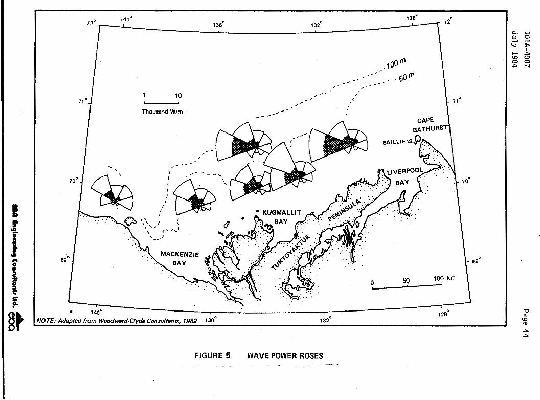
101A-4007
July 1984
- Page 44

I P
Kannerk G-42, Sacrificial Beach Island Note: Profile is approximate. taken from Profile, 1976 "Beauiort Sea Sediment Dynemicr" Cross section B - 8' reportpy Woodward-Clyde Consultana
m NORTHING E
I- I-
Kannerk 6-42, Sacrificial Beach Island SEA LEVEL 0 Profile, October 1980 z Cross section B - 6' 0 Note: Profile taken from Drawing No. 1080"6,
I" a E -5 Job NO. C-10800 (ESSO~ L
J -10
? 0
E NORTHING E h ?.
I- I-
SEA LEVEL 0 z t"
Kannerk 0-42, Sacrificial Beach island Profile, September 1981 Cros section 8 - B' Nore: ProfiJe taken from Drawing No. I I404-"72,
0 Q g -5 L 2 Jab NO. C- 1 1404 (ESSO~ Lu -10
~ ..
I /Island Centre (19761
Kannark 0-42, Sacrificial Beach lsland Profile, October 7982 z Cross section B - E' 0- Note: Profile taken from Drawing No. 11800-If#-21,
SEA LEVEL 0
$ g -5 -2 Job NO. C-I 1800-7 I IESSO) 1 Lu
;I 0
a% (D P
I- :: NORTHING- r-
FIGURE 6 NORTH - SOUTH CROSS SECTIONS KANNERK G-42

101A-4007 Page 46
July 1984
Kannerk G42. Sacrificial Beach Island Profile, October 1980 Cross section A - A'
Note: Proflle taken from Drawing No.-lO&-M I Job NO. C-10800 (ESSO)
1
SEALEVEL 0 - E
9 z
5 E d UI
Kannerk G-42, Sacrificial Beach Island, Profile, September 1981 Cross section A - A' I
I
Note: Profile taken frurn'Drewlng No. 11404"-12, '
Job NO. C-11404 (E~so), Island centre (1976)
- E t
k > 4 UI d UI
0
LD
P F
'I EASTING
Kannerk G42, Sacrificial Beach Island Profile, Octaber 1982 Cros mction A - A'
Note: Profile taken from Drawing No. 1180LTM-21,'
i
Job NO, C- 1 1800 (Esse)
Island centra (1978);
P - . EASTING
FIGURE 7 EAST - WEST CROSS SECTIONS KANNERK G-42

101A-4007 Page 47
July 1984
, lsserk E-27, Sacrificial Beach Island Profile - 1977
Cross Section A - A'
5 < SEALEVEL. 0 8
-10 -1 6 -20
-
-25 -30 I I I
NOTE: Profile taken from Figure 4.7, "'Beaufort Sea Sediment Dynamics" Woodward-Clyde Consuttanra i
lsserk E-27. Sacrificial Beach Island Profile - 1980
Cross Section A - A'
a -1 0, -1 6 -20 -25 -30
NOT&: Profile taken from Figure 4.7, "Beaufoorr See Sediment Dynamics" Woodward-Clyde Consultana
lsserk E-27, Sacrificial Beach;lsland Profile - 1981
Crow- Section A - A'
SEALEVEL 0
NOTE: Profile taken from Figure 4.7, "Beaufort Sea Sediment Dynamics" Woodward-Clyde Consultants.
FIGURE 8 EAST - WEST CROSS SECTIONS ISSERK E-27
Em €nglnwrirg Conrultanb ltd. &

101A-4007 Page 48
July 1984
ltiyok 1-27, Sacrificial Beach Island Profile, September 1982 Cross seetion E - E'
Note: Profile taken from brawing No. 118OPl1-M-22, Job NO. C-f 1800-1 1 ( E s ~ c ~ ) Proposed hiand elmwe.,
.. w l- h
ltiyok 1-27, Seuificial Beach Island; Profile, October 1982 i Cross m i o n B - B' I
Note: Profile taken from Drawing No. 71-171-018, Job NO. M-1008-71 (ESSO]
E NORTHING
ltiyok 1-27, Sacrificial Bsach Island, Profile, July 1983 cros saction B - B* 1 Note: Profile taken from Drewing No. 1180@11-M-26,
8 f= NORTHING
FIGURE 9 NORTH -SOUTH CROSS SECTIONS ITIYOK 1-27

101A-4007 Page 49
July 1984
Itiyok 1-27, Sacrificial Beach Island Profile, September 1982 Cros section A - A'
Note: profile taken from Drawing Mo. 1 1800-1 I-"22, j Job No. C- 1 1800- 1 1 (Esso) I
2 SEA LEVEL.0 L -5 ?
-1 0 -1 5
J -20.
<
1
P m UJ 2i In
17 m In
EASTING ,
ltiyok 1-27, Sacrificial Beach Island Profile, October 1982 Cross m i o n A - A' Nom: Profile taken from Drawing No. 118W-ll-M-26p
*r I
Job NO. C- 1 18W 1 1 (ESSO)
SEA
-5 t
EAST1 NG ,
ltiyok 1-27. Sacrificial Bsach Island, Profile, July 1983 Cross m i o n A - A'
Note: profile taken from Drawing No. 71-ITl-OlB. 1
Job NO. M-1008-71 (ESSO) Propored Island Centre
0
v) z UI 8 v)
EASTING
FIGURE 10 EAST -WEST CROSS SECTIONS ITIYOK 1-27
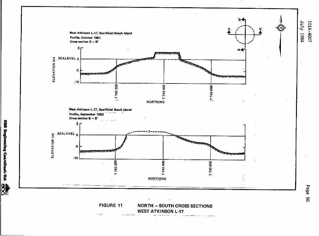
101A-4007
Page 50 July 1984
I I I t- I 1 1
0'
0
z
ai: EPL L !
Do9 EPL L'

101A-4007
Page 51 July 1984
a.9 -
Ln
loo E19;
108 Zl9
lo9 tL9
300 El9
c
LC I
101A-4007
Ju ly 1984
were not avai l able, The f igures ind ica te sdmil ar manner t o Kannerk, through the a
windward sideslope and a steeper leeward sl
Page 52
tha t the i s land was behaving i n a formation o f a gradual l y r i s i n g ope. It i s also evident that the
i s l a n d had " f la t tened" out substant ia l ly , w i th th is apparent ly occurr ing
shor t l y a f te r the i s land was vacated. Lack o f horizontal survey control on supplied drawings make evaluat ion o f t h i s o b s e r v a t i o n d i f f i c u l t .
Itiyok 1-27 was a s a c r i f i c i a l beach is land constructed i n an exposed l o c a t i o n i n 15 metres o f water. It was constructed i n 1982 and abandoned i n 1983. The change i n subsurface i s land morphology fo l lowing abandonment i s presented i n Figures 9 and 10, for the north-south and east-west directions, respect ively. A survey conducted a few months a f te r the . i s land was abandoned showed t h a t p a r t o f t h e a e r i a l p o r t i o n o f the i s land had been re- d i s t r i b u t e d around the perimeter o f the submerged po r t i on o f the i s l a n d ra ther than jus t on the leeward s ide of the is land. It i s apparent tha t more sediment had been re-deposited on the exposed s ide o f the is land than had been re-deposited on the more protected s ide of an island. I t i s suggested t h a t as waves s t a r t t o erode the i s 1 and (beach deplet ion) the entrained sediment i s transported back into the water by backwash .thereby increasing the diameter o f t h e i s l a n d s l i g h t l y below ' the water l ine on the windward side o f the island. As the above-water l ine port ion of the is land d is in tegrates and the i s land erodes to below the water1 ine, the waves pass over the is land, red is t r ibut ing the ent ra ined sediment on the lee s ide of the i sl and.
. .
West Atkinson L-17, a s a c r i f i c i a l beach is land s i tua ted i n 7.5 metres o f water, i l l u s t r a t e s a simi lar t rend. Constructed in 1981 and abandoned i n 1982, West Atkinson a1 so displayed erosion o f the exposed po r t i on o f t he i s i and both towards and wi th the dominant wave power d i rect ion (F igures 11 and 12). Although only a few months had passed between the t ime that the

101A-4007
J u l y 1984
Page 53
i s 1 and was vacated and the t ime o f the survey (September, 1982) i s l a n d de te r io ra t i on appeared t o be well underway. Results of any 1983 monitor ing were no t ava i l ab1 e a1 though it was known tha t t he i s1 and s t i l l protruded two metres above the waterl ine.
3.1.4 Long-Term Is1 and I n t e g r i t y
The r a t e o f erosion i s d i f f i c u l t t o monitor once an is land deter iorates t o below the waterl ine. There i s no avai lab le quant i ta t ive data descr ib ing t h i s phase o f the process other than the cross-sections presented i n t h e previous section. These sect ions ind icated that the t o p surface of the is lands studied was about four metres below sea l e v e l w i t h i n a few years o f the is land be ing abandoned.
In the summer o f 1983, Esso measured the water depth over s i x of t h e i r vacated islands (Esso, 1984). Some o f these islands had been vacated f o r up t o e i g h t years. This information i s presented i n Table 4. The depth o f water over these islands varied from 3 t o 4.5 metres, with no apparent re la t i onsh ip ex i s t i ng between s i t e water depth and the depth of water over the island. It appears that the is lands, once the slope protect ion was removed, de te r io ra ted t o a cer ta in e leva t ion , a f te r which they remained s t a t i c . The indicated water depth a t which erosion ceased, o r became undetectable, i s approximately four metres. It i s n o t p o s s i b l e t o p red ic t the t ime requ i red fo r th is e ros ion to occur s ince the e ros ion ra te i s
extremely dependent upon the frequency;duration, and i n t e n s i t y of storms.
Woodward-Clyde Consultants (1982) suggested t h a t i s 1 and erosion t o an average depth of f i v e metres below the water1 i ne was i n d i r e c t response t o a
high frequency o f occurrence o f c r i t i c a l f l u i d v e l o c i t y . Based upon a sediment o rb i ta l th resho ld ve loc i ty of about 400 mil 1 imetres per second,

/I
t r 0
TABLE 4 ISLAND TOP SURFACE EROSION1 5 , - 7 925 l - P - 0
ISLAND ISLAND TYPE YEAR YEAR WATER DEPTH TO ISLAND NAME CONSTRUCTED VACATED DEPTH TOP SURFACE FROM
WATERLINE (198312 t ml (m)
Netserk F-40 Sandbag retained 1975 1976 7 .O 3.0 sand
Kugmall i t H-59 Sandbag retaf ned 1976 1977 5.3 3.0 sand
Arnak t-30 S a c r i f i c i a l beach, 1976 1977 8.5 3.5 sand
Kannerk G-42 S a c r i f f c i a l beach, 1976 1977 8.5 4.0 sand
I sserk E-27 S a c r i f i c i a l beach, 1977 1978 13 .O 4.5 sand
Issungnak 2-0-61 S a c r i f f c i a l beach, 1980 1981 19 .o 3.0 sand
NOTES: 1. Information obtained from ESSO, 1984.
2. Depths t o top surface are uncorrected for t f d a l f l u c t u a t f o n or storm surge.

Page 55
they predicted that sediment w i th in the upper f i v e metres o f seawater was disturbed by waves 50 percent of the t ime. This would cause is lands to erode rapidly to about the -5 metre e levat ion, af ter which erosion would
continue, a1 though a t a grea t l y reduced rate.
Other studies have shown tha t the th resho ld ve loc i ty fo r t yp ica l Beaufor t Sea sands may be c loser to 150 mil 1 imetres per second. Using the rat ionale presented by Woodward-Clyde Consultants (19821, r a p i d Ssland erosion to a depth o f about eight metres below the waterline would be predicted.
The va r ia t i on between the observed and the predicted erosional depths may be due to "self armoring" o f the fi 11 as i t erodes . This armoring occurs as the f iner mater ia ls are washed away, leaving behind a lag deposi t cons is t ing of coarser-grained material s. Since the orb i ta l t h resho ld ve loc i t y o f the coarser materials would be substant ia l ly greater thsn that o f t h e f i n e r mater ia l , less erosion would occur. It should be noted that t h i s process has not been observed i n the Beaufort Sea and i s only hypothesized.
3.2 ,Chemical Effects
3.2.1 Chemical Oceanography
The po ten t ia l e f fec ts o f i s l a n d abandonment on water chemistry re late t o the po ten t ia l f o r d i s s o l u t i o n o f chemical wastes on the is1 and and is land s lope
through the resuspension of par t i cu la tes in the water column. An increase i n suspended par t i cu la te loads can be expected i n t h e v i c i n i t y o f a r t i f i c i a l islands during periods o f i s land eros ion a1 though the increases i n suspended part iculate concentrat ions f rom erosion will be less than that occurr ing dur ing is land construct ion. The e f f e c t s on chemical water properties during
E M Engineering Conrultanb ltd.

101A-4007 Ju l y 1984
Page 56
i s land const ruct ion and dredging can therefore be viewed as a worst case
s i tua t ion fo r i s land e ros ion .
Dredging effects on water q u a l i t y have been s t u d i e d i n some d e t a i l b o t h i n the Beaufort Sea and worldwide. Studies carried out during dredging i n the Canadian Beaufort Sea have f a i l e d to document a response i n water qual i ty a t t r i b u t a b l e t o dredging other than increased suspended par t i cu la te loads and i n some instances, increased oxygen demand (Erickson and Pett, 1981; Thomas, 1980; Envirocon Limited, 1977; Slaney, 1977). These e f fec ts a re of
short durat ion and l imi ted extent. Increased suspended par t i cu la te loads during periods o f rapid erosion are masked somewhat by the high natural suspended pa r t i cu la te l oads i n t he open water per iod in the shal low areas o f the Beaufort Sea where i s 1 ands have been constructed. A1 1 i s 1 and s i tes are w i th in the summer plume o f the Mackenzie River discharge and are therefore sub jec t to h igh ly var iab le suspended par t i cu la te loads th rwgh the open water season.
Studies undertaken i n other regions on the re lease o f heavy metal s and organics from contaminated dredge s p o i l s i n sea water during ocean dumping suggest t h a t d i s s o l u t i o n of heavy metals or organics from contaminated i s 1 and mater ia l dur ing erosion would be undetectable, given the quanti t ies of sediment involved and the rap id d i lu t ion concurrent wi th per iods of r a p i d i sl and erosion and sediment resuspension (Chen ” e t a1 , 1976; Boehm and Feis t , 1983). Dissolut ion o f metals would be short-term and local . Most hydrocarbons have a low water sol ubi1 i ty and would tend t o remain associated w i th pa r t i cu la te ma te r ia l . The Issungnak Oceanographic Survey (Erickson ” e t a1 . , 1983) provides the only comparative data for water chemistry around an a r t i f i c i a l i s l a n d a f t e r abandonment. Three s i t e s were sampled around the Issungnak 0-61 i s l a n d

101A-4007
July 1984 Page 57
from March, 1981 t o April, 1982. Water samples were collected seven times after abandonment i n August, 1981. The study examined levels of heavy metals (Hg, Cd, C u , Zn, Cr), polycyclic aromatic hydrocarbons (PAH's) , nutri ents , oxygen, a1 kal i n i ty , to ta l organic carbon , and suspended sol ids . W i t h the exception o f suspended sol ids, there was no a1 teration i n levels of any parameters attributable t o is1 and erosion i n agreement w i t h water qual i ty studies during dredging for island construction. Suspended solid levels were approximately five times higher i n October 1981 a t a l l locations compared t o levels i n water o f similar sa l in i ty before abandonment. Suspended particulate measurements were made after severe erosion o f the is1 and during a late September and early October storm. A near-bottom maximum (18 metres) was t h o u g h t t o be either a result o f a near-bottom t u r b i d i t y flow from the is1 and slope or sett l i n g out of resuspended materi a1 . The only chemical measurements made i n the October, 1981 sampling period were on reactive nutrients (silicate, phosphate, and nitrate). The increased suspended particulate loads i n October d i d not result i n an increase i n phosphate or nitrate concentrations. Silidate levels d i d increase, b u t the levels observed were w i t h i n the range observed i n under- ice samples w i t h low particulate loads (Pett " e t a1 ., 1983).
3.2.2 Sediment Chemistry
No studies have been conducted in the Beaufort Sea specifically t o evaluate the effects o f artif icial island abandonment on sediment chemistry. A
number o f studies, however, have been carried out around arti ficial is1 ands t o evaluate the effects o f island construction (dredging) and the operational discharge of drilling wastes from exploration islands on the marine environment. Some of these studies may be useful for making inferences about the effect of island abandonment on sediment chemistry.

101A-4007
J u l y 1984
Page sa
Erosion, for example, can be viewed as the slow reverse process o f i s 1 and cons t ruc t ion ( the t ime sca le fo r i s land cons t ruc t ion i s months; t h a t f o r i s land e ros ion i s years ) . Time ser ies measurements o f d r i l l i n g waste concentrat ions i n sediments around is lands may provide useful information about the fate o f contaminants after abandonment because is lands erode t o some degree t h r o u g h o u t t h e i r l i f e , n o t j u s t a f t e r abandonment.
A summary o f those studies judged to be re levant t o i s l and abandonment are given below.
3.2.2.1 Previous Studies
NETSERK F-40
The exploratory we1 1. a t Netserk F-40 was spudded . in November, 1975 and completed i n May 1976. The i s 1 and was abandoned i n September, 1976. Two
sediment chemistry surveys were conducted; t he fS rs t i n August, 1976 (Slaney , 1977) a f t e r d r i l l i n g was completed and the second i n August 1977 , approximately one yea r a f te r i s1 and abandonment (Beak, 1978). The posi t ions o f s ta t i ons sampled i n each survey overlapped t o a large extent. A t the t ime of t h e f i r s t survey, considerable reworking of sediments a1 ong the perimeter o f the i s land was evident; by the t ime o f the second survey, the po r t i on of the i s land above the water l ine was reduced to approximately one-
addi t ion, a zone containlng eroded sand 100 metres by 600 metres was del ineated
ha1 f i t s o r i g i n a l surface area. I n and gravel with dimensions o f about on the seabed around the is1 and.
Results o f the two studies are df f f ana ly t i ca l problems. However , two
i c u l t t o compare because o f sampling and observed trends i n the resu l ts o f the
s tud ies re la te d i rec t l y t o t he e f fec t o f i sland abandonment on sediment
101A-4007 July 1984
Page 59
chemistry. First, the level of heavy metals measured i n the sediments d i d
not change greatly from 1976 t o 1977 despite the obvious presence o f island construction materials t h a t blanketed the stations. This suggests t h a t as the is1 and eroded 1 i t t l e mixing of d r i 11 i n g waste w i t h i s 1 and sediment occurred, Second, erosion of the is1 and d id not appear to be a mechani sm for dispersing contaminated sediment dur ing the first year after abandonment as the enrichment of metals around the island appeared to be limited t o distances o f approximately 300 metres.
I t NlUSt be stressed t h a t the trends discussed above are only tentative since da ta from the two studies are not directly comparable.
ISSUNGNAK 0-61
An oceanographic survey, inc luding sediment geochemistry and water column particulate measurements, was conducted a t Issungnak 0-61 artif icial island between March 1981 and April 1982 (Erickson e t a1 . , 1983). Sampling spanned pre- and post-island abandonment. Three s ta t ions were sampled, two o f which were approximately 500 metres from the island and a third was approximately four kilometres w e s t o f the island, On the basis o f this data set i t was not possible t o judge accurately the degree or geographical extent t o which sediment chemistry was influenced by island abandonment. Some trends, however, are worthy of note. Storm events appear to be an effective mechanism for dispersing is land material and associated drilling wastes. Concentrations o f suspended particulates , for instance, increased as much a s . five-fold following storms i n October, 1981. If discharged drill ing wastes were present along the i s land slopes or shores i n the wave- influenced zone, then they too would have been transported t o the surrounding sediments. The range of transport, on the basis of the data coll ected i n the study, appeared to be between 500 metres and 4 k i l ometres.
”

101A- 4007 Page 60 J u l y 1984
Trace metal and hydrocarbon concentrations i n the sediments around Issungnak 0-61 were consis tent wi th the hypothesis that any short-term s i g n i f i c a n t i n f l u e n c e o f i s l a n d abandonment on sediment chemistry would be r e s t r i c t e d t o areas very near the island.
TARS I UT N-44
Sediment sampling was conducted twice; i n August, 1981 and July, 1982. All
sampl i n g was completed before is1 and abandonment. However , approximately 70 000 cubic metres of sand was l o s t through the northeast, northwest, and southwest caisson doors during a storm i n 1981 (Heath and Thomas, 1983). Routine remedial dredging operations were conducted to replace the sand and provide addit ional support t o the berm u n t i l September, 1982. Results o f the sediment surveys (Thomas ” e t a1 ., 1982; Heath and Thomas, 1983) i nd i ca te t h a t no a l t e r a t i o n s t o the sediment tex tu re around the i s l and were detectabl e.
OTHER STUDIES
Pre- and post-dredging surveys of sediment chemistry were completed a t Arnak L-30 during 1976. Approximately 1.1 mil 1 ion cubic metres o f granular mater ia l was used t o construct the is land. No detectable d i f f e r e n c e i n sediment chemistry was observed during the study (Slaney, 1977). Sim i la r resu l t s were obtained for studies conducted during dredging operations at McKinley Bay (Thomas, 1979) The r e s u l t s from these dredging studies are re levant to i s l a n d abandonment because the leve l of sediment r e d i s t r i b u t i o n i n t h e area surrounding is land construct ion s i tes i s expected t o be s im i la r t o or greater than that which would occur during the erosion o f an i s 1 and fo l lowing abandonment.

A General Discussion o f t he E f fec ts o f A r
101A-4007
Ju ly 1984
3.2.2.2
Page 61
t i f i c i a l
I s1 and Abandonment on Sediment Chemi $try
As abandoned a r t i f i c i a l i s l ands in the Beaufor t Sea erode, they become sources of uncontaminated sedimentary material (predominantly sand and gravel) and, t o a fa r lesser degree, sources o f contaminants associated with d r i l l i n g waste discharges. Changes t o sediment geochemistry will occur for two main reasons:
1) modi f icat ion o f sediment texture, and 2) i n t r o d u c t i o n o f Contaminants.
Modi f icat ion of Sediment Texture
All islands in the Beaufort Sea have been constructed o f fill mater ia l obtained from distant sediment borrow areas o r o f material obtained from subsurface sediment layers a t o r near the island construction sftes. The material comprising the i s l a n d i s u s u a l l y sand and can be d i f f e r e n t i n texture from t h e s u r f i c i a l sediments occur r ing na tura l l y in the a rea where the i s1 and i s constructed. The Arnak L-30 a r t i f i c i a l i s l a n d i s an example; t h e s u r f i c i a l sediments i n the area contain approximately 25 percent sand whi le the is1 and i t s e l f , made up of mater ia l obtained from 1 oca1 subsurface sediments, contained 85 percent sand (S1 aney , 1977).
It i s known tha t the heavy metal and hydrocarbon content of Beaufort Sea sediments bear a d i rec t re1 a t ionsh ip to sediment gra in size (Dome ” e t a1 . , 1982b); the concentrations of metals and hydrocarbons usually increase as
t he s i1 t / c l ay sediment f ract ion increases, Consequently, as a r t i f i c i a l is lands erode, the is land mater ia ls will accumulate i n the local surrounding sediments and tend to reduce the t o t a l metal and hydrocarbon content of
EBCl Engimudng Conrulhtr ltd.

101A-4007
Ju l y 1984
Page 62
those sediments. Natural sedimentation processes would counteract the above process, tending t o al ter the composi t ion of t he su r f i c i a l sediments to the o r i g i n a l background (pre- is land) condi t ion. It must be s t ressed tha t i n t h i s case, the main process i s merely a r e d i s t r i b u t i o n of uncontaminated sediment from one par t o f the Beaufor t Sea t o another.
I n t roduc t i on o f Contaminants
Waste d r i l l i n g f l u i d s and cu t t i ngs have been d ischarged d i rect ly to the
sea d u r i n g r o u t i n e e x p l o r a t o r y d r i l l i n g f r o m a r t i f i c i a l i s l a n d s i n t h e Beaufort Sea. Chemical s spi 11 ed upon the i s1 and surface are introduced t o the sea dur ing i s1 and erosion. These wastes contain many natural and synthet ic chemical s i nc l ud ing heavy metal s, hydrocarbons ( i ncl udi ng re f i ned o i l s) , and persistent organic chemicals. The sol i d components o f discharged f l u i d s and cu t t i ngs s ink rap id l y and form p i l e s on the is land s lope or on the seabed near the is land. The ex ten t t o which t h e d r i l l i n g wastes are dispersed w i 11 depend on the i r phys ica l proper t ies (densi ty , cohesion, v i scosi ty ) and the d i spers ion character is t ics of the receiving environment (currents, wave cl imate, tides, water co1 umn structure, water depth, e tc . ) . Thomas " e t a1 . , (1983) suggest, however, t h a t i n most cases it i s expected t h a t a t l e a s t 80 percent o f the to ta l d ischarge will i n i t i a l l y encounter the bottom wi th in 10 t o a few hundreds of metres from the po in t source discharge. A1 though some o f the sedimented mater ia l will be r e d i s t r i b u t e d by wave and c u r r e n t a c t i v i t y , most o f it will remain i n t a c t as p a r t o f the is land s t ructure.
.~
The inf luence which t h e d r i l l i n g waste contaminants have on the geochemistry o f the surrounding sediments will probably be l imi ted for severa l reasons:

101A-4007 July 1984
Page 63
1) the volume of drill i n g wastes discharged from recently drilled Esso wells a t artif icial islands i n the Beaufort Sea has been about 1500 t o 2000 cubic metres. T h i s volume comprises 25 percent we1 1 cuttings and 75 percent solid and l i q u i d drilling f l u i d products (M. Psutka, pers. corn. , 19841,
2) the volume of material available for erosion from the artificial island is usually much larger (100 000's cubic metres) providing for large d i l u t i o n through sediment mixing , and
3) fol 1 owing is1 and abandonment, rapid erosion of the upper portion o f
the is1 and t o about four metres below the water1 ine typical ly occurs. I t appears t h a t most o f the eroded material is deposited down slope wi t h i n a few hundreds of mtres of i ts original location ( Woodward-Clyde Consultants, 1982). In add i t ion , i t appears tha t once an island is below the waterline, i t i s fa r less susceptible t o further erosion. The net effect, therefore, will be for the drill i n g discharges t o become "capped" by the material eroded from the upper portions o f the island and is01 ated from the environment. With time, waves, currents, and ice-scour would tend t o redistribute and mix the drill ing wastes w i t h sediments and reduce their concentrations.

I I I I I I I I I I I I I I I I I I I
101A-4007
July 1984 Page 61
3.2.2.2 A General Discussion of the Effects of Artificial Island Abandonment on Sediment Chemistry
As abandoned artificial islands i n the Beaufort Sea erode, they become sources o f uncontaminated sedimentary material (predominantly sand and gravel) and, to a far lesser degree, sources of contaminants associated w i t h d r i l l i n g waste discharges, Changes t o sediment geochemistry will occur for two main reasons:
1) modification of sediment texture, and 2 ) introduction of contaminants.
Modification of Sediment Texture
All islands i n the Beaufort Sea have been constructed of f i l l material obtained from d i s t a n t sediment borrow areas or o f material obtained from subsurface sediment layers a t or near the island construction sites. The material comprising the island i s usually sand and can be different i n texture from the surficial sediments occurring naturally i n the area where the is1 and is constructed. The Arnak L-30 ar t i f icial island is an example; the surficial sediments i n the area contain approximately 25 percent sand while the island itself , made up of material obtained from local subsurface sediments, contained 85 percent sand (Slaney, 1977),
I t i s known t h a t the heavy metal and hydrocarbon content of Beaufort Sea
sediments bear a direct re1 ationship t o sediment grain size (Dome e t a1 , , 1982b); the concentrations of metals and hydrocarbons usually increase as the s i 1 t/clay sediment fraction increases. Consequently, as artif icial
”
islands erode, the island materials will accumulate i n the local surrounding sediments and tend t o reduce the to ta l metal and hydrocarbon content of
EBCl Engineating ConrultancI Ud. &
101A-4007
J u l y 1984
Page 64
3.3 Bio log ica l E f fec ts
3.3.1 Benthos
3.3.1.1 Resource Descr ipt ion
Benthic invertebrates represent a major segment of b i o t a on the seaf loor o f the southern Beaufort Sea. Benthic fauna are general ly divided into broad categories according to size (macrofauna; meiofauna) and t h e i r p o s i t i o n r e l a t i v e t o the surface o f the seafloor (infauna; epifauna) Macrofauna are those animals retained on a sieve o f 0.5 m i l l i m e t r e mesh; meiofauna represent the fract ion passing through it.
Benthic infauna are general ly found within uncompacted sediments and often 1 ead sedentary 1 ives (i .e., burrowing bivalve molluscs and polychaetes). Epi fauna usual ly inhabi t the surface of the substrate, ,though some forms may
b r i e f l y burrow into; soft sediments. Sessile epifauna (i.e., hydroids, anemones, bryozoans) are attached to hard substrates, while mobile epifauna ( i .e. , amphi pods, isopods , echinoderms , gastropods) are act ive animal s moving about the seafloor.
. -
Macroinfauna are the most commonly encountered benthos i n the v i c in i t y o f of fshore explorat ion is lands i n the southern Beaufort Sea. They are a1 so most sensi t ive t o the consequences o f i s land cons t ruc t jon and abandonment due t o t h e i r 1 imi ted mobil i ty . They are susceptible t o srnotheri ng by r e d i s t r i b u t e d sediments, and i n many cases they have preferences for a
narrow range of sediment par t i c le s izes .
Mobile macroepifauna are a1 so p r e v a l e n t i n t h e v i c i n i t y of explorat ion is lands but are more able to avoid the phys ica l e f fects o f is land
101A-4007
July 1984
Page 65
construction and abandonment. Sessile epifauna are greatly limited i n d i s t r i b u t i o n i n the southern Beaufort by the relative lack o f hard substrates.
Wacasey (1975) has described four zones of zoobenthos d i s t r i b u t i o n i n the southern Beaufort based on observed physical characteristics and zoobenthic diversi ty and biomass. Artificial islands and berms have been constructed w i t h i n three of the zones, namely the Estuarine Zone (0 t o 15 metres of water) , the Transition Zone (15 t o 30 metres o f water) and the Marine Zone
(30 t o 200 metres of water)
In the nearshore ,Estuarine Zone which is strongly influenced by Mackenzie River run-off; water temperatures and sal i n i t ies vary widely w i t h season, and average levels o f zoobenthic biomass ( 2 g/m2) and diversity (1 t o 32 species per s ta t ion) are low. Most sacrificial beach islands have been constructed i n this zone (Table 1, Figure 1)-
The Transition Zone i s only moderately affected by Mackenzie River run-off, hence temperature and salinities have a narrower range t h a n i n the Estuarine Zone and zoobenthic indices are generally higher (average biomass, 5 g/m2; diversity, 20 to 40 species per station). A few sacrificial beach islands ( i .e. N-44)
Water River
I Issungnak 0-61) and cai sson-retai ned i sl ands (i .e., Tarsiut have been bu'il t i n the Transition Zone (Table 1 , Figure 1).
properties i n the Marine Zone are less influenced by the Mackenzie Water temperatures and salinities are more stable seasonal l y and
zoobenthic indices are relatively h i g h for the southern Beaufort Sea (average biomass, 14 g / d ; diversity, 3 t o 81 species per station). The Uviluk and Nerlerk berms (Tab1 e 1 , Figure 1 ) have been constructed i n this zone.
8
I
101A-4007
J u l y 1984 Page 66
3.3.1.2 Documented Case His tor ies o f B io log ica l
E f fec ts of I s l and Abandonment
The b io log ica l e f fects o f i s l a n d abandonment p r inc ipa l l y a r ise f rom the nature o f the dredged sediments used i n i s l a n d c o n s t r u c t i o n and the r e d i s t r i b u t i o n of the sediments during erosion o f the island slopes. The g rave l l y and/or sandy sediments used in i s land cons t ruc t ion a re much coarser than the natural clays and s i 1 t s o f t h e Mackenzie Delta area. The b io log i ca l consequences o f abandonment include smothering of benthic infauna and modi f icat ion o f benth ic habi ta t by the dispersal of coarse sediments over the natural f ine sediments of the surrounding seaf loor. Avai lable informat ion sources a r e l i s t e d i n T a b l e 5 . The informat ion avai lable from these studies indicates that any adverse e f f e c t s will be only temporary, and
certainly less severe than those associated wi th is land construct ion.
Several studies i n t h e v i c i n i t y o f ar t i f i c i a l i s l ands p rov ide i n fo rma t ion on the impacts on benthos o f i s 1 and abandonment i n the Beaufort Sea. The i s 1 and s i t es conce rned i nc lude Ne tse rk F-40, Issungnak 0-61, and Tars iu t N-44.
NETSERK F-40
I n t h e summer o f 1977, the Netserk F-40 i s l a n d s i t e i n 7.0 metres o f water was sampled for in faunal benthos (Beak, 1978; Crippen e t a1 ., 1980).
Biological analyses included wet weight biomass and density estimates and taxonomic i d e n t i f i c a t i o n s o f benthic infauna. A t the time, Netserk F-40 was undergoing rapid erosion fo l lowing complet ion of a d r i 11 i n g program i n May 1976. The i s l a n d was reduced i n area above the water1 ine, and the indigenous dredged mater ia l forming the is land was being reworked and t ranspor ted to new deposi t ion s i tes.
-

101A-4007
July 1984 TABLE 5 SUMMARY OF LITERATURE ON EFFECTS ON BENTHOS
RELATED TO ISLAND ABANDONMENT
Page 67
REFERENCE AGENCY LOCATION DATA COLLECTED DATE
Beak (1978)
Crippen, Greene and Hodd (1980)
Crippen and McKee (1981)
Er ickson e t a l . (1983) Crippen (7383
Thomas e t a l . (1982) Heath and momas (1983)
Heath 2 fi. , 1982
Heath and Thomas, 1984a ( in p repara t ion)
Heath and Thomas, 1984b ( in preparat ion)
Beak Consultants Ltd.
Beak Consultants Ltd, and Esso Resources Canada Ltd.
Beak Cansul tants Ltd.
Arct ic Laborator ies Limited IEC Beak Consultants L t d .
Arctf c Laboratories L imi ted
Arct ic laborator ies Limited
Arct ic Laboratories Limited
Arct ic Laboratories Limited
Netserk F-40 - numerical density - biomass (wet) - taxonomic i d e n t i t i e s
sediment and b i o t a Isserk F-27 - heavy metals i n
Netserk F-40 as above
Issungnak 0-61 - numerical density - number o f species/
- e q u i t a b i l i t y - cornunity analysis - heavy metals fn sediment and b i o t a - sediment p a r t i c l e s i ze d i s t r i bu t i ons
s ta t fan
Issungnak 0-61 - heavy metals - p a r t i c l e s i te d l s t r i b u t i o n - numerical density - no. of species/ s ta t ion - d i v e r s i t y - e q u i t a b i l i t y
- taxonomjc i d e n t i t i e s
Tars iu t N-44 - numerical density South Tars iu t - biomass (wet & dry) Borrow Area - no. o f taxa/sample - community analyses - taxonomic i d e n t i t i e s - pa r t i c l e s i ze
d i s t r i b u t i o n s - heavy metals i n sediment - hexane extractable compounds
Herschel Island - biomass (wet) v i c i n i t y - numerical density (gravel borrow - taxonomic famil feS area) - sediment p a r t i c l e
s ize d is t r ibut ions
Herschel Island - biomass (wet L dry) v i c i n i t y - numerical densf ty (gravel borrow - taxonomic i d e n t i t i e s area) - sediment p a r t i c l e
s ize d is t r ibut ions - bottom water s a l i n i t i e s - community analyses
Banks Is land - biomass (wet & dry) v i c i n i t y - numerical density (gravel borrow - no. taxa/sample area 1 - taxonomic i d e n t i t i e s
- sediment p a r t i c l e s i t e d i s t r i bu t i ons - community analyses
- side scan sonar records
August 1977 ( a f t e r Netserk abandonment) (Isserk - ear ly construction)
August 1977 ( a f t e r abandonment) (symposi urn presentation)
August-September 1980 ( a f t e r enhancement)
May 1981 - A p r i l 1982 (a f te r abandonment)
September 1981 July 1982
September 1981
Ju ly 1982 September 1982

I 8 P I I I I t I
I I I
101A-4007
July 1984 Page 68
According t o q u a l i t a t i v e sediment descript ions, the sediments i n the v i c i n i t y o f Netserk F-40 exh ib i ted a grea t dea l o f va r iab i l i t y . The v a r i a b i l i t y was a t t r ibu ted to na tura l phys ica l e f fec ts such as i c e scour a t most depths, and sediment deposition from the Mackentie River i n a d d i t i o n t o c o n s t r u c t i o n a c t i v i t i e s such as dumping o f clean, dredged sand and gravel. Undisturbed natural sediments consisted o f 5 t o 40 mi l l ime t res of yel low- brown s i 1 t over grey clay. Several si1 t-fil l e d depressions i n the c lay up t o 220 mill imetres deep 1 i kely represented previous disturbance by ic.e gouging. Some sand accumulation i n the upper few cent imetres o f sediment was detected out t o more than 300 metres offshore. This sand was thought t o have or ig inated f rom the const ruct ion or eros ion o f Netserk F-40. There was no evidence o f depos i t i on o f sand f rom e i ther the construct ion phase o r t h e ear ly erosional phase beyond 900 metres f rom the is land shorel ine.
Biomass and densi ty of benthos were depressed w i t h i n a distance of 300 metres from the island shore1 in@. Higher and more stab1 e 1 eve1 s observed between 300 and 1800 metres offshore. The 1 ow Val ues recorded up t o 150 metres offshore were considered t o r e f l e c t t h e smothering effects o f r a p i d sediment accumulation which occurred during the construction phase and which was occurr ing dur ing the summer of 1977 due to the e ros ion of the is land. The r e l a t i v e s t a b i l i t y of the populat ion densi t ies a t t h e s t a t i o n s 300 metres and more offshore was considered to i nd i ca te t ha t t hose s ta t i ons were beyond the major inf luences o f e i the r t he i s l and or t h e d r i l l i ng operations The mean and range o f popu la t ion dens i t ies a t the sampled radial d istances f rom the is land are presented i n Table 6.

I 1
8 II I I I I
101A-4007 Ju l y 1984
Page 69
TABLE 6 BENTHOS DENSITIES MEASURED AT NETSERK F-40, 1977
. . . - ~ "_ -~ .. . .
DISTANCE 45 metres 90 metres 150 metres >300 metres OFFSHORE
I
Mean 190/m2 1100/m2 2000/m2 2950/m2
Range 20-450/m2 500-1900/m2 800-3750/mZ 1250-5300/m2
These data suggest that benth ic recolon izat ion o f the island slopes was very s i g n i f i c a n t i n areas 90 metres offshore and beyond. A t 45 metres offshore recolon izat ion was ' ev iden t a t low l e v e l s even i n t h i s dynamic shallow (three metre) zone.
The q u a l i t a t i v e sediment data indicated that the maximum area affected by t h e r e d i s t r i b u t i o n o f sediment a t the t ime of the 1977 sampling was less than 2.8 square ki lometres. However, the r e s u l t s for the faunal ind ices o f densi ty and biomass ind icated no demonstrable impacts on benthos due t o sedimentation beyond 300 metres from the i s1 and shore1 ine. Thus, the area o f depressed abundance of benthos was less than 0.4 square k i lometres.
Crippen e t a l . (1980) suggested that the ef fects o f sediment r e d i s t r i b u t i o n would be temporary. Benthic populations will cont inue to re-establ ish themselves .in the affected area through recruitment from p lanktonic larva l stages and by immigration. According t o Wacasey (1975) the re-establishment o f a mature infaunal community may take up t o 12 years based on the estuarine bivalve, Yoldiel la intermedia. This process i s slower i n a r c t i c regions than i n temperate areas. Modification o f ben th i c hab i ta t a t
"

101A-4007
Ju l y 1984
Page 70
abandoned i s 1 and s i t e s by r e d i s t r i b u t i o n o f coarse borrow materials may prolong the per iod for recolonizat ion to pre- impact levels and inf luence benthic community s t ruc tu re un t i l a b lanket o f natura l f ine sediment covers the sand,
Crippen ” e t a1 (1980) suggested tha t a possible advantage of the erosional p r o c e s s a t Netserk F-40 was t h a t t h e r e d i s t r i b u t i o n o f s u r f i c i a l sediments may have d i l u t e d and/or bur ied the d ischarged d r i l l i ng wastes which were contaminated with heavy metals, thereby reducing the exposure o f aquatic organisms t o these contaminants.
ISSUNGNAK 0-61
Bio log ica l and chemical studies were performed around the Issungnak 0-61 i s l a n d i n August-September 1980 (Crippen and McKee, 1981 and between May 1981 and A p r i l 1982 (Erickson ” e t a1 ., 1983; Crippen, 1983). The sampl i n g i n 1980 took place immediately after the completion o f i s l and enhancement by dredging, but before del ineation we1 1 d r i l l i n g . The sampling i n 1981/82 was conducted before and fo l lowing abandonment o f t he i s1 and.
Issungnak 0-61, i n 19 metres of water was constructed wi th f ine- to medium-grained sand from nearby borrow p i t s and wi th smal ler quant i t ies of borrow material barged from Tuft Point. The underwater base of the i s land extended about 300 metres beyond i t s shore l ine, Natura l sur f ic ia l sediments i n the area consist o f s i l t and clay. The i s l a n d s i t e i s l o c a t e d i n t h e Trans i t ion Zone (15 t o 30 metres of water; Wacasey, 1975).
I n 1980, benthic macroinvertebrates were sampled by grab a t 20 s ta t i ons on t ransec ts rad ia t ing from the i s l and t o document spat ia l var ia t ions in fauna l

1 I I I I
101A-4007
July 1984 Page 71
indices (number o f species, density, biomass, and divers i ty) . Tissues o f
infaunal polychaetes and bivalves were analyzed for heavy metals.
Crippen and McKee (1981) iden t i f i ed a t l ea s t two, and possibly three, biological zones around Issungnak 0-61: an outlying background or undisturbed tone 900 metres offshore and beyond, a construction zone w i t h i n 300 metres o f the shore1 ine, and possibly an intermediate zone. The biological zones were similar to zones based on sediment particle size. Background sediments were defined as containing a c lay-s i l t f ract ion of more than 75 percent, whereas those i n the construction zone were defined as containing less than 50 percent clay and silt. The biological intermediate zone was suggested t o have clay and si1 t fractions between 50 and 85 percent, a1 though no s ta t ions fell w i t h i n the intermediate zone based on biological indices.
The benthic community i n the construction zone had depressed levels o f population density, biomass and number o f species present. Organisms found i n this impacted zone were either able to maintain position i n the sediment during construction and enhancement or they were early colonizers recruited from other locations. Several of the species present appeared to have a preference for the sandy sediments, such as the spionid polychaetes, Microspio sp , , Prionospio sp. and Scol ecolepi des sp. since they were found only i n the construction zone. These species a l l have meroplanktonic larval stages which f a c i l i t a t e wide dispersal and rapid colonization of new areas where conditions are favourable.
Crippen and McKee (1981) suggested that the adverse biological effects i n t h e v i c i n i t y o f Issungnak 0-61 would be temporary since physical processes i n the Mackentie Delta region should promote the return of the surface sediment composition to i t s natural state, Benthic populations will

101A-4007
Ju ly 1984 Page 72
re-establ ish themselves i n the affected area through recruitment of planktonic larval stages and immigration o f juveni les and adults.
I n 1981 and 1982, benthos was sampled a t th ree s ta t ions as p a r t o f the Issungnak Oceanographic Survey (Crlppen, 1983) t o f u r t h e r document the benthic species composition and d i s t r i bu t i ons , and t o examine evidence o f benthic recolonizat ion of affected areas around Issungnak and evidence o f seasonal v a r i a t i o n i n benthos population levels, The i s l a n d was abandoned i n August, 1981.
Sediments a t S ta t i ons 1 and 2 (500 metres of fshore) consisted of f ine and coarse fract ions which va r ied i n p ropor t i ons between samplings. The v a r i a b i l i t y i n sediment composition was considered t o r e f l e c t sediment pa tch iness o r red is t r ibu t ion between seasons. Both explanations were considered probable since the island was constructed of material from more than one source, and was being eroded by waves or i c e movement throughout the study. The area 500 metres offshore, i n p a r t i c u l a r , was subject to considerable ice scour from the rubble f i e l d i n winter.
The mean numerical densities of benthos increased with distance from the shorel ine during 1981/82 as was the case i n the previous study i n 1980. Densities observed during 1981/82 range from 249 t o 6445/rn2 compared w i th 345 t o 1657/m2 i n 1980. Populat ion densit ies for both years are presented i n Tables 7 and 8, f o r 1981/82 and 1980, respect ively.

101A-4007
Ju l y 1984
Page 73
TABLE 7 BENTHOS DENSITIES MEASURED AT ISSUNGNAK 0-61, 1981/82
DISTANCE 500 metres 500 metres 4 k i 1 ometres OFFSHORE (S ta t ion 1) (S ta t ion 2) (S ta t ion 4)
Mean 941/m2 1587/m2 2520/m2
Range 263-2728/m2 249-3028/mZ 396-6445/m2
TABLE 8 BENTHOS D E N S I T I E S MEASURED AT ISSUNGNAK 0-61, 1980
0 I STANCE OFFSHORE 300 metres 900 metres 3 k i 1 ometres
Mean 172/m2 456/m2 1152/m2
Range 99-284/m2 345-587/mZ 503-1657/11?
A comparison of data from the two studies a t Issungnak i nd i ca tes t ha t benth ic recolon izat ion was act ively proceeding despi te the f a c t t h a t d e n s i t i e s i n t h e immediate v i c i n i t y of the i s land were s t i l l depressed compared t o background leve ls four ki lometres away. Physical processes which deter benthic recolonizat ion i n the shor t - term at abandoned is lands such as Issungnak inc lude erosion of sediments by waves and currents in sunnner and i c e scour i n w i n t e r .

101A-4007
J u l y 1984 Page 74
The t o t a l number, type, and d i s t r i b u t i o n o f macroinvertebrate taxa i n the benthos samples was qui te s i rn i l ar for the two study periods. The mean number o f species a t distances 500 metres and more from the i s land were very s i m i l a r f o r both studies, a1 though the range o f taxa was g r e a t e r i n the 1981/82 study (Tables 9 and 10).
TABLE 9 MACROINVERTEBRATE TAXA DENSITIES MEASURED AT ISSUNGNAK 0-61, 1981/82
0 I STANCE 500 metres 500 metres 4 k i 1 ometres OFFSHORE (Sta t ion 1 ) (S ta t ion 2 1 (S ta t ion 3 )
Mean 27/m2
Range 13-54/1112
26/m2
14-44/1112
34/m2
25-51/m2
TABLE 10 MACROINVERTEBRATE TAXA DENSITIES MEASURED AT ISSUNGNAK 0-61, 1980
D I STANCE OFFSHORE 300 metres 900 metres 3 k i 1 ometres
Mean 18/m2 28/rn2 35/m*
Range 10-28/m2 22-31/1112 29-47/m2

101A-4007 J u l y 1984
Page 75
Most of the common t a x a a t S t a t i o n 3 ( four k i lometres offshore) i n 1981/82 were a1 so common a t 900 metres offshore and beyond i n 1980, b u t were ra re o r absent 100 metres and 300 metres from the is land. Members of the polychaete family Spionidae were most prevalent near the is land, but were ra re o r absent a t o u t l y i n g s t a t i o n s i n b o t h s t u d i e s .
Crippen (1983) concluded t h a t a1 te ra t ion o f the na tura l benth ic community i n t h e v i c i n i t y of Issungnak 0-61 through construction and subsequent
erosion ( i .e., smothering of the benth ic habi ta t and modi f icat ion o f the sediment composition) was s t i l l evident near the perimeter o f the i s land base (Stat ions 1 and 2 ) one year and nine months a f te r i s land cons t ruc t ion (Section 2.1.2).
TARSIUT N-44
Studies o f the benthos and sediment chemistry i n t h e v i c i n i t y o f the Tarsiut N-44 caisson-retained island were conducted i n September 1981 (Thomas ” e t a1 ., 1982) and i n J u l y 1982 (Heath and Thomas, 1983). Grab sampling i n 1981 was performed a t 12 s tat ions a f ter const ruct ion of the i s 1 and berm and i n s t a l l a t i o n o f the concrete caissons, but prior t o d r i l l i n g operat ions. In 1982, sampl i n g was ,performed a t t h e same s ta t ions a f te r the winter and spr ing 1982 d r i 11 i n g program, but before i sl and abandonment.
The sub-sea berm o f Tarsiut N-44 was constructed wi th dredged sand and gravel on a seabed o f s i 1 ty c l a y i n 22 metres o f water. The dredged sand was obtained from the Ukalerk, South Tarsiut , and Isserk borrow areas, the gravel was from t h e v i c i n i t y of Herschel Island, The per imeter of the base o f the berm was about 350 metres from the centre of the is land. Thus about 40 hectares of seabed were covered by the i s land berm. The Ta rs iu t N-44 s i t e i s l o c a t e d i n t h e T r a n s i t i o n Zone (15 t o 30 metres o f water; Wacasey , 1975 1.
I I 1 5 I I'
101A-4007
J u l y 1984 Page 76
Although the Tarsiut N-44 studies were conducted before abandonment o f the i s land berm, the f o l l ow ing resu l t s and conclus ions o f the f ina l repor t
(Heath and Thomas, 1983) a re re levant to the e f fec ts o f i s 1 and abandonment.
1. The pr inc ipa l reg ion o f inf luence of i s land const ruct ion on zoobenthos was w i t h i n 500 metres from the cai ssons. There were s i g n i f i c a n t 1 y lower leve ls o f biomass, populat ion density, and s p e c i e s d i v e r s i t y (number o f taxa/sampl e) a t s ta t i ons , on the berm (50 metres offshore) than a t surrounding stat ions (500 metres and three ki lometres of fshore) Community analyses also indicated that the impact on zoo- benthic community s t ruc tu re was conf ined to the sandy berm stat ions.
2. There was signi f icant evidence o f benthic recolonizat ion on the u p p e r berm i n September 1981 w i t h 31 t a x a i d e n t i f i e d a t stat ions 5 0 m e t r e s o f f sho re . I n Ju l y 1982 a t o t a l o f 29 taxa were represented i n benthos sampl es from the upper berm. Recoloni tat ion was s t i 11 i n the "pioneer stage'' i n 1982 w i t h small populations of hardy species with a f f i n i t i e s fo r t he sancly sediments of the berm account ing for most o f t he biomass and numbers i n many samples. -Populat ion densi t ies and biomass l e v e l s a t berm s ta t i ons did n o t d i f f e r s i g n i f i c a n t l y between 1981 and 1 9 8 2 sampl ing per iods, ind icat ing that the ra te o f recolon izat ion will prob- ably be slow. The eventual populations o f co lon iz ing s p e c i e s w i 1 1 l i k e l y be lower i n d i ve rs i t y , dens i t y , and biomass than the surrounding benthos populations i n deeper areas w i t h f i n e r g r a i n e d s e d i m e n t s . Species d i v e r s i t y (number o f t a x a p r e s e n t ) i n t h e g e n e r a l a r e a , however, will probably continue to be enhanced by the addi t ion o f species which prefer the coarser sediments o f t h e berm, n o t a b l y b i Val ves.

101A-4007
July 1984 Page 77
I I Recolonization by roobenthos on the lower slopes of the berm (greater
t h a n 12 metres i n depth) was not directly observed, b u t may have been more advanced than on the upper slopes. Wave action would be less severe a t greater depths, b u t ice scour might s t i l l be important. In general, the mre stable sediments o f the lower berm would t i kely be more suitable. for a higher diversity and biomass of roobenthos than those o f the upper berm.
Further trends i n benthic recolonization o f the Tarsiut N-44 berm w i 11 depend on the role o f the is1 and i n oi 1 exploration. I f the island i s maintained for further drilling or production activities, recolonization o f the upper berm would 1 i kely proceed slowly due to the adversities o f the dynamic physical regime. I f the island i s abandoned, wave and ice erosion would war the berm down gradually. Improved stability o f sediments and water properties and natural sedimentation o f si1 t would likely favour development of a more complex and diverse benthic community. Eventually the benthos o f the berm si te should resemble tha t of the surrounding area.
3- The sediment particle sire data suggest t h a t the slope of the Tarsiut island i s stable; there i s no indication of a shif t t o coarser particle size i n samples from stations 500 metres offshore.
4. The changes t o benthic h a b i t a t and communities caused by the construction (and abandonment) of Tarsiut N-44 l ikely represent temporary disturbances t o a highly resilient ecosystem which repeatedly recovers from harsh environmental perturbations, such ,as ice scouring, storm wave action, and seasonal fluctuations o f temperature, sal i n i ty , and food supply.

10lA-4007 July 1984
Borrow Areas
Page 70
Studies on the impacts o f marine dredging on arctic benthos and the subsequent recolonization o f the dredge trenches provide further information on the response o f Beaufort Sea benthos to h a b i t a t a1 teration i n shallow water. In add i t ion , the relocation of dredged sediments ( h a b i t a t ) and possibly some viable benthos from the borrow areas t o the artificial i s land si tes (Heath and Thomas, 1983) supports the ecological association of borrow sites w i t h a r t i f i c i a l is land sites. Following abandonment, the island berm returns t o the state of a local deposit o f sand and gravel which is subject t o erosion and benthic recolonization.
On gravel bars i n the vicinity of Herschel Island, Heath et al . (1982) observed tha t disturbance of the macrobenthos was confined t o the dredge trenches. Most organisms removed dur ing dredging were lost from the borrow area, al though some survivors may have resettled t o the seafloor. Recolonization of the trenches started very soon after dredging was completed. Video recordings were made of epifauna such as isopods, amphipods, errant polychaetes, tunicates, and soft coral i n the trenches. Resettl i n g of suspended sand and si1 t appeared to prepare a sui tab1 e substrate for colonization by infauna.
”
Heath and Thomas (1984a; i n preparation) noted tha t i n areas near Herschel Is1 and which were affected by both dredging and ice scouring, the sediments were highly disrupted and benthic population distributions were patchy. Despite this, the mean population density, biomass, and community structure o f the benthos a t the dredged and ice scoured sites were quite similar to those o f other stations w i t h sediments o f similar particle size. The benthos of the gravel bars near Herschel Is1 and had re1 atively h i g h faunal diversity (52 taxa/sample) , but low levels of biomass (1.2 grams of dry

101A-4007 J u l y 1984
Page 79
weigWm2) and populat ion density compared t o most other shallow study areas o f the southern Beaufort Sea.
A t Banks Island, dredged s i t e s were observed about one year af ter dredging (Heath and Thomas, 1984b; i n preparation). The shallow dredge trenches i n 16 t o 18 metres o f water had co l lec ted severa l cent imetres o f f ine s i1 ty
sediments. Benthic recolonization by infauna and epifauna was we11 advanced a1 though l e v e l s of populat ion densi ty, biomass , and d i v e r s i t y were s t i l l below that of areas adjacent to the t renches. The ,benthic community
associated wi th samples from the trenches was s i m i l a r to t h a t o f samples from outside the trenches. Re-establ ishment o f the natural benthos populat ions o f the Banks Is1 and borrow area appeared, t o be occuring r a p i d l y . 3.3.2 Fish
3.3.2.1 In t roduct ion and Background
The Beaufort Sea supports a t l e a s t 43 species o f anadromous and marine f i s h (LGL and ESL, 1981), as wel l as several freshwater species which occur i n nearshore habi tats at certain t imes of the year (Wright, 1977). However, many of these species are not present i n s u f f i c i e n t numbers t o be considered common residents. In r e l a t i v e terms, only 12 a r e l o c a l l y abundant or common. These are 1 i s t e d i n Table 11 , and are the focus o f the present review. A de ta i led descr ip t ion of the Beaufort Sea f ishery resources i s
prov ided in . LGL and ESL (1981) and Dome ” e t a1 . (1982b) 9
Anadromous f i s h comprise the dominant po r t i on of domestic and commercial coastal f isher ies in the southeastern Beaufort Sea. Seven species are known t o commonly occur along the Beaufort coastl ine (Table 11). Although marine

101A-4007
Ju l y 1984
Page 80
TABLE 11 LOCALLY ABUNDANT OR COMMON FISHES OF THE SOUTHEASTERN BEAUFORT SEA ( a f t e r LGL and ESL, 1981)
ANADROMOUS MARINE
Coregonus autmnalis - Arc t i c c i sco Boreoaadus saida - A r c t i c cod ”
C . sardi ne1 1 a - leas t c i sco -
- C . c l upeaforrni s - humpback whi t e f i sh
C. nasus ”
- broad whi tef ish
Stenodus leucichthys - inconnu
Salvel inus alpinus - Arct ic char
Osmerus eperlanus - boreal smelt
+ X I Clu ea harengus - P a c i f i c
he r r i ng
- fourhorn (scul p i n )
Liopsetta _g lac ia l i s
P1 at ichthys ( stel 1 atus)
Arc ti c f lounder
s t a r r y ( f 1 ounder
Page 81 101A-4007 July 1984
fishes are less important than anadromous fishes t o domestic and commercial fisheries, they are important t o Arctic marine food webs, providing a primary source of food for many species of marine mammal s and birds (Craig and Haldorson, 1981). There are five species o f marine fish which are considered comnon i n the region (Tab1 e 11).
The occurrence and distribution o f fish i n the southeastern Beaufort Sea i s 1 argely determined by the seasonal and spatial boundaries between the warmer fresh water associated w i t h the Mackenzie River, and the colder marine offshore water mass. Anadromous fishes usual ly disperse into shallow (less t h a n five metres deep), brackish nearshore waters during spring and summer, re-entering the freshwater environment during fa1 1 to overwinter. The brackish or estuarine zone does not extend far from shore i n some areas, a1 t hough the Mackenzie River plume can extend 50 t o 100 kilometres seaward i n summer. W i t h i n the plume, there i s vertical stratification o f the water column w i t h relatively warm and turbid river water overlying the colder and 1 ess turbid marine water. Consequently, a t some offshore sites, anadromous species my be present i n the upper water layers, while marine species occur i n the underlying 1 ayers.
Field surveys conducted t o date i n the Canadian Beaufort region have been concentrated i n nearshore areas, w i t h comparatively 1 i t t l e sampl ing undertaken i n waters deeper than 20 metres (LGL and ESL, 1981). The Arctic cod is the only species which has been commonly sampled during offshore trawl s a t water depths ranging from 10 t o 180 metres. Flounders, fourhorn sculpin, and Pacific herring were the most common marine fishes found i n nearshore areas. Least cisco, Arctic cisco, and boreal smel t are the most abundant anadromous species nearshore, a1 though the others 1 i sted i n Table 11 are also frequently sampled. In several studies, small numbers of Arctic cisco have been found a t least 25 kilometres offshore, b u t w i t h i n the

I I I I I I I
101A-4007
J u l y 1984
Page 82
Mackenzie River plume (Gal b r a i t h and Fraser 1984; Envirocon 1977; Olmsted 1977) No other anadromous species are known t o occur a t th is d is tance f rom shore, although sampling efforts i n t h i s area have not been extensive.
The fo l lowing sect ion examines the poten t ia l e f fec ts o f a r t i f i c i a l i s l a n d abandonment i n the southern Beaufort Sea on marine and anadromous fishes of t h i s region. Following a review of avai lable data regarding th is potent ia l in teract ion, it was concluded t h a t e f f e c t s of i s l and abandonment on f i sh a re n o t an area o f s i g n i f i c a n t concern. The ef fects o f is land const ruct ion are of greater potential concern than those associated with abandonment, b u t even these have been recognized as l o c a l i z e d and of short durat ion (Dome - e t
summarized and presented i n subsequent t e x t t o (1) substantiate the above conclusion, and (2) descr ibe. the type and nature o f the po ten t ia l e f fec ts .
- al . 1 9 8 2 ~ ) . Information sources examined in the present rev iew are
3.3.2.2 Potent ia l E f fec ts
The p o t e n t i a l e f f e c t s o f a r t i f i c i a l i s l a n d abandonment on marine- f ishes have never been speci f ica l ly invest igated, a1 though the potent ia l in teract ion between f i s h and a r t i f i c i a l s t r u c t u r e s i n general was examined by ESL (1982). I n a rev iew o f the b io log ica l e f fec ts o f hydrocarbon exploration and p roduc t i on ac t i v i t i es on marine f lora and fauna i n the Canadian Beaufort Sea, ESL (1982) s t a t e d t h a t a r t i f i c i a l s t r u c t u r e s used ( o r proposed) by the o i l and gas indust ry (i .e., a r t i f i c i a l i s l a n d s , causeways, tanker loading te rmina ls ) cou ld a f fec t f i sh in th is reg ion th rough a t t rac t ion . In many cases, however, t h e a t t r a c t i o n would have pos i t i ve bu t temporary e f f e c t s on l o c a l f i s h communities. Overal l , the poten t ia l e f fec ts assoc ia ted w i th th is i n t e r a c t i o n were i d e n t i f i e d as a negl i g i b l e regional concern. Persons 5 nvol ved i n research , monitor ing , and/or management programs associ atcd with
101A-4007 J u l y 1984
Page 83
I I- I I I I
Beaufort development confirmed tha t t he po ten t i a l i n te rac t i on between abandoned i s 1 ands and f i s h i s n o t a concern i n both the Canadian ( W . Bond, B. Gal 1 away , and J . Ward, pers. comms., 1984 ) and A1 askan (B. Gal 1 away, M.
Fraker, pers, comms , 1984) Beaufort Sea regions.
Ar t i f ic ia l s t ructures in aquat ic env i ronments tend t o a t t r a c t a va r ie t y of
pelagic and mid-water f i s h species (€Sly 1982). It i s p o s s i b l e t h a t a t certain stages of erosion, abandoned art1 f i c i a l is1 ands will r e s u l t i n the a t t r a c t i o n o f some f ish species i n the southeastern Beaufort Sea, a1 though t h i s has not been s p e c i f i c a l l y examined i n t h i s region. The p o t e n t i a l f o r f i s h t o b e a t t r a c t e d as a r e s u l t o f enhanced oppor tun i t i es f o r feeding/shel ter or for spawning will be discussed i n the fo l lowing text , although f t i s emphasized tha t the eco log ica l s ign i f i cance o f any at t ract ions are considered inconsequent ia l because (1) f i s h t h a t a r e at t racted could re locate t o adjacent unaffected areas fol lowing the deter iorat ion o f the created habi ta t , ( 2 ) the number o f i nd i v idua ls a f fec ted would be extremely 1 fmi ted, and ( 3 ) f i s h e s i n t h i s r e g i o n do not include species with a strong tendency f o r a t t r a c t i o n t o a r t i f i c i a l S t r u c t u r e s *
Potential for Increased Feeding Opportuni t ies/Shel ter
The presence o f an a r t i f i c i a l s t r u c t u r e can cause loca l changes i n sediment deposit ion and current pat terns, wave action, and the locat ion o f i ce rubb le f ie lds, or lead t o the development o f areas o f t h i n i c e and open water i n the lee of a st ructure (ESL, 1982). The r e s u l t i n g l o c a l i z e d changes i n the oceanographic patterns are known t o r e s u l t i n a l oca l i zed i nc rease i n species d ivers i ty and abundance ( C a r l i s l e ” e t a l . 1979; Turner ” e t a l . 1969; Gallaway ” e t al . 1979). Wi th respec t t o f i sh , a r t i f i c i a l s t ruc tu res a re known to c rea te areas of refuge from predators, as we1 1 as areas o f reduced currents and enhanced food production (Tarbox and Spight, 1979). Another

101A-4007
July 1984 Page 84
factor contributing to the attraction o f fish t o artificial structures is the thigmotropic response (a t t rac t ion to large stationary objects), a characteristic behaviour o f some species.
In the southeastern Beaufort Sea, abandoned is1 ands are known to affect local oceanographic patterns i n some o f the ways described above w i t h respect t o artificial structures i n general (Section 3.1). Consequently, attraction o f some fish due t o increased opportunities for food/refuge i s expected to occur. The potential for attraction would probably be greatest throughout the period when an abandoned island exists above sea level since this i s the time when the effects of the structure on the local oceanographic regime would be greatest. A t this tSme, abandoned islands would provide she1 tered and exposed environments comparable to those provided by natural barrier i s 1 ands and spits i n the region during the open water season.
Natural spits and barrier islands i n the region are important habi ta t s for fish, particularly as rearing areas for young o f the year and juvenile fish. Slaney (1974b) reported t h a t densities of fish were significantly higher along leeward shores of the Mackenzie Del t a barrier is1 ands than along seaward shores, while Olmsted (1977) reported a significantly greater abundance o f epifaunal invertebrates i n the lee of a Beaufort Sea artificial island (Arnak L-30). Since many fish species i n this region feed almost exclusively on epifauna, they may be attracted t o artificial structures which support higher s tanding stocks of epifauna t h a n adjacent undisturbed areas.
However, as an abandoned island gradually deteriorates, the effects o f i t s presence on local oceanographic patterns would decrease. When a structure

I I I I 1 I t I 1
101A-4007
Ju ly 1984
Page 85
erodes t o a depth a t which it becomes a r e l a t i v e l y stab1 e subsurface feature below the pycnocl ine, the potent ia l for a t t ract ion of f i s h would be a t a minimum. Ind iv idua ls tha t had been a t t rac ted t o t he i s l and would probably have relocated by the t ime the s t ructure deter iorated to th is form. A t these stages of erosion, an abandoned st ructure would have negl i g i b l e e f f e c t s on the pa r t i cu la r oceanographic parameters (Section 3.1) which when a 1 t e r e d , c a n l e a d t o f i s h h a b i t a t enhancement o r i nc reased food avai 1 abi 1 i ty.
Potent i a1 for Increased Avai 1 abi 1 i ty o f Spawning Habitat
A t any stage o f de te r io ra t i on , an abandoned a r t i f i c i a l i s l a n d i s no t expected t o prov ide s ign j f i can t spawning h a b i t a t f o r l o c a l f i s h stocks. Spawning habi ta t preferences for the 12 common species i n the region (Table 11) are general l y we1 1 known (LGL and ESL, 1981). Since anadromous species p re fe r l o t i c f reshwa te r hab i ta t s f o r spawning, an abandoned i s land would not provide sui tab1 e avai lab le spawning h a b i t a t f o r these species Three of the comon marine species i n the reg ion (Arct ic cod, Arct ic f lounder, and s t a r r y f lounder) have semi-bouyant eggs which are planktonic unt i l hatching. Consequently, these species do not requi re a substrate for egg development, .and would not spawn on an abandoned i s 1 and. The fourhorn sculpin and Pac i f i c he r r i ng a re t he on l y common marine species with demersal eggs. Whi le her r ing typ ica l l y spawn on seaweed or rocks, the fourhorn sculpin spawns i n shallow coastal waters on sand/si 1 t substrates. Therefore, the sculpin i s the only common species i n the reg ion tha t cou ld po ten t ia l l y u t i l i z e abandoned is lands as 'spawning s i tes. However, the e f fec ts on t h i s species would be inconsequential because it i s ubiquitous, has no commercial or domestic value, and i s n o t l i k e l y l i m i t e d by a v a i l a b i l i t y o f n a t u r a l spawning habi ta t .
E M Enginnring CoMultanb 1Cd. ero~ &

101A-4007
J u l y 1984
3.3 .3 Birds
3.3.3.1 In t roduct ion and Background
Offshore and coastal areas of the Beaufort Sea are v is
Page 86
i t e d annua ~ l l y by several species o f mari ne-associated birds. I n t o ta l , t he re a re about 20 species which are considered common marine v is i tants, and these include loons, brant, diving ducks, shorebirds, Jaegers, terns, gulls, guillemots, and murres. The ma jo r ac t i v i t i es o f bi rds dur ing the i r res idence in the region include spr ing and fal l migration/staging, nesting, brood-rearing, and/or moulting. With the probable exceptions o f the i vory gu l l , Ross’ g u l l , and the black gui l lemot, marine birds do not overwinter i n the Beaufort region (Barry ” e t al . 1981). A deta i led descr ip t ion of the abundance, d i s t r i b u t i o n , and l i f e h i s t o r i e s o f b i rds i nhab i t i ng t h i s reg ion d u r i n g a l l o r p a r t of t h e i r annual c y c l e i s p r o v i d e d i n LGL and ESL ( 1981) and Dome e t a1 . (1982b). ”
The fol lowing sect ions examine the po ten t i a l d i rec t and i n d i r e c t e f f e c t s o f
a r t i f i c i a l i s l a n d abandonment a c t i v i t i e s i n t h e Canadian Beaufort Sea on marine birds. To1 lowing a review o f pub1 i shed and unpubl i shed data concern ing th is in teract ion, it was conc luded tha t s ign i f i can t e f fec ts on b i r d s as a r e s u l t o f t h i s p a r t i c u l a r a c t i v i t y a r e u n l i k e l y . A summary o f the data examined in the p resent rev iew i s p resented in subsequent t e x t t o
substantiate this conclusion.
3.3.3.2 Poten t ia l D i rec t E f fec ts
The d i r e c t e f f e c t s o f a r t i f i c i a l i s l a n d abandonment on marine b i r d s have not been speci f ica l ly invest igated, a1 though the po ten t ia l in te rac t ion has been

101A-4007
July 1984 Page 87
addressed by some authors (Owens, 1977; Hopkins, 1978; BLM, 1979). In each o f these documents, the effects of is1 and . abandonment on birds were reported as inconsequential, During a thorough review of the biological effects of hydrocarbon exploration and production activities on marine flora and fauna of the Beaufort Sea, ESL (1982) stated t h a t the degree o f regional concern w i t h respect. to artificial structures and birds ranged from negligible to minor. The 'minor' level of potential concern reflected the susceptibility of some birds to airborne noise, human activities, or artificial structures a t active si tes, while the 'negligible' level o f concern related to i ndustrial structures which are not characterized by activities known t o disturb birds ( i .e . , abandoned i sl ands) . Theoretical l y , abandoned i sl ands coul d d i rectly affect b i rds through attraction and subsequent redistribution of some individuals. Attraction i s considered a probable response to the increased h a b i t a t and/or food resources (Sections 3.3.1 and 3.3.2) associated w i t h an abandoned island during the period when i t exists above the sea surface. In the Canadian Beaufort Sea, the length of this period of ,potential interaction could range from a few months t o 1 - t o 2 years following abandonment (Section 2.2).
In the Canadian Beaufort Sea, species t h a t could ,be attracted t o an abandoned island would 1 i kely include those that occupy natural sand/gravel islands and spits i n the region. Common nesters i n these habitats include the common eider (Somateria mol 1 issima) , black brant (Branta bernicl a nigricans) , Arctic tern (Sterna poradi saea), glaucous g u l l (Lorus - hyperboreaus) , and Sabine' s gull (Xema - sabini 1. These habitats are particularly important t o birds duri'ng the nesting season (June 1 t o August 15) because they offer protection from terrestrial mammal predation, and from winds (S1 aney , 1974b). Birds using these habitats during fa1 1 migration stopovers include the tundra swan (Cygnus columbianus) and

101A-4007
Ju l y 1984 Page a8
several species o f shorebirds (S1 aney, 1974b; Owens, 1977; Schamel , 1977; Johnson and Richardson , 1980) . A1 though i t i s poss ib le tha t ind iv idua ls o f the spec ies mentioned above coul d temporari ly occupy an abandoned i s 1 and dur ing nest i ng/mi g ra t i on overa l l , the pos i t i ve o r negat ive e f fec ts assoc ia ted w i th th is a t t rac t ion would be i n s i g n i f i c a n t i n terms o f bo th a f fec ted ind iv idua ls and regional populat ions (Owens, 1977; J. Ward, pers. corn. 1984). Both the length of t ime tha t an abandoned i s 1 and c o u l d a t t r a c t b i r d s , and the number o f i nd iv idua ls tha t cou ld be affected, would be extremely l i m i t e d (T. Barry, L.
Allen, J. Ward, pers. corns., 1984). T. Barry (pers, corn., 1984) was able to repo r t on l y one instance during his studies in the Beaufor t Sea where b i r d s were observed on an abandoned a r t i f i c i a l i s l a n d (West Atkinson L-17). It was' not determined if the glaucous gul l s and Arc t i c te rns observed on the i s land dur ing the la te spr ing o f 1983 were nesting.
I f future development plans i n the Canadian Beaufort Sea region were t o
include abandonment of a r t i f i c i a l i s l a n d s t h a t p e r s i s t e d above the sea surface for a per iod of ,several years, then it i s l i k e l y , t h a t some b i r d s would colonize the abandoned surfaces . However, the i nd i v idua l s u t i 1 i z i n g the addi t ional habi ta t and tak ing advantage o f increased food a v a i l a b i l i t y would probably be a f f e c t e d i n a p o s i t i v e manner.
In the Alaskan Beaufort Sea, D. Troy (pers, corn., 1984) has observed black gui 11 m o t s and common eiders nest ing on abandoned gravel islands offshore of the Sagavani rktok River. The design o f i s lands abandoned i n this area a1 lows them t o p e r s i s t f o r much longer periods than islands constructed i n the Canadian Beaufort Sea. The U.S. Fish and Wi ld l i fe Serv ice recommends t h a t a r t i f i c i a l i s l a n d o p e r a t o r s be requi red to abandon (rather than remove)

1 I 1 R I 1 I I I I t 1 t I R
101A-4007
Ju ly 1984
Page 89
i s 1 ands, as these structures have enhanced the avai l ab1 e h a b i t a t f o r some species.
3.3.3.3 Poten t ia l I nd i rec t E f fec ts
As descr ibed ear l ier (Sect ion 3.1.1.1), ar t i f i c i a l i s l ands cons t ruc ted and abandoned t o date have had no detectable ef fects on the landfast ice regime. Consequently, the p o t e n t i a l i n t e r a c t i o n between b i r d s and island-induced ice regime e f f e c t s has not been i d e n t i f i e d as an area o f potent ia l reg ional concern (ESL, 1982). Assuming the ice regime i s not af fected ta an extent beyond i t ' s n a t u r a l v a r i a b i l Sty i n the future, concerns associated with this po ten t ia l in te rac t ion a re not ant ic ipated.
I n the un l ike ly event tha t fu tu re o f fshore s t ruc tu res d id a f fec t the i ce regime, the po ten t i a l e f fec ts on b i o t a would be evaluated a t that t ime. Some mar ine b i rds a re par t fcu l a r ly dependent on the ice regime during spring, and it i s dur ing th is ,per iod tha t changes in i ce pa t te rns cou ld a f fec t b i rd popu la t i ons . The remainder of t h i s sec t i on addresses the po ten t i a l e f fec ts o f i c e regime changes on birds, although it i s emphasized t h a t t h e l i k e l i h o o d of abandoned is lands a f fec t ing the i ce regime beyond the na tu ra l va r iab i l i ty of t h i s system i s remote.
During spring migration, several species o f marine-associated birds stage i n open water areas and leads of the Beaufort Sea region. A1 though the location of these important areas varies among years, they generally recur a t the seaward edge o f the landfast ice ( f law-lead) . During surveys o f t h i s i c e edge, Barry " e t a1 . (1981) and Barry and Barry (1982) recorded the common

101A-4007 July 1984
Page 90
eider , k i n g eider ( S . - spectabi 1 i s) , 01 dsquaw ( C1 angul a hyemal is) , glaucous g u l l , and red-throated loon (Gavia - stellata) as the predominant species. Most birds were sighted w i t h i n about 1 t o 2 kilometres of the landfast ice edge, and over waters 10 t o 25 metres deep.
I f ar t i f ic ia l . islands (operational and abandoned) d i d result i n an extension o f the landfast ice edge,’ some b i rds which stage i n th i s ’ area i n spring could be prevented from reaching preferred feeding areas, or could become stranded. The depths t o which common eiders, k i n g eiders, and oldsquaw can dive for food has been estimated a t 10, 20, and 40 metres, respectively (Palmer 1976 , cited i n Barry ” e t a1 . 1981). I f access to feeding areas of suitable depth is restricted, then fitness for migration and nesting would be less than optimum. Nevertheless, the potential for abandoned islands t o result i n effects on the ice regime t h a t exceed the natural variability o f
this system i s remote (Section 3.1.1.1).
3.3.4 Marine Mammals
3.3.4.1 Introduction and Background
The Canadian Beaufort Sea supports several resident and migratory populations of marine and marine-associated mammals. Major resident species include the ringed seal (Phoca - h i s p i d a ) , bearded seal (Erignathus barbatus), Arctic fox (Alopex lagopus) , and polar bear (Ursus - maritimus), while major migrant species include the white whale (Delphinapterus leucas) and the bowhead whale (Balaena mysticetus) . With the exception o f the bowhead, a1 1 of the above species are harvested by local I n u i t . The bowhead is subject t o a subsistence h u n t i n A1 aska, but i t i s illegal t o h u n t bowheads i n Canada. Background information i s included throughout the following text where necessary for describing or understanding potential effects , whi 1 e a

101A-4007 July 1984
Page 91
detailed description o f the marine mammal resources of the Beaufort Sea
region is provided i n Dome " e t a1 . , ( 1982b) and LGL and ESL (1981).
A1 though the potential exists for marine mammals i n the region t o be affected by artificial island abandonment activities, studies examined i n the present review indicate t h a t this i s generally not an area o f significant potential concern. Evidence i n support o f this conclusion i s provided i n the following sections. In most instances art if icial islands would have fewer effects on marine mammal s t h a n dredge removal of the structure (Hopkins, 1978; BLM, 1979)
Unless otherwise indicated, the potential effects of abandoned is1 ands described i n this section are those associated w i t h sacrificial beach is1 ands. These structures could theoretically affect marine mammals during the period following abandonment t o the time when the abandoned structure becomes a stable subsurface feature (Section 2.2). Since the length of this deterioration period varies among structures, the durat ion of potential interaction between islands and marine mammals cannot be accurately predicted and would not be equal for any two structures. Effects on marine mammals are not anticipated as a result, of: (1) shallow water islands t h a t have deteriorated Snto a stabilized subsea feature, or ( 2 ) subsea berms t h a t persist on the seafloor fol lowing removal of the upper portion of the islands, These structures extend t o w i t h i n 3 t o 10 metres of the sea surface, and therefore are similar to some naturally occurring shoals i n the region.
3.3.4.2 Potential Direct Effects
The direct effects of artif icial island abandonment on marine mammals have not been specifically addressed i n any major review Of the potential ef fects
101A-4007
July 1984
o f offshor e petroleum hydroc
Page 92
arbon exploration and production activities on Arctic marine mammals (Mansfield, 1980; Geraci and S t . Aubin, 1980; Cowles " e t a1 . , 1981; ESL, 1982; Richardson " e t a1 . 1983a). However, Richardson - et I a1 . (1983a) reported t h a t the physical presence of structures used by the o i l industry are not likely t o affect marine mammals. In this context, "structures" include abandoned as we1 1 as operational is1 ands. The potential effects on marine mammals associated w i t h offshore structures generally relate to human and industrial activities a t these s l t e s , and not t o the physical presence of a structure (Richardson " e t a1 . , 1983a) ''
A1 though the direct effects o f island abandonment on marine mammals have not been investigated, some studies have examined this potential interaction indirectly and these will be reviewed briefly i n the following section.
White Whales
Theoretically, abandoned islands could directly affect white whales by interfering w i t h migration and/or navigation, or by restricting access to t rad i t iona l feeding and/or calving areas. This species is harvested by I n u i t s so any direct effects on the population may a1 so affect the harvest of this species (Section 4.2).
The re1 ative abundance and d i s t r i b u t i o n of white whales i n the Mackenzie Estuary have been monitored for the past 12 years (S1 aney, 1973, 1974, 1975, 1976; Fraker, .1977a,b; 1978; Fraker and Fraker, 1979, 1981; Norton Fraker and Fraker, 1982; Norton Fraker 1983; Robertson and Mil 1 ar i n prep.). A
major objective o f , these monitoring programs has been to document white whale distribution and h u n t i n g success i n relation t o offshore hydrocarbon exploration activities, and to detect and minimize possible adverse effects o f these operations on the populat ion.
101A-4007 Ju l y 1984
Page 93
With respect to the potent ia l e f fects o f a r t i f i c i a l i s l a n d s , i d e n t i f i e d concerns inc lude the potent ia l for is1 ands t o block important white whale t rave l rou tes and t o r e s t r i c t w h i t e whale access t o calving, harvesting, or feeding grounds. However, i n summarizing the resu l ts o f t h e f i r s t seven years of the white whale monitoring programs, Fraker (1978) repor ted tha t the physical presence o f a r t i f i c i a l i s l a n d s had n o t r e s u l t e d i n s i g n i f i c a n t e f f e c t s on white whale d i s t r i b u t i o n o r t h e i r a b i l i t i e s f o r n a v i g a t i o n . I n t h i s case, " a r t i f i c i a l i s 1 ands" would have i n c l uded abandoned as we1 1 as operational structures. P. Norton Fraker (pers. corn., 1984) conf i rmed that th is conc lus ion a lso appl ies to the f ind ings of the more recent studies o f
the white whale monitoring programs ( i .e., 1979 t o 1982).
Fraker (1977~) emphasized tha t wh i te whales are well adapted t o navigate i n ice-infested waters, and therefore would have no d i f f i c u l t y n a v i g a t i n g amongst abandoned a r t i f i c i a l i s 1 ands. Fraker (1977~) repor ts tha t wh i te whales were not adversely affected when migrat ing past an a r t i f i c i a l (operational ) i s 1 and s i t u a t e d w i t h i n t h e i r main t ravel route. S1 aney ( 1975, 1976) and Fraker (1977a,b) s ta ted that whi le the presence of a r t i f i c i a l is lands does not d isrupt whi te whale movements, i n some instances , marine l og i s t i cs t ra f f i c assoc ia ted w i th ope ra t i ona l i s l ands can r e s u l t i n s h o r t - term changes i n white whale d is t r ibu t ion (Fraker 1977a,b, 1978, 1979), M a r i n e l o g i s t i c s t r a f f i c , however, i s not a concern with respect t o i s l and abandonment.
The studies described above ind i ca te t ha t wh i te whales a re no t l i ke l y t o be
adversely af fected by abandoned i s 1 ands encountered during migration or l oca l movements. Consequently, i t i s not expected that white whale access t o t r a d i t i o n a l f e e d i n g a n d / o r c a l v i n g a r e a s w o u l d be r e s t r i c t e d ,
101A-4007 J u l y 1984
Page 94
Furthermore, the areal extent o f h a b i t a t removed by abandoned i s 1 ands would be the same as t h a t removed dur ing construct ion and operat ion of the is land, and inconsequential i n terms o f to ta l ava i 1 ab1 e feeding and/or calving habi tat .
A t t rac t i on o f f i s h t o abandoned is lands (sect ion 3.3.2) may r e s u l t i n a concomi tant a t t ract ion o f some white whales t o areas where f i s h a r e abundant. However, t h i s a t t r a c t i o n would be extremely local ized, and overa l l have no s i g n i f i c a n t e f f e c t on the white whale populatfon.
Bowhead Whal es
T h e o r e t i c a l l y , a r t i f i c i a l i s l a n d abandonment procedures could affect bowheads by b lock ing o r i n te r fe r i ng with migration/navigation, or by excluding indiv idual s from feeding areas. There have been no studies on the p o t e n t i a l e f f e c t s o f i s l a n d abandonment on bowheads in the Beaufor t reg ion o r elsewhere and t h i s i n t e r a c t i o n has not been i d e n t i f i e d as an area of potential concern with respect to bowheads and offshore development (ESL, 1982; Richardson, 1983).
Major concerns regarding bowheads r e l a t e p r i m a r i l y t o the overa l l e f fec ts o f development on t h i s species, and the potent ia l for underwater noise associated wi th of fshore operat ions to d isturb bowheads, and there fore the i r d i s t r i b u t i o n and access t o feeding areas. Results from systematic aerial surveys conducted i n the southeastern Beaufort Sea during the period from 1980 t o 1983 ind i ca ted t ha t t he d i s t r i bu t i on o f bowheads on t h e i r summer range varies markedly among years (Renaud and Davis , 1981; Davis ” e t a1 . , 1982; Harwood and Ford, 1983; McLaren and Davis, 1984). The natural factors inf luencing bowhead d i s t r i b u t i o n i n t h i s r e g i o n have not been wel l documented, but probably include zooplankton concentration and d i s t r i b u t i o n ,
101A-4007
Ju ly 1984
Page 95
and type, concentration, and loca t i on of i c e (Harwood and Ford, 1983; Richardson ” e t a1 . , 1983b; BEMP, 1984).
The e f fec ts of abandoned a r t i f i c i a l i s l a n d s on bowhead d i s t r i b u t i o n would probably be: (1) ind is t inguishable f rom the overa l l e f fects o f indust ry a c t i v i t i e s i n t h e development zone, and ( 2 ) inconsequential i n terms of the bowhead population since abandoned structures do not cons t i tu te a source o f i ndus t r i a l underwater noise disturbance (Fraker, 1977~; Richardson, 1983).
Ringed and Bearded Seals
Abandoned a r t i f i c i a l i s l ands cou ld a f fec t sea ls by: (1) i n te r fe r i ng w i th o r b lock ing loca l or migratory movements, ( 2 ) excluding indiv iduals f rom feeding areas, o r (3 ) r e d i s t r i b u t i o n of ind iv iduals through a t t ract ion. A l though the d i rec t e f fec ts o f a r t i f i c i a l i s l and abandonment a c t i v i t i e s on seals have not been examined, Kingsley ” e t a1 (1982) and King1 sey and Lunn (1983) studied the ef fects of overal l of fshore development i n the Canadian Beaufort Sea on seal d is t r ibu t ion dur ing the 1981 and 1982 spring haul -out period. These authors did not observe any changes i n hauled-out seal densi t ies that could be a t t r i b u t e d t o o f f s h o r e o i l and gas explorat ion a c t i v i t i e s ( i n c l u d i n g abandoned i s l a n d s ) i n t h i s area.
Numerous pub1 ished and unpubl ished anecdotal accounts o f seals , in the v i c i n i t y of indust ry act iv i t ies lend suppor t to the suggest ion that r inged and bearded seals are general ly tolerant of offshore Beaufort operations (Renaud and Davis, 1981; Ward, 1981; Harwood and Ford, 1983; McLaren and Davi s, 1984)
Industry personnel have frequently observed seal pups and occasional ly maternal females hauled-out on slopes o f a r t i f i c i a l i s l a n d s d u r i n g c o n s t r u c t i o n a c t i v i t i e s (M. Psutka, pers. corn., 1984). There i s no

101A-4007 July 1984
Page 97
3.3.4.3 Potential Indirect Effects
There is concern t h a t artificial islands (both operational and abandoned) may a f f ec t the 1 andfast ice regime by delaying break-up , and/or extending the seaward edge of the landfast ice beyond i t s normal 1 imits (Fraker, 1977c; Hopkins, 1978; Dome " e t a1 ., 1982c,e; Crook, 1983; Thomson, 1983; BEMP, 1984). Effects on the landfast ice regime could i n turn affect some Beaufort Sea marine mammals which depend on the landfast ice during a l l or part of their annual cycle. Information concerning the a1 teration of the landfast i c e regime by artif icial islands i s discussed i n Section 3.1.1.1, while a description of the nature o f potential effects on marine mammals i s
provided here.
AS described i n Section 3.1.1, existing data on landfast ice break-up dates and seaward extent o f the landfast ice edge indicate t h a t a r t i f i c i a l islands constructed and abandoned to date have had no detectable effects on the Beaufort Sen ice regime. However, given increases I n the number, size, and types o f is1 ands proposed for the future (Dome - e t - * a a1 1982a) , i t i s not known whether effects will continue t o be undetectable. For this reason, the following discussion i s presented t o briefly address the potential effects of an altered ice regime on Beaufort Sea marine mammals. I t is emphasized t h a t these effects have no t been observed t o date i n the Beaufort region, a1 though concerns regarding these i ssues have been identified w i t h respect t o three species o f Beaufort Sea marine mammals (Fraker, 1977c; Dome " e t a1 . , 1982c,e; Crook, 1983; BEMP, 1984) . These species are the white whale, polar bear, and Arctic fox, a l l of which are important t o I n u i t harvests. Potential concerns w i t h respect t o indirect ef fects o f island abandonment activities and other marine mammals i n the region have not been identified (Dame e t a1 . , 1982e; Crook, 1983; BEMP, 1984) .
"

101A-4007
July 1984 Page 96
c
t
- t..
L
I
I
c
1
.3.
I
evidence t o sugges t t h a t seals would be adversely affected by abandoned artificial islands, although it i s considered possible tha t some individuals may be temporarily attracted t o these sites i f the ice regime i s s ignif icant ly modified (Foster, 1977).
Overall, the potential effects o f island abandonment on seal populations would be highly localized, and inconsequential i n terms o f local communities or regional seal populations (Foster, 1977). In the Alaskan Beaufort Sea, BLM (1979) describes the effects of is1 and abandonment on seal s as minor. In the Canadian Beaufort Sea, the degree of potential regional concern regarding the effects o f artificial structures on seals was identified as negligible (ESL, 1982; Dome ” e t a1 , 1 9 8 2 ~ )
Polar Bears and Arctic Foxes
Polar bears and Arctic foxes could be attracted to abandoned is land sites t o scavenge on materials not removed during the abandonment process. A1 though the potential fo r attraction o f these species to abandoned islands has n o t been directly examined, i t woul d be 1 imi ted to is1 ands above sea level , and then only t o periods of ice cover when these species would have access. During the latter period, however, opportunities for attraction would be limited because abandoned sites would usually be covered w i t h snow.
Thorough clean-up of artif icial is1 ands dur ing abandonment operations and the f ac t t h a t most is1 ands would not pet-si s t above the water1 ine for a period i n excess of a few months generally eliminates the potential for a t t rac t ion of these species. ESL (1982) classified concerns related t o effects of the physical presence of artificial structures ( i n c l u d i n g abandoned is1 ands) on polar bears and Arctic foxes as negl i g i b l e, whi 1 e Foster (1977) stated tha t art if icial island abandonment activities would n o t directly affect these species or their h a b i t a t .
EBCl Engln88rlng Conrultanb ltd. h

Page 98
White Whales
Each year, white whales of the 'Mackentie Estuary Stock' enter the Mackenzie Estuary fol 1 owing break-up o f the landfast ice, and remain there for about three weeks (Norton Fraker, 1983). The current 'best' estimate o f the number o f white whales (excluding calves) recorded during a period o f peak whale abundance i n the Mackenzie River Estuary i s 7000 (Fraker and Fraker 1979; Norton Fraker, 1983). However, during offshore systematic surveys i n 1 ate July 1981, Davis and Evans (1982) reported an estimated 4400 white whales i n the offshore Beaufort, and concluded t h a t not all white whales o f the population had migrated to the Estuary i n July o f t h a t year. Norton Fraker and Fraker (1982) a1 so suggested t h a t a t least some white whales remain i n Amundsen G u l f dur ing July. I t i s not clear why white whales occupy estuaries during summer, a1 though Fi n l ey (1982) recently suggested t h a t the whales moult while i n these shall ow areas. Fraker " e t a1 . (1979) suggested t h a t estuaries provfde a thermal advantage over non-estuarine areas, and t h a t estuaries may have an important social functi-on. I t is generally agreed t h a t white whales do not feed while i n estuaries dur ing summer (Fraker e t a1 . 1979).
. .
"
In the Mackenzie Estuary, the t iming of break-up o f the landfast ice determines the time a t which white whales have access t o the Estuary. Timing of break-up also influences, a t least partially, which areas of the Estuary are ultimately occupied by the whales (Norton Fraker and Fraker, 1982; Norton Fraker, 1983). Consequently, the imp1 ications o f delayed break-up w i t h respect t o the white whale populat ion include: (1) the potential for delayed arrival o f whales i n the Estuary; and ( 2 ) changes i n whale use o f this area.

101A-4007 July 1984
Page 100
A1 though the abundance and distribution o f this species w i t h i n the Mackentie Estuary has been extensively monitored (Slaney, 1973; 1974; 1975; 1976; Fraker, 1977a ,b ; 1978; Fraker and Fraker, 1979, 1981; Norton Fraker and Fraker, 1982; Norton Fraker, 1983; ,Robertson and Millar, i n prep.), only one investigation of the factors influencing whale distribution w i t h i n the Estuary has been conducted (Fraker ” e t a1 . , 1979). In the absence o f
definitive data regarding the factors influencing white whale distribution, and the function and importance o f estuaries to white whales, the biological significance o f changes i n whale distribution w i t h i n the Estuary cannot be predicted. BEMP (1984) recently recommended that the factors controlling white whale d i s t r i b u t i o n i n the Mackenzie Estuary be further investigated, and that the white whale moni toring programs be continued and revised.
Polar Bears and Arctic Foxes . .
In the Beaufort Sea region, polar bears occupy the sea ice throughout most of the year. Adul t female polar bears w i t h cubs of the year comprise the sex/age class typically associated w i t h the landfast ice. Emerging from their coastal winter dens i n l a t e March or early April, this group occupies the 1 andfast ice and preys on breeding ringed seal s. Adult -males, non- breeding females, females w i t h yearlings, and subadults occupy the t ransi t ion zone i n winter and spring (S t i r l i ng ” e t a l . , 1975; 1981). During 1 a t e spring and summer, most of the polar bear population remains w i t h the retreating pack ice and continues to prey on seal s (St i r1 i n g ” e t a1 . , 1975; 1981). Polar bears are presently harvested under a community quota system administered by the N.W.T. government.
Arctic foxes are terrestrial throughout most of the i r range, individuals from arctic coastal populations move onto the nears ice d u r i n g winter to forage on seal carrion left by bears Smith, 1977) , and to prey on ringed seal pups (Smi th , 1976) . i s trapped on the landfast ice by I n u i t from local communi 4.2).
a1 though some ;bore landfast ( S t i rl i ng and
This species t i es (Section

101A-4007
Ju ly 1984
Page 101
I d e n t i f i e d concerns with respect to polar bears/Arct ic foxes and the i nd i rec t e f fec ts of a r t i f i c i a l i s l a n d abandonment r e l a t e to the po ten t ia l for extension o f the seaward edge o f the land fas t i ce , and a concomitant displacement o f bears and foxes fur ther of fshore and therefore fur ther from accessible hunting areas (Dome " e t a1 ., 1982e; Crook, 1983). A r t i f i c i a l islands constructed and abandoned t o date have had no detectable e f fects on the seaward extend o f the landfast ice (Sect ion 3.1.1.1). Potent ia l extensions of the landfast ice assoc iated with i s l a n d abandonment a c t i v i t i e s , however, would probably be w i t h i n the range o f natural va r iab i l t y (Sec t i on 3.1.1.11, and therefore inconsequential i n terms o f the po la r bear and A r c t i c fox populations.
Changes i n I n u i t h u n t i n g e f f o r t c o u l d occur i f changes i n t h e l a n d f a s t i c e regime af fect po lar bear or Arc t ic fox populat ions. Potent ia l e f fects on hunt fng e f fo r t a re descr ibed in Sec t ion 4.2, and could include increasing the harvest o f females wl t h dependant cubs The ecological s igni f icance of increased pressure on maternal females cannot be predicted, however, because the ex ten t o f any potent ia l increases in hunt ing pressure ( i f any) are not known.
4.0 POTENTIAL LAND USE CONFLICTS
4.1 Hazards t o Vessel Navigation
4.1.1 Review o f Published and So l ic i ted In fo rmat ion
The subject o f abandoned a r t i f i c i a l i s l a n d s and their actual and/or po ten t ia l e f fec ts on Arc t i c nav iga t ion has r e c e i v e d r e l a t i v e l y l i t t l e at tent ion dur ing previous "environmental ef fects" studies. Most o f t h e pub1 ished information consists of Federal government reports and memoranda. Addi t ional informat ion has been provided through discussion with shipping companies, o i l indust ry personnel , and Canadian Coast Guard staff.
101A-4007
July 1984 Page 102
The discussion of effects of abandoned i sl an& a5 hazards to naviga t ion falls i n t o two categories:
1. the hazards t o col 1 i sion and grounding of boat and barge traffic , and
2. the hazards, part 1 e f t on some of
i cul arly t o sma these is1 ands
abandonment procedures.
11 craft, of residual material s following completion o f i s land
Bannon and Bryant (1978) prepared a report discussing the results of inspections t o reveal the state o f abandoned artificial islands before and after cleanup measures were initiated by industry. Inspectfon reports of 16 abandoned islands, a l l i n the shallow waters were included.
The authors reported t h a t island cleanup practices were inadequate and went on t o conclude t h a t the presence of polyfil ter cloth, used on a1 1 the islands reported, posed a potential hazard t o transportation, particularly since the plastics i n the cloth are persistent i n the environment and remain i n the water for Sndefini t e time periods. They recommended tha t i n the future, INAC l and use permits issued for construction of a r t i f i c i a l islands used for drill ing platforms should include a requirement tha t would make mandatory the cleanup of an is land w i t h i n a specified time period after r5g release. They suggested t h a t this cleanup should include 'la1 1 plastics, cable, and wires used for shore protection on the islands''
A report prepared for the Department of Fisheries and Environment by Wright ( 1977) discussed br ie f ly the navigational concerns posed by present i s 1 and abandonment procedures. Steel pilings and mooring dolphins were identified as hazards. Abandoned sacrificial beaches or conventional sandbag retained islands could act as large shoals w i t h the potential for damaging unsuspecting boat and barge t r a f f i c unless these islands were properly
E M Enginerring Co~ultanCr Ud. &

I
I I
101A-4007
July 1984
Page 103
charted and marked. The abandoned sand bagging and f i l t e r material were identified as hazards t o j e t drive 'intakes and small c r a f t propellers.
The two avai 1 ah1 e reports (Wright, 1977; Bannon and Bryant, 1978) describing abandoned island inspections are 7 and 6 years o ld respectively. I t is highly probabl now outdated. study.
As a componenl
e t h a t the Information on island abandonment deficiencies is More recent inspection reports were not available for this
t o f the present study, telephone interviews were he1 d w i t h Beaufort Sea transportation companies, Canadian Coast Guard personnel, and o i l industry representatives. Discussions w i t h senior personnel from several marine transportation companies yielded the following information:
1. The ocean-going supply vessels currently travelling i n the region O f the Beaufort islands operate w i t h a draft of up t o six metres. Icebreakers draw up t o 10 metres of water.
2. None o f the operators f e l t t h a t polyfi 1 ter cloth and other floating debris from these islands posed a hazard t o their vessels. The steel p i l i n g s l e f t on some o f the abandoned islands were mentioned as a concern t o sh ipping .
3. The existing regul atory procedures for identifying is1 ands through a "Notice to Mariners" was considered adequate to warn mariners of
the is1 ands , particul arly while the is1 ands are active and equipped w i t h proper radar reflectors and visible d r i l l i n g equipment.
4. One of the operators expressed concern about the running aground o f ships on islands not equipped w i t h locator equipment. He reported personally having three near misses of abandoned islands during the 1983 shipping season.

I 101A-4007
July 1984
Page 104
5. Concern was expressed about the qual i ty of navigat ion charts. A t
least one operator f e l t t h a t the base map information should be updated more frequently to make it more dimensionally accurate. Mariners report significant errors when attempting to f i x charted islands t o shore points. The errors appear t o l i e i n the base map information and no t i n the i s land coordinates provided i n the notices t o shipping. As a result of these errors navigators give the charted art if icial i sl ands more berth than necessary.
6. There was a concern about the absence of physical markers or radar ref1 ectors on abandoned islands. A1 though this equipment may be p u t i n place as part of the abandonment activities, its replacement i s required annu'ally because o f the erosive ice action. A suggestion was made to p u t Radar Beacons (Racons) and buoys on the is1 ands, particularly once they are eroded t o an elevation below the water surface.
..
Mr. J, Duduman, Senior Officer, Navigable Waters, Ministry o f Transport, supplied the study team w i t h a copy of the recently released policy proposal regarding the construction and abandonment o f Beaufort Sea Artificial Islands. The policy document specifically addresses the hazard o f collision or grounding posed by these is1 ands. I t has been desfgned to cover a1 1 vessels 1 ikely to operate w i t h i n the region. I t was presented a t the 1984 Western Arctic Athabasca - Mackenzie Workshop on January 17 o f this year for review by bo th the developers of the is1 ands and the marine users of the Beaufort Sea. A meeting o f interested parties wi 11 be convened later this year t o dev.elop the pol icy proposal . The proposed guidel ines are quoted i n their entirety as follows:
"Because of the proliferation o f artif icial island and berm construction i n the Beaufort Sea and the problems associated w i t h their removal, i t was fe l t t h a t there should be some guidel ines established t o govern their removal as we1 1 as their construction.

I I 1 I I I
' I I I
~ I ~
101A-4007
July 1984
Page 105
It i s r :ognized t h a t those structures constructed in the Beaufor t Sea that are not easi ly d ismant led or removed, may represent a
substantial hazard to present and fu tu re nav iga t ion in the area.
The fol lowing guide1 ines are intended t o minlmize this hazard by s e t t i n g o u t t h e c r i t e r i a to be used i n assessing the impact of the proposed s t r u c t u r e s i n any given area:
O Navigational Corridor Zone: This i s a corr idor approximately 10 naut ica l mi les wide stretching from the Alaska/Yukon border, through the Beaufort Sea t o the eastern Arct ic. The Canadian Hydrographic Service has been conducting a survey i n t h i s zone t o determine the safe drafts avai lable. It i s proposed t h a t no structures be allowed t o be constructed i n t h i s zone o r a f l v e nautfcal mile bu f fe r tone on each s ide o r tha t a l l s t ruc tu res cons t ruc ted be reduced t o o r i g i n a l bed l e v e l .
O Deep Water Zone: A1 1 s t r u c t u r e s i n t h i s zone would be reduced to a l eve l o f a t 1 east 12 metres below the surface and no rock, p i les, etc., be l e f t i n place from -12 metres to na tura l seabed level . I n a d d i t i o n , d r i l l stems, pipes, etc, , would have to be c u t a t o r bel ow seabed 1 eve1 and a t a l e v e l somewhat below -12 metres.
O Shall ow Water Zones: Near shore areas where structures might not need t o be removed or reduced t o any p a r t i c u l a r l e v e l . The need for t o t a l removal o r sca lp ing in any zone would a1 so be determined by the s t ruc tu re 's exac t loca t ion in the Beaufor t Sea.

I I 1 I
101A-4007
Ju ly 1984
Page 106
I n a l l cases, there would be a requirement for appropriate notices
and markings. In add i t ion , it i s intended that the annual "Notice to Mariners" will contain a l i s t i n g o f a l l offshore structures, t he i r cu r ren t s ta tus and 1 i m i t i n g depth"
The exac t loca t ion o f the corr idor, as defined by the Canadian Coast Guard, i s i l l u s t r a t e d i n F i g u r e 13.
The proposed po l i cy guide1 i nes have been devel oped because a few ships have run aground or near ly run aground on abandoned i s 1 ands. M r . H. Debinski of the Canadian Coast Guard, Hay River reported two close cal ls by Coast Guard vessels due t o poor v i s i b i l i ty .
Oil industry personnel expressed economic concerns about t h i s new po l i cy fo r a r t i f i c i a l i s l a n d c o n s t r u c t i o n and abandonment. First , the establ ishment of an " is land f ree" nav igat ional corr idor zone places severe restr ict ions on d r i l l i n g a c t i v i t i e s w i t h i n t h e zone. Second, the abandoned islands are viewed as a resource fo r the fo l low ing reasons:
1, the mater ia ls o f construction could serve as borrow material for new i sl ands constructed nearby, reducing s ign i f icant ly the cost of constructing those new i s 1 ands, and
2. i f the i s 1 ands were kept i n place, they could serve as a base f o r c o n s t r u c t i o n o f p e r m a n e n t d r i l l i n g i s l a n d s d u r i n g f u t u r e production.
Final ly, the requirement for scalping o f is1 ands i n the deep water zone t o -12 metres or more adds a s ign i f icant operat ional cost t o the abandonment a c t i v i t i e s .
There appears t o be general uncertainty within industry about the rat ionale fo r t he new po l i cy as it exists . A t l e a s t one respondent f e l t it was geared toward future o i l tanker t ra f f i c . Another ind icated complete uncertainty wi th the ra t ionale. There was concern expressed over the potential for

Koparroar represents one of the few commercial finds in the mgim.
FIGURE 13 LOCATION OF ARTIFICIAL ISLANDS AND PROPOSED NAVIGATIONAL CORRIDOR
L

I I I 1 I I
101A-4007
J u l y 1984
Page 108
"pena l i za t i on " o f o i l companies with leases i n the deep water zone, The p o l i c y has minimal e f f e c t on companies explor ing in the shal low water tone,
A f ina l observa t ion to be made i s the loca t ion o f the navigat ional corr idor zone. It appears to traverse an area prev ious ly Ident i f ied by industry as t h e i n i t i a l p r o d u c t i o n zone in t he Beau fo r t Sea.
Industry personnel acknowledged the need t o provide permanent markings for abandoned islands. One suggestion was made t o use sac r i f i c i a l rada r re f l ec to rs . These are re la t ive ly inexpensive t o replace and they could be deployed easily by h e l i c o p t e r a t t h e s t a r t o f each open-water season,
4.1.2 I d e n t i f i c a t i o n o f Key Concerns
The major concerns regarding hazards t o vessel navigation may be summarized as f o l 1 ows:
1 E a r l i e r (1977/78) i s 1 and cleanup practices during abandonment were inadequate. F l o a t i n g p o l y f i l t e r f a b r i c and s tee l p i l i ngs 'were po ten t i a l hazards t o m a l 1 c r a f t and large vessel s.
2. The absence of adequate permanent a ids t o marine nav form of radar re f1 ectors , buoys, radar beacons, hazard t o navigation. The problem i s p a r t i c u is lands have been eroded t o an e leva t i on j us t face. The eros ive act ion o f win te r i ce deployment o f whatever aids are used.
i g a t i o n i n t h e etc., poses a
l a r l y acute where the below the water sur- requires the annual
3. The proposed po l i cy recent ly prese'nted by the Canadian Coast Guard under the Navigable Waters Protect ion Act may have major economic impl icat ions fo r the industry. It places major rest r ic t ions on the
101A-4007
J u l y 1984
Page 109
4.2
e x p l o r a t i o n and p r o d u c t i o n a c t i v i t i e s w i t h i n a d e f i n e d "nav igat ional corr idor zone", increases the cost o f i s 1 and development In the "deep water zone", and has 1 i t t l e e f f e c t on i s l a n d development i n the "shal l ow water zone". The need f o r de f i n ing a "nav igat ional corr idor zone" appears t o be somewhat premature since there i s n o t a consensus among o i l i n d u s t r y personnel regarding the method by which fu ture product ion o i l will be moved from the Arct ic.
Ef fects on Hunting and Trapping
The e f f e c t s o f abandoned a r t i f i c ia1 i s l ands on hunting and t rapp ing i n t he Beaufort Sea have been i d e n t i f i e d f rom the l i te ra tu re , t ranscr ip ts from the Beaufort Sea Environmental Assessment Panel, and ' from a telephone questionaire administered ta o f f i c i a l s from l o c a l government, i n t e r e s t groups, Government o f t h e N o r t h w e s t T e r r i t o r i e s , a n d t h e F e d e r a l Government.
4.2.1 Review of Publ ished In format ion
A b r ie f rev iew o f published information shows that very l i t t l e e x i s t s w i t h respect to a r t i f i c i a l i s 1 ands i n t h e i r abandoned state and the i r impact upon hunting, trapping, and f ish ing. Most o f the l i te ra tu re concent ra tes on the impact o f o i l and gas e x p l o r a t i o n a c t i v i t i e s upon Inu i t harves t ing : such a c t i v i t i e s as se ismic, is land bu i ld ing, dr i l l ing, re-supply vessel t ra f f ic , etc., (Dome, e t a1 , 1982d)
"
By way o f f u r the r example, Matr ix 2.5-1 o f volume four o f the Beaufort Sea Environmental Impact Statement (EIS) which summarizes the biological impact
o f normal hydrocarbon a c t i v i t i e s i n the Beaufort Sea does not inc lude is land

101A-40 '0 7 Page 110
J u l y 1984
abandonment as a separate act iv i ty , but was included under the physical presence o f a r t i f i c i a l s t ruc tu res ca tegory f o r purposes o f assessment (Dome e t a1 ., 1982b). "
Numerous studies have been pub1 ished wi th respect to whi te whale monitoring programs i n the Mackenzie Estuary for the past 12 years (Section 3.2.4.2). As a r e s u l t of these studies, it has been concluded by the authors that the physical presence o f a r t i f i c i a l i s l a n d s ( o p e r a t i o n a l and abandoned) had not resu l ted i n s i g n i f i c a n t e f f e c t s on white whale d i s t r i b u t i o n or t h e i r ab i l i t i es f o r nav iga t i on . Th i s would therefore, suggest i n an i n d i r e c t way t h a t whale hunting should also not be s ign i f i can t l y a f fec ted by the physical presence o f abandoned a r t i f icial i sl ands.
The people who could be most a f fected by any adverse ef fects o f abandoned a r t i f i c i a l i s l a n d s upon animals ( i nc lud ing mammals) would be those who hunt and t r a p o u t of Akl avik, Inuvik, and. Tuktoyaktuk, Order o f magnitude ,
f igures have been summarized from the 1 i t e ra tu re to ii l u s t r a t e t h e r e l a t i v e importance of hunt ing and trapping t o these comnuni t i e s . As wi th any harvest ing stat ist ics, these should be treated with caution since they are dependent upon indiv idual hunters/ t rappers accurately recording and r e p o r t i n g t h e i r annual take to the government. Table 12 summarizes ava i lab le harves t ing s ta t i s t i cs . A crude estimate of the economic value of the annual harvests t o each o f the communi t i e s i s presented i n Table 13.
The economic value of the annual harvest from the Beaufort Sea a t t r i b u t e d t o
residents o f the three communitees has been estimated by taking reported harvests and applying average 1982 values for pel t s and average y i e l d s f o r meat and est imat ing the cost to rep lace th is meat with imported meats. These estimates are conservative since the information on h a r v e s t i n g . i s
incomplete and no economic value has been assigned t o whale blubber.

101A-4007 July 1984
TABLE 1 2 ESTIMATES OF ANNUAL HARVEST AKLAVIK/TUKTOYAKTUK/INUVIK
( N . W . T . BEAUFORT SEA
Page 111
COMMUNITY ~ ~~
ARCTIC FOX POLAR BEAR ~ . ~~ . ~ ~~~
WHITE WHALE SEAL
Harvest Quota Harvest Harvest Harvest
Akl avi k 35 NIL n.a. 19.3 n.a.
Tuktoyaktuk 800 22 17-22 . 48.2 10 .o
Inuvi k n.a. NIL n.a. 52.5 n.a.
(Source: Dome ” e t a1 . , 19834)
TABLE 13 ESTIMATES OF ANNUAL ECONOMIC VALUE OF ANNUAL HARVEST ( N .W.T. BEAUFORT SEA) AKLAVIK/TUKTOYAKTUK/INUVIK ( 1982 Dol 1 ars 1
COMMUNITY ARCTIC FOX POLAR BEAR WHITE WHALE SEAL TOTAL
P e l t s Meat Meat Pelts Meat
Akl av i k $ 1 800 NIL NIL $ 23 000 n.a. n.a. $. 24 800
Tuktoyaktuk $40 000 $24 200 $19 300 $ 57 600 n.a. $1 600 $142 700
Inuvi k n.a. n.a. n.a. $ 62 700 n.a. n.a. $ 62 700
. $41 800 $24 200 $19 300 $143 300 n.a . $1 600 $230 200 ”
NOTES: Yields based upon: Mhite Whale - 239 1 b of meat/whale Polar Bear - 175 l b o f meat/bear Seal - 31 l b o f rneat/seal
Prices based upon: Arct ic Fox - $ 50/pelt Polar Bear - $1 100/p@lt Imported Meat - $ 5 / l b
Page 112
Present concerns over the abandonment o f ar t i f i c i a l i s l ands a re mos t l y concerns for f u tu re development rather than concerns over the development i n the past o f some 26 a r t i f i c i a l i s l a n d s . These concerns with respect t o f u tu re development have been expressed i n t h e f i n a l r e p o r t of t h e j o i n t Tuk- Indust ry task force estab l ished to examine the e f fec ts 'of a r t i f i c i a l i s l a n d s on Beaufort Sea i c e (Dome e t a1 . , 1982e) . There were two major concerns i d e n t i f i e d i n t h e r e p o r t , namely:
"
1. extending the limit o f t h e l a n d f a s t i c e away from shore, and 2. delaying the breakup of the landfast ice i n the spring.
Should the above two concerns prove t o be well-founded, then the indirect e f f e c t on hunting and t rapping i n the area could be:
1. i.f the landfast i c e 1 imit was extended, hunters would be f o r c e d t o t rave l a longer d is tance to the i r hunt ing areas a t the shear zone (i.e. polar bears, seals, and Arct ic foxes), and
2. i f the breakup o f the land fas t i c e i n spr ing was delayed, it could res t r i c t the en t rance of white whales in to Kugmal l i t Bay during t h e i r m i g r a t i o n i n 1 ate June and reduce the annual harvest, and a f fec t t he i r d i s t r i bu t i on w i th in t he Es tua ry .
It i s emphasized t h a t t o date there i s no evidence t o suggest t h a t
a r t i f i c i a l i s l a n d s have extended the 1 imi t of t h e l a n d f a s t i c e away from the shore, In addi t ion, de lays to the breakup of l a n d f a s t i c e i n the spr ing have been r e s t r i c t e d t o very smal 1 areas around some of the is lands. The i n d i r e c t e f f e c t on hunt ing and trapping i n t h e area has been repo r ted t o be negl i g i b l e t o date.

101A-4007 Ju l y 1984
Page 113
There were a t o t a l o f 11 conclusions reached by the task force. Some o f the more s ign i f i can t conc lus ions a re re la ted t o i s l and abandonment are presented bel ow:
O Between 1973 and 1981 h i s t o r i c a l sate11 i t e photographs have shown tha t t he re have been no evident changes i n the l and fas t i ce extent r e s u l t i n g from the construct ion of a r t i f i c i a l i s l a n d s .
* H i storical sate1 l i t e photographs have shown no evidence o f delay i n
break-up i n the years 1973 t o 1978.
O The e f f e c t o f a l a r g e r number o f f u t u r e a r t i f i c i a l i s l a n d s on l a n d f a s t i c e i s n o t c l e a r from e x i s t i n g data. Ice condi t ions should be c lose ly monitored dur ing fu r ther cons t ruc t ion to determine i f f l o e s can lodge between islands t h a t are close together.
O The white whale harvest i n the Beaufort has shown a l o t o f
va r iab i l i t y f rom yea r t o yea r , but it d i d n o t appear t o be c lose ly l i n k e d t o breakup dates.
O The whale hunt i s genera l ly best between Ju l y 10 and 20. I f the i c e breakup i s delayed such tha t l a rge r c racks have n o t yet formed by t h a t date, then the whale migration may by-pass Kugmal l i t Bay and the harvest will be reduced.
More recent ly , the e f fects o f o f f s h o r e a r t i f i c i a l s t r u c t u r e s on white whales and polar bears were examined dur ing the Beaufort Environmental
Monitor ing Project (BEMP, 1984) . These ser ies of workshops were attended by b i o l o g i s t s from the Canadian Federal Government, Government o f the Northwest T e r r i t o r i e s , Alaska, industy, and the consul t ing community. Hypotheses

101A-4007 J u l y 1984
Page 114
l i nk ing o f fshore s t ruc tu res w i th e f fec ts on the i ce regime and harvests were
formulated and examined with respect t o v a l i d i t y .
The working group for the whi te whale harvest hypothesis concluded that:
- Delays i n break-up r e s u l t i n g from the presence of offshore structures could lead t o a reduct ion i n the white whale harvest However, on the basis o f p r o j e c t i o n s i n the present development scenario, substantial industry-induced delays i n break-up o f b a r r i e r s across Kugmall it and Niakunak bays have a low p robab i l i t y of occurrence. In addi t ion, the t im ing o f break-up i s not the only factor determining the arr ival t ime o f white whales i n the Estuary, although .it i s a good i n d i c a t o r i n most years.
- It i s not known i f industry-induced delays i n break-up could be of s u f f i c i e n t magnitude to r e s u l t i n a major reduction i n the number of whales using the Mackenzie Estuary. However, wi th in the range of natura l var ia t ion observed between 1972 and 1982, there i s a p o s i t i v e c o r r e l a t i o n between whale abundance and size o f harvest, and a negative co r re la t i on between a r r i va l da te and s ize o f harvest.
With respect t o effects of a r t i f i c i a l s t r u c t u r e s on the polar bear harvest, it was concluded t h a t one l i n k of the hypothesis was probably not Val i d . This l i n k encompassed concerns re1 ated t o changes i n winter ice patterns t o an e x t e n t t h a t r e s t r i c t s or eliminates hunter access to polar bear harvest areas.
The major conclusions to be drawn from the publ ished and unpublished 1 i t e ra tu re t o da te a re t ha t :

101A-4007 July 1984
Page 115
1- The impact Of abandoned artif icial islands upon harvesting has been negligible t o date.
2. Sufficient research or historical da ta does not exist to accurately predict the future behaviour o f the ice i n response to more art if icial islands and/or production islands being constructed i n the Beaufort Sea,
3. The, location o f the Shear Zone can vary from year t o year by as
much as 25 kilometres b u t generally can be predicted t o occur between the 12 and 18 metre isobaths. In the Beaufort Sea this i s
usually 40 kilometres from shore.
4.2.2 Beaufort Sea EARP Hearings (Transcripts)
Transcripts from the Beaufort Sea hearings i n Inuvik were reviewed i n detail along w i t h transcripts of community meetings i n Tutoyaktuk and Akl avi k . The Inuvi k hearing occurred i n November 1983, while the community sessions were held i n September of 1983 (Beaufort Sea Environmental Assessment Panel , 1982).
Summaries of the key concerns identified a t those sessions are outlined bel ow:
CATEGORY
Ice Regime
CONCERNS
- Extension of landfast ice from shore. - Delays i n landfast ice break-up. - Ice-ridge b u i l d u p around artificial islands could
- Shear zone will follow the art if icial islands hold back 1 andfast ice.
beyond the present shear zone without complete abandonment and removal down t o the sea floor.

1 I t
101A-4007
J u l y 1984 Page 116
' I
Hunting and Trapping - Delays i n l a n d f a s t i c e break-up due t o a r t i f i c i a l islands (mostly i n the future) could adversely a f f e c t w h i t e w h a l e h a r v e s t b y d e l a y i n g o r prevent ing migrat ion in to Kugmal l i t Bay. - Extension o f l a n d f a s t i c e and hence the shear zone could af fect the polar bear harvest as we1 1 as making the harvest more cost ly .
I I s1 and Abandonment
Kendall Is1 and
Production I sl ands
- Envi ronmenta l impact o f d i s r u p t i n g e a r l y reco lon iza t ion o f new benthic communities on side s lopes o f a r t i f i c ia l i s lands th rough abandonment procedures i s unknown.
- Possible delay i n break-up o f l and fas t i ce by 7 t o 10 days could a f f e c t growing season on Kendall I s l and and perhaps a f f e c t egg hatching of geese.
- Spacing between f i e lds cou ld be 10's of miles; whereas spacing between production islands i n the same f i e l d ( 3 o r 5) could be three ki lometres. . -
- Views of some government and local people, with respect t o i c e br idg ing between is lands , a t odds with indust ry . Government and local people say 5 t o 10 kilometres spacing t o avoid br idging: Industry says 300 metres,
- Cr i t i ca l water depths fo r i s land abandonment programs 15 t o 25 metres,
Ice Breaker Support - The possible need for assistance i n the i ce breakup i n Kugmall it Bay to a l low whi te whales i n t o t h e Bay. - Industry concerned with precedent and cost.
- I n u i t concerned with respect t o e f f e c t on i c e rubble between i sl ands .
The major concerns i den t i f i ed i n t he hea r ing t ransc r ip t s a re more or l ess the same as those i d e n t i f i e d i n t h e pub1 i shed l i t e ra tu re . Almost a l l t h e concerns r e l a t e t o the manner i n which f u t u r e o i l and gas a c t i v i t i e s i n t h e Beaufort Sea will a f f e c t t h e i c e regime and the impact upon harvesting the white whale and polar bear.

101A-4007 Ju l y 1984
Page 117
4.2.3 Questionnaire Results
A telephone questionaire was admin is tered to 1 oca1 1 eaders and government o f f i c i a l s a t b o t h t h e t e r r i t o r i a l and federal levels. A copy o f the questionaire i s included i n Appendix A-3, A t o t a l o f seven questionaires o u t o f 14 were successful ly completed. Issues ar is ing f rom the quest ionaire have been summarized i n Table 14,
A1 1 bu t the 1 a s t two issues have a1 ready .been descr ibed el sewhere i n t h i s
study. The concern expressed over island abandonment procedures related t o changes o f a1 ready approved i s l a n d abandonment programs t o those of a lesser scope.
Ice r idges around t h e a r t i f i c i a l i s l a n d s have i n h i b i t e d passage through by snowmobile on the way t o the shear zone. These r idges must ei, ther be by- passed or cu t th rough resu l t ing in t ime de lays and addi t ional cost. However, t h i s appears t o be more of a nuisance ,than a major i s s u e a t presen to
A di f ference of opinion seems t o e x i s t between industry/COGLA on one hand and local peoplelEnvironment Canada on the other, with respect t o the extent of the impact o f a r t i f i c i a l i s l a n d s upon t h e i c e regime. h d u s t r y and COGLA c la im a very loca l i zed e f fec t o f about 300 metres; whereas loca l hunters and trappers, along with Environment Canada, say e f f e c t s can be detected up t o f i ve k i l omet res from the is lands,
The only use noted for an abandoned i s l a n d has been for the establ ishment of I n u i t camps on o r nea r a r t i f i c i a l i s l ands nea r t he shear zone for the purpose of polar bear hunting. The grounded i c e ensures t h a t the camp will
n o t d r i f t o u t on a moving ice f low.
CorvrrlW Ud. Ai eba
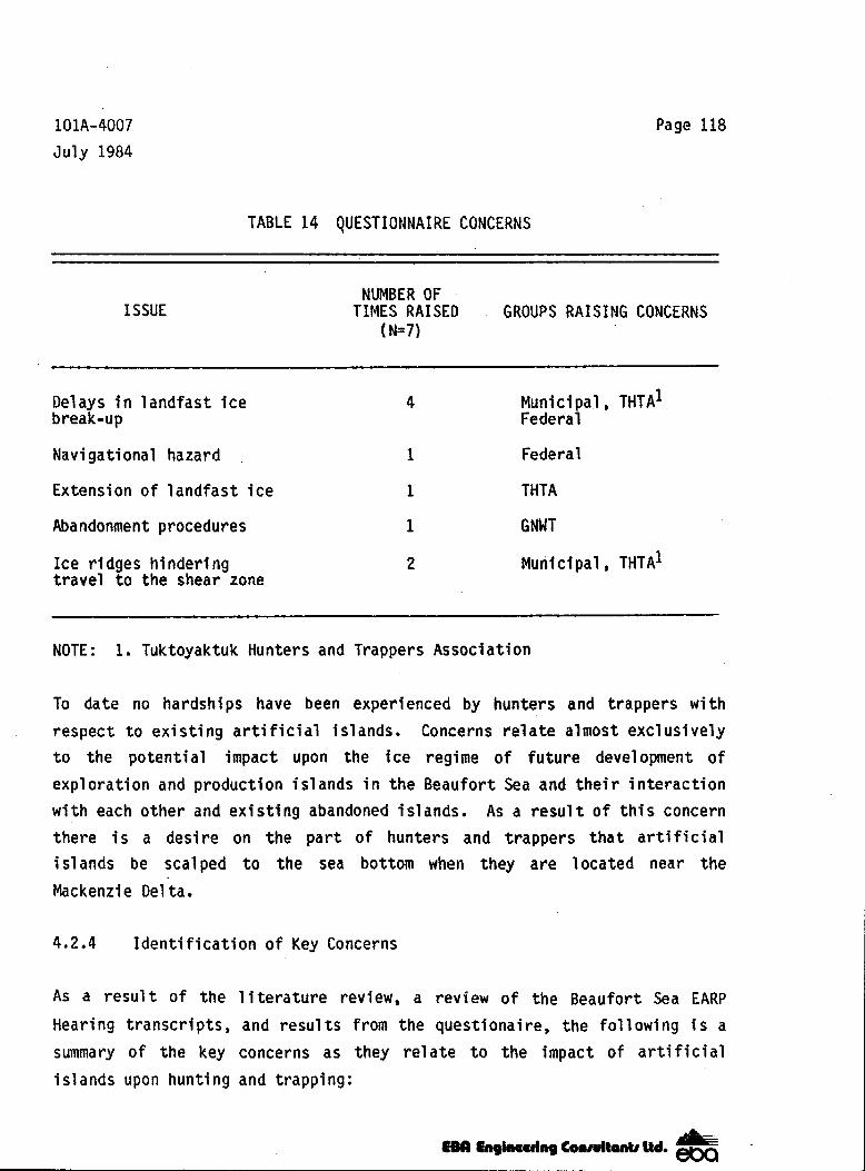
101A-4007
July 1984 Page 118
TABLE 14 QUESTIONNAIRE CONCERNS
ISSUE NUMBER OF
(N=7) TIMES RAISED GROUPS RAISING CONCERNS
Delays i n landfast ice break-up
Navigational hazard
Extension of landfast ice
Abandonment procedures
Ice ridges h i nderi ng travel t o the shear zone
4 Municipal, THTAl Federal
1 Federal
1 THTA
1 GNWT
2 Municipal, THTAl
NOTE: 1. Tuktoyaktuk Hunters and Trappers Association
To date no hardships have been experienced by hunters and trappers w i t h respect t o existing a r t i f i c i a l islands. Concerns relate almost exclusively t o the potential impact upon the ice regime of future development of exploration and production islands i n the Beaufort Sea and their interaction w i t h each other and existing abandoned i s 1 ands. As a result o f this concern there i s a desire on the part o f hunters and trappers t h a t art if icial islands be scalped t o the sea bottom when they are located near the Mackenzi e Delta . 4.2.4 Identification o f Key Concerns
AS a result o f the literature review, a review of the Beaufort Sea EARP
Hearing transcripts, and results from the questionaire, the following i s a summary o f the key concerns as they relate t o the impact of artif icial islands upon h u n t i n g and trapping:

101A-4007 J u l y 1984
Page 119
1. The possi b i l i ty of de lay ing the breakup o f l and fas t i ce i n the * spr ing due to the future development of a r t i f i c i a l e x p l o r a t i o n and
product ion is1 ands and the resul t ing impact on white whale m ig ra t i on /d i s t r i bu t i on and harvesting.
2. The p o s s i b i l i t y of extending the landfast ice tone away from s h o r e and the resul t ing impact on harvesting of polar bear, A rc t i c fox , and seal a t t h e shear zone.
5 .O CONCLUSIONS
In format ion avai lab le t o date suggests that abandoned is lands have n e g l i g i b l e d i r e c t e f f e c t s on the physical, chemical, and b io log i ca l environment o f the sou thern por t ion o f the Beaufort Sea. The only i d e n t i f i e d area o f concern relates t o the ind i rect e f . fects of v a r i a t i o n s i n the landfast ice cover on marine mammals and birds. It has ,been suggested that ar t i f ic ia l is lands could conceivably extend the year ly landfast ice sheet t o deeper water or could delay the breakup of the landfast ice, however, t h i s argument has never been extended t o abandoned a r t i f i c i a l i s l a n d s . S i g n i f i c a n t a l t e r a t i o n i n the time of breakup or the loca t ion o f the shear zone could conceivably a1 ter t he d i s t r i bu t i on and populat ion of both white whales and birds. On a re1 ated issue, it has a1 so been suggested t h a t any extension of the landfast ice sheet will also af fect the d istances that hunters must t rave l t o f i n d game, On the basis of a l l i n fo rma t ion reviewed i n conjunct ion wi th t h i s study, there i s no evidence t o suggest t h a t a r t i f i c i a l i s l a n d s , e i t h e r i n use or abandoned, have af fected landfast i c e i n any measurable manner. However, should extensive use of a r t i f i c i a l is lands be continued in the fu tu re , fu r ther mon i to r ing may be required t o ensure tha t th is conc lus ion remains va l i d .
Abandoned a r t i f i c i a l i s l a n d s c o n s t i t u t e a hazard to navigation. Since most
is lands will natu ra l l y erode t o an elevat ion o f about -4 metres they must be marked. Accurate chart ing of is land locat ions and t he i ns ta l l a t i on o f appropriate devices (i .e., radar re f lec to rs and buoys) a t i s l a n d s i t e s
EBCl wk- COMvltW Ud-

J I J I I I I I I
11 1 I I I I I I
101A-4007
July 1984 Page 120
should be sufficient to ensure t h a t abandoned islands can readily be avoided by marine operators. I t i s believed t h a t the proposed island scalping program is both premature and has no apparent basis. There a1 so appears t o be no basis for the implementation o f the proposed navigational corridor since production scenarios have not been developed. As well, the program would penalize exploration companies t h a t currently hold leases w i t h i n the proposed corridor. I f a demonstrated need for a navigational corridor arises i n the future, an attempt should be made to locate the corridor re1 ative t o development centres. A program t h a t requires complete removal of abandoned islands is unreal istic. I t appears t o be unreasonable to scalp an is1 and t o -12 metres, or t o the seabed, unless a clear need for elimination of the hazard posed by the island exists.
The 1 ine of responsi b i l i ty within the government is not clear a t the present time. Many departments and agencies claim involvement i n the regulatory process b u t only a few appear to be actively involved i n actual abandonment programs Numerous Acts are a v a i l ab1 e b u t the appl ication and interpretation o f these Acts i s no t clear. I t i s recommended t h a t responsi b i l i t ies for abandoned is1 ands be assigned t o one department or agency and t h a t they be provided w i t h a clear mandate to a i d them i n establ i sh in9 guide1 ines for the actual abandonment and subsequent monf t o r i n g o f arti f ici a1 i sl ands.
Identified data deficiencies concern the dynamics of island abandonment. Monitoring o f is1 and eroslon to determine deterioration rates and sediment dispersal paths appears t o have been severely lacking t o date. Only very 1 imi ted information was avail ab1 e for this study Further monitoring o f the dynamics of is1 and abandonment i s recommended to address these da ta deficiencies.

APPENDIX A
REFERENCES
APPENDIX A-1 REPORTS
ABDELNOUR, R., and SAYED, M., 1982. Ice r ide-up on a man-made island. Conference Proceedings: 1982 Offshore Techno1 ogy Conference. Houston, Texas, pp. 141-152.
AGERTON, D.V., 1983. Construction of an Arc t ic o f fshore gravel i s land i n 39 ft. of water during winter and summer, Conference Proceedings: 1983 Offshore Technology Conference. Houston, Texas, pp. 309-316.
BANNON, P o and BRYANT, W.J., 1978. An inves t i ga t i on of the environmental consequences o f a r t i f i c i a l i s l a n d abandonment i n the Beaufort Sea. Prepared by Environmental Protection Service, N.W.T. 38 pp.
BARRY S.J. and BARRY, T.W., 1982. Sea-bird surveys i n the Beaufort Sea, Amundsen Gul f and Prince of Wales S t r a i t , 1981 Season. Prepared f o r Dome Petroleum Ltd., Esso Resources Canada l t d . and Canadian Wi 1 d l i f e Service. 52 pp.
BARRY, T.W., BARRY, S.J., and JACOBSON, B., 1981. Sea-bird surveys i n the Beaufort Sea, Amundsen Gulf, Prince of Wales S t r a i t and Viscount M e l v i l l e Sound, 1980 Season. CWS, Edmonton. 69 pp.
BEAK CONSULTANTS LIMITED, 1978. Heavy metals project Mackenzie Del ta and Estuary. A repo r t f o r Imper ia l Oi 1 Limited, Calgary, A1 berta. 63 p.
BEAUFORT SEA ENVIRONMENTAL ASSESSMENT PANEL, 1983. ,Transcripts, Inuvik hearings (Nov 9-30), Tuktoyaktuk Community Session (September 14) Akl av i k Community Session (September 15).
BEMP (Beaufort Environmental Monitoring Project), 1984, Draf t repor t , Workshop I1 Recomendations. Prepared f o r INAC and DOE. 294 pp.
BLM (Bureau o f Land Management), 1979. Beaufort Sea: Final Environmental Impact Statement, Vol. 1. Alaska Outer Continental Shelf Office, Anchorage, Alaska. 397 pp.
BERCHA, F.G. POTTER, R.E., GOSS, R.D., and GHONEIM, G.A., 1980. Effects of p i le-ups and rubb le f i e lds on ice-s t ructure in teract ion forces. Conference Proceedings: 1980 Offshore Technology Conference . Houston, Texas, pp. 297-305.
BERZINS, W.E., and HEWITT, K.J., 1984. The use of hydrau l i ca l l y p laced sand in i s l and cons t ruc t i on , Conference Prepr ints: 1984 Offshore Technology Conference. Houston, Tex, pp. 1-15.
BOEHM, P.D. and FEIST, D.L.,* 1983. Ocean dumping of dredged m a t e r i a l i n the New York Bight: organic chemistry studies. ( In) Wastes i n the Ocean, Vol , 2, D.R. Kester e t a l . (ed,). Wiley-Interscience, New York. pp. 151-172.

Page A-1.2
REFERENCES (continued)
BOONE, D.J. , 1980. The construct ion o f an a r t i f i c i a l d r i l l i n g i s l a n d i n intermediate water depths i n the Beaufort Sea. Conference Proceedings: 1980 Offshore Technology Conference. Houston, Texas, pp. 187-195,
BORNHOLD, B.C., 1975. Suspended matter i n the southern Beaufort Sea. Beaufort Sea Technical Report 25b. Beaufort Sea Project , Department of the Environment.
BROAD, A.C., 1980. Environmental assessment o f se lec ted hab i ta ts in Arc t i c L i t t o r a l Systems. Annual Report.
BRUCE, J.C., and HARRINGTON, A.G., 1982. Design aspects o f a Mobi le Arct ic Caisson. Conference Proceedings: 1983 Offshore Technology Conference. Houston, Texas, pp. 405-416 .
CARLISLE, J.G., TURNER, C.H., and EBERT, E.E., 1964. A r t i f i c i a l h a b i t a t i n the marine environment. Calif.Dept.Fish.Game, F ish Bu l l . - 124; 93 pp.
CARLTON, J.G., 1976. In te rp re ta t i on o f Ocean Dumping Control Act. Memorandum submitted t o L.A. W i l l i s , January 26, 1976.
CHEN, K.Y., LU, J.C.S., and SYCIP, A.Z., 1976. M o b i l i t y o f trace metals d u r i n g open wa te r d i sposa l o f dredged mater ia l and f o l 1 owing resedimentation. (In) Dredging and i t s Environmental Effects. P.A. Krenkel e t a l . (ed.). American Society of Civ i l Engineers, New York. pp. 435-454.
COWLES, C.J. , HANSEN, D.J., and HUBBARD, J.D., 1981. Types o f po ten t ia l ’ e f f e c t s o f offshore oi l and gas development on marine mammals and
endangered species of the northern Bering, Chukchi and Beaufort Seas. Alaska Outer Continental Shelf Office, Technical Paper No. 9 , December 1981. 23 pp.
CRAIG, P, and HALDORSON , C. , 1981. Beaufort Sea b a r r i e r i s 1 and-1 agoon ecological process studies. Final report Simpson Lagoon. Par t 4. Fish.Res.Unit 467. ( in ) Env i r . Assess. Alaskan Cont, Shelf, Final Report . BLM/NOAA, OCSEAP , Boul der, Colorado.
CRIPPEN, R.W., 1983, Issungnak Oceanographic Survey, Par t B: Benthic macroinvertebrates, A report prepared for Esso Resources Canada Limited, Dome Petroleum Limited and Gul f Canada Resources Inc. by IEC Beak Consultants Ltd., Mississauga, Ontario. 36 p .
CRIPPEN, R.W., HODD, S.C., and GREENE, G., 1980. Metal levels i n sediment and benthos r e s u l t i n g from a d r i l l i ng f l u id d i scha rge i n to t he Beau fo r t Sea. ( I n ) Symposium on research on environmental fate and e f f e c t s of d r i l l i n g f l u i d s and cutt ings, Jan. 21-24, 1980, Lake Buena V i s t a , Flor ida, Vol . I , pp. 636-669.

Page A-1.3
REFERENCES (continued)
CRIPPEN, R.W. and McKee, P. , 1981, Base1 ine biological and chemical study Issungnak 0-61 Beaufort Sea - 1980. Report prepared for Esso Resources Canada LImi ted, Calgary, A1 berta by Beak Consultants Limited, Mississauga, Ontgario. 63 p.
CROASDALE, K.R., and MARCELLUS, R.W., 1977. Ice and wave action on art if icial islands i n the Beaufort Sea. Canadian Journal of C i v i l Engineering, Vol. 5, 1978, pp. 98-113.
CROOK, J.F., 1983. The effects of icebreaking and artificial islands on marine h u n t i n g and t r app ing near Tuktoyaktuk, N.W.T. M . R . M . , Simon Fraser University, Vancouver, B.C. 83 pp.
CUDDY, C., 1978. Artificial island clean-up status - 27 June, 1978. INAC report submitted t o Mr. A. Ganske, Yellowknife, N.W.T.
CUDDY, C., 1979. Artificial islands inspection of August 16, 1979. INAC report submitted t o Mr. D. Cormier, Yellowknife, N.W.T.
DANIELEWICZ, B.W., and PILKINGTON, C.R., 1980. Selected environment characteristics of Beaufort Sea ice. Dome Petroleum Limited Technical Report.
DAVIS, R.A., and EVANS, C.R., 1982. Offshore distribution and numbers of white whales i n the eastern Beaufort Sea and Amundsen Gul f, summer 1981. Unpubl . LGL Limited rep. for Sohio Alaska Petroleum Company, Anchorage, and Dome Petroleum Limited , Calgary 78 p.
D A V I S , R - A - , KOSKI, W.R., RICHARDSON, W.J., EVANS, C.R., and ALLISTON, W.G., 1982. Distribution, numbers and productivity of the western Arctic S tock Of bowhead whales i n the eastern Beaufort Sea and Amundsen G u l f , Summer 1981. Report by LGL Limited, Toronto, Ontario t o Dome Petroleum Limited, Calgary, Alberta and t o Sohio Alaska Petroleum Company, Anchorage, Alaska. 135 pp.
DE JONG, J.J.A., and BRUCE, J.C., 1978. Design and construction o f a caisson retained is land d r i l l i n g platform for the Beaufort Sea. Conference Proceedings: 1978 Offshore Technology Conference. Houston, Texas, pp. 2111-2120.
DIKKEN, J.J. , and BRAKEL, J . , 1982. Dredging and construction techniques for steep slopes on a r t i f i c i a l d r i l l i ng islands i n the Canadian Arctic, Conference Proceedings: 1982 Offshore Tel chnol ogy Conference. Houston, Texas, pp. 713-719.
DOBBYN, G. , 1976. Artificial island construction procedures and present status o f islands. Internal summary report t o Chief Land Use Administrator, Department o f Indian and Northern Affairs.

Page A-1.4
REFERENCES (continued)
DOME PETROLEUM LIMITED, ESSO RESOURCES CANADA LIMITED and GULF CANADA RESOURCES INC., 1982a . Envi ronmentzl Impact Statement f o r Hydrocarbon Development i n the Beaufort Sea - Mackenze Delta Region. Vol . 2 Development Systems. Calgary, Alberta.
DOME PETROLEUM LIMITED, ESSO RESOU,RCES CANADA LIMITED and GULF CANADA RESOURCES INC., 1982b. Beaufort Sea - Mackentie Delta Environmental Impact Statement. Vol. 3A Beaufort-Delta Setting.
DOME PETROLEUM LIMITED, ESSO RESOURCES CANADA LIMITED and GULF CANADA RESOURCES INC., 1982c. Environmental Impact Statement for Hydrocarbon Development i n the Beaufort Sea - Mackentie Delta Region. Vol . 4. Bio log ica l and Physical Effects, Calgary, Alberta.
DOME PETROLEUM LIMITED, ESSO RESOURCES CANADA LIMITED and GULF CANADA RESOURCES INC. , 1982d. Environmental Impact Statement f o r Hydrocarbon Development i n the Beaufort Sea - Mackenzie Delta Region - Vol. 5 . Socio - Economic Effects. Calgary, Alberta.
DOME PETROLEUM LIMITED, ESSO RESOURCES CANADA LIMITED, GULF CANADA RESOURCES INC. and TUKTOYAKTUK HUNTERS AND TRAPPERS ASSOCIATION, 1982e. F ina l repor t o f the Jo in t ,Tuk- Indus t ry Task Force to examine the e f fec ts of a r t i f i c i a l i s l a n d s on Beaufort Sea ice.
DUNWOODY, A.B., 1983. The design ice is land for impact against an of fshore structure. Conference Proceedings: 1978 Offshore Technology Conference. Houston, Texas, pp. 325-330.
ENVIROCON LTD., 1977. I s s e r k a r t i f i c i a l i s l a n d environmental basel i n e and monitoring study . Unpubl . repor t for Imper ia l O i 1 L,td., Calgary. 125 PP
ERICKSON, P.E. and PEfT, R., 1981. Concentrat ion of suspended p a r t i c u l a t e mater ia l and dissolved oxygen i n Tuktoyaktuk Harbour near dredging condu6ted by the Government o f the Nor thwest Terr i tor ies June 18 - June 26, 1981. A report prepared by Arct ic Laborator ies L imited, Inuvik, N.W .T. f o r t he Government o f the Northwest Terr i tor ies (unpubl ished manuscript). 7 1 pp.
ERICKSON, P. E . , THOMAS, D.J . , PETT, R., and de LANGE BOOM, B., 1983. Issungnak Oceanographic Survey, Par t A: oceanographic propert ies. A repor t fo r Esso Resources Canada Limited, Gulf Canada Resources Inc., Dome Petroleum Limited by Arct ic laborator ies L imi ted, Inuv ik , N.W.T. 194 p.
ESL ENVIRONMENTAL SCIENCES LIMITED, 1982. The b i o l o g i c a l e f f e c t s o f hydrocarbon explorat ion and production re1 ated act ivi t ies, disturbances and wastes on marine f lora and fauna of the Beaufort Sea region. Prepared by ESL Environmental Sciences Limited, Vancouver, B.C. for Dame Petroleum Limited , Calgary, A1 berta. Beaufort E I S Support Documents.

Page A-1.5
REFERENCES (continued)
ESSO, 1984. Depths to tops of eroded is1 ands. Tab1 e submitted t o EBA Engineering Consultants Ltd., March, 1984.
FENTON, W., 1983. Ex i s t ing legislation applicable to Beaufort Sea dredging. Letter and attachments submitted t o Mr. B. Smiley, July 18, 1983.
FINLEY, K.J. , 1976. Studies of the status of marine mammals i n the central Dis t r ic t o f Franklin, N.W.T. June-August, 1975. Report by LGL Limited, Toronto for Polar Gas Project, Toronto. 183 p.
FINLEY, K.J . , 1982. The estuarine habit o f the beluga or white whale Delphinapterus leucas. Cetus - 4(2); 4-5.
FITZPATRICK, J . , and STENNING, D.G., 1983. Design and construction of Tarsiut Island i n the CanadSan Beaufort Sea. Conference Proceedings: 1983 Offshore Technology Conference. Houston, Texas, pp. 51-60.
FOSTER, J.A., 1977. Foxes, bears and seals. p. 8-1 - 8-31 ( I n ) Environmental assessment o f construction and construction support act ivi t ies re la ted to the proposed ten year Beaufort Sea offshore exploratiowprogram. Prepared by F.F. Slaney and Co. Ltd. for Imperial O i 1 L i m i ted, Calgary , A1 berta.
FRAKER, M.A., 1977a. The 1976 whale monitoring program, Mackenzie estuary, N-W-T. Report by F.F. Slaney and Co. Ltd., Vancouver for Imperial O i l Limited, Calgary. 53 p.
FRAKER, MOA.,: 1977b. The 1977 whale monitoring 'program, Mackentie estuary, N.W.T.. Report by F.F. Slaney and Co. Ltd. , Vancouver for Imperial O i l Limited, Calgary. 53 p.
FRAKER, M.A., 1977c. Whales. p.7-1 t o 7-45. ( I n ) Environmental assessment of construction and construction support activities related to the proposed ten year Beaufort Sea offshore exploration program. Prepared by F.F, S1 aney and Co. Ltd., Vancouver for Imperial O i 1 Limited, Calgary , A1 berta.
FRAKER, M.A.., 1978. The 1978 whale monitoring program, Mackenzie Estuary, N.W.T. Unpublished F.F. Slaney and Co. report submitted to Esso Resources Canada Limited, Calgary, 28 p.
FRAKER, M.A. 1979. Observations of bowhead and beluga whales i n relation to offshore exploration i n the Canadian Bleaufort Sea. Alaska Offshore Lease Sal e Hearings, Fai rbanks, A1 aska.
FRAKER, M.A. and FRAKER, P.N., 1979. The 1979 whale monitoring program, Mackenzie estuary. Report by LGL Limited for Esso Resources Canada Ltd. , Edmonton. 51 p.

Page A-1.6
REFERENCES (continued)
FRAKER, M.A., GORDON, C.D., McDONALD, J.W., FORD, J.K.B., and CAMBERS, G., 1979. White whale (Del h i n a terus leucas) d is t r ibu t ion and abundance and the relationship +anKl"mlcal characteristics of the Mackenzie estuary. Can. F ish . Mar, Serv. Rep. No. 863. 56 p.
FRAKER, P.N. and FRAKER, M.A., 1981. The 1980 whale monitoring program, Mackenzie estuary. Unpubl . LGL Limited report for Esso Resources Canada Limited, Calgary. 98 p.
GADD, P.E . , GIBSON, D.H., NAGEL, R.H., and SONU, C.U., 1982. Natural Barrier Island mjgration and change - No Name Island, Beaufort Sea, A1 aska. Conference Proceedings: 1982 Off shore Tel chnol ogy Conference. Houston, Texas, pp. 673-688.
GALEWITH, D.F., and FRASER, D.C., 1974. Distribution and food habits o f fish i n the eastern coastal Beaufort Sea. Fisheries and Marine Service, Environment Canada. Beaufort Sea Project Interim Report B - 1 . 48 PP-
GALLAWAY, B.J., JOHNSON, M.F., HOWARD, R.L., MARTIN, L.R., and BOLAND, G.S. , 1979. A study of the effects of Buccaneer Oil Field structures and associated effluents o f biofouling communities and the Atlantic spade fish (Chaetodipterous faber). Unpubl report by LGL Ltd. U.S., Inc. for National Marine k i s m e s Service.
GALLOWAY, D.E., SCHER, R.L., and PRODANOVIC, A., 1982. The construction of man-made dril l i n g is1 ands and sheetpil e enclosed dri 11 si,tes i n the A1 askan Beaufort Sea. Conference Proceedings : 1982 Offshore Technology Conference. Houston, Texas, pp. 437-448.
GERACI, J.R., and ST. AUBIN, D.J., 1980. Offshore petroleum - resource develo went and marine mammals: A review and research recommdations. Mar. Fish. Rev - 42(11); 1-12.
GERWICK, 8.C., JR., LITTON, R.W., and REIMER, R.B., 1981. Resistance of concrete wall s t o h igh concentrated ice loads. Conference proceedings: 1981 Offshore Technology Conference, Houston, Texas, pp. 425-436
GULF CANADA RESOURCES INC., 1983. East Tarsuit N-44A abandonment plan - Phase I c a i $son removal. Report t o regulatory authori ties.
HARWOOD, L.A. and FORD, J.K.B., 1983. Systematic aerial surveys o f bowhead whales and other marine mammal s i n the southeastern Beaufort Sea, August-Sepetmber 1982. Report by ESL Environmental Sciences Limited, Sidney, B.C. for Dome Petroleum Limited and G u l f Canada Resources Inc., Calgary. 76 p.

Page A-1.7
REFERENCES (cont'inued)
HEATH, W.A. and THOMAS, D.J., 1983. A study of the benthos and sediment chemistry a t T a r s i u t N-44 a r t i f i c i a l i s l a n d and borrow areas i n the Southern Beaufort Sea - 1982. A report prepared for Dome Petroleum Limi ted and Gulf Canada Resources Inc. By Arct ic Laborator ies L imited, Inuvik, Northwest Terr i tor ies. 79 p and Appendices.
HEATH, W.A. and THOMAS, D.J , , 1984a ( in p repara t ion) . The impact of gravel dredging on benthic fauna near Herschel Island, Yukon Ter r i t o ry , 1981- 1982. A repor t prepared for Dome Petroleum Limited and Gul f Canada Resources Inc. by Arct ic Laborator ies LimS ted, Inuvik, Northwest Te r r i t o r i es .
HEATH, W.A. and THOMAS, D.J., 1984b ( in p repara t ion) . The impact of gravel dredging on benthos near Banks Is land, Northwest Terr i tor ies - 1981 and 1983. A repor t prepared for Dome Petroleum Limited and Gul f Canada Resources Inc. by Arctic Laboratories Limited, Inuvik, Northwest Te r r i t o r i es .
HEATH, W.A., THOMAS, D.J., KOLEBA, J.M., PERRY, B.M., ETHIER, A.G., and MacLAUCHLAN, L., 1982. The impact of gravel dredging on benthic fauna near Herschel 'Island, Yukon Ter r i t o ry , 1981,. A repor t prepared for Dome Petroleum Limited, Calgary, A1 ber ta by Arct ic Laborator ies Limited, Inuvi k , Northwest Terr i tor ies.
HERLINVEAUX, R.H. and de LANGE BOOM, B.R., 1975, Physical oceanography of southeastern Beaufort Sea. Beaufort Sea Project Technical Report 118, I n s t i t u t e o f Ocean Sciences, Sidney, B.C. 97 pp.
HOPKINS, D.M. (ed , ) , 1978. E f fec ts of gravel mining and construct ion of gravel is1 ands and causeways , p. 321-334 . ( I n ) Environmental Assessment o f the Alaskan Continental She1 f. Interim Synthesis: Beaufort/Chukchi . ANOAA and BLM.
JOHNSON, S.R. and RICHARDSON, W.J., 1980, Beaufort Sea ba r r i e r i s l and - lagoon ecological process studies: final report, Sirnpson Lagoon. Pa r t 3 Birds, Prepared by LGL Ecological Research Associates Inc. and LGL Ltd. for NOAA/OCSEAP and U.S. Bureau o f Land Management Contract No, 03-6-022-35193.
KINGLSEY, M.C.S., CALVERT, W . , and STIRLING, I., 1982. Abundance o f seals i n the eastern Beaufort Sea and Amundsen Gulf and Pr ince A lber t Sound, 1981. Prepared by Canadian Wild1 i f e Se rv i ce f o r Dome Petroleum Limited, Esso Resources Canada Ltd. , Gulf Canada Resources Inc. , Calgary. 19 p.
KINGSLEY , M.C.S. and LUNN , N.J . , 1983. The abundance of seals i n t h e Beaufort Sea, northern Amundsen Gulf and Pr ince Albert Sound, 1982. Report by Canadian Wild1 i fe Service, Edmonton , f o r Dome Petroleum Limited and Gulf Canada Resources Inc. Calgary. 65 p.

Page A-1.8
REFERENCES (continued)
KOSKI, W.R., and DAVIS, R.A., 1979. D i s t r i b u t i o n of marine mammals i n northwest Baffi n Bay and adjacent waters, May-October 1978. Prepared by LGL Ltd., for Petro-Canada, Calgary, 305 pp,
KOTRAS, T.V., ARNOLD, C.L., and BERGMAN, K.M., 1983. Strength of of fshore gravel islands t o res i s t i ce l oads . Conference Proceedings: 1983 Offshore Technology Conference. Houston Texas, pp. 317-324.
LEIDERSDORF, C . B . , POTTER, R.E., and GOFF, R.D., 1981. Slope pro tec t ion fo r a r t i f i c i a l e x p l o r a t i o n i s 1 ands o f f Prudhoe Bay. Conference Proceedings: 1981 Offshore Technology Conference. Houston Texas, pp, 437-447.
LEIDERSDORF, C . B . , POTTER, R.E., GERWICK, B.C. JR., and HSU, Y.Y . , 1982. Modular slope protection for the arct ic environment. Conference Proceedings: 1982 Offshore Technology Conference. Houston, Texas, pp. 689-764
LGL LTD. ENVIRONMENTAL RESEARCH ASSOCIATES and ESL ENVIRONMENTAL SCIENCES LIMITED, 1981. Biological overview of the Beaufort and NE Chukchi Sea. Prepared f o r Dome Petroleum Limited, Calgary, A1 ber ta
MANCINI, C.V., DOWSE, B.E.W., and CHEVALLIER, J.M., 1983. Caisson retained i s l a n d f o r Canadian Beaufort Sea - Geotechnical design and construct ion considerations . Conference Proceedings: 1983 Offshore Technol ogy Conference. Houston, Texas, pp. 17-22.
MANSFIELD, A.W., 1980. Impact o f o i l p r o d u c t i o n on marine mammals. pp. 334-351 ( in) Ninth Environmental Workshop on Offshore Hydrocarbon Development, Fairmont, B.C. May 1980. Special publ icat ion, the Arct ic I n s t i t u t e o f North America, University of Calgary, Alberta, Canada.
"W-IAM, W.E. , 1983. A r t i f i c i a l i s 1 ands and fast ice. Prepared by Department o f Environment, Special Ice Studies, Downsview, Ontario.
MATSUMOTO, E. and WONG, C.S., 1977. The d i s t r i b u t i o n o f suspended p a r t i c l e s i n the southern Beaufort Sea. J . Ocean. SOC. Japan, - 33; 227-233.
MCLAREN, P.L. and DAVIS, R.A., 1984. D i s t r i b u t i o n of bowhead whales and other marine mammals i n the southeast Beaufort Sea, August-September 1983. Report by LGL Ltd., Toronto, f o r Dome Petroleum Limited and Gulf Canada Resources Inc., Calgary. 65 p.
MYERS, R.M., DUNWOODY, A.B., and KIRBY, J.A., 1983. Wave i n t e r a c t i o n w i t h Tarsui t Is1 and. Conference Proceedings: 1983 Offshore Technol ogy Conference, Houston, Texas, pp. 23-26.

Page A-1.9
. .
REFERENCES ( c o n t i nued)
MYERS, R.M., and KIRBY, J.A., 1983. Design and toe protect ion at caisson
NORTON FRAKER, P., 1983. The 1982 white whale monitoring program, Mackenzie estuary. Part I. Migra t i on , d i s t r i bu t i on and abundance of whales and e f f e c t s o f , i n d u s t r y a c t i v i t i e s on whales. Report by LGL Ltd., t o Esso Resources Canada Limited, Dome Petroleum Limited and Gulf Canada Resources Inc. 54 p.
i s l ands . Dome Petroleum Limi ted Technical Paper.
NORTON FRAKER, P. and FRAKER, M.A., 1982. The 1982 whale monitoring program, Mackenzie estuary. Report by LGL Limited, Sidney, B.C. f o r Esso Resources Canada Limited, Calgary. 74 p.
OLMSTED, W.R., 1977. F ish communities. ( In) 1976 summer aquatic studies, Arnak L-30 a r t i f i c i a l i s l a n d s i t e and Tuf t Point borrow s i te . Unpubl . repor t by F .F. Slaney and Co. Ltd. f o r Imper ia l Oil Limited, Calgary.
OSBORNE, J., 1980. Pol i c y statement and br ie f ing no te . Memorandum submitted t o RODAC Members, February 14, 1980.
OWENS, R.A., 1977. . Avifauna. pp. 9-1 t o ,9-20. ( I n ) Environmental assessment o f construct ion and cons t ruc t ion suppor t ac t i v i t ies re la ted t o t h e proposed ten year Beaufort Sea Offshore explorat ion program. prepared by F.F. Slaney and Co. Ltd., Vancouver, B.C., for Imperial Oil Limited, Calgary, A1 berta.
PATTERSON, D.R., SHAK, A.T., and CZERNIAK, M.T., 1982. Inspect ion o f submerged A r c t i c s t r u c t u r e s b y s i d e s c a n s o n a r . Conference Proceedings: 1982 Offshore Techno1 ogy Conference . Houston, Texas, pp. 705-712
PETT, R.J., VICKERS, G.P., ACREMAN, J.C., and ETHIER, A.G. , 1983. A seasonal study of the epontic and planktonic communities near the Issungnak A r t i f i c i a l I s l a n d and McKinley Bay i n the Canadian Beaufort Sea. An unpubl i shed repor t fo r F isher ies and Oceans Canada by A rc t i c Laboratories Ltd., 89 p.
RENAU0,W.E.. and DAVIS, R.A., 1981. Aerial surveys of bowhead whales and other marine mammals o f f the Tuktoyaktuk Peninsula, N.W.T. August- September 1980. Unpubl . LGL L imi ted repor t fo r Dome Petroleum Limited, Calgary. 55 p.
RICHARDSON, W . J . (ed. ) , 1983 . Behaviour, disturbance responses and d i s t r i b u t i o n o f bowhead whales Balaena mysticetus i n t he eas te rn Beaufort Sea 1982. Unpubl . repor-La Lcol . Res. Assoc., Inc., Bryan, TX, f o r U.S. Minerals Management Service, Reston, VA. 357 p .

Page A-1.10
REFERENCES (continued)
RICHARDSON, W.J., GREEN€, C.R., H I C K I E , J.P., and DAVIS, R.A., 1983a. Effects of offshore petroleum operations on cold water marine mammals. A 1 i terature review. Prepared by LGL Ltd., Toronto, Ontario, f o r API, Washington, D.C. 297 pp.
RICHARDSON, W.J., DAVIS, R.A., EVANS, C.R., and NORTON, P., 1983b. D i s t r i b u t i o n o f bowheads and i n d u s t r i a l a c t i v i t y , 1980-82. p. 269-357. ( I n ) W.J. Richardson (ed.). Behaviour, disturbance responses and d i s t r i b u t i o n o f bowhead whales Balaena mysticetus i n t h e e a s t e r n Beaufort Sea, 1982. Unpubl. r e p o m LXL t co l . Res. Assoc., Inc., Bryan, TX, f o r U.S. Minerals Management Service, Reston, VA. 357 p .
RILEY, J.G., 1975. The construct ion o f a r t i f i c i a l i s l a n d s i n t h e Beaufort Sea . Conference Proceedi ngs: 1975 Offshore Techno1 ogy Confernce, pp. 211-222.
ROBERTSON, I . , and MILLER, J., 1984. White whale monitoring, Mackenzie Estuary, 1983. Report submitted t o Esso .Resources Canada Limited, Gulf Canada Resources, Inc., and Dome Petroleum Limited.
SCHAMEL, D., 1977. Breeding of the common eider (Somateria mol 1 i ssima) on the Beaufort Sea coast of Alaska. Condor - 79; 478-485.
SLANEY, F.F. & COMPANY LIMITED, 1973. Environmental impact assessment, Immerk A r t i f i c i a l I s l and Cns t ruc t i on , Mackenzie Bay, Northwest Te r r i t o r i es . Volume 2, Environmental studies. Unpubl. r e p o r t f o r Imperial Oil Limited, Calgary. 59 p.
SLANEY, F.F. & COMPANY LIMITED, 1974a. White whale ,study, Herschel I s land - Cape Dalhousie, coastal region o f the Beaufort Sea. Unpubl. r e p o r t f o r Imperial Oil Limited, Calgary. 29 p.
SLANEY, F.F. & COMPANY LIMITED, 1974b. Preliminary environmental impact assessment. Granular materials Mackenzie Bay, Nor thwest Terr i tor ies. Prepared fo r Imper ia l Oil Limited, Calgary, Alberta.
SLANEY, F.F. & COMPANY LIMITED, 1975. Summer environmental program, Mackenzie River Estuary. Vol urne 3, White whale studies. Unpubl . repor t f o r Imper ia l Oil Limited, Calgary. 53 p .
SLANEY, F,F. & COMPANY LIMITED, 1976. Summer environmental program, Mackenzie River Estuary. Volume 2, White whale studies. Unpubl . repor t f o r Imperial Oil Limited, Calgary. 61 p.
SLANEY, F.F. & COMPANY LIMITED, 1977b. 1976 summer aquatic studies: Arnak 1-30 A r t i f i c i a l I s l a n d s i t e and Tuf t Point borrow s i te . Repor t for Imperial Oil Limited (unpublished manuscript), 117 pp. + Appendices,
SMITH, T.G., 1976, Predation o f ringed seal pups (Phoca hispida) by the a r c t i c fox (Alopex lagopus). Can. J . 2001. 54; 1-1,
E8A wkmrlng Mhlr Ud. -
&E

Page A-1.11
REFERENCES (continued)
SPEDDING, L.G., 1974, The extent and growth pattern of landfast ice i n the southern Beaufort Sea - winter 1972-73. Imperial Oil Limited Internal Report .
SPEDDING. L-C. , 1976a. Spring break-up i n the Plackenzie Delta and southern Beaufort Sea i n 1974. Imperial O i 1 Limited Internal Report.
SPEDDING, L.G., 1978a. Landfast and shear tone conditions i n the southern Beaufort Sea, winter 1975-76. Esso Resources Canada Internal Report.
SPEDDING, L.G., 1978b. Landfast and shear zone i ce conditions i n the southern Beaufort Sea - winter 1976-77. Esso Resources Canada Limited Internal Report.
SPEDDING, L.G., 1978c. Break-up pattern of the landfast ice i n the MacKenzie Delta region for the spring of 1975. Esso Resources Canada Limited Internal Report.
SPEDDING, L . E . , 1979a. Landfast ice break-up patterns i n the MacKenzie Delta region for 1976, 1977, and 1978. Esso Resources Canada Limited Internal Report.
SPEDDINC, L.G., 1979b. Landfast and shear zone ice conditions i n the southern Beaufort Sea - winter 1977-78. Esso Resources Canada Limited Internal Report.
SPEDDING, L.G., 1980. Southern Beaufort Sea ice conditions i n the vicinity o f Issungnak 0-61 - winter 1978-79. Esso Resources Canada Limited Internal Report.
SPEDDING, L-.G., 1982. Southern Beaufort Sea ice conditions - winter 1979- 80. Esso Resources Canada Limited Internal Report.
SPEDDING, L O G . and DANXELEWICZ, B.W., 1983. Artificial islands and the i r e f fec t on regional landfast i c e conditions i n the Beaufort Sea. Esso Resources Canada Limited and Dome Petroleum Limited Report.
STEWART, H.R. , JEFFERIES, M.G., and GOLDBY, H.M., 1983. Berm construction for the Gulf Canada Mobile Arctic Caisson. Conference Proceedings: 1983 Offshore Technology Conference. Houston, Texas, pp. 339-346.

Page A-1 12
REFERENCES (conti nued)
STIRLING, I . , ANDRIASHEK, D , , CATOUR, A., and CALVERT, W , , 1975. The distribution and abundance o f polar bears i n the eastern Beaufort Sea. Beaufort Sea Project, Victoria, B.C., Fisheries and Marine Service Department of the Environment, 59 p.
STIRLING, I . , ANDRIASHEK, D., and CALVERT, W . , 1981. Habitat preferences and distribution of polar bears i n the western Canadian Arctic. Prepared for Dome Petroleum Limited, the Arctic Islands Offshore Production Committee and the Canadian Wildlife Service.
STIRLING, I. and SMITH, T.G., 1977. Interrelationships of Arctic Ocean mammals i n the sea-ice habitat. pp. 129-136. ( I n ) Circumpolar Conference on Northern Ecology , National Research Council of Canada, Ottawa.
TARBOX, K. and SPIGHT, T., 1979. Beaufort Sea fishery investigations. (In) Prudhoe Bay water-flood project. Biological effects o f impingement and entrainment from operation of the proposed intake - summer 1978. Report prepared by Woodward-Clyde Consultants for Prubhoe Bay U n i t . 42 PP
TAYLOR, D., REED, M., SMILEY, B. , and FLOYD, G., 1984. Historical review of marine dredging i n the Beaufort Sea, Final draft, Canadian data report of Hydrography and Ocean Sciences No. 5, 1984 t o PERD Dredging - Steering Committee.
THOMAS, D.J . , 1979. Dome petroleum - McKinley Bay Dredging Program Phase I : Geochemical base1 ine survey and environmental monitoring during 1979 operations, A report prepared by Arctic Laboratories Limited, Inuvi k , N O W .T. for Dome Petroleum Limited, Calgary, A1 berta (unpubl i shed manuscript) 80 pp.
THOMAS, D.J . , 1980, Dome Petroleum Limited: Water quality measurements and dredge spoil monitoring a t McKinley Bay, N.W.T., 1980, A report prepared by Arctic Laboratories Limited, Inuvik, N.W.T. for Dome Petroleum Limited, Calgary , A1 berta ( u n p u b l i shed manuscript) , 4 1 pp.
THOMAS , D.J. , HEATH, W.A., KOLEBA, J .Me, PERRY, B.M., and ETHIER, A.G. , 1982. A study of the benthos and sediment chemistry at Tars iut N-44 ar t i f ic ia l i s land and South Tarsiut Borrow Area, 1981. A report prepared for Dome Petroleum Limited and Gulf Canada Resources Inc., Calgary, Alberta by Arctic Labortories Limited, Inuvik, Northwest Terri tories. 160 p.
THOMAS, D.J . , GREENE, G.D. , DUVAL, W . S . , and MILNE , K.C. , 1983. Offshore o i l and gas production waste charcterist ics, treatment methods, biological effects and their application t o Canadian regions, A dra f t r epor t p repa red j o in t ly by Arct ic Laborator ies Limited, ESL Environmental Sciences Limited and SKM Consulting Limited for the Environmental Protection Service, Water Pollution Control Directorate, Ottawa, Ontario, 363 pp.
E m &B9krUdA9 Wlkrb ltd. &

I I I P I I t 4 I a 1
Page A-1.13
REFERENCES (continued)
THOMAS, D.J., MacDONALD, R.W., and CORNFORD, A.B., 1983b. A comparison of natural and petroleum resource development related fluxes of metal s , hydrocarbons and nitrogen, phosphorus and si 1 icon to the Beaufort Sea. Can. Tech. Rep. Hydrogr. Ocean Sci . - 30. 48 pp .
THOMSON, R.B., 1983. Breakup patterns o f landfast ice southern Beaufort Sea 1975-1982. Scientific Services, A.E.S. Western Region, Report 83-7. 5 pp + Appendix.
TURNER, C.H., EBERT, E.E., Calif . Dept. Fish and
VIVATRAT, V . , and KREIDER,
and GIVEN, R.R., i969. Man-made reef eco Game. Fish. Bull. No. 146. 210 pp.
109Y
J.R., 1981. Ice force prediction using a limited driving force approach. Conference Proceedings: 1981 Offshore Technology Conference. Houston, Texas, pp. 471-485.
WACASEY, J.W.? 1975. Biological productivity of the Southern Beaufort Sea: zoobenthic studies. Beaufort Sea Technical Report 12b. Dept. of Environment, Victoria, B.C.
WANG, J.L., MACHEMEHL, J.L.., and AY, R.L., 1983. Design criteria for wave run-up on artificial Islands. Conference Proceedings: 1983 Offshore Technology Conference. Houston, Texas, pp. 9-16.
WARD, J.G., 1981. Wildlife observations during dredging operations i n McKinley Bay, July-August 1980. Dome Petroleum Limited. 75 p.
WATT, B., 1982. Hydrocarbon extraction i n arctic frontiers. Proceedings, Boss'82. Third International Conference, Behaviour of Offshore Structures, Cambridge, Massachusetts, pp. 71-91.
WOODWARD-CLYDE CONSULTANTS, 1982. Beaufort Sea sediment dynamics . Report submitted t o Geological Survey of Canada.
WRIGHT, D.G., 1977. Artificial islands i n the Beaufort Sea. A review of potential environmental impacts . Prepared f o r Fisheries and Environment. Land agency, Fisheries and Marine Service, Environmental Secretariat. 23 pp.
APPENDIX A
REFERENCES
APPENDIX A-2 INFORMATION SOURCES
A.2.1 Computer L i t e r a t u r e Search: (Fish, Birds, Mammals)
The computer l i t e r a t u r e search accessed three data bases: CENV (Canadian Environment; 59,076 t i t l e s ) , AST ( A r c t i c Science and Technology; 12,778 t i t l e s ) and SWR (Selected Water Resources Abstracts; 64,700 t i t les) . The program sought the fo l lowing key words i n various combinations i n t h e t i t l e s of government, indust ry and consu l tan t repor ts : "a r t i f i c ia l i s land" , "of fshore is land", ''removal", "abandonment", "erosion", "recolonization", " f i s h " , "biolog-I' . A.2.2 Personal Communications and Agencies Contacted
P. Norton Fraker LGL Ecological Research Associates Ltd. Sidney, B.C.
T.W. Barry Canadian Wi 1 d l i f e Service Edmonton, A1 ber ta
L. Al len Canadian Wi 1 d l i f e Service Edmonton, A1 ber ta
J. Ward Dome Petroleum Limited Cal gary , A1 ber ta
0.- Troy LGL Alaska Research Associates Inc. Anchorage, A1 aska
W.A. Bond Department o f Fisher ies and Oceans Winnipeg, Manitoba
M.A. Fraker Sohio Alaska Petroleum Company Anchorage, A1 aska

Page A-2.2
B .J . Gal 1 away LGL Ecological Research Associates Inc. Bryan, Texas
M. Psutka Esso Resources Canada Ltd. Cal gary , A1 b e r t a
0. F isse l Arc t i c Sc iences t td . Sidney , B .C. J. Moir Esso Resources Canada L i m i t e d Calgary, A1 b e r t a
W. Fenton Environmental Protect ion Service Yellowknife, N.W.T.
B. Heath Ind ian and Nor the rn A f fa i r s Canada Inuv ik , N.W.T.
A r c t i c O f f shore L imi ted Hay River, N.W.T.
A rc t i c T ranspor ta t i on L im i ted Calgary , A1 b e r t a
Canada Oil and Gas Lands Admin is t ra t ion Yellowknife, N.W.T. Ottawa, Ontar io
Dome Petroleum Limited Calgary , A1 b e r t a
Atmospheri c Environment Service Environment Canada Government of Canada Edmonton, A lber ta
Esso Resources Canada L imi ted Cal gary , A1 b e r t a
Executive Council Government o f the Nor thwest Ter r i to r ies Yellowknife, N.W.T.
Page A-2.3
Gulf Canada Resources, Inc. Cal gary , A1 ber ta
Hamlet o f Aklavi k Aklavik, N.W.T.
Hamlet o f Tuktoyaktuk Tuktoyaktuk, N.W.T.
Indian and Northern Af fa i rs Canada Government of Canada Inuvik, N.W.T. Ottawa, Ontario
Northern Transportation Company L imi ted Edmonton, A1 be r ta
Renewable Resources Government o f the Northwest Terr i tor ies Yellowknife, N.W.T.
Tuktoyaktuk Hunters and Trappers Association Tuktoyaktuk, N.W.T,
.t I
APPENDIX A
I REFERENCES
I' I I
APPENDIX A-3 TELEPHONE QUESTIONAIRE
ABANDONMENT OF OFFSHORE ARTIFICIAL ISLANDS BEAUFORT SEA
HUNTING, FISHING & TRAPPING
NAME : DATE :
ORGANIZATION: TITLE:
INTERVIEW TYPE: Local In terest Group Municipal Gov.
T e r r i t o r i a1 Gov . Federal Gov.
Indust ry Rep .
1.0 Do you have any concerns with regards t o t h e p r e s e n t a r t i f f c i a l i s l a n d abandonment procedures i n the Beaufort Sea?
1.1 Physical
. Extension o f l a n d f a s t i c e , Specify 1.1.1
. Delays i n l a n d f a s t i c e breakup , Specify 1.1.2
. Navi gati onal hazards Specify 1.1.3
. Abandonment procedures , Specify 1.1.4
. . Other , Specify 1.1.5
1.2 B io log ica l
. Whal es:
- white (Beluga) , Specify 1.2.1 - - bowhead , Specify 1.2.2

.I I . Seals:
R I
- Ringed Specify 1.2.3 -9
- Bearded -, Specify 1.2.4
. Polar Bears Specify 1.2.5 -9
Arct ic Fox Specify 1.2.6 - Birds Specify 1.2.7
-9
Fish , Specify 1.2.8 - Benthic Communi t i e s Specify 1.2.9
-9
I Plankton Specify 1.2.10 - . Other , Specify 1.2.11
2.0 Have you or anyone else you know used an abandoned a r t i f i c i a l i s l a n d ?
I f yes, for what purpose? BENEFIT YES NO
$
2.1
2.2
2.3
”
”
”
2.4 ”

I P I I
I I
3.0 To your knowledge, have any o f the abandoned a r t i f i c i a l i s l a n d s af fected e i ther posi t ive ly or negat ive ly hunt ing, f ish ing, Or t rapping a c t i v i t i e s ?
YES - I f yes, how?
EFFECT ISLAND
NO
IMPACT ECONOMIC COST POSITIVE NEGATIVE $ $/Y R
3.1
3.2
3 .3
3.4
3.5
4.0 I s there anyth ing e lse you wish t o say about t h e a r t i f i c i a l i s l a n d abandonment p r a c t i c e s i n t h e Beaufort Sea?
THANK YOU FOR YOUR TIME.