Embed Size (px)
Citation preview
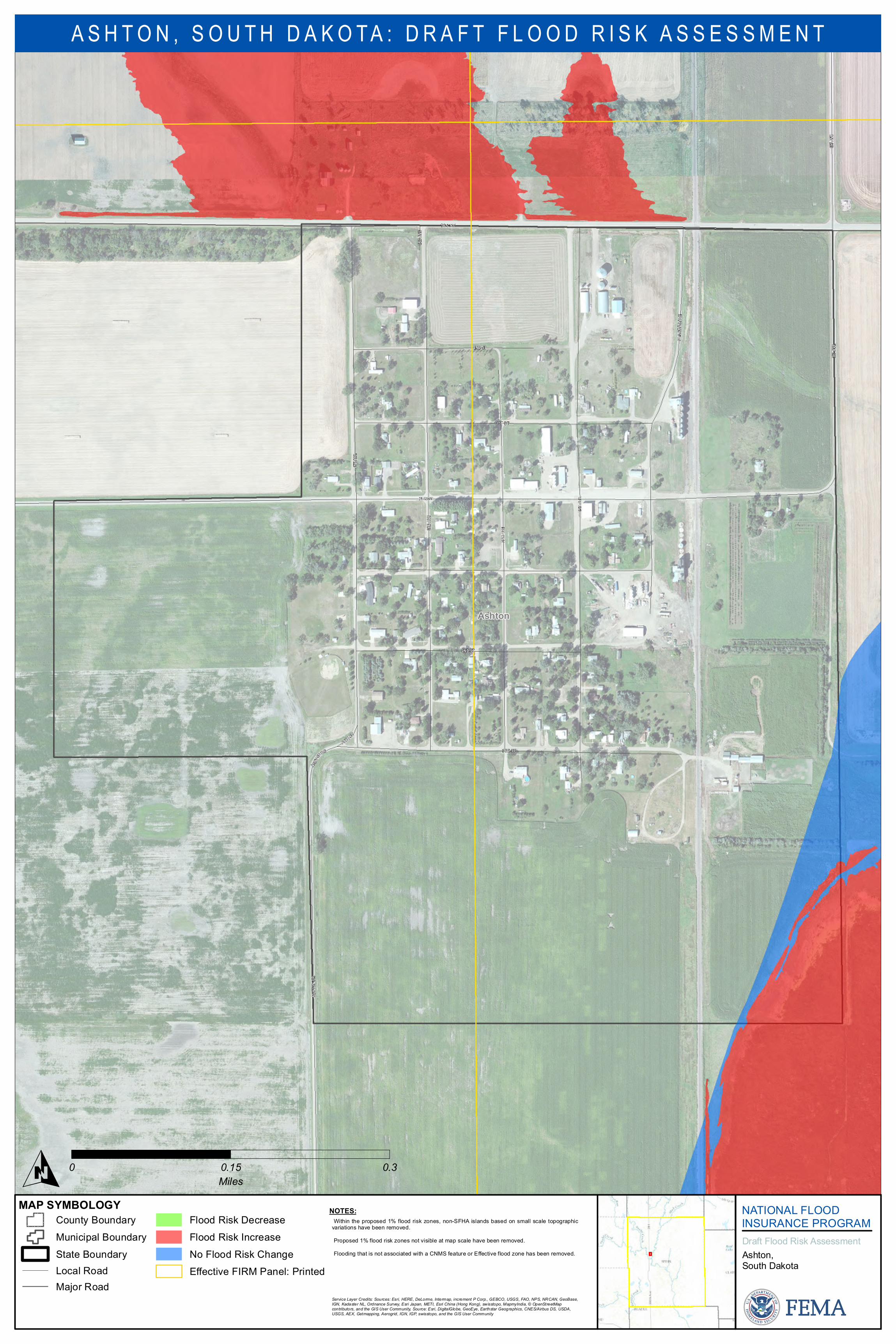
165 ST
Ashton
3RD ST
4TH A
VE
3RD A
VE
1STA
VE
4T H AVE
2ND A
VE3RD A
VE
MAIN ST
1ST ST
2ND ST
2ND ST
387 AV
E
RAILR
OAD A
VE
387 AV
E
A SHTO
N DR
ASHT
ON DR
MAP SYMBOLOGY NATIONAL FLOODINSURANCE PROGRAMDraft Flood Risk As ses s mentAs hton,Sou th Dakota
A S H T O N , S O U T H D A K O T A : D R A F T F L O O D R I S K A S S E S S M E N T
Cou nty Bou ndaryMu nicipal Bou ndaryState Bou ndaryLocal RoadMajor Road
Flood Ris k DecreaseFlood Ris k IncreaseNo Flood Ris k ChangeEffective FIRM Panel: Printed
O 0 0.15 0.3Miles
NOTES:•Within the propos ed 1% flood ris k zones , non-SFHA is lands bas ed on s mall scale topographicvariations have been removed.•Propos ed 1% flood risk zones not visible at map s cale have been removed.•Flooding that is not as sociated with a CNMS featu re or Effective flood zone has been removed.
Service Layer Credits: Sources: Esri, HERE, DeLorme, Intermap, increment P Corp., GEBCO, USGS, FAO, NPS, NRCAN, GeoBase,IGN, Kadaster NL, Ordnance Survey, Esri Japan, METI, Esri China (Hong Kong), swisstopo, MapmyIndia, © OpenStreetMapcontributors, and the GIS User Community, Source: Esri, DigitalGlobe, GeoEye, Earthstar Geographics, CNES/Airbus DS, USDA,USGS, AEX, Getmapping, Aerogrid, IGN, IGP, swisstopo, and the GIS User Community
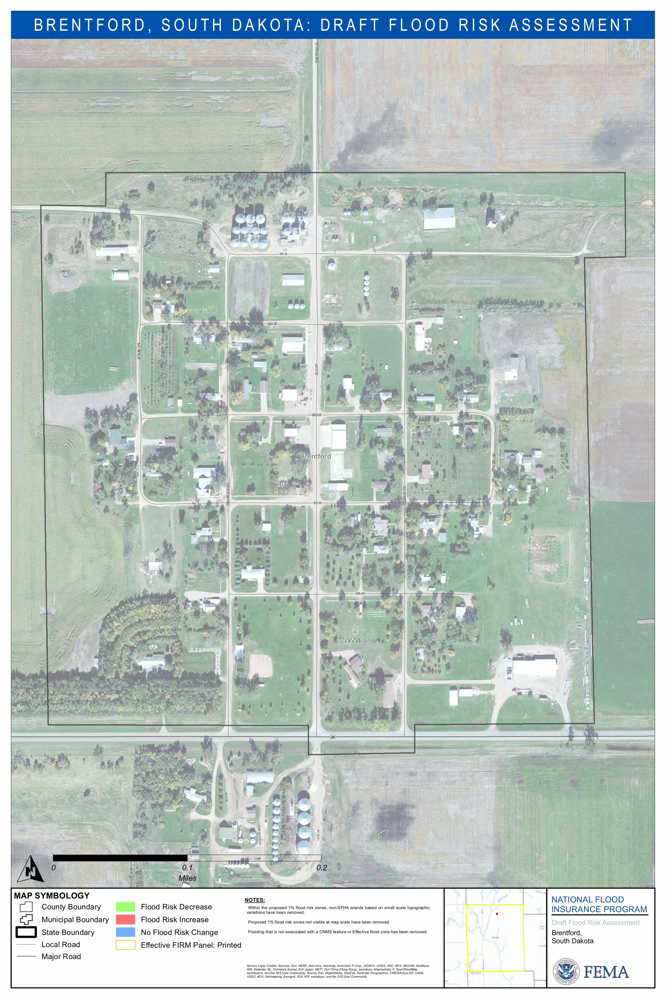
Brentford
BREN
TFOR
D DR
5TH ST
GREG
ORY A
VE
MCCA
UGHE
Y AVE
MAIN
ST
4TH ST
3RD ST
1ST ST
2ND ST
STEV
ENS A
VE
STYL
ES AV
E
¬«20
MAP SYMBOLOGY NATIONAL FLOODINSURANCE PROGRAMDraft Flood Risk As ses s mentBrentford,Sou th Dakota
B R E N T F O R D , S O U T H D A K O T A : D R A F T F L O O D R I S K A S S E S S M E N T
Cou nty Bou ndaryMu nicipal Bou ndaryState Bou ndaryLocal RoadMajor Road
Flood Ris k DecreaseFlood Ris k IncreaseNo Flood Ris k ChangeEffective FIRM Panel: Printed
O 0 0.1 0.2Miles
NOTES:•Within the propos ed 1% flood ris k zones , non-SFHA is lands bas ed on s mall scale topographicvariations have been removed.•Propos ed 1% flood risk zones not visible at map s cale have been removed.•Flooding that is not as sociated with a CNMS featu re or Effective flood zone has been removed.
Service Layer Credits: Sources: Esri, HERE, DeLorme, Intermap, increment P Corp., GEBCO, USGS, FAO, NPS, NRCAN, GeoBase,IGN, Kadaster NL, Ordnance Survey, Esri Japan, METI, Esri China (Hong Kong), swisstopo, MapmyIndia, © OpenStreetMapcontributors, and the GIS User Community, Source: Esri, DigitalGlobe, GeoEye, Earthstar Geographics, CNES/Airbus DS, USDA,USGS, AEX, Getmapping, Aerogrid, IGN, IGP, swisstopo, and the GIS User Community
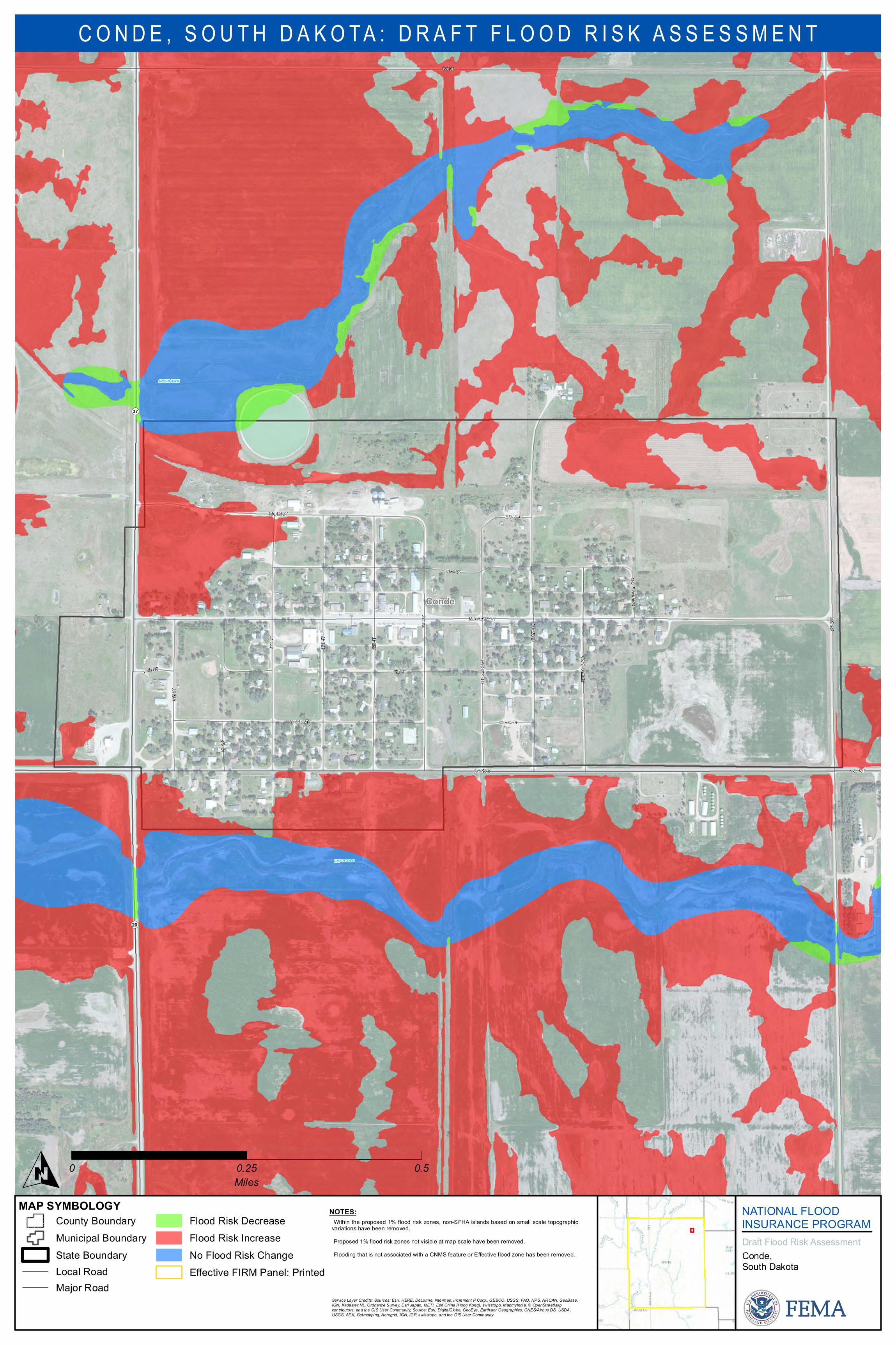
154 STOAK ST
Conde
407 AV
E
PINE ST
MAPLE ST
BROADWAY ST
PINE ST
BIRCH ST
2ND S
T
CEDAR ST
MAPLE ST
4TH S
T
3RD S
T
5TH ST
MCCL
ELLA
N AVE
6TH S
T
CEDAR ST
SHER
IDANA
VE
153 ST
1ST S
T
SHER
MAN A
VE
GRAN
T AVE
¬«37
¬«20
UN K N OW N
UN K N OW N
MAP SYMBOLOGY NATIONAL FLOODINSURANCE PROGRAMDraft Flood Risk As ses s mentConde,Sou th Dakota
C O N D E , S O U T H D A K O T A : D R A F T F L O O D R I S K A S S E S S M E N T
Cou nty Bou ndaryMu nicipal Bou ndaryState Bou ndaryLocal RoadMajor Road
Flood Ris k DecreaseFlood Ris k IncreaseNo Flood Ris k ChangeEffective FIRM Panel: Printed
O 0 0.25 0.5Miles
NOTES:•Within the propos ed 1% flood ris k zones , non-SFHA is lands bas ed on s mall scale topographicvariations have been removed.•Propos ed 1% flood risk zones not visible at map s cale have been removed.•Flooding that is not as sociated with a CNMS featu re or Effective flood zone has been removed.
Service Layer Credits: Sources: Esri, HERE, DeLorme, Intermap, increment P Corp., GEBCO, USGS, FAO, NPS, NRCAN, GeoBase,IGN, Kadaster NL, Ordnance Survey, Esri Japan, METI, Esri China (Hong Kong), swisstopo, MapmyIndia, © OpenStreetMapcontributors, and the GIS User Community, Source: Esri, DigitalGlobe, GeoEye, Earthstar Geographics, CNES/Airbus DS, USDA,USGS, AEX, Getmapping, Aerogrid, IGN, IGP, swisstopo, and the GIS User Community
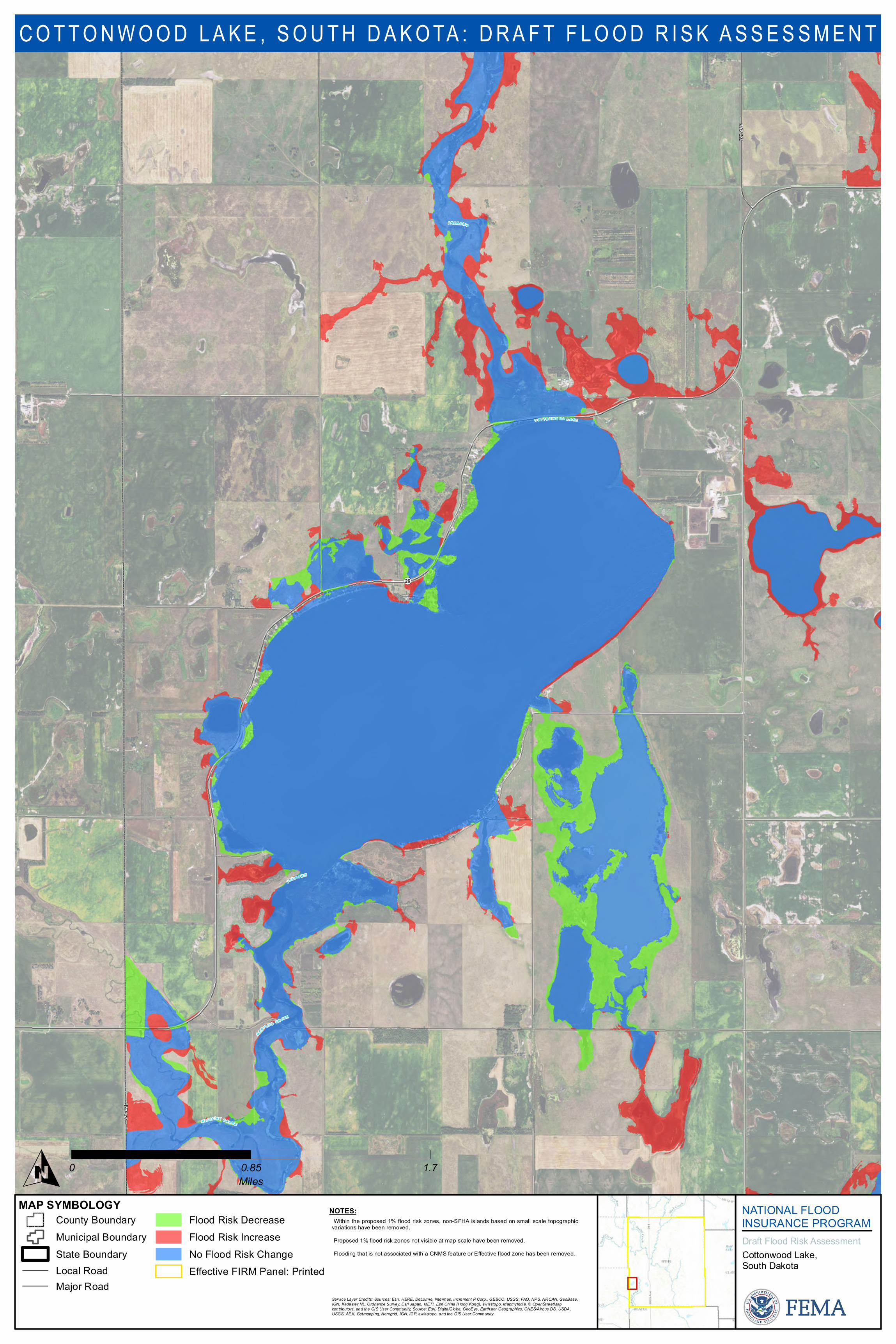
377 A
VE
374 A
VE
¬«26
C O T T O N W O O D L A K E
U N K N OW N
M E D IC IN E C R E E K
U NK N O W N
M E D I C IN E C R E E K
MAP SYMBOLOGY NATIONAL FLOODINSURANCE PROGRAMDraft Flood Risk As ses s mentCottonwood Lake,Sou th Dakota
C O T T O N W O O D L A K E , S O U T H D A K O TA : D R A F T F L O O D R I S K A S S E S S M E N T
Cou nty Bou ndaryMu nicipal Bou ndaryState Bou ndaryLocal RoadMajor Road
Flood Ris k DecreaseFlood Ris k IncreaseNo Flood Ris k ChangeEffective FIRM Panel: Printed
O 0 0.85 1.7Miles
NOTES:•Within the propos ed 1% flood ris k zones , non-SFHA is lands bas ed on s mall scale topographicvariations have been removed.•Propos ed 1% flood risk zones not visible at map s cale have been removed.•Flooding that is not as sociated with a CNMS featu re or Effective flood zone has been removed.
Service Layer Credits: Sources: Esri, HERE, DeLorme, Intermap, increment P Corp., GEBCO, USGS, FAO, NPS, NRCAN, GeoBase,IGN, Kadaster NL, Ordnance Survey, Esri Japan, METI, Esri China (Hong Kong), swisstopo, MapmyIndia, © OpenStreetMapcontributors, and the GIS User Community, Source: Esri, DigitalGlobe, GeoEye, Earthstar Geographics, CNES/Airbus DS, USDA,USGS, AEX, Getmapping, Aerogrid, IGN, IGP, swisstopo, and the GIS User Community
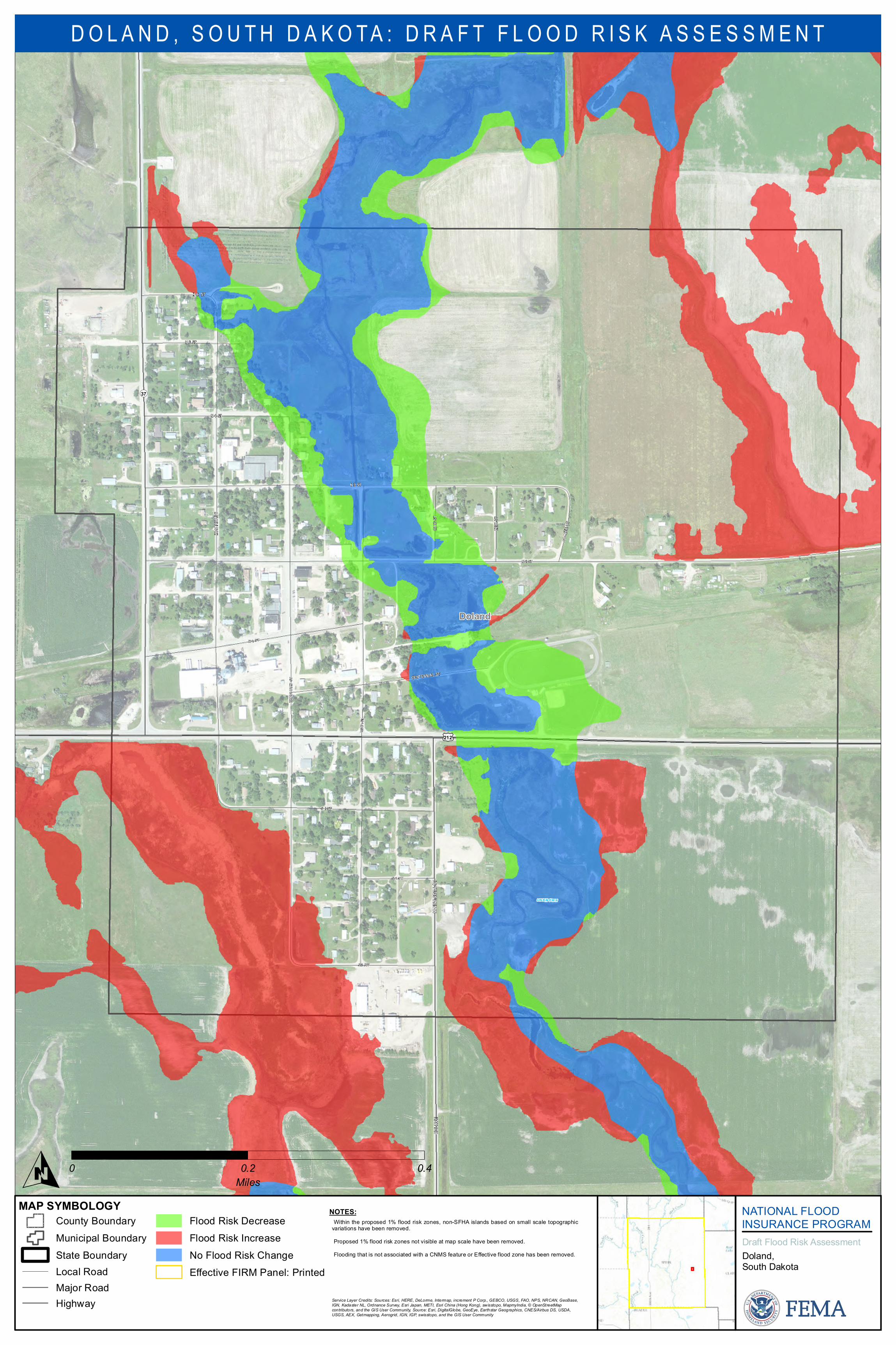
MINN
ESOT
A ST
406 A
VE
Doland
N 5 ST
HUMP
HREY
ST
MONT
ANA S
T
IOWA S
T
N 2 ST
N 3 ST
N 6 ST
S 3 ST
N 1 ST
S 1 ST
N 4 ST
CENTENNIAL ST
S 2 ST
ERIE
ST
OHIO
ST
PALM
E RST
¬«37
£¤212
UN K N OW N
MAP SYMBOLOGY NATIONAL FLOODINSURANCE PROGRAMDraft Flood Risk As ses s mentDoland,Sou th Dakota
D O L A N D , S O U T H D A K O T A : D R A F T F L O O D R I S K A S S E S S M E N T
Cou nty Bou ndaryMu nicipal Bou ndaryState Bou ndaryLocal RoadMajor RoadHighway
Flood Ris k DecreaseFlood Ris k IncreaseNo Flood Ris k ChangeEffective FIRM Panel: Printed
O 0 0.2 0.4Miles
NOTES:•Within the propos ed 1% flood ris k zones , non-SFHA is lands bas ed on s mall scale topographicvariations have been removed.•Propos ed 1% flood risk zones not visible at map s cale have been removed.•Flooding that is not as sociated with a CNMS featu re or Effective flood zone has been removed.
Service Layer Credits: Sources: Esri, HERE, DeLorme, Intermap, increment P Corp., GEBCO, USGS, FAO, NPS, NRCAN, GeoBase,IGN, Kadaster NL, Ordnance Survey, Esri Japan, METI, Esri China (Hong Kong), swisstopo, MapmyIndia, © OpenStreetMapcontributors, and the GIS User Community, Source: Esri, DigitalGlobe, GeoEye, Earthstar Geographics, CNES/Airbus DS, USDA,USGS, AEX, Getmapping, Aerogrid, IGN, IGP, swisstopo, and the GIS User Community
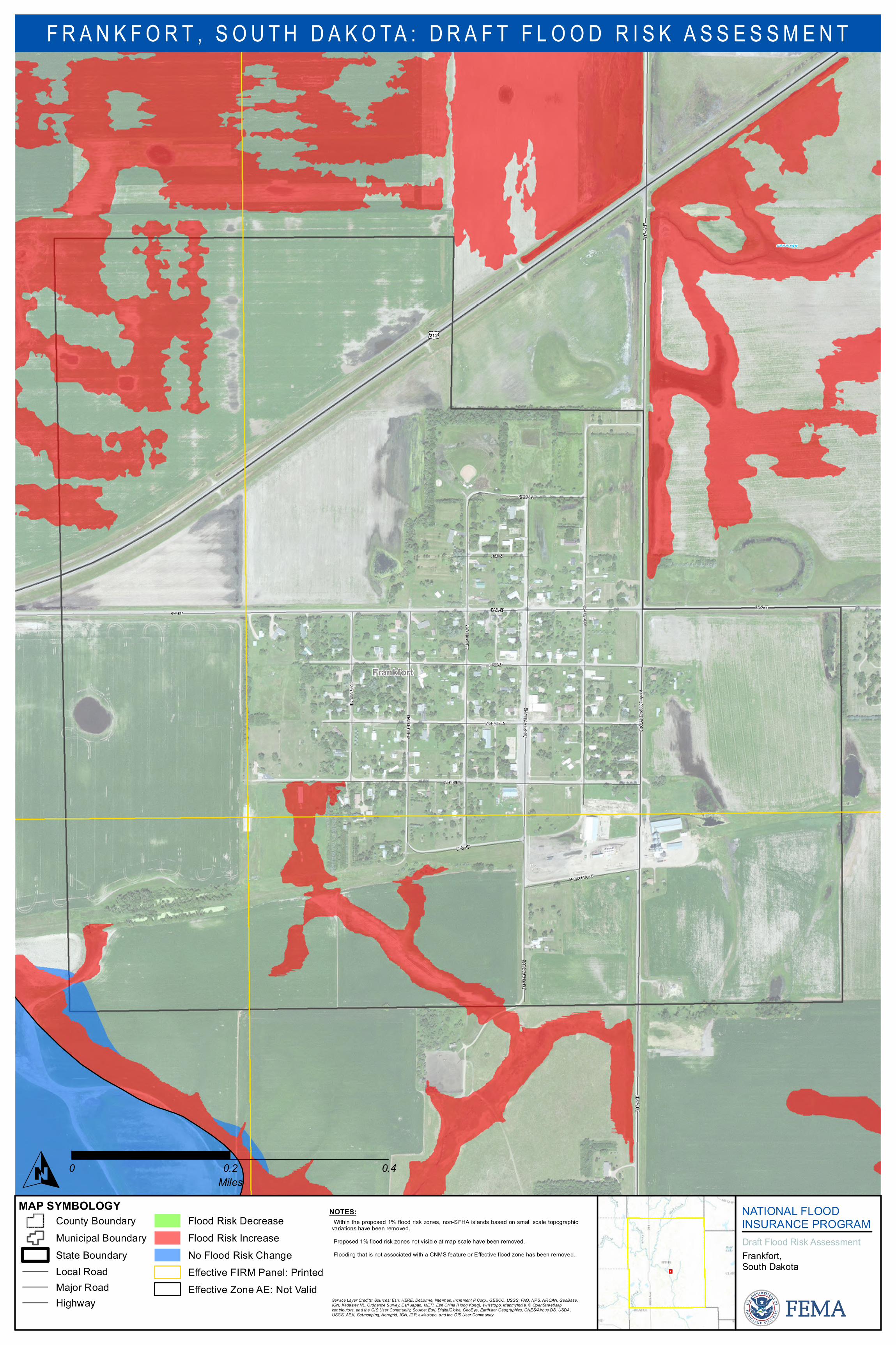
WAS H
INGTO
NAV
E39
6 AVE
396 A
VE
Frankfort
OAK ST
ASH ST
ADAM
S AVE
WALNUT ST
PINE ST
LINCO
LN AV
E
MONR
OE AV
E
MAPLE ST
ELM ST
BEECH ST
RAILROAD ST
OAK ST173 ST
JEFF
ERSO
N AVE
JEFF
ERSO
N AVE
MADIS
ON AV
E
£¤212
UN K N OW N
MAP SYMBOLOGY NATIONAL FLOODINSURANCE PROGRAMDraft Flood Risk As ses s mentFrankfort,South Dakota
F R A N K F O R T , S O U T H D A K O T A : D R A F T F L O O D R I S K A S S E S S M E N T
County Bound aryMunicip al Bound aryState Bound aryLocal RoadMajor RoadHighway
Flood Ris k Decreas eFlood Ris k Increas eNo Flood Ris k ChangeEffective FIRM Panel: PrintedEffective Zone AE: Not Valid
O 0 0.2 0.4Miles
NOTES:•Within the p rop os ed 1% flood ris k zones , non-SFHA is land s bas ed on s mall scale top ograp hicvariations have been removed .•Prop os ed 1% flood risk zones not visible at map s cale have been removed .•Flood ing that is not as sociated with a CNMS feature or Effective flood zone has been removed .
Service Layer Credits: Sources: Esri, HERE, DeLorme, Intermap, increment P Corp., GEBCO, USGS, FAO, NPS, NRCAN, GeoBase,IGN, Kadaster NL, Ordnance Survey, Esri Japan, METI, Esri China (Hong Kong), swisstopo, MapmyIndia, © OpenStreetMapcontributors, and the GIS User Community, Source: Esri, DigitalGlobe, GeoEye, Earthstar Geographics, CNES/Airbus DS, USDA,USGS, AEX, Getmapping, Aerogrid, IGN, IGP, swisstopo, and the GIS User Community
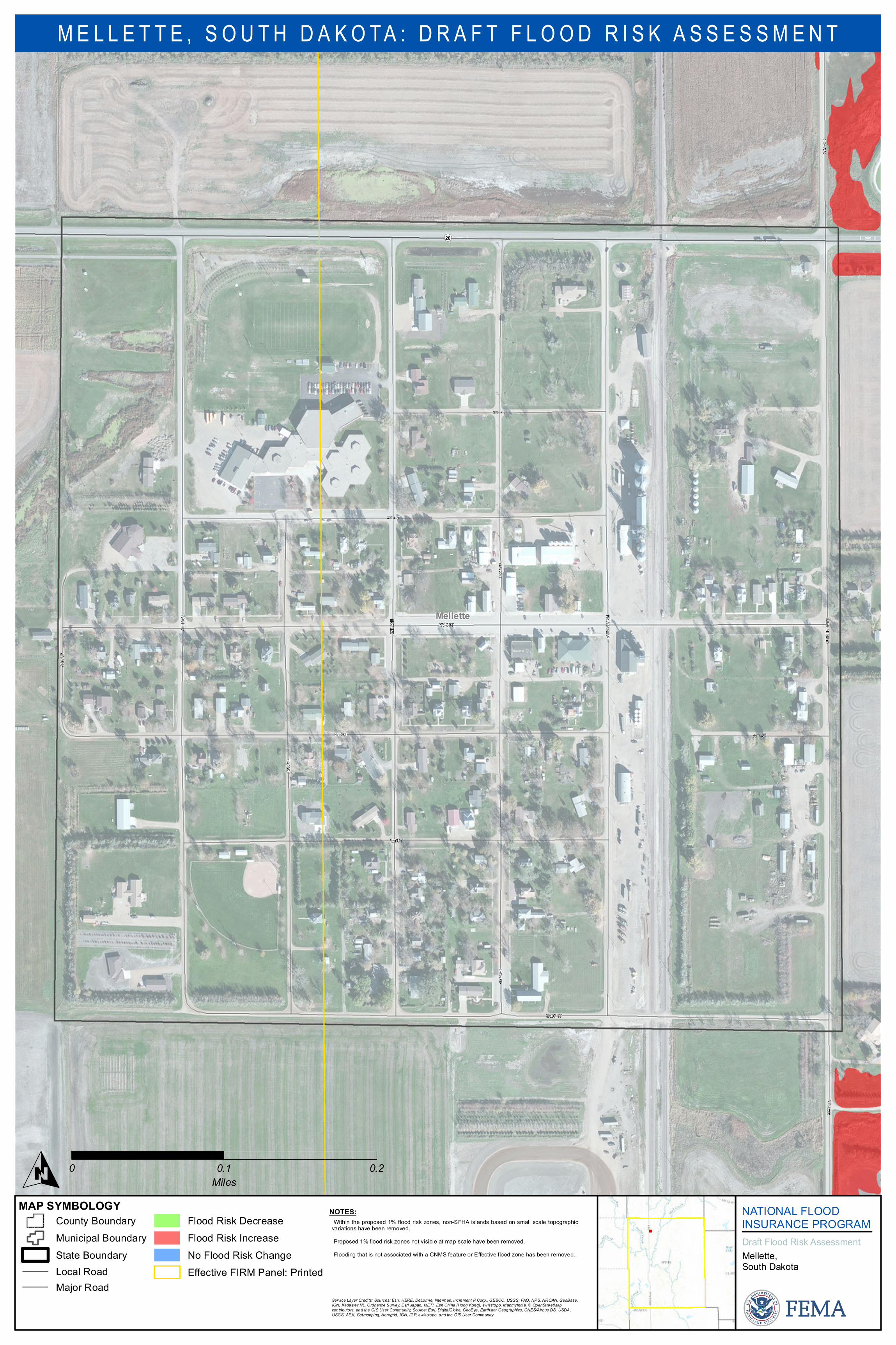
Mellette
3RD ST
2ND A
VE
CADY ST
MAIN ST
RAILW
AY AV
E
1ST ST
2ND ST
4TH ST
3RD A
VE
4THA
VE
SUNS
HINE T
RL
2ND ST
387 AV
E387
AVE
1ST A
VE1S
TAVE
5TH A
VE
¬«20
MAP SYMBOLOGY NATIONAL FLOODINSURANCE PROGRAMDraft Flood Risk As ses s mentMellette,Sou th Dakota
M E L L E T T E , S O U T H D A K O T A : D R A F T F L O O D R I S K A S S E S S M E N T
Cou nty Bou ndaryMu nicipal Bou ndaryState Bou ndaryLocal RoadMajor Road
Flood Ris k DecreaseFlood Ris k IncreaseNo Flood Ris k ChangeEffective FIRM Panel: Printed
O 0 0.1 0.2Miles
NOTES:•Within the propos ed 1% flood ris k zones , non-SFHA is lands bas ed on s mall scale topographicvariations have been removed.•Propos ed 1% flood risk zones not visible at map s cale have been removed.•Flooding that is not as sociated with a CNMS featu re or Effective flood zone has been removed.
Service Layer Credits: Sources: Esri, HERE, DeLorme, Intermap, increment P Corp., GEBCO, USGS, FAO, NPS, NRCAN, GeoBase,IGN, Kadaster NL, Ordnance Survey, Esri Japan, METI, Esri China (Hong Kong), swisstopo, MapmyIndia, © OpenStreetMapcontributors, and the GIS User Community, Source: Esri, DigitalGlobe, GeoEye, Earthstar Geographics, CNES/Airbus DS, USDA,USGS, AEX, Getmapping, Aerogrid, IGN, IGP, swisstopo, and the GIS User Community
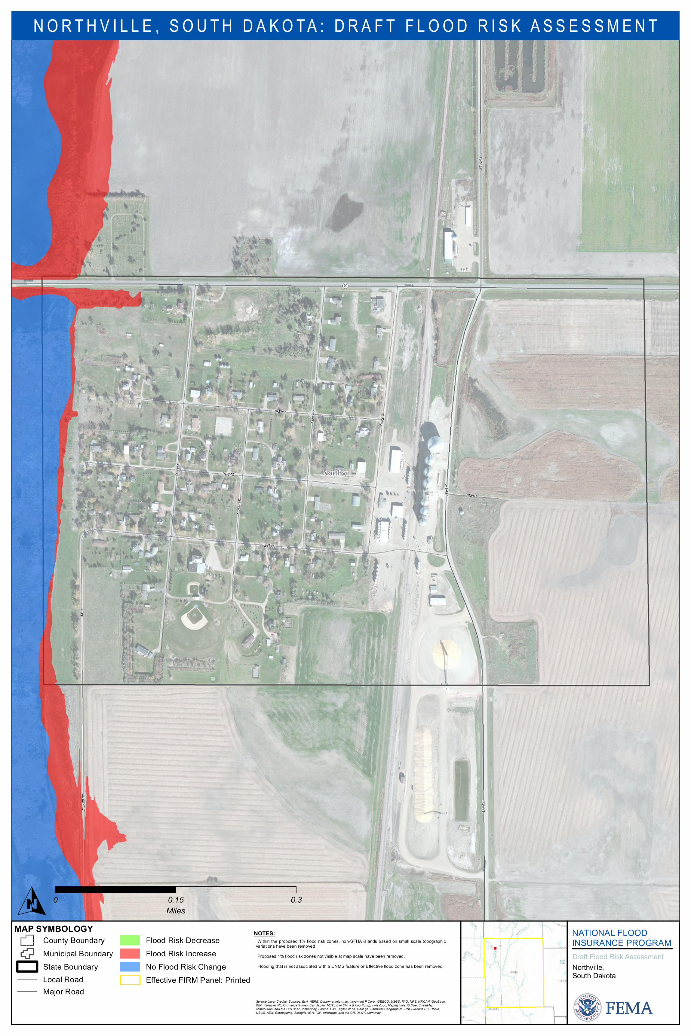
1STS
T
383 A
VE38
3 AVE
Northville
WEST
ST
MAIN ST
OAK ST
MAIN ST
THAY
ER ST
PARK
ST
F RON
T ST
VILLA
GE DR
ELM ST
ELM
ST
¬«20
MAP SYMBOLOGY NATIONAL FLOODINSURANCE PROGRAMDraft Flood Risk As ses s mentNorthville,Sou th Dakota
N O R T H V I L L E , S O U T H D A K O T A : D R A F T F L O O D R I S K A S S E S S M E N T
Cou nty Bou ndaryMu nicipal Bou ndaryState Bou ndaryLocal RoadMajor Road
Flood Ris k DecreaseFlood Ris k IncreaseNo Flood Ris k ChangeEffective FIRM Panel: Printed
O 0 0.15 0.3Miles
NOTES:•Within the propos ed 1% flood ris k zones , non-SFHA is lands bas ed on s mall scale topographicvariations have been removed.•Propos ed 1% flood risk zones not visible at map s cale have been removed.•Flooding that is not as sociated with a CNMS featu re or Effective flood zone has been removed.
Service Layer Credits: Sources: Esri, HERE, DeLorme, Intermap, increment P Corp., GEBCO, USGS, FAO, NPS, NRCAN, GeoBase,IGN, Kadaster NL, Ordnance Survey, Esri Japan, METI, Esri China (Hong Kong), swisstopo, MapmyIndia, © OpenStreetMapcontributors, and the GIS User Community, Source: Esri, DigitalGlobe, GeoEye, Earthstar Geographics, CNES/Airbus DS, USDA,USGS, AEX, Getmapping, Aerogrid, IGN, IGP, swisstopo, and the GIS User Community
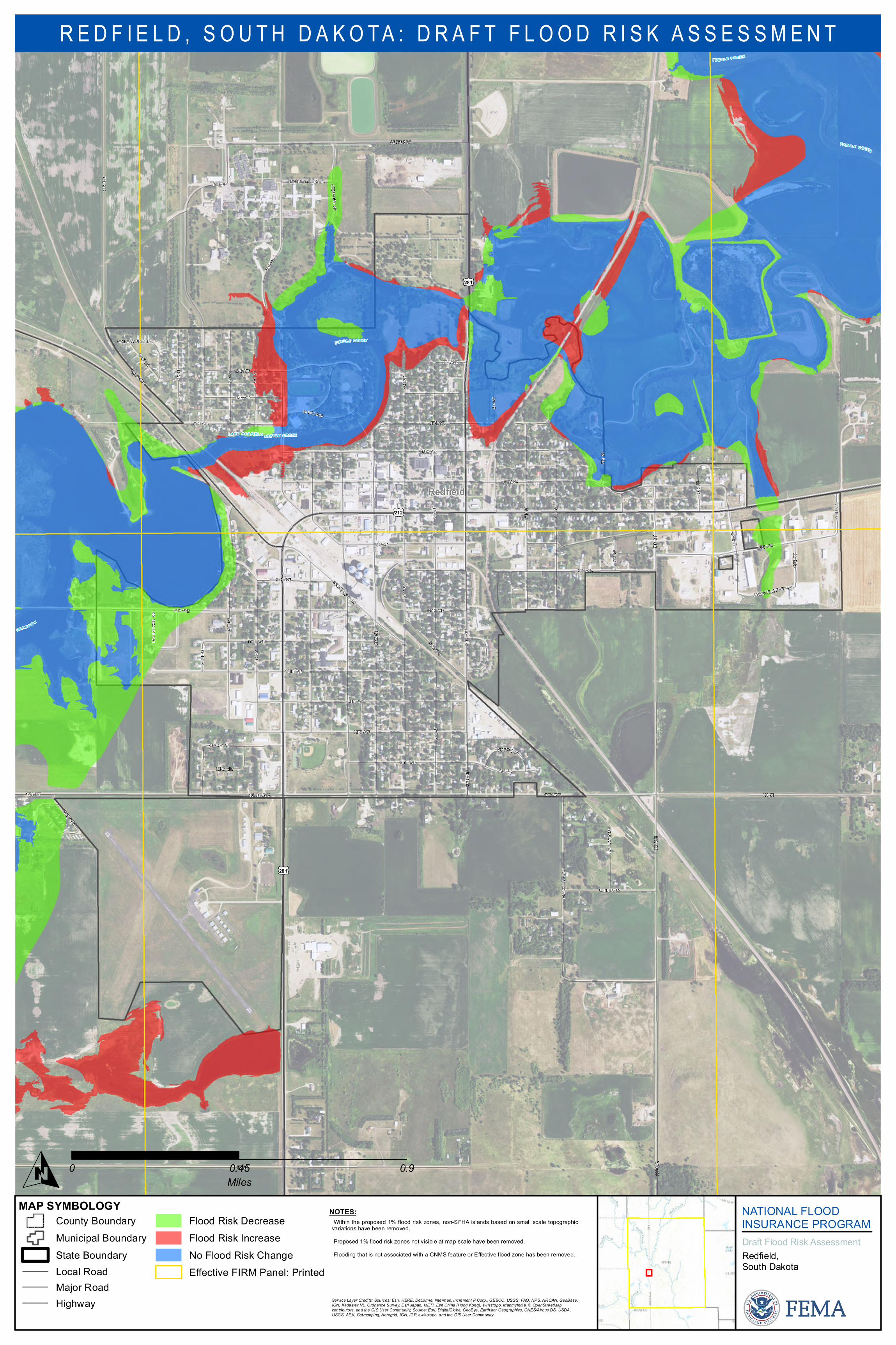
16T H AVE174 ST
3RD
ST3R
D ST
Redfield
5TH AVE
3RD ST
9TH AVE
PARK LN
6TH AVE
4TH S
T
13TH AVE
10TH AVE
16TH AVE
UNKNOWN
9TH S
T
4TH AVE
174 ST
COMMERCIAL LN
11 THST
9TH AVE
SHERRY LN
4TH AVE
12 TH ST
3RD AVE
2ND AVE
11TH AVE
14TH AVE
12TH AVE
4TH S
T
5TH S
T
5TH S
T
6TH S
T
15TH AVE
W 6T
H ST
2ND S
T
8TH AVE
10TH AVE
2ND AVE
SOUTH LN
8TH AVE
SUNRISE ST
PARK LN
TURTLE CREEK AVE
7TH
ST
CENTER DR
INDUSTRIAL PARK CIR
MEADOW DR
175 ST
RAILR
OAD
ST
7TH S
T
8TH S
T
1ST S
T1S
T ST
MAIN
ST
5TH S
T
COUNTRYSIDE DR
UNKNOWN
6TH ST
PARK LOOP
2ND S
T
4TH S
T
C E MET E RY R D
14TH S
T
13TH S
T
LYNN CIR
385 AV
E
PLAIN
VIEW
AVE
386 AV
E386
AVE
LAKE
SHOR
EDR
£¤281
£¤212
£¤281
U N K N O W N
T U R T L E C R EE K
L A K E R E D F I E L D
T U R T L E C R E EK
T U R T L E C R E E K
T U R T L E C R E E K
MAP SYMBOLOGY NATIONAL FLOODINSURANCE PROGRAMDraft Flood Risk As ses s mentRedfield,Sou th Dakota
R E D F I E L D , S O U T H D A K O T A : D R A F T F L O O D R I S K A S S E S S M E N T
Cou nty Bou ndaryMu nicipal Bou ndaryState Bou ndaryLocal RoadMajor RoadHighway
Flood Ris k DecreaseFlood Ris k IncreaseNo Flood Ris k ChangeEffective FIRM Panel: Printed
O 0 0.45 0.9Miles
NOTES:•Within the propos ed 1% flood ris k zones , non-SFHA is lands bas ed on s mall scale topographicvariations have been removed.•Propos ed 1% flood risk zones not visible at map s cale have been removed.•Flooding that is not as sociated with a CNMS featu re or Effective flood zone has been removed.
Service Layer Credits: Sources: Esri, HERE, DeLorme, Intermap, increment P Corp., GEBCO, USGS, FAO, NPS, NRCAN, GeoBase,IGN, Kadaster NL, Ordnance Survey, Esri Japan, METI, Esri China (Hong Kong), swisstopo, MapmyIndia, © OpenStreetMapcontributors, and the GIS User Community, Source: Esri, DigitalGlobe, GeoEye, Earthstar Geographics, CNES/Airbus DS, USDA,USGS, AEX, Getmapping, Aerogrid, IGN, IGP, swisstopo, and the GIS User Community

183 ST
Tulare
KANSAS ST
MAIN ST
SECO
ND AV
E
UTAH ST
OHIO ST
DAKOTA ST
RAILW
AY AV
E
IOWA ST
HAWAII ST
385 AV
E385
AVE
3RD A
VE
4TH A
VE
£¤281
MAP SYMBOLOGY NATIONAL FLOODINSURANCE PROGRAMDraft Flood Risk As ses s mentTu lare,Sou th Dakota
T U L A R E , S O U T H D A K O T A : D R A F T F L O O D R I S K A S S E S S M E N T
Cou nty Bou ndaryMu nicipal Bou ndaryState Bou ndaryLocal RoadMajor RoadHighway
Flood Ris k DecreaseFlood Ris k IncreaseNo Flood Ris k ChangeEffective FIRM Panel: Printed
O 0 0.2 0.4Miles
NOTES:•Within the propos ed 1% flood ris k zones , non-SFHA is lands bas ed on s mall scale topographicvariations have been removed.•Propos ed 1% flood risk zones not visible at map s cale have been removed.•Flooding that is not as sociated with a CNMS featu re or Effective flood zone has been removed.
Service Layer Credits: Sources: Esri, HERE, DeLorme, Intermap, increment P Corp., GEBCO, USGS, FAO, NPS, NRCAN, GeoBase,IGN, Kadaster NL, Ordnance Survey, Esri Japan, METI, Esri China (Hong Kong), swisstopo, MapmyIndia, © OpenStreetMapcontributors, and the GIS User Community, Source: Esri, DigitalGlobe, GeoEye, Earthstar Geographics, CNES/Airbus DS, USDA,USGS, AEX, Getmapping, Aerogrid, IGN, IGP, swisstopo, and the GIS User Community
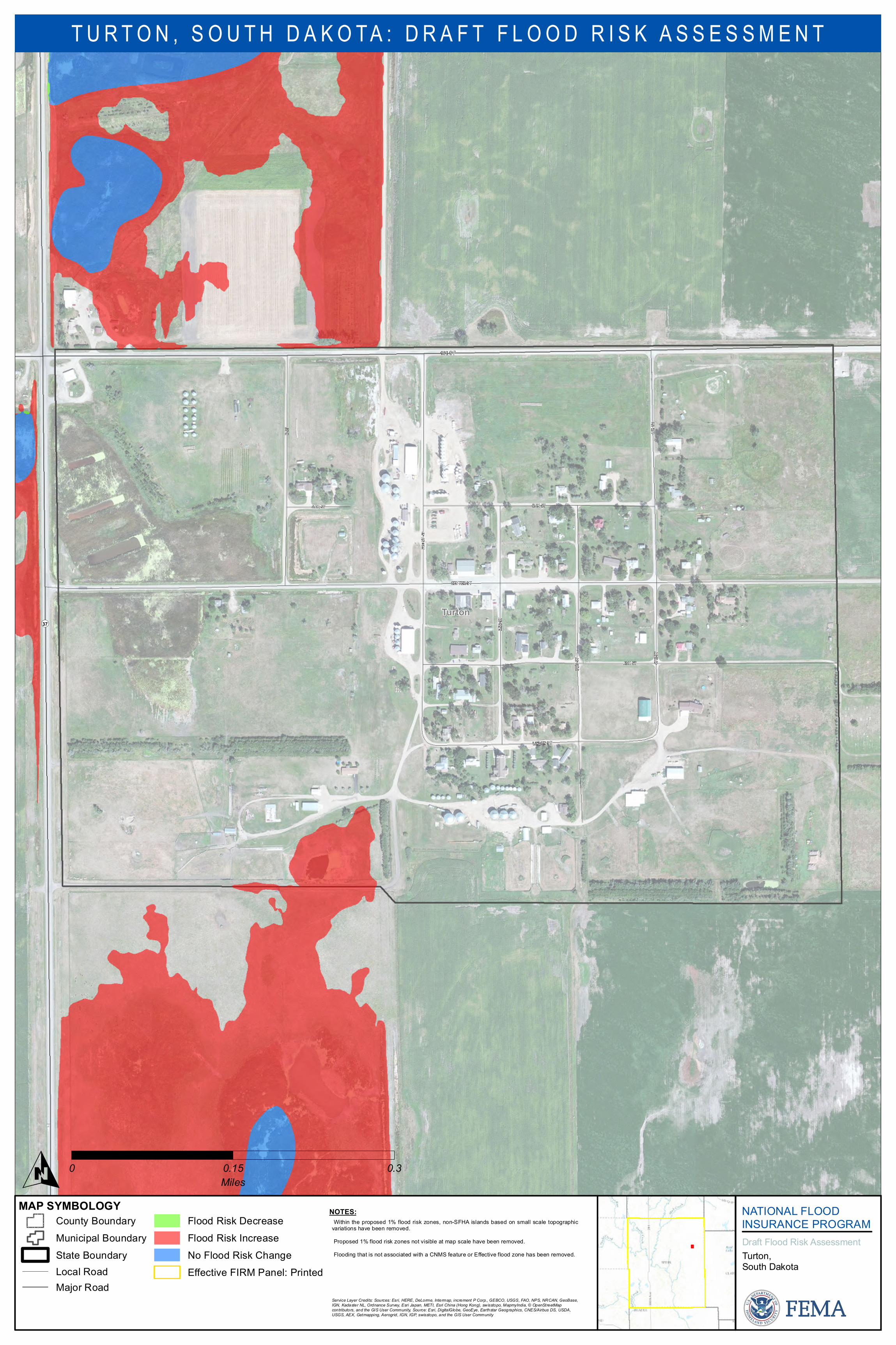
161 ST
Turton
ASH ST
LINDEN ST
OAK ST
CENTER ST
OAK ST
3RDS
T
2ND S
T
B ST
4TH S
T4T
HST
FRON
T ST
¬«37
MAP SYMBOLOGY NATIONAL FLOODINSURANCE PROGRAMDraft Flood Risk As ses s mentTu rton,Sou th Dakota
T U R T O N , S O U T H D A K O T A : D R A F T F L O O D R I S K A S S E S S M E N T
Cou nty Bou ndaryMu nicipal Bou ndaryState Bou ndaryLocal RoadMajor Road
Flood Ris k DecreaseFlood Ris k IncreaseNo Flood Ris k ChangeEffective FIRM Panel: Printed
O 0 0.15 0.3Miles
NOTES:•Within the propos ed 1% flood ris k zones , non-SFHA is lands bas ed on s mall scale topographicvariations have been removed.•Propos ed 1% flood risk zones not visible at map s cale have been removed.•Flooding that is not as sociated with a CNMS featu re or Effective flood zone has been removed.
Service Layer Credits: Sources: Esri, HERE, DeLorme, Intermap, increment P Corp., GEBCO, USGS, FAO, NPS, NRCAN, GeoBase,IGN, Kadaster NL, Ordnance Survey, Esri Japan, METI, Esri China (Hong Kong), swisstopo, MapmyIndia, © OpenStreetMapcontributors, and the GIS User Community, Source: Esri, DigitalGlobe, GeoEye, Earthstar Geographics, CNES/Airbus DS, USDA,USGS, AEX, Getmapping, Aerogrid, IGN, IGP, swisstopo, and the GIS User Community